
Nashville City Zoning Code
CHAPTER 17
28 - ENVIRONMENTAL AND OPERATIONAL PERFORMANCE STANDARDS
17.28.010 - Purpose and intent.
The purpose of this article is to establish standards for development in environmentally sensitive areas, in a manner which provides for reasonable use of the land while retaining to the maximum extent possible the environmentally sensitive portions in a predeveloped state. This article is predicated on the concept that land use policy decisions and zoning decisions must be made in the context of the land's characteristics. The choice of residential land uses should be based on site-specific characteristics which coincide with the many available varieties of housing. Commercial land use decision-making, conversely, is likely driven more by market forces, such as location or access, than by site characteristics. It is the intent of this article to offer incentives to minimize environmental disturbance. The requirements and standards of this article are intended to promote low-impact development in the sensitive hillsides and areas of special flood hazard of the community through incentives to preserve these lands in an undeveloped state, to insure protection of special vegetative assets and to promote well-conceived development which recognizes the problem soils of the community.
(Ord. 96-555 § 7.1(A), 1997)
17.28.020 - Applicability.
A.
Hillside Development Standards. The hillside development standards apply to new construction on land in an undeveloped state where natural slopes are of fifteen percent or greater.
B.
Special Flood Hazard Development Standards. The floodplain development standards apply to new construction where there are special flood hazard areas, as described in the Nashville stormwater management manual. Nothing contained in the official maps of special flood hazard shall prohibit the application of these regulations to lands which can be demonstrated by competent engineering survey to lie within any one hundred-year floodplain; conversely, any lands which can be demonstrated by competent engineering to lie beyond the floodplain shall not be subject to these regulations.
C.
Problem Soils Requirements. The problem soil development standards apply to predevelopment conditions for new development located within the listed soil types as identified in the Davidson County Soil Survey (USDA, Soil Conservation Service).
D.
Protection of Cedar Glade Plant Communities. The standards for Cedar Glade plant communities apply to predevelopment conditions for new residential construction located within Cedar Glades as identified by the Tennessee Department of Environment and Conservation.
E.
Trees are acknowledged to be an important part of the natural environment and as such shall be protected and replaced as provided in this chapter.
F.
Exemptions. The provisions of this article shall not apply to:
1.
Any construction, development or use initiated pursuant to any valid building permit or approved final site plan issued or approved prior to the adoption of the ordinance codified in this title;
2.
Any essential public utility facility, system or road initiated to provide utility services or access to a property;
3.
Repairs or replacement to an existing structure or building that does not increase impervious surface area of the site more than twenty-five percent of the existing area or multiple increases of not more than fifty percent in any five-year period;
4.
The construction of a single-family or two-family dwelling unit on a platted lot existing at the time of the enactment of the ordinance codified in this title; a lot depicted on a preliminary plat of subdivision having a valid approval by the planning commission on the effective date of the ordinance codified in this title; and subsequently recorded in compliance with that preliminary approval shall also be exempt.
(Ord. BL2022-1122 § 9, 2022; § 5(1) of Amdt. 1 with Ord. 96-555 § 7.1(B), 1997)
17.28.030 - Hillside development standards.
A.
Residential Districts. The development of residentially zoned property shall minimize changes in grade, cleared area, and volume of cut or fill on those hillside portions of the property with twenty percent or greater natural slopes. Approval of a final site plan for a "critical lot" established by the subdivision regulations shall be based upon a demonstration that the proposal takes into consideration factors such as, but not limited to, soil conditions, degree of slope and feasibility of construction. The standards for review of critical lots from the adopted subdivision regulations shall apply.
1.
Single or Two-Family Lots. The following provisions of this section shall not apply to single or two-family lots equal to or greater than one acre in size. For lots of less than one acre, any natural slopes equal to or greater than twenty-five percent shall be platted outside of the building envelope and preserved to the greatest extent possible in a natural state. The planning commission may authorize the creation of a single or two-family lot of less than one acre in size with natural slopes equal to or greater than twenty-five percent subject to the following standards and conditions:
a.
The resulting lot shall be designated as a "critical lot" on the final plat of subdivision approved by the metropolitan planning commission and the department of public works;
b.
For natural slopes that generally rise away from the fronting street, the building envelope width shall be as approved on all preliminary plats approved prior to March 1, 2006. After March 1, 2006, a building envelope on less than twenty percent natural slope and a minimum width of seventy-five feet at the building line shall be provided, or
c.
For natural slopes that are generally parallel with fronting street, the building envelope width shall be as approved on all preliminary plats approved prior to March 1, 2006. After March 1, 2006, a building envelope on less than twenty percent natural slope and a minimum width of seventy-five feet at the building line shall be provided, or
d.
For natural slopes that generally fall away from the fronting street, a building envelope on less than twenty-five percent natural slope shall be provided;
e.
A certified engineer can demonstrate, through the use of special design and construction techniques, that a residential structure will be constructed on the lot in a manner which effectively minimizes disturbance of the hillside and optimizes the preservation of mature trees and will not adversely impact the storm water runoff on down slope or adjacent properties;
f.
All specially noted design, construction and drainage standards shall be incorporated into the preliminary and final subdivision plat approvals, and recorded in the form of a covenant running with the land; and
g.
The clearing of trees exceeding eight inches in diameter from those natural slopes equal to or greater than twenty-five percent shall be minimized by sensitive construction techniques.
2.
Single and/or two-family subdivisions in areas characterized by twenty percent or greater slopes shall employ the conservation development provisions of Section 17.12.090. In general, lots so created shall be grouped on those portions of the site that have natural slopes of less than twenty percent. The planning commission may authorize lots on natural slopes ranging up to twenty-five percent, subject to the special standards and conditions noted above. Large contiguous areas containing natural slopes in excess of twenty-five percent should be recorded as either common or natural open space and permanently maintained in a natural state.
3.
All Other Development in Residential Districts. For any multifamily or nonresidential form of development occurring within a residential district (the RM40, RM40-NS, RM40-A, RM40-A-NS, RM60, RM60-NS, RM60-A, RM60-A-NS, RM80-A, RM80-A-NS, RM100-A, and RM100-A-NS districts excepted), manipulation of the natural slopes by grading shall result in an effective impervious surface ratio (ISR) for those portions disturbed as shown in Table 17.28.030A.
a.
That portion of a multifamily development site containing large contiguous areas of natural slopes of twenty-five percent or greater should be permanently maintained in a natural state. The clearing of trees exceeding eight inches in diameter from those natural slopes shall be minimized by sensitive construction techniques.
b.
The use of retaining walls, rip rap or hydraulically applied concrete to stabilize slopes within multifamily developments shall be screened as follows:
i.
When oriented towards a lot or parcel zoned R/R-A or RS/RS-A, apply the next higher landscape buffer yard standard from Section 17.24.240;
Table 17.28.030A
ISR ADJUSTMENTS (RESIDENTIAL DISTRICTS)
* For the purposes of calculation, slopes may be averaged for the entire lot area employing slope contour intervals of two feet.
ii.
When oriented towards another lot or parcel with an RM zoning classification, apply landscape buffer yard Standard A from Section 17.24.240; and
iii.
When oriented towards a public street, apply landscape buffer yard Standard B from Section 17.24.240.
B.
Nonresidential Sites.
1.
In all nonresidential zoning districts except CF, CF-NS, MUI, MUI-NS, MUI-A, and MUI-A-NS, manipulation of the natural slopes by grading shall result in effective impervious surface ratio (ISR) adjustments for those portions disturbed as shown in Table 17.28.030B.
2.
Grading standards for hillside sites in nonresidential zone districts are as follows:
a.
For lots or parcels containing natural slopes of twenty percent or greater, approval of a final site plan shall be based upon a demonstration that the development plan minimizes unnecessary disturbance to those slopes in the placement and orientation of building and parking areas. Architectural and engineering features which reduce unnecessary encroachment on steep slopes may include, but are not limited to, the use of retaining walls and structural foundations to return to natural grade.
b.
The use of retaining walls, rip rap or hydraulically applied concrete to stabilize slopes on nonresidential sites shall be screened as follows:
i.
When oriented towards a lot or parcel zoned R and R-A, RS and RS-A or RM, apply the next higher landscape buffer yard standard from Section 17.24.240; and
ii.
When oriented towards a public street, apply landscape buffer yard standard B from Section 17.24.240.
Table 17.28.030B
ISR ADJUSTMENT (NONRESIDENTIAL DISTRICTS)
* For the purposes of calculation, slopes may be averaged for the entire lot area
employing slope contour intervals of two feet.
(Ord. BL2022-1121 § 5, 2022; Ord. BL2019-111 § 1(Exh. A, §§ 36, 37), 2020; Ord. BL2015-1153 § 16, 2015; Ord. BL2011-898 §§ 11, 13, 2011; Ord. BL2009-586 § 1(Exh. A, § 40), 2010; Amdt. 1 to Ord. BL2006-1045 § 1, 2006; Ord. BL2006-1045 § 1, 2006; Amdt. 1 with Ord. 98-1268 § 1 (part), 1998; § 5(2), (3) of Amdt. 1 with Ord. 96-555 § 7.1(C), 1997)
17.28.040 - Floodplain/floodway development standards.
A.
Limited encroachments into the preserved floodplain may be authorized as a variance by the stormwater management commission, as set forth in Section 15.64 of the Metropolitan Code of Laws. Such variances shall be approved only if the committee finds that the encroachment reduces the flood danger or would improve and enhance the environmental quality of the affected floodplain section. Variances shall not be approved for greater than twenty percent of the floodplain area required to be preserved.
B.
All development shall be undertaken consistent with the flood insurance standards and requirements of the Federal Emergency Management Agency, as necessary, to maintain the eligibility of the National Flood Insurance Program within Davidson County. Notwithstanding any provision herein to the contrary, all development alterations or improvements that would otherwise be subject to Chapter 15.64 of this Code shall comply with the provisions of that chapter and the regulations and technical guidelines promulgated by the department pursuant to that chapter.
C.
Residential Development. Residential development on property encumbered by natural floodplain or floodway on the effective date of the ordinance codified in this section shall comply with the following, except for the installation of streets and utilities where required by the planning commission to alleviate an undue hardship:
1.
Single or Two-Family Lots. Land area designated as natural floodplain or floodway on the effective date of said section may be included within a residential lot, but if manipulated, shall not be counted towards satisfying the minimum lot size requirements of the base zoning district. Any residential lot, or any portion of a residential lot, containing natural floodplain shall be designated as a "critical lot" and minimum finished floor elevations shall be established on the final plat of subdivision approved by the metropolitan planning commission and the department of water and sewerage services.
2.
Grouped lots. A single and/or two-family subdivision proposed on property containing natural floodplain and floodway areas shall employ the conservation development Section 17.12.090 or the Planned Unit Development (PUD) cluster lot option of Section 17.36.070. Residential lots under the conservation development or PUD cluster lot option may be grouped within the manipulated areas of the natural floodplain. Any residential lot, or any portion of a residential lot, containing natural floodplain shall be designated as a "critical lot" and minimum finished floor elevations shall be established on the final plat of subdivision approved by the metropolitan planning commission and the department of water and sewerage services. Protected floodway and floodplain areas shall not be excluded from the calculation of gross land area for purposes of determining lot yield pursuant to Section 17.12.090.
(Ord. BL2023-1888 § 25, 2023; Ord. BL2022-1121 § 6, 2022; Ord. BL2016-513 §§ 32—36, 2017; Ord. BL2011-898 § 11, 2011; Ord. BL2009-586 § 1(Exh. A, § 41), 2010; Amdt. 1 to Ord. BL2002-1021 § 1, 2003; Ord. BL99-117 § 1 (part), 2000; Amdt. 1 with Ord. 98-1268 § 1 (part), 1998; Ord. 96-555 § 7.1(D), 1997)
17.28.050 - Problem soil—Requirements.
On lots or parcels identified as containing Bodine-Sulfura, Dellrose Cherty Silt Loam, Newark or Taft Silt loam soils, applications for final site plan approval shall be accompanied by a geotechnical report. Both the geotechnical report and the site plan shall be certified by a qualified engineer licensed in the State of Tennessee. The qualifying engineer shall certify that the construction techniques proposed adequately mitigate any potential soil hazards identified by the report.
(Ord. 96-555 § 7.1(E), 1997)
17.28.060 - Protection of Cedar Glade plant communities.
A residential subdivision or multifamily development proposed on land containing a designated Cedar Glade environment shall make all reasonable effort to preserve that environment through the use of conservation development afforded by this title.
(Ord. BL2022-1121 § 7, 2022; Ord. 96-555 § 7.1(F), 1997)
17.28.065 - Trees.
A.
Designation of Tree Types.
1.
Designation of Protected Trees. A protected tree is any existing tree with at least a six-inch diameter at breast height (DBH); or any existing tree two inches in DBH or larger located in the public right-of-way. To qualify as a protected tree, the tree shall not be listed on the most recent edition of the Tennessee Invasive Exotic Plant List and shall be in fair or better condition with no major insect or pathological problems.
2.
Designation of a Heritage Tree.
a.
A heritage tree is any tree that meets the one or more of the following criteria:
i.
Any tree with a DBH that meets or exceeds the following sizes:
ii.
Any tree registered in the metro historic or specimen tree program; or
iii.
Any tree listed on the Tennessee Champion Tree list or the Tennessee Landmark and Historic Tree Registry as maintained by the Tennessee Division of Forestry.
b.
In addition to the criteria listed above, to qualify as a heritage tree the tree shall meet all of the following:
i.
Shall not be listed on the most recent edition of the Tennessee Invasive Exotic Plant List;
ii.
Must have a life expectancy of greater than fifteen years;
iii.
Must have a structurally sound trunk without extensive decay;
iv.
Must have no more than one major and several minor dead limbs; and
v.
Must have no major insect or pathological problems.
3.
Designation of Historic and Specimen Trees. Historic and Specimen Trees program is a volunteer program in which trees shall be designated by the Metropolitan Beautification and Environment Commission based on advice from the Metropolitan Tree Advisory Committee and consent of the property owner. No historic or specimen tree shall be removed without a finding by the Metropolitan Beautification and Environment Commission that the tree is a hazard or a determination that it is not economically or practically feasible to develop the parcel without removing the tree. All trees in the Historic and Specimen Trees program shall also be designated as Heritage trees as defined in Section 17.28.065 Trees.
B.
Tree Preservation.
1.
It is the intent of this section to minimize the removal of trees and to ensure that property owners and developers take reasonable measures to design and locate the proposed improvements so that the number of trees to be removed is minimized. In particular, the design shall attempt to preserve protected, heritage, and specimen and historic trees, which meet the criteria set forth in Section 17.28.065.A, designation of tree types. For purposes of this chapter, the term 'retained tree' means a tree that is selected to be saved or preserved for purposes of being counted toward the required tree density for the property and which is not listed on the most recent edition of the Tennessee Invasive Exotic Plant List and which is in fair or better condition, with no major insect or pathological problems.
2.
Any tree with a diameter at breast height (DBH) of twenty-four inches or more, or that qualifies as a heritage tree under Section 17.28.065.A of this title, shall be survey located and depicted on the final site plan.
C.
Replacement of Trees.
1.
Trees removed pursuant to Section 17.40.470, tree removal permit procedures, shall be replaced at the expense of the property owner or developer to meet the required tree density standard.
2.
Any retained tree that is removed without a tree removal permit shall be replaced on an inch for inch basis as specified Section 17.28.065.D.
3.
Tree Density.
a.
Each property, other than those residential properties provided for below. of this section, shall attain a tree density factor of at least twenty-two units per acre using retained or replacement trees, or a combination of both.
b.
Residential properties shall attain the following tree density factors:
i.
Property within a single and/or two-family residential subdivision for which the preliminary site plan is filed with the planning commission after the date of enactment of this subsection shall attain a tree density factor of at least fourteen units per acre using retained or replacement trees, or a combination of both, excluding the area of the building lots. Proof of compliance with this requirement shall be provided prior to the release of any applicable public infrastructure bonds.
ii.
Requirements for individual single and two-family residential lots.
(1)
Individual single and two-family lots, other than those lots zoned AG or AR2a, shall include at least one two-inch caliper tree for each thirty feet of lot frontage (or portion thereof), excluding alley frontage. Such trees must be chosen from the Urban Forestry Recommended and Prohibited Tree and Shrub List, and shall be of a form and quality set out in the American Standard for Nursery Stock (ANSI Z60.1, latest edition).
(2)
Individual single and two-family lots on a cul-de-sac shall attain a tree density factor of at least two two-inch caliper trees for each thirty feet of lot frontage (or portion thereof). Such trees must be chosen from the Urban Forestry Recommended and Prohibited Tree and Shrub List, and shall be of a form and quality set out in the American Standard for Nursery Stock (ANSI Z60.1, latest edition).
(3)
If the width of an individual single or two-family lot is less than twenty-five percent of the average lot depth, the lot shall attain a tree density factor of at least seven units per acre using retained or replacement trees, or both.
(4)
Proof of compliance with this subsection shall be provided prior to the issuance of a certificate of occupancy.
iii.
Alternative tree density requirements for single and two-family residential lots. In lieu of the requirements of subsection 2.a.ii of this section, a home builder may petition the urban forester for credit for retaining existing trees on the building lot, provided that the overall tree density, including both replacement and retained trees, is not less than seven units per acre. Retained trees used to satisfy this requirement shall be protected according to Section 17.28.065.A. Proof of compliance with this requirement shall be provided prior to the issuance of a certificate of occupancy.
c.
Compliance with this subsection 3., tree density, shall be calculated using gross acreage of the property but shall not include the following:
i.
The portion of the land area currently or proposed to be covered by buildings;
ii.
The fenced area of any athletic field;
iii.
The area of a lake or pond which is covered by water year round; and
iv.
Open areas of golf facilities.
v.
Natural areas preserved in open space pursuant to Section 17.12.090 Conservation Development.
d.
Retained and replacement trees shall contribute toward the tree density.
e.
Tree density schedules shall be calculated according to the following schedules.
Retained Tree Schedule
UNITS represents basal area
DBH refers to diameter at breast height
Heritage Tree Schedule
UNITS represents basal area
DBH refers to diameter at breast height
*Greater than 24" equals DBH × 0.5 per inch.
Replacement Tree Schedule
UNITS represents basal area
CAL refers to caliper size (a tree's diameter measured six inches from the top of
the root ball)
4.
Existing prohibited trees may be counted for full credit of the tree density requirement if in the opinion of the urban forester, they are healthy existing trees.
5.
Single-trunk replacement trees shall be (i) a minimum width of two-inch calipers; (ii) a minimum height of six feet; and (iii) shall consist of recommended species listed in the Urban Forestry Recommended and Prohibited Tree and Shrub List.
6.
A retained tree moved from one location to another on the site may be given credit upon approval of the urban forester.
7.
Except for sites located within the Downtown Code (DTC) zoning district, credit toward the required tree density may be given for the installation of street trees that meet the following criteria:
a.
Street trees shall be chosen from the Urban Forestry Recommended and Prohibited Tree and Shrub List and shall be a minimum of two-inch caliper and a minimum of six feet in overall height. Canopy trees shall be installed except where conflicts with overhead utility lines exist; in those instances, understory trees may be substituted.
b.
Street trees installed for tree density credit shall be depicted on the landscape plan.
c.
The proposed location of street trees and planting area dimensions and standards shall be subject to review and approval by the urban forester and metro public works.
d.
The owner of the property frontage along which the street trees are installed shall maintain street trees installed per this title to International Society of Arboriculture standards.
8.
Subdivision developments, other than single and two-family residential subdivisions required to meet the tree density requirements of subsection 2. of this section, shall be exempt from the tree replacement provisions of this title during the phases of construction to install streets, utilities and drainage structures required to be installed or bonded prior to recording of a final plat, so long as: (1) the tree survey includes the area to be disturbed by the construction of streets, utilities and required drainage facilities; and (2) the removal of protected and heritage trees, as set forth in subsection 17.28.065, is confined to the area of disturbance determined by the planning commission to be the minimum area necessary to install the infrastructure required by the subdivision regulations; and (3) so long as no protected and heritage trees, as set forth in subsection 17.28.065, are to be removed outside of the agreed upon disturbed area. Development of individual parcels within the subdivision must comply with the tree replacement provisions unless exempted by other provisions of this title.
9.
Existing developments not otherwise exempted shall comply with the tree replacement provisions of this title when undergoing expansions as follows:
a.
No additional compliance is required if there is no enlargement of the lot, or in the improved portion of the existing lot, and either:
i.
The value of any one expansion is less than twenty-five percent, or the value of multiple expansions during any five-year period is less than fifty percent, of the value of all improvements on the lot prior to expansion; or
ii.
The total building square footage of any one expansion is less than twenty-five percent, or the total building square footage of multiple expansions during any five-year period is less than fifty percent of the total building square feet of all improvements on the lot prior to expansion.
b.
When the previously improved portion of a lot is enlarged, or additional area is incorporated into the lot, only the additional area or expanded area of improvement is required to be brought into compliance with the tree replacement requirements, if either:
i.
The value of any one expansion is less than twenty-five percent, or the value of multiple expansions during any five-year period is less than fifty percent of the value of all improvements on the lot prior to expansion; or
ii.
The total building square footage of any one expansion is less than twenty-five percent, or the total building square footage of multiple expansions during any five-year period is less than fifty percent of the total building square footage of all improvements on the lot prior to expansion.
c.
Total compliance is required if exemption cannot be claimed under other provisions of this section.
10.
Any replacement tree planted for credit shall be replaced by a tree of equal or greater diameter than originally planted if the tree dies. Under no circumstances shall any replacement tree, planted for credit, be removed by the owner or developer without the prior permission of the urban forester. All trees and shrubs required by this code shall be inspected within three years of initial planting. Notwithstanding the foregoing provision of this subsection to the contrary, there is no requirement that a replacement tree planted for credit be replaced if the tree dies as a result of a natural disaster or other act of God. For purposes of this section, 'natural disaster' shall not include drought.
11.
Where construction work will be completed under a phased schedule, site work and tree removal for the entire tract may be completed at one time and replacement or addition of trees can be deferred for a maximum of five years, so long as each phase is in compliance with the tree density requirements upon completion of that phase, and so long as the entire site is in compliance with the tree density requirements within five years, or upon completion of the entire project, whichever occurs first.
12.
Notwithstanding any provisions of this title to the contrary, the board of zoning appeals may hear and decide appeals from any order, requirement, decision or determination made by the urban forester in carrying out the enforcement of this chapter.
D.
Protection of Trees During Development Activities.
1.
General. To assure the health and survival of retained trees, the following kinds of tree injuries shall be prohibited during all development activities:
a.
Mechanical injuries to roots, trunk and branches;
b.
Injuries by chemical poisoning or soil flooding;
c.
Injuries by grade changes;
d.
Injuries by excavations, trenching, or soil compaction; and
e.
Injuries by paving or other soil covering or material storage.
2.
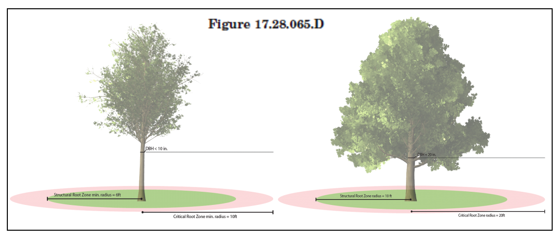
Tree Protection Zone. A tree protection zone shall be established around each retained tree, tree preservation area, and natural area, as required, as shown in Figure 17.28.065.D. The tree protection zone shall be comprised of two distinct areas.
a.
The structural root zone (SRZ) is to be determined by measuring one-half foot per each inch of tree diameter at breast height. If the SRZ is less than six feet, then the SRZ shall be a minimum of six feet.
1.
No area within the SRZ shall be disturbed or modified.
b.
The critical root zone (CRZ) shall be directly adjacent to the SRZ and is to be determined by measuring one foot per each inch of tree diameter at breast height. If the CRZ is less than ten feet, the protection zone shall be a minimum of ten feet.
1.
The configuration of the CRZ may be adjusted up to twenty percent upon approval of planning or codes staff, as applicable. This may include pre-existing site conditions such as structures, foundations, or utilities. It may also include tree characteristics such as species and tolerance to stress and construction activities.
[2.
Reserved.]
3.
Development Prohibited within the Tree Protection Zone. All development activities shall be prohibited within the tree protection zone provided for any protected trees, including any construction of buildings, structures, paving surfaces, and storm-water retention/detention ponds. All temporary construction activities shall also be prohibited within tree protection areas, including all digging, concrete washing, storage of construction material, and parking of construction vehicles.
4.
Development Prohibited within the Natural Areas. All development activities shall be prohibited within any tree protection zone established for a natural area preserved in open space pursuant to Section 17.12.090 Conservation Development.
5.
Fencing of Tree Protection Zone or Natural Area Open Space. Prior to the commencement of grading or construction, the developer shall enclose the entire tree protection zone or natural area open space within a fence as follows:
a.
Chain link fencing at least four feet in height and secured using appropriate posts spaced not more than ten feet apart.
b.
During construction, each tree protection zone shall be identified with temporary signs to clearly demarcate the extent of the zone. Signs shall be made of a recyclable material and installed on the tree protection fence, visible on all sides of the fenced-in area at a rate of at least one sign for every one hundred linear feet. The size of each sign must be a minimum of two feet by two feet and shall contain the following language in English and Spanish: "TREE PROTECTION ZONE: KEEP OUT. ZONA DE LA PROTECCION DEL ARBOL. NO SE PERMITE ENTRAR". The owner shall maintain the protective barrier during the entire construction process and shall make certain that it is observed by the contractor.
c.
The location of tree fence shall be coordinated with any required silt fence. Tree fence shall be located toward the tree with the silt fence outside to prevent erosion inside a tree preservation area.
d.
Tree fence shall be maintained until applicable staff has completed a final inspection and released the project. For the purposes of this section, "applicable staff" means the urban forester or staff designated by the urban forester.
6.
Tree Protection Zone Encroachment.
a.
Utility Excavation. Excavating or trenching shall not be permitted within the tree protection zone. Utilities shall be located away from the tree protection zone. If trees are damaged or destroyed during excavation or trenching, the damaged or destroyed trees shall be replaced in accordance with Section 17.28.065. Placing of utilities through the use of tunnelling may be permitted with approval from planning or codes staff, as applicable. Applicable staff may propose rules and regulations governing and/or limiting utilities in the tree protection zone.
b.
Sodding and Groundcover. Placement of sod or other groundcovers and the preparation of the ground surface for such covers shall be permitted within the tree protection zone, so long as tree roots in the area are not damaged by the method of preparation.
c.
Tree Care. Pruning of branches or roots or removal of dead limbs on a tree/s located within the tree protection zone shall be permitted. An ISA certified arborist shall be required to supervise all operations related towards tree care. All tree care activities shall be done without the use of heavy machinery or vehicles within the tree protection zone. Prior to tree care activities, planning or codes staff, as applicable, shall be informed in writing.
7.
Inspections.
a.
All retained trees, pursuant to a tree survey, shall be inspected by applicable staff one year following completion of the project to ensure that they are surviving in a healthy condition.
b.
Retained trees which require replacement shall be determined by planning or codes staff, as applicable.
c.
Any retained tree which is damaged during construction, or with damage occurring as a result of construction, shall be replaced as provided in Section 17.28.065. Trees planted to replace damaged or removed protected trees shall not be counted toward the site TDU.
d.
The owner shall be notified in writing of staff's determinations.
8.
Tree Protection Violations.
a.
Civil penalties shall be assessed in the event of injury, damage, or removal of trees within the tree protection zone. Penalties shall be assessed at fifty dollars per violation, per day. Each tree, in which a violation occurred, shall be considered an individual violation. No notice of violation shall be required prior to the assessment of civil penalty pursuant to this subsection.
b.
In the event disturbance occurs, all trees within the tree protection zone shall no longer be counted for TDU requirements unless an assessment has been provided by an ISA certified arborist and approved by applicable staff.
c.
Any injury, damage, or removal of tree shall be determined as removal without a permit and shall be replanted in accordance with Section 17.28.065.
d.
A site shall be considered in compliance with the submittal of a revised landscape plan and planting deadline approved by planning or codes staff, as applicable. In the event that replacement trees are not planted by the agreed-upon deadline, civil penalties previously assessed shall resume until final inspection of replacement trees.
E.
Less Desirable Trees. The urban forester shall compile a list of plants which are considered less desirable in the area of the metropolitan government. Upon adoption following public hearing and comment by the metropolitan planning commission, such list shall have the force and effect of regulation. The metropolitan beautification and environment commission, upon advice of the tree advisory board, may add or delete trees from such list from time to time following public hearing. Once such list of less desirable plants is duly adopted, the plants included therein may not be used to satisfy the requirements of Section 17.28.065.C, except as specifically permitted therein. Use of such trees in excess of the requirements of sections listed above is not prohibited.
(Amdt. 1 to Ord. BL2024-687 § 2, 2025; Ord. BL2024-687 § 2, 2025; Ord. BL2022-1122 § 11, 2022)
17.28.070 - Purpose and intent.
The operational performance standards included in this article are intended to protect the health, safety and welfare of the citizens of Metropolitan Nashville and Davidson County by regulating potential hazardous or nuisance characteristics of land uses permitted by this title.
(Ord. 96-555 § 7.2(A), 1997)
17.28.080 - Applicability.
A.
In case of conflict between the operational performance standards set forth herein and any rules or regulations adopted by any other applicable governmental agency, the more restrictive shall apply.
B.
When an existing land use or structure is expanded, enlarged or otherwise reconstructed after the effective date of the ordinance codified in this title, the applicable performance standards shall apply to the expanded, enlarged or reconstructed portion, with the exception of undergrounding utilities; see Section 17.28.103 of this chapter.
C.
The following performance standards are regulated by other codes:
1.
Title 10, Chapter 10.56 of the metro code (Air Pollution Control) regulates smoke, particulate matter, demolition and odors, and is administered by the metropolitan health department.
2.
Title 10, Chapter 10.64 of the metro code (Fire Prevention Code) regulates fire, hazardous materials, and explosive hazards, and is administered by the metropolitan fire marshal.
D.
The following activities are exempt from the operational performance standards of this article:
1.
Temporary construction, excavation and grading;
2.
Demolition activities which are necessary and incidental to the development of facilities on the same lot, on another of several lots being developed at the same time, or on the public right-of-way or easement for a community facility.
(Ord. BL2005-628 § 2, 2005; Ord. 96-555 § 7.2(B), 1997)
17.28.090 - Reserved.
17.28.100 - Lighting.
A.
Definitions Specific to this Section. When used in this chapter, the following words and terms shall have the meanings ascribed to them in this section. In the event of a conflict between a definition in this section and Section 17.04.060, the definition in this section will control.
"Ambient lighting" means the general overall level of lighting in an area.
"Architectural lighting means outdoor lighting directed at buildings, facades, structures, monuments, and other architectural features.
"Canopy" means a roofed structure with at least one side open for pedestrian and/or vehicle access that typically provides protection from the sun or weather and is associated with providing goods or services.
"Commercial" means any lot, however zoned, in any zoning district that does not have as its primary use a single-family or two-family residential dwelling or land used for agricultural purposes.
"Correlated color temperature (CCT)" means measured in degrees Kelvin (K), the absolute temperature of a blackbody whose chromaticity most nearly resembles that of the light source. For the purpose of this section, "CCT" is used as a simplified way to characterize the spectral properties of a light source and estimate the overall appearance of the light to the human eye.
"Floodlight" means a light designed for lighting a scene or object to a luminance greater than its surroundings.
"Foot-candle" means a unit of measure of illuminance equal to one lumen of light spread over an area of one square foot.
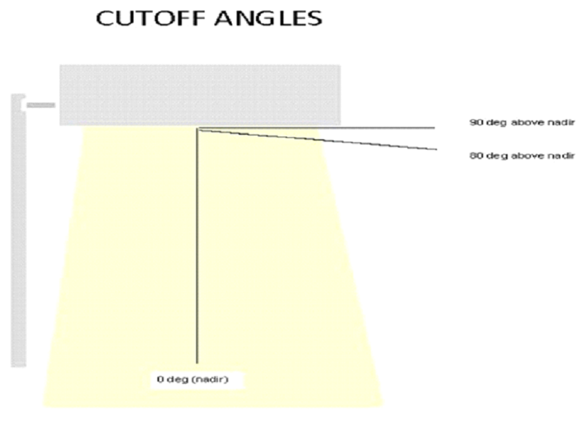
"Full cutoff luminaire" means a luminaire having zero intensity at or above horizontal (90°) and limited to a value not exceeding ten percent of lamp lumens at or above eighty degrees. Such luminaire is determined by a photometric test and certified by the manufacturer. See diagram below:
"Glare" means lighting entering the eye directly from luminaires or indirectly from reflective surfaces that causes visual discomfort or reduced visibility.
"IES" means Illuminating Engineering Society of North America.
"Illuminance" means the total luminous flux incident on a surface, per unit area.
"Illuminance grid plot" means a photometric report indicating the average horizontal illumination delivered to each of the squares of a gridded area illuminated by one or more luminaires.
"Initial lumen" means the measurement of a lamp's lumen output at the time the lamp is burned for the first time. As a light ages, the amount of light produced is reduced.
"Installed height" means the height above grade of the lowest light emitting point of an installed luminaire.
"ISO foot-candle plots" means a plot that graphically represents a particular luminaire's lighting pattern, in illuminance, as the light strikes a horizontal surface. It includes foot-candle calculations shown with the luminaire at various mounting heights. Contour lines are drawn through illuminance values.
"Kelvin" means a unit increment of temperature used as a color temperature scale of a light bulb (see definition of "correlated color temperature (CCT)" in this section).
"LED (light emitting diode)" means an electronic semiconductor device that emits light when an electrical current is passed through it.
"Lamp" means the source of light being emitted from a luminaire, such as a bulb, LED, and/or a refractive pane.
"Light" means electromagnetic radiation within a range of wavelengths sufficient for visual perception by the normal unaided human eye.
"Light level" has the same meaning as Illuminance.
"Light output" means luminous flux (see definition of "luminous flux" in this section). The amount of light which is emitted by a lamp or luminaire.
"Light pole" means a pole on which a luminaire is mounted.
"Light spill" means unwanted transmission of light onto adjacent areas that may affect sensitive receptors such as residential properties or ecological sites.
"Light trespass" means light that falls on property other than that of the owner of the light source.
"Lighting installation" means an arrangement of one or more luminaires including any mounting hardware, brackets, and supporting structures.
"Lighting plan" means an overall plan that describes the outdoor lighting.
"Lumen" means a unit of measure of luminous flux.
"Luminaire, light luminaire" means the complete lighting assembly (including the lamp(s), housing, ballasts, photocells, globes, reflectors or refractors, lenses, sensors and shield(s) and excluding the support assembly or pole, mounting bracket and base) consisting of one or more lamps, together with the attachment parts designed to distribute light, position and connect the lamp to the power supply.
"Luminous flux" means the power emitted from a source of electromagnetic radiation, such as a light bulb, in the form of visible light. Luminous flux is measured in lumens and is typically specified by the manufacturer for a given lamp or luminaire.
"Municipal stadium" means a structure:
1.
With seats for not less than thirty thousand spectators;
2.
Constructed after July 7, 1977;
3.
Used primarily for sporting events and other related activities; and
4.
Currently financed or was financed by general obligation bonds, revenue bonds or other indebtedness issued by the metropolitan government or the sports authority.
"Nadir" means the direction pointing directly downward from the light source of the luminaire that originates from a horizontal plane at the lowest point on the luminaire. See diagram above.
"Neon light" means colored fluorescent or gas discharge tubular which can be bent into various forms for use decoratively or as signs.
"New construction," subject to the exemption described in subsection 4 of this definition, means:
1.
Site preparation for, and construction of, entirely new structures (including new poles) and subsequent replacement of such new structures or any part thereof.
2.
Enlargement of any existing structure by the more restrictive of fifty percent of the area of the footprint of the building or fifty percent of the gross square footage of such existing structure (regardless of the number of other structures on the same site).
3.
Adding new exterior lighting fixture(s), pole(s) or other amenity(ies) to existing structure(s) or pole(s) to which such fixture(s) were or are to be attached.
4.
New construction does not mean the replacement of lamps in lighting fixtures, poles, or other amenities that existed prior to the passage of this ordinance.
"Open space and open space lot" means a parcel of land in a predominately undeveloped condition that is protected from development.
"Organized sporting event" means a prearranged sports or recreational event involving at least one group or team with a roster and schedule.
"Outdoor lighting" means light generated from an indoor or outdoor source that provides illumination to any exterior surface, building, sign, structure, device, or other outdoor feature (including land) which is visible to an observer located outdoors. For the purposes of this section, the light source inside an internally illuminated sign is not considered outdoor lighting.
"Photometric plan" means a technical plan that will indicate light distribution and the performance of lighting fixtures. It will explain the distribution of the proposed lighting and its effects on the area surrounding the site.
"Playing field" means an open outdoor field or court used for, but not limited to, playing sports such as baseball, soccer, football, tennis, volleyball, and basketball.
"Residential" means any zoning lot in a residential or agricultural zoning district that has as its primary use a single-family home or duplex.
"Street lighting" means one or more luminaires or light installations designed to illuminate a private roadway or intersection.
"Sidewalk lighting" means free-standing lighting for the illumination of sidewalks and walkways.
"Uplighting" means lighting applications which direct light above a horizontal plane.
B.
Application of Provisions. This section shall be applicable to the following lighting applications:
1.
Residential and Agricultural: All exterior lighting, excluding freestanding floodlights, is subject to subsection E.4 only. Freestanding floodlights shall be subject to subsections E.1.d, E.2, and E.4.
2.
Commercial: For new construction only and the subsequent maintenance of all new construction: any outdoor lighting luminaire.
3.
Public Utility Rental Lighting: Security lighting installed by the local public utility through a rental program is subject to Sections D, E1,E2, and F.
C.
Exempt Outdoor Lighting. The following lighting is exempt from the provisions of these outdoor lighting regulations for new construction in any zoning district as of the effective date hereof, provided such activities are permitted by this title:
1.
Temporary lighting for theatrical, television, performance areas and construction sites, specifically excluding upward-facing searchlights used to advertise the location of an event.
2.
Lighting that is otherwise required for a life-safety purpose within the Metropolitan Code.
3.
Lighting that is only erected or used under emergency conditions.
4.
Lighting located within the following Downtown Code Subdistricts: Core Historic, Core, Upper Broadway, 2nd and Broadway, SoBro, except that such lighting shall be subject to the provisions of subsections D.3., D.4., and D.5. of this section.
5.
Lighting located at a Municipal Stadium, except that such lighting shall be subject to the provisions of subsections D.3. and D.5. of this section. However, the provisions of D.5. shall not be applicable during an event, game, performance or other organized function at the municipal stadium.
6.
Lighting on property owned by the Metropolitan Nashville Airport Authority and lighting otherwise required by the Federal Aviation Administration.
D.
Prohibited Outdoor Lighting. The following lighting shall not be permitted for new construction in any zoning district as of the effective date hereof:
1.
Strobe lights and laser lights, including laser light shows and aerial laser lights.
2.
Flashing lights unless temporarily triggered by a security system and extinguished within thirty minutes or at a time of security response.
3.
Any lighting luminaire that is construed as or confused with a traffic signal or traffic control device.
4.
Lighting that contributes to or causes disabling or distracting glare onto a public roadway.
5.
The use of uplighting, except when lighting a flag or other government endorsed symbol.
E.
Illumination Standards:
1.
Light Intensity and Uniformity:
a.
The maximum illuminated surface light level at any point outdoor parking lots, automobile convenience stations and drive-in/drive-through canopies is ten foot-candles, measured horizontally at ground level.
b.
The total installed initial luminaire lumens of all exterior lighting systems on the site shall not exceed the allowed total initial site lumens. The allowed total initial site lumens shall be the sum of 7,000 base lumens for all entrances and facades plus 2.5 lumens per square foot of hardscape.
c.
As an alternative to compliance with the foregoing provisions of this section, an applicant may choose to comply with The International Dark Sky Association (IDA) model legislation of June 2011 (located at https://www.darksky.org/wp-content/uploads/bsk-pdf-manager/16_MLO_FINAL_JUNE2011.PDF.) except no special permit referenced in section VI.B of the model legislation shall be required. For special uses outlined in section VI.B of the model legislation that cannot comply with the technical requirements, a letter from an engineer licensed with the State of Tennessee shall be submitted to the department of codes administration confirming that the project has sustained reasonable effort to mitigate the effects of light on the environment and surrounding properties, supported by a signed statement describing the mitigation measures. Lighting zones in the model legislation shall correlate to the Transect Category for the site as designated in the Community Plans of NashvilleNext as follows:
d.
Light Direction and Control. Lighting applications shall meet the following requirements:
2.
Correlated Color Temperature (CCT): All lighting sources, except for public playing fields and lighting on public property necessary for the proper functioning of security cameras, must have a correlated color temperature (CCT) at or below three thousand degrees Kelvin (3000° K).
3.
Permitted Hours of Outdoor Lighting:
a.
Commercial: No more than fifty percent of exterior lighting shall be permitted to be illuminated, or lighting shall be dimmed by thirty percent illuminance except for one hour before start of business, during regular business hours as determined by said business, and one hour following close of business unless exempt for safety or security concerns. Motion detectors may be used to restore lighting to one hundred percent for safety. All outdoor lighting shall be turned off during daylight hours.
b.
Property Used for Governmental and Public Purposes: Any zoning lot in any zoning district used for governmental or public purposes, except for street lighting, shall comply with the permitted hours and security lighting limitations for commercial lighting zones. Outdoor lighting of the playing field of an organized sporting event on public property may remain illuminated until one hour after the conclusion of an event.
4.
Light Trespass:
a.
All site lighting shall be shielded so that substantially all directly emitted light falls within the property line. No illumination in excess of one-half foot-candle shall be permitted across the boundary of any adjacent residential property or the mid-line of a public street.
b.
No illumination shall produce direct, incident or reflected light that interferes with the safe movement of motor vehicles on public streets. Lighting prohibited by this provision shall include, but not be limited to any light that may be confused with or construed as a traffic-control device.
c.
Rope lighting shall not be used on a building, sign, or any property with non-residential zoning located adjacent to an arterial or collector street as identified on the Major and Collector Street Plan. This provision shall not apply to properties zoned as DTC.
F.
Luminaire Standards:
1.
Full Cutoff Requirement: All lighting regulated by this chapter shall be full cutoff.
2.
Photocell/Timer Requirement for Parking Lot Lights: Parking lot lighting shall include photocells or timers as needed to regulate the hours of operation as required by this chapter and to prevent operation during daylight hours.
3.
Canopy Requirement: All canopies must be skirted with a skirt depth of eight inches or greater or use other means to limit light spill to within ten feet of the area covered by the canopy.
G.
Procedural Requirements:
1.
Plan Submission: For land development, redevelopment and new zoning applications where outdoor lighting is proposed, prior to final approval by Metro Plans Inspection a letter from an engineer licensed with the State of Tennessee shall be submitted to the department of codes administration confirming that the plan complies with the requirements of this section. Engineer review shall be based on the following information:
a.
A site plan complete with all structures, parking spaces, building entrances, traffic areas (both vehicular and pedestrian), vegetation that might interfere with lighting, and all adjacent uses. The site plan shall show and identify the location of each existing and proposed luminaire and shall specify its installed height, pole foundations, and method of mounting.
b.
Iso-foot-candle plots for individual lighting installations, or ten feet by ten feet illuminance grid plots for multi-luminaire lighting installations which shall demonstrate compliance with all applicable requirements set forth in this chapter. The plots shall indicate the location of each existing and proposed luminaire, the installed height of said luminaires, and the overall light levels in foot-candles and initial lumens on the entire zoning lot and at the property lines.
c.
A summary table identifying the maximum and minimum light levels in foot-candles and initial lumens for all, but not limited to, parking areas, street or building entryways, signs, street lighting, canopies, architectural lighting and walkways.
d.
A description of each luminaire identified in the site plan including, but not limited to:
i.
Manufacturer with website.
ii.
Lamp type.
iii.
Bulb type including CCT (Kelvin).
iv.
Model number.
v.
Photograph or catalog cut.
vi.
Photometric plan.
vii.
Light output in initial lumens.
viii.
Shielding or glare reduction devices.
ix.
Energy reduction and on/off control devices.
2.
Post Approval Alterations: Post approval alterations to lighting plans or intended substitutions for approved lighting equipment shall be submitted to the zoning inspector after review by a qualified engineer at the expense of the applicant and approval prior to issuance of an use and occupancy permit, with all plan submission requirements set forth in this chapter, prior to installation.
3.
Inspections: The department of codes administration shall have the right to conduct a post installation inspection to verify compliance with the requirements of this chapter and, if appropriate, to require remedial action within thirty days at the expense of the applicant.
4.
Violations of this chapter shall be punishable as provided by Chapter 17.40, Article XIII of the Metropolitan Code.
5.
Variances: Variances to the requirements of this chapter may be granted by the board of fire and building code appeals as provided in Chapter 2.80 of the Metropolitan Code.
(Ord. BL2022-1088 §§ 2, 3, 2022; Ord. BL2021-974 § 1, 2021; Amdt. 2 to Ord. BL2020-535 § 2, 2021; Ord. BL2020-535 § 2, 2021; Ord. BL2017-903 § 2, 2017; Ord. BL2013-403 § 1, 2013; Ord. 96-555 § 7.2(D), 1997)
17.28.101 - Air pollution control.
In all districts, all material storage and manufacturing activities must comply with the air pollution regulations contained in Chapter 10.56 "Air Pollution Control" of the Metropolitan Code of Laws and the regulations adopted pursuant thereto by the metropolitan health department, pollution control division.
(Amdt. 1 with Ord. 98-1268 § 1 (part), 1998)
17.28.102 - Storage capacity of flammable and combustible liquids, liquid gases and gases.
Table 17.28.102
STORAGE CAPACITY OF FLAMMABLE AND COMBUSTIBLE LIQUIDS,
LIQUID GASES, AND GASES
In the table below, all storage amounts are based on up to two acres of land. Properties of over two acres may increase the allowable storage provided in the table by an equal percentage of property in excess of two acres.
All storage of flammable liquids, liquid gases or gases must be referred to the metropolitan fire marshal for a determination that the storage will comply with the Metropolitan Fire Code, as amended, prior to issuance of a permit.
(Ord. BL2019-111 § 1(Exh. A, § 38), 2020; Ord. BL2015-1153 § 15, 2015; Amdt. 1 with Ord. 98-1268 § 1 (part), 1998)
17.28.103 - Underground utilities.
A.
Applicability. These standards shall apply to any application for residential development submitted to the metropolitan government for approval, wherein a new public or private street is to be constructed now or in the future, or where an existing public or private stub street, is to be extended, as follows:
1.
Any application for a new or amended preliminary planned unit development;
2.
Any new or amended preliminary SP plan;
3.
Any new or amended preliminary urban design overlay district; or
4.
Any new or revised preliminary subdivision plat; and in the case of a proposed revised preliminary plat, these provisions shall only apply to those plats deemed to be a major modification by the executive director of the metro planning department, as provided in the Subdivision Regulations.
B.
Utility Services.
1.
A public utility easement shall be provided along all public and private streets and alleys by the property owner.
2.
All public and private utility services installed shall be underground, including the conduit (raceway) from service equipment, except as provided in subsections C, D, and F of this section. Such conduit (raceway) shall be placed underground to the curbline and/or utility right-of-way, including but not limited to, electric, telephone, communication, exterior lighting and television cable.
3.
Related equipment excluding electric utility meters shall be above ground, preferably within the furnishing zone between the curb and sidewalk, within the public utility easement, or within the required street setback; electric utility meters shall be above ground, not located within the required street setback, and located on or within three feet of the serviced structure unless otherwise expressly required by the power supplier for safety and access purposes. Equipment placed in the street right-of-way shall be subject to all applicable laws and ordinances.
C.
Previously Approved Streets and Utilities. Where a subdivision abuts an existing public or private street, or one shown on an approved final plan with an overlay district, recorded final plat, or on the Metropolitan Government Official Street and Alley Map, then no undergrounding shall be required of existing utilities or new utilities proposed along that existing portion of the public or private street, unless underground utilities already exist.
D.
Exemptions. The following items shall be exempt from complying with the provisions of this section.
1.
Any residential lot or parcel greater than forty thousand square feet in size.
2.
Above-ground utility equipment installed, maintained, and utilized by utility companies for a period not to exceed thirty days in order to provide emergency utility services. The time limitation may be extended, if warranted, by the metro planning commission.
3.
Utility equipment utilized exclusively for street lighting purposes.
4.
Utility equipment utilized exclusively for vehicular and pedestrian traffic control purposes.
5.
Utility equipment appurtenant to underground facilities and which meet the requirements of subsection (B)(3) of this section, such as service-mounted, pedestal-mounted, or pad-mounted transformers, terminal boxes, meters, cross boxes, cabinets, vaults, electronic enclosures, pedestals, flush-to-grade hand holes, splice closures.
6.
Temporary utility equipment utilized or to be utilized exclusively in conjunction with construction projects, seasonal, or special event installations. Upon installation of permanent utility service, above-ground service shall be removed.
7.
Fire hydrants, fireplugs, and other utility equipment utilized exclusively for firefighting purposes.
8.
Overhead wires attached to the exterior surface of a building by means of a bracket or other fixture and extending from one location on the building to another location on the same building, or to an adjacent building or to the alley, without crossing any public street.
9.
Antennas, associated equipment and supporting structures, used by a utility for furnishing communication services.
10.
Electrical distribution lines on major streets as shown on the Major Street Plan, electrical transmission lines, or switch gear.
11.
Equipment installed by the utility which should not be installed underground for engineering, safety, or environmental regulatory reasons.
12.
Utility lines where severe disruption of existing improvements, diminished quality of service, or undue difficulty in repair would occur. Such exemption shall require the review and approval of the metropolitan planning commission.
13.
Utility lines where an affected adjoining property owner will not consent to modification of easements. Such exemption shall require the review and approval of the metropolitan planning commission.
E.
Variance. A property owner and/or developer may appeal to the board of zoning appeals indicating why undergrounding utilities are not feasible in accordance with the procedures set forth in Section 17.40.350 of this Code. The board shall not act upon such a request without first receiving a recommendation from the metropolitan planning commission, as provided in Section 17.40.340 of this Code.
F.
Alleys. Where a subdivision proposes alleys, utilities may be located above or below ground in these alleys. If utilities are located above ground, then all utilities serving the proposed lots shall be placed in the alleys, except any street light system. Utilities connecting one alley to another alley may cross a public or private street above ground.
G.
Property Owner Responsibility. The property owner and/or developer installing, requesting, or requiring the construction of the improvement, and not the metropolitan government or the utility, shall be responsible for the cost of placing utility lines underground and shall make the necessary arrangements with the serving utility companies. The utility shall have no obligation to underground facilities unless and until it receives full payment for costs to do so.
H.
Non-Conforming Utility Equipment. Any utility equipment approved or installed and operating prior to the effective date of the ordinance codified in this section may be maintained in its present condition and may be upgraded to conform to new technologies and regulatory requirements.
I.
Existing City Franchises Not Affected. The provisions of this section do not waive any right enjoyed by the metropolitan government with respect to any franchisee, nor waive the obligations created by any franchise. If any provision of this section conflicts with any provision of a franchising agreement or ordinance, said franchise provision shall control. The provisions of this section likewise are not intended to create any conflict with the rights granted pursuant to T.C.A. §§ 65-21-201, et seq. and 65-21-107.
J.
Relationship to Other Requirements. In case of conflict between the standards of this section and any other standards, rules, or regulations adopted by any other applicable metropolitan government department or agency, the provisions of this article shall control.
K.
Severability. If any portion of this section is held to be invalid or unconstitutional by any court of competent jurisdiction, such holding shall not affect any other portion of this section.
(Ord. BL2022-1581 § 2, 2023; Ord. BL2018-1403 § 1, 2019; Ord. BL2005-628 § 3, 2005)
17.28.104 - Compliance certification.
In all districts, any request for a zoning permit for manufacturing or other uses shall be accompanied by a certification from a licensed registered professional engineer of the state which states that the proposed activity can comply with the applicable performances standards. If the zoning administrator has reasonable belief that a violation may occur despite the opinion of the engineer, then the zoning administrator, may reject the application, citing the reasons.
(Amdt. 1 with Ord. 98-1268 § 1 (part), 1998)