
Nashville City Zoning Code
CHAPTER 17
12 - DISTRICT BULK REGULATIONS
17.12.010 - Purpose and general provisions.
A.
Purpose and Intent. The purpose of this chapter is to establish appropriate standards relating to the size and placement of structures within each of the zoning classifications created by this title in order to assist in the achievement of the goals established in the general plan for the development of the community.
B.
General Provisions. The required specifications for lot area, residential density, floor area ratio (FAR), impervious surface ratio (ISR), setbacks, building heights and separation between buildings are specified in this chapter on the basis of zoning district classification. Lots shall be created, and building and zoning compliance permits shall be issued only in compliance with these bulk regulations.
(Ord. 96-555 § 3.1, 1997)
17.12.020 - District Bulk Tables.
The bulk standards of this code are established by the District Bulk Tables of this section. The standards contained in these tables apply uniformly to all uses within the same zoning district classification, with the exception of uses that are permitted with conditions (PC), as special exceptions (SE) in the district land use table of Section 17.08.030 or as provided in the Downtown Code (Chapter 17.37), which may have higher standards. Alternative standards may be imposed by any planned unit development, historic or urban design overlay district as long as the standards are consistent with the purpose and intent of the overlay district.
A.
District Bulk Table 17.12.020A establishes the bulk requirements for one-family and two-family dwellings in residential districts.
B.
District Bulk Table 17.12.020B establishes the bulk requirements for multifamily and nonresidential structures in residential districts.
C.
District Bulk Table 17.12.020C establishes the bulk requirements for all structures in AG, mixed-use and nonresidential districts.
D.
District Bulk Table 17.12.020D establishes the bulk requirements for all structures in the alternative zoning districts for multi-family, mixed-use, office and commercial.
Table 17.12.020A
SINGLE-FAMILY AND TWO-FAMILY DWELLINGS
Note 1: For all zoning districts permitting multi-family uses, the rear and side setbacks for single-family cottage developments shall be a minimum of three feet. This note shall not apply to the DTC district.
Note 2: When a right-of-way dedication is required for an existing lot or parcel along an existing street that meets the minimum lot area or could be subdivided into two or more lots that would each meet the minimum lot area for the zoning district prior to the dedication of right-of-way, the minimum lot area shall be considered to be the area prior to the dedication. The newly created lots shall meet all other bulk standards of the Zoning Code based on the dimensions after the dedication of the right-of-way.
Note 3: Single-family and two-family dwellings in the RM9-A, RM9-A-NS, RM15-A, RM15-A-NS, RM20-A, RM20-A-NS, RM40-A, RM40-A-NS, OR20-A, OR20-A-NS, OR40-A, OR40-A-NS, ORI-A, ORI-A-NS, MUN-A, MUN-A-NS, MUL-A, MUL-A-NS, MUG-A, MUG-A-NS, MUI-A, and MUI-A-NS shall use the build-to zone standards listed in Table 17.12.020D.
Note 4: In addition to the height restrictions in [Section] 17.12.060, the height of two detached dwelling units on a single lot cannot exceed a ratio of 1.0 horizontal to 1.5 vertical for each structure. Maximum height shall be measured from the natural grade. The natural grade shall be determined based on the average elevation of most exterior corners of the front facade, to the roof line. Natural grade is the base ground elevation prior to grading. The appropriate height shall be determined by the metro historic zoning commission for properties within a historic overlay. Notwithstanding the above provisions, two-family structures legally constructed prior to the effective date of this ordinance may remove the connector required under the previous definition of two-family, regardless of the height of the units.
Note 5: In RS3.75-A, RS5-A, RS7.5-A, R6-A and R8-A districts, the following standards shall apply:
a. Access and Driveways.
1. Where existing, access shall be from an improved alley only. Where no improved alley exists, one driveway within the street setback may be permitted.
2. For a corner lot, the driveway shall be located within thirty feet of the rear property line.
3. Parking, driveways and all other impervious surfaces in the required street setback shall not exceed twelve feet in width.
b. Garages.
1. Detached. The front of any detached garage shall be located behind the rear of the primary structure. The garage door of a detached garage may face the street.
2. Attached. The garage door shall face the side or rear property line.
c. A minimum raised foundation of 18—36" is required.
Table 17.12.020B
MULTIFAMILY, MOBILE HOMES AND NONRESIDENTIAL USES
Note 1: Street setbacks are listed in Table 17.12.030A and 17.12.030B.
Note 2: No maximum FAR applies to multifamily developments in the RM15, RM15-NS, RM20, RM20-NS, RM40, RM40-NS, RM60, RM60-NS, OR20, OR20-NS, OR40, OR40-NS districts.
Note 3: Within the urban zoning overlay district, any attached townhomes or rowhouses with alley access to required off-street parking, may have a zero-foot side setback (1) on internal lot lines between units, or (2) where the side of a unit is adjacent to an area having a minimum width of ten feet that is shown on the final site plan as an open space area or a required landscape buffer yard, provided that each unit has a private yard and no more than eight units are contained in any single-structure. This note shall not apply to the DTC district.
Note 4: [Reserved.]
Note 5: [Reserved.]
Note 6: Within the urban zoning overlay district, any proposed development that does not meet the setback standards within this table may apply for a special exception as provided for in Sections 17.12.035.A and 17.12.035.D. This note shall not apply to the DTC district.
Note 7: When a right-of-way dedication is required for an existing lot or parcel along an existing street that could be subdivided into two or more lots that would each meet the minimum lot requirements for the zoning district prior to the dedication of right-of-way, the minimum lot area shall be considered to be the area prior to the dedication. The newly created lots shall meet all other bulk standards of the Zoning Code based on the dimensions after the dedication of the right-of-way.
Note 8: In RS3.75-A, RS5-A, RS7.5-A, R6-A and R8A districts, the following standards shall apply:
a. Access and Driveways.
1. Where existing, access shall be from an improved alley only. Where no improved alley exists, one driveway within the street setback may be permitted.
2. For a corner lot, the driveway shall be located within thirty feet of the rear property line.
3. Parking, driveways and all other impervious surfaces in the required street setback shall not exceed twelve feet in width.
b. Garages.
1. Detached. The front of any detached garage shall be located behind the rear of the primary structure. The garage door of a detached garage may face the street.
2. Attached. The garage door shall face the side or rear property line.
c. A minimum raised foundation of 18—36" is required.
Table 17.12.020B.1
MINIMUM LOT SIZE AND SETBACKS FOR ATTACHED HOUSING
Table 17.12.020C
MIXED-USE AND NONRESIDENTIAL DISTRICTS
Note 1: [Reserved.]
Note 2: Floor area bonuses are available (1) for the MUI and MUI-NS districts, and (2) within the urban zoning overlay district, for all mixed-use districts (See Section 17.12.060).
Note 3: Street setbacks are listed in Table 17.12.030B.
Note 4: For properties located within an adopted Redevelopment District an alternative standard for the maximum allowable building height at a setback line may be established as part of an adopted Redevelopment District plan.
Note 5: Development standards shall be as specifically listed in the site specific SP ordinance.
Note 6: Within the urban zoning overlay district, any proposed development that does not meet the setback standards within this table may apply for a special exception as provided for in Sections 17.12.035.A and 17.12.035.D.
Table 17.12.020D
MULTI-FAMILY, MIXED USE AND NONRESIDENTIAL ALTERNATIVE ZONING DISTRICTS
Note 1: The area of any parcel dedicated as right-of-way as part of a related development process may be used to calculate FAR or density for the applicable property. No maximum FAR applies to multi-family developments in the RM9-A and RM9-A-NS thru RM40-A and RM40-A-NS and OR20-A, OR20-A-NS, OR40-A, OR40-A-NS, ORI-A, ORI-A-NS districts.
Note 2: Within the urban zoning overlay district, any attached townhomes or rowhouses with alley access to required off-street parking, may have a zero-foot side setback (1) on internal lot lines between units, or (2) where the side of a unit is adjacent to an area having a minimum width of ten feet that is shown on the final site plan as an open space area or a required landscape buffer yard, provided that each unit has a private yard and no more than eight units are contained in any single-structure.
Note 3: Alternative zoning districts shall have the following standards apply to the location of a building and its associated parking:
a. Sidewalks shall be constructed to the standard of the Major and Collector Street Plan or, if on a local street, to local street standards. The build-to zone for alternative zoning districts shall be measured from the Standard right-of-way line as established by the table entitled "Standard Street Right-of-Way Widths" in the Major and Collector Street Plan. Streets included in the Major and Collector Street Plan are not eligible for the in-lieu fee in Section 17.20.120.D.
b. A parcel located at the intersection of two public streets shall have a building occupy the corner of the parcel that is bounded by the two intersecting public streets subject to the "Notes" of this table, which apply to both frontages.
c. A primary entrance to the building shall be located along the building façade within the build-to zone.
d. Street Level Parking Decks. Parking decks located at street level shall have no less than seventy-five percent of the lineal street frontage devoted to office or nonparking commercial uses, or in districts that only permit residential uses, residential uses at a minimum depth of twenty feet. A minimum of fifty percent of that wall area shall be glazed. That floor area shall be excluded from the calculation of floor area ratio.
e. The zoning administrator may allow necessary adjustments to the build-to zone when existing utilities or utility easements are within the build-to zone and unusual circumstances require that the utilities cannot be relocated or easements reduced. Upon allowing an adjustment to the build-to zone, the zoning administrator may also allow adjustments to the rear setback and landscape buffer yard as authorized by Table 17.24.230, to provide for a necessary building area. The zoning administrator may allow necessary adjustments to the build-to zone, rear setback and landscape buffer yard based on the nature of the existing and future land uses and site conditions in the general vicinity after receiving a written recommendation from the planning department and any relevant department or agency.
f. For first floor residential uses, a minimum raised foundation of 18—36" is required.
g. Glazing on the first floor of any public street frontage shall be a minimum of forty percent for nonresidential uses and a minimum of twenty-five percent for residential uses. Glazing on the upper floors of any public street frontage shall be a minimum of twenty-five percent.
h. In the UZO:
i. Where an improved alley exists, primary vehicular access shall be taken from the alley.
ii. Any unimproved alley abutting the property that would provide direct access to an improved alley or street shall be constructed as the primary vehicular access.
iii. A parcel that is sixty feet wide or greater shall have the front facade of the building extend across at least sixty percent of the parcel's frontage.
iv. A parcel less than sixty feet wide shall have the building's front facade extend across the full width of the parcel in mixed-use, office and commercial districts.
v. If an improved alley is not present or required, an opening of up to twenty-six feet wide shall be permitted, regardless of the requirements of subsections iii and iv above.
vi. Parking shall be permitted only at the sides and rears of buildings.
i. Outside of the UZO:
i. The front facade of the building shall extend across at least forty-five percent of the parcel's frontage or the building front façade shall be at least twenty-five feet in width, whichever is greater.
ii. A maximum of one module of parking (two rows and a drive aisle) shall be permitted
between the building and the street.
(Ord. BL2021-796 §§ 1—5, 2021; Ord. BL2019-111 § 1(Exh. A, §§ 7—15), 2020; Ord. BL2017-684 § 1, 2017; Ord. BL2015-1153 §§ 4, 12, 13, 15, 2015; Ord. BL2014-770 § 2, 2014; Ord. BL2013-567 § 1, 2013; Amdt. 1 to Ord. BL2012-183 §§ 1, 3, 2012; Ord. BL2012-183 §§ 1—3, 2012; Ord. BL2011-27 § 1, 2011; Ord. BL2011-898 §§ 7, 11, 2011; Ord. BL2009-586 § 1(Exh. A, §§ 10—14), 2010; Amdt. 1 to Ord. BL2006-1047, § 1, 2006; Ord. BL2006-1047 § 1, 2006; Ord. BL2006-971 §§ 2, 4, 2006; Ord. BL2005-762 § 4, 2005; Amdt. 2 to Ord. BL2005-712, 2005; Amdt. 1 to Ord. BL2005-712, 2005; Ord. BL2005-712 § 1, 2005; Ord. 2002-1010 § 1, 2002; Ord. BL2001-675 § 1 (part), 2001; Ord. BL2000-364 § 1 (part), 2000; Ord. 99-1641 § 1, 1999; Amdt. 1 with Ord. 99-1617 § 1, 1999; Ord. 99-1615 § 1 (part), 1999; Ord. 98-1268 § 1 (part), 1998; § 1(5), (6) of Amdt. 1 with Ord. 96-555 § 3.2, 1997)
17.12.030 - Street setbacks.
A.
Measurement: For single and two-family lots the street setback shall be measured from the street right-of-way line. For multi-family and non-residential districts and non-residential uses in the R/R-A, RS/RS-A, AR2a and AG districts the minimum street setback shall be measured from the Standard right-of-way line as established by the table entitled "Standard Street Right-of-Way Widths" in the Major and Collector Street Plan.
B.
Street Classifications. All street classifications are as established in the "Subdivision Regulations of the Metropolitan Government of Nashville and Davidson County" and the "Major and Collector Street Plan" as adopted by the metropolitan planning commission.
C.
Street Setbacks.
1.
The minimum setback of a structure from an adjacent street shall be established by the following tables according to the zoning of the property and the classification of the street.
2.
When the rear setback of a corner lot is oriented towards the rear setback of a neighboring lot, the required street setback along the street common to those two lots may be reduced by fifty percent. A corner residential lot created by plat prior to the effective date of the ordinance codified in this chapter may reduce the required setback of Table 17.12.030A by fifty percent along that street running parallel with the side of the residential structure. Lots zoned R20, RS20, R30, RS30, R40, RS40, R80, and RS80 shall be excluded from this subsection C.2 and shall provide the full required street setback of Table 17.12.030A for both streets; detached two-family residential uses within these zoning districts shall provide the full required contextual street setback for both streets.
3.
In residential areas with an established development pattern the following standards shall apply:
a.
The minimum required street setbacks for the R, RS and MHP districts shall be the average setback of the four nearest single-family or two-family houses on the same block face that are oriented to the same street and that follow the established development pattern.
b.
When there are fewer than four single-family or two-family houses on the same block face that are oriented to the same street and that follow the established development pattern, then the minimum required street setback shall be the average setback of all single-family or two-family houses on the same block face that are oriented to the same street and that follow the established development pattern.
c.
The existence of an established development pattern shall be determined by the zoning administrator who has the discretion to exclude any property that has a setback disproportionate to the other houses on the block face.
d.
When there are no other single-family or two-family houses on the same block face, oriented to the same street and that follow the established development pattern, then the value provided in Table 17.12.030A shall determine the setback.
e.
In the MUN and MUL districts, the average street setback of existing structures along the same block face may be applied to new construction on that block, if determined appropriate by the zoning administrator to maintain or reinforce an established form of character of development.
4.
When a subdivision plat establishes a reservation of land for future right-of-way acquisition, the street setback shall be measured from the ultimate right-of-way line.
5.
Double frontage lots are subject to the provisions of Section 17.24.060(B). Property abutting a street designated as a scenic arterial by the major street plan shall comply with the provisions of Section 17.24.070.
6.
The front facade of a principal structure on a corner lot that has lot lines of unequal length abutting the streets shall be oriented to the shorter lot line, except where the zoning administrator determines that the longer lot line is more appropriate based on one or more of the following criteria:
a.
The longer lot line of a lot zoned for office, mixed-use, commercial, or industrial use is located along an arterial street as shown on the adopted major street plan;
b.
The proposed structure will contain multiple businesses with outside entrances;
c.
The predominant character or pattern of adjoining development is or will be oriented to the street on which the longer lot line is located.
d.
The previous principal structure on a residential lot was oriented to the street on which the longer lot line is located.
7.
The front facade of all single-family principal structures constructed within the RS20, RS15, RS10, RS7.5, RS5, RS3.75, R20, R15, R10, R8, and R6 zoning districts shall face a public or private street unless the property is within a redevelopment district or zoning overlay that specifically includes a design review process to evaluate the appropriateness of an individual alternative front facade location.
Table 17.12.030A
STREET SETBACKS FOR SINGLE AND TWO-FAMILY STRUCTURES
(1) Two-family dwellings with any parking proposed between the street line and the front edge of the residential structure shall provide a minimum street setback of thirty feet.
(2) Lots having vehicular access to these streets shall develop in a manner which avoids back-up movements into the public street.
Table 17.12.030B
STREET SETBACKS FOR MULTI-FAMILY AND NON-RESIDENTIAL DISTRICTS; AND
NON-RESIDENTIAL USES IN AG, AR2A, R/R-A AND RS/RS-A DISTRICTS
Note 1: SP Districts. Street setbacks shall be as specifically listed in the site specific SP ordinance.
Note 2: Properties abutting a street designated as a scenic arterial by the Major and Collector Street Plan shall comply with the provisions of Section 17.24.070. This note shall not apply to the DTC district.
Note 3: In no event shall any street setback provisions permit a principal building to be constructed within an area designated for street improvements on a major street plan adopted subsequent to the effective date of this note.
Note 4: The above street setback standards shall not apply within the Alternative Zoning Districts.
Note 5: For attached housing developed under Section 17.12.110, the minimum street setback shall be three feet from the right-of-way line but shall not vary by more than 20 percent from the standards set in Section 17.12.030.C(3). This note shall not apply to the DTC district.
Note 6: Within the urban zoning overlay district, any proposed development that does not
meet the setback standards within this table may apply for a special exception as
provided in Sections 17.12.035.A and 17.12.035.D. This note shall not apply to the
DTC district.
(Ord. BL2024-346 § 2, 2024; Amdt. 1 to Ord. BL2023-1691 § 1, 2023; Ord. BL2023-1691 §§ 1, 2, 2023; Amdt. 1 to Ord. BL2022-1270 § 1, 2022; Ord. BL2022-1270 § 1, 2022; Ord. BL2019-111 § 1(Exh. A, §§ 16, 17), 2020; Ord. BL2015-1153 §§ 15, 16, 2015; Ord. BL2014-725 § 1, 2014; Ord. BL2011-898 §§ 8, 9, 2011; Ord. BL2011-897 §§ 5—10, 2011; Ord. BL2009-586 § 1(Exh. A, §§ 15, 16), 2010; Amdt. 1 to Ord. BL2006-1047, § 2, 2006; Ord. BL2006-1047 § 2, 2006; Ord. BL2006-971 § 3, 2006; Ord. BL2005-762 §§ 5, 6, 2005; Ord. 2002-1013 § 1, 2002; Amdt. 1 with Ord. 2002-1012 § 1, 2002; Ord. 2001-858 § 1, 2001; Ord. BL99-117 § 1 (part), 2000; Ord. 98-1268 § 1 (part), 1998)
17.12.035 - Street setbacks within the urban zoning overlay district.
A.
This section establishes street setbacks within the mixed use, office, industrial, RM20, RM20-NS, RM40, RM40-NS, RM60, RM60-NS, or commercial zone districts for any property located within the urban zoning overlay district regardless of the minimum street setback requirements described in Tables 17.12.030A and 17.12.030B whenever one or more of the conditions listed below applies (1—4). However, in all districts, a principal or accessory structure may be located closer to the street or property line than as permitted by this section or by Tables 17.12.020B, 17.12.020C, and 17.12.030B based on the review and approval of a Special Exception by the Board of Zoning Appeals as provided in [subsection] 17.12.035.D below. The standards of this subsection shall not apply within the alternative zoning districts.
1.
The setback of a principal building, fronting the same street, that is located on an abutting lot or a lot separated by an intervening public street or alley does not meet the minimum requirements of Tables 17.12.030A or 17.12.030B;
2.
In the case of a corner lot, the setback of a principal building located on any other corner lot at the same street intersection does not meet the minimum requirements of Tables 17.12.030A or 17.12.030B;
3.
In the case of a corner lot, there is no principal building located on any other corner lot at the same street intersection;
4.
Two-thirds or more of the principal buildings located along the same or opposite block face do not meet the minimum requirements of Tables 17.12.030A or 17.12.030B; or
5.
The owner of one or more contiguous lots that collectively include at least one corner lot and at least fifty percent or more of the street frontage along either block face furnishes the zoning administrator a written request to use the contextual street setback requirements.
B.
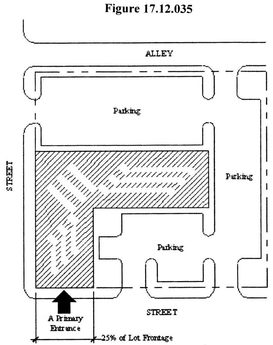
The determination of the appropriate street setbacks within mixed use, office, industrial, RM20, RM20-NS, RM40, RM40-NS, RM60, RM60-NS, or commercial zone districts located within the urban zoning overlay district shall be made by following the criteria as outlined in subsection C of this section. For the purposes of this section, lots that are sixty feet wide or greater shall have the front façade of the building extend across at least twenty-five percent of the lot frontage or be at least twenty-five feet in width, whichever is greater. Lots that are less than sixty feet wide shall have the building extend across the full width of the lot in mixed use and commercial districts unless a driveway is required to access required parking, except that one or two family dwellings may have side yards a minimum of three feet in width. If a driveway is needed for service to accessory parking, an opening of up to twenty-six feet wide shall be permitted. Parking shall be permitted only at the sides and rears of buildings, and at the fronts of the buildings to the extent shown in Figure 17.12.035. A primary entrance to the building shall be located at the front setback line. The front façade may have projections and recesses to accommodate columns, entrances, covered patios, and similar features. The standards of this subsection shall not apply within the alternative zoning districts.
C.
The following criteria shall be used to determine the street setback, as applicable. The standards of this subsection shall not apply within the alternative zoning districts.
1.
If the site is within a zoning overlay district, redevelopment district or an area having a design plan adopted by metropolitan council that includes a master plan or design guidelines for the placement of buildings at this location such guidelines shall apply.
2.
If the site is not within an area having an adopted design plan, master plan or design guidelines and the building types and setbacks of existing buildings are characteristic of development under a different zoning district than what the property is currently zoned and that implementation of the current zoning will change the development character within the district (e.g., the existing development is one- or two-family dwellings and the zoning is for multi-family dwellings), then the setbacks from Section 17.12.030 (Street Setbacks) shall apply.
3.
If neither subsection (C)(1) nor (C)(2) applies, then the site shall comply with these contextual setback provisions. Setbacks shall be determined as follows:
a.
Use of buildings and site features as context:
i.
Consistency with like building type. Lots with buildings of the same building type as proposed are to be used as the contextual basis for street setbacks. Lots with buildings of a different building type are not to be used as the contextual basis for street setbacks unless it can be demonstrated that the pattern of setbacks for both building types is fundamentally the same within a radius of five hundred feet. Civic buildings are not to be used as the contextual basis for street setbacks of non-civic buildings. Likewise, non-civic buildings are not to be used as the contextual basis for civic buildings.
ii.
The determination of the appropriate street setback may take into account the presence of recorded easements or utility obstructions that prevent meeting any of the criteria above.
b.
Contextual criteria:
i.
Street setbacks shall be consistent with the predominant pattern of street setbacks of pre-1950 buildings (built before 1950) located within a distance of three lot widths along both sides of the same or intersecting street frontages, as applicable. If the predominant pattern is consistent with the setback requirements of the base zoning district, then Table 17.12.030A or Table 17.12.030B shall apply as applicable.
ii.
If the lot is a corner lot, street setbacks shall be consistent with the street setbacks of any pre-1950 building that previously occupied the same corner lot. If that information is not available, street setbacks shall be consistent with the street setbacks of any pre-1950 building located on any of the other corner lots at the same intersection.
iii.
If there are no pre-1950 buildings located on adjacent or nearby lots, street setbacks shall be consistent with the pattern of street setbacks shown at that location on record maps dating from 1950 or earlier.
D.
Special Setback Regulations for All Uses (Excluding Single-Family and Two-Family Dwellings) Within the Urban Zoning Overlay District:
1.
In all districts, a principal or accessory structure may be located closer to the street or property line than as permitted by this section or by Tables 17.12.020B, 17.12.020C, and 17.12.030B based on the review and approval of a Special Exception by the Board of Zoning Appeals.
2.
An applicant shall provide evidence to the board as provided in Section 17.12.060.F.3 that the proposed building setbacks shall not create an adverse impact on adjacent properties nor detract from a strong pedestrian-friendly environment.
3.
The board shall consider a recommendation from the historic zoning commission and planning commission as provided in Section 17.12.060.F.4.
(Ord. BL2019-111 § 1(Exh. A, § 18), 2020; Ord. BL2011-898 § 10, 2011; Amdt. 1 to Ord. BL2006-1047, §§ 3, 4, 2006; Ord. BL2006-1047 §§ 3, 4, 2006; Ord. BL2004-221 § 1 (part), 2004)
17.12.040 - Other setbacks.
Within the DTC zoning district, see Chapter 17.37 for permitted encroachments into setback areas.
A.
Railroads. In the IWD, IR and IG districts, no side or rear setback shall be required along a lot line adjacent to an operative railroad track.
B.
Setbacks for Irregular-Shaped Lots. Wherever a lot is of such irregular shape that the setback provisions cannot be readily applied, the zoning administrator shall interpret the application of the setback provisions.
C.
Party Walls. The side setback requirements may be waived when attached dwelling units are subdivided for sale along common party walls in the RM and mixed-use districts.
D.
Building Separation. In the RM districts the minimum distance between two buildings on the same lot shall be ten feet or the minimum required by the building code, whichever is greater.
E.
Permitted Setback Obstructions. The following structures or building components may be located within required setbacks. Except for screening walls, fences and hedges, the following features shall not be permitted within a required landscape buffer yard.
1.
Accessory buildings.
a.
Accessory buildings with a footprint of seven hundred square feet or less and located to the rear of a principal structure shall provide a minimum side setback equal to one-half of that required for the zoning district, but not less than three feet, and a minimum rear setback of at least three feet, except when garage doors or carport openings face or open directly to an alley, in which case the minimum rear setback shall be ten feet. Accessory buildings with a footprint of more than seven hundred square feet shall provide the full setbacks of the zoning district;
b.
Above ground swimming pools or in-ground swimming pools that extend more than twelve inches above ground level and are located to the rear of a principal structure shall provide a minimum side setback equal to one-half of that required for the zoning district, but not less than three feet. In-ground swimming pools that extend above ground level less than twelve inches shall provide a minimum setback of three feet;
2.
Arbors and trellises;
3.
Awnings, patio covers, or canopies projecting not more than six feet from a building wall over a required setback;
4.
Chimneys projecting not more than three feet into the required setback, and not exceeding two percent of the overall setback area provided that a minimum setback of three feet to any property line shall be provided;
5.
Clothes poles or clothes lines in rear setbacks of residential districts;
6.
Within the urban zoning overlay district, covered or enclosed porches, between thirty inches and eight feet in height above grade, in the side and rear setback areas (but not closer than three feet from the property line);
7.
Curbs and sidewalks;
8.
Eaves, gutters or downspouts, projecting into or over required yards not more than twenty-four inches;
9.
In nonresidential districts, elevated pedestrian walkways that cross lot lines or public ways;
10.
Fire escapes or staircases, the riser of which shall be at least fifty percent open, subject to the following conditions:
a.
In residential districts the encroachment may be up to three feet into the required yard as long as a minimum setback of two feet from the property is maintained,
b.
In mixed-use and nonresidential districts, the total area of stairway coverage shall not exceed thirty percent of the area of such required yard;
11.
Flagpoles having only one structural ground member;
12.
Fountains;
13.
Heating, ventilation and air conditioning units (including compressors and condensers) for single-family or two-family dwellings, provided exhaust air is directed vertically or otherwise away from the adjacent property line;
14.
Mailboxes;
15.
Open terraces, including natural plant landscaping;
16.
Open, uncovered stoops, including handicap ramps;
17.
For single family or duplex uses, parking spaces for the handicapped;
18.
Recreational equipment in the rear setback in residential districts;
19.
Sculpture or other similar objects of art;
20.
Signs, subject to the provisions of Chapter 17.32;
21.
Steps to the principal entrance and necessary landings, together with a railing no more than three feet high, and extending no more than six feet into the setback;
22.
Street furniture such as benches, drinking fountains, trash receptacles (not dumpsters), ash trays, light standards or directional signs. Dumpsters may encroach on the required rear setback;
23.
In-ground swimming pools extending twelve inches or less above ground level in side or rear setback areas;
24.
Trees, shrubs, flowers, hedges or other features of natural growth;
25.
Vehicular parking areas and associated driveways, except within landscape buffer yards or within the required street setback of the MUN, MUN-NS, MUL, MUL-NS, OR20, OR20-NS and OR40 districts;
26.
Screening Walls or Fences. The maximum permitted height measured from finish grade level on the side of the wall or fence with the greatest vertical exposure shall be:
a.
Two and one-half feet in height within ten feet of a street right-of-way. Open fences, such as chain link or those of a similar nature are permitted to be six feet in height. Electric fences are permitted only within the IWD, IR and IG districts and shall be no more than ten feet in height, subject to the provisions of Section 16.04.200,
b.
Six feet in height within the remainder of the required front setback. Electric fences are permitted only within the IWD, IR and IG districts and shall be no more than ten feet in height, subject to the provisions of Section 16.04.200,
c.
Eight feet in height within the required side or rear setback or within any platted common open space. Electric fences are permitted only within the IWD, IR and IG districts and shall be no more than ten feet in height, subject to the provisions of Section 16.04.200;
27.
An uncovered deck that is located at least ten feet from the rear property line, does not encroach on required side setbacks and has a maximum deck elevation no greater than the average finished first floor elevation of the principal building as established by the front entrance;
28.
Wells;
29.
Utility transmission lines and associated structures, such as poles, provided that electric utility meters shall not be permitted in the required street setback unless expressly required by the power supplier for safety and access purposes;
30.
Satellite dishes not exceeding eighteen inches in diameter; and,
31.
Yard and service lighting fixtures and poles.
32.
Covered front porches in residential districts extending no more than six feet into the required street setback, provided that the following are met:
a.
The porch shall not be enclosed,
b.
There shall be no enclosed space above the porch or enclosed habitable space below the porch,
c.
The porch shall be located at least ten feet from the right-of-way.
F.
Reserved.
(Ord. BL2023-79 §§ 1, 2, 2024; Ord. BL2022-1581 § 1, 2023; Ord. BL2022-1346 § 3, 2022; Ord. BL2019-111 § 1(Exh. A, § 19), 2020; Ord. BL2017-898 §§ 1—3, 2017; Ord. BL 2009-586 § 1(Exh. A, § 17), 2010; Ord. BL2006-1283 § 3, 2007; Ord. BL2006-1087 § 2, 2006; Ord. BL2005-650 § 1, 2005; Ord. 2002-1015 § 1 (part), 2002; Ord. 2000-364 § 1 (part), 2000; Ord. 98-1268 § 1 (part), 1998; amended during 2-98 supplement; Ord. 96-555 § 3.4, 1997)
17.12.050 - Accessory building floor area controls.
A.
On all lots with a size of less than forty thousand square feet, the building coverage of an accessory structure located to the rear of the principal dwelling and complying with the district setbacks shall be limited to seven hundred square feet or fifty percent of the building coverage of the principal dwelling, whichever is greater, but in no case shall exceed two-thousand five-hundred square feet.
B.
These floor area controls shall not apply to accessory structures proposed on lots where agricultural activities and domestic animals/wildlife are permitted.
(Ord. BL2005-650 § 1, 2005; Ord. 2002-1015 § 1 (part), 2002)
17.12.060 - Building height controls.
A.
Height Controls Established. No building or other structure shall penetrate the height control plane except as permitted by this section. Height controls shall be imposed from:
1.
All setback lines in AG, AR2a and residential districts;
2.
All street setback lines in nonresidential districts;
3.
The boundary between an AG, AR2a, RS and RS-A, R and R-A, RM or MHP district and a nonresidential district;
B.
Special Height Regulations for Single-Family and Two-Family Dwellings. Single-family and two-family dwellings shall not exceed three stories. On all lots with a lot size less than forty thousand square feet, accessory structures shall not exceed one story or sixteen feet in height. On all lots with a size with forty thousand square feet or more, accessory structures located to the rear of the principal dwelling may be two stories or twenty-four feet in height provided that the full side and rear setbacks required by the applicable district are provided. If not so established in historic overlay districts, the zoning administrator shall establish height regulations based upon the recommendation of the historic zoning commission.
C.
Special Height Regulations for Single-Family and Two-Family Dwellings Within the Urban Zoning Overlay District.
1.
Single-family and two-family dwellings shall not exceed three stories to a maximum height of forty-five feet. Maximum height shall be measured from either the finished grade or, if present, from the ceiling of an exposed basement not more than seven feet above the finished grade. Finished grade shall be determined based on the average elevation of the four most exterior corners of the structure, to the eave or roof deck. Finished grade is the final ground elevation.
2.
On all lots with a size less than forty thousand square feet, an accessory structure located to the rear of the principal dwelling may have vertical walls rising no higher than sixteen feet from the side and rear setback lines. The roof on the structure shall rise from the side walls at a roof pitch no steeper than the predominant roof pitch of the principal dwelling, except that the vertical walls may extend to the underside of the roof at the gable end of a gabled roof. The top elevation of an accessory structure shall not exceed the top elevation of the principal dwelling.
3.
On all lots with a lot size of at least forty thousand square feet, an accessory structure located to the rear of the principal dwelling may have vertical walls rising no higher than twenty-four feet in height exclusive of a pitched roof, provided that the full side and rear setbacks required by the applicable district are provided. The top elevation of an accessory structure shall not exceed the top elevation of the principal dwelling.
If not so established by the design standards of an historic overlay district, the zoning administrator shall establish height regulations based upon the recommendation of the historic zoning commission.
D.
Permitted Height Obstructions. In the mixed-use and nonresidential districts, the following structures shall be exempt from the height control standards of this section.
1.
On-premises signs subject to the provisions of Chapter 17.32;
2.
Chimneys or flues;
3.
Elevator or stair bulkheads, roof water tanks, or cooling towers;
4.
Flagpoles;
5.
For religious institutions, ornamental towers, spires or belfries having no floor area within that portion of the tower exceeding the height limit or penetrating the height control plane;
6.
Parapet walls not more than four feet high.
E.
Special Height Restrictions Along Highways Designated Scenic Under T.C.A. Section 54-17-101 et seq.
1.
For purposes of this subsection D, the following terms shall have the meanings shown:
a.
"Coverage area" means the total surface area proposed to be covered by a structure.
b.
"Natural elevation" means the average elevation of the coverage area prior to grading, to be computed by dividing the sum of the elevations of points taken at twenty-five foot intervals around the perimeter of the coverage area by the total number of such points.
c.
"Measuring segment" means the full segment of scenic highway abutting the property on which the building is to be built.
d.
"Measuring segment elevation" means the average elevation of the measuring segment, to be computed by dividing the elevations of points taken along the centerline of the measuring segment at twenty-five foot intervals divided by the total number of such points.
e.
"Maximum building height" means the difference between the maximum elevation of a building, including any object to be affixed thereto, and the natural elevation.
2.
The "maximum building height" of any building to be built within three hundred feet of, and on a parcel of property abutting, a road designated a scenic highway by Tenn. Code Ann. Section 54-17-101 et seq., as amended, shall not exceed the following:
a.
For a building site having a natural elevation lower than the measuring segment elevation, maximum building height shall be no more than thirty-five feet higher than the measuring segment elevation.
b.
For a building site having a natural elevation higher than the measuring segment elevation, maximum building height shall be no more than thirty-five feet higher than the natural elevation.
F.
Special Height Regulations for All Uses (Excluding Single-Family and Two-Family Dwellings) Within the Urban Zoning Overlay District, but not including the DTC district:
1.
In all districts, a principal or accessory structure may exceed the maximum height at the setback line and/or penetrate the height control plane as shown in Tables 17.12.020B and 17.12.020C, or the maximum height in the build to zone for thirty percent of the façade fronting each public street and/or the maximum heights specified in Table 17.12.020D, based on the review and approval of a Special Exception by the board of zoning appeals.
2.
The top elevation of an accessory structure shall not exceed the top elevation of any principal building or structure located within the development.
3.
An applicant shall provide evidence to the board that the proposed building height shall not create an adverse impact on air, light, shadow, or wind velocity patterns due to the configuration of the building relative to the maximum permitted height standards (including height control plane) and its juxtaposition to, and with, existing structures in the vicinity, or approved, but not yet built structures. In addition, the applicant shall demonstrate that the proposed building height contributes to, and does not detract from, a strong pedestrian-friendly streetscape.
4.
The board shall consider a recommendation from the historic zoning commission, if the property is located within an historic overlay district, and a recommendation from the planning commission as provided in Section 17.40.300. The planning commission shall recommend on the proposed development's consistency with the goals, objectives and standards of any redevelopment district as well as the general plan, including any community, neighborhood or other design plan.
(Ord. BL2022-1346 § 4, 2022; Ord. BL2015-1153 §§ 16, 17, 2015; Ord. BL2015-1053 § 1, 2015; Ord. BL2012-183 § 4, 2012; Ord. BL2007-1431 § 1, 2007; Amdt. 1 to Ord. BL2006-1047, § 5, 2006; Ord. BL2006-1047 § 5, 2006; Ord. 2002-1015 § 1 (part), 2002; Amdts. 2, 8 with Ord. BL2000-364 § 1 (part), 2000; Amdt. 1 with Ord. BL2000-317 § 1, 2000; Amdt. 1 with Ord. 98-1268 § 1 (part), 1998; § 1(9) of Amdt. 1 with Ord. 96-555 § 3.5, 1997)
17.12.070 - Special floor area ratio (FAR) provisions.
A.
Plazas/Arcade Bonus. For properties located within the MUI, MUI-NS, MUI-A, MUI-A-NS district, a floor area development bonus is offered in return for the design and construction of pedestrian plazas and/or arcades that are accessible to the general public. Two categories of bonuses are offered to the property owner:
1.
Design Plan Plaza/Arcade Bonus. A property owner electing to construct a pedestrian plaza or arcade in strict accordance with the design standards established by an Urban Design Overlay district shall derive the following increase in building floor area based on each square foot of plaza or arcade area provided.
2.
Standard Plaza/Arcade Bonus. Properties not specifically designated by an urban design overlay district as qualifying for plaza and/or arcade bonuses under the provisions of subdivision (1) of this subsection, also may elect to provide a plaza and/or arcade in return for a floor area development bonus.
a.
For qualifying plazas and arcades, the provision of one square foot of plaza or arcade area shall yield the following increase in developable floor area:
b.
Design Criteria. To qualify for a standard plaza/arcade floor area bonus, the following design criteria shall be satisfied:
i.
Plazas.
(A)
The plaza shall provide a minimum depth of ten feet from the adjacent street and a minimum area of five hundred square feet.
(B)
The floor of the building located at plaza level shall provide individual establishments such as restaurants or retail sales that open directly to the plaza. Up to fifty percent of the plaza area may be utilized as a sidewalk cafe.
(C)
When feasible, pedestrian linkages shall be provided to plazas located on adjacent lots.
ii.
Arcades.
(A)
The arcade shall provide a minimum height of twenty-five feet and a minimum area of five hundred square feet.
(B)
The arcade shall be located within five feet of the average level of the street. The floor of the building located at arcade level shall provide individual establishments such as restaurants or retail sales that open directly to the arcade.
B.
Residential Bonus in the MUN and MUL Zoning Districts.
1.
For property located within the urban zoning overlay district and within the MUN, MUN-NS, MUN-A, MUN-A-NS, MUL, MUL-NS, MUL-A, and MUL-A-NS zoning district, in any building where at least twenty-five percent of the floor area (exclusive of parking) is designed and constructed for residential occupancy, a bonus value of 1.0 may be applied to the permitted FAR of the zoning district. This bonus floor area shall be utilized for residential uses only. This bonus floor area shall not be combined with any other bonus allowed under this section or Section 17.36.090.
2.
In any development that uses the floor area bonus of this section, the following uses shall be prohibited from the development:
a.
Short term rental property — Owner Occupied
b.
Short term rental property — Not Owner Occupied
C.
Exemption in the MUI, MUI-NS, MUI-A, MUI-A-NS District. In the MUI, MUI-NS, MUI-A, and MUI-A-NS district, leasable space that is located at street level with a minimum depth of twenty feet, which is occupied by uses that have individual access to the street such as, but not limited to, either a bar, restaurant or retail use, shall be excluded as floor area for the purpose of calculating floor area ratio. A minimum of fifty percent of each storefront shall be glazed window area. Also excluded as floor area:
1.
Below grade parking; and
2.
Above grade parking decks of flat plate type construction that provide no less than twelve feet floor to ceiling clearance and have architectural cladding.
D.
Parking Exemptions. In all districts the floor area used for the provision of off-street parking spaces or loading berths (and the driveways and maneuvering aisles for those spaces and berths) shall not be counted as floor area for the purpose of calculating floor area ratio when such spaces or berths are used to satisfy the parking demands for the principal use(s) on the parcel. When no parking is required, provision of off-street parking spaces shall not be counted as floor area for the purpose of calculating floor area ratio when such spaces or berths do not exceed the parking maximum set by the UZO District standard in Table 17.20.030.
E.
Street Level Parking Decks in the MUG, MUG-NS, ORI, ORI-NS, MUI, and MUI-NS Districts. Regardless of whether other special floor area ratio (FAR) provisions in this section are utilized, parking decks located at street level shall have no less than seventy-five percent of the lineal street frontage devoted to office or nonparking commercial uses at a minimum depth of twenty feet. A minimum of fifty percent of that wall area shall be glazed. That floor area shall be excluded from the calculation of floor area ratio.
F.
Parking Garage Liner Buildings. Within the CF, CF-NS, ORI, ORI-NS, ORI-A, ORI-A-NS, and all mixed-use districts, parking garages fronting a public street or public space may be masked by a liner building that is a minimum of twenty feet deep. The floor area of any liner building shall be excluded from the calculation of the floor area ratio, provided the following requirements are satisfied:
1.
The first twenty feet of depth of the liner building shall be occupied by office, residential, or other non-parking commercial uses.
2.
For non-residential uses on the first floor, a minimum of forty percent of the front facade of the first floor shall be clear or lightly tinted windows and doors. The first floor transparent glazing area calculation shall be measured from the finished grade at the setback to the finished floor elevation of the second floor, or to a height of sixteen feet, whichever is less. Upper floors, regardless of use, shall have a minimum of twenty-five percent of glazing to be eligible for square footage calculation exemption.
3.
For residential uses on the first floor, a minimum of twenty percent of the front facade of the first floor shall be openings. Openings shall be clear or lightly tinted windows or main entrance doors. The first floor opening area calculation shall be measured from the finished floor elevation of the first floor to the finished floor elevation of the second floor, or to a height of twelve feet, whichever is less. Upper residential floors shall have a minimum of twenty-five percent glazing to be eligible for square footage calculation exemption. Residential uses on the first floor shall have a minimum finished floor elevation one and one half feet above the finished grade at the setback.
The provisions of this subsection shall be enforced pursuant to the final site plan review procedures in Section 17.40.170.
(Ord. BL2022-1412 § 1, 2022; Ord. BL2021-797 § 1, 2021; Ord. BL2019-111 § 1(Exh. A, § 20), 2020; Ord. BL2015-1153 § 5, 2015; Ord. BL2012-183 § 5, 2012; Ord. BL2009-586 § 1(Exh. A, §§ 18—25), 2010; Ord. BL2007-36 § 1, 2007; Ord. BL2007-1531 § 2, 2007; Ord. BL2006-975 § 1, 2006; Ord. 2002-1015 § 1 (part), 2002; Ord. BL2000-364 § 1 (part), 2000; Amdt. 1 (part) with Ord. 99-1754 § 4, 1999; Ord. 96-555 § 3.6, 1997)
17.12.080 - Compact development.
A.
Purpose and Intent. Compact development is a set of alternative zoning standards that may be utilized in the design of residential subdivisions. It is the purpose of this section to provide for the health and welfare of residents by creating the opportunity for a diversity of housing and recreational opportunities by creating usable open space and allowing for a mixture of residential lot sizes.
Applicability. Subdivisions proposed in the R/RS and R/RS-A zoning districts where less than ten percent of the site contains any, or a combination of, the natural areas as defined in Section 17.12.090 and meet one of the following standards may utilize the provisions of this section.
1.
Proximal Option Minimum Site Area. Property located within 0.25 miles of any MCSP classified arterial or collector street shall have a minimum site area of no less than five times the minimum lot area for the base zoning district as established by Table 17.12.020A. For example, in the R10 district the minimum area for the subdivision would be fifty thousand square feet. (Ten thousand square feet minimum lot size times five.)
2.
Distal Option Minimum Site Area. Property located more than 0.25 miles of any MCSP classified arterial or collector street shall have a minimum site area of no less than ten times the minimum lot area for the base zoning district as established by Table 17.12.020A. For example, in the R10 district the minimum area for the subdivision would be one hundred thousand square feet. (Ten thousand square feet minimum lot size times ten.)
B.
Maximum Lot Yield. Eighty percent of the gross acreage shall be divided by the minimum lot size of the base zoning district to determine the maximum yield. For example, a one hundred thousand square foot RS5 zoned property shall only be permitted to have at most sixteen lots.
C.
Design Flexibility. In order to accomplish the purpose of this section, flexibility in lot sizes may be proposed in exchange for the creation of open space on the site according to the following standards:
1.
Utilization of the compact development shall result in the creation of open space. A minimum of fifteen percent of the site shall be placed in open space.
2.
Lot Size Flexibility.
a.
Subdivisions may reduce lots in size from the minimum required by the base zoning district an equivalent of two smaller zoning districts. For example, a subdivision in the R15 district may utilize the compact development standard to create lots equivalent in size to the R8 and R8-A district. In a similar fashion, a subdivision in the RS15 district may create lots equivalent in size to the RS7.5 and RS7.5-A district.
b.
If additional usable open space is provided, beyond the minimum requirement, a subdivision may reduce the minimum lot size by an equivalent percentage beyond the two-zoning district reduction.
i.
Subdivisions proposed in all R/RS districts where there are at least two smaller zoning districts, excluding RS7.5/RS7.5-A, RS5/RS5-A, and RS3.75/RS3.75-A may reduce their lot size no more than ten percent beyond the two-district district reduction with an additional dedication of ten percent useable open space (at least fifteen percent total useable open space), and shall be based on the reduced size zoning district. For example, if a subdivision in R10 utilizing the reduced lot size of the R6 district sets aside ten percent usable open space then the lot sizes may be reduced an additional five percent. The reduced lot size would be reduced from a minimum six thousand square feet lot to a minimum five thousand seven hundred square feet.
ii.
Subdivisions proposed in R8/R8-A districts may reduce lots in size from the minimum required by the base zoning district by an additional equivalent percentage of the site that is in usable open space, with a maximum additional reduction of twenty percent. For example, a subdivision in a R8 district utilizing the R6 lot standards that dedicates an additional twenty percent useable open space (at least twenty-five percent total useable open space) may reduce the lot size to four thousand eight hundred square feet.
iii.
Subdivisions in the R6/R6-A districts that have no district lot size reduction available, lots may be reduced in size by the equivalent percentage of the site that is in the open space, with a max reduction of thirty percent. For example, a subdivision in an R6 district dedicating an additional thirty percent useable open space (at least thirty-five percent total useable open space) may reduce lot size to four thousand two hundred square feet.
c.
No lot shall be reduced to less than three thousand seven hundred fifty square feet.
3.
Lots proposed for two-family dwellings shall meet the minimum lot size of the base zoning district (no reduction of lot area permitted) and shall comply with the standards of Section 17.16.030.D of this title.
4.
Development in hillside and floodplain areas shall follow those standards as set out in Chapter 17.40.
5.
Tree removal in a compact development shall follow the standards of Section 17.28.65 and Chapter 17.40.
6.
The standards for the review of critical lots as provided in the adopted subdivision regulations shall apply.
7.
The bulk standards and landscaping requirements of a comparable zoning district which most closely resembles the alternative lot sizes proposed for any given phase of development shall be employed for that phase of the subdivision, except for any standard that is addressed within this ordinance.
8.
Perimeter lots that are reduced in size from the minimum lot size requirements required by the base zoning district and are abutting a conventional R/RS subdivision shall be required to utilize a twenty-foot standard B landscape buffer yard, unless located within the Urban Zoning Overlay, as per Chapter 17.24 Article III landscape buffer yard requirements. If the perimeter lots meet the minimum size of the base zoning district, no landscape buffer yard is required.
a.
Landscape buffer yards shall be permitted within an access easement on individual lots, provided the easement connects to common open space that is accessible from the public right-of-way.
D.
Open Space Standards. The required fifteen percent open space of a compact development may contain usable open space and stormwater features as required and described in this section.
1.
Usable Open Space & Features. A minimum of five percent of a compact subdivision's total area shall be usable open space. One usable feature shall be installed for subdivisions containing between four and ninety-nine total residential units, plus an additional usable feature for every one hundred residential units, or portion thereof, in excess of the first ninety-nine units. Usable features shall not be located in regulatory no-disturb stormwater buffers or floodway as determined by metro water services. Any usable feature proposed to be located in floodplain shall not be fenced or contain impervious surfaces. Usable features, as approved by the Planning Commission or their designee, may include but are not limited to:
a.
Paved greenway trails or trailhead facilities identified in the Metropolitan Parks and Greenways Master Plan and located within publicly accessible greenway conservation easements to the benefit of the Metropolitan Greenways Commission or Metro Parks;
b.
Walking or bicycle trails;
c.
Reflective, passive recreation areas such as picnic shelters, gazebos, or shared docks;
d.
Playgrounds with benches and pedestrian scale lighting;
e.
Dog parks with benches and pedestrian scale lighting;
f.
Stormwater mitigation facilities such as bioretention, bioswale, or rain garden, designed as an amenity and provided in conjunction with other usable features mentioned in this section; a stormwater feature alone shall not count as usable open space;
g.
Other active recreational or play facilities including but not limited to paved game courts such as tennis, basketball, or volleyball courts, swimming pools, baseball/softball diamonds or other facilities;
h.
Historic or cultural sites with walkways and interpretive signage;
i.
Unstructured open play areas for practice or pickup games;
j.
Low impact recreation options (i.e. bocce ball, horseshoes, outdoor chess tables);
k.
Conservation of natural features as defined in Section 17.12.090.
2.
Stormwater Features. The following uses may count toward the open space stormwater feature component of this section:
a.
Required stormwater mitigation measures such as reforestation;
b.
Stormwater control measures, such as retention and detention basins, and other conventional stormwater facilities as approved by the planning commission, or their designee, and by metro water services.
3.
If a property is located within 0.25 miles of local, state, or federal park, no minimum useable open space is required; however, the compact development subdivision is required to have at least ten percent total open space. For the purpose of this section greenways shall not be considered parks.
4.
Compact development subdivisions shall attain a tree density factor of at least twenty-two units per acre using retained or replacement trees, or a combination of both.
5.
Regardless of whether sidewalks are installed, street trees shall be required on new and existing streets.
a.
If sidewalks are installed, street trees shall be planted within the grass strip/green zone for any sidewalk constructed, dependent on roadway classification and right-of way availability.
b.
If no sidewalks are installed, street trees are required to be located within the right-of-way, dependent on roadway classification and right-of way availability.
c.
Trees shall be installed according to the provisions of the Metro Nashville Street Tree Specifications prepared and maintained by metro water services in conjunction with Nashville Department of Transportation, Planning, and Codes.
d.
Street trees shall be chosen from the Urban Forestry Recommended Tree List. Canopy trees shall be installed, except where conflicts with overhead electrical powerlines exist. In those instances, understory trees may be substituted.
e.
Required street trees shall be depicted on a landscape plan. The landscape plan and specifications shall be prepared by, or under the direction of, and bear the seal of a professional landscape architect registered in Tennessee.
f.
Trees installed pursuant to this section shall be eligible for credit toward tree density required by Chapter 17.28 of this title.
6.
Configuration and Access. To the maximum extent practicable given the configuration, the open space shall be in a contiguous tract. When possible, usable open space shall be centrally located, directly accessible to the largest practicable number of lots within the subdivision, have street frontage and each lot shall be no more than one thousand three hundred twenty feet from usable open space as measured from the perimeter of the open space to individual lot lines. Non-adjacent lots shall be provided with pedestrian access to the usable open space via direct access or an access easement designated on the plat.
7.
Ownership and Management.
a.
Open space and street trees within a compact development shall be owned and maintained by an incorporated association for the mutual benefit of residents or property owners within the development and shall be adequately described on a recorded plat of subdivision approved by the planning commission. All property owners within a compact development subdivision shall be a member of the association which shall be responsible for the assessment of dues to cover the recurring costs of maintaining all open space areas and usable features. Articles of incorporation and bylaws shall be submitted and approved according to the subdivision regulations.
b.
In limited circumstances where the open space is identified on the Greenways Master Plan or within the Parks Master Plan, the developer may offer the open space for dedication to metro parks subject to approval and acceptance by metro parks board and metro council as appropriate.
c.
Open Space Management Plan. With the concept plan applicants shall submit a plan for the management of the open space, common open space, and street trees which allocates responsibility and guidelines for maintenance and operation of the open space and any facilities located within the open space areas. If the open space is restricted via a conservation easement in the favor of a bona fide land trust or other permanently established organization legally able to accept such easements, a stewardship plan or other management plan associated with the conservation easement may be provided in lieu of the open space management plan.
d.
Failure to maintain. When the failure of an association or other responsible party to properly maintain open space results in a public nuisance, the zoning administrator is empowered to initiate appropriate measures to eliminate the nuisance. If public funds are utilized to remove a nuisance and/or maintain open space, those costs shall be assessed proportionally against all property owners within the development in the form of a tax lien. This provision shall not apply to any open space that has been dedicated to and accepted by the metropolitan government.
E.
For the purpose of this section (17.12.080), a property shall be determined to be located within 0.25 miles of an Arterial Boulevard, Collector Avenue, or park when fifty percent or greater area of the subject site lies within a buffer when measured from the edge of right-of-way or site boundary.
F.
A property that is required to utilize Conservation Development, as stipulated by Section 17.12.090, that has since been modified to remove natural features after the adoption of this ordinance shall be prohibited from utilizing compact development as determined by staff.
1.
All agricultural uses, including but not limited to commercial nurseries, botanical gardens, tree farms and grove operations shall be exempt, but only as to those trees and sites which were planted or managed for silvicultural or agricultural purposes or for the sale or intended sale in the ordinary course of business.
2.
Any applicant that contests staff determination of the removal of natural features shall be required to provide an individual assessment that natural features disturbed or removed were done so prior to the adoption of this ordinance.
G.
Application Requirements.
1.
The subdivision concept plan (preliminary plat) shall clearly indicate that a compact development is proposed and shall be prepared in accordance with the procedures and requirements of the metro subdivision regulations.
2.
All submittals shall clearly show and label the required open space and usable open space and features documenting that these requirements have been met.
3.
Concurrent with the submittal of the concept plan, the applicant shall prepare and submit a site analysis map that identifies the natural areas as defined in Section 17.12.090. Documentation of, or determinations regarding the areas from appropriate metro, state or federal agencies or official maps or resources, if applicable, shall also be provided.
(Amdt. 1 to Ord. BL2023-120 § 2, 2024; Ord. BL2023-120 § 2, 2024; Ord. BL2015-1153 § 16, 2015; Ord. 2002-1015 § 1 (part), 2002; Ord. 96-555 § 3.7, 1997)
17.12.090 - Conservation development.
A.
Purpose and Intent. Conservation development is a set of standards that shall be utilized in the design of subdivisions as provided in this section. The purpose of these standards is to:
1.
Preserve unique or sensitive natural resources such as steep slopes; hillsides; streams, wetlands, floodways, and floodplains; problem soils; archaeological resources; and native forests or unique vegetation through the creation of natural open space.
2.
Encourage the creation of lots on less environmentally sensitive areas of the site.
3.
Provide flexibility in design of subdivisions within existing zoning districts to promote environmental resource protection.
B.
Applicability. Subdivisions proposed in the R/R-A and RS/RS-A zoning districts that meet both of the following standards shall utilize the provisions of this section.
1.
Minimum Site Area. The minimum site area of no less than ten times the minimum lot area for the base zoning district as established by Table 17.12.020A. For example, in the R10 district the minimum area for the subdivision would be one hundred thousand square feet. (Ten thousand square feet minimum lot size times ten).
2.
Minimum Natural Area. A minimum of ten percent of the site contains any, or a combination of, the following:
a.
Areas shown on FEMA maps as part of the 100-year floodplain or identified in local studies as confirmed by Metro Stormwater;
b.
All perennial and intermittent streams, floodways, and associated buffers, as determined by Metro Stormwater or the State;
c.
Areas of natural slopes of twenty percent or greater of at least ten thousand square foot contiguous area;
d.
Areas containing problem soils as established by Section 17.28.050; wetlands, as determined by metro stormwater;
e.
Habitat for federally or state listed or proposed rare, threatened, or endangered species;
f.
Areas containing a Cedar Glade environment as established by Section 17.28.060;
g.
Archaeological or historic sites, cemeteries, and burial grounds;
h.
Protected, heritage, and historic and specimen trees, as defined by Section 17.28.065 of the Metro Zoning Code; or
i.
For this section, the area calculated for protected, heritage, and historic and specimen trees, shall utilize the size of the tree protection zone, as defined within Section 17.28.065.
C.
Maximum Lot Yield. The determination of the maximum lot yield shall be based on assigning twenty percent of the gross acreage of the site to open space and infrastructure. The remaining eighty percent of the gross acreage shall be divided by the minimum lot size of the base zoning district to determine the maximum yield. Yield shall not be based on the minimum lot size as described in Section D Lot Size Flexibility.
D.
Conservation and Design Flexibility. In order to accomplish the purposes of this section, flexibility in lot sizes may be proposed in exchange for protection of the natural areas present on the site in natural open space according to the following standards:
1.
Conservation Areas:
a.
Subdivisions subject to the rural character subdivision regulations shall follow the procedures of those regulations for identification and protection of primary conservation lands in natural open space. In no case shall the standards of this section be construed to lessen the requirements for protection of primary conservation lands as identified in the rural character subdivision regulations or establish a lower minimum open space threshold for such developments. If less than twenty percent of the site is primary conservation land, then trees, if applicable, as specified in Section 17.12.090.B.2 shall be included as natural area required to be preserved in open space.
b.
All other subdivisions shall set aside as natural open space those portions of the site containing natural areas for purposes of conserving those resources according to the following:
i.
If less than or equal to twenty percent of the site contains these natural areas, then the entire area shall be set aside in natural open space.
ii.
If more than twenty percent of the site contains natural areas, then a minimum of twenty percent of the site shall be set aside as natural open space.
The applicant is encouraged, but not required, as part of this chapter, to set aside areas of common open space in excess of twenty percent in exchange for additional design flexibility.
2.
Common open space may be provided for other purposes besides protection of natural areas, but such open space shall not contribute to the flexibility of lot sizes afforded by this section.
3.
Lot Size Flexibility:
a.
Subdivisions subject to the rural character subdivision regulations may reduce lots in size from the minimum required by the base zoning district by equivalent percentage of the site that is in the natural area protected in natural open space and such lots shall be reduced in lot area no more than the equivalent minimum lot size of two smaller base zoning districts. For example, a rural character subdivision in a RS20 district with twenty percent natural open space may create lots reduced in size by twenty percent. On a similar RS20 site with sixty percent natural open space, lots may be reduced the equivalent in size to a RS10 district, but no smaller.
b.
All other subdivisions may reduce lots in size from the minimum required by the base zoning district by equivalent percentage of the site that is in the natural area protected in natural open space. For example, on a site zoned RS15 with ten percent of the site set aside as natural open space, the lots may be reduced in size by ten percent, or to a minimum of thirteen thousand five hundred square feet in area. On a site zoned RS15 with thirty-five percent of the site set aside as natural open space, the lots may be reduced in size by thirty-five percent, or to a minimum of nine thousand seven hundred fifty square feet.
4.
In no case shall the minimum lot size be reduced below three thousand seven hundred fifty square feet.
5.
Lots proposed for duplexes must meet the minimum lot size of the base zoning district (no reduction in area permitted) and shall comply with the standards of Section 17.16.030.D of this title.
6.
Development in hillside and floodplain areas shall follow those standards as set out in Chapter 17.28. If the natural area preservation required in those sections is greater than the area required here, then that chapter shall prevail. In no case shall the required natural area preservation be less than that required in this section.
7.
Tree preservation or removal proposed in a conservation development shall follow the standards of Section 17.28.065. If the tree or natural area preservation required in that section is greater than the area required here, then the requirements of that section shall prevail. In no case shall the required natural area preservation be less than that required in this section.
8.
The standards for the review of critical lots as provided in the adopted subdivision regulations shall apply.
9.
The bulk standards and landscaping requirements of a comparable zoning district which most closely resembles the alternative lot sizes proposed for any given phase of development shall be employed for that phase of the subdivision.
10.
A standard C landscape buffer yard as per Chapter 17.24 Article IV Landscape Buffer Yard Requirements shall be required along the perimeter of the development when perimeter lots are reduced in size from the minimum lot size required by the base zoning district. If all perimeter lots meet the minimum size of the base zoning, no landscape buffer yard is required.
E.
Natural Open Space. Open space provided for the purposes of protecting natural areas and in exchange for flexibility of design, as described above, shall be called natural open space and subject to the standards below. These standards are not applicable to common areas or open spaces that may be provided for other purposes.
1.
All natural open space provided in accordance with this section shall be platted with the first phase of development that includes any lots utilizing alternative lot sizes as provided for above and shall be identified on the plat as protected natural open space. Consideration shall be given to the timing of platting of natural open space for large developments that contain natural area located in a portion of the site that may be inaccessible to the first phases of development.
2.
Clearing, grading or disturbance of natural open space shall be prohibited, except for essential infrastructure. Roadways and other essential utilities necessary to serve the development may be permitted to cross a natural open space provided that this development minimizes impacts to this area. Preliminary grading and construction plans that demonstrate the limits of disturbance, feasibility of construction and overall impacts to the area at a level of detail beyond that normally required at the concept plan (preliminary plat) phase shall be required prior to approval of a plan incorporating such infrastructure. The portion of the natural open space that must be disturbed to accommodate essential infrastructure shall not contribute toward the required minimum natural open space or flexibility of lot size afforded by the previous section.
3.
Protected natural open space shall be located and identified in the field by the applicant prior to the issuance of a tree removal or grading permit to ensure there is no disturbance of these areas during the construction process.
4.
Configuration and Access. To the maximum extent practicable given the configuration of natural areas, the open space shall be in a contiguous tract. Consideration should be given to the preservation of natural area that adjoins neighboring areas of open space, other protected areas, and non-protected natural areas that would be candidates for inclusion as part of a future area of protected open space in an adjacent development. The open space shall be directly accessible to the largest practicable number of lots within the subdivision. Non-adjoining lots shall be provided with pedestrian access to the open space via direct access or an access easement designated on the plat.
5.
Permitted Uses of Natural Open Space. The following uses may be located or installed within natural open space without affecting the contribution of those areas to flexibility of lot size afforded by the previous section:
a.
Conservation of natural resources.
b.
Paved greenway trails or trailhead facilities identified in the Metropolitan Parks and Greenways Master Plan and located within publicly accessible greenway conservation easements to the benefit of the metropolitan greenways commission or metro parks.
c.
Walking or bicycle trails provided they are constructed of pervious paving materials.
d.
Athletic courts and fields or playgrounds, provided that they meet the following:
i.
All facilities are designed and constructed with a permeable base or groundcover; no impermeable surfaces shall be used;
ii.
All facilities make up no more than five percent of the total natural open space area of the development or four thousand six hundred square feet, whichever is less; and
iii.
No facility shall be constructed on wetlands as determined by metro stormwater; in known habitat for federally or state listed or proposed rare, threatened, or endangered species; in areas containing a protected Cedar Glade plant species as established by Section 17.28.060 of the Metro Zoning Code; on archaeological or historic sites, cemeteries, and burial grounds; or in an area that would require the removal of protected, heritage, and/or historic and specimen trees as defined by Section 17.40.450 of the Metro Zoning Code.
e.
Passive recreation areas such as picnic shelters, gazebos, or shared docks.
f.
Required stormwater mitigation measures such as reforestation that do not require grading.
g.
Other conservation-oriented uses compatible with the purposes of this section.
6.
Prohibited Uses of Natural Open Space.
a.
Clearing, grading, disturbance, or tree removal except as specifically authorized in the permitted uses.
b.
Roads, parking lots, impervious surfaces, and infrastructure.
c.
Active recreational or play facilities that are designed and constructed with impermeable surfaces including but not limited to tennis courts, basketball courts, swimming pools, playgrounds, baseball/softball diamonds or volleyball courts or other facilities.
d.
Impoundments, such as retention and detention basins, and other conventional stormwater facilities.
7.
Ownership and Management.
a.
Natural open space within a conservation development shall be owned and maintained by an incorporated association for the mutual benefit of residents or property owners within the development and shall be adequately described on a recorded plat of subdivision approved by the planning commission. All property owners within a conservation subdivision shall be a member of the association which shall be responsible for the assessment of dues to cover the recurring costs of maintaining all natural open space areas. Articles of incorporation and bylaws shall be submitted and approved according to the subdivision regulations.
b.
In limited circumstances where the natural open space is identified on the Greenways Master Plan or within the Parks Master Plan, the developer may offer the open space for dedication to metro parks subject to approval and acceptance by metro parks board and metro council as appropriate.
c.
Natural Open Space Management Plan. With the concept plan applicants shall submit a plan for the management of the open space and common facilities which allocates responsibility and guidelines for maintenance and operation of the open space and any facilities located within the open space areas. If the open space is restricted via a conservation easement in the favor of a bona fide land trust or other permanently established organization legally able to accept such easements, a stewardship plan or other management plan associated with the conservation easement may be provided in lieu of the open space management plan.
d.
Failure to Maintain. When the failure of an association or other responsible party to properly maintain a natural open space results in a public nuisance, the zoning administrator is empowered to initiate appropriate measures to eliminate the nuisance. If public funds are utilized to remove a nuisance and/or maintain natural open space, those costs shall be assessed proportionally against all property owners within the development in the form of a tax lien. This provision shall not apply to any natural open space that has been dedicated to and accepted by the metropolitan government.
F.
Application Requirements.
1.
The subdivision concept plan (preliminary plat) shall clearly indicate that a conservation development is proposed and shall be prepared in accordance with the procedures and requirements of the metro subdivision regulations.
2.
Concurrent with the submittal of the concept plan, the applicant shall prepare and submit a site analysis map that identifies the natural areas. Documentation of, or determinations regarding the areas from appropriate metro, state or federal agencies or official maps or resources, if applicable, shall also be provided.
3.
Preliminary grading and construction plans that demonstrate the limits of disturbance, feasibility of construction and overall impacts to a natural area at a level of detail beyond that normally required at the concept plan (preliminary plat) phase shall be required prior to approval of a conservation plan.
(Ord. BL2024-617 § 2, 2024; Ord. BL2022-1122 § 4, 2022; Amdt. 2 to Ord. BL2022-1121 § 1, 2022; Ord. BL2022-1121 § 1, 2022; Ord. BL2015-1153 §§ 15, 16, 2015; Amdt. 1 to Ord. BL2007-1365 § 1, 2007; Ord. BL2007-1365 § 1, 2007; Ord. 2002-1015 § 1 (part), 2002; Amdt. 1 with Ord. 98-1268 § 1 (part), 1998; Ord. 96-555 § 3.8, 1997)
17.12.100 - Single-family cottage developments.
In order to provide opportunities for individual ownership of small residential lots oriented onto a common open space, lots in cottage subdivisions shall be arranged subject to the following:
A.
Applicability. Single-family cottage developments are permitted in all zoning districts that permit multi-family uses; see Chapter 17.37 for applicability in the DTC zoning district.
B.
Density. Single-family cottage subdivisions shall be developed at a density consistent with the density requirements of the base zone district. Each individual single-family cottage development within a subdivision shall contain four to ten cottage units in small lots around a common open space.
C.
Orientation. Cottage units shall be oriented to front, and have a main entry onto, the common open space. However, cottage lots abutting a street may front the street, but shall not have the rear of the unit facing the street. Cottage units fronting the street shall have a secondary entrance onto the common open space.
D.
Bulk Standards. The following bulk standards shall apply:
1.
Minimum lot sizes shall be waived. See Table 17.020.B.1 for other standards.
2.
The common open space shall total at least 250 square feet per cottage unit, and shall have cottages abutting on at least two sides.
3.
The common open space shall be accessible to all cottage units in the development.
4.
Only one dwelling unit per lot shall be permitted.
5.
The maximum building coverage, excluding covered porches, shall be 1,000 square feet.
6.
The maximum height of a cottage shall be two stories.
7.
Front, rear and side setbacks from the property lines shall be a minimum of three feet.
8.
Cottage units abutting a public street shall meet the requirements of Table 17.12.030.A. Notwithstanding the base zoning district, cottage units abutting a public street within the UZO shall be subject to the contextual street setbacks specified in Section 17.12.035.
9.
Where a proposed development cannot comply with the standards of this section, the zoning administrator may approve other standards provided that the intent of this section is met.
E.
Parking Requirements. The requirements for the provision of parking for single-family cottage developments shall be as follows:
1.
Parking shall be located on the cottage development property.
2.
Parking shall meet the requirement for single-family residential units established in Table 17.20.030.
3.
Parking shall be provided on each cottage lot, or in the form of shared parking cluster(s) in commonly owned space, or a combination of the two.
4.
Parking clusters shall be no more than six adjoining spaces and shall not be visible from a public street. Parking shall be screened from adjacent residential uses by landscaping or architectural screening as specified in Section 17.24.150.B.
5.
Parking shall not be permitted in an established front yard setback or required common open space.
6.
Parking may be permitted between, or to the side of structures, only when it is setback a minimum of ten feet from the leading edge of the front facade of a cottage unit and is accessed by a side or rear alley, or a side or rear private driveway.
7.
The zoning administrator may approve other methods for the provision of parking provided the intent of this section is met.
(Ord. BL2009-586 § 1(Exh. A, § 26), 2010; Ord. BL2006-971 § 5, 2006)
17.12.110 - Alternative minimum lot size and setbacks for attached housing.
In order to provide opportunities for individual home ownership in all zoning districts that permit multi-family uses (except in the DTC zoning district), lots in attached housing developments of at least three units may be arranged subject to all of the following:
A.
Density. The attached housing shall be developed at a density consistent with the density requirements of the base zone district.
B.
Bulk Standards. The following bulk standards shall apply:
1.
The attached housing shall be developed at a Floor Area Ratio (FAR) consistent with the FAR of the base zone district.
2.
Only one dwelling unit per lot shall be permitted.
3.
The attached housing shall meet the standards contained in Table 17.12.020.B.1.
4.
The minimum street setback shall be three feet from the right-of-way line but shall not vary by more than 20 percent from the standards set in Section 17.12.030.C(3).
C.
Parking Requirements. The requirements for the provision of parking for attached housing shall be as follows:
1.
Parking shall meet the requirements for multi-family residential units established in Table 17.20.030.
2.
Parking shall be accessed by a side or rear alley or a side or rear private driveway and shall not be visible from the street. Parking shall be screened from adjacent residential uses by landscaping or architectural screening as specified in Section 17.24.150.B.
3.
The zoning administrator may approve other methods for the provision of parking provided the intent of this section is met.
(Ord. BL2009-586 § 1(Exh. A, § 27), 2010; Ord. BL2006-971 § 6, 2006)
17.12.120 - Reserved.
Editor's note—Ord. BL2015-1152 § 1, passed July 21, 2015, repealed § 17.12.120, which pertained to transfer of development rights and derived from Amdt. 1 to Ord. BL2007-1369 § 1, 2007; Ord. BL2007-1369 § 1, 2007.