
Nashville City Zoning Code
CHAPTER 17
20 - PARKING, LOADING AND ACCESS
17.20.010 - Purpose and intent.
The purpose of this chapter is to establish standards for vehicular parking, loading and access in a manner which provides for reasonable utilization of land without adversely impacting abutting properties or the community as a whole. The requirements and standards of this chapter are intended to ensure the provision of adequate and functional loading facilities for all land uses, to allow full utilization of land commensurate with sufficient levels of roadway service, and to provide reasonable vehicular access to property while at the same time protecting the operational integrity and safety of public streets.
(Ord. 96-555 § 5.1, 1997)
17.20.020 - Applicability.
A.
New Development. New development occurring after the effective date of the ordinance codified in this title shall comply with all parking, loading and access management provisions of this chapter.
B.
Change in Legally Nonconforming Development. Developments with legally nonconforming parking and loading areas on the effective date of the ordinance codified in this title shall not increase the level of nonconformance by reducing the number of existing parking or loading spaces. The following provisions shall apply to any expansion or change in use:
1.
If any existing, nonconforming property has a building expansion or change of use occur such that there is an associated increased parking or loading requirement in this title of less than twenty-five percent over what was required by this title before the expansion or change of use, only the number of parking or loading spaces required by the expansion or change of use shall be added.
2.
If any existing, nonconforming property has a building expansion or change of use occur such that there is an associated increased parking or loading requirement in this title of twenty-five percent or more over what was required in this title before the expansion or change of use, all required parking and loading shall be provided.
C.
Downtown Code. For properties zoned DTC district, see Chapter 17.37, Downtown Code (DTC) for parking, loading and access management provisions.
(Ord. BL2009-586 § 1(Exh. A, § 35), 2010; Ord. 96-555 § 5.2, 1997)
17.20.030 - Parking requirements established.
The number of parking spaces required for each land use classification of this Zoning Code is established in Table 17.20.030. Each parking space designated therein must be available for use primarily to the occupants, tenants and/or residents of the related land use, unless otherwise specified in a shared parking arrangement approved pursuant to Section 17.20.100.
A.
Nonclassified Uses. For uses not specifically classified in Table 17.20.030, the zoning administrator shall apply the parking requirements for a similar listed use.
B.
Multiple Uses. Lots containing more than one use shall provide parking and loading in an amount equal to the total of the requirements for all of the uses, unless a shared parking arrangement is approved pursuant to Section 17.20.100, shared parking.
C.
Fractions. Any fraction less than one-half shall be disregarded and any fraction of one-half or more shall be rounded upward to the next highest full number.
D.
Bench Seating. Where seating consists of benches or pews, the equivalent number of seats shall be determined using the standards of the metropolitan building code.
E.
Floor Area. For parking requirements that are based on the amount of square footage in buildings, calculations shall be on a gross floor area basis.
F.
Parking Study. Several uses listed in Tables 17.20.030 and 17.20.070 have a large variability in parking and/or loading demand, making it impossible to specify a single parking or loading requirement. The parking or loading requirement for such uses shall be established by the metropolitan traffic engineer based upon a parking and/or loading study. The board of zoning appeals may grant a parking reduction to the minimum parking requirement for existing religious institutions within residential districts which have a valid use and occupancy permit on the effective date of the ordinance codified in this chapter. This reduction will be based on a parking study demonstrating that the parking requirement is excessive due to carpooling, van-pooling, mass transit, and/or pedestrian movement between the religious institution and the surrounding residential neighborhood.
G.
Exemptions for Pedestrian Walkways. Retail malls which contain multiple tenants where shops are predominantly served by interior pedestrian walkways may base their parking requirement on gross leasable area within the mall.
H.
Mixed-Use Projects. In a mixed-use project where a traffic impact study demonstrates that there is a reduction in the number of trips due to pedestrian linkages between land uses, the applicant may claim a similar reduction in required parking based upon a parking study reviewed by the traffic engineer and authorized by the board of zoning appeals or metropolitan planning commission as applicable.
(Ord. BL2022-1412 § 2, 2022; Ord. BL2022-1073 § 5, 2022; Ord. BL2019-32 § 4, 2019; Amdt. 1 to Ord. BL2018-1288 § 1, 2018; Ord. BL2018-1288 § 1, 2018; Ord. BL2017-899 § 3, 2017; Ord. BL2017-654 § 12, 2017; Ord. BL2015-1121 § 4, 2015; Ord. BL2015-1210 § 3, 2015; Ord. BL2008-327 § 1, 2008; Ord. BL2006-1087 § 3, 2006; Ord. BL2006-973 § 4, 2006; Ord. BL2006-972 § 4, 2006; Ord. BL2002-1016 § 1, 2002; Ord. BL2000-477 § 1 (part), 2000; Amdt. 4 to Ord. BL2000-364 § 1 (part), 2000; Ord. BL99-117 § 1 (part), 2000; Amdt. 1 (part) with Ord. 99-1644 § 1 (part), 1999; Ord. 98-1321 § 1 (part), 1998; Ord. 98-1268 § 1 (part), 1998; Ord. 96-555 § 5.3(A), 1997)
17.20.040 - Adjustments to required parking.
Notwithstanding the provisions of Section 17.20.030:
A.
No parking shall be required for uses located in the DTC district.
B.
No parking shall be required for existing structures in the CF, CF-NS, MUI, MUI-NS, MUI-A, or MUI-A-NS districts which were constructed prior to December 24, 1974.
C.
For uses located within the CF, CF-NS, MUI, MUI-NS, MUI-A, or MUI-A-NS districts within the I-40/I-65/I-265 loop south of the CSX railroad, and north of, or having frontage on, Gateway Boulevard, and which are located within a council-approved redevelopment district, the off-street parking requirement shall be one-quarter the requirement set forth in Table 17.20.030.
D.
For uses located within the CF, CF-NS, MUI, MUI-NS, MUI-A, or MUI-A-NS districts within the I-40/I-65/I-265 loop, south of properties fronting on Gateway Boulevard, and which are located within a Council approved redevelopment district, the off-street parking requirement shall be one-half the requirement set forth in Table 17.20.030.
E.
Within the urban zoning overlay district, for uses not eligible for a parking reduction or exemption pursuant to Sections 17.20.040A through 17.20.040D, the minimum amount of required parking shown in Table 17.20.030 shall be adjusted as follows. The combined effect of all applicable adjustments in this section shall not reduce the off-street parking required by Table 17.20.030 by more than twenty-five percent.
F.
On-street parking on narrow streets within the urban zoning overlay district: Unless otherwise posted and pursuant to other limitations set forth in Section 17.20.040, on-street parking may be used to meet minimum parking requirements for properties on only one side of non-arterial streets within the urban zoning overlay district that are less than twenty-six feet wide (curb to curb). For streets that are oriented northerly to southerly, properties abutting the easterly side qualify. For streets that are oriented easterly to westerly, properties abutting the northerly side qualify.
G.
UZO parking standards and requirements shall be construed as parking maximum requirements within the UZO and parking minimum requirements within any UDOs outside the UZO or within any SP which references UZO standards as a minimum or within any Neighborhood Landmark Overlay districts applied after November 15, 2022, within the UZO. No parking shall be required within the UZO, except as noted above. The UZO parking standard shall also be used to determine floor area ratio exemptions as set out in Section 17.12.070.D of this Ordinance for uses that are not required to provide parking.
(Ord. BL2022-1412 § 3, 2022; Ord. BL2020-117 § 1, 2020; Ord. BL2019-111 § 1(Exh. A, § 28), 2020; Ord. BL2011-898 § 11, 2011; Ord. BL2009-586 § 1(Exh. A, § 36), 2010; Ord. BL2008-327 § 2, 2008; Ord. 2002-1017 § 1, 2002; Ord. BL2000-364 § 1 (part), 2000; Amdt. 2 with Ord. 99-1614 § 1, 1999; Ord. 96-555 § 5.3(B), 1997)
17.20.050 - Handicapped parking.
An appropriate number of parking spaces shall be specifically designated, located and reserved for vehicles licensed by the state for use by the handicapped.
(Ord. 96-555 § 5.3(C), 1997)
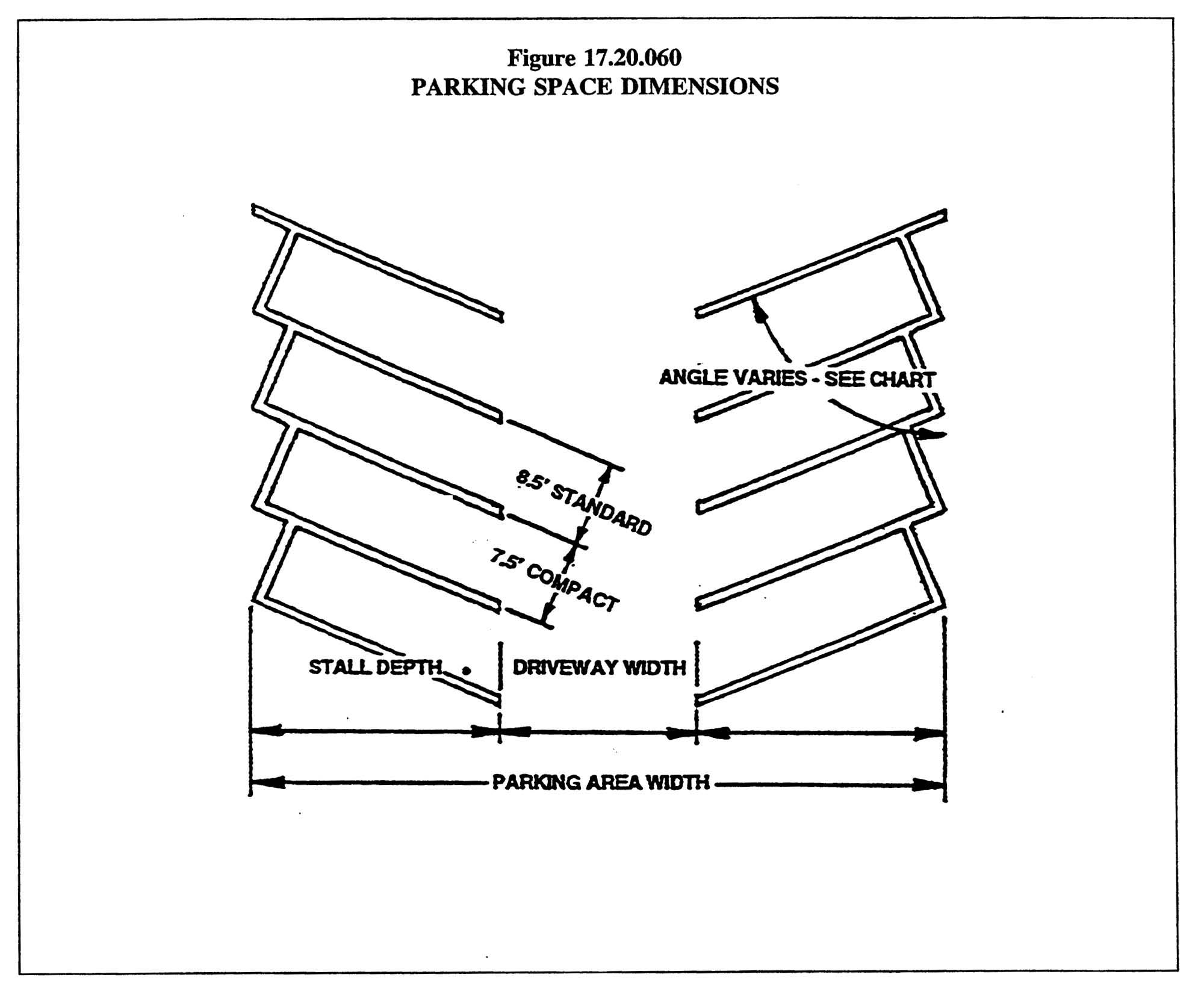
17.20.060 - Parking area design standards.
A.
Standard and Compact Spaces. Parking spaces shall be classified as standard or compact spaces with required dimensions in accordance with Table 17.20.060. No development shall be allowed to have more than thirty percent of the total required parking as compact spaces.
B.
Parking Space and Aisle Dimensions. The minimum required dimensions of parking spaces and aisles are established in Table 17.20.060. For parking angles not shown in the table, dimensions shall be interpolated by the metropolitan traffic engineer. Minor deviations from these standards may be approved by the traffic engineer for parking structures. The dimensions for a sixty-five degree parking layout are graphically shown in Figure 17.20.060.
C.
Parallel Parking. Parallel parking spaces shall have a minimum length of twenty-three feet and a minimum width of eight feet.
D.
Residential Parking. Required parking spaces for a single-family or two-family dwelling unit shall be a minimum of eight feet wide and twenty feet long. Required parking spaces may be placed end to end. Garage doors opening toward a public street shall be a minimum of twenty feet from the property line. Within the urban zoning overlay district, no off-street parking area or loading area shall be located within any required street setback area, unless it is located on a driveway in accordance with Section 17.20.060G.
E.
Use of Parking Areas. Required parking spaces and associated aisles and maneuvering areas shall be reserved for vehicle use at all times.
F.
Off-street Parking Standards. The following standards shall apply to all off-street parking areas.
1.
No parking space shall open directly onto a public street (single-family and two-family dwellings and townhomes are exempt).
2.
Except for single-family and two-family dwellings, aisles, driveways and joint access easements shall not be used for parking vehicles.
3.
Required parking spaces for all uses except single-family and two-family dwellings shall be designed to permit entry and exit without moving any other vehicle.
4.
No parking space shall be located so as to block designated emergency access.
5.
No portion of any required parking space shall be located within the right-of-way of a street or alley.
6.
For parking areas with ten or more spaces, a minimum queuing distance of twenty feet shall be provided along all access drives between the street right-of-way line and the nearest parking space.
7.
The zoning administrator or planning commission, as applicable, may request the traffic engineer to review site plans for on and off-site traffic circulation.
G.
Paving and Marking. Permanent parking areas containing five or more spaces shall be surfaced with asphalt or concrete, or other hard-surfaced dustless materials, and shall be constructed to provide for adequate drainage. Each space shall be marked by a single or double stripe, with stall width measured centerline to centerline. Single-family and two-family dwellings shall be exempt from this requirement. All private driveways and parking areas shall also conform to the requirements of Section 13.12.200.
H.
Curbs. Curbs or other equivalent means shall be provided to prevent any vehicle using a parking area from encroaching on any public right-of-way, on-site sidewalk, required landscaping area or adjacent property.
Table 17.20.060
PARKING SPACE AND AISLE DIMENSIONS
(Ord. BL2020-188 § 3, 2020; Ord. BL2016-493 § 5, 2017; Ord. BL2000-364 § 1 (part), 2000; Ord. 98-1268 § 1 (part), 1998; Ord. 96-555 § 5.3(D), 1997)
17.20.070 - Queuing requirements for drive-through facilities.
The minimum number of queue spaces, including the vehicle being serviced, shall be provided according to Table 17.20.070. Each queue space shall be a minimum of twenty feet in length. Unless otherwise indicated in the table, queuing shall be measured from the point of ultimate service to the end of the queuing lane. Each queue lane shall be clearly defined and designed so as not to conflict or interfere with other traffic using the site. Each land use in Table 17.20.070 shall have a bypass lane with a minimum width of twelve feet and shall be clearly distinguished from the queuing lane by markings. Queuing vehicles shall not stand within a public street or alley rights-of-way.
Table 17.20.070
QUEUING REQUIREMENTS FOR
DRIVE-THROUGH FACILITIES
(Ord. BL2006-972 § 5, 2006; Ord. 98-1321 § 1 (part), 1998; Ord. 98-1268 § 1 (part), 1998; Ord. 96-555 § 5.3(E), 1997)
17.20.080 - Off-site parking.
All required parking spaces shall be located on the same lot as the principal use, provided that the zoning administrator or planning commission (as applicable) may permit all or a portion of the required parking spaces to be located on a remote and separate lot from the lot on which the principal use is located, based on the following provisions.
A.
Qualifying Districts. Land uses on lots which contain existing buildings on the effective date of the ordinance codified in this chapter located within any of the commercial, industrial, office, ORI, ORI-NS, ORI-A, ORI-A-NS, mixed-use or shopping center districts or within a planned unit development (PUD) or urban design overlay district, may qualify for locating required parking on a separate lot. Land uses on lots which develop after the effective date of the ordinance codified in this chapter located within the mixed-use districts may also qualify for locating required parking on a separate lot. Any lot utilized to satisfy the parking requirements of an off-site land use must be zoned for automotive parking uses in the zoning district land use table of Section 17.08.030 and be connected to the principal use by a continuous sidewalk system. In a planned unit development, institutional overlay, or shopping center district both lots must be part of the same master development plan or a unified plat of subdivision as authorized by Chapter 17.40, Article V.
B.
Separation.
1.
The nearest property line of any off-site parking area required for a residential use shall not be located more than two hundred feet away from the residential use as measured from the nearest property line of the residential use.
2.
The nearest property line of any off-site parking area for a nonresidential use:
a.
Shall not be located more than five hundred feet away from the nonresidential use as measured from the nearest property line of the nonresidential use; and
b.
Shall not be separated from the nonresidential use by any street with more than four travel lanes.
3.
Properties in the MUI, MUI-NS, MUI-A, MUI-A-NS, CF, CF-NS, SCR, SCR-NS districts, and all religious institutions subject to Section 17.16.170(E)(2), shall be exempt from the above maximum separation provisions.
4.
Within the qualifying districts, the above distance standards may be increased for those land uses identified in Table 17.20.030 in which the traffic engineer must establish the parking requirement, provided that the location of the off-site parking lot is recommended by the traffic engineer.
C.
Common Ownership. Any off-site parking area shall be under the same ownership as the principal use to which it is accessory, or otherwise secured by a lease of no less than, three years with a guaranteed renewal option or the lease is equal to the term of any lease for the principal use, whichever is greater, and all necessary legal instruments shall be executed and recorded with the Register of Deeds against all parcels involved. Copies of all recorded lease agreements shall be provided to the zoning administrator prior to the issuance of zoning permits. All renewal agreements pertaining to off-site parking contained within the lease shall be provided to the zoning administrator prior to the end of a lease term. This is to ensure that the required number of spaces shall remain available throughout the life of the principal use.
D.
Approval Criteria. The zoning administrator or planning commission (as applicable) shall base the decision to approve or disapprove a request for off-site parking on the recommendation of the metropolitan traffic engineer.
(Ord. BL2019-111 § 1(Exh. A, §§ 29, 30), 2020; Ord. BL2011-898 § 11, 2011; Ord. 2002-1019 § 1, 2002; Ord. BL2000-364 § 1 (part), 2000; Amdt. 1 with Ord. 98-1268 § 1 (part), 1998; Ord. 96-555 § 5.3(F), 1997)
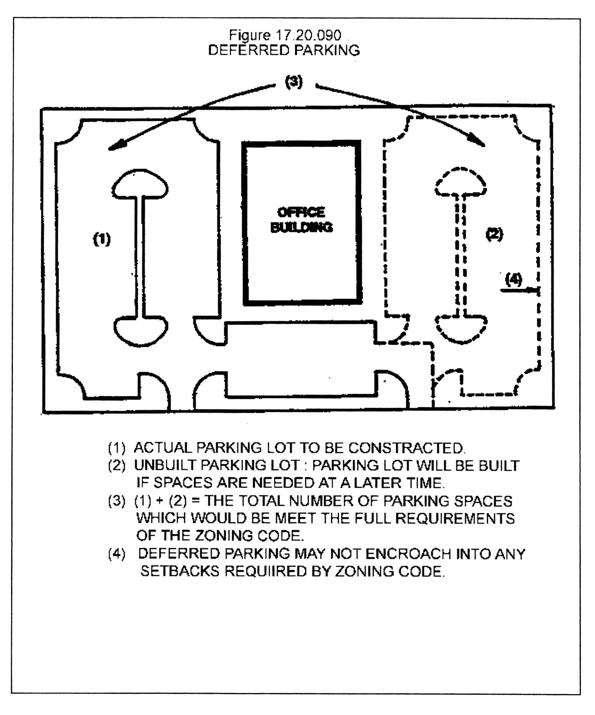
17.20.090 - Deferred parking.
To avoid requiring more parking spaces than actually are needed to serve a development and to reduce the visual and drainage impacts caused by large impervious areas, the zoning administrator or planning commission (as applicable) may allow some portion of the parking spaces required by this Zoning Code to be deferred if the conditions and requirements of this article are satisfied.
A.
Criteria for Approval. As a condition precedent to obtaining a partial deferral, the developer shall demonstrate to the traffic engineer through a parking study that there is not a present need for the number of required parking spaces deferred. Based upon the favorable recommendation of the traffic engineer, the zoning administrator or planning commission (as applicable) may approve a deferred parking site plan. No deferred parking plan shall be approved unless the property contains sufficient land area upon which required parking can be constructed as a surface parking lot.
B.
Implementation of Deferred Parking. If the justification for deferred parking is approved, the following provisions shall apply.
1.
Deferred Parking Plan. A deferred parking site plan shall be prepared according to the following requirements.
a.
The deferred parking plan shall be designed to contain sufficient space to meet the full parking requirements of this Zoning Code. The developer shall illustrate the layout for the full number of parking spaces, and shall designate which parking spaces are to be deferred. (See Figure 17.20.090)
b.
Deferred parking spaces shall not be assigned to areas required for landscaping, or buffer yards, or areas that would otherwise be unsuitable for parking spaces because of the physical characteristics of the land or other requirements of this title.
c.
The plan shall include a landscaping plan for the deferred parking area.
d.
The plan shall be accompanied by a written commitment agreement specifying that any time after the date of issuance of the certificate of compliance, the deferred spaces shall be converted to parking spaces that conform to this Zoning Code at the developer's expense should the zoning administrator determine that the additional spaces are needed. The zoning administrator shall establish a reasonable time period for the property owner to bring the development into full compliance with the parking requirement. The developer or owner shall apply to the zoning administrator for renewal on a yearly basis. Alternatively, the developer may at any time request that the zoning administrator approve a permit allowing conversion of the deferred spaces to operable parking spaces. This written agreement will be noted on a recorded plat and in any restrictive covenants, and shall be referenced on the site plan.
e.
The deferred or shared parking site plan shall contain the following note: Any expansion or change of use on this site shall conform to all parking requirements of this title.
2.
Monitoring Deferred Parking. In order to effectively ensure that parking demand for developments with approved deferred parking site plans does not increase to levels where the total required parking spaces are needed, the owner must designate an employee or otherwise establish a transportation coordinator position to monitor and enforce proposed commuting patterns. Retail and restaurant land uses in the district land use table in Section 17.08.030 with less than one hundred employees will not require a transportation coordinator position.
3.
Required Road Improvements. The approval of a deferred parking agreement shall not relieve or diminish any obligation by the developer to provide necessary infrastructure improvements required by ordinance or by a condition of development approval.
(Ord. 98-1321 § 1 (part), 1998; Ord. 96-555 § 5.3(G), 1997)
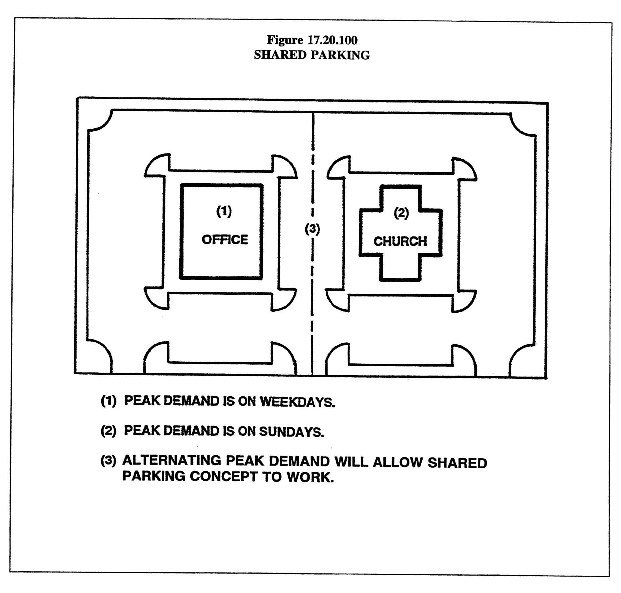
17.20.100 - Shared parking.
Within the urban zoning overlay district, the zoning administrator or planning commission (as applicable) may approve a shared parking plan for a mixed use project when uses are located near one another and have different peak parking demands and operating hours, or other characteristics that would enable them to share parking areas without resulting in significantly higher on-street parking in surrounding areas or unauthorized use of other parking facilities, based upon a favorable recommendation of a shared parking study and site plan from the metropolitan traffic engineer. (See Figure 17.20.100) Shared parking arrangements shall be subject to the requirements set forth below.
Outside of the urban zoning overlay district, the zoning administrator or planning commission (as applicable) may approve a shared parking plan for a mixed use project when uses are located near one another and have different peak parking demands and operating hours, based upon a favorable recommendation of a shared parking study and site plan from the metropolitan traffic engineer. (See Figure 17.20.100) Shared parking arrangements shall be subject to the following requirements:
A.
Agreements. In cases where the uses for which shared parking is requested are located on lots under different ownership, a three party agreement between the metropolitan government and owners shall be required and subject to approval by the metropolitan government's legal counsel. Any applicable easements and joint access corridors which tie the shared parking concept together will be required to be recorded on a final plat and in any restrictive covenants, and shall be referenced on the site plan.
B.
Parking Zone Lot. Owners of multiple adjacent properties may petition to have their parcels considered as a single parcel (a "parking zone lot") for purposes of compliance with parking requirements, provided that the parking zone lot includes a sufficient number of spaces to meet the sum of the minimum off-street parking space requirements for each use within the parking zone lot. Such requests shall be reviewed and approved through the site plan approval process (Section 17.40.170(c)(2)). Documentation of an approved parking zone lot shall be recorded with the register of deeds. The approved parking zone lot may be amended or terminated through the site plan process upon (1) a petition filed by a majority of the owners whose properties include at least seventy-five percent of the square footage included in the approved parking zone lot prior to amendment or termination, and (2) submission of evidence that each use has made alternative provisions to satisfy its minimum off-street parking required by this code.
C.
Criteria. In reviewing an application for a reduction in the minimum number of required parking spaces, the following shall be considered:
1.
Characteristics of each use and projected peak parking demand, including hours of operation;
2.
Potential reductions in vehicle movements afforded by multipurpose use of spaces by employees, customers or residents; and
3.
Potential improvements in access, design, open space preservation and circulation afforded.
(Ord. BL2000-364 § 18 (part), 2000; Ord. 96-555 § 5.3(H), 1997)
17.20.110 - Parking reduction for preservation of protected and heritage trees.
A.
A reduction of required parking spaces may be allowed when the reduction would result in the preservation of a protected tree with a trunk of twelve inches in diameter or greater or a heritage tree.
B.
The reduction in required parking spaces shall not exceed the number of parking spaces required to prevent removal of protected or heritage trees, or the number in Table 17.20.110, whichever is less.
Table 17.20.110
MAXIMUM PARKING REDUCTION
(Ord. BL2018-1416 § 3, 2019; Ord. 96-555 § 5.3(I), 1997)
17.20.120 - Provision of sidewalks.
Purposes. Nashville's population and built environment has grown and continues to grow rapidly. Sidewalks are required to facilitate safe and convenient pedestrian movements for residents, employees and/or patrons, and to reduce dependency on the automobile, thus reducing traffic congestion on the community's streets and protecting air quality. The designation of an accessible and safe path for walking increases homeowner and community health and social connections.
Sidewalk networks minimize conflicts between vehicular and pedestrian movement along corridors and within and around centers identified in the General Plan (2015). Sidewalks offset a portion of the vehicular traffic consequences of population growth and increased density.
In consideration of these reasons, the sidewalk requirements below are aimed at creating a safe and convenient sidewalk network along the streets, corridors and centers identified in Nashville's General Plan (2015):
Nashville Next, Nashville's Strategic Transit Plan (2016): nMotion, and Nashville's Strategic Plan for Sidewalks and Bikeways (2017): WalknBike, where the impact of Nashville's growth is greatest.
These provisions are not intended to and shall not decrease the allowable floor area ratio for development.
A.
Applicability.
1.
Multi-family or non-residential development or redevelopment. All provisions of this section shall apply to the development or redevelopment of multi-family or nonresidential property when the property is located within the urban services district, or within a center designated in the general plan, or any of the property frontage is within a quarter-mile of the boundary of a center designated in the general plan, or the property is on a street in the major and collector street plan. Properties on the opposite side of navigable waterways or controlled access highways from a center designated in the general plan are not subject to this provision. For the purposes of this subsection, there shall be a presumption that the current appraised value of all structures on the lot is that established by the office of the metropolitan tax assessor. Development or redevelopment of multi-family or nonresidential property shall include one of more of the following:
a.
Construction of a new structure on a vacant lot, including lots on which all structures have been or are planned to be demolished; or
b.
The cost of any one renovation equal to or greater than fifty percent of the current appraised value of all structures on the lot, or the value of multiple renovations during any five-year period equal to or greater than seventy-five percent of the current appraised value of all structures on the lot; or
c.
The cost of any one expansion equal to or greater than twenty-five percent of the current appraised value of all structures on the lot, or the value of multiple expansions during any five-year period equal to or greater than fifty percent of the current appraised value of all structures on the lot; or
d.
The total building square footage of any one expansion is equal to or greater than twenty-five percent of the total square footage of all structures on the lot, or the total building square footage of multiple expansions during any five-year period is equal to or greater than fifty percent of the total square footage of all the structures on the lot.
2.
Single-family or two-family construction. All provisions of this section shall apply to the construction of new single-family or attached or detached two-family structure(s) when the property is within the Urban Zoning Overlay, or within a center designated in the general plan, or any of the property frontage is within a quarter-mile of the boundary of a center designated in the general plan, or the property is on a street in the major and collector street plan in the urban services district (arterial and collector streets). Properties on the opposite side of navigable waterways or controlled access highways from a center designated in the general plan are not subject to this provision.
3.
Waiver requests for all development types. Notification of a waiver request shall be sent to the appropriate district councilmember, by way of the metropolitan council office, by the metropolitan department of codes administration. Building permit(s) shall not be issued until at least five business days from the date notification was sent to the metropolitan council office.
The zoning administrator may waive, in whole or in part, the requirements of this section upon request by the property owner or its agent under the following circumstances:
a.
Where there is an existing substandard sidewalk, insufficient right-of-way, existing physical features on the property such as utilities, a ditch or drainage ditch, historic wall(s) or stone wall(s), tree(s), steep topography, or other hardship, the zoning administrator may approve an alternative design, or eliminate the sidewalk requirement in whole or in part if it is determined that a new sidewalk would not further the goal of extending or completing a sidewalk network. In addition to the executive director of the planning department, the zoning administrator shall consult with the director of public works and the director of water services, or their designees, prior to making any final determination.
b.
In unique situations where a public sidewalk is required by subsection 17.20.120 A.1. or A.2. and installation is required by subsection C of this section, the zoning administrator may allow the building permit applicant to make the in-lieu contribution for all or a portion of the street frontage(s) as an alternative to construction. In addition to the executive director of the planning department, the zoning administrator shall consult with the director of public works and the director of water services, or their designees, prior to making any final determination. This provision shall be limited to unique situations that are not typical.
c.
For properties eligible for public incentives for affordable housing from the metropolitan government, where the appropriately designated metropolitan government department has provided the property owner with a letter indicating that said property or properties will be utilizing public funds for land or construction of the structure, the zoning administrator may waive the requirements of Section 17.20.120 A., C., and/or D., or, rather than waive the sidewalk requirements, the zoning administrator may only require sidewalks at key locations if recommended by the executive director of the planning department, or his or her designee.
d.
Where reconstruction is required due to circumstances beyond the control of the property owner, including, but not limited to, natural disaster, fire, or accident, the zoning administrator may waive the requirement for new sidewalk construction.
e.
For properties within Historic Zoning Overlay Districts, where new sidewalks would be detrimental to the historic nature of the street, and the waiver has been recommended by the executive director of the metropolitan historical commission, or his or her designee, the zoning administrator may waive the requirement for new sidewalk construction.
f.
Where a greenway exists or is reasonably expected to be constructed within six years that would provide similar connectivity, and the waiver has been recommended by the executive director of the metropolitan planning department, or his or her designee, the zoning administrator may waive the requirement for new sidewalk construction.
g.
For properties situated on corner lots in R and RS zoned districts, where new construction of sidewalks is determined to be inappropriate, the zoning administrator may permit alternative requirements. The zoning administrator shall consider the amount of street frontage and classification of fronting streets when making a determination. In addition to the executive director of the planning department, the zoning administrator shall consult with the director of public works and the director of water services, or their designees, prior to making any final determination.
B.
On-Site Sidewalk Installation For Multi-Family and Nonresidential Development. A continuous, all-weather internal sidewalk network, constructed to a minimum width of five feet, shall connect all pedestrian building entryways to parking areas and all public rights-of-way. Sidewalks shall be designed and constructed to be distinguishable from driving surfaces.
C.
Public Sidewalk Installation. The provisions of this subsection apply to all property frontage, regardless of whether sidewalks are provided in public right-of-way or pedestrian easements.
1.
Construction of new sidewalks is required along the entire property frontage under any one or more of the following conditions, unless the property abuts a sidewalk segment that the department of public works has funded and scheduled for construction:
a.
When there is existing sidewalk in need of repair or replacement.
b.
To extend the existing sidewalk, or sidewalk required as part of an existing final development plan for a specific plan zoning district or issued permit within any other zoning district, on an abutting development.
c.
Existing sidewalk present on the same block face.
d.
Multi-family or nonresidential properties within the Urban Zoning Overlay.
e.
Multi-family or nonresidential properties along a street in the major and collector street plan.
2.
Sidewalk Design Standards.
a.
Sidewalk dimensions and required elements shall comply with the major and collector street plan or, for a street not in the major and collector street plan, the adopted standards of the metropolitan government. Design of sidewalks shall comply with approved standards established by the department of public works.
b.
Obstructions are prohibited within the required pedestrian travelway, but may be located within a grass strip/green zone or frontage zone. Prior to the issuance of use and occupancy permits, existing obstructions shall be relocated outside of the required pedestrian travelway.
c.
For multi-family and nonresidential development or redevelopment, street trees shall be required within the grass strip/green zone or frontage zone for any sidewalk constructed within a center designated in the general plan.
i.
Trees shall be installed according to the provisions of the Metro Nashville Street Tree Specifications prepared and maintained by Metro Water Services in conjunction with Metro Public Works, Planning and Codes.
ii.
Street trees shall be chosen from the Urban Forestry Recommended Tree List. Canopy trees shall be installed, except where conflicts with overhead electrical power lines exist. In those instances, understory trees may be substituted.
iii.
The owner of the property frontage along which the street trees are installed shall maintain the trees installed per this title according to the provisions of the Metro Nashville Street Tree Specifications. The owner of the property frontage shall execute and record a restrictive covenant agreeing to these maintenance responsibilities.
iv.
Required street trees shall be depicted on a landscape plan, which shall be submitted with construction drawings for the sidewalks. The landscape plan and specifications shall be prepared by, or under the direction of, and bear the seal of a professional landscape architect registered in Tennessee.
v.
Trees installed pursuant to this section shall be eligible for credit toward the tree density required by Chapter 17.28 of this title.
D.
Contribution to the fund for the pedestrian benefit zone as an alternative to sidewalk installation.
1.
When a public sidewalk is required by subsection A, but installation is not required by subsection C of this section, the building permit applicant may make a financial contribution to the fund for the pedestrian benefit zone in lieu of construction. The value of the contribution shall be the average linear foot sidewalk project cost, including new and repair projects, determined by July 1 of each year by the department of public works' review of sidewalk projects contracted for or constructed by the metropolitan government. The contribution in-lieu of construction shall be no more than three percent of the total construction value of the permit.
2.
Any such contributions received by the metropolitan government shall be assigned and designated for implementation of the strategic plan for sidewalks and bikeways, as approved by the planning commission. The applicant's payment shall be allocated within ten years of receipt of the payment within the same pedestrian benefit zone as the property to be developed; otherwise, the payment shall be refunded to the building permit applicant.
3.
Contribution to the pedestrian network as an alternative to sidewalk installation required under this section shall be received by the department of public works, and written confirmation of the contribution shall be sent to the department of codes administration prior to the issuance of a building permit.
E.
Dedication of Right-of-Way and Easements Required. Dedication of right-of-way and/or public pedestrian easement is required to permit present or future installation of a public sidewalk built to the current standards of the metropolitan government.
F.
Improvements required or elected on public rights-of-way and/or public pedestrian easements under subsection C of this section shall be reviewed for compliance by the department of public works. No building permit shall be issued by the department of codes administration until the department of public works has released the building permit. Prior to the department of codes administration authorizing final use and occupancy, the department of public works shall inspect and approve the sidewalk improvements in the public rights-of-way and/or public pedestrian easements.
(Ord. BL2022-1122 § 5, 2022; Ord. BL2020-288 § 1, 2020; Ord. BL2019-1659 § 1, 2019; Ord. BL2016-493 § 1, 2017; Ord. BL2004-491 § 1, 2005; Amdt. 1 with Ord. BL2004-289 § 1, 2004; Amdt. 1 with Ord. BL2000-479 § 1, 2000; Ord. 96-555 § 5.3(J), 1997)
Editor's note—Section 17.20.120 is no longer enforced and is subject to a permanent injunction. See Agreed Entry of Judgment and Injunction entered 9/22/23 in Knight, et al., v. Metropolitan Government, U.S. District Court, M.D. Tenn., Case No. 3:20-cv-00922.
17.20.125 - Right to appeal and seek variances.
The provisions of Section 17.20.120 may be varied or interpretations appealed in conformance with Chapter 17.40, Administration and Procedures. The board of zoning appeals may require a contribution to the pedestrian network consistent with subsection 17.20.120.D., an alternative sidewalk design, or other appropriate mitigation for the loss of the public improvement as a condition to a variance. The board of zoning appeals shall not accept an application until the zoning administrator has made a determination on the requirement as set forth in this chapter.
(Ord. BL2019-1659 § 2, 2019; Ord. BL2016-493 § 2, 2017; Amdt. 1 with Ord. BL2004-289 § 2, 2004)
17.20.130 - Loading space requirements.
A.
The number of loading spaces required for each land use classification of the Zoning Code is established in Table 17.20.130
Table 17.20.130
NUMBER OF LOADING SPACES REQUIRED
B.
Size of Loading Spaces Provided. The minimum dimensions of loading spaces, open or enclosed, shall be twelve feet in width by fifty-five feet in length, with a minimum vertical clearance of fifteen feet. Where tractor-trailer units will be using the facility, the minimum length shall be sixty-five feet.
C.
Paving Standards. All open loading spaces shall be surfaced with concrete, or other hard-surfaced dustless materials, and shall be constructed to provide for adequate drainage.
D.
Use of Loading Spaces. Required loading spaces and associated aisles and maneuvering areas shall be used for vehicle loading/unloading only.
E.
Layout. All loading spaces shall comply with the following design requirements.
1.
No loading space shall be located within the right-of-way of a public street. Any loading space or door shall be set back far enough from the right-of-way so that no portion of the right-of-way is occupied by trucks or other vehicles while loading or unloading.
2.
The location of the loading space shall not interfere with the free circulation of vehicles in the off-street parking area. Where loading spaces are directly adjacent to or integrated with an off-street parking lot, the metropolitan traffic engineer may require installation of physical barriers or other means of separating loading spaces from parking areas and pedestrian traffic.
3.
No loading space shall be located so as to block access by emergency vehicles.
(Ord. 99-1643 §§ 1, 2, 1999; Ord. 98-1268 § 1 (part), 1998; Ord. 96-555 § 5.3(K), 1997)
17.20.135 - Bicycle parking.
A.
Space Required. Bicycle parking shall be provided for all principal uses located within the Urban Zoning Overlay district or an Urban Design Overlay district.
1.
Bicycle parking shall be required as provided in Table 17.20.135 for any new building or structure and any addition or enlargement of an existing building of more than fifty percent of the gross floor area. For additions or enlargements, the bicycle parking requirement shall apply only to the additional building floor area.
B.
Unless otherwise expressly stated in Table 17.20.135, a minimum of two publicly available bicycle spaces shall be provided for every use. Unless specified in Table 17.20.135, residential uses shall not be required to provide bicycle parking.
C.
One vehicle parking space required by Section 17.20.030 may be used as a space for providing bicycle parking.
D.
Where subsurface conditions or below-ground infrastructure make bicycle parking difficult or infeasible, the zoning administrator, based on a recommendation from the planning department, may reduce or waive the required bicycle parking and/or may approve different design and location standards for required bicycle parking spaces.
E.
Required bicycle parking spaces design and location standards shall meet the recommendations of the Association of Pedestrian and Bicycle Professionals (APBP) Bicycle Parking Guidelines.
1.
The required publicly available bicycle parking spaces shall be located in a convenient and visible area within fifty feet of a principal entrance or other approved location by the zoning administrator with guidance from the department of public works and shall permit the locking of the bicycle frame and one wheel to a rack or fixture and shall support a bicycle in a stable position without damage to the wheels, frame or components.
2.
Required bicycle parking spaces shall not be located on a residential balcony.
Table 17.20.135
BICYCLE PARKING REQUIREMENTS
Fractions: Any fraction less than one-half shall be disregarded and any fraction of one-half or more shall be rounded upward to the next highest full number.
(Ord. BL2014-714 § 1, 2014)
17.20.140 - Multimodal transportation analysis.
A.
The purpose of a multimodal transportation analysis is to evaluate the impact of a proposed development on the safety, operations, and condition of the adjacent transportation network, and to identify what transportation mitigations, if any, are necessary to offset the impact caused by additional trips generated by the proposed development.
1.
Elements of the adjacent transportation network to be evaluated may include intersection operational performance, multimodal connectivity, and safety of the transportation network for all road users.
2.
Transportation mitigations may include, but are not limited to, the provision of roadway traffic operations and capacity facilities; modifications to the roadway network that increase safety; micromobility enhancements; the addition or enhancement of bicycle, pedestrian, and transit facilities; and/or development of programs to encourage an appropriate mix of travel modes and complete streets where appropriate.
B.
Requirements for a Multimodal Transportation Analysis. A multimodal transportation analysis shall be required by the planning department for applications to the metropolitan planning commission (MPC) or the Nashville Department of Transportation and Multimodal Infrastructure (NDOT) for all other development which contains:
1.
Residential developments with more than seventy-five dwelling units; or
2.
Nonresidential developments of more than fifty thousand square feet; or
3.
Combinations of residential and nonresidential uses expected to generate seven hundred fifty trips or more per day, or one hundred or more peak-hour trips; or
4.
In the opinion of NDOT, a multimodal transportation analysis is needed for developments not meeting the above thresholds.
NDOT shall set requirements for the level of analysis, modes of transportation considered, and analysis methodology for applicants meeting any of the above thresholds.
C.
Levels of Multimodal Transportation Analysis Required.
1.
Level 1. A level 1 multimodal transportation analysis is required for smaller scale projects that are not anticipated to have a significant impact on the overall transportation system but will have impacts at the site access.
a.
A level 1 multimodal transportation analysis shall be required in cases where the proposed development will create a through connection between collector roadways and/or roadways of greater functional classification based on the Major and Collector Street Plan.
b.
The project access points to public roadways, public alleys, private driveways, and joint access easements will be evaluated, and this includes those locations that the planning department or NDOT determines are necessary to provide for an adequate review of the proposed project's impact.
c.
The multimodal infrastructure and the safety of all modes of transportation in the vicinity of the project will also be analyzed as part of a level 1 analysis.
2.
Level 2. A level 2 multimodal transportation analysis is required for larger scale development projects that are anticipated to have a significant transportation impact on the overall transportation system. A level 2 multimodal transportation analysis will evaluate impacts at site access points and appropriate nearby intersections as well as impacts to the multimodal transportation network and safety for all modes of transportation.
a.
A level 2 analysis will include an analysis of the project's access points, all roadways serving the project; and, all intersections up to the first collector roadway, or the first roadway of higher functional classification, and the intersections of these roadways with arterial roadways based on the major and collector street plan.
b.
Elements that may be considered by NDOT during review of a level 2 multimodal transportation analysis request include parking supply, existing or planned multimodal infrastructure adjacent to the development, proximity to transit, population density of the area adjacent to the development, and traffic congestion.
c.
The study area includes intersections and transportation facilities that the planning department and NDOT determine are necessary to provide for an adequate review of the proposed project's impacts.
D.
Rezoning Analysis. The purpose of a rezoning analysis is to analyze the capacity of the existing transportation system to accommodate potential new development in the absence of mitigation measures.
1.
A rezoning analysis compares the typical and maximum potential trip generation of representative uses permitted in the existing zoning with the typical and maximum representative uses permitted under the requested zoning or through design-based districts.
2.
Completing a rezoning analysis does not preclude the need to complete a more thorough multimodal transportation analysis upon submission of development plans for the subject property(s) and/or requests for the issuance of permits for construction.
3.
Specific mitigation measures will be identified through the detailed multimodal transportation analysis process.
E.
Multimodal Transportation Analysis Scoping. Upon determination that a new development meets the threshold for a multimodal transportation analysis, the applicant must contact NDOT and submit a Scoping Evaluation Form for review. The purpose of the form is to provide NDOT with basic information about a new development, set analysis parameters, and guide the applicant through a preliminary assessment of the transportation network within the study area. NDOT shall review and provide comments or approval of a submitted scoping document within ten business days of submittal.
F.
Phased Development.
1.
If a development is phased, the sequence and timing of a development shall be incorporated into the multimodal transportation analysis.
2.
An overall multimodal transportation analysis may be required with additional analysis for individual phases of construction.
3.
Completing a multimodal transportation analysis for one phase of development does not preclude the need to complete additional analysis upon submission of development plans for the subject property(s) and/or requests for the issuance of permits for construction.
G.
Waiver of a Multimodal Transportation Analysis. A property owner or their representative who demonstrates that a development will not have a significant impact on the transportation system may request a waiver of a multimodal transportation analysis.
1.
A request to waive a multimodal transportation analysis shall be made by a property owner or their representative in writing to NDOT and for applications to the planning commission, the planning department. Sufficient documentation shall be included that supports the waiver request.
2.
A copy of the request to waive a multimodal transportation analysis shall concurrently be sent by the property owner or their representative to the member(s) of the metropolitan council in whose district(s) the development is located.
3.
NDOT will make a decision on the waiver request within fifteen business days, and for applications to the planning commission, will consider a recommendation from the planning department.
H.
Approval of Multimodal Transportation Analysis.
1.
If a multimodal transportation analysis is required per Subsection B above, the multimodal transportation analysis and transportation mitigation strategies should be reviewed and approved by NDOT prior to the planning commission review. The planning department may recommend deferral as a staff recommendation to the planning commission for applications without an approved multimodal transportation analysis.
2.
The multimodal transportation analysis shall be approved by NDOT and, for applications to the planning commission, the planning department, with all applicable performance requirements incorporated into any site and building plans.
3.
NDOT shall review and provide comments or approval of a submitted multimodal transportation analysis within twenty business days of submittal.
I.
Applicability of a Multimodal Transportation Analysis. A previously approved multimodal transportation analysis may require revision if the following criteria are met:
1.
Zoning approval or permit approval not obtained within sixty months (five years) of multimodal transportation analysis approval; or
2.
Changes in access points from proposed development are made from site plan submitted as part of approved multimodal transportation analysis; or
3.
Increase in daily or peak hour trips resulting from a change in proposed land use types or intensities.
4.
Developments meeting the above criteria shall revise and resubmit a multimodal transportation analysis. If a multimodal transportation analysis is required for a submitted planning application, the planning department may recommend deferral as a staff recommendation to the planning commission for applications with a multimodal transportation analysis meeting any of the above criteria without approval from NDOT.
J.
Implementation of Multimodal Transportation Analysis Recommendations.
1.
The multimodal transportation analysis may consider the capital improvements budget and improvements for which council has adopted a resolution appropriating funds.
2.
Any required improvements which have not been funded or otherwise completed by the metropolitan government shall be completed by the developer prior to the issuance of a use and occupancy permit by the zoning administrator.
3.
When it can be demonstrated that a development will only partially contribute to the need for additional off-site improvements, NDOT or planning department (as applicable) may require a pro-rata contribution.
4.
Prior to the issuance of a ROW permit and per Section 13.20.050 of this Code, the applicant's contractor shall be required to obtain a performance bond executed by the contractor and its surety or sureties, guaranteeing the execution of transportation infrastructure follows NDOT requirements and the payment of all legal debts pertaining to the performance of the work. Surety(ies) shall be authorized to do business in the State of Tennessee and be listed on the United States Department of the Treasury Financial Management Service list of approved bonding companies.
(Ord. BL2023-2010 § 1, 2023; Ord. BL2017-721 § 1, 2017; Amdt. 1 with Ord. 98-1268 § 1 (part), 1998; Ord. 96-555 § 5.4(A), 1997)
17.20.150 - Protection of residential areas.
In order to minimize deterioration and destabilization of residential areas, access for nonresidential properties which abut residential-zoned areas shall be designed so as to minimize the intrusion of nonlocal traffic onto residential local and minor local streets.
(Ord. 96-555 § 5.4(B), 1997)
17.20.160 - Access from nonarterial streets.
Driveways providing vehicular access from streets which function and/or are designated by the planning commission as nonarterial streets shall comply with the following provisions.
A.
Driveway Location. The following provisions apply to the location of driveways providing access to and from nonarterial streets.
1.
A driveway providing access to a single-family or two-family lot from a minor local or local street shall be located at least fifteen feet from a street intersection; a driveway accessing a collector street shall be at least fifty feet from an intersection.
2.
A driveway providing access to a use other than a single-family or two-family dwelling shall be located at least fifty feet from a street intersection. A driveway shall be at least one hundred feet from the intersection of a collector street.
3.
A driveway other than for a single-family or two-family dwelling shall be located at least thirty feet from another driveway.
B.
Deviations. The metropolitan traffic engineer may authorize deviations from the provisions of this section, based upon a demonstration by the applicant that improvement of the property is impractical under the standards of this section and a determination that granting the requested deviation will not be contrary to public health, safety and welfare.
(Ord. 96-555 § 5.4(c), 1997)
17.20.170 - Access from arterial streets.
Driveways providing vehicular access from streets which are designated by the planning commission on the adopted major street plan as arterial streets shall comply with the following provisions.
A.
Number of Driveways. Table 17.20.170 sets forth the maximum number of driveways based on the amount of lot frontage along an arterial classification of street. Driveways shall be a minimum of thirty feet apart. The traffic engineer may require a greater minimum distance between driveways if it is in the best interest of public safety. When appropriate, all new driveways shall be placed directly across from driveways on the opposite side of the street to enhance traffic flow and public safety.
B.
Driveway Separation from Intersecting Streets. To protect the safety of the motoring public, the following standards shall apply:
1.
Along the frontage of an arterial street, no driveway ramp shall be located within one hundred eighty-five feet of a street intersection.
2.
Along any classification of street, no driveway ramp shall be located within two hundred fifty feet of a controlled access highway ramp.
3.
A platted lot existing on the effective date of the ordinance codified in this title, which does not have sufficient street frontage to satisfy the separation requirements of this section, may be granted one driveway ramp provided that it is located as far from the intersection as is reasonably feasible and does not create a hazard to the motoring public.
C.
Building Permit Restrictions. If an undeveloped lot or unplatted parcel has less street frontage than the minimum spacing required in subsections A and B of this section and is adjacent to another lot under common ownership on the effective date of the ordinance codified in this title, establishment of a joint access driveway may be required by the traffic engineer.
D.
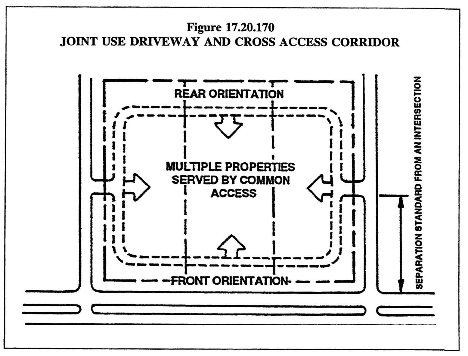
Alternative Access. Where the configuration of properties located on arterial streets precludes spacing of driveway access in accordance with the requirements of this section due to topography or prior site development layout, the metropolitan traffic engineer shall be authorized to require joint access driveways or cross access corridors (See Figure 17.20.170). The following provisions set forth standards for joint use driveways and cross access corridors for reduced spacing situations.
Table 17.20.170
MAXIMUM NUMBER OF DRIVEWAYS
1.
Joint Use Driveways. Wherever feasible, the metropolitan traffic engineer may require the establishment of a joint use driveway serving two or more abutting properties. If a proposed development abuts an existing development which contains an existing joint access driveway, the vehicular circulation of the proposed development shall be designed to connect to the abutting access and circulation areas. If a proposed development abuts an existing undeveloped property, the vehicular circulation of the proposed development will contain a joint access driveway which is designed to connect to the abutting property at a later date.
2.
Cross Access Corridors. The metropolitan traffic engineer shall be authorized to designate cross access corridors on properties adjacent to arterials. The developments within the affected cross access area shall be designed so as to provide for mutually coordinated parking, access and circulation systems. Such designation shall be referenced on a plat of subdivision. Additionally, if a development within the cross access area abuts an existing developed property which is not in the cross access area, but has an abutting joint access driveway, it shall be designed to tie into the abutting access and circulation system.
3.
Recording Easements. Wherever cross access corridors or joint use driveways are provided in accordance with this section, the site plan shall not be approved unless the plan grants an easement for cross access to and from abutting properties. Such easement shall be recorded by the applicant in the public records of Metropolitan Nashville and Davidson County and constitute a covenant running with the land.
4.
Closing of Interim Driveways. Wherever a permanent joint use driveway or cross access easement is constructed in accordance with this section, all preceding interim driveways shall be closed and eliminated. In the case of a joint use driveway, the property owner shall enter into a written agreement with the metropolitan government, recorded in the public records of Metropolitan Nashville and Davidson County and running with the land, that existing driveways shall be closed and eliminated after the construction of both sides of a joint use driveway.
5.
Where Unified Access and Circulation is Not Practical. The metropolitan traffic engineer shall be authorized to waive the requirements of this subsection when abutting properties have been developed in such a manner that it is clearly impractical to create a unified access and circulation system with all or part of the affected areas.
(Ord. 96-555 § 5.4(D), 1997)
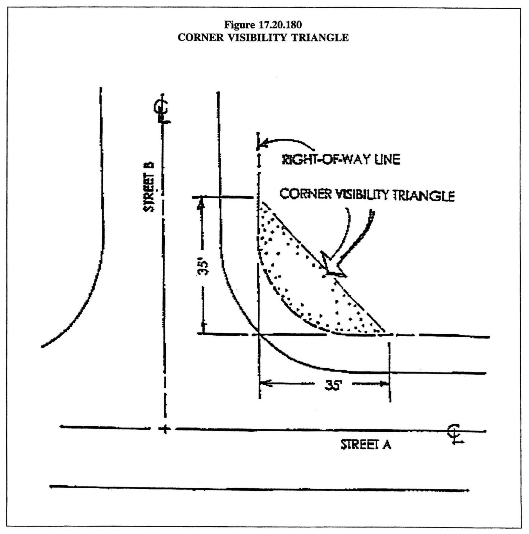
17.20.180 - Visibility.
In order to safely accommodate vehicular movements to and from public streets, the sight distance and visibility provisions in the traffic and parking code and the following provisions shall be required.
A.
At street intersections nothing shall be erected that will obstruct vision at any point above the center line grades of the intersecting streets within the triangular area formed by the right-of-way lines and a straight line joining the right-of-way lines at points which are thirty-five feet distant from the intersection of the right-of-way lines and measured along such right-of-way lines. Development within the urban zoning overlay district and in the DTC, CF, CF-NS, MUI, and MUI-NS districts shall be exempt from this provision. (See Figure 17.20.180)
B.
In all zoning districts, no fence, wall, hedge, or other planting or structure shall be allowed on private property that will obstruct vision at any point where private driveways intersect a public street in such a manner as to interfere with traffic visibility of any driver using an authorized driveway, alley or roadway.
(Ord. BL2019-111 § 1(Exh. A, § 31), 2020; Ord. BL2000-364 § 1 (part), 2000; Ord. 96-555 § 5.4(E), 1997)
17.20.190 - Measurement of distances.
For the purposes of this article, distances shall be measured in the following manner.
A.
Distance Between Driveways. Distances between driveways shall be measured along the right-of-way line from the nearest points of intersection of the driveways with the right-of-way line. In the event that the curb return of a driveway begins outside of the right-of-way, the point of intersection of the extension of the driveway curb or edge shall be used for measurement purposes.
B.
Distance from Intersection. The distance from street intersections shall be measured from the nearest intersection of the existing right-of-way lines or extensions thereof. For streets designated to be widened at a future time by the adopted major street plan, measurement shall be made from the ultimate right-of-way.
C.
Distance from an Interstate Ramp. The distance from interstate ramps shall be measured from that point where the centerline of the right-of-way for the interstate ramp intersects the right-of-way for the arterial street serving the lot.
(Ord. 96-555 § 5.4(F), 1997)