
Nassau County Unincorporated
City Zoning Code
City Zoning Code
ARTICLE 44
TRANSECT BASED ZONING DISTRICT TBZ
Section 44.01.- Intent and purpose of district.
The intent and purpose of the Transect-Based Zoning (TBZ) is to implement the provisions of the adopted Comprehensive Plan. TBZ is only permitted within designated Community-Based Design Overlays (CBDO) and must adhere to both the community-based design standards (CBDS) outlined in the Land Development Code (LDC) and the additional standards provided in this article.
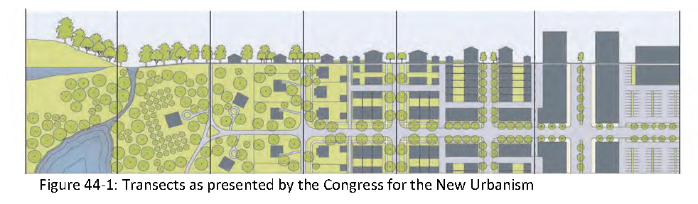
The TBZ framework organizes development through a series of transects that represent a continuum from natural, preserved areas to the urban core. This system allows for the gradual transition from rural to urban character, ensuring that development intensity and form are responsive to context. In addition to the primary transect zones (ranging from natural to urban core), a special district classification is provided to accommodate development types that do not fit within the primary transects. Figure 44-1 illustrates the transect framework as defined by the Congress for the New Urbanism. A detailed description of Nassau County's transects is provided in section 44.04.
The provisions of this article establish density and intensity standards to guide the evolution of these areas over time, consistent with the goals and policies of the adopted comprehensive plan and vision plan. The TBZ framework furthers these initiatives by fostering a walkable, sustainable development pattern that enhances quality of life and strengthens the connection between places where people live, work, play, and stay.
TBZ is a key component of Nassau County's CBDS and serves as the preferred approach to achieving the desired development patterns within CBDOs. Transects are designed to either transition into existing developed areas or create new walkable, mixed-use neighborhoods. TBZ provides a clear and adaptable structure for organizing land uses and physical form, moving from natural and rural settings into compact, mixed-use centers.
It is the expressed intent of Nassau County that, over time, lands within a CBDO will transition to the TBZ designation through the rezoning process established in the LDC.
TBZ serves as a tool to focus and guide development into appropriate areas, allowing growth to occur in a planned, coordinated manner with the necessary civic infrastructure and public amenities to support a high-quality urban environment, while simultaneously protecting critical environmental resources. These regulations are designed to:
A.
Protect, enhance, and integrate the natural environment into new development, ensuring accessible and connected green spaces for all residents;
B.
Focus development within designated nodes and activity centers along established transportation corridors to support efficient infrastructure investment;
C.
Promote compact, walkable, mixed-use neighborhoods that integrate residential, commercial, employment, and recreational uses at a human scale, supporting a reduced reliance on single-occupancy vehicles and encouraging healthy lifestyles;
D.
Establish a comprehensive network of interconnected streets, trails, bike paths, and pedestrian walkways to enhance non-motorized mobility and improve access between neighborhoods, activity centers, and public amenities;
E.
Support long-term resilience by ensuring that new development incorporates strategies for climate adaptation, environmental sustainability, and technological advancements; and
F.
Ensure high-quality urban design and a lasting sense of place through the use of traditional design principles, including appropriate scale, form, and architectural character.
(Ord. No. 2025-012, § 2(Exh. A), 6-23-25)
44.02.01. - Eligibility for transect based zoning district.
To be eligible for TBZ, a parcel of land must be included in a Community-Based Design Overlay regulating plan, which establishes the applicable transect for the parcel. In addition to meeting the general rezoning review criteria set forth in the Land Development Code, applications for rezoning to a transect must also demonstrate compliance with the requirements in this section.
A.
Parcels assigned TBZ shall comply with the assigned transect for the parcel as adopted in the Nassau County Comprehensive Plan.
B.
All TBZ rezoning applications shall include the transect assigned to the parcel as a part of the rezoning application.
C.
All TBZ rezoning and land use applications shall comply with the applicability standards defined by each Community-Based Design Overlay. These standards may include provisions for transect modifications.
(Ord. No. 2025-012, § 2(Exh. A), 6-23-25)
44.03.01. - Introduction.
A regulating plan is a map that identifies the specific TBZ transect designation assigned to each parcel within a Community-Based Design Overlay (CBDO). The regulating plan serves as the primary tool for applying the standards and regulations contained in this article. The regulating plan is developed through a combination of:
A.
Community input;
B.
Professional design and planning analysis;
C.
Industry best practices;
D.
Evaluation of existing conditions and development patterns within the area; and,
E.
Consistency with the goals, objectives, and policies of the adopted Nassau County Comprehensive Plan and Vision Plan.
44.03.02. - Community-based design overlay (CBDO) regulating plan.
The adopted regulating plan for each CBDO is included in a future land use map series (FLUMS) of the Nassau County Comprehensive Plan. This plan identifies the location and boundaries of each transect within the overlay. Any proposed amendment to the assigned transect designation for a parcel within a CBDO may require an amendment to the future land use map to change the transect FLUM designation.
(Ord. No. 2025-012, § 2(Exh. A), 6-23-25)
44.04.01. - Introduction.
The transect system of spatial and land use organization, also commonly referred to as form-based districts, establishes a framework where land uses, building design, density, height, street design, open space, parking, and other elements of the built environment are comprehensively coordinated. Nassau County recognizes and adopts the following transects, each of which serves a distinct role in guiding the development pattern, transition, and character of the built environment.
44.04.02. - Transect descriptions.
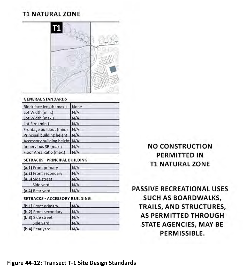
A.
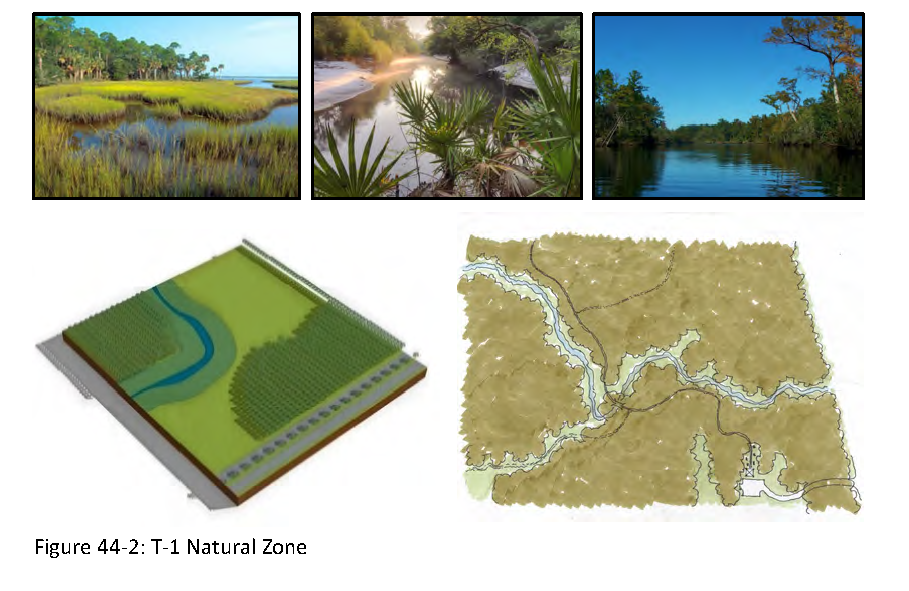
T-1 Natural Zone. This transect consists of lands approximating or reverting to wilderness, including lands unsuitable for settlement due to topography, hydrology or vegetation. These areas include lands designated by the Conservation Future Land Use Map designation Conservation Habitat Network (CHN) within the East Nassau Community Planning Area (ENCPA), and jurisdictional wetlands, National Wetland Inventory (NWI) lands, and wetlands identified by the St. John's Water Management District (SJRWMD), and may include lands within the Coastal High Hazard Area (CHHA) and other environmentally sensitive areas.
The specific boundaries of the T-1 transect may be adjusted as additional or refined data becomes available during development review, subject to state and federal permitting. The final delineation will be established during development approval through the Nassau County Development Review Committee. As T-1 areas are further refined, the new uplands shall utilize the adjacent transect designation.
Due to environmental constraints, development is prohibited within the T-1 transect, except for water-dependent recreational uses, including boat/kayak ramps, launches, and passive recreational features such as elevated boardwalks, riverfront promenades, and viewing platforms.
B.
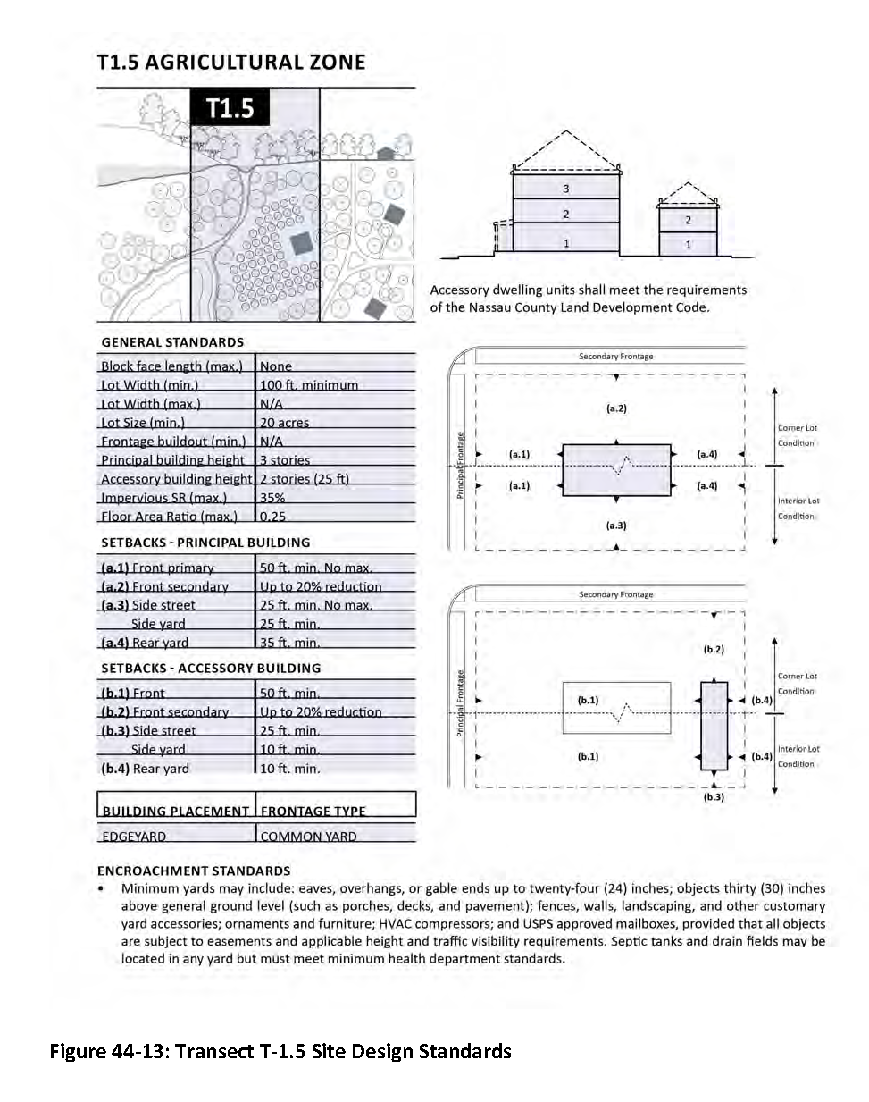
T-1.5 Agricultural Zone. This transect consists of larger, sparse rural parcels and allows agriculture, hunting camps, fishing camps, managed preserves, and silviculture. Properties in this transect are generally larger than twenty (20) acres in size. Typical buildings are single-family houses and agricultural buildings. Planting is naturalistic and setbacks are relatively deep. Building height is up to three (3) stories. May include lands located in the CHHA not designated as T-1.
C.
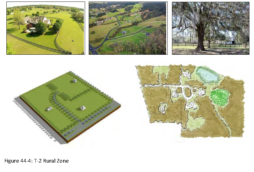
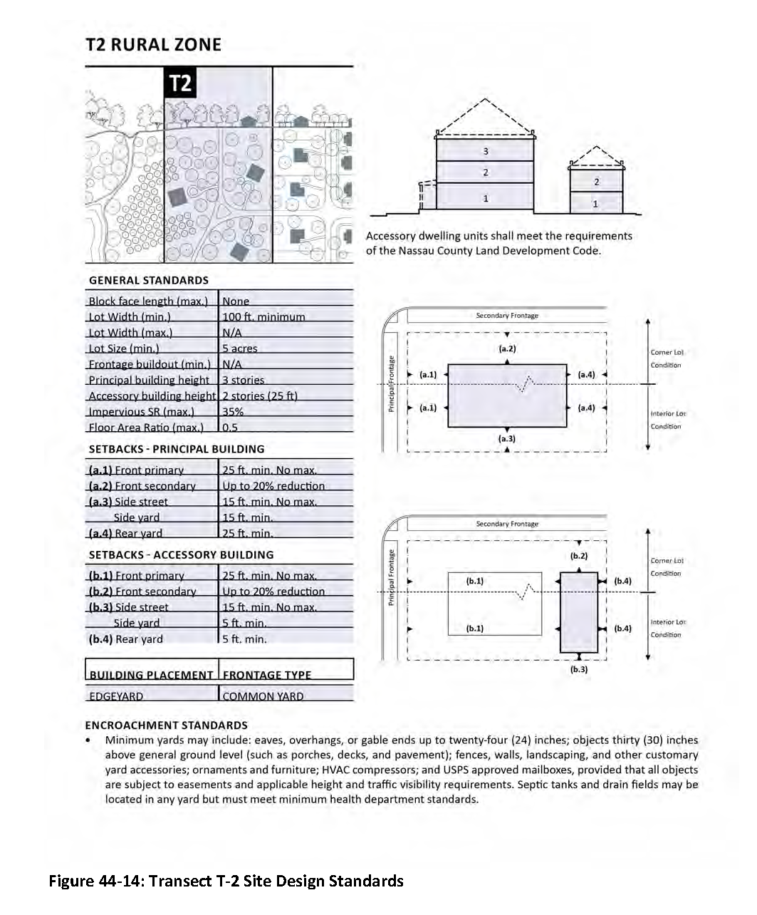
T-2 Rural Zone. This transect consists of sparsely settled lands in an open or cultivated state. Typical structures are single family detached homes and agricultural buildings. Planting is generally naturalistic and setbacks are relatively deep. Typical land uses include agricultural uses and single-family ranchettes ranging in five (5) to twenty (20) acres in size. Building height is up to three (3) stories. Cluster subdivisions and other techniques are encouraged to preserve the rural aesthetic and preserve a rural way of life. It is the intent to differentiate the T-2 rural zone from the T-2.5 rural transitional zone and T-3 suburban zone through the transect specific design standards established in Section 44.06.
D.
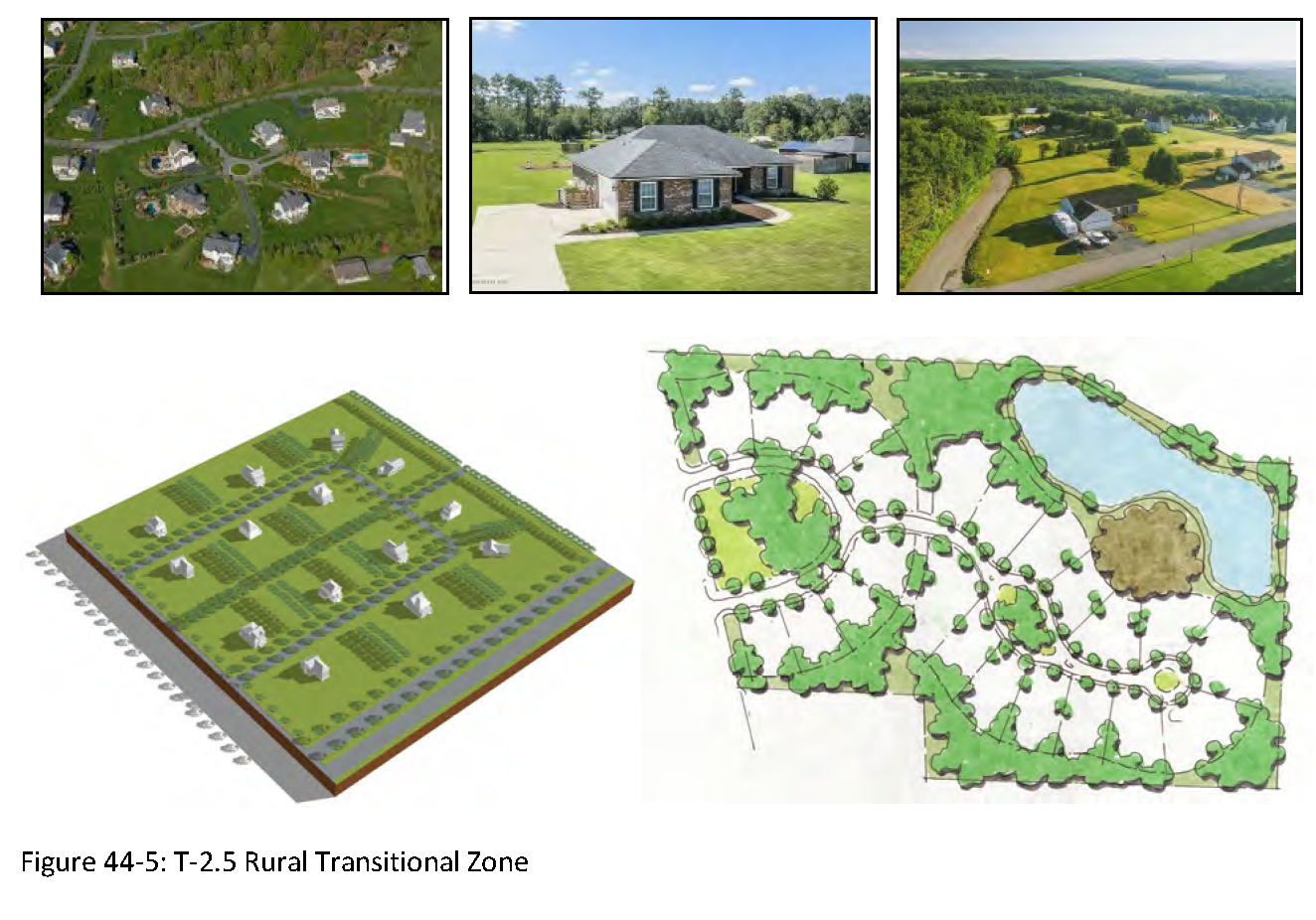
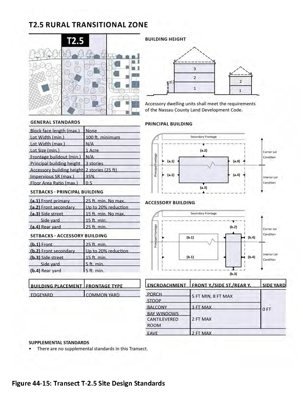
T-2.5 Rural Transitional Zone. This transect consists of low-density residential areas between the rural zones and suburban zone. Building sites in these zones are generally one (1) to five (5) acres. Typical land use is for single family detached homes. Planting is naturalistic and setbacks are relatively deep. Building height is up to three (3) stories. This transect is intended to provide a transition area around the T-2 rural zone. Such transition from rural to suburban maintains T-1.5 to T-2 lands rural and prevents encroachment of the T-3 suburban zone into rural areas.
E.
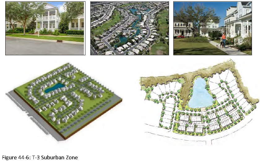
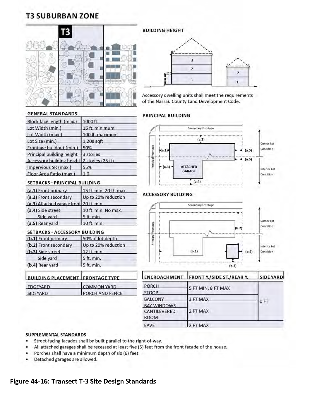
T-3 Suburban Zone. This transect consists of low-density residential areas with a density range of two (2) to five (5) dwelling units per acre, adjacent to the urban transitional zone. Limited non-residential uses as permitted in section 44.05 may be allowed. Planting is generally uniform, and setbacks are relatively shallow. Blocks may be medium in length, and the roads irregular to accommodate natural conditions. Refer to Table 44-3: Transect Standards, for details on block size. Housing types are typically single-family detached homes and single-family attached homes. Building height is up to three (3) stories. The use of clustering and other similar techniques are encouraged to create a more compact, walkable and sustainable suburban development pattern.
F.
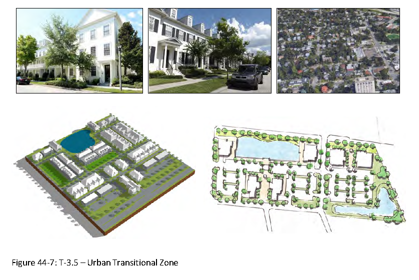
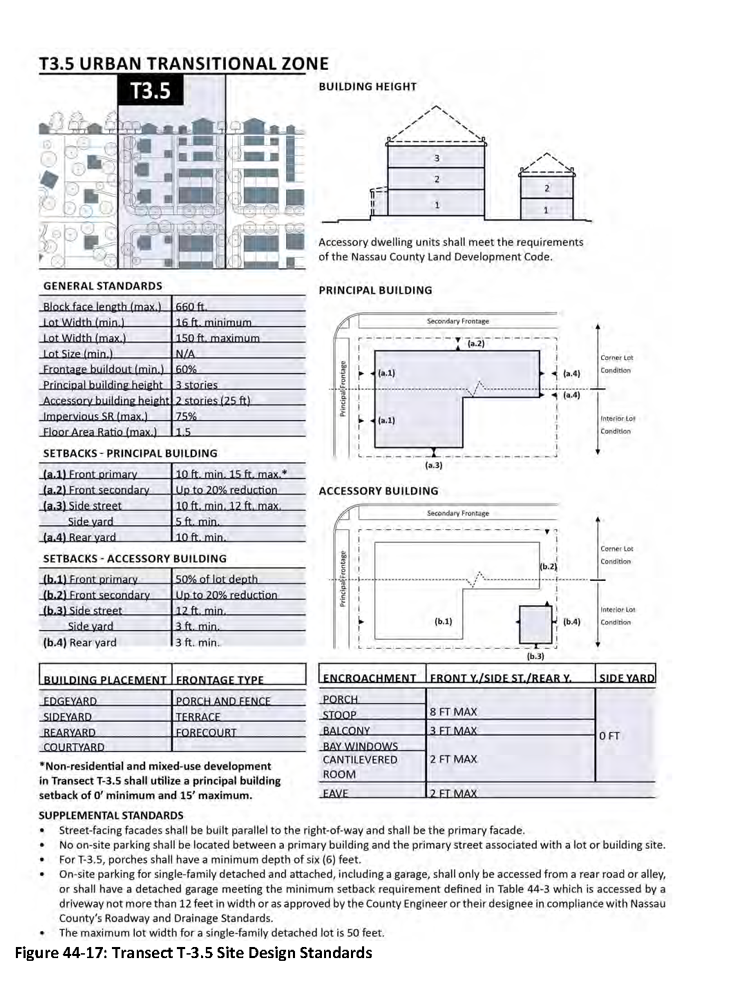
T-3.5 Urban Transitional Zone. This transect consists of medium-density residential areas ranging from five (5) to ten (10) dwelling units per acre, and a mixture of uses, adjacent to the urban edge. Blocks are generally medium sized to allow for a mixture of residential single-family attached and limited detached product and multi-family. Refer to Table 44-3: Transect Standards, for details on block size. Neighborhood commercial is permitted at fringe of T-4 and in clustered interior locations. Building height is up to three stories. Development in this transect shall be compact and walkable with retail, service, and civic uses necessary to support the day-to-day life of residents without the predominant use of the automobile. Such uses shall be located in central neighborhood clusters or adjacent to T-4 urban edge/urban general zone. In transect 3.5, nonresidential services may be provided from adjacent transects when contiguous to transect 4, 4.5, or 5. Nonresidential services are encouraged within Transect T-3.5 when fronting on US 17 or SR 200 to support walkable, mixed-use neighborhood environments. However, T-3.5 may consist of exclusively residential uses when nonresidential services are readily available in adjacent or nearby transects.
G.
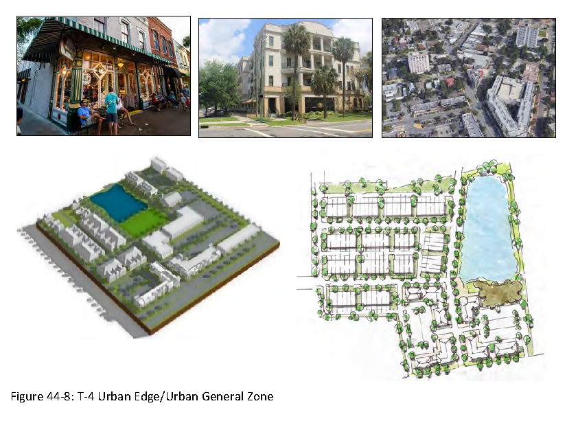
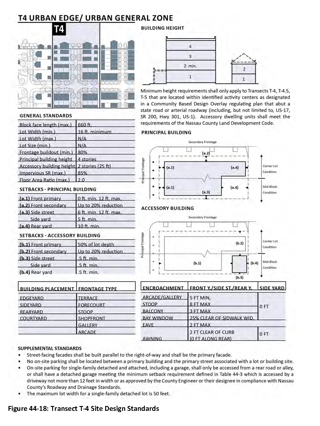
T-4 Urban Edge/Urban General Zone. This transect is intended to be a compact mixed-use zone arranged, primarily, as residential urban fabric. Density is eight (8) to fifteen (15) dwelling units per acre. This transect shall have a wide range of building types and a mixture of uses is required. Setbacks and landscaping are variable. Streets with curbs and sidewalks define medium-sized blocks. Refer to Table 44-3: Transect Standards, for details on block size. Building height is up to four (4) stories. This transect creates compact mixed use village centers surrounded by or within walking distance of compact residential neighborhoods. The development pattern and program shall be as such to support the intent. This is not a primarily residential zone.
H.
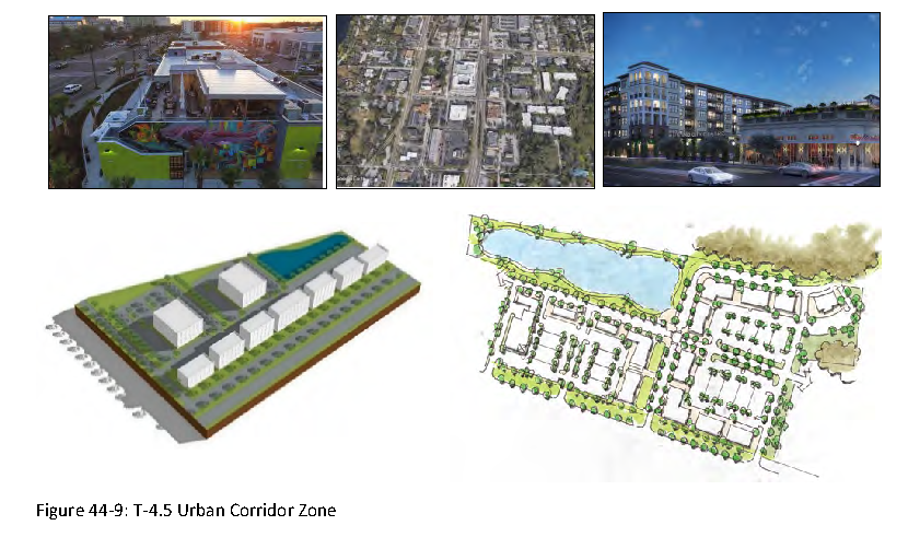
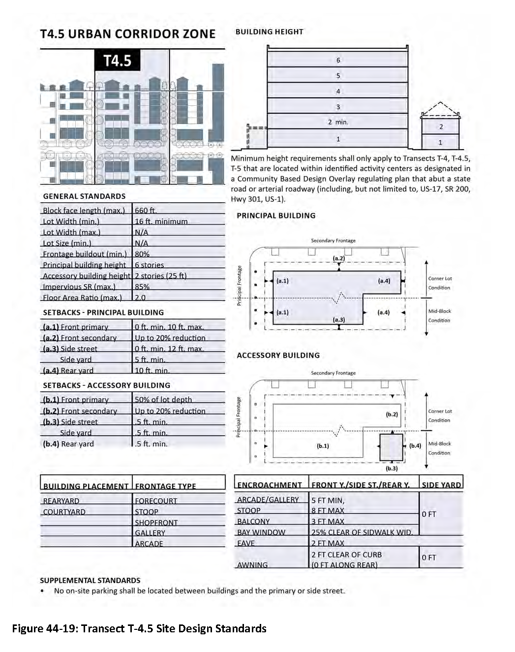
T-4.5 Urban Corridor Zone. This transect consists of a mix of uses but can be primarily non-residential or multi-family. While generally arranged to accommodate vehicular traffic, application of high-quality urban form and walkability is integral, as this transect serves as the connective tissue between individual urban nodes. The residential density varies from zero (0) to eighteen (18) dwelling units per acre. This transect has a wide range of building types. Streets with barrier curbs and sidewalks define medium-sized to large blocks. Refer to Table 44-3: Transect Standards, for details on block size. Buildings are located to define the street edge. Building heights can reach up to six (6) stories and shall define the street edge. The first floor of all buildings engages the public realm by promoting active and walkable streets.
I.
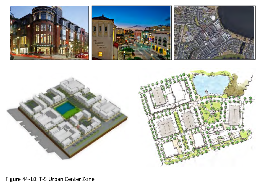
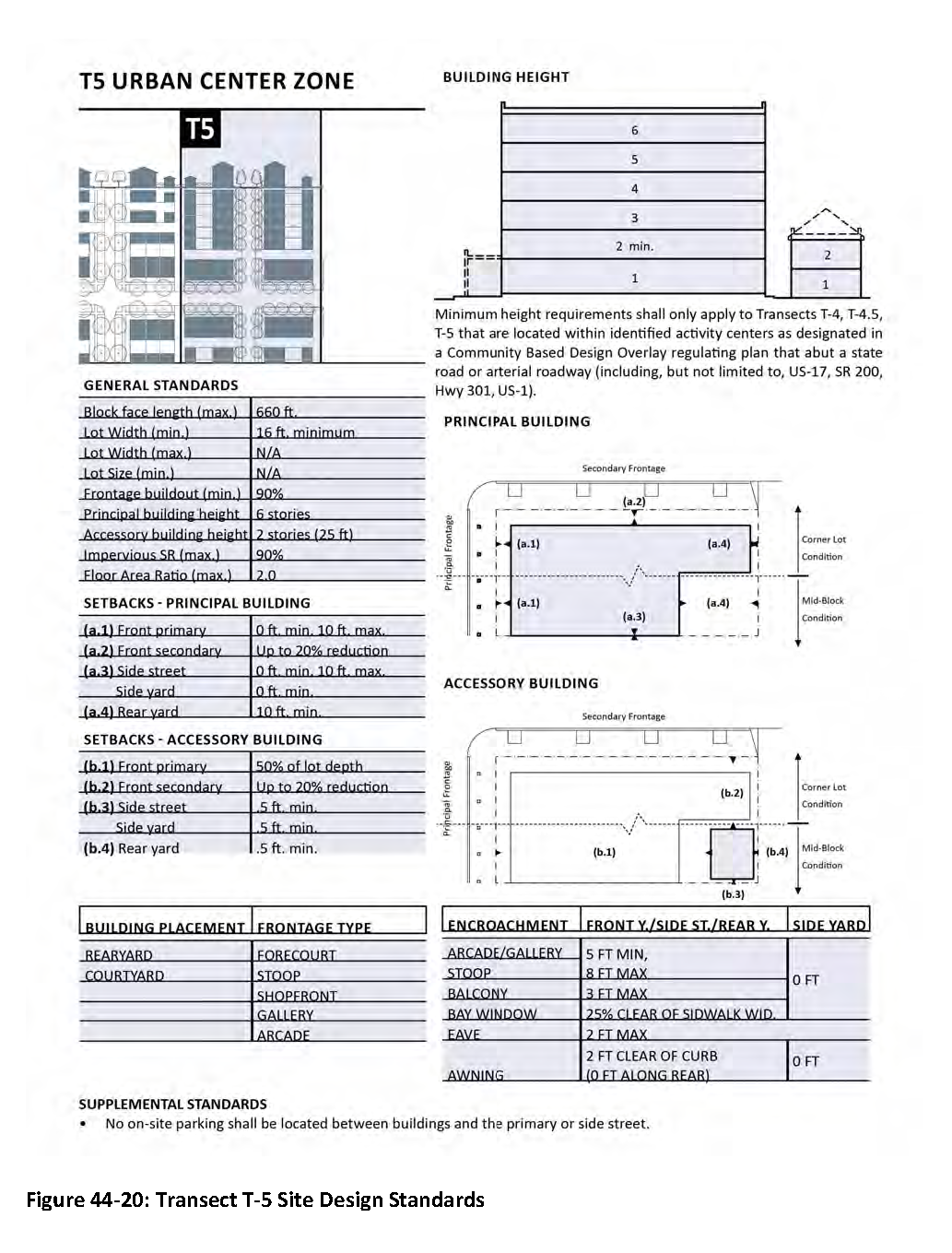
T-5 Urban Center Zone. This transect consists of higher-density, mixed-use buildings that accommodate retail, office, civic, and residential uses. It has a tight network of streets with wide sidewalks, interval street tree planting and buildings placed close to the sidewalks. It has shallow to no setbacks and building heights can reach up to six (6) stories. The residential density range is ten (10) to twenty-five (25) dwelling units per acre. The first floor of all buildings engages the public realm, primarily with the use of storefront windows.
J.
T-7: Special District Zone. Special districts consist of areas that by their function, disposition, or configuration cannot, or should not, conform to one (1) or more of the primary transect zones.
 | T-7.1 East Nassau Community Planning Area (ENCPA) special district. This special district is regulated by ENCPA Master Land-use Plan and related text in Objective FL.13 of the adopted Comprehensive Plan and associated policies, the Employment Center Detailed Specific Area Plan (EC-DSAP#1), ENCPA Detailed Specific Area Plan DSAP #2, and any applicable adopted Preliminary Development Plans (PDP), as amended from time to time. |
 | T-7.2 Campus and institutional special district. Campus and institutional uses are unique and require special consideration as each campus and/or institutional use must be tailored to the needs of the user. As such, campus and institutional uses fall outside of the primary transects and are subject to special development standards that will be considered on a case-by-case basis by Nassau County. Within the William Burgess District (WBD), the campus and institutional uses special district includes the Robert M. Foster Judicial Complex and the Florida State College at Jacksonville - Nassau Campus. |
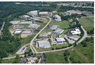 | T-7.3 Industrial park. The T-7.3 Transect is designated as a Special District intended to accommodate light industrial, warehousing, and related employment-generating uses in a manner compatible with surrounding development and infrastructure. Industrial parks are unique and require special consideration, as each site must be tailored to the operational needs of specific industrial users. As such, properties designated T-7.3 fall outside the standard form-based transect structure and are instead subject to special development standards and review. |
Permitted uses within T-7.3 include those listed under Industrial, Warehouse and Industrial, Heavy as defined in articles 20 and 21 of the Nassau County Land Development Code (LDC), provided such uses are evaluated and approved through the appropriate development review process. In addition, travel trailer parks and campgrounds are permitted in T-7.3, subject to the supplemental standards contained in section 28.09 of the LDC. All development within the T-7.3 Transect shall be reviewed on a case-by-case basis by Nassau County to ensure compatibility with surrounding Transects, and alignment with applicable infrastructure and environmental considerations.
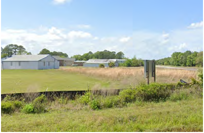 Figure 44-11: T-7 Special District Zones
| T-7.4 Flying M Acres special district. The Flying M Acres special district is unique and requires special consideration to accommodate an existing airstrip and residential community. As such, the Flying M Acres special district falls outside of the primary transects and is subject to special development standards that will be considered on a case-by-case basis by Nassau County. Flying Acres will be permitted to redevelop under Open Rural (OR) zoning regulations. In the case of redevelopment pursuant to Transect Based Zoning, the transect 4 designation and the Timber to Tides Community-Based Design Standards found in article 45 shall be applicable. |
T-7.5 Central Nassau Employment Center (CNEC) special district. The Central Nassau Employment Center (CNEC) is unique and requires special consideration to accommodate varying industrial and supporting uses that are tailored to the needs of the user at individual campuses. As such, the CNEC falls outside of the primary transects and is subject to special development standards that will be considered on a case-by-case basis by Nassau County. CNEC campuses shall be designed with the intent to conserve existing wetlands and wildlife corridor systems, divert heavy vehicular traffic off main corridor areas, develop a road network that preserves the silvicultural quality of the area, incorporate a mix of supporting non-industrial uses that promote self-sustainable campuses, and generate a high concentration of jobs. At a minimum, the following standards shall be adhered to in transect 7.5:
A.
Conservation.
1.
A minimum undisturbed natural vegetative upland buffer of twenty-five (25) feet shall be required and maintained between developed areas and contiguous (i.e., non-isolated) wetlands to protect the water quality of the wetlands and to preserve existing wildlife corridor areas. An average of the upland buffer is allowed, but in no instance shall the upland buffer be less than fifteen (15) feet, except for those areas adjacent to unavoidable wetland impacts such as road crossings.
B.
Traffic.
1.
Each campus within the CNEC shall submit a Transportation Impact Analysis (TIA), i.e. traffic study to assess the adequacy of existing and proposed transportation facilities and impact to the mobility network at the time of development review. The TIA shall be prepared according to the adopted Nassau County Transportation Impact Analysis Guidelines. The TIA shall demonstrate how heavy-vehicle and commercial traffic will be diverted off State Road 200 when the new I-95 interchange becomes functional.
C.
Road Network.
1.
CNEC campuses shall utilize the Timber Road Types specified in article 45 for main collector roadways when adjacent to industrial uses.
D.
Self-Sustainable Campus.
1.
Industrial uses shall be the primary use within the CNEC. Industrial uses shall mean activities associated with the manufacture, assembly, distribution, processing, including data processing, or storage of products or the performance of related services.
2.
Supporting non-industrial uses are permitted to offer mixed-use services allowing for the CNEC to be self-sustainable. Supporting non-industrial uses may include office, retail, and related uses as approved by the Planning Director.
3.
Supporting non-industrial uses shall only compose ten percent (10%) of the total development square footage as measured over the entire transect 7.5. The remaining ninety percent (90%) shall be industrial uses.
E.
Jobs and Livability. Actual delineation of transect 7.5 boundaries may be adjusted based on additional or refined data provided as properties undergo development review based on permitting through state and federal agencies. The final delineation of transect 7.5 will be determined at time of development approval through the Nassau County Development Review Committee. This delineation shall not change the gross land area by more than ten (10) percent.
F.
Permit Process and Applicability.
1.
Development within the CNEC shall follow these requirements and section 45.03.02.C Cross Sections, Timber Road Types. Development within the CNEC shall not be subject to the section 45.02 Site Engineering Plan Community Based Design Standards.
2.
The following standards shall apply on a gross basis to the land area associated with transect 7.5:
a.
General Parameters. Ninety percent (90%) Impervious Surface Ratio (ISR), Floor Area Ratio (FAR) 4.0, minimum building setback is zero (0) feet, and no maximum building height.
b.
Internal Tree Planting. Customer and employee parking areas shall meet the internal tree planting requirements in LDC section 37.05.
44.04.03. - Transect density.
Table 44-1: Transect Density Ranges
A.
All development shall meet the minimum residential density requirements assigned for its designated transect.
B.
When calculating minimum residential densities, land areas within the development parcel used for right-of-way, stormwater management facilities (SWMF), wetlands, required buffers, public utilities, public parks, and/or public schools may be excluded from the minimum density requirement calculation.
C.
When calculating maximum residential densities, the gross acres of the parcel, including uplands and wetlands, shall be used.
D.
Where residential and non-residential uses are vertically integrated within the same structure, floor area ratio (FAR) calculation will exclude those portions devoted to residential dwelling units located above non-residential uses/spaces.
(Ord. No. 2025-012, § 2(Exh. A), 6-23-25)
Section 44.05. - Transect allowable uses table.
A.
The permitted uses for TBZ are established and regulated by transect. The assigned transect for a parcel of land is established in the applicable regulating plan. The Transect Allowable Uses Table identifies the allowed uses in each transect.
B.
Transect Allowable Uses Table key.
1.
Uses permitted by right (P). A "P" indicates that a use is allowed by right in the respective transect.
2.
Uses permitted in a limited area (P*). A "P*" indicates that a use is allowed by right only where the use is abutting a state road or arterial roadway (including, but not limited to, US-17, SR 200, Hwy 301, US-1).
3.
Conditional use (C). A "C" indicates a use that is allowed in the respective transect only where approved as a conditional use in accordance with the procedures and criteria outlined in sections 5.03 and 5.04 of the LDC.
4.
Uses not allowed. A blank cell in the use table indicates that a use is not allowed in the respective transect.
5.
Prohibited Uses. Any use that is not identified in the Transect Allowable Uses Table is prohibited. An applicant may request an interpretation to determine if a use that is not identified is permissible, based on substantial similarity of the requested use to permissible uses within the transect in which the property is located. A requested use shall be considered substantially similar when the characteristics of the requested use are equivalent in type, intensity, degree, or impact when compared to a use named in the Transect Allowable Uses Table. The Planning Director shall make this determination based on the following criteria:
a.
Typical hours of operation;
b.
Use of outdoor storage;
c.
Trip generation rates;
d.
Generation of noise, light pollution, emissions, electromagnetic interference, or vibration;
e.
Customary functions of the use; and
f.
Impacts to urban form and design standards.
Table 44-2: Transect Allowable Uses Table
P= Permitted C= Conditional use Blank = not allowed
1 Surface parking lots are permissible with associated structures or anchor buildings. This use is specific to surface parking lots with no associated structures or anchor buildings.
(Ord. No. 2025-012, § 2(Exh. A), 6-23-25)
Section 44.06. - Transect specific design standards.
In addition to the design standards for Community-Based Design Overlays, article 45 of the Land Development Code, all properties zoned TBZ shall also adhere to the following design standards as they apply to the specific district of the parcel.
44.06.01. - Site design.
A.
Table 44-3: Transect Standards.
Table 44-3 notes
*Minimum height requirements shall only apply to transects T-4, T-4.5, T-5 that are located within identified activity centers as designated in a Community Based Design Overlay regulating plan that abut a state road or arterial roadway (including, but not limited to, US-17, SR 200, Hwy 301, US-1).
See additional notes on the following page.
**In the case of attached residential dwellings, the minimum side yard setback may be zero (0) feet between interior units.
***Lots with a gross area less than five (5) acres in size created after the date of this article shall have a minimum net usable area equal to or greater than the minimum lot area requirement of the respective transect. Net usable area shall mean the portion of a lot or property that is clear and free of all stormwater management facilities, ponds, and jurisdictional wetlands.
****Non-residential and mixed-use development in Transect T-3.5 shall utilize a principal building setback of zero (0) feet minimum and fifteen (15) feet maximum.
B.
Measurements.
1.
Block lengths shall be determined during site engineering in context with lots or parcels, mobility or non-mobility roadways, site constraints, and creative design. Such block lengths shall be measured along the primary public roadway from the outer boundaries of the lots or parcels comprising the block or along the margins of continuous physical features such as wetlands, rivers, water bodies, railroads that may form the face of a block.
a.
A block face exceeding five hundred (500) feet shall have a mid-block pedestrian pathway or activation, minimum of twenty (20) feet, to provide pedestrian connectivity between blocks or uses.
b.
Blocks composed entirely of water bodies, wetlands, parks, and/or civic uses shall have no maximum length, width or perimeter requirement.
c.
Block length and depth may be increased or decreased, based on the following criteria:
i.
preserving trees or ecologically sensitive areas; or
ii.
where there are mid-block pedestrian pathway or activation used to interrupt a continuous streetscape; or
iii.
the terminus of the block is shown as a civic space.
2.
Building height. Maximum building height is determined by the number of stories allowed in each transect. Minimum height requirements shall only apply to Transects T-4, T-4.5, T-5 that are located within identified activity centers as designated in a Community Based Design Overlay regulating plan that abut a state road or arterial roadway (including, but not limited to, US-17, SR 200, Hwy 301, US-1). The height of the first story shall not exceed twenty (20) feet, and the height of each subsequent story shall not exceed fifteen (15) feet. However, the Planning Director may approve increased story heights for specific uses, including, but not limited to, auditoriums, churches, big box stores, warehouses, and similar uses.
3.
Front façade. All required setbacks, build-to zones, or other dimensional standards referencing the front façade of a building shall be measured from the primary front wall plane of the building, defined as the vertical surface of the exterior wall facing the primary frontage.
a.
Exclusions for Projections. Minor architectural features that project from the primary front wall plane including, but not limited to, roof eaves, bay windows, awnings, stoops, porches, balconies, and decorative trim may extend into the required front yard or build-to zone, subject to the allowable encroachment standards specified elsewhere in this Code. Such projections shall not be used as the reference point for measuring the front façade distance.
b.
Principal Entrance and Active Frontage. In cases where a building includes a covered porch, arcade, or colonnade that is structurally integrated into the building's design and serves as the primary pedestrian entrance, the outer edge of such feature may be considered the front façade for measurement purposes, provided it is at least partially enclosed or roofed and designed to support active pedestrian use.
c.
Clarity in Site Plans. Site plans and building permit applications shall clearly identify the primary front wall plane and any projecting architectural features to ensure accurate measurement and compliance with required setbacks and build-to zones.
C.
Administrative Flexibility.
1.
The Planning Director may grant up to a ten percent (10%) administrative flexibility to dimensional standards in Table 44-3 for individual lots or buildings at the time of site engineering plan or subdivision approval, provided such adjustments:
a.
Do not result in an increase in permitted density, intensity, or building height;
b.
Do not reduce required street, framework, or pedestrian frontage;
c.
Maintain the intent of the applicable Transect and the Regulating Plan; and
d.
Are the minimum necessary to address site-specific constraints, such as lot shape, topography, or environmental features.
2.
Applicable Standards. This administrative flexibility may be applied to:
a.
Setbacks;
b.
Lot width;
c.
Frontage buildout; or
d.
Block face length.
3.
Excluded Standards. This administrative flexibility shall not be applied to:
a.
Floor Area Ratio (FAR);
b.
Impervious Surface Ratio (ISR); or
c.
Density requirements.
4.
Flexible provisions for supplemental standards in T-3.5 and T-4.
a.
In Transects T-3.5 and T-4, residential development shall provide rear-loaded or alley-accessed units to support a walkable, pedestrian-oriented development pattern as specified in the supplemental requirements of article 44.
b.
To allow limited flexibility in site layout, a development may include one (1) front-loaded residential unit (attached or detached) for every two (2) rear-loaded diversified housing units provided.
c.
For the purposes of this provision, diversified housing units shall include townhomes (attached), duplexes, triplexes, cottage courts, and other missing middle housing types as defined in this article. Rear-loaded single-family detached units shall not count toward this ratio.
d.
In no case shall front-loaded units exceed twenty-five percent (25%) of the total number of residential units within the development. Front-loaded units shall not front on SR 200, US 17, or framework streets and must comply with all other applicable design standards of this Article and community based design standards.
5.
In order to promote walkable environments and activate community open spaces, a zero-foot principal building front setback may be administratively approved for residential structures fronting directly onto designated open spaces, parks, or common areas. This flexibility may be applied when the following criteria are met:
a.
The building fronts a designated open space or common area with direct pedestrian access from the front façade;
b.
Vehicular access is provided from a rear alley, lane, or alternative configuration that avoids conflict with the open space frontage; and
c.
The design maintains appropriate architectural orientation and compatibility with surrounding development and frontage standards.
D.
Required Building Placement. Building placement relates to how a building is located on an individual lot and where the yard is located and is depicted in Table 44-4. All buildings shall utilize building placement types found herein.
Table 44-4: Required Building Placement
|
Building
placement types | Transect | Example | General description |
|---|---|---|---|
| Edgeyard |
T-1.5
T-2 T-2.5 T-3 T-3.5 T-4 |  |
A building placed within the boundaries of its lot
to create an edgeyard around the building, with setbacks on all sides. The front yard is intended to be visually continuous with the yards of adjacent buildings. The rear yard can be secured for privacy by fences. |
| Sideyard |
T-3
T-3.5 T-4 |  | A building that occupies one side of the lot with the setback to the other side. A shallow frontage setback defines a more urban condition. If the adjacent building is similar with a blank side wall, the yard can be quite private. This type permits systematic climatic orientation in response to the sun or the breeze. |
| Rearyard |
T-3.5
T-4 T-4.5 T-5 |  | A building that occupies the full frontage, leaving the rear of the lot as the sole yard. This is a very urban type as the continuous facade steadily defines the public thoroughfare. The rear elevations may be articulated for functional purposes. In its residential form, this type is the rowhouse. For its commercial form, the rear yard can accommodate substantial parking. |
| Courtyard |
T-3.5
T-4 T-4.5 T-5 |  | A building that occupies the boundaries of its lot while internally defining one or more private patios. This is the most urban of types, as it shields the private realm from all sides while strongly defining the public thoroughfare. Because of its ability to accommodate incompatible activities, masking them from all sides, it is recommended for workshops, lodging and schools. |
E.
Required Private frontage. A private frontage is the area between the front of the building and the public right-of-way, and visually is part of the public realm. Table 44-5 depicts the section and plans for different types of private frontages, as determined by the corresponding transect. All buildings along street frontages shall utilize a permitted frontage type found herein. Corner lots shall have two (2) frontages.
Table 44-5: Required Private Frontages
| Frontage types | Transect | Example | General description |
|---|---|---|---|
| Common yard |
T-1.5
T-2 T-2.5 T-3 | 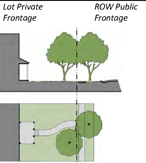 | A planted frontage wherein the facade is set back substantially from the frontage line. The front yard remains unfenced and is visually continuous with adjacent yards, supporting a common landscape. The deep setback provides a buffer from the higher speed thoroughfares. |
| Porch and Fence |
T-3
T-3.5 | 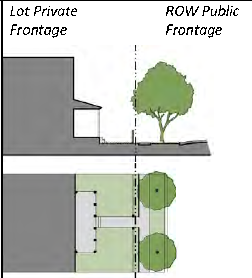 | A planted frontage wherein the facade is set back from the frontage line with an attached porch permitted to encroach. A fence at the frontage line maintains street spatial definition. |
| Terrace |
T-3.5
T-4 | 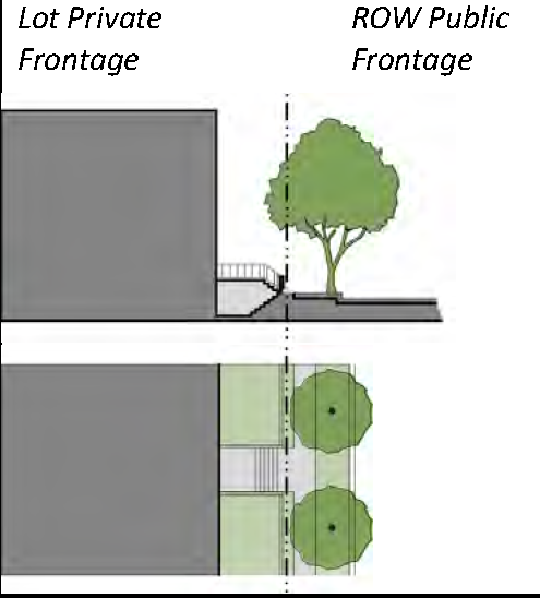 | A frontage wherein the facade is set back from the frontage line by an elevated terrace. This type buffers residential uses from sidewalks and removes the private yard from public encroachment. |
| Forecourt |
T-3.5
T-4 T-4.5 T-5 | 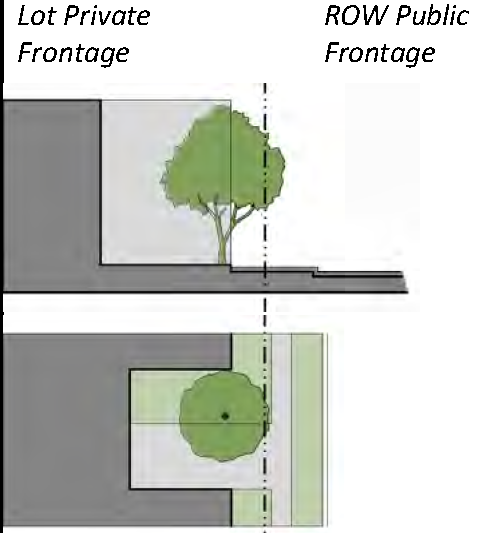 | A frontage wherein a portion of the facade is close to the frontage line and the central portion is set back. The forecourt is suitable for vehicular drop-offs. This type should be utilized in conjunction with other frontage types. Large trees within the forecourts may overhang the sidewalks. |
| Stoop |
T-4
T-4.5 T-5 | 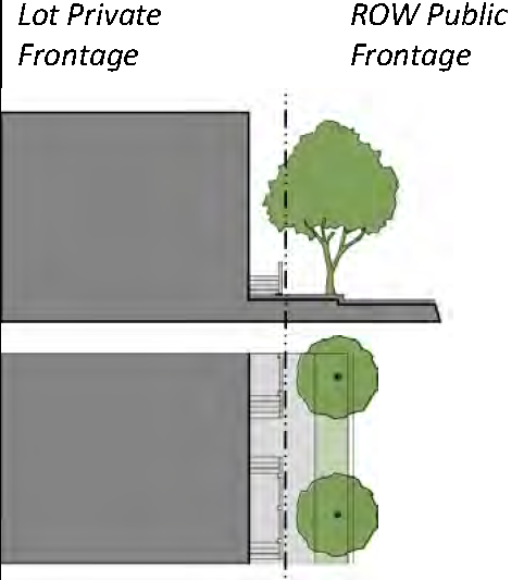 | A frontage wherein the facade is aligned close to the frontage line with the first story elevated from the sidewalk sufficiently to secure privacy for the windows. The entrance is usually an exterior stair and landing. |
| Shopfront |
T-4
T-4.5 T-5 | 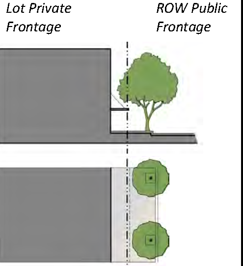 | A frontage wherein the facade is aligned close to the frontage line with the building entrance at sidewalk grade. This type is conventional for retail use. The sidewalk level includes substantial glazing and an awning that may overlap the sidewalk to within 2 feet of the curb. |
| Gallery |
T-4
T-4.5 T-5 | 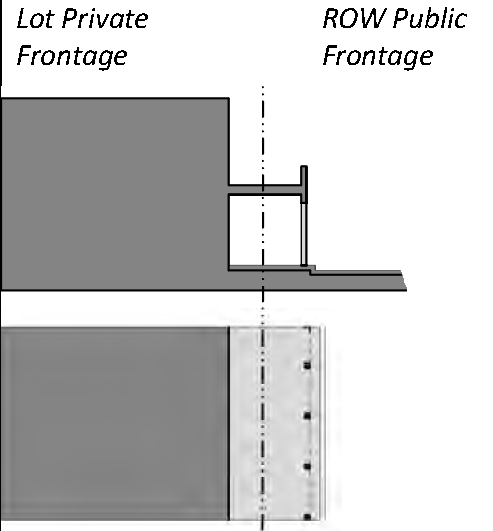 | A frontage wherein the facade is aligned close to the frontage line with an attached cantilevered shed or a colonnade overlapping the sidewalk. This type is conventional for retail use. |
| Arcade |
T-4
T-4.5 T-5 | 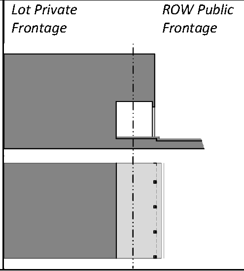 | A colonnade supporting habitable space that overlaps the sidewalk, while the facade at sidewalk level remains at or behind the frontage line. This type is conventional for retail use. |
F.
Transect Standards Summary Sheets—Transect 1 to Transect 5.
44.06.02. - Greens, squares, plazas, playgrounds and other social spaces.
A.
For non-residential developments, public spaces and related amenities shall be provided to further engage the public and private realms. These spaces can be included within the extent of the development, or the sidewalk can be widened to provide amenities and activate public spaces.
B.
All non-residential development shall provide public spaces in the form of pocket parks, greens, courtyards, squares, plazas, or similar spaces designed to encourage social activity and provide for a sense of shared space. These public spaces shall be interconnected by orientation or pedestrian facilities, and are intended to be outside rooms that may be used for dining, entertainment, meeting spaces, pocket parks, community functions, and other similar activities.
C.
Public spaces shall be visible and accessible from the adjacent street or major internal pedestrian route.
D.
Public spaces shall include pedestrian-scale lighting.
Table 44-6: Civic/social space
| Civic/Social spaces | Transect | Example | General description |
|---|---|---|---|
| Playground |
T-1.5
>T-2 T-2.5 T-3 T-3.5 T-4 T-4.5 T-5 | 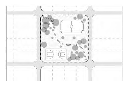 | An open space designed and equipped for the recreation of children. A playground should be fenced and may include an open shelter. Playgrounds may be placed within a block. Playgrounds may be included within parks and greens. There shall be no minimum or maximum size. Trees shall provide for strategic shade around play equipment, benches, and picnic tables. |
| Square |
T-3
T-3.5 T-4 T-4.5 T-5 | 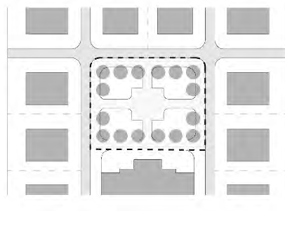 | An open space available for unstructured recreation and civic purposes. A square is spatially defined by building frontages. Its landscape shall consist of paths, lawns and trees, formally arranged. Squares shall be located at the intersection of important thoroughfares. The minimum size shall be 1/2 acre and the maximum shall be 5 acres. |
| Plaza |
T-3
T-3.5 T-4 T-4.5 T-5 | 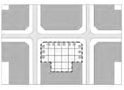 | An open space available for civic purposes and commercial activities. A plaza shall be spatially defined by building frontages. Its landscape shall consist primarily of pavement. Tree plantings will provide for strategic shade. Plazas should be located at the intersection of streets. The minimum size shall be 1/2 acre and the maximum shall be 2 acres. |
| Green |
T-3
T-3.5 T-4 T-4.5 T-5 | 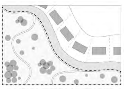 | An open space available for unstructured recreation. A green may be spatially defined by landscaping rather than building frontages. Its landscape shall consist of lawn and trees, naturalistically arranged. The minimum size shall be 1/2 acre and the maximum shall be 8 acres. |
| Passive Park |
T-1.5
T-2 T-2.5 T-3 T-3.5 T-4 T-4.5 T-5 | 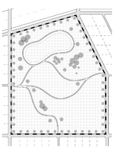 | A natural preserve available for unstructured recreation. A park may be independent of surrounding building frontages. Its landscape shall consist of paths and trails, meadows, waterbodies, woodland, and open shelters, all naturalistically arranged. Parks may be lineal, following the trajectories of natural corridors. The minimum size varies. |
E.
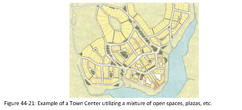
In higher transects (Transect 3.5 or above), activity centers, town centers, and similar intensive urban environments, the level of service (LOS) requirements for neighborhood, community, and regional parks, as specified in the adopted comprehensive plan, may be met through a series of smaller, interconnected open and civic spaces. These spaces, integrated within the urban fabric, shall be designed to provide accessible and well-distributed parks and recreational opportunities that support the density and walkability of the surrounding development. The following principles shall apply:
1.
Smaller Open Spaces in Urban Areas: The requirements for local parks may be satisfied by a network of smaller open spaces, greens, civic plazas, and playgrounds located within a walkable distance of residential and commercial areas. These spaces shall serve as multifunctional areas for passive and active recreation, public gatherings, and social interaction.
2.
Civic and Public Spaces: Civic spaces, including plazas and squares, shall be integrated into the design of town centers and urban environments to provide functional, accessible areas for community activities. These spaces shall be designed with considerations for urban aesthetics, accessibility, and connectivity, and may include amenities such as seating, water features, or public art.
3.
Interconnected Green Spaces: A system of green spaces, including parks, greens, and linear corridors, shall be incorporated into the layout of the built environment, ensuring that they are connected and accessible. These green spaces should allow for pedestrian and bicycle circulation, offering recreational opportunities and promoting active lifestyles.
4.
Landscaped Plazas and Play Areas: In addition to parks, smaller play areas and landscaped plazas shall be provided in urban and town center environments to meet recreational needs. These shall be strategically located in higher transects, providing easy access and connectivity to other community amenities and open spaces.
5.
Level of Service in Higher Transects: In compact walkable village centers and higher transects, the cumulative effect of these smaller open spaces shall meet or exceed the LOS requirements traditionally fulfilled by larger local parks. The integration of green spaces, parks, and civic spaces in these areas shall ensure that the needs of the community are addressed in a manner consistent with the goals of good urbanism and pedestrian-oriented design.
6.
Flexibility and Context-Sensitivity: The application of these requirements shall be evaluated on a case-by-case basis, taking into account the specific characteristics of the development area, including density, land use, and the surrounding urban context. In some instances, a combination of public and private spaces may be used to meet LOS standards, provided they are accessible to the public and appropriately designed.
(Ord. No. 2025-012, § 2(Exh. A), 6-23-25)
Section 44.07. - Definitions
These definitions apply to Transect Based Zoning Districts. Undefined terms shall have the meanings provided in the Land Development Code, Article 32, as applicable.
General Definitions
1.
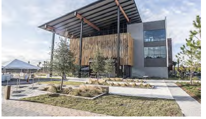
Activity Center: A designated area within a Community-Based Design Overlay (CBDO), as defined in article 45 of the Land Development Code, which encourages mixed-use development and serves as a focal point for social, commercial, and recreational activities within the community.
2.
Civic Building: A publicly or quasi-publicly owned structure that is dedicated to functions such as government, education, recreation, arts, or culture. Examples include municipal buildings, libraries, community centers, theaters, and transit stations.
3.
Encroachment: The physical intrusion of a structure or part of a structure that extends beyond the legal building envelope, such as into required setbacks or airspace limits. Encroachments can include projections like balconies, overhangs, or eaves that violate zoning or design regulations.
4.
Façade: The primary exterior face or wall of a building that is visible from a public space, such as a street, plaza, or public open space. The façade is a key element in determining the aesthetic and functional character of a building, including elements like windows, entrances, and architectural treatments.
5.
Middle Housing: A range of moderate-density residential building types that are compatible in scale with detached single-family homes and support walkable, mixed-use neighborhoods. Middle housing includes, but is not limited to, duplexes, triplexes, quadplexes, townhomes (attached), cottage courts, live-work units, and other small-scale, multi-unit configurations. These housing types serve as a transition between lower-density detached housing and higher-density multifamily or mixed-use development and are designed to integrate seamlessly within Transect-based communities.
6.
Liner Building: A building designed specifically to conceal a parking structure or parking lot from public view. Liner buildings typically have active uses (such as retail or residential) at the ground level to create a continuous street edge and maintain an attractive urban environment.
7.
Live-Work: A residential unit that integrates both living and working spaces, designed to accommodate individuals or families who operate a business or office from their residence. Live-work units are common in mixed-use neighborhoods where there is a blending of residential and commercial uses.
8.
Lot Width: See article 32, Land Development Code.
9.
Fair Market Value: The value of buildings and structures, excluding the land and other improvements on the parcel. Fair market value is the actual cash value (like-kind replacement cost depreciated for age, wear and tear, neglect, and quality of construction) determined by a Florida Certified Appraiser, or tax assessment value established by the Nassau County Property Appraiser plus ten (10) percent. Appraisals by a Florida Certified Appraiser shall not use the "income capitalization approach," which bases value on the use of the property and not on the structure.
10.
Passive Recreational Opportunities: Leisure activities that do not require intense physical exertion or structured organization. These activities are often nature-based and include hiking, birdwatching, fishing, camping, and other outdoor pursuits that encourage interaction with the natural environment.
11.
Principal Frontage: The main street-facing side of a property, often determined by the location of the building's primary entrance. On corner lots, the principal frontage refers to the street that provides the main access and the primary orientation for the building design.
12.
Private Frontage: The portion of land between the building facade and the public frontage line, often developed with landscaping, sidewalks, or other private amenities. This space is typically owned by the property owner and is regulated for aesthetic and functional purposes in urban design.
13.
Public Frontage: The area between the curb and the private frontage line, which is typically dedicated for public use. Public frontage includes sidewalks, streetscapes, and other elements of the public realm that enhance pedestrian access, safety, and the visual appeal of the area.
14.
Rearage Road: A secondary access road, typically located at the rear of properties, used primarily for service functions, such as loading docks, delivery zones, and parking areas. Rearage roads are designed to reduce traffic congestion and maintain the aesthetic appeal of primary streets.
15.
Regulating Plan: A zoning map or set of maps that defines specific regulations for each zone, including transect zones, building form standards, land use regulations, and special requirements. Regulating plans are often used in form-based codes to direct the development of public spaces, streets, and private properties.
16.
Retail Frontage: A segment of the building or lot designated for retail use, typically located on the ground floor and facing the street. Retail frontages are designed to encourage pedestrian traffic and activate the public realm with retail or service-based businesses.
17.
Setback: See article 32, Land Development Code.
18.
Side Street: The street that runs along the side of a corner lot, typically having a lower classification than the primary street (e.g., a secondary road or residential street). The side street often has its own setback and design requirements.
19.
Transparency: refers to the percentage of a building façade composed of clear, non-reflective glazing that provides direct views into and out of interior spaces. It is calculated as a proportion of the wall surface within a measured façade area and is intended to promote visual interaction between the public and private realms, contributing to pedestrian safety, comfort, and an engaging streetscape. Only transparent glazing that allows unobstructed visibility into active interior spaces shall be counted toward meeting transparency requirements. Glazing that is opaque, frosted, mirrored, or heavily tinted does not qualify. Spandrel glass, faux windows, or glass applied solely for decorative or screening purposes shall also be excluded. Alternative materials may be considered only if they provide equivalent transparency and are permanently installed to allow clear visual connection between the building's interior and the exterior public realm. Approval of such materials shall be subject to review by the Development Review Committee and demonstration of functional transparency.
_____
Residential Uses
1.
Accessory Dwelling: See article 32, Land Development Code.
2.
Assisted Living Facility: See article 32, Land Development Code.
3.
Bed and Breakfast (Up to five (5) guest rooms): See article 32, Land Development Code.
4.
Courtyard Single Family Development: A development featuring single-family homes arranged around a central courtyard, offering shared open space for residents.
5.
Hotel (No Guest Room Limit): See article 32, Land Development Code.
6.
Inn (Up to 12 guest rooms): A small lodging establishment with up to twelve (12) guest rooms, typically offering personal accommodations, often with additional services like breakfast.
7.
Live-Work Unit: A residential unit designed for both residential and business uses, allowing the resident to operate a business from the same space.
8.
Manufactured Home/Mobile Home: See article 32, Land Development Code.
9.
Mixed Use: A development model that incorporates multiple land uses (such as residential, commercial, and/or office) within the same building or complex, either through vertical stacking (e.g., apartments above retail) or horizontal adjacency (e.g., different uses in separate buildings within close proximity).
10.
Multi-Family two (2) to four (4) Units: A residential structure containing two (2) to four (4) separate dwelling units, typically for rental or ownership by multiple households.
11.
Multi-Family Greater than four (4) Units: A residential structure containing more than four (4) units, intended for multi-household living, including apartments or condominiums.
12.
Resort: A recreational facility offering lodging accommodations, amenities, and services for guests, typically in tourist destinations.
13.
School Dormitory: See article 32, Land Development Code.
14.
Single-Family Attached (Row House/Townhouse): A residential building that shares at least one wall with an adjacent unit, typically part of a larger development.
15.
Single-Family Detached Dwelling: See article 32, Land Development Code.
_____
Office Uses
1.
Medical/Personal Services Offices: See article 32, Land Development Code.
2.
Office Building: See article 32, Land Development Code.
3.
Professional Offices: See article 32, Land Development Code.
_____
Service Uses
1.
Ambulatory Care: A healthcare service facility that provides medical treatment to patients who are not admitted overnight. These facilities typically offer diagnostic, therapeutic, or preventive services, and patients visit for scheduled appointments or treatments.
2.
Animal Groomer: A business providing grooming services for pets, including bathing, trimming, and other services.
3.
Animal Vet/Daycare/Boarding Facility: A facility offering veterinary care, pet daycare, or boarding services for animals.
4.
Child/Adult Daycare: See article 32, Land Development Code.
5.
Funeral Home: A business providing funeral services, including preparation, embalming, and cremation (provided off-site only), as well as the sale of caskets and urns.
6.
Health and Fitness Establishment: A facility offering services related to fitness and wellness, including gyms, yoga studios, and fitness training centers.
7.
Hospital: See article 32, Land Development Code.
8.
Mini-Storage: See article 32, Land Development Code.
9.
Research and Development Center: A facility dedicated to the research, design, and development of new products or technologies.
_____
Retail Uses
1.
Alcohol Selling Establishment (Including Amenity Centers): A business that sells alcoholic beverages, such as a bar or restaurant, including amenities centers in residential areas.
2.
Kiosk: A small, stand-alone structure used for the display and sale of goods or services. Kiosks are typically located in high-traffic areas, such as malls, parks, or transit stations, and can serve as points of sale, information centers, or service desks.
3.
Open-Market Building/Farmers Market: A space where vendors sell agricultural products directly to consumers, often in an open-air setting.
4.
Restaurant/Food Establishment: A business that prepares and serves food for consumption on-site or for takeout.
5.
Retail Building: See article 32, refer to definition of "Retail."
6.
Shopping Center: See article 32, Land Development Code.
7.
Grocery Store/Supermarket: A retail business selling food and other essential goods, typically with a focus on groceries.
8.
Big Box Store (> seventy-five thousand (75,000) square feet): A large-scale retail or wholesale establishment with a gross floor area of seventy-five thousand (75,000) square feet or more, typically offering a wide variety of consumer goods, bulk merchandise, or home improvement products. These stores may operate as standalone businesses or as anchor tenants within commercial developments, serving as regional or community retail destinations.
9.
Home Improvement Store: A retail store specializing in home construction, renovation materials, tools, and appliances.
_____
Public/Quasi-Public Uses
1.
Bus Shelter: A structure providing shelter for individuals waiting for public transportation.
2.
Cemetery: See article 32, Land Development Code.
3.
Convention Center: A large facility designed to host conventions, trade shows, and other large events.
4.
Essential Public Services: Services necessary for the functioning of a community, such as water, sewage, and emergency services.
5.
Fire Station: A facility where firefighting personnel and equipment are located, providing emergency response services.
6.
Parking Structure: A multi-level building designed to provide parking spaces for vehicles.
7.
Passenger Terminal: A facility used for the boarding and disembarking of passengers, such as at airports or bus terminals.
8.
Playground: An outdoor recreational space with equipment designed for children to play.
9.
Police Station: A facility housing law enforcement officers and equipment for providing public safety services.
10.
Public Art: Artwork displayed in public spaces for the enjoyment and education of the community.
11.
Religious Assembly: A building or space used for religious services and activities, such as a church, synagogue, mosque, or temple.
12.
Surface Parking Lot: An open area designated for the parking of vehicles, typically without any structures.
13.
Indoor/Outdoor Recreation (Private): Private facilities for recreational use, including gyms, sports clubs, and private parks.
14.
Indoor/Outdoor Recreation (Public): Public facilities for recreational use, such as community centers, public parks, and playgrounds.
15.
Library: A public facility offering books, digital media, and other resources for learning and leisure.
_____
Entertainment Uses
1.
Live Theater: A venue for live performances, including plays, musicals, and other theatrical productions.
2.
Movie Theater: A facility designed for the viewing of films on large screens.
3.
Museum: A public institution dedicated to the collection, preservation, and exhibition of items of historical, artistic, or cultural significance.
4.
Outdoor Auditorium: A venue designed for outdoor performances and gatherings, such as concerts or theatrical productions.
_____
Agricultural Uses
1.
Agricultural Storage: A facility used for storing agricultural products, tools, and equipment.
2.
Agricultural Stand: See article 32, Land Development Code.
3.
Agritourism: Agricultural activities offered to the public for recreational, educational, or entertainment purposes, such as farm tours or harvest festivals.
4.
Event Venue: A location used for hosting events, such as weddings, conferences, and other large gatherings.
5.
General Agriculture: The cultivation and production of crops, livestock, and other agricultural products.
6.
Greenhouse: A structure used for growing plants in a controlled environment.
7.
Kennel: See article 32, Land Development Code.
8.
Livestock Pen: A confined space used for keeping and managing livestock.
9.
Silviculture: The practice of managing forests for timber production, conservation, and other uses.
10.
Stable: A structure used for housing and caring for horses.
11.
Urban Farming: Agricultural activities that take place in urban areas, such as rooftop farming or community gardens.
_____
Automotive Uses
1.
Automobile Service: See article 32, Land Development Code.
2.
Drive-Through Facility: A facility that allows customers to receive services or products without leaving their vehicles, such as a drive-through restaurant.
3.
Gasoline Service Station: A facility where gasoline and other fuels are sold, often including additional services like convenience stores.
4.
Truck Service: A business providing maintenance and servicing of trucks and commercial vehicles.
_____
Educational Uses
1.
Charter or Private School (Other Than an Elementary): A private or charter school providing primary or secondary education, not operated by a public school system.
2.
College/University: An institution of higher education offering undergraduate and graduate degree programs.
3.
Elementary School (Public, Private, or Charter): A school providing primary education, typically for children ages five (5) to twelve (12).
4.
High School: An educational institution providing secondary education for students aged fourteen (14) to eighteen (18).
5.
Middle School: A school that serves as a transition between elementary and high school, typically for students aged eleven (11) to fourteen (14).
6.
Vocational, Technical, Trade Schools and Similar Uses: Educational institutions focused on teaching skills for specific trades or technical fields.
(Ord. No. 2025-012, § 2(Exh. A), 6-23-25)