
New Smyrna Beach City Zoning Code
ARTICLE VI
DEVELOPMENT DESIGN AND IMPROVEMENT STANDARDS
601.00.- General.
No site plan shall be approved until city technical review staff and/or the planning and zoning board find, after reviewing the construction plans, that all plans for the design and improvements of the respective development meet or exceed the minimum standards and requirements of this LDR. Additions and alterations to existing structures shall be required to conform to these requirements unless the improvement is determined to be unnecessary by the city planner.
(Ord. No. 35-11, § 5, 6-28-2011; Ord. No. 19-18, § 1, 3-13-2018)
602.00. - Conformity with the future land use plan and thoroughfare plan.
The development of any areas subject to this LDR shall be in conformity with:
The goals, objectives and policies of the adopted comprehensive plan;
Policies and plans established by the utilities commission and city commission with respect to water supply, sewerage and solid waste disposal, and other essential utilities;
All city land development regulations;
All county, state and federal agency regulations and permitting requirements; and
All requirements of the planning and zoning board and city commission.
(Ord. No. 35-11, § 5, 6-28-2011; Ord. No. 19-18, § 1, 3-13-2018)
603.00. - Responsible entity.
The city engineer shall be responsible for determining that all plans and specifications for required street, sidewalk, drainage, wetlands protection, and water management improvements meet or exceed the minimum city and state requirements and specifications. The utilities commission representative shall be responsible for determining that all plans and specifications for required potable water, sanitary sewer and electrical power improvements meet or exceed the minimum utilities commission, city and state requirements and specifications. The city fire marshal shall be responsible for determining that all plans and specifications for required fire protection, water and building improvements meet or exceed the city, state and national requirements and specifications. The city horticulturist shall be responsible for determining that all plans and specifications for required landscaping meet or exceed the minimum city, county or state requirements and specifications. The city postmaster shall be responsible for determining that all plans and specifications for postal services meet or exceed the minimum requirements of the post office. The city police chief shall be responsible for determining that all plans and specifications for required police protection meet or exceed the minimum requirements and specifications. The city public works director shall be responsible for determining that all plans and specifications for required solid waste management meet or exceed the minimum city and state requirements and specifications. The chief building official shall be responsible for determining that all plans and specifications for required building improvements meet or exceed minimum city, state and federal requirements and specifications. The city planner shall be responsible for determining that all plans and specifications for required improvements meet or exceed the requirements of this LDR.
The entity responsible for determining that all plans and specifications for required improvements meet or exceed minimum city, state, county and federal requirements shall also determine adequate inspection of construction for compliance with the approved plans and specifications and, if applicable, for issuing a certificate of completion upon the approved completion of the work subject to the maintenance period provided for.
(Ord. No. 35-11, § 5, 6-28-2011)
604.00. - Required improvements.
604.01. Stormwater management and drainage.
A.
Definitions
Addition or alteration: Any work beyond routine maintenance or repair of a drainage system, which alters the existing system capacities or locations different from those originally approved or constructed, and result in changes to the rate, volume, or timing of discharges.
Adverse impacts: Any modifications or effects on the stormwater management systems or facilities, water bodies, groundwater and surface waters, which are, or potentially may be, harmful or injurious to human health, welfare, safety or property, or which unreasonably interfere with the enjoyment of life or property, or cause damage to ad jacent property owners, due to development or other construction activities. The term includes secondary and cumulative as well as direct impacts.
Attenuation: The reduction of stormwater discharge through retention or detention storage volume, which minimizes off-site and downstream impacts.
Base flood: A flood having a one-percent chance of being equaled or exceeded in any given year. The base flood is commonly referred to as the 100-year flood elevation.
Base flow: Surface water recharge, which originates from ground water seepage during low flow conditions.
Best management practices (BMP): Practices and methods to manage stormwater runoff by controlling peak runoff rates and volumes to improve water quality, prevent erosion, and reduce the amount of pollutant generated by non-point source.
Capacity: The limiting flow rate or volume that the drainage system can receive, without causing adverse impact to the surrounding areas, public or private.
Closed basin (land-locked): A basin that drains to a depression or receiving water body in which water can only discharge through percolation or evaporation. Or the receiving waters in such drainage basins are considered "volume sensitive" in capacity.
Compensation storage: Constructed or otherwise provided additional storage volume to offset or compensate the storage lost due to filling within the 100-year floodplain. The compensation volume is provided between the seasonal high-water table and 100-year flood elevation.
Control elevation: The lowest elevation at which stormwater can be discharged through a control device to meet attenuation and treatment requirements.
Design high water (DHW): The peak water surface elevation of the stormwater management facility, conveyance system, or water body, which is determined by the design storm event flow conditions.
Design storm: An adopted rainfall amount corresponding to the storm intensity, duration, and frequency used as the basis of the stormwater management facility design.
Detention: To temporary hold back or store stormwater to control the rate of discharge with subsequent gradual release of the volume over a specific time and usually not greater than the pre-development rate.
Development project: Any manmade change to property or improvement to land, which increases the amount of impervious coverage, changes the land topography and drainage patterns, or impact the existing stormwater systems. A development project shall include but not be limited to residential lots, subdivision, commercial, and industrial, and other site plan approval under the city's land development regulations.
Directly connected impervious area (DCIA): Impervious coverages such as building, impermeable pavement surface, and/or other impervious surfaces, which drain directly into the stormwater management system without first flowing across open space or pervious areas to allow infiltration into the groundwater.
Discharge: The outflow of water from a project site that can be quantified as discharge rate or volume release from the drainage system or stormwater management facility.
Disturbed area: Area where construction activity is currently occurring and includes but is not limited to clearing, grubbing, grading, excavating, stockpiling, landscaping, placement of fill, paving, installation of drainage systems or utilities, and construction of buildings or structures that result in soil disturbance.
Drainage basin: The surface area delineated by topographic boundaries that direct stormwater runoff to a common point or receiving water body and can be part of a larger watershed.
Drainage divide: The physical boundary (commonly the high-point or ridge) which separates two drainage basins, and from which stormwater flows on either side of the basin.
Drainage system (artificial): Any canal, ditch, culvert, dike, storm sewer or other manmade facility which can be used to control stormwater surface flow.
Drainage system (natural): Surface streams, rivers, wetlands, or marshes which convey stormwater to the natural downstream points of drainage system.
Drawdown: Lowering the surface water level, water table or piezometric surface as result of changes to the outflow system.
Duration: Time from the beginning to end of a storm event used to perform runoff calculations.
Easement: An interest in the land owned by another that entitles its holder to a specific limited use and purpose.
Elevation: Height in feet expressed in relation to mean sea level and referenced to the 1929 National Geodetic Vertical Datum (NGVD) or 1988 National Vertical America Datum (NAVD).
Encroachment (floodplain): Infringement into the floodplain or floodway by development which causes a reduction in flood storage volume and/ or conveyance capacity.
Erosion: The general process whereby soils and sediments are transport by moving water, wind, ice, climate conditions, or land-disturbing activities.
Exfiltration system: A subsurface drainage facility consisting of a conduit, such as perforated pipe, surrounded by natural or artificial aggregate that temporary stores and filters stormwater into the underlying soil through filtration.
First flush (treatment volume): The initial volume from a storm event that contains the majority concentration of contaminants and pollutants, which are directed into the drainage system for treatment.
Flooding: A general inundation of land by water to depths greater than typically occur during the normal wet season.
Flood insurance rate map (FIRM): An official map of a community which the Federal Emergency Management Agency (FEMA) has delineated both the areas of special flood hazard and the risk premium zones applicable to the community.
Flood insurance study (FIS): The official report provided by the Federal Emergency Management Agency (FEMA). The report contains flood profiles, as well as the flood boundary-flood way map and the water surface elevation of the base flood.
Floodplain: Land area subject to inundation by flood waters from a natural or man-made watercourse or water body by a storm event, including but not limited to the 100-year storm.
Flood zone: Special flood hazard area (SFHA) shown on the FEMA FIRM map, typically Zone A or Zone AE.
Floodway: The conveyance portion of a watercourse (channel) and its ad jacent floodplain areas that must remain unobstructed to convey the regulatory flood discharge for the 100-year storm event without raising the flood elevations above specified levels.
Freeboard: A vertical distance between the Design High Water (DHW) or Hydraulic Grade Line (Line) elevation to the pond top of berm or edge of pavement grade, to provide a safety factor.
Groundwater recharge: Additional water into the surface drainage system from the subsurface flow, or by surface water infiltration, percolation or seepage through naturally and/or artificial means.
Head loss: Loss of energy in fluid flows caused by friction, obstacles, eddies, tailwater, and changes in velocity and direction of flow.
Hydraulic grade line (HGL): In open channel flow, it is the water surface along the watercourse. In pressure or pipe flow, it is the theoretical line representing the pressure or piezometric head along the pipe or closed conduit.
Hydrograph: A graph of the time distribution of runoff (expressed as flow rate) from a watershed.
Hydroperiod: The duration and range of elevation of inundation in a wetland system.
Impervious surface: A surface which is highly resistant to infiltration by water. It includes surfaces such as compacted base material, as well as pavement surfaced streets, roofs, sidewalks, porous and nonporous parking lots and other similar surfaces.
In filtration: The gradual downward flow of water from the ground surface through the soil layers and eventually to the water table reservoirs.
Level of service (LOS): The performance and capacity of the stormwater management system in terms of level of protection provided, such as the 25-year/24-hour storm event.
Low impact development (LID): Stormwater management systems that incorporate one or more of the following components such as bioretention swales, rain gardens, pervious pavement, planter boxes, and disconnected impervious areas (i.e. impervious area where runoff is directed over pervious open space prior to discharge into the stormwater pond).
Lowest finished floor: The top surface of the lowest area within the inside perimeter of the exterior walls of a building. For slab-on-grade type buildings or buildings with basements the top surface of the slab or basement floor would constitute the lowest floor. For footing, foundation walls, or pile type buildings with crawl spaces under the building without basements, the top surface of the finished flooring above the horizontal joist, beam or other supporting member would constitute the lowest floor.
Normal water level (NWL): The typical water level within a pond, lake, or other type of impoundment, natural or man-made at the elevation of the orifice outflow or spillway or permanent pool volume.
Peak discharge: The maximum flow rate of water passing a given point during or after a storm event.
Positive outfall: The ability to discharge freely and directly into naturally or manmade channel, water body, pipe or drainage system, which is part of receiving waters and has adequate capacity to receive the water.
Retention: To retain stormwater and prevent any surface water discharge. The retained stormwater is either infiltrated into the ground or evaporated.
Retention pond: A pond designed to collect and temporary store stormwater volume for infiltration into the ground and recovers the volume within a specific time.
Runoff: The portion of rainfall that is not evaporated, transported, infiltrated, intercepted, or retained in water body.
Scouring: The abrasive action of water flowing through soils causing sediments to displace from its existing location. Scouring can occur within natural and man-made watercourse, water body or through pipes and structures.
Sediment: Fine particulate material, whether mineral or organic, that is in suspension or has settled in a water body or has been deposited by moving water, wind, or other sources.
Seasonal high ground water table (SHGWT): Elevation of groundwater when soils are most saturated during a normal wet season with average rainfall.
Sheet flow: Overland flow of water consisting of a uniform shallow or thin layer of water across sloping ground or other surfaces.
Storm frequency: A statistical, long-term average number of years within which a particular storm event of specific magnitude will be equaled or exceeded (i.e. 25-year /24-hour storm).
Stormwater management system: A surface or subsurface system to collect, store, control or remove excess water on the land, including both natural and man-made systems. The system may include ditches, box culverts, channels, pipes, inlets, structures, ponds, exfiltration system, swales, or a combination thereof, and may be designed and constructed in phases.
Surcharge: Flow conditions which occurs in a closed conduit when the hydraulic grade line (HGL) is above the crown of the pipe or inlet structure.
Time of concentration: Time it takes a drop of water falling from the hydraulically most remote point in the watershed to travel to the outlet or discharge point of the watershed.
Tailwater: The water surface elevation at the downstream end of a drainage system usually at the outfall location.
Treatment: Typically refers to the stormwater management practices improving the quality of stormwater discharged.
Underdrain: A system of perforated pipes below the pond or roadway that are designed to lower the groundwater table to facilitate pond volume recovery or protect the road base. It can be used to filter stormwater runoff prior to discharge.
Water body: Any natural or artificial pond, lake, reservoir or other area which ordinarily or intermittently contains water, and which has a discernible shoreline.
Watercourse: Any natural or artificial channel, ditch, canal, stream, river, creek, waterway or wetland which flows either continuously or intermittently, and which has a definite channel, bed, banks or other discernible boundary.
Watershed: A drainage basin or area contributing to the flow of water directly or indirectly into receiving waters.
Wet detention pond: A pond designed to collect and temporary store stormwater runoff in a permanent wet impoundment and provides treatment through physical, chemical, and biological processes and subsequence gradual release of the stormwater.
Wetland: Wetlands shall be defined based on hydrology as well as hydric soil and wetland vegetation. Wetlands shall include those areas that are inundated or saturated by surface or groundwater at a frequency and duration sufficient to support, and that under normal circumstances do, or would support, a prevalence of vegetation typically adapted for life in saturated soil conditions. Wetland boundaries shall be made in accordance with the requirements of the Florida Department of Environmental Protection, St. Johns River Water Management District, and the U.S. Army Corps of Engineers and shall include the largest or most inclusive area whether isolated or contiguous with a natural or artificial water body.
B.
General requirements.
(1)
All development shall provide stormwater management systems which conform to F.A.C. ch. 40C-42, Stormwater Discharge Rule-SJRWMD [St. John's River Water Management District]. Florida water quality standards found in chapter 62-302, Florida Administrative Code. This section is intended to be the minimum stormwater management standards and criteria. In some cases, other regulatory agencies requirements may conflict with these city standards and criteria. In those case with conflicting criteria, it is the intent of this article to use the most stringent regulations governing the stormwater management system unless otherwise determined by the city engineer.
(2)
All development within a closed basin shall provide protection against flooding for the 100-year, three-day storm; and if the development is located within a FEMA flood hazard zone, the FEMA 100-year flood elevation cannot be increased.
(3)
Easements shall be granted as follows:
a.
Drainage easements shall be provided where deemed necessary by the city engineer and shall be granted at no cost to the city.
b.
Where a subdivision is traversed by a watercourse, drainage way, channel or stream, there shall be provided an easement for such drainage facility. Such an easement shall be of sufficient width to adequately provide for such watercourse, drainage way, channel or stream, and access to maintain said easement shall be a minimum of 20 feet wide on one side, for channels up to 16 ft wide and both sides for channels wider than 16 ft.
c.
Closed drainage easement (storm sewer / outfall pipe). The minimum easement is (Outside pipe diameter + 4 feet + 2 x D), where D = depth to pipe invert in feet. The min. pipe easement width is 12 feet wide.
(4)
Systems constructed within the 100-year floodplain have the potential to increase flood stages on adjacent property. A system must not cause a net reduction in flood storage within the 100-year floodplain. Compensatory storage shall be in accordance with city ordinance 109-20.
(5)
[Erosion and sediment control measures] shall be utilized to safeguard persons, protect property, and limit damage to the environment within the city. To achieve these goals, the following soil conservation measures and procedures shall be undertaken on all sites:
a.
During construction. Standard best management practices (BMPs) and details specifically approved by the city shall be used to prevent erosion and the depositing of soil on or off-site. This shall include the protection of bare soils from wind forces, moving water, climate conditions, and land-disturbing activities.
b.
Permits.
1.
All construction activities within the city shall follow the rules and regulations outlined by the National Pollutant Discharge Elimination System (NPDES) generic permit requirements for phase II municipal separate storm sewer systems (MS4s), pursuant to chapters 62-620 and 62-621, Florida Administrative Code, and F.S. § 403.0885.
2.
Any land activity or permit application where 0.5 acres (21,780 square feet) or more of soil will be disturbed shall also provide an erosion and sediment control plan (ESCP) or Stormwater Pollution Prevention Plan (SWPPP).
3.
An erosion and sediment control plan is not required for any emergency activity that is immediately necessary for the protection of life, property, or natural resources.
(6)
All property owners must maintain stormwater management systems as approved by the city engineering department.
(7)
The stormwater management and drainage standards and requirements of this section shall be reviewed every two-years and updated as needed.
C.
[Conformance to regulations.] All development shall provide stormwater management systems which conform to the stormwater management and conservation regulations as follows:
(1)
[Activities requiring permit.] No person may subdivide or make any changes in the use of land or construct or reconstruct a structure or change the size of a structure, except as hereinafter exempted, without first obtaining a permit from the city engineer's office as provided herein. For the purposes of this article, the following activities may potentially alter or disrupt existing stormwater runoff patterns, and as such, will require a permit prior to the initiation of any project:
a.
Clearing and/or drainage of land;
b.
Converting agricultural lands to nonagricultural uses;
c.
Subdividing land;
d.
Replatting recorded subdivisions and the development of recorded and unrecorded subdivisions;
e.
Changing the use of land and/or the construction of a structure or a change in the size of one or more structures; and
f.
Altering the shoreline or bank of any surface water body.
(2)
[Exempted activities.] For the purpose of this section, the following activities shall be exempt from the formal permitting procedures of the section:
a.
Existing bona fide agricultural pursuit;
b.
Maintenance work on utility or transportation systems, if performed on established rights-of-way or easements; provided such maintenance work does not alter the purposes and intent of the system as constructed;
c.
Maintenance work performed on existing mosquito control drainage canals for the purpose of public health and welfare;
d.
Any maintenance, alteration, renewal, use or improvement to any existing structure not changing or affecting the rate or volume of runoff as determined by the methods defined in [sub]section 604.01B.(3);
e.
The acceptance of a plat by the city commission in accordance with the subdivision regulations, within this LDR as amended, or approval of a site plan by the planning board in accordance with this LDR, as amended, shall be construed as a permit and a separate permit under this article is not required, but compliance herewith shall be demonstrated as a part of the review procedure pursuant to said LDR. Subsequent changes or additions not reflected by the accepted plat or site plan, however, shall be subject to the terms of this section;
f.
For the purposes of this provision, a temporary parking lot shall be defined as a parking lot to be used for a period less than one calendar year. City commission approval shall be required to allow an exemption under this provision. The city commission may subject the issuance of an exemption under the provision to reasonable terms and conditions. Applications for a temporary parking lot exemption shall be made to the city engineer. All temporary parking lots shall be constructed and maintained in accordance with the following specifications:
1.
That bumper stops to be placed to indicate the location of the parking stalls.
2.
The proper signs be installed to direct the flow of traffic.
3.
That a device approved by the city engineer be placed at the entrance and egress of the parking lot to prevent stormwater and surface materials being washed or carried into the street. A one-year extension may be granted by the city commission.
4.
Temporary parking lot must accommodate fire rescue truck and H-20 loading requirements.
g.
Bona fide agricultural pursuits including forestry, except where an artificial drainage system will be used to increase the flow of surface water from the applicant's land.
h.
Maintenance or renewal of existing pavement or buildings.
D.
[Requirements and Standards}
(1)
The hydrologic requirements mandated by this article shall be developed in accordance with the latest releases and revisions of the U.S. Department of Agriculture, Soil Conservation Service's Technical Release No. 55, entitled "Urban Hydrology for Small Watersheds," except that the 100-year storm requirements shall not be required. Alternate methods may be used if, in the opinion of the city engineer, similar results are produced. Innovative approaches to stormwater management shall be encouraged and the concurrent control of erosion, sedimentation and flooding shall be mandatory. Stormwater management and conservation control strategies shall meet the following performance standards and requirements:
a.
Design storms shall be SCS Type II Florida Modified Rainfall Distribution with rainfall amounts for the 25-year 24-hour storm shall be 9.5 inches, or as amended, but shall not be less than 9.5 inches; rainfall amounts for the 100-year 24-hour storm shall be 13.0 inches, or as amended, but shall not be less than 13.0 inches; rainfall amounts for the 100-year 72-hour (3 days) storm shall be 16.2 inches per NOAA, Atlas 14 rainfall data for New Smyrna Beach.
b.
On-site retention shall be provided as required in the stormwater management plan section.
c.
For a 25-year storm of 24 hours duration, the peak discharge rate and the total runoff volume leaving the developed or redeveloped site shall be limited to 100 percent of the peak discharge rate and the total runoff volume prior to development or redevelopment.
d.
Stormwater runoff shall be subject to best management practice prior to discharge into natural or artificial drainage systems. Best management practice shall mean a practice or combination of practices determined by the city engineer to be the most effective practical means of preventing or limiting the pollution generated by the project to a level compatible with Florida water quality standards found in F.A.C. ch. 17-3.
e.
Runoff computation shall be based on the most critical situation and conform to acceptable engineering practices using rainfall data and other local information applicable to the affected area.
f.
No site alteration shall cause siltation of wetlands, pollution of downstream wetlands, or reduce the natural retention or filtering capabilities of wetlands or lowering of the existing water table.
g.
No site alteration shall allow water to become a health hazard or contribute to the breeding of mosquitoes.
h.
All site alteration activities shall provide for water retention and settling structures and flow attenuation devices as may be necessary to ensure the foregoing standards and requirements are met.
i.
Design of water retention or detention structures and flow attenuation devices shall be subject to the approval of the city engineer.
j.
In subdivisions and on parcels where stormwater retention meeting current standards is not provided, filling of low lots shall not be allowed within required yard areas except that a minimum amount of fill may be allowed for: (1) a driveway and up to five feet on either side of the driveway; and (2) no more than six inches of fill may be allowed within the required yard areas provided an adequate drainage scheme is constructed to not allow stormwater onto adjacent lots. Construction techniques allowed to elevate the first floor of a structure include use of stem wall and pier foundations.
Table 1: Design Storm Events and Peak Discharges
Note: Above storm design frequency or duration may be increased if deemed necessary by the city engineer to prevent flooding and protect properties.
* In addition to SJRWMD closed basin (land-locked) criteria.
** As determined by the city engineer. Alternatively, a stormwater model with computations can be provided to the city engineer for review by a licensed professional engineer to show that the downstream system or infrastructure will not be flooded or adversely impacted by the proposed development.
Table 2: Minimum Freeboard Protection and Hydraulic Grade Line (HGL)
Table 3: Minimum Easements and Maintenance Berms for Drainage Systems
Note: Easements may be increased if deemed necessary by the city engineer for public safety and constructability.
Table 4: Stormwater Management System Side Slopes
Table 5: Tailwater for Design
Note: Above tailwater requirements may be increased if deemed necessary by the city engineer to prevent flooding and protect properties.
Roadway and Streets Drainage Design Standards
a.
Public and private roads. All city roads must provide adequate drainage to properly collect and remove excess runoff during and after storm events. This is accomplished through proper drainage design, pavement cross-slopes and gutter grades, curbing, and inlet locations to minimize spread onto the travel lanes. Proper roadway drainage extends the life of the pavement and reduces maintenance.
b.
Hydraulic grade line (HGL) analysis. Roadway design must include calculations to demonstrate that the hydraulic grade line (HGL) of the storm sewer system is minimum six inches (6") below gutter or inlet elevation for the 10 year - 24 hour storm with minor and major head losses included. Please use rational equation method and rainfall intensity duration frequency (IDF) curves for Zone 7.
c.
Minimum separation between the seasonal high-water table (SHWT) and roadway base. All roads shall be designed to provide minimum clearance of one foot between the bottom of the road base and estimated seasonal high-water table (SHWT) or the water table set by proposed underdrain or exfiltration system.
d.
Underdrains or French drains. Roads with underdrain or French drain system must include the contributing flows into the stormwater management system design.
e.
Minimum cross-slope and gutter grade. All roads shall be designed to provide minimum 2.0 percent (1/4 inch per foot slope) pavement cross-slope and minimum 0.30 percent gutter grade for positive drainage.
f.
Stormwater spread into traveled lane. A rainfall intensity of 4.0 inches per hour must be used for the spread analysis and maximum allowable spread as follow.
Table 6: Maximum Allowable Roadway Spread
g.
Storm inlets. All inlets shall be designed for heavy duty traffic loading (H-20) and placed at all low-points, streets intersection, and along continuous grades to collect runoff and prevent spread into the travel lane. Inlet types are based on FDOT Standard Plans Index.
1.
Curb inlets shall not be constructed within the curb radius returns.
2.
Inlet grates shall be designed to minimize clogging from debris such as leaves and sediments.
3.
Wherever possible, curb inlets shall be placed in front of lot lines to minimize conflicts with driveway aprons.
4.
Top of all inlets shall be flushed with contiguous sidewalks and pavements.
5.
Multiple inlets may be required at low points to provide a safety factor in case one inlet becomes non-functional due to siltation or clogging.
Table 7: Maximum Inlet Interception Rates
h.
Storm sewers. The minimum storm pipe is 15-inches diameter. However, outfall pipe for weir and control structures can be smaller than 15-inch to meet Pre versus Post discharge requirements. Storm sewer shall have minimum one foot of cover or meet latest FDOT Drainage Manual Appendix 'C' Cover Height Tables, whichever is greater. The following are acceptable pipe material.
1.
Class III reinforced concrete pipe (RCP).
2.
Class HE-III elliptical reinforced concrete pipe (ERCP)
3.
High density polyethylene (HDPE)
4.
High-performance polypropylene (HP Storm)
5.
Polyvinyl chloride (PVC)
Table 8: Maximum Pipe Lengths without Structure for Maintenance and Access
Table 9: Minimum and Maximum Pipe Velocities
Open drainage conveyance systems requirements
a.
Open drainage. Drainage systems that are man-made consisting of grassed swales, ditches, and canals to convey stormwater runoff for a design storm event. Open drainage systems are acceptable only within areas that do not contain poorly drained soils and the water table shall be below the bottom elevation.
b.
Longitudinal slopes and velocities. All open drainage systems shall be designed with a minimum longitudinal slope of 0.05 percent (0.0005 ft/ft). Maximum allowable velocities for different lining types are provided below.
Table 10: Maximum Allowable Velocities for Open Conveyance Systems
c.
Separation from seasonal high-water table. Open drainage systems shall have a minimum one-foot separation between the bottom and estimated seasonal high-water table. Swale treatment volume shall percolate and recovery within 72 hours after a storm event.
d.
Dimensions. Open drainage systems shall have a minimum bottom width of 4-feet for maintenance. Swales less than 12-inches deep may have V-bottom or triangular cross-section. The maximum side slopes for all open drainage systems are 4:1 (horizontal to vertical).
e.
Setbacks. Swales berm shall be setback minimum 5-feet from the property line. Canals and ditches berm shall be setback from property line at a distance to meet the required maintenance berms.
Best Management Practices and Stormwater Pollution Prevention Plan (SWPPP)
a.
Erosion control plan. Erosion control plan and SWPPP are required to control erosion and limit the transport of sediments outside the project construction limits. This pre-construction condition shall be satisfied for the entire construction duration and is the contractor or owner responsibility. Please refer to FDEP Florida Stormwater Erosion and Sedimentation Control Inspector's Manual for additional state-wide requirements.
b.
Stockpiling material. Excavated material shall not be stockpiled in manner which can discharge offsite and impact adjacent drainage systems, water bodies, and properties. Dust control shall be provided to prevent airborne particles leaving the site. A stockpile plan prepared by a licensed engineer may be required for project in which fill material is excavated and stored on-site for future phases and uses. The city shall review and approve such plan prior to construction.
c.
Inlet protection. All inlets and catch basins shall be protected from sediment runoff during construction until the completion of all construction operations that contribute flows to the inlets.
d.
Temporary seeding. Exposed areas due to construction operation that are not expected to be sodded within thirty (30) days shall be seeded with hydroseed or quick growing grass species to prevent erosion and sediment runoff. Hydroseed should be used only when the land slope is less than five percent and flow velocities are less than three feet per second otherwise the exposed areas shall be sodded.
e.
Re-grassing. All grassed areas shall be maintained and inspected during construction to ensure sufficient ground coverage to minimize erosion and sediment runoff. If after sixty (60) days the ground coverage is not established, then the area shall be re-grassed by the contractor or owner.
f.
De-watering. Dewatering must meet SJRWMD or FDEP permit requirements for turbidity and water quality prior to discharge off-site. Dewatering shall not impact existing drainage systems, water bodies, rivers, wetlands, or adjacent properties.
Residential Lot Grading (Plot Plan)
a.
Finished floor elevation (FFE). The minimum finished floor elevation (FFE) shall be based on the following criteria and shall be the most stringent.
1.
Min. one foot (12 inches) above the highest crown elevation of any adjacent streets or roads in FEMA Zone 'X.'
2.
Min. two-feet (24 inches) above the FEMA FIRM Map 100-year flood elevation.
3.
Min. two-feet (24 inches) above the stormwater management pond 100-year 24-hour storm design high water (DHW).
4.
These criteria may be modified by the city engineer based on site specific conditions and evidence provided by a professional engineer licensed in the State of Florida.
b.
Lot grading. All residential lots shall be per standard FHA lot grading type A, B, C or Modified Type A, B, C. Positive drainage shall be provided. Drainage swales may be required to prevent flooding and impact to adjacent properties. Swale if required will be minimum one-foot deep, side slopes not greater than 4:1 (horizontal to vertical), and minimum one-percent conveyance slopes and shall be sodded.
c.
Adjacent lots FFE. Proposed FFE shall be the averages of the surrounding developed lots FFE on each side and rear of the lot. Proposed FFE shall not impede existing drainage flows or patterns.
d.
Driveways. All driveways shall be located minimum 5 feet from the property line and slope toward the streets whenever possible. Driveways shall not block or impede drainage flows within the public right-of-way and shall be ADA compliant. Maximum residential driveway slopes shall be less than ten percent, unless waived by the city engineer.
e.
Erosion protection. All lots grading shall have sediment control silt fence installed and maintained during the entire construction. Maximum tie-down slope to existing ad jacent grades is 4:1 (horizontal to vertical) to minimize erosion.
f.
Retaining wall. All retaining walls over two (2) feet high measured from the bottom to top of wall shall be designed by a licensed professional engineer. Retaining walls over 2.5 feet (30 inches) high shall have safety fence or railing for protection. A soil stability analysis may be required by a licensed engineer to support the retaining wall design.
(2)
Stormwater management plan requirements.
a.
General Notes
1.
The following activities may potentially alter or disrupt existing runoff patterns. Prior to undertaking any such activity, a stormwater management plan shall be submitted and approved:
i.
Clearing, draining, compacting, filling, changing grade, or excavating of land or otherwise altering the natural flow pattern.
ii.
Converting agricultural lands to nonagricultural uses.
iii.
Subdividing land or replatting recorded subdivisions.
iv.
Development of recorded and unrecorded subdivisions.
v.
Construction of a structure or change in the size of one or more structures.
vi.
Changing the use of land.
vii.
Altering the shoreline or bank of any surface water body or water course.
2.
These requirements shall not be construed to prevent the doing of any act necessary to prevent material harm to or destruction of real or per sonal property as a result of a present emergency, including but not limited to fire and hazards resulting from violent storms or hurricanes or when the property is in imminent peril and obtaining a permit is impractical. A report of any emergency action shall be made by the owner or person in control of the property on which the emergency action was taken as soon as practicable, but no more than ten days following such action. Remedial action may be required.
3.
A Certificate of occupancy for any development shall be denied if construction is not completed consistent with the certifications contained in the stormwater management plan.
b.
Construction of or addition to any existing structure or paved area not exceeding 500 square feet of impervious area, the following requirements shall be met:
1.
For construction of single-family and duplex residences and minor commercial development, including accessory structures, on existing lots of record, the stormwater management plan requirement may be satisfied by filing a plan as described herein with the building permit or site plan application, and adhering to the plan.
i.
The increase in impervious surface shall not exceed 500 square feet.
ii.
The proposed development does not change the existing grades on the site.
iii.
The proposed development does not alter any existing stormwater management system, change the existing drainage patterns of the site, nor impede existing drainage patterns of adjacent properties.
2.
The stormwater management plan for development described herein shall include:
i.
The names, addresses, and telephone numbers of the developer and owners.
ii.
The street address and l egal description of the development and a description of the improvement.
iii.
The owner or developer shall certify that the development as constructed will operate as follows:
(a)
Not obstruct the natural flow of stormwater runoff. (b) Not increase stormwater runoff to adjacent lands.
(c)
Not concentrate the discharge of runoff onto adjacent lands in such a manner as to present a flooding hazard or cause soil erosion.
(d)
Not adversely affect adjacent lands and structures.
(e)
Provide a positive drainage outlet from the site.
(f)
Not adversely impact adjacent wetlands or watercourses.
(g)
Employ measures to control soil erosion on the site.
(h)
Provide positive conveyance away from the foundation of the structure.
iv.
Additional information may be required if necessary to evaluate the effect of the development.
c.
Construction of or addition to any existing structure or paved area not exceeding 2,500 square feet of impervious area, the following performance criteria shall be met:
1.
The volume of retention provided shall be equivalent to one and one-half inch of depth over the impervious area. For certain soil conditions or groundwater tab le conditions which do not permit the percolation of this volume within the five days following a storm event, detention with filtration systems in lieu of retention may be approved.
2.
A positive drainage system shall be provided which will not adversely impact downstream owners or ad jacent lands.
3.
Where possible, natural vegetation shall be used as a component of the drainage system. The water table should not be manipulated in a manner which endangers natural vegetation and is beneficial to water quality.
4.
Runoff from higher adjacent lands shall be considered and provisions for conveyance of such runoff (off-site flow) shall be included in the drainage plan.
5.
No site alteration shall allow water to become a health hazard or con tribute to the breeding of mosquitoes.
6.
Stormwater runoff shall be subjected to best management practices to prevent or reduce the amount of soil erosion and pollution caused by the project.
7.
Water retention structures shall be constructed subject to approval.
8.
Runoff shall be treated to remove oil and floatable solids before discharge from the site.
9.
Infill lot, individual single-family dwelling unit, duplex, triplex, quadruplex, and associated residential improvements which do not have a master stormwater pond system and not part of a permitted subdivision, can exceed the 2,500 SF impervious threshold of this section. The required retention volume shall be 1.5 inches over the impervious area.
d.
Development or redevelopment with more than 2,500 square feet of impervious area, or any development not otherwise provided for, the performance criteria for stormwater management shall be as follows:
1.
These development sites shall prepare a stormwater management plan and supporting stormwater calculations. Site plan application and an environmental resource permit (ERP) will be required by the city.
i.
The more stringent of any site design criteria outlined herein or the state or FDEP/SJRWMD requirements shall be met.
ii.
Development sites that discharge to a state designated OFW shall require a 50 percent increase in required stormwater treatment volume.
iii.
Development sites that have an ultimate receiving waterbody that is listed as impaired for nutrients shall be subject to nutrient removal criteria in the stormwater treatment system per the latest Environmental Resource Permit (ERP) Stormwater Quality Applicant's Handbook.
2.
As a minimum, the runoff from the first one-half inch (0.5") of rainfall from each storm over the developed or redeveloped portion of the site or one and one-quarter inch (1 .25") over the impervious area, whichever is greater, plus one-half inch (0.5") over the entire site, shall be retained on the site (treatment volume) except in cases where soil or groundwater table conditions are not conducive to such practice, in which case the first inch shall be detained and released over a period of 24 to 72 hours.
3.
The cumulative impact of the discharge from the site on downstream flow shall be considered in analyzing discharge from the site. Detention structures shall be designed to release runoff to the downstream drainage system over a period so as not to exceed the capacity of the existing downstream drainage system. The peak rate of discharge from a site after development or redevelopment shall not exceed the peak rate of discharge from the site prior to development or redevelopment as computed for the Mean Annual Storm (2.33-year 24-hour), 25-year 24-hour and/or the 100-year 24-hour storms, with runoff rates in excess of 100 percent of the predevelopment rate accommodated in an approved manner on site.
4.
The volume of runoff from a site after development or redevelopment shall not exceed the volume of runoff from the site prior to development or redevelopment and shall not exceed the latter for a 25-year 24-hour storm unless the intent of this recharge provision will be met through detention of the difference between said volumes, in which case said volume difference may be released over not less than a 24-hour nor greater than a 72-hour period of time. This requirement may be waived by the city engineer for sites consisting predominantly of poorly drained soils having permanently and naturally impaired recharge potentials.
5.
Where possible, natural vegetation shall be used as a component of drainage design. The manipulation of the water table should not be so drastic as to endanger the natural vegetation beneficial to water quality.
6.
Runoff from higher adjacent or upstream lands shall be considered and provision for conveyance of such runoff (off-site flow) shall be included in the drainage plan.
7.
No site alteration shall allow water to become a health hazard or contribute to the breeding of mosquitoes.
8.
No site alteration shall cause siltation of wetlands, pollution of downstream wetlands or reduce the natural retention or filtering capabilities of wetlands.
9.
Stormwater runoff shall be subjected to best management practices prior to discharge into natural or artificial drainage systems. Best management practices shall mean a practice or combination of practices determined by the city to be the most effective and practical means of preventing or reducing the amount of siltation and pollution generated by the project.
10.
All site alteration activities shall provide for such water retention and settling structures and flow attenuation devices as may be necessary to ensure that foregoing standards and requirements are met.
11.
Design of water retention structures and flow attenuation devices shall be subject to approval of the city.
12.
Runoff shall be treated to remove oil and floatable solids before discharge from the site in a manner approved by the city.
e.
For this article, it is presumed that the lowering of the water table for the purpose of constructing detention/retention basins and for the purpose of permanently protecting road construction does not conflict with the stated objectives of this article if all of the following are met:
1.
The development site is not in an area known to the city, based on data collected and interpreted by the U.S. Geological Survey, the St. Johns River Water Management District, the city and other professional investigators, as important to recharge or to prevention of discharge to the Floridan aquifer.
2.
The proposed lowering of the water table shall be over no more than 15 percent of the site to a depth of five feet below the surface of the existing undisturbed ground, or an equivalent volume, said area to be measured at the overflow elevation of the retention area(s).
3.
If ditches, underdrains or similar devices are used to lower the water table, the lateral volumetric effect will be calculated, and the volume will be deducted from that allowed for retention areas.
4.
The high-water table may be lowered up to two feet below the undisturbed ground in the vicinity of roads for the purpose of protecting the sub-base and base of the roadway and/or for the purpose of preventing mosquito breeding in the roadside swales.
5.
The lowering of the water table has no adverse effect on wetlands as defined herein.
6.
The lowering of the water table does not increase flows to the detriment of neighboring lands.
f.
Review.
1.
To expedite review of large or complex projects, the applicant may authorize the city to retain a professional consultant paid for by the applicant to evaluate the design.
2.
In approving or denying an application, the following factors shall be considered:
i.
The characteristics and limitations of the soil at the proposed site with respect to percolation and infiltration.
ii.
The existing topography of the site and the extent of topographical changes after development.
iii.
The existing vegetation of the site and the extent of vegetational changes after development.
iv.
The water quality and quantity calculations with any accessory drainage calculations.
v.
The plans and specifications of structures or devices the applicant intends to employ for on-site stormwater retention/detention with filtration, erosion control and flow attenuation.
vi.
The impact the proposed project will have on the natural recharge capabilities of the site.
vii.
The impact the proposed project will have on downstream water quantity and quality and specifically the potential for downstream flooding conditions.
viii.
The continuity of phased projects. Projects to be developed in phases require the submission of an overall plan for the applicant's total land holdings.
ix.
The effectiveness of erosion control measures during construction.
x.
Permits required by any governmental jurisdiction to be obtained prior to the issuance of a permit under the LDC.
xi.
The effect the proposed water management will have upon mosquito breeding habitat.
xii.
The adequacy of easements for drainage systems in terms of both runoff conveyance and maintenance.
xiii.
The method of handling upland flow which presently discharges through the site.
xiv.
The maintenance entity responsible for upkeep of the system upon its completion.
xv.
Acceptable hydrology and hydraulics calculations for flood plain impacts and compensation approved by FEMA.
(3)
Low Impact Development.
a.
Applicability. The inclusion of low impact development (LID) techniques, in whole or in part, in the planning, design, construction, and operation of a site within the city is fully elective on the behalf of the developer. Any developer may choose to include the integrated management practices (IMPs) closely associated with LID in a site with regards to stormwater management. The requirements for stormwater management outlined in this subsection shall supersede all other requirements for stormwater management otherwise stated in this USEPA Green Streets Handbook for those projects, that are determined to be in full compliance of the LID principles set forth by this subsection. Compliance with the standards set forth in this subsection or elsewhere in these Land Development Regulations does not necessarily imply compliance with the requirements of jurisdictions other than the city. It is the responsibility of the developer to meet the requirements of the St. Johns River Water Management District, Florida Department of Environmental Protection, Florida Department of Transportation, and any other applicable jurisdiction.
b.
Objective. The provisions of this subsection contain standards and requirements for construction activities and facility operations of development and redevelopment projects that elect to integrate LID practices and standards for the mitigation of stormwater pollution by maximizing open, green and pervious space, taking the necessary steps to maintain the hydrology of the undeveloped property upon development of the site. These developments and redevelopment projects shall occur in a manner consistent with the city's landscape ordinance and other related requirements as established in the USEPA Green Streets Handbook.
c.
Scope. This subsection contains requirements for projects electing to implement LID stormwater pollution control measures in development and redevelopment projects and authorizes the city to further define and adopt stormwater pollution control measures, develop LID principles and requirements, including, but not limited to, the objectives and specifications for integration of LID strategies. It shall also provide the authority to the city to collect or waive best management practices compliance plan check fees, collect funds for projects that are granted waivers, conduct inspections, cite violators for infractions, and impose fines.
d.
LID requirements. Development or redevelopment projects considering the use of LID shall be planned and designed to manage and capture stormwater runoff, to the maximum extent feasible, in a manner that maintains the predevelopment hydrology of the site through the use of integrated management practices (IMPs). Proper selection of IMPs well suited to an individual site, can achieve this goal by increasing time of concentration, provide disconnection of runoff sources, preservation of natural vegetation, limiting clearing and compaction, and the best use of native soils, slopes, and drainage patterns inherent to a site. In most situations where LID is adopted for use, the treatment and management of stormwater will require the use of multiple IMPs creating a treatment "train." For review, construction, and future management of these systems, a LID plan shall be prepared to comply with the following:
1.
Stormwater runoff will be managed by IMPs that infiltrate, provide for evapotranspiration, capture and use, treatment through on-site high efficiency removal devices, and through stormwater management techniques that comply with the provisions of the USEPA Green Streets Handbook. To the maximum extent feasible, onsite stormwater management techniques must be properly sized, resulting in a net reduction in runoff leaving the site.
For purposes of compliance with the stormwater and LID requirements, credit may be considered on a case-by-case basis, at the discretion of the administrator of the Land Development Regulations for runoff from the water quality design storm event that has been treated through an on-site high removal efficiency biofiltration/biotreatment system. It shall be the burden of the applicant to demonstrate the treatment efficiency of these devices; instances that can successfully exhibit sufficient treatment efficiency may be exempt from the runoff volume requirements of this article.
2.
Pollutants shall be prevented from leaving the site for a water quality design storm event unless it has been treated through an onsite high removal efficiency biofiltration/biotreatment system.
e.
The use of LID shall be permitted only in those instances where the onsite LID requirements are technically feasible, partially or fully, as defined in the USEPA Green Streets Handbook. Final determination of the feasibility of use shall be made by the city engineer or their designee upon review for consistency of the submitted LID plan with city requirements. A pre-application meeting shall be conducted to establish the use of LID on a particular site. Technical infeasibility may result from conditions that may include, but are not limited to:
1.
Locations where seasonal high groundwater is within close proximity to surface grade;
2.
Locations within 100 feet of a groundwater well used for drinking water;
3.
Brownfield development sites or other locations where pollutant mobilization is a documented concern;
4.
Locations with potential geotechnical hazards;
5.
Locations with impermeable soil type as indicated in applicable soils and geotechnical reports; and
6.
Other site or implementation constraints identified in the Development Best Management Practices Handbook.
f.
Any development or redevelopment that wishes to incorporate the LID requirements set forth herein into the project shall have all fees associated with conceptual plan review waived and all LID related plan check processes shall be expedited.
(4)
[Application procedures.] The following are the application procedures:
a.
Preliminary application. Any person proposing to make any change in the arrangement or size of any structure, except as exempted in [sub]section 604.01B.(2) above, when in doubt as to whether a standard permit application is necessary, may furnish completed preliminary application form to the city engineer. The preliminary application shall be filed by the owner/applicant in duplicate and shall contain the following elements:
1.
A location map;
2.
A statement expressing the intent and scope of the proposed project; and
3.
A schedule of proposed improvements.
b.
Review procedure for preliminary application. The preliminary application shall be reviewed by the city engineer in order to determine whether a standard permit application shall be required. Within ten working days after submission of the preliminary application, the city engineer will notify the applicant that the project either is approved, is exempt or that a standard permit application must be filed for the project.
c.
Standard permit application procedure. If a standard permit application is required for the project, the applicant shall furnish the following information to the city engineer together with the completed standard permit application form:
1.
The detailed site plan prepared by a professional engineer or architect registered in the State of Florida;
2.
Topographic maps of the site before and after the proposed alteration, as prepared by a professional engineer or land surveyor registered in the State of Florida;
3.
General vegetation maps of the site before and after the proposed alteration; and
4.
Construction plans, specifications, computations and hydrographs necessary to indicate compliance with the requirements of this article, as prepared by a professional engineer registered in the State of Florida. Exception: The water management plan for a single-family home may be prepared by either the homeowner or a licensed contractor.
5.
A subsoil report shall be prepared by a geotechnical engineer, licensed in the State of Florida and experienced in the preparation of this type of report. The contents of the subsoil report will be in accordance with the requirements of this Code. A minimum of one (1) boring will be taken per retention/detention area. Soil borings in dry retention areas shall include permeability test results. All soil borings must include the groundwater encountered and estimated seasonal high-water table (SHWT).
d.
Review procedure for standard application. The city engineer shall review the application with the following considerations as listed in subsection (e) below.
e.
Considerations. The city engineer in approving or denying a permit application shall consider, as a minimum, the following factors as they may apply to the stormwater management performance standards as set forth previously:
1.
The characteristics and limitations of the soil at the proposed site, with respect to percolation and infiltration;
2.
The existing topography of the proposed site and the extent of topographical changes after development;
3.
The existing vegetation of the proposed site and the extent of vegetational changes after development;
4.
The impact the proposed project will have on the natural recharge capabilities of the site;
5.
The impact the proposed project will have on upstream and downstream water quantity and quality and, specifically, the potential for upstream and downstream flooding conditions;
6.
The impact of future sea level rise could have on the proposed project;
7.
The plans and specifications of structures or devices the applicant intends to employ for on-site water retention, detention, erosion control and flow attenuation;
8.
The effect the proposed water retention or detention structures will have upon mosquito breeding habitat;
9.
The continuity of phased projects (projects that are to be developed in phases will require the submission of an overall plan for the applicant's total land holdings); and
10.
The adequacy of easements for a drainage system in terms of both runoff conveyance and maintenance. Within 15 days after submission of the completed permit application package, the city engineer shall approve with specified conditions or modifications or reject the proposed plan and shall notify the applicant accordingly. If the engineer has not rendered a decision within 15 working days after plan submission, he must inform the applicant of the status of the review process and the anticipated completion date. If the plan is rejected or modified, the city engineer shall state the reason for rejection or modification or delay. If the applicant feels aggrieved due to rejection, modification, or delay, he may appeal the city engineer's decision to the city manager. If the applicant feels aggrieved due to the city manager's decision, then the applicant may appeal the city manager's decision to the city commission. The city manager and city commission may affirm, reverse, or modify previous decisions and grant equitable and other relief in accordance with the Land Development Regulations, and to the extent allowed by law.
(5)
Permit fees. A permit fee shall be collected at the time the standard application package is submitted and will reflect the cost of administration and management of the permitting process. The fee schedule may be amended from time to time by the commission by resolution. Notice of said resolution shall be published no less than 15 days prior to adoption.
(6)
Plan adherence. After approval of the preliminary or standard permit application, the applicant shall be required to adhere strictly to the plan as approved. Any change or amendments to the plan must be approved by the city engineer in accordance with the procedures set forth in [sub]section 604.01B.(4) above. After the completion of the project, the city engineer may require as-built plans from the owner/applicant if the completed project appears to deviate from the approved plan. enforcement officials shall be granted inspection rights and right-of-entry privileges in order to ensure compliance with the requirements of this section.
(7)
Final as-builts shall be provided in electronic and hard copy signed and sealed by professional surveyor. All elevations shall be provided in NAVD 88 vertical datum. The electronic submittal shall include AutoCAD or GIS files in FL83-EF (NAD83 Florida State Plane Coordinates, East Zone, US Foot) and shall be able to be inserted into the city's overall GIS system.
(8)
Maintenance. The installed systems required by this section shall be maintained by the owner or HOA except that the city may accept certain systems for city maintenance.
a.
The selection of critical areas and/or structures to be maintained by the city engineer shall be determined after receipt of comments from the appropriate officials. All areas and or structures to be maintained by the city must be dedicated to the city by plat or separate instrument such as easements and accepted by the city commission.
b.
The systems to be maintained by the owner or HOA shall have adequate access and easements to permit the city to inspect and, if necessary, to take corrective action should the owner fail to properly maintain the systems. Should the owner fail to properly maintain the systems, the city engineer shall give such owner written notice of the nature of the corrective action. Should the owner fail, within 30 days from the date of the notice to take, or commence taking, corrective action to the satisfaction of the city engineer, the city may enter upon lands, take corrective action and place a lien on the property of the owner for costs thereof.
c.
Plat notes shall include the city's right to access stormwater conveyance and treatment systems for maintenance, if needed.
(9)
Enforcement. If the enforcement official determines that the project is not being carried out in accordance with the approved plans or if any project subject to this section is being carried out without a permit, the city is authorized to:
a.
Issue written notice to the applicant specifying the nature and location of the alleged noncompliance, with a description of the remedial actions necessary to bring the project into compliance within a reasonable specified time; or
b.
Issue a stop-work order directing the applicant or person in possession to cease and desist all or any portion of the work which violates the provisions of this section, if the remedial work is not completed within the specified time. The applicant shall then bring the project into compliance or be subject to immediate revocation of his permit and to the penalties in [sub]section 604.01B.(10).
(10)
Penalties. Any person or entity who violates or causes to be violated any provision of this section or permits any such violations or fails to comply with any of the requirements hereof shall be punished by a fine not to exceed $500.00 per day or by imprisonment for a period not to exceed 60 days, or by both such fine and imprisonment. Each day upon which such violation occurs shall constitute a separate offense. In addition to any other remedies, whether civil or criminal, the violation of this section may be restrained by injunction, including a mandatory injunction and otherwise abated in any manner provided by law.
(11)
Variance procedure. Upon request by any person required to obtain a permit hereunder and where it may be shown that an increase or decrease in the rate of surface runoff shall not be harmful to the water resources of New Smyrna Beach, the city commission, after recommendations by the city engineer, may grant or deny a variance to this section. The city engineer shall make recommendations within ten working days after notification.
(12)
Emergency exemption. This section shall not be construed to prevent the doing of any act necessary to prevent material harm to or destruction of real or personal property as a result of a present emergency, including but not limited to fire, infestation by pests, or hazards resulting from violent storms or hurricanes or when the property is in imminent peril and the necessity of obtaining a permit is impractical and would cause undue hardship in the protection of the property. A report of any such emergency action shall be made to the city engineer by the owner or person in control of the property upon which emergency action was taken as soon as practicable, but not more than ten days following such action. At the discretion of the city engineer, remedial action may be required to conform with the intent of this section.
(13)
Vested rights. This section shall not in any way limit or modify the vested rights of any person to complete any development or improvements to lands based upon prior law or previous permit or authorization granted as a result of compliance with the New Smyrna Beach Land Development Regulations or by a building permit or other authorization on which there has been reliance and change of position and which authorization or permit was issued prior to the effective date hereof. Any person whose rights may have vested through reliance on prior law or prior authorization may seek a determination of such rights from the city commission within one year from the date thereof.
(14)
Conflict with other regulation and codes. In case of conflict between this section or any part thereof, and the whole or part of any other existing or future ordinance 1061 or LOR, the most restrictive in each case shall apply.
E.
Illicit connections and discharges to the city's municipal separate storm sewer system (MS4).
(1)Purpose
and intent. The purpose of this section is to provide for the health, safety, and general welfare of the citizens of the City of New Smyrna Beach through the regulation of non-stormwater connections and discharges to the city's separate storm sewer system, also known as the MS4, to the maximum extent practicable, as required by federal and state law. This section establishes methods for controlling the introduction of pollutants into the MS4 in order to comply with the requirements of the National Pollutant Discharge Elimination System (NPDES) permit process. The objectives of this section are:
a.
To regulate the contribution of pollutants to the MS4 from stormwater discharges by any user;
b.
To prohibit illegal connections and discharges to the MS4; and
c.
To establish legal authority to carry out all inspection, surveillance, monitoring and enforcement procedures necessary to ensure compliance with this section.
(2)
Applicability. This section shall apply to all water entering the MS4 generated on any developed and undeveloped premises, unless expressly exempted by the city.
(3)
Responsibility for administration. The city shall administer, implement and enforce the provisions of this section.
(4)
Discharge and connections prohibitions and exemptions.
a.
Illicit discharges. No person shall throw, drain or otherwise discharge, cause or allow others under its control to throw, drain or otherwise discharge into the MS4 any pollutants or water containing any pollutants other than stormwater to the maximum extent practicable.
b.
Exemptions. The commencement, conduct or continuance of any illicit discharge to the MS4 shall be illegal except as exempted below:
1.
Water line flushing, landscape irrigation, diverted stream flows, rising ground waters, uncontaminated ground water infiltration, uncontaminated pumped ground water discharges from potable water sources, foundation drains, air conditioning condensation, springs, water from crawl space pumps, footing drains, individual residential car washing, flows from riparian habitats and wetlands, dechlorinated swimming pool discharges, house washing, driveway cleaning and street wash water.
2.
Discharges or flow from firefighting, and other discharges specified in writing by the City of New Smyrna Beach as being necessary to protect public health and safety.
3.
Discharges associated with dye testing; however, this activity requires a verbal notification to the City of New Smyrna Beach prior to the time of the test.
4.
Discharges associated with dumpster waste, provided that the discharge has been pre-treated. Pre-treatment methods will be reviewed and approved as part of the site plan review process.
5.
Non-stormwater discharge permitted under an NPDES permit, waiver, or waste discharge order issued to the discharger and administered under the authority of the Florida Department of Environmental Protection (FDEP), provided that the discharger is in full compliance with all requirements of the permit, waiver or order and other applicable laws and regulations, and provided that written approval has been granted for any discharge to the MS4.
c.
Illicit connections. No person shall construct, use, maintain, or continue the existence of an illegal connection to the city's MS4. This prohibition expressly includes but is not limited to illegal connections made in the past, regardless of whether the connection was permissible under law or practices applicable or prevailing at the time of connection.
1.
A person is considered to be in violation of this section if the person connects a line conveying sewage to the MS4 or allows such a connection to continue.
2.
Improper connections in violation of this section must be disconnected and redirected, if necessary, to an approved on-site wastewater management system or the sanitary sewer system upon approval of the New Smyrna Beach Utilities.
3.
Any drain or conveyance that has not been documented in plans, plats, maps or their equivalent, and which may be connected to the MS4, shall be located by the owner or occupant of that property on revised plans, plats, maps or their equivalent, upon receipt of written notice of violation from the City of New Smyrna Beach. Such notice of violation shall specify a reasonable time period within which the location of the drain or conveyance is to be determined, that the drain or conveyance be identified and illustrated, and that the outfall location or point of connection to the MS4, the sanitary sewer system or other discharge point be identified and illustrated, all on revised plans, plats, map, or their equivalent. The owner or occupant shall provide written documentation to the city as to how the drain or conveyance and outfall were located.
(5)
Watercourse protection. Every person owning or leasing property through which a watercourse passes shall keep and maintain that part of the watercourse within the property free of trash, debris, excessive vegetation and other obstacles that would pollute, contaminate or significantly retard the flow of water through the watercourse. In addition, the owner or lessee shall maintain existing privately owned structures within or adjacent to a watercourse, such that those structures will not become a hazard to the use, function, or physical integrity of the watercourse.
(6)
Industrial or construction activity discharges.
a.
Any person subject to an industrial or construction activity NPDES stormwater discharge permit shall comply with all provisions of such permit. Proof of compliance with said permit may be required in a form acceptable to the city prior to discharging into the MS4.
b.
The operator of a facility, including constructions sites, required to have an NPDES permit to discharge stormwater associated with industrial activity shall submit a copy of the notice of intent (NOI) to the City of New Smyrna Beach at the same time the operator submits the original NOI to the FDEP.
c.
The copy of the NOI shall be delivered to the City of New Smyrna Beach city engineer.
d.
A person commits an offense under this section if the person operates a facility that is discharging stormwater associated with industrial activity without first having submitted a copy of the NOI to the City of New Smyrna Beach.
(7)
Compliance monitoring; inspection and sampling.
a.
Pursuant to sub-paragraph d. below, the city's duly authorized enforcement agent(s) shall at any reasonable time enter and inspect any property, premises or place that is subject to compliance under this section, except a private residence, for the purpose of ascertaining the state of compliance with this section, an NPDES permit, state or federal law, rules or regulations. This includes premises where records are kept that are required under the ordinance, the entity's NPDES permit, or by other laws and regulations.
b.
Pursuant to sub-paragraph d. below, the city's duly authorized enforcement agent(s) shall at all reasonable times have access to and authority to copy any records required under this section, under an NPDES permit, or as required by other laws and regulations. The agent(s) may also inspect any monitoring equipment or method; sample for any pollutants; and obtain any other information necessary to determine compliance with permit conditions, the requirements of this section, or with other laws and regulations.
c.
No person shall refuse reasonable entry or access to any duly authorized enforcement agent of the city who requests entry for purposes of inspection and who presents appropriate credentials; nor shall any person obstruct, hamper, or interfere with any such inspection. The owner or operator of the premises shall receive a report, if requested, setting forth all facts found which relate to compliance status.
d.
An inspection pursuant to subsections a. and b. above shall be conducted after:
1.
Consent for the inspection is received from the owner, operator, or person in charge; or
2.
An appropriate inspection warrant is issued in accordance with Florida law.
(8)Requirement
to prevent control and reduce stormwater pollutant s using best management practices. The city shall adopt requirements identifying best management practices that can be implemented on a case-by-case basis, as it relates to the violating property for any activity, operation, or facility which may cause or contribute to pollution or contamination of stormwater, the MS4, watercourses and receiving waters. The owner or operator of such activity, operation, or facility shall provide, at his or her own expense, reasonable protection from accidental discharge of illicit materials or other wastes into the MS4 or watercourses through the use of these structural and non-structural BMPs. Further, any person responsible for a property or premises that is, or may be, the source of an illicit discharge may be required to implement, at said person's expense, additional structural and non-structural BMPs to prevent the further discharge of pollutants to the MS4, watercourses, and receiving waters. Compliance with all terms and conditions of a valid NPDES permit authorizing the discharge of stormwater associated with industrial activity, to the maximum extent practicable, shall be deemed compliant with the provisions of this section. These BMPs shall be part of a stormwater management plan (SWMP) as necessary for compliance with requirements of the NPDES permit.
(9)
Notification of spills.
a.
Notwithstanding other requirements of law, as soon as any person responsible for a facility or operation thereof, or responsible for emergency response for a facility or operation has information of any known or suspected release of materials which are resulting or may result in illegal discharge or pollutants discharging into stormwater, the MS4, watercourses, or receiving waters, said person shall take all necessary steps to ensure the discovery, containment and clean-up of such release.
b.
In the event of a release of hazardous materials, the person shall immediately notify emergency response agencies of the occurrence via emergency dispatch services.
c.
In the event of a release of non-hazardous materials, the person shall notify the city engineer in person or by phone, facsimile or e-mail no later than the next business day. Notifications in person or by phone shall be confirmed by written notice addressed and mailed to the city engineer within three business days of the verbal notice.
d.
If the discharge of illicit materials emanates from a commercial or industrial establishment, the owner or operator of such establishment shall also retain an on-site written record of the discharge and the actions taken to prevent its recurrence. Such records shall be retained for at least ten years.
e.
Failure to provide notification of a release as provided above is a violation of this section.
(10)
Violations, enforcement and penalties.
a.
Violations. It shall be unlawful for any person to violate any provision of this section or fail to comply with any of the requirements of this section. Any person who has violated or continues to violate the provisions of this section shall be subject to appropriate enforcement actions consistent with the ordinances of the City of New Smyrna Beach and all other applicable laws, rules and regulations.
b.
Notice of violation. Whenever the city finds that a person has violated a prohibition or failed to meet a requirement of this section, the city shall order compliance by written notice of violation to the responsible person.
The notice of violation shall contain:
1.
The name and address of the alleged violator;
2.
The address, when available, or a description of the building, structure or land upon which the violation is occurring or has occurred;
3.
A statement specifying the nature of the violation;
4.
A description of the remedial measures necessary to restore compliance with this section and a time schedule for the completion of such remedial action;
5.
A statement of the penalty or penalties that shall be assessed against the person to whom the notice of violation is directed;
6.
A statement that the determination of violation may be appealed to the city by filing a written notice of appeal to the city's code enforcement board within seven days of service of notice of violation; and
7.
A statement specifying that should the violator fail to restore compliance within the established time schedule, the city may undertake either or both of the following steps:
i.
Disconnect the premises from the MS4;
ii.
With the written permission of the property owner, or upon a lawful order, direct city personnel or a licensed contractor hired by the city to enter upon the premises, undertake the required work, and charge the expenses thereof to the violator.
Such notice of violation shall require, without limitation, one or more of the following:
1.
The performance of monitoring, analyses and reporting;
2.
The elimination of illicit connections or discharges;
3.
The ceasing and desisting of all violating discharges, practices or operation;
4.
The abatement or remediation of stormwater pollution or contamination hazards and the restoration of any affected property;
5.
Payment of a fine to cover administrative and remediation costs, with a lien placed against the violator's premises should the fine go unpaid after 30 days; and
6.
The implementation of source control or treatment BMPs.
c.
Emergency cease and desist orders. When the city determines that any person has violated or continues to violate any provision of this section or any order issued hereunder, or that the person's past violations are likely to recur, and that the person's violation(s) has or have caused or contributed to an actual or threatened discharge to the MS4, watercourses or receiving waters which reasonably appears to present an imminent or substantial endangerment to the health or welfare of persons or to the environment, the city shall issue an order to the violator directing the violator to immediately cease and desist all such violations and directing the violator to:
1.
Immediately comply with all permits, ordinance and other requirements of law; and
2.
Take such appropriate preventive action as may be needed to properly address a continuing or threatened violation, including immediately halting operations and/or terminating the discharge.
Any person notified of an emergency order directed to him or her under this subsection shall immediately comply and stop or eliminate its endangering discharge. In the event of a discharger's failure to immediately comply voluntarily with the emergency order, the city shall take such steps as deemed necessary to prevent or minimize harm to the MS4, watercourses, or receiving waters, and/or endangerment to persons or to the environment, including immediate termination of a facility's water supply, sewer connection, or other municipal utility services. The city may allow the person to recommence its discharge when it has demonstrated to the satisfaction of the city that the period of endangerment has passed, unless further termination proceedings are initiated against the discharger under this section. A person that is responsible in whole or in part for any discharge presenting imminent endangerment shall submit a detailed written statement describing the causes of the harmful discharge and the measures taken to prevent any future occurrence, to the city within three days of receipt of the emergency order. Issuance of an emergency cease and desist order shall not be a bar against or a prerequisite for taking any other action against the violator.
d.
Immediate suspension due to illicit discharges in emergency situations. The city shall, without prior notice, suspend MS4 discharge access to a person when such suspension is necessary to stop an actual or threatened discharge which presents or may present imminent and substantial danger to the environment or to the health or welfare of persons, or to the MS4, watercourses, or receiving waters. If the violator fails to comply with a suspension order issued in an emergency, the City of New Smyrna Beach shall take such further steps as deemed necessary to prevent or minimize damage to the MS4, watercourses or receiving waters, or to minimize danger to persons, with all costs and expenses thereof borne by the violator.
e.
Civil penalties, costs. In the event the alleged violator fails to take the remedial measures set forth in the notice of violation or otherwise fails to cure the violations described therein within the time set forth in the notice, and either fails to appeal or is unsuccessful on appeal, the city may impose a penalty not to exceed $250.00. Repeat violations shall carry a fine not to exceed $500.00. For the purposes of this section, each day shall constitute a separate violation for each day the violation remains unremediated after receipt of the notice of violation. In addition to such civil penalties, the city shall have the authority to assess against the violator the actual costs incurred by the city to correct violations of this section with the right to lien the violator's premises for any unpaid costs.
(11)
Appeal of notice of violation. Any person receiving a notice of violation may appeal the determination of the violation to the city's code enforcement board. The notice of appeal must be received within seven days from the date of service of the notice of violation. Hearing on the appeal before the code enforcement board shall take place within 30 days from the date of receipt of the notice of appeal. The decision of the board shall be final.
(12)
Enforcement measures after appeal. If the violation has not been corrected pursuant to the requirements set forth in the notice of violation, or in the event of an appeal, within seven days of the decision of the code enforcement board upholding the decision of the city, then the city shall undertake those actions pursuant to subsection (10)b.7. above, take corrective action and place a lien on the property of the owner for the costs and expenses thereof. It shall be unlawful for any person, owner, agent or person in possession of any premises to refuse to allow duly authorized enforcement agents of the city or its designated contractor to enter upon the premises for the purposes set forth herein. Pursuant to subsection (15) below, these remedies are not exclusive of any other remedies available under any applicable federal, state or local laws.
(13)
Violations deemed a public nuisance. In addition to the enforcement processes and penalties provided in this section, any condition caused or permitted to exist in violation of any of the provisions of this section is a threat to public health, safety, and welfare, and is declared and deemed to be a public nuisance, and such condition may be summarily abated or restored at the violator's expense, or a civil action to abate, enjoin, or otherwise compel the cessation of such nuisance may be undertaken.
(14)
Ultimate responsibility. The standards set forth herein and promulgated pursuant to this section are minimum standards; therefore, this section does not intend nor does it imply that compliance by any person will ensure that there will be no contamination, pollution or unauthorized discharge of pollutants. Every person bears ultimate responsibility for any contamination or pollution discharged in the MS4, the waters of the United States or other watercourses within the city.
(15)
Compatibility with other regulations. This section is not intended to modify or repeal any other ordinance, rule, regulation or other provision of law. The requirements of this section are in addition to the requirements of any other ordinance, rule, regulations or other provisions of law, and where any provision of this section imposes restrictions different from those imposed by any other ordinance, rule, regulation or other provision of law, whichever provision is more restrictive or imposes high protective standards for human health or the environment shall control.
(16)
Remedies not exclusive. The remedies provided for in this section are not exclusive of any other remedies available under any applicable federal, state or local law, and it is within the discretion of the city to seek cumulative remedies. The city may recover all attorney fees, court costs, costs of remediation, administration, and other expenses associated with enforcement of this section, including sampling and monitoring expenses, with interest. The city shall have the right to establish a lien against the violator's premises for all unpaid expenses incurred in remedying violations of this section and may utilize any other method or procedure provided by law or ordinance for imposition and collection of the lien.
Editor's note— Ord. No. 35-11, § 1, adopted June 28, 2011, repealed subsection 604.01, which pertained to rights-of-way. Additionally, § 5 of said ordinance renumbered former subsection 604.02 as subsection 604.01, as set out herein.
604.02. Utilities.
A.
General requirements.
(1)
All developments shall provide wastewater, potable water, reclaim water, fiber conduit, and electrical power systems as required by the Utilities Commission, City of New Smyrna Beach, Rules and Standards; requirements; tariffs, policies; and agreements prevailing at the time of the developer's requested approval of a utilities commission agreement(s) from the utilities commission. No lots may be developed after the effective date of this LDR unless the wastewater, potable water, and electrical power systems are approved by the utilities commission and all gas systems located on private property within the city shall be inspected by the City of New Smyrna Beach. All other utilities not provided by the utilities commission shall be in accordance with and consistent with the City of New Smyrna Beach's LDR.
(2)
A utility system associated with a proposed development shall be integrated with existing utility systems and shall be looped. No "package type" wastewater or potable water systems shall be allowed within the city unless approved by the utilities commission.
(3)
All water, wastewater, and reclaim water systems shall be designed by a professional engineer certified as an engineer by the Florida Department of Business and Professional Regulation, installed by a licensed underground contractor, and approved by the utilities commission. The electrical distribution system will be designed by the utilities commission engineering department and included with the approved site plan drawings.
(4)
All utilities, including wastewater, potable water, reclaim water, electrical distribution lines (excluding transmission and sub-transmission lines), electrical and gas power, and telephone and television communication shall be placed underground from the property line to the structure in all new developments constructed after the effective date of this LDR.
(5)
Improvements and additions to multi-family residential and non-residential developments that require upgraded or relocated electric service for the construction of a new structure, or an addition to an existing structure, or substantial renovation to an existing structure (exceeding 50 percent of the structure's appraised value) having existing overhead electric service must relocate the existing electric service to underground electric service from the property line to the structure.
(6)
All new single-family and new duplex developments shall be required to provide underground utility service, including wastewater, potable water, electrical distribution lines (excluding transmission and sub-transmission lines), gas power, and telephone and television communication, from the property line to the structure. The requirement to underground existing overhead electrical distribution lines from the property line to the structure shall also apply to any electrical service upgrade of 250 amps or larger.
(7)
The city may participate in the cost of facilities and improvements which must be designed to serve more extensive areas than the development if, in the opinion of the planning and zoning board an unnecessary burden would be imposed on the developer and the city commission approves the participation.
(8)
When a development is proposed, the developer shall install a wastewater system as required by this LDR and in the event that public wastewater is not available within 100 lineal feet of the property lines, the wastewater system shall be capped until such time when it is available to serve the development. Septic tanks may be used until a wastewater system becomes available within 100 lineal feet of the property lines. The use of septic tanks is subject to utilities commission and county health department approvals. The determination of whether wastewater is available to serve a development shall be made by the utilities commission.
(9)
Wastewater, potable water, reclaimed water, electrical power utility and other easements shall be provided within a proposed development on front, rear and side lot lines or where deemed necessary by the utilities commission. Such easements shall be 20 feet in width; with reasonable justification, the utilities commission may reduce the easement to less than 20 feet in width or may request up to an additional five feet in width, if necessary.
(10)
All commercial kitchens must provide a grease trap to prevent grease from entering the wastewater system as required by UC Resolution No. 1-92. The grease trap size, capacity and specifications shall be as required by the utilities commission.
(11)
All developments shall be provided with a water system designed in accordance with and capable of providing adequate fire flows as required by the fire department's division of fire safety management's fire flow regulations. The existing municipal water system may be used to meet all or part of the above requirement.
(12)
All subdivisions or additions to existing subdivisions requesting preliminary plat approval after February 1, 1997, shall be required to connect to the utilities commission's reclaimed-water system if the closest point of the proposed subdivision is within 500 feet of the utilities commission's reclaimed-water system. If reclaimed water is planned to be available within five years of completion of the subdivision according to the latest utilities commission master or budget plan, the developer shall be required to install a "dry-type" system.
B.
Electric utility improvements. All developments shall provide electric service utilities which shall conform to the utilities commission's electrical service rules and standards, adopted by the utilities commission on October 1, 2010, and as periodically amended.
C.
Water utility improvements. All developments shall provide water service utilities which shall conform to the water service rules and standards adopted by the Utilities Commission, City of New Smyrna Beach on January 2, 2010, and as periodically amended.
D.
Wastewater utility improvements. All developments which provide wastewater service utilities shall conform to the utilities commission wastewater service rules and standards adopted by the Utilities Commission, City of New Smyrna Beach on January 2, 2010, and as periodically amended.
E.
Reclaim utility improvements. All developments which provide reclaim water service utilities shall conform to the utilities commission reclaim water service rules and standards adopted by the Utilities Commission, City of New Smyrna Beach on January 2, 2010, and as periodically amended.
Editor's note— Ord. No. 35-11, § 5, adopted June 28, 2011, renumbered former subsection 604.03 as subsection 604.02, as set out herein.
604.03. Fire protection.All development shall conform to the National Fire Code and Standard Fire Prevention Code adopted by the City of New Smyrna Beach, and as periodically amended.
Editor's note— Ord. No. 35-11, § 5, adopted June 28, 2011, renumbered former subsection 604.04 as subsection 604.03, as set out herein.
604.04. Landscaping requirements.
A.
Shrubs. Each residential lot within a subdivision developed after the effective date of this LDR shall have a minimum of ten shrubs preserved or planted on the property. No less than eight of the shrubs shall be located in front of the home. The shrubs shall be a minimum of 18 inches in height. No certificate of occupancy shall be issued until this requirement has been met.
B.
Landscape plan. A landscape plan, signed and sealed by a landscape architect, shall be submitted with each site plan. The plan shall indicate the type, size, and location of plant materials, and shall include plans and specifications for an irrigation system. Two sketch landscape plans shall be prepared at the site by the architect or engineer in collaboration with the city manager or his/her designee. One plan is then given to the city manager or his/her designee and the other plan is used by the architect or engineer in preparing the final landscape plan to be submitted with the site plans to the planning department.
The final landscape plan shall be reviewed by the city manager or his/her designee and no building permit shall be issued by the building department for any building until the plan is approved and the following steps have been taken: (1) a land clearing permit has been issued by the city engineer; (2) existing trees and vegetation to remain on the property have been flagged by the developer, or his/her designee, and verified by the city manager or his/her designee. A certificate of occupancy cannot be issued until the city manager or his/her designee has verified to the building official, in writing, that all landscape and irrigation improvements have been completed in accordance with the approved landscape plan.
Any existing residential, commercial, or industrial property that has an existing primary structure, that is replacing the entire existing landscaping, shall at this time meet all current landscaping regulations under Article VI.
The following regulations shall apply to the landscape plans:
(1)
All plant materials shall be Florida No. 1 grade, or better, according to the current "Grades and Standards for Nursery Plants," State of Florida Department of Agriculture, Tallahassee, except where in the discretion of the city manager or his designee, natural vegetation is adequate to provide the necessary visual screening.
(2)
Tree species shall be a minimum of nine feet in height and have a minimum caliper of two and one-half inches when measured six inches above ground level. Also, trees planted within 12 feet of publicly maintained streets or other improvements shall be selected from a "List of Trees" available at the parks and recreation department or shall be a tree species approved by the city manager or his designee.
(3)
Shrubs and hedges shall be a minimum of two feet in height, immediately after planting. Plants shall be spaced no more than three feet apart measured from center to center.
(4)
Ground covers may include any plant materials that reach an average height of not more than 12 inches. They may be used in lieu of grass. Ground covers must present a finished appearance and provide reasonably complete coverage at time of planting.
(5)
Grassed areas shall be planted with any species of grass common to central Florida. Such areas shall be sodded, plugged, or sprigged. Sod is required in swales or other areas subject to erosion.
(6)
Stone, gravel, cypress mulch, bark, or a mulch approved by the city manager or his designee shall be used in combination with other plants.
C.
Landscaped buffer requirements. Where a landscaped buffer area is required, the following regulations shall apply:
(1)
A landscaped buffer area shall be provided in zoning districts as required in article V. Such buffer shall be not less than seven feet in width unless otherwise specified, measured at right angles to the property line and landscaped with 20 percent trees, 60 percent shrubs and hedges, and 20 percent any combination of materials described in [sub]section 604.05 B.(2), (3), (4), and (6).
(2)
When a landscaped buffer area abuts a single-family or two-family zoning classification, it shall include a visual screen constructed of materials as described in [sub]section 604.05 C.(3) or a decorative screening wall or fence.
(3)
If plant materials are used for screening, they shall be selected and located to provide, within two years, a visual barrier that is three feet to six feet above the average ground level of the buffer area.
(4)
If a decorative wall or fence is used for screening, it shall be six feet high with shrubs or vines planted abutting the side of the wall or fence facing the adjoining property or street. Shrubs and vines shall be planted at intervals of no more than ten feet.
(5)
All required landscape buffer plantings shall be placed outside any utility easement.
D.
Commercial buffers. Required off-street parking areas having off-street parking spaces for more than eight vehicles shall have interior landscaped areas covering ten percent of the total off-street parking area; however, shopping centers in the B-5, Planned Shopping Center District, shall have interior landscaped areas covering 20 percent of the total off-street parking area. Interior landscaped areas are exclusive of any required landscaped buffer areas. No more than 25 percent of the required interior landscaped area shall be placed in any one location except as necessary for minimum area requirements. The interior landscaped area shall include a minimum of one tree per 100 square feet or fraction thereof. Interior landscaped areas shall have a minimum area of 75 square feet with no dimensions less than six feet.
Each landscaped area shall include at least one tree. The remaining area shall be landscaped with shrubs (less than four feet high), grass, or a ground cover, and all plants shall be mulched.
E.
Irrigation. All landscaped areas shall be irrigated with a workable underground irrigation system except that areas left natural do not need to be irrigated.
F.
Multi-family irrigation. All multi-family developments containing more than ten units shall use a non-potable water irrigation system for watering landscaped areas.
G.
Failure to maintain irrigation system. All landscaped areas and irrigation systems must be maintained in perpetuity by the property owner, tenant, or agent according to these regulations at a minimum. Any property owner who does not maintain the landscaped areas in a healthy, neat, and orderly fashion, free from refuse and debris, is subject to action from the code enforcement officer and citizens code enforcement board.
H.
Common space sodding requirement. All common space, whether used for water retention or not, shall be sodded and irrigated.
I.
Residential sodding within 90 days. All residential lots shall be fully landscaped no longer than 90 days after a certification of occupancy has been issued for the dwelling unit.
J.
Property owner's duty to sod right-of-way. It is the responsibility of the property owner, renter, lessee, or agent, adjacent to the right-of-way to sod all areas within the right-of-way which do not contain the road, curb, or sidewalk prior to the city issuing a certificate of occupancy for a home or other building. It is the responsibility of the property owner, renter, lessee, or agent, adjacent to the right-of-way to maintain all areas within the right-of-way which do not contain the road, curb, or sidewalk, to maintain the sod or other approved materials approved by the city engineer.
K.
Curb to protect landscaping. All landscaped areas, whether on private property or public right-of-way, shall be curbed to protect the landscaping from traffic. If the elevation of a grassed landscaped area is the same as the surrounding impervious area, than curbing shall be gapped to allow flow of water into and through the grassed landscaped area.
Editor's note— Ord. No. 35-11, § 5, 6-28-2011, renumbered former subsection 604.05 as subsection 604.04, as set out herein.
604.051. Tree preservation.
A.
In general—Tree removal. It is unlawful for any person to cut down, move, remove or destroy any tree in violation of the rules of this section. It is unlawful for any person to cut down, move, remove or destroy any tree without first obtaining a tree removal permit (if a permit is required) from the city's development services department. No permit to cut down, move, remove or destroy any tree (if a permit is required) shall be issued for any property unless the property owner has an active building permit or land clearing and water management permit. Fees to cut down, move, remove or destroy any tree shall be as established by resolution of the city commission. Removal of mangrove trees shall require a permit from the Florida Department of Environmental Protection (if a permit is required). West of the Indian River, this section shall apply to trees that are six inches or greater in diameter measuring four feet above ground level and trees with a multi-stem trunk system with a well developed crown at least 15 feet high as measured from its base shall be subject to the provisions of this section. East of the Indian River, this section shall apply to trees that are four inches or greater measured four feet above ground level. Trees smaller than the aforesaid trees (to wit: saplings) are specifically excluded and shall not be subject to the provisions of this section. The tree regulations for the city shall be generally in three groups: residential, commercial and industrial, and agriculture zoning classifications. The specific zoning classifications that are covered within each of these groups are set forth in each individual group.
(1)
Residential zoning classifications. The following tree removal and replacement requirements shall apply in all land zoned for residential uses. This provision shall apply in the RE, R-1, R-2, R-2A, R-3, R-3A, R-3B, R-4, R-5, R-6, MH-1, MH-2 zoning districts.
a.
Minimum tree coverage standard. All properties zoned for residential uses shall have no less than one tree for every 2,500 square feet of property.
b.
Time to come into compliance with minimum tree coverage standard.
1.
New construction on vacant property zoned for residential uses shall comply with the minimum tree coverage standards prior to issuance of a certificate of occupancy.
2.
Existing nonconforming properties shall comply with the minimum tree coverage standard when all of the existing structures on the property are replaced with new structures. As an alternative to planting the minimum number of required trees on-site, owners of nonconforming properties shall be allowed to pay into the city's tree mitigation fund. The cost of replacement shall be as outlined in subsection B., below. The option to provide a payment into the tree mitigation fund shall only apply to properties zoned or used exclusively for single-family and two-family residential uses. Properties having made an application for building or development permits prior to the adoption of this section and active at the time of adoption of this section shall comply with the tree regulations in force at the time the building or development permit application was made.
c.
Permit and tree replacement requirement.
1.
Residentially zoned property. All tree removal on land zoned for residential uses shall be in compliance with this provision.
(a)
Trees that may be removed without a permit and no replacement trees are required. The trees listed on the Florida Exotic Pest Plant Council (FLEPPC) list may be removed from land zoned for residential uses without obtaining a permit from the city and replacement trees shall not be required to replace trees that have been removed, provided that the removal of the tree or trees does not result in the number of the trees on the property falling below the minimum tree coverage standard of no less than one tree for every 2,500 square feet of property. If the removal of a tree or trees results in the number of the trees on the property falling below less than one tree for every 2,500 square feet of property replacement trees are required.
(b)
Trees that permits for removal are required and replacement trees are not required. The trees listed below may be removed from land zoned for residential uses with a permit from the city and replacement trees shall not be required to replace trees that have been removed, provided that the removal of the tree or trees does not result in the number of the trees on the property falling below the minimum tree coverage standard of no less than one tree for every 2,500 square feet of property. If the removal of a tree or trees results in the number of the trees on the property falling below less than one tree for every 2,500 square feet of property replacement trees are required.
i.
All dead, dying and diseased trees.
(c)
Trees requiring permits for removal and replacement trees are required. The trees listed below may be removed from land zoned for residential uses with a permit from the city and replacement trees shall be required to replace trees that have been removed. However, if the removal of a tree or trees does not result in the number of trees on the property falling below the minimum tree coverage standard of no less than one tree for every 2,500 square feet of property, no replacement trees shall be required.
i.
All healthy specimen trees.
ii.
All healthy historic trees (permit must be issued by city commission.)
iii.
All healthy trees other than the invasive exotic trees listed in (1)c.1.(a) above.
(2)
Commercial and industrial zoning classifications. The following tree removal and replacement requirements shall be required in all land zoned for commercial and industrial uses. This provision shall apply in the MU, B-2, B-3, B-4, B-5, B-6, B-6A, CM, I-1, I-2, I-3, I-4, BBH, COZ, PUD, HBOD, C, and R zoning districts.
a.
Minimum tree coverage standard. All properties zoned for commercial and industrial uses shall have no less than one tree for every 2,500 square feet of property or as required by an approved site plan.
b.
Time to come into compliance with minimum tree coverage standard. New construction shall comply with the minimum tree coverage standards prior to issuance of a certificate of occupancy. All nonconforming properties shall comply with the minimum tree coverage standard when all of the existing structures on the property are replaced with new structures. Properties having made an application for building or development permits prior to the adoption of this section and active at the time of the adoption of this section shall comply with the tree regulations in force at the time the building or development permit application was made.
c.
Permit and tree replacement requirement.
1.
Commercial and industrial zoned property. All tree removal on land zoned for other than residential uses shall be in compliance with this section.
(a)
Trees that may be removed without a permit and no replacement trees are required. The trees listed on the Florida Exotic Pest Plan Council (FLEPPC) list may be removed from land zoned for commercial and industrial uses without obtaining a permit from the city and replacement trees shall not be required to replace trees that have been removed, as long as the removal of the tree or trees does not result in the number of the trees on the property falling below the minimum tree coverage standard of no less than one tree for every 2,500 square feet of property or as required by an approved site plan. If the removal of a tree or trees results in the number of the trees on the property falling below less than one tree for every 2,500 square feet of property or removal of the trees is required by an approved site plan, replacement trees are required.
See, section 169(a)(6) of the Volusia County Code of Ordinances for list of exempt species of trees.
(b)
Trees that permits for removal are required and replacement trees are not required. The trees listed below may be removed from land zoned for commercial and industrial uses with a permit from the city and replacement trees shall not be required to replace trees that have been removed, so long as the removal of the tree or trees does not result in the number of the trees on the property falling below the minimum tree coverage standard of no less than one tree for every 2,500 square feet of property or as required by an approved site plan. If the removal of a tree or trees results in the number of the trees on the property falling below less than one tree for every 2,500 square feet of property or removal of the trees is required by an approved site plan, replacement trees are required.
i.
All dead, dying and diseased trees.
See, section 169(a)(3) of the Volusia County Code of Ordinances.
(c)
Trees requiring permits for removal and replacement trees are required. The trees listed below may be removed from land zoned for commercial and industrial uses with a permit from the city and replacement trees shall be required to replace trees that have been removed.
i.
All healthy specimen trees.
ii.
All healthy historic trees (permit must be issued by city commission.)
iii.
All healthy trees other than the invasive exotic trees listed in (2)c.1.(a) above.
(3)
Agriculture zoning classifications. Trees located on agricultural cultivation or grazing land, or on commercial plant nursery sites are exempt from the provisions of this section. This provision shall apply in the A-1, A-2 and FR zoning districts, and property on which trees were planted and grown for sale to the general public or some public purposes, and licensed plant or tree nurseries, and botanical gardens (See, section 169(a)(5) [of the] Volusia Code of Ordinances). The exemption in this provision shall be subject to the following condition. Any property owner who removes or destroys trees from agricultural cultivation or grazing land, or commercial plant nursery sites within three years of filing an application for rezoning to a non-agricultural classification, applying for subdivision approval, or filing for special exception approval shall be presumed to have performed such removal or destruction of trees with the intent of developing the land for a non-agricultural use and shall not be exempt from the provisions of this section. Said presumption shall be a legally rebuttable presumption. The property owner shall have rebutted the presumption that the removal or destruction of trees on his property was with the intent of developing the land for a non-agricultural use by filing a sworn and notarized affidavit with the city attesting that any trees that were removed in the past three years from the subject property were removed in conformity with recognized agricultural management or production practices and not merely for the purpose of avoiding the requirements of this section. The affidavit filed by the property owner may be challenged by the city within 30 days of filing the affidavit. In the event that the city elects to challenge the property owner's affidavit, the exemption may be denied by the city upon showing by substantial competent evidence that the trees were not removed in conformance with recognized agricultural management or production practices. The city shall have the burden of proof to refute the affidavit filed by the property owner. Any decision to deny an exemption under this provision shall be in writing, state the factors considered in denying the exemption, state the reasons for denying the exemption, and be signed by the city manager or his designee. The city shall consider, among any and all other relevant factors, the following when reviewing any request for an exemption under this provision:
a.
The specific reasons stated by the property owner for removal of the trees.
b.
The length of time the land has been in agricultural production.
c.
Whether the agricultural use has been continuous.
d.
The size of the area as it relates to efficient agricultural production.
e.
Whether the land has been sufficiently and adequately cared for within accepted commercial practices of the dominant type of production.
f.
Whether the land is under lease and if so, the type and terms of said lease.
g.
Whether the tree removal was done in the ordinary course of business.
h.
Any contract for sale in existence at the time the affidavit is submitted.
i.
Other factors that are relevant to the determination of good faith land use.
The applicant shall submit with its application for an exemption to the tree replacement requirement copies of any and all contracts, agreements, deeds and all usual and customary business records that would be reasonably necessary for the city to review to determine whether or not the applicant is entitled to an exemption. The applicant shall not fraudulently withhold any document.
See generally, section 169(a)(2) of the Volusia County Code of Ordinances.
(4)
Reserved.
B.
Replacement trees.
(1)
Approved trees. Only the following trees shall be planted to meet the minimum tree requirements of this section and as replacement trees:
See Exhibit "A" attached hereto and by reference made a part hereof.
Historic and specimen trees shall be replaced with trees of like species unless like species are not reasonably available.
(2)
Prohibited trees. The following trees may not be planted to meet the minimum tree requirements and shall be removed when new construction is undertaken on a parcel.
All trees listed as Category I invasive species by the Florida Exotic Pest Plant Council are prohibited.
(3)
Replacement of trees shall be calculated based on the replacement of one-tenth of the total cross-sectional area of the trunk(s) of the protected tree(s) permitted for removal. Cross-sectional area shall be measured at the DBH of the tree. Single trees may be replaced with two or more trees meeting the standards as set forth in the following paragraph. For one and two-family residences, replacement trees are to be provided based on one replacement tree for each protected tree 12-inches or less DBH and two replacement trees for each tree in excess of 12-inches DBH.
(4)
Replacement trees shall be a minimum of nine feet in height and have a minimum caliper of two and one-half inches when measured six inches above ground level. Replacement trees must be maintained in good condition.
(5)
Replacement trees shall be selected from the tree list included as section B.(1), above. Historic and specimen trees must be replaced with trees of like species unless like species are not reasonably available.
(6)
Palms may be used as replacement stock up to the full cross-sectional area of palms being removed from the site and for up to one-third of the cross-sectional area for replacement of non-palm species at the ratio of 16 square inches of replacement cross-sectional area of palms for each square inch of required non-palm species replacement. Where non-palm species are proposed as replacements for palm trees, the replacements shall be done according to the following chart:
(7)
When replacement trees are required, the replacement trees shall be provided prior to the issuance of a certificate of occupancy. If there is no certificate of occupancy required for the site, then the replacement trees shall be installed within 60 days of the date when notice is provided that replacement trees are required.
(8)
Survival of replacement trees shall be guaranteed for one year. Replacement trees that die during the first year after planting must be replaced.
(9)
In the event that a property has existing tree canopy coverage of 30 percent or greater of the property, the property owner may elect to place required replacement trees on the public right-of-way immediately adjacent to the property owner's property, or on the publicly-owned neighborhood park or recreation area servicing the property owner's property. Said park or recreation area must be within the incorporated boundaries of the city. The type of trees to be planted and the location of the trees must be approved by the city department responsible for the operation of the public right-of-way, park, or recreation area. The city may grant permission when the proposed tree planting is accompanied by an approved landscape plan and associated maintenance and guarantee agreement between the developer requesting the plantings and the city department that would be responsible for the area in which the trees would be placed. This provision shall in no way affect a property owner's right to seek and receive a general variance granted by the planning and zoning board from the tree preservation requirements.
(10)
Except as exempted in [sub]section 604.051(B)(9), above, tree replacement shall occur on-site, if there is adequate space to plant the replacement trees. If there is not sufficient space on-site, the developer shall then plant replacement trees within public rights-of-way immediately adjacent to the property owner's property, or on the publicly-owned neighborhood park or recreation area servicing the property owner's property, provided such park is within the incorporated boundaries of the city. If replacement trees cannot be placed within public rights-of-way or parks, the developer shall provide a payment to the city for the cost of the remaining replacement trees. The developer shall pay these fees into the city Tree Mitigation Fund.
The cost of replacement trees shall be $500.00 per 2.5-inch caliper hardwood tree, measured six inches above grade level or 8-inch caliper palm tree measured four feet above grade. The cost per tree shall be reviewed beginning January 1st of each calendar year. Costs shall be based upon average costs per tree as established by local nurseries selling trees that meet the minimum size requirements outlined in this section. If needed, an amendment to the Code will be brought to the planning and zoning board in February of each calendar year.
Funds deposited into the Tree Mitigation Fund shall be appropriated in accordance with the annual adopted budget of the city for, but not limited to, the following projects:
• Planting native trees, shrubs and plants on city-owned property.
• Purchasing environmentally sensitive land for permanent preservation.
• Purchasing a vacant parcel that could be planted with replacement trees.
• Removing invasive species from city-owned property.
• Raising community awareness about the care of the natural environment.
• Funding of matching grants for projects involving vegetative plantings.
• Designing and planting right-of-way beautification projects.
C.
Tree protection during construction.
(1)
Marking trees. Prior to the commencement of construction any tree or tree groups to be maintained shall be clearly marked and the markings shall remain in place during construction. Any land clearing equipment shall be operated in a manner as not to injure or destroy any trees designated to remain on the site.
(2)
Temporary barriers. During the period of construction a temporary barrier at least three feet in height shall be formed a minimum of seven feet from the base of the tree or trees and it shall include at least 50 percent of the area under the drip line of the tree(s). (Driveways and parking areas may be placed under the branches of trees so long as the impervious surface does not exceed 50 percent of the total area under the drip line of the tree. The impervious area may not be located closer than six feet from the trunk of the tree.)
(3)
Natural soil level. Except for palm trees, all trees and replacement stock shall have their natural soil level maintained. Tree wells and/or planter islands shall be provided if necessary to maintain the natural existing soil level.
D.
Variances. The following variances shall be allowed as variances to the minimum tree standards provided for in this section. Variances shall be reviewed and approved by the development services director or his designee.
(1)
Variances allowing removal without replacement. Trees may be removed without replacement for the following purposes:
a.
Trees in areas needed for a septic tanks and drain field (must be approved by health department and the septic tank and drain field can not reasonably be moved to another location).
b.
Trees in the areas that need to be de-mucked to stabilize soils. Future development on the property must comply with the general minimum tree standards.
c.
Trees in the building foot print plus ten feet around the foot print of a single-family or two-family residence or permitted accessory structures (For example: driveways, sidewalks, patios, and swimming pools) for a single-family or two-family residence.
d.
Trees need to be removed to construct a golf course. Historic and specimen trees must be replaced in accordance with the provisions for replacing historic and specimen trees.
e.
Trees need to be removed to construct an athletic field.
(2)
Variances allowing removal with replacement. Trees may be removed with replacement for the following purposes.
a.
Trees in building foot print for multi-family residential structures.
b.
Trees in building foot print for commercial structures.
c.
Trees in building foot print for industrial structures.
E.
Exemptions. The following exemptions shall apply to this section. Exemptions shall be reviewed and approved by the development services director or his designee.
(1)
Storm threat to a residential structure. Residential structure exemption from tree protection.
Notwithstanding any provision to the contrary in this section, any tree that could fall on a residential structure is exempt from all city tree preservation requirements and may be removed at any time with the permission of the owner. To qualify for this exemption, the residential structure subject to being hit by the tree must be located on a lot zoned and used for single-family dwellings. The removal of a tree under this provision requires the tree owner's written authorization and a tree removal permit issued by the city. Trees removed under this provision are exempt from all tree replacement requirements.
(2)
Public safety and sanitary exemptions. Trees may be removed without replacement for the following purposes:
a.
Trees threatening air safety.
b.
Trees in public rights-of-way for either construction or maintenance. (Note: Specimen trees on the public rights-of-way must be replaced with a replacement tree at the closest location on public right-of-way available. See section 50-169(4) of the Volusia Code of Ordinances.)
c.
Trees interfering with the construction of utilities, so long as the removal of the trees does not reduce landscape buffer plantings below the minimum requirements. If the placement of utilities results in a reduction of plantings below the minimum buffer requirements, the plantings must be replaced by the person granted the tree removal permit for new development, or by the utility responsible for the removal of the trees for utility construction, reconstruction or maintenance on all other properties. The replacement rate shall be ten percent of the cross-sectional area of the trees to be removed.
d.
Trees and vegetation posing a fire hazard which threaten life or property may be removed by written authorization of the fire chief or his designee.
F.
Permitting. The tree removal application shall be made in the following manner:
(1)
Sites requiring plan review committee (class II or class III site plans) approval shall be required to provide a survey of the property prepared by a surveyor registered with the State of Florida showing existing features of the property including elevations, buildings, structures, trees over six inches in trunk diameter at 4.5 feet above ground level, all specimen and historic trees, streets, utility easement rights-of-way, and land use. For properties east of the Indian River the survey must show trees over four inches in diameter at 4.5 feet above ground level. In lieu of a tree survey an applicant may submit any generally accepted method of calculating the number of trees.
Class I site plans may submit a sketch in place of a tree survey.
No permit to clear or grade shall be issued until either the required survey or sketch is filed.
(2)
The location of all trees on the site, designating the trees to be retained, removed, relocated or replaced. Groups of trees in close proximity may be designated as "clumps" of trees with the estimated number shown. Historic trees, specimen trees, and those trees to be removed, relocated or replanted must be named (botanical) on the site plan.
(3)
In the case of partial development, show only those areas and items affected.
(4)
Upon receipt of the application and fee for tree removal permit, the city manager or his designee shall review the plans and may inspect the site.
(5)
If the work described is not begun within one year from the date of issuance of the permit for tree removal, said permit shall be void. The city manager or his designee reserves the right to extend or rescind the tree removal permit if conditions warrant.
(6)
Historic trees in all zoning districts shall be removed only upon a tree removal permit granted by the city commission at a quasi-judicial public hearing, after a finding that the evidence presented is more compelling for the removal of the historic tree than for it to remain.
a.
Petitioners wishing to obtain a permit must show:
i.
The tree is currently damaging or is posing an imminent danger to an existing structure; or
ii.
The tree is damaging and/or interfering with the installation. operation, and/or maintenance of existing or proposed public infrastructure; or
iii.
The tree is dead, diseased, structurally unsound, or severely injured such that the tree is likely to die within two years; or
iv.
Other extraordinary circumstance or hardship where the applicant has demonstrated that no other feasible option exists to preserve the tree.
b.
Applications for historic tree removals shall be accompanied by a written tree evaluation report prepared by an ISA certified arborist which identifies the tree's location, size, species, condition, and basis for meeting one or more of the listed removal conditions.
(7)
Specimen trees 24-inches DBH or greater shall be removed only upon a tree removal permit approved by the Development Services Director, based on the proposed tree removal meeting one of the four conditions listed in Section 604.051(F)(6)(a). Appeals of the Director's decision may be made to the City Commission as a quasi-judicial matter.
G.
Appeal. Within 30 days after any decision made by the city manager or his designee in the administration and interpretation of this section, but not thereafter, the applicant may appeal to the city commission, who by majority vote may affirm, reverse or modify the decision of the city manager or his designee. The city commission's review of the city manager's decision shall be de novo with notice to all interested parties at least ten days prior to the hearing on the appeal. Notice shall be made by the city clerk by U.S. mail and by publication in a newspaper of general circulation in the city of the time and place of the hearing. Any decision by the city commission shall be subject to review by the circuit court of appeal.
H.
Violations and penalties. Any person, organization, society, association, or corporation or any agent or representative thereof, who shall violate the provisions of this section shall, upon a finding of violation by the code enforcement board, be required to replace all trees with trees chosen from the "Large and Medium Trees" section of the "New Smyrna Beach Tree List" provided as Exhibit A, necessary to provide the total cross-sectional area of the tree(s) removed, provided that no individual replacement tree shall have a diameter of less than six inches when measured four feet above ground level, a height of no less than 15 feet and a crownspread of not less than ten feet. The replacement of trees under this section shall not preclude the imposition of any other penalties provided by law or ordinance for the violation. Replacement trees shall be maintained and guaranteed survival for one year.
I.
Stop work orders. The city shall issue a stop work order to any person found in the act of cutting down, destroying, damaging or removing trees in violation of this section (See, section 50-165 of the Volusia Code of Ordinances.)
J.
Tree preservation in parking areas. Preservation and planting of trees in parking lots shall be approved by the city horticulturist in accordance with section 604.051. If trees having a diameter of six inches or larger on the mainland, or four inches or larger on the beachside are preserved in parking areas, a reduction in required parking spaces shall be allowed, when the reduction in parking spaces will preserve species of trees other than species listed in section 604.051B(2). The city horticulturist shall approve the reduction of required parking spaces as provided below. The reduction in parking spaces shall not exceed 50 spaces. The reduction in parking spaces shall be subject to the following limitations:
(1)
The required number of parking spaces shall be designated on an approved site plan.
(2)
The reduction of required parking spaces shall be allowed as set forth below. In no event shall the reduction in spaces exceed 50 parking spaces.
NEW SMYRNA BEACH TREE LIST
;sz=6q;*Asterisk * indicates the tree is salt tolerant and appropriate for beachside.
Column Legend
;sz=6q;
*Asterisk * indicates the tree is salt tolerant and appropriate for beachside.Column Legend
NEW SMYRNA BEACH TREE LIST
;sz=6q;
*Asterisk * indicates the tree is salt tolerant and appropriate for beachside.Column Legend
;sz=6q;*Asterisk * indicates the tree is salt tolerant and appropriate for beachside.
Column Legend
Note: Only trees with a 6" diameter when measured at breast height shall require replacement except on beachside where the replacement requirement shall be 4" due to the slower rate of growth. Replacement shall be based on 10% of the cross-sectional diameter of the tree to be destroyed.
604.05. Addressing and mail delivery.
A.
Addressing. All lots within subdivisions shall be addressed according to the official addressing system of the City of New Smyrna Beach. The E911 Coordinator for the City of New Smyrna Beach shall approve the addressing of all lots within subdivisions located in the city.
B.
Mailboxes Mailbox locations for all dwelling units shall be specified by the city postmaster.
C.
Numbering. All structures assigned an address shall display the address in an approved location in accordance with the guidelines established by the fire departments division of fire safety management.
Editor's note— Ord. No. 35-11, § 5, adopted June 28, 2011, renumbered former subsection 604.06 as subsection 604.05, as set out herein.
604.06. Police protection.
A.
Lighting. The city chief of police shall request additional lighting within a proposed development if the lighting is needed for crime protection.
B.
Landscaping and public/semipublic building design The city chief of police shall request alternate landscaping and/or public/semipublic building design if the proposed landscaping and/or subdivision design is conducive to criminal or mischievous activity.
C.
Signage. The city chief of police shall request additional or alternative signage within a proposed subdivision if the signage is needed for crime prevention or traffic circulation.
Editor's note— Ord. No. 35-11, § 5, adopted June 28, 2011, renumbered former subsection 604.07 as subsection 604.06, as set out herein.
604.07. Solid waste management.
A.
All developments, except single-family developments, must provide an on-site dumpster area to the specifications provided herein unless the city public works director approves an alternative solid waste management area and specifications.
B.
All on-site dumpster areas must be accessed by a city garbage truck entering a site in a forward motion and maneuvering completely on-site to approach the dumpster, pick up the waste and exit the site in a forward motion. The site must be laid out so that the truck is never required to back onto or off of the development site except that an alley may be used to back onto or off of the development site.
C.
All dumpster areas shall meet the following requirements:
(1)
Concrete dumpster pad having 3,000 psi compressive strength in 28 days six inches thick with 10/10/6 inches by six inches wire mesh reinforcing steel;
(2)
Concrete pad measuring a minimum of 12 feet wide by 20 feet deep for a single dumpster and 22 feet wide by 20 feet deep for double dumpsters;
(3)
Dumpster enclosure having inside dimensions of 12 feet wide and 14 feet deep for a single dumpster and 22 feet wide by 20 feet deep for double dumpsters. The enclosure shall have a double gate with a minimum clearance of ten feet for a single dumpster enclosure and 14 feet for a double dumpster enclosure. The enclosure shall be six feet in height and be made of opaque material.
D.
Condominiums and hotels may have the dumpsters located in a room within a building provided the room meets the minimum requirements in [subsection] (3) above and the room is accessible to the city solid waste collection vehicles without moving the dumpsters farther than 20 feet on a concrete slab and if the city public works director approves of this alternative.
E.
All restaurants must provide a used grease storage area separate from the dumpster enclosure. The used grease area shall conform to the following requirements:
(1)
concrete container pad a minimum of four inches thick, and a depth and width to allow a one-foot clearance around the used grease storage container;
(2)
Gated opaque fence having inside dimensions of a depth and width to allow a one-foot clearance around the used grease storage container;
(3)
Easily accessed by a used grease collection truck.
F.
All businesses generating hazardous wastes or using or producing hazardous materials shall indicate how the hazardous materials are stored and transported from and/or to the business.
G.
All carwashes shall provide documentation from the department of environmental regulation either approving their waste management system or exempting the business from the waste management requirements.
H.
All developments, except single-family developments, must provide an on-site recyclable materials storage area that meets the following requirements:
(1)
A four-inch-thick concrete or asphalt pad dimensioned as required by the public works director;
(2)
An opaque fence or wall having a minimum height, width and depth of four feet with a gate having a minimum clearance of three feet when opened. Alternative dimensions may be allowed if approved by the public works director;
(3)
The recyclable materials storage area shall be accessed by the collection truck. Accessed shall mean within 25 lineal feet of the collection truck.
Editor's note— Ord. No. 35-11, § 5, adopted June 28, 2011, renumbered former subsection 604.08 as subsection 604.07, as set out herein.
604.08. Building improvements.
A.
All proposed building improvements shall meet or exceed the adopted Florida Building Code and adopted National Life Safety Code requirements.
B.
All buildings in any business or industrial district constructed after the effective date of this ordinance shall have a building front facade made of a decorative material such as brick, glass, glass block, wood, or siding, and shall not be made of aluminum, steel, vinyl siding or similar materials.
Editor's note— Ord. No. 35-11, § 5, adopted June 28, 2011, renumbered former subsection 604.09 as subsection 604.08, as set out herein.
604.09 Off-street parking, loading, and driveways.
A.
General requirements.
(1)
Each application for development approval shall include plans for at least the minimum number of off-street parking, loading spaces and driveways as required by this code. Plans shall include information as to location and dimensions of off-street parking, loading spaces and driveways. The Administrative Official shall not authorize the issuance of any permit until s/he determines that the requirements of this section are met in the plans. No use shall be permitted without the required number of parking spaces, unless the number of required spaces are vested.
(2)
Off-street parking and loading facilities shall be maintained as constructed and continued as an accessory use as long as the primary use is continued.
(3)
Buildings existing at the effective date of this code may be modernized, altered or repaired, provided there is no increase in floor area or capacity and there is no change of occupancy, without providing additional off-street parking and loading facilities.
(4)
When a building or use that existed at the effective date of this code is enlarged in floor area, volume, capacity, or space occupied, off-street parking and loading facilities as required by this code shall be provided.
(5)
When a building or use that existed at the effective date of this code is changed in use or occupancy, additional off-street parking and loading facilities shall be provided when the required off-street parking and loading facilities for the new use or occupancy exceeds the off-street parking and loading facilities required for the previous use or occupancy.
(6)
Spaces required for one use may not be assigned to another use, except as follows:
• One-half of the parking spaces required for churches, theaters, or other places of assembly whose peak attendance will be at night or on Sundays may be assigned to a use which will be closed at night and on Sundays.
• One-half of the required parking spaces for a use which will be closed at night and on Sundays may be assigned to churches, theaters, or other places of assembly whose peak attendance will be at night and on Sundays.
(7)
Only properties within the Mainland, Flagler and U.S. 1 Special Parking districts may provide required parking off-site. Off-site parking within the Mainland, Flagler and U.S. 1 Special Parking districts is subject to the following requirements:
• MU zoned properties: Off-site parking must be provided within 1,500 feet.
• All other non-residential zoning districts: Off-site parking must be provided within 200 feet.
• Off-site parking must be on land that is zoned for non-residential uses. The only exception is a residentially-zoned parcel that is immediately adjacent to the business that requires the off-site parking. Off-site parking areas on residentially-zoned properties shall require a 10-foot wide landscape buffer around all property lines.
• Multi-family and transient lodging uses shall provide all parking on-site.
• The distance of the off-site parking area shall be measured in a straight line from the closest points between the two properties.
• Off-site parking must be owned or leased by the business requiring the off-site parking.
• Documentation of continued control of off-site parking areas shall be provided each year when the business tax receipt for the business is renewed.
• Off-site parking lots shall meet all landscaping, stormwater retention and dimensional requirements of the LDR.
• Applicants seeking approval of a special event in a Special Parking District that intend to close their parking lots or limit parking in their parking lots during a special event must provide replacement parking equal to, or exceeding, the number of parking spaces eliminated during the special event, unless waived by the city commission. Replacement parking shall be located off-site on a permitted commercial site approved by staff.
(8)
No parking spaces shall block access to a building, dumpster, access aisle or block access to any other structure.
(9)
Applicants seeking approval of a special event that intend to close their parking lots or limit parking in their parking lots during a special event must provide replacement parking equal to, or exceeding, the number of parking spaces eliminated during the special event on a permitted commercial site approved by staff, unless waived by the city commission.
(10)
Properties within the U.S. 1 Corridor Special Parking District zoned B-3 shall be exempt from the off-street parking space requirements of this section in cases of a change of use or activation of a terminated use where there is no change to the building footprint.
B.
Single-family and two-family residential driveways.
(1)
Minimum width: 8 feet.
Maximum width (at front yard setback line): 40 percent of the lot width.
Maximum width (at property line): 30 feet.
(2)
Allowed materials: Driveways may be paved or unpaved. Both paved and unpaved driveways shall be included in the maximum lot coverage calculations.
(3)
Location: Driveways shall be located in front of the garage or in the side yard. Driveways shall not be expanded across the front of the house, unless a circular driveway is proposed.
(4)
Setbacks: Three feet, unless the driveway is shared between adjacent properties.
(5)
Number of entrances:
• All parcels shall be allowed one driveway access point.
• Two driveway access points are allowed for a circular driveway on local streets if the parcel is at least 75 feet wide.
• On streets not classified as a local, two driveway access points are allowed for a circular driveway if the parcel is at least 100 feet wide.
• Corner lots and through lots may have a driveway access point on each street.
C.
Multi-family and non-residential parking lot design standards.
(1)
Entrances and exits:
Minimum width (one-way): 12 feet.
Maximum width (one-way): 18 feet.
Minimum width (two-way): 24 feet.
Maximum width (two-way): 30 feet.
(2)
Drive aisles:
Minimum width (one-way, not adjacent to a parking space): Ten feet.
Maximum width (one-way, not adjacent to a parking space): 15 feet.
Minimum width (two-way, not adjacent to a parking space): 20 feet.
Maximum width (two-way, not adjacent to a parking space): 30 feet.
(3)
Allowed materials: All off-street parking lots, including exits, entrances, maneuvering and parking spaces shall be graded, paved with concrete, brick, asphalt, or paver blocks and permanently maintained by the owner(s) except for section 604.09 H. of this LDR.
(4)
Exceptions: Church parking spaces may be excluded from paving requirements and shall, as an alternative, use grass with a stabilized subgrade and individually designated bumper stops.
(5)
Location:
• Parking lot entrances and exits shall have access to a street or alley.
• Entrances and exits shall be located at least 23 feet from the radius of an intersection of two streets.
• Entrances and exits shall be located at least 50 feet from the radius of another parking lot entrance or exit which is on property under the same ownership.
(6)
Minimum radius requirements:
• Drive aisles: Ten feet.
• Parking spaces: Five feet.
(7)
Parking spaces shall be situated at either a 90-, 60-, 45- or 30-degree angle in relation to the drive aisle. Parking spaces may also be parallel to the drive aisle.
(8)
Parking lot design standards—Developments 20,000 square feet or greater):
a.
90-degree angle parking spaces;
b.
60-degree angle parking spaces;
c.
45-degree angle parking spaces;
d.
30-degree angle parking spaces;
e.
Parallel parking two-way double sided;
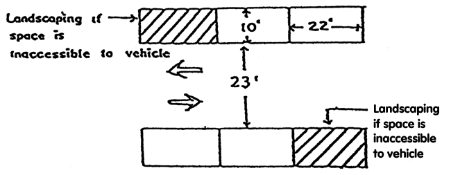
f.
Parallel parking one-way double sides;
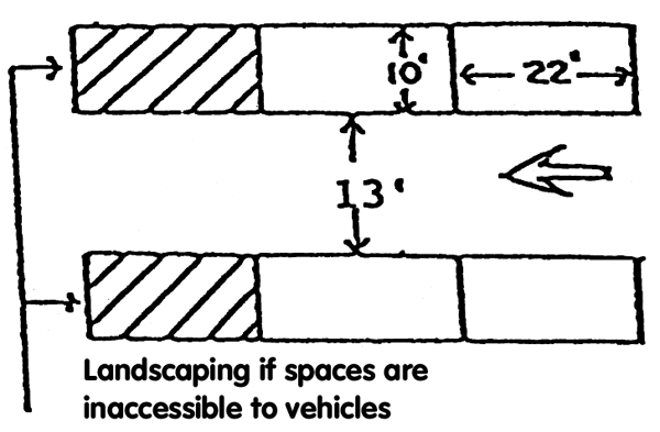
g.
Parallel parking two-way one sided;
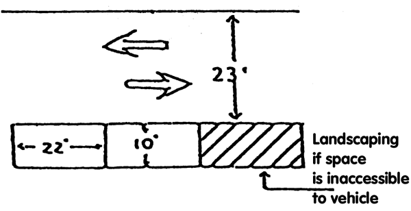
h.
Parallel parking one-way one sided;
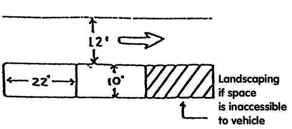
(9)
Parking lot design standards—Developments less than 20,000 square feet:
a.
Parking lots for developments consisting of less than 20,000 square feet, shall use the same design standards as above, with the following modifications to minimum drive aisle widths:
(10)
Access aisles for 90-degree and parallel parking spaces may be designed for two-way or one-way traffic.
(11)
Access aisles for 60-degree, 45-degree and 30-degree parking spaces shall only be designed for one-way traffic.
(12)
Should an access aisle be used to access two different angles of parking spaces, then the larger access aisle shall be required.
(13)
No public right-of-way shall be used as an access aisle except an alley may be used to access parking spaces provided:
(a)
The alley meets the access aisle width requirements above; and
(b)
The alley used to access the subject parking spaces has a minimum width of 20 feet for two-way traffic and 10 feet for one-way traffic.
(14)
Parking lot design standards—Mainland, Flagler and U.S. 1 Corridor Special Parking Districts:
a.
90-degree angle parking spaces;
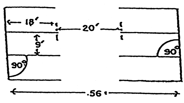
b.
60-degree angle parking spaces;
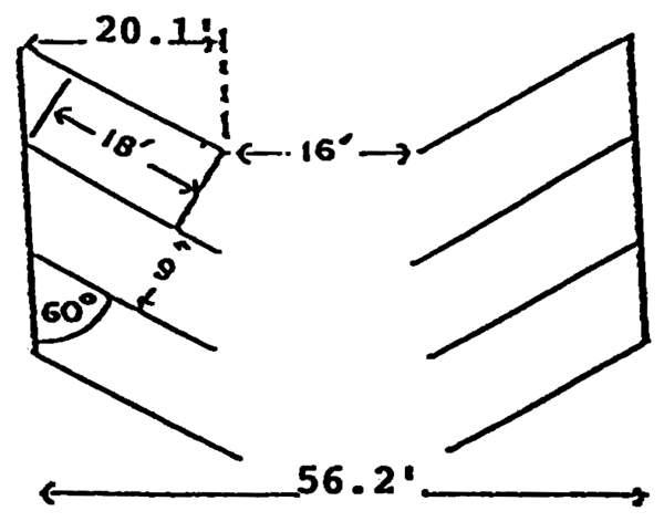
c.
45-degree angle parking spaces;
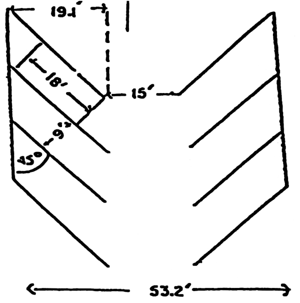
d.
30-degree angle parking spaces;
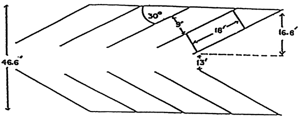
e.
Parallel parking two-way double sided;
f.
Parallel parking one-way double sides;
g.
Parallel parking two-way one sided;
h.
Parallel parking one-way one sided;
(a)
The entrance/exit drive may be a minimum of ten feet in width and may be two-way for 90-degree angle parking provided:
1.
A sign is posted at the approach to exit stating that vehicles entering the parking lot have the right-of-way; and
2.
The entrance/exit drive is not adjacent to any parking space.
D.
Parking space design standards.
(1)
Minimum parking space dimensions:
Surface parking:
Standard space: Ten feet wide by 20 feet deep.
Handicapped accessible parking space: 12 feet wide by 20 feet deep.
Parking structure:
Standard space: Nine feet wide by 18 feet deep.
Handicapped accessible parking space: 12 feet wide by 18 feet deep.
Parallel parking spaces: Ten feet wide by 22 feet long.
Mainland, Flagler and U.S. 1 Corridor Special Parking Districts: Nine feet wide by 18 feet deep.
(2)
Parking space striping and signage: All parking spaces shall be striped with 4-inch wide white lines measuring the length of the parking space. Handicapped spaces shall be signed and marked according to state law.
(3)
Curbing and wheel stops: All parking spaces, except parking spaces for developments of 20,000 square feet or greater shall have wheel stops or curb stops. Curbing or wheel stops shall be located no further than 2.5 feet from the front of the parking space.
(4)
Parking space overhangs:
• The area between the front of a 90-degree parking space and the wheel stop or curbing may be used as a portion of a sidewalk. However, but the sidewalk overhang shall not be included as part of the minimum required sidewalk width.
• The area between the front of the parking space and the wheel stop or curbing may be used as a landscaped area. Plantings in the overhang area shall not exceed six inches in height above the elevation of the parking space. The area between the front of the parking space and the wheel stop or curbing shall not be credited towards required landscaping.
E.
Shell parking lot requirements.
(1)
Non-residential uses:
a.
The shell parking spaces are over and above the minimum number of parking spaces required or the number of minimum required parking spaces is 25 or less;
b.
The non-residential use associated with the parking lot does not generate more than an average trip rate of 200 vehicle trips per any day of the week according to the Institute of Transportation Engineers (ITE) Manual, latest edition;
c.
The dimensional, landscaping and stormwater retention requirements of the land development regulations are met; and
d.
The following construction specifications are shown on the design plan:
1.
Placement of railroad ties (without creosote or arsenic) or other materials at the entrances and exits and the perimeter of the parking lot to prevent stormwater and shell material from leaving the site;
2.
Placement of railroad ties (without creosote or arsenic), concrete bumper stops or other suitable material to act as bumper stops and to designate individual parking spaces;
3.
Placement of railroad ties (without creosote or arsenic) or other means to protect landscaped areas from automobiles;
4.
Placement of proper signs to direct traffic flow;
5.
North arrow, scale, property lines and location of property; and
6.
Construction specifications, including subbase compaction, shell layer thickness and compaction, storm water management and landscaping plan.
(2)
Single-family and duplex residences:
a.
The residential unit(s) do not require more than five parking spaces according to the land development regulations;
b.
No planning and zoning board review and approval is required to allow the land use or construction;
c.
All other applicable stormwater retention, landscaping and dimensional requirements are met.
(3)
All residential and non-residential shell parking lots shall be maintained as originally designed for the life of the parking lot. At no time during the life of the parking lot shall stormwater or shell be allowed to migrate from the premises, shall potholes or any other travel hindrances form, shall bumper stops be relocated, shall landscaping be allowed to deteriorate nor shall traffic flow signs be allowed to be incomprehensible.
F.
Minimum number of parking spaces required: Every land use shall provide the minimum number of parking spaces, as required below. When the total number of required spaces includes a fraction of 0.5 or greater, the required number of spaces shall be rounded up to the nearest whole number.
Example: The spaces required calculates to 3.5, four (4) spaces shall be required.
Example: The spaces required calculates to 3.49, three (3) spaces shall be required.
If a proposed land use is not listed below, the administrative official shall determine the number of parking spaces based on a closely related land use that is listed below. Under no circumstances shall any land use be permitted without a reasonable number of parking spaces just because it is not specifically listed below.
G.
Exceeding the minimum number of required parking spaces. If any non-residential development proposes to provide more than 120 percent of the required number of parking spaces, the project developer shall provide twice the amount of landscaping required in the parking lot. This requirement shall only apply if the minimum number of required parking spaces is at least 30.
Example: A use requires 50 parking spaces according to the city's land development regulations with ten percent interior landscaping and the developer wants to provide 61 parking spaces, then the interior landscaping requirement shall be 20 percent. However, if the use requires 50 parking spaces according to the city's land development regulations with ten percent interior landscaping and the developer wants to provide 60 parking spaces, then the interior landscaping requirement shall remain at ten percent.
H.
Temporary parking lot requirements.
• All stormwater retention, landscaping, curbing/wheel stop, lighting, signage and dimensional requirements of this code shall be met.
• The city commission shall review and approve all applications for temporary parking lots, using the following criteria:
• Estimated number of vehicular trips on any day of the week.
• Visibility of the site within the community.
• Principal use of the subject property.
• Anticipated use of the parking lot by the public.
• The City Commission may apply reasonable terms and conditions to the approval of any temporary parking lot.
• Approval of a temporary parking lot shall be limited to a maximum of two years from the date of City Commission approval.
• On or before the two-year expiration date, the temporary parking lot use shall comply with one of the following:
• The temporary parking lot is paved and striped according to city standards in place at the time of paving; or
• The temporary parking lot use is abandoned; or
• A new temporary parking lot application is submitted for city commission review.
All temporary parking lots that were approved on or before April 8, 2008, shall be permitted to remain until April 8, 2013.
I.
Special parking district regulations.
1.
District boundaries: The following three special parking districts are hereby established within the city, and shown on the maps below:
• Mainland Special Parking District.
• Flagler Avenue Special Parking District.
• U.S. 1 Corridor Special Parking District.
The following regulations shall apply within each of the special parking districts.
2.
Minimum number of parking spaces:
i.
Additions of less than 500 square feet to existing structures which would require less than 12 additional off-street parking spaces, shall not be required to provide additional off-street parking. This exemption from the parking requirements may only be used once during the lifetime of the building.
ii.
New construction and additions that are 500 square feet or greater shall provide off-street parking at a rate that is at least 50 percent of the LDR requirement. Nonconforming or grandfathered parking conditions may not be used to meet the requirements of this subsection.
iii.
For new construction and additions that are 500 square feet or greater, at least 50 percent of the required parking must be provided on-site. The remainder of the required parking may be provided in one of the following ways:
• Joint use agreement.
• Lease agreement.
• Off-site parking meeting the requirements of section 604.09(A)(8).
• Valet parking.
• Any other method approved by the administrative official.
iv.
For expansion of a business or a change in use where no addition is proposed, off-street parking shall be provided at a rate that is at least 50 percent of the LDR requirement. Credit shall be allowed for the amount of parking required for the previous use. This credit shall also be calculated at 50 percent of the parking ratio required in section 604.09(G). Off-street parking required by this subsection may be provided on-site or by any other method allowed by the land development regulations.
v.
Multi-family and transient lodging facilities shall provide 100 percent of the parking required by this code within the boundaries of the property.
vi.
Non-residential uses on parcels greater than one acre shall provide 100 percent of the parking within the boundaries of the parcel.
3.
Special parking district supplemental regulations. On-street parking may be counted towards the required on-site parking ratios if the following conditions are met:
i.
The project shall meet all other development criteria with regard to required setbacks, height, density, and dwelling unit size as defined in the LDR.
ii.
The proposed development shall incorporate architectural features such as roof styles, window and door placement and style, and canopies that are found on the historic buildings within the Mainland National Register Historic District.
iii.
Sufficient on-street parking or other public parking is available within 500 feet of the business to make up the difference between the number of off-street parking spaces provided on-site and the number of parking spaces required in the Mainland Special Parking District. This on-street or public parking shall be shown on the site plan and must be approved by the administrative official.
iv.
The applicant shall formally designate any on-street parking that is located immediately in front of the place of business requesting the reduced parking ratios. Formally designating on-street parking shall, at a minimum, require striping to designate individual parking spaces and installation of curbing along sidewalks. Formal designation may also include installation of landscape islands to prevent parking spaces from being located too close to intersections.
MAINLAND SPECIAL PARKING DISTRICT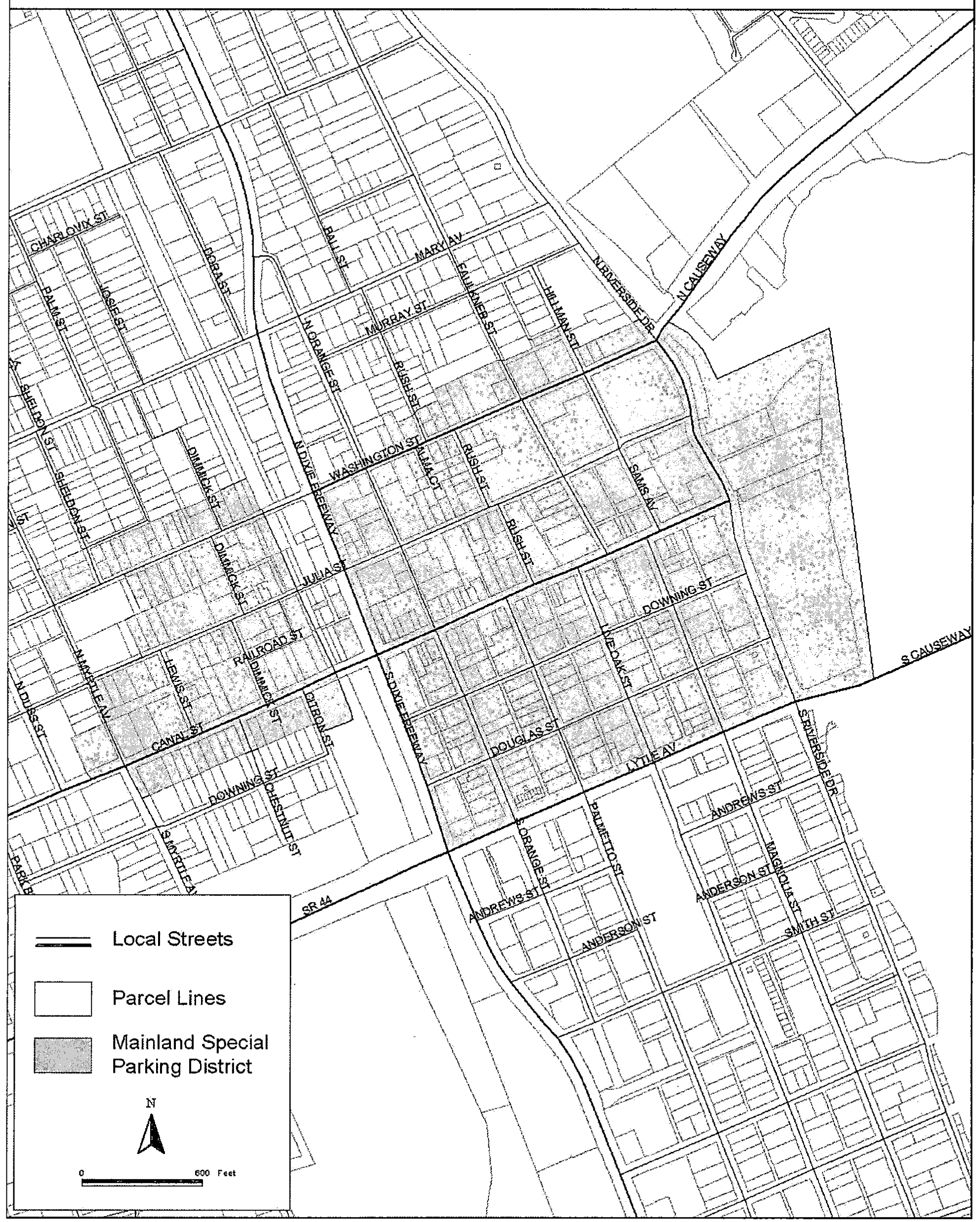
FLAGLER AV SPECIAL PARKING DISTRICT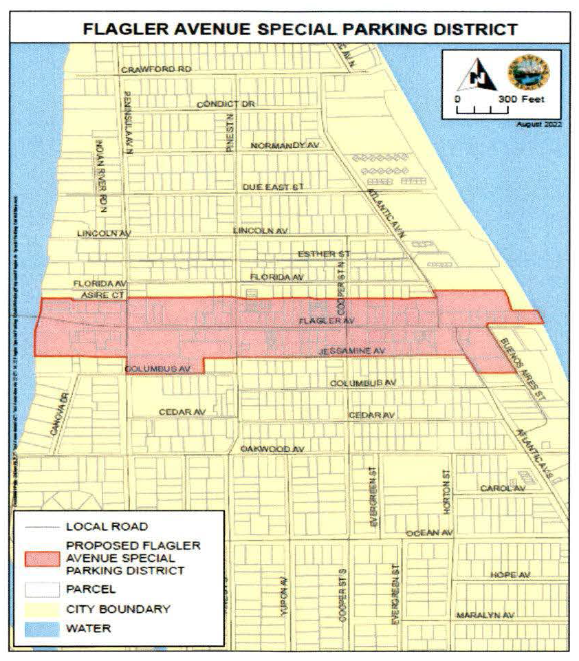
U.S. 1 CORRIDOR SPECIAL PARKING DISTRICT MAP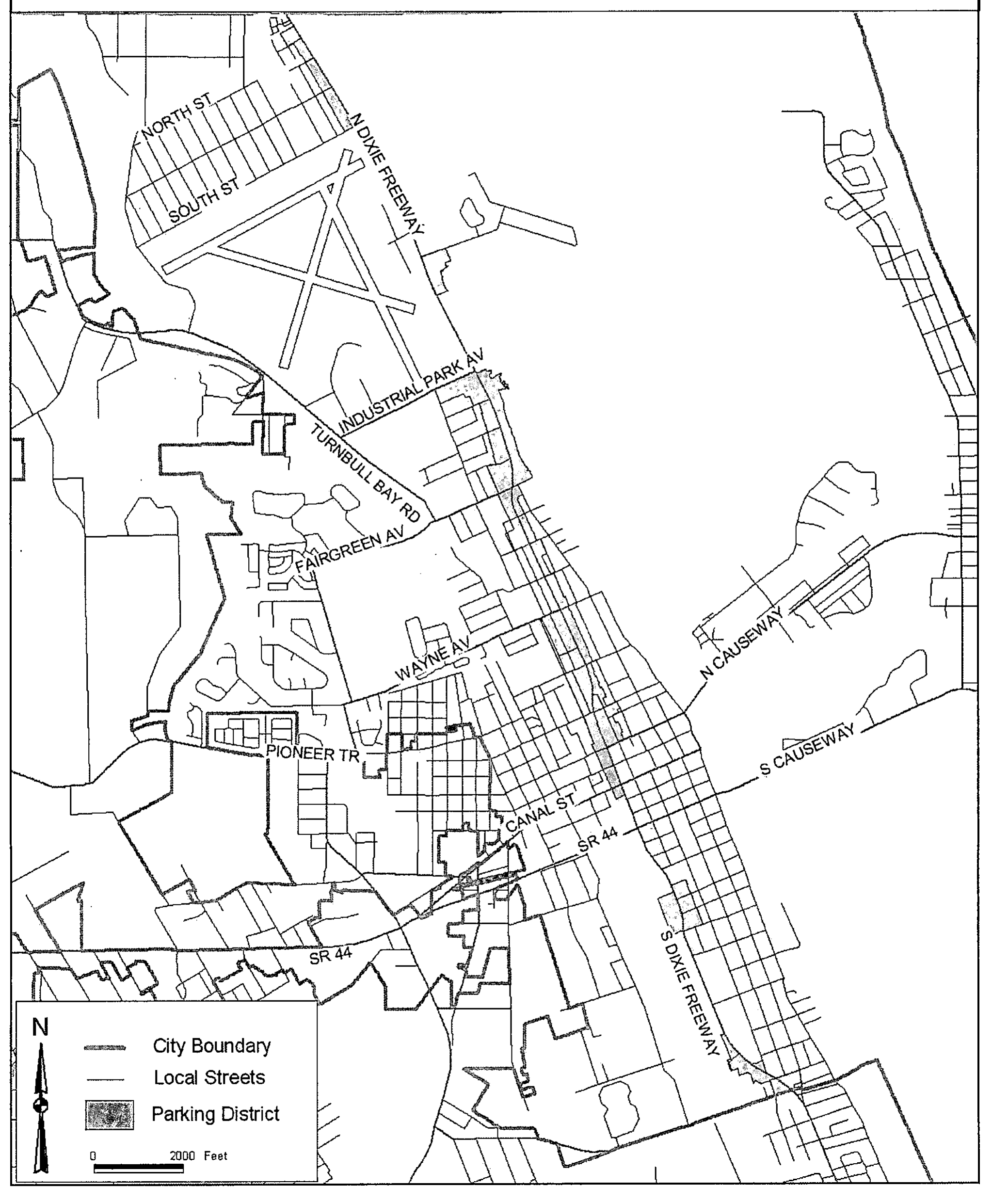
J.
Valet parking. Valet parking shall be allowed within the city as a convenience service to customers of a business or other establishment, or as a means to compensate for a parking deficiency. No valet parking shall be allowed for any establishment unless a valid valet parking license has been issued by the City of New Smyrna Beach. The City shall issue a valet parking permit once the applicant has demonstrated to the Administrative Official that all of the following requirements have been met:
1.
Design standards. All city design standards for a parking lot have been met with regard to paving, landscaping and stormwater retention. Valet parking lots may also utilize the following design and dimensional standards:
a.
Minimum valet parking space size: Eight feet by 18 feet.
b.
Individual spaces may be stacked or double-parked no more than two cars long or wide.
c.
Access aisles with reduced width are allowed at the discretion of the administrative official provided the aisle is used only to access valet parking spaces.
d.
No through lane within a public right-of-way may be used for valet parking pickup.
e.
The design of the parking lot shall be such that it does not interfere with adjacent vehicular or pedestrian traffic flow within a public right-of-way.
2.
Other standards.
a.
One sign no greater than three square feet must be posted at the valet parking pickup area and must state the name of the establishment for which valet parking is intended and a cost to use the service if there is a cost.
b.
Valet parking lot signs no larger than three square feet may be provided at each entrance to a valet parking lot. If valet parking spaces are in a parking lot intended for non-valet parking, each space shall be posted with a sign not to exceed two square feet indicating that the parking space is reserved for valet parking only.
c.
Off-premises parking lots may be allowed provided they are located no more than 1,500 feet from the entranceway of the building or structure containing the principal use.
3.
Licensing requirements. The following shall be required for a valet parking license:
a.
The valet parking area shall comply with all city design, sign and location standards contained in the city's land development regulations.
b.
The licensee shall maintain a one million dollar insurance policy issued by an insurance company licensed to do business in the State of Florida for personal and property damage arising out of unlawful or negligent acts of the licensee, its officers, employees, agents or invitees.
c.
The licensee shall not employ as a valet parking attendant or valet ticket-taker any person who has been convicted of a felony or a crime involving theft, dishonesty or moral turpitude; or who is less than eighteen years of age.
d.
The licensee shall pay the required application fee, as established by the city commission.
K.
Public parking lots.
(1)
The property owner of any site located in a MU or R zoning district that is used exclusively for public parking and is not associated with any required parking spaces associated with a development may submit a request to waive one or more requirements of this section.
(2)
Waivers must be submitted in writing to the development services director and, at a minimum, must demonstrate:
•
That the waiver will not negatively impact the stormwater system; and
•
The waiver will not negatively impact adjacent properties; and
•
The waiver will not have a negative effect on any existing historic and/or specimen trees.
(3)
The development services director shall review the waiver request and determine whether to grant the waiver as requested, grant a partial waiver, or deny the request.
604.10. Sidewalks.
A.
General requirements.
(1)
All developments shall have a sidewalk plan included to enable pedestrians to access the building(s) and parking lot, parking spaces and other accessory components of the site without walking through landscaped areas. The sidewalk plan shall be designed to provide direct pedestrian traffic, shall assume the pedestrians will take the most direct path to their destination, and shall assume that reasonable pedestrians will travel through grass or landscaping, if able to, before walking great distances to stay on the sidewalk.
(2)
All developments, whether new or additions, are required to install public sidewalks along all road frontage in front of their parcel within the right-of-way six inches from the right-of-way line. This is not required if a sidewalk exists. If a sidewalk exists but does not meet the width requirements, the developer shall add the required width. This provision shall not apply if a bicycle path (not lane) exists in front of the establishment.
(3)
If a sidewalk is required under [sub]section 604.10(A)(2) but the construction of the sidewalk is determined to not be practical, as outlined in [sub]section 604.10(A)(4) below, then the property owner or permit applicant shall make a contribution to the sidewalk account in lieu of constructing the required sidewalk. The amount of the contribution shall be determined by multiplying the linear feet of that parcel's street frontage(s) (minus the width of any paved driveway and/or driveway apron) times the per linear foot contribution fee established pursuant to [sub]section 604.105 of this LDR.
(4)
The decision of whether the construction of a sidewalk on a parcel is "not practical" shall be made by the city engineer or designee. In making such a decision, the city engineer or designee shall consider the following factors:
a.
Whether an adopted neighborhood plan or the city's comprehensive plan mandates that sidewalks not be constructed within a particular neighborhood; or
b.
Whether a sidewalk cannot be constructed without removing a historic or specimen tree within the right-of-way; or
c.
Whether a stormwater drainage ditch or similar public utility infrastructure readily prevents the construction of a sidewalk and neither the infrastructure nor the proposed sidewalk can be reasonably relocated or altered to accommodate both the infrastructure and the sidewalk; or
d.
Whether or not other unique or peculiar circumstances exist on a given parcel or development.
(5)
In the event that it is determined that the construction of a sidewalk is "not practical" (as provided for in [sub]section 604.10(A)(4) and by the city engineer) and if the permit is being issued for a single-family residential home, the contribution to the sidewalk account shall not be required in any of the following instances:
a.
The permit is issued for an affordable housing unit. For the purposes of this section, an affordable housing unit shall be determined as defined in article II of this LDR; or
b.
The permit is issued for a single-family or two-family residential dwelling which meets all of the following criteria:
1.
The single-family or two-family dwelling is located on a street functionally classified as a local road; and
2.
The permit is for new construction or expansion of an existing single-family or two-family residential dwelling; and
3.
There are no sidewalks on the local road within 500 feet of the single-family or two-family dwelling. This distance shall be measured linearly on the same side of the local road as the residence; and
4.
The city's capital improvements plan does not include any plans for funding or construction of sidewalks on the local road within 500 feet in either direction of the single-family or two-family dwelling. This distance shall be measured linearly on the same side of the road as the residence.
(6)
The minimum width of sidewalks located along all local streets is four feet and collectors and arterials shall have five feet wide sidewalks. Sidewalks located in multi-family or duplex developments shall have a minimum width of 30 inches provided they are used to access ten or less dwelling units. Sidewalks located within multi-family and duplex and nonresidential developments, where the sidewalk accesses more than ten dwelling units, shall have a minimum width of four feet. For the purpose of this section, access to residential development shall mean the only paved pathway to a building entranceway. All buildings shall have a sidewalk leading from the city right-of-way, public walkway or vehicular access way to the building entranceway. Stepping stones, gravel, or decorative rock shall not constitute a sidewalk.
(7)
Sidewalks shall be constructed of 3,000 psi 28-day concrete with a minimum thickness of four inches except that a minimum of six inches is required at driveways. Sidewalks shall be reinforced with six-inch by six-inch and 10/10 wire mesh or contain fiberglass mesh within the ready mix. Wheelchair ramps for the handicapped shall be provided at all intersections and other points of pedestrian traffic flow.
Editor's note— Ord. No. 35-11, § 5, adopted June 28, 2011, renumbered former subsection 604.12 as subsection 604.10, as set out herein.
604.105. Sidewalk account.
A.
There is hereby established a sidewalk account. The sidewalk account shall be used for the deposit, maintenance and distribution of all monetary contributions made in lieu of constructing a sidewalk pursuant to [sub]section 604.10(A) of this LDR. All contributions made to and interest derived from the sidewalk account shall be used solely for the purpose of constructing, repairing or replacing sidewalks or bicycle paths along or on public streets or on public property.
B.
The sidewalk account fee shall be established from time to time by city commission resolution. The fee shall be calculated by multiplying the number of linear feet of street frontage where a sidewalk is required to be built times the prevailing construction costs as determined by the city engineer.
604.11. Bicycle facilities.
A.
General requirements.
(1)
Any development adjacent to an arterial or collector roadway shall provide a bike path along one side of the arterial or collector roadway in lieu of the public sidewalk. This provision shall not apply if bike lanes are provided.
(2)
Bike paths shall be located within the roadway right-of-way and constructed to city, county, or state bike path specifications. If adequate area is not available within the right-of-way, the bicycle facility shall be constructed to city, county, or state specifications on private property and a public access easement shall be granted for the width of the bicycle facility.
(3)
City specifications for a bicycle path are a minimum width of eight feet, a minimum limerock base thickness of four inches, and a minimum Type I asphaltic concrete pavement thickness of 1.5 inches.
(4)
A bicycle path shall not be required for any development located adjacent to an arterial or collector roadway with an existing sidewalk or bicycle path located on the same side of the right-of-way as the proposed development.
Editor's note— Ord. No. 35-11, § 1, adopted June 28, 2011, repealed subsection 604.11, which pertained to permanent reference points. Additionally, § 5 of said ordinance renumbered former subsection 604.13 as subsection 604.11, as set out herein.
604.12. Signs.
A.
Purposes, intent, and scope. The purpose of these sign regulations is to protect, preserve, and improve the character and appearance of the City of New Smyrna Beach; to provide ample opportunity to advertise in commercial and industrial areas while preventing excessive advertising which would have a detrimental effect on the character and appearance of those areas; to limit signs in non-commercial and non-industrial areas to protect the residential character and appearance of those areas; and to preserve the First Amendment rights of all persons subject to these regulations.
It is intended that signs placed on land or on a building for the purpose of identification, or for advertising a use conducted on that land or in that building, or to exercise the first amendment rights of the owner or occupant of that land or building, shall be deemed to be accessory and incidental to the land, building, or use.
With respect to commercial signs, it is specifically intended, among other things, to avoid excessive competition and clutter among sign display in the demand for public attention. Therefore, the display of signs should be appropriate to the land, building, or use to which they are appurtenant and be adequate, but not excessive, for the intended purpose of identification or advertising.
Signs commonly referred to as billboards, outdoor advertising, or poster panels, which advertise products or businesses not connected with the site on which they are located, are prohibited in accordance with the predominantly residential atmosphere of the community, such signs being most appropriate on open highways and roads where they do not detract from community character.
B.
Prohibited signs. The following signs are prohibited in the City of New Smyrna Beach:
Beacon light signs.
Billboards.
Flashing signs.
Moving signs.
Off-site signs except exempt bench signs.
Pole signs, except as provided for in section 604.12.G.(11).
Roof signs.
Snipe signs.
Trailer/mobile signs.
Traveling light signs.
Signs which in any way simulate or appear to simulate emergency vehicles, traffic control signs, or devices, or directional, informational, or warning signs erected or maintained by any public body, or any railroad, public utility, or similar body.
Private signs, whether temporary or permanent, placed on public property, except as expressly permitted by the appropriate public body.
Signs containing any statements, words, or pictures of an obscene nature, that is, which are utterly without redeeming social value as determined by the community standard prevailing in New Smyrna Beach and the immediate surrounding area.
Signs exceeding three square feet attached to passenger vehicles.
Signs which in any way obstruct, cover, or block, any fire escape, window, or door, or which are attached to any fire escape or ventilation device.
Signs which include pennants, ribbons, streamers, spinners, or wind-operated devices, except as provided herein.
Signs designed to be visible from any part of the Atlantic Ocean beach area, or from any waterway within the City limits, with the following exceptions: 1) approved wall signs in MU, B-2, B-3, B-4, PUD, or CM zoning districts; and 2) signs complying with the exemption provision of this LDR.
Commercial signs that are carried, waved, or otherwise displayed by persons ("sign walkers", "sign spinners", or "commercial mascots") either on public rights-of-way or in a manner visible from public rights-of-way.
Signs located in the visibility triangle of any corner lot, except as provided herein. The visibility triangle shall be drawn using the street right-of-way lines and a line connecting them at points 25 feet from the intersection formed by such right-of-way lines, or signs which otherwise obstruct the view in any direction at a street intersection.
Commercial signs attached to or painted on vehicles or trailers which are not regularly used as part of the advertised business and are obviously parked for the primary purpose of advertising to passing motorists or pedestrians.
C.
Exemptions. The following signs shall be exempt from the permitting requirements of this LDR:
Automobile vehicle wraps on currently registered vehicles.
Banners, for the promotion of a new business in a nonresidential zoning district for a time period not to exceed 45 consecutive days after receiving a Business Tax Receipt subject to the following conditions:
1.
Maximum copy area: 32 square feet.
2.
The banner sign may be hung on a wall or any other suitable location. The location of the sign shall not interfere in any way with the traffic or public safety of the citizens of the city, and the sign shall not violate any other applicable provisions of this LDR.
3.
The banner signs shall not be considered in the computation of the number of signs allowed or the maximum allowable display area for a premises.
Bench signs approved by the city commission on benches placed on public property for the use and convenience of the general public.
Flags which do not bear any commercial advertising, mounted on a single flag pole or separate flag poles installed either on the building or adjacent to the building (within 15 feet). Maximum two flags per premises; maximum area 40 square feet each.
Integral signs, provided the individual letters or numerals of such sign do not exceed two inches in height, and provided the sign itself does not exceed three square feet of display area.
Neon light or other type of light sign hung inside the window of an establishment and intended to be seen from the outside provided: (1) no more than five are exempt; and (2) the energy source is by plug into an existing wall outlet.
In commercial districts, one non-electric noncommercial signs not exceeding six square feet in area for each street or waterway frontage of a commercial premise.
In residential districts, one non-electric sign not exceeding three square feet in area, and temporary signs allowed in accordance with subsection G.(6).
Sandwich boards provided that:
1.
The business and sign are located within the MU (mixed use) zoning districts only.
2.
One sandwich board sign may be located in front of each non-residential property or tenant space.
3.
Sandwich board signs may be placed on a public sidewalk no closer than one foot inside the curb, and must maintain a minimum of 36 inches of clear sidewalk space.
4.
Maximum sign size: 42 inches in height and 36 inches in width.
5.
The sign shall only be placed on the sidewalk during business hours.
6.
The sign shall be located in front of the specific business advertised on the sign, and not at another location. If the business is a corner property, the sign may only be placed in one location.
7.
Additional sandwich board sign. A business located within the MU (mixed use) zoning district may display one additional sandwich board sign, provided that such additional sandwich board sign:
a.
Meets all of the sandwich board sign requirements of this section; and
b.
Is located within 500 feet of the business for which the sign is advertising; and
c.
Is located in the same MU zoning district or an adjacent non-residential zoning district; and
d.
If located on a public sidewalk, does not impair accessibility of the sidewalk; and
e.
Written consent to the placement of the sandwich board sign is obtained from the property owner if located on private property, or if located on a public sidewalk, from the property owner immediately abutting the section of public sidewalk on which the sign will be located. The written consent shall be submitted to the city and kept on file.
Signs attached to passenger vehicles that do not exceed three square feet in copy area.
Signs located on soda, candy, or food dispensing machines.
Signs which are necessary to protect the physical safety of the public, prevent property damage, meet constitutional due process and other requirements of law, or otherwise serve compelling governmental interests, including:
1.
No trespassing, warning, traffic control, or similar signs of not more than two square feet where such signs are reasonably necessary to notify the public of the matters contained in the signs in the interests of public health and safety.
2.
Legal notices posted on real property in accordance with requirements of federal, state, or local law, provided the notice shall be displayed only for the time period required by law.
3.
One sign not exceeding three square feet in area per premises, bearing only property numbers, post office numbers, and names of occupants of such premises, for identification purposes only to allow emergency responders, law enforcement personnel, delivery personnel, and the general public to find the premises.
4.
Signs required by any professional licensing body of the State of Florida provided that such signs do not exceed the state minimum requirements imposed by such body in any respect.
Window signs, provided that the total area of all signs does not exceed 35 percent of the total glass area of the window containing the display.
Window wraps which do not advertise a business or product.
D.
Permits. No person shall erect, alter, repair, or relocate any non-exempt sign without first obtaining a permit for such work from the Building Official of the City of New Smyrna Beach. No permit shall be issued until the planning manager and chief building official, or designees, have determined that such work is in accordance with this LDR and all other LDRs and ordinances of the City of New Smyrna Beach and a certificate of zoning has been issued.
(1)
Application for a sign permit shall be on forms provided for that purpose by the chief building official and shall contain the following information:
a.
The name, address, and telephone number of the applicant, the owner of the sign, and the owner of the property on which the sign is to be located;
b.
The address, if any, and legal description of the premises on which the sign is to be located;
c.
A drawing to scale, in duplicate, showing the size, height, structural details, and dimensions of the sign and sign structure;
d.
A drawing to scale, in duplicate, showing the position of the sign, and any other existing advertising structures, in relation to the buildings or structures on the premises and to the boundaries of the property;
e.
The signatures of the applicant and the owner of the property; or in the event the owner is not available, written evidence of the owner's permission for the erection of the sign;
f.
Any electrical and/or plumbing permit required for the sign;
g.
For any sign which the chief building official determines may reasonably be subject to dead load, wind, or other physical threat, engineering drawings showing display area, support structure above and below ground, wind pressure specifications, and method of installation, signed and sealed by a registered engineer or architect licensed by the State of Florida in that profession;
h.
Signs in the visibility triangle shall have a maximum height of 3.0 feet to allow for proper visibility.
E.
Schedule of fees. The schedule of fees for sign permits shall be established, and periodically adjusted by city commission resolution.
F.
General provisions. The following provisions shall apply to every sign erected in the City of New Smyrna Beach, including exempt signs:
(1)
The name and address of the company or person installing any permanent sign and the name and address of the company or persons maintaining any permanent sign, the date of erection and voltage of any electrical apparatus shall be painted or printed conspicuously on every sign erected.
(2)
Any light from any illuminated sign shall be shaded, shielded or directed so that the light intensity or brightness shall not affect adversely the vision for operation of vehicles in any public or private road, highway, driveway, or parking area. Such light shall not shine directly on or into any residential structure or directly onto approaching traffic. Such light shall not be visible from the public beach during sea turtle nesting season (May 1 - November 1 annually) per Volusia County Code of Ordinances, Chapter 72, Division 12, Sea Turtle Protection.
(3)
All permanent signs shall be designed and constructed to withstand a wind pressure as required by the Florida Building Code.
(4)
The area around the base of any ground sign shall be kept free of any rubbish or other material that might constitute a fire or health hazard. Appropriate landscaping, monument architectural detailing, and/or pole skirts around the base of the signs are required.
(5)
Square footage of copy area determined by lineal feet of frontage shall be determined by measuring along the entrance side of individual stores; in the case of corner stores, additional signage may be allowed only when the same or similar façade treatment is used on both front and side; sign area is not transferable between facades.
(6)
Copy area of a sign shall be based upon the surface area encompassed within any regular geometric figure which forms the information component of a sign when such sign is viewed from one direction on the adjacent right-of-way. The frame which decorates or structurally supports the copy area shall be included when calculating area. The pole associated with a pole sign shall not be included when calculating area. The entire area of a ground sign shall be used in calculating the area of a ground sign.
(7)
A projecting or ground sign with sign surface on both sides shall be construed as a single sign, and the total area of such sign shall be the area computed on a single sign. The faces of ground signs may be separated, and will be construed as a single sign provided that the angle of separation does not exceed 45 degrees.
(8)
Unless specifically provided otherwise, no more than a total of three non-exempt signs shall be erected or maintained per premises. The signs may be apportioned between any allowable types of sign in the district so long as the total copy area does not exceed the maximum permissible area provided herein.
(9)
All signs shall be erected, altered, operated, maintained in good repair and working order, and kept free of any foreign matter, and in addition, shall be designed and installed in compliance with the requirements of the building and electrical codes of the City of New Smyrna Beach.
(10)
Vintage signs that do not comply with sign regulations as outlined in this section may be removed and replaced, provided approval is obtained from the Historic New Smyrna Beach Preservation Commission.
(11)
All signs shall be set back a minimum of five feet from the front property line unless specifically noted otherwise below.
(12)
Ground signs.
(a)
The width of the copy area of ground signs may not exceed the width of the supporting structure by more than ten percent of the width of the base. [Figure 604.12.F.12.(a)]
(b)
The material used to construct a ground sign shall match or complement the construction material of the associated building.
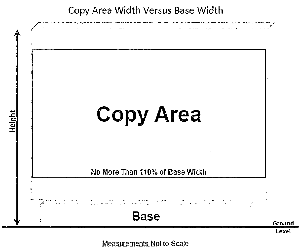
Figure 604.12.F.12.a.
G.
Sign standards. The following sign standards shall apply in the respective zoning districts as indicated below unless more stringent regulations are included within the LDR:
(1)
Signs erected upon property zoned for commercial or industrial use and designated as MU, B-2, B-3, B-4, B-6, B-6A, CM, I-1, I-2, I-3, (except for the airport industrial park), and I-4, and corridor overlay zone (COZ) zoning districts shall conform to the following:
a.
Ground signs. Figure 604.12G.1.a.1.
1. Maximum copy area: Four square feet for each lineal foot of building structure frontage, not to exceed 48 square feet.
2. If the building has frontage on more than one right-of-way, an additional sign may be located on the second frontage. Maximum copy area: two square feet of copy area shall be allowed for each lineal foot of building structure frontage on the second right-of-way. Maximum copy area not to exceed 24 square feet. Signage copy area may not be transferred between the sign addressing the primary frontage and the sign addressing the secondary frontage.
3. No ground sign shall be erected within 50 feet of any other ground sign on the same premises. No such sign shall extend more than ten feet above ground level. Existing pole signs are considered non-conforming and are to be amortized in accordance with subsection H. below.
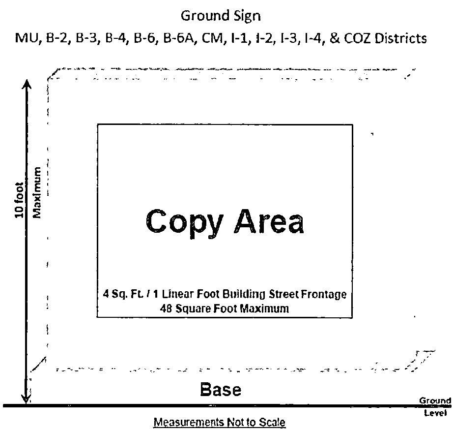
Figure 604.12.G.1.a.1.
b.
Wall signs.
1. Maximum copy area: 100 square feet per premises.
2. Wall signs shall not project more than one foot from any wall of a building, and no such sign shall project above the roof line or parapet, whichever is higher.
3. Wall signs shall not cover, block, or obstruct any part of a window, including any part of a window within the sign perimeter, or obstruct window light or vision.
c.
Marquee signs.
1. Shall not project more than one foot below the bottom or above the top of the vertical face of the marquee.
2. At least eight feet of clearance from the walkway grade to the bottom of the sign must be maintained.
3. May be attached underneath a marquee at a business entrance, provided the sign:
(a) Does not extend beyond the perimeter of the marquee;
(b) Does not exceed three square feet total copy area; and
(c) Does not extend below an eight foot clearance measured from the sidewalk grade to the bottom edge of the sign.
4. If the marquee sign extends over public property, it shall have a minimum clearance of nine feet from the walkway grade to the bottom edge of the sign and shall require approval from the jurisdictional authority that has the maintenance responsibility for the affected public property.
d.
Projecting signs.
1. Maximum copy area: 32 square feet.
2. No part of any such sign shall project more than 36 inches from the wall of a building.
3. No such sign shall physically cover, block or obstruct any window or part of a window, nor obstruct window light and vision.
4. No projecting sign shall extend above the top of a parapet wall.
5. In no event shall a sign projecting over a public right-of-way project to within less than two feet of the curb line.
6. Signs shall have a clearance above the sidewalk grade of at least nine feet, or at least fourteen feet above the grade of the road, driveway or alley.
7. The owner of any sign extending over the public right-of-way shall enter into a license agreement with the city, and shall hold the city harmless from any liabilities resulting from damage to or lack of maintenance of the sign.
e.
Portable signs. One portable sign shall be permitted one time for a business or for a shopping center whose allowable freestanding sign has not yet been erected. Such sign shall be permitted for a period of not more than 30 days or until installation of the allowable freestanding sign, whichever shall occur first. The portable signs shall conform to all city codes and criteria, including but not limited to:
1. Maximum copy area: 32 square feet.
2. No more than one such sign shall be permitted for each premises.
3. Copy on signs shall be maintained in a legible condition.
4. No flashing lights of any kind permitted. External illumination confined to sign face area.
5. Portable signs shall be used on-site only.
6. A new permit must be obtained for each period of use of a portable sign. Application for a permit for a portable sign shall include:
(a) A diagram indicating the manner in which the sign will be anchored to meet the specifications outlined above;
(b) Plot plan showing that the proposed location is:
i. In accordance with intersection visibility standards outlined in this Code;
ii. Illuminated signs shall be connected to a ground fault interrupter circuit receptacle. The use of extension cords for the power supply to the sign shall be prohibited; and
iii. Not in a required parking space.
f.
Construction site signs.
1. One sign shall be allowed for each commercial or industrial construction project where a building permit has been obtained for the project.
2. Such signs shall be removed within 15 days after substantial construction operations have ceased, and in no event, later than the date of issuance of a certificate of occupancy.
3. Maximum copy area: 32 square feet.
g.
Development project signs.
1. One sign for each street frontage, provided such development has been approved and is undergoing active construction and/or sale.
2. Maximum copy area: 32 square feet.
3. Maximum height: 10 feet above grade.
4. All signs shall be removed when all units are sold.
h.
Non-residential subdivision signs.
1. One sign per vehicular entrance.
2. Maximum copy area: 40 square feet.
3. Maximum height; 4 feet above grade.
i.
Awning sign.
1. One awning sign shall be allowed for each business.
2. Maximum copy area: One square foot per lineal foot of business unit frontage, not to exceed 50 square feet.
(2)
Signs located in the B-5, planned shopping center district, or for building(s) containing two or more units in any commercial district shall conform to the following:
a.
Freestanding ground signs.
1. Maximum height: 15 feet in the B-5 zoning district. Per the maximum sign height limits in other zoning district.
2. Maximum copy area:
(a) Shopping centers under 75,000 square feet: 62 square feet.
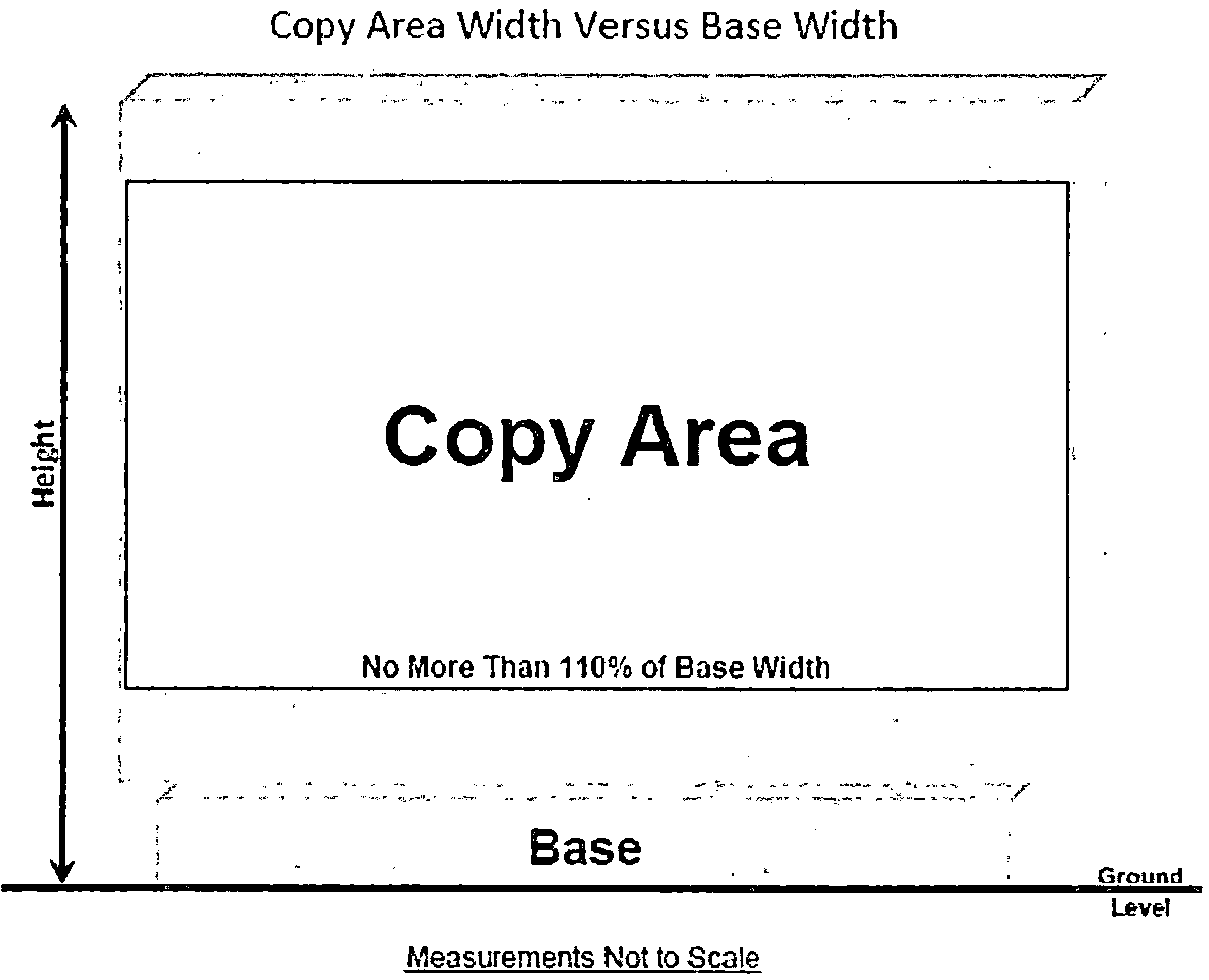
Figure 604.12.G.2.a.
(b) Shopping centers of 75,000 square feet to 250,000 square feet: 141 square feet.
(c) Shopping centers over 250,000 square feet: 157 square feet.
3. Shall be placed only adjacent to the arterial right-of-way frontage line.
4. Minimum setbacks:
(a) Five feet from the arterial right-of-way line.
(b) Fifty feet from side lot lines.
b.
Individual anchor stores shall be allowed additional signs as follows:
1. Wall signs.
(a) Maximum number: 2.
(b) Maximum copy area: Two square feet of copy area per one lineal foot of store unit frontage, not to exceed 200 square feet.
2. Two signs hanging below the marquee, not to exceed three square feet of copy area and having a clearance of eight feet if hanging below the marquee. These signs shall not be calculated as any of the allowable number of wall signs.
c.
Individual tenants in a shopping center or multi-tenant building, excluding anchor stores and businesses located on an outparcel shall be allowed additional signs as follows:
1. One wall sign not to exceed four square feet of sign area per one lineal foot of store frontage, not to exceed 100 square feet.
2. One sign hanging below the marquee not to exceed three square feet of copy area and having a clearance of eight feet.
d.
Individual businesses located on an outparcel shall be allowed any combination of signs as indicated in section 604.12 G.(1) above.
(3)
Signs located in office or industrial parks shall conform to the following:
Office and/or industrial parks shall be allowed one freestanding sign as detailed below:
a.
Office or industrial parks having less than 50 acres: (Figure 604.12.G.3.a.)
1. Maximum copy area: 40 square feet.
2. Maximum height: 8 feet.
Figure 604.12.G.3.a.
b.
Office or industrial parks having 50 to 100 acres:
1. Maximum copy area: 40 square feet.
2. Maximum height: 10 feet.
c.
Office or industrial parks having more than 100 acres:
1. Maximum copy area: 80 square feet.
2. Maximum height: 10 feet.
d
Individual businesses within an office or industrial park shall comply with the sign regulations as indicated in section 604.12 G.(1) above.
e.
Signs in the airport industrial park. In the event there exists a conflict between the sign regulations and I-3, industrial park sign requirements, then I-3, industrial park sign requirements shall control. No sign shall be erected or maintained within the airport industrial park except in conformity with the following:
1. Signs visible from the exterior of any building may be lighted, but no signs or any other contrivance shall be devised or constructed so as to rotate, gyrate, blink or move in any animated fashion. Because of location near airport property, the upward reflection of ground level floodlight fixtures to illuminate facings of signs would be hazardous to aircraft traffic, and therefore ground level floodlighting is not permitted.
2. All signs attached to the building shall not project more than one foot from any wall of a building, nor project above the roof line or parapet, whichever is higher.
3. Only one single-faced or doubled-faced sign shall be permitted per street frontage. No sign or combination of signs shall exceed one square foot in area for each 600 square feet of total site area. However, no sign shall exceed 200 square feet in area per face. An additional 20 square feet shall be allowed for each business conducted on the site.
4. A sign advertising the sale or lease of the site shall be permitted in addition to the other signs listed in this section where a site is actively listed for sale or lease. Said sign shall not exceed a maximum area of 32 square feet.
5. No ground signs, except those at entranceways to the park, shall exceed four feet above grade in vertical height. Also, ground signs in excess of 100 square feet in area (single face) shall not be erected in the first 20 feet, as measured from the property line of any street side setback area.
6. The following definitions shall apply for interpretation of paragraph e. and all subparagraphs thereunder. Single-face sign shall mean a sign with lettering or symbols on one side. Double-face sign shall mean a sign with lettering or symbols on two sides. Fixture sign shall mean a sign including letters and/or symbols, constructed of suitable materials and permanently affixed to the exterior wall of a building.
7. Wall signs shall be fixture signs; signs painted directly on the surface of a wall shall not be permitted.
8. A wall sign with the individual letters applied directly shall be measured by a rectangle around the outside of the lettering and/or the pictorial symbol and calculating the area enclosed by such line.
9. One sign during construction shall be permitted upon the commencement of construction not exceeding 32 square feet, but must be removed immediately upon completion of construction.
(4)
Signs located on residentially zoned property shall conform to the following:
a.
Subdivisions.
1. One sign per main vehicular access to the subdivision:
2. Maximum copy area: 60 square feet.
3. Maximum height: Four feet above the nearest adjacent road grade.
b.
Multi-family residential developments:
1. Ground signs:
(a) One ground sign for each street frontage.
(b) Maximum copy area: 30 square feet.
(c) Maximum height: 8 feet above the nearest adjacent road grade.
2. Wall signs.
(a) One wall sign shall be permitted on one of the buildings located within a multi-family development.
(b) Maximum copy area: one square foot per each foot of building height, or one square foot per each unit, whichever is less. Maximum sign area not to exceed 100 square feet.
(c) Maximum height of the channel letters is two feet.
3. All residential developments are allowed one sign not to exceed 32 square feet during construction, which must be removed upon completion of the project.
4. All residential developments are allowed one additional sign not to exceed 32 square feet in area as long as residential units are available for sale or lease within the development.
(5)
House of worship shall conform to the following: Any house of worship or related property is allowed the following signage:
a.
One freestanding sign.
1. Maximum copy area: 32 square feet.
2. Maximum height: 6 feet above grade.
b.
One wall sign.
1. Maximum copy area: 32 square feet.
(6)
Temporary signs districts shall conform to the following: Temporary signs, including banners, yard signs, and other signs of nonpermanent construction may be erected for temporary periods as follows:
a.
Temporary signs, whether one or the maximum number allowed, may be displayed on any premises for a maximum of 100 days during any 12-month period. Where a use has two or more contiguous "premises" as defined in this LDR due to street frontage in excess of 250 feet, the combined premises shall be treated as one for this purpose.
b.
In residential districts, a maximum of ten temporary signs may be displayed on each premises. No temporary sign shall exceed three square feet.
c.
In nonresidential districts, temporary signs with a total sign area not exceeding 32 square feet for each 100 feet of street frontage or part thereof may be displayed on each premises. Temporary signs exceeding six square feet in area shall be set back five feet from the front property line and 25 feet from the side property line, and have a maximum height of ten feet. No temporary sign shall exceed 32 square feet.
d.
Commercial buildings over 35 feet in height located in a B-6 Medical-Professional zoning district west of the Intracoastal Waterway may display temporary wall banners with a total wall banner area not exceeding 100 square feet for each 100 feet of street frontage. Temporary wall banners shall be allowed only on building facades that are set back at least 50 feet from the property line. No single temporary wall banner sign shall exceed 250 square feet in area. Temporary wall banners may be displayed on the premises for a maximum of 60 days during any 12-month period. A permit is required for these temporary wall banners and only one permit will be allowed in any 12-month period. The temporary wall banners provided for in this section 604.12G(6)d. are expressly prohibited for single or multi-family residential dwellings, hotels, motels, assisted living facilities, and condos.
(7)
Signs located at bed and breakfast homes, adult living facilities, nursing homes, public and private schools, and private and semi-public clubs located within residentially-zoned areas and non-residential uses within the RA zoning district shall conform to the following:
a.
Ground signs.
1. Maximum copy area: 32 square feet.
2. Maximum height: 8 feet.
3. Materials and illumination. Must utilize indirect lighting to illuminate only the sign face.
(8)
Electronic message centers. Electronic message centers shall only be allowed in the B-3 and B-5 zoning districts. Electronic message center signs shall be prohibited east of U.S. 1, except for properties with direct frontage on the east side of U.S. 1, regardless of zoning. Additionally, electronic message centers shall conform to the following requirements:
a.
Minimum separation between electronic message center signs is 600 feet unless approved by the planning manager based on visibility needs.
b.
Electronic message center signs must not face property zoned for single-family residential uses.
c.
Electronic message center signs shall be prohibited within historic districts or facing a historic district if the electronic message center sign will be within 200 feet of the historic district.
d.
The maximum light emanation from an electronic message center sign shall be no greater than .3 foot-candles, measured 200 feet from the sign.
e.
Every electronic message center shall be equipped with an automatic dimmer device.
f.
All electronic message centers shall comply with the appropriate city sign and other regulations.
g.
Any malfunctioning electronic message centers must be turned off or display a blank screen until repaired.
h.
All electrical equipment shall be UL listed.
i.
All power to an electronic message center shall be supplied via underground carrier, inside approved conduit, and shall be installed according to the city electrical requirements.
j.
All electronic message centers shall be kept in good operating condition and maintained with good external appearance.
k.
Copy cannot change more than once every eight seconds.
(9)
Additional signage on properties subject to active listing for sale or lease. Additional signs may be erected on properties subject to active listing for sale or lease in accordance with the following criteria:
a.
Exempt signs: The following additional signs may be erected without a permit:
1. One sign not exceeding six square feet in area may be erected for each street or water frontage adjoining the parcel of property offered for sale, lease, or rent.
2. A maximum of three "add-on" or "rider" signs may be attached to each exempt additional sign, provided the total area of all "add-on" or "rider" signs does not exceed five square feet and provided that no "add-on" or "rider" sign exceeds the width of the exempt additional sign.
3. Minimum setbacks: Ten feet from side property lines and two feet from public right-of-way lines.
b.
Non-exempt additional signs may be erected on property zoned C, RC, FR, R, A-1, A-2, MU, B-2, B-3, B-4, B-6, B-6A, CM, I-1, I-2, I-3, I-4, PUD, and COZ provided a permit is obtained and the additional signs conform to the following:
1. Maximum size: 32 square feet.
2. Maximum number of signs: One per each street or water frontage for each premises.
3. Minimum setbacks: five feet from any adjacent right-of-way, except where the applicant demonstrates that existing vegetation or other obstructions would preclude compliance with the five-foot setback.
c.
Non-exempt additional signs may be erected on property zoned RA, RE, R-1, R-2, R2-A, R-3, R3-A, R3-B, R-4, R-5, R-6, MH-1, and MH-2, provided a permit is obtained and the additional signs conform to the following:
1. Maximum size: 16 square feet.
2. Maximum number of signs: one per each street and/or water frontage for each premises.
3. Minimum setbacks: Five feet from all property lines.
d.
Visibility requirements: All additional signs allowed pursuant to this paragraph (9) shall be located outside the required visibility areas at the intersections of rights-of-way and outside the required visibility areas on waterfront parcels with the exception that when the visibility areas on a waterfront parcel overlap due to the width of the parcel, either one exempt sign or one non-exempt sign may be placed at the approximate mid-point of the water frontage.
(10)
Flags in addition to exempt flags shall conform to the following:
a.
Maximum number: Two flags per premises.
b.
Flags shall be mounted on a single flag pole or separate flag poles installed either on the building or adjacent to (within 15 feet) the building.
c.
No single flag shall exceed 40 square feet in area, and the aggregate size of all flags shall not exceed 72 square feet.
d.
For the purpose of determining the size of a flag, only one side of the flag shall be counted as display surface.
e.
Flags do not count in determining the maximum number of signs permitted.
(11)
Signs in the New Smyrna Beach National Register of Historic Places Historic District and the Coronado National Register of Historic Places Historic District. Signs in the New Smyrna Beach National Register of Historic Places Historic District and the Coronado National Register of Historic Places Historic District that meet all other signage regulations may additionally be of the following types:
a.
Dual Pole Sign consisting of two structural poles supporting the copy area between the poles. (Figure 604.12.G.(12)a.)
Figure 604.12.G.11.a.
b.
Offset monopole sign consisting of one structural pole with the copy area offset entirely to one side of the pole, either attached to the pole or a single horizontal cross-bar. (Figure 604.12.G.(12)b.)
Figure 604.12.G.11.b.
H.
Non-conforming signs.
(1)
Amortization of non-conforming signs. Any existing sign which is in violation of this LDR, after the effective date of this LDR shall be deemed a non-conforming sign. Such signs may be continued subject to the following requirements:
a.
No non-conforming sign shall be altered, moved, or changed in any way except in full compliance with the terms of this LDR. This provision shall not apply to the changing of temporary copy on changeable copy signs or the painting or altering of copy area to restore the original sign appearance.
b.
The non-conforming sign provision shall apply to repairs necessary to maintain a sign, in good working order. The cost of such repairs may not exceed 25 percent of the cost of materials which would be necessary to construct, in all other respects, an identical conforming sign on the same site. Such costs shall be determined by the chief building official.
c.
All existing, non-vintage designated pole signs are subject to the following conditions:
1. No face changes are permitted on existing non-vintage designated pole signs after November 29,2023.
2. Existing non-vintage designated pole signs shall be removed after November 29, 2024 for any change of use, activation of a terminated use, change of tenant, change of ownership, or for a terminated use.
d.
Notwithstanding the time periods for amortization of non-conforming signs set out above, no non-conforming sign of any kind or type shall be allowed to remain if:
1. The sign is determined to be structurally unsound.
2. Cosmetic changes to the sign are valued in excess of 25 percent of the cost of materials that would be necessary to construct a sign identical to the nonconforming sign.
3. Repairs required to keep the sign in good working order exceed 25 percent of the cost of materials that would be necessary to construct a sign identical to the nonconforming sign.
e.
Notwithstanding any other provision in this LDR, if any nonconforming sign, other than a pole sign, is destroyed by more than 50 percent of its replacement value, through an accident, act of God, or intentional act not caused by the person responsible for said sign, then the sign may be reconstructed and rebuilt and utilized for the balance of the amortization period then left.
(2)
Non-conforming signs shall be removed or made to conform with this LDR within the time periods set out below or upon deterioration to the point specified below:
a.
The following types of signs shall be removed or made to conform within 60 days after the effective date of this LDR:
1. Beacon light signs.
2. Flashing signs.
3. Moving signs.
4. Snipe signs.
5. Trailer/mobile signs.
6. Traveling light signs.
7. Signs which in any way simulate or appear to simulate emergency vehicles, traffic control signs, or devises or directional information or warning signs erected or maintained by any public body or any railroad, public utility or similar body.
8. Private signs placed on public property, except as expressly permitted by the appropriate public body.
9. Signs containing any statements, words, or pictures of an obscene nature, that is, which are utterly without redeeming social value as determined by the community standard prevailing in New Smyrna Beach and the immediately surrounding area.
10. Signs attached to passenger vehicles exceeding three square feet.
11. Signs which in any way obstruct or block any fire escape, window or door, or which are attached to any fire escape or ventilation device.
12. Signs designed to be visible from any part of the Atlantic Ocean beach area, or from any waterway within the city limits, with the following exceptions: 1) approved wall signs in MU, B-2, B-3, B-4, or CM zoning districts; 2) signs complying with the exemption provision of this LDR; and 3) signs expressly permitted by the provisions of this LDR.
b.
The following types of signs prohibited by this LDR shall be removed within one year after the effective date of this LDR [Ord. No. 108-11 effective November 29, 2011]:
1. Billboards.
2. Off-site signs, unless said sign is an off-site directional sign as defined herein.
c.
The following types of signs prohibited by this LDR shall be removed within one year after the effective date of this LDR [Ord. No. 33-18 effective June 12, 2018]:
1. Off-site directional signs.
(3)
Removal of signs. The chief building official shall have the responsibility to enforce the provisions of this LDR.
a.
If any property owner fails to comply with this LDR by failing to remove an unlawful sign, a sign for which the amortization period applicable to the sign has lapsed or a sign which has deteriorated beyond the point set forth in subsection (1)d. above, the code enforcement officer shall send a notice of violation by certified mail, return receipt requested, to the owner of the property at the address shown on the latest consolidated county tax rolls. If the notice is returned unclaimed or otherwise undelivered, a true copy of such notice shall be posted on the subject property for ten consecutive days. The notice shall contain the name and address of the owner as shown on the tax rolls, the legal description of the property, the time in which the owner shall abate the nuisance, not less than 30 days, and have attached a photocopy of the relevant provisions of this LDR.
b.
Any owner aggrieved by any action taken by the city under this LDR may appeal such action to the city commission.
c.
If no action has been taken regarding a notice of violation by the owner of the property involved within 60 days after service of the notice, or the last day of posting on the property, and no appeal has been taken, the code enforcement officer shall request approval of the code enforcement board to remove the sign and after obtaining such approval, shall cause the sign to be removed. The reasonable cost of such removal is hereby assessed against the property involved and declared to be a lien on such land in accordance with state law. Such liens may be foreclosed by the city as provided by law.
(4)
Signs visible from interstate or Federal Aid Primary Highway System; harmony of regulations.
a.
The removal provisions of this LDR shall not apply in the case of outdoor advertisements or advertising structures visible from roads or highway systems to the extent that such removal is preempted by the state. This shall not affect the duty of sign owners to remove the signs under this LDR nor shall it affect the authority and responsibility of the city to enforce this LDR through other appropriate means, including referral for criminal prosecution.
b.
This LDR shall be construed to be in harmony with Florida Statutes. In cases where local authority is preempted by the state, or where a question arises regarding such preemption, it shall be the responsibility of the chief building official to coordinate with the state to insure that state regulation and enforcement is pursued to the fullest extent.
(5)
Vintage sign designation.
a.
Applications for the designation of vintage signs shall be reviewed and approved by the Historic New Smyrna Beach Preservation Commission at a public hearing in accordance with the following criteria:
1. The sign must be a least 30 years old at the time of application; and
2. The sign is in good structural and working condition; and
3. The sign meets two or more of the following criteria:
(a) The sign is one that demonstrates a past style of architecture; an example of technology, craftsmanship or design of the period when it was constructed, (e.g. satellite signs, roto-spheres, donut signs, clock signs, paint can signs, opal glass signs, retro pole signs, neon signs, character signs, etc.).
(b) The sign uses historic sign materials or means of illumination (e.g. exposed integral incandescent lighting, or exposed neon lighting).
(c) The sign has retained the majority of its character-defining features (i.e. materials, technologies, structure, colors, shapes, symbols, text, typography, and/or artwork) that have historical significance, are integral to the overall sign design, or convey historical or regional context.
(d) The sign exemplifies the cultural, economic, and historic heritage of the city.
(e) The sign exhibits aesthetic quality, creativity or innovation.
(f) The sign is unique, was originally associated with a local business or local or regional chain, there is academic research, including, but not limited to, sign industry journals, articles or books to support its significance, or it is a surviving example of a once common sign type that is no longer common.
b.
If character-defining features have been altered or removed, the majority of these features shall be restored to their historic function and appearance upon approval of the sign as vintage.
c.
An applicant may appeal the decision of the Historic New Smyrna Beach Preservation Commission to the city commission by filing a notice of appeal with the city clerk within 30 days of written rendition of the decision.
I.
Variances. Variances to the requirements of this LDR may be granted by the planning and zoning board only where a literal enforcement of the provisions of this LDR would result in substantial practical difficulty or unnecessary hardship or difficulty which might be suffered by the owners of that property. Variances shall be granted only in accordance with the procedures and criteria set out in the city land development regulations.
J.
Penalties. Violations occurring on public property shall be issued a trespassing citation, fines for which are set by the city code of ordinances. Violations occurring on private property may be issued a code citation per F.S. ch. 162, and may be cited to appear before the code enforcement board; additionally, violations must come into compliance as determined by the code enforcement officer.
604.13. Outdoor lighting.
A.
General requirements.
(1)
All developments shall provide outdoor lighting in the parking area and yard areas. No such lighting is required for single-family residential lots.
(2)
The locations of the lighting shall be indicated on a site plan and shall be approved by the city planner and city police chief.
(3)
All lights shall have shielded nonglare fixtures. Notwithstanding this provision, lights within the boundary of the Community Redevelopment District (said boundary as defined in Ordinance No. 22-85) that are nonshielded and are not nonglare shall be allowed provided:
a.
The installation or operation of said lights does not violate either the city's or county's sea turtle protection ordinances; and
b.
Lights located within 20 feet of residentially used or zoned property shall have:
1.
A pole height (excluding globe) no greater than 12 feet above grade;
2.
Shielding to the extent necessary to prevent illumination of surrounding residentially used or zoned property; and
3.
Shall be nonglare;
4.
Shall have an internal optical refractor system to limit illumination of adjacent residentially used properties.
B.
Outdoor lighting in beach areas.
Editor's note— This subsection (B) on sea turtle lighting protection has been repealed by Ord. No. 52-99 adopted on Sept. 28, 1999, which ordinance authorizes Volusia County to administer the county's sea turtle lighting protection program within the city limits.
Editor's note— Ord. No. 35-11, § 5, adopted June 28, 2011, renumbered former subsection 604.15 as subsection 604.13, as set out herein.
604.14. Street paving waivers. Street paving waivers may be approved by the city commission on a case-by-case basis, based upon the merits of the project, the character of the surrounding neighborhood, and the estimated city maintenance costs over ten years. applications shall be made using the form prepared by the planning department and shall be accompanied by a $250.00 filing fee.
(Ord. No. 14-01, § 1, 2-28-2001; Ord. No. 03-01, § 1, 1-23-2001; Ord. No. 52-01, § 1, 9-18-2001; Ord. No. 58-01, § 1, 3, 4, 10-9-2001; Ord. No. 10-02, § 1, 2-26-2002; Ord. No. 38-02, § 1, 8-27-2002; Ord. No. 44-02, § 1, 8-24-2002; Ord. No. 27-04, § 1, 5-25-2004; Ord. No. 09-05, § 1, 1-5-2005; Ord. No. 42-05, § 1, 5-10-2005; Ord. No. 101-05, § 1, 9-25-2005; Ord. No. 65-06, § 1, 8-8-2006; Ord. No. 01-07, § 1, 1-23-2007; Ord. No. 35-07, § 1, 3-13-2007; Ord. No. 37-07, § 1, 4-10-2007; Ord. No. 99-07, § 1, 1-8-2008; Ord. No. 26-08, § 1, 4-8-2008; Ord. No. 37-08, § 2, 8-26-2008; Ord. No. 45-08, § 2, 10-28-2008; Ord. No. 72-08, § 4, 12-9-2008; Ord. No. 18-09, § 1, 4-14-2009; Ord. No. 06-10, § 1, 2-23-2010; Ord. No. 29-10, § 1, 6-8-2010; Ord. No. 35-10, § 1, 9-14-2010; Ord. No. 59-10, § 1, 12-14-2010; Ord. No. 63-10, § 1, 12-14-2010; Ord. No. 01-11, § 1, 2-8-2011; Ord. No. 12-11, § 1, 4-12-2011; Ord. No. 35-11, §§ 1, 5, 6-28-2011; Ord. No. 38-11, § 4, 6-28-2011; Ord. No. 76-11, § 1, 9-13-2011; Ord. No. 103-11, § 1, 10-25-2011; Ord. No. 108-11, §§ 2, 3, 11-29-2011; Ord. No. 23-12, § 1, 2-28-2012; Ord. No. 73-12, § 1, 9-11-2012; Ord. No. 37-13, § 1, 6-11-2013; Ord. No. 193-13, § 1, 10-8-2013; Ord. No. 28-15, § 1, 3-24-2015; Ord. No. 96-15, § 1(Exh. A), 11-17-2015; Ord. No. 56-16, § 1, 9-27-2016; Ord. No. 57-17, § 1, 8-22-2017; Ord. No. 33-18, § 1(Exh. A), 6-12-2018; Ord. No. 50-18, §§ 1(Exh. A), 2(Exh. B), 9-25-2018; Ord. No. 09-19, §§ 2, 3, 4-2-2019; Ord. No. 26-19, § 1, 6-11-2019; Ord. No. 46-19, § 2, 8-27-2019; Ord. No. 74-19, § 2, 12-10-2019; Ord. No. 73-20, § 1, 8-11-2020; Ord. No. 04-21, § 1(Exh. A), 1-26-2021; Ord. No. 11-21, § 1, 4-13-2021; Ord. No. 31-21, § 1, 8-24-2021; Ord. No. 54-21, § 1, 12-14-2021; Ord. No. 53-22, § 1, 9-13-2022; Ord. No. 06-25, § 1, 2-11-2025; Ord. No. 61-25, § 1, 9-15-2025)
605.00. - Reserved.
Editor's note— Ord. No. 35-11, § 1, adopted June 28, 2011, repealed section 605.00, which pertained to subdivision design.
605.01. Reserved.
Editor's note— Ord. No. 35-11, § 1, adopted June 28, 2011, repealed subsection 605.01, which pertained to blocks.
605.02. Reserved.
Editor's note— Ord. No. 35-11, § 1, adopted June 28, 2011, repealed subsection 605.02, which pertained to lots.
605.03. Access.
A.
No newly developed or redeveloped nonresidential or multifamily residential lot shall have vehicular access within 50 feet of the radius, or if no radius exists, 65 feet, of the intersection of two rights-of-way. Lesser distances may be allowed if the lot is less than 90 feet wide but in no instance shall the vehicular access be located closer than 40 feet of the intersection of the rights-of-way or the radius of two rights-of-way.
B.
No single-family or duplex residential lot platted after the effective date of this ordinance shall have direct vehicular access to an arterial or collector roadway unless no other access can be provided.
C.
No exit from a lot shall be located less than 75 feet from the right-of-way intersection having traffic signal lighting except if the exit is channelized and right turn only. The right-of-way intersection shall be considered where the radius begins or where the right angle is at the intersection of two rights-of-way.
D.
All developments shall have the number and width of vehicular access points as required by the National Fire Code. Should there be a difference between this LDR and the National Fire Code, the National Fire Code shall prevail.
E.
Pedestrian and bicycle access shall be required when subdivision or other development is adjacent, or close to, a road, park, retail, office, or business area, or any other activity center. By no means shall pedestrian or bicycle access be denied in such a way that a pedestrian or cycler must travel long distances in a circuitous path to reach a destination which could easily be provided and is considerably closer in an airline distance. Said pedestrian and bicycle access shall be a minimum of ten feet wide and lighted for night time travel.
F.
No lot shall be developed unless:
(1)
The lot has direct access and is adjacent to a right-of-way containing a paved city street conforming to city engineering standards unless the proposed development is single-family or duplex residential on an unpaved street which was officially opened by the city prior to the effective date of this LDR;
(2)
The lot has direct access and is adjacent to a right-of-way containing a paved roadway meeting county and state specifications and maintained by the county or state or a prescriptive rights paved roadway maintained by the county or state;
(3)
The lot has direct access and is adjacent to an access drive having a minimum width of 20 feet and approved by the planning and zoning board of New Smyrna Beach, but has not been accepted for maintenance by the city and is not available for public uses.
(Ord. No. 35-11, § 1, 6-28-2011)