
Northfield City Zoning Code
ARTICLE 5
- SUBDIVISION OF LAND
5.1 - Basic Subdivision Requirements.
5.1.1
Purpose and Applicability.
(A)
The city hereby adopts subdivision regulations, the authority of which is provided for in Minn. Stat. § 462.358. The intent of these regulations is to protect and provide for the public health, safety, morals, and general welfare of the city and its people, and specifically to achieve the following purposes:
(1)
To implement the comprehensive plan;
(2)
To ensure that subdivisions are consistent with all applicable provisions of all applicable plans (See Section 8.2.4), laws and regulations;
(3)
To establish standard requirements, conditions, and procedures for the design and review of subdivisions;
(4)
To provide for the orderly subdivision of land and to ensure proper legal descriptions and monumentation of subdivided land;
(5)
To encourage the wise use and management of land and natural resources throughout the city in order to preserve the integrity, stability, and natural beauty of the community;
(6)
To ensure that adequate public infrastructure, facilities and services are available concurrent with development;
(7)
To require subdividers to furnish land, install infrastructure, pay fees, and establish mitigative measures to ensure that development provides its fair share of capital facilities;
(8)
To encourage a beneficial relationship between the uses of land and circulation of traffic throughout the city, and to provide for the proper location and design of streets;
(9)
To prevent problems associated with inappropriately subdivided lands, including excess subdivision, partial or incomplete subdivision, or scattered subdivision;
(10)
To assure that new subdivisions will contribute toward an attractive, orderly, stable, livable, and safe community; and
(11)
To provide adequate utility systems to support the future needs of the system.
(12)
To implement the city's Surface Water Management Plan, protect and improve surface water quality, promote ground water recharge, enhance wildlife through proper management of surface water, and minimize public expenditures needed to protect water quality problems.
(13)
To implement the policies and objectives found in adopted plans of the city including but not limited to:
(a)
The Comprehensive Sanitary Sewer Plan;
(b)
The Comprehensive Water Plan;
(c)
The Greater Northfield Area Greenway System Action Plan;
(d)
The Natural Resources Inventory;
(e)
The Parks, Open Space, and Trail System Plan; and
(f)
The Comprehensive Transportation Plan Update.
5.1.2
Subdivision Approval Required.
(A)
Applicability. Subdivision approval, in compliance with the provisions of this section shall occur as follows:
(1)
Minor Subdivision where a lot division or consolidation results in three or less parcels under certain conditions as described in Section 8.5.11, Minor Subdivision or Lot Consolidation.
(2)
Major Subdivisions where a lot division creates two or more parcels, lots, or tracts under single ownership where the division necessitates the creation of streets, roads, or alleys for residential, commercial, industrial, or other use or any combination thereof, or any change in the lot line or lines of a parcel, lot, or tract, or the establishment of the lot lines of a parcel, lot, or tract not previously platted as described in Section 8.5.12, Major Subdivisions.
(B)
Exemptions.
(1)
Subdivision approval is not required for those separations where all the resulting parcels, tracts, lots, or interests will be 20 acres or larger in size and 500 feet in width for residential uses and five acres or larger in size for commercial and industrial uses;
(2)
Subdivision approval is not required for separations creating cemetery lots; and
(3)
Subdivision approval is not required for separations resulting from court orders or the adjustment of a lot line by the relocation of a common boundary.
(C)
Prohibition Related to Building Permits.
(1)
No lot, parcel, or tract created after the effective date of this code shall be issued a building permit unless the lot, parcel or tract has been created in compliance with the subdivision regulations of the city.
(2)
No building permits shall be issued for a habitable structure proposed to be located on an outlot.
5.1.3
Energy Conservation Design.
(A)
The developer of each subdivision shall consider opportunities for energy conservation such as including passive or natural heating or cooling opportunities, in compliance with the following, where feasible:
(1)
Lots shall be largely oriented in an east-west direction.
(2)
Proposed lots shall be oriented to maximize the potential for solar energy access and, to the greatest extent possible, provide for structures to be aligned east and west to take advantage of solar exposure and prevailing breezes.
5.1.4
Development Agreement Required.
(A)
Purpose. It is the purpose of this section to ensure that a subdivider follows the conditions of approval and properly installs the basic improvements required in a plat. Whenever a subdivision includes any public improvements or other conditions of approval, the subdivider shall enter into a development agreement with the city, setting forth the conditions under which the subdivision is approved.
(B)
Required Improvements.
(1)
Basic Improvements. All of the following required improvements to be installed under the provisions of this section shall be designed and constructed in accordance with the design standards of this section and the current version of city's engineering standard specifications, which are adopted herein by reference, and approved by and subject to the inspection of the city engineer prior to approval:
(a)
Streets;
(b)
Sanitary sewer;
(c)
Watermain;
(d)
Surface water facilities (pipes, ponds, rain gardens, and similar improvements);
(e)
Grading and erosion control;
(f)
Sidewalks/trails;
(g)
Street lighting;
(h)
Street signs and traffic control signs;
(i)
Street trees;
(j)
Tree preservation;
(k)
Wetland mitigation and buffers;
(l)
Monuments required by Minnesota Statutes; and
(m)
Miscellaneous facilities or other elements defined by the guiding documents.
(2)
Other Improvements. The subdivider shall arrange for the installation of private utilities including but not limited to telecommunications cabling, electrical and natural gas service following the backfilling of the curb and gutter.
(C)
Installation of Basic Improvements.
(1)
The subdivider shall arrange for the installation of all required improvements in the development subject to the development agreement. All of the city's expenses incurred as the result of the required improvements shall be paid to the city by the subdivider including but not limited to legal, planning, engineering and inspection expenses incurred in connection with approval and acceptance of the plat, the preparation of the development agreement, review of construction plans and documents, and all costs and expenses incurred by the city in monitoring and inspecting development of the plat. The subdivider shall reimburse the city for costs incurred in the enforcement of the development agreement, including engineering and attorneys' fees.
(2)
The city council reserves the rights to, in its sole discretion, elect to install all or any part of the basic improvements required under the provisions of this section and assess the costs to the benefiting property owners pursuant to Minn. Stat., ch. 429, as may be amended.
(3)
Unless separate written approval has been given by the city as provided for in Section 8.5.12(B)(3)(a), within the plat or land to be platted, the subdivider may not grade or otherwise disturb the earth, remove trees, construct sewer lines, water lines, streets, utilities, public or private improvements, or any buildings within the plat or land to be platted until all the following conditions have been satisfied:
(a)
The development agreement has been fully executed by both parties and filed with the city clerk;
(b)
The necessary security has been received by the city;
(c)
The plat has been filed with the county recorder's office;
(d)
The construction plans have been approved and signed by the city engineer; and
(e)
The city has issued a letter that all conditions have been satisfied and that the subdivider may proceed.
(4)
The improvements shall be installed in accordance with this LDC, city standard specifications for utilities and street construction, and the city's engineering standard specifications. The subdivider shall submit plans and specifications that have been prepared by a competent registered professional engineer to the city for approval by the city engineer. The city shall, at the subdivider's expense, provide all on-site inspection and soil testing to certify that the construction work meets the city's standards and approved plans.
(5)
All labor and work shall be done and performed in the best and most workmanlike manner and in strict conformance with the approved plans and specifications. No deviations from the approved plans and specifications will be permitted unless approved in writing by the city engineer. The subdivider shall not do any work or furnish any materials not covered by the plans and specifications and special conditions of this development agreement, for which reimbursement is expected from the city, unless such work is first ordered in writing by the city engineer as provided in the specifications.
(D)
Time of Performance.
(1)
The subdivider shall complete all required basic improvements no later than one year following the commencement of work on the improvements, except:
(a)
Where weather precludes completion;
(b)
For street lighting;
(c)
For landscaping; and
(d)
For the wearing course of streets.
(2)
Where weather precludes completion, the timeline for completion of the improvements may be extended an additional six months.
(3)
The subdivider shall complete street lighting within two years following the initial commencement of work on the required basic improvements.
(4)
The subdivider shall complete landscaping by the development phase within 90 days following the issuance of a building permit for the last vacant lot within a phase unless weather precludes completion, in which case the landscaping shall be completed at the outset of the next growing season.
(5)
Neither curb and gutter nor bituminous pavement shall be installed between November 15, and April 15. The final wear course on streets shall be installed between May 15 and October 1 the first summer after the base layer of asphalt has been in place one freeze thaw cycle. Any deficiencies in the base asphalt, curb or other improvements must be repaired by the subdivider at its own cost prior to final paving. The subdivider may, however, request an extension of time from the city. If an extension is granted, it shall be conditioned upon updating the security posted by the subdivider to reflect cost increases and the extended completion date. Final wear course placement outside of this time frame must have the written approval of the city engineer.
(E)
Financial Guarantees.
(1)
Subsequent to execution of the development agreement but prior to approval of a signed final plat for recording, the subdivider shall provide the city with a financial guarantee in the form of a letter of credit from a bank, cash escrow, or other form of security acceptable to the city. A letter of credit or cash escrow shall be in an amount as determined by the city engineer.
(2)
It shall be the responsibility of the subdivider to insure that a submitted financial guarantee shall continue in full force and effect until the city engineer has approved and the city council has accepted all of the required improvements. The city engineer thereby is authorized to release the guarantee or reduce the amount of the guarantee as provided in Section 5.1.4(G), Approval and Acceptance of Basic Improvements.
(3)
When any instrument submitted as a financial guarantee contains provision for an expiration date, after which the instrument may not be drawn upon, notwithstanding the status of the development agreement or of the required improvements, the expiration date shall be December 31 or the closest business day in the case of weekends and legal holidays. Further, the financial guarantee shall be deemed automatically extended without change for six months from the expiration date unless 60 days prior to the expiration date the financial institution notifies the city in writing by certified mail that it does not elect to renew the financial guarantee for an additional period. If the instrument is not to be renewed and has not been released by the city engineer, another acceptable financial guarantee in the appropriate amount shall be submitted at least 60 days prior to the expiration. The term of any extension shall be approved by the city engineer and subject to the requirements of this section. Upon receipt of an acceptable substitute financial guarantee, the city engineer may release the original guarantee.
(4)
Forms of Financial Guarantees.
(a)
Letter of Credit. If the subdivider posts a letter of credit as a guarantee, the credit shall:
(i)
Be irrevocable;
(ii)
Be from a bank approved by the city;
(iii)
Be in a form approved by the city;
(iv)
Be for a term sufficient to cover the completion, maintenance and warranty periods identified in this section; and
(v)
Require only that the city present the credit with a sight draft and an affidavit signed by the city administrator or the city administrator's designee attesting to the city's right to draw funds under the credit.
(b)
Cash Escrow. If the subdivider posts a cash escrow as a guarantee, the escrow instructions approved by the city shall provide that:
(i)
The subdivider will have no right to a return of any of the funds except as provided in Section 5.1.4(G), Approval and Acceptance of Basic Improvements; and
(ii)
The escrow agent shall have a legal duty to deliver the funds to the city whenever the city administrator presents an affidavit to the agent attesting to the city's right to receive funds whether or not the subdivider protests that right.
(c)
Cash. A cash deposit made with the city finance department may be used as part of the required financial guarantee in those instances where the subdivider elects to have the city install some or all of the public improvements.
(5)
Amounts of Financial Guarantees. The subdivider shall submit either a financial guarantee in one of the forms listed in Section 5.1.4(E)(4), Forms of Financial Guarantees, for an amount determined by the city engineer in accordance with the following:
(a)
Subdivider Installed Improvements. For basic improvements to be installed by the subdivider, the required financial guarantee shall include all of the following fixed or estimated costs:
(i)
Costs of the basic improvements identified in Section 5.1.4(B)(1), Basic Improvements.
(ii)
Engineering, to include subdivider's design, construction management, surveying, inspection, and drafting.
(iii)
Twenty-five percent contingency or add-on to the costs in paragraphs (i) and (ii) above; and
(iv)
Estimated cost of energy for street lights for the first two years of operation.
(b)
City Installed Improvements. For basic improvements to be installed by the city, the required financial guarantee shall be the sum of the following fixed or estimated costs:
(i)
A cash deposit in an amount equal to 25 percent of the estimated cost of installing the specified public improvements as determined by the city engineer, which costs would include charges incurred by the city for legal, planning, engineering and administration associated with the installation project(s). The deposit shall be applied to the costs of such installations, with the remainder of the costs specially assessed, in the manner provided by Minnesota Statutes, over a period of five years together with interest thereon.
(ii)
In lieu of the cash deposit, the subdivider may elect to have the city provide 100 percent of the cost of such installations, which costs shall be assessed over a period of five years. In such event, the subdivider shall post a letter of credit for 60 percent of the cost of assessments, which letter of credit shall be released after the subdivider pays the principal and interest on said assessments for two years and which letter of credit shall be separate from any other letters of credit associated with the subdivider's project.
(F)
Other Cash Requirements. The subdivider will be responsible for additional cash requirements which must be furnished to the city at the time of final plat approval. The subdivider shall not proceed with any improvements until these cash requirements have been paid to the city. The cash requirements may include:
(1)
Park dedication fees (See Section 5.2.6, Parks, Trails, and Open Space Dedication);
(2)
Utility charges and fees. This may include sewer availability charges (SAC), water availability charges (WAC), and trunk fees;
(3)
Special assessments including interest;
(4)
The city's legal, engineering administration, and construction observation fees;
(5)
Costs associated with traffic control and street signs to be installed in the plat by the city;
(6)
Map upgrade fee; and
(7)
Other charges or fees as determined by the city.
(G)
Approval and Acceptance of Basic Improvements.
(1)
Upon receipt of proof satisfactory to the city engineer that work has been completed and financial obligations to the city have been satisfied, with city engineer approval the security may be reduced from time to time by 90 percent of the financial obligations that have been satisfied. Ten percent of the amounts certified by the subdivider's engineer shall be retained as security. Reductions in the financial guarantee shall be considered only after underground utilities are tested and found to be satisfactory and again after the base bituminous layer has been placed.
(2)
The financial guarantee shall be held by the city until, upon written notice by the subdivider and certification from a professional engineer that all of the required improvements have been completed and upon verification of such by the city staff, a portion or the entire financial guarantee is released by the city engineer. No financial guarantee shall be released in full until the following has occurred:
(a)
All improvements have been completed and public improvements have been accepted by the city engineer.
(b)
Iron monuments for lot corners have been installed.
(c)
All financial obligations to the city have been satisfied.
(d)
Reproducible record plans of all public improvements as required by the city engineer have been furnished to the city by the subdivider. Such record plans shall be certified to be true and accurate by the registered engineer responsible for the installation of the improvements.
(e)
A warranty/maintenance guarantee has been provided as described in Section 5.1.4(H), Warranty/Maintenance Guarantee.
(f)
A title insurance policy approved by the city attorney indicating that the improvements are free and clear of any and all liens and encumbrances.
(H)
Warranty/Maintenance Guarantee. The subdivider shall submit either a warranty/maintenance bond or a letter of credit for an amount determined by the city engineer.
(1)
The required warranty period for materials and workmanship from the utility contractor installing public sewer and water mains shall be two years from the date of final written city acceptance of the work.
(2)
The required warranty period for all work relating to street construction, including concrete curb and gutter, sidewalks and trails, materials and equipment shall be subject to one year from the date of final written acceptance, unless the wearing course is placed during the same construction season as the bituminous base course. In those instances, the subdivider shall guarantee all work, including street construction, concrete curb and gutter, sidewalks and trails, material and equipment for a period of two years from the date of final written city acceptance of the work.
(3)
The required warranty period for trees and landscaping is one growing season following installation.
(4)
The required warranty period for erosion control will be as established in the development agreement.
(I)
Insurance. The subdivider shall take out and maintain or cause to be taken out and maintained until six months after the city has accepted the public improvements, public liability and property damage insurance covering personal injury, including death, and claims for property damage which may arise out of subdivider's work or the work of its subcontractors or by one directly or indirectly employed by any of them. Limits for the coverage shall be in accordance to the city's current requirements. The city shall be named as an additional insured on the policy, and the subdivider shall file with the city a certificate evidencing coverage prior to the city signing the plat. The certificate shall provide that the city must be given ten days advance written notice of the cancellation of the insurance.
5.2 - Subdivision Design Standards.
5.2.1
General Standards.
(A)
Applicability. Each subdivision shall be designed in compliance with the standards of this section, unless an exception is granted in compliance with Section 8.5.16, Variance.
(B)
Public Access to Public Resources. Each proposed subdivision shall be designed and constructed to provide public access to waterways, lakes, and reservoirs, if they are adjacent to the subdivision.
(C)
Sidewalks, Pathways, and Trails. Sidewalk, pathways, trails, and other pedestrian connections shall be required in accordance with Section 3.7, Pedestrian Access and Circulation.
(D)
Monuments.
(1)
Official permanent monuments shall be placed as required by Minn. Stat. § 505.021 (as may be amended).
(2)
All monument markers shall be correctly in place upon final grading and installation of utilities.
(3)
The city will not issue building permits for a lot within a plat until monuments have been placed for that lot.
(4)
All United States, state, county or other official bench marks, monuments or triangulation stations in or adjacent to the property shall be preserved in precise position.
(E)
Subdivision Names. The proposed name of the subdivision shall not duplicate or too closely approximate phonetically, the name of any other subdivision in the city or county. The city shall have final authority to designate the name of the subdivision.
(F)
Street Names. Street names shall be designated by the city's "Administrative Program for Assigning Roadway Names and Addresses." The city planner shall have discretion to alter the city street naming system, when appropriate, in order to avoid confusion to the traveling public.
(G)
Debris and Waste. No cut trees, diseased trees, timber, debris, earth, rocks, stones, soil, junk, rubbish or other waste materials of any kind shall be buried in any land, or left or deposited on any lot or street at the time of the issuance of a certificate of occupancy, and removal of those items and materials shall be required prior to issuance of any certificate of occupancy in a subdivision. No items and materials as described in the preceding sentence shall be left or deposited in any area of the subdivision at the time of expiration of the development agreement or dedication of public improvements, whichever occurs sooner.
(H)
Open Space and Natural Features.
(1)
Natural features (including views, protected trees, creeks, riparian corridors, rocky outcrops, and similar features) shall be preserved and incorporated into proposed development to the greatest extent feasible.
(2)
Development on hillsides shall generally follow the natural terrain contour. Stepped building pads, larger lot sizes, and setbacks shall be used to preserve the general shape of natural land forms and to minimize grade differentials with adjacent streets and with adjoining properties.
(3)
Public access and visibility to creeks and the separation of residences and other uses from creeks shall be provided through the use of single-loaded frontage roads or multi-use trails. Pedestrian access to and along creeks and riparian corridors may need to be restricted to flatter areas (e.g., beyond top of bank, natural benches) where grading needs and erosion potential are minimal and where sensitive environmental resources require protection.
(4)
Development adjacent to parks or other public open spaces shall be designed so that not more than 50 percent of the park perimeter abuts private property. The intention is to make at least half of the park perimeter open and visible to the neighborhood.
5.2.2
Lot and Block Design.
(A)
Lot Dimensions.
(1)
All lot dimensions shall comply with the standards of the applicable zoning district in this LDC. Depth and width of properties reserved or laid out for commercial, office or industrial purposes shall be adequate to provide for the off-street parking and loading facilities required for the type of use contemplated, as established in this LDC Section 3.6, Off-Street Parking, Loading, and Mobility.
(2)
No subdivision shall be designed to leave unsubdivided islands, strips or parcels, or property unsuitable for subdividing, which is not either accepted by the city or other appropriate entity for public use, or maintained, as common area within the development.
(B)
Lots Designed for Affordable Housing. The city encourages the development of affordable housing. In an effort to encourage the distribution of lots for affordable housing across the city, as an alternative to clustering affordable housing in a single area of the city, no more than 20 percent of any lots on a single block may include deed restrictions or other covenants that are tied to the provision of affordable housing (e.g., limiting housing costs or establishing maximum income levels)(See Table 3.2-2, Note [4]).
(C)
Lot Arrangement. The lot arrangement shall be such that there will be no foreseeable difficulties, for reasons of topography or other conditions, in securing building permits to build on all lots in compliance with this LDC. In addition, all lots shall abut and have direct access to an improved street except for developments within manufactured home parks, in which case the base lot shall abut and have direct access to an improved street.
(D)
Street Frontage Required. Each proposed parcel shall have frontage on a public street. The frontage width shall be the lot width required by the applicable zoning district.
(E)
Side Lot Lines. Side lines of lots shall be substantially at right angles to street lines and substantially radial to curved street lines, unless an alternative layout will result in a better street or lot plan.
(F)
Corner Lots.
(1)
Corner lots shall be of sufficient width and depth to comply with the minimum building setback or build-to line requirement from both streets and to comply with the minimum driveway setback from the intersection, as established in this LDC.
(2)
See the provisions related to corner lots in Section 3.1.5(D)(2), Corner Lots.
(G)
Double Frontage Lots.
(1)
No parcel shall have streets abutting both the front and rear lot lines, except when necessary because of topographical or other physical conditions or where access from one of the roads is prohibited. An alley is not considered a street for the purposes of this section.
(2)
Vehicular access onto a double frontage lot shall generally be from the street with the lowest existing and projected traffic volumes, but with each proposed building designed so that its primary facade faces the higher volume street. Authorization may be given by the city for alternative access locations where appropriate because of localized traffic conditions, and/or nearby residential areas that would be adversely affected by increased traffic.
(3)
Corner lots shall be of sufficient width and depth to comply with the minimum building setback or build-to line requirement from both streets and to comply with the minimum driveway setback from the intersection, as established in this LDC. See the provisions related to corner lots in Section 5.2.2(F)(1).
(4)
See the provisions related to double frontage lots in Section 3.1.5(D)(3), Double-frontage Lots.
(H)
Panhandle Lots.
(1)
Panhandle lots are prohibited except as may be necessary due to topography, configuration of land, existing road layouts or other special circumstances.
(2)
Where panhandle lots are included in a subdivision, such lots shall be exempt from the maximum lot width and lot depth standards of the applicable zoning district and shall, instead, be required to have a minimum lot area of 20,000 square feet (See Section 3.2, Site Development Standards, for setback and other site development requirements related to building placement).
(3)
The stacking of multiple panhandle lots shall be prohibited (See Figure 5-1).
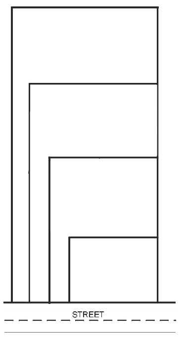
Figure 5-1: The stacking of multiple panhandle lots is prohibited.
(I)
Access from Arterials and Collectors.
(1)
Lots shall not, in general, derive access exclusively from an arterial or collector roadway. No lot parallel to an arterial or collector roadway and having a width of less than 200 feet should front on these roadways unless:
(a)
Access is limited to streets other than an arterial or collector;
(b)
Access is provided jointly with other lots; or
(c)
Access is ultimately to be provided from a planned frontage road.
(2)
Where possible, driveways shall be designed and arranged so as to avoid requiring vehicles to back into traffic on arterial or collector roadways.
(J)
Lots Abutting Water.
(1)
If a tract being subdivided contains a water body, or portion thereof, lot lines shall be so drawn as to distribute the entire ownership of the shoreline of the water body among the fees of adjacent lots. The city may approve an alternative plan whereby the ownership of and responsibility for safe maintenance of the shoreline of the water body is so placed that it will not become a city responsibility.
(2)
Lots abutting a water body, wetland, drainage way, channel, stream or pond shall be of sufficient width and depth and at the elevation needed to assure that building sites are not subject to flooding. The platting of lots within the floodplain is subject to the FP-O district regulations in Section 2.5.1, Floodplain Overlay District (FP-O), and Section 4.1, Development Standards for the FP-O District.
(K)
Large Tracts. When a parcel of land is subdivided into larger tracts than for building lots, such tracts shall be divided so as to plan for future lots and for the opening of major streets and the ultimate extension of adjacent streets and utilities.
(L)
Blocks.
(1)
A block shall normally be so designed as to provide two tiers of lots, unless it adjoins a railroad, arterial or collector street, lake, wetland, park, stream, or other natural feature, where it may have a single tier of lots.
(2)
Block length and width or acreage within bounding streets shall be sufficient to accommodate the size of lots required by this LDC and to provide for convenient access, circulation control and safety of street traffic. Residential block lengths, measured between street centerlines, shall not exceed 700 feet nor be less than 300 feet, except where topography or a block design feature justifies a departure from that standard.
(3)
Commercial and industrial block lengths shall not exceed 900 feet nor be less than 500 feet, except where topography justifies a departure from that standard. These block lengths shall not apply to areas zoned C1 district where the maximum block length shall be 330 feet or such length as to reflect the historic block pattern of the area of the city zoned C1 district.
(Ord. No. 1066, § 5, 10-15-2024)
5.2.3
Streets.
(A)
Purpose. Northfield views the street system as an integral element of the public realm that is designed in coordination with the Land Use Principles found in the Northfield Comprehensive Plan. A well designed street system creates a lasting image of the City. Therefore, these regulations are proposed to insure:
(1)
A high degree of connectivity,
(2)
Provide for a pleasant experience while moving throughout the city,
(3)
Linkage to the various residential and commercial neighborhoods,
(4)
An accessible multi-modal system, and
(5)
A system with a high degree of safety and convenience for the movement of people, goods and services.
(B)
General Requirements.
(1)
Gated Communities Prohibited. "Gated communities" and similar residential developments (developments that contain a gate or other barrier placed across an access road, or that are designed to appear or function as walled-off areas disconnected and isolated from the rest of the community) are prohibited.
(2)
Grid Street Network. New subdivisions shall be based on a grid or modified grid street system to the maximum extent feasible.
(3)
Street Dedications. A street that is not constructed to city standards will not be accepted by the city for dedication as a public street. However, even a street that complies with all applicable city standards may not be accepted for dedication. Acceptance of street dedication is at the discretion of the city council.
(4)
Topography and Arrangement.
(a)
The arrangement, character, extent, width, and location of all streets shall be considered in relation to existing and planned streets, shall provide for reasonable traffic circulation and traffic calming, and shall be appropriately located in relation to topography, run-off of surface water, convenience and safety, and proposed uses of the land to be served. Wherever possible, the arrangement of streets in new subdivisions shall provide for the continuation of existing and planned streets within and outside the proposed plat. Where adjoining lands are not subdivided, the arrangement of streets shall make provision for the proper projection of streets into adjoining lands by carrying the streets to the boundaries of the plat. The arrangement of streets shall not cause hardship to owners of adjoining property in platting their own land and providing convenient access to it.
(b)
Streets proposed within a new subdivision shall be interconnected and shall connect with adjacent streets external to the subdivision, to provide multiple routes for multi-modal circulation, emergency access, and trips from, to, and within the subdivision. Where street connections cannot occur due to topography, design constraints or some other feature beyond the control of the developer, sidewalks and/or trails shall be extended to connect with other pedestrian access improvements.
(c)
In commercial and industrial developments, the streets and other accessways shall be planned in connection with the location of buildings, rail facilities, truck loading and maneuvering areas, and sidewalks and parking areas so as to minimize conflict of movement between the various types of traffic, including pedestrian traffic.
(5)
Grading and Improvement Plan. The full width of the street right-of-way shall be graded and improved in conformance with the city's engineering standard specifications and the construction plans submitted as part of the final plat application.
(6)
Roadway and Access Offsets. Roadways or other access points entering upon opposite sides of any given roadway shall have their centerlines located directly opposite each other as far as practical or the centerlines located shall be offset at least 150 feet for local residential streets, and at least 200 feet for all other roadways. Driveways on local streets accessing one, two, or three family residential units are exempt from this requirement.
(7)
Access.
(a)
Vehicle access shall be prohibited from a stub street to adjoining lots until such time as the stub street is extended into an adjoining tract, or unless a temporary turn around feature is provided.
(b)
When a proposed plat contains or borders on the right-of-way of an existing or planned principal or minor arterial roadway, the city may require dedication and installation of a street approximately parallel to and on each side of such right-of-way for adequate protection of properties and to afford a separation of local and through traffic. Such streets shall be located at a distance from the major roadway suitable for the appropriate use of any intervening land. Such distance shall also be determined with due regard for the requirements of approach connections, future grade separations, and lot depths.
(c)
The subdivider shall provide access to all lots via local streets. When a proposed plat contains or borders on the right-of-way of a principal arterial, vehicle access points shall be restricted in accordance with the city's comprehensive transportation plan update and the access requirements of the Minnesota Department of Transportation in the relevant counties. When a proposed plat contains or borders on the right-of-way of an arterial or collector roadway, vehicle access points shall be restricted from such roadways. If access onto an arterial or collector is the only option for access and is therefore required, such vehicle access points shall be limited from individual lots onto such streets through the use of shared driveways, consistent with the access management provisions of the city's comprehensive transportation plan update.
(d)
Driveway access shall comply with Table 5.2-1.
(e)
Access to minor and major collector streets shall be in compliance with Table 5.2-2.
(8)
Signs, Traffic Signs and Lights, and Street Lights.
(a)
Street signs of standard design approved by the city shall be installed at each street intersection or at such other locations within the subdivision as designated by the city engineer, in accordance with the Minnesota Manual on Uniform Traffic Control Devices (MMUTCD).
(b)
Traffic control signs pursuant to Minn. Stat. § 169.06 and the Comprehensive Transportation Plan Update, where applicable, shall be installed at locations within the subdivision as designated by the city engineer.
(c)
Turn lanes and traffic lights shall be installed at the expense of the subdivider when required as a result of the proposed subdivision.
(d)
Street lights shall be installed at all intersections and at other locations, as required by the city engineer. All street lights within new subdivisions shall be on street light poles meeting the standards of the city and shall be equipped with underground electrical service, and shall conform to city lighting standards. The developer shall pay to the city the energy cost for the first two years of operation, or until the dwellings on all lots within the subdivision have been completed, whichever time period is less.
(9)
Sidewalks and Trails. Sidewalks and trails required by Section 3.7, Pedestrian Access and Circulation and Section 5.2.6, Parks, Trails, and Open Space Dedication, shall be installed at the time a street is constructed.
(10)
Street Trees Required. At least one street tree shall be properly installed at the time of street construction for each 40 foot length of right-of-way. This requirement may be modified depending on the chosen tree species and its typical spread at maturity.
(11)
Dead-End Streets, Stub Streets, and Cul-de-Sac Streets (Permanent and Temporary).
(a)
Dead-end streets shall be prohibited, except as stub streets.
(b)
Stub streets shall be installed to permit future street extensions into adjoining tracts, where appropriate. Barricades shall be installed at the end of stub streets and signage may be provided indicating a future street connection. Stub streets shall not exceed 150 feet in length. Where required by the city engineer a temporary connection to another street, or a temporary turnaround, shall be provided by the subdivider.
(c)
Permanent cul-de-sac streets are prohibited except as may be installed where absolutely necessary due to topography, configuration of land, existing road layouts or other special circumstances. The closed end of the cul-de-sac shall have a pavement width of 80 feet in diameter and the overall length of the road shall not exceed 600 feet in length as measured from the centerline of the nearest intersection to the closed end of the cul-de-sac.
(d)
In those instances where a street is terminated pending future extension in conjunction with future platting and its terminus is located 150 feet or more from the nearest intersection, a temporary cul-de-sac with a pavement width of 70 feet in diameter shall be provided at the closed end. Any portion of a temporary cul-de-sac not located within the street right-of-way shall be placed in a temporary roadway easement extending at least ten feet beyond the curb line of the temporary cul-de-sac in all directions. No building permit shall be issued for any properties containing or adjacent to a temporary cul-de-sac or roadway easement.
(12)
Alleys and Private Streets.
(a)
Alleys may be established in the city under the following conditions:
(i)
The alleys are publicly owned and maintained;
(ii)
The alleys shall be made of concrete, asphalt, pervious pavers, or other similar non-graveled surfaces;
(iii)
No home shall be oriented to face the alley; and
(iv)
Alleys are permitted as a secondary access when the lots front on an arterial or collector street as identified in Table 5.2-3.
(b)
Private streets are prohibited except in the R4 district.
(C)
Street Design Standards.
(1)
In order to provide for streets of suitable location, width, and general improvement to accommodate prospective traffic and afford satisfactory access to police, firefighting, snow removal, sanitation and road maintenance equipment, and to coordinate roads so as to compose a convenient system and avoid undue hardships to adjoining properties, all streets shall be subject to the standards of this section.
(2)
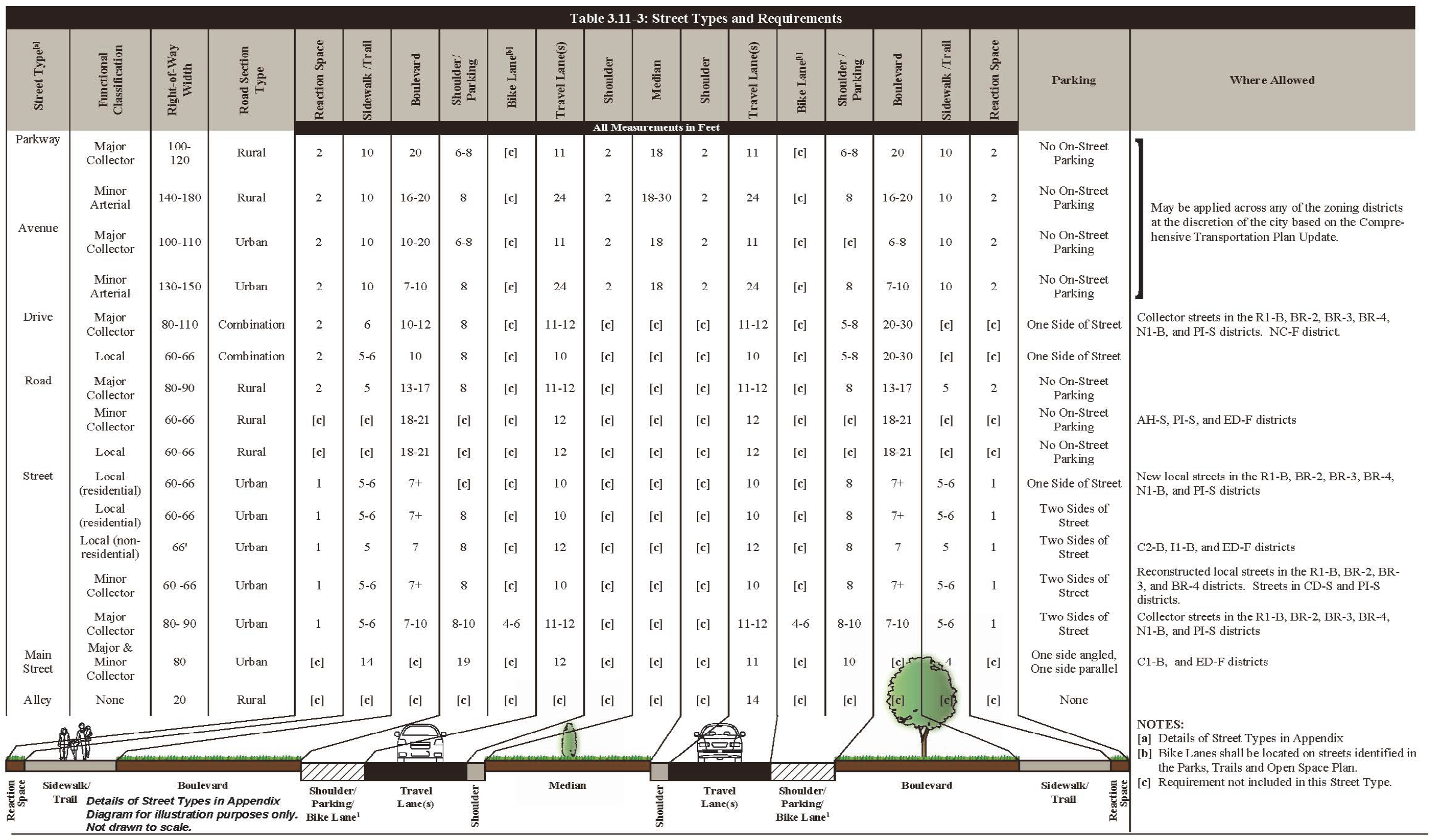
Street types shall be regulated by Table 5.2-3 and the design standards established in the Northfield comprehensive transportation plan update as shown in Appendix A.
(3)
Street Surfacing and Improvements. After the subdivider has installed sewer and water, the subdivider shall construct poured-in-place concrete sidewalks, curbs and gutters and shall surface streets to the width prescribed in this section. Curbs and gutters shall only be installed to the degree where necessary to accommodate the street design standard. The designer is encouraged to include techniques that will direct surface water drainage to off-street areas. Types of pavement shall be as prescribed in the city's engineering standard specifications. Adequate provision shall be made for culverts, drains and bridges. The portion of the right-of-way outside the area surfaced shall be sodded or planted with other acceptable materials as approved by the city engineer. All road pavement, shoulders, drainage improvements and structures, curbs, turnarounds and sidewalks shall conform to all construction standards and specifications in the city's engineering standard specifications and shall be incorporated into the construction plans required to be submitted by the subdivider for final plat approval.
(4)
Grading.
(a)
Streets shall be graded with at least 0.5 percent slope from the centerline to the curb to maintain drainage.
(b)
Arterial and collector streets shall have a maximum running grade of five percent.
(c)
All other streets shall have a maximum running slope of seven percent, or as determined by the city engineer.
(5)
Street Intersection, Tangent, Deflection and Other Design Standards.
(a)
Street Intersections shall intersect at right angles and in no instance shall the angle formed by the intersection be less than 60 degrees. Street intersections having more than four corners shall be prohibited and the curb line at street intersections shall have a radius not less than 15 feet.
(b)
Street tangents of at least 150 feet shall be designed between reverse curbs on collector streets and 100 feet on all local streets.
(c)
When connecting street lines deflect from each other at a point of more than ten degrees, they shall be connected by a curve with a radius adequate to insure a site distance of no less than 500 feet for arterials, 300 feet for collectors, and 100 feet for local streets.
(d)
Half streets and any corresponding right-of-way for half streets shall be prohibited.
Table 5.2-3: Street Types and Requirements
5.2.4
Sanitary Sewer, Water, and Other Utilities.
(A)
The subdivider shall install adequate sanitary sewer and water facilities (including fire hydrants) subject to the specifications in the city's engineering standard specifications, and the Recommended Standards for Water Works and the Recommended Standards for Wastewater Facilities (known collectively as the "ten-state standards").
(B)
The subdivider shall install sanitary sewer, water mains and service connections, stubbed to the lot line, meeting the minimum size requirements of the city and provided to all lots in the subdivision. Where a subdivider is required to install sanitary sewer or water mains that are larger than the minimum size as required by the city, the subdivider will be compensated by the city for the cost differential for material only for the cost of the minimum size sanitary sewer or water compared to the cost of the larger mains installed.
(C)
The subdivider shall extend sewer and water mains to the lot lines of abutting sites that do not have public water service.
(D)
All utility facilities, including but not limited to telecommunications cabling, natural gas and electric power, shall be located underground. Whenever existing utility facilities are located above ground, except when existing on public roads and right-of-way, they shall be removed and placed underground.
(E)
Five foot utility easements shall be required along the front lot line of each lot, measured from the lot lines. Such easements shall have continuity for alignment from block to block. Such easements shall also be provided at deflection points for pole-line anchors where necessary.
(F)
Easements shall be dedicated on the plat instrument for the required use.
5.2.5
Surface Water, Drainage, Water Quality, and Erosion Control.
(A)
Purpose. These regulations are intended to result in the effective management of surface water run-off by ensuring compliance with the adopted Surface Water Management Plan of the City of Northfield and also the requirements found in Chapter 22, Article VI of the Northfield Municipal Code. The City of Northfield supports a regional approach to surface water management or any similar innovative approach to managing surface water that protects and improves surface water quality, promotes ground water recharge, enhances wildlife through proper management of surface water, and minimizes public expenditures needed to protect water quality problems.
(B)
Subdivider Responsibilities. The subdivider is responsible for compliance with the overall objectives and expectations as stated in the Surface Water Management Plan and shall install needed improvements or pay to the City fees and or charges that have been established to ensure compliance with surface water management requirements as established by the City. If the city's surface water management plan designates a regional pond within the boundaries of the proposed subdivision, the subdivider shall provide the city with drainage and utility easements for the regional pond. The subdivider shall construct the pond in conjunction with development of the subdivision.
(C)
Nature of Surface Water Facilities.
(1)
Location. The city may require the subdivider to carry away by pipe any spring or surface water that may exist either previously to, or as a result of the subdivision. Such drainage facilities shall be located in the road right-of-way where feasible, or in perpetual unobstructed easements of appropriate width and shall be constructed in accordance the city's engineering standard specifications.
(2)
Accommodation of Upstream Drainage Areas. A culvert or other drainage facility shall in each case be large enough to accommodate potential runoff from its entire upstream drainage area in accordance with the city's surface water management standards in Chapter 22, Article VI - Surface Water Management.
(3)
Effect on Downstream Drainage Areas. The city's surface water management plan, together with such other studies as shall be appropriate, shall serve as a standard to needed improvements in downstream drainage facilities outside the subdivision.
(a)
The subdivider shall mitigate increased runoff due to development in accordance with the city's surface water management plan.
(b)
Where it is anticipated that the additional runoff attributable to the development of the subdivision will overload any existing downstream drainage facility, the city may withhold approval of the subdivision until provision has been made for the expansion of the existing downstream drainage facility.
(4)
Floodplain Areas. The city may, when it deems it necessary for the health, safety or welfare of the present or future population of the area and necessary to the conservation of water, drainage and sanitary facilities, prohibit the subdivision of any portion of a property that lies within the floodplain of any stream or drainage course in accordance with the provisions of this LDC.
(D)
Dedication of Drainage Easements.
(1)
Where a watercourse, drainage way, channel or stream traverses a subdivision, the subdivider shall provide a surface water easement, or park dedication, whichever the city may deem more appropriate. This easement or dedication shall conform substantially with the lines of such water courses, together with such further width for construction and maintenance, or both, as will be adequate for the surface water drainage of the area. The city engineer shall determine the width of such easements or dedication areas.
(2)
Drainage Easements.
(a)
Where topography or other conditions are such as to make impractical the inclusion of drainage facilities within road rights-of-way, the subdivider shall provide perpetual, unobstructed easements at least 20 feet in width for drainage facilities across property outside the road lines and with satisfactory access to the road. Easements shall be indicated on the plat. Drainage easements shall extend from the road to a natural watercourse or to other drainage facilities.
(b)
When a proposed drainage system will carry water across private land outside the subdivision, appropriate drainage rights must be secured and indicated on the plat.
(c)
The subdivider shall dedicate by a drainage easement, land on each side of the centerline of any wetland, body of water, watercourse or drainage channel, whether or not shown on the city's comprehensive plan, to a sufficient width to:
(i)
Provide proper protection for water quality;
(ii)
Provide retention of surface water runoff; and
(iii)
Provide for the installation and maintenance of storm sewers.
5.2.6
Parks, Trails, and Open Space Dedication.
(A)
Purpose, Nexus, and Proportionality
(1)
Purpose. These requirements are established for the purpose of assisting with the implementation of the Parks, Open Space and Trail System Plan of the City of Northfield by providing for the orderly development of recreation areas and the conservation of natural resources and scenic beauty in the city. The Parks, Open Space and Trail System Plan promotes a balanced and systematic approach to acquiring park and open space resources that include active park facilities, an interconnected trail system, areas of natural and ecological significance emphasizing the Cannon River corridor that is available to residents of the city and the broader region. As a means to accomplish these goals, each developer shall be required to dedicate land, or at the discretion of the city, pay an equivalent cash payment in lieu of land dedication for parks and open space acquisition and development. The policy of the city is to acquire and manage larger parcels of park and open space land resources; therefore, as a result of this policy, it is likely that a cash payment in lieu of land dedication will be the method by which this requirement will be accomplished in most instances, although not to the complete exclusion of a land dedication requirement.
(2)
Nexus. The city council finds that there is a rational nexus between the demands created by the subdivision and related development of land and the need for parks, trails, open space areas, public art, and facilities.
(3)
Proportionality. Further, the city council herein establishes requirements for the dedication and/or development of park land, trail improvements, and open space land that is roughly proportionate to the demands created by the subdivision and development of land resulting from such subdivision approval.
(B)
Authority. It is found and declared that, pursuant to Minn. Stat. § 462.358, subd. 2b, it is reasonable to require dedication of an amount of land equal in value to that percentage of the undeveloped land set forth in Section 5.2.6(D), Land Dedication Required.
(C)
Waiver of Requirements. Upon a request by the developer, the city council, may waive or reduce the requirements of this section for development in the C1 (Downtown), ED-F (Economic Development) or N2 (Neighborhood General) districts where the city council finds:
(1)
That the vitality resulting from development or redevelopment occurring in areas zoned C1 district is of greater benefit to the city in comparison to parks, trail and open space improvements;
(2)
That development in areas zoned ED-F district which results in significant increases in tax revenues to the city or significantly increases employment opportunities is of greater benefit to the city in comparison to parks, trail, or open space improvements;
(3)
That development in areas zoned N2 district which allows for the construction of affordable housing units of a type, price, or amount that is determined to be of greater benefit to the city in comparison to parks, trail, or open space improvements; or
(4)
That city-assisted development or redevelopment projects achieve public objectives.
(D)
Land Dedication Required.
(1)
In every plat, replat, or subdivision of land allowing development for residential, commercial, industrial, or other uses or any combination thereof, or where a waiver of platting is granted, but excluding adjacent parcel land conveyances (See Section 8.5.10, Adjacent Parcel Land Conveyance) that do not create additional lots, a reasonable portion of such land shall be set aside and dedicated by the applicant to the public for park, trail, or open space purposes.
(2)
The park and recreation advisory board may recommend to the city council that the applicant may be required to dedicate other parcels of property that are separate and distinct from the property proposed for subdivision that are owned or acquired by the applicant that more effectively accomplish the goals of systematically developing park and open space resources as outlined in the Parks, Open Space and Trail System Plan. Where the applicant is not able to dedicate or acquire such alternate property, the applicant shall be required to make cash payment in lieu of land dedication as set forth in Section 5.2.6(K), Dedication or Cash-in-Lieu of Requirements, of this LDC.
(3)
Pursuant to Minn. Stat. § 462.358, subd. 2b, it is reasonable to require a portion of buildable land to be dedicated to the public for parks, recreational facilities, playgrounds, trails, wetlands or open space purposes. The land to be used for the purposes previously stated shall be determined to be suitable at the sole discretion of the city and the city shall not be required to accept land that is not usable for the stated purposes.
(4)
The land required to be dedicated by the applicant for parks, recreational facilities, playgrounds, public art, trails, wetlands or open space is a recreational and open space resource available for the benefit of the public. The amount and type of park and open space resource dedicated is intended to be proportionate to the users of the park and open space resource that result from the subdivision of the land.
(5)
The amount of land required to be dedicated by the applicant for stated purposes in (1) above shall be based upon the net area (gross area minus area required for public streets, trails, and stormwater ponding) of the land to be subdivided which could be developed for residential, commercial, industrial or other purposes. The area shall be determined at the time of the preliminary plat and shall be calculated as follows:
(a)
Residential Development.
(b)
Commercial Development. Five percent of the gross area subdivided.
(c)
Industrial Development. Two percent of the gross area for the purpose of trails only.
(6)
This dedication shall be in addition to the land dedicated for streets, alleys, stormwater ponds or other public purposes.
(7)
Such dedication shall be in an amount based on the schedule of dedication requirements adopted by city council and maintained outside of this LDC.
(E)
Land Suitability Requirement.
(1)
Land dedicated for parks, trails, and open space shall be reasonably suitable as advised by the parks and recreation advisory board for its intended use and shall be at a location convenient to the people to be served.
(2)
Factors used in evaluating the adequacy of a proposed park, trail, or open space dedication shall include:
(a)
Future park needs pursuant to the Parks, Open Space, and Trail System Plan;
(b)
Size (that is consistent with the city's policy of wanting more large parks and fewer small parks);
(c)
Shape;
(d)
Topography;
(e)
Geology;
(f)
Hydrology;
(g)
Tree Cover; and
(h)
Access and location.
(3)
Parks, trails, or open space land to be dedicated shall be above the ordinary high water mark of any lake, river or stream.
(4)
Areas of slope exceeding 12 percent shall be deemed unsuitable for dedication and not included as part of areas to meet the dedication requirements.
(5)
Land with trash, junk, pollutants, and/or unwanted structures are not suitable.
(6)
The city shall not be required to accept land which will not be useable for parks, trails or open space or which would require extensive expenditures on the part of the city.
(7)
All land dedicated for parks, trails, and/or open space shall be designed to incorporate natural features such as rivers, streams, wildlife habitats, woodlands, and ponding areas.
(F)
Conformance with the Comprehensive Plan. Land dedicated under this division shall conform to the city's comprehensive plan and Parks, Open Space, and Trail System Plan, wherever possible. If the comprehensive plan or Parks, Open Space and Trail System Plan for the parcel of land to be subdivided calls for public property in excess of that required by Section 5.2.6(D), Land Dedication Required, the city council shall, before approval or disapproval of the plat, determine whether to take the necessary steps to acquire, by purchase or condemnation, all or part of the additional public property.
(G)
Dedication of Excess Land. If the city requires parks, trails or open space dedication in excess of the amount of land required by Section 5.2.6(D), Land Dedication Required, the city shall pay to the developer the fair market value of the land in excess of the percentage of land required to be dedicated. The excess amount that would otherwise be dedicated for parks, trail and open space under this section shall be due at the time of final plat approval.
(H)
Dedication Process. Prior to the dedication of the required property pursuant to this division, the developer shall provide the city evidence of title in a form acceptable to the city attorney or a title insurance policy insuring the city's interest in the property. In any dedication of required land, the developer must have good and marketable title to the land, free and clear of any mortgages, liens, encumbrances or assessments, except easements or minor imperfections of title acceptable to the city.
(I)
Trail Construction. When the city's comprehensive plan or Parks, Open Space, and Trail System Plan identifies a trail to be constructed in the land to be subdivided, this trail segment shall be interpreted by the city as basic infrastructure and, therefore, the developer shall be required to pay for the construction of the trail improvements. This trail construction requirement shall be in addition to the required land dedication as set forth in Section 5.2.6(D), Land Dedication Required, or set forth in Section 5.2.6(K) Dedication or Cash Payment in Lieu of Requirements. The construction specifications of trails shall be determined by the city engineer and whenever possible, trails shall connect with existing trails and/or sidewalks.
(J)
Credit for Private Open Space, Recreational Areas and Trails. Where a private open space for park, recreation or trail purposes is provided in a proposed subdivision and such space is to be privately owned and maintained by the future residents of the subdivision, a credit of up to 25 percent of the requirements of Section 5.2.6(D), Land Dedication Required, may be given, provided that the following conditions are met:
(1)
Such land area is not occupied by non-recreational buildings and is available for the use of all residents of the proposed subdivision.
(2)
Required setbacks shall not be included in the computation of such private open space.
(3)
The use of the private open space is restricted for park, recreational and trail purposes by recorded covenants which run with the land in favor of the future owners of the property within the tract and which cannot be eliminated without the consent of the city.
(4)
Credit for private trail improvements shall be given by the city only when the private trail system connects to a public trail or walkway system.
(5)
The proposed private open space is of an appropriate size, shape, location, topography and usability for park, recreational and trail purposes or contains unique natural features that are important to be preserved.
(6)
The proposed private open space reduces the demand for public recreational facilities to serve the development.
(K)
Dedication or Cash-in-Lieu of Requirements. The city may elect to accept a cash payment in lieu of land dedication for parks, recreational facilities, playgrounds, trails, wetlands or open space purposes. In such cases the applicant shall be required to make such payment to the city's dedicated park fund based on the Estimated Market Value as indicated in the records of the County Assessor that is equivalent to a land dedication requirement as follows:
(1)
Residential Development.
(2)
Commercial Development. Five percent of the gross area subdivided.
(3)
Industrial Development. Two percent of the gross area subdivided.
(L)
Time of Performance - Land Dedication or Cash Payment In Lieu Of. The dedication of land or the payment of cash in lieu of land dedication by the applicant shall occur as a condition prior the city council approval of the final plat.
(M)
Park Tree Requirements. The subdivider or developer shall preserve existing trees on any land to be dedicated under this section in accordance with Section 3.5.6, Tree and Woodland Preservation.
(N)
Other Conditions Prior to Deeding. Prior to dedicating land for parks, trails, or open space, the land shall meet the following conditions:
(1)
Grading in the parks shall conform to the grading plan as approved by the city engineer.
(2)
Rocks that are four inches or greater in diameter shall have been removed from the land. If possible, any boulders or glacial erratic should remain and be incorporated for landscaping interest in parks and open spaces.
(3)
A minimum of four inches of topsoil shall have been provided by the developer dependent on subsoil material as determined by the city engineer.
(4)
The surface should be planted with low maintenance vegetation to ensure the immediate stabilization of the exposed soils. The park and recreation advisory board should be consulted to determine which areas should become turf and which should be planted with non-turf vegetation. Areas of turf shall be seeded in the amount of 50—75 percent Kentucky bluegrass and 25—50 percent perennial ryegrass, or other quick establishing crop to prevent soil erosion.
(O)
Infrastructure. The applicant may bring utilities a reasonable distance inside the property line of the future park, as determined by the city engineer, and shall cap them at no cost to the city. Utilities shall include gas, storm sewer, water, electricity and sanitary sewer. The location where such utilities are to be brought into the future park shall be determined by the city engineer.
(P)
Access. All land dedicated for parks shall have at least 50 feet of street frontage on at least one side. All trails shall have at least 20 feet of access where the trail connects to a street or sidewalk.