
Northfield City Zoning Code
ARTICLE 9
- Definitions
9.1 - Rules of Construction and Interpretation.
9.1.1
Intent. All provisions, terms, phrases, and expressions contained in this LDC shall be construed according to this LDC's stated purpose and intent.
9.1.2
Lists and Examples. Unless otherwise specifically indicated, lists of items or examples that use terms such as including, such as, or similar language are intended to provide examples, and not to be exhaustive lists of all possibilities.
9.1.3
Computation of Time. Unless the terms of a specific provision state otherwise (e.g., some provisions specify "business days"), periods of time defined by a number of days shall mean a number of consecutive calendar days, including all weekend days, holidays, and other non-business/working days; however, if the last day is a Saturday, Sunday, or legal holiday, that day shall be excluded.
9.1.4
References to Other Regulations, Publications, and Documents. Whenever reference is made to an ordinance, resolution, statute, regulation, or document, that reference shall be construed as referring to the most recent edition of such regulation (as amended), resolution, statute, or document or to the relevant successor document, unless otherwise expressly stated.
9.1.5
Public Officials and Agencies. All public officials, bodies, and agencies to which references are made are those of the City of Northfield, unless otherwise expressly stated.
9.1.6
Delegation of Authority. Whenever a provision appears requiring the head of a department or another officer or employee of the city to perform an act or duty, that provision shall be construed as authorizing the department head or officer to delegate the responsibility to subordinates, unless the terms of the provision specify otherwise.
9.1.7
Technical Words. Technical words and phrases not otherwise defined in this LDC that may have acquired a peculiar and appropriate meaning in law shall be construed and understood according to such meaning.
9.1.8
Mandatory and Discretionary Terms. The word "shall" and "will" are always mandatory, and the words "may" or "should" are always permissive.
9.1.9
Conjunctions. Unless the context clearly suggests the contrary, conjunctions shall be interpreted as follows:
(A)
"And" indicates that all connected items, conditions, provisions, or events shall apply; and
(B)
"Or" indicates that one or more of the connected items, conditions, provisions, or events shall apply.
9.1.10
Tense and Usage. Words used in one tense (past, present, or future) include all other tenses, unless the context clearly indicates the contrary. The singular shall include the plural, and the plural shall include the singular.
9.1.11
Gender. The masculine shall include the feminine, and vice versa.
9.1.12
Meaning. For the purpose of this LDC, words and phrases shall have the meanings set forth in this article, or, for use categories and use types, as specified in Section 2.8, Use Definitions.
9.1.13
Other Terms Not Defined. Words and phrases not otherwise defined in this LDC shall be construed according to the common and approved usage of American English.
9.1.14
Additional Definitions within this LDC. There are additional definitions located in Section 2.8, Use Definitions, that are intended to define specific uses of property within this LDC.
9.2 - Definitions.
Abutting or Adjacent. The land, lot, or property adjoining the property in question along a lot line or separated only by an alley, easement, or street.
Accessory Dwelling Unit. A habitable dwelling unit detached from a single-family dwelling, on a permanent frost free foundation, connected to sanitary sewer and water services, that provides basic requirements for living, sleeping, eating, cooking, and sanitation and conforms to applicable building codes.
Accessory Structure. A subordinate building or other subordinate structure including but not limited to garages, sheds, accessory dwelling units, or swimming pools, the use of which is clearly subordinate to the use of the principal building.
Adult Establishment. Any establishment in which an adult use comprises more than ten percent of the floor area of the establishment in which it is located or more than 20 percent of the gross receipts in any month for the entire business operation.
Adult Use. Any use as defined in Section 2.8.4(A).
• Any business that:
(i)
Devotes a substantial or significant portion of its inventory, stock-in-trade or publicly displayed merchandise to; or
(ii)
Devotes a substantial or significant portion of its floor area of the business (not including store rooms, stock areas, bathrooms, basements, or any portion of the business not open to the public) to; or
(iii)
Derives a substantial or significant portion of its gross revenue from sales of, materials or devices that stimulate human genitals, are designed for sexual stimulation, or that depict or that relate to "specified anatomical areas" or "specified sexual activities."
• Activities and matters classified as obscene as defined by Minn. Stat. § 617.241 are not adult uses and are prohibited in the City.
Affordable Housing. Owner or renter occupied housing where the annual mortgage or annual rent plus the cost of utilities do not exceed 30% of gross household income.
Alley. A public or private right-of-way, usually 20 feet or less in width, which normally affords a secondary means of vehicular access to abutting property.
Antenna. Any system of wires, poles, rods, reflecting discs, or similar devices used for the transmission or reception of electromagnetic waves when such system is either external to or attached to the exterior of a structure.
Antenna, Building Mounted. Any antenna, other than an antenna with its supports resting on the ground, directly attached or affixed to a building, tank, tower, building mounted mast less than ten feet tall and six inches in diameter, or structure other than a telecommunication tower.
Antenna, Directional. Also known as a panel antenna, means an antenna that transmits and/or receives radio frequency signals in a directional pattern of less than 360 degrees.
Antenna, Ground-Mounted. Any antenna with its base, single or multiple posts, placed directly on the ground or a mast less than ten feet tall and six inches in diameter.
Antenna, Omnidirectional. An antenna that transmits and/or receives radio frequency signals in a 360 degree radial pattern. For the purpose of this LDC, an omnidirectional antenna is up to 15 feet in height and up to four inches in diameter.
Antenna, Parabolic. Also known as a satellite dish antenna, means any device incorporating a reflective surface that is solid, open mesh, or bar configured and that is a shallow dish, cone, horn, bowl or cornucopia shaped and is used to transmit and/or receive electromagnetic or radio frequency communication/signals in a specific directional pattern. This definition is meant to include but is not limited to what are commonly referred to as "satellite earth stations", "TVROs (television receive only)" and "satellite microwave antennas."
Antenna, Portable. Any device used to transmit and/or receive electromagnetic or radio frequency communication/signals in a specific directional pattern, located on a portable or moveable base designed to be placed either for temporary or long-term use at a given site.
Antenna, Vertical. A vertical-type antenna without horizontal cross sections greater than one-half inch in diameter.
Appeal. A request for review of an administrative interpretation or decision made in relation to this LDC.
Applicant. Unless otherwise specified, an owner or an agent for the owner, including, a subdivider, developer, attorney, or similar representative, who has filed an application for development review pursuant to Article 8: Development Procedures.
Application. The process by which the owner, or their agent, of a parcel of land within the city submits a request for any type of development review or approval identified in Article 8: Development Procedures. Applications include all written documentation, verbal statements, and representations, in whatever forms and quantities as required by the city.
Arbor. A framework, typically made of latticework, supporting climbing plants.
Art, Public. The term public art properly refers to work of art in any media to improve the public realm and contribute to place, character and identity that has been planned and executed with the specific intention of being sited or staged in the physical public domain and available to all.
Automated Teller Machine (ATM). An automated device that performs banking or financial functions at a location remote from the controlling bank or financial institution.
Awning. A canopy or covering structure projecting from and attached to a building.
Bars, Taverns and Nightclubs. Any building or structure devoted primarily to the selling, serving or dispensing and drinking of malt, vinous, or other alcoholic beverages in which the serving of food may occur incidental to the consumption of such alcoholic beverages.
Base. The structural elements, design features, and materials associated with the first floor elevation of a building façade.
Base Flood. The flood having a one percent chance of being equaled or exceeded in any given year.
Basement. A portion of a building located partly underground but having half or more of its floor-to-ceiling height below the average grade of the adjoining ground. Also, within the FP-O District any area of a structure, including crawl spaces, having its floor or base subgrade (below ground level) on all four sides, regardless of the depth of excavation below ground level.
Blade (Wind Energy System). Extensions from the hub of a WET that are designed to catch the wind and turn the rotor to generate electricity.
Block. The enclosed area within the perimeter of roads, property lines or boundaries of the subdivision, including both the pavement and the boulevard.
Boarding House. A building, excluding a hotel, motel, dormitory or residence hall, where lodging or rooms, or both, are provided for compensation, whether directly or indirectly.
Body. The remainder of the building visible between the building base and cap.
Brew pub. Brew pub is a brewer who also holds one or more retail on-sale licenses and who manufactures fewer than 3,500 barrels of malt liquor in a year, at any one licensed premises, the entire production of which is solely for consumption on tap on any licensed premises owned by the brewer, or for off-sale from those licensed premises as permitted in Minn. Stat. 340A.24, subd. 2.
Brewer taproom. A facility on the premises of or adjacent to the premises owned by a brewer, licensed under Minn. Stat. § 340A.301, intended for the on-sale consumption and limited off-sale of beer produced on site by the brewer as authorized by Minn. Stat. § 340A.26.
Buffer. An area of natural or planted vegetation adjoining or surrounding a land use and unoccupied in its entirety by any building structure, paving or portion of such land use, for the purposes of separating, screening, and softening the effects of the land use, no part of which buffer is used for active recreation or parking, or interior access drives. A buffer may include a wall, fence, or berm as provided in accordance with the provisions of Section 3.5, Landscape, Screening, and Buffering Standards.
Building. A structure, of more or less permanent construction, having a roof and intended to be used for sheltering people, animals, property, or business activity.
Building Coverage. The area of a lot covered by the footprint of a principal building, detached garage, and covered porches, expressed as a percentage of the total lot area.
Building Height. The vertical distance of a building as measured in accordance with Section 3.1.6, Height, Measurement, Limits, and Exceptions.
Building-Integrated Solar Energy Systems. An active solar energy system that is an integral part of a principal or accessory building, rather than a separate mechanical device, replacing or substituting for an architectural or structural component of the building. Building-integrated systems include but are not limited to photovoltaic or hot water solar energy systems that are contained within roofing materials, windows, skylights, and awnings.
Building Mounted Solar Energy Systems. An active solar energy system that is mounted to the roof or other part of the building using brackets, stands or other apparatus.
Building Line (Front Façade). A line that runs parallel and adjacent to the primary building façade.
Building, Accessory. See definition for "Accessory Structure."
Building Placement. The actual location of an existing building on a property.
Building, Principal. A building that is the primary use of the lot.
Build-to-Line. A build-to-line specifies the required location of a new structure in relation to the street frontages of a site, so that a proposed building will effectively assist in shaping the public space of streets, to enhance the comfort and convenience of the pedestrian experience.
Cap. The structural elements, design features, and materials associated with the top floor elevation of a building façade.
Certificate of Appropriateness. That document provided by the heritage preservation commission which evidences approval of activities proposed for a heritage preservation site.
City. City of Northfield, unless otherwise noted.
City Attorney. The attorney employed by the city or retained to represent the city general civil matters.
City Council. The City Council of the City of Northfield.
City Engineer. The licensed engineer employed or retained by the city to manage the engineering department.
City Planner. The staff person at the city or retained consultant who has the primary responsibility for administering the duties of this LDC.
Clear cutting. The entire removal of a stand of vegetation.
Clinic. A building, or part of a building, where persons are cared for on an outpatient basis.
Cocktail room. A facility on or adjacent to the premises of a microdistillery licensed under Minn. Stat. § 340A.22, which has been issued a cocktail room license for the on-sale of distilled liquor produced by the distiller for consumption on the premises of or adjacent to one distillery location owned by the distiller.
Commercial Message. Any sign, wording, logo or other representation that, directly or indirectly, names, advertises or calls attention to a business, product, service or other commercial activity.
Commercial Solar Farm. A facility that converts sunlight into electricity whether by photovoltaic action (PV), concentrating solar thermal devices (CST), or other conversion technology for the sale to an electric utility company.
Commercial Wireless Telecommunication Services. Licensed commercial wireless telecommunication services including cellular, personal communication services (PCS), specialized mobilized radio (SMR), enhanced specialized mobilized radio (ESMR), paging, and similar services that are marketed to the general public.
Commissioner of Natural Resources. The Minnesota Department of Natural Resources Commissioner.
Community Solar Garden. A solar electric (photovoltaic) array that provides retail electric power (or a financial proxy for retail power) to multiple community members or businesses residing or located off site from the location of the solar energy system, under the provisions of Minn. Stat. § 216B.1641 or successor statute.
Comprehensive Plan. The Comprehensive Plan of Northfield, Minnesota adopted on November 17, 2008.
Construction Drawings. Drawings and specifications prepared by a registered engineer showing how a specific improvement, submitted as part of a development review application, is to be constructed.
County. Rice County and/or Dakota County, Minnesota.
Cul-De-Sac. A street with a single means of ingress/egress and having a turnaround at the terminus.
Damaged or Diseased Trees. Trees that have split trunk, broken tops, heart rot, insect or fungus problems that will lead to imminent death, undercut root systems that put the tree in imminent danger of falling, lean as a result of root failure that puts the tree in imminent danger of falling, or any other condition that puts the tree in imminent danger of being uprooted or falling into or along a stream or onto a structure.
dB. Abbreviation for decibel.
DBH. Diameter-at-breast-height. DBH is used to measure the caliper of a tree trunk at the specific height of 4.5 feet above the ground.
Decibel. The unit of measurement for the loudness of a sound.
Deciduous Tree. Generally, a tree that loses all of its leaves for part of the year. Sometimes called a broad-leaf tree or a hardwood tree.
Deck, Attached. A deck structure attached to the principal structure, and intended for use during the summer months, but does not include a roof and/or walls.
Deck, Detached. A freestanding deck that is an accessory use of the principal structure, intended for use during the summer months, but does not include a roof and/or walls.
Density. The number of dwelling units per gross acre of land. Gross density shall be the total number of dwelling units as divided by the gross area of a site (including public right-of-way, easements, etc.). Net density shall be the total number of dwelling units divided by the gross area of the site minus any land used for easements and/or rights-of-way.
Development. Any manmade change to improved or unimproved land, including but not limited to the construction of buildings or other structure, mining, dredging, filing, grading, paving, excavation, or drilling.
Development Agreement. A contract entered into between the city council and a subdivider related to subdivisions and related improvements as outlined in Section 5.1.4, Development Agreement Required.
DNR. The Minnesota Department of Natural Resources.
Drainage Course. A watercourse or indenture for the drainage of surface water.
Drip Line. The circle which would exist if you drew a line below the tips of the outer most branches of a tree or plant.
Driveway. A private way, other than a street or alley, that provides access to one lot of record for the use of vehicles and pedestrians.
Dwelling. A building or portion thereof designed or used for residential occupancy, but not including hotels, motels, bed and breakfasts, or dormitories.
Dwelling Unit. A single unit of one or more rooms providing complete, independent living facilities for one or more persons including permanent provisions for living, sleeping, eating, cooking, and sanitation but not including a tent, cabin, hotel, motel, recreational vehicle, or other temporary or transient structure or facility.
Easement. A grant by an owner of land for a specific use by a person other than the owner. An easement may be granted for the purpose of contributing and maintaining walkways, roadways, utilities, and other uses.
Encroachment. The advancement of a structure or part of a structure beyond the permitted property line setback established by the zoning district.
Equal Degree of Encroachment. A method of determining the location of floodway boundaries so that flood plain lands on both sides of a stream and are capable of conveying a proportionate share of flood flows.
Equipment Building, Shelter or Cabinet. A cabinet or building used by telecommunication providers to house equipment at a facility.
Evergreen Tree. A tree that remains green throughout the year with an expected height of at least 40 feet.
Façade. The exterior wall on the front, side, or rear elevation of the building regardless of whether the building side faces a street.
Façade, Primary. The front face of a building which faces the front yard and is located nearest the front property line. An attached garage is not a component of the primary façade.
Façade, Recessed. That portion of a building which faces the front yard and is set back from the front property line a distance greater than that of the primary façade.
Fall Zone. The area on the ground within a prescribed radius from the base of a WET. The fall zone is the area within which there is a potential hazard from falling debris (such as ice) and, in the case of towers, shall not be less than a radius equal in distance to the total height of the WET. The area within the fall zone shall be under the legal care, custody and control of the WET applicant. Applicants who own contiguous parcels of land that will be included within the fall zone must file ANR applications to relocate any property lines within the fall zone.
Family. A person living alone or any of the following groups living together as single, non-profit, housekeeping unit sharing common living, sleeping, cooking, and eating facilities:
• Any number of people related by blood, marriage, adoption, guardianship, or duly authorized custodial relationship.
• Up to five unrelated people.
• Two unrelated people and any children related to either of them.
• Not more than the number of people who are allowed in a licensed residential facility as provided for in Minnesota statutes.
Federal Aviation Administration (FAA). The governmental agency responsible for regulating airways in the United States.
Federal Communications Commission (FCC). The government agency responsible for regulating telecommunications in the United States.
Federal Emergency Management Agency (FEMA). The government agency responsible for regulating flood plain regulations in the United States.
Feeder Line. Any power line that carries electrical power from one or more wind turbines or individual transformers associated with an individual wind turbine to the point of interconnection with the electric power grid, in the case of interconnection with the high voltage transmission systems the point of interconnection shall be the substation serving the WECS.
Fence. An artificially constructed barrier of wood, masonry, stone, metal, or other manufactured material or combination of materials erected to enclose, screen, or separate areas.
Final Plat. The final map, drawing, or chart on which the subdivider's plan of subdivision is presented to the city council for approval and which, if approved, will be submitted to the county recorder.
Flag. Any fabric or other flexible material attached to or designed to be flown from a flagpole or similar device.
Flood. A temporary increase in the flow or stage of a stream or in the stage of a wetland or lake that results in the inundation of normally dry areas.
Flood frequency. The frequency for which it is expected that a specific flood stage or discharge may be equaled or exceeded.
Flood Fringe. That portion of the flood plain outside of the floodway. Flood fringe is synonymous with the term "floodway fringe" used in the Flood Insurance Studies as adopted in this code.
Flood Plain. The beds proper and the areas adjoining a wetland, lake or watercourse which have been or hereafter may be covered by the regional flood.
Flood Proofing. A combination of structural provisions, changes, or adjustments to properties and structures subject to flooding, primarily for the reduction or elimination of flood damages.
Floodway. The bed of a wetland or lake and the channel of a watercourse and those portions of the adjoining flood plain which are reasonably required to carry or store the regional flood discharge.
Floor Area, Gross. The sum of the gross horizontal areas of several floors of a building, measured from the exterior faces of exterior walls or from the centerline of party walls separating two buildings. In particular, floor area shall include the following:
• Basement space if at least one-half of the basement story is above the established curb level or, where the curb level has not been established, above the average level of the finished grade;
• Elevator shafts and stairwells at each floor;
• Floor space used for mechanical equipment where the structural headroom exceeds seven and one half feet, except equipment open or enclosed, located on the roof, i.e., bulkheads, water tanks and cooling towers;
• Attic floor space where the structural headroom exceeds seven and one half feet;
• Interior balconies and mezzanines; and
• Enclosed porches, but not terraces, breezeways, and screened porches.
Foot-candle. A unit of illumination produced on a surface, all points of which are one foot from a uniform point source of one standard candle.
Footprint. The area of a building measured from the exterior surface of the exterior walls at grade level where a building is elevated above grade level.
Freestanding Solar Energy Systems. Freestanding solar panels mounted to the ground by use of stabilizers or similar apparatus.
Fresnel Zone (WET). An area within the pattern of electromagnetic radiation that is created by a transmitting station from its antenna to receiving antennas.
Frontage, Building. The length of an enclosed building facing a public or private street. When a business does not front a public right-of-way, the city planner shall designate the building frontage. In structures with more than one business, the frontage of each business shall be calculated separately in determining its sign area (See Figure 6-1).
Frontage, Street. The distance for which the front boundary line of the lot and the street line are coincident (See Figure 9-1).
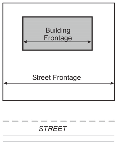
Figure 9-1: Illustration of building frontage versus street frontage.
Garage. A building primarily intended for and used for the enclosed storage or shelter of private motor vehicles of the owner or occupant of the principal building.
Grade (Adjacent Ground Elevation). The lowest point of elevation of the finished surface of the ground, paving or sidewalk within the area between the building and the property line or, when the property line is more than five feet from the building, between the building and a line five feet from the building.
Grass. A species of perennial grass grown as permanent lawns or for landscape purposes.
Grid Inter-tie Solar Energy System. A solar energy system that is connected to an electric circuit served by an electric utility company.
Grid Street Pattern. A network of parallel and perpendicular streets intersecting at approximately 90-degree angles, forming rectangular blocks of land (See Figure 9-2).
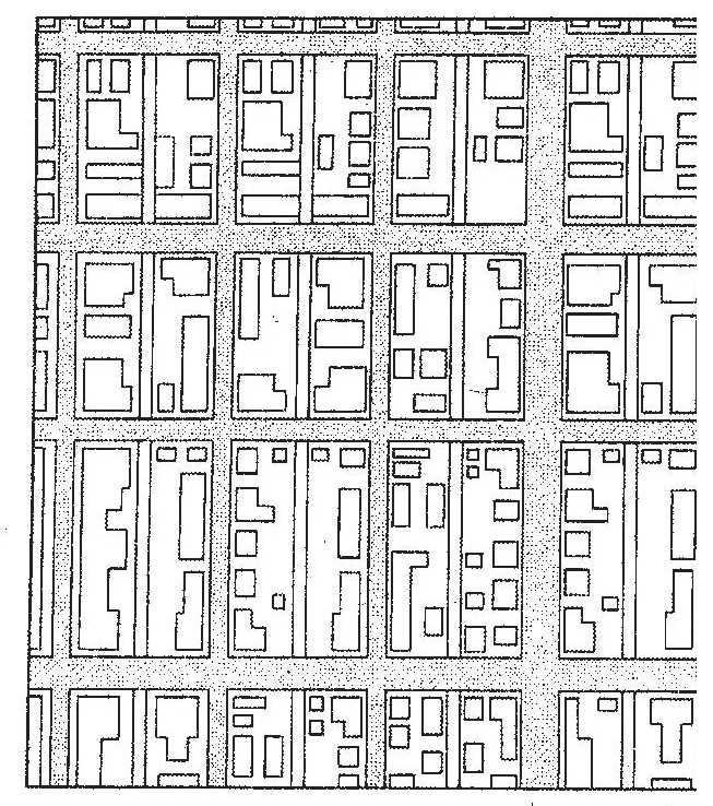
Figure 9-2: Illustration of Grid Street Pattern.
Grid Street Pattern, Modified. A network of streets that is similar to a grid street pattern, except that it uses a combination of "T" intersections and crossroad intersection producing an irregular grid with a large amount of variety. These modifications may incorporate curves or offsets in roadways, diagonally directed streets and similar features that take advantage of focal points and terminal vistas. This pattern may be used in areas where the roadway design must be sensitive to topography, existing development, other pre-existing constraints, or other planned non-residential features of the subdivision such as parks or open spaces (see Figure 9-3).
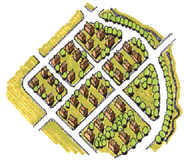
Figure 9-3: Illustration of a Modified Grid Street Pattern.
Ground Cover. A plant growing less than two feet in height at maturity that is grown for ornamental purposes. Ground covers are used as an alternative to grasses. On slopes, ground covers control erosion while eliminating the maintenance of mowing on hillsides. Ground covers also provide permanent covering of open ground to prevent erosion and/or create visual appeal.
Ground Mounted Solar Energy System. A freestanding solar energy system mounted directly to the ground using a rack or pole rather than being mounted on a building.
Group Residential Facility. A residential facility for a group of individuals (who are not mentally ill or developmentally disabled) having full or part-time supervisory staff providing care, education, and participation in community activities, living in a district authorizing residential uses. A retirement facility shall not be included under this definition.
Heritage Preservation Site. Any area, place, building, structure, land, significant landscaping, district, adjacent property or other object which has been so designated pursuant to this article. The downtown historic district is considered individually and in its entirety as a heritage preservation site.
Highway. An officially designated state or federal numbered highway or other road designated as a highway in the Northfield Transportation Plan.
Home Business. A business, occupation, or profession for financial gain or profit that is incidental to and carried on within a dwelling unit located on a lot by resident occupants of the dwelling unit and which occupation is clearly incidental to and accessory to the residential use of the property.
Housekeeping Unit. One or more persons occupying a dwelling unit and living as a single group, and doing their own cooking on the premises as distinguished from a group occupying a bed and breakfast establishment, hotel, or motel.
HPC. The City of Northfield Heritage Preservation Commission.
Hub (WET). The center of the rotor that is part of a WET, to which the blades are attached.
Hub Height (WET). The height as measured from the base of the tower to the center of the hub.
Impervious Surface. Any hard-surfaced, man-made area that does not readily absorb or retain water, including but not limited to buildings, roofs, parking and driveways, sidewalks, and pavement.
Improvements. The grading, draining, sanitary and storm sewers, water mains, pavement, curbs and gutters, sidewalks, street signs, street lights, parks, monuments and the appropriate appurtenances required to render land suitable for the use proposed.
In-Home Day Care. The care of children within a dwelling unit where the day care is an ancillary use, permitted as a home business.
Landscaping. The improvement of a lot, parcel, tract of land, or portion thereof, with grass, shrubs, and trees. Landscaping may include pedestrian walks, flower beds, trees, shrubs, and ornamental objects such as fountains, statuary, and other similar natural and artificial objects.
Large-Scale Wind Energy Turbine (LWET). Wind energy system consisting of a wind turbine, a tower, and associated control or conversion electronics, whose total height is more than 130 feet above natural grade. LWETs shall have a rated capacity of more than 60 KW and be intended primarily to produce energy for sale to the grid, for consumption off-site.
Lattice Tower. A self-supporting support structure, erected on the ground, which consists of metal crossed strips or bars to support antennas and related equipment.
Lettering. The symbols for speech sounds written or printed on something.
Lettering Style. An assortment or set of lettering type or characters all of one style and sometimes one size.
Levels of Service (LOS). In regard to transportation planning, is a measure of the quality of traffic flow that uses qualitative measures to characterize operational conditions with a traffic stream and their perception by motorists. Six LOS are defined for roadways: A, B, C, D, E, and F with LOS A representing the best operating conditions and LOS F representing the worst.
Light, Cutoff. An artificial outdoor light source designed to ensure that no light is directly emitted above a horizontal line parallel to the ground as regulated and illustrated in Section 3.3.4, Outdoor Lighting Standards.
Light, Non-Cutoff. An artificial outdoor light source designed to allow light to be directly emitted above a horizontal line parallel to the ground as regulated and illustrated in Section 3.3.4, Outdoor Lighting Standards.
Live Work. A structure or a portion of a structure that combines a commercial activity allowed in the zone with a residential living space for the owner of the commercial business or the owner's employee and that person's household. The resident owner or employee of the business is responsible for the commercial activity performed within the structure.
Loading Area. An off-street space or berth for the loading or unloading of freight carriers on the same lot as the structure they serve.
Logo. A graphic mark, emblem, or symbol used to aid and promote public identification and recognition. It may be of an abstract or figurative design or include the text of the name it represents as in a wordmark.
Lot. A parcel of land designated by metes and bounds, plat, registered land survey, auditor's plot, or other accepted means and separated from other parcels or portions by the description for the purpose of sale, lease, or separation thereof.
Lot Area. The total area within the lot lines, excluding dedicated public rights-of-way.
Lot Coverage. That portion of a lot that is covered by the principal and accessory building, structures, and surfaces that prevent the passage or absorption of stormwater including paving, driveways, and other impervious surfaces.
Lot Depth. The mean horizontal distance between the front lot line and the rear lot line of a lot.
Lot Line. A line of record bounding a lot that divides one lot from another lot, a public right-of-way or any other public or private space. Lot line may also be called a "property line."
Lot Line, Front. That boundary of a lot which abuts an existing or dedicated public street, and for a corner lot it shall be the shortest dimension on a public street. If the dimensions of a corner lot are equal, the front line shall be designated by the city.
Lot Line, Rear. That boundary of a lot which is opposite the front lot line. If the rear line is less than ten feet in length or if the lot forms a point at the rear, the rear lot line shall be a line ten feet in length within the lot, parallel to and at the maximum distance from the front lot line.
Lot line, Side. Any lot line other than a front or rear lot line.
Lot of Record. Any lot which is one unit of a plat designated by metes and bounds, registered land survey, auditor's plot, or other accepted means and separated from other parcels or portions of the description for the purpose of sale, lease or separation thereof that has been recorded in the office of the county recorder prior to the effective date of this LDC.
Lot Width. The horizontal distance between the side lot lines as measured in accordance with Section 3.1.4, Lot Width Measurements (See Figure 9-4).
Lot, Corner. A lot abutting upon two or more streets at their intersection or upon two parts of the same street, and in either case forming an interior angle of less than 135 degrees (See Figure 9-4).
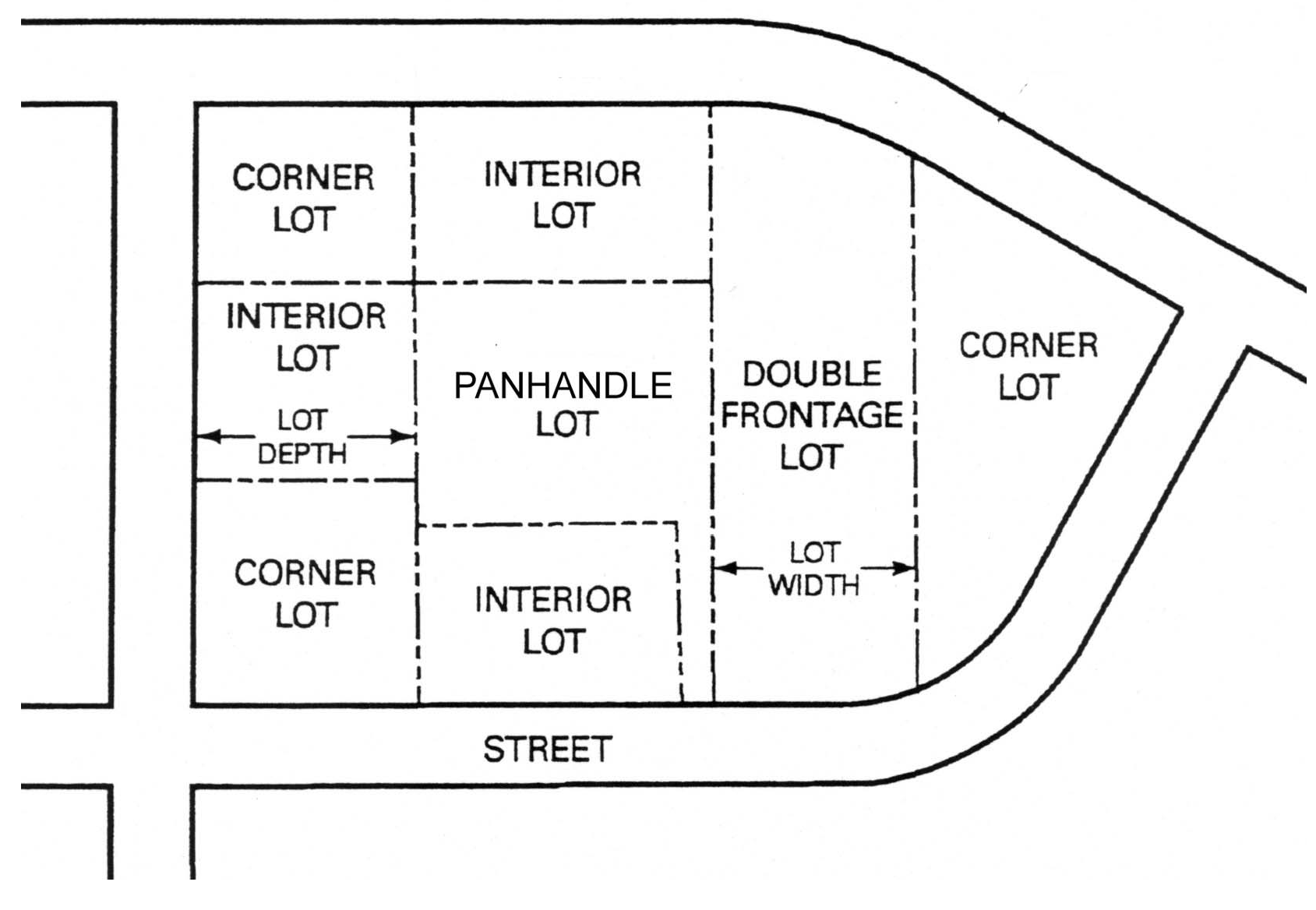
Figure 9-4: Illustration of lot configurations and types.
Lot, Double Frontage. A lot which has a front line abutting on one street and a back or rear lot line abutting on another street (See Figure 6-4).
Lot, Interior. A lot that has a single street frontage, a rear lot line, and at least two side lot lines (See Figure 6-4).
Lot, Panhandle or Flag. A lot not fronting or abutting a public street and where access to the public street is limited to a narrow strip of land (See Figure 6-4).
Lowest Floor. The lowest floor of the lowest enclosed area (including basement). An unfinished or flood resistant enclosure, used solely for parking of vehicles, building access, or storage in an area other than a basement area, is not considered a building's lowest floor.
Luminaire. A complete lighting unit consisting of one or more lamps, together with the components designed to distribute the light, to position and protect the lamps, and to connect the lamps to the electrical power supply; also called the lighting fixture. Luminaire shall not include the light pole used to support the luminaire.
Manufactured Home. A dwelling unit within the FP-O District generally defined as a structure, transportable in one or more sections, which is built on a permanent chassis and is designed for use with or without a permanent foundation when attached to the required utilities. The term "manufactured home" does not include the term "recreational vehicle." For areas outside the FP-O District Manufactured Home shall be as specifically defined in Minn. Stat. § 327.31, subd. 6.
Manufactured Home Park. Any site, lot, field, or tract of land upon which two or more manufactured homes are located and includes any building, structure, vehicle, or enclosure intended for use as a part of the equipment of such manufactured home park (See also Minn. Stat. § 327.14, Subd. 3).
Manufactured Home Stand. The part of an individual manufactured home lot that has been reserved for placement of the manufactured home, appurtenant structures, or additions.
Maximum Extent Feasible. That no feasible and prudent alternative exists, and all possible efforts to comply with the regulation or minimize the potential harm or adverse impacts have been undertaken. Economic considerations may be taken into consideration.
Medium-Scale Wind Energy Turbine (MWET). Wind energy conversion system consisting of a wind turbine, a tower, and associated control or conversion electronics, whose total height is between 75 feet and 130 feet above natural grade. MWETs shall have a rated capacity in excess of 60 KW, be intended primarily to produce energy for on-site power consumption and reduce the need to purchase utility power from the grid, and have the ability to sell power back to the grid.
Menu Board. Any signage pertaining to items, goods, or services offered by a drive-through business.
Metes and Bounds Description. A method of property description by means of the direction and distance from an identifiable point of beginning.
Microbrewery. A facility that manufactures and distributes intoxicating malt liquor or wine in total quantity not to exceed 250,000 barrels a year. A microbrewery may have space dedicated as a taproom to distribute on-sale and off-sale alcohol in compliance with Minn. Stat. § 340A.26.
Microdistillery. A distillery operated within the state producing premium, distilled spirits in total quantity not to exceed 40,000 proof gallons in a calendar year and licensed under Minn. Stat. § 340A.22.
Minnesota Department of Transportation (MnDOT). The agency that regulates state roadways in the State of Minnesota.
Minor Subdivision. Lot division or consolidation which results in three or less parcels as described in Section 8.5.11, Minor Subdivision or Lot Consolidation.
Miscellaneous Adult Use. Any establishment, business, or service whose products or services are substantially or significantly distinguished or characterized by an emphasis on specified sexual activities or specified anatomical areas.
Mixed Use. A building or tract of land developed or used for two or more different uses, including but not limited to, residential, office, manufacturing, retail, public, entertainment, or other uses.
Mobile Home. See definition of "Manufactured Home."
Modular Home. A structure not built on-site, but which is placed on a permanent foundation and meets the state building code standards.
Monopole. A wireless communication facility which consists of a monopole structure, erected on the ground to support wireless communication antennas and connecting appurtenances.
Nacelle (WET). The frame and housing at the top of the tower which protects the gear box and generator from weather and helps control the mechanical noise level.
Native Prairie. Land as mapped or defined by the Minnesota Department of Natural Resource.
Noncommercial Message. A message on the sign that is not classified as a commercial message.
Nonconformity. Lots, uses of land, structures, and uses of structures and land in combination, lawfully existing at the time of enactment of this ordinance or its amendments, which do not conform to the regulations of the applicable zoning district, and are therefore incompatible.
Nude or Specified Anatomical Areas.
• The showing of the human male or male genitals, pubic area, vulva, anus, anal cleft or cleavage with less than a fully opaque covering; the showing of the female breast with less than a fully opaque covering of any part of the nipple; the exposure of any device, costume, or covering which gives the appearance of or simulates the genitals, pubic hair, natal cleft, perineum anal region or pubic hair region; or the exposure of any device worn as a cover over the nipples and/or areola of the female breast, which device simulates and gives the realistic appearance of nipples and/or areola; or
• Human male genitals in a discernibly turgid state, even if completely and opaquely covered.
Obstruction. Any dam, wall, wharf, embankment, levee, dike, pile, abutment, projection, excavation, channel modification, culvert, building, wire, fence, stockpile, refuse, fill, structure, or matter in, along, across, or projecting into any channel, watercourse, or regulatory flood plain which may impede, retard, or change the direction of the flow of water, either in itself or by catching or collecting debris carried by such water.
Off-Grid Solar Energy System. A solar energy system in which the circuits energized by the solar energy system are not electrically connected in any way to electric circuits that are served by an electric utility company.
Open Space. Open areas, including parks, nature areas, playgrounds, and trails. This does not include holding ponds, streets, driveways, or parking areas.
Ornamental Shrub. A deciduous shrub with visual appeal through flowers, fruit, leaf color, or fall colors.
Ornamental Tree. A small to medium tree with an expected height of 20 feet at maturity and that is planted for aesthetic purposes such as colorful flowers, interesting bark, or fall foliage.
Outdoor Lighting. Any source of light that is installed or mounted outside of an enclosed building or structure, but not including streetlights installed or maintained along public streets by a government agency or public utility.
Outdoor Wood Fire Boilers or Furnaces. Any equipment, device, appliance or apparatus, or any part thereof, which is installed, affixed or situated outdoors for the primary purpose of combustion of fuel to produce heat or energy used as a component of a heating system providing heat for any interior space or water source. An outdoor wood fire boiler may also be referred to as an outdoor wood furnace or outdoor wood-fired hydronic heater.
Owner. An individual, firm, association, syndicate, co-partnership, corporation, trust, or any other legal entity having sufficient proprietary interest in the land sought to be subdivided to commence and maintain proceedings to subdivide the land under this article.
Parapet Façade Plane. Shall be the front face of the parapet.
Parking Aisle. The driveway or access drive by which a car enters and departs a parking space.
Parking Area. The entire paved area that encompasses all parking spaces and the access drives that provide access to those spaces but that does not include the entry drive or driveway with no direct access to a parking space.
Parking Space. A suitably surfaced and permanently maintained area on privately owned property either within or outside of a building of sufficient size to store one standard automobile.
Pedestrian Way. A public right-of-way across or within a block intended to be used by pedestrians, including bicyclists.
Pergola. A horizontal trellis or framework, supported on posts, that carries climbing plants and may form a covered walk.
Planning Commission. The City of Northfield Planning Commission.
Plat. A map or drawing which graphically delineates the boundaries of land parcels for the purpose of identification and record of title. The plat is a recorded legal document and must conform to all state laws.
Porch. A one-story, enclosed or unenclosed entrance to a building, with a separate roof, that is not used for livable space.
Pre-application Meeting. Discussions held between the developer and city staff before submission of an application for a permit, certificate, or other procedure.
Preliminary Plat. The preliminary map, drawing or chart indicating the proposed layout of the subdivision to be submitted to the planning commission and city council for their consideration.
Primary Entrance. The place of ingress and egress to a building, parcel, or development used most frequently by the public, or facing the street from which the structure obtains its street address.
Property Line. The legal boundaries of a parcel of property (See also the definition of "Lot Line").
Public and Institutional Uses. Uses that fall under the Public, Institutional, or Recreational Use Category (See Section 2.8.7, Public, Institutional, or Recreational Use Category) with the exception of campgrounds, day care facilities, and indoor recreational facilities.
Public Land. Land owned or operated by municipal, school district, county, state or other governmental units.
Public Utility. Persons or companies supplying gas, electric, transportation, water, sewer, or land line telephone service to the general public. For the purpose of this section, commercial wireless telecommunication service facilities shall not be considered public utility uses, and are defined separately.
Public Water. A body of water as defined in Minn. Stat. § 1036.005.
Ramp. A structure attached to a principal building that is constructed at a slope that meets the requirements of the applicable state building code that provides access to a building.
Reach. A hydraulic engineering term to describe a longitudinal segment of a stream or river influenced by a natural or man-made obstruction. In an urban area, the segment of a stream or river between two consecutive bridge crossings would most typically constitute a reach.
Recreational Vehicle. A vehicle that is built on a single chassis, is 400 square feet or less when measured at the largest horizontal projection, is designed to be self-propelled or permanently towable by a light duty truck, and is designed primarily not for use as a permanent dwelling but as temporary living quarters for recreational, camping, travel, or seasonal use. For the purposes of this division, the term recreational vehicle shall be synonymous with the term travel trailer/travel vehicle.
Regional Flood. A flood that is representative of large floods known to have occurred generally in Minnesota and reasonably characteristic of what can be expected to occur on an average frequency in the magnitude of the 100-year recurrence interval. Regional flood is synonymous with the term "base flood" used in a flood insurance study.
Registered Land Survey. A survey map of registered land designed to simplify a complicated metes and bounds description, designating the land into a tract of a registered land survey number.
Regulatory Flood Protection Elevation. An elevation no lower than one foot above the elevation of the regional flood plus any increases in flood elevation caused by encroachments on the flood plain that result from designation of a floodway.
Related Equipment. All equipment ancillary to the transmission and reception of voice and data via radio frequencies. Such equipment may include but is not limited to cable, conduit and connectors.
Renewable Energy System. A solar energy or wind energy system. Renewable energy systems do not include passive systems that serve a dual function, such as a greenhouse or window.
Right-of-Way. A strip of land dedicated to be used for streets, highways, sidewalks, boulevard, landscaping, railroads or utility purposes.
Road. See definition of "Street."
Roofline. Either the edge of the roof or the top of the parapet, whichever forms the top line of the building silhouette. Where a building has several roof levels, the pertinent roofline or parapet shall be the one belonging to that portion of the building on whose wall the sign is located.
Rooming House. A residential building where sleeping rooms for lodgers is provided, and where in no dining facilities are maintained for the lodger, as distinguished from a boarding house.
Rotor. A WET's blades and the hub to which they are attached.
Rotor Diameter. The diameter of a WET's rotor measured as twice the length of the largest blade (or equal to the diameter of the swept area).
Satellite Dish. A parabolic dish antenna including its structural supports, used for reception of various satellite television programming signals.
Screen. A visual shield between uses accomplished by the use of berms, landscaping, walls or other aesthetic means.
Setback. The minimum distance from any lot line that an improvement may be placed, measured perpendicular from the lot line to the closest point of the improvement.
Shadow/Flicker. Shadows cast from WETs which generally occur in close proximity to the WET, although this will vary depending on the time of year, latitude and turbine height. Flicker effects can occur when the sun shines through the rotor blades at certain times of day and results in the temporary blocking of the sun's rays with each pass of a rotor blade.
Shed. A detached accessory building used primarily for storage purposes.
Shoreland. Land located within the following distances from public waters:
• 1,000 feet from the ordinary high water mark of a lake, pond or flowage; and
• 300 feet from a river or stream, or the landward extent of a floodplain designated by ordinance on such a river or stream, whichever is greater.
The practical limits of shorelands may be less than the statutory limits whenever the waters involved are bounded by natural topographic divides which extend landward from the water for lesser distances and when approved by the commissioner of natural resources.
Sidewalk. A pedestrian walkway within a right-of-way of a public street but not on the street surface.
Sign. Any letter, figure, symbol, trademark, architectural or illuminating device intended to attract attention to any place, subject, person, firm, corporation, public performance, article, machine, or merchandise and painted, printed, or constructed and displayed in any manner whatsoever out-of-doors for recognized advertising purposes. However, this shall not include any official court or public notices nor the flag, emblem, or insignia of a government, school, or religious group when displayed for official purposes.
Sign Area. The entire area within a continuous perimeter enclosing the limits of the sign message and background, or sign message in the case of individual letters and symbols (See Section 6.4, Computations).
Sign Copy. Any graphic, word numeral, symbol, insignia, text, sample, model, device or combination thereof which is primarily intended to advertise, identify, or notify.
Sign Face. The area or display surface used for the message.
Sign Height. The vertical distance measured from the lowest adjacent grade to the highest point of the sign or sign structure.
Sign, Awning. A sign that is painted on or attached to an awning.
Sign, Billboard. Any sign that advertises or otherwise directs attention to an activity not on the same lot where the sign is located.
Sign, Changeable Copy. A sign where there is an ability to modify or change displays, words, lines, logos, or symbols on a sign to provide different information. Changeable copy signs include electronic/digital signs, reader boards with changeable letters, and manual changeable copy signs.
Sign, Ghost. An old hand-painted advertising sign that has been preserved on a building for an extended period of time.
Sign, Ground. A detached sign erected upon or supported by the ground, the top of which is less than eight feet above the ground and which is not attached to any building.
Sign, Inflatable. Any sign or inflatable device of more than two cubic feet in capacity designed to be filled with air or gas lighter than air, used singly or in clusters, displayed to attract the attention of the public. This definition shall include balloons and balloon signs. Inflatable signs may contain an advertised message.
Sign, Internally Illuminated. A sign that is illuminated by self-illumination or by an artificial source of light either on the face of the sign, such as light emitting diodes (LEDs) or light bulbs, or contained within such sign, including, but not limited to, fluorescent signs, neon signs, lightbox signs, cabinet signs, front-lit channel letter signs, reverse-lit channel letter signs, and halo-lit signs.
Sign, Kiosk. A sign of a permanent nature that provides public service information such as: maps; location of buildings; restrooms; telephones, walkways and other facilities; hours of operation; or other information of a similar nature.
Sign, Nonconforming. A sign constructed before March 20, 1969, or amendment of this division that does not meet the requirements of this division or its amendments.
Sign, Project. A sign that identifies a new residential subdivision or a major real estate development project.
Sign, Projecting. A sign, other than a wall sign, which projects perpendicularly from, and is supported by, a wall of a building or structure. This definition shall include any portion of a wall sign projecting more than 12" from the building surface.
Sign, Promotional. A sign used to promote a special private or public event that does not normally occur more than four times per year.
Sign, Pylon. A sign erected upon freestanding shafts, posts, or similar material where no portion of the sign is less than eight feet above the ground.
Sign, Roof. Any sign erected or constructed as an integral or essentially integral part of a normal roof structure, such that no part of the sign extends vertically above the highest portion of the roof and such that no part of the sign is separated from the rest of the roof by a space more than six inches.
Sign, Sidewalk. A temporary sign that can be placed on the sidewalk to advertise for the applicable property and is removed on a daily basis.
Sign, Snipe. A sign that is tacked, nailed, posted, pasted, glued, or otherwise attached to trees, poles, stakes, fences, or to other objects and which is located within the public right-of-way.
Sign, Temporary. A banner, pennant, poster, or advertising display constructed of cloth, canvas, plastic sheet, cardboard, wallboard, inflatable device, or other like materials that identify symbols or messages related to the use or event, and intended to be displayed for a limited period of time.
Sign, Wall. A sign affixed directly to, painted on, or otherwise inscribed on an exterior wall and confined within the limits thereof of any building.
Sign, Window. A sign that is applied or attached to the interior of a window, including windows and doors.
Site. A parcel of land or portion thereof devoted to or intended for use or occupied by a structure or a group of structures.
Small-Scale Wind Energy Turbine (SWET). A wind energy conversion system consisting of a wind turbine, a tower, and associated control or conversion electronics, whose total height is between zero and 75 feet above natural grade. SWETs shall have a rated capacity of not more that 60 KW, be intended primarily to produce energy for on-site power consumption and reduce the need to purchase utility power from the grid, and have the ability to sell power back to the grid.
Solar Access. A view of the sun, from any point on the collector surface, that is not obscured by any vegetation, building, or object located on parcels of land other than the parcel upon which the solar collector is located, between the hours of 9:00 AM and 3:00 PM Standard time on any day of the year.
Solar Collector. A device, structure or a part of a device or structure for which the primary purpose is to transform solar radiant energy into thermal, mechanical, chemical, or electrical energy.
Solar Collector Surface. Any part of a solar collector that absorbs solar energy for use in the collector's energy transformation process. Collector surface does not include frames, supports and mounting hardware.
Solar Energy. Radiant energy received from the sun that can be collected in the form of heat or light by a solar collector.
Solar Energy System, Passive. A system that converts sunlight into heat without transforming it to electricity.
Solar Energy System. A device for converting sunlight into electricity.
Solar Energy System Removal Costs. The estimated costs, as approved by the city engineer, that will be incurred to decommission and remove all components of a solar energy system from the real property on which it is constructed.
Specified Sexual Activities.
• Sex acts, normal or perverted, actual or simulated, including intercourse, oral copulation, masturbation, or sodomy; or
• Fondling or other erotic touching of human genitals, pubic region, buttocks, anus or female breast(s); or
• Excretory functions as part of or in connection with any of the activities set forth in (1) and (2) above.
Stacking Lane. A waiting area for motorists who remain in their vehicles awaiting service at a drive-through establishment.
Story. That portion of a building included between the upper surface of any floor and the upper surface of the floor next above, except that the topmost story shall be that portion of a building included between the upper surface of the topmost floor and the ceiling or roof above. If the finished floor level directly above a basement, cellar or unused under-floor space is more than six feet above grade as defined in this section for more than 50 percent of the total perimeter or is more than 12 feet above grade as defined in this section at any point, such basement, cellar or unused above-floor space shall be considered as a story.
Street. A public right-of-way which affords primary means of access to abutting property, and also includes an avenue, highway, road, or way, or however otherwise designated. Streets are further classified by functional classification and street type as defined in Section 5.2.3, Streets.
Street Width. The width of the street surface measured at right angles from face of curb to face of curb.
Street, Primary. Street, primary arterial, means a street which is the major interconnection within a community transportation system providing major access routes within the community and its environs.
Street, Private. A street serving as vehicular access to one or more parcels of land and which is not dedicated to the public but is owned and serviced by one or more private parties.
Street, Side. Shall mean the secondary (by volume and/or size) street at intersections.
Structural Alteration. Any change, other than incidental repairs, which would prolong or modify the life of the supporting members of a building, such as bearing walls, columns, beams, girders or foundations.
Structure. Anything constructed or erected on the ground or attached to the ground or on-site utilities, including, but not limited to, buildings, factories, sheds, detached garages, cabins, manufactured homes, recreational vehicles not meeting the exemption criteria specified in Section 4.1.9(C) of this division and other similar items.
Structure, Nonconforming. Any structure lawfully existing on the effective date of this LDC, or any amendment to it rendering such structure nonconforming, which does not comply with all of the standards and regulations of this LDC or any amendment thereto.
Structure, Principal. The principal building on a parcel of land.
Structure Ridgeline. The line along the top of a roof or top of a structure, if it has no roof.
Subdivider. Any person commencing proceedings under this article to effect a subdivision of land under this LDC for himself/herself or for another.
Subdivision. The separation of an area, parcel, or tract of land into two or more parcels, tracts, lots, or long-term leasehold interests where the creation of the leasehold interest necessitates the creation of streets, roads, or alleys, for residential, commercial, industrial or other use or any combination thereof, except those separations:
• Where all the resulting parcels, tracts, lots, or interests will be 20 acres or larger in size and 500 feet in width for residential uses and five acres or larger in size for commercial and industrial uses.
• Creating cemetery lots.
• Resulting from court orders or the adjustment of a lot line by the relocation of a common boundary.
Substantial Damage. Damage of any origin sustained by a structure where the cost of restoring the structure to its before damaged condition would equal or exceed 50 percent of the market value of the structure before the damage occurred.
Substantial Improvement. Within any consecutive 365-day period, any reconstruction, rehabilitation (including normal maintenance and repair), repair after damage, addition, or other improvement of a structure, the cost of which equals or exceeds 50 percent of the market value of the structure before the "start of construction" of the improvement. This term includes structures that have incurred "substantial damage," regardless of the actual repair work performed. The term does not, however, include either:
• Any project for improvement of a structure to correct existing violations of state or local health, sanitary, or safety code specifications which have been identified by the local city planner and code enforcement official and which are the minimum necessary to assure safe living conditions.
• Any alteration of an "historic structure," provided that the alteration will not preclude the structure's continued designation as an "historic structure." For the purpose of this division, "historic structure" shall be as defined in Code of Federal Regulations, Part 59.1.
Surfaced. A road, driveway, approach, or parking lot which consists of gravel, crushed rock, limerock, bituminous surface, concrete surface, or other similar material.
Telecommunication Facility. A facility that transmits and/or receives electromagnetic signals. It includes antennas, microwave dishes, horns, and other types of equipment for the transmission or receipt of such signals and telecommunication towers or similar structures supporting the equipment, equipment buildings, parking areas, other accessory development and related equipment.
Telecommunication Facility, Collocated. A telecommunication facility comprised of a single telecommunication tower or building supporting one or more antennas, dishes, or similar devices owned or used by more than one public or private entity.
Telecommunication Facility, Commercial. A telecommunication facility that is operated primarily for a business purpose or purposes.
Telecommunication Facility, Multiple-user. A telecommunication facility comprised of multiple telecommunication towers or buildings supporting one or more antennas owned or used by more than one public or private entity, excluding research and development industries with antennas to serve internal uses only.
Telecommunication Facility, Non-commercial. A telecommunication facility that is operated solely for a non-business purpose.
Temporary Family Health Care Dwelling. A mobile residential dwelling providing an environment facilitating a caregiver's provision of care for a mentally or physically impaired person that meets the requirements of LDC Section 2.10.4.
For purposes of this section, the following terms have the meanings given.
Caregiver means an individual 18 years of age or older who:
(1)
Provides care for a mentally or physically impaired person; and
(2)
Is a relative, legal guardian, or health care agent of the mentally or physically impaired person for whom the individual is caring.
Instrumental activities of daily living means activities related to living independently in the community, including but not limited to: meal planning, preparation, and cooking; shopping for food, clothing, or other essential items; laundry; housecleaning; assistance with medications; managing finances; communicating needs and preferences during activities; arranging supports; and assistance with traveling around and participating in the community.
Mentally or physically impaired person means a person who is a resident of this state and who requires assistance with two or more instrumental activities of daily living as certified in writing by a physician, a physician assistant, or an advanced practice registered nurse licensed to practice in this state.
Relative means a spouse, parent, grandparent, child, grandchild, sibling, uncle, aunt, nephew, or niece of the mentally or physically impaired person. Relative includes half, step, and in-law relationships.
Temporary Storage Container. A portable structure or container that allows for storage of goods or materials, on- or off-site and which is not permanently affixed to a foundation. Temporary storage containers can include semi-tractor trailers if they are used for storage and not transport.
Total Height (WET). The combined height as measured from the natural grade at the base of the tower to the tip of the rotor blade when extended vertically 90° from the horizontal plane of the ground.
Tower. A vertical structure that supports the electrical generator, rotor, and blades, of a wind energy conversion system, or the meteorological equipment.
Tower Height. The height as measured from the base of the tower at the foundation to the top of the monopole tower.
Tower, Telecommunication. A mast, pole, monopole, guyed tower, lattice tower, freestanding tower, or other structure designed and primarily used to support antennas. A ground- or building-mounted mast greater than ten feet tall and six inches in diameter supporting one or more antenna, dishes, arrays, etc., shall be considered a telecommunication tower.
Tower, Guyed. A monopole or lattice tower that is tied to the ground and supported by diagonal cables attached to concrete and steel anchors embedded in the ground.
Tower, Monopole. The type of tower that is self-supporting with a single shaft of wood, steel, fiberglass, or concrete, on which the nacelle and blades are located.
Traffic Safety Visibility Triangle (Area). An area of a lot or parcel where landscaping and development is restricted adjacent to the intersection of streets with other streets or with driveways in order to protect traffic visibility at intersections (See Section 3.1.6, Height Measurement, Limits and Exceptions). Where this ordinance refers to Traffic Safety Visibility Area this term is meant to mean Traffic Safety Visibility Triangle. Where this ordinance to Traffic Safety Visibility Triangle this term is meant to mean Traffic Safety Visibility Area.
Use. Any purpose for which a lot, building, or other structure, or a tract of land may be designated, arranged, intended, maintained, or occupied; or any activity, occupation, business, or operation carried on or intended to be carried on in a building or other structure or on a tract of land.
Use, Accessory. A use subordinate to and servicing the principal use or structure on the same lot and customarily incidental thereto.
Use, Conditional. A use which may be appropriate or desirable in a specified zone, but requires special approval through a Conditional Use Permit (See Section 8.5.9, Conditional Use Permit) because, if not carefully located or designed, it may create special problems such as excessive height or bulk or abnormal traffic congestion.
Use, Nonconforming. Any use lawfully being made of any land, building, or structure on the effective date of this LDC or any amendment thereto rendering such use nonconforming, which does not comply with all of the regulations of this LDC or any amendment thereto.
Use, Principal. The main use of land or buildings as distinguished from subordinate or accessory uses. A principal use may be either permitted or conditional.
Use, Temporary. A use that may be permitted for a specified period of time. Temporary uses may require a Temporary Use Permit in compliance with Section 2.11, Temporary Uses and Structures, and may be subject to additional building and zoning requirements.
Variance. A modification or variation of the requirements of this LDC, authorized by the zoning board of appeals, in accordance with Section 8.5.16, Variance.
Vehicles. Automobiles, trucks, trailers, railroad cars, construction equipment, and other such mobile equipment whose major purpose is other than the display of advertising.
Wetland. Land that is annually subject to periodic or continual inundation by water and commonly referred to as a "bog," "swamp," or "marsh."
Wind Energy Conversion System (WECS). An electrical generating facility comprised of one or more wind turbines and accessory facilities, including but not limited to: power lines, transformers, and substations that operate by converting the kinetic energy of wind into electrical energy. The energy may be used on-site or distributed into the electrical grid.
Wind Energy Conversion System, Commercial. A WECS of equal to or greater than 100 kW in total nameplate generating capacity.
Wind Energy Conversion System, Micro. A wind energy conversion system of 2 kW nameplate generating capacity or less.
Wind Energy Conversion System, Non-Commercial. A WECS of less than 100kW and greater than 2kW in total nameplate generating capacity.
Wind Energy Turbine (WET). Any structure or facility used for the converting of wind energy to electric power, including, but not limited to, towers, blades, motors, transformers, transmission wires, buildings, monopoles or other support structures, constructed, installed or operated, or to be constructed, installed or operated.
Workshop. A detached accessory building used for the creation of individually crafted artwork, jewelry, furniture, sculpture, pottery, leathercraft, hand-woven articles, and related items.
Yard. A required open space on a lot which is unoccupied and unobstructed by a structure from its lowest level to the sky except as permitted by this LDC. The yard extends along the lot line at right angles to such lot line to a depth or width specified in the setback regulations for the zoning district in which such lot is located.
Yard, Front. A yard extending along the full width of the front lot line between side lot lines and extending from the abutting street right-of-way line to the depth required in the setback or build-to-line regulations for the applicable zoning district.
Yard, Rear. An open, unoccupied space on a lot, except for accessory structures as herein permitted, extending across the rear of the lot from one side lot line to the other side lot line.
Yard, Side. An open, unoccupied space or spaces on one or more sides of a principal structure extending from the structure to the side lot line.
ZBA. The Zoning Board of Appeals for the City of Northfield.
Zoning Amendment. A change, authorized by the city in accordance with Section 8.5.14, Text and Zoning Map Amendments, that either changes the zoning district on the zoning map or changes the text of this LDC.
Zoning District. An area within the city limits for which the regulations and requirements governing use are uniform as defined by Section 2.2, Establishment of Zoning Districts.
(Ord. No. 971, 6-16-2015; Ord. No. 973, 7-7-2015; Ord. No. 985, 2-7-2017; Ord. No. 1000, § 1, 6-4-2019; Ord. No. 1045, § 4, 10-18-2022; Ord. No. 1049, § 4, 1-17-2023; Ord. No. 1067, § 4, 10-15-2024)