
Oakdale City Zoning Code
ARTICLE 26
- SHORELAND OVERLAY ZONING DISTRICT
Sec. 25-480. - Purpose and Intent.
(a)
Policy. The Legislature of Minnesota has delegated responsibility to local governments of the state to regulate the subdivision, use and development of the shorelands of public waters and thus preserve and enhance the quality of surface waters, conserve the economic and natural environmental values of shorelands, and provide for the wise use of waters and related land resources. This responsibility is hereby recognized by the City of Oakdale.
(b)
Statutory Authorization. These shoreland regulations are adopted pursuant to the authorization and policies contained in Minnesota Statutes, Chapter 103F, Minnesota Rules, Parts 6120.2500 through 6120.3900, and the planning and zoning enabling legislation in Minnesota Statutes, Chapter 462.
(c)
Jurisdiction. The provisions of this article apply to the shorelands of the public water bodies as classified in Section 25-483 of this article. A body of water created by a private user where there was no previous shoreland may, at the discretion of the governing body, be exempt from this article.
(d)
Compliance. The City of Oakdale is responsible for the administration and enforcement of this article. Any violation of the provisions of this article or failure to comply with any of its requirements including violations of conditions and safeguards established in connection with grants of variances or conditional uses constitutes a misdemeanor and is punishable as defined by law. Violations of this article can occur regardless of whether or not a permit is required for a regulated activity listed in Section 25-482 of this article.
(e)
District Application. The shoreland overlay district shall be superimposed (overlaid) upon all the zoning districts identified in Chapter 25 of the City Zoning Ordinance as existing or amended by the text and map of this article. The regulations and requirements imposed by the shoreland overlay district shall be in addition to those established by the based zoning district that jointly apply. Under application of the districts, the more restrictive requirements shall apply.
(f)
Exemption. A structure or use that was lawful before adoption of this article, but that is no in conformity with the provisions of the shoreland overlay district, may be continued subject to Section 25-486 of this article and Section 25-3-1400 of the City Zoning Ordinance.
(Ord. No. 912, § 1, 11/28/23)
Sec. 25-481. - Definitions.
Boathouse. A facility as defined by Minnesota Statutes, Section 103G.245.
Buffer. A vegetative feature as defined by Minnesota Statutes, Section 103F.48.
Building line. A line parallel to a lot line or the ordinary high-water level at the required setback beyond which a structure may not extend.
Controlled access lot. A lot used to access public waters or as a recreation area for owners of non-riparian lots within the same subdivision containing the controlled access lot.
Commissioner. The commissioner of the Department of Natural Resources.
Deck. A horizontal, unenclosed platform with or without attached railings, seats, trellises, or other features, attached or functionally related to a principal use or site and at any point extending more than three (3) feet above ground.
Expansion. Any increase in a dimension such as number of units or size, area, volume, or height of an existing structure or accessory structure or facility.
Impervious Surface. A constructed hard surface that prevents or retards entry of water into the soil and causes water to run off the surface in greater quantities and at an increased rate of flow than prior to development, including rooftops; decks; sidewalks; patios; swimming pools; parking lots; concrete, asphalt, gravel driveways, or permeable pavers; and other similar surfaces.
Improvement. Making an existing structure or accessory structure or facility of better quality, more efficient, or more aesthetically pleasing, that does not replicate what pre-existed, but does not include an expansion, enlargement, or intensification.
Industrial Use. The use of land or buildings for the production, manufacture, warehousing, storage, or transfer of goods, products, commodities, or other wholesale items.
Intensive Vegetation Clearing. The complete removal of trees or shrubs in a contiguous patch, strip, row, or block.
Ordinary High-Water Level. The boundary of public waters and wetlands, and shall be an elevation delineating the highest water level which has been maintained for a sufficient period of time to leave evidence upon the landscape, commonly that point where the natural vegetation changes from predominantly aquatic to predominantly terrestrial. For watercourses, the ordinary high-water level is the elevation of the top of the bank of the channel. For reservoirs and flowages, the ordinary high-water level is the operating elevation of the normal summer pool.
Public Waters. Any water as defined in Minnesota Statutes, Section 103G.005, Subd. 15, 15a.
Resort. "Resort" has the meaning in Minnesota Statute, Section 103F.227.
Setback. The minimum horizontal distance between a building, structure, fence, parking lot, to an ordinary high-water level or property line.
Sewage Treatment System. "Sewage treatment system" has the meaning given under Minnesota Rules, part 7080.1100, Subp. 82.
Sewer System. Pipelines or conduits, pumping stations, and force main, and all other construction, devices, appliances, or appurtenances used for conducting sewage or industrial waste or other wastes to a point of ultimate disposal.
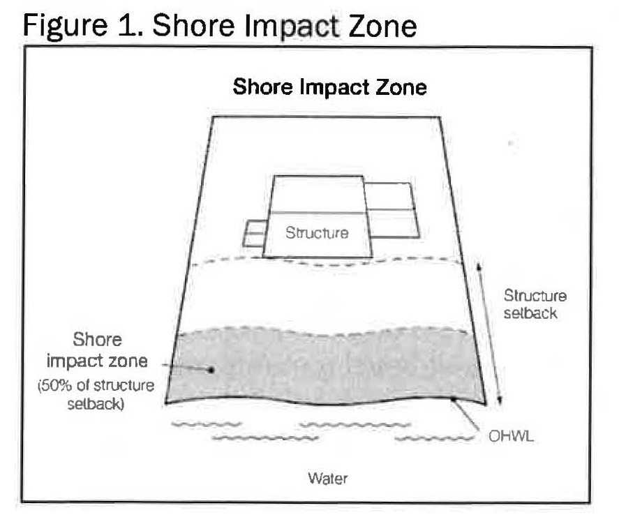
Shore Impact Zone. Land located between the ordinary high-water level of a public water and a line parallel to it at a setback of fifty percent (50%) percent of the structure setback (see Figure 1).
Shoreland. Land located within one thousand (1,000) feet from the ordinary high-water level of a lake, pond, or flowage.
Shore recreation facilities. Swimming areas, docks, watercraft mooring areas and launching ramps and other water recreation facilities.
Significant Historic Site. Any archaeological site, standing structure, or other property that meets the criteria for eligibility to the National Register of Historic Places or is listed in the State Register of Historic Sites, or is determined to be an unplatted cemetery that falls under the provisions of Minnesota Statutes, Section 307.08. A historic site meets these criteria if it is presently listed on either register or if it is determined to meet the qualifications for listing after review by the Minnesota state archaeologist or the director of the Minnesota Historical Society. All unplatted cemeteries are automatically considered to be significant historic sites.
Steep Slope. Lands having average slopes over twelve percent (12%), as measured over horizontal distances of fifty (50) feet or more.
Water-oriented Accessory Structure or Facility. A small, above ground building or other improvement, except stairways, fences, docks, and retaining walls, which, because of the relationship of its use to surface water, reasonably needs to be located closer to public waters than the normal structure setback. Examples of such structures and facilities include, watercraft and watercraft equipment storage structures, gazebos, screen houses, fish houses, pump houses, patios, and detached decks. Boathouses and boat storage structures given the meaning under Minnesota Statutes, Section 103G.245 are not a water-oriented accessory structures.
Water-dependent Use. The use of land for commercial, industrial, public or semi-public purposes, where access to and use of a public water is an integral part of the normal conduct of operation. Marinas, resorts, and restaurants with transient docking facilities are examples of uses typically found in shoreland areas.
(Ord. No. 912, § 1, 11/28/23)
Sec. 25-482. - Administration.
(a)
Permits Required.
(1)
When a building permit is required for any activity regulated herein, no additional shore land alteration permit shall be required. However, the standards for the activity as contained herein shall be applied to the issuance of that permit.
(2)
A shoreland alteration permit shall be required for all construction and development activity regulated within this chapter including for:
(3)
All grading, filling and excavation activity as regulated within Section 25-491.
(4)
All shoreland vegetation alteration activity regulated under Section 25-490.
(b)
DNR Review Notification Procedures.
(1)
Notification shall be provided to the DNR Area Hydrologist at least ten (10) days prior to a public hearing to consider variances, conditional use permits, planned unit developments, minor subdivisions, and plats within the shoreland area or amendments to the shoreland standards.
(2)
Notification shall occur ten (10) days after a final decision on all variances, conditional use permits, planned developments, minor subdivisions, and plats.
(Ord. No. 912, § 1, 11/28/23)
Sec. 25-483. - Shoreland classification system and land uses
(a)
Purpose. To ensure that shoreland development on the public waters of the City of Oakdale is regulated consistent with the classifications assigned by the commissioner under Minnesota Rules, part 6120.3300.
The shoreland area for the waterbodies listed below are shown on the Official Zoning Map. The following public water bodies have been given classification and are regulated as such under state law, as amended by the DNR.
* Datum: NAVD 88
** Estimated OHWL
(Ord. No. 912, § 1, 11/28/23)
Sec. 25-484. - Dimensional and performance standards.
(a)
Lot area and width standards shall be regulated per the underlying zoning district of the property.
(b)
Riparian lots must maintain a minimum lot area no less than twenty thousand (20,000) square feet. Excepting the Tanners Lake Redevelopment District, any riparian residential development or redevelopment of more than four (4) units with dwelling unit densities exceeding twenty thousand (20,000) square feet in size may be allowed under the following conditions:
(1)
Preservation of the shore impact zone in its natural or existing state, for a minimum of eighty percent (80%). Where the existing or natural state has been cleared or lacks woody deep-rooted vegetation, the shore impact zone shall be restored.
(2)
Protections shall be preserved in perpetuity and maintained by use of deed restrictions, covenants, permanent easements, public dedications, or other equally effective permanent instruments.
(3)
No more than four (4) mooring spaces on one (1) centralized mooring facility.
(c)
The use of all properties within the shoreland area shall be regulated per the underlying zoning district.
(d)
Height of structures and other facilities on lots shall be regulated per the underlying zoning district of the property.
(e)
Except as provided in Section 25-283, impervious surface coverage of lots shall not exceed the standard of the underlying zoning district, including twenty-four percent (24%) in the R-1 District, forty-five percent (45%) in the R-2 District, and forty percent (40%) in the R-3 District. Permeable pavement shall be considered impervious surface for the purpose of lot coverage.
(f)
Where structures exist on the adjoining lots on both sides of a proposed building site, structure setbacks may be altered without a variance to conform to the adjoining structure setbacks from the ordinary high-water level, provided the proposed structure is not located in a shore impact zone. The setback shall be determined by the average setback of structures on the two (2) immediately adjoining lots.
(Ord. No. 912, § 1, 11/28/23)
Sec. 25-485. - Lowest Floor Elevation.
(a)
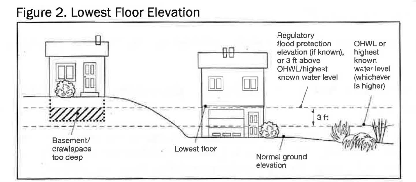
Determining Elevations. Structures must be placed at an elevation consistent with the applicable floodplain regulatory elevations. Where these elevations are not known, the lowest floor, including basement, must be placed or flood-proofed at an elevation determined using the following methodology:
For lakes, by placing the lowest floor at a level at least three (3) feet above the highest known water level, or three (3) feet above the ordinary high-water level, whichever is higher (see Figure 2).
(b)
Methods for placement.
(1)
In addition to the lowest floor, all service utilities must be elevated or water-tight to the elevation determined in subsection (a).
(2)
If elevation methods involving fill would result in filling in the shore impact zone, then structures must instead be elevated through floodproofing methods in accordance with Section 25-484(b)(3) below;
(3)
If the structure is floodproofed, then it must be built to resist hydrostatic pressure through elevation methods such as blocks, pilings, filled stem walls, elevated concrete pad, internally flooded enclosed areas, or through other accepted engineering practices consistent with FEMA technical bulletins 1, 2 and 3.
(c)
Significant Historic Sites. No structure may be placed on a significant historic site in a manner that affects the values of the site unless adequate information about the site has been removed and documented in a public repository.
(Ord. No. 912, § 1, 11/28/23)
Sec. 25-486. - Ordinary High-Water Level Setbacks.
Along with the setback requirements in the underlying zoning district, the following setback requirements from the ordinary high-water level shall apply to all principal and accessory uses.
* excludes the Tanners Lake Redevelopment District site described in Sec. 25-487
Legal non-conforming principal structures that encroach into the ordinary high-water level setbacks may be continued in accordance with Section 25-3-1400 of the Oakdale Zoning Ordinance and lateral or vertical expansion may be permitted without a variance.
(Ord. No. 912, § 1, 11/28/23)
Sec. 25-487. - Tanners Lake Redevelopment District.
Intent. To allow lesser setbacks from the ordinary high-water level to accommodate redevelopment and to enable public access to the lake where development has occurred. It is also intended to ensure greater setbacks where fewer disturbances have occurred and to allow vegetative restoration along the shoreline.
The Tanners Lake Redevelopment District consists of the following legally described properties.
Lots 10, 11, 12, 13, 14, and 15, Block 10, Lake Park Addition, according to the recorded plat thereof, Washington County, Minnesota, together with that part of the vacated alleys that accrued thereto by reason of the vacation thereof.
Lots 21, 22, 23, and 24, Block 10, Lake Park Addition, according to the recorded plat thereof, Washington County, Minnesota, excluding therefrom the West one-half (W 1/2) of the adjoining vacated alley.
The North 1/3 of Lot 16 and all of Lots 17, 18, 19 and 20, Block 10, Lake Park Addition, according to the recorded plat thereof, Washington County, Minnesota.
Lots 1 through 9, and the South ½ of Lot 16, Block 10, Lake Park Addition, together with vacated alley accrued thereto by reason of the vacation thereof, and together with that portion of vacated alley which accrued to the North ½ of Lot 16, and Lots 17 through 24, Block 10, Lake Park Addition, by reason of the vacation thereof.
Lots 1 and 2, Block 2, Tanners Lake, Washington County, Minnesota. Together with that part of the adjacent vacated street that accrued thereto by reason of the vacation thereof.
Lots 3, 4, 6 and 7, Block 2, Tanners Lake, Washington County, Minnesota.
Lot 5, Block 2, Tanners Lake, Washington County, Minnesota.
Ordinary high-water level setbacks for the Tanners Lake Redevelopment District shall be a minimum of thirty (30) feet with an additional allowance for setback averaging as permitted in accordance with Section 25-484(f) of this article, provided that the setback is no less than twenty-five (25) feet.
No more than eighty percent (80%) of the lot, parcel, or tract of land shall be covered by structures or impervious surface in the Tanners Lake Redevelopment District. Permeable pavement shall be considered impervious surface for the purpose of lot coverage.
Vegetative restoration of the shoreline shall be conducted where practicable and must include woody deep-rooted vegetation.
The following uses are prohibited in the Tanners Lake Redevelopment District.
A.
Beaches.
B.
Private residential use mooring spaces.
(Ord. No. 912, § 1, 11/28/23)
Sec. 25-488. - Exceptions.
The following types of structures are exempt from the ordinary high-water level setbacks indicated in Section 25-486, but are required to follow the standards contained in Section 25-489:
(a)
Stairways, stairway landings, and pedestrian lifts;
(b)
Watercraft lifts, landing facilities, and docks;
(c)
Fences, retaining walls, and ancillary recreational uses;
(d)
Public park, beach, and marina facilities and other public improvements;
(e)
Water-oriented accessory structures.
(Ord. No. 912, § 1, 11/28/23)
Sec. 25-489. - Performance Standards for Public and Private Facilities.
(a)
Placement and Design of Roads, Driveways, and Parking Areas. These facilities must be designed to take advantage of natural vegetation and topography to achieve maximum screening as viewed from public waters. They must be constructed to minimize and control erosion to public waters consistent with the field office technical guides of the local Soil and Water Conservation Districts and comply with the following standards:
(1)
Roads, driveways, and parking areas must meet structure setbacks and must not be placed within shore impact zones, when other reasonable and feasible placement alternatives exist. If no alternatives exist, they may be placed within these areas, and must be designed to minimize adverse impacts;
(2)
Watercraft access ramps, approach roads, and access-related parking areas may be placed within shore impact zones provided the vegetative screening and erosion control conditions of this subpart are met;
(3)
Private watercraft access ramps, approach roads, and access-related parking areas are prohibited.
(4)
Private facilities must comply with the grading and filling provisions of Section 25-491 of this article; and
(5)
For public roads, driveways and parking areas, documentation must be provided by a qualified individual that they are designed and constructed to minimize and control erosion to public waters consistent with the field office technical guides of the local soil and water conservation district, or other applicable technical materials.
(b)
Stairways, Lifts, and Landings. Stairways and lifts are the preferred alternative to major topographic alterations for achieving access up and down bluffs and steep slopes to shore areas. Stairways, lifts, and landings must meet the following design requirements:
(1)
Stairways and lifts must not exceed four (4) feet in width on residential lots. Wider stairways may be used for commercial properties, public recreational uses, and planned unit developments;
(2)
Landings for stairways and lifts on residential lots must not exceed thirty-two (32) square feet in area. Landings larger than thirty-two (32) square feet may be used for commercial properties, public-space recreational uses, and planned unit developments;
(3)
Canopies or roofs are not allowed on stairways, lifts, or landings;
(4)
Stairways, lifts, and landings may be either constructed above the ground on posts or pilings, or placed into the ground, provided they are designed and built in a manner that ensures control of soil erosion;
(5)
Stairways, lifts, and landings must be located in the most visually inconspicuous portions of lots, as viewed from the surface of the public water assuming summer, leaf-on conditions, whenever practical; and
(6)
Facilities such as ramps, lifts, or mobility paths for physically handicapped persons are also allowed for achieving access to shore areas, if they are consistent with the dimensional and performance standards of this section and the requirements of Minnesota Rules, Chapter 1341.
(c)
Water-oriented Accessory Structures or Facilities. Each lot may have one (1) water-oriented accessory structure or facility if it complies with the following provisions:
(1)
The structure or facility must not exceed ten (10) feet in height for single family residential lots, exclusive of safety rails, and cannot occupy an area greater than two hundred fifty (250) square feet. The structure or facility may include detached decks not exceeding eight (8) feet above grade at any point or at-grade patios;
(2)
The setback of the structure or facility from the ordinary high-water level must be at least ten (10) feet;
(3)
The structure is not a boathouse or boat storage structure as defined under Minnesota Statutes, Section 103G.245;
(4)
The structure or facility must be treated to reduce visibility as viewed from public waters and adjacent shorelands by vegetation, topography, increased setbacks or color, assuming summer, leaf-on conditions;
(5)
The roof may be used as an open-air deck with safety rails, but must not be enclosed with a roof or sidewalls or used as a storage area;
(6)
The structure or facility must not be designed or used for human habitation and must not contain water supply or sewage treatment facilities;
(7)
As an alternative for general development and recreational development waterbodies, water-oriented accessory structures used solely for storage of watercraft and boating-related equipment may occupy an area up to four hundred (400) square feet provided the maximum width of the structure is twenty (20) feet as measured parallel to the shoreline; and
(8)
Water-oriented accessory structures may have the lowest floor placed lower than the elevation specified in Section 25-281 if the structure is designed to accommodate internal flooding, constructed of flood-resistant materials to the elevation, electrical and mechanical equipment is placed above the elevation and, if long duration flooding is anticipated, the structure is built to withstand ice action and wind-driven waves and debris.
(d)
Fences. Fences between principal structures and the waterbody are allowed if fences are:
(1)
Not higher than six (6) feet.
(2)
Not located within the shore impact zone.
(3)
Not located in the regulatory floodplain.
(4)
Within the ordinary high-water level setback:
(5)
Lighting shall be fully shielded and directed away from the water.
(6)
Up lighting viewable from the water is prohibited.
(Ord. No. 912, § 1, 11/28/23)
Sec. 25-490. - Vegetation and Land Alterations.
Limited clearing and trimming of trees and shrubs in the shore impact zones and on steep slopes, is allowed to provide a view to the water from the principal dwelling and to accommodate the placement of stairways and landings, picnic areas, access paths, beach and watercraft access areas, and permitted water-oriented accessory structures or facilities, provided that:
(a)
Vegetation be maintained to the screening of structures, vehicles, or other facilities by at least fifty percent (50%) as viewed from the water, assuming summer, leaf-on conditions, is not substantially reduced. The maximum view corridor shall be less than fifty (50) feet or one-third (⅓) of the parcel width, whichever is less;
(b)
Cutting debris or slash shall be scattered and not mounded on the ground; and
(c)
Perennial ground cover is retained.
(Ord. No. 912, § 1, 11/28/23)
Sec. 25-491. - Grading and Filling.
(a)
Grading and filling activities must comply with the provisions of this subsection except for the construction of public roads and parking areas if consistent with Section 25-489 of this article.
(b)
Permit Requirements.
(1)
Grading, filling and excavations necessary for the construction of structures, sewage treatment systems, and driveways, if part of an approved permit, do not require a separate grading and filling permit. However, the standards of this article must be incorporated into the permit.
(2)
For all other work, including driveways not part of another permit, a grading and filling permit is required for:
a.
The movement of more than ten (10) cubic yards of material on steep slopes or within shore impact zones; and
b.
The movement of more than fifty (50) cubic yards of material outside of steep slopes and shore impact zones.
c.
Placement of retaining walls, including boulder walls within the shore impact zone provided that:
1.
If the project includes work at or below the ordinary high-water level, the developer shall obtain a permit through the DNR.
2.
The structures are used only to correct a documented existing erosion problem and not for aesthetic reasons.
3.
The height and length are the minimum necessary to control the erosion problem and are not higher than four (4) feet or longer than ten (10) feet, unless the zoning administrator determines that a larger wall is necessary to correct the erosion problem; and
4.
Walls are screened by vegetation to not be visible from the waterbody.
d.
Placement of natural rock rip rap, including associated grading of the shoreline and placement of a filter blanket is permitted if:
1.
If the project includes work at or below the ordinary high-water level, the commissioner has already approved or permitted the project;
2.
The finished slope does not exceed three (3) feet horizontal to one (1) foot vertical;
3.
The landward extent of the riprap is within ten (10) feet of the ordinary high-water level; and
4.
The height of the riprap above the ordinary high-water level does not exceed three (3) feet.
5.
A vegetative buffer, consisting of deep rooted and woody vegetation, is to be established at a distance no less than fifteen (15) feet from the landward extent of the riprap.
(c)
Grading, filling and excavation activities must meet the following standards:
(1)
Grading or filling of any wetland must meet or exceed the wetland protection standards under Minnesota Rules, Chapter 8420 and any other permits, reviews, or approvals by other local state, or federal agencies such as watershed districts, the DNR or US Army Corps of Engineers;
(2)
Land alterations must be designed and implemented to minimize the amount of erosion and sediment from entering surface waters during and after construction consistently by:
a.
Limiting the amount and time of bare ground exposure;
b.
Using temporary ground covers such as mulches or similar materials;
c.
Establishing permanent, deep-rooted and dense vegetation cover as soon as possible;
d.
Using sediment traps, vegetated buffer strips or other appropriate techniques;
e.
Stabilizing altered areas to acceptable erosion control standards consistent with the field office technical guides of the soil and water conservation district;
f.
Not placing fill or excavated material in a manner that creates unstable slopes. Plans to place fill or excavated material on steep slopes must be reviewed by qualified professionals for continued slope stability and must not create finished slopes of 30 percent (30%) or greater;
g.
Any alterations below the ordinary high-water level of public waters must first be authorized by the commissioner under Minnesota Statutes, Section 103G; and
h.
Alterations of topography are only allowed if they are accessory to permitted or conditional uses and do not adversely affect adjacent or nearby properties
(3)
Connections to public waters. Excavations to connect boat slips, canals, lagoons, and harbors to public waters require a public waters permit and must comply with Minnesota Rules, Chapter 6115.
(Ord. No. 912, § 1, 11/28/23)
Sec. 25-492. - Stormwater Management.
(a)
General Standards.
(1)
When possible, existing natural drainageways, and vegetated soil surfaces must be used to convey, store, filter, and retain stormwater runoff before discharge to public waters.
(2)
Development must be planned and conducted in a manner that will minimize the extent of disturbed areas, runoff velocities, erosion potential, and reduce and delay runoff volumes. Disturbed areas must be stabilized as soon as possible and appropriate facilities or methods used to retain sediment on the site.
(3)
When development density, topography, soils, and vegetation are not sufficient to adequately handle stormwater runoff, constructed facilities such as settling basins, skimming devices, dikes, waterways, ponds and infiltration may be used. Preference must be given to surface drainage, vegetation, and infiltration rather than buried pipes and man-made materials and facilities.
(b)
Specific Standards.
(1)
Except as provided in Section 25-487, impervious surfaces of lots shall not exceed the standard of the underlying zoning district, including twenty-four percent (24%) in the R-1 District, forty-five percent (45%) in the R-2 District, and forty percent (40%) in the R-3 District.
(2)
When constructed facilities are used for stormwater management, documentation must be provided by a qualified individual that they are designed and installed consistent with the field office technical guide of the local soil and water conservation district or the Minnesota Stormwater Manual, as applicable.
(3)
New constructed stormwater outfalls to public waters must be consistent with Minnesota Rules, part 6115.0231.
(Ord. No. 912, § 1, 11/28/23)
Sec. 25-493. - Sanitary Provisions.
All lots within the shoreland district shall be connected to the public water and sanitary sewer systems and old sewer and water systems shall be abandoned in conformance with State law and City ordinance.
(Ord. No. 912, § 1, 11/28/23)