
Oklahoma City City Zoning Code
ARTICLE XIII
ZONING OVERLAY DISTRICTS
§ 59-13100.- General provisions.
This Article establishes specific regulations of limited application within the City, that assure additional consideration for areas of special interest or value.
A.
Purpose and Intent. The purpose of this article is to:
(1)
Provide a framework for enabling legislation to aid in the creation of special regulations.
(2)
Provide a categorization of all special regulations, which may be adopted as a result of the enabling legislation.
(3)
Provide guidelines for the application of all special regulations created to assure conformity with the objectives of good planning and zoning practice.
B.
Application. Special regulations may be adopted within this article and applied to designated areas of the City when the Planning Commission and City Council find conditions or purposes within said areas merit special consideration in order to protect the health, safety and general welfare.
C.
Special Regulations Established. The following special regulations are hereby established. Any special district adopted as a result of authorization by way of these regulations shall be codified.
Section Special Area Regulations
59-13150 Airport Zoning Overlay Districts
59-13250 Classen Boulevard Overlay District
59-13300 Historic Landmark Overlay
59-13350 Manufactured Home Overlay District
59-13400 Parking Overlay District
59-13450 Scenic River Overlay District
59-13500 Scenic River Overlay Design Districts
59-13550 Stockyards City Transitional Development Districts
59-13600 Twenty-Third Street Uptown Corridor Overlay District
59-13650 Urban Conservation Districts
59-13700 Urban Design Districts
D.
Modification to Special Regulations. Modifications or changes to the special regulations shall be subject to the provisions of the amendment procedure for this chapter contained in Article IV, Administrative Procedures.
§ 59-13150. - Airport Zoning Overlay Districts.
13150.1. Purpose and Intent.
A.
Purpose. The purpose of this section is to:
(1)
Promote the public health, safety and general welfare.
(2)
Prevent the creation of airport hazards, which are public nuisances and an injury to the region served by the airports.
(3)
Protect the City and the utilization of the airports against potential litigation.
(4)
Reduce the adverse impact of airports on surrounding properties.
B.
Intent. It is hereby established that an airport is a vital component in accomplishing the City's overall goals of economic growth. It is also known that airport hazards, including noise impact, endanger the lives, health, safety and property of users of airports, and of occupants of land in the vicinity of airports. The provisions addressed herein are intended:
(1)
To prevent the occurrence of airport hazards.
(2)
To protect the long-term utility of airports and the public investment involved therein.
(3)
To restore or enhance the public health, safety and welfare of residents living around airports.
13150.2. Declaration. It is hereby determined that airport hazards, obstructions and excessive noise levels endanger the life, health, safety and property of users of airports, and of occupants of land in the vicinity of airports, and tend to destroy or impair the utility of airports and the public investment therein. Accordingly, it is declared:
A.
The creation or establishment of an obstruction in an airport zone, as set forth herein, is a public nuisance and an injury to the region served by the airport.
B.
The construction of residential structures without provision for adequate protection from excessive noise levels within certain areas, set forth herein, endangers the lives, health and safety of residents and impairs the utility of airports and the public investment.
C.
In the interest of the public health, safety and general welfare, the creation or establishment of obstructions or airport hazards should be prevented to alleviate the destruction or impairment of the utility of airports and the public investment therein.
D.
The prevention of hazards should be accomplished, to the extent legally possible, by the exercise of the police power without compensation.
E.
Both the prevention of the creation or establishment of airport hazards, and the elimination, removal, alteration, mitigation or marking and lighting of existing airport hazards are public purposes for which political subdivisions may raise and expend public funds, and acquire land or interests in land.
13150.3. Scope of the Provisions. This provision is intended to address the areas of height restriction zones around airports, and airport environs zones created by the existing and future potential noise impact.
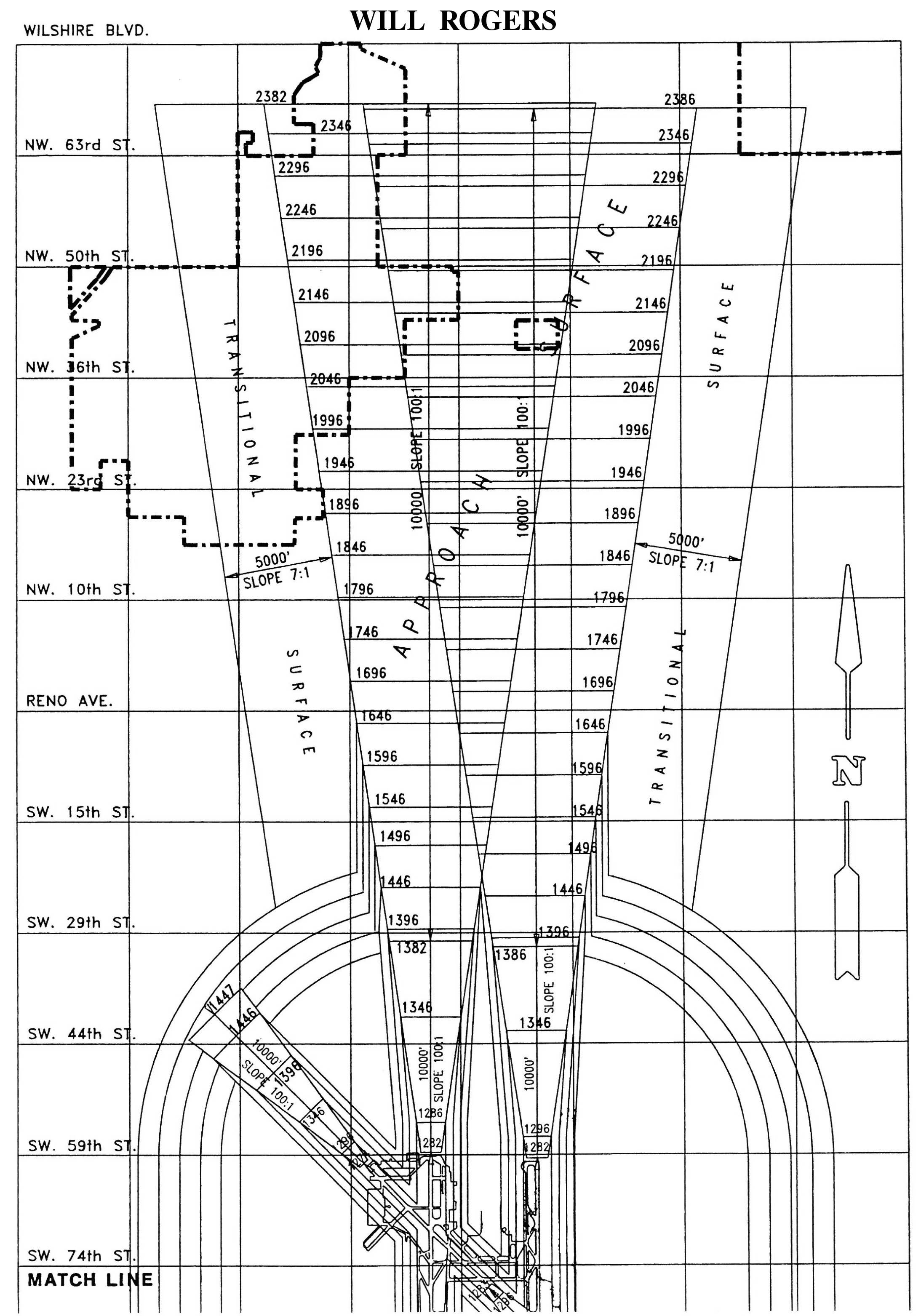
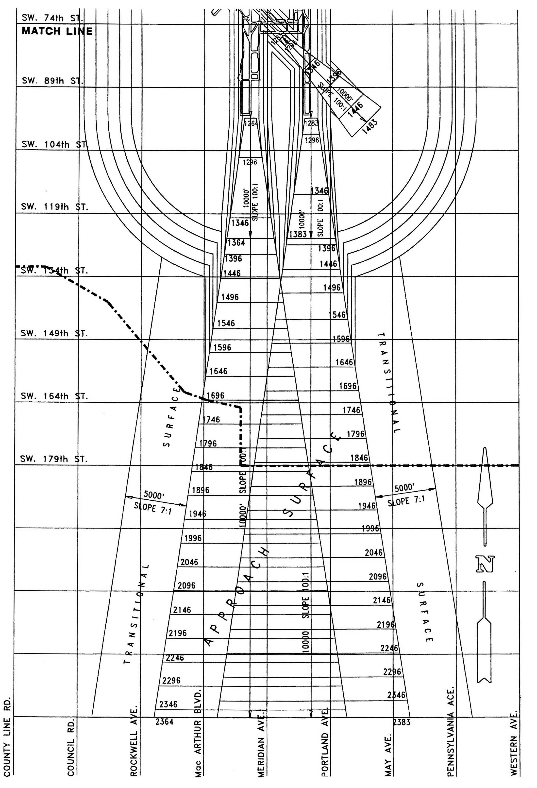
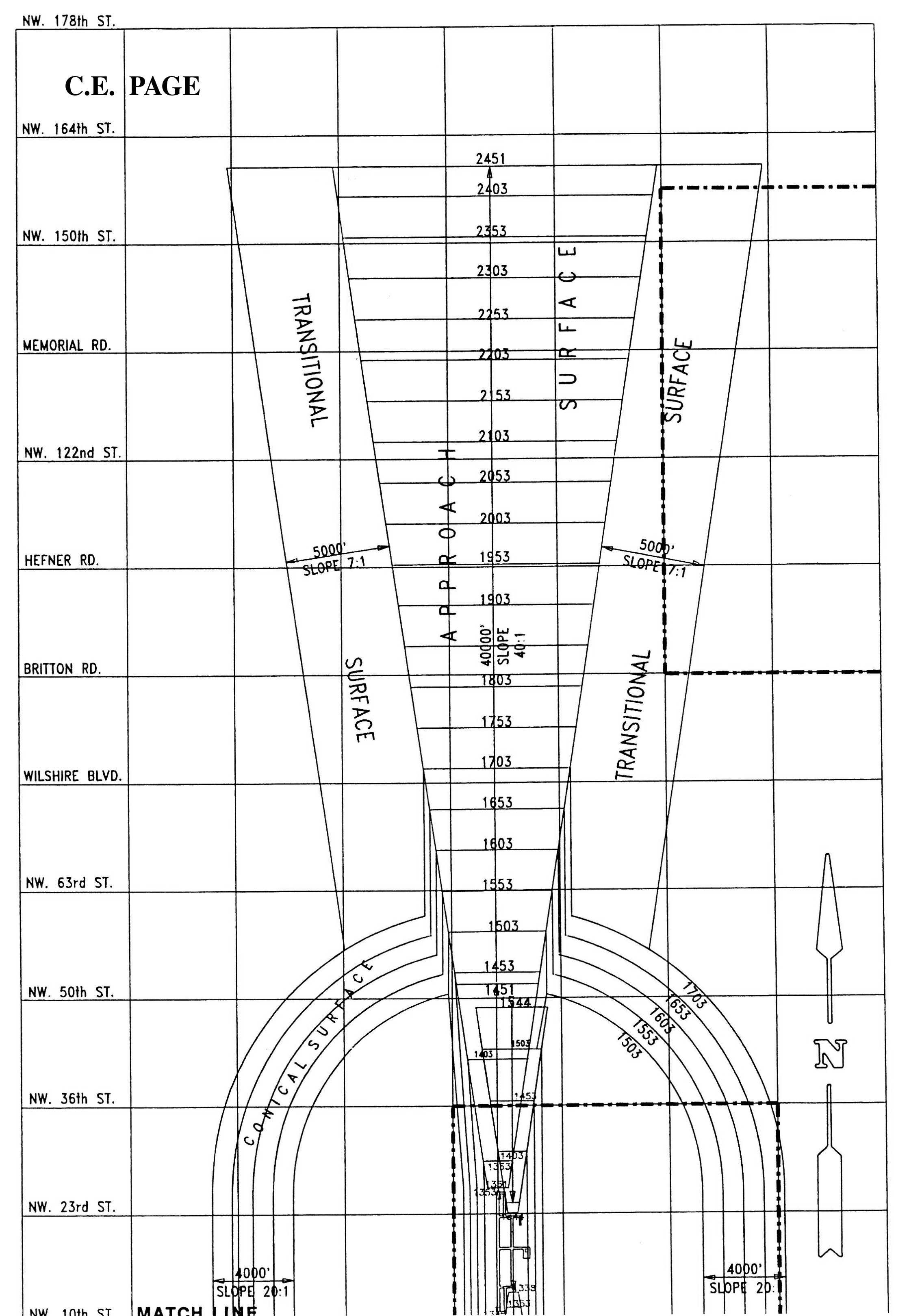
13150.4. Airport Zones Related to Height Restriction. In order to carry out the provisions of this section, there are hereby created and established certain zones which include all the land lying beneath the instrument approach zones, non-instrument approach zones, transition zones, horizontal zones and conical zones as they apply to the Will Rogers World Airport, Wiley Post Airport and Clarence E. Page Airport. Such zones are shown separately for each airport on its respective Height Zoning Maps. These maps shall remain on file in the office of the City Clerk and are made a part of this chapter by reference. An area located in more than one of the following zones is considered to be in the zone with the more restrictive height limitation. The various zones are hereby established and defined as follows.
A.
Precision Instrument Runway Approach Zone. The inner edge of this approach zone coincides with the width of the primary surface and is 1,000 feet wide. The approach zone expands outward uniformly to a width of 16,000 feet at a horizontal distance of 50,000 feet from the primary surface. Its centerline is the continuation of the centerline of the runway.
B.
Runway Larger Than Utility with a Visibility Minimum Greater than Three-Fourths Mile Non-Precision Instrument Approach Zone. The inner edge of this approach zone coincides with the width of the primary surface and is 500 feet wide. The approach zone expands outward uniformly to a width of 3,500 feet at a horizontal distance of 10,000 feet from the primary surface. Its centerline is the continuation of the centerline of the runway.
C.
Utility Runway Visual Approach Zone. The inner edge of this approach zone coincides with the width of the primary surface and is 250 feet wide. The approach zone expands outward uniformly to a width of 1,250 feet at a horizontal distance of 5,000 feet from the primary surface. Its centerline is the continuation of the centerline of the runway.
D.
Transition zones are hereby established adjacent to each instrument and non-instrument runway and approach zone, as indicated on the zoning maps.
E.
Horizontal zones for instrument and non-instrument runways are hereby established by swinging arcs of 5,000 feet radii for all non-instrument runways and 10,000 feet for all instrument runways from the center of each end of the primary surface of each runway and connecting the adjacent arcs by drawing lines tangent to those arcs. The horizontal zone does not include the approach and transitional zones.
F.
Conical zones for instrument and non-instrument runways are hereby established as the area that commences at the periphery of the horizontal zone and extends outward there from a horizontal distance of 4,000 feet. The conical zone does not include the instrument and non-instrument approach zones and transition zones.
G.
Airport Zone Height Limitations. Except as otherwise provided in this section, no structure or tree shall be erected, altered or maintained, or allowed to grow, in any zone to a height in excess of the height limit herein established for that zone. Height limitations are computed from the established airport elevation. Such applicable height limitations are hereby established for each of the zones in question as follows.
(1)
Precision Instrument Runway Approach Zone. Such zone slopes 100 feet outward for each foot upward, beginning at the end of, and at the same elevation as, the primary surface and extending to a horizontal distance of 10,000 feet along the extended runway centerline; thence slopes upward 40 feet horizontally for each foot vertically to an additional horizontal distance of 40,000 feet along the extended runway centerline.
(2)
Runway Larger Than Utility With a Visibility Minimum Greater than Three-Fourths Mile Non-Precision Instrument Approach Zone. Such zone slopes 50 feet outward for each foot upward, beginning at the end of, and at the same elevation as, the primary surface and extending to a horizontal distance of 10,000 feet along the extended runway centerline.
(3)
Utility Runway Visual Approach Zone. Such zone slopes 34 feet outward for each foot upward, beginning at the end of, and at the same elevation as, the primary surface and extending to a horizontal distance of 5,000 feet along the extended runway centerline.
(4)
Transition Zone. Such zone slopes seven feet outward for each foot upward, beginning at the sides of, and at the same elevation as, the primary surface, and extending to a height of 150 feet above the airport elevation. In addition to the foregoing, there are established height limits sloping seven feet outward for each foot upward, beginning at the sides of, and at the same elevation as, the approach surface, and extending to where they intersect the conical surface. Further, where the precision instrument runway approach zone projects through and beyond the conical zone, there are established height limits sloping seven feet outward for each foot upward beginning at the sides of and at the same elevation as the approach surface, and extending a horizontal distance of 5,000 feet from the edge of the instrument approach zone measured at right angles to the extended runway centerline.
(5)
Horizontal Zone. Such zone is established at 150 feet above the established airport elevation.
(6)
Conical Zone. Such zone slopes 20 feet outward for each foot upward, beginning at the periphery of the horizontal zone, and at 150 feet above the airport elevation and extending to a height of 350 feet above the airport elevation.
(7)
Excepted Height Limitation. Nothing in this section shall be construed as prohibiting the construction or maintenance of any structure, or growth of any tree to a height up to 50 feet above the surface of the land.
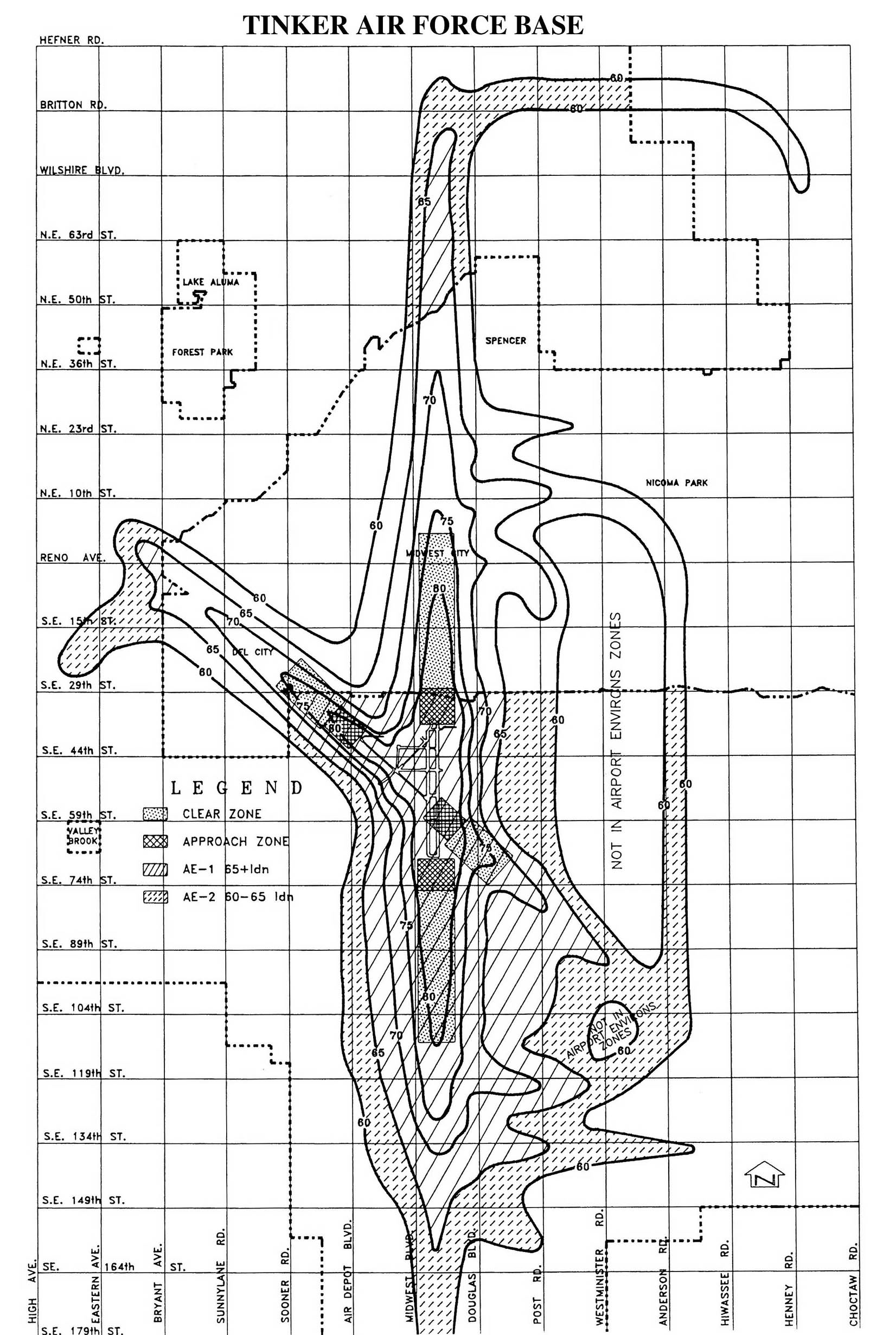
13150.5. Airport Environs Zones. Airport Environs Zones shall be shown separately on official maps and aerial photographs for each airport: Wiley Post Airport, Will Rogers Airport, Clarence E. Page Airport and Tinker Air Force Base. These maps and aerial photographs shall remain on file in the Office of the City Clerk and are made a part of this chapter, by reference.
A.
Airport Environs Zone One (AE-1). The Airport Environs Zone One (AE-1) shall be governed by the following regulations:
(1)
Certain land uses, such as agricultural, airport property and related uses, industrial uses, wholesale and retail commercial uses, and areas zoned for open space or recreational uses, are deemed compatible, and therefore shall be exempted from the provisions of Division 4 of Article II of Chapter 12 of the Oklahoma City Municipal Code.
(2)
Other uses allowed within the AE-1 Zone shall meet or exceed building code requirements for a minimum noise level reduction of 30 decibels inside the structure as set forth in Division 4 of Article II of Chapter 12 of the Oklahoma City Municipal Code.
(3)
All uses allowed within this zone shall grant an avigation easement right as a condition of subdivision or building permit approval, except as otherwise provided herein. Said avigation easement right shall be granted to the Oklahoma City Airport Trust for uses within the AE-1 Zones for Will Rogers World Airport, Wiley Post Airport and Clarence E. Page Airport.
(4)
All residential uses and institutional uses such as schools, community centers, churches, etc., are prohibited in this zone.
B.
Airport Environs Zone Two (AE-2). Airport Environs Zone Two (AE-2) shall be governed by the following regulations:
(1)
Certain land uses, such as agricultural, airport property and related uses, industrial uses, wholesale and retail commercial uses, and areas zoned for open space and recreational uses, are deemed compatible, and therefore shall be exempted from the provisions of Division 4 of Article II of Chapter 12 of the Oklahoma City Municipal Code.
(2)
Other uses allowed within this zone shall meet or exceed building requirements for a minimum noise level reduction of 25 decibels, inside the structure as set forth in Division 4 of Article II of Chapter 12 of the Oklahoma City Municipal Code.
(3)
All uses allowed within this zone shall grant an avigation easement right to the Oklahoma City Airport Trust as a condition of subdivision or building permit approval, except as otherwise provided. Said avigation easement right shall be granted to the Oklahoma City Airport Trust for uses within the AE-2 Zones for Will Rogers World Airport, Wiley Post Airport and Clarence E. Page Airport.
C.
Avigation easements submitted pursuant to the terms of this section shall conform to the provisions contained within the Oklahoma City Airports Model Avigation Easement, a copy of which shall remain on file in the Office of the City Clerk.
13150.6. Specific Regulations for Wiley Post Airport, Will Rogers World Airport and Clarence E. Page Airport. Each airport shall be regulated by the appropriate section and subsection as prescribed in this article, and official airport maps delineating height zones and airport environs zones for each airport. Table 13150.1 provides a brief summary of Wiley Post Airport (WPA), Will Rogers World Airport (WRWA), and Clarence E. Page Airport (CEP) height restriction zones around airports.
13150.7. Specific Regulations for Tinker Air Force Base Airport.
A.
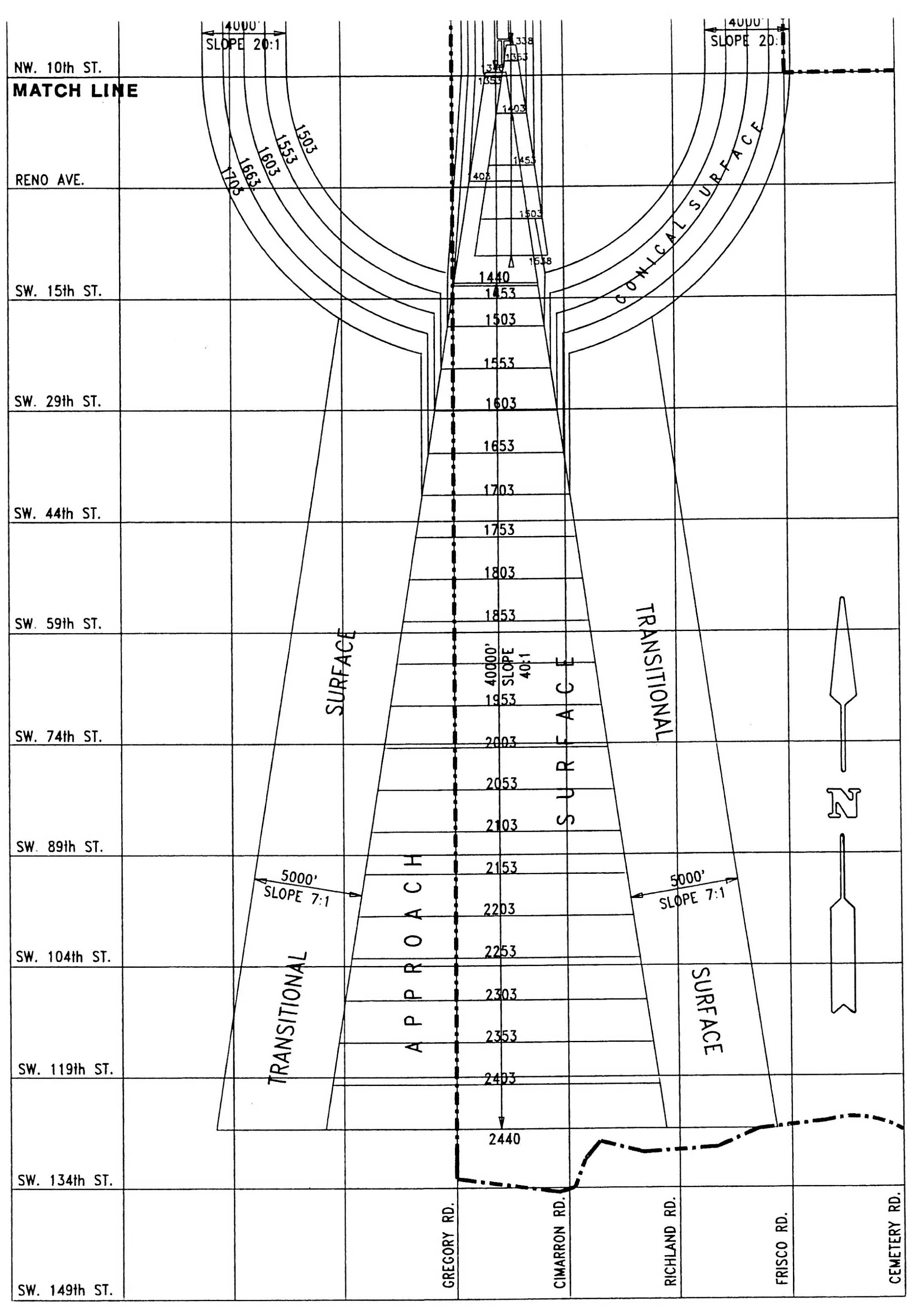
Base Airport Restriction Zones. In order to carry out the provisions of this section, there are hereby created and established certain zones which include all of the land lying within the instrument approach zones, non-instrument approach zones, transition zones, horizontal zones and conical zones. Such areas and zones are shown on the Tinker Air Force Base Zoning Map, dated November 13, 1959, revised May 26, 1960, and November 1, 1960, which map shall remain on file in the Office of the City Clerk and is made a part of this chapter by reference. The various zones are hereby established and defined as follows.
(1)
Instrument Approach Zone. An instrument approach zone is hereby established at each end of the instrument runway for instrument landings and takeoffs. The instrument approach zones shall have a width of 2,000 feet at a distance of 200 feet beyond each end of the runway, widening thereafter uniformly to a width of 16,000 feet at a distance of 50,200 feet beyond each end of the runway, its centerline being the continuation of the centerline of the runway.
(2)
Non-Instrument Approach Zone. A non-instrument approach zone is established at each end of all non-instrument runways on Tinker Air Force Base for non-instrument landings and takeoffs. The non-instrument approach zone shall have a width of 2,000 feet at a distance of 200 feet beyond each end of the runway, widening thereafter uniformly to a width of 6,000 feet beyond each end of the runway, its centerline being the continuation of the centerline of the runway.
(3)
Transition Zone.
(a)
Transition zones are hereby established adjacent to each instrument and non-instrument runway and approach zone, as indicated on the zoning map.
(b)
Transition zones symmetrically located on either side of runways have variable widths as shown on the zoning map. Transition zones extend outward from a line 1,000 feet on either side of the centerline of the non-instrument runway for the length of the runway, plus 200 feet on each end and 1,000 feet on either side of the centerline of the instrument runway for the length of the runway, plus 200 feet on each end, and are parallel and level with such runway centerlines. The transition zones, along such runways slope upward and outward at one foot vertically for each seven feet horizontally, to the point where they intersect the surface of the horizontal zone.
(c)
Transition zones are established adjacent to both instrument and non-instrument approach zones for the entire length of the approach zones. These transition zones have variable widths, as shown on the zoning map. Such transition zones flare symmetrically with either side of the runway approach zones from the base of the zones and slope upward and outward at the rate of one foot vertically for each seven feet horizontally to the points where they intersect the surfaces of the horizontal and conical zones.
(d)
Transition zones are also hereby established adjacent to the instrument approach zone where they project through and beyond the limits of the conical zone, extending a distance of 5,000 feet measured horizontally from the edge of the instrument approach zones at right angles to the continuation of the centerline of the runway.
(4)
Horizontal Zone. A horizontal zone is hereby established as the area within a circle with its center at the airport reference point and having a radius of 13,000 feet. The horizontal zone does not include the instrument and non-instrument approach zones, and the transition zones.
(5)
Conical Zone. A conical zone is hereby established commencing at the periphery of the horizontal zone and extending a distance of 20,000 feet from the airport reference point. The conical zone does not include the instrument and non-instrument approach zones and transition zones.
B.
Height Limitations.
(1)
Zone Height Limitations. Except as otherwise provided in this section, no structure or tree shall be erected, altered, allowed to grow or maintained in any zone created by this section to a height in excess of the height limit herein established for that zone. Height limitations are computed from the established airport elevation and are hereby established for each of the zones in question as follows.
(a)
Instrument Approach Zone. One foot in height for each 100 feet in horizontal distance, beginning at a point 200 feet from the end of the instrument runway and extending to a distance of 15,200 feet from the end of the runway. Thence horizontal distance to a point 50,200 feet from the end of the runway.
(b)
Non-Instrument Approach Zone. One foot in height for each 100 feet in horizontal distance beginning at a point 200 feet from the end of the non-instrument runway and extending to a point 15,200 feet from the end of the runway.
(c)
Transition Zone. One foot in height for each seven feet in horizontal distance beginning at a point 1,000 feet from the centerline of non-instrument runways and 1,000 feet from the centerline of the instrument runways, measured at right angles to the longitudinal centerline of the runway, extending upward to a maximum height of 150 feet above the established airport elevation, which is 1,291 feet above mean sea level (MSL). In addition to the foregoing, there are established height limits of one foot vertical height for each seven feet horizontal distance measured from the edges of all approach zones for the entire length of the approach zones and extending upward and outward to the points where they intersect the horizontal and conical surfaces.
Further, where the instrument approach zone projects through and beyond the conical zone, a height limit of one foot for each seven feet of horizontal distance shall be maintained beginning at the edge of the instrument approach zone and extending a distance of 5,000 feet from the edge of the instrument approach zone measured at right angles to the continuation of the centerline of the runway.
(d)
Horizontal Zone. 150 feet above the established airport elevation or a maximum height of 1,441 feet above mean sea level (MSL).
(e)
Conical Zone. One foot in height for each 20 feet of horizontal distance beginning at the periphery of the horizontal zone and measured in an inclined plane passing through the airport reference point.
13150.8. Enforcement and Administration.
A.
Public Works Director. Except as otherwise provided, the Public Works Director, or his/her authorized representative, is hereby designated the Administrative Officer. It shall be the duty of the Administrative Officer to administer and enforce the provisions of this article.
B.
Application for Permits and Variances. Applications for permits and variances shall be made to the Administrative Officer on a form furnished by him/her. Applications required by this article to be submitted to the Administrative Officer shall be promptly considered, and granted or denied.
C.
Administrative Officer to Transmit Applications to Board of Adjustment. Application for action by the Board of Adjustment shall be forthwith transmitted by the Administrative Officer.
13150.9. Noncomplying and Nonconforming Uses.
A.
The regulations prescribed by this section shall not be construed to apply to any structure or natural object not conforming to the regulations, as of the December 23, 1980, or that otherwise interfere with the continuance of any noncomplying use. Nothing herein contained shall require any change in the construction, alteration or intended use of any structure, the construction or alteration of which was begun prior to December 23, 1980.
B.
Residential uses located in an area designated as an AE-1 or AE-2 Zone pursuant to the terms of this section and in existence prior to December 23, 1980 shall be designated as "noncomplying uses" and shall be permitted to continue in their present location and further, such structures may be rebuilt, modified, improved or expanded.
C.
Any rebuilding, modification, improvement or expansion of a noncomplying residential use, whether located within an AE-2 or an AE-1 Zone pursuant to the terms of this section may be constructed in accordance with building code provisions applicable to residential construction generally without regard to noise attenuation requirements.
D.
No person applying for a building permit to rebuild, modify, improve or expand a noncomplying residential use shall be required to submit an avigation easement as a condition for approval thereof.
E.
All structures, other than residential structures, located in an AE-1 or an AE-2 Zone, pursuant to the terms of this section, shall be designated as "nonconforming uses" and shall be permitted to continue in their present location and may be modified, improved or expanded, except that such rebuilding modification, improvement or expansion shall be constructed in accordance with such provisions of this section or Division 4 of Article II of Chapter 12 of the Oklahoma City Municipal Code as are applicable to the Airport Environs Zone in which said structure is located.
F.
Notwithstanding the foregoing provisions of this section, the owner of any nonconforming structure or natural object is hereby required to permit the installation, operation and maintenance thereon of any markers and lights that the Director of Airports shall deem necessary to indicate the presence of such hazard to the operators of aircraft in the vicinity of the airport. Such markers and lights shall be installed, operated and maintained at the expense of the
City and, in the case of Tinker Air Force Base Airport, at the expense of said air force base.
G.
No permit shall be granted that would allow the establishment or creation of an airport hazard or permit a nonconforming use, structure or natural object to be made or become higher or become a greater hazard to air navigation than it was on December 23, 1980, or on the effective date of any amendment hereto, or than it was when the application for a permit was made.
H.
If the Administrative Officer, or other designated authority, has determined that the nonconforming structure or natural object has been abandoned for more than two years or more than 80 percent torn down, physically deteriorated or decayed, no permit shall be granted that allows a structure or natural object to exceed the applicable height limit or otherwise deviate from the zoning regulations.
13150.10. Building Permit Required.
A.
Permit Required For New Uses. Except as specifically provided by this section, no material change shall be made in the use of the land, and no structure shall be erected, altered or otherwise established in any zone hereby created, unless a building permit is obtained indicating the purpose for which the building permit is desired, with sufficient detail to determine whether the resulting use would conform to the provisions of this section.
B.
Oklahoma City Airports Board of Adjustment. The Oklahoma City Board of Adjustment established pursuant to this chapter is hereby appointed as the Oklahoma City Airports Board of Adjustment.
C.
Variances. Any person desiring to erect or increase the height of any structure, or permit the growth of any natural object, or use his/her property in any manner not in accordance with the regulations prescribed in this section, may apply to the Board of Adjustment for a variance from the regulations.
Applications for variances must include copies of all notices required by the Federal Aviation Administration under Federal Aviation Regulation Part 77, and copies of all Federal Aviation Administration action taken pursuant to the case. Variances shall be allowed in accord with the provisions of this chapter.
D.
Hazard Marking and Lighting. If such action is deemed advisable to effectuate the purpose of this section, and is reasonable in the circumstances, any permit or variance granted may require the owner of the structure or natural object in question to permit the City at its own expense and, in the case of Tinker Air Force Base Airport, at the expense of said air force base airport, to install, operate and maintain thereon any markers and lights that may be necessary to indicate to flyers the presence of an airport hazard or obstruction.
13150.11. Delineation of Airport Environs Zones Boundaries. For the purpose of determining whether property is included within the confines of an AE-1 or AE-2 Zone, established pursuant to the terms of this section, the following guidelines are established.
A.
Property developed or platted prior to December 23, 1980 shall be deemed to be within an AE-1 or AE-2 Zone if the contour line for any such zone as established by the official Airport Environs Map intersects said property.
B.
Where property is undeveloped, only such portion of it as is actually within the contour lines of an AE-1 or AE-2 Zone shown on the Official Airport Environs Map shall be considered to be included. However, at such time as said property shall be developed, subdivided or platted, any lots or developed tract intersected by the contour line of an AE-1 or AE-2 Zone shall be deemed to be wholly included therein.
13150.12. Overlapping Limitations: Exception.
A.
Where an area is covered by more than one height limitation, the more restrictive limitation shall prevail.
B.
Nothing in this section shall be construed as prohibiting the growth, construction or maintenance of any natural object or structure to a height up to 50 feet above the surface of the land.
13150.13. Use Restrictions.
A.
Notwithstanding any other provisions of this section, no use may be made of land within any zone established by this section in such a manner as to create electrical interference with radio communication between the airport and aircraft, to make it difficult for pilots to distinguish between airport lights and other lights, to create glare in the eyes of pilots using the airport, to impair visibility in the vicinity of the airport, or to otherwise endanger the landing, take-off or maneuvering of aircraft.
B.
Notwithstanding any other provisions of this section, no use may be made of, and no installation may be placed on, land within any airport zone that will produce smoke, fumes, gases or odors that would interfere with the safe use by aircraft of the airport.
C.
Notwithstanding any other provisions of this section, no use may be made of, and no installation may be placed on, land within any airport zone for rifle ranges, public or private, or private aircraft landing fields, which would interfere with the safe use by aircraft of the airports.
13150.14. Conflicting Regulations: Priority. Where there exists a conflict between any of the regulations or limitations prescribed in this section, and any other regulations applicable to the same area, whether the conflict may be with respect to the height of structures or natural objects, the use of land, or any other matter, the more stringent limitation or requirement shall govern and prevail.
§ 59-13200. - Reserved.
Editor's note— Ord. No. 25972, § 8), adopted July 31, 2018, repealed § 59-13200, which pertained to Alcoholic Beverage Consumption Overlay Districts (ABC) and derived from Ord. No. 23781, § 1, 1-13-09; Ord. No. 24517, § 1, 8-14-12; Ord. No. 24726, § 10, 8-13-13; Ord. No. 25434, § 7, 8-16-16.
§ 59-13250. - Classen Boulevard Overlay District.
13250.1. Purpose and Intent. This is an overlay zoning district designed to conserve the resources and encourage the orderly development in the Classen Boulevard Commercial Corridor.
13250.2. District Boundaries. The general boundaries are Classen Boulevard from Reno Avenue to the Northwest Expressway, more specifically defined in the Appendix A of this chapter.
13250.3. District Use Regulations.
A.
In the office and commercial zoning districts, metal building façades shall be prohibited on primary buildings where the metal façade would be visible from the street. However, metal roofs are permitted and coated aluminum siding may be used to cover clapboards on existing buildings.
B.
For the portion of the district south of NW 36th Street, the required off-street parking need not be located on the same site as the principal use, but shall be located within 200 feet of the site measured from a point on the property line of the site closest to the parking area.
§ 59-13300. - HL Historic Landmark Overlay District.
The Historic Landmark Overlay District (HL Overlay District) and its regulations may be applied to property located in any other zoning district, whether agricultural, residential, commercial or industrial in accordance with the provisions of the Historic Preservation Ordinance. The HL Overlay District is intended as an overlay zoning district and the regulations imposed by such district shall be in addition to the regulations of the underlying zoning district applicable to the subject parcel. All provisions of the Historic Preservation Ordinance, including the definitions contained therein, but not including the regulations of the HP District, shall be applicable to this district.
13300.1. District Identification. Tracts, buildings or sites designated by the City Council as being within the HL Overlay District shall be identified on the Official Zoning Districts Map of the City, and in other official writings, by the suffix "HL."
13300.2. Qualifier. Except for the provisions specifically contained in this section, all other provisions of this chapter shall apply to, and have full force upon, the properties contained in the HL Overlay District. If a conflict exists between the regulations of the underlying zoning district and the HL Overlay District, the regulations of the HL Overlay District shall prevail.
13300.3. Certificate of Appropriateness Required. A Certificate of Appropriateness shall be required prior to the commencement of work upon any structure or site located within a Historic Landmark Overlay District, and shall be subject to Chapter 59-7250.4.C. Certificate of Appropriateness Required, Chapter 59-7250.4.D. Development Regulations, and Chapter 59-7250.4.E. Ordinary Maintenance and Repair.
(Ord. No. 24498, § 3, 7-31-12; Ord. No. 24902, § 4, 6-10-14)
§ 59-13350. - Manufactured Home Overlay District (MH).
13350.1. Purpose and Intent. This overlay district is intended to be used to provide affordable infill housing in declining residential areas of arrested development with a history of little or no new construction.
13350.2. General Description. This overlay district is designed to help meet the need for affordable housing by allowing manufactured homes, built in compliance with the Federal Manufactured Housing Construction and Safety Standards (a.k.a. HUD codes), to be used as infill housing units. It also encourages conservation of natural resources and makes better use of existing infrastructure.
13350.3. Qualifier. Except for the provisions specifically contained in this section, all other provisions of this chapter shall apply to and have full force upon the properties contained in the MH Overlay District.
13350.4. Underlying Districts over which the MH Overlay District May Be Requested. The regulations of this overlay district shall only apply to the following underlying residential zoning districts: all residential zoning districts other than AA, RA, HP and Urban Conservation Districts.
13350.5. Use Regulations.
A.
Permitted Uses.
(1)
Manufactured Home Residential (59-8200.6)
13350.6. District Regulations.
A.
Minimum parcel size eligible for rezoning: Ten acres.
B.
Improvement of the site will be in conformance with the development regulations of the zoning district in which it is located.
C.
Manufactured homes must meet the following conditions for approval:
(1)
Minimum width: 24 feet.
(2)
Exterior veneer material must be compatible with at least 50 percent of the existing homes on the blockface, unless the number of vacant lots exceeds the number of existing homes.
(3)
The roof of each home must be a gable or hip type, with at least Class C shingle roofing material.
(4)
The roof of each home must meet a minimum of a 3:12 slope.
(5)
Each home must be attached to a continuous concrete or concrete block foundation with crawl space, adequate access and ventilation in accordance with the current adopted code for single-family dwellings.
§ 59-13400. - Parking Overlay Districts.
13400.1. General Description.
A.
FP Fringe Parking Overlay District. The erection, expansion or use of any principal building or secondary structure located in the Fringe Parking Overlay District shall not be required to provide minimum off-street parking.
B.
DP Downtown Parking Overlay District. Subject to other applicable provisions of this chapter, property located in the Downtown Parking Overlay District, established by Ordinance Number 14568 and delineated by a map on file in the Office of the City Clerk of the City, may have off-site off-street parking facilities for the total number of spaces required by this chapter, subject to the following conditions:
(1)
This provision is limited to the authorization of off-site, off-street parking lots for properties which have been made nonconforming in terms of parking regulations only as a result of governmental action, such as annexation, taking of additional right-of-way, or a change in the parking requirements of this chapter. This provision shall not apply to noncompliance caused by the construction of a new building, expansion or remodeling of an existing structure, or change in the use of an existing structure.
(2)
Such facilities must be located within 300 feet of the property of the principal use to which it is accessory.
(3)
Said facilities must be in the same ownership as the use and lot to which it is accessory, and necessary written instruments must be executed to insure the required number of spaces will remain available throughout the life of such use.
(4)
The facility must not be located to draw vehicular traffic to and through streets having predominantly residential frontage.
(5)
All side and rear lot lines abutting a residential district shall be screened in accordance with the requirements of this chapter for commercial properties.
13400.2. Legal Description. The legal description(s) of the Parking Overlay Districts can be found in Appendix A.
13400.3. Qualifier. Except for the provisions specifically contained in this section, all other provisions of this chapter shall apply to and have full force upon the properties contained in the Parking Overlay Districts.
§ 59-13450. - Scenic River Overlay District (SRO).
13450.1. Purpose and Intent. The Scenic River Overlay District is intended to promote the health, safety, economic, cultural and general welfare of the public by encouraging the conservation and enhancement of the urban environment specifically in the area of Oklahoma City in the vicinity of the North Canadian River.
13450.2. Legal Description. The legal description of the SRO District can be found in Appendix A.
13450.3. Qualifier. Except for the provisions specifically contained in this section, all other provisions of this chapter shall apply to, and have full force upon, the properties contained in the SRO Overlay District.
13450.4. Overlay Zoning District Established.
A.
The underlying zoning on the property, designated by the regular zoning overlay district regulations of this chapter, shall continue to regulate the use and development of land, unless expressly modified by this section.
B.
Areas, tracts or sites within this overlay district shall henceforth be identified on the Official Zoning Map and in other official writings by the attachment of the suffix "SRO" to the underlying zoning district classification.
C.
The regulations established in this section shall take precedence over all other regulations in this chapter.
13450.5. Review of Proposed Development. The Planning Director shall notify the Chair of the Oklahoma City Riverfront Redevelopment Authority of all applications for rezoning, variances, special exceptions, special permits or subdivisions of land requiring a public hearing involving land parcels located wholly or partially within, or contiguous to, the SRO District.
13450.6. District Regulations. The following regulations shall be effective within the boundaries of the SRO District. The regulations contained herein may be more restrictive than the regulations of the underlying zoning district. In that case, these regulations shall take precedence.
A.
Requirement for Open Space and Additional Setbacks.
(1)
50 feet of open space, measured from the floodway of the North Canadian River, shall be provided for land adjacent to the river. This open space shall contain no drive, parking or buildings. All buildings shall set back an additional 50 feet from the open space boundary.
(2)
The open space area and building setback may be reduced when developed as part of a PUD.
B.
Landscaping Requirements. In addition to the requirements of Article XI, Landscaping and Screening Regulations, compliance with the following requirements must be achieved.
(1)
At least ten percent of the area in the overlay district, not including street right-of-way, shall be landscaped. For every 600 square feet of required landscaped area, or fraction thereof, at least one tree shall be planted. The required size of trees and credit for existing trees shall be in accordance with Article XI, Landscaping and Screening Requirements.
(2)
For every 30 feet, or fraction thereof, that a site abuts the North Canadian River, at least one tree shall be planted. These trees shall be counted against the trees required above. These trees must be planted at least 20 feet from the floodway of the North Canadian River, but no further away than 150 feet from the floodway.
(3)
For every 40 feet, or fraction thereof, of a site that abuts a Pearl of the String of Pearls or publicly owned land within the district, at least one tree shall be planted. The tree shall be located within ten feet of the adjoining property line. These trees shall be counted against the required trees above.
C.
Exemption for Existing Residential Uses. All existing single-family and two-family residential uses made nonconforming by any of the provisions of this section shall be considered legally noncomplying uses. A legally noncomplying use can be maintained, remodeled, expanded, restored or redeveloped for the same use unit, and shall be exempt from the provisions of this section that are more restrictive than the regulations of the underlying zoning district.
D.
Exemption for Existing Businesses. All existing commercial, industrial and special uses made nonconforming by any of the provisions of this section shall be considered legally nonconforming uses. Such uses may continue indefinitely. However, should any buildings be enlarged or added to the site, or should the use be discontinued for a period of two years, then the use of the building or the premises shall thereafter conform to the use regulations of this district.
E.
Special Uses. The Oklahoma City Riverfront Redevelopment Authority shall be notified of all applications concerning the following special uses and shall have the opportunity to respond to the applications in order to ensure the protection of the environmental quality of the river environment:
(1)
Mining and Processing: Minerals and Raw Materials (59-8450.1).
(2)
Mining and Processing: Oil and Gas (59-8450.2).
(3)
Sanitary Landfill (59-8350.12).
13450.7. Subdivision Requirements.
A.
A permanent open space easement of 50 feet, measured from the floodway of the North Canadian River, shall be provided for land adjacent to the river. For plats submitted in association with a PUD, open space requirements may be reduced. Provisions should be made for permanent maintenance of all open space corridors. Unless otherwise designated in a PUD, no drives, parking or buildings will be permitted in open space easements.
B.
Platted building lines shall meet setback requirements of the Scenic River Overlay District, except where otherwise specified in a PUD.
13450.8. Planned Unit Development Requirements.
A.
Planned unit developments are encouraged. The rezoning of any parcel that lies partially or totally within 300 feet of the district should be done through a PUD.
B.
PUD Guidelines.
(1)
Public Access. Right of public access, which functions as part of the String of Pearls Master Plan, should be provided.
(2)
Open Space. Except for areas designated as access points along the river, a 50-foot wide open space corridor should be provided, measured from a point beginning at the floodway of the North Canadian River. The open space corridor may be reduced if extensive landscaping and screening is provided. The open space area should contain no drives, parking or buildings. Provisions should be made for permanent maintenance of all open space corridors.
(3)
Landscaping. Landscaping in excess of that required by Article XI, Landscaping and Screening Regulations, should be provided along the river, within any of the Pearls of the String of Pearls, and at highly visible locations within the district. Within 150 feet of the district, ten percent of the site should be landscaped. Otherwise, three percent of the site should be landscaped. Provisions should be made for the continual maintenance of all new landscaping.
(4)
Screening. Any land uses, activities or structures that detract from the environmental quality in and around the String of Pearls should be screened. Storage, delivery, parking lots, service areas and other utilitarian space should be placed out of view or screened. Screening must be supportive of the overall String of Pearls environment.
(5)
Setback. Information concerning landscaping treatment, and the type of building materials, should be provided where a building setback is less than that required in the district.
(6)
Signs. Signage should be in keeping with the surrounding natural environs and height of the buildings, but in no case should it exceed the limitations of the sign regulations.
(7)
Architectural Guidelines. Buildings that are constructed in the Pearls of the String of Pearls should be compatible with surrounding buildings, in terms of scale and type of materials used.
§ 59-13500. - Scenic River Overlay Design Districts (SRODD).
13500.1. Purpose and Intent. Oklahoma City has made a tremendous investment in infrastructure along the North Canadian River (a portion of which has been renamed the Oklahoma River) in recent years to set the stage for future infill and redevelopment. The implementation of these development regulations and guidelines will protect the City's investment as well as the investments of property owners, project developers and other interests that invest within the Scenic River Overlay Design District (SRODD) in the future. These development regulations and guidelines will serve as the primary tool for the implementation of the North Canadian River Strategic Action and Development Plan, which defines the City's vision for the SRODD. They are intended to assist property owners, project developers, and City agencies and staff to achieve this vision and to be used as a supplement to the City's development code.
13500.2. General Provisions.
A.
Intent. The General Provisions set forth below are intended to provide a flexible approach towards development within the SRODD that will ensure a high level of consistency and quality while still allowing for flexibility and creativity in design.
B.
District Designation.
(1)
Divisions. To address variations in uses and design character throughout the SRODD, two tiers of development regulations and guidelines have been established:
(a)
General Development Regulations and Guidelines. The General Development Regulations and Guidelines shall be applicable to all development within the SRODD.
(b)
Riverfront Design District Development Regulations and Guidelines. The development Regulations and Guidelines contained in each of the six Riverfront Design Districts have been tailored to address variations within the SRODD and shall be applicable only to development within the area defined for each district, as set forth in this chapter.
C.
Exemptions. The Regulations and Guidelines contained in this section shall not apply to:
(1)
Single-family residential within the SRODD including:
(a)
New construction of a single-family detached residence.
(b)
Existing single-family detached residences.
(c)
Expansion to an existing single-family detached residence.
(d)
Structures accessory to a single-family residence such as attached or detached garage or storage shed.
(2)
Existing non-residential uses, providing:
(a)
Existing non-residential uses shall remain exempt unless and until such time as alterations to the exterior or expansions to a structure or site requiring a building permit are proposed; at which time, the action requiring a building permit shall be required to comply with the provisions of this section.
(b)
Existing non-residential uses made legally non-conforming by the enactment of this ordinance shall comply with Article XV.
(3)
Existing Planned Unit Developments and Subdivision Plats approved prior to the effective date of these regulations and guidelines.
13500.3. Certificate of Approval Required. A Certificate of Approval shall be required prior to the commencement of any development, redevelopment or expansion within the SRODD as follows:
A.
Unless administratively approvable or otherwise listed as exempt in this chapter, the Urban Design Commission shall issue Certificates of Approval for the following:
(1)
Public and private capital projects, including parks, gateway markers, monuments, public art landmarks, and bridges.
(2)
Signage:
(a)
Electronic Message Display (EMD) signs 25 square feet or more in area; and
(b)
All other signage 100 square feet or greater.
(3)
Proposed demolition of any structure(s) totaling 10,000 gross square feet or more, except buildings that have been declared dilapidated and approved for demolition by City Council.
(4)
For development totaling 10,000 gross square feet or more, including:
(a)
new construction or expansion of any structure and associated sites;
(b)
alteration, restoration, or remodel of the exterior façade not qualifying as ordinary maintenance and repair; and
(c)
construction or enlargement of a parking area.
B.
Staff may approve Certificates of Approval for the following:
(1)
All other building and site development, associated with structures less than 10,000 gross square feet, unless otherwise listed as exempt in the chapter.
(2)
All other public and private improvements including but not limited to:
(a)
Site modifications including, but not limited to, installation of streetscape elements including small wireless facilities, as defined by State law, between the back of the curb and the structured, fencing, or dumpster enclosures;
(b)
Exterior modification of a structure of 10,000 square feet or less or expansion to a structure resulting in a structure totaling 10,000 square feet or less;
(c)
Application of paint to a previously unpainted brick or masonry exterior surface; and
(d)
Installation or expansion of surface parking lots not submitted as part of a development project requiring approval from the Downtown Design Commission.
(e)
Replacement of public and private improvements.
(3)
Demolition of any structure under 10,000 square feet except structures that have been declared dilapidated and approved for demolition by City Council.
(4)
Submittals for extensions to unexpired Certificates of Approval.
(5)
Signage:
(a)
Electronic Message Display Signs less than 25 square feet in area; and
(b)
All other signage less than 100 square feet.
(6)
Temporary Construction Staging Areas, Off-Site.
(7)
Upon request, any submittals for Administrative Approval may be referred to the Urban Design Commission for review.
(8)
Murals (Use Unit Classification 8250.16).
C.
Exception.
(1)
A Certificate of Approval shall not be required for Ordinary Maintenance and Repair that involves no change in materials, dimensions, design, configuration, texture, surface coating, or visual appearance for work meant to remedy damage or deterioration of site elements, structures, or their appurtenances.
(2)
A Certificate of Approval shall not be required for the installation of additional equipment on existing poles if the equipment is at least eight feet above the sidewalk.
D.
Revisions to Certificates of Approval.
(1)
Staff may approve plans previously approved by staff or the Riverfront Design Committee or the Urban Design Commission which require minor revisions that impact less than 20 percent of the site or building, provided that the revisions meet the intent of the Guidelines, and maintain conformance with Regulations and any conditions associated with the approval.
(2)
Staff may approve minor revisions to an unexpired Certificate of Approval without additional fee provided the following conditions are satisfied:
(a)
No more than five percent of the site or building is modified from the original Certificate of Approval;
(b)
Revisions do not significantly alter the work previously approved;
(c)
Revisions are in conformance with regulations and meet the intent of the guidelines; and
(d)
Revisions are consistent with any conditions associated with the original Certificate of Approval.
13500.4. District Use Regulations.
A.
Standards for All Permitted Uses. All uses permitted in the underlying zoning districts are permitted subject to the regulations and guidelines of the Scenic River Overlay Design District and individual Design Districts, unless specifically prohibited within this section or the individual Design Districts.
B.
Conditional Uses. In order to encourage a broad mix of uses within the SRODD and to provide maximum flexibility for the consideration of future development proposals, additional uses are allowed, subject to the conditions of the underlying zoning districts unless modified herein. Should a conflict exist with the underlying zoning district regulations and the SRODD, the overlaying district regulations shall supersede.
(1)
Conditions.
(a)
No off-street surface parking or loading space shall be located within 100 feet of the floodway of the river or any tributary waterway unless appropriately screened from the River.
(b)
Minimum Lot Size: No minimum lot size shall apply.
C.
Special Exception Uses. Unless specifically prohibited in the SRODD, all Special Exception uses may be authorized by the Board of Adjustment, subject to the applicable provisions of Section 59-4250.1 of this chapter.
;sz=8q; FOOTNOTES: TABLE 13500.1
1 This use requires a special permit and any additional standards found in Section 59-4250.2 for both the I-2 and I-3 underlying zoning districts.
2 These uses shall not be permitted within the underlying I-2 zoning district, but are permitted as allowed in other underlying districts.
3 These uses shall be permitted only within underlying I-2 and I-3 zoning districts.
13500.5. General Development Regulations and Guidelines. This section sets forth specific development regulations and guidelines and includes both regulatory and advisory language.
A.
General Intent.
(1)
To establish a set of regulations and guidelines that apply in all areas of the SRODD—minimizing the need for duplicative regulations and guidelines within each of the Design Districts;
(2)
To create a consistent level of development quality that serves as a unifying and identifying feature of the SRODD;
(3)
To promote a distinctive image and identity for the SRODD; and
(4)
To preserve and restore the historic resources within the SRODD.
B.
Applicability. General Development Regulations and Guidelines shall be applicable to all properties contained within the SRODD. The General Development Regulations and Guidelines shall be applied in conjunction with the development regulations and guidelines set forth for each of the Riverfront Design Districts.
C.
Development Regulations vs. Guidelines. Statements containing the word "shall" are to be construed as mandatory regulations. Statements containing the words "should" or "encouraged" are to be construed as guidelines. Guidelines are advisory in nature and serve as a reference for all parties involved in the design review process. They do not constitute mandatory regulations.
D.
Intent Statement. This is a broad statement explaining the design intent for the regulations and guidelines within this section. They should be used to help interpret the application of the guidelines in a specific situation. In cases in which special conditions exist that are not specifically addressed by the guidelines, the intent statement should serve as the basis for determining the appropriateness of the proposed design.
E.
Existing Buildings and Historic Resources.
(1)
Intent. To encourage efforts to enhance the appearance of the district through preservation of Historic Resources and Architectural Resources.
(2)
Development Guidelines.
(a)
Existing buildings and character-defining architectural features such as building mass, roofs, exterior walls, doors, windows, and architectural detailing should be retained, refurbished, and remain in the original locations.
(b)
Site elements such as walkways, pedestrian amenities, and hardscape features should be retained and rehabilitated.
(3)
Demolition Guidelines.
(a)
Purpose and Intent. Buildings and structures form the framework of special districts. The placement height, and materials of buildings and structures, as well as their history, form the character of a district; therefore, it is appropriate to evaluate the impact of the proposed demolition of a structure on the district as a whole. In some cases, demolition or removal of an existing structure may have an adverse affect on the quality and character of the district. However, in other cases, demolition or removal of an existing structure may be appropriate to provide for the continued growth and vitality of the district, and may facilitate economic development or otherwise improve a district's appearance or viability.
(b)
Guidelines for Demolition. In considering a Certificate of Approval for the demolition or removal of a structure, the Urban Design Commission (or staff, if applicable) may consider any of the following factors:
1.
Design, Form, or Urban Character.
i.
Staff shall make a recommendation (or determination, if applicable) regarding whether removal of the structure will have an adverse impact on the design, form, or urban character of the district. For purposes of this section, the terms design, form, and urban character shall mean:
a.
Design refers to the use of architectural components, building materials, or other distinct elements of structures that create a cohesive theme and standard of quality within the urban environment.
b.
Form refers to the physical layout and design of the built environment, taking into consideration building height, density and floor-area ratio, mass and scale, and the configuration and relationships formed between adjacent buildings, streets, pedestrian areas, and open spaces.
c.
Urban character refers to the general atmosphere and experience created by an environment exhibiting heavy concentrations of entertainment, civic, residential, office, commercial, and cultural uses. Urban character may be physically expressed through:
i.
Buildings defining corners and blocks and forming a sense of enclosure through a continuous street wall:
ii.
Landscaping within public rights-of-way, defining public spaces, and the pedestrian realm; and
iii.
A well-connected, accessible network of sidewalks, streets, and public spaces.
2.
Significance.
i.
Staff shall make a recommendation (or determination, if applicable) regarding whether the structure is a Historic Resource or Architectural Resource, using information that may include, but not be limited to, the following:
a.
Research, investigations, and historical or architectural surveys;
b.
Archival information from newspapers and libraries, which may include photographs, a review of Sanborn Fire Insurance Maps, and historic city directories such as Polk or Criss-Cross; or
c.
Documentation verifying that the structure is listed in the National Register of Historic Places or has an official Determination of Eligibility from the National Park Service for the National Register.
ii.
Burden of Proof. In support of the application, the applicant may (but is not required to) submit information as described in this Section regarding whether the structure is a Historic Resource or Architectural Resource.
3.
Structural Integrity.
i.
The structure, which has not otherwise been declared a public nuisance by the City Council, poses an imminent threat to public health or safety and the demolition of said structure is required to alleviate said threat.
ii.
Burden of Proof. In support of the application, the applicant may (but is not required to) submit:
a.
A signed, stamped analysis from a licensed professional engineer describing any structural deficiencies in the building or structure proposed for demolition.
b.
The scope of work that would be necessary to repair or remedy such deficiencies.
4.
Economic Feasibility.
i.
There is no viable economic use of the structure. For purpose of this paragraph, the term "no viable economic use" shall mean:
a.
The existing structure is incapable of earning a reasonable economic return.
b.
The structure cannot reasonably be adapted or rehabilitated for any other use which would result in a reasonable economic return.
c.
The owner or developer, using due diligence, has been unable to find a financier, purchaser or tenant that would enable the owner or developer to realize a reasonable economic return.
ii.
Standard. For purposes of evaluating a reasonable economic return, the applicable standard is what an owner or developer, in its good faith judgment, would consider to be a reasonable economic return for such a structure, as determined in a manner that is consistent with commonly accepted practices and expectations of persons who buy, sell, develop or invest in similar types of property in the community.
iii.
Burden of Proof. In support of the application, the applicant may (but is not required to) submit: a cost analysis and supporting documents, including the cost of demolition and financial information regarding stabilization, repair, rehabilitation, and/or re-use of the building or structure, which may include appraisals, profit and loss statements, itemized expenses, listings of the property for sale, current fair market value, records depicting the current conditions of the property and other relevant documentation.
iv.
Economic Review Board
a.
If the applicant requests issuance of a Certificate of Approval for demolition based upon "no viable economic use" of the property, the Urban Design Commission (or staff, if applicable) shall either (i) approve the application, or (ii) immediately refer the application to the Economic Review Board, which shall consist of three independent experts appointed by the City Manager. Economic Review Board members shall be knowledgeable in the economics of real estate, renovation and redevelopment. "Independent" as used in this Paragraph means that the expert has no financial interest in the property, its renovation or redevelopment; is not an employee of the property owner, is not a City employee, is not a member of the Urban Design Commission, and is not compensated for serving on the Economic Review Board.
b.
The Economic Review Board shall have 60 days to hold a public hearing, review the submitted documentation (which may include appraisals, profit and loss statements, itemized expenses, listings of the property for sale, current fair market value, records depicting the current condition of the property and other relevant documentation, including the cost of demolition and financial information regarding stabilization, repair, rehabilitation, and/or re-use of the building or structure), consider all options for renovation, adaptive reuse and redevelopment, and forward a non-binding recommendation to the Urban Design Commission.
c.
After the Economic Review Board has made a written recommendation, the application shall be deemed complete and the Urban Design Commission shall hold a public hearing within 65 days of receiving said recommendation for the purpose of considering the Certificate of Approval for demolition or removal. The Urban Design Commission shall either approve or deny the application unless the applicant agrees upon a continuance.
5.
Demolition with Accompanying Proposal for Replacement.
i.
If demolition of an existing structure is requested and a new development is being proposed to replace the existing structure, the applicant is encouraged to submit information demonstrating that the proposed new development's contribution to the design, form, and urban character of the district would outweigh that of the building or structure proposed for demolition. Such information may include (but not be limited to) the following:
a.
Information showing that the new development would conform with adopted plans, such as the City's comprehensive plan and special use plans. If such information is submitted, staff may review applicable plans and make a recommendation concerning the level of conformance that the proposed development demonstrates.
b.
Information showing that the height, massing, architecture, and placement of the new development would complement the urban form and character of the district.
c.
Information showing that the overall contribution of the new development would outweigh the loss of any building or structure that is determined to be a Historic Resource or an Architectural Resource.
6.
Burden of Proof. The applicant has the burden of proof to establish, by a preponderance of evidence, the necessary facts to warrant demolition.
F.
Site Layout and Development Patterns.
(1)
Intent.
(a)
To establish a more compact pattern of development within the SRODD that encourages pedestrian activity at the street level and creates a vibrant and varied urban environment;
(b)
To establish a well-defined pattern of regular blocks or irregular blocks within the SRODD that provide frequent connections and serve as a framework for a varied mix of uses;
(c)
To maintain the physical continuity of the street frontage and the River's edge; and
(d)
To ensure development within the SRODD maintains a strong visual and physical relationship to adjacent streets, the River and its tributary waterways, and neighboring development through the use of reduced setbacks and other design elements.
(2)
Development Regulations.
(a)
Block Pattern.
1.
Block lengths for blocks with lots or buildings fronting on a public street shall be a maximum of 650 feet, except as otherwise permitted herein.
2.
The consolidation of multiple properties to create large "superblocks" that limit access to the River and adjacent neighborhoods are prohibited, except as otherwise provided herein.
3.
The consolidation of properties to create a block that exceeds 650 feet in length shall be permitted in the Farmers Market District for Moderate Industrial (8350.7) uses that are located on property that is situated north of the realigned I-40, and does not adjoin River property owned by The City of Oklahoma City and is administered by the Riverfront Redevelopment Authority on the date this ordinance is enacted.
(3)
Development Guidelines.
(a)
General.
1.
Traditional suburban development patterns that typically site buildings away from streets and place them behind broad setbacks of landscaping or parking are strongly discouraged.
(b)
Block Pattern.
1.
To the maximum extent feasible, new development should incorporate the approximate scale and proportions of the City's traditional block pattern, evident in historic neighborhoods that surround the SRODD. This pattern ranges from a typical 350-foot by 400-foot block pattern in Downtown Oklahoma City to 350-foot by 650-foot blocks in the City's historic residential neighborhoods.
2.
Larger block lengths may be necessary, and are permitted to accommodate variations in building types, to protect existing natural features or topography on a site, or to align with existing or planned street connections; however, in no case shall block lengths exceed 650 feet, except as otherwise provided herein.
3.
A block that exceeds 650 feet in length should be permitted in the Farmers Market District for Moderate Industrial (8350.7) uses that are located on property that is situated north of the realigned I-40, and does not adjoin River property owned by The City of Oklahoma City and administered by the Riverfront Redevelopment Authority on the date this ordinance is enacted.
(c)
Relationship to Surrounding Development.
1.
To the maximum extent feasible, loading docks, trash collection areas, and other similar features should be located away from primary vehicle and pedestrian circulation systems, open space corridors, the River, and other waterways and screened from view.
2.
Buildings should be organized to create and frame usable outdoor spaces, including parks, plazas, walkways, open space, and other features.
(d)
Relationship to River.
1.
Structures and public spaces should be oriented to maximize and frame views to or from the River.
2.
The incorporation of design features that encourage outdoor activity and emphasize the River's presence and visibility are strongly encouraged. Such features may include, but not be limited to:
i.
Balconies and porches;
ii.
River-oriented entrances;
iii.
Riverbank enhancement;
iv.
Public art;
v.
Outdoor plazas and seating; and
vi.
Rooftop terraces.
G.
Built Form.
(1)
Intent.
(a)
To encourage creativity and variety in the design of buildings within the SRODD;
(b)
To establish a high quality appearance of SRODD developments through the incorporation of architectural detailing, façade articulation, and other features designed to provide a more distinct character and pedestrian scale;
(c)
To ensure that development is constructed of durable, long-lasting materials; and
(d)
To ensure that new development contributes to the long-term vision set forth for the SRODD and builds value over time.
(2)
Development Regulations.
(a)
Materials.
1.
Primary building materials shall be durable and project an image of permanence including, but not limited to:
i.
Brick, stone, or other masonry products;
ii.
Steel;
iii.
Stucco;
iv.
Cast concrete;
v.
Split face block;
vi.
Composite siding; or
vii.
Tilt-up concrete panels, provided they are clad or faced with one or more of the approved building materials listed above.
viii.
Additional materials shall be permitted on a case-by-case basis, provided that product warrantees and product specifications submitted as part of the development proposal guarantee that the proposed material is equivalent to one of the above materials.
2.
The use of simulated stucco products such as EIFS (Exterior Insulation and Finish Systems) shall be limited to that of an accent material that does not exceed 20 percent of the wall surface area on any side of the building.
3.
The following materials shall be prohibited, except as otherwise provided herein:
i.
Aluminum or vinyl siding;
ii.
Sheet metal siding; and
iii.
Smooth-faced concrete block.
4.
The following exterior façade materials are permitted in the Farmers Market District, for Moderate Industrial (8350.7) uses located on property that is situated north of the realigned I-40, and does not adjoin River property owned by The City of Oklahoma City and administered by the Riverfront Redevelopment Authority on the date this ordinance is enacted:
i.
Painted sheet metal siding; and
ii.
Painted smooth-faced concrete block.
5.
Building additions less than 20 percent of the existing structure shall be exempt from the building materials regulations.
(b)
Building Design.
1.
Articulation shall be provided at the pedestrian level of building façades by means of breaking the building face into separate but attached or adjoining pieces by using a variety of building materials, openings, or the stepping in or out of the exterior walls.
2.
Equal attention shall be paid to all sides of a building visible from a public way. "Blank" walls absent of architectural detailing described above shall not be permitted, except as otherwise provided herein.
3.
"Blank" walls absent of architectural detailing are permitted in the Farmers Market District, for Moderate Industrial (8350.7) uses with building façades of painted sheet metal siding and/or painted smooth-face concrete block that are located on property that is situated north of the realigned I-40 and does not adjoin River property owned by The City of Oklahoma City and administered by the Riverfront Redevelopment Authority on the date this ordinance is enacted.
(3)
Built Form Guidelines.
(a)
Materials. The use of sustainable building materials and construction techniques is encouraged. These may include, but are not limited to the use of:
1.
LEED (Leadership in Energy and Environmental Design) standards and guidelines; and
2.
Recycled or "green" building materials for residential development, as defined by the National Home Builders Association;
3.
Building additions less than 20 percent of the existing structure should use materials that are compatible with the existing structure, and should strive to meet the standards of the building materials regulations.
(b)
Building Massing.
1.
The incorporation of a variety of building heights and forms is encouraged to create visual interest and establish a distinct identity within each design district of the SRODD.
2.
Concentrations of mass and height are encouraged at key intersections, along major pedestrian corridors, within major activity centers, and along multi-modal corridors that transport passengers to and from the SRODD.
3.
New development occurring adjacent to existing and stable neighborhoods should respect established patterns of massing and height. Where dramatic variations exist between the adjacent uses, transitions should be provided by "stepping down" the higher intensity use or increasing setbacks and open space along shared boundaries.
4.
Streetwalls formed by existing buildings along arterials and massing of buildings at corners should be maintained.
(c)
Building Design.
1.
A variety of architectural styles are encouraged within the SRODD. Structures are encouraged to draw themes from the unique and in some cases historic character of each design district.
2.
Buildings within the SRODD should be oriented towards the primary street frontage, the River and/or a tributary waterway so that entrances are visible and accessible to pedestrians from adjacent sidewalks or trails.
3.
Architectural detailing, such as the use of stone and other masonry materials, and incorporation of awnings, balconies, and other details, should be incorporated into the design of the building façade to provide a high level of interest at the pedestrian level and to establish a high standard of quality for SRODD development.
(d)
Relationship to Surrounding Neighborhoods. Higher intensity uses adjacent to existing single-family neighborhoods should provide a transition in scale and intensity to the residential use.
(e)
Existing Structures. Where appropriate, alterations to existing buildings should be designed in a manner compatible with the character of the building as originally constructed, and implemented without damaging the early fabric. Restorations, renovations, and rehabilitation should utilize the Building Conservation and Rehabilitation Guidelines for Oklahoma City.
H.
Circulation and Access.
(1)
Intent.
(a)
To enhance circulation and reduce physical barriers within and between the SRODD's various activity centers and the surrounding neighborhoods as redevelopment occurs over time, allowing for a more integrated community environment;
(b)
To establish an efficient network of streets and pedestrian linkages throughout the SRODD; and
(c)
To accommodate and encourage the use of a variety of transportation modes within the SRODD.
(2)
Circulation and Access Regulations.
(a)
Vehicular Circulation and Access. Vehicular circulation systems shall provide efficient on and off-site connections, disperse traffic, and accommodate a variety of modes of transportation including motor vehicles, transit, bicycles, water taxis, and pedestrians.
(b)
Pedestrian Circulation and Access.
1.
An on-site system of pedestrian walkways shall be provided to establish direct visual and physical access along all street frontages and connections to and between the following:
i.
The primary entrance or entrances to each building;
ii.
Any sidewalks, trails, or walkways on adjacent properties that extend to the boundaries shared with the development;
iii.
Any lakes, tributary waterways, and/or the River;
iv.
Any adjacent public park, boat dock, greenway, or other public or civic use including but not limited to schools, public recreational facilities, or government offices; and
v.
Any transit stop or related facility.
2.
All sidewalks along street frontages shall be detached from the curb and separated by a buffer zone not less than five feet in width. Where there is insufficient right-of-way to provide the minimum separation between curb and sidewalk, the buffer may be reduced to accommodate the required five-foot sidewalk.
3.
All sidewalks shall be a minimum of five feet in width.
(3)
Circulation and Access Guidelines.
(a)
Vehicular Circulation and Access.
1.
To the maximum extent feasible, access points along primary SRODD roadways should be coordinated with adjacent properties to promote efficient traffic operations and to minimize the need for multiple curb cuts.
2.
To the maximum extent practicable, existing north/south roadways outside the SRODD should be extended and incorporated into the overall circulation framework of potential development/redevelopment scenarios. Exceptions may be considered on a case-by-case basis to accommodate unique circumstances, such as when existing adjacent uses are incompatible with the proposed use in terms of traffic generation or access requirements—such as an existing industrial use adjacent to a planned residential use.
(b)
Pedestrian Circulation and Access.
1.
Pedestrian amenities. Pedestrian amenities may include but are not limited to light standards, small wireless facilities, signage, transit stops, public art, bike racks, security bollards, seating for outdoor dining, benches, and trash receptacles. The placement and design of such elements should observe the following guidelines:
(a)
Pedestrian amenities should not obstruct any sidewalk or pedestrian access.
(b)
Where parking is provided along the abutting curb, amenities should be spaced so that they do not impede passengers from exiting parked vehicles. At locations of angled parking, amenities should be located so that they do not impede vehicle overhangs.
(c)
Amenities should match the material, finish, and color of other amenities located within the same block.
(d)
Poles should match the color of other poles located within the same block.
(e)
Amenities should be installed so that the bottom edge of any suspended component is at least eight feet above the sidewalk.
I.
Parking.
(1)
Intent.
(a)
To minimize the visual prominence of parking within the SRODD, promoting increased pedestrian activity and enhancing the overall appearance of development;
(b)
To support more urban development intensities that encourage the most efficient use of the SRODD's valuable land through the use of parking structures and reduced parking requirements in appropriate locations; and
(c)
To encourage the development of attractive, pedestrian-oriented residential streetscapes within the SRODD that minimizes the visual prominence of the garage.
(2)
Parking Regulations.
(a)
General. Parking shall comply with the standards of Article X, Off-street Parking Loading, and Access.
(b)
Design. Surface parking lots exceeding 50 spaces shall be organized as a series of smaller parking lots separated by landscaped islands and pedestrian walkways. Each lot shall be limited to a maximum of 50 spaces unless approved by the RDC or staff.
(c)
Parking Structures. Parking structures shall be designed to incorporate a comparable level of architectural detailing and quality of materials as found on primary buildings on the site.
(d)
Residential Garages.
1.
Front-loading (street-oriented) garage doors shall be limited to 20 feet (two bays) or 35 percent of the front façade of the principal dwelling structure, whichever is less.
2.
Side-loaded garages shall provide windows or other architectural details on the side of the garage facing the street. Blank walls shall be prohibited.
(e)
Surface parking shall be prohibited within 100 feet of the floodway of the river or any tributary waterway unless appropriately screened from the River.
(3)
Parking Guidelines.
(a)
General. The use of joint parking facilities for adjacent uses or multiple-use developments with different peak hour parking demands and operating hours is strongly encouraged.
(b)
Design. The use of parking structures is encouraged to minimize the visual impacts of surface parking within the SRODD and to promote a more efficient use of the SRODD's land.
(c)
Parking Structures. The incorporation of active uses such as restaurants or retail storefronts is strongly encouraged at the street level of parking structures, particularly in high visibility areas and along major vehicular or pedestrian thoroughfares.
(d)
Residential Garages. The use of recessed front-loaded garages, side-loaded garages, or alley-loaded garages, as typically found in Oklahoma City's traditional neighborhoods, is strongly encouraged to promote more pedestrian-friendly residential streetscapes.
J.
Landscaping and Screening.
(1)
Intent.
(a)
To enhance the visual quality and character of SRODD development through the provision of supplemental landscaping and screening requirements;
(b)
To establish a distinctive, tree-lined character along the SRODD's streets, waterways, open space corridors, and other public spaces; and
(c)
To soften the SRODD's appearance over time through the incorporation of a varied palette of landscape materials.
(2)
Landscaping and Screening Regulations.
(a)
Landscaping.
1.
All development shall comply with Article XI, Landscaping and Screening Regulations, with the following exceptions. If a conflict exists, this article shall control:
i.
A minimum of 60 percent of the required Site Points shall be used for landscaping in the front and side yards, which shall include any other yard that is visible from and/or backs onto riverfront open space or trails.
2.
In addition to meeting the City's Landscape Requirements as set forth in Article XI, the following regulations shall apply:
i.
Street trees (minimum 2″ caliper) shall be required for all types of development within the SRODD and shall be spaced a maximum of 40 feet on center, however, where insufficient right-of-way exists to accommodate the required sidewalk and five-foot buffer, street trees shall not be required. A revocable permit is required for any landscaping within the public rights-of-way or utility easements along private street frontages.
ii.
All parking lot islands shall contain a minimum of one two-inch caliper deciduous tree per each 35 linear feet of parking lot island in combination with shrubs and groundcover.
iii.
The perimeter of all parking lots shall be screened from public streets, sidewalks, trails, open space, and other public spaces by one of the following methods:
*
A berm three feet high with a maximum slope of 1:3 in combination with coniferous and deciduous trees and/or shrubs;
*
A low continuous hedge a minimum of three feet in height consisting of a double row of shrubs planted three feet on center in a triangular pattern; or
*
A low decorative masonry wall or fence a minimum of three feet in height with a Landscaped Buffer located on the outside of the wall or fence. Any wall, fence or landscaping proposed within the public right-of-way shall require a revocable permit.
iv.
Plant materials 24 inches in height at time of maturity may be utilized within the sight triangles of street intersections and drive access points in lieu of the required screening where the Director deems sight obstructions of greater height would be hazardous.
(b)
Service Area, Outdoor Storage, and Mechanical/Utility Equipment Screening. All outdoor storage yards, loading docks, service areas, and mechanical equipment or vents larger than eight inches in diameter shall be concealed by screens at least as high as the equipment they hide, of a color and material matching or compatible with the colors and materials found on the façade of the primary building. Chain link, with or without slats, shall not be used to satisfy this screening requirement.
(3)
Landscaping and Screening Guidelines.
(a)
Landscaping.
1.
A list of recommended tree species is provided in Section 13500.13 of this chapter.
2.
The use of native and other low-water usage plant materials is strongly encouraged.
(b)
Landscaping within each district should be designed to complement the specific type of development and to support the "theme" or palette appropriate to each district to retain a distinctive character and provide a compatible transition between each district.
K.
Fencing and Walls.
(1)
Intent.
(a)
To promote a more open character for SRODD development that visually integrates it with adjacent riverfront trails and open space and the surrounding community;
(b)
To reduce the visual and noise impacts of incompatible uses and building functions, such as loading docks, mechanical equipment, and trash collection areas, and similar service areas within the SRODD; and
(c)
To ensure that the design of fencing and walls are compatible with SRODD development and contribute to its overall character.
(2)
Fencing and Wall Regulations.
(a)
Materials and Design. Where perimeter fencing or walls are provided, such fences shall be subject to the following regulations:
1.
Fences and walls shall be constructed of durable, easily maintained materials such as, but not limited to:
i.
Stone or simulated stone;
ii.
Ornamental metal;
iii.
Brick;
iv.
Chain link with manufacturer applied finish in green or black only;
v.
Treated, stained or painted wood panels.
2.
Standard chain link, wire mesh, barbed wire, razor wire, or other similar products shall be prohibited, except as otherwise provided herein.
3.
Standard chain link fencing and barbed wire are permitted in the Farmers Market District for Moderate Industrial (8350.7) uses located on property that is situated north of the realigned I-40 and does not adjoin River property owned by The City of Oklahoma City and administered by the Riverfront Redevelopment Authority on the date this ordinance is enacted. Said fence materials shall be permitted subject to compliance with the conditions listed below:
i.
The fencing does not front on a public street; and
ii.
The fencing is setback a minimum six feet from the property line; and
iii.
The area between the fence and the property line is landscaped.
(3)
Fencing and Wall Guidelines.
(a)
General.
1.
The use of opaque fencing or walls to "block off" different uses or properties within the SRODD is generally discouraged, except as otherwise provided herein.
2.
Continuous lengths of uninterrupted fence planes are strongly discouraged. Columns, landscaped buffers, and other techniques should be used to provide visual relief.
(b)
Height.
1.
Fencing and walls abutting open space, parks, or trails are strongly encouraged to be limited to a maximum of four feet in height, and should be no more than 60 percent opaque except as otherwise provided herein.
2.
Where not abutting parks, open space, or trails, fencing and walls should be limited to six feet in height.
3.
Where an increased height is necessary to meet screening requirements for loading areas, trash receptacles and other service areas, a sightproof wall and fencing as tall as the equipment it screens may be allowed.
4.
Opaque fencing up to eight feet in height should be allowed for screening outdoor storage and loading, trash and other service areas in the Farmers Market District, for Moderate Industrial (8350.7) uses located on property that is situated north of the realigned I-40 and does not adjoin River property owned by The City of Oklahoma City and administered by the Riverfront Redevelopment Authority on the date this ordinance is enacted.
(c)
Materials and Design. Fences and walls should complement the design of the associated building(s) in terms of their color, materials, and scale.
L.
Signage.
(1)
Intent.
(a)
To ensure that new signage or changes to existing signage contributes to the visual continuity and overall quality of development within the SRODD;
(b)
To minimize the visual clutter typically associated with the frequency, variety, and size of highway-oriented signage; and
(c)
To establish a user-friendly system of orientation and directional signage that contributes to the overall visibility and accessibility of the SRODD within the broader community.
(2)
Signage Regulations. Unless modified below, in Chapter 59-13500.5.L(3) Signage Guidelines, or in each of the individual districts of the SRODD, the sign regulations of Chapter 59, Article XVI of the Municipal Zoning Code shall apply.
(a)
Prohibited Signs.
1.
Pole signs, billboards, or flashing signs.
2.
Roof signs, and internally illuminated plastic cabinet signs.
(b)
Projecting (Blade) Signs.
1.
Projecting signs shall not exceed 16 square feet in display area.
2.
Projecting shall not obstruct the architectural elements and detail of a building.
(c)
Free Standing Signs.
1.
All new or replacement free standing signs shall be monument signs which shall not exceed ten feet in height. Such signs shall be consistent with the architectural character of the buildings on the site, incorporating a minimum of one of the primary materials, colors, or design elements of the associated structure(s).
2.
Display areas of freestanding signs shall not exceed 50 square feet or one and one-half square feet per linear foot of building frontage, whichever is less.
(3)
Signage Guidelines.
(a)
General.
1.
All signs should be:
i.
Compatible with and contribute to the character of the surrounding district and adjacent architecture when considered in terms of scale, color, materials, lighting levels, and adjoining uses;
ii.
Compatible with and enhance the architectural characteristics of the buildings on which they appear when considered in terms of scale, proportion, color, materials, and lighting levels;
iii.
Constructed of high quality, durable materials appropriate to the physical demands of the setting.
2.
Signs should balance the need to market individual businesses or uses with the objective of minimizing visual clutter and enhancing the quality and character of the SRODD.
(b)
Free Standing Signs. Freestanding signs, such as monument signs, should be designed with consistent features, such as base material, height, and lettering style, to provide visual continuity.
(c)
Directional Signage. Directional signage should be incorporated into all developments that orient SRODD visitors to points of interest, transportation options, and other locations along the River.
(d)
Wall Signs. Display area of wall signs attached to structures abutting the riverfront should not exceed ten percent of the building wall or 200 square feet, whichever is less.
(e)
The maximum display surface for signs displayed or affixed to windows within a single structure along street frontages should not exceed 20 percent of the transparent areas at ground level.
M.
Lighting.
(1)
Intent.
(a)
To create a safe and inviting nighttime environment within the SRODD.
(b)
To encourage lighting that is of a scale and character that is compatible with the pedestrian-oriented development desired within the SRODD;
(c)
To minimize the negative effects of lighting on adjacent uses within the SRODD.
(2)
Lighting Regulations.
(a)
General.
1.
The mounting height of light fixtures within parking areas shall be limited to 20 feet. Illumination level at the darkest spot shall be a minimum of 0.3 foot-candles.
2.
Landscaping illumination shall be designed to minimize excessive light levels, glare, and direct light above the landscape canopy.
3.
The mounting height of walkway light fixtures shall not exceed 14 feet in height (pedestrian-scale). Illumination levels shall not exceed 0.5 foot-candles at grade.
4.
All light fixtures that generate more than 2,000 lumens shall be designed to direct light downward, and shall include shields to direct light away from adjacent properties or roadways.
(b)
Architectural Building-Mounted Lighting.
1.
General floodlighting of building façades shall be prohibited.
2.
Building mounted neon lighting is only allowed when recessed, or contained in a cap or architectural reveal.
(3)
Lighting Guidelines.
(a)
General.
1.
All lighting fixtures should be designed to minimize glare, shadows, and excessive light levels.
2.
The use of uplighting, spotlights, and other lighting techniques to highlight SRODD landmarks such as bridges and other monuments is encouraged.
(b)
Architectural Building-Mounted Lighting.
1.
Building-mounted lighting should only be used to highlight specific architectural features, primary building entrances, or attached signage.
2.
Security lighting may illuminate building walls up to eight feet above grade.
N.
Parks and Open Space.
(1)
Intent.
(a)
To enhance the SRODD's role as a destination for active and passive recreation within the community—providing a variety of public and private park facilities, ranging from the primary open space and trail system along the River to pocket parks or tot lots within a neighborhood;
(b)
To encourage the restoration and enhancement of the SRODD's many tributary waterways as community amenities and circulation networks;
(c)
To enhance the quality of life of SRODD residents by integrating easily accessible parks, open space within the SRODD's new neighborhoods and by providing direct pedestrian linkages to existing trails and open space;
(d)
To provide periodic visual relief from the SRODD's urban development patterns in the form of comfortable public gathering spaces; and
(e)
To establish an integrated pedestrian circulation network that provides linkages within and between the SRODD's many parks and open space amenities, and provides linkages to neighborhoods, activity centers, parks, and other features in surrounding areas of the City.
(2)
Parks and Open Space Regulations.
(a)
Treatment of the River's Edge. Any enhancements or alterations made to the shoreline of the River or a tributary waterway shall not alter the capacity of the existing floodplain as defined by the Federal Emergency Management Agency (FEMA) or impede the floodway, as defined by the Army Corp of Engineers.
(3)
Parks and Open Space Guidelines.
(a)
General.
1.
Public spaces should be located so as to be visible from surrounding development and streets for a greater sense of security.
2.
Development within each design district should be organized around a hierarchy of public spaces and greenways that encourages community interaction and identity and provide opportunities for recreation.
3.
Public spaces and greenways in developed areas of the SRODD should be designed to serve as an extension of the SRODD's existing open space network, providing direct linkages and views to and from the river where feasible.
4.
The incorporation of fountains, public art, or other features is encouraged for all public spaces.
(b)
Treatment of the River's Edge.
1.
Naturalization of the River's existing "rip-rapped" banks is strongly encouraged through the incorporation of landscaping and other techniques.
2.
Adjustments to the River's existing bank through the incorporation of inlets, coves, terracing, and other variations to provide formal outdoor gathering spaces or additional shoreline within individual developments is strongly encouraged.
(c)
Tributary Waterways. Developments that are adjacent to or contain one or more of the River's tributaries or drainage canals are encouraged to incorporate these features as visual and recreational amenities by:
1.
Establishing pedestrian/bicycle pathways along the waterway's banks to link surrounding neighborhoods and activity centers with the SRODD;
2.
Stabilizing and enhancing the waterway's banks; and
3.
Restoring or introducing native vegetation along the waterway's banks as appropriate.
O.
Gateways.
(1)
Intent.
(a)
To emphasize the River as a major landmark for the SRODD and the City as a whole; and
(b)
To establish repetitive gateway markers and other visual cues that define the bounds of the SRODD and reinforce its identity as a unique and distinctive area within the City.
(2)
Gateway Guidelines.
(a)
Bridges. Sculptural icons or other decorative elements should be incorporated on all vehicular and pedestrian bridges within the SRODD to establish the River as a recognizable and memorable landmark feature for the City. Although bridges throughout the SRODD may feature common design elements, the incorporation of additional features that reflect the unique character associated with individual Riverfront Design Districts is strongly encouraged.
(b)
Gateway Markers.
1.
Gateway markers should be provided at the intersection of the SRODD Boundary and primary north/south and east/west roadways to establish a sense of arrival within the SRODD. Markers should be placed on either side of the roadway and should be easily visible to passing traffic and pedestrians.
2.
Gateway markers should generally be consistent in form throughout the SRODD, but may incorporate a common element—such as a plaque or other feature—that varies by Design District.
3.
Gateway markers should generally be smaller and less visually prominent than sculptural elements or icons used on bridges.
P.
Residential Subdivisions.
(1)
Intent. To establish Residential Development within the district that is consistent with the traditional neighborhood character found in Oklahoma City's historic neighborhoods exemplified by compact building lots, a range of housing types and densities, reduced street widths, and pedestrian-friendly circulation patterns.
(2)
Development Regulations.
(a)
Pedestrian Circulation and Access. A system of pedestrian walkways shall be provided throughout the subdivision to establish direct physical access to adjacent development, including:
1.
Sidewalks, trails, or walkways;
2.
Public park, boat dock, public greenway, schools, public recreational facilities, and transit stop or related facility.
(3)
Development Guidelines.
(a)
Block Pattern. To the maximum extent feasible, new development should incorporate the approximate scale and proportions of the City's traditional block pattern, evident in historic neighborhoods that surround the SRODD. This pattern ranges from a typical 350-foot by 400-foot block pattern in Downtown Oklahoma City to 350-foot by 650-foot blocks in the City's traditional residential neighborhoods.
(b)
Relationship to Surrounding Development. New single-family neighborhoods should provide adequate buffers and transitions to adjacent non-residential uses in order to protect the quality, character and compatibility of the area.
(c)
Building Design.
1.
A variety of architectural styles is encouraged. New residential development is encouraged to draw elements of its architectural detailing from the theme and in some cases historic character of each design district.
2.
The use of sustainable building materials and construction techniques is encouraged. These may include, but are not limited to the use of:
i.
Recycled or "green" building materials for residential development as defined by the National Home Builders Association.
(d)
Garages. To encourage the development of attractive, pedestrian-oriented residential streetscapes within the SRODD that minimizes the visual prominence of the garage.
1.
The use of recessed front-loaded garages, side-loaded garages, or alley-loaded garages, as typically found in Oklahoma City's traditional neighborhoods, is strongly encouraged to promote more pedestrian-friendly residential streetscapes.
2.
Front-loading (street-oriented) garage doors should be limited to 20 feet (two bays) or 35 percent of the front façade of the principal dwelling structure, whichever is less.
3.
Side-loaded garages should provide windows or other architectural details on the side of the garage facing the street. Blank walls are discouraged.
(e)
Fences and Walls. Continuous lengths of uninterrupted fence planes are strongly discouraged. Columns, landscaped buffers, and other techniques should be used to provide visual relief.
13500.6. Riverfront Design Districts.
A.
General Intent.
(1)
To provide a more detailed layer of development regulations and guidelines that enhances and preserves the unique features and variations within each Riverfront Design District, whether existing or proposed;
(2)
To allow for and encourage distinct variations in use, development intensity, and character within individual Design Districts that support the vision and guiding principles set forth in the Strategic Action and Development Plan; and
(3)
To encourage a flexibility and creativity in design that acknowledges there will likely be numerous "right" answers to the question of how to approach the numerous development opportunities within each Riverfront Design District.
13500.7. Meridian Gateway District.
A.
Intent.
(1)
To implement the vision set forth for the Meridian Gateway District by the Riverfront Strategic Action and Development Plan;
(2)
To establish the Meridian Gateway District as the primary western gateway to the SRODD;
(3)
To establish a mixed-use town center and multi-modal transportation hub as the focus of the district; and
(4)
To establish opportunities for waterfront office and hotel development to complement existing uses within the Meridian Corridor.
B.
Development Regulations.
(1)
General. All development shall comply with Development Regulations set forth in Table 13500.2 below.
_____
FOOTNOTES: TABLE 13500.2
1 For use units 59-8300.55, 59-8300.56, 59-8250.2, 59-8250.4 no setbacks shall be required for waterfront recreation related structures and equipment immediately abutting the riverfront.
2 Commercial uses to include retail, office, and other uses as defined in Section 59-8300 of the Municipal Code, but excluding uses 59-8300.49, 59-8300.50, and 59-8300.51, Lodging Accommodations in this instance.
3 Canopies, kiosks, accessory structures located behind the front plane of the primary building, and additions and expansions to existing structures shall be exempt from height and setback regulations.
_____
(2)
Circulation and Access. Direct pedestrian and bicycle pathways to Meridian Avenue shall be provided, to establish linkages to existing hotels and restaurants north and south of the River.
(3)
Parking Requirements.
(a)
Surface parking shall be interspersed with buildings, open space, and other features to avoid creating the undesirable appearance of a continuous parking lot along SW 15th Street.
(b)
Where structures are proposed within a lot that extends from the primary street frontage to the River, parking must be placed within the side yard(s) but may extend beyond the front plane of the primary structure to the street frontage with screening in compliance with § 59-13500.5.J.(2)2.
(4)
[Reserved.]
C.
Development Guidelines.
(1)
Site Layout and Development Pattern.
(a)
A "strip" development pattern that pushes retail and commercial uses towards the rear of the site, backing to the River and lining SW 15th Street with parking is strongly discouraged.
(b)
All development located north of SW 15th Street and south of the River should provide a strong physical and visual orientation towards the River, tributary waterways, and SW 15th Street. Buildings should be oriented to frame views and should provide numerous outdoor gathering spaces, including balconies, public plazas, and other features.
(2)
Built Form.
(a)
Development occurring adjacent to the Meridian Avenue Bridge should incorporate a "landmark" structure to increase the SRODD's visibility and reinforce the Meridian Ave./SW15th Street intersection as a primary gateway to the SRODD.
(b)
The incorporation of a park, plaza or similar feature at the core of the town center is strongly encouraged to provide a framework for surrounding development and to serve as a central gathering space for the district.
(3)
Parking.
(a)
The use of parking structures is strongly encouraged north of SW 15th Street to make efficient use of valuable riverfront parcels and to minimize the visual impacts of surface parking on the Design District.
(b)
The incorporation of active uses at the ground floor of parking structures located within the town center, multi-modal transit center, along the River, and in other highly visible pedestrian corridors is strongly encouraged.
(4)
Gateways. Sculptural icons or other gateway elements should be incorporated at the intersection of Meridian Ave. and SW 15th Street to provide visual interest and to establish a sense of arrival within the SRODD.
13500.8. Stockyards River District.
A.
Intent.
(1)
To ensure that development is compatible with the objectives of the Stockyards City Overlay District and enhances the character of Stockyards City's historic retail district;
(2)
To establish cultural and/or recreational uses along the southern bank of the River that complement the established stockyard-oriented theme of the District and become a major destination within the SRODD;
(3)
To encourage appropriate infill and redevelopment along Exchange Ave. and Agnew Ave., strengthening visual and physical linkages to the River and to the nearby Farmers Market;
(4)
To enhance and encourage reinvestment in existing Stockyards River neighborhoods;
(5)
To establish a framework for the further evaluation of long-term redevelopment areas.
B.
Development Regulations.
(1)
General. All development shall comply with the Development Regulations set forth in Table 13500.3, below.
_____
FOOTNOTES: TABLE 13500.3
1 Residential uses to include Single-Family attached, Duplexes, Triplexes, Townhomes, and Multi-Family Structures.
2 For use units 59-8300.55, 59-8300.56, 59-8250.2, 59-8250.4 no setbacks shall be required for waterfront recreation related structures and equipment immediately abutting the riverfront.
3 Commercial uses to include retail, office, and other uses as defined in Section 59-8300 of the Municipal Code, but excluding uses 59-8300.49, 59-8300.50, and 59-8300.51, Lodging Accommodations.
4 Canopies, kiosks, accessory structures located behind the front plane of the primary building, and additions and expansions to existing structures shall be exempt from height and setback regulations.
_____
(2)
Parking.
(a)
Parking structures located along Exchange Ave. or Agnew Ave. shall incorporate retail storefronts or other active uses at the street level.
(3)
Signage. Pedestrian-oriented directional signage shall be incorporated into all public development to orient district visitors to landmarks, available services, transportation options, and other points of interest along the River.
C.
Development Guidelines.
(1)
Built Form.
(a)
Development Character.
1.
New non-residential and mixed-use development is encouraged to draw elements of its architectural detailing from the historic character and western heritage identified with the district and neighboring Stockyards City.
2.
Residential infill and redevelopment is encouraged to draw elements of its architectural detailing from traditional housing styles characteristic of the surrounding neighborhood.
3.
The use of a major water feature (such as a canal or similar feature) as a unifying element between adjacent districts is strongly encouraged.
(b)
Relationship to Surrounding Neighborhoods. Higher intensity uses located along Exchange Ave. should provide a transition in scale and intensity where they adjoin existing single-family neighborhoods.
(2)
Circulation and Access. A dedicated multi-use trail (equestrian, bicycle, pedestrian) should be established extending from the Fairgrounds, along the River, and to the Equine/Canine Center.
(3)
Signage. Signage should complement the historic character and western theme of the adjacent Stockyards City.
(4)
Gateways. A public art "landmark" should be incorporated in the southeast quadrant of the I-44/I-40 intersection. The landmark should be of significant size to provide visual interest for motorists passing above in addition to providing interest at ground level when viewed from within the SRODD.
(5)
Parking. Parking for uses located along Exchange Ave. should be placed to the side or rear of the structure to the maximum extent feasible. For sites abutting the River, parking should not be located adjacent to the River.
13500.9. Farmers Market District.
A.
Intent.
(1)
To preserve the historic Farmers Market building as the focal point of the district;
(2)
To establish the Farmers Market District as a destination that meets the day-to-day service needs of SRODD residents and residents of the nearby Downtown and Bricktown neighborhoods; and
(3)
To encourage a mix of complementary commercial, retail, and residential infill and redevelopment to enhance the long-term viability and vitality of the Farmers Market District.
B.
Development Regulations.
(1)
General. All development shall comply with the Development Regulations set forth in Table 13500.4, below.
_____
FOOTNOTES: TABLE 13500.4
1 For use units 59-8300.55, 59-8300.56, 59-8250.2, 59-8250.4 no setbacks shall be required for waterfront recreation related structures and equipment immediately abutting the riverfront.
2 Residential uses to include Single-Family attached, Duplexes, Triplexes, Townhomes; but excluding Multi-Family Structures.
3 Commercial uses to include retail, office, and other uses as defined in Section 59-8300 of the Municipal Code, but excluding uses 59-8300.49, 59-8300.50, and 59-8300.51, Lodging Accommodations.
4 Canopies, kiosks, accessory structures located behind the front plane of the primary building, and additions and expansions to existing structures shall be exempt from height and setback regulations.
_____
(2)
Circulation and Access. A signalized crossing shall be provided for pedestrians to provide direct linkages between the existing Farmers Market District and future development occurring east of Exchange Avenue.
(3)
Parking.
(a)
Parking structures located along Exchange Avenue shall incorporate retail storefronts or other active uses at the street edge.
C.
Development Guidelines.
(1)
Site Layout and Development Pattern. Developments are strongly encouraged to incorporate outdoor seating areas, plazas, fountains, and other elements that encourage pedestrian activity and provide recognizable public gathering spaces within the district.
(2)
Built Form.
(a)
Adaptive Reuse of Existing Structures. The renovation, enhancement, and adaptive reuse of existing structures, including existing open air "stalls" surrounding the Farmers Market Building, is strongly encouraged to maintain the district's historic character and to encourage diversity within its built form.
(b)
Development Character.
1.
The architectural character and materials used for new development should complement the historic character of the Farmers Market building, incorporating arched windows, tile roof accents, decorative pediment walls, stucco, and/or other design features.
2.
Building façades of painted sheet metal siding and/or painted smooth-face concrete block and/or "blank" walls absent of architectural detailing should be permitted in the Farmers Market District for Moderate Industrial (8350.7) uses that are located on property that is situated north of the realigned I-40 and does not adjoin River property owned by The City of Oklahoma City and administered by the Riverfront Redevelopment Authority on the date this ordinance is enacted.
(c)
Massing and Form.
1.
The massing and form of new development should emphasize the visual prominence of the Farmers Market building within the district. Low slung, horizontally oriented structures are preferred northwest of Exchange Ave. to maintain the character of the market's traditional open-air stalls.
2.
Building forms other than low slung, horizontally oriented structures should be permitted in the Farmers Market District for Moderate Industrial (8350.7) uses that are located on property that is situated north of the realigned I-40 and does not adjoin River property owned by The City of Oklahoma City and administered by the Riverfront Redevelopment Authority on the date this ordinance is enacted.
(3)
Circulation and Access. As redevelopment occurs south of Exchange Ave., vehicular access points along Exchange Ave., Western Ave., and SW 4th Street should be consolidated to improve traffic flows and create a more pedestrian-friendly environment within the district.
(4)
Parking.
(a)
A 25 percent reduction in the required off-street parking spaces as required in Article X of this chapter may be granted with staff approval per Section 59-10600.5.
(b)
Off-street parking for developments located along Exchange Ave. should be located to the side or rear of buildings to the maximum extent feasible.
13500.10. Western Gateway District.
A.
Intent.
(1)
To establish the Downtown Airpark site and adjacent parcels as a vibrant mixed-use neighborhood that incorporates a variety of housing types and supporting uses as opportunities for a transition in use arise; and
(2)
To enhance existing neighborhoods within the district by encouraging reinvestment and targeted infill and redevelopment.
B.
Development Regulations.
(1)
General. All development shall comply with the Development Regulations set forth in Table 13500.5, below.
_____
FOOTNOTES: TABLE 13500.5
1 For use units 59-8300.55, 59-8300.56, 59-8250.2, 59-8250.4 no setbacks shall be required for waterfront recreation related structures and equipment immediately abutting the riverfront.
2 Residential uses to include Single-Family attached, Duplexes, Triplexes, Townhomes; but excluding Multi-Family Structures.
3 Commercial uses to include retail, office, and other uses as defined in Section 59-8300 of the Municipal Code, but excluding uses 59-8300.49, 59-8300.50, and 59-8300.51, Lodging Accommodations, and 59-8300.2 Dwelling Units and Mixed Use.
4 Canopies, kiosks, accessory structures located behind the front plane of the primary building, and additions and expansions to existing structures shall be exempt from height and setback regulations.
_____
(2)
Circulation and Access. A provision for an eventual vehicular connection to SW 15th Street shall be maintained for future extension east to Western Avenue.
(3)
Parks and Open Space. A minimum of 30 percent of the Western Gateway District's total area shall be dedicated to parks and open space. Plazas, parks, pocket parks, and other formal gathering spaces may be included in this calculation.
C.
Development Guidelines.
(1)
Site Layout and Development Pattern.
(a)
General.
1.
Development should be organized to:
i.
Frame views of or create sightlines to the River and the downtown skyline;
ii.
Form a series of public spaces (plazas, fountains, pocket parks) that draw pedestrian activity to the district and serve as amenities for the district's residents; and
iii.
Transition down to lower-intensity neighborhoods.
(2)
Built Form.
(a)
Development Character.
1.
Infill and redevelopment that occurs within existing neighborhoods in the district should be compatible with the established character and development pattern of the neighborhood, in terms of height, scale, massing, density, setbacks, and other key features.
2.
Non-residential uses should be integrated vertically with residential uses to the maximum extent practicable to maximize the value of the district's waterfront property and to establish a more varied urban character. Where vertically mixed uses are not feasible, a horizontal mix of uses on a single site is strongly encouraged.
3.
Taller structures and major public spaces should be clustered near the waterfront to take advantage of downtown skyline views and establish "landmarks" for the district.
(3)
Circulation and Access.
(a)
To the maximum extent feasible, existing east/west streets west of the Downtown Airpark site should be incorporated into the circulation and access framework of future residential neighborhoods.
(b)
Culs-de-sac or other dead-end streets are discouraged unless warranted due to site constraints such as the sensitivity or incompatibility of an adjacent use.
13500.11. Regatta District.
A.
Intent.
(1)
To establish the Regatta District as a mixed-use neighborhood that supports a variety of high-density housing, riverfront events and recreational opportunities, and supporting retail and commercial uses;
(2)
To establish a variety of settings for outdoor events of varying sizes along the River; and
(3)
To establish development within the Regatta District that contributes to the vitality of Downtown, Bricktown, and the SRODD.
B.
Development Regulations.
(1)
General. All development shall comply with the Development Regulations set forth in Table 13500.6, below.
_____
FOOTNOTES: TABLE 13500.6
1 For use units 59-8300.55, 59-8300.56, 59-8250.2, 59-8250.4 no setbacks shall be required for waterfront recreation related structures and equipment immediately abutting the riverfront.
2 Residential uses to include Single-Family attached, Duplexes, Triplexes, Townhomes, but excluding Multi-Family Structures.
3 Commercial uses to include retail, office, and other uses as defined in Section 59-8300 of the Municipal Code, but excluding uses 59-8300.49, 59-8300.50, and 59-8300.51, Lodging Accommodations, and 59-8200.2 Dwelling Units and Mixed Use.
4 Canopies, kiosks, accessory structures located behind the front plane of the primary building, and additions and expansions to existing structures shall be exempt from height and setback regulations.
_____
(2)
Parking. On-street parking spaces may be counted toward up to 25 percent of the required off-street parking spaces as required in Article X of this chapter.
C.
Development Guidelines.
(1)
Site Layout and Development Pattern.
(a)
To the maximum extent feasible, buildings should be organized to frame prominent views to the River and the downtown skyline.
(b)
The incorporation of existing street and block patterns as a framework for future development is encouraged.
(c)
Developments are strongly encouraged to incorporate outdoor seating areas, plazas, fountains, and other elements that encourage pedestrian activity and provide recognizable public gathering spaces within the district.
(2)
Built Form.
(a)
Development Character. Development within the district should incorporate a more urban character and where located along the waterfront should complement the character of the existing riverfront recreational amenities.
(b)
Massing and Form.
1.
A variety of building heights and massing are encouraged to create visual interest.
2.
Utilizing concentrations of building mass along I-35 to serve as a buffer for other uses in the district is strongly encouraged.
(c)
Treatment of the River's Edge.
1.
The incorporation of terraced seating and other outdoor gathering spaces at the River's edge is strongly encouraged.
2.
The use of landscaping or other techniques to enhance the banks of the cove paralleling I-35 at the east edge of the district is strongly encouraged.
(3)
Parking.
(a)
Large, event-parking areas designed for riverfront events should be located so as to minimize the visual impacts on surrounding residential development.
(b)
The incorporation of parking structures along I-35 to serve as a buffer for other uses in the district is strongly encouraged.
(4)
Circulation and Access.
(a)
Culs-de-sac or other dead-end streets are discouraged unless warranted due to site constraints such as the sensitivity or incompatibility of an adjacent use.
13500.12. American Indian Cultural Center District.
A.
Intent.
(1)
To ensure that development occurring along SE 15th Street and Eastern Avenue is compatible with the overall appearance and function of the American Indian Cultural Center and its associated uses; and
(2)
To establish the American Indian Cultural Center and the I-35/I-40 Gateway as the easternmost entrance to the SRODD.
B.
Recommendations by other Committees/Agencies. Agency representative(s) of the Native American Cultural and Educational Authority (NACEA) shall review and provide a recommendation to the RDC or staff on any development proposal within the American Indian Cultural Center District prior to the issuance of a Certificate of Approval.
C.
Development Regulations.
(1)
Land Use Mix.
(a)
The AICC and its associated uses shall be the primary uses within the American Indian Cultural Center District.
(b)
Secondary uses shall include commercial, retail, and other support uses on properties falling under the AICC's ownership, along SE 15th Street and Eastern Avenue.
(2)
Built Form. All development occurring within the district, outside of the AICC's boundaries shall be compatible with the established character of the AICC.
D.
Development Guidelines.
(1)
Gateways.
(a)
Sculptural icons or other gateway elements should be incorporated at the Eastern Avenue gateway to provide visual interest, establish an identity for the district, and to establish a sense of arrival within the SRODD.
(b)
A public art "landmark" should be incorporated in East Gateway Park. The landmark should be of significant size to provide visual interest for motorists passing above in addition to providing interest at ground level when viewed from the park or the River
13500.13. Recommended Tree Species. The following trees are either recommended for use within the SRODD based upon their proven success in Oklahoma's unpredictable climate, or are NOT recommended for use within the SRODD based upon their lack of proven success with Oklahoma's unpredictable climate or for their invasive characteristics.
A.
Recommended Tree Species.
(1)
Loblolly Pine
(2)
Improved Pear varieties
(3)
Chinese Pistache
(4)
Golden Raintree
(5)
'Oklahoma' Redbud
(6)
Desert Willow
(7)
Chinquapin Oak
(8)
Saucer Magnolia
(9)
London Planetree
(10)
Shantung Maple
(11)
Shumard Red Oak
(12)
Lacebark Elm
(13)
Caddo Maple
(14)
Slash Pine
(15)
Bald Cypress
(16)
River Birch
(17)
Kentucky Coffee Tree
(18)
Burr Oak
(19)
Caneart Red Cedar
(20)
Sawtooth Oak
(21)
Hedge Maple
(22)
Legacy Maple
(23)
Texas Whitebud
(24)
Amur Maple
(25)
American Holly
(26)
Little Gem Magnolia
(27)
Pond Cypress
(28)
Fruitless Sweetgum
(29)
Ginkgo
(30)
American Elm (Dutch Elm Resistant varieties only)
(31)
Nellie R. Stevens Holly
B.
Tree Species Not Recommended.
(1)
Green Ash
(2)
Catalpa
(3)
Cottonwood (female)
(4)
American Elm (Non-Dutch Elm Resistant varieties)
(5)
Box Elder
(6)
Hawthorne
(7)
Black Locust
(8)
Silver Maple
(9)
Fruitless Mulberry
(10)
Pin Oak
(11)
Willow Oak
(12)
Russian Olive
(13)
Japanese Black Pine
(14)
Bradford Pear
(15)
Poplar varieties
(16)
Sweetgum
(17)
Black Willow
(18)
Austrian Pine
(19)
Scottish Pine
(20)
Ponderosa Pine
(21)
Blackgum
(22)
Purpleleaf Plum
(Ord. No. 23546, § 3, 2-12-08; Ord. No. 24009, § 11, 2-2-10; Ord. No. 24128, § 6, 8-31-10; Ord. No. 24291, § 6, 6-21-11; Ord. No. 24478, § 2, 6-19-12; Ord. No. 24901, § 4, 6-10-14; Ord. No. 25264, § 7, 10-27-15; Ord. No. 26280, § 2, 10-22-19; Ord. No. 27526, § 9, 2-13-24, eff. 3-15-24; Ord. No. 27658, § 5, 7-30-24)
§ 59-13550. - Stockyards City Transitional Development Overlay District.
13550.1. General Description and Purpose.
A.
This district is intended to encourage efforts to enhance the appearance of the Stockyards City area through preservation of historic buildings and features, by encouraging architectural innovation in new construction and the rehabilitation of existing buildings, and by effective use of landscaping and streetscaping techniques to enhance the urban environment.
B.
This district provides for appropriate development between the SYD Stockyards City Development area and the SRODD Scenic River Overlay Design District.
C.
This is an overlay zoning district which allows for most of the uses permitted in the underlying zoning districts in the Stockyards City Area.
D.
This district provides for an orderly transition to commercial uses by providing for design review of exterior appearance.
13550.2. District Designation.
A.
Establishment. The Stockyards City Transitional Development District is hereby established.
B.
Overlay Zoning District Established.
(1)
The Stockyards City Transitional Development District shall be an overlay zoning district. The underlying zoning on the property designated by the regular zoning district regulations of this chapter shall continue to regulate the use and development of land, unless expressly modified by this section.
(2)
Areas, tracts, or sites within this District shall henceforth be so identified on the Official Zoning Map.
(3)
The regulations established in this section shall take precedence over all other regulations in the City Code, whether they are more or less restrictive.
C.
District Use Regulations.
(1)
Permitted Uses. Except as provided in Table 13550.1, all uses permitted by the underlying zoning district shall be permitted in the SYT Stockyards Transitional Development District.
(2)
Conditional Uses. In order to encourage a broad mix of uses within the SYT Stockyards Transitional Development District, and to provide maximum flexibility for the consideration of future development proposals, additional uses are allowed as conditional uses within the District, subject to compliance with the regulations and guidelines.
(a)
Requirements for Conditional Uses. These provisions shall apply to all conditional uses, including those specified by the underlying zoning district:
1.
No off-street surface parking or loading space shall be located within 100 feet of the floodway of the Oklahoma River or any tributary waterway unless appropriately screened from the waterway.
2.
No minimum lot size shall apply.
FOOTNOTES: TABLE 13550.1
1 These restrictions do not apply in an underlying I-3 district. Uses that are permitted in I-3 are still permitted; conditional uses in I-3 are subject to the conditions imposed by the I-3 district.
13550.3. Development Regulations and Guidelines.
A.
Site Layout and Development Pattern.
(1)
Intent.
(a)
To establish a more compact pattern of development within the SYT that encourages pedestrian activity at the street level and creates a vibrant and varied urban environment;
(b)
To establish a well-defined pattern of regular blocks that provide frequent connections and serve as a framework for a varied mix of uses;
(c)
To maintain the physical continuity of the street frontage;
(d)
To ensure development within the SYT maintains a strong visual and physical relationship to adjacent streets, the River and its tributary waterways, and neighboring development through the use of reduced setbacks and other design elements.
(e)
To ensure that development is compatible with the character of Stockyards City's historic retail district;
(f)
To establish cultural and/or recreational uses that complement the established stockyard-oriented theme of the district, and become a major destination;
(g)
To encourage appropriate infill and redevelopment along Exchange Ave. and Agnew Ave., strengthening visual and physical linkages to the River and to the nearby Farmers Market;
(h)
To enhance and encourage reinvestment in existing Stockyards City neighborhoods; and
(i)
To establish a framework for the further evaluation of long-term redevelopment areas.
B.
Development Regulations. All development shall comply with the Development Regulations set forth in the table below.
(1)
Block pattern.
(a)
Block lengths for blocks with lots or buildings fronting on a public street shall be a maximum of 650 feet.
(b)
The consolidation of multiple properties to create large "superblocks" that limit access to the River and adjacent neighborhoods are prohibited.
C.
Development Guidelines.
(1)
General.
(a)
Higher intensity uses located along Exchange Ave. should provide a transition in scale and intensity where they adjoin existing single-family neighborhoods.
(b)
Traditional suburban development patterns that typically site buildings away from streets and place them behind broad setbacks of landscaping or parking are strongly discouraged.
(2)
Block pattern.
(a)
To the maximum extent feasible, new development should incorporate the approximate scale and proportions of the City's traditional block pattern, evident in the neighborhoods that surround the SYT.
(b)
Larger block lengths may be necessary, and are permitted to accommodate variations in building types, to protect existing natural features or topography on a site, or to align with existing or planned street connections; however, in no case shall block lengths exceed 650 feet.
(3)
Relationship to Surrounding Development.
(a)
To the maximum extent feasible, loading docks, trash collection areas, and other similar features shall be located away from primary vehicle and pedestrian circulation systems, open space corridors, the River, and other waterways and screened from view.
(b)
Buildings should be organized to create and frame usable outdoor spaces, including parks, plazas, walkways, open space, and other features.
(c)
North of SW 9th St., structures and public spaces should be oriented to maximize and frame views to or from the River.
D.
Built Form.
(1)
Intent.
(a)
To encourage creativity and variety in the design of buildings within the SYT;
(b)
To establish a high quality appearance of SYT developments through the incorporation of architectural detailing, façade articulation, and other features designed to provide a more distinct character and pedestrian scale;
(c)
To ensure that development is constructed of durable, long-lasting materials; and
(d)
To ensure that new development builds value over time.
(2)
Built Form Regulations.
(a)
Materials.
1.
Primary building materials shall be durable and project an image of permanence including, but not limited to:
i.
Brick, stone, or other masonry products;
ii.
Steel;
iii.
Stucco;
iv.
Cast concrete;
v.
Split face block; or
vi.
Composite siding.
vii.
Additional materials shall be permitted on a case-by-case basis if a warranty equivalent to one of the above materials can be provided as part of the development proposal.
2.
Secondary building materials
i.
The use of simulated stucco products such as EIFS (Exterior Insulation and Finish Systems) shall be limited to that of an accent material that does not exceed 20 percent of the wall surface area on any side of the building.
ii.
Smooth-faced concrete block, other than gray, shall be limited to 25 percent of the wall surface on any side of the building.
3.
The following materials shall be prohibited:
i.
Aluminum or vinyl siding;
ii.
Sheet metal siding;
iii.
Smooth-faced gray concrete block;
iv.
Tilt-up concrete panels, if not covered with a permitted material.
(b)
Building Design.
1.
Architectural detailing, including the articulation of building façades, use of stone and other masonry materials, and incorporation of awnings, balconies, and other details, shall be incorporated to provide a high level of interest at the street level, where pedestrian activity is desired, and to establish a high standard of quality for SYT development.
2.
Equal attention shall be paid to all sides of a building. "Blank" walls absent of architectural detailing described above shall not be permitted.
(3)
Built Form Guidelines.
(a)
Materials.
1.
The use of sustainable building materials and construction techniques is encouraged. These may include, but are not limited to the use of:
i.
LEED (Leadership in Energy and Environmental Design) standards and guidelines; and
ii.
Recycled or "green" building materials for residential development, as defined by the National Home Builders Association.
(b)
Building Massing.
1.
The incorporation of a variety of building heights and forms is encouraged to create visual interest and establish a distinct identity.
2.
Concentrations of mass and height are encouraged at key intersections and along major pedestrian corridors.
3.
A vertical mix of uses, as traditionally found within the historic core of Stockyards City is encouraged along Exchange Ave. and Agnew Ave.
4.
New development occurring adjacent to existing and stable neighborhoods should respect established patterns of massing and height. Where dramatic variations exist between the adjacent uses, transitions should be provided by "stepping down" the higher intensity use or increasing setbacks and open space along shared boundaries.
(c)
Building Design.
1.
A variety of architectural styles is encouraged:
i.
New non-residential and mixed-use development is encouraged to draw elements of its architectural detailing from the historic character and western heritage identified with the district.
ii.
Residential infill and redevelopment is encouraged to draw elements of its architectural detailing from traditional housing styles characteristic of the surrounding neighborhood.
iii.
The use of a major water feature (such as a canal or similar feature) as a unifying element between adjacent developments is strongly encouraged to help "draw" visitors from the River towards Stockyards City.
2.
Buildings should be oriented towards the primary street frontage, the River and/or a tributary waterway so that entrances are visible and accessible to pedestrians from adjacent sidewalks or trails.
(4)
Circulation and Access.
(a)
Intent.
1.
To enhance circulation and reduce physical barriers within the SYT and the surrounding neighborhoods as redevelopment occurs over time, allowing for a more integrated community environment;
2.
To establish an efficient network of streets and pedestrian linkages; and
3.
To accommodate and encourage the use of a variety of transportation modes.
(b)
Circulation and Access Regulations.
1.
Vehicular Circulation and Access
i.
Vehicular circulation systems shall provide efficient on and offsite connections, disperse traffic, and accommodate a variety of modes of transportation including pedestrians.
2.
Pedestrian Circulation and Access.
i.
An on-site system of pedestrian walkways shall be provided to establish direct visual and physical access and connections to and between the following:
*
The primary entrance or entrances to each building;
*
Any sidewalks, trails, or walkways on adjacent properties that extend to the boundaries shared with the development;
*
Any lakes, tributary waterways, and/or the River;
*
Any adjacent public park, greenway, or other public or civic use including but not limited to schools, public recreational facilities, or government offices; and
*
Any transit stop or related facility.
ii.
All sidewalks shall be detached from the curb and separated by a tree lawn not less than five feet in width.
iii.
All sidewalks shall be a minimum of six feet in width.
(c)
Circulation and Access Guidelines.
1.
Vehicular Circulation and Access. To the maximum extent feasible, access points along primary roadways should be coordinated with adjacent properties to promote efficient traffic operations and to minimize the need for multiple curb cuts.
2.
Pedestrian Circulation and Amenities.
(a)
Pedestrian amenities. Pedestrian amenities may include but are not limited to light standards, small wireless facilities, signage, transit stops, public art, bike racks, security bollards, seating for outdoor dining, benches, and trash receptacles. The placement and design of such elements should observe the following guidelines:
1.
Pedestrian amenities should not obstruct any sidewalk or pedestrian access.
2.
Where parking is provided along the abutting curb, amenities should be spaced so that they do not impede passengers from exiting parked vehicles. At locations of angled parking, amenities should be located so that they do not impede vehicle overhangs.
3.
Amenities should match the material, finish, and color of other amenities located within the same block.
4.
Poles should match the color of other poles located within the same block.
5.
Amenities should be installed so that the bottom edge of any suspended component is at least eight feet above the sidewalk.
(5)
Parking.
(a)
Intent.
1.
To minimize the visual prominence of parking, promoting increased pedestrian activity and enhancing the overall appearance of development;
2.
To support more urban development intensities that encourage the most efficient use of land through the use of parking structures and reduced parking requirements in appropriate locations; and
3.
To encourage the development of attractive, pedestrian-oriented residential streetscapes that minimize the visual prominence of the garage.
(b)
Parking Regulations.
1.
General. Joint parking may be provided in accordance with Article X.
2.
Design.
i.
Off-street parking for developments located along Exchange Ave. and Agnew Ave. shall be located to the side or rear of buildings.
ii.
Surface parking lots exceeding 50 spaces shall be organized as a series of smaller parking lots separated by landscaped islands and pedestrian walkways. Each lot shall be limited to a maximum of 50 spaces unless approved by the Urban Design Commission.
3.
Parking Structures.
i.
Parking structures shall be designed to incorporate a comparable level of architectural detailing and quality of materials as found on primary buildings on the site.
ii.
Structured parking located along Exchange Ave. or Agnew Ave. shall incorporate retail storefronts or other active uses at the street level.
4.
Residential Garages.
i.
Front-loading (street-oriented) garage doors shall be limited to 20 feet (two bays) or 35% of the front façade of the principal dwelling structure, whichever is less.
ii.
Side-loaded garages shall provide windows or other architectural details on the side of the garage facing the street. Blank walls shall be prohibited.
5.
Surface Parking.
i.
Surface parking shall be prohibited within 100 feet of the floodway of the River or any tributary waterway unless appropriately screened from the waterway.
ii.
The Urban Design Commission may approve reductions to this standard provided parking is appropriately screened from the River and would otherwise not have an adverse impact.
(c)
Parking Guidelines.
1.
General.
i.
Parking for uses located along Agnew and Exchange shall be placed to the side or rear of the structure to the maximum extent feasible.
ii.
The use of joint parking facilities for adjacent uses or multiple-use developments with different peak hour parking demands and operating hours is strongly encouraged.
2.
Design. The use of parking structures is encouraged to minimize the visual impacts of surface parking and to promote a more efficient use of land.
3.
Parking Structures. The incorporation of active uses such as restaurants or retail storefronts is strongly encouraged at the street level of parking structures, particularly in high visibility areas and along major vehicular or pedestrian thoroughfares.
4.
Residential Garages. The use of recessed front-loaded garages, side-loaded garages, or alley-loaded garages, as typically found in Oklahoma City's traditional neighborhoods, is strongly encouraged to promote more pedestrian-friendly residential streetscapes.
(6)
Landscaping and Screening.
(a)
Intent.
1.
To enhance the visual quality and character of development through the provision of supplemental landscaping and screening requirements;
2.
To establish a distinctive, tree-lined character along the streets, open space corridors, and other public spaces; and
3.
To soften the appearance over time through the incorporation of a varied palette of landscape materials.
(b)
Landscaping and Screening Regulations.
1.
All development shall comply with City's Landscape Ordinance, with the following exceptions. If a conflict exists, this section shall control:
i.
Sightproof screening and landscape buffers between residential and nonresidential uses as defined in Section 59-11250.H. Residential Buffers, are not required.
ii.
As defined in Article XI, a minimum of 60 percent of required Site Points shall be used for landscaping in the front and side yards, which shall include any other yard that is visible from and/or backs onto riverfront open space or trails.
2.
In addition to meeting the City's Landscape Requirements as set forth in Article XI, the following regulations shall apply:
i.
Street trees (minimum two-inch caliper) shall be required for all types of development, and shall be spaced a maximum of 40 feet on center. A revocable permit is required for any landscaping within the public rights-of way or utility easements along private street frontages.
ii.
All parking lot islands shall contain a minimum of one two-inch caliper deciduous tree per each 35 linear feet of parking lot island in combination with shrubs and groundcover.
iii.
The perimeter of all parking lots shall be screened from public streets, sidewalks, trails, open space, and other public spaces by one of the following methods:
*
A berm three feet high with a maximum slope of 1:3 in combination with coniferous and deciduous trees and/or shrubs;
*
A low continuous hedge a minimum of three feet in height consisting of a double row of shrubs planted three feet on center in a triangular pattern; or
*
A low decorative masonry wall or fence a minimum of three feet in height with a Landscaped Buffer located on the outside of the wall or fence. Any wall, fence or landscaping proposed within the public right-of-way shall require a revocable permit.
iv.
Service Area, Outdoor Storage, and Mechanical/Utility Equipment Screening
*
All outdoor storage yards, loading docks, service areas, and mechanical equipment or vents larger than eight inches in diameter shall be concealed by screens at least as high as the equipment they hide, of a color and material matching or compatible with the colors and materials found on the façade of the primary building. Chain link, with or without slats, shall not be used to satisfy this screening requirement.
(c)
Landscaping and Screening Guidelines.
1.
A list of recommended tree species is provided in Section 59-13500.13
2.
The use of native and other low-water usage plant materials is strongly encouraged.
(7)
Fencing and Walls.
(a)
Intent.
1.
To promote a more open character for SYT development that visually integrates it with the surrounding community;
2.
To reduce the visual and noise impacts of incompatible uses and building functions, such as loading docks, mechanical equipment, and trash collection areas, and similar service areas; and
3.
To ensure that the design of fencing and walls are compatible with SYT development and contribute to its overall character.
(b)
Fencing and Wall Regulations.
1.
Materials and Design. Where perimeter fencing or walls are provided, such fences shall be subject to the following regulations:
i.
Fences and walls shall be constructed of durable, easily maintained materials such as, but not limited to:
*
Stone or simulated stone;
*
Wrought iron;
*
Brick;
*
Chain link with manufacturer applied finish in green or black only; or
*
Treated, stained or painted wood panels.
ii.
Fences and walls constructed of corrugated metal panel, standard chain link, wire mesh, barbed wire, razor wire, or other similar products shall be prohibited.
(c)
Fencing and Wall Guidelines.
1.
General.
i.
The use of opaque fencing or walls to "block off" different uses or properties is generally discouraged.
ii.
Continuous lengths of uninterrupted fence planes are strongly discouraged. Columns, landscaped buffers, and other techniques should be used to provide visual relief.
2.
Height.
i.
Fencing and/or walls located within the front yard setback, or abutting open space, parks, and trails are strongly encouraged to be limited to a maximum of four feet in height.
ii.
Where not abutting parks, open space or trails, fencing and/or walls should be limited to four feet in height.
iii.
Where an increased height is necessary to meet screening requirements for loading areas/trash receptacles and other service areas, walls and/or fencing up to five feet in height may be allowed, but should be no more than 60 percent opaque.
3.
Materials and Design.
i.
Fences and walls should complement the design of the associated building(s) in terms of their color, materials, and scale.
(8)
Signage.
(a)
Intent.
1.
To ensure that new signage or changes to existing signage contributes to the visual continuity and overall quality of development within the SYT.
2.
To minimize the visual clutter typically associated with the frequency, variety, and size of highway-oriented signage; and
3.
To establish a user-friendly system of orientation and directional signage that contributes to the overall visibility and accessibility of the SYT within the broader community.
(b)
Signage Regulations. Signs shall be subject to the regulations of Chapter 59, Article XVI and to the guidelines within this chapter.
1.
Prohibited Signs.
i.
Pole signs, billboards, or flashing signs.
ii.
Internally illuminated plastic cabinet signs.
iii.
Temporary Signs - Large Display Banners and Supergraphics.
2.
Projecting Signs.
i.
Projecting signs shall not exceed 16 square feet in display area.
ii.
Projecting signs shall not obstruct the architectural elements and detail of a building.
3.
Free Standing Signs.
i.
All new or replacement free standing signs shall be monument signs which shall not exceed ten feet in height. Such signs shall be consistent with the architectural character of the buildings on the site, incorporating a minimum of one of the primary materials, colors, or design elements of the associated structure(s).
ii.
Display areas of free standing signs shall not exceed 50 square feet or one and one-half square feet per linear foot of building frontage, whichever is less.
4.
Projection Image Signs.
i.
Signs larger than eight square feet shall be limited to one week in duration per location per 30-day period when displayed on surfaces other than sidewalk;
ii.
Signs shall not be projected within 200 feet of, or onto, a residential use (excluding Use Classifications 59-8200.2 and 59-8200.4) unless the location and orientation of the projected graphics ensures that light from the images will not infringe on the residential use; and
iii.
Signs shall not be projected onto the surface of the public street.
(c)
Signage Guidelines.
1.
General.
i.
All signs should be:
*
Compatible with and contribute to the character of the surrounding district and adjacent architecture when considered in terms of scale, color, materials, lighting levels, and adjoining uses;
*
Compatible with and enhance the architectural characteristics of the buildings on which they appear when considered in terms of scale, proportion, color, materials, and lighting levels;
*
Constructed of high quality, durable materials appropriate to the physical demands of the setting.
ii.
Signs should balance the need to market individual businesses or uses with the objective of minimizing visual clutter and enhancing the quality, historic character, and western theme of the SYT.
2.
Free Standing Signs. Free standing signs, such as monument signs, should be designed with consistent features, such as base material, height, and lettering style, to provide visual continuity.
3.
Directional Signage. Directional signage should be incorporated into all developments that orient SYT visitors to points of interest, available services, transportation options, and other locations.
4.
Wall Signs. Display area of wall signs should not exceed ten percent of the building wall or 200 square feet, whichever is less. Any sign displayed in a window shall be calculated as part of the total display surface area.
(9)
Lighting.
(a)
Intent.
1.
To create a safe and inviting nighttime environment within the SYT.
2.
To encourage lighting that is of a scale and character that is compatible with the pedestrian-oriented development desired;
3.
To minimize the negative effects of lighting on adjacent uses.
(b)
Lighting Regulations.
1.
General.
i.
The mounting height of light fixtures within parking areas shall be limited to 20 feet. Illumination level at the darkest spot shall be a minimum of 0.3 foot-candles.
ii.
Landscaping illumination shall be designed to minimize excessive light levels, glare, and direct light above the landscape canopy.
iii.
The mounting height of walkway light fixtures shall not exceed 14 feet in height (pedestrian-scale). Illumination levels shall not exceed 0.5 foot-candles at grade.
iv.
All light fixtures that generate more than 2,000 lumens shall be designed to direct light downward, and shall include shields to direct light away from adjacent properties or roadways.
2.
Architectural Building-Mounted Lighting.
i.
General floodlighting of building façades shall be prohibited.
ii.
Building mounted neon lighting is only allowed when recessed, or contained in a cap or architectural reveal.
(c)
Lighting Guidelines.
1.
General.
i.
All lighting fixtures should be designed to minimize glare, shadows, and excessive light levels.
ii.
The use of uplighting, spotlights, and other lighting techniques to highlight SYT landmarks such as bridges and other monuments is encouraged.
2.
Architectural Building-Mounted Lighting.
i.
Building-mounted lighting may only be used to highlight specific architectural features or primary building entrances.
ii.
Security lighting may illuminate building walls up to eight feet above grade.
E.
Demolition.
(1)
Purpose and Intent. Buildings and structures form the framework of special districts. The placement height, and materials of buildings and structures, as well as their history, form the character of a district; therefore, it is appropriate to evaluate the impact of the proposed demolition of a structure on the district as a whole. In some cases, demolition or removal of an existing structure may have an adverse affect on the quality and character of the district. However, in other cases, demolition or removal of an existing structure may be appropriate to provide for the continued growth and vitality of the district, and may facilitate economic development or otherwise improve a district's appearance or viability.
(2)
Guidelines for Demolition. In considering a Certificate of Approval for the demolition or removal of a structure, the Urban Design Commission (or staff, if applicable) may consider any of the following factors:
(a)
Design, Form, or Urban Character.
1.
Staff shall make a recommendation (or determination, if applicable) regarding whether removal of the structure will have an adverse impact on the design, form, or urban character of the district. For purposes of this section, the terms design, form, and urban character shall mean:
i.
Design refers to the use of architectural components, building materials, or other distinct elements of structures that create a cohesive theme and standard of quality within the urban environment.
ii.
Form refers to the physical layout and design of the built environment, taking into consideration building height, density and floor-area ratio, mass and scale, and the configuration and relationships formed between adjacent buildings, streets, pedestrian areas, and open spaces.
iii.
Urban character refers to the general atmosphere and experience created by an environment exhibiting heavy concentrations of entertainment, civic, residential, office, commercial, and cultural uses. Urban character may be physically expressed through:
a.
Buildings defining corners and blocks and forming a sense of enclosure through a continuous street wall:
b.
Landscaping within public rights-of-way, defining public spaces, and the pedestrian realm; and
c.
A well-connected, accessible network of sidewalks, streets, and public spaces.
(b)
Significance.
1.
Staff shall make a recommendation (or determination, if applicable) regarding whether the structure is a Historic Resource or Architectural Resource, using information that may include, but not be limited to, the following:
i.
Research, investigations, and historical or architectural surveys;
ii.
Archival information from newspapers and libraries, which may include photographs, a review of Sanborn Fire Insurance Maps, and historic city directories such as Polk or Criss-Cross; or
iii.
Documentation verifying that the structure is listed in the National Register of Historic Places or has an official Determination of Eligibility from the National Park Service for the National Register.
2.
Burden of Proof. In support of the application, the applicant may (but is not required to) submit information as described in this Section regarding whether the structure is a Historic Resource or Architectural Resource.
(c)
Structural Integrity.
1.
The structure, which has not otherwise been declared a public nuisance by the City Council, poses an imminent threat to public health or safety and the demolition of said structure is required to alleviate said threat.
2.
Burden of Proof. In support of the application, the applicant may (but is not required to) submit:
i.
A signed, stamped analysis from a licensed professional engineer describing any structural deficiencies in the building or structure proposed for demolition.
ii.
The scope of work that would be necessary to repair or remedy such deficiencies.
(d)
Economic Feasibility.
1.
There is no viable economic use of the structure. For purpose of this paragraph, the term "no viable economic use" shall mean:
i.
The existing structure is incapable of earning a reasonable economic return.
ii.
The structure cannot reasonably be adapted or rehabilitated for any other use which would result in a reasonable economic return.
iii.
The owner or developer, using due diligence, has been unable to find a financier, purchaser or tenant that would enable the owner or developer to realize a reasonable economic return.
2.
Standard. For purposes of evaluating a reasonable economic return, the applicable standard is what an owner or developer, in its good faith judgment, would consider to be a reasonable economic return for such a structure, as determined in a manner that is consistent with commonly accepted practices and expectations of persons who buy, sell, develop or invest in similar types of property in the community.
3.
Burden of Proof. In support of the application, the applicant may (but is not required to) submit: a cost analysis and supporting documents, including the cost of demolition and financial information regarding stabilization, repair, rehabilitation, and/or re-use of the building or structure, which may include appraisals, profit and loss statements, itemized expenses, listings of the property for sale, current fair market value, records depicting the current conditions of the property and other relevant documentation.
4.
Economic Review Board.
i.
If the applicant requests issuance of a Certificate of Approval for demolition based on "no viable economic use" of the property, the Urban Design Commission (or staff, if applicable) shall either (i) approve the application, or (ii) immediately refer the application to the Economic Review Board, which shall consist of three independent experts appointed by the City Manager. Economic Review Board members shall be knowledgeable in the economics of real estate, renovation, and redevelopment. "Independent" as used in this Paragraph means that the expert has no financial interest in the property, its renovation or redevelopment; is not an employee of the property owner, is not a City employee, is not a member of the Urban Design Commission, and is not compensated for serving on the Economic Review Board.
ii.
The Economic Review Board shall have 60 days to hold a public hearing, review the submitted documentation (which may include appraisals, profit and loss statements, itemized expenses, listings of the property for sale, current fair market value, records depicting the current condition of the property and other relevant documentation, including the cost of demolition and financial information regarding stabilization, repair, rehabilitation, and/or re-use of the building or structure), consider all options for renovation, adaptive reuse and redevelopment, and forward a non-binding recommendation to the Urban Design Commission.
iii.
After the Economic Review Board has made a written recommendation, the application shall be deemed complete and the Urban Design Commission shall hold a public hearing within 65 days of receiving said recommendation for the purpose of considering the Certificate of Approval for demolition of removal. The Urban Design Commission shall either approve or deny the application unless the applicant agrees to a continuance.
(e)
Demolition with Accompanying Proposal for Replacement.
1.
If demolition of an existing structure is requested and a new development is being proposed to replace the existing structure, the applicant is encouraged to submit information demonstrating that the proposed new development's contribution to the design, form, and urban character of the district would outweigh that of the building or structure proposed for demolition. Such information may include (but not be limited to) the following:
i.
Information showing that the new development would conform with adopted plans, such as the City's comprehensive plan and special use plans. If such information is submitted, staff may review applicable plans and make a recommendation concerning the level of conformance that the proposed development demonstrates.
ii.
Information showing that the height, massing, architecture, and placement of the new development would complement the urban form and character of the district.
iii.
Information showing that the overall contribution of the new development would outweigh the loss of any building or structure that is determined to be a Historic Resource or an Architectural Resource.
(f)
Burden of Proof. The applicant has the burden of proof to establish, by a preponderance of evidence, the necessary facts to warrant demolition.
13550.4. Reserved.
13550.5. Certificate of Approval Required. A Certificate of Approval shall be required prior to the commencement of any development redevelopment, or expansion within the Stockyards City Transitional Development Overlay District as follows:
A.
The Urban Design Commission shall review and issue Certificates of Approval for the following, unless administrative approval is permitted, as referenced in this Section:
(1)
New construction, expansion, or modification to the exterior of existing structures and associated sites.
(2)
Signage, including:
(a)
Any Electronic Message Display (EMD) sign 25 square feet or greater.
(3)
Demolition of a structure, except structures declared dilapidated and approved for demolition by City Council.
(4)
Capital improvements and public or private streetscape improvements.
(5)
Installation (application) of murals, as outlined in Section 59-8250.16.
B.
Staff may review and issue Certificates of Approval for the following:
(1)
Exterior modifications or expansions impacting less than 20 percent of a site or structure.
(2)
Revisions to submittals previously approved by the Stockyards City Urban Design Committee of which the changes impact less than 20 percent of the project.
(3)
Minor public and private improvements including but not limited to sidewalks, kiosks, landscaping, bus stop shelters, benches, ornamental lighting, and small wireless facilities, as defined by State law.
A Certificate of Approval shall be required for the replacement of public and private improvements.
(4)
Parking and expansions to existing parking lots not exceeding a total of 50 spaces.
(5)
Signage, including:
(a)
Any Electronic Message Display (EMD) sign 25 square feet or less;
(b)
All other signage less than 100 square feet; and
(c)
Any Projection Image Sign.
(6)
Accessory structures such as garages, storage buildings and mechanical equipment.
(7)
Awnings, canopies, and lighting.
(8)
Fencing.
(9)
Screening of mechanical equipment and waste receptacle enclosures.
(10)
Submittals for extensions to unexpired Certificates of Approval.
(11)
Murals (Use Unit Classification 8250.16).
C.
Staff may forward administrative cases to the Committee for consideration as deemed necessary.
D.
Exemptions. A Certificate of Approval shall not be required for:
(1)
Single-family detached residential within the District including:
(a)
New construction of a single-family detached residence.
(b)
Existing single-family detached residences.
(c)
Expansion to an existing single-family detached residence.
(2)
Ordinary Maintenance and Repair that involves no change in materials, dimensions, design, configuration, texture, surface coating, or visual appearance for work meant to remedy damage or deterioration of site elements, structures, or their appurtenances.
(3)
Installation of additional equipment on existing poles if the equipment is at least eight feet above the sidewalk.
E.
Staff may approve minor revisions and adjustments to an active Certificate of Approval without additional fee provided the following conditions are satisfied:
(1)
No more than five percent of the site or building is modified from the original Certificate of Approval;
(2)
Revisions do not significantly alter the work previously approved;
(3)
Revisions are in conformance with regulations and meet the intent of the guidelines; and
(4)
Revisions are consistent with any conditions associated with the original Certificate of Approval.
(Ord. No. 24009, § 11, 2-2-10; Ord. No. 24128, § 6, 8-31-10; Ord. No. 24291, § 6, 6-21-11; Ord. No. 25264, § 8, 10-27-15; Ord. No. 26280, § 2, 10-22-19; Ord. No. 27526, § 9, 2-13-24, eff. 3-15-24; Ord. No. 27658, § 5, 7-30-24)
§ 59-13600. - Twenty-Third Street Uptown Corridor Overlay District.
13600.1. Purpose and Intent. The purpose is this district is to encourage neighborhood-oriented commercial development in support of the stabilization of the adjacent residential areas. More-intense commercial uses, particularly those engaging in outside sales, would be discouraged. Automobile repair would have to occur within a building.
13600.2. Use Regulations.
A.
Uses not allowed as Permitted Uses. The following use units are not allowed in this district as Permitted Uses. They may be allowed as Conditional, Special Exception or Special Permit uses, as indicated by the underlying zoning district.
(1)
Agricultural Supplies and Services (59-8300.4).
(2)
Automotive and Equipment: Automotive Dealerships and Malls (59-8300.18).
(3)
Automotive and Equipment: Heavy Repairs, Heavy Equipment (59-8300.15).
(4)
Automotive and Equipment: Sales and Rentals, Farm and Heavy Equipment (59-8300.19).
(5)
Automotive and Equipment: Sales and Rentals, Manufactured (mobile) Homes and Recreational Vehicles (59-8300.20).
(6)
Automotive and Equipment: Storage (59-8300.21).
(7)
Construction Sales and Services (59-8300.31).
(8)
Gasoline Sales: Truck Stops (59-8300.47).
(9)
Lodging Accommodations: Campgrounds (59-8300.50).
(10)
Wholesaling, Storage, and Distribution: Restricted (59-8350.16).
B.
Conditional Uses. The following uses are permitted subject to the conditions contained below and to the applicable provisions of this chapter and the sign regulations:
(1)
Conditional Uses Permitted.
(a)
Automotive and Equipment: Sales and Rentals, Manufactured (Mobile) Homes and Recreational Vehicles (59-8300.20).
[C.
Reserved.]
D.
Conditions for Approval for Automotive and Equipment: Sales and Rentals, Manufactured (Mobile) Homes and Recreational Vehicles.
(a)
The use shall only be permitted as an accessory use to the use unit Personal Storage (59-8300.60). The use shall not be permitted in a PUD or SPUD where outside storage of vehicles and rental trucks has been prohibited.
(b)
The use shall be limited to the rental of light trucks, moving vans, trailers, etc. and accessory sales of related items such as boxes, packing materials, tape etc. The incidental installation of lights, trailer hitches etc. shall be permitted.
(c)
A total of no more than five trucks, vans, trailers and/or pieces of moving equipment will be permitted on the site.
(d)
Adequate space shall be provided on private property to provide for parking, loading, and maneuvering of vehicles in accordance with regulations established in Article X of this chapter.
(e)
Moving trucks shall be limited in size to two axles, 26 feet in length and 13 feet in height.
(f)
A maximum of two rental light trucks may be located along the street frontage if each truck can be located a minimum of 100 feet from a single-family dwelling. Otherwise, the moving equipment must be located at the rear of the property out of sight of the adjoining street.
13600.3. Development Regulations.
A.
Outdoor Sales and Display Restrictions. All uses shall take place within a completely enclosed building, except as follows:
(1)
Gasoline sales under use unit Gasoline Sales, Small: Restricted (59-8300.46) are permitted.
B.
Garden centers, or other permanent outside sales areas of a retail store, are permitted provided the sales area is located behind the front building lines and is screened so that it cannot be seen from any property line.
C.
Special sales merchandise may be temporarily displayed outdoors, provided:
(1)
The display shall be limited to the private sidewalk in front of the store; and
(2)
No required parking lot area shall be used as a display or sales area.
D.
No public sidewalk or street right-of-way shall be used for display, except for an approved temporary special merchant promotion authorized by City regulations.
E.
Inside Repair. For the Automotive and Equipment: Cleaning and Repairs, Light Equipment (59-8300.14) use unit, vehicle repair shall be done within a building.
F.
The storage and display of tires shall comply with the following additional regulations:
(1)
Tires shall not be stored outside the confines of an enclosed building; however, tires may be displayed for sale outside the confines of an enclosed building, but only between the hours of 6:00 a.m. and 9:00 p.m. daily; and
(2)
All premises upon which tires are stored or displayed in violation of this Subsection F shall be brought into compliance with this subsection within six months of the effective date of this ordinance.
(Ord. No. 24103, § 1, 7-20-10; Ord. No. 27526, § 9, 2-13-24, eff. 3-15-24)
§ 59-13650. - Urban Conservation Districts.
13650.1. Purpose of Urban Conservation Districts. The Urban Conservation Districts (UC Districts) are intended to promote the health, safety, economic, cultural, and general welfare of the public by encouraging the conservation and enhancement of the urban environment. The purposes of the UC District are:
A.
To identify physical, social and economic resources within the urban environment worthy of conservation.
B.
To maintain neighborhood character and integrity by focusing special attention on the maintenance of the physical environment, the enhancement of physical, social and economic resources, and the accommodation of desirable change.
C.
To prevent economic obsolescence and promote reinvestment by fostering stable property values and a high level of economic activity, by maintaining essential urban services, and focusing financial assistance and other economic development programs.
D.
To promote the efficient use of urban lands, including the encouragement of compatible infill development on vacant and passed-over parcels.
E.
To encourage and support rehabilitation of the physical environment, and programs for the conservation and revitalization of urban areas.
F.
To foster the harmonious, orderly and efficient growth, development and redevelopment of Oklahoma City.
13650.2. Description of the Urban Conservation District.
A.
The UC District is an overlay zone. The regulations shall be in addition to the provisions of the underlying district applicable to the subject parcel. This designation may be placed in conjunction with any zoning district within the City in accordance with the provisions of this section. When more than one regulation is applicable to a district, the regulations created under this section shall apply.
B.
Areas, tracts or sites within the UC District shall be identified on the Official Zoning Districts Map, and in other official writings, by the suffix "UC."
13650.3. Designation Procedure.
A.
The City may designate areas, tracts or sites for inclusion within the UC District in the same manner prescribed for the designation of other zoning districts by this chapter and subject to compliance with this section.
B.
The initiation of a proposal of designation may be made by either:
(1)
The Oklahoma City Planning Commission, City Council or Planning Department.
(2)
Upon the application of property owners of the area, tract or site to be designated provided the application includes:
(a)
A petition that includes signatures of the property owners of at least 50 percent of the property within the proposed district's boundary.
(b)
A statement documenting the conditions justifying an Urban Conservation designation, and setting forth the purposes and intent of such a designation.
C.
Upon the drafting of an ordinance for an area for UC District designation, public hearings shall be held and notice given to all owners of affected property in accordance with the notice requirements of this chapter. Said notice shall include a copy of the proposed designation ordinance, the Provisions Applicable to All Districts, a letter outlining the basis for the designation, and any obligations and restrictions which may result from such designation.
D.
The Planning Commission may solicit and present expert testimony or documented evidence regarding the importance and effects of urban conservation within the proposed district.
E.
As part of every designation, or amendment of a designation, the Planning Commission shall state in writing the attributes of the area or site designated, as these attributes relate to and comply with the review criteria for district designation, as provided in this section. In addition, the Planning Commission shall state in writing whether or not, in its review, a proposed designation is in compliance with prior actions of the City Council in approving plans, programs or authorizations for public trusts, agencies or authorities of the City. The Planning Department Staff shall report to the Planning Commission about the existence of such plans, programs or authorizations, which might apply to the property proposed for designation, and shall offer a professional opinion concerning the compliance of the proposed designation with same.
F.
Within 30 days after final passage by the City Council, the City Clerk shall submit for filing in the land deeds of the county where a new or amended district is located a list of all affected property parcels, the Provisions Applicable to All Districts, and the ordinance establishing or amending the district.
13650.4. Designation Ordinance.
A.
If the Planning Commission finds that the area meets the criteria found in this section, they shall prepare a designation ordinance which protects the proposed district against detrimental development action.
B.
The designation ordinance shall identify the district boundaries. The designation ordinance may include the following:
(1)
Specific standards and controls to regulate the district. These may include provisions governing:
(a)
The use of land, but no UC District regulations shall supersede any other provisions in this chapter regulating the Low Impact Institutional: Residential-Oriented (59-8200.5) use unit.
(b)
Density and/or intensity of land use, such as minimum lot size, maximum floor area, floor area ratios, number of dwelling units per acre, minimum lot area per dwelling unit, and other related provisions.
(c)
Area and bulk restrictions, including setbacks, maximum lot coverage, height controls, open space requirements and other related provisions.
(d)
Accessory uses and yard utilization regulations, such as landscaping, fencing, carports, access regulations, sidewalks, home occupations, animal regulations, signs and other related provisions.
(e)
Parking regulations, such as number of required spaces per type of use, the location and design of parking areas, restrictions concerning recreational vehicles, trailers, boats, large trucks, and other related provisions.
(2)
Regulation of the conversion of existing structures, including provisions governing the use of converted structures, minimum structural standards, minimum floor area standards, and minimum volume, parking and/or other related provisions.
(3)
Special procedures and techniques for enforcement of the City's building, housing and maintenance codes.
(4)
Procedures, techniques and devices for implementation and enforcement of this section, including the delegation of certain responsibilities and authorities to duly constituted commissions, boards, committees, associations or officials.
(5)
Notification methods including the placement and erection of identification markers.
C.
The Planning Commission shall forward the designation ordinance and its recommendations to the City Council for consideration.
13650.5. Designation Criteria. When determining a district's potential for Urban Conservation designation, the Planning Commission and City Council shall ensure that the following minimum criteria are satisfied:
A.
The need for coordinated action or treatment because of physical, social and/or economic relationships, the presence of unifying elements and cohesiveness within the district, similar land uses, densities and intensities, and any other related problems, issues or factors.
B.
Evidence of structural deterioration, encroachment of incompatible land uses, existence of disruptive elements, or other factors contributing to the decline of the district.
C.
The area exhibits revitalization potential.
D.
District property owners, residents and/or tenants desire and support urban conservation efforts.
E.
District designation conforms to City plans and policies.
F.
Evidence that Urban Conservation designation would be an appropriate and effective method for the area.
13650.6. Taxes. Nothing in this section shall be constructed as a reason for an increased valuation of property for purposes of ad valorem taxation because of Urban Conservation designation.
13650.7. Provisions Applicable to All Districts. The following provisions shall apply to each Urban Conservation District.
A.
The purpose of the district is
(1)
To provide for coordinated action and treatment for the designated area, in accordance with the purposes of the Urban Conservation District stated in Section 59-13650.1;
(2)
To promote neighborhood identity and City recognition of special features and problems of the designated district.
B.
Establishment of an Official Advisory Relationship Between the City and the Urban Conservation District.
(1)
Creation. For each Urban Conservation District, a neighborhood association shall designated to establish a "Steering Committee," which shall serve as an official advisory representative to the City and may advise the City Council, the Planning Commission and other duly appointed commissions and committees of the City on such matters relating to the vitality and integrity of the Urban Conservation District. Such commissions and committees may include but not necessarily be limited to the Alcoholic Beverage License Review Board, Board of Adjustment, Board of Appeals, Board of Park Commissioners, Building Code Commission, Central Oklahoma Transportation and Parking Authority, Traffic and Transportation Commission, and the Capital Improvements Program Citizens Committee. The Director may recognize a successor organization to one designated in the enabling ordinance for a district.
(2)
Organization; Members. The organization, membership and term of the Steering Committee shall adhere to the duly adopted constitution and bylaws of the designated neighborhood association.
(3)
Duties and Functions. The Steering Committee shall serve as an advisory body on governmental matters affecting the district as described below. In general, the Steering Committee shall:
(a)
Initiate, review and recommend criteria and programs for the conservation, development, and enhancement of the district by means of:
1.
Participating in the development and update of the Oklahoma City capital improvements program, including proposing new items and changes relating to the district. It shall be the obligation of the Steering Committee to provide the Planning Department with the name of a contact person for notification of all citizens' capital improvements program meetings.
2.
Receiving and reviewing for comment any proposed revisions to the Oklahoma City Comprehensive Plan which would affect the district.
(b)
Recommend priorities in government service and the operation of the various government departments in the Urban Conservation District by means of:
1.
Requesting and receiving from departments or agencies, prior to implementation, full reports on any proposed changes in service or practice in the district, and recommending approval, disapproval or modification of the proposed changes;
2.
Meeting with the City administrative officials to obtain additional information necessary for the Committee to fulfill its functions;
3.
Reviewing and evaluating pending legislation substantially affecting the district;
4.
Regularly obtaining from the Planning Department, for review, comments and recommendations, notices of all applications for rezoning, variances, special exceptions, special permits, and subdivision of property requiring a public hearing.
(c)
Such suggestions, comments and advice shall be of an advisory nature only, but shall be forwarded with staff reports to the Planning Commission, City Council and Board of Adjustment for consideration at public hearings.
(d)
In the interest of planning for neighborhood needs, identify and study the problems and requirements of the district, in order to:
1.
Create plans and policies that will serve as guidelines for the future development of the neighborhood;
2.
Bring the problems and needs of the neighborhood to the attention of appropriate government agencies or residents;
3.
Recommend solutions or legislation.
(e)
Aid and promote communications within the district, and between it and the rest of Oklahoma City, by means of:
1.
Providing that regular and special meetings of the Steering Committee shall be open to the public;
2.
Soliciting the active cooperation of all segments of the community and City, including organizations, associations, institutions and government;
3.
Initiating proposals and supporting those introduced by individual citizens or area organizations which will enhance the quality of life enjoyed by district residents and preserve the unique residential and commercial mix of the neighborhood;
4.
Promoting and encouraging community business whose functions, methods of operation, location, and architectural appearance are consistent with the character and requirements of the community.
(f)
Encourage members from the district to make themselves available for appointment to the City boards and commissions that make decisions or recommendations affecting the district.
(4)
Review of Proposed Development.
(a)
The Director shall notify the Chair of the Steering Committee of all applications for rezoning, variances, special exceptions, special permits, or subdivision of land requiring a public hearing involving land parcels located wholly or partially within the district or within 300 feet of the district's boundaries.
(b)
The Steering Committee may initiate contact with an applicant to give notice of potential plans for the district and may suggest modifications in the application based on these plans.
(c)
The Steering Committee may make written comments on any such application or have representatives at a public hearing. All written comments shall be attached as a part of staff reports to the Planning Commission, City Council or other body.
(5)
Annual Reports. The neighborhood association shall submit to the Director an annual report which includes the result of election of Steering Committee members and officers, a copy of the printed notice for said elections, and any adopted changes to the constitution and/or bylaws.
C.
Specific standards and controls to regulate all Urban Conservation Districts. The regulations established in this section shall take precedence over all other regulations in this chapter (the Zoning Code), whether they are more or less restrictive, unless there is a statement to the contrary in this section.
(1)
Landscaping.
(a)
Provisions for landscaping in this section shall apply only if they are more restrictive than those of Article XI, Landscaping and Screening Regulations.
(b)
Required Screening of Existing Development: All parking lots, offices and commercial uses, and other similar uses shall be screened from abutting residential property by the installation of sightproof screening. This provision shall become effective one year after a property is added to a district.
(c)
Drainage requirements for additions to hard-surfaced parking area: For all uses other than one- and two-family uses, such added parking area shall be designed so that runoff from said parking area does not flow onto any location on abutting property in excess of the historical rate prior to development.
(2)
Parking. The definition of "Commercial Truck" shall be applied in all residential zones as follows: A commercial truck is any truck with more than two axles; or any truck with any part or attachment to the vehicle exceeding the height of 82 inches; or any truck with a gross vehicle rating greater than 12,000 pounds; or any truck with an overall length of more than 25 feet. Commercial trucks shall include without limitation haulers, semi-trailer rigs, dump-trucks, concrete mixers and tow-trucks
13650.8. Linwood Place Urban Conservation District.
A.
Purpose and Intent. The Linwood Place Urban Conservation District is intended to promote the health, safety, economic, cultural and general welfare of the public by encouraging the conservation and enhancement of the urban environment specifically in the area of Oklahoma City known as Linwood Place.
B.
District Designation. The location of the Linwood Place Urban Conservation District can be found in Appendix A.
C.
Official Advisory Relationship. The Linwood Place Neighborhood Association is designated to establish the "Steering Committee."
D.
Qualifier. Except for the provisions specifically contained in this section, all other provisions of this chapter shall apply to and have full force upon the properties contained in the Linwood Place Urban Conservation District.
E.
District Regulations. The following specific regulations shall be effective within the boundaries of the Linwood Place Urban Conservation District.
(1)
General Regulations.
(a)
Parking. For purposes of these regulations, a commercial vehicle shall be defined as any vehicle in excess of one ton capacity and meeting the provisions of Chapter 32, Article XII, Division 2 of the Oklahoma City Municipal Code.
1.
Special Parking Standards for All Vehicles.
i.
No person may park or store, for longer than 72 hours and not to exceed 14 days total in any calendar year, any boat, commercial vehicle, recreational vehicle or trailer on private property unless such vehicle is parked completely to the rear of the front wall of the main building located on said property, or, in the case of a corner lot, such vehicle is screened from view from the side street on which the property abuts.
ii.
A permanently hard-surfaced area or driveway shall meet the requirements of this chapter. Brick paving may be approved by the Public Works Director.
iii.
Hard-surfaced paving, if located in front of the front wall of the main building located on said property, shall not exceed 24 feet in width.
(b)
Accessory Uses and Structures.
1.
Carport. Carport regulations contained in Article XII, Site Development Standards, shall be applied. However, the following special modifications shall apply:
i.
All carports shall be constructed, erected or installed to conform with the structural requirements of the City's Building Code, as amended, and shall be constructed of the same building materials as the main building on the property. "Same building materials" shall mean wood, siding or brick veneer, but in no case shall it mean corrugated metal, sheet metal or plastic.
ii.
All carports shall be permanently open on two sides from grade surface to eave line.
iii.
All carports shall comply with front yard setback requirements. No carport shall extend past the front wall of the main building located on the property.
iv.
All new carports shall be designed and constructed with drains or gutters that direct the flow of runoff from the roof in such a manner so that said runoff does not flow onto adjacent private property.
2.
Home Occupation. Home occupations shall be permitted, subject to the following conditions, which shall replace those found in Article XII, Site Development Standards:
i.
It shall be the home occupation or professional office of the person who lives in the main building and makes it the principal place of residence.
ii.
No person shall be employed who is not a member of the immediate family living on the premises.
iii.
One sign or nameplate, not to exceed 40 square inches in size, may be permitted if attached to and flush against the main structure on the property.
iv.
The home is not altered to attract business.
v.
No additional curb cuts shall be permitted and no front yard area other than the driveway providing access to a garage or a sidewalk shall be paved or otherwise used for the parking of vehicles, except in accordance with the provisions contained in this section.
vi.
No business, such as a shop or store where chattel, goods, wares or merchandise are created, stored, exchanged, sold or repaired, shall be conducted upon the premises.
vii.
No material or equipment shall be stored outside the confines of the home.
(c)
Conversion of Structures. Regulations for conversion shall apply according to Section 59-12100, and if the proposed remodeling increases the number of residential dwelling units.
1.
Conversion Criteria.
i.
If a property contains more than one structure, the conversion shall bring all structures up to the minimum standards required by all City Codes and ordinances.
ii.
The building shall have a minimum gross floor area, exclusive of porches, garages and basements, in excess of 1,500 square feet before conversion.
iii.
Each dwelling unit shall have a minimum floor area of 750 square feet after conversion.
iv.
The property meets all lot size, height, setback and bulk regulations of the underlying district.
(2)
Commercial Development Regulations.
(a)
Signs.
1.
No non-accessory sign shall be permitted.
2.
Accessory signs shall be permitted on lots within an appropriate underlying district, subject to the following conditions:
i.
No sign, either freestanding or attached, shall exceed the height of the building as constructed.
ii.
No flashing sign shall be permitted to be located where it can be seen from a residential lot.
(b)
Yard. Commercial uses that abut residential uses shall have a rear yard depth of no less than ten feet.
(c)
High Intensity Lighting. When high intensity lighting, such as mercury, high-pressure sodium and/or metal halide, is used, it shall be located and shielded so that it does not create a nuisance for abutting residential property.
(d)
Landscaping and Screening. Screening and landscaping shall be provided as required by Article XI, Landscaping and Screening Regulations. However, the following modifications shall apply:
1.
Litter Control.
i.
Waste cans, dumpster units, and other forms of litter control and refuse disposal shall be placed on the site in a location where they are screened from residential view, with sight-proof screening as defined in Paragraph 2 below.
ii.
Commercial uses shall provide for adequate litter control and containment upon the site.
2.
Sight-Proof Screening and Fencing.
i.
Buildings shall not be used for screening.
ii.
Sight-proof fencing shall be used. A sight-proof fence is a solid or opaque fence or wall that is a minimum of six feet but no more than eight feet in height, made of wood, masonry, or other suitable material in compliance with the Building Code, other than metal.
iii.
A fence or wall is not permitted to be constructed on the front property line.
(3)
Residential Development Regulations.
(a)
Location of Structures.
1.
On all lots, property frontage shall be as platted.
2.
All residences on streets running east and west shall be constructed to face north or south onto the street.
(b)
Area and Setback Regulations. There shall be a front yard having a depth no less than 35 feet.
13650.9. Northeast Gateway Urban Conservation District.
A.
Purpose and Intent. The Northeast Gateway Urban Conservation District is intended to promote the health, safety, economic, cultural and general welfare of the public by encouraging the conservation and enhancement of the urban environment, specifically in the area of Oklahoma City known as the Northeast Gateway.
B.
District Designation.
(1)
Jurisdiction. The provisions of this section shall pertain exclusively to commercial, industrial, institutional and multiple-family (four or more units) uses or districts, except where specifically applied by provision to residential uses or districts.
(2)
Location. The location of the Northeast Gateway Urban Conservation District can be found in Appendix A.
(3)
Official Advisory Relationship. The Northeast Gateway Urban Conservation Neighborhood Association is designated to establish the "Steering Committee."
C.
Qualifier. Except for the provisions specifically contained in this section, all other provisions of this chapter shall apply to and have full force upon the properties contained in the Northeast Gateway Urban Conservation District.
D.
District Regulations.
(1)
Building Façade.
(a)
All structural façades fronting a public street shall be of stone, masonry, glass and/or wood construction. Trim elements may be of metal, wood or other ornamental material.
(c)
Unfinished exposed metal buildings shall be prohibited from fronting onto public streets.
(2)
Landscaping and Screening.
(a)
In addition to the general landscaping requirements of Article XI, Landscaping and Screening Regulations, a minimum of five percent of the front and side yard areas of each property shall be landscaped on all properties, except single-family residential.
(b)
A landscaping plan shall be required as part of the site plan submitted for a building permit. This plan shall show detailed landscape treatment of the area within the street right-of-way between the property line and the curb, and all other areas to be landscaped, as stipulated and required by this section. If landscaping is to be used for sight-proof screening, the entire plan may be contained in a single submission.
(c)
It shall be the responsibility of the property owner to maintain, in good condition, all of the improvements required by this section. Any landscape vegetation which dies shall be replaced.
(3)
Maintenance of Existing Trees.
(a)
A sketch plan showing the location and approximate diameter and height of all existing healthy trees within the property shall be required as part of the site plan submittal for a building permit. This shall include all trees in excess of six inches in diameter, as measured two feet above the tree base. These trees shall be classified as significant trees. Structures and paved areas shall be sited in such a way as to ensure the preservation of significant tree specimens where possible, provided that significant trees may be removed if certified as diseased by a duly qualified arborist.
(b)
Clearing, grubbing and site grading shall be conducted in such a fashion so as to avoid damage to, and disturbance of, significant trees and/or tree clusters.
(4)
Sight-proof Screening and Fencing.
(a)
All outside storage shall be prohibited, except where there is a building on the property. In such cases, outside storage shall be restricted to the area behind a front line established by the existing building.
(b)
In any underlying district, all permitted outside storage areas shall be screened from view from any public street, institutional or residential use by means of sight-proof fencing or landscaping, as described in Article XI, Landscaping and Screening Regulations.
(c)
Material stored within these areas shall be placed so that no stored materials exceed the height of the required sight-proof screening.
(d)
The owner or occupant of any property used or converted to commercial or industrial use shall erect sight-proof screening in compliance with the requirements of this section.
(e)
All sight-proof fencing or landscaping required in the underlying district or by this section shall be shown on the site plan accompanying an application for a building or remodeling permit.
(5)
Signs.
(a)
It shall be prohibited to erect or maintain any permitted illuminated sign where the light source moves or is not of constant intensity or color, or where any sign lighting can shine directly into any window of any residence within 200 feet of light source, or where the illumination interferes with the visibility or readability of any traffic sign or device.
(b)
It shall be prohibited to erect or maintain strings of plastic flags or streamers.
(6)
Noise Restrictions. The provisions of Chapter 34 shall apply except where the following are more restrictive.
(a)
Outside speakers shall only be permitted where required for the conduct of regular business.
(b)
In any case, sound emitted by outside speakers shall be prohibited from being emitted at such a volume that the sound is audible beyond the boundaries of the property where they are installed.
(7)
Height. No structure within any zoning district shall exceed 35 feet in height or the average height of the tree canopy, whichever is the greater.
(8)
Building Lines.
(a)
Special building lines are hereby established along certain streets as defined below. No building or structure other than a permitted sign shall be erected closer to the street than the distance specified in said section.
(b)
The centerline shall be a line equidistant from the established right-of-way lines. However, land dedicated, or easements granted, for widening of streets in new subdivisions shall not be counted in calculating the location of a street centerline.
(c)
Special building lines herein established shall be as follows:
1.
Northeast 63rd Street, north side, between Martin Luther King and Kelley Avenues: 85 feet from centerline.
2.
Northeast Expressway (Interstate 44), between Interstate 35 and Kelley Avenue: 150 feet from centerline.
3.
North Martin Luther King Avenue, between Northeast 50th and Northeast 63rd Streets: 100 feet from centerline.
4.
Grand Boulevard, east side, between Northeast Expressway (Interstate 44) and Northeast 50th Street: 135 feet from centerline.
(d)
This section shall not apply to buildings or structures in existence on October 20, 1981.
(9)
Land Use Restrictions.
(a)
The following uses shall not be permitted:
1.
Automotive and Equipment: Sales and Rentals, Farm and Heavy Equipment (59-8300.19)
2.
Gasoline Sales: Truck Stop (59-8300.47)
3.
Retail Sales and Services: Outdoor Swap Meets (59-8300.64)
4.
Sewage treatment plant, part of Heavy Public Protection and Utility (59-8250.9)
(b)
Any proposed outdoor display use, inclusive of products displayed for sale, lease or rental, shall require a special exception authorized by the Board of Adjustment and shall be subject to the applicable provisions of this chapter.
(10)
Conversion of Structures or Property.
(a)
Regulations for conversion shall apply according to Section 59-12100, and if the proposed remodeling increases the number of residential dwelling units in the structure.
(b)
Conversion Criteria. If a property contains more than one structure, the conversion shall bring all structures up to the minimum standards required by all City Codes and ordinances.
(11)
Violations and Penalties. In addition to those penalties specified in this chapter, no license for a business shall be issued until such time as all improvements to buildings, structures and grounds within that property are in full compliance with this section.
13650.10 Cleveland Urban Conservation District.
A.
Purpose and Intent. The Cleveland Urban Conservation District is intended to promote the health, safety, economic, cultural and general welfare of the public by encouraging the conservation and enhancement of the urban environment specifically in the area of Oklahoma City known as Cleveland.
B.
District Designation.
(1)
Location. The location of the Cleveland Urban Conservation District can be found in Appendix A.
(2)
Official Advisory Relationship. The Cleveland Neighborhood Association is designated to establish the "Steering Committee."
C.
Qualifier. Except for the provisions specifically contained in this section, all other provisions of this chapter shall apply to and have full force upon the properties contained in the Cleveland Urban Conservation District.
D.
District Regulations. The following specific regulations shall be effective within the boundaries of the Cleveland Urban Conservation District.
(1)
Conversion of Residential Structures. Before a residential structure can be converted to a more intense use, the following requirement shall be met.
(a)
For purposes of application within this District, the Regulations for Conversion of Structures in Article XII, Site Development Standards, shall be amended to limit vehicle parking in the front yard setback to a hard-surfaced area or driveway not exceeding 24 feet in width.
(b)
In a property containing more than one structure, the conversion shall bring all structures up to the minimum standards required by all such codes and ordinances.
(2)
Residential Development Regulations.
(a)
Solid Waste Storage. Storage of solid waste must be completely to the rear of the front wall. In the case of a corner lot, it shall be screened from view from the side street it abuts.
(b)
Parking. It shall be unlawful for any person to park or store any vehicle on private property unless such vehicle is parked on a permanent hard-surfaced area or driveway not exceeding 24 feet in width in residential areas.
(3)
Commercial/Office Development Regulations.
(a)
Signs.
1.
No non-accessory signs shall be permitted.
2.
Accessory signs shall be permitted on lots within an appropriate underlying district, subject to the following conditions:
i.
No sign, either freestanding or attached, shall exceed the height of the building as constructed.
ii.
No flashing sign shall be permitted to be located where it can be seen from a residential lot.
(b)
High Intensity Lighting. When high intensity illumination, such as mercury, high pressure sodium or metal halide lighting is used, it shall be located and shielded so it does not create a nuisance for abutting residential property.
(c)
Landscaping and Screening. Screening and landscaping shall be provided as required by Article XI, Landscaping and Screening Regulations. However, the following modifications shall apply:
1.
Litter Control.
i.
Waste cans, dumpster units, and other forms of litter control and refuse disposal shall be placed on the site in a location where they are screened from residential view with sight-proof screening as defined in Paragraph (b) below.
ii.
Office and commercial operations shall provide adequate litter control and containment upon the site.
2.
Sight-Proof Fence. Sight-proof fencing shall be used as follows. A sight-proof fence is a solid opaque fence or wall that is a minimum of six feet but no more than eight feet in height, made of wood, masonry, or other suitable material in compliance with the Building Code, other than metal.
13650.11. Silver Lake Urban Conservation District.
A.
Purpose and Intent. The Silver Lake Urban Conservation District is intended to promote the health, safety, economic, cultural and general welfare of the public by encouraging the conservation and enhancement of the urban environment specifically in the area of Oklahoma City known as Silver Lake.
B.
District Designation.
(1)
Location. The location of the Silver Lake Urban Conservation District can be found in Appendix A.
(2)
Official Advisory Relationship. The Silver Lake Urban Conservation District Neighborhood Association is designated to establish the "Steering Committee."
C.
Qualifier. Except for the provisions specifically contained in this section, all other provisions of this chapter shall apply to and have full force upon the properties contained in the Silver Lake Urban Conservation District.
D.
District Regulations. The following specific regulations shall be effective within the boundaries of the Silver Lake Urban Conservation District.
(1)
Minimum Lot Size for Residential Development.
(a)
The minimum lot size for all residential development shall be 15,000 square feet.
(b)
The intensity of use shall be 15,000 square feet per dwelling unit.
(c)
All land that has been subdivided into lots smaller than 15,000 square feet prior to the effective date of this chapter shall be considered legally noncomplying.
(d)
All parcels of land smaller than 15,000 square feet that have been developed prior to the effective date of this chapter shall be considered legally noncomplying.
(e)
Development and redevelopment shall be allowed on legally noncomplying lots or parcels, provided that the lot size shall not be further reduced.
(2)
Rear Yard Along Shoreline. All property shall have a rear yard with a minimum depth as specified by the underlying zoning district, except for property abutting Silver Lake or Willow Lake, which shall comply with the following:
(a)
All new development shall have a rear yard of at least 30 feet from the rear property line abutting either of the lakes.
(b)
No additions to residential structures shall be permitted closer than 30 feet from the rear property line abutting either of the lakes.
(3)
Uses. Manufactured (Mobile) Home Residential (59-8200.7) shall not be allowed, either as a permitted or special exception use.
(4)
Septic Tank Systems.
(a)
Septic tank systems shall not be allowed for any new development.
(b)
When there is discharge from a septic tank, as determined by the City-County Health Department, it shall either be repaired, or a hookup to an existing City sewer shall be made within 30 days. Within 72 hours of the discharge, the septic tank shall be pumped until the tank is repaired or a hookup to a sewer line is made.
(5)
Accessory Uses, Structures and Buildings.
(a)
Accessory Buildings. No accessory buildings shall be located closer to the lake water than the rear building line of the main structure. For this provision, boat docks and boathouses shall not be considered accessory buildings. A boathouse is a building used for the storage of a boat and located over lake water.
(b)
Carports.
1.
Carports shall be open on two sides from the ground to eave line, and shall be constructed of wood, siding or brick veneer, but not of corrugated metal, sheet metal or plastic.
2.
Carports shall not extend past the front wall of the main building on the lot or parcel.
3.
Carports shall be designed so that runoff does not flow onto adjacent property.
(c)
Fences.
1.
No sight-proof fence shall be erected on the lake side of the lakefront property. All existing fencing not in compliance with this provision on May 27, 1982 shall be considered legally nonconforming.
2.
No fencing of any kind shall exceed four feet in height on the lake side of lakefront property. All existing fencing not in compliance with this provision on May 27, 1982 shall be considered legally nonconforming.
(d)
Electronic Equipment. All electronic equipment used for the purpose of transmitting or receiving television or radio signals shall be limited in height to 15 feet above the roofline of the main structure, and shall not obstruct the view of the lake from the adjacent property. All existing electronic equipment not in compliance with this provision on May 27, 1982 shall be considered legally nonconforming.
(6)
Signs. Non-accessory signs shall not be allowed.
(7)
Parking. No vehicle owned or operated by residents of the Silver Lake Urban Conservation District shall be parked on any road between the hours of 1:00 a.m. and 6:00 a.m.
(8)
Lake Water Quality.
(a)
All dumping or discharge of any waste material, debris, trash, foreign material or any substance hazardous to human life or wildlife into any stream, storm sewer system, drainage canal or body of water shall be prohibited.
(b)
All seawalls, boathouses, boat docks or any other manmade structures abutting or projecting into lake water shall be properly maintained in a safe, non-eroding condition.
(c)
All land abutting lake water which does not have seawalls shall be planted with vegetation to prevent erosion and reduce siltation in the lake.
(9)
Horses. The keeping of horses is a permitted use if all the following conditions are met:
(a)
Horses were being kept on a particular site within the 12 months prior to May 27, 1982.
(b)
The particular site is not enlarged for keeping horses.
(c)
No more than one horse is kept per one acre of land.
(10)
Planned Unit Development Policy.
(a)
A planned unit development should be designed so that it is in harmony with the residential development in Silver Lake area. PUDs should respect the low density residential use and the scale of development in the neighborhood.
(b)
The height and bulk of buildings and the amount of open space should be compatible with existing development. Roads and parking facilities should be designed so that they do not adversely affect the neighborhood.
(c)
This policy is not legally binding but should be considered in the review of residential PUDs.
13650.12. Hilldale Urban Conservation District.
A.
Purpose and Intent. The Hilldale Urban Conservation District is intended to promote the health, safety, economic, cultural and general welfare of the public by encouraging the conservation and enhancement of the urban environment specifically in the area of Oklahoma City known as Hilldale.
B.
District Designation.
(1)
Location. The location of the Hilldale Urban Conservation District can be found in Appendix A.
(2)
Official Advisory Relationship. The Hilldale Urban Conservation District (UCD) Neighborhood Association is designated to establish the "Steering Committee."
C.
Qualifier. Except for the provisions specifically contained in this section, all other provisions of this chapter shall apply to and have full force upon the properties contained in the Hilldale Urban Conservation District.
D.
District Regulations. The following specific regulations shall be effective within the boundaries of the Hilldale Urban Conservation District.
(1)
General Regulations.
(a)
Restricted or Limited Uses. No license shall be granted for any proposed location of a Drinking Establishments: Sitdown, Alcohol Permitted (59-8300.38), which is within a 1,000-foot radius of any other drinking establishment. In the event that any two or more drinking establishments are located within 1,000 feet of each other as of July 27, 1982, they shall be permitted as legal nonconforming uses.
(b)
Sidewalks. Sidewalks shall be required on local streets as a part of the subdivision review process, at the discretion of the Planning Commission and in accordance with the Subdivision Regulations.
(c)
Capital Facilities Planning. In the case of any application for a building permit for a use which is more intense than the R-2 District, or for approval of a subdivision design, it shall first be determined whether or not the City Council has deemed the condition of any capital facility to constitute a threat to the public health, safety or welfare, pursuant to a hearing on the capabilities of a capital facility. In the event such condition has been deemed to exist, the Director shall cause to be made a determination as to whether or not addition of the proposed development to the affected capital facility would so burden said facility as to substantially aggravate the threat to public health, safety or welfare. If such determination shall be made, the Director shall cause to be delayed the issuance of such permit or subdivision approval, until such time as the condition has been alleviated. Any applicant who is so delayed shall have the option of modifying his/her application for building permit or subdivision approval in such manner as to meet the approval of the Director.
(2)
Commercial/Office Development Regulations.
(a)
Signs. Accessory signs shall be permitted on lots, which are within an appropriate underlying district, subject to the following condition.
1.
No flashing sign shall be permitted to be seen from a residential lot.
(b)
Landscaping and Screening. Landscaping shall be required for 25 percent of the front yard setback for property that is developed for office use.
1.
Litter.
i.
Office and commercial operations shall provide for adequate litter control and containment upon the site.
ii.
Waste cans, dumpster units, and other forms of litter control and refuse disposal shall be placed on the site in a location where they are screened from residential view with sight-proof screening, as defined in this chapter.
(3)
Residential Development Regulations.
(a)
Solid Waste Storage. Storage of solid waste must be completely to the rear of the front wall and shall be screened from view of public streets.
(b)
Parking. It shall be unlawful for any person to park or store any vehicle on private property, unless such vehicle is parked on a permanent hard-surfaced area or driveway not to exceed 24 feet in width, or unless such vehicle is parked completely to the rear of the main building located on said property.
13650.13. Mesta Park Urban Conservation District.
A.
Purpose and Intent. The Mesta Park Urban Conservation District is intended to promote the health, safety, economic, cultural and general welfare of the public by encouraging the conservation and enhancement of the urban environment specifically in the area of Oklahoma City known as Mesta Park.
B.
District Designation.
(1)
Location. The location of the Mesta Park Urban Conservation District can be found in Appendix A.
(2)
Official Advisory Relationship. The Mesta Park Neighborhood Association is designated to establish the "Steering Committee.
C.
Qualifier. Except for the provisions specifically contained in this section, all other provisions of this chapter shall apply to and have full force upon the properties contained in the Mesta Park Urban Conservation District.
D.
District Regulations.
(1)
General Overlay Regulations. The following specific regulations shall be effective within the boundaries of the Mesta Park Urban Conservation District.
(2)
Legally Noncomplying Use.
(a)
Any use made noncomplying from a change in the underlying district to a lower intensity district shall be considered legally noncomplying.
(b)
A legally noncomplying use could be redeveloped or restored for that same use unit without regard to the extent or cause of the damage to the structure, or the period of the discontinuance of the use.
(c)
However, should the use of a site be changed to a use of a more restrictive classification or to a conforming use, the use shall not thereafter be changed to a less restrictive use.
(3)
Regulations Between Olie Avenue and Western Avenue. The following regulations shall be effective within that portion of the district located between North Olie Avenue and North Western Avenue.
(a)
If a tract is located adjacent to both Olie Avenue and an east-west local street, then no curb cuts shall be placed on Olie Avenue.
(b)
Surface-level vehicular parking shall be permitted on all lots located west of Olie Avenue, which are utilized for such parking or are vacant on the effective date of this chapter.
13650.14. Heritage Hills East Urban Conservation District.
A.
Purpose and Intent. The Heritage Hills East Urban Conservation District is intended to promote the health, safety, economic, cultural and general welfare of the public by encouraging the revitalization and enhancement of the urban environment specifically in the area of Oklahoma City known as Heritage Hills East.
B.
District Designation.
(1)
Location. The location of the Heritage Hills East Urban Conservation District can be found in Appendix A.
(2)
Official Advisory Relationship. The Heritage Hills East Urban Conservation District Neighborhood Association is designated to establish the "Steering Committee."
C.
Qualifier. Except for the provisions specifically contained in this section, all other provisions of this chapter shall apply to and have full force upon the properties contained in the Heritage Hills East Urban Conservation District.
D.
District Regulations. The following specific regulations shall be effective within the boundaries of the entire Heritage Hills East Urban Conservation District.
(1)
New Development.
(a)
For all new development, a tree of at least two inches minimum diameter shall be provided for every 50 feet of frontage. This provision does not require trees to be placed on the street or within a utility easement.
(b)
The maximum height of any new buildings shall be 35 feet.
(2)
Parking.
(a)
In a residential district, no person may park or store, for longer than 72 hours and not to exceed 14 days total in any calendar year, any boat, commercial vehicle, recreational vehicle, or trailer on private property unless such vehicle is parked completely to the rear of the front wall of the main building located on said property.
(b)
The maximum driveway width in the front yard area for a single-family residential development with a single garage is 12 feet. The maximum driveway width in the front yard for a single-family residential development with a double-car garage and for two-family residential development is 20 feet. In a single-family and two-family residential development, only that portion of the front yard area necessary for driveways shall be paved.
(c)
For all residential development, except single-family and two-family development, no more than 50 percent of the front yard area shall be paved.
(d)
To lessen potential carryover effects upon abutting residential lots, office and commercial developments that front Broadway Avenue shall provide parking to the front of the main structure, with at least an additional five percent of the total required off-street parking area utilized for landscaping purposes.
(3)
Storage of Trash Receptacles, Materials and Equipment. Cans or receptacles containing garbage and rubbish shall be stored behind the front building line of the main structure, except on days of scheduled garbage pickup.
(4)
Signs.
(a)
No non-accessory sign shall be permitted.
(b)
No sign, either freestanding or attached, shall exceed the height of the building as constructed.
(c)
Portable signs shall be prohibited.
(d)
No sign with flashing or intermittent lighting shall be permitted.
(e)
Where a commercial use has frontage on Broadway Avenue and is on a corner lot, no accessory sign shall be permitted in the side yard abutting another street.
(f)
Where a commercial use fronting Broadway Avenue has been expanded to lots with frontage only on a local neighborhood street, no sign shall be permitted on said lots. Where a commercial use exists on a lot with no frontage on Broadway Avenue and is not under the control of ownership of the abutting Broadway Avenue use, then only a sign attached to the building shall be permitted for said use. Said sign shall only be illuminated by indirect lighting or direct lighting through a translucent panel.
(g)
Pole signs, as defined in Chapter 3 of the Oklahoma City Municipal Code, are prohibited.
(h)
Permanent ground accessory signs must have a secured fixed base of masonry construction. Maximum height of these permitted ground signs shall be six feet.
(5)
Accessory Structures and Buildings.
(a)
Garage.
1.
All garages, accessory buildings and carports shall be located even to, or behind, the rear wall of the main building.
2.
The side yard setback requirement is hereby waived for existing shared garages in violation of side yard setback requirements.
(b)
Fence. All fencing in front of the main structure shall be of stone, wood, brick, masonry or decorative iron, or a combination thereof. Prohibited fencing shall include, but is not limited to, chain-link, hog wire, barb wire, corrugated metal, or plastic. The maximum height of the fence shall be three feet. Sight-proof fencing, in compliance with these requirements, is allowed.
(6)
Legally Noncomplying Use.
(a)
Any residential use made noncomplying from a change in the underlying district to a lower intensity district shall be considered legally noncomplying.
(b)
A legally noncomplying use could be redeveloped or restored for that same use unit without regard to the extent or cause of the damage to the structure or the period of the discontinuance of the use.
(c)
Should the use of a site be changed to a use of more restrictive classification or to a conforming use, the use shall not thereafter be changed to a less restrictive use.
13650.15. Jefferson Park Urban Conservation District.
A.
Purpose and Intent. The Jefferson Park Urban Conservation District is intended to promote the health, safety, economic, cultural and general welfare of the public by encouraging the conservation and enhancement of the urban environment specifically in the area of Oklahoma City known as Jefferson Park.
B.
District Designation.
(1)
Location. The location of the Jefferson Park Urban Conservation District can be found in Appendix A.
(2)
Official Advisory Relationship. The Jefferson Park Urban Conservation Neighborhood Association is designated to establish the "Steering Committee."
C.
Qualifier. Except for the provisions specifically contained in this section, all other provisions of this chapter shall apply to and have full force upon the properties contained in the Jefferson Park Urban Conservation District.
D.
District Regulations. The following specific regulations shall be effective within the boundaries of the Jefferson Park Urban Conservation District.
(1)
New Development.
(a)
The maximum height of any new structure shall be 35 feet.
(b)
For all new development, a tree of at least two inches minimum diameter shall be provided in the required front yard for every 25 feet of frontage. This provision does not require trees to be placed on the street or within a utility easement.
(2)
Parking.
(a)
Commercial Parking. For all non-residential off-street parking areas which abut a local or collector street:
1.
Shrubbery, landscaped earthen berms, or sight-proof walls or fences shall be placed around all boundaries of the lot which abut local or collector streets.
2.
The shrubbery, wall, fence or landscaped earthen berms shall be at least three feet, and no more than four feet, in height.
3.
All plantings shall be maintained in a healthy condition and dead plants shall be promptly replaced.
4.
All commercial parking areas shall be lit between sunset and sunrise. Lighting equipment shall not create a nuisance or hazard for streets or adjoining properties.
(b)
Residential Parking. The purpose of this section is to prohibit paving of the entire front yard and to conserve the front yard areas of various residential land use intensities.
1.
Single-Family Structures.
i.
The maximum driveway width in the front yard for a single-family structure shall be 20 feet.
ii.
Circle drives are permitted provided the maximum driveway width does not exceed 20 feet.
2.
Two-Family, Three-Family and Four-Family Structures.
i.
Off-street parking areas shall be located behind the main structure. However, if there is one structure on one lot, a paved driveway, in the area comprising the front yard, may be used to fulfill two of the minimum residential parking space requirements in accordance with this chapter.
ii.
For two-family, three-family and four-family structures, front yard driveways that are one-way shall not exceed 12 feet in width. Front yard driveways that are two-way shall not exceed 20 feet in width. In no case shall the total of all driveway widths in the front yard exceed 24 feet.
3.
Multiple-Family Structures.
i.
For all multiple-family structures that contain five or more units and front a local or collector street, off-street parking areas shall be located behind the main structure.
ii.
All multiple-family parking areas located behind the main structure shall be lit between sunset and sunrise. Lighting equipment shall not create a nuisance or hazard for streets or adjoining properties.
(3)
Yards. All unpaved rear, front and side yard setback areas shall be landscaped with natural materials.
(4)
Sight-proof Screening and Fencing. When a use unit classified as a Multiple-Family Residential (59-8200.12) abuts Single-Family Residential (59-8200.14), Two-Family Residential (59-8200.16) or Three-Family and Four-Family Residential (59-8200.15), said multiple-family residential shall be screened in accordance with provisions of Article XI, Landscaping and Screening Regulations.
(a)
Sight-proof screening shall not be required where the site is screened by an accessory building.
(b)
Sight-proof screening shall not be required along that portion of a rear property line of an existing site where an alley abutting that section of the rear property line is used as a secondary access drive for maneuvering into off-street parking areas. The intent of this provision is not to require sight-proof screening where the design of parking for existing development makes the placement of screening infeasible.
(5)
Storage of Trash Receptacles. Storage of cans, dumpsters or receptacles containing garbage and rubbish shall be prohibited in the front yard or side yard areas except on days of scheduled garbage pickup.
(6)
Outdoor Storage. For purposes of these regulations, junk shall include furniture or materials in an unusable, abandoned or inoperable condition.
(a)
Outdoor storage, including storage of goods or equipment, and the accumulation of junk, trash or debris, shall be prohibited in any portion of a yard or on porches visible from the street.
(b)
Construction materials and equipment are exempted from this provision for 30 days after construction is complete, but the construction time shall not exceed one year.
(7)
Signs.
(a)
Non-accessory signs shall be prohibited.
(b)
Flashing, moving or intermittent lighting shall be prohibited.
(c)
All portable signs, as defined in Chapter 3 of the Oklahoma City Municipal Code, shall be prohibited.
13650.16. Wilde Oaks Urban Conservation District.
A.
Purpose and Intent. The Wilde Oaks Urban Conservation District is intended to promote the health, safety, economic, cultural and general welfare of the public by encouraging the conservation and enhancement of the urban environment specifically in the area of Oklahoma City known as Wilde Oaks.
B.
District Designation.
(1)
Location. The location of the Wilde Oaks Urban Conservation District can be found in Appendix A.
(2)
Official Advisory Relationship. The Wilde Oaks Urban Conservation District Neighborhood Association is designated to establish the "Steering Committee."
C.
Qualifier. Except for the provisions specifically contained in this section, all other provisions of this chapter shall apply to and have full force upon the properties contained in the Wilde Oaks Urban Conservation District.
D.
District Regulations. The following specific regulations shall be effective within the boundaries of the Wilde Oaks Urban Conservation District.
(1)
Use. The only residential uses permitted shall be Single-Family Residential (59-8200.14).
(2)
Development.
(a)
No subdivision of land will be allowed resulting in any lot less than 12,000 square feet in Tract 2 (see Appendix A). All land which has been legally subdivided or developed into lots smaller than 12,000 square feet prior to the effective date of this section, shall be considered legally noncomplying. Development and redevelopment shall be allowed on legally noncomplying lots, provided that the lot size shall not be further reduced.
(b)
For the remaining portion of the district (Tract 1, see Appendix A), no subdivision of land will be allowed resulting in any lot less than 15,000 square feet. All land which has been legally subdivided or developed into lots smaller than 15,000 square feet prior to the effective date of this section, shall be considered legally noncomplying. Development and redevelopment shall be allowed on legally noncomplying lots, provided that the lot size shall not be further reduced.
13650.17. Gatewood Urban Conservation District.
A.
Purpose and Intent. The Gatewood Urban Conservation District is intended to promote the health, safety, economic, cultural and general welfare of the public by encouraging the conservation and enhancement of the urban environment specifically in the area of Oklahoma City known as Gatewood.
B.
District Designation.
(1)
Location. The legal description of the Gatewood Urban Conservation District can be found in Appendix A.
(2)
Official Advisory Relationship. The Gatewood Urban Conservation District Neighborhood Association is designated to establish the "Steering Committee."
C.
Qualifier. Except for the provisions specifically contained in this section, all other provisions of this chapter shall apply to and have full force upon the properties contained in the Gatewood Urban Conservation District.
D.
District Regulations. The following specific regulations shall be effective within the boundaries of the Gatewood Urban Conservation District.
(1)
Development Regulations.
(a)
Height. The maximum height of any new building shall be limited to 35 feet.
(b)
Setbacks. Building setbacks for the R-3, R-3M, R-4 and R-4M Districts, and all non-residential districts that abut a residential zoning district are as follows:
1.
Front Yard: 25 feet.
2.
Interior Side Yard: Ten feet.
3.
Rear Yard: 15 feet.
(c)
Orientation of Building on the Lot.
1.
For redevelopment on lots abutting a local or collector street, property frontage shall be as platted, with the narrower end of the lot abutting the street as the front of the lot. Buildings shall face the front of the lot.
2.
For redevelopment, except single-family residential, on lots abutting arterial streets, the development shall be oriented towards the arterial street. This shall mean that all detached signage shall be located in the front yard and not the rear or side yard, that access drives are designed so that at least half the traffic enters the site from the arterial street, and that existing traffic is directed through construction of curb cuts to head towards the arterial street.
(d)
Depth of Lots for Non-Residential Development. Non-residential development or redevelopment on sites abutting arterial or major collector streets, as classified by the Oklahoma City Plan, shall be limited to a depth of a single lot, as platted at the time of the effective date of this chapter. However, this provision does not apply to property already zoned for non-residential use at the effective date of this chapter. In addition, a PUD could be used to modify the one lot depth requirement, in accordance with the Oklahoma City Plan policies.
(2)
Building Materials and Pitched Roofs.
(a)
Except for residential accessory storage buildings, exposed metal buildings shall not be permitted. However, metal buildings may be used if the exposed metal is covered by wood, siding, brick or masonry veneer on the portion of the building visible from the street or adjoining residential properties.
(b)
Carports shall be constructed of the same building materials as the main building on the property. "Same building materials" shall mean wood, siding, brick or masonry veneer, but in no case shall it mean corrugated metal, sheet metal or plastic.
(c)
Primary residential structures on a site shall have either a gable or hipped roof with at least a ten-degree pitch.
(3)
Front Yard Paving and Parking Requirements.
(a)
Parking areas in all residential districts, except R-1, R-1ZL and R-2 Districts, shall be located in the rear yard.
(b)
In all residential zoning districts, the maximum width of driveways in the front yard shall be 12 feet for one-way drives and 20 feet for two-way drives. Circle drives are permitted. However, two or more separate, unconnected drives in the front yard are not.
(4)
Curb Cuts and Property Access. In the R-3, R-3M, R-4M and R-4 Districts, and the non-residential districts, where a property abuts an arterial street, access to the site shall only be from the arterial street.
(5)
Screening of Higher Density Residential and Non-Residential Properties, and Trash Receptacles.
(a)
In the R-3, R-3M, R-4M and R-4 Districts, sight-proof screening shall be provided for three-family, four-family, and multiple-family developments where the property abuts a single-family or two-family use.
(b)
All trash receptacles for three-family, four-family and multiple-family residential developments, stores and offices, in the R-3, R-3M, R-4M and R-4 Districts, and the non-residential districts, shall be screened from view of any street or adjoining property zoned an R-1, R-1ZL or R-2 District and developed residentially, regardless of when it was developed.
(6)
Landscaping and Tree Maintenance.
(a)
For new development or redevelopment in all districts except the R-1 District, landscaped areas amounting to at least ten percent of the required off-street parking shall be provided. Parking lots shall be separated from abutting streets by either shrubs or earthen berms at least three feet in height. In addition, there shall be planted at least one tree, at least two inches in caliper, for every 25 feet of property frontage abutting a single street, and one tree for every 50 feet of property frontage abutting more than one arterial street.
(b)
In all zoning districts, all unpaved rear, front and side yard setback areas shall be landscaped with natural material vegetative cover and/or decorative landscape materials, such as pecan shells or rocks.
(c)
In addition to the requirements of Section 53-21 of the Oklahoma City Municipal Code concerning the maintenance of trees, the property owner shall remove any dead tree from his property and the remaining stump shall not extend above ground level. Any dead tree removed by the property owner from the street right-of-way shall be replaced by said owner.
(7)
Signs.
(a)
Only wall, canopy, ground or pole signs shall be permitted.
(b)
Wall or canopy signs shall have a display surface area that does not exceed 25 percent of the area of the attached wall.
(c)
Ground signs shall not exceed four feet in height and shall have a display surface area no more than 24 square feet.
(d)
Pole signs shall not exceed 20 feet in height and shall have a display surface area that does not exceed two square feet of display surface area for every foot of frontage, up to a maximum of 120 square feet.
(e)
Signs shall not be located in the side or rear setback.
(f)
If signs are lighted, they shall only be ground or internally lighted. Neon lighting shall be permitted.
(g)
The provisions of this section do not apply to neighborhood signs of an informational nature, as defined by Chapter 3 of The Oklahoma City Municipal Code.
(8)
Lighting. In the R-3, R-3M, R-4M and R-4 Districts, and all the non-residential districts, all decorative and security lighting, except street lighting located in the street right-of-way, shall not have a height that exceeds the roofline of the primary structure on the site. Flashing, oscillating or intermittent lighting, including flashing signs, shall be prohibited. The lighting shall be directed towards the subject lot and away from adjoining residential property.
(9)
Sidewalks. Sidewalks shall be required for new development or conversion to a more intense use where the subject site is adjacent to existing sidewalks on either side. Existing sidewalks shall not be removed except for the purpose of replacement.
(10)
Front Yard Fencing. Chain-link, barbed wire and chicken wire fences shall not be allowed in the front yard or exterior side yards.
(11)
Outdoor Storage. For purposes of these regulations, "junk" shall include furniture or materials in an unusable, abandoned or inoperable condition.
(a)
Outdoor storage, including storage of goods or equipment, and the accumulation of junk, trash or debris shall be prohibited on porches, or in any portion of a yard visible from the street.
(b)
Construction materials and equipment are exempt from this provision for 30 days after construction is complete, but the construction time shall not exceed one year.
(12)
Storage of Boats and Recreational Vehicles. No person may park or store, for longer than 72 hours and not to exceed 14 days total in any calendar year, any boat, commercial vehicle, recreational vehicle or trailer on private property unless such vehicle is parked completely to the rear of the front wall of the main building located on said property. In the case of a corner lot, if such vehicle is screened from view from the side street on which the property abuts, it may be parked completely to the rear of the front wall of the main building located on said property.
(13)
Uses.
(a)
The following use units and uses are prohibited:
1.
Adult Entertainment Uses (59-8300.3)
2.
Agricultural Supplies and Services (59-8300.4)
3.
Animal Interment Services (59-8300.6)
4.
Animal Sales and Services: Kennels and Veterinary, General (59-8300.10)
5.
Automotive: Parking Garages (59-8300.12)
6.
Automotive: Parking Lots, as a Principal Use (59-8300.13)
7.
Automotive and Equipment: Heavy Repairs, Heavy Equipment (59-8300.15)
8.
Automotive Auction (59-8300.16)
9.
Automotive Vehicle Impound Yard and Damaged Vehicle Auctions (59-8300.17)
10.
Automotive and Equipment: Automobile Dealerships and Malls (59-8300.18)
11.
Automotive and Equipment: Sales and Rentals, Farm and Heavy Equipment (59-8300.19)
12.
Automotive and Equipment: Sales and Rentals, Manufactured (Mobile) Homes and Recreational Vehicles (59-8300.20)
13.
Automotive and Equipment: Storage (59-8300.21)
14.
Communication Services: Broadcast Towers (59-8300.28)
15.
Communication Services: Telecommunications Towers (59-8300.30)
16.
Construction Sales and Services (59-8300.31)
17.
Gasoline Sales: Truck Stops (59-8300.47)
18.
Laundry Services (59-8300.48)
19.
Lodging Accommodations: Campgrounds (59-8300.50)
20.
Lodging Accommodations: Commercial Lodging (59-8300.51)
21.
Manufactured (Mobile) Home Residential (59-8200.7)
22.
Participant Recreation and Entertainment: Indoor (59-8300.55)
23.
Participant Recreation and Entertainment: Outdoor (59-8300.56)
24.
Personal Storage (59-8300.60)
25.
Retail Sales and Services: Outdoor Swap Meets (59-8300.64)
26.
Signs: Non-Accessory (59-8300.66), not including neighborhood signs
27.
Spectator Sports and Entertainment: General (59-8300.67)
28.
Spectator Sports and Entertainment: Restricted (59-8300.69)
(b)
Distance Requirements Between Uses. All distances required to be met, pursuant to the terms of this section, shall begin at the property line of the proposed use and be measured to the nearest property line of the relevant existing use.
1.
No pawn shop shall be located within a radius of 1,000 feet of another pawn shop.
2.
No drinking establishment shall be located within a radius of 1,000 feet of another drinking establishment.
(14)
Legally Noncomplying Use. A legally noncomplying use could be redeveloped or restored for that same use unit without regard to the extent or cause of the damage to the structure or the period of the discontinuance of the use. However, should the site remain vacant (i.e., has no primary building on it) for at least two years, then development shall be in accordance with the regulations of the zoning district classification of the site.
13650.18. Mayfair Heights Urban Conservation District.
A.
Purpose and Intent. The Mayfair Heights Urban Conservation District is intended to promote the health, safety, economic, cultural and general welfare of the public by encouraging the conservation and enhancement of the urban environment specifically in the area of Oklahoma City known as Mayfair Heights.
B.
District Designation.
(1)
Location. The location of the Mayfair Heights Urban Conservation District can be found in Appendix A.
(2)
Official Advisory Relationship. The Mayfair Heights Neighborhood Association is designated to establish the "Steering Committee."
C.
Qualifier. Except for the provisions specifically contained in this section, all other provisions of this chapter shall apply to and have full force upon the properties contained in the Mayfair Heights Urban Conservation District.
D.
District Regulations. The following specific regulations shall be effective within the boundaries of the Mayfair Heights Urban Conservation Zoning District.
(1)
Overlay Regulations for Multiple-Family Residential and Commercial Development. These provisions shall apply to all parcels not zoned R-1 Single-family Residential.
(a)
This area shall be subject to the R-4 General Residential use and development regulations, unless further restricted in this section or by the master design statement of an approved Planned Unit Development or Simplified Planned Unit Development, which would take precedence.
(b)
Any portion of property abutting R-1 Single-Family Residential District shall be screened by a sight-proof fence made of wood, brick, stone, stucco or masonry, a minimum of six feet, and a maximum of eight feet, in height, and kept in an attractive state and in good repair at all times by the property owners.
(c)
Any main structure within this area shall have an exterior of brick, stone or stucco, as originally platted.
(d)
No building within this area shall exceed a height limit of three stories, except for any attic, basement and/or sub-level portion, provided the building does not exceed a height of 35 feet from outside ground level.
(e)
Commercial grade waste cans, dumpster units, and other forms of commercial grade litter control and refuse disposal shall be placed on the site in a location where they are screened from the direct line of sight of any adjacent R-1 Single-Family Residential District uses by a sight-proof fence made of wood, brick, stone, stucco or masonry. Consideration shall be given to the placement of the collection unit based on the reasonable access required by commercial refuse collection.
(f)
All exterior lighting shall be arranged so that there will be no annoying glare directed or reflected toward any adjacent R-1 Single-family Residential District uses.
(g)
Off-street parking or loading spaces shall be located a minimum of 20 feet from any lot line abutting R-1 Single-Family Residential District.
(h)
Special Provision for Lots 17 and 18, Block 10, Mayfair Heights Addition:
1.
No building within this area shall exceed a height limit of two stories, except for any attic, basement and/or sub-level portion, provided the building does not exceed a height of 25 feet from outside ground level.
(i)
Special Provisions for Lots 15 and 16, Block 10, Mayfair Heights Addition:
1.
The continued use as residential duplexes shall comply with the provisions established in the overlay regulations for residential development; any other use shall comply with the provisions established in this section.
2.
No building within this area shall exceed a height limit of two stories, except for any attic, basement and/or sub-level portion, provided the building does not exceed a height of 25 feet from outside ground level.
(j)
Special Provisions for Lot 13, Block 13, Mayfair Heights Addition:
1.
(a) This area shall be subject to the standard R-1 Single-Family Residential District use and development regulations, unless further restricted in this section or the compliance with the master design statement as defined under the provisions of an approved Planned Unit Development or Simplified Planned Unit Development, which would take precedence.
2.
Paragraphs (a), (b), (c), (d), (f), and (g) above shall not apply.
(2)
Overlay Regulations for Residential Development. These provisions shall apply to all parcels zoned R-1 Single-family Residential.
(a)
Structures.
1.
Location of structures, area zoning and setback regulations: On all lots, property frontage shall be as platted.
2.
Blocks 1 thru 18, Mayfair Heights Addition, shall have a front yard setback of 30 feet and, in the event of a corner lot, a side yard setback of 15 feet on the side abutting a street, as originally platted.
3.
Blocks 1 thru 3, Robin Lee Addition, shall have a front yard setback of 25 feet and, in the event of a corner lot, a side yard setback of 15 feet on the side abutting a street, as originally platted.
(b)
Construction Height Limitation. No single-family residential structure shall exceed a height of two and one-half stories, except for any attic, basement and/or sub-level portion, provided the building does not exceed a height of 35 feet from outside ground level.
(c)
Structural Façade. The structural façade or veneer of the main structure on the property, fronting a public street, shall be a minimum of 50 percent brick, stone or stucco as originally platted.
(d)
Carports. Carports are permitted to be added to an existing residential structure, subject to the following conditions and requirements:
1.
The façade or veneer of a carport shall be constructed of the same building materials as the main structure on the property.
2.
The roof of a carport shall be constructed of the same material as the roof of the main structure.
3.
All carports shall be designed and constructed with drains or gutters that direct the flow of runoff from the roof in such a manner so that said runoff does not flow onto adjacent private property.
4.
All carports shall not exceed the width of the driveway or 24 feet, whichever is smaller.
(e)
Driveways. Driveways forward of the front building line shall be constructed of a standard hard surface material such as concrete, asphalt or similar product, brick type pavers, natural stone or gravel not to exceed 30 percent of the front lot width or a maximum width of 24 feet, whichever is smaller.
(f)
Satellite, Television, Radio and Any Other Transmission or Receiving Implements.
1.
This section shall only apply to satellite dishes in excess of two meters in width.
2.
If mounted on a pole or attached to the ground, satellite dishes shall not project past the front building line nor exceed the height of the main structure by more than 15 feet.
3.
If mounted to the main structure, satellite dishes shall not project past the front building line. In the event the structure has a hip or gable roof, the satellite dish shall not be forward of the main ridge line and/or mounted to the front slope. In the event the mounting is on the side of the structure and/or the side slope of a hip or flat type roof, the satellite dish shall be a minimum of ten feet from the front building line. This provision shall not prevent the item from protruding above the main ridge line and the height shall not exceed the height of the main structure by more than 15 feet.
4.
Pre-existing satellite, television, radio and any other transmission or receiving implements, prior to the enactment of this Urban Conservation District, shall have been deemed to be legally nonconforming only for a period of one year.
(g)
Fencing and Gates. A property owner may at their discretion, construct and install a fence along the exterior of the property, setback or easement lines, or any other lawful location, provided:
1.
If rear of the front building line, the height shall be a minimum of four feet and a maximum of eight feet.
2.
If rear of the front building line, the material used in the construction or installation of the fence, other than the support structure, shall be made of wood, brick, stone, stucco, masonry, vinyl or composite type products specifically made for residential fence use. The use of chain link as a fencing material shall be permitted rear of the front building line, but shall have a maximum height limit of six feet. The use of corrugated, ribbed or sheet type metal, plastic or similar sheeting, plywood, barbed, single strand, hog or chicken wire, or other items not intended for use in standard residential fence construction or installation shall be prohibited. Installed gates, regardless of the material used, shall be reasonably compatible to the fence and/or overall exterior design.
3.
Fencing forward of the front building line shall be prohibited, as originally platted.
4.
The use of a hedge as a fence forward of the front building line, may be permitted, provided:
i.
That the vegetation does not extend into or beyond the front property or easement line.
ii.
That the vegetation shall have a maximum height limit of four feet.
iii.
That the vegetation does not cause a view obstruction for any private driveway entrance to or from a public street or intersection.
(h)
Parking. Parking of motor vehicles, motor homes, campers, boats, trailers and any other wheeled vehicles, related equipment and/or attachments, motorized or non-motorized, operable or inoperable, and/or any item(s) intended to be transported thereon shall be as follows:
1.
Motor vehicles, motor homes, campers, boats, trailers and any other wheeled vehicles, related equipment and/or attachments, parked in front of the front building line, shall only park on a hard surface, described as a driveway made of concrete, asphalt or similar product, brick type pavers, natural stone or gravel.
2.
Motor vehicle shells, covers and related attachments, not mounted to a motor vehicle, shall be stored to the rear of the front building line.
3.
Boats that are not mounted to an appropriate trailer, which they are intended to be transported thereon, shall only be stored to the rear of the front building line and shall be behind a sight-proof fence. Boats which are not behind a sight-proof fence and are visible from the street, shall be covered by a boat tarp.
4.
Boats which are deemed to be person-transportable, such as canoes or similar boats, and do not have an appropriate trailer that they are intended to be transported thereon, and are not mounted to an operable motor vehicle, shall only be stored to the rear of the front building line.
5.
Motor homes, campers, boats and trailers parked in the driveway in front of the front building line, shall not be parked in or extend beyond the front property or easement line, or a minimum of 11 feet from the curb line, whichever is greater.
(i)
Storage of Junk, Debris, Trash or Refuse. Storage of junk, debris, trash or refuse is prohibited.
(j)
Basketball Hoops and Related Support Structures.
1.
The erecting or installing of any type of basketball hoop on any type of freestanding permanent pole, post or other support type structure in front of the front building line shall be prohibited. This provision does not prohibit the attachment of a basketball hoop, or related support structure, directly to a building, provided that it does not extend out from the building more than five feet or extend above the eave line of the structure more than five feet, or a maximum of 15 feet from grade level.
2.
The use or keeping of a temporary and/or portable basketball hoop in front of the front building line shall be permitted, provided that the item, when not in use, is not left in, or adjacent to, the street or driveway or front yard.
(k)
Storage of Construction Material, Equipment and Other Related Items.
1.
No construction material, equipment, dumpsters and/or other related items shall be stored forward of the front building line, except for construction-related material and/or equipment being used in any current and active building, renovation or other construction-related activity.
2.
The storage of construction material, equipment, dumpsters and/or other related items being used in any current and active building, renovation or other construction related activity, forward of the front building line, shall not exceed a period of 30 days from the date of last building, renovation or other construction related activity, and/or 30 days after the expiration of the permit, if required, authorizing the building, renovation or construction-related activity, whichever comes first.
3.
The storage of construction related material, equipment, dumpsters and/or other related items not complying with these provisions shall be stored in the following manner:
i.
If the property owner cannot reasonably move the items to the rear of the front building line, causing them to be stored forward of the front building line, they shall be covered by an appropriate tarp.
ii.
If stored to the rear of the front building line, shall be behind a sight-proof fence.
iii.
If not behind a sight-proof fence and visible from the street, shall either be covered by an appropriate tarp, or stacked and arranged in a neat and orderly manner so as not to present a disorderly appearance.
(l)
Storage or Keeping of the Following Items Not Defined Elsewhere in This Section. The storage or keeping of items forward of the front building line shall be prohibited: barbecues or other types of charcoal or gas type grills, appliances, buckets, tools, tires, toys, bicycles, wheelbarrows, laundry, and furniture not intended for outside use.
(m)
Signage. All signs in excess of two square feet shall be prohibited, except for those specifically permitted below:
1.
Residential identification nameplates shall be placed flat against the front exterior wall and limited to four square feet.
2.
Residential house number identification plates shall be limited to four square feet.
3.
One temporary sign, not exceeding six square feet, offering a property for sale, lease or rent is permitted within the property in which the sign directly relates.
4.
One temporary sign, not exceeding ten square feet, stating a contractor and/or sub-contractor's name is permitted for the period of construction.
(n)
Landscape Installation and Maintenance.
1.
Trees shall be kept and maintained by pruning or removal of any dead, deceased and/or damaged portions that may pose a danger to persons or property. Trees which have had a majority portion of the canopy damaged, pruned and/or removed, and present a barren stump-like appearance, shall be removed in their entirety to ground level.
2.
In the overall landscape design of the front or side yard area abutting a street, a property owner, may at their discretion, install concrete, asphalt or similar product, brick type pavers, natural stone or gravel, not to exceed 30 percent coverage of the area, using any one specific type of concrete, asphalt or similar product, brick type pavers, natural stone or gravel. It is the intention of this provision to prevent the use of a single type of landscape product in covering the area in total. It is not the intention of this provision to prohibit the use of a combination of various landscape products in the overall landscape design.
(o)
Originally Platted Park Areas.
1.
The construction of any structures, placement of any temporary buildings, and installation of signage shall be prohibited in that portion of land between: May Avenue and Mayfair Drive, Northwest 47th Street proceeding North 205 feet from the centerline of Northwest 47th Street to an East-West line, between the Northwest corner of Lot 13, Block 13, Mayfair Heights Addition and the centerline of May Avenue.
2.
The use of the land as an open-landscaped park area, as originally platted, shall be as defined in the land use policy statement for that portion of land between May Avenue and Mayfair Drive, Northwest 43rd Street and Northwest 47th Street.
§ 59-13700. - Urban Design Overlay District.
13700.1. Purpose and Intent. The Urban Design Overlay District (UD Overlay District) is intended to promote the health, safety, economic, cultural and general welfare of the public by encouraging the revitalization and enhancement of the urban environment. The purpose of the district is:
A.
To provide for coordinated action and treatment for the areas included in the Urban Design Overlay District.
B.
To serve as a nucleus for the stability of residential and business uses in the area.
C.
To promote area identity and City recognition of special features and problems of the Urban Design Overlay District.
D.
To encourage efforts to enhance the appearance of the district through preservation of Historic Resources and Architectural Resources, by encouraging architectural innovation in new construction and the rehabilitation of existing buildings, and by effective use of landscaping and streetscaping techniques to enhance the urban environment.
13700.2. District Establishment.
A.
The Urban Design Overlay District shall be an overlay district. The underlying zoning on the property designated by the regular zoning district regulations of this chapter shall continue to regulate the use and development of land unless expressly modified by this section.
B.
Areas, tracts or sites within this District shall henceforth be identified on the Official Zoning Map and in other official writings by the attachment of the suffix "UD" to the underlying zoning district classification.
13700.3. Qualifier. Except for the provisions specifically contained in this section, all other provisions of this chapter shall apply to, and have full force upon, the properties within the Urban Design Overlay District.
13700.4. Certificate of Approval Required. A Certificate of Approval shall be required in the following instances prior to the commencement of work upon any structure or site located within an Urban Design Overlay District:
A.
The Urban Design Commission shall review and issue Certificates of Approval for the following, unless administrative approval is permitted, as referenced in this section:
(1)
New construction, expansion, or modification to the exterior of existing structures and associated sites;
(2)
Signage, including:
(a)
Any Electronic Message Display (EMD) sign greater than 25 square feet.
(3)
Demolition of a structure, except structures declared dilapidated and approved for demolition by City Council; and
(4)
Capital improvements and public or private streetscape improvements.
B.
Staff may review and issue Certificates of Approval for the following:
(1)
Exterior modifications or expansions impacting less than 20 percent of a site or structure.
(2)
Revisions to submittals previously approved by the Urban Design Commission of which the changes impact less than 20 percent of the project.
(3)
Minor public and private improvements including but not limited to sidewalks, kiosks, landscaping, bus stop shelters, benches,ornamental lighting, and small wireless facilities, as defined by State law.
(4)
Parking and expansions to existing parking lots not exceeding a total of 20 spaces.
(5)
Signage, including:
(a)
Any Electronic Message Display (EMD) sign 25 square feet or less;
(b)
All other signage less than 100 square feet; and
(c)
Any Projection Image Sign.
(6)
Accessory structures such as garages, storage buildings and mechanical equipment.
(7)
Awnings, canopies, and lighting.
(8)
Fencing.
(9)
Screening of mechanical equipment and waste receptacle enclosures.
(10)
Submittals for extensions to unexpired Certificates of Approval.
(11)
Replacement of public and private improvements.
(12)
Murals (Use Unit Classification 8250.16).
C.
Staff may forward administrative cases to the Urban Design Commission for consideration as deemed necessary.
D.
A Certificate of Approval shall not be required for Ordinary Maintenance and Repair that involves no change in materials, dimensions, design, configuration, texture, surface coating, or visual appearance for work meant to remedy damage or deterioration of site elements, structures, or their appurtenances.
A Certificate of Approval shall not be required for the installation of additional equipment on existing poles if the equipment is at least eight feet above the sidewalk.
E.
Staff may approve minor revisions and adjustments to an active Certificate of Approval without additional fee provided the following conditions are satisfied:
(1)
No more than five percent of the site or building is modified from the original Certificate of Approval;
(2)
Revisions do not significantly alter the work previously approved;
(3)
Revisions are in conformance with regulations and meet the intent of the guidelines; and
(4)
Revisions are consistent with any conditions associated with the original Certificate of Approval.
13700.5. General Development Regulations.
A.
Applicability. These General Development Regulations shall be applicable to all properties contained within the Urban Design Overlay District. The General Development Regulations shall be applied in conjunction with the development regulations and design guidelines set forth in individual subdistricts. Should any conflict exist between the General Development Regulations and the development regulations for subdistricts, the subdistrict regulations shall control.
The General Development Regulations contained herein may be more or less restrictive than the regulations of the underlying zoning district or any other applicable regulations in the Code. In either case, these regulations shall take precedence, whether they are more or less restrictive.
B.
Site Design Requirements.
(1)
Maximum Building Height. As permitted in the underlying zoning district unless conflicting with the intent of the chapter or specific guidelines of Section 59-13700.6.B.
(2)
Front Building Line. For Commercial and Office uses as defined in Article VIII, Section 59-8300, a minimum of 80 percent of the front façade of the building shall "build to" or within ten feet of the right-of-way. The remaining 20 percent of the front façade may be set back from the right-of-way to accommodate plazas, pocket parks, or other outdoor gathering spaces. Setbacks for all other uses as permitted in the underlying zoning district unless conflicting with the intent of the Urban Design Guidelines or Regulations of Section 59-13700.6.B.
(a)
Exceptions to Front Building Line Requirements:
i.
Gasoline Sales, Small: Restricted: (59-8300.46)
ii.
Expansions to existing buildings.
iii.
Accessory buildings.
iv.
Canopies and awnings.
(3)
Side-yard setbacks.
(a)
For Commercial and Office uses as defined in Article VIII, Section 59-8300, ten-foot maximum setback from right-of-way abutting a street.
(b)
For Commercial and Office uses as defined in Article VIII, Section 59-8300, no setback required for interior lots.
(c)
For all other uses, setbacks shall be as defined in the underlying zoning unless conflicting with the intent of the Urban Design Overlay guidelines and regulations of Section 59-13700.6.B.
(4)
Rear-yard setbacks. As defined for all uses in the underlying zoning districts unless conflicting with the intent of the Urban Design Overlay guidelines and regulations of Section 59-13700.6.B.
C.
Building Material Requirement. Metal siding is not permitted for exterior walls of buildings.
D.
Landscaping Requirement.
(1)
Parking lots shall be landscaped, at a minimum, in accordance with the provisions of Section 59-11250.E (Automotive Parking Lot Landscape Requirements) and Section 59-11350 (Landscape Irrigation Requirements) of this chapter with the following provision.
(a)
In base zoning districts that do not have off street parking requirements, parking lots provided as a part of a development (not a Stand-Alone parking lot) shall be required to comply with Section 59-11250.E and Section 59-11350 except that two points of landscaping shall be required for each proposed parking space.
(2)
In Commercial and Office uses, as defined in Article VIII Section 59-8300, where the setback from the build-to line is not a hardscaped plaza or entryway, a landscaped area shall be installed.
E.
Commercial Waste Collection Receptacles, Commercial Generators, Commercial Heating and Cooling Units, and Other Similar External Units.
(1)
Commercial waste collection receptacles, commercial generators, commercial heating and cooling units, and other similar external units shall be placed in or immediately adjacent to alleys whenever possible, and shall be at least 25 feet from the nearest street curb. Those not placed in alleys, but positioned within 100 feet of a street curb, shall be sight-proof screened from view from public streets. A building, wall, fence, vegetation or other form of screening in accordance with Article XI, Landscaping and Screening Regulations, shall satisfy this requirement.
(2)
A waste receptacle or other similar external unit, and its required screening, may only be located in the public right-of-way upon the issuance of a revocable permit for both the receptacle or external unit, and the installation of the screening. Any immobile screening fence requires a fence permit.
(3)
The waste collection receptacles shall be so screened and maintained by the property owner so that they do not generate trash, debris or odor beyond the screened facility.
F.
Signs. All signs shall be subject to the regulations of Chapter 59, Article XVI and to the guidelines within this chapter.
(1)
Restoration of Historic Signs.
(a)
Historic signs painted on the exterior walls of buildings may be restored, provided that the restored sign is in keeping with the sign's prior size and character.
(b)
Such signs are considered historic elements of the building exterior, and the size and number of such signs shall not be counted against the size and number restrictions for accessory signs in the sign regulations.
(2)
Attached Signs.
(a)
The maximum display surface area for attached signage shall be no more than ten percent of the area of the wall, including windows of the building to which the sign is attached.
(b)
Any sign displayed in a window shall be considered an attached sign and shall be calculated as part of the maximum display surface area for attached signs.
(3)
A-frame, sandwich and springer signs shall not require a Certificate of Approval and shall be subject to the following conditions:
(a)
The display area of each side shall not exceed eight square feet;
(b)
The height shall not extend more than four feet eight inches above grade;
(c)
A minimum of eight feet of right-of-way shall exist from back of curb to building face when located in the right-of-way;
(d)
A five-foot minimum unobstructed walkway shall be maintained at all times within the Sidewalk Zone;
(e)
Signs shall be weighted to ensure that they are not readily displaced;
(f)
Signs shall be in place only during any period between dawn and dusk;
(g)
Sign frames shall be constructed of hard plastic or metal;
(h)
Sign faces shall be chalk board or printed material;
(i)
Quantity of signs shall be limited to one sign per street level tenant at building frontage;
(j)
Signs shall only be located over paved surfaces;
(k)
Signs shall be located so that adequate vehicle sightlines are maintained;
(l)
Signs shall be located in a manner that does not obstruct pedestrian patterns or accessible routes;
(m)
Revocable permits shall be required if located in the street right-of-way; and
(n)
Signs shall be designed such that they typically remain stationary and are not in motion. Signs shall be removed from display when the face swings more than 20 degrees from vertical.
(4)
Projection Image Signs.
(a)
Signs larger than eight square feet shall be limited to one week in duration per location per 30-day period when displayed on surfaces other than sidewalk;
(b)
Signs shall not be projected within 200 feet of, or onto, a residential use (excluding Use Classifications 59-8200.2 and 59-8200.4) unless the location and orientation of the projected graphics ensures that light from the images will not infringe on the residential use; and
(c)
Signs shall not be projected onto the surface of the public street.
G.
Sidewalks. Sidewalks shall be provided as part of all projects as follows:
(a)
All sidewalks and sidewalk treatments shall be subject to all permitting requirements of the Public Works Department.
(b)
Sidewalks shall be extended along the entire property line to the adjacent lot lines. In cases of corner lots, sidewalks shall be extended to the adjacent lot along each street frontage.
(c)
The sidewalk shall be a minimum of four feet wide, unless required to be wider in accordance with the Americans With Disabilities Act and applicable provisions of the Subdivision Regulations, and shall be maintained free of any obstructions to allow for the passage of pedestrians. The sidewalk shall not be shared with the Streetscape or Storefront Zones, unless provided for herein.
1.
In instances where there is not sufficient right-of-way to satisfy the applicable minimum sidewalk width as specified above, the available space between the back of curb and the property line shall be used for a Sidewalk Zone only.
(d)
Where the building does not abut an adjacent street sidewalk, direct sidewalk access shall be provided on site between the street sidewalk and the primary front-facing or side-facing entrance to each building.
(e)
Existing sidewalks shall be brought up to City standards.
13700.6. General Design Guidelines. The Urban Design Commission shall be directed by these guidelines in reviewing applications for Certificates of Approval. In applying these guidelines to specific proposals, the Urban Design Commission shall recognize the physical and environmental characteristics unique to the proposed site and its surroundings. All applications for Certificates of Approval that meet the following design guidelines shall be approved by the Urban Design Commission or staff as authorized in § 59-13700.4:
These General Design Guidelines shall be applicable to all properties contained within the Urban Design Overlay District. The General Design Guidelines shall be applied in conjunction with the design guidelines set forth in individual subdistricts. Should any conflict exist between the General Design Guidelines and design guidelines for subdistricts, the subdistrict guidelines shall control.
A.
If economically feasible, existing buildings should be preserved to maintain the existing historic, architectural and visual character of the area.
B.
New construction should be compatible with existing building stock in the vicinity in terms of height, size, type of construction, setback (front, side and rear) and general appearance.
C.
Construction, should promote pedestrian comfort, interest and security by incorporating appropriate design features, including orientation of buildings to the street, use of street access doorways and glass storefronts, limitation of curb cuts, reliance upon on-street parallel parking, rear service access, and the construction and maintenance of sidewalks.
D.
Promote and enhance the character of streets and sidewalks within particular locales by building on unique elements such as narrower or wider sidewalks, particular types of trees, and lighting fixtures incorporating specific historic or architectural styles.
(1)
Sidewalks should be maintained free of any obstructions to allow for the passage of pedestrians.
(2)
Landscaping and pedestrian amenities should be placed at least 18 inches from the back of the curb and may be subject to Revocable Permit requirements.
(3)
These amenities may include but are not limited to planting strips, raised planters, light standards, signage, transit stops, public art, bike racks, security bollards, Café seating, small wireless facilities, street trees, and furnishings.
(4)
Where parking is provided along the abutting curb, landscaping and amenities should be spaced so that they do not impede passengers from exiting parked vehicles. At locations of angled parking, landscaping and amenities should be located so that they do not impede vehicle overhangs.
(5)
Existing healthy street trees should not be removed unless replaced with appropriate Street Trees of equal or better height and caliper.
(6)
Amenities should match the material, finish, and color of other amenities located within the same block.
(7)
Poles should match the color of other poles located within the same block.
(8)
Amenities should be installed so that the bottom edge of any suspended component is at least eight feet above the sidewalk.
E.
New construction, reconstruction and building expansion should be designed to promote greater vitality of the streetscape.
F.
Signage.
(1)
Intent. Signage is an element used to convey a sense of the excitement and public vitality of the districts. It should, however, balance the need to promote activities with the objective of minimizing visual clutter and enhancing the quality and character of the district. While it is appropriate for signage in the districts to address vehicular orientation, it should also respect the pedestrian experience. Those signs scaled to attract the attention of motorists should be orientated towards highways and/or major vehicular corridors approaching the districts.
(2)
Character. All signs should be:
(a)
Compatible with and contribute to the character of the surrounding uses, adjacent architecture, and the district;
(b)
Compatible with and not diminish the architectural characteristics of the buildings on which they appear; and
(c)
Appropriate to and expressive of the business, use, and/or activity for which they are displayed.
(3)
Materials.
(a)
Signs should be constructed of high quality, durable materials appropriate to the physical demands of the setting;
(b)
Signs other than freestanding signs should attach to the structure in such as way as to avoid permanent damage to the structure to which affixed;
(c)
Attached signs, including projecting blade signs, should be mounted using materials designed as a decorative or complementary element of the sign; and
(d)
Freestanding signs should be compatible with the materials of the primary structure.
(4)
Illumination. Interior and Exterior Illuminated signs should:
(a)
Be shielded to minimize glare;
(b)
Have electrical power components concealed as much as possible; and
(c)
Provide a level of light intensity appropriate to the specific location and adjacent uses.
(5)
Design. All signs should be designed:
(a)
To be visually engaging to pedestrian and indicative of the product/location/business being advertised;
(b)
To be in proportion and scale with the building;
(c)
To be compatible with the building's materials; and
(d)
To have human scale where the entire sign is located entirely within the pedestrian viewscape of 14 feet or less above grade.
G.
Demolition.
(1)
Purpose and Intent. Buildings and structures form the framework of special districts. The placement height, and materials of buildings and structures, as well as their history, form the character of a district; therefore, it is appropriate to evaluate the impact of the proposed demolition of a structure on the district as a whole. In some cases, demolition or removal of an existing structure may have an adverse affect on the quality and character of the district. However, in other cases, demolition or removal of an existing structure may be appropriate to provide for the continued growth and vitality of the district, and may facilitate economic development or otherwise improve a district's appearance or viability.
(2)
Guidelines for Demolition. In considering a Certificate of Approval for the demolition or removal of a structure, the Urban Design Commission (or staff, if applicable) may consider any of the following factors:
(a)
Design, Form, or Urban Character.
1.
Staff shall make a recommendation (or determination, if applicable) regarding whether removal of the structure will have an adverse impact on the design, form, or urban character of the district. For purposes of this section, the terms design, form, and urban character shall mean:
i.
Design refers to the use of architectural components, building materials, or other distinct elements of structures that create a cohesive theme and standard of quality within the urban environment.
ii.
Form refers to the physical layout and design of the built environment, taking into consideration building height, density and floor-area ratio, mass and scale, and the configuration and relationships formed between adjacent buildings, streets, pedestrian areas, and open spaces.
iii.
Urban character refers to the general atmosphere and experience created by an environment exhibiting heavy concentrations of entertainment, civic, residential, office, commercial, and cultural uses. Urban character may be physically expressed through:
a.
Buildings defining corners and blocks and forming a sense of enclosure through a continuous street wall:
b.
Landscaping within public rights-of-way, defining public spaces, and the pedestrian realm; and
c.
A well-connected, accessible network of sidewalks, streets, and public spaces.
(b)
Significance.
1.
Staff shall make a recommendation (or determination, if applicable) regarding whether the structure is a Historic Resource or Architectural Resource, using information that may include, but not be limited to, the following.
i.
Research, investigations, and historical or architectural surveys;
ii.
Archival information from newspapers and libraries, which may include photographs, a review of Sanborn Fire Insurance Maps, and historic city directories such as Polk or Criss-Cross; or
iii.
Documentation verifying that the structure is listed in the National Register of Historic Places or has an official Determination of Eligibility from the National Park Service for the National Register.
2.
Burden of Proof. In support of the application, the applicant may (but is not required to) submit information as described in this Section regarding whether the structure is a Historic Resource or Architectural Resource.
(c)
Structural Integrity.
1.
The structure, which has not otherwise been declared a public nuisance by the City Council, poses an imminent threat to public health or safety and the demolition of said structure is required to alleviate said threat.
2.
Burden of Proof. In support of the application, the applicant may (but is not required to) submit:
i.
A signed, stamped analysis from a licensed professional engineer describing any structural deficiencies in the building or structure proposed for demolition.
ii.
The scope of work that would be necessary to repair or remedy such deficiencies.
(d)
Economic Feasibility.
1.
There is no viable economic use of the structure. For purpose of this paragraph, the term "no viable economic use" shall mean:
i.
The existing structure is incapable of earning a reasonable economic return.
ii.
The structure cannot reasonably be adapted or rehabilitated for any other use which would result in a reasonable economic return.
iii.
The owner or developer, using due diligence, has been unable to find a financier, purchaser or tenant that would enable the owner or developer to realize a reasonable economic return.
2.
Standard. For purposes of evaluating a reasonable economic return, the applicable standard is what an owner or developer, in its good faith judgment, would consider to be a reasonable economic return for such a structure, as determined in a manner that is consistent with commonly accepted practices and expectations of persons who buy, sell, develop or invest in similar types of property in the community.
3.
Burden of Proof. In support of the application, the applicant may (but is not required to) submit: a cost analysis and supporting documents, including the cost of demolition and financial information regarding stabilization, repair, rehabilitation, and/or re-use of the building or structure, which may include appraisals, profit and loss statements, itemized expenses, listings of the property for sale, current fair market value, records depicting the current conditions of the property and other relevant documentation.
4.
Economic Review Board.
i.
If the applicant requests issuance of a Certificate of Approval for demolition based upon "no viable economic use" of the property, the Urban Design Commission (or staff, if applicable) shall either (i) approve the application, or (ii) immediately refer the application to the Economic Review Board, which shall consist of three independent experts appointed by the City Manager. Economic Review Board members shall be knowledgeable in the economics of real estate, renovation and redevelopment. "Independent" as used in this Paragraph means that the expert has no financial interest in the property, its renovation or redevelopment; is not an employee of the property owner, is not a City employee, is not a member of the Urban Design Commission, and is not compensated for serving on the Economic Review Board.
ii.
The Economic Review Board shall have 60 days to hold a public hearing, review the submitted documentation (which may include appraisals, profit and loss statements, itemized expenses, listings of the property for sale, current fair market value, records depicting the current condition of the property and other relevant documentation, including the cost of demolition and financial regarding stabilization, repair, rehabilitation, and/or re-use of the building or structure), consider all options for renovation, adaptive reuse and redevelopment, and forward a non-binding recommendation to the Urban Design Commission.
iii.
After the Economic Review Board has made a written recommendation, the application shall be deemed complete and the Urban Design Commission shall hold a public hearing within 65 days of receiving said recommendation for the purpose of considering the Certificate of Approval for demolition or removal. The Urban Design Commission shall either approve or deny the application unless the applicant agrees upon a continuance.
(e)
Demolition with Accompanying Proposal for Replacement.
1.
If demolition of an existing structure is requested and a new development is being proposed to replace the existing structure, the applicant is encouraged to submit information demonstrating that the proposed new development's contribution to the design, form, and urban character of the district would outweigh that of the building or structure proposed for demolition. Such information may include (but not be limited to) the following:
i.
Information showing that the new development would conform with adopted plans, such as the City's comprehensive plan and special use plans. If such information is submitted, staff may review applicable plans and make a recommendation concerning the level of conformance that the proposed development demonstrates.
ii.
Information showing that the height, massing, architecture, and placement of the new development would complement the urban form and character of the district.
iii.
Information showing that the overall contribution of the new development would outweigh the loss of any building or structure that is determined to be a Historic Resource or an Architectural Resource.
(f)
Burden of Proof. The applicant has the burden of proof to establish, by a preponderance of evidence, the necessary facts to warrant demolition.
13700.7. Lincoln Boulevard Corridor Subdistrict.
A.
Intent.
(1)
To promote uses that properly reflect and are compatible with the stature of the corridor as a primary vehicular access from Interstate 44 to the State Capitol area;
(2)
To create a vibrant urban corridor that promotes the integration of office, retail, and residential land uses;
(3)
To implement design guidelines that will result in superior design character appropriate to the prominence of the corridor;
(4)
To promote the integration of pedestrian-friendly access and amenities within the corridor;
(5)
To ensure that future development occurring within the corridor is compatible with the overall appearance and function of the State Capitol; and
(6)
To enhance existing neighborhoods within and adjacent to the district by encouraging reinvestment and targeted redevelopment of infill sites.
B.
Development Regulations. These regulations shall be implemented in addition to and in conjunction with the General Development Regulations of the Urban Design Overlay District pursuant to Section 59-13700.5. Where there is a conflict, these regulations shall take precedence over the development regulations of the underlying zoning district and the General Development Regulations of the Urban Design District, whether they are more or less restrictive.
(1)
Use Regulations.
(a)
Except as indicated in Table 13700.1 below, all uses permitted in the underlying zoning districts and the additional use of Multi-Family Residential (8200.12) are permitted within the Lincoln Boulevard Corridor Subdistrict, subject to the applicable development standards and design guidelines of the Urban Design Overlay District and this subdistrict.
(2)
Development Regulations.
(a)
All development shall comply with the Development Regulations set forth in Table 13700.2, below:
(b)
Exceptions.
1.
The following use unit classifications and structures shall be exempt from the requirements for minimum building height:
i.
8300.34, Eating Establishments: Drive-In
ii.
8300.35, Eating Establishments: Fast Food
iii.
8300.36, Eating Establishments: Fast Food, with Drive-Thru Order Window
iv.
8300.37, Eating Establishments: Sit Down, Alcohol Not Permitted
v.
8300.38, Eating Establishments: Sit Down, Alcohol Permitted
vi.
8300.39, Eating Establishments: Sit Down, Limited Alcohol Permitted
vii.
8300.45, Gasoline Sales, Large
viii.
8300.46, Gasoline Sales, Small: Restricted
ix.
Accessory buildings
x.
Canopies and awnings
2.
The following use unit classifications and structures shall be exempt from the requirements for front yard setbacks:
i.
Gasoline Sales, Small: Restricted: (59-8300.46)
ii.
Expansions to existing buildings.
iii.
Accessory buildings.
iv.
Canopies and awnings.
(3)
Sidewalks.
(a)
Sidewalks along Lincoln Boulevard shall be a minimum of six feet wide. All sidewalks along Lincoln Boulevard shall be five feet from the curb face with a landscaped parkway planter strip between the back of curb and the edge of the sidewalk with a four foot landscaped planter strip behind the sidewalk.
(4)
Signs.
(a)
Prohibited Sign Types:
1.
Electronic Message Display (EMD) Signs;
2.
Projection Image Signs;
3.
Non-Accessory Signs;
4.
Pole Signs;
5.
Pylon Signs;
6.
Billboards; and
7.
Flashing or Intermittent Signs.
(b)
Number of Signs.
1.
One attached sign per elevation shall be allowed for each tenant/occupant having street frontage, provided that the total display surface area of all such signs combined shall not exceed the maximum area permitted. Double sided projecting signs shall be considered one sign. One additional sign per elevation may be permitted to identify the name of the building/project. Elevations with no street frontage shall not be allowed attached signage.
2.
One identification nameplate for each business or professional occupancy of a building without direct exterior access.
3.
One freestanding sign per site. Such freestanding signs shall be monument signs only.
(c)
Maximum Display Surface Area.
1.
Attached Signs. The maximum display surface area shall be no more than 15 percent of the area of the wall that the sign is attached to, with the maximum area for any one individual sign not to exceed 250 square feet.
2.
Identification Nameplate Signs. The maximum size of an identification nameplate sign shall be four square feet.
3.
Freestanding Signs. The maximum display surface area of a freestanding sign shall be 120 square feet.
(d)
Maximum Height.
1.
Freestanding Signs.
i.
Signs located 0—10 feet from the property line: 6 feet
ii.
Signs located more than 10 feet from the property line: 8 feet
2.
Attached Wall Signs. Signs attached to a building shall not exceed the height of the building by more than three feet.
(e)
Landscaping for Freestanding Signs. All freestanding accessory signs shall provide a Landscaped Area surrounding the base and within ten feet of the sign at a ratio of one landscape point per two square feet of sign area or fraction thereof. Turf grass shall not be used to satisfy this requirement.
(f)
Window Signage. Any sign or graphic displayed on or affixed to windows within a single structure along street frontage(s) should not exceed 20 percent of the total of transparent areas at street level. Window signage is prohibited above the first floor.
(5)
Parking Lots.
(a)
No parking stall shall be located in front of any building on Lincoln Boulevard or closer to Lincoln Boulevard than the front façade of the building(s).
(b)
Wherever a surface parking lot is visible from any adjacent street, the parking lot shall be screened from view from the street with:
1.
a landscaped hedge using a species that will grow to a minimum height of three feet at maturity or combinations of other plants that would result in a screen of similar height; or
2.
a decorative solid wall with a minimum height of three feet. When such a wall is used, there shall be a minimum three foot wide landscape strip in front of the wall.
(6)
Service Areas and Utility Screening. All loading docks, service areas, and roof-mounted mechanical or vents larger than eight inches in diameter visible from ground level shall be concealed by screens at least as high as the equipment they screen and shall be of a color and material matching or compatible with the colors and materials found on the façade of the primary building.
(a)
Chain link fencing, with or without slats, shall not be used to satisfy this requirement.
(b)
Service areas and loading docks accessed from any alleyway shall be exempt.
(c)
All service areas and loading docks shall be located so that they will not be visible from Lincoln Boulevard.
(7)
Fences. Fences shall comply with the requirements listed below:
(a)
Prohibited Fence Materials:
1.
Chain link fencing;
2.
Cable fencing (not including multi-strand cable railing systems);
3.
Ribbed steel, plywood, aluminum, or vinyl panels;
4.
Garage doors, doors, or any other type of scrap wood; and
5.
Electrified, barbed wire, razor wire, hog wire, or chicken wire.
(b)
Front Yard Setbacks.
1.
Fences located between the building and the street shall be a minimum of 10 feet from the property line on Lincoln Boulevard and a minimum of 5 feet from the property line on the intersecting cross-streets of Lincoln Boulevard.
(c)
Maximum Height.
1.
Front Yards. For all fences located in front of a building, the maximum fence height shall be six feet subject to the applicable design guidelines in Section 59-13700.7.C.(8).
2.
Side and Rear Yards. No fence shall exceed eight feet in height.
C.
Design Guidelines.
(1)
Development Pattern.
(a)
New development should concentrate mass and height at intersections and along arterials.
(b)
Streetwalls formed by existing buildings along arterials and massing of buildings at corners should be maintained.
(c)
New development occurring adjacent to existing and stable residential neighborhoods should provide appropriate transitions that respect the scale, character, and architectural detailing of the adjacent uses.
(2)
Building Design. Building design within the Lincoln Boulevard Corridor Subdistrict should promote architectural diversity while encouraging design that relates to and reinforces the overall character of the immediate surroundings, creating a strong building-to-pedestrian relationship and supporting a strong urban environment. Building design should be applied as follows:
(a)
Vertical Character. Ground floor building façades of non-residential uses, and including mixed uses and multi-family housing should create vertical breaks at regular intervals by spacing architectural features no less than every 20 feet and no greater than every 40 feet.
(b)
Ground Floor Façade.
1.
When the ground floor use of a building has a non-residential use and abuts a public street, at least 60 percent of the storefront/building wall should consist of clear or tinted windows and/or doors, and/or display windows set into the building wall.
2.
Pedestrian entries should be oriented toward the street and recessed, covered, or otherwise clearly identifiable.
(c)
Awnings/Canopies.
1.
Awnings, when used, should be installed so that the bottom edge of the valance is at least eight feet above the sidewalk.
2.
Awnings and canopies extending into the street right-of-way should terminate no less than 18 inches from the back of the curb and should not extend into the Streetscape Zone.
(3)
Relationship to Surrounding Development.
(a)
To the maximum extent feasible, loading docks, trash collection areas, and other similar features should be located away from primary vehicle and pedestrian circulation systems, open space corridors, and screened from view.
(b)
Buildings should be organized to create and frame usable outdoor spaces including parks, plazas, walkways, open space, and other features.
(4)
Building Materials.
(a)
Exterior cladding of buildings should consist of glass, steel, architectural metals, and/or masonry materials such as brick, stone, or cement stucco.
(b)
Material modules, other than glazing systems, should not exceed either five feet horizontally or three feet vertically without the clear expression of a joint.
(c)
For non-residential uses, wood siding may be allowed but should be limited to 30 percent of the total of exterior building materials of any façade, not including the windows and doors.
(d)
Synthetic stucco materials, such as Exterior Insulation and Finish Systems (EIFS), may be approved through the design review process; provided that detailed review of the material specifications indicates that the finished surface will be durable, high-quality surface. Such materials should be limited to a maximum of 60 percent of the total of exterior building materials, not including windows, on a building's first three floors. Above the third floor, materials such as synthetic stucco may be used for up to 100 percent of the total of exterior building materials, not including windows.
(e)
Exceptions.
1.
Architectural cast-in-place concrete may be approved through the design review process, provided specific review of finish specifications indicates high quality of the finished surface.
2.
Ribbed or corrugated metal panel roofing systems may be approved through the design review process provided specific review of finish specifications indicates high quality of the finished surface.
3.
Additions to an existing building totaling less than 40 percent of the existing building may be clad with materials consistent with existing materials and exterior finishes of the original structure.
4.
Alternative cladding and accent materials may be allowed on a case-by-case basis provided that product warranties and specifications submitted guarantee that the proposed material is equivalent to any of the materials noted in this section.
(5)
Pedestrian Circulation and Amenities. Streetscapes are established within the Lincoln Boulevard Corridor Subdistrict to create an attractive and animated sidewalk environment and to foster safe and efficient pedestrian movement. The streetscape along Lincoln Boulevard should utilize a uniform streetscape treatment within the district and follow the guidelines below to assure improved pedestrian connectivity.
(a)
A Streetscape Zone and Sidewalk Zone should be provided whenever sufficient right-of-way exists between the curb and the property line.
(b)
A safe and accessible route should be provided to establish direct visual and physical access along all street frontages with connections to and between the primary entrance or entrances to each building.
(c)
Landscaping and pedestrian amenities should be located within the Streetscape Zone and/or Storefront Zone.
1.
These elements, with the exception of some plant materials, should be placed at least 18 inches from the back of the curb and may be subject to Revocable Permit requirements.
2.
These amenities may include, but are not limited to, planting strips, raised planters, light standards, signage, transit stops, public art, bike racks, security bollards, café seating, and street trees and furnishings.
3.
Street tree species are a component of the Urban Design Review and should comply with the following:
i.
Be adaptable to the conditions of a dense urban environment;
ii.
Follow the tree species recommendations, minimum placement clearances, minimum tree spacing, and application types as referenced in "Trees and Plants for Oklahoma City", and any amendments thereto, as maintained online or in the Office of the City Clerk;
iii.
Be installed in the Streetscape zone; and
iv.
Have a minimum caliper of two inches.
4.
The Urban Design Commission or staff may modify these guidelines, recognizing that not all street or block faces may be appropriate for Street Trees due to the lack of sunlight or other limitations such as overhead or underground utility locations. The Commission or staff may allow alternative elements, such as above-ground planters, street furniture, or public art, which may be located within the Storefront Zone.
5.
Existing healthy street trees should not be removed unless replaced with appropriate street trees of equal or better height and caliper.
(6)
Parking and Vehicular Access.
(a)
Parking Lots. Parking lots should be designed in compliance with the following standards:
1.
No parking stall should be located:
i.
within 25 feet of the front property line on Lincoln Boulevard;
ii.
within 15 feet of the front or side property line on cross-streets of Lincoln Boulevard
iii.
within ten feet of the rear property line facing an adjoining street on a through lot;
iv.
within five feet of an interior side property line not facing an adjoining street; or
v.
within five feet of a rear property line (not abutting a street).
(b)
Access Drives.
1.
Vehicular access on Lincoln Boulevard should be kept to a minimum in both number and in driveway width to promote pedestrian safety and activity. Whenever feasible, east-west cross-streets and existing alleyways should be utilized to provide vehicular access to parking lots and parking garages. All developments are encouraged to eliminate any unused existing curb cuts on Lincoln Boulevard.
2.
Adjoining parcels should provide internal cross access easements to facilitate vehicles moving from one property to the next without forcing vehicle out onto Lincoln Boulevard to do so.
(7)
Parking Structures.
(a)
Ramped and sloping floors should be located so that the sloped floors are not visible from the street.
(b)
All parking structures should be designed to screen views of parked vehicles at every level of the parking garage from all views from street level.
(c)
Parking structures should be located to the rear of all primary buildings.
(d)
Parking structures should not be located:
1.
within 40 feet of the front property line on Lincoln Boulevard;
2.
within 15 feet of the front property line (or side property line at corner lots) on cross-streets of Lincoln Boulevard;
3.
within 15 feet of the rear property line facing an adjoining street on a through lot;
4.
within ten feet of an interior side property line not facing an adjoining street;
5.
within five feet of a rear property line (not abutting a street); or
6.
in front of any building on Lincoln Boulevard.
(e)
Stairwells should be located at the exterior corners of parking garages and constructed so that at least one wall of the stairwell would be visually open to the outdoors.
(f)
Pedestrian and vehicular access points for parking garages should be clearly marked through the use of materials, architectural features, lighting, signage, etc. to ensure visibility and promote pedestrian safety.
(g)
Parking garages should be designed with materials, openings and proportions that will result in an aesthetic and architectural integration between the parking garage and the adjoining structures.
(8)
Fences.
(a)
Front yard fences.
1.
Front yard fences should be decorative fences built of wood picket, architectural metals, multi-strand cable railing systems (using wood or metal posts), or ornamental metal pickets (including ornamental iron, galvanized steel, aluminum, or similar material that allow for transparency.
Other designs and materials resulting in greater or lesser degrees of transparency with a vertical, horizontal, or grid pattern may be considered through the design review process.
2.
Front yard fences should not exceed four feet in height. Fences taller than four feet in height may be considered as necessary to address noise or other environmental conditions when fences are adjacent to high volume or higher speed roadways. Fences taller than four feet in height should incorporate a minimum of 50% transparency above four feet.
3.
Picket width, picket separation, and fence post positioning should be designed to consider the following guidelines but alternate designs and standards may be considered through the design review process:
i.
For ornamental metal picket fencing four feet or less in height, the maximum picket width should not be less than one inch and the minimum separation of pickets should not be less than two and one-half inches. Spiked caps or spears should not be used.
ii.
For ornamental metal picket fences in excess of four feet in height, minimum separation of pickets should not be less than six inches above the first four feet in height of the fence.
iii.
For wood picket fencing the maximum picket width should be three and one-half inches and the minimum separations of the pickets should be three and one-half inches.
iv.
Support posts for ornamental metal fencing should be metal or masonry columns and should be spaced so that visibility is not obstructed so as to present a hazard to pedestrians or vehicular traffic.
(b)
Side and rear yard fences.
1.
Fencing materials should consist of open ornamental metal pickets, stockade wood boards, slatted wood panels, wood pickets, or masonry.
2.
Ornamental metal fences are allowed to include masonry columns.
3.
Sizes and spacing for pickets on ornamental metal and wood picket fencing should comply with the applicable guidelines for front yard fences.
13700.8. Legacy Resources.
A.
Establishment of Legacy Resources.
1.
Standard Legacy Resources. The City has determined that the history and legacy of the City is present in districts, sites, buildings, structures and objects that retain integrity of location, design, setting, materials, workmanship, feeling and association. Such properties may have contributed to the City's history in one or more of the following ways:
(a)
Association with events that have made a significant contribution to the broad patterns of the City's past.
(b)
Association with the lives of persons significant in the City's past.
(c)
Embody the distinctive characteristics of a type, period or method of construction.
(d)
Representation of the work of one recognized as a master or that possess high artistic value.
(e)
Representation of a significant and distinguished entity whose components may lack individual distinction.
(f)
Have yielded, or may be likely to yield, information important in prehistory or history.
2.
Special Legacy Resources. The City recognizes that certain types of properties are not normally considered under the preceding criteria. Therefore, under exceptional circumstances special consideration may be given to such properties if they are integral parts of districts that do meet the criteria or if they fall within the following categories:
(a)
Cemeteries that derive primary significance from graves of persons of transcendent importance, from age, from distinctive design features or from association with historic events.
(b)
Birthplaces or graves of historical figures of outstanding importance if there is no appropriate and surviving site or building directly associated with his/her productive life.
(c)
Properties owned by religious institutions or whose primary use is for religious purposes if said property derives primary significance from architectural or artistic distinction or historical importance.
(d)
Buildings or structures that have been moved from their original locations if such building or structure is significant primarily for architectural value, or which is the surviving building or structure most importantly associated with a historic person or event.
(e)
Reconstructed historic buildings if accurately executed in a suitable environment and presented in a dignified manner as a part of a restoration master plan, and when no other building or structure with the same association has survived.
(f)
Properties primarily commemorative in intent, design, age, tradition or symbolic value if it has historical significance of its own.
(g)
Properties that have achieved significance within the past 45 years if such property is of exceptional importance.
3.
Determination and Record Keeping. Upon receipt of an application for a Certificate of Approval, the Director shall use available resources, including information provided in the application, as outlined in this Chapter, to review structures against the criteria in this section to determine if a property is a Legacy Resource. Properties determined to be Legacy Resources shall be listed and made available by the Director. All resources used in determining a Legacy Resource shall be noted and retained in accordance with the City's Records Retention Policy.
B.
Review of Legacy Resources. For sites, buildings, structures, objects, and properties that meet one or more of the criteria established above, and located within districts reviewed by the Urban Design Commission, the following items shall be considered:
1.
Should a new use for the structure be requested that is not consistent with the original use of the structure, or had not been permitted in the past, any changes made to accommodate the structure's new use must retain original distinctive materials and architectural features. Distinctive materials or architectural features that are not original, but may have gained significance over time, may be afforded the same consideration as those that are original.
2.
The historic character of a property should be retained and preserved. The removal of distinctive materials or alteration of features that characterize a property should be avoided.
3.
Each property should be recognized as a physical record of its time, place, and use. Changes that create a false sense of historical development, such as adding conjectural features or elements from other historic properties, should not be undertaken.
4.
Changes to distinctive materials or architectural features that may not be original, but have acquired significance in their own right, should be retained and preserved.
5.
Distinctive materials, features, finishes, and construction techniques or examples of craftsmanship that characterize a property should be preserved.
6.
Deteriorated historic or character-defining features should be repaired rather than replaced. In cases where the severity of deterioration requires replacement of a distinctive feature, the new feature should match the old in design, color, texture, and, where possible, materials.
7.
Replacement of missing features shall be substantiated by sworn statements of fact, photographic, and/or physical evidence.
8.
New additions, exterior alterations, or related new construction should not destroy aged materials or features that characterize the property.
9.
New additions, exterior alterations, or related new construction should be differentiated from the old and be compatible with the existing or original materials, features, size, scale and proportion, and massing thereby protecting the visual and architectural integrity of the property.
10.
New additions and adjacent or related new construction should be undertaken in such a manner that, if removed in the future, the essential form and integrity of the property's significant structures would be unimpaired.
(Ord. No. 23993, § 3, 12-8-09; Ord. No. 24009, § 11, 2-2-10; Ord. No. 24128, § 6, 8-31-10; Ord. No. 24291, § 6, 6-21-11; Ord. No. 25264, § 9, 10-27-15; Ord. No. 26033, § 2, 10-9-18; Ord. No. 26280, § 2, 10-22-19; Ord. No. 27526, § 9, 2-13-24, eff. 3-15-24)
§ 59-13750. - Northeast Twenty-Third Street Overlay District.
13750.1 Purpose and Intent. The purpose of this district is to encourage quality redevelopment of the commercial district along NE 23rd Street with the intent to improve the appearance and contribute to the stabilization of the adjacent residential areas.
13750.2 Legal Description. The legal description of the Northeast Twenty-Third Street Overlay District can be found in Appendix A of this chapter.
13750.3 Qualifier. Except for the provisions specifically contained in this section, all other provisions of this chapter shall apply to and have full force upon the properties contained in the Northeast Twenty-Third Street Overlay.
Should a conflict exist with the underlying zoning district regulations and the Northeast Twenty-Third Street Overlay District, the overlay district regulations shall supersede.
13750.4 Use Regulations.
A.
Standards for All Permitted Uses. All uses permitted in the underlying zoning districts are permitted subject to the regulations of the Northeast Twenty-Third Street Overlay District, unless specifically prohibited within this section.
B.
Nonconforming uses. Any use lawfully in existence on the effective date of this ordinance which is in violation of this section shall be deemed a legal nonconforming use. Such nonconforming uses shall not in any manner be enlarged, extended, altered or rebuilt except that such uses may be changed so as to comply with the provisions of this section. Provided, notwithstanding the foregoing or any other provision of this Code, any legal nonconforming use which is terminated or ceases for any reason for a period of three months or more shall terminate or come into compliance with the terms of this section.
C.
Conditions for Approval for Signs: Non-Accessory. Non-accessory signs shall comply with the regulations in Section 59-9350.59 of this chapter and Article V, Division 3, of Chapter 3 of this Code.
D.
Conditions for Approval for Automotive and Equipment: Sales and Rentals, Manufactured (Mobile) Homes and Recreational Vehicles.
(1)
The use shall only be permitted as an accessory use to the use unit Personal Storage (59-8300.60).
(2)
The use shall be limited to the rental of moving vans or trucks, trailers, etc. and accessory sales of related items such as boxes, packing materials, tape etc. The incidental installation of lights, trailer hitches etc. shall be permitted.
(3)
A total of no more than five moving trucks or vans, trailers and/or pieces of moving equipment will be permitted on the site.
(4)
Adequate space shall be provided on private property to provide for parking, loading, and maneuvering of vehicles in accordance with regulations established in Article X of this chapter.
(5)
Moving vans or trucks shall be limited in size to two axles, 26 feet in length and 13 feet in height.
(6)
A maximum of two moving vans or trucks may be located along the street frontage if each truck can be located a minimum of 100 feet from a single-family dwelling. Otherwise, the moving equipment must be located behind the front building line of the primary structure on the lot and screened from view of the adjoining street.
13750.5 Development Regulations.
A.
Outdoor Sales and Display Restrictions. All uses shall take place within a completely enclosed building, except as follows:
(1)
Gasoline sales under use unit Gasoline Sales, Small: Restricted (59-8300.46) are permitted.
(2)
Garden centers, or other permanent outside sales areas of a retail store, are permitted provided the sales area is located behind the front building lines and is screened so that it cannot be seen from any property line.
(3)
Special sales merchandise may be temporarily displayed outdoors, provided:
(a)
The display shall be limited to the private sidewalk in front of the store; and
(b)
No required parking lot area shall be used as a display or sales area.
(4)
No street right-of-way and/or public sidewalk shall be used for display. Provided, that all premises upon which merchandise is stored or displayed in violation of this Subsection (4) shall be brought into compliance with this subsection within six months of the effective date of this ordinance.
B.
Tires.
(1)
Tires shall not be stored outside the confines of an enclosed building. However, tires may be displayed for sale outside the confines of an enclosed building, but only between the hours of 8:00 a.m. and 9:00 p.m. daily.
(2)
All premises upon which tires are stored or displayed in violation of this Subsection C shall be brought into compliance with this subsection within six months of the effective date of this ordinance.
C.
Front yard setback. For properties fronting NE 23rd Street: None.
D.
Reductions in Required Parking. The minimum parking requirement for properties fronting NE 23rd Street may be reduced under the following conditions:
(1)
Transit incentives: Either (a) or (b) may be provided to reduce parking, but they may not be combined.
(a)
The minimum parking requirement may be reduced ten percent if the proposed use is located within 300 feet of a transit stop with midday service headways of 30 minutes or less in each direction.
(b)
The minimum parking requirement may be reduced ten percent if the use provides adequate sheltered transit stop within the development, as determined by Central Oklahoma Parking and Transit Authority (COPTA).
(2)
Bicycle parking:
(a)
Bicycle racks providing a minimum of eight bicycle parking spaces may be provided in lieu of not more than one required automobile parking space.
(b)
Bicycle racks shall be located in a convenient and visible area no farther from the principal entrance to the building served than the closest automobile parking spaces. Bicycle parking may be located in the public right-of-way with a revocable permit.
E.
Off Site Parking. The required off-street parking for a use, as specified in Article X, may be provided off-site, so long as the parking is within 200 feet of the use, measured from a point on the property line of the site closest to the parking area.
F.
Cross Access.
(1)
New buildings on properties located on NE 23rd Street shall provide a cross access drive and pedestrian access to allow circulation between adjacent sites.
(2)
Cross-access corridors shall be shown on any subdivision or site plan. A system of joint use driveways and cross access easements shall be required to provide unified access and circulation among parcels and assist in local traffic movement. In such cases, the building site shall incorporate the following:
(a)
A continuous cross-access or service drive with sufficient width to accommodate two-way travel aisles for automobiles, service vehicles, and loading vehicles.
(b)
Stub-outs and other design features to make it visually obvious that abutting vacant properties should be tied in to provide cross access at the time they are developed.
(c)
Parking areas designed to ensure parking, access and circulation that are easily tied into future adjacent development.
(d)
Outparcels with access via the shared circulation system of the principal development or retail center. Access to outparcels shall be designed to avoid excessive movement across parking aisles and queuing across surrounding parking and driving aisles.
G.
Building Materials. Street facing metal building façades shall be prohibited on primary buildings. However, metal roofs are permitted and coated aluminum siding may be used to cover clapboards on buildings existing prior to the effective date of this ordinance.
H.
Fencing.
(1)
No such fence shall be constructed of metal, plastic or plywood sheets. However, ribbed steel panel fencing may be used provided such fencing material meets the following minimum property standards:
(a)
Ribbed steel panels shall have the following dimensions: Rib depth of one to one and one-half inches by a width of two and one-half to three and one-half inches, with six to 12 inches between rib centers.
(b)
Ribbed steel panels must be properly primed and coated with a factory thermal set silicone polyester base finish.
(c)
The fence shall be kept in an attractive state, in good repair, and in safe and sanitary condition at all times by the property owner.
(2)
Barbed, hog or chicken wire, or single-strand fences shall not be used.
(Ord. No. 23948, § 1, 9-29-09; Ord. No. 24139, § 1, 9-28-10)
§ 59-13800. - Healthy Neighborhoods Overlay District.
59-13800.1 Purpose and Intent. The purpose of the Healthy Neighborhoods Overlay District (HNO) is to promote the public health, safety and welfare by enacting additional regulations in a specified area where there is a desire and need for greater diversity for healthy retail food options and convenient access to fresh meats, fruit, and vegetables. These regulations are intended to:
(1)
Avoid and reduce over-concentration of small-box discount stores in a specified area.
(2)
Encourage access to fresh meats, fruit, and vegetables.
(3)
Encourage greater diversity in retail food options in a specified area.
59-13800.2 District Boundaries. This ordinance shall apply to properties partially or wholly located within the 73111 zip code, excluding properties under jurisdiction of the State's Capitol-Medical Zoning Commission within the Oklahoma Capitol-Medical Center Improvement Zoning District. District boundaries are delineated more specifically in Appendix A of this chapter.
59-13800.3 Applicability. The regulations of this Section are applicable to properties located within the boundaries of the Healthy Neighborhoods Overlay (HNO) district. Except as otherwise expressly stated, the regulations of this section shall not apply to small box discount stores in existence and open for business prior to the date Ordinance No. 26141 became effective.
59-13800.4 Dispersal Standards for Small-Box Discount Stores. Any small-box discount store, as defined in Section 59-2150 of Article II of this Chapter, must be separated from another small box discount store within or outside the overlay area by a minimum distance of 5,280 feet. The required separation distance must be measured in a straight line from the nearest point on the lot line of the property occupied by a small box discount store to the nearest point on a lot line of the other property occupied by a small box discount store.
A.
Exemptions from the Dispersal Standards.
(1)
Uses that contain a prescription pharmacy
(2)
Uses that dedicate a minimum floor area of 500 square feet of retail floor space to the sale of fresh meat, fruit, and vegetables, subject to proper licensing
(Ord. No. 26348, § 2, 1-7-20)