
Oklahoma City City Zoning Code
APPENDIX A
- DISTRICT BOUNDARIES
The official Zoning Districts Map shall supersede if a discrepancy exists between the Zoning Map and the written descriptions below.
1.- Bricktown Core District.
The general boundary of the Bricktown Core District is as follows: An area bordered generally by the BNSF Railroad; Reno Avenue; Centennial Expressway; and the railroad right-of-way between Main and NE 1st.
2. - Central Business District Parking Overlay District.
The Central Business District Parking Overlay District shall be bounded by the centerlines of the following streets or other facilities: Begin at the intersection of West Main Street and North Pennsylvania Avenue; thence south along Pennsylvania Avenue to the North Canadian River; thence southeasterly along the river to the intersection of the river and the Chicago, Rock Island, and Pacific Railroad; thence easterly along the railroad right-of-way to Byers Avenue; thence northeasterly along Byers to East Reno Avenue; thence east on Reno to High Avenue; thence north on High to the north trackage of the Chicago, Rock Island, and Pacific Railroad; thence westerly along the railroad right-of-way to Santa Fe Avenue; thence north along Santa Fe Avenue to Northwest Sixth Street; thence west along Sixth Street to North Western Avenue; thence south on Western Avenue to West Main Street; thence west on Main Street to its intersection with North Pennsylvania Avenue, the place of beginning.
3. - Classen Boulevard Overlay District.
The general boundaries are Classen Boulevard from Reno Avenue to the Northwest Expressway, more specifically described as: Beginning at the northwest corner of lot 15 block 2 Parkview West Sub Addition, south the north line of block 15 Parkview West Sub Addition, west to the northwest corner of lot 21 block 15 Parkview West Sub Addition, south to the southeast corner of said lot 21, east to the northeast corner of lot 28 block 15 Parkview West Sub Addition, south to the southwest corner of lot 9 block 11 Nelsons Sub Addition, east to the northeast corner of lot 14 block 11 Nelsons Sub Addition, south to the southeast corner of said lot 14, west to the southwest corner of said lot 14, south to the southwest corner of lot 17 block 9 Shaw's Heights Subdivision, east to the northeast corner of lot 35 block 9 Shaw's Heights Subdivision, south 75 feet, west 100 feet to the east line of lot 31 block 9 Shaw's Heights Subdivision, south to the north line of block 29 Putnam Heights Addition, west to the northeast corner of lot 1 block 29 Putnam Heights Addition, south to the southeast corner of lot 5 block 32 Putnam Heights Addition, west to the southwest corner of said lot 5, south to the northwest corner of lot 1 block 20 Putnam Heights Addition, east to a point 6 feet west of the northeast corner of lot 7 block 20 Putnam Heights Addition, south to the south line of said lot 7, west to the east line of lot 2 block 20 Putnam Heights Addition, south to the southeast corner of lot 4 block 19 Putnam Heights Addition, west to a point on the south line of said lot 4 said point being the intersection of the south line of said lot 4 and the east line of lot 10 block 2 Continental Place Addition projected through, south to the southeast corner of lot 10 block 2 Continental Place Addition, west to the southwest corner of said lot 10, south to the northwest corner of lot 25 Block 1 of Parkdale Addition, east to the northeast corner of lot 24 block 1 of Parkdale Addition, south to the north line of lot 2 Purdue Addition, east to the northeast corner of said lot 2, south of the north line of lot 1 block 19 Military Park Addition, east to the northeast corner of said Lot 1, south to the southeast corner of lot 5 block 10 Military Park Addition, west 50 feet, south to a point 20 feet south of the south line of lot 2 block 5 Military Park Addition, east to the west line of lot 6 block 5 Military Park Addition, south to the north line of block 16 Military Park Addition, west to the northeast corner of lot 1 block 16 Military Park Addition, south to the southeast corner of lot 2 block 18 Military Park Addition, east to the northeast corner of lot 12 block 1 Lawndale Addition, south to the southeast corner of said lot 12, west to the southwest corner of lot 15 block 1 Lawndale Addition, south to the north line of lot 20 block 2 Lawndale Addition, east to the northeast corner of lot 21 block 2 Lawndale Addition, south to the southeast corner of said lot 21, east the southeast corner of lot 26 block 2 Lawndale Addition, south to the east line of Classen Boulevard, southeast along the east line of Classen Boulevard to the intersection of the south line of NW 24th Street and east line of Classen Boulevard, east to the northeast corner of lot 1 block 2 S J Youngs Sub Addition, south to the northeast corner of lot 18 block 2 S J Youngs Sub Addition, east to the northeast corner of lot 20 Wert Sub Addition, north to the northwest corner of lot 4 Wert Sub Addition, east to the northeast corner of lot 3 Wert Sub Addition, south to the northeast corner of lot 22 Wert Sub Addition, east to the northeast corner of lot 24 Wert Sub Addition, south to the north line of block 7 University Addition, east to the northeast corner of said block 7, south to the intersection of the west line of Western Avenue and the north line of Classen Boulevard, southeast to the southwest corner of lot 24 block 74 University Addition, south along the east line of Western Avenue to the southwest corner of lot 17 King's Addition, east to a point at with the north line of NW 13th Street intersects with the east line of lot 16 block 4 of Classens Marquette Addition if projected through, south to the southeast corner of said lot 15, east to the southeast corner of lot 13 block 4 Classens Marquette Addition, south to the north line of block 6 Classens Marquette Addition, east to the northeast corner of lot 9 block 6 Classens Marquette Addition, south to the southeast corner of said lot 9, west to the southwest corner of said lot 9, south to the southeast corner of lot 2 block 1 Blanchard Addition, east 35 feet, south along the east line of lot 14 block 1 Blanchard Addition to the north line of block 4 Blanchard Addition, east to the northeast corner of lot 1 block 4 Blanchard addition, south to the southeast corner of said lot 1 east to the northeast corner of lot 16 block 4 Blanchard Addition, south to the southeast corner of said lot 16 east to a point where the north line of NW 10th Street intersects with the east line of lot 24 block 2 Northwest Addition if projected through, south to the southeast corner of said lot 24 southeast to the northwest corner of lot 33 block 2 Northwest Addition, south to the north line of lot 8 block 2 Northwest Addition, west to the northeast corner of lot 9 block 2 Northwest Addition, south to the southeast corner of said lot 9, west to the southeast corner of lot 11 block 2 Northwest Addition, south to the southeast corner of lot 22 block 5 Northwest Addition, west to the southwest corner of lot 19 block 5 Northwest Addition, south to the northwest corner of lot 19 block 8 Northwest Addition, east to the northeast corner of lot 20 block 8 Northwest Addition, south to the northeast corner of lot 13 block 8 Northwest Addition, west to the northwest corner of lot 14 block 8 Northwest Addition, south to the northwest corner of lot 19 block 11 Northwest Addition, east to the northeast corner of lot 22 block 11 Northwest Addition, south to the southeast corner of said lot 22, east to the southeast corner of lot 20 block 11 Northwest Addition, south to the southeast corner of lot 13 block 11 Northwest Addition, east to the southeast corner of lot 9 block 11 Northwest Addition, south to the southeast corner of lot 24 block 14 Northwest Addition, west to the southeast corner of lot 22 block 14 Northwest Addition, south to the southeast corner of lot 11 block 20 Northwest Addition, east to the point 178 feet east of the southwest corner block 20 Northwest Addition, south 175 feet, west 34.7 feet, south to the south line of Robert S. Kerr Street, east along the south line of Robert S. Kerr Street to a point 460 feet northwest of the northwest corner of block 3 Carey and Weaver Addition, southwest at a 90 degree angle with Robert S. Kerr 140.78 feet, south to the north line of block 21 Main Street 2nd Addition, northwest along the north line of said block 21 to the northeast corner of lot 12 block 21 Main Street 2nd Addition, south to the southeast corner of said lot 12, southeast to the west line of lot 9 block 21 Main Street 2nd Addition, south to the southeast corner of lot 36 block 22 Main Street 2nd Addition, northeast along the south line of said block 22 to a point where the south line of said block 22 intersects with the east line of block 20 Main Street Addition if projected through, south to the northeast corner of block 20 Main Street Addition, southwest along the north line of said block 20 to the northeast corner of lot 11 block 20 Main Street Addition, south to the north line of block 19 Main Street Addition, east to the northeast corner of said block 19, south to the southeast corner of lot 1 block 19 Main Street Addition, west to the southeast corner of lot 14 block 19 Main Street Addition, south to the north line of block 18 Main Street Addition, east to the northeast corner of lot 13 block 18 Main Street Addition, south to the southeast corner of said lot 13 east to the southeast corner of lot 15 block 18 Main Street Addition, south to the north line of block 17 Main Street Addition, east to the northeast corner of lot 5 block 17 Main Street Addition, south to the southeast corner of said lot 15 east to the southeast corner of lot 1 block 17 Main Street Addition, south to the centerline of Reno Avenue, west along the centerline of Reno Avenue to a point where said centerline intersects with the west line of Western Avenue, north along the west line of Western Avenue to the southwest corner of lot 22 block 23 Main Street 2nd Addition, east to the southwest corner of lot 26 block 23 Main Street 2nd Addition, north to the northwest corner of said lot 26, east to the northeast corner of lot 28 block 23 Main Street 2nd Addition, north to the south line of block 22 Main Street 2nd Addition, west to the southwest corner of lot 20 block 22 Main Street 2nd Addition, north to the northwest corner of lot 7 Block 22 Main Street 2nd Addition, northwest along the north line of said block 22 to the northwest corner of lot 9 block 22 Main Street 2nd Addition, north to the north line of the railroad right-of-way, northwest along said railroad right-of-way to the intersection of the railroad right-of-way and the east line of Western Avenue, north to the southwest corner of lot 12 block 21 Northwest Addition, east to the southwest corner of lot 7 block 21 Northwest Addition, north to the northwest corner of lot 7 block 16 Northwest Addition, west to the northwest corner of lot 12 block 16 Northwest Addition, north to the northwest corner of lot 13 block 15 Northwest Addition, east to the northwest corner of lot 19 block 15 Northwest Addition, north to the southwest corner of lot 19 block 10 Northwest Addition, east to the southwest corner of lot 23 block 10 Northwest Addition, north to the south line of block 9 Northwest Addition, west to the southwest corner of lot 8 block 9 Northwest Addition, north to the northwest corner of said lot 8, east to the northwest corner of lot 2 block 9 Northwest Addition, north to the south line of block 4 Northwest Addition, west to the southwest corner of lot 6 block 4 Northwest Addition, north to the northwest corner of said lot 6, northwest to a point 12.5 feet west of the southwest corner of lot 19 block 4 Northwest Addition, north to the north line of said block 4, east to the northwest corner of lot 20 block 4 Northwest Addition, north to the south line of block 3 Northwest Addition, east to a point 12.5 feet west of the southwest corner of lot 4 block 3 Northwest Addition, north to the north line of lot 5 block 3 Northwest Addition, east to the northwest corner of lot 4 block 3 Northwest Addition, north to the north line of block 3 Northwest Addition, east to the northwest corner of lot 2 block 3 Northwest Addition, north to the south line of block 3 Blanchard Addition, west to the southwest corner lot 23 block 3 Blanchard Addition, north to the southwest corner lot 2 block 3 Blanchard Addition, west to the southwest corner lot 4 block 3 Blanchard Addition, north to the south line of lot 5 block 2 Blanchard Addition, west to the southwest corner of lot 5 block 2 Blanchard Addition, north to the south line of block 6 Classens Marquette Addition, west to the southwest corner lot 31 block 6 Classens Marquette Addition, north to the northwest corner lot 8 block 5 Classens Marquette Addition, west to the southwest corner of lot 3 block 12 Shields Heights Sub Addition, north to the south line of block 7 Shields Heights Sub Addition, west to the southwest corner lot 21 block 7 Shields Heights Sub Addition, north to the northwest corner said lot 21, east to the southwest corner of lot 12 block 7 Shields Heights Sub Addition, north to the northwest corner of said lot 12, east to the point where the north line of block 7 Shields Heights Sub Addition intersects with the west line of lot 12 block 6 Classen's Sub Addition if projected through, north to the northwest corner of lot 1 block 6 Classen's Sub Addition, east to the northeast corner of lot 1 block 6 Classen's Sub Addition, north to the southeast corner of lot 1 block 1 Avoca Sub Addition, west to the southwest corner lot 2 block 1 Avoca Sub Addition, north to the south line block B University Addition, west to the southeast corner lot 13 block 75 University Addition, north to the northeast corner said lot 13, west to the southwest corner lot 7 block 75 University Addition, north to the northwest corner of said lot 7, east to a point being at the intersection of the north line of block 75 University Addition and the west line of lot 8 block 10 University Place Addition, north to the north line of block 7 University Place Addition, west to a point 67.5 feet east of the southeast corner of lot 7 block 7 University Place Addition, north to the south line of lot 2 block 7 University Place Addition, east to the southeast corner lot 2 block 7 University Place Addition, north to the northeast corner of said lot 2, east 50 feet, north to the south line of block 6 University Place Addition, east to the southeast corner of lot 11 block 6 University Place Addition, north to the southeast corner of lot 9 block 1 University Place Addition, west to the southwest corner of lot 10 block 1 University Place Addition, north to the northwest corner of said lot 10 east to a joint being the intersection of the north line of block 1 University Place Addition and the west line of lot 17 block 21 University Addition if projected through, north to the southwest corner of lot 12 block 21 University Addition, west to the southwest corner of lot 5 block 21 University Addition, north to the south line of block 8 University Addition, west to the southwest corner of said block 8, north to the south line of block 21 Bell Monde Addition, west to the southwest corner of lot 28 block 21 Bell Monde Addition, north to the south line of lot 21 block 21 Bell Monde Addition, west to the southwest corner of lot 15 block 21 Bell Monde Addition, northwest corner of said lot 15 west to the northwest corner of lot 13 block 21 Bell Monde Addition, north to the south line of lot 3 Mohrs Sub Addition, north to the northwest corner of lot 1 Mohrs Sub Addition, west to a point being at the intersection of the north line of lot 1 block 9 Epworth View Addition and the west line of lot 4 block 10 Epworth View Addition if projected through, north to the south line of block 12 Epworth View Addition, west to the southwest corner of lot 25 block 12 Epworth View Addition, north to the south line of block 13 Epworth View Addition, west to the southwest corner of lot 34 block 13 Epworth View Addition, north to the northwest corner of lot 9 block 13 Epworth View Addition, east to the northwest corner of lot 1 block 13 Epworth View Addition, north to the south line of block 4 Military Park Addition, west to a point 12.5 feet west of the southwest corner of lot 6 block 4 Military Park Addition, north to the south line of lot 38 block 4 Military Park Addition, west to the southwest corner of said lot 38, north to the northwest corner of said lot 38, east to the northwest corner of lot 1 block 4 Military Park Addition, north to the southeast corner of lot 29 block 18 Military Park Addition, west to the southwest corner of lot 26 block 18 Military Park Addition, north to the northwest corner of said lot 26, east to the northwest corner of lot 1 block 18 Military Park Addition, north to the south line of lot 1 block 34 Putnam Heights Addition, east to a point 125 feet west of the southeast corner of said lot 1, north to the north line of said lot 1, west to a point being at the intersection of the north line of said lot 1 and the west line of lot 4 block 35 Military Park Addition if projected through, north to the northwest corner of lot 1 block 35 Military Park Addition, east to a point being the intersection of the north line of said lot 1 and the west line of lot 2 block 1 Butlers 2nd Addition, north to the southwest corner of lot 1 block 1 Butlers Sub Addition, west to the southwest corner of lot 12 block 1 Butlers Sub Addition, north to the northwest corner of said lot 12, east to the northwest corner of lot 1 block 1 Butlers Sub Addition, north to the southwest corner of lot 11 block 22 Milams Sub Addition, west to the southwest corner of lot 44 block 22 Milams Sub Addition, north to the northwest corner of lot 13 block 22 Milams Sub Addition, east to the northwest corner of lot 1 block 22 Milams Sub Addition, north to the northwest corner of lot 1 block 21 Lake View Sub Addition, east to the northeast corner of said lot 1, north to the southeast corner of lot 11 block 3 Teams Sub Blocks 17—19 Shaw Heights, west to the southwest corner of lot 32 block 4 Teams Sub Blocks 17—19 Shaw Heights, north to the northwest corner of said lot 32, east to the northeast corner of said lot 32, north to the northwest corner of lot 2 block 4 Teams Sub Blocks 17—19 Shaw Heights, east to the northwest corner of lot 1 block 4 Teams Sub Blocks 17—19 Shaw Heights, north to a point 55 feet south of the northeast corner of lot 34 block 6 Teams Sub Blocks 17—19 Shaw Heights, northwest to a point 20 feet south of the northwest corner lot 33 block 6 Shaw Heights, north to the centerline of Northwest Expressway, northeast to the northwest corner of lot 15 block 2 Parkview West Sub Addition, east to the point of beginning.
4. - Fringe Parking Overlay District.
The Fringe Parking Overlay District shall be defined as that area of the City bounded by the following description: Beginning at the intersection of the centerlines of the rights-of-way of Northwest 13th Street and North Hudson Avenue; thence east along the centerline of the right-of-way of Northwest and Northeast 13th Streets to its intersection with the centerline of the right-of-way of Stiles Avenue; thence south along the centerline of the right-of-way of Stiles Avenue to the center of Stiles Park; then east to the centerline of the right-of-way of Northeast Eighth Street; then, east along the centerline of the right-of-way of Northeast Eighth Street to its intersection with the centerline of the North Lincoln Boulevard right-of-way; thence south along the centerline of the North Lincoln Boulevard right-of-way to its intersection with the centerline of the right-of-way of the Centennial Expressway (I-235); thence southeastwardly along the centerline of the right-of-way of the Centennial Expressway to its intersection with the centerline of the right-of-way of Interstate Highway 40 (I-40); thence west along the centerline of the right-of-way of Interstate Highway 40 (I-40) to the centerline of the right-of-way of the Atchinson, Topeka, and Santa Fe Railroad (ATandSF); thence north along the centerline of the Atchinson, Topeka, and Santa Fe Railroad (ATandSF) to the centerline of the right-of-way of Northwest Fourth Street; thence west along the centerline of the right-of-way of Northwest Fourth Street to its intersection with the centerline of North Hudson Avenue; thence north along the centerline of the right-of-way of North Hudson Avenue to the centerline of the right-of-way of Northwest 13th Street, the point or place of beginning.
5. - Neighborhood Conservation District.
The following properties shall have the Neighborhood Conservation District zoning classification: Blocks 1—6 and Lots 1—5 of Block 7 and all 8—10, Pleasant View Addition; Kirk's Subdivision of Pleasant View Addition; Mossman Place Subdivision; Jones Subdivision of Pleasant View; Blocks 1—21, Guernsey Park Place Addition; Spanish Village Addition; Blocks 1—2 and Lots 1—15 of Block 3 of Seman's University Addition; Blocks 1—2 of Albion Place Addition; and an unplatted parcel, referred to as Unplatted Parcel #1, in the southwest quarter of Section 21, Township 12N, Range 3 West, and defined as follows: beginning at the northeast corner of the southwest quarter of Section 21 and then due west approximately 1,350 feet, then due south approximately 1,520 feet, then due west approximately 1,320 feet, then due north approximately 1,520 feet, then due east approximately 1,320 feet to the point of beginning.
The district is divided into tracts, the boundaries of which are provided below and shown in the following map.
Neighborhood Conservation Zoning Tracts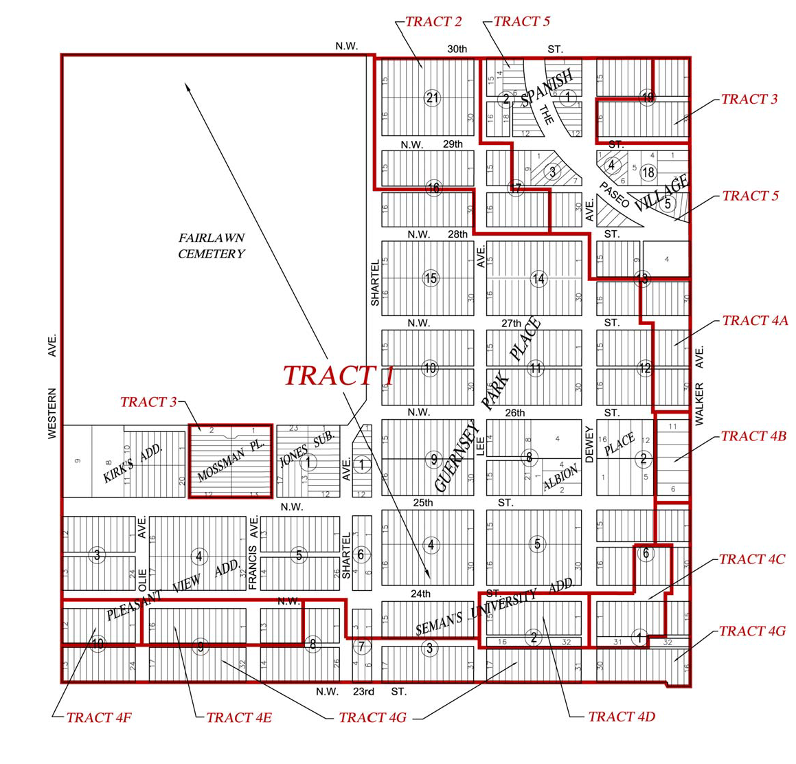
A.
Tract 1.
Block 4, Block 5, Lots 6—21 of Block 6; Blocks 8—11, Lots 9—24 of Block 12, Lots 16—24 of Block 13; Blocks 14—15, Lots 16—30 of Block 16 of Guernsey Park Place Addition; Block 1 and Lots 1—5 and 12—16 of Block 2 of Albion Place Addition; Kirk's Subdivision of Pleasant View Addition; Jones Subdivision of Pleasant View Addition, Blocks 1—6 and Lots 1—3 of Block 7 of Pleasant View Addition, Lots 1—15 of Block 3 of Seman's University Addition, and the unplatted parcel #1, defined above.
B.
Tract 2.
Block 21, Lots 1—15 of Block 16, Lots 12—25 of Block 17 of Guernsey Park Place Addition.
C.
Tract 3.
Mossman Place Subdivision, Lots 1—7 and 16—30 of Block 19 of Guernsey Park Place Addition.
D.
Tract 4.
Tract 4A.
Lots 25—30 of Block 13, Lots 1—8 and 25—30 of Block 12 of Guernsey Park Place Addition.
Tract 4B.
Lots 6—11 of Block 2 of Albion Place Addition.
Tract 4C.
Lots 22—27 of Block 6 and Lots 1—11 and Lot 31 of Block 1 of Guernsey Park Place Addition.
Tract 4D.
Lots 1—16 and Lot 32 of Block 2 of Seman's University Addition.
Tract 4E.
West ½ of Lot 7 and Lots 8—13 of Block 8 and 1—16 of Block 9 of Pleasant View Addition.
Tract 4F.
Lots 1—12 of Block 10 of Pleasant View Addition.
Tract 4G.
Lots 1—5 and 28—30 of Block 6 of Guernsey Park Place Addition, and Lots 12—30 and 32 of Block 1 of Guernsey Park Place, and Lots 17—31 of Block 2 of Seman's University Addition, and Lots 27—31 of Block 3 of Seman's University Addition, and Lots 4—5 of Block 7 of Pleasant View Addition, and Lots 1—6 and the east ½ of Lot 7 and Lots 14—26 of Block 8 of Pleasant View Addition, and Lots 17—32 of Block 9 of Pleasant View Addition, and Lots 13—24 of Block 10 of Pleasant View Addition.
E.
Tract 5.
Blocks 1—6 of Spanish Village Addition, and Lots 8—15 of Block 19 of Guernsey Park Place Addition, and Block 18 of Guernsey Park Place Addition, and Lots 8—11, Lots 26—30 plus a 20-foot alley adjacent to Lot 9 on the east of Block 17 of Guernsey Park Place Addition, Lots 4—15 of Block 13 of Guernsey Park Place Addition, and Block 20 of Guernsey Park Place Addition.
(Ord. No. 23993, § 4, 12-8-09; Ord. No. 24726, § 11, 8-13-13)
6. - Scenic River Overlay District.
The boundaries of the Scenic River Overlay District are delineated in Attachment I to Ordinance No. 18686, and are made a part of this section.
8. - Stockyards City Development And Transitional Development Districts.
The SYD District incorporates the four blocks surrounding the intersection of Agnew and Exchange Avenues, more particularly described as follows: Beginning at the centerline of SW. 11th Street and S. Youngs Boulevard thence west to the corporate limits of The City of Oklahoma City, said point being the eastern boundary of the Oklahoma National Stockyards; thence south to the centerline of SW. 13th Street; thence east to the centerline of SW. 13th Street and Youngs Boulevard; thence north to the point of beginning.
The SYT District is composed of three areas. The boundaries of the three areas are described as those properties abutting S. Agnew Avenue between SW 11th Street and the floodway of the North Canadian River; properties abutting S. Agnew between SW 13th Street and SW 15th Street; and properties abutting Exchange Avenue between S. Pennsylvania and S. Youngs Boulevard. The following properties are more particularly described as the Stockyards City Transitional Development District: Stockyards Addition: All of blocks 1, 16, and 21; lots 10 through 21 of block 2; lots 15 through 28 of block 8; lots 15 through 28 of block 9; lots 18 through 40 of block 10; lots 1 through 14 of block 13; lots 1 through 14 of block 14; lots 1 through 22 of block 15; lots 10 through 21 block 17; and, lots 10 through 21 of block 22. Stockyards Fourth Addition: All blocks 100, 105, and 110; lots 11 through 22 of block 101; lots 11 through 15 of block 106; and, lots 11 through 15 of block 111.
9. - Urban Conservation Districts.
A.
Linwood Place Urban Conservation District. The boundaries of the Linwood Place Urban Conservation District shall include all of Blocks 15 through 42 inclusive, Linwood Place Addition to Oklahoma City, Oklahoma, as shown by the recorded plat thereof, and any replats which have been filed of record. This area is generally within the boundaries of the centerlines of the following streets: Northwest 23rd Street on the north, North Drexel Boulevard on the east, Northwest 16th Street on the south and Interstate Highway 44 on the west.
B.
Northeast Gateway Urban Conservation District. The Northeast Gateway Urban Conservation District is generally located from North Kelley Avenue to North Martin Luther King Avenue, and the Deep Fork Creek and Northeast Grand Boulevard to Northeast 70th Street; plus from North Martin Luther King Avenue to Interstate 35, and Remington Place and Northeast 50th Street to Northeast 67th Street extended. It shall be bounded as follows: Portions of land lying within the south half of Sections 1 and 2, Township 12 North, Range 3 West and Sections 11 and 12, Township 12 North, Range 3 West described as follows: Begin at a point 2,640 feet north of the southwest corner of Section 2, Township 12 North, Range 3 West on the centerline of North Kelley Avenue, then extend a line east across said Section 2 to the centerline of Martin Luther King Avenue; then southerly along the centerline of North Martin Luther King Avenue to a point 1,320 feet north of the southeast corner of said Section 2, then easterly across Section 1, Township 12 North, Range 3 West to the west right-of-way line of Interstate 35; then southerly along the west right-of-way line of said Interstate Highway to a point in Section 12, Township 12 North, Range 3 West where it intersects the centerline of Northeast 50th Street; then West along the centerline of Northeast 50th Street to a point of intersection with Grand Boulevard; then northwesterly along the centerline of Grand Boulevard to a point of intersection with the centerline of Deep Fork Creek in Section 11, Township 12 North, Range 3 West; then westerly along the centerline of Deep Fork Creek to the point of intersection with the centerline of North Kelley Avenue; then north along the centerline of North Kelley Avenue to the point or place of beginning.
C.
Cleveland Urban Conservation District. The Cleveland Urban Conservation District is generally located from Northwest 23rd Street to Northwest 30th Street, and North Villa Avenue to North May Avenue, excluding Northwest Classen High School and Northwest Christian Church.
D.
Silver Lake Urban Conservation District. The Silver Lake Urban Conservation District is generally located from West Britton Road to South Shore Drive, and North MacArthur Boulevard to one-half mile west. Its legal description is: Begin at the southeast corner of the southeast quarter of Section 28, T13N R4W, then proceed north along the east line of said quarter approximately 2,640 feet to the northeast corner of said southeast quarter, then west along the north line of the southeast quarter to the northwest corner of said quarter then west approximately 425 feet to the point of intersection with the east line of Briarcreek Subdivision to Oklahoma City, Oklahoma, then southerly along the east boundary of said subdivision approximately 270 feet to a point of intersection with the northerly line of Lot 24, Block 10; then southwesterly along the north line of said Lot 24 134.39 feet to the point of intersection with the east right-of-way line of Briarcreek Drive; then southeasterly along the east right-of-way line of Briarcreek Drive approximately 494 feet to a point of intersection with the north line of Lot 1, Block 5 of the said Briarcreek Subdivision; then southerly and easterly around the west and south lines of said Lot 1 a distance of approximately 194 feet to the intersection of the northwest corner of Lot 1, Block 4, Briarcreek Subdivision, with the east right-of-way line of Northwest 98th Street; then southeasterly along the east right-of-way line to NW 98th Street approximately 78 feet to a point of intersection with the north line of Lot 2, Block 4 of said subdivision; then southeasterly along said north line 100 feet to a point of intersection with the east line of Lot 2 which is the east boundary of Briarcreek Subdivision; then southerly along said east line approximately 340 feet to a point of intersection with the east right-of-way line of Lakeland Terrace; then southwesterly along said east right-of-way line approximately 700 feet to the point of intersection with the west line of Lot 25, Block 1 of said Briarcreek Subdivision; then southeasterly along said west line approximately 112 feet to a point of intersection with Lot 13, Block 1 of said Subdivision; then west approximately 30 feet to the west line of said Lot 13; then southwesterly approximately 151 feet along the west line of said Lot 13 to a point of intersection with the east right-of-way line of Northwest 95th Street; then southeasterly along the east right-of-way line of said Northwest 95th Street approximately 267 feet to a point of intersection with the south line of Lot 10, Block 1, of said Briarcreek Subdivision; then southeasterly along the south line of said Lot 10 approximately 120 feet to the east line of Briarcreek Subdivision then south along said east line approximately 250 feet to a point on the south line of Section 28, Township 13 North Range 4 West which is the southeast corner of the southwest quarter of said section; then east along the south line of said Section 28 approximately 2,640 feet to the point of beginning.
E.
Hilldale Urban Conservation District. The Hilldale Urban Conservation District is generally within the boundaries of Northwest 19th Street on the north, North Meridian Avenue on the east, Northwest 10th Street on the south, and North Ann Arbor Avenue on the west.
F.
Mesta Park Urban Conservation District. The Mesta Park Urban Conservation District is generally located from one-half block south of NW 16th Street to one-half block north of NW 22nd Street, and from North Walker Avenue to North Western Avenue; plus both sides of NW 22nd Street between North Robinson Avenue and North Walker Avenue. It shall include all of the following described property: Lots 17—32 of Block 1, Lots 17—32 of Block 2, Lots 18—34 of Block 3, Lots 14—26 of Block 4, Lots 17—32 of Block 5, Lots 13—24 of Block 6, Blocks 23—34, Blocks 43—54, Blocks 63—74 of University Addition; Lots 1—5 of Block 1, Lots 1—5 of Block 2, Lots 1—4 of Block 3 of Classen's West Highland Park Addition; Lots 71—87 of Harndale Addition; Lots 8—14 of Block 1, Lots 8—14 of Block 2, Lots 1—7 of Block 3, and Lots 1—7 of Block 4 of Winans Highland Terrace Addition.
G.
Heritage Hills East Urban Conservation District. The Heritage Hills East Urban Conservation District is generally located from Northwest 14th Street to one-half block north of Northwest 22nd Street, and from North Broadway Avenue to North Robinson Avenue. It is contained within the following described boundaries, which are also shown by the map attached to this Ordinance No. 17225, and made a part thereof: NORTH: along the north property line of Lots 12 through 17 and Lot 4 of Block 13 in Winans Highland Terrace Addition between Robinson and Broadway Avenues; EAST: starting at the centerline of Broadway Avenue adjacent to the northeast corner of Lot 4, Block 13 of Winans Highland Terrace Addition, and proceeding south along said centerline until Broadway branches at Winans Park, whereupon the district boundary shall follow the centerline of the northbound lane of Broadway surrounding the park, until the two lanes converge at NW 20th Street, whereupon the boundary once again follows south along the centerline of Broadway until NW 14th Street; SOUTH: along the centerline of NW 14th Street, between Broadway and Robinson; WEST: along the centerline of Robinson Avenue between NW 14th Street adjacent to the northwest corner of Lot 12, Block 13 of Winans Highland Terrace Addition.
Included within the aforementioned boundaries are the following subdivisions and unplatted land: The southern 25 feet of Lots 4, 5, and 12 through 17 of Block 13, Lots 1 through 18 of Block 14, Lots 1 through 18 of Block 15, Lots 1 through 12 of Block 16 of Winans Highland Terrace Addition; Winans Park; Lots 4 through 6 and Lots 13 through 19 of Block 16, Lots 1 through 2A and 6 through 11A of Block 1 of Nichols and Chandlers Addition; Lots 3 through 5 and 12 through 17 of Block 1, Lots 1 through 17 of Block 2, Lots 1 through 17 of Block 3 of Winans Highland Terrace Addition, all of Overholser and Aveys Addition including an unplatted parcel starting at the northwest corner of Lot 5 in Weavers Addition, south 400 feet, west 430.3 feet, north 50 feet, east 300.3 feet, north 350 feet, and east 130 feet back to the point of origin; all of Weavers Addition; and all of Fays Addition.
H.
Jefferson Park Urban Conservation District. The Jefferson Park Urban Conservation District is generally located from Centennial Expressway to North Walker Avenue, and one-half block north of Northwest 23rd Street to Northwest 30th Street. It shall include all of the following described property: Lots 8—17 of Block 1, Lots 1—3 and Lots 11—14 of Block 2, Lots 1—8 of Block 3, Lots 1—3 and Lots 15—22 of Block 4, Blocks 5—8, Lots 9—23 of Block 9, Blocks 10—14, Lots 9—22 of Block 16, Blocks 19, 20, 25 of Jefferson Park Addition; Blocks 15, 17, 18, 21, 22, 23, 24 and part of 10 and 14 of the amended plat of Jefferson Park; Lots 7—20 of Block 26, Lots 8—21 of Block 27, Lots 9—22 of Block 28 of Jefferson Park Second Addition.
I.
Wilde Oaks Urban Conservation District. The Wilde Oaks Urban Conservation District is generally located from NE 50th St to the Deep Fork Creek south of Interstate 44, from North Kelley Avenue to one-half mile east, plus a triangle one-fourth (¼) mile on each side northwest from the corner of NE 50th Street and North Kelley Avenue. Begin at the southeast corner of Lot 1, Block 1, Cashions Wildewood Addition within the southwest quarter of Section 11, Township 12 North, Range 3 West; and proceed north approximately 425 feet along the east line of Lots 1—2, Block 1 of said Addition to a point of intersection of the southeast corner of Lot 3, Block 1, of said Addition; then east approximately 325 feet along the south line of Lots 4—5, Block 1 of said Addition to a point of intersection of the southeast corner of said Lot 5; then north approximately 335 feet along the east lines of Lots 5—6, Block 1 of said Addition to a point of intersection of the northeast corner of said Lot 6; then east approximately 355 feet along the south lines of Lots 7—9, Block 1 of said Addition to a point of intersection of the southeast corner of said Lot 9; then north approximately 1,125 feet along the east lines of Lots 9, 11—15, Block 1, and Lots 1—2, Block 13A, of said Addition to a point of intersection of the northwest corner of Lot 1, Block 4, of Higley's Wildwood Addition, Section 3; then easterly along the north line approximately 240 feet of said Lot 1, Block 4, of Higley's Wildwood Addition to a point of intersection of the northeast corner of said Lot 1; and continuing northeasterly approximately 95 feet to the point of intersection of the southwest corner of Lot 4, Block 17, of Park Estates 11th Addition; then northeast along the west line of said Lot 4 approximately 110 feet to the point of intersection of the northwest corner of said Lot 4; then east approximately 300 feet along the north lines of Lots 4—1, Block 17, of said Park Estates 11th Addition to the point of intersection of the northeast corner of said Lot 1, Block 17, of said Addition; then north approximately 765 feet along the west line of Lots 12—1, Block 17, of said Addition to a point of intersection of the north right-of-way line of NE 58th Street with Lot 9, Block 15, of Cashions Wildewood Addition; then west approximately 235 feet along the south lines of Lot 9, Block 15, and Lot 1, Block 16, of said Cashions Wildewood Addition to a point of intersection of the southwest corner of said Lot 1, Block 16 and said Addition; proceeding northerly approximately 920 feet along the west line of Block 16 of said Addition to a point of intersection of the northwest corner of Lot 17, of said Block; proceeding northwesterly approximately 2,370 feet along a line 100 feet south of the centerline of Deep Fork Creek to the point of intersection of the northeast corner of Lot 7, Block 2, of Richardsons Wildewood Addition; then west approximately 430 feet along the north lines of Lots 7—9, Block 2, of Richardsons Wildewood Addition to a point of intersection of the northwest corner of said Lot 9, Block 2, of said Addition; then southerly approximately 305 feet along the west lines of Lots 9—12, Block 2, of said Addition to a point of intersection of the northeast corner of Lot 14, Block 2, of said Addition; proceeding west approximately 630 feet along the north lines of Lots 14—22, Block 2, of said Addition to a point of intersection of the northwest corner of said Lot 22, Block 2, of said Addition; then south approximately 285 feet along the west line of Lot 22, Block 2, of Richardsons Wildewood Addition to a point of intersection of the southwest corner of said lot, and proceeding south across the right-of-way at NE 59th Street to a point of intersection of the northwest corner of Lot 16, Block 1, of said Addition, and further south approximately 155 feet along the west line of said Lot 16 to a point of intersection of the said lot's southwest corner; then west approximately 60 feet to the west line of the said Section 11; proceeding south approximately 2,625 feet along the west line of Section 11 to a point of intersection of the northeast corner of Lot 12, Block 1, of Burr Oaks Addition, which is entirely located in the southeast quarter of Section 10,Township 12 North, Range 3 West, and continuing southwesterly for approximately 2,280 feet along the northern and western line of Block 1 of said Addition to a point of intersection of the south line of said southeast quarter of Section 10; then east approximately 1,390 feet along the south line of the southeast quarter of said Section 10 to its southeast corner, where it intersects the southwest corner of the southwest quarter of Section 11, Township 12 North, Range 3 West; then further east approximately 1,975 feet along the south line of said southwest quarter of Section 11 to the point of beginning.
Tract 1 is that part of the District not within the area described as Tract 2.
Tract 2 is that portion of the District located within the southeast and northeast quarters of Section 11, Township 12 North, Range 3 West, and within the northwest quarter of said section that is located east and north of a line originating at the south line of the said northwest quarter where it intersects with the middle of the right-of-way at Lottie Avenue, thence proceeding north for approximately 200 feet, then west approximately 210 feet, then north approximately 60 feet, then northwesterly approximately 290 feet to a point of intersection at the centerline of a stream tributary of the Deep Fork Creek, and following said stream centerline in a northerly direction to its intersection with a point 100 feet south of the centerline of the Deep Fork Creek.
J.
Gatewood Urban Conservation District. The Gatewood Urban Conservation District is generally from North Classen Boulevard to North Pennsylvania Avenue, and from one-half block south of Northwest 16th Street to Northwest 23rd Street, except the Plaza District Urban Design zone. It includes Blocks 8—13, 15—21, 36—37, 40—41, 56—57, 61, 75—79, and B of University Addition; Blocks 1—4 of Nichols University Place Addition; Blocks 1—10 of University Place Addition; all of Blocks A and B and 1—17 and Lots 1—9 of Block 18 and Lots 1—15 of Block 19 and all Block 20 and Lots 1—5 of Block 21 and Lots 2—13 of Block 22 and all Block 23, and the unnumbered blocks east and north of Block 11, of Gatewood Addition; Block 4 of McKinley Place Addition, and McKinley Place Amended Addition; Lots 7—24 of Block 31 of Young's Englewood Addition; Lots 7—29 of Block 1 of Baumann Addition; Lots 1—8 of Whytes Subdivision; Lots 1—12 of Block A of College Addition; Lots 7—12 of Ware's Subdivision; Lots 1—12 of Block 1 and Lots 1—6 of Block 2 of University Heights Addition; Lots 1—5 and 30—34 of Block 2 of Edgewood Subdivision; Lots 1—9 of Block 1 of Avoca Addition; Lots 1—7, north 150 feet of Lots 8—11, and one-half vacated street adjacent to Lot 1 on the east of Block 1; and north 150 feet of Lots 1—6 and north 140 feet of Lots 7—12 of Block 2 of University View Addition; Lots 1 and 2, plus the north 140 feet of a vacated street adjacent to the west of Lots 2 and 3, plus the north 15 feet of Lots 3 and 6 of Block 3 of Summers Place Addition; and a tract designated as Blocks C, D and E of Carey Place.
K.
Mayfair Heights Urban Conservation District. The Mayfair Heights Urban Conservation District is generally from North May Avenue to one-half block east of North Miller Avenue, and from Northwest 41st Street to Northwest 50th Street, less the commercial districts on the northwest and southwest corners. Its boundaries shall include all of Blocks 1 thru 18, Mayfair Heights Addition and Blocks 1 thru 3, Robin Lee Addition, less and except Lot 1, Block 11; Block 11A and Block 12, Mayfair Heights Addition.
10. - Urban Design Districts.
The Urban Design Overlay is applied in several districts, the general locations of which are listed below. The boundaries are shown on the Official Zoning Districts Map.
A.
Northwest 23rd Street Corridor. Generally located on both sides of NW 23rd Street from North Broadway Avenue to North Villa Avenue, plus Shepherd Mall.
B.
Plaza District. Generally located on both sides of NW 16th Street from North Blackwelder Avenue to west of North Indiana Avenue.
C.
Asian District. Generally located on both sides of North Classen Boulevard from NW 23rd Street to NW 30th Street, and from North Western Avenue to North Douglas Avenue between NW 23rd Street and NW 26th Street.
D.
Capitol Hill District. Generally located from SW 24th Street to SW 26th Street, between Shields Boulevard and west of South Walker Avenue, plus both sides of South Robinson Avenue and South Walker Avenue north of SW 29th Street.
E.
Cottage District. This area is not in the Urban Design Overlay District, but it is subject to review by the Urban Design Commission under the Downtown Transitional District, Limited (DTD-1) criteria. Reference § 59-7200.3.B.(1)(a) for the legal description.
F.
Lincoln Boulevard Corridor. The Lincoln Boulevard Corridor Subdistrict is generally located along both sides of N Lincoln Boulevard from NE 30th Street north to Central Park Drive. It is contained within the following described boundaries, which are also shown by the map attached to this Ordinance 26033, and made a part thereof: A tract of land being a part of the South Half (S/2) of Section 10, Section 15 and the North Half (N/2) of Section 22, Township 12 North, Range 3 West of the Indian Meridian, Oklahoma City, Oklahoma County, Oklahoma, being more particularly described as follows: Beginning at the Southwest (SW) Corner of the Northeast Quarter (NE/4) of Said Section 22, said point being the Point of Beginning; Thence East along and with the centerline of N.E. 30 th Street, a distance of 333 feet; Thence North, departing said South line, to a point on the South right-of-way line of N.E. 32 nd Street; Thence West, along and with the South right-of-way line of N.E. 32 nd Street, a distance of 112 feet; Thence North, departing said South right-of-way line, to the South right-of-way line of Hill Street; Thence East along and with the South right-of-way line of Hill Street, a distance of 155 feet; Thence North departing said South right-of-way line, to the South right-of-way line of N.E. 33 rd Street; Thence West, along and with the South right-of-way line of N.E. 33 rd Street to the extended West line of Lot 14 as shown on the plat W.J. Landes Subdivision Block 5 McNabb & Hunt Addition; Thence North, along and with the West line of Lots 14 and 8 extended as shown on the plat W.J. Landes Subdivision Block 5 McNabb & Hunt Addition to the South right-of-way line of N.E. 35 th Street; Thence West along and with the South right-of-way line of N.E. 35 th Street, to the extended West line of Lot 31 Block Three as shown on the recorded plat Hares Lincoln Boulevard Addition; Thence North along and with the West line of Lot 31 Block 3 as shown on the recorded plat Hares Lincoln Boulevard Addition to the Northwest (NW) Corner of Lot 31 Block 3 as shown on the recorded plat Hares Lincoln Boulevard Addition; Thence East along and with the North line of Lot 31 Block 3 as shown on the recorded plat Hares Lincoln Boulevard Addition to the Southwest (SW) Corner of Lot 17 Block 3 as shown on the recorded plat Hares Lincoln Boulevard Addition; Thence North along and with the West line of Lot 17 Block 3 extended and the West line of Lot 32 Block 2 extended as shown on the recorded plat Hares Lincoln Boulevard Addition to the Northwest (NW) Corner of Lot 32 Block 2 extended as shown on the recorded plat Hares Lincoln Boulevard Addition; Thence East along and with the North line of Lots 32 through 48 Block 2 as shown on the recorded plat Hares Lincoln Boulevard Addition extended to the centerline of Lindsay Avenue; Thence North along and with the centerline of Lindsay Avenue to the extended North line of the East/West Alley in Block 3 as shown on the recorded plat Oklahoma Heights; Thence West, departing said centerline, a distance of 130 feet; Thence North to the centerline of N.E. 38 th Street as shown on the recorded plat Lincoln Plaza Addition Section 2; Thence West along and with the centerline of N.E. 38 th Street as shown on the recorded plat Lincoln Plaza Addition Section 2, a distance of 112 feet; Thence North, departing said centerline, to the South line of Lot 2 as shown on the recorded plat North View Addition; Thence West, along and with the South line of Lot 2 as shown on the recorded plat North View Addition to a point 310 feet East of the Southwest (SW) Corner of Lot 2 as shown on the recorded plat North View Addition; Thence North, parallel with and 310 feet East of the West line of Lot 2 as shown on the recorded plat North View Addition to the South right-of-way line of N.E. 42 nd Street; Thence West, along and with the South right-of-way line of N.E. 42 nd Street to the centerline of Woodland Drive; Thence Northerly along and with the centerline of Woodland Drive to the extended Northeast (NE) line of Lot 9 Block 2 as shown on the recorded plat Thompson's Woodland Addition; Thence North, departing said centerline, to the North right-of-way line of Woodland Boulevard; Thence Northeasterly, along and with the North right-of-way line of Woodland Boulevard to the Easternmost Corner of Lot 7 Block 4 as shown on the recorded plat Thompson's Woodland Addition; Thence North to the centerline of N.E. 50 th Street; Thence West, along and with the centerline of N.E. 50 th Street to the East right-of-way line of Lincoln Boulevard; Thence Northerly along and with the East right-of-way line of Lincoln Boulevard to the extended centerline of Central Park Drive; Thence Westerly, along and with the extended centerline of Central Park Drive to the centerline of Beverly Drive; Thence Southeasterly, along and with the centerline of Beverly Drive to the centerline of N.E. 50 th Street; Thence West, along and with the centerline of N.E. 50 th Street, a distance of 233 feet; Thence South, departing said centerline, to a point on the South line of Lot 1 as shown on the recorded plat Plainview Addition; Thence East, along and with the South line of said plat Plainview Addition, a distance of 110 feet; Thence South, departing said South line, to the centerline of N.E. 48 th Street; Thence West, along and with the centerline of N.E. 48 th Street, a distance of 130 feet; Thence South, departing said centerline, to the South right-of-way line of N.E. 46 th Street; Thence West, along and with the South right-of-way line of N.E. 46 th Street, to the East right-of-way line of Stiles Avenue; Thence South, along and with the East right-of-way line of Stiles Avenue approximately 595 feet, to the Southwest (SW) Corner of a tract of land recorded in Book 13272, Page 1703, said point lying on the North line of a tract of land recorded in Book 12603, Page 1105; Thence along and with the North line of said tract of land recorded in Book 12603, Page 1105 the following four calls:
1.
Easterly and Southeasterly along a non-tangent curve to the right having a radius of 120.80 feet (said curve subtended with a chord bearing of South 57°26'18" East a distance of 154.02 feet) for an arc length of 167.23 feet;
2.
North 50°50'18" East, a distance of 122.00 feet;
3.
South 43?°00'47" East, a distance of 30.27 feet;
4.
North 50°50'18" East, a distance of 440.27 feet to a point on the West right-of-way line of Lincoln Boulevard;
Thence South, along and with the West right-of-way of Lincoln Boulevard to a point on the South line of said tract of land recorded in Book 12603, Page 1105; Thence along and with the South line of said tract of land recorded in Book 12603, Page 1105 the following nine calls:
1.
Southwesterly along a non-tangent curve to the right having a radius of 332.15 feet (said curve subtended with a chord that bears South 68°33'13" West a distance of 185.10 feet) for an arc length of 187.73 feet;
2.
North 00°00'00" West, a distance of 15.60 feet;
3.
North 90°00'00" West, a distance of 55.00 feet;
4.
South 82°09'42" West, a distance of 59.50 feet;
5.
North 70°41'47" West, a distance of 30.69 feet to a point on a curve;
6.
Southwesterly along a non-tangent curve to the right having a radius of 264.91 feet (said curve subtended with a chord that bears South 79°19'39" West a distance of 69.34 feet) for an arc length of 69.54 feet;
7.
North 90°00'00" West, a distance of 65.50 feet;
8.
North 00°00'00" West, a distance of 1.28 feet;
9.
North 90°00'00" West to the extended East right-of-way line of Stiles Avenue;
Thence South, to the South line of the Northwest Quarter (NW/4) of said Section 15; Thence East, to the extended East line of Lot 13 Block 1 as shown on the recorded plat Kenwood Highland Addition; Thence South along and with the extended East line of Lot 13 Block 1 as shown on said plat Kenwood Highland Addition, the extended East line of Lot 13 Block 2 as shown on said plat Kenwood Highland Addition, the extended East line of Lot 13 Block 1 as shown on the recorded plat Kenwood Second Addition, the extended East line of Lot 13 Block 4 as shown on said plat Kenwood Second Addition, the extended East line of Lots 13 and 36 Block 1 as shown on the recorded plat Irvington, the extended East line of Lots 13 and 36 Block 4 as shown on the recorded plat Irvington, the extended East line of Lots 13 and 36 Block 5 as shown on the recorded plat Irvington, the extended East line of Lots 13 and 36 Block 8 as shown on the recorded plat Irvington to the South right-of-way line of N.E. 36 th Street; Thence West, along and with the South right-of-way line of N.E. 36 th Street to a point 650 feet West of the East line of the Northwest Quarter (NW/4) of said Section 15; Thence South, to a point on the North right-of-way line of N.E. 34 th Street; Thence East, a distance of 300 feet; Thence South, departing said North right-of-way line, to the South right-of-way line of N.E. 34 th Street; Thence West, along and with the South right-of-way line of N.E. 34 th Street to the Northwest (NW) Corner of Lot 2 Block 3 as shown on the recorded plat Santa Fe Industrial District; Thence South, along and with the West line of said Lot 2 Block 3 as shown on said plat Santa Fe Industrial District to the Southwest (SW) Corner of said Lot 2 Block 3 as shown on said plat Santa Fe Industrial District; Thence East, along and with the South line of said Lot 2 Block 3 as shown on said plat Santa Fe Industrial District, a distance of 100 feet; Thence South, departing said South line, to the North line of Lot 11, Block 3 as shown on said plat Santa Fe Industrial District; Thence West, along and with the North line of said Lot 11, Block 3 as shown on said plat Santa Fe Industrial District to the Northwest (NW) Corner of said Lot 11, Block 3 as shown on said plat Santa Fe Industrial District; Thence South, along and with the West line extended of said Lot 11, Block 3 as shown on said plat Santa Fe Industrial District, the extended West line of Lots 2 and 11 Block 4 as shown on the recorded plat Santa Fe Industrial District 2, to the South right-of-way line of N.E. 31 st Street; Thence West, along and with the South right-of-way line of N.E. 31 st Street to a point 580 feet West of the East line of the Northwest Quarter (NW/4) of said Section 22; Thence South, to the centerline of N.E. 30 th Street; Thence East, along and with the centerline of N.E. 30 th Street, to the Point of Beginning. Less & Except: A tract of land as described in Corporation Warranty Deed recorded in Book 7870, Page 100; A part of the Northeast Quarter (NE/4) of Section 15, Township 12 North, Range 3 West of the Indian Meridian, Oklahoma County, Oklahoma, more particularly described as follows: Commencing at the Northwest corner of said Quarter section; thence East along the North line of said Quarter section, a distance of 320 feet; thence South and parallel to the West line of said Quarter section, a distance of 33 feet, to the point or place of beginning; thence South and parallel to the West line of said Quarter section, a distance of 170 feet; thence West and parallel to the North line of said Quarter section, a distance of 221.02 feet, to a point on the Easterly Right-of-Way Line of Lincoln Boulevard as shown by Federal Aid Project No. U-IN-369 (3); thence in a Northeasterly direction along said Easterly Right-of-Way Line a distance of 90.55 feet to a point of intersection of said line and the Southerly right-of-way line of the property as described and shown in Book 253, Page 577 records of Oklahoma County; Thence in a Northeasterly direction along a 259.24 foot radius curve to the right along the Southerly Right-of-Way Line of the property as described in Book 253, page 577, a distance of 189.96 feet, to a point of tangent 300 feet East and 33 feet South of the Northwest corner of said Quarter section; Thence East parallel to and 33 feet South of the North line of said Quarter section; Thence East parallel to and 33 feet South of the North line of said Quarter section, a distance of 20 feet to the point or place of beginning.
(Ord. No. 23755, § 10, 12-2-08; Ord. No. 26033, § 5, 10-9-18)
11. - Healthy Neighborhoods Overlay District.
The general boundaries are properties located within the 73111 zip code, excluding the Oklahoma Capitol-Medical Center Improvement District, more specifically described as:
Beginning at the Northwest Corner of section 26 Township 12 North Range 3 West of the Indian Meridian, Oklahoma County Oklahoma, said point being the intersection of the centerline of Northeast 23rd Street and the centerline of North Kelly Avenue; thence south along the centerline of North Kelly Avenue a distance of 2467.1 feet to the intersection of the centerline of North Kelly Avenue and the extension of the North line of lots 14-26 Block 13 of Gast Heights Addition according to the recorded plat thereof; thence east along the extension of the North line of lots 14-26 Block 13 a distance of 33.00 feet to the NW corner of lot 14; thence east along the north line of lots 14-26 a distance of 286.50 feet to the NW corner of lot 25; thence south along the west line of lot 25 a distance of 140.00 feet to the SW corner of lot 25; thence east along the south line of lots 25 & 26 a distance of 50.00 feet to the SE corner of lot 26; thence east along the extension of the south line of lots 25 & 26 a distance of 30.00 feet to the centerline of North Stonewall Avenue; thence North along North Stonewall Avenue a distance of 140.00 feet to the intersection of the centerline of North Stonewall Avenue and the extension of the south alley line of Block 14 of Gast Heights Addition according to the recorded plat thereof; thence east along the extension of the South alley line a distance of 30.00 feet to the NW corner of lot 21 Block 14 of Gast Heights Addition; thence east along the north line of lots 21-40 a distance of 500.00 feet to the NE corner of lot 40 Block 14 of Gast Heights Addition; thence east along the extension of the north line of lots 21-40 Block 14 a distance of 30.00 feet to the intersection of the north line of lots 21-40 Block 14 and the centerline of North Everest Avenue; thence east along the extension of the north line of lots 19-36 Block 15 of Gast Height addition according to the recorded plat thereof a distance of 30 feet to the NW corner of lot 19 of said Gast Heights Addition; thence east along the north line of lots 19-36 Block 15 a distance of 400 feet to the NW corner of lot 35; thence south along the west line of lot 35 a distance of 140 feet to the SW corner of lot 35; thence east along the south line of lots 35 & 36 a distance of 54 feet to the SE corner of Lot 36 Block 15 of Gast Heights Addition; thence east along the extension of the south line of lots 19-36 Block 15 a distance of 53.00 feet to the intersection of the centerline of North Lottie Avenue and the extension of the south line of lots 19-36 Block 15 of Gast Heights Addition; thence south along the centerline of North Lottie Avenue a distance of 37.50 feet to the intersection of the centerline of NE 16th street and the centerline of North Lottie Avenue; thence east along the centerline of N.E. 16th Street a distance of 203' to the intersection of the centerline of N.E. 16th Street and the extension of the East line of lot 22 Block 16 of Gast Heights Addition; thence North along the extension of the east line of lot 22 Block 16 a distance of 37.50' to the SE corner of lot 22 Block 16 of Gast Height addition according to the recorded plat thereof; thence North along the east line of lot 22 a distance of 140.00 feet to the NE corner of Lot 22; thence East along the North line of lots 23-32 a distance of 281.70 to the NE corner of lot 32 Block 16 Gast Heights Addition; thence east along the extension of the north line of lots 17-32 block 16 of Gast Heights addition a distance of 30.00 feet to the centerline of North Kate Avenue; thence south along the centerline of North Kate Avenue a distance of 19.00 feet; thence east along the extension of the North line of lots 25-48 block 4 of Bancroft addition according to the recorded plat thereof a distance of 30.00' to the NW corner of lot 25; thence east along the north line of lots 25-48 block 4 of said plat a distance of 603.30 feet to the NE corner of lot 48; thence east along the extension of the North line of lots 25-48 block 4 of said plat a distance of 25.00 feet to the centerline of North Prospect Avenue; thence north along the centerline of North Prospect Avenue a distance of 6.50 feet; thence east along the extension of the south line of lots 1-11 block 1 of Stouts Addition according to the recorded plat thereof a distance of 25.00 feet to the NW corner of lot 12 of said plat; thence east along the south line of lots 1-11 Block 1 of said plat a distance of 275 feet to the NE corner of lot 21; thence east along the extension of the South line of lots 1-11 Block 1 of said plat a distance of 21.83 feet to the centerline of North Bath Avenue; thence south along the centerline of North Bath Avenue a distance of 165.00 feet to the centerline of N.E. 16th Street; thence east along the centerline of N.E. 16th Street approximately 2,328.95 feet to the SW Corner of the NW Quarter of Section 25 Township 12 North Range-3-West. Thence East along the Centerline of Northeast 16th Street approximately 2612.63 feet to the Southwest Corner of the NE/4 of Section 25 Township 12 North Range 3 West; Thence continuing East along the Centerline of Northeast 16th Street a distance of 186.50 feet to the intersection of Northeast 16th Street and North Page Avenue; Thence North along the Centerline of North Page Avenue a distance of 170.00 feet to the intersection of North Page Avenue and an extension of the South line of Lot 25 Block 9 of Edwards Heights Addition (Re-Subdivision of Success Heights); Thence 25.00 feet East to the Southwest Corner of Lot 25 Block 9 of said Edwards Heights; Thence East along the South lines of lots 25 through 12 a distance of 350.00 feet to the Southeast corner of Lot 12 Block 9 of said Edwards Heights; Thence East along the extension of the South line of Lot 25 Block 9 a distance of 10.00 feet to a point on the west line of Lot 6 Block 9 of said Edwards Heights; Thence South a distance of 15.00 feet to the Southwest corner of Lot 6 Block 9 of said Edward Heights; Thence South a distance of 50.00 feet to the Southwest Corner of Lot 8 Block 9 of said Edwards Heights; Thence East a distance of 140.00 feet to the Southeast Corner of Lot 8 Block 9 of said Edwards Heights; Thence East along the extension of the North line of Lot 9 Block 9 a distance of 200.00 feet to the Southwest Corner of Lot 18 Block 8 of said Edwards Heights; Thence South a distance of 80 feet along the West line of lots 18 through 21 to the Southwest Corner of Lot 21 Block 8 of said Edwards Heights; Thence East along the South line of Lot 21 Block 8 of said Edwards Heights a distance of 66.00 feet to the Southeast corner of a property described in Book RE12089 Page 1315 filed for record at Oklahoma County Clerk's Office; Thence North along said property line a distance of 130.00 feet to a point on the North line of Lot 17 Block 8 of said Edwards Heights said point being the Northeast Corner of said property; Thence East along the North line of Lot 17 Block 8 a distance of 74.00 feet to the Northeast Corner of Lot 17 Block 8 of said Edwards Heights; Thence East along the extension of the North line of Lot 17 Block 8 a distance of 10.00 feet to a point on the West line of Lot 22 Block 8 of said Edwards Heights; Thence North along the West line of Lot 22 Block 8 a distance of 5.00 feet to the Northwest Corner of Lot 22 Block 8 of said Edwards heights; Thence East along the North line of Lots 22-31 a distance of 245.50 feet to the Northeast Corner of Lot 31 Block 8 of said Edward Heights, said point also being a point on the West Line of Lot 9 Block 2 of McDonald Heights Addition according to the Plat thereof; Thence North along the West Line of Lot 9 Block 2 of said McDonald Heights Addition a distance of 10.00 feet to the Northwest Corner of said Lot 9; Thence East along the North line of Lots 9 through 13 a distance of 250.00 feet to the Northeast Corner of Lot 13 Block 2 of said McDonald Heights; Thence South along the East Line of said Lot 13 a distance of 145.00 feet to the Southeast Corner of said Lot 13; Thence East along the South Line of Lots 14 & 15 a distance of 100.00 feet to the Southeast Corner of Lot 15 Block 2 of said McDonald Heights Addition; Thence North along the East line of said Lot 15 a distance of 145.00 feet to the Northeast Corner of said Lot 15; Thence East along the North Line of Lot 16 Block 2 of Said McDonald Heights Addition a distance of 51.70 feet to the Northeast Corner of said Lot 16; Thence East a distance of 25.00 feet to the intersection of the Centerline of Edwards Avenue and an extension of the North line of Lot 16 Block 2 of Said McDonald Heights Addition; Thence South along the Centerline of Edwards Avenue a distance of 5.00 feet to the intersection of the Centerline of Edwards Avenue and an Extension of the North line of Lot 17 Block 17 of Edwards Heights Addition according to the Plat thereof; Thence East along the extension of the North line of Lot 17 Block 17 of Edwards Heights Addition a distance of 25.00 feet to the Northwest Corner of Lot 17 Block 17; Thence East along the North Line of Lots 17 through 30 a distance of 700.00 feet to the Southeast Corner of Lot 3 Block 17 of said Edwards Heights Addition; Thence North along the East Line of Lot 3 Block 17 a distance of 140.00 feet to the Northeast Corner of Lot 3 Block 17 of said Edwards Heights Addition; Thence North along the extension of the East line of Lot 3 Block 17 a distance of 50.00 feet to the Southeast Corner of Lot 22 Block 16 of said Edwards Heights Addition; Thence North along the East line of lot 22 Block 16 a distance of 93.30 feet to the Northwest Corner of Lot 24 Block 16 of said Edwards Heights Addition; Thence East along the North line of Lot 24 Block 16 a distance of 105.00 feet to the Northeast Corner of Lot 24 Block 16 of said Edwards Heights Addition; Thence East along an extension of the North Line of Lot 24 Block 16 a distance of 50.00 to the Centerline of North Bryant Avenue; Thence North along the Centerline of North Bryant Avenue a distance of 211.70 feet to the intersection of North Bryant Avenue and Northeast 18th Street; Thence West along the Centerline of Northeast 18th Street a distance of 144.93 to the intersection of the extension of the East line of Lot 9 Block 3 Dodson Heights Addition according to the Plat thereof and the Centerline of Northeast 18th Street; Thence North along the extension of the East line of Lot 9 Block 3 a distance of 25.00 feet to the Southeast Corner of Lot 9 Block 3 of said Dodson Heights Addition; Thence North along the East line of said Lot 9 a distance of 120.00 feet to the Northeast Corner of Lot 9 Block 3 of said Dodson Heights Addition; Thence West along the North line of said Lot 9 a distance of 24.32 feet to the Southeast Corner of Lot 7 Block 3 of said Dodson Heights Addition; Thence North along the East line of Lots 7 through 1 a distance of 490.00 feet to the Northeast Corner of Lot 1 Block 3 of Said Dodson Heights Addition; Thence North along an Extension of the East Line of Lot 1 Block 3 of said Dodson Heights addition a distance of 25.00 feet to the Centerline of Northeast Success Street; Thence East along the Centerline of Northeast Success Street a distance of 170.00 feet to the intersection of Success Street and North Bryant Avenue; Thence North along the centerline of North Bryant Avenue a distance of 165.00 feet to the intersection of the centerline of North Bryant Avenue and the south line of Block 1 of Bryant Center according to the recorded plat thereof; Thence West along the extension of the South line of Block 1 a distance of 50.00 feet to the Southeast corner of Block 1 of said Bryant Center recorded plat; Thence West along the South line of Block 1 a distance of 884.09 feet to the far Southwestern corner of said plat; Thence North along the West line of Block 1 a distance of 43.20 feet to a jog in the boundary of said plat; Thence West along the outside boundary of Block 1 a distance of 25.00 feet to the Northern most Southwesterly corner of said plat; Thence North along the West line of Block 1 a distance of 140.27 feet to a jog in the boundary of said plat; Thence continuing North along the West line of Block 1 a distance of 280.00 feet to the Northwest corner of said plat; Thence East along the North line of Block 1 of said recorded plat of Bryant Center a distance of 456.85 feet to the southwest corner of a property described in Book 11056 Page 1613 filed for record at the Oklahoma County Clerk's office; Thence North along the West line of said property a distance of 349.66 feet to the Northwest corner of property as described in said record; Thence East along the North line of said property a distance of 449.00 feet to the Northeast corner of property as described in said record; Thence East along the extension of the North line of said property a distance of 33.00 feet to the centerline of North Bryant Avenue; Thence North along the centerline of North Bryant Avenue a distance of 343.00 feet to the intersection of North Bryant Avenue and Northeast 23rd Street; Thence North along the Centerline of North Bryant Avenue a distance of 193.00 feet to the intersection of the Centerline of North Bryant Avenue and the Extension of the South Line of Lot 1 Block 4 Wails' 2nd Addition according to the Plat thereof; Thence West a distance of 33.00 feet to the Southeast Corner of Lot 1 Block 4 of said Wails' 2nd Addition, said point also being the Southeast Corner of a property described in Book 10234 Page 1766 filed for record at the Oklahoma County Clerk's Office; Thence continuing West along the South line of said Property a distance of 160 feet to the Southwest Corner of said Property, said point also being 10.00 feet West of the Southwest corner of Lot 6 Block 4 of said recorded plat of Wails' 2nd Addition; Thence North along the West line of said Property a distance of 140.00 feet to a point on the North Line of Block 4 of said Wails' 2nd Addition, said point also being the Northwest Corner of said Property; Thence North along the extension of the West line of said recorded property a distance of 30.00 feet to the intersection of the centerline of Northeast 24th Street; Thence East along the centerline of Northeast 24th Street a distance of 193.00 to the intersection of the centerline of North Bryant Avenue; Thence North along the centerline of North Bryant Avenue a distance of 390.00 feet to the intersection of the centerline of North Bryant Avenue and the extension of the South line of Block 13 Wails' Addition according to the recorded plat thereof; Thence West along the extension of the South line of said Block 13 a distance of 33.00 feet to the Southeast Corner of Lot 32 Block 13 of said Wails' Addition; Thence West along the South Line of Lots 30 through 32 a distance of 75.00 feet to the Southwest Corner of Lot 30 of Block 13 of said Wails' Addition; Thence North along the West line of said Lot 30 a distance of 140.00 feet to the Northwest Corner of Lot 30 Block 13 of said Wails' Addition; Thence East along the North line of lots 30 through 32 a distance of 75.00 feet to the Northeast corner of Lot 32 Block 13 of said Wails' Addition; Thence East along an Extension of the North Line of said Lot 32 a distance of 33.00 feet to the centerline of North Bryant Avenue; Thence North along the Centerline of North Bryant Avenue a distance of 1,446.24 feet to the Southeast Corner of a Property described in Book 12677 Page 592 filed for record at the Oklahoma County Clerk's Office; Thence West along the South Line of said record Property a distance of 334.00 feet to the Southwest corner of said Property; Thence North along the West line of said record Property a distance of 300.00 feet to the Northwest Corner of said Property; Thence East along the North line of said record Property a distance of 40.93 feet to the Southwest Corner of Lot 3B Block 3 Forest Village Estates Section 1 according to the recorded Plat thereof; Thence North along the West line of said Lot 3B a distance of 148.31 feet to the Northwest Corner of Lot 3B Block 3 of said Forest Village Estates Section 1; Thence S 89°58'02" W along the boundary of said Forest Village Estates Section 1 a distance of 6.92 feet, as described on Forest Village Estates Section 1 Plat; Thence N 00°01'58" W along the boundary of said Forest Village Estates Section 1 a distance of 50.00 feet, as described on Forest Village Estates Section 1 Plat; Thence N 89°58'02" E along the boundary of said Forest Village Estates Section 1 a distance of 74.63 feet, as described on Forest Village Estates Section 1 Plat; Thence N 44°58'02" E along the boundary of said Forest Village Estates Section 1 a distance of 35.36 feet, as described on Forest Village Estates Section 1 Plat; Thence N 00°01'58" E along the boundary of said Forest Village Estates Section 1 a distance of 95.06 feet, as described on Forest Village Estates Section 1 Plat, to the Southeast Corner of Lot 1A Block 1; Thence S 89°58'02" W along the South Line of said Lot 1A a distance of 99.63 feet to the Southwest Corner of Lot 1A Block 1 as described on Forest Village Estates Section 1 Plat; Thence N 00°01'58" W along the West line of Block 1 a distance of 438.86 feet to the Northwest Corner of Lot 6B Block 1 as described on Forest Village Estates Section 1 Plat; Thence North along an extension of the West line of said Block 1 a distance of 279.77 feet to the Southwest Corner of Common Area "A" of said Forest Village Estates Section 1 Plat; Thence North along the West line of said Common Area "A" a distance of 69.17 feet to the Northwest Corner of Common Area "A" of said Forest Village Estates Section 1 Plat; Thence East along the North line of said Common Area "A" a distance of 249.99 feet to the Northeast Corner of said recorded Plat of Forest Village Estates Section 1; Thence East along an extension of the North line of said Plat a distance of 50.00 feet to the centerline of North Bryant Avenue; Thence North along the centerline of North Bryant Avenue a distance of 1537.46 feet to the intersection of North Bryant Avenue and Northeast 36th Street; Thence North along the Centerline of North Bryant Avenue a distance of 5,294.8 feet to the intersection of North Bryant Avenue and Northeast 50th Street; Thence North along the Centerline of North Bryant Avenue a distance of 5,291.88 feet to the intersection of North Bryant Avenue and Northeast 63rd Street; Thence North along the centerline of North Bryant Avenue a distance of 50.00 feet to the intersection of North Bryant Ave. and the extension of the North Right-of-way Line of Northeast 63rd Street; Thence West a distance of 50.00 feet to a point on the North right-of-way line of Northeast 63rd Street, said point also being the Southeast corner of a property described in Book RE14092 Page 1080 filed for record at the Oklahoma County Clerk's Office; Thence S 89°40'35" W along the South property line of said property a distance of 199.79 feet as recorded in said book; Thence N 68°12'25" W along the Southwesterly property line of said property a distance of 98.48 feet to the Southwest corner of said property, said point also being on the East right-of-way line of Interstate Highway No. 35; Thence N 01°36'22" E along the East right-of-way line of Interstate Highway No. 35 also being the West property line of said property as described in Book RE14092 Page 1080 a distance of 370.73 feet to the Southwest Corner of a property as described in Book 10648 Page 1277 filed for record at the Oklahoma County Clerk's Office; Thence continuing N 01°36'22" E along the East right-of-way line of Interstate Highway No. 35 also being the West property line of said property as described in Book 10648 Page 1277 a distance of 100.06 feet to the Southwest corner of a property as described In Book RE11450 Page 337 filed for record at the Oklahoma County Clerk's Office; Thence Continuing N 01°36'22" E along the East right-of-way line of Interstate Highway No. 35 also being the West property line of said property as described in Book RE1145 Page 337 a distance of 32.41 feet to a point, said point also being a jog in the East right-of-way line of Interstate Highway No. 35; Thence N 01°36'22" E along the extension of the East right-of-way line on Interstate Highway No. 35, also being the extension of the West property line of said property as described in Book RE1145 Page 337 a distance of 1,319.45 feet to a point of curvature on the Northwesterly right-of-way line of Interstate Highway No. 35; Thence along the Northwesterly right-of-way line of Interstate Highway No. 35 on a curve to the Left having a radius of 1,105.92 feet a curve length of 85.04 feet a chord bearing of N 33°11'13" E and a chord distance of 85.02' feet to the Southeast corner of a property described in Book 7817 Page 1546 filed for record at the Oklahoma County Clerk's Office; Thence continuing along Northwesterly right-of-way line of Interstate Highway No. 35 along a curve to the left having a radius of 1,105.92 feet a curve length of 126.91 feet a chord bearing of N 27°41'48" E and a chord distance of 126.84 feet to a point of tangency; Thence N 23°52'26" E and continuing along the Northwesterly right-of-way line of Interstate Highway No. 35 a distance of 111.78 feet to a point of curvature; Thence continuing along the Northwesterly right-of-way line of Interstate highway No. 35 along a curve to the left having a radius of 914.93 feet a curve length of 290.77 feet a chord bearing of N 13°43'20" E and a chord distance of 289.55 feet to a point of tangency, said point also being the Southeast corner of a property as described in Book 6312 Page 1519 filed for record at the Oklahoma County Clerk's Office; Thence N 00°23'36" W along the West right-of-way line of Interstate Highway No. 35 of way a distance of 165.00 feet to a point on the North line of the Southeast Quarter (SE/4) of Section 1 Township 12 North Rane 3 West; Thence East along the North line of said Southeast Quarter (SE/4) a distance of 50.00 feet to the centerline of North Bryant Avenue; Thence North along the centerline of North Bryant Avenue a distance of 665.00 feet to the intersection of the centerline of North Bryant Avenue and the extension of the South line of a property as described in Book 9773 Page 59 filed for record at the Oklahoma County Clerk's Office; Thence West along the extension of the South Line of said Property described in Book 9773 Page 59 a distance of 200.00 feet to the Southeast corner of a property described in Book 11030 Page 126 filed for record at the Oklahoma County Clerk's Office; Thence West along the South line of said property a distance of 452.33 feet to the Southwest Corner of said property as described in Book 11030 Page 126; Thence North along the West Property line of said property a distance of 370.87 feet to the Southwest corner of a property described in Book 13118 Page 1343 filed for record at the Oklahoma County Clerk's Office; Thence North along the West line of said property a distance of 287.47 feet to the Northwest Corner of said property as described in Book 13118 Page 1343 said point also being on the South line of Government Lot 1 Section 1 Township 12 North Range 3 West; Thence West along the South Line of said Government Lot 1 a distance of 27.23 feet to the Southeast Corner of a Property described in Book 11333 Page 1188 filed for record at the Oklahoma County Clerk's Office; Thence West along the South Line of said property as described in Book 11333 Page 1188 a distance of 618.10 feet to the Southwest corner of said property; Thence North along the West line of said property as described in Book 11333 Page 1188 a distance of 275.10 feet to the Southwest Corner of a property as described in Book 6927 Page 326 filed for record at the Oklahoma County Clerk's Office; Thence North along the West line of said property as described in Book 6927 Page 326 a distance of 356.50 feet to the Northwest Corner of said property; Thence East along the North Line of said property as described in Book 6927 Page 326 a distance of 956.43 feet to the Southwest Corner of a property as described in Book 9177 Page 1381 filed for record at the Oklahoma County Clerk's Office; Thence East along the South Line of said Property as described in Book 9177 Pag 1381 a distance of 343.90 feet to the Southeast Corner of said property, said point being on the centerline of North Bryant Avenue; Thence North along the centerline of North Bryant Avenue a distance of 633.60 feet to the intersection of East Wilshire Boulevard and North Bryant Avenue; Thence West along the Centerline of East Wilshire Boulevard a distance of 416.66 feet to the Southeast Corner of a property as described in Book RE 13399 Page 1747 filed for record at the Oklahoma County Clerk's Office; Thence North along the East line of the SE/4 of said Section 36 a distance of 2,625.09 Feet to the Northeast Corner of the SE/4 of said Section 36; Thence West along the North line of the SE/4 of said Section 36 a distance of 2,629.54 feet to the Northwest Corner of the SE/4 of said Section 36; Thence South along the West line of the SE/4 of said Section 36 a distance of 1312.41 feet to the Northeast Corner of a property described in Book 12623 Page 1227 filed for record at the Oklahoma County Clerk's Office; Thence West along the North line of said property a distance of 413.60 feet to the Northeast Corner of a property as described in Book 3684 Page 106 filed for record at the Oklahoma County Clerk's Office; Thence West along the North line of said Property a distance of 413.60 feet to the Northeast Corner of a property as described in Book RE 12221 Page 269; Thence West along the North line of said property a distance of 1,739.79 feet to the Northwest corner of said property as described; Thence along the East Right-of-way line of North Eastern Avenue the following four (4) courses as described in said Book RE12221 Page 261;
1.
Southeasterly along a curve to the left having a radius of 683.80 feet (said curve being subtended by a chord that bears S 26°38'43" E a distance of 248.01 feet) for an arc distance of 249.39 feet to a point;
2.
Thence S 37°05'36" E a distance of 333.92 feet to a point of curvature;
3.
Southeasterly along a curve to the right having a radius of 749.80 feet (said curve subtended by a chord that bears S 18°24'44" E a distance of 479.61 feet) for an arc distance of 488.19 feet to a point;
4.
Thence S 00°14'24" W a distance of 330.28 feet to a point; said point also being the Southwest Corner of said property as described in Book RE12221 Page 261;
Thence South along the extension of the West line of said property as described in Book 12221 Page 261 a distance of 40.00 feet to the intersection of the Centerline of East Wilshire Boulevard; Thence West along the Centerline of East Wilshire Boulevard a distance of 33.00 feet to the intersection of North Martin Luther King Avenue and East Wilshire Boulevard; Thence West along the Centerline of East Wilshire Boulevard a distance of 495.00 feet to the Southwest Corner of a property as described in Book 9743 Page 1891 filed for record at the Oklahoma County Clerk's Office said point also being the Southeast Corner of Section 35 Township 13 North Range 3 West of the Indian Meridian, Oklahoma County Oklahoma; Thence West along East Wilshire Boulevard a distance of 400.00 feet to the Southeast Corner of a property as described in Book 10344 Page 879 filed for record at the Oklahoma County Clerk's Office; Thence North along the East line of said property a distance of 577.50 feet to the Northeast corner of said property as described; Thence West along the North line of said property a distance of 234.29 feet to the Northwest Corner of said property as described; Thence South along the West line of said property a distance of 577.50 feet to the Southwest corner of said property said point also being a point in the centerline of East Wilshire Boulevard; Thence West along the Centerline of East Wilshire Boulevard a distance of 1,042.83 feet to the intersection of the Centerline of East Wilshire Boulevard and the extension of the East Property line of a property as described in Book 10359 Page 421 filed for record at the Oklahoma County Clerk's Office; Thence North along the extension of the East line of said property a distance of 33.00 feet to the Southeast corner of said property as described; Thence North along the East line of said property a distance of 157.20 feet to the Northeast Corner of said property as described; Thence West along the North line of said property a distance of 300.00 feet to a point on the East line of a property as described in Book 7927 Page 558 filed for record at the Oklahoma County Clerk's Office; Thence North along the East line of said Property a distance of 1,127.53 feet to the Northeast Corner of said property as described; Thence West along the North line of said property a distance of 330.66 feet to the Northwest Corner of said property as described; Thence South along the West line of said property a distance of 659.00 feet to the Northeast corner of a property as described in Book RE12848 Page 591 filed for record at the Oklahoma County Clerk's Office; Thence West along the North line of said property a distance of 330.33 feet to a point on the East line of a property described in Book RE12448 Page 131, Book 8176 Page 1609, and Book RE11299 Page 183 filed for record at the Oklahoma County Clerk's Office; Thence North along the East line of said property a distance of 1,318.28 feet to the Southerly Northeast corner of said property as described; Thence West along said Property Line a distance of 330.59 feet to a point; Thence North along said Property Line a distance of 659.31 feet to the Northerly Northeast Corner of Said Property as described; Thence West along the North line of said property a distance of 992.71 feet to the Northwest Corner of said property as described; Thence South along the West line of said Property a distance of 1,979.52 feet to the Northeast Corner of a property as described in Book 13788 Page 1202 filed for record at the Oklahoma County Clerk's Office; Thence West along the North line of said property a distance of 329.97 feet to the Northwest Corner of said property as described; Thence South along the West line of said property a distance of 660.68 feet to the Southwest corner of said property said point also being a point in the centerline of East Wilshire Boulevard; Thence West along the Centerline of East Wilshire Boulevard a distance of 448.91 feet to the intersection of the Centerline of East Wilshire Boulevard and North Kelley Avenue, said point also being the Northeast corner of a property as described in Book 8011 Page 1031 filed for record at the Oklahoma County Clerk's Office, said point also being the Northeast Corner of the NE/4 of Section 3 Township-12-North Rang-3-West of the Indian Meridian, Oklahoma County Oklahoma. Thence West along the North line of said Property a distance of 1,855 feet to the Northwest Corner of said property as described; Thence South along the West line of said Property a distance of 826.56 feet to a point; Thence East along said Property Line a distance of 526.50 feet to a point; Thence East along said Property line a distance of 7.81 feet to a point; Thence South along said Property line a distance of 719.36 feet to the Southwest Corner of said Property as described; Thence East along the South line of said Property a distance of 1320.19 feet to the Southeast Corner of said Property, said point also being a point on the Centerline of North Kelley Avenue; Thence South along the Centerline of North Kelley Avenue a distance of 431.84 feet to the intersection of the Centerline of North Kelley Avenue and Extension of the North Line of Lot 8 Block 2 K.O.M.A. Heights according to the recorded Plat thereof; Thence West along the extension of the North line of Lot 8 Block 2 a distance of 50.00 feet to the Northeast Corner of Lot 8 Block 2 of said K.O.M.A. Heights Plat; Thence continuing West along the North line of said Lot 8 Block 2 K.O.M.A. Heights a distance of 190 feet to the Northwest Corner of Lot 8 Block 2; Thence South along the West line of Lot 8 Block 2 of said Plat a distance of 76.20 feet to the Southwest Corner of Lot 8 Block 2; Thence East along the South Line of Lot 8 Block 2 a distance of 190.00 feet to the Southeast Corner of Lot 8 Block 2 of said K.O.M.A. Heights Plat; Thence East along the extension of the South Line of Lot 8 Block 2 of said K.O.M.A. Heights a distance of 50.00 feet to a point in the Centerline of North Kelley Avenue; Thence South along the Centerline of North Kelley Avenue a distance of 523.80 feet to the Northeast corner of the Southeast Quarter (SE/4) of Section 3 Township 12 North Range 3 West, said point also being the Northeast corner of Ravenswood Manor Addition according to the recorded Plat thereof. Thence west along the North line of said Plat a distance of 230 feet to an extension of the West line of Lot 11 Block 1 of said Plat; Thence South along an extension of the West line of said Lot 11 Block 1 a distance of 30 feet to the Northwest corner of said Lot 11 Block 1; Thence South along the West lines of Lots 11 and 44 Block 1 a distance of 233.71 feet to the Southwest Corner of Lot 44 Block 1 of said Plat; Thence South along the extension of the West line of Lot 44 Block 1 of said Plat a distance of 60 feet to the Northwest Corner of Lot 11 Block 8 of said Plat; Thence South along the West line of Lot 11 Block 8 of said Plat a distance of 116.10 feet to the Northwest Corner of Lot 44 Block 8; Thence West along the North line of Lots 42-43 Block 8 a distance of 50.00 feet to the Northwest Corner of Lot 42 Block 8 of said Plat; Thence South along the West line of Lot 42 Block 8 a distance of 116.10 feet to the Southwest Corner of Lot 42 Block 8 of said Plat; Thence East along the South Line of Lots 42 & 43 Block 8 a distance of 50.00 feet to the Southeast Corner of Lot 43 Block 8 of said Plat; Thence South along the Extension of the East line of Lot 43 Block 8 a distance of 60.00 feet to the Northwest Corner of Lot 11 Block 9 of said Plat; Thence South along the West line of Lot 11 Block 9 a distance of 116.10 feet to the Southwest Corner of Lot 11 Block 9 of said Plat; Thence East along the South line of Lots 10 & 11 a distance of 50.00 feet to the Southeast Corner of Lot 10 Block 9 of said Plat; Thence East along the extension of the South line of Lot 10 Block 9 a distance of 20.00 feet to a point on the West line of Lot 5 Block 9 of said Plat; Thence South along the West line of Lot 5 Block 9 a distance of 12.50 feet to the Southwest Corner of Lot 5 Block 9 of said Plat; Thence South along the West Line of Lots 6 through 9 Block 9 a distance of 103.60 feet to the Southwest Corner of Lot 9 Block 9 of said Plat; Thence South along the extension of the West line of Lot 9 Block 9 a distance of 60 feet to the Northwest Corner of Lot 1 Block 16 of said Plat; Thence South along the West line of Lots 1 through 9 a distance of 232.20 to the Southwest Corner of Lot 9 Block 16 of said Plat; Thence South along the extension of the West line of Lot 9 Block 16 a distance of 30.00 feet to the Centerline of Northeast 68th Street; Thence East along the Centerline of Northeast 68th Street a distance of 160.00 feet to the intersection of Northeast 68th Street and North Kelley Avenue; Thence South along the Centerline of North Kelley Avenue a distance of 322.20 feet to the intersection of North Kelley Avenue and the extension of the North Line of Lot 1 Block 24 of said Plat; Thence West along the Extension of the North Line of Lot 1 Block 24 a distance of 40.00 feet to the Northeast Corner of Lot 1 Block 24 of said Plat; Thence West along the North line of Lot 1 a distance of 120.00 feet to the Northwest Corner of Lot 1 Block 24 of said Plat; Thence South along the West line of Lots 1 through 9 Block 24 a distance of 232.20 feet to the Southwest Corner of Lot 9 Block 24 of said Plat; Thence South along the extension of the West Line of Lot 9 Block 24 a distance of 60.00 feet to the Northwest Corner of Lot 1 Block 25 of said Plat; Thence West a distance of 20.00 feet to the Northeast Corner of Lot 10 Block 25 of said Plat; Thence West along the North line of Lots 10 through 13 Block 25 a distance of 100.00 feet to the Northwest Corner of Lot 13 Block 25 of said Plat; Thence South along the West line of Lots 13 and 42 Block 25 a distance of 232.20 feet to the Southwest Corner of Lot 42 Block 25 of said Plat; Thence South along the extension of the West line of Lot 42 Block 25 a distance of 30.00 feet to the intersection of the extension of the West line of Lot 42 Block 25 and the Centerline of Northeast 65th Street; Thence East along the Centerline of Northeast 65th Street a distance of 120.00 feet to the intersection of Northeast 65th Street and the extension of the West line of Lot 1 Block 34 of said Plat; Thence South along the Extension of the West line of Lot 1 Block 34 a distance of 30.00 feet to the Northwest Corner of Lot 1 Block 34 of said Plat; Thence South along the West line of Lots 1 through 9 Block 34 a distance of 232.20 feet to the Southwest Corner of Lot 9 Block 34 of said Plat; Thence South along the extension of the West line of Lot 9 Block 34 a distance of 60.00 feet to the Northwest Corner of Lot 1 Block 35 of said Plat; Thence South along the West line of Lots 1 through 9 a distance of 232.20 feet to the Southwest Corner of Lot 9 Block 35 of said Plat; Thence South along an extension of the West line of Lot 9 Block 35 a distance of 40.00 feet to the intersection of the Extension of the West line of Lot 9 Block 35 and the Centerline of Northeast 63rd Street said point also being 160.00 feet West of the SE Corner of Section 3 Township 12 North Range 3 West of the Indian Meridian, Oklahoma County, Oklahoma. Thence West along the centerline of Northeast 63rd Street. a distance of 80.00 feet to the intersection of Northwest 63rd Street and the extension of the West line of a property as described in Book 9432 Page 749 filed for record at the Oklahoma County Clerk's Office; Thence South along the extension of the West line of said property also being the extension of the East Right-of-way line of Interstate 44 Service Road a distance of 50.00 feet to the Northwest corner of said property as described in Book 9432 Page 749; Thence South along the West line of said described property also being the East Right-of-way line of Interstate 44 Service Road a distance of 109.21 feet to a point of curvature; Thence Southerly along the West line of said described property also being the East Right-of-way line of Interstate 44 Service Road on a curve to the right having a radius of 840.91 feet, (said curve subtended by a chord bearing of S 07°58'17" W (South 07°59'14" W Record) and a chord distance of 231.40 feet record) an arc length of 232.14 feet to a point as described in Book 9432 Page 749; Thence S 00°00'36" E parallel to the centerline of North Kelley Avenue a distance of 674.56 feet to a point on the North line of Woodward Park Addition according to the recorded plat thereof, said point also being on the South Right-of-way line of Interstate 44; Thence along the South Right-of-way line of Interstate 44 the following Six (6) courses:
1.
Thence S 41°37'38" W a distance of 393.15 feet;
2.
Thence S 65°30'47" W a distance of 167.48 feet;
3.
Thence S 43°37'18" W a distance of 724.90 feet;
4.
Thence S 55°27'24" W a distance of 295.83 feet;
5.
Thence S 31°18'39" E a distance of 161.45 feet;
6.
Thence S 00°25'27" E a distance of 100.00 to a point;
Said point being on the South Right-of-way line of interstate 44, said point further being described in Book 12711 Page 824 filed for record at the Oklahoma County Clerk's Office;
Thence the following eighteen (18) courses as per property recorded in said book of record:
1.
Thence N 45°12'11" W a distance of 95.44 feet;
2.
Thence N 65°05'36" W a distance of 93.42 feet;
3.
Thence S 68°22'33" W a distance of 444.56 feet;
4.
Thence S 29°05'12" W a distance of 637.53 feet;
5.
Thence S 44°11'26" W a distance of 454.95 feet;
6.
Thence S 58°43'13" W a distance of 61.81 feet;
7.
Thence Southwesterly along a non-tangent curve to the right having a radius of 553.87 feet (said curve subtended by a chord which bears S 23°23'42" W a distance of 106.53 feet) for an arc distance of 106.71 feet to the intersection of the easterly right-of-way line of Lincoln Boulevard and the southeasterly right-of-way line of Interstate 44;
8.
Thence S 08°55'14" E a distance of 596.93 feet;
9.
Thence S 13°37'42" E a distance of 182.80 feet;
10.
Thence Southerly along a non-tangent curve to the right having a radius of 3,924.70 feet (said curve subtended by a chord which bears S 08°16'28" E a distance of 76.84 feet) for an arc distance of 76.84 feet;
11.
Thence S 87°15'27" E a distance of 344.94 feet;
12.
Thence S 07°16'02" E a distance of 155.51 feet;
13.
Thence S 62°02'04" W a distance of 163.95 feet;
14.
Thence along a curve to the Left having a radius of 270.79 feet, a curve length of 65.24, a chord bearing of S 39°22'51" W, and a chord bearing of 65.08 feet;
15.
Thence N 75°21'58" W a distance of 115.38 feet;
16.
Thence N 87°15'27" W a distance of 330.92 feet;
17.
Thence S 03°40'14" W a distance of 284.24 feet;
18.
Thence S 00°02'23" W a distance of 476.10 feet to the Southwest corner of said property described in Book 12711 Page 824, said point being on the centerline of Northeast 50th Street;
Thence East along the Centerline of 50th Street a distance of 1,077.17 feet to the intersection of an extension of the West line of Block 1 Burr Oaks Addition according to the Plat thereof and 50th Street; Thence N 27°01'15" E along said extension of the West line of Block 1 Burr Oaks Addition a distance of 460.85 feet; Thence N 41°00' E continuing along the West line of said Block 1 a distance of 280.00 feet; Thence N 52°35' E continuing along the West line of said Block 1 a distance of 550.00 feet to the Southwest corner of Lot 10 Block 1 of the Re subdivision of Lot 10, Block 1 Burr Oaks Addition; Thence along the South line of said Lot 10 Block 1 the following courses;
1.
Thence S 51°22' E a distance of 185.00 feet;
2.
Thence N 55°44' E a distance of 130.00 feet;
3.
Thence N 89°53' E a distance of 275.00 feet to the Southeast corner of said Lot 10 Block 1;
Thence East along the extension of the South line of Lot 10 a distance of 50.00 feet to a point on the centerline of Kelly Avenue; Thence South along the Centerline of Kelly Ave. a distance of 917.28 feet the intersection of Kelly Avenue and Northeast 50th Street; Thence South along the Centerline of North Kelley Avenue a distance of 162.88 feet to the Intersection of the Centerline of North Kelley Avenue and an Extension of the North Line of Lot 6 Block 7 Thompson's Woodland Addition according to the recorded plat thereof; Thence West along the extension of the North line of Lot 6 Block 7 a distance of 33.00 feet to the Northeast corner of Lot 6 Block 7 of said Thompson's Woodland Addition. Thence West along the North line of Lot 6 Block 7 a distance of 190.00 feet to the Northwest Corner of Lot 6 Block 7 of said Thompson's Woodland Addition. Thence South along the West line of Lots 6 and 7 a distance of 260.00 feet to the Southwest Corner of Lot 7 Block 7 of Said Thompson's Woodland Addition; Thence East along the South line of Lot 7 Block 7 a distance of 190.00 feet to the Southeast Corner of Lot 7 Block 7 of said Thompson's Woodland Addition; Thence East along an extension of the South line of Lot 7 Block 7 a distance of 33.00 feet to the intersection of the extension of the South Line of Lot 7 Block 7 of Thompson's Woodland Addition and the Centerline of North Kelley Avenue; Thence South along the Centerline of North Kelley Avenue a distance of 270 feet; Thence West a distance of 33.00 feet to a point on the East line of Lot 6 Block 9 of Thompson's Woodland Addition, said point also being a point of tangency of the West Right-of-way line of North Kelly Avenue and the South Right-of-way line of Northeast 49th Street; Thence South along the East line of Lot 6 Block 9 a distance of 165.59 feet to the Northeast Corner of Lot 7 Block 9 of said Thompson's Woodland Addition. Thence Northwesterly along the North line of Lot 7 Block 9 a distance of 138.38 feet to the Northwest Corner of Lot 7 Block 9 of said Thompson's Woodland Addition; Thence Southwesterly along the West line of Lot 7 Block 9 a distance of 168.95 feet to the Northwest Corner of Lot 8 Block 9 of said Thompson's Woodland Addition; Thence South on the West line of Lots 8 through 11 a distance of 495.00 feet to the Southwest Corner of Lot 11 Block 9 of Said Thompson's Woodland Addition; Thence South along an extension of the West line of Lot 11 Block 8 of said Thompson's Woodland Addition a distance of 60.00 feet to the Northwest Corner of Lot 1 Block 10 a Re-subdivision of Thompson's Woodland Addition according to the recorded Plat thereof; Thence South along the West line of Lots 1 through 6 of Block 10 of said Re-Subdivision of Thompson's Woodland Addition a distance of 715.00 feet to the Northwest Corner of Lot 8 Block 12 of Thompson's Woodland Addition according to the recorded Plat thereof; Thence South along the West line of Lots 8 through 10 Block 12 a distance of 375.00 feet to the Southwest Corner of lot 10 Block 12 of said Thompson's Woodland Addition; Thence East along the South line of Lot 10 Block 12 a distance of 218.12 feet to the intersection of an extension of the South Line of Lot 10 Block 12 of said Thompson's Woodland Addition and the Centerline of North Kelley Avenue; Thence South on the Centerline of North Kelley Avenue a distance of 30.00 feet to the Northeast Corner of a property described in Book RE 12394 Page 732 filed for record at the Oklahoma County Clerk's Office, said point also being the intersection of the centerline of North Kelly Avenue and the centerline of Northeast 42nd Street; Thence West along the North line of said property also being the centerline of Northeast 42nd Street a distance of 1,321.71 feet to the Northwest Corner of said property; Thence South along the West line of said property a distance of 1,320.36 feet to the Northwest corner of a property described in Book 10346 Page 779 filed for record at the Oklahoma County Clerk's Office; Thence East along the North line of said property a distance of 330.14 feet to the Northeast corner of said property; Thence South along the East line of said property a distance of 1,320.78 feet to the Southeast corner of said property, said point being on the Centerline of Northeast 36th Street; Thence East along the Centerline of Northeast 36th Street a distance of 762 feet to the Southwest Corner of a property described in Book 12566 Page 1344 filed for record at the Oklahoma County Clerk's Office; Thence North along the West line of said property described in Book 12566 Page 1344 a distance of 250.00 feet to the Northwest Corner of said property; Thence East along the North Line of said Property described in Book 12566 Page 1344 a distance of 250.00 feet to the Northeast Corner of said property, said point also being a point on the Centerline of North Kelley Avenue; Thence South along the Centerline of North Kelley Avenue a distance of 250.00 feet to the intersection of North Kelley Avenue and Northeast 36th Street; Thence West along the Centerline of Northeast 36th Street a distance of 190.00 feet to the intersection of the centerline of Northeast 36th Street and the centerline of Springlake Drive as recorded in Park Terrace Addition according to the Plat thereof; Thence South along the Centerline of Springlake Drive a distance of 165.00 feet to the intersection of the centerline of Springlake Drive and an extension of the South line of Block A of said Park Terrace Addition; Thence East along an Extension of the South line of Block A of said Plat a distance of 52.08 feet; Thence South a distance of 50.00 feet to the Northwest Corner of Lot 9 Block C of said Park Terrace Addition; Thence Southwesterly along the West line of Lots 8 and 9 Block C a distance of 318.34 feet to the Southwest Corner of Lot 8 Block C of said Park Terrace Addition; Thence Southeasterly along the South Line of Lot 8 Block C a distance of 180.00 feet to the Northwest Corner of Lot 4 Block C of said Park Terrace Addition; Thence Southwesterly along the West line of Lot 4 Block C a distance of 100.00 feet to the Southwest Corner of Lot 4 Block C of said Park Terrace Addition; Thence Southwesterly along an extension of the West line of Lot 4 Block C of said Plat a distance of 30.00 feet to a point on the North Line of Lot 3 Block 8 of said Park Terrace addition; Thence Southeasterly along the North Line of Lots 3 through 8 of Block 8 a distance of 268.21 feet to the Northeast Corner of Lot 8 Block 8 of said Park Terrace Addition; Thence East a distance of 40.00 feet to the Centerline of North Kelley Avenue; Thence South along the Centerline of North Kelley Avenue a distance of 1,480.34 feet to the intersection of North Kelley Avenue and an extension of the North Line of Lot 1 Block 1 of McNabb Park Addition according to the Plat thereof; Thence West along an extension of the North Line of Lot 1 Block 1 a distance of 33.00 feet to the Northeast Corner of Lot 1 Block 1 of said McNabb Park Addition; Thence West along the North Line of Lots 1 through 4 a distance of 200.00 feet to the Northwest Corner of Lot 4 Block 1 of said McNabb Park Addition; Thence South along the West line of Lot 4 Block 1 a distance of 140.00 feet to the Southwest Corner of Lot 4 Block 1 of said McNabb Park Addition; Thence East along the South line of Lot 4 Block 1 a distance of 50.00 feet to the Southwest Corner of Lot 3 Block 1 of said McNabb Park Addition; Thence South along an extension of the West line of Lot 3 Block 1 a distance of 20.00 feet to the Northwest Corner of Lot 21 Block 1 of said McNabb Park Addition; Thence South along the West line of Lot 21 a distance of 140.00 feet to the Southwest Corner of Lot 21 Block 1 of said McNabb Park Addition; Thence East along the South line of Lots 21 through 23 a distance of 150.00 feet to the Southeast Corner of Lot 23 Block 1 of said McNabb Park Addition; Thence East along an extension of the South line of Lot 23 Block 1 of said McNabb Park Addition a distance of 33.00 feet to the Centerline of North Kelley Avenue; Thence South along the Centerline of North Kelley Avenue a distance of 33.00 feet to the intersection of the centerline of North Kelley Avenue and the centerline of Northeast 30th Street; Thence South along the Centerline of North Kelley Avenue a distance of 2,644.77 feet to the intersection of the centerline of Northeast 23rd Street and the centerline North Kelly Avenue, said point also being the Northwest corner of Section 26 Township 12 North Range 3 West of the Indian Meridian, Oklahoma County Oklahoma and the point or place of beginning.
(Ord. No. 26348, § 3, 1-7-20)