
Park Forest City Zoning Code
ARTICLE X
- SUBDIVISION DEVELOPMENT STANDARDS
§ X-1 - General Provisions
A.
Purpose. The purpose of this Article is to regulate the subdivision and development of land and to establish an adequate street system; water supply, sewage disposal, and other utilities; surface drainage; and stormwater management in order to promote public health, safety, and welfare and meet the goals of the elements of the Village's Comprehensive Plan and this UDO.
B.
Applicability. The provisions of this Article apply to all parcels of land being subdivided within the corporate limits of the Village, and all subdivisions under the Village's jurisdiction that are located within the contiguous unincorporated area within one and a half miles of the Village boundary, by the process established in Article IX (Subdivision Applications).
C.
Subdivision Applications. Applications for the subdivision of land are established in accordance with Article IX (Subdivision Applications).
D.
Plan Documents for Infrastructure Improvements.
1.
Plan Approval. Plans, profiles, and specifications for all improvements required by this Article shall be in accordance with the standards and specifications set forth herein. No improvements shall be made, installed, or constructed until all such plans, profiles, and specifications have been submitted to and approved by the Village Engineer, and such county, state, and other public officials as may be concerned or have jurisdiction therein.
2.
Drawings and Electronic Files. Upon completion of improvements in a subdivision, one set of drawings and one set of electronic files showing as-built plans shall be filed with the Village Engineer in a format suitable for reproduction that shows all improvements as installed in the field.
3.
Agreements for Infrastructure Improvements. All agreements for infrastructure improvements required by this Article shall be negotiated prior to the recommendation of approval of any plat of subdivision by the Village Engineer. All agreements shall be executed prior to the recording of a final plat.
(Ord. No. 2078, 12-11-17)
§ X-2 - Subdivision Design and Layout
A.
Applicability. The following requirements for the design and layout of blocks, streets, and lots and assignment of zoning districts apply to all subdivisions.
B.
Blocks. The following standards apply to block design and layout. Refer to Figure X-2-A. Maximum Block Length and Size.
1.
Block Configuration. The shape of a block shall generally be rectangular when feasible, but may vary based on topography, natural features, or site constraints. Blocks shall be two lots deep whenever feasible.
2.
Block Length and Size. Maximum block length shall be 1,200 feet and maximum block perimeter shall be 3,000 feet.
a.
It is preferred that blocks have a maximum length of 800 feet to facilitate walkability.
b.
Mid-block pedestrian crossings shall be provided across the right-of-way for all blocks longer than 800 feet and shall be located at the approximate center of the block.
c.
Mid-block pedestrian access shall be provided along a cut-through public easement between lots at the approximate center of the block for all blocks longer than 800 feet. This access shall meet the standards for pedestrian crossings in X-3.B.1.c.(1)(c) (Pedestrian Connection from a Cul-de-Sac). Refer to Figure X-3-A (Pedestrian Connection from Cul-de-Sac).
Figure X-2-A. Maximum Block Length and Size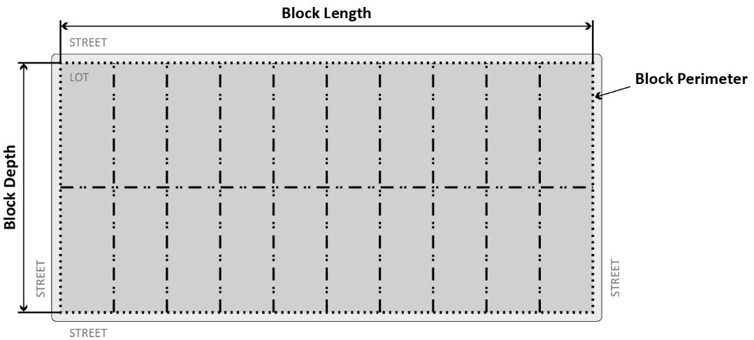
C.
Streets. Refer to § X-3.D (Street Type Standards) for street design standards by street type.
D.
Lots. The following standards apply to the dimensions, configuration, and orientation of lots.
1.
Lot Dimensions. All lots of record shall be developed to meet the applicable zoning district requirements established in Article IV (Zoning District Regulations).
2.
Lot Configuration. All lots shall have frontage along a publicly dedicated and maintained street.
a.
Lot Shape. Interior side lot lines shall be perpendicular to the right-of-way to the extent practical.
b.
Through Lots. The creation of new through lots is prohibited unless subdivision of an existing through lot results in new through lots.
c.
Flag Lots. Flag lots are prohibited.
3.
Lot Orientation. Lot orientation along an east-west longitudinal axis is recommended when feasible for increased energy efficiency.
(Ord. No. 2078, 12-11-17)
§ X-3 - Street Standards
A.
General Provisions.
1.
Intent. The standards established in this Section are intended to:
a.
Create complete streets that facilitate all modes of travel, including pedestrian traffic, bicycle traffic, transit, and vehicular traffic.
b.
Continue to provide a logical and comprehensible system of streets and street names that result in a simple and consistent pattern of blocks, lots, and house numbers.
c.
Create streets that are appropriate for their contexts and are designed to encourage travel at appropriate volumes and speeds.
d.
Encourage streets that respect natural features by following topography and drainage systems.
e.
Create streets and public rights-of-way that help to reduce stormwater runoff and improve the quality of runoff.
2.
Applicability. All provisions of this Section shall be installed, constructed, or otherwise made effective for every subdivision that includes streets established within the Village.
3.
General Requirements. All proposed streets, parkways, and sidewalks shall be located in dedicated rights-of-way as required by this Article.
a.
Street Types. All new streets shall meet the requirements of the street types designated in § X-3.D.2. Street Type Design Standards. Street types shall be approved by the Village Board pursuant to the recommendation of the Zoning Administrator based on the objectives of the Village's Comprehensive Plan elements and the other land use policies of the Village. Street type approval and subdivision approval shall occur simultaneously in accordance with Article IX (Subdivision Applications).
b.
Typical and Alternative Street Types. Typical and alternative versions of Avenue, Industrial, and Neighborhood Streets are designated in § X-3.D.2 (Street Type Design Standards), which provide several acceptable configurations for each respective street type.
c.
Public Use. All streets shall be available for public use at all times. Gated streets and private streets are not permitted.
d.
Right-of-Way Features. Where the design requirements of this Section stipulate the provision of turning lanes, turning radii, center medians, traffic control devices, or other features which cannot be accommodated within the existing right-of-way, the developer shall dedicate additional rights-of-way as necessary to accommodate the required features.
e.
Street Lighting.
(1)
Location. Street lighting shall be installed in the following locations.
(a)
At all street, township, county, and state highway intersections.
(b)
At all intersections where the right-of-way of at least one street is 66 feet or greater.
(c)
At all Neighborhood Street cross or tee intersections.
(d)
At the end of streets and the turn-around point of culs-de-sac.
(e)
At mid-block of all blocks, or at a spacing not to exceed 250 feet.
(f)
At all major curves in street alignment.
(g)
For Avenues and Connectors, street lighting shall conform to the requirements of the IDOT Bureau of Design and Environment Manual.
(2)
Illumination. Illumination shall not exceed the following intensities.
(a)
Residential zoning districts within the right-of-way shall not exceed 0.5 foot-candles.
(b)
Residential zoning districts on residential property shall not exceed 0.2 foot-candles.
(c)
Non-residential zoning districts within the right-of-way shall not exceed 0.5 footcandles.
(d)
Non-residential zoning districts on non-residential property shall not exceed 2.0 footcandles.
(3)
Mounting Height. Mounting height for street lighting shall be no less than 25 feet and no more than 30 feet.
(4)
Luminaires. Street lighting shall be installed with LED luminaires or similar energy efficient technology.
f.
Street Names. New street names shall not duplicate any existing street name in the Village except where a new street is a continuation of an existing street.
g.
Street Trees. Street trees shall be installed throughout the subdivision in accordance with the following specifications.
(1)
Frequency. Shade trees shall be installed at a minimum rate of one shade tree per 30 linear feet, with planted trees selected for appropriate size at maturity for the subject parkway width, based on consultation with the Village Arborist and Village Engineer. Trees shall be placed on center, or at a rate that matches the existing tree spacing pattern on adjacent parkways, whichever results in a greater density of tree plantings. Spacing may be adjusted to ensure adequate room for streetlights and utilities, with prior written Zoning Administrator approval.
(2)
Species Diversity. It is recommended that not more than five percent of any one species, ten percent of any one genus or 20 percent of any one family be planted within the Village. Broad species diversity within individual streets will result in reduced catastrophic loss due to a disease or pest.
(3)
Tree Species Not Permitted. The only tree species that shall be permitted for planting as street trees are those listed as preferred on the Morton Arboretum Northern Illinois Tree species List.
(4)
Trunk Diameter. The trunk diameter of street trees at the time of installation shall be a minimum of three inches, measured at a height of six inches above finished ground level.
(5)
Drought and Salt Tolerance. All street trees proposed to be planted shall be drought- and salt-tolerant. Refer to The Morton Arboretum Northern Illinois Tree Species List for preferred plant species.
(6)
Tree Wells. Tree wells shall be utilized in locations where the sidewalk extends from the back of the curb to the lot line.
(7)
Structural Soil. A minimum volume of 1,000 cubic feet of structural soil is required per large street tree, and 750 cubic feet per medium street tree, to accommodate subsurface root expansion.
B.
Street Design Standards for All Street Types.
1.
General Street Layout Requirements. The following standards apply to new or newly-platted streets.
a.
Curved Streets.
(1)
Horizontal Alignment. When street lines deflect from each other by more than ten degrees in horizontal alignment, the centerline shall be connected by a curve with a minimum radius meeting American Association of State Highway and Transportation Officials (AASHTO) standards.
(2)
Vertical Alignment. The vertical alignment shall be selected with minimum sight distances designed to AASHTO standards.
b.
Interconnected Streets. The network of streets shall form an interconnected grid pattern, with multiple intersections when appropriate, and provide for the continuation of existing streets from adjoining areas into new subdivisions.
c.
Disconnected Streets. Disconnected streets may take the following forms.
(1)
Cul-de-Sac Streets. Cul-de-sac streets are prohibited in new subdivisions unless approved by the Village Board due to site constraints such as topography, natural features, or manmade barriers such as a railroad or raised highway. When cul-de-sacs are allowed, the following standards apply.
(a)
The cul-de-sac shall not be more than 400 feet in length as measured along the centerline from the closest intersection. Special consideration may be given for longer cul-de-sacs under certain topographic conditions or other unique situations.
(b)
Circular turn-around areas shall adhere to the following turning radii:
i.
The R-1, R-2, R-3, and R-4 Districts shall utilize a maximum outside turning radius of 30 feet.
ii.
The C-1, C-2, C-3, and M Districts shall utilize a maximum outside turning radius of 50 feet.
(c)
When the center point of a cul-de-sac is within 350 feet of another street or cul-de-sac right-of-way and no connection to that other right-of-way exists, pedestrian access shall be provided along a public easement between the lots. Refer to Figure X-3-A. Pedestrian Connection from Cul-de-Sac.
i.
The public easement for pedestrian access shall be a minimum of 15 feet wide.
ii.
Pedestrian access shall include a multi-use path constructed of a permanent surface approved by the Village Engineer, with a minimum width of ten feet, and lighting approved by the Zoning Administrator.
iii.
Maintenance of the easement area shall be the responsibility of adjacent property owners or another group specifically designated in the final plat.
(d)
Treatment of Natural Features. Streets shall be designed to respect natural features, such as rivers, woodlands, or slopes, by following, rather than interrupting or deadending at, the feature.
(e)
Snow Storage. A plan for snow removal for any cul-de-sac shall be designed in consultation with the Village Engineer, and included as a note on the final plat.
Figure X-3-A. Pedestrian Connection from Cul-de-Sac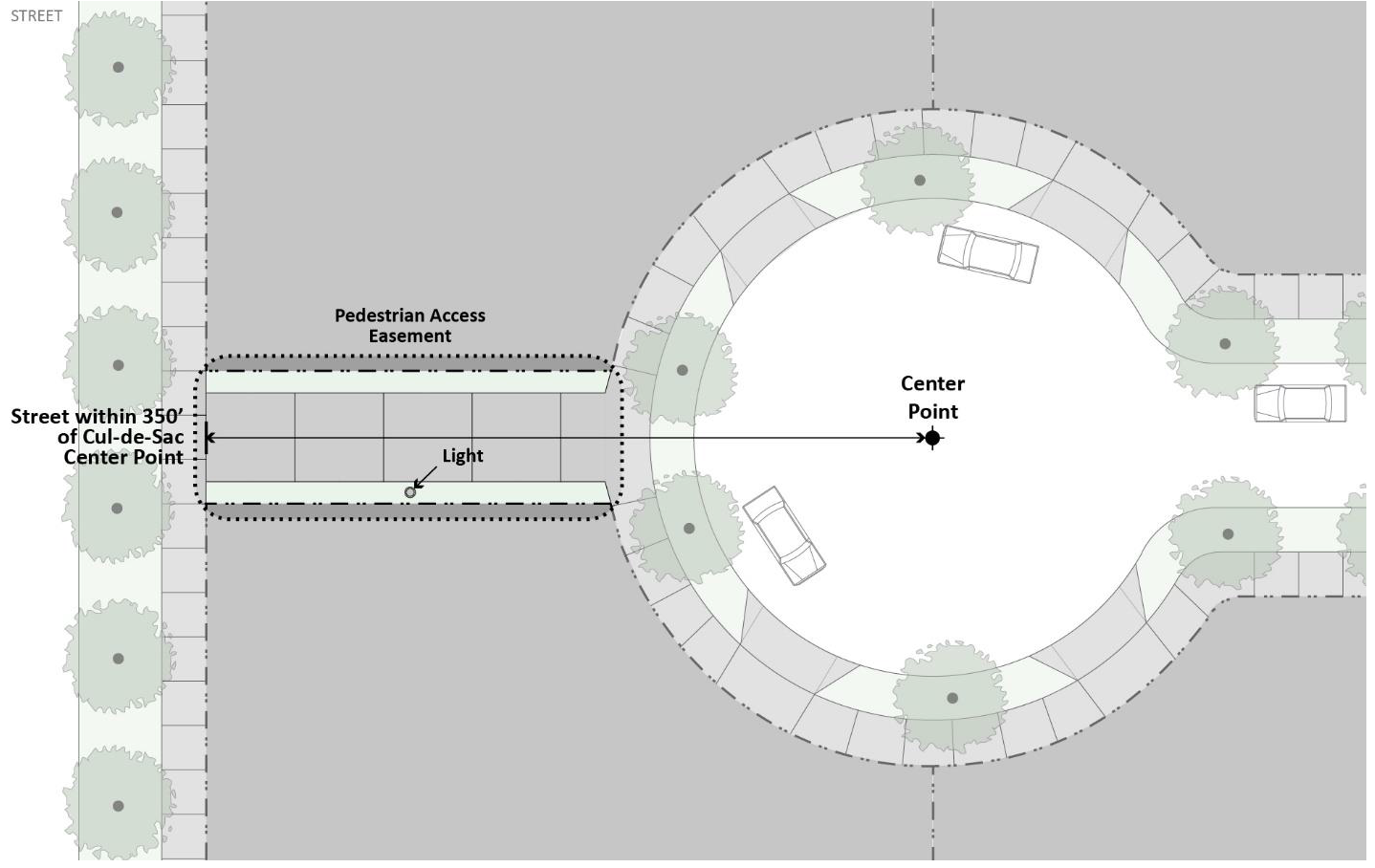
(2)
Stub Streets. Where adjoining areas are not subdivided, stub streets in new subdivisions shall be extended to the boundary line of the tract to provide for the future connection of streets.
(a)
Where abutting property is not subdivided, stub streets shall be provided at intervals no greater than 400 feet.
(b)
Existing stub streets adjacent to a proposed subdivision shall be connected.
(3)
Half Streets. The construction of a half street is prohibited unless otherwise approved by the Village Board in unique circumstances where a half street is essential and where satisfactory assurance for dedication of the remaining half of the street is provided.
(a)
Proposed half streets along the periphery of a subdivision shall have no less than one half of the right-of-way dedicated and constructed.
(b)
Existing half streets adjacent to a proposed subdivision shall be completed with the dedication of the remaining right-of-way and the completed development of the proposed subdivision.
2.
Intersection Design.
a.
Applicability. The following standards apply to all new and reconstructed intersections.
b.
Alignment of Intersections. New streets shall be aligned with existing streets whenever feasible.
(1)
Number of Streets. No more than two streets shall intersect at any point.
(2)
Angle of Intersection. Streets shall be aligned to intersect at right angles whenever possible. The angle of intersection of center lines shall not be less than 80 degrees or more than 100 degrees.
(3)
Centerline Offsets. Refer to Figure X-3-B. Minimum Street Centerline Offset.
(a)
Centerline offsets of less than 200 feet shall be prohibited. Centerline offsets shall also be sufficient for any turn lane storage bays and tapers that are required.
(b)
Driveways serving commercial, industrial, institutional, or multi-family land uses shall not be permitted within the 200-foot offset unless they are restricted to right-in/right-out ingress and egress.
Figure X-3-B. Minimum Street Centerline Offset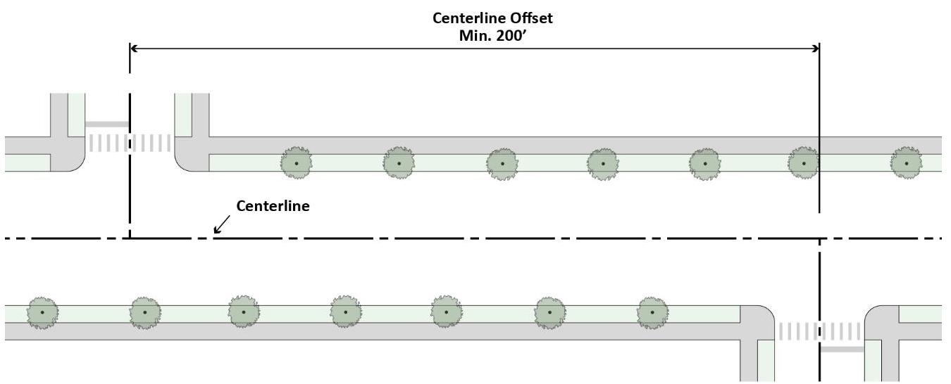
(4)
Clear Sight Triangles. Minimum clear sight distance at all intersections in accordance with § II-5.C (Visibility Obstruction).
(5)
Vertical Alignment. An extension of the through street cross slope shall be provided.
(a)
This cross slope shall be carried back 100 to 200 feet each way from the intersection of the two centerlines.
(b)
An allowance of two percent maximum intersection grade shall be permitted.
c.
Curb Radii. The following curb radii shall be utilized unless otherwise authorized by the Village Engineer.
(1)
Design Vehicle Used. Intersections shall be designed using the maximum design vehicle that accommodates the street users. The design vehicle used shall consider and balance the needs of the various users of the street, including pedestrians, bicyclists, and vehicles, and the volume and frequency of these users.
(2)
Corner Radii. Intersections shall be designed for the effective turning radius of the chosen design vehicle, as opposed to the actual curb radius, as illustrated in Figure X-3-C. Effective right Turn Radius. Refer to Table X-3-A. Minimum Curb Return Radii Standards and in accordance with § X-3.D (Street Type Standards).
(3)
Larger Radius. When the design vehicle requires a larger curb radius than permitted by Table X-3-A. Curb Return Radii Standards, a larger radius is permitted with approval of the Village Engineer.
Figure X-3-C. Effective Right Turn Radius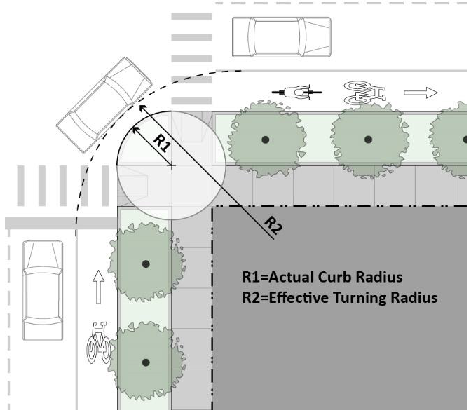
Table X-3-A. Minimum Curb Return Radii Standards
d.
Crosswalks. Crosswalks shall be required at all intersections.
(1)
Dimensions. Crosswalks shall be a minimum of six feet in width, measured from mid-stripe to mid-stripe, per the Manual on Uniform Traffic Control Devices.
(2)
Markings. Crosswalks shall be appropriately indicated on the finished street surface with highly visible painted markings and/or textured or colored pavement.
(3)
Crossing Distances. To encourage pedestrian activity and safety, pavement width shall not extend over 38 feet without intervening installation of a landscape median, curb extensions, or other acceptable pedestrian refuge.
e.
Curb Extensions. Curb extensions shall be installed at the intersections of all street types that contain an on-street parking lane adjacent to the curb, to support pedestrian activity at corners and shorten crossing distances. Curb extensions shall contain landscaped bioretention cells to facilitate stormwater infiltration, as established in § X-3.D.1.f (Stormwater Management Facilities).
f.
Median Pedestrian Refuges. At any intersection requiring a pedestrian to cross more than three lanes of vehicle travel, a median pedestrian refuge shall be installed to provide adequate pedestrian safety. The refuge cut-through or ramp width shall equal the width of the crosswalk. Refer to Figure X-3-D. Median Pedestrian Refuge Design.
Figure X-3-D. Median Pedestrian Refuge Design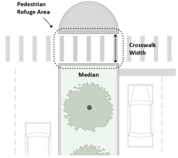
g.
Accessible Ramps and Warning Panels. Accessible ramps and warning panels are required where all sidewalks or trails terminate at a crosswalk or curb, per the Americans with Disabilities Act or any more stringent state requirement. Two ramps per corner at intersecting streets are required and shall be oriented perpendicular to traffic.
3.
Curbs and Gutters. The dimensions and materials of all curbs, driveway curbs, and gutter installations shall be determined in consultation with the Village Engineer.
C.
Street and Sidewalk Construction Standards. All construction in the right-of-way shall follow specifications defined by the Department of Public Works and shall be available from the Village.
D.
Street Type Standards.
1.
General Street Type Standards.
a.
Applicability. This Section establishes street types that depict acceptable street configurations to be applied to all new streets within subdivisions. The Zoning Administrator may require additions or reductions to the right-of-way, pavement width, or additional street elements depending on unique site characteristics. Refer to Table X-3-B. General Street Type Standards, which summarizes the requirements of each street type.
b.
Typical and Alternative Street Types. Typical and alternative versions of all street types are designated in § X-3.D.2 Street Type Design Standards, which provide examples of acceptable configurations for each street type.
c.
Graphics. The graphics provided to illustrate each street type are examples of potential configurations of that street type. Other configurations may be deemed acceptable by the Village Engineer.
d.
Typical Street Elements. Typical elements of a street are divided into the vehicle and pedestrian realms. Each street type detailed in this Article identifies which facilities are applicable. Refer to Figure X-3-E. Typical Right-of-Way Elements.
Figure X-3-E. Typical Right-of-Way Elements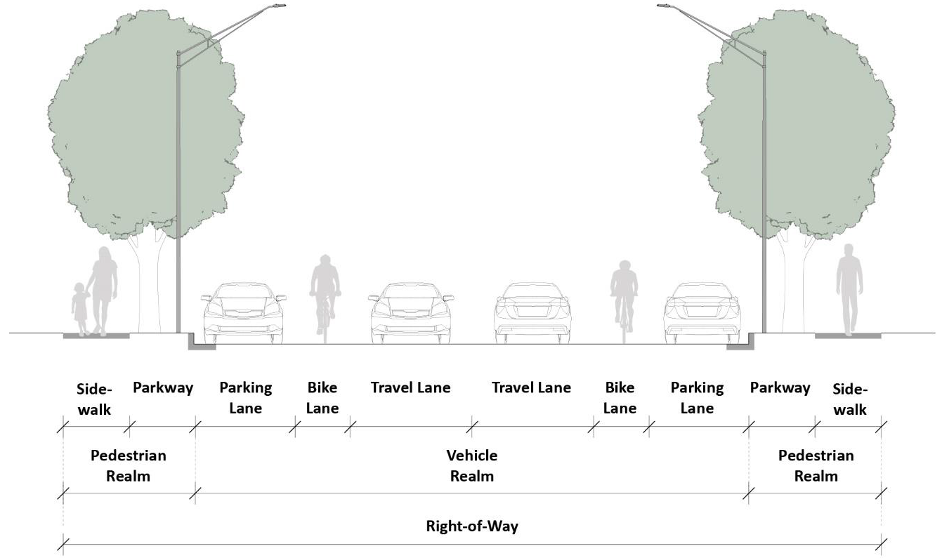
Table X-3-B. General Street Type Standards
e.
Bicycle Facilities. Three types of bicycle facilities are permitted in the vehicle realm. One off-street bicycle facility is permitted within the pedestrian realm. Refer to Figure X-3- F. Bicycle Facilities.
(1)
Dedicated Bicycle Lane. Dedicated bicycle lanes are striped lanes on the outside of the outermost vehicular travel lanes that are designated for bicycle use. This lane occurs on both sides of the street and shall be a minimum of five feet wide.
(2)
Designated Shared Lane. A designated shared lane is a lane that is shared by vehicles and bicycles. This designated shared lane shall be a minimum of 14 feet wide, which is wider than a standard vehicle lane in order to accommodate both vehicles and cyclists. The designated shared lane shall include a painted bicycle marker combined with a double arrow (known as a "sharrow" or "shared lane marking"). On two-way streets, a designated shared lane is required in both directions.
(3)
Shared Lane. A shared lane refers to a street that does not have dedicated bicycle lanes or designated shared lanes, but the speed and configuration of the street allows bicycles to comfortably share lanes with traffic.
(4)
Sidepath. A sidepath is an off-street facility that is shared between pedestrians and bicycles. This path functions like a sidewalk but is wide enough to accommodate bicyclists and pedestrians simultaneously. Sidepaths are required on both sides of the street and shall be a minimum of 10 feet wide.
Figure X-3-F. Bicycle Facilities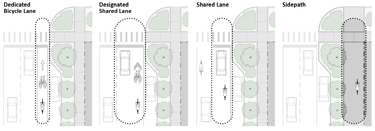
f.
Stormwater Management Facilities. Stormwater management facilities shall be integrated within the right-of-way as part of the design of all street types to help clean and infiltrate stormwater runoff in accordance with the following requirements. Examples of such facilities are illustrated in this Section (refer to Figure X-3-G. Bioswale Design, Figure X-3-H. Bioretention Planter Design, and Figure X-3-I. Bioretention Curb Extension Design).
(1)
Bioswales, bioretention planters, or other stormwater management best management practices (BMPs) accepted by the Village Engineer shall be installed within all new parkways.
(2)
Bioretention cells shall be included within curb extensions at intersections for all street types when a parking lane is adjacent to the parkway. Cells may extend into the parkway.
Figure X-3-G. Bioswale Design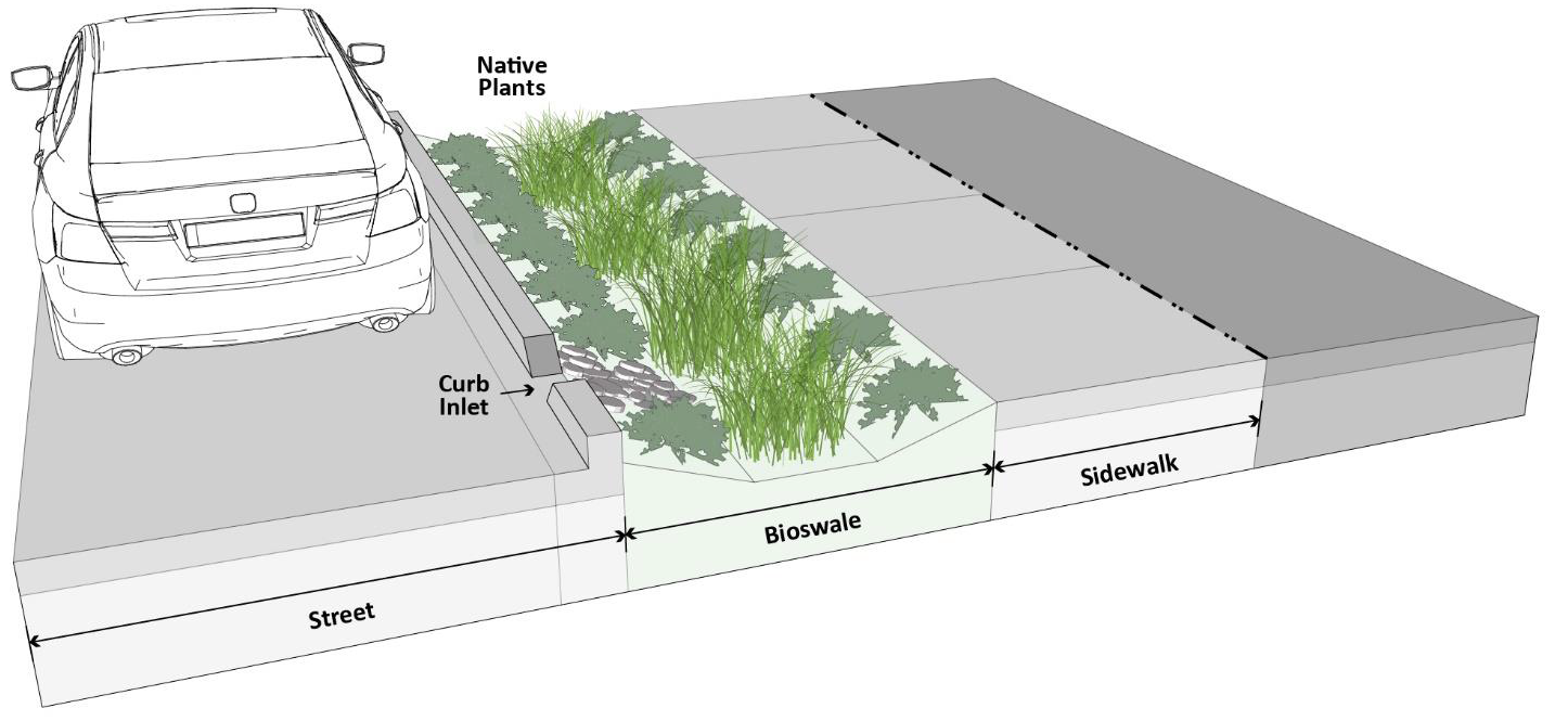
Figure X-3-H. Bioretention Planter Design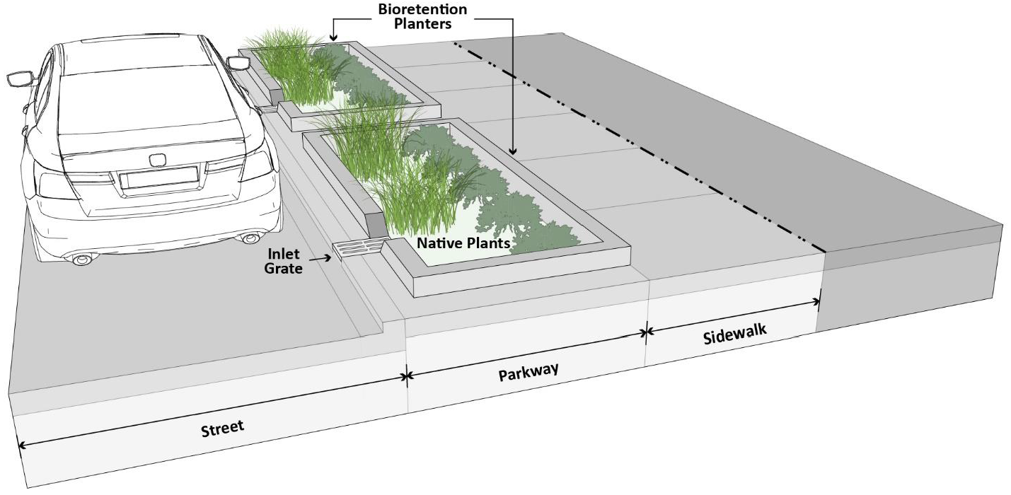
Figure X-3-I. Bioretention Curb Extension Design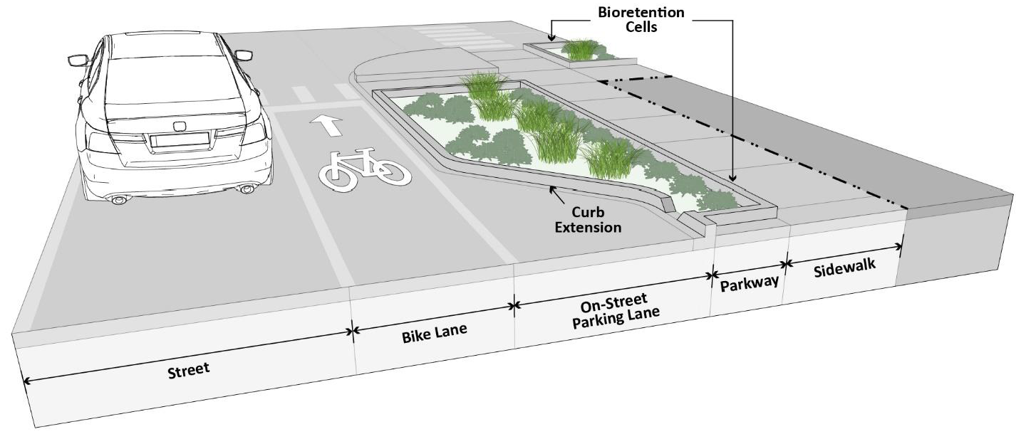
2.
Street Type Design Standards.
a.
Avenue. Refer to the typical plan and section, Figure X-3- J. Typical Avenue and Figure X-3-K. Alternative Avenue.
(1)
Intent. The Avenue is a high capacity street with a wider right-of way than other street types, designed for moderate speeds. It serves higher-intensity development and provides crosstown connections.
(2)
General Requirements. Avenues shall be developed using the standards in Table X-3-C. Avenue Requirements.
Table X-3-C. Avenue Requirements
Figure X-3-J. Typical Avenue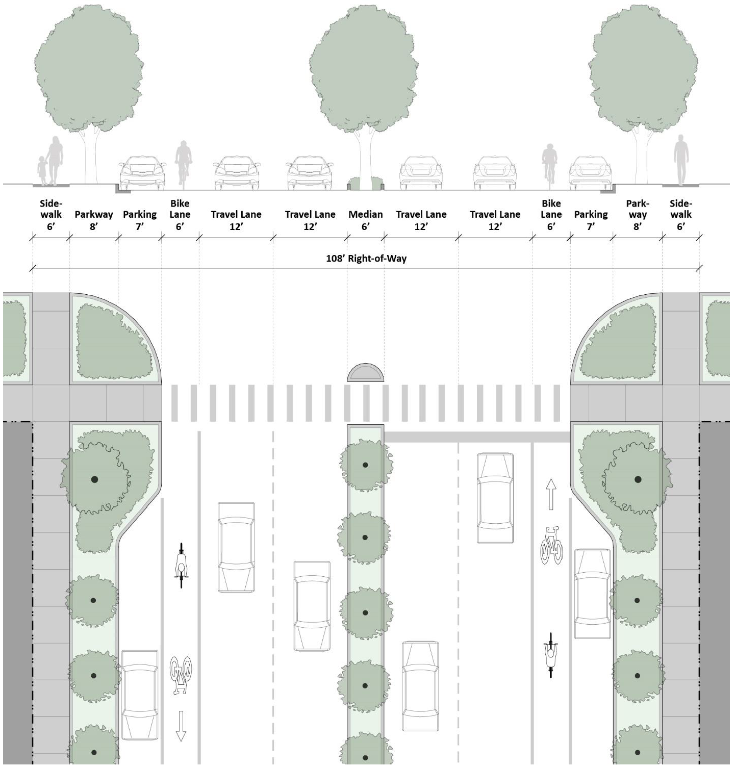
Figure X-3-K. Alternative Avenue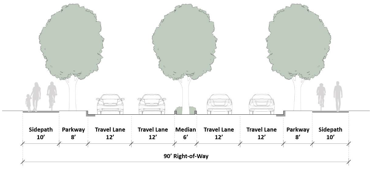
b.
Connector. Refer to the typical plan and section illustrations, Figure X-3-L. Typical Connector and Figure X-3-M Alternative Connector.
(1)
Intent. The Connector is a medium capacity street, designed for moderate speeds. It primarily serves as a through street and connects Neighborhood Streets and Avenues.
(2)
General Requirements. Connectors shall be developed using the standards in Table X-3-D. Connector Requirements.
Table X-3-D. Connector Requirements
Figure X-3-L. Typical Connector
Figure X-3-M. Alternative Connector
b.
Industrial Street. Refer to the typical plan and section illustrations, Figure X-3-N. Typical Industrial Street and Figure X-3-O. Alternative Industrial Street.
(1)
Intent. The Industrial Street is a medium capacity street designed for low to moderate speeds with a right-of-way that accommodates larger vehicles than other street types.
(2)
General Requirements. Industrial Streets shall be developed using the standards in Table X-3-E. Industrial Street Requirements.
Table X-3-E. Industrial Street Requirements
Figure X-3-N. Typical Industrial Street
Figure X-3-O. Alternative Industrial Street
c.
Neighborhood Street. Refer to the typical plan and section illustrations, Figure X-3-P. Typical Neighborhood Street and Figure X-3-Q. Alternative Neighborhood Street.
(1)
Intent. The Neighborhood Street is a low capacity street designed for slow speeds. It primarily serves the area directly adjacent to it.
(2)
General Requirements. Neighborhood Streets shall be developed using the standards in Table X-3-F Neighborhood Street Requirements.
Table X-3-F. Neighborhood Street Requirements
Figure X-3-P. Typical Neighborhood Street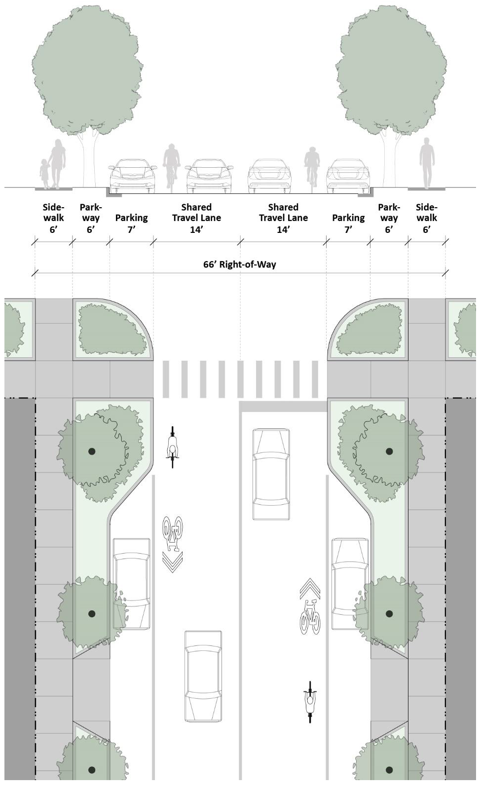
Figure X-3-Q. Alternative Neighborhood Street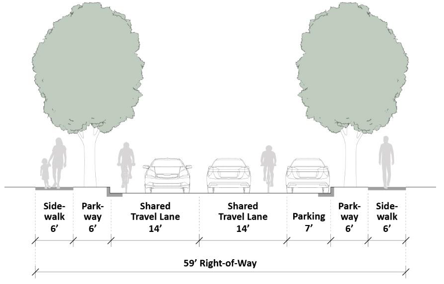
d.
Narrow Neighborhood Street. Refer to the typical plan and section illustration, Figure X-3-R. Narrow Neighborhood Street.
(1)
Intent. The Narrow Neighborhood Street is the Village's lowest capacity street and is designed to accommodate slow speeds and minimize the impervious surface area required for the roadway. It primarily serves the residential areas directly adjacent to it.
(2)
General Requirements. Narrow Neighborhood Streets shall be developed using the standards in Table X-3-G. Narrow Neighborhood Street Requirements.
Figure X-3-R. Narrow Neighborhood Street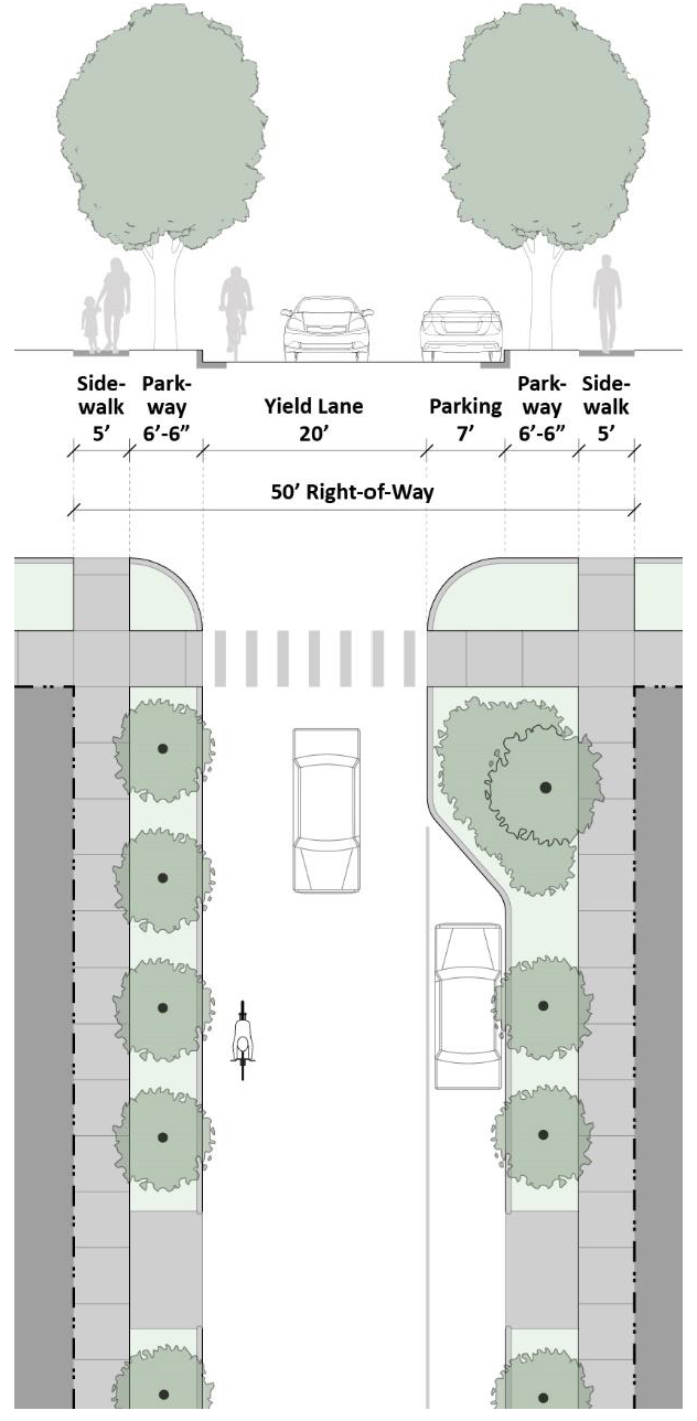
Table X-3-G. Narrow Neighborhood Street Requirements
e.
Alley. Refer to the typical plan and section illustration, Figure X-3-S. Typical Alley.
(1)
Intent. The Alley is a very low capacity street located at the rear or to the side of parcels that is used to minimize the need for curb cuts and driveways along other streets and provide access to parking, loading, and service areas.
(2)
General Requirements. Alleys shall be developed using the standards in Table X-3-H. Alley Requirements. The Zoning Administrator may require additional pedestrian safety devices at the intersection of an Alley with sidewalks of other rights-of-way.
Figure X-3-S. Typical Alley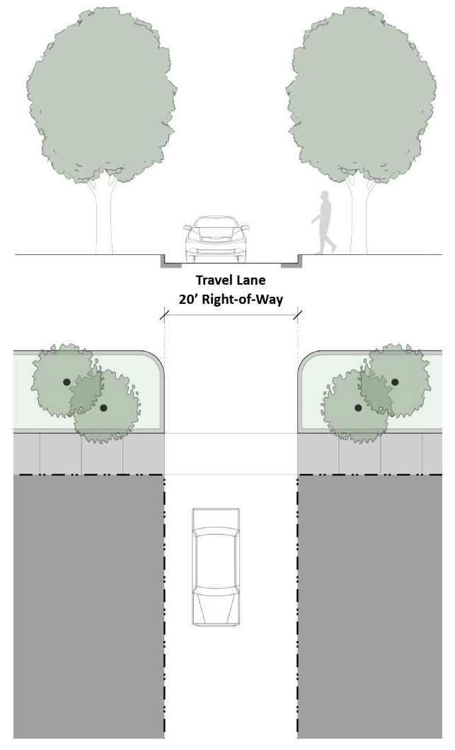
Figure X-3-S. Typical Alley
Table X-3-H. Alley Requirements
(Ord. No. 2078, 12-11-17)
§ X-4 - Required Public Improvements
Public improvements, such as water supply, sanitary sewer, stormwater management, and other utilities, shall be provided as follows.
A.
Water Supply.
1.
Provision of Service. The developer must provide the development with a complete water main supply system that is connected to a public water supply system.
a.
General Requirements. The system shall provide reliable and adequate water supply, with sufficient pressure, to the uses anticipated within the subdivision, including fire flow, and shall be constructed according to the specifications and performance standards established by the Village and any other agencies that have jurisdiction.
b.
Individual Water Supply. If good and sufficient reason can be demonstrated that such connection cannot be made, the developer must provide an individual water supply on each lot in the development in accordance with the requirements of the Cook County or Will County Health Department, whichever has jurisdiction.
2.
Water Mains.
a.
Construction Standards. All water mains and appurtenances must meet the requirements of the latest edition of the Standard Specifications for Water and Sewer Construction in Illinois.
b.
Minimum Diameter. Water mains shall be at least eight inches in diameter, and include installation of shutoff valves and fire hydrants.
3.
Fire Hydrants.
a.
General Requirement. Fire hydrants must be installed throughout a development when serviced by a public water supply system, per the current requirements of the Fire Department.
b.
Frequency of Installation. Fire hydrants must be installed at intervals of no more than 300 feet, unless otherwise authorized by the Fire Department.
c.
Location. The locations of the fire hydrants shall generally take advantage of clear space adjacent to driveways and be coordinated with the Fire Department.
B.
Sanitary Sewer.
1.
Public Treatment. A complete sanitary sewer system must be provided that connects all lots in the subdivision with a public sanitary sewer system.
2.
Construction Standards. The public sanitary sewer system and treatment plan shall conform to the requirements set forth in the latest edition of the Standard Specifications for Water and Sewer construction in Illinois and the Thorn Creek Basin Sanitary District Requirements for Permitting and Construction of Sanitary Sewer Extensions, Sanitary Sewer Connections, and Building Demolition.
C.
Stormwater Drainage and Management. All development must comply with Article XI (Stormwater Management) of this Ordinance. Stormwater best management practices (BMPs) should be incorporated into the storm sewer system as much as practical.
D.
Communication, Power, and Other Utilities.
1.
Location of Utility Lines. All communication, power, and other utility lines, except power lines carrying 12,000 volts or more, must be placed underground within easements or dedicated public ways.
2.
Compliance. The installation of such facilities must be made in compliance with the applicable regulations of the Illinois Commerce Commission. The owner or subdivider of any property served by underground installations is responsible for compliance with the applicable regulations of the Illinois Public Utilities Act (220 ILCS 5/1-101 et seq.) for any public utility whose services will be required for the provision of underground facilities.
3.
Utility Clustering. Utility services should be clustered within a single easement when practical.
E.
Easements.
1.
Easement Provision. Easements must be provided for utility services and drainage including, but not limited to, sanitary sewer, storm sewer, water, gas, telecommunication, cable television, and electric. The location of a utility easement is determined by the developer and/or the appropriate utility company, to be reviewed and approved by the Village Engineer. These easements must be marked on the plat.
2.
Use of Easements. Easements are reserved for the performance of municipal and governmental services, including sanitary sewer, storm sewer, and water service and maintenance, and for those utility companies that operate within the Village.
3.
Right to Access and Modify. The Village and utility companies have the perpetual right, privilege, and authority to construct, reconstruct, repair, inspect, maintain, and operate the utility transmission and distribution systems as part of such easement, together with right of access across the property for necessary personnel and equipment to do work.
4.
Building Limitations. Principal buildings, accessory structures (with the exception of fences), including temporary structures, are prohibited within the easement. The easement may be used for landscape and other purposes that do not interfere with the utility and its maintenance. The Village or utility retains the right to cut down, trim, or remove any fences, accessory structures, temporary structures, trees, shrubs, or other plants that interfere with operation of the utilities within the easement area, without compensation.
(Ord. No. 2078, 12-11-17)
§ X-5 - Park Site Dedication
A.
Purpose. The purpose of this Section is to provide for the immediate and future needs of residents for park and recreation land and facilities.
B.
Applicability. The requirements of this Section shall apply to the following:
1.
New building permits issued for construction on a vacant lot that results in one or more dwelling units.
2.
New residential subdivisions that create one or more lots.
3.
New residential planned unit developments of five acres or more.
4.
Any annexation of land for new residential subdivisions or residential planned unit developments of five acres or more.
C.
General Provisions.
1.
Title. A clear title to the land to be dedicated shall be delivered within 30 days after the recording of a final plat, unless otherwise negotiated between the Village and the developer.
2.
Payments. Payments covering fees in lieu of land dedication and the initial improvements fee shall be calculated according to the number of dwelling units in the subdivision and a proportionate amount shall be paid at the time a building permit is issued.
3.
Park Contributions Account. All monies received as park contributions shall be paid into a park contributions account established by the Village. Such funds shall be disbursed only for park acquisition and/or improvement purposes for existing parks within the Village.
4.
Park Improvements Credit. The Village Board may recognize existing or proposed park improvements as equal to or greater than the value of the improvement fees required in this Section and may credit the development's total required park contribution with the additional value of such site improvements.
5.
Planned Unit Developments. Park site dedication for planned unit developments shall be provided in accordance with § VIII-4.G (G. Zoning District Exceptions and Provision of Community Amenities).
D.
Land Dedication Requirements. The developer is required to dedicate land according to the formula set forth in Table X-5-A. Determination of Total Park Contribution Per Development, or to make a cash contribution in lieu of actual land and remit any fees as established in this Section.
1.
Siting. The dedicated site shall be usable for active or passive recreation and sited in an accessible location. The slope, geology, and topography of the dedicated site shall be compatible with the surrounding neighborhood to the greatest extent possible.
2.
Consistency with Comprehensive Plan. The location of park sites shall be guided by the goals and objectives of the Village's comprehensive plan elements and other land use policies. Open space areas may be designed to include wetlands that facilitate stormwater management in order to contribute to the character of the Village's existing open space areas.
3.
Condition of Land. Dedicated land shall be in a condition ready for improvement, including proper site drainage and curb and gutter treatment consistent with the remainder of the development. Original topsoil and vegetative cover shall either remain undisturbed or shall be prepared with topsoil in a manner consistent with the remainder of the development.
Table X-5-A. Determination of Total Park Contribution Per Development
TPC = (AD x IIF) + (AD x FMV) or (AD in land dedicated)
TPC = Total park contribution.
AD = Acreage demand for parks based upon population generated.
IIF = Initial improvements fee per acre, adopted to fund initial improvements for park land ($30,000).
FMV = Fair market value, adopted average cost per acre to purchase park land ($33,000).
E.
Land Dedication Calculation.
1.
Park Acreage Requirement. The amount of required park land shall be determined by the ultimate density of the proposed development. For parks, 10 acres of park land per 1,000 residents shall be dedicated.
2.
Determination of Population Density. The population density projection set forth in Table X-5-B. Ultimate Population Per Dwelling Unit, which was prepared by the Illinois School Consulting service, is generally indicative of current and short-range projected trends in family size for new construction and shall be used in calculating the amount of required dedication of acres of land or the cash contributions in lieu thereof unless a written objection is filed by the subdivider.
3.
Land Dedication Formula. The following formula determines how many acres are required to be dedicated:
a.
The total type of each unit to be built is multiplied by the total number of people in the dwelling unit for each type of unit per Table X-5-B. Ultimate Population Per Dwelling Unit.
b.
The total number of people in all dwelling units is divided by 1,000.
c.
The result of such division is then multiplied by ten to determine total acreage needed for park land dedication.
Table X-5-B. Ultimate Population Per Dwelling Unit
(Source: 1996 Illinois School Consulting Service, Naperville, IL)
F.
Initial Improvements Fee. In order to provide for the initial improvement of areas and facilities to serve the residents of the dwelling units proposed, an initial improvements fee shall be assessed. An initial improvements fee of $30,000.00 per acre of dedicated park land is necessary to provide for initial and partial site improvements.
G.
Criteria for Requiring Park Land Dedication.
1.
General Uses and Location. The dedicated site shall be used for active recreation and located so as to be accessible and largely visible from public streets and the surrounding neighborhood. The slope, topography, and geology of the dedicated site shall be compatible with the surrounding neighborhood. Land in the floodplain and areas that may flood periodically as part of the development's stormwater detention system may be considered acceptable locations for park site dedication.
2.
Compatibility with Current Plans. The elements of the comprehensive plan, park and open space plans, and plans for unincorporated lands will be used to guide the location of park sites. Land dedication will only be accepted in those instances where a subdivider owns land in reasonable proximity to a planned future park site or is comparable thereto. In all other cases, the payment of fees in lieu of actual land is required.
3.
Condition of Dedicated Land. Dedicated land shall be in a condition ready for facility development including proper site drainage and curb and gutter treatment in a manner consistent with the balance of the development. Original topsoil and vegetative cover shall either remain undisturbed or the site shall be prepared with topsoil, fine-graded, and seeded in a manner consistent with the balance of the development.
H.
Criteria for Establishment of Fees.
1.
Determination of Amount of Fees. The cash contribution in lieu of land shall be determined by multiplying the acreage demand for a given development by the average fair market value for park acquisition.
2.
Determination of Fair Market Value. The average fair market value for acquiring improved land in the Village is $33,000 per acre. The fair market value will be utilized in computing fees in lieu of land dedication unless the subdivider files a written objection. The fair market value established by this Section shall only be a guideline for any final plat of subdivision resulting from an annexation of property to the Village or of a final plat of a planned unit development. In such case, fair market value may be negotiated between the subdivider and the Village on a case by case basis.
I.
Appeals. The Village Board shall make the final decision concerning any appeal brought by a developer.
1.
Fair Market Value. In the event of a written objection to the determination of fair market value, the developer shall submit an appraisal or other evidence showing fair market value of such land in the area of the subject development, after which a determination of appropriate fair market value shall be made by the Village Board.
2.
Population Density Tables. In the event of a written objection to the population density tables, the developer shall submit their own demographic study showing estimated population per dwelling unit type, after which a determination of appropriate population density shall be made by the Village Board.
3.
Site Improvement Fees. In the event of an objection concerning the site improvement requirements, improvements fees, or inclusion of detention areas, the developer shall submit their objections and proposed action in writing, after which a determination shall be made by the Village Board.
(Ord. No. 2078, 12-11-17)
§ X-6 - School Site Dedication
A.
Purpose. The purpose of this Section is to provide for the immediate and future needs of residents for school land and facilities.
B.
Applicability. The requirements of this Section shall apply to the following:
1.
New residential subdivisions that create five or more lots.
2.
New residential planned unit developments of five acres or more.
3.
Any annexation of land for new residential subdivisions or residential planned unit developments, of five acres or more.
C.
Criteria for Requiring School Site Dedication.
1.
Requirement and Population Ratio. The number of students that will be generated by a residential subdivision or planned unit development will have a direct impact on the amount of land required for school site dedication. The land dedication requirement shall be determined in accordance with the data for the estimated number of children entering school by type of dwelling unit in accordance with Table X-5-B. Ultimate Population Per Dwelling Unit.
2.
Location of Site. The location of school sites shall be guided by the goals and objectives of the Village's comprehensive plan elements, other land use policies, and information provided by the local school district.
D.
Criteria for Requiring a Contribution in Lieu of a School Site.
1.
Small or Otherwise Inappropriate Sites. In cases where a development is small and the resulting site would not be practical or appropriate for a school, the Village shall require the subdivider to pay a cash contribution in lieu of land dedication required. The cash contribution shall be paid to the school district for school grounds to serve the immediate or future needs of children from that subdivision, or for improvements to an existing school site which already serves such needs. Small sites are those where the total number of proposed dwelling units is less than one-half the maximum number of students for each school classification as set forth in Table X-6-A. School Classifications and Size.
2.
Unsuitability to be Determined by Village. The determination that available land is unsuitable for a school site shall be made by the Village after inspection of the land by staff and after receiving the recommendation of the local school board and the subdivider affected. Any developer, subdivider, and/or builder affected may request a hearing before the Village Board on the question of whether the proposed land is inappropriate as a school site. Any developer, subdivider and/or builder affected, as well as the local school board, may present evidence at said hearing and in addition, the board, in its discretion, may hear evidence from other interested parties.
3.
Fair Market Value. The cash contributions in lieu of land shall be based on the fair market value of improved, subdivided land or, as platted within the development's final plat, or of vacant land which results in a net new dwelling unit, that otherwise would have been dedicated as a school site. The Village, based upon its investigation, has determined that the fair market value of any particular parcel, for purposes of this Article, shall be $33,000 per acre. The fair market value shall be used in the determination of cash contributions unless the developer, subdivider and/or builder, or any other subdivider, developer, and/or builder, or any public body, files a written objection thereto. In the event of any such objection, the objecting party shall submit an appraisal showing the fair market value of such improved land in the area of the development. Final determination of the fair market value of the improved land shall be made by the Village Board based on information submitted by the subdivider, other affected parties, and the Village.
4.
Time and Manner of Payment. The cash contribution required herein shall be paid at the time of final plat approval, or calculated according to the number of dwelling units in the subdivision with a proportionate amount paid at the time a building permit is issued for each unit. The amount of each payment shall be determined by the Village at the time of approval of the final subdivision plat, the final plan of a planned unit development, or the building permit, as the case may be.
E.
Conveyance of Site. Any land to be conveyed as a school site shall be conveyed to the applicable school district within 30 days after the recording of a final plat in accordance with the following criteria:
1.
Title to Site. All sites shall be conveyed by warranty or trustee's deed. The subdivider shall be responsible for conveying the title to the school district free of encumbrances unless the encumbrances are waived by the school district. The subdivider shall be responsible for the payment of all real estate taxes to the date of conveyance.
2.
Topography, Grading and General Suitability. The slope, geology, and topography of the dedicated site as well as its immediate surroundings must be suitable for its intended purpose. The site must be free of any environmental and archaeological concerns.
3.
Site Improvements. All sites shall be dedicated in a condition ready for full service of electrical, water, sewer, drainage and streets as applicable to the location of the site.
4.
Sale of Land. The school district may sell this land at its discretion. The proceeds of such sale shall be used in a manner consistent with the purposes of this Section.
F.
Criteria for Requiring Combined Land Dedication and Fee. In circumstances where a combination of land dedication and a contribution in lieu of land is necessary, the following regulations shall apply.
1.
If a portion of the land to be developed is proposed as the location for a school site, then that portion of the land within the subdivision falling within the school location shall be dedicated as a school site and a cash contribution in lieu shall be required for any land that would have been required to be dedicated.
2.
If a major part of the school site has already been acquired and only a small portion of land is needed from the development to complete the site then the remaining needed portions shall be required by dedication, and a cash contribution in lieu of the rest of the subdivider's obligation shall be required.
G.
Reservation of Additional Land. Where Village plans call for a school site in a proposed subdivision that is larger than the subdivider is required to dedicate then the land needed beyond the required contribution shall be reserved for subsequent purchase by the school district. This price shall be determined by the Village Board within one year of the date of an approved final plat.
H.
Combining with Adjoining Developments. Where appropriate, a school site that is to be dedicated should, if possible, be combined with dedications from adjoining developments in order to produce usable school sites without undue hardship on a particular developer.
I.
Density Formula.
1.
School Classifications and Size of School Site. School classifications and the size of school sites within the Village shall be determined in accordance with the criteria shown in Table X-6-A. School Classifications and Size, which is consistent with the minimum site recommendations of the Illinois office of Education Standards, as adopted by the Illinois State Board of Education.
2.
Determination of Population Density. The table of population density contained in Table X-5-B. Ultimate Population Per Dwelling Unit, is generally indicative of current and short-range projected trends in family size for new construction as determined by the Illinois School Consulting Service, and shall be used in calculating the amount of required dedication of acres of land or the cash contributions in lieu thereof unless a written objection is filed thereto by the subdivider with the Village Clerk.
3.
Determination by Village Board. In the event that a subdivider files a written objection to the determination of population density, the subdivider shall submit their own demographic study showing the estimated population to be generated from the subdivision. The final determination of the density formula to be used in such calculation shall be made by the Village Board after a hearing. At such hearing, the subdivider, the school district and other interested people, at the discretion of the board, may present demographic information.
4.
Land Dedication Formula. The ultimate number of students to be generated by a subdivision or planned unit development shall bear directly on the amount of land required to be dedicated for school sites. The land dedication requirement shall be determined by obtaining the ratio of estimated number of children in each school classification from the subdivision or planned unit development over the maximum recommended number of students to be served in each such school classification as stated in Table X-6-A. School Classifications and Size; then applying the resulting ratio to the required number of acres for a school site of each such school classification as stated in Table X-6-A. School Classifications and Size. The result is the number of acres of land deemed needed for school sites to serve the estimated increase in number of students for each such school classification.
Table X-6-A. School Classifications and Size
J.
Agreement Between School District and Subdivider. Nothing in this Article shall prohibit an alternative agreement between the school district and the subdivider for land dedication and/or contributions in lieu that satisfy the requirements of this Article. Evidence of this agreement shall be submitted by an authorized representative of the school district stating that the requirements of this article have been satisfied.
K.
Agreement Between the Village and Subdivider. Nothing in this Article shall prohibit an alternative agreement between the Village and the subdivider, for land dedication and/or contributions in lieu that satisfy the requirements of this Article. Evidence of this agreement shall be submitted by the Village stating that the requirements of this Article have been satisfied.
L.
School District Indemnification and Hold Harmless. All funds collected pursuant to the terms of this article shall be paid to the school district and are to be used by the school district for the purposes stated in this Article. The school district receiving funds shall indemnify, hold harmless, and defend the Village in any action or proceeding which may hereafter be commenced challenging the imposition, collection and transfer of any funds pursuant to this Article. Pursuant to this Section, the school district shall execute and deliver to the Village an indemnification and hold harmless agreement in a form approved by the Village Attorney.
(Ord. No. 2078, 12-11-17)