
Park Forest City Zoning Code
ARTICLE II
- ESTABLISHMENT OF ZONING DISTRICTS
§ II-1 - Purpose
The purpose of this Article is to establish the various zoning districts applicable to the Village and to introduce the Zoning Map.
(Ord. No. 2078, 12-11-17)
§ II-2 - Establishment of Zoning Districts
In order to carry out the purpose and intent of this Ordinance, the Village is hereby divided into the following zoning districts.
A.
Residential Districts.
1.
R-1: Single-Family Residence District. The R-1 Single-Family Residence District is established to accommodate residential development in a manner consistent with the character of most existing single-family neighborhoods in the Village. Single-family dwellings, along with limited civic and institutional uses, are allowed.
2.
R-2: Estate Residence District. The R-2 Estate Residence District provides for neighborhoods of larger-lot single-family dwellings in limited locations within the Village. Single-family dwellings, along with limited civic and institutional uses, are allowed.
3.
R-3: Traditional Multi-Family District. The R-3 Traditional Multi-Family District is established for areas featuring cooperative housing, rowhouses, two-family dwellings, and other types of multifamily housing in the Village. Limited civic and institutional uses are allowed.
4.
R-4: Urban Multi-Family District. The R-4 Urban Multi-Family District is designed to accommodate a mix of housing types, such as moderate-intensity multi-family units, rowhouses, live/work units, and small-lot single-family and two-family dwellings. Limited civic and institutional uses are allowed.
B.
Commercial Districts.
1.
C-1: Neighborhood Commercial District. The C-1 Neighborhood Commercial District is established for limited, small-scale mixed-use areas of the Village that primarily serve the surrounding neighborhoods. The C-1 District allows commercial, mixed-use, and office uses, as well as a variety of residential uses.
2.
C-2: Mixed-Use District. The C-2 Mixed-Use District is established to accommodate moderate-intensity mixed-use and pedestrian-oriented development in the Village's DownTown and transit-oriented development areas, as well as within other limited commercial nodes. The C-2 District allows a range of retail, service, office, multi-family, and institutional uses.
3.
C-3: Corridor Commercial District. The C-3 Corridor Commercial District is established to accommodate auto-oriented commercial development, primarily along Western Avenue, that serves the Village and surrounding communities. The C-3 District allows commercial, office, and institutional uses.
C.
Manufacturing District.
1.
M: Manufacturing District. The M Manufacturing District is established to provide for low-intensity industrial development in limited areas of the Village. The M District allows industrial uses, such as assembly, warehousing, distribution of goods, and light manufacturing, as well as limited institutional and commercial uses.
(Ord. No. 2078, 12-11-17)
§ II-3 - Zoning Map
A.
Establishment of Zoning Map. The location and boundaries of the districts established in § II-2 (Establishment of Zoning Districts) are hereby established on the map designated as the Zoning Map of the Village of Park Forest and referred to herein as the "Zoning Map." The Zoning Map is adopted by reference and declared to be part of this Ordinance.
1.
Location of Map. The Zoning Map shall be kept for reference as part of the Village's public website and in the offices of both the Village Clerk and Zoning Administrator.
2.
Zoning Map Amendments. All amendments to this Ordinance (refer to § VIII-3.E (Zoning Text and Map Amendment)) which involve a change to the district designation of a lot shall be recorded on the Village's official Zoning Map.
B.
Interpretation of Boundary Lines. The boundaries of all zoning districts shown on the Zoning Map shall be determined in accordance with the following rules:
1.
Right-of-Way Lines. Where zoning district boundary lines coincide with streets, alleys, railroads, easements, or similar rights-of-way, the centerline of the right-of-way shall be considered the boundary line of the district.
2.
Lot Lines. Where zoning district boundary lines coincide with a lot line, the lot line shall be considered the boundary line of the district.
(Ord. No. 2078, 12-11-17)
§ II-4 - Annexed Land
Unless designated otherwise as part of an annexation agreement, any property annexed to the Village shall be classified as R-1 Single-Family Residence District upon annexation and shall be subject to the requirements of the R-1 Single-Family Residence District until the property is rezoned.
(Ord. No. 2078, 12-11-17)
§ II-5 - Use of Land and Buildings
A.
Number of Buildings on a Lot. In the R-1 and R-2 Districts, no more than one principal building may be located on a lot used for a single-family or two-family dwelling. For other uses in the R-1 and R-2 Districts and in all other districts, more than one principal building may be located on a lot provided that each building complies with the applicable requirements of Article IV (Zoning District Regulations) as though it were a principal building on an individual lot.
B.
Applicability of District Regulations.
1.
Applicability of Use Regulations. No building, structure, or land shall be used for any use other than a use allowed as either a permitted or special use in the zoning district in which such building, structure, or land is located. Buildings, structures, or land may also be used for an accessory use or a temporary use in accordance with the requirements of § III-4 (Accessory Structures and Uses) and § III-5 (Temporary Structures and Uses).
2.
Applicability of Lot and Setback Regulations. No lot or setback shall be reduced in dimension or area below the minimum requirements of this Ordinance. Lots or setbacks created after the effective date hereof shall meet the minimum requirements established by this Ordinance. All setbacks allocated to a building shall be located on the same zoning lot as such building.
3.
Applicability of Bulk and Height Regulations. All buildings and structures erected after the effective date of this Ordinance shall meet the bulk and height requirements for the zoning district in which the structure is located. No existing structure shall be enlarged, altered, reconstructed, or relocated in such a manner that conflicts with the requirements of the zoning district in which the structure shall be located.
C.
Visibility Obstruction. Nothing shall be erected, placed, or allowed to grow in a manner that will create a visibility obstruction for motorists, bicyclists, or pedestrians. No building, structure, sign, or landscape element shall be located between 2.5 feet and eight feet in height within the sight triangle area formed by 25 feet along the intersecting streets, measured along the curb line, or edge of pavement where no curbs are present (see Figure II-5-A. Visibility Obstruction).
Figure II-5-A. Visibility Obstruction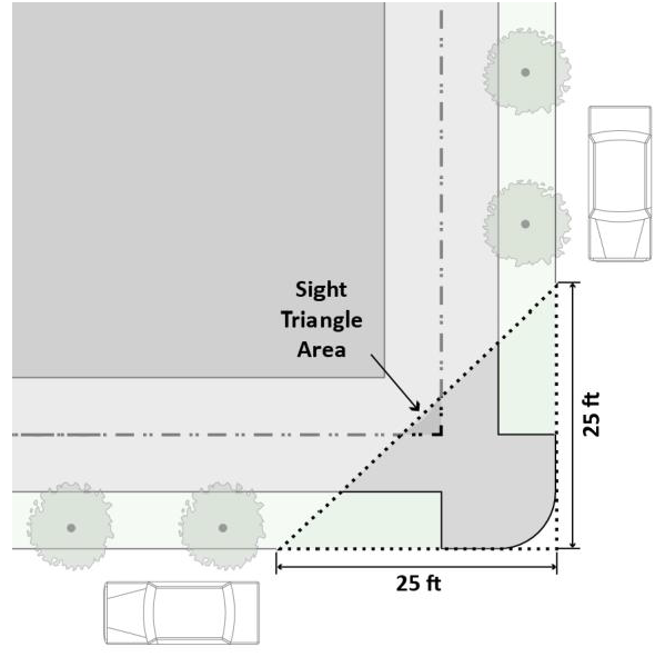
(Ord. No. 2078, 12-11-17)