
Polk County Unincorporated
City Zoning Code
City Zoning Code
APPENDIX E
PARCEL SPECIFIC FUTURE LAND USE Abrogated 1/7/2014 by Ord. 14-004
Section E101 - Purpose and Intent
A Parcel Specific Future Land Use with conditions (PSLUC) may be established as the result of a comprehensive plan amendment, which has been reviewed and adopted by the Board of County Commissioners. These parcels will be identified on the Future Land Use Map Series (FLUMS) and the Land Development Code Sub-District Map (LDCSDM). Development regulations for a PSLUC are to be applied in conjunction with the requirements of the Polk County Comprehensive Plan and the development regulations contained herein and elsewhere in this Code. The regulations contained in this Code apply unless otherwise provided for in this Appendix. Where conflict occurs between the regulations within this Appendix and other regulations of this Code, the PSLUC regulations shall guide and regulate development.
Section E102 - Applicability
A Parcel Specific Future Land Use with conditions (PSLUC) established is based upon policies and provisions in the Comprehensive Plan. Each PSLUC specifies the Future Land Use Districts permitted within its boundaries, and are reflected in the Future Land Use Map Series (FLUMS). The suffix "PC" for Parcel Conditions, in the land use district abbreviation indicates that the standard district has been modified for the particular property. Permitted or conditional uses within the district are shown on the Use Tables for each individual PSLUC. The district description and intent is the same as those for the Standard Land Use districts in Section 203 and 204, of the Land Development Code, except as modified by the Comprehensive Plan and Appendix E. In addition, conditional uses are listed in Section 303.
Section E103 - Development in Established Parcel Specific Future Land Use with conditions (PSLUC)
Development in all PSLUC shall comply with the land use tables and requirements of this Appendix in addition to all other development standards of this Code. When a Planned Development or Conditional Use is requested, it shall be reviewed and processed in accordance with Chapters 3 and 9 of this LDC. PSLUC shall be consistent with existing Planned Developments and Conditional Uses or applications submitted prior to the adoption of a Neighborhood Plan if they are to remain in effect.
Section E104 - More Restrictive Provisions of LDC to Apply
All other provisions of the Land Development Code not expressly modified by this Appendix shall remain in full force and effect to the extent they are not in conflict with any provisions contained herein. To the extent there is a conflict between these regulations and regulations found elsewhere in the Land Development Code, the more stringent of regulation shall apply.
Section E105 - Parcel Specific Comprehensive Plan Amendments (CPA) with Conditions (Revised: LDC 17T-07 - Ord. 18-009 (1/23/18); LDC 17T-02 - Ord. 17-019 (04/18/17); LDC 17T-01 - Ord. 17-021 (4/18/17); LDC 16T-12, Ord. 17-010; LDC 17T-03 - Ord. 17-006; LDC 16T-10 - Ord. 17-004; LDC 16T-05 - Ord. 16-041 (9-6-16); LDC 16T-02 - Ord. 16-038; LDC 15T-08 - Ord. No. 15-052 - 8/19/15; Ord. No. 14-040 - 7/22/14)
Table E1 Parcel Specific Comprehensive Plan Amendments (CPA) with Conditions
A.
Removed by LDC 17T-03 adopted 01/17/2017
B.
CPA 14S-07 - Parcel ID #: 242917-285000-006301 & 242917-285000-006302 (Added Ord. No. 14-040 - 07/22/14)
1.
Applicability
The provisions and requirements of this Subsection apply to the subject site, the boundaries of which are shown on the Future Land Use Map Series and Land Use District maps, more particularly those depicted in the panel showing Range 24, Township 29, Section 17. The site is legally described as:
Lot 63, W.F. Hallam & Company's Club Colony Tract, in Section 17, Township 29 South, Range 24 East, Polk County, Florida, as recorded in Plat Book 1, Page 102A, public records of Polk County, Florida; LESS AND EXCEPT road rights-of-way for County Road 540A & High Glen Drive
2.
Allowable Uses and Intensity of Development
All allowable uses shall comply with the following additional site development standards prior to site alteration or development:
a.
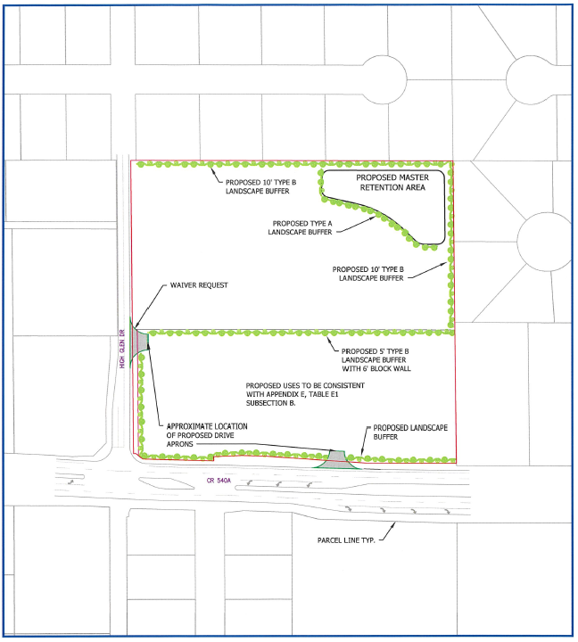
Any development or redevelopment of the subject site shall be conditioned upon a 10 foot wide Type "B" Landscape Buffer, in accordance with Section 720 of this Code shall be required, adjacent to the High Glen & Groveglen South subdivisions to the north and east of the boundaries of the Activity Center Plan.
b.
Any development or redevelopment of the subject site shall be conditioned upon a 5 foot wide Type "B" Landscape Buffer, including a minimum six feet high block or masonry wall shall be required, in accordance with Section 720 of this Code, along the entire North boundary of the NAC land use.
c.
The maximum height of any on-site light source shall be 24 feet. Illumination shall be directional and any spill onto adjacent properties shall not exceed 0.5 foot candles.
d.
The minimum setback of the light source from any residential property line shall be a horizontal distance of 20 feet, except when the light source is adjoining a right-of-way. If the on-site light source adjoins a right-of-way, the lighting can be placed within the landscape buffer ten feet in width.
e.
Any building(s) within 200 feet of the centerline of High Glen Drive shall be designed to achieve a residential appearance or otherwise include design components to break the wall plane (change in plane or height, change in texture or patterns, include doors, windows or articulated base, etc.). No buildings within the 200 feet of the centerline of High Glen Drive shall have a main entrance on the western wall facing High Glen Drive. Corner entries shall be allowed.
f.
External operations such as receiving deliveries, docking, loading or unloading of trucks, shall be limited to the hours between 6 a.m. and 8 p.m. on any loading area less than 200 feet east of High Glen Drive as measured from the centerline of roadway.
g.
Sidewalks shall be constructed, 5 feet wide along both sides of High Glen Drive adjacent to the subject site, as development occurs; sidewalk design and construction on the West side of High Glen Drive shall be subject to right-of-way availability.
h.
The master stormwater detention pond shall be designed to accommodate the 100-yr/24-hr storm event for the entire Activity Plan property. The edge of the retention pond shall be landscaped with similar planting materials of a Type A Buffer along any side not adjacent to another buffer.
i.
All signs shall be monument signs and shall not exceed eight feet in height.
j.
No Drive-Thru/Drive-In Restaurants or Transit Facilities shall be allowed within 200 feet of the intersection of High Glen Drive, as measured from the centerline of roadway.
k.
Retail uses shall not exceed 10,000 square feet per building.
l.
Prior to Level 2 Approval for any structure or use on the property, the applicant shall demonstrate negotiations with the McDonald's for cross access.
3.
Revised Use Table
The following Use Table (Table E3) specifies the level of approval for those uses within the NAC District modified by this amendment. Additionally, the conditions as outlined in Section 303 of this Code shall apply to each use listed below. All other uses will be permitted as per Table 2.1 of this LDC:
TABLE E3 NAC ALLOWABLE LAND USES FOR CPA 14S-07 and LDC 14T-03
4.
The Activity Center Plan (ACP), as required per Policy 2.110-J1, g, is reflected below and the final ACP shall meet the conditions of approval in sections 1 through 3 above and the relevant sections of the Land Development Code.
C.
CPA 15B-02 - Parcel IDs #: 283201-000000-011130 and 283201-000000-011150
1.
Applicability
The provisions and requirements of this Subsection apply to the subject site, the boundaries of which are shown on the Future Land Use Map Series and Land Use District maps, more particularly those depicted in the panel showing Range 28 EAST, Township 32, Section 1. The site is legally described as:
The South 650 feet of that part of U.S. Government Lot 1, lying east of Lake Reedy Boulevard, less and except a strip of land 200 feet wide, east to west lying east of and adjacent to Lake Reedy Boulevard, in Section 1, Township 32 South, Range 28 East, Polk County, Florida.
And the South 50 feet of that part of the U.S. Government Lot 1, lying between Lake Reedy Boulevard and the waters of Lake Reedy, in Section 1, Township 32 South, Range 28 East, Polk County, Florida.
And Begin at the intersection of the south line of U.S. Government Lot 1 in Section 1, Township 32 South, Range 23 East, Polk County, Florida, and the easterly right-of-way line of Lake Reedy Boulevard, and run East 200 feet, thence northerly parallel to said easterly right-of-way line to a point 50 feet north of said south line of said U.S. Government Lot 1, thence west 200 feet to said right-of- way line, thence southerly along said right-of-way line to the point of beginning.
2.
The following uses are prohibited:
a.
High Intensity Recreation.
b.
Vehicle Oriented Recreation.
c.
Hotels and Motels.
D.
CPA 16C-03 - Parcel IDs#:232815-000000-013030, 232815-000000-013040, 232815- 000000-013230. (Added 08/02/16 - Ord. 16-038)
1.
Applicability
The provisions and requirements of this Subsection apply to the subject site, the boundaries of which are shown on the Future Land Use Map Series and Land Use District maps, more particularly those depicted in the panel showing Range 23, Township 28, Section 15. The site is legally described as:
A parcel of land being a portion of the Northwest ¼ of the Northeast ¼ and the Northeast ¼ of the Northwest ¼ of Section 15, Township 28 South, Range 23 East, Polk County, Florida, being recorded in Official Records Book 9487, Page 1959, Public Records of Polk County, Florida, described as follows;
Commence at the southwest corner of said Northwest ¼ of the Northeast ¼ of Section 15 for the point of Beginning; thence along the boundary lines of said parcel recorded in Official Records Book 9487, Page 1959 for the following three (3) courses; (1) South 89"16'43" West, 329.46 feet; (2) thence North 00"40'02" West, 823.65 feet to a point on a non-tangent curve the right having a radius of 3520.54 feet, a central angle of 08"07'38", a chord bearing of North 82"51'33" East, and a chord distance of 498.96 feet; (3) thence Northeasterly along the arc of said curve, 499.38 feet; thence South 00"19'06" East, leaving said boundary lines, 85.92 feet to a point on a non-tangent curve the right having a radius of 3434.72 feet, a central angle of 03"09'37", a chord bearing of North 88"26'02" East, and a chord distance of 189.42 feet; thence Northeasterly along the arc of said curve, 189.45 feet to the point of tangency; thence South 89"59'10" East, 937.01 feet to the boundary line of aforesaid parcel recorded in Official Records Book 9487, Page 1959; thence along the boundary lines of said parcel for the following seventeen (17) courses; (1) South 00"54'07" East, 90.35 feet; (2) thence South 00"54'07" East, 100.00 feet; (3) thence South 00"19'44" East, 100.00 feet; (4) thence South 00"14'38" West, 100.02 feet; (5) thence South 00"54'07" East, 100.00 feet; (6) thence South 01"28'29" East, 14.72 feet; (7) thence South 89"47'34" West, 96.08 feet; (8) thence South 88"59'06" West, 100.00 feet; (9) thence South 89"26'36" West, 100.00 feet; (10) South 00"33'24" East, 12.70 feet; (11) thence South 89"26'36" West, 100.00 feet; (12) thence South 00"54'07" East, 145.00 feet; (13) thence South 89"26'36" West, 705.01 feet; (14) thence South 00"54'07" East, 100.00 feet; (15) thence North 89"26'36" East, 80.00 feet; (16) thence South 00"54'07" East, 25.00 feet; thence South 89"26'36" West, 271.34 feet to the Point of Beginning.
2.
The following uses are prohibited:
a.
Airports
b.
Bars, Lounges, and Taverns
c.
Communication Towers, Guyed, Lattice, or monopole
d.
Gas Stations
e.
Heliports and helistops
f.
Lime Stabilization Facility
g.
Power Plants
h.
Retail
i.
Transit Facility
j.
Utilities
k.
Commercial Vehicle Parking
3.
Intensity of Development
All allowable uses shall comply with the following additional site development standards and display on all Level 2, 3 or 4 Reviews:
a.
Lighting shall be consistent with Dark Skies best practices as listed in Section 642 of the Land Development Code;
b.
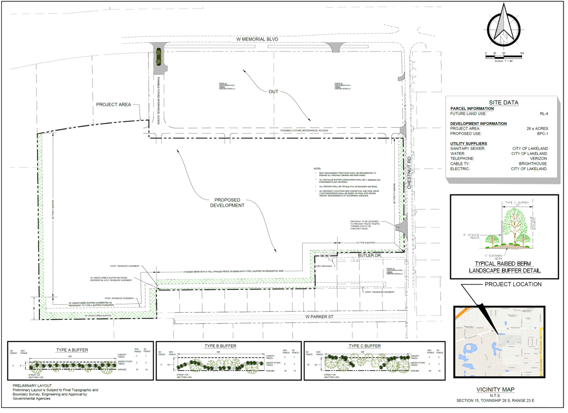
As part of the required reconstruction of Chestnut Road, the applicant shall construct certain improvements between Memorial Boulevard and the southern boundary of the Subject Property as follows:
i.
On the west side of Chestnut Road along the length of the Subject Property, dedicate sufficient right-of-way to provide forty (40') feet from centerline of Chestnut Road;
ii.
Chestnut Road shall be improved to a collector road standards with a total of two (2) twelve (12') foot travel lanes
iii.
On the west side of Chestnut Road, construct a six (6') foot sidewalk and a six (6') foot paved shoulder;
iv.
On the east side of Chestnut Road, construct a sidewalk meeting Polk County Land Development Code requirements, within the existing available right-of-way; and
v.
The final engineered design of the new cross-section of N. Chestnut Road shall be submitted with the plans for the first building constructed on the subject property and shall be completed prior to the issuance of the certificate of occupancy for same.
vi.
The applicant shall coordinate with Roads and Drainage to install Pedestrian warning signs between Memorial Boulevard and the southern end of the site.
c.
Any access from Memorial and any access from Chestnut Road shall require cross access to the OC and the CC land uses;
d.
Truck traffic exiting the site from the southernmost driveway shall not be permitted to turn south on Chestnut Road and the southernmost driveway shall be constructed consistent with standards in the LDC and designed to prevent truck traffic from traveling south on Chestnut Road;
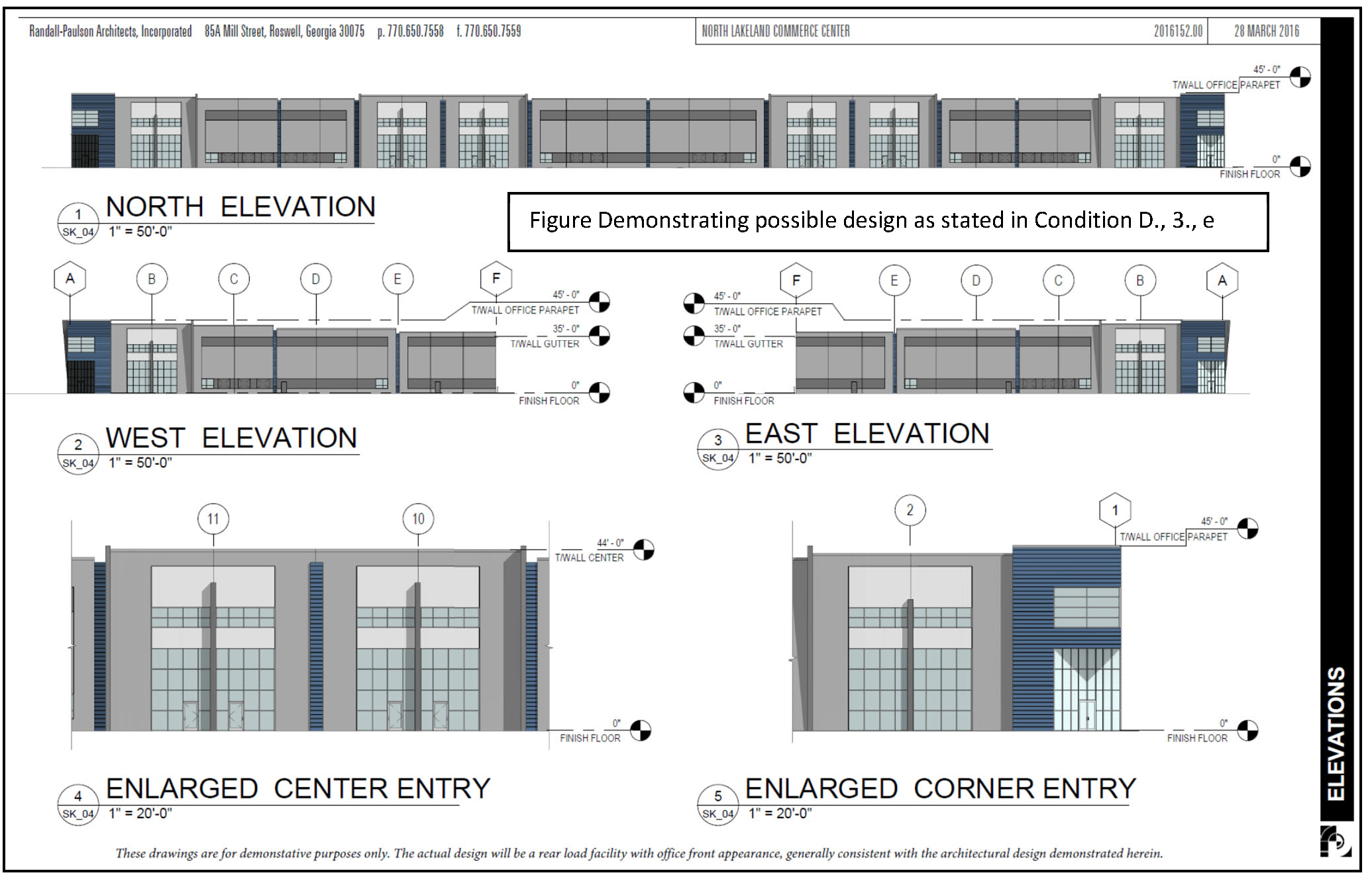
e.
All buildings shall have an office front appearance, generally consistent with the architectural design demonstrated in the figure below, while allowing for appropriate loading and unloading facilities:
f.
All retention ponds shall be designed to resemble natural features this can include any combination of pond shape or the use of planting materials;
g.
There shall be no cold storage within 750 feet of the western right-of-way line of Chestnut Road;
h.
There shall be no overnight idling of trucks unless connected to an electric power source;
i.
For structures exceeding fifty (50) feet in height, setbacks from parcels designated or developed as residential shall be increased by one-half of one foot for each one foot of height over (fifty) 50 feet;
j.
The landscaping along the property lines shall be as follows and consistent with the figure below:
i.
The landscaping on the eastern boundary, except for driveway cuts, shall be consistent with a Type "C" Buffer as indicated in Section 720 of the LDC; and
ii.
Landscaping along the southern and western property boundaries shall include a combination of enhanced landscape standards, 5 foot tall berm and fencing consistent with the specifications as stated in the following figure:
k.
Any changes to this section shall be subject to the public hearing and notice requirements for a Comprehensive Plan map amendment as listed in Chapter 9 of the Land Development Code.
E.
CPA 16C-02 - Parcel IDs #: 242827-000000-014022, 242827-000000-014001, 242827- 000000-041011, 242827-000000-041030, 242827-000000-041032 and 242827-000000-041033
1.
Applicability
The provisions and requirements of this Subsection apply to the subject site, the boundaries of which are shown on the Future Land Use Map Series and Land Use District maps, more particularly those depicted in the panel showing Range 24, Township 24, and Section 27. The site is legally described as:
THE FOLLOWING THREE PARCELS OF LAND RECORDED IN O.R. BOOK 9414, PAGE 1026, IN THE PUBLIC RECORDS OF POLK COUNTY, FLORIDA, ALSO BEING REFERENCED IN THE DEED AS PARCEL ID# 242827-000000-014022, PARCEL ID# 242827-000000-041001, PARCEL ID # 242827-000000-041011.
AND
THE PARCEL OF LAND RECORDED IN O.R. BOOK 6613, PAGE 1593, IN THE PUBLIC RECORDS OF POLK COUNTY, FLORIDA, ALSO KNOWN AS PARCEL ID# 242827-000000-041030.
AND
THE PARCEL OF LAND RECORDED IN O.R. BOOK 9698, PAGE 222, IN THE PUBLIC RECORDS OF POLK COUNTY, FLORIDA, ALSO KNOWN AS PARCEL ID# 242827-000000-041033.
AND
THE PARCEL OF LAND RECORDED IN O.R. BOOK 9693, PAGE 240, IN THE PUBLIC RECORDS OF POLK COUNTY, FLORIDA, ALSO KNOWN AS PARCEL ID# 242827-000000-041032.
2.
Salvage Yards and outdoor activity shall not be within 300 feet from residential land uses. The 300 foot buffer can count towards the minimum 10 acre requirement for a salvage yard.
3.
Construction Aggregate, Processing and Storage shall be limited to a defined area as described by legal description and map depicted below:
A PARCEL OF LAND BEING A PORTION OF THE SOUTHWEST ¼ OF SECTION 27, TOWNSHIP 28 SOUTH, RANGE 24 EAST, POLK COUNTY, FLORIDA, BEING DESCRIBED AS FOLLOWS: COMMENCE AT THE SW CORNER OF THE NE ¼ OF THE SW ¼ OF SECTION 27, TOWNSHIP 28 SOUTH, RANGE 24 EAST, POLK COUNTY, FLORIDA; THENCE N 00°00'00" E, ALONG THE WEST LINE OF SAID NE ¼ OF THE SW ¼, A DISTANCE OF 96.13 FEET TO THE SOUTH RIGHT-OF-WAY LINE OF MINE AND MILL ROAD AS RECORDED IN OFFICIAL RECORDS BOOK 2009, PAGE 846, PUBLIC RECORDS OF POLK COUNTY, FLORIDA; THENCE N 89°56'52" E, ALONG SAID SOUTH RIGHT-OF-WAY LINE, A DISTANCE OF 395.47 FEET TO THE POINT OF BEGINNING; CONTINUE N 89°56'52" E, ALONG SAID SOUTH RIGHT-OF-WAY LINE OF MINE AND MILL ROAD, 174.82; THENCE S83°46'29"E, ALONG SAID SOUTH RIGHT-OF- WAY LINE, 15.08 FEET; THENCE S00°05'29"W, 375.36 FEET; THENCE EAST, 253.00 FEET; THENCE N00°05'29"E, 325.24 FEET TO A POINT ON A NON-TANGENT CURVE CONCAVED WESTERLY HAVING A RADIUS OF 50.00 FEET, CHORD BEARING OF N07%%d15'39"W AND A CHORD DISTANCE OF 65.37 FEET, SAID POINT BEING ON THE RIGHT-OF-WAY LINE OF SAID MINE AND MILL ROAD; THENCE NORTHERLY ALONG SAID CURVE THRU A CENTRAL ANGLE OF 81%%d38'42", AN ARC LENGTH OF 71.25 FEET TO THE END OF SAID CURVE; THENCE N85°58'05"E, 664.44 FEET; THENCE S28°59'30"E, 219.88 FEET; THENCE S14°41'53"E, 323.86 FEET; THENCE WEST, 375.00 FEET; THENCE SOUTH, 430.78 FEET; THENCE WEST 360.52 FEET; THENCE NORTH, 399.50 FEET; THENCE WEST 375.65 FEET; THENCE NORTH, 36.67 FEET; THENCE WEST, 125.01 FEET; THENCE SOUTH, 109.57 FEET; THENCE EAST, 25.09 FEET; THENCE SOUTH, 65.00 FEET; THENCE WEST, 100.00 FEET; THENCE NORTH 65.00 FEET; THENCE EAST 25.09 FEET; THENCE NORTH, 549.68 FEET RETURNING TO THE POINT OF BEGINNING. SAID PARCEL CONTAINS 651,972 SQUARE FEET OR 14.97 ACRES, MORE OR LESS.
4.
The following uses shall be prohibited:
a.
Hazardous Waste Transfer, Storage
b.
Hazardous Waste Treatment Facilities
c.
Manufacturing Explosives/Volatile Material
d.
Railroad Yard
5.
All General Manufacturing uses shall be in enclosed structures within 300 feet from residential land uses.
6.
Any changes to this section shall be subject to the notice requirements for a Comprehensive Plan map amendment as listed in Chapter 9 of the Land Development Code (LDC).
F.
CPA 17A-02 - Parcel ID#: 252911-000000-031020
1.
Applicability
The provisions and requirements of this Subsection apply to the subject site, the boundaries of which are shown on the Future Land Use Map Series and Land Use District maps, more particularly those depicted in the panel showing Range 25, Township 29, Section 11. The site is legally described as:
THE SOUTH 530.00' OF THE FOLLOWING DESCRIBES THE PROPERTY.
A PARCEL OF LAND LYING IN THE NORTHWEST ¼ OF SECTION 11 AND THE SOUTHWEST ¼ OF SECTION 2 OF TOWNSHIP 29 SOUTH, RANGE 25 EAST, POLK COUNTY, FLORIDA, DESCRIBED AS FOLLOWS:
COMMENCE AT THE SOUTHEAST CORNER OF SAID NORTHWEST ¼ OF SECTION 11, THENCE S89°47'18"-W ALONG THE SOUTH BOUNDARY OF SAID NORTHWEST ¼ OF SECTION 11 A DISTANCE OF 40.00 FEET TO THE WEST RIGHT OF WAY LINE OF SPIRIT LAKE ROAD ACCORDING TO MAP BOOK 4, PAGE 741, PUBLIC RECORDS OF POLK COUNTY, FLORIDA; THENCE N00°00'25"-W ALONG SAID WEST RIGHT OF WAY LINE A DISTANCE OF 1788.60 FEET TO THE POINT OF BEGINNING; THENCE S89°37'40"-W A DISTANCE OF 826.37 FEET; THENCE NORTH 00°00'25"-W A DISTANCE OF 870.33 FEET TO THE SOUTH BOUNDARY OF SAID SOUTHWEST ¼ OF SECTION 2; THENCE CONTINUE N-00°00'25"-W A DISTANCE OF 252.22 FEET TO THE SOUTH RIGHT OF WAY LINE OF THORNHILL ROAD ACCORDING TO MAP BOOK 1, PAGES 31-33, PUBLIC RECORDS OF POLK COUNTY, FLORIDA; THENCE ALONG SAID SOUTH RIGHT OF WAY THE FOLLOWING SIX COURSES; S67°30'17"-E A DISTANCE OF 29.14 FEET; THENCE S67°47'29"-EAST A DISTANCE OF 200.00 FEET; THENCE S67°30'17"-E A DISTANCE OF 200.00 FEET; THENCE S67°47'29"-E A DISTANCE OF 217.56 FEET TO THE NORTH BOUNDARY OF SAID NORTHWEST ¼ OF SECTION 11; THENCE CONTINUE S67°47'29"-E A DISTANCE OF 177.40 FEET TO A POINT ON A RIGHT OF WAY LINE FOR SPIRIT LAKE ROAD, ACCORDING TO MAP BOOK 3, PAGE 117, PUBLIC RECORDS OF POLK COUNTY, FLORIDA; THENCE S-46°18'50"-EAST ALONG SAID RIGHT OF WAY LINE A DISTANCE OF 88.33 FEET TO SAID WEST RIGHT OF WAY LINE OF SPIRIT LAKE ROAD, THENCE S-00°00'25"-E ALONG SAID WEST RIGHT OF WAY LINE A DISTANCE OF 743.62 FEET TO THE POINT OF BEGINNING.
CONTAINING 10.05 ACRES MORE OR LESS.
2.
Revised Use Table
The following modified Use Table (Table E4) replaces Table 2.1 and specifies the type of uses, and levels of approval required for those uses, allowable within this BPC-1 site. All conditions outlined in Section 303 of this Code shall apply to each use listed below:
TABLE E4 BPC ALLOWABLE LAND USES FOR CPA 17A-02 AND LDC 16T-10
3.
Additional Site Development Standards
In addition to all applicable standards of this Code, all allowable uses shall comply with the following additional site development standards prior to site alteration or development:
a)
All proposed development or redevelopment of the site adjacent to a residential use or residential future land use designation shall be conditioned upon a 50-foot wide buffer area that shall include the plantings of a Type "C" Landscape Buffer as outlined in Section 720 of this Code and a minimum six foot high opaque fence.
b)
All development shall submit a lighting plan. All lighting shall be directional and fully shielded with cut-off, non-glare fixtures directed straight downward onto the subject site. The maximum height of on-site lighting fixtures shall be limited to 17 feet. All light fixtures shall be setback a horizontal distance of at least 50 feet from any residentially used or designated property. Illumination onto adjacent properties and rights- of-way shall not exceed 0.5 foot candles, measured at the property line of the site.
c)
All loading and unloading areas shall be at least fifty (50) feet from all property lines abutting residentially used or designated property.
d)
All doors and loading bays shall remain closed except while being accessed for loading and/or unloading.
e)
All activities shall be conducted within the enclosed building. There shall be no outdoor activities or storage.
f)
Structures shall not exceed fifty (50) feet in height.
g)
Hours of operation shall be limited to between 7 a.m. and 9 p.m. Monday- Friday. There shall be no activity on-site on Saturday or Sunday.
G.
CPA 16S-12 - Parcel ID# 232822-094500-002242 (Added 2/21, Ord. 17-010 (CPA 16T-12)
1.
Applicability
The provisions and requirements of this Subsection apply to the subject site, the boundaries of which are shown on the Future Land Use Map Series and Land Use District maps, more particularly those depicted in the panel showing Range 23, Township 28, Section 22. The site is legally described as:
Parcel 2: Begin 284.10 feet East of the Northwest corner of the Southeast ¼ of the Northeast ¼ of Section 22, Township 28 South, Range 23 East, Polk County, Florida, and run thence East, 377.75 feet; thence S00°28'00''W, a distance of 377.75 feet; thence N00°25'00"W to the POINT OF BEGINNING.
2.
Revised Use Table
The following modified Use Table (Table E4) replaces Table 2.1 and specifies the type of uses, and levels of approval required for those uses, allowable within this BPC-2 site. If the uses are not listed in this table it is prohibited. All conditions outlined in Section 303 of this Code shall apply to each use listed below:
TABLE E4 PERMITTED USES FOR CPA 16S-12 AND LDC 16T-12
3.
Additional Site Development Standards
In addition to all applicable standards of this Code, all allowable uses shall comply with the following additional site development standards prior to site alteration or development:
a)
All proposed development or redevelopment of the site adjacent to a residential use or residential future land use designation shall be conditioned upon a natural 20-foot buffer at a length of a 175-feet that increases to 25-feet for the remainder of the western property line, a natural 50-foot buffer on the eastern property line, and a natural 130-foot buffer on the southern property line to include the plantings of a Type "C" Landscape Buffer as outlined in Section 720 of this Code and a minimum six foot high opaque fence.
b)
All development shall submit a lighting plan. All lighting shall be directional and fully shielded with cut-off, non-glare fixtures directed straight downward onto the subject site. The maximum height of on-site lighting fixtures shall be limited to 17 feet. All light fixtures shall be setback a horizontal distance of at least 50 feet from any residentially used or designated property. Illumination onto adjacent properties and rights- of-way shall not exceed 0.5 foot candles, measured at the property line of the site.
c)
All loading and unloading areas shall be at least fifty (50) feet from all property lines abutting residentially used or designated property.
d)
All doors and loading bays shall remain closed except while being accessed for loading and/or unloading.
e)
Structures shall not exceed fifty (50) feet in height.
f)
Hours of operation shall be limited to between 7 a.m. and 7 p.m. Monday- Friday.
H.
CPA 16D-02 - Parcel IDs#:232803-000000-024000, 232803-000000-024010, 232803- 021000-000102, 232803-021000-000301, 232803-021000-0000302. (Revised LDCT 2019-2 - Ord. No. 19-051; Added 17T-02 - Ord No. 17- 019 (4/18/17)
1.
Applicability
The provisions and requirements of this Subsection apply to the subject site, the boundaries of which are shown on the Future Land Use Map Series and Land Use District maps, more particularly those depicted in the panel showing Range 23, Township 28, Section 03. The site is legally described as:
A parcel of land being a portion of Lots 1 through 4, WEBSTER & OMOHUNDRO EST. LANDS, being in the Northwest ¼ of the Southeast ¼ of Section 3, Township 28 South, Range 23 East, Polk County, Florida, and a portion of the Southwest ¼ of the Southeast ¼ of Section 3, Township 28 South, Range 23 East, Polk County, Florida, being described as follows:
Commence at the northeast corner of said Northwest ¼ of the Southeast ¼ of Section 3 for the Point of Beginning; thence South 00°16'07" East, along the east line of said Northwest ¼ of the Southeast ¼ and the east line of aforesaid Southwest ¼ of the Southeast ¼ of Section 3, a distance of 2614 feet, more or less, to the intersection of said east line of Southwest ¼ of the Southeast ¼ and the north right-of-way line of Bella Vista Street; thence South 89°41'55" West, along said north right-of-way line, 1305 feet, more or less, to the intersection of said north right-of-way line of Bella Vista Street and the east right-of-way line of George Wheeler Road; thence North 00°21'40" West, along said east right-of-way line of George Wheeler Road, 1301 feet, more or less, to the north line of aforesaid Southwest ¼ of the Southeast ¼ of Section 3; thence North 89°47'13" East, along said north line of the Southwest ¼ of the Southeast ¼, a distance of 645 feet, more or less, to the east line of the West 1/2 of aforesaid Lot 1; thence North 00°20'03" West, along said east line of the West 1/2 of Lot 1 a distance of 329 feet, more or less, to the north line of said Lot 1; thence South 89°46'47" West, along said north line of Lot 1, a distance of 645 feet, more or less, to aforesaid east right- of-way line of George Wheeler Road; thence North 00°21'40" West, along said east right-of-way line of George Wheeler Road, 164 feet, more or less, to the south line of the North 1/2 of aforesaid Lot 2; thence North 89°46'46" East, along said south line of the North 1/2 of aforesaid Lot 2, a distance of 247 feet, more or less, to the east line of the west 264.48 feet of said Lot 2; thence North 00°20'03" West, along said east line of the west 264.48 feet of said Lot 2, a distance of 164 feet, more or less, to the north line of said Lot 2; thence South 89°46'20" West, along said north line of said Lot 2, a distance of 247 feet, more or less, to aforesaid east right-of-way line of George Wheeler Road; thence North 00°21'40" West, along said east right-of-way line of George Wheeler Road, 507 feet, more or less, to the south line of the North 150 feet of aforesaid Lot 4; thence North 89°45'26" East, along said south line of the North 150 feet of Lot 4, a distance of 294 feet, more or less, to the east line of the West 310.4 feet of Lot 4; thence North 00°20'03" West, along said east line of the West 310.4 feet of Lot 4, a distance of 150 feet, more or less, to the north line of aforesaid Northwest ¼ of the Southeast ¼ of Section 3; thence North 89°45'25" East, along said north line of aforesaid Northwest ¼ of the Southeast ¼, a distance of 1016 feet, more or less, to the Point of Beginning.
Less and except:
A parcel of land being a portion the Southwest ¼ of the Southeast ¼ of Section 3, Township 28 South, Range 23 East, Polk County, Florida being described as follows: Commence at the intersection of the north right-of-way line of Bella Vista Street and the east right-of-way line of George Wheeler Road; thence North 00°21'40" West, along said east right-of-way line, 731 feet more or less to the north line of aforesaid Southwest ¼ of the Southeast ¼ of Section 3; thence North 89°47'13" East, along said north line of the Southwest ¼, a distance of 537 feet, more or less; thence South 00°21'40" East, parallel with aforesaid east right-of-way line of George Wheeler Road, a distance of 731 feet, more or less; thence South 89°47'13" West, parallel with said north line of aforesaid Southwest ¼ of the Southeast ¼, a distance of 537 feet, more or less, to the Point of Beginning.
Said parcel containing 9.00 acres, more or less.
2.
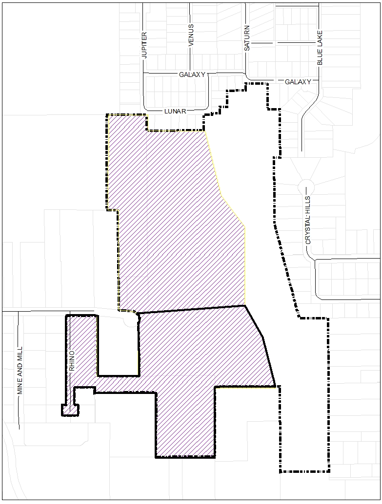
Permitted and conditional uses within the L/R Land Use designation shall be allowed with the following restrictions, as shown in figure H.1:
a.
No concert or other event with amplified noise will be held within 536 feet of the western boundary of the subject site adjacent to George Wheeler Road.
b.
No concert or other event with amplified noise will be held on any portion of the subject site within 658 feet of the north boundary.
c.
No vehicle oriented use shall be allowed on the subject property with the exception of parking at events.

I.
CPA 16D-07 - Parcel IDs#: 272614-000000-021010. (Added Ord. 17-021 - LDC 17T- 01 - 04/18/2017)
1.
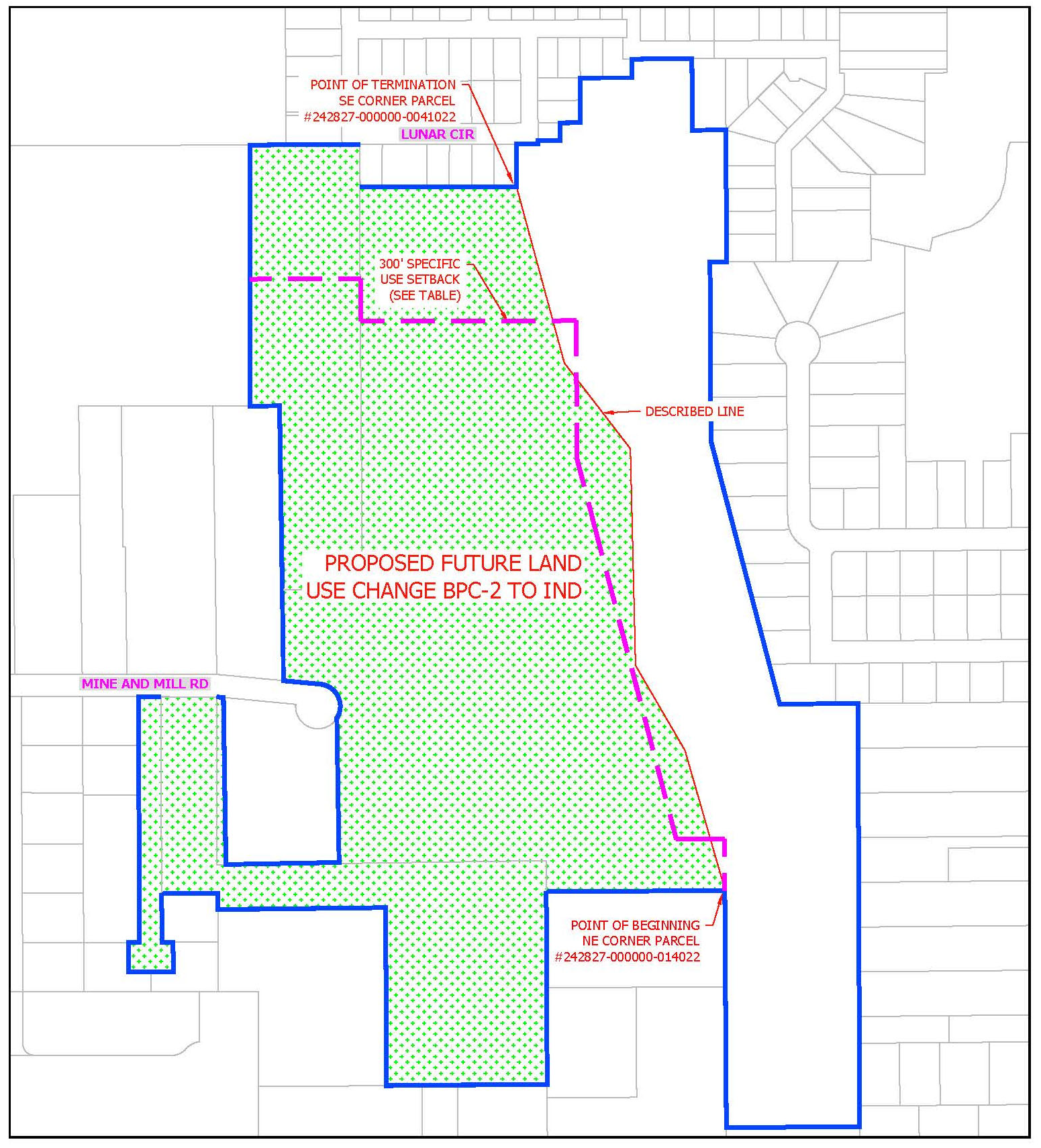
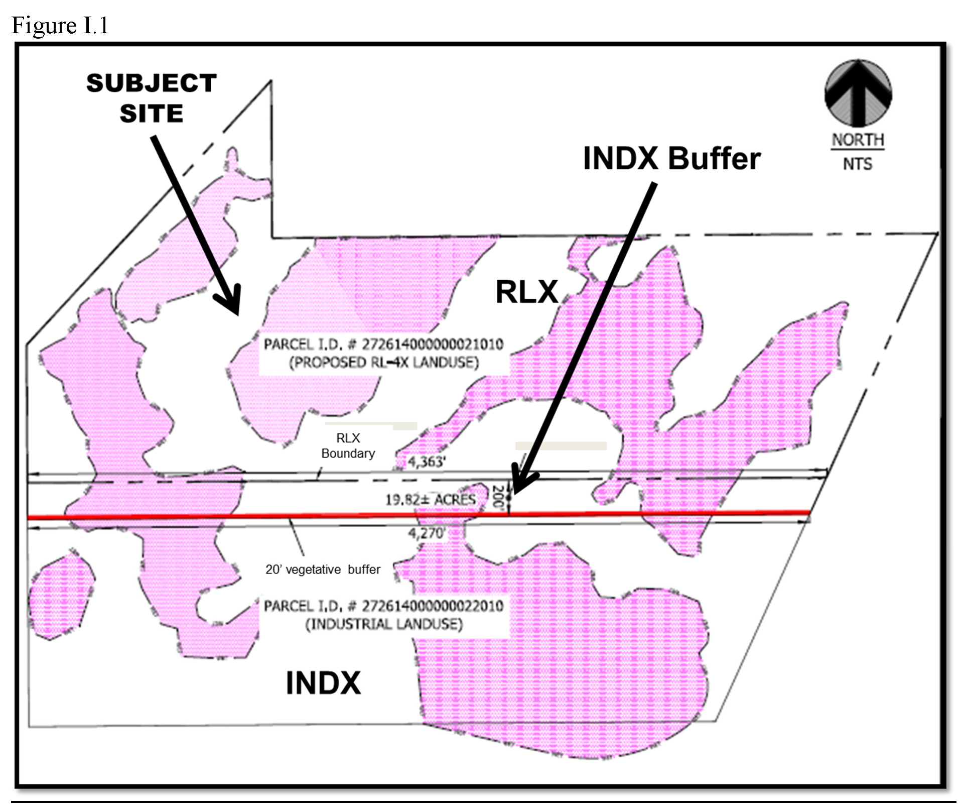
Applicability. The provisions and requirements of this Subsection apply to the subject site, the boundaries of which are shown on the Future Land Use Map Series and Land Use District maps, more particularly those depicted in the panel showing Range 27, Township 26, Section 14. The site is identified as Parcel 272614 000000 021010 and the north 200 feet of Parcel 272614 000000 022010 and legally described as:
THE NORTH HALF OF THE SOUTHEAST QUARTER (N1/2 OF SE ¼), EXCEPT THAT PART OWNED BY THE ATLANTIC COAST LINE RAILROAD; THAT PART OF THE NORTH HALF OF THE SOUTHWEST QUARTER (N1/2 OF SW ¼) LYING EAST OF OLD DIXIE HIGHWAY # 2; THAT PART OF THE SOUTHWEST QUARTER OF THE NORTHWEST QUARTER (SW ¼ OF NW ¼ LYING SOUTH AND EAST OF OLD DIXIE HIGHWAY # 2, ALL IN SECTION FOURTEEN (14), TOWNSHIP TWENTy-SIX (26) SOUTH, RANGE TWENTY-SEVEN (27) EAST, AS RECORDED IN DEED BOOK 749, PAGE 58, AT BARTOW, IN POLK COUNTY, FLORIDA.
LESS AND EXCEPT THE FOLLOWING FOUR WETLAND AREAS (WETLANDS 1 - 4), MORE PARTICULARLY DESCRIBED AS FOLLOWS:
EXCEPTION WETLAND 1:
COMMENCE FROM THE SOUTHWEST CORNER OF POLK COUNTY PARCEL NUMBER 272614 000000 032030,
DESCRIBED BY WARRANTY DEED RECORDED IN OFFICIAL RECORD BOOK 9251, PAGES 513 & 514,
PUBLIC RECORDS OF POLK COUNTY, FLORIDA, SAID POINT BEING HELD AS THE SOUTHWEST CORNER
OF THE SOUTHEAST ¼, OF THE NORTHWEST ¼ OF SECTION 14, TOWNSHIP 26 SOUTH, RANGE 27
EAST, POLK COUNTY, FLORIDA, BEING A 4 INCH BY 4 INCH CONCRETE MONUMENT WITH NO IDENTIFICATION,
HAVING A NORTHING COORDINATE OF 1,414,054.57 AND AN EASTING OF 789,312.74 OF THE STATE
PLANE COORDINATE SYSTEM FOR THE FLORIDA WEST ZONE; RUN THENCE N00°04'48"W ALONG THE
WEST BOUNDARY OF SAID SOUTHEAST ¼ OF THE NORTHWEST ¼, A DISTANCE OF 244.35 FEET TO
THE POINT OF BEGINNING. THENCE N00°04'48"W A DISTANCE OF 58.46 FEET; THENCE N24°38'43"W
A DISTANCE OF 27.71 FEET; THENCE S82°59'40"W A DISTANCE OF 71.77 FEET; THENCE N67°37'44"W
A DISTANCE OF 54.81 FEET; THENCE N52°53'56"W A DISTANCE OF 57.17 FEET; THENCE N05°02'39"W
A DISTANCE OF 106.79 FEET; THENCE N43°00'21"W A DISTANCE OF 28.03 FEET; THENCE S52°36'06"W
A DISTANCE OF 33.79 FEET; THENCE S05°37'59"W A DISTANCE OF 130.27 FEET; THENCE S59°30'55"W
A DISTANCE OF 68.42 FEET; THENCE S50°28'10"W A DISTANCE OF 109.11 FEET; THENCE S30°05'22"W
A DISTANCE OF 94.30 FEET; THENCE S26°56'18"W A DISTANCE OF 54.63 FEET; THENCE S50°33'39"W
A DISTANCE OF 110.27 FEET; THENCE S45°46'46"W A DISTANCE OF 59.94 FEET; THENCE S22°27'31"W
A DISTANCE OF 63.74 FEET; THENCE S49°52'58"W A DISTANCE OF 56.93 FEET; THENCE S57°31'14"W
A DISTANCE OF 95.28 FEET; THENCE S40°44'02"W A DISTANCE OF 72.84 FEET; THENCE S31°05'49"W
A DISTANCE OF 59.64 FEET; THENCE S28°05'08"W A DISTANCE OF 66.78 FEET; THENCE S02°26'00"E
A DISTANCE OF 67.84 FEET; THENCE S35°43'44"E A DISTANCE OF 86.25 FEET; THENCE S74°22'08"E
A DISTANCE OF 40.26 FEET; THENCE N61°43'57"E A DISTANCE OF 47.44 FEET; THENCE S55°50'40"E
A DISTANCE OF 34.42 FEET; THENCE N82°44'01"E A DISTANCE OF 39.28 FEET; THENCE N55°19"32"E
A DISTANCE OF 24.78 FEET; THENCE N12°07'33"E A DISTANCE OF 70.25 FEET; THENCE N66°08'15"E
A DISTANCE OF 68.52 FEET; THENCE N73°07'51"E A DISTANCE OF 96.50 FEET; THENCE N70°27'46"E
A DISTANCE OF 96.93 FEET; THENCE N35°58'26"E A DISTANCE OF 123.59 FEET; THENCE N40°04'29"E
A DISTANCE OF 139.19 FEET; THENCE N24°31'31"E A DISTANCE OF 54.51 FEET; THENCE N13°47'45"W
A DISTANCE OF 60.65 FEET; THENCE N41°35'24"W A DISTANCE OF 93.54 FEET; THENCE N18°15'27"E
A DISTANCE OF 91.94 FEET; THENCE N49°12'25"E A DISTANCE OF 50.10 FEET; THENCE S76°03'35"E
A DISTANCE OF 91.14 FEET; THENCE N73°03'49"E A DISTANCE OF 92.65 FEET; THENCE N51°44'10"E
A DISTANCE OF 17.51 FEET TO THE POINT OF BEGINNING.
EXCEPTION WETLAND 2:
COMMENCE FROM THE SOUTHWEST CORNER OF THE NORTHWEST ¼ OF THE SOUTHWEST ¼ OF SECTION
14, TOWNSHIP 26 SOUTH, RANGE 27 EAST HAVING A NORTHING COORDINATE OF 1,412,727.03,
AND EASTING OF 787,982.58 FOR THE STATE PLANE COORDINATE SYSTEM FOR THE FLORIDA WEST
ZONE. RUN THENCE N89°36'52"E ALONG THE SOUTH BOUNDARY OF SAID NORTHWEST ¼ OF SOUTHWEST
¼, A DISTANCE OF 355.10 FEET TO THE POINT OF BEGINNING. THENCE N28°09'49"E A DISTANCE
OF 49.73 FEET; THENCE N20°35'14"W A DISTANCE OF 53.82 FEET; THENCE N30°40'44"W A DISTANCE
OF 65.71 FEET; THENCE N03°15'28"E A DISTANCE OF 39.69 FEET; THENCE N02°07'35"E A DISTANCE
OF 54.33 FEET; THENCE N38°23'22"W A DISTANCE OF 75.16 FEET; THENCE N30°31'54"W A DISTANCE
OF 50.19 FEET; THENCE N20°10'52"W A DISTANCE OF 77.81 FEET; THENCE N23°35'33"W A DISTANCE
OF 69.20 FEET; THENCE N11°47'15"W A DISTANCE OF 67.29 FEET; THENCE N58°58'09"W A DISTANCE
OF 80.63 FEET; THENCE N35°16'46"W A DISTANCE OF 41.67 FEET; THENCE N28°35'36"W A DISTANCE
OF 46.19 FEET; THENCE N11°30'17"W A DISTANCE OF 44.69 FEET; THENCE N55°55'11"E A DISTANCE
OF 27.94 FEET; THENCE N61°06'34"E A DISTANCE OF 28.06 FEET; THENCE N60°05'48"E A DISTANCE
OF 46.73 FEET; THENCE N65°20'14"E A DISTANCE OF 62.64 FEET; THENCE N32°48'45"E A DISTANCE
OF 61.76 FEET; THENCE N46°29'18"E A DISTANCE OF 56.23 FEET; THENCE N13°16'18"W A DISTANCE
OF 48.84 FEET; THENCE N22°49'35"E A DISTANCE OF 43.70 FEET; THENCE N50°29'37"E A DISTANCE
OF 61.44 FEET; THENCE N56°24'16"E A DISTANCE OF 48.32 FEET; THENCE N63°21'55"E A DISTANCE
OF 49.33 FEET; THENCE S88°22'26"E A DISTANCE OF 28.08 FEET; THENCE S16°29'25"E A DISTANCE
OF 31.85 FEET; THENCE S01°35'33"E A DISTANCE OF 57.16 FEET; THENCE S27°23'24"E A DISTANCE
OF 81.85 FEET; THENCE S31°21'55"E A DISTANCE OF 81.89 FEET; THENCE S38°18'48"E A DISTANCE
OF 71.49 FEET; THENCE S71°48'36"E A DISTANCE OF 36.47 FEET; THENCE S45°08'49"E A DISTANCE
OF 37.43 FEET; THENCE S29°10'36"W A DISTANCE OF 42.08 FEET; THENCE S22°00'32"W A DISTANCE
OF 38.25 FEET; THENCE S12°30'00"W A DISTANCE OF 77.03 FEET; THENCE S18°59'24"E A DISTANCE
OF 76.36 FEET; THENCE S23°23'13"E A DISTANCE OF 61.72 FEET; THENCE S53°12'59"E A DISTANCE
OF 82.58 FEET; THENCE S83°53'07"E A DISTANCE OF 36.66 FEET; THENCE S36°37'11"E A DISTANCE
OF 85.96 FEET; THENCE S05°33'24"W A DISTANCE OF 24. 70 FEET; THENCE S25°26'39"W A
DISTANCE OF 64.48 FEET; THENCE S51°24'55"W A DISTANCE OF 77.12 FEET; THENCE S59°58'08"W
A DISTANCE OF 46.55 FEET; THENCE S63°48'37"W A DISTANCE OF 36.34 FEET; THENCE S10°16'37"W
A DISTANCE OF 25.30 FEET; THENCE S34°03'29"E A DISTANCE OF 43.44 FEET; THENCE S38°46'29"E
A DISTANCE OF 58.32 FEET; THENCE S66°29'20"E A DISTANCE OF 60.39 FEET; THENCE N87°24'23"E
A DISTANCE OF 134.67 FEET; THENCE N80°26'47"E A DISTANCE OF 135.88 FEET; THENCE N74°57'31"E
A DISTANCE OF 72.50 FEET; THENCE N73°15'15"E A DISTANCE OF 38.70 FEET; THENCE S62°49'45"E
A DISTANCE OF 70.37 FEET; THENCE S08°52'52"W A DISTANCE OF 51.41 FEET; THENCE S89°36'52"W
ALONG SAID SOUTH BOUNDARY OF NORTHWEST ¼ OF SOUTHWEST ¼, A DISTANCE OF 822.41 FEET
TO THE POINT OF BEGINNING.
EXCEPTION WETLAND 3:
COMMENCE FROM THE NORTHEAST CORNER OF THE NORTHEAST ¼ OF THE SOUTHWEST ¼ OF SECTION
14, TOWNSHIP 26 SOUTH, RANGE 27 EAST, POLK COUNTY FLORIDA BEING A 4 INCH BY 4 INCH
CONCRETE MONUMENT STAMPED PRM 1784, HAVING A NORTHING COORDINATE OF 1,414,070.41,
AND AN EASTING OF 790,657.05 FOR THE STATE PLANE COORDINATE SYSTEM OF THE FLORIDA
WEST ZONE; RUN THENCE S89°19'30"W ALONG THE NORTH BOUNDARY OF SAID NORTHEAST ¼ OF
SOUTHWEST ¼, A DISTANCE OF 94.79 FEET TO THE POINT OF BEGINNING; THENCE S35°51'08"W
A DISTANCE OF 62.44 FEET; THENCE S49°19'16"W A DISTANCE OF 74.23 FEET; THENCE S39°07'14"W
A DISTANCE OF 67.54 FEET; THENCE S38°37'33"W A DISTANCE OF 51.58 FEET; THENCE S47°25'18"W
A DISTANCE OF 84.79 FEET; THENCE S26°00'22'W A DISTANCE OF 49.39 FEET; THENCE S17°38'42"W
A DISTANCE OF 87.78 FEET; THENCE S26°15'09"W A DISTANCE OF 97.72 FEET; THENCE S44°59'26"W
A DISTANCE OF 90.28 FEET; THENCE S72°40'45"W A DISTANCE OF 99.93 FEET; THENCE N80°10'25"W
A DISTANCE OF 134.22 FEET; THENCE S31°21'48"W A DISTANCE OF 80.84 FEET; THENCE S07°41'48"E
A DISTANCE OF 87.18 FEET; THENCE S00°18'51"E A DISTANCE OF 54.59 FEET; THENCE S21°16'34"W
A DISTANCE 140.92 FEET; THENCE S47°18'00"W A DISTANCE OF 81.34 FEET; THENCE S67°37'57"W
A DISTANCE OF 123.00 FEET; THENCE N88°07'38"W A DISTANCE OF 103.93 FEET; THENCE N63°17'06"W
A DISTANCE OF 90.16 FEET; THENCE S23°44'38"W A DISTANCE OF 85.87 FEET; THENCE S18°03'08"W
A DISTANCE OF 95.32 FEET; THENCE S58°55'53"W A DISTANCE OF 58.61 FEET; THENCE N78°37'47"W
A DISTANCE OF 74.35 FEET; THENCE N71°56'17"W A DISTANCE OF 65.58 FEET; THENCE N41°24'43"W
A DISTANCE OF 88.36 FEET; THENCE N39°46'12"W A DISTANCE OF 44.57 FEET; THENCE N27°37'09"W
A DISTANCE OF 61.71 FEET; THENCE N14°11'09"W A DISTANCE OF 43.06 FEET; THENCE N16°31'30"W
A DISTANCE OF 41.10 FEET; THENCE N19°10'28"W A DISTANCE OF 42.70 FEET; THENCE N20°12'33"W
A DISTANCE OF 68.25 FEET; THENCE N12°58'50"W A DISTANCE OF 48.89 FEET; THENCE N38°04'30"E
A DISTANCE OF 61.49 FEET; THENCE N32°31'23"E A DISTANCE OF 61.09 FEET; THENCE N59°08'10"E
A DISTANCE OF 35.95 FEET; THENCE N59°02'29"E A DISTANCE OF 42.92 FEET; THENCE N36°00'16"E
A DISTANCE OF 65.02 FEET; THENCE N27°26'43"E A DISTANCE OF 41.92 FEET; THENCE N19°26'37"E
A DISTANCE OF 64.66 FEET; THENCE N05°13'51"W A DISTANCE OF 30.34 FEET; THENCE N12°17'15"E
A DISTANCE OF 69.47 FEET; THENCE N43°04'31"E A DISTANCE OF 145.28 FEET; THENCE N17°24'13"E
A DISTANCE OF 51.12 FEET; THENCE N53°41'23"E A DISTANCE OF 68.81 FEET; THENCE N40°57'43"E
A DISTANCE OF 44.04 FEET; THENCE N72°24'02"E A DISTANCE OF 49.35 FEET; THENCE N04°38'08"E
A DISTANCE OF 66.13 FEET; THENCE N89°19'30"E ALONG SAID NORTH BOUNDARY OF NORTHEAST
¼ OF SOUTHWEST ¼, A DISTANCE OF 1007.54 FEET TO THE POINT OF BEGINNING.
EXCEPTION WETLAND 4:
COMMENCE FROM THE NORTHEAST CORNER OF THE NORTHEAST ¼ OF THE SOUTHWEST ¼ OF SECTION
14, TOWNSHIP 26 SOUTH, RANGE 27 EAST, POLK COUNTY FLORIDA BEING A 4 INCH BY 4 INCH
CONCRETE MONUMENT STAMPED PRM 1784, HAVING A NORTHING COORDINATE OF 1,414,070.41,
AND AN EASTING OF 790,657.05 FOR THE STATE PLANE COORDINATE SYSTEM OF THE FLORIDA
WEST ZONE; RUN THENCE S00°00'33"W ALONG THE EAST BOUNDARY OF SAID NORTHEAST ¼ OF THE
SOUTHWEST ¼, A DISTANCE OF 1325.39 FEET TO THE SOUTHWEST CORNER OF THE NORTHWEST ¼
OF THE SOUTHEAST ¼; THENCE N89°37'22"E ALONG SOUTH BOUNDARY OF SAID NORTHWEST ¼ OF
THE SOUTHEAST ¼ A DISTANCE OF 503.09 FEET TO THE POINT OF BEGINNING. THENCE N30°48'02"E
A DISTANCE OF 83.98 FEET; THENCE N16°39'12"E A DISTANCE OF 102.64 FEET; THENCE N02°17'49"E
A DISTANCE OF 77.61 FEET; THENCE N42°33'40"W A DISTANCE OF 113.73 FEET; THENCE N28°05'30"W
A DISTANCE OF 36.27 FEET; THENCE N76°31'28"W A DISTANCE OF 47.50 FEET; THENCE N55°54'04"W
A DISTANCE OF 68.55 FEET; THENCE N83°50'27"W A DISTANCE OF 32.03 FEET; THENCE N65°50'02"W
A DISTANCE OF 47.02 FEET; THENCE N81°37'54"W A DISTANCE OF 52.59 FEET; THENCE S69°14'25"W
A DISTANCE OF 22.66 FEET; THENCE S85°40'37"W A DISTANCE OF 75.71 FEET; THENCE S88°28'22"W
A DISTANCE OF 70.64 FEET; THENCE N78°27'55"W A DISTANCE OF 70.62 FEET; THENCE S73°08'25"W
A DISTANCE OF 93.21 FEET; THENCE S67°30'25"W A DISTANCE OF 95.18 FEET; THENCE S44°36'18"W
A DISTANCE OF 63.19 FEET; THENCE S66°48'16"W A DISTANCE OF 58.99 FEET; THENCE S90°00'0"W
A DISTANCE OF 43.80 FEET; THENCE N02°11'33"E A DISTANCE OF 138.08 FEET; THENCE N32°49'19"E
A DISTANCE OF 50.41 FEET; THENCE N48°21'32"E A DISTANCE OF 63.63 FEET; THENCE N63°17'23"E
A DISTANCE OF 45.98 FEET; THENCE N38°54'54"E A DISTANCE OF 89.41 FEET; THENCE N55°40'47"E
A DISTANCE OF 78.00 FEET; THENCE N70°43'02"E A DISTANCE OF 80.75 FEET; THENCE N66°26'50"E
A DISTANCE OF 58.03 FEET; THENCE N56°32'25"E A DISTANCE OF 121.07 FEET; THENCE N22°46'03"E
A DISTANCE OF 61.66 FEET; THENCE N20°04'33"E A DISTANCE OF 95.41 FEET; THENCE N39°58'09"E
A DISTANCE OF 78.89 FEET; THENCE N72°30'07"E A DISTANCE OF 72.64 FEET; THENCE N30°06'01"E
A DISTANCE OF 84.65 FEET; THENCE N53°28'57"W A DISTANCE OF 44.94 FEET; THENCE N54°46'54"W
A DISTANCE OF 49.06 FEET; THENCE N68°34'42"W A DISTANCE OF 32.10 FEET; THENCE N08°52'56"W
A DISTANCE OF 40.06 FEET; THENCE N05°25'42"E A DISTANCE OF 41.61 FEET; THENCE N30°20'13"E
A DISTANCE OF 95.87 FEET; THENCE N89°48'40"E A DISTANCE OF 409.35 FEET; THENCE S74°46'18"W
A DISTANCE OF 52.96 FEET; THENCE S87°01'36"W A DISTANCE OF 90.20 FEET; THENCE S73°57'04"W
A DISTANCE OF 46.07 FEET; THENCE S81°02'01"W A DISTANCE OF 42.23 FEET; THENCE S77°05'10"W
A DISTANCE OF 61.42 FEET; THENCE S48°36'56"W A DISTANCE OF 40.32 FEET; THENCE S38°50'48"W
A DISTANCE OF 44.00 FEET; THENCE S31°55'37"W A DISTANCE OF 39.90 FEET; THENCE S26°07'00"E
A DISTANCE OF 37.74 FEET; THENCE S33°16'04"E A DISTANCE OF 55.56 FEET; THENCE S80°01'50"E
A DISTANCE OF 52.23 FEET; THENCE S60°18'24"E A DISTANCE OF 72.97 FEET; THENCE N88°44'13"E
A DISTANCE OF 60.73 FEET; THENCE N57°26'11"E A DISTANCE OF 65.86 FEET; THENCE N37°07'49"E
A DISTANCE OF 76.78 FEET; THENCE N34°37'22"E A DISTANCE OF 52.52 FEET; THENCE N43°36'47"E
A DISTANCE 72.92 FEET; THENCE N55°57'46"E A DISTANCE OF 51.03 FEET; THENCE S61°53'51"E
A DISTANCE OF 36.07 FEET; THENCE S25°10'37"E A DISTANCE OF 56.19 FEET; THENCE S09°18'40"E
A DISTANCE OF 57.14 FEET; THENCE S13°41'46"E A DISTANCE OF 75.08 FEET; THENCE S09°53'17"E
A DISTANCE OF 106.18 FEET; THENCE S50°21'45"E A DISTANCE OF 56.24 FEET; THENCE S48°50'48"E
A DISTANCE OF 48.15 FEET; THENCE S13°36'23"E A DISTANCE OF 53.02 FEET; THENCE S05°07'40"W
A DISTANCE OF 76.73 FEET; THENCE S33°37'24"W A DISTANCE OF 91.97 FEET; THENCE S50°57'05"W
A DISTANCE OF 77.63 FEET; THENCE S38°45'36"W A DISTANCE OF 77.90 FEET; THENCE S11°24'56"W
A DISTANCE OF 59.16 FEET; THENCE S13°37'28"E A DISTANCE OF 74.66 FEET; THENCE S08°39'58"E
A DISTANCE OF 50.52 FEET; THENCE S27°15'44"W A DISTANCE OF 29.60 FEET; THENCE S61°07'56"W
A DISTANCE OF 55.22 FEET; THENCE S41°06'00"W A DISTANCE OF 55.81 FEET; THENCE S01°43'59"W
A DISTANCE OF 26.31 FEET; THENCE S53°40'05"E A DISTANCE OF 35.01 FEET; THENCE N84°50'03"E
A DISTANCE OF 41.91 FEET; THENCE N45°59'37"E A DISTANCE OF 76.05 FEET; THENCE N59°23'12"E
A DISTANCE OF 32.72 FEET; THENCE N79°47'06"E A DISTANCE OF 71.50 FEET; THENCE N74°00'40"E
A DISTANCE OF 98.24 FEET; THENCE N47°58'26"E A DISTANCE OF 76.42 FEET; THENCE N27°28'57"E
A DISTANCE OF 73.69 FEET; THENCE N32°13'20"E A DISTANCE OF 115.78 FEET; THENCE N46°21'57"E
A DISTANCE OF 99.62 FEET; THENCE N43°51'53"E A DISTANCE OF 101.76 FEET; THENCE N40°26'20"E
A DISTANCE OF 104.52 FEET; THENCE N56°57'05"E A DISTANCE OF 63.61 FEET; THENCE N71°01'17"E
A DISTANCE OF 104.90 FEET; THENCE N68°09'52"E A DISTANCE OF 114.18 FEET; THENCE N59°55'36"E
A DISTANCE OF 77.84 FEET; THENCE N87°24'39"E A DISTANCE OF 22.00 FEET; THENCE S59°03'21"E
A DISTANCE OF 22.37 FEET; THENCE S17°48'20"W A DISTANCE OF 69.02 FEET; THENCE S13°29'12"W
A DISTANCE OF 54.15 FEET; THENCE S16°25'21"W A DISTANCE OF 79.69 FEET; THENCE S02°49'38"E
A DISTANCE OF 134.33 FEET; THENCE S48°31'25"W A DISTANCE OF 102.68 FEET; THENCE S43°48'04"W
A DISTANCE OF 76.31 FEET; THENCE S23°58'44"W A DISTANCE OF 74.53 FEET; THENCE S04°06'26"E
A DISTANCE OF 54.47 FEET; THENCE S01°08'52"E A DISTANCE OF 62.17 FEET; THENCE S03°26'46"W
A DISTANCE OF 84.29 FEET; THENCE S09°11'55"W A DISTANCE OF 38.82 FEET; THENCE S83°42'31"W
A DISTANCE OF 37.73 FEET; THENCE S74°53'23"W A DISTANCE OF 91.89 FEET; THENCE S79°23'46"W
A DISTANCE OF 57.73 FEET; THENCE S86°57'53"W A DISTANCE OF 96.36 FEET; THENCE S42°40'29"W
A DISTANCE OF 68.48 FEET; THENCE S38°31'43"W A DISTANCE OF 41.12 FEET; THENCE S30°00'50"W
A DISTANCE OF 70.64 FEET TO SAID SOUTH BOUNDARY OF NORTHWEST ¼ OF THE SOUTHEAST ¼;
RUN THENCE S89°37'22"W ALONG SAID SOUTH BOUNDARY, 702.87 FEET TO THE POINT OF BEGINNING.
2.
At the time of Level 2 review, development plans shall include a 200 feet parcel/strip of land to be used as buffer from the south edge of the parcel designated as Residential Low (RLX) (the north 200 feet of Parcel 272614 000000 022010 as depicted in Figure H.1.);
3.
The 200-foot buffer will remain designated as Industrial (INDX), but shall not be allowed to develop with industrial uses or any related use.
4.
The 200-foot buffer parcel designated as INDX shall not be allowed to have any vertical building or structures and development shall be limited to facilities and activities as permitted in the INDX Land Use designation that will complement the residential development such as recreational activities, open space, stormwater retention/detention facilities, wetland mitigation, and floodplain compensation.
5.
The developer will provide an undisturbed Type "C" buffer on the southern 20 feet of the 200-foot buffer. The existing wetlands and native vegetation can be used to meet the Type "C" buffer;
J.
Allowable Uses and Intensity of Development
1.
All uses are as listed Table 2.1.
2.
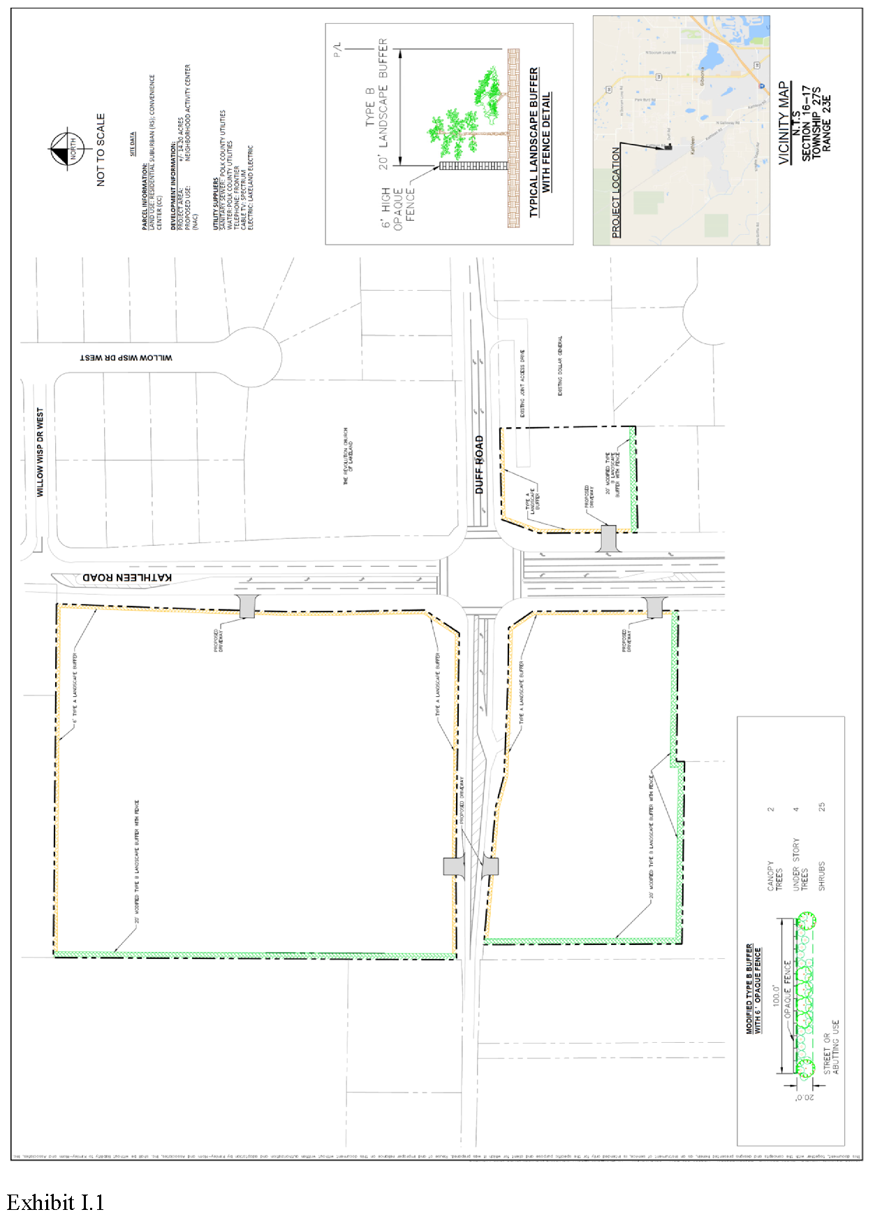
All allowable uses shall comply with the following additional site development standards prior to site alteration or development and consistent with the Activity Center Plan as displayed in Exhibit I-1:
a.
Excluding property frontage on Polk County maintained stormwater ponds and rights-of-way, all proposed development or redevelopment of the subject site shall be conditioned upon a minimum twenty (20) foot wide Type "B" Landscape Buffer, as defined in Section 720 of this Code, with the following modifications:
i.
Vegetative buffer that shall achieve eighty-percent (80%) opacity with shrubs capable of growing 36 inches in height within twelve (12) months of planting; and
ii.
An optional solid fence or wall, but if the wall is included the requirements of the width and density of vegetative buffer shall not be reduced as long as there exists a residential use or residential future land use designation on the adjacent properties to the subject site.
b.
Except when special requirements in this section are more stringent, all uses shown as allowed in the NAC Land Use designation as "P" in table 2. 1 of Chapter 2 of this LDC shall, at a minimum, comply with the Criteria for Conditional Uses for uses contained in Section 303 of this Code. All uses will be subject to the Level of Review established as per Table 2. 1 of this LDC.
c.
A master infrastructure plan, including stormwater plans, utility easements, and cross-access easements, for the entire site or for each of the northwest or southwest corners independently of the Kathleen and Duff Roads intersection, as generally depicted on the Activity Center Plan, shall be submitted prior to site plan (Level 2) approval on any portion of the identified development area.
d.
A cross-access easement between and among the subject parcels, generally consistent with the Activity Center Plan, shall be recorded prior to site plan (Level 2) approval for the respective development areas.
e.
The edge of the retention ponds shall be landscaped with similar planting materials of a Type "A" Buffer along any side not adjacent to another buffer.
f.
Unless as otherwise provided herein for lighting, no structure or parking shall be located within the landscape buffer.
g.
All truck parking, vehicle repair bay/area, outdoor storage, transit facilities, and loading and unloading areas shall be at least fifty (50) feet from all property lines abutting residential uses, excluding property lines abutting Polk County maintained stormwater ponds and rights-of-way.
h.
All principal structures and those accessory structures related to truck parking or loading and unloading activities shall be at least fifty (50) feet from all side and rear property lines, excluding property lines abutting Polk County maintained stormwater ponds and rights-of-way.
i.
Gas pumps shall be set back at least thirty (30) feet from property lines, excluding property lines abutting Polk County maintained stormwater ponds and rights-of-way.
j.
Accessory structures, not related to truck parking or loading and unloading activities shall be at least twenty (20) feet from all side and rear property lines.
k.
The maximum height of any on-site light sources shall be forty (40) feet if placed at least thirty (30) feet from a residential property line, and twenty- four (24) feet if within thirty (30) feet of an existing residential property line. The height limitation shall not apply to boundaries abutting rights-of- way. Illumination shall be shielded and directional and any spill onto adjacent properties shall not exceed one-half (0.5) foot candles and consistent with Dark Sky Friendly lighting.
l.
The minimum setback of the light source from the residential property line shall be a horizontal distance of twenty (20) feet, except when the light source is adjoining a right-of-way. If the on-site light source adjoins a right-of-way, the lighting can be placed within the landscape buffer as required by Section 720 of this Code.
m.
Any building façade within two hundred (200) feet of an existing residence and greater than thirty-five (35) feet in height and having a wall length greater than two hundred (200) feet in length shall be designed to achieve an office or residential appearance or otherwise include design components to break the wall plane (change in plane or height, change in texture or patterns, include doors, windows or articulated base, etc.); this provision shall not apply when over at least fifty percent (50%) of that building plane contains overhead doors or loading docks/bays for trucks.
n.
For structures exceeding thirty-five (35) feet in height, setbacks from parcels designated or developed as residential shall be increased by one-half of one foot for each one foot of height over thirty five feet.
o.
External operations such as receiving deliveries, docking, loading or unloading of trucks, shall be limited to the hours between 6 a.m. and 8 p.m. for non-residential development within two hundred (200) feet of an existing residence, excluding parcels abutting Polk County maintained stormwater ponds and rights-of-way.
3.
Any changes to this section shall be subject to the public hearing and notice requirements for a Comprehensive Plan map amendment as listed in Chapter 9 of the Land Development Code.
K.
CPA 18C-01 and LDCPAS-2024-5 - Parcel ID#s: 232911-000000-012120, 232911-000000-012200 and 232911-000000-012030 (Added 8/21/18 - Ord. 18-060)
1.
Applicability
The provisions and requirements of this Section apply to the subject site, the boundaries of which are shown on the Future Land Use Map Series and Land Use District maps.
2.
Allowable Uses and Intensity of Development
a.
The allowable use for this property shall be limited as follows:
i.
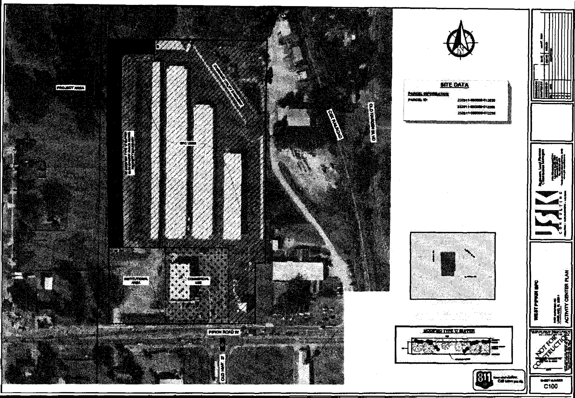
Business Park Center Uses that shall be allowed only in the area designated on the Activity Center Plan subject to the Level of Review established in Table 2.1 of this LDC. The Activity Center Plan shall be limited to the following uses and at a minimum, comply with the Criteria for Conditional Uses contained in Section 303 of this Code:
a)
Commercial Vehicle Parking.
b)
Office.
c)
Self-Storage Facility.
d)
Commercial Uses, consistent with Convenience Center land use, shall not extend more than 260-feet into the site as measured from the right-of-way of W. Pipkin Road.
ii.
Institutional Uses that shall be allowed only in the area designated on the Activity Center Plan subject to the Level of Review established in Table 2.1 of this LDC and at a minimum, comply with the Criteria for Conditional Uses contained in Section 303 of this Code.
b.
All allowable uses shall comply with the following additional site development standards prior to site alteration or development:
i.
All proposed development or redevelopment of the site shall be conditioned upon a 50 foot wide buffer area running 760' south from the northernmost property line along the residential uses to the west and 165' east along the north property line from the westernmost property line as generally shown on the Activity Center Plan. The buffer shall include the plantings of a Type "C" Landscape Buffer as outlined in Section 720 of this Code. In addition, a minimum six-foot-high opaque fence shall be installed around the entire property boundary using outdoor storage.
ii.
Except as provided in Condition 2(b)(i), all proposed development or redevelopment of the site shall have a minimum 20-foot setback requirement unless a larger setback is required in Table 2.2 and subject to standard Landscape Buffer requirements as outlined in Section 720 of this Code.
iii.
All development shall submit a lighting plan. All lighting shall be directional and fully shielded with cut-off, non-glare fixtures directed straight downward onto the subject site. The maximum height of on-site lighting fixtures shall be limited to 17 feet. All light fixtures shall be setback a horizontal distance of at least 50 feet from any residentially used or designated property. Illumination onto adjacent properties and rights-of- way shall not exceed 0.5-foot candles, measured at the property line of the site.
iv.
Structures shall not exceed fifty (50) feet in height.
3.
The Activity Center Plan shall be as shown:
L.
LDCPAL 2019-6 - Parcel ID#s: 303116-000000-011010, 303116000000013040, 303116000000014010, 303116000000031010
1.
Applicability
The provisions and requirements of this Subsection apply to the Subject Site, the boundaries of which are shown on the Future Land Use Map Series and Land Use District maps, more particularly those depicted in the panel showing Range 30, Township 31, Section 16, hereafter the "Subject Site." The Subject Site is legally described as:
THAT PART OF SECTION 16, TOWNSHIP 31 SOUTH, RANGE 30 EAST, POLK COUNTY, FLORIDA, LYING SOUTH AND EAST OF COUNTY ROAD 630, BEING MORE PARTICULARLY DESCRIBED AS:
BEGIN AT THE SOUTHEAST CORNER OF SAID SECTION 16, AND RUN THENCE ALONG THE SOUTH LINE THEREOF N-89°38'40"-W, 2656.06 FEET TO THE SOUTHWEST CORNER OF THE SOUTHEAST ¼ OF SAID SECTION 16; THENCE CONTINUE ALONG SAID SOUTH LINE N-89°35'49'-W, 1277.05 FEET TO A POINT THAT LIES 50.00 FEET EAST OF THE WEST LINE OF THE EAST ¾ OF SAID SECTION 16; THENCE ALONG A LINE PARALLEL WITH AND 50.00 FEET EAST OF SAID WEST LINE N-00°10'44"-W, 1326.66 FEET TO A POINT THAT LIES 50.00 FEET EAST OF THE NORTHWEST CORNER OF THE SOUTHEAST ¼ OF THE SOUTHWEST ¼ OF SAID SECTION 16, ALSO BEING THE SOUTHWEST CORNER OF THE NORTHEAST ¼ OF THE SOUTHWEST ¼ OF SAID SECTION 16; THENCE CONTINUE ALONG A LINE PARALLEL WITH AND S0.00 FEET EAST OF SAID WEST LINE N-00°09'13"-W, 1324.77 FEET TO A POINT THAT LIES 50.00 FEET EAST OF THE NORTHWEST CORNER OF THE NORTHEAST ¼ OF THE SOUTHWEST ¼ OF SAID SECTION 16, ALSO BEING THE SOUTHWEST CORNER OF THE SOUTHEAST ¼ OF THE NORTHWEST ¼ OF SAID SECTION 16;
THENCE CONTINUE ALONG A NON-RADIAL LINE PARALLEL WITH AND 50.00 FEET EAST OF SAID WEST LINE N-00°11'45"-W, 793.71 FEET TO A POINT ON THE EAST MAINTAINED RIGHT-OF-WAY OF COUNTY ROAD 630 PER MAP BOOK 02, PAGE 50, PUBLIC RECORDS OF POLK COUNTY, FLORIDA, SAID POINT BEING A POINT OF CURVE CONCAVE NORTHWESTERLY; THENCE ALONG SAID EAST RIGHT-OF-WAY, AND NORTHEASTERLY ALONG SAID CURVE HAVING A RADIUS OF 2371.83 FEET, A CENTRAL ANGLE/DELTA OF 02'09'36", A CHORD BEARING OF N-56°47'44"-E, A CHORD DISTANCE OF 89.41 FEET, FOR AN ARC LENGTH OF 89.42 FEET TO A INTERSECTION WITH THE EAST RIGHT-OF-WAY OF COUNTRY ROAD 630 PER OFFICIAL RECORDS BOOK 8059, PAGE 1495, PUBLIC RECORDS OF POLK COUNTY, FLORIDA, SAID INTERSECTION ALSO BEING A POINT OF COMPOUND CURVE CONCAVE NORTHWESTERLY; THENCE NORTHEASTERLY ALONG SAID CURVE HAVING A RADIUS OF 750.00 FEET, A CENTRAL ANGLE/DELTA OF 38°42'01", A CHORD BEARING OF N-53°29'56"-E, A CHORD DISTANCE OF 497.01 FEET, FOR AN ARC LENGTH OF 506.59 FEET; THENCE DEPARTING SAID EAST RIGHT-OF-WAY, AND ALONG A NON-RADIAL LINE S-89°21'49"-E, 285.05 FEET; THENCE N-31°17'56"-E, 208.71 FEET; THENCE ALONG A NON-RADIAL LINE N-89°21'49"-W, 280.28 FEET TO A POINT ON SAID EAST MAINTAINED RIGHT-OF-WAY, SAID POINT ALSO BEING A POINT OF CURVE CONCAVE NORTHWESTERLY; THENCE ALONG SAID EAST RIGHT-OF-WAY, AND NORTHEASTERLY ALONG SAID CURVE HAVING A RADIUS OF 2371.83 FEET, A CENTRAL ANGLE/DELTA OF 08°51'55", A CHORD BEARING OF N-34°21'18"-E, A CHORD DISTANCE OF 366.62 FEET FOR AN ARC LENGTH OF 366.99 FEET; THENCE N-29°55'20"-E, 550.19 FEET; THENCE DEPARTING SAID EAST RIGHT-OF-WAY S-60°05'33"-E, 300.64 FEET; THENCE N-29°56'06"-E, 145.02 FEET; THENCE N-60005'33"-W, 300.67 FEET TO A POINT ON SAID EAST RIGHT-OF-WAY; THENCE ALONG SAID EAST RIGHT-OF-WAY N-29°55'20"-E, 349.97 FEET; THENCE DEPARTING SAID EAST RIGHT-OF-WAY S-60°06'57"-E, 300.33 FEET; THENCE N-29°58'28"-E, 144.90 FEET; THENCE N-60°05'20"-W, 268.74 FEET TO A POINT ON THE NORTH LINE OF SAID SECTION 16; THENCE ALONG THE NORTH LINE OF SAID SECTION 16 S-89°21'19"-E, 2531.70 FEET TO THE NORTHEAST CORNER OF SAID SECTION 16; THENCE ALONG THE EAST LINE OF SAID SECTION 16 S-00°02'26"-W, 5283.40 FEET TO THE POINT OF BEGINNING.
LESS
PARCEL 13 OF UNRECORDED "FLORIDA ESTATES", DESCRIBED AS FOLLOWS: THE SOUTH 300.5 FEET OF THE NORTH 661 FEET OF THE WEST 175 FEET OF THE EAST 1925 FEET OF THE NORTHEAST ¼ OF SAID SECTION 16. SUBJECT TO AN EASEMENT 30 FEET WIDE ALONG THE EAST BOUNDARY FOR COMMON ACCESS ROAD. ALSO LESS PARCEL 41 OF UNRECORDED "FLORIDA ESTATES", DESCRIBED AS FOLLOWS:
THE SOUTH 330 FEET OF THE NORTH 1321 FEET OF THE WEST 660 FEET OF THE EAST 1320 FEET OF THE NORTHEAST ¼ OF SAID SECTION 16. SUBJECT TO AN EASEMENT 30 FEET WIDE ALONG ITS EAST BOUNDARY FOR COMMON ACCESS ROAD.
THE ABOVE DESCRIBED PARCEL CONTAINS 435.00 ACRES, MORE OR LESS
2.
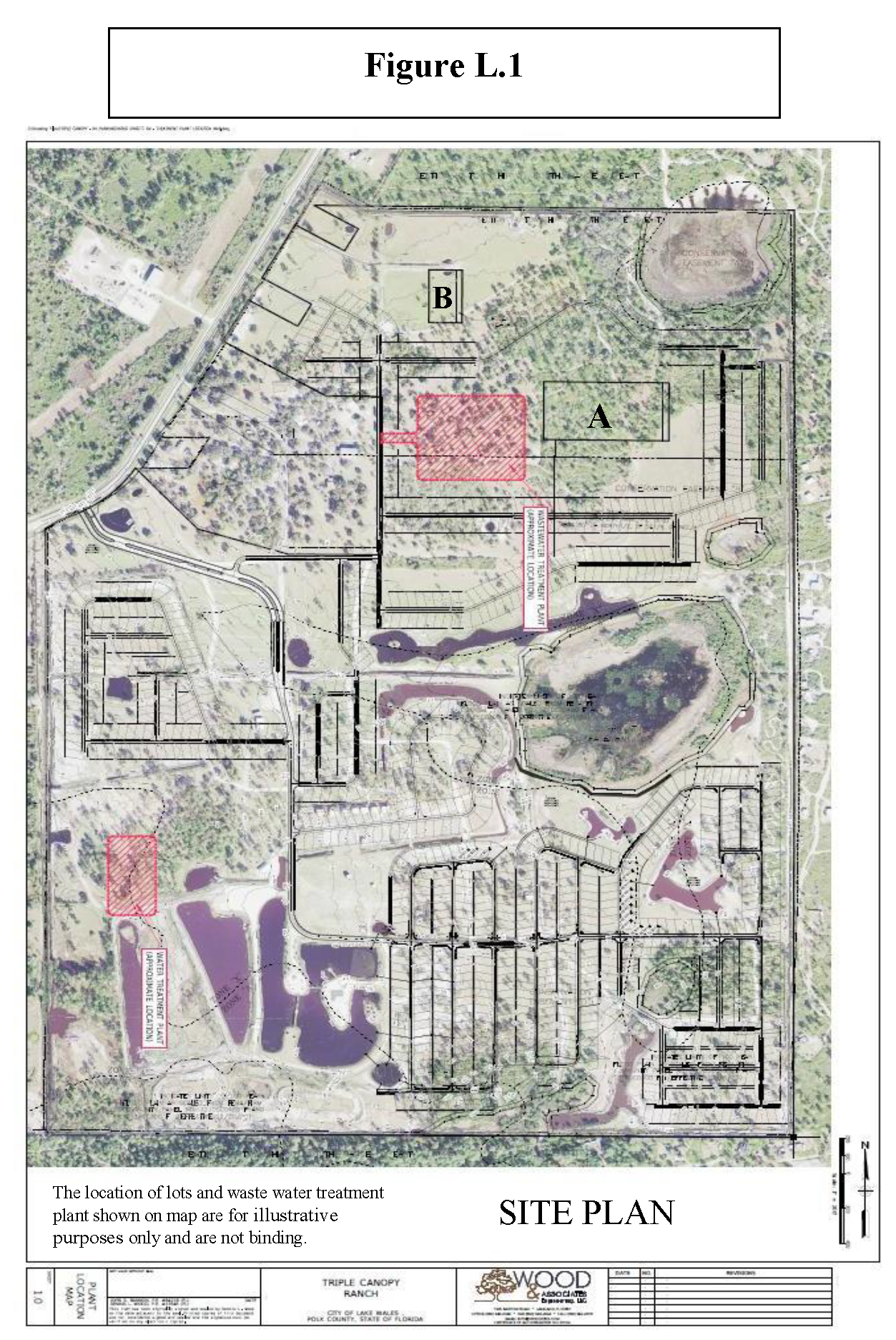
Development standards within the L/R Land Use designation shall be allowed with the following restrictions, as shown in Figure L.1.
a.
An exclusive 25-foot access easement shall be provided and displayed, submitted at Level 2 Review, to parcels A and B in Figure L.1. A 100 foot buffer shall be provided around these parcels, maintained by the Subject Sites developer and/or land owner, due to their Agriculture Residential/Rural Future Land Use designation.
b.
The Site Plan, submitted at Level 2 Review, shall only allow for RV's, limited to 1,000 units, on the subject site.
c.
Per the JLUS (7.2.4), Low Level Flight Areas signage shall be placed at the entrance and throughout the Subject Site to state that there is potential of low flying aircraft.
d.
Per the JLUS (7.2.6), bird/aircraft strike hazards shall be addressed by conditioning covered trash cans for property and all special events.
e.
Per the JLUS (7.2.7), lighting during nighttime training from the Avon Park Air Force Range shall be addressed by coordinating all outdoor events between the Avon Park Airforce Range and the Subject Sites developer and/or land owner. Lighting for events shall be consistent with "dark sky" requirements.
f.
Per the JLUS (7.2.8), Conservation resources (prescribed burning) on the Avon Park Air Force Range shall be addressed by coordination of schedules with Avon Park Air Force Range and developer and/or land owner.
M.
LDCPAS-2019-18
1.
Applicability
The provisions and requirements of this Subsection apply to the subject site, the boundaries of which are shown on the Future Land Use Map Series and Land Use District maps, more particularly those depicted in the panel showing Range 23, Township 29, Section 22. The site is legally described as:
Commence at the Southeast corner of Section 22, Township 29 South, Range 23 East, Polk County, Florida and run thence N 00°23'34" W, along the East boundary thereof, 84.85 feet to the Northerly right of way line of Shepherd Road; thence S 89°50'06" W, along said right of way line, 113.44 feet to the Point of Beginning; thence S 89°47'29" W, along said Northerly right of way line, a distance of 245.00 feet; thence N 00°24'41" W, a distance of 320.13 feet; thence S 89°46'53" W, a distance of 179.92 feet to a point on the Easterly right of way line of Chelsea Oaks Drive as shown on the Plat of Chelsea Oaks as recorded in Plat Book 134, Page 46-49, Public Records of Polk County, Florida; thence N 00°22'35" W, along said Easterly right of way line, a distance of 389.95 feet; thence N 89°36'38" E, a distance of 20.08 feet to the Point of Beginning; thence N 00°23'11" W, a distance of 464.38 feet; thence N 89°48'02" E, a distance of 386.03 feet; thence S 27°40'23" E, a distance of 268.65 feet; thence S 44°31'54" E, a distance of 66.47 feet; thence S 08°20'59" E, a distance of 130.42 feet; thence S 59°28'44" E, a distance of 33.24 feet; thence S 17°59'24" E, a distance of 12.01 feet; thence S 43°02'41" W, a distance of 26.10 feet; thence S 89°36'38" W, a distance of 587.77 feet; to the Point of Beginning. The above parcel containing 233.689 square feet, 5.36 acres, more or less.
2.
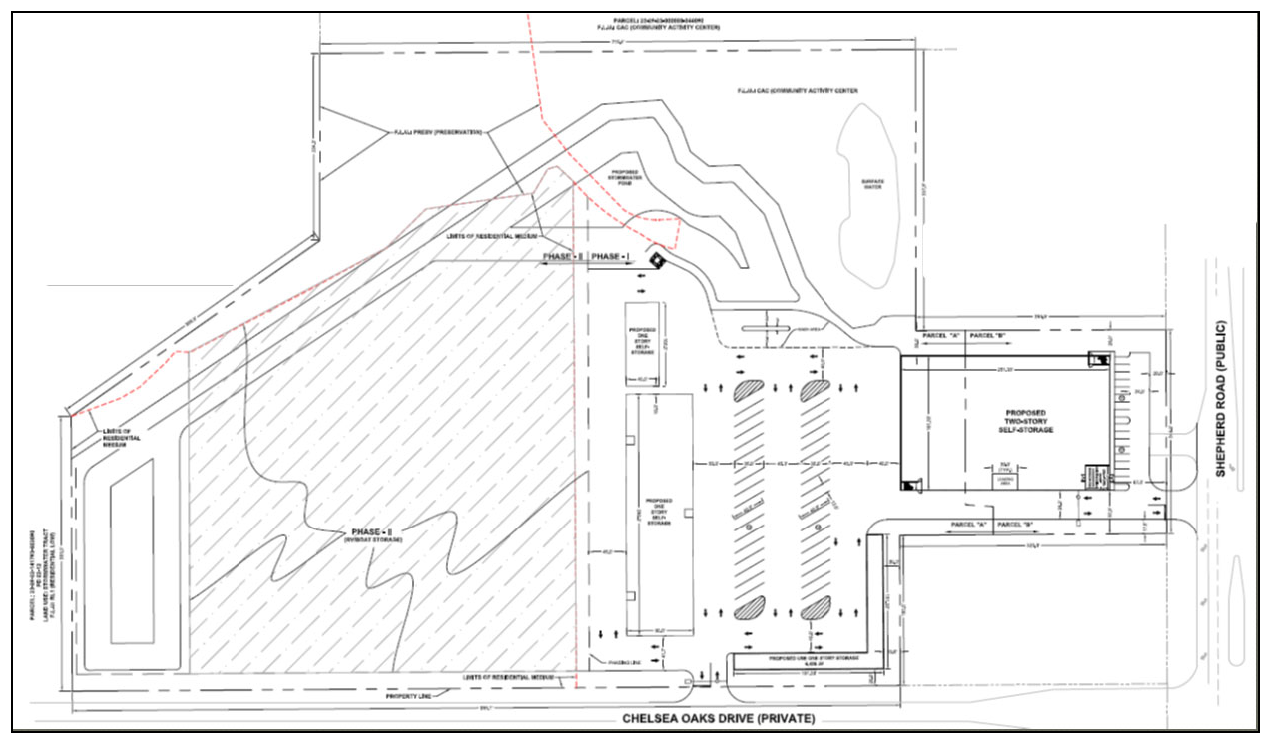
Permitted and conditional uses within the CAC Land Use designation shall only include Self Storage as permitted by the Land Development Code including all other applicable sections of the Land Development Code. Accessory uses to self-storage such as, but not limited to, RV and boat storage and other similar accessory storage items may also be permitted consistent with the Land Development Code. Figure M.1 is a general depiction of the property.
N.
LDCPAS-2021-13 Parcel #242911-281016-000041
1.
Applicability
The provisions and requirements of this Subsection apply to the subject site, the boundaries of which are shown on the Future Land Use Map Series and Land Use District maps, more particularly those depicted in the panel showing Range 24, Township 29, Section 11. The site is legally described as:
TOWN CENTER EAST PB 157 PGS 31 & 32 LOT 4 LESS THAT PART LYING WITHIN FOLL: COMM SE COR OF SAID LOT 4 S89-52-10W 665.09 FT TO POB CONT S89-52-10W 65 FT N00-07-50W 186.64 FT N38-37-02W 889.48 FT N00-38-05W 117.91 FT N89-57-09E 1276.21 FT S00-36-58E 684.87 FT N86-48-19W 557.96 FT S89-52-10W 105.41 FT S00-07-50E 346.46 FT TO POB & LESS THAT PT DESC AS: COMM NE COR OF SAID LOT 4 RUN S00-36-58E 230.64 FT S89-57-09W 475.02 FT N00-36-58W 230.65 FT N89-57-14E 475.02 FT TO POB & LESS THAT PT DESC AS: COM SE COR OF SAID LOT 4 RUN S89-52-10W ALONG S BNDRY & N R/W LINE OF CLUBHOUSE RD 665.09 FT N00-07-50W 346.46 FT N89-52-10E 105.41 FT S86-48- 19E 557.96 FT TO PT ON W R/W OF FIRST ST S00-36- 58E ALONG SAID W R/W LINE & E LINE OF SAID LOT 4 314.10 FT TO POB
2.
Prohibited Use
The following uses are prohibited on this subject parcel:
a.
Residential
b.
Alcohol Package Sales
c.
Bars, Lounges, Taverns
d.
Car washes; Full-Service, Self-Services, Incidental
e.
Communication Towers
f.
Community Centers
g.
Cultural Facilities
h.
Financial Institutions
i.
Gas Stations
j.
Hotels & Motels
k.
Light Assembly
l.
Manufacturing
m.
Medical Marijuana Dispensaries
n.
Motor Freight Terminals
o.
Personal Service (Retail)
p.
Printing & Publishing
q.
Religious Institutions
r.
Retail Uses - other than ancillary to Self-Storage
s.
Schools
t.
Utilities, Classes I, II, & III
u.
Vehicle Repair & Vehicle Service
O.
LDCPAS-2021-24 Parcel numbers 232903-000000-042010; 232910-000000-031050, 232910-000000-031140, 232910-000000-032020, 232910-000000-032050, 232910-000000-032060
1.
Applicability
The provisions and requirements of this Subsection apply to the subject site, the boundaries of which are shown on the Future Land Use Map Series and Land Use District maps, more particularly those depicted in the panel showing Range 23 East, Township 29 South, Section 3 and 10. The site is legally described as:
The East 1/2 of the Northeast ¼ of the Northwest ¼, Less the West 40 Feet and Less the East 200 feet of the West 240 feet of the North 155 feet thereof all in section 10. Township 29 South. Range 23 East, TOGETHER with all improvements located thereon;
And
The South 40 yards of the Southeast ¼ of the Southeast ¼ of the Southwest ¼, Less the West 240 feet thereof, and Less road. right of way for Drane Field Road, all being in Section 3, Township 29 South, Range 23 East, TOGETHER with all improvements located thereon;
LESS AND EXCEPT that parcel of land described in Official Records Rook 5444, Page 1628 of the Public Records of Polk County, Florida, being more particularly as follows;
The South 208.71 feet of the North 930.71 feet of the East 208.71 feet of the West 248.71 feet of the East 1/2 of the Northeast ¼ of the Northwest ¼ of Section 10, Township 29 South, Range 23 East, Polk County, Florida; Together with an easement for egress, ingress and utility purposes over and across the North 930.71 feet of the West 40.0 feet of the East 1/2 of the Northeast ¼ of the Northwest ¼ of the said Section 10 and over and across that port of the West 40.0 feet of the East 1/2 of the Southeast ¼ of the Southwest ¼, Lying South of the South Right-of-Way line of Medulla Road of Section 3, Township 29 South, Range 23 East, Polk County, Florida.
TOGETHER WITH AN EASEMENT for ingress and egress over and across the West 40 feet of the North 1/2 of Northeast ¼ of Northwest ¼ of Section 10, Township 29 South, Range 23 East and the West 40 feet of the East 1/2 of the South 40 yards of the Southeast ¼ of the Southwest ¼ of Section 3, Township 29 South, Range 23 East, less road right of way for Drane Field Road.
AND
The West 446.61 feet of the North 420.00 feet of the West 700.00 feet of the Southeast ¼ of the Northwest ¼ of Section 10, Township 29 South, Range 23 East, Together with an Easement for Ingress, Egress and Utilities over the East 30.00 feet and the South 30.00 feet of the East 253.39 feet of the North 420.00 feet of the West 700.00 feet of the Southeast ¼ of the Northwest ¼ of Section 10, Township 29 South, Range 23 East, Polk County, Florida.
AND
The West 40 feet of East ½ of Northeast ¼ of Northwest ¼ of Section 10, Township 29 South, Range 23 East and the West 40 feet of the East ½ of the South 40 yards of the Southeast ¼ of Southwest ¼ of Section 3, Township 29 South, Range 23 East, less road right-of-way for Drane Field Road, all of the public records of Polk County, Florida.
AND
The North 195.00 feet of the East 253.39 feet of the North 420.00 feet of the West 700.00 feet of the Southeast ¼ of the Northwest ¼ of Section 10, Township 29 South, Range 23 East. Subject to an Easement for Ingress, Egress and Utilities over the East 30.00 feet thereof. Together with a non-exclusive Easement over and across the West 40 feet of East ½ of Northeast ¼ of Northwest ¼ of Section 10, Township 29 South, Range 23 East and the West 40 feet of the East ½ of the South 40 yards of the Southeast ¼ of Southwest ¼ of Section 3, Township 29 South, Range 23 East, less road right-of-way for Drane Field Road, all of the public records of Polk County, Florida.
AND
The South 225.00 feet of the East 253.39 feet of the North 420.00 feet of the West 700.00 feet of the Southeast ¼ of the Northwest ¼ of Section 10, Township 29 South, Range 23 East, subject to an Easement for Ingress, Egress and Utilities over the East 30.00 feet and the South 30.00 feet thereof, and together with and Easement for Ingress, Egress and Utilities over the East 30.00 feet of the North 195.00 feet of the of the East 253.39 feet of the North 420.00 feet of the West 700.00 feet of the Southeast ¼ of the Northwest ¼ of Section 10, Township 29 South, Range 23 East, all of the Public records of Polk County, Florida.
AND LESS AND EXCEPT the following
A PARCEL OF LAND BEING IN THE NORTHWEST ¼ OF SECTION 10 AND THE SOUTHWEST ¼ OF SECTION 3, BOTH IN TOWNSHIP 29 SOUTH, RANGE 23 EAST, POLK COUNTY, FLORIDA, DESCRIBED AS FOLLOWS:
COMMENCE AT THE NORTHWEST CORNER OF SAID SECTION 10 (SOUTHWEST CORNER OF SAID SECTION 3) THENCE NORTH 89°55'115" EAST 2247.82 FEET ALONG THE NORTH LINE OF SAID SECTION 10 (SOUTH LINE OF SAID SECTION 3); THENCE DEPARTING SAID SECTION LINE, RUN NORTH 00°13'11" WEST 17.33 FEET TO THE POINT OF BEGINNING; THENCE CONTINUE NORTH 00°13'11" WEST 21.21 FEET TO THE EXISTING SOUTHERLY RIGHT OF WAY LINE OF MEDULLA ROAD (AS SHOWN ON THE CITY OF LAKELAND RIGHT OF WAY MAP PROJECT NO. 005533) ; THENCE NORTH 89°57'29" EAST 75.51 FEET ALONG SAID EXISTING SOUTHERLY RIGHT OF WAY LINE OF MEDULLA ROAD TO A POINT ON A TANGENT CURVE TO THE RIGHT (CONCAVE SOUTHWESTERLY); THENCE NORTHEASTERLY, EASTERLY AND SOUTHEASTERLY ALONG SAID EXISTING SOUTHERLY RIGHT OF WAY LINE AND SAID CURVE, HAVING A RADIUS OF 691.20 FEET, FOR AN ARC DISTANCE OF 270.03 FEET, THROUGH A CENTRAL ANGLE OF 22°23'00" TO END OF CURVE; THENCE SOUTH 67°39'31" EAST 9.05 FEET ALONG SAID RIGHT OF WAY LINE TO A POINT ON A TANGENT CURVE TO THE LEFT (CONCAVE NORTHEASTERLY); THENCE SOUTHEASTERLY ALONG SAID RIGHT OF WAY LINE AND SAID CURVE, HAVING A RADIUS OF 843.51 FEET, FOR AN ARC DISTANCE OF 89.18 FEET, THROUGH A CENTRAL ANGLE OF 06°03'26" TO THE EAST LINE OF SAID SOUTHWEST ¼ OF SECTION 3, AND END OF CURVE; THENCE SOUTH 00°15'18" EAST 12.18 FEET ALONG SAID EAST LINE OF THE SOUTHWEST ¼ OF SECTION 3 TO A POINT ON A NON-TANGENT CURVE TO THE RIGHT (CONCAVE NORTHEASTERLY); THENCE NORTHWESTERLY ALONG SAID CURVE, HAVING A RADIUS OF 840.00 FEET, FOR A DISTANCE OF 64.87 FEET, HAVING A CHORD BEARING OF NORTH 71°20'26" WEST FOR A DISTANCE OF 64.86 FEET, THROUGH A CENTRAL ANGLE OF 04°25'30" TO A POINT OF REVERSE CURVE TO THE LEFT (CONCAVE SOUTHWESTERLY); THENCE NORTHWESTERLY ALONG SAID CURVE, HAVING A RADIUS OF 840.00 FEET, FOR A DISTANCE OF 144.22 FEET, HAVING A CHORD BEARING OF NORTH 73°40'03" WEST FOR A DISTANCE OF 144.04 FEET, THROUGH A CENTRAL ANGLE OF 09°50'14" TO END OF CURVE; THENCE SOUTH 89°25'57" WEST 37.47 FEET TO A POINT ON A NON-TANGENT CURVE TO THE LEFT (CONCAVE SOUTHEASTERLY); THENCE SOUTHWESTERLY, SOUTHERLY AND SOUTHEASTERLY ALONG SAID CURVE, HAVING A RADIUS OF 46.00 FEET, FOR AN ARC INSTANCE OF 59.08 FEET, HAVING A CHORD BEARING OF SOUTH 15°39'33" WEST FOR A DISTANCE OF 55.10 FEET, THROUGH A CENTRAL ANGLE OF 73°35'14" TO A POINT OF COMPOUND CURVE TO THE LEFT (CONCAVE NORTHEASTERLY); THENCE SOUTHEASTERLY ALONG SAID CURVE, HAVING A RADIUS OF 900.00 FEET, FOR AN ARC DISTANCE OF 156.12 FEET, HAVING A CHORD BEARING OF SOUTH 26°06'14" EAST FOR A DISTANCE OF 155.92 FEET, THROUGH A CENTRAL ANGLE OF 09°56'20" TO END OF CURVE; THENCE SOUTH 31°04'24" EAST 279.91 FEET TO A POINT ON A TANGENT CURVE TO THE RIGHT (CONCAVE SOUTHWESTERLY); THENCE SOUTHEASTERLY ALONG SAID CURVE, HAVING A RADIUS OF 1,000.00 FEET, FOR AN ARC DISTANCE OF 86.17 FEET THROUGH A CENTRAL ANGLE OF 04°56'14" TO SAID EAST LINE OF THE NORTHWEST ¼ OF SECTION 10, AND END OF CURVE; THENCE SOUTH 00°17'39" EAST 435.89 FEET ALONG SAID EAST LINE OF THE NORTHWEST ¼ TO A POINT ON A NON-TANGENT CURVE TO THE LEFT (CONCAVE SOUTHWESTERLY); THENCE NORTHWESTERLY ALONG SAID CURVE, HAVING A RADIUS OF 900.00 FEET, FOR A DISTANCE OF 483.48 FEET, HAVING A CHORD BEARING OF NORTH 15°41'01" WEST FOR A DISTANCE OF 477.69 FEET, THROUGH A CENTRAL ANGLE OF 30°46'45" TO END OF CURVE; THENCE NORTH 31°04'24" WEST 279.91 FEET TO A POINT ON A TANGENT CURVE TO THE RIGHT (CONCAVE NORTHEASTERLY); THENCE NORTHWESTERLY ALONG SAID CURVE, HAVING A RADIUS OF 1,000.00 FEET, FOR AN ARC DISTANCE OF 282.53 FEET, THROUGH A CENTRAL ANGLE OF 16°11'15" TO END OF CURVE SAID POINT BEING ON A NON-TANGENT CURVE TO THE LEFT (CONCAVE SOUTHERLY); THENCE NORTHWESTERLY ALONG SAID CURVE, HAVING A RADIUS OF 905.00 FEET, FOR AN ARC DISTANCE OF 1.97 FEET, HAVING A CHORD BEARING OF NORTH89°38'25" WEST FOR A DISTANCE OF 1.97 FEET, THROUGH A CENTRAL ANGLE OF 00°07'29" TO END OF CURVE; THENCE NORTH 89°42'10" WEST 50.26 FEET TO THE POINT OF BEGINNING.
AND ALSO LESS:
A PARCEL OF LAND BEING IN THE SOUTHWEST ¼ OF SECTION 3, TOWNSHIP 29 SOUTH, RANGE 23 EAST, POLK COUNTY, FLORIDA, DESCRIBED AS FOLLOWS: COMMENCING AT THE SOUTHWEST CORNER OF SAID SECTION 3; THENCE NORTH 89°55'15" EAST 2,007.82 FEET ALONG THE SOUTH LINE OF SAID SECTION 3 TO THE WEST LINE OF THAT CERTAIN PROPERTY AS DESCRIBED IN OFFICIAL RECORDS BOOK 1376, PAGE 813 OF THE PUBLIC RECORDS OF POLK COUNTY, FLORIDA; THENCE NORTH 00°13'11" WEST 78.90 FEET ALONG SAID WEST PROPERTY LINE TO THE POINT OF BEGINNING; THENCE CONTINUE ALONG SAID WEST PROPERTY LINE, NORTH 00°13'11" WEST 19.79 FEET TO THE EXISTING SOUTHERLY RIGHT OF WAY LINE OF MEDULLA ROAD (AS SHOWN ON THE CITY OF LAKELAND RIGHT OF WAY MAP PROJECT NO. 005533); THENCE NORTH 89°57'29" EAST 40.00 FEET ALONG SAID RIGHT OF WAY LINE TO THE EAST PROPERTY LINE OF AFOREMENTIONED PROPERTY; THENCE SOUTH 00°13'11" EAST 20.03 FEET ALONG SAID EAST PROPERTY LINE; THENCE DEPARTING SAID EAST LINE, RUN NORTH 89°42'10" WEST 40.00 FEET TO THE POINT OF BEGINNING.
1.
Permitted Uses. The permitted uses on this site shall be those uses associated with the Residential High future land use as permitted in Table 2.1 of this Code. Except that the three western most parcels shall only be restricted to retention, open space, or parking.
2.
Additional Site Development Standards
In addition to all applicable standards of this Code, any development on the subject site shall comply with the following site development standards prior to site alteration or development:
a.
Any development of the site adjacent to existing single-family residential homes use shall be conditioned upon a 25-foot setback that shall incorporate at least a Type "B" Landscape Buffer as outlined in Section 720 of this Code that is irrigated.
b.
Dumpsters, mailboxes, car washing & maintenance areas, storage areas, and other accessory structures shall be located at least 50 feet from any residential property lines.
c.
Parking lots (minimum two rows) shall separate all structures from all perimeter residential lots.
d.
All balconies and terraces shall face interior to the site.
e.
All outdoor lighting in areas adjacent to a residential use shall be subject to the following conditions:
i.
All outdoor lighting shall be located, aimed or shielded so as to minimize light projection across property boundaries.
ii.
Except for security lighting fixtures, all outdoor lighting fixtures shall be of the fully shielded type. Examples of the fully shielded lights are set forth in Figure "A".
a)
Light fixtures shall be aimed no higher than 45 degrees above vertical down (half-way between straight down and straight to the side) when the light source is visible from any off-site residential property or thoroughfare.
b)
Prohibited lights:
1)
Flashing, revolving, or intermittent lights visible from any property line.
2)
High intensity light beams such as but not limited to searchlights, laser lights, or strobe lights visible from any property line.
FIGURE "A"
EXAMPLES OF FULLY SHIELDED LIGHTS
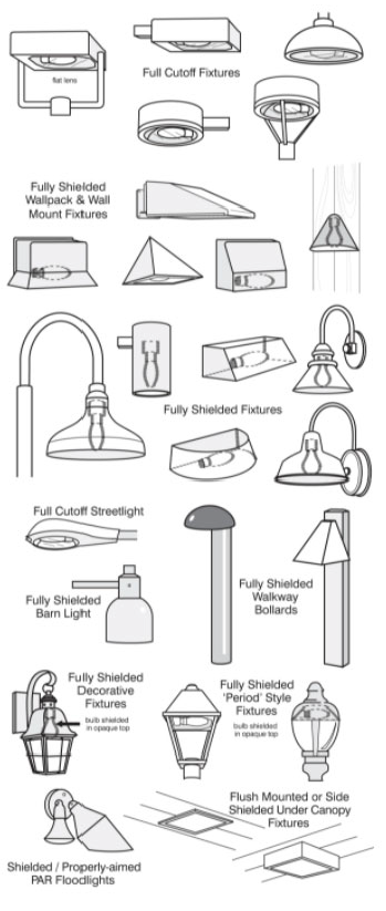
P.
LDCPAS-2022-6 Parcel #252805-319500-006800, 252804-313000006900, 252804-313000-007101, 252809-000000-033020, 252809-000000-0033010.
1.
Applicability. The provisions and requirements of this Section apply to the subject site, the boundaries of which are shown on the Future Land Use Map Series and Land Use District maps, more particularly those depicted in the panel showing Range 25, Township 28, Section 04, 05 & 09. The site is legally described as:
Lots 68, 69, 70 and 71 of LAKESIDE PARK as recorded in Plat Book 3, Page 20 of the Public Records of Polk County, Florida Lying South of the Southerly Right-of-Way line for State Road No. 570 and Old Dixie Highway, lying in Sections 4 & 5, Township 28 South, Range 25 East, Polk County, Florida.
AND
The North ½, of the Northwest ¼, of the Northwest ¼, of Section 09, Township 28 South, Range 25 East, Polk County, Florida.
AND
The South ½, of the Northwest ¼, of the Northwest ¼ of Section 09, Township 28 South, Range 25 East, Polk County, Florida.
AND
The North ½, of the Southwest ¼, of the Northwest ¼, of Section 09, Township 28 South, Range 25 East, Polk County, Florida, being more fully described as follows: Begin at the Southeast corner of said Section 5, run thence N 89°54'34" W along the South line of said Section 5 a distance of 332.02 feet, thence departing the South line of said Section 5 run N 00°13'06" W a distance of 1268.60 feet to a point on the Southerly right-of-way line of State Road No. 570, run thence N89°35'06" E along the Southerly right-of-way line of said State Road No. 570 a distance of 990.19 feet, continue thence N 00°11'43" W along said Southerly right-of-way line a distance of 50.37 feet to the Southerly right-of-way line of said Old Dixie Highway, run thence N 89°12'39" E along the Southerly right-of-way line of said Old Dixie Highway a distance of 0.56 feet, continue thence N 89°02'20' E along the Southerly right-of-way line of Old Dixie Highway a distance of 658.43 feet to a point on the East line of Said Lot 71 run thence S 00°04'39" W along the East line of said Lot 71 a distance of 1312.95 feet to the Northeast corner of the Northwest ¼, of the Northwest ¼ of said Section 09, run thence S 00°04'39" W along the East line of said Northwest ¼, of the Northwest ¼ a distance of 1326.53 feet to the Northeast comer of the North ½, of the Southwest ¼, of the Northwest ¼ of said Section 09, run thence S 00°04'39" W along the East line of the Southwest ¼, of the Northwest ¼ of said Section 09 a distance of 663.26 feet, run thence S 88°52'50" W a distance of 1315.69 feet to the West line of said Section 09, run thence N 00°13'36" W along the West line of said Section 09 a distance of 1990.74 feet to the POINT OF BEGINNING.
2.
The following uses are prohibited:
a.
Airports.
b.
Bars, Lounges, and Taverns.
c.
Communication Towers, Guyed, Lattice, or Monopole.
d.
Concrete Plants.
e.
Heliports and Helistops.
f.
Lime Stabilization Facility.
g.
Power Plants, non-certified low and high.
h.
Transit Facility.
3.
All allowable uses shall comply with the following additional site development standards and display on all Level 2, 3 or 4 Reviews:
a.
Lighting shall be consistent with Dark Skies best practices as listed in Section 642 of the Land Development Code. Warehouse buildings shall have state of the art wall packs down shading lighting on the west building wall within the truck court.
b.
As part of the required intersection improvements of Old Dixie Highway at Moss Road, the applicant shall construct certain improvements as provided in a Major Traffic Study consistent with the Land Development Code.
c.
There shall be no truck courts or truck parking between any warehouse buildings and the east and west property lines as illustratively displayed in Figure O-1.
d.
The buffering plan shall include a 25-foot-wide buffer along the west, east, and south boundaries in the areas depicted in Figure O-1. The buffer shall include a six-foot-tall opaque fence and shall include a five (5) foot earthen berm with a Type C Buffer consistent with the location and cross section as displayed on the illustrative Figure O-1. The plantings shall be those listed in Chapter 7 of the LDC and may include cedar for some of the plantings. The buffer shall be located on the sides and top of the berm to reduce degradation of the berm.
e.
Figure O-1 is meant to be for illustrative purposes expect for the landscape buffer and the cross sections of the berms.
FIGURE O-1
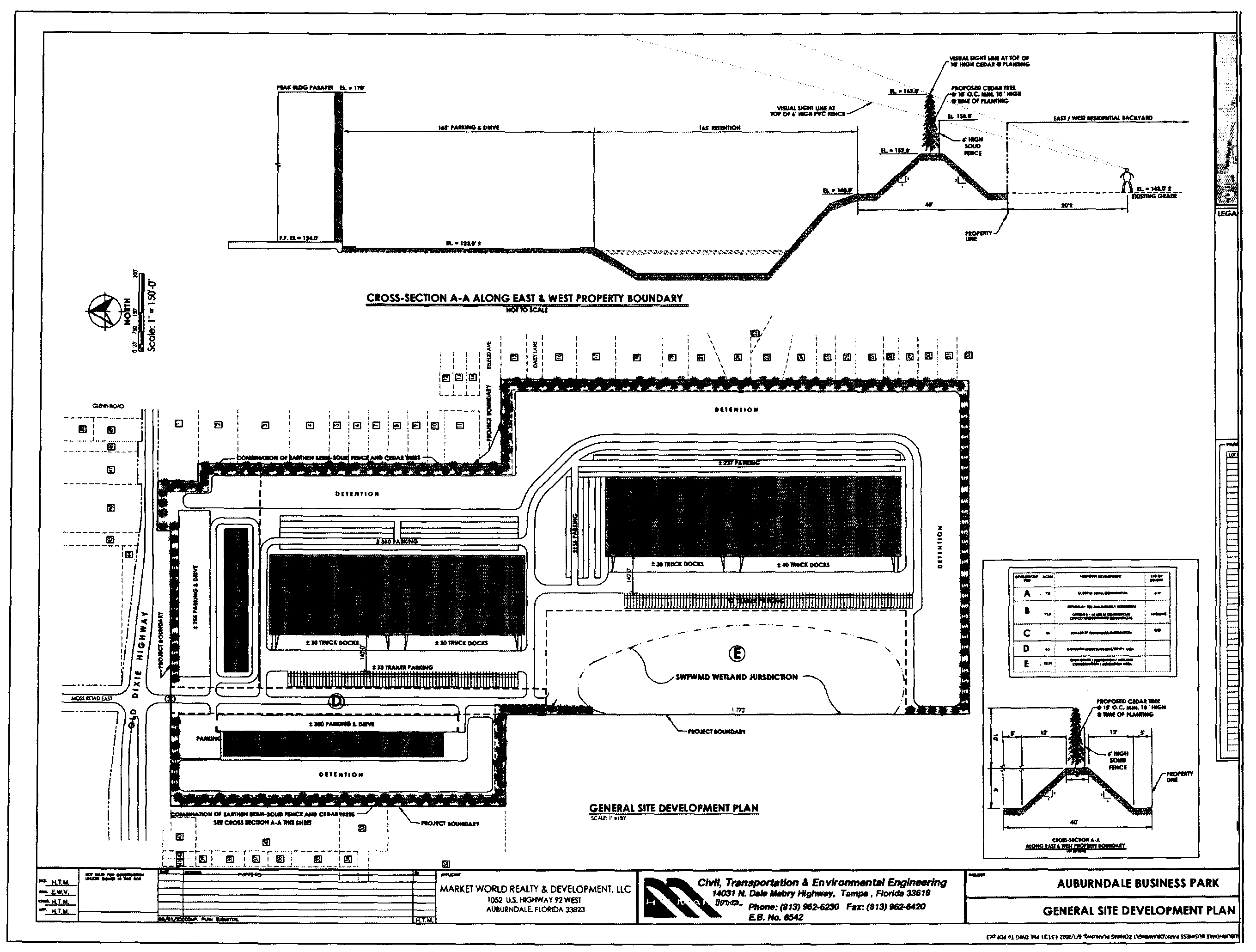
Q.
LDCPAS-2022-32 Parcel numbers 242803-000000-042010, 242803-000000-042060, 242803-000000-042110, 242803-000000-042090, 242803-000000-042180, 242803-000000-042150 [1]
1.
Applicability
The provisions and requirements of this Subsection apply to the subject site, the boundaries of which are shown on the Future Land Use Map Series and Land Use District maps, more particularly those depicted in the panel showing Range 24, Township 28, Section 03. The site is legally described as:
Parcel 1
The NW 1/4 of the SE 1/4 of the SW 1/4 of Section 3, Township 28 South, Range 24 East, Polk County, Florida; LESS AND EXCEPT: the North 208.70 feet of the West 208.71 feet of said NW 1/4, The West 165.00 feet of the NW 1/4; LESS AND EXCEPT: the North 208.71 feet of the NW 1/4 and the South 264.00 feet of said NW ¼, The South 264.00 feet of the West 330 feet of the NW 1/4, LESS road-right-of ways.
Parcel ID: 242803-000000-042060
And
Parcel 2
The East 1/2 of the East 1/2 of the North 1/2 of the SE 1/4 of the SW 1/4 of Section 3, Township 28 South, Range 24 East, Polk County, Florida.
Parcel ID: 242803-000000-042090
And
Parcel 3
The West 1/2 of the SE 1/4 of the SE 1/4 of the SW 1/4 of Section 3, Township 28 South, Range 24 East, Polk County, Florida, LESS and EXCEPT the East 100.00 feet of the South 435.60 feet thereof and Less road Right-of way.
And
The East 100.00 feet of the North 217.80 feet of the South 435.60 feet of the West 1/2 of the SE 1/4 of the SE 1/4 of the SW 1/4 of Section 3, Township 28 South, Range 24 East, Polk County, Florida, Less road Right-of way.
Also Described as
The West 1/2 of the SE 1/4 of the SE 1/4 of the SW 1/4 of Section 3, Township 28 South, Range 24 East, Polk County, Florida, LESS and EXCEPT the East 100.00 feet of the South 217.8 feet thereof and Less road Right-of way.
Parcel ID: 242803-000000-042150
And
Parcel 4
The East 100.00 feet of the South 217.8 feet of the West 1/2 of the SE 1/4 of the SE 1/4 of the SW 1/4 of Section 3, Township 28 South, Range 24 East, Polk County, Florida, Less road Right-of way.
Parcel ID: 242803-000000-042010
And
Parcel 5
The East 1/4 of the South 1/2 of the SE 1/4 of the SW 1/4 of Section 3, Township 28 South, Range 24 East, Polk County, Florida.
Parcel ID: 242803-000000-042180
And
Parcel 6
The W 1/2 of the NE 1/4 of the SE 1/4 of the SW 1/4 of Section 3, Township 28 South, Range 24 East, Polk County, Florida.
Parcel ID: 242803-000000-042110
2.
Allowable Uses. For development permitted on the subject site, Table 2.1 of this Land Development Code is modified to address levels of review for those uses as cited herein. Unless as otherwise restricted herein, all uses will be allowed as listed in Table 2.1:
a.
The following uses are specifically prohibited:
i.
Airports
ii.
Bars, Lounges, and Taverns
iii.
Communication Towers, Guyed, Lattice, or monopole
iv.
Gas Stations
v.
Heliports and helistops
vi.
Lime Stabilization Facility
vii.
Power Plants
viii.
Transit Facility
ix.
Utilities
x.
Commercial Vehicle Parking (as a stand alone principal use only)
3.
Development Standards. All allowable uses shall comply with the following additional site development standards and display on all level 2, 3 or 4 reviews:
a.
The maximum height of any on-site light sources shall be 24 feet if within 30 feet of an existing residential property line. The height limitation shall not apply to boundaries abutting rights-of-way. Illumination shall be shielded and directional and any spill onto adjacent properties shall not exceed one-half foot candles and consistent with dark sky friendly lighting as indicated in Section 642 of the Land Development Code;
b.
Within 250 feet of an residential structure existing at the adoption of the BPC land use, the following requirements must be met:
i.
There shall be no BPC use activities, excluding stormwater ponds and landscaping/buffering;
ii.
There shall be no cold storage facilities within any building;
iii.
There shall be no overnight idling of trucks, unless connected to an electric power source;
iv.
External operations such as receiving deliveries, docking, loading or unloading of trucks, shall be limited to the hours between 6 a.m. and 8 p.m. for non-residential development,
c.
All buildings shall be setback a minimum of 165' from residentially designated land along the western property boundary.
d.
All buildings shall have an office front appearance, generally consistent with the architectural design demonstrated in Exhibit "A" attached hereto, and implement office front appearance or a decorative facade along the building wall face exposed within 50 feet of a property boundary.
e.
Truck courts shall be setback a minimum of 100 feet from the project property lines adjacent to Ralph Road and Saddle Creek Boulevard.
f.
All retention ponds shall be designed to resemble natural features this can include shape of pond or the use of planting material;
g.
The maximum structure height for any building shall be 50 feet, exclusive of any parapets or other decorative facade features.
h.
Landscaping and Buffering Standards shall be as follows:
i.
The landscaping along Ralph Road shall be consistent with a 20 feet type "C" buffer as indicated in Land Development Code Section 720 and shall not be waived;
ii.
Buffers and landscaping along the southern and western property boundaries shall:
a)
Include a combination of enhanced landscape standards, enhanced landscaping and fencing consistent with the specifications contained on Exhibit B, attached hereto and made part hereof; and
b)
Maintain existing mature natural vegetation to the greatest extent practical; and:
iii.
All vegetative buffers shall achieve 80 percent opacity with shrubs capable of growing 36 inches in height within 12 months of planting:
iv.
All buffers shall include an solid opaque fence or wall and the requirements of the width and density of vegetative buffer shall not be reduced as long as there exists a residential use or residential future land use designation on the adjacent properties to the subject site, excluding property lines abutting Polk County maintained stormwater ponds and rights-of-way
iv.
The site shall not exceed a Floor Area Ratio ("FAR") of 0.4 and shall not have an Impervious Surface Ratio ("ISR") greater than 0.7 to limit the intensity of the development and to ensure adequate stormwater retention.
4.
Transportation and Access.
a.
All access from Saddle Creek Road shall require cross access within the BPC land uses;
b.
No access (ingress or egress) shall be permitted on Ralph Road.

Concept Site Plan
R.
LDCPAS-2023-34 Parcel numbers 303116-000000-032030; 303116-000000-032040; and, 303116-000000-032050.
1.
Applicability
The provisions and requirements of this Subsection apply to the subject site, the boundaries of which are shown on the Future Land Use Map Series and Land Use District maps, more particularly those depicted in the panel showing Range 30, Township 31, Section 16. The site is legally described as:
Begin at the Southwest corner of the Northwest 1/4 of Section 16, Township 31 South, Range 30 East, Polk County, Florida; thence run North 00°13'26" East along the West line of said Northwest 1/4 a distance of 140.80 feet to a point of the South Right-of-Way line of County Road 630; thence run North 65°30'43" East along said South Right-of-Way a distance of 1455.73 feet to a point on the East line of the Southwest 1/4 of the Northwest 1/4 of Section 16, Township 31 South, Range 30 East, Polk County, Florida; thence run South 00°07'26" East along the East line of the Southwest 1/4 of the Northwest 1/4 of said Section 16 a distance of 762.75 feet to the Southeast corner of the Southwest 1/4 of the Northwest 1/4 of Section 16, Township 31 South, Range 30 East; thence run South 00°05'21" East along the East line of the West 1/2 of the Southwest 1/4 of Section 16, Township 31 South, Range 30 East, Polk County, Florida a distance of 331.28 feet; thence departing said East line, run North 89°13'18" West a distance of 329.17 feet; thence run North 00°32'15" West a distance of 331.45 feet to a point on the South line of the Southwest 1/4 of the Northwest 1/4 of said Section 16; thence run North 89°11'54" West along said South line a distance of 354.84 feet; thence departing said South line, run South 00°48'13" West a distance of 331.53 feet; thence run North 89°13'18" West a distance of 437.00 feet; thence run North 00°48'13" East a distance of 331.70 feet to a point on the South line of the Southwest 1/4 of the Northwest 1/4 of Section 16, Township 31 South, Range 30 East; thence run North 89°11'54" West a distance of 203.51 feet to the Point of Beginning.
AND
The North 1094 feet of the West 50.00 feet of the Southeast 1/4 of the Northwest 1/4 and the Northeast 1/4 of the Southwest 1/4 lying South and East of Highway 630 in Section 16, Township 31 South, Range 30 East, Polk County, Florida.
2.
Prohibitive Uses
The following uses are prohibited on this subject parcel:
a.
Multi-family
b.
Mobile Home Park
c.
Communication Tower, Monopole
d.
Helistops
e.
Seaplane Base
f.
Recreational Vehicle Parks
3.
Additional Site Development Standards
In addition to all applicable standards of this Code, any development on the subject site shall comply with the following site development standards prior to site alteration or development:
a.
Per the JLUS (7.2.4), Low Level Flight Areas signage shall be placed at the entrance and throughout the Subject Site to state that there is potential of low flying aircraft.
b.
Per the JLUS (7.2.6), in order to reduce bird/aircraft strike hazards JLUS (7.2.6), all trash receptacles shall be covered.
c.
Per the JLUS (7.2.7), all outdoor lighting shall be consistent with "dark sky" requirements and be subject to the following conditions:
i.
All outdoor lighting shall be located, aimed or shielded so as to minimize light projection off-site.
ii.
All outdoor lighting fixtures shall be of the fully shielded type. Examples of the fully shielded lights are set forth in Figure "A" below.
d.
Light fixtures shall be aimed no higher than 45 degrees above vertical down (halfway between straight down and straight to the side) when the light source is visible from any off-site property or thoroughfare.
e.
Prohibited lights:
1)
Flashing, revolving, or intermittent lights visible from any property line.
2)
High intensity light beams such as but not limited to searchlights, laser lights, or strobe lights visible from any property line.
Figure "A"
S.
LDCPAL-2024-12 Parcel numbers 233006-000000-022020, 233007-000000-011010, 233007-000000-022020, 233008-000000-012020, 233008-000000-021020, 233008-000000-012090, and 233008-000000-021120.
1.
Applicability
The provisions and requirements of this Subsection apply to the subject site, the boundaries of which are shown on the Future Land Use Map Series and Land Use District maps, more particularly those depicted in the panel showing Range 23, Township 30, Sections 6, 7 & 8. The site is legally described as:
A PARCEL OF LAND LYING IN SECTIONS 6, 7 & 8 TOWNSHIP 30 SOUTH, RANGE 23 EAST, POLK COUNTY, FLORIDA, DESCRIBED AS FOLLOWS;
COMMENCE AT THE SOUTHWEST CORNER OF SAID SECTION 8; THENCE N 00°31'21" W ALONG THE WEST LINE OF SAID SECTION 8 A DISTANCE OF 40.80 FEET TO A POINT ON THE NORTH RIGHT OF WAY LINE OF HIGHWAY 676 (NICHOLS ROAD) AS SHOWN ON STATE ROAD DEPARTMENT RIGHT OF WAY MAP SECTION 16570-2603; THENCE S 89°47'53" W ALONG SAID RIGHT OF WAY LINE A DISTANCE OF 1341.19 FEET; THENCE N 01°36'26" W ALONG THE WEST BOUNDARY OF A PARCEL OF LAND DESCRIBED IN OFFICIAL RECORDS BOOK 8109, PAGE 1092 OF THE PUBLIC RECORDS OF POLK COUNTY, FLORIDA FOR A DISTANCE OF 731.25 FEET TO A POINT ON THE NORTH BOUNDARY OF THE SOUTH 770 FEET OF SAID SECTION 7 ALSO BEING ON THE BOUNDARY OF PARCEL OF LAND DESCRIBED IN OFFICIAL RECORDS BOOK 6599, PAGE 1374 OF THE PUBLIC RECORDS OF POLK COUNTY, FLORIDA; THENCE N 89°52'34" E ALONG SAID LINE A DISTANCE OF 1205.05 FEET; THENCE ALONG THE BOUNDARY OF SAID PARCEL PER OFFICIAL RECORDS BOOK 6599, PAGE 1374 FOR THE FOLLOWING TWO COURSES; (1) N 70°25'03" W A DISTANCE OF 571.56 FEET; (2) N 58°07'50" W A DISTANCE OF 841.52 FEET TO A POINT ON THE BOUNDARY OF A PARCEL OF LAND DESCRIBED IN OFFICIAL RECORDS BOOK 4365, PAGE 708 OF THE PUBLIC RECORDS OF POLK COUNTY, FLORIDA; THENCE ALONG SAID PARCEL FOR THE FOLLOWING EIGHT COURSES; (1) N 00°29'56" W A DISTANCE OF 1100.00 FEET; (2) N 54°26'52" E A DISTANCE OF 1500.00 FEET; (3) N 20°31'38" W A DISTANCE OF 1499.96 FEET; (4) N 50°30'08" W A DISTANCE OF 350.03 FEET; (5) S 89°39'34" W A DISTANCE OF 600.31 FEET; (6) N 00°25'24" W A DISTANCE OF 850.00 FEET; (7) S 54°20'01" E A DISTANCE OF 680.34 FEET; (8) N 89°38'35" E A DISTANCE OF 1000.00 FEET TO THE EAST LINE OF SAID SECTION 6; THENCE S 00°20°32'" E A DISTANCE OF 149.88 FEET TO THE NORTHWEST CORNER OF SAID SECTION 8; THENCE S 00°31'21" E ALONG THE WEST BOUNDARY OF SAID SECTION 8 A DISTANCE OF 306.94 FEET TO A POINT ON THE BOUNDARY OF A PARCEL OF LAND DESCRIBED IN OFFICIAL RECORDS BOOK 7424, PAGE 1395 OF THE PUBLIC RECORDS OF POLK COUNTY, FLORIDA; THENCE ALONG SAID PARCEL FOR THE FOLLOWING THREE COURSES; (1) S 64°44'45" E A DISTANCE OF 80.71 FEET; (2) S 52°34'43" E A DISTANCE OF 851.75 FEET; (3) S 74°52'26" E A DISTANCE OF 1657.71 FEET TO A POINT ON THE BOUNDARY OF A PARCEL OF LAND DESCRIBED IN OFFICIAL RECORDS BOOK 5373, PAGE 511 OF THE PUBLIC RECORDS OF POLK COUNTY, FLORIDA; THENCE ALONG SAID BOUNDARY FOR THE FOLLOWING SEVEN COURSES; (1) N 45°44'25" E A DISTANCE OF 169.92 FEET; (2) S 49°50'22" E A DISTANCE OF 282.89 FEET; (3) S 52°10'14" E A DISTANCE OF 1688.35 FEET; (4) N 87°15'28" E A DISTANCE OF 312.79 FEET; (5) S 43°10'16" E A DISTANCE OF 177.06 FEET TO THE MAINTAINED RIGHT OF WAY OF OLD NICHOLS ROAD AS SHOWN ON MAINTAINED RIGHT OF WAY MAP BOOK 10, PAGES 134-135 OF THE PUBLIC RECORDS OF POLK COUNTY, FLORIDA; (6) S 00°14'20" E ALONG SAID RIGHT OF WAY A DISTANCE OF 34.14 FEET; (7) S 89°35'59" W A DISTANCE OF 303.75 FEET; THENCE S 52°51'26" E A DISTANCE OF 165.08 FEET TO THE NORTHEAST CORNER OF THE WEST 298 FEET OF THE NORTHEAST 1/4 OF THE SOUTHEAST 1/4 OF SAID SECTION 8; THENCE S 00°33'22" E ALONG THE EAST LINE OF SAID WEST 298 FEET A DISTANCE OF 668.87 FEET TO THE NORTH LINE OF A PARCEL BEING THE EAST 198 FEET OF THE WEST 396 FEET OF THE NORTH 220 FEET OF THE SOUTH 660 FEET OF SAID NORTHEAST 1/4 OF THE SOUTHEAST 1/4; THENCE ALONG SAID PARCEL FOR THE FOLLOWING 3 COURSES; (1) S 89°46'18" W A DISTANCE OF 100.29 FEET; (2) S 00°33'21" E A DISTANCE OF 219.70 FEET; (3) N 89°46'18" E A DISTANCE OF 100.29 FEET TO A POINT ON SAID EAST LINE OF THE WEST 298 FEET; THENCE S 00°33'21" E ALONG SAID EAST LINE AND THE EAST LINE OF THE WEST 298 FEET OF THE SOUTHEAST 1/4 OF THE SOUTHEAST 1/4 OF SAID SECTION 8 A DISTANCE OF 848.74 FEET TO A POINT ON THE BOUNDARY OF A PARCEL OF LAND DESCRIBED IN OFFICIAL RECORDS BOOK 3404, PAGE 1719 OF THE PUBLIC RECORDS OF POLK COUNTY, FLORIDA; THENCE ALONG SAID BOUNDARY FOR THE FOLLOWING THREE COURSES: (1) S 89°51'44" W A DISTANCE OF 328.29 FEET; (2) N 00°32'37" W A DISTANCE OF 199.55 FEET; (3) S 89°49'41" W A DISTANCE OF 3461.83 FEET TO A POINT ON THE EAST BOUNDARY OF A PARCEL OF LAND DESCRIBED IN OFFICIAL RECORDS BOOK 8284, PAGE 273 OF THE PUBLIC RECORDS OF POLK COUNTY, FLORIDA; THENCE ALONG SAID BOUNDARY FOR THE FOLLOWING THREE COURSES; (1) S 17°50'46" W A DISTANCE OF 600.80 FEET; (2) N 72°09'14" W A DISTANCE OF 90.00 FEET; (3) S 89°50'46"W A DISTANCE OF 131.56 FEET; THENCE CONTINUE S 89°50'46" W A DISTANCE OF 65.85 FEET TO THE WEST LINE OF SAID SECTION 8; THENCE S 00°31'21" E ALONG SAID WEST LINE A DISTANCE OF 215.80 FEET TO THE BOUNDARY OF A PARCEL OF LAND DESCRIBED IN OFFICIAL RECORDS BOOK 8284, PAGE 273 OF THE PUBLIC RECORDS OF POLK COUNTY, FLORIDA; THENCE ALONG SAID PARCEL FOR THE FOLLOWING TWO COURSES: (1) S 17°13'28" W A DISTANCE OF 141.27 FEET; (2) S 67°07'48" E A DISTANCE OF 46.92 FEET TO THE WEST LINE OF SAID SECTION 8; THENCE S 00°31'21" E ALONG SAID WEST LINE A DISTANCE OF 166.64 FEET TO THE POINT OF BEGINNING.
LESS AND EXCEPT LANDS DESCRIBED IN OFFICIAL RECORDS BOOK 8284, PAGE 273 OF THE PUBLIC RECORDS OF POLK COUNTY, FLORIDA.
AND LESS AND EXCEPT: COMMENCE AT THE SOUTHWEST CORNER OF SAID SECTION 8; THENCE N89°49'36"E ALONG THE SOUTH LINE OF SAID SECTION 8 A DISTANCE OF 1585.08 FEET; THENCE N00°10'24"W A DISTANCE OF 1328.09 FEET TO THE POINT OF BEGINNING; THENCE N03°49'08"W A DISTANCE OF 455.34 FEET; THENCE N33°36'33"E A DISTANCE OF 609.37 FEET; THENCE N48°16'13"E A DISTANCE OF 212.04 FEET; THENCE N79°38'45"E A DISTANCE OF 532.36 FEET; THENCE S55°21'54"E A DISTANCE OF 256.35 FEET; THENCE S32°32'18"E A DISTANCE OF 584.83 FEET; THENCE S57°26'47"W A DISTANCE OF 1030.09 FEET; THENCE S89°29'58"W A DISTANCE OF 646.16 FEET TO THE POINT OF BEGINNING.
AND LESS AND EXCEPT LANDS WITHIN THE CSX RAILROAD RIGHT OF WAY.
AND
THAT PART OF SECTION 8, TOWNSHIP 30 SOUTH, RANGE 23 EAST, POLK COUNTY, FLORIDA, DESCRIBED AS FOLLOWS:
THAT PART OF THE SOUTHEAST 1/4 OF THE SOUTHEAST 1/4 LYING EAST OF THE WEST 298 FEET AND LYING NORTH AND WEST OF THE RIGHT OF WAY OF COUNTY ROAD 676 (NICHOLS ROAD),
LESS THAT PART OF THE SOUTH 920 FEET LYING WEST OF THE EAST 280 FEET, AND
THE NORTHEAST 1/4 OF THE SOUTHEAST 1/4 LYING EAST OF THE WEST 298 FEET, LESS THE NORTH 50 FEET OF THE EAST 867 FEET,
AND LESS THE EAST 198 FEET OF THE WEST 396 FEET OF THE NORTH 220 FEET OF THE SOUTH 660 FEET,
AND LESS THE MAINTAINED RIGHT OF WAY OF NIXON ROAD AS RECORDED IN MAINTAINED RIGHT OF WAY MAP BOOK 3, PAGE 210 OF THE PUBLIC RECORDS OF POLK COUNTY, FLORIDA.
AND
THAT PART OF THE SOUTHWEST 1/4 OF SECTION 9, TOWNSHIP 30 SOUTH, RANGE 23 EAST, POLK COUNTY, FLORIDA, LYING WEST OF COUNTY ROAD 676 (NICHOLS ROAD) AND LYING SOUTH OF THE CSX RAILROAD RIGHT OF WAY.
2.
Applicability - 200-Foot-Wide Buffer Zone.
The provisions and requirements of this subsection apply to a 200-foot-wide strip along a portion of the north side of the subject site as shown in Figure "A", more particularly that area legally described as:
A parcel of land lying in Sections 6, 7 & 8 Township 30 South, Range 23 East, Polk County, Florida, described as follows:
Begin at the Northwest corner of said Section 8; thence S 00°31'21" E along the west boundary of said Section 8 a distance of 306.94 feet to a point on the boundary of a parcel of land described in Official Records Book 7424, page 1395 of the public records of Polk County, Florida; thence along said parcel for the following three courses; (1) S 64°44'45" E a distance of 80.71 feet; (2) S 52°34'43" E a distance of 851.75 feet; (3) S 74°52'26" E a distance of 1092.21 feet; thence S 15°05'26" W a distance of 200.00 feet; thence N 74°52'26" W a distance of 1131.75 feet; thence N 52°34'43" W a distance of 869.85 feet; thence N 64°44'22" W a distance of 184.91 feet; thence N 00°31'21" W a distance of 433.01 feet to the south line of said Section 6; thence N 00°20'32" W a distance of 149.88 feet to the boundary of a parcel of land described in Official Records Book 4365, page 708 of the public records of Polk County, Florida; thence N 89°38'35" E along said boundary a distance of 200.00 feet to the east line of said Section 6; thence S 00°20°32'" E along the east line of said Section 6 a distance of 149.88 feet to the Point of Beginning.
3.
Allowable uses within the phased setback.
a.
The first 100 feet shall allow for passive activities such as, but not limited to Landscaping, Stormwater management, Floodplain compensation, open spaces, natural habitat and restoration, utility easements, mitigation and buffer zones.
b.
Within 100 to 200 feet, industrial activities including, but not limited to such as Non-Phosphate Mining, Off-site Agricultural support, General Farming, Solar Electric - Power Generation Facilities, Commercial Vehicle Parking, Light Assembly, Light Manufacturing, Light Repair, and other uses similar in intensity and activity, but do not have any outdoor storage or operations, shall be allowed in this area. Additionally, the uses allowed by LDCU 2024-24, as approved by the Planning Commission on October 2, 2024, shall be allowed in this area. Light and General Manufacturing and all other uses permitted in Industrial listed in the Land Development Code Section 205 Table 2.1.
c.
Outside of 200 feet shall allow activities including Aggregate Storage and Processing along with Salvage Yards activities, and all other uses permitted in Industrial listed in Section 205 Tables 2.1. & 2.2, subject to the requirements of the Land Development Code.
d.
In addition to the foregoing, these uses must comply with the location and review criteria in Section 205, Tables 2.1 & 2.2 for Standard Land Use Districts.
4.
Landscape Buffers
a.
The required 25-foot-wide landscaped buffer shall be planted when site development activity occurs within the 200-foot-wide strip as legally described in this Section, or when site development activity occurs within the adjoining Residential Planned Unit Development property in the City of Mulberry.
b.
The required 25-foot-wide landscaped buffer to be located next to the CSX railroad, on the eastern side of the subject property, shall be planted when site development activity occurs within 200 feet.

T.
Parcel Specific Comprehensive Plan Amendments with Conditions for LDCPAS-2024-27.
1.
At the time of Level 2 review, the portion of the subject property as depicted in Attachment A designated with the Future Land Use of Employment Center (ECX) will not be allowed to develop with Employment Center uses. The only development allowed will be stormwater ponds, utilities, and the relocated LaRoche Road.
2.
The relocation of LaRoche Road will be within the ECX land use. A Type B buffer is required between the relocated LaRoche Road and the north property line. A Type B buffer is also required between the relocated LaRoche Road and the future development to the south. The existing native vegetation can be used to meet the Type B buffer requirement.
3.
The relocated LaRoche Road must be built to the standards of a Local Commercial Road. This includes the need to construct an opaque fence of at least six (6) feet tall on both sides of the road to go along with the vegetative buffering.

U.
State Road 60 & Boy Scout Road Rural Cluster Center Activity Center Plan
1.
Activity Center Plan (ACP) Applicability
The provisions and requirements of this Subsection apply to the parcels located east of Lake Wales at the intersection of State Road 60, Boy Scout Rd and Walk-in-Water Road, as shown in the ACP. It is intended to apply to those parcels within the existing RCC boundary and serve as a guide for future expansions and access management.
2.
LDCPAL-2024-25 Parcel numbers 293008-000000-031010.
This RCC shall be expanded to include the subject parcel (293008-000000-031010), the boundaries of which are shown on the Future Land Use Map Series and Land Use District maps, more particularly those depicted in the panel showing Range 29, Township 30, Section 8.
The site is legally described as:
That part of Section 8, Township 30 South, Range 29 East, Polk County, Florida described as follows:
Commence at the NW corner of the SW ¼ of said Section 8; thence N 89° 41' 02"E, 40.00 feet to the east right of way line of Boy Scout Road; thence S 00° 16' 46"E along said east right of way line, 861.74 feet to the POINT OF BEGINNING; thence N 89° 43' 14"E, 648.63 feet; thence S 00° 16' 46"E, 495.00 feet to the northerly right of way line of State Road 60 per O.R. Book 2659, Page 115, Public Records of Polk County, Florida; thence along said northerly right of way line the following four calls: 1.) N 80° 54' 08"W, 161.03 feet; 2.) N 9° 05' 52" E, 5.00 feet; 3.) N 80° 54' 08"W, 440.64 feet; 4.) N 59° 17' 22"E, 65.11 feet to the aforesaid east right of way line of Boy Scout Road; thence N 00° 16' 46"W along said east right of way line, 358.51 feet to the POINT OF BEGINNING.
3.
Permitted Uses
Uses permitted within the boundaries of this RCC shall conform to those found in Table 2.1 Use Table for Standard Land Use Districts.
4.
Transportation
a)
Access: This ACP shows the general locations of access points to the existing Boy Scout Road, Walk-in-Water Road, and SR 60 rights-of-way. They are conceptual and non-binding, with the exact driveway and cross-access location shall be determined at Level 2 review. In addition:
1)
There shall be no easements or divisions of land created that prevent access to Boy Scout Road or SR 60.
2)
Development shall be designed to allow cross-access to adjacent parcels.
3)
All development shall ensure cross-access and connectivity to these two main roadways is maintained.
4)
The general location of proposed access points shall not be the sole basis for the granting of any waiver from any applicable provision of the Land Development Code.
b)
Intersection Design Changes:
1)
It is anticipated that the Florida Department of Transportation (FDOT) may modify the SR 60 median opening to change the median opening to a directionalized median.
2)
An alternate alignment for Rose Terrance is shown on the ACP to allow safer separation distance from the SR 60 intersection and allow for more usable area of the land within the RCC.
5.
Mass Transit locations: Future transit service and stop locations shall be implemented by the transit provider at locations optimum for safe and effective operations.
6.
Signage: Pole Mounted signage shall be prohibited within this RCC. All other signage shall meet the requirements of Section 760 of the Land Development Code.
7.
Landscaping: To the greatest extent practicable, development shall conserve and utilize existing on-site trees to meet the landscape and buffering requirements of Section 720 of the Land Development Code.
8.
Architectural Standards - Buildings within this RCC shall be designed and constructed to contain additional/enhanced architectural design standards. The building's architectural design shall be reviewed by staff as part of the Level 2 process, and such approval shall not be unreasonably withheld. Building facades facing arterial or collector roadways may not include a metal panel exterior finish and must incorporate at least three (3) of the following architectural elements:
- Changes in texture/finish across the facade (i.e., stucco to block);
- Variations in fenestration, roof line, or parapet height;
- Pitched or sloped roof entry feature (may be accomplished via a parapet wall);
- Enhanced facade landscaping with flowering species (min. 5' & width);
- Awnings or covered front entryways;
- Columns or pilasters, decorative exterior trim, and additional facade treatments.
9.
Lighting: All outdoor lighting shall be consistent with "dark sky" requirements and be subject to the following conditions:
a)
All outdoor lighting shall be located, aimed, shielded, and maintained in a manner which minimizes light projection off-site.
b)
All outdoor lighting fixtures shall be of the fully shielded type. Examples of the fully shielded lights are set forth in Figure "A" below.
c)
Light fixtures shall be aimed no higher than 45 degrees above vertical down (half-way between straight down and straight to the side) when the light source is visible from any off-site property or thoroughfare.
d)
Prohibited lights:
1)
Flashing, revolving, or intermittent lights visible from any property line.
2)
High intensity light beams such as but not limited to searchlights, laser lights, or strobe lights visible from any property line.
10.
RCC Expansion - Any expansion of this RCC must meet criteria listed in Objective 2.110-B, Rural-Cluster Centers, of the Comprehensive Plan and the requirements for a Comprehensive Plan Amendment per state law.
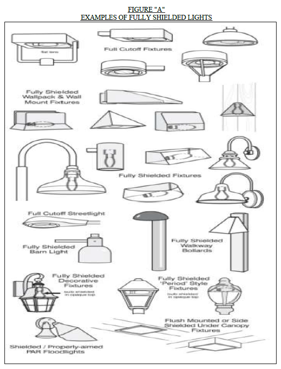
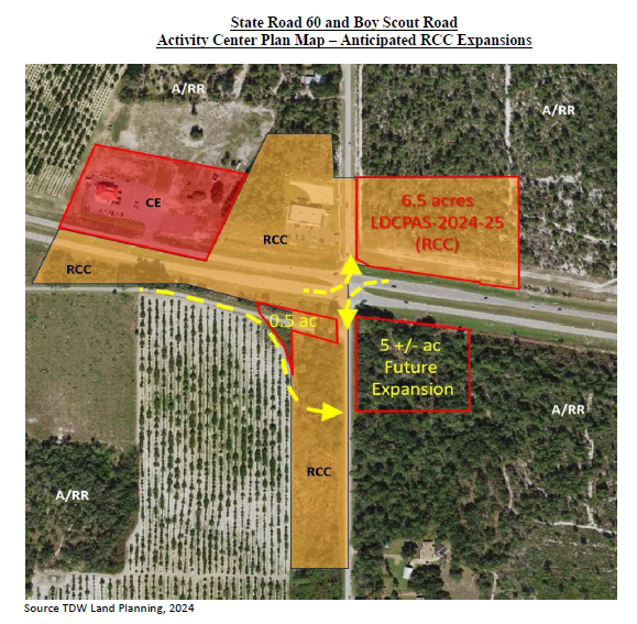
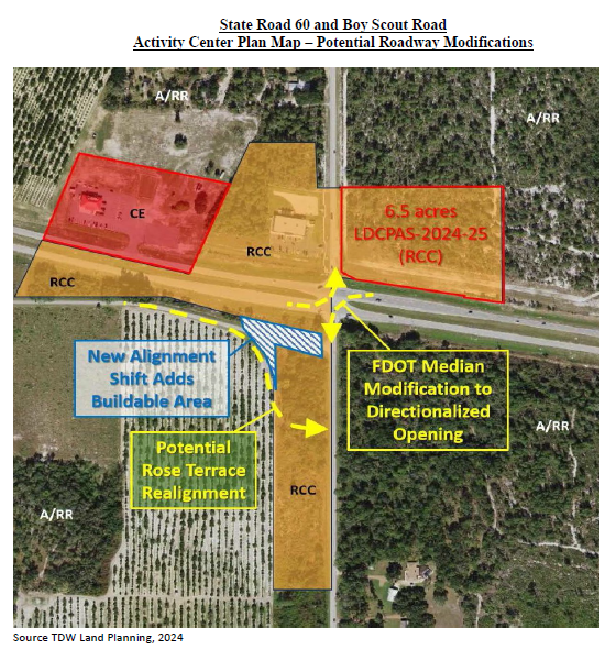
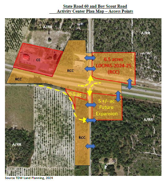
V.
LDCPAS-2025-17 Parcel Numbers: 252728-000000- 043020, 252728-000000-0431 80, 252728-000000-043 190, 252728-000000-043200, 252728-000000-043210, 252728-000000-043230, 252728-000000-043230, 252728-000000-043240
1.
Applicability
The provisions and requirements of this Subsection apply to the subject site, the boundaries of which are shown on the Future Land Use Map Series and Land Use District maps, more particularly those depicted in the panel showing Range 25, Township 27, Section 28. The entire site is legally described as:
DESCRIPTION:
Tract 1(252728-000000-043020)
The north 125.00 feet of the East 360 feet of the SE 114 of the NW 114 of the SW 114 of Section 28, Township 27 South, Range 25 East, Polk County, Florida. Less road right-of-way for S.R. 655 Containing 0.93 acres.
andTract 2 (252728-000000-043180)
The South 125.00 feet of the North 250.00 feet of the East 360.00 feet of the SE 1/4 of the NW 114 of the SW 1/4 of Section 28, Township 27 South, Range 25 East, Polk County, Florida. Less road right-of-way for S.R. 655. Containing 0.93 acres.
and
Tract 3: (252728-000000-043190)
The South 125.00 feet of the North 375.00 feet of the East 360.00 feet of the SE 1/4 of the NW 114 of the SW 1/4 of Section 28, Township 27, South Range 25 East, Polk County, Florida. Less road right-of-way for S.R. 655. Containing 0.93 acres.
and
Tract 4: (252728-000000-043200)
The East 200.00 feet of the SE 1/4 of the NW 1/4 of the SW 1/4 of Section 28, Township 27 South, Range 25 East, Polk County, Florida. Less the North 375.00 feet thereof, Less road right-of-way for S.R. 655 and Braddock Road. Containing 0.96 acres.
and
Tract 5: (252728-000000-043210)
The West 160.00 feet of the East 360.00 feet of the SE 1/4 of the NW 1/4 of the .SW 1/4 of Section 28, Township 27 South, Range 25 East, Polk County, Florida. Less the North 375.00 feet thereof, less road right-of-way for Braddock Road. Containing 0.94 acres.
and
Tract 6: (252728-000000-043220)
The SE 1/4 of the NW 1/4 of the SW 1/4 of Section 28, Township 27 South, Range 25 East, Polk County, Florida. Less the North 400.00 feet thereof and less the East 460.00 feet thereof, less road right-of-way for Braddock Road. Containing 1.1 acres.
andTract 7: (252728-000000-043230)
The South 200.00 feet of the North 400.00 feet of the SE 1/4 of the NW 1/4 of the SW 1/4 of Section 28, Township 27 South, Range 25 East, Polk County, Florida. Less the East 410.00 feet thereof.
and
The West 50.00 feet of the East 460.00 feet of the SE 1/4 of the NW 1/4 of the SW 1/4 of Section 28, Township 27 South, Range 25 East, Polk County, Florida. Less the North 400.00 feet thereof and less road right-of-way for Braddock Road . Containing 1.4 acres.
and
Tract 8: (252728-000000-043240)
The North 200.00 feet of the SE 114 of the NW 114 of the SW 1/4 of Section 28, Township 27 South, Range 25 East, Polk County, Florida. Less the East 360.00 feet thereof:
and
The West 50.00 feet of the East 410.00 feet of the SE 114 of the NW 1/4 of the SW 114 of Section 28, Township 27 South, Range 25 East, Polk County, Florida. Less the North 200.00 feet thereof and less road right-of-way for Braddock Road. Containing 1.87 acres.
Less and except
A parcel of land lying in the Northwest one-quarter (N.W. 1/4) of the Southwest one-quarter (S.W. 114) of Section 28, Township 27 South, Range 25 East, less the road right of way for Braddock Road as recorded in Official Records Book 958, at Page 415, and Official Records Book 7565, at Page 109, of the Public Records of Polk County, Florida, being more particularly described as follows:
COMMENCE at a 4 inch by 4 inch concrete monument (broken) with a ½ inch iron rod bent marking the Southwest corner of the Southwest one-quarter (S.W. ¼) of Section 28; thence North 00°12'09" West, along the West line of said Southwest one-quarter (S.W. ¼), a distance of 1,311.41 feet to the Southwest corner of the Northwest one-quarter (N.W. ¼) of the Southwest one-quarter (S.W. ¼) of Section 28; thence North 89°59'56" East, along the South line of said Northwest one-quarter (N.W. ¼) of the Southwest one-quarter (S.W. ¼) of Section 28, a distance of 665.49 feet to a railroad spike marking the Southeast comer of the Southwest one-quarter (S.E. ¼) of the Northwest one-quarter (N.W. 1/4) of the Southwest one-quarter (S.W. ¼) of Section 28; thence North 00°01'11" West, along the West line of said Southeast one-quarter (S.E. ¼) of the Northwest one-quarter (N.W. ¼) of the Southwest one-quarter (S.W. ¼) of Section 28, a distance of 25.00 feet to the POINT OF BEGINNING, being on the existing Northerly right of way line of Braddock Road (also known as Spring Road) per Official Record Book 872, Page 339 of the Public Records of Polk County, Florida; thence North 00°01'11" West, continuing along said West line, a distance of 68.56 feet; thence departing said East line, run South 89°54'17" East, a distance of 593.84 feet; thence North 44°38'36" East, a distance of 52.50 feet to the existing West right of way line of State Road No. 655 (Berkley Road) as recorded in said Official Records Book 7565, at Page 109; thence South 05°01'43" East, along said existing West right of way line, a distance of 79.93 feet; thence South 42°35'00" West, along said existing West right of way line, a distance of 34.36 feet to its intersection with the existing North right of way line of said Braddock Road; thence South 89°59'56" West, along said existing North right of way line, a distance of 614.46 feet to the POINT OF BEGINNING. Containing 1.005 acres, more or less.
Containing 7.95 acres, more or less.
2.
Allowable Uses and Intensity of Development
a.
The development of Block A shall be allowed per Table 2.1 of the Land Development Code for Neighborhood Activity Center, except the following uses are prohibited:
I.
Alcohol Package Sales
II.
Cemetery
III.
Helistops
IV.
Marina and Related Facilities
V.
Medical Marijuana Dispensaries
VI.
Mining, Non-phosphate
VII.
Nurseries and Greenhouses
VIII.
Utility, Class III
IX.
Vehicle Service, Mechanical
X.
Water Ski Schools
b.
The development of Block B shall be allowed per Table 2.1 of the Land Development Code for Neighborhood Activity Center, except the following uses are prohibited:
I.
Gas Station
II.
Alcohol Package Sales
III.
Car Wash, Incidental
IV.
Cemetery
V.
Helistops
VI.
Marina and Related Facilities
VII.
Medical Marijuana Dispensaries
VIII.
Mining, Non-phosphate
IX.
Nurseries and Greenhouses
X.
Recreation, & Amusement, General
XI.
Retail, 35,000-64,000 sq. ft.
XII.
Retail, more than 65,000 sq. ft.
XIII.
School, Technical/Vocational/Trade & Training
XIV.
Utility , Class III
XV.
Vehicle Service, Mechanical
XVI.
Water Ski Schools
c.
The development of Block C shall be allowed per Table 2.1 of the Land Development Code, except the following uses are prohibited:
XI.
Gas Station
XII.
Alcohol Package Sales
XIII.
Car Wash, Incidental
XIV.
Cemetery
XV.
Helistops
XVI.
Marina and Related Facilities
XVII.
Medical Marijuana Dispensaries
XVIII.
Mining, Non-phosphate
XIX.
Nurseries and Greenhouses
XX.
Recreation, & Amusement, General
XXI.
Restaurant, Drive-thru/Drive-in
XXII.
Retail, 35,000-64,000 sq. ft.
XXIII.
Retail, more than 65,000 sq. ft.
XXIV.
School, Technical/Vocational/Trade & Training
XXV.
Utility, Class III
XXVI.
Vehicle Service, Mechanical
XXVII.
Water Ski Schools
d.
Outdoor Storage shall be prohibited in all blocks with the exception approved Self-storage facilities and subject to the Land Development Code Section 303 self-storage facilities.
e.
The boundaries of Blocks A, B, and C shall generally match the boundaries as depicted in the Activity Center Plan.
3.
Enhanced Developer Standards
a.
All allowable uses shall comply with the following additional site development standards on all Level 2, 3, or 4 reviews prior to site alteration or development:
i.
Excluding property frontage on rights-of-way, all proposed development or redevelopment of the subject site shall be conditioned upon Landscape Buffers, as defined in Section 720 of this code, with the following modifications:
a.
any vegetative buffer shall achieve 80% opacity with shrubs capable of growing 36 inches in height within 12 months of planting; and
b.
the Landscape Buffers may be constructed in phases as the site develops in either Block A or Block B or Block C, as delineated on the Activity Center Plan, and as follows:
1).
Upon commencement of development in Block A, the 10' Type "A" Landscape Buffer shall be constructed along the entire northern boundary of Block A, the 10' Type "A" Landscape Buffer along the frontage of right-of-way of Berkley Road and Braddock Road, and the 6' Type "A" with Fence Landscape Buffer shall be constructed, if not constructed as a result of development by Block C, along the boundary between Block A and Block C.
2).
Upon commencement of development in Block B, the 10' Type "B" Landscape Buffer, including a masonry wall that shall be a minimum eight feet high, shall be constructed along the entire northern boundary of Block B, the 10' Type '1A" buffer along the frontage of right-of-way of Berkley Road, and the 6' Type "A," including a fence that shall be a minimum six feet high, 100 percent opaque wood or PVC, Landscape Buffer shall be constructed, if not constructed as a result of development by Block C, along the boundary between Block B and Block C.
3).
Upon commencement of development in Block C, the 10' Type "B" Landscape Buffer, including a masonry wall that shall be a minimum eight feet high, shall be constructed along the entire western boundary and northern boundary of Block C, the 10' Type "A" buffer along the frontage of right-of-way of Braddock Road, and the 6' Type "A," including a fence that shall be a minimum six feet high, 100 percent opaque wood or PVC, Landscape Buffer shall be constructed, if not constructed as a result of development by Block C, along the boundary between Block B and Block C.
ii.
Except when special requirements in this section are more stringent, all uses shown as allowed in the NAC Land Use designation as "P" in table 2. 1 of Chapter 2 of this LDC shall, at a minimum, comply with the Criteria for Conditional Uses for uses contained in Section 303 of this Code. All uses will be subject to the Level of Review established as per Table 2. 1 of this LDC.
iii.
The first Level 2 review submitted for any Block shall include a master infrastructure plan, including stormwater plans, utility easements, and cross-access easements, for the entire site.
iv.
A cross-access easement between and among the subject Blocks, generally consistent with the Activity Center Plan, will be recorded prior to site plan (Level 2) approval for the respective development areas. This shall include facilitating future expansion of the Activity Center Plan to adjacent parcels. The easements are displayed in the general location and maybe adjusted without an amendment to this section of the Activity Center Plan as long as cross-access maintained in a safe manner.
v.
The edge of the retention ponds shall be landscaped with similar planting materials of a Type "A" Buffer along any side not adjacent to another buffer.
vi.
Unless as otherwise provided herein for lighting, No structure or parking shall be located within the landscape buffer.
vii.
All truck parking, vehicle repair bay/area, outdoor storage, transit facilities, and loading and unloading areas shall be at least fifty (50) feet from all property lines abutting residential uses, excluding property lines abutting right-of-way.
viii.
All principal structures and those accessory structures related to truck parking or loading and unloading activities shall be at least fifty (50) feet from all side and rear property lines, excluding property lines abutting rights-of-way.
ix.
Accessory structures, not related to truck parking or loading and unloading activities shall be at least twenty (20) feet from all side and rear property lines.
x.
The maximum height of any on-site light sources shall be forty (40) feet if placed at least thirty (30) feet from a residential property line, and twenty four (24) feet if within thirty (30) feet of an existing residential property line. The height limitation shall not apply to boundaries abutting rights-of-way. Illumination shall be shielded and directional and any spill onto adjacent properties shall not exceed 0.5 foot candles and consistent with Dark Sky Friendly lighting.
xi.
The minimum setback of the light source from the residential property line shall be a horizontal distance of twenty (20) feet, except when the light source is adjoining a right-of-way. If the on-site light source adjoins a right-of-way, the lighting can be placed within the landscape buffer as required by Section 720 of this code.
xii.
For structures exceeding thirty-five (35) feet in height, setbacks from parcels designated or developed as residential shall be increased by one-half of one foot for each one foot of height over thirty-five (35) feet.
xiii.
External operations such as receiving deliveries, docking, loading or unloading of trucks, shall be limited to the hours between 6 a.m. and 8 p.m. for non-residential development within two-hundred (200) feet of an existing residence.
xiv.
Signs relating only to identification of the premises and occupants and to goods sold or services rendered on the premises shall be limited as to the type, number, and area, as follows:
1)
All signage for the property shall be monument signs. This limitation shall not preclude building signs, window signs, or directional signs which shall be permitted in accordance with Section 760 of Land Development Code.
2)
When more than one place of business or activity exists in combination on a site, not more than one monument sign may be permitted when such sign is mounted on a permanent support in any required front yard in this district if such sign and its support do not constitute substantial impediments to visibility in relation to traffic flow on the site or on the adjacent street. Such monument sign, when identifying more than one place of business or activity or a combined grouping of places of business or activities, shall not exceed eighty (80) square feet in surface area per side or one-hundred-sixty (160) square feet in total combined surface area. No such sign support(s) shall be erected within ten (10) feet of any property line, excluding rights-of-way.
3)
In addition, one-sign, which does not exceed ten (10) square feet of surface area, for each ten (10) lineal feet of building frontage, the location of which is identified on the Occupational License. Such sign shall be mounted on the main building and shall not extend more than three (3) feet above the roof or beyond the sides of the building.
4.
Revised Use Table
The following Prohibited Use Tables (Tables E4—E7) shall replace Table 2.1 and specifies the types of uses explicitly prohibited within this site. Ifa use is not listed in this table, and listed in Table 2.1, it is allowable as allowed in Table 2.1. All conditions outlined in Section 303 of this Code shall apply to each use listed below:
TABLE E4, NAC PROHIBITED LAND USES FOR
LDCPAL-2024-13 AND LDCD-2024- 7
BLOCK A
TABLE E4, NAC PROHIBITED LAND USES FOR
LDCPAL-2024-13 AND LDCD-2024-7
BLOCK B
TABLE E4, NAC PROHIBITED LAND USES FOR
LDCPAL-2024-13 AND LDCD-2024- 7
BLOCK C
W.
Parcel Specific Comprehensive Plan Amendments with Conditions for LDCPAS-2025-26.
1.
Applicability
The provisions and requirements of this Subsection apply to the subject site, the boundaries which are shown on the Future Land Use Map Series and Land Use District maps, more particularly those depicted in the panel showing Range 27, Township 29, and Section 17. The entire site legally described as:
Parcels #272917-000000-013030, 272917-000000-013090, 272917-000000-013010, 272917- 000000-013080
BEGIN AT THE NORTHWEST CORNER OF THE NORTHWEST ¼ OF THE NORTHEAST ¼ OF SECTION 17, TOWNSHIP 29 SOUTH, RANGE 27 EAST, POLK COUNTY, FLORIDA AND RUN THENCE ALONG THE NORTH LINE THEREOF, N88°52'02"E A DISTANCE OF 1329.80 FEET TO THE NORTHEAST CORNER OF SAID NORTHWEST ¼ OF THE NORTHEAST ¼; RUN THENCE ALONG THE EAST LINE OF SAID NORTHWEST ¼ OF THE NORTHEAST ¼, S00°26'35"E A DISTANCE OF 1331.65 FEET TO THE SOUTHEAST CORNER OF SAID NORTHWEST ¼ OF THE NORTHEAST ¼; RUN THENCE ALONG THE SOUTH LINE OF SAID NORTHWEST ¼ OF THE NORTHEAST ¼, S89°06'13"W A DISTANCE OF 450.01 FEET TO THE SOUTHEAST CORNER OF THAT PARCEL DESCRIBED BY WARRANTY DEED IN OFFICIAL RECORD BOOK 4432, PAGE 2060, PUBLIC RECORDS OF POLK COUNTY, FLORIDA; RUN THENCE ALONG THE BOUNDARY OF SAID PARCEL THE FOLLOWING THREE COURSES: (1) N00°26'35"W A DISTANCE OF 377.01 FEET; (2) THENCE S89°06'13"W A DISTANCE OF 251.69 FEET; (3) S00°31'50"E A DISTANCE OF 377.01 FEET TO THE SOUTH LINE OF SAID NORTHWEST ¼ OF THE NORTHEAST ¼; RUN THENCE ALONG SAID SOUTH LINE OF THE NORTHWEST ¼ OF THE NORTHEAST ¼, S89°06'13"W A DISTANCE 226.58 FEET TO THE SOUTHEAST CORNER OF THAT PARCEL DESCRIBED BY QUIT CLAIM DEED IN OFFICIAL RECORD BOOK 3993, PAGE 2014 PUBLIC RECORDS OF POLK COUNTY, FLORIDA. RUN THENCE ALONG THE EAST BOUNDARY THEREOF, N00°31'50"W A DISTANCE OF 272.01 FEET; THENCE S89°06'13"W A DISTANCE OF 19.00 FEET; THENCE N00°31'50"W A DISTANCE OF 105.00 FEET; THENCE S89°06'13"W A DISTANCE OF 103.00 FEET; TO THE BOUNDARY OF SAID PARCEL DESCRIBED BY QUIT CLAIM DEED; RUN THENCE ALONG SAID BOUNDARY THE FOLLOWING TWO COURSES: (1) N00°31'50"W A DISTANCE OF 251.51 FEET; (2) S89°06'13"W A DISTANCE OF 278.01 FEET TO THE WEST LINE OF SAID NORTHWEST ¼ OF THE NORTHEAST ¼; RUN THENCE ALONG SAID WEST LINE OF THE NORTHWEST ¼ OF THE NORTHEAST ¼, N00°31'50"W A DISTANCE OF 697.64 FEET TO THE POINT OF BEGINNING.
2.
Prohibitive Uses:
The following uses are prohibited on this subject parcel:
Multifamily
Hotels and Motels
Medical Marijuana Dispensaries
Helistops
Nightclubs and Dance Halls
Recreation and Amusement Intensive
Outdoor Concert Venues,
Vehicle Oriented Recreation
Recreation Vehicle Parks
This agreement fulfills the objectives of the applicant and the County.
(Ord. No. 2020-012, §§ 1, 2, 2-4-2020; Ord. No. 2020-025, § 1, 4-21-2020; Ord. No. 22-007, § 1, 2-1-2022; Ord. No. 22-036, 5-3-2022; Ord. No. 2023-004, § 1, 1-3-2023; Ord. No. § 2, 5-2-2023; Ord. No. 2023-036, § 2, 5-2-2023; Ord. No. 2024-037, § 1, 6-4-2024; Ord. No. 2024-057, § 1, 9-17-2024; Ord. No. 2025-011, § 1, 2-18-2025; Ord. No. 2025-014, § 2, 2-18-2025; Ord. No. 2025-016, § 1, 2-18-2025; Ord. No. 2025-077, § 2, 12-16-2025; Ord. No. 2025-079, § 1, 12-16-2025)
Editor's note— Ord. No. 2023-036, § 2, adopted May, 2, 2023, set out provisions intended for use as Appendix E § O. Inasmuch as there were already provisions so designated, said section has been codified herein as Appendix E § Q at the discretion of the editor.