
Polk County Unincorporated
City Zoning Code
City Zoning Code
CHAPTER 4
SPECIAL DISTRICTS
Section 401 - Selected Area Plan Districts, Established
A.
Purpose and Intent
A special district may be established as the result of a Selected Area Plan (SAP) which has been reviewed and adopted by the Board of County Commissioners. The Selected Area Plan Districts are mapped on the Future Land Use Map Series (FLUMS). Such regulations are to be applied in conjunction with the requirements of the Polk County Comprehensive Plan and the development regulations contained elsewhere in this Code. The regulations contained in this Code apply unless otherwise provided in this Chapter. When there is a conflict between the SAP district regulations and other regulations of this Code, the SAP district regulations shall guide and regulate development.
B.
Applicability (Revised 09/02/09 - Ord. 09-056; 05/21/08 - Ord. 08-16; 7/25/07 - Ord. 07-039; 10/11/06 - Ord. 06-64; 3/6/02 - Ord. 02-13; 11/1/01 - Ord. 01-44)
Selected Area Plan (SAP) districts established below are based upon the Selected Area Plan (SAP) policies and provisions in the Comprehensive Plan. Each SAP is divided into said districts, the boundaries and designations of which are shown on a series of maps entitled "Future Land Use Map Series (FLUMS)." The suffix "X" in the land use district abbreviation denotes a standard district modified as an SAP district. The specific uses which are permitted or conditional are shown on the Use Tables 4.1, 4.3, 4.8, 4.11, for each individual SAP district. The district description and intent is the same as those for the Standard Land Use districts in Section 203, except as modified by the Comprehensive Plan or this Chapter.
1.
I-4/Northeast Parkway Selected Area Plan Districts:
2.
Ronald Reagan Parkway Selected Area Plan Districts:
3.
North US 27 Selected Area Plan Districts:
4.
US Highway 98 Selected Area Plan Districts:
5.
State Road 559 Selected Area Plan Districts:
6.
North Ridge Selected Area Plan Districts:
C.
Linked Recreation and Open Space System
Development in all Selected Area Plans shall provide a linked recreation and open space system as outlined in the Polk County Comprehensive Plan. The purpose of the system is to provide on-site passive and active open space which is linked by non-vehicular access.
1.
Open space shall comply with the Chapter 10 definition and Section 750 whichever is more restrictive.
2.
Open space linkages shall be made possible by inclusion of a pedestrian path or sidewalk and appropriate easements. Exceptions may be necessary when it is demonstrated by the developer that linkage is not possible.
D.
Development in Established Selected Area Plans (Revised. 4/23/02 - Ord. 02-20; 3/6/02 - Ord. 02- 13)
Development in all Selected Area Plans shall be in accordance with the land use tables and requirements that are described in the sub-sections for each respective Selected Area Plan of this chapter and other pertinent chapters of this Code. Where applicable, Planned Developments shall be reviewed and processed in accordance with Chapters 3 and 9 of this Code.
Existing Planned Developments which were approved after September 1, 2000, shall remain in effect in accordance with the conditions of County approval, unless the property owner desires to abandon the Planned Development. Planned Developments that have been approved by the Planning Commission are subject to Level 3 Review to seek approval for abandonment. If a Planned Development received County approval through a Level 4 or BoCC approval, such Planned Development shall be subject to a Level 4 Review and approval for abandonment.
(Ord. No. 21-046, § 2, 8-17-2021; Ord. No. 23-019, § 1, 3-21-2023)
Section 401.01 - I-4/NE Parkway Plan Districts
A.
Purpose and Intent (Revised 10/06/10 - Ord. 10-070)
The I-4/NE Parkway plan districts implement the I-4/NE Parkway Selected Area Plan (SAP) of the Polk County Comprehensive Plan. Development within the I-4/NE Parkway plan districts shall comply with all land use requirements and development standards contained in the I-4/NE Parkway Selected Area Plan (SAP) in Section 2.131-A of the Polk County Comprehensive Plan as well as conditions in the Polk Commerce Centre Development of Regional Impact Development Order for those areas of this SAP that are within the DRI.
B.
Applicability
This Section applies to development within the I-4/NE Parkway plan districts, the boundaries of which are shown on the FLUMS.
C.
Use Table
The land use categories and uses allowable in these districts are shown in Table 4.1. Land use categories and uses not shown are prohibited. Land uses shown with a C1, C2, C3 or C4 shall comply with applicable Criteria for Conditional Uses in Chapter 3.
D.
Density and Dimensional Regulations and Performance Standards (Revised 11/4/14 - Ord. 11- 066; 10/06/10 - Ord. 10-070)
1.
CR 559-A Improvements - Development along and accessing CR 559-A within this SAP shall only be permitted when the cost and timing of necessary improvements to CR 559-A have been agreed to by the landowner (or designee) and the County.
2.
Outdoor Storage - Outdoor storage is only permitted as an accessory use in the LCCX and BPC-2X districts. Outdoor storage areas shall comply with the following:
a.
Be located behind the rear building line and adequately buffered from users of the Polk Parkway and adjacent residents;
b.
All outdoor storage shall be at a minimum of 50 feet from any side lot line, and a minimum of 25 feet from the rear lot line;
c.
All speakers shall be setback 100 feet from any adjacent or adjoining residential use or residential land use district; and
d.
All speakers shall be directed away from any adjacent or adjoining residential use or residential land use district.
Figure 401.01 Outdoor Storage - Permitted and prohibited storage areas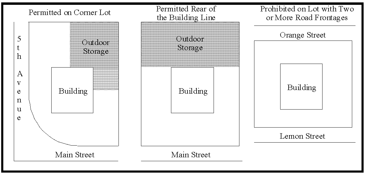
3.
Recreation and Open Space - In addition to the other standards in this Code, the following shall apply:
a.
Open Space - For the purpose of this SAP, opens space may consist of the following:
i.
Retention ponds meeting the following design requirements;
(a)
Resemble natural land/water body features;
(b)
Landscaped in accordance with the planting requirements of a Type "C" Buffer. These landscape requirements may include plant clustering or alternative planting schemes approved by the Development Review Committee; and,
(c)
Include pedestrian trail(s) paved or unpaved, benches or gazebo and fountain(s), or picnic pavilions with amenities;
ii.
Wildlife habitat, native plant communities including wooded areas that remain in a natural state and platted as such in perpetuity; and
iii.
Upland areas or open field(s).
iv.
For all residential developments, open space areas shall be designated within separate tracts and made accessible to all of the residents of the development.
b.
Passive recreation - These areas may be used to meet the Open Space requirement under the following conditions:
i.
Passive recreation such as parks or pedestrian paths shall be incorporated into the open space plan; and,
ii.
The recreation areas shall be linked via greenways/trails, wetlands, floodplains, or other natural areas within and adjacent to the development.
c.
The recreation and open space areas shall be linked to any proposed internal pedestrian network within the development; and,
d.
Recreation areas shall be accessible to all residents within residential development.
e.
Bona-fide agricultural uses, Family Farms, Family Homestead, and Lots of Record are exempt from this Section
4.
SPA I-a Performance Standards - All development within SPA I-a shall conform to the following:
a.
Buildings within SPA I-a shall not exceed two stories in height and shall be designed to achieve an office front appearance and front pedestrian entrances.
b.
Truck bay facilities shall be permitted only at the rear of buildings.
c.
All access from CR 559-A to this SPA shall be via five shared ingress/egress points. Three of these driveways shall be on the east/west straight section of existing CR 559-A and the remaining two drives shall provide access to the properties located on the north/south leg connecting with Mt. Olive Road. Vehicular access to individual lots shall not be permitted via CR 559-A by other than these shared driveways.
d.
To promote a more pleasing streetscape and to further assist in the transition from non-residential uses to residential uses, setbacks of no less than 35 feet shall be maintained for all street frontages. Variations in individual building setbacks, of no less than five feet, shall be required on that portion of CR 559-A which is straight for distances greater than 1,000 feet. The minimum setback area shall be landscaped in accordance with the Comprehensive Plan and this Code. Parking areas shall not be allowed to intrude into setback areas.
e.
An SAP site plan showing the overall setback plan and driveway access points shall be required prior to the issuance of development orders. An architectural elevation plan shall be required in the initial design stages for any primary building to be located within this SPA.
5.
SPA II - The original purpose of the SPA II was to not only realize the development potential of this intersection but also protect an existing eagle's nest that was identified when this SAP was created in the early 1990s. Therefore, prior to the approval of any development, the applicants for land development shall confirm whether the eagle's nest has been abandoned, reused or relocated and develop the property according to state and regional regulations. It is the purpose of the SPA II to restrict development in the vicinity of an existing eagle's nest so that construction and future land use activities disturb the site as minimally as possible while still realizing appropriate development potential. Until such time as the nest is abandoned, the purpose of this SPA II has expanded to encourage a higher quality for development along the Pace Road corridor. Pace Road is a gateway into the SAP, and the Cities of Lakeland, Auburndale, Polk City and Lake Alfred. The activities associated with this corridor support a nearby college/university. To accomplish these purposes, development shall be limited to those uses outlined in the SAP.
6.
SPA III - The Special Provision Area III (SPA III) is established as designated on the I-4/NE Parkway SAP map. SPA III is located at the intersection of the Parkway and a future unapproved extension of Gapway Road. The specific boundary of this SPA is not delineated to allow for flexibility; however, it is intended that a majority of the SPA be located symmetrically around the intersection and, generally, not extend more than 2,000 feet from where the centerlines intersect.
7.
Signs shall be in accordance with the following:
a.
Signs in Special Provision Areas I-a, I-b and II shall complement the overall selected area site and building design. Said sign in SPA I-1 and I-b shall be no taller than the height of the primary structure on the site and shall be limited to one hundred square feet in cumulative sign area. The setback shall be in accordance with Chapter 7 of this Code. Variances to this sign section may be granted according to Chapter 9 of the LDC.
b.
The construction of any off-premises signs shall be n accordance with Chapter 7Section 760 N and Chapter 9Section 931 of this Code.
c.
Buildings in the IACX shall comply with the CAC standards in Chapter 7. Commercial and business park uses in MUX shall be consistent with BPCX standards in Chapter 7. Residential uses in MUX shall be consistent with the respective Future Land Use designation with which the proposed density is most consistent as stated in Chapter 7. Variances may be granted as permitted in Chapter 7 and 9 of the LDC.
8.
Roadway Construction Buffers - Roadway construction and design shall be in accordance with the following:
a.
A landscape/buffer area of a minimum of 35 feet in width shall be provided on the north side of CR 559-A in SPA I-a and shall conform to the specifications of a Type "A" Buffer per Section 720.
b.
Provided that acquisition of right-of-way is obtained on the south side of CR 559-A, adjacent to SPA I-a, landscaping shall be provided within a buffer ten feet in width buffer conforming to the specifications of a Type "B" Buffer, Section 720.
c.
Buffer areas shall not include any right-of-way.
d.
An alternate roadway and buffering plan may be approved through a variance per a Planned Development or waiver when the alternate buffering is designed to help soften the impact of the non-residential buildings from the residential uses to the south, as well as to maintain driver safety on CR 559- A, in accordance with standards in Section 931 and 932, respectively.
9.
Multi-modal Collector Roadway System - This roadway system is based on state and regional plans for this area as well as the Polk Commerce Centre Community Redevelopment Area (CRA) Redevelopment Plan, as amended. This system is shown on the SAP FLUM map as dashed lines and includes 1) all roads that will intersect with the proposed roads and Berkley Road and/or the Polk Parkway, and 2) Berkley Road, CR 559-A, Pace Road, and Braddock Road.
a.
Prior to Level 2 Review approval or at time of Level 5 Review approval, right-of-way shall be dedicated for the Multi-Modal Collector Road System designated on the FLUM for this SAP by all development, adjacent to the roadways or accessing the roadways, and shall comply with all standards as listed within relevant Sections of the LDC.
b.
At a minimum, sidewalks shall be required per Chapter 7, and along both sides of the Multi Modal Collector Road system as designated on the SAP FLUM and DRI master development plan (MAP H) consistent with the requirements in Chapter 7. Bike lanes, or appropriate paved shoulders, shall also be required along both sides of the Multi Modal Collector Road system as designated on the SAP FLUM and on the DRI master plan (Map H).
c.
The right-of-way for the roadways listed in this Section shall be a minimum of 80 feet and may be required to be 120 feet as determined during the Level 2 Review process. The purpose of this right-of-way is to ensure a complete street system that includes sidewalks and pavement for bike lanes or the appropriate pavement width for a bike lane on both sides and be consistent with the Cities of Lakeland, Auburndale, and Polk City roadway designs and needs.
d.
At a minimum, sidewalks shall be constructed on at least one side of local roads intersecting these roadways.
e.
Multi use facilities may be used in lieu of bike lanes, or appropriate paved shoulders, and sidewalks in accordance with local and state standards.
f.
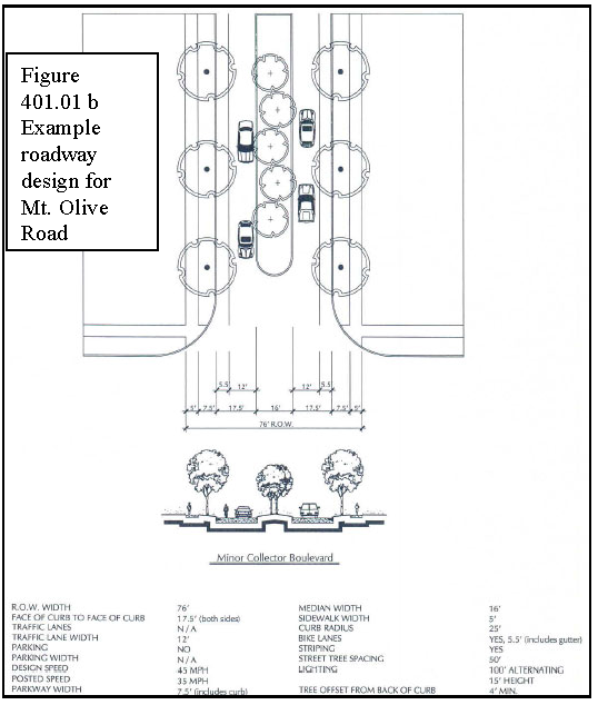
Mt. Olive Road Extension, the north/south road on the east side of the Polk Parkway, is required per the Polk Commerce Centre Development of Regional Impact (DRI) Development Order. The figure below is the design of the roadway anticipated by the City of Lakeland to be constructed within the Williams DRI. The design of the Mt. Olive Road Extension shall be based on input from the cities of Lakeland, Polk City, Auburndale, and Lake Alfred and shall meet the requirements of this Section.
g.
Alternatives to the items above may be approved through the Development Review Committee. The technical standards are not intended to be waived but altered based on property hardships.
10.
Stormwater Facilities - Stormwater facilities may be used in the following manner:
a.
The facilities may be included in the required open space only if the facilities are designed to resemble natural features and are buffered similar to the plantings of a Type A Buffer which may be clustered around the pond and landscaped with species native to this area of Polk County. The final plantings may vary from the Type A Buffer listed in Chapter 7 with approval from the Development Review Committee. See below for examples of undesirable and desirable designs that are to be used as a guide.
b.
The facilities may be constructed in a different land use than the principal use(s) as long as it is available for joint use by nearby uses and consistent with the Polk Commerce Centre DRI if applicable. An easement granting this right shall be created and granted at the time of Level 2 Review approval.
Figure 401.01 C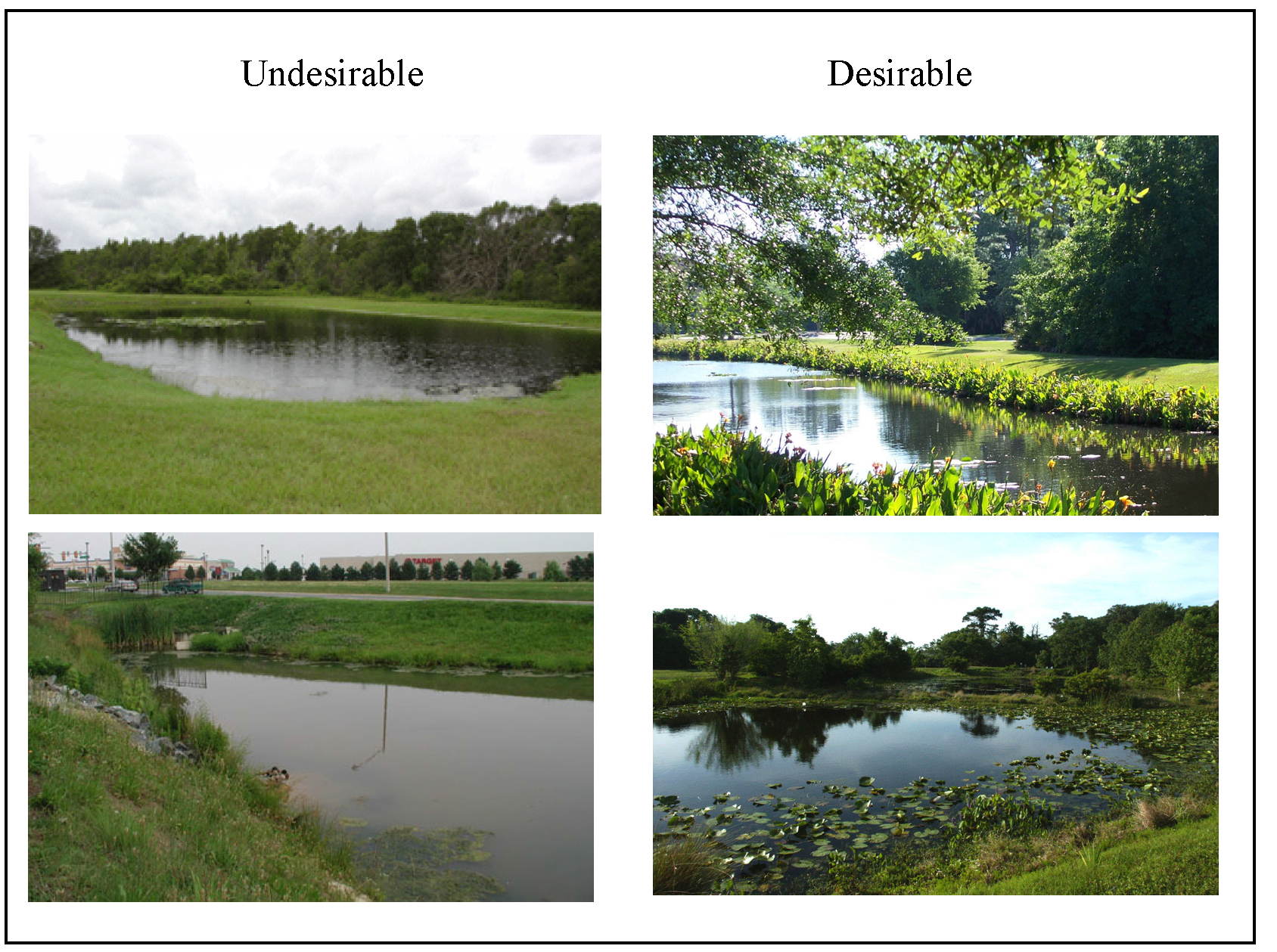
11.
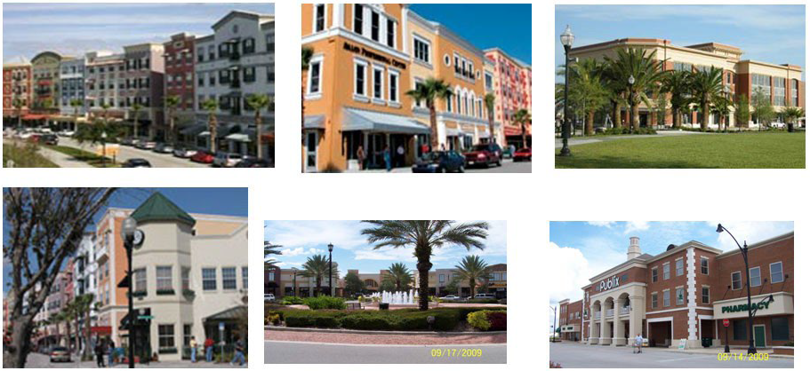
Architectural Building Design - The first property to be developed in the BPCX, along Pace Road, IACX, and the MUX shall be required to submit architectural renderings of all buildings for review by the Polk Commerce Centre Community Redevelopment Agency (CRA). The architectural style and design of all subsequent buildings shall be based on this first approval. It is anticipated that the buildings will be compatible in design to the University of South Florida PolyTechnic (USFP) Campus. Staff shall work with the developer to develop a set of parameters that other property owners throughout the CRA shall use for subsequent building construction. It may be necessary for County staff to establish other building design standards for review and approval by the CRA after the first site is reviewed by the CRA and may require an amendment to this SAP. The following pictures are provided as examples in addition to and until such time as the final design of the USFP is completed and started construction.
12.
Auburndale TECO Trail - All new development or expansions of existing development, except bona fide agricultural uses, Family Homesteads, Family Farms, and Lots of Record, on parcels adjacent to the Auburndale TECO Trail shall comply with the following:
a.
All new development or 50% expansions (of the gross floor area of all buildings) of existing development on parcels adjacent to the Trail shall plant a Type A Buffer and maintain buffering in accordance with the planting requirements of this Section and Chapter 7. The plantings and design shall be consistent with that of the Trail.
b.
All outdoor storage for non-residential uses shall be setback 100 feet and screened from the trail property line.
c.
Any use, structure, or equipment that generates noise above 65 decibels, vibrations, or noxious odors shall be setback 100 feet from the trail right-of- way and screened from offsite view.
13.
Trail Connection through Braddock Road - Developments that provide a pedestrian connection consistent with the needs of the City of Auburndale between the current end of Braddock Road and Tenoroc shall be permitted the maximum FAR without requiring a Planned Development or additional development requirements.
14.
Landscape Buffers - A five foot landscaped buffer consistent with the plantings of a Type B Buffer, in accordance to Section 720 of the LDC, shall be required between all non-residential developments as follows:
a.
Where a proposed non-residential use abuts an existing non-residential use, half the required plantings and width of a Type B Buffer, in accordance to Section 720 of the LDC, shall be required, unless the existing use has an equivalent full Type B Buffer than the Type B Buffer shall not be required;
b.
Where the proposed non-residential use abuts a non-residential designated parcel, that is vacant and without approved development plans from the County, the proposed use shall provide the equivalent of half of the required plantings and width of the Type B Buffer, in accordance to Section 720 of the LDC and the abutting parcel when developed will provide half of the required plantings and width of a Type B Buffer, in accordance to Section 720 of the LDC so that between the two uses will be a full Type B Buffer with half of the plantings and width on each lot;
c.
If the abutting non-residential use, whether it is an existing use or has received development approval from the County, has a clustered landscaped buffer, the abutting use shall cluster the landscaped buffer on center between the proposed or existing clustered landscaping. The proposed non-residential use in this situation, cannot apply for a waiver from the required landscaping;
d.
The plantings of the required landscape buffer between non-residential uses may be clustered, provided the separation between clusters is no greater than 30 feet;
e.
No more than 50% of the required plantings shall be of any one sub-species;
f.
Half of the required understory tree and shrub plantings from the Type B Buffer between non-residential uses may be transferred from the perimeter landscape to the surrounding building(s) for the development;
g.
Where the buildings abut each other so that there is no vehicle use area between the buildings and utilize shared parking areas, a landscape buffer shall not be required to separate the two uses; and,
h.
All landscaped buffers, including those within the building setbacks, may be counted toward the required Open Space for non-residential development.
i.
Alternatives to the items above may be proposed through a waiver in accordance with the standards in Section 932 of the LDC. The standards are not to be waived but altered based on property hardships so that quality landscaping is provided for non residential uses.
15.
Parking Areas - All non-residential development, multi-family, and townhouse developments shall comply with the following:
a.
Parking shall be provided to meet the needs of the uses in an efficient manner that best suits the community collectively through optional methods such as shared parking and alternative pavement consistent with Appendix A of this Code.
b.
Structured parking (otherwise known as parking garages) is not required; however, if a developer chooses to create structured parking, it shall incorporate the following:
i.
All structured parking shall be architecturally integrated or designed with an architectural theme similar to the main building(s);
ii.
Structured parking, starting on the first floor, may include retail, office, personal service and professional uses.
c.
All parking lot landscaping and buffer requirements shall meet the requirements of this Section in addition to the requirements of Section 720 of this Code. Where conflicts occur, the more restrictive shall apply.
i.
Xeriscape landscaping and native plant materials are encouraged to be incorporated into the parking lot landscaping.
ii.
No more than 50 percent of the required plantings shall be of any one species.
iii.
The minimum landscaping for each lot shall be provided within the interior of a required paved off-street parking area as follows;
(a)
Each aisle of parking spaces shall be terminated by landscaped islands which measure not less than nine feet in width, as measured from the face of curb to face of curb, and not less than 18 feet in length, At least one canopy tree shall be planted in each terminal island;
(b)
Mandatory terminal islands shall be surrounded with a continuous raised curb;
(c)
Landscaped divider medians may be used to meet interior landscape requirements. If divider medians are used, they shall form a continuous landscaped strip between abutting rows of parking spaces. The minimum width of divided medians shall be a minimum six foot wide, as measured from the face of curb to face of curb. One under story tree shall be planted for each 30 linear feet of divided median, or fraction thereof. Trees in a divided median may be planted individually or in clusters. The maximum spacing between clusters shall be 60 feet.
(d)
A minimum six foot wide divider median, as measured from face of curb to face of curb, shall be required every fourth bay of parking as shown in Figure C. A minimum of one understory tree shall be planted for each 30 linear feet of divider median. An alternative option, three diamond shaped islands may be substituted for the continuous six foot wide divider median, as shown in Figure C.
(e)
Optional interior islands and divider medians shall be protected by curbing or wheel stops; and,
(f)
Each parking bay shall have no more than ten continuous parking spaces unbroken by a landscape island that shall be the width of a parking space, as measured from face of curb to face of curb.
d.
Landscape areas shall be located in such a manner as to divide and break up the expanse of paving and to guide traffic flow.
e.
A Type A Buffer 15 feet in width shall be required between all frontage roads and parking lots in accordance with Section 720 of this Code.
f.
For required landscaping where off-street parking abuts public right-of-way: A landscape strip of land shall be provided consistent with this Section and Section 720 of this Code, with at least one drought resistant, Florida native tree for each 75 linear feet, or fraction thereof shall be planted. Trees may be planted separately or in clusters.
g.
No landscaping shall be provided in the right-of-way unless the County or FDOT gives the owner approval to do so. In addition, a completed agreement as to who will maintain the landscaping within the right-of-way shall be submitted prior to Level 2 Review approval.
h.
Alternatives to the above items may be proposed through a PD or waiver in accordance with the standards in Section 931 and 932 respectively of this Code for the intention of addressing hardship issues rather than granting exemptions to these requirements.
Figure 401.01 d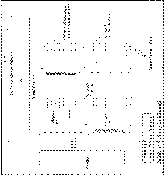
E.
Mixed Use-X Performance Standards (Revised 10/06/10 - Ord. 10-070)
In order to develop the Mixed Use-X in accordance with the intent outlined in the Polk County Comprehensive Plan, the following performance standards shall apply. Said standards are in addition to those outlined in this Section, which apply to the entire SAP.
1.
The architectural, streetscape, local road, pedestrian and bicycle network scheme for all public and private improvements shall be consistent with the architectural design standards established by the Polk Commerce Centre CRA.
2.
Buildings shall be consistent with the style designed according to Section D. 11, above.
3.
Development plans shall provide a mix of at least two land uses including, but not limited to, residential (single and multi-family), institutional, office, commercial, warehouse/distribution, and light industrial. A mix of uses may be accomplished horizontally, within separate buildings; and/or vertically, with different uses within the same building.
4.
Development density and intensity within the Mixed Use-X district shall meet the standards set forth in Table 4.2 of this Section.
5.
Uses within the MU district shall be linked to one another by a system of roadways and pedestrian walkways.
6.
All developments shall provide on-site safe pedestrian pathway connections from all parking areas and abutting residential development where appropriate.
7.
There shall be at least one main collector roadway that provides access to all property within this district consistent with the requirements listed in Section 401.01 D.9. and the roadway design for the Mt. Olive Road Extension as shown 401.01 D.9. This collector roadway shall provide at least one main connection to the parcel to the north for vehicular access to Pace Road and at least one main connection to the parcels to the south for vehicular access to Braddock Road.
8.
Access to individual and/or uses as part of an overall project, either requested for approval at one time or over a cumulative basis, shall be by an internal road system, frontage roads, cross-access easements, shared ingress/egress access easements, or some combination of these, off of a main access to a collector or arterial road.
9.
Different uses shall incorporate the use of shared ingress/egress facilities even if on the same parcel or multiple parcels.
10.
Parking shall be provided to meet the needs of the uses in an efficient manner that best suits the community collectively through optional methods such as shared parking and permeable surface parking. Shared parking areas include off site and/or on site of parking areas for the joint use by more than one non residential and/or residential uses. To determine the best means for the parking area, the applicant shall submit the appropriate documentation consistent with Section 710, B, to ensure peak demand is addressed as well as provide any sharing agreements between property owners necessary for the long term use of the parking areas.
11.
A transit stop shall be incorporated into the development every ¼ mile along an internal collector roadway. This shall include but not be limited to a bench, signage, and pedestrian cover at the discretion or approval of the Transit Director.
12.
Any uses that manufacture products shall only be permitted if conducted within wholly enclosed buildings.
13.
Any loading docks, utility facilities, and storage areas abutting rights-of-way shall be buffered from off-site view with landscape material.
14.
Signs within the MUX shall conform to the following:
a.
All signs shall be based on the standards for the CAC in Chapter 7 for non residential uses. Signs for residential uses within MUX shall be based on standards for the corresponding residential land use district with which the proposed density matches. All master developments, as required per this section and Polk 2.131-A4, d of the Comprehensive Plan, shall include a master sign plan;
b.
All signs and lighting of signs shall be consistent with architecture of the buildings; and
c.
Signs shall be monument-style or building-mounted only; freestanding pole signs shall be specifically prohibited.
15.
The FAR and ISR for commercial shall be consistent with NAC in Table 2.2 of this Code.
16.
The FAR and ISR for BPC type uses shall be consistent with the BPC land Use District in Table 2.2 of this Code.
17.
The minimum lot sizes for Low Density Residential, Medium Density Residential, and High Density Residential shall meet the requirements in Table 2.2 for Residential Low, Residential Medium, and Residential High respectively.
F.
Interchange Activity Center Performance Standards (Revised 10/06/10 - Ord. 10-070) In order to develop the IACX in accordance with the intent outlined in the Polk County Comprehensive Plan, the following performance standards shall apply. These standards are in addition to those outlined in this Section, which apply to the entire SAP.
1.
The architectural, signage, streetscape, local road, pedestrian and bicycle network scheme for all public and private improvements shall be consistent and approved by the Polk Commerce Centre CRA with the first development application so that it can be used as a guide for all subsequent development.
2.
Cross access easements shall be required to ensure safe access management on the accessed collector road.
3.
Conditional use approval shall not be approved without first considering the concerns of the nearby jurisdictions of Lakeland, Polk City, and Auburndale.
4.
Items 5 through 13 under MUX above shall apply for IACX. To ensure efficient use of building area, shared parking between uses
5.
Signage shall be consistent with CAC as listed in Chapter 7 of this Code.
G.
Conditional Uses In addition to the requirements listed in Chapter 3, Section 303, the following standards shall apply to the listed conditional uses):
1.
Multi-Family Multifamily development within the BPC-1X and BPC-2X shall be limited to 20 percent of the district rather than as permitted in Chapter 3.
2.
Hotels/Motels - Hotels and motels within the BPC-1X and BPC-2X districts shall be limited to the 15 % percentage cap for retail uses within BPCX;
3.
Light Assembly - The standards for this use shall be those as Manufacturing.
4.
Manufacturing - The following standards shall apply:
a.
No outdoor storage of any materials shall be permitted;
b.
There shall be no external activity beyond loading and unloading of materials to and from an enclosed structure; and,
c.
A buffer equal to a Type "C" buffer in accordance with Section 720 shall be provided between a residential use and any structure requiring loading and loading of commercial vehicle(s).
5.
Motor Freight Terminals - The following standards shall apply:
a.
There shall be no loading or unloading forward of the front building line or within 50 feet of adjacent property with a residential use or residential Future Land Use designation;
b.
A Type "C" buffer 25 feet in width shall be required adjacent to or adjoining a residential district or a school;
c.
A Type "C" buffer 5 feet in width shall be required adjacent to or adjoining non-residential use or district;
d.
No vehicle parking, gasoline sales, fuel storage or truck servicing activities are allowed within 65 feet of the property line that abuts any residential district or a school regardless if the use or district is across a roadway;
e.
All outdoor storage shall be screened from offsite view and shall be set back 50 feet from any adjacent property with a residential structure, residential land use designation or school.
6.
Offices and Office Parks - The following standards shall apply:
a.
Offices shall not exceed 15 percent of the total developable areas of the subject TCCX district. The total developed areas shall be calculated based on the inclusion of all existing uses in the subject land use district and those with approved and valid site plans, construction plans and plats. The applicant must demonstrate that the development does not exceed this 15 percent maximum;
b.
All offices shall have vehicular and pedestrian interconnectivity. Development shall stub out for future vehicular and pedestrian connection.
c.
Internal sidewalks shall be provided between offices and associated parking lots to meet pedestrian access of all offices within the office park; and
d.
At a minimum, a Type "A" buffer shall be required along the entire perimeter of the office park.
7.
Recreation and Amusement, General - In addition to the standards in Chapter 3, the following shall apply:
a.
All uses within the RMX and RHX Future Land Use district shall be complimentary to the Lake Myrtle Community Park. Dormitories for students of and using the facility may be permitted within the RMX and RHX Future Land Use district consistent with the densities of that district;
b.
Limitations on hours of operation may be conditioned when the use is adjacent to developed residential areas;
c.
Additional buffering may be needed when adjacent to developed residential areas;
d.
Access through the Lake Myrtle Community Park shall be explored to limit traffic on local residential roads. Depending on the nature of the local road, traffic from this recreation use may be prohibited from using the local road.
8.
Retail - In addition to the standards listed in this Chapter and Chapter 3, retail uses shall not exceed 15% of the contiguous BPCX district. This shall also include hotel and motel uses.
9.
Warehouse and/or distribution facilities - The conditions for Motor Freight Terminals shall apply.
10.
Wholesale, enclosed - The conditions for manufacturing shall apply.
(Ord. No. 2022-080, § 3, 12-6-2022; Ord. No. 2024-025, § 4, 4-16-2024; Ord. No. 2025-023, § 2, 4-15-2025)
Section 401.01.01 - Use Table for Interstate 4 Selected Area Plan Land Use Districts
The permitted and conditional uses for the standard land use districts for this SAP are prescribed in Table 4.1.c. Use Table for Interstate 4 Selected Land Use Districts: (Revised 10/06/10 - Ord. 10-070)
A.
Prohibited Uses (Revised 10/06/10 - Ord. 10-070)
The use of land or structures not expressly listed in the Use Tables for this SAP or within this SAP as permitted or conditional are prohibited.
B.
Other Regulations
Uses listed as permitted may be established only after meeting all applicable regulations of Polk County and other governmental agencies.
C.
Conditional Uses
Uses listed as conditional may be established only after compliance with the specific conditions and procedures outlined in Chapter 3, Conditional Uses, and all applicable codes of Polk County and other governmental agencies.
C1 Conditional uses which are reviewed at the staff level through an existing permit procedure. The review process is outlined in Section 904, Level 1 Reviews.
C2 Conditional uses which are reviewed by the staff but involve multiple issues or departments. The review process is outlined in Section 905, Level 2 Reviews, and involves review of a site plan by the Development Review Committee.
C3 Conditional uses which are reviewed by the staff but involve multiple issues and potential off-site impacts. The review process is prescribed in Section 906, Level 3 Reviews, and includes a site plan submittal for review by the Development Review Committee (DRC) and a public hearing before the Planning Commission (PC).
C4 Conditional uses which involve multiple issues and potential significant off-site impacts. These uses are reviewed by the DRC and include public hearings before the Planning Commission and BOCC. The procedure for this review is prescribed in Section 907, Level 4 Reviews.
D.
Accessory and Temporary Uses (Revised 10/06/10 - Ord. 10-070)
Accessory and Temporary Uses are defined in Chapter 10 and regulated in Chapter 2 of this Code.
E.
Infill and Compatibility
All uses are subject to Infill and Compatibility requirements outlined in Sections 220 and 221.
F.
Density and Dimensional Regulations (Revised 10/06/10 - Ord. 10-070)
Density and Dimensional Regulations shall be consistent with Table 2.2 and all other applicable density and dimensional provisions of this Code. Higher densities may be achieved through a Planned Development (PD) pursuant to Section 303. Approved PDs in the I-4 SAP are subject to the performance standards found in Comprehensive Plan Policy 2.131-A10.
(Ord. No. 2025-023, § 3, 4-15-2025)
(Ord. No. 19-069, § 1, 12-3-2019; Ord. No. 19-072, § 1, 12-3-2019; Ord. No. 2024-007, § 2, 2-6-2024; Ord. No. 2025-074, § 3, 12-16-2025)
Section 401.02 - Ronald Reagan Parkway Plan District
A.
Purpose and Intent
The Ronald Reagan Parkway Plan district implements the Ronald Reagan Parkway Selected Area Plan (SAP) portion of the Polk County Comprehensive Plan. The Ronald Reagan Parkway Selected Area Plan vision is to create a series of urban communities and neighborhoods interspersed within the natural environment while creating commerce nodes and villages to foster community interaction and public gathering spaces. The district encompasses a wide residential spectrum, commercial centers, corporate centers and natural preserves arranged in a manner to ensure an environmental, economic, and socially sustainable community.
The Ronald Reagan SAP is intended to develop as a more urban community relative to the rest of Polk County. The majority of the housing stock in this community serves three main residential markets; Orlando Metro Area Commuter, Extended Stay Tourist, and Empty Nesters. Retail and employment uses must be granted flexibility to meet the needs of these three different markets. Within the selected area plan there is a mix of regional retail, regional employment centers, and residential neighborhoods that form an interconnected hierarchy of streets, public spaces and vistas.
B.
Applicability
Development within the CR 54 plan district shall comply with all land use requirements and development standards contained in the CR 54 SAP in Section 2.131-B of the Polk County Comprehensive Plan. This Section applies to development within the CR 54 plan district, the boundaries of which are shown on the FLUMS.
C.
Use Table
Ronald Reagan Selected Area Plan (SAP) establishes modified future land use districts that include urban uses and urban design aspects that more specifically target the positive market forces attracting development to the area. These vary from those allowed under the general provisions for each specific land use category in with the Comprehensive Plan because of the differences in development styles and urban perspective that this area of the County embodies. Where plan language is in conflict between the standards and characteristics of this Selected Area Plan and other areas of the Comprehensive Plan the provisions of this Selected Area Plan shall apply. The land use categories and uses allowable in this district are shown in Table 4.3. Land use categories and uses not shown are prohibited. Land uses shown with a C1, C2, C3 or C4, shall comply with applicable review processes that correspond with their number.
D.
Density and Dimensional Regulations
The density and dimensional regulations for these SAP districts are outlined in Table 4.4, Density limits for the Ronald Reagan Parkway SAP.
Table 4.3 Use Table for Standard Land Use Districts for the Ronald Reagan Selected Area Plan(For revision history, please see last row in table. Newer ordinances appear after the table.)
(Ord. No. 19-069, § 1, 12-3-2019; Ord. No. 19-072, § 1, 12-3-2019; Ord. No. 23-019, § 3, 3-21-2023; Ord. No. 2024-007, § 2, 2-6-2024; Ord. No. 2024-022, § 8, 3-19-2024; Ord. No. 2025-074, § 4, 12-16-2025)
Table 4.4 Density and Dimensional Regulations for the Ronald Reagan Selected Area Plan (Revised 11/09/05 - Ord. - 65)
See footnotes following table.
Footnotes for Table 4.4
1.
Residential density is the average number of dwelling units per acre of land. Gross density is calculated by dividing the total number of dwelling units on a site by the gross site area, exclusive of existing water bodies and limited transfer of density out of wetlands per Section 620. (Note: The term "water bodies" does not include man-made wet-retention/detention areas, man-made lakes, or man-made ponds). The area for computing gross density shall include all public and institutional land areas (e.g., internal streets, sewer plants, schools, and parks) located within a site, as well as one-half of the right-of-way area for perimeter local streets, and one-fourth of the right-of-way area for perimeter local street intersections.
2.
Higher densities and Floor Area Ratio (FAR) may be achieved through a Planned Development. See Sections 303 and 401.02 E.7
3.
Residential is only permitted in NACX, CCX, and OCX when accessory to commercial or office development.
4.
The impervious surface ratio (ISR) is the relationship between the total amount of impervious surface which is present on a site and the total site area. Impervious surfaces are those which do not absorb water. They include buildings, parking areas, driveways, roads, sidewalks, and any areas of concrete or asphalt. The ISR is calculated by dividing the total area of all impervious surfaces on a site by the gross site area, excluding existing water bodies (Note: The term "water bodies" does not include man-made wet-retention/detention areas, man-made lakes, or man-made ponds).
5.
The floor area ratio (FAR) is the relationship between the total floor area on a site and the total site area. The FAR is calculated by adding together all floor areas of all floors and dividing this total by the gross site area, exclusive of existing water bodies (Note: The term "water bodies" does not include man-made wet-retention/detention areas, man-made lakes, or man-made ponds).
6.
Front, exterior side, and exterior rear setbacks for principal and accessory structures shall be determined by the distance from the road right-of-way (R/W). Setbacks from private roads shall be calculated in the same manner or from the edge of pavement, whichever is greater. All linear dimensions are given in feet.
7.
Residential structures exceeding 35 feet in height, setbacks shall be increased by one-half of one foot for each one foot of height over 35 feet. The 100' height may only be obtained according to Section 401.02 E. Performance Standards, Subsection 9. ChampionsGate MUX.
8.
All development is subject to Section 610 - Setbacks from lakes and surface waters.
9.
All development is subject to Section 220 - Compatibility.
10.
Chimneys, smoke stacks, communication towers, and Religious Institution symbols, including, but not limited to: minarets, prayer towers, steeples, crosses, menorahs, Stars of David, and bell towers are exempt from the structure height limitations.
11.
All structures are subject to compliance with the Polk County Airport Zoning Regulations, adopted and administered by the Joint Airport Zoning Board (JAZB).
12.
All single-family detached, single-family attached, duplex, townhome, and residential detached garage entrances for vehicles shall be setback a minimum of 25 feet from the property line, drive aisle, or right-of-way easement.
13.
All structures shall comply with Section 214 - Distance between Buildings.
15.
Impervious surface ratio (ISR) does not apply to single-family residential development. GS indicates lower ISR standard for properties in the Green Swamp Area of Critical State Concern.
16.
Minimum interior side setbacks for non-residential uses which adjoin non-residential districts may utilize a zero setback in accordance with the provisions in Section 755, provided that side adjoins a non-residential district.
17.
Recreational lighting, seating, press boxes, and other similar appurtenances are excluded from height restrictions when approved through a Level 3 Conditional Use process.
18.
The Building Official may approve a reduction in the required setbacks of up to ten percent (10%) of the requirement through a Level 1 Review process.
(Ord. No. 2020-048, § 2, 12-1-2020; Ord. No. 2022-083, § 2, 12-20-2022; Ord. No. 23-019, § 4, 3-21-2023; Ord. No. 2024-025, § 4, 4-16-2024)
E.
Performance Standards
The performance standards for development in the Ronald Reagan Parkway SAP are embodied in seven primary categories; Vehicle Transportation, Pedestrian Accessibility, Recreation, Wetlands, Landscaping, Signs, and Specific Use Standards.
1.
Transportation To accommodate the urban densities and intensities intended for this planning area, a network of collector roads is needed to provide multiple routes to the major transportation corridors that connect this area with the Orlando Metropolitan Area. Ronald Reagan Parkway (CR54), US Highway 27, Lake Wilson Road, and U.S. Highway 17/92 alone cannot provide the needed capacity in the long run. Parallel routes must be created to divert traffic seeking a multitude of destinations. Employment, retail, and residential development must be interconnected to mitigate the burden of growth upon this area. The following standards apply to all development within the SAP:
a.
Where a future roadway is indicated on the Comprehensive Plan Future Land Use Map to lie within the property to be developed, there are two options
i.
The developer may construct the road, as set forth in the SAP, through the property from the general location depicted on the FLUMS where it enters the property to the general location where it terminates; or,
ii.
The developer may dedicate, fee simple prior to Level 2 development approval, the maximum amount of right-of- way to the County for the road type specified in the plan per the Florida Department of Transportation Manual of Uniform Minimum Standards for Design, Construction and Maintenance for Streets and Highways.
b.
Where different types [1] of development meet there shall be at least one direct vehicle connection to the greatest extent practicable.
c.
All residential development of two hundred (200) units or more shall have more than one access or entrance.
d.
All residential development of more than five hundred units shall have at least three forms of access or entrance.
e.
Within developments that have an internal roadway system, streets will be designed to be as narrow as possible, without compromising auto safety and access to public service vehicles. Table 4.5 shall be used as a guide:
NOTES:
* 5' planter within rear yard setback
** See CR 54/ Loughman Development Handbook
*** Parallel parking and planter share same 7 foot width of ROW and alternative
**** 7' setback at side yard
***** Tree wells at 40' on-center in parking area
2.
Pedestrian Accessibility In order to ensure adequate safety for the non-motorized public in an area developed to an urban intensity, it is imperative that stabilized pedestrian facilities are provided internally and externally in all development to create an efficient, effective and safe circulation throughout the plan's area. All development shall include an internal pedestrian network that links directly to adjacent development and to existing or planned external pedestrian facilities. The following criteria identify the minimum extent of internal sidewalk patterns and pedestrian connections:
a.
Where streets exceed an uninterrupted [2] distance of 800 feet or more, there shall be sidewalks on both sides.
b.
Where streets terminate with a cul-de-sac, sidewalks may be discontinued within 150 feet of the end of pavement unless there is a corresponding pedestrian connection located within that distance.
c.
Where open space areas, recreation areas, utility easements or stormwater tracts from neighboring developments meet, a pedestrian connection shall be constructed. Such facility shall be a minimum 4 feet wide and constructed of a dust free surface or clearly marked stabilized base surface.
3.
Recreation Facilities - 380 square feet of park-and-recreation space per unit shall be provided within each residential development and related specifically to that development. Each dwelling unit shall be within ¼ mile of park or recreation facility within the residential development. The following types of land shall be allowed to meet the park-and-recreation space requirements:
a.
Right-of-way over-sizing with accommodation for pedestrian sidewalks, bicycle pathways and pocket parks.
b.
Stormwater retention/detention provided it is designed in an aesthetically pleasing manner that creates a sense of place and opportunities for community gatherings and includes a pedestrian/bicycle path that is connected to a linked system;
c.
Passive recreation areas; and
d.
Active recreation areas.
4.
Wetlands. All wetland areas deemed under the jurisdiction of the Army Corps of Engineers, Florida Department of Environmental Protection or the Water Management District (South or Southwest Florida) are considered Preservation (PRESVX) regardless of their appearance on the generalized Future Land Use Map. The purpose of the preservation district is to offset and mitigate the impact upon the regional environmental system that is anticipated to result from the urbanization of the area. The following uses shall be the only development allowed in wetlands:
a.
Access to the site where other alternatives do not exist;
b.
Internal traffic or pedestrian circulation, where other alternatives do not exist, or for purposes of public safety;
c.
Utility transmission and collection lines;
d.
Passive recreation facilities; and,
e.
Pre-treated storm-water management.
5.
Landscaping and Reforestation - It is essential when creating an urban environment to replenish and protect the natural landscape. The benefits are: reduction of ambient temperatures, creation a more drought tolerant environment, mitigation of the hardscape of urban areas, restoration of wildlife habitat, reduction of noise pollution, and the reduction of light pollution. The Ronald Reagan Parkway SAP requires the following minimum standards for Canopy Tree Planting, Roadway Landscape and Parking Lot Areas in all development:
a.
Canopy trees shall be planted in all development and consist of mixture of deciduous and non-deciduous trees. The minimum number of canopy trees, exclusive of buffers, to be planted or preserved as follows:
i.
Residential Low (RLX) — 1 tree shall be planted or preserved for every 5,000 square feet of developable residential land area or fraction thereof, up to a maximum of 8 trees.
ii.
Residential Medium (RMX) and Residential High (RHX) — 8 trees per gross developable acre shall be planted or preserved.
iii.
Activity Centers (RACX, CACX, NACX, CCX, OCX, and ECX), Institutional (INSTX) and MUX — 6 trees per gross developable acre shall be planted or preserved.
iv.
Industrial (INDX), Business Park Center (BPCX) — 4 trees per gross developable acre shall be planted or preserved.
b.
Roadway Landscape Design within all development shall conform to the following:
i.
A 25'-wide landscape/buffer area shall be provided on both sides of all arterial collector roads. This landscape/buffer area shall be landscaped with trees and shrubs to achieve a 25% coverage after one year of planting. Landscape/Buffer areas are in addition to the street right-of-way.
ii.
Landscaping shall also be encouraged within road rights-of-way but must be based on a plan approved by the County.
iii.
Developers of properties shall plant Live Oak trees along collector and arterial roadways at a ratio of one tree for every 40 linear feet of right-of-way frontage.
iv.
A site plan showing the easement landscape plan and driveway access points shall be required prior to the approval of horizontal plans.
c.
Parking lots shall be landscaped pursuant to the following provisions:
i.
Parking lots shall be required to be landscaped so that no less than 50% of the parking is underneath a canopy at tree maturity.
ii.
Minimum Landscaped Area - A minimum area not less than 5% of the total off-street parking area shall be devoted to landscaping.
iii.
Location Not more than 20% of the parking area landscaping requirement may be provided adjacent to the building it is intended to serve. All other landscaping shall be provided in the form of interior islands, divider medians, and perimeter landscape strips. Landscaped areas shall be located in such a manner as to divide and breakup the expanse of paving and to guide traffic flow. Landscape islands and divider medians shall measure not less than 5 feet in width. At least 1 tree shall be provided in each landscaped area. The remainder of the area shall be landscaped using grass, ground cover, mulch, shrubs, trees, or other landscaping material excluding sand or pavement. All landscaped areas shall avoid overhang encroachment with curb stops or bumpers. If curbing is used abutting landscaped areas, it shall be perforated to permit drainage where necessary.
iv.
Required Landscaping Adjacent to Public ROWs — Where a paved off-street parking area is abutting a public right-of-way, landscaping shall be provided between the off-street parking area and the right-of- way in accordance with the following:
1)
Landscaped strip of land, a minimum of five feet in width, shall extend along the length of the boundary between the parking area and the abutting right-of-way except at point of access. This landscaped strip shall contain at least one (1) tree for each 75 lineal feet, or fraction thereof. Trees may be planted separately or in clusters.
2)
The required landscaped strip shall contain a hedge, wall, fence, berm, or other opaque screen, a minimum of 3 feet high, but no more than 6 feet high attained within one year of installation. If non-living barriers are used, one shrub or vine shall be planted along the street side for each 15 lineal feet of screen. The remainder of the landscaped strip shall be landscaped with grass, ground cover, or other appropriate landscaped treatment.
d.
Parking shall be minimized and provided the least priority in the Ronald Reagan SAP to provide for more desired open space or to encourage pedestrian activity in an urban environment. Parking requirements of Section 720 may be reduced through shared parking agreements and for all mixed use and interconnected developments by approval of the Land Development Director.
6.
Signs Signage shall be more restrictive than typical standards for Polk County. The SAP shall use visually pleasing, lower height and smaller signs to compliment the overall selected-area site and building design. Flapping flags, blinking lights, and portable signs shall be prohibited. The construction of billboards along the roadways and Interstate 4 shall be specifically prohibited except for temporary billboards advertising the availability of industrial and commercial space located within the SAP for the respective property(ies).
7.
Planned Development - Densities may be increased and a greater floor area ratio may be sought provided the following is accomplished with design and approved by the Planning Commission:
a.
Substantial effort is made to soften the hardscape of development through:
i.
Preservation of mature landscaping or increased and more mature plantings; and,
ii.
Curved streets and drive aisles,
b.
Multiple connections a provided to adjacent properties (both pedestrian and vehicle); and
c.
A substantial effort has been made to step down intensity and ease the transition to abutting existing developments of lesser intensity.
Self-Storage Facility (Conditional Use Standards) (Added by Ord. No. 17-038 - 08/08/17)
8.
The following conditional use standards are considered to be more specific and shall be required in lieu of those conditional use standards for Self-Storage Facilities as identified in Section 303 of the Code.
a.
Storage of hazardous materials is prohibited. Storage of vehicles, boats, recreational vehicles, etc., shall occur in designated areas, entirely screened from view of adjacent residential property and from public rights-of-way. Except as provided herein, outdoor storage of any kind shall be prohibited.
b.
Personal storage facilities shall provide one parking space per 200 bays, plus one space per employee.
c.
Building facades visible from the public right-of-way shall have the appearance of an office and/or retail building through the use of doors, windows, awnings, and other appropriate building and design elements.
d.
Exterior building material shall be stucco, brick, stone, split-faced block, or a combination of those materials. Building modulation shall be employed to break up long facades and create a visually unique project. Building modulation may be achieved through the use of horizontal and vertical projections or recesses, including awnings, overhangs or other similar architectural features.
e.
Buildings that can accommodate two or more stories shall be designed to have the appearance of a multi-story building through the use of windows, doors, awnings, canopies and other appropriate building elements. For purposes of these design standards, these may consist of transparent windows, vehicular breezeways, or spandrel architectural elements may be used to further enhance facades.
f.
Access to all storage units shall be from the interior of the building.
9.
ChampionsGate MUX - The MUX district is to address flexible residential unit needs of the ChampionsGate development to create a urban resort environment as well as to expand the same style of development from Osceola County. The portion of MUX between ChampionsGate Boulevard and the Portofina development may achieve a building height of 100 feet while the portion of the MUX between Westside Boulevard and Portofino shall be limited to a height of only 75 feet.
Tables 4.6 and 4.7 Deleted due to Ordinance 05-65 Adopted November 14, 2005
(Ord. No. 2021-038, § 3, 7-6-2021; Ord. No. 23-019, § 5, 3-21-2023)
General types such as residential, commercial, office, service, employment, etc.
--- (2) ---
Street intersection or traffic calming device.
Section 401.03 - North US 27 Selected Area Plan
A.
Purpose and Intent
This Selected Area Plan (SAP) was adopted in the Polk County Comprehensive Plan to recognize the anticipated high level of urbanization during the next twenty years. The districts and performance standards that follow implement the public/private initiatives outlined in the Plan. In order to achieve an efficient and highly desirable urban growth pattern, a balance of residential and non-residential uses is required, as well as a range of housing opportunities and short trips between housing, employment, and shopping. The approach utilized in the SAP districts includes the creation of traditional neighborhood villages and a town center while preserving sensitive environmental resources.
B.
Applicability
This Section applies to development within the North US 27 SAP, the boundaries of which are shown on the FLUMS.
C.
Use Table
The land use categories and uses allowable in this district are shown in Table 4.8. Land use categories and uses not shown are prohibited. Land uses shown with a C1, C2, C3 or C4 shall comply with applicable Criteria for Conditional Uses in Chapter 3.
D.
Density and Dimensional Regulations (Revised 2/11/02 - Ord. 02-05)
The allowable densities for this SAP are shown in Table 4.9. Density bonuses are shown in Table 4.10. Excess density credit, earned above the actual constructed density [3], may be transferred off-site throughout the SAP so long as the gross density of the receiving area does not exceed the maximum permitted density within the district. To receive density transfers, a minimum of 30 bonus points is required of the receiving development. Town Center (TC) is a mixed-use district that has both a density by right as well as a floor-area-ratio.
For the entire SAP, height and setbacks are based upon compatibility with adjacent uses and not limited by table 2.2. This SAP also has a minimum gross density per district. To develop below the minimum gross density, bonus points must also be achieved (see Table 4.11).
E.
Performance Standards (Revised 4/4/02 - Ord. 02-18; 2/11/02 - Ord. 02-05)
In addition to all other applicable provisions in this Code, the following conditions and performance standards are imposed for all development within this SAP. Additional standards for the Town Center are outlined in Subsection H.
1.
Linked recreation and open space system shall be provided in compliance with Section 401 C.
2.
Buffers shall be utilized to create reforestation opportunities and to reduce visual and noise impacts on residential uses. A landscaped buffer 25 feet in width shall be required, according to Buffer Type C in Section 720, along all collector and arterial roads.
3.
Special landscaping standards shall apply to all public rights-of-way and private lands used for parking and located along rights-of-way in compliance with Section 401.02 E.3. Xeriscape design is encouraged.
4.
Billboards and other off-site signs are prohibited except as outlined below.
a.
Entrance features may incorporate signs for off-site uses within the SAP.
b.
Temporary signs for real estate sales and special events are permitted as per Section 760.
5.
Transportation improvements shall comply with the following:
a.
Arterial and collector roadways shall adhere to the adopted road plan for US 27.
b.
Arterial roads shall be considered controlled direct access roads and access points shall be at least 300 feet apart.
c.
Rights-of-way shall be dedicated for roads designated on the FLUMS and shall comply with the widths required in Section 823.
d.
Curb cut criteria shall be:
6.
In order to provide safe and efficient local traffic movement, the County may designate cross-access corridors along certain roadways. Said corridors shall be designed to provide unified access and circulation among parcels on each block of the thoroughfare. Each corridor shall include the following elements:
7.
Self-Storage Facility (Conditional Use Standards)
The following conditional use standards are supplementary to the conditions for self-storage facilities found in LDC Section 303. Where there may be a conflict between these standards, the following shall take precedence.
a.
The self-storage facility shall be multi-tenant with at least three leasable storefronts. A storefront may be occupied with any use permitted within the applicable land use designation. Each storefront shall be at least 800 square feet. Only one storefront that is directly related to the self-storage facility may be counted towards the three leasable storefront requirement of this paragraph. Separate entrances to each leasable area are permitted.
b.
Storage of hazardous materials is prohibited.
c.
Outdoor storage is prohibited, except as otherwise provided in (d).
d.
Storage of vehicles, boats, recreational vehicles, etc. shall only be permitted within an enclosed structure or screened entirely from offsite by the facility's buildings. Enclosed structures intended for the storage of these vehicles are not required to have a roof or ceiling.
e.
Self-storage facility shall provide one parking space per 150 storage units, plus one parking space per employee. All other parking shall comply with LDC Chapter 7 Table 7.10. Parking Waivers may be requested on a case-by-case basis in accordance with LDC Section 709.J.
f.
Building facades visible from the public right-of-way shall have the appearance of an office and/or retail building through the use of doors, windows, awnings, sills, shutters, reliefs, trims, columns, pilasters, quoins, reveals, cornices, horizontal banding, arches, decorative vents, faux windows, accent tile, or other appropriate building and architectural design features.
g.
Exterior building material shall be stucco, brick, stone, split-faced block, or a combination of those materials. Building modulation shall be employed to break up long facades and create a visually unique project. Building modulation may be achieved through the use of horizontal and vertical projections or recesses, including awnings, overhangs, or other similar architectural features.
h.
Buildings that can accommodate two or more stories shall be designed to have the appearance of a multi-story building through the use of windows, doors, canopies, sills, shutters, reliefs, trims, columns, pilasters, quoins, reveals, cornices, horizontal banding, arches, decorative vents, faux windows, accent tile and other appropriate architectural design features. For purposes of these design standards, these may consist of transparent windows, vehicular breezeways, or spandrel architectural elements may be used to further enhance facades.
i.
Access to all storage units shall be interior to the building or an otherwise enclosed structure.
Section 401.03.01 Use Table for U.S. 27 Selected Area Plan[4]
(Ord. No. 19-069, § 1, 12-3-2019; Ord. No. 19-072, § 1, 12-3-2019; Ord. No. 2024-007, § 2, 2-6-2024; Ord. No. 2024-014, § 2, 3-5-2024; Ord. No. 2024-064, § 2, 10-1-2024; Ord. No. 2025-074, § 5, 12-16-2025)
Table 4.9 Density Limits for U.S. 27 SAP (Revised 1/6/10 - Ord. 10-003; 05/21/08 - Ord. -08-016; 7/25/07 - Ord. 07-39; 02/11/02 - Ord. 02-05; 11/1/01 - Ord. 01-44)
a.
A continuous linear travel corridor extending the entire length of the block which it serves, or at least 1,000 feet of linear frontage along the thoroughfare, and having a design speed of 10 mph. Final design of the facility shall be approved by the County Engineer.
b.
Sufficient width to accommodate two-way travel aisles for automobiles, service vehicles, and loading vehicles.
c.
Stub-outs and other design features which make it visually obvious that the abutting properties may be tied in to provide cross-access, shall be constructed at the time of development.
d.
Linkage to other cross-access corridors in the area.
e.
Where a cross-access corridor is designated by the County, no subdivision plat, site plan, or other development shall be approved unless the property owner grants an easement allowing general cross-access to and from the other properties in the affected area. Such easement shall be recorded in the public records of Polk County and shall constitute a covenant running with the land.
Table 4.10 (Revised 02/11/02 - Ord. 02-05)
Table 4.11 (Revised 05/21/08 - Ord. 08-016; 7/25/07 - Ord. 07-039; 02/11/02 - Ord. 02-05)
f.
Wherever a cross-access corridor has been designated, the sites shall be so designed for coordinated or joint parking, access and circulation systems. These sites shall include stub-outs and other design features necessary to make it visually obvious that the abutting properties may be connected to a unified system.
g.
If a site is developed prior to an abutting property, it shall be designed to ensure that its parking, access, and circulation may be connected to a unified system at a later date.
h.
If a site abuts an existing developed property, it shall be so designed to connect to the abutting parking, access and circulation unless the Planning Director determines this to be impractical.
F.
Environmental Protection (Revised 02/11/02 - Ord. 02-05)
All development within this SAP shall be designed to protect upland wildlife habitats, native plant communities, wetlands, and other natural resources.
1.
If land proposed for development contains a native plant community or communities which equals or exceeds 50 percent of the total pervious open space of the project it shall retain this native vegetation including understory vegetation. If the area of existing native plant community or communities is less than 50 percent of this total pervious open space, then all of the natural vegetation shall be retained. Stormwater ponds or conveyance areas are exempt from this calculation.
2.
Land alteration activity which destroys, reduces, impairs a wetland or natural body of water, shall be prohibited, unless there is no recourse in order to allow reasonable use of the land.
3.
Wider setbacks may be required by the County to mitigate potential adverse impacts to environmentally sensitive areas.
4.
Building setbacks shall be 50 feet from environmentally sensitive areas. Wider setbacks may be required by the County depending on the environmental sensitivity of the area and the intensity of the development proposed adjacent to the area.
5.
No filling, excavating, or placement of permanent structures or other impervious surfaces shall be allowed within setbacks except for the installation of a sprinkler system, utility lines, or landscaping; or except as approved by the County for the construction of a road essential for access, construction of a stormwater retention or detention basis or stormwater conveyance, construction of a boardwalk or their stilted structure, grade finishing to provide a gradual slope between the setback line and the environmentally sensitive area, or the limited use of pervious paving material.
6.
No underground petroleum storage tanks shall be allowed within the North US 27 SAP, unless the tanks are double walled and provide for monitoring of the interstitial space between the inner and outer tanks.
G.
Town Center-X Performance Standards (Revised 2/11/02 - Ord. 02-05)
In order to develop the Town Center-X in accordance with the intent outlined in the Polk County Comprehensive Plan, the following performance standards shall apply. Said standards are in addition to those outlined in this Section, which apply to the entire SAP.
1.
The architectural, streetscapes, local road, pedestrian and bicycle network scheme for all public and private improvements shall be consistent.
2.
A system of pedestrian walkways shall be provided to link the Town Center-X with surrounding neighborhoods.
3.
A street grid system shall be established and continued for all development.
4.
Landmarks and focal points shall be incorporated into the Town Center-X to visually connect to the residential areas.
5.
Compliance with the linked open space and recreation system as required in Section 401 C.
6.
Road networks shall contain a hierarchy of streets based on pedestrian usage as shown in Table 4.7.
7.
Alternative parking approaches will be considered if proven to be adequate to serve the project while encouraging an improved pedestrian environment and design compatibility.
8.
Lands within the TCX designation are entitled to 10 units per acre and 1.0 non-residential floor-area-ratio by right. Higher densities may be achieved through a density bonus system provided in Table 4.10 and 4.11 not to exceed 25 dwelling units per acre (25 du./ac.).
H.
Professional Institutional -X Performance Standards (Revised 1/6/10 - Ord. 10-003; 7/25/07 - Ord. 07-039)
1.
Development shall be consistent with the following:
a.
On-premises signs shall meet the requirements of Section 760 for the Community Activity Center (CAC) and shall be reduced by 15 percent for sign height and area within the SAP;
b.
The setbacks and building height shall meet the requirements of the CAC in accordance with Section 205, Table 2.2.;
c.
Multifamily residential development, as a primary, shall be permitted to a maximum of 15 percent of the total developable area of a PIX area at densities ranging from 6 du/ac to 10 du/ac and shall comply with all other requirements of Chapter 3 for multifamily developments within activity centers (CAC, RAC, and BPC-1). Residential units above non-residential uses, at Medium Density Residential density, are encouraged and are not included in the 15 percent residential cap;
d.
Retail uses that complement office establishments are permitted to a maximum of 25 percent of the total developable area of a PIX area
e.
Single-family attached, single-family detached, duplex, and three unit residential buildings shall be prohibited from being used in the PIX; and
f.
Development within the Professional Institutional district shall comply with the following criteria (Policy 2.131-C4f.3. of the Comprehensive Plan).
i.
Non-residential Floor Area Ratio (FAR) shall not exceed 0.70;
ii.
Impervious Surface Ratio shall not exceed 0.60;
iii.
Residential densities shall not be less than 6 dwelling units per gross acre nor exceed 10 dwelling units per gross acre.
iv.
Lands shall only be divided as part of a master subdivision plan and all individual lots shall be accessible via internal local roadways;
v.
All developments shall provide on-site pedestrian pathways connections to provide access from all parking areas and abutting residential development where appropriate, to the primary uses of the district;
vi.
Non-residential building entrances shall be oriented towards abutting rights-of-way in order to create a village like appearance along primary streets; furthermore, no more than two rows of parking shall be placed forward of the front building facade;
vii.
Off street parking areas for non-residential uses shall be designed to complement the building facade and emphasize the building appearance and relationship to abutting rights-of-way;
viii.
Single occupancy, detached residential dwellings and duplexes are prohibited in the Professional Institutional district;
ix.
Short-term rental units shall include a management office on the same site as the individual units; and
x.
Loading docks, drive-thru facilities, utility facilities, and storage areas shall be designed to minimize their visibility from abutting collector and/or arterial rights-of-way without diminishing their utility of intended function.
2.
For purposes of this section, total developable area of a PIX shall be the group of contiguous parcels designated as PIX not bisected by collector or arterial roads or any physical natural barriers.
I.
Residential High-X Performance Standards (Added 5/21/08 - Ord. 08-016)
In order to develop the residential High-X in accordance with the intent outlined in the Comprehensive Plan, and to complement the creation of a viable mixed-use development pattern, the following performance standards shall apply (Policies 2.131 - C. 2 .f, and 2.131 - C. 4 e, of the Comprehensive Plan):
1.
The base density for a RHX district is established at 15 dwelling units per acre (15 DU/AC).
2.
The maximum density for a RHX district that does not abut RACX or TCX shall not exceed 20 dwelling units per acre (20 DU/AC), in accordance with Table 4.9, and the density bonus point system identified in Tables 4.10 and 4.11.
3.
Residentially Based, Mixed-Use Development may be permitted within the RHX district per the development standards listed in both Chapter 3 of the LDC and this SAP.
4.
In addition to residential dwelling units, limited, non-residential uses are allowed in a Residentially Based, Mixed-Use structure, in accordance with Table 4.8 and Section 401.03 J (Residentially Based Mixed-Use).
5.
In addition to the landscaping and tree requirements contained in Sections 720 and 721 of this Code, a minimum of six (6) canopy trees per gross developable acre shall be planted or preserved.
J.
Residentially Based Mixed - Use Standards (Added 5/21/08 - Ord. 08-016)
The North US 27 SAP shall encourage Mixed-Use Development through Residentially Based Mixed-use Development and/or Residentially Based Mixed-Use Structure (RBMS) within RLX, RMX, and RHX:
1.
Residentially Based, Mixed-Use Development shall be reviewed in accordance with Section 303 of this Code and the criteria outlined and/or modified within the North US 27 SAP and shall be consistent with the following:
a.
The Development Review Committee (DRC) shall evaluate the proposed development to determine how the project is consistent with the items listed in Chapter 3 of this Code and in this SAP. The DRC decision shall be considered as required by the Code in site plan design for Levels 2 through 4 reviews.
b.
The non-residential portion shall be permitted to include uses within the Convenience Center (CC) and Neighborhood Activity Center (NAC) as listed in Table 2.1 of this Code. The population support shall be based not only on current population within and outside of the project boundaries but future estimated population from a source such as the Bureau of Economic and Business Research (BEBR) and/or Polk County population projections within the next five years within the market area radius for the CC or NAC.
c.
The various non-residential uses may be phased. In no instance shall the non-residential uses of a project be constructed prior to completion of at least 50 percent of the residential dwelling units.
d.
All new landscape planting shall consist of mainly native and/or drought tolerant plants that are xeric.
e.
The Development Review Committee shall review the proposed development to determine the project is consistent with items a. through d. above and this SAP. Items a. through d. above may be modified based on circumstances that create a significant hardship on the property through a Planned Development. However, the applicant shall demonstrate how each requirement is being met by the site plan or why a specific requirement should be modified.
2.
Residentially Based Mixed-use Structure (RBMS) shall be permitted through a unified master plan as a Level 2 review and shall be consistent with the following:
a.
Residentially Based Mixed-Use Structures shall contain non-residential use(s) vertically integrated. The non-residential uses shall consist of only those uses permitted within the Convenience Center (CC) and Neighborhood Activity Center (NAC).
b.
A RBMS must be developed within a master plan in order to ensure that the overall development is well integrated and shall be based on a consistent architectural, streetscape, local, and bicycle network scheme developed through an urban design component.
c.
In no instance shall a RBMS be constructed without the residential component
d.
Lot areas, setbacks, height, and other site and performance standards shall be shown on the permitted use site plan or subdivision construction plans.
e.
Non-residential uses within a RBMS shall be constructed as an integral part of the overall construction of the structure, including residential uses.
f.
RBMS, located within a development containing other uses, shall be integrated with the remainder of the development by the use of pedestrian connections in addition to automobile connections.
g.
RBMS, located adjacent to a RACX or TCX district, shall be integrated with the adjacent development by the use of pedestrian and automobile connections. In these instances, the RBMS shall be permitted in accordance with this section and not as a component of a RBMD unless single use non-residential structures are proposed consistent with the RBMD definition
h.
A RBMS shall incorporate safe pedestrian and bicycle oriented design which shall include the following:
i.
Pedestrians shall have the choice of walking along a safe a dedicated pathway from the parking areas to the building;
ii.
Five foot sidewalks shall be provided along building facades and where required in this SAP and this Code;
iii.
Clearly marked pedestrian paths must be provided from sidewalks, parking lots, and other access points to the entrance of buildings;
iv.
Adequate access and parking facilities (racks, storage, etc.) to support bike riding;
v.
All development shall have, at a minimum, pedestrian interconnection with adjacent uses;
vi.
Multiple aisle parking shall be allowed on only one side of the structure. All other at grade parking shall be limited to one row (See Figure A.1) and,
vii.
All development shall incorporate pedestrian friendly parking areas. At a minimum, parking areas shall include five foot wide paved sidewalks between parking rows every other parking isle.
Figure A.1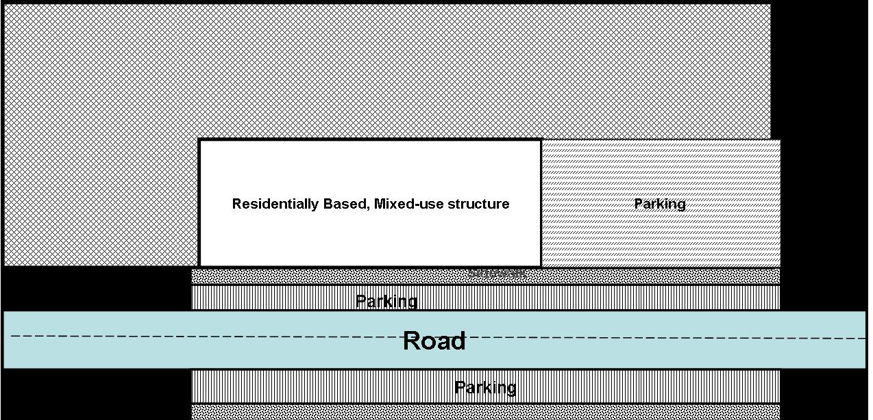
viii.
Structured parking is not a requirement; however, if a developer chooses to create structured parking, it shall incorporate the following:
ix.
All structured parking shall be architecturally integrated or designed with an architectural theme similar to the main building(s);
x.
The perimeter of each parking garage floor shall incorporate an opaque screen or other screening mechanism and/or landscaping to ornament, enhance, or embellish automobiles from public view while still maintaining a safe environment; and
xi.
Structured parking, starting at the first floor, may include retail, personal, and professional uses.
j.
The Development Review Committee shall review the proposed development to determine the project is consistent with items a. through j. above and this SAP. Items a. through j. above may be modified based on circumstances that create a significant hardship on the property through a Planned Development. However, the applicant shall demonstrate how each requirement is being met by the site plan or why a specific requirement should be modified.
(Ord. No. 19-069, § 1, 12-3-2019; Ord. No. 19-072, § 1, 12-3-2019; Ord. No. 2020-016, § 1, 3-3-2020; Ord. No. 2021-007, § 2, 2-2-2021; Ord. No. 2021-038, § 3, 7-6-2021; Ord. No. 21-046, §§ 3, 4, 8-17-2021; Ord. No. 22-008, § 2, 2-1-2022)
Actual constructed density must be above the density permitted by right to qualify for TDRs.
--- (4) ---
Editor's note— The Use Table for U.S. 27 Selected Area Plan had previously been numbered § 401.01. Inasmuch as § 401.01 already existed in the Code, and to maintain Code continuity, the Use Table for U.S. 27 Selected has been renumbered as § 401.03.01, at the discretion of the editor.
Section 401.04 - US Highway 98 Selected Area Plan (Revised 12/1/10 - Ord. 10-082; 5/18/05 - Ord. 05-18)
A.
Purpose and Intent
This Selected Area Plan (SAP) was adopted in the Polk County Comprehensive Plan to recognize the anticipated high level of urbanization during the next twenty years along the US Highway 98 corridor between the Cities of Lakeland and Bartow. The districts and performance standards that follow implement the initiatives outlined in the Plan. In order to achieve an efficient, sustainable, and highly desirable urban growth pattern, a balance of residential and non-residential uses, wide range of housing types and choices, and short trips between housing, employment, and shopping are all required. Pedestrian and bicycle connections between development will help reduce the need for short vehicular trips and better accommodate those not able to drive. The Fort Fraser Trail is an important non-motorized, linear pedestrian connection linking all development within this SAP and needs to be protected from incompatible uses and connected to all development by a network of sidewalks and bike lanes. Access management required in this section is consistent with the Florida Department of Transportation's (DOT) US Highway 98 Corridor Access Management Plan (CAMP).
B.
Applicability
This section applies to development within the US Highway 98 SAP, the boundaries of which are shown on the Future Land Use Map (FLUM).
C.
Allowable Use and Intensity of Development (Revised 11/4/2014 - Ord. 14-066; 04/23/08 - Ord. 08- 011; 10/11/06 - Ord. 06-64)
The land use categories and uses allowable in this district are shown in Table 4.12. Land use categories and uses not shown are prohibited. Table 4.13a, 4.13b, 4.13c, and 4.13d displays the Density and Dimensional standards separated by residential and non-residential.
1.
All development that is permitted (P) or permitted with density bonus points (B) shall require a Level 2 Review in accordance with Table 4.13a, 4.13b, 4.13c, and 4.13d.
2.
Land uses shown with a C1, C2, C3 or C4 shall comply with applicable Criteria for Conditional Uses in the US 98 SAP in addition to the requirements of Chapter 3 of the Land Development Code, and all other standards of this Code and other applicable governmental agencies.
3.
Uses listed as needing Planned Development (PD) approval shall require a Level 3 Review in accordance with this Code.
4.
All development shall (development is defined in Chapter 10 of the LDC):
a.
Connect to public potable water and sanitary sewer (except uses in A/RRX, RSX, PRESVX, and ROSX). The connection to sewer may be waived if determined that the project's estimated sewer generation does not meet the definition of availability in Chapter 10 and the service provider's Utility Director, in a written statement, grants an exemption to the applicant for the specific project in accordance with the following criteria through a waiver or Planned Development according to the following criteria:
i.
The utility provider issues a letter signed by the Utility Director that connection for reasons including, but not limited to the utility provider's inability to provide service because the expansion is not within the permitted or physical capabilities of the utility provider; and,
ii.
Is not meant to circumvent the existing requirement to connect to sewer when the definition of availability is met per this Code.
b.
Provide reuse when determined to be available by the utility provider;
c.
Install utilities underground for all subdivisions and non-residential development;
d.
Provide pedestrian, mass-transit, and non-motorized vehicular (i.e., bicycle) connections and accommodations as provided for in this SAP; and
e.
Bona-fide agricultural uses, Family Farms, Family Homesteads, and Lots of Record Are Exempt from this requirement.
f.
These requirements do not apply for a one time split of a Lot of Record for residential purposes within a residential land use district. Development on a Lot of Record shall be required to connect to public sewer if the development on that lot meets the definition of availability.
5.
Prior to land alteration and as part of a Level 1 Review, a property owner or representative shall submit the following:
a.
Any findings from a site survey/walkover by a qualified professional which identifies any threatened or endangered plant or animal species on site. If any are discovered, the applicant shall properly protect the specie(s) or mitigate any impacts consistent with federal, state and local law;
b.
A statement verifying the proposed site is not part of the Master File of archeological sites from the Department of State, Division of Historical Resources, or Bureau of Archeological Research. If the site is found to be of historical and/or archeological significance, then the property owner shall ensure proper mitigation pursuant to state and federal law;
c.
A tree survey which shall identify, at a minimum,
i.
All trees of 12 inch diameter breast height (d.b.h.) and greater;
ii.
All trees that will be preserved to meet the requirements as part of Section J of this SAP which is 25 percent (%) of trees with a 12 inch diameter breast height or greater; and,
iii.
Any trees included in an applicant's request and qualifying for a credit of existing trees as defined in Section 721 of the LDC;
d.
Existing, bona fide agricultural uses as defined in Florida Statutes, shall be exempt from this requirement; and,
e.
This requirement, C., 5, may be reviewed as part of a Level 2 review if the applicant wishes to combine land clearing activities concurrent with Level 2 reviews.
6.
All Development Projects - In addition to all requirements of this Code, development in all districts, except ROSX and PRESVX and bona-fide agricultural uses, Family Farms, Family Homestead, and Lots of Record, shall be consistent with the following (this criteria shall be evaluated by the DRC at Levels 2, 3 and 4 to determine the consistency of each development request with the following criteria):
a.
Transit stops shall be incorporated into the development every 1/4 mile along U.S. Highway 98. This shall include a bench, signage, and pedestrian cover at the discretion or approval of the Transit Director;
b.
All development shall incorporate safe pedestrian and bicycle oriented design which shall include the following:
i.
Pedestrians shall have the choice of walking along a safe and dedicated pathway from the parking area to the building;
ii.
5 foot wide Sidewalks shall be provided where required in this SAP and the LDC;
iii.
Clearly marked pedestrian paths must be provided from sidewalks, parking lots, and other access points to the entrance of the business(es), (See Figure C);
iv.
Adequate access and parking facilities (racks, storage, etc.) in non-residential developments to support bike riding for non-residential uses; and,
v.
All development shall have, at a minimum, pedestrian interconnection with adjacent parcels and development in addition to the sidewalks required along road frontages. The interconnection does not have to be public (i.e., a locked pedestrian gate in a gated community).
c.
Parking shall be provided to meet the needs of the uses in an efficient manner and may employ optional methods such as shared parking and permeable surfaces. The intent of Chapter 7 shall be met and if any deviations from Chapter 7 are requested, the request shall be made through a waiver as provided for in Chapter 9 or alternative parking strategy as provided for in Chapter 7;
d.
Structured parking is not required, however, if it is used structured parking shall incorporate architectural designs to the facade of the building compatible and consistent with that of the surrounding development. These buildings may include retail, personal, and professional uses in the same structure if in a Land Use sub district that permits these uses;
e.
Building height shall be in accordance with Section 205 of the LDC, Table 2.2 with the exception of the Employment Center (ECX) and Town Center (ECX) land use districts (see Section D. Modified Land Use Requirements);
f.
Building setbacks and impervious surface ratios shall be in accordance with Section 205 of the LDC, Table 2.2., with the exception of the Employment Center (ECX), Town Center (TCX), and Office Center (OCX) land use districts (see Section D. Modified Land Use Requirements);
g.
Floor Area Ratios for non-residential land uses are addressed in Section O of this SAP;
h.
Applicants for mixed use developments, including two or more uses (i.e., residential and retail) or retail for projects above 20 acres, shall make the necessary contacts to ensure that public safety services (fire, EMS, and Sheriff), and educational facilities are available to the proposed development. At time of application for a Level 2, 3, or 4, the applicant for a mixed use development shall provide letters, from the provider for Fire, EMS, Sheriff, School Board, and Emergency Management, on the status of each provider's ability to meet their level of service and what is needed to ensure the needed level of service;
i.
Setback and height requirements for non-residential development on vacant property with established non-residential adjacent development shall be used according to the averaging standards in Section 219 of the LDC. The infill non-residential uses shall be limited to office and retail uses under 20,000 total square feet; and,
j.
New development and redevelopment of property shall construct all necessary improvements to ensure the minimum roadway standards are met for the entire road frontage of the development according to subsection M., 1.
k.
Where outdoor storage is allowed as an accessory use, the following standards shall apply:
i.
All outdoor storage shall be at a minimum of 50 feet from any residential use or land use district;
ii.
All activity shall be limited to operation between the hours of 8 a.m. and 8 p.m.;
iii.
All speakers shall be setback 100 feet from any residential use or residential land use district; and,
iv.
All speakers shall be directed away from any residential use or land use district.
(Ord. No. 19-069, § 1, 12-3-2019; Ord. No. 19-072, § 1, 12-3-2019; Ord. No. 2023-048, § 5, 7-25-2023; Ord. No. 2025-074, § 6, 12-16-2025)
D.
Modified Land Use Requirements (Revised 2/6/18 - Ord. 18-012; 12/5/17 - Ord. 17-071; 1/22/13 - Ord. 13-002; 12/1/10 - 10-082; 04/23/08 - Ord. 08-011; 10/11/06 - Ord. 06-64)
1.
Neighborhood Activity Center (NACX) - In addition to the other requirements of this Code, all development shall be consistent with the following:
a.
Residential development is not permitted as a primary use in NACX, but is permitted above retail, office, or personal service developments in a mixed-use building as an accessory use for up to four stories of residential over non-residential uses (a five story mixed-use building).
2.
Linear Commercial Corridor (LCCX) -In addition to the other requirements of this Code, all development shall be consistent with the following:
a.
New development in infill areas shall be limited to office, professional and retail uses.
b.
Residential development is not permitted as a primary use, but is permitted above retail, office, or personal service developments in a mixed-use building as an accessory use for up to two stories of residential above the non-residential uses (a three story mixed-use building);
c.
Non-conforming uses cannot be intensified; and,
d.
Outdoor display, as part of a retail business, is allowed for no more than 25 percent of the impervious area, and shall be limited to the hours of operation.
3.
Commercial Enclave (CEX) - In addition to the other requirements of this Code, all development shall be consistent with the following:
a.
Residential development is not permitted as a primary use, but is permitted above retail, office, or personal service developments as an accessory use for up to a total of one story of residential over one story of retail development (a two story mixed-use building);
b.
Non-conforming uses cannot be intensified; and,
c.
Outdoor display, as part of a retail business, is allowed for no more than 25% of the impervious area, and shall be limited to the hours of operation.
4.
Business Park Centers (BPCX) - In addition to the other requirements of this Code, all development shall be consistent with the following:
a.
In BPCX-2, outdoor storage, when 100 percent (%) screened from off-site view and not adjacent to the Ft. Fraser Trail, is permitted only in the rear yard of building site (see Figure B);
b.
Outdoor display, which is accessory to a retail use consistent with the 15 percent (%) limit of the total area of the BPCX, shall be limited to 25 percent (%) of the impervious area of the retail use; and,
c.
In addition to the buffering requirements of Section 720 of the LDC, a Type C Buffer is required when adjacent to a residential land use district or existing residential. (See Figure B)
5.
Industrial (INDX) - In addition to the other requirements of this Code, all development shall be consistent with the following:
a.
Outdoor storage, when 100 percent (%) screened from off-site view and not adjacent to the Ft. Fraser Trail, is permitted only in the side and rear yard of building site (see Figure A); and,
b.
In addition to the buffering requirements of Section 720 of the LDC, a Type C Buffer is required when adjacent to a residential land use district or existing residential.
Figure A Outdoor Storage - Permitted and prohibited areas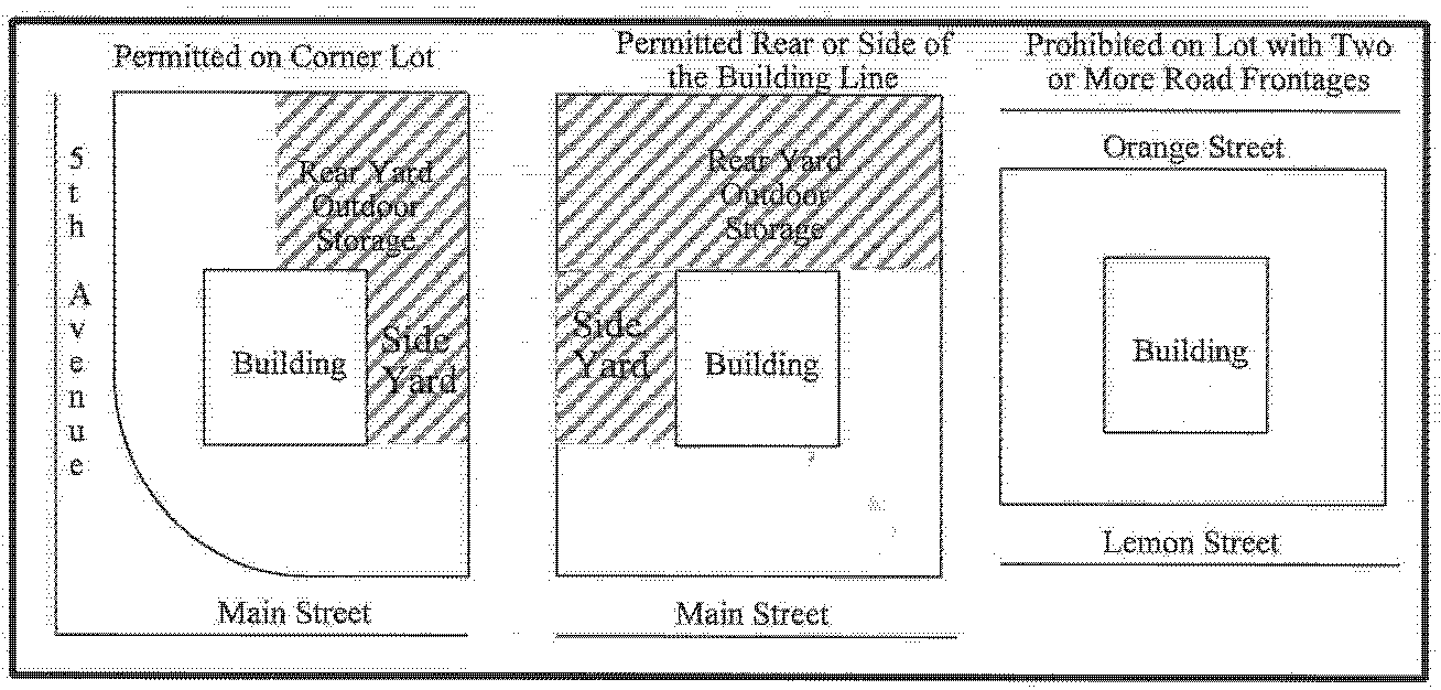
6.
Employment Center (ECX) B In addition to the other requirements of this Code, all development shall be consistent with the following:
a.
On-premises signs shall use the Community Activity Center (CAC) standards of Section 760 (reduced by 15 percent (%) for the SAP) of the L D C;
b.
Structure and use setbacks shall meet the Community Activity Center (CAC) requirements of Table 2.2, Density and Dimensional Regulations for Standard Districts of the LDC;
c.
Residential development shall be limited to a maximum of 25 percent of the total area of an ECX utilizing High Density Residential density (10 to 15 du/ac) and shall comply with all other requirements of Chapter 3, Conditional Uses, for multifamily developments within activity centers (CACX, RACX, and BPC-1X). Residential units above non-residential uses (vertical mixed- use) are encouraged and do not count towards the 25 percent residential cap. The setbacks for High Density Residential shall conform to the setbacks for the RH Future Land Use district as listed in Table 2.2, Density and Dimensional Regulations for Standard Districts of the LDC;
d.
Single-family attached or detached, duplex, and three unit (triplex) residential buildings shall be prohibited in the ECX;
e.
Light industrial uses that include at least 50 percent (%) office space, assemble products, and conduct research and development, but do not manufacture any products shall be permitted without a Level 3 Review;
f.
The maximum FAR shall be 0.70. Higher FARs will be allowed through bonus points per the Land Development Code for a total of 1.5. The ISR shall be limited to 0.70 in all cases;
g.
Retail and personal services are limited to 30 percent of the ECX district. The maximum FAR for retail uses shall be 0.60. Higher FARs, up to 0.75 may be allowed with bonus points and a Planned Development;
h.
Warehouse uses as an accessory use (where at least 50 percent (%) of the square footage is office space) shall be permitted without a Level 3 Review;
i.
The maximum building height shall be 100 feet. This may be increased through a variance or a Planned Development; and,
j.
The building setbacks shall comply with those listed in Table 2.2 for Community Activity Center (CAC). All footnotes to Table 2.2 shall apply.
k.
Area of an ECX shall only include property contiguous within that district irrespective of Preservation/Wetland areas and local or collector roads.
7.
Office Centers (OCX) - In addition to the other requirements of this Code, all development shall be consistent with the following:
a.
Retail activities and personal services to support activity within an Office Center shall not exceed ten (10) percent of the total area of the Office Center and shall be limited to specialized retail stores. These activities shall not have any outdoor storage;
b.
Vehicle parking areas shall not front on roadway systems (along right-of-way) unless a hardship based on the physical constraints of the parcel can be demonstrated by the applicant during a Level 2 Review. Alternative parking proposals shall meet the waiver requirements of Section 932 of the LDC. This waiver may be considered as part of a PD;
c.
Residential development is not permitted as a primary use, but is permitted above retail, office, or personal service developments in a mixed-use building as an accessory use for up to two stories of residential above the non-residential uses (a three story mixed-use building); and,
d.
Development within the OCX district shall meet 0 to 15 feet build to lines from roads. A Build to Line is a line parallel to the property line adjacent to rights-of-way, along which a building shall be built. The maximum distance that any building can be from the property line is 15 feet. This is to allow for the parking area required in item b above as well as any required pedestrian and bicycle facilities. To allow for maximum development flexibility in meeting the standards within this item and item b, there shall be no pre-determined side or rear setbacks or side or rear build to lines other than those that are required for public safety. However, if the adjoining parcel(s) are developed with an existing residential use or has a Future Land Use district of ROSX, PRESVX, ARRX, RSX, RLX, RMX, or RHX the building(s) shall be consistent with the side and rear setbacks for OC in Table 2.2. Variances to these requirements may be granted according to Section 931 or in association with a PD.
8.
Town Center (TCX) - Development within the Town Center shall conform to the following criteria in addition to all other regulations within this Code:
a.
Buildings within the TCX shall build to property lines rather than setback back from property lines as follows:
i.
Build to lines from roads - (0-15 feet) - A Build to Line is a line parallel to the property line adjacent to rights-of-way, along which a building shall be built. The maximum distance that any building can be from the property line is 15 feet. This area between the building and the property line shall incorporate sidewalks, sidewalk cafes/eating areas, or retail display areas. The building shall be in close proximity to the streets and pedestrian friendly parking areas, pathways, and gathering spaces shall be oriented toward the interior of the development rather than the traditional strip development where a large parking area is in front of a building; and,
ii.
Side and Rear build to lines - To allow for maximum development flexibility, there shall be no pre-determined side or rear setbacks or side or rear build to lines other than those that are required for public safety. However, if the adjoining parcel(s) are developed with an existing residential use or have a Future Land Use district of ROSX, PRESVX, ARRX, RSX, RLX, RMX, or RHX the building(s) shall be consistent with the side and rear setbacks for CAC in Table 2.2.
b.
Impervious Surface Area Ratio (ISR) - The ISR shall be 0.70 for all development within the TCX. If a true hardship on the property can be determined, a waiver may be requested pursuant to Section 932;
c.
Building design and uses shall include the following:
i.
Developments shall have a consistent streetscape and architectural style. The first buildings to be constructed in the Town Center are expected to set the tone of the remaining building design. This may include various frontage types such as terraces, awnings, galleries, or arcades, etc. These terms are not strictly defined but are based on architectural standards of traditional downtowns (i.e., downtowns similar to historic areas of Tampa, Orlando, or Tallahassee);
ii.
At least 60 percent (%) of the parcel frontage on the rights-of-way of all roads and the Ft. Fraser Trail shall be lined with buildings;
iii.
Pedestrian shelters, awnings, roof overhangs, or other forms of shelter from the weather shall be incorporated along all building sides adjacent to pedestrian walkways; and,
iv.
Front building facade architecture shall be incorporated into any building side adjacent to right-of-way.
d.
Parking design shall include the following:
i.
Parking lots shall be specifically prohibited between the building and US Highway 98 unless the parking is on-street parking, such as parallel parking;
ii.
All development shall incorporate pedestrian friendly parking areas. At a minimum, parking areas shall include five foot wide paved walkways between parking rows every other parking isle (See Figure C); and
iii.
Structured Parking is not a requirement; however, if a developer chooses to create structured parking, it shall incorporate the following:
1)
All structured parking shall be architecturally integrated or designed with an architectural theme similar to the main building(s);
2)
The upper floor of parking facilities, if not covered with a roof, shall be landscaped in accordance with parking lot landscaping standards for vehicular use areas, or some other design scheme so that the upper floor does not resemble a field of parking from the upper deck or from the ground elevation. Suggestions, other than landscaping may include trellis work, or treated with a combination of architectural/landscaped elements;
3)
The perimeter of each parking garage floor shall incorporate an opaque screen or other screening mechanism and/or landscaping to ornament, enhance, or embellish, automobiles from public view while still maintaining a safe environment; and,
4)
Structured parking, starting at the first floor, may included retail, personal, and professional uses.
e.
Development proposals of ten acres or more shall provide the following in addition to the other items in this section:
i.
A central focal feature such as a park, sculpture, fountain, or plaza that shall include public gathering spaces for pedestrians. Other central focal feature types may be considered by the DRC if based on neo- traditional design;
ii.
The central feature shall be pedestrian friendly and allow users of the site to walk from the central feature to all buildings and uses within the development. The central feature shall also include benches or other seating facilities that are incorporated into the architecture of the space; and,
iii.
All development shall have, at a minimum, pedestrian interconnection with adjacent parcels and development.
f.
Roadway and/or Alley Construction shall be consistent with the following:
i.
US Highway 98 and collector roads shall be lined with pedestrian- oriented features which are constructed in a uniform arrangement;
ii.
On-street parking shall be provided for any internal roads constructed that meet the County's local or collector standards. This shall be parallel parking; and,
iii.
Internal roads meeting the County's local or collector road standards shall also incorporate sidewalks and bike lanes.
g.
Sign standards within the TCX shall conform to the following:
i.
All signs shall be based on the standards for the CAC in Chapter 7 and reduced by 15 percent. Prior to any development, a sign plan shall be submitted for review and final approval.
ii.
All signs erected in the TCX shall be reviewed by the DRC to ensure the design of the sign is aesthetically consistent and in harmony with the architecture of the TCX. The first buildings and signs erected within the TCX shall set the tone and style of all signs;
iii.
Signs shall be monument-style or building-mounted only; freestanding pole signs shall be specifically prohibited;
iv.
Banners attached to lighting fixtures will be permitted if allowed by the owner of the light fixture; and,
v.
All signs and lighting of signs shall be consistent with architecture of the buildings.
h.
Residential uses shall be limited to Special Residential densities as a primary use for up to 25 percent of the TCX district. Residential units above non-residential uses as an accessory use (vertical mixed-use) are encouraged and are not counted against the maximum residential percentages and densities. Residential development shall be apartment-style or townhouse- style;
i.
Any loading docks, utility facilities, car washes and storage areas abutting rights-of-way shall be landscaped from off-site view;
j.
The maximum building height shall be 75 feet. This may be increased through a variance or a Planned Development;
k.
The Development Review Committee (DRC) shall evaluate proposed development projects to determine how the projects are consistent with items a through k above. The DRC's decision shall be considered as required by this Code in site plan design for Level 3/4 Conditional Use, and Level 2 Review; and,
l.
Any use with a drive-thru facility shall be reviewed as a Planned Development and shall only be located on properties adjacent to US Highway 98 or the Fort Fraser Trail.
m.
Any use with a driveway aisle between the Fort Fraser Trail and the principal structure within the TCX shall comply with the standards listed in 401.04 I.7 to provide for safe pedestrian crossing points.
n.
Items a through k above may be modified based on circumstances that create a significant hardship on the property through a Planned Development. However, the applicant shall demonstrate how each requirement is being met by the site plan or why a specific requirement should be modified.
9.
All Residential Future Land Use Designations - In addition to other standards in this Code, the following provision shall apply to all residential development within a residential Future Land Use Designation and Residentially Based Mixed-Use Developments (RBMDs) (Deviations in the maximum lot size, proposing Residentially Based Mixed-Use Developments [RMBDs], or deviations from one of the following amenities shall require a Planned Development [PD] application, see sub section O in this SAP):
a.
The dedication of future right-of-way (stub-out) for access to any adjacent undeveloped parcel(s) or to any existing adjacent connections;
b.
Pedestrian and/or bicycle connections to adjacent development and parcels;
c.
Sidewalks along both sides of the internal roadway network;
d.
Sidewalks along frontage of the external roadway network consistent with other requirements in this SAP;
e.
An approved bench or other appropriate facility on designated transit routes;
f.
Fifty percent of the required park and recreation level-of-service acreage shall be provided on site. These recreation areas shall meet the following:
i.
No lot shall be more than 1320 feet from any recreation area, measured by way of provided pedestrian connections;
ii.
A minimum of 2000 square feet;
iii.
Designed with a 2:1 length to width ratio;
iv.
Dedicated within a separate tract and maintained by a home owner's association upon its inception. The developer shall provide all maintenance until such time. All tracts shall be accessible by a means other than an easement;
v.
At least one recreation space per development shall include at a minimum one active recreation facility (tennis, racquet ball, basketball, volleyball, equestrian, football, soccer, skate park, etc.); and,
vi.
Shall be comprised of upland areas only.
g.
All new lots, created after the adoption of the US Highway 98 SAP, which contain a portion of the mapped 100-year flood plain or wetland area(s), shall consist of a usable non-floodplain and/or non-wetland area which is at least as large as the lot size required for the applicable land use sub-district;
h.
Setbacks, lot sizes, and general intensity within this SAP favor more compact and efficient development while allowing the most flexibility for varying housing types and layouts. The standards provided in this section are the sole exceptions and deviations from Table 2.2. All other development standards shall apply;
i.
To allow for maximum development flexibility, the established minimum side setbacks for residential development shall be five feet unless the zero lot line provisions of Chapter 7 are utilized;
ii.
All single-family detached, single-family attached, or residential detached garage door entrances facing rights-of-way shall be set back no less than 25 feet. Any Level 2 or Level 3 projects applied for prior to February 6, 2023 may continue to apply the 20-foot garage setback development standard which would have applied to the project before February 6, 2023. Right-of-way setbacks for houses with side loading garages may be reduced to 10 feet provided the entrance does not face the right-of-way and two parking spaces are provided on the property within the driveway;
iii.
Where multi-family is adjacent to single-family development, the height of multi-family structures shall be limited to no more than 150 percent (%) of the adjacent single-family structures if the multi-family structure is within a distance equal to the proposed height of that multi-family building (i.e., the farther away the multi-family structure is from the single-family structure then the taller the multi-family structure can be);
iv.
Setbacks along local road rights-of-way may be reduced to ten feet as long as a porch is provided along the front facade and the main entrance to the structure is from this porch;
v.
The maximum average lot size per unit permitted by right (Level 2 Review) within each district shall be:
RL-1: 30,000 square feet RL-2: 15,000 square feet
RL-3: 10,000 square feet RL-4: 8,000 square feet
Lots used to meet the transition lot requirements in item h., vi below, are exempt from the maximum average lot size calculation provided the overall density of the subdivision meets the provisions of Table 4.13b; and,
vi.
This section (vi) applies to proposed lots or parcels of a development within a 100 feet of the site boundary to be called transition lots. The intent of transition lots or parcels along edges of a development boundary is to provide for better compatibility to existing residential lots or parcels created prior to the adoption of this section (May 18, 2005) that are within 100 feet beyond the site boundary. Divisions of land created after the adoption of this Code shall not be used to avoid this requirement. All other lots or parcels beyond the 100 feet of a site boundary, within the development site, shall be permitted in accordance with the maximum average lot sizes provided in Table 4.13b. The figure below this section (Figure A-1) is used to provide better explanation. These transition lots shall:
1)
Be no smaller than 75 percent (%) of the off-site adjacent parcels;
2)
Be required from lots or parcels separated from the development site by a local road, or a collector road with substandard pavement or substandard right-of-way width;
3)
Not be required to be larger than one acre:
4)
Not be required if adjacent to property with a bona-fide agricultural use that has maintained a green belt tax exemption for more than a year (see exhibit below); and
5)
Not be required if the development site is adjacent to a non- residential future land us district.
vii.
Bona-fide agricultural uses, Family Farms, Family Homestead, Lots of Record, and land divisions of Lots of Record creating less than three lots and consistent with Policy 2.128-C3 of the Comprehensive Plan are exempt from this section. The Development Standards for these lots shall be consistent Table 2.2, Chapter 3, and Chapter 8.
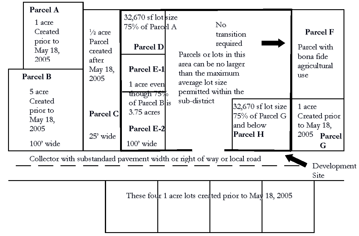
The Development site is bounded by a dark bold line. Parcels D, E-1, E-2, and H are transition lots from Parcels A, B, and G respectively. Parcel C was created after May 18, 2005 and is not consistent with the Maximum Lot size. Parcel F has a bona fide agricultural use with a green belt tax exemption and therefore no transition is required. In addition, Parcels E and H also have to transition from lot on the south side of the street. All other lots can be designed based on the permitted density, maximum average lot size, and other requirements of this Code.
E.
Conditional Use Requirements (Revised 11/4/14 - Ord. 14-066; 215/11 - Ord. 11-002; 2/3/10 - Ord. 10- 007; 10/11/06 - Ord. 06-64)
In addition to applicable provision in Chapter 3, the following conditions shall apply:
1.
Agricultural Support, off-site -Any outdoor storage of equipment or equipment repair areas shall be screened from existing residential uses with a Type B Buffer;
2.
Boarding of animals - Boarding of animals at a veterinary office shall be considered accessory provided the boarding area is within an enclosed building. Exterior run for exercise purposes is permissible.
3.
Hotel/Motel Hotel/motel uses within the ECX and BPC-1X and BPC-2X districts shall be limited to the percentage cap for retail uses listed in the Comprehensive Plan for this SAP;
4.
Family Farm - The requirements of Chapter 3 shall apply as well as the requirements of the US 98 SAP unless otherwise exempted.
5.
Family Homestead - the requirements of Chapter 3 shall apply as well as the requirements of the US 98 SAP unless otherwise exempted.
6.
Financial Institutions - In addition to all applicable regulations, the following standards shall apply:
a.
All financial institutions, within BPCX and INDX, shall support the existing developed uses. The financial institution has to support uses that are existing within the BPCX or INDX land use district; and,
b.
Financial institutions shall not exceed fifteen percent of the total developed area of the subject land use district. The total developed area shall be calculated based on the inclusion of all existing uses in the subject land use district and those with approved and valid site plans, construction plans and plats.
7.
Financial Institutions drive-thru - In addition to all applicable regulations, the following standards shall apply:
a.
The minimum distance from the drive-thru facility to any residentially designated property shall be 50 feet measured at the narrowest point between the property line of the residential property and either the stacking lanes, service equipment, or speaker box, whichever is closer;
b.
All speaker boxes shall be oriented away from adjoining residential property;
c.
All drive-thru facilities, including windows and stacking lanes, adjacent to property with a residential use shall be screened with a Type C Buffer; and,
d.
The primary frontage and access shall be on a collector road or better unless contained within a master planned development with access to a collector road or better.
8.
Light Assembly -The following standards shall apply:
a.
No outdoor storage of any materials shall be permitted;
b.
There shall be no external activity beyond loading and unloading of materials to and from an enclosed structure; and,
c.
A buffer equal to a Type C buffer (see section 720) shall be provided between a residential use and any structure requiring loading and unloading of a commercial vehicle(s).
9.
Retail, Home Sales Offsite - The following standards shall apply:
a.
Any display of homes shall be limited to an outdoor display area of up to 50 percent of the total developable square footage of the subject site;
b.
Any site adjacent to a residential use shall provide a Type C buffer (see section 720); and,
c.
Any on-site repairs shall be screened from off-site view.
10.
Nurseries, Retail - The following standards shall apply:
a.
Nurseries and Greenhouses conditions in Section 303 of this Code shall be applicable;
b.
In the A/RR land use district:
i.
Any retail activity shall be accessory and subordinate to the bona fide agricultural use of the property; and,
ii.
Any structure(s) used for retail activity shall not exceed 1,200 square feet.
11.
Office Park - The following standards shall apply:
a.
Offices shall not exceed 30 percent of the total developable area of the subject TCX district. The total developed area shall be calculated based on the inclusion of all existing uses in the subject land use district and those with approved and valid site plans, construction plans and plats; and,
b.
Offices shall not exceed 50 percent of the total developable area of the subject ECX district.
12.
Retail, Outdoor Sales/Display - In addition to the applicable district regulations in Table 2.2, the following standards shall apply:
a.
All outdoor storage shall be at a minimum of 50 feet from any side lot line, and a minimum of 25 feet from the rear lot line;
b.
Retail establishments shall be required to provide a landscaped buffer at a minimum equal to a Type C buffer (see Section 720); and,
c.
All activity shall be limited to operation from 8:00 a.m. to 9:00 p.m.
13.
Research and Development - Research and development uses within the Institutional district shall support the surrounding uses, i.e., the use has to be related or work in association with the surrounding uses within INST;
14.
Restaurant, sit down/take out - Restaurants, sit down/take out, within the OCX, as part of the ten (10) percent (%) retail and personal services restriction listed in Section D., 7, shall be limited to small sandwich and/or coffee shops intended to serve the OCX;
15.
Retail Retail uses are limited to 15 percent (%) of the total area of BPCX and INDX and ten (10) percent (%) within the OCX district. Total area includes all the property within the contiguous Future Land Use district of BPCX and INDX even if across a road. Only natural water bodies can be removed from the total area calculations;
16.
Self Storage Facilities -These facilities shall not be more than ten (10) percent (%) of the total area of the ECX district. In addition, the individual spaces shall not be permitted to be accessed from the outside. All users shall access the individual rented space through a common access. Each facade of the facility shall have an office or similar appearance;
17.
Special Residential - If special residential is placed on the edge of the district, the height of the building cannot be more than twice the height of the building in the adjoining district/parcel. Parking areas for special residential uses shall not be adjacent to RLX Future Land Use districts. Light poles, used for special residential uses, shall not be adjacent to existing residential or property designated with a residential Future Land Use district and the lighting shall be directed toward the interior of the development. A lighting plan that includes the fixture type, location, intensity, and photometric calculations shall be submitted for development review with any special residential project;
18.
Transit Facilities - All outdoor storage shall be screened from off site view and shall be setback 50 feet from any property with a residential structure or residential land use designation;
19.
Truck Stop - The following shall apply:
a.
A Type C Buffer 25 feet in width shall be required where the truck stop abuts a residential district or a school;
b.
A Type B Buffer shall be required where a truck stop abuts a non-residential district or use; and,
c.
No truck parking, gasoline sales, fuel storage, or truck servicing activities are allowed within 65 feet of the property line that abuts any residential district or a school.
20.
Vehicle Sales, Leasing - The following shall apply within the ECX land use district:
a.
Vehicle Sales and Leasing establishments are considered to be retail/commercial uses and shall not exceed the 30% limit of such retail/commercial uses allowed throughout the defined ECX district.
b.
The minimum acreage shall be five acres.
c.
All Vehicle Sales and Leasing uses shall have direct frontage on US Highway 98.
d.
All garage bay doors or openings for vehicles shall not face US Highway 98. If garage bay doors or openings for vehicles are facing residentially-designated properties, there shall be a 50' setback.
e.
A buffer equal to a Type C Buffer (see Section 720) shall be provided between the use and all abutting residential districts and uses.
f.
Vehicles shall not be parked or stored within the right-of-way or in front of any landscaping or grassed area adjacent to the right-of-way.
g.
All building facades facing US Highway 98 shall resemble a permanent construction office style or type.
h.
All Vehicle Sales and Leasing establishments within the ECX district shall include an onsite service and repair operation in an effort to increase the employment potential of the district. The service and repair operation shall be performed within an enclosed structure(s), thereby limiting the extent of their external impacts upon adjacent and nearby properties.
21.
Vehicle Service, Mechanical - The following shall apply within the ECX land use district:
a.
There shall be no external activity beyond loading and unloading of materials. All vehicle repair and servicing of vehicles shall be conducted within enclosed structures.
b.
There shall be no outdoor storage.
c.
No activity shall be conducted that produces noise, odors, dust, fumes, fire hazard, or other nuisance beyond the property lines.
d.
All vehicle service structures shall be setback 50 feet from the property line when abutting a residential or professional district.
e.
The only mechanical/automotive services permitted are routine maintenance, including, but not limited to, tire services, alignment services, cooling system services, oil changes, wheel and brake services, suspension services, electrical services, battery services and preventive maintenance services.
f.
All garage bay doors or openings for vehicles shall not face US Highway 98, residential uses or residentially designated properties.
g.
A buffer equal to a Type C Buffer (see Section 720) shall be provided between the vehicle service facility and all abutting residential districts and uses. Also, additional canopy trees equal to one tree per 30 linear feet shall be provided adjacent to residential areas.
h.
No vehicles shall be stored outdoors overnight.
i.
This use shall be considered part of the retail limitation of 30 percent for the ECX land use district unless varied from by the Planning Commission through a Level 3 Review.
j.
If this use is part of a Planned Development that is associated with the TCX land use district, the architecture of the building(s) shall be consistent with the initial buildings constructed in the TCX.
k.
There shall be at least one pedestrian access point on each side of the site boundaries if the request is part of a Planned Development.
22.
Warehouse and/or distribution facilities - There shall be no loading or unloading forward of the front building line, adjacent to the Fort Fraser Trail, or adjacent to residentially developed property, or to property with a residential Future Land Use designation.
F.
Development Design Standards and Requirements (Revised 12/6/16 - Ord. 16-074)
In addition to all other applicable provisions in this Code, the following conditions are imposed:
1.
Any Development fronting along SR 540 shall conform to the following:
a.
Any new non-residential buildings or expansion of existing non-residential buildings shall provide a facade resembling a typical office; and,
b.
No outdoor storage shall be visible (100% screened) from US 98, SR 540 or adjacent to residential lots.
2.
All development at the intersection of SR 540 and US 98 shall provide, at a minimum, a Type "A" Buffer along these road rights-of-way;
3.
Residentially Based Mixed Use Development (RBMD) - In addition to other standards in this Code and in addition to D.10, the following shall apply:
a.
Parcels abutting US 98 or Colbert Road shall provide a landscaped buffer between the off-street parking areas and internal or external roadways in accordance with the following:
i.
In addition to Section 720 of the LDC, the minimum width shall be 25 feet and shall contain one canopy tree for each 75 linear feet or fraction thereof. Trees may be planted separately or in clusters. Existing trees may remain and credited to meet this standard; and,
ii.
The required buffer shall be designed to minimize water use and contain indigenous plants and/or grassed berms. The remainder of the landscaped strip shall be landscaped with water-wise Florida-friendly landscaping techniques.
4.
Off-Premises Signs - Additional off-premises signs (i.e., Billboards) shall be prohibited within this SAP. Existing conforming off-premises signs can be replaced as per Chapter 7 of the LDC; and,
5.
New Non-Residential Future Land Use Districts and expansion of all non-residential districts except NACX, BPCX, INDX, INSTX, OCX, PRESVX and ROSX shall not be permitted unless, at least, 80 percent (%) of the total area of TCX is developed.
G.
Open Space/Greenways (Revised 10/11/06 - Ord. 06-64)
1.
Open Space - For the purpose of this SAP, open space may consist of the following:
a.
Retention ponds meeting the following design requirements:
i.
Resemble natural land/water body features;
ii.
Landscaped in accordance with the planting requirements of a Type A Buffer. These landscape requirements may include plant clustering or alternative planting schemes approved by the Development Review Committee; and,
iii.
Include pedestrian trail(s) paved or unpaved, benches or gazebo and aerobic fountain(s), or picnic pavilions with amenities;
b.
Wildlife habitat, native plant communities including wooded areas and wetlands that remain in a natural state and platted as such in perpetuity; and
c.
Upland areas or open field(s).
2.
The following additional standards shall apply:
a.
All development shall provide a minimum of ten percent open space;
b.
A minimum of ten percent of the open space requirement shall be upland;
c.
Open Space shall not be counted as active Recreation areas;
d.
Lots of record are exempt from providing open space as required by this SAP; and
e.
For all residential developments, open space areas shall be designated within separate tracts and made accessible to all of the residents of the development.
3.
Greenways The Greenway Corridor is designated on the FLUM and shall be established as follows:
a.
Recreation amenities and stormwater retention areas shall be located adjacent to the Greenway Corridor, unless an alternative location is approved by the Development Review Committee (DRC);
b.
Recreational trails shall be allowed within designated Greenway Corridors; and,
c.
All new residential development shall provide pedestrian access to and through the development, connecting to parks, schools and activity centers. Developments providing multiple direct and convenient links to existing or planned routes and trails beyond each development shall receive density bonuses per Section "O" of this SAP. These connections are in addition to sidewalk requirements achieved through interconnected streets.
4.
Bona-fide agricultural uses, Family Farms, Family Homestead, and Lots of Record are exempt from this section
H.
Recreation
In addition to the other recreation standards in this Code, the following shall apply:
1.
Passive recreation areas may be used to meet the Open Space requirement under the following conditions:
i.
Passive recreation such as parks or pedestrian paths shall be incorporated into the open space plan; and,
ii.
The recreation areas shall be linked via greenways/trails, wetlands, floodplains, and other natural areas within and adjacent to the development.
2.
The recreation areas shall be linked to any proposed internal pedestrian network within the development; and,
3.
Recreation areas shall be accessible to all residents within the development.
I.
Ft. Fraser Trail (Revised 1/22/13 - Ord. 13-002; 04/23/08 - Ord. 08-011; 10/11/06 - Ord. 06-64)
1.
All new development or expansions of existing development, except bona fide agricultural uses, Family Homesteads, Family Farms, and Lots of Record, on parcels adjacent to the Ft. Fraser Trail shall plant a Type A Buffer adjacent to the Trail and maintain buffering in accordance with the planting requirements of this section. The buffering shall be consistent with the planting design installed with the construction of the Trail.
In addition to this buffer, canopy trees shall be installed and maintained every 50 linear feet on center. These canopy trees shall be native to this part of Polk County i.e., Pignut Hickory, Live Oak, etc. Pursuant to the per tree credit schedule of Section 721, existing trees may be used to satisfy up to 50 percent (%) of either the per unit tree planting requirements of J.2.a—c or the landscape buffering requirements of Section 720 of the LDC.
2.
No single sub-species shall be counted for more than 50 percent (%) of the required plantings. Species diversification and variety shall be incorporated into landscape plans.
3.
For non-residential uses that are adjacent to the trail, outdoor storage is prohibited between the trail and any buildings.
4.
All outdoor storage for non-residential uses shall be setback 100 feet and screened from the trail property line.
5.
Any use, structure, or equipment that generates noise, vibrations, or noxious odors shall be setback 100 feet from the trail right-of-way.
6.
Any new walls or fences adjacent and adjoining the trail are limited to four feet in height and shall be made of decorative brick or wrought iron or similar material to those used on the trail. Any new fences that are not adjacent and adjoining shall not be within three feet of the trail. Any new fences located between three feet and twenty feet from the property line for the Trail shall be permitted according to the following:
a.
Made of vinyl coated chain link material not to exceed six feet in height;
b.
If a fence is constructed between three feet and twenty feet from the property line for the Trail, a combination of Canopy trees and understory trees, native to this part of Polk County, shall be required within the first three feet of property adjacent to the Trail property. These trees shall be located every forty feet on center. Pursuant to the per tree credit schedule of Section 721, existing native trees may be used to satisfy this requirement. Alternative plantings that meet the intent of providing a vegetative buffer may be permitted if approved through a Wavier or Planned Development approval;
c.
Existing Bona-fide agricultural uses and animal husbandry uses located adjacent to the Ft. Frasier Trail are exempt form this requirement and shall be allowed to maintain existing barbed wire and woven wire fencing customarily used for animal containment.
7.
In addition to all applicable regulations, the following standards shall apply to provide a safe crossing point for pedestrians from Ft. Fraser Trail to any use with a drive aisle between the trail and the principal structure:
a.
One-way traffic to allow pedestrians to scan for traffic in only one direction;
b.
Crosswalk markings that require motorists to stop for pedestrians;
c.
A raised crosswalk that provides direct access to a building entrance or curb extensions to reduce vehicle speed and reduce the pedestrian crossing distance; and
d.
The provision of adjacent bicycle and pedestrian amenities, e.g., bicycle rack and benches, to help channel pedestrians to the enhanced crosswalk. This may be permitted within the required buffering.
J.
Tree Preservation and Planting Requirements (Revised 10/11/06 - Ord. 06-64)
All development shall plant and maintain trees in accordance with the requirements of this section as follows:
1.
In order to meet the requirements of this section, all newly planted trees that are required by this SAP and Chapter 7 of the LDC, shall be:
a.
One and one-half (1.5) inch caliper or larger;
b.
Florida native canopy trees selected from Appendix B of this Code; and,
c.
Located outside of all rights-of-way, and any access, drainage, and utility easements.
2.
All new development shall plant trees in accordance with the following sub-section. Up to 50 percent (%) credit shall be granted for existing Florida Native trees in accordance with the provisions of Section 721 (new plantings shall constitute the remaining 50 percent [%]).
a.
Single-family and duplex residential developments shall provide two canopy trees per unit. These two trees shall be distributed on the site so that one tree is located in the front yard and one is located in either the rear or side yard;
b.
All other residential developments shall provide canopy trees at a ratio of one tree for every three units. Fractional measurements shall be rounded up;
c.
All non-residential development shall provide trees meeting the canopy coverage requirements of Section 720 of the LDC. No more than 50 percent of the required canopy trees shall be within landscape buffers;
d.
Trees species shall be selected and planted to minimize the danger to humans and damage to structures;
e.
For residential development, newly planted trees within required landscape buffers shall not be used to satisfy the canopy coverage requirement;
f.
No more than 50 percent (%) of the required plantings shall be of any one sub- species; and,
g.
Plantings within separate buffers shall be required to be installed prior to Certificate of Occupancy for non-residential development or prior to first Certificate of Occupancy for residential development. Plantings on individual residential lots shall be required prior to Certificate of Occupancy.
3.
All new development shall preserve at least 25 percent (%) of all on-site Florida Native trees 12 inches in diameter breast height (d.b.h.) or greater. Preserved trees shall comply with the Section 721 B., Tree Protection Guidelines;
4.
Pursuant to the per tree credit schedule of Section 721, existing trees may be used to satisfy up to 50 percent (%) of either the per unit tree planting requirements of J.2.a-c or the landscape buffering requirements of Section 720 of the LDC;
5.
Alternatives to items 2 and 3 above may be requested, through a waiver or PD and reviewed by the DRC, if the following standards are met:
a.
All reasonable use of the property is prevented by the planting and preservation requirements of 2 and 3 above. For example, the trees that would be required to be preserved are on the most developable portion of the property or within the entrance to the property and cannot be avoided; and,
b.
Alternative tree planting or tree preservation standards shall be proposed so that the required number of trees are planted and preserved according to 2 and 3 above.
6.
Property owners found in violation of J., 3., shall, in addition to any other requirements, sanctions or penalties imposed through the Polk County Code enforcement process, be required to select one option from the following table and plant Florida Native Trees to replace each tree taken down that would have been necessary to meet the requirement listed in item J.3, above. These plantings shall not be counted toward any buffer [planting or landscaping requirement] listed anywhere in this Code.
7.
Bona-fide agricultural uses, Family Farms, Family Homestead, and Lots of Record are exempt from this requirement except as otherwise required in Section C., and J. 3., except for bona-fide agricultural uses.
K.
Landscape Buffers (Figure B) (Revised 12/1/10 - 10-082)
1.
Non residential Development in all non-residential land use districts except INDX - A five foot landscaped buffer consistent with the plantings of a Type B Buffer, in accordance to Section 720 of the LDC, shall be required between all non-residential development as follows:
a.
Where a proposed non-residential use abuts an existing non-residential use, half the required plantings and width of a Type B Buffer, in accordance to Section 720 of the LDC, shall be required, unless the existing use has an equivalent full Type B Buffer than the Type B Buffer shall not be required;
b.
Where the proposed non-residential use abuts a non-residential use, that is vacant and without approved development plans from the County, the proposed use shall provide the equivalent of half of the required plantings and width of the Type B Buffer, in accordance to Section 720 of the LDC and the abutting parcel when developed will provide half of the required plantings and width of a Type B Buffer, in accordance to Section 720 of the LDC so that between the two uses will be a full Type B Buffer with half of the plantings and width on each lot;
c.
If the abutting non-residential use, whether it is an existing use or received development approval from the County, has a clustered landscaped buffer, the abutting use shall cluster the landscaped buffer on-center between the proposed or existing clustered landscaping. The proposed non-residential use in this situation, cannot apply for a waiver from the required landscaping;
d.
The plantings of the required landscape buffer between non-residential uses may be clustered, provided the separation between clusters is no greater than 30 feet;
e.
No more than 50% of the required plantings shall be of any one sub-species;
f.
Half of the required understory tree and shrub plantings from the Type B Buffer between non-residential uses may be transferred from the perimeter landscape to landscaping surrounding the building(s) for the development;
g.
Where the buildings abut each other and utilize shared parking areas, a landscape buffer shall not be required to separate the two uses; and,
h.
All landscaped buffers, including those within the building setbacks, are allowed to be counted toward the required Open Space for non-residential development.
2.
Walls Only block with stucco, brick, or decorative precast masonry walls shall be permitted as part of the landscape buffer as required by Section 720 of the LDC. Privacy fences for residential and non-residential uses that are not part of the landscape buffer are allowed as permitted by Section 210 of the LDC.
3.
Buffer locations - All buffers required for residential development shall be located in separate tracts.
4.
Alternatives to 1 and 2 above may be proposed through a waiver or PD in accordance with the standards in section 932 of the LDC. The standards are not to be waived entirely but altered based on property hardships.
Figure B Landscape Buffer Between Non-Residential Uses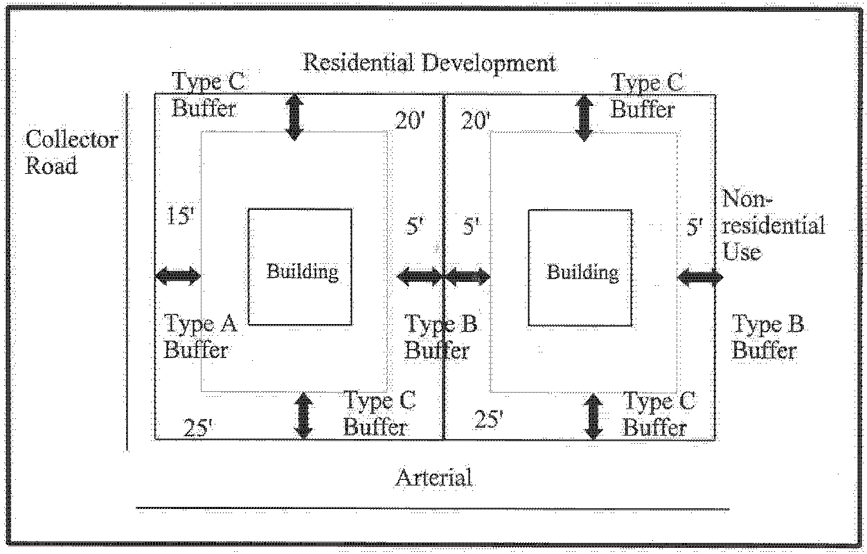
L.
Parking Lot Landscaping (See Figure C) (Revised 12/1/10 - 10-082)
All parking lot landscaping and buffer requirements shall meet the requirements of this section in addition to the requirements of Section 720 of the LDC. Where conflicts occur, the more restrictive shall apply.
1.
Xeriscape landscaping and native plant materials are encouraged to be incorporated into the parking lot landscaping.
2.
At least 30 percent of the required canopy trees in the parking lot landscaping shall be native.
3.
No more than 50 percent (%) of the required plantings shall be of any one sub- species.
4.
The minimum landscaping for each parking lot shall be provided within the interior of a required paved off-street parking area as follows:
a.
Each aisle of parking spaces shall be terminated by landscaped islands which measure not less than nine feet in width, as measured from face of curb to face of curb, and not less than 18 feet in length. At least one canopy tree shall be planted in each terminal island;
b.
Mandatory terminal islands shall be surrounded with a continuous, raised curb;
c.
Landscaped divider medians may be used to meet interior landscape requirements. If divider medians are used, they shall form a continuous landscaped strip between abutting rows of parking spaces. The minimum width of divider median shall be a minimum six foot wide divider median, as measured from face of curb to face of curb. One under story tree shall be planted for each 30 linear feet of divider median, or fraction thereof. Trees in a divider median may be planted singly or in clusters. The maximum spacing between clusters shall be 60 feet;
d.
A minimum six foot wide divider median, as measured from face of curb to face of curb, shall be required every fourth bay of parking as shown in Figure C. A minimum of one understory tree shall be planted for each 30 linear feet of divider median. An alternative option, three diamond shaped islands may be substituted for the continuous six foot wide divider median, as shown in Figure C;
e.
Optional interior islands and divider medians shall be protected by curbing or wheel stops; and,
f.
Each parking bay shall have no more than ten continuous parking spaces unbroken by a landscape island that shall be the width of a parking space, as measured from face of curb to face of curb.
5.
Location of landscaping B Landscaped areas shall be located in such a manner as to divide and break up the expanse of paving and to guide traffic flow.
6.
A Type A buffer 15 feet in width shall be required between all frontage roads and parking lots in accordance with Section 720 of the LDC.
7.
Required landscaping where off-street parking abuts public right-of-way: A landscaped strip of land shall be provided consistent with this section and Section 720 of the LDC with at least one drought resistant, native to the ridge, tree for each 75 lineal feet, or fraction thereof shall be planted. Trees may be planted separately or in clusters.
Figure C Parking Lot Landscaping/Pedestrian Design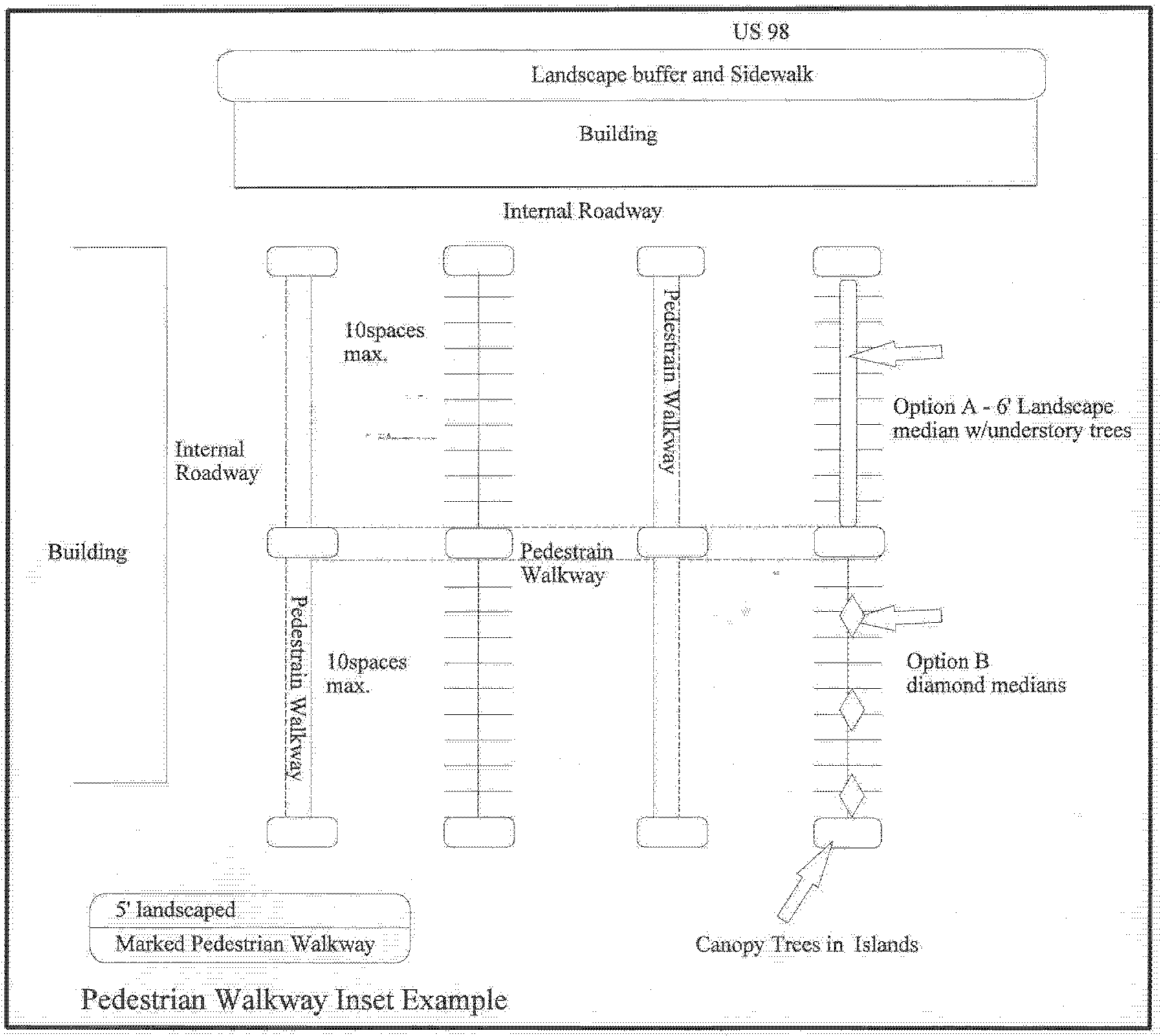
8.
No landscaping shall be provided in the right-of-way unless the County or FDOT gives the owner approval to do so. In addition, a completed agreement as to who will maintain the landscaping within the right-of-way shall be submitted by the developer and the owner of the right-of-way(s) prior to Level Review 2 approval.
9.
Alternatives to the above items may be proposed through a waiver or PD in accordance with the standards in section 932 of the LDC. The above standards are not to be waived entirely but altered based on property hardships.
M.
Transportation Network
The following standards shall apply for all roadways within this SAP:
1.
Transportation improvements shall comply with the following:
a.
Improvements or new construction of any roadway shall be consistent with all standards within the US 98 CAMP, and the County's Multi-modal Collector Road System for this SAP, and other applicable adopted plans and regulations;
b.
In addition to other requirements for roadway improvements listed in the LDC, the following shall apply within existing, dedicated, and/or donated rights-of-way:
i.
If a property to be developed for residential or non-residential uses generates 27 AADT per day or more and is adjacent to a roadway that does not meet the requirements of Table 8.3 of the LDC, the developer shall construct this road to a width meeting County standards for that type of roadway facility along the entire development frontage. Bona fide agricultural uses and residential lots of record are exempt from this requirement;
ii.
Any change to pavement width shall incorporate appropriate striping to ensure a safe transition between improved and unimproved sections of the subject roadway. In addition, the centerline of the roadway shall be maintained.
iii.
Where sufficient right-of-way is not available or obtainable by the developer, alternative roadway construction designs may be proposed based on sound and acceptable engineering practices and roadway construction hardships. These alternative roadway designs may be evaluated and considered as part of the Level II process. Examples of construction hardships include, but are not limited to, the presence of wetlands within the right-of-way, utility re-location, and/or drainage constraints.
c.
Prior to Level 2 Review approval or at time of Level 5 Review approval, right-of-way shall be dedicated for the Multi-Modal Collector Road System designated on the FLUM for this SAP by all development, and shall comply with all standards as listed within relevant sections of the LDC; and,
d.
Road access connection criteria shall be consistent with the relevant sections of the LDC, this SAP, and with Rule 14-96 and Rule 14-97, Florida Administrative Code, as amended, and the access management plan for the jurisdiction of that facility as well as the US 98 Corridor Access Management Plan.
2.
All access and subdivision of land shall comply with the following:
a.
Access to US 98 shall be permitted according to the requirements listed in the US 98 CAMP;
b.
Any subdivision of property with frontage along US 98, south of the Polk Parkway, shall have a minimum frontage of 660 feet. The minimum frontage may be reduced if access is from a shared driveway or access, side road, cross access easement, or other internal road. Final design shall be consistent with the Land Development Code and approved by the County Engineer and the Planning Division;
c.
All new lots with frontage on US 98 north of the Polk Parkway shall have a minimum frontage of 440 feet wide. The minimum frontage may be reduced if access is from a shared driveway or access, side road, cross access easement, or other internal road. Final design shall be consistent with the Land Development Code and approved by the County Engineer and the Planning Division; and,
d.
Where access to any road is shared by more than one user, an easement shall be located on the site plan at Level 2 Review and any required plat. A completed shared access agreement shall be provided prior to any Level 2 Review approval. Final design shall be consistent with the Land Development Code and approved by the County Engineer and the Land Development Division.
3.
In order to provide safe and efficient local traffic movement, the County may designate cross-access easements on property along US 98 and collector roads within this SAP that would be appropriate for future cross-access to gain access to a median openings along US 98 and collector roads. Said easements shall be designed to provide unified access and circulation among parcels on each block of the easement thoroughfare. These easements may be designated during Level 1, 2, 3 or 4 reviews. Each easement shall include the following elements unless altered for safety purposes:
a.
If the easement is a continuous linear travel corridor or at least 1,000 feet long with a design speed of 10 miles per hour than the easement corridor should meet the County's standards for a local road as well as meet items b through h below;
b.
At a minimum, meet the County's road requirements of Appendix A of the LDC in order to maintain sufficient width to accommodate two-way travel aisles for automobiles, service and loading vehicles;
c.
Stub-outs to adjoining property and other design features which make it visually obvious that the abutting properties may be tied in to provide a cross-access corridor, shall be constructed at the time of development;
d.
Linkage to other cross-access easements or corridors to adjacent property ;
e.
Where a cross-access easement is designated, no subdivision plat, site plan or other development shall be approved unless the property owner grants an easement allowing general cross-access to and from the other properties in the affected area. Such easement shall be recorded in the public records of Polk County and shall constitute a covenant running with the land;
f.
Wherever a cross-access easement has been designated, the sites shall be so designed for coordinated or joint parking, access and circulation systems. These sites shall include stub-outs to adjoining properties and other design features necessary to make it visually obvious that the abutting properties may be connected to a unified system;
g.
If a site is developed prior to an abutting property, it shall be designed to ensure that its parking, access, and circulation may be connected to a unified system at a later date; and,
h.
If a site abuts an existing developed property, it shall be so designed to connect to the abutting parking, access, and circulation unless the Growth Management Director or his designee determines this to be infeasible or impractical.
4.
At a minimum, sidewalks shall be required along both sides of the Multi-Modal Collector Road System as designated on the SAP FLUM and on all collector roads that connect to US 98. This is not available for a waiver.
5.
At a minimum, sidewalks shall be required on at least one side of roads that will connect or currently connect the Multi-Modal Collector Road System as designated on the SAP FLUM to US 98.
6.
At a minimum, bike lanes, or appropriate paved shoulders, shall be required along both sides of the Multi-Modal Collector Road System as designated on the SAP FLUM and on all collector roads that connect to US 98.
7.
At a minimum, bike lanes, or appropriate paved shoulders, shall be required on at least one side of roads that will connect or currently connect the Multi-Modal Collector Road System as designated on the SAP FLUM to US 98.
8.
Multi use facilities may be used in lieu of bike lanes, or appropriate paved shoulders, and sidewalks in accordance with state standards.
9.
In addition to the sidewalk and bike lane requirements already listed in this SAP, safe pedestrian and bicycle facilities shall be provided if deemed appropriate by the DRC for those developments required to complete a Major Traffic study or Segment Analysis.
10.
Alternatives to the items above may be proposed through a waiver or PD in accordance with the standards in Section 931, A and 932, A, respectively, of this LDC. The standards are not to be waived but altered based on property hardships.
N.
US Highway 98 (Revised 12/1/10 - 10-082)
1.
Property north of CR 540A - Development along US 98 north of CR 540A shall comply with the following:
a.
Sidewalks shall be constructed along both sides of US 98. If a frontage road is proposed adjacent to the Ft. Fraser Trail, the sidewalk may be placed adjacent to the frontage road rather than US 98. The Ft. Fraser Trail may meet this sidewalk requirement for development on the east side of US 98 depending on site plan design. Alternative to this item may be considered through the request of a waiver meeting the requirements of Section 932 of this LDC; and,
b.
Service roads, frontage roads, or backage roads are encouraged. However, joint or shared driveways or access, side roads, or cross access easements, or other internal road shall be required, at a minimum, consistent with M., 3 above.
2.
Property south of CR 540A - Service roads, frontage, or backage roads, as described in the US 98 CAMP, shall be constructed by the developer of property within this SAP. These roads are designated in their general locations on the FLUM maps for this SAP. Bike lanes, or paved shoulders where appropriate, and sidewalks shall be required on both sides of these roads; this is not available for a waiver. The exact location of these roads and bike lanes and sidewalks shall be determined by jointly through the Transportation Planning Organization, Planning Division, and the County Engineer's Office. The construction of the service roads, frontage, or backage roads shall be completed in accordance with state and local regulations.
O.
Density and Dimensional Regulations
Changes to the standards as listed in Section D of this SAP shall comply with the following:
1.
Non-residential Development Floor Area Ratio (FAR) Range Table - The maximum FAR ranges for non-residential land use designations are provided in Table 4.13a below. The lowest number in the table for each Future Land Use designation is the maximum FAR permitted. However, FARs up to the highest shown in the table, for each Future Land Use designation, may be achieved through bonus points and/or a Planned Development (PD) pursuant to the Land Development Code. FAR standards will not apply to residential development;
2.
Non Residential Ratio FAR Development - Table 4.13a shall be implemented as follows:
a.
The FAR shown in the row designated with a "P" will be reviewed through a Level 2, unless other requirements of this Code require a different Level of Review;
b.
Any FAR above those shown in the row designated as "P" and up to those shown in the row designated B, shall be reviewed through a Level 2, unless other requirements of this Code require a different Level of Review. However, to achieve a higher FAR than those shown in the row designated with a P, shall require 5 bonus points, using Table 4.13d, for an increase of .05 FAR. In addition, bonus points shall be used from at least three sections, even if the amount of bonus points achieved is more than needed. The purpose is to ensure variety of amenities for any development.
c.
Any FAR above those shown in the row designated as "B" and up to those shown in the row designated as PD, shall be reviewed through a PD. Applicants requesting to use this option shall specifically demonstrate the following in the Level 3 application:
i.
How the development is different and unique than other developments within the County either incorporated or unincorporated;
ii.
How the development would improve the area surrounding the proposed development; and,
iii.
Residential development within non-residential districts is required to obtain five bonus points for every one dwelling unit per acre du/ac of density.
3.
Residential Development - The US 98 Selected Area Plan is planned for compact, efficient growth. In order to determine how to achieve a certain density, refer to Table 4.13b. This table indicates the maximum average lot size, the density range required, and the steps needed to achieve them. The maximum average lot size describes how development in this SAP may contain a variety of lot sizes provided the average for the entire development does not exceed the maximum allowed in that district. Development exceeding the allowable maximum average size may be requested as part of a Planned Development which includes bonus points from at least three different categories of those listed in Table 4.13d. If a desired density requires bonus points (B) or a Planned Development (PD) approval, the following shall apply:
a.
FAR standards will not apply to residential development;
b.
Each request that is required to use bonus points shall, at a minimum, obtain bonus points from at least three different categories even if the points obtained is above the needed amount;
c.
Suburban Planned Developments within the RSX land use district shall require 10 points to achieve a maximum of two du/ac and then 10 points for each half unit per acre (or fraction thereof) increase up to three units per acre; and,
d.
Increases or decreases in density within the RLX land use districts as provided in table 4.13b, shall require five points for every half unit per acre (or fraction thereof) change;
e.
Bonus points for Increases in density for RMX and RHX land uses are provided in Table 4.13b.
Table 4.13b US 98 SAP Density Schedule (Revised 01/24/12 - Ord. 12-003)
Table 4.13d Density and Floor Area Ratio Bonus Point Schedule(1)
(Ord. No. 19-055, § 2, 8-20-2019; Ord. No. 2021-038, § 3, 7-6-2021; Ord. No. 22-024, § 2, 4-5-2022; Ord. No. 2022-083, § 2, 12-20-2022)
Section 401.05 - State Road 559 Selected Area Plan
A.
Purpose and Intent
The State Road 559 (SR 559) plan district implements the SR 559 Selected Area Plan (SAP) portion of the Polk County Comprehensive Plan. Development within the SR 559 Plan District shall comply with all land use requirements and development standards contained in the SR 559 Selected Area Plan in Section 2.131-P of the Polk County Comprehensive Plan.
B.
Applicability
This Section applies to development within the SR 559 Plan District, the boundaries of which are shown on the FLUMS.
C.
Use Table
The land use categories and uses allowable in this district are shown in Table 4.14. Land use categories and uses not shown are prohibited. Land uses shown with a C1, C2, C3 or C4, shall comply with applicable Criteria for Conditional Uses in Chapter 3.
D.
Density and Dimensional Regulations
The density and dimensional regulations for these SAP districts are outlined in Table 4.15, Density limits for the SR 559 SAP.
E.
State Road 559 SAP Performance Standards (Revised 09/19/17 - Ord. 17-041 - LDC 17T- 05 - Item 12)
The performance standards outlined below shall apply to development in any district of the State Road 559 SAP.
1.
Green Swamp Area of Critical State Concern (GSACSC). In addition to the other applicable provisions, land within the Green Swamp Area of Critical State Concern shall be developed in accordance with the following criteria:
a.
Purpose It is the specific intent of this GSACSC to allow environmentally responsible development to occur provided that the integrity of the Green Swamp is preserved and the recharge nature of the land is protected.
b.
Development Criteria - All the provisions governing the Green Swamp Area of Critical State Concern in Section 2.123-F 2 of the Polk County Comprehensive Plan shall be followed except as herein amended:
i.
New development shall not be allowed to use septic tanks for disposal of wastewater.
ii.
Development shall connect to a regional sewer system, defined as a public central sewer system having a capacity of at least 100,000 gallons per day or greater.
iii.
New development and redevelopment bordering the wetlands and flood plains of the Green Swamp shall designate as open space a minimum area of 50 feet upland from the wetlands and flood plains. Passive recreation shall be allowed in the open space area. Any encroachment into the setback 50 feet in width or passive use will be subject to the approval of Polk County and the appropriate regulatory agency at the time of development approval.
iv.
All applications for development shall prepare and submit a Green Swamp Impact Assessment Statement in compliance with Policy 2.132-E19. All development applications for non-residential and residential developments of 50 or more lots shall prepare and submit a Polk County impact statement that demonstrates that the policies of Objective 2.123-F, except as provided above, are met. Such development shall also include certification (with supporting data) by a registered Professional Engineer that the requirements of the Green Swamp Overlay District are met.
v.
All development shall comply with the requirements and standards of Section 2.132E "Critical Area Resource Management Plan."
2.
All buffering and landscaping of the areas adjoining other properties shall meet the standards set forth in the Polk County Comprehensive Plan and other County land development regulations. On all parcels within the SR 559 SAP that either abut SR 559 or abut CR 557A, landscaping shall be provided between the off-street parking areas and rights-of-way in accordance with the following:
a.
A landscaped strip of land, a minimum of 25 feet in width, shall extend along the length of the boundary between parking areas and abutting internal rights-of-way except at the point of access. This landscaped strip shall contain one tree for each 75 linear feet, or fraction thereof. Trees may be planted separately or in clusters. Existing trees may be left and credited to meet this standard.
b.
The required landscaped strip shall be constructed to minimize water use and contain indigenous plants and/or grassed berms. The strip will achieve a 25 percent coverage within two years. The remainder of the landscaped strip shall be landscaped with xeriscaping techniques, or other appropriate landscape treatment. It shall be the responsibility of the property owner to maintain approved landscaping and provide replacement for dead plant material.
c.
Planting of trees within utility easements or that may effect an existing overhead power line shall be permitted upon the submittal of proof that all utility providers using the easement approve of the landscape plan. Proof of acceptance shall be submitted with the landscape plan.
3.
In order to provide closer monitoring of this project by Polk County, the Regional Planning Council, and the Department of Community Affairs, this Selected Area Plan shall be submitted for impact review when the development meets the current criteria and thresholds of F.S. ch. 380 and Rule 28-24 or its replacement.
4.
Future development shall be consistent with the following guidelines for public water connection:
a.
Connection to public water facilities shall be required. All developments shall use water conservation equipment in accordance with the "Water Conservation Act" of 1983 (F.S. ch. 553.14(1) and (2)).
b.
Water main over sizing shall be provided consistent with the public provider's overall plans for the area.
c.
The developer shall pay for line extensions sufficient for the development's need. The provider may pay the incremental cost for any required over sizing.
d.
All proposed development within the Selected Area Plan shall coordinate with the utility provider to ensure that water facilities are extended in accordance with the Polk County/Auburndale or Polk County/Lakeland interlocal agreement, as applicable.
5.
Future development shall be consistent with the following guidelines for public sewer connection:
a.
Connection to public sewer facility shall be required.
b.
Sewer main over sizing shall be provided consistent with the City of Auburndale's overall plans for the area.
c.
The developer shall pay for line extensions sufficient for the development's need. The provider may pay the incremental cost for any required over sizing.
d.
All proposed development within the Selected Area Plan shall coordinate with the utility provider to ensure that sewer facilities are extended in accordance with the Polk County/Auburndale Interlocal Agreement, as applicable.
6.
The development within the SAP shall comply with Section 3.103 Solid Waste of the County's Infrastructure Element.
Table 4.14 Use Table for State Road 559 Selected Area Plan Land Use District(For revision history, see last row of table. Newer ordinances appear after the table.)
(Ord. No. 19-069, § 1, 12-3-2019; Ord. No. 2025-074, § 7, 12-16-2025)
Table 4.15 SR 559 Density Limits
7.
The following curb cut and joint access criteria shall be approved by the County Engineer and implemented on the following roadway types:
a.
Unified Access and Joint Use Driveways:
i.
All development shall be designed to incorporate unified access and circulation in accordance with the requirements described below.
ii.
The County shall require the establishment of a joint use driveway serving two abutting building sites, with cross-access easements provided in accordance with the criteria below.
b.
The County shall designate cross-access corridors on properties adjacent to roadways. Such designation may be made in connection with the approval of any subdivision or site plan of the affected area, or as part of an overall planning program.
c.
Cross-access corridors shall be designed to provide unified access and circulation among parcels on each block of the thoroughfare, in order to assist in local traffic movement. Each corridor shall be designed to include the following elements:
i.
A continuous linear travel corridor extending the entire length of the block, which it serves, or at least 500 feet linear frontage along the thoroughfare.
ii.
Sufficient width to accommodate two-way travel aisles designed to accommodate automobiles, service vehicles, and loading vehicles.
iii.
Stub-outs and other design features which make it visually obvious that the abutting properties may be tied in to provide cross-access, shall be constructed at the time of development.
iv.
Linkage to other cross-access corridors in the area.
d.
Where a cross-access corridor is designated by the County, no subdivision plat, site plan or other development shall be approved unless the property owner shall grant an easement, running with the land, allowing general cross-access to and from the other properties in the affected area. Such easement shall be recorded in the public records of Polk County and shall constitute a covenant running with the land.
e.
Wherever a cross-access corridor has been designated, the business sites with the affected area shall be so designed as to provide for mutually coordinated or joint parking, access and circulation systems, and shall include stub-outs and other design features as necessary to make it visually obvious that the abutting properties may be tied in to create a unified system.
f.
In the event that the building site is developed prior to an abutting property, it shall be designed to ensure that its parking, access, and circulation may be easily tied in to create a unified system at a later date.
g.
In the event that the building site abuts an existing developed property, it shall be so designed as to tie into the abutting parking, access and circulation to create a unified system unless the County Engineer finds that this requirement to be impractical.
8.
Land alteration activity which destroys, reduces, or impairs a wetland or natural body of water, shall be prohibited, with the exception of seaplane and/or boat ramps which have been permitted prior to January 1, 1998.
9.
Setbacks shall be 50 feet from environmentally sensitive areas. Wider setbacks may be required by the County depending on the wetlands, lakes and other environmental sensitivity of the area and the intensity of the development proposed adjacent to the area.
a.
Removal of native vegetation within a setback as required in Policy 2.131-PC2 is prohibited. The County shall require that all of the vegetation within a setback be retained to provide natural filtration of surface water run off or to prevent soil erosion and downstream sedimentation.
b.
No filling, excavating, or placement of permanent structures (other than those required to maintain existing drainage patterns) or other impervious surfaces shall be allowed within setbacks required in Policy 2.131-PC2 except for the installation of sprinkler systems, utility lines, or landscaping; or except as specially approved by the County for the construction of a boardwalk or other stilted structure, with the exception of seaplane and/or boat ramps which have been permitted prior to January 1, 1998.
10.
No underground petroleum storage tanks shall be allowed within the SR559 SAP, unless the tanks are double walled and provide for monitoring of the interstitial space between the two tanks.
11.
All applications for development shall comply with Section 507 D., E. & G.
12.
The following standards shall apply for all development in the TCCX along Holy Cow Road: (Added 09/19/17 - Ord. 17-041 (LDC 17T-05)
a.
The 50 foot required setback from all wetlands shall be identified on a Level 2 Review and a barrier marked on the property to prevent any encroachment into this area for any reason. This Level 2 Review shall be submitted and the setback marked prior to any use of property in the TCCX north of Holy Cow Road;
b.
Temporary storage uses on the north side of Holy Cow Road shall only be permitted on pervious areas that do not require any storm water permitting; and
c.
Any increase in impervious surface or parking spaces shall only be permitted if the existing stormwater management system does not need to be altered to accept the additional runoff from this increase.
F.
Stormwater Management
In addition to the requirements of Section 703 H., the following shall be minimum design criteria for stormwater management systems for the Level-of-Service (LOS) standards:
1.
All new development within the SAP area shall be constructed at the applicable LOS. All drainage requirements and improvements shall be accomplished by private development with development funds. No capital outlay for drainage improvements will be required by Polk County.
2.
Funding mechanisms for fire and EMS facilities beyond the scope of what is currently available will be proposed at the time of development approval and may consist of assessments and or voluntary impact fees.
3.
The developers of the SR 559 SAP will be responsible for the following needed roadway improvements:
a.
Internal roadways to the project will be funded by the developer.
b.
A traffic signal at the intersection of CR 557A and SR 559 when warranted. The signal will be funded by the developer through voluntary impact fees when signal warrants are met based on the Manual of Uniform Traffic Control Devices (MUTCD) or LOS issues.
c.
The provisions of four travel lanes on SR 559 from the northern terminus of the planned FDOT project on SR 559 (approximately 1/10 mile) to the intersection of CR 557A and SR 559. This improvement will be funded through voluntary impact fees or a special assessment to be exacted by the developer.
d.
Right-of-way required for the four landing of SR 559 from the Interstate 4 interchange north will be dedicated by the developer along the eastern edge of SR 559. This right-of-way dedication shall not include land required for deceleration and acceleration lanes on the north side of Interstate 4 and SR 559 related to interchange improvements.
G.
Site Specific Standards
1.
For all parcels located in the SAP with the exception of one parcel located on the southeast corner of Interstate 4 and SR 559 the following standards will apply:
a.
Lighting
i.
Cut-off/non-glare fixtures are required.
ii.
The maximum height of the light sources shall be 40 feet.
iii.
Illumination onto adjacent properties shall not exceed 0.5 foot candles.
iv.
The minimum setback of the light source from the property line shall be a horizontal distance of 20 feet, except when adjoining a right-of-way. If the property adjoins a right-of-way, the lighting can be placed within the landscape buffer ten feet in width.
b.
Signs shall comply with the following:
i.
Two freestanding identification signs are allowed per site. This limitation does not apply to directional, regulatory or temporary signs.
ii.
Parcels located further than 3 mile from an exit ramp of the Interstate shall utilize ground mounted signs with a maximum square foot area of 50 feet per sign face. Maximum height of ground signage shall be no more than 16 feet from grade.
iii.
Illumination of any sign shall be so lighted and maintained as to not throw a glare or blinding light into any street, highway, or other public thoroughfare, which would be likely to impair the vision of any motorist upon the street, highway or thoroughfare.
iv.
Temporary signs, which show property for sale or lease, shall be allowed.
c.
Landscape shall comply with the following:
i.
Shade trees ten feet in height shall be planted 50 feet on center along all public right-of-way frontages. 50 percent of required shade trees shall be Live Oaks (Quercus Virginiana).
ii.
All vehicular use areas fronting on public right-of-way will be screened by a shrub mass. Shrubs are to attain a height of three feet within one year of planting and have 80 percent opacity at time of planting.
iii.
A landscape buffer ten feet in width shall be present around all property boundaries located along public right-of-way and along property edges that are the boundaries of the Selected Area Plan. These buffers are to include a minimum of two canopy trees ten feet in height and two under story trees six feet in height per 100 lineal feet. 50 percent of required shade trees shall be live oaks (Quercus Virginiana). Buffers are not required around wetlands.
iv.
The developer of the property shall provide a landscape, which meets the above buffer requirement, between SR 559 and the frontage roads to be constructed by FDOT. This buffer shall meet all FDOT standards.
v.
A minimum of one shade tree ten feet in height is required for each 3 acre or fraction thereof of gross site area. Existing trees may be counted towards this total.
d.
Pedestrian Access shall comply with the following:
i.
A sidewalk five feet in width shall be provided along public right-of-way by the developer of each site, if not already in place.
ii.
Connectivity of sidewalks from each site shall be provided to enhance pedestrian accessibility.
iii.
A pedestrian connection shall be provided between the sidewalk and the entrance to the building.
2.
For all parcels within the SR 559 SAP located on the southeast corner of Interstate 4 and SR 559, the following standards will apply:
a.
Lighting shall comply with the following:
i.
Cut-off/non-glare fixtures are required.
ii.
The maximum height of the light sources shall be 40 feet.
iii.
Illumination onto adjacent properties shall not exceed 0.5 foot candles.
iv.
The minimum setback of the light source from the property line shall be a horizontal distance of 20 feet, except when adjoining a right-of-way. If the property adjoins a right-of-way, the lighting can be placed within the landscape buffer ten feet in width.
b.
Signs shall comply with the following:
i.
Two freestanding identification signs are allowed per site. This limitation does not apply to directional, regulatory or temporary signs.
ii.
Illumination of any sign shall be so lighted and maintained as to not throw a glare or blinding light into any street, highway, or other public thoroughfare, which would be likely to impair the vision of any motorist upon the street, highway or thoroughfare.
iii.
Temporary signs, which show property for sale or lease, shall be allowed.
c.
Landscape shall comply with the following:
i.
Shade trees ten feet in height 50 feet on center shall be planted along all public right-of-way frontages. 50 percent of required shade trees shall be live oaks (Quercus Virginiana).
ii.
All vehicular use areas fronting on public right-of-way will be screened by a shrub mass. Shrubs are to attain a height of three feet within one year of planting and have 80 percent opacity at time of planting.
iii.
A landscape buffer ten feet in width shall be present around all property boundaries located along public right-of-way and along property edges that are the boundaries of the Selected Area Plan. These buffers are to include a minimum of two canopy trees ten feet in height and two under story trees six feet in height per 100 lineal feet. 50 percent of required shade trees shall be live oaks (Quercus Virginiana). Buffers are not required around wetlands.
iv.
The developer of the property shall provide a landscape, which meets the above buffer requirement, between SR 559 and the frontage roads to be constructed by FDOT. This buffer shall meet all FDOT standards.
v.
A minimum of one shade tree ten feet in height is required for each 3 acre or fraction thereof of gross site area. Existing trees may be counted towards this total.
3.
When the BPCX parcels located north of CR 557A and east of SR 559 are developed, a building setback of 50 feet will apply along the northern property boundary and a barrier wall six feet in height will be constructed running east and west along the northern property line.
H.
Archeological and Historical Resources
Prior to initiating any project related land clearing or ground disturbing activities within undisturbed upland portions of the project area, a systematic, professional archeological and historical survey will take place within sites identified by the State Division of Historical Resources. At the time of development approval, all state guidelines shall be followed.
(Ord. No. 2021-038, § 3, 7-6-2021)
Section 401.06 - The North Ridge Selected Area Plan (Revised 03/06/02 - Ord. 02-13)
A.
Purpose and Intent
This Selected Area Plan (SAP) was adopted in the Polk County Comprehensive Plan to recognize the anticipated high level of urbanization during the next twenty years along the US 27 corridor between Haines City and Interstate 4 and along US 17/92 north of Haines City and south of CR 54. The districts and performance standards that follow implement the public/private initiatives outlined in the Plan. In order to achieve an efficient and highly desirable urban growth pattern, a balance of residential and non-residential uses is required, as well as a range of housing opportunities and short trips between housing, employment, and shopping including access management. The approach utilized in the SAP districts include the creation of traditional neighborhood villages and access management standards while preserving sensitive environmental resources.
B.
Applicability
This section applies to development within the North Ridge SAP, the boundaries of which are shown on the FLUM.
C.
Allowable Uses and Intensity of Development, and Dimensional Regulations (Revised 6/21/16 - Ord. 16-031; 11/4/14 - Ord. 14-066; 05/07/08 - Ord. 08-013)
The land use categories and uses allowable in this district are shown in Table 4.16. Land use categories and uses not shown are prohibited.
1.
All development that is permitted (P) or permitted with density bonus points (B) shall require a Level 2 Review in accordance with Table 4.20 and Table 4.21.
2.
Land uses shown with a C1, C2, C3 or C4 in Table 4.16 shall comply with applicable Criteria for Conditional Uses in the North Ridge SAP in addition to the requirements of Chapter 3 of the Land Development Code.
3.
All development that is permitted with a Planned Development (PD) shall require a Level 3 Review in accordance with Table 4.20 and Table 4.21.
4.
The dimensional regulations for these SAP districts are outlined in Table 4.17 for the North Ridge Selected Area Plan.
5.
Where outdoor storage is allowed as an accessory use, the following standards shall apply:
a.
All outdoor storage shall be at a minimum of 50 feet from any residential use or land use district;
b.
All activity shall be limited to operation between the hours of 6:00 a.m. and 9:00 p.m.;
c.
All speakers shall be setback 100 feet from any residential use or residential land use district; and
d.
All speakers shall be directed away from any residential use or residential land use district.
(Ord. No. 19-069, § 1, 12-3-2019; Ord. No. 19-072, § 1, 12-3-2019; Ord. No. 2023-031, § 2, 5-2-2023; Ord. No. 2023-048, § 6, 7-25-2023; Ord. No. 2023-054, § 2, 9-5-2023; Ord. No. 2023-075, § 2, 12-5-2023; Ord. No. 2024-007, § 2, 2-6-2024; Ord. No. 2025-074, § 8, 12-16-2025)
(Ord. No. 2022-083, § 2, 12-20-2022; Ord. No. 2024-025, § 4, 4-16-2024)
D.
Modified Land Use Requirements
1.
In all land uses, sand mining has historically occurred on lands within the North Ridge SAP. It is anticipated that sand mining will continue to be allowed within this SAP. Expansions of over 25 percent of mined areas of currently permitted mines and new mines will be allowed with the approval of a conditional use for a mine plan in accordance with the provisions.
2.
Residential Low - 3 (RL-3X) and Residential Low - 4 (RL-4X) B In addition to the other applicable provisions, the following regulations shall apply:
a.
Duplexes and single-family attached units
i.
In RL-3X, the minimum lot size is 6,000 square feet for each unit, provided the following conditions are met:
(1)
The duplex or single-family attached unit development is adjacent to or abuts a residential development, that is developed or has final development approval for residential development at a density greater than two dwelling units per acre (2 du/acre);
(2)
The duplex or single-family attached unit development abuts a vacant and undeveloped residential district; or
(3)
If none of the above conditions can be met, then each duplex or single-family attached buildings shall have a minimum lot size of 12,000 square feet for each unit in the RL-3X.
ii.
In RL-4X, the minimum lot size is 4,000 square feet for each unit, provided the following conditions are met:
(1)
The duplex or single-family attached unit development is adjacent to or abuts a residential development, that is developed or has final development approval for residential development at a density greater than two dwelling units per acre (2 du/acre);
(2)
The duplex or single-family attached unit development abuts a vacant and undeveloped residential district; or
(3)
If none of the above conditions can be met, then each duplex or single-family attached buildings shall have a minimum lot size of 6,000 square feet for each unit in the RL-4X.
iii.
Duplexes and single-family attached buildings are permitted as a Level 2 Review in the RL-3X and RL-4X;
iv.
Duplexes and single-family attached buildings are permitted on public or private roads, provided the road is paved and meets County standards or other type frontage as provided for in this SAP or within other sections;
v.
A Type B Buffer is required where a duplex or single-family attached unit development abuts a residential district; and
b.
Multifamily buildings:
i.
Permitted to have up to four units per building in the RL-3X and RL- 4X provided the overall density for the district is maintained in accordance with Table 4.16 and 4.18, however, this provision may be varied within the TSDA with the approval of a Level 3 Conditional Use; and
ii.
There is no minimum lot size or height limitation for multifamily building in the RL-3X and RL-4X.
3.
Residential Medium (RMX) B In addition to the other applicable provisions, the following regulations shall apply:
a.
Duplexes and single-family attached buildings:
i.
The minimum lot size is 3,000 square feet for each unit or may be reduced with a Level 3 Conditional Use approval;
ii.
Duplexes are permitted on public or private roads provided the road is paved and meets County standards or other type frontage as provided for in this SAP or within the Comprehensive Plan; and
b.
Multifamily units:
i.
Permitted to have up to 16 units per building provided the overall density for the district is maintained. A Level 3 Conditional Use approval shall be required if more than 16 units per building is developed, provided the overall density for the district is maintained in accordance with Table 4.16 and 4.18; and
ii.
There is no minimum lot size or height limitation for multifamily building.
4.
Residential High (RHX) - In addition to the other applicable provisions, the following regulations shall apply:
a.
Multifamily units:
i.
There is no maximum number of units per building provided the overall density for the district is maintained. A Level 3 Conditional Use approval shall be required if more than 32 units per building is developed, provided the overall density for the district is maintained in accordance with Table 4.16 and 4.18; and
ii.
There is no minimum lot size or height limitation for multifamily buildings.
5.
Convenience Center (CCX) — In addition to the other applicable provisions, residential use is not permitted as a primary use, but is permitted above non-residential uses as an accessory use for a total of two stories of residential over one story of non-residential uses (total of three story mixed-use building).
6.
Neighborhood Activity Center (NACX) — In addition to the other applicable provisions, residential use is not permitted as a primary use, but is permitted above non-residential uses as an accessory use at the Medium-Density Residential density (5.01 du/ac to 10.0 du/ac).
There is no minimum lot size or height limitation for multifamily buildings.
7.
Community Activity Center (CACX) — In addition to the other applicable provisions, residential use is not permitted as a primary use, but is permitted above non-residential uses as an accessory use at the Medium-Density Residential density (5.01 du/ac to 10.0 du/ac). The Floor Area Ratio (FAR) can exceed the base FAR in accordance with Table 4.20.
There is no minimum lot size or height limitation for multifamily buildings.
8.
Regional Activity Center (RACX)
a.
Residential uses: Residential units developed at the Special Residential Density of ten to 50 dwelling units per acre for up to 25 percent of the district are permitted provided that the applicant demonstrates that the development will not exceed the 25 percent maximum of residential development for the RACX area of each corner of the intersection of I-4 and US 27 within this SAP. There is no minimum lot size or height limitation for multifamily buildings.
b.
Non-Residential uses:
i.
Mixed use buildings with non-residential uses as the primary use and accessory residential units above the non-residential uses are not included in the 25 percent maximum residential calculations. The density shall only be limited by the setbacks, FAR, etc., rather than by units per acre;
ii.
The Floor Area Ratio (FAR) for non-residential development may exceed the base FAR of 1.0 in accordance with Table 4.20; and
iii.
There is no height limitation for buildings.
iv.
DEVELOPMENT OF REGIONAL IMPACTS (DRI) - At the adoption of this SAP in 2001, there were two DRIs titled Circus World/Boardwalk and Baseball and Ridgewood Lakes. Other DRIs were subsequently approved including Four Corners, Stoney Brook and Westridge. In addition, the Victor Posner City Center DRI was created in 2003 when it separated from the Circus World/Boardwalk and Baseball DRI and become a separate DRI. However, in 2016 the Victor Posner City Center DRI was rescinded according to F.S. § 380.115, and development within the Victor Posner City Center site at the southeast corner of I-4 and US 27 shall be entitled to the following stipulations and liabilities when development occurs during Level 2 Review process:
1.
Business Park Center Uses (BPC) - The Development Order previously permitted BPC uses on the Master Development Plan (Map H) of the Victor Posner City Center DRI.
a.
Permitted uses - The following BPC uses shall be permissible provided they are developed consistent with their definitions and regulatory guidelines found in the North Ridge SAP, Polk County Comprehensive Plan, and the Polk County Land Development Code: research and development center, light assembly/manufacturing light facilities, or any combination thereof with distribution/warehousing as an accessory component.
b.
Location To continue to provide for the allowance provided by Section 380.115, F.S., the BPC uses described in subsection a. above shall be permitted as accessory uses on all parcels, as primary uses anywhere the applicant can demonstrate compliance with the Business Park Center location criteria enumerated in Policy 2.113-A3, and as primary uses on areas identified as parcels 11 and 12 of Map H shown in the exhibit below. This allowance does not limit the development of the referenced parcels for all other uses allowed within the SAP.
c.
Map H - for illustrative purposes only
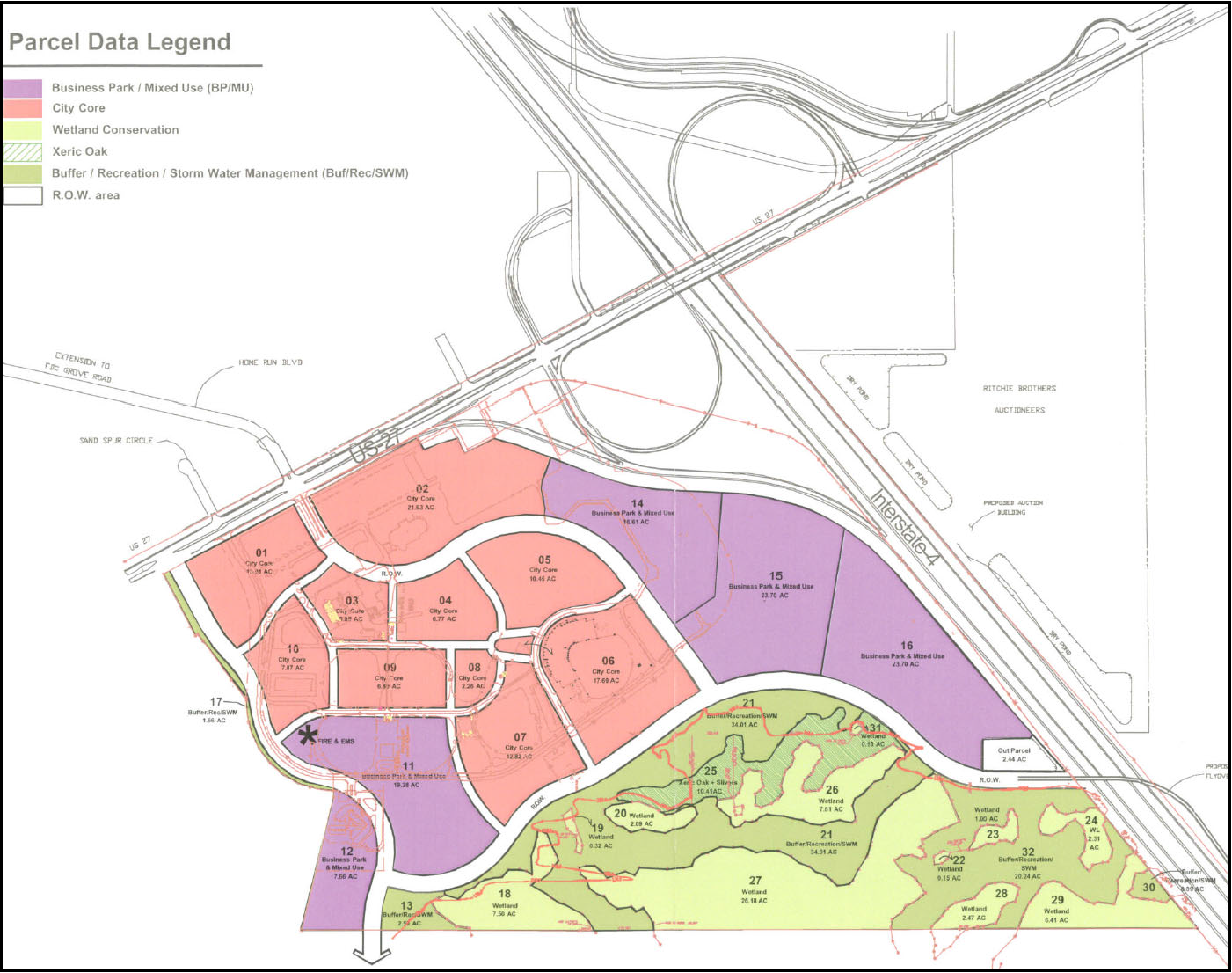
2.
Transit Center (TC) - The developer shall reserve an area within the City Core (as defined by the Map H above) or on the southwestern most area of parcel 11 in close proximity to US 27 for a Transit Center to serve as the future base for a regional transit network of local circulator service, express routes, and other modes of transportation. This Transit Center will include a Park-and-Ride Lot with a minimum of 100 free parking spaces. The required parking spaces may be shared with parking for commercial land uses. The location and size of the parcel for the Transit Center shall be subject to the review and approval of Polk County.
The developer shall construct and maintain at its expense a Transit Center with the following amenities: passenger shelter; transit system map/fare information; benches, trash receptacle; lighting; bicycle storage; bus bays and automobile parking. The design and construction of the Transit Center shall be subject to the review and approval of Polk County and can be consistent with the design theme of the Property. The Transit Center shall have a clearly delineated pedestrian path to surrounding land uses. The timing and specific requirements for the Transit Center will be addressed in a Development Agreement.
9.
Commercial Enclave (CEX) B In addition to the other applicable provisions, residential use is not permitted as a primary use, but is permitted above non-residential uses as an accessory use for a total of two stories of residential over non-residential uses (mixed-use building).
10.
Linear Commercial Corridor (LCCX) B This Future Land Use designation recognizes existing developed LCCX within the North Ridge SAP. The following requirements will be met for redevelopment:
a.
Non-conforming uses cannot be intensified;
b.
New Industrial (IND) and High Impact Commercial (HIC) uses are not permitted within the LCCX;
c.
New development in infill areas shall be limited to office, professional offices, and retail uses;
d.
Mixed use buildings are permitted; and
e.
Residential use is not permitted as a primary use, but is permitted above non-residential uses in a mixed-use building as an accessory use at the Medium Density Residential density (5.01 du/ac to 10.0 du/ac).
f.
There is no height limitation for buildings.
11.
Professional Institutional (PIX) B Development shall be consistent with the following:
a.
On-premises signs shall meet the requirements of Section 760 for Community Activity Center (CAC) and shall be reduced by 15 percent for sign height and area within the SAP;
b.
Residential development, as a primary or accessory use, shall be permitted to a maximum of 15 percent of the total developable area of a PIX area at Medium Density Residential density (5.01 to 10 du/ac) and shall comply with all other requirements of Chapter 3 for multifamily developments within activity centers (CAC, RAC, and BPC-1). Residential units above non-residential uses, at Medium Density Residential density, are encouraged and are not included in the 15 percent residential cap;
For purposes of this section, total developable area of a PIX shall be the group of contiguous parcels designated as PIX not bisected by collector or arterial roads or any physical natural barriers.
c.
Single-family attached, single-family detached, duplex, and three unit residential buildings shall be prohibited from being used in the PIX; and
d.
The Floor Area Ratio (FAR) for non-residential development may exceed the base FAR of 0.70 in accordance with Table 4.20.
12.
Employment Center (ECX) B Development shall be consistent with the following:
a.
On-premises signs shall meet the requirements of the Community Activity Center (CAC) and shall be reduced by 15% for the SAP in accordance with Section 760 of the Land Development Code;
b.
The setbacks and building height shall meet the requirements of Section F.5. and 6. of this SAP, Development Design Standards and Requirements;
c.
Residential development, as a primary use or accessory use, shall be permitted to a maximum of 15 percent of the total developable area [5] of ECX at Medium Density Residential density (5.01 to 10 du/ac) and High Density residential (10.01 du/ac to 15 du/ac) and shall comply with all other requirements of Chapter 3 for multifamily developments within activity centers (CACX, RACX, and BPC-1X). Residential units above non-residential uses are encouraged and are not included in the 15 percent residential cap for units above non-residential, the density shall only be limited by setbacks, and height, etc., rather than by units by acre. Residential development in excess of the 15% ECX designation may be permitted through a Planned Development. Alternatively, residential development may exceed the 15% ECX designation and be permitted a maximum density of 25 dwelling units per acre through a technical review performed by the Development Review Committee (Level 2 Review) if parallel connector roads or the functional equivalent such as frontage roads, backage roads, or other shred access method (the "Parallel Connector") are constructed between two or more roads intersecting with US 27 that connect residential and commercial development along the US 27 corridor; each Parallel Connector must comply with one or more of the provision in Policy 2.131-W4.1, 2, 4 or 5 and one or more of the provisions in Section 401.06, Q4. A, b, and e;
d.
Single-family attached, single-family detached, duplex, and three unit residential buildings shall be prohibited from being used in the ECX; and
e.
The Floor Area Ratio (FAR) for non-residential development can exceed the base FAR in accordance with Table 4.20.
13.
Tourism Commercial Centers (TCCX) B The Floor Area Ratio (FAR) for non-residential development may exceed the base FAR of 0.50 in accordance with Table 4.20.
14.
Leisure Recreation (L/R) - In compliance with the Polk County Comprehensive Plan, L/R areas are not intended for permanent residents. In addition to other applicable provisions within this Code and the Polk County Comprehensive Plan, the following regulation shall apply:
a.
Retail uses are limited to 7 percent of the net usable area.
b.
Retail uses over 7 percent and up to 15 percent may be permitted if developed as part of a mixed use project.
c.
The number of units per acre, except hotel/motel room accommodations which are limited by the allowable FAQR, is defined in Section 205, Table 2.2 in accordance with the guidelines of Policy 2.115-A4 of the Polk County Comprehensive Plan. The Floor Area Ration (FAR) can exceed the bas FAR in accordance with Table 4.20.
E.
Modified Special Use Requirements (Revised 6/21/16 - Ord. 16-031; 11/4/14 - Ord. 14-066; 2/3/10 - Ord. 10-007; 07/25/07 - Ord. 07-039)
1.
Residentially Based Mixed Use Developments (RBMD) Design Standards:
a.
The design configuration and mix of uses shall emphasize a pedestrian oriented environment;
b.
The street pattern shall resemble a grid and limit the use of cul-de-sac streets;
c.
Development shall comply with the provisions within the North Ridge SAP regarding Recreation Space, and Open Space in lieu of the Recreation and Open Space requirement of Section 401;
d.
Residential and non-residential uses, within the development, shall be interconnected to enable efficient flow of pedestrian and vehicular traffic;
e.
Non-residential uses shall be interconnected to adjacent development to enable efficient flow of pedestrian and vehicular traffic;
f.
The non-residential uses for the development, such as community facilities, personal services, laundromat, dry cleaners, etc., shall not exceed 12,000 square feet or 20 percent of the area of the development, whichever is more restrictive;
g.
The residential uses for a development shall be developed in accordance with Table 4.18 and Table 4.21; and
h.
The non-residential uses for the RBMD are not restricted on location, however, the non-residential uses must provide a buffer in accordance with Section 720 of the Land Development Code when abutting residential uses within or outside of the RBMD.
2.
Accessory Uses B Alcoholic beverage sales for consumption on site shall be permitted as an accessory use in timeshares, hotels, and other resort communities in those land uses where the uses are allowed.
3.
Conditional Uses - In addition to Chapter 3, the following conditions shall apply within the North Ridge SAP:
a.
Agricultural Support, off-site - Any outdoor storage of equipment or equipment repair areas shall be screened with a Type B Buffer;
b.
Bars, Lounges, Taverns - Bars, Lounges and Taverns shall meet the following conditions:
i.
Square footage shall not exceed 2,000 in PIX, ECX, NACX, BPC- 1X, BPC-2X and INDX, not including a kitchen or storage; and
ii.
All standards in Section 224 shall apply.
c.
Boarding of animals - Boarding of animals at a veterinary office shall be considered accessory provided the boarding area is within an enclosed building and provisions are made to attenuate the noise. Exterior run for exercise purposes is permissible;
d.
Bed and Breakfast B In non-residential districts, bed and breakfast facilities shall comply with applicable standards and the following conditions:
i.
If the bed and breakfast abuts a residential district on one or more sides, the use shall comply with the conditions in Chapter 3. A Type B Buffer shall be required where the bed and breakfast abuts residential districts; and
ii.
If the bed and breakfast is surrounded by non-residential uses, the use may take on the character of the adjacent and surrounding uses and comply with the district requirements.
e.
Carwash (Incidental) establishments within the ECX district of the North Ridge SAP are considered to be retail/commercial uses and shall not exceed the 30 percent limit of such retail/commercial uses allowed throughout the ECX district. A higher percentage of the limited 30 percent of retail and commercial uses shall only be permitted through a Planned Development. Incidental Carwash establishments shall adhere to conditional use development criteria expressed for Incidental Carwashes in Section 303, Criteria for Conditional Uses, of the Land Development Code and shall have direct frontage along US Highway 27.
f.
Convenience Store establishments within the ECX district shall conform to Section 303 (Convenience Stores) of the LDC in addition to the following conditional use development criteria:
i.
Convenience stores are considered to be retail/commercial uses and shall not exceed the 30 percent limit of such retail/commercial uses allowed throughout the ECX district. A higher percentage of the limited 30 percent of retail and commercial uses shall only be permitted through a Planned Development
ii.
Convenience store establishments within the ECX district must be part of a Planned Development and shall include a phasing plan for the incorporation of future ECX uses. The tract of land designated for the convenience store use does not require a minimum acreage amount, but shall be required to have direct frontage along US Highway 27 and provide interconnecting access to those adjacent tracts within the planned development. Proposed convenience store establishments within the ECX district that do not have frontage along this identified regional roadway shall be prohibited.
iii.
Direct access onto US Highway 27 via new individual driveways shall be prohibited; however, access to a proposed parcel/site may be achieved via:
a.
An arterial road that intersects US Highway 27; or
b.
An urban collector or local roadway that intersects US Highway 27 within a ¼ mile of the proposed site.
iv.
Additional buffering techniques that exceed Land Development Code standards (whether through vegetative screening, distance separation, limiting the scale, or a combination thereof) may be required by the Development Review Committee (DRC) where the effect of lighting, noise, or other such compatibility factors is determined to adversely impact nearby residential uses or residential FLU districts.
g.
Financial Institutions - In addition to all applicable regulations, the following standards shall apply:
i.
All financial institutions, within BPCX and INDX, shall support the existing developed use; and
ii.
Financial institutions shall not exceed fifteen percent of the total developed area of the subject land use district. The total developed area shall be calculated based on the inclusion of all existing uses in the subject land use developable area and those with approved and valid site plans, construction plans and plats.
h.
Financial Institutions drive-thru - In addition to all applicable regulations, the following standards shall apply:
i.
The minimum distance from the drive-thru facility to any residentially designated property shall be 50 feet measured at the narrowest point between the property line of the residential property and either the stacking lanes, service equipment, or speaker box, whichever is closer;
ii.
All speaker boxes shall be oriented away from adjoining residential property;
iii.
All drive-thru facilities, including windows and stacking lanes adjacent to property with a residential use shall be screed with a Type C Buffer; and
iv.
The primary frontage and access shall be on a collector road or better unless contained within a master planned development with access to a collector road or better.
i.
Gas Station establishments shall conform to Section 303 (Gasoline Sales) of the LDC in addition to the following conditional use development criteria:
i.
The following conditions shall apply to gas stations within the ECX:
(1)
Gas Stations are considered to be retail/commercial uses and shall not exceed the 20% limit of such retail/commercial uses allowed throughout the ECX district.
(2)
Gas Stations within the ECX district must be part of a planned development that is no less than a total of eight (8) acres in size and shall include a phasing plan for the incorporation of future ECX uses. The tract of land designated for the Gas Station use does not require a minimum acreage amount but shall be required to have direct frontage along US Highway 27 and provide interconnecting access to those adjacent tracts within the planned development. Proposed Gas Stations within the ECX district that do not have frontage along this identified regional roadway shall be prohibited.
(3)
Direct access onto US Highway 27 via new individual driveways shall be prohibited; however, access to a proposed parcel/site may be achieved via:
(a)
An arterial road that intersects US Highway 27; or
(b)
An urban collector or local roadway that intersects US Highway 27 within a ¼ mile of the proposed site.
(4)
Additional buffering techniques that exceed County development standards (whether through vegetative screening, distance separation, limiting the scale, or a combination thereof) may be required by the County's Development Review Committee (DRC) where the effect of lighting, noise, or other such compatibility factors is determined to adversely impact nearby residential uses or residential FLU districts.
ii.
The following conditions shall apply to gas stations within the PIX:
(1)
Gas Stations are considered to be retail/commercial uses and shall not exceed the 20% limit of such retail/commercial uses allowed throughout the PIX district.
(2)
Must have direct frontage at a signalized intersection of a principal arterial roadway.
(3)
Gas Stations within the PIX shall not have high-speed diesel pumps.
j.
Heliports and Helistops B Heliports and helistops may be permitted as a Level 2 Review in accordance with Section 401.06, Table 4.16;
k.
Hotel/Motel - Hotel/Motel uses within the ECX and PIX districts shall be limited to the percentage cap for retail uses listed in the Comprehensive Plan for this SAP;
l.
Light assembly - the following standards shall apply:
i.
No outdoor storage of any materials shall be permitted;
ii.
There shall be no external activity beyond loading and unloading of materials to and from an enclosed structure; and
iii.
A Type C Buffer (see section 720) shall be provided between a residential use and any structure requiring loading and unloading of commercial vehicle(s).
m.
Retail, Home Sales Offsite - the following standards shall apply:
i.
Any display of homes shall be limited to an outdoor display area of up to 50 percent of the total developable square footage of the subject site;
ii.
Any site adjacent to a residential use shall provide a Type C Buffer (see Section 720); and
iii.
Any on-site repairs shall be screened from off-site view.
n.
Nurseries, Retail - The following standards shall apply:
i.
Nurseries and Greenhouses conditions in Section 303 of this Code shall be applicable;
ii.
In the A/RR land use district:
(1)
Any retail activity shall be accessory and subordinate to the bona fide agricultural use of the property; and
(2)
Any structure(s) used for retail activity shall not exceed 1,200 square feet.
o.
Office Park
i.
All offices, in the office park, shall have vehicular and pedestrian interconnectivity.
ii.
A maximum of 15 percent of the developable area for the Regional Activity Center (RACX) is permitted as office park. The applicant must demonstrate that the development does not exceed the 15 percent office park cap.
iii.
An internal sidewalk shall be provided between the offices and parking lots to meet the pedestrian needs of all offices within the office park.
iv.
The office park shall provide a minimum of 1,000 square feet of landscaped area adjacent to each building/structure.
v.
At a minimum, a Type A Buffer shall be required at the perimeter of the office park.
p.
Retail, Outdoor Sales/Display - In addition to applicable district regulations in Table 2.2, the following standards shall apply:
i.
All outdoor storage shall be at a minimum of 50 feet from any side lot line, and a minimum of 25 feet from the rear lot line;
ii.
Retail establishments with outdoor storage shall be required to provide a landscaped buffer at a minimum equal to a Type C buffer (see Section 720) where the boundary abuts a residential use or residential land use district and Type B buffer (section L. of this SAP) where adjacent to a non residential use; and
iii.
All activity shall be limited to operation from 8:00 a.m. to 9:00 p.m.
q.
Railroad Yard B A Type C Buffer 25 feet in width is required where a railroad yard abuts any residential district, including Agriculture/Residential Rural (A/RRX).
r.
Retail - The following standards shall apply:
i.
Retail uses are limited to 15 percent of the total developable area PIX, BPCX and INDX;
ii.
Total area includes the group of contiguous parcels designated a land use that is not bisected by a collector or arterial roads or any physical natural barriers; and
iii.
Only natural water bodies and untouched wetlands can be removed from the total area calculations.
s.
Short Term Rentals - In addition to the conditions in Chapter 2, single-family detached units shall be a prohibited use for Short Term Rental units in the RACX.
t.
Self Storage Facilities - These facilities shall be permitted through a Planned Development within the ECX or PIX district. In addition, the individual storage spaces shall not be permitted to be accessed from the outside. All users shall access the individual rented storage space through a common access. Where the facility fronts the collector road, mixed use structures (e.g., office, personal service, commercial with the self-storage above or behind), are required. Each facade of the facility shall have an office or similar appearance.
u.
Time Shares
i.
A Type C Buffer shall be required where a time share development abuts a residential district.
ii.
A Type B Buffer shall be required where a time share development abuts a non-residential district or use.
iii.
All time share development shall connect to centralized water and wastewater services.
v.
Special Residential - If special residential structure is placed on the edge of the district, the height of the building cannot be more than twice the height of the building in the adjoining district/parcel unless it is approved as part of ta master planned development. Parking areas for special residential uses shall not be immediately adjacent to residential Future Land Use districts. Light poles, used for special residential uses, shall not be adjacent to existing residential or property designated with a residential Future Land Use district and alighting shall be directed toward the interior of the development. Alighting plan that includes the fixture type, location, intensity, and photometric calculations shall be submitted for development review with any special residential project.
w.
Transit Facilities - All outdoor storage shall be screened from offsite view and shall be setback 50 feet from any property with a residential structure or residential land use designation.
x.
Truck Stop
i.
A Type C Buffer 25 feet in width shall be required where the truck stop abuts a residential district or a school.
ii.
A Type B Buffer shall be required where a truck stop abuts a non- residential district or use.
iii.
No truck parking, gasoline sales, fuel storage, or truck servicing activities are allowed within 65 feet of the property line that abuts any residential district or a school.
y.
Vehicle Sales and Leasing establishments within the ECX district shall conform to the following conditional use development criteria:
i.
Vehicle Sales and Leasing establishments are considered to be retail/commercial uses and shall not exceed the 30 percent limit of such retail/commercial uses allowed throughout the ECX district. A higher percentage of the limited 30 percent of retail and commercial uses shall only be permitted through a Planned Development.
ii.
Vehicle Sales and Leasing establishments within the ECX district shall be prohibited on lots less than 10 acres in size.
iii.
Lots within the ECX district shall also have direct frontage along US Highway 27. Proposed Vehicle Sales and Leasing establishments within the ECX district that do not have frontage along this identified regional roadway shall be prohibited.
iv.
Direct access onto US Highway 27 via new individual driveways shall be prohibited; however, access to a proposed parcel/site may be achieved via:
a.
An arterial road that intersects US Highway 27; or
b.
An urban collector or local roadway that intersects US Highway 27 within a ¼ mile of the proposed site.
v.
All Vehicle Sales and Leasing establishments within the ECX district shall include an onsite service and repair operation in an effort to increase the employmentpotential of the district. The service and repair operation shall be performed within an enclosed structure(s), thereby limiting the extent of their external impacts upon adjacent and nearby properties.
vi.
Additional buffering techniques that exceed Land Development Code standards (whether through vegetative screening, distance separation, limiting the scale, or a combination thereof) may be required by the County's Development Review Committee (DRC) where the effect of lighting, noise, or other such compatibility factors is determined to adversely impact nearby residential uses or residential FLU districts.
z.
Vehicle Service (Mechanical) establishments within the ECX district shall conform to the following conditional use development criteria:
i.
Vehicle Service (Mechanical) establishments proposed as a primary use are considered to be retail/commercial uses and shall not exceed the 30 percent limit of such retail/commercial uses allowed throughout the ECX district. A higher percentage of the limited 30 percent of retail and commercial uses shall only be permitted through a Planned Development.
ii.
Lots within the ECX district must also have direct frontage along US Highway 27. Proposed vehicle service establishments within the ECX district that do not have frontage along this identified regional roadway shall be prohibited.
iii.
Direct access onto US Highway 27 via new individual driveways shall be prohibited; however, access to a proposed parcel/site may be achieved via:
a.
An arterial road that intersects US Highway 27; or
b.
An urban collector or local roadway that intersects US Highway 27 within one-quarter mile of the proposed site.
iv.
A buffer equal to a Type C buffer (see Section 720) shall be provided between the vehicle service facility and all abutting residential districts. Also, additional trees equal to one tree per 30 feet shall be provided adjacent to residential areas.
v.
There shall be no external activity beyond loading and unloading of materials. All vehicle services shall be conducted within an enclosed structure; and all accessory outdoor storage shall be screened from off-site view.
aa.
Warehouse and/or distribution facilities - there shall be no outdoor loading or unloading forward of the front building line, or adjacent to residentially developed property, or to property with a residential Future Land Use designation unless the loading and unloading area is screened from off-site view.
F.
Development Design Standards and Requirements (Revised 11/4/14 - Ord. 14-066; 05/07/08 - Ord. 08-013; 07/25/07 - Ord. 07-039)
1.
All non-residential, commercial, and residential development with three dwelling units per acre or higher densities shall utilize underground utilities within the development. Above ground utilities are permitted only along the road or as needed by the utility service provider(s) in order to meet the regional demands of providing the service(s). Lots of records are exempt from this requirement.
2.
All development shall utilize a water reuse system, where service is available or planned by the County or local municipalities.
3.
Density bonus points:
a.
All residential development within Residential Land Uses shall obtain five density bonus points for every one dwelling unit per acre increase above the permitted base density with the total required bonus points coming from at least three categories as shown in Table 4.19. Residential developments within non-residential districts are required to obtain five bonus points for every one dwelling unit per acre of density up to 50 points, and one bonus point for every one dwelling unit per acre du/ac after that; and
b.
Regional Activity Center (RACX) within the North Ridge SAP:
Notwithstanding any other provision contained herein, residential development within Regional Activity Center (RACX) is permitted (P) to occur at the maximum density with a Level 2 Review without any Bonus Points;
4.
Floor Area Ratio (FAR) bonus points:
a.
All non-residential development requesting an increase in the Floor Area Ratio (FAR) shall obtain five (5) Floor Area Ratio (FAR) bonus points for every 0.05 FAR increase above the base FAR, with the total required bonus points coming from at least three categories as shown in Table 4.19;
b.
All development that is permitted (P) or permitted with density bonus points (B) shall require a Level 2 Review in accordance with Table 4.20; and
c.
All development that is permitted with a Planned Development (PD) with bonus points (B) shall require a Level 3 Review in accordance with Table 4.20 and Table 4.21.
5.
Outdoor storage:
a.
Outdoor storage forward of the rear building line is not allowed in all Future Land Use districts, however, outdoor storage is permitted in the LCCX, CEX, BPC-2X, and INDX land use districts forward of the rear building line, provided the area is screened from off-site view;
b.
Outdoor storage shall be allowed to the rear of the lot behind the building/structure. On corner lots, outdoor storage shall not extend toward the road frontage by more than one half the length of the building/structure, as shown in Figure 4.1. Except for corner lots, outdoor storage shall be prohibited for non-residential lots with two or more front yards, as shown in Figure 4.1;
c.
Outdoor storage for multiple buildings, within a project or on a parcel, shall be permitted in a manner consistent with the intent of Figure 4.1. In addition, at a minimum, outdoor storage for multiple buildings shall only be permitted behind the rear line of the building that is farthest from any street;
d.
Where outdoor storage of cars, recreational vehicles, and boats is permitted, it shall be to the rear of the building line;
e.
All outdoor storage shall be screened from off-site view; and
f.
All Salvage Yards shall be consistent with the conditions listed in Chapter 3.
Figure 4.1 Outdoor Storage - Permitted and prohibited areas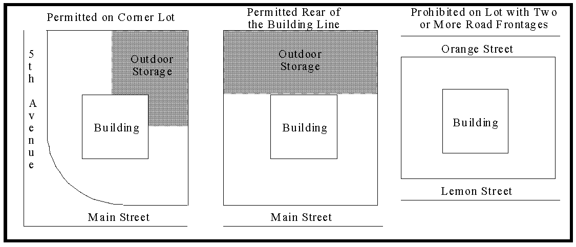
6.
Canopy trees B All canopy trees, at the time of planting for all development, shall be a minimum of ten to twelve feet tall and have a minimum of two inches diameter at breast height (D.B.H.). At maturity, a tree must reach a minimum height of 25 feet with a minimum spread (or crown) of 15 feet.
G.
Multi-Modal Collector Road System
The collector road system is designated on the FLUM and shall be established by requiring development to provide a minimum of 40 feet from the centerline for the right-of-way to the County. All other roads shall be in accordance with Section 823.
H.
Greenway Corridor
The Greenway Corridor is designated on the FLUM and shall be established as follows:
1.
New development or redevelopment bordering the wetlands and floodplains of the Green Swamp CORE shall designate the westerly 50 feet of uplands as a conservation easement and the easterly 50 feet of wetlands or floodplains as a conservation easement;
2.
Recreation amenities and stormwater retention areas shall be located adjacent to the Greenway Corridor, unless an alternative location is approved by the Development Review Committee (DRC); and
3.
Recreational trails shall be allowed within the Greenway Corridor.
I.
Horse Creek Corridor
1.
Recreation amenities areas may be located adjacent to the Horse Creek Corridor.
2.
Recreational trials and other passive recreation activities shall be allowed within the Horse Creek Corridor.
J.
Recreation Space (Revised 07/25/07 - Ord. 07-039)
1.
All residential and short-term rental development shall provide 50 percent of the required park and recreation space on-site and an amount established by the County Impact Fee Ordinance as amended will be contributed to the acquisition and/or development of a regional park or community parks.
2.
Passive recreation may be used to meet the Open Space requirement.
3.
Active recreation areas may be used to meet the Open Space requirement under the following conditions:
a.
Passive recreation such as parks or pedestrian paths shall be incorporated into the active recreation areas for the use of the residents that the open space is intended for;
b.
The recreation areas shall be used to link greenways, wetlands, floodplains, water bodies, and other natural areas within and adjacent to the development;
c.
The recreation areas shall be linked to any proposed internal pedestrian network within the development; and
d.
All recreation areas shall be accessible to all residents within the development and shall incorporate unobstructed views from the roadways.
K.
Open Space (Revised 07/25/07 - Ord. 07-039)
Open space within the North Ridge SAP includes upland, wildlife habitat, dry and wet retention ponds, preserved native plant communities, and floodplains.
1.
All development will be required to provide a minimum often percent open space in the SAP but shall provide a minimum of 30 percent open space if in the Green Swamp. Planned Developments must meet the open space standards found in Section 303.
2.
Building setbacks are allowed to be used as part of the open space for non-residential development.
3.
Lots of record are exempt from providing open space as required by this SAP.
L.
Buffers (See Figure 4.2)
1.
A landscaped buffer, 25 feet in width, shall be required along arterial roads consistent with the planting requirements of a Type C buffer for all development. The required sidewalk may be incorporated into the landscape buffer provided an access easement is recorded at the time of Level 5 Review.
2.
Developers of properties along US 27 shall plant Live Oak trees at a ratio of one tree for every 40 linear feet of right-of-way frontage.
3.
A landscaped buffer 15 feet in width shall be required along all collector roads, consistent with the planting requirements of a Type A buffer, for all development. The sidewalk may be incorporated into the landscape buffer provided an access easement is recorded at the time of Level 5 Review.
4.
A landscaped buffer consistent with the Type C buffer in Section 720 shall be required where non-residential development abuts any vacant or developed residential districts. This buffer may be reduced to ten feet if a masonry wall is incorporated into the buffer.
5.
A five foot landscaped buffer consistent with the Type B Buffer, in accordance to Section 720, shall be required between all non-residential developments as follows:
a.
Where a proposed non-residential use abuts an existing non-residential use, a Type B Buffer, in accordance to Section 720, is required, unless the existing use has an equivalent buffer.
b.
Where the proposed non-residential use abuts a non-residential district, that is vacant and without approved development plans from the County, the proposed use shall provide the equivalent of half of the required plantings of the Type B Buffer, in accordance to Section 720.
c.
If the abutting non-residential use, whether it is an existing use or received development approval from the County, has a clustered landscaped buffer, the abutting use shall cluster the landscaped buffer on-center between the proposed or existing clustered landscaping. The proposed non-residential use in this situation, cannot apply for a waiver from the required landscaping.
d.
The plantings of the required landscape buffer between non-residential uses may be clustered, provided the separation between clusters is no greater than 30 feet.
e.
Half of the required understory tree and shrub plantings, from the Type B Buffer between non-residential uses, may be transferred from the perimeter landscape to landscaping surrounding the building(s) for the development.
f.
Where the buildings abut each other and utilize shared parking areas, a landscape buffer shall not be required to separate the two uses.
g.
All landscaped buffers, including those within the building setbacks, are allowed to be counted toward the required Open Space for non-residential development.
6.
Existing trees, including citrus trees, can be counted toward the buffer requirement per Section 721 and Table 4.17 of the Land Development Code. In non-residential uses, up to 50 percent of the citrus trees can be counted toward the buffer requirement per Section 721 and Table 4.17.
7.
Only block with stucco, brick, or decorative precast masonry walls shall be permitted as part of the landscape buffer as required by Section 720. Privacy fences for residential and non-residential uses that are not part of the landscape buffer are allowed as permitted by Section 210.
8.
Landscaped buffers within the rights-of-ways shall not count toward the required Open Space.
Figure 4.2 Landscaping between non-residential uses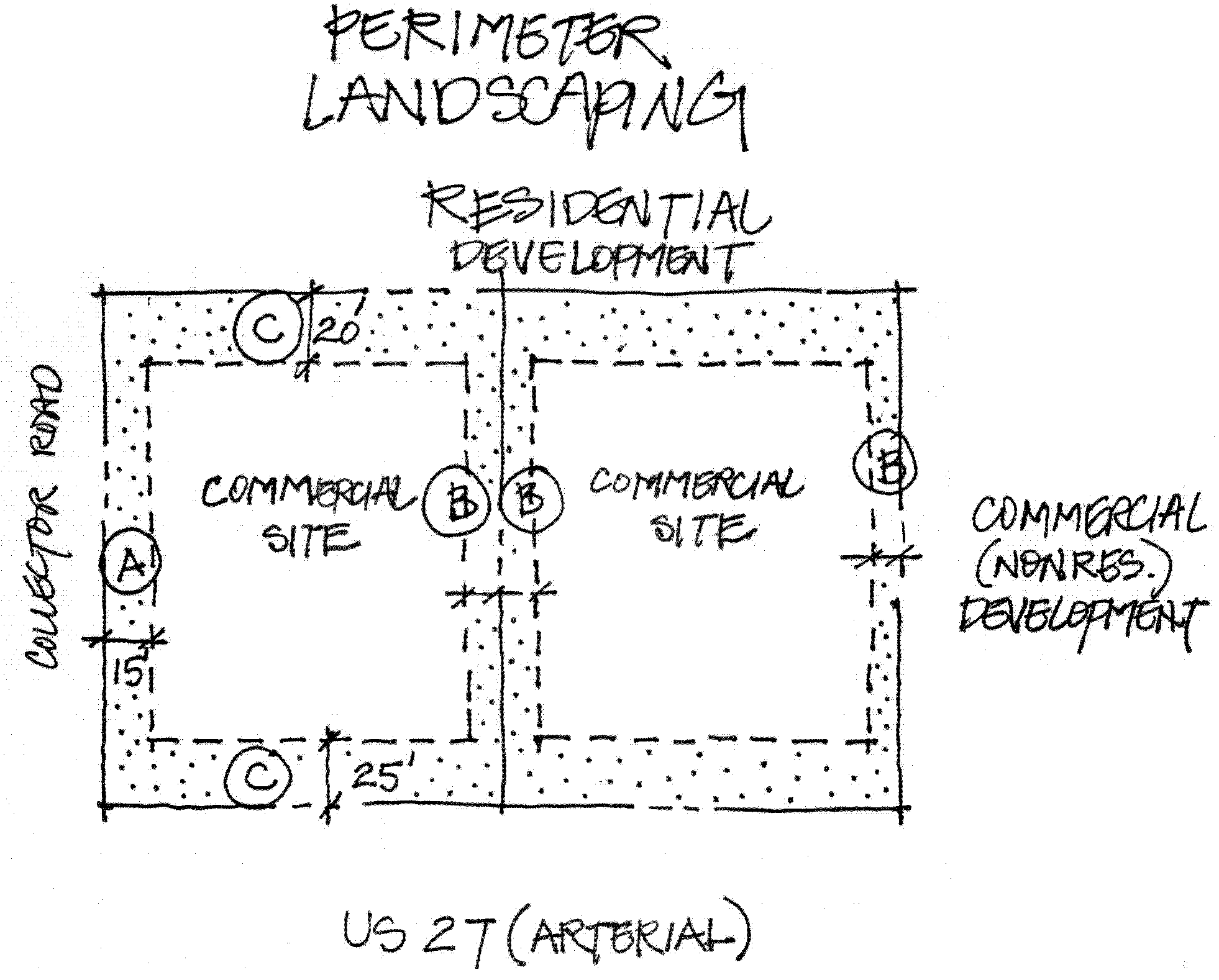
M.
Parking Lot Landscaping (See Figure 4.3)
1.
All parking lot landscaping and buffer requirements shall meet the requirements of this section; the landscaping requirements of Section 720 C. and D. shall not be applicable in this SAP.
2.
Xeriscape landscaping and native plant materials are encouraged to be incorporated into the parking lot landscaping.
3.
At least 30 percent of the required canopy trees in the parking lot landscaping shall be native to the ridge or drought resistant.
4.
The minimum landscaping for each parking lot shall be provided within the interior of a required paved off-street parking area as follows:
a.
Each aisle of parking spaces shall be terminated by landscaped islands which measure not less than nine feet in width, as measured from face of curb to face of curb, and not less than 18 feet in length. At least one canopy tree shall be planted in each terminal island;
b.
Mandatory terminal islands shall be surrounded with a continuous, raised curb.
c.
Landscaped divider medians may be used to meet interior landscape requirements. If divider medians are used, they shall form a continuous landscaped strip between abutting rows of parking spaces. The minimum width of divider median shall be a minimum six foot wide divider median, as measured from face of curb to face of curb. One under story tree shall be planted for each 30 linear feet of divider median, or fraction thereof. Trees in a divider median may be planted singly or in clusters. The maximum spacing between clusters shall be 60 feet;
d.
A minimum six foot wide divider median, as measured from face of curb to face of curb, shall be required every fourth bay of parking as shown in Figure 4.2. A minimum of one understory tree shall be planted for each 30 linear feet of divider median. An alternative option, three diamond shaped islands may be substituted for the continuous six foot wide divider median, as shown in Figure 4.2;
e.
Optional interior islands and divider medians shall be protected by curbing or wheel stops; and
f.
Each parking bay shall have no more than ten continuous parking spaces unbroken by a landscape island that shall be the width of a parking space, as measured from face of curb to face of curb.
5.
Location of landscaping - Landscaped areas shall be located in such a manner as to divide and break up the expanse of paving and to guide traffic flow.
6.
A Type A buffer 15 feet in width shall be required between all frontage roads and parking lots in accordance with Section 720.
7.
Required landscaping where off-street parking abuts public right-of-way: A landscaped strip of land shall be provided consistent with this section and Section 720 with at least one drought resistant, native to the ridge, tree for each 75 lineal feet, or fraction thereof shall be planted. Trees may be planted separately or in clusters.
8.
No landscaping shall be provided in the right-of-way unless the County or FDOT gives the owner approval to do so. In addition, a completed agreement as to who will maintain the landscaping within the right-of-way shall be submitted by the developer and the owner of the right-of-way(s) prior to Level Review 2 approval.
Figure 4.3 Parking Lot Design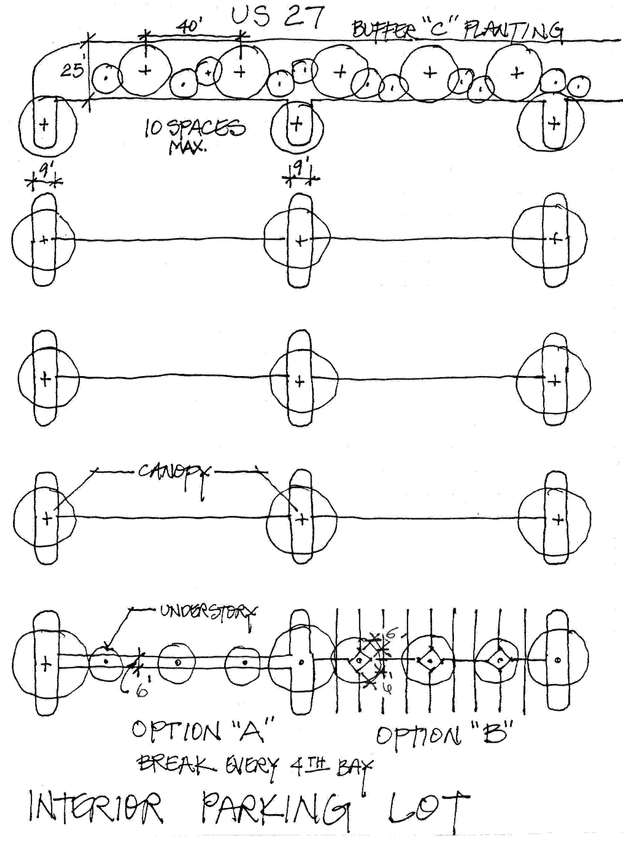
N.
Tree Planting
The minimum number of trees to be planted or preserved in addition to buffering and landscaping requirements is listed in Table 4.17.
Table 4.17 Number of Trees to Plant or Preserve for Development
O.
Credits for Existing Trees
Credits for existing trees shall be consistent with Section 721.
P.
Signs
1.
Off-Premises signs shall be prohibited except as temporary real estate signs advertising the availability of commercial space and special events as permitted per Section 760 of the Land Development Code.
2.
On-premises signs shall be permitted in accordance with Section 760.
3.
On-premises signs shall be permitted in the Professional Institutional (PIXX) and Employment Center (ECX) districts consistent with the Community Activity Center (CACX) standards per Section 760.
4.
All other signs shall be permitted in accordance with Section 760.
Q.
Transportation Network and Road Frontage Requirements (Rev. 08/15/08 - Ord. 08-041; Rev. 06/08/04 - Ord. 03-94)
1.
Transportation improvements shall comply with the following:
a.
Improvements or construction of arterial, collector, or local roadways shall be consistent with FDOT plans and the County's proposed collector road system for this SAP, and other applicable adopted plans;
b.
At the time of Level 2 Approval or Level 5 Approval, rights-of-way shall be dedicated for roads designated on the FLUM by all development, and shall comply with the widths required in this Section and Chapter 8; and
c.
Curb cut criteria shall be consistent with Rule 14-96 and Rule 14-97, Florida Administrative Code, as amended, and the access management plan for the jurisdiction of that facility.
2.
To comply with the conditions of approval for the level of service variance on US 27 (DOT Case No.: 06-117), FDC Grove Road and Holly Hill road will be improved within this SAP as follows:
a.
The Corridor Alignment Study for FDC Grove Road and Holly Hill Road, will define the typical section and location of these two roads; and
b.
For development on parcels impacting, adjacent or contiguous to the FDC Grove Road and Holly Hill Road corridor alignments, the applicant will be required to dedicate right-of-way and fund or construct those portions of FDC Grove Road or Holly Hill Road. The applicant shall be provided with two options to meet the provisions of this section.
1.
The road design plans shall be submitted and approved as part of the Level 2 Construction Plan process. The applicant shall dedicate fee simple at no cost to the County, all the appropriate right-of-way for either FDC Grove Road or Holly Hill Road as part of their Level 2 or Level 5 approvals. The roadway shall be constructed by the applicant in accordance to all the applicable standards within the Land Development Code and approved by Polk County prior to a Certificate of Occupancy being issued; or
2.
The applicant shall dedicate fee simple at no cost to the County, all the appropriate right-of-way for either FDC Grove Road or Holly Hill Road as part of their Level 2 or Level 5 approvals. The applicant shall submit an itemized cost estimate prepared by a licensed Professional Engineer that practices in the State of Florida for design and construction of their portion of either FDC Grove Road or Holly Hill Road for approval by Polk County. The cost estimate shall take into account mechanisms for the additional storm water runoff that may occur as part of the construction of the new roads. Once an engineering estimate is accepted by Polk County, the applicant shall notate this cost agreement on the Level 2 construction plans and Level 5 Plat. 50% payment of those funds to Polk County shall occur prior to the first issuance of a Certificate of Occupancy. The remaining 50% payment of funds shall be paid prior to the last issuance of a Certificate of Occupancy. Once the funds have been received and accepted by Polk County, those funds will be placed into an account designated for design, right-of-way, and construction of either FDC Grove Road or Holly Hill Road.
3.
All access and subdivision of land shall comply with the following:
a.
All access to collector and local road shall be consistent with this Section and Chapter 8;
b.
Only one driveway shall be permitted along US 27 every 1,320 feet between any perpendicular roadway intersection with US 27, except as otherwise authorized in writing by FDOT.
c.
Any subdivision of property along all arterial roadways shall have a minimum frontage of 600 feet. This may be reduced if access is not from US 27 and access is gained from a shared driveway, consistent with item 2b above, internal road or cross access easement;
d.
The required frontage may be reduced if access is gained through a joint or shared access, a side road, or other internal road; and
e.
Where access is shared by more than one user, an easement shall be located on the site plan at Level 2 Review and any required plat. A completed access agreement shall be provided prior to any Level 2 Review approval.
4.
In order to provide safe and efficient local traffic movement, the County shall designate cross-access corridors along US 27, US 17/92, all urban collector roads within the SAP, and other roads that may be designated in the future. Said corridors shall be designed to provide unified access and circulation among parcels on each block of the thoroughfare. Each corridor shall include the following elements:
a.
A continuous linear travel corridor extending the entire length of the block which it serves, or at least 1,000 feet of linear frontage along the thoroughfare, and having a design speed of ten mph. Final design of the facility shall be approved by the County Engineer;
b.
At a minimum, meet the County's local road requirements of Appendix A of the Land Development Code in order to have sufficient width to accommodate two-way travel aisles for automobiles, service vehicles, and loading vehicles;
c.
Stub-outs and other design features which make it visually obvious that the abutting properties may be tied in to provide cross-access, shall be constructed at the time of development;
d.
Linkage to other cross-access corridors in the area;
e.
Where a cross-access corridor is designated, no subdivision plat, site plan or other development shall be approved unless the property owner grants an easement allowing general cross-access to and from the other properties in the affected area. Such easement shall be recorded in the public records of Polk County and shall constitute a covenant running with the land;
f.
Wherever a cross-access corridor has been designated, the sites shall be so designed for coordinated or joint parking, access and circulation systems. These sites shall include stub-outs and other design features necessary to make it visually obvious that the abutting properties may be connected to a unified system;
g.
If a site is developed prior to an abutting property, it shall be designed to ensure that its parking, access, and circulation may be connected to a unified system at a later date; and
h.
If a site abuts an existing developed property, it shall be so designed to connect to the abutting parking, access, and circulation unless the Planning Director and County Engineer determines this to be impractical.
R.
Environmental Protection
All development within this SAP shall be designed to protect upland wildlife habitats, native plant communities, wetlands, and other natural resources.
1.
All mining within the North Ridge SAP shall meet the requirements of Section 2.304 of the Comprehensive Plan. The county will encourage the mining of vacant, undeveloped land that is designated within the Mineral Resource Protection District prior to being developed.
2.
Building setbacks shall be 50 feet from environmentally sensitive areas. Wider setbacks may be required by the County depending on the environmental sensitivity of the area and the intensity of the development proposed adjacent to the area.
3.
Underground petroleum storage tanks shall be allowed within the North Ridge SAP in accordance with the Comprehensive Plan and federal and state requirements.
S.
Density Regulations (Revised 05/07/08 - Ord. 08-013)
1.
The allowable densities and density bonus points for this SAP are shown in Tables 4.18 and 4.19, respectively. If the Green Swamp Area of Critical State Concern regulations are more restrictive, then they shall apply to the development.
2.
Planned Developments shall be required as specified in Table 4.18, Table 4.20, and Table 4.21.
Table 4.18 Density Limits for North Ridge SAP(1)(Revised 07/25/07 - Ord. 07-039)
Table 4.19 Density and Floor Area Ratio Bonus Point Schedule(1)(Revised 07/25/07 - Ord. 07-039)
Table 4.20 North Ridge SAP Floor Area Ratio (FAR) Bonus Points Awarded (Non-Residential Development)(1)(Revised 07/25/07 - Ord. 07-039)
Table 4.21 North Ridge SAP Density Bonus Awarded (Residential Districts)
(Ord. No. 19-046, §§ 1—6, 7-16-2019; Ord. No. 2020-013, § 1, 2-4-2020; Ord. No. 2020-026, §§ 1, 3, 6-2-2020; Ord. No. 21-036, §§ 2, 3, 7-6-2021; Ord. No. 2021-038, § 3, 7-6-2021; Ord. No. 22-032, § 2, 5-3-2022; Ord. No. 2022-065, §§ 1, 2, 9-6-2022; Ord. No. 2022-080, § 3, 12-6-2022; Ord. No. 2023-031, § 2, 5-2-2023; Ord. No. 2023-075, § 2, 12-5-2023; Ord. No. 2024-025, § 4, 4-16-2024)
For purposes of this section, total developable area of an ECX shall be the group of contiguous parcels designated as ECX not bisected by collector or arterial roads or any physical natural barriers.
Section 401.07 - The Brewster Selected Area Plan (Revised 03/18/14 - Ord. 14-015; 8/23/11 - Ord. 11- 018)
A.
Purpose and Intent
This Selected Area Plan (SAP) was adopted in the Polk County Comprehensive Plan to recognize an area of the County for the development of an environmentally focused recreational development, which includes an activity center base for outdoor recreation and sporting activities. Additionally, the SAP promotes the establishment of open space and preservation areas on reclaimed phosphate mined land. The land use districts and performance standards that follow implement the vision and basic principles outlined in the Plan. The SAP, which is located within the southwest portion of Polk County, will enable the use of lands previously mined or designated as Phosphate Mined (PM) in a manner that is consistent with existing reclamation activity and will promote uses which are consistent with the physical characteristics of the land. The SAP promotes land stewardship initiatives, which focus on environmental stewardship, economic vitality and long-term sustainable uses of reclaimed lands.
B.
Applicability
1.
This section applies to development within the Brewster SAP, the boundaries of which are shown on the FLUM.
2.
Development within the SAP shall occur in accordance with other provisions of the Land Development Code except where regulations are modified by this Section. Where there is a conflict the regulations for the SAP shall supersede the other provisions of the Land Development Code.
C.
Allowable Uses, Intensity of Development and Dimensional Regulations
The land use categories and uses allowable in this district are shown in 401.07 Table 1 Use Table for Land Use Districts. Land use categories and uses not shown are prohibited.
1.
All development that is permitted (P) shall require a Level 2 Review.
2.
Land uses shown with a C1, C2, C3 or C4 in 401.07 Table 1 shall comply with applicable Criteria for Conditional Uses in Chapter 3 of the Land Development Code.
3.
Uses listed as needing Planned Development (PD) approval shall require a Level 3 Review in accordance with this Code.
4.
Typical setbacks shall be in accordance with, 401.07 Table 2 of this Code.
5.
Impervious Surface Ratios and Floor Area Ratios shall be in accordance with 401.07 Table 2 of this SAP and shall be calculated based on the net usable acreage for the
Future Land Use category within the SAP and as described within the Comprehensive Plan. The net usable acreage does not include water bodies, wetlands, or clay settling areas.
6.
Phosphate mining activities listed below may be permitted in all of the Future Land Use designations based on the following:
a.
Continuation of mining operations which were permitted by a Phosphate Mining Operating Permit pursuant to Polk County Ordinance No. 88-19, as amended and are consistent with the Phosphate Mining (PM) land use designation;
b.
Existing or future mining related activities which support phosphate ore extraction (such as pipelines, transmission lines, access roads) or reclamation activities; or
c.
Existing or future mining activities authorized by a Development of Regional Impact (DRI).
7.
Development within the TCCX and the L/RX shall be served by central potable water and sanitary sewer service in accordance with this Code, with the following provisions:
a.
Class III Utilities shall address sizing, capacity, and fire protection
b.
Non-residential, isolated and ancillary uses, which generates a demand for less than 1,000 gallons per day of potable water or wastewater treatment.
8.
Development of habitable structures shall be in accordance with acceptable engineering practices and shall include the submission of subsurface soil analysis to determine the appropriate method of construction.
9.
Alcoholic Sales (Consumption on site): Other than those establishments provided for in Section 224.5 and 401.07 Table 2 the on-site consumption of alcoholic beverages shall be permitted as an accessory use according to the following requirements:
a.
Alcoholic beverage sales for consumption on-site for Active Recreation shall be permitted as an accessory use so long as alcohol sales are less than 50 % of the total gross revenue. The consumption, sales, or service of alcoholic beverages shall also meet those requirements in Section 224 for Alcohol Sales.
b.
Such sale uses shall be permitted subject to a Level 1 Review.
401.07 Table 1 - Use Table for Brewster Selected Area Plan Land Use Districts (Revised 11/21/17 - Ord. 17-067; 11/21/17 - Ord. 17-066; 7/11/17 - Ord. 17-036
(Ord. No. 19-069, § 1, 12-3-2019; Ord. No. 19-072, § 1, 12-3-2019; Ord. No. 2023-048, § 7, 7-25-2023)
401.07 Table 2 - Density and Dimensional Regulations(7, 8, 9)
(Ord. No. 2020-048, § 2, 12-1-2020)
D.
Development Design Standards and Modified Land Use Requirements (Revised 01/12/15- Ord #15-002)
1.
An increase in the Floor Area Ratio (FAR) from the minimum up to the maximum level as identified in 401.07 Table 2 may be approved through a Level 3 review.
2.
Transportation access and internal traffic circulation for the SAP shall be provided in accordance with the following provisions:
a.
The TCCX activity center shall serve as the central multi-modal location for access and connection to services provided within the SAP by providing vehicular and pedestrian cross access from the TCCX to all areas of the SAP.
b.
Development within the SAP shall encourage multi-modal components through an internal roadway system that allows for multi-passenger transit access and/or internal paths to accommodate golf carts, bicycles, and pedestrian traffic.
c.
Access from the TCCX to an Off Highway Vehicle (OHV) recreational use is not required.
d.
Access from District Line Road shall be limited to emergency access only until such time that a primary access connection is needed. Primary access to District Line Road shall require the road to be paved in accordance with Section 705, Access to County Transportation System, of this Code.
e.
When trips on to County Road 663 (Ft. Green Road) exceed 700 PM Peak Hour trips:
i.
Another access shall be provided other than County Road 663 to the resort within the TCCX and
ii.
County Road 663 shall be improved prior to any additional development approvals within this SAP.
3.
In addition to the storm water management standards in Section 740 of this Code, basins and storm water management systems shall be integrated and designed to blend into open spaces and shall resemble natural areas by having sides that are contoured to resemble natural land/water body features.
4.
Limited impacts to wetland areas may occur provided any impacts comply with applicable state regulations regarding wetland impacts and mitigation and Section 2.123-C (Wetland Protection Areas) of the Comprehensive Plan.
5.
Habitable structures shall not be allowed to locate with the 100-year floodplain. Floodplain areas shall be identified through field survey and analysis as development and any reclamation of mined areas occur.
6.
Agriculture/Residential-Rural (A/RRX) - Residential development within the A/RRX shall be required to develop in accordance with the standards set forth in this Land Development Code.
7.
Tourism Commercial Center (TCCX) - Development within the TCCX Future Land Use district shall be consistent with the following standards:
a.
Development shall be designed as a harmonious grouping of uses and buildings that have a unified scale, character and image, including cohesive architecture and linked through internal vehicle traffic and pedestrian circulation. Level 2 plans shall require the submission of conceptual architectural renderings which clearly demonstrate compliance with this requirement. Design features shall include, but not be limited to:
i.
Common architectural elements
ii.
Common building materials should be used in a manner that achieves a coordinated design on all building facades
iii.
Uniform way-finding
iv.
Avoid night sky light-pollution through the use of down-lighting and light shields.
b.
Development shall include a mix of uses which will provide a range of activities and services for a destination resort that will maximize the potential for internal trip capture. A destination resort can include, but is not limited to the following:
i.
Short-term or overnight lodging
ii.
A signature or anchor amenity such as a golf course
iii.
Full-service dining and beverage facilities
iv.
Spa/health/wellness facilities
v.
Meeting/conference facilities
vi.
Commercial retail outlet
8.
Leisure/Recreation (L/RX) - Development within the L/RX Future Land Use district shall be consistent with the following standards:
a.
Recreational uses shall consist of resource-based and passive recreation including, but not limited to golf courses, horseback riding, water sports and fishing.
b.
Non-lighted, active, low intensity, high intensity and general recreation and amusement uses and facilities may be permitted through the approval of a Conditional Use (CU) as identified in 401.07 Table 1.
c.
Permanent single-family detached residential dwelling units shall be permitted as part of a Planned Development (PD) in accordance with the requirements for Planned Developments contained in Section 303 of this Code and the following requirements:
i.
Residential lots shall be clustered in a compact, cohesive manner in order to create a more efficient design of land, natural resources and infrastructure.
ii.
Development shall follow Section 753, Cluster Design Option, of this Code or the Conservation Development Program.
iii.
Development shall connect to a central water and sewer system.
iv.
The maximum gross residential density shall not exceed 1 du/5 acres.
v.
The maximum residential lot size shall be one acre (43,560 square feet).
vi.
The minimum street frontage for lots shall be a minimum of eighty feet (80') except along the circumference of a cul-de-sac improved to county standards where a minimum of thirty-five feet (35') may abut the street.
vii.
The minimum lot width at the front setback line for residential structures shall be eighty feet (80').
viii.
Residential lots shall be contiguous to each other except in locations intended to provide a contiguous connection of open space areas.
ix.
The development shall demonstrate the use of Low Impact Development (LID) design techniques as used in industry standard to manage storm water, maintain or restore a watershed's hydrologic and ecological functions and minimize impacts to Little Payne Creek.
x.
Development shall have a minimum of 50% total open space of which at least 25% of the open space is upland. Open space areas shall be linked to provide a contiguous connection to provide for large and integrated open space areas within the subdivision. Contiguous shall be defined as the ability of a pedestrian to legally move from one open space area to another. Open space may still be considered connected if it is separated by a roadway.
xi.
Golf course and active recreation uses shall not be permitted within the open space area of the Planned Development.
xii.
Individual residential lots shall not encroach upon or contain any of the required minimum designated open space for the subdivision.
xiii.
At least half of the lots shall directly abut open space or face open space land across the street.
xiv.
All open space land shall be permanently restricted from future development by a conservation easement or other method of protection and preservation acceptable to the County. All methods of protection and preservation of open space areas shall be approved and recorded prior to or concurrent with the recording of the final plat for the subdivision.
xv.
Pedestrian access to open space shall be provided.
xvi.
A maximum of 50% of the residential units shall be allowed to be used as primary residences. Lots which are intended to be used for primary residences shall be designated on the recorded subdivision plat.
xvii.
Development shall demonstrate the availability of retail and medical to meet daily shopping needs, personal services, and medical needs of residents within ten (10) miles of the subdivision. Daily needs may include but are not limited to the following:
(a)
Bakery and dairy products
(b)
Fresh produce
(c)
Canned and dry goods
(d)
Hair and beauty products
(e)
Non-prescription medications
(f)
Medical services for uncomplicated, minor illnesses
9.
Recreation and Open Space (ROSX) - In addition to the other requirements of this Code, all development shall be consistent with the following:
a.
Development and uses permitted within the ROSX shall be limited to low impact development and may include the following:
i.
Publicly or privately owned or operated outdoor sporting and recreational activities, including golf courses and associated amenities such as a clubhouse, driving range, gift/pro shop, bar and lounge.
ii.
Publicly or privately owned and managed open spaces.
b.
Access roads designed for public use shall be paved to minimum County standards and connect to the main entrance road through the TCCX Activity Center.
10.
Phosphate Mining (PMX) - In addition to the other requirements of this Code, all development shall be consistent with the following:
a.
Permitted uses and activity shall be directly related to the extraction of phosphate and the reclamation of mined lands as authorized by mine operating permits pursuant to local and state requirements for phosphate mining.
b.
Allied industries and related uses are not permitted.
c.
No intensification of existing industrial and mining uses is allowed.
11.
Preservation (PRESVX) - In addition to the other requirements of this Code, permitted development and uses shall be limited to low impact development and may include the following:
a.
Limited crossings for internal paths to accommodate golf carts, bicycles, and pedestrian traffic.
b.
Construction of walking trails, timber boardwalks, observation decks, or other similar structures.
c.
One vehicular crossing for automobiles, trucks, etc., and utility lines for water and sewer service shall be located in the vicinity of a pre-existing crossing, which is located in Section 21, Township 32 South, Range 24, East.
E.
Recreation and Open Space System
Prior to any new development, a Recreation and Open Space System and Management Plan shall be established based on the following provisions:
1.
A minimum of 70% of the SAP area shall be maintained or preserved for recreation and open space.
2.
Golf courses may account for a maximum of 25% for the required open space.
3.
The Management Plan for the Integrated Habitat Network (IHN)/Coordinated Development Area: Lease Numbers 3963, 3995 and 4236 developed and updated by the Florida Department of Environmental Protection (FDEP) Bureau of Mine and Mineral Reclamation (BOMR) shall serve as a guide for reclamation and conservation within the SAP by the following methods:
a.
Areas identified by conservation agreements on the IHN shall be designated as PRESVX.
b.
Areas located adjacent to the IHN and any additional areas identified by the owner as wildlife habitat may be preserved under the ROSX land use classification.
c.
Any application for development within the IHN shall be reviewed by FDEP Bureau of Mine Reclamation and the Florida Fish and Wildlife Conservation Commission (FWC) for consistency with the IHN.
4.
An Recreation and Open Space Management Plan displaying the Recreation and Open Space System shall be developed and submitted to the Polk County planning staff. This Plan shall include, at a minimum, the following:
a.
Area designated for recreation activities.
b.
Areas designated for open space.
c.
Areas identified by the IHN.
d.
Method for preserving and maintaining the recreation and open space.
e.
In the event that areas which are designated as open space are divided and sold to more than one owner, an agreement for maintenance of the area shall be executed and recorded in the official records of Polk County, Florida.
f.
Any modifications to the Recreation and Open Space System shall be submitted prior to issuing any new Level 2 development approval.
(Ord. No. 2021-038, § 3, 7-6-2021; Ord. No. 21-070, § 3, 11-30-2021)
Section 401.08 - Southeast Polk Selected Area Plan (Revised 1/22/2019 - Ord. 19-006 - LDCT-2018-12; Added 12/3/13 - Ord. 13-062)
A.
Purpose and Intent
The purpose of the Southeast Polk Selected Area Plan (SE Polk SAP) is to implement the goals established in the Comprehensive Plan for the plan area as described on the Future Land Use Map Series and the SE Polk SAP Vision Map. The SAP standards included herein are designed to protect the rural character of communities in the area; recognize private property rights; encourage sustainable development and the conservation of environmentally sensitive lands and open space by providing incentive based options for development; and to support increased intergovernmental coordination with neighboring jurisdictions.
B.
Applicability.
This Section applies to development within the SE Polk SAP, the boundaries of which are shown on the FLUMS and the SE Polk SAP Vision map. The permitted and conditional uses for the standard land use districts for this SAP are prescribed in Table 401.08.01, Use Table for SE Polk Selected Area Plan Land Use Districts. The special standards and conditions in this SAP are intended to enhance the standards and conditions of other sections of this LDC. This SAP's boundaries also intersect with portions of the SR 17 Ridge Scenic Highway Overlay and the Military Compatibility Zones. Section 679 of this Land Development Code regulates development on parcels fronting SR 17, Ridge Scenic Highway. For those parcels within this SAP located along the Scenic Highway, except for the maximum density/intensity allowed within the Village Centers and Village Center Cores, where there is a conflict, the standards and conditions of Section 679 will prevail. Development within this SAP located within the Military Compatibility Zones (MCZ) shall be required to meet the standards in Section 642 of this Code.
C.
Allowable Use and Density and Dimensional Regulations
The modified land use categories and uses allowable in the SE Polk SAP are shown in Table 401.08.01. Land use categories and uses not shown are prohibited. As shown in the SAP Vision Map, there are four subareas identified as Village Centers (Village) and the Village Center Core (VC-Core). These are located in the Warner University/Crooked Lake northwest area, the Babson Park area, the Frostproof area, and the Sun Ray Community area respectively. The Use table shows the allowances for properties located in the SAP, within the Village and VC-Core Overlay areas (combined) or outside these areas. Development within the Land Uses shown in this SAP shall comply with applicable criteria for Conditional Uses in this section in addition to requirements in Chapter 3. Where there is a conflict, the requirements in Section 401.08 shall prevail.
D.
Incentives for Quality Development in Villages and Village Center Core Areas Overlay (Villages and VC-Core)
The purpose of the Villages Center (Village) and Village Center Core (VC-Core) is to incentivize development in the densest areas of this SAP as well as provide quality development. The Village and VC-Core overlays were established and defined in Policy 2.131-UB6 of the Comprehensive Plan and designated in the Comprehensive Plan Future Land Use Maps Series. These overlays will include those areas, as shown in the Vision Map, that surround existing Rural Cluster Centers (RCCs), Neighborhood Activity Centers (NACs), or significant existing commercial nodes (CEs and municipal commercial districts) located at intersections of arterial or collector roads, and where infill development and additional density/intensity shall be encouraged.
This LDC section includes development/design standards such as walkable development, a mix of complementary land uses and activities, a range of housing opportunities, improved vehicular and pedestrian access to adjacent uses; transportation services from and to other Village Centers; and access to community/public water and sewer service, that will need to be achieved to allow densities/intensities (as described in Table 401.08.03 of this SAP) through administrative and technical reviews. Therefore, the following incentives will apply:
1.
Shorter Review Time - Qualifying development meeting the SAP standards shall be evaluated through an expedited L2 review process.
2.
Higher densities and intensities - Qualifying development will be allowed at higher densities/intensities in accordance with Table 401.08.03 and meeting the requirements of Subsection 401.08 G. Development Tiers.
3.
Dimensional Regulations - Setbacks and height standards different than those listed in Table 2.2 of this Code are established for development within in the Villages and VC-Cores to allow more flexibility of design, size, type and placement of structures.
E.
Accessory and Temporary Uses
Accessory and Temporary Uses are defined in Chapter 10 and regulated in Chapter 2 of this Code.
F.
Infill and Compatibility
All uses are subject to Infill and Compatibility requirements outlined in Sections 219 and 220 respectively.
Table 401.08.01 Use Table for SE Polk SAP (Revised 05/01/18 - Ord. 18-025; 4/17/18 - Ord. 18-21; 11/21/17 - Ord. 17-067; 11/21/17 - Ord. 17-066; 07/11/17 - Ord. 17-036; 01/17/17 - Ord. 17-007; 2016 - Ord. 16-22; 11/4/14 - Ord. 14-066; 08/05/14 - Ord. 14-045; 03/18/14 - Ord 14-015)
(Ord. No. 2023-048, § 8, 7-25-2023; Ord. No. 2025-074, § 9, 12-16-2025)
G.
Density and Dimensional Regulations - Development Tiers
The density and intensity standards for development that are to take place within the land use districts of this SAP are prescribed in Table 401.08.03 and subsection H. of this SAP. A base and three levels of compliance (development tiers) are established in Table 401.08.02 below to measure the level achieved by each proposed development. These tiers serve to measure the compliance with the different requirements needed to achieve higher densities/intensities within the SAP. Development must meet the requirements of this section of the Code and meet the requirements within each tier to achieve the desired density/intensity. Development within the Villages or VC-Cores must meet the development criteria established for such development within the corresponding land use district and at least the requirements of Tier 1. Outside those areas, development at the lowest densities or intensities can be achieved by meeting the development criteria (base), but must meet tier requirements or process a Planned Development to achieve the higher densities/intensities.
Participation in a higher Tier requires compliance with all the standards of the preceding Tiers. The higher intensities are granted upon the completion of a Level 2 Review process after the applicant demonstrates that all requirements for the proposed Tier have been met. Incentive bonuses expire with the expiration of the Level 2 Review approval. The requirements and the higher intensities are based on the following:
TABLE 401.08.03 DENSITY/INTENSITY
H.
Dimensional Regulations - Height, Setbacks and Lot Size
This section addresses setbacks, lot sizes, and general intensity within this SAP to achieve more compact and efficient development while allowing the most flexibility for varying housing types and layouts. The standards provided in this section are the sole exceptions and deviations from Table 2.2. Except for height, development outside the Village and VC-Core shall comply with all other development standards, including compatibility standards listed in Section 220 of this Code, and any requirements in place to ensure Polk County Complete Street Policy guidelines [6] and buffers standards shall apply. Properties within the Scenic Ridge Highway overlay shall comply with the requirements of Section 679 or those in this section for height standards, whichever is more restrictive.
1.
Height Requirements
a.
Height requirements within the Villages and VC-Core shall be determined based on the Compatibility Standards in Section 220 of this Code, but in no case shall it exceed 150% of the district's maximum height as per Table 401.08.04;
b.
Properties located within the Military Compatibility Zone (Section 642), will be required to comply with the height requirements of that section.
c.
Variances to the regulations within this Subsection and Table 401.08.04 may be requested pursuant to Chapter 9 except for the maximums of the Floor Area Ratios (FAR) and densities as these are set within the Comprehensive Plan for this SAP. Additionally, variances to the height limitation within the Military Compatibility Zone (MCZ) for the Avon Park Air Force Range will be evaluated using the criteria and process established in Section 642 of this Code. Other height limitation variances may require approval of the Joint Airport Zoning Board as per the conditions in Section 303 and those in Section 641 of this Code.
2.
Lot Size and Setback Requirements - Table 401.08.04:
The following requirements shall apply within the Village and VC-Core; Table 2.2. of this Code shall apply for all areas outside the Village
Table 401.08.04 SE Polk SAP Dimensional Regulations for Standard Districts
within the Village Centers and Village Center Cores(a)
Table 401.08.04 SE Polk SAP Dimensional Regulations for Standard Districts
within the Village Centers and Village Center Cores(a)
The Footnotes of Table 2.2. shall apply unless otherwise stated herein.
(a) See J.9. of this SAP for alternative parking options.
3.
Residential Development in the Villages and VC-Core Areas - Developments obtaining higher densities and intensities per Table 401.08.03 shall not be required to have a minimum or maximum lot size but maximum average lot sizes as per Table 401.08.04 as long as the project is connected to public water and the development standards listed in this Code and in the Life Safety Code, are met.
4.
Transitional Lots.
In order to provide for better compatibility to existing large residential lots or parcels created prior to the adoption of this section, those projects immediately adjacent to large lot developments will be required to develop transitional lots within the first 100 feet of the property immediately adjacent to the larger lots (see Figure 401.08.01 for an illustration). All other lots or parcels beyond the 100 feet of a site boundary, within the development site, shall be permitted in accordance with the maximum average lot sizes provided in Table 401.08.04. These transition lots shall:
a.
Be no smaller than 75% of the off-site adjacent parcels;
b.
Be required from lots or parcels separated from the development site by a local road, or a collector road with substandard pavement or substandard right-of-way width;
c.
Not be required to be larger than one acre;
d.
Not be required if adjacent to property with a bona-fide agricultural use that has maintained an agricultural/green belt tax exemption for more than a year (see exhibit below); and
e.
Not be required if the development site is adjacent to a non-residential future land use district.
f.
Bona-fide agricultural uses, Family Farms, Family Homestead, Lots of Record, and land divisions of Lots of Record creating less than four lots are exempt from this section. The Development Standards for these lots shall be consistent with Table 2.2, Chapter 3, and Chapter 8.
I.
Modified Land Use Requirements (Revised 11/4/14 - Ord. 14-066)
This section implements the policies within the Modified Future Land Use section of the Comprehensive Plan for this SAP. The items below are in addition to and complement the Development Standards of Chapters 2, 3, 6, and 7 of this LDC.
1.
Agriculture/Residential Rural (A/RRX) - In addition to applicable provisions in this Code, the following provisions shall apply to A/RRX districts within this SAP:
a.
Farm Worker Housing, Barrack Style shall be permitted within the A/RRX Future Land Use district outside the Village and VC-Core areas through an administrative and technical review as long as conditions of such use listed in this section and Section 303 of this Code are met.
b.
Development rights may be transferred from properties within A/RRX districts designated on the SE Polk SAP Vision Map as "sending areas" to any Future Land Use district that permits residential or mixed use development that is located within an area designated as a "receiving" area.
2.
Residential Suburban (RSX) - In addition to applicable provisions in this Code:
a.
Residential uses shall be permitted at a maximum density of one dwelling unit per two and one half acres (1 du/2.5 ac or 0.40 du/a) through a Level 2 (L2) review for parcels five (5) acres or less existing as of the effective date of this SAP; Five acre parcels created after the effective date of adoption of this SAP will need approval via a Suburban Planned Development to be further subdivided.
b.
Minimum lot size allowed without the SPD will be 1 acre;
c.
Centralized sewer services may be extended to serve development within the RSX districts without approval from the Board of County Commissioners. Site plans, compliant with the requirements of this LDC, shall be submitted at the time of development.
3.
Rural Cluster Center (RCCX) - Development within the RCCX shall be consistent with the applicable provision of this section and other sections within this Code;
4.
Tourism Commercial Center (TCCX) - In addition to applicable provisions in this Code, the following provisions shall apply to TCCX districts within this SAP:
a.
Development occurring within TCCX districts adjacent to environmental lands, agriculture, and/or water bodies shall provide a buffer adjacent to these areas according to Section J, Quality Performance and Development Standards; and
b.
Development and redevelopment (of at least 50% of the original development) within the TCCX districts that highlight or complement the rural character of communities and/or unique environmental qualities of the SE Polk SAP shall be encouraged consistent with Section J, Quality Performance and Development Standards and shall be reviewed under an expedited Level 2 Review process.
c.
Development shall include a mix of uses which will provide a range of activities and services for a destination resort that will maximize the potential for internal trip capture. A destination resort can include, but is not limited to the following:
i.
Short-term or overnight lodging
ii.
A signature or anchor amenity such as a golf course
iii.
Full-service dining and beverage facilities
iv.
Spa/health/wellness facilities
v.
Meeting/conference facilities
vi.
Commercial retail outlet
d.
Recreational uses shall consist of resource-based and passive recreation including, but not limited to golf courses, horseback riding, water sports and fishing.
e.
Non-lighted, active, low intensity, high intensity and general recreation and amusement uses and facilities may be permitted through the approval of a Conditional Use (CU) as identified in Table 401.08.01.
f.
Golf course and active recreation uses shall not be permitted within the required open space area.
5.
Office Center (OCX) - In addition to applicable provisions in this Code:
a.
Retail uses shall not exceed 10% of the districts outside the Village and VC-Core areas, 15% within.
b.
Restaurants and personal services shall be limited to the percent of retail established above.
6.
Business Park Center (BPCX) and INDUSTRIAL (INDX) - In addition to applicable provisions in this Code, the following provisions shall apply to BPCX and INDX districts within this SAP:
a.
All development within the LCCX, CEX, BPC-2X and INDX districts shall be required to screen outdoor storage from off-site view with a minimum six foot opaque fence meeting the fencing requirements of Section 210;
b.
Development and redevelopment which is at least 50% adjacent to conservation or preservation areas shall provide a minimum of a 25 foot landscape buffer that includes a mix of over story or long leaf pines, understory, and shrubs that are native to this area of Florida consistent with a Type A Buffer as listed in Section 720 of this Code, and meet the open space requirements in 401.08 J., 4;
c.
Any development adjacent to residential development or residential districts shall provide the required landscape buffer per Section 720, and any additional conditions in Chapter 3 and this SAP. At least half of the required landscape shall be on the exterior side of the fence;
d.
Other buffer or landscaping standards may be required per Section J, Quality Performance and Development Standards; and
e.
Any development shall be required to provide transit facilities when needed based on traffic impacts, coordination with the Polk Transportation Planning Organization, and when necessary to help mitigate transportation impacts.
7.
Institutional (INSTX) - In addition to applicable provisions in this Code, the following provisions shall apply to INSTX districts within this SAP:
a.
Environmental educational uses such as outdoor classrooms, interactive exhibits and other facility conducive to create a learning environment, proposed to be developed within the INSTX district shall be reviewed under an expedited Level 2 Review process;
b.
Development and redevelopment of a parcel at least 50% adjacent to conservation or preservation areas shall provide a minimum of a 25 foot landscape buffer that includes a mix of over story or long leaf pines, understory, and shrubs that are native to this area of Florida within the SAP consistent with a Type A Buffer as listed in Section 720 of this Code. This can count toward open space requirements to meet quality performance standards to obtain higher intensities (i.e., tiers);
c.
All development shall be required to provide transit when needed based on traffic impacts, in coordination with the Polk Transportation Planning Organization, and when necessary to help mitigate transportation impacts.
8.
Recreation And Open Space (ROSX) and Preservation (PRESVX) - In addition to applicable provisions in this Code, the following provisions shall apply to ROSX and PRESVX districts within this SAP:
a.
Up to 50% of the required open space of a development shall be permitted in the ROSX or PRESVX districts if the district is part of or immediately adjacent to the developing property and designated for preservation or conservation in the Polk Green map.
b.
Nature-based uses/activities and environmental education shall be reviewed under an expedited Level 2 Review process;
c.
Agricultural uses shall be permitted in ROSX districts as a means to continue existing agricultural uses as well as to enhance or preserve open space and promote connected corridors;
d.
Controlled burns and other Best Management Practices for land management techniques shall be permitted with these districts to effectively manage natural areas and agricultural lands;
e.
Recreation and Open Space facilities existing prior to residential or non-residential development on adjacent property(s) shall not be hindered by such development. In order to prevent compatibility issues that may result from activities such as spraying and burning, any structure or location of recreational activity shall be setback at least 25 feet from areas that are expected to be fire managed, and any landscaping shall be consistent with Firewise Installation techniques.
f.
Preservation Areas existing prior to residential or non-residential development on adjacent property(s) shall not be hindered by such development. In order to prevent compatibility issues that may result from activities such as spraying and burning, residential development shall be setback at least 25 feet from areas that are expected to be fire managed and any landscaping shall be consistent with Firewise Installation techniques.
J.
Quality Performance and Development Standards (Revised 11/4/14 - Ord. 14-066)
This section is intended to require quality development standards for inside and outside the Villages and VC-Core areas. Conditions required inside the Village and VC-Core areas will be indicated as such and necessary to obtain higher developer rights per Section G. of this SAP. In addition to applicable provisions in this Code, design standards that promote transit, walkability, connectivity, and architectural consistency with existing development shall be required in the Village and VC-Core overlay per the Performance Standards in this section. If a condition is not specified as being required within a specific area, (in or outside the Village or VC-Core areas) then it is required throughout the SAP.
1.
Scenic Highway SR 17 - For those parcels within this SAP located along the Scenic Highway, except for the maximum density/intensity allowed within the Village and VC-Cores, where there is a conflict, the standards and conditions of Section 679, Ridge Scenic Highway, shall prevail.
2.
Multi-modal Collector Roadway System - This roadway system, based on state and regional plans for this area and the East Polk Roadway Network as identified by the Polk Transportation Planning Organization (TPO), as amended, shall be implemented as follows:
a.
Multi-Modal Collector Road System per Chapter 7 of this Code shall include the following:
i.
Establishment of a complete street system include, when deemed appropriate, the necessary pavement width to accommodate sidewalks and bike lanes.
ii.
Establishment of necessary infrastructure for pedestrians and biker usage. Final roadway typical section will be based on technical review by the County Engineer and Polk TPO;
b.
All development shall incorporate safe pedestrian and bicycle-oriented design which shall include the following:
i.
Five (5) foot wide sidewalks along one or both sides of the roads as required in this SAP and the LDC;
ii.
Clearly marked pedestrian paths must be provided from sidewalks, parking lots, and other access points to the entrance of the subdivisions or business(es), (See Figure 401.08.02);
iii.
Adequate access and parking facilities (racks, storage, etc.) in non-residential developments to support bike riding for non-residential uses;
iv.
All development shall have, at a minimum, pedestrian interconnection with adjacent parcels and development in addition to the sidewalks required along road frontages. The interconnection does not have to be public (i.e., a locked pedestrian gate in a gated community); and
v.
Construction of paved trails, sidewalks, shoulders and other facilities shall incorporate techniques that minimize impervious surface.
c.
Multi-use facilities may be permitted as long as the safety of all types of users is maintained;
d.
Alternatives to items (a) through (c) above may be proposed through a planned development (PD) or conditional use (CU). The technical standards are not intended to be waived but altered based on property hardships through the PD or CU conditional use process.
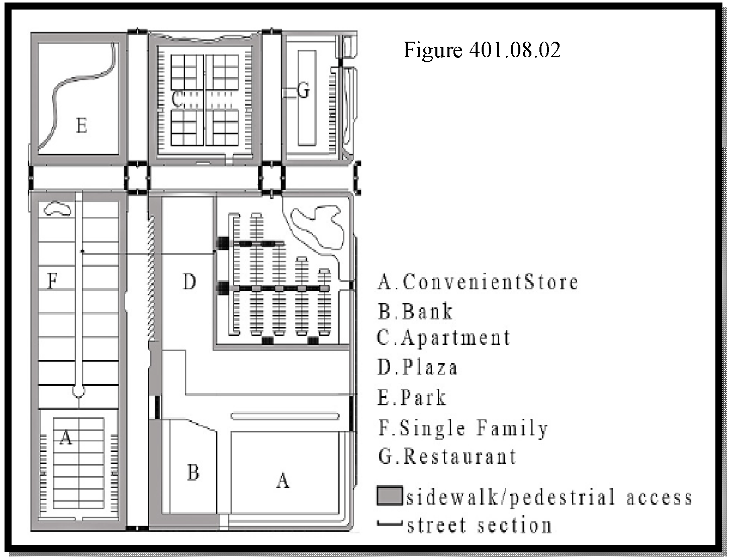
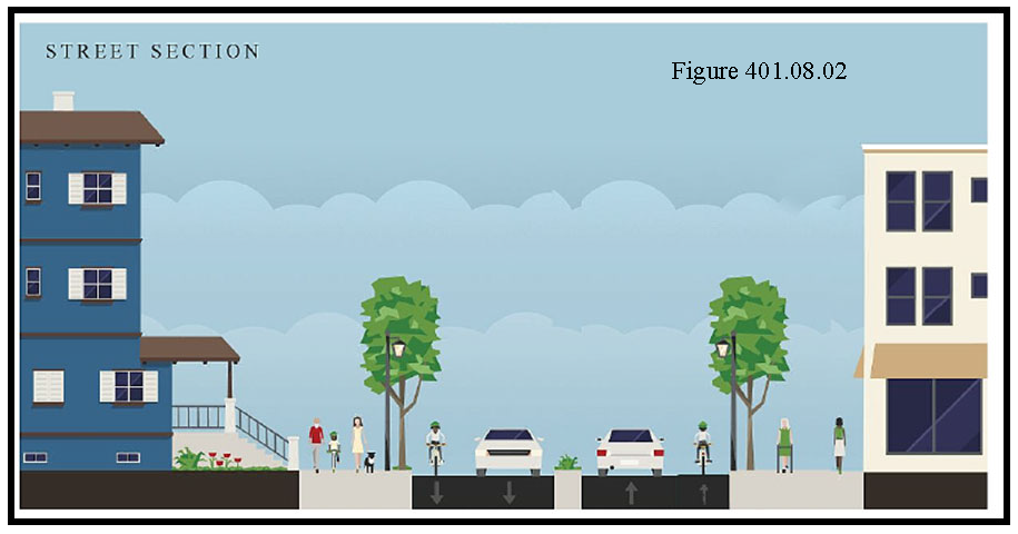
e.
All development within the Villages and VC-Core areas shall comply with the Complete Streets Manual as completed by the Polk TPO to achieve maximum density and intensity as provided in section G. and H.
f.
Bona-fide agricultural uses, Family Farms, Family Homestead, and Lots of Record are exempt from this Section.
3.
Stormwater Management Facilities - Stormwater facilities shall be constructed according to the following standards in addition to other requirements in this Code:
a.
Stormwater management facilities shall be constructed within the land use district of principal uses except for those parcels with a split land use meeting Section 102 H. of this Code.
b.
Stormwater management facilities outside the Villages and VC-Core areas may be constructed in a different land use than the principal use(s) as long as it is available for joint use by nearby uses and consistent with other requirements of this Code, if applicable. An easement granting this right shall be created and granted at the time of Level 2 Review approval.
c.
To achieve higher densities and intensities within the Villages and VC-Core areas, stormwater management facilities shall be constructed according to the requirements of the open space and design in Section J.4 and may be placed on parcels outside the developing parcel either as a private or as a shared facility.
d.
Stormwater management facilities require at a minimum a Type A Buffer as listed in Section 720. The final plantings for those facilities may vary from this requirement with approval from the Development Review Committee.
See Figure 401.08.03 below for examples of undesirable and desirable designs that are to be used as a guide.
e.
Bona-fide agricultural uses, Family Farms, Family Homestead, and Lots of Record are exempt from this Section
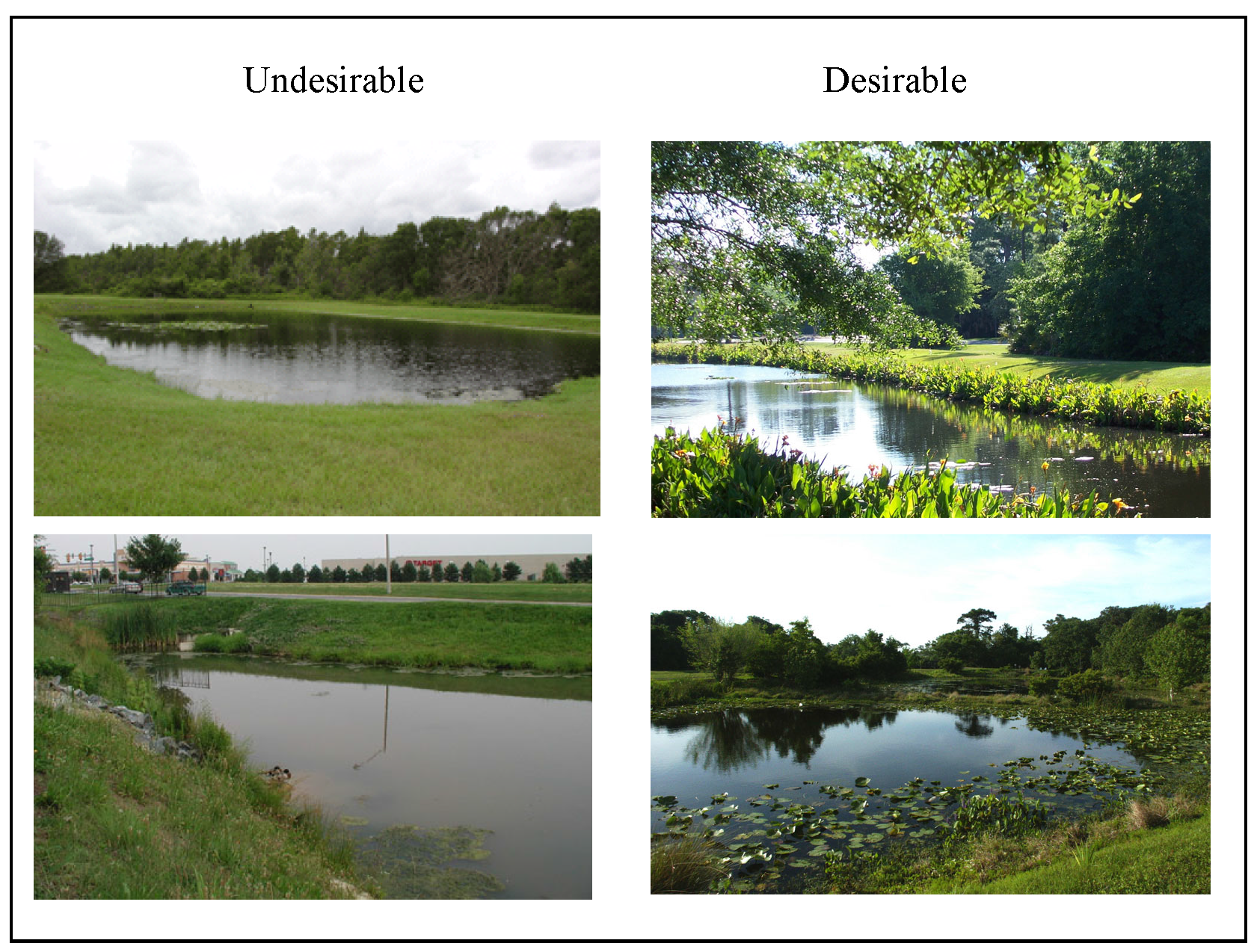
4.
Open space and design - Recreation and open space area is a requirement for many conditional uses inside and outside of Village and VC-Core areas. Recreation and open space requirements for conditional uses or where otherwise required by this Code shall be designed according to this section. The amount of recreation and open space inside and outside the Village and VC-Core areas shall be pursuant to the Tier system to achieve higher densities and intensities.
a.
Open Space - For the purpose of this SAP, open space may consist of the following:
i.
Retention ponds meeting the following design requirements;
(a)
Integrated to the existing open space/natural environment or resemble natural land/water body features;
(b)
Landscaped to enhance natural environment in accordance with the planting requirements of a Type "C" Buffer at a minimum. These landscape requirements may include plant clustering or alternative planting schemes approved by the Development Review Committee and shall be native to this part of Polk County;
(c)
Include pedestrian trail(s) paved or unpaved, benches or gazebo and fountain(s), or picnic pavilions with amenities; and
(d)
Existing vegetation can be counted towards the buffer requirements if it meets the criteria for landscaped buffering for this area.
ii.
Wildlife habitat, native plant communities including wooded areas that remain in a natural state and platted as such in perpetuity;
iii.
Upland areas or open field(s);
iv.
For all residential developments, open space areas shall be designated within separate tracts and made accessible to all of the residents of the development;
v.
All development adjacent to lands placed in a conservation easement or owned for preservation purposes shall include a 25 to 50 foot buffer (or average of 35 feet) that includes planting material native to this part of Florida; and
vi.
All development adjacent to lands with agricultural uses shall include a 25 to 50 foot buffer (or average of 35 feet) that includes fences and planting material native to this part of Florida.
b.
Passive recreation - These areas may be used to meet the Open Space requirement under the following conditions:
i.
Passive recreation such as parks or pedestrian paths shall be incorporated into the open space plan; and
ii.
The recreation areas shall be linked via greenways/trails, wetlands, floodplains, or other natural areas within and adjacent to the development.
c.
The recreation and open space areas shall be linked to any proposed internal pedestrian network within the development;
d.
Recreation areas shall be accessible to all residents within a residential development; and
e.
Bona-fide agricultural uses, Family Farms, Family Homestead, and Lots of Record are exempt from this Section.
5.
Architectural design - Development shall be encouraged to develop with an architectural design consistent with the activity center development types in the immediate surrounding area. The pictures below (Figure 401.08.04) are provided as a guide. However, architectural consistency with other buildings in the surrounding area in the Villages and VC-Core areas shall be required to obtain higher densities and intensities as provided in Table 401.08.03. The following shall be required at the time of Level 2 Review submittal:
a.
A rendering of the building to be located on the development site so that the design of all sides of the building can be reviewed for consistency with the neighboring structures in the Village or VC-Core area;
b.
A narrative on how the architectural design of the building(s) meets the surrounding architecture;
c.
The goal of this is to match strategic elements of the surrounding buildings. The examples below show different design elements of building such as roof line, eves, awnings, multiple stories, and color;
d.
The Development Review Committee shall have final design approval based on the elements described in c. above; and
e.
Bona-fide agricultural uses, Family Farms, Family Homestead, and Lots of Record are exempt from this Section.
Figure 401.08.04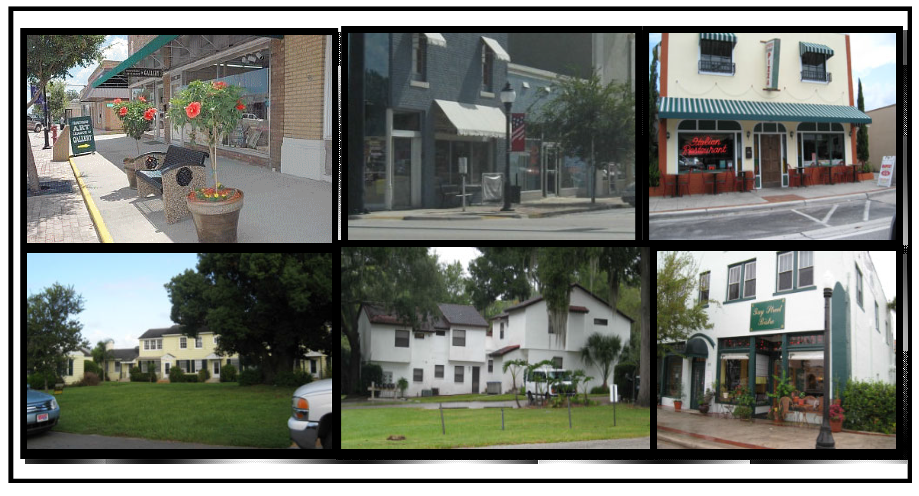
6.
Buffering (landscaping and screening) -
a.
Within the Village and VC-Core, developers shall implement The Scenic Highway planting requirements for residential and non-residential development as per Section 679 of this Code;
b.
"Firewise" planting will be required within the buffers where properties in this SAP are adjacent to existing preservation and conservation lands, as well as existing recreation and open space facilities;
c.
When immediately adjacent to agricultural (active/bona-fide) or environmentally sensitive areas within the Village and VC-Core areas, 25 feet side and rear setbacks will be required to mitigate potential adverse impacts (see Sub-section G, Tiers, and quality standards: can be used for open space/buffer/low impact stormwater facility, etc.);
d.
When immediately adjacent to agricultural (active/bona-fide) or environmentally sensitive areas outside the Village and VC-Core areas, 50' side and rear setback will be required to mitigate potential adverse impacts to agricultural or environmentally sensitive areas outside the Village and VC-Core areas (see Sub-section G, Tiers and quality standards: can be used for open space/buffer/low impact stormwater facility, etc.);
e.
Wider setbacks may be required by the County depending on the environmental/agricultural sensitivity of the area and the intensity of the development proposed adjacent to the area.
f.
No filling, excavating, or placement of permanent structures or other impervious surfaces shall be allowed within setbacks except for the installation of a sprinkler system, utility lines, or landscaping; or except as approved by the County for the construction of a road essential for access, construction of a stormwater retention or detention basis or stormwater conveyance, construction of a boardwalk or other stilted structure, grade finishing to provide a gradual slope between the setback line and the agricultural or environmentally sensitive area, or the limited use of pervious paving material.
7.
Lighting - Internal development and street lighting within the Villages and VC- Core areas shall be designed as follows:
a.
Roadway illumination of any kind, including street lighting, is prohibited except adjacent to entrance driveways for developments and public roadway intersections with SR 17 and US 27;
b.
Lighting fixtures shall be limited to 12 feet in height within 25 feet of local road rights-of-way and 16 feet in height within 200 feet of collector and arterial roads except adjacent to entrance driveways and intersections with collector and arterial roadways;
c.
All lighting shall be fully shielded with cut-off, non-glare fixtures directed only onto the subject site consistent with Figure 401.08.05 below. To minimize off site glare non-shielded fixtures without cut-offs are prohibited;
d.
Outdoor lighting shall not create offsite impacts above 1.0 lumens; and
Figure 401.08.05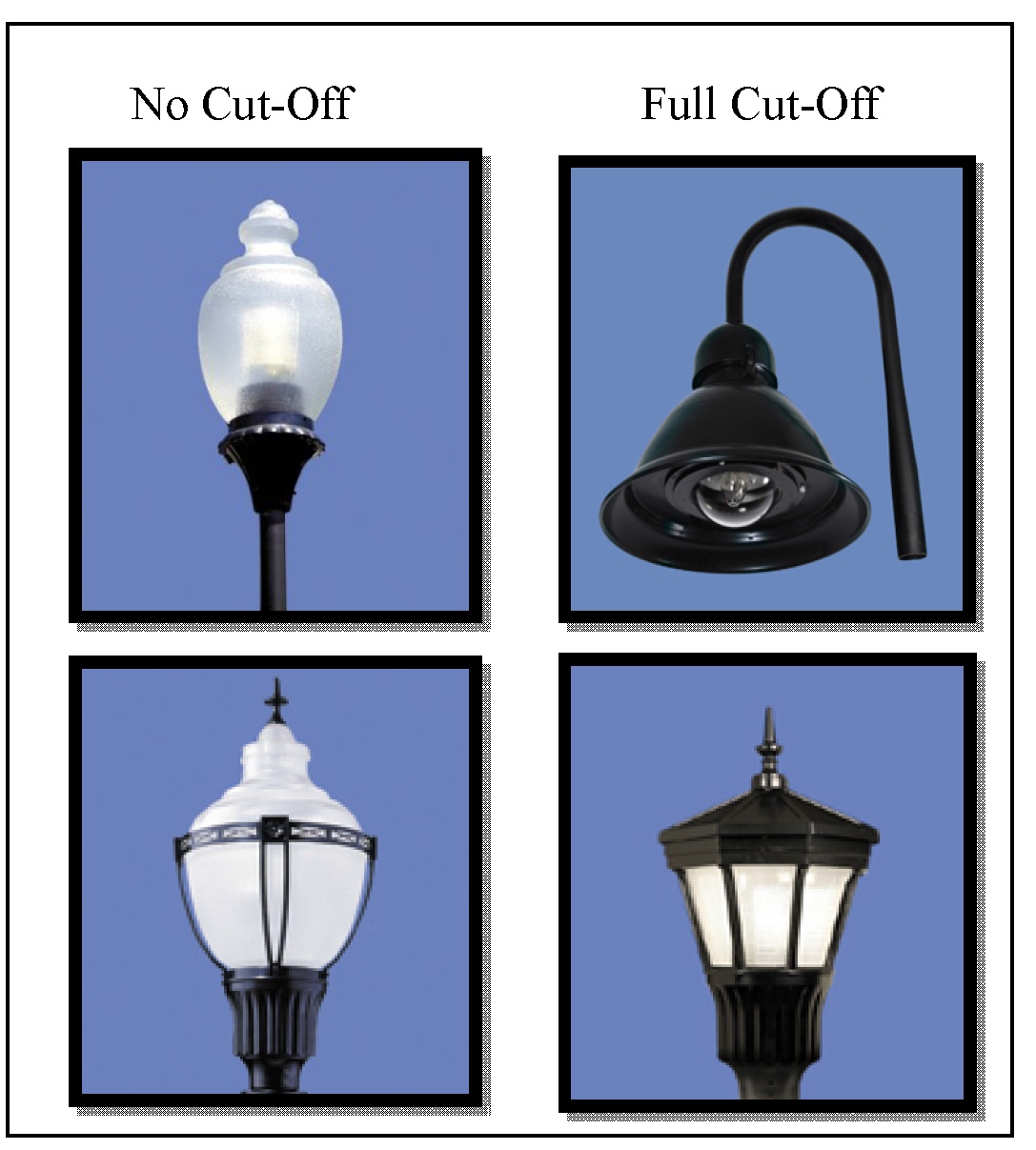
e.
Non-residential Development Lighting
i.
Electrical reflectors, spotlights, floodlights and other sources of illumination may be used to illuminate buildings, landscaping, signs, parking and loading areas on any property provided the illumination is cast downward and the fixtures focus the illumination only onto the building, landscaping, signs, parking and loading areas and prevents illumination upon adjacent property or any public right-of- way.
ii.
Lighting shall be directed away from all residentially developed or designated areas.
iii.
All outdoor lighting shall be fully shielded with cut-off, non-glare fixtures directed only onto the subject site (see Figure 401.08.05).
8.
Design, Location and Orientation of Development - Development within the Villages and VC-Cores obtaining higher densities and intensities shall place common open space and recreation areas between built areas so that areas from multiple separate development projects will be clustered as well as adjacent to agricultural and preservation/conservation areas to help implement the Polk Green.
9.
Parking Design - Parking design and number of spaces shall be consistent with Chapter 7 of this Code and shall be provided to meet the needs of the uses in an efficient manner.
a.
Developers may employ optional methods such as shared parking and pervious pavement to address parking needs within this SAP. The parking requirements of Section 708 may be reduced by approval of the Development Review Committee as part of the Level 2 Review process through shared parking agreements and for all mixed-use and interconnected developments with a supporting parking study.
b.
In the Village and Village Center Core
i.
Parking in up to 50% of the front setback will be allowed in non- residential developments with parking plans that include integrated uses and activities (such as sidewalk sitting areas), and pedestrian circulation and landscaping (compatible with the Scenic Hwy requirements) integrated to the parking. For residential development, except for side entrance garages and carports with front façade treatment no garage or carport is allowed closer to the street than the façade of the residence;
ii.
All parking lot landscaping and buffer requirements shall meet the requirements of this section in addition to the requirements of Section 720 of the LDC. Where conflicts occur, the more restrictive shall apply.
iii.
Florida native landscaping and plant materials shall be required in at least 30 percent of the required canopy trees in the parking lot landscaping;
iv.
No more than 50% of the required plantings shall be of any one sub- species;
v.
The minimum landscaping for each parking lot shall be provided within the interior of a required paved off-street parking area as follows:
(a)
Each aisle of parking spaces shall be terminated by landscaped islands which measure not less than nine feet in width, as measured from face of curb to face of curb, and not less than 18 feet in length. At least one canopy tree shall be planted in each terminal island;
(b)
Mandatory terminal islands shall be surrounded with a continuous, raised curb;
(c)
Landscaped divider medians may be used to meet interior landscape requirements. If divider medians are used, they shall form a continuous landscaped strip between abutting rows of parking spaces. The minimum width of divider median shall be a minimum six foot wide divider median, as measured from face of curb to face of curb. One under story tree shall be planted for each 30 linear feet of divider median, or fraction thereof. Trees in a divider median may be planted singly or in clusters. The maximum spacing between clusters shall be 60 feet;
(d)
A minimum six foot wide divider median, as measured from face of curb to face of curb, shall be required every fourth bay of parking as shown in Figure 401.08.06. A minimum of one understory tree shall be planted for each 30 linear feet of divider median. An alternative option, three diamond shaped islands may be substituted for the continuous six foot wide divider median, as shown in Figure 401.08.06;
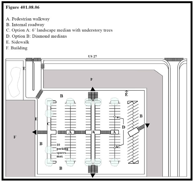
(e)
Optional interior islands and divider medians shall be protected by curbing or wheel stops; and,
(f)
Each parking bay shall have no more than ten continuous parking spaces unbroken by a landscape island that shall be the width of a parking space, as measured from face of curb to face of curb.
vi.
Landscaped areas shall be located in such a manner as to divide and break up the expanse of paving and to guide traffic flow.
vii.
A Type A buffer 15 feet in width shall be required between all frontage roads and parking lots in accordance with Section 720 of the LDC.
viii.
Required landscaping where off-street parking abuts public right-of- way: A landscaped strip of land shall be provided consistent with this section and Section 720 of the LDC with at least one drought resistant, native to the ridge, tree for each 75 lineal feet, or fraction thereof shall be planted. Trees may be planted separately or in clusters.
ix.
No landscaping shall be provided in the right-of-way unless the County or FDOT gives the owner approval to do so. In addition, a completed agreement as to who will maintain the landscaping within the right-of-way shall be submitted by the developer and the owner of the right-of-way(s) prior to Level Review 2 approval.
x.
Alternatives to the above items may be proposed through a waiver or PD in accordance with the standards in section 932 of the LDC. The above standards are not to be waived entirely but altered based on property hardships.
c.
Structured parking is not required; however, if used, structured parking shall incorporate architectural designs to the facade of the building compatible and consistent with that of the surrounding development. These buildings may include retail, personal, and professional uses in the same structure if in a Land Use sub-district that permits these uses.
10.
Transit and connectivity within the Village and VC-Core areas - Transit stops may be incorporated into the development as approved by the Polk Transit Authority Director or a designee, by including stops with benches (covered or not), signage, bike racks and other features as to create a focal point for pedestrians.
11.
Wall design - Walls incorporated into development within the Villages and VC- Cores shall not be more than 50% opaque. The pictures below (figure 401.08.07) are offered as a guide to the walls that are preferred within the Villages and VC- Core areas. Development within the Villages and VC-Core areas shall meet the requirements of the SR 17 Scenic Highway Section 679 of this Code.
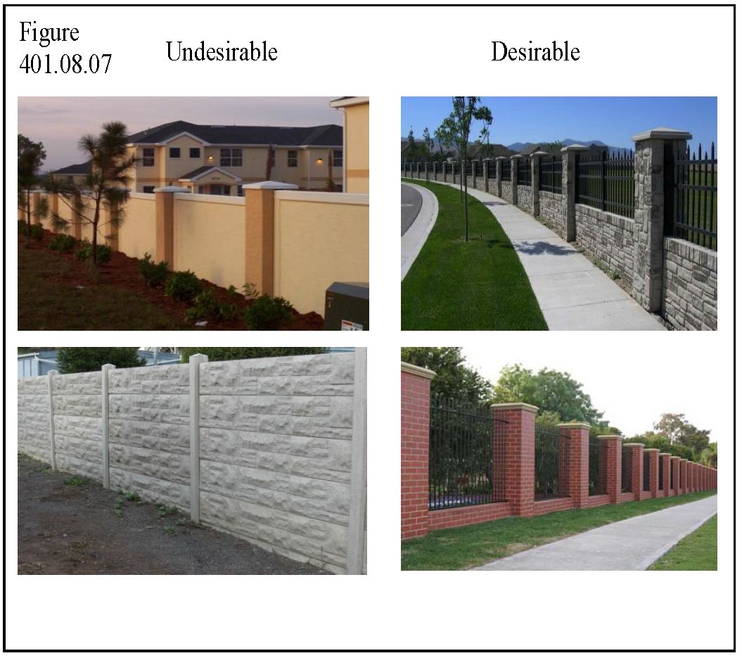
12.
Utilities - The requirement for the connection to public water and sewer per the Policies of the Polk County Comprehensive Plan are as follows:
a.
Outside Village and VC-Cores - Connection to public potable water, sanitary sewer, and reuse shall be consistent with the requirements of the applicable Development Area within Chapter 7.
b.
Inside the Village and VC-Cores - Connection to public potable water, sanitary sewer, and reuse shall be consistent with the requirements listed in Chapter 7 for the applicable Development Area. However, connection to public sanitary sewer within the Suburban Development Area (SDA) shall not require Board approval.
13.
Other Utilities - Underground utilities shall be required for all subdivisions and non-residential development within the Village and VC-Core.
14.
Controlled Burns and Land Management - There are many acres of property within this SAP that are owned or managed by the Polk County's Environmental Lands Program, the Nature Conservancy or other regional, state, or federal agencies. Controlled burns are an integral part of land management. Nothing in this SAP shall prevent these agencies from managing their property with fire or other means deemed appropriate by local, state, and federal law and industry Best Management Practices. The buffering standards listed in 401.08 J.6. are intended to assist with providing buffer of these areas from development, so that each use can effectively function.
15.
Agricultural Uses - There are many acres of property within this SAP that are used for agricultural purposes. Nothing in this SAP shall prevent the farm operators and owners from managing these agricultural properties according to local, state, and federal law and industry Best Management Practices.
16.
Agritourism - Agritourism, as defined in Chapter 10, is encouraged within this SAP and shall be implemented per Section 229 and other relevant sections of this Code.
17.
Ecotourism - Ecotourism, defined for the purposes of this SAP as utilizing those areas generally identified as conservation, preservation or open space as part of a tourism infrastructure to attract visitors to the area, will be permitted under the guidelines for passive or resource-based recreation, or those for low intensity recreational facilities. Lodging, dining and other facilities associated with this activity will be allowed in compliance with the requirements for any other tourist/commercial use. Any proposed facility, such as shelters, pavilions, interactive exhibits, lookouts, trails, etc., shall be designed with minimal impact to the natural environment. Paving for parking and other impervious surfaces should be minimized by utilizing pervious surfaces or other surface water percolating techniques; buildings and other structures, trails and lookouts should be elevated to avoid or minimize direct impacts on the surface. Directional signs to the sites should comply with the requirements of Section 760 D of this Code.
18.
Military Compatibility Zones (MCZ) - Development within this SAP located within the Avon Park Air Force Range Military Compatibility Zones shall be required to meet the standards in Section 642 of this Code.
19.
Conservation Subdivisions/Conservation Developments (Comprehensive Plan Objective 2.1252) - These are residential developments that receive higher densities in return for implementing tools and techniques that aid in the conservation of existing environmental resources in an effort to balance the need for housing while maintaining environmental balance as per Objective 2.2351 of the Comprehensive Plan. Applicants for this type of development shall meet the following requirements:
a.
Submit an application that fulfills the application requirements of a Planned Development as listed in Section 303 of this Code and graphically demonstrates consistency with this section;
b.
Shall have a minimum impact to the natural landscape and environment by the following:
i.
Limiting all paving/impervious surfaces in the development to no more than 50%;
ii.
Cluster lots;
c.
Shall provide interconnectivity throughout the development using both bike trails and walking paths;
d.
May use alternative pavement designs and rights-of-way as approved by the County Engineer;
e.
Shall install buffers throughout the property and around drainage areas utilizing native flora and fauna so as to resemble nature. Rain gardens on each lot may be provided in lieu of retention areas;
f.
Protection emphasis shall include natural environmentally sensitive areas, historical or historically significant sites, scenic overlooks/view, and active or agricultural lands; and
g.
Preliminary site plan and environmental site assessments shall be submitted to the DRC before the Level 2 review is submitted to discuss how the site is consistent with this section, Objective 2.2351 and how to implement the site walkover with community property owners.
20.
Transfer of Development Rights (TDR) - Transfer of Development Rights (TDR) will be permitted within this SAP as follows:
a.
Residential densities may be transferred from wetland or areas of special flood hazards to contiguous non-wetland/non-flood hazard areas within the same development in accordance to the requirements outlined in Chapter 6 of this Code;
b.
Residential densities of up to one unit per acre (but no higher than the land use allowable density of the sending parcel), may be transferred from areas within this SAP identified in the PolkGreen Overlay map to areas within the Village and VC-Cores as part of the process to achieve the higher densities allowed within each land use; and
c.
Transfer transaction must be processed in compliance with the requirements of Section 914 of this Code and they must be noted and identified as part of the recorded development plat, an individual plat or other reliable tracking mechanism to ensure the preservation of those parcels/acreages from which development rights have been transferred; etc.
21.
Lots in Flood Hazard area and/or Wetland - All new lots, created after the adoption of this SAP, which contain a portion of the mapped 100-year flood plain and/or wetland area(s), shall have a usable non-floodplain and/or non-wetland area which is at least as large as 75% the lot size required for the applicable land use sub- district.
22.
Outdoor Storage - Where outdoor storage is allowed as an accessory use, the following standards shall apply:
a.
All outdoor storage shall be, at a minimum, 50 feet from any residential use or residential land use district;
b.
A Type C Buffer plus a minimum six foot high opaque fence must be placed between the activity and any residentially used or designated property;
c.
All activity shall be limited to operation between the hours of 8:00 a.m. to 8:00 p.m.;
d.
All speakers shall be setback 100 feet from any residential use or residential land use district; and
e.
All speakers shall be directed away from any residential use or residential land use district.
K.
Conditional Uses: (Revised 01/22/19 - Ord. 19-006; 11/4/14 - Ord. 14-066)
In addition to those conditions listed in Section 303 of this Code, and unless otherwise stated, the following conditions apply to development throughout the SE Polk SAP:
1.
Agricultural Support, off-site
a.
Any outdoor storage of equipment or equipment repair areas shall be located on the side or rear of the property and no closer than 25 feet from property line if adjacent to a residential use or designation;
b.
Sites shall be screened with a Type B Buffer when adjacent to non- residential uses;
c.
Sites shall be screened with a Type C Buffer plus an opaque eight-foot fence when adjacent to a residential use or designation.
2.
Alcohol Package Sales: Is allowed as part of the retail cap in those land use districts where retail is allowed (BPC-1X, BPC-2X, INDX, OCX, L/RX)
3.
Animal Farm Intensive: When located adjacent to properties used or designated for residential uses, new farming infrastructure and facilities must be setback a minimum of 25 feet with a Type B Buffer and a fence along the adjacent boundary.
4.
Aquiculture: When located adjacent to properties used or designated for residential uses, ponds and other facilities must be setback a minimum of 25 feet with a Type B Buffer and an eight-foot fence.
5.
Assembly, Light (Light Assembly):
a.
No outdoor storage of any materials shall be permitted;
b.
There shall be no external activity beyond loading and unloading of materials to and from an enclosed structure; and
c.
A minimum 25 feet setback shall be provided between a residential use and any structure where loading and unloading of commercial vehicle(s) occurs.
6.
Bars, Lounges, Taverns:
a.
Shall not exceed 3,500 sq ft in the Village and VC-Core Overlay; and
b.
Use is allowed as part of the retail cap in the BPC-1X, BPC-2X, INDX, OCX, L/RX.
7.
Bed and Breakfast: Bed and breakfast establishments within the Villages and VC- Cores shall comply with applicable standards and when adjacent to a residential district on one or more sides, a Type A Buffer shall be required where the bed and breakfast abuts the residential districts.
8.
Carwash Full Service: Carwash full service facilities are allowed as part of the retail cap in those land use districts where retail is allowed (BPC-1X, BPC-2X, INDX, OCX, L/RX).
9.
Carwash Incidental: Carwash incidental facilities are allowed as part of the retail cap in those land use districts where retail is allowed (BPC-1X, BPC-2X, INDX, OCX, L/RX).
10.
Carwash Self-Service: Carwash self-service facilities are allowed with the following conditions:
a.
Within the Village and VC-Core, self-service carwashes shall be limited to three bays;
b.
Hours of operations shall be restricted to 7:00 am to 10 pm; and
c.
The service shall be allowed as part of the retail cap in those land use districts where retail is allowed (BPC-1X, BPC-2X, INDX, OCX, L/RX).
11.
Community Centers: When adjacent to properties used or designated for residential, the use must have a Type B Buffer and a six-foot high opaque fence between the properties from the line of the front façade of the building to the rear of the property.
12.
Convenience Stores:
a.
Convenience Stores allowed within the Village and VC-Core shall comply with the following conditions:
i.
Must be located on parcels no larger than one (1) acre in size;
ii.
Have a maximum gross leasable area (GLA) of 3,000 square feet;
iii.
Have a maximum of six pumps; and
iv.
For parcels directly fronting US 27 and at signalized intersections of a collector roadway, a Level 3 Review shall be required to consider any deviation from the above listed criteria
v.
For Parcels directly fronting US 27 and at signalized intersections of a collector roadway, a Level 3 review shall be required to consider any deviation from the above listed criteria.
b.
Convenience Stores allowed within the Village and VC-Core shall conform to the following development criteria:
i.
Points of ingress and egress for Village and VC-Core shall be designed to minimize traffic hazards and decreases in highway capacity; provide adequate parking with safe internal traffic circulation; and provide safe bicycle and pedestrian access.
ii.
Buffering shall be provided where the effects of lighting, noise, odors, and other such factors would adversely affect adjacent land uses. Parking lots, loading areas, dumpsters, utilities and air- conditioning units, signage, etc., are examples of facilities that may require special buffering provisions.
iii.
All facilities shall be at a minimum of 15 feet from any side lot line, and a minimum of ten feet from the rear lot line.
iv.
The minimum distance from a convenience store facility to any residentially designated property shall be 50 feet measured at the narrowest point between the property line of the residential property.
v.
Convenience store facilities located adjacent to residentially designated properties shall be required to provide a landscaped buffer equal to a Type C buffer (see Section 720) between any on site structures, and adjacent residential areas.
vi.
All facilities shall have at a minimum 50 feet of road frontage and be located at a minimum on an Urban collector or Rural Major collector road or better unless contained within a planned development with access to a major collector road or better.
vii.
All on site garbage collection facilities shall be screened from any adjacent property.
13.
Convenience Store Isolated: shall comply with the following:
a.
Does not have to meet the population support required in Section 303 of this Code; and
b.
It must be located on an arterial or on a major collector road within a ½ a mile of an intersection with an arterial road.
14.
Dairies: New dairies within Village and VC-Core shall place caretaker's homes and the office facilities towards the front of the property and they must be compatible in character and size to the surrounding development.
15.
Duplex and Single-Family Attached: Development of residential projects with these types of units must comply with Section 303 conditions for Multi-Family Development sub-section 5., Multi-family development within low density residential districts.
16.
Emergency Shelter, Medium (7 to 14 Residents): If this use is adjacent to residential uses or designations, a Type A Buffer, consistent with the requirements of Section 720 of this Code shall be required.
17.
Emergency Shelter, Large (15 or more Residents): If this use is adjacent to residential uses or designations, a Type A Buffer, consistent with the requirements of Section 720 of this Code shall be required.
18.
Farming General: When located next to properties used or designated for residential uses, new farming infrastructure and facilities must be setback a minimum of 25 feet with a Type B Buffer and a fence.
19.
Farmworker Housing Apartment Style: All structures and facilities on-site shall be compatible in scale with the surrounding residential uses. When located within 250 feet of a single-family detached housing community, the maximum height shall be two stories and the maximum number of units per building shall not exceed eight units. In no case shall the number of units exceed 16 units per building if within the Village or VC-Core.
20.
Financial Institutions:
a.
Financial institutions shall be limited to the retail or office cap in those districts where there is a cap; and
b.
The total developed area shall be calculated based on the inclusion of all existing uses in the subject land use developable area and those with approved and valid site plans, construction plans and plats.
21.
Financial Institutions Drive-thru: The following standards shall apply:
a.
All drive-thru facilities, including windows and stacking lanes adjacent to property with a residential use shall be screened with a Type C Buffer; and
b.
The primary frontage and access shall be on a collector or arterial road unless contained within a master planned development with access to a collector or arterial road.
22.
Funeral Homes & Related Facilities: When adjacent to residential, a crematorium shall be setback at least 100 feet from the property line; additionally, an opaque fence at least six feet in height shall be installed as part of the landscape buffer along the boundary with the residential use or designation.
23.
Gas Stations: Gas stations shall meet the conditions in Section 401.08 K.12.a as outlined above and Section 303, with the exception to subsections 4 & 5, of this Code for Convenience Store, Village;
24.
Heavy Machinery Equipment Sales and Service: The following standards shall apply within the Village and VC-Core,
a.
No outdoor storage of any materials other than the equipment for sale shall be permitted;
b.
There shall be no external activity beyond loading and unloading of materials to and from an enclosed structure; and
c.
A Type C Buffer and a minimum 25 feet setback shall be provided between a residential use, local road, and any structure requiring loading and unloading of commercial vehicle(s).
d.
For Heavy Machinery Equipment Sales and Service uses in the Commercial Enclave-X (CEX) land use district, the following additional conditions shall apply:
i.
Shall have direct frontage along US 27;
ii.
All ingress/egress shall be from US 27;
iii.
Shall be limited to no more than five acres in size; and
iv.
All hours of operation shall be limited to 6:00 a.m. to 7:00 p.m.
25.
Hotel/Motel: Hotel/Motel uses within the BPCX districts shall be limited to the cap for retail uses listed in the Comprehensive Plan for this SAP;
26.
Kennel Boarding: Boarding areas shall be within an enclosed building and provisions shall be made to attenuate the noise, smell or other impacts. Use of exterior run for exercise purposes is permissible during daytime hours;
27.
Lodges and Retreats, Private: When adjacent to residential use or designation a Type B Buffer shall be required along the boundary adjacent to the residential.
28.
Manufacturing General: The following standards shall apply within the Village and VC-Core:
a.
Outdoor storage shall be subordinate and ancillary to the manufacturing activity;
b.
All outdoor storage must be screened from off-site view;
c.
No outdoor activity other than loading and unloading of materials shall be located within 100 feet of any residentially used or designated property; and
d.
No activity shall be conducted that produces noise, odors, dust, fumes, fire hazard, or other nuisance beyond the property boundary adjacent to residentially used or designated property.
29.
Manufacturing light; The following standards shall apply within the Village and VC-Core:
a.
No outdoor storage of any materials shall be permitted forward of the rear building line;
b.
Outdoor storage shall be subordinate and ancillary to the manufacturing activity;
c.
Outdoor storage shall be setback 100-feet from the property boundary of any residentially used or designated property.
d.
Additional to the required buffer, a 50-foot set-back and an opaque eight- foot fence shall be provided between a residential use and any structure requiring loading and unloading of commercial vehicles.
30.
Motor Freight Terminals: The following standards shall apply in Village and VC-Core
a.
There shall be no loading or unloading forward of the front building line or within 50 feet of adjacent properties with a residential use or residential designation;
b.
A Type C Buffer 25 feet in width and a minimum eight foot high opaque fence shall be required adjacent to or adjoining a residential use or district or a school;
c.
A Type C Buffer 10 feet in width shall be required adjacent to or adjoining a non-residential use or district;
d.
No vehicle parking, gasoline sales, fuel storage or truck servicing activities are allowed within 65 feet of the property line that abuts any residential district or a school regardless if the use or district is across a roadway; and
e.
All outdoor storage shall be screened from offsite view and shall be setback 50 feet from any adjacent property with a residential structure, residential land use designation or school.
31.
Multi-Family Three and Four Attached Units - Development of residential projects with these types of units must comply with Chapter 3 conditions for Multi-Family Development subsection 5. Multi-family development within residential low density districts.
32.
Night Clubs and Dance Halls: The following conditions will apply for development within the Village and VC-Core:
a.
Structures must be designed to a scale and appearance compatible with the surrounding uses and structures; and
b.
In no case shall the establishment exceed 2,000 square feet of GLA, not including kitchen or storage facilities.
33.
Nurseries, Retail - The following standards shall apply:
a.
The loading and unloading area shall be located at least 50 feet from all property lines abutting residential districts.
b.
A Type B Buffer as per Section 720 of this Code and an opaque six foot high fence shall be installed along the side(s) of the property abutting residential uses or land use districts. A fence and/or landscape buffer in accordance with the requirements of Section 720, of the Land Development Code, shall be provided in all other cases.
c.
Except for security purposes, no outdoor lighting shall be permitted to illuminate items sold at the nursery in the A/RRX and RSX districts; lighting in other districts shall not create off-site impacts above 1.0 lumens.
d.
The retail portion of a nursery shall meet the following requirements:
i.
Retail areas shall be limited to 25% of the nursery when in the A/RRX and RSX districts,
ii.
Structure(s) used for retail activity shall not exceed 1,200 square feet.;
iii.
The retail area and loading area shall be designated on a site plan;
iv.
The retail area shall be at least 50 feet from all property lines, except from the right-of-way or front yard setback, consistent with Table 2.2, of this Code.
e.
An overall site plan shall be submitted by the nursery owner to the Land Development Division, as part of a Level 2 Review, to determine the consistency with the SAP.
34.
Office Park: The following conditions shall apply:
a.
All offices in the office park shall have vehicular and pedestrian interconnectivity;
b.
An internal sidewalk shall be provided between the offices and parking lots to meet the pedestrian needs of all offices within the office park;
c.
The office park shall provide a minimum of 1,000 square feet of landscaped area adjacent to each building/structure with at least two benches;
d.
At a minimum, a Type A Buffer shall be required at the perimeter of the office park; and
e.
Offices shall not exceed 15% of the total developable areas of the BPCX or INDX district. The total developed areas shall be calculated based on the inclusion of all existing uses in the subject land use district and those with approved and valid site plans, construction plans and plats. The applicant shall demonstrate that the development does not exceed this 15% maximum.
35.
Residentially Based Mixed Use Developments (RBMD) Design Standards:
a.
The design configuration and mix of uses shall emphasize a pedestrian oriented environment;
b.
The street pattern shall resemble a grid and limit the use of cul-de-sac streets;
c.
Development shall comply with the provisions within this SAP regarding Recreation Space, and Open Space in lieu of the Recreation and Open Space requirement for RBMD in Section 303 of this Code;
d.
Residential and non-residential uses, within the development, shall be interconnected to enable efficient flow of pedestrian and vehicular traffic and shall not be significantly divided by any barrier such as fences or hedges;
e.
The non-residential uses for the development, such as community facilities (except club houses), personal services, laundromat, dry cleaners, etc., shall not exceed 12,000 square feet or 20% of the area of the development, whichever is more restrictive;
f.
The residential uses for a development shall be developed in accordance with Table 401.08.03; and
g.
The non-residential uses for the RBMD are not restricted on location; however, the non-residential uses must provide a buffer in accordance with Section 720 of this Code when abutting residential uses within or outside of the RBMD.
36.
Research and Development: Research and Development uses within the Institutional district shall be compatible with and supporting to the surrounding uses, i.e., the use has to be related or work in association with the surrounding uses within INST;
37.
Retail, (all size categories): The following conditions shall apply:
a.
Within the Village and VC-Core, retail establishments shall be compatible in scale and architectural appearance to the surrounding structures.
b.
Retail uses are limited to 15% of the total developable area OCX, BPCX and INDX; and
c.
Total area includes the group of contiguous parcels designated a land use that is not bisected by a collector or arterial roads or any physical natural barriers.
38.
Retail, Home Sales Offsite: The following standards shall apply:
a.
Any display of homes shall be limited to an outdoor display area of up to 50% of the total developable square footage of the subject site;
b.
Any site adjacent to a residential use shall provide a Type C Buffer (see Section 720); and any on-site repairs shall be screened from off-site view.
39.
Retail, Outdoor Sales/Display: The following standards shall apply:
a.
All outdoor storage shall be, at a minimum, 50 feet from any side lot line, and a minimum of 25 feet from the rear lot line;
b.
Retail establishments with outdoor storage shall be required to provide a landscaped buffer, at a minimum, equal to a Type C Buffer (see Section 720 of this LDC) where the boundary abuts a residential use or residential land use district, and Type A Buffer (see Section 720 of this LDC) where adjacent to a non-residential use. Development shall adhere to buffering standards in section J. of this SAP; and
c.
All activity shall be limited to operation from 8:00 a.m. to 9:00 p.m.
40.
Short Term Rentals: Single-family detached units shall be a prohibited use for Short Term Rental units in the TCCX and L/RX within the Village and VC-Core; and
41.
Self-Storage Facilities: The following conditions shall apply:
a.
These facilities shall not be more than 10% of the total area of the NACX, BPCX and INDX district;
b.
In all land use districts, the individual storage spaces shall not be accessed directly from any of the building facades;
c.
All users shall access the individual rented storage space through a common access;
d.
Where the facility fronts the collector road, mixed use structures (e.g., office, personal service, commercial with the self-storage above or behind), are required; and
e.
Outdoor storage will only be allowed within the courtyard of the facilities, where the surrounding structure is enclosed or semi-enclosed usable space (not just a wall). The courtyard area cannot be larger than ½ the area of the footprint of the building surrounding it. Each facade of the facility shall have an office or similar appearance.
42.
Special Residential: The following conditions shall apply:
a.
If special residential structures are placed within 100 feet of the perimeter of the 'district, the height of the building cannot be more than twice the height of the building in the adjoining district/parcel unless it is approved as part of a master Planned Development;
b.
Parking areas for special residential uses shall not be immediately adjacent to residential Land Use districts; and
c.
Light poles, used for special residential uses, shall not be adjacent to existing residential or property designated with a residential Future Land Use district and lighting shall be directed toward the interior of the development. A lighting plan that includes the fixture type, location, intensity, and photometric calculations shall be submitted for development review with any special residential project.
43.
Time Shares: The following conditions shall apply:
a.
A Type C Buffer shall be required where a time share development abuts a residential district.
b.
A Type B Buffer shall be required where a time share development abuts a non-residential district or use.
c.
All time share development shall connect to centralized water and wastewater services.
44.
Transit Facilities: All outdoor storage shall be screened from offsite view and shall be setback 50 feet from any property with a residential structure or residential land use designation.
45.
Truck Stop: The following conditions shall apply:
a.
A Type C Buffer 25 feet in width shall be required where the truck stop abuts a residential district or a school.
b.
A Type B Buffer shall be required where a truck stop abuts a non-residential district or use.
c.
No truck parking, gasoline sales, fuel storage, or truck servicing activities are allowed within 65 feet of the property line that abuts any residential district or a school.
46.
Veterinary Services: The following conditions shall apply:
a.
Boarding of animals at a veterinary office shall be considered accessory provided the boarding area is within an enclosed building and provisions are made to attenuate the noise source;
b.
Use of the exterior for exercise purposes, placed at least 25 feet from any property line, is permissible during daytime hours.
47.
Warehouse, Wholesale Enclosed and/or distribution facilities: The following conditions shall apply:
a.
There shall be no loading or unloading forward of the front building line, or adjacent to residentially developed property, or to property with a residential Land Use designation;
b.
All loading and unloading areas shall be at least 50 feet from all property lines abutting residential uses;
c.
All principal structures and those accessory structures related to truck parking or loading and unloading activities shall be at least 50 feet from all side and rear property lines;
d.
Accessory structures, not related to truck parking or loading and unloading activities shall be at least 20 feet from all side and rear property lines;
e.
The maximum height of any on-site light sources shall be 40 feet, if placed at least 30 feet from the property line and 24 feet if less. Illumination shall be directional and any spill onto adjacent properties shall not exceed 1.0 lumens;
f.
The minimum setback of the light source from the residential property line shall be a horizontal distance of 20 feet, except when the light source is adjoining a right-of-way. If the on-site light source adjoins a right-of-way, the lighting may be placed within the landscape buffer 10 feet in width;
g.
When adjacent to a residential Future Land Use designation or residential dwellings, all sides of the building(s) shall be designed to achieve an office front appearance or otherwise include design components to break the wall plane (change in plane or height, change in texture or patterns, include doors, windows or articulated base, etc.); this provision shall not apply when over at least 50% of that building plane contains overhead doors or loading docks/bays for trucks;
h.
For structures exceeding 50 feet in height, setbacks from parcels designated or developed as residential shall be increased by one-half of one foot for each one foot of height over 50 feet;
i.
If any of the adjacent parcels are developed residentially then external operations such as receiving deliveries, docking, loading or unloading of trucks, shall be limited to the hours between 6 a.m. to 8 p.m.; and
j.
In the BPCX and INDX Land Use designations, retail uses shall not exceed 15% of the contiguous district.
(Ord. No. 19-057, § 1, 9-17-2019; Ord. No. 19-072, § 1, 12-3-2019; Ord. No. 2021-038, § 3, 7-6-2021; Ord. No. 22-068, §§ 2, 3, 9-20-2022; Ord. No. 2022-080, § 3, 12-6-2022; Ord. No. 2025-069, § 2, 12-2-2025)
Section 402 - Development of Regional Impact and Pre-Development of Regional Impact, and Utility Enclave Areas (Revised 4/8/09 - Ord. 09-012)
This Section describes the land use densities and intensities for all mixed use Developments of Regional Impact (DRI), Pre-DRIs without land use designations, and Utility Enclave Areas as mapped in the Future Land Use Map Series. The numbers provided are subject to revisions based on amendments to the Development Orders for DRIs and the Binding Letters of Interpretation for Pre-DRIs. The Utility Enclave Areas possess special uses and standards pertinent to the level of urban services provided with them.
A.
Purpose and Intent
This PRE-DRI and DRI SAP Section includes a brief summary of each the County's two PRE-DRI projects—Poinciana New Township and Indian Lake Estates—and all non-phosphate DRIs. This summary contains a description of the approved land uses, along with the number of dwelling units and any other applicable information, and shall be the maximum densities and intensities allowed within the subject DRI. More detailed information on these projects is available through the Planning Division, or with the Florida Department of Economic Opportunities (DEO), Division of Resource Planning and Management. All DRIs except Poinciana, Indian Lake Estates, and Grenelefe have approved Development Orders on file with the Polk County Planning Division. The Development Order includes a Map of where the uses listed in this Section will be permitted.
Any proposed use that will render a legal use nonconforming shall require a Level 3 Review.
B.
Poinciana (PRE-DRI #1)
The Poinciana development contains approximately 47,000 acres located in Polk and Osceola counties. The project is a multi-use development proposed to contain single-family, multi-family, commercial, industrial, institutional, and open space/recreation uses within eight villages, nine estate areas, and six office/industrial parks. Located in Polk County are Villages 3, 4, 6, 7, and 8. The Poinciana development received approval by Polk County in 1971 as a Planned Unit Development (PUD 71-10). In 1983, Poinciana received vested rights status under Section 830.06 and 120.57, F.S., which vested this project from the Development of Regional Impact (DRI) review process.
The approved master development plan for Poinciana and subsequent modifications to various portions of this development are on file in the offices of the Polk County Development Services. Approved land uses are also detailed in the Poinciana Binding Letter of Interpretation of Vested Rights Status, date May 17, 1983, and subsequent Binding Letters of Modification to a Development of Regional Impact with Vested Rights, issued by and on file with the State Department of Economic Opportunity (DEO). Additional copies are also available through the Polk County Land Development Division. In 2018, the Florida legislature modified Section 380.06 that local governments may modify the Binding Letters of Interpretation of Vested Rights (BLIVR)s instead of DEO.
1.
Poinciana boundaries and included areas. Since the PUD was established, the boundaries have changed several times because properties have been added and removed from the original PUD. There are two ways to establish if a property lies within the boundaries of the Poinciana pre-DRI:
a.
A Binding Letter of Interpretation or Modification (BLIM) from the Florida Department of Economic Opportunity (DEO) can verify that lot is within the boundaries of the DRI; or
b.
If the property lies within the boundaries of a platted village within PUD 71-10;
2.
If a property is not within the DRI or PUD, its land use is Agricultural/Residential Rural (A/RR). If it cannot be accurately determined by the Future Land Use Map that a piece of property is within the Poinciana Development, the master site plan, PUD maps, recorded plats and DEO BLI, or BLM will be used to make the determination; likewise if the property owner can demonstrate that a piece of property is not part of the Poinciana development, its land use will be Agricultural/Residential Rural (A/RR).
3.
Once it is established that the property is or is not within the DRI boundaries, a Future Land Use Map amendment may be required to change the land use to PRE- DRI#1 or A/RR whichever is deemed appropriate.
Implementation and Modifications to the BLIVR
1.
Poinciana Master Plan - The Poinciana Master Plan serves as the Planned Development (PD) binding site plan and the basis to implement the BLIVR. The BLIVR does not include development standards such setbacks, building locations, parking and retention areas, Floor Area Ratio (FAR) and Impervious Surface Ratio (ISR). Therefore, as development has occurred, the approved PD 71-10 has been modified or new PDs created to approve binding site plans consistent with the BLIVR or Binding Letters of Modifications to Vested Rights (BLIM). Not all parcels within Poinciana have binding site plans through a PD. Development in Poinciana will be permitted consistent with the BLIVRs or BLIMs and a PD approval. Any proposed development inconsistent with the BLIVR or BLIM may only be permitted with the approval of a land use change through a Comprehensive Plan Amendment, but development standards may be amended through a PD modification. PD modifications shall follow the same requirements as found in the appropriate sections of the LDC.
2.
Future Roadways - The Poinciana Master Plan includes current roads and proposed roads. The final location of the roadways may be adjusted based on appropriate location standards within the Comprehensive Plan and Land Development Code without the need for a PD amendment. In addition, Activity Center establishments and other land use changes may be considered on proposed roadways; however, prior to development the roadways shall be constructed and connected to other development so that the future roadway is meeting the definition of a collector road.
C.
Indian Lake Estates (PRE-DRI #2)
The Indian Lake Estates development comprises more than 5,000 acres and of the zoning designation of Pre-Existing Planned Unit Development (P.E. PUD). There is no approved land use map for Indian Lake Estates. Indian Lake Estates is not a vested development from the DRI statute like Poinciana. This development is a platted subdivision, recorded in the official public records of Polk County, Florida as follows:
Except for certain lots in Units 10 and 11, the permitted use of all lots within this development is single-family residential. The following lots in Unit 10 are designated as commercial:
The following lots in Unit 11 are permitted for single-family or duplex residential structures:
D.
Ridgewood Lakes (DRI #1)(09/15/15 - Ord. 15-059)
Ridgewood Lakes is a mixed use development consisting primarily of single and multi-family dwelling units with golf courses and clubhouse amenities. Also approved is a nominal amount of neighborhood commercial.
E.
Oak Hills Estates (DRI #2)
This is a mixed-use DRI, consisting of residential, commercial, and recreational open space on 2,215 acres southeast of Loughman. Development will occur in three five year phases. The breakdown of uses is as follows:
F.
Grenelefe Utility Enclave Area (UEA) (Revised 4/8/09 - Ord. 09-012)
The Grenelefe Development of Regional Impact (Grenelefe DRI) is a mixed-use DRI, which was originally oriented towards retirees, tourists, and conventions, but has transitioned to a more permanent residential area. Encompassing 971 acres, the original Grenelefe DRI has reached built-out status. An "Essentially Built-Out Agreement" among the land owner, developer, their successors and assigns, Polk County, and the Department of Community Affairs (now called Florida Department of Commerce) has been approved stating that the DRI has met all of its obligations.
The lands within the Grenelefe DRI, together with an approximate 278-acre tract contiguous to the southeast border of the Grenelefe DRI (the additional property), have been incorporated into a Utility Enclave Area (UEA) Development Area category within the Polk County Comprehensive Plan called the "Grenelefe Utility Enclave Area." Any new development other than on vested and platted lots shall be limited to 1,700 single family units, 246 multifamily units as limited by this section 402, F, and 60,0000 square feet of non-residential development excluding golf course and other recreation amenities. The areas designated TCCX, remaining after the adoption of LDCPAL-2024-6, are exclusive of the 60,000 square feet or residential limitations listed in this paragraph. The remaining TCCX areas shall develop in accordance with the standards in Table 4.25, Table 4.26. and other requirements of the Land Development Code and this section.
1.
Development Standards
a.
Uses and Standards - Listed below are the table of allowable uses and standards within the Grenelefe UEA. Any further development or redevelopment within the additional property of the Grenelefe UEA shall be processed in accordance with the development standards and requirements contained in Tables 4.25, 4.26, and 4.27 and other development standards contained in this section and reviewed according to the County's Land Development Code. Residential densities and non-residential intensities within the Grenelefe UEA shall be in accordance with Section 2.130-E of the Polk County Comprehensive Plan and the Future Land Use Map Series. The Grenelefe UEA maximum residential densities shall not be subject to Section 303, Table 3.3 Locational Eligibility Score of the Polk County Land Development Code.
Uses listed as conditional may be established only after compliance with the specific conditions and procedures in this Chapter and outlined in Chapter 3, Conditional Uses, and all applicable codes of Polk County and other governmental agencies. See Section 205, E for descriptions of P, C1, C2, C3 and C4.
b.
Village Areas Development Standards
The Following Standards apply to all new development displayed in the Villages in Figure 4.4. A Planned Development will be required if any density, lot width and unit type are inconsistent with Table 4.27 below. Table 4.27 is meant to limit the density, lot width, unit type and minimum lot size for purposes of compatibility rather than specific unit counts for each village. This will allow some flexibility of the 1,275 single family units and 246 multifamily units to shift between village without future text amendments.
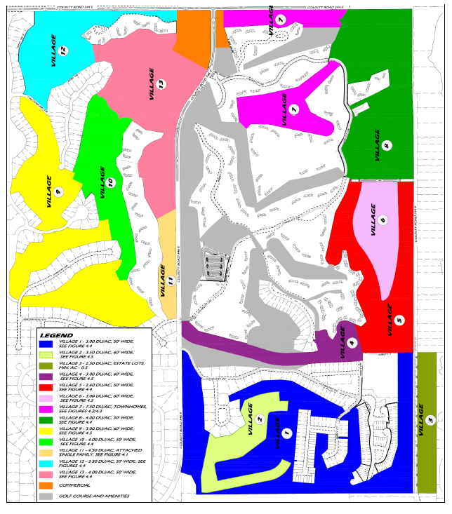
2.
Conditional Development Standards
a.
Short Term Rental Ownership
In recognition of the fact that the existing residential units within the Grenelefe UEA have been allowed short term rental status to date, all the units existing of the approval date of this paragraph under the "Ownership" section, January 7, 2025 shall continue to be allowed use as a short-term rental unit status.
b.
Multifamily - Multifamily shall be limited to town homes and single family attached.
c.
Transportation Study - Section 703 of the LDC provides the concurrency review process to ensure adequate public facilities. Appendix C of the LDC identifies the purpose of a traffic impact study to identify the potential impacts of new development on the Polk County transportation system and to provide information which will allow a concurrency determination to be made on each impacted segment. It is anticipated that not all the developable land will be submitted with the first Level 2 Review which means some Level 2 Reviews will require a Major Traffic Study, some a Minor Traffic Study and some Level 2 Review requests will be too small for any traffic study per the requirements of Appendix C of the LDC.
Prior to the first Level 2 Review approval, a Major Traffic study will be prepared and performed in accordance with a methodology to be developed in conjunction with Polk County and the Polk Transportation Planning Organization (TPO) to analyze all future development and identified improvements on impacted links. Subsequent Major Traffic Studies shall incorporate previous development as required per Appendix C of the LDC.
Consistent with Appendix E, e. Minor Traffic Studies, for those Level 2 Reviews meeting the threshold for a Minor Traffic study, the study shall include the standard form for a Minor Traffic Study and an evaluation of the first directly accessed segment and additional segments where the original Major Traffic Study indicated all of the future development displayed in Figure 4.4 as being significant. Significancy means that project traffic is five percent (5 %) or more of the capacity of the impacted links. Per Appendix E., e. 5., the Polk TPO can add segments when it would be in the best interest of Polk County to do so to maintain the adopted Level-of-Service standards. The additional evaluation is needed to ensure the proper planning and scheduling of any needed improvements that cannot be constructed by any one developer meaning the County will bear the responsibility. The methodology for the additional analysis to be part of each subsequent Minor Traffic Study shall be reviewed for a final approval by Polk County and the Polk TPO. The developer is eligible to implement transportation improvements negotiated from a Development Agreement or proportionate share agreement as permitted by the Comprehensive Plan and Land Development Code.
d.
Buffers and recreation and open space - The following shall apply:
i.
Existing trees in the Village, Commercial and Golf Course/amenity area shall be preserved to the greatest extent possible to maintain the mature trees.
ii.
Open space shall be required per section 750 of the Land Development Code.
e.
Private Utilities Site - Improvements to the utilities requested on a separate parcel from that existing in 2024 shall require a review consistent with Table 4.25.
f.
Open Space and Recreation Area Requirements
i.
Recreation Land dedicated within the development shall meet the Open Space and Recreation requirements which shall require a minimum 500 sq. ft. of park-and- recreation space per unit. In no case shall any individual recreation area be less than 10,000 square feet in area.
ii.
An Open Space Plan shall be submitted as part of the application for each Level 2 Development approval. The plan shall designate the boundaries, the size, and the proposed use of all Open Space for each plan and the overall cumulative area provided. The plan shall specify whether the Open Space areas will be dedicated or preserved and by what mechanism. Open Space shall not consist of setbacks, landscaped parking i lands, tracts for lift stations, wetlands, stormwater management facilities, rights-of-way, parking lots, or landscaping buffers unless noted below:
1.
Landscaping buffers meeting or exceeding 25 feet in width and planted with Type "C" landscaping which provide a transition from neighboring developments may count towards Open Space requirements.
2.
Stormwater facilities may be used to meet Open Space requirements only if all facilities onsite are curvilinear in design and meet the canopy and understory tree planting requirements of a Type "C" Buffer. This landscaping may be clustered and shall be landscaped with species native to the area.
3.
To meet recreation requirements, stormwater facilities shall meet the Open Space standards above and be utilized for active or passive recreation. Pedestrian connectivity to these features is required.
4.
Where Type II-IV Amenities abut residential lots, Type "C" landscape buffering shall be provided to separate the residential property from the park.
5.
Wetland buffers may be counted towards Open Space if a 25-foot setback is maintained throughout the entire buffer.
h.
Parking Standards
i.
Parking requirements for each unit, recreational uses, and non-residential development shall be required per Chapter 7 of the LDC.
ii.
In addition, a minimum of two exterior spaces per unit shall be required of all single family attached and detached, duplex, and townhome developments whether lots are platted or not platted.
iii.
Additional parking is required for developments with upland densities above three dwelling units per acre or lot widths less than 65 feet in width. This parking can be provided in the development through evenly distributed clustered parking lots or parallel parking on private roads or drive aisles. Additional parking shall be provided in accordance with Table 3.6 located in Chapter 3 of the Land Development Code.
G.
Imperial Lakes (DRI #4)
Imperial Lakes is a primarily residential DRI, but also contains commercial property and a golf course and encompasses 1,700 acres. Listed below are the land uses, acreage, and dwelling units.
H.
Winterset (DRI #5)
Winterset is a mixed-use, multi-phase DRI on 137 acres. Consisting mainly of residential and commercial uses, the development has approval for all four phases. The land use summary is as follows:
I.
State Farm (DRI #7)
The State Farm DRI is an office development on 109 acres. It contains 415,000 sq. ft. of office space, and serves as a regional headquarters for the State Farm Insurance Company.
J.
River Ranch (DRI #8)
The River Ranch DRI is a mixed-use DRI. Primarily containing RV sites, it also has residential and commercial uses. Portions of the development are exempt from the DRI review process. The breakdown of land uses for the site is as follows:
K.
Boardwalk & Baseball (DRI #9)
Boardwalk and Baseball is a predominantly tourist related development, also containing recreational vehicle and multi-family uses located on 840 acres at the southeast corner of US 27 and I-4. The theme park and hotel sites on the portion of the development nearest I-4 are currently zoned Commercial (C-6). The remaining portion of the development is zoned PUD 86-24 which has final approval for Phases I, II, and III of Deer Creek Golf and Tennis RV Resort. Portions of the commercial tracts and the dormitory complex have also been granted final approval. The breakdown of land uses is as follows:
(Ord. No. 21-032, § 2, 7-6-2021; Ord. No. 2025-004, § 2, 1-7-2025)
Section 403 - Neighborhood Plan Districts, Established (Revised 01/18/05 Ord. 04-22)
A.
Purpose and Intent
A special district may be established as the result of a Neighborhood Plan (NP), which has been reviewed and adopted by the Board of County Commissioners. The Neighborhood Plan Districts are mapped on the Future Land Use Map Series (FLUMS). Development regulations for a neighborhood plan are to be applied in conjunction with the requirements of the Polk County Comprehensive Plan and the development regulations contained elsewhere in this Code. The regulations contained in this Code apply unless otherwise provided for in this Chapter. Where conflict occurs between the NP district regulations and other regulations of this Code, the NP district regulations shall guide and regulate development.
B.
Applicability
Neighborhood Plan (NP) districts established below are based upon the Neighborhood Plan (NP) policies and provisions in the Comprehensive Plan. Each NP specifies the Future Land Use Districts permitted within their boundaries, and are reflected in the Future Land Use Map Series (FLUMS). The suffix "X" in the land use district abbreviation indicates that each standard district has been modified. Permitted or conditional uses within each district, are shown on the Use Tables for each individual NP. The district description and intent is the same as those for the Standard Land Use districts in Section 203 and 204, of the Land Development Code, except as modified by the Comprehensive Plan or this Chapter. In addition, conditional uses are listed in Section 303.
C.
Linked Recreation and Open Space System
Development in all Neighborhood Plans shall provide a linked recreation and open space system as outlined in the Polk County Comprehensive Plan. The purpose of the system is to provide appropriate linkages between on-site passive and active recreation and open space.
1.
Recreation and open space shall comply with the Chapter 10 definition and Section 750, of the Land Development Code.
2.
Recreation and open space linkages shall be made possible by inclusion of a pedestrian path or sidewalk and appropriate easements.
D.
Development in Established Neighborhood Plans
Development in all Neighborhood Plans shall comply with the land use tables and requirements of this Chapter in addition to all other development standards of this Code. When a Planned Development or Conditional Use is requested, it shall be reviewed and processed in accordance with Chapters 3 and 9 of this Code.
Existing Planned Developments and Conditional Uses or applications submitted prior to the adoption of a Neighborhood Plan, shall remain in effect in accordance with Section 120 and the conditions of approval. All Level 2 Review applications received after the adoption date of the Neighborhood Plan shall meet all requirements of that Neighborhood Plan, in addition to all other Code requirements.
(Ord. No. 19-072, § 1, 12-3-2019)
Section 403.01 - Wahneta Neighborhood Plan (Wahneta NP)
A.
Purpose and Intent
The Wahneta NP was created to recognize existing businesses, assist in the redevelopment of the existing residential and commercial areas, and encourage development of vacant properties to assist in the revitalization efforts for the Wahneta area. The districts and performance standards within this Chapter implement the public/private initiatives outlined in the Comprehensive Plan. To enhance the community identified by the residents of Wahneta and surrounding areas, a balance of redevelopment and newly residential and nonresidential uses are needed. The revitalization effort is anticipated to address the infrastructure and social needs of the community and improve the quality of life of the residents, as well as the overall image of the community.
The emphasis of the Wahneta Neighborhood Plan is to create a pedestrian-oriented community with a mix of residential and commercial uses to meet its needs. Development within the community shall be consistent with the goals of the Wahneta NP to assist in the improvement of the quality of life of residents in the area.
B.
Applicability
This section applies to development within the Wahneta NP, the boundaries of which are shown on the FLUMS.
C.
Allowable Uses and Intensity of Development (Revised 2/3/10 - Ord. 10-007
1.
The land use categories and uses allowable in this district are shown in Table 4 of the Wahneta NP.
2.
The allowable densities for the Wahneta NP shall be in accordance with Table 2.2 and Section 303, Planned Developments, of the Land Development Code, unless modified by the Table 1, Table 2, or other requirements of the Wahneta NP below:
a.
Building height within the LCCX is permitted up to 50 feet. All other dimensional regulations of Table 2.2, of the Land Development Code, shall apply.
b.
Within the RSX and RL-1X districts, the interior side setback shall be reduced to seven/five feet (primary/accessory structures) and the interior rear yard shall be reduced to ten/five feet (primary/accessory structures).
c.
Residential development is prohibited within Business Park Center (BPCX) districts, with exception of a residence for security purposes.
d.
The maximum Floor Area Ratio (FAR) is 0.70 within RMX, LCCX, NACX and OCX districts.
e.
Residential Suburban (RSX) shall allow for the following uses:
i.
Residential developments for sites five acres or less, for vested lots prior to December 19, 2003, with a density of up to two dwelling units per acre (2 du/ac), including duplexes or single-family attached units, are permitted with a Level 2 Review, and do not require a Suburban Planned Development (SPD) approval under the following conditions:
(1)
Subdivision review and platting in accordance with the provisions of Chapter 8, of the Land Development Code, shall apply if three or more lots are created from the original parcel, tract, or lot.
(2)
Development shall comply with the requirements of a an SPD in Section 303, and the requirements of Section 403.1 C., of the Wahneta NP, but only require a Level 2 Review.
(3)
The minimum lot size permitted is 10,890 square feet.
ii.
Development of residential units for sites greater than five acres shall comply with all other requirements of Section 303, Suburban Planned Development (SPD), of the Land Development Code.
iii.
Residential land divisions meeting the family homestead requirements and vested lots do not require an SPD or Level 2 Review, but all other requirements of the Land Development Code shall be met.
iv.
Farm Worker Housing, Triplexes, Quads, and Multi-family units - Sanitary sewer is permitted to be extended into the RSX to meet farm working and affordable housing needs of the community.
f.
Within Residential Low (RL-X) the density and type of housing units permitted is modified as follows:
i.
Triplexes and quads are permitted as a conditional use with Bonus Points and up to four dwelling units per acre.
ii.
Multi-family units are permitted as a conditional use with Bonus Points between four and six residential units per acre.
g.
Residential uses within non-residential uses in select commercial districts are permitted consistent with Table 2, of the Wahneta NP. The density for residential units shall be based on the requirements of this section. The density for residential units shall be based on the gross density of the site.
h.
Residential Infill Development meeting the criteria of Section 303, of the Land Development Code, is exempt from the Bonus Points requirements of this section.
*
Existing development is the amount of area included within parcels which contain: residential lots and/or parcels at densities of 1 DU/AC or greater, to also include subdivisions with lots of at least 1 DU/AC which have been built out at least 50%; non-residential structures, excluding agricultural related structures; roads; parks; and other similar improvements.
**
Developable areas, for the purpose of this policy, excludes areas not suitable for development and/or areas where the Plan prohibits, or discourages development, e.g., ancient scrub, wetlands, floodplains, lakes, streams, rivers, and other water bodies.
i.
Temporary Uses are permitted in accordance with Section 207 and Table 2.3, of the Land Development Code, except as modified by Table 3, of the Wahneta NP, and the following time limitations:
(1)
Food and Produce Stands B Maximum of 90 days per year per parcel, unless operated by the property owner as part of an existing business on the property.
(2)
Retail Stand B Maximum of 45 days per year per parcel.
3.
Home occupations shall be permitted to be operated within the garage, in addition to within 25% of the home's first floor, of a single-family home where the business is operated by the property owner. The operation of the business shall not change the residential character of the unit, and all other requirements of Section 206, E., of the Land Development Code, apply.
Table 4: Wahneta Neighborhood Plan - Use Table (Allowable Uses and Districts)For revision history, please see last row of table (Newer ordinances appear after the table.).
Notes: Conditions for the uses within this table are provided in Section 303 and Section 403.01 C., of the Wahneta NP, within the Land Development Code.
(Ord. No. 19-069, § 1, 12-3-2019; Ord. No. 19-072, § 1, 12-3-2019; Ord. No. 2023-048, § 9, 7-25-2023; Ord. No. 2025-074, § 10, 12-16-2025)
Table 5: Wahneta NP - Bonus Points Available for Developments
Table 6a: Wahneta NP - Bonus Points Awarded for Residential Developments in Residential Districts
Table 6b: Wahneta NP - Bonus Points Awarded for Developments in Commercial Districts
D.
Non-Conforming Residential Uses
1.
Single-family residential and other residential units (including rental units) that are damaged or destroyed can be replaced, provided the unit is replaced within five years of the damage or destruction of the original residential unit;
2.
The original unit(s) can be replaced with any residential unit type, provided the overall density for the site remains the same as it was prior to the destruction of the unit(s) on the property;
3.
A conventional/site-built or modular home may be replaced with a manufactured or mobile home, consistent with Section 303, Mobile Homes, of the Land Development Code;
4.
Conventionally built or modular single-family residential units are permitted to be built within commercial and other non-residential districts if the property was created for residential purposes and is vacant;
5.
Replacement residences shall comply with all setbacks of the Future Land Use district. If there are two or more districts, the district that is the majority of the site shall be utilized to determine the setbacks;
6.
The replacement home shall meet all other requirements of the Land Development Code at the time of replacement.
E.
Modified Special Use and Conditional Use Requirements: These requirements shall be met in addition to the requirements of Section 303, of the Land Development Code:
1.
Childcare Center
a.
In the RL-3X, RL-4X, and RMX districts, the childcare center shall be required to take the characteristic of a residential unit.
b.
Childcare centers are permitted with a Level 2 Review in the RL-3X in the Neighborhood Utility Service Area (NUSA).
2.
Duplex, Two-Family Attached
a.
Principal structure(s) shall be at least 20 feet from all property lines, except from public or private roads, in which the required setback shall be consistent with Table 2.2, of the Land Development Code.
b.
Duplexes and Two-Family Attached units are permitted as a Level 2 Review consistent with Table 4 and all other requirements of the Wahneta NP.
c.
In the RL-3X and RL-4X districts within the Neighborhood Utility Service Area (NUSA), a Type "A" Buffer with a six foot tall opaque fence is required if the abutting property is a non-residential district and has a residence on the site. Section 720, of the Land Development Code shall apply for other buffer requirements.
d.
Buildings shall be limited to two stories in height.
3.
Flea Market, Enclosed (Conditional Use Standards)
The following conditional use standards are considered to be more specific and shall be required in lieu of those conditional use standards for Flea Markets (Enclosed) identified in Section 303 of the Code.
1.
Hours of Operation:
a.
Hours of operation and frequency of events for enclosed flea markets shall not be regulated via this Section of the Code; however, proposed developments should be mindful of neighboring residential development.
2.
Public Safety and Nuisance Mitigation:
a.
Fire Marshal's Office review and approval is required prior to opening.
b.
Prior to Level 2 Review approval, the property owner must submit a copy of procedures that will be used to address clean-up and maintenance of the property.
3.
Site Design Criteria:
a.
All requests for an Enclosed Flea Market within the LCCX Land Use district of the Wahneta Neighborhood Plan shall require successful completion of a Level 2 Review.
b.
Outdoor storage of equipment and/or accessories associated with the facility shall be prohibited unless allowed by other applicable Sections of the Code.
c.
Opaque fencing shall be provided along the side and rear yard when adjacent to residential uses or property primarily designated for residential purposes.
d.
Prior to Level 2 Review approval, Pedestrian/bicycle pathways shall be clearly identified on the site plan.
e.
Produce may be sold outdoors provided a temporary use permit pursuant to Section 207 is obtained.
f.
Shared parking with adjacent non-residential districts is encouraged.
4.
Flea Market, Open (Conditional Use Standards)
The following conditional use standards are considered to be more specific and shall be required in lieu of those conditional use standards for Flea Markets (Open) identified in Section 303 of the Code.
1.
Hours of Operation:
a.
Open Flea Markets shall only be allowed to operate for no more than 4 days within a week (Sunday-Saturday).
b.
Hours of operation shall be limited from 7:00 a.m. to 8:00 p.m.; however, hours of operation on Sundays shall not exceed 6:00 p.m.
2.
Public Safety and Nuisance Mitigation:
a.
The applicant shall provide an operation management plan that details:
i.
Hours of Operation;
ii.
Traffic circulation procedures during hours of operation;
iii.
Facility public safety measures;
iv.
Procedures for Clean-up after close of business; and
v.
Adherence to Polk County Ordinance 2014-030 (Noise Ordinance). Outdoor public announcement (PA) systems shall be prohibited.
b.
Operation management plans may be modified and documented via a Level 1 Review before the Development Review Committee.
3.
Site Design Criteria:
a.
All requests for an Open Flea Market within the LCCX Land Use district of the Wahneta Neighborhood Plan shall require successful completion of a Level 2 Review.
b.
The applicant shall provide an architectural rendering of the proposed development (as part of the Level 2 Review process) that exhibits a uniform design of the stall areas. Pedestrian pathways shall be clearly identified on the site plan. The County's Land Development Director (or his/her designee) shall make a determination as to whether the proposed rendering is consistent with the vision and character of the Wahneta Neighborhood Plan.
c.
All temporary structures (visible from all adjacent roads) shall be removed from open areas at close of business day.
d.
Metal tent canopies with removable tarps shall not be permitted as permanent structures.
e.
Outdoor storage of equipment and/or accessories associated with the facility shall be prohibited unless allowed by other applicable Sections of the Code.
f.
Outdoor lighting shall not be intrusive to neighboring residential properties and shall be oriented in a manner that is shielded from neighboring residential properties.
g.
A maximum of 50% of the required parking spaces may be grass or other pervious material. All other parking shall be paved. Shared parking with adjacent non-residential districts is encouraged.
h.
Under no circumstances shall parking be permitted within adjacent right-of-way.
i.
Opaque fencing shall be provided when adjacent to uses or property primarily designated for residential purposes.
4.
Group Living Facilities (Congregate, Group Home, and Family Care) B Group living facilities shall meet the requirements of Section 303, of the Land Development Code, in addition to the following:
a.
Signage, where allowed, shall be limited to one solid based sign consistent with Table 7.16, of the Land Development Code. Other signs exempted from permits are allowed on the property consistent with Section 760, D., of the Land Development Code.
b.
A Type "A" Buffer with a six foot tall opaque fence is required for property abutting a non-residential district with a single-family home developed on the site. All other buffers shall be consistent with Section 720, of the Land Development Code.
5.
Multi-family
a.
In the LCCX and NACX districts, the following shall be required:
i.
Multi-family units shall be limited to 20% of the total acreage of the Activity Center proposed for residential development;
ii.
All buildings, except accessory structures, shall be at least 50 feet from all property lines, except from the right-of-way or front yard, consistent with Table 2.2;
iii.
All other requirements of Section 303, Multi-family Units, of the Land Development Code shall be met.
b.
In the RSX district, the following shall be required:
i.
A Suburban Planned Development (SPD) with bonus points;
ii.
All buildings, except accessory structures, shall be at least 50 feet from all property lines, except from the right-of-way or front yard setback, consistent with Table 2.2, of the Land Development Code;
iii.
All other requirements of Section 303, Multi-family Developments, of the Land Development Code shall be met.
6.
Nurseries, Retail; Nurseries and Greenhouses
a.
The loading and unloading area shall be located at least 50 feet from all property lines abutting residential districts.
b.
A six foot fence and/or landscape buffer in accordance with Section 720, of the Land Development Code, shall be provided.
c.
No outdoor lighting shall be permitted to illuminate items sold at the nursery in the A/RRX and RSX districts; lighting in other districts shall not create off- site impacts.
d.
The retail portion of a nursery shall meet the following requirements:
i.
Retail areas shall be limited to 25% of the nursery when in the A/RRX and RSX districts;
ii.
The retail area and loading area shall be designated on a site plan;
iii.
The retail area shall be at least 50 feet from all property lines, except from the right-of-way or front yard setback, consistent with Table 2.2, of the Land Development Code.
e.
An overall site plan shall be submitted by the nursery owner to Development Services, as a Level 2 Review, to determine the consistency with the Wahneta NP.
7.
Triplex or Quad B The following shall be required in addition to Section 303, of the Land Development Code:
a.
The principal structure(s) shall be at least 20 feet from all property lines, except from the right-of-way or front yard setback, consistent with Table 2.2, of the Land Development Code.
b.
Only one entrance is permitted as access, unless the applicant can demonstrate that multiple entrances will improve pedestrian and vehicular safety.
c.
In the RL-3X and RL-4X districts within the Neighborhood Utility Service Area (NUSA), a Type "A" Buffer with a six foot high opaque fence is required for developments abutting non-residential districts with a single- family home on the site. Section 720, of the Land Development Code shall apply for other buffer requirements.
d.
Building height shall be limited to two stories.
F.
Development Design Standards and Requirements
1.
Underground utilities B All non-residential, commercial, and residential development with three dwelling units per acre or higher shall utilize underground utilities within the development. Above ground utilities are permitted as needed by the utility service provider(s) in order to meet the regional demands of providing the service(s). Lots of record are exempt from this requirement.
2.
Density bonus points shall be provided in accordance to Table 5, 6a, and 6b of the Wahneta NP.
3.
Outdoor storage
a.
Outdoor storage shall be screened from off-site view with a six foot fence and/or a buffer in accordance to Section 720 or Section 303, of the Land Development Code, whichever is more restrictive.
b.
Where outdoor storage of cars, recreational vehicles, and boats is permitted, it shall be to the rear of the building line, except for vehicle sales and leasing and development within the Industrial (INDX) or Business Park Center (BPC- 2X) districts.
4.
Open Space B Open Space shall be provided in accordance to Section 750 and Chapter 10, of the Land Development Code. All wet retention/detention ponds may be counted as open space if landscaped to resemble a natural feature. Wet retention/detention ponds shall be required to have a three to six foot tall fence around the perimeter of the ponds. A vinyl coated chain link fence is permitted for this purpose.
5.
Signs
a.
Off-Premises signs shall be prohibited in all Future Land Use Districts within the Wahneta Neighborhood Plan area except for High Impact Commercial (HICX) and Industrial (INDX) south of Peace Creek along Rifle Range Road (CR 655) and State Road 60. Temporary real estate signs advertising the availability of commercial space and special events are permitted per Section 760, of the Land Development Code.
b.
All other signs shall be permitted in accordance with Section 760, of the Land Development Code.
6.
Credits for Existing Trees B For residential developments, existing trees, including citrus trees, can be counted toward the buffer requirement per Section 721 and Table 7, of the Land Development Code and Wahneta NP. In non-residential uses, up to 50 percent of the citrus trees can be counted toward the understory trees provided to meet the buffer requirement consistent with Section 721 and Table 7, of the Land Development Code and the Wahneta NP.
7.
Tree Planting B The minimum number of trees to be planted or preserved, in addition to buffering and landscaping requirements, are listed in Table 7, of the Wahneta NP.
Table 7: Wahneta NP - Number of Trees to Plant or Preserve for Development
REVISED 4/21/10 - Ord. 10-016
8.
Installation of street and security lighting shall be encouraged for new residential and commercial development by the establishment of Street Lighting districts and by including street lighting on a Level 2 Review site plan.
9.
Parking space requirements for non-residential and commercial development may be reduced by up to 60% of the required parking spaces in Section 708, of the Land Development Code; however, the applicant shall provide a parking space reduction plan to demonstrate how the proposed development and site plan will promote a pedestrian-oriented community based on the following criteria:
Table 8: Parking Space Reduction Criteria
G.
Environmental Areas of Concern
1.
Peace Creek Corridor
a.
Recreation amenity areas, trails, and other passive recreation activities are permitted adjacent to or within the Peace Creek Corridor.
b.
New development or redevelopment along the corridor shall include a 50 foot setback, as measured from the centerline of the Peace Creek and designated as a conservation easement or tract.
c.
Buildings and accessory structures, not related to recreation, shall be located outside the 50 foot setback from the centerline of the Peace Creek.
2.
Wahneta Farms Drainage Canal
a.
Recreation amenity areas, trails, and other passive recreation activities are permitted adjacent to the Wahneta Farms Drainage Canal.
b.
New development or redevelopment along the corridor shall include a 50 foot setback, as measured from the centerline of the Wahneta Farms Drainage Canal, and designated as a conservation easement or tract.
c.
Buildings and accessory structures, not related to recreation, shall be located outside the 50 foot setback from the centerline of the Wahneta Farms Drainage Canal.
3.
Lake Gwyn Area B Recreation amenities areas, trails, other passive recreation activities, and other restoration or natural resource preservation efforts are permitted adjacent to or within the Lake Gwyn area designated as Preservation (PRESVX).
4.
Wildlife Refuge
a.
A 25 foot wide Type C Buffer shall be required of all development abutting the Wildlife Refuge, located between Lake McCleod and Gerber Dairy Road and between District Line Road and Gerber Dairy Road along Cutrone Road. Individual single-family or existing development with Level 2 Review approval, prior to July 15, 2004, are exempt from this requirement.
b.
Stormwater retention/detention areas shall be located along the Wildlife Refuge where feasible. If the stormwater retention/detention areas are not 25 feet in width, the remainder of the area shall include the plantings required by a Type C Buffer to provide a separation from the proposed development from the Wildlife Refuge.
c.
No development shall occur within the Wildlife Refuge without the consent from the U.S. Department of Interior or acting agent.
H.
Multi-Modal Transportation Issues
1.
New developments that are along existing and proposed bus routes, shall be required to designate a bus stop area that can accommodate a bus shelter; the bus stop location shall be reviewed by the bus service provider(s) in the area to determine if it meets the needs for the bus route(s). Prior to Level 2 Review approval, the applicant shall be required to provide a letter from the bus service provider indicating their acceptance of the location or that the stop is not necessary.
2.
Transportation improvements shall be consistent with the County's requirements in Chapter 8, the 2025 Transportation Plan, and the Wahneta Neighborhood Plan.
3.
All access and subdivision of land shall comply with the following:
a.
All access to collector and local roads shall be consistent with this Section and Chapter 8, of the Land Development Code;
b.
Access to collector roads shall be consistent with Chapter 8, of the Land Development Code. Gerber Dairy Road shall be considered a collector road for the portion within the Wahneta NP and development accessing it shall meet the collector road requirements of Chapter 8, of the Land Development Code;
c.
The required road frontage may be reduced if access is gained through a joint or shared access, a side road, or other internal road;
d.
Where access is shared by more than one user, an easement shall be designated on the site plan at Level 2 Review and any required plat and be recorded as part of the deed. A completed access agreement shall be provided prior to any Level 2 Review approval;
e.
Stub-outs and other design features, which make it visually apparent that the abutting properties may be tied in to provide cross-access, shall be constructed at the time of development;
f.
If a site is developed prior to an abutting undeveloped property, it shall be designed to ensure that its parking, access, and circulation may be connected to a unified system at a later date; and
g.
If a site abuts an existing developed property, it shall be so designed to connect to the abutting parking, access, and circulation unless the Planning Director and County Engineer determines this to be impractical.
4.
Pedestrian Access B Sidewalks shall be required to be constructed for all development, consistent with Section 707, of the Land Development Code, and the following:
a.
Within one mile of an Activity Center.
b.
Within the Neighborhood Utility Service Area (NUSA).
c.
Collector roads, arterial roads, and Gerber Dairy Road shall have sidewalks on both sides of the road.
d.
Existing development may provide a striped, designated walkway on asphalt in lieu of a sidewalk on the property if the sidewalk interferes with the vehicular circulation and presents a hazard to pedestrians, as determined by the County Engineer, Planning Director, Transportation Planning Organization Manager, or their designees.
I.
Neighborhood Utility Service Area (NUSA) B Development within the NUSA can develop with or without connecting to centralized sewer in accordance to Policy 2.134-E4 of the Comprehensive Plan and Table 1 and 2 within Section 403.01, Wahneta NP, of the Land Development Code.
J.
Commercial Vehicle Parking Exemptions
1.
Residential Suburban (RSX) B Only one commercial vehicle and trailer, owned and operated by the resident of the home, is permitted on properties that are five acres or more without a special exception, provided all other requirements of Section 216, of the Land Development Code, are met.
2.
All other commercial vehicle parking shall be consistent with Section 216, of the Land Development Code.
K.
Definitions
1.
Quad-Residential units with four units per building and no greater than two stories high.
2.
Triplex Residential units with three units per building and no greater than two stories high.
3.
Multi-family Residential units with more than four units per building.
(Ord. No. 2021-038, § 3, 7-6-2021; Ord. No. 2024-058, § 3, 9-17-2024)