
Port Royal City Zoning Code
ARTICLE 3
- SPECIFIC TO ZONES
3.1.10 - Purpose
This Division establishes the zones applied to property within the Town and adopts the Town's Zoning Map.
3.1.20 - Establishment of Zones
Zoning Map. The Town Council hereby adopts the Town of Port Royal Zoning Map (hereafter referred to as the "Zoning Map"), which is on file with Town staff. See Division 1.5 (Official Zoning Map). The Zoning Map is hereby incorporated into this Development Code by reference as though it were fully included here.
Zones Established. The Town of Port Royal shall be divided into transect zones and overlay zones that implement the Comprehensive Plan. The zones in this Division are hereby established, and shall be shown on the Zoning Map.
Interpretation of Zone Boundaries. Where uncertainty exists as to the boundaries of any of the zones shown on the Zoning Map or maps, the Planning Commission, upon written application or upon its own motion, shall determine the location of such boundaries on said Zoning Map or maps. All dedicated public streets within the County shall be zoned.
3.1.30 - Transect Zones
The transect zones are described in Division 3.2 (Transect Zones). They primarily focus on mixed-use, walkable areas of the Town and range in function and density from primarily residential areas with a mix of building types (e.g., T3 Neighborhood), to medium density neighborhoods and other commercial and retail areas (e.g., T4 Neighborhood Center).
3.1.40 - Overlay Zones
The overlay zone standards are described in Division 3.3 (Overlay Zones). Overlay zones include areas of the Town that are subject to additional design standards or limitations, such as the Airport MCAS Overlay or Historic Preservation Overlay.
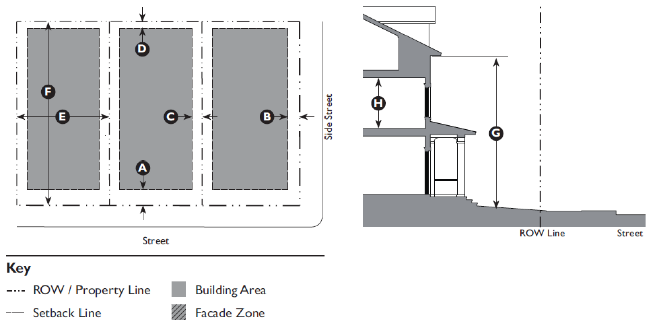
3.1.50 - How Building Height is Measured
A.
Determining Overall Building Height. Building height shall be measured in number of stories from the natural grade or finished grade adjacent to the building exterior to the highest point of coping of a flat roof, the top of a mansard roof, or the highest point of the highest pitched roof.
B.
Determining the Maximum Number of Stories Permitted. The maximum number of stories (floors) allowed in a building is established by Transect Zone in Division 3.2.
C.
Determining the Height of each Story. The following methodology shall be used to determine the minimum and maximum height of each floor in a building.
1.
Where applicable, minimum ground floor height and upper story height are established by Transect Zone in Division 3.2.
2.
Maximum ground floor height and upper story height are established in Table 3.1.50.A (Maximum Height of a Story) below. A story that exceeds these regulations shall be counted as two or more stories.
D.
Ground Floor Finish Level.
1.
Where applicable, minimum and maximum ground floor finish level (measured from adjacent finished grade) are established by Transect Zone in Division 3.2.
2.
Ground floor finish level for Single, Two-Family, or Multi-Family Residential building types shall be a minimum of 18 inches and a maximum of five feet (measured from adjacent finished grade). Where maximum ground floor finish level exceeds this height, the undercroft (basement, crawl space, or storage area) shall count as a story.
E.
Basement. Basements with an exterior exposed wall greater than five feet tall (measured from the adjacent finished grade to the finished floor of the story above) shall count as a story.
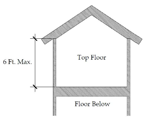
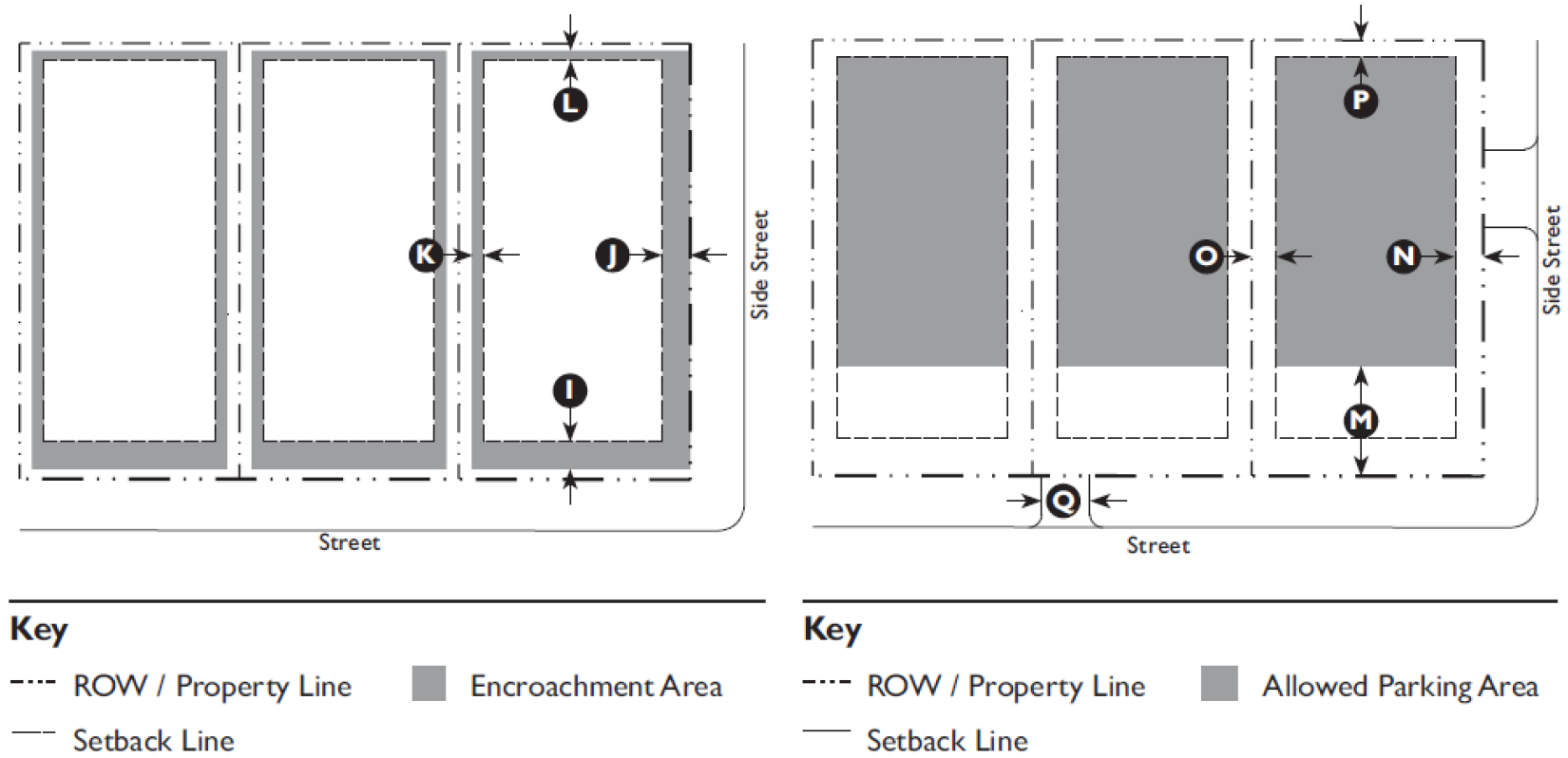
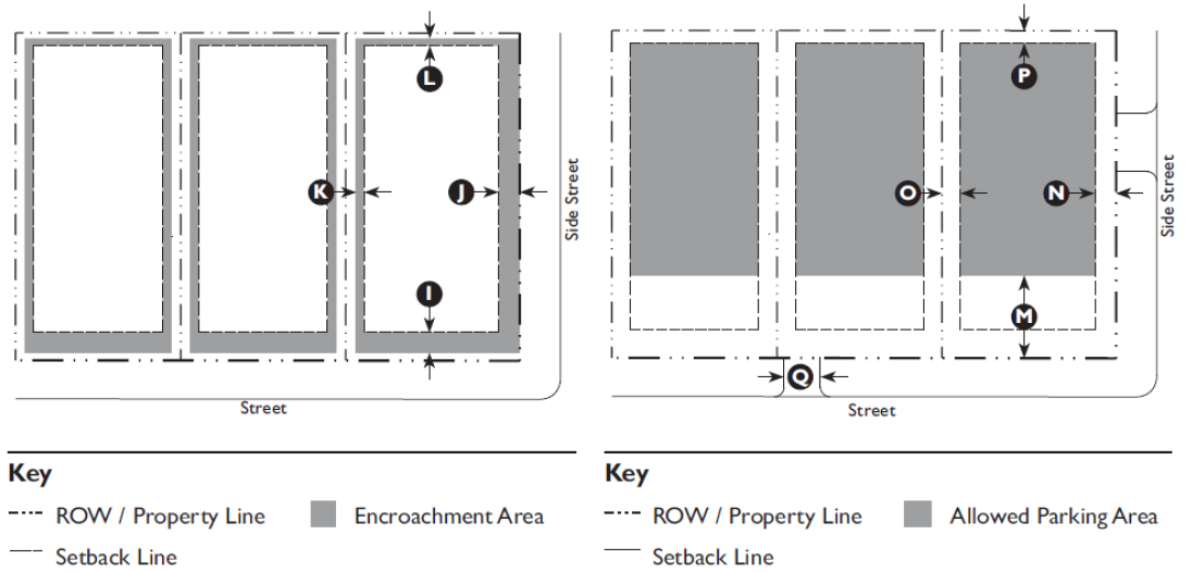
Diagram 3.1.50:
½ Story
Depicted.
(Credit: Lee Helena)
F.
½ Story. A 1/2 story is the top floor of a building that has a maximum exterior wall height not to exceed six feet, creating a sloped ceiling on the top level of the structure. Dormers may be used to provide egress windows as required by the adopted building code. See Diagram 3.1.50.A (1/2 Story Depicted)
G.
Appurtenances. Architectural, Mechanical, and Structural Appurtenances may exceed the allowable building height, and shall conform to the standards for Appurtenances, as conveyed in the Building Form Standards for each Transect Zone (see Division 3.2. Transect Zones).
3.2.10 - Purpose
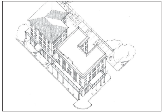
This Division provides regulatory standards governing land use and building form within the transect zones. The Form-Based Code is a reflection of the community vision for implementing the intent of the Comprehensive Plan to preserve the Town of Port Royal's character and create walkable places. These standards are intended to ensure that proposed development is compatible with existing and future development on neighboring properties, and produces an environment of desirable character.
3.2.20 - Applicability
The requirements of this Division shall apply to all proposed development within the transect zones, and shall be considered in combination with the standards for specific uses in Article 4 (Specific to Use), and the development standards in Article 5 (Supplemental to Zones). If there is a conflict between any standards, the provisions of Article 4 (Specific to Use) control over Article 3 (Specific to Zones) and Article 5 (Supplemental to Zones).
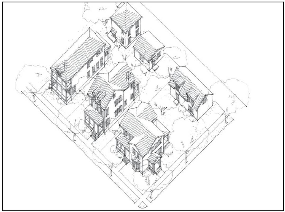
3.2.30 - T1 Natural Preserve (T1) Standards
General note: the illustrations above are intended to provide a brief overview of
the transect zone and are descriptive in nature
A.
Purpose. The Natural Preserve (T1) Zone is intended to preserve areas that contain sensitive habitats, open space, and limited agricultural uses. This Zone typically does not contain buildings; however, small civic buildings or interpretive centers may be located within this zone.
B.
Allowed Uses.
C.
Allowed Building Types.
N/A
D.
Parking.
(Ord. No. 2018-11, 11-14-18)
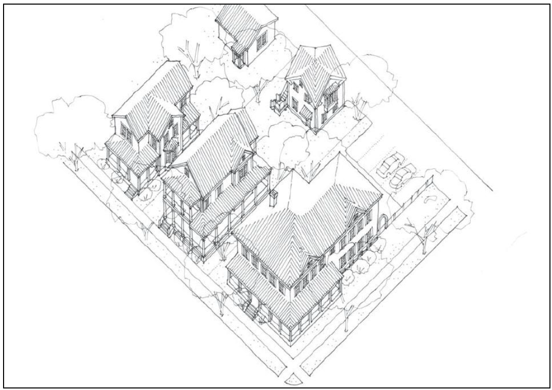
3.2.40 - T3 Edge (T3E) Standards
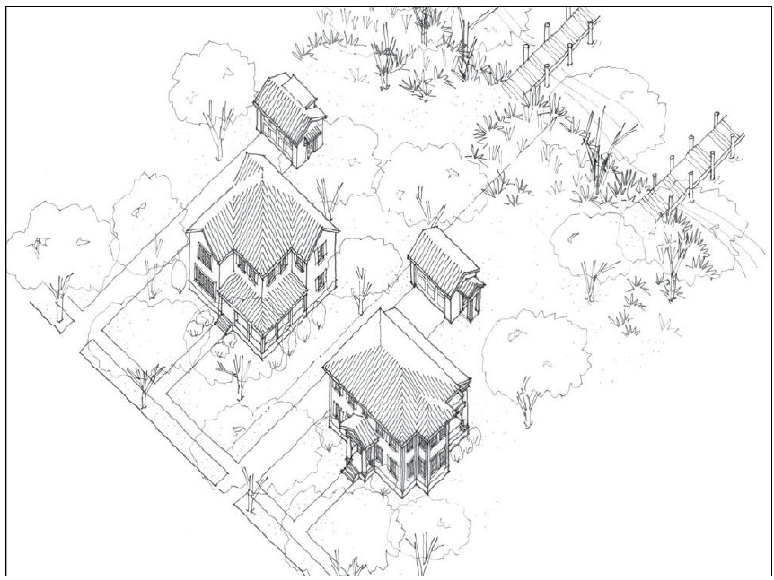
General Note: The illustration above is intended to provide a brief overview of the
transect zone and is descriptive in nature.
A.
Purpose. The Edge (T3E) Zone is a special area that forms at the fringe of Town limits where land meets adjacent waterways. While almost exclusively residential, civic and park functions are also complimentary to the character within the T3 Edge Zone.
B.
Allowed Building Types.
T3 Edge (T3E) Standards
C.
Building Placement.
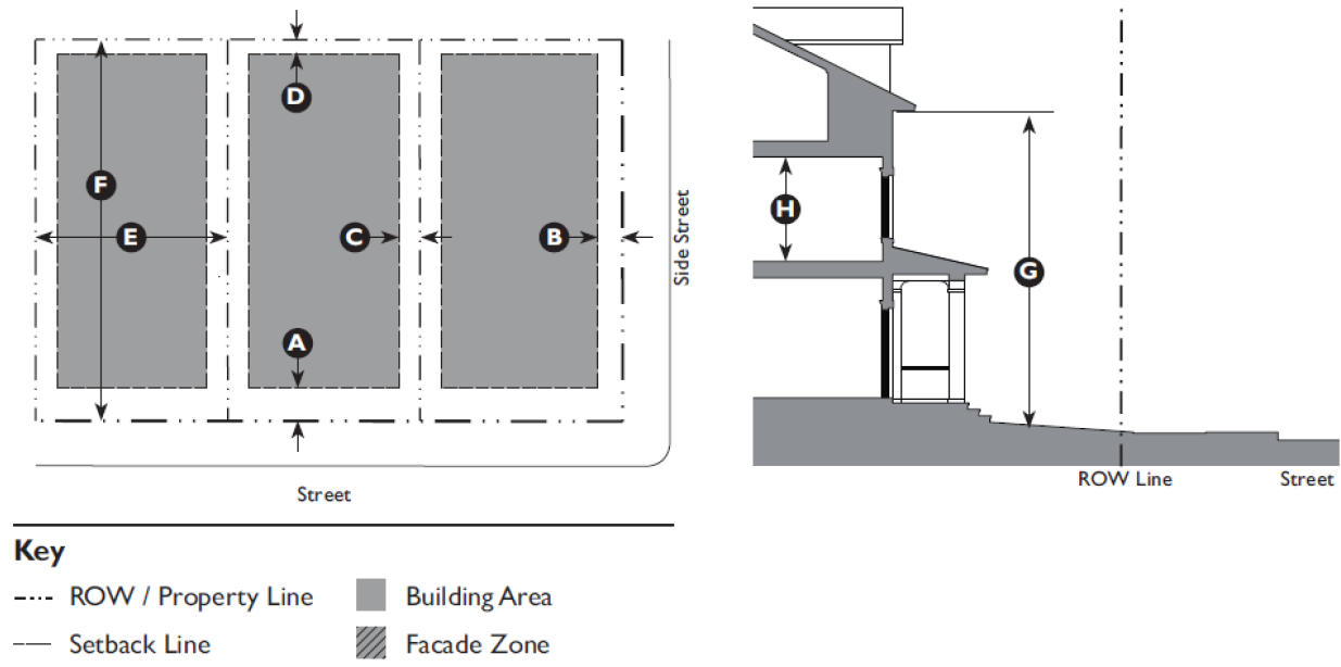
| Setback (Distance from ROW/Property Line) | ||
| Front | 25' min. | |
| Side Street | 15" min. | |
| Side: | ||
| Side, Main Building | 10' min. | |
| Side, Ancillary Building | 5' min. | |
| Rear | 15' min. | |
| Lot Size (11,250 SF min.) | ||
| Width | 75' min. | |
| Depth | 150' min. | |
| Miscellaneous | ||
| Where existing adjacent buildings are in front of the regulated build-to-line (BTL) or front setback, the building may be set to align with the facade of the front-most immediately adjacent property. | ||
|
The Administrator may exempt the following uses from the maximum lot size requirement:
Parks & Open Areas; Water or Marine Oriented Facility. | ||
D.
Building Form.
| Building Height | ||
| Main Building | 2.5 stories max. | |
| Ancillary Building | 2 stories max. | |
| Ground Floor Finish Level 1 | 18" min., 60" max. | |
| Upper Floors(s) Ceiling | 8' min. clear | |
| Appurtenances | ||
| Architectural (cupolas, towers, steeples, chimneys, etc.): | ||
| Roof Area (combined) | 25% max. | |
| Height | 15' max. | |
| Mechanical, Structural (heat and air, elevator enclosure, etc.): | ||
| Roof Area (combined | 25% max. | |
| Height | 15' max. | |
| Footprint | ||
| Lot Coverage | 25% of lot area max. | |
| Loading docks, overhead doors, and other service entries may not be located on street-facing facades | ||
| Notes | ||
| 1 Buildings located in a flood hazard zone will be required to be built above base flood elevation in accordance with the building code. | ||
T3 Edge (T3E) Standards
E.
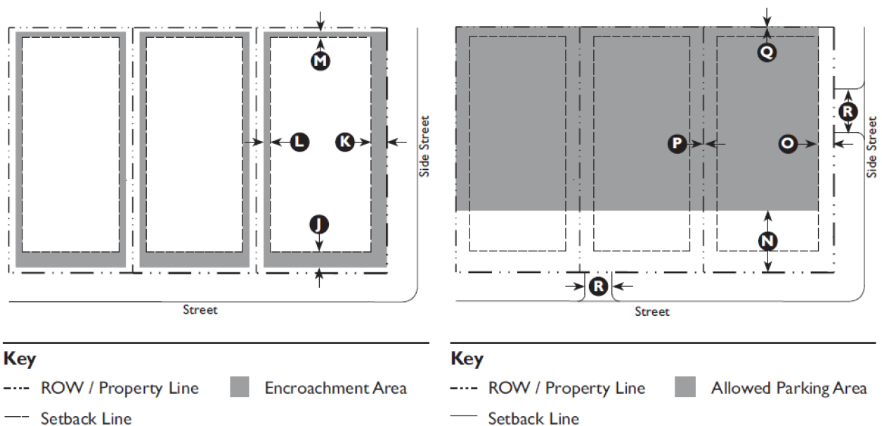
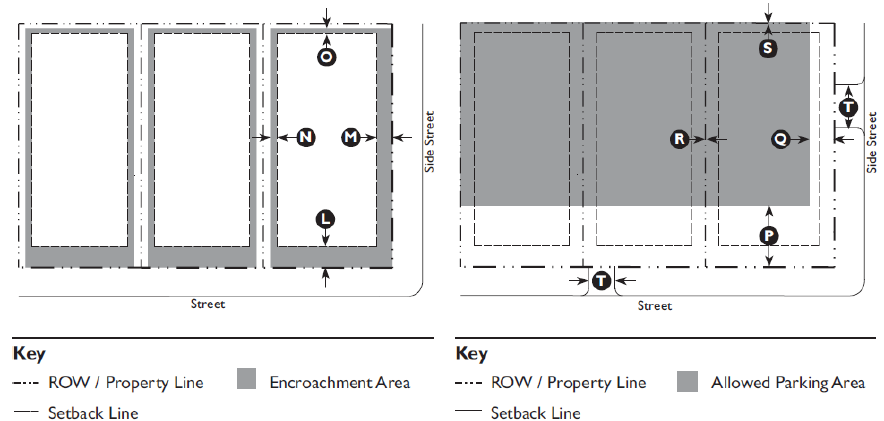
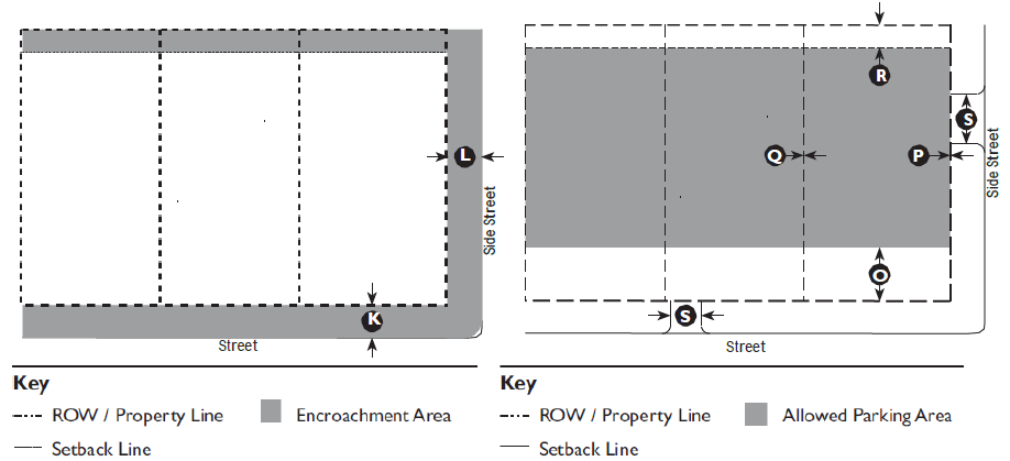
Encroachments and Frontage Types.
| Encroachments | ||
| Front | 5' max. | |
| Side Street | 5' max. | |
| Side | 3' max. | |
| Rear | 5' max. | |
| Encroachments are not allowed within a Street ROW / Alley ROW, buffer, or across a property line. | ||
| See Division 5.3 (Private Frontage Standards) for further refinement of the allowed encroachments for frontage. | ||
| Required Frontage Types | ||
| Common Yard | Porch, Engaged 1 | |
| Porch, Projecting 1 | Stoop 1 | |
| 1 Accessory steps may exceed the maximum encroachment. | ||
| Additional Frontages are permitted for Landmark Buildings. | ||
F.
Parking.
| Location (Setback from Property Line) | ||
| Front | 50' min. | |
| Side Street | 25' min. | |
| Side | 0' min. | |
| Rear | 5' min. | |
| Miscellaneous | |
| Curb Cut or Parking Driveway Width: | |
| Residential except Community Residence | 10' max. |
| Non-residential & Community Residence | 14' max. |
T3 Edge (T3E) Standards
G.
Allowed Uses.
H.
Lots with Buildings Oriented to Water or Marsh.
3.2.50 - T3 Sub-Urban Neighborhood (T3SN) Standards
General note: The illustration above is intended to provide a brief overview of the
transect zone and is descriptive in nature.
A.
Purpose. The Sub-Urban Neighborhood (T3SN) Zone is intended to provide a less intense, predominantly single-family area within the framework of a neighborhood in which Civic and park functions, as well as limited goods and services are located within walking distance.
B.
Allowed Building Types.
;adv=;6q;T3 Sub-Urban Neighborhood (T3SN) Standards
C.
Building Placement.
| Setback (Distance from ROW/Property Line) | ||
| Front | 25' min., 35' max. | |
| Side Street | 15' min, 25' max. | |
| Side: | ||
| Side, Main Building | 10' min, 15' max. | |
| Side, Ancillary Building | 5' min. | |
| Rear | 5' min. | |
| Lot Size (7,500 SF min.) | ||
| Width | 75' min. | |
| Depth | 100' min. | |
| Miscellaneous: | ||
|
Where existing adjacent buildings are in front of the regulated build-to-line (BTL)
or front setback, the building may be set to align with the facade of the front-most
immediately adjacent property.
The Administrator may grant exemptions to the maximum setback requirements to avoid trees with calipers greater than eight (8) inches. The exemption could only be granted with a certified arborist’s viability report of the subject tree(s). The Administrator may exempt the following uses from the maximum lot size requirement: Parks & Open Areas; School: Public or Private; Water or Marine Oriented Facility. | ||
D.
Building Form.
| Building Height | ||
| Main Building | 2.5 stories max. | |
| Ancillary Building | 2 stories max. | |
| Ground Floor Finish Level 1 | 18" min., 60" max. | |
| Upper Floors(s) Ceiling | 8' min. clear | |
| Appurtenances | ||
| Architectural (cupolas, towers, steeples, chimneys, etc.): | ||
| Roof Area (combined) | 25% max. | |
| Height | 15' max | |
| Mechanical, Structural (heat and air, elevator enclosure, etc.): | ||
| Roof Area (combined) | 25% max. | |
| Height | 15' max | |
| Footprint | ||
| Lot Coverage | 40% of lot area max. | |
| Loading docks, overhead doors, and other service entries may not be located on street-facing facades. | ||
| Notes | ||
| 1 Buildings located in a flood hazard zone will be required to be built above base flood elevation in accordance with the building code. | ||
E.
Encroachments and Frontage Types.
| Encroachments | ||
| Front | 5' max. | |
| Side Street | 5' max. | |
| Side | 3' max. | |
| Rear | 5' max. | |
| Encroachments are not allowed within a Street ROW/Alley ROW, buffer, or across a property line. | ||
| See Division 5.3 (Private Frontage Standards) for further refinement of the allowed encroachments for frontages. | ||
F.
Parking.
| Location (Setback from Property Line) | ||
| Front | 50' min. | |
| Side Street | 25' min. | |
| Side | 0' min. | |
| Rear | 5' min. | |
| Miscellaneous | ||
| Curb Cut or Parking Driveway Width: | ||
| Residential Uses | 10' max. | |
|
Non-residential
Uses | 14' max. | |
G.
Allowed Uses.
H.
Lots with Buildings Oriented to Water or Marsh.
(Ord. No. 2014-20, 1-14-15)
3.2.60 - T3 Neighborhood (T3N) Standards
General note: The illustration above is intended to provide a brief overview of the
transect zone and is descriptive in nature.
A.
Purpose. The Neighborhood (T3N) Zone is intended to provide a predominantly single-family area in which compatible multi- family housing types, such as duplexes and cottage courts are integrated into the neighborhood framework. Civic and park functions, as well as transit, and commercial functions are located within walking distance.
B.
Allowed Building Types.
T3 Neighborhood (T3N) Standards
C.
Building Placement.
| Setback (Distance from ROW/Property Line) | ||
| Front | 15' min., 20' max. | |
| Side Street | 10' min., 20' max. | |
| Side: | ||
| Side, Main Building | 10' min. | |
| Side, Ancillary Building | 5' min. | |
| Rear | 5' min. | |
| Facade within Facade Zone: | ||
| Front | 40% min. | |
| Side Street | 20% min. | |
| Lot Size (20,000 SF max.) | ||
| Width | 100' max. | |
| Depth | 200' max. | |
| Miscellaneous | ||
|
Where existing adjacent buildings are in front of the regulated build-to-line (BTL)
or front setback, the building may be set to align with the facade of the front-most
immediately adjacent property.
The Administrator may grant exemptions to the maximum setback requirements to avoid trees with calipers greater than eight (8) inches. The exemption could only be granted with a certified arborist’s viability report of the subject tree(s). The Administrator may exempt the following uses from the maximum lot size requirement: Parks & Open Areas; School: Public or Private; Water or Marine Oriented Facility. | ||
D.
Building Form.
| Building Height | ||
| Main Building | 2.5 stories max. | |
| Ancillary Building | 2 stories max. | |
| Ground Floor Finish Level 1 | 18" min., 60" max. | |
| Upper Floors(s) Ceiling | 8' min. clear | |
T3 Neighborhood (T3N) Standards
E.
Encroachments and Frontage Types.
| Encroachments | ||
| Front | 5' max. | |
| Side Street | 5' max. | |
| Side | 3' max. | |
| Rear | 5' max. | |
| Encroachments are not allowed within a Street ROW/Alley ROW, buffer, or across a property line. | ||
| See Division 5.3 (Private Frontage Standards) for further refinement of the allowed encroachments for frontages. | ||
F.
Parking.
| Location (Setback from Property Line) | ||
| Front | 40' min. | |
| Side Street | 15' min. | |
| Side | 0' min. | |
| Rear | 5' min. | |
| Miscellaneous | ||
| Curb Cut or Parking Driveway Width: | ||
| Residential Uses | 10' max. | |
| Non-residential Uses | 14' max. | |
G.
Allowed Uses.
H.
Lots with Buildings Oriented to Water or Marsh.
(Ord. No. 2014-20, 1-14-15)
3.2.70 - T4 Neighborhood Center (T4NC) Standards
General note: The illustration above is intended to provide a brief overview of the
transect zone and is descriptive in nature.
A.
Purpose. The Neighborhood Center (T4NC) Zone is intended to integrate appropriate, medium-density residential building types, such as duplexes, townhouses, small courtyard housing, and mansion apartments into a neighborhood framework that is conducive to walking and bicycling. Civic, transit, and commercial functions are located within walking distance.
B.
Sub-Zones.
C.
Allowed Building Types.
T4 Neighborhood Center (T4NC) Standards
D.
Building Placement.
| Setback (Distance from ROW/Property Line) | ||
| Front | 10' min., 25' max. 1 | |
| Side Street | 10' min., 20' max. | |
| Side: | ||
| Side, Main Building | 5' min. | |
| Side, Ancillary Building | 0' min. | |
| Rear | 0' min. | |
| Facade within Facade Zone: | ||
| Front | 40% min. | |
| Side Street | 20% min. | |
| Lot Size (37,500 SF max.) | ||
| Width | 150 ft. max. | |
| Depth | 250 ft. max. | |
| Large Footprint Building Only | ||
| Width | Max. width of block face | |
| Depth | Max. depth of block face | |
| Miscellaneous | ||
| Where existing adjacent buildings are in front of the regulated build-to-line (BTL) or front setback, the building may be set to align with the facade of the front-most immediately adjacent property. The Administrator may grant exemptions to the maximum setback requirements to avoid trees with calipers greater than eight (8) inches. The exemption could only be granted with a certified arborist’s viability report of the subject tree(s). | ||
| Loading docks, overhead doors, and other service entries may not be located on street-facing fades. | ||
| The Administrator may exempt the following uses from the maximum lot size requirement: | ||
Community Recreation Facility; Meeting Facility or Place of Worship (> 10,000 SF); Parks & Open Areas; | ||
Recreation and Entertainment Facility: Outdoor; School: Public or Private; School: College or University; Water or Marine Oriented Facility. | ||
E.
Building Form.
| Building Height | ||
| Main Building | 3 stories max. | |
| Ancillary Building | 2 stories max. | |
| Ground Floor Finish Level: | ||
| Residential | 18" min., 60" max. | |
| Non-Residential (T4NC-O) | 6" max. | |
| Ground Floor Ceiling: | ||
| Non-Residential (T4NC-O) | 10' min. | |
| Upper Floor(s) Ceiling | 8' min. | |
| Ground Floor lobbies and Common areas in multi-unit buildings may have a 0" to 6" ground floor finish level. | ||
| Within 25' of the rear property line, buildings may not be more than a half-story taller than the allowed height of adjacent buildings. | ||
| Appurtenances | |
| Architectural (cupolas, towers, steeples, chimneys, etc.): | |
| Roof Area (combined) | 25% max. |
| Height | 18' max. |
| Mechanical, Structural (heat and air, elevator enclosure, etc.): | |
| Roof Area (combined) | 25% max |
| Height | 18' max. |
| Footprint | |
| Width: | |
| Main Building | 100' max |
| Large Footprint Building | Max. width of block face. |
| Upper floors must have a primary entrance along the Front. | |
| Notes | |
|
1
The Front Setback for the Flex and Main Street Mixed Use building type (excluding
Large Footprint Building) shall be: 10' min., and 18' max.
| |
F.
Encroachments and Frontage Types.
| Encroachments | ||
| Front | 12' max. | |
| Side Street | 12' max. | |
| Side | 3' max. | |
| Rear | 0' max. | |
| Encroachments are not allowed across a side or rear property line, or across a curb. | ||
| See Division 5.3 (Private Frontage Standards) for further refinement of the allowed encroachments for frontages. | ||
G.
Parking.
| Location (Setback from Property Line) | ||
| Front | 40' min. | |
| Side Street | 15' min. | |
| Side | 0' min. | |
| Rear | 5' min. | |
| Miscellaneous | ||
| Curb Cut or Parking Driveway Width | ||
| 40 spaces or less | 14' max. | |
|
Greater than 40
spaces | 18' max. | |
H.
Allowed Uses.
I.
Lots with Buildings Oriented to Water or Marsh.
(Ord. No. 2014-20, 1-14-15; Ord. No. 2018-11, 11-14-18)
3.2.80 - T4 Urban Center (T4UC) Standards
General note: The illustration above is intended to provide a brief overview of the
transect zone and is descriptive in nature.
A.
Purpose. The Urban Center (T4UC) Zone is intended to integrate vibrant main-street commercial and retail environments into a walkable neighborhood framework. This area serves as the focal point for the community, providing access to day-to-day amenities and transit.
B.
Allowed Building Types.
T4 Urban Center (T4UC) Standards
C.
Building Placement.
| Setback (Distance from ROW/Property Line) | ||
| Front | 0' min., 15' max. | |
| Side Street | 0' min., 10' max | |
| Side: | ||
| Main Building | 3' min., 6' max. | |
| Ancillary Building | 0' min. | |
| Rear | 0' min. | |
| Facade within Facade Zone: | ||
| Front | 40% | |
| Side Street | 20% | |
| Lot Size (62,500 SF max.) | ||
| Width | 250' max. | |
| Depth | 250' max. | |
| Large Footprint Building Only | ||
| Width | Max. width of block face | |
| Depth | Max. depth of block face | |
| Miscellaneous | ||
| Where existing adjacent buildings are in front of the regulated build-to-line (BTL) or front setback, the building may be set to align with the facade of the front-most immediately adjacent property. The Administrator may grant exemptions to the maximum setback requirements to avoid trees with calipers greater than eight (8) inches. The exemption could only be granted with a certified arborist’s viability report of the subject tree(s). | ||
| No planting strips are allowed between sidewalk and building. | ||
| New Development in T4 NC shall not have Monument Signs. | ||
|
The Administrator may exempt the following uses from the maximum lot size requirement:
Community Oriented Facility; Community Recreation Facility; Meeting Facility or Place of Worship (>10,000 SF); Parks & Open Areas; School: Public or Private; School: College or University; Water or Marine Oriented Facility. | ||
D.
Building Form.
| Building Height | ||
| Main Building | 2 stories min., 1 | |
| 4 stories max. 2 | ||
| Ancillary Building | 2 stories max. | |
| Ground Floor Finish Level: 3 | ||
| Residential | 18" min., 60" max. | |
| Non-Residential | 6" max. | |
| Ground Floor Ceiling: | ||
| Non-Residential | 10' min. | |
| Upper Floor(s) Ceiling | 8' min. | |
| Ground Floor lobbies and common areas in multi-unit buildings may have a 0" to 6" ground floor finish level. | ||
| Within 25' of rear property line, bldgs. may not be more than a ½ story taller than the allowed height of adjacent buildings. | ||
T4 Urban Center (T4UC) Standards
E.
Encroachments and Frontage Types.
| Encroachments | ||
| Front | 12' max. | |
| Side Street | 12' max. | |
| Side | 3' max. | |
| Rear | 0' max. | |
| Encroachments are not allowed across a side or rear property line, or across a curb. | ||
| See Division 5.3 (Private Frontage Standards) for further refinement of the allowed encroachments for frontages. | ||
|
Awnings, Galleries, Arcades, and Balconies (see below) may encroach further into the
street ROW to within 2' of face of curb. Eaves may encroach up to 3' into the street
ROW.
All other encroachments are not allowed within street ROW. | ||
F.
Parking.
| Location (Setback from Property Line) | ||
| Front | 40' min. | |
| Side Street | 5' min. | |
| Side | 0' min. | |
| Rear | 5' min. | |
| Miscellaneous | ||
| Curb Cut or Parking Driveway Width: | ||
| 40 spaces or less | 14' max. | |
|
Greater than 40
spaces | 18' max. | |
G.
Allowed Uses.
(Ord. No. 2014-20, 1-14-15)
3.2.90 - T5 Main Street (T5MS) Standards
General note: The illustration above is intended to provide a brief overview of the
transect zone and is descriptive in nature.
A.
Purpose.
T5 Main Street Zone consists of higher density, mixed- use buildings that accommodate retail, rowhouses, offices, and apartments along primary thoroughfares within a neighborhood framework. A tight network of streets defines this Zone as a highly walkable area. Buildings are set very close to the frontages in order to define the public realm.
B.
Allowed Building Types.
C.
Building Placement.
| Setback (Distance from ROW/Property Line) | ||
| Front | 0' min., 0' max. | |
| Side Street | 0' min., 0' max | |
| Side: | ||
| Main Building | 0' min., 0' max. | |
| Ancillary Building | 0' or 0' min. | |
| Rear | 0' min. | |
| Facade within Facade Zone: | ||
| Front | 40% | |
| Side Street | 20% | |
| Lot Size (62,500 SF max.) | ||
| Width | 250' max. | |
| Depth | 250' max. | |
| Large Footprint Building Only | ||
| Width | Max. width of block face | |
| Depth | Max. depth of block face | |
| Miscellaneous | ||
| Build-to-line (BLT) must be defined by a building within 30' of corner along the front. | |
|
A building form with a chamfered corner is permitted only if a corner entry is provided.
Entire BTL / ROW must be defined by a building or a 24" to 42" high fence or stucco or masonry wall. No planting strips are allowed between sidewalk and building. New Development(s) in T5 MS shall not have a Monument Sign. The Administrator may grant exemptions to the maximum setback requirements to avoid trees with calipers greater than eight (8) inches. The exemption could only be granted with a certified arborist’s viability report of the subject tree(s). The Administrator may exempt the following uses from the maximum lot size requirement: Community Oriented Facility; Community Recreation Facility; Meeting Facility or Place of Worship (> 10,000 SF.); Parks & Open Areas; School: Public or Private; School: College or University; Water or Marine Oriented Facility. | |
D.
Building Form.
| Building Height | ||
| Main Building | 2 stories min., 1 | |
| 4 stories max. | ||
| Ancillary Building | 2 stories max. | |
| Ground Floor Finish Level: 2 | ||
| Residential | 18" min., 60" max. | |
| Non-Residential | 6" max. | |
| Ground Floor Ceiling: | ||
| Non-Residential | 12' min. | |
| Upper Floor(s) Ceiling | 8' min. | |
| Ground Floor lobbies and common areas in multi-unit buildings may have a 0" to 6" ground floor finish level. | ||
| Within 20' of rear property line, bldgs. may not be more than a ½ story taller than the allowed height of adjacent buildings. | ||
| Appurtenances | ||
| Architectural (cupolas, towers, steeples, chimneys, etc.): | ||
| Roof Area (combined) | 25% max | |
| Height | 18' max. | |
| Mechanical, Structural (heat and air, elevator enclosure, etc.): | ||
| Roof Area (combined) | 25% max. | |
| Height | 18' max. | |
| Footprint | ||
| Depth: Ground-Floor Space | 30' min. | |
| Distance between Entries to ground floor (uses): | 50' max. | |
| Any building wider than 150' shall read as a series of buildings. | ||
| Loading docks, overhead doors, and other service entries may not be located on street-facing facades. | ||
| Notes | ||
| 1 The Large Footprint Building Type may be 1 story in height. | ||
| 2 Buildings in a flood hazard zone are required to build above the base flood elevation in accordance with the bldg. code. | ||
T5 Main Street (T5MS) Standards
E.
Encroachments and Frontage Types.
| Encroachments | ||
| Front | 14' max. | |
| Side Street | 14' max. | |
| Side | 0' max. | |
| Rear | 0' max. | |
| Encroachments are not allowed across a side or rear property line, or across a curb. | ||
| See Division 5.3 (Private Frontage Standards) for further refinement of the allowed encroachments for frontages. | ||
| Awnings, Galleries, Arcades, and Balconies (see below) may encroach further into the street ROW to within 2' of the face of curb. Eaves may encroach up to 3' into the street ROW. All other encroachments are not allowed within street ROW. | ||
F.
Parking.
| Location (Setback from Property Line) | ||
| Front | 40' min. | |
| Side Street | 5' min. | |
| Side | 0' min. | |
| Rear | 5' min. | |
| Miscellaneous | ||
| Curb Cut or Parking Driveway Width: | ||
| 40 spaces or less | 14' max. | |
|
Greater than 40
spaces | 18' max. | |
G.
Allowed Uses.
(Ord. No. 2014-20, 1-14-15)
3.3.10 - Purpose
This Division provides regulatory standards governing land use and building form within special overlay zones. These zones are typically applied to certain areas of the Town where extreme environmental, physical or cultural constraints need increased planning guidelines and consideration.
3.3.20 - Applicability
The requirements of this Division shall apply to all proposed development within the overlay zones, and shall be considered in combination with the standards for specific uses in Article 4 (Specific to Use), if applicable, and the development standards in Article 5 (Supplemental to Zones). If there is a conflict between any standards, the provisions of Article 4 (Specific to Use) control over Article 3 (Specific to Zones) and Article 5 (Supplemental to Zones).
3.3.30 - Military Overlay (MO) Zone Standards
A.
Purpose. The Military Overlay (MO) Zone is applied to existing military bases and Department of Defense lands, and provides for military facilities and all supporting activities such as housing, offices, and services that are on base land, even though they would otherwise be considered separate uses. Military property is under jurisdiction of the federal government. Recommendations and standards for this Zone are not included in this Division, since these lands are federally owned, and are typically not subject to Town regulations.
B.
Allowed Land Uses. Any use which is integral or compatible to the principal operation located within the MO Zone, provided that such use is authorized and under the control of the responsible governmental agency owning the land or operating the facility or installation, and provided that such use is determined by the responsible governmental agency not to be contrary to the public welfare.
C.
Other Requirements. Allowed uses may be located in the MO Zone subject to such requirements and regulations as deemed necessary by the governmental agency responsible for their operation to assure their most effective utilization in terms of the overall functioning of the installation or facility and in terms of insuring the best interests of the general public.
3.3.40 - MCAS Airport Overlay (MCAS-AO) Zone Standards
A.
Purpose. The MCAS Airport Overlay (MCAS-AO) shall overlay other zoning classifications that shall be referred to as base zoning. The MCAS-AO Zone includes all lands within an established footprint affected by airport operations at the Marine Corps Air Station Beaufort (MCAS-Beaufort). The overlay "district" includes all lands underlying the noise zones of 65 DNL (day-night average sound level) and above, and accident potential zones as designated in the most recent Air Installations Compatible Use Zones (AICUZ) Report for MCAS-Beaufort as authorized for use by the Department of the Navy, and as adopted by the Town of Port Royal Council.
In order to increase public awareness and to ensure the general safety and welfare of persons affected by adverse impacts common to military aircraft operations, Subsection E (Airport Noise Zone Disclosure Statement) of this overlay district requires that property owners within the MCAS-AO Zone be properly notified of their location. In addition, Subsection H of this overlay district sets forth limitations and restrictions that shall apply to certain land uses that have been determined to be incompatible according to federal standards.
B.
Accident Potential Zones. Accident potential zones (APZ's) are divided into three types along primary flight paths. The clear zone (CZ) is an area at either end of a runway which possesses a high potential for accidents. APZ-1 is the area normally beyond the clear zone, which possesses a significant potential for Accidents. APZ-2 is an area normally beyond APZ 1, which has a measurable potential for accidents.
C.
Noise Zones. The noise exposure from aircraft operations is measured using the day-night average sound level noise metric (DNL). The DNL averages aircraft sound levels over a 24-hour period with an adjustment for increased sensitivity to nighttime noise. The DNL visually is depicted as a noise contour that connects points of equal value. The area between two noise contours is known as a noise zone.
Noise zones are hereby established as follows:
D.
Noise Reduction Requirement.
E.
Airport Noise Zone Disclosure Statement.
I hereby acknowledge and understand that in making this application for the location of a manufactured home within Noise Zone _______, I fully acknowledge that such Has been determined to be possibly hazardous to health by excessive aircraft noise. I further acknowledge that manufactured homes are constructed to Federal standards and may not meet the Town of Port Royal standards for noise attenuation consistent with the location of homes within this zone.
Dated this _______ day of _______, _______.
Witness _______ Owner _______.
F.
Notification.
1.
At all real estate closings involving a property in an accident potential zone or noise zone, the buyer, seller and witnesses shall sign the following form which shall be filed with the deed and/or plat at the Beaufort County Register of Deeds Office.
a.
MCAS Airport Overlay Disclosure Form:
The property at _______ (address/location) is located in proximity to the Marine Corps Air Station Beaufort. Beaufort County and the Town of Port Royal have determined that persons on the premises will be exposed to accident potentials and/or significant noise levels as a result of the airport operations. The Town has established certain noise zones and accident potential zones (APZs) within its Development Code.
The above property is located in Noise Zone _______ and in Accident Potential Zone _______.
The Town has placed certain restrictions on the development and use of property within these areas. Before purchasing the above property, you should consult the Town of Port Royal Administrator to determine the restrictions that have been placed on the subject property.
b.
Certification.
As the owner of the subject property, I hereby certify that I have informed _______, as a prospective purchaser, that the subject property is located in the MCAS Airport Overlay district.
Dated this _______ day of _______, _______.
Witness _______ Owner _______.
As a prospective purchaser of the subject property, I hereby certify that I have been informed that the subject property is in the MCAS Airport Overlay district, and I have consulted the Town of Port Royal Administrator to determine the restrictions which have been placed on the subject property.
Dated this _______ day of _______, _______.
Witness _______ Purchaser _______.
2.
All prospective renters signing a commercial or residential lease shall be notified by the property owner through a written provision contained in the lease agreement if the leased property is located within the MCAS-AO Zone.
3.
All subdivision plats, planned unit development plats, townhouse plats and/or condominium documents shall contain the following disclosure statement:
a.
MCAS Airport Overlay Disclosure Statement:
This property lies within the MCAS Airport Overlay District, which applies to property in proximity to the Marine Corps Air Station Beaufort. Purchasers are required to sign a Disclosure Form per Division 3.4.30 of the Town of Port Royal Development Code and file the form with the deed and/or plat at the Beaufort County Register of Deeds Office. All or a portion of this property lies within:
Accident Potential Zone: _______.
Noise Zone: _______ DNL (Day-Night Average Sound Level): _______.
b.
Reserved.
4.
In the case of new construction, a signed MCAS Airport Overlay Disclosure Statement shall accompany the building permit application.
G.
Non-Conforming Uses and Structures. The standards for nonconformities contained in Article 6 (Nonconformities) are modified or supplemented as follows:
1.
Nonresidential Uses and Structures.
a.
A nonconforming structure with damage greater than 50 percent of its market value before the damage shall be replaced by a conforming structure.
b.
Nonconforming uses and structures shall not be expanded.
c.
Nonconforming uses and structures shall not become conforming through the special use permit process.
d.
Improvements to a nonconforming structure that exceed 50 percent of its market value (before the improvements) shall be required to meet the noise attenuation requirements of this Section. Permits for improvements shall be cumulative for a period of five years.
e.
Any nonconforming use or structure shall be considered abandoned if vacant or unused for 90 days, and shall only be replaced with conforming uses/structures.
f.
Notwithstanding the above, a nonconforming meeting facility/place of worship shall be permitted to be rebuilt if damaged greater than 50 percent of its market value (before the damage) provided the noise attenuation requirements of this Section are met. A nonconforming meeting facility/place of worship may be expanded by up to 15 percent of the gross floor area provided the expansion does not increase the occupant load of the building.
2.
Residential Structures. Improvements to a nonconforming residential structure that exceed 50 percent of its market value before the improvements shall be required to meet the noise attenuation requirements of this Section. Permits for improvements shall be cumulative for a period of five years.
H.
Variances. The Town Zoning Board of Appeals (ZBOA) shall not act upon a request for a variance from this Section affecting lands within the MCAS-AO Zone until they have received an advisory opinion from MCAS-Beaufort. If an advisory opinion is not received within 30 days of notification, the ZBOAA may proceed to act on the request without the opinion.
I.
Use Limitations. The following limitations apply to uses allowed in the MCAS-AO zone:
1.
Density standards for residential development.
a.
Accident Potential Zones and Noise Zone 3 (DNL 75 and above). Gross density shall not exceed one unit per three acres. No residential development is permitted within a clear zone.
b.
Noise Zone 2b (DNL 70 to 75). Gross density shall not exceed one unit per acre.
c.
Noise Zone 2a (DNL 65 to 70). Gross density shall not exceed two units per acre.
2.
Clustering requirement. Residential units may be required to be clustered outside of the accident potential and/or noise zones if possible. Staff may modulate building placement standards to achieve this result.
3.
See Table 3.3.40.A (Use Limitations Within the MCAS-AO Zone).
MCAS Airport Overlay (MCAS-AO)
3.3.50 - Historic Preservation Overlay (HPO) Zone Standards
A.
Purpose.
1.
The purpose of this article is:
a.
To protect, preserve and enhance the distinctive architectural and cultural heritage of the town;
b.
To promote the educational, cultural, economic and general welfare of the people of the town;
c.
To foster civic pride;
d.
To encourage harmonious, orderly and efficient growth and development of the town;
e.
To strengthen the local economy;
f.
To improve property values; and
g.
To support the goals of the town's comprehensive plan.
2.
Reserved.
B.
Applicability.
1.
This Section is part of the zoning ordinance of the town, and is enacted pursuant to the S.C. Code 1976, §§ 6-29-710 and 6-29-870.
2.
The provisions of this Section shall apply within historic districts and to landmarks. Whenever there is conflict between the regulations of this Section and those found elsewhere in this Code, the more restrictive shall apply.
3.
Information regarding the establishment, composition, terms, and responsibilities of the Historic Preservation Commission are located in this Division.
C.
Designation to the Port Royal Historic Register.
1.
Initiation of Designations. Initiation of the proposed designation of landmarks or historic districts to the Town Historic Register may be made by any member of the Commission, any member of Town Council, or a Board or Commission appointed by Town Council, the petition of any ten residents of the Town, or an owner thereof. A request for designation shall be made on the appropriate application form provided by the Commission and submitted to the Commission for review and public hearing.
2.
List of Designated Landmarks or Districts. The list of designated landmarks and districts in the Town of Port Royal is maintained by the Municipal Clerk.
3.
Designation Criteria. For a landmark or district to be designated to the Town Historic Register, Town Council must conclude that it:
a.
Is significant in American, state, or Town history, architecture, archeology, engineering, or culture.
b.
Has integrity of location, design, setting, materials, or workmanship that need to be protected or preserved and meets one or more of the following criteria:
(1)
It is associated with events that have made a significant contribution to history;
(2)
It is associated with the lives of persons significant in history;
(3)
It has distinctive characteristics of a type, period, or method of architecture or construction; represents the work of a master; possesses high artistic values; or represents a significant and distinguishable entity whose components may lack individual distinction;
(4)
It has yielded or is likely to yield information important in prehistory or history;
(5)
It is listed on the National Register of Historic Places; or
(6)
Is 75 years old or older.
4.
Public Notice.
a.
The Commission shall give the owners of properties proposed for designation as a historic district or as a landmark written notice of the hearing by the Commission on the application for such designation by mail sent to the address for the property listed on the most current town real property tax records, unless another address is known by the commission, no fewer than 30 days prior to the scheduled date of the hearing. Such notice shall state the date, time, place and purpose of the hearing. The notice shall be considered given when placed in the U. S. Post Office at Port Royal, South Carolina with proper postage affixed.
b.
In addition, one public notice sign shall be posted on each street frontage of the subject property stating the date, time, place, and purpose of the public hearing. Where more than one property is proposed for designation, the number and location of required public notice signs shall be determined by the Administrator.
5.
Consideration by Town Council. Within 15 days after the meeting at which a designation is considered, the Commission shall forward its recommendation on the designation to the town council. The proposed designation shall not become effective unless approved by Town Council by adoption of an ordinance to include a public hearing.
6.
Opposition to Designation. Any property owner may object to the decision by the town council, to designate his/her property as historic by filing suit against the town before the courts of the state.
7.
Nominations to the National Register of Historic Places. The Commission may conduct first review and evaluation of all proposed national register nominations within the town, including any which may have been submitted to the state historic preservation office (SHPO), and forward all reviewed nominations to the SHPO with recommendations for consideration by the state board of review.
8.
Re-filing for Designation. If a request for designation is denied, the request may not be filed again for one year from the date of that denial unless the applicant can demonstrate to the commission a substantial change in circumstances relevant to the request.
9.
Procedure for Removing Designation. The procedure followed for removing a designation shall be the same as that for initial designation.
D.
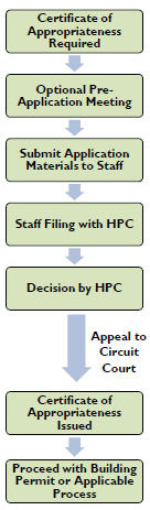
Certificate of Appropriateness.
1.
Activities Requiring a Certificate.
a.
On Property Not in a Street or Town Park.
(1)
A Certificate of Appropriateness may be required for alteration, construction, demolition, or relocation on property listed on the Town Historic Register visible from a public street right-of-way except that any change to a landmark may require a certificate even if not visible.
(2)
For the purposes of this article, an activity shall be considered visible even if hidden by vegetation or a fence. An alteration requires a certificate even if the color, texture, and composition of the material (excluding paint) is not discernible from a street right-of-way.
(3)
The Commission may authorize the Administrator to approve a certificate for certain types of work with the concurrence of the chairman.
(4)
Either the chairman or Administrator require approval by the commission of any certificate for an activity not specifically covered.
b.
In a Street (Including a Parkway). A certificate of appropriateness may be required for the following:
(1)
In a street (including a parkway) individually designated as a landmark; widening a street or the improved surface of a street or paving an unpaved street; or eliminating the parkway or providing parking areas thereon.
(2)
In a street (including a parkway) within a historic district or individually designated as a landmark; alteration, construction, demolition, or relocation of buildings, walls, fences, gates, and stone curbs.
c.
In a Town Park Individually Designated as a Landmark. A Certificate of Appropriateness shall be required for alteration, construction, demolition, or relocation of buildings, walls, fences, and gates.
d.
Vegetation. For plant materials or trees individually designated as landmarks or required as a condition of approval of a certificate of appropriateness, a certificate shall be required for cutting down, destroying, relocating, or eliminating plant materials or trees.
2.
Activities Exempt from Certificate of Appropriateness.
a.
A Certificate of Appropriateness shall not be required for the following:
(1)
Interior renovations.
(2)
Alteration, construction, demolition, relocation, or other work on a property not in a street or Town park not visible from a street.
(3)
Exterior painting of previously painted structures.
(4)
Repairs, replacements, and routine maintenance that do not constitute alteration.
(5)
Installing, cutting down, destroying, relocating, pruning, or eliminating plant materials or trees not designated as landmarks or required as a condition of a certificate of appropriateness.
(6)
Any work in a street that does not involve an activity listed in Subsection 1.b. (above) or any work in a town park that does not involve an activity listed in Subsection 1.c. (above).
(7)
Any work on objects that the planning director determines are not structures because of their insignificance.
b.
Reserved.
E.
Application - Certificate of Appropriateness.
1.
Application for Certificate of Appropriateness.
a.
Applications for Certificates of Appropriateness are available from the Zoning Administrator, and completed applications shall be submitted to the Administrator. An application for a Certificate of Appropriateness must be made by an owner-of-record of the property or by an agent with written authorization to make such application.
b.
Applications for a Certificate shall be accompanied by the following unless waived by the secretary or otherwise specified on the application form provided by the commission.
(1)
Drawings, including plans and exterior elevations, drawn to scale, with sufficient detail to show the exterior architectural design of the structure.
(2)
Specifications or other information describing proposed materials and textures; samples of materials may be required by the commission.
(3)
Plot plan or site layout showing all existing structures and any improvements affecting appearances such as walls, walks, terraces, accessory buildings, signs, lights, plantings, and other elements.
(4)
Photographs of the site location, showing contiguous properties and streetscapes.
(5)
All other information requested by the commission.
c.
Applications for a Certificate of Appropriateness shall pay the standard fee set by the Town Council, which fee shall be subject to review and approval by the Commission, to cover the reasonable administrative costs of processing such applications.
d.
Where a Variance or other approval is required for a project from the Zoning Board of Appeals, such approval shall be obtained prior to consideration of a request for a Certificate of Appropriateness by the Commission.
F.
Review - Certificate of Appropriateness.
1.
Public Hearing and Public Notice. For any Certificate of Appropriateness application that it must consider, the HPC shall conduct a public hearing not later than 30 days following receipt of a completed application form accompanied by all required information and documents. Public notice of each such public hearing shall be given at least seven days prior to the hearing by the posting of a sign by the town on each street frontage of the subject property clearly visible to the public stating the date, time, and place of the public hearing.
2.
Notice to Applicants and Owners.
a.
The HPC shall give the applicant written notice of the public hearing on his application. This notice shall be sent by certified mail to the address listed on the application and shall be considered given when placed in the U. S. Post Office at Port Royal, South Carolina with proper postage affixed.
b.
If the applicant is not the owner, a copy of the letter providing notice shall be sent by certified mail to the owner-of-record. This notice shall be considered given when placed in the U.S. Post Office at Port Royal, South Carolina with proper postage affixed.
c.
The notices required by this section shall state the identity, address, and telephone number of the applicant and property owner; the address or location of the subject property; and the time, place, and purpose of the hearing.
3.
Approval by the Administrator. With the concurrence of the Chairman, the Administrator may approve or amend Certificates of Appropriateness for the following activities on sites not owned by the Town or may refer them to the Commission for a decision:
a.
Activities expressly authorized by the Commission.
b.
Minor design changes to projects for which a certificate of appropriateness has been issued by the HPC or increasing the expiration date of a certificate of appropriateness for an additional period not to exceed six months.
c.
Anything not specifically covered by this article that the Administrator determines is not so significant as to impair or affect historic, architectural, or aesthetic character. Such an application shall be considered by the Administrator as soon as possible but not later than 15 days following receipt of a completed application form accompanied by all required information and documents. A public hearing or public notice shall not be required unless the application is referred to the HPC. Applications referred to the HPC by the planning director must be considered within 30 days following receipt of the completed application form accompanied by all required information and documents.
4.
Procedures Following Approval. If an application for a certificate of appropriateness is approved, the following apply:
a.
The decision shall be filed with the secretary and a certificate of appropriateness issued to the applicant. Specific conditions upon which the certificate is issued and with which the applicant must comply shall be listed on the certificate.
b.
If an application is approved by the HPC, the certificate shall be signed by the chairman, vice chairman, or presiding member of the HPC; if approved by the Administrator, he/she shall sign the certificate and shall notify the HPC of the decision.
c.
A copy of the certificate and the approved application shall be provided to the building official and the zoning official who shall periodically inspect the work and report any violation of the certificate or this article to the Administrator.
d.
The certificate shall expire two years from the date of issuance unless the work allowed there under has been substantially completed or unless another expiration date is specified by the HPC or by the Administrator pursuant to subsection (f)(2).
5.
Denial of Application.
a.
By the Administrator. If an application is denied by the Administrator, the Administrator shall file his/her written decision with the HPC chairman including the reasons for denial, send a copy to the applicant by certified mail, and provide a copy to the building official and the zoning official and each HPC member.
b.
By the HPC. If an application is denied by the HPC, the following apply:
(1)
The HPC shall file its written decision, which shall include a statement of the reasons for denial, and shall provide a copy of the statement to the applicant and to the building official, the zoning official, and each HPC member within 15 days of the public hearing thereon.
(2)
The HPC in its decision may make recommendations to the applicant concerning changes in the proposed action that may cause it to reconsider denial. The applicant may submit an amended application to the secretary incorporating those recommendations. Such an amended application shall be subject to the same procedures as an initial application but is exempted from the limitations in subsections (i) and (j).
(3)
The applicant may apply under section 22-244 for an exemption.
6.
Reconsideration. Upon good cause being shown by any person aggrieved by a final decision of the HPC or an application for a certificate of appropriateness, the HPC may reconsider its decision. In the event of such reconsideration, the HPC shall conduct a public hearing giving the public notice required by subsection (d). The request for reconsideration will not be reviewed unless submitted to the secretary within ten days of the date on which the written decision is mailed to the applicant.
7.
Appeal.
a.
From the Administrator. Any property owner, town official, or other person aggrieved by and seeking relief from any final decision of the Administrator on an application for a certificate of appropriateness or interpretation of this article and related provisions may appeal the decision of the Administrator to the Historic Preservation Commission by submitting to the secretary a written request stating the grounds for the appeal. The appeal request must be submitted to the secretary within 20 days of the date on which the written decision is mailed to the applicant. The appeal shall meet the public notice requirements under subsection (d), and it shall be placed on the next HPC meeting agenda for which public notice requirements can be met. An appeal must be decided within 45 days of submission of the written appeal request.
b.
From the HPC. Any property owner, town official, or other person aggrieved by and seeking relief from any final decision of the HPC on an application for a certificate of appropriateness may appeal that decision to the Circuit Court pursuant to S.C. Code 1976 § 6-29-900, by filing a petition with the court within 30 days of the filing of the written decision of the HPC with the secretary.
8.
Review Standards.
a.
General. In reviewing applications, the HPC and the Administrator shall consider the standards stated in this article for the purpose of determining whether alterations, construction, demolitions, or relocations are in harmony with the prevailing historical, architectural, archeological, or aesthetic character of the historic district, a structure in a historic district, or landmark.
b.
Construction and Alteration. In reviewing an application for construction or alteration, the HPC and the Administrator shall consider general design, character and appropriateness of design, scale of buildings, texture and materials, relationship of such elements to similar features of structures in the immediate area, and the extent to which the alteration or construction would be harmonious with the historic district in which it is located or with the landmark. The HPC and the Administrator also shall consider the relevant standards and guidelines in the most current edition of the U.S. Secretary of the Interior's Standards for Rehabilitation.
c.
Demolition. In reviewing an application for demolition, the HPC and the planning director shall consider the historical, archeological, and aesthetic character of the structure (or portion thereof) proposed for demolition. They shall also consider: (1) the structural integrity (i.e., condition) of the structure and (2) the integrity of materials, location, and design of the structure. No application for demolition shall be approved solely on the basis of a structure's deteriorated condition where the commission determines that the applicant is primarily responsible for the deteriorated condition. Finally, the HPC shall consider the extent to which demolition would, in the judgment of the HPC, produce a detrimental effect upon the character of the structure or property affected or upon the surrounding properties, or upon the district in which the structure is located. No application for demolition of a Landmark shall be approved.
d.
Specific Guidelines. The Commission shall adopt additional guidelines, subject to review and approval by town council, consistent with this article for reviewing applications for a Certificate of Appropriateness.
9.
Re-filing of an Application. If an application of a certificate of appropriateness is denied, the application may not be considered by the HPC again for one year unless the applicant can demonstrate to the HPC a substantial change in circumstances relevant to the application.
G.
Demolition or Relocation.
1.
Certificate of Appropriateness Required.
a.
No structure within a historic district or landmark shall be demolished or relocated until he owner thereof has applied for and received a certificate of appropriateness from the HPC.
b.
The HPC may delay the granting of the Certificate for a period of up to 180 days from the time of the filing of the application. The HPC may extend this postponement for another 180 days after a public hearing and finding by the HPC that the structure or landmark is of historical, architectural, or archeological importance to the public or town. Within any period of postponement, the commission shall endeavor to ascertain what may be done to preserve the structure or landmark. Such steps shall include, but are not limited to, consultation with civic groups, interested citizens, public interest groups, and public boards and agencies.
c.
After the postponement period has ended and the commission has been unable to determine a reasonable alternative to demolition or relocation, the certificate shall be granted after a public hearing, with the notice required by subsection 22-242(d) being given. However, if the commission finds that the structure contributes to the character of the historic district or that the landmark is of historical, archeological, or architectural significance or that, for any other reason, preservation in the public interest is warranted, the application shall be denied. In the event of such denial, the owner may apply for an exception under section 22-244.
2.
Demolition by neglect.
a.
Prevention of Demolition by Neglect of Exterior. No owner or person with an interest in real property which is designated a landmark in any part of the town or any property in an historic district, whether that property is occupied or not, shall permit the structure or property to fall into a serious state of disrepair or to remain in a serious state of disrepair so as to result in the deterioration of any exterior architectural feature which would, in the judgment of the HPC, produce a detrimental effect upon the character of the structure or property, or, if the structure or property is in an historic district, upon the district. Examples of such deterioration include:
(1)
Deterioration of exterior walls or other vertical supports;
(2)
Deterioration of roofs or other horizontal members;
(3)
Deterioration of exterior chimneys;
(4)
Deterioration of crumbling of exterior stucco or mortar;
(5)
Ineffective waterproofing of exterior walls, roofs or foundations, including broken windows or doors;
(6)
Deterioration of any exterior feature so as to create a hazardous condition which could make demolition necessary for the public safety; or
(7)
Deterioration or removal of any unique exterior architectural feature which would detract from the original architectural style.
b.
Prevention of Demolition by Neglect of Interior. No owner or person with an interest in real property which is designated a landmark in any part of the town, or any property in an historic district, whether that property is occupied or not, shall permit the interior portions of such structure or property to fall into a serious state of disrepair which, in the judgment of the HPC, produces a detrimental effect upon the structural integrity of such structure or property which could make demolition necessary for the public safety.
H.
Determination of Economic Hardship.
1.
Submission Requirements. If an application for a certificate of appropriateness is denied by the HPC, the applicant may request that the application be reviewed for economic hardship pursuant to this section. The commission may obtain expert testimony and require the applicant make submissions concerning the following information before the commission makes a final determination on the application.
a.
Estimate the cost of the proposed construction, alteration, demolition, or relocation and an estimate of any additional cost that would be incurred to comply with the recommendations or directives of the commission for changes necessary for issuance of a certificate.
b.
A report from a licensed engineer or architect with experience in rehabilitation on the structural soundness of any structures and their suitability for rehabilitation.
c.
Estimated market value of the property under the following conditions: in its current condition; after completion of the proposed construction, alteration, demolition, or relocation; after any changes recommended or directed by the commission; and, in the case of a proposed demolition, or relocation, after renovation of the existing property for continued use. The commission may require that these estimates be prepared by a qualified expert.
d.
In the case of a proposed demolition or relocation, an estimate from an architect, developer, real estate consultant, appraiser, or other real estate professional experienced in rehabilitation as to the economic feasibility of continued use, rehabilitation, or reuse of the existing structure at its current location.
e.
Amount paid for the property, the date of purchase, and the party from whom purchased, including a description of the relationship, in any, between the owner-of-record or applicant and the person from whom the property was or is to be purchased, and the terms of financing.
f.
If the property is income-producing, the annual gross income from the property for the previous two calendar or fiscal years; itemized operating and maintenance expenses during the same period; and depreciation, deduction, and annual cash flow before and after debt service, if any, during the same period.
g.
Any other information requested by the commission in its discretion to reach a determination as to whether the property does yield or may yield a reasonable return to the owners.
2.
Review. The commission shall review all of the evidence and information required from the applicant, hold a public hearing, and make a determination thereon within 30 days after receipt of all required information of whether the denial of a certificate of appropriateness will result in economic hardship to the owner because he will be deprived of all reasonable use of the property. If the commission makes a determination that, in its discretion, economic hardship has not been proven by the applicant, the application for a certificate of appropriateness based upon economic hardship shall be denied. If the commission determines, in its discretion, that economic hardship would occur to the owner, the commission may issue a certificate of appropriateness based upon economic hardship or delay action on the application for a period of 90 days If at the end of the 90-day period, the commission finds, after a public hearing with the notice required by subsection 22-242(d) being given, that without issuance of the certificate of appropriateness, an economic hardship would still occur, then the commission shall issue a certificate of appropriateness based upon economic hardship.
I.
Interpretation and Enforcement.
1.
Interpretation. The Administrator shall interpret the provisions of this article. Any final interpretation by the planning director may be appealed pursuant to the procedures at subsection 22-242(j).
2.
Enforcement.
a.
The zoning official shall periodically inspect work in progress under a certificate of appropriateness.
b.
In the event that this article or a certificate of appropriateness is violated, the HPC, zoning official, or building official may issue an order requiring the person or persons committing the violation to cease and desist immediately there from. The cease-and-desist order shall remain in effect until any certificate of appropriateness required for the work is approved.
c.
A violation of a cease-and-desist order issued by the HPC or the zoning official or building official is hereby declared unlawful and shall be punished as set forth in subsection (c).
3.
Violations and Penalties. It shall be unlawful for any person to violate any provisions of this article, and any person violating these provisions shall be guilty of a misdemeanor and, upon conviction, shall be punished by a fine not exceeding $500.00 per day. Each day that the violation of any provision hereof continues shall constitute a separate offense.
J.
Historic Preservation Definitions.
1.
See Table 3.3.50.A (Historic Preservation Definitions).
2.
Reserved.
3.3.60 - Manufactured Homes on Individual Lots Overlay (MHO) Zone Standards
A.
Purpose. The purpose of the Manufactured Homes on Individual Lots Overlay (MHO) Zone is to ensure affordable housing options for a variety of residents while promoting quality design principles that maintain the character and value of the surrounding neighborhood.
B.
Applicability. The Manufactured Homes on Individual Lots Overlay (MHO) Zone applies to specific areas of the Town, delineated on the Official Zoning Map, in which base zoning currently exists and new manufactured homes shall be permitted. The Overlay is intended for individual manufactured homes sited on individual lots, as opposed to the establishment of a manufactured home community, which is not permitted in the Town.
C.
Requirements. To the maximum extent practicable manufactured homes shall be regulated using the existing provisions of this ordinance.
1.
Zoning. To the maximum extent practicable, the underlying zoning district shall determine:
a.
Building Type
b.
Building Placement
c.
Building Form
d.
Encroachments and Private Frontage Types
e.
Parking
f.
Uses
2.
Building Type. Manufactured homes may be reviewed as a Compact House, Medium House, or Large House Building Type (see Division 5.1 Building Type Standards).
3.
Building Orientation. The Private Frontage shall front the street or public thoroughfare and determine the orientation of the structure (see Division 5.3 Private Frontage Standards).
Generally, the maximum width permitted for the Main Body of the building (see Division 5.1 Building Type Standards) will result in the "narrow end" of the manufactured home fronting the street or public thoroughfare. Table 5.4.40 (Lowcountry Vernacular) depicts the massing and elevation of a manufactured home with a sideyard porch oriented in this manner.
In order to ensure that the private frontage always addresses the street or public thoroughfare, a structure that otherwise conforms with all required setbacks may exceed the maximum width permitted for the "Main Body" of the building and orient its "wide end" toward the front of the lot.
4.
Building Form.
5.
Architecture. Table 5.4.40 (Lowcountry Vernacular) depicts the basic massing and elevation of a manufactured home.
To the maximum extent practicable, manufactured homes shall be designed as conveyed in the provisions of Division 5.4 (Architectural Standards and Guidelines).
The Administrator shall have the right to adjust or waive any standard that cannot be met without significantly disrupting the integrity of the structure.