
Port Royal City Zoning Code
ARTICLE 5
SUPPLEMENTAL TO ZONES
5.1.10 - Purpose
This Division sets forth standards that are applicable to the development of each building type, as identified and permitted by zone (see Article 3 Specific to Zone). Standards are intended to ensure development reinforces the highly-valued existing character and scale of the Town of Port Royal.
5.1.20 - Applicability
A.
The requirements of this Division shall apply to all proposed development, and shall be considered in combination with the standards for the applicable zone in Article 3 (Specific to Zones), the proposed use in Article 4 (Specific to Use), and the rest of this Article.
B.
The vast majority of functions are suitable for one or more building types found in this Division. However, in very specific cases the physical form of a building is a direct result of its use (e.g. civic buildings, gas stations, transportation terminals, parking garages). Such structures are referred to as "Exceptional Buildings," and are addressed in Division 5.2 (Exceptional Building Types).
5.1.30 - Building Types Overview
This Section provides an overview of the allowed building types.
A.
Table 5.1.30.A (Traditional Building Types) provides an overview of the allowed building types.
B.
The names of the building types are not intended to limit uses within a building type. For example, a single-family house may have non-residential uses such as home occupation uses or service uses when permitted within the zone.
C.
The lot size standards for each building type designate the range of lot sizes that the given building type is allowed to be built on. If the lot is smaller or larger than the allowed lot size, a different building type shall be selected.
D.
When minimum lot sizes are established in Article 3 (Specific to Zones), those minimum lot sizes shall govern.
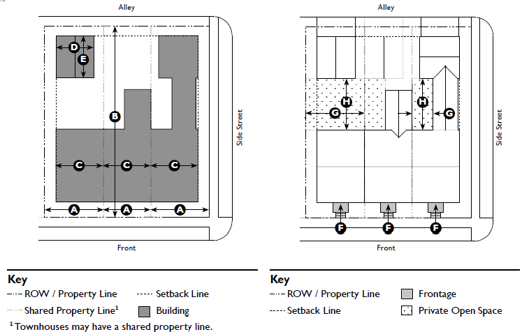
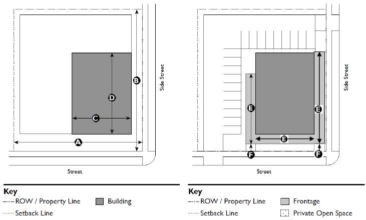
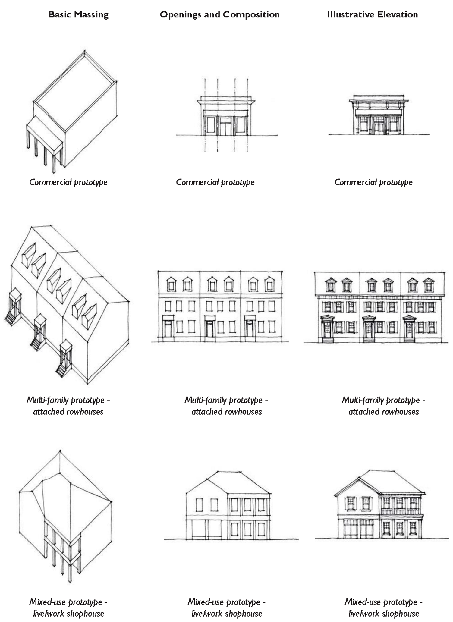
| Table 5.1.30.A: Traditional Building Types | ||
|---|---|---|
| Illustration | Building Type | Allowed In |
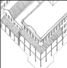
 | Carriage House. This building type is a secondary structure typically located at the rear of a lot. This structure frequently provides either a small residential unit, home office space, or other small commercial or service use that may be above a garage or at ground level. This building type is important for providing affordable housing opportunities and incubating small businesses within walkable neighborhoods. |  |
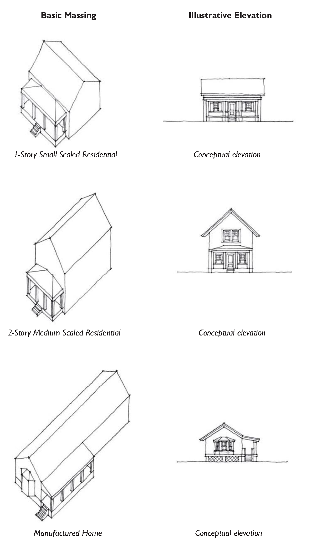
 | Detached House - Large. This building type is a large detached structure on a large lot that incorporates one unit. It is typically located within a primarily single-family residential neighborhood in a sub-urban or rural setting. If located within a walkable neighborhood, this building type is often sited along the water, or in a manner that provides a transition to more rural areas. While primarily used for single family housing, this building type is appropriate for low intensity group living. |  |
 | Detached House - Medium. This building type is a medium-sized detached structure on a moderate-sized lot that incorporates one unit. It is typically located within a primarily single-family residential neighborhood in a walkable urban setting, potentially near a neighborhood main street. While primarily used for single family housing, this building type is appropriate for low intensity group living and non-residential uses. | 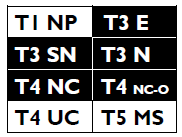 |
 | Detached House - Compact. This building type is a compact, detached structure on a small lot that incorporates one unit. This Type allows for appropriately-scaled, well-designed higher density housing within a primarily single-family neighborhood, and is important for providing a broad choice of detached housing types that promote walkability. While residential in form, this building type is ideal for low intensity retail, service, and office uses, and is often located near, or even on a neighborhood main street. |  |
 | Cottage Court. This building type consists of a series of small, detached structures on a single lot, providing multiple units arranged to define a shared court that is typically perpendicular to the street. The shared court takes the place of a private rear yard and becomes an important community-enhancing space. The Cottage Court allows for the introduction of appropriately-scaled medium density, detached housing within a single-family neighborhood, and is important for providing a broad choice of housing types that promote walkability. While residential in form, this building type allows for the establishment of a single-lot cluster of buildings dedicated to retail, the arts, education, and similar uses. |  |
| General Note: Images on this page are illustrative, not regulatory | ||
| Table 5.1.30.A: Traditional Building Types | ||
|---|---|---|
| Illustration | Building Type | Allowed In |
 | Duplex. This building type is a small to medium-sized structure that consists of two side-by-side or two stacked dwelling units, both facing the street. The Duplex is properly scaled, and designed to appear as a moderate to large single-family home, allowing for the introduction of medium density housing within a primarily detached single-family neighborhood. This Type is important for providing a broad choice of housing options that promote walkability. While residential in form, this building type is appropriate for low intensity retail, service, and office uses. |  |
 | Townhouse. This building type is a small to medium-sized attached structure that consists of three or more dwelling units placed side-by-side. This Type is typically located within medium-density neighborhoods or in a location that transitions from a primarily single-family neighborhood into a neighborhood main street. This building type is critical to the effort to provide a broad choice of housing types that promote walkability. While primarily residential in form, this Type may be used for live-work and similar medium intensity retail, service, and office uses. Syn: Rowhouse. |  |
 | Mansion Apartment. This building type is a medium structure that consists of three to six side-by-side and/or stacked dwelling units, typically with one shared entry or individual entries along the front. This Type has the appearance of a medium-sized family home and is appropriately scaled to fit in sparingly within primarily single-family neighborhoods or medium-density neighborhoods. This building type is critical to the effort to provide a broad choice of housing types that promote walkability. While residential in form, this building type may be appropriate for office, medical, lodging, and similar uses. | 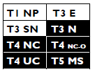 |
 | Apartment House. This building type is a medium-to-large-sized structure that consists of 7 to 12 side-by-side and / or stacked dwelling units, typically with one shared entry. This type is appropriately-scaled to fit within medium-density neighborhoods or sparingly within large lot predominantly singly-family neighborhoods. This building type is critical to the effort to provide a broad choice of housing types that promote walkability. Buildings shall not be constructed as isolated "complexes" but rather integrated into the neighborhood block and street system. While residential in form, this building type may be appropriate for office, medical, lodging, and similar uses. | 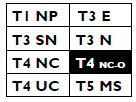 |
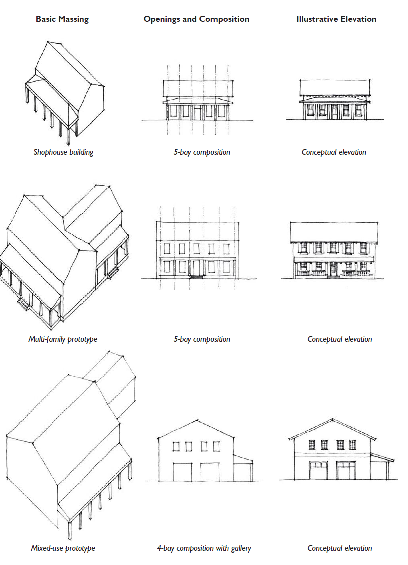
 | Flex Building. This building type is a medium to large-sized detached structure of one to two-and-a-half stories with a storefront treatment that most often accommodates commercial, recreational entertainment, light industrial, and other uses that are too large or intense to be appropriately housed in a residential or Main Street Mixed-Use building type. This building is inspired by the large vernacular prototypes of the lowcountry, including: packing sheds, barns, warehouses, and maritime structures. The front facade is typically flat, often with a Shopfront or Gallery frontage. This Type is a primary component of an urban flexible neighborhood that provides a mix of buildings, and is often located along significant thoroughfares. |  |
 | Main Street Mixed-Use. This building type is a small to medium-sized structure, typically attached, intended to provide a vertical mix of uses with ground-floor commercial, service, or retail uses and upper-floor commercial, service, or residential uses. This Type makes up the primary component of a neighborhood main street and portions of a downtown main street, and is critical to providing a walkable environment. | |
| General Note: Images on this page are illustrative, not regulatory | ||
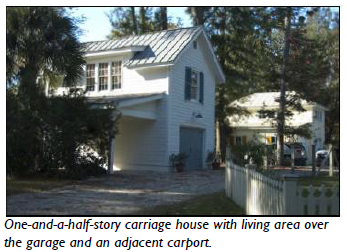
5.1.40 - Carriage House
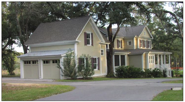
One-and-a-half-story Carriage House with living area over the garage.
| A. Description. | |
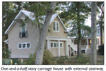 | Carriage House This building type is a secondary structure typically located at the rear of a lot. This structure frequently provides either a small residential unit, home office space, or other small commercial or service use that may be above a garage or at ground level. This building type is important for providing affordable housing opportunities and incubating small businesses within walkable neighborhoods. |
 | Allowed in Transect Zones |
| |
| General Note: Photos on this page are illustrative, not regulatory. |
| D. Building Size and Massing. | ||
| Height | ||
| Per building form standards based on zone. | ||
| Main Body | ||
| Width | 36 ft. max. | |
| Depth | 3 0 ft. max. | |
| Separation from main building | 10 ft. min. 1 | |
| 1 Carriage house may be connected to the main building by an uninhabitable space such as a breezeway. | ||
| Footprint | ||
| The Carriage House shall not have a larger footprint than the main building on the lot. | ||
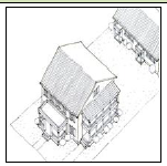
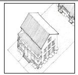
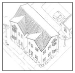
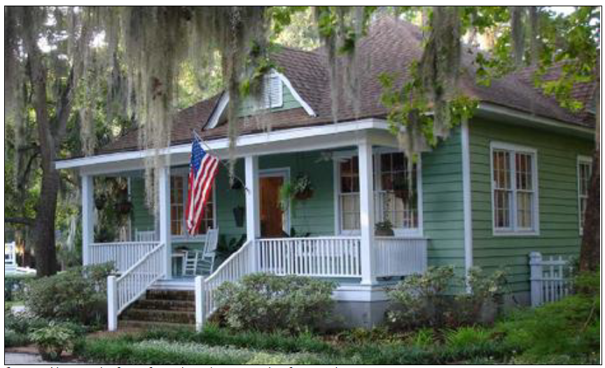
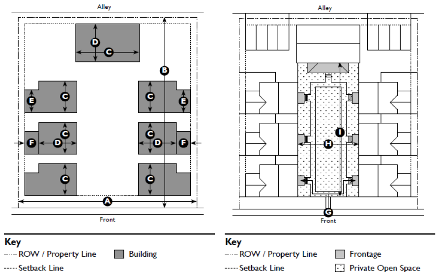
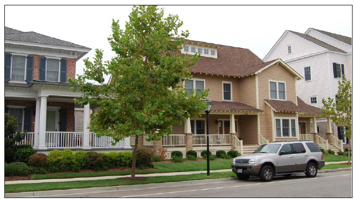
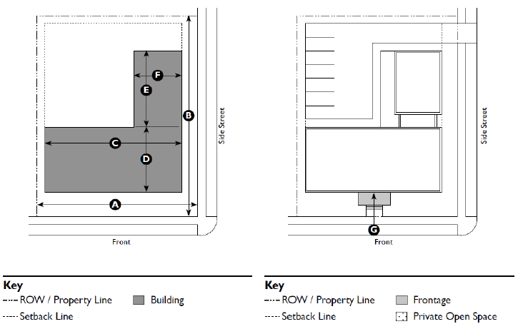
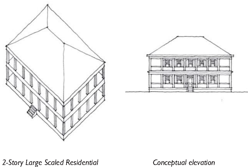
5.1.50 - Detached House - Large
Large House with a two-story porch for a private frontage.
| A. Description. | |
 | Detached House - Large. This building type is a large detached structure on a large lot that incorporates one unit. It is typically located within a primarily single-family residential neighborhood in a sub-urban or rural setting. If located within a walkable neighborhood, this building type is often sited along the water, or in a manner that provides a transition to more rural areas. While primarily used for single family housing, this building type is appropriate for low intensity group living. |
 | Allowed in Transect Zones |
| |
| General Note: Photos on this page are illustrative, not regulatory. |
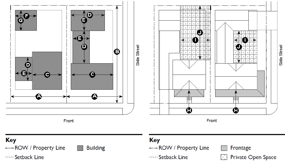
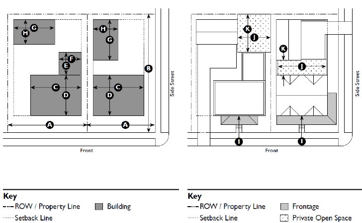
| B. Lot. | ||
| Lot Size | ||
| Width | 75 ft. min. | |
| Depth | 100 ft. min. | |
| Area | 10,000 SF min. | |
| D. Building Size and Massing. | ||
| Height | ||
| Per building form standards based on zone. | ||
| Main Body | ||
| Width | 48 ft. max. | |
| Secondary Wing(s) | ||
| Width 1 | 36 ft. max. | |
| Depth 1 | 30 ft. max. | |
| 1 Width and depth regulations do not apply to Secondary Wings located behind the Main Body. | ||
| Accessory Structure(s) | ||
| Width | 36 ft. max. | |
| Depth | 30 ft. max. | |
| Foundation | ||
| Exposed foundation walls or piers shall be clad in face brick, stone, stucco, or a similar masonry mater | ||
| Latticework, vertical or horizontal wood boards, or a similar screening shall be installed between piers on all sides. | ||
| F. Pedestrian Access. | ||
| Main Entrance Location | Front | |
| H. Private Open Space. | ||
| Width | 3 0 ft. min. | |
| Depth | 3 0 ft. min. | |
| Area | 3,000 SF min. | |
| Required street setbacks and driveways shall not be included in the private open space area calculation. | ||
| Required private open space shall be located behind the main body of the house. | ||
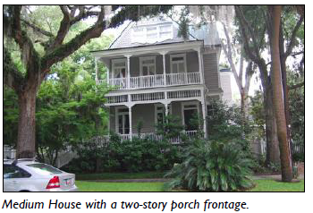
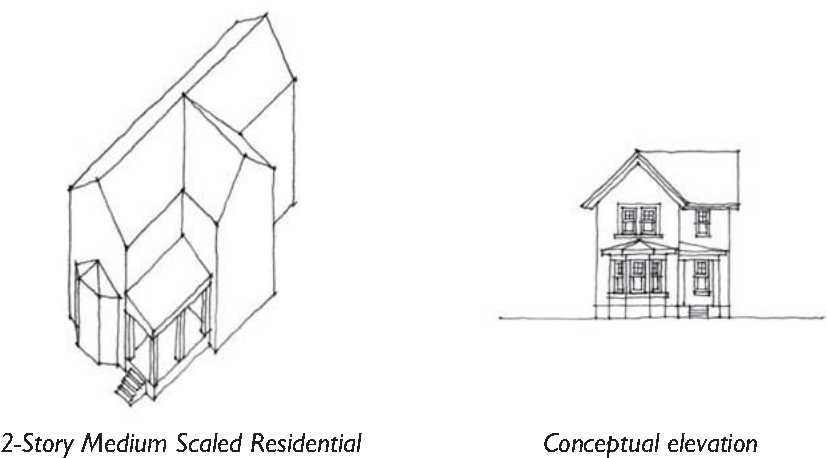
5.1.60 - Detached House - Medium
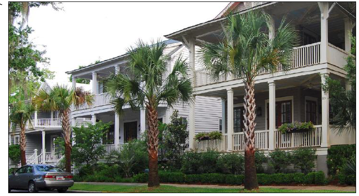
Streetscape of Medium Houses with two-story porches.
| A. Description. | |
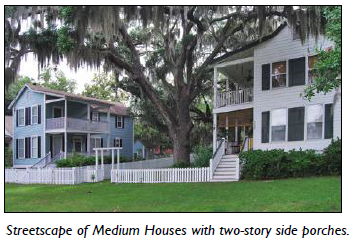 | Detached House - Medium. This building type is a medium-sized detached structure on a moderate-sized lot that incorporates one unit. It is typically located within a primarily single-family residential neighborhood in a walkable urban setting, potentially near a neighborhood main street. While primarily used for single family housing, this building type is appropriate for low intensity group living and non-residential uses. |
 | Allowed in Transect Zones |
 | |
| General Note: Photos on this page are illustrative, not regulatory. |
| B Lot. | ||
| Lot Size | ||
| Width | 50 ft. min.; 100 ft. max. 1 | |
| Depth | 75 ft. min.; 200 ft. max. 1 | |
| Area | 5,000 SF min. 1 | |
| 1 Smaller lot size permitted only if building type is already existing on lot at time of code adoption, X/X/2013 | ||
| D. Building Size and Massing. | ||
| Height | ||
| Per building form standards based on zone. | ||
| Main Body | ||
| Width | 48 ft. max. | |
| Secondary Wing(s) | ||
| Depth | 30 ft. max. | |
| Width | 30 ft. max. | |
| Accessory Structures(s) | ||
| Width | 24 ft. max. | |
| Depth | 30 ft. max | |
| Foundation | ||
| Exposed foundation walls or piers shall be clad in face brick, stone, stucco, or a similar masonry material. | ||
| Latticework, vertical or horizontal wood boards, or similar screening shall be installed between piers on all sides. | ||
| F. Pedestrian Access. | ||
| Main Entrance Location | Front | |
| G. Vehicle Access and Parking. | ||
| Parking may be accessed from the alley, side street or front. | ||
| Parking may be accessed from the front only when there is no adjacent alley or side street, and must meet all setbacks. | ||
| Tuck-under parking shall not be visible from the street. | ||
| H. Private Open Space. | ||
| Width | 20 ft. min. | |
| Depth | 20 ft. min. | |
| Area | 600 SF min. | |
| Required street setbacks and driveways shall not be included in the private open space area calculation. | ||
| Required private open space shall be located behind the main body of the house. | ||
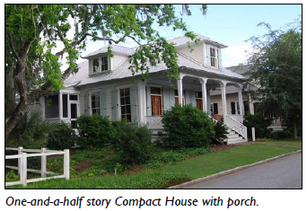
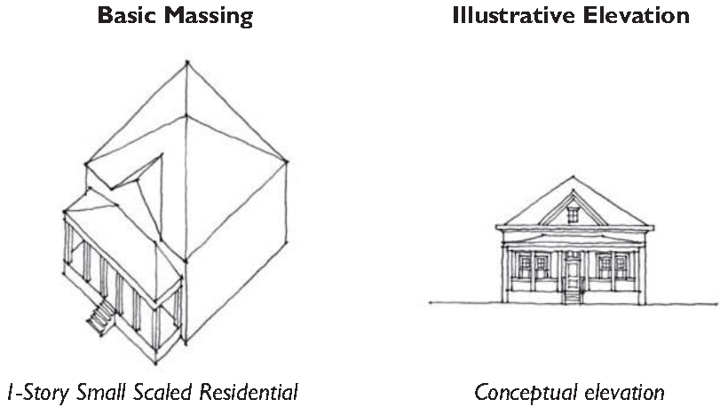
5.1.70 - Detached House - Compact
Compact House in the form of a traditional cottage with a front porch.
| A. Description. | |
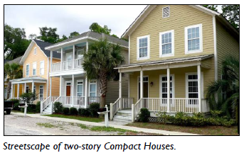 | Detached House - Compact. This building type is a compact, detached structure on a small lot that incorporates one unit. This Type allows for appropriately-scaled, well-designed higher density housing within a primarily single-family neighborhood, and is important for providing a broad choice of detached housing types that promote walkability. While residential in form, this building type is ideal for low intensity retail, service, and office uses, and is often located near, or even on a neighborhood main street. |
 | Allowed in Transect Zones |
| |
| General Note: Photos on this page are illustrative, not regulatory. |
| B. Lot. | ||
| Lot Size | ||
| Width | 30 ft. min.; 50 ft. max. 1 | |
| Depth | 50 ft. min.; 200 ft. max. 1 | |
| Area | 2,500 SF min. 1 | |
| 1 Smaller lot size permitted only if building type is already existing on lot at time of code adoption, X/X/2013 | ||
| D. Building Size and Massing. | ||
| Height | ||
| Per building form standards based on zone. | ||
| Main Body | ||
| Width | 36 ft. max. | |
| Secondary Wing(s) | ||
| Depth | 24 ft. max. | |
| Width | 24 ft. max. | |
| Accessory Structures(s) | ||
| Width | 24 ft. max. | |
| Depth | 30 ft. max | |
| Foundation | ||
|
Exposed foundation walls or piers shall be clad in face brick, stone, stucco, or a
similar masonry material.
Latticework, vertical or horizontal wood boards, or similar Screening shall be installed between piers on all sides. Latticework, vertical or horizontal wood boards, or a similar screening shall be installed between piers on all sides. | ||
| F. Pedestrian Access. | ||
| Main Entrance Location | Front | |
| H. Private Open Space. | ||
| Width | 15 ft. min. | |
| Depth | 15 ft. min. | |
| Area | 300 SF min. | |
| Required street setbacks and driveways shall not be included in the private open space area calculation. | ||
| Required private open space shall be located behind the main body of the house. | ||
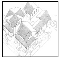
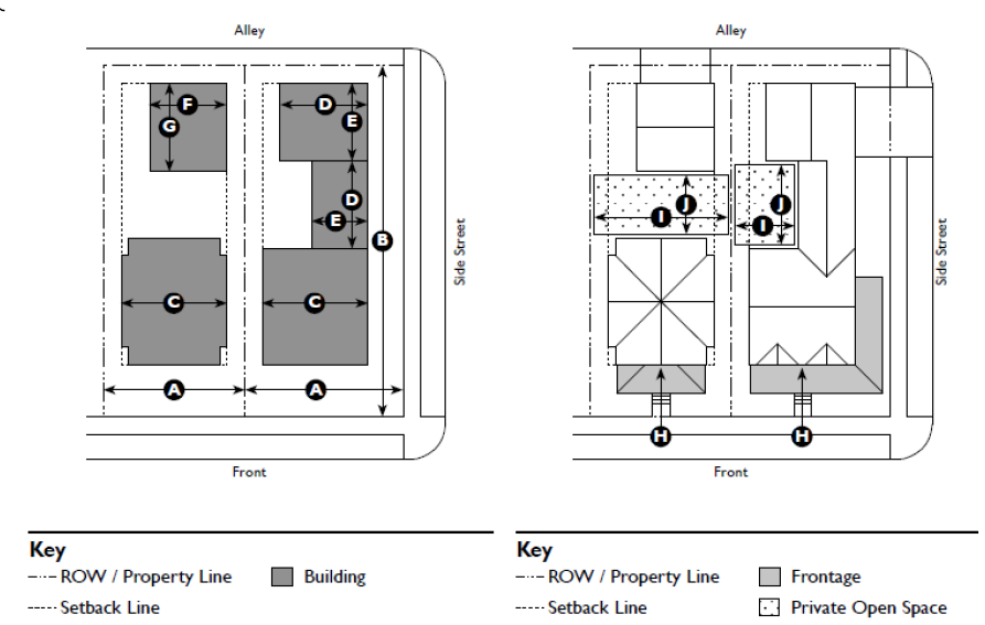
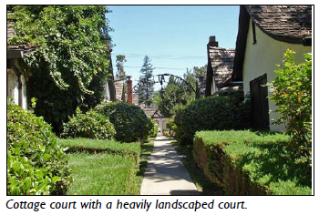
5.1.80 - Cottage Court
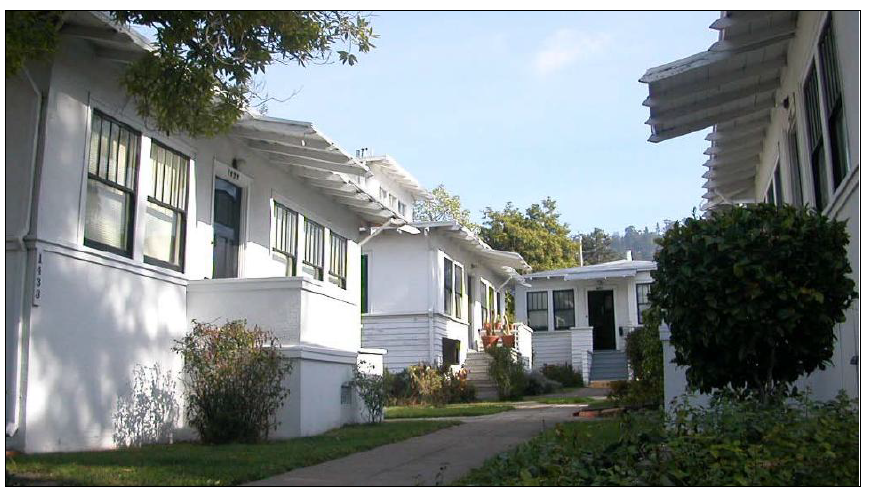
Cottage Court with raised stoop entries enclosing a formal, landscaped court that
primarily serves as a pedestrian passage.
| A. Description. | |
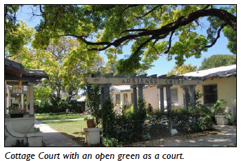 | Cottage Court. This building type consists of a series of small, detached structures on a single lot, providing multiple units arranged to define a shared court that is typically perpendicular to the street. The shared court takes the place of a private rear yard and becomes an important community-enhancing space. The Cottage Court allows for the introduction of appropriately-scaled medium density, detached housing within a single-family neighborhood, and is important for providing a broad choice of housing types that promote walkability. While residential in form, this building type allows for the establishment of a single-lot cluster of buildings dedicated to retail, the arts, education, and similar uses. |
 | Allowed in Transect Zones |
| |
| General Note: Photos on this page are illustrative, not regulatory. |
| B. Lot. | ||
| Lot Size | ||
| Width | 75 ft. min.; 150 ft. max. | |
| Depth | 100 ft. min.; 150 ft. max. | |
| Miscellaneous | ||
| This building type shall not be used on corner lots. | ||
| D. Building Size and Massing. | ||
| Height | ||
| Typically 1-1/2 stories. Per building form standards for zone. | ||
| Main Body | ||
| Width | 32 ft. max. | |
| Depth | 24 ft. max. | |
| Secondary Wing(s) | ||
| Width | 24 ft. max. | |
| Depth | 12 ft. max. | |
| Accessory Structure | ||
| F. Pedestrian Access. | ||
| Main Entrance Location: | ||
| Common Courtyard/Unit | Front | |
| H. Open Space. | |||||
| Common Courtyard | |||||
| Width | 20 ft. min. 1 | Depth | 20 ft. min. 1 | ||
| Area | 400 SF min. 1 | ||||
| 1 Alternative courtyard configurations may be approved so long as the minimum width, depth, and area are realized. | |||||
| Private Open Space | |||||
| No private open space is required. | |||||
5.1.90 - Duplex
A side-by-side duplex with each unit having its own porch.
| A. Description. | |
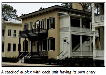 | Duplex. This building type is a small to medium-sized structure that consists of two side-by-side or two stacked dwelling units, both facing the street. The Duplex is properly scaled, and designed to appear as a moderate to large single-family home, allowing for the introduction of medium density housing within a primarily detached single-family neighborhood. This Type is important for providing a broad choice of housing options that promote walkability. While residential in form, this building type is appropriate for low intensity retail, service, and office uses. |
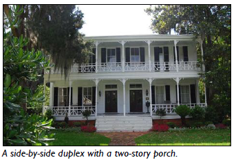 | Allowed in Transect Zones |
| |
| General Note: Photos on this page are illustrative, not regulatory. |
| B. Lot. | ||
| Lot Size | ||
| Width | 30 ft. min.; 75 ft. max. | |
| Depth | 100 ft. min.; 150 ft. max. | |
| Units may be side by side or stacked as individual "flats" | ||
| D. Building Size and Massing. | ||
| Height | ||
| Per building form standards based on zone. | ||
| Main Body | ||
| Width | 48 ft. max. | |
| Secondary Wing(s) | ||
| Width | 24 ft. max. | |
| Accessory Structure(s) | ||
| Width | ||
| Individual unit ownership | 24 ft. max. | |
| Shared between units | 48 ft. max. | |
| Depth | 30 ft. max | |
| Foundation | ||
| Exposed foundation walls or piers shall be clad in face brick, stone, stucco, or a similar masonry material. | ||
| Latticework, vertical or horizontal wood boards, or similar screening shall be installed between piers on all sides. | ||
| F. Pedestrian Access. | ||
| Main Entrance Location | Front 2 | |
| Each unit shall have an individual entry facing the street on or no more than 10 ft. behind the front facade. | ||
| 2 On corner lots, each unit shall front a different street. | ||
| H. Private Open Space. | ||
| Width | 15 ft. min. | |
| Depth | 15 ft. min. | |
| Area | 300 SF min. | |
| Required street setbacks and driveways shall not be included in the private open space area calculation. | ||
| Required private open space shall be located behind the main body of the house. | ||
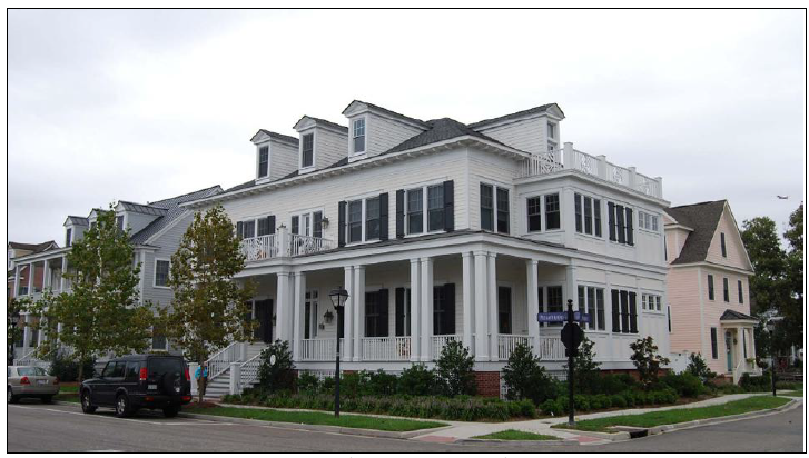
5.1.100 - Townhouse
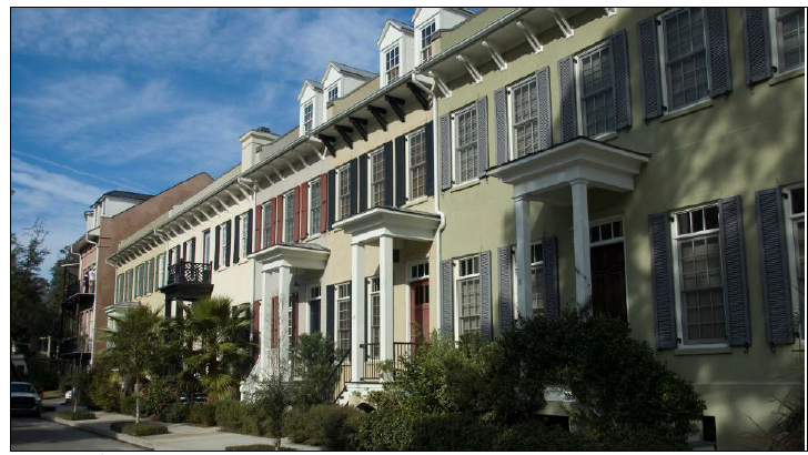
Streetscape of traditional Townhomes in which individual stoops, dormers, and color
help to breakdown the overall massing.
| A. Description. | |
 | Townhouse. This building type is a small to medium-sized attached structure that consists of three or more dwelling units placed side-by-side. This Type is typically located within medium-density neighborhoods or in a location that transitions from a primarily single-family neighborhood into a neighborhood main street. This building type is critical to the effort to provide a broad choice of housing types that promote walkability. While primarily residential in form, this Type may be used for live-work and similar medium intensity retail, service, and office uses. Syn: Rowhouse. |
 | Allowed in Transect Zones |
| |
| General Note: Photos on this page are illustrative, not regulatory. |
| B. Lot. | ||
| Lot Size | ||
| Width | 16 ft. min. | |
| Depth | 80 ft. min. | |
| D. Building Size and Massing. | ||
| Height | ||
| Per building form standards based on zone. | ||
| Main Body | ||
| Width | 16 ft. min.; 36 ft. max. | |
| Secondary Wing(s) | ||
| The footprint area of the secondary wing(s) may not exceed the footprint area of the main body. | ||
| Accessory Structure(s) | ||
| Width | 24 ft. max. | |
| Depth | 30 ft. max | |
| The footprint area of an accessory structure may not exceed the footprint area of the main body. | ||
| F. Pedestrian Access. | ||
| Main Entrance Location | Front | |
| Each unit shall have an individual entry facing a street. | ||
| H. Private Open Space. | ||
| Width | 8 ft. min. | |
| Depth | 8 ft. min. | |
| Area | 100 SF min. | |
| Required street setbacks and driveways shall not be included in the private open space area calculation. | ||
| Required private open space shall be located behind the main body of the house. | ||
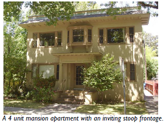
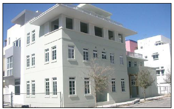
5.1.110 - Mansion Apartment
A mansion apartment with the scale and character of the surrounding single-family
houses.
| A. Description. | |
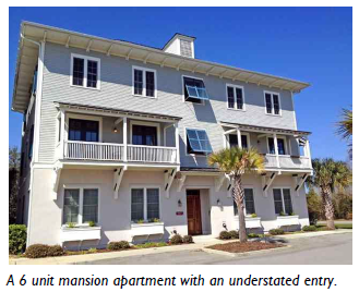 | Mansion Apartment. This building type is a medium structure that consists of three to six side-by-side and/or stacked dwelling units, typically with one shared entry or individual entries along the front. This Type has the appearance of a medium-sized family home and is appropriately scaled to fit in sparingly within primarily single-family neighborhoods or medium-density neighborhoods. This building type is critical to the effort to provide a broad choice of housing types that promote walkability. While residential in form, this building type may be appropriate for office, medical, lodging, and similar uses. |
 | Allowed in Transect Zones |
| |
| General Note: Photos on this page are illustrative, not regulatory. |
| B. Lot. | ||
| Lot Size | ||
| Width | 50 ft. min.; 100 ft. max. | |
| Depth | 100 ft. min.; 150 ft. max. | |
| D. Building Size and Massing. | ||
| Height | ||
| Per building form standards based on zone. | ||
| Main Body | ||
| Width | 48 ft. max. | |
| Depth | 36 ft. max. | |
| Secondary Wing(s) | ||
| Width | 30 ft. max. | |
| Depth | 30 ft. max. | |
| Accessory Structure(s) | ||
| Width | 48 ft. max. | |
| Depth | 30 ft. max. | |
| The footprint area of an accessory structure may not exceed the footprint area of the main body. | ||
| Foundation | ||
| Exposed foundation walls or piers shall be clad in face brick, stone, stucco, or a similar masonry material. | ||
| Latticework, vertical or horizontal wood boards, or similar screening shall be installed between piers on all sides. | ||
| F. Pedestrian Access. | ||
| Main Entrance Location | Front | |
| Each unit may have an individual entry. | ||
| H. Common Open space. | ||
| Common Courtyard | ||
| Width | 8 ft. min. | |
| Depth | 8 ft. min. | |
| Area | 100 SF min. | |
| Required street setbacks and driveways shall not be included in the common open space area calculation. | ||
| Required common open space shall be located behind the main body of the house. | ||
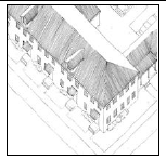
5.1.120 - Apartment House
An apartment house with an understated and recessed stoop.
| A. Description. | |
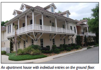 | Apartment House. This building type is a medium-to-large-sized structure that consists of 7 to 12 side-by-side and / or stacked dwelling units, typically with one shared entry. This type is appropriately-scaled to fit within medium-density neighborhoods or sparingly within large lot predominantly singly-family neighborhoods. This building type is critical to the effort to provide a broad choice of housing types that promote walkability. Buildings shall not be constructed as isolated "complexes" but rather integrated into the neighborhood block and street system. While residential in form, this building type may be appropriate for office, medical, lodging, and similar uses. |
 | Allowed in Transect Zones |
 | |
| General Note: Photos on this page are illustrative, not regulatory. |
| B. Lot. | ||
| Lot Size | ||
| Width | 75 ft. min.; 150 ft. max. | |
| Depth | 100 ft. min.; 150 ft. max. | |
| D. Building Size and Massing. | ||
| Height | ||
| Per building form standards based on zone. | ||
| Main Body | ||
| Width | 60 ft. max. | |
| Depth | 50 ft. max. | |
| Secondary Wing(s) | ||
| Width | 48 ft. max.; 60 ft. allowed if broken in floor plan and roof form. More than 1 allowed. Only in T4 NC-O and T4 UC | |
| Depth | 36 ft. max. | |
| Accessory Structure(s) | ||
| Width | 48 ft. max. | |
| Depth | 30 ft. max. | |
| The footprint area of an accessory structure may not exceed the footprint area of the main body. | ||
| F. Pedestrian Access. | ||
| Main Entrance Location | Front | |
| Units located in the Main Body shall be accessed by a Common entry along the front. | ||
| On corner lots, units in a secondary wing may front the side street. | ||
(Ord. No. 2018-11, 11-14-18)
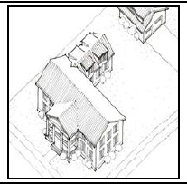
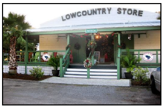
5.1.130 - Flex Building
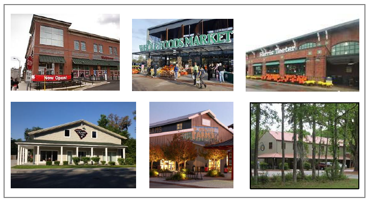
A pictorial collage of medium to large-sized, primarily single use, Flex Buildings.
| A. Description. | |
 | Flex Building. This building type is a medium to large-sized detached structure of one to two-and-a-half stories with a storefront treatment that most often accommodates commercial, recreational entertainment, light industrial, and other uses that are too large or intense to be appropriately housed in a residential or Main Street Mixed-Use building type. This building is inspired by the large vernacular prototypes of the lowcountry, including: packing sheds, barns, warehouses, and maritime structures. The front facade is typically flat, often with a Shopfront or Gallery frontage. This Type is a primary component of an urban flexible neighborhood that provides a mix of buildings, and is often located along significant thoroughfares. |
 | Allowed in Transect Zones |
| |
| General Note: Photos on this page are illustrative, not regulatory. |
| B. Lot. | ||
| Lot Size | ||
| Width | 100 ft max. | |
| Depth | 200 ft max. | |
| Large Footprint Building Only | ||
| Width | Max. width of block face | |
| Depth | Max. depth of block face | |
| C. Building Size and Massing. | ||
| Height | ||
| Per building form standards based on zone. | ||
| Main Body | ||
| Width | 100 ft. max. | |
| Depth | 150 ft. max. | |
| Large Footprint Building Only | ||
| Width | Max. width of block face | |
| Depth | Max. width of block face | |
| 1 Frontage shall extend along a min. of 75% of the front facade and 75% of the street side or side frontage. |
| E. Pedestrian Access. | ||
| Main entrance location on front facade of building: | ||
| Mid-block site: | Middle or corner. | |
| Corner Site: | Shall include middle or street side corner. | |
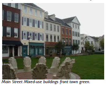
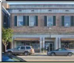
5.1.140 - Main Street Mixed-Use
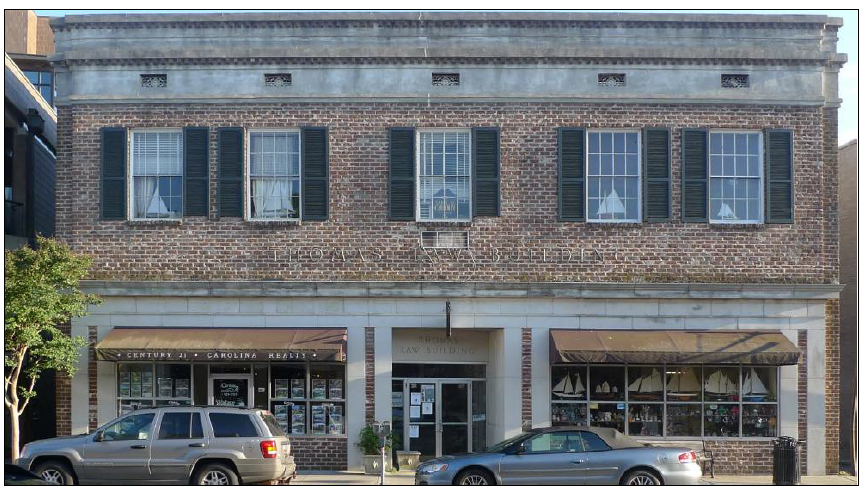
Historic Main Street Mixed-use building.
| A. Description. | |
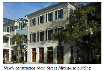 | Main Street Mixed-Use. This building type is a small to medium-sized structure, typically attached, intended to provide a vertical mix of uses with ground-floor commercial, service, or retail uses and upper-floor commercial, service, or residential uses. This Type makes up the primary component of a neighborhood main street and portions of a downtown main street, and is critical to providing a walkable environment. |
 | Allowed in Transect Zones |
| |
| General Note: Photos on this page are illustrative, not regulatory. |
| B. Lot. | ||
| Lot Size | ||
| Width | 25 ft. min.; 150 ft. max. | |
| Depth | 80 ft. min.; 150 ft. max. | |
| Large Footprint Building Only | ||
| Width | Max. width of block face | |
| Depth | Max. depth of block face | |
| D. Building Size and Massing. | ||
| Height | ||
| Per building form standards based on zone. | ||
| Main Body | ||
| Width | 150 ft. max. | |
| Depth | 80 ft. max. | |
| Large Footprint Building Only | ||
| Width | Max. width of block face | |
| Depth | Max. depth of block face | |
| Secondary Wing(s) / Accessory Structure(s) | ||
| Width | 100 ft. max. | |
| Depth | 65 ft. max. | |
| Separation from Main Body | 10 ft. min. | |
| A secondary wing / accessory structure shall have a smaller footprint, a narrower width, and a depth not greater than the main body. | ||
| F. Pedestrian Access. | |
| Upper floor units located in the main body shall be accessed by a common entry along the front. | |
| Ground floor units may have individual entries along the front or side street. | |
| On corner lots, units in a secondary wing/accessory structure may front the side street. | |
5.2.10 - Purpose
Exceptional Buildings refer to a subset of Traditional Building Types in which the form of the structure is primarily driven by its function or use. These provisions supplement the standards for Traditional Buildings, and contain additional requirements regarding location, site planning, and building design. At the community scale, these criteria ensure the continued establishment and promotion of walkable places of value and meaning; while at the lot level, they maximize the application of appropriately-scaled elements and features.
5.2.20 - Applicability
The requirements of this Division shall only apply to those uses listed with each Exceptional Building Type. They shall be considered in combination with the standards of Division 5.1 (Traditional Building Types), the applicable zone in Article 3 (Specific to Zones), and the provisions of this Division.
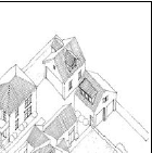
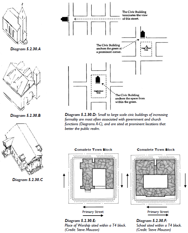
5.2.30 - Landmark Buildings
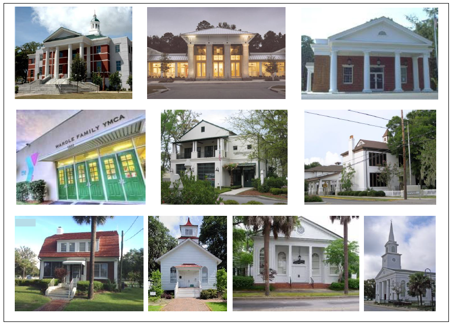
A pictorial collage of Landmark Buildings who's prominent siting and design reflects
their significant contribution to the community.
Landmark Buildings: Community Oriented Facility; Community Recreation Facility; Community Safety Facility; Meeting Facility or Place of Worship; Schools: Public or Private and College or University.
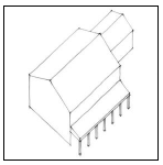
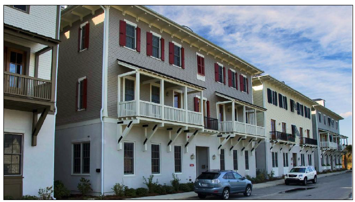
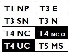
5.2.40 - Gas Station
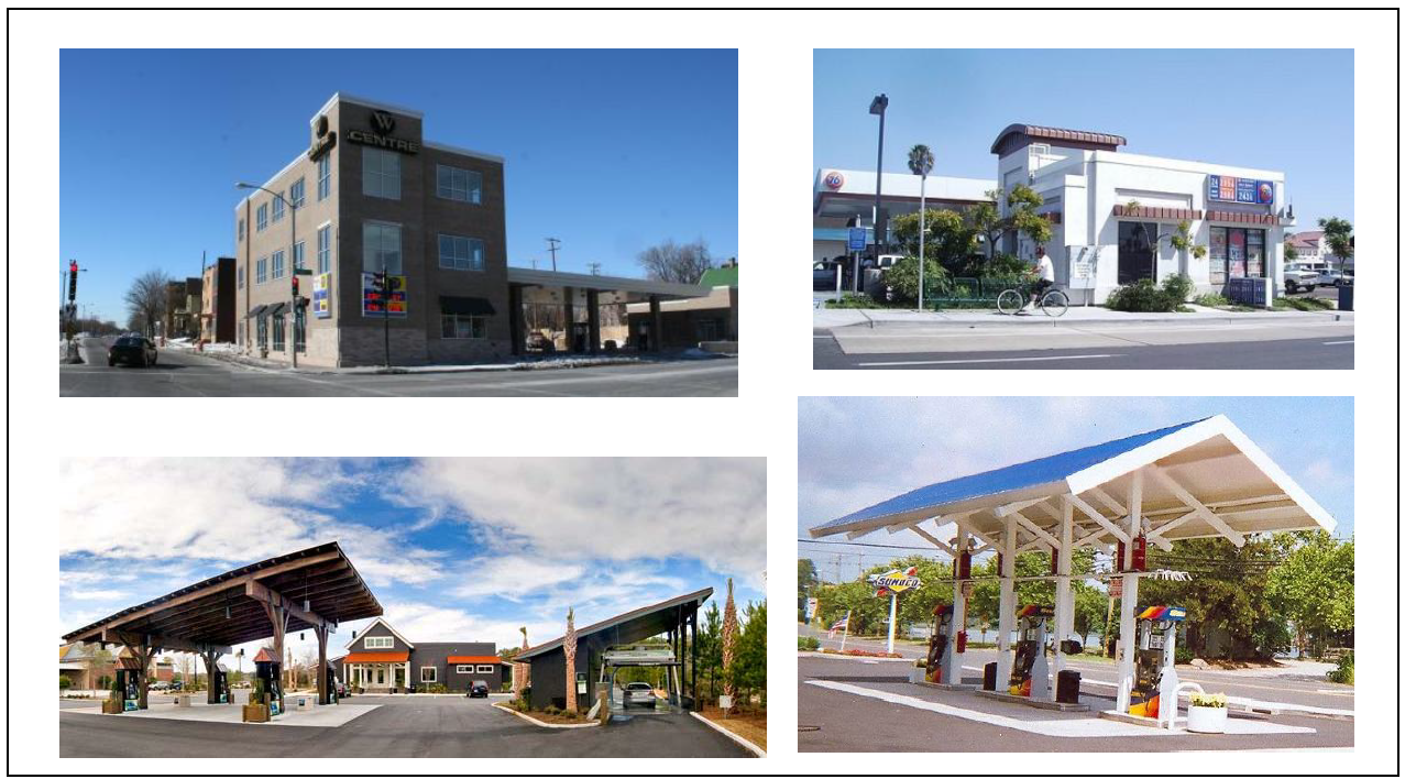
In this pictorial collage the Gas Station's main building anchor's the corner (above).
The pumps (below) are appropriately scaled to the building and display architectural
merit. When combined, these attributes create a more walkable and interesting streetscape.
| A. Description. |
| Gas Station. A corner-lot or mid-block building type which provides for necessary services without sacrificing the walkability of the surrounding street frontage. Gas pumps are located behind a shopfront "convenience store" that addresses the street and is designed to the dimensional and development standards of this code. |
| Allowed in Transect Zones |
 |
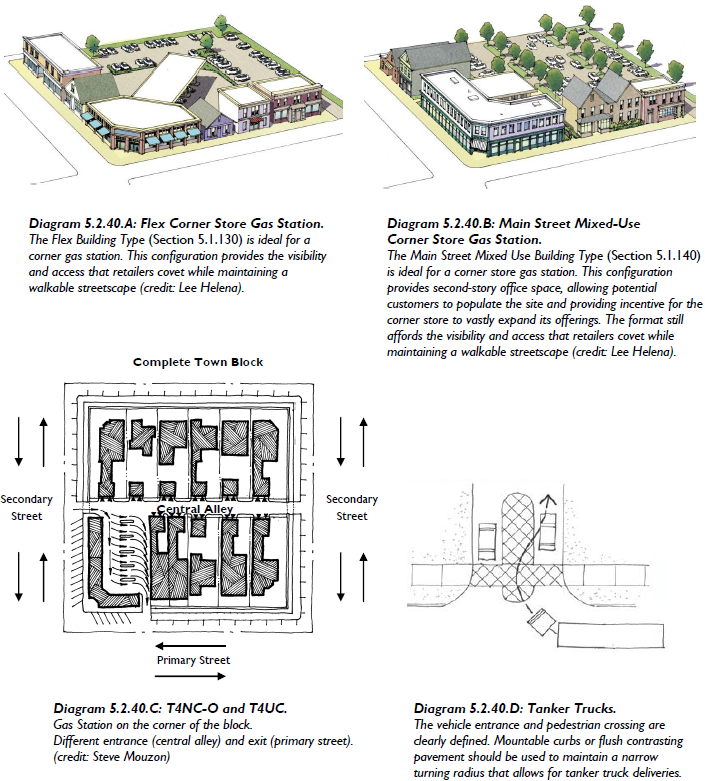
Gas Station. The following Diagrams depict potential and desired configurations for Gas Stations.
(Ord. No. 2015-8, 5-13-15)
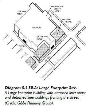
5.2.50 - Large Footprint Building
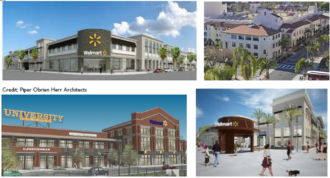
This pictorial collage demonstrates how a large footprint structure that is typically
associated with an auto-centric, suburban location can be sited in an "in-town" setting
that maintains an interesting streetscape and promotes walkability.
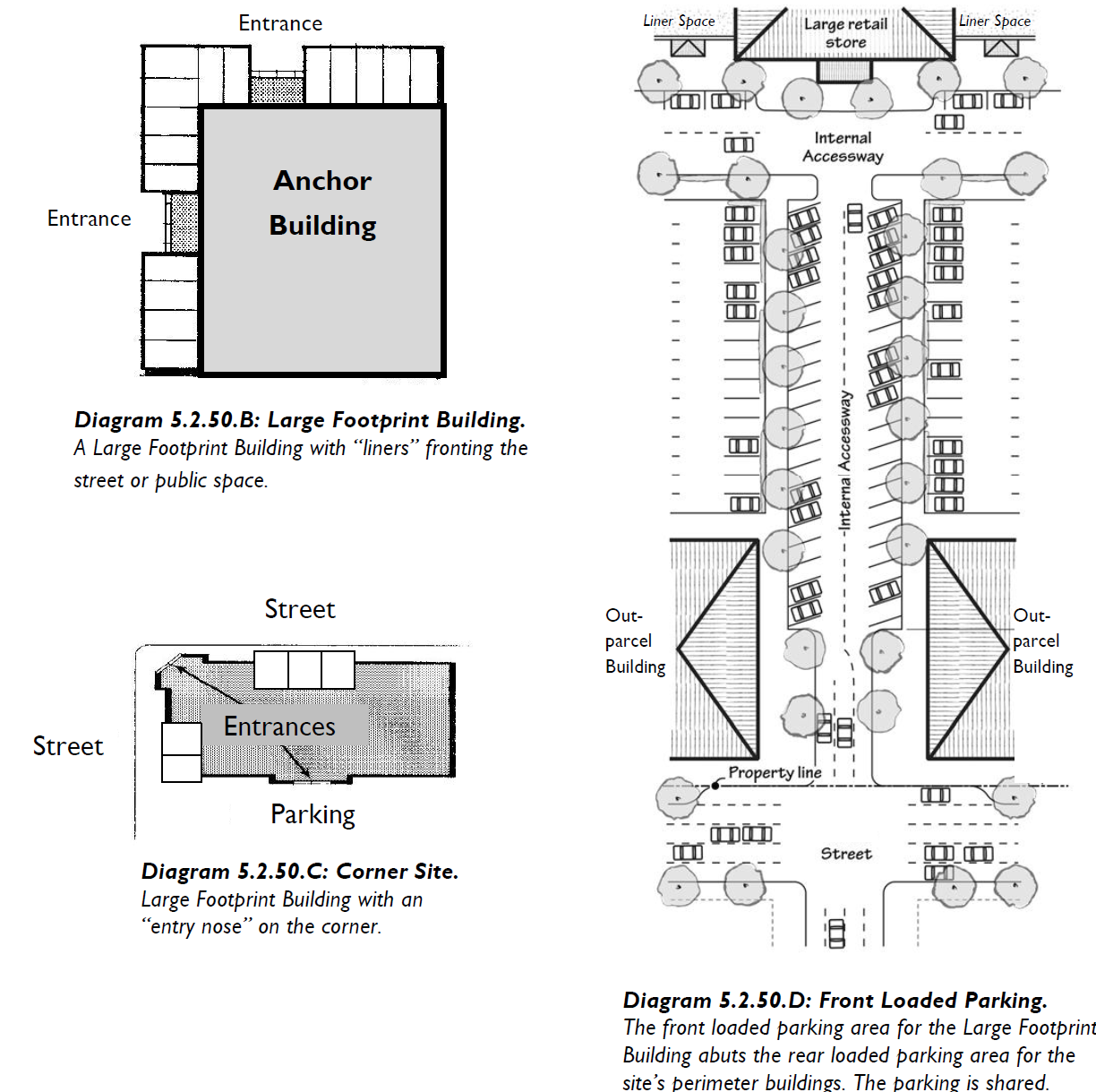
| A. Description |
| Large Footprint Building. A building type that appropriately accommodates a large building envelope devoted to a single use in excess of 35,000 sf. Large Footprint Buildings are required to provide commercial, office, or residential liner space along each facade that fronts a public street or space. |
| Those functions deemed applicable for a Large Footprint Building are conducive to a walkable environment, and: |
| • The use is inherently associated with long blank exterior walls, requiring special treatment (i.e., parking garage, movie theater, warehouse club, etc.); and / or |
| • The use is associated with a single story structure whose mass (20 to 30 ft tall) often equals that of a standard 2-3 story building (e.g., department store, building supply, grocery store, etc.), |
| While a multi-story format is encouraged, a single story building with liners is equally beneficial to the public realm. |
| Allowed in Transect Zones |
 |
| G. Pedestrian Access |
| Per the standards for the underlying building type in 5.1 (Traditional Building Types). |
| Every habitable space on the ground floor shall locate its main entrance along the facade such that it provides access directly from the street right-of-way. |
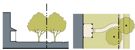
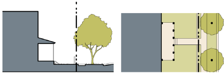
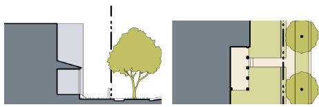
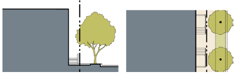
| The pedestrian entrance for the "anchor" use may breach the "liner space" and address the perimeter street frontage in the form of a storefront "entry nose." See Diagrams 5.2.50.A: (Large Footprint Site); 5.2.50.C: (Corner Site). |
| H. Vehicular Access and Parking |
| Access |
| Per the standards for the underlying building type in Division 5.1 (Traditional Building Types), |
| Vehicular access to a parking garage shall be provided through an alley, where available, or directly from a secondary street. Direct access from a primary street shall not be permitted. |
| Parking |
| To the maximum extent practicable on-site parking shall be located as conveyed in Article 3 (Specific to Zones). |
| Front-loaded Parking |
| Facilities that desire a front-loaded parking lot shall be strongly discouraged, and shall only be permitted if: |
| 1. The facility and parking is sited internal to the lot / block; and |
| 2. The facility is appropriately "lined" with commercial, office, or residential space (as conveyed in this Section); and |
| 3. The facility and parking is constructed as part of a larger, multi-building project as conveyed and depicted in Sub-section 2.2.100 (Multi-building Development); and |
| 4. The facility and parking is "wrapped" by outparcels / perimeter buildings that occupy a minimum of 70% of the perimeter street frontage (primary and secondary); and |
| 5. The "Front-loaded" parking area abuts a rear or side-loaded parking area for one or more perimeter buildings on the site (See Diagram 5.2.50.D: Front-Loaded Parking). If possible this parking shall be shared. |
 |
5.3.10 - Purpose
This Division sets forth the standards applicable to the development of private frontages. Private frontages are the components of a building that provide an important transition and interface between the public realm (street and sidewalk) and the private realm (yard or building). These standards supplement the standards for each zone that the frontage types are allowed within. For each private frontage type, a description, a statement of the type's intent, and design standards are provided. These standards are intended to ensure development that reinforces the highly-valued existing character and scale of the Town of Port Royal.
5.3.20 - Applicability
These standards work in combination with the standards found in Article 3 (Specific to Zones), Division 5.1 (Traditional Building Types), Division 5.2 (Exceptional Building Types), and are applicable to all private frontages within transect zones.
5.3.30 - Private Frontages Overview
A.
Table 5.3.30.A (Private Frontages - General) provides an overview of the required private frontage types.
B.
Exception. A Landmark Building may incorporate a permitted Required Frontage, as conveyed in Sub-section 5.2.30.G (Building Design) in any zoning district.
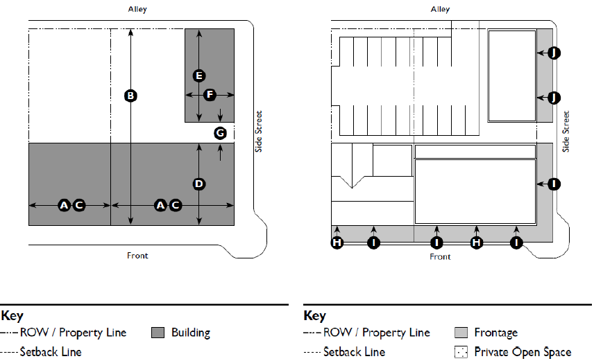
5.3.30.A - Private Frontages - General
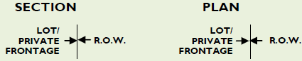
| The private frontage is the area between the building facade and the lot line. | |
|---|---|
 | |
 | |
| Common Yard. The main facade of the building has a large planted setback from the frontage line providing a buffer from the higher-speed thoroughfares. The front yard created remains unfenced and is visually continuous with adjacent yards, supporting a common landscape and working in conjunction with the other private frontages. | |
| _____ | |
 | |
| Porch: Projecting. The main facade of the building has a small to medium setback from the frontage line. The resulting front yard is typically very small and can be defined by a fence or hedge to spatially maintain the edge of the street. The projecting porch is open on three sides and all habitable space is located behind the setback line. | |
| _____ | |
 | |
| Porch: Engaged. The main facade of the building has a small to medium setback from the frontage line. The resulting front yard is typically very small and can be defined by a fence or hedge to spatially maintain the edge of the street. The engaged porch has at least two adjacent sides engaged to the building while the other sides are open. | |
| _____ | |
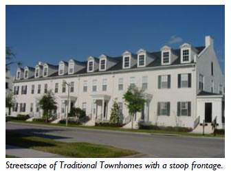
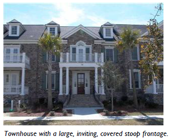
 | |
| Stoop. The main facade of the building is near the frontage line and the elevated Stoop engages the sidewalk. The stoop shall be elevated above the sidewalk to ensure privacy within the building. Stairs from the stoop may lead directly to the sidewalk or may be side-loaded. This type is appropriate for residential uses with small setbacks. | |
| _____ | |
 | |
| Forecourt. The main facade of the building is at or near the frontage line and a small percentage is set back, creating a small court space. The space could be used as an entry court or shared garden space for apartment buildings, or as an additional shopping or restaurant seating area within commercial areas. | |
| _____ | |
| The private frontage is the area between the building facade and the lot line. | |
|---|---|
| |
 | |
| Dooryard. The frontage line is defined by a low wall or hedge and the main facade of the building is set back a small distance creating a small dooryard. The dooryard shall not provide public circulation along a ROW. The dooryard may be raised, sunken, or at grade and is intended for ground floor residential in flex zones, live/work, and small commercial uses. | |
| _____ | |
 | |
| Shopfront. The main facade of the building is at or near the frontage line with an at-grade entrance along the public way. This type is intended for retail use. It has substantial glazing at the sidewalk level and may include an awning that may overlap the sidewalk. It may be used in conjunction with other frontage types. Syn: Retail Frontage, Awning. | |
| _____ | |
 | |
| Terrace. The main facade is at or near the frontage line with an elevated Terrace providing public circulation along the facade. This type can be used to provide at-grade access while accommodating a grade change. Frequent steps up to the terrace are necessary to avoid dead walls and maximize access. This type may also be used to mimic historic loading docks. | |
| _____ | |
 | |
| Gallery. The main facade of the building is at the frontage line and the Gallery element overlaps the sidewalk. This type is intended for buildings with ground-floor commercial uses and may be one or two stories. The gallery should extend far enough from the building to provide adequate circulation for pedestrians and extend close enough to the curb so that a pedestrian cannot bypass it. | |
| _____ | |
 | |
| Arcade. An arcade is a covered walkway with habitable space above often encroaching into the ROW and should extend far enough from the building to provide adequate protection and circulation for pedestrians. This type is intended for buildings with ground floor commercial uses and is common along public courtyards. Syn: Colonnade | |
| _____ | |
5.3.40 - Common Yard
| A. Description |  | ||
| Common Yard. The main facade of the building has a large planted setback from the frontage line providing a buffer from the higher-speed thoroughfares. The front yard created remains unfenced and is visually continuous with adjacent yards, supporting a common landscape and working in conjunction with the other private frontages. | |||
| B. Size | |||
| Depth | 20 ft. min. | ||
| C. Miscellaneous | |||
| Fences between front yards or between the sidewalk and front yard are not allowed. | |||
| Common Yard Frontages shall be used in conjunction with another required private frontage type, such as a porch. | |||
 | |||
5.3.50 - Porch: Projecting
| A. Description |  | ||
| Porch: Projecting. The main facade of the building has a small to medium setback from the frontage line. The resulting front yard is typically very small and can be defined by a fence or hedge to spatially maintain the edge of the street. The Projecting Porch is open on three sides and all habitable space is located behind the setback line. | |||
| B. Size | |||
| Width, Clear | 10 ft. min. | ||
| Depth, Clear | 8 ft. min. | ||
| Height, Clear | 8 ft. min. | ||
| Height | 2 stories max. | ||
| Finish Level above Sidewalk | 18 inches min. |  | |
| Stairs | 3 ft. min. clear area | ||
| C. Miscellaneous | |||
| Projecting Porches are open on three sides and must have a roof. | |||
| In transect zones where both Projecting Porches and encroachments are allowed, a Projecting Porch is an allowable encroaching element. | |||
5.3.60 - Porch: Engaged
| A. Description |  | ||
| Porch: Engaged. The main facade of the building has a small to medium setback from the frontage line. The resulting front yard is typically very small and can be defined by a fence or hedge to spatially maintain the edge of the street. Traditionally, the Engaged Porch has two adjacent sides engaged (attached) to the building while the other sides are open. An Engaged Porch may may also be attached on three sides (photo at right). The porch is typically recessed and centered. | |||
| B. Size | |||
| Width, Clear | 10 ft. min. | ||
| Depth, Clear | 8 ft. min. | ||
| Height, Clear | 8 ft. min. | 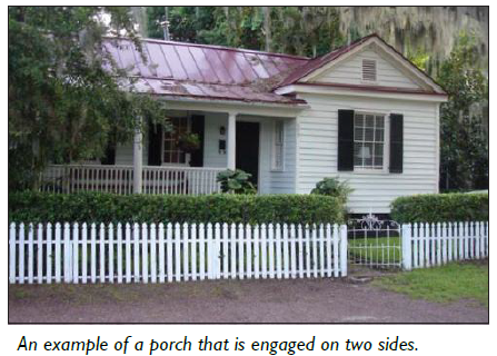 | |
| Height | 2 stories max. | ||
| Finish Level above Sidewalk | 18 inches min. | ||
| Stairs | 3 ft. min. clear area | ||
| C. Miscellaneous | |||
| Engaged Porch with 2 sides attached to the building: The porch and up to 2/5 of the building facade may project beyond the setback line into the encroachment area. | |||
| Engaged Porch with 3 sides attached to the building: Neither the porch nor any aspect of the facade may encroach beyond the setback line into the encroachment area. | |||
| Engaged Porches must be open on one, but no more than two sides. They must have a roof. | |||
5.3.70 - Stoop
| A. Description | 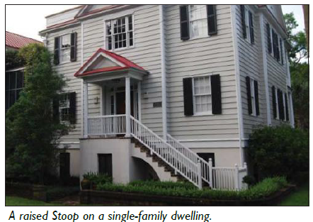 | ||
| Stoop. The main facade of the building is near the frontage line and the elevated Stoop engages the sidewalk. The Stoop shall be elevated above the sidewalk to ensure privacy within the building. Stairs from the Stoop may lead directly to the sidewalk or may be side-loaded. This type is appropriate for residential uses with small setbacks. | |||
| B. Size | |||
| Width, Clear | 5 ft. min.; 8 ft. max. | ||
| Depth, Clear | 5 ft. min.; 8 ft. max. | ||
| Height, Clear | 8 ft. min. | ||
| Height | 1 story max. | ||
| Depth of Recessed Entries | 6 ft. max. | 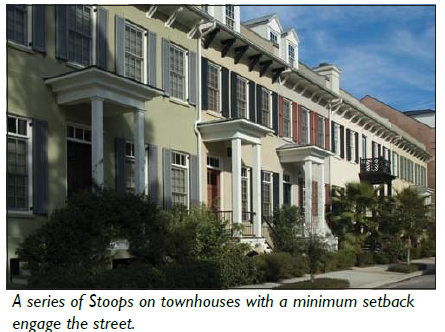 | |
| Finish Level above Sidewalk | 18 inches min. | ||
| C. Miscellaneous | |||
| Stairs may be perpendicular or parallel to the building facade. | |||
| Ramps shall be parallel to the facade or along the side of the building. | |||
| The entry door shall be covered or recessed to provide shelter from the elements. | |||
| All doors must face the street. | |||
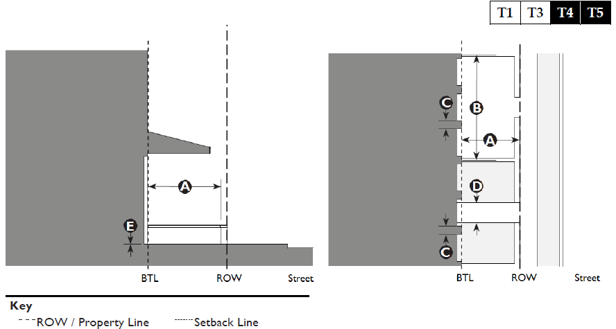
5.3.80 - Forecourt
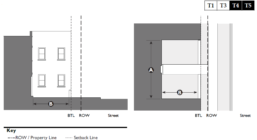
| A. Description | 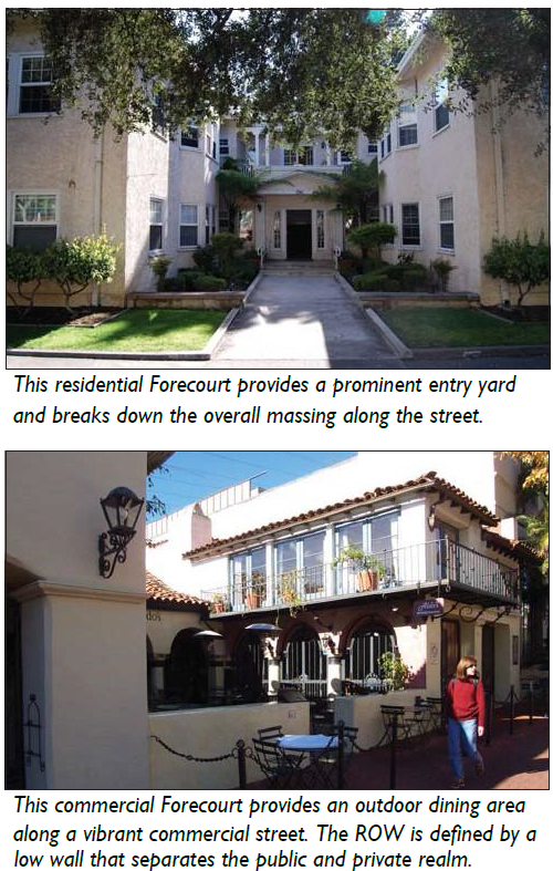 | ||
| Forecourt. The main facade of the building is at or near the frontage line and a small percentage is set back, creating a small court space. The space could be used as an entry court or shared garden space for apartment buildings, or as an additional shopping or restaurant seating area within commercial areas. | |||
| B. Size | |||
| Width, Clear | 12 ft. min. | ||
| Depth Clear | 12 ft. min. | ||
| Ratio, Height to Width | 2:1 max. | ||
| C. Miscellaneous | |||
| Forecourts should be used sparingly and should not be repeated along a block frontage. | |||
| The proportions and orientation of these spaces should be carefully considered for solar orientation and user comfort. | |||
 | |||
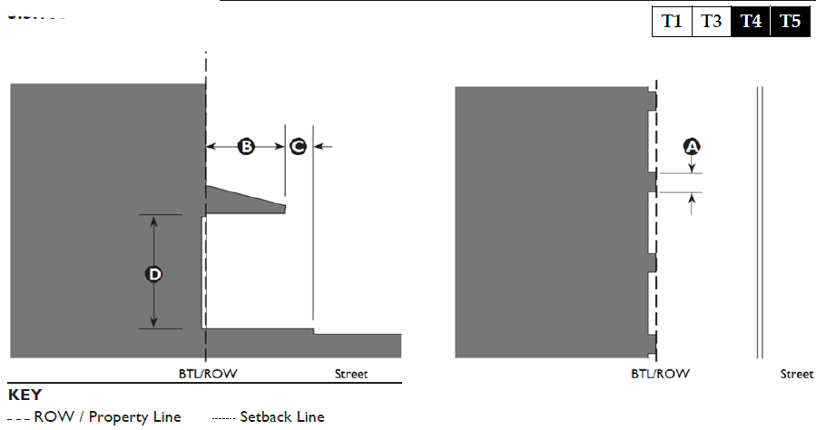
5.3.90 - Dooryard
| A. Description | 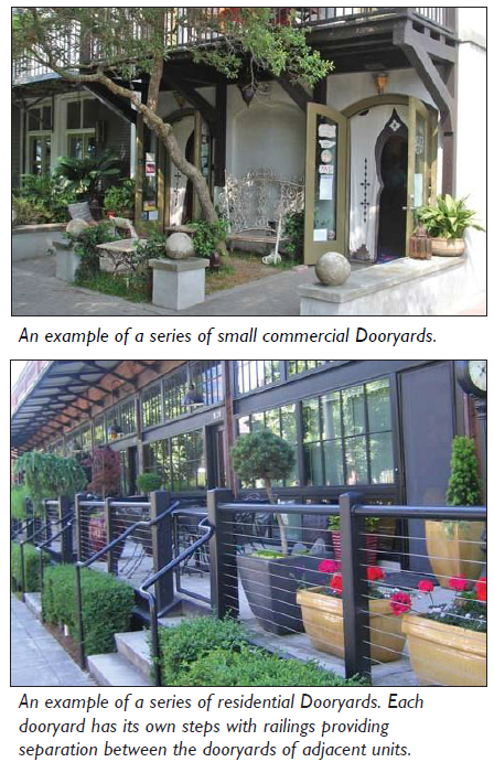 | ||
| Dooryard. The frontage line is defined by a low wall or hedge and the main facade of the building is set back a small distance creating a small Dooryard. The Dooryard shall not provide public circulation along a ROW. The Dooryard may be raised, sunken, or at grade and is intended for ground floor residential in flex zones, live/ work, and small commercial uses 2,500 SF or less. | |||
| B. Size | |||
| Depth, Clear | 8 ft. min. | ||
| Length | 50 ft. max. | ||
| Distance between Glazing | 4 ft. max. | ||
| Ground Floor Transparency | 50% min. 1 | ||
| Depth of Recessed Entries | 5 ft. max. | ||
| Path of Travel | 3 ft. wide min. | ||
| Finish Level above Sidewalk | 3—6 inches max. | ||
| Finish Level below Sidewalk | 6 ft. max. | ||
| 1 For live/work and commercial uses only. | |||
| C. Miscellaneous | |||
| For live/work and commercial uses, these standards are to be used in conjunction with those for the Shopfront frontage type. In case of conflict between them, the Dooryard frontage type standards shall prevail. | |||
| Low walls used as seating are encouraged. | |||
| Shall not be used for circulation for more than one ground floor entry. | |||
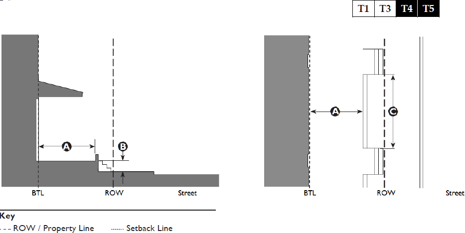
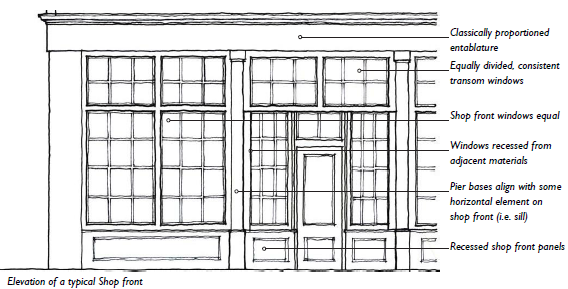
5.3.100 - Shopfront
| A. Description | 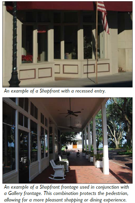 | ||
| Shopfront. The main facade of the building is at or near the frontage line with an at-grade entrance along the public way. This type is intended for retail use. It has substantial glazing at the sidewalk level and may include an awning that may overlap the sidewalk. It may be used in conjunction with other frontage types. | |||
| B. Size | |||
| Distance between Glazing | 2 ft. max. | ||
| Ground Floor Transparency | 75% min. | ||
| Depth of Recessed Entries | 5 ft. max. | ||
| C. Awning | |||
| Depth | 4 ft. min. | ||
| Setback from Curb | 2 ft. min. | ||
| Height, Clear | 8 ft. min. | ||
| D. Miscellaneous | |||
| Doors may be recessed as long as the main facade is at the BTL. | |||
| Operable awnings are encouraged. | |||
| Open-ended awnings are encouraged. | |||
| Rounded and hooped awnings are discouraged. | |||
| Shopfronts with accordion style doors / windows, or other operable windows that allow the space to open to the street are encouraged. | |||
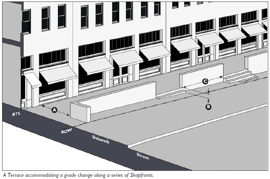
5.3.110 - Terrace
| A. Description | 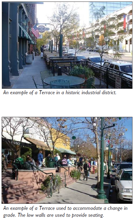 | ||
| Terrace. The main facade is at or near the frontage line with an elevated Terrace providing public circulation along the facade. This type can be used to provide at-grade access while accommodating a grade change. Frequent steps up to the terrace are necessary to avoid dead walls and maximize access. This type may also be used in historic industrial areas to mimic historic loading docks. | |||
| B. Size | |||
| Depth, Clear | 8 ft. min. | ||
| Finish Level above Sidewalk | 3 ft. 6 inches max. | ||
| Length of Terrace | 150 ft. max. | ||
| Distance between Stairs | 50 ft. max. | ||
| C. Miscellaneous | |||
| These standards are to be used in conjunction with those for the Shopfront frontage type. In case of conflict between them, the Terrace frontage type standards shall prevail. | |||
| Low walls used as seating are encouraged. | |||
| If the building is located in a floodplain, the finish level above the sidewalk may exceed 3'6" | |||
5.3.120 - Gallery
| A. Description |  | ||
| Gallery. The main facade of the building is at the frontage line and the Gallery element overlaps the sidewalk. This Type is intended for buildings with ground-floor commercial uses and may be one or two stories. The Gallery should extend far enough from the building to provide adequate protection and circulation for pedestrians and extend close enough to the curb so that a pedestrian cannot bypass it. | |||
| B. Size | |||
| Depth, Clear | 8 ft. min. | ||
| Ground Floor Height, Clear | 11 ft. min. | ||
| Upper Floor Height Clear | 9 ft. min. | ||
| Height | 2 stories max. | ||
| Setback from Curb | 2 ft. min.; 3 ft. max. | ||
| C. Miscellaneous | |||
| These standards are to be used in conjunction with those for the Shopfront frontage type. In case of conflict between them, the Gallery frontage type standards shall prevail. | |||
| Upper-story Galleries facing the street must not be used to meet primary circulation requirements. | |||
| Galleries must have a consistent depth along a frontage. | |||
| Galleries must project over a sidewalk. | |||
5.3.130 - Arcade
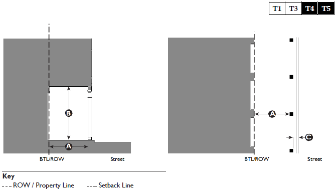
| A. Description | 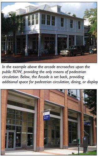 | ||
| Arcade. A covered walkway with habitable space above often encroaching into the ROW. The Arcade should extend far enough from the building to provide adequate protection and circulation for pedestrians. This type is intended for buildings with ground floor commercial uses and is common along public courtyards. Syn: Colonnade | |||
| B. Size | |||
| Depth, Clear | 12 ft. min. | ||
| Ground Floor Height, Clear | 14 ft. min. clear | ||
| Setback from Edge of Curb | 1 ft. min. / 2 ft. max. 1 | ||
| 1 Setback may be greater than 2' if arcade is located completely outside of ROW. | |||
| C. Miscellaneous | |||
| These standards are to be used in conjunction with those for the Shopfront frontage type. In case of conflict between them, the Arcade frontage type standards shall prevail. | |||
| Arcades must have a consistent depth along a frontage. | |||
| Arcades with more than 2 floors of habitable space above the colonnade may not encroach onto a public ROW, and must be located so that it abuts a public ROW. | |||
5.4.10 - Purpose
The purpose of this Division is as follows:
A.
To provide standards and guidelines that achieve and promote a consistently high level of design for the Town's most intense and most visible development; and
B.
To encourage new and renovated buildings to reflect the distinct characteristics of the Town of Port Royal and the lowcountry.
5.4.20 - Applicability
A.
The standards and guidelines in this Division should be used to promote, enhance, and maintain walkable places of character, and to maximize the application of appropriately-scaled elements and aesthetics. These provisions are applicable to::
1.
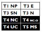
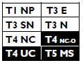
All proposed development within the T4NC, T4NC-O, T4UC and T5 MS Zones.
2.
All proposed development within the T1NP, T3E, T3SN, and T3N Zones except Single-Family Detached and Two-Family Residential Uses.
B.
Why All Applicants Should Review this Division. The design measures contained in this Division embody the historic traditions and unique characteristics of Port Royal's built form; a form that its citizens have come to know and cherish.
Traditional design elements are not only aesthetically pleasing; they incorporate time-honored strategies that are energy efficient and cost effective. Therefore, while technically not required, it is strongly recommended that all applicants wishing to develop in the Town review these provisions.
C.
Standards and Guidelines. This Division includes both standards and guidelines. Statements predicated by the words "shall" or "must" are to be interpreted as standards. Statements predicated by the words "should" or "may" are to be interpreted as guidelines.
5.4.30 - General Architectural Standards
The purpose of this Section is to provide general architectural standards that result in a quality built environment in keeping with the character of the Town. This is achieved by adhering to time-honored architectural design principles and incorporating additional architectural elements that blend harmoniously with the natural surroundings.
A.
Building Scale and Massing.
1.
Compatibility with Surrounding Buildings. Building design shall take into account the immediate off-site surrounding structures, and provide mass, height and building elevations, so as to create substantially compatible scale with adjacent structures.
2.
Building Massing. Buildings shall incorporate variations in wall heights, facade articulations and varied roof planes and pitches. Wall planes shall be divided into modules that express traditional dimensions such that a primary facade plane shall not exceed 75 feet in length. If a wall plane exceeds this dimension, then a jog shall be provided to divide it into subordinate elements each less than 75 feet in length.
B.
Facade Features. Building facades shall be designed to provide visual interest through detail and ornamentation that is viewed at both the immediate pedestrian level as well as from a distance.
1.
Wall Planes. Wall planes shall be divided into smaller components by the arrangement of windows and other facade articulation features, such as columns, pilasters, and canopies.
2.
Entrances. The main entrance to a building shall be clearly identifiable and shall be oriented to face a public street, internal street, or public space. Entrances shall incorporate design features such as canopies, porticos, arcades, raised cornice parapets or peaked roof forms over the doorways, arches, and display windows.
3.
Vertical Articulation. For all multi-story buildings, the building elevations shall clearly reflect a bottom (first) floor and its representative interior height, a middle ground consisting of all floors above the first floor and a visually pronounced building top that consists of a defined cornice at the top of the parapet roof section or at the transition of the sloped roof section.
C.
Roofs.
1.
Concealing Rooftop Equipment. Where mechanical HVAC equipment, satellite dish structures, and other equipment are located on a roof, the roof structure shall be designed to be tall enough to completely conceal the equipment from any public street or space.
2.
Building Articulation. Varied roof pitches and planes shall be used to break up the massing of larger buildings. Long, unarticulated roofs are prohibited.
D.
Accessory Buildings. To the maximum extent practicable, an accessory building's color, siding, roof pitch, window detailing, roofing materials, and foundation shall be compatible with the principal building on the lot.
5.4.40 - Architectural Expression and Formality
A.
This Section reflects and summarizes the range of traditional architectural expression and formality that occurs within the Town of Port Royal. Historically, architecture in more rural places has generally been less formal, and characterized by vernacular treatments, including simple, low-slung massing, wood detailing, and a muted color palette. Architecture in more urban places has generally been more formal, characterized by more classical treatments, including vertically-proportioned massing, detailing in masonry and stucco, and a broader range of colors.
B.
Overview of Architectural Expression and Formality. There are three broad categories of architectural expression distinguished in this section: Lowcountry Vernacular, Village Revival, and Mainstreet Classical. Architectural expression can be applied with varying degrees of formality as illustrated in Table 5.4.40.A. (Town of Port Royal Architectural Expression and Formality).
C.
While additional architectural styles and precedents do exist, these three categories (Lowcountry Vernacular, Village Revival, and Mainstreet Classical) represent the majority of elements traditionally applied to development within the Town of Port Royal. Since regulatory differences are present amongst the three categories, it is strongly recommended that the applicant and Administrator / Town Architect engage in a pre-application meeting prior to any submittal.
Ultimately, the Administrator / Town Architect shall determine whether a submittal is reviewed as Lowcountry Vernacular, Village Revival, or Mainstreet Classical.
| Table 5.4.40.A: Town of Port Royal Architectural Expression and Level of Formality | ||||
|
Architectural
Expression and Level of Formality |
Rural
and Sub-urban Places |
Neighborhoods
and Community Centers | Downtown | |
 |
Lowcountry
Vernacular (5.4.40.B) |  | ||
 | Village Revival (5.4.40.C) |  | ||
 | Main Street Classical (5.4.40.D) |  | ||
| Transect Zones | T1 T2 T3 T4 T5 | |||
| Table 5.4.40.B: Lowcountry Vernacular | 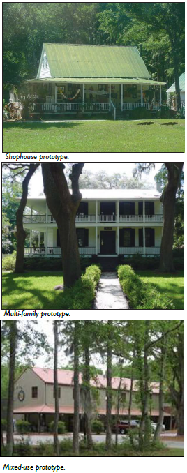 |
| A. Architectural Expression and Formality | |
| Description | |
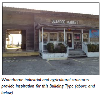
| In rural and low intensity sub-urban areas, commercial and multi-family buildings should reflect vernacular rural forms. These include simple residential prototypes, and agricultural prototypes, such as packing sheds, barns, and warehouses. Essential characteristics include: | |
|
1. Simple, 1 to 1.5 story rectangular massing, with straight, gabled roof forms
2. Raised foundations 3. Simple eaves, often with exposed rafter tails 4. Simply detailed, broad, often wraparound porches 5. Predominantly wooden architectural vocabulary 6. Muted color palette, predominantly white or off-white 7. South facing porches, large windows, and high ceilings | |
| Commercial Buildings | |
| Commercial buildings are typically residential in character with simple modifications to accommodate commercial activities. | |
| Multi-Family Buildings | |
| Multi-family buildings appear as two or more units that are configured to resemble a large single-family house. | |
| Mixed-Use or Larger Commercial Buildings | |
| Mixed-use or larger commercial structures find precedent in the vernacular packing sheds, barns, and warehouses of the Lowcountry. | |
| Residential Buildings | |
| Residential structures find precedent in the vernacular small cottages and narrow two story houses of the Lowcountry. |
| Table 5.4.40.B: Lowcountry Vernacular |  |
| B. Massing | |
| General Massing | |
| Buildings are typically simple combinations of one or more rectangular forms. | |
| Roofs | |
| Roofs are typically simple, gable-end or hipped forms. | |
| Simple commercial and multi-family buildings typically have relatively steep slopes, ranging from 8 in 12 to 10 in 12. Larger commercial buildings may have slopes from 4 in 12 to 8 in 12. | |
| Shed (monopitch) roofs shall only be attached to the principal building walls, with a minimum slope of 2 in 12. | |
| Porch roofs may have a lower pitch with a minimum slope of 3 in 12. | |
| Applied Mansard roofs are not allowed. | |
| Roof-Wall Connections | |
| Eaves typically employ exposed rafter tails, with a minimal fascia depth. | |
| Roof overhangs shall have a minimum 1' overhang at eave and rake. | |
| Primary Walls | |
| Primary walls should be clad in siding (wood or cementitious). Siding may be horizontal lap, ship-lap, or vertical board and batten. | |
| Siding may be mitered at building corners or clad with a minimum 4" trim board. Trim board is typically 6". | |
| Exposed wood may be painted, stained, weathered, or left natural. | |
| Base | |
| Primary walls should rest on a drip edge and water table made from wood or cementitious boards over foundation piers. | |
| Foundation piers shall be no less than 12" square. If the foundation is taller than 4' above grade, than the foundation piers shall be no less than 16" square. | |
| Crawlspace openings and the undercroft of foundations, decks, and porches shall be framed in with a 2" minimum recessed lattice, vertical pickets and/or hogs pen pattern (wood or similar). | |
| We Do This Because… | |
| Roof Design: Roofs are the greatest source of potential heat gain in the warmest months of the year when the midday sun is directly overhead. A light- colored, reflective roof surface is most effective in minimizing heat gain. |
| Table 5.4.40.B: Lowcountry Vernacular |  |
| C. Openings | |
| Facade Composition | |
| Building elevations are typically divided into simple facade compositions of equal bays. Three, five, and seven-bay compositions are predominant. | |
| Windows | |
| Windows are typically double hung with first story windows taller than upper story windows. | |
| Window openings shall have vertical proportions, or may be square. | |
| Windows shall be framed with a minimum 3.5" wood or fiber cement trim. | |
| All windows shall have a sill. The sill should not be integrated into a "picture frame" surround. | |
| Windows are typically vertically-proportioned and multi-paned with exterior true or simulated muntins. | |
| Window panes may be in a 1-over-1, 2-over-2, or 6-over-6 divided light pattern. | |
| When windows are ganged together, a 3" minimum mullion shall be between each individual window. | |
| Shutters, when used, shall be sized equal to half the width of the window, the same height as the window, and shall be operable. | |
| Doors | |
| Doors shall have a trim surround with a 3.5" minimum wood or fiber cement trim. | |
| Panels and windows should be simple and rectilinear. | |
| Transom windows are allowed. |
| Openings (continued) | 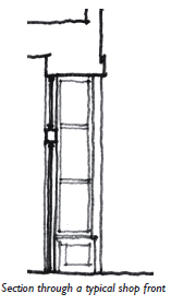 |
| Shopfronts | |
| All regulations regarding windows and doors described in this Section apply to windows and doors that are a part of a shopfront assembly. | |
| Shopfronts are typically composed of doors and windows that are residential in character. | |
| Shopfront infill assemblies shall be made of painted or varnished wood, aluminum-clad wood, or painted metal. | |
| Porches, galleries, and awnings may be incorporated into shop front designs. | |
| See Section 5.3.100 (Shopfront) for more standards. |
| Table 5.4.40.B: Lowcountry Vernacular |  | |
| D. Attached Elements | ||
| Porches | ||
| Porches typically extend across the entire length of the facade or are utilized to frame a primary entrance, and may be 1 or 2 stories in height. | ||
| Bay spacing on porches, while occasionally broad, shall be vertically proportioned or square. | ||
| Porches may be found in settings as the primary entrance into buildings that have a predominantly residential form. In other instances, Galleries may be used. | ||
| Columns shall be… | ||
| Width: | 6" min. | |
| Shape: | Square | |
| Porches shall be made predominantly of wood. | ||
| The undercroft of decks and porches shall be enclosed with lattice, vertical pickets or horizontal 1 x 4's. | ||
| Railing spindles and pickets on porches shall not exceed 4" on center, or as required by the Building Code, whichever is less. | ||
| See Sections 5.3.50 (Porch: Projecting) and 5.3.60 (Porch: Engaged) for more standards. | ||
| Galleries | ||
| Galleries are typically found on buildings with a commercial form. | ||
| Bay spacing on galleries shall be vertically proportioned or square. | ||
| Columns shall be… | ||
| Width: | 6" min. | |
| Shape: | Square | |
| See Section 5.3.120 (Gallery) for more standards. | ||
| Balconies | ||
| Balconies shall be made of wood or metal, and may be open or covered. | ||
| Spindles and balusters on balconies shall not exceed 4" on center, or as required by the Building Code, whichever is less. | ||
| Second floor balconies shall have a minimum height clearance of 10' from grade. Supporting brackets shall have 8' minimum clearance from grade. | ||
| Upper floor balconies shall be a minimum of 3' deep. | ||
| Accessibility | ||
| ADA ramps are encouraged to be incorporated into the architecture of the building, generally along the side or rear facade. | ||
| Table 5.4.40.C: Village Revival |  |
| A. Architectural Expression and Formality | |
| Description | |
|
In urban centers and established areas of community outside the Town core, commercial
and multi-family buildings should reflect a combination of vernacular and more formal
architecture. These include more formal residential prototypes utilized for commercial
purposes, and commercial and mixed-use prototypes constructed of more permanent and
durable materials. Essential characteristics include:
1. Simple, 2 to 2.5 story massing, with predominantly gabled or hipped roof forms, and some parapeted roofs. 2. Raised or at-grade foundations. 3. Both enclosed eaves with simplified classical detailing and exposed rafter ends are appropriate. 4. Multi-storied, wrap-around porches with simplified classical detailing. 5. Mixed architectural vocabulary, utilizing wood, stucco, and masonry. 6. Muted colors and materials, predominantly white or off-white, with masonry tones and occasional brighter accent colors. | |
| Commercial Buildings | |
| Commercial buildings are typically commercial in character, appearing as detached, single-use structures with parapeted or gabled, pedimented roof forms, and formal storefronts. | |
| Multi-Family Buildings | |
| Multi-family buildings may appear as two or more units that are configured to resemble a large single- family house, or as attached rowhouses. | |
| Mixed-Use or Larger Commercial Buildings | |
| Mixed-use or larger commercial structures are modest in scale, and appear as both detached commercial buildings and attached, multi-story, vertical mixed-use structures. | |
| Residential Buildings | |
| Residential structures find precedent in the vernacular one and one half story cottages, narrow two story houses with side porches, and estates of the Lowcountry. |
 | |
| We Do This Because… | |
| High Ceilings:High Ceilings allow the hot air to rise above the occupied areas, increasing human comfort. | |
 | |
| We Do This Because… | |
| Vertical Proportions:The up-right human body is vertically proportioned. Therefore, human-beings inherently relate to, and view structures and elements with vertical proportions as being “human-scaled.” As such, all buildings, spaces, and associated openings (windows and doors) should be vertically proportioned. | |
 | |
| We Do This Because… | |
| Symmetry:The up-right human body is more or less symmetrical. Human-beings inherently relate to this quality, finding beauty and logic in such composition. Intuitively, this principle is extended to other artistic efforts, including architecture. Applied to buildings, symmetry evokes a sense of order and dignity that is timeless, attractive, and loveable. | |
| Table 5.4.40.C: Village Revival | 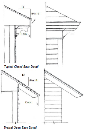 |
| B. Massing | |
| General Massing | |
| Buildings are typically simple combinations of one or more rectangular forms. | |
| Roofs | |
| Roofs are typically gabled or hipped. | |
| Half stories are typically articulated utilizing gable ends and dormers. | |
| Simple commercial and multi-family buildings typically have relatively steep slopes, ranging from 8 in 12 to 10 in 12. Larger commercial buildings may have slopes from 4 in 12 to 8 in 12 or have flat roofs. Porch roofs may have a lower pitch with a minimum slope of 3 in 12. | |
| Flat roofs shall provide a parapet to conceal all roof areas/equipment from view of a public street or space. | |
| Shed (monopitch) roofs shall only be attached to the principal building walls, with a minimum slope of 2 in 12. | |
| Applied Mansard roofs are not allowed. | |
| Skylights shall be flat (non-bubble) only unless concealed behind a parapet. | |
| Roof-Wall Connections | |
| Eaves typically utilize an enclosed cornice and entablature with simplified classical detailing. | |
| Roof overhangs shall have a minimum 1' overhang at eave and rake. | |
| Primary Walls | |
| Primary walls may be clad in horizontal lap, ship-lap, or vertical board and batten siding (wood or cementitious), stucco, or brick. | |
| Exposed wood shall be unpainted, painted, or stained. | We Do This Because… |
| Brick mortar joints shall be struck. | |
| Stucco shall be smooth and sand finish only. | Dormers:The use of Dormers is strongly encouraged as both a functional and decorative element. Aesthetically, Dormers provide architectural interest and additional articulation along the Roof. Functionally, they provide upper story spaces with additional heated space, light and ventilation. |
| Two or more wall materials may be combined on one facade only with the lighter material above the other, more substantial material (e.g., wood above stucco or masonry, or stucco above masonry). | |
| Decorative moldings, cornices, or an applied ornament of stone or cast concrete may be used to express the vertical division between the base, body, and the top. | |
| Cantilevers shall be supported by visible brackets scaled as if they were supporting the weight of the mass above. |
| Table 5.4.40.C: Village Revival |  |
| B. Massing (continued) | |
| Base | |
| Primary walls, when set on a raised crawlspace foundation foundation, should rest on a sill and fascia (wood or cementitious) over foundation piers. | |
| Foundation piers shall be no less than 12" square. If the foundation is taller than 4' above grade, than the foundation piers shall be no less than 16" square. | |
| Crawlspace openings and the undercraft of foundations, decks, and porches shall be framed in lattice or vertical pickets (wood or similar). | |
| We Do This Because… | |
| Chimneys:Chimneys have served as central elements for buildings for centuries, providing numerous opportunities for decorative detailing. However, their main function is to ventilate fire. Fire is dangerous and highly flammable to the wrong types of materials. Therefore, chimneys shall only be constructed of brick, stucco, or tabby. |
| Table 5.4.40.C: Village Revival |  |
| C. Openings | |
| Facade Composition | |
| Simple and regular rhythm of openings. | |
| Windows | |
| Windows may be double hung, single hung, or casement. On side and/or rear elevations of mid-block (non-corner) buildings, windows may be horizontal sliders. First story windows are taller than upper story windows. | |
| When utilized with wood cladding materials, windows shall be framed with a minimum 3.5" wood or fiber cement trim. | |
| When utilized with stucco or masonry cladding materials, windows shall be framed with a minimum 2.5" brick mould. | |
| All windows shall have a sill. The sill should not be integrated into a "picture frame" surround. | |
| Windows are typically vertically- or square- proportioned and multi-paned with exterior true or simulated muntins. | |
| Window panes may be in a 1-over-1, 2-over-2, 6-over-6, or 6-over-9 divided light pattern. | |
| When windows are ganged together, a 3" minimum mullion shall be between each individual window. | |
| Shutters, when used, shall be sized equal to half the width of the window, the same height as the window, and shall be operable. | |
| Doors | |
| When utilized with wood cladding materials, doors shall have a trim surround with a 3.5" minimum wood or fiber cement trim. | |
| When utilized with stucco or masonry cladding materials, doors shall be framed with a minimum 2.5" brick mould. | |
| Panels and windows should be simple and rectilinear. |  |
| Transom windows are allowed. | |
| We Do This Because… | |
| Windows:The size, number, type, and placement of windows dramatically effect the comfort and energy efficiency of a building. If possible, reduce the size and number of windows on the heat-intensive west side, in favor of larger windows that provide greater ventilation and day lighting on the north and east sides. Double-hung windows are ideal for ventilation, allowing cooler air to enter through the raised bottom sash, while hot air escapes through the lowered upper sash. | |
| On residential buildings and upper-stories too many windows can make walls appear weak and unstable, and negate all benefits related to energy efficiency. |
| C. Openings (continued) | 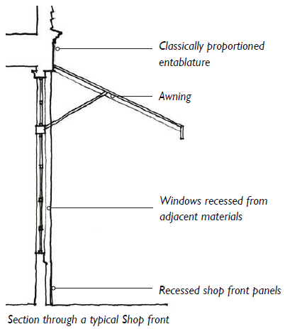 |
| Shopfronts | |
| All regulations regarding windows and doors described in this Section apply to windows and doors that are a part of a shopfront assembly. | |
| Shopfront infill assemblies shall be made of painted or varnished wood, aluminum-clad wood, or painted metal. | |
| In multi-story buildings, there shall be a horizontal band, articulated fascia, and/or entablature to separate the ground level shop front from the upper floors. This band may be incorporated into the shopfront design. | |
| Porches, galleries, and awnings may be incorporated into shopfront designs. | |
| Lighting shall be mounted on the store front wall, preferably centered on the piers between windows/ doors or centered above the windows/doors of the shopfront. In instances where projected shed roofs are used over entries the lighting may be mounted in the shed underside. Lighting shall comply with Division 5.8 (Exterior Lighting). | |
| Shopfront edges should integrate heavier piers or pilasters to visually carry the weight of the building above. | |
| See Section 5.3.100 (Shopfront) for more standards. |
| Table 5.4.40.C: Village Revival | 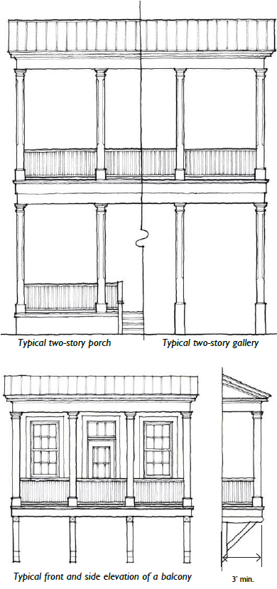 | |
| D. Attached Elements | ||
| Porches | ||
| Porches typically extend across the entire length of the facade or are utilized to frame a primary entrance. | ||
| Bay spacing on porches, while occasionally broad, shall remain vertically proportioned or square. | ||
| Porches may be found in rural settings as the primary entrance into buildings that have a predominantly residential form. In other instances, galleries may be used. | ||
| Columns shall be: | ||
| • Porches may utilize single-story columns or a "giant order" that spans 2 stories. | ||
| • Columns shall utilize architecturally correct capitals and bases… | ||
| Width: | 6" min. | |
| Shape: | Square or Round | |
| Porches shall be made predominantly of wood. | ||
| The undercroft of decks and porches shall be enclosed with lattice or vertical pickets. | ||
| Railing spindles and pickets on porches shall not exceed 4" on center, or as required by the Building Code, whichever is less. Standard pipe rails are prohibited. | ||
| See Sections 5.3.50 (Porch: Projecting) and 5.3.60 (Porch: Engaged) for more standards. | ||
| Galleries | ||
| Galleries are typically found on buildings with a commercial form. | ||
| Bay spacing on galleries shall be vertically proportioned or square. | ||
| Columns shall be… Width: | Shape: | |
| 6" min. | Square or Round | |
| See Section 5.3.120 (Gallery) for more standards. | ||
| Balconies | ||
| Balconies shall be made of wood or metal, and may be open or covered. | ||
| Spindles and balusters on balconies shall not exceed 4" on center, or as required by the Building Code, whichever is less. | ||
| Second floor balconies shall have a minimum height clearance of 10' from grade. | ||
|
Upper floor balconies shall be a minimum of 3' deep.
Cantilevered balconies shall be supported by visible brackets scaled as if they were supporting the weight of the mass above. | ||
| Accessibility | ||
| ADA ramps are encouraged to be incorporated into the architecture of the building, generally along the side or rear facade. | ||
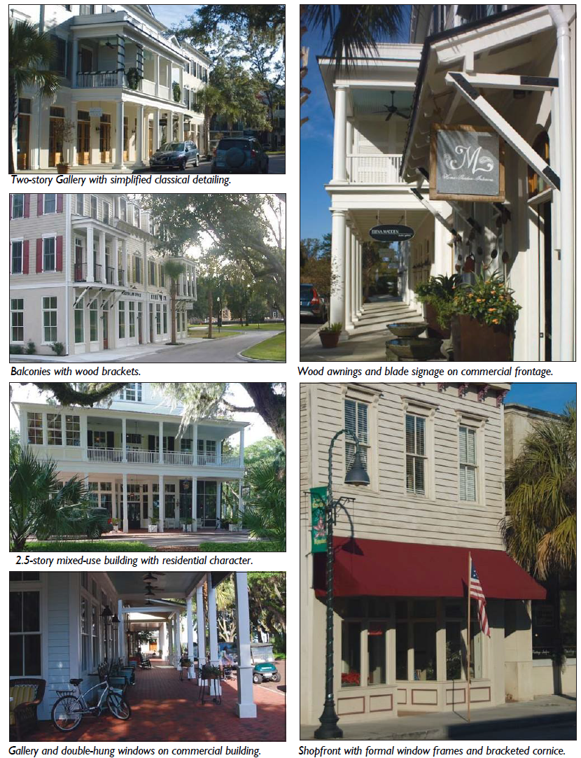
| Table 5.4.40.D: Main Street Classical | 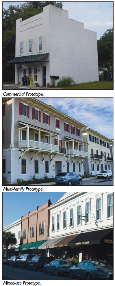 |
| A. Architectural Expression and Formality | |
| Description | |
| Within urban centers commercial and multi-family buildings should reflect a more formal and diverse architectural expression. Prototypes include true mixed- use buildings for commercial and residential uses that are constructed of permanent and durable materials. Essential characteristics include: | |
| 1. Simple, up to 4 stories, vertically-proportioned massing, with predominantly flat roofs finished in parapets or pediments. | |
| 2. At-grade foundations, with classically detailed base in masonry or stucco. | |
| 3. Enclosed eaves with formal classical detailing, often incorporating dentils and/or brackets. | |
| 4. Multi-storied galleries. | |
| 5. Architectural vocabulary predominantly in masonry and stucco. | |
| 6. A broad range of colors and natural materials. | |
| Commercial Buildings | |
| Commercial buildings are typically mixed-use in character, appearing as attached, multi-story structures with parapeted or pedimented roof forms and formal storefronts. | |
| Multi-Family Buildings | |
| Multi-family buildings typically appear as attached buildings that define the street wall, articulated with portals and upper-story balconies. | |
| Mixed-Use or Larger Commercial Buildings | |
| Mixed-use buildings typically appear as attached, multi-story structures that define the street wall, with articulated ground floor storefronts and awnings or multi-storied galleries that extend over the sidewalk. | |
| Residential Buildings | |
| Residential structures find precedent in the two story homes, tall two and one half to three story narrow homes of the Lowcountry. |
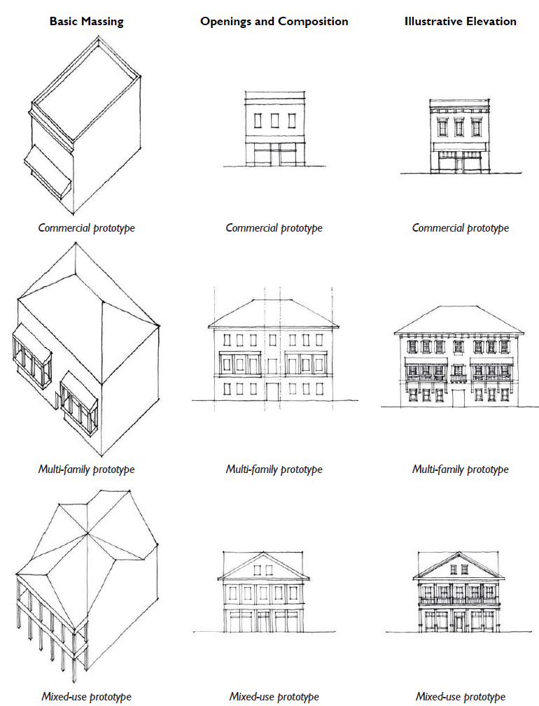
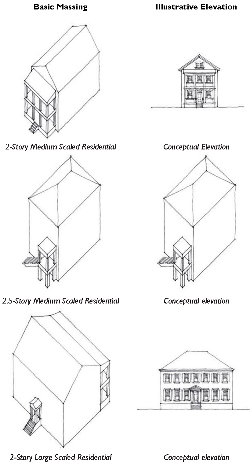
| Table 5.4.40.D: Main Street Classical | 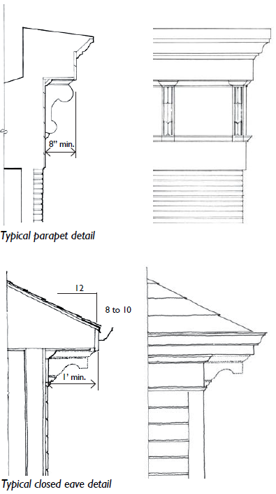 |
| B. Massing | |
| General Massing | |
| Buildings are typically simple combinations of one or more rectangular forms. | |
| Roofs | |
| Roofs are typically flat, with some gabled or hipped. | |
| Larger commercial buildings may have slopes from 4 in 12 to 8 in 12 or have flat roofs. | |
| Flat roofs shall provide a parapet to conceal all roof areas / equipment from view of a public street or space. | |
| Applied Mansard roofs are not allowed. | |
| Skylights shall be flat (non-bubble) only unless concealed behind a parapet. | |
| Roof-Wall Connections | |
| Eaves typically utilize an enclosed cornice and entablature with formal classical detailing, often incorporating dentils and/or brackets. | |
| Roof overhangs shall have a minimum 8" overhang at eave and rake. | |
| Primary Walls | |
| Primary walls may be clad in stucco, or brick. Wood siding may be utilized sparingly. | |
| Exposed wood shall be painted or stained. | |
| Brick mortar joints shall be struck. | |
| Stucco shall be smooth and sand finish only. | |
| The vertical delineation of wall materials should be used sparingly. Two or more wall materials may be combined on one facade only with the lighter material above the other, more substantial material (e.g., wood above stucco or masonry, or stucco above masonry). | |
| Decorative moldings, cornices, or an applied ornament of stone or cast concrete may be used to express the vertical division between the base, the body, and the top. | We Do This Because…
|
| Cantilevers shall be supported by visible brackets scaled as if they were supporting the weight of the mass above. | Parapet:Parapets are used for both aesthetic and functional purposes. Functionally, the Parapet was originally used as a means of fire protection (fire wall) between structures. More recently, they have been used to reduce wind pressure, especially during hurricanes and tornadoes. Today, they are frequently used to screen unsightly roof-top items such as HVAC equipment, compressors, vents, communications devises, etc. from public view. Aesthetically, a Parapet is frequently used as a means of establishing correct proportions on the structure. |
| Base | |
| Treatments for stucco ases or masonry baseboard shall be articulated. |
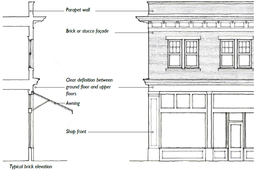
| Table 5.4.40.D: Main Street Classical | 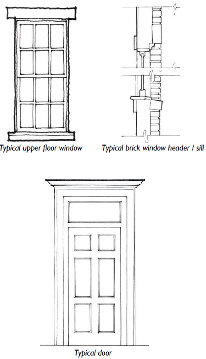 |
| C. Openings | |
| Facade Composition | |
| Simple and regular rhythm of openings. | |
| Windows | |
| Windows may be double hung, single hung, or hinged casement. On side and/or rear elevations of mid-block (non-corner) buildings, horizontal slider windows may be utilized. | |
| When utilized with wood cladding materials, windows shall be framed with a minimum 3.5" wood or fiber cement trim. | |
| When utilized with stucco or masonry cladding materials, windows shall be framed with a minimum 2.5" brick mould. | |
| All windows shall have a sill. The sill should not be integrated into a "picture frame" surround. | |
| When utilized with masonry cladding materials, window headers shall be articulated with appropriate materials such as brick arch, jack arch, cast stone or cut stone. | |
| Windows are typically vertically- or square- proportioned and multi-paned with exterior true or simulated muntins. | |
| Window panes may be in a 1-over-1, 2-over-2, 6-over-6, or 6-over-9 divided light pattern. | |
| When windows are ganged together, a 3" minimum mullion shall be between each individual window. | |
| Shutters, when used, shall be sized equal to half the width of the window, the same height as the window, and shall be operable. | |
| Doors | |
| When utilized with wood cladding materials, doors shall have a trim surround with a 3.5" minimum wood or fiber cement trim. | |
| When utilized with stucco or masonry cladding materials, doors shall be framed with a minimum 2.5" brick mould. | |
| Panels and windows should be simple and rectilinear. | |
| Transom windows are encouraged. |
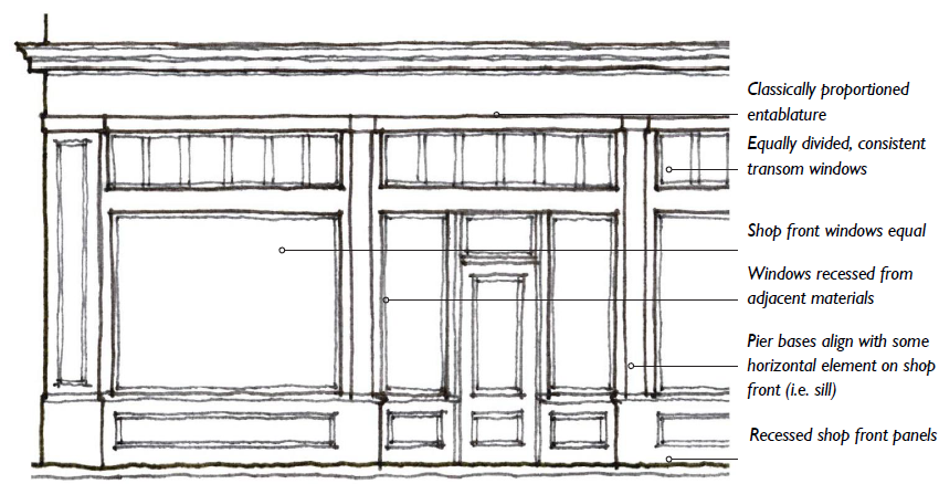
| C. Openings (continued) | 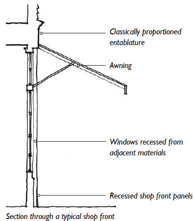 |
| Shopfronts | |
| All regulations regarding windows and doors described in this Section apply to windows and doors that are a part of a shopfront assembly. | |
| Shopfront infill assemblies shall be made of painted or varnished wood, aluminum-clad wood, or painted metal. | |
| In multi-story buildings, there shall be a horizontal band, articulated fascia, and/or entablature to separate the ground level shop front from the upper floors. This band may be incorporated into the shop front design. | |
| Porches, galleries, and awnings may be incorporated into shop front designs. | |
| Lighting shall be mounted on the storefront wall, preferably centered on the piers between windows/ doors or centered above the windows / doors of the shop front. In instances where projected shed roofs are used over entries the lighting may be mounted in the shed underside. Lighting shall comply with Division 5.8 (Exterior Lighting). | |
| Shopfront edges should integrate heavier piers or pilasters to visually carry the weight of the building above. | |
| See Section 5.3.100 (Shopfront) for more standards. |
| Table 5.4.40.D: Main Street Classical | 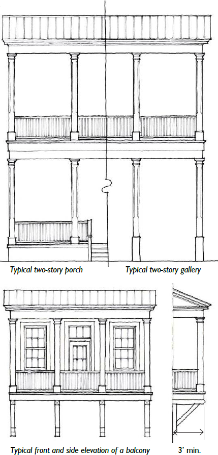 | ||
| D. Attached Elements | |||
| Galleries | |||
| Galleries are typically found on buildings with a commercial form. | |||
| Bay spacing on galleries shall be vertically proportioned or square. | |||
| Galleries should be articulated with an architecturally correct cornice and entablature, and may have a parapeted or pedimented cap. | |||
| Columns: | |||
| • Porches may utilize single-story columns or a "giant order" that spans 2 stories. | |||
| • Columns shall utilize architecturally correct capitals and bases, and shall be… |
Width:
8" min. |
Shape:
Round | |
| See Section 5.3.120 (Gallery) for more standards. | |||
| Balconies | |||
| Balconies shall be made of wood or metal, and may be open or covered. | |||
| Spindles and balusters on balconies shall not exceed 6" on center, or as required by the Building Code, whichever is less. | |||
| Second floor balconies shall have a minimum height clearance of 10' from grade. | |||
| Upper floor balconies shall be a minimum of 3' deep. | |||
| Cantilevered balconies shall be supported by visible brackets scaled as if they were supporting the weight of the mass above. | |||
| Accessibility | |||
| ADA ramps are encouraged to be incorporated into the architecture of the building, generally along the side or rear facade. | |||
| We Do This Because…
| |||
| Arcades:Arcades function similarly to Galleries; however, the upper stories are enclosed and heated, providing livable space that is deemed to be part of the frontage as opposed to the main building. In locations where Arcades encroach into the Right Of Way, this space may occupy the area above the public sidewalk. This is a significant bonus and provides strong incentive to use the Arcade. The Arcade provides an immediate transition between the private and public realm, allowing for window-shopping, dining, or other activities that promote interaction at the street level. Like a porch, the space is shaded from the sun and protected from the elements; yet still permits breezes to infiltrate the body of the building. This helps to save energy and reduce costs. Aesthetically, the Gallery provides architectural interest and delineates the building's entrance.(Syn: Colonnade) | |||
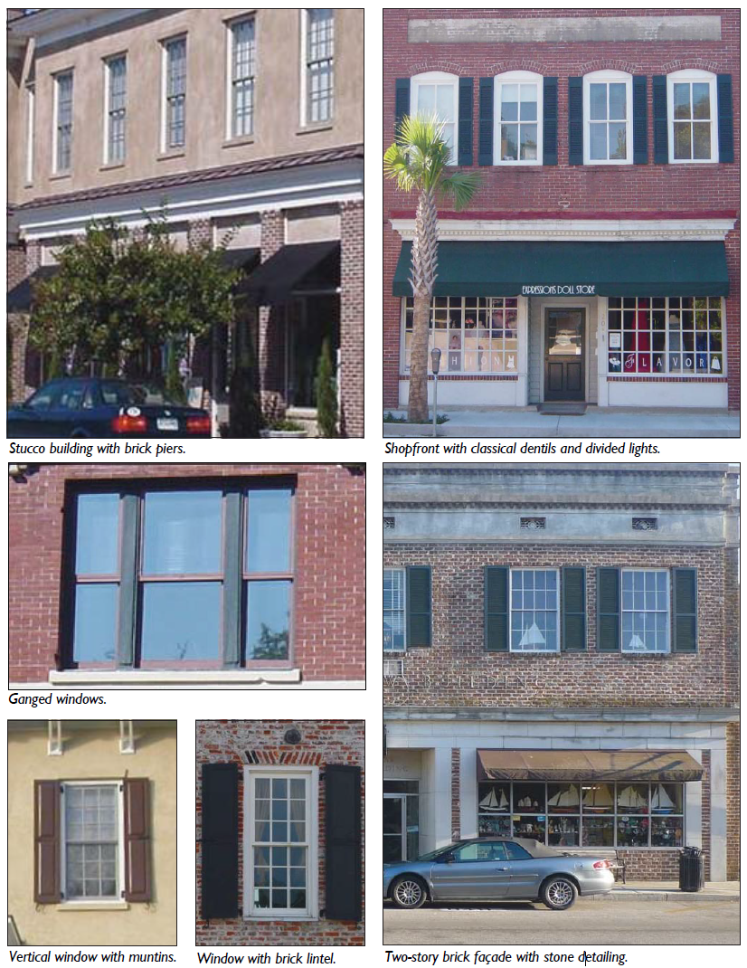
5.5.10 - Purpose
The purpose of this Section is to regulate the location, height, and appearance of fences and walls to maintain visual harmony within neighborhoods in the Town, protect adjacent properties from the indiscriminate placement and unsightliness of fences and walls, and ensure the safety, security, and privacy of properties.
5.5.20 - Applicability
The provisions of this Section shall apply to all construction, substantial reconstruction, or replacement of fences or walls not required for support of a principal or accessory structure, or any other linear barrier intended to delineate different portions of a lot. If there is any inconsistency between the provisions of this Section and any screening standard in Division 3.2 (Transect Zones), the standards in Division 3.2 (Transect Zones), shall control.
5.5.30 - General Requirements for Fences and Walls
A.
Fence and Wall Location.
1.
Fences and walls are permitted:
a.
On the property line between two or more parcels of land held in private ownership.
b.
On a property line adjacent to, but outside a public right of way.
c.
On a property when utilized to delineate different portions of the lot.
d.
Underground, for the electronic control of domestic animals.
2.
Visibility Clearance. Fences and walls shall be placed outside of required sight triangles or areas needed for visibility.
3.
Near Fire Hydrants. Fences and walls shall not be located where they would prevent immediate view of, or access to, fire hydrants or other fire-fighting water supply devices, in accordance with the Fire Code.
4.
Utility Easements. Fences shall be prohibited within utility easements except where constructed by the utility. This provision shall not be construed to prevent fencing around stormwater retention or detention facilities.
5.
Drainage Areas. No fence or wall shall be installed so as to block or divert a natural drainage flow on to or off of any other land.
B.
Maintenance. All fences and walls and associated landscaping shall be maintained in good repair and in a safe and attractive condition—including, but not limited to, the repair or replacement of missing, decayed, or broken structural and decorative elements.
5.5.40 - Fence and Wall Design
A.
Changes in Character and Intensity with Zone.
1.
Table 5.5.40.A. (Fence and Wall Design) conveys the types of Fences and Walls that are most often associated with each zoning district.
2.
Table 5.5.40.B. (Fences and Walls: Changes in Character and Intensity with Zone) provides photographic examples of the fences and walls identified in Table A and demonstrates how their character and intensity changes with district. These photographs are illustrative only, and are not intended to be regulatory.
B.
Materials and Height.
1.
Table 5.5.40.A. (Fence and Wall Design) conveys:
a.
Permitted height for fences and walls, as measured from natural grade, for each zoning district.
b.
Permitted and prohibited materials for fences and walls.
2.
Height Exemptions.
a.
Pergolas, Arbors, Trellises. Architectural features that are both functional and compatible with the fence or wall are exempt from the height restrictions of this Section.
b.
Required Screening. A fence or wall utilized to meet the standards of Division 4.2 (Conditional Use Regulations), Division 5.2 (Exceptional Building Types), or Division 5.7 (Landscaping and Screening), is exempted from the height standards of this Section, but in no case shall the fence or wall exceed a height of ten feet.
c.
Recreational Fencing. Customary fencing provided as a part of a permitted tennis court, athletic field, or other recreational facility shall be exempt from the height restrictions of this Section.
d.
Public Safety Use Fences and Walls. Major utilities, wireless communication towers, government facilities, and other public safety uses shall be allowed to increase maximum fence or wall heights to ten feet in front, side, and rear yards, unless further increased through an approved security plan (see Subsection e. below).
e.
Security Plan for Fences and Walls. A property owner may submit a site security plan to the Administrator that proposes fences or walls taller than those permitted by this Section, or the use of barbed or concertina wire atop a fence or wall. The Administrator may approve, or approve with conditions, the site security plan if:
(1)
The condition, location, or use of the land, or the history of activity in the area, indicates the land or any materials stored or used on it are in significantly greater danger of theft or damage than surrounding land; and
(2)
The proposed taller fences or walls, or use of barbed or concertina wire, will not have a significant adverse effect on the security, functioning, appearance, or value of adjacent lands or the surrounding area as a whole.
| Table 5.5.40.A: Fence and Wall Design | ||||||
| Zone | Typical Fences and Walls (Recommended) | Permitted Height | Permitted and Prohibited Materials (Primary) | 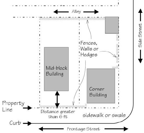 | ||
Front Yard 1 | Side and Rear Yard 2 | Side and Rear Yard adjacent to a ROW 3 | ||||
| Fence Types 1. Privacy 2. Split Rail 3. Post and Rail 4. "Living" |
Min 42"
Max 60" | Max 72" |
Min 42"
Max 60" | PERMITTED • Treated or rot-resistant wood • Plants and vines • Wrought Iron • Brick • Stone • Concrete Masonry Units with Stucco (C.B.S. - if primary structure is masonry). • Reinforced Concrete with Stucco (if primary structure is masonry). PROHIBITED • Plastic, Sheet Metal, Vinyl Plywood, Junk, and Waste. • Barbed Wire, Concertina Wire, and above ground Electrified Fences not associated with agricultural activities or an approved security plan, (see Section 5.4.40.B.2.e. Security Plan Fences and Walls). | ||
| Fence Types 1. Privacy Fence 2. Split Rail Fence 3. Post and Rail Fence 4. "Living" Fence 5. Chain Link Fence 6. Lattice Fence* 7. Picket or Baluster Fence with Corner Posts Wall Types 1. Hedge Wall 2. Hedge Wall with Brick Posts 3. Garden Wall * Or Similar Pattern |
Min 36"
Max 48" | Max 72" |
Min 36"
Max 48" | |||
| Fence Types 1. Privacy Fence 2. "Living" Fence 3. Lattice Fence* 4. Picket or Baluster Fence with Corner Posts 5. Wrought Iron Fence 6. Wrought Iron Fence with Brick Posts Wall Types 1. Hedge Wall 2. Hedge Wall with Brick Posts 3. Garden Wall 4. Garden Wall with Wrought Iron Fence * Or Similar Pattern |
Min 24"
Max 42" | Max 72" |
Min 36"
Max 42" | GENERAL REMARKS 1. Fences and Walls are strongly encouraged and, if built, should be constructed along all un-built rights-of-ways that abut streets and alleys, as conveyed in the above diagram and this Table. 2. Fences and Walls shall be a minimum of 25% opaque. 3. The more "finished" side of a fence or wall shall face the perimeter of the lot. 4. The name assigned to each fence or wall type is based on common industry terminology. 5. Differing fence and wall types may be integrated so long as they comply with this Section (e.g., fence in front of a hedge or fence on top of a wall). Fences 1. Fence Types may be finished in various "styles" (e.g., "Gothic" or "Dog Ear" Picket Fence). 2. Chain Link shall not be permitted in the Front Yard, or Side and Rear Yard adjacent to a ROW. 3. Split Rail and Post and Rail fences may use "hog wire" fill. 4. A "Living Fence" consists of wood posts with "hog wire" infill and a board rail on top. 5. Wood pickets or balusters shall be rectangular or round. Spacing shall not exceed 1 ½ inches. 6. Hedge Walls shall be a minimum of 8" thick. 7. Vertical posts on Wrought Iron fences shall be a minimum of 5/8" thick and spaced between 4 and 6 inches. Walls 1. Reserved. | ||
| Notes: | ||||||
|
1
Area in front of the primary structure.
2 Side and Rear Yard (behind the front plane of the primary structure). 3 Side and Rear Yard (behind the front plane of the primary structure) that abuts a side street Right-of-Way. | ||||||
| Table 5.5.40.B: Fences and Walls: Changes in Character and Intensity with Zone |
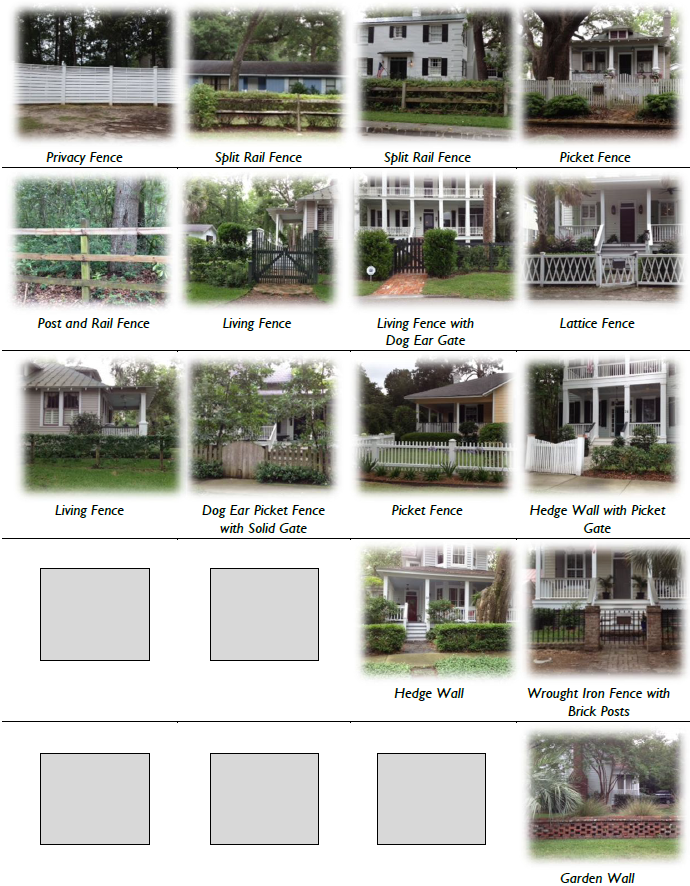 |
| General Note: Photos on this page are illustrative, not regulatory. |
5.6.10 - Purpose
The purpose of this Division is to regulate and ensure the provision of adequate parking and access for motor vehicles and bicycles. The Division also provides options for adjusting parking requirements and providing parking alternatives. These standards ensure that the parking needs of new land uses and development are met, and parking areas are designed and located in a manner that promotes walkability.
5.6.20 - Applicability
A.
The parking standards of this Division shall apply to the following within the Town: new development; changes in land use; and, changes in intensity of buildings or structures of 15 percent or more of:
a.
Gross floor area;
b.
Seating capacity;
c.
Dwelling units;
d.
Parking spaces; and/or,
e.
Other units of measurement listed in Table 5.6.30.A (Parking Spaces Required).
B.
Relationship to Transect Zones. The standards in this Division are intended to supplement those found in Article 3 (Specific to Zones). Should a conflict exist between the regulations found in this Division and those in Article 3 (Specific to Zones), the standards found in Article 3 (Specific to Zones) shall prevail.
C.
Location, Design, Landscaping. All parking spaces provided shall meet the location, design, and landscaping requirements of this Division, Division 3.2 (Transect Zones), and Division 5.7 (Landscaping and Screening).
5.6.30 - Number of Motor Vehicle Parking Spaces Required
A.
Minimum Number of Parking Spaces Required. The number of parking spaces required for Residential, Offices and Services, and Retail and Restaurant uses are regulated in Division 3.2 (Transect Zones). Parking for all other uses not listed in Division 3.2 (Transect Zones), including:
1.
Recreation, Education, Safety, Public Assembly
2.
Transportation, Communication, Infrastructure
3.
Industrial
…shall be determined by Table 5.6.30.A (Parking Spaces Required). Uses not listed in Table 5.6.30.A (Parking Space Required) shall use the parking requirement for the most similar use, as determined by the Administrator.
B.
Maximum Number of Parking Spaces. The maximum number of off street parking spaces shall be as follows:
1.
For buildings with a footprint less than or equal to 65,000 gsf, no more than 140 percent of the required minimum number of parking spaces; or
2.
For buildings with a footprint greater than 65,000 gsf, no more than 125 percent of the required minimum number of parking spaces.
C.
Off-Site Parking. Required off-street parking may be provided off-site, without further study, if the following standards are met:
1.
Required parking may be provided in off-street parking facilities on another property within 600 feet of the proposed development, as measured along the street right-of-way; and
2.
Pedestrian access between the use or the site and the off-premise parking area shall be via paved sidewalk or walkway; and
3.
The owner shall provide a recorded parking agreement reflecting the arrangement with the other site.
D.
Parking Adjustments.
1.
Transit. A parking reduction of up to 20 percent may be approved by the Administrator for any use within one-quarter mile of an active bus stop or other transit stop (e.g., ferry terminal).
2.
Shared Parking Simplified. For two use types, shared parking shall be calculated as follows. The sum of the required parking for the two use types shall be divided by the factor listed in the Table 5.6.30.B (Shared Parking Factor for Two Uses) below.
3.
Reductions Based on a Parking Study.
a.
The Administrator may grant a reduction in the parking requirements set forth in this Section based upon the findings of a parking study submitted by the applicant that provides an analysis of peak parking demand for the entire development and that justifies a parking reduction. A reduction may be granted in the following cases:
(1)
When three or more use types share parking;
(2)
When a use type is not listed in Table 5.6.30.B (Shared Parking Factor for Two Uses);
(3)
When uses in the same or adjoining development have different peak hour parking demand and seek to share parking;
(4)
When the lot and use is adjacent to a thoroughfare with dedicated on-street parking spaces that may potentially count towards the use's required parking (Single-Family Residential, Two-Family Residential, and Accessory Dwelling Units are excluded);
(5)
When the lot and use are located within ¼ mile of a public parking facility;
(6)
Where the special nature of a certain development (e.g., a small scale amphitheater with on-street parking, or a housing project inhabited by persons with low or no automobile ownership) does not require the amount of parking listed in Subsection A (Minimum Number of Parking Spaces Required).
(7)
Where fewer parking spaces are needed due to special designs and traffic mitigation measures incorporated in the parking lot design and circulation plan.
In special cases off-street required parking may be reduced to zero.
b.
The Administrator shall consider the following in determining whether a reduction is warranted:
(1)
The likelihood that the reduced number of parking spaces can satisfy demand;
(2)
The amount of time during the year when the number of spaces provided may be insufficient and the amount of resulting parking overflow;
(3)
The impact of periodic overflows upon the public streets and other parking facilities; and
(4)
The nature of surrounding land uses, character of surrounding road system, and nearby circulation pattern.
Unless requested by the Administrator, the burden to demonstrate that a reduction in parking requirements is warranted shall rest with the applicant.
c.
Bicycle Parking Substitution. Required vehicular parking spaces may be reduced at a rate of one vehicular parking space for every one bicycle parking space provided above the minimum provided in Section 5.6.50 (Bicycle Parking). Reduction in parking shall not exceed a maximum of 20 percent of the required motor vehicle parking spaces.
5.6.40 - Parking Spaces, Lot Design, and Layout
A.
Access. Except where modified by Article 3 (Specific to Zones), the following standards are applicable to all off-street parking areas including Single and Two-family residences.
1.
Parking spaces in any parking lot or parking structure for any use other than single and two-family dwellings shall not be designed or located so as to permit a vehicle to enter or exit a parking space directly from a public thoroughfare and shall meet the following standards:
a.
Ingress to and egress from parking spaces shall be from an on-site aisle or driveway as specified in Table 5.6.40.A (Minimum Dimensions for Parking Spaces and Aisles).
b.
Exception. Parking spaces within lots of up to eight spaces may be designed or located so as to permit a vehicle to enter or exit a parking space directly from an alley or rear lane.
2.
Access between driveways and thoroughfares shall be by forward motion of the vehicle; except for single and two-family residential units, individual townhome units, and accessory dwelling units, where access shall be as is practicable for the site.
3.
Driveways serving single and two-family residential units, individual townhome units, and accessory dwelling units may not exceed ten feet in width.
4.
The design and construction of all off-street parking access drives shall meet the requirements of the Town's engineering standards and the applicable fire code.
B.
Dimensional Standards for Parking Spaces and Aisles
1.
General. Standard car parking spaces and parking lot aisles shall comply with the minimum dimensional standards established in Table 5.6.40.A (Minimum Dimensions for Parking Spaces and Aisles).
2.
Dimensional Adjustments. Parking structures may be subject to dimensional adjustments based on utilization, but in no case shall the standard parking space width be less than eight feet. Reduction in design standards shall be subject to approval by the Administrator and Town Building Official.
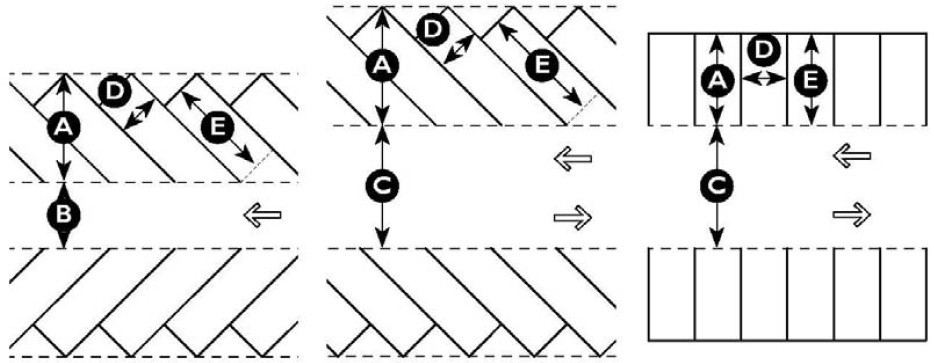
| Table 5.6.40.A: Minimum Dimensions for Parking Spaces and Aisles | |||||
|---|---|---|---|---|---|
| Angle | Parking Row Depth | Drive Aisle Width | Space Width | Space Length | |
| One-way | Two-way | ||||
| Parallel | 8 feet 1 | 12 feet | 20 feet | 8 feet 1 | 20 feet |
| 30 degrees | 17 feet | 11 feet | 24 feet | 9 feet | 20 feet |
| 45 degrees | 20 feet | 13 feet | 24 feet | 9 feet | 20 feet 1 |
| 60 degrees | 21 feet | 18 feet | 24 feet | 9 feet | 18 feet |
| Perpendicular | 18 feet | 22 feet | 24 feet | 9 feet | 18 feet |
| Tandem 2 | 36 feet | 22 feet | 24 feet | 9 feet | 36 feet |
| Notes: | |||||
|
1
Width of on-street parallel parking shall be determined by standards set forth in
Division 2.3 (Thoroughfare Standards).
2 Permitted for Residential parking only, one Tandem Parking Space (allowing two vehicles) may be used to satisfy the parking requirement for one residential unit, but may not be counted as Accessible Parking. | |||||
C.
Identified as to Purpose and Location. Off-street parking areas of four or more spaces shall include:
1.
Painted lines, wheel stops, or other methods of identifying individual parking spaces and loading areas, and distinguishing such spaces from aisle and other circulation features.
2.
A separation of at least five feet from buildings in order to provide a sidewalk between the building and parking area.
D.
Materials.
1.
Parking spaces and driveways shall be paved with asphalt or concrete; or
2.
Shall be comprised of a pervious or semi-pervious surfacing material including, but not limited to "grasscrete," or recycled materials such as glass, rubber, used asphalt, brick, block and concrete). These may be approved by the Administrator for required vehicular surface area on a site, provided such areas are properly maintained. Where possible, such materials should be used in areas proximate to, and in combination with on-site stormwater control devices.
3.
Parking provided above the minimum required parking spaces shall be comprised of a pervious or semi-pervious surfacing material as established in Subsection 2 above.
4.
Specific to T3 Edge. All residential parking areas shall be comprised of pervious materials.
E.
Accessible Parking. All parking facilities that require accessible parking spaces shall ensure that a portion of the total number of required parking spaces shall be specifically designated, located, and reserved for use by persons with physical disabilities, in accordance with the standards in the federal American with Disabilities Act (ADA).
F.
Landscaping, Fencing, and Screening. Location of required on-site parking in all zones is regulated by setbacks set forth in Article 3 (Specific to Zones), and required planting areas are established in Division 5.7 (Landscaping and Screening).
G.
Lighting. For requirements for lighting within parking areas see Division 5.8 (Exterior Lighting).
H.
Size of Parking Lot. A single parking area that exceeds one acre in size shall be broken down into smaller lots using perimeter landscape strips.
I.
Signs. For standards related to signage see Division 5.9 (Sign Standards).
5.6.50 - Bicycle Parking
A.
Applicability.
1.
The following regulations are applicable whenever the provisions of Section 5.6.20 (Applicability) have been met.
2.
Bicycle parking is not required for single-family residential developments and uses.
B.
Required Spaces.
1.
Developments shall provide the greater of:
a.
Two bicycle parking spaces; or
b.
Bicycle parking spaces equal to five percent of required off-street parking spaces.
2.
Bicycle spaces shall be provided in accordance with the following standards:
a.
Bicycle parking shall consist of either a lockable enclosure (locker) in which the bicycle is stored or a rack to which the bicycle can be locked;
b.
Lockers and racks shall be securely anchored to the pavement or a structure;
c.
Racks shall be designed and installed to permit the frame and one or both wheels to be secure;
d.
Areas containing bicycle spaces shall be surfaced with impervious surfaces such as concrete or pavers. Pervious pavements or gravel may be used where appropriate as determined by the Administrator;
e.
When located within a parking area: curbs, fences, planter areas, bumpers, or similar barriers shall be installed and maintained for the mutual protection of bikes, motor vehicles and pedestrians, unless determined by the Administrator to be unnecessary; and
f.
Bicycle parking shall be placed in a convenient, highly-visible, active, and well-lit location not more than 100 feet walking distance of the main entrance, but shall not interfere with pedestrian movements.
C.
Bicycle Parking Space Dimensions. All bicycle parking shall meet the following minimum dimensions:
1.
Each bicycle parking space shall include a minimum area of 72 inches in length and 24 inches in width that is clear of obstructions;
2.
No part of the rack shall be located closer than 30 inches to a wall or other obstruction;
3.
The front or back of the rack shall be located no less than 48 inches from a sidewalk or pedestrian way; and
4.
A minimum of 30 inches shall be provided between adjoining racks.
5.6.60 - Loading and Service Areas
A.
Site Plans. Site plans involving uses which require loading facilities must be designed to ensure, and demonstrate the functional separation between loading spaces/truck turnaround areas, and between vehicular/pedestrian areas.
B.
Location.
1.
Outdoor storage, trash collection, and loading areas are required to be located on the same lot as the building or lot served by the loading area.
2.
To the maximum extent practicable, outdoor storage, trash collection, and loading areas shall not be visible or shall be screened from public or private rights-of-way and residential uses.
3.
Shopping cart containment areas shall not be located immediately adjacent to public spaces, plazas, or streets (includes internal streets and spaces).
C.
Screening. Parking lots shall meet the screening standards found in Section 5.7.60 (Screening), as well as Division 4.2 (Conditional Use Regulations).
5.7.10 - Purpose and Intent
Landscaping and trees provide many aesthetic, ecological, functional and health/safety benefits to the Town's communities, along its thoroughfares, and within its public spaces by:
A.
Aesthetics and Walkability.
1.
Providing spatial definition or a visual edge to public spaces and thoroughfares;
2.
Coordinating the public frontage with the private frontage;
3.
Providing visual screening and /or mitigation of noisy activities or machinery; and
4.
Celebrating the Town's unique character by emphasizing species native to the Lowcountry.
B.
Health and Safety.
1.
Improving air quality;
2.
Mitigating audible noise from automobiles and land uses;
3.
Providing seasonal shade and temperature regulation;
4.
Limiting glare created by exterior lighting; and
5.
Providing a partial barrier between sidewalks and vehicular lanes.
C.
Environment and Energy.
1.
Reducing carbon dioxide and other greenhouse gasses and pollutants;
2.
Conserving energy used in buildings through strategic shading and wind breaks;
3.
Preserving and protecting the water table and surface waters;
4.
Increasing the tree canopy to provide shade and moderate the effect of heat islands;
5.
Reducing stormwater runoff;
6.
Mitigating against erosion and sedimentation, and filtering of particulate pollution;
7.
Restoring soils and land disrupted as a result of construction or grading.
5.7.20 - Applicability
A.
Exemptions. Development in the T1 Natural Preserve District shall be exempt from the standards of this Division.
B.
Landscape Plan Required. To ensure compliance with the standards of this Section, a landscape plan demonstrating how existing and proposed landscaping and tree protection complies with the requirements of this Section on a development site shall be included as a part of any application.
C.
Landscape Plan Adjustment.
1.
Criteria. Adjustments to the Landscape Plan may be approved by the Administrator as conveyed in Division 8.6.10 (Administrative Adjustments) if site or development conditions make compliance with such standards impossible or impractical. Such conditions include:
a.
Natural conditions, such as rivers, streams, wetlands, or other topography;
b.
The likelihood that landscaping material would be ineffective at maturity due to topography, placement, or other existing site conditions;
c.
Lot size or configuration;
d.
The presence of utilities, public easements or rights-of-way; and
e.
The potential for interference with public safety; and
f.
Any other situation in which the Administrator determines that strict adherence to the standards of this Division is inconsistent with the Purpose and Intent of this Division, and/or inconsistent with the goals of the Comprehensive Plan.
2.
Permitted Adjustment. An Administrative Adjustment from the standards of this Division shall be determined by the Administrator. These include, but are not limited to:
a.
An adjustment to planting locations, and/or
b.
A reduction in the type or total number of required caliper inches, and/or
c.
A reduction in count or spacing standards.
5.7.30 - General Landscape Design
New plantings provided in accordance with this Division shall comply with the following standards:
A.
General.
1.
Plant Types. Plantings are grouped into five types: overstory trees, understory trees, shrubs, grasses, and ground cover.
2.
Document Existing Vegetation. Type, size, and limits of existing vegetation shall be identified on the landscape plan.
3.
Definitions. The following definitions shall apply when determining both the size and number of plantings necessary to fulfill the requirements of this Division.
a.
ANSI Z60.1-2004 or American Standard for Nursery Stock. In 2004 the American Nursery and Landscape Association established industry standards that provide buyers and sellers with a common terminology in order to facilitate transactions involving nursery stock. The standard defines terms and numerical relationships among tree parts.
b.
ACI or Aggregate Caliper Inches. A measure of the total combined number of inches of existing and proposed trees used to meet landscaping requirements.
c.
Caliper. Diameter of the trunk measured six inches above the ground for trees up to and including four-inch diameter, and measured 12 inches above the ground for larger trees. This measurement is used for proposed or nursery-grown trees.
d.
DBH or Diameter at Breast Height. The diameter (in inches) of the trunk of a tree (or, for multiple trunk trees, the aggregate diameters of the multiple trunks) measured 4 ½ feet from the existing grade at the base of the tree. This measurement is used for existing trees.
e.
Overstory Tree. A tree that, when mature, reaches a height of at least 35 feet.
f.
Significant Tree. Significant Trees are considered to be important community resources deserving of special protection because of their age, size, historical importance, or uniqueness. Such trees are also described in ordinances as heritage, historic, landmark, legacy, special interest, or specimen trees.
g.
Understory Tree. A tree that, when mature, reaches a height of 12 to 35 feet.
B.
Existing Landscape Preservation. Preservation of existing trees and vegetation is the preferred means of landscaping. Existing, healthy trees and vegetation shall count toward all planting requirements, and must be shown on the landscape plan.
1.
Protect Significant Trees During Site Planning. Whenever practicable, priority shall be given to protecting and maintaining Significant Trees that are healthy and provide landscaping, screening, wildlife habitat and/or linkages to wildlife habitat. Such trees include, but are not limited to:
a.
Overstory trees. American Elm, American Holly, Bald Cypress, Beech, Black Oak, Black Tupelo, Cedar, Hickory, Live Oak, Palmetto, Pecan, Pond Cypress, Red Maple, Southern Red Oak, Spruce Pine, Sycamore, Tulip Poplar, Walnut, and various Palms having a single trunk eight inches or greater DBH; and
b.
Understory trees. Dogwood, Loblolly Bay, Redbud, Southern Magnolia, Sweet Bay, and various Palms having a single trunk eight inches or greater DBH.
2.
Reserved.
C.
Indigenous Vegetation. The use of indigenous, drought tolerant vegetation is desired, and shall be strongly encouraged.
D.
Minimum Plant Size at Time of Planting. All landscape plant materials shall conform to the latest version of the American Standard of Nursery Stock (ANSI Z60.1, as amended).
1.
Overstory Trees. Overstory trees shall have a minimum caliper of two and one half inches.
2.
Understory Trees. Understory trees shall have a minimum caliper of one and one-half inches.
3.
Shrubs. Shrubs shall be of a minimum three gallon container size.
4.
Grasses. Grasses shall be of a minimum three gallon container size.
5.
Groundcovers. Groundcovers shall meet the minimum standards of a one gallon nursery container.
E.
Plant Location.
1.
Utility and Easement Plantings. Without the consent of the utility provider or easement holder, nothing but groundcover may be planted or installed within any underground or overhead utility, drainage, or gas easement; or within three feet of any fire protection system.
a.
Power lines. No street or overstory trees shall be planted if, upon maturation, the height and spread of the tree will encroach within five feet of the utility line.
b.
Sewer, Gas, and Water Lines. Tree species whose roots are known to cause damage to sewer, gas, and water lines shall not be planted closer than 12 feet to such public utilities unless the tree root system is completely contained with a barrier or is otherwise approved by the utility provider or Administrator.
c.
Fire Hydrants. No planting except ground cover less than six inches in height shall be installed within three feet of any fire hydrant.
2.
Trees.
a.
Proposed trees shall be centered horizontally and minimally:
(1)
Two feet from walkways, curbing, and other impervious pavements when planted in a tree well or continuous planter;
(2)
Three feet from walkways, curbing, and other impervious pavements when planted in a continuous swale;
b.
All trees shall be planted such that, upon maturation, maximum height and spread shall not encroach within five feet of street lights or similar public infrastructure.
c.
Tree spacing and arrangement for the thoroughfare planter and center median can be found in Article 2.3 (Thoroughfare Standards), Table 2.3.80.E (Public Frontage Types), and Table 2.3.80.F (Public Frontage Standards).
(1)
Tree spacing and arrangement in the planter and center median shall be coordinated with the appropriate agency.
(2)
If a thoroughfare calls for a planter and median that consists of "naturalistic clusters" of trees (as opposed to a "regularly spaced allee" of trees), then groundcover and shrubs shall be installed in the center median as part of the clustered arrangement; ideally providing for a semi-continuous planting of at least 50 percent. The remaining 50 percent may be groundcover, shrubs and/or turf grass.
Permitted street-tree species can be found in Table 2.3.80.G (Public Planting).
F.
Ground Stabilization. Disturbed areas and required landscape planting areas shall be stabilized and maintained with lawn, ground covers, mulches, or other approved materials to prevent soil erosion and allow rainwater infiltration.
G.
Berms. To the maximum extent practicable berms shall not be used as an alternative to landscape and / or other means of screening. When no reasonable alternative exists, the administrator may approve the use of a berm.
H.
Stormwater Integration. These provisions are intended to encourage low impact stormwater tools (used for the channeling, storage, and filtration of water) to be located and configured as landscaping amenities within a development site, while also contributing to the required civic space set-aside. See Division 5.11 (Stormwater Standards) and Division 2.4 (Civic Space Types).
1.
Irrigation, stormwater detention, and stormwater retention ponds shall be integrated landscape features rather than single-purpose flood control and stormwater management devices. They shall be designed as site amenities that:
a.
Are integrated with other site features, as opposed to being isolated on the periphery;
b.
Avoid the use of fencing, except where mandated by code;
c.
Include shrubs, native grasses, groundcovers and trees as a minimum coverage of 50 percent of the stormwater feature's slopes and a minimum ten foot area from the top of slope to the landward side of the feature. Plants in basin areas prone to submersion shall be hydrophilic. Adjacent areas may be vegetated with turf grass. Paved Basins in urban settings may be hardscaped and shall contain planted shade trees;
d.
Provide pedestrian access such as pathways and seating, where practicable;
e.
Maintain gentle slopes of 3:1 or less, and avoid sharp drop-offs to the water line, except for paved basins; and
f.
Count as a civic space set-aside if the site complies with the requirements of Section 2.4.60 (Ownership of Set-Asides) and Section 2.4.70 (Maintenance of Set-Asides).
2.
Rain Gardens and Bioswales. Rain gardens and bioswales may be installed to infiltrate runoff from parking lots, streets, civic spaces and other impervious surfaces. A rain garden or bioswale shall count as a civic space set-aside if the site complies with the requirements of Section 2.4.60 (Ownership of Set-Asides) and Section 2.4.70 (Maintenance of Set-Asides).
3.
Roof Garden / Green Roof. A roof garden/green roof is a specific type of community garden in which buildings are equipped with roofs of shallow four-inch soils and drought tolerant plants.
a.
Buildings approved for intensive roof gardens may hold soils deeper than four inches and larger plants and trees.
b.
A roof garden/green roof shall count as a civic space set-aside if the site is accessible to all occupants of the building and complies with the requirements of Section 2.4.60 (Ownership of Set-Asides) and Section 2.4.70 (Maintenance of Set-Asides).
4.
Cisterns. Cisterns may be used to capture and re-circulate stormwater from buildings, and may count as a civic space set-aside if the site complies with the requirements of Section 2.4.60 (Ownership of Set-Asides) and Section 2.4.70 (Maintenance of Set-Asides).
5.7.40 - Private Frontage Planting Requirement
A.
Applicability.
1.
Private Frontage Planting, refers to required landscaping on the lot that is NOT required Parking Lot Landscaping or Screening.
2.
All lots are required to meet the minimum planting requirements conveyed in Table 5.7.40.A (Private Frontage Planting Requirement), except:
a.
Detached Single-Family and Two-Family Residential uses in the T1NP, T3E, T3SN, and T3N Zones shall be exempt from the requirements of this Section.
b.
Plantings shall only be required on portions of the lot in which the building's facade, including the Private Frontage encroachment (e.g., Porch) is setback from the lot line by:
(1)
Mid-block Building - more than five feet (includes the Private Frontage).
(2)
Corner Building - more than ten feet.
(3)
Any Building with a Gallery or Arcade Frontage - more than ten feet.
A mid-block building in which the facade is setback five feet or less, a corner building in which the facade is setback ten feet or less, or any building with a Gallery or Arcade frontage in which the facade is setback ten feet or less should incorporate planters, window boxes, hanging plants, and / or potted plants as part of the Private Frontage.
B.
Private Frontage Planting Area. The Required Landscape Area is depicted in Figure 5.7.40.A (Required Private Frontage Planting Area) and includes the Principal Lot Frontage (area extending from the front of the Structure and front of the Parking Lot to the front property line, and bounded on each side by a side property line). Corner Lots. On corner lots, the Private Frontage Planting area shall include the combined Principal Lot Frontage (above) and Secondary Lot Frontage (area extending from the side of the Structure and side Parking Lot to the side street property line. The Secondary Lot Frontage is also bounded by the front lot line and rear lot line.
C.
Tree Diversity. In order to encourage biodiversity, trees, should be of a different species than adjacent Street Trees on the Public Frontage.
D.
Lawn (Turf). Lawn (turf), not composed of native grasses shall be permitted, but discouraged in favor of native plantings.
| Table 5.7.40.A: Private Frontage Planting Requirement | ||||
|---|---|---|---|---|
| Transect Zone | Minimum Required Plantings Per Lot Frontage | |||
| Trees | Shrubs | |||
| T3 Edge | 2 trees (overstory or understory) for every 30 ft of lot frontage within the Required Landscape Area. | 20 shrubs for every 30 ft of lot frontage within the Required Landscape Area. | ||
| T3 Sub-Urban Neighborhood | ||||
| T3 Neighborhood | Plant shrubs along building foundation. | |||
| T4 Neighborhood Center | 1 tree (overstory or understory) for every 30 ft of lot frontage within the Required Landscape Area. | 10 shrubs for every 30 ft of lot frontage within the Required Landscape Area. | ||
| T4 Urban Center | Plant shrubs along building foundation. | |||
| Notes: | ||||
| One tree (required for every 30 ft of lot frontage) may be substituted with ten shrubs, planted along a fence line. | ||||
| Required trees may be substituted with existing trees of four inches DBH or greater that are healthy. | ||||
| New Palmetto Trees may not be used to fulfill tree planting requirements. | ||||
| Trees may be located as desired within the Required Landscape Area. | ||||
Figure 5.7.40.A: Required Private Frontage Planting Area.
5.7.50 - Parking Area Landscaping
A.
General.
1.
This Section provides standards for landscaping within parking lot: (1) tree islands, (2) landscape medians, and (3) perimeter landscaping strips.
2.
Prohibited Plantings. Lawn (turf) shall be prohibited within tree islands, landscape medians, and perimeter landscape strips.
3.
Canopy Coverage. It is the intent of these standards that upon maturity, the trees planted in off-street parking areas shall provide a minimum canopy coverage of 50 percent.
4.
Protection from Vehicle Damage. All planting areas shall be protected from vehicle damage by the installation of curbing, wheel stops, or other comparable methods.
B.
Tree Islands.
1.
There shall be one tree island for every eight or fewer parking spaces. Both the location of tree islands and ratio of parking spaces to tree islands may be adjusted so long as:
a.
No more than 12 spaces are located in a continuous row without being interrupted by a tree island; and
b.
The site continues to average one tree island per eight parking spaces.
2.
Tree islands are required at the end of every parking aisle to separate the last space from adjacent travel lanes.
3.
Tree island design and size shall correspond to the type of parking space (Parallel, 30* angled, 45* angled, 60* angled, 90* Perpendicular, 90* Tandem) and occupy a minimum area of 160 square feet for single loaded bays and 320 square feet for double loaded bays.
4.
One overstory tree shall be installed per tree island. In locations directly under overhead utilities, understory trees shall be substituted for canopy trees.
5.
Shrubs, native grasses, groundcover, and / or mulch shall be installed in each tree island.
6.
T4, T5. Parking spaces on either side of a tree island shall be constructed of pervious paving materials with additional means of aeration installed.
C.
Landscape Medians. Landscape medians shall comply with the following standards.
1.
Parking lots with 64 or more spaces shall provide a minimum six-foot-wide landscaped median between, and perpendicular to each row of parking bays (see Figure 5.7.50.A).
2.
Parking lots exceeding 128 spaces shall provide a minimum eleven-foot-wide landscaped median between, and perpendicular to every other row of parking bays. A minimum five-foot-wide pedestrian walkway shall run the length of the landscape median (see Figure 5.7.50.B).
3.
Plantings in all landscape medians shall comply with the following:
a.
A minimum of four overstory trees, spaced evenly along the median, shall be provided for every eight parking bays (single or double loaded).
b.
Shrubs, native grasses, groundcover and/or mulch shall be installed to provide for semi- continuous planting along the median.
c.
Exemption. Landscape medians with pedestrian walkways of eight or more feet in width are not required to plant trees or shrubs.
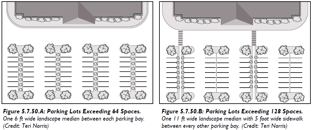
D.
Rain Gardens and Vegetated Bioswales. Rain gardens and vegetated bioswales may be sited throughout the lot, including as a substitute for tree islands and landscape medians. Such features may be combined as a component of a stormwater management plan and shall be appropriately designed and planted using native trees, shrubs, native grasses, and groundcover.
E.
Parking Lot Perimeter Landscape Strips. Parking lot perimeter strips serve the purpose of screening parking lots, maintaining pedestrian vitality, and providing spatial definition along thoroughfares.
1.
A parking lot perimeter landscape strip is required:
a.
Between all off-street parking areas and public or private thoroughfares, including alleys.
b.
Along abutting parking areas, on adjoining lots where no cross access is provided.
c.
Around any parking area that exceeds one acre in size. Such parking areas shall be broken down into smaller lots using perimeter landscape strips.
2.
Width:
a.
With Only Landscaping. Parking lot perimeter strips that utilize only landscaping shall be a minimum of 10 feet in width.
b.
With Fences or Walls. Parking lot perimeter strips that utilize fences or walls for the entire length of the strip shall be a minimum of five feet in width.
3.
Planting and Screening Requirements.
a.
Where no fences or walls are used, shrubs shall be used to form a continuous opaque visual screen in the perimeter landscaping strip. Shrubs shall be maintained at a minimum height of three feet.
b.
In order to assure visibility and safety of pedestrians on the public street and within the parking area and maintain a pedestrian-scaled streetscape; shrubs, fences and walls may be no greater than a height of four feet.
c.
Parking lot perimeter strips shall allow compliance with all local, state, and federal highway sight distance standards.
d.
Where fences or walls are utilized, they shall meet the standards of Division 5.5 (Fences and Walls) and shall incorporate groundcover, low-lying shrubs, ornamental grasses, and/or vines.
5.7.60 - Screening
A.
General Requirements. In addition to the other forms of required landscaping, screening shall be required to conceal unsightly or hazardous areas, and mitigate the effects of noisy activities and machinery. Such areas shall be screened at all times, unless otherwise specified. In the case of conflict, the screening requirements of Division 4.2 (Conditional Use Regulations) shall supersede these standards.
B.
Items to be Screened. The following areas shall be screened in accordance with this Section:
1.
Large waste receptacles (e.g., dumpsters and cardboard recycling containers) and refuse collection areas;
2.
Loading and service areas;
3.
Outdoor storage areas (including, but not limited to, inoperable vehicles, appliances, tires, manufactured homes, building materials, equipment, raw materials, and aboveground storage tanks) located within 200 feet of a public right-of-way;
4.
Shopping cart containment areas located adjacent to public spaces, plazas, or streets (includes internal sites and streets); and
5.
Ground-level mechanical equipment and utility meters.
C.
Screening Methods.
1.
The following items are permitted for use as screening materials, and more than one method may be used on a development site.
a.
Vegetative materials that provide a fully opaque screen to the minimum height necessary to fully screen the facility from off-site views; or
b.
An opaque fence or wall consistent with the standards in Division 5.5 (Fences and Walls).
c.
Buildings.
2.
Reserved.
D.
Configuration of Vegetative Materials. Where vegetative materials are used for screening a site feature in accordance with this Section, the vegetative materials shall be planted around the perimeter of the site feature in a manner that screens it from all off-site views;
E.
Large Waste Receptacles and Refuse Collection Areas. Except for facilities serving individual single-family detached dwellings, two-family dwellings, manufactured homes, and temporary waste receptacles that do not generate any waste, all large waste receptacles and refuse collection areas shall be subject to the following standards.
1.
Show on Plans. The location and configuration of screening for large waste receptacles and refuse collection areas shall be depicted on the Site Plan and on the plan submitted with an application for a building permit.
2.
Opaque Gate. Where access to large waste receptacles and refuse collection areas faces a public right-of-way, the access way shall be screened with an opaque gate. Chain link shall not be used for such gates.
5.7.70 - Landscape Construction and Maintenance Standards
A.
Tree Protection Zones. Tree protection zones shall be established and maintained for each tree preserved or planted on a development site, as follows:
1.
Tree Protection Zone. For existing trees that are being saved, the tree protection zone shall be a circle with a radius of 1 ½ ft for every one inch of dbh, or ft, whichever is greater.
2.
Tree Protection Fence. Prior to commencing construction or any site alteration, a conspicuous four-foot-high fence to prevent encroachment by persons and vehicles shall be erected around a tree or group of trees to be preserved and protected. The fence shall remain in place until the Certificate of Compliance is issued.
3.
New Trees. The protection zone in areas where new trees will be planted shall be a circle with a radius of two feet for understory trees and three feet for overstory trees.
4.
No Paving within Tree Protection Zone. The area within the tree protection zone shall be open and unpaved, except where approved, perforated pavers may be utilized, or tree aeration systems and tree wells installed.
5.
Changes in Grade. Changes in grade shall not be permitted within the tree protection zone except for a two-inch cut or a two-inch fill of topsoil, sod, or mulch.
6.
Underground Utility Lines. Underground utility lines shall be routed around and away from tree protection zones. Necessary installation through tree protection zones shall be accomplished through tunneling, rather than cutting open trenches.
7.
Silt Fencing. Where wetlands or river buffers are involved, a silt fence (made of permeable geotextile buried at the bottom, stretched, and supported by steel posts) shall be erected and installed at least one foot into the buildable area of the site prior to any land disturbance.
8.
Disturbance. Landscape soils that have been compacted during construction activities shall be loosened and aerated to a depth of six inches before planting.
9.
Irrigation. Temporary spray irrigation systems may be used to establish seeded and/or planted areas.
B.
Time for Installation of Required Landscaping. All required landscaping shall be installed in accordance with the required planting standards set forth in this Section before issuance of a Certificate of Occupancy.
C.
Maintenance of Landscaping Materials. The owner shall be responsible for the maintenance of all landscape areas not in the public right-of-way. Such areas shall be maintained in accordance with the approved landscape plan and shall present a healthy and orderly appearance free from refuse and debris. All plant life shown on an approved landscape plan or alternative landscape plan shall be replaced if it dies, is seriously damaged, or is removed.
1.
Protection during Operations. The owner or developer shall take actions to protect trees and landscaping from unnecessary damage during all facility and site maintenance operations. Plants shall be maintained in a way that does not obstruct sight distances at roadway and driveway intersections, obstruct traffic signs or devices, or interfere with the use of bikeways, sidewalks, or pedestrian trails.
2.
Maintain Shape. All required trees (whether overstory or understory) shall be maintained in their characteristic natural shape, and shall not be severely pruned, sheared, topped, or shaped as shrubs.
5.8.10 - Purpose and Intent
This Division provides standards for the regulation of exterior lighting and is intended to:
1.
Encourage good lighting practices such that lighting systems are designed to conserve energy and money, while increasing nighttime safety, utility, security and productivity; and
2.
Ensure that all lighting is designed and installed to maintain adequate lighting levels on-site while limiting the negative impacts of light spillage and glare upon adjacent lands and motorists.
5.8.20 - Applicability
A.
General. The provisions of this Section shall apply to all development in the Town.
B.
Exempt from this Division.
1.
Single and two-family residential uses are exempt from the provisions of this Division.
2.
Required safety lighting for towers shall be exempt from the provisions of this Division.
C.
Date of Effect. All outdoor lighting installed after the date of effect of this code shall comply with the standards of this Division. This includes, but is not limited to, new lighting, replacement lighting, or any other lighting whether attached to structures, poles, the earth, or any other location, including lighting installed by any third party.
D.
Time of Compliance. A lighting plan shall be submitted with an application for approval of a Site Plan or Special Exemption Permit.
5.8.30 - Design Standards for Exterior Lighting
A.
General Standards.
1.
All outdoor artificial illuminating devices shall be installed in conformance with the provisions of this section.
2.
The provisions of this section are not intended to prevent the use of any material or method of installation not specifically mentioned by this section.
3.
As new lighting technology develops which is useful in reducing light above the horizontal, consideration shall be given to use of state of the art technology in keeping with the intent of the this section.
4.
Outdoor light fixtures are defined as outdoor artificial illuminating devices, outdoor fixtures, lamps and other devices, permanent or portable, used for illumination or advertisement. Such devices shall include, but are not limited to, search, spot or flood lights for:
a.
Buildings and Structures
b.
Landscape Lighting
c.
Sign Lighting
d.
Thoroughfare Lighting
e.
Parking Lot Lighting
f.
Recreational and Performance Areas
B.
Light Fixtures.
1.
Fully Shielded. All exterior illuminating devices, except those exempt, shall be fully shielded. "Fully Shielded" shall mean that those fixtures so designated shall be shielded in such a manner that light rays emitted by the fixture, either directly from the lamp or indirectly from the fixture, are projected below a horizontal plane running through the lowest point of the fixture where light is emitted.
2.
Light Trespass and Glare. All nonexempt outdoor lighting fixtures shall be placed so as to not cause light trespass or glare beyond the property boundary, nor impair the vision of pedestrians or motorists.
3.
Illumination Types. Only those types of lighting listed in Table 5.8.30.A (Permitted Illumination Types) shall be allowed. The same type of lighting must be utilized for all fixtures and light sources on the site.
4.
Filtration. Those outdoor light fixtures requiring a filter in Table 5.8.30.A (Permitted Illumination Types) shall have glass, acrylic or translucent enclosures (Quartz Glass is excluded).
C.
General to Zones T1, T3, T4, and T5.
1.
Outdoor Illumination of Buildings and Landscaping. Outdoor illumination of any building, landscaping, or other structure shall use "fully shielded" fixtures.
2.
Signage. If a sign is to be externally illuminated, a stationary light directed solely at the sign shall be used.
a.
Monument Signs. Such signs may be illuminated with reverse channel/halo lighting or one up-light per side. The up-light must have a shield to direct light at the sign.
b.
Wall Signs. Wall signs may be illuminated with reverse channel/halo lighting or down lighting using a "fully shielded" fixture. The brightness of the sign shall not exceed 30 foot-candles at any one point on the sign face.
c.
Goose Neck Lighting. The use of goose neck light fixtures is encouraged.
d.
Noble Gases. Externally mounted gas-filled tubes are only permitted in T4 and T5.
e.
Colored Lights. The use of colored lights to illuminate signage is prohibited.
3.
Thoroughfare Lighting.
a.
Lighting for thoroughfares shall be of a general type illustrated in Table 2.3.90.I (Public Lighting), and located and spaced as conveyed in Table 2.3.90.J (Lighting for Thoroughfares and Bikeways or Pathways).
b.
All thoroughfare lighting shall have no light emitted above 90 degrees.
4.
Off-Street Parking.
a.
With the exception of low pressure sodium lights in rear-loaded parking lots, all other parking lot lighting shall use "fully shielded" fixtures.
b.
Lighting for off-street parking lots shall be of a general type illustrated in Table 2.3.90.I (Public Lighting).
c.
In areas where walkability is desired light poles should range from 12—16 feet in height and shall not exceed 20 feet in height. In autocentric areas where walkability is impossible or non-existent, the Administrator may approve light poles as tall as 25 feet.
5.
Recreation and Performance Areas.
a.
Shielding/Glare Control. To the maximum extent practicable, all lighting fixtures shall be "fully shielded" and / or equipped with a glare control package (e.g., louvers, shields, or similar devices). Lighting shall be aimed so that the beam is directed and falls within the primary playing or performance area.
b.
Hours of Operation. Lighting associated with a recreational event or program shall not continue after 11:00 p.m., except to conclude a specific activity conducted at a ball park, outdoor amphitheater, arena, or similar facility in progress prior to 11:00 p.m.
6.
Prohibited. The following are prohibited:
a.
Searchlights. The operation of searchlights for advertising purposes between the hours of 11:00 p.m. and sunrise shall be prohibited.
b.
Mercury Vapor Lighting. The installation of Mercury Vapor light fixtures is prohibited.
c.
Cobra Head Fixtures. With the exception of thoroughfare lighting in T1, all Cobra Head fixtures are prohibited.
d.
Wall Packs. Wall packs shall be prohibited as a means of general building and site lighting, and may only be used at auxiliary entrances to a building. When used, Wall Packs shall be "fully shielded" fixtures, and shall not be visible from any off-site location.
E.
Illuminance in Foot Candles.
1.
T1 and T3. No lighting level measured at the building frontage (lot) line shall exceed (1.0 fc.).
2.
T4 and T5. No lighting level measured at the building frontage (lot) line shall exceed (2.0 fc.).
3.
In order to account for Primary, Secondary, and Auxiliary Building Frontages, as well as rear and side parking areas, the Standards in Sub-section 1 and 2 above shall apply to all sides of the lot.
| Table 5.8.30.A: Permitted Illumination Types | |||
|---|---|---|---|
| Fixture Lamp Type | Shielded | Filtered | |
| Incandescent 1 | Fully | No | |
| Color Corrected High Pressure Sodium | Fully | No | |
| Metal Halide | Fully | Yes | |
| Florescent 2 | Fully | Yes | |
| LED | Fully | No | |
| Quartz | Fully | No | |
| Tube Filled with Noble Gasses (e.g., Neon, Krypton, Argon) | No | No | |
| Other Sources | By Administrative Adjustment (Section 8.6.10) 3 | ||
| Notes: | |||
| 1 These bulbs are not efficient and are likely to be phased out with time. | |||
| 2 Warm white and natural lamps are preferred to minimize detrimental effects. Outdoor advertising signs of the type constructed of translucent material and wholly illuminated from within do not require shielding. | |||
| 3 Other sources of Illumination that dramatically minimize undesirable light into the night sky, demonstrate significant architectural merit, or are highly energy efficient may be approved using the process for an Administrative Adjustment. | |||
| Natural Gas Lamps are permitted and do not require any shielding nor filtering. | |||
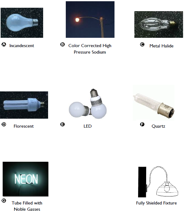
Figure 5.8.30.A: Types of Illumination.
5.9.10 - Purpose and Applicability
A.
Purpose. The purpose of this Division is to regulate the time, place, and manner in which commercial and non-commercial signs shall be permitted, and to ensure that all signs installed in the Town promote vibrant, safe, mixed-use streetscapes that are equally amenable to pedestrian and vehicular users.
B.
Applicability.
1.
These sign regulations apply to all signs within the Town.
2.
The provisions of this Division do not regulate the message content of a sign (sign copy), regardless of whether the message content is commercial or non-commercial.
3.
Sign Permit. A Sign Permit shall be required for the erection, placement, alteration, or reconstruction of any sign unless otherwise noted below, and shall be issued by the Administrator in accordance with the standards of this Division.
5.9.20 - Signs Exempt from a Sign Permit
A.
No Sign Permit is required for the following signs:
1.
Government signs required by any law, order, or governmental regulation.
2.
Signs or plates on structures or premises bearing the address.
a.
Single-family, Two-family and Multifamily dwellings shall have address numbers a minimum of four inches in height and conspicuously located so as to provide visibility from the street on which the structure fronts. Signs may include name and/ or address of the occupant, and similar uses customarily associated with residential structures.
b.
Nonresidential structures shall have address numbers a minimum of six inches in height and conspicuously located so as to provide visibility from the street on which the structure fronts.
3.
Historical markers, monuments or signs as recognized by local, state or federal authorities.
4.
Signs denoting the location of underground utilities.
5.
Holiday decorations.
6.
Window Signs. Such signs shall not require a Sign Permit, but shall comply with the standards of Section 5.9.150 (Window Signs).
B.
Temporary Signs. The following temporary signs shall not require a Sign Permit, but shall comply with the standards for temporary signs in Section 5.9.170 (Temporary Signs).
1.
Schedule of Events Sign. Public or private school or recreational, church or civic club-sponsored entity signs related to schedules of events. See Table 5.9.170.A (Schedule of Events Sign).
2.
For Sale or For Lease Signs. See Table 5.9.170.B. (For Sale or For Lease Sign).
3.
Non-residential Flags. Non-residential Flags bearing the official design of a government, educational institution, church, fraternal organization or ornamental / decorative design. See Table 5.9.170.C (Non-residential Flags).
5.9.30 - Prohibited Signs
The following signs are prohibited:
A.
General. Signs violating any provision of any law of the state relative to outdoor advertising;
B.
Location. Signs located as follows:
1.
Off-premises except signs, flags, and banners erected by the Town, County, or State government.
2.
In the public rights-of-way, except those posted by a public agency;
3.
In any manner or place so as to constitute a hazard to pedestrian or vehicular traffic;
4.
In a manner that obstructs free ingress to, or egress from a required door, window, fire escape or other required exitway;
5.
In any salt marsh areas or on any land subject to periodic inundation by tidal saltwater;
6.
Affixed to a private residence or dwelling or displayed upon the grounds thereof, except as follows:
a.
One personal identification sign not exceeding two square feet in area; and/or
b.
One non-illuminated "for sale" or "for rent" sign not exceeding six square feet in area.
7.
Attached or painted on to the following:
a.
Trees, rocks or other natural features;
b.
Fenceposts, telephone or utility poles; or
c.
Roofs of buildings visible from any public thoroughfare.
C.
Billboards. New Billboards in the Town of Port Royal are prohibited.
D.
Moving, Flashing or Audible Signs. Signs that can potentially distract drivers with the following features:
1.
Permanent moving signs or devices designed to attract attention with any of the following features:
a.
All or part of which move by any means regardless of whether they contain written messages.
b.
Set in motion by movement of the atmosphere or by mechanical, electrical or other means, including but not limited to:
(1)
Flags (other than those of government origin and not used for commercial purposes), pennants, posters, propellers, discs, ribbons, streamers, strings of light bulbs and spinners, "feathers," etc.
(2)
Reserved.
2.
Flashing signs or devices displaying flashing or intermittent lights or lights of changing degrees of intensity, except for:
a.
Signs displaying time and / or temperature.
b.
Reserved.
3.
Signs which emit audible sound, odor or visible matter.
E.
Portable or Towed Signs.
1.
Portable signs or so constructed as to permit its being used as a conveyance upon public streets, and usually parked in public places or private property primarily for the purpose of public display.
a.
Except those permitted by Section 5.9.170 (Temporary Signs) including any signs painted on or displayed on vehicles or trailers,
b.
Reserved.
2.
The parking in public view of any vehicle bearing a commercial message which is not in operating condition or lacking current registration.
3.
Any sign on or towed behind a boat, raft, aircraft, or helicopter.
F.
Sign Copy Limitations.
1.
Signs copying or imitating official government signs or which purport to have official government status;
2.
Any sign and/or sign structure which obstructs the view of, may be confused with or purports to be a governmental or traffic direction / safety sign;
3.
Signs using the words "stop," "danger" or any word, phrase, symbol or character in a manner that misleads, confuses or distracts a vehicle driver;
4.
Signs containing statements, words or pictures of obscene, pornographic or immoral character;
G.
Height.
1.
Signs erected on the roof of any building;
2.
Any sign or sign structure, any portion of which extends above the parapet, building roofline or canopy against which the sign is located. Except:
a.
Freestanding Signs; and
b.
Marquee Signs.
H.
Sign Types.
1.
Inflatable signs.
2.
Snipe signs. A temporary sign not identified elsewhere in this code that contains an advertisement, and is most often placed in the ground or attached to a utility pole.
I.
Abandoned or Deteriorated Signs or Businesses.
1.
Sign structures no longer containing signs;
2.
Signs made structurally sound by unsightly bracing;
3.
Abandoned or dilapidated sign;
4.
Signs referencing businesses which have been out of business for more than 30 days.
5.9.40 - General Sign Requirements
The following shall apply to all signs:
A.
Visibility. The area around the sign shall be properly maintained clear of brush, trees and other obstacles so as to make signs readily visible.
B.
Wiring. Signs with internal electrical wiring or lighting equipment, and all external lighting equipment should be inspected and approved by the Town in accordance with existing and prevailing electrical codes. All wiring to electrical signs or to lighting equipment directed to ground signs shall be underground and GFCI protected.
C.
Business Closes. Whenever the use of a building or premises by a business or occupation is discontinued for at least 30 days, then the signs pertaining to that business or occupations shall be removed.
D.
Design. Sign design and materials shall be as follows:
1.
Compatibility. Signage, including overall design, materials, colors and illumination must be compatible with the overall design of the main building. Details of the sign, such as typeface and layout, shall be subject to minimal review only to prevent obtrusive designs.
2.
Signs used for Business Identification / Advertisement. The business name shall be the predominant feature of the sign. Graphic accents (items and info other than the business name) may not dominate the sign face.
3.
Color.
a.
Bright, primary, or neon colors are not permitted. This includes corporate logos using these colors.
b.
The use of subdued colors is encouraged. In order to allow for creative artwork there is no specific limitation on the number of colors used. A darker background with lighter lettering and graphics is encouraged as a traditional and aesthetically pleasing presentation.
4.
Materials. The finish materials to be used for signage throughout all districts shall be as follows:
a.
Wood: painted, stained, or natural;
b.
Metal: copper, brass, or galvanized steel;
c.
Stucco, tabby, or brick;
d.
Any other material that is finished or painted and looks like wood;
e.
Canvas Awnings; or
f.
Paint (Applied Directly onto Building Walls or Window Glass).
5.
Shape. Signs shall be composed of standard geometric shapes and/or letters of the alphabet, or when approved by the Town Administrator, as a sponsor motif (bottle, hamburger, ice cream cone, etc.). All elements of a sign structure shall be unified in such a way not to be construed as being more than one sign. Outcrops on signs are prohibited.
6.
Lighting. See Division 5.8 (Exterior Lighting), specifically Subsection 5.8.30.C.2 (Signage) for standards regarding appropriate light fixtures and illumination levels for signs.
a.
Any light from any illuminated sign, or flood light or spot light used to illuminate a sign, shall be shaded, shielded, or directed so that the light intensity or brightness shall:
(1)
Illuminate only the surface area of the sign;
(2)
Not interfere with the safe vision of motorists or bicyclists as determined by the building official. For spot-lit signs, the sign base and/or proposed landscaping shall be designed to conceal the base of the light fixture to the extent feasible.
b.
Illuminated signs shall not have a light reflecting background, but may use reflective lettering.
c.
The background of internally-illuminated cabinet signs shall be completely opaque. This provision does not apply to internally-illuminated channel letters.
d.
The following provisions shall apply to the use of neon:
(1)
Neon signs are permitted in the T4 and T5 districts;
(2)
Outlining of buildings, canopies, windows, and doors is prohibited.
E.
Sign Measurement Criteria.
1.
Sign Area Measurement. Sign area for all sign types is measured as follows:
a.
Sign copy mounted, affixed, or painted on a background panel or surface distinctively painted, textured, or constructed as a background for the sign copy, is measured as that area contained within the sum of the smallest rectangle(s) that will enclose both the sign copy and the background. See Figure 5.9.40.A (Sign Area for Signs on Background Panel and Signs with Individual Letters).
b.
Sign copy mounted as individual letters or graphics against a wall, fascia, mansard, or parapet of a building or surface of another structure, that has not been painted, textured, or otherwise altered to provide a distinctive background for the sign copy, is measured as a sum of the smallest rectangle(s) that will enclose each word and each graphic in the total sign. See Figure 5.9.40.A (Sign Area for Signs on Background Panel and Signs with Individual Letters).
c.
Sign copy mounted, affixed, or painted on an illuminated surface or illuminated element of a building or structure, is measured as the entire illuminated surface or illuminated element, which contains sign copy. Such elements may include, but are not limited to lit canopy fascia signs; spanner board signs; and/or interior lit awnings. See Figure 5.9.40.A (Sign Area for Signs on Background Panel and Signs with Individual Letters).
d.
Multi-face Signs. Multi-face signs are measured as follows:
(1)
Two face signs: if the interior angle between the two sign faces is 45 degrees or less, the sign area is of one sign face only. If the angle between the two sign faces is greater than 45 degrees, the sign area is the sum of the areas of the two sign faces. See Figure 5.9.40.B (Sign Area for Multi-face Signs or Free Form Signs).
(2)
Three or four face signs: the sign area is 50 percent of the sum of the areas of all sign faces. See figure on next page. See Figure 5.9.40.B (Sign Area for Multi-face Signs or Free Form Signs).
e.
Free-form or Sculptural Signs. Spherical, free-form, sculptural or other non-planar sign area is measured as 50 percent of the sum of the areas using only the four vertical sides of the smallest four-sided polyhedron that will encompass the sign structure, as shown in Figure 5.9.40.B (Sign Area for Multi-face Signs or Free Form Signs).
Signs with greater than four polyhedron faces are prohibited.
2.
Sign Height Measurement. Sign height is measured as the vertical distance from the average elevation between the highest point and the lowest point of finished grade at the base of a sign to the top of the sign.
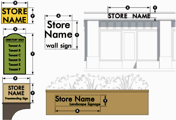
Figure 5.9.40.A: Sign Area for Signs on Background Panel and Signs with Individual
Letters.
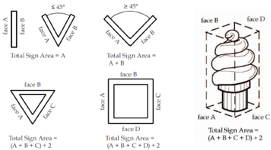
Figure 5.9.40.B: Sign Area for Multi-face Signs or Free Form Signs.
5.9.50 - Selecting Sign Types for Buildings, Businesses, and Communities
A.
Table 5.9.50.A (Sign Types) establishes the types of signs that are allowed, the zoning district where each type is permitted, whether the sign is "attached" or "detached" from the building, and the subsection that contains specific standards for each sign type.
B.
Any building, business, or community located in the Town may utilize one or more sign types permitted in Table 5.9.50.A (Sign Types) in accordance with the standards below and the specific limitations prescribed in Sections 5.9.60—5.9.160.
1.
Home Occupation. A Home Occupation may have one non-illuminated "Building Attached" Yard Sign, not more than six square feet in sign area, mounted on the porch and / or one non-illuminated "Building Detached" Yard Sign, not more than six square feet in sign area, mounted in the yard. See 5.9.160 (Yard Signs).
2.
Live Work. A live work townhouse unit may have any combination of non-illuminated "Building Attached" signs on the principal frontage of the building or unit, so long as the maximum aggregate sign area does not exceed one square foot per linear foot of principal frontage. Signage for a "detached" live work unit shall comply with the standards for Home Occupation (above).
3.
Drive-Through Menu Boards. To the maximum extent practicable, menu boards shall not be visible from a primary street and the base of the menu board shall be landscaped.
4.
Service Station Signs. Gasoline service stations and other establishments selling gasoline shall be permitted one "oil company," "self-service / full-service," or "pump number identification" sign per pump island. The sign shall be a maximum of ten square feet in sign area, and shall be secured to each pump island.
5.
Upper Story Business. A second story retail or service oriented business is permitted one Projecting Sign, Suspended Sign, or Wall Sign, not to exceed the maximum permitted square footage and located at the first floor entrance. Additional upper floor (non-commercial) businesses that share a common first floor entrance shall utilize a shared Wall or Directory Sign located at the sidewalk level.
| Table 5.9.50.A: Sign Types | |||
|---|---|---|---|
| Specific Sign | Illustration | Permit/Standards | Location |
| Awning Signs: Awnings are a traditional storefront fitting and can be used to protect merchants’ wares and keep storefront interiors shaded and cool in hot weather. | 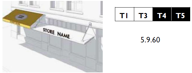 |
Building
Attached | |
| Landscape Wall Sign: Landscape wall signs are attached to freestanding walls and are often used to mark a place of significance or the entrance to a location. |  |
Building
Detached | |
| Marquee Signs: A sign mounted to or hung from a marquee that projects horizontally or vertically from the facade to express a figural design and message to motorists and pedestrians. Marquee signs often have patterned or neon lighting and changeable or painted lettering. | 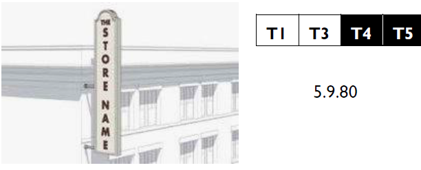 |
Building
Attached | |
| Free Standing Signs: Free standing signs encompass a variety of signs that are not attached to a building and have an integral support structure. Two varieties include: Monument Signs and Pole Signs. | 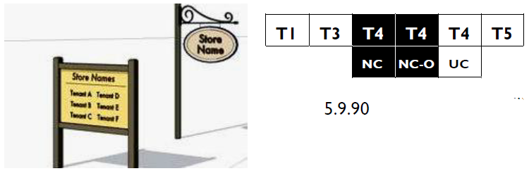 |
Building
Detached | |
| Projecting Signs: Projecting signs mount perpendicular to a building’s facade. These signs are small, pedestrian scaled, and easily read from both sides. Syn. Blade Sign. |  |
Building
Attached | |
| Key | |||
| Table 5.9.50.A: Sign Types | |||
|---|---|---|---|
| Specific Sign | Illustration | Permit/Standards | Location |
| Sidewalk Signs: Sidewalk signs provide secondary signage and may be used to announce daily specials, sales, or point to shops off the sidewalk (i.e., a shop located along a passageway). |  | Building Attached | |
| Suspended Signs: Suspended signs mount to the underside or beams or ceilings of a porch, gallery, arcade, breezeway or similar covered area. These signs are small, pedestrian scaled, and easily read from both sides. |  | Building Attached | |
| Wall Signs.: Wall signs are signs flat against the facade consisting of individual cut letters applied directly to the building or painted directly on the surface of the building. |  | Building Attached | |
| Wall Mural Signs. Wall mural signs are flat against the facade and are located on a secondary facade, typically along a side street, alley, or passageway. These signs are typically painted directly on the building and contain a combination of text and graphic elements. | 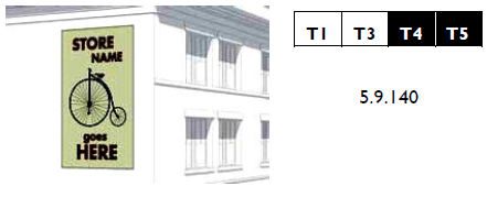 | Building Attached | |
| Window Signs: Window signs are professionally painted consisting of individual letters and designs, gold leaf individual letters and designs, applied directly on the inside of a window. |  | Building Attached | |
| Yard Signs: Yard signs are signs mounted on a porch or in a yard between the public ROW and building facade. | 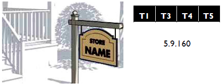 | Building Attached and Building Detached | |
| Key | |||
5.9.60 - Awning/Canopy Sign Type
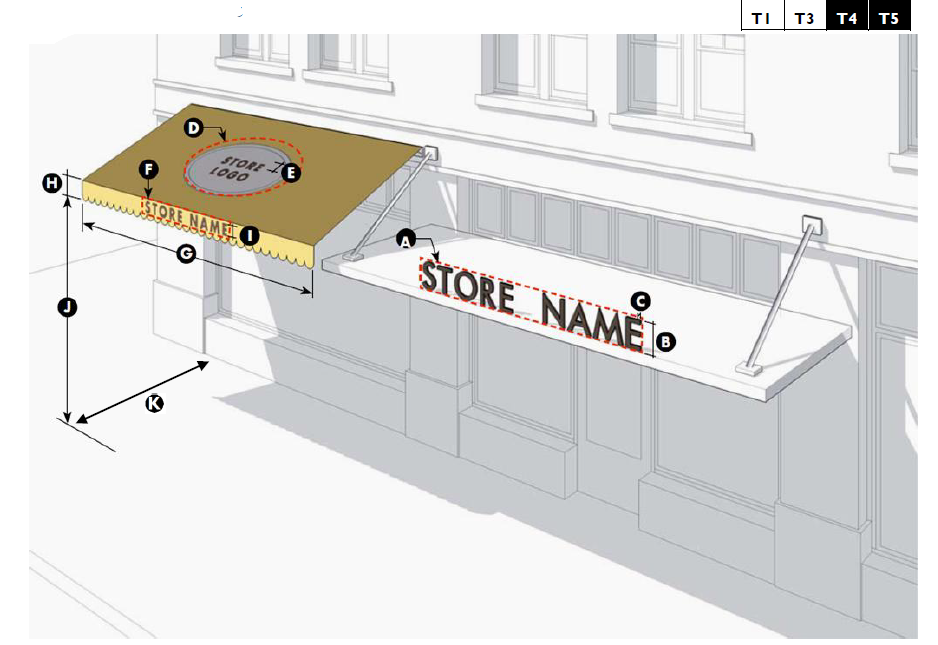
| A. Description | ||
| Awning Signs are a traditional storefront fitting and can be used to protect merchant's wares and keep storefront interiors shaded and cool in hot weather. Retail tenant signs may be painted, screen printed, or appliqued on the awnings. | ||
| B. Standards | ||
| Size | ||
| Projecting: | ||
| Sign Area | 1 sf per linear foot of shopfront, max. | |
| Lettering Height | 16" max. | |
| Lettering Thickness | 6" max. | |
| Sloping Plane: | ||
| Sign Area | 25% coverage max. | |
| Lettering Height | 18" max. | |
| Valance: | ||
| Sign Area | 75% coverage max. | |
| Width | Storefront width max. | |
| Height | 8" min.; 16" max. | |
| Lettering Height | 8" max. | |
| Location | ||
| Clear Height: | 8' min. | |
| Signs per awning: | 1 projecting; or 1 valance and 1 sloping plane max. | |
| Signs per building: | 1 per storefront frontage (principal, secondary, auxiliary). | |
| Distance From Sidewalk/Curb | 2' min. | |
| Second story: | Sign copy on awnings on 2nd story windows not permitted. | |
| Miscellaneous | ||
| Only tenant's store name, logo, and/or address should applied to awning. Additional information is prohibited. | ||
| Open-ended awnings are strongly encouraged. | ||
| Vinyl or plastic awnings are prohibited. | ||
5.9.70 - Landscape Wall Sign Type
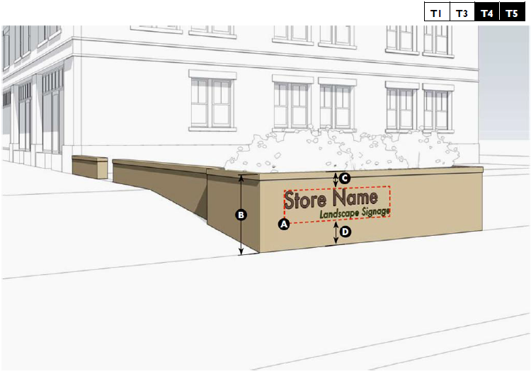
| A. Description | ||
| Landscape Wall Signs are attached to freestanding walls and are often used to mark a place of significance or the entrance to a location. These signs are appropriate in higher Transect Zones, and may be used as a replacement for, or a means of transitioning away from auto-centric Freestanding Signs on busy Thoroughfares. | ||
| B. Standards | ||
| Size | ||
| Signable Area | 24 sf Max. | |
| Location | ||
| Height of Wall | 4' max. | |
| Mounting Height: | ||
| Top of Wall | ||
| Above Grade | At least 12" | |
| Number of Signs | 1 per wall face. | |
| Miscellaneous | ||
| A Wall Sign may be used to mark the entrance to a development or neighborhood. One (1) sign shall be permitted per primary and / or secondary thoroughfare entrance. | ||
5.9.80 - Marquee Sign Type
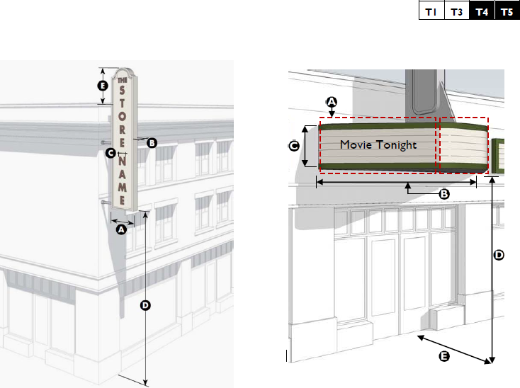
| A. Description | ||
| Marquee Signs. A sign mounted to or hung from a marquee that projects horizontally or vertically
from the facade to express a figural design and message to motorists and pedestrians.
Marquee signs often have patterned or neon lighting and changeable or painted lettering.
Horizontal Marquee. A canopy-like structure integrated into the facade that projects horizontally over the sidewalk and is typically centered upon the entrance. A Horizontal Marquee may serve as the base for a Vertical Marquee, forming one combined sign. Vertical Marquee. A linear, vertically oriented structure that projects outward at a 90 degree angle from the facade of the building or at a 45 degree angle from the corner of the building. A Vertical Marquee often extends beyond the parapet of the building, but may also terminate below the cornice. | ||
| B. Sign Standards | ||
| Vertical Marquee Sign | ||
| Signable Area: | ||
| Width | 24" max. | |
| Depth | 10" max. | |
| Lettering: | ||
| Width | 75% of sign width max. | |
| Clear Height | 12' min. | |
| Extension Above Roofline | 10' max. 1 | |
| 1 May not extend beyond the eave of a pitched roof. | ||
| Horizontal Marquee Sign | ||
| Sign Area: | 5 sf per linear ft of Shopfront width up to 250 sf max. | |
| Sign Width | Shopfront width, max. | |
| Sign Height | 5 ft max. | |
| Clear Height: | 10' min. | |
| Distance From Sidewalk/Curb | 2' min. | |
| Miscellaneous | ||
| Signs Per Building | 1 of each type or 1 combined max. | |
5.9.90 - Freestanding Sign Type
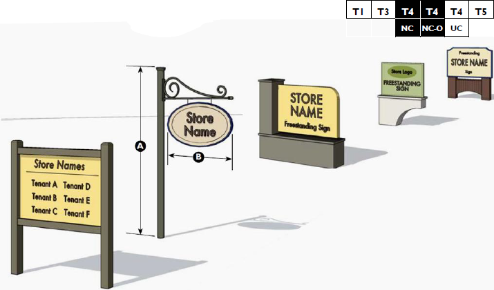
| A. Description | |
| Freestanding Signs encompass a variety of signs that are not attached to a building and have an integral
support structure. Freestanding varieties include Monument and Pole Signs.
A Pole Sign is often double-faced and mounted on a single or pair of round or square poles without any type of secondary support. A Monument Sign rests directly on the ground, and contains a clearly distinguishable base (foundation), middle (sign area) and top. It is often used to mark a place of significance or the entrance to a building. | |
| B. Standards | |
| Size | |
| Signable Area: | |
| Single Tenant | 25 sf max. |
Multiple Tenant with one thoroughfare frontage | 30 sf max. |
Multiple Tenant with two or more thoroughfare frontages | 30 sf max. per frontage. |
Single Family, Multi-family or Mixed-use Residential Community | 25 sf. max. per frontage. |
| Location | |
| Signs per thoroughfare frontage: | |
| Single Tenant | 1 max. 1 |
| Multiple Tenant | 1 max. 1,2,3 |
| Residential/Mixed-use Community | 1 max. 1,3 |
| Sign Height: | |
| Single Tenant | 7' max. |
| Multiple Tenant | 8' max. |
| Single / Two / Mixed-use Community | 7' max. |
| Sign Width: | |
| Single Tenant | 6' max. |
| Multiple Tenant | 6' max. |
| Single / Two / Mixed-use Community | 6' max. |
| Distance from ground to the base of sign. | 4' max. |
| 1 Signs for new development shall be limited to lots that front: Robert Smalls Pkwy, Savannah Hwy, Ribault Rd, Parris Island Gtwy, Grober Hill Rd, or Goethe Hill Rd. | |
| 2 Individual tenants may not have a Freestanding Sign. | |
| 3 Frontages greater than 500 feet may include one additional Freestanding Sign. | |
| Miscellaneous | |
| Changeable copy signs are allowed for gasoline price signs, houses of worship, schools, directory signs listing more than one tenant, and signs advertising restaurant food specials, films and live entertainment which change on a regular basis. | |
5.9.100 - Projecting Sign Type
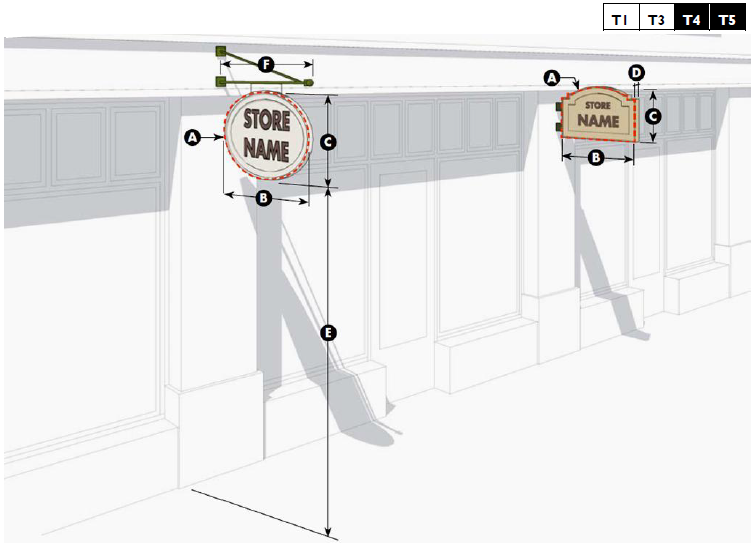
| A. Description | ||
| Projecting Signs mount perpendicular to a building's facade. They are typically hung from decorative cast or wrought iron brackets in a manner that permits them to swing slightly. These signs are small, pedestrian-scale, and easily read from both sides. Often, Projecting Signs offer the opportunity for a more creative or "playful" sign. Projecting Signs should be hung well out of reach of pedestrians and all exposed edges of the sign should be finished. Syn. Blade Sign. | ||
| B. Standards | ||
| Size | ||
| Signable Area: | ||
| Area | 6 sf max. | |
| Width | 48" max. | |
| Height | 36" max. | |
| Thickness | 4" max. 1 | |
| 1 Special and creative signs that have a three-dimensional quality may have a greater thickness subject to approval by the Administrator. | ||
| Location | ||
| Clear Height | 8' min. | |
| Extension | 6' max. | |
| Signs per building | 1 per storefront max. 2 | |
| 2 One (1) additional sign may be located along an auxiliary elevation at a secondary entrance. | ||
| Upper Story Commercial | 1 sign at first floor entrance. | |
(Ord. No. 2014-14, 9-10-14)
5.9.110 - Sidewalk Sign Type
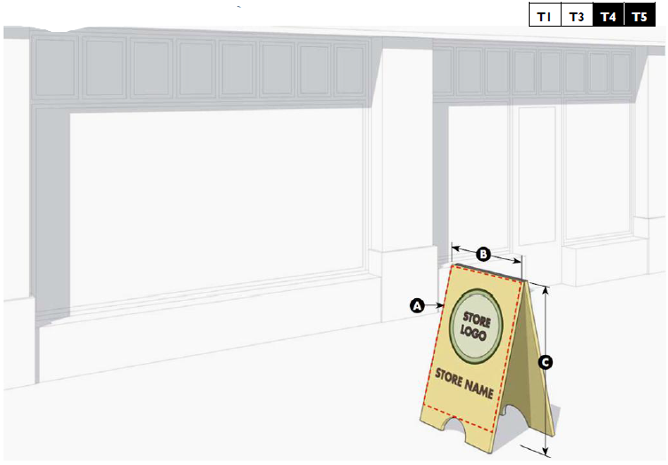
| A. Description | ||
| Sidewalk Signs provide secondary signage and may be used to announce daily specials, sales, or point to shops off the sidewalk (i.e., a shop located along a paseo). They may be painted wood panels or cut wood shapes. Traditional slate boards are highly recommended. Chaser lights or illuminated signs may not be used. | ||
| B. Standards | ||
| Size | ||
| Signable Area: | ||
| Area | 6 sf max. | |
| Advertising a New Business | 8 sf max. | |
| Width | 30" max. | |
| Height | 42" max. | |
| Location | ||
| Sidewalk Signs must be located on or adjacent to a sidewalk and shall not interfere with pedestrian travel or encroach upon the required accessible path. | ||
| Sidewalk Signs may only be displayed during business hours and must be removed when the business is closed. | ||
| Signs per building | 1 per storefront max. 1 | |
| 1 One (1) additional sign may be located along an auxiliary elevation at a secondary entrance. | ||
5.9.120 - Suspended Sign Type
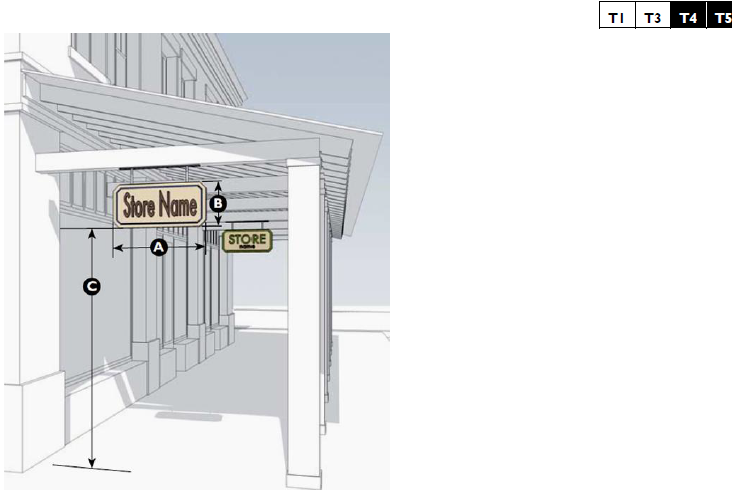
| A. Description | ||
| Suspended Signs mount to the underside of beams or ceilings of a porch, gallery, arcade, breezeway or similar covered area. They are typically hung in a manner that permits them to swing slightly. These signs are small, pedestrian-scaled, and easily read from both sides. Suspended signs should be hung well out of reach of pedestrians and all exposed edges of the sign should be finished. | ||
| B. Standards | ||
| Size | ||
| Signable Area: | ||
| Area | 6 sf max. | |
| Width | 36" max. | |
| Height | 36" max. | |
| Location | ||
| Clear Height | 8' min. | |
| Signs per building | 1 per shopfront, max. 1 | |
| 1 One (1) additional sign may be located along an auxiliary elevation at a secondary entrance. | ||
| Upper Story Commercial | 1 sign at first floor entrance | |
| Miscellaneous | ||
| Suspended Signs shall not extend beyond the edge of the building facade, frontage, or overhang on which it is placed. | ||
5.9.130 - Wall Sign Type
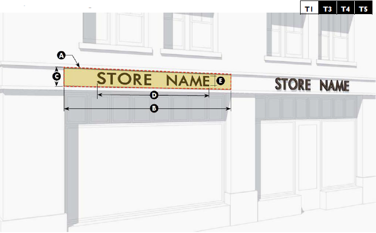
| A. Description | ||
| Wall Signs are flat against the facade consisting of individual cut letters applied directly to the building, or painted directly on the surface of the building. Wall signs are placed directly above the main entrance and often run horizontally along the "expression line" or entablature of traditional buildings. Wall signs do not protrude beyond the roof line or cornice of a building. Wall signs are typically intended to be seen from a distance and are often accompanied by additional pedestrian-scaled signage. | ||
| B. Standards | ||
| Size | ||
| Signable Area: | ||
| Area | 1 sf per linear foot of shopfront width up to 80 sf max. | |
| Width | Shopfront width, max. | |
| Height | 12" min,; 5' max. | |
| Lettering: | ||
| Width | 75% of signable width, max. | |
| Height | 75% of signable height, max.; 35" max. | |
| Location | ||
| Projection from facade | 8' max. | |
| Signs per building | 1 per shopfront. 1 | |
| Facade > 80 ft. wide | 2 per shopfront. 1 | |
| 1 One (1) additional sign may be located along each auxiliary elevation. No sign shall not exceed 80 sf. | ||
| Upper Story Business: | ||
| Commercial | 1 sign only, 3 sf max., located at the entrance. | |
| All other 2nd Story Businesses | 1 shared sign only, 3 sf max, located at the entrance. | |
| Miscellaneous | ||
| Changeable Copy Signs allowed for gasoline prices, multi-tenant directories, dining specials, and entertainment. | ||
5.9.140 - Wall Mural Sign Type
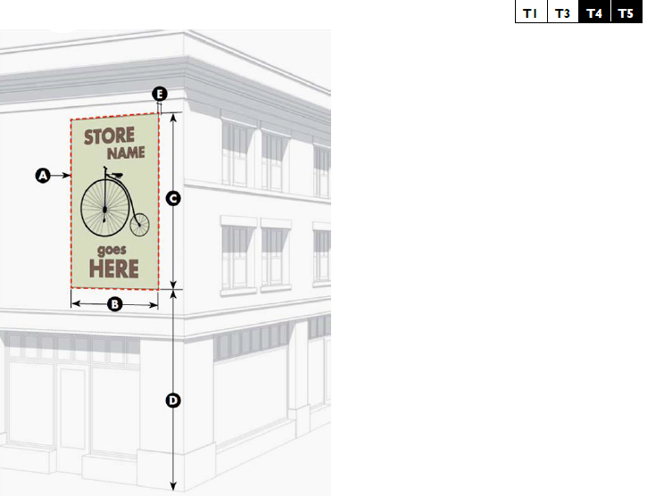
| A. Description | ||
| Wall Mural Signs are flat against the facade and are located on a secondary facade, typically along a side street, alley, or passageway. These signs are typically painted directly on the building and contain a combination of text and graphic elements. These signs are intended to be visible from a greater distance and must be accompanied by additional signage on the primary facade at the business entrance. | ||
| B. Standards | ||
| Size | ||
| Sign Area: | ||
| Area | 1,000 sf max. | |
| Width | 200' max. | |
| Height | 50' max. | |
| Location | ||
| Height above ground | 3' min. | |
| Projection | 8" max. | |
| Signs per building: | 1 max. | |
| Except: | 2 max. when located along an Alleyway or Pedestrian Passage. | |
5.9.150 - Window Sign Type
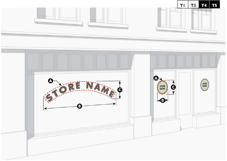
| A. Description | ||
| Window signs are professionally painted consisting of individual letters and designs, gold leaf individual letters and designs, applied directly on the inside of a window. Window signs offer a high level of craftsmanship and visibility, and are often used for small professional offices. Window signs are often repeated on storefronts with several divided openings, however, repetition should be done with great care to ensure that the entrance to the business is clearly marked. | ||
| B. Standards | ||
| Size | ||
| Sign Area: | ||
| Per Shop front Bay | 25% max | |
| Per Shop front | 15% max | |
| Width | 5' max. | |
| Height | 36' max. | |
| Location | ||
| Window signs shall be placed at or above eye level. | ||
| Window signs shall be applied directly to the inside of the glass. | ||
| Miscellaneous | ||
| Applied plastic or vinyl cut letters are strongly discouraged. | ||
| Window signs must have a clear background. | ||
| No Permit Required. | ||
5.9.160 - Yard Sign Type
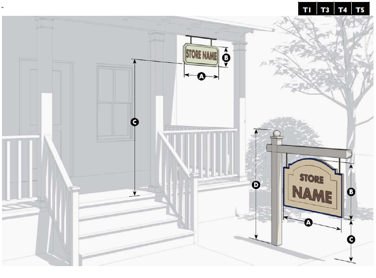
| A. Description | ||
| Yard Signs are signs mounted on a porch or in a yard between the public ROW and the building facade. Yard signs mounted on a porch are placed parallel to the building's facade. Yard signs mounted in a yard are placed parallel or perpendicular to the ROW. Yard signs work well for home businesses located in mixed-use environments. | ||
| B. Standards | ||
| Size | ||
| Signable Area: | ||
| Area | 6 sf max. | |
| Width | 36" max. | |
| Height | 36" max. | |
| Location | ||
| Clear Height: | ||
| Mounted on Porch | 6' 8" min. | |
| Mounted in Yard | 12" min. | |
| Overall Height | 5' max. | |
| Signs per Building: | ||
| Mounted on Porch | 1 per business. | |
| Mounted in Yard | 1 max. | |
| Miscellaneous | ||
| Yard signs may not be located within a public ROW. | ||
| Yard mounted signs shall be parallel or perpendicular to the ROW. | ||
5.9.170 - Temporary Signs
A.
Permit Required.
1.
Grand Opening Signs. Signs or displays calling attention to a new business shall be a maximum of six feet high and shall be located a minimum of ten feet from the street right-of-way. The signs may be displayed for grand openings for a maximum of 30 days.
2.
Banners. Promotional banners shall have a maximum of 30 square feet in sign area, a maximum height of three feet, and be secured to the business along all four sides at all times. Promotional banners shall be displayed for a maximum of 30 consecutive days. Application for a permit for promotional banners may be made only four times during any calendar year. A minimum of 30 days shall expire between permit applications.
3.
Sandwich Board and Easel Signs for New Businesses. Signs shall comply with the standards of Section 5.9.110 (Sidewalk Sign Type). The sign permit shall be valid for six months from the date of issuance. No renewal of temporary business signs is permitted.
B.
No Permit Required.
1.
Schedule of Events Sign. Public or private school or recreational, church or civic club-sponsored entity signs related to schedules of events shall comply with the below standards (Table 5.9.170.A: Schedule of Events Sign).
2.
For Sale or For Lease Sign. Such signs shall comply with the below standards (Table 5.9.170.B: For Sale or For Lease Sign).
3.
Non-residential Flags. Flags bearing the official design of a government, educational institution, church, fraternal organization or ornamental/decorative design shall comply with the below standards (Table 5.9.170.C: Non-residential Flags).
4.
Construction Signs. One sign per street frontage. The sign shall have a maximum of 32 square feet in sign area, a total aggregate of 64 square feet, be a maximum of six feet high and shall be located a minimum of 10 feet from the street right-of-way. The sign permit shall be valid for the duration of the construction period.
5.
Political Signs. Political campaign signs shall not be posted in the public right-of-way, including signs posted on trees, utility poles, and similar structures. Signs may be posted 60 days in advance of the day of election, and shall be removed within 7 days following the day of election.
(Ord. No. 2014-14, 9-10-14)
5.9.180 - Sign Maintenance and Enforcement
A.
In order to ensure that signs are erected and maintained in a safe and aesthetic manner, the following maintenance requirements shall be observed for all signs visible from any public street, and any deficiency shall be corrected within 30 working days of being detected:
1.
No sign shall have more than ten percent of its surface area covered with disfigured, cracked, ripped or peeling paint or poster paper;
2.
No sign shall stand with bent or broken sign facings, broken supports, loose appendages or struts or be allowed to stand more than 15 degrees away from the perpendicular;
3.
No sign shall have weeds, trees, vines or other vegetation growing upon it or obscuring its view from the street from which it is to be viewed; and
4.
No internally illuminated sign shall stand with only partial illumination.
B.
Impoundment of Signs.
1.
The Administrator shall have the authority to remove, without notice to the owners thereof, and impound for a period of ten days, signs placed within any street or highway right-of-way; signs attached to trees, fence posts, telephone and utility poles, or other natural features; and signs erected without a permit or prohibited by this Division.
2.
The owner of a sign impounded may recover the sign upon the payment of $2.00 for each square foot of such impounded sign, prior to the expiration of the ten-day impoundment period. If the sign is not claimed within ten days, the Administrator shall have authority to discard the sign.
3.
If the owner or lessee fails to remove the sign during the permitted time, then the Town or an independent contractor secured by the Town shall remove the sign and ensure charges shall be assessed to the owner or lessee.
5.10.10 - Purpose and Intent
This Division provides standards for the protection of natural systems, including, wildlife habitat, species diversity, and water quality. The requirements of this Division are intended to maintain natural resources and to ensure that proposed development is consistent with the character of its natural surroundings while:
A.
Preserving unusual terrain, scenic vistas, and native vegetation;
B.
Preserving and enhancing the visual character and aesthetic qualities of the Town for the enjoyment of both residents and visitors; and
C.
Preserving and enhancing the character and value of all properties.
5.10.20 - Applicability
A.
General. These resource protection standards apply to all development in the Town, unless expressly stated otherwise in this Division. Existing lots of record with built, single family and two and three family dwellings are exempt from the provisions of this section.
B.
Plan for Development Required. Development subject to the standards of this Division shall provide a plan for development illustrating how the proposal complies with these standards.
(Ord. No. 2018-21, 2-13-19)
5.10.30 - River Buffer and Setback
Development adjacent to and affecting the river buffer or S.C. Office of Ocean and Coastal Resource Management (OCRM) Critical Line shall comply with the following standards.
A.
Setback from OCRM Critical Line.
1.
The purpose of a River Buffer is to preserve or restore the native landscape along the marsh edge. This serves to mitigate the impact of tropical storms and hurricanes, provide a natural filtration system for runoff from adjoining development, minimize erosion and help stabilize the stream bank, and protect sensitive visual and ecological resources. The river buffer shall be established inland of all tidal waters beginning at the OCRM Critical Line, as established in Table 5.10.30.A; and
2.
All development shall be also set back a minimum of 50 feet from all tidal waters beginning at the OCRM Critical Line, except for as shown in Table 5.10.30.A.
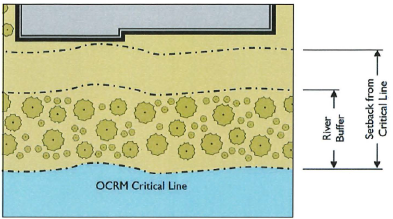
Figure 5.11.60.A: Relationship between the river buffer width and building setback
from the OCRM Critical Line
B.
Drainage. Except for existing agriculture:
1.
Apply Stormwater Best Management Practices (BMPs). Development adjacent to and affecting the river buffer or OCRM Critical Line shall apply BMPs in accordance with the County Manual for Stormwater BMPs, as amended, in the design of drainage and detention basins. Additional special engineering may be required where the Town Engineer determines it is necessary to protect nearby waters or wetlands.
2.
Divert Drainage Away from OCRM Critical Line. All drainage shall be diverted away from the OCRM Critical Line, through a Town-approved stormwater system employing BMPs.
3.
Lots Adjoining River Buffer. Lots adjoining the river buffer shall be designed and engineered to prevent direct discharge from impervious surfaces across the river buffer. All discharges shall be diverted into the development's stormwater system and treated in accordance with the requirements of this Development Code. (While agriculture is exempt from this Subsection, such activities are strongly urged to utilize BMPs.)
C.
Development and Removal of Vegetation Prohibited: the entire buffer shall be undisturbed. Indigenous vegetation removal in the tidal area buffer is limited to that necessary to provide for a structure/activity permitted by this subsection and to provide for reasonable sight lines, with the following exceptions:
1.
Paths, steps, decks, open-air structures (up to 80 square feet), docks, paths, and streets and sidewalks accessible to the public, erosion control devices (not stormwater ponds), and any other elements linked to the critical area that are permitted by OCRM are permitted in the Critical Area Vegetative Buffer.
2.
View Corridor. A view corridor across the river buffer may be established by a landowner in accordance with the following:
a.
Width. The width of the view corridor crossing the river buffer shall be no more than 75 feet or one-third of the lot width, whichever is less.
b.
Management. Management of vegetation within the view corridor shall be limited to only pruning needed to provide views, except that a landowner may submit a selective clearing and selective landscaping program for the view corridor, which shall be approved if the net result provides both ample screening of the shoreline and filtering of runoff from lawns on the lots.
3.
Re-vegetation Plan. Any other disturbance of the shoreline within the river buffer landwards of the OCRM Critical Line shall require submission of a re-vegetation plan that complies with the standards of Division 5.7 (Landscaping and Screening), and the following:
a.
Intent. A principle objective of the plan is to preserve and replace as much of the on-site pre-construction native vegetation to the extent possible. Other acceptable landscaping plants are found in the SCDHEC publication entitled "Backyard Buffers", publication CR-003206 (11/00). The re-vegetation plan shall be prepared by a landscape designer or landscape architect. The re-vegetation plan shall be designed so that upon plant maturity, the disturbed area is completely vegetated.
b.
Plant Back Requirement. Removal of trees and shrubs shall require plant back on an inch for inch (trees) or plant for plant (shrubs) basis.
c.
Slope Stabilization. Re-vegetation of area landward of the OCRM Critical Line with slope topography in excess of a 1:3 slope shall also include slope stabilization measures in compliance with the South Carolina Sediment and erosion Control Act.
4.
Lots with bulkheads existing at the times of adoption of this ordinance, are exempt from the provisions of the section.
D.
Waiver. Where existing lots (conforming or nonconforming) are so small that a single family house cannot be developed on the lot and comply with the required OCRM Critical Line setbacks and other related standards, the Administrator shall grant a waiver from these requirements, in accordance with the following provisions:
1.
OCRM Critical Line Setback Significantly Limits House Size. The applicant shall demonstrate:
a.
That the size of the home would have to be less than the average size of homes within five lots on either side of the lot for which the waive is requested, due to the OCRM Critical Line setback and application of the other standards in this section; or
b.
If there are no homes within five lots of either side of the lot for which the waive is requested, a floor area ratio of three-tenths or a maximum building footprint (livable area) of 15 percent of the total lot area, whichever is less, shall guide the need for a waiver.
2.
Reduction of Street or Front Yard Setback to Avoid Waiver. It is infeasible to reduce the street or front setback by up to 30 percent in order to avoid the need for a waiver. (In development that is largely un-built, with lots still in common ownership, the Town may require the developer to revise covenants to grant reduced street setbacks. The street setback reduction shall be the minimum possible).
3.
Structure Shall Not Encroach Into OCRM Critical Line Setback. To the maximum extent practicable, the home approved through the waiver is designed so it does not encroach into OCRM Critical Line setback area (i.e., design alternatives such as adding a second or third story, adjusting house dimensions, reducing overall house size, etc., would still render the noncritical line setback area as unbuildable.)
4.
Limit on Reduction of OCRM Critical Line Setback. The OCRM Critical Line setback shall not be reduced to less than a 25-foot setback, except in areas where homes that already exist are located closer than 25 feet to the OCRM Critical Setback. In those cases, the average Critical Line setback of adjoining lots shall be used, provided that in no case shall a setback of less than 20 feet be granted unless the setback is to preserve a specimen tree, historic resource, or to prevent a lot from becoming unbuildable with comparable houses as described in Subsection I.1 above. Where the setback is to preserve a specimen tree or historic resource, the building envelope allowed shall optimize the protection of the resources.
5.
Stormwater Management. If the house and lot do not drain into a stormwater management system that uses BMP's in accordance with the requirements of this Section, the landowner shall provide the necessary stormwater management on the lot.
(Ord. No. 2018-21, 2-13-19)
5.10.40 - Tidal Wetlands
Development in Tidal Wetlands is prohibited, except for Marine-Oriented Facilities (see Table 4.1.30 Principal Use Table) and accessory Water-Oriented Facilities (see Sub-section 4.3.30.A.1 (Water-Oriented Facilities) with the following:
A.
Approved by USACE and OCRM. The plan for development of the Marine-Oriented Facilities and / or accessory Water-Oriented Facilities shall be approved by the United States Army Corps of Engineers (USACE) and the S.C. Office of Ocean & Coastal Resource Management (OCRM); and
B.
Appropriate Design. It is demonstrated the design of the plan for development of the Marine-Oriented Facilities and / or accessory Water-Oriented Facilities:
1.
Minimizes Impact. Minimizes the impact on Tidal Wetlands; and
2.
Maximizes Sharing of Facility. Maximizes the sharing of the facility to avoid having every property in the area seek a similar request. (This may mean shared facilities for the entire development or facilities that can serve several adjoining properties.)
5.10.50 - Non-Tidal Wetlands
Development in Non-tidal Wetlands is prohibited, except in the following instances:
A.
Where structures are necessary to a permitted use and cannot be located outside the wetland, the structure shall be located on piles. Where needed, access shall be provided on structures such as boardwalks.
B.
Private Roads. Road crossings are allowed in non-tidal wetlands only where no reasonable alternative exists. Roads shall be elevated and not constructed of or on fill material. Where appropriate, wildlife corridors shall be provided under the roads.
C.
Trails. Trails are allowed in non-tidal wetlands where it is demonstrated they are essential to establish a crossing between different areas, or where the trail has an historical purpose. Trails shall be of boardwalk construction. The height of the boardwalk shall be above normal high water to ensure the boardwalk minimally disrupts plant life.
D.
Buffers.
1.
Vegetative buffers shall be retained or created along the banks or edges of all freshwater wetlands as part of the required setback distance. The following average depth shall be established for construction from the boundary of all wetlands.
a.
Single and Two-family Residential uses: 20 feet.
b.
Multifamily Residential, Commercial, Industrial, and Mixed Uses: 50 feet.
c.
Impervious parking areas: 30 feet.
2.
Vegetative buffers are areas completely pervious to the ground in nature and are intended to prevent polluted runoff from entering fragile wetland systems. For this purpose, they shall be a minimum of 15 feet in depth and contain living plant material including but not limited to trees, shrubs, vines, ferns, mosses, flowers, grasses, herbs and ground cover.
5.11.10 - Purpose
The purpose of these standards is to control the adverse effects of post development stormwater runoff and nonpoint and point source pollution associated with new development and redevelopment. This Division seeks to meet this purpose by fulfilling the following objectives:
A.
Calibrate these controls based on the context of the site to ensure that walkable, urban patterns of development are favored as the primary Best Management Practices (BMPs); and
B.
Minimize increases in stormwater runoff from new development or redevelopment to the maximum extent practical for the applicable design storm in order to reduce flooding, siltation, erosion, increases in temperature, and to maintain the integrity of stream channels, marshes and aquatic habitats; and
C.
Minimize increases in non-point and point source pollution caused by stormwater runoff from development that would otherwise degrade local water quality; and
D.
Minimize the total volume of surface water runoff that flows from any specific site during and following development in order to replicate pre development hydrology to the maximum extent practicable through the use of structural and nonstructural stormwater management Best Management Practices (BMPs); and
E.
Establish minimum post development stormwater management standards and design criteria for the regulation and control of stormwater runoff quantity and quality.
5.11.20 - Applicability
The standards established in this Division shall apply to all proposed development within the Town, as conveyed in this Section.
A.
Exemptions.
1.
Any maintenance, alteration, renewal use or improvement to an existing drainage structure as approved by the Administrator which does not create adverse environmental or water quality impacts and does not increase the temperature, rate, quality, or volume or location of stormwater runoff discharge;
2.
Development where adequate drainage exists of fewer than four residential dwelling units that are not part of a phase of a larger development, not involving a main drainage canal;
3.
Site work on existing one-acre sites or less where impervious area is increased by less than two percent;
4.
Site work on existing one-acre sites or less where impervious area is increased by less than two percent, and any earthwork that does not increase runoff and/ or eliminate detention / retention facilities and / or stormwater storage or alter stormwater flow rates or discharge location(s);
5.
Agricultural activity not involving relocation of drainage canals; or
6.
If possible, when work is done by agencies or property owners to mitigate emergency flooding conditions, the work should be approved by the duly appointed officials in charge of emergency preparedness or relief. Property owners performing emergency work will be responsible for any damage or injury to persons or property caused by their unauthorized actions.
B.
Private Drainage Systems Not Town Responsibility. Where private drainage systems and easements have been previously approved as private facilities, as well as all new development and redevelopment, such facilities shall not become Town responsibility.
C.
Applicability. See the STORMWATER MANAGEMENT AND UTILITY AGREEMENT BETWEEN BEAUFORT COUNTY, SOUTH CAROLINA AND THE TOWN OF PORT ROYAL, SOUTH CAROLINA dated June 26, 2012 with Attachment.
5.11.30 - Stormwater Standards
A.
Beaufort County BMP Manual. Where required, all development and redevelopment shall provide adequate drainage, peak rate, volume and stormwater pollution control in accordance with Section 3 of the Beaufort County Manual for Stormwater Best Management and Design Practices (BMP), and the STORMWATER MANAGEMENT AND UTILITY AGREEMENT BETWEEN BEAUFORT COUNTY, SOUTH CAROLINA AND THE TOWN OF PORT ROYAL, SOUTH CAROLINA dated June 26, 2012 with Attachment, which are incorporated herein by reference.
B.
Reserved.
5.11.40 - Planning for Stormwater
A.
Planning for Stormwater Should Commence at Project Inception: Planning for stormwater should commence at project inception. As the requirements set forth above and elsewhere in BMP manual will require stormwater management to become a vital aspect of all development and redevelopment projects within the Town, planning for stormwater management, in accordance with this section shall commence at the time of initial project inception and presentation to the Administrator. Review of stormwater management for development and redevelopment will be undertaken during all phases of the development review process.
B.
Stormwater BMPs shall be selected in keeping with the applicable Transect Zone, as indicated in:
1.
Table 5.11.40.A (Stormwater BMPs by Transect Zone).
2.
The "Light Imprint Handbook - Integrating Sustainability and Community Design," 2008, Tom Low, DPZ Charlotte. 2008.
Stormwater BMPs shall be selected to respond to the site's location within a volume sensitive watershed, according to the worksheets provided in the Beaufort County BMP Manual.
| Table 5.11.40.A: Stormwater BMPs by Transect Zone | ||
| Stormwater BMP Type | Allowed In | |
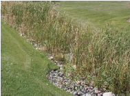 | Vegetated Swales are shallow drainage ways that employ landscaping to provide water quality treatment via biofiltration. They are designed to remove silt and sediment associated pollutants before discharging to storm sewers and to reduce volume if soils allow for infiltration. The treatment area can be planted in a variety of grasses, sedges and rushes, while the side slopes can be planted with shrubs and groundcover. Check dams are added to aid infiltration. | |
 | Green Roofs are a way of managing stormwater in urban areas with limited space for more land intensive BMPs. Green roofs are able to store stormwater in the soil medium during rain events, helping to detain runoff. Some of the stormwater will be taken up by the roots of the plants and some will be evaporated from the soil medium, reducing the amount of runoff from the roof. | |
 | Pervious Paving Systems allow water to pass freely through the interstitial space ingrained throughout the paving matrix, thereby transforming traditionally impervious surfaces. Several examples are pervious concrete and asphalt, interlocking pavers, and reinforced gravel and grass paving. | |
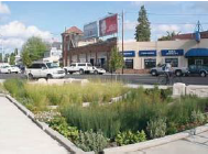 | Rain Gardens are flat-bottomed landscaped depressions that can be built to any size or shape. Also known as ‘bioretention cells’, they are designed to allow water to settle and infiltrate into the soil. They reduce the peak discharge rate from a site via detention. Water quality improvements are achieved through particle settling, nutrient uptake, and filtration as water soaks into the ground. | |
 | Disconnected Downspouts. In lower density residential areas downspouts should be disconnected from storm drain systems and directed towards landscaped areas. This reduces the burden on the storm drain network and allows runoff to slow and infiltrate before overflowing to storm drains. | |
 | Tree Box Filters are containers filled with a soil mixture, a mulch layer, under-drain system and a shrub or tree similar to flow through planters. The compact size of tree box filters allow volume and water quality control to be tailored to specific site characteristics and are well suited to urban areas. Tree box filters provide the added value of aesthetics while making efficient use of available land for stormwater management. | |
| General Note: Images on this page are illustrative, not regulatory | ||
| Table 5.11.40.A: Stormwater BMPs by Transect Zone (continued) | ||
| Stormwater BMP Type | Allowed In | |
 | Vegetated Flood Plains can be integrated with parks, playing fields, or unmanaged landscapes. Frequent storm events can be detained by smaller decentralized means, while larger storm events should be directed to non-priority vegetated landscapes for temporary detention. | |
 | Urban Flood Plain. Urban hardscapes can be used for temporary storage of large storm events. Smaller events should be mitigated by decentralized means, while the larger events can be directed toward non-priority spaces which are planned and designed for the temporary storage of stormwater flows. | |
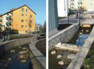 | Riffle Pools. Connected landscapes provide retention of runoff by integrating intermittent vertical drops and damming in a watercourse. The retained runoff is then allowed to infiltrate into the groundwater table or conveyed for further treatment. | |
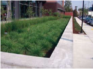 | Flow-through Planters are landscape features that also provide stormwater runoff control and treatment. Flow-through planters are sealed on all sides and fitted with an underdrain. They only absorb as much water as soil and plants in the planter can accommodate. Once the planter is at capacity, water is then discharged through the underdrain. They are ideal for receiving roof runoff from downspouts and can be incorporated into foundation walls. | |
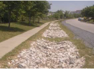 | Infiltration Trenches are subsurface facilities designed to provide on-site stormwater retention in areas of good infiltration by collecting and recharging stormwater runoff into the ground. Trenches filter pollutants to improve water quality and contribute towards groundwater recharge. They are relatively low maintenance and can be easily retrofitted into existing sidewalk areas and medians. | |
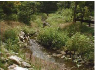 | A Natural Channel is a meandering, vegetated watercourse with natural banks. It is buffered from development zones by large uncultivated landscape. | |
| General Note: Images on this page are illustrative, not regulatory | ||
| Table 5.11.40.A: Stormwater BMPs by Transect Zone (continued) | ||
| Stormwater BMP Type | Allowed In | |
 | Dry Detention Ponds are basis whose outlets have been designed to retain stormwater runoff for some minimum time (e.g., 24 hours) to allow particles and associated pollutants to settle. Unlike wet ponds, these facilities do not have a large permanent pool of water. However, they are often designed with small pools at the inlet and outlet of the basin. Ponds require land to be set aside in a manner that can disrupt the quality of the surrounding urbanism. They should be utilized with caution in the T4 zoning districts. | |
 | Water Retention Ponds consist of a permanent pool of water into which stormwater runoff from each rain event is detained and treated in the pond until it is displaced by runoff from the next storm. Wet ponds allow for additional biological interactions that assist in improving water quality for nutrients. Ponds require land to be set aside in a manner that can disrupt the quality of the surrounding urbanism, and should be utilized with caution in the T4 zoning districts. | |
 | Urban Channels are narrow vegetated or stone lined conveyances framed by vertical stone or concrete banks abutting cultivated landscapes or hardscapes. | |
 | Level Spreaders are structures that are designed to uniformly distribute concentrated flow over a large area to mimic natural sheet flow. Concentrated flow enters the spreader through a pipe, ditch or swale; the flow is retarded, energy is dissipated; the flow is distributed throughout a long linear shallow trench or behind a low berm; water then flows over the berm/ditch uniformly (in theory) along the entire length. | |
 | Rain Barrels are connected directly to downspouts to capture and store runoff for future use. Stormwater discharge is slowed down and water can be reused for irrigation. Fifty gallons of storage is suggested as a minimum. Barrels must also have a cover to prevent insect and debris collection. | |
 | Cisterns function similar to rain barrels by collected stormwater and storing it for reuse, but on a much larger scale. Cisterns can be stored above ground, buried below ground, or located inside of buildings. They typically store rainwater for reuse in irrigation, mechanical uses, toilet flushing, and fire prevention. | |
| General Note: Images on this page are illustrative, not regulatory | ||