
Ray Township City Zoning Code
OS OPEN
SPACE COMMUNITY
SECTION 2400 - OPEN SPACE COMMUNITIES.
A.
Statement of Intent.
The purpose of this Section of the Zoning Ordinance is to allow and encourage alternative subdivision designs which preserve Ray Township's character and environmentally sensitive elements, while providing housing communities that are desired by the community.
Open Space Communities promote the following objectives:
•
Maintain the rural character of the Township.
•
Maintain an image of open space within the Township.
•
Preserve open space within the township.
•
Preserve natural resources within the Township.
•
Preserve agriculture and farming within the Township.
•
Achieve a balance between farming, open space and residential growth within the Township.
B.
Site Criteria.
1.
An open space community may be located in all residential districts.
2.
The open space community shall have direct access to an approved public roadway.
3.
In all open space communities, at least two (2) of the following items must be present:
a.
Preservation of Natural Amenities - Sites preserving a significant quantity of any of the following:
(1)
Organic Amenities: Significant views and vistas, mature woodlands, wetlands or lowland areas, prairie, bodies of open water (such as ponds, streams, natural drainage ways), wildlife habitat or corridors, and significant size trees (six to eight inches or more, measured five feet above the grade).
(2)
Nonorganic Amenities: Farmhouses (viable for restoration and/or preservation), fence lines (stone or wood), buildings or foundations of historical value.
b.
Provisions for Recreational Facilities - The submittal should include both passive and/or active recreation areas. Passive recreation areas shall include areas such as pathway systems, common green areas of a substantial size, and open/preserves natural amenity areas, or other areas or uses consistent in nature. Active recreation areas shall include areas such as children play sets, sports fields (i.e., football, soccer, baseball), and other fitness areas that are consistent in nature.
c.
Creation of Natural Amenities - These areas are to be constructed in a manner that replicates a natural setting. A percentage of these areas should remain "unmanicured," allowing natural growth and processes to occur. These areas can take a number of forms, such as woodlands (interior street tree plantings shall not count for this requirement), wildflower or grass meadows, constructed wetlands (preferably extension to an existing), or other areas consistent in nature.
d.
Preservation of Agriculture - Land uses, such as orchards, horse stables, active farms, or other similar agriculture uses, shall be preserved, where feasible or viable. In no way shall an intensive animal raising, slaughter house or similar use be allowed within an open space community. A buffer shall be maintained between the agricultural use and the residential units.
4.
All of the above-mentioned areas shall be accessible or open to all residents within the open space community, with the exception of farmland.
C.
Submission Requirements.
The submission for an Open Space plan shall consist of all four (4) of the following plans. Plans #2 and #3 may be shown on the same sheet if clarity is maintained.
1.
Plan #1 - Parallel Plan.
A "parallel" or "yield plan" shall be prepared by the developer showing a feasible development under the requirements of the zoning district in which the property is located and the requirements of any and all State, County and Township Zoning Ordinance and subdivision regulations. All lots, roads and other improvements shall be designed so that they do not adversely impact wetlands, floodplains or drainage ways, as regulated by Federal, State, County or local agencies.
It must be determined by the Planning Commission that the parallel plan is able to be physically constructed and meet all current Zoning Ordinance and subdivisions regulations. If there is a question regarding the availability of water, suitability of soils for septic, the location or extent of wetlands or floodplains, the Planning Commission may request further review and recommendation from the proper regulatory authority. If it is determined, through these responses, that the number of lots proposed is unfeasible, the yield plan shall be revised and resubmitted, minus that number of lots.
Further, the Planning Commission may also waive the submission of a yield plan if it is determined that the number of housing units proposed under the open space community is, without question, well below what would be feasible for the site. Such waivers must be detailed in writing and recorded as part of the motion in the minutes of the Planning Commission.
2.
Plan #2 - Site Analysis Plan.
A site Analysis Plan shall be submitted, showing the following site features:
a.
Wetlands, as determined by the Michigan Department of Natural Resources and Environment
b.
Water areas, such as lakes, streams and ponds
c.
Woodlands, tree rows and farmlands
d.
Soils and topography
e.
Drainage patterns and County drains
f.
Historic and cultural features
g.
Wildlife habitat corridors
h.
View sheds and view corridors
i.
Existing easements of record
j.
Existing and proposed rights-of-way
k.
Existing infrastructure
l.
Adjacent development within two hundred (200) feet
3.
Plan #3 - Conservation Areas Plan.
The combination of the site analysis elements noted above shall be used to outline the primary and secondary conservation areas. The primary conservation areas include areas where no development is to occur. The secondary conservation areas are areas where development can occur, but special care must be taken to minimize adverse impacts.
a.
Primary Conservation Areas shall generally include- floodplains, regulated wetlands, drainage ways, easements, 150 - foot exterior road buffer, or other exceptional elements.
b.
Secondary Conservation Areas shall generally include - farmlands, woodlands, suspected or marginal wetlands, tree lines, soils sensitive to development, soils prone to flooding, aesthetic views, etc.
c.
Buildable Areas shall generally include - areas that are not dedicated to primary conservation areas may be treated as buildable areas. Housing sites should be located so as to complement the conservation areas.
4.
Plan #4 - Open Space Plan.
An Open Space Plan, with the proposed housing layout (not exceeding the maximum number of housing units determined by the parallel/yield plan). The Open Space Plan shall provide all information required for a standard subdivision or site condominium plan.
5.
A copy of the proposed Master Deed, maintenance assurances, easements, and restrictive covenants. Furthermore, upon recording, recorded copies shall be provided to the Township.
D.
The Review Process.
1.
The Planning Commission shall determine that the parallel plan submitted meets all applicable regulations of the State Subdivision Control Act and the Township Subdivision and Land Division Regulations.
2.
The Planning Commission shall confirm the accuracy and feasibility of the open space plan as regulated by this Section and all other applicable regulations of the Zoning Ordinance, subdivision regulations, and Land Development and Engineering Ordinance.
3.
Planning Commission Determination.
a.
Approval of the open space plan shall be synonymous with preliminary plan review for a site condominium or tentative preliminary plat approval for a subdivision and the remainder of the process shall follow conventional processing requirements for site condominiums and subdivisions. For an open space community with simple splits on a public or private road, Planning Commission approval of the open space plan shall be synonymous with final approval.
b.
If denied, the proprietor may either submit the parallel plan for approval under conventional subdivision or site condominium review process, or submit a revised application for an open space community.
E.
Site Design Requirements.
1.
Unless otherwise provided for in this Ordinance, all other applicable Zoning Ordinance provisions shall apply.
2.
Minimum Lot Size - Lot sizes shall be determined by the State and County Health Departments' regulations or standards.
3.
Minimum Yard Setbacks - Ten (10) feet.
4.
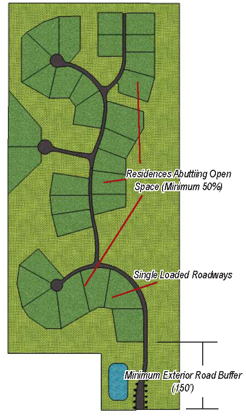
Development Layout - The development is encouraged to include roads that are single loaded (homes along only one side of the street).
5.
Minimum Exterior Road Buffer - A minimum of a one hundred and fifty (150) foot buffer from the proposed right-of-way along any exterior County Road or State Highway.
6.
Minimum Open Space - A minimum of fifty (50%) percent of the gross land area.
7.
Maximum Amount of Unbuildable Land Used as Open Space - A maximum of fifty (50%) percent of the total open space allotment may be unbuildable land such as; land that is regulated by Michigan Department of Natural Resources and Environment, or the Environmental Protection Agency, Army Corps of Engineers, or any other regulatory body which has jurisdiction over land which cannot be used for the construction of housing.
8.
Houses Abutting the Open Space - A minimum of fifty (50%) percent of all dwelling units within the development shall abut a dedicated open space area.
9.
Access to Open Space - Access points or paths shall be provided to afford access to open space and common areas. These access points shall link the open space to the roadway, sidewalks, or the remainder of the development.
10.
General Lot Character - Flag lots or panhandle lots shall not be permitted within an open space community.
11.
Natural Area - An undisturbed greenbelt shall be required around any natural features or farmland preserved within the common open space areas.
12.
Pedestrian Circulation - Adequate pedestrian circulation shall be provided. Adequate access shall be provided to all open space/ recreational spaces from the residential areas. Paths provided within the development shall be constructed of asphalt (meeting the design specifications of the Township) or other similar material as approved by the Planning Commission.
13.
Garages - A minimum of fifty (50%) percent of all dwelling units shall have side, rear, or alley entry garages, or other garages configurations not opening to the street. Garages that face the roadway shall not extend beyond the front plane of the house and are encouraged to be recessed at least five (5') feet from the front plane of the house.
14.
Overall Architectural Character - A diversity of single-family housing styles, colors, and configurations are encouraged throughout the development.
F.
Roadways.
1.
Roadways Widths - Roadway surface and base standards shall conform to the standards of the Ray Township Land Development and Engineering Standards. The following minimum roadway widths are established for an approved open space community:
2.
Cul-de-sac Design - Each cul-de-sac shall be designed to allow for trees and landscaping within the interior area of the cul-de-sac. The types of vegetation shall be approved by the Township Fire Department.
G.
Dedication of Open Space.
The dedicated open space shall be set aside in an irrevocable conveyance that is acceptable to the Township, such as the following:
1.
A Conservation Easement, as established by the State of Michigan Conservation and Historic Preservation act, Public act 197 of 1980, as amended (M.C.L. 399.251).
2.
Master Deed, as established by the State of Michigan Condominium Act, Act 59 Public Act of 1978, as amended.
3.
Distributed, gift or sale of the development rights to all property owners within the Open Space Community, the Township, or other acceptable land conservancy.
The above conveyance shall indicate all proposed uses of the dedicated open space, which shall also be shown on the approved open space or farmland community. The Township Attorney shall review the conveyance and assure the Township that such lands shall remain as open space for perpetuity. The conveyance shall also detail a maintenance schedule and funding for operation, maintenance and insurances for all common areas, facilities, projects and programs of the Open Space Community, and shall include methods of payment and collection.
(Ord. of 4-17-2024)