
Reno City Zoning Code
CHAPTER 18
02 - Zoning Districts
Article 3 - Urban Districts[1]
Editor's note— Ord. No. 6692, § 1(Exh. A), adopted January 8, 2025, amended the title of Art. 3 to read as herein set out. The former Art. 3 title pertained to Mixed-Use Districts.
Article 4 - Employment Districts[2]
Editor's note— Ord. No. 6692, § 1(Exh. A), adopted January 8, 2025, amended the title of Art. 4 to read as herein set out. The former Art. 4 title pertained to Nonresidential Districts.
18.02.101 - Organization of this Chapter
(a)
Base Zoning Districts
(1)
Content Articles 2 through 5 of this chapter follow a common structure and describe the purpose and intended character of the zoning districts, the lot and building standards applying to development in the districts, and any district-specific development standards.
(2)
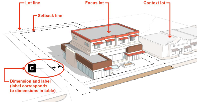
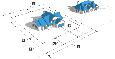
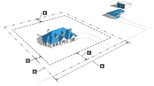
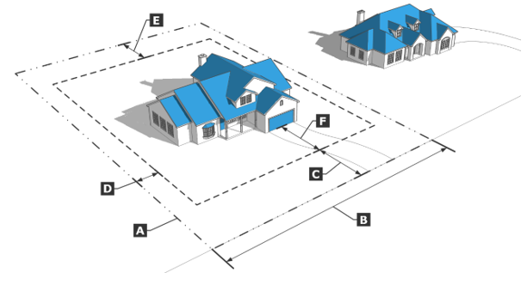
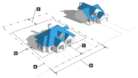
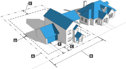
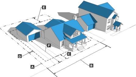
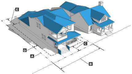
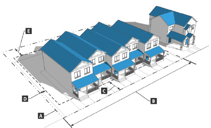
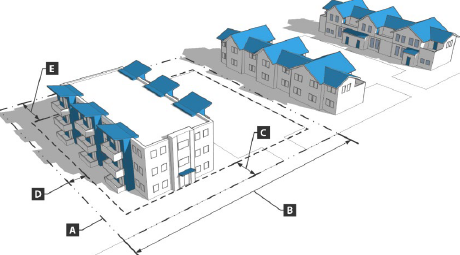
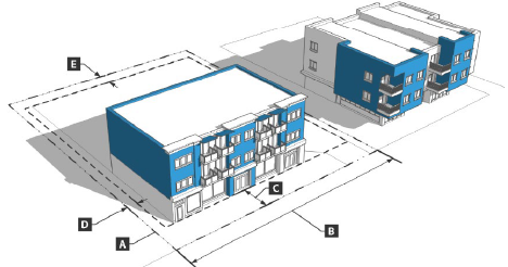
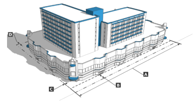
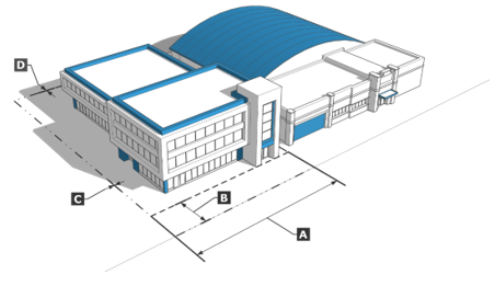
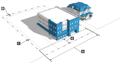
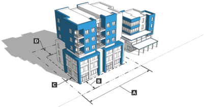
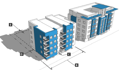
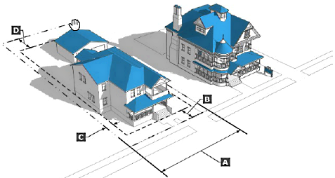
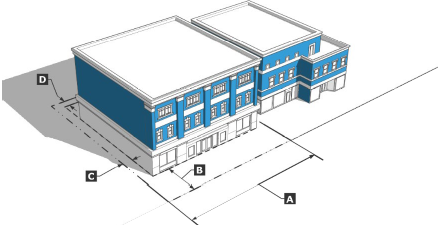
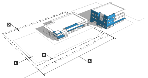
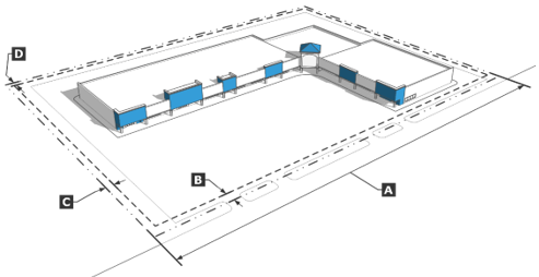
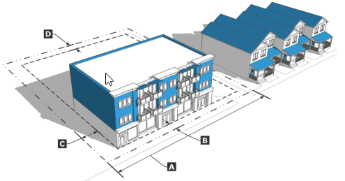
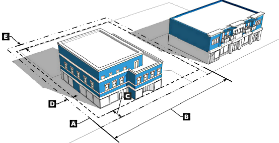
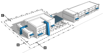
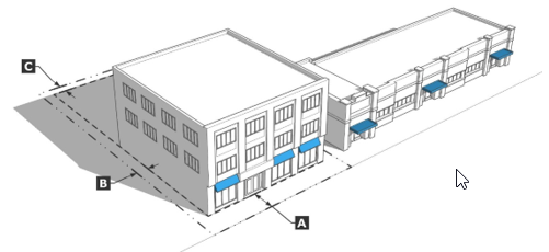
Graphics For each base zoning district, this article includes an illustration depicting how the district's lot and building standards apply to lots and typical building forms. Illustrations are intended to exemplify the general character of the district and do not show specific locations or buildings. Illustrations do not necessarily reflect all the standards that may apply to a particular development. If a standard shown in an illustration is inconsistent with the respective table of lot and building standards, the standards in the table shall govern.
(3)
Overlay Districts
a.
Overlay zoning districts are established by an amendment to the Official Zoning Map (see Section 18.08.503, Rezoning (Zoning Map Amendment)). They are superimposed over a base zoning district. If the standards for an overlay district expressly conflict with those for an underlying base zoning district, the overlay zoning district standards shall apply. If standards for an overlay district expressly conflict with standards for another applicable overlay district, the more restrictive standards shall apply.
b.
Article 6 identifies the overlay zoning districts and sets forth each district's purpose and the standards that modify those of underlying districts.
18.02.102 - Adoption of Districts—Official Zoning Maps
(a)
Zoning Maps The established districts and boundaries are adopted as shown on the maps entitled "Zoning Maps," which are made a part of this chapter and title, together with all notations, references, data and other information, and all subsequent associated changes and amendments. The official Zoning Maps are recorded by the City Clerk and maintained in the office of the Administrator.
(b)
Zoning Map Amendments Records of past ordinances amending the Zoning Maps are located in the office of the City Clerk.
18.02.103 - Rules for Interpretation of Zoning District Boundaries
(a)
Interpretation of District Boundaries Where uncertainty exists as to the boundaries of zoning districts, as shown, the following rules shall apply:
(1)
Boundaries are intended to parallel street lines or to follow lot or property lines as they exist at the time of passage of this chapter or amendments hereto, unless specifically shown otherwise.
(2)
Where a boundary follows a public street or alley, the centerline of the street shall be the boundary. If the street moves, the zoning boundary moves accordingly.
(3)
In the event of further uncertainty, the Administrator shall determine the boundary location.
(4)
The Administrator may make minor adjustments to the zoning district boundaries based on a final subdivision design provided a finding is made that such adjustment is not contrary to the original project approval and complies with this Title.
(b)
Errors and Omissions
(1)
If a previously approved map amendment was not changed by error or oversight, the Administrator shall make any changes necessary to comply with the approved map amendment.
(2)
The Administrator may make minor adjustments to district boundaries of a zoning map amendment case provided:
a.
The minor modification is made based on the filing of a tentative map or final map that shows minor discrepancies with the legal description provided with the initial application for a zoning change;
b.
The intent of the original project is met; and
c.
The change does not have any effect on the character of the proposed zoning map amendment.
(c)
Vacated Rights-of-Way If a dedicated street or alley is abandoned, the zoning regulations applicable to abutting properties shall apply to the portion of the vacated right-of-way.
(d)
Annotating District Boundary Changes When a district change is approved by the City Council, the zoning maps shall be amended. Each amendment shall incorporate a map clearly delineating the area affected and the zoning classification to which the area is changed. Each map shall be certified by the mayor, attested by the clerk, and a true copy attached to the zoning map.
(e)
Property with More Than One Zoning Designation Parcels with more than one zoning designation (on separate and discrete areas) are permitted. Land use and development shall be in conformance with the applicable zoning district for each portion of the parcel.
18.02.104 - Effect of Districting
(a)
Application The provisions of this Title governing the use of land, buildings and structures, the size of yards, height and bulk of buildings, density of population, and other provisions, are hereby declared to be in effect upon all land within the boundaries of each and every district established in this chapter.
(b)
Classification of Land Uses The following shall prevail:
(1)
The express enumeration in this chapter of a particular class of building or use in any district shall be determined a prohibition of such building or use in all other districts unless so specified.
(2)
Uses not specifically included in any zoning district and not specifically excluded therefrom by this chapter may be included in that district, as determined by the Administrator, if such uses are similar to and have less of an impact than the uses specifically included, or if such uses are accessory to uses that are specifically included.
(c)
Lots Divided into Separate Ownership Where a lot is divided into separate ownerships and the area of either portion is such that the number and location of buildings thereon no longer conforms to the lot area requirements of the particular district, then in the determination of the permissive number and location of buildings of either portion, both parts shall be considered as one parcel only. Such restrictions shall be noted on the deed and shall be binding on subsequent purchasers.
18.02.105 - Classification of Annexed Land
Territory annexed to the city shall, upon the date of such annexation, be classified for the purposes of this Chapter in accordance with the hierarchy established below:
(a)
Master Plan Designations
(1)
The Master Plan land use designation that applies to the territory shall be as shown on the City of Reno Master Plan Land Use plan map.
(2)
In the absence of a City of Reno Master Plan Land Use designation, the designation shall be in accordance with Table 2-1 below.
(Ord. No. 6692, § 1(Exh. A), 1-8-25)
18.02.106 - Zoning Designations
(a)
Except as provided in subsection (b), below, the zoning designation that applies to the territory shall be assigned in accordance with Table 2-1, City of Reno Master Plan Land Use and Zoning Based on County Plan or Zoning, above.
(b)
When the City of Reno zoning that would be granted in accordance with Table 2-1, City of Reno Master Plan Land Use and Zoning Based on County Plan or Zoning does not conform with the City of Reno Master Plan Land Use designation, the zoning that conforms to the Master Plan and most closely approximates the zoning that would be assigned in accordance with Table 2-1, City of Reno Master Plan Land Use and Zoning Based on County Plan or Zoning will be granted.
18.02.107 - Sphere of Influence
(a)
Master Plan For all territory in the sphere of influence where the adopted City of Reno Master Plan has a land use designated, that land use shall apply and the City shall exercise all authority conferred by NRS Sections 278.010 to 278.630, inclusive.
(b)
Zoning
(1)
The City may adopt zoning map designations within the sphere of influence.
(2)
All lands within the Sphere of Influence shall be classified in accordance with the hierarchy established for annexation in Section 18.02.105, Classification of Annexed Land. Where the City of Reno Master Plan allows for a range of densities, the density that most closely approximates Washoe County's land use plan or zoning (as applicable) within that range shall be utilized as the basis for assigning zoning.
(3)
For Sphere of Influence properties without zoning designations, development shall proceed in accordance with the zoning district that would be assigned upon annexation in accordance with Section 18.02.105, above.
18.02.108 - Zoning Districts Established
In order to classify and regulate the use of land; the location, use, bulk, height of structures; and to carry out the purpose of this Title, the zoning districts are established as follows in Table 2-2.
(Ord. No. 6692, § 1(Exh. A), 1-8-25)
18.02.109 - Zoning District Conversion Table
The conversion of prior zoning districts and sub-districts to new districts shall be in accordance with Table 2-3, below.
(Ord. No. 6692, § 1(Exh. A), 1-8-25)
18.02.201 - LLR-2.5: Large-Lot Residential (2.5 Acres)
(a)
Purpose The LRR-2.5 district is intended to accommodate rural single-family residential uses and agricultural uses. Secondary uses include parks, schools, community gardens, and home occupations. This district is the largest-lot residential district and requires large setbacks. This zoning district is also intended to preclude premature development of rural land on the fringes of the urban area and protect environmental resources.
(Ord. No. 6692, § 1(Exh. A), 1-8-25)
18.02.202 - LLR-1: Large-Lot Residential (1 Acre)
(a)
Purpose The LLR-1 district is intended to accommodate rural single-family residential uses and agricultural uses. Secondary uses include parks, schools, community gardens, and home occupations. This district requires a minimum lot size of one acre and requires large setbacks. This district is also intended to preclude premature development of rural land on the fringes of the urban area and protect environmental resources.
(Ord. No. 6692, § 1(Exh. A), 1-8-25)
18.02.203 - LLR-0.5: Large-Lot Residential (0.5 Acre)
(a)
Purpose The LL-0.5 district is intended to accommodate single-family residential uses. Secondary uses include agricultural uses, parks, schools, community gardens, and home occupations.
(Ord. No. 6692, § 1(Exh. A), 1-8-25)
18.02.204 - SF-3: Single-Family Residential
(a)
Purpose The SF-3 district is primarily intended to accommodate single-family detached residential uses. Secondary uses include parks, schools, community gardens, and home occupations. This zoning district functions as a transition from the large-lot zoning districts to the higher-intensity residential districts.
(Ord. No. 6692, § 1(Exh. A), 1-8-25)
18.02.205 - SF-5: Single-Family Residential
(a)
Purpose The SF-5 district is intended primarily to accommodate single-family detached residential uses. Secondary uses include parks, schools, community gardens, and home occupations. This zoning district functions as a transition from the large-lot zoning districts to the higher-intensity residential districts.
(Ord. No. 6692, § 1(Exh. A), 1-8-25)
18.02.206 - SF-8: Single-Family Residential
(a)
Purpose The SF-8 district is intended primarily to accommodate single-family detached residential uses. Secondary uses include parks, schools, community gardens, and home occupations. This district is appropriate in many locations and can function as a transition between larger lot single family districts and multi-family, Urban Districts, or Employment Districts.
(Ord. No. 6692, § 1(Exh. A), 1-8-25)
18.02.207 - SF-11: Single-Family Residential
(a)
Purpose The SF-11 district is primarily intended to accommodate single-family attached and detached residential uses. Secondary uses include parks, schools, community gardens, and home occupations. This district is considered appropriate on infill sites and in areas of minimal slope. In areas of significant slope (15 percent or more), its use is appropriate only to the extent that it results in the preservation of steep or difficult to develop land.
(Ord. No. 6692, § 1(Exh. A), 1-8-25)
18.02.208 - MF-14: Multi-Family Residential
(a)
Purpose The MF-14 district is intended to accommodate single-family residential development and low-density multi-family residential development such as duplexes, triplexes, fourplexes, townhomes, and small multi-family buildings. Secondary uses include parks, schools, and community gardens. This zoning district is appropriate adjacent to single-family zoning and can serve as a transition to higher-intensity multi-family, Urban Districts, and Employment Districts.
(Ord. No. 6692, § 1(Exh. A), 1-8-25)
18.02.209 - MF-21: Multi-Family Residential
(a)
Purpose The MF-21 district is intended to accommodate multi-family residential development, as well as duplexes, triplexes, fourplexes, townhomes, and single-family residential uses. Secondary uses include neighborhood-serving limited commercial and retail, parks, schools, and community gardens. Additional district standards ensure that amenities such as open space are provided to offset the increased residential densities. This district is appropriate adjacent to other multi-family, single-family, Urban Districts, and Employment Districts.
(Ord. No. 6692, § 1(Exh. A), 1-8-25)
18.02.210 - MF-30: Multi-Family Residential
(a)
Purpose The MF-30 district is intended to provide multi-family residential development and limited commercial and retail uses. Secondary uses include duplexes, triplexes, fourplexes, townhomes, single-family residential uses, parks, and schools. Additional district standards ensure that amenities such as open space are provided to offset the increases residential densities. This district is appropriate adjacent to other multi-family, single-family Urban Districts, and Employment Districts.
(Ord. No. 6692, § 1(Exh. A), 1-8-25)
18.02.301 - MD-ED: Downtown - Entertainment District
(a)
Purpose The MD-ED district is intended to support the most intensive transit-supportive development within the downtown regional center and the region as a whole. The MD-ED district functions as the 24-hour gaming area, as facilitated by the Gaming Overlay District, and includes major hotel-casinos and cultural/entertainment/recreational facilities, as well as retail, restaurants, high-density residential, and urban open spaces. Active uses are focused along Virginia Street, Sierra Street, 2nd Street, Commercial Row, and 4th and 5th Streets.
(Ord. No. 6692, § 1(Exh. A), 1-8-25)
18.02.302 - MD-ID: Downtown - Innovation District
(a)
Purpose The MD-ID district is intended support the district's transition into a mixed-use and light-manufacturing environment while retaining its eclectic character. The MD-ID district may include a range of employment uses, such as small-scale manufacturing, processing, wholesaling, office, and flex-space, as well as supporting uses like retail, restaurants, cultural facilities, high-density residential, and live/work.
(Ord. No. 6692, § 1(Exh. A), 1-8-25)
18.02.303 - MD-NWQ: Downtown - Northwest Quadrant
(a)
Purpose The MD-NWQ district is intended to support the expansion of services and housing in downtown. Primary uses include a mix of employment uses, service-oriented, and residential uses. Gaming is also permitted in a limited portion of the MD-NWQ district, generally north of 5 th Street, South of I-80, east of Keystone Avenue, and west of Vine.
(Ord. No. 6692, § 1(Exh. A), 1-8-25)
18.02.304 - MD-RD: Downtown - Riverwalk District
(a)
Purpose The MD-RD district is intended to support the downtown regional center with a particular focus along the Truckee River frontage, which serves as a major resource and amenity to the community. Minimum densities are applied to support the use of transit and other alternative modes. Primary uses include a mix of employment uses, retail, and cultural facilities, and high-density residential. This district transitions in height and intensity south of the Truckee River where it abuts adjacent central neighborhoods.
(Ord. No. 6692, § 1(Exh. A), 1-8-25)
18.02.305 - MD-UD: Downtown - University District
(a)
Purpose The MD-UD district is intended to support the expansion of university-supportive uses south of the UNR campus. The MU-UD district supports a mix of student housing, educational facilities, ground floor retail, innovation and research uses, and related uses; however, the overall mix and location of uses in the district should consider the University of Nevada Reno Campus Master Plan. Cannabis and gaming establishments (including accessory) are prohibited.
(Ord. No. 6692, § 1(Exh. A), 1-8-25)
18.02.306 - MD-PD: Downtown - Powning District
(a)
Purpose The MD-PD district is intended to protect the historic character of this neighborhood within the downtown regional center. Primary uses include single-family homes, multi-family homes, offices, and retail uses.
(Ord. No. 6692, § 1(Exh. A), 1-8-25)
18.02.307 - MU: Mixed-Use Urban
(a)
Purpose The MU district is intended to promote an urban pattern of mixed-use development. The MU district is located adjacent to existing/planned high-frequency transit corridors, or where higher pedestrian activity is desired. The district accommodates an integrated mix of higher-density residential, commercial, retail, employment, and other service-oriented uses. Higher-intensity uses are located adjacent to designated Urban Corridors (Virginia Street, Fourth Street, Mill Street and Plumb Lane), with lower intensities near the adjacent residential districts.
(Ord. No. 6692, § 1(Exh. A), 1-8-25)
18.02.308 - MS: Mixed-Use Suburban
(a)
Purpose The MS district is intended to promote the gradual transition of the City's suburban corridors to a mix of higher-density residential, retail, commercial, and other employment- and service-oriented uses. Mixed-Use Suburban is generally appropriate within or adjacent to areas identified as Corridors, Employment Areas, and Mixed-Use within the Master Plan Structure.
(Ord. No. 6692, § 1(Exh. A), 1-8-25)
18.02.309 - GC: General Commercial
(a)
Purpose The GC district is intended to accommodate a mix of established low-intensity auto-oriented uses, while supporting the gradual transition of the city's suburban corridors to a mix of higher-density residential, retail, commercial, and other employment- and service-oriented uses.
(Ord. No. 6692, § 1(Exh. A), 1-8-25)
18.02.310 - NC: Neighborhood Commercial
(a)
Purpose The NC district is intended to promote a mix of pedestrian-oriented commercial, retail, services, and housing options. Additional standards are included to ensure that the site design, uses, and scale are consistent with the adjacent neighborhoods.
(Ord. No. 6692, § 1(Exh. A), 1-8-25)
18.02.311 - PO: Professional Office
(a)
Purpose The PO district provides for office conversions and small office developments and is considered appropriate in transitional areas designated on the Master Plan or adjacent to residential districts.
(Ord. No. 6692, § 1(Exh. A), 1-8-25)
18.02.312 - MU-MC: Mixed-Use Midtown Commercial
(a)
Purpose The MU-MC district is intended to promote a mix of pedestrian-oriented commercial, retail, and services in the Midtown area along the Virginia Street corridor. Higher-density housing (above 30 units per acres) is only allowed within one block of South Virginia Street. Additional standards are included to ensure that the site design, uses, and scale are consistent with the adjacent established neighborhoods.
(Ord. No. 6692, § 1(Exh. A), 1-8-25)
18.02.313 - MU-RES: Mixed-Use Midtown Residential
(a)
Purpose The MU-RES district is intended to accommodate residential uses (up to 30 units per acre) in the Midtown area along the Virginia Street corridor. Nonresidential uses are limited. Additional standards are included to ensure that the site design, uses, and scale are consistent with the adjacent established neighborhoods.
(Ord. No. 6692, § 1(Exh. A), 1-8-25)
18.02.401 - I: Industrial
(a)
Purpose The I district is intended to accommodate intensive land uses that require mitigation of impacts, including the heaviest industrial uses. Sites are commonly comprised of large-footprint buildings designed for warehousing, flex space, manufacturing, and supporting office uses. This district should be located in areas with access to air, roadway, and/or railway transportation systems. This zoning district should be separated from residential development and schools by natural and man-made buffers.
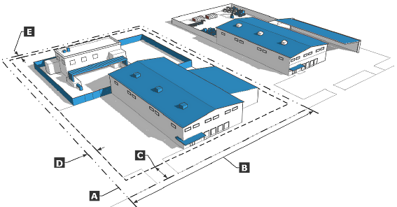
(Ord. No. 6692, § 1(Exh. A), 1-8-25)
18.02.402 - IC: Industrial Commercial
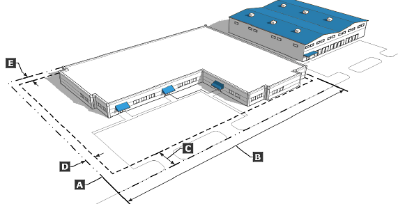
(a)
Purpose The IC district is intended to provide for a mix of industrial, research and development, and commercial uses. Sites are commonly comprised of moderate-footprint buildings (generally less than 500,000 square feet) designed for warehousing, flex space, manufacturing, and supporting office uses. This zoning district should be separate from residential development by natural and man-made buffers.
(Ord. No. 6692, § 1(Exh. A), 1-8-25)
18.02.403 - ME: Mixed Employment
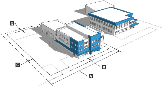
(a)
Purpose The ME district is intended to provide a mix of employment focused uses such as light manufacturing, processing, wholesaling, flex space, research and development, and offices. Secondary uses include supportive services such as small-scale retail, restaurants, and caretaker's quarters. Buildings are typically smaller than those found in the Industrial (I) District; however, may also include campus-like employment and educational development.
(Ord. No. 6692, § 1(Exh. A), 1-8-25)
18.02.404 - MA: Mixed-Use Airport
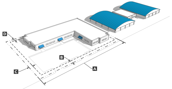
(a)
Purpose The MA district is intended to promote a broad range of transportation, service, and employment uses on Reno Tahoe Airport Authority (RTAA) property that compliment and are compatible with RTAA's core mission of maintaining and expanding aviation services and facilities to meet regional demand, while recognizing the unique operational requirements of each airport.
(Ord. No. 6692, § 1(Exh. A), 1-8-25)
18.02.501 - PGOS: Parks, Greenways and Open Space
(a)
Purpose The PGOS district is intended to preserve areas for drainage facilities, utilities, open space, conservation, recreation, or multi-use trails. In addition to providing active and passive recreational opportunities for the community, the district is intended to protect the scenic and environmental quality of sensitive natural areas. This district is generally owned by public agencies, however in some instances may include privately-owned and maintained open spaces.
(Ord. No. 6692, § 1(Exh. A), 1-8-25)
18.02.502 - PF: Public Facility
(a)
Purpose The PF district is intended to provide for public and quasi-public facilities and services. Primary uses include public institutions, cultural centers, religions institutions, government centers, libraries, hospitals, schools, and utility installations. Depending on the scale and impacts of the proposed use, additional mitigation may be appropriate when adjacent to residential districts.
(Ord. No. 6692, § 1(Exh. A), 1-8-25)
18.02.503 - UT-5: Unincorporated Transition 5 Acres
(a)
Purpose The UT-5 district is intended to preserve properties that Washoe County has planned for large lot residential development into a Reno zoning district without modifying the planned density. Secondary uses may include agriculture, energy production, and outdoor recreation.
(Ord. No. 6692, § 1(Exh. A), 1-8-25)
18.02.504 - UT-10: Unincorporated Transition 10 Acres
(a)
Purpose The UT-10 district is intended to preserve properties that Washoe County has planned for large lot residential development into a Reno zoning district without modifying the planned density. Secondary uses may include agriculture, energy production, and outdoor recreation.
(Ord. No. 6692, § 1(Exh. A), 1-8-25)
18.02.505 - UT-40: Unincorporated Transition 40 Acres
(a)
Purpose The UT-40 district is intended to preserve properties that Washoe County has planned for large lot residential development into a Reno zoning district without modifying the planned density. Secondary uses may include agriculture, energy production, outdoor recreation, or a preserved rural state due to environmental sensitivity.
(Ord. No. 6692, § 1(Exh. A), 1-8-25)
18.02.506 - SPD: Specific Plan District
(a)
Purpose
(1)
The purpose of this district is to accommodate projects or plans where the design and configuration of the uses are so arranged as to constitute a single functionally integrated entity. In such projects the use of land within a component, and among the various components if there is more than one component, shall be designed to be compatible and complementary. In this district, the location, use, and physical characteristics of structures, improvements, and open space shall all work together in furthering the stated purpose of the design of the project or plan.
(2)
In order to achieve optimal functional integration in such projects or plans, the City recognizes that it may be desirable to regulate and restrict on a project- or plan-specific basis the erection, construction, reconstruction, alteration, repair, or use of buildings, structures, or land.
(b)
Permitted Uses The City recognizes that the master plan may be furthered by permitting a diversity of land uses not found in other zoning districts. In light of the diverse land uses that may be permitted in this district, and the need to ensure that such uses are internally compatible and both complementary and compatible with nearby existing and/or planned uses of land, it is the express intent of the City to subject requests for changes in zoning to the SPD to a heightened level of scrutiny during the review process and to apply appropriate restrictions to maintain compatibility over time.
(c)
Development Standards
(1)
Generally, all development and design standards should be based on an existing base zone district. The project applicant shall be responsible for demonstrating the benefits of modifications to the standards that would otherwise be applicable in a standard zoning district.
(2)
Any potentially modified provisions for lot and building standards, land uses, or development standards shall result in an improvement to the overall design and compatibility of the project.
(3)
Requirements and standards pertaining to public safety, natural resources, and public infrastructure shall not be modified.
18.02.507 - PUD: Planned Development
(a)
Purpose The Planned Unit Development (PUD) District is intended to achieve the following purposes:
(1)
To implement the Reno Master Plan;
(2)
To allow various combinations of land uses;
(3)
To ensure compatibility between residential and mixed-use or nonresidential areas and to minimize potential impacts to residential areas from adjacent more intensive uses; and
(4)
To facilitate development by permitting greater flexibility than allowed by the strict application of this Title in exchange for more creative and imaginative designs with a higher level of amenities and public benefits than would otherwise occur under the standard zoning districts.
(b)
Permitted Uses A PUD is subject to the approval of the City Council and may include any uses permitted in any zone classification, provided that any combination of uses is planned in a manner compatible to each and to the surrounding environment.
(c)
Minimum Development Size A PUD shall contain a minimum of ten contiguous acres of land unless proper justification for a smaller size is made to the satisfaction of the decision-making body.
(d)
Site and Building Intensity Standards A PUD shall be located within city limits. Lot size, lot coverage, street width, height, and distance between buildings shall meet health, safety, and welfare requirements and reflect good planning practices subject to the approval of the City Council.
(e)
Development Standards
(1)
Generally, all development and design standards should be based on an existing base zone district. The project applicant shall be responsible for demonstrating the benefits of modifications to the standards that would otherwise be applicable in a standard zoning district.
(2)
Any potentially modified provisions for lot and building standards, land uses, or development standards shall result in an improvement to the overall design and compatibility of the project.
(3)
Requirements and standards pertaining to public safety, natural resources, and public infrastructure shall not be modified.
(f)
Common Open Space
(1)
Amount A planned unit development including residential development shall provide common open space developed with recreational amenities. The landowners may apply for an exemption from the City of Reno's Residential Construction Tax Program with the amount of the exemption to be based on the merits of the plan and as approved by the City Council.
(2)
Management A planned unit development which includes common open space shall be subject to the requirements and regulations pertaining to organization for ownership and maintenance and procedures for enforcing payments of assessments for the maintenance of common open space as provided in NRS Sections 278A.130 to 278A.160, inclusive.
(g)
Composition of Final Plan The graphic and textual elements together compose the final plan.
18.02.601 - Overlay Districts, Generally
(a)
General Purpose of Overlay Zoning Districts An overlay district, whether a general or a planning area overlay district, is a zoning district that is superimposed on an underlying base zoning district, thus establishing a layer of additional regulations that restrict, prohibit, or add to the base zoning regulations set forth in this Title.
(b)
Establishment of Overlay Districts Pursuant to authority granted by NRS Section 278.250, the City Council hereby establishes two types of overlay zoning districts: general and planning area overlay districts.
(1)
General Overlay Districts General overlay districts are intended to address unique issues, opportunities, and challenges associated with a specific type of land use or specific type of geologic feature that may be found or established in many different parts of the city.
(2)
Planning Area Overlay Districts Planning area overlay districts are intended to address unique land use issues, opportunities, and challenges associated with a specific geographic part or portion of the city, and for which the city has adopted or applied specific area land use plans or policies. Accordingly, the general and planning area overlay districts applicable in the city are:
(c)
Conflicting Regulations If a conflict exists between one or more standards applicable in the base zoning district and one or more standards applicable in the overlay zoning district, provisions of the zoning overlay district shall apply and control. Where conflicts exist between different overlay districts, the more restrictive standard as determined by the Administrator shall apply.
18.02.602 - General Overlay Districts
(a)
Airport Flight Path (AF) Overlay District
(1)
Purpose The purpose of establishing airport flight path areas is to reduce the risk of injury and property damage areas near Reno-Tahoe International and Reno-Stead Airports.
(2)
Applicability New construction and expansion of existing buildings located within airport critical areas as identified in Figure 2-1 and Figure 2-2 shall be subject to the requirements of this subsection.
Figure 2-1: Reno-Tahoe International Airport Critical Areas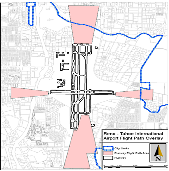
(3)
Building Height Review in Vicinity of Airports New construction of, or expansion of existing structures to a height greater than 45 feet above ground level, on properties located within the FAR Part 77 Airspace map for the
Figure 2-2: Reno-Stead Airport Critical Areas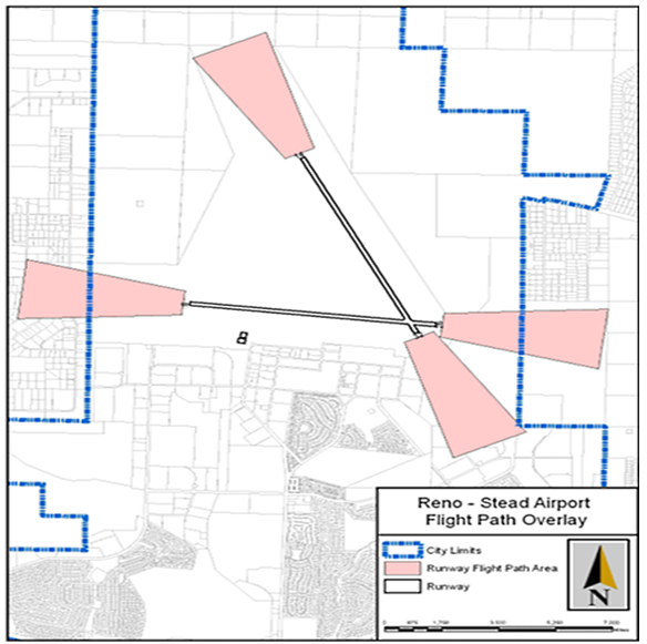
Reno-Tahoe International Airport (Figure 2-3) or the Reno-Stead Airport (Figure 2-4) shall be required to show documentation their plans have been submitted to the Reno-Tahoe Airport Authority, before plans will be approved or a building permit issued.
Figure 2-3: FAR Park 77 Airspace Map for Reno-Tahoe International Airport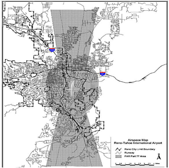
Figure 2-4: FAR Part 77 Airspace Map for Reno-Stead Airport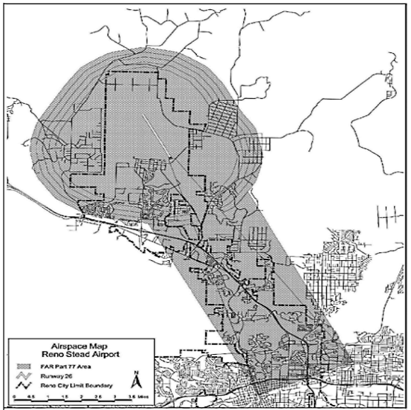
(4)
Prohibited Uses No property within an airport flight path area shall be used for:
a.
Any residential land use.
b.
Any building occupied or intended to be occupied as a temporary residence for at least one overnight stay, to include but not be limited to hotel, motel, prison/custodial institution, homeless shelter, etc.
c.
Primary schools, secondary schools, hospitals-acute and over-night care, childcare facilities;
d.
Sports arena, stadium, or track; banquet hall; amusement/recreation facilities (indoor or outdoor); religious assemblies;
e.
Any nonresidential use which will result on a regular basis in a concentration of population exceeding 25 persons per acre per parcel per hour over a 24-hour period. Density calculations shall exclude public streets; for the purpose of calculation, time shall be calculated in per person hours based on dwell time. Dwell time shall be defined as the amount of time an individual is on site based on minutes per hour. Density calculations for commercial condominium development shall be allowed to include common area proportionate to the size of the condominium unit in proportion to the total site area. Density calculations shall be made in writing with the development permit application and shall be attached to each business license;
f.
Any nonresidential use which will result on a regular basis in a concentration of population exceeding 50 persons per acre per parcel for more than two hours. Density calculations shall exclude public streets; for the purpose of calculation, time shall be calculated in per person hours based on dwell time. Dwell time shall be defined as the amount of time an individual is on site based on minutes per hour. Density calculations for commercial condominium development shall be allowed to include common area proportionate to the size of the condominium unit in proportion to the total site area. Density calculations shall be made in writing with the development permit application and shall be attached to each business license;
g.
Rifle ranges, above-ground bulk tank storage of compressed flammable or compressed toxic gases and liquids, gas station;
h.
Electric power plants or substations;
i.
Any use or building material which would cause sunlight to be reflected toward an aircraft engaged in an initial straight climb following takeoff or toward an aircraft engaged in a straight final approach toward a landing at the airport;
j.
Any use which would attract large concentration of birds, or which may otherwise affect safe air navigation within this area; or
k.
Any transmission system that would generate electrical interference that may be detrimental to the operation of aircraft and/or aircraft instrumentation.
(b)
Airport Noise Exposure (AN) Overlay District
(1)
Purpose The purpose of establishing airport noise exposure areas is to ensure that appropriate construction methods are used to reduce noise impacts near the Reno-Tahoe International and Reno-Stead Airports.
(2)
Noise Exposure for Airport Operations
a.
Residential development, hospitals, religious assemblies, schools, offices, and the office portion of industrial or commercial uses shall comply with (b) and (c) below.
b.
Properties located within the 80 dBA Lmax noise contour map for the Reno-Tahoe International Airport (see Figure 2-5) will be required to provide a list, verified by a qualified acoustical consultant, of construction methods to be utilized for noise attenuation to a maximum interior noise level of 45 dBA DNL prior to the issuance of a building permit.
c.
Properties located within the 1998 65 dBA DNL noise contour for the Reno-Tahoe International Airport (Figure 2-5) will be required to meet the following:
1.
Provide a list, verified by a qualified acoustical consultant, of construction methods to be utilized for noise attenuation to a maximum interior noise level of 45 dBA DNL prior to the issuance of a building permit.
2.
Air conditioning systems shall be incorporated in all dwelling units.
Figure 2-5: Reno-Tahoe International Airport 1998 dBA DNL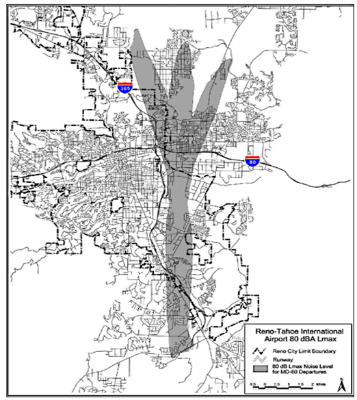
(3)
Building Height
a.
Properties located within the FAR Part 77 Airspace map for the Reno-Tahoe International Airport (Figure 2-3) or the Reno-Stead Airport (Figure 2-4) the following building height requirements apply.
b.
New construction of, or expansion of existing structures to a height greater than 45 feet above ground level, on properties located within the FAR Part 77 Airspace map for the Reno-Tahoe International Airport (Figure 2-3) or the Reno-Stead Airport (Figure 2-4) shall be required to show documentation their plans have been submitted to the Reno-Tahoe Airport Authority, before plans will be approved or a building permit issued.
(c)
Gaming (G) Overlay District
(1)
Purpose This district establishes regulations that recognize the unique characteristics of hotel/casino developments to mitigate potential impacts and encourage higher quality destination resorts that will increase tourism within the community.
(2)
Specific Gaming Overlay District Standards In addition to the general standards of this subsection, hotels with nonrestricted gaming in specific gaming overlay districts are subject to the following standards:
a.
Gaming Overlay 1: Convention Center
1.
Design and Layout
[a]
A minimum of 20,000 square feet of convention space shall be provided on site.
[b]
A minimum of 35,000 square feet of gaming area consisting of both slot machines and live games.
[c]
Three restaurants shall be provided, one of which must be open for service to the public 24 hours per day, seven days a week and which has a minimum seating capacity of 60 patrons at one time.
[d]
Safe connections and amenities supporting the convention center.
[e]
All of the above improvements shall be constructed or provided prior to any certificate of occupancy for any new development.
2.
Building Height
[a]
Maximum building height shall be determined by the number of hotel rooms as follows:
3.
Maximum building height within each room number category may be increased with the approval of a conditional use permit.
b.
Gaming Overlay 2: Redfield Only one Hotel with Nonrestricted Gaming shall be allowed. An additional Hotel with Nonrestricted Gaming shall not be approved unless any existing conditional use permit for this use is simultaneously revoked.
c.
Gaming Overlay 3: Reno-Tahoe International Airport Shall be located within ½ mile of the airport terminal, except prohibited in the Airport Critical Area.
d.
Gaming Overlay 4: Corridor Gaming Nonrestricted gaming is only allowed where currently operating, existing, or entitled at the time of adoption of this Code.
e.
Gaming Overlay 5: Western Gateway
1.
Location
[a]
The site shall have direct access from a collector street or greater.
[b]
The building footprint of the casino floor shall be located at least 500 feet from the nearest existing school, church, residentially zoned property, or hospital.
2.
Gaming Space
[a]
The maximum area of all gaming space shall not exceed ten percent of the net land area of the site.
[b]
No hotel with or without gaming shall be permitted on a site of less than three acres in net land area.
[c]
The project shall provide convention space at a minimum ratio of 50 square feet per hotel room.
3.
Landscaping and Recreation
[a]
The minimum area devoted to landscaping and recreational uses shall be equal to 30 percent of the net land area.
[b]
A minimum of 15 percent of the net land area shall be landscaped in such a manner as to soften the appearance of the project from the street, break up the parking lot(s), and buffer adjoining land uses.
[c]
The minimum area devoted to recreational uses shall be equal to seven and one-half percent of the net land area. Recreational uses shall include putting greens, jogging paths, fitness centers, video arcades, tennis courts, outdoor picnic areas, court games, swimming pools, playgrounds, theaters, bowling alleys, ice skating rinks, and other similar facilities.
(d)
Historic Landmark (HL) Overlay District
(1)
Purpose This district preserves the integrity of buildings, structures, historic landscapes, or other character defining features with historical, architectural, cultural, or landmark significance as determined by the Historical Resources Commission and City Council. This district also provides for property owner incentives and allows for appropriate uses other than those permitted in the underlying zoning district as an aid to the owner's efforts to preserve the historical, architectural, cultural, or landmark value.
(2)
Applicability This zoning district's standards shall apply only to properties or resources listed individually or within a district on the City Register of Historic Places.
(3)
Standards See Chapter 18.07 for all processes and standards related to Historic Preservation.
(Ord. No. 6692, § 1(Exh. A), 1-8-25; Ord. No. 6710, § 1, 6-4-25)
18.02.603 - Neighborhood Planning Area Overlay Districts
(a)
Country Club Acres Neighborhood Planning Area (CCAN) Overlay District
(1)
Purpose This district outlines the development standards that specifically apply to this neighborhood in addition to those set forth in the underlying zoning districts. These standards provide a detailed description of the elements that create the desired development character.
(2)
Applicability This zoning district's standards shall apply to properties located within the Country Club Acres Neighborhood Plan.
(3)
Country Club Acres Neighborhood Plan Residential (CCAN/RD) District
a.
Land Uses The following land uses shall be prohibited:
1.
Accessory Dwelling Units;
2.
Mini-Warehouse;
3.
Mobile Home Subdivisions;
4.
Multi-Family;
5.
Duplex, Triplex, and Fourplex;
6.
Single Family, attached Condominium/Townhouse; and
7.
Single Family, Zero Lot Line.
(4)
Development Standards In addition to those requirements contained in this Title, the following shall prevail:
a.
Maximum building coverage: 40 percent, including all detached structures.
(b)
Greenfield Neighborhood Planning Area (GF) Overlay District
(1)
Applicability This zoning district's standards shall apply to the plan area identified in the Greenfield Neighborhood Plan.
(2)
Greenfield Single-Family (GFSF) District
a.
Applicability These standards shall apply to all properties designated as GFSF in the Greenfield Neighborhood Plan.
b.
Land Uses
1.
Permitted land uses shall be:
[a]
Single Family, detached; and
[b]
Accessory Dwelling Unit.
2.
Permitted land uses with the approval of a conditional use permit:
[a]
Child Care Center, as accessory use only;
[b]
Churches/House of Worship;
[c]
Utility Box/Well House, Back-up Generator, Pumping Station or Booster Station;
[d]
Utility Installation other than listed; and
[e]
Communication Facility, Equipment Only
c.
Accessory Buildings
1.
Shall not be located closer than three feet to any main building on the same lot;
2.
One of the following:
[a]
If the building is 120 square feet or less in size and has a building height of seven feet or less, and the highest point of the roof does not exceed ten feet, the minimum side and rear setback will be five feet; or
[b]
If the building is greater than 120 square feet in size or over seven feet in building height, or the highest point of the roof exceeds ten feet, the minimum side and rear setback will be ten feet;
3.
Shall not exceed two stories or 25 feet in building height as defined in this Title; and
4.
Shall not occupy more than 1,200 square feet of any lot nor be located in the front yard area.
d.
Setbacks Minimum setbacks shall be:
1.
Front: 30 feet.
2.
Side: 12 feet.
3.
Rear: 30 feet.
e.
Height Limitation Two stories.
f.
Required Area and Width A one-acre minimum area with a 120-foot average width is required. Lots that are less than one acre in size at the time of enactment of these regulations shall be considered to conform to these standards. Existing lots that do not meet the minimum lot size/average lot width shall not be further divided/reduced in size and/or width.
g.
Parking One off-street parking space is required per bedroom.
h.
Fencing Open rail fencing of five feet or less in height may be erected on the lot line in front yards, except within 20 feet of the primary driveway.
(3)
Greenfield Professional Office (GFPO) District
a.
Applicability These standards and regulations shall apply to all properties designated GFPO in the Greenfield Neighborhood Plan.
b.
Land Uses
1.
Permitted land uses shall be:
[a]
Single Family, detached; and
[b]
Accessory Dwelling Unit.
2.
Permitted land uses with the approval of a minor site plan review (SPR):
[a]
Medical Facility, Day Use only; and
[b]
Office, Other than listed;
3.
Permitted land uses with the approval of a conditional use permit:
[a]
Utility Box/Well House, Back-up Generator, Pumping Station or Booster Station;
[b]
Utility Installation other than listed; and
[c]
Communication Facility, Equipment Only.
c.
Setbacks Minimum setbacks shall be:
1.
Front: 20 feet.
2.
Side: Ten feet.
3.
Rear: 15 feet.
d.
Maximum Building Height Main buildings shall not exceed two stories or 35 feet whichever is greater.
e.
Required Parcel Width No parcel may be less than 100 feet wide.
f.
Minimum Office Development
1.
The minimum parcel size is one acre.
2.
In the case of business condominiums and business common interest communities, where the pre-project parcel and building size meets the minimum parcel size and setbacks of the GFPO Zoning District, deviations in parcel size as necessary to effectuate the business condominium or business common interest community are allowed when consistent with the purpose and intent of Chapter 18.02 Zoning Districts, Chapter 18.03 Use Regulations, and Chapter 18.06 Land Division.
3.
The maximum building footprint coverage, including all buildings and accessory structures, excluding covered patio areas, gazebos, enclosed trash receptacles, and enclosed utilities, is 25 percent of the gross parcel area.
g.
Building Separations There shall be a minimum separation of 20 feet between buildings on the same parcel.
h.
Traffic Generation Traffic generation shall not exceed 25 average daily trips per 1,000 square feet of gross floor space.
i.
ParkingChapter 18.04, Article 7, Off-Street Parking and Loading, is applicable to off-street parking in the Professional Office Zoning District with the following exceptions:
1.
No more than 30 percent of required parking shall be permitted in the front yard of a building;
2.
No surface parking spaces shall be located within 50 feet of the Plumas Street right-of-way;
3.
Parking in excess of five percent of the amount required by Chapter 18.04, Article 7, Off-Street Parking and Loading, is prohibited;
4.
Excess parking shall not be counted toward future development needs; and
5.
A minimum of ten percent of the required parking for two-story structures shall be enclosed within the structure or located within a detached garage.
j.
Minimum Landscape Area A minimum of 30 percent of the site shall be landscaped in accordance with Chapter 18.04 Article 8, Landscaping, Buffering, Screening, and Fencing, with the following exceptions:
1.
A maximum of 20 percent of the required landscape area may be decorative hardscape, such as, decorative sidewalks, walkways, fountains, and covered patio areas;
2.
The first 15 feet adjacent to any exterior property line of a development shall contain 50 percent evergreen and 50 percent deciduous trees and within these ratios there shall be the following mixes:
[a]
There shall be a mix of 50 percent six-foot tall trees, 25 percent eight-foot tall trees, and 25 percent ten-foot tall evergreen trees;
[b]
There shall be a mix of 50 percent two-inch caliper trees and 50 percent three-inch caliper deciduous trees;
[c]
A minimum of one tree shall be planted for every 250 square feet of landscape area; and
[d]
Six shrubs shall be planted for each tree. The shrubs shall be a minimum 50 percent five-gallon or larger and 50 percent one gallon or larger with a minimum of 50 percent of all required shrubs evergreen.
k.
Landscaping of Yards
1.
Front yards shall be landscaped except for curb cuts, sidewalks, and driveways; and
2.
Side and rear yards shall be landscaped except for sidewalks and driveways.
l.
Sign Regulations On-premise signs are allowed with the following exceptions:
1.
No signs shall be allowed on Plumas Street;
2.
Signs shall only face or front onto Moana Lane;
3.
Heights of monument signs shall be limited to an overall height of six feet including pedestals;
4.
Only indirect lighting is allowed;
5.
Sign lights shall be turned off daily between the hours of 7:00 p.m. and 6:00 a.m.;
6.
Sign design shall be compatible with and complementary to the building architecture; and
7.
No other signs whatsoever shall be allowed, except temporary signs permitted in Chapter 18.05 Signs.
(c)
Mortensen-Garson Neighborhood Plan (MGOD) Overlay District
(1)
Purpose This district modifies the underlying base zoning land uses, development standards, and development review procedures within the Western Gateway Regional Center Plan and Mortensen-Garson Neighborhood Plan areas.
(2)
Applicability The MGOD encompasses the plan areas as defined in the Western Gateway Regional Center Plan and the Mortensen-Garson Neighborhood Plan on approximately 2,723.9 acres as illustrated in Figure 2-6.
Figure 2-6: MGOD Project Area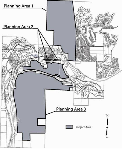
(3)
Uses Uses permitted within each zoning district shall be those identified in this Title, except for the following uses which shall be prohibited:
a.
Auto repair garage, paint and body shop (does not include quick lube or vehicle maintenance associated with service station);
b.
Single room occupancy;
c.
Adult business;
d.
Towing and impound yard;
e.
Blood plasma donor center;
f.
Outdoor manufacturing, processing, assembly or fabrication;
g.
Outdoor storage;
h.
Salvage or reclamation products (indoors);
i.
Tattoo parlor, body painting and similar uses;
j.
Laundry, self-service;
k.
Theaters (in AC and IC only - allowed in HC);
l.
Crematoriums; or
m.
Billboards
(4)
Land Use Plan Zoning for the plan area (see 2) was developed in the Mortensen-Garson Development Standards Handbook and adopted into Reno Municipal Code as base zoning established on parameters outlined in Table 2-39 and Table 2-40, below. Adjustments to the total numbers and types of development allocated to each planning area may only be made as allowed in Section 18.02.603(c)(16) entitled "Administration/Amendments."
Figure 2-7: (Reserved); (per Ord. No. 6108) 6-24-09
(5)
Traffic Studies Each development application will include a traffic analysis identifying the roadway improvements necessitated by that particular development. This will assure that improvements are planned to coincide with the need to maintain level of service C, with the exception of freeways and freeway ramps.
a.
Trip Reduction
1.
In order to facilitate trip reduction, a park and ride facility will be provided when determined feasible by the City of Reno and Regional Transportation Commission (RTC). Such a facility will be placed at the southern end of the employment center located south of I-80. RTC has indicated that 50 parking spaces will be adequate for this facility. An area of approximately 6,000 square feet should accommodate this facility.
2.
A temporary parking area will be provided prior to construction of the fire station at this location. With construction of the fire station, a permanent parking area will be provided if warranted.
b.
Connection to Somersett Access from Planning Area 1 to the east (i.e., Somersett) shall be limited to emergency access only. In no way shall this preclude pedestrian or bicycle access.
c.
Traffic studies for individual projects shall evaluate the cumulative impacts of development.
d.
Traffic studies for Planning Area 1 will include an assessment of impacts to the on-ramp for the Highway 40/I-80 interchange.
(6)
Hillside Development
a.
Purpose The purpose of this subsection is to regulate hillsides in a manner different from regulation of flat terrain. This subsection establishes provisions for developing, preserving and protecting hillsides and ridgelines with the intent of protecting the public health, safety and welfare by:
1.
Minimizing use of slopes subject to instability, erosion, landslide, flood hazards or drainage problems;
2.
Minimizing the careless alteration of and disruption to the natural topography and landscape;
3.
Providing safe and adequate vehicular and pedestrian access to and within hillside areas, including emergency access;
4.
Establishing stormwater runoff and erosion control techniques to minimize adverse water quality impacts resulting from non-point runoff;
5.
Encouraging innovative grading techniques and building design which respond to the hillside terrain and natural contours of the land;
6.
Minimizing impacts on existing trees and vegetation which reduce erosion, stabilize steep hillsides, enhance visual quality, protect water quality and preserve critical water-shed recharge areas;
7.
Encouraging the transfer of density to avoid hazardous areas and to protect environmentally sensitive and open space areas; and
8.
Minimizing impacts on prominent ridgelines, significant viewsheds, canyons and visually prominent rock outcroppings which reflect the visual value and scenic character of hillside areas.
b.
Applicability The provisions set forth in this subsection shall apply as follows:
1.
Hillside and Ridgeline Development This article applies to all new development that requires tentative maps or conditional use permits by the City and contains slopes greater than 15 percent on 20 percent or more of the site.
c.
Application Requirements and Procedures In place of the application requirements found in the Chapter 18.04 Article 4, Hillside Development, the following submittals shall be required for all hillside development:
1.
Site Analysis A site analysis, prepared by a qualified engineer, planner, landscape architect or architect shall be submitted. This analysis shall provide the basis for assessing the opportunities and constraints of the site for development and shall be in the form of a design standards handbook incorporating both textual and graphical representations of the requested action. At a minimum, a site analysis shall indicate:
[a]
Major topographic conditions including ridgelines, ravines canyons and knolls;
[b]
Preliminary geological conditions including major rock outcroppings, slide areas and areas underlain with faults that have been active during the Holocene epoch of geological time;
[c]
Preliminary soil conditions including soil type, expansiveness, slumping, erodibility and permeability;
[d]
Significant surface hydrological conditions including natural drainage courses, perennial streams, floodplains, wetlands and ponding area;
[e]
The location and types of significant vegetation including known rare and endangered plant species and general plant communities;
[f]
Habitat areas for rare or endangered animal species;
[g]
Preliminary viewshed analysis including cross sections of views to and from the development site from all major roadways within one mile of the project site, and from major focal points on the project site;
[h]
How the development responds to the unique conditions of the hillside and;
[i]
A slope analysis, submitted on a topographic map with contour intervals of at least five feet for planning purposes. This analysis shall indicate the location and amount of land included within the following slope categories, tabulated in acres;
i.
0—15 percent
ii.
15—20 percent
iii.
20—25 percent;
iv.
25—30 percent; and
v.
Greater than 30 percent.
2.
Developable Area Map A developable area map, prepared pursuant to the following subsection entitled "Determination of Developable Area."
3.
Constraint and Mitigation Analysis A detailed analysis of how the identified constraints will be mitigated and incorporated into the project's design.
4.
Detailed Contour Analysis A topographic map with more or less detailed contour intervals may be required by the Administrator for design purposes.
d.
Determination of Developable Area To determine the location and amount of land suitable to support development, a developable area analysis is required on a hillside property.
1.
Purpose The purpose of identifying the developable area of a hillside is to designate those areas suited for development and construction as evidenced by soils, geotechnical, biological and hydrological investigations and studies. A developable area analysis is required to ensure that the proposed project complies with the intent, standards and requirements of the MGOD.
2.
Developable Area Map The developable area analysis shall be in the form of a developable area map; shall be drawn at a scale appropriate to the project; shall identify the location and amount of total land area suitable for development pursuant to the standards outlined in "Determination of Developable Area" (below); and shall be prepared by a qualified engineer, planner, landscape architect or architect.
3.
Determination of Developable Area Areas considered less suitable for development include:
[a]
Slopes greater than 30 percent, based on a slope analysis;
[b]
Areas of landslides or landslide potential;
[c]
Areas underlain with faults that have been active during the Holocene epoch of geological time;
[d]
Habitat area of known rare or endangered plant or animal species; and
[e]
Significant streams, ravines and drainageways.
4.
Exceptions Development shall be permitted within areas of a hillside property considered less suitable for development by the Administrator due to extenuating circumstances, provided the applicant can demonstrate that:
[a]
The purpose of this article will not be compromised;
[b]
Unstable slopes proposed for development will be sufficiently stabilized;
[c]
Areas of landslide or landslide potential proposed for development will be stabilized;
[d]
Earthquake resistant structures will be constructed on development sites proposed on potential earthquake areas;
[e]
Areas of rare and endangered animal or plant habitat proposed for development will be relocated and mitigation measures adhered to; and
[f]
Significant ridgelines, rock outcroppings, canyon and landforms will be protected to the greatest extent possible.
e.
Protected Open Space Areas Any portion of a hillside development which has been deemed unsuitable for development pursuant to this subsection shall be designated as permanent open space and shall be subject to the following provisions:
1.
Permitted Uses Uses permitted within the permanent open space areas shall be those that are directly related to the open space function of the land, are necessary to provide community services, or are necessary for the health, safety or welfare of the public. The following uses and facilities shall be permitted in the permanent open space area:
[a]
Paved and unpaved pedestrian, equestrian and bicycle paths and trails;
[b]
Outdoor recreational uses and facilities such as skiing, fishing, boating, swimming, horseback riding, nature observation, community parks and picnic areas;
[c]
Roads, bridges and culverts for vehicles, pedestrians, bicyclists or equestrians used to provide access to permitted open space uses or to developable areas;
[d]
Installations, maintenance and operation of typical utilities; and
[e]
Dams, swales, detention ponds and impoundments areas, wetlands and wetlands mitigation sites, and other structures necessary to prevent flooding and erosion and to protect water quality.
2.
Land Restriction A deed restriction, easement, offer of dedication, or other conveyance describing limitations placed on the permanent open space areas of the property shall be recorded concurrent with the issuance of a development permit. The restriction shall include provisions for the management and maintenance of the property. Where appropriate, open space shall be dedicated to a public agency.
f.
Site Development Standards This subsection sets forth development standards to address the physical and technical conditions unique to hillside and ridgeline property within the MGOD. In case of conflict between the provisions of this subsection and those of any other portion of Reno Municipal Code, the provisions of this subsection shall prevail unless otherwise determined by the Administrator, City Engineer, or designated staff from the appropriate fire protection agency.
1.
Building Location The following standards are intended to encourage compatibility between development and the existing hillside and vegetation character:
[a]
Structures shall be located on the natural slope of the land rather than on man-made pads and terraces;
[b]
Structures shall be located in such a manner so as to retain or enhance views, particularly views from public places as identified in the required viewshed analysis and individual residential dwelling units;
[c]
Development clusters shall be permitted, where appropriate, to preserve natural features, reduce grading and impervious surface area, increase usable open space areas, and preserve views of the hillsides;
[d]
The character and profile of the hillside should be preserved by using existing disturbed areas for building envelopes rather than undisturbed areas; and
[e]
For projects with multiple buildings, structures should be sited in staggered arrangements and height variation to minimize a "walled" effect.
2.
Building Design The following standards are intended to encourage building design that is compatible to the character of hillsides and ridgelines and minimize alteration of the natural landforms:
[a]
Split-pad and stepped foundations will be used where appropriate;
[b]
The use of decks and small patios shall be encouraged to reduce the amount of grading;
[c]
Structures shall be designed to blend into the natural character of the hillside by reducing the visual bulk through landscaping, terraced building forms and height variations; and
[d]
A series of smaller, visually distinct roofs, specifically pitched, gabled and hipped roofs, shall be encouraged to reflect the visual diversity of the natural hillsides.
3.
Building Height Buildings shall not exceed the maximum allowable height standards established for the zoning district in which the structure is located.
4.
Yards The following standards are intended to ensure sloped yards are adequately maintained by the dwelling unit physically and visually accessing them:
[a]
Cut or fill slopes should be designed such that they are visible from the residence on the property in which they are located. This will encourage property owners to stabilize, maintain and treat slopes to prevent erosion.
[b]
Slopes adjacent to a roadway should be designed and maintained in a uniform manner.
[c]
To promote creative site planning design, residential yard requirements and building placement standards may be reduced by the Administrator with a tentative map or conditional use permit provided the applicant can demonstrate that the reduction:
i.
Does not diminish solar access to the primary living space or yard area of an adjoining residence;
ii.
Does not block views from adjoining lots and streets beyond that which would have occurred without the reduced yard allowance; and
iii.
Is consistent with the natural hillside character.
5.
Parking and Sidewalks The following standards are intended to ensure safe and adequate access to residential hillside development areas and to minimize the width of hillside roadways where feasible and as appropriate:
[a]
On lots fronting a street with on-street parking prohibited on both sides of the street, one additional off-street parking space shall be provided per unit;
[b]
The width of a driveway at curb cut shall not exceed 24 feet, and the distance between two or more curb cuts on the same property shall be at least 20 feet;
[c]
To reduce the number of curb cuts, amount of grading impervious surface area, and site disturbance, use of common driveways shall be encouraged by the Administrator, provided that a common easement maintenance agreement is secured; and
[d]
Tandem parking may be permitted by the Administrator provided that the applicant can demonstrate that such configuration will reduce the amount of grading.
6.
Lot Configuration The following standards are intended to ensure platting of new lots which reflect the natural character of hillside properties:
[a]
Stable and sufficiently usable areas of land for development shall be provided for each lot;
[b]
Building envelopes, disturbed areas and areas to remain undisturbed for each created lot shall be shown on the tentative and final maps;
[c]
Reasonably safe and adequate access from public streets without requiring massive grading or substantial vegetation removal shall be required for each created lot; and
[d]
Lot patterns which offer a variety of configurations shall be encouraged.
7.
Fences and Walls The following standards are intended to minimize the visual effect of excessive fencing and retaining walls in hillside and ridgeline development:
[i]
Multiple retaining walls shall be separated horizontally by a distance equal to at least the height of the lower retaining wall and include appropriate landscaping between walls (see also the Community Design subsection standards below), and;
[ii]
A series of smaller retaining walls shall be encouraged rather than one large, uninterrupted wall.
8.
Significant Natural Features Significant natural features shall be protected and preserved where appropriate and feasible including, but not limited to, ridgelines, canyons, ravines, streams and creeks, natural drainages, and rock outcroppings.
9.
Open Space and Recreational Trails Open space areas and recreational trails provided as part of a hillside development shall be consistent with Figure 2-11.
g.
Grading and Drainage Standards This section sets forth development standards for grading of hillside and ridgeline properties.
1.
Grading These grading standards are applicable to hillside and ridgeline development only if a conditional use permit for grading is required pursuant to Reno Municipal Code. The following standards are intended to preserve natural topographic features, foster resource preservation, and minimize degradation of the visual character of hillsides:
[a]
Grading shall relate to the natural topography with the natural topography maintained to the greatest extent possible. Mass grading in areas of 30 percent or greater slope shall be avoided unless associated with necessary access, utilities or is in an isolated area not a part of a larger hillside, or significant ridgeline;
[b]
Where alteration to the natural topography is necessary, graded slopes shall be contoured to provide a smooth and gradual transition of grading and natural slopes, while maintaining the basic character of the terrain;
[c]
Standard pad grading or terracing which results in grading outside the building footprint and access area shall be discouraged;
[d]
Grading of knolls, ridgelines or toes of slopes shall be rounded to conform with the natural grades and to provide a smooth transition to the natural slope;
[e]
Grading shall create varying gradients in order to avoid a "manufactured" appearance;
[f]
Grading in environmentally sensitive habitat areas shall occur only when necessary to protect, maintain, enhance, or restore the habitat; and
[g]
A slope stability and scarring mitigation plan, certificated by the project engineer, shall be reviewed, and approved by the Administrator prior to initiation of grading.
2.
Drainage and Erosion Control All hillside development shall satisfy current Reno Municipal Code for drainage and erosion control.
h.
Vegetation Preservation and Restoration Standards This section sets forth development standards to ensure maximum preservation and restoration of existing trees and vegetation on hillsides and ridgelines, reduce damage from sediment and runoff, improve wildlife habitat, and retain the desirable qualities of hillsides.
1.
Existing Native Trees and Vegetation Existing native trees and vegetation shall be retained and integrated into the site development plan to the maximum extent feasible so as to maintain the natural surface drainage system, protect and preserve ecological communities, and enhance the natural scenic and visual quality.
2.
Disturbed Areas Where existing trees or plants have been removed from hillside or ridgeline properties, the following standards shall apply;
[a]
Existing vegetation shall not be destroyed, removed or disturbed more than 15 days before grading is scheduled to begin; and
[b]
All graded or disturbed area, exposed slopes and areas of soil or land form disturbance not designated for development shall be revegetated and replanted immediately after grading in order to mitigate adverse visual impacts, improve soil conditions, minimize erosion and stabilize necessary cut and fill slopes with plant roots.
i.
Street Standards This subsection sets forth development standards to ensure streets and roadways are adequate for serving the unique conditions of hillside areas.
1.
Applicability Street standards for hillside and ridgeline properties shall be subject to the provisions of Reno Municipal Code, and be in accordance with a detailed geotechnical engineering investigation that provides recommendations for the following:
[a]
Design of cut and fill slopes;
[b]
Design of roadway drainage systems;
[c]
Protection of slopes from erosion;
[d]
Pavement and structural design; and
[e]
Construction procedures and methods to be used during site grading and roadway construction.
2.
Standards Waiver The street standards in Reno Municipal Code, Street Design Standards, may be modified for hillside development if the geotechnical investigation indicates that other roadway cross sections are more suitable for the proposed development. Any modifications to the standards shall be designed in accordance with Reno Municipal Code and to the satisfaction of the Administrator, City Engineer, and staff from the appropriate fire protection agency.
j.
Fire Safety Standards This section sets forth development standards to minimize the potential of fire spread and ensure fire safety to hillside areas through the provision of adequate water supply and sources, fuel breaks and fire-resistant landscaping.
1.
Water Provisions The applicant shall demonstrate that adequate fire line water supply, flow and pressure are available and consistent with standards established by the appropriate fire protection agency, and that all applicable fire hydrant requirements have been fulfilled.
2.
Building Materials Fire retardant roofing and decking shall be required.
3.
Fuel Breaks Fuel breaks shall be provided to reduce the risk of spread of wildfire and the opportunity of ignition, and to assure emergency access to the hillside development. The fuel breaks shall be established around all buildings and community facilities, and at appropriate intervals and locations within a hillside development to provide safer access for firefighting and to reduce the rate of fire spread, as follows:
[a]
The perimeter of all buildings shall be cleared of underbrush and excess vegetation;
[b]
Lot size and building placement shall allow adequate clearance of hazardous flammable vegetation; and
[c]
Fuel breaks shall allow safe access for fire-fighting personnel and equipment.
4.
Fire-Resistant Planting In high-risk fire areas, the following standards shall apply:
[a]
Existing fire-resistant and fire-retardant plants shall be retained where feasible;
[b]
The use of fire-resistant and fire-retardant plants shall be encouraged, and the use of highly flammable plants shall be prohibited;
[c]
New trees shall be planted at least 15 feet from existing and proposed structures. Where this setback is infeasible due to yard requirements or other physical constraints, the use of fire-resistant trees shall be required;
[d]
Trees shall be pruned such that no dead branches or foliage extend lower than six feet above finished grade within ten feet of a chimney; and
[e]
Yard areas shall be regularly maintained to remove excessive dry wood, debris, weeds, and other highly flammable materials.
(7)
Significant Hydrologic Resources
a.
Purpose The purpose of this subsection, Significant Hydrologic Resources, is to regulate development activity within and adjacent to perennial streams to ensure that these resources are protected and enhanced. This subsection establishes standards for use of land in "critical stream zone buffer areas" and "sensitive stream zone buffer areas" preserving and protecting perennial streams to implement a policy of "no net loss" of significant hydrological resource size, function and value. The purpose of requiring perennial stream buffer areas is to recognize that many uses directly adjacent to a hydrologic resource may compromise the integrity of the resource through various negative features endemic to the specific use. Negative activities in the buffer areas may impact the quality or quantity of the existing hydrology, soil characteristics, vegetation communities or topography thereby jeopardizing the resource's functions. The intent of these regulations is to protect the public health, safety, and welfare by:
1.
Preserving, protecting and restoring the natural functions of existing perennial streams in Washoe County;
2.
Reducing the need for the expenditure of public funds to remedy or avoid flood hazards, erosion, or other situations caused by inappropriate alterations of streams;
3.
Ensuring the natural flood control functions of perennial streams including, but not limited to, stormwater retention and slow-release detention capabilities are maintained;
4.
Ensuring stormwater runoff and erosion control techniques are utilized to stabilize existing stream banks, reduce downstream sediment loading, and ensure the safety of people and property;
5.
Ensuring the natural water quality functions of perennial streams including, but not limited to, pollution filtering, groundwater recharge, nutrient storage, nutrient recycling capabilities, and sediment filtering capabilities are not impacted by existing and proposed developments;
6.
Encouraging common open space to avail hazardous or environmentally sensitive areas, protect important habitat and open space areas, and minimize impacts on groundwater recharge areas;
7.
Establishing buffer areas around all significant hydrological resource areas to ensure the resource is not jeopardized or degraded by adjacent offsite development activity;
8.
Ensuring a no net loss of value, acreage and function of each different significant hydrological resources is adhered to; and
9.
Identifying, establishing and managing perennial streams as mitigation sites for destroyed or degraded hydrological resources.
b.
Applicability The provisions set forth in this subsection shall apply as follows:
1.
Area of Applicability The provisions of this subsection shall apply to the properties identified in Figure 2-8. All new development that requires permitting or review by the city shall be reviewed for compliance with the significant hydrologic resource standards contained herein.
Figure 2-8: MGOD Significant Hydrologic Resources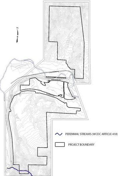
2.
Relationship to Other Restrictions The requirements established in this subsection are not intended to repeal, abrogate, supersede or impair any existing federal, state or local law, easement, covenant or deed restriction. However, if this article imposes greater or more stringent restrictions, the provisions of this article shall prevail. Specifically, if an applicant also acquires authorization under Section 404 of the Clean Water Act from the United States Army Corps of Engineers, the applicant shall meet any greater or more stringent restriction set forth in this article in addition to and independent of the restrictions of such permit.
3.
Application of this Article to the Truckee River The provisions of this article do not apply for development along the Truckee River.
4.
Impact on Land Use Designations The provisions of this subsection shall neither be used as justification for changing a land use designation nor be used to reduce the development density or intensity otherwise allowed by the land use designation of the property, subject to the provisions and limitations of the section.
c.
Perennial Streams Buffer Areas Perennial stream buffer areas are established to provide adequate setbacks and land use controls to ensure water quality functions of each perennial stream are not jeopardized through development activity. To limit significant impacts adjacent to hydrological resources, two buffer areas are hereby established - the "critical stream zone buffer area" and the "sensitive stream zone buffer area". All proposals to develop uses within the critical stream zone buffer area and/or the sensitive stream zone buffer area shall submit a site plan with precise dimensions depicting the boundary line for the buffer areas.
1.
Critical Stream Zone Buffer Area The critical stream zone buffer area shall be all land and water surface within 30 feet from the centerline of the perennial stream. The centerline of the stream shall be determined by either survey from a licensed surveyor or by determination of the thalweg (i.e., the line connecting points of maximum water depth) from a topographic survey, or appropriate USGS 7.5 minute topographic map covering the site.
2.
Sensitive Stream Zone Buffer Area The sensitive stream zone buffer area shall be all land and water surface between the critical stream zone buffer area boundary of 30 and 150 feet from centerline or thalweg of the perennial stream.
d.
Critical Stream Zone Buffer Area Development Standards All development in the critical stream zone buffer area shall be subject to the following standards:
1.
Allowed Uses Uses allowed within the critical stream zone buffer area are limited to those uses necessary for providing community services such as managing and conserving natural resources, and providing recreational and educational opportunities, including:
[a]
Weed control consistent with state and local laws.
[b]
Mosquito abatement consistent with state and local laws.
[c]
Conservation or preservation of soil, water, vegetation, fish, and other wildlife habitats.
[d]
Outdoor recreation activities such as fishing, bird watching, hiking, and swimming.
[e]
Education and scientific research including, but not limited to, water quality monitoring and stream flow gauging.
[f]
Maintenance of an existing public or private road, driveway, structure or facility, including drainage facilities, water conveyance structures, dams, fences, trails, and any public or private utility facility used to provide transportation, electric, gas, water, telephone, telecommunication, or other including individual service connections. Written notice shall be provided to the Administrator at least 15 days prior to the commencement of work, and all impacts to the critical stream zone buffer area are minimized and disturbed areas are immediately restored to their natural state.
[g]
Landscape improvements and maintenance of native vegetation is allowed within an established critical stream zone buffer area including the pruning of trees and the removal of dead vegetation and debris. Ornamental landscaping that would require fertilizer of pesticide applications for growth and maintenance is not permitted within the critical stream buffer zone area.
[h]
Landscaping area requirements in accordance with Reno Municipal Code may be satisfied by using the natural, undisturbed or restored critical stream zone buffer area to county towards the required area to be landscaped for new residential, civic, commercial, industrial or agricultural use types. Parking and loading areas on the developed portion of the site shall continue to require landscaping.
[i]
Continuation of existing agricultural operations such as the cultivation and harvesting of hay or pasturing of livestock or change of agricultural practices such as the relocation of an existing pasture fence, which has no greater impact on perennial stream water quality.
[j]
Perimeter fencing on a property boundary with a valid building permit pursuant to approval by the Administrator to ensure that obstruction to stream flows has been avoided.
2.
Permitted Uses Requiring a Conditional Use Permit Subject to the regulatory zone in effect for the property establishing the uses, the following use types may be permitted in the critical stream zone buffer area pursuant to a conditional use permit being issued by the City of Reno according to the provisions of Section 18.08.605, Conditional Use Permit, and this subsection. Any construction in the critical stream buffer zone area will require submission of a grading plan showing compliance with applicable best management practices as defined by the City of Reno to minimize stream bank and stream bed erosion. The grading plan shall also be designed to prevent construction drainage and materials from increasing sedimentation impacts to the stream environment and to minimize impervious surfaces.
[a]
Construction or enlargement of any public or private roads, driveway, structure or facility including drainage facilities, water conveyancestructures, dams, trails and any public or private utility facility used to provide transportation, electric, gas, water, telephone, telecommunication or other services.
[b]
Civic Use Types. Civic uses such as a nature center, active recreation, passive recreation and safety services use types may be permitted in the critical stream zone buffer area.
3.
Prohibited Uses Due to the incompatible nature of certain uses (i.e., ground disturbance, untreated water discharge, hazardous materials, chemical contamination, scale of use, traffic, etc.) and the potential negative impacts on the perennial stream and adjoining critical stream zone buffer area, all new construction and development uses not listed in either the allowed or permitted portions of this subsection shall not be established in the critical stream zone buffer area.
[a]
Residential, civic, commercial, industrial and agricultural use types All new residential, civic, commercial, industrial, and agricultural use types not listed as allowed or permitted uses are prohibited in the critical stream zone buffer area. Specifically prohibited industrial uses include:
i.
Aggregate facilities—Permanent.
ii.
Aggregate facilities—Temporary.
iii.
Energy production.
iv.
General industrial—Heavy.
v.
Inoperable vehicle storage.
vi.
Mining operations.
vii.
Salvage yards.
viii.
Wholesaling, storage, and distribution—Heavy.
[b]
Parking and Ornamental Landscaping All new parking and ornamental landscaping areas to fulfill the minimum requirements for new residential, civic, commercial, industrial, or agricultural use types shall be prohibited in the critical stream zone buffer area.
[c]
Fences To prevent livestock from destroying the stream bank slope, all new perpendicular-oriented fences shall be prohibited in the critical stream zone buffer area. Fencing that is parallel to the stream and is designed to keep livestock from access to the water and stream bank may be permitted after review and approval by the Administrator.
e.
Sensitive Stream Zone Buffer Area Development Standards All development in the sensitive stream zone area shall be subject to the following standards:
1.
Allowed Uses All allowed uses within the critical stream zone buffer area are also allowed in the sensitive stream zone buffer area. Additional allowed uses in the sensitive stream zone buffer area include:
[a]
Single-family, detached residential uses with the approval of a tentative map. All related accessory uses associated with the single-family residence requiring a building permit. Attached or detached accessory dwelling may also be erected within the sensitive stream zone buffer area with the approval of a tentative map. New building structures such as storage sheds and gazebos that, due to their minimum gross floor area, do not require a building permit may also be erected within the sensitive stream buffer area.
[b]
Landscaping area requirements in accordance with Reno Municipal Code, including ornamental landscape planting, may be satisfied by using the sensitive stream zone buffer area to count towards the required area to be landscaped for new residential, civic, commercial, industrial or agricultural use types. Parking and loading areas on the developed portion of the site shall continue to require landscaping.
[c]
New fencing constructed in accordance with Reno Municipal Code.
2.
Permitted Uses Requiring a Conditional Use Permit Subject to the regulatory zone in effect for the property establishing the uses, all new use types may be permitted in the sensitive stream zone buffer area pursuant to a conditional use permit being issued by the City of Reno. The conditional use permit requirement is also applicable to construction or enlargement of any public or private roads, driveway, structure or facility including drainage facilities, water conveyance structures, dams, trails, and any public or private utility facility used to provide transportation, electric, gas, water, telephone, telecommunication or other services. New residential, commercial and industrial subdivisions processed with a tentative subdivision map, shall not require the concurrent processing of a conditional use permit, as long as the "Special Review Considerations" of this subsection (below) are addressed in the tentative subdivision map review. Any construction in the sensitive stream zone buffer area will require submission of a grading plan showing compliance with applicable best management practices as defined by the City of Reno to minimize stream bank and streambed erosion. The grading plan shall also be designed to prevent construction drainage and materials from increasing sedimentation impacts to the stream environment and to minimize impervious surfaces.
3.
Prohibited Uses Due to the incompatible nature of certain uses (i.e., ground disturbance, untreated water discharge, hazardous materials, chemical contamination, scale of use, traffic, etc.) and the potential negative impacts on the perennial stream and adjoining sensitive stream zone buffer area, the following uses shall not be established in the sensitive stream zone buffer area;
[a]
Aggregate facilities—Permanent.
[b]
Aggregate facilities—Temporary.
[c]
Energy production.
[d]
General industrial—Heavy.
[e]
Inoperable vehicle storage.
[f]
Mining operations.
[g]
Salvage yards.
[h]
Wholesaling, storage, and distribution—Heavy.
f.
Special Review Considerations In addition to the findings required by Section 18.08.605, Conditional Use Permit, prior to approving an application for development in the critical stream zone buffer area or the sensitive stream zone buffer area, the record at the Planning Commission shall demonstrate that the following special review considerations are addressed:
1.
Conservation of topsoil;
2.
Protection of surface water quality;
3.
Conservation of natural vegetation, wildlife habitats and fisheries;
4.
Control or erosion;
5.
Control of drainage and sedimentation;
6.
Provision for restoration of the project site to predevelopment conditions;
7.
Provision of a bonding program to secure performance of requirements imposed; and
8.
Preservation of the hydrologic resources, character of the area and other conditions as necessary;
g.
Modification of Standards Modification of standards, including interpretation of the applicability of the standards in this subsection, shall be set forth as follows:
1.
Appeals for Errors The City Council shall hear and decide appeals when it is alleged there is an error in any requirement, decision, or determination. Appeals shall be processed under the provision of Subsection 18.08.307(j), Appeal.
2.
Special Exceptions The City Council shall hear and decide requests for special exceptions from the requirements of this subsection. In passing upon such applications, the City Council shall consider all technical evaluations and all relevant requirements, factors and standards specified in the MGOD and shall also consider the following provisions:
[a]
The potential degradation of the stream environment.
[b]
The danger to life and property due to flooding or erosion damage.
[c]
The loss of critical habitat.
3.
Issuance of Special Exception Special exceptions shall only be issued when in compliance with the provisions of this section and the City Council finds:
[a]
A showing of good and sufficient cause such as renovation, rehabilitation or reconstruction of the stream environment; or
[b]
A determination that failure to grant the special exception would result in exceptional hardship to the applicant, such as deprivation of a substantial use of property and that the granting of a special exception will not result in degradation of the stream environment.
4.
Extent of Special Exception Special exceptions shall only be issued upon a determination that the special exception is the minimum necessary to afford relief.
5.
Conditions of Special Exceptions Upon consideration of the factors set forth in this section and the purpose of this subsection, the City Council may attach such conditions to the granting of special exceptions as it deems necessary to further the purpose of this article.
h.
Wetlands
1.
Preliminary wetland delineations for the properties included in the MGOD have been prepared by JBR Environmental Consultants, Inc., and Huffman and Associates, Inc. These studies have been included in Supporting Studies Book 2, associated with the Mortensen-Garson Development Standards Handbook. Figure 2-9, below, depicts the general location and extent of potential wetlands and potential Waters of the U.S. within the project boundaries.
2.
Each tentative map, parcel map and conditional use permit shall show the wetlands and waters of the U.S. Wetlands within the project will be protected and mitigated according to Reno Municipal Code, Wetlands and Stream Environments. Wetlands will be avoided and retained as open space unless the location of the wetland and or the physical characteristics of the site necessitate modification of a wetland. In this instance, the wetland shall be replaced at a minimum 2:1 ratio of as required by the U.S. Army Corps of Engineers, whichever is more restrictive.
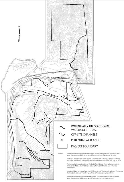
Figure 2-9: MGOD Wetlands
(8)
Ridgelines Figure 2-10, below, defines the significant ridgelines that are found within the MGOD. Development immediately adjacent to these ridgelines shall provide the following treatments to minimize visual impact to I-80:
a.
Minimum structure setback of 45 feet from the ridgeline; or
b.
Single story building height limitation and landscape treatments consisting of the use of existing or additional evergreen trees and shrubs for screening of structures. Landscaping shall consist of plant material that is either identical or similar to existing plant material; or
c.
Structures stepped into the hillside and landscape treatments consisting of the use of existing or additional evergreen trees and shrubs for screening of structures. Landscaping shall consist of plant material that is either identical or similar to existing plant material.
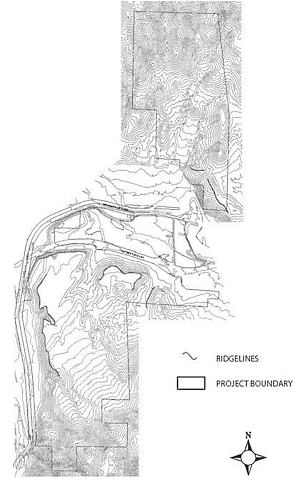
Figure 2-10: MGOD Ridgelines
(9)
Edge Matching New development adjacent to the existing developments of Blue Heron, Verdi Bluffs and Canyon Ranch Estates subdivisions shall provide an edge density and lot size for edge lots equal to or less dense than the above-referenced subdivisions, or shall provide an open space buffer equal to at least one lot depth of the above-referenced subdivisions. This standard in no event requires an edge lot size of buffer in excess of one acre in size.
(10)
Exterior Lighting The purpose of this section is to provide outdoor lighting standards that will improve safety, minimize glare and light trespass, and conserve energy for businesses and the residents of the Verdi area. Lighting will vary from larger scale roadway lighting to more intimate pedestrian scale lighting. Lighting will be used to create mood and reinforce the character of distinct areas within the project. Lighting will also be designed to be minimal, from the perspective of nurturing "dark sky" in most project areas. Lighting will be designed according to City of Reno standards and modified for the nurturing of "dark skies", to the approval of the city.
a.
Light All exterior light sources shall be located and installed in such a way as to prevent spillover lighting onto adjoining properties. All light fixtures shall be located, aimed or shielded so as to minimize light trespass across property boundaries. Where applicable, all commercial installations shall utilize house-side shielding to minimize light trespass on residential properties. The following provisions shall apply to all existing and proposed development:
1.
Any lighting facilities shall be so installed as to reflect away from adjoining properties. Covers shall be installed on all lighting fixtures and lamps shall not extend below the bottom of the cover.
2.
Light standard in or within 100 feet of residential zones shall not exceed 12 feet in height. The Administrator may permit additional height provided such lights are a sharp cutoff lighting system.
3.
No permanent rotating searchlights shall be permitted in any regulatory zone, except that an administrative permit may be issued by the Administrator for a period not to exceed three days for a temporary search light. The administrative permit shall be limited to a maximum of three times in any one calendar year.
b.
Shielding Full Cutoff lighting is strongly recommended. Where Full Cutoff fixtures are not utilized, acceptable outdoor light fixtures shall include those which:
1.
Are provided with internal and/or external glare control louvers and installed so as to minimize uplight and offsite light trespass, and
2.
Are installed and maintained with aiming angles that permit no greater than five percent of the light emitted by each fixture to project above the horizontal.
c.
Lighting Design The style and intensity of lighting shall consider not only function and appearance, but shall reflect the existing character of surrounding areas and shall replicate natural light as much as possible.
d.
Glare Reflected glare on nearby buildings, streets or pedestrian areas shall be avoided by incorporating overhangs and awnings, using non-reflective building materials for exterior walls and roof surfaces, controlling angles or reflection, and placing landscaping and screening in appropriate locations.
e.
Reduced Lighting Levels Lighting levels shall be reduced to security levels within 60 minutes after the close of business or the end of the business activity.
f.
General Lighting Standards
1.
Lighting levels should be limited to effect "dark skies";
2.
Fixture scale and illumination levels will be consistent with the specific use;
3.
Fixtures will employ cutoff features, refractors, or housing shields to eliminate lighting spillover onto adjoining uses where the light would be a nuisance; and
4.
Use energy efficient lighting design.
g.
Streetlighting
1.
Locate streetlights to provide safe illumination of roadways and to minimize glare. At a minimum, streetlights will be located at all intersections, pedestrian crossings, bus stops, and traffic circles;
2.
The scale and spacing of streetlights will reflect the street hierarchy;
3.
Care will be taken to ensure the project's street lighting is unobtrusive and optimized to afford views of the night sky;
4.
Streetlights will be submitted for approval and inclusion in the NV Energy streetlight program prior to approval of the applicable Final Map; and
5.
Streetlights will have individual photocontrol units.
h.
Pedestrian Lighting Pedestrian lighting will reflect the level of activity intended for the specific area. Higher light levels are appropriate in intensive use areas such as hotel casino, shopping districts or plazas. Low light levels are appropriate in more natural areas. Where little or no light will be provided in adjacent areas, low lighting levels will be used to prevent "blind spots" at the interface between lit and unlit areas.
i.
Residential Lighting Standards Exterior fixtures mounted on buildings will be no higher than the line of the first story eave or, where no eave exists, no higher than 12 feet above finished grade and shall be shielded to reduce spillover on adjacent properties.
j.
Commercial Lighting Standards
1.
Commercial area lighting will coordinate with the associated building architecture;
2.
Building lighting will clarify pedestrian routes and highlight building entries;
3.
At a minimum, commercial areas will provide parking lot lighting and lighting at all pedestrian routes;
4.
Building lighting will be integrated with the architectural design of the building with no exposed bulbs;
5.
Building illumination and architectural lighting will be indirect in character. Overhead down lighting or interior illumination, which spills outside is encouraged. Architectural lighting will accent and animate the building in addition to providing functional lighting for safety;
6.
Service area lighting will be contained within the service area boundaries and enclosure walls;
7.
Locate lighting fixtures to reduce shadow or interference from trees and other objects in the landscape;
8.
Parking lot lights will clarify vehicular and pedestrian circulation routes; and
9.
Parking lot light standards will not exceed 25 feet in height unless the Administrator determines that a higher light standard will result in an overall reduction in lighting impact.
(11)
Parks and Trails Figure 2-11, below, depicts the parks and trails plan of the MGOD and shall be implemented with tentative maps and conditional use permits. Trails in addition to those shown in Figure 2-11 may be required with tentative maps. The MGOD shall include:
a.
Public access through the MGOD to connect with U.S. Forest Service lands to the south and north of the Overlay District;
b.
A 30-foot wide trail shall be established along the entirety of the Steamboat Ditch within the MGOD. This trail will be dedicated or easement granted, as determined by the City with the first tentative map in Planning Area 3;
c.
Five Trailheads to be generally located as follows:
1.
At the southern edge of Planning Area 1 to access the trail network through the Planning Area 1 and provide access to the Bull Ranch Road trailhead proposed within the Somersett PUD;
2.
At the north end of Planning Area 2, providing pedestrian access to a trail that currently extends to the Truckee River;
3.
At the northern edge of Planning Area 3 adjacent to Steamboat Ditch;
4.
At the southeast edge of Planning Area 3 adjacent to USFS land; and
5.
At the southwest edge of Planning Area 3 adjacent to Steamboat Ditch and an existing trail.
d.
Trails will be designed to address their physical setting, intensity of use and proposed interconnection to offsite trails.
e.
Minimum of six parking spaces will be provided at each trailhead. Trailhead parking lots shall be designed such that no home will lie within 75 feet of any parking lot.
f.
Pedestrian and bicycle access will be provided within the Business Park (IC) area located along the southwest portion of Planning Area 3.
g.
Three parcels in Planning Area 2 (APN's 038-100-10, 11 & 12) will be dedicated to the City of Reno with the first Final Map associated with Planning Area 1.
h.
Three new parks shall be constructed and shall be open to the public. Parks shown are approximately three to five acres in size, for a minimum total of 15 acres. Exact park details including size, timing, location, and amenities/features to be included in each park will be subject to the approval of the Director of Parks and Recreation and the Administrator. Specific size and location of parks will be shown with individual tentative maps. Smaller pocket parks maintained by a Homeowner's Association may be built to supplement the parks shown in Figure 2-11. Timing of construction and details of park tax crediting may be addressed in parks agreements between the property owner and the city. Unless an alternate timeframe is approved by the Director of Parks and Recreation and the Administrator, park land shall be dedicated as follows:
1.
Park 1—With the first final map for residential development in Planning Area 1.
2.
Park 2—With the first final map for any development adjacent to the park site.
3.
Park 3—With the first final map for any development adjacent to the park site.
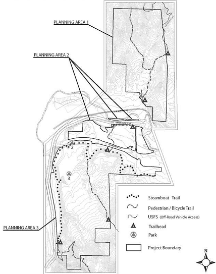
Figure 2-11: MGOD Parks and Trails
(12)
Community Design The following community design standards have been established to compliment the character of the Verdi community.
a.
Building Height Figure 2-12, below, depicts properties that will have unique height limitations.
1.
Parcel A—Two stories.
2.
Parcel B—40 feet.
3.
Parcel C—110 feet.
4.
Parcel D—35 feet.
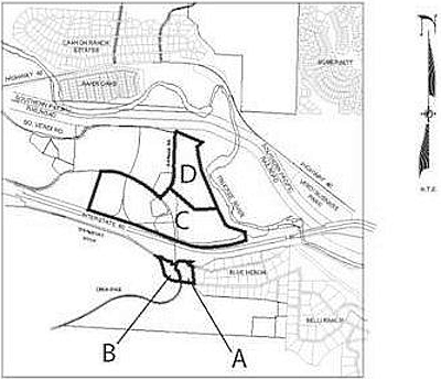
Figure 2-12: MGOD Building Height
b.
Access
1.
Other than gated emergency or utility maintenance access as may be required by the City of Reno, no development adjacent to Blue Heron/Belli Ranch subdivisions or Verdi Bluff may create a new roadway that connects to these existing subdivision.
2.
All existing access to USFS lands shall be maintained during construction and upon completion.
3.
Motorized access to USFS lands will be provided in the locations generally shown in Figure 2-11.
c.
Grading
1.
For residential development abutting Blue Heron/Belli Ranch and Verdi Bluff, the following grading standards shall apply:
[a]
Grading for subdivision improvements, conditional use permits or other discretionary approvals or building permits shall:
i.
When grading occurs adjacent to an existing residence, fills shall not be placed within an area that exceeds a projected slope or four to one (4:1) for a distance of 40 feet from the common property line (see Figure 2-13);
ii.
Be limited on cut slopes to equal to, or steeper than, three to one (3:1) and may include a rockery or manufactured masonry retaining wall with a maximum height of eight feet. If necessary, one additional retaining wall set back eight feet from the west wall will be allowed; or
iii.
If the applicant proposes cuts, fills or slopes in excess of the standard, the applicant shall address compatibility with adjacent lots and visual impacts to the community and proposed design criteria, landscaping and buffering to mitigate impacts of adjacent property owners and the community's scenic character. The mitigation shall be reviewed by the Administrator prior to any ground-disturbing activities.
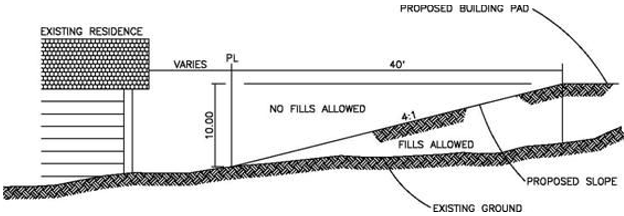
Figure 2-13: MGOD Typical Setback at Existing Residence
d.
Fencing (see also the Hillside Development portion of MGOD) The following shall apply to all residential areas within the MGOD:
1.
Each tentative map application shall include a fencing plan detailing the type, materials and location of all fencing proposed within the project; and
2.
Fencing adjacent to all open space shall be limited to "open view fencing".
3.
Solid fencing shall be minimized while still providing for privacy within individual lots.
e.
Wildlife Corridors Wildlife corridors for each planning area will be identified with the first tentative map for each planning area. Wildlife corridors will be developed in consultation with Nevada Division of Wildlife (NDOW) and will include:
1.
Creation of as much open space as possible next to culverts;
2.
Establishment of continuous corridors;
3.
Creation of natural rock check dams to create natural water resources consistent with hydrologic considerations with approval by the City of Reno and NDOW;
4.
Landscaping in or near corridors will place a priority on use of native vegetation species. Secondary priority will be given to those non-native species that provide good wildlife habitat and food value;
5.
Areas adjacent to or within these corridors that are disturbed during development shall be restored to as natural a condition as possible by utilizing native plant species; and
6.
Minimal fencing or fencing that allows wildlife to pass.
f.
Community Character The architectural character of the existing Verdi area may best be described as "varied". The following design standards will apply to the MGOD:
1.
Residential Development
[a]
Varied setbacks;
[b]
Mix of building heights;
[c]
Mix of larger and smaller houses;
[d]
Curvilinear streets and culs-de-sac; and
[e]
Use of natural elevation changes.
2.
Business Park located at the southwest edge of Planning Area 3
[a]
Architectural Development Standards will be approved by Reno City Council prior to issuance of the first building permit for the Business Park;
[b]
Architectural treatments will include earth tones compatible with the natural setting, use of non-reflective materials, extensive use of native landscape, vehicle parking screened from the west, and freestanding signs limited to monument type signage; and
[c]
Building height will be limited to two stories.
(13)
Schools The land use plan within the Mortensen-Garson Development Standards Handbook identifies a ten acre elementary school site located in Planning Area 3 and is reflected in the adopted base zoning as Public Facility zoning. This exact site will be identified with the first final map in Planning Area 3 with the aid of Washoe County School District. This site will be offered for purchase by Washoe County School District at the current acquisition price for a period of five years from the approval of the overlay district. The following standards will apply to schools within the MGOD;
a.
The developer will be responsible for installing safety/school zone signage;
b.
Development of the elementary school site shall assure separate access for buses and parent drop-off areas; and
c.
Washoe County School District reserves the right to require school sites with tentative maps.
(14)
Utilities A preliminary water plan was prepared by Capital Engineering for the MGOD. As identified in the preliminary plan, surface water shall provide the primary source of water supply. Groundwater shall supplement the surface water supply in peak times and as approved by the State Water Engineer. The city shall require the water supplier to follow the plan above.
Community water systems will be extended to the property lines in those areas adjacent to the existing subdivisions of Blue Heron and Verdi Bluff.
(15)
Fire Services The 2.9-acre public facility site located in Planning Area 3 will be dedicated to the City of Reno with the first final map in Planning Area 3.
(16)
Administration/Amendments
a.
Amendments The base zoning for each parcel in the MGOD will be consistent with the designations and standards of Chapter 18.02 Zoning Districts. The maximum density for each property may only exceed or change from those shown in and Table 18.08-47 and 48 and implemented through adopted base zoning, consistent with the following:
1.
The total amount of development resulting from any change in density shall not exceed 3,000 dwelling units and 300 commercial acres cumulatively for all the properties in the MGOD.
2.
No density increases are permitted along the exterior of the property for the areas immediately adjacent to Verdi Bluff, Blue Heron and the Canyon Ranch Estates unless the zoning/land use designations on these abutting properties are increased.
3.
Density increases by a maximum of ten percent may be approved by the Administrator or through the tentative map and/or conditional use permit process.
4.
Density increases of up to 25 percent may be allowed subject to a public hearing process with a tentative map or conditional use permit provided the planning process includes a review of any such application by the Verdi Township CAB and Northwest NAB.
5.
Density increases beyond 25 percent will require a zoning map amendment application and be processed in the same manner as the original overlay district or development standards handbook (i.e., procedures established in the Settlement Agreement).
6.
Properties owned by Boomtown and zoned HC may be converted to AC and still be considered consistent with this overlay provided such rezoning occurs through the City of Reno zoning amendment public hearing process.
b.
Archaeological Studies Tentative maps will include archaeological surveys.
c.
Verdi Township Citizens Advisory & Northwest Neighborhood Advisory Board Review All tentative maps, conditional use permits, or rezoning applications shall be presented to the Verdi Township Citizen's Advisory Board and the Northwest Neighborhood Advisory Board for comment prior to City of Reno public hearing.
d.
Project Management At the City's discretion, the developers of the project will fund a project inspector.
(d)
McQueen Neighborhood Planning Area (MQ) Overlay District
(1)
Applicability This zoning district's standards shall apply to properties in the McQueen Neighborhood Plan.
(2)
Freeway Corridor Development Standards The following standard shall apply if any portion of a property is within this 500 feet of the Interstate 80 right-of-way line:
a.
Development shall be clustered away from the freeway. Buildings shall be setback a minimum of 30 feet from the freeway right-of-way line. Landscaped and irrigated buffers with a minimum width of ten feet and one tree every 30 linear feet shall be provided between development and the freeway. Blank wall building facades adjacent to the freeway are prohibited.
(3)
Hillside Development Standard Within the McQueen Neighborhood, any development that meets the definition of hillside development as outlined in Chapter 18.04 Article 4, Hillside Development, will be required to meet the following:
a.
Open view fencing will be required for yards that face open space areas, and drainageways.
(e)
Plumas Neighborhood Residential Core Planning Area (PL) Overlay District
(1)
Applicability This zoning district's standards shall apply to properties in the Plumas Neighborhood Residential Core Area, as identified by the zoning map.
(2)
Height Limitation The maximum height shall be 25 feet, with a maximum of two stories.
(3)
Architectural Treatment New primary structures shall have a minimum roof pitch of four-foot rise in 12-foot run.
(4)
Off-street Parking No off-street parking spaces shall be permitted between the front facade of any primary building and an adjacent street.
(f)
Southeast Neighborhood Planning Area (SENP) Overlay District
(1)
Applicability This zoning district's standards shall apply to the areas specified in the Southeast Neighborhood Plan.
(2)
District-Specific Standards
a.
Conformities
1.
Any existing land uses legally established prior to the adoption of the SENP zoning overlay district may continue to operate and expand.
2.
Expansion of existing and legally established uses at the time of the adoption of this ordinance, that are not allowed by the SENP zoning overlay district shall require a conditional use permit if the proposed development expands the site, building or business area by more than 100 percent.
3.
Any expansion of existing land uses that were nonconforming prior to the plan and are still nonconforming in the SENP zoning overlay district, shall apply for a conditional use permit to expand.
4.
Changing land use from one nonconforming land use to another nonconforming land use is not allowed.
b.
Land Uses
1.
The following additional land uses are permitted with the approval of a conditional use permit for areas zoned General Commercial (GC):
[a]
Cluster development;
[b]
Farm;
[c]
Hospital, Acute and Overnight Care;
[d]
Hotel (without Nonrestricted Gaming Operation);
[e]
Indoor Manufacturing, Processing, Assembly or Fabrication;
[f]
Maintenance, Repair or Renovation Business;
[g]
Single Family, detached;
[h]
Single Family, Zero Lot-Line;
[i]
Sports Arena, Stadium, or Track
[j]
Warehousing/Distribution Center;
[k]
Welding Repair, as an accessory use;
[l]
Wholesale of Construction Materials; and
[m]
Wholesale of Products Manufactured or Assembled On-Site.
2.
The following additional land uses are permitted with the approval of a minor site plan review for areas zoned General Commercial (GC):
[a]
School, Primary (Public or Private)
c.
Setbacks
1.
For parcels zoned SF-8 the rear yard setback is 15 feet; and
2.
For parcels zoned SF-8 the minimum lot size is 5,000 square feet.
(g)
Wells Avenue Neighborhood Planning Area (WANP) Overlay District
(1)
Purpose The WANP Overlay District provides the development standards that specifically apply to the WANP in addition to those set forth in the underlying zoning districts adopted for the designated location. These standards provide a detailed description of the elements and design criteria that create the desired development character.
(2)
General Applicability These standards shall apply to all development within the WANP boundaries. The overlay contains two layers of applicability, as described below. Regulations applicable to parcels with the Urban Residential/Commercial or Public Facility land use designation shall be limited to those contained in the underlying zoning regulations.
(3)
General Standards The following standards shall apply to all parcels located within the boundaries of the WANP, except those designated as Urban Residential/Commercial or Public Facility.
a.
Parking Requirements Off-street parking shall be provided as follows:
b.
On-Street Parking Up to 50 percent of the required off-street parking, may be substituted with on-street parking, subject to Section 18.04.706, Parking Alternatives, Credits, and Adjustments.
c.
Building Orientation Primary buildings shall be oriented towards and accessed from the front yard and street with the main entrance located on the front facade of the building.
d.
Prohibited Materials The following building materials shall be prohibited as primary building materials when used in their traditional form (e.g., a commercial or industrial "warehouse" context); however, the creative incorporation of these or similar materials in a non-traditional form is permitted.
1.
Sheet metal siding;
2.
Tilt-up concrete panels; and
3.
Smooth-faced gray concrete block.
(4)
General Residential Standards
a.
Applicability The following standards shall apply to all parcels located within the boundaries of the following land use designations, as defined on the Land Use Framework Map contained in the Wells Avenue Neighborhood Plan.
1.
Mixed-Residential 14 (MR-14);
2.
Mixed-Residential 30 (MR-30); and
3.
Mixed-Use Residential (MUR).
b.
Architectural Character Due to the wide range of architectural styles found in the neighborhood's residential areas (see Figure 2-14), the use of one or more specific architectural styles is not mandated. However, infill development and major renovations to existing structures shall be designed to complement the established framework of the neighborhood in terms of its streetscape quality, block pattern, and overall urban neighborhood character (see Figure 2-15). These general residential standards are not intended to promote the replication of historic styles found in the neighborhood, but rather to encourage a range of architectural styles that reflect the diversity of the neighborhood.
Figure 2-14: WANP General Residential Architectural Character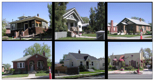
Figure 2-15: WANP Infill Development Architectural Character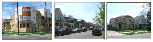
c.
Building Massing and Form Multi-family buildings shall incorporate one of the following techniques:
1.
Facades of multi-family buildings developed on combined lots on the interior of the block (not on a corner) shall be articulated so that they appear from the street to be separate homes. This shall be accomplished by "stepping back" the front facade a minimum of ten feet at the traditional side yard setback to provide a visual transition along the street frontage (see Figure 2-16).
2.
Multi-family buildings of four units or less shall be designed so that the massing and use of exterior materials gives each building the appearance of a large single-family home. This includes duplexes (see Figure 2-16), but is not intended to apply to townhomes in which the unique individualism of each unit is expressed.
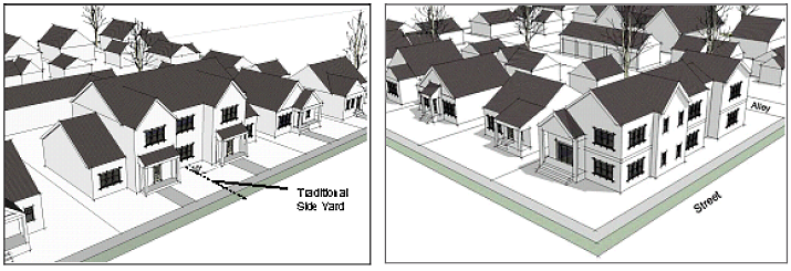
Figure 2-16: WANP Multi-Family Residential Architectural Character
d.
Relationship to Surrounding Development
1.
Blocky, multi-story building forms devoid of articulation or architectural features shall be prohibited. Infill homes (single-family or multi-family) that exceed the height of adjacent existing homes by one or more stories in height and/or are significantly larger in terms of their overall mass shall provide a transition using at least two of the following techniques (see Figure 2-17 and):
[a]
Graduating building height and mass in the form of building step-backs a minimum of ten feet in depth, or other techniques, so that new structures have a comparable scale with existing structures;
[b]
Orienting windows, porches, balconies, and other outdoor living spaces away from the shared property line to protect the privacy of adjacent residents where applicable;
[c]
Installing canopy trees 20 feet on center within the side yard to help break up the appearance of the taller structure. Trees shall be installed to the satisfaction of the city's landscape architect;
[d]
Utilizing a roof pitch and overhang like that of the adjacent structures; or
[e]
Utilizing dormers and sloping roofs to accommodate upper stories for major renovations and new construction.
Figure 2-17: WANP Relationship to Surrounding Development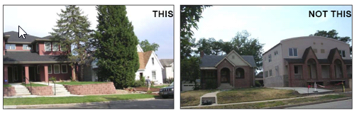
2.
To satisfy the above standard, one of the following techniques for alley homes shall be provided:
[a]
A graduated building height and mass in the form of building step-backs a minimum of ten feet in depth, or;
[b]
Similar techniques, so that the new structure has a comparable scale with the existing home located along the primary street frontage.
Figure 2-18: WANP Relationship to Surrounding Development for Alley Homes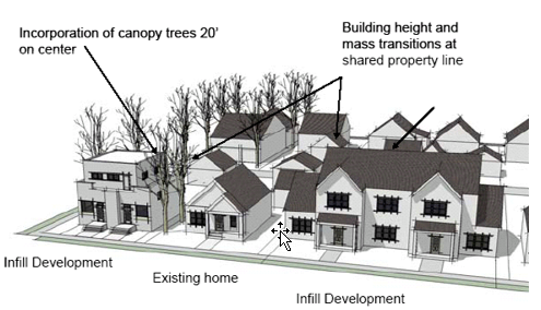
e.
Maximum Building Length The maximum allowable building length of a multi-family building shall be 80 feet (see Figure 2-19).
Figure 2-19: Maximum Allowable Length of Multi-Family Residential Structure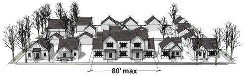
f.
Garage and Parking Location and Design
1.
Aside from driveways, off-street parking is prohibited within the front yard setback.
2.
Required parking shall be provided behind the primary structure and/or on-street.
3.
Garages shall be oriented towards and accessed from the alley or detached from the primary structure and located in the rear yard, as traditionally found in this area of the neighborhood (Figure 2-20).
4.
Surface parking lots shall be internalized in building groupings and located away from street frontages.
5.
When access to a rear garage or surface parking is provided from a street frontage, the maximum driveway width within the front and side yard setback is 12 feet.
Figure 2-20: WANP Residential Garage Design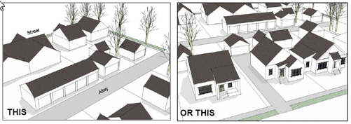
g.
Building Variety
1.
For new construction, no one housing type shall occupy more than 40 percent of the total length of a block face (Figure 2-21).
2.
Development parcels encompassing more than two and one-half acres, shall incorporate a minimum of two housing types. Development parcels larger than five acres shall incorporate a minimum of three housing types.
3.
The following housing types may be used to satisfy the above building variety standards:
[a]
Duplexes;
[b]
Townhomes;
[c]
Apartments;
[d]
Condominiums; or
[e]
Single-family homes.
Figure 2-21: WANP Building Variety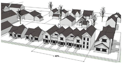
h.
Architectural Character - Renovation Guidelines The renovation of homes within the Wells Avenue Neighborhood constructed prior to 1950 should be conducted in accordance with the following guidelines.
1.
Windows
[a]
The character, proportion, size, and general appearance of original windows should be preserved during renovation.
[b]
Original window openings should not be enclosed, enlarged, or otherwise modified.
[c]
Replacement windows should have a similar appearance as the original window's design in terms of their materials, dimension, profile, and finish; however, improving energy efficiency should also be considered.
2.
Materials
[a]
Original building materials should be repaired rather than replaced to the maximum extent feasible.
[b]
To the maximum extent feasible, original masonry building materials should not be altered or otherwise covered with new building materials, such as stucco or vinyl siding, or painted.
3.
Architectural Detailing
[a]
Character-defining features that are original to the home, such as stone retaining walls, steps, and foundations should be preserved to the maximum extent feasible.
[b]
Enclosure of or other significant alterations to decks or balconies that were not originally enclosed should be prohibited.
(5)
Single-Family (SF) Designation
a.
Applicability The following standards shall only apply to parcels designated as SF on the Land Use Framework map contained within the Wells Avenue Neighborhood Plan. Design Standards for the SF designation are intended to preserve the predominantly detached, single-family character of the area.
b.
Prohibited Uses The following lists of prohibited uses modify Table 3-1, Table of Allowed Uses and shall apply to all parcels located within the SF area of the Wells Avenue Neighborhood Plan:
1.
Multi-family;
2.
Single-family attached/condominium townhouse;
3.
Single-family zero lot-line;
4.
Mobile home subdivisions;
5.
Mini-warehouses.
6.
Convenience store.
c.
Maximum Building Height Maximum building height shall be two stories or 30 feet.
d.
Maximum Driveway Width Maximum driveway width within the front and side yard setback is 20 feet.
e.
Maximum Building Coverage Maximum allowable building coverage for areas designated SF by the Wells Avenue Neighborhood Plan shall not exceed 20 percent above that of the existing lot or 30 percent, whichever is less.
f.
Garage Design
1.
Garages that protrude towards the street in front of the primary facade of the primary structure shall not be permitted. Garage doors on all front loading (street oriented) garages shall be either (Figure 2-22):
[a]
Recessed a minimum of ten feet behind the front facade of the dwelling portion of the structure (including side-loading garages) or a front porch that is a minimum of five feet wide by eight feet long, or
[b]
Recessed a minimum of two feet beneath a second-floor bay.
Figure 2-22: WANP Garage Design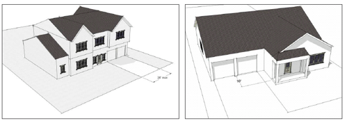
2.
Length Front-loading (street oriented) garage doors shall not comprise more than 40 percent of the total length of the front facade (Figure 2-23).
Figure 2-23: WANP Garage Length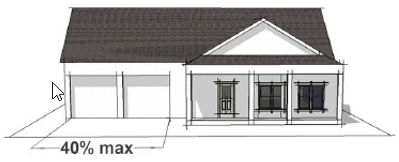
g.
Transitions
1.
New, multi-story homes and major renovations to existing homes shall incorporate a transition in height and scale (Figure 2-24) through two or more of the following techniques:
[a]
"Stepping-down" to meet the approximate height of the adjacent structure. Step-downs shall be a minimum of ten feet in depth.
[b]
Utilizing dormers and sloping roofs to accommodate upper stories for major renovations and new construction.
[c]
Utilizing a roof pitch and overhang like that of the adjacent structures.
[d]
Installing canopy trees 20 feet on center within the side yard to help break up the appearance of the taller structure. Trees shall be installed to the satisfaction of the city's landscape architect.
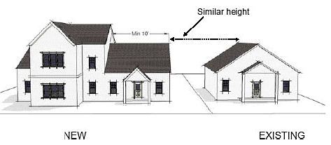
Figure 2-24: WANP Single-Family
(6)
Multi-Family Residential (MF-14) Designation
a.
Applicability The following standards shall only apply to parcels designated as MF-14 on the Land Use Framework map contained within the Wells Avenue Neighborhood Plan, with the exception of those designated as Public Facility. Design Standards for the MF-14 area are intended to allow for the accommodation of a range of residential housing types through infill and redevelopment while protecting the traditional, single-family character of the area.
b.
Prohibited Uses The following list of prohibited uses modify Table 3-1, Table of Allowed Uses, and shall apply to all parcels located within the MF-14 area of the Wells Avenue Neighborhood Plan:
1.
Mobile home parks and subdivisions
2.
Mini-warehouses
3.
Convenience store
c.
Maximum Building Coverage
1.
Maximum allowable building coverage shall be 45 percent (Figure 2-25).
2.
Maximum allowable building coverage may be increased to 65 percent if height is limited to one and one-half stories or 30 feet.
Figure 2-25: WANP Maximum Building Coverage (45 Percent)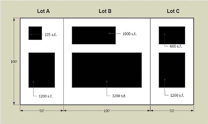
d.
Maximum Building Height Maximum building height shall be two stories or 35 feet.
(7)
Multi-Family Residential (MF-30) Designation
a.
Applicability The following standards shall apply to all parcels designated as MF-30 on the Land Use Framework map contained within the Wells Avenue Neighborhood Plan. Design Standards for the MF-30 area are intended to allow for the accommodation of a range of residential housing types through infill and redevelopment while protecting the traditional neighborhood character of the area.
b.
Prohibited Uses The following list of prohibited uses modify Table 3-1, Table of Allowed Uses, and shall apply to all parcels located within the MF-30 area of the Wells Avenue Neighborhood Plan:
1.
Mobile home parks.
2.
Mini-warehouses.
3.
Copy center.
4.
Financial institution.
5.
General personal services.
6.
General retail store or commercial use.
7.
Laundry. Drop off/pickup.
8.
Convenience store.
c.
Maximum Building Coverage
1.
Maximum allowable building coverage shall be 50 percent (Figure 2-26).
2.
Maximum allowable building coverage may be increased to 70 percent if height is limited to 35 feet and the required minimum side yard setback is increased from ten feet to 12 feet.
Figure 2-26: WANP Maximum Building Coverage (50 Percent)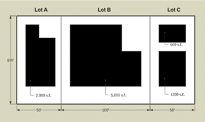
d.
Maximum Building Height Maximum building height shall be three stories or 45 feet.
(8)
Wells Avenue Mixed-Use (WA-MU) Designation
a.
Applicability The following standards shall apply to all parcels designated as WA-MU on the Land Use Framework map contained within the Wells Avenue Neighborhood Plan, except those designated as Public Facility. Design Standards for the WA-MU area are intended to reinforce its distinction as a pedestrian-oriented "main street" that serves the neighborhood and the surrounding community.
1.
Permitted/Prohibited Uses The following modifications to Table 3-1, Table of Allowed Uses, shall apply to all parcels located within the WA-MU area of the Wells Avenue Neighborhood Plan:
The following uses shall be prohibited:
[a]
Auto repair garage and paint and body shop;
[b]
Automobile and truck sales and mobile home, RV, boat and trailer sales or rental;
[c]
Building landscape material/lumber yard;
[d]
Laboratory;
[e]
Indoor gun range;
[f]
Commercial stables or riding academy;
[g]
Motels;
[h]
Food processing/wholesale;
[i]
Mini-warehouse; and
[j]
Truck rentals.
The following principal uses shall be permitted by right:
[k]
Restaurant with Alcohol Service.
[l]
Restaurant without Alcohol Service.
The
following principal uses shall be permitted with a conditional use permit:
[m]
Drive-through facility.
[n]
Convenience store.
b.
Maximum Building Height Maximum building height shall be three stories or 45 feet.
c.
Maximum Building Footprint The maximum footprint for a single-use commercial building shall be 30,000 square feet.
d.
Building Placement Buildings shall be "built to" the back of the sidewalk or the supplemental zone (if one is approved) as described in subsection j. "Supplemental Zone."
e.
Building Massing and Form New developments that are significantly larger than adjacent existing development in terms of their height and/or mass, as determined by the administrator, shall provide a development transition using an appropriate combination of the following techniques:
1.
Wrapping the ground floor with a building element or integrated architectural feature (e.g., pedestrian arcade) that is the same height as the adjacent structure; or
2.
Graduating building height and mass in the form of building step-backs or other techniques so that new structures have a comparable scale with existing lots (Figure 2-27); and
3.
Orienting porches, balconies, and other outdoor gathering areas away from the shared property line to protect the privacy of adjacent residents where applicable.
Figure 2-27: WANP Building Stepback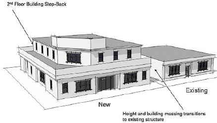
f.
Building Transparency General: A minimum percentage of the total area of each ground floor building facade which faces a street, plaza, park, or other public space, shall be comprised of transparent window openings to allow views of interior spaces and merchandise, to enhance the safety of public spaces by providing direct visibility to the street, and to create a more inviting environment for pedestrians. Minimum percentages vary according to use as follows:
1.
Wells Avenue
[a]
Nonresidential and Mixed-Uses: Forty percent minimum
[b]
Residential Uses: Twenty-five percent minimum.
2.
Non-Wells Avenue
[a]
Nonresidential Uses: Thirty-five percent minimum.
[b]
Residential Uses: Twenty percent minimum.
3.
Measuring Transparency For the purposes of the above standard, all percentages shall be measured using elevation views of the building plan and "ground floor" shall be measured from floor plate to floor plate (Ground floor heights are assumed to be a minimum of ten feet).
4.
Ground-Floor Windows The following standards shall apply to all ground floor windows:
[a]
Nonresidential uses: Glazing on all ground floor windows shall be transparent.
[b]
Residential uses: Glazing on ground floor windows shall be transparent to allow views into common hallways, foyers, or entryways, but may be translucent or opaque when necessary to protect the privacy of ground-floor spaces used for dwelling purposes.
[c]
Black or mirrored glass is prohibited.
g.
Street Tree/Furniture Zone A continuous street tree/furniture zone a minimum of eight feet in width shall be provided adjacent to the curb (Figure 2-28). Street trees shall be provided in accordance with Section 18.04.804(f), Street Tree Requirements. In addition, the zone is intended for the placement of street furniture, streetlights, waste receptacles, fire hydrants, traffic signs, newspaper vending boxes, bus shelters, bicycle racks, public utility equipment, and similar site elements.
Figure 2-28: WANP Street Trees, Furniture, and Sidewalks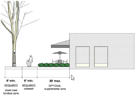
h.
Sidewalks A continuous sidewalk shall be provided adjacent to the Street Tree/Furniture Zone that is a minimum of eight feet in width. The sidewalk shall remain unobstructed by any permanent or nonpermanent element for a minimum width and height of eight feet.
i.
Supplemental Zone (optional) A supplemental zone may be provided at the option of the applicant between the street-facing facade line and the required clear zone. Supplemental zones shall be a maximum of 20 feet in width. The following elements may be located within a supplemental zone:
1.
Accessory outdoor dining, provided that the dining area is separated from the sidewalk by planters, shrubs, or ornamental metal fencing with a maximum height of 42 inches;
2.
Landscaping;
3.
Plazas, urban parks, or other outdoor gathering spaces;
4.
Incidental display and sales; and
5.
Terraces provided they have a maximum finished floor height of 24 inches above the sidewalk grade and shall be surrounded by a guardrail that meets city specifications.
j.
Spillover Lighting
1.
Lighting Standard Lighting from a nonresidential or mixed-use property shall not create greater than 0.50 foot candle of spillover light at an adjacent residentially zoned property line.
2.
Redirecting/screening of Light Sources All sources of light, including security lighting, illuminated signs, vehicular headlights and other sources shall be directed away from adjacent residentially-zoned properties or screened so that the light level stated in standard 1., above, is not exceeded.
3.
Height of Light Sources Light fixtures and standards shall not exceed 20 feet in height.
k.
Pedestrian Amenities
1.
Pedestrian Amenities Required A minimum of 25 percent of the required landscaped area of the site shall be devoted to pedestrian amenities that are visible and accessible from Wells Avenue.
2.
Approved Pedestrian Amenities Pedestrian amenities used to satisfy the above standards shall include three or more of the following:
[a]
Benches or seating areas;
[b]
Raised landscape planters;
[c]
Decorative trash receptacles;
[d]
Historic markers as provided in accordance with a property's acceptance on a local, State, or National historic register;
[e]
Outdoor dining area;
[f]
Shade structures;
[g]
Public art (e.g., sculptures, murals, water elements, carvings, frescos, mosaics, and mobiles);
[h]
Decorative transit shelters as approved by RTC and the city; or
[i]
Similar features to the satisfaction of the Administrator.
3.
Location of Pedestrian Amenities Pedestrian amenities shall be located in the supplemental zone (if one is provided) or within the Street Tree/Furniture Zone, as appropriate.
l.
Signage
1.
Materials Signs shall be constructed of durable materials that are compatible with the building that they serve. The use of cardboard, fabric, scrap wood, and other non-durable materials is prohibited.
2.
Prohibited Signs The following signs shall be prohibited:
[a]
Temporary hand-painted or hand-written signs; and
[b]
Reader board, electronic reader board and video display signs.
3.
Preferred Signage Types
[a]
All sign design shall be complimentary to the style of the building on which it is placed and be an integral part of the building facade and shall be oriented to pedestrians with legible and easy to read messages.
[b]
The creative use of symbols or other images indicative of the use contained within the building in the design of signs is strongly encouraged.
[c]
The use of permanent window signs or hanging signs is encouraged to reinforce the pedestrian-oriented scale of the Wells Avenue Corridor. Window signs shall not exceed ten percent of the window area. Hanging signs shall not exceed 24 inches in height and three feet in length. All signs projecting from the building shall not exceed six square feet and shall be located between eight and 12 feet in height.
Figure 2-29: WANP Preferred Signage Types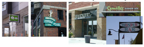
4.
Number of Signage Types No more than two distinct signage types (e.g., window sign and a hanging sign) shall be permitted per single tenant building.
m.
Parking
1.
Shared parking is recommended for commercial, residential and mixed-use development to maximize available parking. Shared parking may be considered and granted by the administrator based on submittal of a parking study justifying alternative parking rates.
2.
A convenient and safe pedestrian access shall be provided from parking/transit areas to the building entrances.
3.
All bicycle parking spaces, as required by this Title, shall be located adjacent to the building or inside the building.
(9)
Mixed-Residential (MUR) Designation
a.
Applicability The following standards shall only apply to parcels designated as MUR on the Land Use Framework map contained within the Wells Avenue Neighborhood Plan, with the exception of those designated as Public Facility. The character of the MUR is currently defined by a mix of retail shops, offices, and single-family homes. Single-family homes have been converted to nonresidential uses over time, contributing to the quaint, residential character of this area. Design standards are intended to reinforce the distinction between the MUR area and the more commercial character of the WA-MU area.
b.
Prohibited Uses The following uses are prohibited within the MUR area:
1.
Auto repair garage/paint and body shop;
2.
Automobile, truck, mobile home, RV, boat, and trailer sales and/or rental;
3.
Building landscape material/lumber yard;
4.
Laboratory;
5.
Drive-through facility;
6.
Indoor gun range;
7.
Commercial stables or riding academy;
8.
Tennis courts;
9.
Motels;
10.
Food processing/wholesale; and
11.
Mini-warehouse.
c.
Maximum Building Coverage
1.
Maximum allowable building coverage shall be 40 percent (Figure 2-30).
2.
Maximum building coverage may be increased to 60 percent if height is limited to 35 feet.
Figure 2-30: WANP Maximum Building Coverage (40 Percent)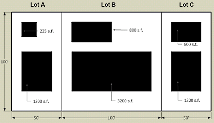
d.
Building Height Maximum building height shall be three stories or 45 feet.
e.
Signs
1.
General
[a]
Signs shall be designed to reflect the residential scale and appearance of the Mixed-Use Residential area (Figure 2-31).
[b]
The creative use of symbols or other images indicative of the use contained within the building in the design of signs is strongly encouraged.
Figure 2-31: WANP Preferred Signage Types Along Vasar Street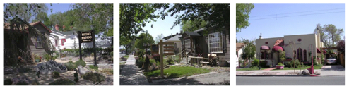
2.
Materials Signs shall be constructed of durable materials that are compatible with the building that they serve. The use of cardboard, fabric, scrap wood, and other non-durable materials is prohibited.
3.
Prohibited Signs The following signs shall be prohibited:
[a]
Temporary hand-painted or hand-written signs;
[b]
Reader board, electronic reader board and video display signs; and
[c]
Internally lit cabinet signs (individual letters and symbols on a sign may be internally lit.)
4.
Maximum Height The maximum freestanding sign height shall be six feet.
(h)
West University Neighborhood Planning Area (WUNP) Overlay District
(1)
Applicability
a.
Except where noted, these standards apply to development on all parcels within the West University Neighborhood Plan which have the Master Plan designations of (1) University Regional Center and Transit Corridor, excluding those parcels included in the University of Nevada Regional Center Plan, and (2) Traditional Neighborhood, as set forth in the West University Neighborhood Plan, an element of the City of Reno Master Plan.
b.
Development on lands within the West Seventh Street Business Corridor shall comply only with the district-specific use standards stated in subsection (2), below.
c.
These standards shall not apply to work on the site which involves parking lots, fences, landscape walls, interior renovations, uncovered or covered patios, or any other improvements that do not expand the building footprint or change the roof pitch.
d.
These standards shall not apply to properties owned by the University of Nevada, Reno.
(2)
District-Specific Use Standards The following modifications to Table 3-1, Table of Allowed Uses, apply within the following applicable districts of the West University Neighborhood Plan:
a.
Supplemental Use Standards for the Traditional Neighborhood Plan District
1.
Animal clinics, shelters, hospitals and boarding kennel are prohibited in the NC Zoning District;
2.
Art galleries are allowed in conjunction with a residential use, subject to approval of a conditional use permit, in the SF8, MF14, MF21 and MF30 Zoning Districts;
3.
Car wash facilities are prohibited in the NC Zoning District;
4.
Cluster developments are prohibited in the SF8 Zoning District;
5.
Commercial childcare facilities are prohibited in the SF8, MF14, MF21, and MF30 Zoning District;
6.
Convents and monasteries are allowed, subject to approval of a conditional use permit, in the SF8, MF14, MF21, and MF30 Zoning Districts;
7.
Fitness centers are prohibited in the MF21 and MF30 Zoning Districts;
8.
Fraternity and sorority houses are prohibited in the MF21 Zoning District;
9.
In-home childcare (7—12 children) facilities are prohibited on lots less than 10,000 square feet in the SF8 and MF14 Zoning Districts;
10.
Libraries are allowed, subject to approval of a conditional use permit, in the SF8, MF14, MF21, and MF30 Zoning Districts;
11.
Mini-warehouses are prohibited in the SF8 and MF14 Zoning Districts;
12.
Multi-family developments are prohibited in the SF8 Zoning District;
13.
Museums are allowed, subject to approval of a conditional use permit, in the SF8, MF14, MF21, and MF30 Zoning Districts;
14.
Night clubs are prohibited in the NC Zoning District;
15.
Private dorms are prohibited in the MF21 and MF30 Zoning Districts;
16.
Gas stations are prohibited in the NC Zoning District;
17.
Showrooms are prohibited in the NC Zoning District;
18.
Single-family, condominium, townhouse and multi-family developments are allowed in the NC Zoning District and are not required to be located on above-ground floors or be accessory to a nonresidential use;
19.
Video arcades are prohibited in the NC Zoning District.
b.
Supplemental use standards for the University Regional Center and Transit Corridor Plan District:
1.
Automobile and truck sale and mobile home, RV, boat and trailer sale or rental facilities are prohibited in the GC Zoning District;
2.
Automobile rental facilities are prohibited in the GC Zoning District;
3.
Drive-through facilities are prohibited in the GC Zoning District;
4.
Multi-family developments are prohibited in the GC and NC Zoning Districts unless the multi-family use is confined to above ground floor levels of multi-story buildings and nonresidential uses are located on the ground floor;
5.
Multi-family developments in excess of 30 units per acre are allowed in the MF30 Zoning District;
6.
Rental stores with outdoor storage and truck rental facilities are prohibited in the GC Zoning District;
7.
Single-family, attached/condominium/townhouse developments are prohibited in the GC and NC Zoning Districts unless the residential use is confined to above ground floor levels of multi-story buildings and nonresidential uses are located on the ground floor;
8.
Restaurants with alcohol service are allowed in the MF30 Zoning District on properties fronting on Virginia Street, Center Street, Sierra Street, Ninth Street and Eighth Street;
9.
Restaurants without alcohol service are allowed in the MF30 Zoning District;
10.
Single room occupancy facilities are allowed in the GC Zoning District;
c.
Supplemental use standards for the West Seventh Street Business Corridor:
1.
Drive-through facilities are allowed in the NC Zoning District on properties fronting on Keystone Avenue and within the block bounded by I-80, Keystone Avenue, West Seventh Street and Alvaro Street.
(3)
District-Specific Standards for Development of Single-Family or Two-Family Residences
a.
Front Setbacks
1.
Structures shall be constructed so that the front setback is within the range of the front setbacks for the two nearest structures on either side of the new structure on the same side of the street (see Figure 2-32);
Figure 2-32: WUNP Interior Lot Front Setbacks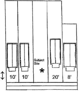
2.
In the case of new construction on a corner lot, the front setback may not be outside of the range of the front setbacks of the nearest single or two-family structures located within 100 feet of the new structure as on the same side of the street (see Figure 2-33).
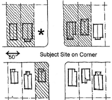
Figure 2-33: WUNP Corner Lot Front Setback
3.
If the allowable front setback range is less than five feet, development with front setbacks up to five feet outside of the allowable range shall be allowed if the administrator finds that significant site features, such as trees, will be preserved or existing development on the site prevents placement of the proposed structural expansion within the allowable front setback range.
b.
Permitted Setback Encroachments for Expansions Expansion of the footprint or exterior modifications to structures more than 50 years old shall be allowed to encroach on required rear setback(s) or a front setback for lots with two front yards, if the administrator finds the expansion or modifications comply with, as applicable, concerning historic preservation and the building code in effect in the city, and as may be amended, concerning fire protection.
c.
Maximum Building Coverage on Parcel A building or combination of buildings, including any covered rear or side porch or stairs, but excluding any balcony, driveway, walkway, uncovered deck, or covered front porch shall not cover more than 40 percent of the lot area; however, development of structures listed in the city's Register of Historic Places, may cover 50 percent of the lot area.
d.
Roofs A minimum of 80 percent of the building footprint shall be covered by a roof with a minimum pitch of 4:12. Flat roofs are not allowed on any building section. Roof pitch will be evaluated from a plan view perspective.
e.
Front Door Orientation The front door of the dwelling closest to the street shall face a street.
f.
Vehicle Access
1.
If the site is served by an alley, access for motor vehicles shall be from the alley, not from a street frontage (see Figure 2-34). Access from a street frontage shall be allowed to continue upon approval of a structural addition if the structural addition is less than 500 square feet and access was previously achieved from a street frontage.
2.
When access is from a street frontage, the maximum driveway width in front of a building is 12 feet for properties with garages or carport openings less than 12 feet and 20 feet for properties with garages and/or carport openings equal to or greater than 12 feet.
3.
Excluding driveways, parking is not allowed in front setback areas and in areas between a front property line and a building.
4.
When parking is provided in a garage or carport and the garage door(s) or carport opening faces a street, garage and carport opening areas shall not be more than 30 percent of the length of the building elevation that faces the street except when detached garages are located on or within five feet of a rear yard setback line.
Figure 2-34:WUNP Vehicle Access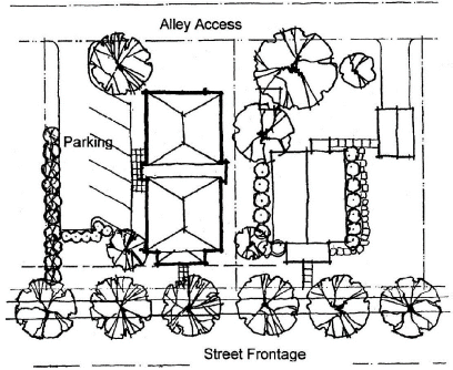
g.
Buildings
1.
Modifications to any structure on a parcel which increases the building footprint or construction of new structures shall include two of the following:
[a]
The exterior finish is constructed with materials compatible with the existing main structure building materials. The new materials shall be either identical or similar to the original building materials. For example, details of synthetic siding should match that of traditional wood siding.
[b]
Contemporary interpretations of architectural features such as trim, fenestration, window frames, dormers, columns, gables, decorative wood, or metal work found on the existing main structure are used.
[c]
The roof pitch is the same or within the range of the roof pitches on the existing main structure.
2.
If the height of a proposed structure would exceed the height of an existing building that faces the street on the same lot, the rear and side-yard setbacks shall be increased by five feet for every eight feet that the new structure exceeds the height of the existing building.
(4)
District-Specific Standards for Development of Multi-Family Residential Containing Three or More Dwelling Units
a.
Setbacks Multi-family development on half-blocks that contain parcels zoned either single-family residential or multi-family residential of 14 units or less is subject to the following setback standards.
1.
Structures shall be constructed so that the front setback is within the range of the front setbacks for the two nearest structures on either side of the new structure on the same side of the street (see Figure 2-32).
2.
In the case of new construction on a corner lot, the front setback may not be outside of the range of the front setbacks of the nearest single or two-family structures located on the same side of the street (see Figure 2-33).
3.
If the allowable front setback range is less than five feet, development with front setbacks up to five feet outside of the allowable range shall be allowed if the administrator finds that significant sites features, such as trees, will be preserved or existing development on the site prevents placement of the proposed structural expansion within the allowable front setback range.
b.
Roofs A minimum of 80 percent of the building footprint shall be covered by a roof with a minimum pitch of 4:12. Flat roofs are not allowed on any building section. Roof pitch will be evaluated from a plan view perspective.
c.
Motor Vehicle Access
1.
If the site is served by an alley, access for motor vehicles shall be from the alley, not a street frontage (see Figure 2-34). Access from a street frontage shall be allowed to continue upon approval of a structural addition if the structural addition is less than 500 square feet and access was previously achieved from a street frontage.
2.
When access is from a street frontage, the maximum driveway width is 12 feet for properties with garages or carport openings less than 12 feet and 20 feet for properties with garages and/or carport opening equal to or greater than 12 feet.
3.
Excluding driveways, parking is not allowed in front setback areas and in areas between a front property line and a building.
d.
Buildings
1.
Modifications to any existing structure on a parcel which increases a building footprint or construction of new structure shall include two of the following:
[a]
The exterior finish is constructed with materials compatible with the existing main structure building materials. The new materials shall be either identical or similar to the original building materials. For example, details of synthetic siding should match that of traditional wood siding.
[b]
Contemporary interpretations of architectural features such as trim, fenestration, window frames, dormers, columns, gables, decorative wood, or metal work found on the existing main structure may be used.
[c]
The roof pitch on an addition or new structure shall be the same or within the range of the roof pitches on the existing main structure.
2.
For every 35 feet of building length facing a street, each story shall have an individual dwelling entrance, private balcony, or patio. Each required balcony or patio shall be at least six feet wide and four deep, accessible from an interior room, and unenclosed except ground level patios may be enclosed by a six-foot fence.
3.
Dwelling and main entrances shall be delineated by the use features such as recesses, additional detailing, overhangs, columns, and change in volume and form (see Figure 2-35).
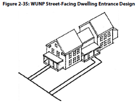
4.
If entrances to all units do not face a street, a main entrance shall be provided which includes either a covered front porch at least nine feet wide and six feet deep or an arcade which has the following characteristics (see Figure 2-36):
[a]
Is between six feet and ten deep;
[b]
Extends the length of the building to which it is attached;
[c]
Intersects with an on-site pedestrian path and individual unit entrances or stairwells;
[d]
Is at least 14 feet in height;
[e]
Contains openings of not less than six feet in width;
[f]
Is at least 25 percent solid but no more than 50 percent solid;
[g]
Is open to the air on three sides; and
[h]
Has no blocked street facings or end openings, in part or in full, with walls, glass, lattice, glass block or any other material.
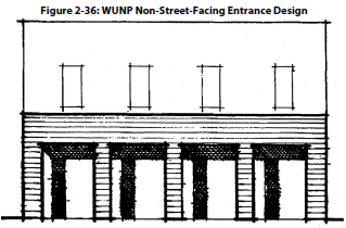
e.
On-Site Pedestrian Path A hard-surface path of not less than four feet in width shall be provided to a building entrance from each street frontage or from a street corner.
f.
Gathering Space If a project has six or more units, there shall be a gathering space which:
1.
Has at least 100 square feet provided for each street the project faces;
2.
Is visible from the street(s) for which it was provided;
3.
Corresponds to at least 50 percent of the required usable open space for the project; and
4.
Contains one of the following amenities for each 100 square feet:
[a]
Bench or other seating;
[b]
Tree which is not included in the minimum landscape requirements;
[c]
Kiosk;
[d]
Water feature such a pond or a fountain;
[e]
Landscape planter or planning bed of at least 20 square feet; or
[f]
Fixed recreational apparatus.
(5)
Residential Buffers
a.
The building height for a 15-foot portion of a lot abutting a parcel zoned single-family is limited to the maximum building height allowed by the single-family residential zoning district (see Figure 2-37).
b.
The building height for a 15-foot portion of a lot abutting a parcel zoned multi-family residential, 14 units or less is limited to the maximum building height allowed by the multi-family residential, 14 units or less zoning district.
c.
A five-foot landscape area shall be installed along any lot line that abuts a parcel zoned single-family or multi-family residential, 14 units or less.
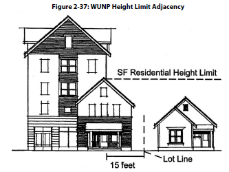
(6)
District-Specific Standards for Development of Nonresidential Uses and Residential Units with Nonresidential Use on the Ground-Floor
a.
Front zero lot-line setbacks are required when:
1.
A structure on one of the abutting parcels on the same side of the street is built to the zero-lot line; or
2.
In the case of new construction on a corner lot, the nearest existing commercial structure located within 100 feet of the new structure on the same side of the street is built to zero-lot line.
b.
Roofs
1.
A minimum of 80 percent of the building footprint shall be covered by a roof with a minimum pitch of 4:12; or
2.
Be flat with either a decorative parapet that surrounds the building and is at least 18 inches in height or have three distinct roof planes with a minimum 18-inch overhang over the two other planes.
c.
Ground-Floor Windows Windows shall be at least 50 percent of the length and 25 percent of the area of all exterior ground level building walls within 20 feet of a street lot line, sidewalk, plaza, or other public open space (see Figure 2-38). Ground floor walls are equal to all exterior wall area up to nine feet above the finished grade. This requirement does not apply to the walls of parking garages and residential units. Required window areas shall be either windows that allow views into working areas or lobbies, pedestrian entrances or display windows set into the wall. Display cases attached to the outside of the wall do not qualify. The bottom of the windows shall be no more than four feet above the adjacent exterior grade.
Figure 2-38: WUNP Ground Level Transparency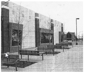
d.
Ground Floors Ground floor shall be visually distinct from upper levels by:
1.
A cornice above the ground level;
2.
An arcade;
3.
Changes in material or texture; or
4.
A row of clerestory windows on a building's street facing elevation.
e.
Corner Reinforcement The structure with the greatest ground level square foot area shall be within ten feet of both street lot lines on at least one corner on corner lots where two sidewalks or public pedestrian ways meet.
f.
Parking Parking is not permitted between a building and a street unless a property is bound by two or more roadways, has parking between the building and street on no more than one street frontage, and contains a ten-foot landscaped area between the street and the parking area which is in addition to the minimum landscape area requirements.
g.
Residential Buffers
1.
The building height for a 15-foot portion of a lot abutting a parcel zoned single-family is limited to the maximum building height allowed by the single-family residential zoning district (see Figure 2-37).
2.
The building height for a 15-foot portion of a lot abutting a parcel zoned multi-family residential, 14 units or less is limited to the maximum building height allowed by the multi-family residential, 14 units or less zoning district.
3.
A ten-foot wide landscaped area shall be installed along any lot area which abuts residentially zoned parcels.
h.
On-Site Pedestrian Path System The development shall include on-site pedestrian path systems that:
1.
Provide direct pedestrian paths from all adjacent streets or street corners to main entrances, ground level stairwells, and elevator landings;
2.
Connect all buildings, bicycle and parking areas, recreational areas, and gathering spaces;
3.
Are hard-surfaced;
4.
Are at least four feet wide;
5.
Are clearly identifiable, through the use of elevation changes, speed bumps, different paving material, or by other similar methods, but not striping, where the pedestrian path crosses driveways, parking areas, and loading areas;
6.
Are raised or separated from automobile travel lanes by raised curbs with curb ramps, bollards, landscaping or other physical barrier when parallel and adjacent to an automobile travel lane.
7.
On-premises advertising display. On-premises advertising display shall not be internally illuminated when visible from residentially zoned properties within 600 feet of the display.
(Ord. No. 6692, § 1(Exh. A), 1-8-25)
18.02.604 - Conservation and Historic Overlay Districts
(a)
Newlands Heights Conservation Overlay District [reserved for future development following code adoption]
(b)
Powning Conservation Overlay District [reserved for future development following code adoption]
(c)
Wells Avenue Conservation Overlay District [reserved for future development following code adoption]