
Reno City Zoning Code
CHAPTER 18
04 - Development Standards
Article 10 - Site and Building Standards for Urban Districts (MD-ED, MD-ID, MD-NWQ, MD-RD, MD-UD, GC, NC, PO, MD-PD, MU, MS, MU-MC and MU-RES)[1]
Editor's note— Ord. No. 6692, § 1(Exh. A), adopted January 8, 2025, amended the title of Art. 10 to read as herein set out. The former Art. 10 title pertained to Site and building standards for Mixed-Use Districts.
Article 11 - Site and Building Standards for Employment Districts (I, IC, ME and MA)[2]
Editor's note— Ord. No. 6692, § 1(Exh. A), adopted January 8, 2025, amended the title of Art. 11 to read as herein set out. The former Art. 11 title pertained to Site and Building Standards for Nonresidential Districts.
18.04.101 - General Environmental Standards
(a)
General
(1)
Purpose The purpose of this article is to set forth regulations that protect natural resources and the public from the potential negative effects of development and business activities by regulating smoke and particulate matter, odorous matter, fire or explosive materials, toxic and noxious matter, vibration, open storage, glare, and fuel supply in the vicinity of such sites.
(2)
Applicability The following general environmental standards shall apply to all zoning districts.
(b)
Glare and Spillover Lighting See Chapter 18.04Article 13, Exterior Lighting, and Article 14, Residential Adjacency.
(c)
Shading of Parks and Residences
(1)
Applicability Shading standards apply only to development outside of the Mixed-Use Downtown (MD-) zoning districts.
(2)
Residential Shading Structures that exceed 35 feet in height, as defined by 18.09.207, shall not cast a shadow on residentially zoned property between the hours of 10:00 a.m. and 2:00 p.m. on December 21, except structures allowed up to 45 feet in height may shadow other properties designated MF-21 or MF-30.
(3)
Public Parks and Plaza Shading No structure may cast a shadow on public parks or plazas between the hours of 10:00 a.m. and 2:00 p.m. on December 21.
(d)
Setbacks from the Truckee River
(1)
Measurement A horizontal line measured landward from the floodway boundary; the high-water mark in low-lying areas having a 4:1 slope or less; or from the top of the river bank in areas having a slope greater than 4:1 whichever is greater.
(2)
General River Setback Required No structure outside of the Esplanades located within the Downtown - Riverwalk District (MD-RD) shall be erected, mobile home or recreational vehicle placed, or material stored within 50 feet of the banks of the Truckee River as designated in the Record of Survey #1167 filed in the office of the County Recorder on April 18, 1978, without having first secured the Administrator's approval or a conditional use permit. As used in this section, the term "structure" includes all decks, patios, and parking areas or other impervious surfaces.
(3)
Administrative Exception for Accessory Structures The Administrator may approve the construction of any accessory structure, including decks and patios, within 50 feet of the Truckee River as designated in the Record of Survey #1167 filed in the office of the County Recorder on April 18, 1978, provided that:
a.
The proposed project will not impair the river environs.
b.
The proposed project does not involve placement of fill in the floodplain, construction on unstable slopes, or the removal of riparian vegetation.
c.
The proposed project will not negatively impact the visual integrity of the river or result in a visual barrier to the river corridor.
(e)
Noise
(1)
Noise at Residential Property Lines See Article 14, Residential Adjacency.
(2)
Noise Exposure from Airport Operations See Section 18.08.402, Airport Safety General Overlay Districts.
(f)
Smoke and Particulate Matter
(1)
Standards No industrial operation or use shall cause, create, or allow the emission of air contaminants for more than three minutes in any one hour which, at the emission point, or within the bounds of the property, are:
a.
In violation of the standards specified by the Washoe County District Health; or
b.
Of such opaqueness as to obscure an observer's view to a degree equal to or greater than does smoke or contaminants in the standard prescribed in Section 18.04.101(f)(1), above. However, when the presence of steam is the only reason for failure to comply or when such contaminants are emitted inside a building which prevents their escape into the outside atmosphere, performance shall be considered to comply with this section.
(2)
Combined Standards The emission of particulate matter from all sources in a district subject to this section shall not exceed the level specified by Washoe County District Health.
(3)
Standards Measured at Property Line Open storage and open processing operations, including on-site transportation movements that are the source of wind or airborne dust or other particulate matter; or that involve dust or other particulate air-contaminant-generating equipment including paint spraying, grain handling, sand or gravel processing or storage, or sand blasting shall be so conducted such that dust and other particulate matter generated are not transported across the boundary property line or the tract on which the use is located in concentrations exceeding standards set by Washoe County District Health.
(g)
Odors
(1)
Applicability No use shall be operated in any zoning district in such a manner that the emission of odorous matter occurs in such quantity or volume as to produce a nuisance or hazard beyond the bounding property lines of the use.
(2)
Determination The nuisance threshold for odors, as referred to in this section shall be determined using methods and procedures specified by the American Society for Testing Materials ASTMD 1391-57 entitled "Standard Method for Measuring Odors in Atmosphere."
(h)
Toxic and Noxious Matters No industrial operation or other use shall emit toxic or noxious matter as defined by Washoe County District Health in any concentration across the bounding property line of the tract on which the operation or use is located.
(i)
Vibration No permanent use (construction activities such as site grading, land development, and building construction are not included) shall at any time create earthborne vibration that, when measured at the boundary property line of the source operation, exceeds the limits of the displacement below:
(j)
Fire or Explosive Hazard Materials Uses that involved the handing, manufacture, storage, or use of explosive or flammable materials shall comply with the standards of Title 16 and state fire and hazardous material standards.
(Ord. No. 6692, § 1(Exh. A), 1-8-25)
18.04.102 - Flood Hazard Areas
(a)
General Provisions
(1)
Purpose and Authority The purpose of this section is to safeguard the public health, safety, and welfare by establishing guidelines and requirements for development of property within areas determined to be subject to flood damage. The requirements set forth in this section are authorized by NRS Chapter 278 in general and more specifically by NRS sections 278.020 and 278.250.
(2)
Applicability This section shall apply to all flood hazard areas as set forth in the flood insurance rate maps ("FIRMs") and limited flooding areas (shaded "X") within the jurisdiction of the City.
(3)
Basis for Establishing Flood Hazard Areas and Limited Flooding Areas The flood hazard areas and limited flooding areas (shaded "X") identified by the Federal Insurance Administration (FIA) of the Federal Emergency Management Agency (FEMA) in the flood insurance study (FIS) dated September 30, 1994 and accompanying flood insurance rate maps (FIRM) dated September 30, 1994 and all subsequent amendments and/or revisions, are hereby adopted by reference and declared to be a part of this section. The FIS and attendant mapping are the minimum area of applicability of this section and may be supplemented by studies for other areas that allow implementation of this article and that are recommended to the City of Reno by the Floodplain Administrator. The FIS and FIRMs are on file at Reno City Hall, 1 East First Street, Reno, NV 89505, in the Department of Public Works.
(4)
Compliance No structure or land shall hereafter be constructed, located, extended, converted, or altered without full compliance with the terms of this section and other applicable regulations.
(5)
Abrogation and Greater Requirements This section is not intended to repeal, abrogate, or impair any existing easements, covenants, or deed restrictions. However, where this section and another chapter, article, easement, covenant, or deed restriction conflict or overlap, whichever imposes the more stringent requirements, shall prevail.
(6)
Interpretation In the interpretation and application of this section, all provisions shall be considered as minimum requirements, shall be liberally construed in favor of the City, and shall be deemed to neither limit nor repeal any other powers granted under state statutes.
(7)
Warning and Disclaimer of Liability The degree of flood protection required by this section is considered reasonable for regulator purposes and is based on scientific and engineering considerations. Larger floods can and will occur on rare occasions. This section does not imply that land outside flood hazard areas or limited flooding areas or uses permitted within such areas will be free from flooding or flood damages. This section shall not create liability on the part of the City, any officer or employee thereof, or the FIA, for any flood damages that result reliant on this article or any administrative decision lawfully made thereunder.
(8)
Letter of Map Amendment (LOMA)
a.
If an owner, developer, or lessee believes their property to be inappropriately designated as being in a flood hazard area (zone A, A1—30, AH, AE, and AO) or an area of limited flooding (shaded "X") on the FIRM, they may appeal to FEMA following the guidelines set forth in the Federal Regulations Title 44, Part 70. A successful appeal will show either that the property is higher in elevation than the base flood, or that the elevation of the base flood is incorrect. If the appeal is successful, FEMA will provide the owner or developer with a letter of map amendment, which will exempt them from the requirements of this article and from the mandatory purchase of flood insurance.
b.
For all other modifications to the FEMA flood and floodway mapping, an owner or developer is required to follow the procedures set forth for in Federal Regulations Title 44 for the type of modification being proposed. Modifications to the flood mapping shall be submitted directly to the Floodplain Administrator for review, approval, and submission to FEMA. The applicant will be required to provide all the required materials, review fees, and any corrections modifications required during the review process. For purposes of this article, the Floodplain Administrator is the Director of Public Works or designee. The Floodplain Administrator will transmit the appeals to the FEMA for its consideration.
(b)
Permit
(1)
Building and/or Grading Permit Required Any person desiring to construct, locate, extend, convert, or alter a structure or alter any land within any flood hazard areas (zones A, A1—30, AH, AE, and AO) or limited flooding area (shaded "X") shall obtain a building and/or grading permit and none of the exemptions to the building code in effect in the city shall apply to any such development. The City shall determine whether the proposed development is within any flood hazard areas (zone A, A1—30, AH, AE, and AO) or limited flooding area (shaded "X"). If so, the procedures and requirements set forth in this section shall be satisfied before a building and/or grading permit is issued.
(2)
Responsibilities of the Owner or Developer
a.
The owner or developer shall submit the following information for review by the City:
1.
The elevation of the base flood at the site(s) proposed for development.
2.
In A, A1—30, AH, and AE zones, proposed elevation in relation to mean sea level, certified by an engineer or surveyor, lowest point of the lowest horizontal member of the lowest floor of all structures; in zone AO, elevation of proposed finish grade and proposed elevation of lowest floor of all structures.
3.
Proposed elevation in relation to mean sea level to which any structure will be floodproofed, certified by an architect, engineer, or land surveyor.
4.
Certification by an engineer that the proposed development will comply with the provisions for flood hazard reduction required in Section 18.04.102(b)(3), below.
5.
Description of the extent to which any watercourse will be altered or relocated as a result of proposed development, certified by an engineer. The altered watercourse shall have a flood-carrying capacity that is at least equal to the unaltered course that it replaces and is to be certified to that effect by an engineer.
6.
An operation and maintenance plan for any and all flood protection measures, such as levees, dams, dikes, reservoirs, etc.
b.
The owner or developer shall obtain a permit from all applicable agencies responsible for reviewing navigable bodies of water, as defined in NAC 322.060, as amended, before altering or relocating any waterway. This permit will be provided to the City.
c.
Notify, in riverine situations, adjacent communities and the state coordinating office prior to altering or relocating any waterway, and submit copies of such notifications to the Federal Insurance Administration (for the purpose of this section "community" means any state or area or political subdivision thereof, or any Indian tribe or authorized tribal organization, or authorized native organization, which has authority to adopt and enforce floodplain management regulations for the areas within its jurisdiction).
d.
The owner or developer shall provide the City with certification by an engineer that all development was completed in compliance with the provisions of this article and all other applicable City codes.
(3)
Responsibilities of the City
a.
The City will review all permit applications to determine:
1.
That the requirements of this article have been satisfied.
2.
That the site is reasonably safe from flooding.
3.
That the cumulative effect of the proposed development when combined with all other existing and anticipated development, will not increase the water surface elevation of the base flood more than one foot at any point.
4.
That the flood discharge volume and velocity exiting the development after construction is equal to or less than the flood discharge at the location prior to development and that no property upstream or downstream will be subject to increased flood levels or velocities as a result of the development.
5.
That the applicant has obtained all required state and federal permits.
b.
The City will maintain for public inspection and make available as needed for flood insurance policies all certifications required in this article.
c.
The City will provide interpretations, where needed, as to the location of the boundaries of the flood hazard areas and limited flooding areas, and the elevation of the base flood.
d.
When base flood elevation data has not been provided in accordance with Section 18.04.102(a)(3), the City shall obtain, review, and reasonably utilize any base flood elevation data available from a federal, state, or other source in order to administer Section 18.04.102(a). The City may require that the developer provide an engineering study which determines the base flood elevation.
e.
The City will maintain on file in the Floodplain Administrator's office all operation and maintenance plans submitted by the developer for any and all flood protection measures.
(c)
Provisions for Flood Hazard Reduction
(1)
Standards of Construction In all flood hazard areas, the following standards are required:
a.
Anchoring
1.
All new construction and substantial improvements shall be anchored to prevent floatation, collapse, or lateral movement of the structure.
2.
All manufactured home units shall meet the anchoring standards of Section 18.04.102(c)(5), below.
b.
Construction Materials and Methods
1.
All new construction and substantial improvements shall be constructed with materials and utility equipment resistant to flood damage.
2.
All new construction and substantial improvements shall use methods and practices that minimize flood damage.
3.
All elements that function as a part of the structure, such as furnace, hot water heater, air conditioner, etc., shall be elevated to one foot or more above the base flood elevation or depth number specified on the FIRM.
4.
For all new construction and substantial improvements, fully enclosed areas below the lowest floor that are subject to flooding shall be designed to automatically equalize hydrostatic flood forces on exterior walls by allowing for the entry and exit of floodwaters. Designs for meeting this requirement shall either be certified by a registered professional engineer or architect or shall meet or exceed the following minimum criteria: A minimum of two openings having a total net area of not less than one square inch for every square foot of enclosed area subject to flooding shall be provided. The bottom of all openings shall be no higher than one foot above grade. Openings may be equipped with screens, louvers, or other coverings or devices if they permit the automatic entry and exit of floodwaters.
c.
Elevation and Floodproofing
1.
In zones A, A1—30, AH, and AE, new construction and substantial improvement of any structure shall have the bottom of the lowest floor beam or basement floor elevated to one foot or more above the base flood elevation. Nonresidential structures will meet the standards in Section 18.04.102(c)(1)c.4, below.
2.
New construction and substantial improvement to any structure in a zone AO shall have the bottom of the lowest floor beam or basement floor elevated from finish grade adjacent to the building at least one foot above the depth number specified on the FIRM. If there is no depth number on the FIRM, the bottom of the lowest floor beam or basement floor shall be elevated to a depth of at least two feet above the finished grade adjacent to the building. Nonresidential structures will meet standards in Section 18.04.102(c)(1)c.4, below.
3.
New construction and substantial improvement to any structure in a limited flooding area (shaded "X") shall have the top of the bottom floor elevated to at least one foot above the highest grade adjacent to the building, or one foot above the highest top of curb on the street adjacent to the property, as approved by the Floodplain Administrator. Nonresidential structures will meet standards in Section 18.04.102(c)(1)c.4, below.
4.
Nonresidential construction shall either be elevated in conformance with Sections 18.04.102(c)(1)c.1-3, or together with attendant utility and sanitary facilities, be floodproofed as follows:
[a]
Zone A: At least one foot above the base flood elevation.
[b]
Zone AO: At least one foot above the depth number from finish grade adjacent to the building or where no depth number is given, two feet above the finish grade adjacent to the building.
[c]
Shaded X: At least one foot above the highest existing grade adjacent to the building, or one foot above the highest top of curb on the street adjacent to the property, as approved by the Administrator.
[d]
Examples of floodproofing include, but are not limited to:
i.
Installation of watertight doors, bulkheads, and shutters.
ii.
Reinforcement of walls to resist water pressure.
iii.
Use of paints, membranes, or mortars to reduce seepage through walls.
iv.
Addition of mass or weight to the structure to resist floatation.
v.
Armor protection of all fill materials from scour and erosion.
[e]
A registered professional engineer or architect shall develop and/or review plans for construction and shall certify that the structure is watertight with walls substantially impermeable to the passage of water and with structural components having the capability of resisting hydrostatic and hydrodynamic loads and the effects of buoyancy.
5.
Manufactured homes shall meet the above standards and the standards in Section 18.04.102(c)(5).
6.
In A1—30, AH and AE zones, all recreational vehicles shall be fully licensed and highway ready. (A recreational vehicle is ready for highway use if it is on its wheels or jacking system, is attached to the site only by quick disconnect type utilities and security devices and has no permanently attached additions.) An acceptable option requires that the recreational vehicle be elevated on a permanent foundation so that the lowest portion of the floor will be elevated to or above the base flood elevation and be securely anchored to an adequately anchored foundation system to resist flotation, collapse and lateral movement. Methods of anchoring may include, but are not to be limited to, use of over-the-top or frame ties to ground anchors. This requirement is in addition to applicable state and local anchoring requirements for resisting wind forces.
(2)
Standards for Alluvial Fans Areas subject to alluvial fan flooding have irregular flow paths that result in erosion of existing channels and the undermining of fill material. Those areas are identified on the FIRM as AO and AH zones with velocities.
a.
All structures shall be securely anchored to minimize the impact of the flood and sediment damage.
b.
All new construction and substantial improvements shall be elevated on pilings, columns, or armored fill so that the bottom lowest floor beam is elevated at least one foot above the depth number.
c.
All fill materials shall be armored to protect the material from the velocity of the flood flow.
d.
Provide adequate drainage paths around structures on slopes, to guide floodwaters around and away from proposed structures.
e.
All proposals for subdivision development shall provide a mitigation plan that identifies the engineering methods used to:
1.
Protect structures from erosion and scour caused by the velocity of the flood flow.
2.
Capture or transport flood and sediment flow through the subdivision to a point of deposition that will not create a health or safety hazard.
f.
All manufactured homes shall be prohibited within the identified hazard area except within existing manufactured home parks or existing manufactured home subdivisions.
(3)
Standards for Utilities
a.
Electrical, heating, ventilation, plumbing, and air-conditioning equipment and other service facilities shall be designed and/or located to prevent water from entering or accumulating within the components during conditions of flooding.
b.
On-site waste disposal systems shall be located to avoid impairment to them or contamination from them during flooding.
c.
All new and replacement water supply systems shall be designed to minimize or eliminate infiltration of floodwaters into the system.
d.
All new and replacement sanitary sewage systems shall be designed to minimize or eliminate infiltration of flood waters or discharge from the systems into flood waters. Sanitary sewer and storm drainage systems for buildings that have openings below the base flood elevation shall be provided with automatic backflow valves or other automatic backflow devices that are installed in each discharge line passing through a building's exterior wall.
(4)
Standards for Subdivisions
a.
In addition to the requirements for subdivisions set forth in NRS Chapter 278 and Chapter 18.06 Land Division, the following requirements apply:
1.
All tentative subdivision maps shall identify the flood hazard area, the limited flooding area, and the elevation of the base flood.
2.
All subdivision improvement plans shall identify the flood hazard area, the limited flooding area, the elevation of the base flood, the elevation of proposed structure(s), pads, and adjacent grade. If the site is filled above the base flood, the final pad elevation shall be certified by an engineer or surveyor and provided to the City.
3.
All subdivision proposals shall be consistent with the need to minimize flood damage.
4.
All subdivision proposals shall have public utilities and facilities such as sewer, gas, electrical, and water systems located and constructed to minimize flood damage to these utilities.
5.
All subdivision proposals shall demonstrate that adequate drainage will be provided to reduce exposure to flood damage as set forth in this section.
(5)
Standards for Manufactured Homes, Manufactured Home Parks, and Subdivisions
a.
All new manufactured homes and additions to manufactured homes shall be set on a permanent foundation by anchoring the unit to resist flotation, collapse, or lateral movement by one of the following methods:
1.
By providing an anchoring system designed to withstand horizontal forces of 15 pounds per square foot and uplift forces of nine pounds per square foot, and vertical (down) loading as required by NRS Section 489.251.
2.
By the anchoring of the unit's system, designed to comply with the U.S. Department of Housing and Urban Development (HUD), "Manufactured Home Construction and Safety Standards"; or
3.
By bolting the frame or undercarriage to a reinforced, permanent foundation such as a retaining wall or storm wall used to set the unit.
b.
Adequate surface drainage and access for a hauler shall be provided.
c.
All manufactured homes shall be placed on pads or lots elevated on compacted fill or on pilings so that the lowest floor of the mobile home is at least one foot above the base flood level. If elevated on pilings:
1.
The lots shall be large enough to permit steps;
2.
The pilings shall be placed in stable soil no more than ten feet apart; and
3.
A lateral reinforcement shall be provided for pilings taller than six feet above ground level.
d.
No manufactured home shall be placed in a floodway.
e.
Neither an existing manufactured home park nor an existing manufactured home subdivision shall be allowed to expand into a floodway.
(6)
Floodways
a.
Located within flood hazard areas are areas designated as floodways. Since the floodway is an extremely hazardous area due to the velocity of floodwaters which carry debris, potential projectiles, and erosion potential, any encroachment, including fill, new construction, substantial improvements, and other development is prohibited in the floodway.
b.
If no floodway is identified, the permit applicant shall provide an engineering study for the project area that establishes a setback from the stream bank within which no encroachment of any new development will be allowed. Development occurring beyond the setback will be allowed only to the extent that the elevation of the base flood is not increased more than one foot at any point. The area reserved for conveyance between the stream channel and the setback shall be capable of discharging the base floodwaters without causing increased flood levels or velocities upstream or downstream.
(7)
Closed Intermittent Lakes, Restrictions
a.
Development within watersheds contributing to closed basins and intermittent lakes shall not raise the base flood water surface elevation during the 100-year, 10-day storm. Any development that would cause an expansion of the limits of the area designated as A, A1—30, AH, AE, and AO zones as shown on the FEMA maps shall require prior map amendment pursuant to Section 18.04.102(a)(8).
b.
Plans shall include onsite detention/retention basins that are adequately sized to mitigate the increase of storm water runoff as the result of the development to a minimum mitigation ratio of 1:1.3 (1.3 cubic feet of retention for every 1 cubic foot of increased runoff) during the 100-year, 10-day storm.
c.
Drainage facilities (e.g., drainage swales, storm drainage pipes, detention/retention basins) shall be privately owned and maintained unless a public stormwater district is available. Developments shall prepare and implement an operations and maintenance manual for all privately maintained drainage facilities. The manual shall outline operations and maintenance tasks, frequency of maintenance, access for maintenance, and a detailed description of the type(s) of equipment that are anticipated to be necessary for the operations and maintenance tasks. The manual shall be implemented by the property owner or equivalent entity responsible for storm drainage for the development.
(8)
Critical Flood Zone 1
a.
Any public or other improvement that changes existing grades, places fill, imports, and or displaces any volume of water within Critical Flood Zone 1 for the Truckee River shall meet the following requirements:
1.
Storm water discharges from the project shall be limited to pre-development conditions relative to peak flows; and
2.
Flood storage volume mitigation resulting in the greater of 1.3:1 mitigation or No Adverse Impact is required for displacement of available flood storage volume below the 1997 water surface elevation of the Critical Flood Zone 1.
b.
Subject to the concurrence of the Administrator, the requirements of Section 18.04.102(c)(8)a.1. - 2., above, may be met by:
1.
Excavating 1.3 parts volume for every one-part volume of flood storage volume displaced. The excavation shall occur within:
[a]
The same "flood storage area" as the volume placed, and
[b]
At the same elevation band as the volume placed per the Elevation Map.
2.
When mitigation within the same Flood Storage Area and within same elevation band cannot be met because of utility conflicts, topography, high groundwater, or other conditions exist, mitigation outside of the same Flood Storage Area but within the Critical Flood Zone 1 shall:
[a]
Provide for at least 1.3 parts excavation volume to one-part volume displaced, and
[b]
Demonstrate through application and output of the appropriate Truckee River Flood Project Mitigation Model the actual mitigation required.
3.
The entire mitigated volume of mitigation areas shall be available for flood storage during any flood event. Detention basins required by other ordinances are not eligible for mitigation of lost storage volumes.
4.
Mitigation cannot occur in conflict with and/or at same location of approved Truckee River Flood Project Features which are shown on the Truckee River Flood Project Features Maps on file with the City of Reno Development Service Department and Public Works Department, as amended, and incorporated by reference.
5.
Mitigation shall occur concurrently with, or prior to, a reduction of flood storage volume.
(d)
Remedies
(1)
In addition to the provisions of Chapter 18.01 Article 5, Enforcement, Violations, and Penalties, the City has the following remedies:
a.
Declaration of Public Nuisance Every new structure, building, fill, excavation, or development located or maintained within any area of special flood hazard shall comply with the FIRM in effect at the time the structure, building, fill, excavation, or development is permitted. Any new structure, building, fill, excavation, or development within any area of special flood hazard which is not in compliance with the governing FIRM is a public nuisance per se and may be abated, prevented, or restrained by action of the City.
b.
Abatement of Violations Within 30 days of discovery of a violation of this ordinance, the Floodplain Administrator may:
1.
Request the property owner of the property upon which the violation exists to provide whatever additional information may be required for their determination. Such information shall be provided to the City within five days; and/or
2.
Consider whether any application for a variance on file by the property owner is sufficient mitigation to withhold any further remedial action until the City makes a decision to grant or deny the variance. The duty to consider the effects of an application for a variance shall be a continuing duty of the Floodplain Administrator. At any time during the time that the variance application is being considered, the Floodplain Administrator may take any remedial action allowable under the law, they deem appropriate; and/or
3.
Take any action to affect the abatement of such violations allowable under the law; and/or
4.
Submit to the Administrator of FIA a declaration for denial of insurance, stating the property is in violation of a cited statute or ordinance pursuant to Section 1316 of the National Flood Insurance Act of 1968, as amended.
(e)
Variances
(1)
Applicability In addition to the standards and procedures of Section 18.08.801, Variance, this subsection shall apply to all requests for variance in flood hazard areas. Wherever standards conflict, the more restrictive standard shall apply.
(2)
Nature of Variances
a.
A variance is a grant of relief from the requirements of this ordinance that permits construction in a manner that would otherwise be prohibited by ordinance.
b.
The variance criteria set forth in this section of the ordinance are based on the general principle of zoning law that variances pertain to a piece of property and are not personal in nature. A variance may be granted for a parcel of property with physical characteristics so unusual that complying with the requirements of this ordinance would create an exceptional hardship to the applicant or the surrounding property owners. The characteristics shall be unique to the property and not shared by adjacent parcels. The unique characteristic shall pertain to the land itself, not to the structure, its inhabitants, or the property owners.
c.
The need to protect the public from flooding is so compelling and the implications of the cost of insuring a structure built below flood level are so serious that variances from flood elevation or from other requirements in the flood ordinance are quite rare. The long-term goal of preventing and reducing flood loss and damage can only be met if variances are strictly limited. Therefore, the variance regulations provided in this ordinance are more detained and contain multiple provisions that shall be met before a variance can be properly granted. The criteria are designed to screen out those situations in which alternative other than a variance is more appropriate.
(3)
In deciding whether to grant variances, the City shall consider all technical evaluations, all relevant factors, standards specified in other sections of this ordinance, and:
a.
The danger of materials being swept onto other lands and injuring others;
b.
The danger to life and property due to flooding or erosion damage;
c.
The susceptibility of the proposed facility and its contents to flood damage and the effect of such damage on the existing individual owner and future owners of the property;
d.
The importance of the services provided by the proposed facility to the community;
e.
The necessity to the facility of a waterfront location, where applicable;
f.
The availability of alternative locations for the proposed use which are not subject to flooding or erosion damage;
g.
The compatibility of the proposed use with existing and anticipated development;
h.
The relationship of the proposed use to the comprehensive plan and floodplain management program for that area;
i.
The safety of access to the property in time of flood for ordinary and emergency vehicles;
j.
The expected heights, velocity, duration, rate of rise, and sediment transport of the floodwaters expected at the site; and
k.
The cost of providing governmental services during and after flood conditions, including maintenance and repair of public utilities and facilities such as sewer, gas, electrical, and water system, and streets and bridges.
(4)
Procedure The procedure for obtaining a variance shall be in accordance with this Title; and Section 18.08.801, Variance.
(5)
Conditions
a.
In addition to the considerations set forth in Section 18.04.102(e)(3), the City shall consider that:
1.
Variances may be issued for new construction, substantial improvements, and other proposed new development to be erected on a lot of one-half acre or less in size contiguous to and surrounded by lots with existing structures constructed below the base flood level, providing that the procedures, considerations, conditions, and findings set forth in this ordinance have been fully considered. As the lot size increases beyond ½ acre, the technical justification required for issuing a variance increases.
2.
Variances may be issued for the repair or rehabilitation of "historic structures" upon a determination that the proposed repair or rehabilitation will not preclude the structure's continued designation as a historic structure and the variance is the minimum necessary to preserve the historic character and design of the structure.
3.
Variances shall not be issued within any mapped regulatory floodway if any increase in flood level during the based flood discharge would result.
4.
Variances shall only be issued upon a determination that the variance is the "minimum necessary" considering the flood hazard, to afford relief. "Minimum necessary" means to afford relief with a minimum of deviation from the requirements of this ordinance. For example, in the case of variances to an elevation requirement, this means the City of Reno need not grant permission for the applicant to build at grade, or even to whatever elevation the applicant proposed, but only to that elevation which the City of Reno believes will both provide relief and preserve the integrity of the local ordinance.
5.
Variances may be issued for new construction, substantial improvement, and other proposed new development necessary for the conduct of a functionally dependent use provided that subsection a-d are satisfied and that the structure or other development is protected by methods that minimize flood damages during the base flood and does not result in additional threats to public safety and does not create a public nuisance. With respect to nuisances in this article, the granting of a variance shall not result in anything which is injurious to safety or health of the entire community or neighborhood, or any considerable number of person, or unlawfully obstructs the free passage or use, in the customary manner of any navigable lake, or river, bay, stream, canal, or basin.
(6)
Findings
a.
After consideration of the factors set forth in Section 18.04.102(e)(3) and the conditions set forth in Section 18.04.102(e)(5) to approve an application for a variance, the City shall grant a variance upon a:
1.
Showing of good and sufficient cause;
2.
Determination that failure to grant the variance would result in hardship to the applicant. The hardship shall be exceptional, unusual, and peculiar to the property involved. Mere economic or financial hardship alone is not exceptional. Inconvenience, aesthetic considerations, physical handicaps, personal preferences, or the disapproval of one's neighbor likewise cannot, as a rule, qualify as a hardship. All these problems can be resolved through other means without granting a variance, even if the alternative is more expensive, or requires the property owner to build elsewhere or put the parcel to a different use than originally intended.
3.
Determination that the granting of a variance will not result in increased flood heights, additional threats to public safety, or extraordinary public expense, create a nuisance, conflict with existing local laws or ordinances, or commit fraud/victimization on the public. With respect to fraud/victimization, the City will consider the fact and that every newly constructed building adds to government building responsibilities and remains a part of the community for 50 to 100 years. Buildings permitted to be constructed below the base flood elevation are subject during all those years to increase risk of damage from floods, while future owners of the property and the community as a whole are subject to all the costs, inconvenience, danger, and suffering that those increased flood damages bring. Additionally, future owners may be unaware of the risk potential to the property due to flood damage and the extremely high rates for flood insurance, and
4.
Making of the findings set forth in Section 18.08.801, Variance.
(7)
Upon consideration of all the factors and considerations and the purposes of this article, the City may attach such conditions to the granting of variances as it deems necessary to further the purposes of this article.
(Ord. No. 6692, § 1(Exh. A), 1-8-25)
18.04.103 - Wetlands and Stream Environment Protection
(a)
Purpose The purpose of this section is to establish standards for the review of development proposals within wetlands, stream environments, and areas of significant hydrologic resources to:
(1)
Improve area water quality;
(2)
Retain natural flood storage capacity;
(3)
Protect rare and endangered plant and animal species; and
(4)
Enhance the aesthetics of the community.
(b)
Mapped Resources The map, incorporated by reference, entitled "Potential Wetlands, Stream Environments and Regionally Significant Hydrologic Resources Map" as amended from time to time, depicting significant hydrologic resources is adopted. Potential stream environments are listed in the "Administrative Manual for Implementation of the Wetland and Stream Environment Policy" as amended from time to time is a companion document to the map. It shall be available from the Development Services Department.
(c)
Administrative Manual/Guidelines
(1)
The "Administrative Manual for Implementation of the Wetland and Stream Environment Policy" ("Manual") is adopted for the purpose of providing guidance in the administration of this section.
(2)
This Manual may be amended only after a public hearing by the Planning Commission and adoption of a resolution by the City Council. It shall be available from the Development Services Department.
(d)
Applicability and Exemptions
(1)
Applicable to Requests for Development Permits Within or Adjacent to Significant Hydrologic Resources
a.
Unless exempted by Section 18.04.103(d)(2), below, the wetlands and stream environment protection standards in this section shall apply to requests for development permits that include or are within 150 feet of areas depicted on the Potential Wetlands, Stream Environments and Regionally Significant Hydrologic Resources Map as significant hydrologic resources.
b.
For purposes of this section, the term "development permit" includes:
1.
Building permits, grading permits, drainage plans;
2.
Tentative subdivision or parcel map applications; and
3.
Master Plan amendments, zoning map amendments, minor site plan review, major site plan reviews, minor conditional use permits, and conditional use permits.
(2)
Exemptions The following developments shall be exempt from this section:
a.
No Over-Covering of Additional Land Development projects or permit applications that do not involve over-covering of additional land area (e.g., signs, interior remodels, Master Plan amendments to open space).
b.
Projects Previously Approved Permit applications that have been approved prior to the effective date of this ordinance.
c.
Farming Activities Normal farming activities as described in Section 404(f) of the Clean Water Act as amended from time to time.
d.
Certain Lots or Parcels Development on lots or parcels in existence prior to September 24, 1991, shall not be required to meet the requirements of this section if all the following criteria are met:
1.
The impact to the stream environment, playa, spring fed stand of riparian vegetation or wetlands not requiring a U.S. Army Corps of Engineers (USACE) 404 permit ("non-404 wetlands") is ½ acre or less;
2.
The property is adjacent to urban or suburban development along 75 percent of its perimeter; and
3.
Off-site mitigation, or in-lieu fees, is provided in accordance with the "Administrative Manual for Implementation of the Wetland and Stream Environment Policy."
(e)
No Net Loss Standard Adopted
(1)
There shall be no net loss of wetlands, stream environments, playas, spring fed stands of riparian vegetation, and non-404 wetlands in the city, in terms of both acreage and value. The goal of no net loss shall be achieved in one or more of the following ways. Methods to achieve "no-net-loss" are listed in order of priority. Applications that select lower priority options shall demonstrate why higher priority approaches are not feasible or desirable for the project.
a.
Designation of lands for resource or open space use;
b.
Avoidance of these areas for development;
c.
Mitigation of impacts on site; or
d.
Mitigation off-site.
(2)
No building permit shall be issued to erect or construct any structure; no grading permit or drainage plan shall be approved; and no tentative subdivision map, parcel map or conditional use permit shall be approved, unless the requirements of this article are met.
(f)
Technical Survey Requirements/Waiver
(1)
Technical Survey Required Development permit applications subject to this article's protection standards shall be accompanied by technical surveys sufficient to determine:
a.
If a significant hydrologic resource is present and its classification and value;
b.
The need for protection of the resource; and
c.
The appropriate design techniques or mitigation measures that should be incorporated into the development.
(2)
Waiver of Technical Surveys The requirement for a technical survey may be waived by the Administrator when the landowner or developer sets aside as open space, any and all lands involved in the development permit request which have been identified on the potential wetland, stream environment and regionally significant hydrologic resources map.
(3)
Requirements for Technical Surveys
a.
Technical surveys should be based on field methods described in the Federal Delineation Manual. Based on the technical survey, lands which do not meet the definition of federally significant hydrologic resources, or regionally significant hydrologic resources found in the administrative manual shall be removed from the map as areas of concern.
b.
Lands which only meet the definition of potential mitigation sites shall be so noted on the map, and shall not trigger additional surveys or protection at the time of development unless voluntarily protected through the use of incentives, or other desires of the property owner, actively targeted for off-site mitigation efforts or acquisition by a public or non-profit organization.
(g)
Mitigation Required
(1)
Mitigation Plan Required Negative impacts to wetlands, stream improvements, playas, spring fed riparian and non-404 wetlands shall be mitigated. A detailed mitigation plan in compliance with the administrative manual shall be submitted when a federally or regionally significant hydrologic resource is proposed or expected to be destroyed or substantially altered by development.
(2)
Approval of Plan The mitigation plan, including an erosion control and landscape plan, shall be approved by the City of Reno Planning Manager prior to final action on the primary development permit. Once approved, the mitigation plan shall be considered a condition of approval of the project and subject to enforcement.
(Ord. No. 6692, § 1(Exh. A), 1-8-25)
18.04.104 - Drainageway Protection
(a)
Findings The protection of drainageways in the City of Reno is important to the public health, safety, and welfare, and their protection under this section implements the City's mandated policies to preserve major drainageways as open and recreational space and to save and improve these public resource areas for future generations.
The specific purposes of this section are to carry out the provisions of the City of Reno Major Drainageways Plan, an element of the City of Reno Master Plan, and to establish standards for the review of development proposals within major drainageways to:
(1)
Ensure the safety of people and property by providing for drainage of storm waters;
(2)
Maintain, preserve, or enhance the quality of the water in both the Truckee River and Stead basins;
(3)
Maintain or improve wildlife habitats, native vegetation, and natural terrain;
(4)
Reduce the need for the expenditure of public funds to remedy or avoid flood hazards, erosion, or other situations caused by inappropriate alterations of natural watercourses;
(5)
Provide open space land, especially in environmentally sensitive areas, with development where high densities require new approaches and attention to open space needs;
(6)
Improve or enhance wildlife corridors in urban areas to maintain the quality of life and the ecological balance of the community; and
(7)
Assure that drainageways are used for public access and recreational facilities, where determined appropriate.
(b)
Applicability The drainageway protection standards in this section shall apply to all new development that is located within a major drainageway. For purposes of this article, a "major drainageway" is a drainageway that drains a land area of 100 acres or more.
(c)
Generally Applicable Protection Standards
(1)
Unless otherwise specified, though the approval of a major site plan review in accordance with Section 18.08.603, all drainageways shall be the width of the 100-year floodplain with a minimum 15-foot wide area on each side. If the major drainageway is not within a floodplain, the width of the drainageway shall be based on hydrologic analysis per the approval of the Administrator.
(2)
Maintenance of the drainageways shall be performed by the property owner including, removal of trash, clearing of sediments and debris, and clearing of weeds.
(3)
Soils, grading spoils, rubbish, abandoned autos and auto bodies, etc., which impair the usefulness or capacity of the drainageway as a water storage and transport area, shall not be introduced into the drainageway. In cases of severe destruction (cannot be remedied by general maintenance) of the drainageway's vegetation and capacity as a water storage and transport area, the property owner or the person determined to have disrupted the channel will be required to rehabilitate the drainageway to a stable condition comparable to pre-disturbance capacity.
(4)
There shall be no net loss of wetlands, stream environments, playas, stream fed riparian and non-404 wetlands in terms of both acreage and value. See Section 18.04.103, above, for applicable wetland and stream environment protection standards.
(5)
Drainageways will not be piped and/or filled in unless there are no alternatives (e.g., re-route or bridge).
(6)
Engineered improvements to the drainageway shall emphasize reducing erosion, improving water quality, and controlling velocities.
(d)
Additional Standards for Natural Major Drainageways
(1)
All-natural drainage courses within project sites shall be preserved as open space.
(2)
All-natural drainageways shall remain undisturbed except for enhancements to existing vegetation.
(3)
No grading shall occur within a natural drainageway except for that which is required for the construction of bicycle/pedestrian paths or necessary roadway or utility crossings.
(4)
Whenever development comes in contact with a natural drainageway, the drainageway shall be marked and restricted as a non-construction area during construction (e.g., no stock piling of materials, no parking of equipment, no dumping of refuse, soils, or rocks, and no construction roads). Sediment fencing or other suitable treatment shall be employed to protect the channel from sediment loaded runoff into the drainageway.
(5)
The fencing of properties adjacent to the natural drainageway shall be no more than six feet in height and shall be black, green, or brown chain link, wooden split-rail, ornamental iron, or an acceptable alternative. Such alternative treatment shall be described in detail at the time the project is presented to the planning staff. Slats will not be allowed in the chain link fence; however vegetative screening is permissible. Solid wooden fences are strongly discouraged adjacent to drainageways. Any development adjacent to a drainageway shall submit a detailed fencing plan for approval by the Administrator or decision-making body.
(6)
Native and drought-tolerant or riparian vegetation, whichever is deemed most appropriate, shall be used in the natural drainageway.
(7)
If channelization of a natural drainage course is deemed necessary by the City, natural materials shall be utilized.
(e)
Additional Standards for Disturbed Major Drainageways
(1)
Native and drought-tolerant or riparian vegetation, whichever is deemed most appropriate, shall be used in the disturbed drainageway.
(2)
If a drainageway is disturbed during development activity, (e.g., stripping of natural vegetation), the developer shall be required to:
a.
Perform analysis of soils including pH texture, depth, type, and compaction;
b.
Identify the direction of exposure (i.e., southern) of all surfaces and slopes of the drainageway;
c.
Prepare discussion of the characteristic behavior of water and moisture in the drainageway;
d.
Except for drainageways designated to be "landscaped," prepare a listing of diversified plant communities, with an emphasis on shrubs and forbs and consideration of wildlife needs, proposed for planting in the drainageway and the methods for irrigation;
e.
Submit above with any other information explaining process by which the drainageway will be enhanced, or the natural condition reestablished for review and approval by planning staff;
f.
If the rehabilitation or modification is deemed acceptable, the owner/developer shall deposit a bond or letter of credit in the amount determined by the City to assure that plantings within the natural drainageway will be permanently established. The security shall remain in effect until the City determines that plantings have been permanently established, or for a period of not more than four years; and
g.
In the event the City determines that rehabilitation and plantings have not been permanently established within the four-year period following construction, the City will determine the cost to replace and permanently establish such plantings. Such costs shall be deducted from the security and retained by the city for rehabilitating the drainageway. Any remaining security will be returned to the owner/developer.
(Ord. No. 6692, § 1(Exh. A), 1-8-25)
18.04.105 - Tree Protection
(a)
Applicability This section's tree protection standards apply to all new construction and land-disturbing activity subject to City requirements for a grading or building permit, where the Administrator determines that the construction or land-disturbing activity is expected to adversely affect mature healthy trees on the site. Such determination shall be made prior to or concurrent with an application for a grading or building permit.
(b)
Preserved Tree Criteria A tree shall be considered "preserved" only if a minimum of 75 percent of the critical root zone is maintained at undisturbed natural grade and no more than 25 percent of the canopy is removed due to building encroachment.
(c)
Tree Credits Existing mature, healthy trees that are preserved along public rights-of-way or in the front yard may be eligible for a credit toward the total tree requirements stated in Section 18.04.809(a) or in the street tree requirements stated in Section 18.04.804. Eligibility for tree credits shall be based on size and condition of the existing trees as determined by the Urban Forester at the time of application for a building permit. The tree credit shall be calculated by dividing the preserved tree diameter by 2.5. The tree credit may not exceed 30 percent of the required number of trees on the lot. The Administrator shall approve the credit.
(d)
Replacement of Trees/Penalty for Removal Where existing mature, healthy trees, as determined by the Administrator in consultation with the Urban Forester, are removed along public rights-of-way or in the front yard as a result of any construction, they shall be replaced based on the size of the tree, with deciduous trees of a minimum caliper of 2 ½ inches and evergreen trees with a minimum height of ten feet. The maximum tree penalty for this section is 30 percent. Replacement trees required under this section shall count toward the minimum number of trees required elsewhere in this chapter.
(e)
Tree Mitigation Plan A tree preservation plan shall be provided by an arborist where construction is expected to adversely impact mature healthy trees. Unless otherwise approved in writing by the Urban Forester, the following procedures shall be followed on all construction projects:
(1)
Tree Flagging All protected trees on the subject property within 50 feet of a construction area or surface improvements, such as driveways and walks, shall be flagged with bright fluorescent orange vinyl tape wrapped around the main trunk at a height of four feet or more, so that the tape is visible to workers operating construction equipment.
(2)
Open Space Flagging All trees or groups of trees within areas intended to be saved as open space shall be enclosed with fluorescent orange tape along all areas of possible access or intrusion by construction equipment. Tape shall be supported at a minimum of 25-foot intervals by wrapping trees or utilizing another approved method. Access for the purposes of clearing underbrush is allowed outside of riparian zones.
(3)
Protective Fencing In those situations where a protected tree is so close to the construction area that construction equipment will infringe on the root system, a protective fence may be required between the tree and the construction activity. See Figure 4-1, below.
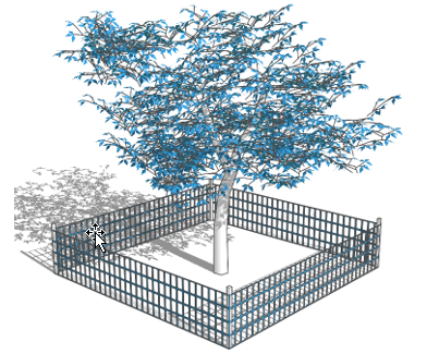
Figure 4-1: Protective Fencing for Trees
(4)
Bark Protection In situations where a protected tree remains in the immediate area of intended construction, the tree shall be protected by enclosing the entire circumference of the tree with two-inch by four-inch lumber encircled with wire or other means that do not damage the tree. This will protect the bark of the tree against incidental contact by large construction equipment.
(f)
Prohibited Activities Adjacent to Trees The following activities shall be prohibited within the limits of the critical root zone of any protected tree, subject to the requirements of this ordinance:
(1)
Material Storage No materials intended for use in construction, or waste materials accumulated due to excavation or demolition, shall be placed within the limits of the critical root zone of any protected tree.
(2)
Equipment Cleaning/Liquid Disposal No equipment shall be cleaned, or other materials or liquids deposited or allowed to flow over land, within the limits of the critical root zone of a protected tree. This includes, without limitation, paint, oil, solvents, asphalt, concrete, mortar, or similar materials.
(3)
Tree Attachments No signs, wires, or other attachments other than those of a protective nature shall be attached to any protected tree.
(4)
Vehicular Traffic No vehicular and/or construction equipment traffic or parking shall take place within the limits of the critical root zone of any protected tree other than on an existing paved street or parking lot. This restriction does not apply to single incident access within the critical root zone for purposes of clearing underbrush, establishing the building pad and associated lot grading, vehicular traffic necessary for routine utility maintenance or emergency restoration of utility service or routine mowing operations.
(5)
Grade Changes No grade changes over two inches (cut or fill) shall be allowed within the limits of the critical root zone of any protected tree unless adequate construction methods are utilized which have been approved by the Urban Forester.
(g)
Permitted Construction Methods
(1)
Boring Boring of utilities under protected trees may be required in certain circumstances. When required, the length of the bore shall be at a minimum the width of the critical root zone and shall be at a minimum depth of 48 inches.
(2)
Grade Change Grade changes within the critical root zone of a protected tree should not exceed two inches. If more than 25 percent of the critical root zone is disturbed by trenching or a grade change greater than two inches, the applicant may be required to prune the root zone or tree canopy in accordance with industry standards, or to take some other mitigative measure to help preserve the health of the tree.
(3)
Trenching All trenching shall be designed to avoid crossing the critical root zone of any protected tree.
(4)
Root Pruning All roots two inches or larger in diameter that are exposed because of trenching or other excavation, shall be cut off and covered with pruning compound within two hours of initial exposure.
18.04.106 - Wildland Interface/Fire Safety
Development within City of Reno limits that are located within a high or extreme fire risk Wildland-Urban Interface (WUI) Area shall follow requirements set forth in the State's adoption of the Wildland-Urban Interface Code under NRS Chapter 477 and NAC Section 477.281. The regulations in this Title are intended to mitigate the risk to life and structures from intrusion of fire from wildland fire exposures from adjacent structures and to mitigate structure fires from spreading to wildland fuels. A vegetation management plan shall be submitted to the Administrator, the Reno Fire Department and the State Forester for review and approval as part of the plans required for a building permit or discretionary approval. Fire Risk ratings for properties within Washoe County can be found on the Washoe Regional Mapping System.
(a)
At a minimum, the vegetation management plan shall include a fuel loading plan and related provisions to minimize wildfire hazards.
(b)
Deviations from the landscape requirements in Chapter 18.04 Article 8 may be made by the Administrator, if required to mitigate wildland-urban interface concerns.
18.04.107 - Source Water Protection
(a)
Purpose The purpose of this section is to reduce threats to public health and safety by reducing the contamination risk for public drinking water supplies.
(b)
Potentially Contributing Uses The following land uses pose a moderate to high risk of contamination of drinking water supplies and are classified for purposes of this section as "Potentially Contributing Uses":
(1)
Public Park or Recreation Area
(2)
College, University, or Seminary
(3)
School, Secondary
(4)
School, Vocational or Trade
(5)
Healthcare Facilities (all uses)
(6)
Agricultural, Animals, and Farming (all uses)
(7)
Cleaners, Commercial
(8)
Amusement or Recreation, Outside
(9)
Sports Arena, Stadium, or Track
(10)
Airport Operations and Facilities
(11)
Auto Service and Repair
(12)
Gas Station
(13)
Truck Stop / Travel Plaza
(14)
Industrial Uses (All Uses)
(c)
Design and Operation Considerations Potentially Contributing Uses shall carefully consider, as applicable:
(1)
The primary and secondary containment of potential contaminants on site;
(2)
Overflow alarms and their maintenance;
(3)
Standard operating procedures for storage and handling of hazardous material(s) or other potential contaminant(s); and
(4)
What to do in the event of an emergency including notification procedures in the event of a release of hazardous material(s) or potential contaminant(s) and an employee training program regarding the above.
(d)
Coordination with Public Water Provider New construction, establishment, or expansion of a Potentially Contributing Use requiring a new or revised business license or development permit shall comply with the following standards. This is not required with a change in ownership.
(1)
Show documentation that notification has been submitted to the Truckee Meadows Water Authority (TMWA) before plans are approved or a building permit or business license is issued.
(2)
Notification will contain the property's Assessor's parcel number(s) (APN), the applicable permit or application number, the type(s) of Potential Contributory Use, and contact information.
(3)
Notification information may be used by TMWA to identify risks and promote actions that reduce potential for contamination of drinking water supplies. TMWA may contact the development/business to provide educational information regarding water quality risks, water pollution prevention plans, and applicable local, state, and federal requirements.
18.04.108 - Wildlife Habitat Management
(a)
Feral Horse Management
(1)
Applicability Properties that abut or have access to the Virginia Range (consisting of the area bounded on the North by Interstate 80, on the East by Highway 95A, on the South by Highway 50, and on the West by Old Highway 395) shall incorporate the following standards into any new development:
a.
Fencing Plan A fencing plan shall be provided that demonstrates the following:
1.
Contiguous horse fencing with no gaps through which horses may enter the property in accordance with NRS 569.431.
2.
Cattle guards (installed inside the project fencing) with welded "hoof stops" and self-closing gates that open outward installed at all locations where roadways cross the perimeter fencing.
3.
Six-foot wide, self-closing pedestrian gates that open out installed at all locations where sidewalk/pedestrian pathways cross the perimeter fencing. Pedestrian gates installed near cattle guards may double as emergency exits for horses that may become stuck inside the gate.
4.
A return gate, or gates shall be installed in the perimeter fence line to facilitate returning horses to the range side of the fencing should they ever enter the neighborhood. Gates shall be a minimum of ten feet wide. Panel gates or equivalent that do not allow for passage or horses when closed shall be used. Gates shall be secured for emergency access only with daisy chain or independent locks that will allow for emergency access.
Said fencing plan shall be approved prior to the issuance of any building permit and all required fencing, cattle guards, and/or pedestrian gates shall be installed prior to any construction, including grading, commencing.
b.
Maintenance and Monitoring
1.
Perimeter fencing shall be maintained by the developer during construction and maintenance responsibility shall be transferred to a homeowner's association, landscape maintenance association, or other similar entity upon formation.
2.
The party responsible for maintaining the fence shall maintain a contract for on-call fence repair to expedite response (within 48 hours of notice) to repairs as needed.
3.
During construction, the developer will require its contractor to provide a gate monitor for roadway crossings with an emphasis on monitoring areas on the property with potential ingress/egress to existing improved areas.
c.
Additional Improvement Requirements
1.
Turf shall be prohibited within 200 feet of any proposed cattle guard/roadway crossing.
2.
Where open channel drainage facilities cross the perimeter fencing on a subject property, large rip-rap, or other floodway fencing as approved by the Administrator, shall be installed in the drainage channel abutting the perimeter fencing.
3.
If any kind of pre-construction trench for ground testing is dug, temporary fencing must be erected around it until it is filled back in.
4.
Any cattle guard installed before fencing and gate are attached should be either a) covered with steel plates and dirt until fencing and gates are attached, or b) temporary fencing erected around it until such time as the fencing and gates are attached.
5.
As fencing wire is installed, it shall be flagged to be highly visible to both animal and human.
6.
Feral horse informational signs shall be installed near access points leading to the Virginia Range. These signs shall include a message to keep gates closed referencing NRS 207.220, and that it is illegal to feed the horses referencing NRS 569.040.
(b)
Species of Special Concern [reserved for possible future development]
(Ord. No. 6692, § 1(Exh. A), 1-8-25)
18.04.301 - General Compliance with City Standards
In addition to the grading, erosion prevention, and sedimentation control provisions in this article, all land-disturbing activity, including without limitation, grading or tree/vegetation clearance, shall comply with all applicable city standards, including without limitation, the Public Works Design Manual.
18.04.302 - Limits on Grading (Cut and Fill)
(a)
Authority NRS Section 278.250 and NRS Chapter 445A authorize the adoption of grading regulations.
(b)
Purpose The purpose of this section is to:
(1)
Minimize environmental damage associated with grading;
(2)
Encourage balancing the site and reduce importing and exporting soil;
(3)
Limit visual scarring;
(4)
Limit unnecessary site disturbance; and
(5)
Limit impacts to water quality during grading.
(c)
Grading Permit Required No person shall excavate, fill, or otherwise alter the existing grade of any property without first obtaining a grading permit according to the procedures and criteria stated in subsection 18.08.606(b).
(d)
Major Site Plan Review Required An applicant shall obtain a major site plan review permit when engaged in any grading resulting in:
(1)
Grading resulting in cuts deeper than 20 feet and/or fills greater than ten feet in height;
(2)
Hillside development meeting the criteria in Section 18.04.402, Applicability;
(3)
Grading within a major drainageway meeting the criteria in Section 18.04.104(c), Applicability; or
(4)
Grading within the Parks, Greenways, and Open Space (PGOS) District, except for paths, public recreational amenities, or environmental restoration.
a.
Findings The following findings shall be made prior to granting a major site plan review (or conditional use permit, if elevated), in addition to the general major site plan review findings:
1.
The proposed project mitigates environmental degradation, including slope failure, erosion, sedimentation, and stormwater run-off;
2.
The proposed project utilizes grading practices that are appropriate for hillsides and designed to minimize the visibility of unsightly scarring;
3.
The proposed project provides open space based on hillside constraints;
4.
The proposed project adheres to applicable hillside development design standards and to Master Plan provisions related to development in sloped areas; and
5.
The proposed project's site layout and design features adequately mitigate potential visual impacts of development near prominent ridgelines and within other visually prominent areas.
(e)
General Grading (Cut and Fill) Standards
(1)
Preservation of Stable Steep Slopes On all projects that include slopes steeper than three to one, existing stable slopes shall be preserved unless the City determines during subdivision or development review that cut and fill slopes are justified and necessary in the overall design of an otherwise acceptable development.
(2)
Fill Slopes Fill slopes in all zoning districts, including residentially zoned property, adjacent to residentially zoned property shall comply with the standards in Section 18.04.1404, Grading, for all use types.
(3)
Location of Cut and Fill Slopes
a.
Wherever feasible, cut and fill slopes adjoining parcel boundaries shall be located within the parcel that the slope is visible from or within a common area.
b.
Tops and toes of cut and fill slopes steeper than 5:1 at property boundaries shall not encroach into the right-of-way.
c.
Tops and toes of cut and fill slopes steeper than 5:1 shall be located at least 18 inches behind a sidewalk and at least six feet behind the face of a curb where no sidewalk is provided.
d.
Cut and fill slopes exceeding 5:1 shall not be located within ten feet of sewer or storm drain access locations.
e.
The Administrator may approve exceptions to these standards in consultation with the City Engineer for hillside developments and other situations where level areas are not warranted for future sidewalk construction or infrastructure maintenance purposes.
(4)
Noxious Weed Abatement Applications proposing grading activities on sites with noxious weeds, as defined by the State of Nevada, shall prepare and implement a noxious weed monitoring and management plan. The plan shall address construction and post construction activities to monitor, eradicate, and prevent the spread of noxious weeds. The plan shall be implemented and enforced throughout the life of the project.
(5)
Re-Vegetation Required After Final Grading
a.
Temporary stabilization shall be applied in accordance with the Truckee Meadows Construction Site Best Management Practices Handbook and in accordance with the State's General Permit.
b.
Cut and fill slopes steeper than 3:1 shall have riprap and revegetation. Alternative designs may be approved by the Administrator, subject to an approved geotechnical report.
c.
Soil tests shall be conducted after final grading operations are complete and prior to planting to determine required soil amendments that may be needed for the site.
d.
Re-vegetation shall commence the following late fall with approved security and temporary irrigation (if necessary) provided to ensure proper re-establishment of disturbed areas.
e.
All slopes disturbed by grading, including on site/in-lot slopes that are not necessary for construction staging, shall be reseeded with native shrubs, grasses, etc., consistent with existing on-site native vegetation upon completion of final grading. These areas shall be bonded to ensure proper re-establishment of the vegetation, with temporary irrigation if deemed necessary, based on seed mix, and time of year.
f.
The re-vegetation plan shall include plans to stockpile existing topsoil and vegetative strippings and reapply the material to all disturbed areas that are not formally landscaped.
g.
Re-vegetation shall be a uniform perennial vegetative cover with a density of 70 percent of the native background vegetative cover for the unpaved areas and areas not covered by permanent structures.
h.
Rocks used for riprap and retaining walls shall be of a color consistent with the site, or landscaping shall be installed sufficient to provide 20 percent coverage in three years.
i.
Establishment of coverage will be judged at the end of the second or third year of installation by Development Services staff in the form of an administrative decision, subject to appeal.
j.
The Administrator shall monitor the re-vegetated areas to identify problems that could prevent or interfere with successful re-vegetation projects. Monitoring activities should react to problems which include: the establishment of invasive weeds, erosion (rilling) caused by sudden or steady runoff that can damage restored areas, failure or lack of vigor in introduced plants, unfavorable amounts of moisture (too little or too much), and damage resulting from human trespass.
(6)
No Tracking of Grading Material onto Streets or into Storm Drains Material loosened by grading activity shall not be tracked onto adjacent streets or washed down storm drains. The drive apron onto the street shall be stabilized with pavement, gravel, or other approved covering.
(7)
Site Design Applicants for a grading permit with a retaining wall, cut slope, or fill slope exceeding four feet in height shall comply with the slope treatment standards for hillside developments in Section 18.04.409, Slope Treatment, to the satisfaction of the Administrator.
(8)
Tree Protection Applicants for a grading permit shall comply with the tree protection standards in 18.04.105, Tree Protection, as applicable.
(Ord. No. 6692, § 1(Exh. A), 1-8-25)
18.04.303 - Control of Construction Site Discharge
(a)
Enabling Clause The Nevada Department of Environmental Protection (NDEP) has issued a discharge permit to Reno, Sparks, and Washoe County requiring the development, implementation, and enforcement of a regional storm water quality management program. The storm water discharge permit is a component of a national pollutant discharge elimination system (NPDES) established by the Clean Water Act Amendments of 1987. An element of the storm water quality management program is the reduction of pollution from construction sites to the maximum extent practicable in accordance with the NPDES permit issued by NDEP.
(b)
Purpose and Intent The purpose and intent of this section is to:
(1)
Promote and protect the health, safety, and general welfare of the citizens of Reno and enhance and preserve the quality and value of our resources by regulating construction activities.
(2)
Provide for the protection of storm water, ground water, water bodies, watercourses, and wetlands pursuant to and consistent with the Clean Water Act, and NPDES permit granted to the City of Reno.
(3)
Manage and control the amount of pollutants in storm water discharges, soil erosion, sediment discharge, mud and dirt deposits on public roadways, and municipal storm sewer systems caused by or a result of construction activities.
(4)
Ensure adequate drainage, storm water management, and soil conservation measures are utilized at the site of any construction activity.
(c)
Applicability Off-site impacts of erosion and sedimentation from a construction site are prohibited and polluting substances such as construction materials and wastes shall be contained on the site where they cannot drain or be transported by storm water into a water body, channel, or storm drain. Best Management Practices shall be implemented for all construction sites and are mandated for construction sites with a disturbed area of one acre or greater or one acre or less if in a sensitive area or part of a larger planned development according to the performance standards of the "Truckee Meadows Construction Site Best Management Practices Handbook" ("BMP Manual") together with such addendum, all of which are on deposit in the office of the City Clerk, are adopted by reference and incorporated here in and made a part hereof as if set forth in full.
(d)
Regulatory Consistency This section shall be construed to assure consistency with state and federal laws, rules and regulations, including the Clean Water Act and all acts amendatory thereof or supplementary thereto; all NPDES permits issued to the City of Reno; and any other provisions of the Reno Municipal Code. No permit or approval issued pursuant to this section shall relieve a person of the responsibility to secure permits and approvals required for activities regulated by any other applicable rule, code, act, permit, or ordinance. Compliance with this section does not exempt any person from complying with other applicable ordinances, rules, codes, acts, or permits.
(e)
Construction Site Discharge Regulations and Requirements
(1)
Construction permit submittal is required on all projects that may require a grading, site development, building, site drainage, or encroachment permits and will disturb one or more acres of land (including public works projects).
(2)
Prior to the issuance of a construction permit, the following shall be submitted:
a.
Construction permit submittal checklist;
b.
Performance standards compliance checklist;
c.
Copy of notice of intent;
d.
Copy of receipt from NDEP or permit; and
e.
Proof of the SWPPP.
(3)
The installation and maintenance of storm water controls are to be in accordance with the standards as set for in the BMP Manual.
(4)
At the end of construction when the site has been finished and cleaned and permanent erosion controls are in place, a revegetation plan per Chapter 18.08 Administration and Procedures, together with associated security may be required by the city to assure permanent establishment of installed measures.
(f)
Administrative Fees
(1)
The required permit fees are based on the nature or size of the permitted area and are for the purpose of providing administration, inspection, and enforcement of the provisions of this section.
(2)
The City shall collect an administrative service charge for inspection of storm water quality controls, for inspection of appropriate maintenance, for inspection of the measures at the completion of work, and for inspection of measures at the start of each phase of work. The administrative service charge is as set forth in the current resolution and any amendments thereto which establishes the service charges and fees for the City of Reno.
(3)
The above listed fees shall be doubled if the construction activity is commenced prior to the issuance of the required permit and/or installation of storm water controls. Payment of the double fee shall not preclude the City from taking any other enforcement actions within its authority.
(g)
Inspection
(1)
All construction activities that fall within this section shall be subject to the inspection provisions provided herein.
(2)
The City maintains the right to inspect any site of construction activity. The responsible person shall schedule inspection through Development Services. An inspection shall be conducted prior to the initiation of construction to verify placement of storm water controls. Initial inspections shall be requested a minimum of 24 hours prior to the desired time of inspection, excluding Saturdays, Sundays, and holidays. Follow up inspections will not be scheduled but will occur as follows:
a.
Prior to commencing construction when BMP's are in place.
b.
At the end of construction when the site has been finished and cleaned and permanent erosion controls are in place.
c.
Monthly for those sites with a combination of extreme factors including slopes greater than ten percent, proximity to floodplains and waterways, long project duration (more than six months), and environmental sensitivity.
d.
Additional inspections may also occur as deemed necessary by Development Services.
e.
For phased projects, the city shall inspect installed measures per the SWPPP prior to the commencement of each phase.
(3)
If an inspector determines the installed storm water controls are placing the city at risk of violating its NPDES permit, the inspector may order change to the storm water controls. If the change to the storm water controls is not acceptable or is not immediately implemented, enforcement action may be taken.
(4)
Emergency control measures may be ordered when pollutants are leaving the site.
(5)
A complaint of violation shall be promptly investigated.
(h)
Enforcement
(1)
Authority The Administrator is hereby authorized and directed to enforce all the provisions of this article.
(2)
Right of Entry Whenever necessary to make an inspection to enforce any of the provisions of this Title or any other lawful ordinance, the Administrator or their authorized representative may enter the property at all reasonable times to inspect the same or to perform any duty imposed upon the Administrator by this section, provided they shall first present proper credentials and request entry. If entry is refused, the Administrator or their authorized representative shall have recourse to every remedy provided by law to secure entry.
(3)
Notice of Violation Whenever the Administrator finds a violation of the provisions of this article, the Administrator may issue a notice of violation in writing served on the responsible person. The notice of violation will provide a time period in which the corrective action shall be completed.
(4)
Stop Orders A written stop work order may be served on the responsible person, and any such persons shall forthwith stop such work until authorized by the Administrator to proceed with the work.
(5)
Penalty for Violation In addition to any other remedies under this section, a person violating any of the provisions of this article may be subject to provisions of Chapter 1.05, Code Enforcement .
(6)
Nevada Department of Environmental Protection The City may, at its discretion, contact the NDEP for further enforcement.
(7)
Costs Accrued by City Should the City be required to intercede in the installation, maintenance or removal of measures, said costs accrued by the City for time and material necessary to correct the defective installation, maintenance or removal of said measures, shall be levied against the property, and shall be paid in full prior to issuance of any final approval or certificate of occupancy associated with the permit, and prior to issuance of any subsequent permit or start of subsequent phase.
(i)
Disclaimer of Liability The degree of protection required by this section is considered reasonable for regulatory purposes and is based on scientific, engineering, and other relevant technical considerations. The standards set forth herein are minimum standards and this section does not imply that compliance will ensure against all unauthorized discharge of pollutants. This section shall not create liability on the part of the city, any agent or employee thereof for any damages that result from reliance on this section or any administrative decision lawfully made thereunder.
(Ord. No. 6692, § 1(Exh. A), 1-8-25)
18.04.304 - Post-Construction Storm Water Quality Management
(a)
Enabling Clause The Nevada Department of Environmental Protection (NDEP) has issued a discharge permit to Reno, Sparks, and Washoe County requiring the development, implementation, and enforcement of a regional storm water quality management program. The storm water discharge permit is a component of a national pollutant discharge elimination system (NPDES) established by the Clean Water Act Amendments of 1987. An element of the storm water quality management program is the reduction of pollution from construction sites to the maximum extent practicable in accordance with the NPDES permit issued by NDEP.
(b)
Purpose and Intent The purpose and intent of this section is to:
(1)
Prevent threats to public health and safety by regulating storm water runoff discharges from applicable land development projects and other construction activities in order to control and minimize increases in storm water runoff rates and volumes, soil erosion, flooding, stream channel erosion, and non-point source pollution associated with storm water runoff.
(2)
Control and minimize the above impacts through implementation of approved post construction storm water quality management plans that place a strong emphasis on implementing Low Impact Development (LID) principles and techniques that include, but are not limited to disturbing only the smallest area necessary, minimizing soil compaction and imperviousness in drainage and recharge areas, preserving natural drainages, vegetation, and buffer zones, and utilizing on-site storm water treatment techniques to the maximum extent practicable.
(c)
Applicability
(1)
Approved post-construction storm water quality management plans and storm water treatment device access and maintenance agreements are required for the following development activities unless waived according to the terms outlined Section 18.04.304(f):
a.
Any new development involving the following:
1.
Building permits, conditional use permits, and site plan reviews that would create a new industrial, commercial, or civic structures;
2.
Any new development that would specifically enable outdoor material storage; outdoor material loading/unloading; fueling areas; outdoor work, maintenance, and wash areas; spill prevention, containment and cleanup; waste handling and disposal uses; any industrial use that has been assigned a Federal North American Industry Classification System (NAIC) code; and uses defined as "industrial" in Chapter 18.09 Rules of Construction and Definitions.
3.
Final plat and parcel maps that require improvement plans on one or more acres of land;
4.
Grading and site permits involving one or more acres of land except for individual single-family homes;
5.
Development activities defined in Section 18.04.304(c)(1)a.3-4, above, that are smaller than one acre if such activities are part of a larger common plan of development, even though multiple separate and distinct land development activities may take place at different times on different schedules;
6.
Development that will include constructed open channels and local or regional detention basins for flood management;
7.
Development that will disturb less than one acre of land that will also be located within or directly adjacent to environmentally sensitive areas, as defined in the Truckee Meadows Structural Controls Design and Low Impact Development Manual.
(2)
Complete applications for applicable development permits and entitlements that have been submitted before the effective date of the ordinance codified in this section are exempt from the requirements of this section.
(3)
Permits and entitlements that were issued before the effective date of this section shall not be subject to this section if the accompanying permit is valid.
(4)
Permits and entitlements for individual single-family homes and tenant improvements that do not require expansion of the site shall not be subject to this section.
(d)
Application Requirements
(1)
No applicable permit shall be issued until the post construction storm water quality management plan (as described in Section 18.04.304(e)) and storm water treatment device access and maintenance agreement are approved by the Development Services Department.
(2)
Applications meeting the terms of Section 18.04.304(c) shall be accompanied by the following documents in order for the application to be considered complete: two copies of the post construction storm water quality management plan and two copies of the storm water treatment device access and maintenance agreement. The post construction storm water quality management plan and storm water treatment device access and maintenance agreement shall be prepared to meet the requirements outlined in this section.
(3)
Appeals of post construction storm water quality management plan disapprovals for building permits shall follow in accordance with the provisions of Subsection 18.08.307(j), Appeal, and all other appeals shall be filed with the relevant provisions of this title.
(e)
Standards
(1)
Post-Construction Storm Water Quality Management Plan Required for All Applicable Developments A post construction storm water quality management plan shall be prepared by a professional civil engineer, registered in the State of Nevada and prepared using the "Truckee Meadows Structural Controls Design and Low Impact Development Manual" and the "Public Works Design Manual", together with all addendum, as planning and design guidance for the implementation of the post construction storm water quality management requirements described in this section. Storm water quality management plan standards are described in the "Public Works Design Manual." These documents are on deposit with the office of the City Clerk.
(f)
Waivers to Applicability
(1)
Every applicant shall provide for storm water quality management as required by this section, unless a written request to waive the plan requirements is granted by the Administrator.
(2)
Because there may be circumstances when the post construction storm water quality treatment measures described in this section are inappropriate to meet the purpose and intent of this section, the minimum requirements for a post-construction storm water quality management plan may be waived provided that at least one of the following conditions applies to the satisfaction of the Administrator:
a.
The proposed development is not likely to impair attainment of the purpose and intent of this section, or the site conditions are such that of the purpose and intent of this section are unattainable; or
b.
The proposed development is listed under Section 18.04.107, Source Water Protection, and the Administrator determines that the public interest is best served; or
c.
Provisions are made to manage storm water quality by an off-site facility,
1.
An off-site facility is defined as a storm water management measure located outside the subject property boundary described in the permit application for land development activity; and
2.
The off-site facility is required to be in place, to be designed and adequately sized to provide a level of storm water treatment and control that is equal to or greater than that which would be afforded by on-site practices, and there is a legally obligated entity responsible for long-term operation and maintenance of the storm water practice.
(g)
Performance Bond/Security
(1)
The developer shall submit a performance security or bond prior to issuance of a permit requiring post construction storm water quality management in order to ensure that the storm water practices are installed by the permit holder as required by the approved storm water management plan. The amount of the installation performance security shall be the total estimated construction cost of the storm water management practices approved under the permit, plus 20 percent. The performance bond/security can be a stand-alone instrument or may be combined with other required performance securities. The performance security shall be forfeited for failure to complete work specified in the storm water management plan.
(2)
The performance security shall be released in full upon submission of "as built plans" and written certification by a professional civil engineer, registered in the State of Nevada, that the storm water practice has been installed in accordance with the approved plan and other applicable provisions of this section. The Development Services Department will make a final inspection of the storm water practice to ensure that it follows the approved plan and the provisions of this section.
a.
Provisions for a partial pro-rata release of the performance security based on the completion of various development stages can be done if each of the following is satisfied:
1.
At least 50 percent of the secured improvements are completed;
2.
The applicant has submitted an estimate of the work remaining that is sealed by a professional civil engineer registered in the State of Nevada; and
3.
The applicant has provided evidence in a form acceptable to the Development Services Department of replacement security in the lower amount.
(3)
A reduction of the security may be considered once each calendar year or upon completion of 25 percent, 50 percent, or 80 percent of the secured items. The dollar amount of no one item, as set forth in the bond estimate as approved by the city, shall be reduced below ten percent of the original item amount, and further the security shall at no time be reduced below 20 percent of the original security amount until all storm water practices have been completed in a manner acceptable to the city. The following procedure is to be followed when requesting a reduction in security:
a.
The subdivider/developer shall make a formal request in writing to the city that the security be renegotiated.
b.
The project engineer shall provide the city with an estimate of the work remaining in the format as provided by the city.
c.
The city will determine the total amount of security reduction allowed based on the estimated amount of work remaining as provided by the project engineer and verified by the city and shall provide the subdivider/developer with a revised bond estimate.
d.
The subdivider/developer shall submit to the city new security, in the format as provided by the city with a revised bond estimate attached, for the storm water practices remaining.
e.
Upon approval as to legal form of the new security by the City Attorney, the new security will be filed with the City Clerk and the old security document returned.
(4)
In no case shall a reduction in security be construed as constituting a final acceptance of storm water practices by the city, either in whole or in part.
(h)
Maintenance and Repair of Storm Water Quality Facilities
(1)
Access and Maintenance Agreement Prior to the issuance of any permit requiring post construction storm water quality management, the applicant or owner of the site shall execute a storm water treatment device access and maintenance agreement that shall be binding on all subsequent owners of land served by the storm water quality management facility. The agreement shall be approved as to form by the City Attorney's Office. The agreement shall provide for access to the facility at reasonable times for periodic inspection by the City of Reno, or their contractor or agent, and for assessments of property owners to ensure that the facility is maintained in working condition to meet design standards and any other provisions established by this article. The applicant shall record the agreement with Washoe County and provide a copy of the recorded document to the City of Reno before permits may be issued.
(2)
Records of Installation and Maintenance Activities Applicants and/or owners responsible for the operation and maintenance of a post construction storm water quality management facility shall maintain records of all maintenance and repairs. These records shall be made available during inspection of the facility and at other reasonable times upon request.
(3)
Requirements for Maintenance All post construction storm water management facilities shall undergo, at a minimum, an annual inspection by the persons responsible for their operation and maintenance to document and perform maintenance, repair needs, and ensure compliance with the requirements of this article and accomplishment of its purposes. These needs may include but are not limited to removal of silt, litter, and other debris from the catch basins, inlets, and drainage pipes; grass cutting and vegetation removal; and necessary replacement of landscape vegetation. Any maintenance needs found shall be addressed in a timely manner.
(4)
City Inspection of Storm Water Facilities Inspections include, but are not limited to: routine inspections; random inspections; inspections based upon complaints or other notice of possible violations; inspection of drainage basins or areas identified as higher than typical sources of sediment or other contaminants or other pollutants; inspections of businesses or industry of a type which are more likely than the typical discharge to cause violations of state or federal water or sediment quality standards or the NPDES storm water permit; and joint inspections with other agencies inspecting under environmental or safety laws, reviewing maintenance and repair records; sampling discharges, surface water, ground water, and material or water in drainage control facilities; and evaluating the condition of drainage control facilities and other storm water treatment practices.
(5)
Right of Entry for Inspection When Connection is Private to Public When any new connection is made or when any new connection is made between private property and a public drainage control system or sanitary sewer, the property owner shall grant to the City of Reno on a form provided by or acceptable to city the right to enter the property at reasonable times and in a reasonable manner for the purpose of inspection. This includes the right to enter a property when it has a reasonable basis to believe that a violation of this section is occurring or has occurred, and to enter when necessary for abatement of a public nuisance or correction of a violation of this section.
(Ord. No. 6692, § 1(Exh. A), 1-8-25)
18.04.401 - Purpose
The purpose of regulations regarding hillside development is to:
(a)
Acknowledge that, as slope increases, so does the potential for environmental degradation including slope failure, increased erosion, sedimentation, and stormwater run-off;
(b)
Preserve and enhance the beauty of the landscape by encouraging retention of natural topographic features, including prominent ridgelines, major drainageways, and significant rock outcrops;
(c)
Encourage innovative grading practices that are more appropriate in hillsides and hide from public view unsightly scarring;
(d)
Consider that hillside development sites have unique topographic, landscape, and geotechnical settings and thus require site-specific design solutions; and
(e)
Promote the preservation of significant topographic features by retaining portions of development sites as undisturbed open space.
18.04.402 - Applicability
(a)
Hillside development regulations apply to developments that have an average slope, as calculated below, equal to or greater than ten percent or slopes that exceed 15 percent on 25 percent or more of the site.
(b)
Hillside developments greater than ten acres in area shall be subject to the approval of a major site plan review according to Section 18.08.603, Major Site Plan Review.
(c)
Development of one single-family house and permitted accessory structures, activities typically associated with and accessory to legally established uses, and trails shall be exempt from this article's regulations.
(d)
Utility box/well house, back-up generator, and pumping or booster station uses shall be exempt from the conditional use permit process requirement if structures total no more than 2,000 square feet in size on the subject parcel. Compliance with this section shall be verified during building permit review for such facilities.
(e)
The Administer may waive certain hillside development standards on sites no greater than 10 acres in size that meet the threshold to be considered a hillside development only because of prior grading activities and are located in an area that generally does not qualify as hillside development. This exception is appropriate on small infill development sites where the natural environment has been significantly altered.
18.04.403 - Computation of Slope
(a)
Slope shall be computed on the existing slope of the land before any grading for the proposed development has commenced, as determined by a digital slope cell calculation or from a topographic map having a scale of not less than one inch equals 60 feet, and a contour interval of not more than two feet. Average slope of a development and slope cell sizes shall not be derived from lower resolution topographic data.
(b)
Percent slope for cells shall be computed by dividing the contour interval by the horizontal distance between contour intervals then multiplying by 100 percent, or by a comparable digital slope analysis.
(c)
For purposes of determining the applicability of a project to this article's standards, the average slope formula below or a comparable digital slope analysis shall be used.
(Ord. No. 6692, § 1(Exh. A), 1-8-25)
18.04.404 - Required Plans
(a)
Plans for a hillside development shall depict existing contours, proposed finish contours, representative cross sections showing existing and proposed conditions, ridgelines and their proposed treatment, proposed erosion control and slope stabilization techniques, structure siting criteria, building envelopes, any height limitations, any solar orientation considerations, grading treatments necessary to provide access to building envelopes, vehicular circulation routes, and pedestrian circulation routes. Locations of all six-inch caliper or larger trees proposed to be maintained or removed with development shall also be noted on aerial photographs or site plans.
(b)
Additional grading plans and site improvement plans shall be superimposed over a color slope cell map that groups pre-grading slopes into categories identified in Table 4-4, Hillside Density Calculation.
(c)
All projects proposing development on hills or mountains, as shown on the "visually prominent ridgeline and related landforms" map (adopted by reference and available for inspection or purchase at the Administrator's office), shall provide additional application material indicating how mapped ridgelines and other visually prominent portions of the project are proposed to be treated. Application material may include photo simulations, sight-line analyses, three-dimensional models, three-dimensional computer-generated images, or similar representations of the proposed project.
(d)
All required plans shall be wet-stamped, signed, and certified accurate by a civil engineer licensed in the State of Nevada. Scanned copies of stamped plans may be submitted with project applications if original wet-stamped plans are also provided at least ten calendar days prior to a public hearing or administrative decision.
(Ord. No. 6692, § 1(Exh. A), 1-8-25)
18.04.405 - Calculation of Density
To retain the natural features of hillsides, the maximum number of dwelling units shall be reduced as slope increases in accordance with Table 4-4, Hillside Density Calculation, and the following standards:
(a)
General
(1)
Each property to be developed shall be divided into cells of similar slope, utilizing the slope ranges listed in Table 4-4, Hillside Density Calculation.
(2)
The 100-year floodplain of major drainageways plus a 15-foot-wide buffer on both sides shall be excluded from density calculations and shall not be allocated any development for purposes of hillside density calculations. (See Section 18.04.104 for applicable major drainageway standards.) Notwithstanding the above, the area excluded from density calculations shall not exceed 80 feet in width along each major drainageway.
(3)
In zoning districts without residential base density standards, allowable development density shall be based on other applicable provisions of this Title.
(4)
The maximum number of dwelling units allowed by Table 4-4, Hillside Density Calculation, may only be realized if the proposed development complies with all other applicable provisions of this article.
(Ord. No. 6692, § 1(Exh. A), 1-8-25)
18.04.406 - Required Open Space
(a)
Open space shall be preserved in accordance with Table 4-5, below.
(b)
Open space required by other subsections of this article shall be added to open space required by Table 4-5 and may be provided within any slope range.
(c)
Property that is zoned to open space in conjunction with a hillside development shall qualify towards open space required by Table 4-5.
(d)
Required open space areas shall be strategically located to include some of the site's environmental, recreational, or scenic areas. Environmental, recreational or scenic amenities include, but are not limited to, major drainageways, wetlands, riparian vegetation, high value groundwater recharge areas, visually prominent areas (including ridgelines on the "visually prominent ridgelines and related landforms" map), recreational amenities (including connections to off-site amenities), rock outcrops, and viewpoints.
(e)
Required open space shall be retained in a natural state without clearing, grading, or other construction-related disturbance, or shall be restored or improved with landscaping or recreational amenities.
(f)
At its sole discretion, the decision-making body may allow some or all the required open space to be incorporated within private lot lines if the project site meets the following standards:
(1)
The site does not include a major drainageway;
(2)
The site does not abut an existing or planned open space or public recreational area;
(3)
Visual impacts in any sensitive viewshed area are mitigated using alternative means; and
(4)
The alternative site layout is determined to be more compatible with nearby development.
(Ord. No. 6692, § 1(Exh. A), 1-8-25)
18.04.407 - Visually Prominent Ridgelines
Potential visual impacts of development containing ridgelines identified on the "visually prominent ridgelines and related landforms" map shall be mitigated with site design, structure locations, and/or architectural treatments. Techniques to mitigate visual impacts may include preserving ridgelines as open space, providing setbacks from ridgelines and other visually prominent areas, height limitations, structure colors consistent with the natural environment, architectural treatments, or similar techniques. If mapped ridgelines are primarily developed on properties surrounding the proposed development, a similar development pattern may occur subject to design provisions of this section.
18.04.408 - Development on 30 Percent and Greater Slopes
Development on natural slopes greater than 30 percent shall only be permitted in accordance with Sections 18.04.408(a)-(b), below.
(a)
The following developments may be allowed on 30 percent or greater slopes in accordance with other provisions of this Title:
(1)
Communication facilities;
(2)
Recreational facilities;
(3)
Utilities;
(4)
Agriculture;
(5)
Forestry;
(6)
Mining; and
(7)
Residential development at a maximum density of one unit per 40 acres.
(b)
All other development on 30 percent or greater slopes shall comply with the requirements of this Title, this article, and the following conditions:
(1)
A 2:1 ratio of property with slopes under 30 percent shall be added to the project open space requirement for all encroachments of development into 30 percent or greater slopes; and
(2)
Encroachments are determined to improve or not significantly impact the open space network, based on the purpose statement in Section 18.04.401, above.
18.04.409 - Slope Treatment
(a)
Purpose The purpose for these standards is to provide for safe, stable, and aesthetically pleasing artificial slopes that are limited in size and overall steepness.
(b)
General Slope Treatment Standards
(1)
Except where needed for access and circulation, non-natural slopes shall not exceed the following heights, measured in vertical feet from the toe of slope to the top of slope.
a.
Finished slopes of 3:1 or less in steepness are limited to 45 feet in height if facing a public right-of-way, open space, park, or a property not located within the project. Slope height may be increased to 60 feet in height if the slope faces and is partly screened by homes or other buildings within the project area.
b.
Finished slopes steeper than 3:1 are limited to 30 feet in height if facing a public right-of-way, open space, park or a property not located within the project. Slope height may be increased to 40 feet in height if the slope faces and is partly screened by a home or other building within the project area.
(2)
Visually integrate all slope faces (cut or fill) into the natural terrain by a gradual transition or "contouring/rounding" of artificial landforms with the natural terrain to add sinuosity to the grading of the site.
(3)
Cut and fill slopes over 15 feet in height shall provide horizontal and vertical changes to vary the flat-engineered look to these slopes by incorporating varied slope steepness and surface treatments such as talus slopes, embedded boulders, landscaping, rockery walls, or other similar methods to break up these slopes and provide a more natural appearance.
(4)
Retaining walls with landscaping are encouraged for cut and fill slopes that require mechanical stabilization, are over 15 feet in height, and are within or visible from areas with public access. Use of riprap shall be limited to smaller slopes that are screened from public view, and portions of larger slopes when used in conjunction with other stabilization methods.
(5)
Retaining walls shall be constructed with decorative materials such as natural rock, brick, stamped and tinted concrete, stucco-faced concrete, or similar materials. Where used, natural rock shall have a similar appearance to native rock or be decorative in appearance. Surface treatments shall be used as necessary to blend construction rocks with the surrounding natural environment.
(6)
Natural rock is preferred in areas that interface with the natural environment and for smaller walls (generally under 6 feet) where stability is not a significant concern and the wall can be seen from public spaces. Natural rock walls are generally inappropriate for larger walls and shall be limited to walls not exceeding 6 feet in height, with sections up to 8 feet in height allowed when appropriate to reduce grading disturbance.
(7)
Retaining walls greater than six feet in height shall have safety railings or other safety features at the top when accessible from public spaces such as sidewalks, trails, and open space areas.
(8)
Retaining walls visible from areas with public access shall be integrated into the overall grading and landscape plans and shall provide horizontal and vertical changes to vary the flat-engineered look of these walls.
(9)
If two or more retaining walls are used, benches shall be provided between the walls for maintenance access and landscaping. Each bench shall have an average width at least as wide as the height of retaining wall below it. Walls and landscaped benches shall be designed to provide long term planting areas for trees, shrubs, and other landscape material.
(10)
If more than two retaining walls are used, the total slope between the bottom of the lowest wall and the top of the highest wall may not exceed 1:1.
(11)
The Administrator may approve exceptions from these standards when slopes are cut into stable rock or other stable ground material, as determined by a geotechnical report.
18.04.410 - Hillside Architecture
(a)
Hillside adaptive architectural features shall be strategically utilized to reduce grading disturbances in areas where flat homesite pads would generate major grading disturbances and deviations from flat homesite pads would not prevent effective utility and service delivery.
(b)
For the purposes of this section, major grading disturbances include cut or fill slopes steeper than 3:1 that exceed 30 feet in height, cut or fill slopes less steep than 3:1 that exceed 45 feet in height, and fill depths that exceed ten feet at project edges and interfaces with major drainageways.
(c)
Hillside adaptive architectural features include but are not limited to, walkout basements, multi-level foundations, construction of structures on the existing natural grade, and similar techniques. If any of the above-listed major disturbances are proposed, development shall utilize walkout basements, multi-level foundations or construction of structures on natural grade to reduce the size of finished slopes.
18.04.411 - Pedestrian Circulation
(a)
Sidewalks or walkways shall be provided in accordance with a total pedestrian circulation plan that addresses projected needs, including those of school children.
(b)
Safe pedestrian access shall be provided between occupied structures and recreational facilities on or adjacent to the site.
(c)
Sidewalk standards may be modified to minimize grading disturbances.
(d)
The pedestrian circulation plan shall be evaluated with respect to safety, accessibility, and recreational value.
18.04.412 - Reduction of Street Width
On-street parking lanes may be omitted from streets when the result is a substantial decrease in cutting and/or filling. Off-street parking areas shall provide one additional space for each dwelling unit that does not front an on-street parking lane. Local streets may be reduced to 20 feet in width for one-way travel, 24 feet in width for two-way travel (with no on-street parking), or 28 feet in width (with on-street parking on one side of the street). Street width is measures from the face of curb or from the flow line for rolled curbs.
18.04.413 - Alternative Project Design
Alternative designs that exceed the slope treatment standards in Section 18.04.409 or the hillside architecture standards in Section 18.04.410 may be approved with a minor site plan review for projects ten acres or less in size, or with a major site plan review for projects over 10 acres in size. In order to approve alternative slope treatments, the decision-making body shall make the standard findings and a supplemental finding that the proposed slope sizes, slope treatments, and architectural accommodations are appropriate for the site, provide a safe and stable finished grades, and adequately mitigate visual impacts.
(Ord. No. 6692, § 1(Exh. A), 1-8-25)
18.04.501 - Streets
(a)
Street Design: General Standards
(1)
Incorporation of the City of Reno Public Works Design Manual The City of Reno Public Works Design Manual, as amended, is hereby incorporated by reference, and made a part of this chapter as if set forth in full.
(2)
Minimum Street Design Requirements All street design shall conform to the Public Works Design Manual, city standards, application reports and documents, and the requirements in this article.
(b)
Sound Barriers Sound barriers adjacent to public rights-of-way shall be placed within a public improvement easement or on common area parcels. All maintenance of sound walls shall be the responsibility of the adjacent property owner, homeowners association, landscape maintenance association, or other similar body.
(c)
Right-of-Way Dedications
(1)
Dedication of right-of-way shall be mandatory when in accordance with the Regional Transportation Plan, City of Reno Master Plan, Reno Municipal Code, or Public Works Design Manual.
(2)
Dedications will be compensated in accordance with city policy and the regional road impact fee administrative manual.
(3)
Dedication shall be completed prior to or concurrent with issuance of any building permit associated with a discretionary request or that is valued at over ten percent of the assessed value of the structure on the most recent tax rolls.
(d)
Private Streets
(1)
Applicability Developments may be developed with private streets instead of public streets if the development complies with the requirements of this section. Variances to these requirements shall not be permitted.
(2)
Design and Construction Standards Private streets shall conform to the same standards regulating the design and construction of public streets.
(3)
Streets Excluded Arterials, collectors, and routes shown on the multi-modal transportation system map of the Master Plan shall not be used, maintained, or constructed as private streets. The Administrator may also deny the creation of any private street if in the Administrator's judgment the private street would:
a.
Negatively affect traffic circulation on public streets;
b.
Impair access to property either on site or off-site to the development;
c.
Impair access to or from public facilities including schools, parks, and libraries; or
d.
Delay the response time of emergency vehicles.
(4)
Property Owners' Associations Required
a.
Mandatory Association Developments with private streets shall have a mandatory property owners association that includes all property served by private streets. The association shall own and be responsible for the maintenance of private streets and appurtenances. Such documents shall be reviewed and approved by the City Attorney to ensure conformance to this and other applicable city ordinances.
b.
Association Standards The association documents shall be filed of record prior to the approval of the final map. Lot deeds shall convey membership in the association and provide for the payment of dues and assessments required by the association. The association may not be dissolved without the prior written consent of the City. Nor may any portion of the association documents pertaining to assessments and the maintenance of the private streets be amended without the written consent of the City.
(5)
Private Street Lot Private streets shall be constructed within a separate lot owned by the property owners' association. This lot shall conform to the City's standards for public street right-of-way. An easement covering the street lot shall be granted to the City and utility companies providing unrestricted use of the property for utilities and utility maintenance. This right shall extend to all utility providers including telecable companies and emergency services operating within the city. The easement shall also provide the City with the right of access for any purpose related to the exercise of a governmental service or function, including, but not limited to, fire and police protection. inspection and code enforcement. The easement shall permit the City to remove any vehicle or obstacle within the street lot that impairs emergency access.
(6)
Construction and Maintenance Cost The City shall not pay for any portion of the cost of constructing or maintaining a private street including street signs and regulatory signage. Costs incurred for construction will not offset any impact fee charges.
(7)
Utilities Sewer, drainage facilities, and signs placed within the private street shall be installed to City standards. Dedication to the City shall occur prior to acceptance of the development and/or release of securities. All City regulations relating to infrastructure financing, developer cost participation, and capital cost recovery shall apply to developments with private streets.
(8)
Plans and Inspections Developments proposed with private streets shall submit the same plans and engineering information required to construct public streets and utilities. Requirements pertaining to inspection and approval of improvements prior to final map approval shall apply. Fees charged for these services shall also apply. The City may periodically inspect private streets and require repairs necessary to ensure emergency access. The City may take legal action to ensure necessary repairs are made and/or perform the repairs and charge the owners actual costs.
(9)
Access Restrictions The entrances to all private streets shall be marked with a sign stating that it is a private street. Guard houses, access control gates and cross arms may be constructed. All restricted access entrances shall be staffed 24 hours every day or provide an alternative means of ensuring access to the development by the City and other utility service providers with appropriate identification. If the association fails to maintain reliable access as required to provide city services, the city may enter the development and remove any gate or device which is a barrier to access at the sole expense of the association. The association documents shall contain provisions in conformity with this paragraph which may not be amended without the written consent of the City.
(10)
Access Restricted Entrance Design Standards Any private street that has an access control gate or cross arm shall have a minimum uninterrupted pavement width of 22 feet at the location of the access control device. If an overhead barrier is used, it shall be a minimum of 14 feet in height above the road surface. All gates and cross arms shall be of a break-away design. A turnaround space shall be in front of any restricted access entrance to allow vehicles denied access to safely exit onto public streets. The location and design of gates is subject to city approval.
(11)
Waiver of Services The subdivision final map or other final development plan or permit, property deeds, and property owner association documents shall note that certain city services shall not be provided on private streets. All private traffic regulatory signs shall conform to the Manual of Uniform Traffic Control Devices. Depending on the characteristics of the proposed development, services may not be provided.
(12)
Petition to Convert to Public Streets The property owner association documents shall allow the association to request the City to accept private streets and associated property as public streets and right-of-way upon written notice to all association members and the favorable vote of a majority of the membership. However, in no event shall the City be obligated to accept the streets as public. Should the City elect to accept the streets as public, the City may inspect the private streets and assess the lot owners for the expense of needed repairs concurrent with the City's acceptance of the streets. The City will be the sole judge of whether repairs are needed. The city may also require, at the association's expense, removal of guard houses, access control devices, landscaping or other aesthetic amenities located within the street lot. The association documents shall provide for the City's right to such assessment. Those portions of the association documents pertaining to the subject matter contained in this paragraph shall not be amended without the written consent of the City.
(e)
Collector and Larger Roadways Single-family homes that are proposed to have direct driveway access onto collector or larger roadways shall record a notification for future buyers identifying the functional classification of the road providing primary access and the maximum allowable traffic volume for that classification.
18.04.502 - Sidewalks, Curbs, and Gutters
(a)
Applicability
(1)
General Sidewalks, curbs, and gutters shall be required on all lots or parcels of land that are improved or upon which any building or construction shall take place, unless excepted in Subsection (2), below. Sidewalks are required on both sides of all streets, public and private, unless another means of pedestrian access is approved, or if the sidewalk is impractical or is unnecessary for pedestrian access purposes as determined by the Administrator.
(2)
Exceptions Sidewalks, curbs, and gutters are not required in the event of addition or remodel of 500 square feet or less to an existing structure.
(3)
Timing of Determination of Sidewalk Requirements In new developments, sidewalk requirements shall be determined at time of tentative map or parcel map approval. In the absence of any proposed division of land, determinations shall be made at time of entitlement and/or building permit.
(4)
Waiver of Sidewalk, Curb, and Gutter Requirements
a.
Upon application by a property owner and for cause shown, the Administrator may waive the requirement for curb, gutter, and/or sidewalk whenever the Administrator determines that it is not practical to be installed at the time of building or construction due to negative impacts on future road construction or improvements, undesirable obstruction to drainage patterns, flow paths, public safety or where a pedestrian circulation plan has been adopted for an area that indicates no sidewalks are planned for a site.
b.
The Administrator may waive the sidewalk requirement in the event of repair, remodeling, or addition to existing improvements on all parcels of land or for new construction of a single-family residence where sidewalks within 300 feet of the immediate area do not presently exist or where topographic constraints, walls, or landscaping or other obstructions prevent continuous extension on this property or others.
c.
The Administrator may waive or modify sidewalk requirements and allow alternative pedestrian circulation plans for hillside developments, to reduce project grading, or to satisfy Low Impact Development objectives.
d.
No requests for sidewalk waivers will be considered on any parcels of land, which are located within ¼ mile of any school measured in a straight line from property line to property line.
e.
The decision denying the applicant of the sidewalk waiver may be appealed in writing to the Hearing Examiner within ten days after notification of such denial.
(5)
Hold-Harmless Agreement To have consideration for any provisions described in this subsection, the applicant shall provide to the City a hold-harmless agreement, subject to the approval of the City Attorney. The applicant shall also waive any protest or objection pursuant to state statutes to any future assessment district that may be formed to incorporate sidewalk upon all the tracts in the district. Such waiver of protest shall be recorded in the Office of the County Recorder and the provisions thereof complied with by any successor in interest.
(b)
Sidewalk Dimensions
(1)
Sidewalks shall be a minimum of five feet wide along local and residential collector streets.
(2)
Sidewalks shall be a minimum of six feet wide along commercial collector and arterial streets.
(3)
Additional district specific requirements for sidewalks and landscaped parkways are set forth in Articles 8, 9, and 10, below.
(4)
The Administrator may modify minimum sidewalk dimensions to protect existing structures, utilities, street trees, or landscaping; or for consistency with existing sidewalk dimensions on adjacent properties. Any modifications shall maintain sufficient access for people with disabilities.
(c)
Commencement and Completion of Construction Construction of sidewalks, curbs, and gutters shall be commenced within 30 days from the date of issuance of the permit for the work contemplated or the date of completion of the engineering required to establish the street grade, whichever is later, and shall be completed within 60 days from such date.
(Ord. No. 6692, § 1(Exh. A), 1-8-25)
18.04.503 - Utilities and Services
(a)
Sewage Any new subdivision or development within the city shall connect to the City's sanitary sewer system unless the City Council approves an agreement under which sewer service is to be provided by another entity or unless a property owner requests and obtains permission from the City Council to connect to a different sanitary sewer system. If sewer service is provided by an entity other than the City, then the City assumes no liability for the quality and continuity of service. Any necessary sanitary sewer main extension or the upgrading of any existing sanitary sewer system which is necessary to serve the subdivision or development shall be provided by the developer. When an oversized public sewer main is required for future service to other properties, the provisions of Section 12.16.480, Sewer Main Line Extensions, will be followed.
(b)
Water and Fire Hydrants
(1)
The water supply system shall be adequate for all domestic use plus fire protection, which is when the system can furnish the required fire flow from any fire hydrant for the required duration of time while the required residual pressures are maintained in the system. The criteria for determining the above requirements for any specific subdivision or area, shall be the "Standard Schedule for Grading Cities and Towns of the United States with Reference to Their Fire Defenses and Physical Conditions," a publication of the National Board of Fire Underwriters.
(2)
A subdivision or development located outside a water service district that is to be supplied by a source other than the local water utility will require a complete design for the source of supply acceptable to the City. The design, showing pressure, capacity, potential population capable of being served, and the provisions to comply with National Board of Fire Underwriters recommended fire flow, shall be furnished. Any water supply obtained from wells shall be clearly shown on the design. A statement shall be submitted stating the capacity of the well, pressure, the population which can be served from the well or wells, and the state permit number issued for each well. An agreement satisfactory to the City shall be submitted guaranteeing continued water supply for the subdivision or development.
(3)
Water mains to fire hydrants shall conform to recommendations of the National Board of Fire Underwriters, and the number of fire hydrants and their placement throughout the subdivision or development will be specified by the fire department.
(4)
Fire hydrants shall be installed in conformance with City standards. Fire hydrant markers shall be placed as directed by the fire chief.
(c)
Underground Utility Services
(1)
The subdivider or developer shall provide for utility distribution service and facilities to serve each lot of a subdivision or development, including, but not limited to, gas, water, electricity, communication, and cable television. The location and kilovolts are to be shown on project applications to the Development Services Department and on building permit plans for all new or existing power lines to be relocated within and/or adjacent to a project.
(2)
All new or relocated utility distribution and service facilities, including communication and cable television, shall be placed underground except surface mounted transformers located in conformance to applicable setbacks, pedestal mounted terminal boxes, meter cabinets and concealed ducts. Above-ground installations shall be aesthetically screened.
(3)
The Administrator may waive the requirements for undergrounding power lines under the following conditions:
a.
A conflict with the National Electrical Safety Code.
b.
The proposed undergrounding of relocated power lines would result in the need for power line improvements outside and not adjacent to the site in excess of 100 percent of the on-site or adjacent to the site undergrounding costs.
c.
New overhead, relocated, or upgraded service drops are in an area where 90 percent of services within 300 feet are overhead, or where the impact on public or private improvements is deemed excessive.
d.
Public roadway improvements projects including, but not limited to new construction, major repair and maintenance.
e.
Electrical distribution facilities supporting more than 25kV.
(4)
The subdivider or developer is responsible for complying with the requirements of this subsection, and shall make the necessary arrangements with the utility companies involved for the installation of the facilities in accordance with such applicable tariffs, rules and regulations of the utilities as may be on file with the state public service commission, and in accordance with any pertinent franchise arrangements, agreements or contracts.
(5)
The developer of new development with an aggregate 660 feet of street frontage shall underground existing overhead utilities upon the following conditions:
a.
The developer is responsible for all costs of undergrounding the existing facilities, including, right-of-way or easement acquisition, permitting, trenching, street cuts, restoration costs, and adjoining property impacts inclusive of changing out service panels; and
(d)
Water Supply Ditches Any water supply ditch adjacent to residential units is to be fenced in accordance with Section 18.04.809(f) and City standards, to safeguard the public; except specially constructed, privately maintained, decorative streams.
(e)
Regional Utility Corridors A minimum setback of ten feet on each side of a regional utility corridor, as identified in the Truckee Meadows Regional Plan, must be maintained in which only passive uses, including but not limited to parks, trails, parking, landscaping, and fencing are allowed.
(Ord. No. 6692, § 1(Exh. A), 1-8-25)
18.04.601 - Vehicle Access/Circulation and Traffic Analysis
(a)
Site Access: Driveways, Alley Access and Curb-Cuts
(1)
Driveways All driveways shall conform to the following standards unless otherwise approved by the Administrator.
a.
Every development site shall have unobstructed access to a public right-of-way. This access shall intersect the right-of-way at an angle of approximately 90 degrees.
b.
All driveways shall be paved and shall comply with the Public Works Design Manual and Title 12.
c.
Except in conjunction with a single-family, duplex, or triplex residential use, no driveways shall require or encourage a vehicle to back over the property line into a public street right-of-way except that backing into an alley is permitted. Exceptions may be approved by the decision-making body for adaptive re-use projects on sites where the prior use backed onto a street, the street is not an arterial, and safety concerns are sufficiently mitigated. No new driveway access encouraging a vehicle to back over the property line into a public street right-of-way will be permitted on streets which carry more than 4,000 average daily trips.
d.
No driveway shall be less than 20 feet in length as measured from the back of the sidewalk or planned sidewalk to the garage door or the end of paving. Exceptions to this must be approved by the City Engineer.
e.
For residential driveways, the width of a driveway at curb cut shall be no less than 12 feet and shall not exceed 30 feet, and the distance between two or more curb cuts on the same property shall be at least 28 feet. Exceptions to this must be approved by the City Engineer.
f.
For driveways that are not residential, the width of the driveway and distance between two or more curb cuts on the same property shall comply with the Public Works Design Manual and Title 12.
(2)
Curb-Cuts Where parking on any residential lot is accessible from the street, or access for motor vehicles is desired in business, commercial, or industrial use, provisions shall be made for a driveway. All driveway approaches shall enter properties via a standard curb-cut.
a.
Shared Curb-Cuts and Driveways Shared driveways or curb-cuts, and reciprocal access easements may be required by the Administrator along common lot lines as follows:
1.
Where existing abutting property is already developed, driveways and access aisles shall be interconnected unless the abutting property is already developed in such a manner that interconnection is physically or legally impossible. See Figure 4-2, below.
Figure 4-2: Shared Curb-Cuts and Driveways - Developed Property
2.
Where abutting property is not developed and where the owner of the abutting property does not wish to develop concurrently, driveways shall be brought to the common property line so that future interconnection is possible. See Figure 4-3, below.
Figure 4-3: Shared Curb-Cuts and Driveways - Undeveloped Property
b.
Maximum Number of Curb-Cuts The maximum number of curb-cuts from any project or property shall comply with the Public Works Design Manual and Title 12.
c.
Curb Returns Curb returns shall be provided with accessible pedestrian ramps in accordance with City standards when a spandrel style curb-cut is used.
d.
Design and Construction Design and construction of driveways, driveway approaches, and curb-cuts shall comply with the Public Works Design Manual and Title 12.
e.
Separate Access for Service The Administrator may require that separate service access be provided to a development when doing so would result in a reduction in potential vehicular and pedestrian conflicts or improve traffic safety.
f.
Street Reconstruction Projects Whenever a street reconstruction project includes curb and gutter improvements, existing curb-cuts in excess of the requirements of this section shall be removed.
(b)
Vision Triangles Vision triangles and development restrictions shall be provided in accordance with the Public Works Design Manual and Title 12.
(c)
Traffic Impact Analysis (TIA) Requirements
(1)
Purpose of Traffic Studies Traffic impact analyses and traffic entry and access studies (collectively, "traffic studies") are required to:
a.
Ensure that public roadways in the city will continue to function at an acceptable level-of-service and in an acceptable manner for the city as a whole;
b.
Reduce traffic conflicts and hazards, which may compromise safety of the traveling public; and
c.
Help prevent commercial, industrial, and other cut-through traffic from using local residential roadways.
d.
Support the development of a multimodal transportation network.
(2)
Projects that Require a Traffic Impact Analysis
a.
A traffic impact analysis (TIA) shall be submitted concurrently with the submission of an application for a Master Plan amendment, zoning map amendment, tentative map, conditional use permit, minor conditional use permit, major site plan review, minor site plan review, or a building permit, if the site meets any of the following criteria:
1.
Applications generating 200 or more peak-hour trips or that propose a change to roadways in the Regional Transportation Plan (RTP) for Washoe County or the Regional Road Impact Fee (RRIF) Network.
2.
Projects defined as "projects of regional significance" in Section 18.08.601.
3.
Projects that will be phased over a period exceeding ten years (does not apply to Master Plan or zoning map amendments).
4.
Projects that may impact planned roadway projects (e.g., a proposal may require revised access or be located near an arterial intersection).
5.
Projects deemed to have impacts related to intersection capacity, safety, neighborhood, or other concerns as identified by the City of Reno or the State of Nevada Department of Transportation (NDOT).
b.
TIAs submitted for Master Plan or zoning map amendments shall utilize assumptions based on the typical types and intensities of development allowed within the proposed Master Plan and zoning designations.
c.
If a TIA has been previously submitted for a site, a new study shall not be required. However, the Administrator may require an update of the study if the study is more than one year old or if conditions on the site or in the general area of the site have changed substantially.
d.
In addition, the Administrator may require a TIA of any proposed development if there is cause and concern that the development will conflict with existing traffic flows, may impact the traffic operation at intersections, may not provide adequate site access or will likely adversely impact neighborhoods.
(3)
Projects That Require a Traffic Entry and Access Study
a.
All developments for which the estimated trip generation for all uses on the lot collectively is equal to or greater than 100 trips per peak hour, according to Table 4-5, below, shall be required to submit a traffic entry and access study:
b.
As an alternative to Table 4-5, the current edition of Trip Generation by the Institute of Transportation Engineers (ITE) may be used to determine peak hour trip rates.
(4)
Process
a.
Pre-Submittal Conference
1.
Prior to commencing a required traffic study, the applicant's traffic engineer shall confer with the Administrator, and discuss such items as:
[a]
Definition of the study area;
[b]
Level of background traffic;
[c]
Directional distribution of traffic;
[d]
Street and intersection capacity;
[e]
Intersections requiring level-of-service analysis;
[f]
Methods for projecting build-out volume; and
[g]
Considerations for incorporating multimodal elements including walking, bicycling and public transit.
b.
Study Format To facilitate review by other agencies and to promote region-wide uniform requirements for the content and preparation of traffic studies, the Traffic Impact Analysis Guidelines adopted by the regional transportation commission shall be used for formatting any TIA, unless otherwise approved by the City's traffic engineer.
c.
Professionally Prepared All traffic studies shall be prepared and sealed by a Nevada Registered Professional Engineer with experience in transportation planning and engineering.
d.
Preliminary Traffic Studies Where the proposed development is in the preliminary design stage, the city traffic engineer may only require a preliminary TIA, subject to a standard TIA being completed and submitted prior to, or concurrently with, the submission of an application for a development review, tentative map or building permit, whichever occurs first.
(d)
External Street Connectivity Circulation plans for all new subdivisions and other projects that extend streets or gain access from the terminus of existing streets, shall maintain external street connectivity in accordance with the following standards:
(1)
The arrangement of streets in a development shall provide for the alignment and continuation of existing or proposed streets into adjoining lands in those cases in which the adjoining lands are undeveloped and may provide for future development or in which the adjoining lands are developed and include opportunities for such connections.
(2)
Street rights-of-way shall be extended to or along adjoining property boundaries such that a roadway connection or street stub shall be provided for development to future development sites at least every 1/2 mile for each direction (north, south, east, and west) in which development abuts vacant or developable lands, as determined by the Administrator. Such street stubs shall not be required to abut adjacent developed areas that lack existing or planned street connections, or when floodplains, wetlands, steep hillsides, limited access roadways, or other unique site conditions preventing a street connection in the opinion of the Administrator.
(3)
Residential streets affected by external street connectivity requirements may be candidates for traffic calming treatments upon the recommendation of the Administrator, City Engineer, and Fire Marshall.
(4)
Street and sidewalk connections shall be made between neighborhood commercial centers and adjacent residential neighborhoods.
(5)
At all locations where streets terminate with no street connection, but a future connection is planned or accommodated, the application shall install and maintain a permanent sign at the location with the words "STREET MAY BE EXTENDED BY THE AUTHORITY OF THE CITY OF RENO" to inform property owners.
(6)
The Final Map and a disclosure for all residential dwellings shall identify all stub streets and include a notation that all street stubs are intended for connection with future streets on adjoining undeveloped property.
(Ord. No. 6692, § 1(Exh. A), 1-8-25)
18.04.602 - Pedestrian and Bicycle Connectivity
(a)
Sidewalks All pedestrian access shall comply with the standards stated in Section 18.04.502, Sidewalks, Curbs, and Gutters, and the site and building standards in Articles 8, 9, and 10, below.
(b)
On-Site Pedestrian Walkways All development (excluding residential development of four units or less) shall provide an on-site system of pedestrian walkways that meets the following standards:
(1)
Areas to Connect On-site pedestrian walkways shall provide direct access and connections to and between:
a.
The primary entrance or entrances to each building, including pad site buildings;
b.
Any sidewalks, walkways, multi-use paths, or emergency access roads that extend to the boundaries shared with the development;
c.
Any parking areas intended to serve the development;
d.
Any sidewalk system along the perimeter streets adjacent to the development;
e.
Any planned or existing public transit station areas, transit stops, park and ride facilities, or other transit facilities on-site or along an adjacent street;
f.
Any adjacent residential neighborhoods (planned or existing); and
g.
Any adjacent or on-site public park, trail system, open space, greenway, or other public or civic use or amenity (planned or existing).
(2)
Walkway Design Required on-site pedestrian walkways shall be a minimum width of five feet; however, the Administrator and/or City Engineer may require a wider walkway based on site characteristics such as, but not limited to, anticipated pedestrian volume, street classification, zoning, and location within a neighborhood planning area. All required walkways shall:
a.
Be distinguishable from areas used by vehicles using one or more of the following techniques:
1.
Changing surfacing material, patterns, and/or paving color, but not including the painting of the paving material;
2.
Changing paving height;
3.
Decorative bollards; and
4.
Raised median walkways with landscaped buffers;
b.
Be designed with similar and/or complementary details, colors, and finishes as other interconnected walkways;
c.
Include lighting for security and safety;
d.
Provide reasonably direct connections to the locations specified in Subsection (1), above;
e.
Be ADA accessible; and
f.
Not include barriers that limit pedestrian access between the subject property and adjacent properties.
(3)
Pedestrian Access through Parking Areas All parking lots that contain more than 50 parking spaces shall include pedestrian walkways that are delineated with changes of material, elevation, or landscaping through the parking lot to the primary building entrance or a sidewalk providing access to the primary building entrance. At a minimum, walkways shall be provided for every three driving aisles or not more than 180-foot intervals, whichever is less.
(c)
Bicycle Circulation Bicycle access and circulation improvements shall be provided and shall include the bicycle facilities identified in plans that have been formally approved as a component of the City of Reno Master Plan or the and the Regional Transportation Plan, along with bicycle connections to other adjacent bicycle facilities and to major destinations within the project.
(Ord. No. 6692, § 1(Exh. A), 1-8-25)
18.04.701 - Purpose
This article is intended to provide off-street parking and loading facilities in proportion to the generalized parking, loading, and transportation demands of different land uses. This section is also intended to help protect the public health, safety, and general welfare by:
(a)
Avoiding and mitigating traffic congestion;
(b)
Avoiding and mitigating the adverse visual impact of large concentrations of exposed parking;
(c)
Reducing stormwater runoff, reducing heat island effect from large expanses of pavement, improving water quality, and minimizing dust pollution;
(d)
Providing necessary access for service and emergency vehicles;
(e)
Providing for safe and convenient interaction between vehicles and pedestrians; and
(f)
Providing flexible methods of responding to the transportation and access demands of various land uses in different areas of the city.
18.04.702 - Applicability
(a)
New Development Unless otherwise exempted by this article, the standards in this article shall apply to all development and land uses established after the effective date of this Title.
(b)
Existing Uses
(1)
No existing use or structure shall be deemed nonconforming solely because of the lack of off-street parking (including bicycle parking) or loading requirements prescribed in this article, provided that off-street parking and loading facilities existing on the effective date of this title shall not be reduced in capacity, design, or function to less than the minimum standards prescribed in this article, unless required for a public infrastructure project.
(2)
No existing use shall be required to maintain more parking or loading spaces than is required for a new structure or use under this article.
(3)
It shall be unlawful for an owner of a building or land use affected by this section to cause or permit the discontinuance or reduction of required parking or loading facilities without the establishment of acceptable alternative parking or loading facilities that meet the requirements of this title. Parking shall be considered discontinued if it is rented to other uses off-site, or blocked by storage containers, materials, or merchandise.
(c)
Expansion or Increase in Intensity Unless otherwise exempted by this article, the off-street parking and loading standards of this article apply when an existing structure or use is expanded or enlarged, through the addition of dwelling units, gross floor area, seating capacity, or other units of measurement used for establishing off-street parking and loading requirements. Additional off-street parking and loading spaces shall be required only to serve the enlarged or expanded area, not the entire building or use.
(d)
Change of Use Unless otherwise exempted by this article, off-street parking and loading facilities (including bicycle parking) shall be provided for any change of use that would result in a requirement for more parking or loading spaces than the former use as defined in this article. Additional parking or loading spaces shall be required only in proportion to the extent of the change, not for the entire building or use. Relaxation of minimum parking to accommodate changes of use may be approved with a parking demand study subject to the satisfaction of the Administrator.
(1)
Exception
a.
Motel/Hotel Conversions into Housing Additional off-street parking will not be required for the conversion of motels or hotels into long-term, permanent housing.
(Ord. No. 6692, § 1(Exh. A), 1-8-25)
18.04.703 - General Standards
(a)
Parking Available for Use
(1)
All required parking shall be available for use by on-site tenants.
(2)
Unless expressly allowed by this article, all required off-street parking shall be available on-site.
(3)
Garages in multi-family projects shall only qualify as parking if used for parking, with storage restricted. This standard shall be enforced through the establishment of deed and/or lease restrictions prior to occupancy, and the maintenance of such restrictions.
(4)
Areas adjacent to gas pumps, drive through-lanes, loading areas, and similar parking lot features shall not be considered as required parking.
(b)
Maintenance of Parking and Loading Areas
(1)
Surface Maintenance All parking, loading, and service surfaces, curbs, and approaches shall be maintained in good condition, and free of structural hazards.
(2)
Debris and Litter Off-street parking, loading, and storage areas shall be maintained to prevent the accumulation of debris or litter.
(c)
Public Transit Facilities Where the decision-making body determines that a use or development would result in the need for public transit, the owner shall dedicate and construct bus turnouts and shelters in accordance with city standards.
(d)
Public and Semi-Public Parking and Service Areas Public and semi-public parking lots, service areas, loading spaces, drive-in businesses, automobile, mobile home, recreational vehicle and boat sales, and storage areas shall be developed in accordance with the provisions of this section, and shall be subject to review and approval by the Administrator. A person establishing a public or semi-public parking lot shall maintain a permanent sign at each entrance to the parking lot, approved by the Administrator, suitable to apprize potential users of the following information:
(1)
Hours The hours of the day or night during which the parking lot is open for business.
(2)
Rates The rates (if any) charged for parking, and when more than one rate is charged, or when a sliding rate scale is charged. The figures and letters stipulating each rate shall be of uniform size and dimensions and shall be not less than six inches in height and three inches in width.
(3)
Towing
a.
If vehicles in violation of parking rules will be towed from the parking lot, the sign shall state this information.
b.
If vehicles will be towed, the name and telephone number of the operator of the parking lot who may be contacted if a vehicle is towed shall be stated.
(4)
Patron Lot If the parking lot is used exclusively as a patron parking lot, signage shall clearly advise potential users of the terms and conditions of the use.
18.04.704 - Calculation of Parking and Loading Requirements
(a)
Area Measurements All square footage-based parking and loading requirements shall be computed based on gross floor area of the subject use. Structured parking within a building shall not be counted in such computation.
(b)
Fractions When measurements of the minimum number of required spaces result in a fractional number for a project, total parking shall be calculated in accordance with Section 18.09.209, Rounding.
(c)
Parking and Loading for Unlisted Uses For uses not expressly listed in Table 4-6 Off-Street Parking Requirements, the Administrator is authorized to apply the minimum off-street parking space requirement specified in Table 4-6 Off-Street Parking Requirements, to the proposed use (based on operating characteristics, the most similar related occupancy classification, or other factors determined by the Administrator); or
(1)
Establish the minimum off-street parking space requirement by reference to parking resources published by the Institute of Traffic Engineers (ITE) or other acceptable source of parking demand data; or
(2)
Establish the minimum off-street parking space and loading requirements based on a parking and loading demand study prepared by the applicant according to subsection 18.04.704(d), Requirement Based on Demand Study, below.
(d)
Requirement Based on Demand Study Uses that reference 18.04.704(d) have widely varying parking and loading demand characteristics, making it difficult to specify a single off-street parking or loading standard. Upon receiving an application for a use subject to this subsection, the Administrator shall apply the off-street parking and loading standards based on a parking and loading demand study. Such a study shall estimate parking demand for the proposed use based on the recommendations of the Institute of Traffic Engineers (ITE), Urban Land Institute, the American Planning Association, or other acceptable source of parking demand data for uses and/or combinations of uses of comparable activities, scale, bulk, area, and location. For projects requiring 12 or fewer spaces, the Administrator may apply off-street parking and loading standards based on accepted standards without requiring a parking demand study.
18.04.705 - Off-Street Parking Requirements
(a)
Required Amounts of Parking
(1)
Minimum Table 4-6 Off-Street Parking Requirements, sets forth the minimum required amounts of off-street parking spaces for each specified land use. Minimum parking standards are established by district as defined below.
a.
Downtown Parking District
1.
The Downtown district applies to all Mixed-Use Downtown (MD-) districts.
2.
There is no minimum parking requirement in the Mixed-Use Downtown (MD-) districts.
b.
Level 1 Parking District
1.
Minimum parking requirements in the Level 1 district apply to the Mixed-Use Urban (MU) District and Mixed-Use Midtown Commercial (MU-MC) District.
2.
Properties that are partly or entirely located within ¼ mile of Mixed-Use Downtown (MD-) districts or the centerline of the Virginia Street or Fourth Street bus rapid transit routes (measured in a direct line) may provide parking reduced to 60 percent of the Level 1 parking district minimum.
c.
Level 2 Parking District
1.
Minimum parking requirements in the Level 2 district apply to all zoning districts not in the Downtown or Level 1 districts.
2.
Properties within the Level 2 parking district and within 600 feet of the Downtown or Level 1 parking districts may provide parking at an average of the Level 2 district minimum and the nearby parking district minimum.
(2)
Maximum There is no maximum parking limitation.
(3)
Accessory and Temporary Use Parking
a.
Accessory uses shall provide parking in addition to any parking required for the principal use.
b.
Parking is not required for temporary uses.
(b)
Accessible Parking
(1)
Meeting Parking Requirement Accessible parking required by this subsection shall count toward fulfilling the off-street parking requirements of the site.
(2)
Residential Uses
a.
Accessible parking for residential uses of five or more units per lot shall be provided at the rate established by Section 18.04.705(b)(3), below, for nonresidential projects.
b.
Residential uses less than five units per lot shall provide one accessible space for each dwelling unit that is designed for occupancy by people with disabilities.
c.
Resident parking spaces for Assisted Living Facilities shall be at least ten feet wide.
(3)
Nonresidential Uses
a.
Requirement
1.
Except as provided in Sections 18.04.705(b)(3)a.2. and c., below, accessible parking spaces shall be developed at the following rate based on the number of spaces provided, not the number of spaces required:
2.
Accessible parking spaces shall be provided within 100 feet of the building entrance.
b.
Medical Facilities
1.
Facilities providing medical care, such as hospitals, clinics, and medical offices, shall provide accessible parking at least ten percent of the total number of parking spaces provided for each facility.
2.
Facilities that specialize in treatment or services for persons with mobility impairments and outpatient physical therapy facilities, shall provide accessible parking equal to at least 20 percent of the total number of parking spaces provided serving each facility.
c.
Van Parking One in every six accessible spaces shall be van accessible. If only one accessible space is required, that space shall be van accessible.
(4)
Accessible Parking Design Standards
a.
Minimum Dimensions Minimum dimensions of accessible parking spaces shall be as provided as detailed below and shown in Figure 4-4:
1.
All accessible parking spaces shall be a minimum of eight feet wide, 18 feet long, with an adjacent access aisle with a minimum width of five which may be placed between two accessible spaces so as to serve both spaces.
2.
Van accessible spaces shall be a minimum of eight wide, 18 feet long, with an adjacent access aisle which is a minimum of eight wide which may also be placed between two van accessible spaces to serve both spaces.
[a]
All accessible parking spaces
[b]
Van accessible parking spaces
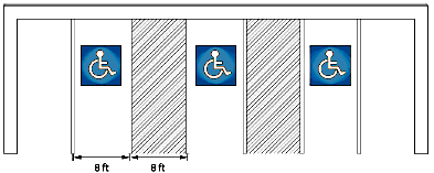
A minimum of 8 feet is required for "van accessible" spaces; other spaces require a minimum of 5 feet.
Figure 4-4: Accessible Parking Spaces
b.
Signage All accessible parking spaces shall be clearly identified with signs as described in the accessible parking sections of NRS Chapter 484 and Section 6.30.400, Handicapped Parking, with a painted symbol. Van accessible spaces shall have an additional sign reading "Van-accessible" mounted below. All signs shall be located so they cannot be obscured by a vehicle parking in the space or by surrounding vegetation.
c.
Clearance All accessible parking spaces shall provide a minimum vertical clearance of eight feet, two at the parking space(s) and along at least one vehicle access route to the spaces from site entrances and exit(s).
d.
Parking Space Slope All accessible parking spaces and access aisles shall be level. Surface slopes shall not exceed 50:1 (two percent) in any direction.
e.
Route to Building Whenever accessible parking is provided, an accessible route shall also be provided which connects accessible parking spaces with main building entrances. This route shall consist of walking surfaces with a slope no greater than 20:1, marked crossings at driveways and other vehicular routes, access aisles, ramps, curb ramps, and/or any other element which is determined by the administrator to be necessary to allow a person with a mobility impairment to travel from the accessible parking spaces to the main building entrances.
f.
The above requirements may be modified by the Administrator based on the Americans with Disabilities Act (ADA) regulations as amended.
(c)
Bicycle Parking
(1)
Requirement Bicycle parking facilities shall be provided as follows:
a.
Minimum Requirement Except for residential uses, a minimum of two bicycle parking spaces is required.
b.
Maximum Requirement Except for residential uses, no more than 30 bicycle parking spaces shall be required for any single use.
(2)
Exempted Uses The following uses are exempted from providing bicycle parking:
a.
All Agriculture, Animals, and Farming uses;
b.
Cemetery of Mausoleum;
c.
Funeral Parlor;
d.
Assisted Living Facility; and
e.
Other uses when the administrator determines that bicycle use would be unsafe or otherwise unnecessary.
(3)
Location and Design
a.
Location All bicycle parking spaces required by this Title shall be located within a building or covered by a roof, awning, or similar shelter structure. The Administrator may waive the shelter requirement or allow for alternative methods.
b.
Right-of-Way Bicycle parking spaces shall not be located fully or partially within a public right-of-way without approval of the City Engineer.
c.
Access and Pedestrian Obstruction All required bicycle parking spaces shall be located so that a minimum six-foot clear pedestrian passage space is provided behind each required space, or a minimum three-foot clear space is provided next to each group of no more than two required spaces. The pedestrian passage space may be within the public right-of-way, or in an area that also serves as parking lot drive aisle, sidewalk, pedestrian route, or similar area.
(Ord. No. 6692, § 1(Exh. A), 1-8-25; Ord. No. 6727, § 3, 10-8-25)
18.04.706 - Parking Alternatives, Credits, and Adjustments
(a)
Generally The Administrator may approve parking alternatives, credits, and adjustments to the off-street parking spaces required by Table 4-6 Off-Street Parking Requirements, in accordance with this section.
(b)
On-Street Parking
(1)
Required parking may be located on-street, subject to the following standards:
a.
On-street parking shall abut the project site;
b.
On-street parking allowed in this subsection shall not be substituted for more than 50 percent of the off-street parking required by this article; and
c.
On-street parking is not for the exclusive use of the property and shall be permitted for use by the general public.
(2)
When an applicant requests the substitution of on-street parking for off-street parking under this subsection for a land use that requires a discretionary review, the body making the final decision on the discretionary review application shall make the determination whether to allow the on-street parking as part of its consideration of the project.
(3)
The Administrator shall review and finally decide all other requests for on-street parking. The Administrator may require that a conditional use permit be obtained from the Planning Commission where there is a dispute related to the location of the on-street parking in relation to the use served or if the Administrator finds that a public review and hearing process is desirable under the circumstances.
(c)
Shared and Off-Site Parking Shared and/or off-site parking is allowed if the shared and/or off-site parking complies with the following:
(1)
Location Standards
a.
In the MU-MC and MU districts, shared and/or off-site parking for nonresidential uses shall be located within 1/4 mile of the property on which the shared parking is provided, as measured along a legal pedestrian route
b.
In all other districts, shared and/or off-site parking for nonresidential uses shall be located within 600 feet of the property on which the shared parking is provided.
c.
The Administrator may authorize farther distances for shared parking facilities where shuttle services are available.
(2)
Shared Parking Rates The total number of spaces may be reduced in one of the following ways:
a.
If the Administrator approves a parking and loading demand study for the combination of land uses. Such a study shall estimate parking demand for the proposed use based on the recommendations of the Institute of Traffic Engineers (ITE), Urban Land Institute, the American Planning Association, or other acceptable source of parking demand data for uses and/or combinations of uses of comparable activities, scale, bulk, area, and location; or
b.
By adjusting parking for joint use of off-street parking areas according to the following percentages listed in the following table, by time of day:
(3)
Parking Agreement Required
a.
Written Agreement The parties involved in the joint use of shared parking facilities and/or the use of off-site parking facilities shall submit a written agreement to the Administrator with the following:
1.
A legal written and recorded agreement;
2.
Proof of continuing use and maintenance;
b.
Approval The Administrator shall approve any agreement prior to issuance of a building permit or business license for any use to be served by the shared and/or off-site parking facility.
(d)
Parking Reduction for Affordable Housing Projects
(1)
Conditions for Parking Reduction Parking reductions for residential developments that meet the affordability guidelines stated in Article 15, Housing, shall be granted if:
a.
The project can demonstrate that either parking cannot be provided in compliance with Section 18.04.705, Off-Street Parking Requirements, or additional amenities can be provided with the reduction of parking; and
b.
Availability of public transportation can be demonstrated.
(2)
Parking Reductions Allowed If the above guidelines are met, then parking may be reduced as follows:
a.
Each unit dedicated to households earning 80 percent of area median income (AMI) may receive a 20 percent reduction to the parking requirements.
b.
Each unit dedicated to households earning 60 percent of AMI may receive a 30 percent reduction to the parking requirements.
c.
Each unit dedicated to households earning 40 percent of AMI or less may receive a 45 percent reduction to the parking requirements.
(e)
Parking Reduction for Solar Panels
(1)
Parking requirements may be reduced by 5% when solar parking structures are installed in the parking lot or solar panels are installed on the site and/or building.
(Ord. No. 6692, § 1(Exh. A), 1-8-25)
18.04.707 - Off-Street Parking Layout and Design
(a)
Use of Parking and Loading Areas
(1)
Except for single-family and duplex dwellings, no required off-street parking or loading space shall be used for any purpose other than the parking of vehicles, unless otherwise allowed by this Title. Off-street parking spaces provided in excess of the number required may be used for any legal purpose within the respective zoning district. If a required off-street parking space is converted to another use or can no longer be used for off-street parking, it shall be deemed a violation of this Title.
(2)
Parking shall be prohibited in aisle ways, fire lanes, or similar areas not officially designated for parking purposes. These areas shall be posted with "No Parking" signs and/or other means as required by the Administrator.
(3)
Required parking spaces and areas shall not be used for the sale, display, or repair of motor vehicles or other goods and services unless authorized by a temporary use permit issued in accordance with Chapter 18.08 Administration and Procedures.
(4)
Vehicles, recreational vehicles, campers, trailers, buses, vans, motor homes, moving vans, refrigerator trucks or similar vehicles shall not be used for storage, overnight occupancy, or any similar use, except as authorized by the Administrator.
(b)
Location Standards Parking lots areas shall be designed to comply with all applicable parking area location and design standards in Sections 18.04.903(a)(3) (Residential Districts), 18.04.1003(a) (Urban Districts), and 18.04.1103(a) (Employment Districts).
(c)
Dimensional Standards
(1)
Parking Spaces and Aisle Widths Parking spaces and aisle widths within parking areas shall be configured according to Table 4-10 and Figure 4-5, below:
Figure 4-5: Off-Street Parking Dimensions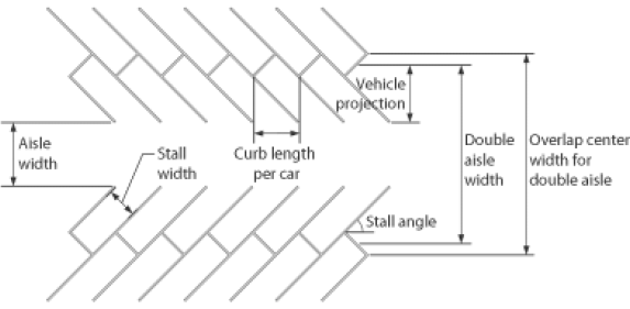
(2)
Compact Spaces for Off-Street Parking
a.
Up to 25 percent of the required number of parking spaces in a parking lot may be sized for compact cars. The compact spaces shall measure a minimum of 8 feet wide by 16 feet long. Each compact space shall be clearly marked "compact only".
b.
Projects on lots no greater than 10,000 square feet in size may reduce the size of all parking stalls to be as small as 16 feet by 9 feet or 19 feet by 8 feet to accommodate site limitations.
(3)
Wheel Stops Wheel stops or other measures that meet the objectives of wheel stops approved by the Administrator shall be provided adjacent to landscaped areas, except a two-foot vehicle overhang may be permitted where parking abuts a sidewalk or landscaping with a minimum width of six feet.
(4)
Parking and Maneuvering Areas To discourage parking in areas with insufficient space, driveways and other parking areas may not be smaller than the minimum size required for an off-street parking space.
(d)
General Standards
(1)
Parking Area Circulation
a.
Adequate ingress, egress, on-premises circulation, and maneuvering areas shall be provided. Interior circulation in parking areas shall be designed to avoid any vehicular stacking on arterial or collector streets as the result of vehicular movements within parking areas.
b.
In cases where an off-street parking lot serving a nonresidential use is located on an abutting lot, connection between the two parking areas via a cross-accessway with a minimum width of 12 feet and a maximum width of 24 feet is strongly encouraged.
(2)
Large Parking Areas Any development that includes 600 or more parking spaces shall either:
a.
Place a minimum of 70 percent of the spaces over 600 within a parking garage; or
b.
Provide enhanced landscaping as required in Section 18.04.804(e).
(3)
Excess Parking If more than 150 percent of the required parking for projects requiring 20 or more parking spaces is provided as surface parking, additional landscaping is required in the amount of an additional ten square feet of landscape area for each parking space in excess of 150%. per Section 18.04.804(e). In lieu of providing the required excess landscaping, a contribution may be made to the City parkway and boulevards landscaping fund. The contribution shall be based on the cost of the additional landscaping which is required.
(4)
Minimizing Vehicular and Pedestrian Conflicts
a.
Traffic control signs and/or striping shall be provided within all parking areas as necessary to prioritize pedestrian safety and minimize vehicular and pedestrian conflicts.
b.
Groundcover adjacent to walkways within or adjacent to parking lots shall be designed to provide level walking surfaces from the walkway to all adjacent parking areas. The use of large rocks and other barriers to pedestrian connectivity shall be avoided.
c.
If vehicular and pedestrian conflicts are apparent, the Administrator may require an alternative design of parking areas to resolve potential conflicts.
(5)
Parking Area Landscaping All parking lot landscaping shall be provided in accordance with Section 18.04.804 Minimum Landscaping Required.
(6)
Parking Area Lighting All parking lot lighting shall be provided in accordance with Section 18.04.1305, Parking Area Lighting.
(e)
Modifications The Administrator may modify the requirements of this section, if in the opinion of the Administrator, a potential traffic safety concern is not present.
(1)
The Administrator may approve alternative parking space sizes and parking area design in order to retain existing trees, native vegetation, or unique, natural features within the parking area.
(2)
The Administrator may approve alternative parking space sizes in parking garages so long as the parking garage will still meet the expected needs of the use.
(3)
The Administrator may approve alternative parking space sizes when it is determined that the reduction is a preferred design component in the implementation of LID objectives.
(4)
The Administrator may allow dedicated employee parking in offices or office complexes with a minimum of 100 stalls to utilize the dimensions given for a nine-foot wide stall, except that the stall width may be reduced to 8 ½ feet.
(f)
Parking Area Construction Materials Parking areas may be constructed of Portland or asphaltic concrete or alternate materials that meet industry standards and can accommodate expected vehicle loads:
(1)
Asphaltic Concrete All off-street parking areas shall be surfaced with a minimum of two inches of asphaltic concrete compacted 95 percent maximum density as determined by ASTM D 1074. Asphaltic concrete shall be placed over six inches of crushed aggregate base compacted to 95 percent maximum density as determined by Nev. T-101.
(2)
Portland Concrete Portland concrete shall meet minimum industry standards.
(3)
Alternate Materials Alternate materials such as pavers and blocks may be used if an engineering study determines that they will support the expected loading and traffic and be sufficiently durable. The use of these materials is subject to the approval of the Administrator.
a.
Curbs Portland cement concrete curbing shall be provided to prevent free roll onto public rights-of-way unless alternative design and/or materials, subject to the approval of the Administrator, are used towards the implementation of LID objectives.
b.
Storage Yards Storage yards may be constructed of Portland or asphaltic concrete or rotomill grindings or alternative materials, subject to the approval of the Administrator.
(g)
Construction of Parking Areas
(1)
Existing Non-Paved Parking In order to reduce air and water pollution, soil erosion, and street sweeping costs, all existing unpaved areas which are used for off-street parking or storage of vehicles shall be paved in accordance with this section within nine months of notice given by the administrator. Temporary construction equipment parking in association with a construction project is exempt. No new unpaved areas may be established as parking areas following the effective date of this article.
(Ord. No. 6692, § 1(Exh. A), 1-8-25)
18.04.708 - Off-Street Loading and Stacking
(a)
Loading and Service Standards
(1)
Number and Size of Loading Areas Off-street loading areas shall be provided for all nonresidential developments as required by Table 4-11, below.
(2)
Location and Design of Loading Areas
a.
Urban Districts Off-street loading areas in Urban Districts shall be designed per Section 18.04.1003, General Standards for Urban Districts.
b.
Employment Districts Off-street loading areas in Employment Districts shall be designed per Section 18.04.1103, General Standards for Employment Districts.
(b)
Vehicle Stacking Where traffic flow is controlled by an entry gate, guard house, or drive-through service facility, an adequate stacking lane, approved by the Administrator, shall be provided in a manner that does not interfere with maneuvering into parking spaces or traffic flow of aisles, streets, bike paths or sidewalks. The following minimum stacking standards shall be met where applicable:
(1)
Car Wash Two stacking spaces required per service lane, plus one stacking space per detailing bay.
(2)
Drive-Through Facility (Food Service)
a.
A minimum of 140 feet of stacking space is required behind the window where payment is made.
b.
A minimum of 100 feet of stacking space is required behind the kiosk/window where orders are taken, which may be part of the 140 feet of stacking space required by subsection a, above.
c.
An additional 40 feet of stacking space is required behind each additional kiosk/window where orders are taken.
d.
The Administrator may require a drive-through stacking and/or queuing analysis.
(3)
Drive-Through Facility (Non-Food Service)
a.
For projects with a single drive up window or machine where payment is made or received, a minimum of 80 feet of stacking space is required behind the window or machine.
b.
If there is a separate window or kiosk where orders are made, a minimum of 60 feet of stacking space is required behind each kiosk/window where orders are made, which may be part of the 80 feet of stacking space required by subsection a, above.
c.
An additional 40 feet of stacking space is required behind each additional kiosk, window, or machine where orders are made.
d.
The Administrator may require a drive-through stacking and/or queuing analysis.
(Ord. No. 6692, § 1(Exh. A), 1-8-25)
18.04.709 - Tandem Parking
Tandem parking will only be permitted in association with:
(a)
Household living uses when all spaces are assigned to the same unit; or
(b)
For valet parking with a full-time attendant. Valet parking spaces shall be no less than eight feet wide by 18 feet long.
18.04.801 - Purpose
The purpose of this article is to establish requirements and standards for landscape and screening to:
(a)
Enhance the aesthetics of the community, including the visual appearance of city streets in all areas of the city;
(b)
Prioritize the planting of shade trees to reduce urban heat, including the planting of large canopy shade trees where feasible;
(c)
Improve the streetscape environment by providing street tree plantings, parkways, and other landscaping in new development and with transportation improvement projects;
(d)
Encourage low impact development (LID) infrastructure that directs stormwater into landscaped or natural areas;
(e)
Promote the use of xeriscape design principles utilizing drought-tolerant or native plants and the efficient use of water;
(f)
Provide for the health and comfort of the public by using landscaping to aid in reducing dust and erosion, promote psychological benefits and natural diversify in the environment, and reduce the effects of heat and cold on buildings, public areas, and parking lots;
(g)
Reduce visual pollution which might otherwise occur within an urbanized area;
(h)
Encourage groundwater recharge, wetland preservation, and associated environmental benefits from open spaces;
(i)
Integrate significant natural features of the city into a landscape that fosters their preservation and enjoyment;
(j)
Promote screening of surface parking lots from public view; and
(k)
Encourage landscaped parkways on all streets.
18.04.802 - Applicability
(a)
New Development The landscaping and screening standards of this article shall apply to all new development except for approved temporary open lot parking or unless otherwise expressly exempted by this article or Title.
(b)
Existing Uses
(1)
Expansion of an Existing Use When an existing site or use that does not comply with the standards of this article is expanded, landscaping shall be provided in an amount that is proportionate to such expansion. Preference shall be given to placing landscaping along public streets and other high-visibility areas. An example is provided below to illustrate this requirement:
(2)
Improvements to Existing Parking Areas When more than 10% percent of an existing parking area is repaved, reconstructed, or expanded, excluding top seal or restriping, (unless the restriping increases or decreases the number of parking stalls by more than 10%), the parking area shall be brought into compliance with the landscaping and screening requirements for parking lots of this article to the extent that the required minimum amount of parking spaces can still be provided. The priority for newly installed landscaping shall be a 5-foot minimum planter along street rights-of-way.
(3)
If development is unable to meet the requirements of this section, the changes or enlargements to a substandard development may be approved through a minor site plan review when the proposed changes are not detrimental to the public health, safety and welfare.
(Ord. No. 6692, § 1(Exh. A), 1-8-25)
18.04.803 - Landscape Plan
(a)
Landscape Plan Required
(1)
Preliminary landscape plans shall be filed with the Administrator for the following:
a.
Any tentative map that includes common area; and
b.
Applications for minor conditional use permit, conditional use permit, minor site plan review, or major site plan review.
(2)
The plan shall, at a minimum, identify all existing trees and all areas to be landscaped, and shall include area and tree calculations, water regime, and general types of landscaping proposed for the areas.
(3)
A final approved landscape plan meeting the requirements of this section shall be submitted and approved prior to the issuance of a building permit to erect or construct any industrial or commercial use, or a model home in a subdivision where the approved tentative map contains 30 lots or more.
(4)
Landscape plans may be combined on the same drawing with required site development plans.
(b)
Exemptions The following are exempted from submitting a landscape plan:
(1)
Single-family and duplex dwellings.
(2)
Building permits for interior remodeling which does not involve a change of use from residential to nonresidential or from single-family or duplex to multi-family use.
(3)
Permits such as, but not limited to, re-roofing, siding, temporary power, change of electrical service, change of furnace, mobile home set up, addition of interior plumbing, addition of interior electrical, fencing, on-premises and off-premises signs, and encroachment.
(4)
Development projects where the existing vegetation to be retained meets or exceeds the requirements of this article.
(c)
Landscape Plans, Generally
(1)
Meet Standards All required landscape plans shall meet or exceed the minimum standards established in this article.
(2)
Professional Preparation
a.
A final landscape plan shall be prepared and sealed by a Nevada-registered landscape architect, architect, residential designer and/or civil engineers, in accordance with NRS 623A.070, as amended.
b.
Plans for residential and nonresidential buildings of 4,000 square feet or less, or office conversions, do not require a signature by a registered landscape architect.
(d)
Approval Procedures
(1)
Approval Landscape plans shall be submitted to and approved by the Administrator before an applicable building permit is issued or final map is approved.
(2)
Changes to Approved Plan The Administrator shall approve any significant changes to the approved plan that affect plant species or irrigation component coverage.
(e)
Installation and Inspection
(1)
Installation Required The approved landscape plan shall be implemented before a certificate of occupancy, or final inspection is issued. However, in the event of a declared drought, during the winter season (October 1—April 30), or for other causes, a temporary or permanent certificate of occupancy may be issued following the filing of a good and sufficient surety bond, cash or a letter of credit. The surety bond shall be written by a surety company authorized to do business in Nevada. The letter of credit shall be issued by a bank as defined by NRS Section 657.010, which is authorized under the provisions of NRS Chapter 659 to do business. The bond, cash deposit, or letter of credit shall be in an amount determined by the Administrator based on cost estimates provided by the applicant plus a 20 percent contingency.
(2)
Inspection Upon installation of landscaping and irrigation systems, the owner shall submit a letter from the landscape architect; or from the responsible party when landscape architect plans are not required. The letter shall state that the installation is in conformance with the approved plans.
(Ord. No. 6692, § 1(Exh. A), 1-8-25)
18.04.804 - Minimum Landscaping Required
(a)
Conflicting Regulations Where the required landscape area standards in this section conflict with a landscaping standard stated elsewhere in this article or this Title, the most restrictive standard shall apply unless otherwise expressly allowed.
(b)
All Districts Street trees shall be prioritized to provide shade for sidewalks, parking areas, and other paved surfaces.
(c)
District-Specific Standards
(1)
Residential Districts The minimum portion of a site to be permanently landscaped shall be:
a.
Single-Family, Detached; Single-Family, Attached; and Duplex Dwellings The required front yard, excluding driveways and sidewalks, shall be landscaped within one year of the issuance of a certificate of occupancy.
b.
All Other Residential Uses Twenty percent of the site.
c.
Reduction Allowed Reductions in the required landscape area may be approved by the Administrator in accordance with Section 18.08.804, Minor Deviation, and NRS Section 278.319. In no case shall the required number of street trees or parking lot trees be reduced.
(2)
Urban Districts The minimum portion of a site to be permanently landscaped except in the Mixed-Use Downtown (MD-) districts shall be:
(3)
Employment Districts The minimum portion of a site to be permanently landscaped shall be:
(4)
Special Purpose Districts The minimum portion of a site to be permanently landscaped shall be:
(d)
Credits Toward Landscaping Requirements
(1)
Landscaping on Parking Structures and in Detention Areas Landscaping on parking structures and within retention or detention areas for stormwater shall be counted toward compliance with this subsection.
(2)
Undeveloped Land Land that will remain undeveloped and undisturbed may be deleted from the total acreage used for the purpose of calculating the landscape requirement, if the Administrator determines that this exclusion meets the statement of purpose for this section.
(3)
Wetlands/Stream Environments
a.
Wetland areas that are preserved and/or enhanced may qualify as a portion of the landscaping required by this section. In no case may the retention of wetlands qualify for more than 50 percent of the required landscaping.
b.
In an established wetland or stream environment, existing Ulmus, Populus, and Salix will be allowed. Any enhancement of the area may not include new plantings of Ulmus, Populus, and Salix without the approval of the urban forester in accordance with Section 8.32.080, Prohibited Trees.
(4)
Common Areas In developments with common areas, the Administrator may administer landscaping standards for the overall project and may give credit to individual parcels for common area landscaping. This credit may only be given once and shall be proportionally equivalent to the required amount of landscaping. The common area landscaping shall be maintained in perpetuity.
(5)
Placement of Required Landscaping Required landscaping may be placed in the public right-of-way (within adjacent parkways and medians) when maintained by the adjoining property owner(s), homeowners, special assessment district, landscape lighting district, or other means approved by the City. Required front yard landscaping may be placed in the public right-of-way to back of curb when the Administrator determines that the pavement width will not need to be increased and sidewalks are not necessary.
(6)
Credit for Preserving Trees Preservation of existing, mature, healthy trees on a site may be credited toward compliance with the minimum tree planting requirements stated in Section 18.04.805(b). Tree credits shall be approved by the Administrator according to the provisions stated in Section 18.04.105.
(e)
Parking Area Landscaping and Screening Requirements
(1)
Applicability The standards in this section shall apply to off-street parking areas in all zoning districts, except for single-family, attached; single-family, detached; or duplex dwellings.
(2)
Surface Parking Lots
a.
Landscape Areas Required
1.
Defining Parking Lots
Landscaping should separate parking lots into a maximum of 350 parking spaces in each
defined lot.
2.
Amount of Landscape Area
[a]
Surface parking lots shall incorporate a minimum of 25 square feet of landscaped area for each off-street parking space.
[b]
The amount of surface parking lot landscaping required by this subsection shall be credited toward the minimum landscape area requirements for the subject zoning district stated in Section 18.04.804, above.
[c]
In no event shall the landscaping provided in surface parking lots be less than 15 percent of the total area of the surface parking lot.
3.
Additional Requirements for Parking Lots with 600 or More Spaces Surface parking lots with 600 or more spaces visible from the public right-of-way shall meet the following additional requirements:
[a]
A 15-foot wide landscape area, which includes a two-foot high berm, wall or hedge shall be placed around the perimeter of the parking area. Where there is a five-foot or greater grade change between the parking area and the site perimeter, the berm may be waived.
[b]
An additional ten square feet of landscape area for each parking space in excess of 600 shall be placed in the interior of the parking area.
4.
Parking Lot Edge
[a]
A parking lot edge shall surround each parking lot and be a minimum of five feet wide excluding any curbing, unless a larger parking edge or perimeter buffer is required by this article. The parking lot edge may overlap any parking setback line. When other provisions of this article require a fully landscaped front, side, or rear yard/setback, and such setback area is larger than five feet and is located in the same place as a required parking lot edge, this provision for a landscaped parking edge shall not apply where the landscaped yard/setback is provided.
[b]
When separating two parking lots, the parking lot edge shall be a minimum of five feet wide (including any curbing) and shall contain an average minimum three-foot high hedge or two-foot berm. Parking lot edges may facilitate the grading and terracing of parking lots on a site or may be used for pedestrian access.
5.
Location of Required Parking Lot Landscape Required landscape areas shall occur entirely within the parking lot and parking lot edge boundaries.
b.
Minimum Requirements for Required Landscape Areas
1.
General Requirements Required landscape areas may take the form of "parking lot edges" or interior "islands" depending on site design and the preservation of natural site features. All landscape areas within parking areas shall:
[a]
Be planted with living plant materials according to this article; and
[b]
Allow for pedestrian walking surfaces across them to provide improved pedestrian circulation across the parking area. Said walking surfaces count towards meeting the landscape area requirement up to a total of 25 percent of the requirement; and
[c]
Have a minimum of one tree for each island with the remaining area in shrubs, ground cover, grasses, or seasonal color; and
[d]
Have a minimum of one tree planted at an average rate of 30 feet on center along any street frontage.
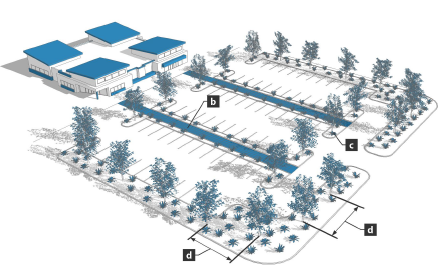
Figure 4-6: Parking Area Landscaping
2.
Tree Placement and Density In meeting the requirement for a minimum number of trees per required landscape area stated in Section 18.04.805(c)(3), below, parking lots that have 12 or more spaces in width shall have at least one island with a shade tree placed so that the parking lot has no more than 12 parking spaces between islands. Parking lots smaller than 12 spaces in width may place shade trees in parking lot edges. Parking lots 12 or more spaces in width shall place shade trees in islands where a parking space would otherwise fit.. Placement of these islands and trees shall be accomplished such that no parking space shall be further than 75 feet from a tree. See Figure 4-6, above.
3.
Tree Size Parking lots shall be entirely landscaped with Class 4 large canopy type trees, unless additional smaller trees are provided to provide comparable shade coverage at maturity. Tree sizes and measurements shall otherwise conform to Section 18.04.805(c)(3).
4.
Islands An island containing at least one tree shall be located in accordance with Subsection 2, above. Islands shall be designed to reflect the size of the adjacent parking space(s). Minimum length for the usable planting area, excluding adjacent curbs or sidewalks, is 14 feet. Minimum width for the usable planting area is 8 feet. Trees shall be placed a minimum of 4 feet from the back of any curb or sidewalk. The location of parking lot islands shall recognize convenient pedestrian circulation routes and walks within the island and shall be planned accordingly. Landscape strips may also be used to address the minimum requirements for parking lot islands and trees.
5.
Soil Preparation Parking lot islands shall be prepared with a minimum three-foot usable soil depth for the entire island area. Except where natural soils are determined to be suitable for healthy tree growth, the entire area of the island shall be excavated to a depth of three feet and backfilled with suitable planting material. Determinations of soil suitability shall made by the landscape architect or other responsible party, as applicable. Planting wells for required trees in parking lot edges shall be similarly prepared with minimum usable soil dimensions of three feet in depth and 25 square feet in surface area.
6.
Placement of Lighting Parking lot lighting shall be located to not be shaded by the expected growth of shade trees.
7.
Existing Trees and Natural Features Notwithstanding the above, the location of landscaped islands should be adjusted to accommodate existing trees or other natural features, provided that the total landscape area requirements are met.
(3)
Screening of Parking from Public Areas
a.
General All parking areas shall be screened from view of public roadways. The screen shall be a minimum of 36 inches in height, and be achieved with street trees and one of the following methods:
1.
A berm (see Figure 4-7);
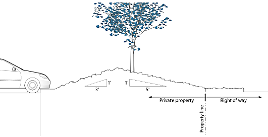
Figure 4-7: Berm Parking Area Screening
2.
A planting screen, including shrubs (see Figure 4-8);
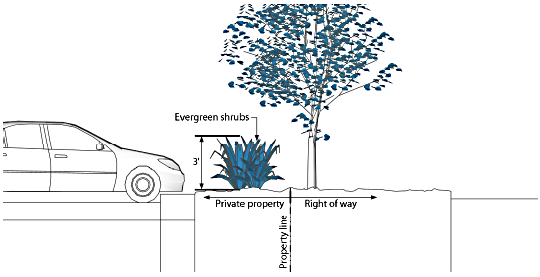
Figure 4-8: Planting Parking Area Screening
3.
A decorative wall (see Figure 4-9); or
4.
A combination of the above, or as shown on the approved detailed site plan.
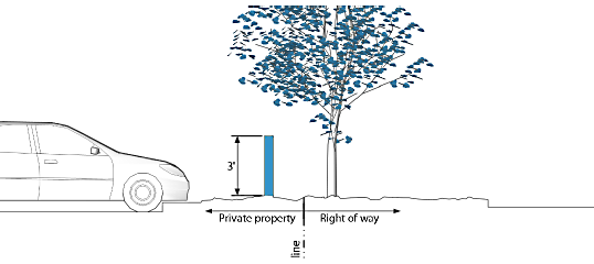
Figure 4-9: Decorative Wall Parking
b.
Parking Lot Edge Screening shall generally be placed within the parking lot edge zone as defined in Section 18.04.804(e)(2), above.
c.
Screening Waiver The screening requirement in this subsection shall be waived when the surface of the entire lot is more than 36 inches below the grade of the street.
(f)
Street Tree Requirements
(1)
Trees Required
a.
Arterials and Collectors
1.
Unless otherwise required, trees shall be planted adjacent to the right-of-way at a minimum average rate of one tree for every 30 feet of street frontage.
2.
Parkway landscaping shall include a minimum of six shrubs per tree and/or living groundcover planted to achieve full coverage at maturity, except for any walkways.
3.
Expanded sidewalks with street trees and furnishings may be provided in lieu of landscaped parkways, to the satisfaction of the Administrator.
b.
Residential Streets
1.
Two street trees shall be planted for each lot up to 50 feet in width and at a minimum average rate of one tree for every 30 feet of frontage over 50 feet. The tree shall be a minimum two-inch caliper tree from the city's permitted street tree list.
2.
The City prefers that all residential street trees be planted in the parkway, if one exists. Where no parkway exists, the Administrator may approve the planting of the required trees between the curb line and the building setback line, but at least 2 ½ feet from the curb line and from the building foundation.
c.
Mixed-Use Downtown (MD-) Districts
All street trees in the MD districts shall meet the standards of the Downtown Streetscape
Design Manual. Where the Downtown Streetscape Design Manual does not identify street
tree requirements, the standard requirements for Arterials, Collectors, and Residential
Streets shall apply.
(2)
Planting Schedule Trees shall be planted prior to the issuance of a certificate of occupancy. The Administrator may allow the planting to occur within the next growing season the required landscaping is bonded or guaranteed as described in Subsection 18.04.803(e), Installation and Inspection.
(3)
Modification of Standards The Administrator may approve a modification of the tree species, tree spacing, planting standard, or location provided that the overall objectives of creating an attractive streetscape are achieved and the approved modification meets the intent of this section.
(4)
Trees in the Public Right-of-Way
a.
Work Permit Required Trees planted or removed from the public right-of-way are subject to the issuance of a tree work permit. Placement, species, and type of tree well covering are subject to City approval prior to the issuance of the tree work permit per Chapter 8.32, Trees and Shrubs.
b.
Maintenance Trees planted in the public right-of-way shall be maintained by adjacent property owners, neighborhood associations, special assessment district or maintenance district formed under NRS Section 278.4787.
(5)
Approved Street Tree Species Street trees shall be selected from the Reno Urban Forestry Commission Approved Street Tree Species List.
(Ord. No. 6692, § 1(Exh. A), 1-8-25)
18.04.805 - Landscaping Standards
(a)
General Materials Requirements All required landscape areas shall be comprised of trees, shrubs, living and/or non-living ground covers, and/or enhanced paving. This area may also include a cover, roof structure or minor structure over a portion of the area, if it will enhance the use of the landscape area. Bare dirt shall not be allowed.
(b)
Minimum Number of Trees and Shrubs in Required Landscape Areas
(1)
All Zoning Districts Except Employment Districts One tree and six shrubs shall be provided for every 300 square feet of required landscaped area, plus any additional trees required by this article.
(2)
Employment Districts One tree for every 300 square feet of required front yard landscaping plus one tree for every ten parking spaces is required. At least 50 percent of the required trees shall be evergreen. If any additional screening is required by this Title, those requirements are in addition to the minimums stated in this subsection.
(c)
Minimum Stocking and Materials Standards All required landscape areas shall comply with the following minimum stocking and materials standards, unless otherwise varied or modified under this Title.
(1)
General Generally, acceptable landscape materials shall include:
a.
Living plant materials.
b.
Alternate materials may be used for playing fields, skywalks, or similar situations with the Administrator's approval.
(2)
Ground Cover Ground cover used in required landscape areas may include the following, or alternatives if equivalent approved by the Administrator:
a.
Lawn or turf.
b.
Living ground covers other than lawn or turf, planted in a manner so the area designed for the ground is at least 90 percent covered at maturity. Ground covers shall be a minimum of a four-inch pot container in size.
c.
Decorative paving, artificial turf, rock, or other inert materials, up to 25 percent of the required landscaped area, unless the Administrator approves a different amount after consideration of the visual appearance of the site. Choices of non-living ground cover should be made after considering the flammability and toxicity of available types. When rock is used on slopes 3:1 or steeper, it shall be fractured at least three-inch minimum. Shredded bark/wood, decomposed granite, or other similar non-stabilized material may not be used on grades greater than 4:1. Landscape walls and retaining walls do not require fractured rock. Loose rock mulch may not exceed 50 percent of the allowed inert materials, with remaining inert materials being an organic mulch such as tree/wood mulch.
d.
Calculation of coverage is by means of the following method:
1.
Grass and ground covers are calculated based on simple area (length × width).
2.
Shrubs should be calculated using the area of a shrub based on spacing. Spacing should be presented in the plant list for use of the landscaper and plan review purposes. Spacing should reflect what the expected average size of the shrub should be in three years.
3.
Calculate the area of shrub coverage based on πr 2 (area of a circle) times the number of shrubs from plant list (π = 3.14, r = radius of shrub spacing).
4.
Total vegetative cover is the sum of all areas covered by grass, ground covers, and shrubs.
5.
Trees do not count toward vegetative cover unless their branches come down to the ground (e.g., many evergreen trees).
(3)
Trees In satisfying the landscaping requirements of this section, the use of high-quality, hardy, and drought-tolerant trees is required.
a.
Size Standards At the time of installation, deciduous trees shall have a minimum caliper of 2 inches, and evergreen trees shall have a minimum height of 6 feet.
b.
Tree Mix A mixture of deciduous and evergreen trees shall be provided. Species diversity is encouraged.
c.
Prohibited Tree List Prohibited trees are listed in Section 8.32.080, Prohibited Trees. The Administrator, in consultation with staff experts, may allow the planting of an otherwise prohibited tree for the purpose of maintaining riparian vegetation and habitat along the Truckee River or in other natural riparian areas.
d.
Tree Well Plantings in Sidewalks and Plazas
1.
Trees shall be placed in landscaped areas no less than five feet in width and length or in tree wells with a minimum five-foot diameter.
2.
The planting hole shall be at least two times the size of the root ball, and deep enough to allow the root ball to be covered in accordance with ANSI A300 (American National Standards Institute) tree and shrub planting standards.
3.
Except where natural soils are determined to be suitable for healthy tree growth, the entire tree well area or a 30 square foot minimum area in the parkway shall be excavated to a depth of three feet and backfilled with suitable planting material. Determinations of soil suitability shall made by the landscape architect or other responsible party, as applicable.
Provisions shall be made for adequate drainage, depending on the soil type and related planting conditions.
e.
Tree Staking All trees shall be staked by an approved method.
(4)
Other Landscape Materials Plant materials used to meet landscape plan requirements shall comply with the following minimum size standards at the time of installation:
a.
Shrubs
1.
Large Shrubs Large shrubs shall be a minimum of a five-gallon container in size.
2.
Small Shrubs Small shrubs shall be a minimum of a one-gallon container in size.
3.
Size Requirements At least 25 percent of the required shrubs shall be a minimum of five-gallon with the remaining 75 percent one gallon or larger.
b.
Ground Covers Ground covers shall be a minimum of four-inch pot container size.
c.
Vines Vines shall be a minimum of a five-gallon container in size.
d.
Grass Solid sod or grass seed applied with Hydro-Mulch may be used.
e.
Annuals and Perennials The use of annuals and perennials are encouraged but do not count toward minimum landscape requirements. There are no size limits.
(5)
Mulch Under all trees and shrubs and anywhere in a required landscaped area not planted with live material or otherwise covered, mulch shall be provided. Mulch may be waived by the Administrator when the landowner has an approved maintenance program and/or has demonstrated acceptable maintenance on past projects. Where mulches are used, they shall be a minimum of four inches in depth to decrease water evaporation. Nonporous material, such as plastic sheets, shall not be placed under the mulch.
(d)
Drainage All trees and shrubs shall be planted with positive drainage.
(Ord. No. 6692, § 1(Exh. A), 1-8-25)
18.04.806 - Water Conservation
To reduce water consumption, all landscaping plans approved under this section shall comply with the following:
(a)
The minimum dimension of each lawn or turf area shall be five feet.
(b)
The maximum slope of lawn or turf areas shall be 3:1. Where a berm is wider than ten feet, one additional foot of level (7:1 or flatter) planted area is required for every three feet of bermed area to capture slope runoff at the toe of the berm.
(c)
In multi-family, Urban Districts, or Employment Districts, or model homes, lawn or turf areas shall not exceed 50 percent of the required landscape area.
(d)
An efficient water-conserving irrigation system including drip, low-arching and/or low-flow heads shall be used.
(e)
Soil in landscape area shall be improved by incorporating a minimum of two inches of organic soil amendment into the top six inches of soil, unless recommended otherwise by the soil report for the property.
(f)
Soil in landscape areas shall be tilled to a minimum depth of six inches for lawn areas, and to the depth of the root ball for shrubs and trees within the planting area to allow for sufficient aeration.
(g)
Non-turf areas shall emphasize low water consumptive plants.
(h)
All debris shall be removed from a planting site prior to soil preparation or planting. Debris includes cement, asphalt, wire, steel, scrap lumber, or other foreign matter.
(i)
Turf and spray irrigation shall be prohibited within 18 inches of all public right-of-way.
(Ord. No. 6692, § 1(Exh. A), 1-8-25)
18.04.807 - Maintenance
(a)
Irrigation
(1)
Irrigation Required All required landscaping shall be irrigated unless approved by the Administrator. Irrigation systems shall be designed for proper irrigation of the plants at maturity.
(2)
Irrigation Plans Irrigation plans that ensure adequate coverage of landscape material shall be submitted at the same scale as the landscape plans. Plans shall also include specifications which comply with the Uniform Plumbing Code, and include the following:
a.
Scale, north arrow, locations of adjacent streets, property lines, easements, sidewalks, drives, paved areas, buildings, street trees, and any other natural or manufactured site features influencing the use of the site.
b.
Identification and description of automatic irrigation components to ensure that vegetation is adequately serviced through water conserving features.
c.
Indication of the system point of connection and size, water pressure available, and maximum demand of the system in gallons per minute.
d.
Manufacturer's name and equipment identification number shall identify irrigation equipment specified.
e.
Reduced pressure backflow preventer (R. P. Device). Refer to water purveyors for requirements for backflow preventers.
f.
All locations of irrigation valves, controllers, hose bibs, quick coupler valves, sprinkler heads, and backflow preventers. Sprinkler location on plans shall also include pattern of sprays (i.e., full circle or half circle), psi, radius of throw, and gallons per minute.
g.
Irrigation details shall be used to clarify particular situations. Typical details should include backflow preventers, valves, irrigation heads, and irrigation controllers.
h.
Schedule 40 PVC with schedule 80 fittings is required on all piping up to three inches in size. For piping over three inches in size, class piping is required. Mainlines shall be a minimum of 24 inches deep with approved backfill. Mainlines shall have detectable tape one foot above line. Lateral lines shall be schedule 40 with a minimum of 18 inches in depth with approved backfill.
(b)
Maintenance
(1)
Maintenance All landscape areas and plant materials shall be maintained in a vigorous and healthy condition, free of weeds and litter. This maintenance shall include weeding, watering, fertilizing, pruning, mowing, edging, mulching, and other needed maintenance, in accordance with generally accepted horticultural practices. This shall include using pruning standards accepted by the International Society of Arboriculture and/or the National Arborist Association.
(2)
Repair and Replacement Any dead plant shall be replaced within 30 days. If the season of the year makes such repair or replacement impractical, the property owner shall schedule an appropriate time for the accomplishment of this work with the Administrator. Damaged plants shall be trimmed to remove dead or damaged material within 30 days.
(3)
Violation If the repair or replacement is not accomplished in a timely fashion as described in 18.04.807(b)(2),above, the Administrator may initiate proceedings to revoke the conditional use permit or business license for the subject property, or use the remedies and fines associated with violations under Title 1, General Provisions.
(4)
Public Maintenance of Landscaping and Irrigation Unless otherwise approved by the City Engineer, landscaping and irrigation that is intended to be owned and/or maintained by the City of Reno shall be reviewed and approved by City Parks Department prior to issuance of building permit.
18.04.808 - Screening
(a)
Conflicting Regulations In case of conflict between the screening standards in this section and any screening standards stated in a different chapter, article, or section of this Title, the most restrictive screening standard shall apply.
(b)
Screening Between Land Uses
(1)
Required Screening Screening shall be required with new development where the new use is different from the existing abutting use, as shown in Table 4-17, below.
a.
Installation Required screening shall be installed by new development that is adjacent to previously developed property.
b.
Substitution of Screening Where a semi-opaque screen is required, a solid screen may be installed.
c.
Maintenance of Screening All screening between land uses installed according to this section shall be maintained for the life of the installing use in good repair and condition sufficient to remain effective for the intended screening purpose.
d.
Alternative Screening Alternative screening may be approved through a minor site plan review, based on the nature and scale of the impacts of the proposed use including, but not limited to, noise, lighting, traffic, and drainage considerations. There are instances where open fencing such as tubular steel and wrought iron may be more appropriate for security and may be approved by the Administrator.
(2)
Exemptions All MD-districts are exempt from the above screening requirements. Additionally, any vertical mixed-use project where multiple uses are proposed in one building are exempt from the above screening requirements.
(3)
Land Use Screening Types The following types of screening shall be used to screen between land uses:
a.
Solid A six-foot high solid masonry, metal, composite, or wood fence with five feet of landscaping adjacent to it with a minimum of one evergreen tree planted every 20 linear feet and a minimum six shrubs planted per tree. See Figure 4-10, below.
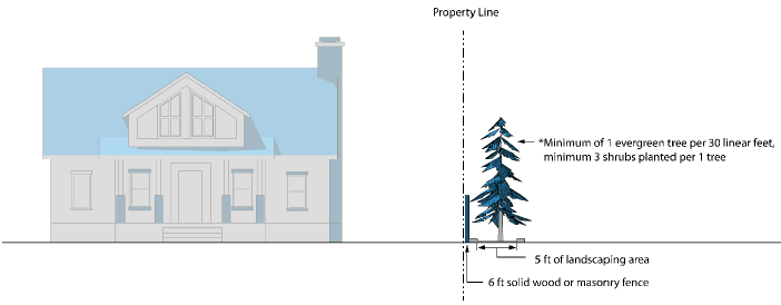
Figure 4-10: Solid Screening
b.
Semi-Opaque
1.
An eight-foot wide landscape area that consists of trees which achieve at least 20 feet in height at maturity and are planted at a rate of every 20 feet and a minimum six shrubs planted per tree, with a three-foot high masonry wall. See Figure 4-11, below.
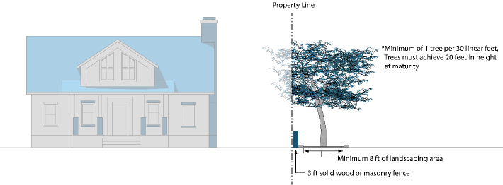
Figure 4-11: Semi-Opaque
2.
A 15-foot wide landscape area that consists of trees that achieve at least 20 feet in height at maturity and are planted at a rate of one for every 20 feet on top of a two-foot high berm interspersed with six shrubs per tree to achieve a screening effect.
3.
A 30-foot wide landscape area that consists of trees planted at a rate of one for every 20 feet and a minimum six shrubs planted per tree.
c.
Wall A six-foot high solid masonry wall with five feet of landscaping adjacent to it with a minimum of one evergreen tree planted every 20 linear feet and a minimum six shrubs planted per tree.
(c)
Screening of Outdoor Service Areas, Utilities, and Equipment
(1)
Trash Receptacles
a.
Applicability To screen trash and recycling receptacles, enclosures shall be constructed with any commercial, office, public building, multi-family building with more than four units, or industrial development, unless otherwise exempted by this section. Additional features may be required by the solid waste provider or environmental control standards.
Figure 4-12: Trash and Recycling Receptacle Screening
b.
Additional/Oversized Enclosures Developments generating ten or more yards of trash per receptacle within any pickup cycle shall expand the size of the enclosure to accommodate demand or shall construct an additional enclosure.
c.
Location of Trash Receptacles
1.
All Uses
[a]
General Trash receptacles shall be located outside building setback lines and buffer yards, and to the side or rear of the principal building. Where the trash receptacle(s) are interior to the site and not visible from any public right-of-way or adjacent property, enclosure may be waived. Trash receptacles may be located on a property line that is adjacent to an alley.
[b]
Adjacent to Residential Properties Trash receptacles shall be screened and odor-controlled. In addition, trash receptacles shall be located a minimum of 25 feet from any residential property line, or as far away from the residential property line as possible.
[c]
The location of the trash receptacle may be modified from these standards, subject to the approval of the Administrator.
2.
Residential Uses Trash storage may be located on a property line that is immediately adjacent to an alley.
3.
Location on Plans Trash enclosure locations shall be indicated on the plans accompanying any application and the plans submitted for building permit approval.
4.
Recycling Containers On-site recycling containers shall be provided for the construction or major renovation of an apartment complex or condominium pursuant to NRS Section 278.02315. On-site recycling containers shall be provided for the construction or major renovation of all non-residential development.
(2)
Mechanical Equipment and Alternative Utility Systems
a.
All mechanical equipment, including, but not limited to, air conditioners, electric meters, heating units, and alternative utility systems (except for wind turbines and solar panels), shall be screened from view of streets and residential areas. This shall apply to equipment and alternative utility systems located on rooftops, at ground level and at any other position upon the structure with the exception of single-family or duplex dwellings and window or wall mounted air conditioners in residential uses and the exceptions identified in Section 18.04.808(c)(2)d, below.
b.
Screening shall be architecturally compatible with the structure, and window mounted air conditioners/heaters in residential buildings shall be considered screened if such equipment consists of a color and material which blends with the rest of the structure, and if the equipment does not extend greater than six inches beyond the plane of the building.
c.
Backflow preventers shall be screened from view of public streets and adjoining properties by low vegetation, walls, covers, or fencing, or other means acceptable to the Administrator.
d.
Every effort shall be made to adequately screen alternative utility systems according to the terms of this section or to integrate them into the design of the primary structure consistent with City design policies; unless it can be proven to the satisfaction of the Administrator that adherence would significantly decrease the efficiency or performance of the system.
(3)
Loading Areas Loading areas shall be located at the side or rear of the building, and screened from view of public rights-of-way, single-family or duplex zoned lots, parks, and other public areas by a screen that is tall enough to screen vehicles and service areas.
(Ord. No. 6692, § 1(Exh. A), 1-8-25)
18.04.809 - Fences and Walls
(a)
Purpose These standards regulate walls, fences, retaining walls, and vertical combinations of those items in order to:
(1)
Provide safety and security for private property;
(2)
Enhance the visual appearance the built environment in the city;
(3)
Establish an attractive streetscape;
(4)
Ensure visual compatibility with public spaces; and
(5)
Promote street and neighborhood character.
(b)
Permit Required Construction of walls, fences, retaining walls, and vertical combinations of those items in the City of Reno shall require a permit in compliance with the provisions and standards stated in this article and in Chapter 14.
(c)
General Standards The following fence and wall standards shall apply in all zoning districts:
(1)
For purposes of this article, on through lots, the front yard shall be the yard adjacent to the street on which the property is addressed and the rear yard shall be the yard opposite the front yard, and walls or fences six feet or less in height may be erected on the rear lot line, except as provided in Section 6.06.090, Same - Designation of Crosswalks and Safety Zones.
(2)
All fencing shall maintain a clear vision triangle in accordance with American Association of State Highway and Transportation Officials AASHTO.
(3)
Where a fence or wall is constructed on top of a retaining wall, the height of such fence or wall shall be measured from the top of the retaining wall.
(4)
Barbed wire, razor ribbon, or razor tape fencing is prohibited, except in UT zoning districts, in conjunction with a public detention or correctional facility, or unless exempted by this Title.
(5)
Public utilities in any zone may be enclosed by a fence six feet in height with barbed wire used above it if the total height thereof does not exceed nine feet. Arms carrying barbed wire shall extend inward or straight up.
(6)
Projects shall be developed so all walls and fences are located on private property or common areas. Fences and walls shall not be placed in the City right-of-way or easements without written approval by the City Engineer. Fences and walls within City right-of-way or easements shall require written agreement with adjacent property owner or applicable maintenance organization.
(7)
Walls or fences adjacent to major drainageways and open space areas shall incorporate open fencing for any portion of a fence or wall that is more than four feet above grade. Chain link is not allowed except where specified.
(8)
Fences or walls proposed outside of a setback area shall be limited to 10' in height limited to side, rear, and secondary front yards.
(9)
Fencing and/or walls used to retain water for flood management and protection are exempt from the height requirements listed in this title.
(d)
Employment Districts (I, IC, ME, and MA) In Employment zoning districts only, the following standards shall apply:
(1)
Walls or fences six feet in height or less may be erected in the required front yard, except as provided in Section 6.06.090, Same - Designation of Crosswalks and Safety Zones.
(2)
Barbed wire may be used above any conventional six-foot fence if the total height does not exceed nine feet. Arms carrying barbed wire shall extend inward or straight up.
(3)
Battery Charged or Electric Fencing Battery charged or electric fencing shall only be permitted on a property that is not designated for residential use, per NRS 268, and shall comply with the following standards:
(a)
Use a battery that is not more than 12 volts of direct current;
(b)
Be surrounded by a nonelectric perimeter fence or wall that is at least five feet in height;
(c)
Not be higher than ten feet in height or two feet higher than the height of the nonelectric perimeter fence or wall described in paragraph (b) whichever is greater; and
(d)
Be marked with conspicuous warning signs that are located on the battery-charged fence and intervals of not more than 40 feet and that read: "WARNING ELECTRIC FENCE"
(e)
All Other Zoning Districts (Residential, Urban, Special Purpose) In all zoning districts, except the employment districts, the following fence and wall standards shall apply:
(1)
Walls or fences six feet or less in height may be erected on lot lines and extending in a generally perpendicular direction from lot lines to buildings in any zone except in required front yards.
(2)
Walls or fences four feet or less in height may be erected in the required front yard area in any zone.
(3)
A fence not to exceed six-feet may be built on front yards not providing primary access with a minimum five-foot setback from the sidewalk or planned sidewalk. The fence setback area shall be landscaping requirements set forth in this Title. For purposes of this subsection the primary access frontage shall be determined by the Administrator based on surrounding characteristics including consistency with adjacent neighbor's yard orientations.
(4)
Notwithstanding Paragraph c., above, if primary access is provided from an alley, a minimum of one front yard setback shall be maintained without fencing over 4 feet in height.
(5)
In residential zoning districts, fence posts may extend up to two feet higher than the fence itself, if the posts area at least six feet apart.
(6)
Where the property abuts an arterial, expressway, or freeway, or any part thereof, fences or walls exceeding six feet in height may be constructed on the property line between the property and the arterial, expressway or freeway, except as provided in Section 6.06.090, Same Designation of Crosswalks and Safety Zones.
(7)
Where side and rear yards in Urban Districts are not located adjacent to a street or residentially zoned property, the Administrator may approve taller fences with barbed wire in accordance is Subsection 18.04.809(d)(2).
(f)
Fencing Standards for Properties/Uses Abutting Water Supply Ditches
(1)
Property Abutting Water Supply Ditches Property abutting or adjoining any water supply ditch shall have 4 ½ foot or taller fencing, approved by the Administrator as reasonably non-climbable and safe, such fencing to have tension wires along both top and bottom, or other adequate means of protection to the specifications of the Administrator, where any water supply ditch constitutes a hazard to the life, limb and safety of the people of the city, such installation to be completed and approved prior to any occupancy other than purely for the purpose of construction.
(2)
Park, Recreation, or Public Use Area Abutting Ditches Where property abutting or adjoining any water supply ditch is a park, recreational area or is otherwise open to public use, the Administrator may, for good cause consistent with public health and safety, waive or modify the requirements in Section 18.04.809(f)(1),above.
(g)
Permit Required Construction of fences and walls in the City of Reno shall require a permit in compliance with the provisions and standards stated in this Title. Some fences may also require a building permit, as specified in Chapter 14.18, Fences, and Title 14.
(Ord. No. 6692, § 1(Exh. A), 1-8-25)
18.04.901 - Purpose
This purpose of this article is to support the implementation of the Neighborhood Design Principles and Neighborhood Corridor Design Principles contained in the City of Reno Master Plan. Principles generally promote high-quality residential development and construction that enhances the character and livability of Reno's neighborhoods, expands housing diversity, and enhances multimodal transportation options. Specifically, the standards in this article:
(a)
Protect public health and safety;
(b)
Promote variety and visual interest in the design of new residential developments;
(c)
Enhance connectivity within and between neighborhoods and to other destinations;
(d)
Expand access to neighborhood services and amenities; and
(e)
Enhance the compatibility of residential infill and redevelopment projects with surrounding neighborhoods.
18.04.902 - Applicability
(a)
District Applicability
(1)
This article shall apply to all development in the following districts unless otherwise noted in the subsections below:
a.
LLR-2.5 Large-Lot Residential (2.5 acres)
b.
LLR-1.0 Large-Lot Residential (1.0 acres)
c.
LLR-.5: Large-Lot Residential (0.5 acres)
d.
SF-3: Single-Family Residential
e.
SF-5: Single-Family Residential
f.
SF-8: Single-Family Residential
g.
SF-11: Single-Family Residential
h.
SF-14: Single-Family Residential
i.
MF-14: Multi-Family Residential
j.
MF-21: Multi-Family Residential
k.
MF-30: Multi-Family Residential
(2)
Nonresidential development within or adjacent to the above zone districts shall also meet the standards of Article 14, Residential Adjacency.
(b)
Project-Specific Applicability
(1)
Within the districts identified in Subsection (a), above, this article applies to the following types of development projects:
a.
Development of any new structure that requires a building permit; and
b.
An addition or renovation to an existing structure where the total gross floor area following the addition or renovation is more than 500 square feet greater than the total gross floor area of the existing structure before addition or renovation.
(2)
In cases where additions or renovations are subject to these standards and full compliance with these standards is not feasible, the resulting project shall result in closer conformance with these standards, as determined by the Administrator.
(3)
For nonresidential and mixed-use development in residential districts, applicants may request that standards in Section 18.04.1003 for the Neighborhood Commercial (NC) District replace this article. The Administrator may approve such a request if the project design is deemed to be compatible with the surrounding development pattern. If necessary to achieve compatibility, the Administrator may require additional design features or consistency with certain design requirements in this article.
(Ord. No. 6692, § 1(Exh. A), 1-8-25)
18.04.903 - General Standards for Residential Districts
(a)
Site Layout and Development Pattern
(1)
Relationship to Major Roadways
a.
Freeway Frontage Developments located along a freeway corridor shall be set back a minimum of 30 feet from the edge of the freeway right-of-way or sound wall and buffered with landscaping. Landscaping within the buffer shall be provided in accordance with Chapter 18.04 Article 8, Landscaping, Buffering, and Screening.
b.
Arterial Streets
1.
Lots and buildings shall be oriented to minimize the impact of arterial streets on neighborhood character, livability, and safety.
2.
Future phases of development and street connections shall be considered when orienting lots and buildings along arterial streets to minimize access limitations.
(2)
Streetscape Design In addition to the standards contained in Article 5, Streets, Utilities, and Services, the following shall apply:
a.
Sidewalks Sidewalks, generally five feet in width, shall be provided in accordance with Section 18.04.502, Sidewalks, Curbs, and Gutters, Section 18.04.602, Pedestrian and Bicycle Connectivity, and the Public Works Design Standards Manual.
b.
Landscape Parkways A minimum five-foot wide landscaped parkway shall be provided between the back of curb and the sidewalk. Landscaping shall be provided in accordance with Article 8, Landscaping, Buffering, Screening, and Fencing. The decision-making body may waive or modify the parkway standard if adjacent properties do not have parkways between the sidewalk and street, in hillside developments, for low impact development designs, or other situations where landscaped parkways are deemed unfeasible or are not desired based on site characteristics or location.
c.
Street Trees and Landscaping Street trees and landscaping shall be provided in accordance with Section 18.04.804(f), Street Tree Requirements.
(3)
Parking and Garage Location
a.
Parking shall be provided in accordance with Article 7, Off-Street Parking and Loading.
b.
Off-street parking is prohibited within the front yard setback unless located on driveways for single-family, duplex, or triplex residences.
c.
For residential driveways, the width of a driveway at curb cut shall not exceed 30 feet, and the distance between two or more curb cuts on the same property shall be at least 28 feet. Exceptions to this must be approved by the City Engineer. Improvements or alterations to the right-of-way require approval by the City Engineer.
d.
For all other uses, parking between residential living areas and street frontages shall be limited to no more than 50 percent of the street frontage.
(4)
Building Orientation
a.
New buildings on sites less than two acres in size shall be oriented towards the primary street frontage, or to the side if direct pedestrian access is provided from the primary street frontage.
b.
New buildings on sites greater than two acres in size, and expansions to existing development on sites of any size, shall be oriented towards the primary street frontage, or have direct pedestrian access from the primary street frontage to all buildings and enhanced landscaping along the street frontage.
(5)
Setbacks and Building Location
a.
Front Yard Setbacks for Infill Lots
1.
Calculation In addition to the requirements of Chapter 18.02 Zoning Districts, front yard setbacks in areas where the predominant development pattern includes single-family and duplex uses, shall either meet the following standards, or the standard setbacks for each zoning district:
[a]
Where a consistent setback (no greater than three feet of deviation) exists along the block face, infill development shall be consistent with the established setback.
[b]
Where a varied setback exists along the block face, infill development shall provide a front yard setback that is within the range of other setbacks provided along the block face.
[c]
When comparing setbacks on a block face, comparison shall be made to a principal structure frontage and shall exclude front porches and similar subordinate features.
[d]
Corner lots shall address these front yard setback standards on the principal street frontage.
[e]
In areas of new development, the developer may determine front setbacks within the limitations of this Title.
[f]
The addition of front porches to existing residences is exempt from these front yard setback standards.
[g]
The Administrator may approve exceptions in areas with unique situations where strict compliance is not feasible or desired.
2.
Allowed Modifications Variances shall not be required for modification of principal front building setbacks if necessary to achieve compliance with these standards.
b.
Accessory Structures in Front Setback On lots with a principal single-family, attached; single-family, detached; or duplex use; accessory structures are prohibited in the area between a front property line and a principal structure unless specifically allowed in Section 18.03.402, Accessory Buildings and Structures in Residential Zoning Districts.
(6)
Cluster Development Cluster development is encouraged to support the protection of sensitive natural resources, viewsheds, or other unique site features; promote fire safety within the wildland interface; provide opportunities for shared common open space; protect documented wildlife corridors; and provide a more gradual transition to the unincorporated county and public lands.
a.
When Allowed Minimum lot size may be reduced through clustering of development if the applicable decision-making body finds that:
1.
The clustering proposal, compared with a more traditional site development plan, better attains the policies and objectives of this article, such as providing more open space, preserving existing trees and vegetation coverage, preserving view corridors, and preserving sensitive environmental areas such as stream corridors, slide areas, wetlands, and steep slopes;
2.
The clustering proposal will have no significant adverse impact on adjacent properties or development, or the applicant has agreed to adopt appropriate mitigation measures such as edge matching, landscaping, screening, illumination standards, and other design features to buffer and protect adjacent properties from the proposed clustered development; and
3.
The clustering proposal meets all other applicable requirements set forth in this article or in other applicable ordinances or regulations.
b.
Eligibility for Density Increase and Lot Modifications
1.
Cluster development may be eligible for exceptions to minimum lot standards.
2.
With approval of a major site plan review in accordance with subsection 18.08.603(e)(3), Cluster Development, cluster development may modify lot dimension standards to result in an increase of overall development density of no more than 15 percent over that which is otherwise permitted by the zoning district in which the lot or parcel is located. Properties subject to the Hillside Development standards in Chapter 18.04 Article 4, Hillside Development, shall not be eligible for this density increase.
c.
Unincorporated Transition Designations Properties within the UT-5, UT-10, and UT-40 zoning designations shall be allowed to use cluster development subject to the provisions above and in subsection 18.08.603(e)(3), Cluster Development, with the following exceptions:
1.
No density increases shall be allowed within these zoning designations.
2.
The applicant shall demonstrate the appropriateness of utility provision.
(7)
Site Compatibility and Adjacency Standards
a.
Applicability New land divisions adjacent to lower density residential zoning districts shall comply with the following standards, as applicable.
b.
Density Transfers To the extent that land in such areas affected by this standard would be buildable under federal, state, or local regulations, the full eligible density may be utilized on other locations on the site, including in other zoning districts. The official zoning map shall be modified to reflect approved transfers.
c.
Large-lot Residential Adjacency Standards To provide adequate transition between varying sizes of single-family residential parcels designated one dwelling unit per five acres to one dwelling unit per acre, the minimum adjacent lot size shall be one acre or one-half the minimum adjacent lot size, whichever is smaller.
d.
Single-Family Residential Adjacency Standards To provide adequate transition between varying sizes of single-family residential parcels designated for greater than one unit per acre density, one of the following methods shall be utilized:
1.
Parcel Size Matching The minimum lot sizes identified in the land use designation of the immediately adjacent property shall be maintained at the edge of the proposed subdivision as depicted in Figure 4-13; or
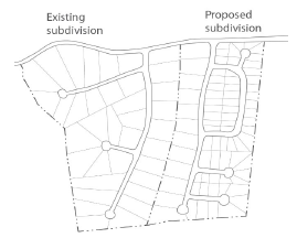
Figure 4-13: Parcel Size Matching
2.
Buffering A "buffer zone" shall be established. When the buffer remains natural vegetation, the buffer zone shall be equivalent to 100 feet or ½ of the average minimum lot depth of the adjoining developed property, whichever is greater (see Figure 4-14). The buffer zone may be common open space for the proposed subdivision and may include paths, trails, or other subdivision amenities. The buffer zone shall be a minimum of 30 feet wide when fully landscaped and maintained. An equivalent combination of natural and landscaped buffer area may be approved by the Administrator; or
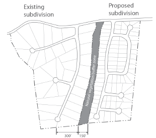
Figure 4-14: Natural Vegetation Buffer Zone
3.
Yard Matching The rear yard widths of the proposed development shall match the rear yard widths of the existing development as depicted in Figure 4-15.
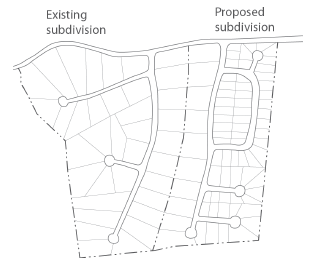
Figure 4-15: Yard Matching
e.
Height Matching Lots proposed within a new subdivision that share a common property line with an established subdivision shall not contain structures within 100 feet of the shared property line that exceed the maximum height of the adjacent equivalent zoning district or land use district.
(b)
Circulation and Access New neighborhoods shall be designed to include an interconnected network of local streets with walkable blocks. In addition to the standards contained in Article 6, Access, Connectivity, and Circulation, the following shall apply:
(1)
Pedestrian and Bicycle Connectivity Any wall, fencing or other barrier that hinders pedestrian and bicycle connectivity to adjacent areas shall be designed to provide access points to abutting streets, sidewalks, parks, and trails, including planned facilities. Exceptions may be approved where topography or other conditions make access infeasible.
(2)
Recreational Access Developments that abut public lands and open spaces at the urban/rural interface shall provide trailheads, connections, and public access from the development to existing or planned trails.
(c)
Building Design
(1)
Additional Setbacks and Stepbacks for Compatibility The following additional standards apply to any new building built within or adjacent to a property zoned LL (all districts), SF (all districts), MF-14, or MD-PD, or adjacent to a mobile home park (regardless of the zoning district).
a.
For any portion of a building above 24 feet in height, a minimum of an additional 1-foot horizontal setback, or 1:1 building height/stepback (see figure 4-16), or a combination thereof is required for each foot of height over 24 feet.
1.
This standard applies to any property line that is abutting the above-mentioned districts.
2.
All property lines that abut a public right-of-way are exempt from the above standard.
3.
Any intrusion that is typically exempt from setback requirements per section 18.09.205 (e) (i.e. cornices, canopies, chimneys, eves, decks, etc.) shall not be exempt from this standard. All intrusions shall meet the 1:1 stepback requirement.
b.
The applicant may apply for a major site plan review if the additional height to setback ratio is not met, but the adjacency to residential is mitigated in other ways.
Figure 4-16: Residential Stepback Example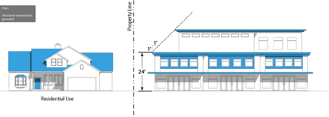
(2)
Stepbacks and Height Limits
a.
Any portion of the building within a certain distance of a property zoned LL (all districts), SF (all districts), or MF-14, or adjacent to a mobile home park (regardless of the zoning district) shall not exceed the following maximum height limits:
1.
Within 75 feet: shall not exceed 60 feet in height
2.
Within 75 feet to 150 feet: shall not exceed 100 feet in height (see Figure 4-17, below).
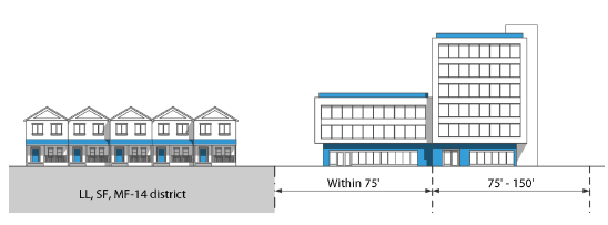
Figure 4-17: Residential Adjacency Stepback and Height Limit
b.
Portions of buildings within 75 feet are not eligible for additional building height incentives that may be available under this Title.
c.
Building features allowed as exceptions to maximum height requirements in 18.09.207(b), Exclusions from Building Height Limits, in are allowed on structures subject to this section, but shall be designed to minimize visibility from adjacent residential districts and fit within the allowed building height of the zoning district where the building is located to the maximum extent practicable.
(3)
Wall Articulation
a.
Blank walls that are devoid of architectural details shall not be permitted. All exterior building facades shall be articulated using design elements as follows:
1.
Variations in roof form or parapet height;
2.
Variations in building height;
3.
Projected or recessed building mass;
4.
Wall plane off-sets;
5.
Window openings;
6.
Balconies;
7.
Distinct changes in texture and color of wall surfaces;
8.
Recessed entries; or
9.
A unique alternative design element as approved by the Administrator.
b.
For duplexes and single-family residences 2,000 square feet or greater, a minimum of four of the design elements listed above shall be incorporated along all street-facing facades. A minimum of two of the above design elements shall be incorporated on all other facades.
c.
For single family residences less than 2,000 square feet, a minimum of three of the design elements listed above shall be incorporated along all street-facing facades. A minimum of one of the above design elements shall be incorporated on all other facades.
d.
For all other development, a minimum of five of the design elements listed above shall be incorporated along all street-facing facades. A minimum of three of the above design elements shall be incorporated on all other facades.
(4)
Ground-Level Interest Ground floors of street facing facades shall have transparent doors or windows no less than three feet in height along at least 20 percent of the facade's horizontal length.
(5)
Alternative Design Approaches The Administrator may approve alternative approaches to, or exceptions to, wall articulation, or ground level interest requirements for building facades that are constructed on side or rear property lines and designed to be attached to future buildings on adjoining parcels or to accommodate the adaptive reuse of:
a.
A vacant or functionally obsolete building;
b.
Historically significant or designated structures; and
c.
Other buildings that contribute to the unique character of the district.
(6)
Shading of Parks and Residences Buildings shall conform with shading requirements in subsection 18.04.101(c), Shading of Parks and Residences.
(Ord. No. 6692, § 1(Exh. A), 1-8-25)
18.04.904 - Additional Standards in Single-Family Residential Districts
(a)
Single-Family Residential Structures
(1)
Applicability In addition to complying with the above standards that are generally applicable to all residential development, development in the Single-Family (SF-) and Large Lot (LL-) districts shall comply with the following standards.
(2)
Site Layout and Development Pattern
a.
Repetition of Residential Facades A detached single-family dwelling that has the same appearance or a mirrored reverse appearance as another detached single-family dwelling facing the same street may not be constructed adjacent to or across the street from that single-family dwelling. A different appearance for purposes of this section involves a different roof line, number of above stories as viewed from the street frontage, and/or footprint. See Figure 4-18.
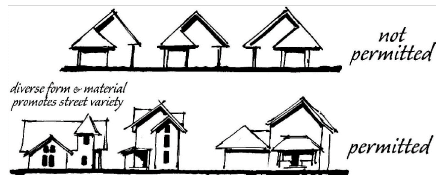
Figure 4-18: Diverse Residential Facades
b.
Standard Street Image Features Unless alternative street image plans are approved in accordance with subsections c. or d. below, new single-family residential structures on lots 70 feet or wider shall utilize a minimum of three of the following techniques, and new single-family residential structures on lots narrower than 70 feet shall utilize a minimum of two of the following techniques to reduce the prominence of garages, promote pedestrian activity, and create visual diversity in single-family neighborhoods:
1.
House Forward Living areas shall extend a minimum of three feet in front of the garage face. See Figure 4-19.
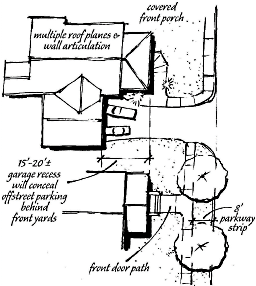
Figure 4-19: House Forward
2.
Front Porches A 60 square foot or larger covered front porch shall be provided and shall extend a minimum of three feet in front of the living area. See Figure 4-20.
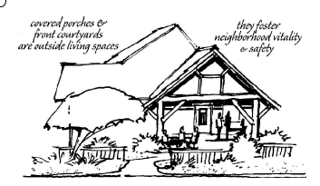
Figure 4-20. Front Porches
3.
Courtyards A 60 square foot or larger front yard courtyard with a hard finished floor surface (concrete, wood, brick, pavers, etc.) and walls not exceeding three feet in height shall be provided and shall extend a minimum of three feet in front of the garage face.
4.
Varied Front Setbacks Front setbacks of adjacent homes on the same side of the street shall vary by a minimum of three feet. See Figure 4-21.
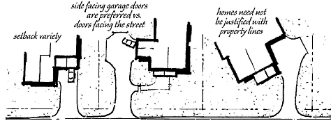
Figure 4-21. Setback Variety
5.
Garage Orientation Garage doors shall not face the street (i.e., provide side loaded garages) and front elevations of garages shall be architecturally consistent with the living area front elevation.
6.
Reduced Garage Width Garages shall not exceed 40 percent of the front elevation.
7.
Hillside Adaptive Architecture Within hillside developments and on properties with an average slope exceeding ten percent, homes shall be built on existing grade. This option may be used if the development requires minor grading for driveways, rear yards and other features but may not be used in projects that mass grade sites to provide flat foundations and yards. See Figure 4-22.
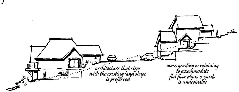
Figure 4-22. Hillside Adaptive Architecture
8.
Enhanced Landscaping On lots narrower than 70 feet, a minimum of one additional code size tree shall be provided in the front yard. On lots 70 feet or wider, a minimum of two additional code size tree shall be provided in the front yard. Where code provides tree size options, the larger option shall be required. In addition, the entire front yard area shall be landscaped and irrigated. A maximum of ten percent of the front yard landscaping may consist of empty shrub beds with landscape fabric and irrigation to provide homebuyers with landscaping options. Bare dirt shall be prohibited in front yards.
9.
Wide Parkway Strips Parkway strips between the street and sidewalk shall be increased to a minimum of eight feet in width.
10.
Front Door Path A three-foot or wider path that is physically separated from the driveway shall be provided from the sidewalk to the front door.
11.
Structure Articulation A minimum of four separate roof planes shall be incorporated within the front elevation and the front elevation shall contain a minimum of two wall planes that are offset by a minimum of three feet.
12.
Architectural Modification Custom-designed homes shall be utilized or a minimum of eight model homes shall be available to customers. Minor facade, material and roof style modifications shall not qualify as separate models.
c.
Neotraditional Design If vehicular access is provided exclusively from rear yard alleys, street image requirements shall be satisfied.
d.
Custom Street Image Plans Custom street image plans may be approved by conditional use permit. In order to approve a conditional use permit for custom street image plans, the Planning Commission shall make the standard conditional use permit findings and an additional finding that the proposed street image plan meets the intent of reducing the prominence of garages, promoting pedestrian activity and creating visual diversity in single-family neighborhoods.
(b)
Large Vehicle Parking and Storage Recreational Vehicles (RVs), trailers, boats, boat trailers, and all other vehicles not in daily use shall not be parked in front of the front building line. Parking of these vehicles may only occur in the side yard if screened by a six-foot fence. Exceptions are allowed for temporary parking not exceeding 14 consecutive days in duration or 90 total days per year.
(c)
Alternative Setback Developments
(1)
Subdivisions and parcel maps in the SF-11 and SF-8 districts may be developed with the rear yard setback reduced to ten feet if one side yard is at least 20 feet wide and contains a minimum of 400 square feet having a maximum slope of seven to one (7:1).
(2)
Subdivisions and parcel maps in the SF-11 and SF-8 districts may be developed with buildings placed on one side property line and a ten-foot minimum setback from the other side property line.
(3)
These alternative setbacks may not be used to reduce the required setback adjacent to property located outside the development site, unless the adjacent property owner provides written consent.
(d)
Setback Requirements for Nonresidential and Multi-Family Uses Any principal nonresidential or multi-family use in a single-family residential zoning district, shall have a minimum 20-foot setback from any property line that adjoins a single-family dwelling use.
18.04.905 - Reserved
Editor's note— Ord. No. 6682, § 3, adopted July 24, 2024, repealed § 18.04.905, which pertained to additional standards for multi-family districts and derived from original Code source.
18.04.1001 - Purpose
This article is intended is intended to:
(a)
Protect public health and safety;
(b)
Promote the development of unique Urban Districts that increase access to services and amenities, expand housing options, and support multiple modes of transportation;
(c)
Encourage creative, high-quality, mixed-use development that is responsive to the unique characteristics and contexts found in different Urban Districts; and
(d)
Encourage reinvestment in established areas of the City; and
(e)
Ensure compatibility between Urban Districts and surrounding neighborhoods.
(Ord. No. 6692, § 1(Exh. A), 1-8-25)
18.04.1002 - Applicability
(a)
District Applicability This article shall apply to all development in the following districts unless otherwise noted in the subsections below:
(1)
MD-ED: Downtown Entertainment District
(2)
MD-ID: Downtown Innovation District
(3)
MD-NWQ: Downtown Northwest Quadrant
(4)
MD-PD: Downtown Powning District
(5)
MD-RD: Downtown Riverwalk District
(6)
MD-UD: Downtown University District
(7)
GC: General Commercial
(8)
NC: Neighborhood Center
(9)
PO: Professional Office
(10)
MS: Mixed-Use Suburban
(11)
MU: Mixed-Use Urban
(12)
MU-MC: Mixed-Use Midtown
(13)
MU-RES: Mixed-Use Residential
(b)
Project-Specific Applicability
(1)
Within the districts identified in Subsection (a), above, this article applies to the following types of development projects:
a.
Development of any new structure that requires a building permit; and
b.
An addition or renovation to an existing structure where the total gross floor area following the addition or renovation is more than 500 square feet greater than the total gross floor area of the existing structure before addition or renovation.
(2)
In cases where additions or renovations are subject to these standards and full compliance with these standards is not feasible, the resulting project shall result in closer conformance with these standards, as determined by the Administrator.
(3)
For residential development in Urban Districts, project applicants may request that standards in sections 18.04.903 and 18.04..1504 for multi-family development replace this article. The Administrator may approve a request that standards in sections 18.04.903 and 18.04.1504 replace this article if the project design is deemed to be compatible with the surrounding development pattern. If necessary to achieve compatibility, the Administrator may require additional design features or consistency with certain design requirements in this article.
(c)
Discretionary Review
(1)
Certain Development Exempt from Discretionary Review, with Exceptions Development within the Mixed-Use Downtown (MD-) districts, Mixed-Use Urban (MU) District, that meets the adopted standards set forth in this section and the standards set forth in the district where the project is located are exempt from discretionary review and may proceed with a building permit application, with the following exceptions:
a.
Large retail establishments as required to be approved by a conditional use permit in accordance with Section 18.04.1006, Supplemental Standards for Large Retail Establishments;
b.
Hazardous waste or explosives are required to be approved by a conditional use permit in accordance with Subsection 18.08.605(b)(5), Hazardous and Explosive Substances; and
c.
Skyways, skytrams, and skybuildings as specified in Article 16, Skyways;
d.
Gaming operations as specified in Subsection 18.08.605(b)(4), Gaming; and
e.
Where discretionary review is required per Chapter 18.03 Use Regulations.
f.
A conditional use permit is required for certain operating hours, as described by section 18.08.605(b)(3).
(Ord. No. 6692, § 1(Exh. A), 1-8-25)
18.04.1003 - General Standards for Urban Districts (MD-ED, MD-ID, MD-NWQ, MD-RD, MD-UD, GC, NC, PO, MD-PD, MU, MS, MU-MC and MU-RES)
(a)
Site Layout and Development Pattern
(1)
Relationship to Major Roadways
a.
Development shall be oriented toward any adjoining arterial and collector street(s) as designated by the City.
b.
Development shall be designed to accommodate planned expansions to major roadways.
(2)
Setbacks
a.
Measurement of Front Setbacks in Downtown, Mixed-Use Urban, and Mixed-Use Midtown Districts Unless otherwise regulated by this article or a specific overlay, front setbacks in the Mixed-Use Downtown (MD-) districts, Mixed-Use Urban (MU) District, and Mixed-Use Midtown (MU-MC & MU-RES) districts shall be measured from the back of the curb or proposed curb.
1.
If the Adopted RTP identifies a street-widening project, the front setback shall be measured from the back of the curb following the street expansion.
2.
If existing buildings are located closer than the minimum required distance from the planned back of curb, then the maximum possible setback shall be provided without removing the building.
b.
Measurement of Other Setbacks
1.
In all other Urban Districts, all setbacks shall be measured from the property line, unless otherwise regulated by this article or a specific overlay.
2.
The Administrator may authorize setback reductions for individual lots when there is excess right-of-way and modifications would allow development to be consistent with the established development pattern.
(3)
Density
a.
Minimum Density Minimum densities shall apply to vacant sites or to sites where existing structures would be demolished and a new structure or structures built. Where projects are partly new development and partly adaptive reuse, density standards shall be deemed satisfied if they are met by the new development portion of a project or by the project as a whole.
b.
Exception for Multi-Story Mixed-Use Building If a development contains more than one story and a mix of land use types including residential and nonresidential, no minimum gross floor area ratio or density shall be required.
c.
Density Alternatives Lower densities may be allowed to accommodate the preservation of historic structures, support the adaptive reuse of vacant or underutilized buildings, and/or accommodate transitions in intensity adjacent to the Downtown-Powning (MD-PD) District, or other less intensive districts.
d.
Phasing Plan Residential densities and gross floor area ratios (FAR) required within Urban Districts may be modified through a phasing plan to the approval of the Administrator. The phasing plan shall show how the project meets the streetscape requirements in the first phase to create the desired pedestrian environment as described in the Master Plan for each mixed-use area.
e.
Minor Site Plan Review Minimum residential densities and gross floor area ratios (FAR) required within Urban Districts may be modified through approval of a minor site plan review.
(4)
Sidewalks In addition to standards of Section 18.04.502, Sidewalks, Curbs, and Gutters, sidewalks within Urban Districts shall include the following components:
a.
Where applicable within the Mixed-Use Downtown (MD-) districts, the Downtown Streetscape Design Manual shall apply.
b.
In portions of the MD districts that are not addressed in the Downtown Streetscape Design Manual, and in the MU District and MU-MC District, an 18-foot front setback is required along Virginia Street and Fourth Street and a 12-foot front setback is required along all other street, as measured from the back of the curb. See Figure 4-23.
1.
Eighteen-foot front setbacks shall include:
[a]
A minimum obstruction-free sidewalk width of six feet;
[b]
An additional eight-foot area located between the back of the curb and the sidewalk. Car door clearance for parallel parking, curb side bus stops, light poles, street furniture, traffic signal poles, street trees, planter boxes, bus benches, and/or bus shelters shall be in this area. The eight-foot area shall be landscaped or paved as part of the sidewalk; and
[c]
An additional area from back of sidewalk to front of building of four feet. Window shopping and street furniture shall be located in this area. The four-foot area shall be paved as part of the sidewalk or landscaped.
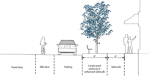
Figure 4-23: Sidewalk Design
2.
Twelve-foot front setbacks shall include:
[a]
A minimum obstruction-free sidewalk width of six feet; and
[b]
An additional six-foot area located between the back of the curb and the sidewalk to accommodate car door clearance for parallel parking, curb side bus stops, light poles, street furniture, traffic signal poles, street trees, planter boxes, bus benches, and/or bus shelters. The six-foot area shall be landscaped or paved as part of the sidewalk.
c.
In the MU-RES District, a ten-foot setback is required, as measured from the back of the curb. In these areas a minimum of five feet shall be provided for sidewalk and a minimum of five feet shall be provided for street trees or landscaped parkway strips.
d.
In the MS, GC, NC, and PO districts, a 10-foot setback is required, as measured from the property line. In these areas, a minimum of five feet shall be provided for sidewalk and a minimum of five feet shall be provided for street trees or landscaped parkway strips.
e.
The Administrator may authorize modifications to these required sidewalk elements to accommodate public safety or access goals, parkways, street trees, utility infrastructure, or enhanced pedestrian amenities, and also for lot transitions or consistency along the same block when adjoining sidewalks do not reflect these standards.
f.
If existing structures are setback less than the minimum required distance from the planned face of curb, then the maximum possible setback shall be provided without removing the building, and the following shall be installed in the order listed as space permits:
1.
Obstruction-free sidewalk area; and
2.
Improvements in the area between the sidewalk and face of curb.
(5)
Pedestrian Amenities Development in the Mixed-Use Downtown (MD-) districts and MU District shall meet the following standards for pedestrian amenities:
a.
Pedestrian amenities including walkways (outside of and through buildings), plazas, artwork, fountains, seating, landscaping, and recreational facilities in any combination shall be provided in an amount equal to one percent of the entire project's costs, exclusive of land and financing for buildings. Interior tenant improvements and infrastructure replacements (HVAC, communication equipment, electric transfer facilities, and the like) shall not be subject to this requirement. Pedestrian amenities may be located outside of or within buildings if the amenities are accessible to the public at no cost.
b.
Required public improvements such as minimum requirement for sidewalks and street trees shall not count toward meeting the minimum percentage requirements for pedestrian amenities in this Title. Amenities not required by this Title shall qualify toward the percentage requirement.
c.
The project may contribute to the pedestrian amenities fund in an amount equal to that required under this Title in lieu of on-site pedestrian amenities with the approval of the Administrator.
(6)
Building Orientation
a.
New buildings on sites less than two acres in size shall be oriented towards the primary street frontage, or to the side property line if direct pedestrian access is provided from the primary street frontage and the building is located at the front setback line.
b.
New buildings on sites greater than two acres in size, and expansions to existing development on sites of any size, shall be oriented towards the primary street frontage, unless direct pedestrian access is provided from the primary street frontage to all buildings and enhanced landscaping is provided along the street frontage.
c.
Exterior play structures associated with commercial activities in all Urban Zoning Districts shall not be placed between the primary building and any adjacent road right-of-way. Childcare centers shall be exempt from this standard.
(7)
Street Frontage Requirements
a.
To promote a compact, pedestrian-oriented pattern of development, the following street frontage requirements apply:
1.
Within the MD (except MD-PD) and the MU District a minimum of 60 percent of the primary street frontage shall be comprised of building wall or pedestrian amenity.
2.
Within the MS District and NC District a minimum of 30 percent of the primary street frontage shall be comprised of building wall or pedestrian amenity.
3.
In all other Urban Districts a minimum of 20 percent of the primary street frontage shall be comprised of building wall or pedestrian amenity.
b.
For a corner lot this requirement pertains to the street with the higher street classification (e.g., arterial/collector). Instances where both streets have the same classification (e.g., collector) this requirement pertains to the street with the primary public access.
(8)
Loading and Service Areas Trash and loading areas shall be centralized wherever possible, and screened in accordance with Section 18.04.808(c), Screening of Outdoor Service Areas, Utilities, and Equipment. Sites along the Truckee River shall not have outdoor trash or loading facilities on the river side of any property.
(b)
Circulation and Access New development in Urban Districts shall be designed to include an interconnected access and circulation network. In addition to the standards contained in Article 6, Access, Connectivity, and Circulation, the following shall apply:
(1)
Site Connectivity Development along major roadways shall provide off-street vehicular connections to adjoining Urban Districts zoned parcels to the extent feasible. Where connections are not feasible, the Administrator may require design accommodations and easements to accommodate future off-street connections.
(2)
Pedestrian and Bicycle Connectivity Any wall, fencing or other barrier that hinders pedestrian and bicycle connectivity to adjacent areas shall be designed to provide access points to abutting streets, sidewalks, parks, and trails, including planned facilities.
(3)
Recreational Access Developments that abut public lands and open spaces at the urban/rural interface shall provide trailheads, connections, and public access from the development to existing or planned trails.
(c)
Building Design
(1)
Additional Setbacks and Stepbacks for Compatibility Any new building built within 150 feet of a property zoned LL (all districts), SF (all districts), MF-14, or MD-PD shall meet the standards of subsection 18.04.903(c)(1), Additional Setbacks and Stepbacks for Compatibility.
(2)
Wall Articulation
a.
Blank walls that are devoid of architectural details shall not be permitted. Building facades shall be articulated using design elements such as, but not limited to:
1.
Variations in roof form or parapet height;
2.
Variations in building height;
3.
Projected or recessed building mass;
4.
Wall plane off-sets;
5.
Window openings;
6.
Balconies;
7.
Distinct changes in texture and color of wall surfaces;
8.
Recessed entries; or
9.
An alternative unique design element as approved by the Administrator.
b.
A minimum of five of the above design elements listed above shall be incorporated along all primary street facing facades. A minimum of three of the above design elements shall be incorporated on all facades facing secondary street frontages, public parks or plazas, or residentially zoned property.
(3)
Ground-Level Interest Ground floors of street-facing facades shall have transparent doors or windows (including faux windows) no less than four feet in height along at least 40 percent of the facade's horizontal length facing Fourth Street or Virginia Street, and at least 25 percent along all other street frontages. When buildings are not oriented toward a street frontage, the primary building frontage shall also have transparent windows or doors along at least 25 percent of the facade's horizontal length. The administrator may approve a reduction of transparency requirements to 20 percent for residential living areas with ground floor street-facing facades when alternative design provisions for ground level interest is provided. Also see Section 18.04.1004, Supplemental Standards for Downtown Districts.
(4)
Alternative Design Approaches The Administrator may approve alternative approaches or exceptions to the wall articulation, or ground level interest requirements for building facades that are constructed on side or rear property lines and designed to be attached to future buildings on adjoining parcels or to accommodate the adaptive reuse of:
a.
A vacant or functionally obsolete building;
b.
Historically significant or designated structures; and
c.
Other buildings that contribute to the unique character of the district.
(5)
Building Massing and Form Multi-building developments shall incorporate a variety of building heights and forms to create visual interest and reinforce distinguishing characteristics of the district.
(6)
Shading of Parks and Residences Buildings shall conform with shading requirements in Subsection 18.04.101(c), Shading of Parks and Residences.
(7)
Pad Sites Structures constructed on pad sites within a shopping center development shall be architecturally compatible with the main structures within the shopping center.
(Ord. No. 6692, § 1(Exh. A), 1-8-25)
Editor's note— Ord. No. 6692, § 1(Exh. A), adopted January 8, 2025, amended the title of § 18.04.1003 to read as herein set out. The former § 18.04.1003 title pertained to general standards for mixed-use districts.
18.04.1004 - Supplemental Standards for Downtown Districts (MD-ED and MD-RD)
(a)
Applicability Standards in this section shall apply to all development in the Mixed-Use Downtown (MD-) Districts as noted in the subsections below.
(b)
Mixed-Use Downtown Entertainment (MD-ED) District
(1)
Site Layout and Development Pattern
a.
Landscaping and Screening Surface parking areas shall be planted with shade trees at a ratio of one tree for every five spaces.
b.
Streetscape Improvements Prior to a certificate of occupancy, the applicant shall install streetscape improvements, including street lighting, in accordance with the Downtown Streetscape Standards Manual.
(c)
Mixed-Use Downtown Riverwalk (MD-RD) District
(1)
Modification of Standards
a.
The Planning Commission or City Council, on appeal, may approve or deny a major site plan review to modify the standards in this subsection in according to the following findings and those contained in Section 18.08.602, Major Site Plan Review, as amended:
1.
The proposed project is consistent with the goals, objectives, and policies of the Master Plan;
2.
The proposed project will be compatible with the site and surrounding area both in scale and context; and
3.
The building has been appropriately designed, or the modification preserves the architectural character of the existing building relative to its scale, mass, building proportion, building height, fenestration, and articulation.
(2)
Setbacks Side setback areas must be screened from the street and sidewalk by a decorative gateway, grille, fence or wall unless designed for public use.
(3)
Active Ground Floor Retail Active ground-level commercial use is required on the frontages listed below. The interior area of the ground floor need not be an "active use"; lobbies and other ancillary uses supporting upper level uses are allowed. Areas where an active ground level commercial use is required include:
a.
North and South Esplanade frontages, between Arlington Avenue and the easterly frontage of Lake Street;
b.
Sierra Street, between the Truckee River and Second Street;
c.
Virginia Street, between Court Street and Second Street; and
d.
North and South sides of First Street, between Arlington Street and Lake Street.
(4)
Riverfront Esplanade The riverfront esplanade standards listed in this subsection shall apply to all development west of Lake Street and north of State Street and Court Street and east of Arlington Street and south of First Street.
a.
All buildings shall be setback a minimum of 25 feet from the existing face of the river flood wall or top of bank to create the north and south Esplanades (see Figure 4-24). The Administrator may require dedication of a 25-foot-wide minimum esplanade setback from the existing face of the river flood wall or top of bank when the location of the development must provide safe and adequate passage and facilitate police and fire protection.
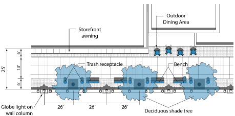
Figure 4-24. Riverfront Esplanade Setbacks
b.
Modifications to the required width of the Esplanade may be considered in situations where there are no alterations to existing footprints and the existing building is less than 25 feet to the face of the flood wall or top of bank. In that instance, the Administrator shall determine the appropriate development standard and amenities.
c.
A continuous building frontage is desired along the Esplanade. Side setback areas must be improved as pedestrian-oriented spaces (e.g., patios or courtyards) and may exceed the setbacks noted above.
d.
Setbacks from the Riverfront Esplanade shall be in accordance with Table 4-18 and Figure 4-25.
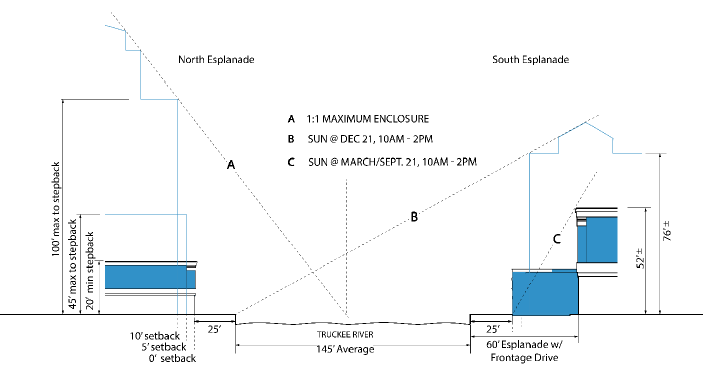
Figure 4-25. Riverfront Esplanade Building Envelope
e.
Additional land use limitations are outlined in Table 4-19.
(5)
Design Standards
a.
Massing Building masses shall be broken at regular intervals to provide variety and scale. Masses shall be defined by a major notch in the building volume, or by a projecting mass. On average, wall planes shall not be longer than 100 feet, with no single plane exceeding 150 feet.
b.
Blank Walls Limitation
1.
Along the following frontages, at least 66 percent of the width of a new or reconstructed first-story building wall facing a street shall be devoted to pedestrian entrances, display windows or windows affording views into retail, office, restaurant or lobby space:
[a]
North and South Esplanade frontage, between Arlington Avenue and Lake Street.
[b]
Sierra Street, north of the Truckee River.
[c]
Virginia Street, I-80 to California Avenue.
[d]
Center Street, north of the Truckee River.
[e]
Fourth Street, Keystone Avenue to Wells Avenue
[f]
Exemption Blank wall limitations shall not apply to historically designated buildings.
2.
On other street frontages, at least 50 percent of the width of a new or reconstructed first-story building wall facing a street shall be devoted to pedestrian entrances, display windows or windows affording views into retail, office, restaurant, lobby space, public art, or other similar architectural features.
c.
Exception Flexibility in applying the design guidelines to existing structures shall be afforded in cases where the economic viability or function of the building is improved.
(Ord. No. 6692, § 1(Exh. A), 1-8-25)
18.04.1005 - Supplemental Standards for Other Urban Districts (PO, MU, MU-MC and MU-RES)
(a)
Applicability This section shall apply to all development in Urban Districts specified in the subsections below.
(b)
Professional Office (PO) District
(1)
Off-Street Parking On sites less than 15,000 square feet, off-street surface parking spaces shall not be located between the front of the primary office building and an adjacent primary access street.
(2)
Architectural Character New construction shall be consistent in scale and architecturally compatible with other principal structures in the area.
(c)
Mixed-Use Urban (MU) District
(1)
Lighting Street lighting installed along East 4th Street shall conform to the Downtown Streetscape Design Manual.
(d)
Mixed-Use Midtown Commercial and Mixed-Use Midtown Residential Districts
(1)
Applicability Except where noted below, the following standards apply to all development in the Mixed-Use Midtown Commercial (MU-MC) and Mixed-Use Midtown Residential (MU-RES) districts.
(2)
Intent Standards are intended to promote a safe and active pedestrian-scale and bicycle friendly area that enhances the convenience, ease, and enjoyment within and around the neighborhood. The overarching goal is to encourage interesting and attractive new development that promotes pedestrian activity.
(3)
General Standards
a.
Parking Parking shall be accessed from the alley or side of the primary structure and shall be located behind the front facade of the primary structure.
b.
Building Orientation Primary buildings shall be oriented to promote the pedestrian and bicycle experience and defining neighborhood character.
c.
Prohibited Materials The following materials shall be prohibited as primary exterior building materials; however, the creative incorporation of these or similar materials in a non-traditional form is allowed.
1.
Metal siding;
2.
Concrete panels; and
3.
Smooth-faced concrete block.
d.
Architectural Character Due to the wide range of architectural styles found in the neighborhood, use of more specific architectural styles is not mandated. However, infill development and major renovations to existing structures shall be designed to complement the established framework of the neighborhood in terms of its streetscape quality, block pattern, and overall urban neighborhood character. These general standards are not intended to promote the replication of historic styles found in the neighborhood, but rather to encourage a range of architectural styles that reflect the diversity of the neighborhood.
e.
Relationship to Surrounding Development
1.
Blocky, multi-story building forms devoid of articulation or architectural features shall be prohibited. Residential development over 21 units per acre shall incorporate all five of the following design criteria. All other development shall incorporate three of the following design criteria:
[a]
Graduating building height and mass in the form of building step-backs a minimum of ten feet in depth, or other techniques, so that new structures have a comparable scale with existing structures;
[b]
Orienting windows, porches, balconies, and other outdoor living spaces away from shared property line to protect the privacy of adjacent residents where applicable;
[c]
Installing trees 20 feet on center within the side yard to help break up the appearance of the taller structure;
[d]
Utilizing a roof pitch and overhang of similar to that of the adjacent structures; or
[e]
Utilizing dormers and sloping roofs to accommodate upper stories for major renovations and new construction.
2.
To satisfy the above standard, one of the following techniques for alley homes shall be provided:
[a]
A graduated building height and mass in the form of building step-backs a minimum of ten feet in depth; or
[b]
Similar techniques, so that the new structure has a comparable scale with the existing home located along the primary street frontage.
f.
Lighting
1.
Lighting Standard Lighting from a nonresidential or mixed-use property shall not create greater than 0.50-foot candle of spillover light at an adjacent residentially zoned property line.
2.
Redirecting of Screening of Light Sources All sources of light, including security lighting, illuminated signs, vehicular headlights and other sources shall be directed away from adjacent residentially zoned properties or screened so that the light level stated in standard [a], above, is not exceeded.
3.
Height of Light Sources Light fixtures shall not exceed 20 feet in height.
(4)
Mixed-Use Midtown Commercial (MU-MC) District The following standards shall apply to all parcels located within the Mixed-Use Midtown Commercial (MU-MC) District.
a.
Building Orientation/Site Configuration
1.
Purpose Clear, obvious, and publicly accessible connections between the primary street and primary uses within the neighborhood shall be provided. A clear, safe, and attractive pedestrian system should enhance the pedestrian experience and encourage walking, shopping, and public gathering, which will be accomplished through one of the following methods.
2.
Storefronts Storefronts must provide a clear, obvious, publicly accessible entrance from the primary street to the primary uses within the building. The entrance shall be in a:
[a]
Door in the front facade of the building;
[b]
An entrance recessed no more than 15 feet from the front facade of the building; or
[c]
A corner entrance located at the corner of the building at approximately 45 degrees, primarily on corner parcels.
3.
Entry Features An entry feature must signal the connection between the primary street and the primary uses within the building, and shall be located on the primary street or visible from the primary street. An entry feature shall be one of the following:
[a]
Door,
[b]
Gate,
[c]
Front Porch,
[d]
Front Stoop,
[e]
Front Terrace,
[f]
Canopy, or
[g]
Arcade.
4.
Pedestrian Connections A pedestrian connection must provide a clear, obvious, publicly accessible connection between the primary street and the primary uses within the building. The pedestrian connection shall comply with the following:
[a]
Fully paved and maintained surface not less than five feet in width;
[b]
Unit pavers or concrete distinct from the surrounding parking and drive lane surface;
[c]
Separated from parking or vehicle traffic to protect pedestrians; and
[d]
No more than a length of 25 feet of the pedestrian connection may cross drive lanes within parking areas.
b.
Building Transparency
1.
General A minimum of 20 percent of the total street facing area of each ground floor shall be comprised of transparent window openings, to:
[a]
Activate the street for pedestrian use;
[b]
Enhance safety; and
[c]
Establish scale, variation, and patterns on building facades.
2.
Measuring Transparency
[a]
For the purposes of the above standard, all percentages shall be measured using elevation views of the building plan and "ground floor" shall be measured from floor plate to floor plate (ground floor heights are assumed to be a minimum of ten feet).
[b]
The use of highly reflective glass should be minimized to avoid glare and reflections onto neighboring streets and properties.
c.
Hours of Operation
1.
Businesses fronting on South Virginia Street may operate 24 hours per day without approval of a conditional use permit.
2.
Business within one block of Virginia Street but not fronting on South Virginia Street may operate between 5:00 a.m. to 1:00 a.m. Operating hours extending beyond these hours shall only be through the approval of a conditional use permit.
3.
New businesses not adjacent to South Virginia Street or within one block of South Virginia Street may have operating hours between 6:00 a.m. and 11:00 p.m., operating hours beyond these shall only be allowed through the approval of a conditional use permit.
(5)
Mixed-Use Midtown Residential (MU-RES) District The following standards apply to all properties located within the Mixed-Use Midtown Residential (MU-RES) District.
a.
Intent The character of the district is currently defined by a mix of retail shops, offices, and residential properties. Single-family homes have been converted to nonresidential uses over time, contributing to the quaint, residential character of this area. Design standards are intended to reinforce the distinction between the residential and commercial sections of Midtown and encourage low-scale, small-lot development projects that reinforce and enhance the eclectic, urban character, and pedestrian scale.
b.
Building Orientation Primary buildings shall give prominence to pedestrian activity, with primary entrances facing a primary street, and create human scale through the use of detail, form, window and door placement, color, and materials.
c.
Signs
1.
General Signs shall be designed to reflect the residential scale and appearance of the Mixed-Use Midtown Residential (MU-RES) District.
2.
Materials Signs shall be constructed of durable materials that are compatible with the building that they serve. The use of cardboard, fabric, scrap wood, and other non-durable materials is prohibited. Letters and symbols on a sign may be internally lit.
3.
Prohibited Signs The following signs shall be prohibited:
[a]
Flashing or animated;
[b]
Temporary hand-painted or hand-written signs; and
[c]
Internally lit cabinet signs.
4.
Height No freestanding sign shall exceed four feet in height.
5.
Number of Signage Types No more than two distinct signage types (e.g., window sign and a hanging sign) shall be permitted per tenant. Only one monument sign is allowed per parcel/development. Monument signs shall be no more than four feet in height above finish grade and six feet in total length.
d.
Hours of Operation New businesses in the area shall be day-oriented operations with hours of operation between 7:00 a.m. and 7:00 p.m.
(Ord. No. 6692, § 1(Exh. A), 1-8-25)
Editor's note— Ord. No. 6692, § 1(Exh. A), adopted January 8, 2025, amended the title of § 18.04.1005 to read as herein set out. The former § 18.04.1005 title pertained to supplemental standards for other mixed-use districts.
18.04.1006 - Supplemental Standards for Large Retail Establishments
(a)
Purpose The purpose of this section is to encourage large retail establishments and commercial center developments containing large retail establishments, to contribute to Reno as a unique place and to physically integrate with the community in a positive way. The standards of this section supplement Section 18.04.1003, General Standards for all Urban Districts, by promoting a basic level of architectural variety and interest, a compatible appearance and scale, pedestrian and parking lot access, orientation of buildings and entrances in relation to surrounding streets, and mitigation of negative impacts from development of large retail establishments.
(b)
Applicability The standards of this section shall apply to the following:
(1)
New construction of a large retail establishment, defined as single tenant building with at least 50,000 square feet of gross floor area for the purpose of retailing; or
(2)
Expansion of or addition to an existing building that creates a large retail establishment.
(c)
Relationship to Other Standards The provisions of this section shall apply in addition to the generally applicable development and design standards found elsewhere in this chapter and Title. Where there is a conflict with generally applicable standards in this chapter or Title, the more specific standards of this section shall apply. Where there is a conflict with standards stated in an overlay zoning district the standards for large retail establishments stated in this section shall apply and control unless otherwise expressly stated.
(d)
Minimum Land Use Mix Required All new large retail establishments shall be located in a commercial center that includes more than four commercial sales and service uses. Such commercial center shall be planned, developed, and owned or managed as a single unit and shall provide off-street parking on the property.
(e)
Adaptability for Reuse and Prohibition of Restrictive Lease Agreements This subsection's standards are intended to mitigate some of the adverse community effects when large retail establishments vacate their buildings and commercial centers. Many national retailers often abandon older outlets for new formats in new locations, rather than reuse and redevelop existing buildings and centers. Vacant, large-format buildings tend to remain empty for many years, causing blight and eroding nearby property values. Retailers often hang on to these empty buildings or, in the case of leased sites, continue to pay rent, to prevent their competitors from occupying the locations. Accordingly, these standards require new large retail establishment structures to be built with adaptable interior configurations for future reuse by multiple, smaller tenants, and to prevent large retailers from blocking competition after vacating a building through restrictive lease terms or covenants.
(1)
The design of all buildings housing a large retail establishment shall include specific elements for adaptation for future multi-tenant reuse. Such elements may include but are not limited to compartmentalized construction, including plumbing, electrical service, heating, ventilation, and air conditioning. The building design shall also allow for:
a.
The interior subdivision of the structure into separate tenancies;
b.
Facades that readily adapt to multiple entrances and adapt to entrances on all but one side of the building;
c.
Parking lot schemes that are shared by establishments or are linked by safe and functional pedestrian connections;
d.
Landscaping schemes that complement the multiple entrance design; and
e.
Other elements of design that facilitate the multi-tenant reuse of the building.
(2)
All development applications subject to this subsection shall include a renewal plan that evidences specific compliance with this subsection's adaptability for reuse standards, and otherwise evidences the feasibility of the building's rehabilitation or redevelopment in the event of closure or relocation by the original occupant.
(3)
When a commercial center development includes a large retail establishment, a property owner shall not enter into a lease agreement or other contract that prevents the landlord from marketing and renting to future lessees after a large retail establishment has vacated the development. After a large retail establishment vacates a commercial center, the property owner shall be free to market to any person or company allowed by City of Reno codes.
(f)
Building Design and Architecture All development subject to this section shall comply with the following standards:
(1)
Facade Articulation and Features
a.
Intent Facade articulations and detailed elements should be employed to reduce the apparent bulk, industrial look, and uniform appearances of large buildings, provide visual interest and variety, and respect and reinforce the human scale.
b.
Minimum Wall Articulation Any building wall greater than 100 feet in length shall include changes in wall plane, changes in texture, windows, trellises with vines, changes in color, or an equivalent element that subdivides the wall into human-scale proportions. See Figure 4-26.
1.
Any building wall greater than 100 feet in length, measured horizontally, that faces a street or connecting pedestrian walkway shall include at least three of the following features within each successive 30-foot section or part thereof:
[a]
Change in wall plane, such as projections or recesses, having a depth of at least three percent of the length of the facade and extending at least 20 percent of the length of the facade;
[b]
Change in texture or masonry pattern;
[c]
Change in color;
[d]
Windows;
[e]
Trellises with vines; or
[f]
An equivalent element that subdivides the wall into human scale proportions.
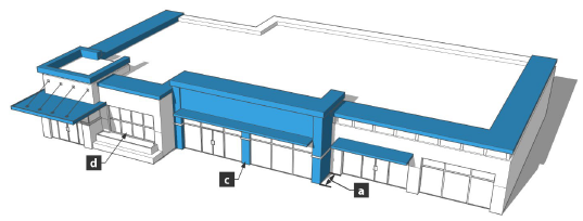
Figure 4-26. Wall Articulation
2.
Ground floor building facades that face public streets shall have arcades, display windows, entry areas, awnings, or other such features along at least 60 percent of their horizontal length.
[a]
All sides of the building shall include articulation, materials, and design characteristics consistent with those on the primary front facade in terms of quality and detail, unless the public's view of a rear or side building elevation from a public street or from an adjacent residentially zoned property is blocked by intervening buildings, topography, or other similar feature. See Figure 4-27.
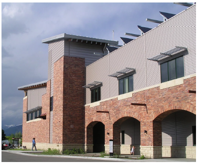
Figure 4-27. Articulation, Materials, and Design of Side and Rear Facades
[b]
If actual doors and windows are not feasible on side or rear walls that face walkways because of the nature of the use of the building facade, then such walls shall include false windows, either glazing or pattern, and defined by frames, sills, and lintels, or similarly-proportioned modulations of the wall.
(2)
Transparency
a.
Intent The use of transparent building materials (e.g., glass) is intended to provide a pedestrian-friendly environment at the ground floor level, and to enhance pedestrian safety wherever possible by allowing visibility of parking areas and on-site walkways from building interiors.
b.
Minimum Transparency Requirements All buildings subject to this section shall comply with the following minimum transparency standards:
1.
A minimum of 60 percent of any ground floor facade between two feet and ten feet above grade fronting on a public street or containing a principal customer entrance shall be comprised of windows for window shopping, with views into interior areas for merchandise display, shopping, and/or other customer services. A minimum of 25 percent of ground floor facades that face parking lots shall also be comprised of windows.
2.
If actual doors and windows are not feasible on side or rear walls that face walkways because of the nature of the use of the building facade, such walls shall include false windows, either glazing or pattern, and defined by frames, sills, and lintels, or similarly-proportioned modulations of the wall. See Figure 4-27.
c.
Small Retail Stores Located Inside or Attached to Large Retail Establishments When a building containing a large retail establishment also contains separately owned commercial establishments with separate customer entrances that occupy less than 25,000 square feet of gross floor area, the following minimum transparency standards shall apply instead of the general standards in subsection (2)b. above:
1.
The street level facade of stores shall be transparent between the height of three feet and eight feet above walkway grade for no less than 60 percent of the horizontal length of the building facade.
(3)
Roof Form and Articulation
a.
Intent To pronounce and vary roof lines and heights to present a distinctive profile, add interest to and reduce the massive scale of large buildings, and complement the character of adjoining neighborhoods.
b.
Screening of Roof-Top Equipment The building parapet shall be the primary means of screening roof-top equipment. All roof-top equipment shall be screened according to Section 18.04.706, Screening.
c.
Roof Design and Treatment Roofs shall have no less than two of the following features:
1.
Three or more roof slope planes.
2.
Parapets concealing flat roofs and roof-top equipment such as HVAC units from public view. The average height of such parapets shall not exceed 15 percent of the height of the supporting wall and such parapets shall not at any point exceed 1/3 of the height of the supporting wall. Such parapets shall feature three-dimensional cornice treatment;
3.
Overhanging eaves, extending no less than three feet past the supporting walls; or
4.
Sloping roofs that do not exceed the average height of the supporting walls, with an average slope greater than or equal to one foot of vertical rise for every three feet of horizontal run and less than or equal to one foot of vertical rise for every one foot of horizontal run.
d.
Consistent Roof Treatment Consistent roof treatment shall be provided on all sides of the building.
e.
Visible Back Sides Finished The back sides of all cornices, parapets, and rooflines that are visible from an adjacent residential zone district or from a public street shall be finished.
(4)
Customer Entrances
a.
Intent To emphasize major entrances into buildings, to ensure that entryway design provides orientation and an attractive appearance to the building, to provide multiple entrances to reduce walking distances, facilitate pedestrian access, and to improve the relationship of the large retail establishments to the surrounding community.
b.
Number of Entrances Required
1.
Buildings containing large retail establishments with 100,000 square feet of gross floor area or more shall feature customer entrances on at least two sides of the building. The two required sides shall be those planned to have the highest level of public pedestrian activity.
2.
When additional commercial establishments under separate ownership are located in the same primary building as a large retail establishment, each such establishment shall have an exterior customer entrance that complies with the visually prominent entrance requirement below, except that such entrance shall include a minimum of two visual prominence features listed in subsection (4)d. below. Restaurants containing less than 2,000 square feet of gross floor area are excluded from this requirement for an exterior customer entrance, except that if such an entrance is provided, the entrance shall comply with the visually prominent entrance requirements below.
c.
Orientation The primary entrance to a large retail establishment shall face the primary street adjacent to the site. The primary street will typically be the street with the highest level of vehicular and pedestrian activity.
d.
Visual Prominence In order to provide clearly defined and highly visible entrances, all building and store fronts subject to subsection (f)(4)'s building design and architecture standards shall have customer entrances featuring no less than three of the following (see Figure 4-34):
1.
Canopies, arcades or porticos that, while satisfying weather protection requirements of Subsection (4)f., below, also lend visual prominence to the entrance;
2.
Overhangs, recesses or projections;
3.
Raised corniced parapets over the door;
4.
Peaked roof forms;
5.
Tower features integrated with the building design that extend above the building roof line;
6.
Arches;
7.
Outdoor patios;
8.
Display windows;
9.
Integral planters or wing walls; and
10.
Entrance atriums with visual connections to outside.
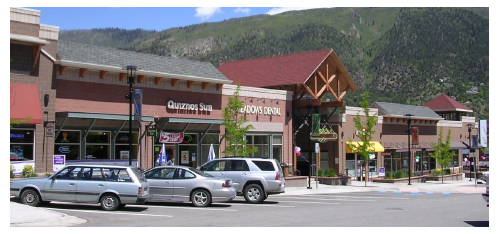
Figure 4-28. Building Entrances
e.
Transparency and Light The principal customer entrance to any building shall feature at least two elements from the following:
1.
Clerestory windows;
2.
Windows flanking main entrance door;
3.
Large entrance door(s)—Transparent, and double hung; and
4.
Ornamental light fixtures.
f.
Weather Protection Canopies, arcades, or similar permanent sheltering roof structures shall provide weather protection along facades of buildings to pedestrians at customer entrances, taxi and drop off zones, valet parking, and bicycle parking. Weather protection means, for purposes of this provision, a permanent shelter or covering of sufficient length and width to provide protection to pedestrians from sun, wind, rain, or snow.
(5)
Building Materials and Colors
a.
Intent To specify building materials that are durable, attractive, and have low maintenance requirements; and reduce the use of bright, intense colors.
b.
Building Materials
1.
All primary buildings shall be constructed or clad with materials that are durable and of a quality that will retain their appearance over time, including, but not limited to, natural or synthetic stone; brick; stucco; integrally-colored, textured, or glazed concrete masonry units; high-quality prestressed concrete systems; Exterior Installation Finish Systems (EIFS); or glass. See Figure 4-29.
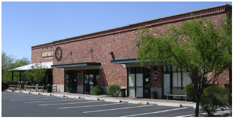
Figure 4-29. Building Materials
2.
The following exterior building materials are prohibited:
[a]
Vinyl siding;
[b]
Field-painted or pre-finished standard corrugated metal siding; or
[c]
Smooth-faced gray concrete block, painted or stained concrete block, tilt-up concrete panels. These materials may be used as main framing materials with an exterior treatment or finish that replicates materials specified in subsection 1, above.
3.
Exterior building material shall be continued down to within nine inches of finished grade on any elevation.
c.
Building Color
1.
Color schemes shall aesthetically integrate building elements together, relate separate (free-standing) buildings within the same commercial center development to each other, and shall be used to enhance the architectural form of a building.
2.
All building projections, including, but not limited to, chimneys, flues, vents, and gutters, shall match or complement in color the permanent color of the surface from which they project.
3.
Intense, bright, black, or fluorescent colors shall be used sparingly and only as accents; such colors shall not be used as the predominant color on any wall or roof of any building. Permitted signs shall be excluded from this standard.
4.
Building trim and accent areas may feature brighter colors, including primary colors; however, neon tubing shall only be an acceptable trim near customer entrances.
5.
Architectural Unity
[a]
Intent To provide a unified, coherent, and aesthetically pleasing design and theme within a commercial center that contains multiple buildings.
[b]
Architectural Unity Required All buildings within the same commercial center shall be architecturally unified. Architectural unity means that buildings shall be related and compatible in style, color scheme, and quality and type of exterior building materials.
(6)
Site Design and Relationship to Surrounding Community
a.
Location and Design of Parking Lots
1.
Intent Large parking areas should be divided into smaller lots and distributed around buildings to provide safe and convenient access, shorten the distance between primary buildings and public streets, and break up the massive scale of large paved surfaces. If buildings containing large retail establishments are located closer to streets, then the scale is reduced, pedestrian traffic is encouraged, and architectural details of the building take on added importance.
2.
Defining the "Front Parking Quadrant" for Large Retail Establishments
[a]
These regulations encourage limiting the number of surface off-street parking spaces located between the front door of a large retail establishment and the primary, abutting street. This is achieved by controlling the amount of parking located within a building's "Front Parking Quadrant." The applicant must designate the "Front Parking Quadrant" on all proposed development and site plans.
[b]
The "Front Parking Quadrant" is defined by connecting each of the four corners of the building containing a large retail establishment to the closest property line. This exercise will create four quadrants. The one quadrant located between the building's front door and the primary abutting street is the "Front Parking Quadrant." See Figure 4-30, below.
[c]
Parking spaces in the Front Parking Quadrant shall be counted to include all parking spaces falling within the boundaries of the Front Parking Quadrant, including all partial parking spaces if the part inside the Front Parking Quadrant boundary lines constitutes more than ½ of such parking space.
3.
Location of Parking In order to reduce the scale of the paved surfaces and to shorten the walking distance between parked cars and a building containing a large retail establishment, the Front Parking Quadrant shall contain no more than 50 percent of the off-street surface parking spaces provided for all uses located in the building containing a large retail establishment. See Figure 4-30. Note that in instances when the building housing a large retail establishment is sited on a side or rear setback line, it may be impossible to site any off-street parking spaces in the "quadrant" adjoining the side or rear setback line.
4.
Parking Blocks Required In order to reduce the scale of parking areas, all surface parking areas shall be broken up into smaller parking blocks containing no more than 40 spaces:
[a]
Parking blocks shall be separated from each other by a minimum five-foot wide landscaping strip, access drives or public streets, pedestrian walkways, or buildings.
[b]
Each parking block shall have consistent design angles for all parking within the block.
[c]
Parking blocks shall be oriented to buildings to allow pedestrian movement down and not across rows (typically with parking drive aisles perpendicular to customer entrances).
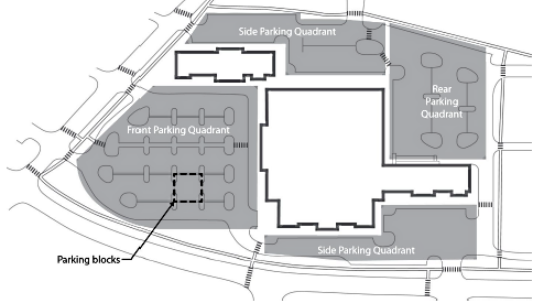
Figure 4-30. Location and Design of Parking Lots
(g)
Pedestrian Access and Circulation All new large-scale retail establishments shall submit a detailed pedestrian circulation plan with all development applications and demonstrate compliance with the standards of this section.
(1)
Public Sidewalks
a.
Location Sidewalks shall be provided along all sides of the parcel or lot that abut a public street.
b.
Design
1.
Sidewalks shall be at least six feet wide.
2.
Sidewalks shall be separated from the street curb by a landscaped parkway or enhanced sidewalk with street trees at least eight feet wide; or the required front yard setback, whichever is greater.
3.
Parkway landscaping shall be in addition to the landscaping required around the perimeter of the parking lot (see Article 8 Landscaping, Buffering, Screening, and Fencing). See Subsection 18.04.804(f), Street Tree Requirements, for applicable street tree requirements.
(2)
Pedestrian Connection to Perimeter Public Sidewalks Connections between the internal pedestrian network and any public sidewalks shall be provided at a "regular interval" of every mid-block or one connection for every 400 feet of perimeter public sidewalk length, whichever distance is shorter (see Figure 4-31).
(3)
Walkways Along Primary Buildings Continuous pedestrian walkways shall be provided along the full length of any primary building facade featuring a customer entrance and along any facade abutting customer parking areas. Such walkways shall be located at least six feet from the facade of the building to provide planting beds for foundation landscaping, except where features such as arcades or entryways are part of the facade. As an alternative to the six-foot planting bed, tree grates with decorative paving may be utilized along 50 percent of the facade. For all options, a minimum eight-foot unobstructed pathway shall be maintained on the pedestrian walkway.
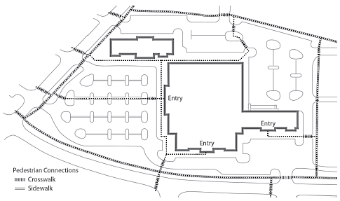
Figure 4-31. Pedestrian Connection to Perimeter Public Sidewalks
(4)
Walkway Design
a.
Width
1.
Sidewalks shall be at least six feet wide.
2.
Planting areas, including trees, shrubs, benches, flower beds, ground cover, and other such materials, shall be installed along no less than 50 percent of the entire length of the walkway.
3.
Where landscaping is provided along the walkway, the combined minimum width of the walkway plus the landscape area shall be 15 feet to accommodate car overhangs (see Figure 4-32).
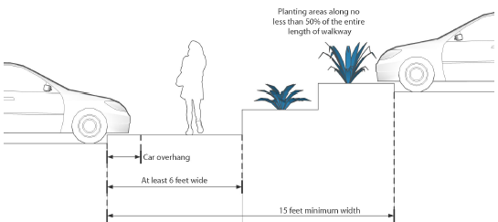
Figure 4-32. Walkway Design
b.
Materials
1.
All internal pedestrian walkways shall be distinguished from driving surfaces through the use of durable, low maintenance surface materials such as pavers, bricks, or scored and tinted concrete to enhance pedestrian safety and comfort, as well as the attractiveness of the walkways. At each point that the on-site pedestrian walkway system crosses a parking lot or internal street or driveway, the walkway or crosswalk shall be clearly marked through the use of a change in paving materials distinguished by their color, texture, or height. Surface striping with paint shall not be considered "a change in paving materials."
2.
The total surface area of all on-site pedestrian walkways that incorporate quality paving materials such as pavers, bricks, or scored and tinted concrete may be credited toward the minimum 25 percent hardscape limit for on-site landscaping stated in Section 18.04.804 Minimum Landscaping Required.
(h)
Site Amenities
(1)
Intent Site amenities and pedestrian-scale features (e.g., outdoor plazas, street furniture, playgrounds, statuary, sidewalk cafes) in commercial center developments offer attractive spaces for customer and visitor interaction and create an inviting image for both customers and employees. Site amenities and gathering places can vary widely in size, type, and location. The use of site amenities can provide pedestrian spaces at the entry to buildings, can break up expanses of parking, enhance the overall development quality, and contribute to the character of an area. Buildings, trees, walls, topography, and other site features within a commercial center that includes a large retail establishment should be oriented and arranged to enclose such gathering places and lend a human scale.
(2)
Standards for Site Amenities
a.
Minimum Area Devoted to Site Amenities All development subject to this section's design standards shall provide a minimum of ten square feet of site amenities, open areas, and public gathering places for each ten parking spaces provided.
b.
Allowed Site Amenities Site amenities shall consist of at least two of the following:
1.
Patio or plaza with seating area;
2.
Mini-parks, squares, or greens;
3.
Bus stops in coordination with the regional transit agency;
4.
Customer walkways or pass-throughs containing window displays;
5.
Water feature;
6.
Clock tower; and/or
7.
Public art;
8.
Any other similar, deliberately shaped area and/or focal feature that, in the City's judgment, adequately enhances such development and serves as a gathering place.
c.
Aggregation Allowed In commercial center developments containing more than one building, the required area may be aggregated into one larger space, provided such space is within easy walking distance of the large retail establishment and other major tenants in the center.
1.
Design Requirements All site amenities within a commercial development shall be an integral part of the overall design and within easy walking distance of major buildings, major tenants, and any transit stops.
[a]
Any such amenity/area shall have direct access to the public sidewalk network.
[b]
The amenity/area shall be constructed of materials that are similar in quality to the principal materials of the primary buildings and landscape.
(3)
Side and Rear Setbacks/Screening
a.
Intent The setback and screening standards are intended to mitigate the potential adverse noise, light/glare, and visual impacts associated with large retail establishments and other large-scale commercial development.
b.
Minimum Setback and Screening Standards The minimum rear or side yard setback for any building containing a large-scale retail establishment shall be 35 feet from the nearest property line. Where such building facade also faces an abutting residentially zoned property, either a six- foot high decorative masonry wall or an earthen berm no less than six feet high shall be provided, in addition to a 20-foot wide landscape buffer containing at a minimum evergreen trees planted at intervals of 20 feet on center or in clusters.
(Ord. No. 6692, § 1(Exh. A), 1-8-25)
18.04.1101 - Purpose
This article is intended to:
(a)
Protect public health and safety;
(b)
Protect and enhance the visual interest, character, and quality of Employment Districts;
(c)
Ensure compatibility between residential neighborhoods and varying intensities of nonresidential areas;
(d)
Reinforce distinctions in scale, character, and intensity between Employment Districts; and
(e)
Protect and enhance property values and encourage further investment and reinvestment.
(Ord. No. 6692, § 1(Exh. A), 1-8-25)
18.04.1102 - Applicability
(a)
District Applicability This article shall apply to all development in the following districts unless otherwise noted in the subsections below:
(1)
I: Industrial
(2)
IC: Industrial Commercial
(3)
MA: Mixed-Use Airport
(4)
ME: Mixed Employment
(b)
Project-Specific Applicability
(1)
Within the districts identified in Subsection (a), above, this article shall apply to the following types of development projects:
a.
Development of any new structure that requires a building permit; and
b.
An addition or renovation to an existing structure where the total gross floor area following the addition or renovation is more than 500 square feet greater than the total gross floor area of the existing structure before addition or renovation.
(2)
In cases where additions or renovations are subject to these standards and full compliance with these standards is not feasible, the resulting project shall result in closer conformance with these standards, as determined by the Administrator.
18.04.1103 - General Standards for Employment Districts (I, IC, ME and MA)
(a)
Site Layout and Building Orientation
(1)
Building Orientation
a.
Customer Entrances The retail- and customer-based portions of nonresidential buildings shall be oriented toward the front setback. Buildings may be located along the front setback or separated from the street with parking lots, pedestrian walkways, outdoor gathering spaces, transit stops, and other site features. Alternative orientations may be approved to enhance residential compatibility.
(2)
Cluster Development Cluster development is encouraged in Employment Districts to support the protection of sensitive natural resources, viewsheds, or other unique site features; promote fire safety within the wildland interface; provide opportunities for shared common open space; protect documented wildlife corridors; and provide a more gradual transition to lower intensity districts and public lands.
(3)
Loading and Unloading Buildings and structures shall be designed and placed upon the property so that the loading and unloading of materials or supplies shall be entirely within the property lines of the lot.
(4)
Trash and Loading Areas Trash and loading areas shall be centralized wherever possible, and screened in accordance with subsection 18.04.808(c), Screening of Outdoor Service Areas, Utilities, and Equipment. Sites along the Truckee River shall not have outdoor trash or loading facilities on the river side of any property.
(5)
Integration of Utilities Pad-mounted transformers and other utility services shall be integrated into the site plan wherever possible. The necessity for utility connections, meter boxes, or other such facilities, should be recognized and integrated within the architectural design of the buildings.
(b)
Circulation and Access
(1)
Use of Public Streets The use of the public street for parking and staging of trucks awaiting loading shall be prohibited. The site must accommodate all maneuvers necessary by trucks (no backing from street).
(2)
Site Layout At least one direct pedestrian entrance shall be provided from the public street and sidewalk to the building with a minimum five-foot wide walkway that is separated by curb and/or landscaping.
(3)
Pedestrian and Bicycle Connectivity Any wall, fencing or other barrier that hinders pedestrian and bicycle connectivity to adjacent uses, services, and amenities shall be designed to provide access points to all abutting streets, sidewalks, parks and trails, including planned facilities.
(4)
Recreational Access Developments that abut public lands and open spaces at the urban/rural interface shall provide connections and public access to existing or planned trails and trailheads from the development.
(c)
Building Design
(1)
Additional Setbacks and Stepbacks for Compatibility Any new building built within 150 feet of a property zoned LL (all districts), SF (all districts), MF-14, or MD-PD shall meet the standards of subsection 18.04.903(c)(1), Additional Setbacks and Stepbacks for Compatibility.
(2)
Building Articulation All street facing facades and facades that are located within 300 feet of and clearly visible from a major arterial or freeway shall meet the minimum standards of subsections (c)(1-3), below, as illustrated in Figure 4-33, below.
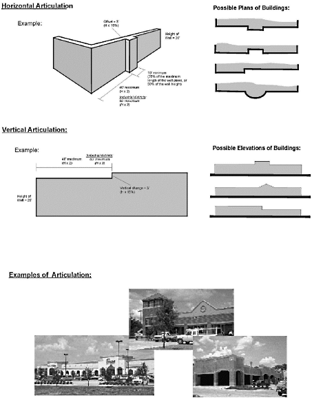
Figure 4-33: Building Facade Articulation
a.
Horizontal Articulation Horizontal features shall include one of the following:
1.
No plane of a building wall shall extend for a horizontal distance greater than two times the height of the wall, or three times the height of the wall in the I and IC districts, without having an offset of 15 percent of the wall's height, and that new wall plane shall extend for a distance equal to at least 25 percent of the maximum length of the first plane.
2.
Alternative methods to provide equal or greater architectural interest may be approved by the decision-making body. Alternative methods may include but are not limited to entry features, canopies, covered porches, architectural details, and/or additional landscaping with shade trees and screening vegetation.
b.
Vertical Articulation Vertical features shall include one of the following:
1.
A pitched roofline with subordinate rooflines at prominent entryways; or
2.
No wall shall extend for a horizontal distance greater than two times the height of the wall, or three times the height of the wall in the I and IC districts, without changing height by a minimum of 15 percent of the wall's height.
3.
An alternative method of vertical articulation providing the level of vertical articulation specified in subsection 2., above, but through alternative designs.
(3)
Integration of Architecture, Signage, and Lighting Exterior interest shall be provided on all facades by breaking the architectural plane or by using material textures, colors, or shadow elements.
(4)
Materials and Colors
a.
The use of color shall be limited to tones, shades and hues that generally blend with the surrounding development pattern or the surrounding on-site soil and vegetation.
b.
Shiny metal roofs shall be prohibited.
c.
Roofs shall be made from fire-resistant materials.
(5)
Shading of Parks and Residences Buildings shall conform with shading requirements in subsection 18.04.101(c), Shading of Parks and Residences.
(d)
Additional Standards for Compatibility Between Employment and Residential Districts When development in Employment Districts occurs in an area subject to Article 14, Residential Adjacency, the following additional standards shall apply:
(1)
Loading docks and semi-truck staging areas shall be designed to minimize noise and odor impacts on residential properties and shall not be located between non-residential buildings and residentially zoned property unless one of the following conditions exist:
a.
The loading docks are screened by another non-residential building on the site; or
b.
The loading docks are screened by a masonry wall at least ten feet in height; or
c.
The loading docks are screened by an enhanced 30-foot-wide landscaped area with a three-foot berm, six-foot-tall masonry wall and landscaping designed to screen the loading docks from the residential areas.
d.
These requirements may be modified through a minor site plan review.
(2)
Developments shall provide landscaping and screening adjacent to all residentially zoned property:
a.
The landscaped area shall be a minimum of 10 feet wide for all developments;
b.
The landscaped area shall increase to a minimum of 15 feet wide for developments containing more than 150,000 square feet of gross floor area or located on a 10 acre or larger site;
c.
The landscaped area shall increase to a minimum of 20 feet wide for developments containing more than 300,000 square feet of gross floor area or located on a 20 acre or larger site; and
d.
Additional landscaping required in some districts for buildings over 35 feet in height shall be in addition to the landscaping required by this section.
(3)
In combination, the maximum landscaped buffer required by these standards and Article 8 Landscaping, Buffering, Screening, and Fencing, standards shall be 30 feet in width.
(4)
Applications for developments containing more than 300,000 square feet of gross floor area or located on a 20 acre or larger site shall:
a.
Provide a site-specific assessment of potential impacts on adjacent residential zoned property and supplemental measures to minimize and mitigate project impacts.
(Ord. No. 6692, § 1(Exh. A), 1-8-25)
Editor's note— Ord. No. 6692, § 1(Exh. A), adopted January 8, 2025, amended the title of § 18.04.1103 to read as herein set out. The former § 18.04.1103 title pertained to General Standards for Nonresidential Districts.
18.04.1104 - District-Specific Standards
(a)
Mixed-Use Airport (MA) District
(1)
Generally
a.
Development Pattern Uses should be organized so that aviation-related uses are closest to the airfield, and so that more intensive uses are buffered from adjacent uses.
(2)
Certain Development Exempt from Discretionary Review, with Exceptions Development within the MA District that meets the adopted standards set forth in this section and the standards set forth in the district where the project is located are exempt from discretionary review and may proceed with a building permit application, with the following exceptions:
a.
Large retail establishments as required to be approved by a conditional use permit in accordance with Section 18.04.1006, Supplemental Standards for Large Retail Establishments;
b.
Hazardous waste or explosives are required to be approved by a conditional use permit in accordance with Subsection 18.08.605(b)(5), Hazardous and Explosive Substances; and
c.
Skyways, skytrams, and skybuildings as specified in Article 16, Skyways;
d.
Gaming operations as specified in Subsection 18.08.605(b)(4), Gaming; and
e.
Where discretionary review is required per Chapter 18.03 Use Regulations.
f.
A conditional use permit is required for certain operating hours, as described by section 18.08.605(b)(3).
(3)
Reno-Tahoe International Airport
a.
Applicability The standards contained in this section shall apply to properties located within the Mixed-Use Airport (MA) District in the Reno-Tahoe International Airport area.
b.
Land Use
1.
All properties shall comply with the following:
[a]
In addition to uses allowed in the Mixed-Use Airport (MA) District, as detailed in Table 3-1, Table of Allowed Uses, applicants may follow the use permissions of the Mixed-Use Urban (MU) District at their discretion. However, once a district is selected by the applicant, the entire project shall be subject to the building and site design standards of that district.
[b]
Uses or buildings utilizing the standards of the Mixed-Use Airport (MA) District are not allowed within 100 feet of the Truckee River, as defined by Washoe County Record of Survey #1167.
[c]
All buildings located within 100 feet of an arterial street shall provide building articulation in accordance with Subsection 18.04.1103(c)(2), Building Articulation, on each building facade that faces the arterial street to the satisfaction of the administrator.
[d]
Temporary asphalt or concrete batch plants are allowed for airport construction for a period not to exceed four years. Temporary asphalt or concrete batch plants shall be located a minimum of 750 feet from residentially zoned property.
[e]
Communication facilities for purposes of air traffic control and airport operations are allowed without conditions.
[f]
Stables and farms are allowed by-right subject to all conditions required by Section 18.08.202 (Additional Regulations for Principal Uses) as amended.
[g]
All residential land uses, primary schools, churches, libraries, medical facilities, and childcare centers are prohibited. Lodging facilities (including hotels and motels without gaming) are only allowed within one-half mile of the airport terminal, subject to the standards of the Mixed-Use Urban (MU) District.
[h]
Operations of the Reno Tahoe International Airport Authority on the east side of Terminal Way are exempt from all standards of the Mixed-Use Urban (MU) District or the Mixed-Use Airport (MA) District except for this subsection (2) and standards related to sidewalk width and pedestrian connections.
c.
Density
1.
On all properties located north of the north bound U.S. Highway 395 on-ramp loop (Entrance 65, starting at the airport terminal) which front on Terminal Way, the minimum residential density shall be 14 dwelling units per acre. The minimum intensity shall be 0.25 FAR for nonresidential and mixed-use developments.
2.
Operations of the Reno-Tahoe International Airport Authority on the east side of Terminal Way are exempt from the FAR and density standards.
d.
Landscaping In cases where required landscaping, such as trees, would interfere with safe airport operations, landscaping features that will not interfere with safe airport operations shall be substituted to the satisfaction of the Administrator.
e.
Residential Interface Properties adjacent to the Boynton Slough, which flows across the southeast portion of the Reno-Tahoe International Airport property, shall be separated from residentially zoned private property with the Boynton Slough (90 feet minimum width) and shall provide a six-foot tall solid masonry or wood fence. A five-foot wide landscape strip with trees planted at a rate of one tree every 30 feet and six shrubs per tree, shall be installed on the south side of the six-foot wall or fence.
f.
Discretionary Review Uses operating between the hours of 11:00 p.m. and 6:00 a.m. shall require a conditional use permit per Section 18.08.605(b)(3) if they are located north of the north bound U.S. Highway 395 on-ramp loop (Entrance 65, starting at the airport terminal) and front on Terminal Way.
(4)
Reno-Stead Airport
a.
Applicability The standards contained in this subsection shall apply to properties located within the Mixed-Use Airport (MA) District in the Reno-Stead International Airport area.
b.
Land Uses
1.
In addition to uses allowed in the Mixed-Use Airport (MA) District, as detailed in Table 3-1 Table of Allowed Uses, applicants may follow the use permissions of the Mixed-Use Suburban (MS) District at their discretion. However, once a district is selected by the applicant, the entire project shall be subject to the building and site design standards of that district.
2.
All residential land uses, schools, churches, libraries, medical facilities, and childcare centers are prohibited. Lodging facilities (including hotels and motels without gaming) are only allowed within one-half mile of the airport terminal, subject to the standards of the Mixed-Use Suburban (MS) District.
c.
Landscaping
1.
Landscaping standards for the Mixed-Use Suburban (MS) District shall apply to properties adjacent to the Mixed-Use Suburban (MS) District.
2.
Landscaping standards for the Mixed-Use Airport (MA) District shall apply to properties that do not qualify under subsection a., above, but which are located adjacent to a public street or the district boundary.
3.
Landscaping shall not be required for properties that are not adjacent to a public road or residentially zoned property.
4.
The Administrator may approve alternative landscaping features in cases where required landscaping would interfere with safe airport operations.
(Ord. No. 6692, § 1(Exh. A), 1-8-25)
18.04.1201 - General Provisions
(a)
Statement of Purpose The purpose of this article is to protect the public by providing safe and orderly developments, by establishing minimum requirements for design, plans, testing, inspection, and supporting documents for improvements provided with new development in the city. This article applies to public and private improvements.
(b)
Authority NRS Section 278.326 provides for enactment of local ordinances governing improvements.
(c)
Applicability The requirements of this article shall apply to any public or other improvements wherein a building or grading permit is required. All development shall conform with City code and with the plans, reports and materials submitted with a project application. In the event of a conflict between the application and City code, City code shall prevail. Improvement plans shall be to the approval of the Administrator prior to final plat approval by or issuance of building permits; and improvements shall be constructed to City standards prior to release of security or issuance of certificates of occupancy. In the event of an error or omission in the accepted improvement plans, City code shall prevail.
(d)
General Compliance Requirement All designs shall conform to City standards, application reports and documents, and the requirements of this article and Chapter 18.06 Land Division, as applicable.
18.04.1202 - Improvement Requirements and Timing of Completion
(a)
Applicant Responsibility for Improvements
(1)
The subdivider or developer shall construct, at their own expense, and within a period as determined by the City, all improvements required by the conditions of approval, the improvement drawings of record, and City Code. Any changes to the improvement plans of record, other than those minor in nature, shall be approved by the Administrator prior to construction. All private improvements within each construction phase of a subdivision, except for recreational facilities, shall be constructed in accordance with the improvement drawings of record.
(2)
An excavation permit is required for excavation within the City's right-of-way. A grading permit and/or building permit shall be obtained prior to any grading.
(3)
Subdivision improvements inspection, testing verification, and acceptance shall be in accordance with City Code.
(b)
Improvement Plans Required
(1)
General Improvement plans shall be to the approval of the Administrator prior to final plat approval or issuance of building permits; and improvements shall be constructed to City standards prior to release of security or issuance of certificates of occupancy.
(2)
Improvement Plan Submittals
a.
Prior to the installation of any improvements, the subdivider or developer shall file all appropriate documents as determined by the Administrator.
b.
All plans and documents submitted shall meet the requirements of NRS Chapter 625, Chapter 18.06 Land Division, and this article. The first sheet of the improvement plans shall contain the statement "These plans, sheets 1 through _______ , have been prepared in accordance with the approved tentative map, conditions of approval, and Reno Municipal Code."
c.
Within 30 days, the Administrator shall complete its review of the plans and documents and advise the subdivider's engineer or surveyor of any revisions or corrections.
(c)
Timing of Completion The timing for completion of required improvements shall be according to following standards:
(1)
Completion of Public Improvements All improvements shown on the plans of record, including primary and secondary or emergency access, shall be constructed and completed within and to serve the subdivision or development prior to the issuance of any certificate of occupancy for the subdivision or development, unless otherwise stated in the terms of an improvement agreement pursuant to Section 18.04.1203, below. For phased subdivision or development projects, please see Section 18.04.1202(c)(4), below.
(2)
Completion of Private Improvements
a.
All private improvements within each construction phase of a subdivision or development, with the exception of recreational facilities, shall be constructed in accordance with the improvement drawings of record and shall be verified by the engineer of record prior to the issuance of any certificate of occupancy for each phase.
b.
Private recreational facilities shall be installed and operational by the time certificates of occupancy have been issued for 75 percent of the dwelling or commercial units within each construction phase of the subdivision.
(3)
Completion of Off-Site Improvements All required improvements located outside the subdivision, development boundary, or phase that are necessary to support the specific subdivision, whether public or private, shall be installed and/or completed and operational prior to the issuance of any certificate of occupancy for any structure within the subdivision phase.
(4)
Completion of Improvements in Phased Projects When the subdivision or development is to be constructed in more than one phase, a phasing plan for all improvements within each construction phase is required according to Section 18.04.1202(b), above. Each construction phase as developed, shall stand on its own and meet the requirements of the total subdivision. All improvements shown on the plans of record, including primary and secondary or emergency access, shall be constructed and completed within the designated construction phase prior to the issuance of any certificate of occupancy for that phase.
18.04.1203 - Improvement Agreements and Security
(a)
Requirement for Improvement Agreement An improvement agreement for construction of public improvements is required prior to final subdivision plat approval, and prior to all other final development plan approvals.
(b)
Contents of Agreement The improvement agreement for construction of public improvements shall be on the document provided by the City, as approved by the City Attorney, and shall include the following exhibits:
(1)
Exhibit "A" An estimate of the quantities and costs of public improvements and on-site improvements. The engineer shall provide an engineer's estimate of the improvement quantities and costs. The city will determine the final estimate of quantities and costs based on the engineer's estimate and the improvement plans of record, and will provide the subdivider/developer with Exhibit A.
(2)
Exhibit "B" A statement of the proposed build-out of the subdivision to be recorded; or when the subdivision to be recorded is to be constructed in more than one phase, a phasing plan for all improvements within each construction phase.
(3)
Exhibit "C" A document, provided by the developer, conforming to the format furnished by the city guaranteeing proper inspection and testing of improvements in accordance with the Public Works Design Manual, latest edition.
(c)
Security for Public Improvements
(1)
Security Required The security for public improvements shall be on a format approved by the City Attorney, shall accompany the improvement agreement, and shall be in such amount as set by the Administrator, corresponding to the improvement agreement, to ensure that all public improvements required by this chapter will be provided and installed by the subdivider or developer within a period as set forth in the improvement agreement.
(2)
Reductions in Security
a.
A reduction of the security for public improvements may be considered once each calendar year or upon completion of 25 percent, 50 percent, or 80 percent of the secured items. The dollar amount of no single item, as set forth in Exhibit "A" to the improvement agreement, shall be reduced below ten percent of the original item amount and the security shall at no time be reduced below 20 percent of the original security amount or as stipulated in the improvement agreement until all improvements have been completed and accepted by the City. The following procedure is to be followed when requesting a reduction in security:
1.
The subdivider or developer shall make a formal request in writing to the City that the security be renegotiated.
2.
The project engineer shall provide the City with an estimate of the work remaining in the format as provided by the City.
3.
The City will determine the total amount of security reduction allowed based on the estimated amount of work remaining as provided by the project engineer and verified by the City, and shall provide the subdivider/developer with a revised Exhibit "A".
4.
The subdivider/developer shall submit to the City new security, in the format as provided by the City with revised Exhibit "A" attached, for the improvements remaining.
5.
Upon approval as to legal form of the new security by the City Attorney, the new security will be filed with the City Clerk and the old security document returned.
b.
When a reduction in security is requested, service charges are required in accordance with City requirements.
c.
In no case shall a reduction in security be construed as constituting a final acceptance of improvements by the City, either in whole or in part.
(d)
Improvement Agreement Extension
(1)
In the event that all improvements shown on Exhibit "A" to the improvement agreement cannot be completed and the public improvements accepted by the City within the time period of the improvement agreement, the developer may make application to the City for an improvement agreement extension, not to exceed two years, which requires new security for the public improvements in an amount determined by the City. Granting of such extension will require approval by the Administrator. In the event that the Administrator denies a request for an extension, or an extension is granted by the City Manager or their designee and at the end of a two-year period following such extension, substantial improvements as shown on Exhibit "A" to the improvement agreement have not been completed, the City Council may cause any or all lands within the recorded plat to be reverted to acreage.
(2)
The subdivider/developer shall file with the City at least 30 days prior to the date for which approval of an improvement agreement extension is sought, the following, including the service charge:
a.
Improvement agreement extension on the form provided by the City, with copies of exhibits attached.
b.
New security to cover the public improvements listed in Exhibit "A."
c.
Estimate of the percent of completion of the bonded improvements.
d.
Written justification for an extension of the original agreement.
e.
Copy of the appropriate water purveyor's letter of commitment to supply water.
(e)
Default and Remedies In the event that the subdivision improvements are not completed within the time period of the improvement agreement and the improvement agreement is not otherwise extended, the subdivision, and specifically the improvement agreement shall be deemed in default. Issuance of building permits and certificates of occupancy will be terminated immediately upon default of the subdivision improvement agreement, and the security for public improvements may be called on as set forth in Section 18.04.1203. "Stop-work" orders will be immediately issued and remain in effect until a subdivision improvement agreement extension has been granted by the City; or the City resorts to the security and causes completion of the public subdivision improvements or causes reversion to acreage. In the event of the reversion of the land to acreage, the land shall be restored to a condition that does not pose a threat to the health, safety and welfare of the community, and any public improvements which are determined by the City to be necessary for the wellbeing of the community shall be provided. The City Council may determine and cause some or all of the public improvements to be installed by the City and expenses thereof assessed against the lots or parcels within the subdivision in accordance with the charter provisions of the City.
18.04.1204 - Residential Construction Tax for Parks, Playground, and Recreational Facility Improvements
(a)
Purpose and General Provisions
(1)
This article is enacted pursuant to the authority of Chapter 726 of the 1973 Statutes of Nevada, as amended, adopted by the legislature of the state on April 30, 1973, to provide for the acquisition, improvement and expansion of public park, playground, and recreational facilities.
(2)
The public interest, convenience, health, welfare, and safety require that certain amounts of land in the city be devoted to park, playground, and recreational purposes, which include neighborhood, district, and regional facilities serving various recreational needs of the residents of the city and the neighborhoods located therein. The geographical areas of the city are, by this article, divided into various park districts, taking into account in such division the uneven population distribution throughout the geographical areas of the city. It is the intent of the City Council that park districts created herein shall periodically be revised, both in number and location, to take account of future population distribution within the different geographical areas of the city and to ensure on a continuing basis that all monies collected are expended, as nearly as practicable and feasible, in the immediate area from which they are collected.
(b)
Definitions As used in this Chapter, unless the context otherwise requires, the following terms shall have the meanings that are ascribed to them as follows:
(1)
"Park" or "park facilities" means a tract of land that is dedicated to, and set aside and maintained for, outdoor recreational purposes and includes, without limitation, areas of turf and trees, playgrounds, fitness equipment, picnic facilities, skate parks, sport courts, playing fields for recreational sports, restrooms, parking lots and other recreational appurtenances for the benefit of the general public.
(2)
"Neighborhood park" means a park the size of which is not less than three acres and not more than twenty-five acres and which is designed to serve natural persons, families and small groups in the park district that is created for the benefit of the neighborhood from which any residential construction tax is derived.
(3)
"Residential dwelling unit" means living units intended for human habitation and which is not subject to a transient lodging tax imposed pursuant to Section 2.10.200 including, without limitation, duplexes, apartments, condominiums, townhouses, detached houses, accessory dwelling units as defined by Section 18.24.203.1840, lots for mobile homes, or for any remodeling of a nonresidential structure for the purpose of converting to a residential dwelling unit(s) as defined herein.
(4)
"Developed open space" means a common open space within a residential subdivision or development that is developed with active recreational appurtenances, which may include any park facilities as defined herein.
(5)
"Trail or Trail System" means a non-motorized trail or network of trails developed to Class 3, Class 4 or Class 5 standards as defined by the US National Forest Service. For the purposes of this section, the following types of trails may be eligible for funding through residential construction tax subject to approval by the Director of Parks and Recreation:
a.
A Class 5 multi-use recreational trail with a hardened surface physically separated from a road or street, contains additional recreational amenities along the trail, and which connects parks within a planned unit development.
b.
A Class 3 or Class 4 single-use or multi-use recreational trail contained entirely within a neighborhood park and designed for one or more specific recreational purposes, such as mountain biking, trail running, walking or hiking.
(6)
"Residential Construction Tax" means the tax imposed by this chapter for the privilege of constructing residential dwelling units.
(c)
Imposition and Rate of Residential Construction Tax
(1)
Prior to the issuance of any building permit for the construction of any residential dwelling unit, the development of any mobile home lot or the remodeling of any nonresidential structure within the incorporated limits of the city for the purpose of residential use, the applicant shall pay to the City a residential construction tax fee which shall be equal to one percent to the nearest dollar of the value or valuation, or $1,000.00, whichever is less, of the residential dwelling unit, mobile home lot or converted residential structure as reflected on the building permit. The value or valuation of the building permit shall reflect actual costs of residential construction in the area as determined by the Development Services Department in accordance with the building code in effect in the city and Marshall-Swift formulas utilized by the Washoe County Assessor's Office.
(2)
In the case of remodeling a nonresidential structure into residential dwelling unit(s), the value or valuation of the building permit shall reflect the actual cost of remodeling the structure for use as a residential dwelling unit(s).
(3)
For the purposes of this chapter, the following types of development shall not be required to pay a residential construction tax: reconstruction of any building damaged by fire or other natural causes; rehabilitation, remodeling or expansion of an existing dwelling unit; replacement of a structure used as a dwelling unit on which a residential construction tax was previously paid; or construction of a structure for student housing by the State of Nevada or political subdivision thereof and located on land owned by the governmental agency constructing the student housing complex.
(d)
Creation of Neighborhood Park and Park Facilities Districts
(1)
There are hereby created within the city five neighborhood park and park facilities districts which are designated by numbers one through five and the boundaries of which are designated on a map of the city that is available for inspection at the administrator's office and incorporated herein by reference thereto. Residential construction taxes collected within a particular district will be expended for the acquisition, improvement and/or expansion of neighborhood parks and facilities for parks within said district which are required by the residents of those apartment houses, mobile homes and residences within said district.
(2)
The parks and recreation department is hereby directed to conduct a continuing study of population trends and concentrations as well as of neighborhood development throughout the city and shall, at least once every five years, submit recommendations to the city council, based on such study, suggesting any changes, either in number or boundary locations, which may be necessary to ensure that monies collected from the residential construction tax are expended for the benefit of the residents within the district from which they were collected.
(3)
The City Council shall consider the recommendations of the Parks and Recreation Department required by Section 18.04.1204(d)(2) in determining whether any amendment to 18.04.1204(d)(1) is required. If the City Council determines amendment to Section 18.04.1204(d)(2) is required, it shall consider the recommendations of the Parks and Recreation Department in adopting such amendment.
(e)
Creation of Neighborhood Park and Park Facilities Fund
(1)
The Office of the Director of Finance shall establish a special fund known as the neighborhood park and park facilities fund.
(2)
The neighborhood park and park facilities fund shall be divided into separate accounts. There shall be one account for each neighborhood park and park facilities district.
(3)
All taxes collected pursuant to Section 18.04.403 shall be placed in the account within the neighborhood park and park facilities fund for the district in which the tax was collected.
(4)
All interest derived from monies within the neighborhood park and park facilities fund shall accrue to such fund and to the particular district account within the fund from which the interest was derived.
(5)
Neighborhood park and park facilities fund monies shall be used only for consultant fees and the acquisition, improvement, and expansion of neighborhood park and park facilities in the city. Such monies shall be expended for the benefit of the residents within the district from which they were collected.
(6)
If a neighborhood park has not been developed or park facilities installed or improvements made to existing or neighborhood parks within the park district created to serve the neighborhood within three years after the date on which 75 percent of the residential dwelling units within an approved subdivision or development are first occupied, all money paid by the subdivider or developer, together with interest at the rate at which the City has invested the money in the fund, shall be refunded to the owners of the lots in the subdivision or development on a pro rata basis.
(f)
Refunds for Amenities A developer shall be entitled to a refund of all of the money that is paid with respect to a residential subdivision or development, together with interest thereon at the average rate at which the City has invested the money in the special revenue fund that is provided for in this chapter, if that developer, at any time prior to the date on which seventy-five percent of the residential dwelling units that are authorized within such subdivision or development first became occupied:
(1)
Provides for and establishes, in the recorded declaration of conditions, covenants and restrictions with respect to such subdivision or development, an association for the common ownership and maintenance of a developed park site or area that is designed for, and dedicated exclusively to, recreation in such subdivision or development, such developed park site or area continues to be owned and maintained by such organization for park and recreational use by the existing and future residents of such subdivision or development and such developed park site or area contains a minimum of two hundred fifty (250) square feet of developed open space per dwelling unit in such subdivision or development;
(2)
Constructs a public park, which satisfies the square-footage requirement and contains the amenities that are set forth in Subsection (a) of this Section; or
(3)
Constructs a combination of private park facilities that are established, owned and maintained in accordance with the recorded declaration of conditions, covenants and restrictions with respect to such subdivision or development, as the same is required by Subsection (a) of this Section, and public park facilities, which combination, in the aggregate, satisfies the square-footage requirement and contains the amenities that are set forth in Subsection (a) of this Section.
(g)
Application for Alternative Treatment
(1)
A developer who seeks alternative treatment shall submit to the City a proposed development plan, project narrative and a construction timetable for the project. Developer may submit such plans and documents in conjunction with and as part of an application for a development agreement pursuant to RMC Section 18.20 Development Agreements.
(2)
The City Council, with input from appropriate staff, shall review the developer's submissions and shall approve or deny such application, or request such additional information as is deemed necessary. The process of review and approval shall take into account and be based upon the City's park specifications and the intent of this chapter.
(3)
If an application is approved, the residential construction tax for the project may be credited, or refunded conditioned upon the developer's execution of an agreement with the City requiring the developer to construct and maintain the park facilities and submit security for their construction in an amount equal to the estimated cost of construction, as determined by the City, plus ten percent for contingency. The instruments of security or other agreements shall specify the duration of the security and its manner of release, and shall provide remedies in the event of default.
(h)
Types of Construction Security The security submitted for the construction of the park facilities pursuant to Sections 18.04.406 or 407 may be as follows:
(1)
A deposit of cash or approved government securities;
(2)
A surety bond issued by a surety company authorized to do business in the State and in a form approved by the City Attorney;
(3)
An agreement with a local financial institution which provides generally that out of the funds loaned to the developer for the construction of the subdivision or development, the lending institution will require that sufficient funds to complete the park facilities and the removal of all rubbish, trash, debris, surplus material and equipment from the area that is to be improved and the adjacent properties will be set aside and used for that purpose, that the lending institution will maintain a ten percent retention of the funds until the installation of the park facilities and the release of funds have been approved by the City;
(Ord. No. 6585, § 1, 1-13-21; Ord. No. 6692, § 1(Exh. A), 1-8-25)
18.04.1205 - Regional Road Impact Fee
(a)
General Provisions
(1)
Short Title, Authority and Application
a.
Title This article shall be known and may be cited as the Regional Road Impact Fee (hereinafter "RRIF") article.
b.
Authority The City Council has the authority to adopt this article pursuant to the Nevada Constitution, NRS Chapter 278, NRS Sections 278B.010—278B.320, NRS Section 244.155, NRS Section 244.195, and NRS Sections 277.080—277.180.
c.
Application This article shall apply to all lands within the boundaries of the City of Reno and pursuant to the Regional Road Impact Fee Ordinance Interlocal Cooperative Agreement (hereinafter "RRIF Interlocal Cooperative Agreement").
d.
Effective Date The RRIF article shall become effective 30 days after this article and similar ordinances are adopted by Washoe County and the City of Sparks.
(2)
Intent and Purpose
a.
Intent Intent is to implement regional CIP, local road CIPs and local master plans. This article is intended to implement and be consistent with the Regional Road Impact Fee System Capital Improvements Plan (hereinafter "RRIF CIP"), the City of Reno Capital Improvements Plan (hereinafter "Local CIP") and Master Plan, and the Local CIPs and master plans of the other two participating local governments.
b.
Purpose Purpose is to establish a region wide impact fee program. The purpose of this article is to establish a region wide impact fee program by the establishment of a comprehensive and region wide system for the imposition of road impact fees to assure that new development contributes its proportionate share of the cost of providing, and benefits from the provision of, the road capital improvements identified as needed to be built in the RRIF CIP which has been adopted as the City of Reno's CIP, and the local CIP of the other two participating local governments.
(3)
Liberal Construction, Severability and Penalty Provisions
a.
Liberal Construction The provisions of this article shall be literally construed to effectively carry out its purposes in the interest of the public health, safety, welfare, and convenience.
b.
Severability If any subsection, phrase, sentence or portion of this article is for any reason held invalid or unconstitutional by any court of competent jurisdiction, such portion shall be deemed a separate, distinct and independent provision, and such holding shall not affect the validity of the remaining portions.
(b)
Adoption and Amendment of RRIF Manual The latest edition of the regional road impact fee system general administrative manual (hereinafter "RRIF manual") approved by the Regional Transportation Commission of Washoe County is hereby adopted by reference. The RRIF Manual shall contain appropriate definitions, an independent fee calculation study, exemptions, credits, appeals and review sections for the effective administration of the program. It may subsequently be amended by a resolution approved by the regional transportation commission board and the governing bodies of each participating local government.
(c)
Adoption of RRIF Capital Improvement Plan The latest edition of the regional road impact fee capital improvement program (RRIF CIP) adopted by the Regional Transportation Commission of Washoe County is hereby adopted by reference. It may be amended only by subsequent ordinance.
(d)
Service Areas There are hereby established two service areas for the imposition of regional road impact fees and the collection and expenditure of funds under the provisions of this article. The service areas are identified in Figure 3 of the RRIF CIP and are defined as:
(1)
North Service Area Starting at the southwest corner of the district at the California-Nevada state line and Interstate 80, follow the state line north to the northern boundary of the Washoe County North Valleys planning area (i.e., northern boundary of the Red Rock Hydrographic Basin boundary), then east along the northern boundary of the North Valleys planning area (i.e., northern boundary of the Red Rock and Bedell Flat Hydrographic Basin boundary), then north to the northwest corner of the Warm Springs planning area, then north and east along the northern boundary of the Warm Springs planning area, then southeast and south along the boundary of the Warm Springs planning area, then west along the southern boundary of the Warm Springs planning area to the eastern edge of the Washoe County Spanish Springs planning area and the Washoe County Truckee Canyon planning area, then southwest along the western edge of the Truckee Canyon planning area to Interstate 80, then west along Interstate 80 to the California-Nevada state line.
(2)
South Service Area Starting at the northwest corner of the district at the California-Nevada state line and Interstate 80, follow Interstate 80 east to the western edge of the Washoe County Truckee Canyon planning area, then south along the Washoe County-Storey County line to the Washoe County-Carson City line, then west along the Washoe County-Carson City line to the southern jurisdictional line of the Tahoe Regional Planning Agency and the Washoe County Tahoe planning area, then north along the California-Nevada state line to Interstate 80.
(e)
Amount of Impact Fees to be Imposed
(1)
The amount of the impact fees shall be determined by the local RRIF Administrator in accordance with the applicable provisions of the RRIF Manual Adopted by the Regional Transportation Commission of Washoe County on September 19, 2014 or by resolution as provided in Subsection 18.04.1205(b), Adoption and Amendment of RRIF Manual, and in conjunction with the fee schedule identified as Appendix B of the RRIF CIP. Appendix B may be amended by ordinance or in accordance with subsection (b) as authorized by NRS Section 278B.225.
(2)
Except as provided in subsection (d), the current amount of the impact fee set forth in the column designed "Fees" in Exhibit D of the RRIF Manual shall be automatically increased to off-set inflation each year in which the City does not:
a.
Adopt any revisions to the land use assumptions regarding the Regional Road Impact Fee; or
b.
Adopt any revisions to the capital improvement plan; or
c.
Otherwise increase the impact fee.
(3)
In years of an automatic increase, the current amount of the impact fee may be increased:
a.
By a percentage equal to the average annual percentage of increase in the Consumer Price Index for West Urban Consumers for the preceding five calendar years; or
b.
By 4.5 percent, whichever is less.
(4)
Each increase authorized in subsection (b) shall be cumulative and become effective one year after:
a.
The date upon which the impact fee initially becomes effective; or
b.
The date the City Council adopts a revised capital improvements plan; or
c.
The effective date of any previous increase in the impact fee pursuant to subsection (b), whichever occurs last.
(5)
The amount of the fee for a traffic generating land development activity paying the fee shall be determined by the date the building permit application or certificate of occupancy is issued by the Development Services Department, City of Reno.
(f)
Use of Funds
(1)
Establishment of Trust Fund There is hereby established the City of Reno Regional Road Impact Fee Trust Fund (hereinafter "City of Reno RRIF Trust Fund") and the RTC Regional Road Impact Fee Trust Fund (hereinafter "RTC RRIF Trust Fund") for the purpose of ensuring that fee payers receive sufficient benefit for regional road impact fees paid.
(2)
Deposit in Trust Fund/General Requirements for Trust Fund
a.
All regional road impact fees collected by the City of Reno's RRIF Administrator pursuant to this article shall be immediately deposited in the City of Reno RRIF Trust Fund.
b.
Any proceeds in the City of Reno RRIF Trust Fund not immediately necessary for expenditure shall be invested in an interest bearing account. All income derived from these investments shall be retained in the City of Reno RRIF Trust Fund until transferred to the RTC RRIF Trust Fund. Record of the City of Reno RRIF Trust Fund accounts shall be available for public inspection in the Local Government RRIF Administrator's Office, during normal business hours.
c.
No less frequently than quarterly, and pursuant to the RRIF Interlocal Cooperative Agreement, the City of Reno RRIF Administrator shall transfer the impact fee funds in the City of Reno RRIF Trust Fund to the RTC RRIF Administrator, who shall deposit these funds in the RTC RRIF Trust Fund. All proceeds in the RTC RRIF Trust Fund not immediately necessary for expenditure shall be invested in an interest bearing account. Records of the RTC RRIF Trust Fund accounts shall be available for public inspection in the RTC RRIF Administrator's office, during normal business hours.
(3)
Limitations on Expenditures
a.
Impact fee monies shall only be expended from funds drawn from the RTC RRIF Trust Fund.
b.
Funds shall only be expended on those projects selected by the RTC Board and approved by the RTC board and the participating local governments in the RRIF interlocal cooperative agreement.
c.
The expenditure of impact fee funds shall be limited to those road capital improvement projects included in the RRIF CIP.
d.
For the purposes of determining whether impact fee funds have been spent or encumbered, the first fees collected shall be considered the first monies spent or encumbered.
e.
If impact fee funds transferred to the RTC RRIF Trust Fund are required to be refunded pursuant to Section VIII of the RRIF Manual, they shall be returned by the RTC RRIF Administrator to the Local RRIF Administrator for refund.
(4)
Service Areas The two service areas within which impact fees are collected are described in the RRIF CIP. Impact fee funds shall be spent within the service area from which the traffic generating land development activity paying the fee is located, except that:
a.
Where a road on the RRIF Network as identified in the RRIF CIP is used to define service area boundaries, the road demarcating the boundary shall be considered as part of both service areas that it bounds, the impact fees from both service areas may be used to fund road capital improvements for that road, including regionally significant freeway ramps that provide access to a boundary road; or
b.
Impact fee funds may be used to fund a road capital improvement on the RRIF CIP outside the service area from which the fees are collected if it is demonstrated by competent substantial evidence that the fee payers from the service area from which the fees come will receive sufficient benefit from the road capital improvement, as provided in the RRIF Manual.
(Ord. No. 6692, § 1(Exh. A), 1-8-25)
18.04.1206 - Police Facility Impact Fee
(a)
General Provisions
(1)
Short Title, Authority, and Application
a.
Title This article shall be known and may be cited as the "police facility impact fee" (hereinafter "PFIF") article.
b.
Authority City Council has the authority to adopt this article pursuant to the Nevada Constitution, Sec. 278, et seq., NRS, Sec. 278B.010—278B.320, NRS, Sec. 244.155 and 244.195, NRS, and Sec. 277.080—277.180, NRS.
c.
Application This article shall apply to all lands within the boundaries of the City of Reno.
(2)
Intent and Purpose
a.
Intent Intent is to implement the police facility capital improvements plan and the Master Plan. This article is intended to implement and be consistent with the City of Reno Police Facility Impact Fee Capital Improvements Plan (hereinafter "PFIF CIP") and the Master Plan.
b.
Purpose Purpose is to establish a police facility impact fee program. The purpose of this article is to establish an impact fee program for the imposition of police facility impact fees to assure that new development contributes its proportionate share of the cost of providing, and benefits from the provision of, the police facility capital improvements identified as needed to be built in the adopted PFIF CIP.
(3)
Liberal Construction, Severability, and Penalty Provisions
a.
Liberal Construction The provisions of this article shall be literally construed to effectively carry out its purposes in the interest of the public health, safety, welfare, and convenience.
b.
Severability If any subsection, phrase, sentence, or portion of this article is for any reason held invalid or unconstitutional by any court of competent jurisdiction, such portion shall be deemed a separate, distinct, and independent provision, and such holding shall not affect the validity of the remaining portions.
(b)
Adoption and Amendment of PFIF Manual The latest edition of the Police Facility Impact Fee System General Administrative Manual (hereinafter "PFIF Manual") approved by City Council is hereby adopted by reference. The PFIF Manual shall contain appropriate definitions, an independent fee calculation study, exemptions, credits, appeals, and review sections for the effective administration of the program. It may subsequently be amended by a resolution approved by City Council.
(c)
Adoption of PFIF Capital Improvement Plan The latest edition of the PFIF CIP adopted by City Council is hereby adopted by reference. It may be amended only by subsequent ordinance.
(d)
Service Area There is a hereby established one service area for the imposition of police facility impact fees and the collection and expenditure of funds under the provisions of this article. The service area is identified in Appendix A of the PFIF CIP and is defined as all lands within the boundaries of the City of Reno except Nevada System of Higher Education, Reno-Tahoe Airport Authority, and tribal lands.
(e)
Amount of Impact Fees to be Imposed
(1)
The amount of the impact fees shall be determined by the PFIF Administrator in accordance with the applicable provisions of the PFIF Manual Adopted by resolution as provided in Section 18.14.502 and in conjunction with the fee schedule identified as Appendix 2 of the PFIF CIP.
(2)
The amount of the fee for a land development activity paying the police facility impact fee shall be determined by the date the building permit application or certificate of occupancy is issued by the Development Services Department.
(f)
Use of Funds
(1)
Establishment of Trust Fund There is hereby established the City of Reno Police Facility Impact Fee Trust Fund (hereinafter "City of Reno PFIF Trust Fund") for the purpose of ensuring that fee payers receive sufficient benefit for police facility impact fees paid.
(2)
Deposit in Trust Fund/General Requirements for Trust Fund
a.
All police facility impact fees collected by the City of Reno's PFIF Administrator pursuant to this article shall be immediately deposited in the City of Reno PFIF Trust Fund.
b.
Any proceeds in the City of Reno PFIF Trust Fund not immediately necessary for expenditure shall be invested in an interest-bearing account. All income derived from these investments shall be retained in the City of Reno PFIF Trust Fund until transferred to the RTC RRIF Trust Fund. Record of the City of Reno RRIF Trust Fund accounts shall be available for public inspection in the City of Reno Finance Department, during normal business hours.
(3)
Limitations on Expenditures
a.
Impact fee monies shall only be expended from funds drawn from the PFIF Trust Fund.
b.
Funds shall only be expended on those projects selected and approved by City Council.
c.
The expenditure of impact fee funds shall be limited to those police capital improvement projects included in the PFIF CIP.
d.
For the purposes of determining whether impact fee funds have been spent or encumbered, the first fees collected shall be considered the first monies spent or encumbered.
(g)
Termination Date The PFIF article shall terminate 10 years after this article is adopted or when impact fee revenue collections reach the cost of the planned Public Safety Center at 455 East 2nd Street attributable to new development, whichever comes first.
(Ord. No. 6692, § 1(Exh. A), 1-8-25)
18.04.1301 - Purpose
The purpose of this article is to provide for exterior lighting that protects and promotes public health, safety, and welfare by permitting reasonable uses of exterior lighting for nighttime safety, utility, security, and enjoyment while minimizing light pollution, increasing energy efficiency, and promoting high quality lighting design that enhances the built environment.
18.04.1302 - Applicability
(a)
New Development All exterior lighting shall be installed in conformance with this article and other applicable City codes.
(b)
Additions and Renovations Any addition or renovation that results in new exterior lighting being installed or modified shall follow this article for any of the proposed lighting.
(c)
Exemptions
(1)
Emergency Lighting Lighting used only under emergency conditions shall not be subject to this article.
(2)
Seasonal Lighting Temporary seasonal lighting between Thanksgiving and January 15 shall not be subject to this article, provided such lighting does not create glare to motorists or result in light trespass onto adjacent properties. This exemption shall not apply to the use of holiday-style lights outside the allowed season.
(3)
Lighting Required by FAA or FCC Lighting required by the Federal Aviation Administration or the Federal Communications Commission shall not be subject to this article.
(4)
Special Events Special events that have been issued a temporary use permit pursuant to Article 5 of Chapter 18.03, Temporary Uses and Structures, shall be allowed temporary lighting for the duration of the event, provided such lighting does not create glare to motorists or result in light trespass onto adjacent properties.
(5)
Lighting Required by Building Code Any lighting that is required by the building code for life safety purposes such as stairway lighting, walkways, and building entrances, shall not be prohibited by this article but shall be subject to the lighting standards.
(6)
Streetlights Streetlights designed in accordance with the Public Works Design Manual.
(Ord. No. 6692, § 1(Exh. A), 1-8-25)
18.04.1303 - Administration
(a)
Lighting Plan Submittal Required For all conditional use permits, minor conditional use permits, minor site plan reviews, major site plan reviews, and building permits, the applicant shall, as part of the application process, submit sufficient information to enable the Administrator or decision-making body to determine whether proposed lighting complies with this article. Except for single-family and duplex residences, the Administrator may require a photometric plan if necessary to demonstrate compliance with this article.
(b)
Plan Approval If the Administrator determines that any proposed lighting does not comply with this article, the associated permit shall not be issued or the application approved unless an alternative is approved pursuant to subsection (c), below.
(c)
Administrative Approval of Lighting Alternatives The Administrator may approve alternative lighting designs, materials, or methods of installation or operation not specifically prescribed by this article provided the proposed alternative:
(1)
Results in approximate equivalence to the applicable specific requirement of this article; and
(2)
Complies with the intent of this article.
(Ord. No. 6692, § 1(Exh. A), 1-8-25)
18.04.1304 - General Exterior Lighting Standards
The following standards for exterior lighting apply to all districts except the MD-ED, MD-UD, MD-ID, MD-RD, and MD-NWQ Districts:
(a)
Prohibited Lighting Types Lighting shall conform to the following standards:
(1)
Light fixtures within 100 feet of a residential zoned property or within a residential zone shall not exceed 18 feet in height both attached to a building and freestanding. Additional height may be permitted by the Administrator if lights are a sharp cutoff lighting system pursuant to section 18.04.1303(c), Discretionary Approval of Lighting Alternatives.
(2)
For properties that are not within areas regulated by the above standard, light fixtures shall not exceed 30 feet in height both attached to a building and freestanding light poles. Additional height may be permitted by the Administrator if lights are a sharp cutoff lighting system pursuant to section 18.04.1303(c), Discretionary Approval of Lighting Alternatives.
(3)
All lights shall be fully shielded and directed away from abutting properties directed downwards to prevent glare and shine.
(4)
Lighting shall not create greater than 0.5-foot candle of spillover light at any property line unless approved by the Administrator pursuant to Section 18.04.1303(c), Discretionary Approval of Lighting Alternatives.
(5)
Warm lighting that possesses a color temperature below 4,000 degrees Kelvin is required. White and blue-white are prohibited.
(b)
Prohibited Lighting Types The following types of exterior lighting are prohibited unless allowed elsewhere in this Title:
(1)
Lights affixed to the top of a roof, except where required by building code;
(2)
Lights that flash, move, revolve, blink, flicker, vary in intensity, change color, or use intermittent electrical pulsation;
(3)
Lights directed toward areas where air traffic is engaged in an initial straight climb following takeoff or in a straight final approach toward a landing at an airport; and
(4)
Searchlights, unless permitted by the Administrator for a period not to exceed three days. No more than three such permits may be issued for the same location within a one-year period.
(c)
Shielding and Light Trespass
(1)
All light fixtures are required to be fully shielded, unless approved by the Administrator pursuant to Section 18.04.1303(c), Discretionary Approval of Lighting Alternatives.
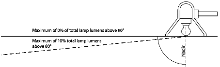
Figure 4-34: Light Fixture Shielding
(2)
All light fixtures shall be aimed and shielded so that the direct illumination shall be confined to the property boundaries of the source or the adjoining public rights of way. Lighting shall not be aimed onto adjacent properties.
(3)
Light trespass onto adjacent public rights-of-way is allowed but may be limited by the Administrator to address a public safety concern or maintain lighting levels consistent with the surrounding area. See Figure 4-35.
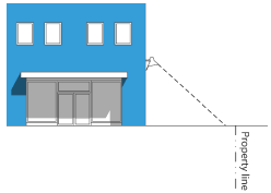
Figure 4-35: Light Trespass
(d)
Lighting Controls
(1)
Lighting Hours All exterior lighting, except security lighting and flagpole lighting, shall be extinguished outside of business hours, or between the hours of 11:00 p.m. and 6:00 a.m., whichever is more permissive. This may be modified with the approval of a minor site plan review.
(2)
Motion Sensors
a.
Motion sensors may be used where the sensor is triggered by activity within the property lines only.
b.
Motion sensing fixtures shall be adjusted to turn off when detected motion ceases and shall only be used with incandescent, fluorescent, LED lighting, or halogen lamps.
(e)
Floodlights and Spotlights
(1)
Floodlights and spotlights shall be fully shielded so that the light element is not visible to an observer on any residentially zoned property or any public right-of-way.
(2)
Stationary floodlighting of the structure is permissible if nothing else is floodlighted and the lighting is screened in a manner that is architecturally compatible with the structure.
(Ord. No. 6692, § 1(Exh. A), 1-8-25)
18.04.1305 - Lighting for Outdoor Recreation and Entertainment Facilities
(a)
Hours of Operation Exterior lighting of recreation or entertainment event shall be turned off by 10:00 p.m. or no later than one hour after the end of the event, whichever is later.
(b)
Lighting for outdoor recreation and entertainment facilities may exceed the standards of Article 13, Exterior Lighting, as necessary to achieve usual and customary lighting levels for the proposed facility with approval of a minor site plan review.
(Ord. No. 6692, § 1(Exh. A), 1-8-25)
Editor's note— Ord. No. 6692, § 1(Exh. A), adopted January 8, 2025, repealed the former § 18.04.1305, and renumbered §§ 18.04.1306, 18.04.1307, as §§ 18.04.1305, 18.04.1306 as set out herein. The former § 18.04.1305 pertained to parking area lighting and derived from original source code.
18.04.1306 - Installation and Maintenance
(a)
Maintenance Exterior lighting shall be maintained in good structural condition at all times.
(b)
Lamp or Fixture Substitution Any proposed change to the type of light source after a permit has been issued shall require submitting a change request to the Administrator for approval prior to substitution.
(c)
Underground Electrical Service Required New electrical service required for exterior lighting shall be located underground.
(Ord. No. 6692, § 1(Exh. A), 1-8-25)
18.04.1401 - Purpose
The purpose of this article is to promote compatible transitions between land use areas of differing intensities and to reduce potential negative impacts that may occur when mixed-use and nonresidential type of development is located near residential zoning districts.
(Ord. No. 6692, § 1(Exh. A), 1-8-25)
18.04.1402 - Applicability
This article applies to all nonresidential development built on or within 300 feet of any property in a residential zoning district or a mobile home park, exempting nonresidential developments that are no greater than 35 feet in height and are separated from residentially zoned property by a freeway. For mixed-use development, this article applies to nonresidential project components, including access and circulation routes.
(Ord. No. 6692, § 1(Exh. A), 1-8-25)
18.04.1403 - Use Limitations
(a)
Where these residential adjacency standards apply, the following uses or features shall be prohibited as principal or accessory uses:
(1)
Public address systems that exceed the limits established in Section 18.04.1408, Noise; and
(2)
Outdoor storage located between a principal building and a residentially zoned property.
(Ord. No. 6692, § 1(Exh. A), 1-8-25)
18.04.1404 - Grading
(a)
All grading for subdivision improvements, conditional use permits, or other discretionary or building permits shall:
(1)
Not place any fill for a distance of 5 feet from the shared property line.
(2)
For a distance of 20 feet from the shared property line with a residentially zoned property, fill depths shall not exceed the natural grade by more than 4 feet.
(3)
For a distance of 50 feet from the shared property line with residentially zoned property, fills depths shall not exceed the natural grade by more than 8 feet. See Figure 4-36, below.
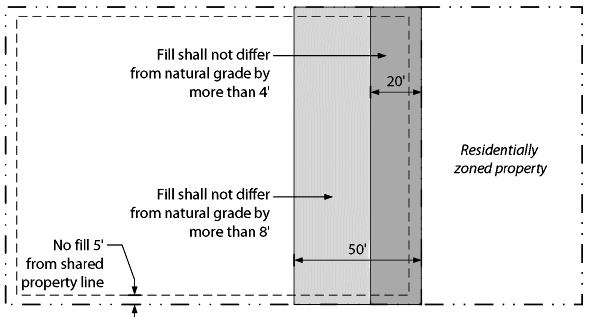
Figure 4-36: Grading Near Property Line
(b)
Grading for nonresidential development adjacent to single-family zoned property shall not include fill slopes which exceed the pad grades of the adjoining single-family residences within 20 feet of the property line of the single-family residence.
(c)
Exceptions or variations from these standards may be approved with written consent of the adjoining residential property owner or when the decision-making body determines that the proposed variation from the strict application of these standards in consistent with development patterns in the area and would not significantly impact the adjoining residence. Alternative features for compatibility may be required when approving exceptions.
(Ord. No. 6692, § 1(Exh. A), 1-8-25)
18.04.1405 - Site and Building Orientation
(a)
Site Orientation
(1)
To the extent feasible, nonresidential developments shall be designed with higher activity areas, such as parking, circulation, loading, and delivery areas, oriented away from any abutting residential uses.
(2)
Where site limitations necessitate higher activity levels abutting residential uses, additional landscaping and/or screening may be required.
(b)
Building Configuration
(1)
Multi-building developments shall be configured to locate the tallest and largest structures within the core of the site and provide a gradual decrease in building height and mass towards adjacent residential land uses.
(2)
Horizontally integrated mixed-use developments shall locate nonresidential uses away from the adjacent residential district.
(c)
Building Facades Developments shall be constructed such that the facade design, including roof lines and roof treatments, is consistent on all sides of the building that are visible from public streets or residential districts.
(d)
Transitions To reduce impacts on residentially zoned property, buildings constructed within 150 feet of a residentially zoned property shall comply with the standards outlined in subsection 18.04.903(c)(1), Additional Setbacks and Stepbacks for Compatibility.
18.04.1406 - Signage Adjacent to Residential
(a)
No advertising signage shall be permitted on a rear or side building facade that faces an abutting residentially zoned property.
(b)
All advertising signage adjacent to and visible from residential districts shall be carefully designed to minimize visibility from adjacent residential districts. Internally illuminated signs may not be oriented toward residential districts. Signs adjacent to residential, even when not oriented toward residential districts, may only be illuminated during allowed hours of operation per subsection 18.04.1403, Use Limitations.
(Ord. No. 6692, § 1(Exh. A), 1-8-25)
18.04.1407 - Noise
(a)
Noise at Residential Property Lines
(1)
Measurement Measurement of noise shall be made at the residential property line with a sound level meter and octave band analyzer meeting the standards prescribed by the American Standards Association.
(2)
Permissible Noise Level
a.
Nighttime Noise Level Noise levels shall not exceed 49 db leq or 49 db for a single event occurring on a re-occurring basis at a residentially zoned property line between 10:00 p.m. and 7:00 a.m.
b.
Daytime Noise Level Noise levels shall not exceed 65 db leq or 65 db for a single event on a reoccurring basis at a residentially zoned property line.
1.
Noise associated with temporary construction activity is exempt from the standards from 6:00 a.m. to 7:00 p.m.
2.
Airport airplane operations are exempt from these standards.
(b)
Exclusions for Existing Higher Ambient Noise Levels Where existing ambient noise levels already exceed the standards of this article as of the effective date of this Title, the subject source may not increase existing levels.
Editor's note— Ord. No. 6692, § 1(Exh. A), adopted January 8, 2025, repealed the former § 18.04.1407, and renumbered §§ 18.04.1408—18.04.1413, as §§ 18.04.1407—18.04.1412 as set out herein. The former § 18.04.1407 pertained to spillover lighting and derived from original source code.
18.04.1408 - Odor
(a)
Generally
(1)
Uses and activities that produce continuous, regular, or frequent odors and/or emissions, detectable beyond the boundary of the property from which the odor originates, may be prohibited, in whole or in part, if the odor or emission in question is a known health risk, danger, or if the Administrator judges such odor or emission to be harmful to the rights of others to enjoy their property.
(2)
All uses and activities shall be sufficiently insulated so no unreasonable odor can be detected off premises.
(b)
Service Areas Service areas containing outdoor garbage or recycling containers shall not be located within 25 feet of an adjacent residential district unless no other feasible options are available and the project is designed to mitigate impacts on adjacent properties.
(Ord. No. 6692, § 1(Exh. A), 1-8-25)
18.04.1409 - Off-Street Parking
(a)
To minimize the impacts of off-street parking for nonresidential uses on residential areas, parking shall be established in one or more of the locations listed below. The locations are listed in priority order from highest to lowest; the applicant shall select the highest feasible location from this list and shall demonstrate why that application was selected over other alternative locations.
(1)
Adjacent to off-street parking lots serving nonresidential uses on abutting lots;
(2)
Adjacent to lot lines abutting nonresidential or mixed-use development;
(3)
On the side of a corner lot not facing the primary street frontage;
(4)
Behind the building; or
(5)
Adjacent to lot lines abutting residential uses.
(b)
If nonresidential parking is located within 30 feet of residential districts and is not separated by a principal building, wall screening shall be provided in accordance with Subsection 18.04.808(b), Screening Between Land Uses, with the landscape area increased to 10 feet.
(Ord. No. 6692, § 1(Exh. A), 1-8-25)
18.04.1410 - Cut-Through Traffic
Sites shall avoid access locations that would encourage cut-through traffic through adjacent residentially zoned properties.
(Ord. No. 6692, § 1(Exh. A), 1-8-25)
18.04.1411 - Use of Alleys
Commercial truck and automobile traffic shall be prohibited on alleys that are shared with residentially zoned properties between the hours of 10:00 p.m. and 7:00 a.m. This includes, but is not limited to, deliveries, and commercial parking lot access. Garbage collection is governed by a franchise agreement and is not subject to this standard.
(Ord. No. 6692, § 1(Exh. A), 1-8-25)
18.04.1412 - Loading Activities
(a)
Off-street loading areas shall not be located within 30 feet of an adjacent residential district unless no other feasible options are available, and the project is designed to mitigate impacts on adjacent properties.
(b)
Service and loading areas shall be screened from residential districts pursuant to subsection 18.04.808(c), Screening of Outdoor Service Areas, Utilities, and Equipment.
(c)
Loading facilities for large tractor trailers (not including package delivery services such as Federal Express or UPS) shall be designed to not directly face residentially zoned property. In the event that tractor trailer loading facilities are located adjacent to residentially zoned property, the loading bay(s) and truck loading space(s) shall be fully screened from adjacent residentially zoned property with a building or a solid wall not less than 14 feet in height matching the primary building materials and colors.
(Ord. No. 6692, § 1(Exh. A), 1-8-25)
18.04.1501 - Purpose
The purpose of this this article is to promote the development and maintenance of affordable housing.
18.04.1502 - Applicability
All new residential and mixed-use development shall be constructed in conformance with this article and other applicable City codes. This section also applies to existing development that adds new units.
(Ord. No. 6692, § 1(Exh. A), 1-8-25)
18.04.1503 - Incentives for Affordable Housing
(a)
Minimum Affordability Guidelines The minimum requirements for rental and homeowner units to qualify as "affordable" are defined by the U.S. Department of Housing and Urban Development.
(b)
Expedited Building Permit Processing For any project providing affordable housing with an average total gross income not exceeding 60 percent of the AMI (area median income), the Development Services Department shall prioritize the building permit review and related plans.
(c)
Density Bonus Incentives
(1)
Density Bonus for Units Meeting Affordability Guidelines Projects may earn bonus density for including affordable housing if they comply with the following standards:
a.
Projects can receive a density bonus if the development includes affordable units meeting the standards in subsection b., below, and if the development complies with the following:
1.
Affordable and bonus units have to be comparable and representative of the overall complex; and
2.
The project must be located within one-quarter mile of an existing fixed route transit service or within an established flex route zone.
b.
The following density bonuses are available:
1.
Four additional units for each one unit offered to qualifying households earning no more than 30 percent of AMI;
2.
Three additional units for each one unit offered to qualifying households earning no more than 40 percent of AMI;
3.
Two additional units for each unit offered to qualifying households earning no more than 60 percent of AMI; or
4.
One additional unit for each unit offered to qualifying households earning no more than 80 percent of AMI.
c.
The maximum density bonus allowed is 80 percent over the zoning district maximum density stated in Article I of this Chapter.
d.
The average total gross income project calculation is based on existing units plus new proposed units.
e.
Bonus units shall not be included in density calculations for purposes of determining compliance with the Master Plan.
f.
Projects must demonstrate that they will continue to meet affordability guidelines for a period of at least 20 years through a recorded deed, lien, or covenant running with the land. This must be demonstrated prior to approval of building permit.
(Ord. No. 6682, § 4, 7-24-24; Ord. No. 6692, § 1(Exh. A), 1-8-25)
18.04.1504 - Density Bonus Incentives for Small Units
(a)
Density Bonuses in Multi-Family Districts (MF-14, MF-21 & MF-30) and certain Mixed-Use Districts (MD-PD, GC, NC, MU-MC & MU-RES) Density increases are allowed for projects with small unit sizes as follows:
(1)
35 percent density increase when average unit size is less than 1,200 square feet.
(2)
45 percent density increase when average unit size is less than 1,000 square feet.
(3)
80 percent density increase when average unit size is less than 800 square feet.
(4)
In no case may these density increases combine with other density increases to result in an overall density increase greater than 80 percent.
(5)
The average unit size is calculated by the sum of the area of all the units divided by the total number of units (i.e. if there are 50 total units with 10 units measuring 1,700 square feet and 40 units measuring 1,000 square feet, the average square footage of those 50 units is 1,300 square feet.
Example:
(1,700 SF x 10 units) + (1,000 SF x 40 units) = 17,000 SF + 40,000 SF = 57,000 SF
57,000 SF / 50 units = average density of 1,140 square feet
(6)
Bonus units shall not be included in density calculations for purposes of determining compliance with the Master Plan.
(Ord. No. 6682, § 5, 7-24-24; Ord. No. 6692, § 1(Exh. A), 1-8-25)
18.04.1601 - Purpose
The purpose of this article is to establish a process for the review of development proposals which include skyways, as defined in Chapter 18.09 Rules of Construction and Definitions, to ensure that proposed skyways:
(a)
Are consistent with the orderly development of the project;
(b)
Are architecturally compatible with the supporting buildings and the surrounding environment;
(c)
Will not have a significant detrimental effect on the volume of street level activity;
(d)
Have been designed to enhance the aesthetics of the community, lessen the "tunnel effect" of elevated structures, and include appropriate aesthetic treatment above and along the covered roadway; and
(e)
Preserve view corridors in Reno.
18.04.1602 - Applicability
No building permit shall be issued to erect or construct any development proposal that includes a skyway unless the requirements of this article are met and a conditional use permit is obtained, subject to the requirements of this article and Section 18.08.605, Conditional Use Permit. All proposals under this article shall require a hearing by the City Council.
18.04.1603 - Prohibited Skyway Locations
No skyway shall be permitted to bridge:
(a)
Virginia Street between Eighth Street on the north and Liberty Street on the south;
(b)
The Truckee River Corridor, a designated Scenic View Corridor, as further depicted in Figure 4-37, below;
(c)
Second Street between Evans Avenue on the east and the terminus of Keystone Street on the west;
(d)
The intersection of Virginia Street and Second Street;
(e)
Fourth Street between Evans Avenue on the west and Wells Avenue on the east;
(f)
Sierra Street between Eight Street on the north and Elm Street on the south;
(g)
Center Street between Eighth Street on the north and Seventh Street on the south;
(h)
The south ramps of Interstate 80 between Ralston Avenue on the west and Valley Road on the east;
(i)
First Street between West Street on the west and Ralston Street on the east; and
(j)
Arlington Avenue between First Street on the south and Second Street on the north.
Figure 4-37: Map of Prohibited Skyway Locations
18.04.1604 - Conditional Use Permit Required
(a)
Findings In addition to the general conditional use permit findings in Section 18.08.605, Conditional Use Permit, the following findings shall be made prior to granting a conditional use permit:
(1)
The skyway design is consistent with the skyway design guidelines and lessens the "tunnel effect";
(2)
The skyway does not materially impair the view of scenic resources, such as significant mountains, significant natural resources, or significant historic resources, officially recognized by the City of Reno;
(3)
The applicant has demonstrated that the skyway is consistent with the orderly development of the project or area;
(4)
The applicant has demonstrated that the skyway will not negatively impact the number of pedestrians at street level by providing written consent of the owners of at least 75 percent of the frontage on both sides of the affected block of any street proposed for a skybuilding.
(Ord. No. 6692, § 1(Exh. A), 1-8-25)
18.04.1605 - Skyway Design
(a)
Skyway Design Guidelines Skyway design guidelines set forth in Appendix B to this Title, and are hereby incorporated by reference. These guidelines may be amended only after a public hearing by the Planning Commission and adoption of a resolution by the City Council.
(b)
Compliance with Design Guidelines Skyways shall conform to the skyways design guidelines stated in Appendix B to this Title. To demonstrate that proposed skyways are in substantial conformance with the skyway design manual, skyway elevations shall be required with a development application that includes a skyway. Skyway elevations shall include all the following:
(1)
Color photographs of the existing street views in each direction, at the pedestrian and vehicular level, showing the views that exist for that roadway, including the structures abutting the street for a distance of not less than 100 feet, and including any other skyways within 660 feet of the proposed skyway in the Downtown area or within 1,320 feet of the proposed skyway in all other districts; and
(2)
Color skyway elevations, which are an accurate representation of the proposed skyway; and
(3)
At the City's discretion, the applicant may be required to provide a scale model depicting the accurate colors and materials of the proposed skyway and terminus buildings.
(Ord. No. 6692, § 1(Exh. A), 1-8-25)
18.04.1606 - Maintenance
Skyways shall always be properly maintained by the skyway property owner. Ventilation and lighting of the public space covered by skyways shall be powered and metered independently in order to provide continuous service to the public. The property owner shall not terminate the lighting and ventilation without the consent of the City. The City, at its discretion and expense, may operate the lighting and ventilation systems for the public space. Any expenditure by the City under this provision will be reimbursed to the City by the property owners. If a skyway is closed to the public, a notation shall be placed at any ground-level entry point.
18.04.1607 - Public Safety
To ensure public safety prior to the issuance of a building permit, the applicant shall hire a qualified, licensed contractor to provide engineering specifications to ensure that public safety personnel will be able to transmit and receive information inside, underneath, and within all areas directly surrounding, connected to, or covered by skyways. This requirement includes radio transmissions, pager information, and wireless or cellular telephone. Prior to the issuance of a certificate of occupancy, the applicant shall install, test, and demonstrate adequacy of these engineering specifications for communication.
18.04.1701—18.04.1709 - Reserved
Editor's note— Ord. No. 6614, § 1(Exh. B, §1.4), adopted December 8, 2021, repealed art. 17 §§ 18.04.1701—18.04.1709, which pertained to safe scape regulations and derived from City Annexation and Land Development Code, effective January 13, 2021.