
Rochelle City Zoning Code
ARTICLE V
- DISTRICTS
Sec. 110-100. - Designated.
In order to carry out the purposes and provisions of this chapter, the city is divided into the following districts:
(1)
Residential districts:
RD rural development district.
R-1 single-family, low-density district.
R-2 single-family, medium-density district.
R-3 single-family, high-density district.
R-4 multifamily, low-density district.
R-5 multifamily, high-density district.
R-O residential office district.
(2)
Commercial districts:
B-1 central business district (CBD).
B-2 highway commercial district.
B-3 neighborhood commercial district.
(3)
Airport district
(4)
Industrial districts:
I-1 light (limited) industry district.
I-2 general industrial district.
I-3 heavy industrial district.
(5)
Planned unit development district:
See article VII, planned unit developments.
(Ord. No. 21-5231, § 2, 4-12-2021)
Sec. 110-101. - Zoning map adopted.
The locations and boundaries of the zoning districts established in this article are shown upon the zoning map which is incorporated into this chapter. The zoning map, together with all notations, references and other information shown thereon, and all amendments thereto, shall be a part of this chapter and shall have the same force and effect as if the zoning map, together with all notations, references and other information shown thereon, were fully set forth and described in this article. Such map, together with a copy of this chapter, shall be available for public inspection at the department of community development, and online at: https://www.cityofrochelle.net/departments/community-development/planning-zoning.html.
(Ord. No. 21-5231, § 2, 4-12-2021)
Sec. 110-102. - Zoning of annexed land; interpretation of district boundaries.
(a)
Property which is annexed into the city shall be zoned in the classification as requested in the petition for annexation when action is taken to annex the property. If no zoning is requested in the petition for annexation, then the annexed property shall be zoned as RD rural development district, as referred to in section 110-110, RD rural development district.
(b)
Wherever any uncertainty exists as to the boundary of any use district, as shown on the official zoning map incorporated in this article, as referred to in section 110-101, zoning map adopted, the following rules shall apply:
(1)
Where zoning district boundary lines are indicated as following streets, alleys, or similar rights-of-way, they shall be construed as following the centerlines thereof.
(2)
Where zoning district boundary lines are indicated as approximately following lot lines, such lot lines shall be construed to be such boundaries.
(3)
In unsubdivided property, the district boundary lines shown on the official zoning map shall be determined by the use of the scale shown on such map.
(c)
Every building hereafter erected or structurally altered to provide dwelling units shall be located on a zoning lot as defined in article XIII, general provisions, and in no case shall there be more than one such building on one zoning lot, unless specifically permitted by this chapter.
(d)
An area indicated on the zoning map as a public park, recreation area, public school site, cemetery or other similar institutional or open space use shall not be used for any other purpose than that designated. If the use of such area is discontinued, it shall automatically be zoned to the most restrictive adjoining zoning district.
(Ord. No. 21-5231, § 2, 4-12-2021)
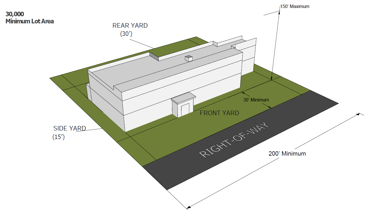
Sec. 110-110. - RD rural development district.
The RD rural development district provides a holding zone for areas that may be required for future urban development. These areas may be rezoned in accordance with the use designation appearing on the future land use plan map contained in the city comprehensive plan, where logical extension of utilities and facilities can be insured. The RD rural development district is intended to discourage haphazard and premature development from occurring at the fringes of the community.
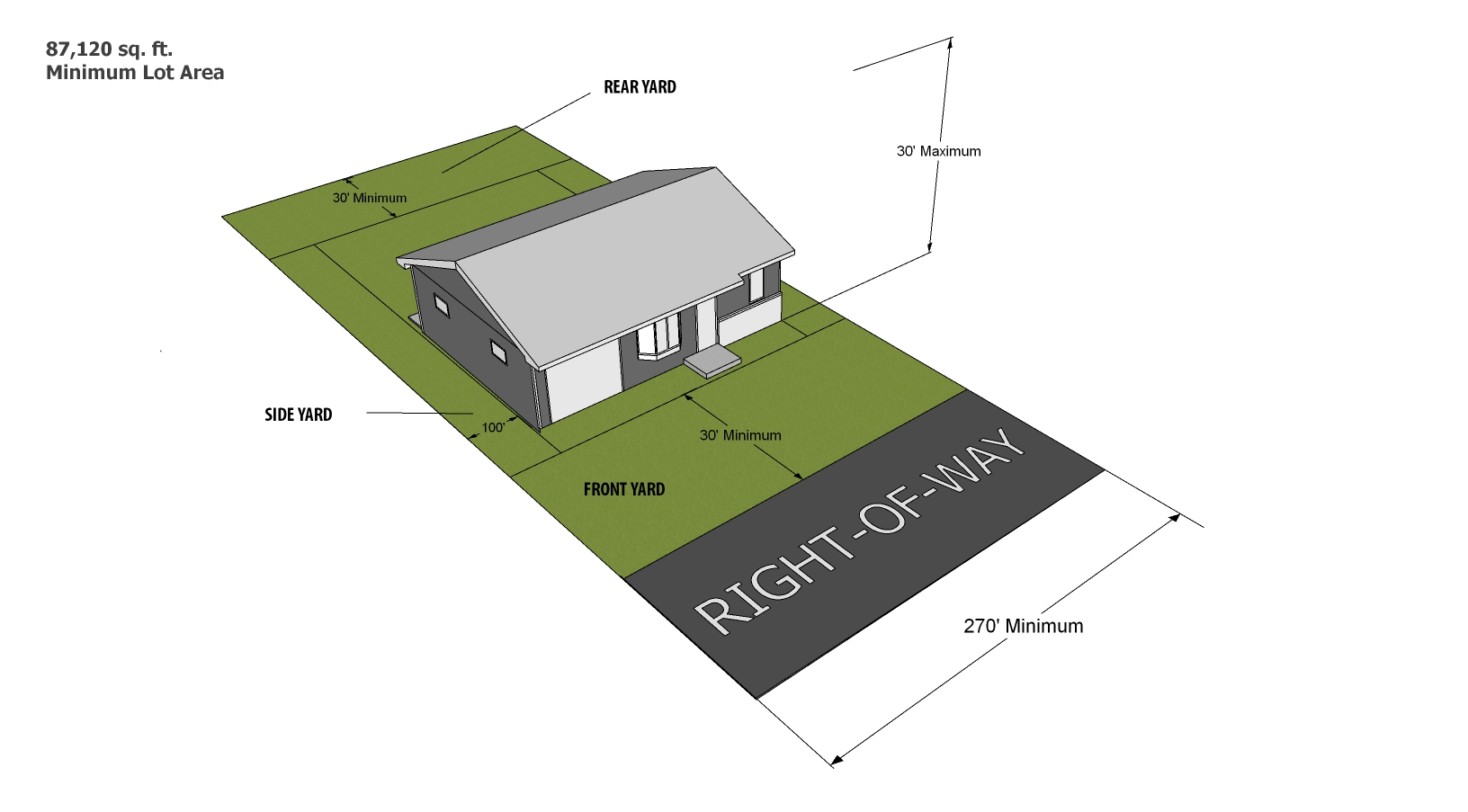
(Ord. No. 21-5231, § 2, 4-12-2021)
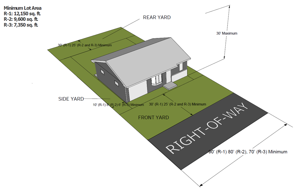
Sec. 110-111. - Single-family dwelling districts (R-1, R-2, and R-3).
(a)
Generally. The regulations set forth in this section or set forth elsewhere in this chapter when referred to in this section, are established as the single-family dwelling district regulations.
(b)
Use regulations. A building or premises shall be used only for the following purposes:
(1)
Single-family dwelling, when having a minimum floor area of 1,000 square feet in the R-1 single-family, low-density district; 720 square feet in the R-2 single-family, medium-density districts; 600 square feet in the R-3 single-family, high-density districts when providing two off-street parking spaces in lieu of providing one off-street parking space on the lot.
(2)
No more than one-third of a single-family lot shall be covered with structures or paved areas.
(3)
Accessory buildings and accessory uses, customarily incidental to the above uses (section 110-55, accessory buildings, structures, and uses of land). Any accessory building that is not a part of the main structure shall be located not less than 60 feet from the front lot line.
(4)
On a single-family lot no more than 40 percent of the rear yard, and 33 percent of the combined front and side yards, may be occupied by accessory buildings or uses. Accessory buildings or uses located in the rear yard do not count toward the maximum lot coverage of 33 percent of the lot.
(5)
Two-family dwellings may be erected in those locations in the R-1 single-family low-density dwelling district where 40 percent or more of the frontage on one side of a street between two intersecting streets is occupied by two-family dwellings or two-family and multiple-family dwellings; provided, however, that the area and parking regulations of the R-4 multiple-family, low-density district are complied with.
(Ord. No. 21-5231, § 2, 4-12-2021)
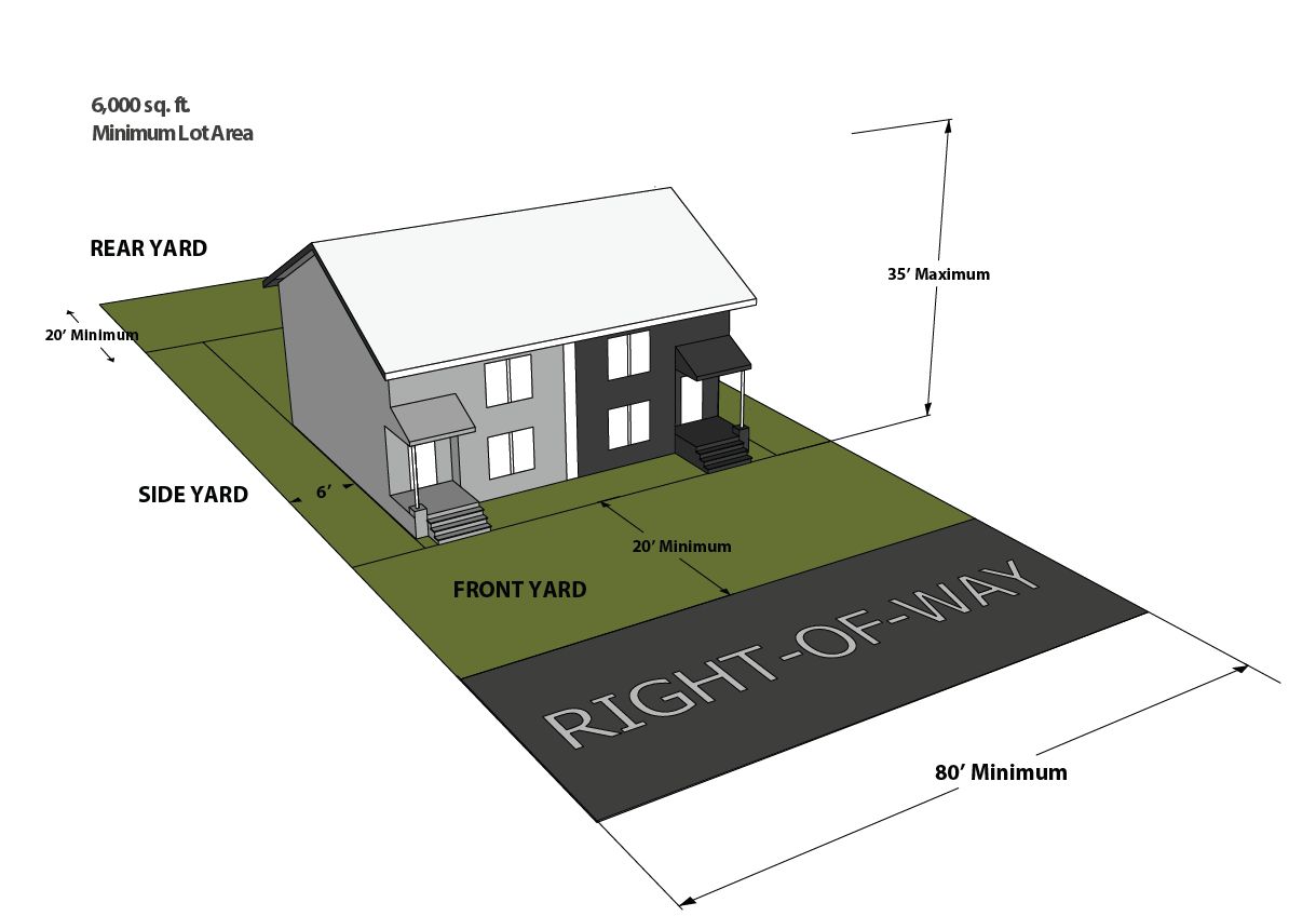
Sec. 110-112. - R-4 multiple-family, low-density district.
(a)
Generally. The regulations set forth in this section or set forth elsewhere in this chapter when referred to in this section are the R-4 multiple-family, low-density district regulations.
(b)
Use regulations. A building or premises shall be used only for the following purposes:
a.
Any use permitted in the single-family dwelling districts.
b.
Two-family dwellings when having not less than 600 square feet of floor space in each dwelling unit.
c.
Multiple-family dwellings may be erected in those locations in the R-4 multiple-family, low-density district where 40 percent or more of the frontage on one side of a street between two intersecting streets is occupied by multiple-family dwellings; provided, however, that the area and parking regulations of the R-5 multiple-family, high-density district are satisfied.
(Ord. No. 21-5231, § 2, 4-12-2021)
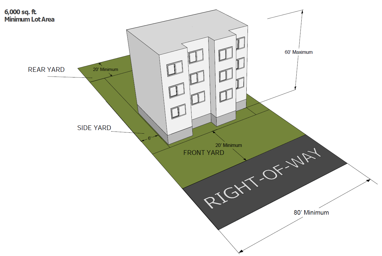
Sec. 110-113. - R-5 multiple-family, high-density district.
(a)
Generally. The regulations set forth in this section or set forth elsewhere in this chapter when referred to in this section are the R-5 multiple-family, high-density district regulations.
(b)
Use regulations. A building or premises shall be used only for the following purposes:
(1)
Any use permitted in the R-4 multiple-family, low-density districts.
(2)
Multiple-family dwellings, when having the following minimum floor area for each living unit:
a.
Two bedrooms or more, 600 square feet;
b.
One bedroom, 450 square feet;
c.
Efficiency units, 300 square feet.
(c)
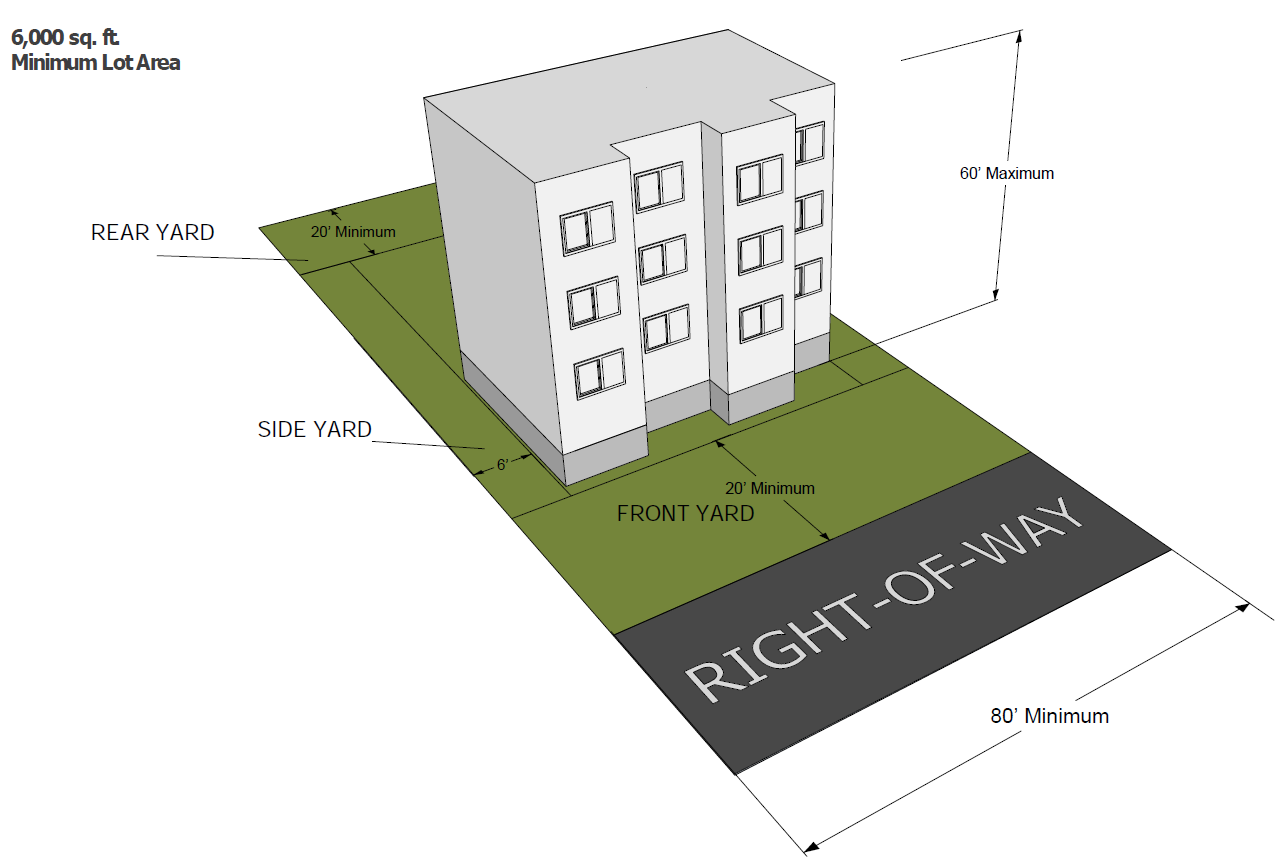
Intensity of use. Except as hereinafter provided, all dwellings hereafter erected, enlarged, converted, relocated or reconstructed shall be located on lots containing the following areas:
(1)
All residential uses permitted in the R-5 multiple-family district shall provide a minimum lot area of not less than 6,000 square feet.
(Ord. No. 21-5231, § 2, 4-12-2021)
Sec. 110-114. - Permitted land uses and developments.
(1)
Residential dwelling units.
(2)
Public buildings used by entities of government such as city, school district, township, park district, county, state or federal government.
(3)
Accessory uses and structures (section 110-55, accessory buildings, structures, and uses of land).
(4)
Permitted residential uses as listed in section 110-160, district use classification list.
(Ord. No. 21-5231, § 2, 4-12-2021)
Sec. 110-115. - Residential fences.
See section 110-545, Residential, security and farm fences.
(Ord. No. 21-5231, § 2, 4-12-2021)
Sec. 110-120. - B-1 central commercial district.
The B-1 central commercial district provides for the continued development of the principal business and shopping areas of the city. Mixed use in the central commercial district permits residential units in commercial buildings only when located above the first floor.
(1)
Central commercial district dwellings shall have the following minimum floor area for each living unit:
a.
Two bedrooms, 600 square feet.
b.
One bedroom, 450 square feet.
c.
Efficiency unit, 300 square feet.
(2)
Special uses and developments. The following alterations to any vacant land or existing structure may be permitted within the B-1 central commercial district under the conditions and requirements specified in section 110-31, special uses:
a.
The new construction of any primary or accessory structure.
b.
Any addition to an existing structure.
c.
Any project that would change the physical appearance of any elevation of any side of an existing structure.
(Ord. No. 21-5231, § 2, 4-12-2021; Ord. No. 22-5365, § 2, 9-12-2022)
Sec. 110-121. - B-2 highway commercial district.
The B-2 highway commercial district provides appropriate areas for highway-oriented commercial uses and those requiring large lots for off-street parking (article X, off-street parking and loading) and outdoor display or storage of merchandise (section 110-203, outdoor storage). Permitted commercial uses are listed in section 110-160, district use classification list.
* Caron to Dement corridor
(Ord. No. 21-5231, § 2, 4-12-2021)
Sec. 110-122. - B-3 neighborhood commercial district.
The B-3 neighborhood commercial district is primarily intended to provide limited retail sales and service opportunities which constitute basic trade and personal services for the convenience of residents in adjacent residential neighborhoods. These commercial uses shall be of such a character and intensity as to be compatible with surrounding residential uses. This district may also serve as transition between more intense commercial districts and less intense residential districts. These regulations are supplemented and qualified by additional general regulations appearing elsewhere in this chapter and which are incorporated into this section by reference.
(1)
Permitted land uses and developments. The following land uses and developments are permitted in the B-3 neighborhood commercial district when not in excess of 3,000 square feet of floor area:
a.
Commercial retail and service uses as listed in (section 110-160, district use classification list).
b.
Accessory uses and structures (section 110-55, accessory buildings, structures, and uses of land).
c.
Dwelling units, when located above the first floor.
d.
Public buildings used by entities of government such as city, school district, township, park district, county, state or federal government. Vehicle maintenance, raw materials storage or other similar type uses shall not be permitted.
(2)
Special uses and developments. The following land uses and developments may be permitted within the B-3 neighborhood commercial district under the conditions and requirements specified in section 110-31, special uses:
a.
Permitted land uses and developments, as identified in section 110-160, district use classification list which exceed two stories or 30 feet in height (whichever is less) including rooftop mechanical equipment attached to the structure and in excess of 3,000 square feet of floor area;
b.
Commercial retail and service uses as listed as a special use in section 110-160, district use classification list.
(3)
Accessory buildings and uses. Accessory buildings and uses, as defined in section 110-55, accessory buildings, structures, and uses of land, as applicable, shall be allowed in the B-3 neighborhood commercial district, and shall include;
a.
Storage of merchandise normally carried in stock on the same lot in conjunction with a permitted or special use allowed within these district regulations. All stored merchandise must be in a fully enclosed accessory structure (section 110-201, activities to be within enclosed buildings.
b.
Off-street parking facilities and loading and unloading areas (article X, off-street parking and loading).
c.
Lighting of parking areas shall be permitted when in conformance with section 110-208, glare.
(4)
Lot area, density and dimensional requirements. Generally, the B-3 neighborhood district shall be located on collector streets so as to avoid traffic congestion and conflict between commercial and residential uses. Every lot or tract of land in the B-3 neighborhood commercial district shall be adequate to provide required building setbacks, landscaping (article VIII, landscaping) and parking (article X, parking) as required by this chapter. One principal and one accessory structure shall be allowed on each lot or parcel.
(5)
Appearance criteria.
a.
A brick facade shall be required on all sides of a building that face a right-of-way, or that abut a residential district or residential use.
b.
The colors used on a building shall be consistent and complimentary to existing buildings in the general area.
c.
Any accessory structure shall match the primary structure in architectural style, material and color.
(6)
Permitted hours of operation. Commercial hours of operation in the B-3 neighborhood commercial district are limited to opening no earlier than 6:00 a.m. and closing no later than 10:00 p.m.
(Ord. No. 21-5231, § 2, 4-12-2021)
Sec. 110-130. - A airport district.
The A airport district is intended to promote development of airport related businesses, and other uses compatible with the city's airport (Koritz Field) in specified A districts within the city.
(Ord. No. 21-5231, § 2, 4-12-2021)
Sec. 110-131. - Location.
The A airport district location is commonly known as Koritz Field and is described as an area of approximately 137 acres located at the northwest intersection of Illinois Route 251 and Gurler Road. The A district may be expanded from time to time for airport related uses upon approval of the city council, after a public hearing (section 110-32, public hearings) before the planning and zoning commission.
(Ord. No. 21-5231, § 2, 4-12-2021)
Sec. 110-132. - Permitted uses.
All uses in the A airport district shall be classified as special uses (section 110-134, special uses).
(Ord. No. 21-5231, § 2, 4-12-2021)
Sec. 110-133. - Prohibited uses.
The following uses shall be prohibited in the A airport district:
(1)
Any uses that interfere with the airport hazard zoning (AHZ).
(2)
Any uses, including without limitation that interfere with the airport layout plan (ALP).
(Ord. No. 21-5231, § 2, 4-12-2021)
Sec. 110-134. - Special uses.
Airport and related airport service uses, as listed as a special use in section 110-160, district use classification list.
(Ord. No. 21-5231, § 2, 4-12-2021)
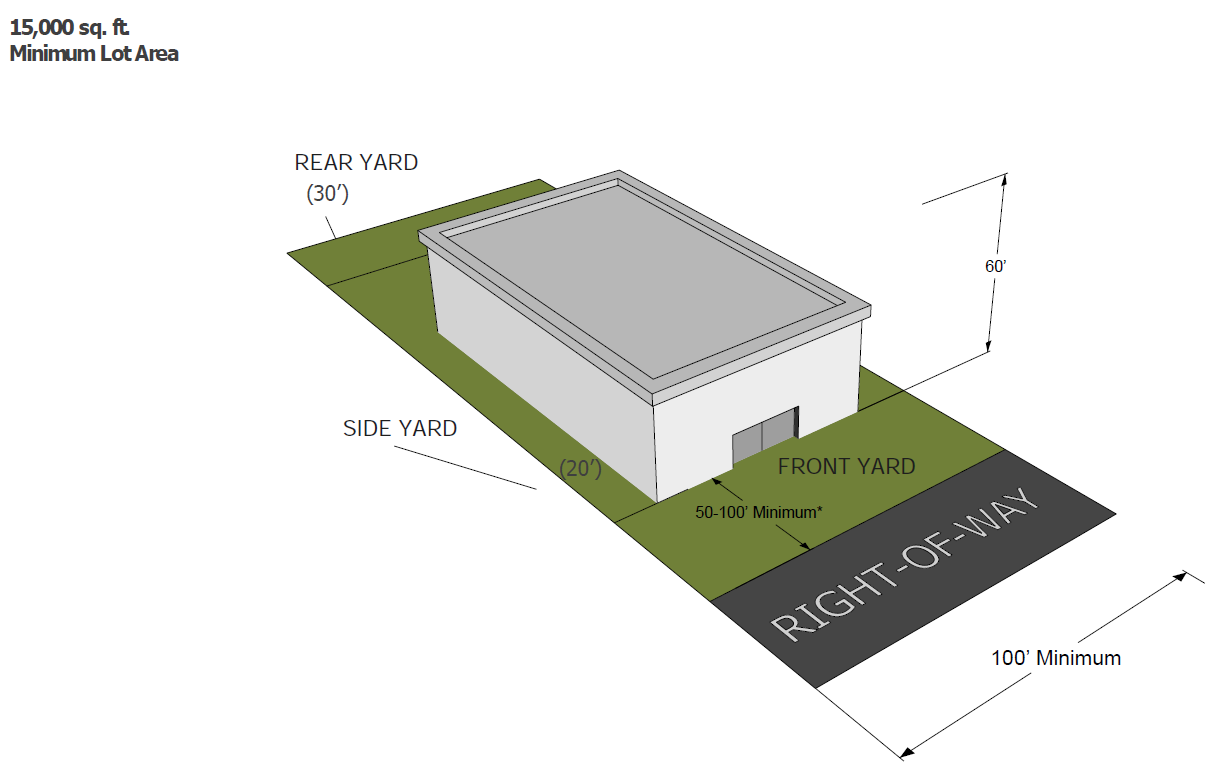
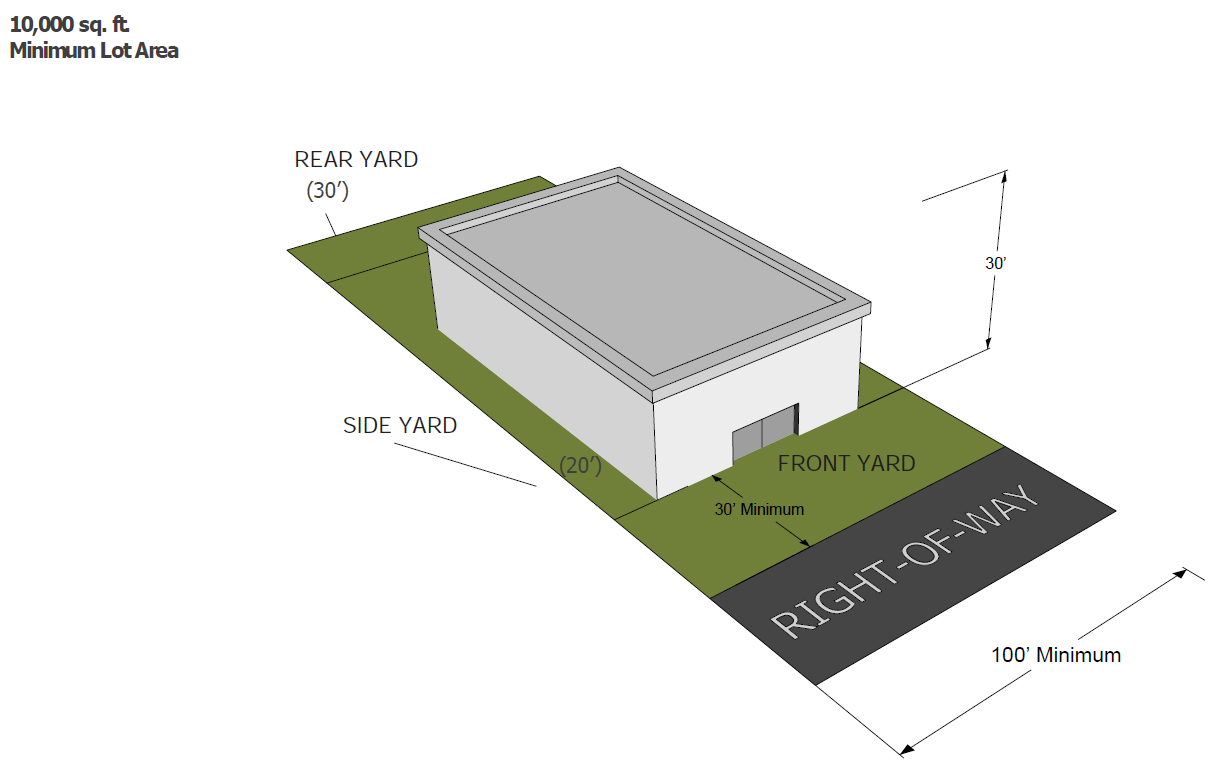
Sec. 110-135. - Lot area, density and dimension requirements.
* Minimum lot width and size do not apply if the use is located on the city airport property.
(Ord. No. 21-5231, § 2, 4-12-2021)
Sec. 110-136. - Appearance criteria.
No building permit approval shall be granted for the development of any building, structure or improvement on any parcel in the A airport district until the planning and zoning commission has recommended, and the city council has approved, that the proposed development will conform to the following criteria:
(1)
Relationship of buildings to site and context.
a.
The site shall be planned to provide for efficient screening, airplane movement, auto movement and parking areas.
b.
Buildings location, mass, scale, and orientation shall be compatible with the character of the adjoining structures and ALP.
c.
Any site development shall comply with all other requirements of this Code.
(2)
Building design.
a.
Buildings and other structures in the A airport district are encouraged to incorporate an airport related architectural theme.
b.
Any building or structure in the A airport district shall meet the requirements of the AHZ, ALP and FAA in design.
(Ord. No. 21-5231, § 2, 4-12-2021)
Sec. 110-137. - Application and contents.
Applications for development within the A airport district shall be accompanied by a boundary survey, architectural drawings, elevations, landscape plan and site engineering.
(1)
The property owner or his/her agent shall meet with the city manager, community development director, superintendent of streets/cemetery/airport and any other applicable city staff, to explain the proposed development, discuss procedures, and obtain an application form.
(2)
The applicant shall file the completed application form, together with the required exhibits and the filing fee, with the community development department.
(3)
The community development director or designee shall transmit the application to the planning and zoning commission for review and consideration.
(4)
The planning and zoning commission shall determine whether the proposed development is consistent with the requirements of the A airport district, including without limitation whether the appearance and arrangement of buildings, off-street parking, lighting, landscaping, ingress and egress, drainage, signage and other improvements are designed in a manner that will promote safety and convenience for the public and preserve property values of surrounding property. Following its consideration, the planning and zoning commission will recommend approval, denial or conditional approval of the application.
(5)
The planning and zoning commission's recommendation will be referred to the city council for final action.
(Ord. No. 21-5231, § 2, 4-12-2021)
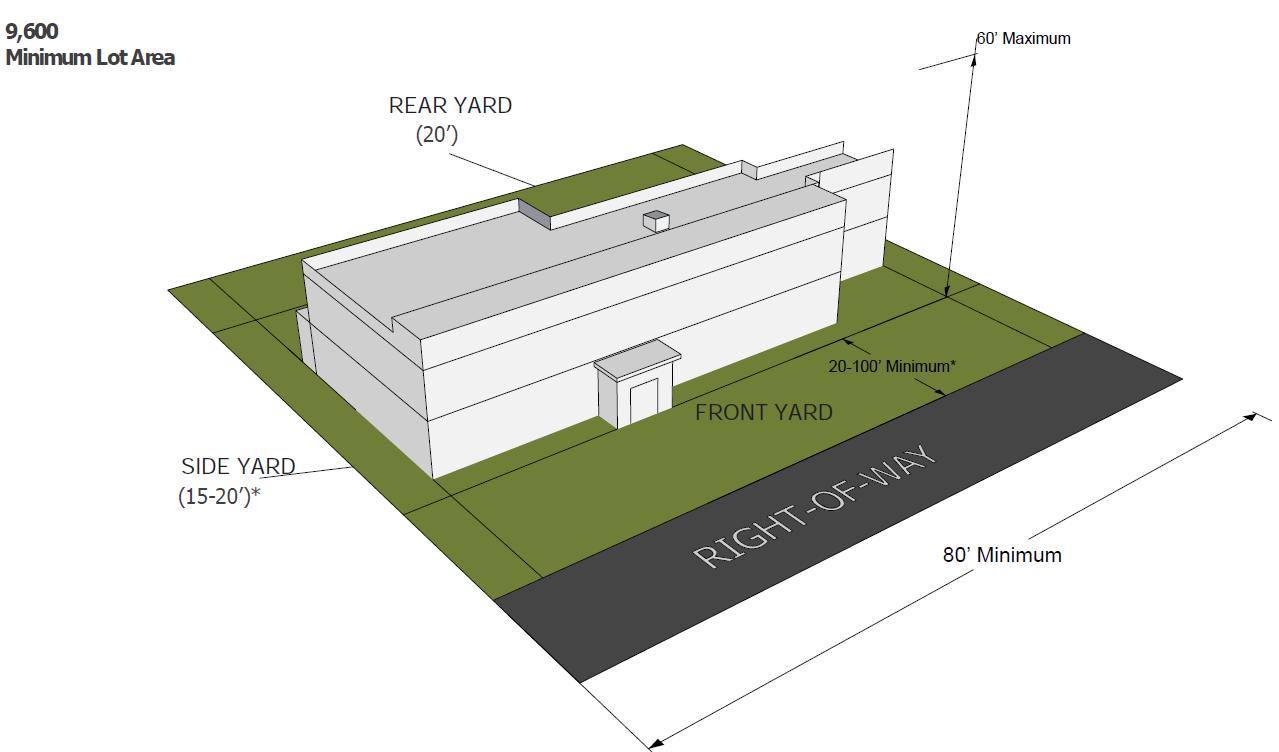
Sec. 110-140. - I-1 light (limited) industry district.
The I-1 light (limited) industry district provides close-in areas, located adjacent to non-industrial districts and uses, for the accommodation of those types of industrial activities that are not likely to result in significant incompatibilities with adjacent non-industrial uses. Permitted industrial and related uses are listed in section 110-160, district use classification list.
* 15th Street west on Highway 38 to City limits.
(Ord. No. 21-5231, § 2, 4-12-2021)
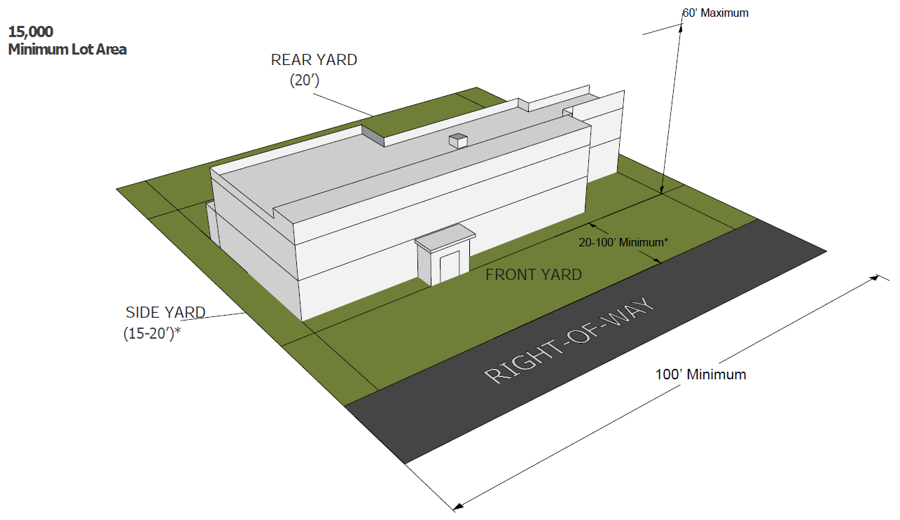
Sec. 110-141. - I-2 general industrial district.
The I-2 general industrial district provides for areas in more outlying locations for those types of activities which might result in incompatibilities with adjacent non-industrial uses. Permitted industrial and related uses are listed in section 110-160, district use classification list.
* 15th Street west on Highway 38 to City limits.
(Ord. No. 21-5231, § 2, 4-12-2021)
Sec. 110-142. - I-3 heavy industrial district.
The I-3 heavy industrial district provides for areas in more outlying locations for those types of activities which might result in incompatibilities with adjacent non-industrial uses, and particularly rail and transportation-related uses. Permitted industrial and related uses are listed in section 110-160, district use classification list.
(Ord. No. 21-5231, § 2, 4-12-2021)
Sec. 110-150. - Purpose.
The R-O residential office district provides for the integrated development of residential and office uses in or near the central part of the city and the downtown. This district would also provide for the conversion of existing single-family residences to multi-family dwellings, or combination residential-commercial uses.
(Ord. No. 21-5231, § 2, 4-12-2021)
Sec. 110-151. - Special requirements.
The following special requirements shall apply in R-O residential office district:
(1)
The residential requirements of the R-5 multiple-family district shall apply. Measurements shall include the sum of both residential and commercial uses.
(2)
Hard-surfaced, off-street parking (section 110-418, parking requirements for specific uses) shall be provided in the amounts required in this chapter.
(3)
Residential and commercial uses in a single structure shall provide separate means of ingress and egress. Residential uses shall be located above the first floor.
(4)
The availability of on-street and off-street parking (article X, off-street parking and loading) shall be considered. The physical and aesthetic impact of off-street parking located on the zoning lot shall not be detrimental to the existing character of the lot and the surrounding neighborhood.
(5)
It shall be a priority to preserve greenspace; thus, off-street parking shall be related to the size and nature of lot.
(6)
Rental of parking spaces on property other than the zoning lot shall not be allowed over 300 feet from property.
(Ord. No. 21-5231, § 2, 4-12-2021)
Sec. 110-160. - District use classification list.
In the following list of uses, a "P" means that the use is permitted in the zoning district subject to the general provisions of this chapter; an "S" means that the use will be permitted only if a special use permit (section 110-31, special uses) is granted by the city council. For uses not included on this list, application shall be made to the planning and zoning commission for interpretation.
(Ord. No. 21-5231, § 2, 4-12-2021; Ord. No. 22-5323, § 2, 1-10-2022; Ord. No. 22-5354, § 2, 6-13-2022; Ord. No. 25-07, § 2, 3-10-2025)