
Rochester Hills City Zoning Code
ARTICLE 9
NATURAL FEATURES
SECTION 138-9.100 - Intent
It is the intent of this section to require a minimum setback from natural features and to regulate the use of property within the setback in order to prevent physical harm, impairment and/or destruction of or to natural features. It has been determined that, in the absence of a minimum setback, intrusions in or onto natural features would occur, resulting in harm, impairment and/or destruction of natural features contrary to the public health, safety and general welfare.
SECTION 138-9.101 - Nonapplicability to Parcels Planned Before January 1, 1990
This section shall not apply to property for which a site plan or condominium plan has been approved or for which a preliminary subdivision plat has received tentative approval or any subsequent approvals prior to January 17, 1990, provided the site plan, condominium plan or plat remains in effect and in good standing.
SECTION 138-9.102 - Natural Features Setback
Except as may be permitted pursuant to Section 138-9.103, a minimum setback of 25 feet from a natural feature, as defined in this ordinance, shall be observed, and any filling, land balancing, dredging, construction or any deposit, installation or removal of any material, including structures, soils, minerals, and/or vegetation, within a natural feature setback is prohibited. Any land located within a natural features setback is intended to be kept in a natural state.
SECTION 138-9.103 - Reduction of Setback
The minimum setback may be reduced upon application by the property owner and determination by the official or body responsible for review and approval of the proposed construction, activity or operation that such construction, activity or operation is not likely to endanger or materially and adversely affect the natural feature. Incidental to the consideration of an application to reduce a natural feature setback, the City may require, at the applicant's expense, an investigation to determine the nature, location and boundaries of the natural feature. In determining whether to authorize a reduction of the minimum setback, the official or body responsible for review and approval of the proposed construction, activity or operation shall consider the following criteria:
A.
The nature, environmental sensitivity and size of the natural feature.
B.
The nature, necessity and economic value of the proposed construction, activity or operation.
C.
The feasibility of alternatives.
D.
The probable impact of the proposed construction, activity or operation on the natural feature and the cumulative effect of other existing and anticipated activities on the natural feature.
E.
The probable impact on fish and wildlife and their habitats.
F.
The maintenance of historic, scenic, ecological and recreational values, and the character of the area.
SECTION 138-9.104 - Exemptions
The following activities shall be exempt from regulation under this section, although other sections of this ordinance may apply:
A.
Beach sanding.
B.
Installation of a dock, seawall or fence.
C.
Lawn maintenance.
D.
Grading and filling required by the City.
E.
Construction, maintenance and improvement of public streets, highways, roads or pedestrian-bicycle pathways within an existing right-of-way or a public easement, in such a manner as to minimize adverse effect on a wetland or watercourse, provided, except in emergencies, that:
1.
Prior written notice is given to the City engineer and written consent is obtained from the City engineer prior to commencement of work;
2.
The work is conducted using good management practices to ensure that flow and circulation patterns, and chemical and biological characteristics of wetlands are not impaired; and
3.
Any adverse effect on the aquatic environment will be minimized.
F.
Installation, maintenance, repair or operation of utilities, including water, sanitary sewer, storm drainage systems and facilities, and electric, gas, telephone and cable television lines, in such a manner as to minimize adverse effect on a watercourse or wetland, provided that, except in emergencies:
1.
Prior written notice is given to the City engineer and written consent is obtained from the City engineer prior to commencement of work;
2.
The work is conducted using best management practices to ensure that flow and circulation patterns, and chemical and biological characteristics of wetlands are not impaired; and
3.
Any adverse effect on the aquatic environment will be minimized.
G.
Maintenance, repair, cleaning and upgrading of any natural and humanmade drainage course, watercourse, drain, pipe, ditch, stream, creek, swale, detention and retention basin and pond which serves to transport or hold stormwater runoff, provided that, except in emergencies:
1.
Prior written notice is given to the City engineer and written consent is obtained from the City engineer prior to commencement of work;
2.
The work is conducted using good management practices to ensure that flow and circulation patterns, and chemical and biological characteristics of wetlands are not impaired; and
3.
Any adverse effect on the aquatic environment will be minimized.
H.
Activities that are authorized on state- or City-regulated wetlands without a state or City permit under section 30305 of Public Act No. 59 of 1995 (MCL § 324.30305, MSA § 13A.30305) or section 126-502 of the City's code of ordinances are specifically authorized in the natural features setback.
SECTION 138-9.105 - Protective Barrier
The City may require that a suitable protective barrier be erected and maintained along the perimeter of the natural feature setback area to prevent construction or development activity from encroaching into the natural feature setback, and to maintain the natural feature setback area in a natural and undisturbed state in perpetuity after construction is completed.
A.
Permanent Barrier Required. Protective barriers shall be permanent and not easily removed. Barriers should also be decorative and highly visible to discourage encroachments into the natural features setback area. Boulder walls are an example of a permanent and visible barrier.
B.
Signs delineating the perimeter of the natural features setback area are easily removed and therefore are not sufficient by themselves to fulfill the intent of this section. However, signs are encouraged in conjunction with a permanent barrier.
SECTION 138-9.200 - Findings and Purpose
A.
Findings. The City Council of the City of Rochester Hills finds that:
1.
The establishment of regulatory and conservation practices to prevent disturbance of steep slopes is needed to protect public health, safety and general welfare. Experience has demonstrated a need for effective protection of steep slopes, including careful review and regulation and the implementation of stringent mitigation measures where, in the opinion of the reviewing authority, no practical alternative to such disturbance exists. However, in all cases where the reviewing authority determines that total avoidance of steep slopes is not practical, such disturbance should constitute the minimum disturbance necessary to ensure the property owner a reasonable use of the property.
2.
The disturbance of steep slopes can aggravate erosion and sedimentation beyond rates experienced in natural processes. Erosion and sedimentation often include the loss of topsoil, a valuable natural resource, and can result in the disturbance of habitats, degradation of surface water quality, degradation of wetlands, alteration of drainage patterns, gullying of land, obstruction of drainage structures, intensification of flooding both on and off the subject site, failure of slopes and the mass movement of earth and danger to the natural environment, man-made structures and the safety of persons.
3.
Steep slopes, including stabilizing deep-root vegetation located thereon, are important environmental features that contribute significantly to the natural beauty of the City. Over-development of or improperly managed disturbance to these steep slopes is detrimental to the environment and the overall character of nearby areas.
4.
Regulation can allow the reasonable use of private property by encouraging flexible development design so as to avoid disturbance of steep slopes. Regulation can also permit limited disturbance of steep slopes that are conducted in accordance with acceptable engineering practices and will not negatively impact the integrity of the steep slope or other nearby environmental features.
B.
Purpose. These regulations are adopted with the intent of providing a reasonable balance between the rights of the individual property owners and the public interest in preserving the valuable functions of steep slopes. The purpose of these Steep Slope regulations are to:
1.
Provide qualitative and quantitative development controls in order to preserve, protect and conserve steep slopes within the City of Rochester Hills.
2.
To maintain and protect the natural terrain and its vegetative features, wetlands, water bodies and watercourses.
3.
Prevent flooding, protect important scenic views and vistas, preserve areas of wildlife habitat, and provide safe building sites.
4.
Protect property within the City by preventing erosion, creep and sudden slope failure.
SECTION 138-9.201 - Applicability
Steep slope areas fall into three categories: a Moderate Steep Slope is a slope equal to or greater than one vertical on five horizontal 20 percent but less than one vertical on four horizontal 25 percent and with a vertical elevation change of ten feet or greater. A Very Steep Slope is a slope equal to or greater than one vertical on four horizontal 25 percent but less than one vertical on 2.5 horizontal 40 percent and with a vertical elevation change of ten feet or greater. A Bluff Slope is a slope greater than or equal to one vertical on 2.5 horizontal 40 percent with a vertical elevation change of 15 feet or greater. The provisions of this Section shall apply to lands defined and/or designated as steep slope areas.
A.
Regulated Slopes.
1.
Slopes Located Within 200 feet of a Watercourse. Any Moderate Steep Slope, Very Steep Slope, and/or Bluff Slope that is located within 200 feet of the Clinton River, Paint Creek, Sargent Creek, Stony Creek, or a tributary of any of the aforementioned watercourses shall be considered a regulated slope.
2.
Slopes Not Located Within 200 feet of a Watercourse. Any Very Steep Slope and/or Bluff Slope that is not located within 200 feet of the Clinton River, Paint Creek, Sargent Creek, or Stony Creek shall be considered a regulated slope.
B.
Steep Slope Inventory. The City shall prepare an inventory map of regulated steep slopes within the City.
C.
Presumption. A steep slope inventory map indicates the location of known steep slopes within the City. Steep slopes may also exist that are not indicated on the map. Such slopes not indicated on the map are regulated by the provisions of this Chapter.
D.
Exemptions.
1.
The reviewing authority may waive the requirements of this Article 9, Chapter 2 for activities on or near slopes that are demonstrated to be man-made. Examples of slopes that are man-made include but are not limited to spoils piles, embankments for roads or railroads, berms, etc. The applicant must demonstrate that construction activity near or on the slope, including the possible removal or elimination of the steep slope area, will not impact or cause to be impacted a nearby natural feature or destroy views or alter the appealing aesthetic character of the area near the man-made slope if requesting an exemption.
2.
Moderate and Very steep slopes covering a horizontal area of 5,000 sq. ft. or less are exempt from the provisions of this Article 9, Chapter 2. For the purposes of this exemption, where a steep slope is located on two or more contiguous parcels the area of the entire steep slope shall be used to calculate if the area exemption applies.
SECTION 138-9.202 - Permitted and Regulated Activities
A.
Allowable Activities Outside of a Steep Slope Setback Area. Any activity that does not impact a steep slope or is located outside of a steep slope setback area shall not be subject to the requirements of this Article 9, Chapter 2.
B.
Allowable Activities on a Steep Slope or in a Steep Slope Setback Area. The following activities are permitted on a steep slope between the toe of slope and top of slope and within a steep slope setback area without a steep slope permit:
1.
Normal ground maintenance that does not require disturbance of existing terrain. Normal ground maintenance includes customary best management practices for deep root vegetation and the mowing, trimming, or pruning of non-deep root vegetation. Normal ground maintenance activities do not include regrading or disturbing the soil surface, and must comply with all other applicable laws and regulations.
2.
The planting of vegetation that does not require the removal of existing deep-root vegetation and does not disturb the natural contour of the land.
3.
Fence construction in accordance with all other applicable laws and regulations.
4.
The disturbance to steep slopes under temporary emergency conditions, as determined by the City's Engineering Services Department, where such disturbance is necessary to protect persons or property from present and imminent danger.
5.
Maintenance and repair of existing roads, driveways, walkways and retaining walls.
6.
Construction or expansion of roads in a public right-of-way.
7.
Public health and safety activities and emergency uses by or on behalf of a public agency.
C.
Regulated Activities. The following activities involving the creation of a new steep slope, alteration or disturbance to an existing steep slope between the toe of slope and top of slope, a manmade change to the land within a steep slope setback area, or any other activity not specifically listed as an allowable activity in Section 138-9.202.B., above, shall not be permitted unless a Steep Slope Permit is issued by the proper reviewing authority:
1.
Constructing, operating, or maintaining any use or development.
2.
Erecting or installing buildings or other structures, improvements, or utilities (exception: fence construction or maintenance, which is a permitted activity).
3.
Depositing or removing material.
4.
Land balancing or other grading.
5.
Removal of deep-root vegetation.
6.
Constructing, operating, or maintaining a stormwater outlet sewer.
D.
Steep Slope Setback. Regulated activities identified in Section 138- 9.202.C., above, may not occur in the steep slope setback area unless a steep slope permit is issued. The steep slope setbacks are defined based on the type of steep slope, and are defined as follows:
1.
A 15-foot setback is required from the top of a moderate steep slope with a ratio of one vertical to five horizontal (20 percent slope or greater).
2.
A 25-foot setback is required from the top of a very steep slope with a ratio of one vertical to four horizontal (25 percent or greater).
3.
A 50-foot setback is required from the top of a bluff slope with a ratio of one vertical to 2.5 horizontal (40 percent or greater).
4.
A 15-foot setback is required from the toe of any steep or very steep slope. A 25-foot setback is required from the toe of any bluff slope.
E.
Measurement of Steep Slope Setback. Many slopes will qualify as two or more types of steep slope due to changes in topography and the grade of the slope. In such a case, the setbacks defined in subsection D., above, shall be measured parallel to the top of slope and any transition contour lines where the grade of the slope changes and the slope changes to a different type of slope (i.e. moderate steep slope to a very steep slope).
The steep slope setback line shall be defined as the setback line that is farthest from the top of slope. Refer to the illustrations on the following page for a graphic representation of a transition contour.
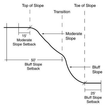
Section View
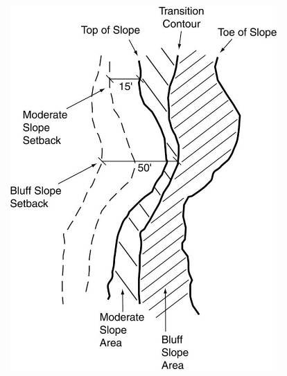
Plan View
SECTION 138-9.203 - Review Criteria
In reviewing any request for a steep slope permit, the reviewing authority shall consider all relevant facts and circumstances. Any steep slope permit application must satisfy the following review criteria:
A.
General Criteria.
1.
Structures shall be designed in a manner that averts or minimizes alteration to the steep slope and that otherwise complies with the grading standards in 138-9.203.B.
2.
Feasible alternatives to the proposed action, including avoidance of disturbance of the steep slope area and the availability of reasonable alternative building locations on the subject site or on any other adjacent parcels under the control of the applicant.
3.
The suitability of the proposed activity to the area for which it is proposed. Structures should be sited on existing level areas of the site.
4.
The suitability of soils and/or other structural characteristics of the slope that make the slope suitable for development, or unsuitable for development due to the slope's susceptibility to erosion, creep, or failure.
5.
The proposed mitigation measures will adequately protect steep slopes from erosion, sedimentation, or damage beyond a natural rate of change.
6.
The availability of technical improvements, safeguards, or other mitigation measures that could feasibly be added to the proposal.
7.
Proposed method(s) of restoring disturbed areas of a steep slope.
B.
Specific Criteria.
1.
The alignment of roads and driveways shall follow the natural topography to minimize regrading and comply with design standards for maximum grades set forth in the City's engineering standards.
2.
The natural elevations and vegetative cover of steep slopes shall be protected from disturbance to the maximum extent possible.
3.
All regrading shall blend in with the natural contours of the land.
4.
Cuts and fills shall be rounded off to eliminate sharp angles at the top, bottom and side of regraded slopes.
5.
The angle of cut and fill slopes shall not exceed the natural angle of repose of the soil in the cut or fill, except where retaining walls or other structural stabilization is used; generally, for soils, cut and fill slopes should be not steeper than one vertical to three horizontal (33 percent slope).
6.
Any disturbance of steep slopes shall be completed within one construction season, and disturbed areas shall not be left bare and exposed during the winter and spring thaw periods.
7.
The disturbance of existing vegetative ground cover shall not take place more than seven days prior to commencing grading and construction.
8.
Permanent deep-root vegetative cover shall be planted within three days after completion of grading. The vegetative cover proposed to be used shall be identified as part of the application and is subject to review and approval by the reviewing authority and City Engineer. Where final grading and permanent planting cannot be established within a short period of time, temporary seeding or mulching shall be applied. Upon good cause being shown by the applicant and based upon consideration of the time of year, slopes, soils and environmental sensitivity of the area involved, the Building Department may modify these specified time periods after consultation with the reviewing authority and City Engineer.
9.
Measures for the control of erosion and sedimentation shall be undertaken in accordance with the Soil and Sedimentation Control Act (See Soil Erosion Act, Part 91 of PA 451 of 1994, as amended), which is administered by the Oakland County Drain Commissioner's Office. Topsoil that will be stripped from all areas of disturbance shall be stockpiled in a manner so as to minimize erosion and sedimentation and shall be replaced on the site at the time of final grading.
10.
Fill material shall be composed only of nonorganic material that will allow for appropriate compaction and cover by topsoil. No voids are to be created or left remaining in the fill material that will allow further settlement of the fill or habitat for rodents, vermin or other undesirable species.
11.
Compaction of fill materials in fill areas shall be such that it ensures support of proposed structures and stabilization for intended uses.
12.
Permanent physical markers will be used to identify and delineate the steep slope setback area.
SECTION 138-9.204 - Determinations
In granting a steep slope permit under this Section, the reviewing authority shall evaluate and approve or deny an application based on the following considerations:
A.
That the proposed activity and the manner in which it is to be accomplished are in accordance with the findings and purpose set forth in Section 138-9.200.
B.
That the proposed activity and the manner in which it is to be accomplished can be completed without increasing the possibility of creep or sudden slope failure and will minimize erosion to the maximum extent practicable.
C.
That the proposed activity and the manner in which it is to be accomplished will not adversely affect the preservation and protection of existing wetlands, water bodies, watercourses and floodplains.
D.
That the proposed activity and the manner in which it is to be accomplished will not adversely affect adjacent property.
E.
That the proposed activity and the manner in which it is to be accomplished can be completed in such a way so as not to adversely affect any threatened or endangered species of flora or fauna.
F.
That the proposed activity is compatible with the public health and welfare.
G.
That the proposed regulated activity cannot practicably be relocated on the site or reduced in size so as to eliminate or reduce the disturbance of the steep slope area.
H.
The applicant shall have the burden of proof to demonstrate compliance with the requirements of this Article 9, Chapter 2.
SECTION 138-9.205 - Review Procedures and Submittal Requirements
A.
Reviewing Authority. The Planning Commission shall be the reviewing authority for any steep slope permit that is required in conjunction with a site plan, conditional use, or plat. The Engineering Services Department shall be the reviewing authority for all other applications, including single-family plot plans.
B.
Submittal Requirements. All applications shall contain the following information:
1.
Name and address of owner and applicant.
2.
Street address of the property, or other means of identifying the property if it does not have a street address such as a tax identification number.
3.
Statement of consent from the owner for any agent making application.
4.
A written narrative explaining the nature of the proposal, including the proposed work and purpose thereof, any future development proposals for the property and whether alternative locations exist for the proposed activity.
5.
A site plan drawn at a scale no less than one inch equals 50 feet and prepared, signed, and sealed by a landscape architect, architect, professional engineer or professional surveyor and showing the following information for all areas on the subject site that contain steep slopes:
a.
The location of proposed buildings and structures, including driveways and retaining walls.
b.
The location of the proposed area of disturbance and its relationship to neighboring properties, together with structures, roads and watercourses or regulated wetlands located within 100 feet of the boundaries of the disturbed area.
c.
The existing topography in the proposed area of disturbance at a contour interval of not more than two feet. Contours shall be shown for a distance of 100 feet or greater beyond the limits of the proposed area of disturbance. The contour map shall be prepared, signed and sealed by a professional engineer or land surveyor licensed to practice in the State of Michigan. The elevations and contours on said map shall be in North American Vertical Datum of (NAVD88) or North American Datum NAD 83 (1986 adjustment) International Feet, or the latest revision of either standard.
d.
The location and size of areas of Moderate Steep Slope, Very Steep Slope, and Bluff Slope under both existing and proposed conditions in the area of proposed disturbance and within a distance of 100 feet thereof.
e.
The top of slope and toe of slope elevation contours, along with any transition contours between areas of Moderate Steep, Very Steep, or Bluff Slope.
f.
Steep slope setback lines measured parallel to the top of slope and any transition contours.
g.
The proposed final contours of the disturbed area at a maximum contour interval of two feet and proposed surface materials or treatment.
h.
Cross-sections of the existing and proposed steep slope areas.
i.
A soil erosion and sedimentation control plan.
j.
The details of any surface or subsurface drainage system proposed to be installed, including special erosion-control measures designed to provide for proper surface or subsurface drainage, both during the performance of the work and after its completion.
k.
A landscape plan showing the location, size, species, and quantity of deep root vegetation that will be established.
l.
Locations of permanent physical markers delineating the steep slope setback area.
6.
Photographs of the steep slope, with the photograph locations cross-referenced on the survey.
7.
A list of all applicable City, County, State and Federal permits required for such work or improvement.
8.
Payment of all applicable fees as required by Division 4 or Article IV of Chapter 110 of the City's Code of Ordinances.
9.
Any of the following information, if determined necessary by the City Engineer or the reviewing authority:
a.
Other information, including specific reports by qualified professionals on soils, geology, hydrology, flora, and fauna.
b.
Existing soils within 50 feet of the proposed disturbed area, taken from field investigations by a soils scientist and classified into hydrologic soil groups.
c.
A cut/fill map delineating proposed areas of disturbance at affected depths in increments of zero to three feet, three to six feet, six to ten feet and ten feet and over and the estimated material quantities of cut/fill.
C.
Review Procedures.
1.
Applications Requiring Planning Commission Review.
a.
Applications for steep slope permits proposed in conjunction with another application requiring Planning Commission review and approval shall be reviewed concurrently with the site plan, special land use, or plat application to which the steep slope permit is related. The Planning Commission shall consider all of the general and specific design standards listed in Section 138-9.203.A. and Section 138-9.203.B. of this Article 9, Chapter 2.
b.
The Planning Commission shall hold a public hearing in accordance with Section 138-1.203 to receive comment on the requested steep slope permit following the noticing procedures applicable for a conditional use.
c.
The Planning Commission may approve, approve with conditions, or deny the requested steep slope permit. All such approvals, approvals with conditions, or denials shall be issued in writing. In the case of a conditional approval or a denial, such written decision shall state the reasons for denial or the conditions of approval.
2.
All Other Applications. Any steep slope permit application that is not proposed in conjunction with another application requiring Planning Commission review shall be reviewed by the Engineering Services Department shall review the application for compliance with all of the standards of this Chapter. The Engineering Services Department may approve, approve with conditions, or deny the requested steep slope permit. All such approvals, approvals with conditions, or denials shall be issued in writing. In the case of a conditional approval or a denial, the written decision shall state the reasons for denial or the conditions of approval.
(Ord. No. 183, § 18, 6-18-2018)
SECTION 138-9.206 - Permits
Steep slope permits issued pursuant to this Chapter and permit holders shall comply with the following requirements:
A.
Content. Steep slope permits shall include, at a minimum, the following items of information:
1.
The approval date of the permit.
2.
The expiration date of the permit.
3.
Limitation on the total portion of any lot or the portion of the steep slope on the lot that may be disturbed.
4.
Setbacks for structures, fill and other activities from the top of slope.
5.
The approved grading plan shall be kept on file with the approved steep slope permit.
B.
Notification and Display of Permit. Permit holders shall comply with the following requirements prior to and during the commencement of activity on the site:
1.
The permit holder shall notify the Engineering Services Department and the Planning Department of the date on which the work is to begin, at least five days in advance of such date.
2.
The permit shall be prominently displayed at the project site during the undertaking of activities authorized by the permit.
C.
Expiration of Permit.
1.
All permits shall expire on completion of the acts specified therein and, unless otherwise indicated, shall be valid for a period of one year from the date of issue.
2.
In the case of a permit where the work on the steep slope(s) has not commenced, the reviewing authority may extend the time in which the acts specified in the permit may be completed if, in its opinion, such extensions are warranted by the particular circumstances involved. Such extensions shall not exceed two additional periods of one year each. The reviewing authority may require the permit holder to provide additional information demonstrating that conditions on the site have not substantially changed from the time the steep slope permit was first issued. The site shall be subject to a field inspection by City Staff or Planning Commission prior to the granting of an extension.
3.
Should a permittee fail to complete the acts specified in the permit prior to the expiration of the second one year extension, the original permit shall become null and void, and an application must be made for a new permit. The request for a new permit shall follow the same form and procedure as the original application.
4.
In the case of a permit where the work on the steep slope(s) is partially completed, the number and length of extensions shall be at the sole discretion of the reviewing authority.
5.
A request for an extension of an original permit shall be made in writing to the reviewing authority at least 30 days prior to the expiration date of the original permit and each extension.
D.
Performance Guarantee. The permit grantee shall be required to file with the City a cash or corporate surety bond or irrevocable letter of credit running to the City in an amount, if any, determined necessary by the City's engineering services department to guarantee performance of and compliance with use permit conditions and this Article.
SECTION 138-9.207 - Appeals
Any final determination, decision or order of the Engineering Services Department or Planning Commission may be appealed to the City Council.
The City Council, upon review, shall make findings and determine whether or not there has been compliance with the requirements and standards of this Chapter, and based on its findings, may affirm, reverse, or modify the decision rendered by the Engineering Services Department or the Planning Commission, as the case may be.
SECTION 138-9.208 - Enforcement
A.
Civil Infraction. Any person who violates this provision of this Chapter shall be responsible for a municipal civil infraction.
B.
Separate Offense. Each consecutive day of the violation shall be considered a separate offense.
C.
Inspections and Violations.
1.
Inspection. Any site for which an application has been submitted shall be subject to inspection by the reviewing authority or its designated representative(s), including weekends and legal holidays.
2.
Administrative sanctions.
a.
Restoration. The Engineering Services Department shall have the authority to direct the violator to restore the steep slope area to its condition prior to violation, insofar as that is possible, within a reasonable time and under the supervision of the Engineering Services Department or its designate. Further, the Engineering Services Department shall have the authority to require an adequate performance guaranty in a form and amount deemed necessary by the Engineering Services Department to insure the restoration of the affected steep slope area.
b.
Stop-work order; revocation of permit. In the event that any person holding a permit issued pursuant to this Chapter violates the terms of the permit, fails to comply with any of the conditions or limitations set forth in the permit, exceeds the scope of the activity as set forth in the application or operates so as to be materially detrimental to the public welfare or injurious to a steep slope area, the reviewing authority may suspend or revoke the permit or withhold issuance of a Certificate of Occupancy until the provisions of this Chapter, including any conditions attached to a Permit, have been fully met. Failure to comply with a stop work order shall constitute a violation of this Chapter.
D.
Fines. Any person convicted of having violated or disobeyed any provision hereof, any order of the reviewing authority or any condition duly imposed by the reviewing authority in a permit granted pursuant to this Section, for the first offense shall be subject to the penalties, sanctions, remedies and costs authorized in City Code Section 1-16.
E.
Injunctive Relief. The City is specifically empowered to seek injunctive relief restraining any violation or threatened violation of any provisions hereof and/or to compel the restoration of the affected steep slope area to its condition prior to the violation of the provisions of this Chapter.
F.
Enforcement. The Mayor, or his or her designee, shall be empowered to enforce compliance with this ordinance.
SECTION 138-9.209 - Notice and Conflicts
In order to carry out the purposes and provisions hereof, and in addition to the powers specified elsewhere in this ordinance, the following general provisions shall apply:
A.
Notice Provisions. The deed, contract of sale and final plat of any land subdivided subsequent to the enactment of this Chapter shall describe all steep slope areas on said land which are regulated by this Chapter and shall include a note on the deed, contract and final plat, respectively, that any construction within these areas requires a permit.
B.
Conflicts. Wherever this Article 9, Chapter 2 is inconsistent with any other law of the City of Rochester Hills, whichever law imposes the more stringent restriction shall prevail.
SECTION 138-9.210 - Definitions
As used in this Article 9, Chapter 2, the following terms shall have the meaning indicated:
APPLICANT: Any individual, firm, partnership, association, corporation, company, organization or other legal entity of any kind, excluding the City of Rochester Hills and its governmental agencies, who requests the reviewing authority to issue a permit, or to whom a permit has been granted under the provisions of this Chapter.
CITY COUNCIL: The City Council of the City of Rochester Hills.
CREEP: The gradual movement downhill of soil or loose rock on a steep slope. The process of creep may result in the migration of the top of slope contour and destabilization of the slope.
DEEP ROOT STABILIZING VEGETATION: Vegetation that increases soil strength and stability by providing reinforcement and increasing the shear strength of soils. Deep root vegetation contains a fibrous root system that penetrates more than four feet below the surface (in a mature plant). Deep root stabilizing vegetation includes certain native species of trees, shrubs, and native grasses. Turf grass root systems are typically only four to six inches deep, so turf grasses do not qualify as deep root vegetation. The City maintains a list of acceptable native deep-root vegetation appropriate for use on steep slopes.
DISTURBANCE: The removal of vegetation, except as specifically permitted herein, or the filling, excavation, regrading or removal of soil, rock or retaining structures in areas of steep slope, whether by manual labor, machine or explosive. The condition of disturbance will be deemed to continue until the area of disturbance is revegetated and/or permanently stabilized.
DISTURBED AREA: Any steep slope area for which a disturbance is proposed or is ongoing.
GRADING: Adjusting the degree of inclination of the natural contours of the land, including leveling, smoothing, grubbing, tilling, and other modification of the natural land surface.
HORIZONTAL AREA: The horizontal area is the area of a level plane drawn underneath the steep slope with the toe and top of slope as the boundaries of the horizontal plane. For instance, a topographical map shows the horizontal area of a steep slope by rendering the slope area on a level plane.
LAND IMPROVEMENT PERMIT: The written approval issued by the Engineering Services Department permitting the actual commencement and continuation of grading work in accordance with an approved grading plan or construction engineering plan.
MATERIAL: All liquid, solid or gaseous substances.
PERSON: Any person, firm, partnership, association, corporation, company, organization or other legal entity of any kind, including public agencies and municipal corporations.
PLANNING COMMISSION: The Planning Commission of the City of Rochester Hills.
PROJECT: Any proposed or ongoing action that may result in direct or indirect physical impact on a steep slope, including, but not limited to, any regulated activity.
REVIEWING AUTHORITY: The City agency(s) or public official(s) empowered to administer the permit procedures of this Chapter.
SLOPE: Slope is defined as "rise over run," and is determined by dividing the vertical change in grade by the horizontal distance over which that grade change occurs. The vertical and horizontal distance of a slope is measured from the toe of slope to top of slope.
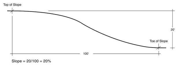
Measurement of Slope
STEEP SLOPE: Any geographical area, whether on a single lot or not, having a topographical gradient of 20 percent or greater (ratio of vertical distance to horizontal distance) between the toe of slope and top of slope and a minimum area as defined below. Known steep slope areas are identified on the City's Steep Slope Map. Steep slopes are further categorized as:
1.
MODERATE STEEP SLOPE: A slope equal to or greater than one vertical on five horizontal (20 percent) but less than one vertical on four horizontal (25 percent) and having a minimum vertical elevation change of ten feet from the top of slope to toe of slope.
2.
VERY STEEP SLOPE: A slope equal to or greater than one vertical on four horizontal (25 percent) but less than one vertical on 2.5 horizontal (40 percent) and having a minimum vertical elevation change of ten feet from the top of slope to toe of slope.
3.
BLUFF SLOPE: A slope equal to or greater than one vertical on 2.5 horizontal (40 percent) and having a minimum vertical elevation change of 15 feet or more from the top of slope to toe of slope.
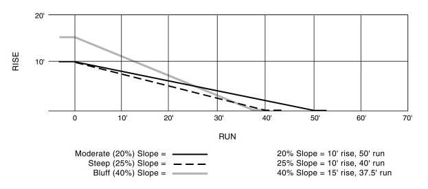
TYPES OF STEEP SLOPE
STEEP SLOPE PERMIT: The written form of City approval granted by the reviewing authority and required by this Chapter for the issuance of a work permit and the conduct of any regulated activity on a steep slope.
STRUCTURE: Anything constructed or erected, the use of which requires location on or in the ground or attachment to something having location on the ground, including, but not limited to, buildings, athletic courts, swimming pools and decks.
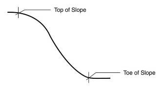
TOE OF SLOPE: The base or bottom of a slope at the point where the ground surface changes to a flatter grade (less than 20 percent), and below which no further steep slope exists within 100 feet of the toe of slope line.
TOP OF SLOPE: The top of slope is the point where the grade changes from less than to greater than 20 percent.
TRANSITION CONTOUR: A contour elevation that marks a change between two types of steep slope. Transition contours also occur if a steep slope includes a plateau of land that has a slope of 20 percent or less with a horizontal distance of less than 100 feet. If such a plateau exists, the contour line where the slope changes from 20 percent or more to less than 20 percent shall be considered as transition contours, and not as a top or toe of slope.