
San Luis Obispo County Unincorporated
City Zoning Code
City Zoning Code
ARTICLE 3
SITE PLANNING AND PROJECT DESIGN STANDARDS
Chapter 22.12 - AFFORDABLE HOUSING INCENTIVES[2]
Editor's note— Ord. No. 3427, § 1, adopted November 17, 2020, repealed ch. 22.12, §§ 22.12.010—22.12.080 and enacted a new ch. 22.12 as set out herein. Former ch. 22.12 pertained to similar subject matter and derived from Ord. No. 2158, adopted 1984; Ord. No. 2428, adopted 1989; Ord. No. 2578, adopted 1992; Ord. No. 2994, adopted 2003; Ord. No. 3108, adopted 2006; Ord. No. 3122, adopted 2007; Ord. No. 3169, adopted 2008; Ord. No. 3236, adopted 2012; Ord. No. 3237, adopted 2012; Ord. No. 3282, adopted 2014; Ord. No. 3382, adopted 2019; Ord. No. 3409, adopted 2020; and Ord. No. 3417, adopted 2020.
22.10.010 - Purpose of Chapter.
A.
The provisions of this Chapter address the details of site planning, project design, and the ongoing conduct/operation of land uses. These standards are intended to ensure that all development produces an environment of stable and desirable character, and is harmonious with existing and future development, and protects the use and enjoyment of neighboring properties, consistent with the General Plan.
[22.04.010]
B.
The operational standards of this Chapter are established to protect residents from the adverse effects of excessive or objectionable emissions of noise or air contaminants that may be generated by land uses, activities, processes or equipment.
[22.06.010]
22.10.020 - Applicability.
A.
The standards of this Chapter apply to all new land uses required to have a land use permit in compliance with this Title, except:
1.
Where the standards of Chapters 22.14 (Combining Designation Standards), or Article 4 (Standards for Specific Land Uses) conflict with the provisions of this Chapter, the provisions of Chapters 22.14 and Article 4 prevail;
2.
Where planning area standards Article 9 (Community Planning Standards) conflict with the standards of this Chapter, the planning area standards prevail.
B.
A use existing on the effective date of this Title, or on the date of a subsequent amendment to this Title that applies more restrictive operational standards to the use, shall not be required to change their operations to comply with the provisions of Sections 22.10.030 (Air Quality), 22.10.050 (Explosives Storage), 22.10.070 (Flammable and Combustible Liquids Storage), 22.10.120 (Noise), 22.10.170 (Vibration), and 22.10.180 (Water Quality), unless a modification of the use is proposed that requires a permit. However, in no case shall existing operations be changed to result in a greater degree of noncompliance with these standards than existed on the effective date of this Title or amendment.
Nothing in this Chapter shall preclude the initiation of revocation, abatement or legal action against an existing use operated in violation of Sections 22.10.120 (Noise) or 22.10.170 (Vibration) or operated in manner that creates a public nuisance.
[Amended 1994, Ord. 2696] [22.04.012, 22.06.020]
22.10.030 - Air Quality.
A.
Air Pollution Control District (APCD) Review.
1.
Purpose. This Subsection establishes a procedure for the notification of the County APCD when a new land use is proposed to include equipment or activities that involve combustion, or the storage or use of hydrocarbons or other air contaminants.
2.
Applicability. These provisions apply to any project for which a discretionary land use permit is required by this Title, except business licenses consistent with the most current guidelines of the Air Pollution Control District.
3.
Review procedure. A copy of any application shall be forwarded to the Air Pollution Control District for review upon receipt by the Department. This referral is intended to enable the APCD to:
a.
Determine if the use proposed is required by the rules and regulations of the APCD to obtain an authority to construct or permit to operate;
b.
Determine if the proposed project exceeds the district's significance thresholds for significant air quality impacts from land use projects, and if mitigations are required.
c.
Contact and advise the applicant on applicable permit and air quality requirements, and to advise the Department of any APCD permit requirements.
(1)
In the case of a Zoning Clearance application, within 10 business days of application transmittal;
(2)
In the case of Minor Use Permit or Conditional Use Permit applications, notification of permit requirements, or special concerns or recommendations to be forwarded to the Review Authority shall be returned to the Department no later than 10 days before the public hearing on the application.
4.
Building Permit issuance. When the APCD has notified the Department that authority to construct is required, the applicant is to provide the Department with evidence of approval of an authority to construct prior to issuance of a building permit. In the event that the APCD has not notified the Department of APCD permit requirements within 10 business days of application transmittal, the lack of notification shall not cause additional delay in permit issuance by the Department; however, permit issuance under such circumstances shall not exempt any person from the necessity of obtaining APCD permits if required.
5.
Certificate of Occupancy. In cases where an APCD permit to operate is required, no certificate of occupancy shall be issued until the applicant has provided the Department with evidence of permit approval.
B.
Odors. Any non-agricultural land use conducted in, or within one-half mile of an urban or village reserve line shall be operated so as not to emit matter causing noxious odors which are perceptible at the points of determination identified in the following table.
[Amended 1992, Ord. 2553; 1995, Ord. 2741] [22.06.082, 22.06.084]
22.10.040 - Archeological Resources.
In the event archeological resources are unearthed or discovered during any construction activities, the following standards apply:
A.
Construction activities shall cease, and the Department shall be notified so that the extent and location of discovered materials may be recorded by a qualified archaeologist, and disposition of artifacts may be accomplished in accordance with state and federal law.
B.
In the event archeological resources are found to include human remains, or in any other case when human remains are discovered during construction, the County Coroner shall be notified in addition to the Department so proper disposition may be accomplished.
[22.05.140]
22.10.050 - Explosives Storage.
The storage of explosives is allowed only for the purpose of sales by a licensed vendor, or where the explosives will be used on the same site as the storage facility, as provided in this Section.
A.
Applicability. The standards of this Section apply in addition to all applicable state and federal standards, including any regulations administered by the County Health Department, Fire Department, Sheriff's Office, Agricultural Commissioner, and Air Pollution Control District. If any standards of this Chapter conflict with regulations administered by other federal, state, or county agencies, the most restrictive standards apply.
B.
Permit requirement. Conditional Use Permit approval within an urban or village reserve line; Minor Use Permit approval in rural areas. Separate land use permit approval is not required where the principal use of the site has been authorized through Conditional Use Permit approval, or in the case of a surface mining operation, where the operation has been authorized by an approved reclamation plan. This permit requirement is in addition to the permit required by the County Sheriff.
C.
Location. Explosives storage is allowed only in the Agriculture, Rural Lands or Industrial land use category, or areas included within an Energy and Extractive Resource (EX) combining designation. A land use permit application that proposes explosives storage may be approved only where the Review Authority finds the proposed site is within an area that is open in character and essentially free of development.
D.
Setbacks. Explosives storage shall not be located closer than 1,000 feet from any property line, except that storage in Class II magazines, as authorized in State law, shall not be located closer than 400 feet from any property line; provided that where the current edition of the Uniform Fire Code adopted by the County would require a greater setback than required by this Section, the greater setback shall apply.
E.
Construction and buffering. Explosives storage shall be effectively screened by a natural landform or artificial barricade either surrounding the entire site or surrounding each storage magazine. Storage magazines shall be designed and constructed in compliance with the current edition of the Uniform Fire Code adopted by the County, and any applicable requirements of the County Sheriff. The landform or barricade shall be of such height that.
1.
A straight line drawn from the top of any side wall of all magazines to any part of the nearest building or structure will pass through the landform or barricade; and
2.
A straight line drawn from the top of any side wall of all magazines to any point 12 feet above the centerline of a railroad or a public street will pass through said landform or barricade.
Artificial barricades shall be a mound or rivetted wall of earth with a minimum thickness of three feet.
F.
Time limit. Land use permit approval for storage of explosives may be granted for a maximum of five years, provided that the land use permit shall be subject to review by the Review Authority at any time. If, through such review, the Review Authority finds that circumstances or conditions have changed so the use no longer meets the requirements of this Section or the conditions of the land use permit, the permit may be revised or revoked, whichever is more appropriate.
[Amended 1982, Ord. 2091; 1992 Ord. 2553] [22.06.124]
22.10.060 - Exterior Lighting.
The standards of this Section are applicable to all outdoor night-lighting sources installed after the effective date of this Title, except for street lights located within public rights-of-way and all uses established in the Agriculture land use category. No land use permit is required for lighting facilities, though an electrical permit may be required by Title 19 of this code (the Building and Construction Ordinance).
A.
Illumination only. Outdoor lighting shall be used for the purpose of illumination only, and shall not be designed for or used as an advertising display, except as provided by Chapter 22.20 (Signs).
B.
Light directed onto lot. Light sources shall be designed and adjusted to direct light away from any road or street, and away from any dwelling outside the ownership of the applicant.
C.
Minimization of light intensity. No light or glare shall be transmitted or reflected in a concentration or intensity that is detrimental or harmful to persons, or that interferes with the use of surrounding properties or streets.
D.
Light sources to be shielded.
1.
Ground illuminating lights. Any light source used for ground area illumination except incandescent lamps of 150 watts or less and light produced directly by the combustion of natural gas or other fuels, shall be shielded from above in such a manner that the edge of the shield is level with or below the lowest edge of the light source. Where any light source intended for ground illumination is located at a height greater than eight feet, the required shielding shall extend below the lowest edge of the light source a distance sufficient to block the light source from the view of any residential use within 1,000 feet of the light fixture.
2.
Elevated feature illumination. Where lights are used for the purpose of illuminating or accenting building walls, signs, flags, architectural features, or landscaping, the light source shall be shielded so as not to be directly visible from off-site.
E.
Height of light fixtures. Free-standing outdoor lighting fixtures shall not exceed the height of the tallest building on the site.
F.
Street lighting. Street lighting shall be designed to minimize light pollution by preventing the light from going beyond the horizontal plane at which the fixture is directed.
[Amended 1999, Ord. 2880] [22.04.320]
22.10.070 - Flammable and Combustible Liquids Storage.
The storage of flammable or combustible liquids (those with flash points below 140 o F) is subject to the following standards.
A.
Applicability. The standards of this Section apply in addition to all applicable state and federal standards, including any regulations administered by the County Health Department, Fire Department, Sheriff's Office, Agricultural Commissioner, and Air Pollution Control District. If any standards of this Chapter conflict with regulations administered by other federal, state, or county agencies, the most restrictive standards apply.
B.
Permit requirements.
1.
Health Department permit. A permit for the underground storage of hazardous substances, including but not limited to gasoline and diesel fuel, shall be obtained as set forth in Chapter 8.14 of this code.
2.
Land use permit. No land use permit is required for the storage of flammable or combustible liquids, except that where the quantity stored exceeds the limitations specified in Subsection D, Minor Use Permit approval is required unless the land use involving the storage of flammable or combustible liquids would otherwise be required by this Title to have Conditional Use Permit approval.
C.
Limitation on use. The storage of flammable or combustible liquids for sale is allowed only in the Recreation, Commercial or Industrial categories, unless authorized by Conditional Use Permit approval.
D.
Limitations on quantity. The quantity of flammable or combustible liquids stored on a site shall be limited as follows.
1.
Residential areas. Five gallons, unless authorized through Conditional Use Permit approval. Excluded from this requirement are the storage of flammable liquids.
a.
In the fuel tanks of self-propelled vehicles, mobile power or heat generators or any other equipment that is accessory to the principal use of the site;
b.
For domestic space heating, cooking or similar purposes, provided that such storage containers and appliances shall satisfy all applicable county and state construction and safety regulations;
c.
The storage or use of paints, oils, varnishes or similar flammable or combustible mixtures when such liquids are stored for maintenance, painting or similar purposes.
2.
Other areas. Storage shall be limited to the following quantities on any single building site, unless greater quantities are authorized through Conditional Use Permit or Minor Use Permit approval.
E.
Setbacks. Aboveground storage facilities for flammable or combustible liquids shall be set back 50 feet from any property line or residential use, or as otherwise required by the Uniform Fire Code or California Building Standards Code where a smaller setback is allowed by those codes.
F.
Additional standards.
1.
All storage of bulk flammable liquids within an urban or village reserve line shall be underground, except:
a.
As specified by Subsection D.1;
b.
Where a petroleum refining or related industrial use is authorized in an Industrial category through Conditional Use Permit approval;
c.
Where an automobile service station or other approved vendor of flammable liquids stores such liquids for sale in approved quantities and containers.
d.
Where an approved use stores such liquids for sale in approved quantities and containers accessory to that approved use
e.
Where a public agency maintains a corporation yard or other approved service facility in a Public Facilities or Industrial land use category, and such storage is authorized through Minor Use Permit.
f.
In a Commercial Service or Industrial land use category where authorized through Minor Use Permit.
2.
All aboveground storage of flammable and combustible liquids shall be within types of containers approved by the county fire chief.
[Amended 1984, Ord. 2163; 1986, Ord 2250; 1987, Ord. 2293; 1992, Ord. 2553; 1999, Ord. 2880; 2014, Ord. 3282] [22.06.126]
22.10.080 - Fencing and Screening.
Standards for fencing and screening are established by this Section to protect certain uses from intrusion, to protect the public from uses that may be hazardous, and to increase compatibility between different land uses by visual screening. Fencing is the enclosure of an area by the materials identified in Subsection C. Screening is the enclosure of an area by a visual barrier, which may include solid fencing, or other materials as specified in Subsection E.
A.
Fencing and screening - where required. Within urban and village reserve lines (except in Agriculture categories), and Commercial Retail and Recreation land use categories in rural areas, fencing and/or screening shall be provided as required by this Section. Unless otherwise specified, fencing and screening shall be a minimum height of six feet.
1.
Mechanical equipment. When located outside of a building, support equipment including air conditioning and heating devices, water and gas meters, but not including plumbing or exhaust vents, or chimneys, shall be screened to the height of the particular piece of equipment, as follows:
a.
Roof-mounted equipment. To be screened by architectural features from the view of abutting streets.
b.
Equipment at grade. When located on the ground adjacent to a building, mechanical equipment shall be screened by landscaping, a solid wall or fencing from the view of the street or surrounding properties.
2.
Multiple-family projects. Multi-family residential projects shall be screened on all interior property lines.
[Added 1982, Ord. 2091]
3.
Outdoor storage. To be screened on all sides by a solid wall or fencing.
4.
Side and rear lot lines. The side and rear property lines of all non-residential uses shall be screened as follows:
a.
Adjacent to a residential use or category. A solid wall or fencing shall be located on side and rear property lines of any non-residential or non-agricultural use abutting a residential use or land use category, except for parks, golf course greens and fairways.
b.
Industrial and Commercial Service categories. A solid wall or fencing shall be located on the side and rear property lines of any site within an Industrial or Commercial Service category that abuts another land use category.
5.
Swimming pools. Yard areas with private swimming pools shall be fenced in compliance with the California Building Standards Code.
B.
Exceptions to fencing and screening requirements.
1.
Buildings abutting property lines. Required screening or fencing may be omitted along any lot line where a building wall exists immediately abutting the lot line.
2.
Location adjustment. Where property line fencing or screening is required, the location may be adjusted (see Section 22.70.030) so the fencing may be constructed at or within the setback line, provided the areas between the fence and the property lines are landscaped, or in rural areas, retained in their natural vegetative state.
3.
Conditions of approval. Where a greater height is required by any other provision of this Title or by a condition of approval, the requirements of this Section shall not apply.
[Added 1994, Ord. 2696]
4.
Modification of fencing and screening requirements. Any of the requirements of this Section may be waived or modified through Minor Use Permit approval, provided the Director first finds that specifically identified characteristics of the site or site vicinity would make required fencing or screening unnecessary or ineffective.
C.
Standards for fencing and screening materials. All fencing and screening shall comply with the following material and height limitations based on the location of the fence:
Notes:
(1)
Solid wood or masonry materials, or plant materials that comply with Subsection E., or other solid materials approved by the Department.
(2)
Open wire or chain link or other materials approved by the Department that permit the passage of a minimum of 90 percent of light.
(3)
Must be authorized by a building permit and constructed consistent with the requirements of the California Building Standards Code.
(4)
To approve a Minor Use Permit, the Review Authority shall first find that the proposed fencing or screening:
a.
Is necessary to enclose private open space for a dwelling because alternative areas such as rear or side yards do not exist or are unsuitable for such use; and
b.
Will not block visibility of the front entrance to the dwelling from the street; and
c.
Will not impair safe sight distances for vehicle traffic; and
d.
Will not exceed 6' - 6" in height.
(5)
The 6 foot 6 inch height limitation does not apply to vegetation growing on an interior side or rear property line or within an interior side or rear setback.
(6)
Fences up to 12 feet in height may only be constructed on a property line where a building may be constructed on a property line.
D.
Gateposts. Gateposts and other superstructures over site entrances and exits may be up to 14 feet 6 inches in height as measured from the surface of the ground to the bottom of the structure, but in no case shall the top of the structure be more than two feet above that height; provided that any gateposts or superstructures above six feet six inches in height shall not block visibility of the front entrance to the dwelling from the street or adjacent properties and will not impair safe sight distances for vehicle traffic and are authorized by a building permit and constructed consistent with the requirements of the California Building Standards Code.
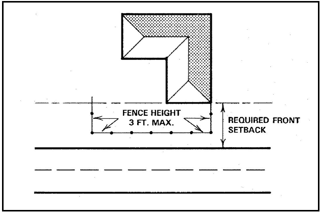
Figure 10-1: Fence Height Example
E.
Screening materials substitution. Where screening is required by this Title to be a solid fence or wall, the following materials may be substituted through adjustment (Section 22.70.030), except a solid fence or wall must be used where screening is required adjacent to a residential use or category.
1.
Landscape screen. Screening plant materials may be substituted for a wall or fence, where:
a.
Proposed plant materials are certified in writing by a registered landscape architect, certified nurseryman or licensed landscape contractor as having the capability of achieving 60 percent of total view blockage within 18 months of installation, and 100 percent of total view blockage within 36 months of installation; and
b.
The applicant agrees in writing to install solid fencing after the expiration of 36 months, and posts a performance bond or other appropriate security approved by the County for one hundred percent of the estimated cost to install solid fencing, in the event that the planting has not totally blocked the view of areas required to be screened.
2.
Berms. A landscaped berm may be substituted for a wall or fence provided that the combination of berm and landscaping is not less than the required height of the fence or wall, and that the berm is constructed with a maximum slope of 3:1, with side slopes designed and planted to prevent erosion, and with a rounded surface a minimum of two feet in width at the highest point of the berm, extending the length of the berm.
3.
Slatted chain-link fencing. Chain-link fencing with slats and landscaping may be substituted for a solid wall or fence in an Industrial category, except where screening or fencing is required adjacent to another land use category.
[Amended 1986, Ord. 2250; 1987, Ord. 2314; 1989, Ord. 2409; 1992, Ord. 2553; 1994, Ord. 2696; 1994, Ord. 2696; 1999, Ord. 2880; 2014, Ord. 3282] [22.04.190]
22.10.090 - Height Measurement and Height Limit Exceptions.
A.
Purpose. This Section limits the height of structures as needed to: support public safety; protect access to natural light, ventilation, and direct sunlight; support the preservation of neighborhood character; and to preserve viewsheds and scenic vistas.
B.
Measurement of height. The height of a building or structure shall be measured as the vertical distance from the highest point of the structure to the average of the highest and lowest points where the vertical plane of the exterior walls would touch the natural grade level of the site; except that finished grade instead of natural grade shall be the basis for height measurement where:
1.
A site is graded or filled in compliance with approved subdivision improvement plans, or a grading permit that was approved to authorize.
a.
Grading or fill to conform the elevation of the building site with that of adjoining developed sites; or
b.
Fill to mitigate flood hazards in compliance with the provisions of Section 22.14.060 et seq.; or
c.
Fill determined by the Environmental Coordinator and Director to be necessary to mitigate the impacts of allowable development on archeological resources, which shall not exceed a depth of 24 inches unless specifically authorized by the Director.
2.
The site was graded or filled in compliance with a grading permit approved before June 25, 1992.
3.
An adjustment (22.70.030) is approved by the Director on the basis that the site was filled before January 1, 1981.
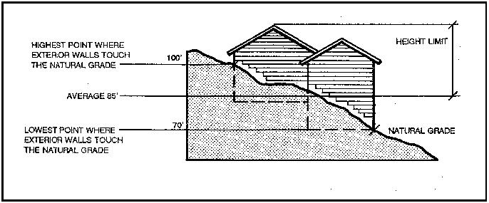
Figure 10-2: Measurement of Height - Example 1
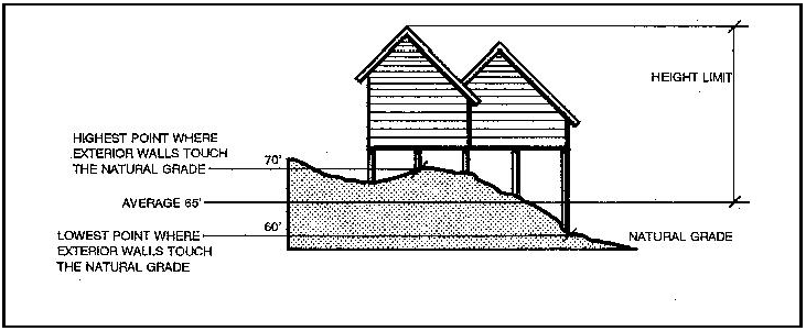
Figure 10-3: Measurement of Height - Example 2
C.
Height limits. The maximum height for new structures is as follows, except where other height limits are established by planning area standards of Chapter 22.09 (Community Planning Standards). (For allowed fence heights, see Section 22.10.080.C.)
1.
Maximum allowed height by land use category.
2.
Exceptions to height limitations.
a.
Commission modifications. Buildings and structures exceeding the heights permitted in Subsection C.1. may be authorized through Conditional Use Permit approval, provided the Commission first finds the project will not result in substantial detrimental effects on the enjoyment and use of adjoining properties, and that the modified height will not exceed the lifesaving equipment capabilities of the fire protection agency having jurisdiction.
b.
Residential exceptions.
(1)
Additional height. The height limitations specified by Subsection C.1 for residential buildings may be adjusted (Section 22.70.030) to allow additional height to a maximum of 45 feet, provided that the required side, rear and interior setbacks shall be increased one foot in width for each foot of height over 35 feet.
(2)
Downhill lot. Where the average front-to-back slope of a lot is greater than one foot of fall in seven feet of distance (14.2 percent average slope) from the centerline of the street to the rear face of the proposed building, up to 5 feet may be added to the allowed height limit (Subsection C.).
c.
Uninhabited structures. The height limits specified in Subsection C.1. do not apply to the following structures (measurement of height is from the ground, as set forth in Subsection A.):
(1)
Radio and television receiving antennas. The type customarily used for home radio and television receivers, as well as amateur and commercial transmitting antennas, when 50 feet or less in height.
(2)
Flagpoles. 50 feet or less in height.
(3)
Agricultural structures. Barns, grain elevators, silos, water tanks, windmills, wind generators and all other similar structures not containing residential uses and located in the Agriculture, Rural Lands, Residential Rural, Residential Suburban and Industrial land use categories.
(4)
Chimneys. No more than 100 feet in height located in the Industrial category; and all other chimneys and roof vents extending no more than three feet above the height limit specified in Subsection C.1.
(5)
Industrial. Industrial towers, non-portable equipment and other uninhabited structures no more than 60 feet in height located in an Industrial land use category.
(6)
Construction equipment. All portable construction equipment.
(7)
Public utilities. Poles and structures for providing electrical and communications services.
(8)
Solar electric facilities and wind energy conversion systems may exceed the height limits specified in Subsection C.1 up to the maximum limits established in Chapter 22.32 for the proposed project.
[Amended 1984, Ord. 2163; 1986, Ord. 2267; 1988; Ord. 2344; 1992, Ord. 2553; 2015, Ord. 3291] [22.04.120, 122, 124]
22.10.095 - Highway Corridor Design Standards.
A.
Applicability. These provisions apply to projects located within the following highway corridor areas:
1.
The Salinas River Highway Corridor, as shown in Figures 10-5 through 10-15.
2.
The San Luis Obispo Highway Corridor, as shown in Figure 10-22.
3.
The South County Highway Corridor, as shown in Figures 10-30 and 10-31.
B.
Salinas River Highway Corridor Design Standards. The purpose of the highway corridor design standards is to provide public views of:
1.
Scenic vistas and backdrops containing varied topography including ridgelines and rock features,
2.
Significant stands of trees and wildflowers, and
3.
Natural landmarks, historic buildings and pastoral settings.
The following standards are intended to expedite the permit process for projects which maintain scenic views and the rural character along portions of Highways 41 and 101, while providing opportunities to use other design solutions through a discretionary review process to achieve scenic goals. Only residential structures, residential accessory buildings, residential access roads, specified agricultural accessory buildings and signs are governed by these standards. All other uses and structures, such as agricultural roads and nursery specialties, are not subject to the following process.
The following standards also apply to certain hillside and hilltop locations on the east and west sides of those highways that have been determined to contain particular scenic value, as shown in Figures 10-4 through 10-15.
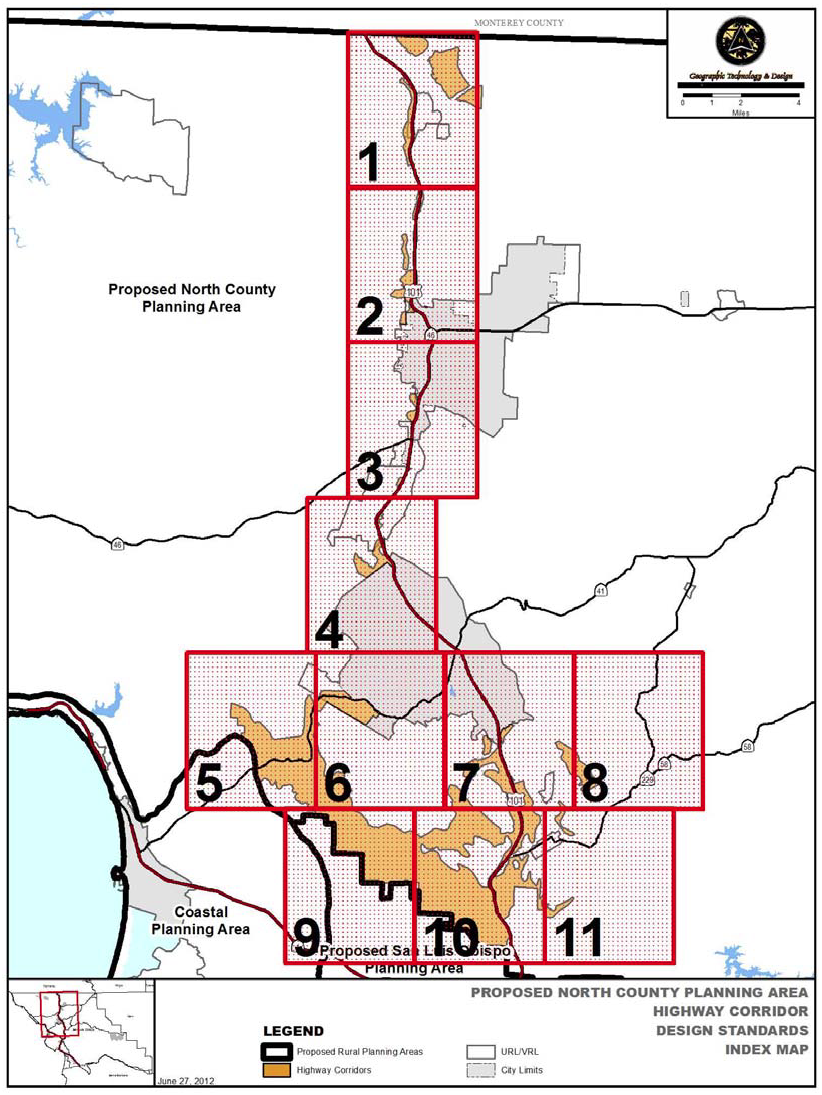
Figure 10-4: Highway Corridor Index
Figure 10-5: Area 1 - San Miguel - Highway Corridor Design Standards
Figure 10-6: Area 2 - Wellsona - Highway Corridor Design Standards
Figure 10-7: Area 3 - South Paso Robles/North Tampleton - Highway Corridor Design
Standards
Figure 10-8: Area 4 - South Templeton, North Atascadero - Highway Corridor Design
Standards
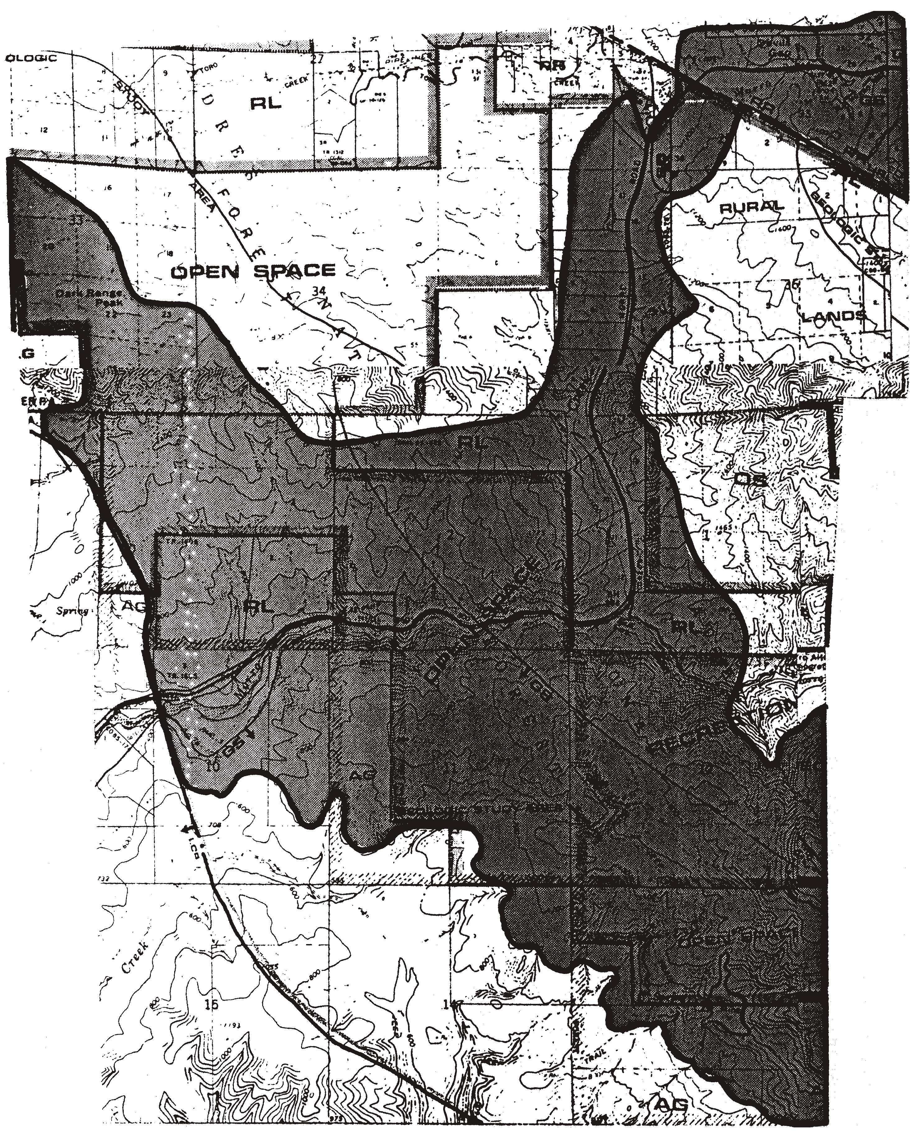
Figure 10-9: Area 5 - West Atascadero, Highway 41 - Highway Corridor Design Standards
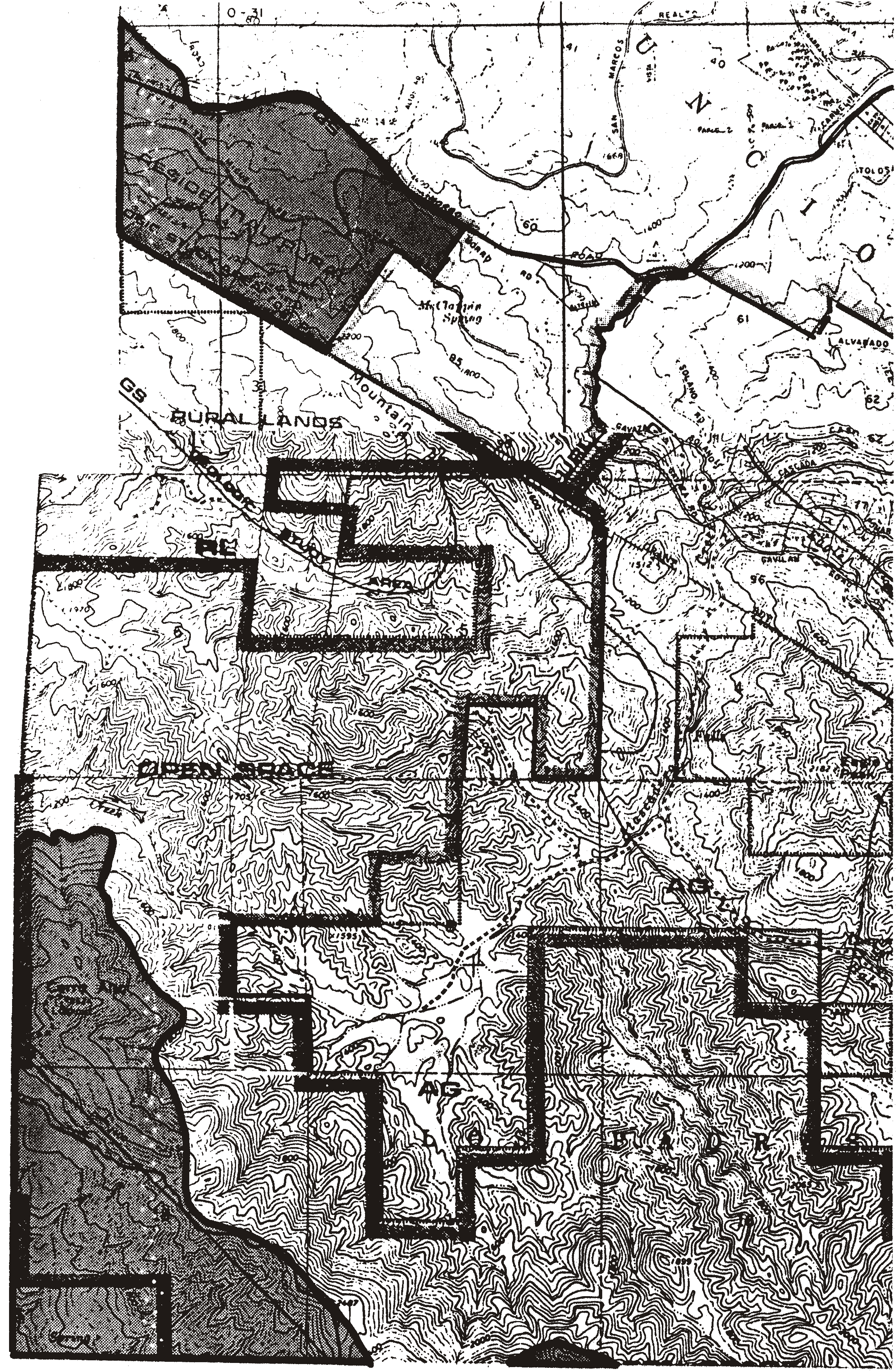
Figure 10-10: Area 6 - West Atascadero, Highway 41 - Highway Corridor Design Standards

Figure 10-11: Area 7 - South Atascadero - Highway Corridor Design Standards

Figure 10-12: Area 8 - Garden Farms - Highway Corridor Design Standards
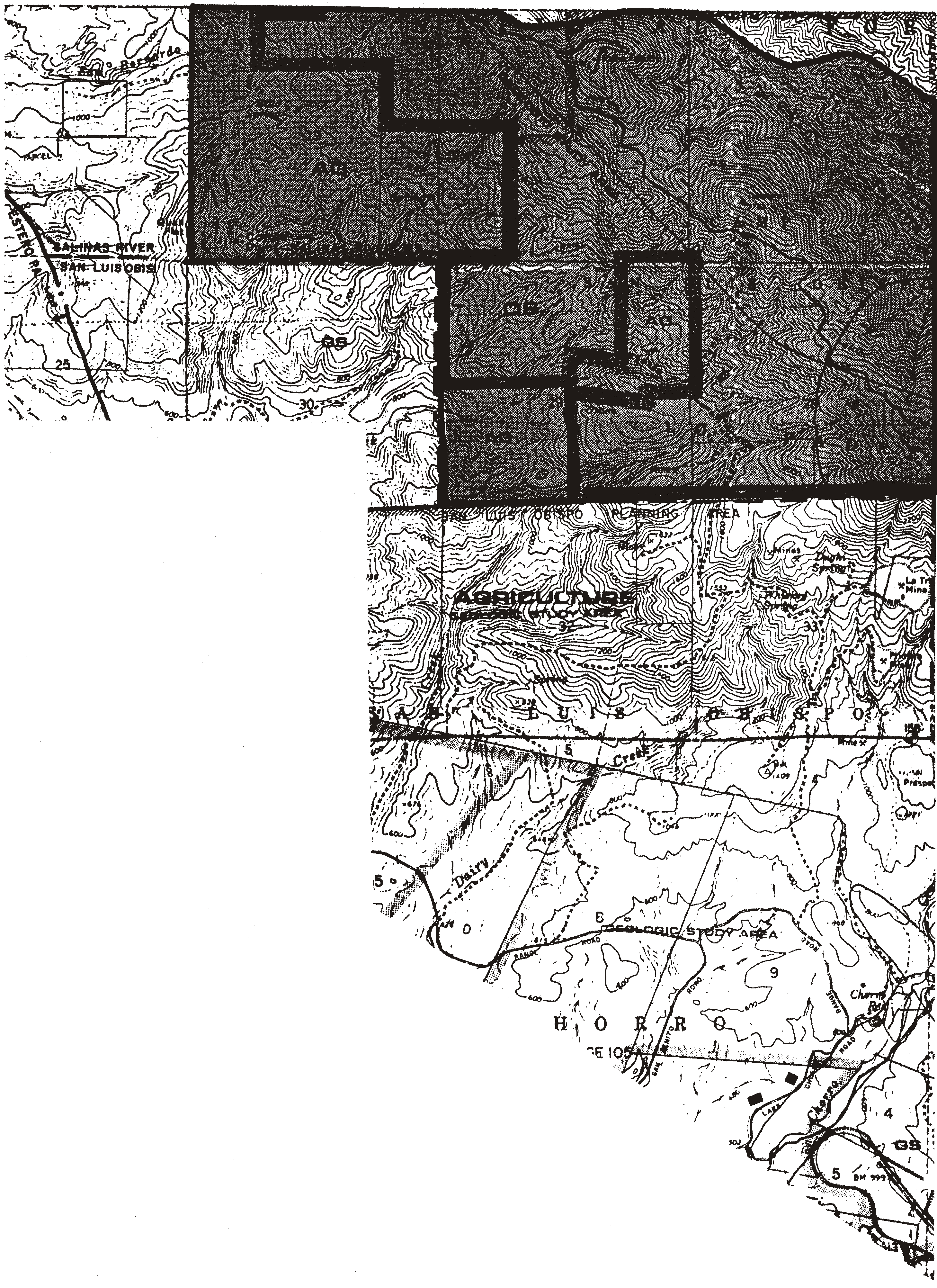
Figure 10-13: Area 9 - Tassajara Canyon - Highway Corridor Design Standards

Figure 10-14: Area 10 - Tassajara Canyon - Highway Corridor Design Standards

Figure 10-15: Area 11 - Santa Margarita - Highway Corridor Design Standards
1.
Permit requirements. For developments that choose to comply with the provisions of Subsections B.2.c through B.2.i, Zoning Clearance is required for residential structures, residential accessory buildings and residential access roads to review conformance with Subsections B.2.c through B.2.i. Projects that do not choose to comply with Subsections B.2.c through B.2.i are required to apply for a Minor Use Permit, or a Conditional Use Permit if otherwise required by Section 22.06.030 (Allowable Land Uses and Permit Requirements).
Within the Highway corridors (limited to the first 300 feet) shown in Figures 104-5 through 104-16, Zoning Clearance approval (with a confirming site visit) is also required for agricultural accessory buildings larger than 600 square feet, individually or cumulatively, and having one or more of the following: a roof pitch of less than 3:12, unarticulated wall surfaces and/or service entrances facing the highway.
If the Zoning Clearance application cannot be approved in compliance with Subsections H.2.c through H.2.i, the applicant may choose to convert the application to a Minor Use Permit application, with the applicant paying the difference in application fees.
2.
Zoning Clearance requirements. Zoning Clearance applications for sites within or partially within the highway corridors shown in Figures 10-4 through 10-15 shall comply with the following, in addition to other applicable standards:
a.
Site visit required. The Zoning Clearance application shall be subject to two site visits; one during the time of application review to confirm that conditions on the site correspond to information provided in the application, and the other prior to final building inspection to confirm that the building and site improvements agree with the approved plan. (Planting of required landscaping improvements may be delayed up to 90 days after final building inspection when installation is guaranteed by bond.)
b.
Exemption. An exemption from Subsections H.2.c through H.2.i may be granted if documentation is provided that the project will not be visible from the applicable highway corridor. Such documentation shall at minimum provide topographic contours (referenced to sea level), and building elevations with preliminary grading and building plans. A visual analysis of the project's location may be useful to facilitate a decision.
If conformance with these standards would unavoidably impact a biological habitat, the Director may waive the applicable standard.
c.
Highway setback. Where possible, residential buildings, residential accessory structures, and agricultural accessory structures larger than 600 square feet with the features described in Subsection H.1, shall be set back 100 feet from the applicable highway right-of-way as shown in Figure 10-16. If there is no feasible development area outside this setback, the project shall be located on the rear half of the property and shall provide a landscaping screen of fast, or moderately fast, growing plant material to provide 80 percent coverage at plant maturity. A landscaping plan per Chapter 22.16 shall be provided with the Building Permit application.
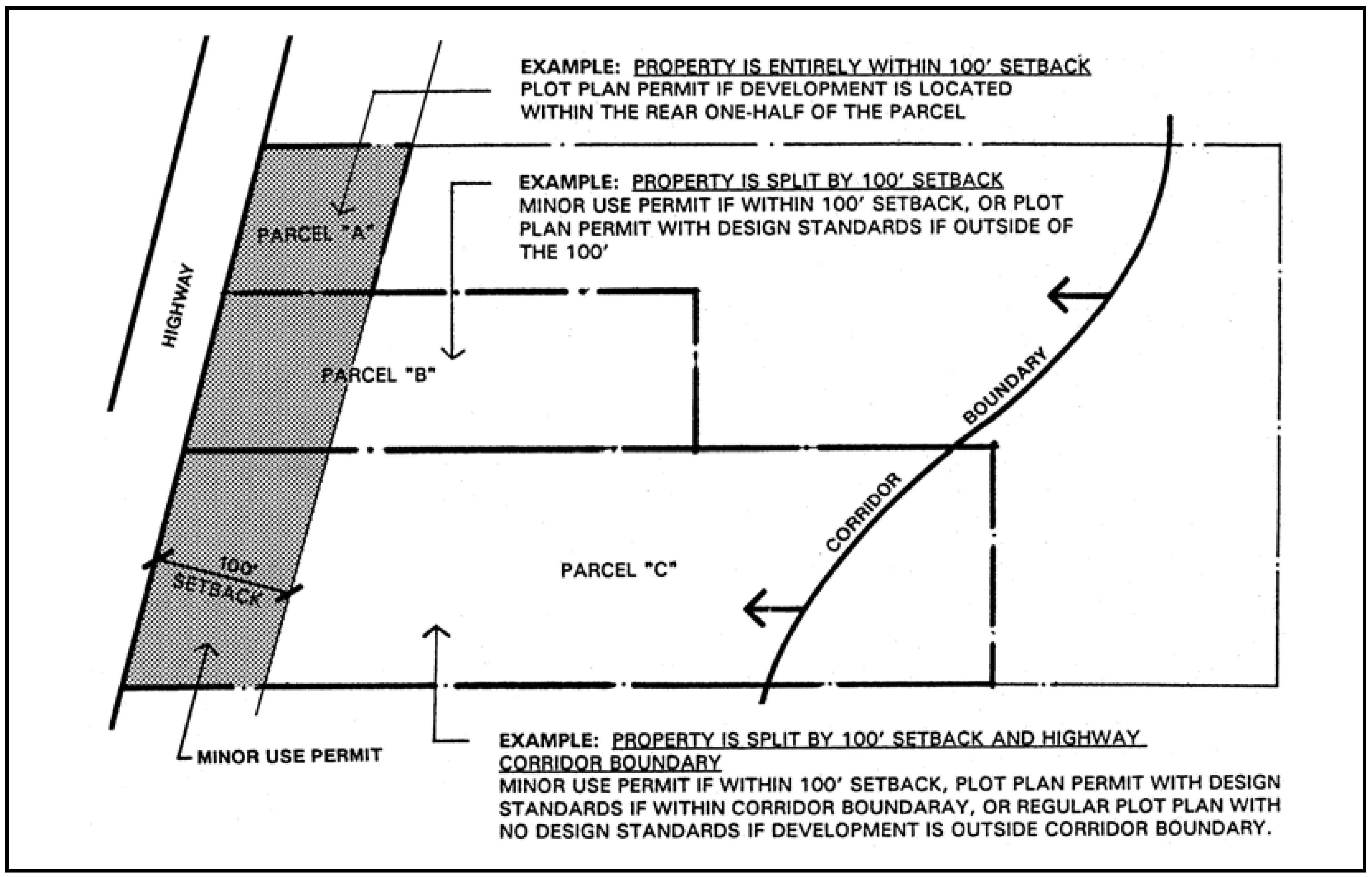
Figure 10-16: Highway Setback for Zoning Clearance Projects
d.
Ridgetop development. Structures within the corridor boundaries shall be located so they are not silhouetted against the sky, as illustrated in Figure 10-17.
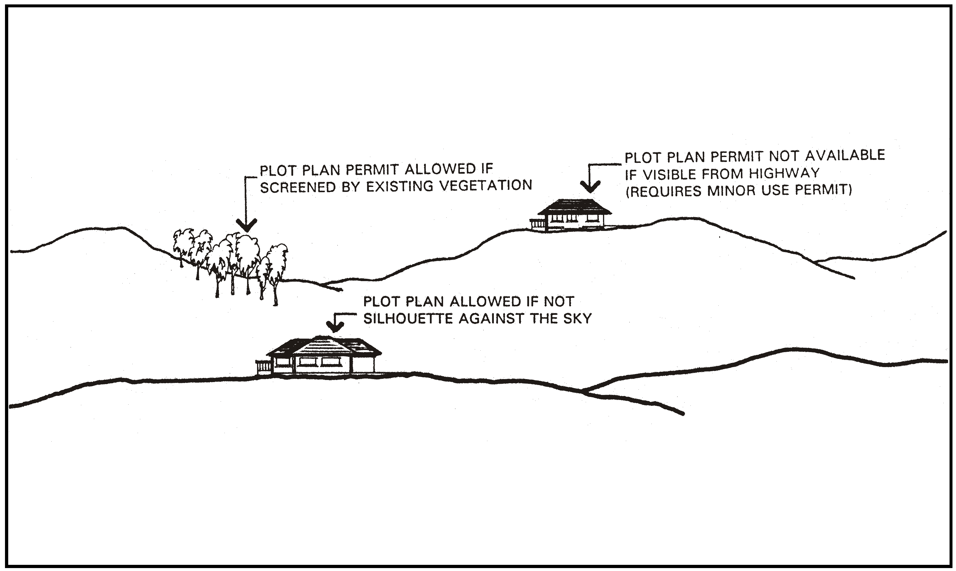
Figure 10-17: Ridgetop Development
e.
Slope limitation. Grading for structures and roads is encouraged to be located on slopes less than 20 percent, as shown in Figure 10-18. Zoning Clearance is required for development on slopes of 20 percent or less, and Minor Use Permit on slopes greater than 20 percent.
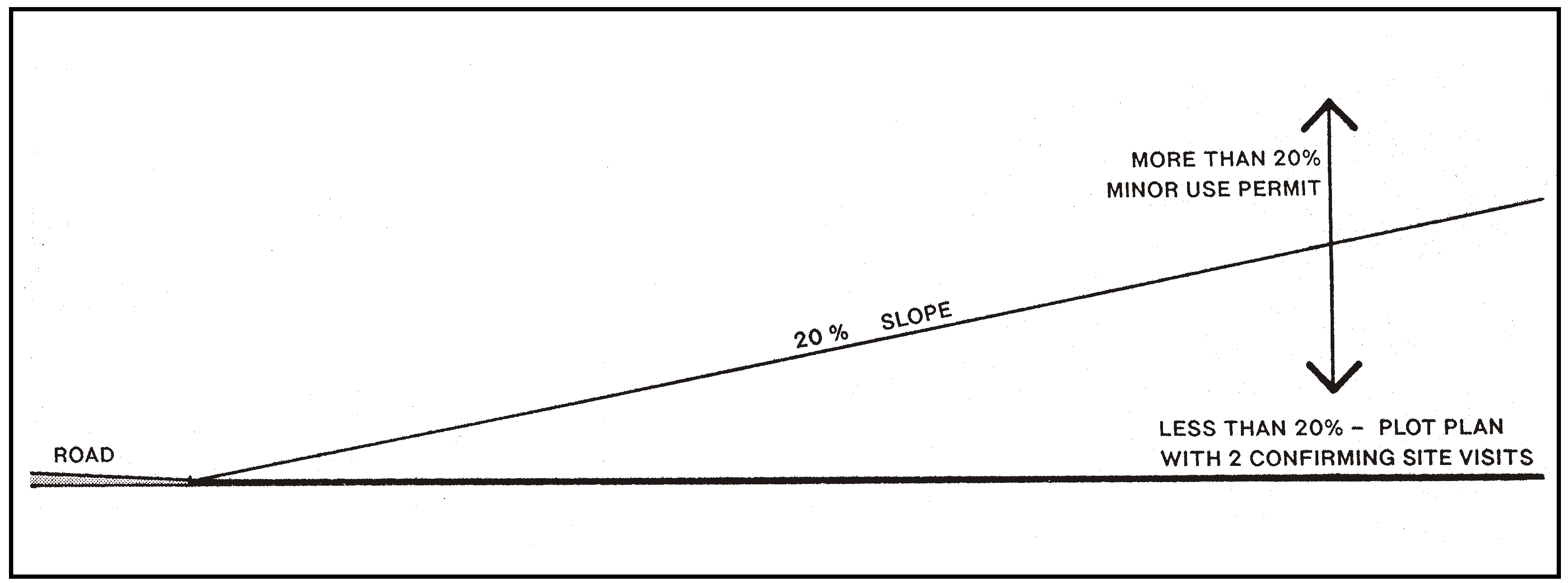
Figure 10-18: Slope Limitation
f.
Landmark features. Grading and placement of structures shall occur at least 150 feet from any significant rock outcrop or geologic feature, as illustrated in Figure 10-19.
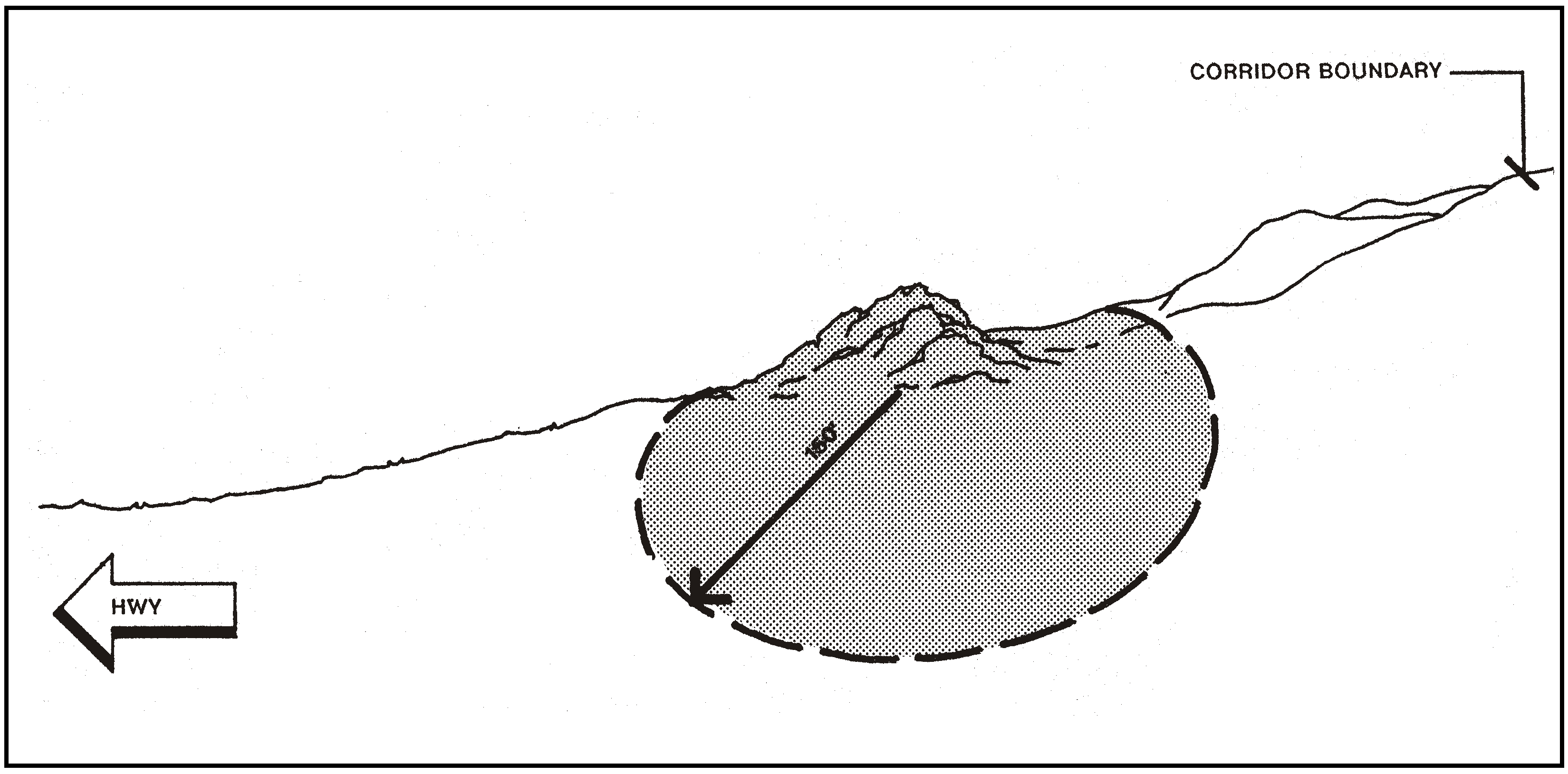
Figure 10-19: Landmark Features
g.
Building height and color. Maximum building height is 25 feet above natural grade, as shown in Figure 10-20. This height limit may be increased an additional five feet for agricultural accessory buildings subject to an adjustment as provided in Section 22.01.044 subject to a visual study that supports a finding that buildings will have appropriate forms to minimize their visual impact on surrounding properties and Highway 101. The additional height shall be for architectural features such as cupolas or gabled vents on no more than one-third the length of any building. Building color other than trim shall be similar to surrounding natural colors and no brighter than 6 in chroma and value on the Munsell Color Scale on file in the Department.
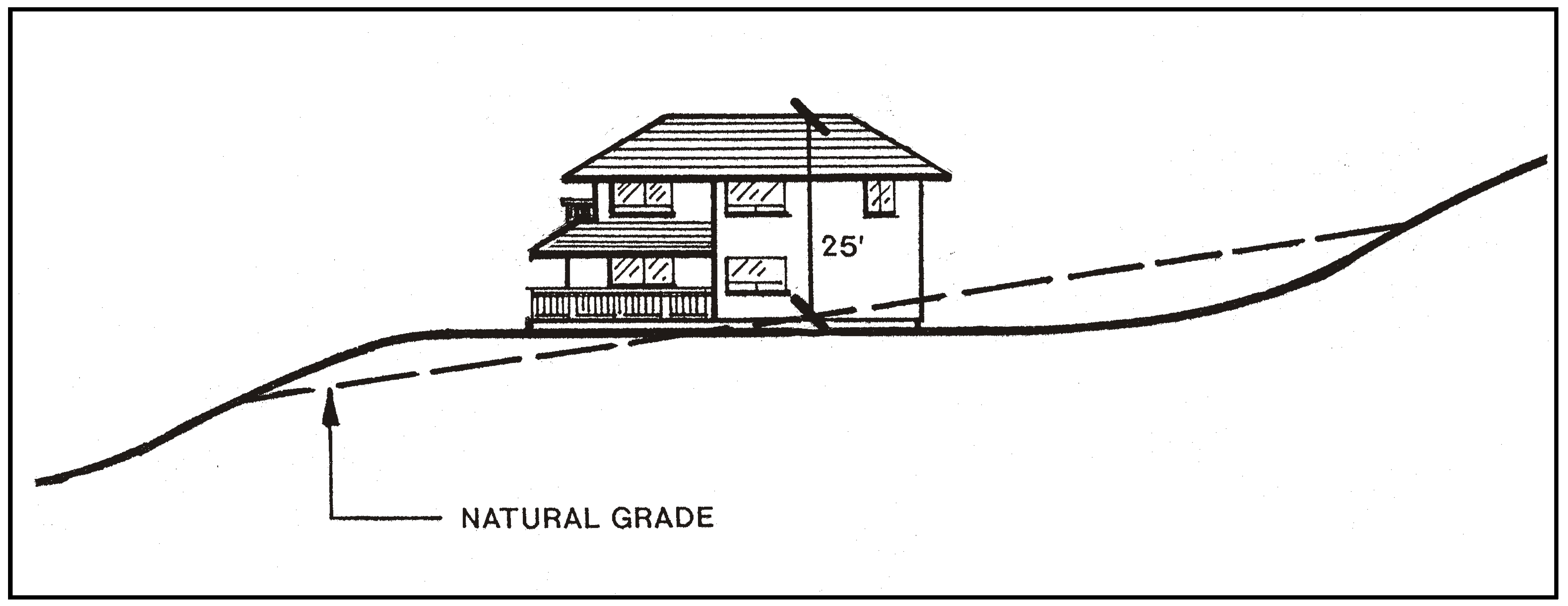
Figure 10-20: Building Height
h.
Landscaping. A landscaping plan is required in compliance with Chapter 22.16, and shall ensure at least 50 percent screening of the structure at plant maturity, as shown in Figure 10-21. Landscaping shall include mitigation planting or seeding to cover and screen visible graded cut and fill areas in compliance with Chapter 22.16.
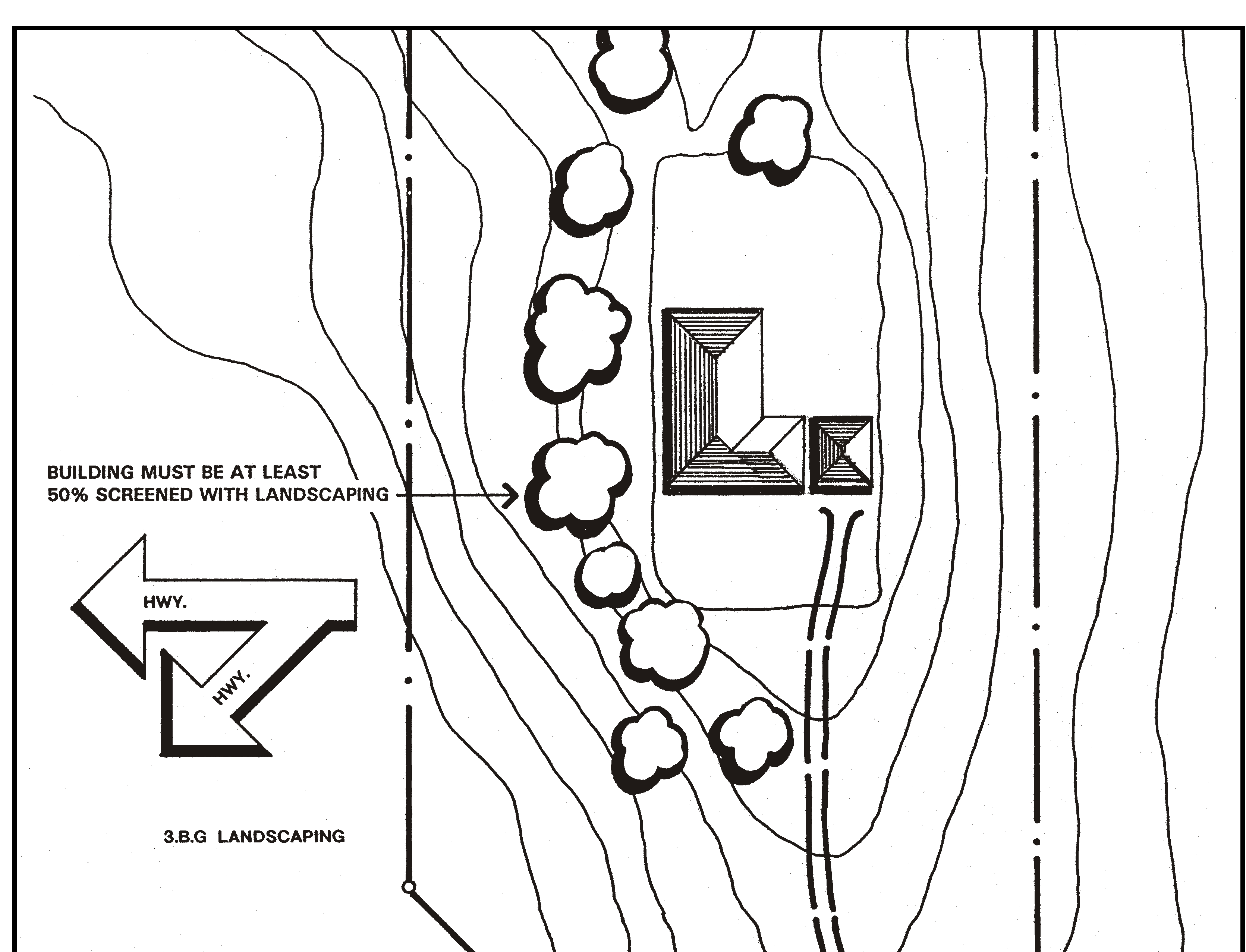
Figure 10-21: Landscaping
i.
Biological habitats. Development shall be designed and located to minimize adverse impacts to important biological resources in conforming with these standards. If there is a conflict between biological resources and these standards, protecting the biological resources takes precedence.
3.
Discretionary permit requirements. Minor Use Permit approval is required for projects that are unable to meet the requirements for a Zoning Clearance as specified in Subsections B.2.c through B.2.h above. Minor Use Permit and any Conditional Use Permit applications that may otherwise be required by this Title shall include a visual analysis that is prepared by a registered architect, landscape architect or other qualified individual acceptable to the Director. The visual analysis shall be utilized to determine compliance with the intent of standards B.2.c through B.2.h and the following:
a.
Locate development, including access roads, in the least visible portion of the site consistent with the protection of other resources, as viewed from the applicable highway corridor or road. Use existing vegetation and topographic features to screen development from view as much as possible.
b.
Minimize grading that would create cut and fill slopes visible from Highway 41 and 101.
c.
Minimize building height and mass by using low-profile design here applicable. Minimize building appearance by using colors to harmonize with the surrounding natural environment.
d.
Provide landscaping to screen and buffer development through extensive use of trees and large-growing shrubs in compliance with Chapter 22.16.
4.
Residential land divisions - Cluster development encouraged. Residential land divisions are encouraged to be clustered in compliance with Section 22.22.140, unless standard subdivision design can include clustered residential building sites that will be in equal conformity with standards B.2.c through B.2.i. Application review shall determine whether the proposed parcels are designed so that residential buildings, accessory buildings and roads will be in conformity with standards H.3.a through H.3.d, in addition to other applicable standards.
Guideline: Retain land in open space in new land divisions that will preserve existing views of land subject to the Highway corridor design standards.
a.
Open Space parcel incentive. Cluster divisions of land that are subject to the Highway Corridor Design Standards may utilize an open space parcel area that is smaller than required by Chapter 22.22. The size of the area may be determined by a visual analysis of the area subject to the Highway Corridor Design Standards as part of the subdivision review process. The analysis shall identify the area that is necessary to maintain open space views of features identified in the Highway Corridor Design Standards.
C.
San Luis Obispo Highway Corridor Area. All projects within the Sensitive Resource Area in the San Luis Obispo sub-area of the San Luis Obispo Planning Area and South County Planning Area and all residential structures, residential access roads, residential accessory structures, and certain agricultural structures on any land within the highway corridor design area shown in Figure 10-22 are subject to the standards in this subsection, in addition to all other applicable standards of this Title. The highway corridor design area supplements the Sensitive Resource Area combining designation that is applied to the most critical scenic resources such as the Morros. The Highway Corridor Design Standards are intended to protect views of scenic backdrops and background vistas and foreground views from scenic roads and highways, and other environmental resources that provide habitat and watershed drainage.
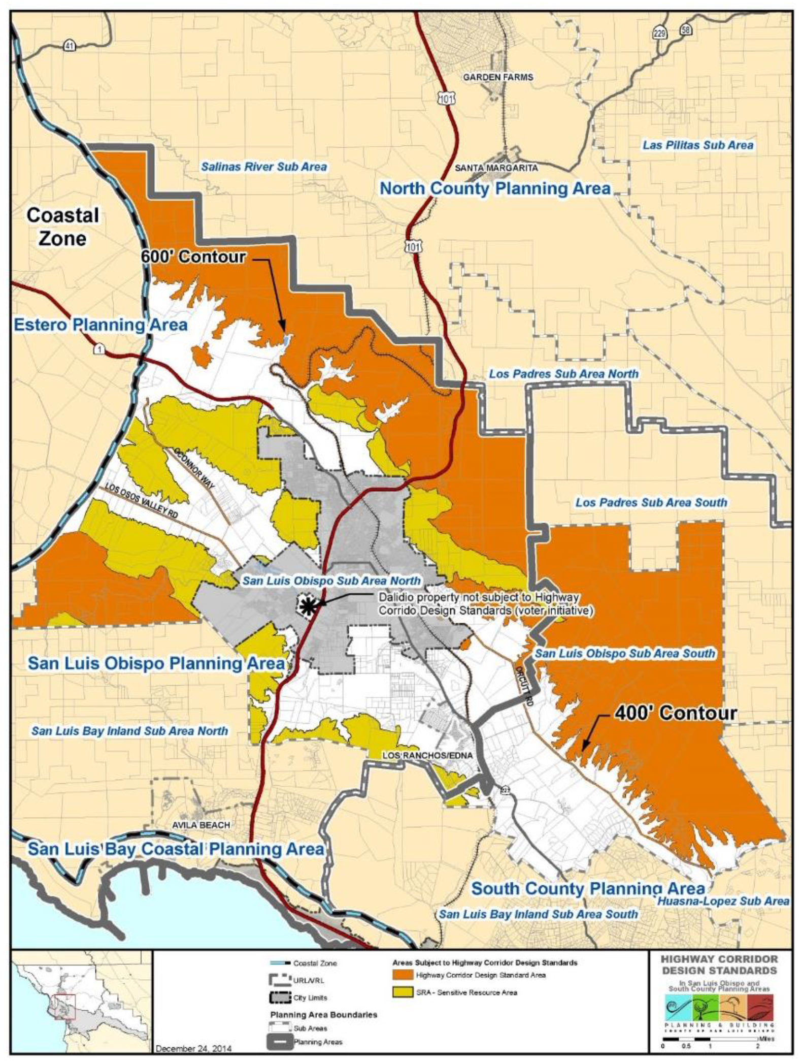
Figure 10-22: Areas subject to Highway Corridor Design Standards
1.
Purpose and applicability. The primary purpose of the following standards is to protect important views, natural landmarks, scenic backdrops, important plant and animal habitats, and watershed values. Chapter 6 of the San Luis Obispo Area Plan includes further discussion of the public interests served by the SRA designations and standards, including general descriptions of the geographic areas to which the SRA has been applied. These standards are intended to promote the protection of existing scenic resources and expedite the permit process through a ministerial Zoning Clearance for proposals meeting the specific design criteria, while also enabling alternative design solutions through a discretionary (Minor Use Permit or Conditional Use Permit) land use permit. Residential structures, residential accessory structures (including water tanks), residential access roads, specified agricultural accessory structures (including water tanks) and signs are governed by these standards. All other uses and structures are not subject to these standards, such as production agriculture, agricultural roads and nursery specialties.
2.
Permit requirement. For projects where the applicant chooses to comply with the requirements of Subsection C.3, Zoning Clearance is required for (1) residential structures, (2) residential accessory buildings, (3) residential access roads, and (4) agricultural accessory structures that are larger than 600 square feet in area and have one or more of the following: (a) a roof pitch of less than 3:12, (b) wall surfaces that are not wood, wood-appearing or textured, and/or (c) service entrances, such as bay doors, facing a highway, unless one of the following conditions apply:
a.
Biological impacts. If conformance with these standards would unavoidably impact a biological habitat, the Director, in consultation with the Environmental Coordinator, may waive the applicable standard.
b.
Project not visible. An exemption from this standard may be granted if documentation is provided demonstrating that the proposed structures and access roads will not be visible from the applicable scenic highway or railroad. Such documentation shall at minimum provide topographic, construction and building elevations with preliminary grading and building plans. A visual analysis of the project's location may also be useful to facilitate a decision.
c.
Project not consistent with Zoning Clearance requirements. If the Zoning Clearance application cannot be approved as consistent with the provisions of Subsection C.3, the application may be converted to a Minor Use Permit application subject to the provisions of Subsection C.4, with the applicant paying the difference in fees, for a discretionary review of the project.
d.
Other land use permit required. Projects for which Section 22.06.030 requires Minor Use Permit or Conditional Use Permit approval shall be subject to those land use permit requirements, and evaluated for compliance with Subsection C.4 (Discretionary Permit Requirements).
3.
Zoning Clearance requirements.
a.
Site visit required. The Zoning Clearance application shall be subject to two site visits; one during the time of application review to confirm that conditions on the site correspond to information provided in the application, and the other prior to final building inspection or release of bond to confirm that the building and site improvements agree with the approved plan. (The planting of required landscaping improvements may be delayed up to 90 days after final building inspection when installation is guaranteed by bond.)
b.
Permit threshold. Where possible, residential buildings, residential accessory structures and agricultural accessory structures shall be set back 100 feet as shown in Figure 108-3 from the applicable scenic highway or railroad right-of-way that is designated in Chapter 6 of the San Luis Obispo Area Plan. If there is no feasible development area outside this setback, the project shall be located on the rear half of the property and shall provide a landscaping screen of moderately fast-growing, drought-tolerant plant material to provide 80 percent view coverage at plant maturity. A landscaping plan in compliance with Chapter 22.16 (Landscaping Standards) shall be provided at the time of Building Permit application submittal.
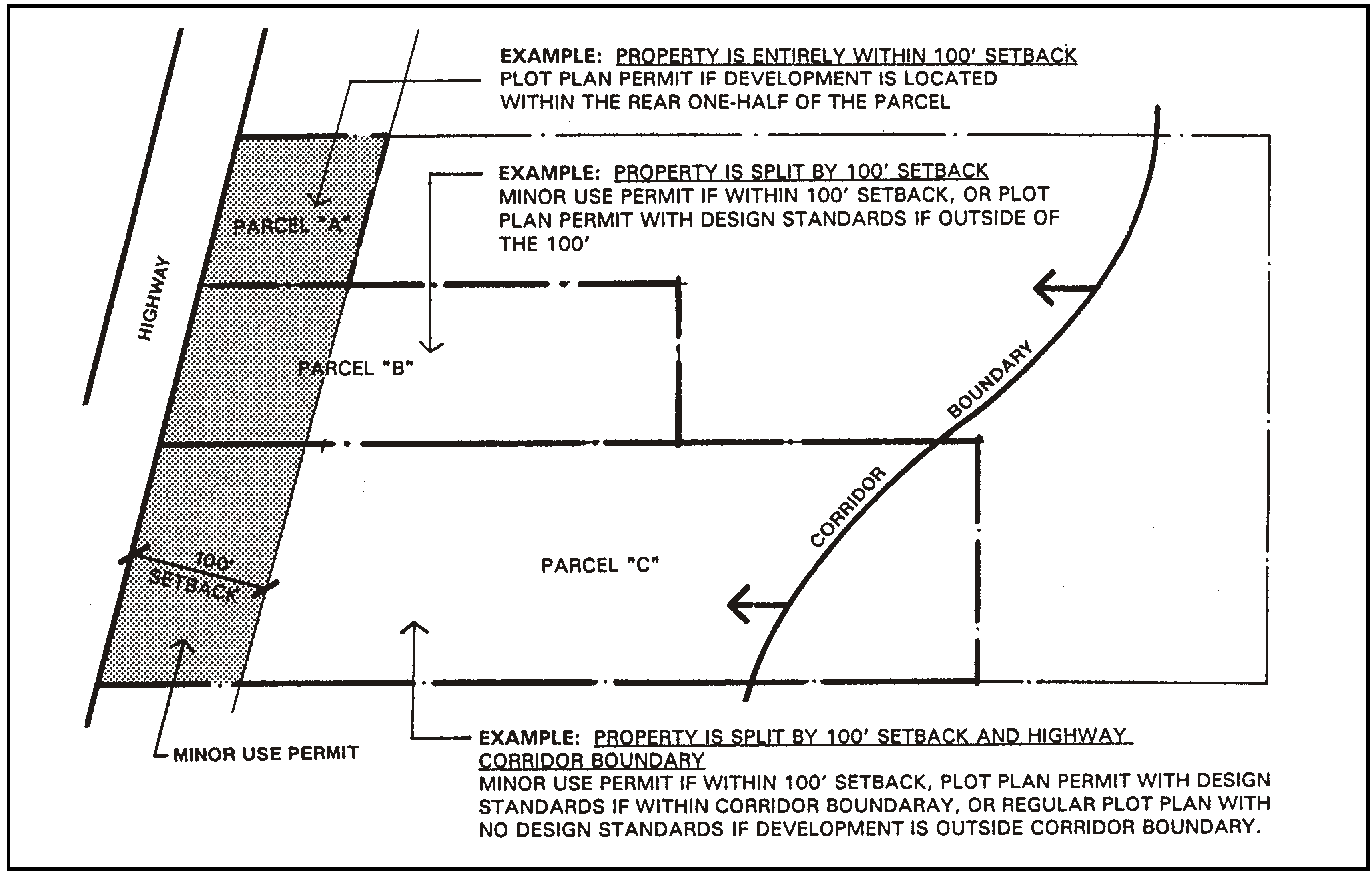
Figure 10-23: Setback Threshold for Zoning Clearances
c.
Biological habitats. Development shall be designed and located to minimize adverse impacts to important biological resources in conforming with these standards. If there is a conflict between biological resources and these standards, protecting the biological resources takes precedence.
d.
Ridgetop development. Structures within the SRA shall not be located so as to be silhouetted against the sky as viewed from any of the scenic highway or railroad corridors designated in Chapter 6 of the San Luis Obispo Area Plan, illustrated in Figure 10-24.
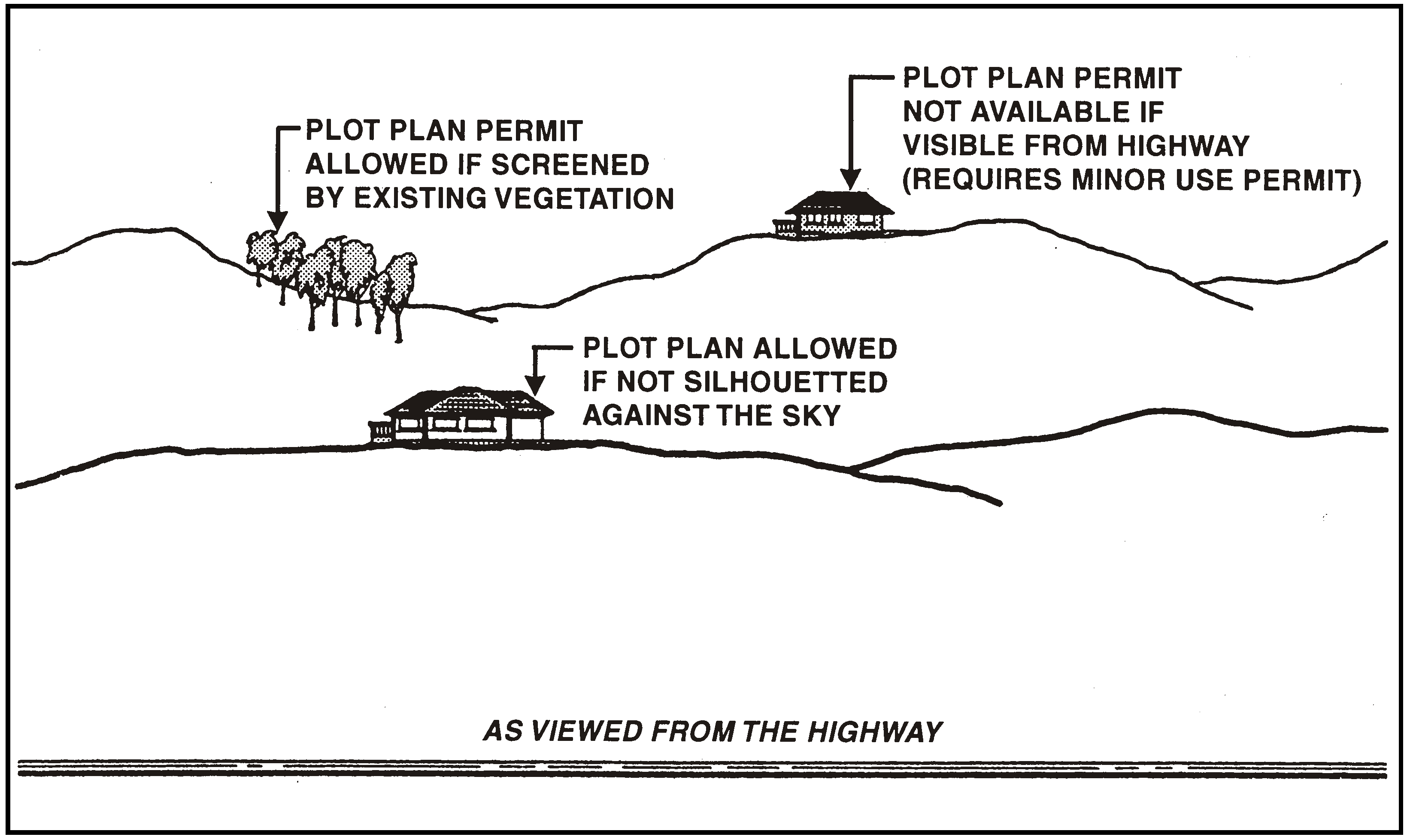
Figure 10-24: Ridgetop development
e.
Slope limitation. Grading for structures and roads shall occur on slopes that are 20 percent or less as shown in Figure 10-25. (Zoning Clearance is required for development on slopes of 20 percent or less, and Minor Use Permit on slopes greater than 20 percent).
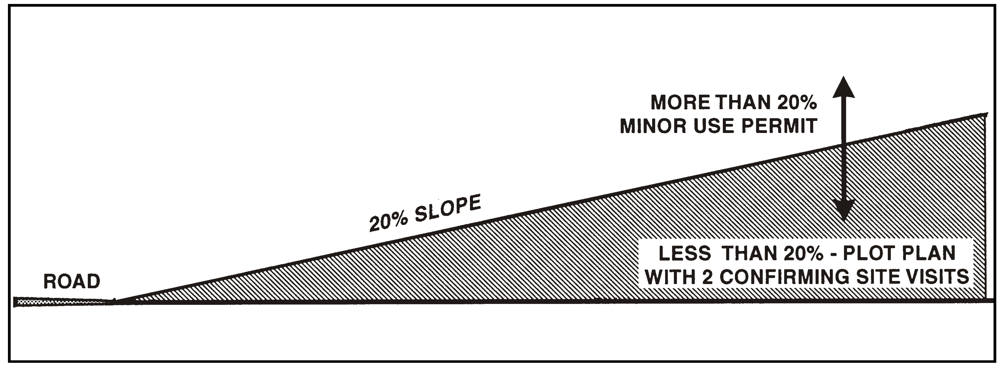
Figure 10-25: Slope limitation
f.
Significant rock outcrops. Grading and placement of structures shall occur at least 150 feet from any significant rock outcrop or geologic feature that is visible from any of the scenic highway or railroad corridors designated in Chapter 6 of the San Luis Obispo Area Plan, as shown in Figure 10-26.

Figure 10-26: Significant rock outcrops
g.
Building features. Maximum building height is 25 feet, measured in compliance with Section 22.10.090 (Height Measurement and Height Limit Exceptions), as shown in Figure 10-27. Building architecture shall include hip roofs with a minimum pitch of 3:12. Building colors shall be similar to surrounding natural colors that are no brighter than 6 in chroma and value on the Munsell color scale on file in the Department.
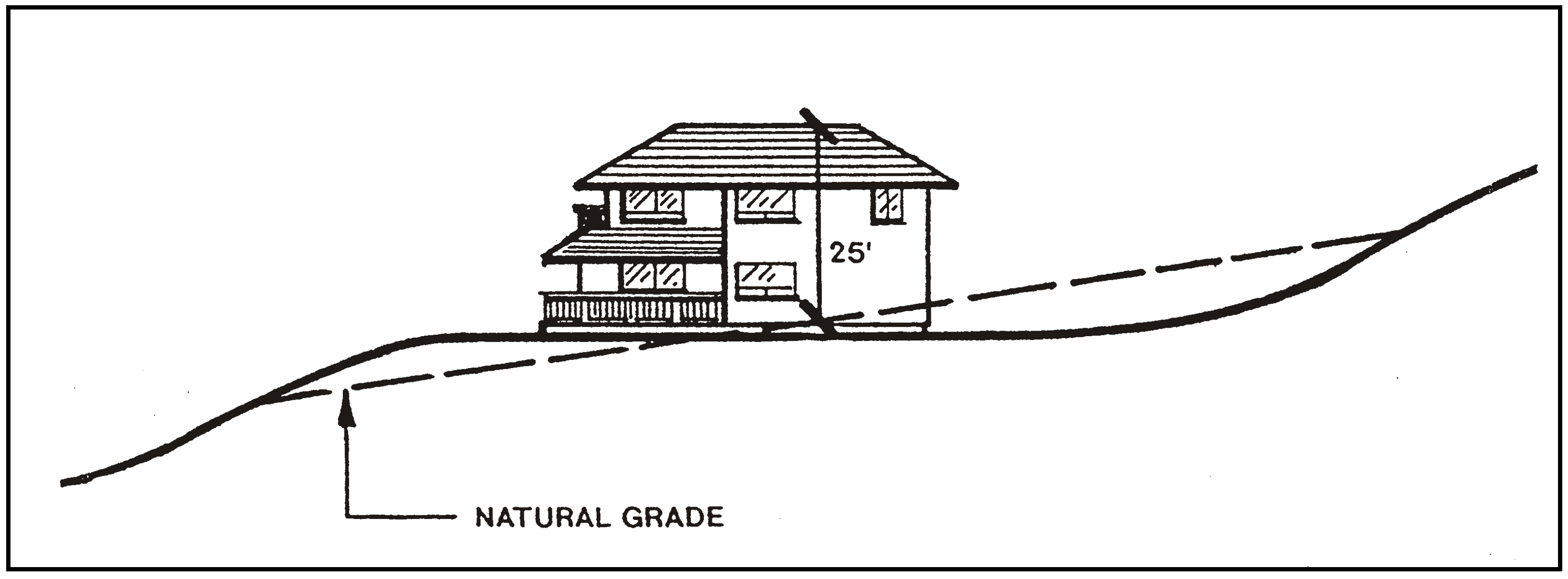
Figure 10-27: Building Height
h.
Landscaping. A landscaping plan is required adjacent to the applicable structure to obtain at least 50 percent view screening of the structure at plant maturity, as illustrated in Figure 10-28. Landscaping shall include mitigation planting or seeding for graded cut and fill slopes and a low water-use irrigation system.
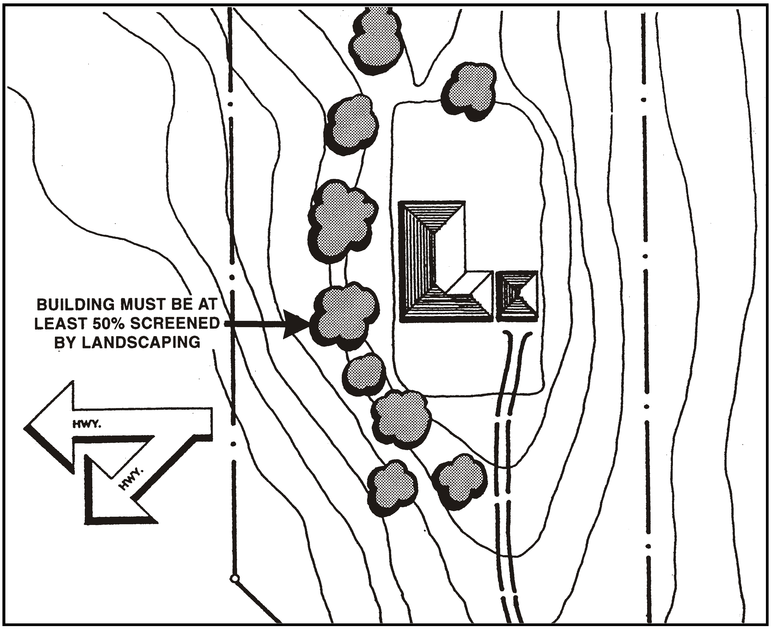
Figure 10-28: Landscaping
4.
Discretionary permit requirements. Minor Use Permit approval is required for projects that are unable to meet the requirements for a Zoning Clearance as specified in Subsection C.3. Any Minor Use Permit and Conditional Use Permit applications that may otherwise be required by this Title shall include a visual analysis prepared by a registered architect, registered landscape architect, or other qualified person acceptable to the Director. The visual analysis shall be utilized to determine compliance with the intent of the provisions of Subsection F.3, and the following.
a.
Locations of development. Locate all development including accessory structures (including water tanks) and access roads in the least visible portion of the site as viewed from any of the scenic highway or railroad corridors designated in Chapter 6 of the San Luis Obispo Area Plan, consistent with the protection of other resources. Use existing topographic features first and vegetation second to screen development from public view as much as possible.
b.
Grading. Minimize grading that would create cut and fill slopes visible from any of the scenic highway or railroad corridors designated in Chapter 6 of the San Luis Obispo Area Plan.
c.
Slope limitation. Grading for structures and roads shall occur on slopes that are less than 30 percent.
d.
Building visibility. Minimize building height and mass by using low-profile design where applicable. Minimize building visibility (including water tanks) by using colors to harmonize with the surrounding natural environment.
e.
Landscaping. Provide landscaping to screen and buffer development with native or drought-resistant plants, including extensive use of evergreen trees and large-growing shrubs, in compliance with Chapter 22.16. Shapes of plant materials should be similar to native vegetation.
f.
Signs. Locate signs that are required to have a land use permit, especially freestanding signs, so that they do not interfere with vistas from any of the scenic highway or railroad corridors designated in Chapter 6 of the San Luis Obispo Area Plan.
5.
Residential land divisions - Cluster requirement. Residential land divisions shall be clustered in compliance with Section 22.22.140, unless modified clusters as allowed by this area plan, or standard subdivision practices such as clustered residential building sites will be of equal conformance with the provisions of Subsection C.3. Application review shall determine whether the proposed parcels or building sites are designed so that residential buildings, accessory buildings and roads will comply with Subsection F.4, in addition to other applicable standards.
6.
Open space preservation. This standard applies to sites located within the Sensitive Resource Area but not the Highway Corridor Design Standards. In compliance with the purpose of the Sensitive Resource Area to retain visual appearance, habitats, drainage ways and watershed values, open space preservation is a compatible measure to support the approval of new development. Approval of an application for any land division, Minor Use Permit or Conditional Use Permit (excluding any agricultural accessory building) is contingent upon the applicant executing an agreement with the County to maintain portions of the site in open space use that are within the SRA and not intended for development. The required open space area shall be in rough proportionality to the visual impacts of the project. Guarantee of open space preservation may be in the form of public purchase, agreements, easements controls or other appropriate instrument, provided that such guarantee agreements are not to grant public access unless acceptable the property owner.
7.
Hillside parcels at the southeast City limits. The following standards apply to the area shown in Figure 10-29 in addition to the above standards for Sensitive Resource Areas.
a.
Permit requirement. Minor Use Permit approval is required for all new structures except agricultural and residential accessory structures and accessory dwelling units.
b.
Sites visible from local streets. Views of the site from Broad Street shall replace those from other scenic highways or the railroad in determining compliance with the above standards for Sensitive Resource Areas.
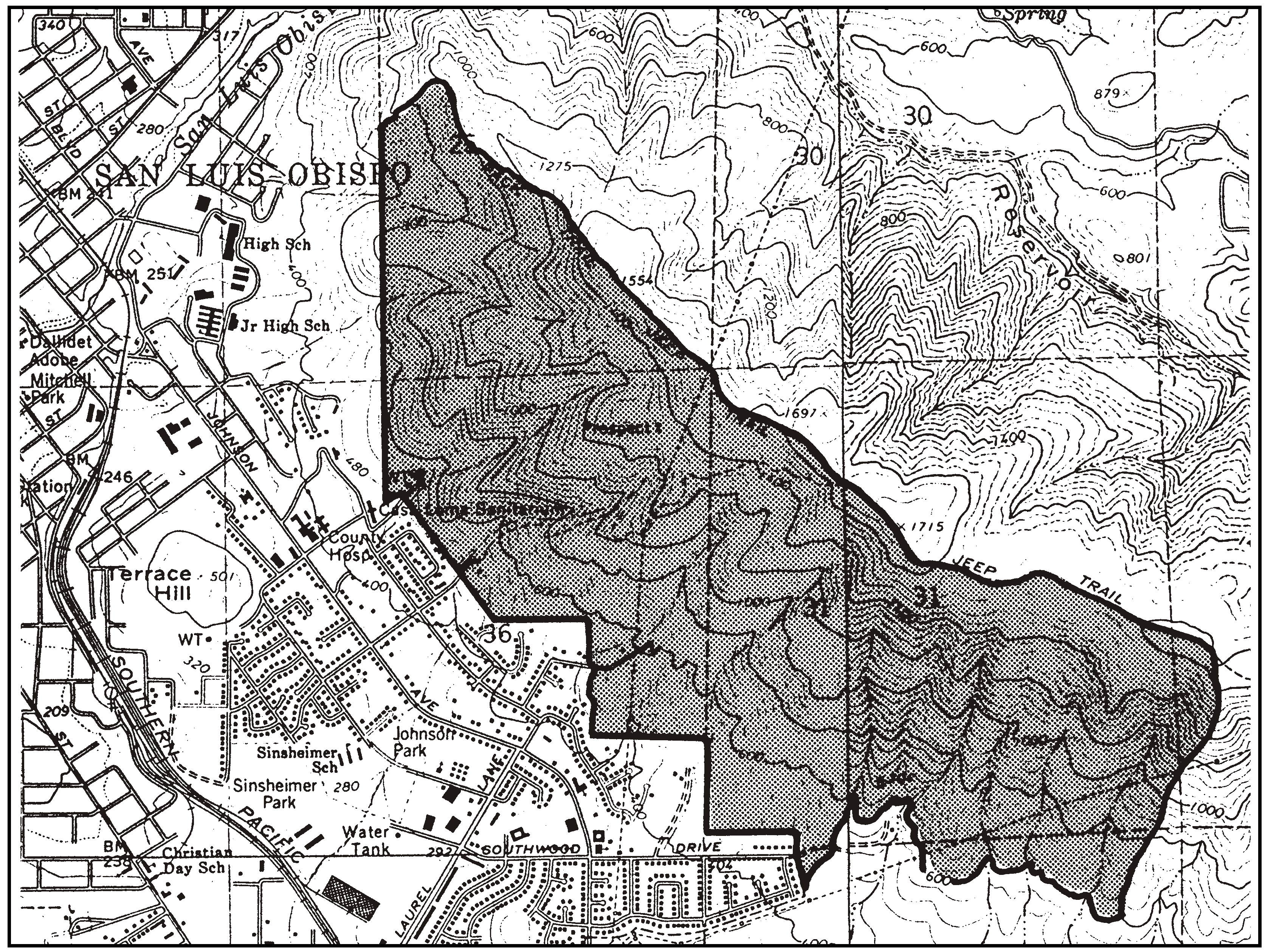
Figure 10-29: Hillside parcels on the southeast side of San Luis Obispo
D.
South County Highway Corridor Area. Highway 101 corridor design standards in the South County area are as follows:
1.
Purpose. The purpose of the following Highway 101 corridor design standards is to provide public views of:
·
varied topography including ridgelines and rock features;
·
significant stands of trees and wildflowers; and
·
historic buildings and pastoral settings.
These standards are intended to expedite the permit process for projects which maintain scenic views and the rural character along Highway 101, while providing opportunities to use other design solutions through a discretionary review process to achieve scenic goals. Only residential structures, residential accessory building, residential access roads, specified agricultural accessory buildings and signs are governed by these standards. All other uses and structures, such as agricultural roads and nursery specialties are not subject to the standards.
2.
Applicability. The following standards apply to the Highway 101 corridor shown in Figures 10-30 and 10-31, and the Newsom Ridge hills shown in Figure 10-30. These standards also apply to the Temattate Ridge hills, east of Highway 101 between Los Berros Creek and Highway 166. Along the Temattate Ridge, south of Los Berros Creek, these standards apply to land above the 800-foot elevation and not beyond 40 feet in vertical elevation below the highest elevation on the back of the ridge at any given point along the ridgeline.
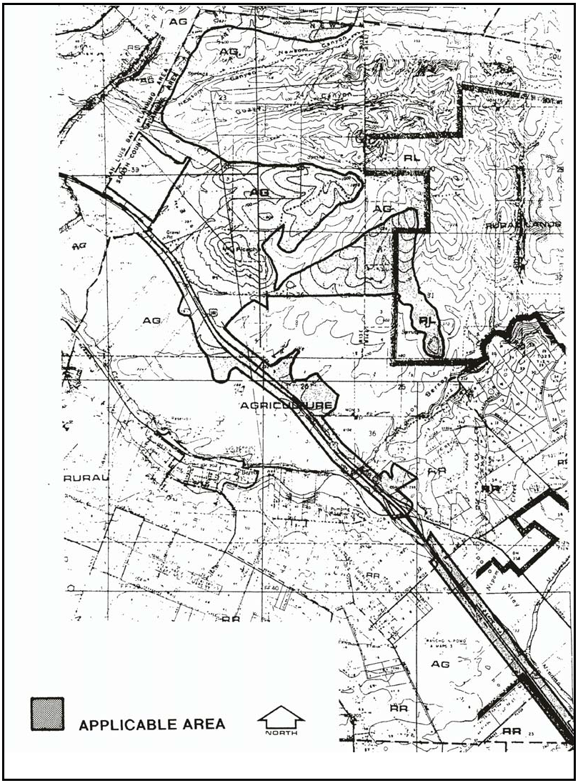
Figure 10-30: Highway 101 Corridor Design Standards
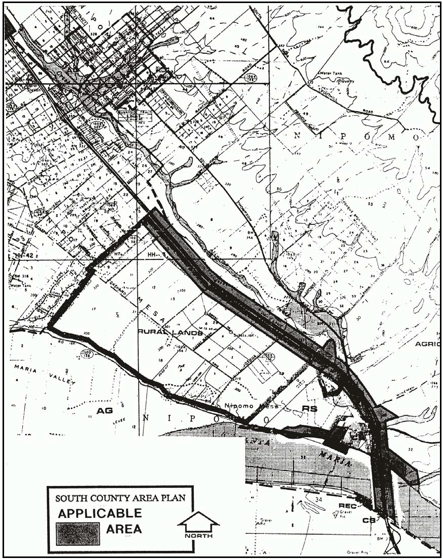
Figure 10-31: Highway 101 Corridor Design Standards
3.
Permit requirements. Zoning Clearance is required for residential structures, residential accessory buildings and residential access roads that comply with the provisions of Subsection D.4. Projects that do not choose to comply with the provisions of Subsection D.4 shall require Minor Use Permit approval, or a Conditional Use Permit if otherwise required by Section 22.06.030.
Within the Highway 101 frontage (limited to the first 300 feet) shown in Figures 10-30 and 10-31, Zoning Clearance is also required for agricultural accessory buildings larger than 600 square feet, individually or cumulatively, that have a roof pitch of less than 3:12, unarticulated wall surfaces and/or service entrances facing the highway.
If the Zoning Clearance application cannot be approved in compliance with Subsection D.4, the application may be converted to a Minor Use Permit application for review of the project, with the applicant paying the difference in application fees.
4.
Project design and processing - Zoning Clearance applications. Projects proposed in Zoning Clearance applications on sites within or partially within the highway corridors shown in Figures 10-30 and 10-31 shall comply with the following, in addition to other applicable standards:
a.
Exemption. An exemption from this standard may be granted if documentation is provided that the project will not be visible from Highway 101. Such documentation shall at a minimum provide topographic, construction and building elevations with preliminary grading and building plans. Submission of a visual analysis of the project's location may be useful to facilitate a decision. If conformance with these standards would unavoidably impact a biological habitat, the Director, in consultation with the Environmental Coordinator, may waive the applicable standard.
b.
Site visit required. Zoning Clearance applications shall be subject to two site visits; one during the time of application review to confirm that conditions on the site correspond to information provided in the application, and the other prior to final building inspection to confirm that the building and site improvements agree with the approved plan. (Planting of required landscaping improvements may be delayed up to 90 days after final building inspection when installation is guaranteed by bond.)
c.
Highway setback. Where possible, residential buildings, residential accessory structures and agricultural accessory structures described in Subsection D.3 shall be set back 100 feet from the Highway 101 right of way as shown in Figure 10-32. If there is no feasible development area outside this setback, the project shall be located on the rear half of the property and shall provide a landscaping screen to provide 80 percent coverage at plant maturity, to be verified by a landscape architect, landscape contractor, certified nurseryman or other qualified individual approved by the Director.
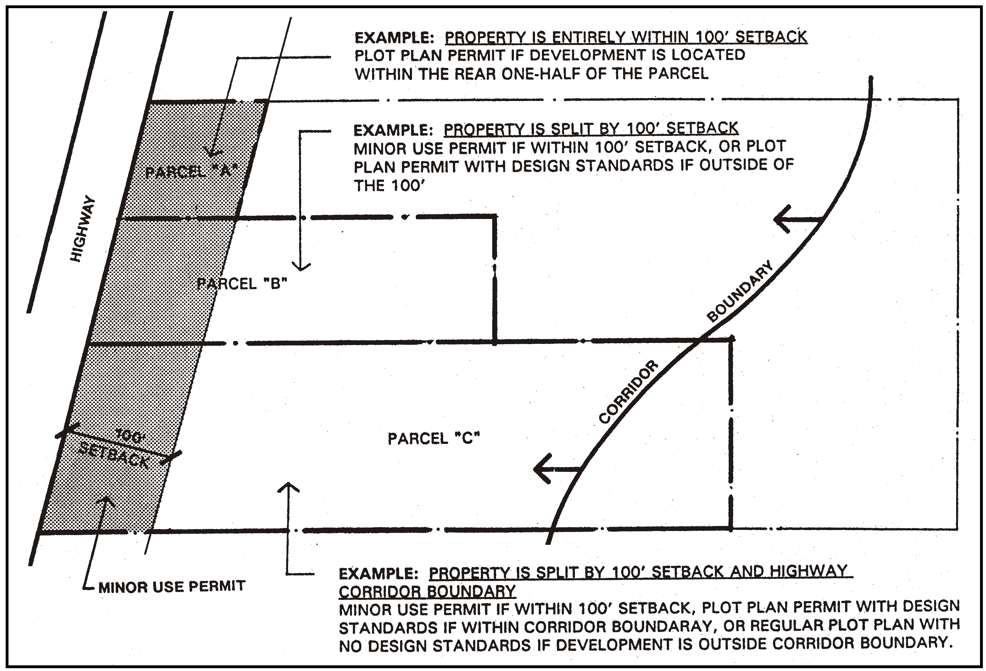
Figure 10-32: Highway Setback for Projects Requiring Zoning Clearance
d.
Ridgetop development. Structures shall be located so they are not silhouetted against the sky as viewed from Highway 101, as illustrated in Figure 10-33.
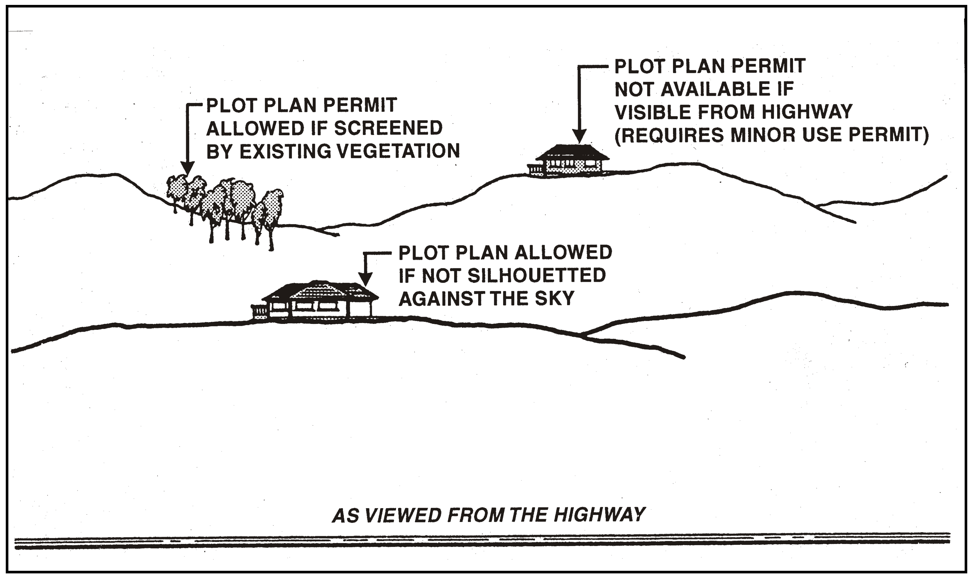
Figure 10-33: Ridgetop Development
e.
Slope limitation. Grading for structures and roads shall occur on slopes that are 20 percent or less, except on the west side of Highway 101 where more restrictive standards may apply as shown in Figure 10-34. Zoning Clearance is required for development on slopes of 20 percent or less, and Minor Use Permits on slopes greater than 20 percent.
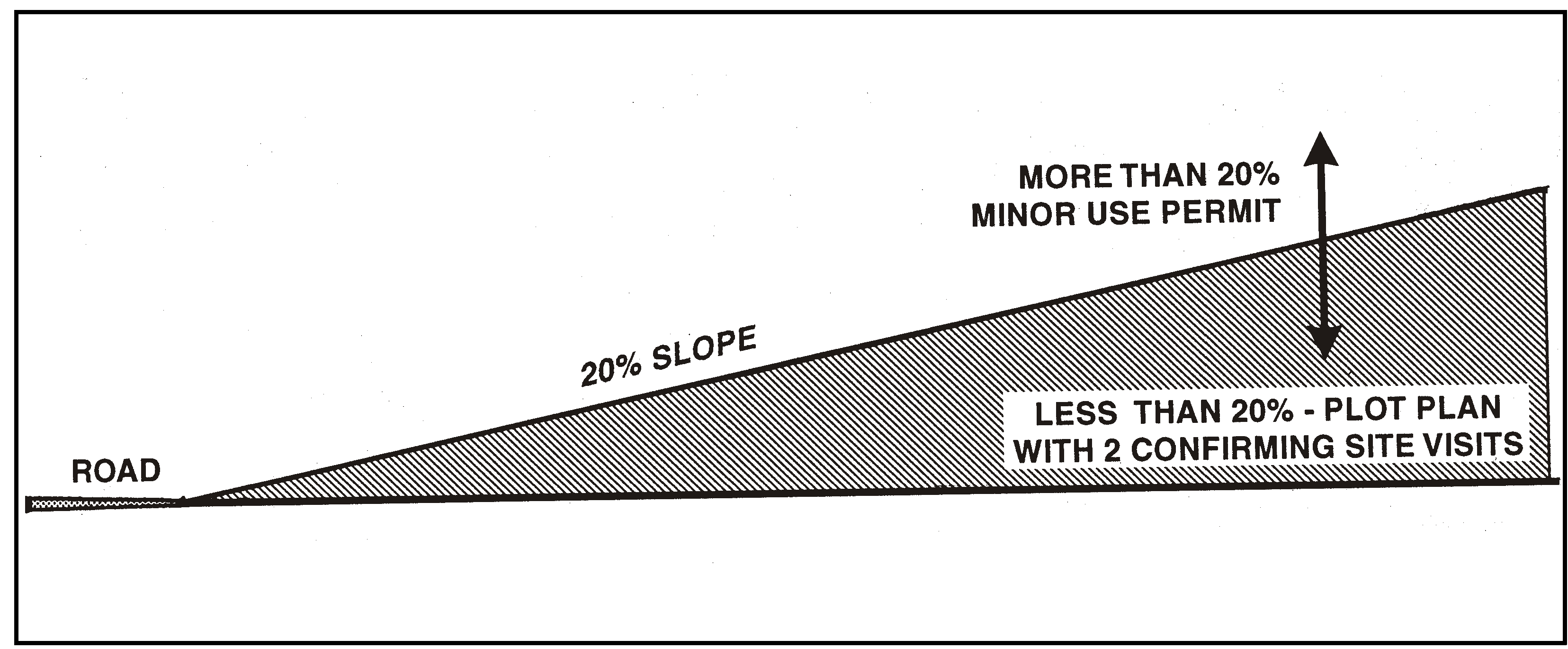
Figure 10-34: Slope Limitation
f.
Building features. Maximum building height is 25 feet above natural grade, as illustrated in Figure 10-35. This height limit may be increased an additional five feet for agricultural accessory buildings subject to an adjustment as provided in Section 22.70.030 subject to a visual study that supports a finding that buildings will have appropriate forms to minimize their visual impact on surrounding properties and Highway 101. The additional height shall be for architectural features such as cupolas or gabled vents on no more than one-third the length of any building. Building architecture shall include roofs with a minimum pitch of 3:12 and articulated wall surfaces at least every 30 feet. Where possible, agricultural accessory buildings within 300 feet of Highway 101 shall have service entrances oriented away from view of Highway 101. Building color shall be similar to surrounding natural colors that are no brighter than 6 in chroma and value on the Munsell color scale on file in the Department.
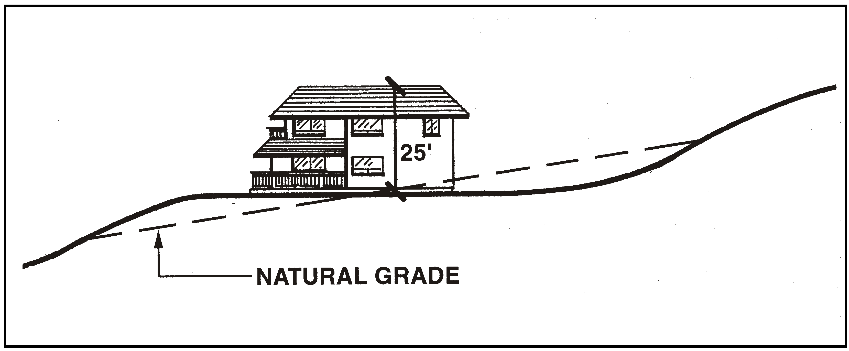
Figure 10-35: Building Features
g.
Landscaping. A landscaping plan is required that will ensure at least 50 percent screening of the structure at plant maturity as shown in Figure 10-36. Landscaping shall include mitigation planting or seeding for graded cut and fill areas in compliance with Chapter 22.16.
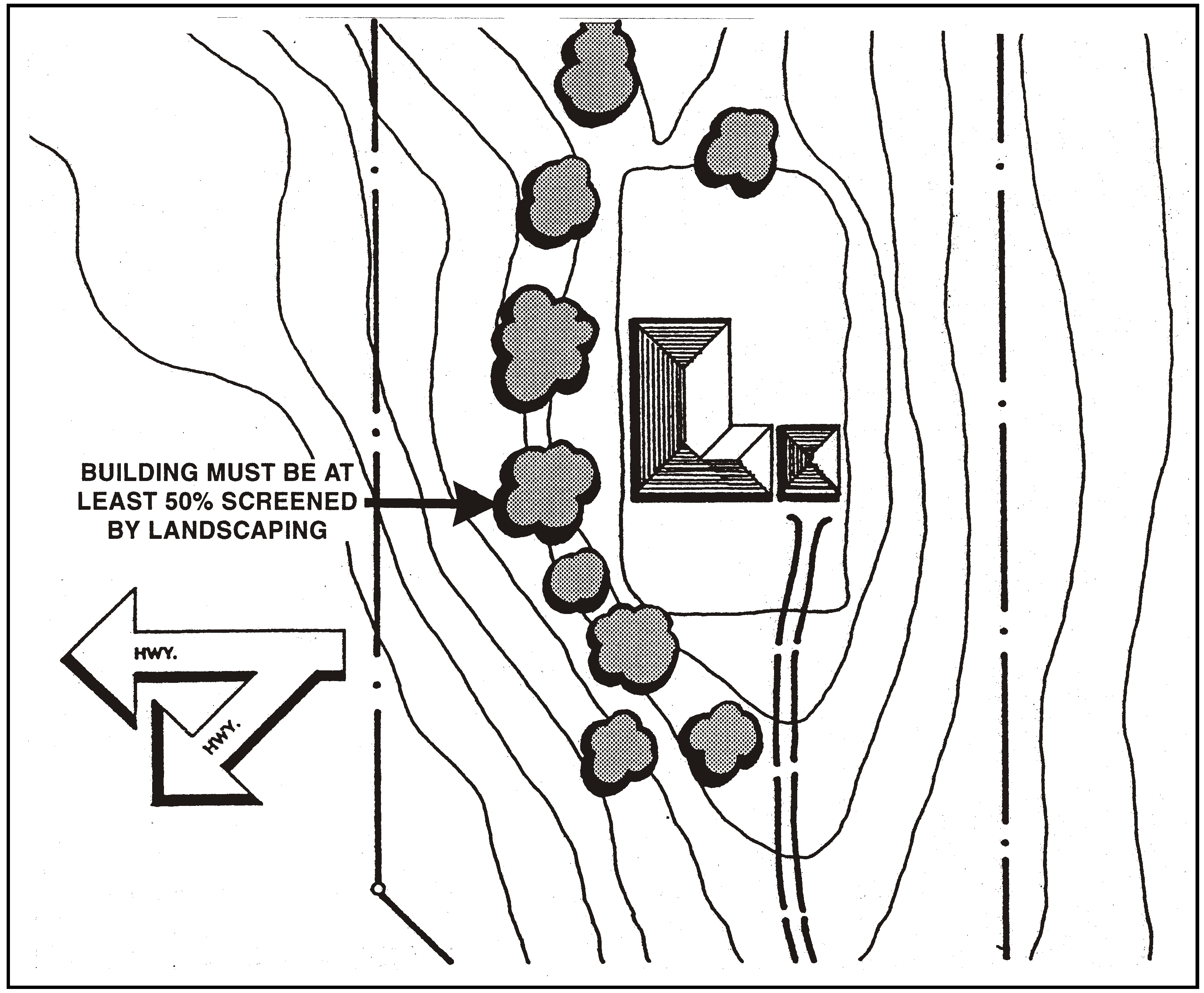
Figure 10-36: Landscaping
h.
Biological habitats. Development shall be designed and located to minimize adverse impacts to important biological resources in conforming with these standards. If there is a conflict between biological resources and these standards, protecting the biological resources takes precedence.
5.
Project design and processing - Discretionary permit applications. Minor Use Permit approval is required for projects subject to Subsection D.4 that are unable to meet the requirements for a Zoning Clearance in standards D.4.c through D.4.h. Minor Use Permit and any Conditional Use Permit applications that may otherwise be required by this Title shall include a visual analysis that is prepared by a registered architect, landscape architect or other qualified individual acceptable to the Environmental Coordinator. The visual analysis shall be utilized to determine compliance with the intent of D.4 and the following:
a.
Locate development, including access roads, in the least visible portion of the site consistent with the protection of other resources, as viewed from Highway 101, unless mitigated to insignificant levels. Use existing vegetation and topographic features to screen development from view as much as possible.
b.
Minimize grading for both structures and roads that would create cut and fill slopes visible from Highway 101.
c.
Minimize building height and mass by using low-profile design where applicable. Minimize the visual impacts of buildings by using colors that blend with surrounding natural colors and/or screen the building from view.
d.
Provide landscaping to screen and buffer both road and building development with native or drought-resistant plants, including the extensive use of trees and large-growing shrubs.
e.
Use of minimal signage is encouraged. Locate signs that are subject to a discretionary land use permit so that they minimize interference with important public views from Highway 101, such as those listed in the preamble to this Section.
6.
Residential land divisions.
a.
Clustering encouraged. Residential land divisions are encouraged to be clustered in compliance with Section 22.22.140, unless standard subdivision design can include clustered residential building sites that will be in equal conformity with Subsection I.5. Application review shall determine whether the proposed parcels or building sites are designed so that residential buildings, accessory buildings and roads will comply with Subsection I.5, in addition to other applicable standards.
Guideline: Retain land in open space in new land divisions that will preserve existing views of land subject to the Highway 101 corridor design standards.
b.
Open space parcel incentive. Cluster divisions of land that are located within the Highway 101 corridor design standards may utilize an open space parcel area that is smaller than required by Section 22.22.140. The size of the area may be determined by a visual analysis of the area subject to the Highway 101 corridor standards as part of the subdivision review process. The analysis shall identify the area that is necessary to maintain open space views of features identified in the Highway 101 corridor design standards.
[Added 1997, Ord. 2800; Amended 2014, Ord. 3256; 2018, Ord. 3369; 2020, Ord. 3409]
22.10.100 - Lot Consolidation.
In any residential or Rural Lands land use category, any single ownership of two or more adjoining vacant lots with continuous frontage, shall be considered a single parcel of real property except as otherwise provided by this Section. No sale or transfer, or division of less than all of such single parcel shall occur unless the portion or portions of the single parcel to be sold, transferred or divided, are in conformity with the provisions of this Title as modified by this Section.
Notes:
(1)
Minimum width is measured along the front setback line (Section 22.10.140).
[Amended 1981, Ord. 2063] [22.04.050]
22.10.110 - Minimum Site Area.
A.
Purpose and applicability. Minimum site area is the smallest existing lot size for which a building permit will be issued. Sections 22.10.100 through 22.10.110 set minimum site area standards for the use of existing lots of record. These standards are not to be used to determine the required parcel size for new land divisions, which are instead subject to Chapter 22.22 (Land Division Standards). Any legally created lot may be used for any use identified as allowable in the applicable land use category by Section 22.06.030 (Allowable Land Uses and Permit Requirements), regardless of whether the lot satisfies the minimum size requirements of Chapter 22.22 for new lots, provided that:
1.
The existing lot proposed for use is not smaller than the minimum site area required for the proposed use by Subsection C. (Required Area), or Chapter 22.30 (Standards for Specific Land Uses), or by the planning area standards of Article 9.
2.
The lot is of sufficient size to satisfy all applicable requirements of this Chapter, without the need for a variance based upon inadequate parcel size.
3.
The proposed use is authorized by the appropriate land use permit as determined by Article 2 or Chapter 22.30, or planning area standard of Article 9.
[Added 1984, Ord. 2163; Amended 1992, Ord. 2553]
B.
Area measured. For the purpose of determining whether a specific lot or contiguous lots satisfy these standards for minimum building site, no portion of an existing or proposed abutting street right-of-way shall be included in the area calculated.
C.
Required area. The following land uses shall be located only on sites with the minimum areas specified, unless other minimum site area requirements are established by Chapter 22.30 for specific uses, by Chapter 22.14 for combining designations or by planning area standards in Article 9.
Notes:
(1)
Except where a larger site area is provided by Section 22.10.100, Lot Consolidation, one acre is required where a well and septic system shall be located on a single lot; 2-½ acres is required where a lot is proposed to have a septic system, and is located within a Domestic Reservoir Watershed as defined by Section 19.20.222b(3) of the Building and Construction Ordinance, except that no minimum is required where a lot is part of an approved cluster subdivision with a maximum density of 2.5 acres per dwelling unit or more. No land within a horizontal distance of 200 feet from the reservoir impoundment, as determined by the spillway elevation, shall qualify for computing minimum site area, residential density, or for septic system siting; and
[Amended 1984, Ord. 2163; 1992, Ord. 2553] [22.04.040, 042, 044]
22.10.120 - Noise Standards.
This Section establishes standards for acceptable exterior and interior noise levels and describe how noise shall be measured. These standards are intended to protect persons from excessive noise levels, which are detrimental to the public, health, welfare and safety and contrary to the public interest because they can: interfere with sleep, communication, relaxation and full enjoyment of one's property; contribute to hearing impairment and a wide range of adverse physiological stress conditions; and adversely affect the value of real property.
A.
Exceptions to noise standards. The standards of this Section are not applicable to noise from the following sources.
1.
Activities conducted in public parks, public playgrounds and public or private school grounds, including but not limited to school athletic and school entertainment events;
2.
The use of any mechanical device, apparatus or equipment related to or connected with emergency activities or emergency work to protect life or property;
3.
Safety signals, warning devices, and emergency pressure relief valves;
4.
Noise sources associated with construction, provided such activities do not take place before 7:00 a.m. or after 9:00 p.m. on any day except Saturday or Sunday, or before 8:00 a.m. or after 5:00 p.m. on Saturday or Sunday;
5.
Noise sources associated with the maintenance of a residential use as listed in Section 22.06.030 (Allowable Land Uses and Permit Requirements), provided that the activities take place between the hours of 7:00 a.m. and 9:00 p.m.;
6.
Noise sources associated with agricultural land uses as listed in Section 22.06.030 (Allowable Land Uses and Permit Requirements), including but not limited to wind machines used for direct climate control, water well pumps and pest-repelling devices, provided that the pest-repelling devices are used in accordance with accepted standards and practices.
7.
Noise sources associated with work performed by private or public utilities in the maintenance or modification of its facilities;
8.
Noise sources associated with the collection of waste or garbage from property devoted to other than residential uses listed in Section 22.06.030 (Allowable Land Uses and Permit Requirements).
9.
Traffic on public roadways, railroad line operations, aircraft in flight, and any other activity to the extent regulation thereof has been preempted by state or federal law.
B.
Exterior noise level standards. The exterior noise level standards of this Section are applicable when a land use affected by noise is one of the following noise-sensitive uses: residential uses listed in Section 22.06.030 (Allowable Land Uses and Permit Requirements), except for residential accessory uses and temporary dwellings; health care services (hospitals and similar establishments only); hotels and motels; bed and breakfast facilities; schools (pre-school to secondary, college and university, specialized education and training); churches; libraries and museums; public assembly and entertainment; offices, and outdoor sports and recreation.
1.
No person shall create any noise or allow the creation of any noise at any location within the unincorporated areas of the county on property owned, leased, occupied or otherwise controlled by the person which causes the exterior noise level when measured at any of the preceding noise-sensitive land uses situated in either the incorporated or unincorporated areas to exceed the noise level standards in the following table. When the receiving noise-sensitive land use is outdoor sports and recreation, the following noise level standards shall be increased by 10 dB.
;sz=8q;Notes:
(1)
Applies only to uses that operate or are occupied during nighttime hours.
2.
In the event the measured ambient noise level exceeds the applicable exterior noise level standard in Subsection B.1, the applicable standard shall be adjusted so as to equal the ambient noise level plus one dB.
3.
Each of the exterior noise level standards specified in Subsection B.1 shall be reduced by five dB for simple tone noises, noises consisting primarily of speech or music, or for recurring impulsive noises.
4.
If the intruding noise source is continuous and cannot reasonably be discontinued or stopped for a time period whereby the ambient noise level can be measured, the noise level measured while the source is in operation shall be compared directly to the exterior noise level standards.
C.
Interior noise level standards. The interior noise level standards of this Section are applicable when the land use which is the source of noise and the land use which is affected by noise are both residential uses as listed in Section 22.06.030 (Allowable Land Uses and Permit Requirements), except for residential accessory uses and temporary dwellings.
1.
No person shall operate or cause to be operated a source of noise within a residential use in any location in the unincorporated areas of the county or allow the creation of any noise which causes the noise level when measured inside a residential use located in either the incorporated or unincorporated area to exceed the interior noise level standards in the following table.
2.
In the event the measured ambient noise level exceeds the applicable interior noise level standard in Subsection C.1, the applicable standard shall be adjusted so as to equal the ambient noise level plus one dB.
3.
Each of the interior noise level standards specified in Subsection C.1 shall be reduced by five dB for simple tone noises, noises consisting primarily of speech or music, or for recurring impulsive noises.
4.
If the intruding noise source is continuous and cannot reasonably be discontinued or stopped for a time period whereby the ambient noise level can be measured, the noise level measured while the source is in operation shall be compared directly to the interior noise level standards.
D.
Other noise sources. The noise level standards in this Section apply to the following.
1.
Air conditioning and refrigeration. Notwithstanding the provisions of Subsection B.1, when the intruding noise source is an air conditioning or refrigeration system or associated equipment installed prior to June 4, 1992, the exterior noise level as measured as provided in Subsection E. shall not exceed 55 dB, except where the equipment is exempt from the provisions of this Chapter. The exterior noise level shall not exceed 50 dB for equipment installed or in use after June 4, 1993.
2.
Waste and garbage collection equipment. Notwithstanding the provisions of Subsection B.1, noise sources associated with the collection of waste or garbage from a residential use (as listed in Section 22.06.030 (Allowable Land Uses and Permit Requirements) by persons authorized to engage in such activity, and who are operating truck-mounted loading or compacting equipment, shall not take place before 7:00 a.m. or after 7:00 p.m., and the noise level created by these activities when measured at a distance of 50 feet in an open area shall not exceed the following standards.
a.
85 dB for equipment in use, purchased or leased prior to December 4, 1992.
b.
80 dB for the equipment described in Subsection D.1 after June 4, 1997.
c.
80 dB for new equipment purchased or leased after December 4, 1992.
d.
75 dB for new equipment purchased or leased after June 4, 1995.
3.
Electrical substations. Notwithstanding the provisions of Subsection B.1, noise from the following electrical substations shall not exceed an exterior noise level of 50 dB between 10:00 p.m. and 7:00 a.m. and 55 dB between 7:00 a.m. and 10:00 p.m., as determined at the property line of the receiving land use: Cholame, San Miguel, Templeton, Cambria, Perry, Cayucos, Baywood, Highway 1 between Morro Bay and the California Men's Colony, Goldtree, Foothill, San Luis Obispo, Oceano, Mesa, Union Oil, Callendar, and Mustang. If any of these substations undergo modifications that increase noise levels, they shall be mitigated in compliance with the policies of the Noise Element Policy Document.
E.
Noise level measurement. For the purpose of evaluating conformance with the standards of this Chapter, noise levels shall be measured as follows.
1.
Use of meter. Any noise measurement in compliance with this Section shall be made with a sound level meter using the A-weighted network (scale). Calibration of the measurement equipment utilizing an acoustical calibrator shall be performed immediately prior to recording any noise data.
2.
Measuring exterior noise levels. Except as otherwise provided in this Section, exterior noise levels shall be measured at the property line of the affected noise-sensitive land use listed in Subsection B. Where practical, the microphone shall be positioned five feet above the ground and away from reflective surfaces.
3.
Measuring interior noise levels. Interior noise levels shall be measured within the affected residential use listed in Subsection C., at points at least four feet from the wall, ceiling or floor nearest the noise source, with windows in the normal seasonal configuration. The reported interior noise level shall be determined by taking the arithmetic average of the readings taken at the various microphone locations.
[Amended 1992, Ord. 2545] [22.06.040, 042, 044, 046, 048, 050]
22.10.125 - Non-Taxable Merchandise Limitations.
A.
Limits on non-taxable sales.
1.
For retail trade uses of 90,000 to 139,999 square feet of floor area (for a single use), no more than three percent of the floor area may be devoted to non-taxable merchandise.
2.
For retail trade uses of 140,000 to 250,000 square feet of floor area (for a single use), no more than two percent of the floor area may be devoted to non-taxable merchandise.
3.
For retail trade uses exceeding 250,000 square feet of floor area (for a single use), no more than one percent of the floor area may be devoted to non-taxable merchandise.
B.
Reporting. The owner of a retail trade use exceeding 90,000 square feet of floor area shall annually provide a report to the Department of Planning and Building specifying the square footage of the retail store and the percentage of the floor area the square footage represents that was devoted to the sale of non-taxable merchandise during the previous year. This report shall be filed no later than February 28 of the year following
C.
Aggregate use. In applying this section, floor areas of adjacent retail uses shall be aggregated when those uses share checkstands, management, a controlling ownership interest, a warehouse or a distribution facility.
[Added 2000, Ord. 2913] [22.04.360]
22.10.130 - Residential Density.
The number of primary dwelling units that may be established on a site that complies with Section 22.10.110 et seq. (Minimum Site Area), is based upon the land use category applied to the site by the Land Use Element. This Section determines the maximum number of primary dwelling units that may be allowed. The number of caretaker units and agricultural worker dwellings are determined instead by Sections 22.30.430 and 22.30.480.B and C., respectively. See Section 22.30.470 for regulations relating to the number of allowable accessory dwellings.
A.
Single-family dwellings and urban dwellings. In land use categories where Section 22.06.030 (Allowable Land Uses and Permit Requirements) identifies single-family dwellings or urban dwellings as permitted or conditional uses, the number of primary dwellings allowed on a single lot is as follows, provided that manufactured homes or mobile homes shall also comply with Section 22.30.450 (Residential - Mobile Homes), urban dwellings shall also comply with Section 22.30.471 (Residential - Urban Dwellings), and parcels served by onsite wastewater treatment systems shall also comply with the San Luis Obispo County Local Agency Management Program (LAMP) and Title 19:
1.
Agriculture and Rural Lands land use categories: See Section 22.30.480 (Residential Uses in the Agriculture and Rural Land Use Categories).
2.
Residential Multi-Family land use category: The number of dwelling units allowed on a lot in the Residential Multi-Family land use category shall be as allowed in Subsection B, except for workforce housing subdivisions processed pursuant to Section 22.30.477 and as allowed by Chapter 22.12 (Affordable Housing Incentives).
3.
Single-Family Residential land use categories - Residential Rural, Residential Suburban, and Residential Single-Family: One for each legal parcel (parcel is defined in Chapter 22.80), except as follows:
a.
Areas with special density standards. Where planning area standards of Chapter 22.09 (Community Planning Standards) establish density requirements, the planning area standards shall control and determine the number of allowed dwelling units.
b.
Density-bonus projects. The number of dwelling units allowed in a project that proposed affordable housing in compliance with Government Code 65915 or with Section 22.12.040—Inclusionary Housing, shall be determined by Chapter 22.12 (Affordable Housing Incentives).
c.
Urban dwellings. A second primary residential dwelling may be established in addition to an existing single-family dwelling authorized by this Section, if allowed by Section 22.30.471.
d.
Workforce housing subdivisions. Residential density in workforce housing subdivisions shall be as allowed by Section 22.30.477 - Residential - Workforce Housing Subdivisions.
4.
Recreation land use category: The number of dwelling units allowed on a lot in the Recreation land use category is as follows:
a.
Rural areas: One unit per five acres where no community water or sewer service is provided; one unit per acre where community water or community sewer is provided. Parcels served by onsite wastewater treatment systems shall comply with the LAMP and Title 19.
b.
Urban or village areas: One unit per acre, except that one unit per 6,000 square feet is allowed where community sewer is provided. Parcels served by onsite wastewater treatment systems shall comply with the LAMP and Title 19. Community water is required for any residential development in the Recreation land use category within an urban or village reserve line.
Nothing in this Section shall be construed as having any effect upon a land division request.
B.
Multi-family dwellings. The number of multiple family dwellings allowed on a single lot or adjoining lots is based upon the "intensity factor" of the site. The intensity factor will be either low, medium or high, based upon the type of street serving the site, the sewer service provided, and the distance of the site from the central business district. The intensity factor determines the maximum number of units allowed, the maximum floor area for all units in the project and minimum areas for landscaping and pedestrian use. A multi-family project must satisfy the floor area and open area standards of this Section, as well as all applicable requirements for parking, setbacks and height. (Multi-Family dwellings in the Recreation Category are subject to Section 22.30.500 (Residential Uses in the Recreation Land Use Category.)
1.
Determining intensity factor. The intensity factor is the lowest obtained from any of the following criteria:
;sz=8q;Notes:
(1)
Site access may be from a cross street where the site abuts a collector or arterial.
(2)
Straight-line distance from central business district (CBD).
2.
Determining allowable density. The allowable density, maximum floor area and minimum open area for a multiple-family project shall be shown in the following table (all area figures are expressed as percentages of the total usable site area). A minimum of 6,000 square feet of site area is required to establish more than one dwelling unit, in compliance with Section 22.10.110.C (Minimum Site Area - Multi-Family Dwellings):
;sz=8q;Notes:
(1)
The gross floor area of all residential structures, including upper stories, but not garages and carports.
(2)
Includes required setbacks, and all areas of the site except buildings and parking spaces.
[Amended 1981, Ord. 2063; 1982, Ord. 2091; 1985, Ord. 2211, 2217; 1992, Ord. 2553; 1999, Ord. 2880; 2007, Ord. 3136; 2012, 3236; 2012, Ord. 3237; Ord. 3340; 2020, Ord. 3409; 2025, Ord. 3537] [22.04.080, 082, 084]
22.10.135 - Residential Floor Area.
A.
Single-family and urban dwellings. The maximum floor area for single-family dwellings and urban dwellings is as follows:
1.
Single-Family Residential land use categories - Residential Rural, Residential Suburban, and Residential Single-Family.
a.
First primary dwelling: No maximum.
b.
Additional primary dwellings: 1,200 square feet.
2.
Non-Single-Family Residential land use categories. No maximum, unless specified in one of the following sections:
a.
Section 22.30.480 - Residential Uses in the Agriculture and Rural Lands Land Use Categories.
b.
Section 22.30.490 - Residential Uses in Office or Commercial Retail Land Use Category.
c.
Section 22.30.500 - Residential Uses in the Recreation Land Use Category.
B.
Multi-family dwellings. See Section 22.10.130.B.
C.
Accessory dwellings. See Section 22.30.470.
D.
Caretaker units. See Section 22.30.430.
E.
Agricultural worker dwellings. See Section 22.30.480.B. and C.
[2025, Ord. 3537]
22.10.140 - Setbacks.
This Section determines the minimum size and allowable uses of setbacks for buildings. These standards provide for open areas around structures where needed for visibility, traffic safety and fire safety; access to and around buildings; access to natural light, ventilation and direct sunlight; separation of incompatible land uses; and space for privacy, landscaping and recreation.
A.
Exceptions to setback standards. All proposed development and new land uses shall comply with the minimum setback requirements of this Chapter except the following (see also Subsection H., Projections Into Required Setbacks):
1.
Fences, hedges or walls as allowed by Section 22.10.080.C (Standards for fencing and screening materials).
2.
Decks, terraces, steps, earthworks and other similar landscaping or design elements placed directly on finished grade that do not exceed an average height of 30 inches above the surrounding finished grade, provided that no such wood structure shall extend closer than 36 inches to a property, unless it complies with applicable fire resistive construction requirements of the California Building Standards Code.
3.
Areas where special setbacks have been established through adoption of building line maps (Section 22.01.030.B), tentative or vesting tentative map approval, Conditional Use Permit approval for a cluster or agricultural cluster development, planning area standard, specific plan, or by Article 4 for a specific use, in which cases the special setbacks apply in place of the setbacks of this Chapter.
4.
Areas where an official plan line for road right-of-way has been established, in which case the front or street-side setbacks required by this Title shall be measured from the plan line instead of from the property line that would otherwise be the basis for setback measurement.
5.
Solar electric facilities, wind energy conversion systems, and other renewable energy facilities as allowed by Chapter 22.32 (Energy-Generating Facilities) with special setback standards. Where Chapter 22.32 establishes larger setback requirements than those identified in this Chapter, the larger setbacks shall apply.
B.
Adjustments to setback standards. Within urban and village reserve lines, on sites of one acre or larger, a smaller setback may be granted using the adjustment provided in Section 22.54.020.F. The adjustment shall consider the ultimate division of the property into the minimum parcel size as allowed by Chapter 22.22 for the applicable land use category, or as set by planning area standard.
[Added 1994, Ord. 2696]
C.
Use of setbacks. Required setback areas shall be landscaped when required by Chapter 22.16 (Landscaping Standards), and shall be unobstructed by any building or structure with a height greater than three feet, except where otherwise provided by Subsection E.3, F.1, H., and Section 22.10.080.G, or Chapter 22.20. The use of setbacks for parking is subject to Section 22.18.030 (Location of Parking on a Site).
D.
Front setbacks. The front setback is established parallel or concentric to the front property line. Front setback landscape and fencing standards are in Chapter 22.16, and Section 22.10.080, respectively.
1.
Basic front setback requirement. All structures with a height greater than three feet shall be set back a minimum of 25 feet from the nearest point on the front property line; except where this Section establishes other requirements or where otherwise provided by Chapter 22.20 (Signs) or Section 22.10.080 (Fencing and Screening).
2.
Residential uses. All residential uses except for second-story dwellings over a commercial or office use shall have a minimum front setback of 25 feet, except as follows:
a.
Shallow lots. The front setback shall be a minimum of 20 feet for any legally-created lot with an average depth less than 90 feet.
b.
Sloping lot adjustment. In any case where the elevation of the natural grade on a lot at a point 50 feet from the centerline of the adjacent street right-of-way is seven feet above or below the elevation of the centerline, required parking (including a private garage) may be located, at the discretion of the applicant, as close as five feet to the street property line, in compliance with Section 22.70.030 (Adjustment), provided that portions of the dwelling other than the garage shall be established at the setback otherwise required.
c.
Variable setback block. Where a residential block is partially developed with single-family dwellings having less than the required front setbacks, and no uniform front setback is established by a planning area standard, the front setback may be adjusted (Section 22.70.030) at the option of the applicant, as follows:
(1)
Prerequisites for adjustment. Adjustment may be granted only when 25 percent of the lots on the block with the same frontage are developed, and the entire block is within a single land use category.
(2)
Allowed adjustment. The normally required minimum front setback shall be reduced to the average of the front setbacks of the existing dwellings (which include attached garages but not detached garages), to a minimum of 10 feet.
d.
Planned development or cluster division. Where a new residential land division is proposed as a planned development, condominium or cluster division (Sections 22.22.140 and 22.22.145), front setbacks may be determined through Conditional Use Permit approval, provided that in no case shall setbacks be allowed that are less than the minimum required by the California Building Standards Code or Section 22.22.145, whichever is greater.
e.
Lots with parkways. Where a lot is fronted by a fixed-width parkway between the curb and sidewalk, or meandering sidewalk that varies the parkway separation between the curb and the sidewalk, and where in either case the parkway is landscaped with one or more street tree for each 50 feet of frontage, and turf or low maintenance plants, the front setback may be reduced to a minimum of 15 feet for all portions of the residence except the garage. The garage shall have a minimum front setback of 25 feet.
3.
Commercial and office categories. No front setbacks are required within a central business district; a 10-foot front setback is required in Commercial and Office categories elsewhere. Ground-floor residential uses in Commercial and Office categories are subject to the setback requirements of Subsection D.2
4.
Industrial category. A minimum 25-foot front setback is required except on interior and flag lots, where the front setback shall be the same as that required for side setbacks by Subsection E.
5.
Recreation category. A minimum 10-foot front setback is required, provided that residential uses are subject to the setback requirements of Subsection A.
6.
Double frontage lots.
a.
Selecting the setback location. Where double frontage setback locations are not specified by subdivision requirements or other applicable regulations, the applicant may, except as otherwise provided in this Section, select the front setback street unless 50 percent of the lots on a double frontage block are developed with the same front yard orientation. In that case all remaining lots shall orient their front setbacks with the majority.
b.
Double frontage setback requirements. A full front setback shall be provided adjacent to one frontage, and a setback of one-half the required front setback depth adjacent to the other frontage; except that where the site of a proposed multiple-residence project includes an entire block, the project shall be designed to provide required front setbacks on the two longest street frontages.
7.
Flag lots and easement access. The front setback for a lot with no street frontage other than a fee ownership access strip or an access easement extending from a public street to the buildable area of the lot shall be measured from the point where the access strip or easement meets the bulk of the lot, to establish a building line parallel to the lot line nearest to the public street.
[Added 1982, Ord. 2091; 1986, Ord. 2250; Amended 2013, 3242]
E.
Side setbacks. The side setback is measured at right angles to the side property line to form a setback line parallel to the side property line, which extends between the front and rear setback areas.
1.
General side setback requirements. These requirements apply except where otherwise provided by Subsections E.2 through E.6. See Subsection H. (Projections into Required Setbacks) for additional applicable standards. The required general side setback is measured at the front setback line as follows:
a.
Within urban and village areas: 10 percent of the lot width, to a maximum of five feet on sites less than one acre in net area, but not less than three feet, and a minimum of 30 feet on sites of one acre or larger in net area. For sites of one acre or larger, a smaller setback may be granted using the adjustment provided in Section 22.54.020.F. The adjustment shall consider the ultimate division of the property into the minimum parcel size as allowed by Section 22.04.025 et seq. applicable to the land use category in which the site is located, or as set by planning area standard.
b.
Within rural areas: 10 percent of the lot width to a maximum of 25 feet, but not less than three feet, on sites of less than one acre in net area, and a minimum of 30 feet on sites of one acre or larger in net area. For sites of one acre or larger, a smaller setback may be granted using the adjustment provided in Section 22.54.020.F.
2.
Corner lots. The side setback on the street side of a corner lot within urban and village areas and on sites of less than one acre shall be a minimum of 10 feet, except that:
a.
Central business districts. In a central business district no side setback is required;
b.
Narrow lots. A site having a width of 50 feet or less shall be provided a minimum of a five foot setback.
c.
Adjacent to key lot. A corner lot adjacent to a key lot shall be provided a side setback equal to one-half the depth of the required front setback of the key lot except that:
(1)
Where the corner lot is less than 50 feet in width, the setback shall be a minimum of 10 feet.
(2)
Where an alley is between the corner lot and a key lot, the setback on the street side of the corner lot shall be five feet.
d.
Rural areas and sites of one acre or larger. In rural areas and on sites of one acre or larger in net area, the street side setback shall comply with Subsection E.1.b.
3.
Accessory buildings or structures. A side yard may be used for an accessory building or structure no greater than 12 feet in height, provided that it is not used for human habitation and is either:
a.
Located no closer than three feet to any property line; or
b.
Established on the property line as a common wall structure in compliance with Subsection E.6, or as a zero lot line structure, provided that all applicable California Building Standards Code requirements are satisfied for a property line wall.
In addition, accessory buildings and structures shall satisfy all applicable provisions of Section 22.30.410 (Residential - Accessory Uses).
[Added 1982, Ord. 2091]
4.
Commercial and Industrial land use categories. No side setback is required in the Commercial or Industrial land use categories, except:
a.
As required for corner lots by Subsection E.2; or
b.
Where required by the California Building Standards Code; or
c.
Adjacent to a residential category. When the commercial or industrial site is adjacent to a Residential land use category, in which case the side setback adjacent to the Residential category shall be a minimum of 10 feet, and shall be landscaped as set forth in Chapter 22.16. The minimum setback shall be increased one foot for each three feet of commercial or industrial building height above 12 feet.
5.
Office and Professional category. Side setbacks shall be provided as set forth in Subsection E.4, except within a central business district no side setback is required.
6.
Side setbacks for special development types.
a.
Airspace condominiums. The side setback for a building constructed within a common-ownership parcel on a smaller individually-owned parcel or within airspace, shall be the same as required for interior setbacks by Subsection G. (Interior Setbacks and Open Areas).
b.
Common wall development. Any two dwelling units, and/or their accessory garages, may be constructed on adjoining lots without setbacks between them provided that:
(1)
The setback has been eliminated through subdivision map or Conditional Use Permit approval; and
(2)
A common wall or party wall agreement, deed restriction or other enforceable restriction has been recorded; and
(3)
The side setbacks opposite the common wall property line are not less than two times the minimum width required by this Section.
(4)
Common wall construction is in compliance with the California Building Standards Code.
c.
Zero lot line development. A group of dwelling units on adjoining lots may be established so that all units abut one side property line, provided that:
(1)
The setback has been eliminated for an entire block through subdivision map or Conditional Use Permit approval; and
(2)
The modified setback requirements for the block are recorded as part of a subdivision map, deed restriction, or other enforceable restriction.
(3)
The side setback shall not be eliminated or reduced on the street side of a corner lot.
(4)
Side setbacks opposite the zero setback property line are not less than twice the minimum required by this Section.
F.
Rear Setbacks. The rear setback is measured at right angles to the rear property line to form a setback line parallel to the rear property line. The minimum rear setback is 10 feet on sites of less than one acre in net area and 30 feet on sites of one acre or larger in net area except as follows:
1.
Accessory buildings and structures. A rear setback in a residential category may be used for an accessory building or structure no greater than 12 feet in height, provided the accessory building is not used for human habitation or the keeping of animals, and is located no closer than three feet to a rear property line or alley. See Subsection H. (Projections into Required Setbacks) and Section 22.30.410 (Residential - Accessory Structures) for additional applicable standards.
2.
Commercial and industrial categories. No rear setback is required in Commercial or Industrial land use categories except:
a.
Adjacent to alley. Where the rear property line abuts an alley the rear setback shall be a minimum of five feet; except where the alley provides vehicular access to the interior of the building, 10 feet.
b.
Adjacent to residential use. Where the rear property line abuts a residential category or use, the rear setback shall be a minimum of 15 feet, except:
(1)
Intervening alley. The rear setback shall be five feet where an alley lies between the commercial or industrial site and a residential use.
(2)
Increased building height. The minimum setback shall be increased one foot for each three feet of commercial or industrial building height above 12 feet, with the height in this case measured along a line projected from the building face at the subject setback line.
3.
Office and Professional and Recreation categories. The rear setback shall be a minimum of 10 feet, except:
a.
Central business district. In a central business district, no rear setback is required except as provided in Subsection F.3.b.
b.
Adjacent to alley. Where the rear property line abuts an alley, the rear setback shall be five feet.
c.
Adjacent to residential use. When the rear property line of an Office and Professional or Recreation site abuts a Residential category, the rear setback shall be as specified in Subsection F.2.b.
G.
Interior setbacks and open areas. Detached buildings located on the same site shall be separated as follows:
1.
Accessory buildings. An accessory building shall be located no closer than six feet from any principal building.
2.
Residential buildings. A principal residential building (including a multi-family dwelling) shall not be located closer to another principal building than 10 feet, or one-half the height of the taller of the two buildings, when one or both are more than two stories.
3.
Non-residential buildings. Set by the California Building Standards Code.
H.
Projections into required setbacks. The setback requirements of this Title are modified as follows:
1.
Decks. When constructed higher than 30 inches above the surrounding finish grade, a wood deck may extend into required setbacks as follows (decks less than 30 inches high are exempt from these requirements - see Subsection A.):
a.
Front setback. A deck shall not be located therein.
b.
Side setback. As determined by Sections 1206 and 1710 of the California Building Standards Code.
c.
Rear setback. A deck may occupy up to 30 percent of a required rear setback, but shall extend no closer than three feet to the rear property line.
2.
Fire escapes. A ladder or stairs designed to be used exclusively as an upper floor fire escape may project into a required setback only as provided by Sections 1206, 1710 and 3305(n) of the California Building Standards Code.
3.
Roof and wall features. Cantilevered and projecting architectural features including chimneys, bay windows, balconies, cornices, eaves, rain gutters, signs (where allowed), display windows, and solar collectors may project into a required setback up to one-third the width of the required setback, only as allowed by Sections 504, 1206 and 1710 of the California Building Standards Code, provided that the bottom edge of the projection shall be located either higher than eight feet or lower than four feet above finish grade.
4.
Porches.
a.
Porch defined. Porches are outdoor steps, stairs, and/or a raised platform with open sides, not exceeding 30 inches in height above grade at any point, or no higher than the ground floor of the building, located immediately adjacent to an entry of a building to provide pedestrian access from the outdoor ground elevation to a building interior and not to be used as habitable living space. If the porch is enclosed, it will be considered habitable living space and shall not project into a required setback. Open is defined as being at least 60 percent open to the elements on three sides (no screening or glass). If the platform portion of a porch (not including steps) is higher than 30 inches, it is considered a deck, and shall not project into a required setback.
b.
Allowed projection. Porches may project into required setbacks as follows.
(1)
Front porch. A front porch and/or stairs may project up to six feet into a required front setback.
(2)
Side porch. A porch and/or outside stairway may be located in a required side setback provided the porch does not extend into the side setback more than allowed by Section 1206, 1710 and 3305(n) of the California Building Standards Code.
(3)
Rear porch. A porch in the required rear setback is subject to the same limitations as a deck, in compliance with Subsection H.1.
5.
Solar electric facilities, Tier 1. Tier 1 roof-mounted solar electric facilities as described by Section 22.32.050 (Solar Electric Facilities) of this Title not exceeding 10 feet in height may project into the required setback up to 15 feet, and no closer than 3 feet to the property line.
[Amended 1981, Ord. 2063; 1982, Ord. 2091; 1984, Ord. 2163; 1986, Ord. 2250; 1992, Ord. 2553; 1993, Ord. 2648; 1994, Ord. 2696; 1999, Ord. 2880; 2014, Ord. 3282; 2015, Ord. 3291] [22.04.100 to 116]
22.10.150 - Solid Waste Collection and Disposal.
This Section determines when new land uses must include provision of identified trash collection, pickup and recycling areas, and sets design standards for such areas.
A.
Where required. The following uses (except individual single-family dwellings, temporary uses, agricultural uses, and other uses that do not create a need for solid waste pickup and disposal) shall provide an enclosed area for the temporary collection of solid waste and recyclable materials before disposal truck pickup:
1.
Within urban or village reserve lines: All uses.
2.
In rural areas: Any commercial, industrial and public facility uses listed as other than "Residential Uses" in Section 22.06.030 (Allowable Land Uses and Permit Requirements).
B.
Application content. All land use permit applications shall include the location of solid waste collection areas, collection containers, recycling area and maneuvering areas for disposal and recycling trucks, including access driveways.
C.
Collection area and recycling area standards.
1.
Location of collection facilities. The solid waste collection area and recycling area shall be located within 100 feet of the dwellings or buildings serviced, but shall not be located in a front setback (Section 22.10.140.B - Front Setbacks), or within 10 feet of a front property line in a central business district.
2.
Enclosure required. Solid waste collection areas and recycling areas that use dumpsters or other containers with a total capacity greater than two 33-gallon containers shall be screened from the view of public streets and adjoining properties on three sides by a solid fence or wall as high as the collection container, but not less than three feet nor more than six feet in height, and on the fourth side by a solid gate.
3.
Enclosure construction standards. Enclosures shall meet the construction requirements as set forth in Chapter 8.12 of the County Code in addition to the following standards.
a.
The floor or bottom surface of a solid waste collection area shall be of concrete or other impervious material.
b.
The collection area shall have unobstructed vertical clearance for a minimum height of 25 feet.
c.
A covered storage area at least three feet by 6-½ feet in size or as otherwise adequate to accommodate containers consistent with current methods of collection in the area where the project is located, accessible for truck loading, shall be incorporated into each solid waste collection area for the accumulation of recyclable materials. This storage area shall not be used for the collection of recyclable materials until such time as a recycling program exists for the area where the project is located.
d.
The recycling area shall be large enough to accommodate an adequate number of bins to allow for the collection of recyclable materials generated by the development.
e.
One or more signs clearly identifying the recycling areas, instructions, and a list of materials accepted shall be posted at all points of access to the recycling area.
f.
Trash container areas shall have drainage from roofs and pavement diverted around the enclosure area(s).
g.
Trash container areas must be screened or walled to prevent loose debris or trash from being transported to nearby storm drain inlets, channels, and/or creeks.
[Amended 1981, Ord. 2063; 1984, Ord. 2163; 1992, Ord. 2553; 1994, Ord. 2696; 2010, Ord. 3188] [22.04.280]
22.10.155 - Stormwater Management.
A.
Purpose. The requirements in this Section are intended to reduce pollutant discharges to the Maximum Extent Practicable and to prevent stormwater discharges from causing or contributing to a violation of receiving water quality standards, also known as post-construction stormwater management. These requirements also emphasize protecting and, where degraded, restoring key watershed processes to create and sustain linkages between hydrology, channel geomorphology, and biological health necessary for healthy watersheds. Maintenance and restoration of watershed processes impacted by stormwater management is necessary to protect water quality and the beneficial uses of surface and groundwater.
B.
Applicability.
1.
Where applicable. The requirements of this section are applicable only where a project will drain to those areas designated by the State Water Resources Control Board (SWRCB) as traditional or non-traditional Municipal Separate Storm Sewer Systems (MS4s), as shown in Figures 10-37 through 10-50. MS4s consist of areas designated as "urbanized" in the most recent decennial US Census, as well as other outlying areas with a population of 10,000 or more or a population density of greater than 1,000 people per square mile.
Designated MS4 areas include, but are not limited to, the following:
a.
All areas within an Urban Reserve Line (URL), as designated in the County General Plan.
b.
All areas within the following Village Reserve Lines (VRLs), as designated in the County General Plan:
(1)
Black Lake Village
(2)
Callender-Garrett
(3)
Garden Farms
(4)
Heritage Ranch
(5)
Los Berros
(6)
Los Ranchos/Edna
(7)
Palo Mesa
(8)
Woodlands
c.
Any other areas identified as being subject to the stormwater standards, as indicated in Figures 10-37 through 10-50.
2.
Limited exemption. Projects which have received approval of a zoning clearance, land use permit or land division prior to March 6, 2014 are exempt from the standards of this Section, unless such approval has expired.
3.
Regulated Projects. Regulated projects include all new development or redevelopment projects, both discretionary and ministerial, that create and/or replace at least 2,500 square feet of impervious surface (collectively over the entire project site).
C.
Stormwater Control Plan (SWCP) Required. Prior to acceptance of an application for a construction permit, grading permit, land use permit or subdivision application associated with a Regulated Project, as defined in Subsection A.3, the applicant shall submit a Stormwater Control Plan that demonstrates compliance with the Post Construction Requirements for the Central Coast Region, adopted by the Central Coast Regional Water Quality Control Board under Order R3-2013-0032.
1.
Site Design Checklist. The SWCP for all projects subject to this Section shall demonstrate that the following design strategies have been pursued in order to reduce runoff:
a.
Limit disturbance of creeks and natural drainage features.
b.
Minimize compaction of highly permeable soils.
c.
Limit clearing and grading of native vegetation at the site to the minimum area needed to build the project, allow access, and provide fire protection.
d.
Minimize impervious surfaces by concentrating improvements on the least-sensitive portions of the site, while leaving the remaining land in natural, undisturbed state.
e.
Implement at least one of the following strategies:
(1)
Direct roof runoff into cisterns, rain barrels, underground storage, or a similar mechanism for reuse.
(2)
Direct roof runoff onto vegetated areas safely away from building foundations and footings, consistent with the California Building Code.
(3)
Direct roof runoff from sidewalks, walkways, and/or patios onto vegetated areas safely away from building foundations and footings, consistent with the California Building Code.
(4)
Direct runoff from driveways and/or uncovered parking lots onto vegetated areas safely away from building foundations and footings, consistent with the California Building Code and Title 19 of the County Code.
(5)
Construct bike lanes, driveways, uncovered parking lots, sidewalks, walkways, and patios with permeable surfaces.
2.
Plan documents and details. The SWCP for all Regulated Projects, as defined in Subsection A.3, shall provide the following documents and details:
a.
Project name, application number, location, and assessor's parcel number.
b.
Name of the applicant.
c.
Identification of which project phase, if the project is being constructed in phases.
d.
Project type (e.g. commercial, industrial, multi-unit residential, mixed use, public) and description.
e.
Total project site area.
f.
Total new impervious surface area, total replaced impervious surface area, total new pervious area, and calculation of Net Impervious Area.
g.
Identification of all structural and non-structural Best Management Practices (BMPs) proposed as part of the stormwater conveyance system.
h.
A certification from a qualified professional (e.g. a Registered Civil Engineer, licensed architect, or other individual deemed to be qualified by the Director) that appropriate Best Management Practices (BMPs) have been incorporated into the plan to the maximum extent practicable.
i.
A preliminary drainage plan, consistent with of Section 22.52.110.
j.
A preliminary erosion and sedimentation control plan, consistent with Section 22.52.120.
k.
If needed to demonstrate compliance with the stormwater quality standards in Subsection D, drainage calculations prepared by a Registered Civil Engineer.
D.
Stormwater Quality Standards. Stormwater Control Plans shall be reviewed for consistency with the post-construction stormwater control standards identified in Central Coast Regional Water Quality Control Board Order R3-2013-0032. Standards contained in this order include, but are not limited to, the following:
1.
Site Design. All Regulated Projects, as defined in Subsection A.3, are subject to this standard.
2.
Water Quality Treatment. All projects resulting in at least 5,000 square feet of net impervious area, other than single-family residences, shall comply with this standard. Single-family residence projects shall comply with this standard if they involve at least 15,000 square feet of impervious area.
3.
Runoff Retention. All projects resulting in at least 15,000 square feet of net impervious area shall comply with this standard.
4.
Peak Management. All projects resulting in at least 22,500 square feet of net impervious area shall comply with this standard.
5.
Special Circumstances. Projects subject to the performance standards identified in Subsection D.3 and D.4, but discharging to watercourses with special circumstances.
E.
Source Control Standards for Specific Uses. The Stormwater Control Plan must address source control of any applicable pollutants associated with the proposed use that could enter the stormwater conveyance system. At a minimum, the SWCP shall consider measures to control pollutants from the following potential sources:
• Accidental spill or leaks
• Interior floor drains
• Parking/storage areas and maintenance
• Indoor and structural pest control
• Landscape/outdoor pesticide use
• Pools, spas, ponds, decorative fountains, and other water features
• Restaurants, grocery stores, and other food service operations
• Refuse areas
• Industrial processes
• Outdoor storage of equipment or materials
• Vehicle and equipment cleaning
• Vehicle and equipment repair and maintenance
• Fuel dispensing areas
• Loading docks
• Fire sprinkler test water
• Drain or wash water from boiler drain lines, condensate drain lines, rooftop equipment, drainage sumps, and other sources
• Unauthorized non-stormwater discharges
• Building and grounds maintenance.
The following source control Best Management Practices (BMPs) are required for projects that propose any of the following features:
1.
Outdoor material storage. Where proposed projects include outdoor storage areas for storage of materials that may contribute pollutants to the stormwater conveyance system, the following structural or treatment BMPs are required:
a.
Materials with the potential to contaminate stormwater must be:
(1)
Placed in an enclosure such as, but not limited to, a cabinet, shed, or similar structure that prevents contact with runoff or spillage to the stormwater system; or
(2)
Protected by secondary containment structures, such as berms, dikes, or curbs.
b.
The material storage area shall be sufficiently impervious to contain leaks and spills.
c.
Where secondary containment is necessary, storage areas shall have a roof or awning to minimize collection of stormwater, or another approved method.
d.
For storage areas involving the storage of motor vehicles, site design shall comply with Subsection E.7.
2.
Loading and unloading dock areas. To minimize the potential for material spills to be transported to the stormwater conveyance system, the following is required:
a.
Loading dock areas shall be covered, or drainage shall be designed to minimize run- on or runoff of stormwater; and
b.
Connections to storm drains from depressed loading docks (truck wells) are prohibited. An approved structural source control measure and/or treatment control measure shall be used to prevent stormwater pollution.
3.
Repair and maintenance bays. To minimize the potential for oil/grease, car battery acid, coolant, and gasoline to be transported to the stormwater conveyance system, design plans for repair/maintenance bays shall include the following:
a.
Repair/maintenance bays shall be indoors or designed in such a way that does not allow stormwater run-on or runoff; and
b.
The drainage system for the repair/maintenance bays shall be designed to capture all washwater, leaks, and spills. Drains shall be connected to a sump for collection and disposal. Direct connection to the storm drain system is prohibited. If required by the Regional Water Quality Control Board, an Industrial Waste Discharge Permit shall be obtained.
4.
Vehicle and equipment wash areas. To minimize the potential for metals, oil/grease, solvents, phosphates, and suspended solids to be transported to the stormwater conveyance system, the area for washing/steam cleaning of vehicles and equipment shall be designed to the following specifications:
a.
Self-contained and/or covered, equipped with a clarifier, or other pre-treatment facility; and
b.
Properly connected to a sanitary sewer or other appropriately permitted disposal facility.
5.
Restaurants. An area for washing/steam cleaning of equipment and accessories shall be included on the plans. To minimize the potential for metals, oil and grease, solvents, phosphates, and suspended solids to be transported to the stormwater conveyance system, the area for washing/steam cleaning of equipment and accessories shall be designed to the following specifications:
a.
Self-contained, equipped with a grease trap, and properly connected to the sanitary sewer; and
b.
If the wash area is to be located outdoors, it must be covered, paved, have secondary containment, and be connected to the sanitary sewer or other appropriately permitted disposal facility.
6.
Fueling areas. To minimize the potential for oil/grease, solvents, car battery acid, coolant, and gasoline to be transported to the stormwater conveyance system, the project plans shall include all of the following BMPs:
a.
The fuel dispensing area shall be covered with an overhanging roof structure or canopy. Provide containment limits on the plans (i.e. grade break, berm, etc.). The canopy's minimum dimensions shall be equal to or greater than the containment limits. The canopy shall not drain onto the fuel dispensing area, and the canopy downspouts shall be routed to prevent drainage across the fueling area.
b.
The fuel dispensing area must be paved with Portland cement concrete (or equivalent smooth impervious surface), and the use of asphalt concrete shall be prohibited.
c.
The fuel dispensing area must have a two percent minimum slope to prevent ponding, and must be separated from the rest of the site by a grade break that prevents run-on of stormwater to the maximum extent practicable.
d.
At a minimum, the concrete fuel dispensing area must extend 6.5 feet from the corner of each fuel dispenser, or the length at which the hose and nozzle assembly may be operated plus 1 foot, whichever is less.
7.
Parking lots. Parking lots with an area of 5,000 square feet or more, or 25 parking spaces or more, shall minimize potential for oil, grease, and other water insoluble hydrocarbons from vehicle drippings and leaks from entering the stormwater conveyance system. Plans shall provide for the following:
a.
Treat to remove oil and petroleum hydrocarbons; and
b.
Ensure adequate operation and maintenance of treatment systems, particularly sludge and oil removal and system fouling and plugging prevention control. At a minimum, this shall include a maintenance program which is funded and carried out by the property owner.
F.
Maintenance. Long-term maintenance of BMPs shall be established through the recordation of a maintenance agreement and/or Covenants, Conditions, and Restriction (CC&Rs), unless the project does not include structural or treatment control BMPs. This agreement shall be recorded prior to or concurrent with issuance of a construction permit. In order to verify that BMPs will be maintained, the agreement shall do the following:
1.
Designate responsibility. Identify the party who is responsible for long-term maintenance of structural and treatment control BMPs.
2.
Address transfer of responsibility. Address how BMPs will be maintained once property has been transferred to private landowners, a homeowners association, or a public entity.
3.
Reference educational materials. Educational materials shall be required to accompany the first deed transfer. These materials shall provide information on what stormwater management facilities are present, signs that maintenance is needed, how the necessary maintenance can be performed, and assistance that the applicant can provide to the new landowner. The transfer of this information shall also be required with any subsequent sale of the property.
4.
Address operations and maintenance reporting. Address how and when long-term operations and maintenance will be verified and reported to the County.
G.
Alternative Compliance. The alternative compliance process specified in Central Coast Regional Water Quality Control Board Order R3-2013-0032 may be followed at the discretion of the Director. Such a process may be available in the following circumstances:
1.
Special Circumstances. Where the project discharges to receiving waters with special circumstances (e.g. highly altered channels, intermediate flow control facilities, and historic lakes and wetlands). In these cases, projects may follow the performance standard identified in Subsection D.5 rather than the performance standards in Subsections D.3 and D.4.
2.
Technical infeasibility. Where technical infeasibility limits or prevents the use of structural stormwater control measures.
3.
Approved watershed or regional plan. Where the project falls under a watershed or regional plan that has received approval from the Executive Director of the Central Coast Regional Water Quality Control Board.
4.
Approved urban sustainability area. Urban infill redevelopment projects located within an Urban Sustainability Area that has been approved by the Executive Director of the Central Coast Regional Water Quality Control Board.
5.
Other circumstances. In other circumstances as approved by the Executive Director of the Central Coast Regional Water Quality Control Board.
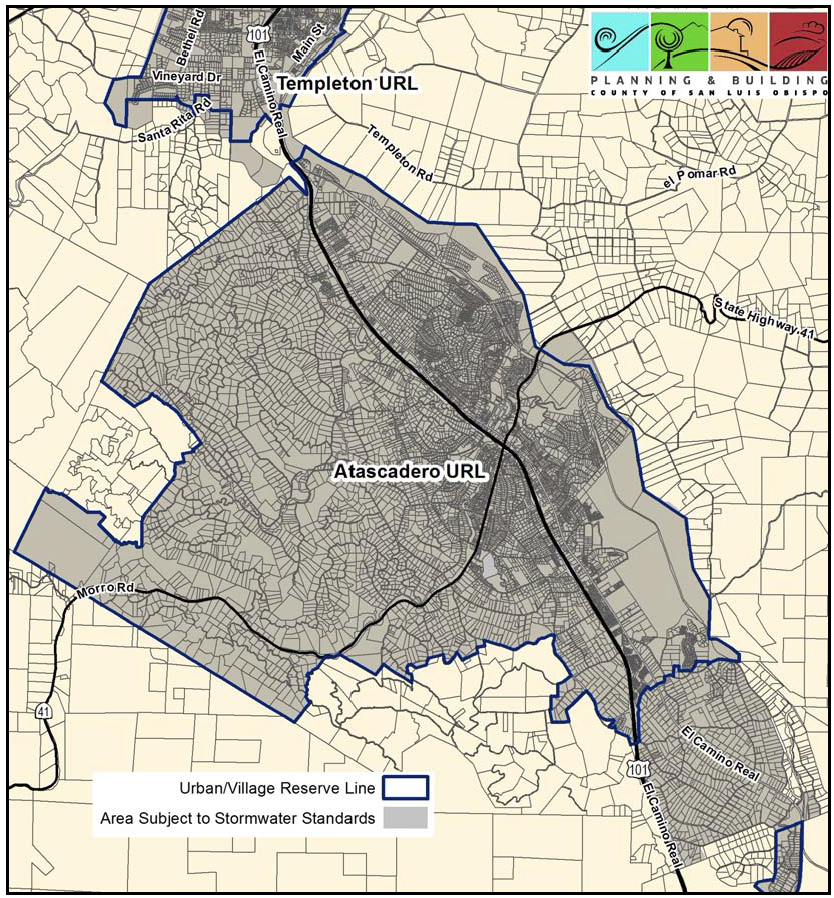
Figure 10-37: Stormwater Management: Atascadero, Templeton, Garden Farms
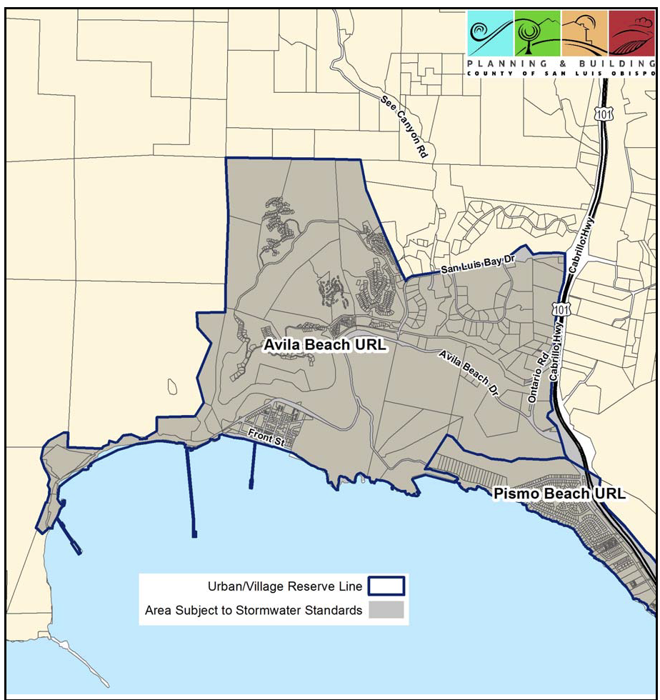
Figure 10-38: Stormwater Management: Avila Beach and Pismo Beach
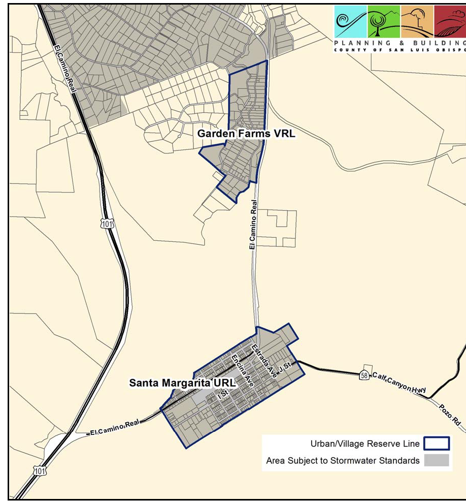
Figure 10-39: Stormwater Management: Garden Farms, Santa Margarita, South Atascadero
Figure 10-40: Stormwater Management: Heritage Ranch
Figure 10-41: Stormwater Management: Five Cities Area
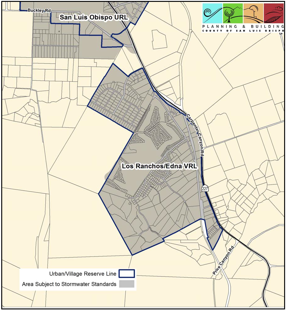
Figure 10-42: Stormwater Management: Los Ranchos/Edna, San Luis Obispo
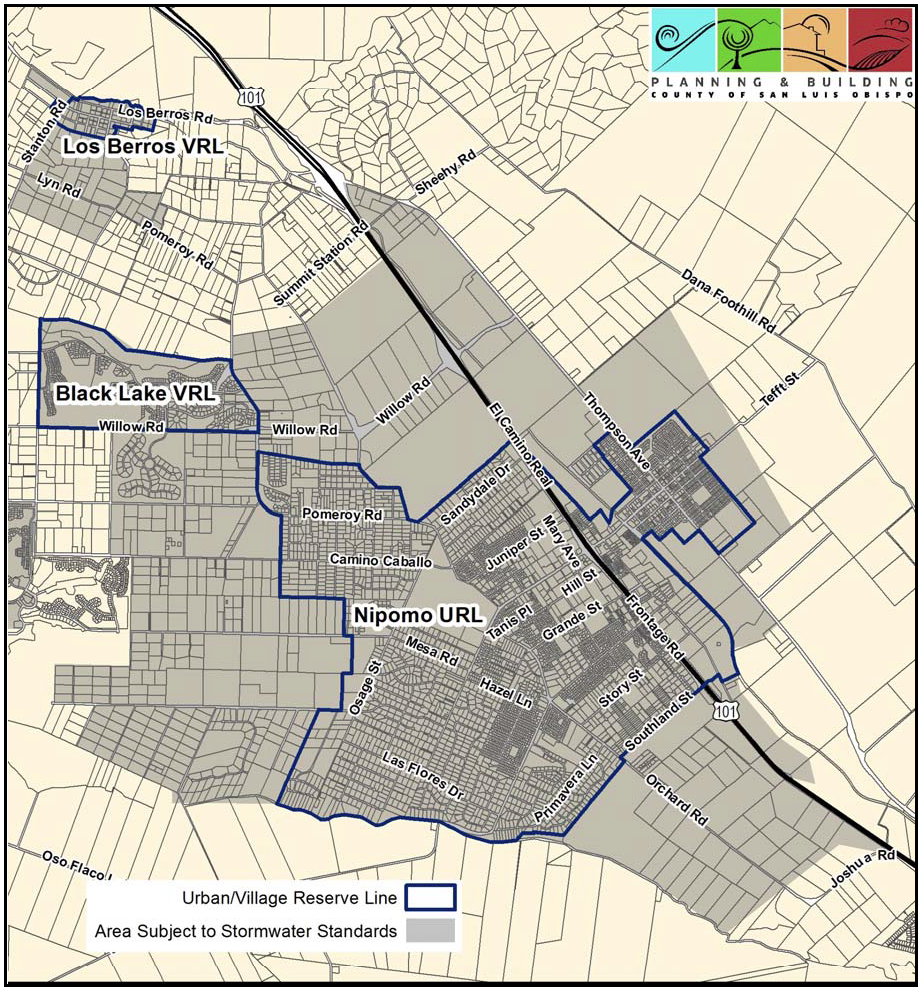
Figure 10-43: Stormwater Management: Nipomo, Black Lake, Los Berros
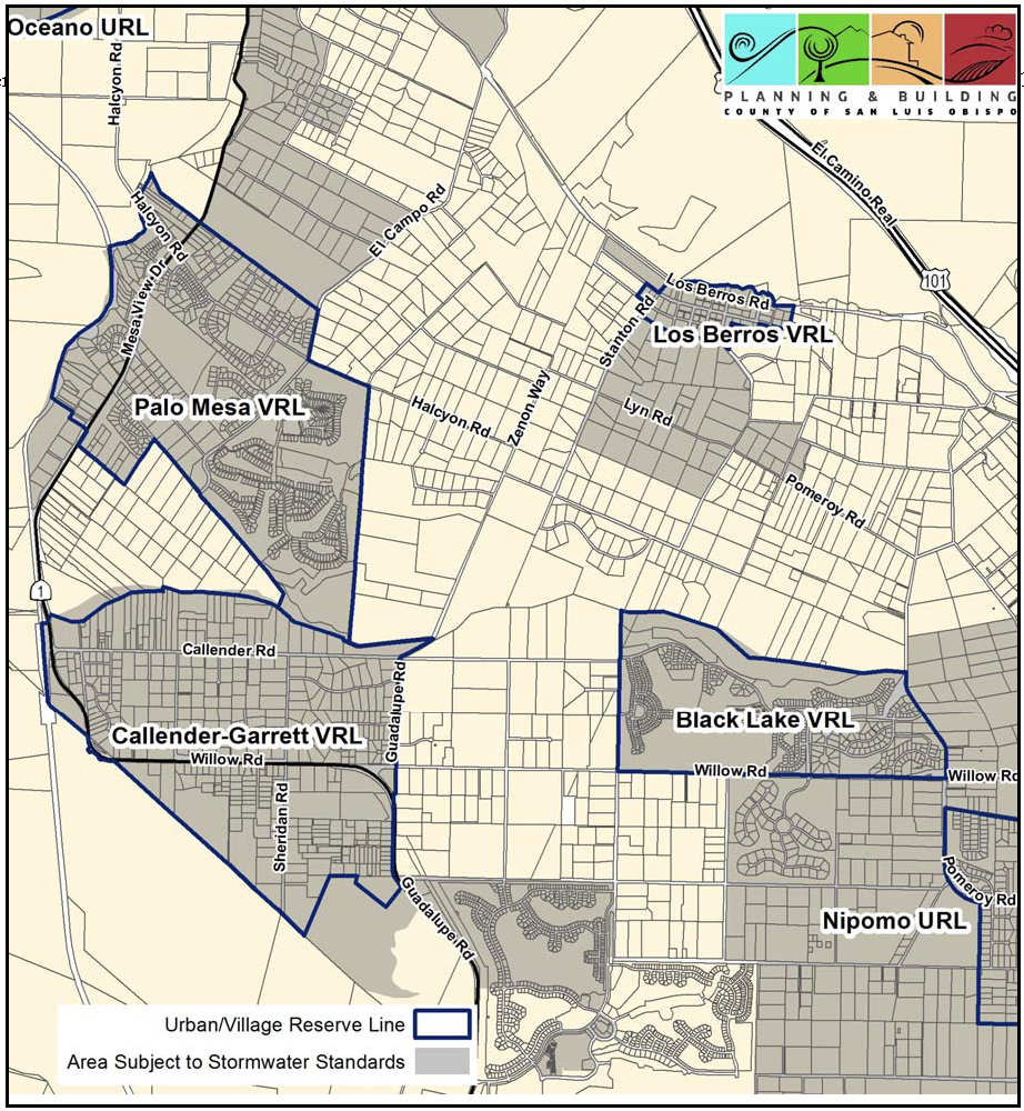
Figure 10-44: Stormwater Management: Northern Nipomo Mesa
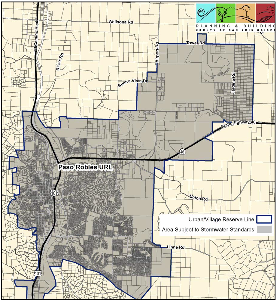
Figure 10-45: Stormwater Management: Paso Robles
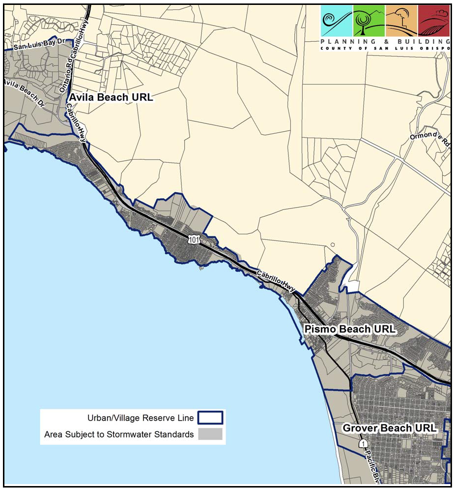
Figure 10-46: Stormwater Management: Pismo Beach
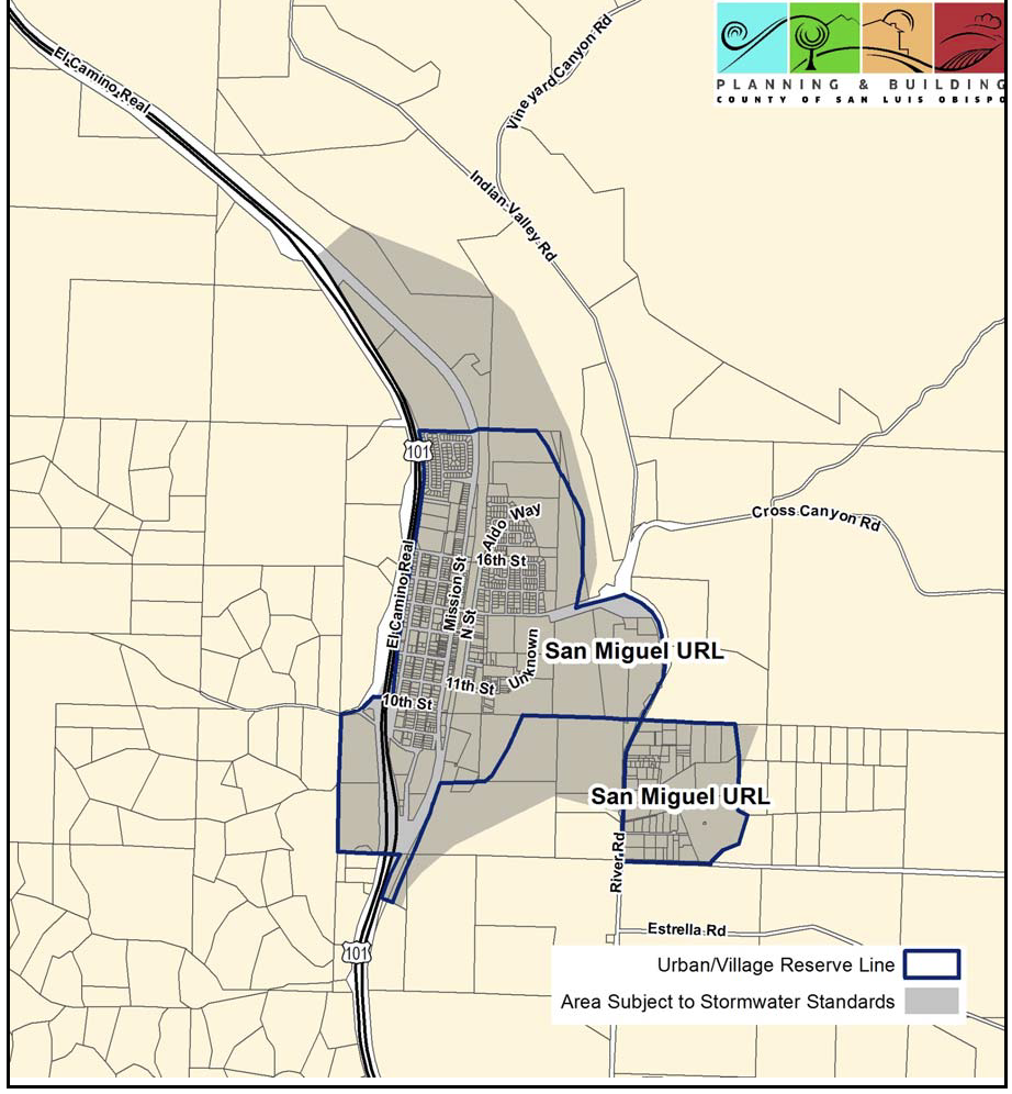
Figure 10-47: Stormwater Management: San Miguel
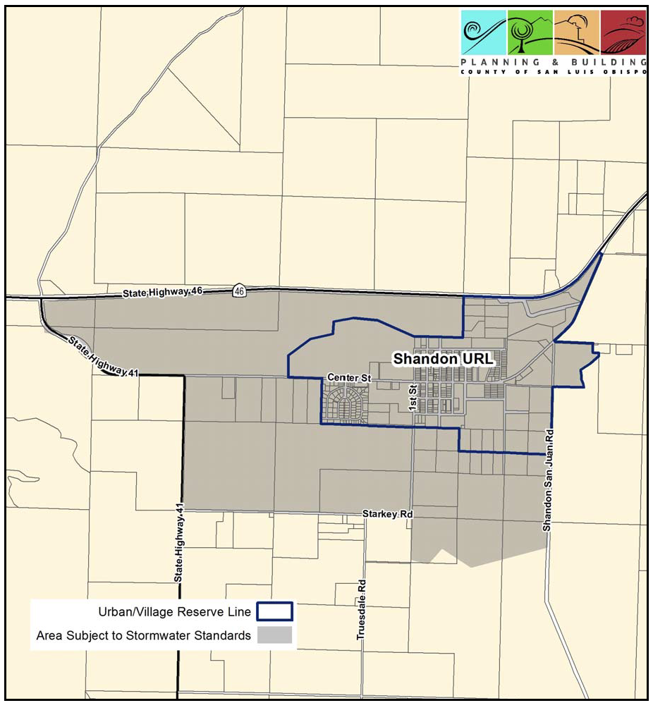
Figure 10-48: Stormwater Management: Shandon
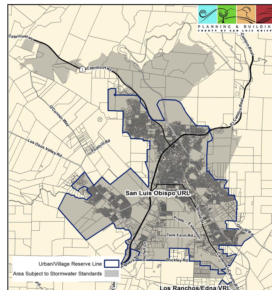
Figure 10-49: Stormwater Management: San Luis Obispo
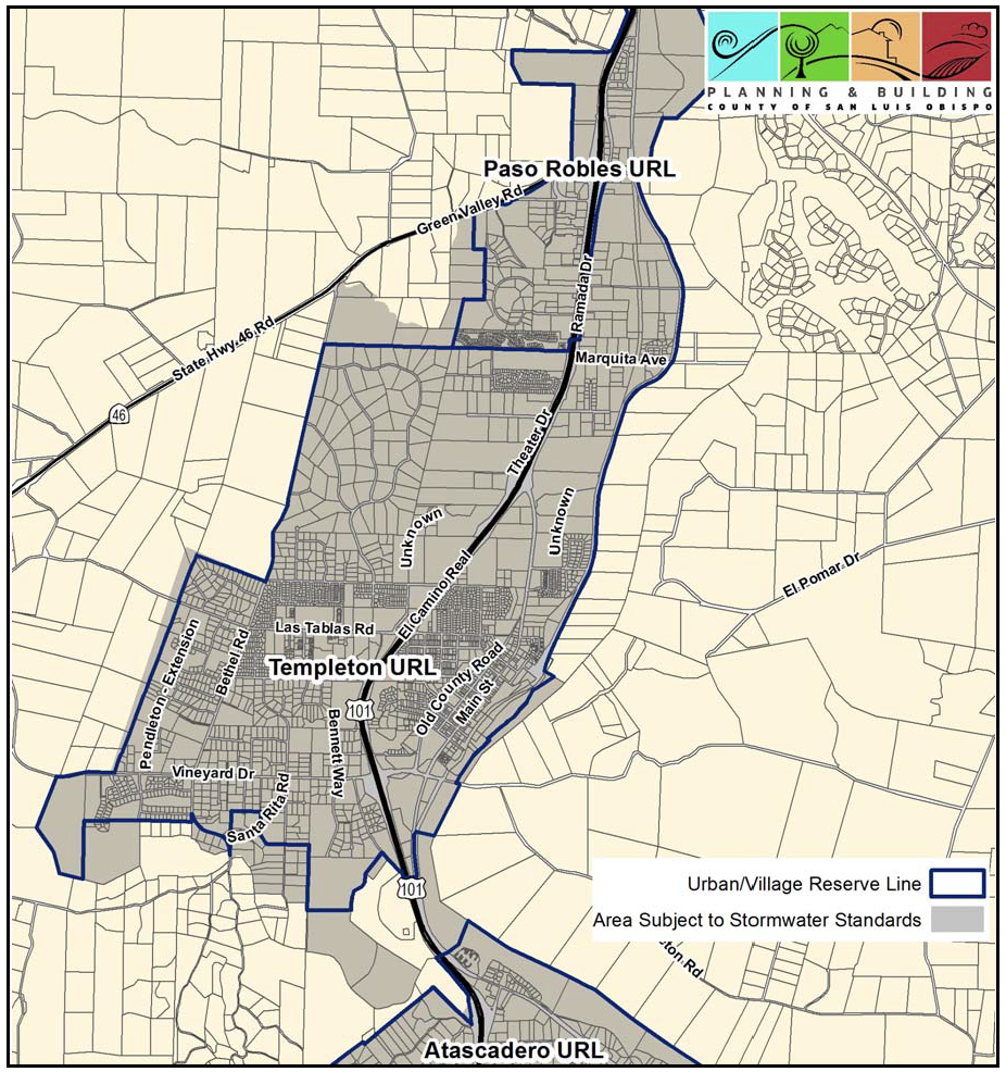
Figure 10-50: Stormwater Management: Templeton
[Added 2010, Ord. 3188; Amended 2013, Ord. 3251; 2018, Ord. 3369]
22.10.157 - Transit Oriented Standards.
A.
Where required. These provisions apply to Minor Use Permit, Conditional Use Permit, and land division applications where applicable for implementing the Circulation Element of the General Plan and the Regional Transportation Plan within the following areas defined by the Land Use Element of the General Plan:
1.
The South County sub-area of the South County planning area.
2.
The San Luis Obispo sub-area of the San Luis Obispo planning area.
3.
The San Luis Obispo sub-area of the South County planning area.
B.
Site Development. Provide a design and site development that is consistent with the following standards:
1.
Where determined appropriate by the Regional Transit Agency, subdivisions or development of 50 or more housing units shall provide pedestrian access to a bus stop along the closest major arterial or collector and fund their share of one shelter or bus stop per one-half mile of that roadway.
2.
Employment centers (100 jobs or more) shall provide one shelter and bus stop pullout within one-quarter mile of the project and provide pedestrian access to the transit facility. Up to a 20 percent reduction in the number of required parking spaces may be allowed for a project that provides on-site measures for alternative transportation, such as car pool programs, etc.
3.
Transit facilities shall be integrated into new development and be usable for different forms of transportation (bike, walking and car) whenever possible, with spacing to provide easy access without unduly impacting route times.
4.
On-site services are allowed as appropriate within projects, including child care, personal services, cafes, pharmacy and convenience stores, depending on the size of the project.
[Added 2014, Ord. 3256]
22.10.160 - Underground Utilities.
Utilities serving new structures shall be installed underground rather than by the use of poles and overhead lines, and where applicable shall be installed in accordance with California Public Utilities Commission rules and regulations. This requirement applies to electrical service and telecommunications (including cable TV, telephone and data transmission) connections between utility company distribution lines and all proposed structures on a site, and all new installations that distribute utilities within a site. This requirement does not apply to the following:
A.
New structures on parcels of five acres or larger, or requiring uninterrupted utility runs of five hundred feet or more;
B.
Public utility distribution service to the edge of the lot, except in an underground utility district or where 75 percent of the lots on the street within 1,000 feet of the site are already developed, and have overhead service from the utility company distribution source to the residences.
C.
Where underground installation may cause a substantial adverse environmental impact, as determined by the Director; or
D.
Temporary overhead extensions for use during construction and/or for the purpose of testing the power supply.
This Section may require an applicant to underground utilities from the utility company distribution source to the site, as well as on the site itself. The utility service provider should be contacted for information on the Public Utility Commission's rules and regulations regarding the undergrounding of utilities. Poles and overhead lines other than those allowed by this Section are allowable subject to Minor Use Permit approval, provided that the Review Authority first finds that either topographical, soil or similar physical conditions, or the distance to the utility company distribution source make the use of underground utilities unreasonable or impractical.
[Amended 1992, Ord. 2553; 1999, Ord. 2880] [22.05.120]
22.10.170 - Vibration.
A.
Vibration standards. Any land use conducted in or within one-half mile of an urban or village reserve line shall be operated to not produce detrimental earth-borne vibrations perceptible at the points of determination identified in the following table.
B.
Exceptions to standards. The vibration standards of this Section do not apply to:
1.
Vibrations from construction, the demolition of structures, surface mining activities or geological exploration between 7:00 a.m. and 9:00 p.m.;
2.
Vibrations from moving sources such as trucks and railroads.
[Amended 1981, Ord. 2063] [22.06.060]
22.10.180 - Water Quality.
This Section establishes a procedure for the notification of the California Central Coast Regional Water Quality Control Board (RWQCB) when a new land use or modification to an existing use may affect groundwater quality because of proposed methods of disposal, or large volumes of wastewater, or because of the disturbance of natural soil contours.
A.
Applications to be transmitted. Any application filed in compliance with Article 6 (Land Use and Development Permit Procedures), Chapter 22.52 (Grading), or Chapters 22.34 and 22.36 (Resource Extraction) except for business licenses, shall be transmitted by the Department to the RWQCB for review where:
1.
Any proposed development of more than five dwelling units will not be connected to an existing public sewer system;
2.
A discharge of wastewater to surface waters is proposed;
3.
A proposed waste discharge will contain toxic or hazardous materials (e.g., agricultural chemicals or metal plating wastes);
4.
On-site wastewater treatment and disposal systems other than conventional individual septic tank absorption fields are proposed;
5.
Waste flows are expected to exceed 2,500 gallons per day;
6.
A variance from state or local water quality or construction standards is requested;
7.
A livestock specialty use as defined by Article 8 (Definitions/Glossary) is proposed;
8.
A cemetery is proposed.
B.
Review procedure. A copy of all applications as described above shall be forwarded to the Regional Water Quality Control Board for review upon receipt by the Department. This transmittal is intended to enable the RWQCB to:
1.
Determine if the proposed use or activity is required to have discharge requirements, or is subject to other regulations of the RWQCB.
2.
Contact and advise the applicant on applicable requirements, and to advise the Department of any RWQCB permit requirements.
a.
In the case of applications for Zoning Clearance or Site Plan Review approval, within 10 business days of application transmittal;
b.
In the case of Minor Use Permit or Conditional Use Permit applications, notification of requirements, special comments, or recommendations to be forwarded to the Review Authority, shall be returned no later than 10 days before the hearing.
[Amended 1992, Ord. 2553] [22.06.100, 102]
22.12.010 - Purpose of Chapter.
This Chapter provides standards and requirements for density bonuses and other associated incentives, housing affordability, and inclusionary housing. These provisions are intended to encourage developers to provide affordable housing while retaining good design and neighborhood character.
(2020, Ord. 3427)
22.12.020 - Density Bonuses and Other Incentives.
An application that satisfies the requirements of this section and State Density Bonus Law for a qualifying housing project may be eligible to receive a density bonus and other incentives, such as concessions and adjusted parking ratios. A housing project approved to receive a density bonus may establish additional housing units over the standard maximum residential density allowed by ordinance, including the standard maximum residential density set by Planning Area Standards. Qualifying housing projects may include, but are not limited to, housing projects that contain one of the following: (1) rental or ownership housing units or vacant lots restricted to very low, lower, or moderate income residents, (2) housing units for transitional foster youth, disabled veterans, or homeless persons, with rents restricted at very low income level, (3) housing units restricted to senior citizens, and 4) mixed-use development. The qualifying housing units shall be deed-restricted in accordance with the approval of the project.
A.
References to State Law. This section references California Government Code 65915 et. seq., Chapter 4.3 (Density Bonuses and Other Incentives), Division 1, Title 7 of the State of California Government Code, which shall be referenced herein as State Density Bonus Law. All references to State Density Bonus Law shall refer to the statute, as it may be amended. Where there is conflict between the State Density Bonus Law and this ordinance, the State Density Bonus Law shall prevail.
B.
Application Submittal.
1.
Application Submittal. For the purpose of this chapter, an application for a density bonus shall mean an application to request density bonus, adjusted parking ratios, incentives or concessions, waivers or reductions of development standards, or any combination thereof, as prescribed in State Density Bonus Law. The level of permitting required is as otherwise required by this Title, not including bonus units. If a discretionary permit is required, CEQA review shall consider bonus units.
2.
Application Submittal Requirements. In addition to the permit submittal requirements for the proposed development, an application requesting a density bonus shall include the following items:
a.
The development project shall have five or more dwelling units, exclusive of any density bonus units.
b.
Density Bonus Guide. Any information and supplement documentation listed in the Guide is required unless otherwise noted as optional.
c.
Include citations of the state and county density bonus codes upon which the density bonus, adjusted parking ratios, incentives or concessions, and waivers or reductions of development standards is requested; and explanations and supporting evidence demonstrating how the proposed project satisfies the applicable standards and criteria.
d.
Include all documentation the applicant would like to rely on to demonstrate support for the requested incentives and concessions, waivers and reductions of development standards. The requests shall conform with the requirements of Section E below (Decisions and Findings).
e.
The application for an incentive, concession, or a waiver or reduction of development standards must also qualify for a density bonus.
3.
Concurrent Processing. The review of the density bonus application shall occur concurrently with all other entitlement applications submitted on behalf of the development requesting the density bonus benefits.
C.
Determination of Eligibility.
1.
Notice of Determination of Eligibility. If the Planning and Building Department deems the application to be complete it shall provide the applicant with a determination of the following, based on the State Density Bonus Law:
a.
The amount of density bonus for which the project is eligible.
b.
The parking ratio for which the project is eligible.
c.
The incentives, concessions, and waivers or reductions of development standards for which the project is eligible. Before a determination pursuant to this subsection can be made, the applicant shall submit sufficient documentation to establish eligibility for a requested density bonus, for any requested incentives or concessions, and for any requested waivers or reductions of development standards.
2.
Project based on Determination of Eligibility. The project's density bonus amount, parking ratios, incentives, concessions, and waivers or reductions of development standards shall be based on the determination of eligibility made at the time the application is deemed complete. However, the Planning and Building Department or the Review Authority shall adjust the amount of density bonus, parking ratios, incentives, concessions and waivers or reductions of development standards based on any changes made to the project prior to permit approval. The applicant may choose to accept less than what is allowed by the project determination. The County may choose to award the project an equal or greater amount than allowed by the State Density Bonus Law.
D.
Project Design.
1.
Location and Dispersal of Dwelling Units. Deed-restricted dwelling units shall be dispersed throughout the development and shall not be clustered, unless the Review Authority approves a cluster design for such units.
2.
Number of Bedrooms. The average number of bedrooms of the deed-restricted dwelling units shall equal or exceed the average number of bedrooms of the market-rate dwelling units.
3.
Exterior Appearance and Quality of Materials. The exterior appearance and quality of materials of the deed-restricted dwelling units shall be the same or similar to the market-rate dwelling units.
4.
Unit Availability and Project Phasing. Deed restricted dwelling units shall be completed and available for occupancy prior to or concurrently with market rate dwelling units. If the project is to be developed in phases, then each phase shall contain a share of the total number of deed restricted units that is proportional to the size of each phase.
5.
Land Donation. The timing and provision of land donation(s) shall comply with California Government Code 65915(g).
E.
Decision and Findings.
1.
Findings for Density Bonus and Adjusted Parking Ratios. The Review Authority shall approve or approve with conditions a request for density bonus and adjusted parking ratios if it finds that:
a.
The proposed project is eligible for the requested density bonus and adjusted parking ratios pursuant to State Density Bonus Law; and
b.
The proposed project is consistent with the applicable standards and criteria found in State Density Bonus Law.
c.
Where a development project may qualify for other density bonuses in addition to those provided by this section (e.g. through Section 22.12.040 - Inclusionary Housing, or Section 22.22.140 - Cluster Division) only one such bonus may be used.
2.
Findings for Incentives and Concessions. The Review Authority shall approve or approve with conditions a request for incentives or concessions, unless it makes any of the following findings based upon substantial evidence:
a.
The incentive or concession does not result in identifiable and actual cost reductions, consistent with California Government Code Section 65915(k):
(1)
to provide for affordable housing costs, as defined in California Health and Safety Code Section 50052.5, or
(2)
for rents for the targeted units to be set as specified in California Government Code Section 65915(c).
b.
The incentive or concession would have a specific, adverse impact, as defined in California Government Code Section 65589.5(d)(2), upon public health and safety or on any real property that is listed in the California Register of Historical Resources, and for which there is no feasible method to satisfactorily mitigate or avoid the specific, adverse impact without rendering the development unaffordable to low-income and moderate-income households.
c.
The incentive or concession would be contrary to state or federal law.
3.
Findings for Waivers and Reductions of Development Standards. The Review Authority shall approve or approve with conditions a request for waivers or reductions of development standards, unless it makes any of the following findings:
a.
The development standard(s) are not preventing the construction of the proposed density bonus project at the densities or with the incentives permitted under this Section
b.
The waiver or reduction of development standards would have a specific, adverse impact, as defined in California Government Code Section 65589.5(d)(2), upon public health and, safety for which there is no feasible method to satisfactorily mitigate or avoid the specific adverse impact.
c.
The waiver or reduction of development standards would have an adverse impact on any real property that is listed in the California Register of Historical Resources.
d.
The waiver or reduction of development standards would be contrary to state or federal law.
4.
Findings for Density Bonus greater than allowed by the State Density Bonus Law. The Review Authority shall approve an additional fifteen percent (15%) density bonus for the inclusion of very low income units beyond that allowed by State Density Bonus Law, to be calculated using the project's base density excluding any density bonus awarded by this section, provided that the Review Authority finds that the proposed project otherwise meets the applicable standards and criteria.
5.
Agreements. The applicant shall enter into an affordable housing agreement with the County and record a deed restriction on the property. The agreement and deed restriction shall require the affordability of the designated dwellings units be maintained and enforced in accordance with the approved project. The agreement and deed restriction shall be in a form prepared by the County and be recorded by the applicant with the final subdivision map or, where no subdivision map is required, prior to issuance of a building permit for any structure on the project site. The agreement and deed restriction shall incorporate the long-term affordability provisions of the State Density Bonus Law and Section 22.12.030 - Housing Affordability Standards. When applicable, ownership units shall also be subject to an equity-sharing agreement pursuant to the State Density Bonus Law. Where allowable by law, the agreement may require payment of a fee to cover the cost of monitoring compliance with the agreement.
(2020, Ord. 3427; 2025, Ord. 3539)
22.12.030 - Housing Affordability Standards.
A.
Applicability. Affordable housing units provided as a result of one or more of the following County actions shall be subject to the standards of this Section:
1.
Approval of a density bonus under Section 22.12.040 of the Land Use Ordinance, Title 22 of the County Code, or
2.
Approval of an exemption from growth management provisions under Subsection 26.01.034b of the Growth Management Ordinance, Title 26 of the County Code, or
3.
Provision of direct financial assistance in the form of a grant (not a loan) to the development of affordable housing.
B.
Eligible Household Definitions. Households eligible to become renters or owner-occupants of affordable housing under provisions of the County Code must have incomes not exceeding one of the following income ceilings and they must agree to occupy said affordable housing as their principal residence. The County will consider actual income and imputed income from assets when determining eligibility.
1.
Extremely low-income: no more than 30 percent of median income.
2.
Very low-income: no more than 50 percent of median income.
3.
Lower-income: no more than 80 percent of median income.
4.
Moderate-income: no more than of 120 percent of median income.
5.
Workforce: no more than 160 percent of median income.
C.
Determination of initial affordable housing sales prices. The following procedure is designed to determine sales prices that will enable purchase of the affordable housing units by the eligible households without their monthly housing costs exceeding 30 or 35 percent of their gross incomes. The Planning and Building Department shall use this procedure to determine maximum sales prices for each proposed land use permit or land division using estimates of actual costs of financing, property taxes, homeowner association fees, and insurance and shall publish typical examples quarterly.
1.
Determine median income. First, find the applicable median income based on the household size. This information is published in Section 6932 of Title 25 of the California Code of Regulations. Both the household size and the size of the housing unit shall be used to determine the affordable housing sales price, as follows:
a.
Studio: use the median income for a one-person household.
b.
One-bedroom unit: use the median income for a two-person household.
c.
Two-bedroom unit: use the median income for a three-person household.
d.
Three-bedroom unit: use the median income for a four-person household.
e.
Four bedroom unit: use the median income for a five-person household.
2.
Determine maximum housing costs. Maximum housing costs by size of housing unit and eligible household group shall be calculated as the following percentages of the median income amounts determined in Subsection C.1., as follows:
a.
Extremely low-income: 30 percent of 30 percent of median income as determined under Subsection C.1.
b.
Very low-income: 30 percent of 50 percent of median income as determined under Subsection C.1.
c.
Lower-income: 30 percent of 70 percent of median income as determined under Subsection C.1.
d.
Moderate-income: 35 percent of 110 percent of median income as determined under Subsection C.1.
e.
Workforce: 35 percent of 150 percent of median income as determined under Subsection C.1.
3.
Estimate housing costs other than payments on mortgage loan principal and interest. The actual costs of property taxes, insurance and homeowner association dues shall be estimated by the Planning and Building Department for affordable housing units in each proposed land use or land division.
4.
Determine amount of income available for payments of mortgage loan principal and interest. The amount of income available for payments of mortgage principal and interest shall be determined by deducting the amounts for property taxes, insurance and homeowners associations dues estimated by Subsection C.3. from the maximum housing costs determined by Subsection C.2.
5.
Determine mortgage interest rate. The Planning and Building Department shall determine the annual percentage rate of conventional mortgage financing, amortized over 30 years, currently available in California at the time of building permit issuance.
6.
Determine the maximum affordable sales price. The Planning and Building Department shall determine the maximum affordable sales price using the income available for payment of mortgage loan principal and interest determined by Subsection C.4., the mortgage interest rate determined by Subsection C.5, and assuming the buyer can pay a down payment of 5 percent of the sales price.
D.
Non-Sales. In cases where no sale will occur, such as when an owner-builder is involved (a landowner who wishes to construct his primary residence on his own property), the sales price that would apply pursuant to Subsection C shall be used in meeting the long-term housing affordability provisions of Subsection F.
E.
Rental units. Rent levels of the affordable units, including allowances for the costs of utilities as determined by the Housing Authority of the City of San Luis Obispo, shall not exceed the following:
1.
Extremely low-income units: 30 percent of 30 percent of the median household income as determined under Subsection C.1.
2.
Very low-income units: 30 percent of 50 percent of the median household income as determined under Subsection C.1.
3.
Lower-income units: 30 percent of 60 percent of the median household income as determined under Subsection C.1.
4.
Moderate-income units: 30 percent of 110 percent of the median household income as determined under Subsection C.1.
5.
Workforce housing units: 30 percent of 150 percent of the median household income as determined under Subsection C.1.
F.
Continued availability of affordable housing. Affordable housing units which are subject to the standards of this section shall continue to be reserved as affordable housing as follows:
1.
For sale units. Prior to the issuance of any project construction permits the property owner and the County shall enter into and record a Master Affordable Housing Agreement, prepared by County Counsel, assuring that the project will provide designated affordable housing unit(s). When a designated affordable housing unit is first sold to an eligible buyer, or when the owner-builder of a designated affordable housing unit requests final permit approval for occupancy of his residence, the buyer and County or the owner-builder and County shall enter into an Option to Purchase at Restricted Price Agreement which shall be recorded as an encumbrance on the property, and secured by a recorded deed of trust. The said Option to Purchase at Restricted Price Agreement shall supersede the Master Affordable Housing Agreement. Under the terms of the Option to purchase at Restricted Price Agreement, the maximum resale price of the housing unit shall be limited for a period of 45 years to the same formula used to determine the initial sales price, except that current information regarding median income, mortgage financing interest rate, taxes, insurance and homeowners association dues shall be applied. Adjustments to the maximum resale price as determined by the Planning and Building Department shall be made to ensure that the resale price is not lower than the original sales price, to increase the maximum resale price by the value of structural improvements made by the owner, and to comply with requirements of State or Federal mortgage lenders as necessary. Ownership of the property may only be transferred to a party that agrees to execute a new Option to Purchase at Restricted Price Agreement with a term of 45 years.
2.
Near market value units: For any affordable housing unit that is subject to Section 22.12.010 or Section 22.12.040 of this Title and will be sold as an ownership unit, if there is a sales price difference of 10 percent or less between the current appraised market value of the unit and the affordable sales price established by this Section then that affordable housing unit shall be reserved as affordable housing for a period of thirty (30) years in the following manner. When the affordable housing unit is first sold to an eligible buyer, or when the owner-builder of a designated affordable housing unit requests final permit approval for occupancy of his residence, the buyer and the County or the owner-builder and the County shall enter into an Option to Purchase at Restricted Price Agreement which shall be recorded as an encumbrance on the property and secured by a recorded deed of trust. The said Agreement and deed of trust shall establish the monetary difference between the initial affordable purchase price and the initial appraised market value as a loan payable to the County. Said loan shall accrue interest at a rate equal to 4.5 points added to the 11th District Cost of Funds as currently published by the Federal Home Loan Bank, amortized over 30 years. The monthly payments of principal and interest shall be waived by the County as long as the owner who was previously approved by the County as an eligible buyer or as an owner-builder continues to own and reside in the affordable unit as his or her principal residence, and also continues to be a legal resident of the County of San Luis Obispo. Upon resale to a non-eligible buyer the County loan amount shall be determined by the Planning and Building Department and shall be adjusted to ensure that the resale price is not lower than the original affordable price, and to allow recovery of any downpayment and value of structural improvements. The provisions of this Section shall not impair the rights of a first mortgage lender secured by a recorded deed of trust. The purchase money lender(s) shall have a higher priority than the County's loan. The County's security shall be prioritized as a second mortgage. This first priority applies to the purchase money lender's assignee or successor in interest, to:
a.
Foreclose on the subject property in compliance with the remedies permitted by law and written in a recorded contract or deed of trust; or
b.
Accept a deed of trust or assignment to the extent of the value of the unpaid first mortgage to the current market value in lieu of foreclosure in the event of default by a trustor; or
c.
Sell the property to any person at a price consistent with the provisions of this Section subsequent to exercising its rights under the deed of trust.
In addition, the following types of transfers shall remain subject to the requirements of the County's loan and right of first refusal: transfer by gift, devise, or inheritance to the owner's spouse; transfer to a surviving joint tenant; transfer to a spouse as part of divorce or dissolution proceedings; or acquisition in conjunction with a marriage; or transfer as a result of foreclosure.
3.
Rental units. Prior to the issuance of any project construction permits the property owner and the County shall enter into and record a Rent Limitation Agreement, prepared by County Counsel, assuring that the project will provide designated affordable housing unit(s). Rent levels shall be based on the same criteria as those used to compute the original rent ceiling in Subsection E for a period of at least 55 years. The rent levels will be enforced through the Review Authority imposing applicable conditions at the time of land use permit or subdivision approval for the project. If ownership of the property is transferred during the initial 55 years period, then a new Rent Limitation Agreement shall be executed with a term of 55 years
G.
Exceptions to initial sales price limitations and resale restrictions. The Director of the Planning and Building Department may grant an exemption to the initial sales price limitation and resale restrictions for housing units that meet all of the following criteria:
1.
The housing units are provided in a development consisting exclusively of housing for very low income, lower income or moderate income households; and
2.
The housing units are constructed with at least 50 percent of the work performed by volunteers and/or households purchasing the housing; and
3.
The Director of the Planning and Building Department has determined that the home purchase financing provided will be affordable to the purchasing households for at least 30 years.
(2020, Ord. 3427)
22.12.040 - Reserved.
Editor's note— Ord. No. 3471, § I, adopted June 7, 2022, repealed § 22.12.040. Former § 22.12.040 pertained to inclusionary housing and derived from Ord. No. 3427, adopted 2020.
22.14.010 - Purpose of Chapter.
Combining designations are used to identify and highlight areas of the county having natural or built features which are sensitive, hazardous, fragile, of cultural or educational value, or of economic value as extractable natural resources. The purpose of combining designation standards is to require project design that will give careful consideration to the land features, structures and activities identified by the combining designations. These standards provide for more detailed project review where necessary to support public safety or proper use of public resources. [22.07.010]
22.14.020 - Applicability of Standards.
The standards of this Chapter apply to all projects for which a land use permit is required, when a project is within a combining designation shown on the official maps (Part III of the Land Use Element). When applicable, these standards apply to a project in addition to any requirements of planning area standards (Article 9 - Community Planning Standards), and the other requirements of this ordinance. When the standards of this Chapter conflict with other chapters of this Title, these standards shall control for the purposes of this Title. If the standards of this Chapter conflict with planning area standards, the planning area standards control. Any determination that the provisions of this Chapter do not apply to a specific land use shall not be construed as exempting the land use from other applicable requirements of this Title. [22.07.012]
22.14.030 - Airport Review Area (AR).
A.
Applicability. The Airport Review (AR) combining designation is used to recognize areas around airports where certain land uses and site development characteristics may conflict with aircraft maneuvers or with the safe and functional use of the airport. The standards of this Section regulate objects affecting navigable airspace, consistent with federal regulations. The Airport Review combining designation is applied to:
1.
Areas below the several imaginary surfaces around each airport established by the U.S. Federal Aviation Administration in its Federal Aviation Regulations, Volume XI, Part 77.
2.
Those areas surrounding each airport as identified in plans adopted by the San Luis Obispo County Airport Land Use Commission.
The two areas described above are identified in Article 9 (Community Planning Standards), which also contains specific requirements for each specific Airport Review combining designation area.
B.
Limitation on use. Developments within areas covered by land use plans adopted by the San Luis Obispo County Airport Land Use Commission are limited to those identified in the plans as "compatible" and "conditionally approvable." Projects that are conditionally approvable may be granted a permit only when in compliance with all conditions of the applicable airport land use plan or its implementing rules.
C.
Application content. In addition to the requirements of Article 6, all applications shall include descriptive and plan information as necessary to determine compliance with these airport review sections.
D.
Additional height standards. The following standards apply to projects in the AR combining designation in addition to the provisions of Section 22.10.090 (Heights):
1.
Except as otherwise provided in this Section, no structure shall be erected, altered, replaced, repaired or rebuilt, or tree be allowed to grow higher or be replanted, in any airport approach area, airport turning area, or airport transition area to a height that would project above the approach surface, the horizontal surface, the conical surface, or the transitional surfaces as defined in Article 8.
2.
The maximum height of Subsection D.1 may be increased by the San Luis Obispo County Airport manager, where existing terrain features near a proposed project are higher than proposed structures, and no additional hazard to air traffic will result. In such cases, the height of proposed structures may be increased to a maximum height equivalent to the terrain feature. Any allowed increase in height may be conditioned to require the owner of the proposed structure to install, operate, and maintain on the structure markers and lights that may be necessary to indicate to flyers the presence of an aviation hazard.
E.
Additional operational standard. The following standard shall apply in addition to the provisions of Article 3. Except as provided in Section 22.14.030, no use may be made of land within any airport approach area, airport turning area, or airport transition area, in a manner to create electrical interference with radio communications between the airport and aircraft, make it difficult for pilots to distinguish between airport lights and others, impair visibility in the vicinity of the airport, or otherwise endanger the landing, taking off, or maneuvering of aircraft.
F.
Avigation easement required. To ensure the continued viability of avigable airspace within AR areas, approval of a land use permit is subject to the property owner providing the county an avigation easement for all projects in areas identified in the applicable airport land use plan as needing an avigation easement.
G.
Appeal procedure. Any appeal or variance to this Section requested in compliance with Section 22.70.050 or 22.70.030 shall first be transmitted to the San Luis Obispo County Airport Land Use Commission for its consideration in accordance with Section 21676 of the California Public Utilities Code. No subsequent approval of the appeal or variance to a degree greater than that set by the Airport Land Use Commission shall be of any effect unless and until the Board of Supervisors so determines by a vote of not less than four-fifths.
[Amended 1986, Ord. 2250] [22.07.020 through 22.07.032]
22.14.040 - Energy and Extractive Resource Area (EX).
A.
Purpose and applicability. The Energy and Extractive Resource Area (EX) combining designation is used to identify areas of the county where:
1.
Mineral or petroleum extraction occurs or is proposed to occur;
2.
The state geologist has designated a mineral resource area of statewide or regional significance pursuant to Sections 2710 et seq. of the Public Resources Code (The Surface Mining and Reclamation Act);
3.
Major public utility electric generation facilities exist or are proposed.
The purpose of this combining designation is to protect significant resource extraction and energy production areas identified by the Land Use Element from encroachment by incompatible land uses that could hinder resource extraction or energy production operations, or land uses that would be adversely affected by extraction or energy production.
B.
Use restrictions. The following uses are prohibited within the EX combining designation:
Recycling—Scrap and dismantling yards
Small Scale Manufacturing
Clubs, Lodges, and Private Meeting Halls
Libraries and Museums
Religious Facilities
Rural Recreation and Camping (except Incidental Camping)
Schools
Restaurants
Lodging (except Bed & Breakfast Inns, 3 or fewer units)
Waste Disposal Sites
Airfields and Heliports
C.
New subdivisions—Minimum parcel size. The minimum parcel size for a new parcel is 10 acres unless a larger minimum parcel size is required by applicable sections in Chapter 22.22.
D.
Processing requirements. When located in an EX area, all proposed land uses required to have land use permit approval by Section 22.06.030 (Allowable Land Uses and Permit Requirements), Article 1 (Standards for Specific Land Uses), or by planning area standards in Article 9, are subject to the requirements of this Section.
1.
Permit required.
a.
Resource extraction. The land use permit requirements for oil wells or mining operations shall be as determined by Chapters 22.34 and 22.36.
b.
Electric generating facilities. The land use permit requirements for new electric generation facilities and modifications to existing facilities are determined by Chapter 22.32.
c.
All other land uses. Proposed land uses not directly related to energy or extraction operations are subject to Minor Use Permit approval, unless the project would otherwise be required by this Title to have Conditional Use Permit approval. The following are exceptions to the Minor Use Permit requirement:
(1)
Uses related to an existing single-family residence. Development accessory to an existing legally-established single-family residence, including, but not limited to, the following:
Minor exterior alterations.
Residential expansions not exceeding 50 percent.
Residential accessory structures and accessory dwelling units.
Home occupations.
Demolition and replacement of a single-family residence in the same location.
(2)
Planning area standard. Where planning standards in Articles 9 or 10 for the EX designation authorize Zoning Clearance approval.
2.
Application content.
a.
Resource extraction: As required by Chapters 22.34 and 22.36.
b.
Electric generating facilities: As required by Chapter 22.32.
c.
All other land uses. Where a land use other than resource extraction or power generation is proposed in an EX area, the permit application shall include a mineral resource report prepared by a geologist or mining engineer that evaluates:
(1)
The estimated extent and commercial value of any mineral resources located on the site or known to be within the vicinity of the proposed uses;
(2)
The feasibility of extracting the identified mineral resources within a reasonable time before development of the proposed use;
(3)
The feasibility of conducting resource extraction operations at the same time as the proposed use.
3.
Required findings. Approval of any use other than energy production or resource extraction may be granted when the finding is made that the proposed use will not adversely affect the continuing operation or expansion of the energy or extraction use.
E.
Development standards. Resource extraction operations shall be established and operated in compliance with the standards of Chapters 22.36 and 22.36. Electric generating facilities shall comply with Chapter 22.32. Development standards for other land uses shall be established through the land use permit review and approval process.
[Amended 1986, Ord. 2250; 1989, Ord. 2409; 1992, Ord. 2553; 1994, Ord. 2696; 2025, Ord. 3531] [22.07.040 to 044]
22.14.050 - Mineral Resource Area (MRA).
A.
Purpose and applicability. The Mineral Resource Area (MRA) combining designation is used to identify areas of the county which the California Geological Survey California Department of Conservation's Division of Mines and Geology has classified as containing or being highly likely to contain regionally significant mineral deposits.
The purpose of this combining designation is to protect existing resource extraction operations and areas with significant mineral resources from encroachment by incompatible land uses that could hinder resource extraction. In addition, Framework for Planning - Inland Portion, Part I of the Land Use Element contains guidelines which call for proposed land use category amendments to give priority to maintaining land use categories which allow and are compatible with resource extraction.
B.
Use restrictions. The following uses are prohibited within the MRA combining designation:
Recycling—Scrap and dismantling yards
Small Scale Manufacturing
Clubs, Lodges, and Private Meeting Halls
Libraries and Museums
Religious Facilities
Rural Recreation and Camping (except Incidental Camping)
Schools
Restaurants
Lodging (except Bed & Breakfast Inns, 3 or fewer units)
Waste Disposal Sites
Airfields and Heliports
C.
New subdivisions—Minimum parcel size. The minimum parcel size for a new residential parcel is 10 acres unless a larger minimum parcel size is required by applicable sections in Chapter 22.22.
D.
Processing requirements. The following standards apply to proposed land uses within the MRA combining designation which are required to have Minor Use Permit or Conditional Use Permit approval by Section 22.06.030 (Allowable Land Uses and Permit Requirements), Chapter 22.30 (Standards for Specific Land Uses), or by planning area standards in Articles 9 and 10.
1.
All proposed mineral or petroleum extraction uses are subject to the requirements of Sections 22.14.040 through 22.14.044 and 22.08.170 through 22.08.198.
2.
Approval of any use other than mineral resource extraction may be granted only when the finding is made that the proposed use will not adversely affect the continuing operation or expansion of a mineral resource extraction use.
[Amended 1991, Ord. 2499; 2025, Ord. 3531] [22.07.050, 052]
22.14.060 - Flood Hazard Area (FH).
A.
Purpose and Statutory Authorization. The Legislature of the state of California has in Government Code Sections 65302, 65560 and 65800 conferred upon local governments the authority to adopt regulations designed to promote the public health safety and general welfare of its citizenry. Therefore, the Board of Supervisors of the County of San Luis Obispo does hereby adopt the following flood plain management regulations. The Flood Hazard (FH) combining designation is applied to areas where terrain characteristics would present new developments and their users with potential hazards to life and property from potential inundation by a 100-year frequency flood. These standards are also intended to minimize the effects of development on drainage ways and watercourses. The areas of special flood hazard identified by the Federal Emergency Management Agency in a scientific and engineering report entitled "The Flood Insurance Study for San Luis Obispo County," dated June 6, 2024, with accompanying flood insurance rate maps, and any subsequent amendments or revisions to these products are hereby adopted and incorporated into this Title by reference as though they were fully set forth here. The flood insurance study is on file in the County Public Works office.
B.
Applicability of Flood Hazard Standards. All uses proposed within a FH combining designation are subject to the standards of this Section, except:
1.
Temporary uses. With the approval of the Floodplain Administrator, the Building Official may authorize construction or placement of a temporary structure or use within a Flood Hazard area pursuant to the required land use permit without meeting these standards, provided that the structure or use will be removable in times of imminent flooding (such as structures or machinery on semi-trailers.
2.
Emergency work. Emergency work may be undertaken where necessary to preserve life or property. Within 48 hours after commencement of such work, the Floodplain Administrator shall be notified and an application filed with the Department of Planning and Building in compliance with the provisions of Subsection E of this section.
3.
Existing uses. The continuance, operation, repair, or maintenance of any lawful use of land existing on the effective date of this Title is permitted. Any expansion or alteration of an existing structure or use, or grading of a site, shall be conducted in accordance with all applicable provisions of this Title.
C.
Definitions. The following definitions are for the purposes of this section.
1.
Base Flood. The flood having a one percent chance of being equaled or exceeded in any given year. Equivalent to a 100-year flood. [Added 1986, Ord. 2250]
2.
Base Flood Elevation. The elevation of the base flood, including wave height, relative to the National Geodetic Vertical Datum (NGVD), North American Vertical Datum (NAVD) or other datum specified in the Flood Insurance Study (FIS).
3.
Flood Fringe. That portion of the flood plain outside the floodway. See Figure 14-1 in Floodway definition.
4.
Flood Insurance Rate Map (FIRM). The official Flood Insurance Rate Map on which the Federal Emergency Management Agency has delineated both the areas of special flood-hazards and the risk premium zones applicable to the community. [Added 1986, Ord. 2250]
5.
Flood Insurance Study. The official report titled "The Flood Insurance Study for San Luis Obispo County," provided by the Federal Emergency Management Agency, that includes flood profiles, the Flood Insurance Rate Map (FIRM), The Flood Boundary Floodway Map, the water surface elevation of the base flood, and supporting technical data. [Added 1986, Ord. 2250]
6.
Flood Plain. Land that has been or may be hereafter covered by flood water, including, but not limited to, the base flood.
7.
Flood Profile, Storm. A graph or longitudinal profile showing the relationship of the water-surface elevation of a flood event to location along a stream or river.
8.
Floodproofing. Any combination of structural and non-structural additions, changes or adjustments to non-residential structures which reduce or eliminate flood damage to real estate or improved property. [Amended 1986, Ord. 2250]
9.
Floodway. The channel of a river or other watercourse and the adjacent land areas that must be reserved to discharge the base flood without cumulatively increasing the water surface elevation more than one foot. Figure 14-1 conceptually illustrates the floodway relative to the broader flood plain.
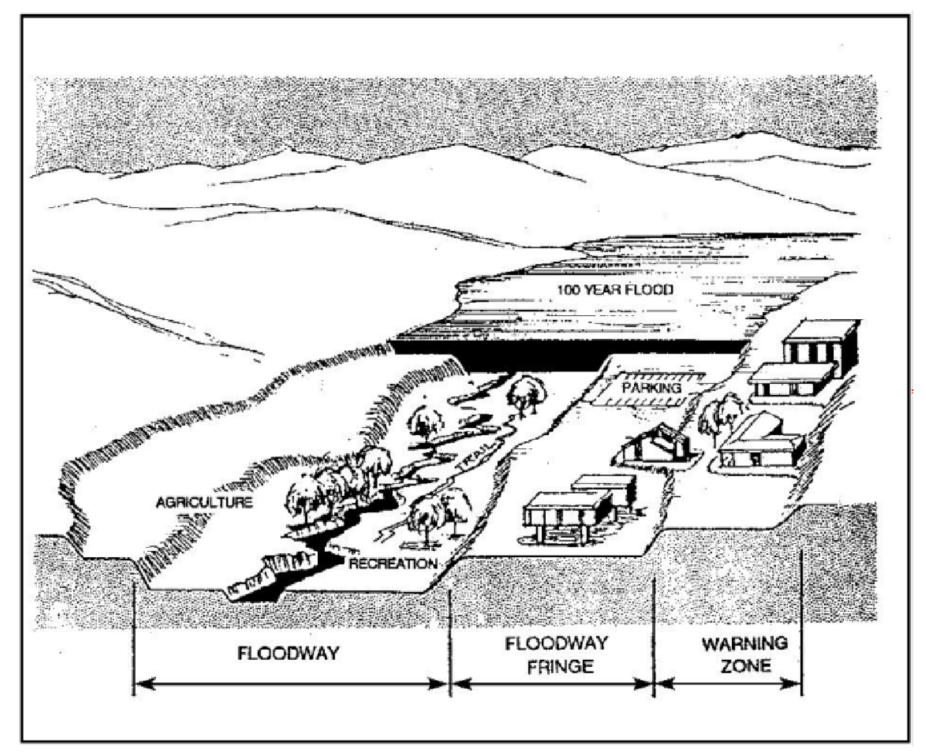
Figure 14-1 - Floodway and Flood Fringe
10.
Lowest Floor. The lowest floor of the lowest enclosed area, including basement. Excludes any unfinished or flood-resistant enclosure, usable solely for vehicle parking, building access or limited storage provided that such enclosure is not built so as to render the structure in violation of the non-elevation requirements of the building codes.
11.
New Construction. For the purposes of determining flood insurance rates, structures for which the "start of construction" commenced on or after the effective date of an initial Flood Insurance Rate Map (FIRM) or after December 31, 1974, whichever is later, and includes any subsequent improvements to such structures. For the purposes of implementing and enforcing floodplain management policies and regulations, new construction means structures for which the start of construction commenced on or after the effective date of a floodplain management regulation adopted by a community and includes any subsequent improvements to such structures.
12.
Start of Construction. Including substantial improvement and other proposed new development, the date the building permit was issued, provided the actual start of construction, repair, reconstruction, rehabilitation, addition, placement, or other improvement was within 180 days from the date of the permit. The actual start means either the first placement of permanent construction of a structure on a site, such as the pouring of a slab or footings, the installation of piles, the construction of columns, or any work beyond the stage of excavation; or the placement of a manufactured home on a foundation. Permanent construction does not include land preparation, such as clearing, grading, and filling; nor does it include the installation of streets and/or walkways; nor does it include excavation for a basement, footings, piers, or foundations or the erection of temporary forms; nor does it include the installation on the property of accessory buildings, such as garages or sheds not occupied as dwelling units or not part of the main structure. For a substantial improvement, the actual start of construction means the first alteration of any wall ceiling, floor, or other structural part of a building, whether or not that alteration affects the external dimensions of the building. [Added 2015, Ord. 3289; 2018, Ord. 3372]
13.
Substantial Damage. Damage of any origin sustained by a structure whereby the cost of restoring the structure to its pre-damaged condition would equal or exceed 50 percent of the market value of the structure before the damage occurred. [Also defined in CCR Title 24 Part 2.]
14.
Substantial Improvement. Any repair, reconstruction, rehabilitation, alteration, addition or other improvement of a structure, whereby the cost equals or exceeds 50 percent of the market value of the structure before the improvement or repair started. When the structure has sustained substantial damage, any repairs are considered substantial improvement regardless of the actual extent of the work performed. Substantial improvement does not include the following: [Also defined in CCR Title 24 Part 2.]
a.
Any improvement of a structure required to correct health, sanitary, or safety code violations identified by the building official and that are the minimum necessary to assure safe living conditions.
b.
Any alteration of a historic structure provided that the alteration will not preclude the structure's continued designation as a historic structure.
D.
Duties and Powers of the Floodplain Administrator.
1.
Designation. The Director of Public Works is designated as the Floodplain Administrator. The Floodplain Administrator shall have the authority to delegate performance of certain duties to other employees. Where California Building Code (CBC) Appendix G refers to the Building Official, each such reference shall refer to the Floodplain Administrator. The Floodplain Administrator is authorized and directed to administer and enforce the provisions of Appendix G.
2.
General authority. The Floodplain Administrator is authorized and directed to administer the provisions of these regulations. The Floodplain Administrator shall have the authority to render interpretations of these regulations consistent with the intent and purpose of these regulations and to establish policies and procedures in order to clarify the application of its provisions. Such interpretations, policies and procedures shall be consistent with the intent and purpose of these regulations and the flood provisions of the building code and Appendix G, as adopted in Title 19, and shall not have the effect of waiving specific requirements without the granting of a variance pursuant to Appendix G.
3.
Coordination. The Floodplain Administrator shall coordinate with and provide comments to the Building Official to administer and enforce the flood provisions of the building code and to ensure compliance with the applicable provisions of these regulations. The Floodplain Administrator and the Building Official have the authority to establish written procedures for reviewing applications and conducting inspections for buildings and for administering and documenting determinations of substantial improvement and substantial damage made pursuant to Subsection F.2 of this section.
E.
Flood Hazard Area Permit and Processing Requirements. Drainage plan approval is required where any portion of the proposed site is located within a Flood Hazard combining designation, in addition to all other permits required by this title, state and federal law. In addition to the information called for in Section 23.05.042 (drainage plan required) the drainage plan shall include:
1.
Federal Emergency Management Agency flood data, including base flood elevations, flood hazard and floodway locations.
2.
In areas where water surface elevation data has not been provided by the Federal Emergency Management Agency, a normal depth analysis or other equivalent engineering analysis that identifies the location of the floodway and demonstrates that the structure will not be located within the floodway or be subject to inundation by the 100-year storm. The following information is required to determine the location of flood elevation and the floodway:
a.
Plans drawn to scale showing the location, dimensions, and elevations of the lot, existing or proposed structures, fill, storage of materials, flood-proofing measures, and the relationship of the above to the locations of the floodway.
b.
Typical valley cross-sections showing the normal channel of the stream, elevation of the land areas adjoining each side of the channel, cross-sections of areas to be occupied by the proposed development, and high-water information sufficient to define the 100-year base flood elevation.
c.
A profile showing the slope of the bottom of the channel or flow line of the stream.
d.
Any previously determined flood data available from any state, federal or other source.
F.
Construction standards. New structures or any substantial improvement or any repair of substantial damage to an existing structure (including manufactured homes) are subject to the following construction standards.
1.
Construction, general: New structures or any substantial improvement or any repair of substantial damage to an existing structure (including manufactured homes) are subject to the following construction standards.
a.
All proposed development in flood hazard areas shall be reviewed to determine that:
(1)
Such proposals are consistent with the need to minimize flood damage and will be reasonably safe from flooding.
(2)
All public utilities and facilities, such as sewer, gas, electric, communications, and water systems are located and constructed to minimize or eliminate flood damage.
(3)
Adequate drainage is provided to reduce exposure to flood hazards; in Zones AH and AO, adequate drainage paths shall be provided to guide floodwater around and away from proposed structures.
b.
No construction or grading shall limit the capacity of the floodway or increase flood heights on existing structures unless the adverse effect of the increase is rectified to the satisfaction of the Floodplain Administrator. In no case shall flood heights be increased above that allowed under the National Flood Insurance Program.
c.
For development activities proposed to be located in a riverine flood hazard area where base flood elevations are included in the effective Flood Insurance Study or on the effective FIRM but floodways have not been designated, hydrologic and hydraulic analyses that demonstrate that the cumulative effect of the proposed development, when combined with all other existing and anticipated flood hazard area encroachments, will not increase the base flood elevation more than one (1) foot at any point within the community. This requirement does not apply in isolated flood hazard areas not connected to a riverine flood hazard area or in flood hazard areas identified as Zone AO or Zone AH.
d.
Structures shall be anchored to prevent collapse, lateral movement or flotation that could result in damage to other structures or restriction of bridge openings and narrow sections of the stream or river.
e.
Service facilities such as electrical and heating equipment shall be floodproofed or constructed at minimum of one-foot above the 100-year base flood elevation for the site.
f.
Water supply and sanitary sewage systems shall be designed to minimize infiltration of flood waters into the system and discharge from systems into flood waters.
g.
On-site waste disposal systems shall be located outside of the flood hazard area to the extent feasible and designed to minimize impairment or contamination during flooding.
h.
All buildings or structures shall be located landward of mean high tide.
i.
Whenever a watercourse is to be altered or relocated, the flood carrying capacity within the altered or relocated portion of the water course shall be maintained. The Floodplain Administrator shall notify adjacent communities and the Department of Water Resources and the Federal Emergency Management Agency of the watercourse alteration. This notification shall include evidence that the flood carrying capacity shall be maintained.
(1)
Require applicants who submit hydrologic and hydraulic engineering analyses to support permit applications to submit to FEMA the data and information necessary to maintain the Flood Insurance Rate Maps when the analyses indicate changes in base flood elevations, flood hazard area boundaries, or floodway designations; such submissions shall be made within 6 months of such data becoming available.
(2)
When additional hydrologic, hydraulic or other engineering data, studies, and additional analyses are submitted to support an application, the applicant has the right to seek a Letter of Map Change from FEMA to change the base flood elevations, change floodway boundaries, or change boundaries of flood hazard areas shown on FIRMs, and to submit such data to FEMA for such purposes. The analyses shall be prepared by a qualified CA Licensed Civil Engineer in a format required by FEMA. Submittal requirements and processing fees shall be the responsibility of the applicant. Provided FEMA issues a Conditional Letter of Map Revision, construction of proposed flood control projects and land preparation for development are permitted, including clearing, excavation, grading, and filling. Permits for construction of buildings shall not be issued until the applicant satisfies the FEMA requirements for issuance of a Letter of Map Revision.
j.
Fully enclosed areas below the lowest floor that are subject to flooding shall be designed to automatically equalize hydrostatic flood forces on exterior walls by allowing for the entry and exit of floodwaters. Designs for meeting this requirement must either be certified by a registered professional engineer or architect or meet or exceed the following criteria:
(1)
A minimum of two openings on different sides of the structure having a total net area of not less than one square inch for every square foot of enclosed area subject to flooding.
(2)
The bottom of all openings shall be no higher than one foot above grade.
(3)
Openings may be equipped with screens, louvers, valves or other coverings or devices provided that they permit the automatic entry and exit of flood waters.
(4)
Buildings with more than one enclosed area must have openings on exterior walls of each area to allow flood water to directly enter.
k.
On the basis of structural plans and the depth analysis, the lowest floor of all residential and non-residential structures, including manufactured homes, shall be constructed at a minimum of one-foot above the 100-year base flood elevation. Within any AO zone on the Flood Insurance Rate maps, this elevation shall be determined by adding one foot to the depth number specified. If no depth is specified, structures shall be elevated a minimum of two feet above adjacent natural grade.
l.
Non-residential construction shall either be elevated in conformance with Subsection F.1.k. of this section, above, or together with attendant utility and sanitary facilities, have the lowest floor elevated a minimum of two feet above the highest adjacent grade and be floodproofed to a minimum of one-foot above the 100-year base flood elevation. Certification to which the lowest floor has been dry floodproofed shall be required prior to final inspection, using the FEMA Dry Floodproofing Certificate form. Examples of dry floodproofing include, but are not limited to:
(1)
Installation of watertight doors, bulkheads, and shutters.
(2)
Reinforcement of walls to resist water pressure.
(3)
Use of paints, membranes, or mortars to reduce seepage through walls.
(4)
Addition of mass or weight to structure to resist flotation.
(5)
Armor protection of all fill materials from scour and/or erosion.
m.
All structures subject to inundation shall use flood resistant materials up to one foot above base flood elevation.
2.
Substantial improvement and substantial damage determinations. For applications for building permits to improve buildings and structures, including alterations, movement, enlargement, replacement, repair, additions, rehabilitations, renovations, substantial improvements, repairs of substantial damage, and any other improvement of or work on such buildings and structures, the Floodplain Administrator, in coordination with the Building Official, shall:
a.
Estimate the market value, or require the applicant to obtain an appraisal of the market value prepared by a qualified independent appraiser, of the building or structure before the start of construction of the proposed work; in the case of repair, the market value of the building or structure shall be the market value before the damage occurred and before any repairs are made.
b.
Compare the cost to perform the improvement, the cost to repair the damaged building to its pre-damaged condition, or the combined costs of improvements and repairs, when applicable, to the market value of the building or structure.
c.
Determine and document whether the proposed work constitutes substantial improvement or repair of substantial damage.
d.
Notify the applicant when it is determined that the work constitutes substantial improvement or repair of substantial damage and that compliance with the flood resistant construction requirements of the building code is required and notify the applicant when it is determined that work does not constitute substantial improvement or repair of substantial damage.
3.
Installation of manufactured homes. In addition to the provisions for manufactured homes in Appendix G:
a.
All manufactured homes installed in flood hazard areas shall be installed by an installer that is licensed pursuant to the Business and Professions Code and shall comply with the requirements of the Department of Housing and Community Development (HCD) and the requirements of these regulations.
b.
In addition to permits pursuant to Appendix G, permits from the HCD are required where the HCD is the enforcement agency for installation of manufactured homes.
c.
Upon completion of installation and prior to the final inspection by the Floodplain Administrator, the installer shall submit certification of the elevation of the manufactured home, prepared by a licensed land surveyor or registered civil engineer, to the Floodplain Administrator.
4.
Recreational vehicles. All recreational vehicles located in flood hazard areas must be placed in accordance with the provisions for recreational vehicles in Appendix G.
5.
Storage and processing. The storage or processing of materials that in time of flooding are buoyant, flammable, or explosive; that could be injurious to human, animal, or plant life; or that may unduly affect floodway capacity or unduly increase flood heights is not permitted. Storage of other material or equipment may be allowed if not subject to major damage by floods and if firmly anchored to prevent flotation, or if readily removable from the area within the time available after flood warning.
6.
Certification of compliance. The following certifications shall be filed with the Floodplain Administrator and Building Official prior to final building inspection:
a.
Upon completion of any structure within a FH combining designation, compliance with elevation requirements shall be certified by a registered civil engineer or a licensed land surveyor. Such certification shall include as a minimum the elevation of the lowest floor. If the structure has been floodproofed in conformance with Subsection F.1.l, the certification shall include the elevation to which the structure has been floodproofed. These records shall be maintained by the Director of Public Works for public inspection and made available as needed.
b.
Where floodproofing is used, a registered civil engineer or architect shall certify that the floodproofing methods are adequate to withstand the flood depths, pressures, velocities, impact and uplift forces and other factors associated with the 100-year flood.
c.
Compliance with the structural design requirements within Coastal High Hazard Areas stated in Section 23.07.066 shall be certified by a registered civil engineer, or architect.
7.
Exceptions to construction standards. The standards of this Section may be waived or modified by the Board through the variance procedure set forth in Code of Federal Regulations, Title 44, Chapter 1, Section 60.6, instead of through the adjustment process in Section 22.70.030. Requests for such waivers or modifications shall be filed with County Public Works for processing.
a.
Variances may be issued for new construction, substantial improvement, and other proposed new development necessary for the conduct of a functionally dependent use provided that the provisions of this ordinance are satisfied and that the structure or other development is protected by methods that minimize flood damages during the base flood and does not result in additional threats to public safety and does not create a public nuisance. Variances may be issued for the repair or rehabilitation of historic resources, as defined by Section 22.14.080, upon a determination that the proposed repair or rehabilitation will not preclude the resources continued designation as a historic resource and the variance is the minimum necessary to preserve the historic character and design of the resource. Upon consideration of the factors of this ordinance, the Board may attach such conditions to the granting of variances as it deems necessary to further the purposes of this Section.
b.
Variances shall not be issued within any mapped regulatory floodway if any increase in flood levels during the base flood discharge would result.
c.
Variances shall only be issued upon a determination that the variance is the minimum necessary considering the flood hazard, to afford relief. Minimum necessary means to afford relief with a minimum of deviation from the requirements of this ordinance.
d.
If a variance is granted, the Board of Supervisors Resolution will act as written notice that the issuance of a variance to construct a structure below the base flood level will result in increased premium rates for flood insurance up to amounts as high as 25 dollars for 100 dollars of insurance coverage, and that such construction below the base flood elevation increases risks to life and property.
e.
The Floodplain Administrator or Public Works Director will maintain a record of all variance actions, including justification for their issuance.
f.
When considering a request for a variance, the Board of Supervisors shall consider all technical evaluations, all relevant factors, standards specified in all other Sections of this Title, and the following:
(1)
Danger that materials may be swept onto other lands to the injury of others.
(2)
Danger to life or property due to flooding or erosion damage
(3)
Susceptibility of the proposed facility and its contents to flood damage and the effect of such damage on the existing individual owner and future owners of the property.
(4)
Importance of the services provided by the proposed facility to the community.
(5)
Necessity to the facility of a waterfront location, where applicable.
(6)
Availability of alternative locations for the proposed use which are not subject to flooding or erosion damage.
(7)
Compatibility of the proposed use with existing and anticipated development.
(8)
Relationship of the proposed use to the comprehensive plan and floodplain management plan for that area.
(9)
Safety of access to the property in time of flood for ordinary and emergency vehicles.
(10)
Expected flood heights, velocity, duration, rate of rise and sediment transport of the flood waters expected at the site.
(11)
Costs of providing governmental services during and after flood conditions, including maintenance and repair of public utilities and facilities such as sewer, gas, electrical and water systems and streets and bridges.
g.
A Variance shall be approved only where the following findings can be made:
(1)
Showing of good and sufficient cause; and
(2)
A determination that failure to grant the variance would result in exceptional hardship to the applicant; and
(3)
A determination that the granting of a variance will not result in increased flood heights, additional threats to public safety, or extraordinary public expense, create a nuisance, cause fraud and victimization of the public, or conflict with existing local laws or ordinance.
G.
Disclaimer of Liability. The degree of flood protection required by this Section is considered reasonable for regulatory purposes and is based on scientific and engineering considerations. Larger floods can and will occur on rare occasions. Flood heights may be increased by man-made or natural causes. This Section does not imply that land outside the areas of special flood hazards or uses permitted within such areas will be free from flooding or flood damages. This Section shall not create liability on the part of San Luis Obispo County, any officer or employee thereof, the State of California or the Federal Emergency Management Agency, for any flood damages that result from reliance on this Section or any administrative decision lawfully made hereunder.
H.
Land Divisions in the Flood Hazard Combining Designation. Land divisions and lot line adjustments are prohibited within the Flood Hazard Combining Designation where they create new building areas within the 100-year flood hazard zone, unless a Flood Hazard Plan identifying construction constraints is approved by the Floodplain Administrator prior to approval.
I.
Abrogation and Greater Restrictions. This Section is not intended to repeal, abrogate, or impair any existing easements, covenant, or deed restrictions. Where this Section and other ordinances conflict or overlap, whichever imposes the more stringent restrictions shall prevail.
[Amended 1984, Ord. 2163; 1986, Ord. 2250; 1992, Ord. 2553; 1995, Ord. 2741; 2004 Ord. 3024; 2010, Ord. 3188; 2015, Ord. 3289; 2018, Ord. 3372; 2020, Ord. 3405; Ord. 3515, 2024] [22.07.060 to 066]
22.14.070 - Geologic Study Area (GSA).
A.
Purpose. The Geologic Study Area (GSA) combining designation is applied to areas where geologic and soil conditions could present new developments and their users with potential hazards to life and property. These standards are applied where the following conditions exist:
1.
Seismic hazard. Areas of seismic (earthquake) hazard are identified through application of an Earthquake Fault Zone. Earthquake Fault Zones are established by the state geologist as required by Sections 2621 et seq. of the Public Resources Code (the Alquist-Priolo Earthquake Fault Zones Act), and are identified in the Land Use Element (Part II);
2.
Landslide hazard. Areas within urban and village reserve lines, identified by the Seismic Safety Element as being subject to moderately high to high landslide risk, and rural areas subject to high landslide risk;
3.
Liquefaction hazard. Areas within urban and village reserve lines, identified by the Seismic Safety Element as being subject to moderate to high soil liquefaction.
B.
Applicability of GSA standards. The standards of this Section apply to all land uses for which a permit is required, except:
1.
One single-family residence, not exceeding two stories, when not constructed in conjunction with two or more residences by a single contractor or owner on a single parcel or abutting parcels, unless the site is located in an area subject to liquefaction or landslide.
2.
Any agricultural use not involving a building, and any agricultural accessory structure.
3.
Alterations or additions to any structure, the value of which does not exceed 50 percent of the assessed value of the structure in any 12-month period.
C.
Application content - Geology and Soils Report required. All land use permit applications for projects located within a GSA (except those exempted by Subsection B.) shall be accompanied by a report prepared by a certified engineering geologist and/or registered civil engineer (as to soils engineering), as appropriate. The report shall identify, describe and illustrate, where applicable, potential hazard of surface fault rupture, seismic shaking, liquefaction or landslide, as provided by this Section. Provided, however, that no report is required for an application located in an area for which the County Engineer determines that sufficient information exists because of previous geology or soils reports. Where required, a geology report shall include:
1.
A review of the local and regional seismic and other geological conditions that may significantly affect the proposed use.
2.
An assessment of conditions on or near the site that would contribute to the potential for the damage of a proposed use from a seismic or other geological event, or the potential for a new use to create adverse effects upon existing uses because of identified geologic hazards. The conditions assessed shall include, where applicable, rainfall, soils, slopes, water table, bedrock geology, and any other substrate conditions that may affect seismic response, landslide risk or liquefaction potential.
3.
Conclusions and recommendations regarding the potential for, where applicable:
a.
Surface rupture or other secondary ground effects of seismic activity at the site;
b.
Active landsliding or slope failure;
c.
Adverse groundwater conditions;
d.
Liquefaction hazards.
4.
Recommended building techniques, site preparation measures, or setbacks necessary to reduce risks to life and property from seismic damage, landslide, groundwater and liquefaction to insignificant levels.
D.
Review of geology report. As required by California Code of Regulations, Title 14, Section 3603, the geology and soils report required by Subsection C. shall be evaluated by a geologist retained by the county who is registered in the State of California. Within 30 days of the acceptance of such report, the Director shall file one copy with the State Geologist.
[Added 1992, Ord. 2553]
E.
Geologic Study Area special standards. All uses within a GSA shall be established and maintained in accordance with the following, as applicable:
1.
Grading. Any grading not otherwise exempted from the permit requirements of Chapter 22.52 (Grading) shall be performed as engineered grading under the provisions of those sections.
2.
Seismic hazard areas. As required by California Public Resources Code Section 2621 et seq. and California Administrative Code Title 14, Sections 3600 et seq., no structure intended for human occupancy shall be located within 50 feet of an active fault trace within an Earthquake Fault Zone.
[Amended 1986, Ord. 2250; 1992, Ord. 2553; 1995, Ord. 2741] [22.07.080 to 086]
22.14.080 - Historic Site (H).
A.
Purpose. The Historic Site (H) combining designation is applied to recognize the importance of archeological sites and historic sites, structures and areas important to local, state, or national history. These standards are intended to protect archeological resources, historic structures and sites by requiring new uses and alterations to existing uses to be designed with consideration for preserving and protecting these resources.
B.
Minimum parcel size. The minimum size for a new parcel with an established structure and Historic Site combining designation shall be determined by Conditional Use Permit. Any parcel where the historic structure is located that is less than the minimum or what would otherwise be required for the applicable land use category can only be transferred to a valid tax-exempt charity under Internal Revenue code section 501(c)(3) or a public agency.
1.
Application content. The Conditional Use Permit application shall be accompanied by a statement from the applicant explaining why it is necessary to separate the existing historic structure from the surrounding ownership, and how such separation will support the restoration or continuation of the historic structure.
2.
Residential use prohibited. No residential use shall be established on the parcel where the historic structure is located if that parcel is smaller than the minimum parcel size or what would otherwise be required by Chapter 22.22 for the applicable land use category.
3.
Non-profit organization. If the parcel where the historic structure is located is smaller than the minimum parcel size or what would otherwise be required by Chapter 22.22 for the applicable land use category, that parcel shall only be transferred to a valid tax-exempt charity under Internal Revenue code section 501(c)(3) or a public agency. Evidence shall be submitted in the form of a letter from the Internal Revenue Service verifying the organization is a valid non-profit organization prior to recordation of a final or parcel map. In addition, a letter of intent to accept title from the valid non-profit organization or public agency shall be submitted prior to recordation.
4.
Declaration of restrictions required. Prior to, or concurrent with, recordation of a final or parcel map, the applicant shall execute and record a declaration of restrictions in a form approved by County Counsel, wherein the applicant agrees on their own behalf and all successors in interest to the parcel that, they will not request approval of or establish any residential use on the parcel. In addition, the declaration of restrictions shall specify that any parcel smaller than the minimum parcel size or what would otherwise be required by Chapter 22.22 shall not be sold except to a valid non-profit organization or public agency. The declaration of restrictions shall not be amended or terminated without the prior approval of the Board.
5.
Required findings. No parcel smaller than the minimum parcel size or what would otherwise be required by Chapter 22.22 for the applicable land use category shall be approved pursuant to this section unless the Review Authority first finds that the parcel meets the minimum site area provisions in Chapter 22.22 that the proposed parcel being smaller than the surrounding holdings will have no adverse effect on the continuing use of parcels adjacent to and in the vicinity of the site, and that the applicant has demonstrated the division will support the restoration or continuation of the historic structure.
[Added 1999, Ord. 2880]
C.
Permit and processing requirements. The following standards apply to all development proposals within an H combining designation.
1.
Minor Use Permit required. Minor Use Permit approval is required for all new structures and uses within an H combining designation, and also for any modifications to existing historic structures within an H combining designation, including restoration or alteration that changes the historic or architectural character of the structure, demolition or relocation, except for minor exterior or interior alterations that do not materially change the historic character of the structure.
2.
Application content. Applications for projects within an H combining designation shall include a description of measures proposed to protect the historic resource identified by the Land Use Element (Part II).
3.
Environmental determination. The initial study shall evaluate the potential effect of the proposed project upon the visual character of the historic site or district, and evaluate the other direct and indirect effects of the new construction upon the actual archeological resources or historic structures.
4.
Required findings for approval. A land use permit application within an H combining designation shall be approved only where the Review Authority first makes all the following findings, where applicable:
a.
Archeological resources. Where an H combining designation is applied to identify areas of archeological resources (historic and prehistoric), project approval shall require the following findings:
(1)
The site design and development as finally proposed incorporates adequate measures to ensure the archeological resources will be acceptably and adequately protected; or
(2)
Where site design and development proposals cannot feasibly be changed, and intrusion into or disturbance of historic or prehistoric archeological resources will result, that construction will use appropriate methods to protect the integrity of the site, including possible relocation of graves and artifacts.
b.
Historic structures, landmarks and districts. Where an H combining designation is applied to identify historic structures, landmarks, or districts, project approval shall require the following findings:
(1)
The height, bulk, location, structural materials, landscaping and other aspects of the proposed use will not obstruct public views of the historic structure or of its immediate setting;
(2)
Any proposed alteration or removal of structural elements, or clearing of landscaping or natural vegetation features will not damage or destroy the character of significant historical features and settings;
(3)
Any proposed remodeling or demolition is unavoidable because it is not structurally or economically feasible to restore or retain existing structures or features.
[Amended 1986, Ord. 2250; 1994, Ord. 2696; 1999, Ord. 2880] [22.07.100 to 102]
22.14.090 - Local Coastal Plan Area (LCP).
The Local Coastal Plan (LCP) combining designation identifies the Coastal Zone of San Luis Obispo County, the area subject to the provisions of the California Coastal Act of 1976. The provisions of this Title do not apply to land use and development activities within the Coastal Zone, which are instead subject to the requirements of Title 23 of this code, the Coastal Zone Land Use Ordinance.
[Amended 1988, Ord. 2344] [22.07.120]
22.14.100 - Renewable Energy (RE) Area
A.
Purpose. The Renewable Energy (RE) Combining Designation is used to encourage and support the development of local renewable energy resources, conserving energy resources and decreasing reliance on environmentally costly energy sources. Specifically, the purpose of the RE Combining Designation is to:
1.
Identify areas of the county where: (1) renewable energy production is favorable, (2) the production of renewable energy resources is prioritized, and (3) permit requirements are structured to streamline the environmental review and processing of land use permits for solar electric facilities (SEFs).
2.
Protect the development and use of locally appropriate distributed renewable energy resources in priority areas in a manner that will not degrade ecosystems, agricultural resources, and other environmental resources.
3.
Notify landowners and the general public of areas where development of renewable energy resources is prioritized.
This combining designation does not limit the development of SEFs outside of this combining designation where it is an allowable use identified in Section 22.06.030 (Allowable Land Uses and Permit Requirements) and regulated by the special use standards in Chapter 22.32 (Energy-Generating Facilities).
B.
Applicability.
1.
The permit requirements of this Section shall apply only to proposed SEFs meeting the site criteria of this Section. Where other accessory or primary uses are proposed that indirectly support proposed SEFs, the applicable permit requirements for the additional use(s) shall be determined as described in Chapter 22.06 (Allowable Land Uses and Permit Requirements by Land Use Category). For purposes of determining permit requirements and standards as established by this Section, the size of the SEF shall be measured as the total area of the facility inclusive of components and subsystems that, in combination, convert or store solar energy into electric energy suitable for use, unless otherwise noted.
2.
Land Conservation Act. Permit requirements of this Section (22.14.100) shall apply to proposed SEFs on land subject to a Land Conservation Act contract within an RE Combining Designation as follows.
a.
If a proposed SEF is greater than 10 acres in total area within an RE Combining Designation and is subject to a Land Conservation Act Contract:
(1)
The project shall be ineligible for the permit requirements established by this Section (22.14.100) but may elect to comply with standards of this section to streamline other aspects of project review.
(2)
The project shall require a Minor Use Permit (or Conditional Use Permit if otherwise required by Chapter 22.32 or the County's Rules of Procedure to Implement The California Land Conservation Act of 1965 (Table 2)).
(3)
The project shall comply with the County's Rules of Procedure to Implement The California Land Conservation Act of 1965 (Table 2), individual Contracts, the provisions of the Land Conservation Act itself and any changes that may be made to it.
b.
If a proposed SEF is 10 acres or less in total area and subject to a Land Conservation Act contract within an RE Combining Designation, the project may be is allowable if the proposed SEF meets the site eligibility criteria for SEFs in Chapter 22.32 (Energy-Generating Facilities).
c.
If a proposed SEF is 10 acres or less in total area and subject to a Land Conservation Act contract within an RE Combing Designation, but is inconsistent with the site eligibility criteria for Tier 1 SEFs in Chapter 22.32 (Energy-Generating Facilities), the project may qualify as Tier 2 SEF if the proposed SEF meets the site eligibility criteria established in this Section (22.14.100).
3.
The standards of this Section shall not apply to proposed SEFs that meet the following criteria. When a proposed SEF does not meet any of the following criteria, the project shall be subject to permit requirements of Chapter 22.32 (Energy-Generating Facilities) or other applicable sections of this Title:
a.
Include energy transmission or distribution facilities within an RE Combining Designation and involve easements over parcels outside of an RE Combining Designation.
b.
Require new transmission lines to tie in to the electric grid.
c.
Are considered accessory energy-generating facilities or Tier 1 solar electric facilities, which are allowable uses as regulated by Chapter 22.32 (Energy-Generating Facilities).
d.
Sited on Prime Farmland, consistent with the areas included in the RE Combining Designation map established by Part IV of the Inland Framework for Planning - Land Use Element.
e.
Located within visual Sensitive Resource Areas.
f.
Parcels subject to conservation easement that prohibit energy-generating facilities.
g.
Parcels in the Recreation (REC) Open Space (OS), Residential Single Family (RSF), Residential Multi Family (RMF) or Residential Suburban (RS) land use designations.
h.
Parcels in the Airport Review (AR) Area.
4.
Other planning area standards. Where Article 9 (Community Planning Standards) or Article 10 (Community Area Standards) apply to a parcel within an RE Combining Designation, the standards of Article 9 and Article 10 shall prevail over the requirements of this Section (22.14.100).
5.
Other combining designations. Projects located within other combining designations shall meet the required findings and standards for those combining designations, including, but not limited to, Flood Hazard Area (FH) and Historic Site (H) Combining Designations.
C.
Application content. Applications for proposed SEFs within the RE Combining Designation shall include descriptive and plan information as necessary to determine compliance with the requirements of this Section 22.14.100 (Renewable Energy Area).
1.
Proposed SEFs eligible for Site Plan Review as determined by part E of this Section shall submit an application form and other information prepared as specified in Chapter 22.60 (Permit Application Filing and Processing), in addition to Sections 22.60.040.B, 22.60.040.D, and 22.62.040 for Site Plan Review. As noted in Section 22.60.040E, the Director may waive some or all application content requirements at the written request of the applicant if it is demonstrated that the absence of the documentation will not reduce the ability of the Director to evaluate the compliance of the proposed project with the standards of this Title.
2.
Proposed SEFs eligible for Zoning Clearance as determined by part E of this Section shall submit application and information required by Sections 22.60.040B and 22.62.030.
3.
Prior to application submittal the applicant shall submit evidence that the neighboring property owners and the applicable advisory groups were notified of the request prior to the submission of the land use permit to the County. This notice shall be provided by the applicant sending a letter using the form provided by the Department of Planning and Building. The letter shall be mailed (via certified mail with return receipt) or delivered at least 10 days prior to application submittal to the applicable advisory group and to all owners of real property within 300 feet as shown on the latest equalized assessment roll.
4.
Proposed SEFs eligible for Site Plan Review as determined by part E of this Section shall be referred to organizations such as and including the California Native Plant Society (CNPS) for review of botanical and biological reports for the proposed project, in addition to other notifications and referrals identified in Subsection 22.60.050.B.
D.
General requirements. The applicable standards for renewable energy technologies described in Chapter 22.32 (Energy-Generating Facilities) shall apply to all renewable energy facilities proposed within the RE Combining Designation. When standards of Chapter 22.32 conflict with this Section, the standards of this Section shall prevail.
E.
Permit requirements. If a ground-mounted SEF is proposed within the RE Combining Designation and meets the criteria of this Section, the project may be eligible for Site Plan Review as described in Subsections 1 - 2. If an SEF is proposed within the RE Combining Designation but does not meet the criteria of this Section, the project is subject to the permit requirements and standards of Chapter 22.32 (Energy-Generating Facilities).
1.
Tier 1 SEF. A proposed SEF that is no more than 20 acres, or that is roof- or structure-mounted, is allowable within and outside the RE Combining Designation subject to Zoning Clearance or Site Plan Review, as established in Chapter 22.32 (Energy-Generating Facilities). No additional streamlining or standards for Tier 1 SEFs are provided in this Section (22.14.100).
If a proposed project is ground-mounted and 20 acres or less in size but does not meet the criteria for a Tier 1 SEF in Chapter 22.32, the project may be eligible for Site Plan Review as a Tier 2 SEF within the RE Combining Designation, as described below in Subsection 2. If a project is proposed within the RE Combining Designation but does not meet the criteria for a Tier 2 SEF as outlined in this Section (22.14.100), the permit requirements and standards of Chapter 22.32 (Energy-Generating Facilities) apply.
2.
Tier 2 SEF. If a proposed SEF meets the following criteria and is 40 acres or less in total area of the facility within the RE Combining Designation, the project may be considered a Tier 2 SEF eligible for Site Plan Review. To be eligible for Site Plan Review within the RE Combining Designation as a Tier 2 SEF, a proposed project must be consistent with the following criteria:
a.
Is proposed on a parcel included in any land use category (vacant or not), except for Open Space (OS), or Recreation (REC), Residential Single Family (RSF), Residential Multi Family (RMF) or Residential Suburban (RS).
b.
In the Agriculture (AG) land use category, is not sited on any type of Important Agricultural Soils as defined in the Conservation and Open Space Element, unless sited on Important Agricultural Soils that are designated as solely Highly Productive Rangeland Soils by the Conservation and Open Space Element. The proposed project may be located on solely Highly Productive Rangeland Soils or sited on other areas of the parcel without any Important Agricultural Soils.
c.
Complies with all development standards of Subsection F of this Section.
If a proposed project is 40 acres or less in size within the RE Combining Designation but does not meet the criteria for a Tier 2 SEF as outlined in this Section (22.14.100), the permit requirements and standards of Chapter 22.32 apply and no alternative requirements are available within the RE Combining Designation.
3.
Tier 3 SEFs. A solar electric facility that is greater than 40 acres or does not meet the criteria in Subsections 1 -2 is considered a Tier 3 SEF and shall require a Minor Use Permit where allowable, as identified by Chapter 22.32 (Energy-Generating Facilities). No alternative requirements or streamlining for Tier 3 SEFs apply within the RE Combining Designation.
F.
Development standards. In addition to applicable site criteria in Subsections E(2) - E(4), proposed ground-mounted SEFs within the RE Combining Designation eligible for Site Plan Review shall comply with all standards in Section 22.32.030.B-D, 22.32.040.A, 22.32.040.B, 22.32.040.D, and 22.32.050.B-D of this Title, in addition to the following, as applicable:
1.
Requirements of this section do not preclude authorities and requirements of other local, state, and federal agencies, including, but not limited to, the San Luis Obispo County Air Pollution Control District, California Department of Fish and Wildlife, California Department of Transportation, United States Fish and Wildlife Service, and the United States Army Corps of Engineers.
2.
If Botanical Reports or Biological Reports prepared as part of the proposed SEF permit application indicate the presence or potential presence of state or federally listed wildlife or plant species or designated critical habitat, the permit requirements and standards of Chapter 22.32 (Energy-Generating Facilities) apply and no alternative requirements are available within the RE Combining Designation. Exceptions to this requirement may apply to ground-mounted SEFs less than 40 acres in total project area if the proposed project is located in the San Joaquin Kit Fox Habitat Area and meets the following criteria:
a.
Botanical Reports or Biological Reports do not indicate the presence of additional state or federally listed wildlife or plant species or designated critical habitat on or adjacent to the project site.
b.
The project site of the proposed SEF is less than 40 acres in area, measured as total project site inclusive of total site disturbance. For all other purposes of determining consistency with standards of this Section (22.14.100), the area of the SEF shall be calculated as otherwise directed by Subsection 22.14.100.B1.
c.
The project complies with the standard mitigation ratio and all applicable kit fox conditions for grading and building plans set forth by the Director.
3.
Ground-mounted SEFs that propose fencing where sensitive wildlife is present shall include wildlife-friendly fencing that is raised 18 inches from the ground with a smooth-bottom wire, and shall be no greater than 42 inches in height and allows for the free movement of species.
4.
Ground-mounted SEFs proposed on remediated brownfield sites (areas that have been developed for industrial or commercial purposes, polluted, and then abandoned or underused before remediation); or SEFs proposed on disturbed areas with site disturbance such as grading, paving, development, or other improvements shall meet the following:
a.
The Site Plan Review application shall include a Habitat Assessment or a Biological or Botanical Report per section 22.14.100 (F)(2) prepared by a qualified biologist.
b.
Provide setbacks from any special-status plant species and habitat that could support special-status plant or wildlife species as specified in the Habitat Assessment for the proposed project, including federally and state-listed Threatened and Endangered, Candidate, and Rare Species; California Species of Special Concern; California Fully Protected Species; and California Rare Plant Rank 1B and 2 plants.
5.
Ground-mounted SEFs shall be set back a minimum of 500 feet from any of the following identified on the site, if identified in the Biological Report, required by Section 22.60.040 of this Title:
a.
Sensitive vegetation and habitat that could support special-status species.
b.
Special-status species that could occur on the site or adjacent properties.
6.
Ground-mounted SEFs shall be set back a minimum of 50 feet from any seasonal or perennial wetlands, drainages, vernal pools, or any other potentially jurisdictional features.
7.
Ground-mounted SEFs shall provide a Archeological Report to demonstrate avoidance of any historical resources or unique archeological resources. The Archeological Report shall include the following information:
a.
California Historic Resource Information Center (CHRIS) search to identify previous projects and previous resources identified in the project.
b.
Archival map research to identify overall sensitivity for historic-era resources as well as locations of built resources of at least 45 years of age.
c.
Where these studies identify any potential resources on the proposed project site, the applicant shall also submit the following:
(1)
One hundred percent (100%) field survey of the proposed project area where all identified resources are recorded on forms required by the State Historic Preservation Officer (SHPO).
(2)
Correspondence with Native American contacts provided by the Native American Heritage Commission (NAHC) and a search of the sacred lands database maintained by the NAHC to identify sensitive resources.
(3)
A technical report presenting the results of these studies, the identification of any resources that might be historic resources, and management and treatment recommendations for these resources in a report format meeting SHPO guidelines to identify measures the project would employ to avoid direct or indirect impacts to any potential resources.
8.
When landscaping is required, it shall include drought-tolerant, non-invasive species to avoid or minimize watering requirements, be compatible with the surrounding native vegetation, and include at least 80 percent native species.
9.
In the Agriculture (AG) land use category, SEFs proposed on active agricultural uses or SEFs proposed on Highly Productive Rangeland, as defined in the Conservation and Open Space Element, shall meet the following:
a.
For projects proposed on land in an active agricultural use, the project shall provide an open space easement (or, if requested by the applicant, a conservation easement) in consultation with the Agriculture Department, which shall be on land that supports grazing or uses similar to those within the project site that would be lost due to the proposed project and is located within San Luis Obispo County at a 1:1 ratio, located on land that can support agricultural uses at the same intensity as the affected agricultural uses. The open space easement may be located at the proposed project site or on a parcel other than the proposed project site:
b.
SEFs proposed on Highly Productive Rangeland should be sited to minimize impacts to Important Agricultural Soils to the maximum extent feasible, in consultation with the Agriculture Department. Where that is not feasible, SEFs proposed on Highly Productive Rangeland Soils shall provide an open space easement (or, if requested by the applicant, a conservation easement) in consultation with the Agriculture Department, which shall be at a 1:1 ratio on Highly Productive Rangeland Soils or other Important Agricultural Soils of comparable suitability for agricultural production. The open space easement may be located at the proposed project site or on a parcel other than the proposed project site.
c.
To determine the suitability of proposed easement sites for purposes of addressing the conversion of agricultural uses or Highly Productive Rangeland, the Agriculture Department shall evaluate criteria related to the intensity and suitability of the site for agriculture, including, but not limited to, soil capability, available water supply, existing on-site land uses, parcel size, and land use designation.
d.
If a proposed SEF demonstrates dual-use design measures that ensure the long-term productivity of agricultural uses on site, or protects agricultural uses or Highly Productive Rangeland Soils through other means, the SEF is allowable without an open space easement through a Minor Use Permit in consultation with the Agriculture Department. Techniques to allow for continuation of agriculture uses (dual-use) or protection of Highly Productive Rangeland Soils may vary based on underlying parcel and site characteristics, but can be achieved through multiple design features. Examples include, but are not limited to:
(1)
The installation of SEFs on poles with no disturbance to soils or crops,
(2)
Elimination of concrete bases, or
(3)
Mounting panels off the ground using other technologies while continuing agricultural uses or protecting soils underneath.
10.
Proposed SEFs shall be sited to be screened from residences and roadways to the maximum extent feasible using existing site features such as natural topography, vegetation, and structures. Where a proposed project cannot be screened using existing features, the project shall provide additional landscaping, screening, or wildlife-friendly fencing where the project abuts public roads.
(2015, Ord. 3291)
22.14.110 - Sensitive Resource Area (SRA).
A.
Purpose. The Sensitive Resource Area (SRA) combining designation is applied to areas of the county with special environmental qualities, or areas containing unique or endangered vegetation or habitat resources. The purpose of these combining designation standards is to require that proposed uses be designed with consideration of the identified sensitive resources, and the need for their protection.
B.
Applicability of standards. The standards of this Section apply to all uses requiring a land use permit that are located within a SRA combining designation, except agricultural uses not involving buildings, agricultural accessory buildings exempted from permit requirements by Section 22.06.040.E, and one single-family dwelling on a single lot of record.
C.
SRA permit and processing requirements. The land use permit requirements established by Section 22.06.030 (Allowable Land Uses and Permit Requirements), and Article 4 (Standards for Specific Land Uses), are modified for the SRA combining designation as follows:
1.
Initial submittal. The type of land use permit application to be submitted shall be as required by Section 22.06.030, Article 4, or by planning area standards (Article 9). The application will be used as the basis for an environmental determination in compliance with Subsection C.3, and depending on the result of the environmental determination, the applicant may be required to amend the application to a Conditional Use Permit application as a condition of further processing of the request (see Subsection C.4).
2.
Application content. Land use permit applications for projects within a SRA shall include a description of measures proposed to protect the resource identified by the Land Use Element (Part II) area plan.
3.
Environmental determination. When a land use permit application has been accepted for processing as set forth in Section 22.60.050.A (Determination of Completeness), it shall be subject to an environmental determination in compliance with the California Environmental Quality Act (CEQA).
4.
Final permit requirement and processing.
a.
If an environmental determination results in the issuance of a proposed negative declaration, the land use permit requirement shall remain as established for the initial submittal.
b.
If an environmental impact report is required, the project shall be processed and authorized only through Conditional Use Permit approval (Section 22.62.060).
5.
Required findings. A Minor Use Permit or Conditional Use Permit application within a SRA shall be approved only where the Review Authority can make the following required findings:
a.
The development will not create significant adverse effects on the natural features of the site or vicinity that were the basis for the SRA designation, and will preserve and protect such features through the site design.
b.
Natural features and topography have been considered in the design and siting of all proposed physical improvements.
c.
Any proposed clearing of topsoil, trees, or other features is the minimum necessary to achieve safe and convenient access and siting of proposed structures, and will not create significant adverse effects on the identified sensitive resource.
d.
The soil and subsoil conditions are suitable for any proposed excavation; site preparation and drainage improvements have been designed to prevent soil erosion and sedimentation of streams through undue surface runoff.
D.
Minimum site design and development standards. All uses within a SRA shall conform to the following standards:
1.
Surface mining is not permitted except in areas also included in an Energy and Extractive Resource Area combining designation by the Land Use Element. Where the dual designation exists, surface mining is allowed only after approval of surface mining permit and reclamation plan, approved in compliance with Chapter 22.36.
2.
Shoreline areas may not be altered by grading, paving, or other development of impervious surfaces for a distance of 100 feet from the mean high tide line, 75 feet from any lakeshore, or 50 feet from any stream bank, except where authorized through Conditional Use Permit approval. Where the requirements of the California Department of Fish and Game or other public agency having jurisdiction are different, the more restrictive regulations shall apply.
3.
Construction and landscaping activities shall be conducted to not degrade lakes, ponds, wetlands, or perennial watercourses within an SRA through filling, sedimentation, erosion, increased turbidity, or other contamination.
4.
Where an SRA is applied because of prominent geological features visible from off-site (such as rock outcrops), those features shall be protected and remain undisturbed by grading or development activities.
5.
Where an SRA is applied because of specified species of trees, plants or other vegetation, such species are not to be disturbed by construction activities or subsequent operation of the use, except where authorized by Conditional Use Permit approval.
[Amended 1986, Ord. 2250; 1992, Ord. 2553; 2015, Ord. 3291] [22.07.160 to 166]
Editor's note— Ord. No. 3291, § 11, adopted March 24, 2015, renumbered §§ 22.14.100—22.14.120 as 22.14.110—22.14.130.
22.14.120 - Transfer of Development Credit Sending Site (TDCS).
The TDCS combining designation is used to identify areas of the county which have a recorded conservation easement or other instrument that qualifies under either the Open Space Easement Act or the Conservation Easement Act, granted in perpetuity to a qualified public or private non-profit organization created for the purposes of protecting and managing resources.
A TDCS combining designation may also be used to describe community-based TDC programs defined by Framework for Planning, Part I of the Land Use Element. Community-based TDC program areas are not required to have a conservation or other instrument recorded over the property. The geographic boundaries of an individual community-based program areas are described in the "Combining Designations" chapter of each area plan. The specific requirements and conditions of each community-based TDC program can be found in Article 9 (Community Planning Standards).
[Added 1996, Ord. 2776; 2015, Ord. 3291] [22.07.180]
Editor's note— See editor's note, § 22.14.110.
22.14.130 - Transfer of Development Credit Receiving Site (TDCR).
The TDCR combining designation is used to identify sites where a recorded parcel or final map used transferred development credits to achieve a higher density than what would otherwise allowed for the applicable land use category.
A TDCR combining designation may also be used to describe community-based TDC programs defined in Framework for Planning, Part I of the Land Use Element. Community-based TDC program areas may not involve a recorded parcel or final map. The geographic boundaries of an individual community-based program area are described in the "Combining Designations" chapter of each area plan. The specific requirements and conditions of each community-based TDC program can be found in Article 9 (Community Planning Standards).
[Added 1996, Ord. 2776; 2015, Ord. 3291] [22.07.190]
Editor's note— See editor's note, § 22.14.110.
22.16.010 - Purpose of Chapter.
The standards of this Chapter are intended to: provide areas that can absorb rainfall to assist in reducing storm water runoff and controlling erosion; preserve natural resources; promote, preserve and enhance native plant species; reduce glare and noise; enhance the appearance of structures and property; and to provide privacy; while recognizing the need to use water resources as efficiently as possible. Additional purposes of these standards are to:
A.
Establish a procedure for designing, installing and maintaining water efficient landscapes; and
B.
Establish provisions for water management practices and limit the waste of water; and
C.
Educate and provide guidelines to property owners in choosing planting materials, efficient irrigation systems, soil management and appropriate maintenance to create landscapes that are both attractive and water conserving.
[Amended 1993, Ord. 2648] [22.04.180]
22.16.020 - Applicability of Landscape Standards.
A.
Where required. Except as provided in Subsection B., the landscape standards of this Chapter shall apply to:
1.
Public projects. Public projects that require a land use permit.
2.
Projects in specific land use categories. Development projects in the Recreation, Office and Professional, Commercial Retail, Commercial Service, Industrial and Public Facilities land use categories.
3.
Developer-installed landscape. For the purposes of this Chapter, developer-installed landscape shall be defined as the landscape installed (including any common area) prior to the initial sale of the residence or landscape installed as a condition of approval of a land use permit.
a.
Within the urban and village areas, all developer-installed landscape in residential land use categories.
b.
Outside of urban and village areas, all developer-installed landscape on parcels of 2.0 acres or less in any land use category.
B.
Exceptions.
1.
Homeowner provided landscape. Landscape in compliance with this Chapter is not required for any homeowner provided landscape in the residential land use categories except where required for a special use by Article 4 (Standards for Specific Land Uses), or by Conditional Use Permit or Minor Use Permit conditions of approval. For the purposes of this Section, homeowner provided landscape is defined as the landscape installed by the individual homeowner after the initial sale of the residence or after compliance with the conditions of approval of a land use permit has been achieved.
2.
Agriculture and Rural Lands categories. Except where required for a special use by Article 4, setbacks and areas not proposed for development are not required to meet the standards of this Chapter when the areas are cultivated or maintained in native vegetation, provided that any applicable requirements of Chapter 22.50 (Fire Safety) are satisfied.
3.
Large rural parcels. When located outside of an urban or village area, any parcel larger than 2 acres is not required to be landscaped. Landscape may be required Article 4, or by Conditional Use Permit or Minor Use Permit conditions of approval. In any case, all areas not proposed for development shall be cultivated, or maintained in native vegetation, and any applicable requirements of Chapter 22.50 (Fire Safety) shall be satisfied.
4.
Cemeteries. Existing or proposed cemeteries are not subject to this Chapter.
5.
Small areas of landscape. Landscaping meeting the water efficient provisions of Sections 22.16.030 is not required for any project with a potential total irrigated landscape area of less than 2,500 square feet with a proposed turf area of less than 20 percent of the irrigated landscape area. Landscaping located in the areas specified in Section 22.16.040.B is required and landscape plans in compliance with Section 22.16.040.D.1, D.3, and D.4 shall be submitted for review and approval. Landscaping shall be installed or its installation guaranteed through bonding prior to occupancy.
6.
Edible plants. Areas dedicated to edible plants, such as orchards or vegetable gardens, are not included in the determination of landscape area.
7.
Effect on existing uses. The provisions of this Chapter are not retroactive in their effect on landscape lawfully established as of the date of adoption of amendments to this Chapter.
C.
Modification. Where Conditional Use Permit or Minor Use Permit approval is required, the Review Authority may waive, modify or increase the landscape standards of this Chapter.
[Amended 1993, Ord. 2648; 1999, Ord. 2880] [22.04.182]
22.16.030 - Water Efficient Landscape - Methods.
When landscape is required to be provided in compliance with Section 22.16.020, the applicant shall choose one of the following methods to determine and guarantee that the proposed planting will be water efficient.
;sz=8q;Notes:
(1)
All plant materials shall be from the lists maintained by the Department for the area of the County where the planting is proposed. The applicant shall provide, with the application submittal, a landscape plan that meets the requirements of Section 22.16.040 showing that all the proposed plant materials have been selected from the appropriate plant list(s). The landscape plan may be prepared by the applicant or a landscape professional as defined in Note 4 below. Addition of a specific plant to the plant list(s) may be approved by the Director upon written request by the applicant.
(2)
In any case where 80 percent of the landscape area (as defined in Article 8 - landscape area) uses plant materials from the plant list, and the remaining 20 percent of the landscape area shall not include additional turf, an adjustment to the plant list may be granted in compliance with Section 22.70.030 (Adjustment).
(3)
If the applicant does not choose to use the plant list method or does not qualify for an adjustment as described in Note 2 above, a request for modification of the standard may be granted through Minor Use Permit approval. The applicant shall provide justification for the request through calculations from a landscape professional (see note 4) showing that water conservation techniques will create a water efficient landscape.
(4)
Licensed landscape architect, licensed architect, licensed landscape contractor, certified nurseryman practicing in San Luis Obispo County, or other qualified individual acceptable to the Director.
[Amended 1993, Ord. 2648] [22.08.184]
22.16.040 - Landscape Plans.
The purpose of a landscape plan is to delineate the outdoor space including site development, earthworks, drainage, planting, irrigation and site details. By detailing the proposed plantings and method of irrigation, a landscape plan provides an effective means for evaluating whether chosen plant materials will: survive in the climate and soils of a given site; satisfy the functional objectives of landscape (such as erosion control, screening and shade) within a reasonable time; and whether a proposed irrigation system will adequately support plantings while conserving water.
A.
Where required. Landscape plans are required to accompany all applications for land use permit approval where required by Section 22.16.020. Preliminary landscape plans may be submitted at the time of land use permit submittal. Final landscape plans meeting the standards of this Chapter will be required prior to issuance of a grading or building permit or establishment of a use not involving construction.
;sz=8q;Notes:
(1)
Specific requirements of the landscape plan may be waived by the Director where determined to be unnecessary.
B.
Location of landscape. Landscape shall be provided in the following locations:
1.
Setbacks. All setback areas required by Section 22.10.140 (Setbacks) or Article 4 (Standards for Specific Land Uses), except where enclosed and screened from the view of the public streets and adjoining properties by solid fencing in accordance with Section 22.10.080 (Fencing and Screening), and except where a required setback is traversed by a driveway or sidewalk.
2.
Unused areas. All areas of a building site not identified in a Zoning Clearance, Site Plan Review, Minor Use Permit or Conditional Use Permit application as intended for a specific use or purpose, except where enclosed and blocked from the view of public streets by solid fencing and/or buildings.
3.
Parking areas. As required by Sections 22.18.060.F and G. (Parking Lot Construction Standards).
4.
Special use sites. As required by Article 4 (Standards for Specific Land Uses) for specific land uses, for the purposes of screening, buffering or general landscaping.
5.
Where required by conditions of approval. As set forth in conditions of approval adopted in compliance with Section 22.62.060.C.2 (Additional Conditions).
C.
Standards for landscape. Proposed landscape should relate to the architectural design elements of the structures on the site and should be compatible with the character of adjacent landscape, provided the adjacent landscape meets the standards of this Title. The following standards shall be incorporated into the design of the proposed landscape and shall be shown on any required landscape plan:
1.
Allowable materials (permeable). Landscape areas shall include some combination of the following materials where appropriate to achieve the intended or required purpose of the landscape (e.g., screening, etc.):
a.
Trees, shrubs, groundcover, vines, flowers or lawns;
b.
Bark, timber, decorative rock, boulders, gravel, decomposed granite or other decorative materials, provided that such materials allow for the percolation of water through to the ground;
2.
Allowable materials (impervious). Landscape areas built for various outdoor activities shall be constructed of materials appropriate to achieve the intended or required purpose of the landscape. These areas shall include some combination of the following materials.
a.
Landscape construction materials including concrete, tile, brick, asphalt, and pavers.
b.
Structural features including fountains, pools, artwork, walls and fences.
3.
Excluded materials. Landscape shall not include any plant materials which:
a.
Will have diminished potential for survival because of proposed locations or grouping that do not satisfy the needs of the plant material necessary for healthy growth.
b.
Because of proposed location and type, will create a potential hazard of brush or forest fire.
c.
Will obstruct the vision of vehicle operators or pedestrians at points of intersection between pedestrian and vehicular traffic. Plant materials that have root structures that in their mature state will damage or interfere with the normal use of existing public or private underground electrical lines, cables, or conduits, pipes or other underground structures; or public or private sidewalks, curbs, gutters or paved parking and turnaround areas, drainage improvements, or adjacent structures, foundations, or landscape materials should be planted away from or use methods that will protect the above-referenced improvements from damage.
4.
Plant selection and grouping. Plants shall be selected appropriately based upon their adaptability to the climatic, geologic and topographic conditions of the site and the following factors shall be considered:
a.
Protection and preservation of native species and natural features and areas is encouraged.
b.
The planting of native species and drought tolerant species is encouraged.
c.
The planting of trees is encouraged.
d.
Plants having similar water use shall be grouped together in distinct hydrozones. Hydrozones as used in this Title means a portion of the planted area having plants with similar water needs that are served with the same irrigation schedule.
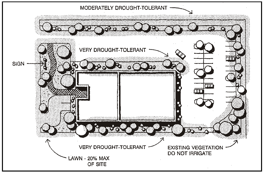
Figure 16-1 - Hydrozones
e.
Fire prevention needs shall be addressed in high and very high fire hazard areas.
f.
The maximum amount of turf (lawn) area shall not exceed twenty percent of the total site area for parcels less than one acre. Parcels of one acre or greater shall not have a turf (lawn) area larger than twenty percent of the site's total landscape area.
g.
Portions of landscape areas in public and private projects such as parks, playgrounds, sports fields, golf courses, or school yards where turf provides a playing surface or serves other recreational purposes are considered recreational areas and are not subject to the turf limitations of Subsection F. These areas may require additional water. A statement shall be included with the landscape plan designating recreational areas to be used for such purposes and specifying any needed amount of additional water to support those areas.
5.
Timing of installation. All required elements of the landscape plan shall be in place before establishment of a use or issuance of a Certificate of Occupancy or final building inspection has been granted by the Building Official, except as provided by Section 22.64.110 (Occupancy with Incomplete Site Improvements).
6.
Maintenance. All required plantings shall be maintained in good growing condition, and in any case where a required planting has not survived, shall be replaced with new plant materials that conform to any approved planting plan. Repair of irrigation equipment shall be done with the originally specified materials or their equivalents.
D.
Landscape plan content. Landscape plans shall be neatly and accurately drawn, at an appropriate scale that will enable ready identification and recognition of information submitted. Where a project covers only a portion of a site, the landscape plan need show only the areas where existing soil contours and vegetation will be disturbed by construction or use, or other areas where landscape is required. Landscape plans shall contain the following information except that specific requirements may be waived by the Director where determined to be unnecessary:
1.
Landscape site plan. A landscape site plan shall be submitted as part of the landscape plan and shall contain the following information:
a.
Existing and proposed buildings and structures including architectural elevations.
b.
Details and location of proposed pools, ponds, water features, fencing, retaining walls, entries, trash collection areas and free-standing signs.
c.
Details and location of proposed walkways, plazas and sitting areas, play areas, including related street furniture and permanent outdoor equipment.
d.
Details and location of proposed outdoor light fixtures, including their location, height and wattage.
2.
Landscape grading and drainage plan. A landscape grading and drainage plan shall be submitted as part of the landscape plan. The proposed grades shall provide for appropriate slopes for the activities indicated on the landscape site plan; result in suitable environments for successful plant growth while providing for water conservation; provide for site drainage that allows maximum percolation in the soil without creating undesirable ponding and not impacting downstream drainage courses or structures; and preserve and enhance areas where existing plants shall remain. Where another section of this Title requires the preparation of a grading and drainage plan, those plans shall be considered as meeting the requirements of this Subsection. The landscape grading and drainage plan shall contain the following information:
a.
Existing contour lines of the property at two foot intervals for the areas proposed for landscape.
b.
Proposed contour lines at two foot intervals for the areas proposed for landscape.
c.
Average slope in percentage for paved areas including driveways, walkways, and ramps.
d.
Average slope in percentage for areas proposed for planting.
e.
Proposed subsurface drainage improvements including inlet structures, piping and outlet structures and details for construction of those elements.
f.
Calculations for any proposed cut and fill.
3.
Planting plan. A planting plan shall be submitted as part of the landscape plan and shall contain the following information:
a.
The location of all trees existing in or within 50 feet of areas proposed for grading or other construction, that are eight inches or larger in diameter at four feet above natural grade. Trees proposed to be removed shall be identified. (See Chapter 22.54 for tree removal standards).
b.
Any shrubs or plants identified by the standards of a SRA combining designation (Part II of the Land Use Element) as endangered or to otherwise be protected.
c.
Natural features including but not limited to rock outcroppings, ponds, and existing vegetation that will be retained.
d.
Designation of specific hydrozones.
e.
The location and proposed area of turf in compliance with the limitations of Section 22.16.040C.4.f.
f.
Proposed plant materials including the location, species (plants shall be labeled using both the botanical and common name), container size, spacing and number of trees, shrubs and groundcover, and a calculation of the total area proposed for planting.
g.
Tree staking, plant installation, soil preparation details, and any other applicable planting and installation details. A mulch of at least three inches shall be applied to all planting areas except areas in turf or groundcover.
h.
Designation of the area to be used for recreational purposes as defined in Section 22.16.030C.4.g.
4.
Irrigation plan. An irrigation plan, meeting the following standards and containing the following information, shall be submitted as part of the landscape plan.
a.
Irrigation standards.
1.
Methods of irrigation. All irrigation shall be drip, trickle, low flow sprinkler heads or any other recognized method of low volume, high efficiency irrigation.
2.
Runoff and overspray. Soil types and infiltration rate shall be considered when designing irrigation systems. All irrigation systems shall be designed to avoid runoff, low-head drainage, overspray, or other similar conditions where water flows onto adjacent property, non-irrigation areas, walks, roadways, or structures. Proper irrigation equipment and schedules, including features such as repeat cycles, shall be used to closely match application rates to infiltration rates therefore minimizing runoff. Runoff shall be avoided on slopes and in median strips, and from overspray in planting areas with a width less than ten feet.
3.
Irrigation timetable. The scheduling of irrigation shall occur between 3:00 a.m. and two hours after sunrise. Large landscape areas, such as golf courses or play fields, shall schedule irrigation to occur between one hour before sunset and two hours after sunrise. These timetables are established to avoid irrigating during times of high temperature or wind.
b.
Irrigation plan details.
1.
Equipment. A plan and schedule of equipment including gate valves, backflow preventers, control valves, piping, sprinkler heads, water meter size and location. Rain sensing override devices shall be required on all irrigation systems.
2.
Controllers. Automatic control systems shall be required for all irrigations systems and must be able to accommodate all aspects of the design.
3.
Valves. Plants which require different amounts of water should be irrigated by separate control valves. If one valve is used for a given area, only plants with similar water use should be used in that area. Alternative methods that meet the intent of this standard may be considered for use.
Anti-drain (check) valves shall be installed in strategic points or heads that have built-in check valves shall be used to minimize or prevent low-head drainage.
4.
Sprinkler heads. Heads and emitters shall have consistent application rates within each control valve circuit. Sprinkler heads shall be selected for proper area coverage, application rate, operating pressure, and adjustment capability.
5.
Water source. Specify the type, size of service connection, flow in gallons per minute (GPM), static water pressure in pounds per square inch (psi), and maximum pressure in psi required to operate the irrigation circuit with the greatest pressure loss in the system. Also specify the flow rate (gallons per minute), application rate (inches per hour), and design operating pressure (psi) for each station.
c.
Irrigation program. An annual irrigation program with monthly irrigation schedules for the plant establishment period, for the established landscape and for any temporarily irrigated areas shall be provided for all projects meeting the applicability standards of Section 22.16.020 within the Commercial Retail, Commercial Service, Office and Professional, Industrial, and Residential Multi-Family land use categories. The irrigation schedule shall:
1.
Include run time (in minutes per cycle), suggested number of cycles per day, and frequency of irrigation for each station; and
2.
Provide the amount of applied water (in hundred cubic feet, gallons, or whatever billing units the local water supplier uses) recommended on a month and annual basis.
3.
Indicate if any additional water is needed for recreation areas as defined by Section 22.16.030C.4.g.
4.
Incorporate, wherever possible, the use of evapotranspiration data such as those from the California Irrigation Management System (CIMIS) weather stations to apply the appropriate levels of water for different climates.
d.
Recycled water irrigation systems.
(1)
Applicability. In the event standards for the installation of greywater systems are adopted through state law, local ordinance or local guidelines approved by the Board, the installation of recycled water irrigation systems (dual distribution/greywater systems) shall be required to allow for the use of recycled water. The recycled water irrigation systems shall be designed and operated in accordance with all local and state codes.
(2)
Exemption. A modification to this standard may be granted by the Director where physical constraints or functional difficulties would make the use of recycled water irrigation systems impractical.
E.
Landscape plan review and approval.
1.
Timing of review. Landscape plans shall be reviewed at the same time as the land use permit application which they accompany.
2.
Criteria for approval. Landscape plans shall be approved when the Review Authority finds that:
a.
The proposed plant materials will survive in the climate and soils of the site; and
b.
The proposed plant materials and their planned locations will satisfy the landscape standards of this Chapter (e.g. screening, shade, maintenance of permeable soil, water efficiency).
c.
The proposed means of irrigation will adequately support the plant materials proposed and will be well designed and maintained in order to achieve the greatest irrigation efficiency.
[Amended 1993, Ord. 2648] [22.04.186]
22.18.010 - Purpose of Chapter.
The parking and loading standards provided by this Chapter are intended to: minimize street congestion and traffic hazards; provide safe and convenient access to businesses, public services, and places of public assembly; and to make the appearance of parking areas more compatible with surrounding land uses. [22.04.160]
22.18.020 - Off-Street Parking Required.
All uses requiring a land use permit shall be provided off-street parking in compliance with this Chapter, except parking lots that qualify for the following modifications:
A.
Compact car spaces. Lots with 20 more spaces may substitute compact car spaces for up to 20 percent of the total number of required spaces. Compact car spaces shall be a minimum of 8 by 14 feet in size.
B.
Motorcycle parking. Lots with 20 or more spaces may replace regular spaces with motorcycle spaces. One regular space may be replaced with a motorcycle space for each 20 required spaces. Motorcycle spaces shall be a minimum size of four by eight feet.
C.
Parking assessment district. Parking requirements may be waived or modified within a parking district, through planning area standards.
D.
Shared on-site parking adjustment. Where two or more nonresidential uses are on a single site, the number of parking spaces may be reduced through adjustment (Section 22.70.030) at a rate of five percent for each separate nonresidential use, up to a maximum of 20 percent; as long as the total of spaces is not less than required for the use requiring the largest number of spaces.
E.
Shared peak-hour parking. Where two or more uses have distinct and differing peak traffic usage periods ( e.g. a theater and a bank), the required number of parking spaces may be reduced through Minor Use Permit approval, in addition to the parking reduction allowed by Subsection D. The most remote spaces in the parking lots shall be located no more than 300 feet from the pedestrian entrance to each use that the parking spaces serve (as measured along the most direct pedestrian path). The total number of spaces required for all uses sharing the parking may be reduced to no less than the number of spaces required by Section 22.18.050 for the single use among those proposed which is required to provide the most parking.
F.
On-street parking adjustment. Where a proposed driveway from a street to a new parking area would eliminate on-street parking spaces equal to or greater than the off-street spaces required, the requirement for off-street spaces may be eliminated through adjustment (Section 22.70.030) where the access or proposed building cannot reasonably be redesigned to avoid a net loss of parking.
G.
Nonconforming parking. Where an existing development is nonconforming as to the off-street parking requirements of this Chapter, a new allowable use may be established, or an existing allowable use may be expanded, only as allowed by Section 22.72.100 (Nonconforming Parking).
H.
Modification of parking standards. The parking standards of this Chapter may be modified as follows:
1.
Permit Requirements. Proposals to reduce the required number of parking spaces, or to modify any of the other parking standards of this Chapter may be authorized through Minor Use Permit approval.
2.
Criteria for approval. Proposed modifications of parking standards shall be approved only where the Review Authority first determines, based upon specific findings of fact, that:
a.
The characteristics of a use, the site, or its immediate vicinity do not necessitate the number of parking spaces, types of design, or improvements required by this Chapter; and
b.
Reduced parking or an alternative to the parking design standards of this Chapter will be adequate to accommodate on the site all parking needs generated by the use, or that additional parking is necessary because of specific features of the use, site, or site vicinity; and
c.
No traffic safety problems will result from the proposed modification of parking standards.
[Amended 1981, Ord 2063; 1984, Ord. 2163; 1992, Ord. 2553] [22.04.162]
22.18.030 - Location of Parking on a Site.
Required parking spaces may be located as needed on a proposed site, subject to the design and construction standards of Sections 22.18.040 and 22.18.060, and the following:
A.
Use of front setback. Required parking spaces shall not be located within the required front setback (Section 22.10.140) except in a Residential Multi-Family category qualifying for medium- or high-intensity development (Section 22.10.130).
B.
Use of side and rear setbacks. Side and rear setbacks may be used for vehicle parking except on the street side of a corner lot.
22.18.040 - Parking Design Standards.
All off-street parking areas shall be designed and improved as follows.
A.
Parking space and aisle dimensions. All off-street automobile parking spaces shall be a minimum of nine by 18 feet in size, except for compact car spaces (Section 22.18.020.A), handicapped spaces (Section 22.18.050.B.1 and motorcycle spaces (Section 22.18.020.B). Parking lot aisles shall be of the following dimensions:
1.
Angle parking. The aisle dimensions for angle parking shall be based upon the angle and width of the parking space, as set forth in the following table. The use of a wider parking space enables reducing the aisle width, as shown.
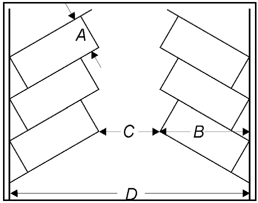
;sz=8q;Notes:
(1)
Aisle widths for 45 o and 60 o spaces are one way only. Two-way aisles for diagonal spaces shall be a minimum of 24 feet wide.
(2)
Tier means tow [two] rows of parking spaces plus an aisle.
(3)
Compact car spaces only, see Section 22.18.020.A.
2.
Parallel parking. Space dimensions shall be nine by 22 feet. Aisle dimensions for parallel parking shall be 12 feet for one-way aisles, and 24 feet for two-way aisles.
B.
Parking lot design standards.
1.
Controlled access required. The design of parking areas for more than two vehicles shall not require or encourage backing out into a public street, pedestrian walk or public alley (unless an alley is also used as an access aisle for angle parking across from the site). Parking lot design and improvements shall prevent vehicle entrance or exit at any point other than marked driveways.
2.
Minimum access and location. Access from a parking area to a public street shall be provided as required by Section 22.54.020 (Site Access and Driveway Requirements).
3.
Guest parking location. Guest parking spaces required for residential projects by Section 22.18.050.C.5 shall be distributed within the project and located so as to be conveniently accessible to guests at all times.
4.
Drop-off points required. When located outside central business districts, parking areas for the public assembly facilities listed in this Section shall include a designated on-site location for dropping off passengers at an entrance to the facility in advance of parking the vehicle. Drop-off areas shall consist of vehicle turnout lanes located outside of normal travel lanes. Drop-off points shall be provided for: hotels and motels, schools with 50 or more students; churches with a capacity of 100 or more; restaurants with a capacity of 50 or more customers; public transportation terminals; places of public assembly; public buildings; and offices larger than 5,000 square feet.
5.
Tandem parking. Each space in a parking lot, area or garage shall be individually accessible, except that automobiles may be parked in tandem in the following situations:
a.
In a parking area serving a single family dwelling, individual mobile home or multi-family dwelling, where the tandem parking is not more than two cars in depth; provided that both spaces are for the same dwelling, and are not located in a required front setback.
b.
In a public garage or public parking area where all parking is performed by attendants at all times, or for public assembly facilities and temporary events where user arrivals and departures are simultaneous and parking is attendant-directed.
c.
For all-day employee parking lots restricted to employee use, provided that required aisle widths are maintained, and no more than 50 percent of the employee spaces are designed for tandem use.
[Amended 1982, Ord. 2091;1991, Ord. 2523] [22.04.164]
22.18.050 - Required Number of Parking Spaces.
All
land uses requiring a permit under this Title shall be provided off-street parking spaces as follows:
A.
Use of tables. The tables in Subsection C. determine the number of parking spaces required for each use of land, as follows:
1.
Uses not listed. For uses not specifically listed in this Subsection that do not have parking requirements set by Article 4 (Standards for Specific Land Uses), the same parking and loading space is required as for the most similar use of equivalent intensity; except where a use not listed requires Conditional Use Permit approval, in which case the amount of parking and loading space required shall be as determined by the Commission.
2.
Uses not specified. Where a commercial, office or industrial building is proposed for construction when the eventual occupants(s) and use(s) of the building are not yet known, the amount of parking and loading space provided shall be as set forth for the allowable use with the largest number of spaces required by Subsection C. (provided the Director determines that the proposed building as designed can reasonably accommodate such use), except:
a.
Where the applicant chooses to limit the uses of the building to a specific list defined by a recorded agreement with the County in a form approved by County Counsel; or
b.
Where the Commission specifies the uses that may be established within the building and the number of parking spaces required through Conditional Use Permit conditions of approval.
[Added 1984, Ord. 2163]
3.
Parking and loading intensity. Parking lot and loading bay intensity describes the rate of vehicle turnover in parking and loading areas. Turnover factors are assigned to each use by the charts in Subsection C. High intensity areas have rapid turnover; medium intensity areas are those where vehicles are parked from two to four hours; low intensity areas have minimum turnover and few repeat users, such as long-term and employee parking lots. Parking lot turnover is used in Section 22.54.020 (Site Access and Driveway Requirements) as a basis for determining site location, and in Section 22.18.060 (Parking Lot Construction Standards). Loading bay intensity is used in Section 22.18.080 (Off-Street Loading Requirements).
4.
Mixed use sites. Where a site contains more than one principal land use (such as a shopping center), the amount of parking required shall be the total of that required for each individual use, except as otherwise provided by Section 22.18.020 (Off-Street Parking Required).
5.
Mixed function buildings and storage areas. Where a building (or separate tenancy rental space within a building) occupied by a single use contains several functions (such as sales, office and storage areas), parking shall be as required for the principal use, for the gross floor area (total area of all internal functions), except where the parking standards in Subsection C. set specific requirements for functional areas within a principal use (e.g., active use area and storage area). Where Subsection C. does not identify specific requirements for storage areas within a principal use and the principal use contains storage areas larger than 2,000 square feet, the parking requirement shall be determined separately for those areas, as specified for warehousing in Subsection C.11.
6.
Terms used in charts.
a.
Active use area. All developed areas of a site and buildings except storage, parking and landscaping.
b.
Floor area. Means gross floor area, all areas within buildings.
c.
Office space. Any private interior office or each 150 square feet of open work area.
d.
Site area. Gross site area.
e.
Use area. All developed areas of a site and buildings, except parking and landscaping.
7.
Number of spaces. Where Section Subsection C. sets parking requirements based on building area (square footage), site or use of area, the number of spaces shall be set forth for each square footage increment specified or fraction thereof, except in the case of a storage area. The number of spaces required on the basis of storage area shall be for each full floor area increment specified and no additional spaces shall be required where the storage area is a fraction of the increment.
B.
Special parking space requirements. In addition to the parking spaces required by Subsection C., new uses within an urban or village reserve line shall also provide, when applicable, the type and number of spaces required as follows:
1.
Handicapped parking. Non-residential parking lots with five or more spaces shall include handicapped parking as required by Title 24 of the California Administrative Code, and as set forth in this Subsection. Handicapped spaces may be included as part of the total number of parking spaces required by this Title.
a.
Number of spaces required:
b.
Design of spaces. Handicapped parking spaces shall be designed, located and provided with identification signing as set forth in Section 2-7102, Title 24, California Administrative Code.
2.
Company vehicles. Commercial or industrial uses shall provide one parking space for each company vehicle which is parked on the site during normal business hours. Such space may be located within a building.
3.
Bicycle racks. Parking lots with 20 or more spaces shall provide one bicycle rack space for each 10 parking spaces. Bicycle racks shall be designed to enable a bicycle to be locked to the rack.
C.
Parking requirements by land use.
1.
Agricultural uses. Except for the specific uses listed in this Subsection, improved off-street parking and loading spaces are not required for an agricultural use, as long as sufficient usable area is provided to meet the parking needs of all employees, visitors and loading activities entirely on the site of the use.
2.
Communication uses. Broadcasting studios shall provide parking as required for offices (see Subsection C.8). Transmission facilities are not required to have identified spaces, as long as sufficient usable area is provided to meet the parking needs of all employees entirely on the site of the use.
3.
Cultural, educational and recreation uses.
4.
Manufacturing and processing uses. Parking lot turnover is low; loading bay intensity is medium. Parking spaces are required as follows:
a.
One space per 500 square feet of active use area within a building; and
b.
One space per 1,000 square feet of storage area within a building; and
c.
One space per 2,000 square feet of outdoor active use area; and
d.
One space per 5,000 square feet of outdoor storage area.
5.
Residential Uses:
6.
Resource Extraction. No improved parking is required, provided sufficient usable area is available to accommodate all employee and visitor vehicles entirely on the site.
7.
Retail Trade Uses. Parking required for a retail use shall be a minimum of two spaces for each use or separate tenancy, except where more spaces are required as follows:
** Kitchen includes all active food preparation areas, but not walk-in storage areas.
8.
Service Uses. Parking required for a service use shall be a minimum of two spaces for each use or separate tenancy, except where more spaces are required as follows:
9.
Transient Lodgings.
10.
Transportation Uses.
11.
Wholesale Trade.
[Amended 1981, Ord. 2063; 1982, Ord. 2091; 1984, Ord. 2163; 1992, Ord. 2553; 1999, Ord. 2880; 2010, Ord. 3199; 2023, Ord. No. 3500] [22.04.166]
22.18.060 - Parking Lot Construction Standards.
All parking areas that require three or more off-street parking spaces shall be improved as follows.
A.
Surfacing. All parking areas (including on-site driveways) shall be surfaced with a minimum of asphalt, concrete, chip seal, or crushed rock surface, as specified in the following chart. Where concrete or asphalt are required, brick or other masonry paving units may be substituted, including vertically oriented concrete block with the block cells planted with grass.
Notes:
(1)
As provided by the San Luis Obispo County Standard Specifications and Improvement Drawings.
B.
Lining and marking. Parking spaces in paved parking areas shall be marked with paint striping, a minimum of two inches in width. Parking spaces in other types of lots may be identified by wheel stop barriers.
C.
Wheel stops. Wheel stops or continuous concrete or asphalt curbing are required in all parking lots to define the perimeter of the parking area and to protect landscaping from vehicle encroachment. In addition, wheel stops can be used for each parking space. Wheel stops shall be constructed as follows:
1.
Materials and installation. Wheel stops shall be constructed of concrete, continuous concrete curbing, asphalt, timber, or other durable material not less than six inches in height. Wheel stops shall be securely installed and maintained as a safeguard against damage to adjoining vehicles, machinery or abutting property.
2.
Setback. Wheel stops or other vehicle barriers less than two feet in height shall be located no closer than three feet to any property line.
D.
Vertical clearance. Covered parking spaces shall have a vertical clearance of at least seven feet six inches (7'-6") above the parking lot surface for all uses except residential.
E.
Slope. The finished grade of a parking lot shall not exceed five percent slope.
F.
Landscaping. All parking lots of three or more spaces shall provide sufficient trees so that within ten years, 60 percent of the surface area of the lot is shaded by deciduous or evergreen trees in addition to any perimeter landscaping required by Subsection G. (Screening); provided that this requirement does not apply to parking lots that are underground or within buildings. Evidence of compliance with this Subsection shall be provided through the review and approval of a landscaping plan in compliance with Chapter 22.16 (Landscaping).
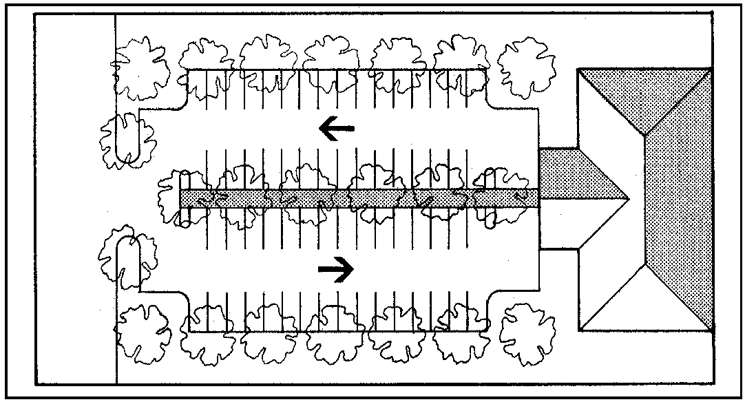
Figure 18-2 - Parking Lot Landscaping Example
G.
Screening.
1.
From residential areas. Parking lots that abut a residential use or residential category shall be separated from the property line by a landscaping strip. The landscaping strip shall have a minimum width of five feet. A six-foot high solid fence or wall shall be installed on the residential side of the landscaping strip, except that the fence shall be three feet high where located adjacent to a required front setback on an adjoining lot.
2.
From streets. Parking lots abutting a public street shall be separated from the street right-of-way by: A landscaping strip with a minimum width of four feet; and where parking spaces are arranged to head toward the street, by a three foot high solid fence located on the parking lot side of the landscaping strip, or by a landscaped berm, three feet high.
[Amended 1984, Ord. 2163; 1992, Ord. 2553] [22.04.168]
22.18.070 - Off-Site Parking.
Where it is not feasible to provide sufficient on-site parking, an adjustment (Section 22.01.044) may be granted to allow the required parking to be located off-site provided that:
A.
The most distant parking space is not more than 400 feet from the use; and
B.
The parking lot site is in the same ownership as the principal use, or is under a recorded lease with the use in a form approved by County Counsel. In the event that off-site parking is leased, the approved use shall be terminated within 60 days of termination of the lease providing parking, unless the parking is replaced with other spaces that satisfy the requirements of this Title; and
C.
The parking lot site is not located in a residential land use category unless the principal use requiring the parking is allowable in a residential land use category. Where any such principal use is subject to Conditional Use Permit approval, the off-site parking shall also be subject to Conditional Use Permit approval.
[Amended 1981, Ord. 2063; 1982, Ord. 2091] [22.04.170]
22.18.080 - Off-Street Loading Requirements.
Off-street loading bays are required as provided by this Section, based upon the loading bay intensity determined by Subsection C. (Parking Spaces Required).
A.
Number of bays required.
B.
Adjustment to number of bays. The number of loading bays required may be adjusted (Section 22.70.030) to 50 percent of the required number when such bays are designed to serve two or more uses jointly, provided that each use has access to the loading zone without crossing public streets, alleys or sidewalks.
C.
Use of loading bays. Loading bays shall not be used for repair work, vehicle storage, or to satisfy space requirements for off-street parking.
D.
Loading bay design standards.
1.
Access. Each loading bay shall be accessible from a street or alley, or from an on-site aisle or drive connecting with a street or alley. Such access may be combined with access to a parking lot if located so loading activities will not obstruct normal on-site parking and traffic flow. Loading bays shall be designed to preclude the necessity for maneuvering on a street or sidewalk.
2.
Setbacks. Loading bays shall be set back a minimum of 25 feet from any residential use or category.
[22.04.172]
22.18.090 - Drive-In and Drive-Through Facilities.
This Section establishes supplementary standards for retail trade or service uses that conduct business while customers remain in their vehicles. These uses may include drive-through facilities that are accessory to a principal building where business is conducted indoors, or that conduct all business by means of drive-through facilities. These uses may include but are not limited to drive-in restaurants, fast food establishments with drive-through take-out windows, photofinishing services, and bank services, where allowed by the Land Use Element. These standards are not applicable to service stations (Section 22.30.130).
A.
Site location criteria. A site that contains drive-in or drive-through facilities shall be located on a collector or arterial, provided that access to drive-through facilities may be to a local street when properties across the local street from the exit driveway are not in a Residential category.
B.
On-site traffic control. Sites with drive-through facilities shall be provided internal circulation and traffic control devices as follows:
1.
Lane separation. An on-site circulation pattern shall be provided for drive-through traffic that separates such traffic from that of stopover customers. Separation may be by paint-striped lanes from the point of site access to the stacking area described in Subsection B.2. The lanes shall be a minimum width of 10 feet.
2.
Stacking area. An area shall be provided for cars waiting for drive-through service that is physically separated from other traffic circulation on the site. That stacking area shall accommodate a minimum of four cars per drive-through window in addition to the car(s) receiving service. Separation of the stacking area from other traffic shall be by concrete or asphalt curbing on at least one side of the lane.
3.
Directional signing. Signs shall be provided that indicate the entrance, exit and one-way path of drive-through lanes.
[Amended 1992, Ord. 2553] [22.04.178]
22.20.010 - Sign Ordinance.
The standards this Chapter shall be known and may be cited as the "San Luis Obispo County Sign Ordinance." These requirements apply to all signs constructed or altered after the effective date of this Title, except as otherwise provided by Section 22.20.040. These requirements apply to proposed signs in addition to all applicable provisions of the California Outdoor Advertising Act (Business and Professions Code Sections 5200 et seq., and California Administrative Code Title 4, Sections 2240 et seq.).
[Amended 1986, Ord. 2250; 2020, Ord. 3420] [22.04.300]
22.20.020 - Purpose of Chapter.
This Chapter establishes sign regulations that are intended to:
A.
Support the use of signs to aid orientation, identify businesses and activities, express local history and character, or serve other information purposes; and
B.
Protect the ability of the public to identify uses and premises without confusion by encouraging signs to be designed with a scale, graphic character and type of lighting compatible with the appearance of the buildings or uses identified by signs, as well as other buildings and uses in the vicinity; and
C.
Support the use of signs that are maintained in a safe and attractive condition that do not:
1.
Create distractions that may jeopardize pedestrian or vehicular traffic safety; or
2.
Produce glare that adversely affects residential uses.
D.
Allow adequate avenues for both commercial and non-commercial messages, and protect the constitutionally guaranteed right of free speech; and
E.
Protect the character of the various communities within the County and safeguard the public health and safety.
[Amended 2020, Ord. 3420]
22.20.030 - General Principles.
A.
Applicability.
1.
Applicable codes. In addition to complying with the provisions of this Chapter, all signs must be constructed in accordance with the Uniform Building Code, the Uniform Sign Code, the Electrical Code, the California Manual on Uniform Traffic Control Devices, and all other applicable laws, rules, regulations, and policies.
2.
Applicable County regulations. In addition to complying with the provisions of this Chapter, all signs must comply with other regulations of this Title, including Planning Area Standards (Article 9), Community Planning Standards (Article 10), and the Highway Corridor Design Standards (Section 22.10.095).
B.
Regulatory interpretations. The County shall apply this Chapter in a content-neutral manner. This Chapter shall be interpreted in a manner consistent with the free speech protections guaranteed by the First Amendment to the United States Constitution and Article 1, Section 2 of the California Constitution. The noncommunication aspects of all signs shall comply with the regulations and standards set forth in this Title. "Noncommunicative aspects" includes regulations that do not relate to the content of the sign, including the time, place, manner, location, size, height, illumination, spacing, and orientation of signs.
C.
Message substitution. A non-commercial message of any type may be substituted, in whole or in part, for any duly permitted commercial message; and any non-commercial message may be substituted for any non-commercial message.
1.
No additional approval required. Such substitution of message may be made without any additional approval, permitting, registration, or notice to the County. This provision prevents any inadvertent favoring of commercial speech over non-commercial speech or favoring any non-commercial message over any other non-commercial message.
2.
Limitations. This provision does not allow the following:
a.
Create the right to increase the total amount of signage for a parcel, lot, or land use;
b.
Affect the requirement that a sign structure or mounting device be properly permitted; or
c.
Allow a change in the physical structure of a sign or its mounting device.
D.
Nothing in this Section shall be construed to prohibit a person from holding a sign while picketing or protesting on public property that has been determined to be a traditional or designated public forum, so long as the person holding the sign does not block ingress and egress from buildings, create a safety hazard by impeding travel, or violate any other reasonable time, place, and manner restrictions adopted by the County.
E.
Severability. If any section, sentence, clause, phrase, word, portion, or provision of this Chapter is held invalid, unconstitutional, or unenforceable by any court of competent jurisdiction, such holding shall not affect, impair, or invalidate any other section, sentence, clause, phrase, word, portion, or provision of this Title which can be given effect without the invalid portion. In adopting this Title, the Board of Supervisors affirmatively declares that it would have approved and adopted the Title even without any portion which may be held invalid, unconstitutional, or unenforceable.
[2020, Ord. 3420]
Editor's note— Ord. No. 3420, § 1, adopted August 18, 2020, repealed § 22.20.030 and enacted a new § 22.20.030 as set out herein. Former § 22.20.030 pertained to the sign code adoption and derived from Ord. 2250 adopted 1986; and Ord. 2553, adopted 1992.
22.20.040 - Sign Permit Requirements.
No sign shall be constructed, displayed or altered without first obtaining a sign permit as required by this Section, except where a sign is exempted from permit requirements by Subsection B (Authorized Signs).
A.
Permit procedures.
1.
Zoning Clearance. The application, processing, review and approval of a land use permit for a sign shall be as set forth in Section 22.62.030 (Zoning Clearance), except where otherwise provided by Section 22.20.060 (Signs Allowed - Type and Area), for signs of specific size or height or where signs are approved as part of an overall development project land use permit.
2.
Minor Use Permit. Greater numbers of signs or areas of signing larger than the allowances permitted by Section 22.20.060, including modifications to an existing sign, require a Minor Use Permit as set forth in Section 22.62.050 (Minor Use Permit).
3.
Concurrent Review. Where signs are proposed for a project subject to land use permit approval, a separate sign permit is not required. The land use permit application shall include complete information about the type, area, location and number of signs proposed, or such information is provided for Department review for conformity with the regulations of this Title before installation.
4.
Construction Permit. If required by the Uniform Sign Code, a construction permit shall also be obtained in compliance with Title 19 of this code before the installation of any sign.
B.
Authorized signs. The following signs are allowed without a land use permit, and shall not be included in determinations on the allowable number, type or area of signs in compliance with Section 22.20.060 (Signs Allowed - Type and Area), provided that they conform to the specified standards. Nothing in this Subsection shall exempt a sign from the necessity of construction permit approval if an electrical or building permit is required by the Building and Construction Ordinance or Uniform Sign Code. This Subsection supersedes Section 303 of the Uniform Sign Code.
1.
Temporary signs. Temporary signs are allowed on a property for a total of 120 calendar days per year. Each sign is allowed for up to 60 consecutive days, and shall be removed within 14 days after the conclusion of the purpose served by the sign. The height of any temporary sign shall not exceed 10 feet. Temporary signs shall adhere to the setback standards of the land use category of the property they are located in. The maximum aggregate sign area for temporary signage is as follows.
a.
Agriculture and Rural Lands Land Use Categories. In the Agriculture and Rural Lands Land Use Categories, temporary signage is allowed up to a maximum aggregate sign area of 32 square feet.
b.
Residential Land Use Categories. In the Residential Rural, Residential Suburban, Residential Single-Family, and Residential Multi-Family Land Use Categories, temporary signage is allowed up to a maximum aggregate sign area of four square feet.
c.
Commercial and Industrial Land Use Categories. In the Office and Professional, Commercial Retail, Commercial Service, and Industrial Land Use Categories, temporary signage is allowed up to a maximum aggregate sign area of 24 square feet.
d.
Special Purpose Land Use Categories. In the Open Space, Recreation, and Public Facilities Land Use Categories, temporary signage is allowed up to a maximum aggregate sign area of 16 square feet.
2.
Directory signs. Wall-mounted building directory signs located at or within the entrance of a building that rents or leases space to tenants, provided that such directories do not exceed 20 square feet on any single building wall, nor a height of eight feet.
3.
Hazard signs. Signs warning of construction, excavation, or similar hazards so long as the hazard exists.
4.
Historical markers. Signs including historical plaques, memorial signs or tablets, or commemorative signs not exceeding four square feet in area, located on historical sites, buildings or areas, placed by a historical society, chamber of commerce or public agency.
5.
Information kiosks. Free-standing structures, located outdoors and adjacent to a building open to the public, or in a space open to the public, on which pamphlets, leaflets, and guides may be affixed to a bulletin-board type surface. The total area of kiosk display surfaces shall not exceed 40 square feet or a height of eight feet. Kiosks shall be separated from adjacent structures by a minimum of six feet.
6.
Internal signs. Signs located in interior areas of a building or site, and intended to be not visible or legible from public streets or adjacent properties.
7.
Miscellaneous information signs. Miscellaneous permanent information signs in nonresidential categories, with an aggregate area not to exceed four square feet at each public entrance nor 12 square feet total, which may indicate address, hours and days of operation, whether a business is open or closed, credit card information and emergency address and telephone numbers.
8.
Official flags. Official federal, state or local government flags, emblems and historical markers.
9.
Official signs/government signs. Official federal, state or local government traffic, directional guide and other informational signs and notices issued by any court, person or officer in performance of a public duty; notices posted by a utility or other quasi-public agency; or other signs required or authorized by law.
10.
Prohibition signs. "No Trespassing," "No Parking," and similar warning signs.
11.
Residential identification signs.
a.
Signs located on individual residences and home occupations, limited to a total aggregate area of two square feet.
b.
One sign with a maximum area of 20 square feet for each lot or parcel containing multi-family dwellings or subdivisions, provided such signing is approved as part of a subdivision map or land use permit for the project.
12.
Safety and directional signing. Parking lot and other private traffic directional signs, including handicapped access and parking signs, each not exceeding five square feet in area. Such signs shall be limited to guidance of pedestrian or vehicular traffic within the premises on which they are located, and shall not display any logo or name of a product, establishment, service, or any other advertising.
13.
Vehicle signs. Displays on commercial vehicles and public transit/public carrier graphics on properly licensed buses, taxicabs, and similar vehicles for hire that legally pass through the County.
14.
Window signs. Temporary window signs constructed of paper, cloth or similar expendable material, provided the total area of such signs shall not exceed 25 percent of the window area.
15.
Exterior wall murals. A hand-painted work of visual art that is either affixed to or painted directly on the exterior wall of a structure with the permission of the property owner. An original art display does not include: mechanically produced or computer generated prints or images, including, but not limited to, digitally printed vinyl; electrical or mechanical components; or changing image art display.
C.
Prohibited signs and sign materials. In addition to any sign or sign materials not specifically in accordance with the provisions of this Title, the following are prohibited:
1.
Signs creating traffic or pedestrian safety hazards. Signs placed, located, or displayed in such a manner as to constitute a traffic or pedestrian safety hazard shall be prohibited, including:
a.
Any sign which simulates or imitates in size, color, lettering or design any traffic sign or signal, or makes use of words, symbols or characters so as to interfere with, mislead or confuse pedestrian or vehicular traffic.
b.
Signs attached or placed adjacent to any utility pole, parking meter, traffic sign post, traffic signal or any other official traffic control device, as prohibited by Section 21464 of the California Vehicle Code.
c.
Signs that obstruct use of any door, window, or fire escape.
d.
Signs that impede normal pedestrian use of public sidewalks.
e.
Signs that constitute a traffic hazard or obstruct the view of traffic, any authorized traffic sign, or signal device.
2.
Animated or moving signs. Signs consisting of any moving, rotating, flashing, or otherwise animated light or component.
3.
Signs for discontinued uses. Any sign or sign structure identifying a use or activity that has not occupied the site for a period greater than six months.
4.
Signs located in the public right-of-way or on public property. Other than official government signs or hazard or prohibition signs required by law, no sign can be placed in or project into the public right-of-way or on public property unless authorized by a County encroachment permit and/or agreement with a public agency such as the California Department of Transportation.
5.
Signs affixed to trees or terrain. Signs cut, burned, marked, or displayed in any manner on a tree, sidewalk, cliff, hillside, or other terrain feature shall be prohibited.
6.
Billboards. Any permanent sign structure that is located adjacent to an Interstate or State highway, typically constructed of steel, concrete or wood that is freestanding or attached to the side of another structure that contains an advertising space that is leased, rented, or donated to advertisers other than the operator of the billboard, shall be prohibited.
[Amended 1982, Ord. 2091; 1984, Ord. 2163; 1986, Ord. 2250; 1994, Ord. 2696; 1995, Ord. 2741; 2020, Ord. 3420] [22.04.306]
22.20.050 - Measurement of Sign Area.
For the purpose of evaluating whether a sign is in conformity with the provisions of this Title, the area of a sign shall be measured as the number of square feet of the smallest rectangle within which a single sign face can be enclosed, as follows:
A.
Sign faces counted. Where a sign has two faces containing sign copy, which are oriented back-to-back and separated by not more than 36 inches at any point, the area of the sign shall be measured using one sign face only.
B.
Wall-mounted letters. Where a sign is composed of letters individually mounted or painted on a building wall, without a border or decorative enclosure, the sign area is that of the smallest single rectangle within which all letters and words can be enclosed.
C.
Three-dimensional signs. Where a sign consists of one or more three-dimensional objects such as balls, cubes, clusters of objects or sculptural or statue-type trademarks, the sign area shall be measured as the area of the smallest rectangle within which the object(s) can be enclosed, when viewed from a point where the largest area of the object(s) can be seen.
[Amended 1981, Ord. 2063; 2020, Ord. 3420] [22.04.308]
22.20.060 - Signs Allowed - Type and Area.
The following permanent signs are allowed on a site subject to approval of a sign permit, in addition to any authorized signs allowed by Section 22.20.040.B.
A.
Sign area limitations by land use category. The number and area of signs allowed on a site shall be as follows, based upon the land use category of the site, except where Subsection C. would also allow specialized signing:
1.
Agricultural and Rural land use categories. Two signs with a total aggregate area not exceeding 32 square feet and a height not to exceed 10 feet for each lot or parcel. Each sign may not exceed 16 square feet.
2.
Commercial Retail, Commercial Service, and Industrial land use categories. The following signs are allowed in the Commercial Retail, Commercial Service and Industrial categories, with a maximum aggregate area of 100 square feet of signing per site, or one square foot per one linear foot of the lot's largest street frontage on a public street, whichever is greater:
a.
Wall signs for each business or tenant, with the number of such signs allowed being equivalent to the number of building faces having a public entrance to the business. The allowed area for the wall signs shall be 15 percent of the building face, up to a maximum of 80 square feet. Such wall signs may be located on building faces other than those with public entrances.
b.
One suspended sign with a maximum area of 10 square feet for each business or tenant.
c.
One free-standing or monument sign for each 300 linear feet of site frontage or portion thereof, with a maximum area of 60 square feet each.
d.
One projecting sign with a maximum area of 20 square feet for each business or tenant.
e.
Marquee signing for each business or tenant, with a maximum area of 40 square feet.
3.
Office and Professional, Recreation, and Public Facilities land use categories. The following signs are allowed in the Office and Professional, Recreation, and Public Facilities land use categories, with a maximum aggregate area of 100 square feet of signing per site, or one square foot per one linear foot of the lot's largest street frontage on a public street, whichever is greater:
a.
Wall signs for each business or tenant, with the number of such signs allowed being equivalent to the number of building faces having a public entrance to the business. The allowed area for the wall signs shall be 10 percent of the building face, up to a maximum of 50 square feet. Such wall signs may be located on building faces other than those with public entrances.
b.
One suspended sign with a maximum area of 10 square feet for each business or tenant.
c.
One monument sign for each business or tenant with a maximum area of 40 square feet and a maximum height of five feet.
4.
Commercial or public assembly uses in other land use categories. Where commercial or public assembly uses are located in the Agriculture, Rural Lands or Residential land use categories, signing is allowed as set forth in Subsection A.3 for the Office and Professional, Recreation, and Public Facilities land use category.
B.
Location of freestanding signs. Freestanding signs may be located within the setback areas required by Section 22.10.140, provided that the signs are:
1.
Monument signs with a maximum height of three feet or less; or
2.
Signs elevated above 12 feet; or
3.
Authorized through Minor Use Permit approval. Freestanding signs with a height between three and 12 feet shall be located outside of the setback areas required by Sections 22.10.140 et seq.
C.
Specialized sign requirements.
1.
Shopping, business or industrial center signing. When approved as part of a Minor Use Permit, a shopping, business or industrial center with five or more separate uses or tenancies on a single site sharing common driveways and parking areas, is allowed one common identification sign with a maximum area of 60 square feet, in addition to the total sign area allowed by Subsection A. Where visible from a public street, signing on shopping center sites shall be of a uniform design throughout the center as to the size, finished framing materials and location on buildings of such signs.
2.
Community identification signs. One community identification sign is allowed at or within an urban or village reserve line on each arterial street entering a community, with a maximum area of 100 square feet and a maximum height of 12 feet.
3.
Freeway identification signs. In addition to the signs allowed by Subsection A., sites located in Office and Professional, Commercial Retail, and Commercial Service land use categories adjacent to Highway 101 or a Highway 101 Frontage Road may be authorized through Conditional Use Permit approval to use an on-site freeway identification sign with a maximum area not to exceed 125 square feet. The maximum height for freeway identification signs shall be 50 feet above grade, provided that the Commission may require a reduced or increased height where deemed appropriate.
4.
Viticultural area signing. Each area of the county recognized as an American Viticultural Area by the U.S. Department of the Treasury, Bureau of Alcohol, Tobacco and Firearms (BATF), may be identified by roadside signs:
a.
Required sign location. On private property along a state highway, at or within the boundary of the viticultural area as determined by BATF.
b.
Maximum area and height. A maximum area of 80 square feet and a maximum height of 12 feet above the elevation of the adjoining roadway.
5.
Off-premise signs. In addition to any signs allowed by Subsection A, any existing use in the Agriculture and Rural Lands Land Use Category may also establish a maximum of two off-premise signs on private property. Each sign shall not exceed a maximum area of 32 square feet and a maximum height of 10 feet. No more than one off-premise sign shall be established per site.
[Amended 1992, Ord. 2553; 2020, Ord. 3420] [22.04.310]
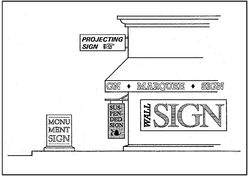
Figure 10-54: Sign Types
22.20.070 - Sign Construction Standards.
The design and construction of signs shall comply with Uniform Sign Code Sections 401 through 1402, and the following:
A.
Height. The height of any building-mounted sign shall be no higher than the height of the building, except where otherwise provided by Section 22.20.060 (Signs Allowed - Type and Area). All other signs may not exceed a maximum of 24 feet in height.
B.
Lighting and Illumination. Signs shall be indirectly lighted by continuous, stationary, shielded light sources, directed solely at the sign, or internal to it.
[2020, Ord. 3420]
22.20.080 - Sign Maintenance Required.
All signs shall be properly maintained in a safe and legible condition at all times. Whenever any sign, by virtue of its physical nature and condition, poses an immediate and serious threat to the public safety, the sign may be removed by County personnel, or repaired to the satisfaction of the County. Signing that is not in conformity with the provisions of this Chapter is subject to Section 22.72.070 (Nonconforming Signs).
[2020, Ord. 3420] [22.04.314]
Editor's note— Ord. No. 3420, § 1, adopted August 18, 2020, set out provisions intended for use as § 22.20.100. For purposes of classification and at the discretion of the editor, these provisions have been included as § 22.20.080.
22.22.010 - Purpose.
The standards of this Chapter determine the minimum size for lots created through new land divisions in each land use category. Procedures and additional standards for dividing land are in Title 21 of this code. By refining the parcel size ranges set in the Land Use Element for each land use category, these standards determine site specific minimum parcel sizes for new lots that are consistent with the General Plan, in compliance with Government Code Section 66473.5.
[Amended 1992, Ord. 2553] [22.04.020]
22.22.020 - Applicability.
The minimum parcel size criteria of this Chapter are used to evaluate proposed land divisions to determine what parcel size may be appropriate in the specific case. The discretionary authority to approve a proposed land division is assigned by the Real Property Division Ordinance (Title 21 of this code). A decision to approve or disapprove a land division will be substantially based on the provisions of this Chapter, however a parcel size larger than the minimum defined through the application of the tests provided in this Chapter may result from the consideration of information developed through analysis of the specific proposal, its site and vicinity, environmental review of the proposal as required by the California Environmental Quality Act (CEQA), public hearing testimony and any potential specific, adverse impacts.
A.
When used. The standards of this Chapter shall be used to determine the allowable area for new lots, and to determine the conformity or nonconformity of the size of existing lots with the provisions of this Title, except as follows:
1.
Where planning area standards (Article 9) set minimum parcel size requirements for specific areas of the county, the planning area standards control instead of the provisions of Sections 22.22.040 through 22.22.130.
2.
The standards of Sections 22.22.040 through 22.22.130 do not determine the minimum site area required for a new use on an existing lot, unless specifically referred to elsewhere in this Title. Standards for the site design of new uses not involving land divisions begin with Section 22.22.110 (Minimum Site Area).
B.
Area measured. For the purpose of determining whether existing or proposed parcels satisfy the standards of this Chapter for the minimum parcel size, net site area (as defined in Article 8 as "Site Area, Net") shall be used in all cases, except that:
1.
Lots one acre or larger after division may use gross site area (see the definition in Article 8) where existing or proposed abutting rights-of-way are owned in fee, and the difference between net and gross site area of the proposed parcel is less than 10 percent.
2.
A subdivision with lots that are proposed to provide any of the following features may include their area in the calculation of net site area for the adjacent lot:
a.
10 additional feet of dedication on each side of the street, improved with fixed-width parkways between curb and sidewalk, or meandering sidewalks that vary the parkway separation between the curb and the sidewalk, where in either case the parkway is landscaped with one or more street tree for each 50 feet of frontage, and turf or low maintenance plants; and
b.
Equestrian trails.
3.
Within a domestic reservoir watershed, no land within a horizontal distance of 200 feet from the reservoir impoundment, as determined by the spillway elevation, shall qualify for computing parcel size or for the siting of septic systems.
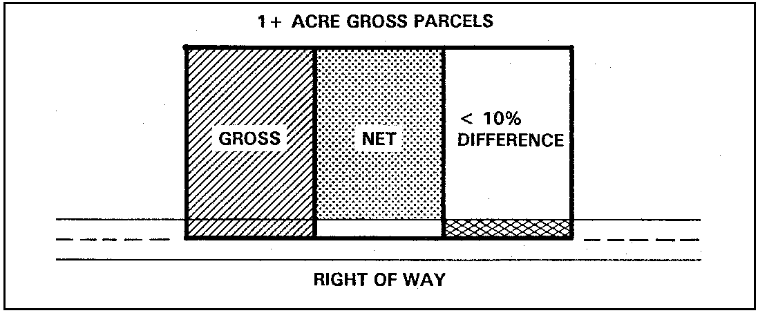
Figure 22-1: Gross and Net Parcel Area
C.
Parcel size within domestic reservoir watersheds. The minimum size for new parcels within a domestic reservoir watershed shall be 2.5 acres, except where:
1.
Sections 22.22.040 through 22.22.130 would require a larger parcel size; or
2.
A proposed parcel is located within a cluster division in compliance with Section 22.22.140 with a maximum density of 2.5 acres or more per dwelling unit; or
3.
A proposed parcel will be served by an approved community sewage collection, treatment and disposal system.
D.
Transfer of Development Credit Program. Where parcels proposed for division are located outside of urban or village reserve areas, the provisions of Section 22.24.070. B.2. apply, in addition to the requirements set forth in Chapter 22.22.
E.
Workforce housing subdivisions. The minimum parcel size for workforce housing subdivisions is determined by Section 22.30.477 (Residential - Workforce Housing Subdivisions).
[Amended 1981, Ord. 2063; 1984, Ord. 2163; 1985, Ord. 2217; 1992, Ord. 2553; 1999, Ord. 2880; 2011, Ord. 3212; 2012, Ord. 3233] [22.22.021]
22.22.030 - Information Used in Determinations.
Where minimum parcel size standards are based upon physical or geologic characteristics of land, the information used in the parcel size determination may be obtained from either:
A.
The information on such land features on file in the Department; and/or
B.
Alternate information prepared and certified by a registered civil engineer, registered geologist, licensed land surveyor, or other cartographic professional, or developed through preparation of a project EIR, in which case the EIR information shall be used instead of the other alternatives identified by this Section unless the information within the EIR is shown to be erroneous through further, more comprehensive study.
[Amended 1982, Ord. 2063] [22.04.022]
22.22.040 - Agriculture Category.
This Section contains three methods for determining minimum parcel size in the Agriculture land use category. Each proposed parcel must be able to qualify for the requested minimum parcel size using all tests within Subsections B. or C. The applicant will disclose as part of the application which Subsection (either B or C) is being used to determine the minimum parcel size for each of the proposed parcels. If the parcel is under agriculture preserve contract, Subsection D. applies.
A.
Purpose. The purpose of this Section is to establish a set of regulations applicable to the division of land within the Agriculture land use category. In addition to complying with the standards set forth in this Section and all applicable policies of the general plan, proposed land divisions shall be specifically evaluated for consistency with the policies of the Agriculture and Open Space Element as follows:
1.
Agricultural land divisions.
a.
Where a division of agricultural lands is proposed, a cluster division where homes are clustered in a compact manner which reduces the agricultural/residential interface, is an alternative to a conventional "lot split" land division.
b.
Where a division is proposed, the proposed parcels should be of adequate size and design to ensure the long term protection of agricultural resources.
2.
Minimum parcel size criteria for the division of Agricultural lands. Minimum parcel sizes for the proposed division of land designated Agriculture shall be based upon either the existing or potential use of the land for cropland and grazing.
3.
Discretionary approval. The approval of a land division is discretionary and a parcel size larger than the minimum designated in the following Subsections may be required to ensure agricultural capability in accordance with the provisions of the adopted Agriculture and Open Space Element of the general plan.
B.
Size based upon existing use. Where a legal lot of record is developed with agricultural uses at the time of application for land division, the minimum size for a new parcel shall be the largest area determined by the following tests:
1.
Use test. The minimum size for new parcels with existing agricultural uses shall be based on the type of existing agricultural use, as follows. Where a site contains more than one agricultural use, each new parcel shall satisfy the minimum parcel size for the qualifying agricultural land use.
a.
Crop production:
Notes:
1.
A larger minimum parcel size (80 acres) may be required where that parcel size will ensure agricultural capability in accordance with the provisions of the Agriculture Preserve Rules of Procedure and the adopted Agriculture and Open Space Element of the general plan
b.
Proposed parcel size. Proposed parcels less than 40 acres, but no smaller than 20 acres, may be proposed if all of the following criteria are met for each proposed parcel:
(1)
The proposed parcels must be Class I or II soils irrigated, or other soils listed as prime by NRCS;
(2)
There must be at least 18 acres or 90 percent of the acreage of the total site, whichever is larger, planted in irrigated row crops, specialty crops, field crops, orchards or vineyards (as defined in the preceding Table);
(3)
There must be a production water source currently installed;
(4)
That prior to or concurrent with recordation of a final or parcel map, the applicant shall execute and record a declaration of restrictions in a form approved by County Counsel, wherein the owner(s) agrees on their behalf and all successors in interest to the parcel that, unless a Land Use Element amendment is first approved to change the classification of the site to a land use category other than Agriculture, approval or establishment of more than one residential use (other than agricultural worker housing) on the parcel will not be requested and cannot be approved. The declaration of restrictions shall not be amended or terminated without the prior approval of the Board; and
(5)
The resulting parcels must enter into a Williamson Act agricultural preserve contract in accordance with the county Rules of Procedure. Separate sale of parcels of record must be in compliance with Table 1 of the Agriculture Preserve Rules of Procedure.
c.
Agricultural processing. The minimum size for a new parcel with established agricultural processing facilities and structures shall be 20 acres on sites with soils having a Natural Resource Conservation Service (NRCS) classification of I, II or III, and 5 acres on soils with an NRCS classification of IV through VII, provided that any parcel approved with less than 20 acres shall be subject to the requirements of this Subsection. The creation of parcels smaller than 20 acres shall not be allowed on properties subject to agricultural preserve contract.
1.
Application content. The land division application shall be accompanied by a statement from the applicant explaining why it is necessary to segregate the existing agricultural processing facility from the surrounding ownership, and how such segregation will support the intensification of agricultural use on the remainder of the property.
2.
Residential use prohibited. No residential use shall be established on a parcel approved for an agricultural processing facility with less than 20 acres.
3.
Declaration of restrictions required. Prior to or concurrent with recordation of a final or parcel map, the applicant shall execute and record a declaration of restrictions in a form approved by County Counsel, wherein an agreement is made on behalf of the current owner(s) and all successors in interest to the parcel that, unless a Land Use Element amendment is first approved to change the classification of the site to a land use category other than Agriculture, no request for approval a residential use on the parcel will be filed, and no residential use will be established on the parcel. The declaration of restrictions shall not be amended or terminated without the prior approval of the Board.
4.
Required findings. No parcel smaller than 20 acres shall be approved in compliance with this Section unless the Board first finds that the proposed parcel being smaller than surrounding agricultural holdings will have no adverse effect on the continuing agricultural use of parcels adjacent to and in the vicinity of the site, and that the applicant has demonstrated the capability of the agricultural processing use.
5.
Change of use. After approval of a parcel smaller than 20 acres in compliance with this Section, Conditional Use Permit shall be required to authorize any change of the use that justified the small parcel to another use.
C.
Size based upon land capability. Where a legal lot of record in the Agriculture category is not developed with an agricultural use at the time of application for land division, or where an applicant chooses this Subsection as the basis for determining allowable minimum parcel size, the minimum area for each new parcel is the largest determined by the following test:
1.
Land capability test. The minimum parcel size for new parcels shall be based on the Natural Resources Conservation Service (NRCS) classification, as set forth in the following table. Where a site contains more than one soil classification, each new parcel shall satisfy the minimum parcel size for the qualifying NRCS classification.
D.
Size based on agricultural preserves. Where a legal lot of record in the Agriculture category is under Williamson Act agricultural preserve contract, the minimum parcel size is based on Subsections B and C, unless a larger minimum parcel size is specified in the terms of an existing Williamson Act agricultural preserve contract.
E.
Declaration of restrictions required. For any land divisions in the Agriculture land use category, prior to or concurrent with recordation of a final or parcel map, the applicant shall execute and record a declaration of restrictions in a form approved by County Counsel, wherein he agrees on behalf of himself and all successors in interest to the parcel that the property is within the Agriculture land use category and the county has adopted a "Right to Farm Ordinance" that protects agricultural operations. The declaration of restrictions shall not be amended or terminated without the prior approval of the Board.
[Amended 1986, Ord. 2250, 2290; 1992, Ord. 2553; 2004, Ord. 3036; 2020, Ord. 3417] [22.04.024]
22.22.050 - Rural Lands Category.
The minimum parcel size for new lots in the Rural Lands category is based upon site features including: remoteness, fire hazard and response time, access and slope. Minimum parcel size is determined by applying the following tests to the site features as described in Subsections A. through D. The allowable minimum size is the largest area obtained from any of the tests, except as provided for cluster divisions by Section 22.22.140.
A.
Remoteness test. The minimum parcel size shall be based upon the distance of the parcel proposed for division from the nearest urban or village reserve line. Such distance shall be measured on the shortest public road route between the reserve line and the site. Private roads shall be included in such measurements only when they provide the only access to the site from a public road. When a lot proposed for division is within the distances given from more than one reserve line, the smallest parcel size shall be used as the result of this test.
B.
Fire hazard/response time test. The minimum parcel size shall be based on the degree of fire hazard in the site vicinity, and the response time. Response time is the time necessary for a fire protection agency to receive the call, prepare personnel and fire equipment for response, dispatch appropriate equipment, and deliver the equipment and personnel to each proposed parcel from the nearest non-seasonal fire station. Fire hazard is defined by the Safety Element of the General Plan; response time is determined by the fire protection agency having jurisdiction.
;sz=8q;Notes:
(1)
Determined by applicable fire protection agency.
(2)
As defined by the Safety Element.
(3)
Includes the high and very high fire hazard areas of the Safety Element.
C.
Access test.
1.
General access test rules. The minimum parcel size is based upon the type of road access to the parcel proposed for division, provided that the proposed parcels will use the road considered in this test for access, either by way of individual or common driveways. Where access to a parcel is over roadways with differing quality of improvement, the minimum size is as required for the road with the least improvement.
2.
Timing of improvements and right-of-way availability. If the improvements do not exist at the time of the subdivision application, the conditions of approval for the tentative map shall require the construction of access improvements which meet the minimum requirements specified by this Section. Additional right-of-way width may be required to allow for the construction of required improvements. The right-of-way required by the table in Subsection C.4 shall exist as either: (1) an offer to dedicate to the public or (2) as a private easement prior to acceptance of the tentative map application for processing. If the access is a private easement, it may be required to be offered for dedication to the public as a condition of approval of the tentative map.
3.
Conditions of approval for improvements and maintenance. In the event that a land division application is approved, the extent of on-site and off-site road improvements required as a condition of approval, and acceptance of the new road for maintenance by the county may vary. This will depend on the parcel size proposed and the requirements of county standards and specifications in effect at the time the tentative map is approved. Paved roads will be required when:
a.
The access road is identified as a collector or arterial by the Circulation or Land Use Element; or
b.
The road will have the potential to serve 20 or more lots or the road will have the potential to experience a traffic volume of 100 or more average daily trips (ADT), based on the capability for future land divisions and development in the site vicinity as determined by the Land Use Element. In the event it is determined by staff that a road will serve 20 or more lots, or will experience 100 ADT or more, the basis for such a determination shall be explained in the staff report on the subdivision.
4.
Parcel size criteria. Minimum parcel size based on the access test shall be determined as shown in the following table (an existing road which is improved to higher standards than those specified in the table will also satisfy the following criteria).
;sz=8q;Notes:
(1)
A County Standard Gravel Road is a road that satisfies or has been constructed to meet the specifications for a gravel road set forth in the county's "Standard Specifications and Drawings."
(2)
An All-Weather Road is a road which can provide year-round access without interruption along a public road that has been established for or is utilized by the public. Organized maintenance is by an organized group of property owners through an association which collects fees and contracts for repairs.
(3)
An improved access road is a road which is passable but may be subject to closure during certain times of the year. A private easement is a road that is not open to the public.
D.
Slope test. Site slope shall be measured as defined in Article 8 (Definitions - Slope).
Notes:
(1)
Geologic Study Area combining designation.
[Amended 1982, Ord. 2091; 1984, Ord. 2198; 1988, Ord. 2367; 1992, Ord. 2553; 1994, Ord. 2696] [22.04.025]
22.22.060 - Residential Rural Category.
The minimum parcel size for new lots in the Residential Rural category is based upon site features including: Remoteness, fire hazard, fire response time, access and slope. Minimum parcel size is determined by applying the following tests to the site features as described in Subsections A. through D. The allowable minimum size is the largest area obtained from any of the tests, except as provided for cluster divisions by Section 22.22.140.
A.
Remoteness test. The minimum parcel size shall be based upon the distance of the parcel proposed for division from the nearest urban or village reserve line, measured on the shortest public road route between the reserve line and the site. Private roads shall be included in the measurement only when they provide the only access to the site from a public road. When a lot proposed for division is within the distances given from more than one reserve line, the smallest parcel size shall be used as the result of this test.
B.
Fire hazard/response time test. The minimum parcel size shall be based on the degree of fire hazard in the site vicinity, and the response time. Response time is the time necessary for a fire protection agency to receive the call, prepare personnel and fire equipment for response, dispatch appropriate equipment, and deliver the equipment and personnel to each proposed parcel from the nearest non-seasonal fire station. Fire hazard is defined by the Safety Element of the General Plan; response time is determined by the fire protection agency having jurisdiction.
Notes:
(1)
Determined by applicable fire protection agency.
(2)
As defined by the Safety Element.
(3)
Includes the high and very high fire hazard areas of the Safety Element.
C.
Access test.
1.
General access test rules. The minimum parcel size is based upon the type of road access to the parcel proposed for division, provided that the proposed parcels will use the road considered in this test for access, either by way of individual or common driveways. Where access to a parcel is over roadways with differing quality of improvement, the minimum size is as required for the road with the least improvement.
2.
Timing of improvements and right-of-way availability. If the improvements do not exist at the time of the subdivision application, the conditions of approval for the tentative map shall require the construction of access improvements which meet the minimum requirements specified by this Section. Additional right-of-way width may be required to allow for the construction of required improvements. The right-of-way required by the table in Subsection C.4 shall exist as either: (1) an offer to dedicate to the public or (2) as a private easement prior to acceptance of the tentative map application for processing. If the access is a private easement, it may be required to be offered for dedication to the public as a condition of approval of the tentative map.
3.
Conditions of approval for improvements and maintenance. In the event that a land division application is approved, the extent of on-site and off-site road improvements required as a condition and approval, and acceptance of the new road for maintenance by the county may vary. This will depend on the parcel size proposed and the requirements of county standards and specifications in effect at the time the tentative map is approved. Paved roads will be required when:
a.
Parcels of less than five acres are proposed; the access road is identified as a collector or arterial by the Circulation or Land Use Element; or
b.
The road will have the potential to serve 20 or more lots or the road will have the potential to experience a traffic volume of 100 or more average daily trips (ADT), based on the capability for future land divisions and development in the site vicinity as determined by the Land Use Element. In the event it is determined by staff that a road will serve 20 or more lots, or will experience 100 ADT or more, the basis for such a determination shall be explained in the staff report on the subdivision.
4.
Parcel size criteria. Minimum parcel size based on the access test shall be determined as shown in the following table (an existing road which is improved to higher standards than those specified in the table will also satisfy the following criteria).
Notes:
(1)
A County Standard Gravel Road is a road that satisfies or has been constructed to meet the specifications for a gravel road set forth in the county's "Standard Specifications and Drawings." Public maintenance means that the road is maintained by the state, county, or special district.
(2)
Organized maintenance is by an organized group of property owners through an association which collects fees and contracts for repairs.
D.
Slope test. Site slope shall be measured as defined in Article 8 (Definitions - Slope).
;sz=8q;Notes:
(1)
Geologic Study Area combining designation.
[Amended 1982, Ord. 2091; 1984, Ord. 2198; 1988, Ord. 2367; 1992, Ord. 2553; 1994, Ord. 2696] [22.04.026]
22.22.070 - Residential Suburban Category.
The minimum size for new parcels in the Residential Suburban category is based upon the terrain of the proposed lots, and the type of water and sewage disposal facilities to be used. Minimum parcel size is determined by applying the tests of this Section to the features of the parcels to be created. The allowable minimum size is the largest area obtained from any of the tests, except as provided for cluster divisions by Section 22.22.140.
A.
Slope test. Site slope shall be measured as defined in Article 8 (Definitions - Slope).
;sz=8q;Notes:
(1)
Geologic Study Area combining designation.
B.
Water and sewer test. The minimum parcel size shall be based upon the type of water supply and sewage disposal facilities to serve the proposed parcels, as follows:
[Amended 1992, Ord. 2553] [22.04.027]
22.22.080 - Residential Single-Family and Multi-Family Categories.
The minimum parcel size is based upon the type of public road serving the property proposed for division, terrain features, and the type of sewage disposal facilities to be used for the parcels to be created. Minimum parcel size is determined by applying the three tests of this Section to the features of the parcels to be created. The allowable minimum size is the largest area obtained from any of the tests, except as provided by Subsection D. for condominium-type projects, and except for cluster divisions in compliance with Section 22.22.140. Community water service is a prerequisite to land division in the Residential Single-Family and Multi-Family categories in every case.
A.
Lot access test. The lot size test considers both the type of public roadway providing vehicular access to the site and roads to be constructed with the land division. If more than one public street would serve a proposed parcel, this access standard shall be applied only to the street that actually provides vehicular access.
;sz=8q;Notes:
(1)
As identified by the Land Use Element (Part II).
B.
Slope test. Site slope shall be measured as an average for each proposed parcel, as defined in Article 8 (Definitions - Slope).
;sz=8q;Notes:
(1)
Geologic Study Area combining designation.
C.
Sewer test. The sewer test considers the type of sewage treatment facilities that will serve the proposed parcels.
D.
Condominiums/Planned Development. A condominium, planned development or similar residential unit ownership project in compliance with Subdivision Map Act Sections 66427 et seq. may use smaller parcel sizes to be determined by the Review Authority through Conditional Use Permit approval as set forth in Section 22.62.060 consistent with Sections 22.22.140 and/or 22.22.145 as applicable, provided that:
1.
The common ownership external parcel is in compliance with the provisions of this Section; and
2.
The density of residential units is in compliance with Section 22.10.130 where the project is located in the Residential Multi-Family category
E.
Condominium conversion. The standards in this Subsection apply to the conversion of an existing residential or nonresidential development into a residential condominium, planned development, stock cooperative or similar residential unit ownership. All conversions shall comply with the California Subdivision Map Act and Title 21 of the County Code in addition to the standards of this Subsection.
1.
Purpose and intent. The purpose of this section is to establish standards for the conversion of rental housing into condominiums that conform to the General Plan and Housing Element, maintain a supply of affordable housing units, retain some rental units, reduce the impact of such conversions on the tenants, facilitate resident ownership of the converted units, ensure that converted housing achieves a high standard of safety and quality, and inform the prospective buyers of the physical conditions of the structure.
2.
Parcel sizes. As set forth in Subsection 22.22.080D.
3.
Application contents. The Conditional Use Permit application required by Subsection D - Condominiums, shall include all information specified by Article 6 of this Title, in addition to the following:
a.
Impact Report. A report shall be prepared and submitted with the application that describes: the number of households that will be displaced, the numbers of persons residing in all households, the age and income levels for all tenants, the rental rates and vacancy rate of all units for the previous three years, documentation of the community-wide number of rental units with similar rental rates, and the current rental vacancy rate for the urban or village area where the project is located. This information shall be used in the Relocation Plan required in subsection E.5.b.
b.
Property Condition Report. A report shall be prepared by a structural or civil engineer and submitted with the application that contains: a detailed description of the physical condition of the roads, paving, buildings, structures, common areas, recreation features, landscape, utilities and infrastructure, an analysis of property and structural compliance with the current building, fire and land use codes, cost estimates for needed repairs and ongoing maintenance costs, and an estimate of the annual amount of homeowners' association fees.
c.
Tenant Information Package. An information package shall be prepared and submitted with the application. Once the Tenant Information Package is determined by the Planning Director to be complete, the applicant shall provide verification that this package has been distributed to each tenant. The information package shall include the following notification and documents:
(1)
The name and address of developer and/or property owner.
(2)
A copy of the Impact Report and Property Condition Report that are submitted in compliance with subsections E.3.a and b.
(3)
The approximate date that the units shall be vacated if the Conditional Use Permit and tentative map are approved.
(4)
The tenant has the right to continue to rent his or her unit for at least 180 days after the date of approval of the Conditional Use Permit and tentative map.
(5)
A general description of the relocation assistance to be provided pursuant to subsection E.5.
(6)
The tenant has the right to terminate any long term rental lease or agreement that he or she may have with the manager or property owner.
(7)
The approximate sales price of the tenant's unit.
(8)
The tenant has an exclusive right to purchase his or her respective unit upon the same terms that such unit will initially be offered to the general public, or more favorable terms, for a period of at least 90 days after a subdivision public report has been issued by the State Department of Real Estate. If no public report is required then the 90 day period shall begin when the final subdivision map is approved by the County.
(9)
Protection from unjust eviction shall be provided to tenants who comply with their rental or lease agreements and with the written regulations of the rental property.
(10)
Once the applicant has issued a notice of "intent to convert," a tenant's rent shall not be increased more than once annually, and such increase shall not exceed the rate of increase in the Consumer Price Index for the same period. Only rate increase terms covered by existing rental or lease agreements are exempt from this provision.
4.
Special noticing requirements. The applicant shall provide evidence, to the satisfaction of the Planning Director, that each tenant has received or will receive each of the following notices and documents, in addition to the notice required by Section 22.70.060.
a.
Notice of intent to convert. A notice of "intent to convert" at least 60 days prior to submittal of the Conditional Use Permit and tentative map application, pursuant to Government Code Section 66427.1. After the notice of "intent to convert" has been issued, the applicant shall inform any new and/or prospective tenants that the County has received the request for approval of a condominium conversion, or that the condominium conversion request has been granted. The format of this notice shall comply with Government Code Section 66452.8(b), or superseding code.
b.
Submittal notice. A "submittal notice" issued within 10 days of the submittal of an application for a public report to the Department of Real Estate, pursuant to Government Code Section 66427.1. The notice shall indicate that the report will be available on request. No such notice is necessary if a public report is not required.
c.
Approval notice. An "approval notice" within 10 days after the County's approval of the final map, pursuant to Government Code Section 66427.1.
d.
Option to purchase. An "option to purchase" notice that grants the tenant an exclusive right to purchase his or her respective unit upon the same terms that such unit will initially be offered to the general public, or more favorable terms, for a period of at least 90 days after a subdivision public report has been issued by the State Department of Real Estate, pursuant to Government Code Section 66427.1. If no public report is required then the 90 day period shall begin when the final subdivision map is approved by the County.
e.
Termination of tenancy. A "termination of tenancy" notice that provides each tenant a minimum period of 180 days after County approval of the Conditional Use Permit and tentative map to vacate his or her residential unit All relocation assistance to be provided, pursuant to Subsection E.5.a and b, shall be described. The said notice shall be delivered by U.S. mail to each tenant within 10 days of County approval of the Conditional Use Permit and tentative map.
5.
Conditions of approval. Approval of a Conditional Use Permit shall include the following conditions of approval at a minimum.
a.
Affordable Housing: Where the project consists of three (3) or more units, the applicant shall agree to rent or sell 25 percent of the total number of units to low or moderate income households, and a minimum of 50 percent of the affordable units shall be affordable to low income households. The sales prices, rental rates, terms and restrictions for the affordable units shall comply with Section 22.12.030. Existing project residents who are income qualified shall be given priority in acquiring the affordable units, and a lottery shall be used if necessary to determine unit possession. Any existing deed restricted affordable units shall remain in the project, and may be counted towards meeting the project's affordable housing requirements. The affordability period of the existing deed restricted units that are counted to meet the project's affordable housing requirements shall be extended to meet the affordability requirements of this project pursuant to Section 22.12.030. If the project is subject to the affordable housing requirements of other ordinances or agencies then the most restrictive requirements shall apply.
b.
Relocation assistance. Applicant shall provide each displaced household with a relocation payment of a dollar amount equal to three months rent in the unit currently occupied by that household. Said relocation payment shall be paid at least 30 days before the household vacates its unit.
(1)
Rent Subsidy. For displaced low income households, when the household moves into a comparable unit where the rent is higher than the rent for the unit that the household occupied in the conversion project then the applicant shall pay the difference for a period of one year from the date of relocation. If the Planning Director determines that no comparable unit is available then the applicant shall extend the household's rental agreement for one (1) year beyond the 180 day termination period, at a rental rate determined by the household's income level and Section 22.12.030.
A comparable unit is one that is decent, safe, sanitary, and in compliance with all local and state housing codes. A comparable unit has facilities that are equivalent to the household's existing dwelling unit with regards to the following features: a) apartment size including number of rooms; b) rent range; c) major kitchen and bathroom facilities; d) special facilities for the handicapped or senior citizen; and e) willingness to accept families with children. A comparable unit is located in an area no less desirable than the household's existing unit with regards to accessibility to the following features: a) the tenant's place(s) of employment; b) community and commercial facilities; c) schools; and d) public transportation. A unit is not comparable if it is located in a building for which a notice of intent to convert has been given.
(2)
Relocation Plan. The Relocation Plan shall describe the affordable housing or relocation benefits that each tenant will received as a result of the conversion. All affordable housing unit sales, transfer of displaced tenants to new housing and execution of one-year lease agreements shall be completed prior to termination of tenancy of each displaced resident.
c.
Property improvements. Each residential unit shall have separate utility hook-ups and meters (i.e., water, electricity and gas meter for each unit).
d.
Compliance with codes. The property, plus all structures and improvements shall be in substantial conformance with building codes, fire codes, and the standards of the County Public Works. The property, plus all structures and improvements shall be inspected and approved by the Chief Building Official, the fire agency responsible for service, and County Public Works.
e.
Compliance with land use standards. The condominium conversion shall comply with the development standards for new residential projects pursuant to the Land Use Ordinance and Land Use Element. This shall include the standards for unit density, setbacks, landscape and irrigation, fencing, parking and paving. All project elements shall be refurbished and restored as necessary to achieve a high standard of appearance, quality, and safety.
f.
Warranty. Applicant shall provide a one-year warrantee free of charge to the homeowners' association for all project components which are owned or maintained by the association. The applicant shall guarantee the condition of common area items, including but not limited to roads, paving, drainage systems, landscaping, and recreational facilities. The applicant shall also guarantee the condition of all residential and/or common area structures, roofing, foundations, plumbing, electrical, heating, ventilation, mechanical systems and utilities. All of these items shall be guaranteed to be in sound, usable condition for a period of one year from the date of the sale of the last individual unit sold.
g.
Covenants, Conditions, and Restrictions. Covenants, Conditions and Restrictions shall be submitted for review and approval by the County.
h.
Property Condition Report. Applicant shall provide each prospective buyer with a copy of the Property Condition Report before the unit is sold.
6.
Special findings for condominium conversion. A Conditional Use Permit for the conversion of an existing residential development into a residential condominium, planned development, stock cooperative or similar residential unit ownership may be approved only after the Review Authority makes the following findings:
a.
That the total number of residential rental units to be converted to condominium units in any calendar year does not exceed 25 percent of the number of multi-family rental dwellings that were built in the previous calendar year. The converted residential units are not required to be located in the same community as the newly constructed residential rental units.
b.
That the proposed condominium conversion will not create a substantial loss of affordable rental housing stock in the community where the conversion project is located.
[Added 1981, Ord. 2063; Amended 1992, Ord. 2553; 1992, Ord. 2583; 2006, Ord. 3111; 2013, Ord. 3242] [22.04.028]
22.22.090 - Commercial and Office Categories.
This Section establishes minimum parcel size standards for the Office and Professional, Commercial Retail and Commercial Service land use categories. The required area is based upon the availability of community services, as follows:
A commercial condominium, planned development in compliance with Section 66427 et seq. of the Subdivision Map Act, with individual unit ownership, may use smaller parcel sizes to be determined by the Review Authority through Conditional Use Permit approval as set forth in Section 22.62.060, consistent with Section 22.22.145 provided that the common ownership external parcel is in compliance with the provisions of this Section.
[Amended 1992, 2583; 2013, Ord. 3242] [22.04.020]
22.22.100 - Industrial Category.
The minimum parcel size in the Industrial category is based upon whether community water and/or sewer services are available to the site proposed for division.
A industrial condominium, planned development in compliance with Section 66427 et seq. of the Subdivision Map Act, with individual unit ownership, may use smaller parcel sizes to be determined by the Review Authority through Conditional Use Permit approval as set forth in Section 22.62.060, consistent with Section 22.22.145 provided that the common ownership external parcel is in compliance with the provisions of this Section.
[Amended 1992, Ord. 2583; 2013, Ord. 3242] [22.04.030]
22.22.110 - Public Facilities Category.
When a proposed land division in a Public Facilities land use category is for the purpose of continuing use as a Public Facility, the minimum parcel size may be 6,000 square feet or larger, as needed for the land use, in compliance with Section 66428 of the Subdivision Map Act. The minimum size of a division for the purpose of sale for private use shall be determined through Land Use Element amendment to designate an appropriate land use category for private use. [22.04.031]
22.22.120 - Recreation Category.
The minimum parcel size shall be determined by the Review Authority through Conditional Use Permit approval (Section 22.62.060), unless a specific minimum parcel size is applied by a planning area standard or through approval of a Specific Plan per Government Code Section 65450 et seq. The purpose of Conditional Use Permit review shall evaluate the appropriateness of a land division request on the basis of the type of development proposed and the character of the site vicinity. The minimum parcel size shall be within the range specified for the Recreation category by Table N in Framework for Planning, Part I of the Land Use Element is as follows:
The size of the new lots within the range specified by the Land Use Element as consistent with the Recreation category, shall be based on the design of the proposed development, the services provided, and the character of surrounding land uses consistent with Section 22.22.145.
[Amended 1992, Ord. 2553; 1992, Ord. 2583; 2013, Ord. 3242] [22.04.032]
22.22.130 - Open Space.
22.22.140 - Cluster Division.
At the option of the land division applicant, the minimum parcel sizes established by this Chapter for the Rural Lands, Recreation, Residential Rural, Residential Suburban, Residential Single-Family and Residential Multi-Family categories may be decreased as provided by this Section.
A.
Permit requirement. Conditional Use Permit approval in compliance with Section 22.62.060 through a public hearing held as set forth in Section 22.70.060, to occur at the same time as approval of a tentative map. Conditional Use Permit approval shall include conditions specifying a phasing schedule for the recordation of a final tract or parcel map, where applicable, the installation of required improvements and a date for termination of the entitlement in the event the use is not established within the specified schedule.
B.
Determining the number of parcels that can be clustered. The number of buildable lots allowed in a cluster division shall be determined through the use of the parcel size tests in Sections 22.22.050 et seq. applicable to the land use categories in which the site is located. In the Residential Multi-Family land use category, the density shall be equal to the density allowed by Section 22.10.130.B. Where a minimum parcel size for new land divisions or a density for multi-family development is set by planning area standard, the number of lots to be clustered shall be determined by dividing the total site area by the minimum parcel size or density specified in the planning area standard. The actual size of the clustered lots shall then be determined by Subsection D.
C.
Density increase bonus. The number of residential lots created by cluster division in the Residential Single-Family and Suburban categories within urban and village reserve lines may be increased from that resulting from application of the minimum parcel size standards of this Chapter by determining the allowed number of lots on the basis of gross density rather than net density, as follows:
1.
Residential single-family. One unit per 6,000 square feet of gross site area.
2.
Residential suburban. One unit per acre of gross site area.
The density bonus provided by this Section may be decreased by the Review Authority on the basis of specific site characteristics through the Conditional Use Permit approval, where it is determined that the site or vicinity cannot support the number of units resulting from the bonus without significant adverse effects.
D.
Lot size and open area requirements. The minimum size of lots created through cluster division shall be as specified in the following table:
;sz=8q;Notes:
(1)
Net area.
(2)
A minimum lot size less than 2½ acres may be granted only when community water is provided. A minimum lot size less than one acre may be granted only when the leaching capacity of site soils for septic tank use is from 0 to 5 minutes per inch, or where community sewer is provided.
(3)
The minimum area is expressed as a percentage of the gross site area.
(4)
Larger parcel sizes may be approved by the Review Authority where requested by the applicant and justified based on specific site characteristics, provided that the minimum open space area requirement is met.
(5)
Lot sizes smaller than 2,000 square feet may be allowed only where the project is consistent with Section 22.30.475 (Small Lot Single-Family)
(6)
The minimum open space parcel shall include a CCGA as set forth in Section 22.22.145.B.1.e.
(7)
A cluster division proposed within the Recreation land use category shall meet the design requirements of Subsection B of Section 22.22.145.
E.
Planned Developments. A cluster division proposed within the Residential Single-Family and Residential Multi-Family land use categories shall be processed as and shall meet the requirements of Subsections B., E, F., and G. of Section 22.22.145 (Planned Development).
F.
Design standards.
1.
Open space parcel required. A cluster division shall include at least one open space parcel. For land use categories other than Residential Single-Family and Multi-Family, such parcel may be used for one of the allowable residential units, provided that the building site does not exceed 6,000 square feet and is defined on the recorded map. Otherwise, the open space parcel shall not be developed with structural uses except as follows: (1) in the Rural Lands, Residential Rural, and Residential Suburban land use categories: agriculture accessory buildings; (2) in the Recreation, Residential Single-Family, and Residential Multi-Family land use categories: community buildings, community residential accessory structures, parking structures, parking spaces, and driveways. The open space parcel in all land use categories may be used for any of the following: Crop production or rangeland; historic, archaeological, or wildlife preserves; water storage or recharge; leach field or spray disposal area; scenic areas; protection from hazardous areas; public outdoor recreation or other similar open space use; or renewable energy facilities generating energy for on-site use subject to the requirements in Chapter 22.32 (Energy-Generating Facilities), not to exceed 3 acres or 25 percent of the area of the open space parcel, whichever is smaller.
2.
Guarantee of open space. The required open space parcel shall be maintained as open space as long as the clustered lots exist, or such other period designated through Conditional Use Permit approval. Such period shall be guaranteed by open space easement. The open space parcel shall be held in common by the homeowners, owned by one of the lot owners with an easement for the benefit of all lot owners, or dedicated in fee or partial fee title to a quasi-public agency.
3.
Site design.
a.
Site disturbance shall be minimized by clustering, road location along contours, and building site selection.
b.
Access to off-site roads shall be controlled, with parcels having access from interior roads wherever feasible.
c.
Development shall be designed to be consistent with the character of the immediate surrounding areas as designated in the Land Use Element.
4.
Attached dwelling units. A cluster division in the Residential Single-Family category may incorporate attached dwelling units with not more than two units per structure where approved by the Review Authority.
[Amended 1984, Ord. 2163; 1992, Ord. 2583; 2013, Ord. 3242; 2015, Ord. 3291] [22.04.036]
22.22.145 - Planned Development.
This Planned Development Ordinance is intended to provide flexibility for applicants when applying development standards to proposed common interest developments or common area maintenance projects consistent with area plans, specific plans, design plans, and design guidelines. The purpose is to allow consideration of innovative and creative site planning and project design that will enable the County to meet its Strategic Growth goals. These specific standards are meant to incentivize creative design and include: reduced minimum lot sizes and common area, improved design qualities, more effective design responses to site features, compatibility with land uses on adjoining properties, more effective and attractive pedestrian orientation, enhanced environmental sensitivity and energy efficiency, and the more efficient use of resources.
A.
Where Allowed. A Planned Development may be proposed on property within the Residential Multi-Family, Residential Single-Family, Recreation, Commercial Retail, Commercial Service, Office & Professional, and Industrial land use categories.
B.
Residential and Mixed-Use Planned Developments.
1.
Residential Planned Developments and any portion of Mixed-Use Planned Developments with a residential component within the Residential Multi-Family, Residential Single-Family, Recreation, Commercial Retail, and Office & Professional land use categories shall meet the following site criteria:
a.
Minimum Lot Size. As set forth in Section 22.22.140.D.
b.
Parking Design and Location. All parking is subject to the following standards.
(1)
Uncovered residential parking spaces shall be screened from public streets and adjacent residential uses by landscaping or architectural screening.
(2)
Shall be located in clusters of not more than six spaces. Each parking bay of six spaces shall be separated by at least a six-foot landscape area unless located under a covered structure, which would allow up to 10 spaces.
(3)
All detached covered parking shall have a roof design that is consistent with the architecture of the primary structures. Flat or slightly pitched roofs may be used for solar access applications or where the architectural relationship to the overall design is compatible.
c.
Architectural Design. For all Residential and Mixed-Use Planning Developments, the applicant shall ensure that projects are consistent with the corresponding sections of the Countywide Design Guidelines and any relevant local design plans. All applications shall include a list of how the local design plans and County Design Guidelines are met and a list of any proposed modifications as allowed by the design plans and guidelines.
d.
Front Setbacks. For new residential neighborhoods, front setbacks may be modified as follows:
(1)
10 feet minimum for residential structure and 5 feet minimum for covered porches that front on a public street or internal private street. Setbacks for lots along a public or internal private street shall be varied and not all set at the minimum. All individual garages shall be setback a minimum of 16 feet for garages that face a public or internal private street and 10 feet for side loaded garages. Where garages face a terminal drive court or internal drive aisle for the provision of vehicular access, the garage shall be setback a maximum of 5 feet or a minimum of 16 feet (nothing in between). (See Figure 22-1)
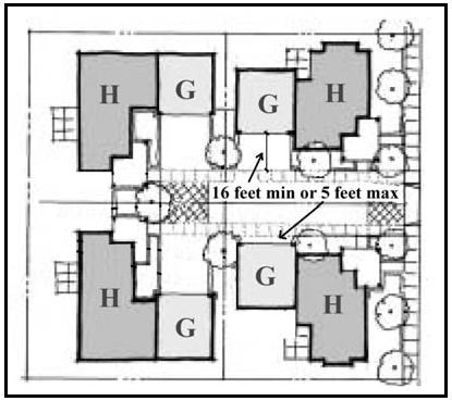
Figure 22-1: Internal Drive Aisle Setback
(2)
Where a project is within an existing residential neighborhood, front setbacks may be established consistent with Section 22.10.140.D.2.c, except where a smaller setback is established through the land use permit consistent with the context of the neighborhood and Subsection C.1.c.(1).
e.
Common Community Gathering Area (CCGA). CCGA(s) available for use by the entire development shall be provided as follows and may be counted as required minimum open space consistent with Section 22.10.130.B.2:
(1)
250 square feet minimum per every two residential units.
(2)
Front setbacks and private open space shall not be counted as CCGA(s) but may be counted as required minimum open space consistent with Section 22.10.130.B.2.
(3)
Residential units that abut the CCGA shall be related to common area either through orientation of the main entry toward the CCGA(s) or through physical and visual connection to the common usable recreation area(s). CCGAs shall be located as centrally as possible, but may be located throughout a project with the objective of creating pleasant and convenient usable activity spaces. All units shall be within a minimum 300 feet walking distance of CCGA(s) and connected to the CCGA(s) by pedestrian access.
(4)
No CCGA is required for a project of five (5) residential units or less if the project is:
i.
Located within ¼ mile (1,320 feet) walking distance of a public park or facility with public open space (i.e., public school); and
ii.
Accessible to the public park or public open space by a dedicated pedestrian path such as a public sidewalk.
f.
Common Community Gathering Area Landscaping. The maximum amount of irrigated turf shall be consistent with Chapter 22.16 (Landscaping Standards). In addition, these gathering areas may include hardscape, planters, and common use amenities such as barbeques, tables and chairs, all in lieu of traditional turf.
g.
Private Outdoor Open Space.
(1)
175 square feet minimum per unit with one minimum dimension of 8 feet, and may include patios, decks, balconies, roof decks, and front porches where porches are not required by Section 22.30.475 (Small Lot Single-Family).
(2)
Shall be adjacent to each unit and be for the exclusive use of the residents of that unit.
h.
Community Buildings/Facilities. Where a community building is available for use by the development, the following standards shall apply:
(1)
Shall be clearly incidental in use and size to the units.
(2)
Shall be commonly owned by property owners.
(3)
Shall be architecturally consistent with the project's residential units.
i.
Fencing. Fencing for both the CCGAs and the private open space shall be designed as follows:
(1)
Fencing within the CCGA and in front yard private open space shall be consistent with Section 22.10.080. In no case shall fencing in these areas exceed four feet in height.
(2)
Fencing around side and rear yard private open space areas shall have a maximum height of six feet.
(3)
Fencing shall not be chain link. Fencing can include materials such as wood, wrought-iron, wood-appearing material, plaster, decorative concrete, or stone.
(4)
Fencing, if over three feet in height, shall be broken-up with textural variety or architectural elements designed to add interest to the fencing. All fencing shall be compatible with the design theme of the project.
2.
Detached Housing. Planned Developments in the Residential Multi-Family, Recreation, Commercial Retail, and Office & Professional land use categories that propose a single-family detached residential style of development (i.e. separated by 3 feet or greater) shall also be consistent with the standards of Section 22.30.475 (Small Lot Single-Family).
C.
Commercial, Office, and Industrial Planned Developments. Commercial, Office, and Industrial Planned Developments and the commercial/office/industrial component of Mixed-Use Planned Developments within the Commercial Retail, Commercial Service, Office & Professional, and Industrial land use categories shall meet the following standards:
1.
Site Planning. Site planning shall include buildings, site landscaping and hardscape improvements designed to attract pedestrian movement, with vehicle circulation, storage and utilities located elsewhere on the perimeter. The use of plazas or courtyards as a means to enhance the pedestrian experience is encouraged.
a.
Building entries shall be oriented so that pedestrian circulation is attractive and convenient. Sidewalks shall be separated from vehicle circulation and loading through the use landscaped areas or planters.
b.
Work bays shall be oriented away from fronting streets, or screened by landscaping.
c.
Parking lots shall be limited in size by separating them into sub-areas divided by landscaping or structures.
d.
Building orientation shall take advantage of active and passive solar opportunities where feasible and practical.
e.
Wherever feasible, site design shall avoid locating vehicle parking at the front of the lot between the buildings and the street.
f.
The use of fences and walls shall be minimized except where required for screening outdoor storage and noise. When proposed, fences/walls shall be solid, attractive, two-sided, and designed for low maintenance, with materials and colors that are complementary to the building. No chain link fences with or without slats are allowed.
2.
Common Open Space. Common open space shall be integrated into the overall design. Such spaces shall have a direct functional or visual relationship to the main building(s) and not be of isolated or leftover character. The following shall not be considered usable common open space:
a.
Areas reserved for the exclusive use or benefit of an individual tenant or owner;
b.
Dedicated streets, alleys and other public rights-of-way;
c.
Vehicular drives, parking, loading and storage area; and
d.
Irregular or unusable narrow strips of land less than ten (10) feet in width, unless such area is improved or planted with the expressed intent to be utilized as common open space.
3.
Functional and Mechanical Features. To the maximum extent practicable, exposed storage areas, trash and garbage containers, exposed machinery installations, service areas, truck loading areas, utility buildings and structures, and similar accessory areas and structures shall be accounted for in the design of the commercial, office, or industrial planned development and screened from public streets.
4.
Driveways, Parking and Circulation. Principal vehicular access shall be from dedicated public streets, and access points shall be designed to encourage smooth traffic flow with controlled turning movements and minimum hazards to vehicular or pedestrian traffic. With respect to vehicular and pedestrian circulation, including walkways, interior driveways and parking, special attention shall be given to the location and number of access points to the public streets, the width of interior driveways and access points, the general interior circulation, the separation of pedestrian and vehicular traffic, the adequate provision for service by emergency vehicles, and the arrangement of parking areas that are safe and convenient, and, insofar as feasible, do not detract from the design of proposed buildings and structures and the neighboring properties.
D.
Required Findings for Approval. The Review Authority may approve a Planned Development only after considering the justification provided in Subsection H. and making all of the following findings in addition to the findings required by Section 22.62.060.C.4.
Compliance
1.
The project complies with all applicable provisions of this Title except where modifications are granted consistent with this Section, the design plans and design guidelines;
Proposed Modifications
2.
The modifications to the development standards of this Title, and any applicable design plan and design guidelines are necessary and appropriate to accommodate the creative and thoughtful design of the proposed project, its compatibility with adjacent land uses, and its successful mitigation of environmental impacts;
Site Suitability and Neighborhood Compatibility
3.
The site is suitable for the project in terms of size, configuration, topography, and other applicable features, has appropriate access to public streets with adequate capacity to accommodate the quantity and type of traffic expected to be generated by the use and all public facilities, services, and utilities are adequate to serve the proposed project; and
4.
The location, size, site planning, building design features, and operating characteristics of the project are complementary to the surrounding neighborhood, and will be compatible with the character of the site, and the land uses and development intended for the surrounding neighborhood by the General Plan.
E.
Ownership and Maintenance. The common area of all Planned Developments shall be owned and maintained either by a Homeowner's Association or in common by the owners of the separate interests who have rights to the beneficial use and enjoyment of the common area through the use of a maintenance agreement.
F.
Phasing. If the construction of the Planned Development is to occur in phases, the common recreation area and common facilities shall be developed and made available in proportion to the number of dwelling units or nonresidential floor area occupied during any given phase. At no time during construction of the project shall the density of developed land exceed the overall density of the established land use category.
G.
Expiration. Timeframes and time extensions for approved Planned Developments with concurrent tentative subdivision maps are prescribed by those timeframes associated with the approved tentative map. Timeframes and time extensions for approved Planned Developments with no concurrent tentative subdivision maps are prescribed by those timeframes associated with the approved Conditional Use Permit.
H.
Justification. The initial application shall include an explanation of why the project is proposed as a Planned Development. This explanation shall include:
1.
A list of which development standards will need to be modified in order to allow a Planned Development to be approved.
2.
A list of project design features and amenities that represent innovative and creative site planning and project design to enable the County to meet its Strategic Growth goals.
3.
A statement describing how the project achieves more effective and attractive pedestrian orientation enhanced environmental sensitivity and energy efficiency, and the more efficient use of resources.
I.
Requests for Modifications to Standards. The Director may approve an Adjustment pursuant to Section 22.70.030 to the standards set forth in this section, provided the following criteria are met:
1.
The site is constrained due to unusual slope, topography, easements, or sensitive areas.
2.
The modification is consistent with the objectives and intent of this Chapter.
3.
The modification meets the required findings set forth in Subsection 22.22.145D.
[Added 2013, Ord. 3242; 2018, Ord. 3369; 2020, Ord. 3409]
22.22.150 - Agricultural Lands Clustering.
It is the policy of the Board to encourage the preservation of agricultural lands in San Luis Obispo County for the continuing and enhanced production of food and fiber through the use of a variety of policy and regulatory techniques. One technique, provided by this Section, is the clustering of allowable dwelling units on relatively small parcels in agricultural areas instead of the dispersal of such units on larger parcels.
A.
Purpose. The purpose of Sections 22.22.150, 22.22.152 and 22.22.154 is to establish a set of regulations which encourages clustering as an alternative to a conventional lot split where an agricultural land division is proposed consistent with Agriculture and Open Space Element and Section 22.22.040. Sections 22.22.152 and 22.22.154 contain two methods for the approval of an agricultural cluster subdivision, Major Agricultural Lands Clustering and Minor Agricultural Lands Clustering. In addition to complying with the standards set forth in this Section and Sections 22.22.152 and 22.22.154, proposed cluster land divisions shall be specifically evaluated for consistency with the policies of the Agriculture and Open Space Element as follows:
1.
Major Agricultural Cluster Projects.
a.
Properties in the unincorporated areas of the county that are located outside the coastal zone, that are partly or entirely within five miles of a urban or village reserve lines, and that comply with the locational criteria in Sections 22.22.152 A. and B. can apply for a major agricultural cluster.
b.
To encourage the use of clustering, the maximum number of residential parcels allowed in a major agricultural cluster project shall be equivalent to the number of primary dwellings normally allowed on the parcels that would result from a conventional land division in the Agriculture land use category based on the minimum parcel size criteria in Section 22.22.040. Except, where Section 22.22.040B1b(4) limits the residential use, the number of parcels is instead based on two primary dwellings per parcel. A Major Agricultural Cluster project could result in a maximum parcel bonus of 100% over a conventional land division. Major Agricultural Cluster projects may be reduced down to 26 percent of the maximum potential allowance, if proposed by the applicant, in order to mitigate potential impacts of the project.
2.
Minor Agricultural Cluster Projects.
a.
Properties throughout the unincorporated areas of the county that meet the locational criteria in Section 22.22.154A, including the coastal zone, can apply for a minor agricultural cluster project.
b.
The maximum number of residential parcels allowed in a Minor Agricultural Cluster project shall be equivalent to the number of parcels that would result from a conventional land division in the Agriculture land use category based on the minimum parcel size criteria in Section 22.22.040, with an increase of at least one more parcel or up to a maximum 25 percent increase in the number of parcels that could be achieved with a conventional land division.
B.
Applicable requirements. The following requirements apply to both Major and Minor Agricultural Cluster projects.
1.
Eligibility of lands under Agricultural Preserve Contract. Lands in the Agriculture land use category under Williamson Act contract shall not be used as the location for clustered parcels; provided that where an ownership includes contiguous contracted and non-contracted lands, the number of parcels and dwelling units normally allowable under the terms of the Agricultural Preserve contract and the provisions of this Title may be clustered on the non-contracted lands within the same ownership in the Agriculture or Rural Lands land use categories in compliance with this Section.
2.
Permit requirement. Conditional Use Permit approval pursuant to Section 22.62.060, shall occur at the same time as approval of a tentative map. Conditional Use Permit approval shall include conditions specifying a phasing schedule for the filing of a final tract or parcel map, where applicable, the installation of required improvements and a date for termination of the entitlement in the event the use is not established within the specified schedule.
3.
Application content. In addition to the information required by Section 22.62.060, the Conditional Use Permit application for a cluster project shall also include a written explanation by the applicant of how the proposed project will satisfy all the required findings specified in Subsection B.5.
4.
Environmental review. After acceptance of an application for cluster development pursuant to Section 22.60.050, an initial study on the project shall be prepared in compliance with the California Environmental Quality Act (CEQA) and the Environmental Review Process Guidelines. The initial study shall closely examine the potential impacts on the long-term protection of the agricultural, environmental and biological resources, as well as the availability of, and potential impacts on, resources such as water, traffic, air quality, schools and other public services and facilities. Whether or not an Environmental Impact Report must be prepared will be determined by the initial study.
5.
Required findings. Approval of a Major or Minor Agricultural Cluster project shall not occur unless the Review Authority first makes all findings required by Section 22.62.060.C.4. and also finds that:
a.
The proposed project will result in the continuation, enhancement and long-term preservation of agricultural resources and operations consisting of the production of food and fiber on the subject site and in the surrounding area.
b.
The proposed project has been designed to:
(1)
Locate proposed development to avoid and buffer all prime agricultural soils on the site, other agricultural production areas on the site, as well as agricultural operations on adjoining properties;
(2)
Minimize, to the maximum extent feasible, the need for construction of new roads by clustering new development close to existing roads;
(3)
Avoid placement of roads or structures on any environmentally sensitive habitat areas;
(4)
Minimize impacts of non-agricultural structures and roads on public views from public roads and public recreation areas;
(5)
Cluster proposed residential structures, to the maximum extent feasible, so as to not interfere with agricultural production and to also be consistent with the goal of maintaining the rural character of the area;
(6)
Minimize risks to life and property due to geologic, flood and fire hazard and soil erosion.
c.
The proposed project will not result in any significant land use compatibility impacts affecting on-site or off-site agricultural operations, including but not limited to trespass, vandalism, and complaints about agricultural practices.
d.
The water resources and all necessary services are adequate to serve the proposed development, including residential uses, as well as existing and proposed agricultural operations on the subject site and in the site vicinity.
e.
The proposed clustered development and the conditions, covenants and restrictions governing the Homeowners Association and/or individual lots are adequate to ensure permanent maintenance of the lands to remain in agricultural production and/or open space.
6.
Access. Clustered developments in compliance with this Section shall be allowed only on ownerships with access to an existing paved, county or state maintained road.
(1)
Ownership and maintenance of roads. Unless otherwise required by the Review Authority, all interior roads and utilities shall be privately-owned and maintained and the applicant shall demonstrate through conditions, covenants and restrictions or other means that the project residents shall maintain all private roads and utilities for the life of the project.
7.
Site layout criteria. The design and development of a Major or Minor Agricultural Cluster project shall be consistent with the following standards:
a.
No structural development shall occur on soils with a Natural Resources Conservation Service classification of I or II, except that agricultural accessory structures and agricultural processing uses may be allowed on sites up to 2.5 acres in size, subject to Minor Use Permit approval, where the applicant can demonstrate that no other suitable area is available for such uses and that the proposed uses are directly related to maintaining and enhancing on-site agricultural operations.
b.
Residential building sites and access drives shall be located within the boundaries of the overall ownership with sufficient separation from exterior property lines in order that the Review Authority can find that the clustered development will not result in adverse impacts on off-site agricultural operations in the site vicinity consistent with agricultural buffer policies adopted by the Board.
c.
Roads and building sites shall be located to minimize site disturbance and visibility from public roads.
d.
Driveway access intersections with off-site roads shall be minimized.
8.
Agricultural land/open space preservation.
a.
Requirements for preservation. Clustered developments in compliance with this Section, and Sections 22.22.152 and 22.22.154 shall provide for the long-term preservation of portions of the site proposed to meet the open space requirements of Section 22.22.152D or 22.22.154D. All open space parcels shall be of a minimum size to qualify as a separate parcel consistent with Section 22.22.040 (Parcel Size - Agriculture Category). In addition, the parcel(s) shall qualify for a stand alone Williamson Act preserve and contract under the current county Rules of Procedure and must be covered by a permanent agricultural open space easement.
b.
Areas included in open space. The open space area provided may include all areas in agricultural production (including directly related infrastructure such as roads and wells), but shall not include any portion of the proposed clustered residential parcels.
c.
Structural uses allowed in defined open space areas. The area proposed for agricultural land and/or open space preservation is not to be developed with structural uses other than:
(1)
A ranch/farm headquarters including up to two of the residential units allowed pursuant to Subsection B9, residential accessory structures and farm support housing, which may be approved or modified after the initial Conditional Use Permit approval through Minor Use Permit, provided that the building site does not exceed 2.5 acres.
(2)
Areas set aside for the preservation of historic buildings identified by the Land Use Element, to be delineated on the recorded map.
(3)
Agricultural accessory structures or agricultural processing uses essential to the continuing agricultural production of food and fiber in the immediately surrounding area,, which may be approved or modified after the initial Conditional Use Permit approval through Minor Use Permit approval, which shall not occupy an aggregate area of the site larger than five 5 acres.
(4)
Renewable energy facilities generating energy for on-site use may be allowed on up to 3 acres or 25 percent of the open space area, whichever is smaller, subject to the requirements in Chapter 22.32 (Energy-Generating Facilities).
d.
Nonstructural uses allowed in defined open space areas. The following nonstructural uses may be allowed in the open space areas: crop production and grazing; animal raising and keeping; specialized animal facilities; nursery specialties (nonstructural); range land or wildlife preserves; water storage or recharge; leachfield or spray disposal area; scenic area protection or buffers from hazardous areas; public outdoor recreation uses on non-prime lands, or other similar open space uses; and roads/turnarounds directly serving the agricultural use.
e.
Guarantee of open space. The required open-space parcel(s) shall be maintained as open space as long as the clustered lots exist. This shall be guaranteed by either of the following methods:
(1)
A recorded, permanent agricultural open-space easement granted to the county and placement in a stand alone Land Conservation Act (Williamson Act) preserve and contract in the Williamson Act Agricultural Preserve Program.
(2)
Transfer of fee title free and clear of any liens, or dedication of a perpetual easement to a qualified public or private non-profit organization (as defined by the regulations of the Internal Revenue Service) created for the purposes of protecting and managing resources.
9.
Number of dwellings. Residential units within a cluster project shall be limited to a ratio of one dwelling unit per clustered parcel, except that farm support housing may be authorized in addition to the units allowed by this Subsection through the approval of the overall project Conditional Use Permit, or subsequent Minor Use Permit approval, in compliance with the standards of Section 22.30.480.
10.
Homeowners association. A homeowners association shall be formed and membership shall be mandatory for each home buyer and successive buyer if there are open space areas held in common by the homeowners. The homeowners association shall be responsible for the permanent maintenance of the open space areas held in common, if any, by the homeowners. An assessment system, or other form of subsidy shall be required to ensure compliance with this provision.
[Added 1984, Ord. 2195; Amended 1986, Ord. 2277; 1987, Ord. 2332; 1988, Ord. 2380; 1993, Ord. 2648; 2004, Ord. 3038; 2006, Ord. 3081; 2015, Ord. 3291] [22.04.037]
22.22.152 - Major Agricultural Cluster:.
A.
Eligible areas of the county. The use of clustering in the Agriculture or Rural Lands categories may be considered on ownerships that are in agricultural use at the time of application. Use of the provisions of this Section may occur only on properties that are partly or entirely within five (5) miles of the Urban Reserve Lines (URL's) of Arroyo Grande, Atascadero, San Luis Obispo, San Miguel, Nipomo, Paso Robles, and Santa Maria and the Creston Village Reserve Line (VRL).
B.
Excluded areas of the county. Properties located in the Arroyo Grande, Cienega and Oso Flaco valleys as identified by the San Luis Bay and South County Area Plans of the Land Use Element are excluded from such use. Sites entirely located beyond five miles from the urban and village reserve lines specified in Subsection A. above are not eligible for clustering pursuant to this Section.
C.
Allowed number of parcels:
1.
Base parcel calculation. The base parcel calculation shall be equivalent to the number of parcels that would result from a conventional land division in the Agriculture land use category based on the minimum parcel size criteria specified in Section 22.22.040 (Parcel Size - Agriculture Category).
2.
Bonus parcel calculation. The maximum number of residential parcels allowed in a Major Agricultural Cluster project shall be equivalent to the number of base parcels calculated in compliance with Subsection C.1., with a parcel bonus of 100 percent.
D.
Lot size and open area requirements. The minimum size of clustered residential parcels in a Major Agricultural Cluster project, and the area of the site required for open space preservation shall be as follows:
;sz=8q;Notes:
(1)
Net area.
(2)
A minimum lot size less than 2½ acres may be granted only when community water is provided. A minimum lot size less than one acre may be granted only where the leaching capacity of site soils for septic tank use is from 0 to 5 minutes per inch, or where community sewer is provided.
(3)
The minimum area is expressed as a percentage of the gross site area.
(4)
Larger parcel sizes may be approved by the Review Authority where requested by the applicant and justified based on specific site characteristics, provided that the minimum open space area requirement is met.
[Added 2004, Ord. 3038; Amended 2006, Ord. 3081]
22.22.154 - Minor Agricultural Cluster:.
A.
Eligible areas of the county. The use of clustering in the Agriculture or Rural Lands categories may be considered on ownerships that are in agricultural use at the time of application. Use of the provisions of this Section may occur on any property in the Agriculture or Rural Lands land use category.
B.
Excluded areas of the county. Properties located in the Arroyo Grande, Cienega and Oso Flaco valleys as identified by the San Luis Bay and South County Area Plans are excluded from such use.
C.
Allowed number of parcels:
1.
Base parcel calculation. The base parcel calculation shall be equivalent to the number of parcels that would result from a conventional land division in the Agriculture land use category based on the minimum parcel size criteria specified in Section 22.22.040 (Parcel Size - Agriculture Category).
2.
Bonus Parcel Calculation. The maximum number of residential parcels allowed in a Minor Agricultural Cluster project shall be equivalent to the number of base parcels calculated in compliance with Subsection C.1., with a parcel bonus of at least one additional parcel, up to a maximum of 25 percent.
D.
Lot size and open area requirements. The minimum size of clustered residential parcels in a Minor Agricultural Cluster project, and the area of the site required for open space preservation shall be as follows:
;sz=8q;Notes:
(1)
Net area.
(2)
A minimum lot size less than 2-1/2 acres may be granted only when community water is provided. A minimum lot size less than one acre may be granted only where the leaching capacity of site soils for septic tank use is from 0 to 5 minutes per inch, or where community sewer is provided.
(3)
The minimum area is expressed as a percentage of the gross site area.
(4)
Larger parcel sizes may be approved by the Review Authority where requested by the applicant and justified based on specific site characteristics, provided that the minimum open space area requirement is met.
[Added 2004, Ord. 3038]
22.24.010 - Voluntary Transfer of Development Credit Program.
A.
Purpose and intent. The provisions of this Chapter implement the voluntary Transfer of Development Credits Program (TDC) established by the Land Use Element by providing a procedure for transferring development credits from one parcel of land to another. Consistent with applicable Land Use Element goals, policies and programs, the objective of this section is to relocate development from environmentally sensitive land, land with agricultural capability or antiquated subdivisions, to more suitable areas. This program is voluntary, incentive-based, and market-driven between willing sellers and buyers.
Properties located within the South County Planning Area as defined by Part II of the Land Use Element are subject to Section 22.24.200. Receiving Sites located within the South Atascadero area, as defined by Section 22.24.300 are subject to Section 22.24.300.
B.
Effect of the TDC program. A site from which development credits have been transferred is called the sending site, and has its development potential reduced or retired through recordation of a permanent conservation easement or other instrument. A site which receives development credits (the receiving site) may be developed with a higher density than would otherwise be allowed under the current land use category or as otherwise set through planning area standards.
Credits originating from a site in the unincorporated part of the county may be transferred to receiving sites within an incorporated city which has adopted plans or ordinances that enable such transfers.
[Added 1996, Ord. 2776; Amended 1999, Ord. 2883; 2004, Ord. 3034; 2011, Ord. 3212; 2012, Ord. 3233] [22.04.500]
22.24.020 - Sending Site Application Content and Processing.
A request for designation of a sending site, using the regulations set forth in Section 22.24.030, shall require the filing and processing of an application for sending site status in compliance with the following requirements:
A.
Application content. In addition to meeting the application contents of Section 22.62.030 (Zoning Clearance), an applicant requesting status as a sending site shall provide at a minimum the following information:
1.
Application form for sending site status.
2.
Which specific or general criteria, in compliance with Sections 22.24.030.A.2, A.3, or A.4, are proposed for use in determining if the property qualifies as a sending site. If the property doesn't meet a specific criteria for qualification, provide a statement of how the property qualifies under the general criteria.
3.
Information supporting the determination of the development value of the property, using one of the methods described in Section 22.24.030.B.3.
4.
Two copies of a preliminary title report concerning the property, which is not more than six months old, showing current property owners.
B.
Application processing. An application for sending site status shall be filed with the Department and shall be processed as follows:
1.
Environmental determination. When a sending site application has been determined to contain adequate information to allow a determination by the Review Authority, it shall be subject to an environmental determination as required by the California Environmental Quality Act (CEQA).
2.
Review by the Planning Commission.
a.
Where the determination on number of development credits is made in compliance with Section 22.24.030.B.1. or 2, the authority to take final action on a request for sending site status and assignment of development credits is assigned to the Planning Commission. Notice of public hearing shall be given as provided by Section 22.70.040. Decisions by the Commission on sending site status and assignment of development credits may be appealed in compliance with Section 22.70.050.
3.
Notice of Eligibility. No sooner than 15 days after the Commission decision on sending site status (if no appeal has been filed), the Director shall prepare a written Notice of Eligibility. The Notice of Eligibility shall state the number of sending site credits assigned to the property and the method used for the assignment of those credits, including the applicable criteria and mathematical formula. The Notice of Eligibility shall be required prior to issuance of a sending site certificate by the TDC Administrator.
[Added 1996, Ord. 2776; Amended 1999, Ord. 2883; 2004, Ord. 3034] [22.04.510]
22.24.030 - Sending Site Eligibility and Determination of Development Credits.
The criteria of this section shall be used in determining if a property is eligible for sending site status. If a property meets the specific or general criteria used to determine sending site status, the property would then be eligible to have credits assigned. A designated receiving site that has been approved and the final map recorded, shall not be considered for sending site status. Credits are assigned only to individual legal lots. Lots that are previously encumbered or otherwise restricted to remove all development potential (e.g.: open space lots, etc.) and lots that are outside of a Community-Based TDC Program Area are ineligible to become sending sites.
A.
Eligibility criteria. The following criteria shall be used in the review of potential sending sites. The intent of these criteria is to limit the designation of sending sites to those properties that would protect a significant resource, land with agricultural capability or land within antiquated subdivisions. The specific criteria are provided to establish certainty in the designation process. Land may be considered for designation as sending sites if one or more of the specific criteria are met. The general criteria shall be used to determine if a site is eligible to become a sending site in cases where the site does not meet the specific criteria. Flexibility is necessary in the evaluation of individual sites to approve those sites that might not pass absolute criteria, but may still qualify as sending sites based on the general criteria which recognize the individual characteristics of that site.
1.
Use of criteria. The criteria in Section 22.24.030.A.2, A.3, and A.4 shall be used to determine if a property is eligible to become a sending site as follows:
a.
Specific criteria. Land that meets one of the specific criteria should be approved as a sending site unless the Review Authority determines that there are special circumstances that would undermine or negate the overall purpose described in the general criteria. This could include factual issues such as clouded legal title or other technical and non-resource related issues.
b.
General criteria. The Review Authority may designate land as a sending site that does not meet the specific criteria, after reviewing the extent to which sending site designation would satisfy any of the general criteria. The Review Authority shall first find that designation as a sending site would satisfy the policy statement of the applicable general criteria and any or all of the general criteria listed.
2.
Agricultural Criteria.
a.
Specific criteria. The specific agricultural criteria are as follows:
(1)
Land capability. At least 50 percent of the site must contain Class I or II (irrigated or non-irrigated) soils based on the Natural Resources Conservation Service classification, and the site must be at least 40 acres in size (this may include multiple lots under common ownership or contiguous lots under different ownership).
(2)
Grazing. Grazing land with a demonstrated continuity of production of over 10 years and the site is a minimum of 320 acres with at least 100 acres of that land being well to moderately suited for rangeland as described in the Natural Resources Conservation Service soil reports. This may include multiple lots under common ownership that are operated as a single agricultural enterprise, or contiguous lots under different ownership.
b.
General criteria. It is the policy of the county to designate sending sites that contain land with prime, unique or other productive soil, as well as make it possible for a family who would otherwise have to sell the land to retain the land and continue in active agriculture. The general agricultural criteria are as follows:
(1)
Continue the demonstrated productive capacity of the land;
(2)
Preserve an area with micro-climates that support specific agricultural crop types;
(3)
Retire the development potential within an area that depends on localized limited groundwater resources; or
(4)
Reduce the potential for erosion or support conservation of soil resources.
3.
Natural resource criteria.
a.
Specific criteria. The specific natural resource criteria are as follows:
(1)
Natural area. The property is within a Natural Area or Significant Biological, Geographical or Riparian Habitat as defined by the Natural Areas Plan and/or the Agriculture and Open Space Element of the General Plan.
(2)
Open space. The property is adjacent to public or private land that is restricted to open space uses or would facilitate a future open space connection between existing public or private land that is restricted to open space uses.
(3)
Viewsheds. The property would protect rural open space views from Highways such as 1, 41, 46, 58, 101, 166 and main collector streets as defined in the Area Plans (Part II of the Land Use Element).
b.
General criteria. It is the policy of the county to designate sending sites that contain diverse and rich habitat for wildlife or contain scenic or other cultural resources (such as historical and archeological resources). The general natural resource criteria are as follows:
(1)
Reduce erosion or support conservation of soil resources, or support the preservation of land essential to local watershed protection;
(2)
Further the public policies of local communities (cities) and the county, such as the creation of greenbelts, community separators, scenic entries, managed growth on the fringe, and protection of shared natural resources; or
(3)
Protect and make available to the public a natural resource or feature. Public access may be controlled and regulated and could include outdoor education, guided hiking, or passive recreation.
4.
Antiquated subdivision criteria.
a.
Specific criteria. The specific antiquated subdivision criteria are as follows:
(1)
Sites located 10 miles or more (as measured using the straight line method as defined in Article 8 Distance - measurement) from an urban or village reserve line where the individual lot is smaller than 20 acres in size.
(2)
Sites located 5 to 10 miles or more (as measured using the straight line method as defined in Article 8 Distance - measurement) from a urban or village reserve line where the lot is smaller than 10 acres in size.
(3)
Sites located within an antiquated subdivision according to the map on file with the Department.
b.
General criteria. It is the policy of the county to designate sending sites that would retire the development potential within antiquated subdivisions located distant from existing urban and village areas. The general antiquated subdivision criteria are as follows:
(1)
Retire the development potential within an antiquated subdivision that contains substandard improvements ; or
(2)
Further air quality objectives and reduce the cost of future county services by retiring development potential on the property in areas that are distant from transportation services or other support services.
B.
Determining development credits. If the Review Authority determines that a property qualifies as a sending site, this section shall be used to determine the number of development credits assigned to a legal lot. The applicant shall choose one of the following methods to determine the number of development credits.
For any sending site that has a Notice of Eligibility dated prior to November 18, 1999, whose Notice of Eligibility has expired and become void, a new application for designation of a sending site shall be submitted for review and approval. The method used for determining development credits and bonuses, and the criteria for determining sending site status shall be as specified in Ordinance No. 2777, adopted October 6, 1996.
1.
Number of development credits. The number of credits assigned to a sending site shall be determined by one of the following methods:
a.
Existing lots. The maximum number of primary single family residences allowed on the existing underlying legal lots. The number of legal lots will require verification from the County; or
b.
Development value. Dividing the development value, as determined using the method described in Section 22.24.030.B.4, by 20,000.
2.
Minimum number of credits. Where a property would not otherwise qualify for one full credit using Subsection B.1, the landowner may request one credit be allocated to the site. A property may qualify only where the sending site eligibility was based on the specific natural resource criteria as set forth in Subsection A.3. The site cannot qualify for more than one credit.
3.
Development value. Where the applicant is requesting a determination of development credits based on Subsection B.1.b the following standards apply.
a.
Full development potential. A landowner who wishes to transfer the property in fee to a public agency or a non-profit organization will receive a determination based on the full value of the property. At the time of application, a landowner requesting a determination based on full development potential shall submit a letter of intent to accept title from the public agency or non-profit organization. The full value of the property shall be considered the development value of the property for the purpose of determining the number of credits under this section.
b.
Partial development potential. A landowner who wishes to retain ownership of the property, and retain certain allowed or special uses of that property in compliance with Section 22.06.030, Table 2-2 (Allowable Land Uses and Permit Requirements), will receive a determination based on partial development potential of the property. The difference between the full value of the property and the restricted value of the property shall be considered the development value of the property for the purpose of determining the number of credits under this Section. The use of the property shall be limited in compliance with Section 22.24.050.A. The development value of the property should increase as a landowner relinquishes additional uses over those required under Section 22.24.050.A.1 and A.2.
4.
Determining development value. The full or partial value of the development potential of the property shall be determined by having the property appraised using the self contained report format as defined by the Uniform Standards of the Professional Appraisal Practices as published by the Appraisers Standards Board of the Appraisal Foundation. The appraisal shall be valid for one year. Evidence shall be submitted with the appraisal to demonstrate that proper procedures and standards were followed for a self contained report and that under those standards the appraisal is valid. The appraisal shall be subject to an independent review by qualified individual selected by the county. The applicant shall fund all costs associated with the independent review.
a.
Full development potential. Where the applicant is requesting a determination based on the full development potential, the appraisal shall be for the full value of the property.
b.
Partial development potential. Where the applicant is requesting a determination based on partial development potential, the appraisal shall include an appraisal of the full value of the property and the restricted value of the property.
[Added 1996, Ord. 2776; Amended 1999, Ord. 2883; 2004, Ord. 3034; 2011, Ord. 3212]
22.24.050 - Designation of sending site.
The following procedures shall be used to complete the sending site designation.
A.
Guarantees of conservation. Credits cannot be officially recognized as attached to a legal parcel and available for purchase by a Receiver Site or other qualified individual until such time as a conservation easement or other instrument that qualifies under either the Open Space Easement Act or the Conservation Easement Act, is granted in perpetuity to a qualified public or private non-profit organization (as defined by the regulations of the Internal Revenue Service) created for the purposes of protecting and managing resources. A list of approved qualified organizations is on file at the Department. Non-profit organizations that are qualified to hold easements in compliance with this ordinance shall be subject to approval by the Director prior to inclusion on the list.
The grant of a conservation easement does not authorize the public or any member thereof any right of public access unless such is specifically set forth in the easement and agreed to by the property owner.
1.
Agricultural. Where a property qualified as a sending site based on agricultural criteria, the property shall be restricted, at a minimum, to prohibit the following uses listed in Section 22.06.030, Table 2-2 (Allowable Land Uses and Permit Requirements): caretakers residence, mobilehomes, residential accessory uses, residential care and single family swellings. Additional uses may be relinquished where the landowner wishes to receive a higher number of credits, as this should increase the development value of the property.
2.
Natural Resources/Antiquated Subdivisions. Where a property qualified as a sending site based on natural resources or antiquated subdivision criteria, the property shall be restricted, at a minimum, to allow only the following uses in compliance with Section 22.06.030, Table 2-2 (Allowable Land Uses and Permit Requirements): agricultural accessory structures, agricultural processing, animal raising and keeping, crop production and grazing, farm equipment and supplies, nursery specialties, specialized animal facilities, libraries and museums, membership organization facilities, schools -specialized education and training, agricultural worker housing, fisheries and game preserves, warehousing and wholesaling and distribution. These uses may also be relinquished where the landowner wishes to receive a higher number of credits, as this should increase the development value of the property.
3.
Recordation of easement. After review and approval by the Department, the easement shall be recorded in the Office of the County Recorder by the Director upon payment by the applicant of the required recording fee. The easement shall be recorded within five years of the receipt of the Notice of Eligibility.
For sending sites that have a Notice of Eligibility, or a property wide Notice of Eligibility that other site specific Notices tier from, dated prior to February 16, 2000, the Notice shall expire ten years from the date of the Notice of Eligibility. This section acts to automatically extend those Notices of Eligibility dated prior to February 16, 2000 for a period of ten years from the date of the Notice of Eligibility, notwithstanding the effective date of this amendment.
If the easement has not been recorded within the time frame specified, the Notice of Eligibility shall expire and become void. Once an easement has been recorded that covers all property described in the Notice, the Notice of Eligibility shall become void.
B.
Issuance of sending site certificate.
1.
Original certificate. After recordation of the easement, a landowner shall request that the TDC Administrator issue the record owner of the property a Certificate of Sending Credits. Such Certificate shall only be assigned in the name of the record owner and only for the total number of credits assigned to the property. Each credit shall be given an individual unique registration number. This number shall never be repeated to describe any other credit.
2.
TDC Administrator review. The TDC Administrator shall review the Notice of Eligibility for authenticity and the easement for county approval and recordation information. A Certificate shall only be issued where the Administrator finds that these conditions have been satisfied.
3.
Certification upon sale. If the holder of a Sending Site Certificate sells credits, the holder shall record the transfer of these credits through the TDC Administrator. The TDC Administrator shall issue a Receipt of Transfer to the purchaser that specifies the registration number(s) of the credit(s) obtained. Concurrently with this action, the TDC Administrator shall permanently alter the Certificate of Sending Credits to reflect the transfer of the credits, by removing the registration number(s) of the credits transferred. In order for the TDC Administrator to record the transfer of credits, the holder of the Certificate of Sending Credits and the individual to whom the credits are being transferred, shall provide to the TDC Administrator the following:
a.
A copy of the recorded documents that describe the terms and conditions of the sale. All documents related to the sale of the credits shall be recorded in the Office of the County Recorder; and
b.
Evidence that the credits are to be used to record a final or parcel map that was conditioned to require the use of TDCs or on an approved receiving site within an incorporated city. Such evidence shall consist of the adopted and signed resolution or other declaration of approval from the Review Authority or incorporated city with the findings and conditions affixed thereto; or
c.
Evidence that the credits are being transferred to a non-profit organization. Such evidence shall consist of a copy of the letter from the Internal Revenue Service verifying the organization is a valid tax-exempt charity under Internal Revenue Code section 501(c)(3).
4.
Receipt of Transfer. If the holder of a Receipt of Transfer wishes to sell or otherwise transfer the Receipt to a subsequent owner, the holder shall record the transfer through the TDC Administrator. The TDC Administration shall issue a new Receipt of Transfer to the purchaser that specifies the registration number(s) of the credit(s). Concurrently with this action, the TDC Administrator shall permanently revoke the original Receipt of Transfer. In order for the TDC Administrator to transfer a Receipt of Transfer to another party the following information shall be provided to the TDC Administrator:
a.
A copy of the recorded documents that describe the terms and conditions of the sale or transfer. All documents related to the sale of the credits shall be recorded in the Office of the County Recorder; and
b.
Evidence that the credits are to be used to record a final or parcel map that was conditioned to require the use of TDCs or on an approved receiving site within an incorporated city. Such evidence shall consist of the adopted and signed resolution or other declaration of approval from the Review Authority or incorporated city with the findings and conditions affixed thereto; or
c.
Evidence that the credits are being transferred to a non-profit organization. Such evidence shall consist of a copy of the letter from the Internal Revenue Service verifying the organization is a valid tax-exempt charity under Internal Revenue Code section 501(c)(3).
C.
General Plan. When a conservation easement or other instrument that qualifies under either the Open Space Easement Act or the Conservation Easement Act has been recorded, the county will amend the general plan to designate the site in the TDC Sending Site Combining Designation (TDCS).
[Added 1996, Ord. 2776; Amended 1999, Ord. 2883; 2004, Ord. 3034; 2020, Ord. 3417] [22.04.540]
22.24.060 - Receiving Site Application Content and Processing.
A request for designation of a receiving site in the county, using the regulations set forth in Section 22.24.070, shall require the filing and processing of an application for receiving site status in compliance with the following requirements:
A.
Application content. In addition to meeting the application contents of Sections 21.02.044, 046, 048 of Title 21 for a tentative map, an applicant requesting status as a receiving site shall provide the following information:
1.
Statements, maps or other information necessary to show how the property meets the criteria used for determining if the property qualifies as a receiving site as set forth in Section 22.24.070A.
2.
Supporting information for the issuance of a density bonus in compliance with Section 22.24.070C.
3.
Information regarding the location and availability of sending credits within the designated region as set forth in Section 22.24.080 for the proposed receiving site.
4.
Evidence that the required notice was provided in compliance with Subsection B.2.
B.
Application processing. A determination on whether the property would qualify as a receiver site shall be determined as follows:
1.
Determination with tentative map approval. A determination on the suitability of the site to receive credits shall be accomplished concurrently with the processing of a tentative map. The Review Authority shall use the criteria as set forth in Section 22.24.070.A. to determine if the site is eligible to be receiving site. The process shall be the same as would otherwise be required for the processing of the tentative map except that notice of the neighboring property owners in compliance with Subsection B.3. shall occur in addition to the required public hearing notice.
2.
Notification of property owners. The applicant shall submit evidence that the neighboring property owners were notified of the request to become a receiving site prior to submission of a request for a tentative map. This notice shall be provided by the applicant sending a letter using the form provided by the Department. The letter shall be mailed or delivered at least 10 days prior to application submittal to all owners of real property as shown on the latest equalized assessment roll within 300 feet of the subject site.
[Added 1996, Ord. 2776; Amended 2004, Ord. 3034; 2011, Ord. 3212] [22.04.550]
22.24.070 - Receiving Site Eligibility, Transfer of Development Credits Required and Determination of Bonus Development.
The criteria of this section shall be used in determining if a property is eligible for receiving site status. If the property meets all the criteria used to determine receiving site status, the property would then be eligible to qualify for bonus density. Bonus density may be added to the base density as set forth in Section 22.24.070.C.
Properties located within the South County Planning Area as defined by Part II of the Land Use Element are subject to Section 22.24.200. Receiving Sites located within the South Atascadero area, as defined by Section 22.24.300 are subject to Section 22.24.300.
A.
Eligibility criteria. The following criteria shall be used in the review of potential receiving sites. Credits are assigned only to individual legal lots. Land may be considered for designation as receiving sites only when all of the following describe the site that is requesting receiver status.
1.
An Exemption (Categorical or General Rule), a Negative Declaration or a Final Environmental Impact Report, that does not identify significant, unavoidable adverse environmental effects, or exacerbation of such effects, relating to the additional density that would be allocated to the site, has been prepared or will be necessary as part of environmental determination for the proposed project.
2.
The site is not in the Agriculture land use category.
3.
The site is within an urban or village reserve line or within a Community-Based TDC program area.
4.
The footprint of the area proposed for development (including new access roads and driveways) is less than 30 percent slope.
5.
The footprint of the area proposed for development is outside of the Sensitive Resource Area (SRA), Flood Hazard (FH), Geologic Study Area (GSA), Earthquake Fault Zone, or Very High Fire Hazard Area as defined by the Land Use Element.
6.
The footprint of the area proposed for development is outside of a Natural Area or Significant Biological Geographical or Riparian Habitat as defined by the Natural Areas Plan, the Land Use Element, or a subsequent revision or update of any element of the general plan.
7.
The development will comply with: all development standards, water, sewage disposal and access standards, and land division standards as contained in Titles 19, 21, 22 and 23 of the county code.
8.
The site was not an approved sending site, and also has a valid conservation easement recorded against the sending site.
B.
Transfer of Development Credits Required. In all cases described in this Subsection, retirement of transfer of development credits shall be required. Credits shall be retired in accordance with Section 22.24.090 at the time of subdivision recordation following approval of the general plan amendment or land division.
1.
Property-owner initiated general plan amendments. Transfer of development credits shall be required to be retired when a property owner requests a general plan amendment which would result in an increase in development density over what is currently allowed. The specific use of transfer of development credits shall be set through establishment of planning area standards. The number of credits retired shall be equal to the net increase in the number of units/parcels allowable under the new land use category
2.
Land Divisions. Transfer of development credits shall be required to be retired for each lot created by any parcel map or tract map when located outside of an urban or village reserve line. The number of credits retired shall be equal to the net new parcels/lots created by the map.
3.
Exception.
a.
Credits shall not be required pursuant to Subsections B.1 or B.2., where the Review Authority first finds that:
(1)
Retirement of credits is unnecessary due to a specific circumstances applicable only to the subject site (for example if credits are not available within the areas defined in Section 22.24.080), or
(2)
A reduced number of credits is applied in the specific case, or
(3)
Where the general plan amendment will facilitate affordable housing and is restricted to meet Affordable housing resale prices as set forth in Section 22.12.030, or
(4)
The general plan amendment is consistent with the strategic growth policies in Framework for Planning.
C.
Amount of bonus. There are two sets of criteria used to determine the amount of a bonus granted on a receiver site. The bonus granted is an increase over the allowable base density.
1.
Determining base density. Base density is the maximum number of lots that may be allowable on a given site under the County Code. Establishing the base density is necessary to determine the amount of the bonus that may be granted. Base density as determined under this Section does not affect the provisions of the County Code for review of proposed land divisions, including approval of such land divisions at a density equal to this base density.
The base density for a site is equal to the minimum parcel size required by Chapter 22.22 for the particular category or where planning area standards (Article 9) establish minimum parcel size requirements different from the provisions of Chapter 22.22, the planning area standards for minimum parcel size shall control and determine the base density.
2.
Determining allowable density with bonus. If the site meets the criteria for receiving site status, the site may qualify for a bonus as follows. All measurements shall use the straight line method as defined in Article 8 (Distance- Measurement). Where a site is within an incorporated city's urban or village reserve line, but outside of the city limit line, the bonuses shown to apply within an urban or village line shall be granted only where the density increase would be consistent with adopted city policies, programs or standards, and where the city supports the location of the sending credits. Support of the project shall be in the form of a letter received from the affected city.
a.
Within an urban or village reserve line: A bonus may be granted up to 50 percent of the base density, except within the California Valley village reserve line, which shall not be eligible for bonus density in compliance with this section.
3.
Additional receiving site bonus. In addition to the density bonus set forth in Subsection C.2, where the receiving site project offers special permanent amenities in excess of the basic requirements as determined by the Review Authority (e.g. cluster subdivision design, trails, coastal access, open space, significant public parkland, telecommuting work centers, design features such as community focal points (squares, greens, plazas) and transit accessibility, etc.), an additional bonus of up to 25 percent of the base density may be granted to the receiving site.
[Added 1996, Ord. 2776; Amended 1999, Ord. 2883; 2004, Ord. 3034; 2006, Ord. 3095; 2011, Ord. 3212] [22.04.560]
22.24.080 - Source of Transferred Credits for Receiving Sites.
A proposed project on a site that meets the criteria for receiving site status shall use credits from sending sites located within a five mile radius of the receiving site, as measured using the straight line method as defined in Article 8 (Distance - measurement). If insufficient credits are available within a five mile radius from the subject receiving site, credits shall be used from other sending sites in the same geographical region as the receiving site as follows, except as needed to accommodate the existing Coordinated Agriculture Stewardship Program (CASP) in the Arroyo Grande and Cienega Valleys. In that case credits may be transferred between the areas described in both Subsections D. and F. :
A.
North County. Receiving sites located within the Nacimiento, Adelaida, Salinas River, and El Pomar-Estrella planning areas shall use credits from sending sites within any of those planning areas.
B.
North Coast. Receiving sites located within the North Coast and Estero planning areas shall use credits from sending sites within any of those planning areas.
C.
Central County. Receiving sites located within the San Luis Obispo and San Luis Bay (Inland) planning areas shall use credits from sending sites within any of those planning areas.
D.
South County. Receiving sites located within the South County (Inland) planning area shall use credits from sending sites within that planning area.
E.
East County. Receiving sites located within the Las Pilitas, Los Padres and Shandon-Carrizo planning areas shall use credits from sending sites within any of those planning areas.
F.
South Coast. Receiving sites located within the South County (Coastal) and San Luis Bay (Coastal) planning areas shall use credits from sending sites within any of those planning areas.
G.
Huasna. Receiving sites located within the Huasna planning area shall use credits from sending sites within that planning area.
[Added 1996, Ord. 2776; Amended 1999, Ord. 2883; 2004, Ord. 3034] [22.04.570]
22.24.090 - Designation of Receiving Site and Retiring Development Credits.
The following procedures shall be used to complete the receiving site designation and to retire credits required under Section 22.24.070.B.
A.
Use of credits. Prior to recordation of the final or parcel map, the applicant shall release their ownership in the Receipt of Transfer or the Certificate of Sending Credits to the Department. Acceptance of the release shall only occur if the credits are located in conformance with Section 22.24.080. The Director shall notify the TDC Administrator of the release and specify the registration number(s) of the credits that were used. After release, the credits are no longer valid and available for use.
B.
Additional map sheet. The final or parcel map shall include a clear and legible note placed on an additional map sheet in compliance with Section 21.06.020(a)(3) of Title 21. The note shall state that the approval of the land division included the use of TDCs, the number of credits used and their registration number(s), and the location and assessor parcel number of the sending site.
C.
General Plan. Receiving sites that have received sending site credits shall be placed in the TDC Receiving Site Combining Designation (TDCR) by general plan amendment initiated by the county.
[Added 1996, Ord. 2776; Amended 2004, Ord. 3034; 2011, Ord 3212] [22.04.580]
22.24.100 - TDC Administrator.
The TDC Administrator is the individual, organization or corporation identified and approved by the County that issues, monitors and maintains records of Certificates of Sending Credits and Receipts of Transfer. The TDC Administrator may charge a fee for these services.
A.
Appointment of TDC Administrator. The TDC Administrator shall be the Director or designee. The Board may choose to appoint a TDC Administrator outside of the staff of the Department. This appointment shall be by resolution of the Board of Supervisors. The performance of the TDC Administrator will be evaluated from time to time. The Board of Supervisors may choose to modify the procedures for issuance, monitoring and record keeping of Certificate of Sending Credits or Receipts of Transfer as deemed necessary. The Board of Supervisors may also choose to replace the TDC Administrator.
B.
Program review. The TDC Administrator shall comply with all provisions of Sections 22.24.010 et seq. On an as needed basis, the TDC Administrator shall provide the Board of Supervisors with a full accounting of all transactions that occurred since the previous reporting period.
C.
Report review. The Board of Supervisors shall annually review a report from the TDC Administrator and the Department regarding the operation of the TDC program. This report shall be considered on the Board's agenda. The report will be available to all interested parties, including community advisory groups. The Commission shall be provided a copy of the report which may be considered on their consent agenda.
[Added 1996, Ord. 2776; 2004, Ord. 3034; 2012, 3233] [22.04.600]
22.24.200 - South County Community Based Program.
A.
Purpose and Intent. This section implements the South County Community Based Voluntary Transfer of Development Credits Program established by the Land Use Element, by providing a procedure to allow the voluntary transfer of development credits from one parcel of land to another. Consistent with applicable Land Use Element goals, policies and programs, the objective of this section is to relocate development from environmentally sensitive land, land with agricultural capability or antiquated subdivisions, to more suitable areas. This program is voluntary, incentive-based, and market-driven between willing sellers and buyers. Landowners are not obligated to use this technique to request an amendment to the general plan or subdivide property in conformance with Chapter 22.22.
B.
Where allowed. The following standards apply only to properties in the South County Planning Area (Inland) as defined by Part II of the Land Use Element.
C.
Applicable Standards. Sending and Receiving Sites shall comply with Sections 22.24.010 et seq.
D.
Eligible purchasers of TDC's. Receiving Sites approved after July 1, 2002 shall only purchase credits from any valid non-profit corporation organized for conservation purposes approved by the Board of Supervisors, except as provided in Subsection D.1. If no valid non-profit corporation exists, credits shall be transferred as set forth in Sections 22.24.010 et seq.
1.
Sending sites approved prior to July 1, 2002, may elect to work directly with an approved Receiver Site instead of selling approved credits to a valid non-profit corporation organized for conservation purposes approved by the Board of Supervisors. This provision is effective for five years from August 10, 2004.
[Added 2004, Ord. 3034]
22.24.300 - South Atascadero Community Based Program.
A.
Purpose and Intent. This section implements the South Atascadero Community Based Voluntary Transfer of Development Credits Program established by the Land Use Element, by providing a procedure to allow the voluntary transfer of development credits from one parcel of land to another. Consistent with applicable Land Use Element goals, policies and programs, the objective of this section is to relocate development from environmentally sensitive land, land with agricultural capability or antiquated subdivisions, to more suitable areas. This program is voluntary, incentive-based, and market-driven between willing sellers and buyers. Landowners are not obligated to use this technique to request an amendment to the general plan or subdivide property in conformance with Chapter 22.22.
B.
Where allowed. The following standards apply only to properties in the Salinas River Planning Area, Residential Suburban ,South Atascadero Area as defined by Figure 24-1 with boundaries as follows: Atascadero City limits on the north, Highway 101 on the west, Santa Margarita Road on the south and all lots within the Atascadero Colony lying beyond the Southern Pacific railroad tracks on the east.
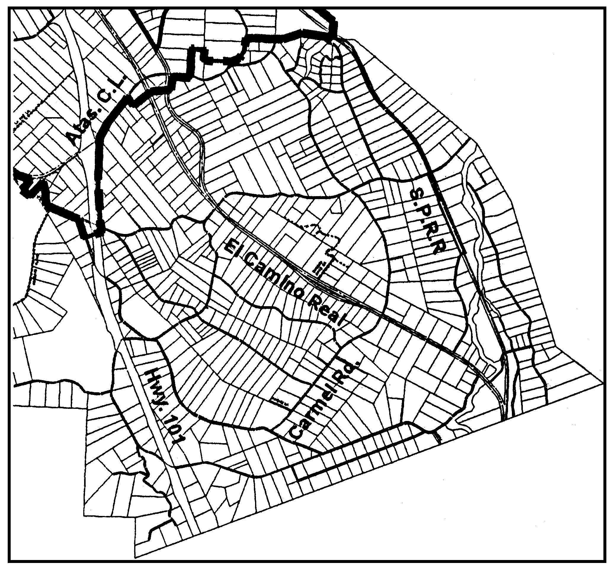
Figure 3-1: South Atascadero Area
C.
Applicable Standards.
1.
Sending Sites. Sending Sites shall comply with Sections 22.24.010 et seq.
2.
Receiving Sites. Receiving Sites shall comply with Sections 22.24.010 et seq. in addition to the following:
a.
Minimum Parcel Size. Proposed receiving sites shall be a minimum of four acres or greater in size. The minimum parcel size for lots created using the South Atascadero Community Based program shall be no less than two acres.
b.
Percolation Tests. A percolation test shall be submitted with the land division application. The percolation test shall be performed during the wet season between December and March.
c.
Groundwater monitoring. A Groundwater monitoring well shall be established on each proposed parcel. Monitoring shall be conducted from November to April. Groundwater levels shall be measured continuously using a piezometer to record the seasonal high level. The piezometer may be a float device that mechanically or electrically records the highest water level. The results of the monitoring shall be submitted with the land division application.
d.
Community water. The existing and proposed parcels shall be served by community water. A water will serve letter shall be submitted with the land division application.
e.
Riparian/Drainage setback. Future development on proposed parcels shall be setback a minimum of 50 feet from any natural drainage swales and from any riparian vegetation. For the purposes of this section, natural drainage swales are defined as any naturally occurring drainage areas.
f.
Drainage. Future development on proposed parcels shall use methods for minimizing run-off rates and volumes of storm water on-site to allow percolation to the underlying aquifer including, but are not limited to, the use of pervious paving materials, vegetated swales and other low impact development techniques and retention basins designed to allow percolation.
g.
Tree removal. Future development on proposed parcels shall avoid native vegetation removal. Where vegetation removal can not be avoided then removal shall be minimized. No removal of trees having a diameter of more than six inches at four feet above grade shall occur.
h.
Botanical Survey. A comprehensive botanical survey report shall be submitted with the land division application. The report shall be prepared by a County-approved consultant. The field survey shall comply with California Department of Fish and Game (CDFG) guidelines and be conducted during the flowering (blooming) period after rains have subsided. The report shall include survey findings, a map showing the location of any sensitive, special-status plant species, and recommended mitigation measures.
i.
Archaeology. Phase I Cultural Resources Survey be conducted by a County-approved consultant for any proposed receiver site that is located within 100 feet of the bank of a creek (appearing as a solid, dotted or dashed blue line on the applicable U.S. Geological survey 7.5 -minute topographic quadrangle map) or within 300 feet of a creek where the slopes of the site is less than 10 percent. The associated report shall be submitted with the land division application. If significant cultural resources are found during the survey, the report shall include recommendations for mitigation, which may include further study, site design modifications, and construction monitoring.
[Added 2007, Ord. 3131]