
San Luis Obispo County Unincorporated
City Zoning Code
City Zoning Code
ARTICLE 5
SITE DEVELOPMENT STANDARDS
22.50.010 - Purpose of Chapter.
The standards of this Chapter provide for precautions to minimize hazards to life and property in the event of fire.
22.50.020 - Applicability.
Any proposed use that requires land use permit approval is subject to the provisions of this Chapter.
[Amended 1991, Ord. 2523] [22.05.080]
22.50.030 - Fire Safety Plan.
The purpose of a fire safety plan is to enable a fire protection agency that has jurisdiction over a proposed site to evaluate the adequacy of proposed fire protection measures, and to keep itself informed of new developments to evaluate their effect upon the ability of the agency to provide continuing service. The approval of a fire safety plan does not imply a commitment by any agency to an increased level of service.
A.
Where required. A fire safety plan be submitted with a land use permit application as follows.
1.
Within urban and village reserve areas. All land use permit applications shall be submitted to the applicable fire protection agency, except for single family dwellings proposed on existing lots where a letter from the applicable fire protection agency is submitted that verifies that adequate fire flow and fire hydrants exist.
2.
Rural areas. All applications for uses proposed outside of urban or village reserve lines are to be submitted to the County Fire Chief or designated appointee, except agricultural uses not involving buildings and agricultural accessory buildings.
3.
Exception. The requirements of this Section may be waived where the applicable fire protection agency verifies in writing that fire safety review is unnecessary.
B.
Fire safety plan content.
1.
Urban and village areas. A fire safety plan identify the location of the fire hydrant nearest to the site; the location of any emergency firefighting equipment or water supplies on the proposed site; the location of any explosive or flammable materials; and means of access to all structures available for firefighting equipment.
2.
Rural areas. A fire safety plan include the location of. available water storage; any storage of fuel, explosives, flammable or combustible liquids and gases; and identification of the extent of proposed vegetative fuel reduction areas.
3.
Exception to content requirements. Where the applicable fire protection agency determines that information provided with the project application and plans is sufficient to enable fire safety review without the need for a separate fire safety plan, the information required by Subsections B.1 and B.2 need not be supplied. A letter verifying the adequacy of application information shall be submitted to the Planning and Building Department.
C.
Fire safety plan review.
1.
Timing of review. Review of a fire safety plan be completed before approval of a Site Plan Review, Minor Use Permit or Conditional Use Permit application; and before application for construction permits in cases of Zoning Clearance approval.
2.
Effect of review. Review of fire safety plans result in a recommendation to the applicant on the adequacy of proposed fire protection measures, which does not affect approval or disapproval of a project application, except.
a.
Where the recommendations of the agency enforce the specific provisions of this Chapter or, where applicable, the Uniform Fire Code and the State Responsibility Area Fire Safe Regulations (Public Resources Code Section 1270 et seq.).
b.
Where the authority vested in the fire protection agency enables the agency to mandate fire protection requirements for new development, such requirements shall be met before final building inspection has been granted or prior to occupancy where allowed by Section 19.04.042 (Occupancy or use of an incomplete structure).
c.
In the case of applications for Minor Use Permit or Conditional Use Permit approval, recommended fire protection requirements shall be considered as conditions of approval in compliance with Section 22.62.060.C.2 (Conditional Use Permit Approval - Additional Conditions).
[Amended 1991, Ord. 2523; 1992, Ord. 2553] [22.05.082]
22.50.040 - Fire Safety Standards.
In areas where fire protection is provided by the San Luis Obispo County Fire Department/California Department of Forestry and Fire Protection, new uses shall comply with applicable provisions of the Uniform Fire Code, 1988 Edition, or later edition adopted by County ordinance. In areas where fire protection is provided by another official agency (e.g., a community services district, etc.), new uses shall comply with the fire safety standards as required by the fire protection agency.
[Amended 1981, Ord. 2063; 1982, Ord. 2091; 1988, Ord. 2367; 1991, Ord. 2523]
22.52.010 - Purpose and Intent.
The purpose of this Chapter is to establish standards to safeguard the public health, safety and general welfare; minimize erosion and sedimentation; minimize fugitive dust emissions; prevent the loss of agricultural soils; reduce the harmful effects of stormwater runoff; encourage groundwater recharge; protect fish and wildlife; reduce hazards to life and property; reduce drainage problems from new development; enhance slope stability; protect natural, scenic, and cultural resources; prevent environmental damage to public and private property; and to otherwise protect the natural environment. This Chapter addresses compliance with the National Pollutant Discharge Elimination System (NPDES) Phase II stormwater regulations and sets forth local stormwater requirements, to avoid pollution of watercourses with sediments or other pollutants generated on or caused by surface runoff on or across construction sites.
[Amended 1999, Ord. 2863; 2010, Ord. 3188] [22.05.010/020]
22.52.020 - Responsibility of the Landowner.
Each landowner has the responsibility or duty before, during, and after construction or site disturbance activities, to ensure compliance with this code. The landowner also has a responsibility to ensure compliance with local, state, and federal permitting requirements. No approval shall exonerate the landowner or his agent(s) from the responsibility of complying with the provisions and intent of this Chapter and other state or federal requirements.
[Amended 1999, Ord. 2863; 2010, Ord. 3188]
22.52.030 - Scope.
This Chapter sets forth standards, including the incorporation of Best Management Practices (BMPs), to control all grading, excavations, and earthwork. This Chapter also provides for the approval of plans and inspection of grading construction and BMPs. In the event of any conflict between the provisions of this Chapter and state law, the more restrictive requirement shall apply. Agricultural grading, whether exempt or required to be permitted by this Chapter, may be exempted from NPDES Phase II requirements, pursuant to Section 22.52.130B.3.
No work subject to the provisions of this Chapter shall be commenced, maintained or completed in violation of these regulations.
[Amended 1999, Ord. 2863; 2010, Ord. 3188][22.05.022]
22.52.040 - Administrative Procedures.
A.
Compliance with building code. All grading activities shall be in compliance with the provisions of Title 19 of the County Code, the currently adopted California Building Code, and adopted Appendices, which are hereby adopted and incorporated into this Title by reference as though they were fully set forth herein. In the event of any conflict between the provisions of this Chapter and the California Building Standards Code or California Building Code, this Title shall apply.
B.
Low Impact Development (LID) Handbook. Low Impact Development requirements shall be imposed, and updated from time to time, by resolution of the Board of Supervisors after a noticed public hearing. Requirements imposed in the LID Handbook shall include any required LID Best Management Practices. Additionally, the LID Handbook may be used to implement other measures as required in the County's Stormwater Management Program. Requirements of the LID Handbook when imposed, shall be a condition of the issuance of permits for, or the approval of, development proj [projects].
[Amended 1999, Ord. 2863; 2010, Ord. 3188; 2014, Ord. 3282]
22.52.050 - Grading Permit Required.
Where not otherwise exempt by Section 22.52.070 (Exemptions from Grading Permits) or authorized through the alternative review process pursuant to Section 22.52.080 (Alternative Review), a grading permit shall be obtained where grading is to occur meeting the definition set forth in Section 22.52.060 (Grading). A separate permit shall be required for each site and shall cover both excavations and fills. Contiguous sites being graded as one integrated project may be considered one site, as deemed appropriate by the Director, in order to enforce the requirements of this Chapter.
Even those activities that do not constitute grading as defined in this Chapter, or are exempt from grading permits, may be subject to other applicable sections in this ordinance. This includes requirements, such as preparation and approval of an erosion and sedimentation control plan, drainage plan, and/or stormwater pollution prevention plan.
In granting any permit in compliance with this Chapter, the Director and, where provided, the Public Works Director, may impose conditions as necessary. These conditions may include requiring a licensed contractor to perform the work or a licensed professional (e.g. civil engineer, geotechnical engineer, etc.) to prepare plans or technical reports in order to prevent creation of a nuisance or a hazard to public health, public safety, or public or private property, or to assure conformity to the County General Plan.
[Amended 1999, Ord. 2863; 2010, Ord. 3188]
22.52.060 - Grading.
A.
Grading. For the purposes of this Chapter, "grading" is defined as all new earthwork that involves one or more of the following activities: excavations, cuts, fills, dams, reservoirs, levees, impoundments, diking, dredging, borrow pits, stockpiling, compaction of fill, or removal of vegetation. Cultivation activities, including disking, harrowing, raking or chiseling, planting, plowing, seeding, or other tilling are not considered grading and are not regulated under this ordinance. A grading permit is required in any of the following cases, unless the project qualifies for an exemption or constitutes agricultural grading as set forth in Section 22.52.070, or unless the project goes through the alternative review process as set forth in Section 22.52.080:
1.
50 cubic yards. The amount of material, measured cumulatively (adding together all proposed earthwork) for any of the above mentioned activities exceeds 50 cubic yards.
2.
Work in a watercourse. The amount of material, measured cumulatively (adding together all proposed earthwork) for any of the above mentioned operations exceeds 20 cubic yards and involves altering or obstructing a drainage way or watercourse.
3.
Removal of vegetation. Projects which would involve more than one acre of vegetation removal on a site.
Vegetation removal is calculated based on the total area of a site which will lack soil cover (i.e. "bare soil") at any given time. Areas subject to previous vegetation removal are not included in this calculation where permanent revegetation has already achieved a minimum of 70 percent coverage.
Note: The grading thresholds specified in Subsections A.1 and A.2 above are to be measured cumulatively for each project. A project may not be broken down into smaller components with the intention of avoiding a grading permit. Activities progressing towards a common endeavor are considered a single project.
B.
Additional permitting requirements. Grading may require a land use permit or variance under the following circumstances:
1.
Site disturbance. For projects subject to Chapter 22.08, grading may require land use permit approval based upon the amount of site disturbance. The land use permit thresholds are established in Section 22.08.030 (Table 2-3).
2.
Slopes. Grading shall be limited to slopes of less than 30 percent, except where:
a.
Variance. The applicant has obtained Variance approval pursuant to Section 22.62.070; or
b.
Agricultural use. The grading is exclusively for one or more of the following agricultural uses:
(1)
An exempt agricultural accessory structure as specified in Section 22.06.040E.1;
(2)
Crop production or grazing;
(3)
Any agricultural roads used exclusively for the purposes set forth in Subsections B.2.b.(1) and B.2.b.(2).
While this Subsection exempts the above uses from the 30 percent slope limitation, this Subsection shall not be construed to exempt any uses from the requirement of obtaining a grading permit or complying with exemption or alternative review procedures pursuant to Section 22.52.050.
[Amended 1999, Ord. 2863; 2010, Ord. 3188]
22.52.070 - Exemptions from Grading Permits.
Note: While the activities under this section are exempted from a grading permit for the purposes of this County's ordinance, the owner and/or applicant should understand that permits may be required by other regulatory agencies, including, but not limited to, the California Department of Fish and Game, Regional Water Quality Control Board, Army Corps of Engineers, U.S. Fish and Wildlife Service, or the California Department of Forestry (Cal Fire). Additionally, grading projects involving work within a state or County right-of-way may require encroachment permit approval.
A.
Minimum requirements to determine exempt status. The following considerations must be addressed in determining if grading activities qualify for an exemption:
1.
Grading activities are not exempt within a geologic study area and/or flood hazard combining designations as shown in the Land Use Element. Agricultural grading as provided by Subsections B and C, Alternative Review as provided by Section 22.52.080, and geotechnical/geologic exploration activities are not subject to this limitation.
2.
Grading activities shall receive all necessary approvals from other County, state, or federal agencies, regardless of whether the activity is exempt under this Chapter.
3.
Activities exempted under this section are still required to incorporate all reasonable measures to ensure against erosion and sedimentation both during and after such activities. In all cases, any grading activities which could result in a hazardous condition are not exempt from grading permit requirements. A hazardous condition exists when activities create a hazard to life and limb, endanger property, adversely affect the safety, use or stability of a public right-of-way or drainage channel, or create a significant environmental impact.
B.
Exempt grading. The following grading does not require a grading permit. Exempt grading activities must employ appropriate sedimentation and erosion control measures:
1.
Excavations below finish grade. The excavation of materials below finished grade for tanks, vaults, basements, retaining walls, swimming pools, or footings of a building or structure, where such excavations are authorized under the provisions of a valid building permit. This does not exempt any fill made with the material from the excavation.
2.
Cemeteries. Cemetery graves, excavation, or fill within a property used or to be used for cemetery purposes is exempt. Grading that is intended to support structures or that will affect natural drainage patterns does not fall under this exemption.
3.
Flood control maintenance. Maintenance and construction work within the prescribed easements of the San Luis Obispo County Flood Control and Water Conservation District as long as width, height, length or capacity is not increased.
4.
Public works projects. Public works projects constructed by the County or its contractors, including those activities as provided by Section 22.01.050B.
5.
Refuse disposal. Refuse disposal sites approved by the County Health Department under the authority of Public Resources Code Sections 40000 et seq.
6.
Surface mining. Surface mining operations approved in compliance with Chapter 22.36 (Surface Mining). Commercial mines which are planned for conversion to on-site only use shall require reclamation in accordance with the approved reclamation plan. Continuing non-commercial operation after reclamation shall require that a grading permit be obtained.
7.
Conservation, restoration, and enhancement projects. A soil, water, and/or wildlife conservation or enhancement project for which a California Department of Fish and Game Alteration Agreement and/or Army Corps of Engineers permit has been secured and which has a design prepared or approved by, and is inspected and certified by a Resource Conservation District, the U.S. Natural Resources Conservation Service or the State of California, Department of Water Resources, or the Central Coast Regional Water Quality Control Board.
8.
Vegetation clearance for fire safety. Clearing of vegetation, (not to include tree removal or removal of vegetation and wildlife protected by County, state, or federal statutes as rare, threatened or endangered) in compliance with CalFire recommendations for fuel reduction or firebreaks for forestry or fire protection purposes. Tree removal is governed by Chapter 22.56. Refer to Section 22.08.030 (Table 2-3), if applicable, for specific land use permit requirements which apply to vegetation removal. Best management practices must be applied to avoid erosion and sedimentation.
9.
Improvement plans. Construction of, or excavations or fills for roads, drainage, and utilities associated with improvement plans for final subdivision maps or public projects within the County-maintained road right-of-way approved by the County Public Works Department, if consistent with the standards, guidelines and provisions identified in this Chapter.
10.
Exploratory excavations and public utility connections. The following exploratory excavations or fills where the natural slope of the site does not exceed 20 percent and where effective erosion and sedimentation control measures are used in compliance with Section 22.52.120 to protect, restore, and revegetate all disturbed areas within 45 days after the completion of work or before October 15. This 45 day period may be extended where work is completed earlier in the year and an extension is necessary for rainfall to assist onsite revegetation. In order to qualify for this exemption, the proposed grading shall comply with the following, as applicable:
a.
Excavation or fill shall not result in impacts to archaeological resources or the removal of trees or native riparian or wetland vegetation, or rare, threatened or endangered species. After consultation with the Environmental Coordinator, on-site monitoring may be required.
b.
Excavations for wells and water pipeline maintenance (not to include grading for road work), disturbing an area that does not exceed an aggregate area of 1,000 square feet or exceed a total grading amount (cut plus fill) of 50 cubic yards.
c.
Excavation for temporary holes or trenches for geological, geotechnical and archaeological exploration, (not to include construction or modification of required access roads) performed under the direction and supervision of a soil engineer, engineering geologist or (where applicable) an archaeologist. The work shall not affect or disturb areas greater than 3,000 square feet in size, shall not cumulatively involve more than 50 cubic yards of material associated with preparing the site for exploration, and shall be protected as required by occupational safety and health agency standards.
d.
Excavations for the installation, testing, maintenance, or replacement of distribution or service facilities for utilities regulated by the California Public Utilities Commission, including electrical, water, or natural gas lines (not to include construction or modification of required access roads).
e.
Excavation and fill of trenches for utility lines not exceeding 24 inches in width or an average of five feet in depth, or holes for utility poles or anchors and limited accessory grading.
f.
Initial excavation and fill necessary to effect such temporary repair or maintenance of oil, gas and utility lines as can be completed within seven days of commencement where such combined excavation and fill does not exceed a total of 100 cubic yards of material.
11.
Ongoing crop production and grazing. Grading for the ongoing production of food and fiber, the growing of plants, and the management of rangeland shall be exempt when all of the following are true:
a.
For grading activities related to crop production, the proposed grading is limited to preparing a field for a crops, repair or restoration of existing fields, removal of vegetation, and associated drainage improvements on land that has been previously cultivated within the previous ten years or covered under a conservation plan prepared as part of the Conservation Reserve Program. Previously cultivated land shall include any land where the following practices have occurred: disking, harrowing, raking or chiseling, planting, plowing, seeding, or other tilling. Activities covered under this exemption are not limited to these cultivation practices.
b.
For grading activities related to range management for livestock production, the grading is limited to the following activities: vegetation management, such as reseeding, removal, or vegetation modification; or livestock watering systems and associated drainage improvements other than ponds or reservoirs. To qualify for this exemption, these activities shall take place only on land where grazing has occurred within the previous ten years or on lands covered under a conservation plan prepared as part of the Conservation Reserve Program.
c.
All site work shall be balanced. No importation or exportation of fill material from/to off-site parcels shall occur. These fill materials include topsoil and sand. The importation or exportation of soil fertility amendments to enhance crop production or rangeland fertility is permissible under this exemption. Soil fertility amendments include materials described in the California Food and Agricultural Code Sections 14511 et seq. (excluding Section 14552(e)). Any land application of treated sewage sludge (i.e. biosolids) as a soil fertility amendment shall be subject to local ordinances. Importation of sand and gravel may occur only when used for drainage improvements.
d.
All site work complies with the standards identified in Subsection C.1.
e.
The grading does not involve construction of or modification to dams, ponds, reservoirs, or roads; however, farm roads located entirely within or on the edge of existing fields may be modified or re-oriented under this exemption.
12.
Routine maintenance. Routine maintenance of legally established existing (exempt or previously permitted) roads; man-made, engineered flood control channels or levees; agricultural ponds and reservoirs; agricultural drainage channels; agricultural water lines; equestrian facilities (e.g. paddocks and arenas); and public utility lines (as provided by Subsection B.10); where the width, length, or design capacity is not increased. Material may be imported under this exemption when used for routine maintenance purposes only.
13.
Agricultural water supplies. Installation of water pipelines, wells, or spring boxes solely to serve agricultural uses. Water supplies shall be installed under proper practices recognized by the Natural Resources Conservation Service and may include importation of materials solely for installation of the water supply system, but not including any new roadwork.
14.
Small agricultural projects. Projects conducted for the exclusive purposes of initiating and/or enhancing crop production and/or grazing, and which involve no more than 50 cubic yards of excavation (including export) and no more than 50 cubic yards of fill (including import).
C.
Agricultural Grading. This Subsection applies to all grading that does not satisfy the description for exempt grading in Subsection B. In order for agricultural grading to be exempt from a grading permit, as set forth in this Subsection, an Agriculture Grading Form shall be completed and submitted to the County prior to commencement of any grading activities, for verification that exemption criteria are met. An applicant's signature on the form indicates participation in an educational, waiver, or certification program approved by the Planning Director in consultation with the Resource Conservation District (RCD) and Natural Resources Conservation Service (NRCS), and acknowledgment of required compliance with the standards in Subsections A and C.
1.
Agricultural Grading Standards.
a.
All excavated material shall be placed on the same or contiguous parcels, unless otherwise specified in Subsection C.2.
b.
Agricultural grading shall employ sound agricultural management measures and practices of the USDA Natural Resources Conservation Service (NRCS) and the UC Cooperative Extension. These practices shall not adversely affect slope stability, or groundwater recharge. Additionally these practices shall prevent off-site drainage and erosion and sedimentation impacts. All agricultural grading, whether requiring a permit or exempt, shall be consistent with the standards and practices contained in the NRCS Field Office Technical Guide (FOTG).
c.
Effective erosion and sedimentation control measures shall be used on all cut and fill slopes in compliance with Section 22.52.150C to protect, restore and revegetate within 45 days after the completion of work or before October 15 and shall be continually maintained for the life of the project. This 45 day period may be extended where work is completed earlier in the year and an extension is necessary for rainfall to assist onsite revegetation. All erosion and sedimentation control measures shall be designed to prevent sediment from entering any blue-line stream, river, pond, lake, wetland, bay, or the ocean.
d.
Any proposed exempt activities within a recorded or unrecorded archaeological site shall comply with the requirements of Section 22.10.040.
2.
Allowed agricultural grading.
a.
New crop production and grazing. Grading to prepare new land for crop production or grazing purposes, including drainage improvements and vegetation removal, on slopes with a natural gradient less than thirty percent. Importation and exportation of commercial soil amendments as specified in Subsection B.11.c is permissible under this exemption.
b.
Small reservoir. A reservoir constructed to regulate or store a supply of water for frost protection, seasonal irrigation, or livestock purposes. Ponds, reservoirs, and dams are subject to the standards in Section 22.52.150F. To qualify for exemption as a small reservoir the following criteria must be met:
(1)
The reservoir shall be designed to contain no more than one acre-foot of water.
(2)
All water storage shall be located entirely below natural grade.
(3)
The reservoir shall not be located on a stream, lake, or marsh, as identified on any U.S. Geological Survey map.
Storage reservoirs that do not meet the criteria under this standard may qualify for alternative review pursuant to Section 22.52.080B.4.
c.
Upland restoration measures. Projects which are undertaken for soil, water quality, habitat, or wildlife restoration, conservation, or enhancement occurring outside of the channel of a stream.
d.
Imbalanced grading. Grading projects intended to accommodate one or more of the projects identified in Subsections B and C, and involving importation or exportation of no more than 2,000 cubic yards on a site per year.
[Amended 1999, Ord. 2863; 2010, Ord. 3188] [22.05.024/026/030]
22.52.080 - Alternative Review Program.
Note: While the activities under this section are exempted from a grading permit for the purposes of this County's ordinance, the owner and/or applicant should understand that permits may be required by other regulatory agencies, including, but not limited to, the California Department of Fish and Game, Regional Water Quality Control Board, Army Corps of Engineers, U.S. Fish and Wildlife Service, or the California Department of Forestry (Cal Fire). Additionally, grading projects involving work within a state or County right-of-way may require encroachment permit approval.
The applicant may elect to use the Alternative Review Program for those projects in compliance with Subsection B. This process allows an applicant to obtain technical assistance, inspection, and sign-off by either the Natural Resources Conservation Service (NRCS) or the Resource Conservation District (RCD).
An Alternative Review Form shall be completed and submitted to the County to verify that the project qualifies for the Alternative Review Process prior to commencement of any grading activities.
A.
Alternative review program standards.
1.
Grading activities allowed under this section must conform to the minimum requirements to determine exempt status identified in Section 22.52.070A, agricultural exempt standards in Subsections C.1.b, C.1.c, and C.1.d of Section 22.52.070, and the standards in Section 22.52.150.
2.
Within 60 days of County verification that the project qualifies for Alternative Review, the NRCS or RCD shall provide written verification that the project can meet Alternative Review requirements, including compliance with appropriate Field Office Technical Guide (FOTG) management practices. An extension of this period may be approved upon applicant request and agreement by the Director and the NRCS/RCD.
3.
Upon final implementation/installation of appropriate FOTG practices and standard engineering practices, the NRCS/RCD shall submit a project finalization report to the County.
4.
Projects which are not approved for Alternative Review, including projects which do not receive a project finalization report, shall be subject to Section 22.52.190 and Chapter 22.74.
5.
For projects involving roads or ponds, the Agricultural Commissioner's office shall make a written determination that the extent of the existing agricultural use or a proposed agricultural use of the property justifies the need for the road or pond. The Agricultural Commissioner may consider such features as length, width, capacity, and extent of the proposed road or pond in determining whether it is justified.
B.
Projects allowed under the alternative review program.
1.
Hillside Benches. Hillside benches and other appropriate methods for planting orchards and vineyards on slopes over thirty percent.
2.
Rangeland Management Projects. Rangeland management projects involving grading, or removal of more than one acre of vegetation, on lands with slopes in excess of 30 percent. Conducting these activities on lands that have been previously grazed may instead qualify for an exemption as set forth in Section 22.52.070B.11.b.
3.
New agricultural roads. New roads, or expansion to the length or width of existing roads, which provide access to farm fields, pastures, water supplies, outdoor equipment or supply storage areas, livestock grazing areas, fence lines, or an agricultural structure which does not require a county building permit (agricultural exempt structure). New roads shall be the minimum width necessary for the planned agricultural use (generally between 12 and 16 feet in width), consistent with the determination made under Subsection A.5. The road shall not supply access to a habitable structure. Ford crossings (i.e. "Arizona" crossings), as determined to be appropriate by the Agricultural Commissioner, may be included in the construction of new agricultural roads.
a.
Future grading permit required. A grading permit shall be required for the road if it will serve a structure that requires a construction permit. Further, the road shall be required to be improved to meet all then current standards. The permit shall include all of the work that was previously exempt or subject to alternative review.
b.
Qualifying criteria for alternative review. In addition to the criteria in Section 22.52.070A., roads shall meet all of the following:
(1)
Must be located within an Agriculture or Rural Lands land use category. The roads must also be outside of an urban or village reserve line, or within a Residential Rural land use category where the road is to serve an existing agricultural operation as determined by the Agricultural Commissioner's office.
(2)
Shall have properly designed and placed culverts, water bars or other drainage and erosion and sedimentation control features meeting the recommended practices and standards provided by NRCS or RCD. Effective erosion and sedimentation control measures shall be used on all cut and fill slopes in compliance with Sections 22.52.120 and 22.52.150C to protect, restore and revegetate within 45 days after the completion of work or before October 15. This 45 day period may be extended where work is completed earlier in the year and an extension is necessary for rainfall to assist onsite revegetation. Vegetation buffer strips shall be maintained between the road and blue line streams (as applicable) shown on the latest USGS 7-1/2 minute topographic quadrangle to trap sediment before it reaches the stream.
(3)
Have adequate cross-slope for proper drainage and erosion control. Outward sloping roads are encouraged unless infeasible or inappropriate.
(4)
Does not divert drainage onto adjacent properties. Does not discharge or threaten to discharge silt on adjacent properties, roads, sensitive resource areas, or into streams as shown on the latest USGS 7-1/2 minute topographic quadrangle.
(5)
Constructed between April 15 and October 15; unless temporary erosion control is in place and the reseeding is assured to occur in the appropriate months for germination, as approved by a soil erosion specialist.
4.
Ponds, reservoirs, and dams. The following types of projects are eligible for ARP processing:
a.
Drainage basins designed to catch run-off not related to development requiring a County permit. A drainage basin designed to catch run-off relating to development requiring a County permit shall require the issuance of a grading permit in compliance with 22.52.050. Any pond, reservoir, or basin which catches and retains surface drainage or riparian underflow shall have applicable water rights entitlements from the State Water Resources Control Board. Ponds, reservoirs, and dams are subject to the standards in Section 22.52.150F.
b.
Ground-water filled agricultural reservoirs are not eligible for ARP processing.
5.
Streambank protection measures. Streambank protection measures when using NRCS Practices.
6.
Conservation, restoration, and enhancement projects. Soil, water, and/or wildlife conservation or enhancement projects, which do not require permits from a state or federal resource agency, or for which the permitting state or federal agency does not review plans or conduct final inspections.
7.
Trail and recreation enhancements. Trails for agricultural production support activities and recreation enhancements of property. If a land use permit is required under this ordinance to establish a recreational facility, no grading shall occur until the appropriate approvals have been secured.
8.
Waste management systems. Waste management systems for agricultural production and processing uses.
9.
Imbalanced Grading. Any agricultural grading identified in Section 22.52.070, Subsections B.11, B.13, and C which would require the importation or exportation involving over 2,000 cubic yards of fill material.
10.
Exempt uses. At the applicant's option the Alternative Review Program may be used in lieu of exemption for grading projects in compliance with Section 22.52.070 - Subsections B.11, B.12, B.13, and C.
[Amended 1999, Ord. 2863; 2010, Ord. 3188; 2017, Ord. 3345][22.05.032]
22.52.090 - Review, Approval and Permits.
A.
Timing and restrictions of approval. Grading permits are subject to the following timing requirements and restrictions:
1.
A grading permit shall not be approved before:
a.
Application for a construction permit, if the grading is proposed for creation of or access to a building site.
b.
Approval of a land use permit, land division, or General Plan amendment, if such approvals are required for completion of any project located on the same site; all required appeal periods shall have expired.
c.
Approval of any required permits from state or federal agencies.
2.
Permits cannot be issued until the determination of adequate water and/or sewage disposal, fire safety plan, or other required site investigations are made, land disturbance shall be limited to the extent necessary to allow such an investigation, consistent with Section 22.52.070B.10.c.
3.
This Subsection shall not apply to subdivision improvements or road construction required as a condition of approval of a land division.
B.
Modifications to approved grading plans. Any alternatives or modifications to approved plans shall be approved by the Director or, where applicable, the Public Works Director. The issuance of a permit in compliance with this Chapter shall constitute an authorization to do only the work that is described or illustrated by the grading plans, erosion and sedimentation control plans, specifications approved by the Director or drainage plans approved by the Public Works Director.
C.
Special Circumstances.
1.
Correction to hazardous condition. Whenever the Director determines that any existing excavation, constructed embankment or fill on land subject to County regulations has become a hazard to life and limb, endangers property, adversely affects the safety, use or stability of a public right-of-way or drainage channel, or creates a significant environmental impact, the Director shall notify the owner of the property, or other person or agent in control of the property. Corrections, remedies, and repairs made necessary by a hazardous situation may be made as required before permits are applied for or issued, at the discretion of the Director. Upon receipt of written notice from the Director, the owner or agent shall within the period specified therein:
a.
Correct, repair or eliminate the condition; and
b.
Comply with the requirements of this code, which may entail preparation of a grading plan, erosion and sedimentation control plan, Stormwater Pollution Prevention Plan, and obtaining any necessary permits.
2.
Emergency work. Section 22.62.080 establishes the procedures for issuance of emergency permits in situations that constitute an emergency. Corrections, remedies and repairs made necessary by an emergency situation involving the sudden, unexpected occurrence of a break, rupture, flooding or breach of an existing facility which presents an immediate threat to life, health or property, may be made as required before the grading permits are applied for or issued. For the purposes of this Chapter, a threat to property may include potential damage to agricultural crops. Written notification and a description of the work shall be submitted to the Director as provided by Section 22.62.080. Permits for emergency work shall be applied for within 15 days of commencement of work. This shall include emergency work done under the Emergency Watershed Protection Program in cooperation with the USDA Natural Resources Conservation Service and the Resource Conservation Districts.
3.
Unpermitted (as-built) grading. If grading operations are commenced before first securing a proper grading permit, no permit will be issued until all illegal grading has been stopped, except to restore the site to its original condition or to correct hazardous conditions to the satisfaction of the Director. Once the site is deemed safe, the owner shall obtain proper permits to rectify the code enforcement violation within a reasonable time as determined by code enforcement. If activities were exempt under Section 22.52.070, but failed to adhere to specified requirements for exemption, such as erosion and sedimentation control practices, these activities shall be considered unpermitted grading. Unpermitted grading is also subject to the following:
a.
All unpermitted grading, which is not exempt under Section 22.52.070, shall require a grading permit. Grading which is listed as exempt under Section 22.52.070, but results in erosion and sedimentation control failures, shall also require a grading permit.
b.
Unpermitted grading shall be ineligible for the alternative review program established in Section 22.52.080, unless the Director determines that site-specific conditions and characteristics warrant use of the alternative review program.
c.
Grading and drainage plans shall be prepared by a registered civil engineer. All plans shall be signed and stamped by the engineer of record. Plans must include a detailed written scope, description of the intended use of the grading area, and all required grading plan contents as specified in Section 22.52.100.
d.
A registered civil engineer or geotechnical engineer shall certify that the work performed meets the California Building Code and this Chapter. In the event that the work performed does not meet these grading standards, then the grading plans must show remedial work to correct deficiencies.
e.
The Director may require approval and implementation of an erosion and sedimentation control plan in the interim if weather or site conditions warrant such action.
f.
If the engineer of record identifies a potentially hazardous condition as a result of the unpermitted site work, the engineer may recommend pursuing immediate remedial action subject to Subsection C.1
g.
In the event that no grading permit or land use permit can be issued for such operations, the site shall be restored to an acceptable condition as determined by the Director.
4.
Denial and site restoration. If the Director requires restoration of a site, restoration plans, prepared by a certified sediment and erosion control specialist or by other qualified professionals at the discretion of the Director, shall be submitted for review and approval prior to any restoration. The permit holder shall pay a restoration permit fee, in addition to any applicable penalties, which shall be equal to the grading permit fee for both the unpermitted quantity and restoring quantities of grading material. Restoration shall be made in conformity with the approved plans.
D.
Environmental review.
1.
Environmental determination. As required by Title 14 of the California Code of Regulations, all grading permit and restoration permit applications are to be reviewed by the Environmental Coordinator for an environmental determination in compliance with the California Environmental Quality Act (CEQA). This Section does not apply to those applications that are deemed exempt from the provisions of CEQA in compliance with section 15304, 15333, or 15061(b)(3) of the State CEQA Guidelines.
Exempt applications under Section 15304 of the State CEQA Guidelines include those that propose grading on terrain with slopes less than 10 percent, will involve less than 5,000 cubic yards of earthwork, do not involve site work in a waterway or wetlands, and are not located within a Sensitive Resource Area.
Exempt applications under Section 15333 of the State CEQA Guidelines include small habitat restoration projects.
Exempt applications under Section 15061(b)(3) of the State CEQA Guidelines include those projects where it can be seen with certainty that there is no possibility that the activity in question may have a significant effect on the environment.
In any case where a drainage plan is required by Section 22.52.110 and an environmental determination is not otherwise required by Section 22.62.060 (Conditional Use Permit), Chapter 22.14 (Combining Designations), or Section 22.52.070 (Exemptions from Grading Permits), the project application shall be subject to an environmental determination in compliance with Section 22.62.060.B.1 before a decision to approve the application, except for single-family residences when exempt from the provisions of CEQA.
Unless exempt, no action shall be taken to approve, conditionally approve, or deny a grading permit or drainage plan until it is:
a.
Accompanied by a written determination by the Environmental Coordinator that the project is exempt from the provisions of CEQA; or
b.
Accompanied by a duly issued and effective negative declaration; or
c.
Accompanied by a certified environmental impact report.
2.
EIR required. Where an environmental impact report (EIR) is required in compliance with CEQA and:
a.
If a Conditional Use Permit is not required by other provisions of the title, a grading permit application shall be processed, reviewed, and approved according to all the provisions of Section 22.62.060 (Conditional Use Permit), and the criteria of Subsection E.1 (Criteria for Approval); or
b.
If the Conditional Use Permit is required by other provisions of this Title, a grading permit application shall be processed, reviewed, and approved according to the provisions of this Section, including a requirement that the grading permit application shall be consistent with and satisfy all condition of approval of the Conditional Use Permit.
3.
EIR not required. Where a grading permit is determined to be exempt from the provisions of CEQA or has been granted a proposed negative declaration, the Director or applicable Review Authority may approve the environmental determination and the permit where the proposed grading is in conformity with applicable provisions of this Title, provided:
a.
The Director may require that grading operations and project designs be modified if delays occur that result in weather-generated problems not addressed at the time the permit was issued.
b.
Where a proposed negative declaration for a grading permit has been issued upon an agreement by the applicant to incorporate mitigation measures into the project that are necessary to reduce its environmental impacts, such mitigation measures shall be added and shown on the grading plans prior to permit issuance, and their completion and inspection shall be required prior to final inspection approval.
c.
The comment period for the negative declaration has expired and no comments have been submitted.
d.
The grading permit received an exemption under CEQA.
E.
Approvals.
1.
Criteria for approval.
a.
Grading plan. A grading permit may be issued where the Director first finds, where applicable, that:
(1)
Proposed grading is consistent with erosion and sedimentation control plan requirements (Section 22.52.120) and applicable standards (Section 22.52.150C);
(2)
The proposed grading design is consistent with the characteristics and constraints of the site;
(3)
The extent and nature of proposed grading is appropriate for the use proposed, and will not create site disturbance to an extent greater than that required to establish the use;
(4)
Proposed grading is consistent with the intent of the General Plan and any applicable specific plan;
(5)
Proposed grading will not result in accelerated erosion, stream sedimentation, significantly reduced groundwater recharge or other adverse effects or hazards to life or property;
(6)
Proposed erosion and sedimentation control measures are appropriate for the degree of site disturbance proposed and characteristics of the site and will result in the establishment of a permanent vegetative cover on denuded areas not otherwise permanently stabilized;
(7)
Unless overriding findings have been made through preparation of an Environmental Impact Report, the proposed grading will not create substantial adverse long-term visual effects;
(8)
If the proposed grading is for the creation of a building site, a design for an access road, if necessary, shall be approved with the grading permit;
(9)
Adequate sewage disposal and water supplies are available;
(10)
Project plans and approvals comply with General Construction Permit and NPDES Phase II provisions, including the preparation of a stormwater pollution prevention plan, if applicable; and
(11)
The proposed grading complies with the air quality control procedures identified in Section 22.52.160C.
(12)
If the proposed grading is to accommodate non-agricultural development on agricultural land, the non-agricultural development has been located off of prime agricultural soils to the maximum extent feasible.
b.
Drainage plan. All drainage plans shall be submitted to the Public Works Director for review, and are subject to the approval of the Public Works Director, prior to issuance of a land use, grading or construction permit, as applicable.
(1)
Appeal. Actions of the Public Works Director on drainage plans may be appealed to the Board of Supervisors in compliance with the procedure set forth in Section 22.70.050; except that where the site is within a Flood Hazard combining designation, the procedure set forth in Section 22.14.060.D.5 shall be used.
(2)
Plan check, inspection and completion. Where required by the Public Works Director, a plan check and inspection agreement shall be entered into and the drainage facilities inspected and approved before final project approval is issued.
2.
Agency referrals and conditions of approval. The Director may refer application materials to appropriate agencies for review and comment prior to grading permit approval. In granting any permit in compliance with this Chapter, the Director may impose, modify, or add conditions as reasonably necessary to prevent potentially adverse environmental impacts, nuisances, or unreasonable hazards to persons, public or private property, sensitive resources, productive soils, native vegetation, or cultural resources. Conditions may include, but are not limited to:
a.
Modifications necessary to ensure that plans comply with all applicable standards in this Title.
b.
Improvement of any existing grading to bring it up to the standards required by this Chapter for new grading.
c.
Requirements for fencing of excavations or fills which would otherwise be hazardous.
d.
Adequate fugitive dust control measures as recommended by the San Luis Obispo County Air Pollution Control District and approved by the Director.
e.
An approved operational plan for creating, using and restoring a borrow area or pit.
f.
Compliance with the purpose and intent of these grading, drainage, erosion and sedimentation control, and stormwater pollution prevention regulations (Section 22.52.110 through 22.52.130) or the grading, drainage, erosion and sedimentation control, and stormwater pollution prevention standards of Section 22.52.150.
g.
Requirements for fencing or other protective measures around cultural resources, native trees, riparian or wetland vegetation, or other sensitive resources identified for protection.
h.
Mitigation measures identified in the project's negative declaration, developer's statement, or environmental impact report.
i.
Limitations on haul routes for materials and hours of operation.
j.
Requirements necessary to implement the recommendations identified in the project's civil engineering report, soils engineering report, engineering geology report, or erosion and sedimentation control plan.
k.
Transfer of responsibility agreement if original civil engineer, soils engineer, engineering geologist, erosion control specialist, or grading contractor is replaced.
l.
Groundwater recharge measures if the project site is known as a valuable groundwater recharge area.
3.
Security. The Director shall require guarantees of performance for all engineered grading plans as set forth in Section 3311 of Title 19 of the County Code and Section 22.64.040, to ensure that the work, if not completed in compliance with the approved plans and specifications, will be corrected to eliminate hazardous conditions, or restore the site to pre-graded or natural condition. The Director may also identify other grading permits that require such security to ensure that environmental impacts are mitigated.
a.
A performance agreement and security posted with the County may be required if, in the Director's opinion, site characteristics including slope, proximity to waterways, neighboring structures, or sensitive resources; or the nature of work to be performed warrant a guarantee.
b.
The guarantee of performance shall cover one hundred twenty percent (120%), (which includes contingencies, engineering and inspection) of the full amount required to assure completion, restoration and/or remediation, based upon estimates approved by the Director and must provide a right of entry from the property owner.
c.
Every guarantee of performance shall be made on the conditions that the permit holder shall:
(1)
Comply with all the provisions of this code, applicable laws and ordinances.
(2)
Comply with all of the terms and conditions of the grading permit.
(3)
Complete all grading, drainage and erosion control work contemplated under the grading permit within the time limit specified in the grading permit, or if no time limit is so specified, the time limit specified in this Chapter. The Director may, for sufficient cause, extend the time specified in the permit, but no extension shall release the owner or the surety on the bond or person issuing the instrument of credit.
d.
Each guarantee of performance shall remain in effect until the completion of the work as specified according to the plans, specifications, and terms and conditions of the grading permit to the satisfaction of the Director.
e.
In the event of failure to complete the work or failure to comply with all of the conditions and terms of the grading permit, the Director may order such work as in his opinion is necessary to correct any deficiencies or eliminate any dangerous conditions and leave the site in a safe condition. The Director may order the work authorized by the permit to be completed to a safe and stable condition to the Director's satisfaction, or may order restoration of the site to pre-graded or natural condition, or such condition deemed appropriate by the Director. The permit holder and/or the surety executing the performance agreement shall continue to be firmly bound under a continuing obligation for the payment of all necessary costs and expenses that may be incurred or expended by the County in causing any and all such work to be completed. In the case of a cash deposit, any unused portion thereof shall be refunded to the permit holder.
f.
The guarantee of performance, less costs of remedial work, if any, shall be released when the Director determines that the erosion, sediment control, and revegetation practices have adequately stabilized the site.
g.
The grading permit may provide for the partial release of the bond or other security required by this Section upon the partial acceptance of the work in compliance with Subsection F.4 (Notification of Completion).
h.
Any contractor or other person engaged in continuous or repeated excavations or, in the case of a construction permit, concurrent with that permit, may provide a blanket security or blanket deposit in the amount sufficient to insure prompt completion of all excavation projects being conducted at any one time. If the number or amount of excavation projects exceeds the amount of the security or deposit, the Director may require additional security or deposit to insure completion of all work being done at any one time.
F.
Permits.
1.
Permit application procedure. An application for a grading permit consists of written and graphic information in compliance with Section 22.52.100B (Grading Plan Content) as well as a statement of compliance with Subsection E.1 (Criteria for Approval). Not all applications require the same level of information. In some situations, additional information may be required after initial review based upon the nature, degree, or location of proposed work.
2.
Grading permit time limits.
a.
Grading with no affiliated construction permit. An approved grading permit that is not affiliated with a construction permit is valid for a period of one year from the date of permit issuance, unless:
(1)
Grading has begun, and an inspection has been recorded; or
(2)
An extension has been granted as set forth in Section 19.02.020f of the Building and Construction Ordinance.
b.
Grading with an affiliated construction permit. An approved grading permit that is affiliated with a construction permit is subject to the expiration limits, based on the associated structure, as set forth in Sections 19.02.020e and 19.02.020f of the Building and Construction Ordinance.
c.
Expiration. Grading authorized by a permit that expires in compliance with this Subsection shall constitute a nuisance and shall be subject to abatement in compliance with Chapter 22.74 unless a new permit is obtained in compliance with California Building Code Section 105.5.2, as modified by Section 19.02.020.f of the County Code, and work is completed.
d.
Time limits for unpermitted grading. Projects where grading operations are commenced before first securing a proper permit are subject to the following time limits:
(1)
Application. Applications for unpermitted grading shall be valid for a period of 60 days from the date of the application. Failure to issue a permit resulting from an incomplete application submittal during this time period shall cause the application to be expired and referred to the code enforcement official. No extensions are allowed without the express written permission from the code enforcement official or Building Official. Extensions may be authorized as necessary to allow completion of environmental review.
(2)
Completion of grading. Grading permits for projects involving previously unpermitted grading shall be valid for a period of 90 days from the date of issuance. Time extensions for a previously unpermitted grading project may only be authorized by the Building Official for due cause.
3.
Revocation of permits.
a.
Failure to comply with any provision of this Chapter or the permit may cause revocation or suspension of the permit. In either case, the owner or permit holder shall be notified in writing of this action and the reasons for the action.
b.
If the operations of the permit holder create an unreasonable occurrence of dust, noise, excessive traffic or other nuisance, the Director may require the permit holder to abate the nuisance and may suspend the permit until abatement measures are taken. Continuance of work without abating the nuisance shall be reason to revoke the permit.
4.
Notification of completion. The permit holder shall notify the Director when the grading operation is ready for final inspection. Final approval shall not be given until all work, including installation of all drainage facilities, recharge facilities, their protective devices, erosion and sedimentation control measures, and Best Management Practices (BMPs) have been completed in compliance with the final approved plans, and the required reports have been submitted and approved by the Director.
[Amended 1999, Ord. 2863; 2010, Ord. 3188; 2014, Ord. 3282]
22.52.100 - Grading Plan Requirements.
All applications for a grading permit shall be accompanied by a grading plan consistent with this Section.
A.
Professionals qualified to prepare grading plans.
1.
Grading Plans may be prepared by anyone who can accurately provide the necessary information for the application, grading plan, erosion and sedimentation control plan, drainage plan, and stormwater pollution prevention plan review. This may include the applicant, a draftsperson, designer, certified sedimentation and erosion control specialist or licensed individuals who are normally involved with a project such as a civil engineer, surveyor, architect, or landscape architect. Should additional information be required due to unique physical characteristics of the site, this may require the information be prepared by the appropriate licensed professional.
2.
Grading Plans prepared for an Engineered Grading Plan (as defined by Subsection C) may be prepared only by professionals licensed by the State of California to prepare grading and drainage plans. The assistance of other professionals approved by the County is encouraged. These professionals may include landscape architects, soil engineers, geologists, engineering geologists, certified sedimentation and erosion control specialists, botanists, biologists, and archaeologists.
B.
Grading Plan content. A grading plan shall be legible and accurately drawn to scale using standard drafting techniques. Plans shall be of sufficient clarity to indicate the nature and extent of the work proposed and show in detail that they will conform to the provisions of this Chapter and all relevant codes and regulations. Plans shall include, but not be limited to, the following information unless waived by the Director:
1.
General site information.
a.
The name, address, and phone number of the owner and the person by whom the plans were prepared.
b.
A description of the land upon which the work is to be performed, including Assessor's Parcel Number, street address, tract, block, and lot number.
c.
An accurate location map with enough detail to find the site in the field and detailed directions to the site.
d.
An accurate site plan that delineates the limits of grading activities.
e.
Photograph(s) (attached to plans) which clearly show the area to be disturbed and characteristics of the site.
f.
A written scope of work, including references to any documents associated with the scope of work. Where grading was previously unpermitted, discussion on background and history of the grading activities shall be included.
2.
Work schedule and information.
a.
A statement as to the specific intentions or ultimate purpose for which the grading is being performed.
b.
A work schedule, including the following information:
(1)
Proposed grading schedule and construction sequence of excavation, filling, stockpiling and other land disturbing activities.
(2)
Proposed timing and application of all erosion and sedimentation control and stormwater pollution prevention methods, practices, devices, and methods of cleaning and disposing of accumulated sediment collected by temporary and permanent sediment control devices.
(3)
Amount of time needed to complete grading activities, and the number and types of earth moving equipment to be used.
(4)
Testing schedule for compacted fills.
c.
A list of the inspections required under Section 22.52.170.
3.
Topography and earthwork quantities.
a.
Existing or natural ground contours, and proposed ground contours at intervals of no more than two feet for area to be graded and five feet for the remainder of site. On rural parcels exceeding 80 acres, existing and proposed contours shall be shown at two foot intervals for area to be graded, and the remainder of site at 20 foot intervals. The latest USGS topographic maps may be used as a source of information for the 20 foot intervals.
b.
An estimate of the volume of earth to be moved, expressed in cubic yards, verified and stamped by the engineer of record. Calculations shall be provided to support the estimate.
c.
An estimate of the surface area of earth to be moved, expressed in square feet, verified and stamped by the engineer of record. Calculations shall be provided to support the estimate.
d.
An estimate of the total area of site disturbance, expressed in square feet. This total shall include all vegetation removal in addition to soil disturbance.
e.
An estimate of total area in square feet of native vegetation to be removed.
4.
Cuts and fills.
a.
Cuts and fills shall be limited to the minimum amount necessary to establish the proposed use. Specify amounts of cut and fill. Identify location of site(s) to receive fill, showing area and depth of fill. Identify location of borrow site(s) and depth of borrow. Whenever possible, cut and fill should be balanced on the site.
(1)
If fill materials are imported to the site, provide information regarding the proposed source(s) and amount of material. If the source changes due to other materials becoming available, this information shall be provided to the Department of Planning and Building as known.
(2)
If excavated materials are exported provide statement of amount, method of disposal, proposed location(s), and details on applicable permits.
(3)
If permits are necessary for the site providing the fill material or receiving excavated material, provide evidence that permits have been issued for that site.
(4)
Provide information regarding the proposed routes for hauling material, hours of work, and methods of controlling dust.
b.
An estimate of the maximum and minimum vertical depth of cuts and fills, expressed in feet and cut and fill slope ratios.
c.
Any required retaining walls or other means of retaining cuts or fills. Additionally, provide details and calculations of the retaining walls, drainage devices, and all other protective structures to be constructed as part of the grading permit.
5.
Finish elevations.
a.
Elevation of the finish floor of the garage or other parking areas.
b.
Ground and finish floor elevations at the base of building or structure corners.
c.
Elevations of the edge of pavement or road at driveway entrance.
d.
Elevations of the top of wall and bottom of footing of proposed retaining walls.
6.
Site improvements and features.
a.
The location of all existing and proposed surface and subsurface drainage ways and drainage systems on the site and adjacent property which may affect or be affected by the proposed project.
b.
The location of all existing and proposed buildings, structures, easements, groundwater recharge areas, wells or sewage disposal systems on site, and the approximate location of these items on adjacent property that are within 100 feet of the property boundary or which may affect or be affected by the proposed project. Show spot elevations at corners of existing and proposed buildings or structures and lots where proposed grading will occur.
c.
Location, description, type or topographic description of existing rock outcropping, natural feature, vegetation, individual oak trees, wooded areas or trees that are five inches or greater in diameter measured 4.5 feet above ground level proposed for disturbance and/or removal. Botanical, archaeological, or biological surveys prepared by a qualified individual may be required where warranted. Show centerline of streams and flood plain lines, if applicable. Clearly identify on the plan the boundary and general characteristics of areas within which no disturbance will occur.
7.
Soils.
a.
A copy of a soils map and soils descriptions covering the project site and adjacent properties (available for free through the USDA Natural Resources Conservation Service, Upper Salinas - Las Tablas and Coastal San Luis Resource Conservation Districts, or online).
b.
When required by the Director, each application for a grading permit shall be accompanied by two sets of supporting data consisting of a civil engineering report, soil engineering report, engineering geology report, erosion and sedimentation control report, and/or any other reports necessary. In many instances this information may be shown on the face of the plan.
c.
Reports shall be prepared by qualified professionals with experience in report preparation and grading plan implementation. Recommendations included in the reports that are approved by the Director shall be incorporated into the grading plan. (See Subsection C, Engineered Grading Requirements.)
d.
Clearly shown groundwater recharge methods that have been incorporated into the project design.
e.
A drainage plan if required by Section 22.52.110.
f.
An erosion and sedimentation control plan (Section 22.52.120), including protective measures to be taken during construction, such as hydro-mulching, berms (temporary or permanent), interceptor ditches, subsurface drains, terraces, and/or sediment traps in order to prevent erosion of the cut faces of excavations or of the sloping surfaces of fills. No grading work shall be permitted unless the plans and specifications submitted for approval include an erosion and sedimentation control plan (and SWPPP if applicable) approved by the Building Official. The requirements of the erosion and sedimentation control plan shall be implemented, as required by the plan, prior to, during, and after any grading. Control measures contained in the erosion and sedimentation control plan shall be implemented according to the California Stormwater Quality Association (CASQA) Stormwater Best Management Practice (BMP) Handbooks (reference: http://www.cabmphandbooks.com).
g.
Stormwater control measures. Where required by Section 22.52.130 (such as when construction activity includes one acre or more of disturbance or is part of a common development of one acre or greater):
(1)
The application shall include a copy of the Notice of Intent (NOI) and the Stormwater Pollution Prevention Plan (SWPPP).
(2)
The owner and/or permit holder of any property on which grading has been performed and that requires a grading permit under Section 22.52.050 shall put into effect and maintain all precautionary measures necessary to protect adjacent watercourses and public or private property. These measures shall be designed to avoid damage by erosion, flooding, and deposition of mud, debris and construction-related pollutants originating from the site. These measures shall remain in effect during and after grading and related construction activities as set forth in the SWPPP.
(3)
The owner and/or permit holder shall be responsible for applying and maintaining appropriate measures necessary to prevent any change in cross-lot surface drainage that may adversely affect any adjoining property as a result of grading and/or construction-related activities. Such measures to prevent any adverse cross-lot surface drainage effects on adjoining property shall be required whether shown on approved grading plans or not.
h.
All applicable dust control measures required by Section 22.52.160C.
8.
Additional information. Additional plans, drawings, calculations, or information deemed necessary by the Director to adequately review, assess, and evaluate the proposed project's impacts and to show that the proposed work conforms with the requirements of this Chapter and other applicable provisions of this code.
C.
Engineered Grading Plan requirements. When required pursuant to Subsection C.1, the grading plan shall be prepared and signed and sealed by a qualified, registered civil engineer or other qualified professional licensed by the state to perform such work, and shall include specifications covering construction, inspection and material requirements in addition to the information required in compliance with Subsection B. Additionally, those items required by Subsections C.2 through C.4 shall accompany the grading plans.
1.
When required. Engineered grading is required when one or more of the following circumstances exist:
a.
The grading will involve 5,000 cubic yards or more (cumulative).
b.
The grading involves site work on slopes of 20 percent or greater.
c.
The proposed grading is located within a Geologic Study Area or Flood Hazard area.
d.
The Director has cause to believe that geologic hazards may be involved.
2.
Site and drainage report. The site and drainage report, shall include, but not be limited to:
a.
The date the report was prepared and the name, address, and phone number of firm or individual who prepared the report.
b.
Hydrology calculations showing maximum peak discharges of water runoff for 10-year and 100-year storm frequencies and comparison of runoff with and without project. Hydraulic calculations for existing down stream runoff conveyance systems that will be impacted by the proposed project runoff.
c.
Summary of the groundwater recharge methods that have been incorporated into the project design.
d.
Inspection and approval to establish lines and grades, design criteria for corrective measures, including the required safe storm drainage capacity of channels both on- and off-site.
e.
Soils, geology, or civil engineer's opinions and recommendations concerning adequacy of site to be developed by the proposed grading.
f.
Sequence and type of recommended inspections.
3.
Geotechnical report. The geotechnical report, shall contain, but need not be limited to, all the following information:
a.
The date the report was prepared and the name, address and phone number of firm or individual who prepared the report.
b.
Data regarding the nature, distribution, and strength of existing soils.
c.
Data regarding the nature, distribution, and strength of soil to be placed on the site, if any.
d.
Conclusions and recommendations for grading procedures.
e.
Conclusions and recommended designs for interim soil stabilization devices and measures for permanent soil stabilization after construction are completed.
f.
Design criteria for corrective measures including buttress fills, when necessary.
g.
Identification of existing cuts and fills on site, recommended measures for compaction, slope stability and other factors affecting suitability for support of a structure.
h.
Engineer's opinions and recommendations concerning adequacy for the intended use of site to be developed by the proposed grading as affected by soils engineering factors, including the stability of slopes, foundation recommendation, soil design criteria, liquefaction, expansive soil, loose or soft soils, areas of unknown problems, undocumented fill, cut/fill, unusual loading, shallow ground water or springs, and landslides.
i.
Sequence and type of recommended inspections.
4.
Engineering geology report. The engineering geology report shall comply with protocol approved by the Department of Planning and Building and shall contain, but need not be limited to, the following information:
a.
The date the report was prepared and the name, address, and phone number of firm or individual who prepared the report.
b.
An adequate description of the geology of the site.
c.
Conclusions and recommendations regarding the effect of geologic conditions on the proposed development.
d.
An opinion on the adequacy for the intended use of site to be developed by the proposed grading, as affected by geologic factors.
e.
Need for underground drainage devices or opportunities for underground recharge devices.
f.
Sequence and type of recommended inspections.
g.
If the proposed grading is for a habitable structure, and the geologist has identified evidence of recent fault ruptures occurring near the proposed structure, additional geological information will be necessary. The guidelines suggested in the California Division of Mines and Geology Notes #49 or subsequent additions shall be used to prepare this supplemental report.
[Amended 1999, Ord. 2863; 2010, ord. 3188]
22.52.110 - Drainage Plan Required.
A.
Requirements. Drainage plans shall be prepared and submitted for review and approval by the Public Works Director, where required by this Title, by Article 9 (Planning Area Standards), or where a project:
1.
Increases or decreases runoff volume or velocity leaving any point of the site beyond those that existed prior to site disturbance activities; or
2.
Involves a land disturbance (grading, or removal of vegetation down to duff or bare soil, by any method) of more than 20,000 square feet; or
3.
Will result in an impervious surface of more than 20,000 square feet; or
4.
Is subject to local ponding due to soil or topographic conditions; or
5.
Is located in an area identified by the Public Works Director or building inspector as having a history of flooding or erosion that may be further aggravated by or have a harmful effect on the project or adjoining properties; or
6.
Is located within a Flood Hazard (FH) combining designation; or
7.
Is located over a known high recharge area identified by the Public Works Director; or
8.
Involves land disturbance or placement of structures within 100 feet of the top bank of any watercourse shown with a blue line on the most current USGS 7½ minute quadrangle map; or
9.
Involves hillside development on slopes steeper than 10 percent; or
10.
May, by altering existing drainage, cause an on-site erosion or inundation hazard, or change the off-site drainage pattern, including, but not limited to any change in the direction, velocity, or volume of flow.
B.
Exemptions. Preparation of a drainage plan is not required where grading is exclusively for an exempt agricultural accessory structure, crop production, or grazing. This shall include any agricultural roads used exclusively for these purposes when they do not require issuance of a County grading permit. Drainage plans may also be waived where authorized by the Public Works Director.
C.
Submittal. Where required by Subsection A, drainage plans are to be submitted with or be made part of the Zoning Clearance, Plot Plan, Minor Use Permit, Site Plan Review, Conditional Use Permit, grading permit, or construction permit application.
D.
Drainage plan content. Drainage plans shall be legible and accurately drawn, at an appropriate scale that will enable ready identification and recognition of submitted information. The Public Works Director may require drainage plans to be prepared by a registered civil engineer.
1.
Basic drainage plan contents. A drainage plan shall include the following information about the site:
a.
Flow lines of surface waters onto and off the site.
b.
Existing and finished contours at two-foot intervals or other topographic information required by the Public Works Director.
c.
Building pad, finished floor and street elevations, existing and proposed.
d.
Location and graphic representation of all existing and proposed natural and man made drainage facilities for storage or conveyance of runoff, including drainage swales, ditches, culverts and berms, sumps, sediment basins, channels, ponds, storm drains and drop inlets. In addition, private water wells and sewage disposal systems must be shown. Include detailed plans of all surface and subsurface drainage devices, walls, cribbing, dams and other protective devices to be constructed with or as a part of the proposed work.
e.
Proposed flood-proofing measures where determined to be necessary by the Public Works Director and in accordance with Federal Emergency Management Agency (FEMA) requirements.
f.
For projects where the Director or Public Works Director determines that increased discharge rates and durations could result in off-site erosion or other impacts to beneficial uses, the project shall incorporate appropriate hydromodification measures as identified in the Low Impact Development (LID) Handbook. Such measures shall be clearly depicted on the drainage plan.
2.
Engineered plan content. In addition to the information required by Subsection D.1, engineered drainage plans are to include:
a.
An evaluation of the effects of projected runoff on adjacent properties and existing drainage facilities and systems.
b.
A map showing the drainage area and hydraulic calculations showing the facilities flow carrying capacities for the design storm event and justifying the estimated runoff of the area served by any drain. Include design discharges and velocities for conveyance devices, and storage volumes of sumps, ponds, and sediment basins based on the design storm.
c.
Estimates of existing and increased runoff resulting from the proposed improvements and methods for reducing velocity of any increased runoff.
d.
Methods for enhancing groundwater recharge that have been incorporated into the project design or an explanation of non-necessity of groundwater recharge for this site
[Amended 1999, Ord. 2863; 2010, Ord. 3188] [22.05.034/036]
22.52.120 - Erosion and Sedimentation Control Plan Required.
A.
Requirements. An erosion and sedimentation control plan shall be required year-round for the following types of projects:
1.
Construction and grading. All construction and grading permit projects.
2.
Site disturbance activities. Any site disturbance activities involving removal of one-half acre or more of native vegetation in any of the following areas:
a.
Geologically unstable areas.
b.
On slopes in excess of 30 percent.
c.
On soils rated by the National Resources Conservation Service (NRCS) as being highly erodible.
d.
Within 100 feet of any watercourse shown on the most current 7-1/2 minute USGS quadrangle map.
B.
Exceptions. Projects exempt from grading permit submittal as set forth in Section 22.52.070 and projects proceeding under alternative review as set forth in Section 22.52.080 are not required to prepare an erosion and sedimentation control plan. For other projects, an exception to the requirement for an erosion and sedimentation control plan may be authorized by the Building Official or Public Works Director only when all the following site characteristics exist in the area to be disturbed; and all work will be completed, and no portion of the site will remain disturbed between October 15 and April 15:
1.
Site disturbance is located in an area that has a maximum slope of less than 10 percent.
2.
Site disturbance is not located within geologically unstable areas.
3.
Site disturbance is located on soils rated as being not highly erodible by the USDA Natural Resources Conservation Service (unless the building inspector or Public Works Director is aware of the potential for erosion problems in the area).
4.
Site disturbance is located more than 300 feet from the top bank of any blue line watercourse or water feature shown on the most current 7 ½ minute USGS quadrangle map.
5.
The grading will not cause organic or earthen materials from logging, construction or other land disturbance activities to be carried into a swale, drainage way, watercourse, or onto adjacent properties by rainfall or runoff.
6.
The project will create minimal site disturbance from combined activities.
C.
Stormwater Control Plan (SWCP). All erosion and sedimentation control plans shall be accompanied with a complete SWCP application, if required by Section 22.10.155.
D.
Erosion and sedimentation control plan content. An erosion and sedimentation control plan shall address pre-construction, during construction, and post-construction measures. Measures shall be in place to control erosion and sedimentation prior to the commencement of grading and site disturbance activities unless the Director of Planning and Building or the Public Works Director determines temporary measures to be unnecessary based upon location, site characteristics or time of year.
Plans may be incorporated into and approved as part of a grading or drainage plan, but must be clearly identified as an erosion and sedimentation control plan. Erosion and sedimentation control plans are reviewed and approved by the Director of Planning and Building or the Public Works Director. The plan shall be prepared by a certified sediment and erosion control specialist, a registered civil engineer, registered architect or landscape architect, certified California nurseryman, licensed landscape contractor, Resource Conservation District or USDA Natural Resources Conservation Service Specialist, or other qualified persons acceptable to the Department of Planning and Building with competence and experience in erosion control plan preparation and implementation.
The plan shall consist of graphic and narrative information of sufficient clarity to indicate the nature, extent, location and placement recommendations (including installation procedures and requirements) of the erosion and sedimentation control measures proposed and show in detail that they will conform to the provisions of this Chapter. The location of all practices, methods and devices shall be shown on the grading plan, or on a separate plan at the discretion of the Director. If separate, it shall be attached to the grading plan used in the field. The plan shall contain, but need not be limited to, all the following information unless some of the information is waived by the Director of Planning and Building or the Public Works Director as not needed for the review of a particular site and its characteristics:
1.
Grading limits shall be graphically defined on the plan and staked out before site disturbance begins.
2.
An outline of the areas of soil disturbance, cut, or fill which will be left exposed during any part of the rainy season, representing areas of potential soil erosion where erosion and sedimentation control BMPs are required to be used during construction.
3.
Estimates of sediment yields before, during, and after construction of the project for a three year period or until revegetation is established. (One acceptable method is the "Universal Soil Loss Equation" developed by the USDA Agricultural Research Service.)
4.
Proposed methods and a description of the BMPs to be used to protect exposed erodible areas during construction, including temporary mulching, seeding, or other recognized surface stabilization measures.
5.
Proposed pre-construction, during construction, and post-construction methods and a description of the practices to be used for cut or fill slopes to prevent erosive surface runoff, including earth or paved interceptors and diversions, energy absorbing structures, or devices and techniques to reduce the velocity of runoff water.
6.
When revegetation is required for smaller disturbed areas near habitats identified at the state and/or federal levels as sensitive (e.g. near creeks or wetlands, coastal scrub), propose an alternative "native-friendly" mix of seeds and/or cuttings that are compatible with the sensitive habitat. The alternative mix to be used shall: a) grow reasonably quickly; b) be from locally- or commercially-available native seed or plant stock; c) be compatible with the surrounding native habitat and climate; and d) be free from noxious weed seed of local and statewide importance (as identified by the Agricultural Commissioner's Office). Where larger areas are to be reseeded, the applicant should consult with a qualified botanist or other qualified expert of native plants to survey the site and determine the best mix of native species.
7.
Proposed methods and description of the temporary and final practices to retain sediment on the site, including sediment basins and traps, vegetative filter strips, or other recognized BMPs, a schedule for their maintenance and upkeep, and provisions for responsibility of maintenance. Include design criteria for the trapping efficiency and storage capacities of sediment basins for flows from a 10-year storm.
8.
Proposed methods, application technique, seed and fertilizer rate, sequence, and description of final erosion control practices for revegetation of all surfaces disturbed by vegetation removal, grading, haul roads, or other construction activity, unless covered with impervious or other improved surfaces authorized by the approved plans. A schedule for maintenance and upkeep of revegetated areas shall be included. Erosion control methods may include a combination of approved mechanical or vegetative measures.
9.
The type, location, and extent of pre-existing and undisturbed vegetation on the site, including an outline of the areas of vegetative soil cover or native vegetation onsite which will remain undisturbed during the construction project.
10.
A description of the BMPs and control practices to be used for both temporary and permanent erosion control measures.
11.
A description of the BMPs to reduce wind erosion at all times, with particular attention paid to stock-piled materials.
12.
A proposed schedule for the implementation of erosion control measures.
13.
An estimate of the cost of implementing and maintaining all erosion and sedimentation control practices where bonds or other financial assurances are proposed or required.
14.
A statement signed by the individual preparing the plan certifying that the amount of site disturbance proposed has been reduced to the maximum extent practicable.
15.
Descriptions and graphic representation of proposed methods to limit access routes and stabilize all access points, and to delineate clearing limits, easements, setbacks, sensitive areas, buffer areas, and drainage courses.
16.
Other additional plans, drawings, calculations, photographs, or other information which are necessary to adequately review, assess, and evaluate proposals and to show that they comply with the requirements of this Chapter.
17.
A statement signed by the preparer of the plan certifying that the plan complies with all applicable standards in this Chapter, including those standards in Section 22.52.150C (Erosion and Sedimentation Control standards).
E.
Field and weather conditions. If field or weather conditions warrant, the Director may require erosion and sedimentation control devices be installed in addition to what is required by the approved plans.
[Amended 1999, Ord. 2863; 2010, Ord. 3188; 2013, 3253] [22.05.038]
22.52.130 - Stormwater Pollution Prevention Plan (SWPPP) Required.
Note: Even if the project results in less than one acre of site disturbance, the Regional Water Quality Control Board may require coverage under a General Construction Permit and preparation of a SWPPP if there is a significant water quality impairment resulting from the activity.
A.
Requirement Criteria. Unless exempted by Subsection B, a Stormwater Pollution Prevention Plan (SWPPP) is required prior to issuance of grading and/or construction permits, and/or prior to approval of subdivision improvement plans, for a project that involves clearing, grubbing, grading, or disturbance to the ground such as stockpiling or excavation that:
1.
Results in site disturbance of one acre or more of land area; or
2.
Results in site disturbance of less than one acre if the activity is part of a larger common plan of development that encompasses one acre or more of site disturbance.
B.
Exemption from SWPPP preparation. The following projects do not require the preparation of a Stormwater Pollution Prevention Plan (SWPPP):
1.
Routine maintenance to maintain original line and grade, hydraulic capacity, or original purpose of an existing legally established use or development.
2.
Emergency construction activities required to protect public health and safety.
3.
Any project exempted from stormwater pollution prevention requirements under a valid waiver or conditional waiver adopted by the State Water Resources Control Board or the Central Coast Regional Water Quality Control Board.
4.
Agricultural discharges regulated by the State Water Resources Control Board and/or Regional Water Quality Control Board pursuant to waiver and/or formal policy, provided compliance with all relevant permit, waiver, or policy conditions established by the State Water Resources Control Board and/or Regional Water Quality Control Board is maintained.
C.
Coverage under the General Construction Permit. Projects which require preparation of a SWPPP pursuant to this Section shall require coverage to discharge clean stormwater under the General Construction Permit administered by the Central Coast Regional Water Quality Control Board (RWQCB) and State Water Resources Control Board (SWRCB). To gain coverage, the applicant shall submit a Notice of Intent (NOI) or Permit Registration Documents (PRDs) to the SWRCB prior to construction. The SWRCB will issue a Waste Discharge Identification Number (WDID) for approved projects. The SWPPP shall include a copy of the NOI/PRDs and the WDID number. A copy of the SWPPP shall be supplied to the Planning and Building Department.
D.
SWPPP requirements. SWPPPs shall comply with all of the requirements outlined in Sections A, B, and C of SWRCB General Construction Permit Number CAS000002, or any subsequent General Construction Permits that amend or replace Permit CAS000002. These requirements include, but are not limited to those measures set forth in Subsections F through J.
E.
County SWPPP review. At the discretion of the Director and/or Building Official, the County may review and request modifications or amendments to the SWPPP in order to ensure compliance with the County Code and/or the General Construction Permit requirements. At the Director's discretion, a SWPPP may be required to be submitted as part of any discretionary permit review, where a project will meet the thresholds of Subsection A, and where such information is needed to ensure all construction and post-construction measures are appropriately evaluated pursuant to the California Environmental Quality Act (CEQA).
F.
Contents. A SWPPP shall include the following:
1.
Site Plan. A site plan shall be provided showing the same information required on the following plans:
a.
Grading plan, pursuant to Section 22.52.100B.
b.
Drainage plan, pursuant to Section 22.52.110C, with the addition of the following features:
(1)
The anticipated discharge location(s) where the stormwater from the construction site discharges to a municipal separate storm sewer system or other water body.
(2)
Drainage patterns across the project site and as far outside the project site as necessary to illustrate the relevant drainage areas.
2.
Erosion and Sedimentation Control Plan. A copy of the erosion and sedimentation control plan shall be included with the SWPPP. The erosion and sedimentation control plan shall include the following additional requirements:
a.
Sediment basin requirements. If a sediment basin is proposed as part of the erosion and sedimentation control plan, the basin shall be designed and maintained pursuant to this code, provided that the design efficiency is as protective or more protective than the design standards found in the General Construction Permit.
b.
Public or private roads. The SWPPP shall include a description of the BMPs to reduce the tracking of sediment onto public or private roads at all times. These public and private roads shall be inspected and cleaned as necessary. Road cleaning BMPs shall be discussed in the SWPPP and will not rely on the washing of accumulated sediment or silt into the stormwater conveyance system.
3.
Pollutant sources and BMP identification. The SWPPP shall include a description of potential sources of pollutants, including pollutants originating from off-site which may flow across or through areas of construction. Additionally, the SWPPP shall include the following:
a.
Avoid runoff through construction areas. Runoff from off-site areas shall be prevented from flowing through areas that have been disturbed by construction, unless appropriate conveyance systems and BMPs are in place. BMPs shall consider stormwater run-on and all calculations for anticipated stormwater run-on shall be shown.
b.
Stormwater inlets. Show the drainage patterns into each on-site stormwater inlet point or receiving water, and describe or show the BMPs that will protect stormwater inlets and/or receiving waters (e.g. concrete rinse water, slurry from sawcutting, etc.).
c.
Contaminated soils or toxic materials. Show or describe the BMPs implemented to minimize the exposure of stormwater to contaminated soil or toxic materials.
d.
Staging. Show areas designated for the following: storage of soil or waste; vehicle storage and service areas; construction material loading, unloading, and access areas; equipment storage, cleaning, and maintenance areas.
e.
Exposure to construction materials/equipment. Describe the BMPs designed to minimize or eliminate the exposure of stormwater to construction materials, equipment, vehicles, waste storage areas, or service areas. The BMPs described shall be in compliance with federal, state, and local laws, regulations, and ordinances.
f.
Post-construction BMPs. Describe all post-construction BMPs for the project, and show the location of each BMP on the site plan. Post-construction BMPs consist of permanent features designed to minimize pollutant discharges, including sediment, from the site after construction has been completed. Also, describe the agency or parties to be the responsible party for long-term maintenance of these BMPs.
g.
Impaired water bodies. Show the locations of direct discharge from the construction site into any Clean Water Act Section 303(d) listed water bodies. Show the designated sampling locations in the receiving waters, which represent the prevailing conditions of the water bodies upstream of the construction site discharge and immediately downstream from the last point of discharge.
h.
Sampling. Show the locations designated for sampling the discharge, associated with contaminated discharges other than sediment. Samples shall be taken if visual monitoring indicates that there has been a breach, malfunction, leakage, or spill from a BMP which could result in the discharge of pollutants that would not be visually detectable, or if stormwater comes into contact with soil amendments or other exposed materials or contamination and is allowed to be discharged. Describe the sampling procedure, location, and rationale for obtaining the uncontaminated sample of stormwater.
4.
Additional sources of pollutants and identification information.
a.
Narrative description. The SWPPP shall include a narrative description of pollutant sources and BMPs that cannot be adequately communicated or identified on the site map. In addition, a narrative description of preconstruction control practices (if any) to reduce sediment and other pollutants in stormwater discharges shall be included.
b.
Inventory of materials and activities. The SWPPP shall include an inventory of all materials used and activities performed during construction that have the potential to contribute to the discharge of pollutants other than sediment in stormwater. Describe the BMPs selected and the basis for their selection to eliminate or reduce these pollutants in the stormwater discharges.
c.
Runoff. The SWPPP shall include the following information regarding the construction site surface area: the size, the runoff coefficient before and after construction, and the percentage that is impervious before and after construction.
d.
Construction schedule. The SWPPP shall include a construction activity schedule which describes all major activities such as mass grading, paving, parcel improvements at the site, and the proposed time frame to conduct those activities.
e.
Responsible person(s). The SWPPP shall list the name and telephone number of the qualified person(s) who have been assigned responsibility for pre-storm, post-storm, and storm event BMP inspections. The qualified person(s) that is/are assigned responsibility shall ensure full compliance with the permit and implementation of all elements of the SWPPP. This shall include the preparation of the annual compliance evaluation and the elimination of all unauthorized discharges.
5.
Non-stormwater management.
a.
Describe all non-stormwater discharges to receiving waters that are proposed for the construction project. Non-stormwater discharges shall be eliminated or reduced to the extent feasible. Include the locations of such discharges and descriptions of all BMPs designed for the control of pollutants in such discharges.
b.
Discharging sediment-laden water which will cause or contribute to an exceedance of the applicable RWQCB's Basin Plan from a dewatering site or sediment basin into any receiving water or storm drain without filtration or equivalent treatment is prohibited.
6.
Post-construction stormwater management.
a.
The SWPPP shall include descriptions of the BMPs to reduce pollutants in stormwater discharges after all construction phases have been completed at the site (Post- Construction BMPs).
b.
The permit holder must consider site-specific and seasonal conditions when designing the control practices.
c.
Operation and maintenance of control practices after construction is completed shall be addressed, including short-and long-term funding sources and the responsible party.
7.
Maintenance, inspection, and repair. The SWPPP shall include a discussion of the program to inspect and maintain all BMPs as identified in the site plan or other narrative documents throughout the entire duration of the project. Inspections are to be completed by the responsible party designated by the permit holder. The program shall include the following provisions:
a.
Responsible person(s). The name and contact information for the responsible person(s).
b.
Inspection timing. Inspections shall be performed before and after storm events, and once each 24-hour period during extended storm events, to identify BMP effectiveness and implement repairs and/or design changes.
c.
Inspection checklist. For each required inspection, the permit holder shall complete an inspection checklist, using an inspection checklist provided by the Regional Water Quality Control Board, and/or State Water Resources Control Board, or on a form containing equivalent information.
d.
Repairs. All corrective maintenance to BMPs shall be performed as soon as possible after the conclusion of each storm depending upon worker safety. Repairs or design changes shall be completed as soon as feasible.
8.
Training. Individuals responsible for SWPPP preparation, implementation, and permit compliance shall be appropriately trained, and the SWPPP shall document all training. This includes those personnel responsible for installation, inspection, maintenance, and repair of BMPs. Those responsible for overseeing, revising, and amending the SWPPP shall also document their training. Training should be both formal and informal, occur on an ongoing basis when it is appropriate and convenient, and should include training/workshops offered by the SWRCB, RWQCB, or other locally recognized agencies or professional organizations.
9.
Contractors and subcontractors. The SWPPP shall include a list of names of all contractors (or subcontractors) and individuals responsible for implementation of the SWPPP. This list shall include telephone numbers and addresses. Specific areas of responsibility of each subcontractor and emergency contact numbers shall also be included.
10.
Incorporation by reference. This SWPPP may incorporate by reference the appropriate elements of other plans required by local, state, or federal agencies. A copy of any requirements incorporated by reference shall be kept with the SWPPP at the construction site.
11.
Certification by the preparer. The SWPPP and each amendment shall be signed by the landowner (permit holder) or his representative and include the date of initial preparation and the date of each amendment.
G.
Monitoring and reporting program. The SWPPP shall include a monitoring and reporting program meeting the following standards:
1.
Annual certification. Each permit holder or qualified assigned personnel listed by name and contact number in the SWPPP must certify annually that construction activities are in compliance with the requirements of the General Construction Permit and the SWPPP. This certification shall be based upon the site inspections required by Subsection F.7. The certification must be completed and submitted to the Department of Planning and Building and to the RWQCB by September 1 of each year.
2.
Noncompliance reporting. Permit holders who cannot certify compliance, in accordance with Subsection G.1 and/or who have had other instances of noncompliance excluding exceedances of water quality standards as defined in Section 22.52.150D.2 (Receiving Water Limitations), shall notify the County and the Central Coast RWQCB within 30 days. Corrective measures shall be implemented immediately following discovery that water quality standards were exceeded. The notifications shall identify the noncompliance event, including an initial assessment of any impact caused by the event; describe the actions necessary to achieve compliance; and include a time schedule subject to the modifications by the RWQCB indicating when compliance will be achieved. Noncompliance notifications must be submitted within 30-calendar days of identification of noncompliance.
3.
Monitoring records. Records of all inspections, compliance certifications, and noncompliance reporting must be retained for a period of at least three years from the date generated.
4.
Monitoring program for sedimentation/siltation. Projects that may discharge stormwater into a threatened or impaired water body are subject to the following standards. A water body is considered threatened or impaired if it appears on the most recent list prepared pursuant to Section 303(d) of the Clean Water Act. Projects which discharge to tributaries that do not appear on the list of threatened or impaired water bodies, or that flow into a municipal separate storm sewer system (MS4) are not subject to these sampling and analysis requirements.
a.
Sampling and analysis program. The permit holder shall conduct a sampling and analysis program for the pollutants (i.e. sedimentation/siltation or turbidity) causing the impairment. The permit holder shall monitor for the applicable parameter.
b.
Sedimentation or siltation. If the water body is listed for sedimentation or siltation, samples shall be analyzed for Settleable Solids (ml/l) and Total Suspended Solids (mg/l). Alternatively or in addition, samples may be analyzed for suspended sediment concentration according to ASTM D3977-97.
c.
Turbidity. If the water body is listed for turbidity, samples shall be analyzed for turbidity, in terms of Nephelometric Turbidity Units (NTUs).
d.
Relationship to BMPs. The sampling and analysis parameters and procedures must be designed to determine whether the BMPs installed and maintained prevent discharges of sediment from contributing to impairment in receiving waters.
e.
Collection of samples. Samples shall be collected during the first two hours of discharge from rain events which result in a direct discharge to any threatened or impaired water body. Samples shall be collected during daylight hours (sunrise to sunset). Permit holders need not collect more than four (4) samples per month. All samples shall be taken in the receiving waters and shall be representative of the prevailing conditions of the water bodies. Samples shall be collected from safely accessible locations upstream of the construction site discharge and immediately downstream from the last point of discharge.
f.
Laboratory analysis. For laboratory analysis, all sampling, sample preservation, and analyses must be conducted according to test procedures under Title 40 of the Code of Federal Regulations, Part 136. Field samples shall be collected and analyzed according to the specifications of the manufacturer of the sampling devices employed. Portable meters shall be calibrated according to manufacturer's specification. All field and/or laboratory analytical data shall be kept in the SWPPP document, which is to remain at the construction site at all times until a Notice of Termination has been submitted and approved.
5.
Monitoring program for pollutants not visually detectable in stormwater. A sampling and analysis program shall be developed and conducted for pollutants which are not visually detectable in stormwater discharges, which are or should be known to occur on the construction site, and which could cause or contribute to an exceedance of water quality objectives in the receiving water. The program shall comply with the following provisions:
a.
Construction sites. Examples of construction sites that may require sampling and analysis include:
(1)
sites that are known to have contaminants spilled or spread on the ground; or
(2)
sites where construction practices include the application of soil amendments, such as gypsum, which can increase the pH of the runoff; or
(3)
sites having uncovered stockpiles of material exposed to stormwater.
b.
Pollutants. Pollutants that should be considered for inclusion in this sampling and analysis program are those identified as required by Subsections F.3 and F.4.
c.
Materials. Construction materials and compounds that are not stored in water-tight containers under a water-tight roof or inside a building are examples of materials for which the permit holder may have to implement sampling and analysis procedures.
d.
Collection of samples. Visual observations before, during, and after storm events may trigger the requirement to collect samples. Any breach, malfunction, leakage, or spill observed which could result in the discharge of pollutants to surface waters that would not be visually detectable in stormwater shall trigger the collection of a sample of discharge. Samples shall be collected at all discharge locations which drain the areas identified by the visual observations and which can be safely accessed. A sufficiently large sample of stormwater that has not come in contact with the disturbed soil or the materials stored or used on-site (uncontaminated sample) shall be collected for comparison with the discharge sample. Samples shall be collected during the first two hours of discharge from rain events that occur during daylight hours and which generate runoff.
e.
Qualified personnel. For sites where sampling and analysis is required, personnel trained in water quality sampling procedures shall collect stormwater samples.
f.
Comparison to uncontaminated sample. The uncontaminated sample shall be compared to the samples of discharge using field analysis or through laboratory analysis. Analyses may include, but are not limited to, indicator parameters such as: pH, specific conductance, dissolved oxygen, conductivity, salinity, and totally dissolved solids (TDS).
g.
Laboratory analysis. For laboratory analysis, procedures shall comply with Subsection G.4.f
6.
Additional requirements. The County and/or RWQCB may require the permit holder to conduct additional site inspections, to submit reports and certifications, or perform sampling and analysis.
H.
Implementation.
1.
The SWPPP shall be developed prior to the start of soil disturbing activities and shall be implemented concurrently with the commencement of soil disturbing activities.
2.
The site shall be maintained consistent with the stormwater pollution prevention standards of Section 22.52.150D.
3.
For ongoing construction activity involving a change of ownership of property, the new owner shall review the existing SWPPP and amend if necessary, or develop a new SWPPP within 45-calendar days.
I.
Availability. The SWPPP shall remain on the construction site while the site is under construction during working hours, commencing with the initial construction activity and ending with termination of coverage under the General Construction Permit (Notice of Termination).
J.
Changes. Whenever there is a change in construction or operations which may affect the discharge of pollutants, the SWPPP shall be amended with the County and RWQCB.
1.
The SWPPP shall be amended if the permit holder violates any standard in this Section or a condition of the General Construction Permit or has not achieved the general objective of reducing or eliminating pollutants in stormwater discharges. If the County and/or RWQCB determines that the permit holder is in violation of this ordinance or the General Construction Permit, the SWPPP shall be amended and implemented in a timely manner, but in no case more than 14 calendar days after notification by the County and/or RWQCB. All amendments shall be dated and directly attached to the SWPPP.
2.
The County and/or RWQCB may require the permit holder to amend the SWPPP.
[Amended 1999, Ord. 2863; 2010, Ord. 3188] [22.05.040]
22.52.140 - Groundwater Recharge.
A.
Requirements. Groundwater recharge elements must be included in the project design to mitigate the impacts on recharge caused by the reduction in the permeability of soil areas on the site, except when any of the following site characteristics exist:
1.
High groundwater in the area limits the effectiveness of recharge efforts or enhancing groundwater recharge would create additional problems related to high groundwater.
2.
The entire site being developed is shown to contain impervious soils that would not benefit from recharge efforts.
3.
There is a known geologic instability that would be negatively impacted by increased groundwater recharge.
4.
It can be demonstrated that no additional runoff will occur from the development.
5.
Federal or state regulations prohibit recharge.
B.
Groundwater recharge. All areas on the project site that will become impervious or will have their soil permeability impaired (such as compaction of soil under an all weather driveway) must be mitigated to the maximum extent practicable with recharge enhancement elsewhere on the parcel. Offsite mitigation is a secondary alternative
[Amended 1999, Ord. 2863; 2010, Ord. 3188) [22.05.042]
22.52.150 - Standards.
A.
Grading standards.
1.
Excavation standards. All excavations are to be conducted in compliance with the provisions of Sections 3304 through 3318 of Title 19 of the County Code and the following standards:
a.
No excavation shall be made with a cut face steeper in slope than two horizontal to one vertical, except under one or more of the following conditions.
(1)
The Director may permit an excavation to be made with a cut face steeper than two horizontal to one vertical if the applicant provides a slope stability analysis prepared by a geotechnical engineer or engineering geologist that the material making up the slope of the excavation and the underlying earth material is capable of standing on a steeper slope, and a certified soil and erosion control specialist or other qualified professional indicates, in writing, that either it is feasible to mitigate erosion and sedimentation impacts and that successful revegetation of the site can be accomplished or that due to the nature or composition of the cut slope, erosion and sedimentation measures and revegetation are unnecessary.
(2)
A retaining wall or other approved support which also mitigates visual impacts of the device is provided to support the face of the excavation.
b.
The Director may require an excavation to be made with cut face flatter in slope than two horizontal to one vertical if a slope stability analysis or other appropriate method of review indicates that the material in which the excavation is to be made is such that the flatter cut slope is necessary for stability, safety, or to prevent erosion and sedimentation and stormwater impacts.
c.
No cut slope shall exceed a height of 25 feet without intervening terraces having a minimum width of six feet. These terraces shall be vertically spaced at intervals of 25 feet except that for slopes less than 40 feet in vertical height the terrace shall be approximately at mid-height. Suitable access shall be provided to permit cleaning and maintenance. The Director may modify this requirement because of geologic or other special conditions.
d.
The border of all cut slopes shall be rounded off to a minimum radius of five feet to blend with the natural terrain.
e.
All cut slopes shall be within parcels under common ownership unless written permission is granted by the adjacent owner.
2.
Fill standards. All fills are to be conducted in compliance with the provisions of Section 3313 of Title 19 of the County Code and the following standards:
a.
No fill shall be made which creates any exposed surface steeper in slope than two horizontal to one vertical, except under one or more of the following conditions:
(1)
A retaining wall or other approved support is provided to support the face of the fill which also mitigates visual impacts of the device.
(2)
The Director may permit a fill to be made which creates an exposed surface steeper in slope than two horizontal to one vertical (2:1) if a geotechnical engineering report demonstrates that slope stability will be ensured. The geotechnical engineer shall certify that the strength characteristics of the material to be used in the fill are such as to produce a safe and stable slope and that the areas on which the fill is to be placed are suitable to support the fill. Additionally, a certified soil and erosion control specialist or other qualified professional shall indicate in writing that it is feasible to prevent erosion and sedimentation impacts, and successful revegetation of the site can be accomplished. All such reports are subject to the approval of the Director.
b.
The Director may require that fill be constructed with an exposed surface flatter than two horizontal to one vertical (2:1) if a slope stability analysis or other appropriate method of review indicates that such flatter surface is necessary for stability, safety, or to prevent erosion and sedimentation impacts.
c.
Unless specified as a non-structural land reclamation, erosion control, or agricultural fill, all fills shall be placed, compacted, inspected, and tested in compliance with the following provisions:
(1)
The natural ground surface shall be prepared to receive fill by removing vegetation, non-complying fill, topsoil and other unsuitable materials. The surface shall be scarified to provide a bond with the new fill and where slopes are steeper than five horizontal to one vertical (5:1) and the height is greater than five feet, by benching into sound bedrock or other competent material as determined by the soils engineer. The bench under the toe of a fill on a slope steeper than five horizontal to one vertical (5:1) shall be at least 10 feet wide. The area beyond the toe of fill shall be sloped for sheet overflow or a paved drain shall be provided. When fill is to be placed over a cut, the bench under the toe of fill shall be at least 10 feet wide, but the cut shall be made before placing the fill. The soils engineer, engineering geologist, or both, shall certify that the bench is a suitable foundation for the proposed fill.
(2)
Except as otherwise permitted by the Director, no rock or similar irreducible material with a maximum dimension greater than six inches shall be buried or placed in fills. No organic material shall be permitted in structural fills. The Director may permit placement of larger rock when the soils engineer properly devises a method of placement, continuously inspects its placement, and approves the fill stability. The following conditions shall also apply:
(a)
Prior to issuance of the grading permit, potential rock disposal areas shall be identified on the grading plan.
(b)
Rock sizes greater than six inches in maximum dimension shall be 10 feet or more below grade, measured vertically.
(c)
Rocks shall be placed so as to assure filling of all voids with well-graded soil.
(3)
A fill shall be spread in a series of horizontal lifts as specified by the geotechnical engineer or other approved professional approved by the Director. The distribution of material throughout each layer shall be free of lenses, pockets or layers of material differing substantially in texture or gradation from the surrounding material. All material shall be compacted into a fill of uniform moisture and density as specified in Subsection A.2.c.(4).
(4)
All fills shall be compacted to a minimum of 90 percent of maximum density as determined by ASTM D 1557-(latest edition) or other approved testing method giving equivalent test results. Field density shall be determined by ASTM D 1556-(latest edition) or other equivalent methods approved by the Director.
(5)
A field density test, as herein provided, shall be taken for each 24 inches of fill, or portion thereof, measured vertically from the lowest point of the area to be filled, and for each 200 cubic yards of fill placed unless a variation is recommended by the Soils Engineer and approved by the Director. In addition, in the case of a subdivision, field density tests shall be taken on lots which receive fill based upon the recommendations of a soils engineer.
(6)
All fills regulated by this Chapter shall be tested for relative compaction by a qualified geotechnical testing agency. Final reports, including a letter certifying compliance with the terms of this Chapter, and the grading permit, setting forth densities, relative compaction and other fill characteristics shall be prepared and signed by a geotechnical engineer or soils engineer. This report shall be submitted to and approved by the Director before any final approval of the fill is given and before any foundation construction begins except for the digging of trenches and placing of reinforcing steel.
d.
Fills toeing out on natural slopes which are steeper than two horizontal to one vertical shall not be permitted unless evaluated and approved by a geotechnical engineer or engineering geologist.
e.
The border of fill slopes shall be rounded off to a minimum radius of five feet to blend with the natural terrain.
3.
Grading setback standards. Cut and fill slopes shall be set back from site boundaries in compliance with the provisions of Title 19 of the County Code and the following standards:
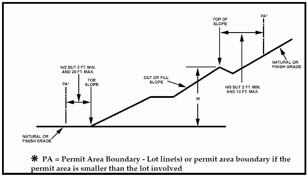
Figure 52-1: Grading Setbacks
a.
General. Setback dimensions shall be horizontal distances measured perpendicular to the site boundary. Setback dimensions shall be as shown in Figure 52-1.
b.
Top of cut slope. The top of the cut slopes shall not be closer to a site boundary line than one fifth of the vertical height of cut with a minimum of two feet and a maximum of 10 feet. The setback may need to be increased for any required interceptor drains or maintenance easements. The Director may approve adjustments as a condition of the permit, as required by individual site conditions.
c.
Toe of fill slope. The toe of fill slopes shall not be closer to the site boundary line than one-half the height of the slope with a minimum of two feet and a maximum of 20 feet. Where a fill slope is to be located near the site boundary and the adjacent off-site property is developed, or site conditions warrant, special precautions shall be incorporated in the work as the Director deems necessary to protect the adjoining property from damage as a result of such grading. These precautions shall include, but are not limited to the following:
(1)
Additional setbacks.
(2)
Provisions for retaining or slough walls.
(3)
Mechanical or vegetative treatment of the fill slope to minimize erosion.
(4)
Provisions for the control of surface waters.
(5)
Provisions for maintenance access.
d.
Modification of slope location. The Director may approve alternate setbacks. The Director may require an investigation and recommendation by a qualified engineer, engineering geologist, or erosion control specialist to demonstrate that the intent of this Section has been satisfied.
e.
Distance from property line. No cut or fill shall be made which is sufficiently close to the property line to endanger any adjoining public or private property or structures without supporting and protecting such property or structures from any settling, cracking, or other damage which might result.
4.
Landform alterations within public view corridors. Grading, vegetation removal, and other landform alterations shall be minimized on sites located within areas determined by the Planning Director to be a public view corridor from collector or arterial roads. Where feasible, contours of finished grading are to blend with adjacent natural terrain to achieve a consistent grade and appearance.
5.
Grading near watercourses. Grading, dredging or diking shall not alter any intermittent or perennial stream, or natural body of water shown on any USGS 7-1/2 minute map, except as permitted through approval of a County drainage plan and a streambed alteration permit from the California Department of Fish and Game issued under Sections 1601 or 1602 of the Fish and Game Code. Watercourses shall be protected as follows:
a.
Watercourses shall not be obstructed unless an alternate drainage facility is approved.
b.
Fills placed within watercourses shall have suitable protection against erosion during flooding.
c.
Grading equipment shall not cross or disturb channels containing live streams without siltation control measures approved by the Public Works Director in place.
d.
Excavated materials shall not be deposited or stored in or alongside a watercourse where the materials can be washed away by high water or stormwater runoff.
B.
Drainage standards. Designs for site area drainage and terraces shall be consistent with the Low Impact Development (LID) Handbook and the following minimum standards:
1.
Design and construction. Drainage systems and facilities subject to drainage plan review and approval that are to be located in existing or future public rights-of-way are to be designed and constructed as set forth in the latest edition of the Public Works Department's Public Improvement Standards, or as per the project's conditions of approval. Applicants may request an adjustment pursuant to the Public Improvement Standards in order to allow for a design that is more compliant with LID practices. Other systems and facilities subject to drainage plan review and approval are to be designed in accordance with good engineering practices. The design of drainage facilities in new land divisions and other new development subject to Minor Use Permit or Conditional Use Permit approval shall maximize groundwater recharge through on-site or communitywide stormwater infiltration measures. Examples of such measures include constructed wetlands, vegetated swales or filter strips, small percolation ponds, subsurface infiltration basins, infiltration wells, and recharge basins. Where possible, recharge basins shall be designed to be available for recreational use.
2.
Natural channels and runoff. Proposed projects are to include design provisions to retain natural drainage patterns and, when required, limit peak runoff to pre-development levels. To the maximum extent feasible, all drainage courses shall be retained in, or enhanced to appear in, a natural condition, without channelization for flood control. On downhill sites, encourage drainage easements on lower properties so that drainage can be released on the street or other appropriate land area below.
3.
Best Management Practices (BMPs). All new development subject to drainage plan review shall use BMPs to address polluted runoff. BMPs shall be consistent with the guidance found in documents such as the LID Handbook. Such measures shall include, but not be limited to: minimizing the use of impervious surfaces (e.g., installing pervious driveways and walkways); directing runoff from roofs and drives to vegetative strips before it leaves the site; and/or managing runoff on the site (e.g., percolation basins); and other Low Impact Design (LID) techniques. The installation of vegetated roadside drainage swales shall be encouraged and, if used, calculated into BMP requirements. The combined set of BMPs shall be designed to treat and infiltrate stormwater runoff up to and including the 85th percentile storm event. The BMPs shall include measures to minimize post-development loadings of total suspended solids.
4.
Runoff volume. Runoff conveyance systems shall be capable of carrying the computed runoff volume from a 25-year frequency storm or greater if deemed necessary by the Public Works Director. This may be reduced to a 10-year storm for small watersheds.
5.
Interceptors. Concrete ditches, bio-swales or other approved methods capable of intercepting surface runoff waters shall be installed along the top of all cut slopes where the tributary drainage area has a slope 10 percent or greater and a horizontal projection greater than 40 feet.
6.
Berms. Berms or drainage divides at least one foot high and three feet wide at the base shall be constructed at the top of all fill slopes where runoff would be directed towards the top of fill.
7.
Over side drains. Over side drains shall be of concrete or corrugated metal pipe having a diameter required by runoff calculations, but not less than eight inches, and shall be aligned so as to minimize velocity at discharge points. Alternate designs, such as LID methods, approved by the Public Works Director may be permitted.
8.
Inlets. Inlets shall be constructed of galvanized iron, or approved equivalent, and shall be provided with overflow structures.
9.
Outlets. Outlet structures shall be provided with approved velocity reducers, diversion walls, rip-rap, concrete aprons or similar energy dissipaters where necessary and aligned to minimize downstream erosion and reasonably maximize recharge at discharge points, and shall be approved by the Public Works Director.
10.
Dispersal structures. An approved drainage dispersal structure shall be constructed wherever it is necessary to convert channel flow to sheet flow.
11.
Sensitive habitat and groundwater protection. Runoff from roads and development shall not adversely affect sensitive habitat, groundwater resources and downstream areas, and shall be treated to remove floatable trash, heavy metals and chemical pollutants as necessary prior to discharge into surface or groundwater.
12.
Groundwater recharge methods. New development shall identify all methods to enhance groundwater recharge.
13.
Impervious surfaces. New development shall be designed to minimize the amount of impervious surfaces in order to maximize the amount of on-site infiltration.
14.
Rain gutters. Approved rain gutters shall be provided to receive all roof water and dispose of the water in a groundwater enhancing and non-eroding manner where the Director determines it to be necessary because of steepness of slope or presence of erodible materials. Direct connection of rain gutter outlets to impervious surfaces shall be minimized.
15.
Building site drainage. All graded building pads shall slope a minimum of five percent for ten feet to an approved drainage device, or as approved by the Director. The drainage device shall be an approved system which conducts the water to a street, recharge area or drainage way. The top of footing stems or finish floor, if a concrete slab, shall extend above the top of street curb or inlet to the drainage device by a minimum of six inches plus two per cent of the distance from the footing to the drainage device or curb. The Director may allow two percent to be used, if, because of terrain or soils, five percent is not reasonably attainable or necessary.
16.
Capacity of drainage devices. On graded sites, the Director may require that drainage devices calculated to convey runoff from a 25-year frequency storm or greater be installed, if deemed necessary to prevent erosion, to conduct stormwater around buildings or structures and to the nearest recharge area, drainage way, or as approved by the Public Works Director.
17.
Appearance of drainage or recharge devices. Where drainage devices are highly visible from the street or located in the public viewshed, they shall be shielded from view, if practical. Where visible, drainage devices shall be compatible with the character of the area and the existing topography. Exposed concrete overside drains are prohibited within these situations unless a visual analysis indicates the prohibition to be unnecessary. If they are visible, the size shall be the minimum necessary to handle drainage and ensure ability to maintain all drainage devices which collect from the slopes, and shall convey drainage by means of underground pipes or rock-lined ditches or other approved materials to blend with the natural topography in character, color and design. Transitions from natural drainage courses to developed areas shall be accomplished with comparable landscaping and grading to blend with existing topography. Detention, retention, or recharge basins shall be designed as a visual and/or recreational amenity within a project whenever practical.
18.
Areas subject to flooding. Buildings or structures are not permitted in an area determined by the Public Works Director to be subject to flood hazard by inundation, overflow, high velocity flows or erosion, except where the buildings or structures comply with the standards in Section 22.14.060, and provisions are made to eliminate identified hazards to the satisfaction of the Public Works Director. These provisions may include providing adequate drainage facilities, protective walls, suitable fill, raising the floor level of the building or structure, or other means. The building and other structures (including walls and fences) shall be placed on the site so that water or mud flow will not be a hazard to on- or off-site structures or adjacent property. In the application of this standard, the Public Works Director shall enforce as a minimum the current federal flood plain management regulations as defined in the National Flood Insurance Program authorized by United States Code Title 42, Section 4001-4128 and contained in Title 44 of the Code of Federal Regulations, Part 59 et seq., which are hereby adopted and incorporated into this Title by reference as though they were fully set forth here.
19.
Design of flood proofing measures. Flood proofing measures required by the Public Works Director shall be designed by a licensed architect or registered civil engineer.
20.
Sub-drains. The Director may require the installation of approved sub-drains in areas where underground water is anticipated.
21.
Runoff computations. Runoff computations may be made by the "rational method" except where specific methods for calculating individual residential retention basins have been adopted or with the approval of the Public Works Director.
22.
Alternate designs. Alternate designs which provide equivalent safety and are approved by the Public Works Director may be used in lieu of those contained in this Section.
23.
Hydromodification control. If the Director or Public Works Director has determined that the project could cause off-site erosion or adverse impacts to beneficial uses as a result of an increase in runoff rates and/or duration, the project shall incorporate hydromodification control measures in compliance with Low Impact Development (LID) Handbook requirements.
C.
Erosion and sedimentation control standards. When required by Section 22.52.120 or elsewhere in this Title, erosion and sedimentation control plans, and implementation thereof, shall comply with the following standards:
1.
Exposed man-made slopes shall be planted in permanent vegetation to prevent erosion unless determined by the Director to be unnecessary.
2.
Grading limits shall be staked out as shown on the approved plans before site disturbance begins. All land disturbance shall be restricted to this area.
3.
All cuts, fills, and disturbed areas shall be planted, mulched and maintained, or otherwise protected from the effects of stormwater runoff and wind erosion. Permanent or temporary soil stabilization must be applied to denuded areas within 15 days after final grade is reached on any portion of the site. Denuded areas which may not be at final grade but which will remain undisturbed for longer than 60 days shall also be stabilized within 15 days. All mulching shall provide the same protection as that resulting from the application of two tons of straw mulch per one acre of surface area. All disturbed or denuded area created during the period between October 15 and April 15 of the following year shall be mulched or equally protected before quitting time each day.
4.
All permanent slopes over three feet high shall be permanently revegetated to achieve a minimum of 70 percent coverage at 24 months. All slopes shall be maintained to assure the success of the plant material and the maintenance of the slope.
5.
A minimum of one (1) one-gallon shrub shall be planted per 100 square feet of slope area where shrubs are appropriate to the area unless equivalent alternate measures are approved by the Director. Plant material must be selected to achieve 100 percent coverage of slope at maturity.
6.
One (1) one-gallon tree shall be planted for every 500 square feet of slope area where appropriate to the area unless equivalent alternative measures are approved by the Director.
7.
Temporary or permanent irrigation shall be provided to assure the successful establishment of the plant material.
8.
Grading for agricultural practices to prepare a field or crop or range improvement practices shall be protected by recognized agricultural erosion and sedimentation control methods, such as those found in the Natural Resources Conservation Service (NRCS) Field Office Technical Guide (FOTG).
9.
Grading permits may be conditioned to provide landscape and maintenance security.
10.
Sediment basins shall be designed to trap and store all sediment particles larger than those passing a #200 testing sieve, from the peak discharge of a 25-year frequency storm.
11.
Runoff shall enter and exit a basin through protected inlets and outlets as approved by the Director.
12.
Sediment removal scheduling and sediment dispersal shall be included with the erosion and sedimentation control plan, subject to approval by the Director.
13.
Temporary drainage control measures during construction shall avoid concentration of flow which may cause or exacerbate erosion and sedimentation.
14.
Topsoil removed from the surface in preparation for grading and construction is to be stored on or near the site and protected from erosion while grading operations are underway, provided that such storage may not be located where it would cause suffocation of root systems of trees intended to be preserved or near a watercourse where sedimentation may occur. After completion of such grading, topsoil is to be restored to exposed cut and fill embankments or building pads to provide a suitable base for seeding and planting.
15.
Native plant materials are encouraged to reduce irrigation demands. Where riparian vegetation has been removed, riparian plant species shall be used for revegetation.
D.
Stormwater pollution prevention standards. Projects requiring a SWPPP pursuant to Section 22.52.130 shall comply with the standards outlined in SWRCB General Construction Permit Number CAS000002, or any subsequent General Construction Permits that amend or replace Permit CAS000002. These standards include, but are not limited to, the following:
1.
Discharge prohibitions.
a.
Approval of a grading plan, stormwater pollution prevention plan, erosion and sedimentation control plan, or drainage plan does not constitute an exemption to applicable discharge prohibitions prescribed in the Central Coast Basin Plan.
b.
Discharges of material other than stormwater (which are not otherwise authorized by an NPDES permit) to a separate storm sewer system (MS4) or waters of the nation are prohibited, except as allowed in Subsection 22.52.130F.5.
c.
Stormwater discharges shall not cause or threaten to cause pollution, contamination, or nuisance.
d.
Stormwater discharges regulated by the General Construction Permit shall not contain a hazardous substance equal to or in excess of a reportable quantity listed in Title 40 of the Code of Federal Regulations, Part 117 and/or Title 40 of the Code of Federal Regulations, Part 302.
2.
Receiving water limitations.
a.
Stormwater discharges and authorized non-stormwater discharges to any surface or ground water shall not adversely impact human health or the environment.
b.
The SWPPP developed for the construction activity shall be designed and implemented such that stormwater discharges and authorized non-stormwater discharges shall not cause or contribute to an exceedance of any applicable water quality standards contained in a Statewide Water Quality Control Plan and/or the Central Coast Regional Water Quality Control Board's Basin Plan.
c.
Should it be determined by the permit holder, County, State Water Resources Control Board (SWRCB), or Regional Water Quality Control Board (RWQCB) that stormwater discharges and/or authorized non-stormwater discharges are causing or contributing to an exceedance of an applicable water quality standard, the permit holder shall:
(1)
Implement corrective measures immediately following discovery that water quality standards were exceeded, followed by notification to the County and RWQCB by telephone as soon as possible but no later than 48 hours after the discharge has been discovered. This notification shall be followed by a report within 14-calendar days to the County and Central Coast Regional Water Quality Control Board, unless otherwise directed by the County and/or RWQCB, describing the following:
(a)
the nature and cause of the water quality standard exceedance;
(b)
the BMPs currently being implemented;
(c)
any additional BMPs which will be implemented to prevent or reduce pollutants that are causing or contributing to the exceedance of water quality standards;
(d)
any maintenance or repair of BMPs; and
(e)
an implementation schedule for corrective actions that describes the actions taken to reduce the pollutants causing or contributing to the exceedance.
(2)
Revise the SWPPP and monitoring program immediately after the report to the County and RWQCB to incorporate the additional BMPs that have been and will be implemented, the implementation schedule, and any additional monitoring needed.
(3)
Nothing in this section shall prevent the County and/or the Central Coast RWQCB from enforcing any stormwater discharge regulations while the permit holder prepares and implements the above report.
3.
Anticipated noncompliance. The permit holder shall give advance notice to the County and RWQCB of any planned changes in the construction activity which may result in noncompliance with General Construction Permit or County Code requirements.
E.
Groundwater recharge standards. Groundwater recharge measures shall be required as part of any land use permit processed pursuant to Chapter 22.62. Plan contents and standards shall be as specified in Section 22.52.100 and as listed below. Stormwater impoundment areas shall:
1.
Be located to use the most permeable soils on the project site, where practical.
2.
Be sufficiently shallow or properly shielded so that they do not pose a safety hazard.
3.
Drain fast enough or be designed so that ponded water does not become a vector habitat (mosquito pond).
F.
Pond, reservoir, and dam standards.
Note: All surface stream water impoundments require approval of an application to appropriate water from the California State Water Resources Control Board, Division of Water Rights.
The following standards apply to ponds, reservoirs, basins, and dams that are not eligible for ARP processing (22.52.080) or otherwise exempt (22.52.070):
1.
Location. The proposed site of the pond, reservoir or dam shall not be:
a.
Identified on any U.S. Geological Survey map as a lake, marsh, or solid or broken "blue line" stream unless the project has been reviewed subject to CEQA and determined not to contain significant adverse impacts to the aquatic or riparian resources.
b.
In a location identified on any published geologic or soils maps on soils prone to slip or slide.
2.
State Permitting. Reservoirs, ponds, or basins, with a storage capacity of 15 acre-feet or more and a dam height of 25 feet or more; or with a storage capacity of 50 acre feet or more and a dam height of 6 feet or more are subject to the jurisdiction of the Division of Dam Safety of the California Department of Water Resources. Ponds, reservoirs, and dams are subject to the standards in Section 22.52.150F.
3.
Noticing. A notice of intent to adopt a negative declaration or mitigated negative declaration shall be mailed for agricultural ponds, reservoirs, and basins to all landowners within 1,000 feet of the project site's parcel boundaries, in addition to all other legal noticing requirements.
4.
Required reports. The Director, in granting a permit for construction, shall require the following information:
a.
Supporting geological and geotechnical engineering reports as deemed necessary for the safe design and construction of such facility. A report from a civil engineer certifying that construction of the facility has been completed in conformity with the approved plans and specifications and this Chapter may be required.
b.
A hydrogeologic analysis prepared by a certified hydrologist, including:
i.
A description of the agricultural use to be supported by the proposed reservoir, pond, or basin. If the proposed reservoir, pond, or basin is in support of a future agricultural use, then the application shall include a planting plan showing the location of the future crops.
ii.
Identification of wells that would be used to fill the proposed agricultural reservoir, pond, or basin.
iii.
Information regarding the property's use of water and proposed use of water after construction of the proposed reservoir, pond, or basin.
iv.
Estimated evaporative water loss from the surface of the reservoir, pond, or basin, based on site specific conditions.
v.
A well interference and draw-down analysis, which evaluates how increased pumping would affect neighboring wells. This analysis shall take into consideration site specific variables such as the number and spacing of wells on-site, pumping rates, properties of the aquifer, and the duration over which pumping has and will occur.
5.
Peer Review. The hydrogeologic analysis required in this section shall be subject to peer review by a qualified hydrogeologist. The peer review shall be conducted by an on-staff or qualified consulting hydrogeologist.
6.
Design Standards. Groundwater filled reservoirs, ponds, and basins shall incorporate all feasible design measures to minimize evaporative water loss. This could include using a smaller surface area and/or an evaporation barrier.
7.
Water Offsets - Projects in an LOS III Groundwater Basin. New agricultural reservoirs, ponds, and basins that would be filled using wells overlying an LOS III Groundwater Basin shall propose measures to offset the estimated evaporative water loss at a ratio of at least 1:1. Compliance with this standard may be achieved through modification of onsite irrigated agriculture in existence at the time of Application Acceptance or through other means proposed by the applicant and approved by the Director of Planning and Building. If offsets are proposed through modification of crops, the applicant shall record a covenant and agreement prohibiting irrigation of the identified areas. The covenant shall remain in effect until the LOS for the groundwater basin is adjusted by the County Board of Supervisors to an LOS of II or lower. Projects in the Paso Robles Groundwater Basin may achieve compliance with this standard by obtaining an Offset Clearance pursuant to the Agricultural Water Offset Program for that basin.
[Amended 1999, Ord. 2863, 2010, Ord. 3188; 2014, Ord. 3282; 2018, Ord. 3345]
22.52.160 - Construction Procedures.
A.
Modifications to approved plans. No work based upon any modifications to the approved plans shall proceed unless and until such modifications have been approved by the Building Official, and where applicable, the County Public Works Department. The proposed change shall not result in greater environmental impacts than those considered in the approved environmental document.
B.
Grading hours - Limitations. No grading work (except for agricultural exemptions and emergency operations specified in Section 22.52.070C and 22.52.090C.2, respectively), which requires a grading permit under the provisions of this Chapter shall take place between the hours of 7:00 p.m. and 7:00 a.m. weekdays and between the hours of 5:00 p.m. and 8:00 a.m. on the weekends, unless the Building Official or approved conditions of a land use permit finds that such operation is not likely to cause a significant public nuisance and authorizes expanded or night operations in writing. Hours of operation on the weekends may be further regulated by conditions of the grading permit.
C.
Air quality controls.
1.
Fugitive dust control. All surfaces and materials shall be managed to ensure that fugitive dust emissions are adequately controlled to below the 20% opacity limit, identified in the APCD's 401 "Visible Emissions" rule and to ensure that dust is not emitted offsite. This applies to surfaces that will be graded, that are currently being graded, or that have been graded; and to all materials, whether filled, excavated, transported or stockpiled. The following fugitive dust control measures are required, unless alternative measures have been approved by the Air Pollution Control District (APCD):
a.
Primary measures. All projects involving grading or site disturbance shall implement the following mitigation measures to minimize nuisance impacts and to significantly reduce fugitive dust emissions:
(1)
Reduce the amount of the disturbed area where possible;
(2)
Use water trucks or sprinkler systems in sufficient quantities to prevent airborne dust from leaving the site. Increased watering frequency shall be required whenever wind speeds exceed 15 mph. Reclaimed (non-potable) water shall be used whenever possible;
(3)
All dirt stock-pile areas shall be sprayed daily as needed; and
(4)
All roadways, driveways, sidewalks, etc. to be paved shall be completed as soon as possible, and building pads shall be laid as soon as possible after grading unless seeding or soil binders are used.
b.
Expanded measures. Projects with site disturbance that exceeds four acres or are within 1,000 feet of any sensitive receptor shall implement the following mitigation measures to minimize nuisance impacts and to significantly reduce fugitive dust emissions:
(1)
All measures identified in Subsection C.1.a;
(2)
Permanent dust control measures identified in the approved project plans shall be implemented as soon as possible following completion of any soil disturbing activities;
(3)
Exposed ground areas that are planned to be reworked at dates greater than one month after initial grading shall be sown with a fast germinating native grass seed and watered until vegetation is established;
(4)
All disturbed soil areas not subject to revegetation shall be stabilized using approved chemical soil binders, jute netting, or other methods approved in advance by the APCD;
(5)
Vehicle speed for all construction vehicles shall not exceed 15 mph on any unpaved surface at the construction site;
(6)
All trucks hauling dirt, sand, soil, or other loose materials are to be covered or shall maintain at least two feet of freeboard (minimum vertical distance between top of load and top of trailer) in accordance with California Vehicle Code Section 23114;
(7)
Install wheel washers where vehicles enter and exit unpaved roads onto streets, or wash off trucks and equipment leaving the site; and
(8)
Sweep streets at the end of each day if visible soil material is carried onto adjacent paved roads. Water sweepers with reclaimed water shall be used where feasible.
c.
Measures to be shown on plans. All of these fugitive dust mitigation measures shall be shown on grading and building plans.
d.
Designated monitor. The contractor or builder shall designate a person or persons to monitor the fugitive dust emissions and enhance the implementation of the measures as necessary to minimize dust complaints, reduce visible emissions below 20% opacity, and to prevent transport of dust offsite. Their duties shall include holidays and weekend periods when work may not be in progress.
Note: Sensitive receptors include schools, parks and playgrounds, day care centers, nursing homes, hospitals, and residences.
2.
Exportation and importation of material. For projects which involve the cumulative importation or exportation of 2,000 cubic yards or more of soil to a non-adjacent site, the Director may impose one or more of the following conditions:
a.
Limiting the distance between the project site and the source/destination site.
b.
Requiring that export/import be phased over a specified amount of time.
c.
Scheduling truck trips during non-peak hours to reduce peak hour emissions.
d.
Limiting the length of the workday.
e.
Applying trucking equipment emission reduction measures as approved by the Air Pollution Control District.
3.
Naturally Occurring Asbestos (NOA). Grading work shall comply with California Air Resources Board Asbestos Air Toxics Control Measure (ATCM) for construction and grading. Prior to any grading activities in NOA candidate areas, the project proponent shall ensure that a geologic evaluation is conducted to determine if NOA is present within the area that will be disturbed. If NOA is not present, an exemption request must be filed with the Air Pollution Control District. If NOA is found at the site, the applicant must comply with all requirements outlined in the Asbestos ATCM. This may include development of an Asbestos Dust Mitigation Plan and an Asbestos Health and Safety Program for approval by the APCD.
D.
Off-site effects. Grading operations shall be conducted to prevent damaging effects of erosion, sediment production and dust on the site and on adjoining properties and roadways.
E.
Hydrocarbon contaminated soil.
1.
Encountered during grading activities. Should hydrocarbon contaminated soil be encountered during construction activities, the Air Pollution Control District (APCD) must be notified as soon as possible and no later than forty-eight (48) hours after affected material is discovered to determine if an APCD Permit will be required. In addition, the following measures shall be implemented immediately after contaminated soil is discovered:
a.
Covers on storage piles shall be maintained in place at all times in areas not actively involved in soil addition or removal;
b.
Contaminated soil shall be covered with at least six inches of packed uncontaminated soil or other Total Petroleum Hydrocarbon (TPH) non-permeable barrier such as plastic tarp. No headspace shall be allowed where vapors could accumulate;
c.
Covered piles shall be designed in such a way to eliminate erosion due to wind or water. No openings in the covers are permitted;
d.
During soil excavation, odors shall not be evident to such a degree as to cause a public nuisance; and
e.
Clean soil must be segregated from contaminated soil.
2.
Anticipated to be present prior to grading activities. An APCD permit to address proper management of anticipated hydrocarbon contaminated soil is required prior to the start of any grading activity or earthwork. This permit shall include conditions to minimize emissions from any excavation, disposal or related process. The applicant is responsible to contact APCD within 120 days prior to the start of any grading activity/earthwork to begin the permitting process.
F.
Responsibility of permit holder.
1.
The permit holder shall be responsible for the work to be performed in accordance with the approved plans and specifications and in conformance with the provisions of this code. The permit holder shall engage the project consultants, as needed, to provide professional inspections on a timely basis. The permit holder shall act as a coordinator between the project consultants, the contractor, and the Building Official. In the event of changed conditions, the permit holder shall be responsible to inform the Building Official of such changes and shall provide revised plans for approval.
2.
The permit holder and/or agents shall maintain all required protective devices, sedimentation and erosion control devices, stormwater BMPs, and temporary drainage facilities during the progress of the grading work. The permit holder shall also be responsible for observance of working hours, dust controls and methods of hauling. The permit holder and/or agents shall be responsible for maintenance of the site until final inspection. The permit holder and/or agents shall become subject to the penalties set forth herein in the event of failure to comply with this Chapter and other applicable laws of the County. No approval shall exonerate the permit holder and/or agents from the responsibility of complying with the provisions and intent of this Chapter.
3.
During grading operations the permit holder shall be responsible for the prevention of damage to any roadways, public improvements, utilities or services. This responsibility applies within the limits of grading and along any equipment travel routes.
4.
Notwithstanding the minimum standards set forth in this Chapter, Title 19 of the County Code, and 1997 Uniform Building Code Appendix Chapter 33, the permit holder is responsible for the prevention of damage to adjacent property, and no person shall excavate on land so close to the property line as to endanger any adjoining public street, sidewalk, alley, structure, trees, vegetation, or any other public or private property without supporting and protecting such property from settling, cracking, or other damage which might result.
[Amended 1999, Ord. 2863; 2010, Ord. 3188]
22.52.170 - Inspections.
All construction and other work for which a permit is required shall be subject to either periodic or continuous inspections by authorized employees of the Planning and Building Department to assure compliance with the approved plans. Inspectors shall approve that portion of the work completed or shall notify the permit holder where the work fails to comply with the approved plans.
Where the Building Official determines it to be necessary to protect the public safety because of the nature and type of material involved, the type of work proposed or the purpose of the work, the work shall have either continuous or periodic inspections and supervision by one or more of the following as a condition of issuance of the grading permit:
(1)
civil engineer;
(2)
geotechnical engineer;
(3)
engineering geologist; or
(4)
responsible designee.
Prior to final approval of grading work under any type of permit, a final inspection shall be made of all construction or work for which a permit has been issued. Final inspection, as required in this chapter, shall be made by an employee of the Planning and Building Department.
Approved plans for grading, vegetation removal work, and erosion and sedimentation control (or SWPPP if required) bearing the stamp of the County of San Luis Obispo Department of Planning and Building shall be maintained at the site during the progress of the work.
In the absence of specific work site designation upon which grading is to be performed, the Building Official may require the site be surveyed and staked by a civil engineer or land surveyor licensed by the State of California, so that the proper location of the work on the lot may be determined.
A.
Required Inspections. Inspections for a grading permit shall be made as provided herein and work shall not continue until approval to proceed has been granted following the requested inspection. The permit holder shall be responsible for requesting inspection by the Planning and Building Department as follows:
1.
Site check. Prior to permit approval and plan checking.
2.
Pre-construction meeting. At the Building Official's discretion, a pre-construction meeting may be required due to site characteristics, required mitigation measures, or complexity of the proposal. Qualified professionals may need to be in attendance.
3.
Pre-construction stormwater inspection. When the permit holder is ready to begin work, but before any grading or vegetation removal has occurred, inspect and review erosion and sedimentation control BMPs with permit holder. Subsequent site inspections may be conducted at any time during the life of the project to determine compliance with the erosion and sedimentation control plan and/or stormwater pollution prevention plan.
4.
Toe inspection. After the natural ground is exposed and prepared to receive fill, but before any fill is placed, review erosion and sedimentation control BMPs with permit holder.
5.
Excavation inspection. After the excavation is started, but before the vertical depth of the excavation exceeds ten feet.
6.
Fill inspection. After the placement of fill is started, but before the vertical height of the fill exceeds ten feet, and at two foot vertical increments thereafter unless waived by the Building Official. In addition, the fill must be inspected by a qualified lab requiring testing for each two feet of fill, or as defined in the soils report.
7.
Key and bench inspection. After keys and benches are excavated, but before fill is placed.
8.
Rough grade inspection. When all rough grading has been completed, including terraces, swales, and other drainage devices.
9.
Drainage and/or groundwater recharge device inspection. After forms and pipe are in place, but before any gravel or concrete is placed, inspect erosion and sedimentation control BMPs.
10.
Post-construction stormwater inspection. When all work has been completed, all disturbed areas of the construction site have been stabilized, and all long-term (permanent) stormwater pollution prevention and erosion and sedimentation control measures have been installed. Consistent with the General Construction Permit Notice of Termination (NOT) requirements (where applicable), in order for the post-construction stormwater inspection to be approved, all soil disturbing activities shall have been completed and one of the following shall have been met:
a.
A uniform vegetative cover of 70 percent coverage has been established. In arid areas where native vegetation covers less than 100 percent of the surface, the 70 percent coverage criterion shall be proportionally adjusted (i.e. where native vegetation covers 50 percent: 0.50 × 0.70 = 0.35 - 35 percent); or
b.
Equivalent stabilization measures have been employed (e.g. fiber blankets, channel liners, mulch, etc.).
11.
Final inspection. When all work, including installation of drainage structures, other protective devices, planting and slope stabilization has been completed and the required reports have been submitted to the Building Official and accepted as complete.
12.
Other inspections. In addition to the inspections above, such other inspections of any work to ascertain compliance with the provisions of this chapter and other laws and regulations as may be required by the Building Official including requirements of the NPDES permit of the County of San Luis Obispo for its stormwater discharges. A licensed landscape architect, qualified biologist, archeologist, agricultural advisor, or other qualified professional may be required to be present during inspections.
13.
Rainy season inspection. During the rainy season (between October 15 and April 15), inspections shall be conducted to verify compliance with required BMPs based on potential for threat to water quality, as determined by the Building Official. Criteria to be considered include area of disturbance, earthwork quantities, and proximity to watercourses. Based on this assessment, a threat priority will be assigned an inspections shall occur as follows:
B.
Exposure of work. Whenever any work for which inspections are required is covered or concealed by other work without having been inspected, the Building Official may require that such work be exposed for examination.
C.
Post construction and other inspections.
1.
Best Management Practices (BMPs). Inspectors of the Planning and Building Department may inspect for adequate installation and functionality of BMPs prescribed by the erosion and sedimentation control plan or SWPPP at any time throughout the year. County inspectors may identify maintenance and repair needs on the site with the permit holder, or permit holder's agent, to ensure compliance with the minimum requirements of BMPs.
2.
Corrective action. If the Building Official determines by inspection that grading as authorized is likely to endanger public health, safety or welfare in the deposition of debris on any public street, or interfere with any existing drainage course, the Building Official may require that reasonable safety precautions be taken to remove such likelihood of danger. Written notice to comply shall be provided to the permit holder allowing no more than ten days for corrections to begin unless an imminent hazard to the public health, safety or welfare exists, in which case the corrective work shall begin immediately.
D.
Special Reports. Periodic reports by a geotechnical engineer, an engineering geologist, or other qualified professional, certifying the compaction or acceptability of all fills may be required. These shall include, but not be limited to, inspection of cleared areas and benches prepared to receive fill and removal of all unsuitable materials, the bearing capacity of the fill to support structures, the placement and compaction of fill materials, and the inspection of buttress fills, subterranean drains, cut slopes and similar devices.
E.
Inspection by Others.
1.
Where the nature of the project, type of soils, geologic conditions or drainage dictate that special engineering, geotechnical engineering, or geological inspections are necessary to prevent danger to public health, safety or welfare, the Building Official may require the permit holder to retain one or more of the following:
a.
A civil engineer: to supervise and coordinate all field surveys and the setting of grade stakes in conformity with the plans, to check elevation of grades, inclination of slopes, installation of drainage structures and other matters related to the geometric design of the work, including the design of revised or modified plans, if necessary.
b.
A geotechnical engineer: to provide either periodic or continuous inspection of all soils work, including grading and compaction.
c.
An engineering geologist: to provide geological inspections.
d.
Resource Conservation District: to provide inspections related to drainage and soil erosion prevention.
2.
On work requiring the continuous supervision and inspection of a civil engineer or geotechnical engineer, required inspections may be delegated to the civil engineer or geotechnical engineer by the Building Official. At the time of checking the plans, the Building Official shall indicate on each application for a grading permit the types of inspection, if any, to be made by the civil engineer or geotechnical engineer.
3.
If the civil engineer or geotechnical engineer or geologist finds that the work is not being performed in substantial conformity with this Chapter, or the plans and specifications, the engineer shall issue a notice to the persons in charge of the grading work and to the Building Official.
4.
APCD or state compliance staff may inspect the project site to ensure that grading activities are in compliance with the California Air Resources Board Asbestos Air Toxics Control Measure (ATCM) for Construction, Grading, Quarrying, and Surface Mining Operations and the National Emission Standard for Hazardous Air Pollutants.
F.
Inspection process.
1.
Grading shall not be commenced until the permit holder or agent has posted an inspection record card in a conspicuous place on the site to allow the inspector to make the required entries thereon regarding inspection of the work. This card shall be maintained and available on the site by the permit holder until final approval.
2.
The permit holder, agent, or contractor shall have an approved set of grading, drainage and erosion and sedimentation control plans, and stormwater pollution prevention plan (if required), on the site and available at all times while work is in progress until final approval. The plans and specifications shall also include any mitigation measures approved by the Environmental Coordinator.
3.
In the absence of a specific work site designation, the Building Official may require the site to be surveyed and staked by a civil engineer or land surveyor licensed by the State of California so that the proper location of the work on the lot or parcel may be determined.
4.
Inspections for a grading permit shall be made as provided herein and work shall not continue until approval to proceed has been granted, following inspection. The permit holder shall be responsible for notifying the Department of Planning and Building at least 24 hours prior to the time when an inspection is necessary.
5.
Where the nature of the project, type of soils, geologic condition, drainage, or weather conditions dictate that special engineering, geotechnical engineering, geological, or erosion and sedimentation or asbestos control inspections are necessary to prevent danger to public health, safety or welfare, the Building Official may require the permit holder to retain a licensed professional qualified to perform the following:
a.
Supervise and coordinate all field surveys and the setting of grade stakes in conformity with the plans; to check elevations or grades; inclination of slopes; elevation and grades of drainage structures and other matters related to the geometric design of the work, including the design of revised or modified plans and "as-graded" plans, if necessary.
b.
Provide either periodic or continuous inspection of soils work, including grading and compaction.
c.
Provide geological inspections.
d.
Inspect all erosion and sedimentation runoff control measures and revegetation practices applied to the site.
6.
Where the nature of the project dictates that special environmental monitors be required, the environmental review process and mitigation measures shall establish the manner and timeframe in which this review shall occur. In these instances, the Director may require the permit holder to retain a qualified professional to perform the work identified from these measures.
7.
If the civil engineer, geotechnical engineer, geologist, or sediment and erosion control specialist find that the work is not being performed in substantial conformity with this Chapter or the approved plans and specifications, notice shall be given to the person in charge of the grading work and to the Building Official. No work shall proceed unless and until the issuance of such written notice from the Building Official that work may proceed.
8.
If the Director or Building Official determines by inspection that grading as authorized is likely to endanger sensitive resources, public health, safety, or welfare in the deposition of debris on any public or private property, or interfere with any existing drainage course, the Director or Building Official shall require that effective precautions be taken to remove such likelihood or danger. Written notice to comply shall be given to the permit holder allowing no more than 10 days for corrections to begin unless an imminent hazard to sensitive resources or the public health, safety or welfare exists, in which case the corrective work shall begin immediately.
9.
Final inspection, as required in this Chapter, shall be made to the satisfaction of the Building Official.
G.
Testing. The Director may also require that the applicant pay for testing to be performed by an independent, approved testing laboratory and that the civil engineer issue an opinion to ensure compliance with this ordinance, permit conditions, and/or accordance with the provisions of Title 19 of the County Code. The Building Official shall inspect or provide for adequate inspection of the project by appropriate professionals at the various stages of work and at any more frequent intervals necessary to determine that adequate control is being exercised by the professional consultants.
H.
Reports required. The registered design professional shall provide a summary of the reports required, including special inspections, as set forth in the California Building Code, observe and testing program, and frequency of progress reports, where applicable.
I.
Transfer of responsibility. Where the soils or other conditions are not as stated on the permit, or where the services of the engineer approved to supervise or inspect grading work have been terminated, work shall not commence again until a civil engineer, geotechnical engineer or engineering geologist certifies in writing to the Director or the Building Official that:
(1)
all phases of the project have been reviewed;
(2)
the engineer is thoroughly familiar with the proposed work; and
(3)
the work already completed is approved or responsibility for making the necessary improvements thereto will be assigned to the engineer.
Upon receipt of this notice, the Director or Building Official shall immediately give written notice that work may proceed. No work shall proceed unless and until the issuance of such written notice that work may proceed has been issued.
J.
Final Reports. Upon completion of the work, the Building Official may require the following reports and drawings:
1.
An as-graded plan prepared by the civil engineer of record, including original ground surface elevations, as-graded ground surface elevations, lot drainage patterns and locations and elevations of all surface and subsurface drainage facilities. Certification by the civil engineer of record shall be provided that all grades, lot drainage, and drainage facilities have been completed in conformity with the approved plans.
2.
A geotechnical engineering report prepared by a geotechnical engineer that includes, but is not limited to, locations and elevations of field density tests and other substantiating data, certification of soil capacity, and compaction summaries of field and laboratory tests, location of tests, and showing limits of compacted fill on a grading plan. This certification shall include specific approval of the grading as affected by soils on the site.
3.
An engineering geology report based on the grading plan prepared by an engineering geologist, that includes, but is not limited to a final description of the geology of the site including any new information disclosed during the grading and specific approval of the grading as affected by geological facts. Where necessary, a revised geologic map and cross-sections and any recommendations necessary shall be included.
4.
An erosion and sedimentation control report prepared by the certified sediment and erosion control specialist or other qualified, approved professional. This report shall include a final description of the erosion, sediment revegetation and runoff control practices applied on the site. Any new information disclosed during site development and the effect of same on recommendations incorporated in the approved grading plan shall also be provided. Any required changes shall be noted. The designated specialist shall provide a statement that, to the best of their knowledge, the work within their area of responsibility is in compliance with the approved erosion and sedimentation control plan and applicable provisions of the California Building Standards Code and this Chapter.
5.
The grading contractor shall submit in a form prescribed by the Director and a statement of conformance to all as-graded plans and specifications.
[Amended 1999, Ord. 2863; 2010, Ord. 3188; 2014, Ord. 3282]
22.52.180 - Request for Relief from Ordinance Provisions and Standards.
A.
A request for relief from the provisions of this Chapter, grading permit conditions of approval, or plan specifications, may be approved, conditionally approved, or denied by the Director. A request for relief must state in writing the provision that is proposed to be varied, the proposed substitute provision, when it would apply, and its advantages. The following findings shall be required to approve or conditionally approve a request for relief:
1.
There are special individual circumstances or conditions affecting the property that make the strict letter of this ordinance impractical; and
2.
No relief shall be granted unless the relief requested is consistent with the purpose and intent of this Chapter and does not diminish the health and safety benefits that would be obtained in the absence of a grant of relief.
B.
The Director may require additional information from professional engineering, engineering geology or geotechnical engineering or erosion control specialists' opinions which are necessary to evaluate the requested relief.
C.
As contemplated in this Section, the Director may grant alternative methods of construction or modifications for projects which could be constructed under the basic standard established in this Chapter, but which if relief is granted, can be better or equal to and more economically designed and constructed than if relief were not given. Relief shall not be granted if it would have the effect of allowing the construction of a project which would not be possible under the provisions of this code without the relief.
[Amended 1999, Ord. 2863; 2010, Ord. 3188]
22.52.190 - Enforcement.
A.
Stop Work Order.
1.
Whenever any grading, construction or earthwork is being done contrary to the provisions of any approval or of any rule, regulation, law or ordinance, or whenever approval was based upon purposeful misinformation or misrepresentation, or whenever the public health, safety or welfare is endangered, or any work is not in compliance with the plans or permits approved for the project, the Director shall issue a written notice or stop work order on the portion of the work affected. Such notice or order to stop work shall be served upon the property owner and any persons engaged in the doing or causing such work to be done, and any such persons shall forthwith stop such work until authorized by the Director to proceed with the work in writing. The notice or order shall state the reason for the notice and no work shall be done on that portion until the matter has been corrected and approval obtained from the Director. The order may specify actions necessary to restore the site or provide temporary measures for erosion and sedimentation control until the stop work order has been removed.
2.
It shall be unlawful for any person to commence or continue any work regulated under the provisions of this Chapter in violation of, or contrary to any stop work notice or stop work order issued in compliance with this Section, except in conformity to the terms of such order or notice of order, or until relief from such order is obtained from the Director or, upon appeal, from the Board of Supervisors.
B.
Appeal. All decisions, interpretations or acts of the Director or Building Official regarding the implementation of the standards of this Chapter, shall be subject to appeal to the Board of Supervisors in compliance with Section 22.70.050.
C.
Violations and penalties.
1.
Any person, firm, contractor, or corporation whether as principal, agent, employee or otherwise who shall commence, construct, enlarge, alter, repair, or maintain any grading, excavation, or fill, or cause the same to be done, contrary to or in violation of any provision of this Chapter is subject to civil and/or criminal action. The Board of Supervisors hereby declares that any grading done contrary to the provisions of this code is unlawful and a public nuisance, subject to abatement as set forth in Section 22.74.150. The offense may be filed as either an infraction or a misdemeanor at the discretion of the San Luis Obispo County District Attorney.
2.
In addition to any penalties prescribed, the Director shall submit a written report to the appropriate state licensing or professional registration board or society in cases where contractors or professional consultants violate the provisions of this code.
3.
If filed as an infraction and upon conviction thereof, the crime shall be punishable by a fine not to exceed one hundred dollars ($100) for a first violation; a fine not exceeding two hundred dollars ($200) for a second violation of the same ordinance thereafter; and a fine not exceeding five hundred dollars ($500) for each additional violation of the same ordinance thereafter.
4.
If filed as a misdemeanor, and upon conviction thereof, the punishment shall be a fine of not less than five hundred dollars ($500) nor more than one thousand dollars ($1,000), or imprisonment in the county jail for a period not exceeding six months, or by both such fine and imprisonment.
5.
Any person violating any of the provisions of this chapter shall be guilty of a separate offense for each and every day or portion thereof during which any violation of any of the provisions of this chapter is committed, continued, or permitted.
6.
Paying a fine or serving a jail sentence shall not relieve any person from responsibility for correcting any condition which violates any provision of this Title.
7.
Grading without a permit, or using inadequate or improper grading techniques, can have potentially greater environmental effects. These effects include sedimentation and erosion impacts and excessive native vegetation and wildlife impacts. To address this, the applicant shall include additional "cumulative impact" measures above those required for specific on-site remedial work. These measures shall be proportional in size to the areas disturbed and may include:
a.
contribution to an off-site revegetation banking program;
b.
contribution towards a Resource Conservation District water quality enhancement or other restoration project;
c.
reestablishment of nearby degraded habitat;
d.
removal of surrounding undesirable weedy plants within a sensitive habitat;
e.
permanent protection of a proportional amount of comparable land;
f.
funding outreach and public education or professional education programs;
g.
providing partial funding to assist the erosion control and outreach programs of local Resource Conservation Districts; and/or
h.
other measures as determined appropriate by the Director.
8.
Where the only violation of this Chapter is failure to file an Agricultural Grading Form, as set forth in Section 22.52.070C, the violation shall be corrected by filing the form after-the-fact. In this circumstance the involved party shall not be subject to penalties, fines, or criminal prosecution.
D.
Injunctions, civil remedies, penalties, and costs.
1.
Any person, firm, contractor, or corporation whether as principal, agent, employee or otherwise who shall commence, construct, enlarge, alter, repair, or maintain any grading, excavation, or fill, or causes the same to be done, contrary to or in violation of any provision of this Chapter shall be subject to injunction against such activity and shall be liable for a civil penalty not to exceed twenty-five thousand dollars ($25,000) for each day that the violation continues to exist.
2.
When the Director determines that any person has engaged or, is engaged, in any act(s) which constitute a violation of provision(s) of this Chapter, or order issued, the District Attorney or the County Counsel may make application to the Superior Court for an order enjoining such acts or practices, or for an order directing compliance, and upon a showing that such person has engaged in any such acts or practices, a permanent or temporary injunction, restraining order, or other order may be granted by a Superior Court having jurisdiction over the cause.
3.
Any person, firm, or corporation whether as principal, agent, employee or otherwise who shall commence, construct, enlarge, alter, repair, or maintain any grading, excavation, or fill, or causes the same to be done, contrary to or in violation of any provision of this Chapter shall be liable for and obliged to pay to the County of San Luis Obispo for all costs incurred by the County in investigating and obtaining abatement or compliance, or which are attributable to or associated with any enforcement or abatement action, whether such action is administrative, injunctive or legal; and for all damages suffered by the County, its agents, officers or employees as a result of such violation or efforts to enforce or abate the violation. (See Section 22.74.080, Recovery of Costs.)
4.
Until all costs, fees and penalties assessed under this Chapter are paid in full, no final approval, Certificates of Completion, Certificates of Compliance, Certificates of Occupancy, land use permits or subdivision maps shall be issued or approved by the Planning and Building Department, Public Works Department, other County agencies, or the Board of Supervisors.
5.
In determining the amount of civil penalty to impose, the Court shall consider all relevant circumstances, including but not limited to, the extent of the harm caused by the conduct constituting the violation; the nature and persistence of such conduct; the length of time over which the conduct occurred; the assets, liabilities and net worth of the persons responsible, whether corporate or individual; any corrective action taken by the persons responsible; and the cooperation or lack of cooperation in efforts toward abatement or correction.
E.
Additional actions and remedies.
1.
Any person who violates any provision of this Chapter or who violates any stop work order or notice may also be in violation of the Federal Clean Water Act and/or the State Porter-Cologne Act and may be subject to prosecution under those Acts, including civil and criminal penalties. Section 309 of the Clean Water Act provides significant penalties for any person who violates a permit condition implementing Sections 301, 302, 306, 307, 308, 318, or 405 of the Clean Water Act or any permit condition or limitation implementing any such section in a permit issued under Section 402. Any person who violates any permit conditions of the General Construction Permit is subject to a civil penalty not to exceed twenty-seven thousand five hundred dollars ($27,500) per calendar day of such violation, as well as any other appropriate sanction provided by the Clean Water Act. The Porter-Cologne Water Quality Control Act also provides for civil and criminal penalties which in some cases are greater than those under the Clean Water Act. Any enforcement actions authorized under this Chapter may also include notice to the violator of such potential liability.
2.
Any person who knowingly makes any false material statement, representation, or certification in any record or other document submitted or required to be maintained by this Chapter or the General Construction Permit is subject to civil or criminal action. This may include prosecution for violation of Section 309(c)(4) of the Clean Water Act which provides for a fine of not more than ten thousand dollars ($10,000), or by imprisonment for not more than two years, or both.
3.
Any person who violates any order issued by the County for violation of the provisions of this Chapter regulating or prohibiting discharge of both stormwater and non-stormwater, and which causes, or threatens to cause, pollutants to enter the County's stormwater conveyance system shall be liable for such amounts that the County may be fined by the State Water Resources Control Board (SWRCB) or Regional Water Quality Control Board (RWQCB), or the amount of any civil liability imposed on the County for non-compliance with the SWRCB permits.
4.
Any party found to be in violation of Sections 22.10.155, 22.52.130, or 22.52.150D in such a manner that poses or threatens to pose a significant danger to the environment or public health and safety, may have its name published in the largest daily newspaper in the San Luis Obispo area.
5.
Violations of San Luis Obispo County Air Pollution Control District (APCD) Rules or fugitive dust mitigation measures, the California Air Resources Board Asbestos Air Toxics Control Measure (ATCM) for Construction, Grading, Quarrying, and Surface Mining Operations, and the National Emission Standard for Hazardous Air Pollutants may result in required mutual settlements and or significant civil and/or criminal penalties as specified in state and federal law.
F.
Denial of subsequent permits. Violation of any of the provisions of this Chapter shall be grounds for denying for five years all applications for building permits, grading permits, land use permits, tentative subdivision maps, general plan amendments, and other land development applications proposed for the site on which the violation occurred. The five-year period shall commence from the date of discovery of the violation. The Board of Supervisors may waive or reduce the penalty imposed by this subsection, for good cause. Any such waiver, if granted, shall in no way relieve the owner or applicant for any such subsequent land development application, of their duty to include the effects of the grading or clearing in any environmental analysis performed for the subsequent application, and to restore or rehabilitate the site, provide substitute or compensating resources, or perform other appropriate measures to mitigate the adverse effects of the illegal grading or clearing.
G.
Remedies not exclusive. The remedies identified in this Chapter are in addition to and do not supercede or limit any other remedies, including administrative, civil and/or criminal remedies pursuant to federal, state, and local law. The remedies provided in this Chapter shall be cumulative and not exclusive.
[Amended 1999, Ord. 2863; 2010, Ord. 3188]
22.52.200 - Education and Outreach.
A.
Outreach and Public Education. A formal outreach and public education program shall be implemented to reach the broadest possible audience, including grading contractors, heavy equipment operators, farmers and ranchers, and other professionals involved in grading and/or earthwork. This program shall include, but shall not be limited to, informational handouts, webpage information, and notification of requirements distributed with construction and land use permits.
B.
Professional Education Program. In the event that the County adopts a certification Program for grading contractors, where state law requires that earthwork, grading, excavation or fill be performed by a licensed contractor, that licensed contractor shall also be certified by the County. Certification requirements shall be as established by the Board, and may include, but not necessarily be limited to, satisfactory knowledge and understanding of the County Grading, Drainage and Erosion and Sedimentation Control Ordinance, and/or familiarity with and continuing education in accepted grading, drainage, erosion and sedimentation control methods.
[Amended 1999, Ord. 2863; 2010, Ord. 3188]
22.52.210 - Fees.
Fees for grading permits and grading, drainage, and erosion and sedimentation control plan checking shall be as set forth in the fee ordinance adopted by the Board. In compliance with the adopted fee schedule, the Director may require payment of actual recorded costs, plus overhead, for those applications which will exceed County fees for processing, plan checking, administration, and/or inspection.
[Amended 1999, Ord. 2863; 2010, Ord. 3188] [22.05.028]
22.54.010 - Purpose of Chapter.
This Chapter provides standards for the site access, driveway, and curb, gutter, and sidewalk improvements required for development projects authorized by a land use permit. [22.05.104]
22.54.020 - Site Access and Driveway Requirements.
All projects that are subject to land use or construction permit approval shall be provided adequate vehicular and pedestrian access, as follows:
A.
Minimum site access. No land use or construction permit shall be approved for any site unless the site has legal access and all-weather physical access to a public road; except that installation of all-weather physical access improvements may be provided prior to final building inspection, or prior to occupancy where allowed by Section 19.04.042 (Occupancy or use of an incomplete structure), where such improvements do not currently exist.
B.
Site access location. The provisions of this Subsection apply only to land uses that are required to have six or more parking spaces. Land use permit approval shall not be granted to a proposed use unless at least one driveway serving the use is located on the type of street specified by this Section. These requirements are based on the traffic volume and turnover rate generated by a new land use, determined by the number of parking spaces required and the intensity of use of the parking lot (see Chapter 22.18 - Off-Street Parking Required, or Article 4 for a special use).
1.
Required street type for access. At least one vehicle access driveway shall be located on any street with a capacity equal to or greater than the minimum specified by the following table. These standards do not apply to a parking lot that is a principal use (see Section 22.30.630 - Vehicle Storage).
;sz=8q;Notes:
(1)
Expressed as the type of street (arterial, collector, local) on which a proposed use must be located. Actual access driveways may be located on a cross-street where the site abuts the required type of street.
(2)
Parking lot turnover is determined by Chapter 22.18 (Parking and Loading), for the specific land use.
(3)
For the purposes of this Section, collector streets include freeway frontage roads that extend between two collectors, between two freeway access points (which must include access and egress for both freeway directions), or a combination of the two situations.
(4)
At least one site access driveway on a collector shall be within 800 feet of an arterial, measured along the roadway.
(5)
At least one site access driveway on a local street shall be within 400 feet of a collector, measured along the roadway.
2.
Alternative street types for access. Driveway access locations other than those required by Subsection B.1 above are allowable subject to Minor Use Permit approval, provided that the Review Authority first finds that the alternate location will not result in traffic congestion or traffic volumes inappropriate or substantially detrimental to the site vicinity. Where a Conditional Use Permit is otherwise required, the approval can be granted by the review authority through the Conditional Use Permit subject to the same required finding.
C.
Driveway placement. A driveway from a street to a parking area with four or more parking spaces shall be located and designed as follows:
1.
Distance from street corner. Driveways shall be located a minimum of 50 feet from the nearest street intersection, as measured from the centerline of the driveway to the nearest travel lane of the intersecting street.
2.
Number of driveways. Driveways serving a single site shall be limited to two along the frontage of any street, except where additional driveways are authorized by Minor Use Permit. The centerline of such driveways shall be separated by a minimum of 30 feet.
3.
Distance from property line. Where a driveway intersects a street, the driveway shall be located a minimum of four feet from a side property line, except that the driveway transition may extend to within one foot of the property line, and except where adjoining lots use a shared driveway.
D.
Driveway design and construction. Proposed driveways shall be designed and constructed as follows. These requirements are in addition to any applicable provisions of Chapter 13.08 of this code (Encroachments).
1.
Driveway width. A driveway, as defined in Chapter 22.80 (Definitions - Driveway), providing access to a building sites or a parking area from the public street or between separate parking areas on a site shall be a minimum width of 10 feet and shall also provide a fuel modification area as defined by Chapter 22.80 (Definitions - Fuel Modification Area), where applicable.
2.
Exception to width standard. The following standards shall apply In high or very high fire hazard severity zones.
;sz=8q;Notes:
(1)
The driveway shall provide for a fuel modification area as defined in Chapter 22.80 (Definitions - Fuel Modification Area).
(2)
A turnout, as defined in Chapter 22.80 (Definitions - Turnout), shall be provided near the midpoint.
(3)
For driveways exceeding 300 feet, a turnaround, as defined in Chapter 22.80 (Definitions - Turnaround), shall be provided at the building site and must be within 50 feet of the dwelling. For driveways exceeding 800 feet, turnouts shall be provided no more than 400 feet apart.
3.
Driveway grade. The minimum level of improvement is determined by the grade of the driveway providing access from the road to the building site or parking area as follows:
;sz=8q;Notes:
(1)
Surface shall be asphalt or concrete as specified in the San Luis Obispo County Standard Specifications and Improvement Drawings, including a non-skid finish.
(2)
A driveway with a grade greater than 16 percent and less than 20 percent may be authorized through an adjustment as set forth in Section 22.54.020.F (Adjustment). An adjustment may also be requested for a driveway designed by a Registered Civil Engineer that exceeds 20 percent grade.
E.
Road design and construction. Proposed roads or extensions of existing roads, as defined in Chapter 22.80 (Definitions - Road), not associated with the approval of a subdivision application shall be designed and constructed as follows:
1.
Road width. The minimum width of applicable roads, as specified above, shall be as follows:
;sz=8q;Notes:
(1)
The road shall also provide for a fuel modification area as defined in Chapter 22.80 (Definitions - Fuel Modification Area).
(2)
Fire lanes shall be provided as set forth in the Uniform Fire Code.
2.
Road grade. The minimum level of improvement is determined by the grade of the road providing access to the building site or parking area as follows:
;sz=8q;Notes:
(1)
Surface shall be asphalt or concrete as specified in the San Luis Obispo County Standard Specifications and Improvement Drawings including a non-skid finish.
(2)
A road with a grade greater than 16 percent and less than 20 percent may be authorized through an adjustment as set forth in Section 22.54.020.F (Adjustment). An adjustment may also be requested for a road that exceeds 20 percent grade and is designed by a Registered Civil Engineer.
F.
Adjustments. An adjustment to the standards of Section 22.54.020.D or E. may be granted where proposed by the applicant and mitigated practices are approved by the fire inspection authority, where the mitigation provides for the ability to apply the same degree of accepted fire suppression strategies and tactics and fire fighter safety as these regulations overall, towards providing a key point of defense from an approaching fire or defense against encroaching fire or escaping structure fires.
1.
Application filing and processing. Requests for adjustment shall be filed with the fire inspection authority by the applicant or the applicant's representative in the form of an attachment to the project application. The request shall state the specific requirement for which an adjustment is being requested, material facts supporting the contention of the applicant, the details of the adjustment or mitigation proposed and a site plan showing the proposed location and siting of the adjustment or mitigation measure, where applicable. A request for adjustment shall be approved by the fire inspection authority when it has determined that the criteria for adjustment are satisfied as described in Section 22.54.020.F
2.
Appeals. Where an adjustment is not granted by the fire inspection authority, the applicant may appeal the denial to the Fire Appeal Board as set forth in Title 16 of this code. Decisions by the Fire Appeal Board may be appealed to the Commission (Section 22.20.050).
[Amended 1991, Ord. 2523] [22.05.104]
22.54.030 - Curbs, Gutters and Sidewalks.
The establishment of an approved land use shall include installation of concrete curb, gutters and sidewalks as set forth in this Section.
A.
When required. Curb, gutter and sidewalk is required to be installed as set forth in this Section when such improvements do not already exist, and:
1.
The value of any new structures or changes to existing structures, items or equipment (that add value to the property but would be exempt from a construction permit, or would not be subject to a "valuation" by the Department) proposed during a period of 12 months (as indicated by all building permits issued for the site during the 12-month period) exceed 25 percent of the total value of all improvements existing on the site as determined by the assessment roll or by a current appraisal. The appraisal shall be completed by an appraiser with a "Certified General License" issued by the State Office of Real Estate Appraisal and shall determine full market value of the parcel, allocating for land and existing site improvements based on the Uniform Standards of the Professional Appraisal Practices published by the Appraisers Standards Board of the Appraisal Foundation. Both of these methods shall be determined at the time the first building permit (within the 12-month period) is applied for.
2.
A new structure is moved on to a site (rather than constructed in place) where street frontage improvement should be required Subsection B.
Where a site proposed for development has existing curb, gutter and/or sidewalk, the County Engineer may determine that the existing improvements have deteriorated so as to be unusable or unsafe, or are improperly located, and that reconstruction of such street frontage improvements is required in compliance with this Section.
B.
Where required. Curb, gutter and sidewalk is required with any project in the following areas, unless otherwise provided by planning area standards (Article 9):
1.
In all Commercial and Office and Professional categories within an urban reserve line.
2.
In Residential Multi-Family categories within an urban reserve line.
3.
In all Industrial categories within an urban reserve line.
4.
In new residential subdivisions, in compliance with Title 21 of this code.
C.
Extent of improvements. Curb, gutter and sidewalk improvements are to be constructed as required by this Section along the entire street frontage of the site, and also along the street frontage of any adjoining lots in the same ownership as the site.
D.
Exceptions. Curb, gutter and/or sidewalk improvement requirements may be waived, modified or delayed as follows, provided that waiver of such improvement requirements shall not grant relief from the requirements of Chapter 13.08 of this code governing encroachment on County rights-of-way:
1.
Incompatible grade. The improvements required by this Section may be waived or modified by the County Engineer when, in the opinion of the County Engineer, the finish grades of the project site and adjoining street are incompatible for the purpose of accommodating the improvements.
2.
Incompatible development. The required improvements may be waived by joint decision of the Director and County Engineer where they determine, based upon the land use designations of the Land Use Element, existing land uses in the site vicinity, and existing and projected needs for drainage and traffic control, that such improvements would be incompatible with the ultimate development of the area.
3.
Premature development.
a.
The required improvements may be waived when the Director determines that they would be premature to the development of the area because the proposed use which causes the improvements to be required by Subsections A. and B. is an interim use of the site and the required improvements can clearly be obtained with further or intensified development of the site at a later time.
b.
A portion of the improvements required by Subsection may be waived when the Director determines that the project under consideration is a part of a phased development and that upon completion of all phases the entire extent of improvements specified by Subsection C. will be constructed.
c.
The required improvements may be delayed when the County Engineer determines that they would be premature to the development of the area, because the proposed use is likely to be the ultimate development of the site, but the characteristics of ongoing development in the vicinity result in the County Engineer concluding that delaying the improvements would better support the orderly development of the area; in which case the applicant shall execute an agreement in compliance with Section 22.54.030.G and construct the improvements within a period of one year or such other time established by the County Engineer.
4.
Board modification. The requirement for curb, gutter and/or sidewalk improvement requirements may be waived, modified or delayed through approval of such by the Board where it has been determined by the County Engineer and the Director that a waiver cannot otherwise be granted through the exceptions defined in Sections 22.54.030.D.1 through D.3, and the Board finds that special circumstances exist including but not limited to, an unusual landscape feature, a specific valuation inequity or a property specific circumstance that would make construction of the required improvements ineffectual.
5.
Exception procedure. Any of the exceptions set forth in this Section are to be requested in writing, using the application form provided by the Department of Planning and Building.
E.
Design and construction. Curb, gutter and sidewalk improvements shall be designed and constructed to the grade and specifications required by the County Engineer, as follows:
1.
Design standards.
a.
The County Engineer shall design and stake the improvements required by this Section when the fronting streets are in the County-maintained road system.
b.
When the fronting streets are not in the County-maintained road system or the improvements are required by Minor Use Permit or Conditional Use Permit conditions of approval, the County Engineer may require that a registered civil engineer be retained by the developer to design and stake the required improvements. Improvement plans shall be prepared in accordance with the San Luis Obispo County Improvement Standard Specifications and shall be approved by the County Engineer
c.
The developer shall enter into an agreement with the County Engineer for the checking and inspection of improvement work designed by a private engineer.
2.
Construction standards.
a.
All grading and construction is to occur at the expense of the developer, including placement of base and surfacing between the lip of the new gutter and the existing pavement (if any) as necessary to complete the street surface.
b.
Any required street surfacing shall be a minimum of 2-inches of asphaltic concrete and the structural section shall be based on a traffic index of four or greater as required by the County Engineer.
c.
Where there is no existing pavement, the paved surfacing across the property frontage shall be a minimum of 24 feet in width measured from the face of the curb and shall continue with a minimum width of 20 feet to the nearest paved, County-maintained road. Where surfacing exists along the fronting street, the new surfacing shall be installed between the gutter and the existing pavement. These improvements shall include paved transitions to provide for existing road drainage as well as drainage to or from the proposed site.
F.
Timing of installation. All required improvements shall be completed in compliance with Section 22.64.090 (Project Completion), Section 22.64.100 (Occupancy or Use of Partially Completed Projects) prior to occupancy, or Section 22.54.030.G (Encroachment Permit Fee and Agreement Required).
G.
Encroachment permit fee and agreement required. All persons required to install concrete curbs, gutters and sidewalks under this Section shall execute with the County Engineer an agreement to install the curbs, gutters and sidewalks in accordance with the provisions of this Section, pay the current fee required for a curb, gutter and sidewalk encroachment permit and post a faithful performance bond for the construction of the improvements in an amount determined by the County Engineer, prior to the issuance of the building permit.
H.
Appeal. Any person aggrieved by the requirements of this Section shall have the right of appeal to the Board in compliance with Section 22.70.050.
[Amended 1981, Ord. 2063; 1985, Ord. 2217; 1986, Ord. 2250; 1992, Ord. 2553; 1994, Ord. 2696; 1995, Ord. 2741; 1999, Ord. 2880] [22.05.106]
22.56.010 - Purpose of Chapter.
The standards of this Chapter are intended to protect existing trees from indiscriminate or unnecessary removal. Tree removal means the destruction or displacement of a tree by cutting, bulldozing, or other mechanical or chemical methods, which results in physical transportation of the tree from its site and/or death of the tree. [22.05.060]
22.56.020 - Tree Removal Permit Required.
No person shall allow or cause the removal of any tree located within urban or village reserve lines, or other specific areas identified in the planning area standards (Article 9) as being subject to these standards, without first obtaining a tree removal permit, as follows.
A.
When required. Zoning Clearance (Section 22.62.030), is required before the removal or replacement of any existing trees except trees that are.
1.
Identified and approved for removal in an approved Zoning Clearance, Site Plan Review, Minor Use Permit or Conditional Use Permit, provided that such removal is subject to the standards of Section 22.56.030 (Tree Removal Standards); or
2.
Located within residential land use categories on sites developed with residential uses; or
3.
Located within or adjacent to a public or public utility right-of-way, when such trees are to be removed by a public agency, public utility or are to be removed under an encroachment permit issued by a public agency having jurisdiction; or
4.
In a hazardous condition which presents an immediate danger to health or property; or
5.
With trunks measuring less than eight inches in diameter at four feet above grade; or
6.
To be removed in preparation for agricultural cultivation and crop production in an Agriculture land use category.
7.
To be removed as part of management practice in orchards of commercial agricultural production.
B.
Application content. Land use permit applications that propose tree removal are to include all information specified by Section 22.62.030 (Zoning Clearance Content), and the following.
1.
The size, species and condition (e.g., diseased, healthy, etc.) of each tree proposed for removal.
2.
The purpose of removal.
3.
The size and species of any trees proposed to replace those intended for removal.
[Amended 1982, Ord. 2091] [22.05.062]
22.56.030 - Tree Removal Standards.
Applications for tree removal in compliance with Section 22.56.020 are to be approved only when the following conditions are satisfied.
A.
Tagging required. Trees proposed for removal shall be identified for field inspection by means of flagging, staking, paint spotting or other means readily visible but not detrimental to a healthy tree.
B.
Removal criteria. A tree may be removed only when the tree is any of the following.
1.
Dead, diseased beyond reclamation, or hazardous;
2.
Crowded, with good horticultural practices dictating thinning;
3.
Interfering with existing utilities, structures or right-of-way improvements;
4.
Obstructing existing or proposed improvements that cannot be reasonably designed to avoid the need for tree removal;
5.
Inhibiting sunlight needed for either active or passive solar heating or cooling, and the building or solar collectors cannot be oriented to collect sufficient sunlight without total removal of the tree;
6.
In conflict with an approved fire safety plan where required by Chapter 22.50;
7.
To be replaced by a tree that will provide equal or better shade, screening, solar efficiency or visual amenity within a 10-year period, as verified in writing by a registered landscape architect, licensed landscaping contractor or certified nurseryman.
[22.05.064]
22.58.010 - Purpose and Intent.
This ordinance establishes criteria to limit the clear-cutting of oak woodland. The intent of this ordinance is to maintain the character of the existing landscape and promote oak woodland management independent of regulation.
[Added 2017, Ord. 3346]
22.58.020 - Applicability.
A.
Location. This ordinance applies to sites located outside of Urban or Village areas within the inland portions of the unincorporated areas of San Luis Obispo County. This ordinance does not apply within the Coastal Zone.
B.
Oak woodland. This ordinance applies to the clear-cutting of oak woodland only. It does not apply to the removal of individual oak trees except for Heritage oaks, woodland thinning, tree trimming, or oak trees that are diseased, dead or that are creating a hazardous condition.
C.
Preemption/emergency. This ordinance is not applicable to activities preempted by state or federal law (including activities performed by public utility companies), emergencies as declared by county, state or federal officials, or emergencies as determined by the Planning Director pursuant to Section 22.62.080.
D.
Residential development. This ordinance does not apply to the establishment of residential land uses that otherwise require a ministerial (non-discretionary) land use permit.
Note: Residential development may be subject to discretionary approval as required by other standards of this Code (Title 22, Land Use Ordinance) or through an application for a land division pursuant to Title 21, Real Property Division Ordinance, of the County Code. Discretionary land use permits and land division applications are subject to the California Environmental Quality Act (CEQA), where potential impacts associated with tree removal may be evaluated and mitigated.
E.
Conservation easement. This ordinance does not apply to Sites under a conservation easement Civil Code Section 815-816 that provides specifically for the management of oak woodland.
F.
Timing. This ordinance applies to oak woodland clear-cutting activities occurring on or after the effective date of this ordinance only.
[Added 2017, Ord. 3346]
22.58.030 - Definitions.
"Canopy" means the overhead covering of a tree or trees formed by its foliage.
"Contiguous Trees" means adjacent trees where the tree canopies may, in some instances, touch or overlap.
"Clear-cut" means the removal of contiguous trees that occupy an area of one acre or more within an Oak Woodland from a Site or portion of a Site for any reason, including the harvesting of wood, or to enable the conversion of land to other land uses.
"Heritage oaks" are any individual oak species, as defined by this ordinance, of 48 inches diameter at breast height (dbh) or greater, separated from all Stands and Oak Woodlands by at least 500 feet.
"Oak Woodland" means a grouping of trees over one acre in area growing in a contiguous pattern and on a site of sufficiently uniform quality that is distinguishable as a unit, including any Stand within 500 feet; where the dominant trees are one or more of the following species: Blue oak (Quercus douglasii), coast live oak (Quercus agrifolia), interior live oak (Quercus wislizeni), valley oak (Quercus lobata), and California black oak (Quercus kelloggii).
"Oak Woodland Management Plan" means a plan prepared that provides for the long-term conservation and maintenance of the oak woodland, including but not limited to programs for the maintenance, regeneration and enhancement of the woodland, and the associated woodland habitat and monitoring programs to ensure the objectives of the plan are continuing to be met.
"Site" for the purposes of this ordinance, means any lot or parcel of land or contiguous combination thereof, under the same ownership.
"Stand" means an individual oak tree or a grouping of contiguous oak trees that occupy less than one acre of area where the dominant trees are one or more of the following species: Blue oak (Quercus douglasii), coast live oak (Quercus agrifolia), interior live oak (Quercus wislizeni), valley oak (Quercus lobata), and California black oak (Quercus kelloggi) separated by more than 500 feet from the nearest Oak Woodland.
"Thinning" is the removal of individual trees for the purpose and intent of oak woodland management to improve the health of the oak woodland and where such thinning would not adversely affect the health or substantially alter the density of the oak woodland.
"Tree removal" means to sever or displace the above-ground portion of a tree using manual, mechanical, or chemical means, which results in the death or stumping of the tree.
[Added 2017, Ord. 3346]
22.58.040 - Clear-cutting of Oak Woodlands.
A.
Prohibition on steep slopes. Clear-cutting of Oak Woodlands on slopes of 30 percent or greater is prohibited on any site in any land use category, except for the following:
1.
As specified in an approved Oak Woodland Management Plan, pursuant to Section 22.58.070.
2.
To establish a fence line, where the amount of tree removal is the minimum necessary to install adequate fencing.
3.
To create a fire break or conduct a prescribed burn in consultation with or as required by Cal Fire or other applicable fire agency with fire safety jurisdiction.
B.
Clear-cutting of Oak Woodland on slopes of less than 30 percent slopes. Clear-cutting of Oak Woodland on slopes of less than 30 percent is allowed as follows:
1.
As allowed as a component of the granting of a Minor Use Permit or Conditional Use Permit, pursuant to Section 22.58.050 for an allowed use as identified in Table 2-2 or for the harvesting of wood where no land use is proposed.
2.
As specified in an approved Oak Woodland Management Plan, pursuant to Section 22.58.070.
3.
To establish a fence line, where the amount of tree removal is the minimum necessary to install adequate fencing.
4.
To create a fire break or conduct a prescribed burn in consultation with or as required by Cal Fire or other applicable fire agency with fire safety jurisdiction.
[Added 2017, Ord. 3346]
22.58.050 - Permit Requirements.
A.
Clear-cutting of one to three acres of Oak Woodland. Minor Use Permit approval is required to clear-cut between one (1) and three (3) acres of a Site's Oak Woodland over a ten year period. Clear-cutting shall be cumulative where clear-cutting may not exceed the maximum allowable by this section during one event or multiple events occurring over a ten year period.
B.
Clear-cutting of more than three acres of Oak Woodland. Conditional Use Permit approval is required to clear-cut more than three (3) acres of a Site's Oak Woodland over a ten year period. Clear-cutting shall be cumulative where the clear-cutting may not exceed the permitted amount during one event or multiple events occurring over a ten year period.
C.
Removal of Heritage Oaks. Minor Use Permit approval is required to remove any Heritage Oak.
[Added 2017, Ord. 3346]
22.58.060 - Oak Woodland Management Plan.
An Oak Woodland Management Plan may be used to allow clear-cutting of Oak Woodland. Plans shall be administered by the landowner or land manager. The cumulative amount of clear-cutting allowed in an Oak Woodland Management Plan, as defined by this ordinance, shall not exceed 5 percent of a Site's total Oak Woodland Canopy, or result in the conversion of the Oak Woodland for an allowed use as identified in Table 2-2, without an approved land use permit pursuant to Section 22.58.050.
Plan Preparation and Verification. Oak Woodland Management Plans shall be prepared by a qualified individual acceptable to the Director of Planning and Building. A list of qualified individuals can be found at the Department of Planning and Building. The plans shall be verified for consistency with this ordinance (Chapter 22.58) by the Planning Director and filed with the Department of Planning and Building. The plan at a minimum shall include:
A.
Site location. Address or Assessor Parcel Number(s);
B.
Objectives. Maps, or other information demonstrating how the objectives specified in the Oak Woodland Management Plan will be accomplished; and,
C.
Timeframe. A proposed time frame, not to exceed ten years. Time frames may be extended or renewed, however, not prior to the final year of the plan. All extensions or renewals shall be consistent with this Title as applicable at the time.
D.
Conservation Easement. Landowner may elect to place the Site covered by the Oak Woodland Management Plan into a conservation easement pursuant to Civil Code Section 815-816.
During the initial time frame set out in the Oak Woodland Management Plan, the landowner shall not be subject to amendments to the Oak Woodland Ordinance, Chapter 22.58, et. seq. unless the Board of Supervisors places a moratorium on oak tree removal throughout the inland portions of the County.
[Added 2017, Ord. 3346]
22.58.070 - Violations/Enforcement
In the event of a violation of this Ordinance or any requirement imposed pursuant to this Ordinance, the County may, in its discretion and in addition to all other remedies, take such enforcement action as is authorized under Title 22 and Title 1 of the County Code and any other action authorized by law, including without limitation enforcement through a civil injunction or the imposition of penalties up to $25,000 per violation. No development, planting, or cultivation of the site will be allowed for a period of not less than seven years after the violation, except as authorized by an approved Conditional Use Permit.
[Added 2017, Ord. 3346]