
Santee City Zoning Code
ARTICLE 4
- BASE ZONING DISTRICTS AND ZONING MAP
Section 4.1.- Establishment of Districts.
4.1.1 Zoning Districts
For the purpose of this Ordinance and in order to implement the Comprehensive Plan, the Town of Santee is hereby divided into the following base zoning districts.
4.1.2 Zoning District References
References in this Ordinance to "nonresidential" zoning districts shall be construed as references to all base zoning districts beginning with the letters "GC" (General Commercial), "OC" (Office Commercial), "I" (Industrial) and "PD" (Planned Development). References to "residential" zoning districts shall be construed as references to all base zoning districts beginning with the letter "R".
4.1.3 Zoning District Hierarchy
Under the hierarchy established by this Ordinance, the RS-1 district is the most restrictive base zoning district, while the GC district is the least restrictive base zoning district.
4.1.4 Density
Density refers to the number of permitted dwelling units per unit of land area. Density is calculated by dividing the number of dwelling units on a site by the gross area (in acres) of land to be developed. The number of dwelling units allowed on a site is based on the presumption that all other applicable standards of this Ordinance shall be met. The maximum density established for a district is not a guarantee that such densities may be obtained, nor shall the inability of a development to achieve the stated maximum density be considered sufficient justification for varying or otherwise adjusting other density, intensity or dimensional standards of this Ordinance.
4.1.5 Lot Area
A.
Measurement. Lot area refers to the horizontal land area within lot lines.
B.
Exceptions. No zoning permit, building permit or development approval may be issued for a lot that does not meet the minimum lot area requirements of this Ordinance except in the following cases:
1.
Nonconforming lots may be used in accordance with the provisions contained in Article 10 of this Ordinance.
2.
Utilities using land or an unoccupied building covering less than 1,000 square feet of site area shall be exempt from minimum lot area standards.
C.
Absence of Sewer or Water. In the absence of public water or public sewer, no zoning permit or building permit shall be issued until the lot meets all applicable requirements of this Ordinance and the South Carolina Department of Health and Environmental Control (DHEC).
4.1.6 Setbacks
Setbacks refer to the unobstructed, unoccupied open area between the furthermost projection of a structure and the property line of the lot on which the structure is located.
A.
Exceptions to Setbacks. Every part of a required setback must be open and unobstructed from the ground to the sky except as set out in this subsection.
1.
Trees, shrubbery or other landscape features may be located within any required setback; however, they shall be selected for site specific conditions.
2.
In all zoning districts, fences, hedges, and walls may be located within any required setback, provided that no fence, wall or hedge shall obstruct the view of vehicular access to any roadway between three (3) and six (6) feet in height above grade.
3.
Driveways may be located in front and side street setbacks.
4.
Sidewalks may be located within any required setback.
5.
Utility lines, wires and associated structures, such as power poles, may be located within any required setback.
6.
Uncovered porches, uncovered steps to building entrances, uncovered patio decks and uncovered balconies may extend up to five (5) feet into any required front, rear or side street setback.
7.
Satellite dish antennas may be placed in required rear setbacks.
8.
Mechanical equipment, including Heating Ventilation and Air Conditioning (HVAC) equipment, may be extended up to five (5) feet into required side or rear setbacks in all zoning districts.
B.
Front Setbacks on Narrow Streets. Where a lot abuts a dedicated street (that has been accepted for street maintenance) with a right-of-way width of less than fifty (50) feet, the required front setback shall be measured from the centerline of the right-of-way, provided all building code and fire/safety requirements are met.
C.
Front Setbacks on Narrow Ingress/Egress Easements. Where a lot abuts an ingress egress easement (that has not been accepted for street maintenance) with a width of less than fifty (50) feet, and is used as a primary access point to the lot as indicated on an approved plat recorded prior to the date of the zoning ordinance adoption in 2000, the required setback shall be measured from the centerline of the easement, provided all building code and fire/safety requirements are met. There shall be a minimum twenty-five (25) foot setback between the edge of the easement to the front of any structure.
D.
Setbacks on Corner and Double-Frontage Lots. On corner and double-frontage lots, front setback standards will apply to each lot line that borders a street. The remaining lot lines will be subject to side setback standards. There is no rear lot line.
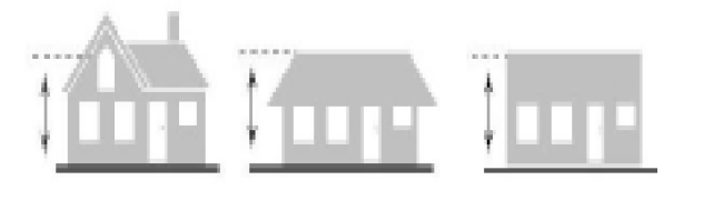
4.1.7 Building Height
Building height refers to the vertical distance to the highest point of the roof for flat roofs; to the deck line of mansard roofs; and to the average height between eaves and the ridge for gable, hip, and gambrel roofs.
A.
Fences or Walls. In the case of fences or walls, height shall be measured from ground level on the higher side of the fence or wall.
B.
Exceptions to Height Limits. Unless otherwise expressly stated, the height limitations of this Ordinance shall not apply to any of the following:
1.
Electrical power transmission lines;
2.
Belfries, cupolas, spires, domes, monuments, flagpoles, chimneys, radio/television receiving antennas or chimney flues; or
3.
Bulkhead, elevator, water tank, or any other similar structure or necessary mechanical appurtenance extending above the roof of any building, if such structure does not occupy more than 30 percent of the area of the roof.
4.1.8 Building Coverage
Building coverage refers to the area of a lot covered by buildings (principal and accessory) or roofed areas, as measured along the outside wall at ground level, and including all projections, other than fire escapes, canopies and the first two (2) feet of a roof overhang. Swimming pools (excluding the pool decking) shall be included in building coverage.
Section 4.2. - Purpose of Districts.
The zoning districts established in this Ordinance are for the purposes of guiding development in accordance with existing and future needs and promoting the public health, safety, morals, convenience, order, appearance, prosperity, and general welfare, and all of the purposes set forth in S.C. Code § 6-29-710. The following statements of intent shall be used in interpretation and application of the district regulations.
The residential district regulations are designed to encourage a stable and healthy environment for residential purposes and to discourage encroachment by commercial, industrial or other uses adversely affecting the residential character of the district.
RS-1, Single-Family Residential District. The RS-1 District is intended to be single-family residential areas with detached units and low densities, large lots. Use regulations allow for limited recreational uses which are compatible with the character of the district.
RS-2, Single-Family Residential District. The RS-2 District is intended to accommodate a variety of mid-range density dwelling units on small parcels. The RS-2 District allows for multi-family dwellings in a compatible residential setting with single-family dwellings.
RS-3, Single-Family Residential District. The intent of the RS-3 District is to accommodate higher density residential areas and to protect property in the district from incompatible land uses. The RS-3 District allows for multi-family dwellings and manufactured homes in a compatible residential setting with single-family dwellings.
RG, General Residential District. The intent of the RG District is to provide for a wide range of high density dwelling units on small parcels of land, including manufactured homes, group housing, and multi-family units in livable residential neighborhoods that encourage the use of land for residential purposes.
GC, General Commercial District. The purpose of the GC District is to provide for areas within the town where a variety of commercial developments and residential uses may take place. This district is designed to support shopping centers and business complexes of greater magnitude than permitted by the OC, Office Commercial District. It permits a wide range of business and commercial uses generally clustered for cumulative attraction and optimum accessibility, oriented primarily along major traffic arteries, but also in strips where so designated by the Comprehensive Plan.
OC, Office Commercial District. The purpose of the OC District is to encourage the development of office activities with supportive retail, service and certain types of residential uses.
I, Industrial District. The purpose of the I District is to recognize the importance of industry to the community and to protect such uses from potentially incompatible uses which would consume industrially suited land for other purposes. It is also designed to encourage industrial park development and promote landscaping of industrial plants, making them more palatable to the residential environment of Santee. The district may also contain uses as special exceptions that may be incompatible elsewhere in the Town of Santee.
PD, Planned Development District. The purpose of the PD District is to encourage flexibility in the development of land in order to promote its appropriate use; to improve the design, character and quality of new development; to facilitate the provision of streets and utilities; and to preserve the natural and scenic features of open space. This district is intended for use in the undeveloped areas of the town where planned development offers a superior response to less coordinated single-lot development, as permitted elsewhere in this Chapter.
Section 4.3. - Establishment of Official Zoning Map.
The boundaries of the zoning districts are shown on a map entitled "Official Zoning Map, Santee, South Carolina," (Official Zoning Map) which together with all explanatory matter is hereby adopted by reference and declared to be a part of this Chapter. The Official Zoning Map shall be identified by the signature of the Mayor, attested by the Town Clerk, together with the date of the adoption of this Chapter. Regardless of the existence of purported copies of the Official Zoning Map which may from time to time be made or published, the Official Zoning Map which shall be located in the Planning and Zoning Department at Town Hall, shall be the final authority as to the current zoning status of land and water areas, buildings, and other structures in the Town of Santee, South Carolina.
Section 4.4. - Interpretation of District Boundaries.
The Zoning Administrator shall interpret the Zoning Map and determine the location of zoning district boundaries, using the following rules of interpretation:
1.
District boundaries indicated as approximately following the center lines of streets, alleys, railroads, or bodies of water shall be construed to follow those center lines.
2.
District boundaries indicated as approximately following platted lot lines or tax map lot lines shall be construed as following those lot lines.
3.
District boundaries indicated as approximately following municipal limits shall be construed as following municipal limits.
4.
District boundaries indicated as approximately parallel to or extensions of features indicated in subsections above shall be so construed for the distances indicated on the Zoning Map. Distances not specifically indicated shall be determined by scale of the map.
Section 4.5. - Lot Divided by District Boundaries.
No structure or accessory use may be placed, structurally altered, or have a change in use where the structure or use is or would be included within two (2) or more zoning districts unless such structure or use conforms to the requirements of all applicable district regulations.
Section 4.6. - Annexation.
All territory which may hereafter be granted or annexed to the Town of Santee shall be classified automatically in the RS-1 District, except that at the time the application for annexation is filed, the applicant may request a zoning classification which is similar to surrounding zoning and/or in accord with the town's Comprehensive Plan. Proposed annexations where the requested zoning is inconsistent with the Land Use Element of the Comprehensive Plan or differs from zoning on adjacent properties shall be reviewed by the Planning Commission in accordance with Article 2, Section 2.2. The Planning Commission shall recommend to the Town Council the appropriate zoning for the property to be annexed, modification to the Land Use Element of the Comprehensive Plan, or both.