
Santee City Zoning Code
ARTICLE 5
- OVERLAY ZONING DISTRICTS AND PD, PLANNED DEVELOPMENT DISTRICT
Section 5.1.- General.
5.1.1 Establishment of Districts
The following Overlay and Special Purpose Zoning Districts are established:
5.1.2 Procedure for Establishment
Overlay and Special Purpose zoning districts shall be established, changed or modified in accordance with the procedures applicable to all zoning districts as described in Article 4 of this Ordinance.
5.1.3 Overlay Zoning District Applicability
The overlay zoning districts only apply to parcels indicated on the corresponding Overlay Zoning District Maps. In the event that the definite boundaries of the district cannot be ascertained, Corridor Overlay Districts shall be deemed to encompass the depth of the lots fronting on both sides of the corridor street up to three hundred (300) feet and all property within three hundred (300) feet of the edge of the right-of-way which utilizes the corridor street for direct access, unless otherwise specified.
The streets designated in Section 5.3 Table 5-1, Column B, are referred to as Corridor Streets (see Figure 5-1).
A street that intersects a designated Corridor Street is referred to as an Intersecting Street (see Figure 5-1).
Figure 5-1 Corridor and Intersecting Streets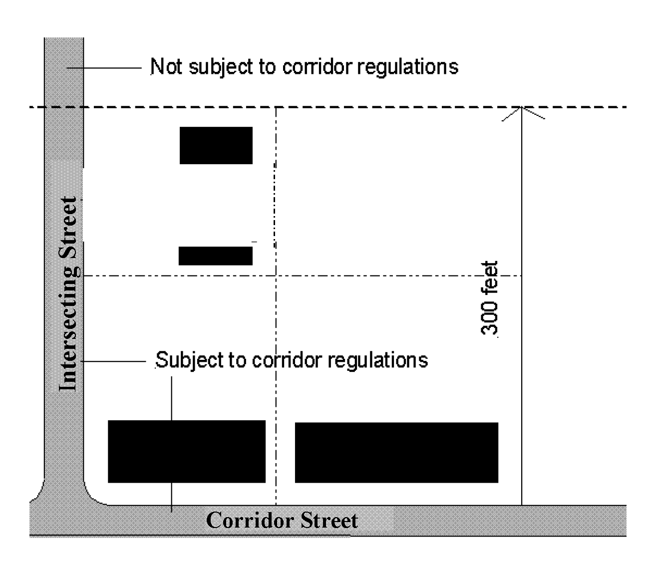
5.1.4 Overlay Zoning District Effect
A.
The overlay zoning districts contained in this Ordinance are zones that impose a set of additional requirements or relax a set of requirements imposed by the underlying zoning district. Therefore, compliance with Article 3, Section 3.4 Zoning Map Amendment (Rezoning), of this Ordinance, is not required for parcels within these overlay zoning districts to be developed in compliance with the overlay zoning district regulations, including but not limited to the use regulations and density, intensity and dimensional standards of the overlay zoning districts. Development of parcels within the overlay zoning districts shall comply with all other applicable requirements and processes of this Ordinance.
B.
If the land use recommendation for a parcel in an overlay zoning district, as shown on the overlay zoning district map, is not utilized, the regulations of the underlying zoning district shall apply.
Section 5.2. - FH, Flood Hazard Overlay District.
The Flood Hazard Overlay District includes (1) flood plains, (2) areas of shallow flooding, (3) areas of special flood hazard, and (4) floodways. The development of these areas, as reflected on Flood Insurance Rate Maps issued by the Federal Emergency Management Agency (FEMA) for Santee, may not occur where alternative locations exist, because of the inherent hazards and risks involved. Before a building permit and/or a development permit are issued, the applicant shall demonstrate that new structures cannot be located out of the Flood Hazard Overlay District. Where there is no alternative to a location in a Flood Hazard Overlay District, proposed development shall be regulated by the following.
5.2.1 Findings of Fact
1.
The special flood hazard areas of Santee are subject to periodic inundation which results in loss of life, property, health and safety hazards, disruption of commerce and governmental services, extraordinary public expenditures of flood protection and relief, and impairment of the tax base, all of which adversely affect the public health, safety and general welfare.
2.
These flood losses are caused by the cumulative effect of obstructions in floodplains causing increases in flood heights and velocities, and by the occupancy in flood hazard areas by uses vulnerable to floods or hazardous to other lands which are inadequately elevated, flood-proofed, or otherwise unprotected from flood damages.
5.2.2 Statement of Purpose
It is the intent of this Section to promote the public health, safety and general welfare and to minimize public and private losses due to flood conditions in specific areas by provisions designed to:
1.
Restrict or prohibit uses which are dangerous to health, safety and property due to water or erosion hazards, or which result in damaging increases in erosion, flood heights, or velocities;
2.
Require that uses vulnerable to floods, including facilities which serve such uses, be protected against flood damage at the time of initial construction;
3.
Control the alteration of natural floodplains, stream channels, and natural protective barriers which are involved in the accommodation of flood waters;
4.
Control filing, grading, dredging and other development which may increase erosion or flood damage; and
5.
Prevent or regulate the construction of flood barriers which will unnaturally divert flood waters or which may increase flood hazards to other lands.
5.2.3 Objectives
The objectives of this Section are:
1.
To protect human life and health;
2.
To minimize expenditure of public money for costly flood control projects;
3.
To minimize the need for rescue and relief efforts associated with flooding and generally undertaken at the expense of the general public;
4.
To minimize prolonged business interruptions;
5.
To minimize damage to public facilities and utilities such as water and gas mains, electric, telephone and sewer lines, and streets and bridges located in floodplains;
6.
To help maintain a stable tax base by providing for the sound use and development of flood-prone areas in such a manner as to minimize future flood blight areas; and
7.
To ensure that potential property buyers are notified that property is in a flood area.
5.2.4 Lands to Which This Section Applies
This Section 5.2 shall apply to all areas of special flood hazard within the jurisdictional boundaries of Santee.
5.2.5 General Development Standards
Development may not occur in the Special Flood Hazard Area (SFHA) where alternative locations exist due to the inherent hazards and risks involved. Before a permit is issued, the applicant shall demonstrate that new structures cannot be located out of the SFHA and that encroachments onto the SFHA are minimized.
In all areas of special flood hazard the following provisions are required:
1.
Anchoring. All new construction and substantial improvements of existing structures shall be anchored to prevent floatation, collapse, or lateral movement of the structure.
2.
Flood Resistant Materials and Equipment. All new construction and substantial improvements shall be constructed with flood resistant materials and utility equipment resistant to flood damage in accordance with Technical Bulletin 2, Flood Damage - Resistant Materials Requirements, dated 8/08, and available from the Federal Emergency Management Agency.
3.
Minimize Flood Damage. All new construction or substantial improvements of existing structures shall be constructed by methods and practices that minimize flood damage.
4.
All heating and air conditioning equipment and components, all electrical, ventilation, plumbing, and other service facilities shall be designed and/or located so as to prevent water from entering or accumulating within the components during conditions of flooding;
5.
Manufactured homes shall be anchored to prevent floatation, collapse, or lateral movement. Methods of anchoring may include, but are not limited to, use of over-the-top or frame ties to ground anchors. This standard shall be in addition to and consistent with applicable state requirements for resisting wind forces.
6.
New and replacement water supply systems shall be designed to minimize or eliminate infiltration of floodwaters into the system;
7.
New and replacement sanitary sewerage systems shall be designed to minimize or eliminate infiltration of floodwaters into the systems and discharges from the systems into floodwaters;
8.
On-site waste disposal systems shall be located and constructed to avoid impairment or contamination during flooding; and
9.
Any alteration, repair, reconstruction, or improvement to a structure that is not in compliance with the provisions of this Ordinance, shall be undertaken only if non-conformity is not furthered, extended, or replaced.
5.2.6 Specific Development Standards
In all areas of special flood hazard where base flood evaluation data are available, the following shall be required.
1.
Residential Construction. New Construction or substantial improvement of any residential structure (including manufactured homes) shall have the lowest floor elevated no lower than one foot above the base flood elevation. A pre-construction and post-construction flood evaluation certificate shall be submitted. No basements are permitted. Should solid foundation perimeter walls be used to elevate a structure, creating a fully enclosed area, said enclosed area shall:
a.
be designed to preclude permanent living space;
b.
be useable solely for parking vehicles, building access, or storage; and
c.
include openings sufficient to facilitate unimpeded movement of floodwaters and/or be designed to automatically equalize hydrostatic flood forces on exterior walls by allowing for entry and exit of floodwaters.
Designs for complying with this requirement must either be certified by a professional engineer or architect or meet the following minimum criteria:
a.
provide a minimum of two openings on different walls having a total net area of not less than one square inch for every square foot of enclosed area subject to flooding;
b.
The bottom of all openings shall be no higher than one foot above grade;
c.
openings may be equipped with screens, louvers, valves, or other breakaway coverings or devices provided they permit the automatic flow of floodwaters in both directions; and,
d.
fill placed around foundation walls must be graded so that the grade inside the enclosed area is equal to or higher than the adjacent grade outside the building on at least one side.
2.
Non-Residential Construction. New construction or substantial improvements of any commercial, industrial, or non-residential structure shall have the lowest flood elevated no lower than one foot above the level of the base flood elevation. No basements are permitted. Structures located in A-Zones may be flood proofed in lieu of elevation are watertight with walls substantially impermeable to the passage of water, using structural components having the capability of resisting hydrostatic loads and the effect of buoyancy. A registered, professional engineer or architect shall certify that the standards of this subsection are satisfied. Agricultural structures may be wet-flood proofed in accord with Technical Bulletin 7-93, Wet Flood Proofing Requirements for Structures Located in Special Flood Hazard Areas in Accordance with the National Flood Insurance Program, document number FIA-TB-7.
3.
Temporary Development. All applicants for a temporary use must submit to the Zoning Administrator, prior to the issuance of a development permit, a written plan for the removal of any temporary use or structure in the event of a hurricane or flash flood warning notification. The plan shall be reviewed and approved in writing, and must include the following information:
a.
a specified time for which the temporary use will be permitted,
b.
the name, address, and phone number of the individual responsible for the removal of said use,
c.
the time frame prior to the event at which any structure will be removed (i.e., minimum of 72 hours before landfall of a hurricane or immediately upon flood warning notification),
d.
a copy of a contract or agreement with a trucking company to insure the availability of removal equipment when needed,
e.
designation of a location outside the floodplain to which said temporary structure will be moved, and
f.
a plan to restore the area to its natural condition once the temporary permit expires or the temporary use is terminated, whichever is first.
4.
Accessory Structures. An accessory structure, the cost of which is greater than $3,000, must comply with the elevated structure requirements of this section. When accessory structures of $3,000 or less are to be placed in the floodplain, such structures shall:
a.
not be used for human habitation (including work, sleeping, living, cooking, or restroom areas); and
b.
be designed to have low flood damage potential, be constructed and placed on the building site so as to offer minimum resistance to floodwaters, and be firmly anchored to prevent flotation, collapse, or lateral movement.
5.
Floodways. The following provisions shall apply within floodways:
a.
No encroachments, including fill, new construction, substantial improvements, additions, or other developments shall be permitted unless it has been demonstrated through hydraulic analysis that the proposed encroachment would not result in any increase in the flood level during the occurrence of a flood.
b.
Where no such increase is certified, new construction and substantial improvements may be permitted in compliance with the requirements of this section.
c.
Permissible uses exempt from such certification include general farming, pasture, outdoor plant nurseries, horticulture, forestry, wildlife sanctuary, game farm, and other similar agricultural, wildlife, and related uses, lawns, gardens, play areas, picnic grounds, hiking and horseback riding trails, provided that they do not employ structures or fill.
6.
Standards for Streams and/or Floodways Without Established Base Flood Elevations. Development contiguous to small streams shall adhere to the following:
a.
No encroachments, including fill, new construction, substantial improvements or new development shall be permitted within 40 feet of the stream bank unless certification with supporting technical data by a registered, professional engineer is provided demonstrating that such encroachments shall not result in any increase in flood levels during the occurrence of base flood discharge.
b.
Where no such increase is certified, new construction and substantial improvements may be allowed within such areas provided all applicable provisions of this section are satisfied.
7.
Standards for Subdivision Proposals -
a.
All subdivision proposals shall have public utilities and facilities such as sewer, gas, electrical, and water systems located and constructed to minimize flood damage;
b.
All subdivision proposals shall have adequate drainage provided to reduce exposure to flood hazard; and,
c.
Base flood elevation data shall be provided for subdivision proposals and other proposed developments greater than the lesser of five (5) lots or five (5) acres.
8.
Standards for Areas of Shallow Flooding (AO Zones). Development within the areas subject to shallow flooding in the AO Zone shall adhere to all development standards of this section.
5.2.7 Warning and Disclaimer of Liability
The degree of flood protection required by this Ordinance is considered reasonable for regulatory purposes and is based on scientific and engineering considerations. Larger floods can and will occur on rare occasions. Flood heights may be increased by manmade or natural causes. This ordinance does not imply that land outside the areas of special flood hazard or uses permitted within such areas will be free from flooding or flood damages. This ordinance shall not create liability on the part of Santee Council or by any officer or employee thereof for any flood damages that result from reliance on this or any administrative decision lawfully made hereunder.
Section 5.3. - Old Number Six (SC 6) Corridor Overlay District.
5.3.1 Establishment of Corridor Overlay District
The following overlay district is hereby established:
TABLE 5-1 CORRIDOR DISTRICT ESTABLISHED
5.3.2 Purpose
The purpose of the Old Number Six Overlay District is to promote development that is compatible with the function, capacity and design of major arterial roadways and remains sensitive to abutting properties. Another purpose of the Old Number Six Overlay District is to augment dimensional and access management standards and establish design standards for commercial and mixed use development within corridors that are predominantly classified as arterial. The permitted uses, dimensional standards and site development standards for the Old Number Six Overlay District are the same as the underlying base district unless a different standard is established in this section.
5.3.3 Permitted Uses
Uses permitted in the Old Number Six Overlay District are provided in Table 5-2.
TABLE 5-2 PERMITTED USES IN THE OLD NUMBER SIX OVERLAY
5.3.4 Dimensional Standards
5.3.4.1 The dimensional standards for the Highway Corridor Overlay District are established in Table 5-3.
TABLE 5-3 DIMENSIONAL STANDARDS FOR THE OLD NUMBER SIX OVERLAY DISTRICT
5.3.4.2 Minimum frontage buildout means the portion of the corridor street frontage of the parcel or parcels included in the development that is occupied by a principal structure at the front setback line. (Example: A parcel that is 200 feet in length requires a building or combination of buildings that total no less than 100 feet in length and are set back no further from the street than the front setback line, either 5 feet or 30 feet.)
5.3.4.3 Where an existing building is located on a parcel and the site development plan includes the utilization of the existing building as a principal structure, the existing setback may be provided. The front setback landscaping requirements specified in this section shall be applied for the provision that most closely matches the existing setback.
5.3.4.4 Gasoline service stations with pump islands perpendicular to the edge of right-of-way maintain a setback of not less than thirty-five (35) feet between the pump islands and right-of-way.
5.3.5 Access
5.3.5.1 Purpose
This section is designed to improve the efficiency of traffic flows and to avoid traffic accidents and unsafe traffic conditions by minimizing and optimizing the use of curb cuts along corridor streets.
5.3.5.2 Generally
New curb cuts and access points on corridor streets are subject to the requirements of this section.
5.3.5.3 Number of Access Points
Access points are permitted from public streets as provided herein.
a.
No more than one (1) curb cut is permitted for any lot or parcel on any corridor street, except as provided in sections (b.) and (c.);
b.
More than one (1) curb cut is permitted if the requirements of sections (1.) and (2.) are satisfied.
1.
The proposed development has frontage on more than one (1) public street.
2.
The need for additional curb cuts is demonstrated in a traffic impact analysis (TIA). The applicant must demonstrate that additional access points will not cause a reduction in the level of service including any mitigation agreed to by the applicant and attached as a condition of approval.
c.
If two (2) or more parcels existing as of the effective date of this Chapter are placed under common ownership and/or control, the parcel assembly may be granted additional access points if:
1.
Only one (1) direct access point is permitted for the corridor street; and
2.
The additional access points are created for new streets or maintained for existing streets internal to the boundaries of the overall development plan.
d.
One (1) additional right-in/right-out access point is permitted on the corridor street where a center median exists or is included in a capital improvements program, or a similar barrier to access from more than one (1) direction exists.
5.3.5.4 Indirect Access
Access shall be provided to lots or outparcels internal to a development that are not permitted direct access to a corridor road:
a.
The internal circulation of a shopping center, office complex, or similar group of buildings having direct access in accordance with an approved TIA; or
b.
Use of shared entrances with those established or likely to be required on adjacent sites.
5.3.5.5 Access Spacing on Public Streets
a.
Access points from a public road or street shall not be located closer to an existing or proposed intersection than one hundred fifty (150) feet or the property line, whichever is greater.
b.
Access points must be located on side streets, an alley or a joint parking area that connects to a side street, if available.
c.
The minimum and maximum access widths measured from face of curb to face of curb shall be as follows:
TABLE 5-4 MINIMUM AND MAXIMUM ACCESS WIDTHS
5.3.5.6 Driveways
a.
Driveways with four (4) or more lanes must include a planted median in order to better control traffic and reduce the visual impact of pavement.
b.
Driveways crossing a sidewalk must maintain and continue the sidewalk, including the sidewalk pavement and texture.
5.3.5.7 Connectivity
a.
The site shall include one (1) vehicular connection to an abutting site, however, no more than one (1) connection on each side and rear property line is required by this subsection.
b.
The connections shall open to existing developed sites or stubbed out to future undeveloped sites. A joint cross or access easement is required if there is no public right-of-way.
c.
The entrances must be designed and improved so as to permit both vehicular and pedestrian access.
d.
The connections must be aligned with any existing connections or parking lot circulation aisles on abutting parcels.
5.3.5.8 Crosswalks
a.
Crosswalks shall be located at all pedestrian crossings. Pedestrian crossings include all street or private drive intersections, and on site midblock locations for blocks that are equal to or more than three hundred (300) feet in length.
b.
Crosswalks shall be striped with white reflective paint or demarcated using brick or stone pavers or contrasting colors. If coloring is used, the outer edges of the crosswalk shall have reflective bands.
Figure 5-2 Crosswalk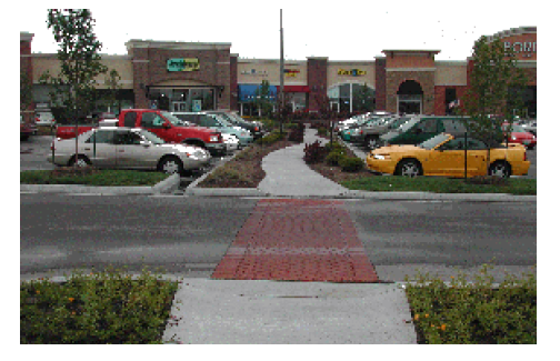
c.
Crosswalks may have texture such as pavers or stamped asphalt in a running bond or herringbone pattern or other configuration.
d.
The crosswalk shall be at least ten (10) feet wide.
5.3.5.9 Sidewalks, Bike Paths, Pathways
a.
Permitted sidewalk materials include concrete, concrete pavers, brick or any combination thereof. Bicycle paths and crosswalks may be constructed of asphalt.
b.
Sidewalks, bike paths and pathways shall comply with any applicable standards of the Americans with Disabilities Act (ADA) (42 U.S.C Subsection 12181 et seq., Pub. L 101-336 and implementing regulations at 28 C.F.R. parts 35 and 36). (Applicants should consult the ADA Technical Assistance Manual from the U.S. Dept. of Justice on the Internet at www.usdoj.gov/crt/ada/taman3.html, and Technical Assistance Manual for State and Local Governments at www.usdoj.gov/crt/ada/taman2.html).
5.3.6 Streetscaping
a.
This section applies to any street improvements included in a development or redevelopment.
b.
Traffic signals are encouraged to be supported by an approved mast arm in lieu of span wire.
c.
Benches and trash receptacles with liners are required in high pedestrian activity areas. High pedestrian activity areas include street intersections and restaurants. Trash receptacles shall be spaced an average of every sixty (60) feet along commercial storefronts on private property.
d.
Pedestrian scaled lighting must be provided along sidewalks. For purposes of this section, "pedestrian scaled lighting" means a lighting standard that is affixed to the ground, is no more than fifteen (15) feet high from the sidewalk surface, and has a masonry, brick or corrugated iron material, or other material approved by the Administrator.
5.3.7 Site Elements
5.3.7.1 Retaining Walls
The surface treatment for retaining walls higher than eighteen (18) inches above the finished grade shall be:
a.
A veneer of brick, stone or synthetic stone;
b.
Stamped concrete with brick or stone texture;
c.
Stacked, stamped concrete or textured blocks; or
d.
An alternative material that achieves the same finish quality and approved by the Administrator.
5.3.7.2 Fencing
Fences may be constructed of the following materials:
a.
Black vinyl clad chain link;
b.
Wood;
c.
Brick;
d.
Stone or synthetic stone;
e.
Wrought iron;
f.
Block or stucco that matches an approved facade building material on the principal structure; or
g.
An alternative material approved by the Administrator.
5.3.7.3 Loading Areas
All loading areas shall be located no closer to the street than the front wall of the principal structure located closest to the street and shall be screened from view from all street frontages and parking areas.
5.3.7.4 Dumpsters
a.
Solid waste dumpsters shall be located no closer to the street than the front wall of the principal structure located closest to the street and shall be screened as provided in this section.
b.
Dumpsters shall not encroach on a curb, sidewalk, public right-of-way or a vehicle sight triangle.
c.
The dumpster location shall not require the service vehicle to back up for a distance exceeding ten (10) feet.
d.
The area around the dumpster for a distance of twenty-five (25) feet must be clear of low overhead branches, overhangs and utility lines.
e.
Dumpsters must be screened from view from all street frontages and parking areas on three (3) sides. Screening can consist of primary buildings, fences, walls or landscaping consistent with the standards required by this Chapter. Screening must be a minimum of six (6) feet in height or a height sufficient to screen the dumpster.
f.
A concrete pad and apron is required to prevent the dumpster and the service vehicle from damaging the adjoining pavement. The pad and apron must:
1.
Have a level surface;
2.
Have a minimum area of eight (8) feet wide and eighteen (18) feet deep;
3.
Be constructed a minimum of eight (8) inches thick and reinforced with #4 reinforcing bar on twelve (12) inch centers; and/or materials should be of sufficient strength characteristics to support traffic without failure.
4.
Contain a back curb at the rear of the dumpster enclosure.
5.3.7.5 Front Setback Landscaping
a.
Landscaping shall be provided on the site and parking areas in accordance with the provisions of Article 8, Section 5.2, and this section.
b.
If a front setback of five (5) feet is utilized the front setback shall be landscaped to the standards of a Type 1 buffer or paved as a widened extension of the public sidewalk.
c.
If a front setback of thirty (30) feet is utilized the first twenty-five (25) feet measured from the property line shall be landscaped to the standards of a Type 4 buffer.
d.
If the front setback exceeds thirty (30) feet the first twenty-five (25) feet measured from the property line shall be landscaped to the standards of a Type 5 buffer.
e.
If the front setback exceeds thirty (30) feet and parking is provided between the front property line and a structure commercial development, the first twenty-five (25) feet measured from the property line shall be landscaped to the standards of a Type 5 buffer.
5.3.8 Signs
a.
The size, quantity and design of signs shall comply with Article 9, Sign Regulations, and this section.
b.
Changeable copy signs are prohibited when visible from the public street. Changeable copy signs are permissible when visibility is limited to a location within the site and may be used for restaurant menus, prices of merchandise, and similar purposes.
5.3.9 Building Design and Materials
5.3.9.1 Architectural Plans
Architectural plans of all elevations of proposed structures shall be submitted with a site plan application. Architectural plans shall include relationships to public views and vistas, construction materials, photographs or perspective drawings indicating visual relationships to adjoining properties and spaces.
5.3.9.2 Wall Detail and Fenestration
All walls visible from a street, parking area or other public space shall include windows, entryways or other wall details equal to twenty percent (20%) of the wall surface in order to break up large expanses of blank wall surfaces.
5.3.9.3 Facade Modulation
Facade modules shall not exceed eighty (80) feet in width and the average of all facade modules on a building may not exceed forty (40) feet.
Figure 5-3 Building Broken into Separate Facade Modules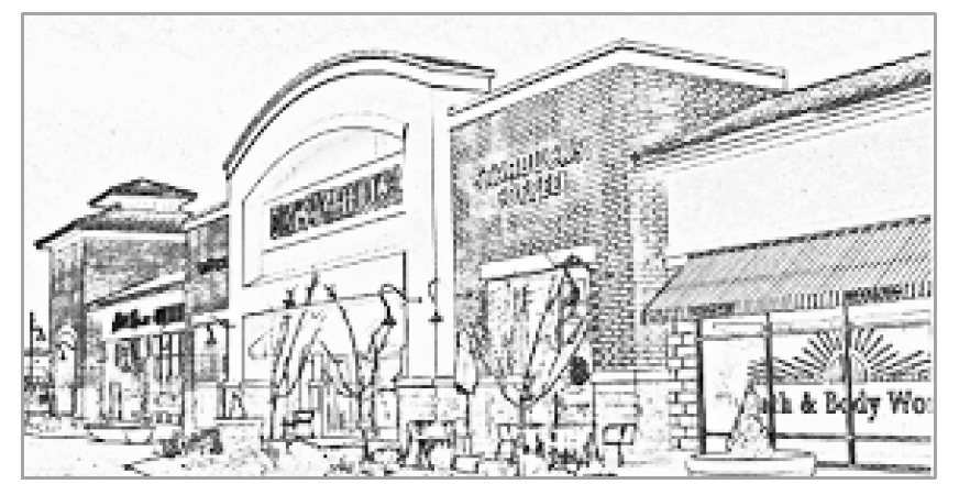
5.3.9.4 Permitted Materials
The following building exterior wall materials are permitted:
a.
Brick
b.
Split-face concrete block
c.
Parged block
d.
Decorative concrete masonry units (CMUs) (i.e., textured, glazed and other special treatments or materials)
e.
Stone
f.
Terra cotta
g.
Fiber cementitious board siding materials
h.
Traditional (real) stucco or plaster that is located no closer than three (3) feet to the established grade. Stucco or plaster may not exceed fifty percent (50%) of the overall non-window wall area.
i.
Carrera glass
j.
Windows and window glazing provided that no more than fifty percent (50%) of the facade facing the corridor street may be glass.
5.3.9.5 Prohibited Materials
The following building exterior wall materials are prohibited:
a.
Ceramic tile, except that up to ten percent (10%) of the wall may incorporate ceramic tile as an accent.
b.
Aluminum siding, except aluminum siding for single-family detached and attached dwelling units.
c.
Vinyl siding, except vinyl siding for single-family detached and attached dwelling units.
d.
Reflective glass curtain walls or other reflective material, except Carrera glass and window glazing.
e.
CMUs, except that decorative CMUs (i.e., split-face, textured, glazed, etc.) are permitted.
f.
Synthetic stucco.
Section 5.4. - PD, Planned Development District.
5.4.1 Purpose
The purpose of the PD District is to encourage flexibility in the development of land in order to promote its appropriate use; to improve the design, character and quality of new development; to facilitate the provision of streets and utilities; and to preserve the natural and scenic features of open space. This district is intended for use in the undeveloped areas of the town where planned development offers a superior response to less coordinated single-lot development, as permitted elsewhere in this Ordinance.
5.4.2 Area and Ownership
In order to qualify as a PD District a project request shall meet the following requirements:
5.4.2.1 The site shall be in single ownership or control, or if in several ownerships, the application for amendment to this Chapter shall be filed jointly by all of the owners.
5.4.3
There is no minimum site requirement for a PD.
5.4.4
The proposed development shall be consistent with the current approved Comprehensive Plan.
5.4.5
The applicant shall demonstrate that the proposed development accomplishes the objectives of Article 1 to a greater extent than land developed under any other zoning district, including a base zoning district.
5.4.6 Procedures
The creation of a PD District designation is a two (2) step process involving both a rezoning and General Development Plan approval.
5.4.6.1 A PD District may be established on the Official Zoning Map in the same manner and in the same form prescribed for in Section 3.4 for other zoning districts.
5.4.6.2 The General Development Plan and administrative review requirements of this section are required after a map amendment is approved. Such requirements and all additional requirements of this section and Section 3.4 shall be addressed prior to the issuance of a building or development permit. A properly approved detailed site plan or subdivision (preliminary and final) or both shall be required prior to a request for a building or development permit. The requirements are specified in Article 3, Development Review Procedures.
5.4.7 Permitted Uses
Any use included in the ordinance rezoning the site to the PD District is permitted in such district. A listing of proposed uses including type and number of dwelling units within a particular PD District shall be included in the approved General Development Plan as part of the regulations applying to the district. Upon approval of the General Development Plan by the Planning Commission and Town Council, the list shall be adopted as part of the regulations applying to that particular PD District. Thereafter, the uses permitted in the district shall be restricted to those listed, approved and adopted.
5.4.7.1 Permitted uses within a PD District are not subject to the restrictions of Article 6, Use Regulations or the Use Matrix. However, the ordinance rezoning the tract and approving the General Development Plan shall include a list of uses, hereinafter entitled the "PD Use List," from the Use Matrix that are permitted in the PD District. The definition of uses included in the Use Matrix shall be used to interpret the PD Use List, unless a different definition is provided in the PD Use List.
5.4.8 Criteria and Development Standards
Overall site design shall be harmonious in terms of landscaping, enclosure of principal and accessory uses, sizes of structures, street patterns, and use relationships. A variety of building types, heights, facades, setbacks and size of open spaces shall be encouraged.
5.4.8.1 The land uses within a PD District shall not be subject to any of the dimensional or density provisions of Article 10. Dimensional standards shall conform to the following, unless a different standard is included in the PD District rezoning ordinance:
a.
Maximum height is forty-five (45) feet, except where otherwise permitted.
b.
Maximum gross density is twelve (12) residential units per gross acre.
c.
The maximum floor area ratio for non-residential uses is two point four (2.4). A minimum of ten percent (10%) and a maximum of seventy percent (70%) of the total project floor area shall be reserved for non-residential uses. For purposes of this Article, semi-detached and two-family dwelling units are presumed to have fifteen hundred (1,500) square feet of floor area unless the specific dimensions are known at the time that the PD District rezoning is approved.
d.
The maximum Impervious Surface Ratio is sixty percent (60%) of the total site area.
5.4.8.2 Open space, parks, and recreation shall comprise a minimum of twenty-five percent (25%) of the total site area. Portions of street rights-of-way that include street trees, sidewalks, and landscaped areas may be counted toward meeting open space requirements.
5.4.8.3 PD District zoning is intended to permit flexibility in the design, construction, and processing of residential, commercial, and/or industrial developments of a quality that could not be achieved by complying with the design and development standards of another zoning district. Therefore, the design elements as set forth in Table 5-5 shall be adhered to in the design of a Planned Development and shall be used in the town's review of proposed PD District projects.
5.4.8.4 In addition to the requirements of Article 8, Supplemental Regulations, areas designated for parking shall be physically separated from public streets and shall be designed in a manner conducive to safe ingress and egress. Access points to internal public streets or internal circulation drives should be no more than three hundred (300) feet apart.
5.4.8.5 In addition to the requirements of Article 8, Supplemental Regulations, buffer yards or landscaping may be required by the Planning Commission between uses within any PD District or along the perimeter of a PD District.
TABLE 5-5 DESIGN ELEMENTS FOR A PLANNED DEVELOPMENT