
Scotts Valley City Zoning Code
CHAPTER 17
40 - HR HILLSIDE RESIDENTIAL COMBINING DISTRICT REGULATIONS, INCLUDING ALL RESIDENTIAL ZONING DISTRICTS WITH GREATER THAN TEN PERCENT SLOPE
17.40.010 - Description and purpose.
The HR district is a combining district and is intended to apply to all residential land and parcels in (or within) the city with an average slope greater than ten percent, as determined by the formula in Section 17.40.020 of this chapter. The HR district is designed to provide for an orderly, harmonious development of the foothills and mountains, resulting in a minimum amount of disturbance of the natural slope; to encourage and provide incentives for excellence in design principles and engineering techniques; and to provide for a variety of dwelling types where consolidation of parcels and unified development are most appropriate. Development shall be sensitive to the steepness of the terrain in order to minimize grading, removal of vegetation, run-off erosion, geologic hazards and fire hazards, and to help ensure utilization of land in balance with its natural capabilities to support development. The intent of this chapter is that grading be limited to that which is necessary to accommodate buildings, roadways, utilities, drainage systems and driveways and that plans be stepped to minimize grading. Furthermore, the HR combining district is established in order to implement the open space element of the General Plan and is directed to the preservation and conservation of natural vegetative and topographic features and open space.
(Ord. 16.76 § 1 (part), 1989)
17.40.020 - Determination of slope.
The average slope(s) of the parcel being considered shall be determined by applying the following formula:
![]()
Where:
The formula may be applied to the net site area. "Net site area" excludes stream channels and adjacent areas where no construction can occur. If net site area is to be used, the area to be excluded shall be shown on a site plan and permanently restricted from construction pursuant to Section 17.46.150 of this title.
The following illustrations present examples of slopes.
A Comparative Definition of Slope
(Percent Slope vs. Degree of Slope)
As defined in the General Plan, "slope" is the natural or artificial incline of ground, with the degree of incline numerically expressed as "percent of slope," or the vertical rise divided by the horizontal run.
Figure 17.40.020A Slope Example A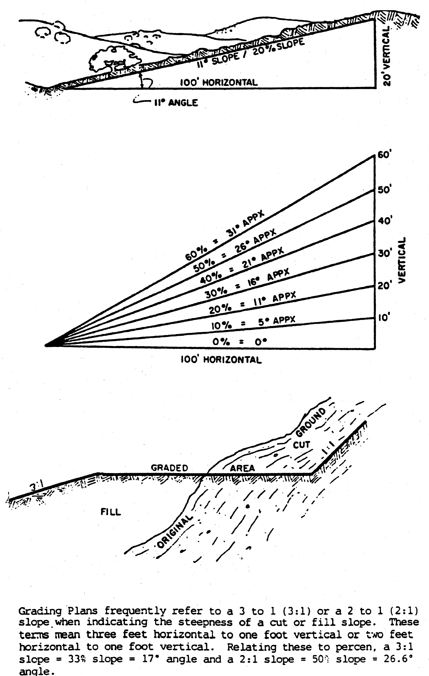
Figure 17.40.020B Slope Example B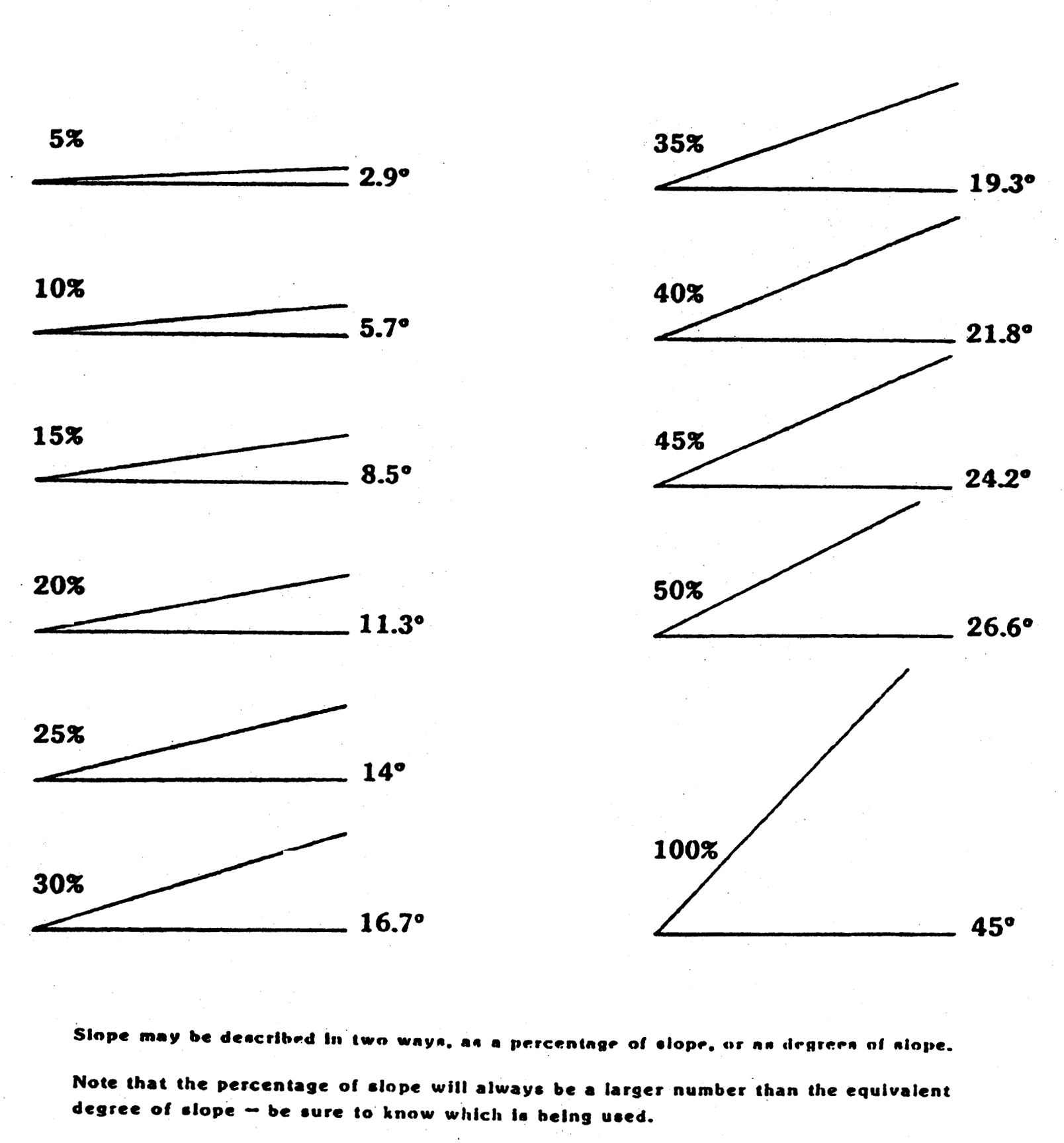
17.40.030 - Review required.
No development proposal shall be approved and no grading or tree removal in connection with such development shall take place until plans thereof have been approved by the city. Except, as otherwise specifically provided in this chapter, the standards and requirements set forth herein shall be considered and applied by the planning commission or city council, as appropriate, in considering development proposals in the HR district. These standards and requirements shall apply in addition to and not in lieu of, the standards and requirements of the base zoning district; provided, however, that in the event of a conflict, the standards and requirements of this chapter shall prevail. The design and siting of buildings and structures shall be compatible with the natural landscape. Site layout and preparation for the building, structures, driveways and roads shall be designed so as not to substantially disrupt the natural silhouette of prominent ridges, ridge lines or surrounding terrain. The planning department shall consider, as part of its review, measures to mitigate the impact of the issues noted above, including, but not limited to, lot configuration, erosion control measures; landscaping, berms and other screening methods; retaining walls to reduce graded slopes; and lowering of building profiles.
(Ord. 16.76 § 1 (part), 1989)
17.40.040 - Submittal requirements for subdivision of hillside residential property.
In connection with the subdivision of any parcel(s) in an HR district, the following submittals shall be required in addition to, and not in lieu of, any and all other development criteria and submittals prescribed in Title 16 of this code:
A.
A site development plan, drawn to scale, shall be submitted to the planning department and shall contain:
1.
The exact location of each use and structure (existing and proposed);
2.
Topographic data, including contours, tree locations, sizes and varieties (including trees to be removed and trees in and adjacent to areas to be graded), natural drainage areas and all graded slopes;
3.
Provisions for the retention of existing vegetation and land forms, including erosion control measures;
4.
Grading information illustrating the extent of all graded slopes (cut and fill). Graded slopes shall be representative of adjacent topography and shall, insofar as is reasonably practical, be an extension of the natural contours, designed to minimize cuts and fills and to avoid erosion, flooding, slides and other hazards;
5.
Location of existing and proposed easements for water, sewer and other utility services; the location of existing and proposed streets; and the location of other access routes which traverse the parcel which shall be engineered to eliminate the risk of failure or collapse, shall be set back from hazard areas and shall be in accord with the geologic and soils investigation report and recommendations;
6.
Cross-section showing maximum proposed cut and fill for all proposed streets;
7.
Such other information as the planning department may require.
B.
A preliminary geologic and soils investigation report prepared by a registered engineering geologist certified by the state or by a registered civil engineer qualified in soils mechanics by the state, shall be filed in conjunction with the site development plan and shall fully and clearly present all of the following, unless the planning director determines that existing information pertinent to the subdivision makes the preliminary analysis or any part thereof unnecessary:
1.
All pertinent data, interpretations and evaluations based on the most current professionally recognized soils and geologic base data pertaining to the subject site;
2.
The significance of the data, interpretations and evaluations with respect to the actual development or implementation of the intended land use through the identification of any significant geologic problems, critically expansive soils, or other unstable soil conditions which, if not corrected, might lead to structural damage or aggravation of future geologic problems, both on and off the site;
3.
Recommendations for corrective or mitigation measures deemed necessary to prevent or significantly mitigate potential damage to the proposed project and adjacent properties or to otherwise insure safe development of the parcel; and
4.
Recommendations for additional investigations that should be made to insure safe development of the parcel.
(Ord. 16.76 § 1 (part), 1989)
17.40.050 - Development standards.
A.
Mandatory Conditions for the Creation of New Building Sites.
1.
No new lots shall be created with an average slope of forty percent or more.
2.
No new lots shall be created with an average slope of the building envelope exceeding twenty-five percent unless an engineering geology report finds the site to be suitable for such construction.
3.
Grade of access road and driveway: No private access roadway to or on any site exceeding one hundred fifty feet in length shall exceed a grade of fifteen percent along the length of the pavement without specific approval of the planning commission.
B.
Mandatory Conditions for Existing Lots of Record.
1.
No structures or driveways shall be proposed on building pads with an average slope of forty percent or more.
2.
Building sites with an average slope exceeding twenty-five percent shall have an engineering geology report prepared. Said report must find the site to be suitable for all construction proposed.
3.
No driveway to or on any building site shall exceed a grade of fifteen percent along the length of the pavement without specific approval of the planning commission.
C.
Clustering of Dwelling Units. Dwelling units may be clustered pursuant to the regulations for a planned unit development (Chapter 17.38 of this code). Such approval shall be based upon a finding that the clustering of dwelling units will significantly promote the purposes of this chapter while allowing reasonable use and enjoyment of the site, in addition to other findings required in connection with a PUD permit.
D.
Grading Standards. Grading standards contained in this section shall apply to existing lots or building sites as well as to the creation of new building sites. All grading shall be in conformance with these standards. These standards are in addition to, and not in lieu of, standards and regulations set forth in Section 15.04.080(G) of this code.
1.
Grading shall be limited to the minimum necessary for development of roads, building sites, utilities and driveways. Portions of a site exceeding thirty percent slope shall not be graded without approval by the planning commission. Mass grading which would unreasonably affect the natural character of the area shall not be permitted.
2.
Visible cut or fill slopes shall not exceed three horizontal to one vertical (3:1); provided, however, that slopes as steep as two horizontal to one vertical (2:1) may be approved by the planning commission upon a finding that the appearance or stability of the completed project will be superior to the result that would be obtained by adhering to the three horizontal to one vertical (3:1) standard.
3.
Grading shall not be allowed in creek and drainage areas without first referring the grading application to the Department of Fish and Game, as required by law. An easement over natural drainage channels may be required to be designated for open space purposes and a storm drainage easement with respect thereto may be required, as the same are deemed necessary and appropriate for the protection of natural drainage channels as well as for protection of surrounding areas from erosion and diversion of stream channels and the like.
4.
In addition to the variances that may be granted pursuant to Section 17.50.010 of this title, the planning commission shall have authority to grant variances from the grading regulations contained in this section.
(Ord. 16.76 § 1 (part), 1989; Ord. 16.77 (part), 1989)
17.40.060 - Construction criteria on a hillside lot.
Each application for a building permit shall, in addition to all other applicable rules, regulations and processes, be subject to the development standards of the underlying zoning district in which the lot is located. In addition, the following regulations apply:
A.
Each application for a building permit shall be reviewed by the planning director and a determination made as to conformance with the following criteria:
1.
Avoid Unreasonable Interference With Views and Privacy. The height, elevations and placement on the site of the proposed main or accessory structure, when considered with reference to the nature and location of residential structures on adjacent lots, will avoid unreasonable interference with views and privacy;
2.
Preserve Natural Landscape. The natural landscape will be preserved insofar as practicable by designing structures to follow the natural contours of the site and minimizing tree and soil removal; grade changes will be minimized and will be in keeping with the general appearance of neighboring developed areas;
3.
Minimize Perception of Excessive Bulk. The proposed main or accessory structure in relation to the immediate neighborhood will minimize the perception of excessive bulk;
4.
Compatible Bulk and Height. The proposed main or accessory structure will be compatible in terms of bulk and height with existing residential structures within the immediate neighborhood and within the same zoning district, and shall not unreasonably impair the light and air of adjacent properties nor unreasonably impair the ability of adjacent properties to utilize solar energy;
5.
Current Grading and Erosion Control Standards. The proposed site development or grading plan incorporates current grading and erosion control standards used by the city;
6.
Increased Setbacks and Height. One foot shall be added to each side yard for each one foot of height above which the top plate line exceeds fifteen feet in height;
7.
Subfloors Clearance. All new primary structures and accessory structures or additions thereto, shall be designed to follow the slope of the site so as to reduce the clearance between ground floor levels and finish grade to not more than four feet. Five feet is permitted if a landscape and irrigation plan which will screen the subfloor area is submitted with the application for a building permit and landscaping is installed prior to final inspection of the structure.
8.
Residential Design Handbook. All projects for the construction or expansion of a single-family primary structure or an accessory structure in the hillside residential combining district shall be consistent with the policies described in the Residential Design Handbook, as adopted by resolution of the city council, and as the same may be amended from time to time hereafter. Such handbook embodies and illustrates the intent of the construction criteria provisions prescribed in Section 17.40.060.
B.
Additional recommendations: The planning director may refer the application to another department, commission or qualified professional for a report and recommendation.
C.
Decision by planning director: The planning director shall render his decision within thirty days after the building official has accepted the application as complete. The planning director may determine that the application conforms to the criteria set forth in subsection A of this section, or may determine to impose reasonable conditions on the application to ensure such conformance, in which case the application shall be as conditioned. In the event the planning director determines that the application does not conform and cannot be conditioned to conform no building permit shall be issued.
D.
Appeals: Any person objecting to a decision by the planning director made pursuant to any of the provisions of this chapter may appeal such decision to the planning commission by filing an appeal application with the secretary of the planning department, in accordance with Section 17.50.060 of this title.
E.
The regulations and determinations contained in this section with respect to a building permit application are supplemental to and not in lieu of any regulations, approvals, processes and reviews required under any applicable ordinance law or code, including but not limited to the rules and regulations set forth in Chapter 15.04 of this code and the approval of the building official.
(Ord. 16.76 § 1 (part), 1989; Ord. 16.78 § 1, 1990; Ord. No. 16.142, § 52, 12-4-2024)
17.40.070 - Variances.
A.
The planning commission may grant a variance to the regulations prescribed herein pursuant to Section 17.50.010 of this code. In addition to the findings required by Section 17.50.010(E), the planning commission must find that the variance is required in order to further the purpose of the hillside overlay zone and to achieve compliance with one or more of the following guidelines and criteria:
1.
To preserve trees and tree clusters;
2.
To minimize grading;
3.
To minimize site disruption;
4.
To minimize the distance from public services;
5.
To maximize access;
6.
To minimize paving and other erosion-producing activities;
7.
To avoid hazardous and sensitive areas;
8.
To protect critical features of the natural landscape;
9.
To protect the existing topographic character of a parcel or area; and
10.
To protect the view of and from the steeper slopes in the city.
B.
In granting a variance to the regulations of this chapter, the planning commission may find it necessary to require a change to a lot size or to the density allowed by the zoning district.
(Ord. 16.76 § 1 (part), 1989)