
Seguin City Zoning Code
CHAPTER 2
- DEVELOPMENT APPLICATIONS/DEVELOPMENT REVIEW PROCESS
Sec. 2.1. - [Generally.]
2.1.1.
Intent. The purpose of this chapter is to establish application procedures, internal review procedures, public notice and hearing procedures, and review criteria for the processing of applications and actions that affect the development and use of property subject to the jurisdiction of the City of Seguin.
2.1.2.
Chapter Components. This chapter reviews in general each of the following development applications, process, and criteria for approval:
•
Voluntary Annexation
•
Zoning Change
•
Specific Use Permits
•
Limited Use Permits
•
Variances (Board of Adjustments)
•
Certificates of Appropriate Design
•
Subdivision Development
•
Development Studies
•
Subdivision Concept Plans
•
Public Infrastructure Permits
•
Floodplain Permits
•
Site Plans
•
Building Permits
•
Certificate of Occupancy
•
Temporary Certificate of Occupancy
•
Outdoor Festival Permit
•
Variance from onsite alcohol consumption distance requirements
2.1.3.
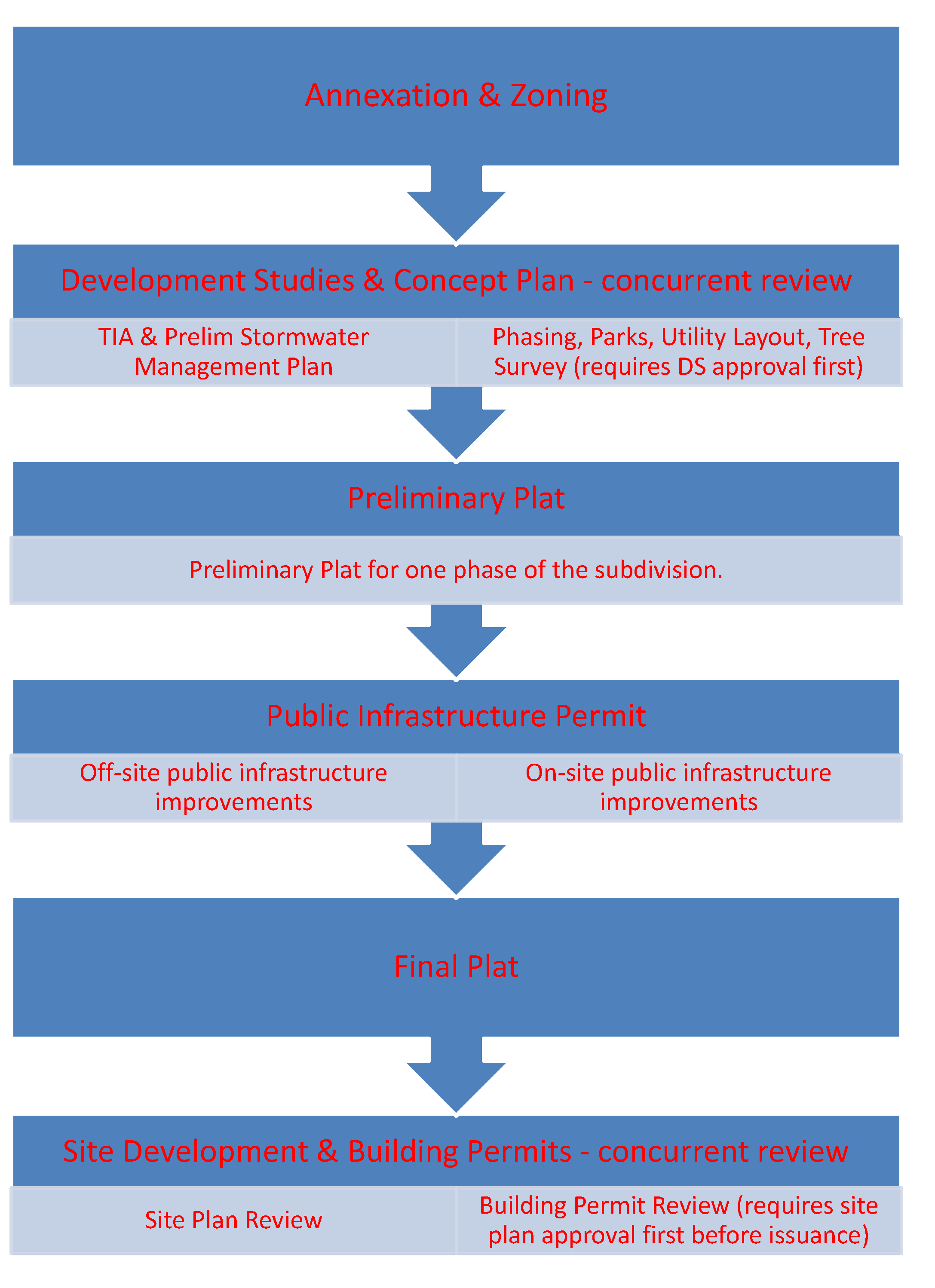
Development Process. Below is an outline of the general development process.
(Ord. No. 2019-054, §§ 2, 4, 5, 9-17-19; Ord. No. 2023-003, pt. 1, 1-17-23)
Sec. 2.2. - Annexation (voluntary).
2.2.1.
Intent. All land in Seguin's current or future extraterritorial jurisdiction area should eventually become part of the City, so it can more effectively guide growth and regulate the quality of the built environment.
2.2.2.
Applicability. The annexation process is used to annex unincorporated land into the City.
2.2.3.
Criteria. Annexation and initial zoning requests are evaluated using all the following criteria:
A.
The request is consistent with community, neighborhood and other applicable land use and development plans;
B.
The property is in the extraterritorial jurisdiction (ETJ) and contiguous to the City limits or a property with a development agreement in which state law permits the City to use as contiguity for annexation purposes;
C.
The ability of the City to provide services to the property;
D.
The annexation request conforms to state law.
2.2.4.
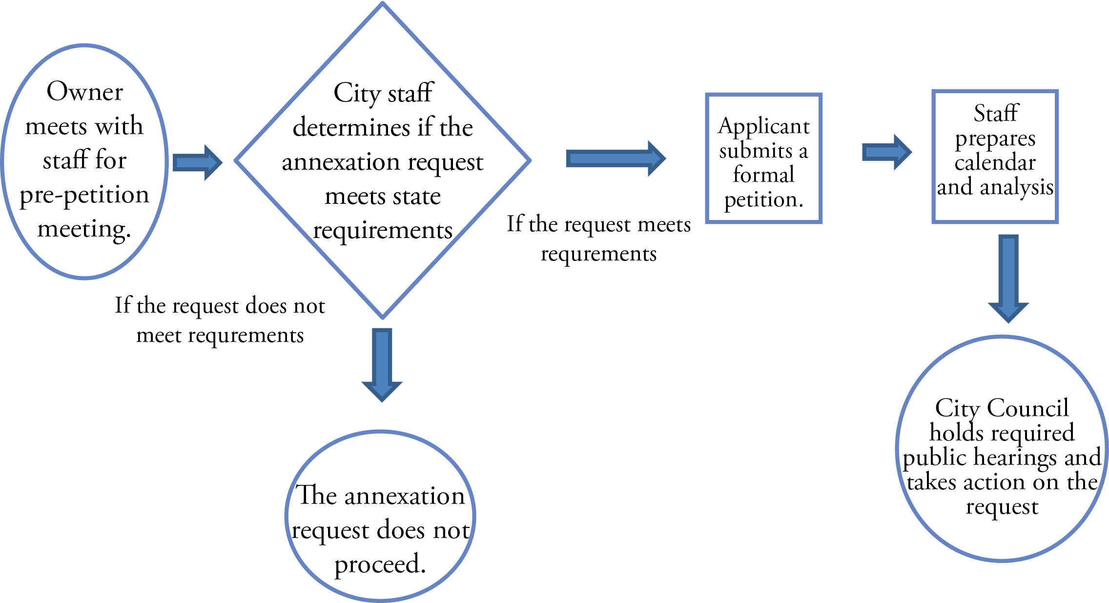
Process. City staff will evaluate the request for the above criteria and prepare a recommendation to the City Council. Conditions may be imposed on an annexation request, to ensure conformance to this code and any community, neighborhood and other applicable land use and development plans. Initial zoning is established as Agricultural Ranch (A-R) unless a specific request is made by the property owners. Initial zoning must conform to the comprehensive plan. A request for a specific zoning classification can be submitted concurrently with the voluntary annexation petition.
(Ord. No. 2023-003, pt. 1, 1-17-23)
Sec. 2.3. - Zoning.
2.3.1.
Intent. The zoning designation for a parcel does not always permit the most appropriate and desired use for the site. This section of the code will outline the steps that may be required in order to entitle a particular property to a proposed use.
2.3.2.
Applicability. The following applications are described in this section:
•
Petition for Zoning Map Amendments
•
Specific Use Permits
•
Limited Use Permits
•
Petition for Planned Unit Development
•
Overlay Districts
•
Certificates of Appropriateness
2.3.3.
Criteria. Please to refer to each section and each development application for criteria for approval and development process for each.

Sec. 2.4. - Zoning map amendment/rezoning/zoning change.
2.4.1.
Application of Requirements. This section applies in the following areas:
2.4.2.
Intent. The purpose of a petition for a zoning map amendment is to establish the initial zoning district classification of land, or to change the zoning map designation currently assigned to a property.
2.4.3.
Applicability. Where a property owner seeks to establish an initial zoning district classification for land, or request a rezone the property owner must submit an application for a zoning map amendment before any action can be taken.
2.4.4.
Criteria. Zoning map amendment requests are evaluated using the following criteria:
A.
The proposed zoning is consistent with the comprehensive plan and any community, neighborhood and other applicable land use and development plans;
B.
The proposed zoning is compatible with existing and permitted uses of surrounding properties;
C.
The proposed zoning does not have an adverse impact on surrounding properties or the natural environment;
D.
The proposed zoning results in a logical and orderly development pattern;
E.
Reserved.
F.
Other factors that impact public health, safety, or welfare.
2.4.5.
General Process.
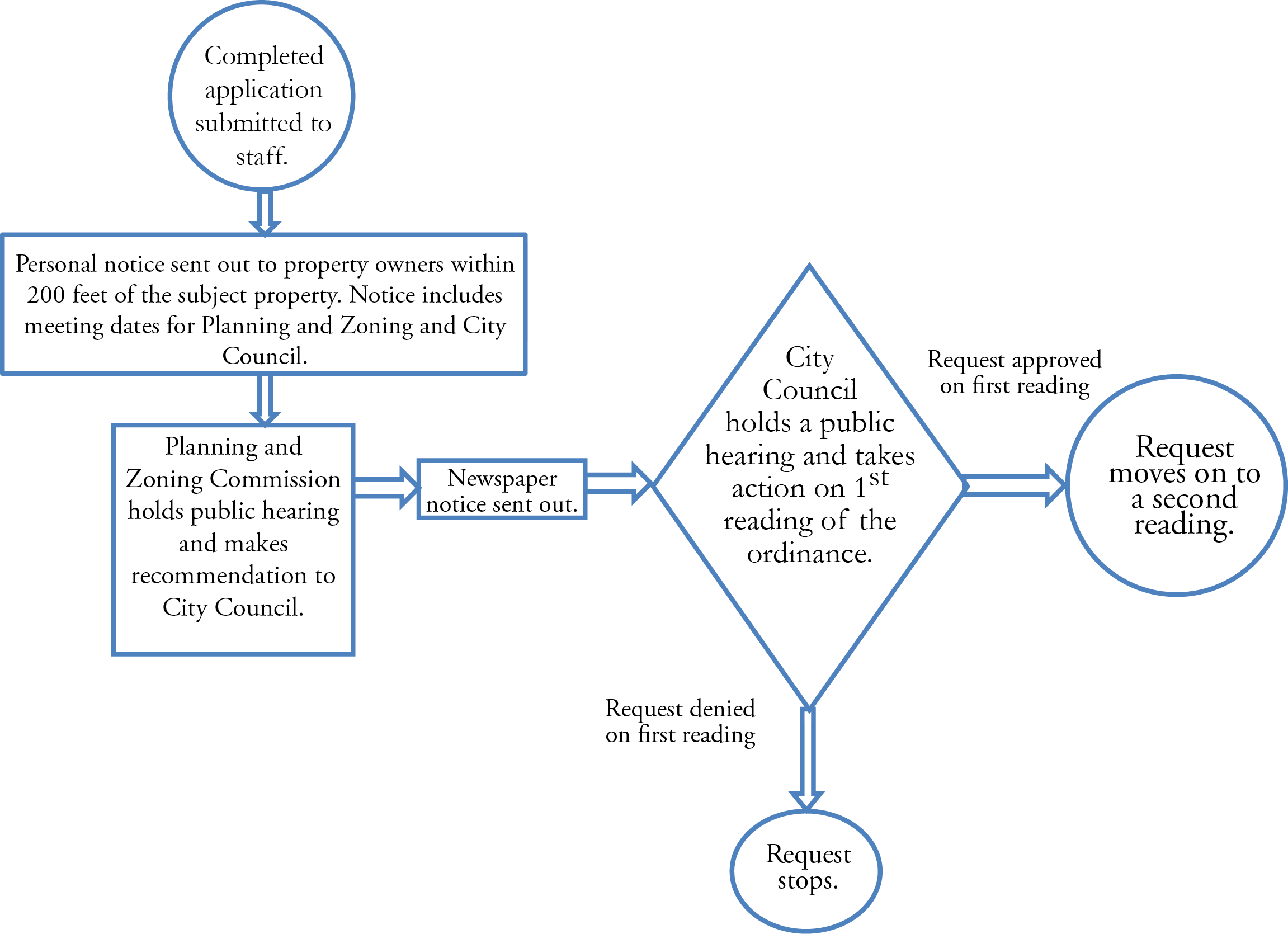
A.
Application. Applications for a zoning change shall be made on forms provided by the City and must contain legal authorization by the property owner for the City to proceed with the request. The same zoning request shall not be considered on any parcel more than once in any 12-month period of time unless the Planning and Zoning Commission, by a three-fourths (¾) vote, determines that there has been a substantial change in conditions surrounding the subject land since the prior request, and agrees to reconsider the request.
B.
Notice.
1.
Personal Notice. Written notice of all Planning and Zoning Commission and City Council hearings on proposed changes to the official zoning map shall be sent to all owners of property located within two hundred (200) feet of the subject property seeking a change in zoning. All notices shall be mailed via the US Post Office within not less than ten (10) days before any such hearing is held. Property owner information based on County Appraisal District records.
2.
Published Notice. Notice of City Council hearing shall be given by publication one time in a newspaper of general circulation in the City of Seguin, stating the time and place of such hearing, which time shall be not less than fifteen (15) days nor more than twenty (20) days from the date of publication.
C.
Public Hearings and Decision. Staff shall review all zoning requests, and provide the Planning and Zoning Commission with a staff analysis of the request. The Planning Commission shall hold a public hearing and provide a recommendation to the City Council. After receipt of the Planning and Zoning Commission recommendation, a public hearing shall be held by the City Council before taking action on a request for a zoning map amendment.
D.
Protests and recommendations for denial.
1.
In case of a written protest against any change in zoning, signed by the owners of twenty (20) percent or more either of the area of the lots or land included in such proposed change, or of the lots or land immediately adjoining the same and extending two hundred (200) feet therefrom, such amendment shall not become effective except by the favorable vote of three-fourths (¾) of all the members of the City Council of the City of Seguin.
2.
A vote of three-fourths (¾) of all the members of the City Council of the City of Seguin is also required to overrule a recommendation of the Commission that the proposed amendment, supplement or change be denied.
(Ord. No. 2015-65, § 1, 9-15-15; Ord. No. 2017-75, § 1, 12-19-17)
Sec. 2.5. - Specific use permits.
2.5.0.
[In general.]
A.
Application of Requirements. This section applies in the following areas:
B.
General. Specific Use Permits, commonly called "SUP", allow uses and/or structures that, with special conditions and development restrictions, may be considered compatible in a Zoning District in which they are not allowed by right.
C.
Intent. The purpose of this section is to outline the types of specific use permits and the criteria for approval for each.
D.
Types of Specific Use Permits. For the purpose of this ordinance there are two types of Specific Use Permits.
1.
Use based for uses identified as SUP on chapter 3 land use matrix.
2.
Alternative Development Plan for property within an overlay district.
E.
General Process for all Specific Use Permits.

1.
Application. An application for a Specific Use Permit shall be filed with the Planning Department on a form provided by that Department. The completed application shall be accompanied by a site plan which, along with the application, will become a part of the Specific Use Permit, if approved. All requirements for application materials can be found on the specific use permit application.
2.
Notice.
•
Personal Notice. Written notice of all public hearings on specific use permits shall be sent to all owners of property located within two hundred (200) feet of the subject property seeking a change in zoning. All notices shall be mailed via the US Post Office within not less than ten (10) days before any such hearing is held.
•
Published Notice. Notice of the Planning and Zoning Commission hearing shall be given by publication one time in a newspaper of general circulation in the City of Seguin, stating the time and place of such hearing, which time shall be not less than fifteen (15) days nor more than twenty (20) days from the date of publication.
3.
Decision. The Planning and Zoning Commission shall review and then approve, deny, or conditionally approve those uses for which Specific Use Permits are required.
4.
Time Limit. A Specific Use Permit issued under this section shall become null and void unless construction or use is substantially underway within one-year from the date of approval, or unless an extension of time is approved by the Planning and Zoning Commission. A Specific Use Permit issued by the Planning and Zoning Commission shall become null and void, if the land use for which it was issued has been closed, vacated, abandoned, or changed to a different use for a period of one (1) or more years.
5.
Revocation. A Specific Use Permit may be revoked or modified, after notice and hearing, for either of the following reasons:
•
The existence of any material error or misrepresentation in the application required in this section of the Ordinance; or
•
The Specific Use Permit was obtained or extended through misrepresentation or deception; or
•
That one or more of the conditions imposed by the permit has not been met or has been violated.
6.
Amendments. No building, premises, or land used under a Specific Use Permit may be enlarged, modified, structurally altered, or otherwise significantly changed unless an amendment to the original Specific Use Permit has been obtained. The procedure for amendment of a Specific Use Permit shall be the same as for a new application.
7.
Appeals for specific use permits. The applicant may present to the City Council a statement, duly verified, setting forth that such decision made by the Planning and Zoning Commission is unjust, in whole or in part, specifying the ground of injustice. Such statement shall be presented to the Planning Director and then to Council within ten (10) days after the final decision of the Commission, and not thereafter, notification of property owners shall be in the same manner as the original application, and calling of a public hearing to act on the appeal.
2.5.1.
Specific Use Permits - Based on proposed use of the property.
A.
Intent. The purpose of a Specific Use Permit is to allow the establishment of uses which may be suitable only in certain locations in a zoning district or only when subject to standards and conditions that assure compatibility with adjoining uses.
B.
Applicability. A Specific Use Permit is required to use or develop property within the City limits for any use designated as a specific use in the Land Use Matrix in Chapter 3 of this Unified Development Code for the zoning district in which the property is located.
C.
Criteria for Approval. A Specific Use Permit shall be issued only if all of the following conditions have been found:
1.
That the specific use will be compatible with and not be injurious to property in the immediate vicinity;
2.
That the establishment of the specific use will not impede the normal and orderly development and improvement of surrounding vacant property;
3.
That adequate utilities, access roads, drainage and other necessary supporting facilities have been or will be provided;
4.
The design, location and arrangement of all driveways and parking spaces provides for the safe and convenient movement of vehicular and pedestrian traffic without adversely affecting the general public or adjacent developments;
5.
That adequate prevention measures have been or will be taken to prevent or control offensive odor, fumes, dust, noise and vibration;
6.
That any lighting to be provided will be directional so as not to disturb or adversely affect neighboring properties;
7.
That sufficient landscaping and screening to insure harmony and compatibility with adjacent property exists or will be provided; and
8.
That the proposed use is in accordance with the Comprehensive Plan.
2.5.2.
Specific Use Permits - Alternative Development within a Corridor Overlay District.
A.
Intent. A Specific Use Permit for alternative development within a corridor overlay district is to allow property owners to submit alternative development proposals for the Planning and Zoning Commission's consideration.
B.
Criteria for Approval. The Planning and Zoning Commission will determine if the proposed development will promote, preserve, and enhance, and will not damage or detract from the distinctive character of the community; will preserve and protect property values and taxable values; will not be detrimental or inconsistent with neighboring uses and occupancies; will not be detrimental to the general interests of the citizens; and will not be detrimental to the public health, safety and welfare. In conducting its review, the Planning and Zoning Commission shall make examination of and give consideration to the traffic flow, development density, neighboring historical designs, neighboring uses, and elements of the application, including, but not limited to:
1.
Height of structures;
2.
Building mass, which shall include the relationship of the building width to its height and depth, and its relationship to the visual perception;
3.
Exterior detail and relationships, which shall include all projecting and receding elements of the exterior, including, but not limited to, porches and overhangs and the horizontal or vertical expression which is conveyed by these elements;
4.
Roof shape, which shall include type, form, and materials;
5.
Materials, texture, and color, which shall include a consideration of material compatibility among various elements of the structure;
6.
Compatibility of design and materials, which shall include the appropriateness of the use of exterior design details;
7.
Landscape design and plantings, which shall include lighting and the use of landscape details to highlight architectural features or screen or soften undesirable views;
If the specific use permit is granted by the Planning and Zoning Commission, the applicant shall be required to obtain a building permit and/or a development permit provided all other requirements for a building permit and/or a development permit are met. The Planning and Zoning Commission may grant an extension of the specific use permit if sufficient documentation can be provided to warrant such an extension.
Sec. 2.6. - Limited use permits.
2.6.1.
Application of Requirements. This section applies in the following areas:

2.6.2.
Intent. The purpose of a Limited Use Permit is to allow the establishment of uses which may be suitable only in certain locations when particular development standards are met.
2.6.3.
Applicability. A Limited Use Permit is required to use or develop property within the City limits for any use designated as a limited use in the Land Use Matrix in Chapter 3 of this Unified Development Code for the zoning district in which the property is located.
2.6.4.
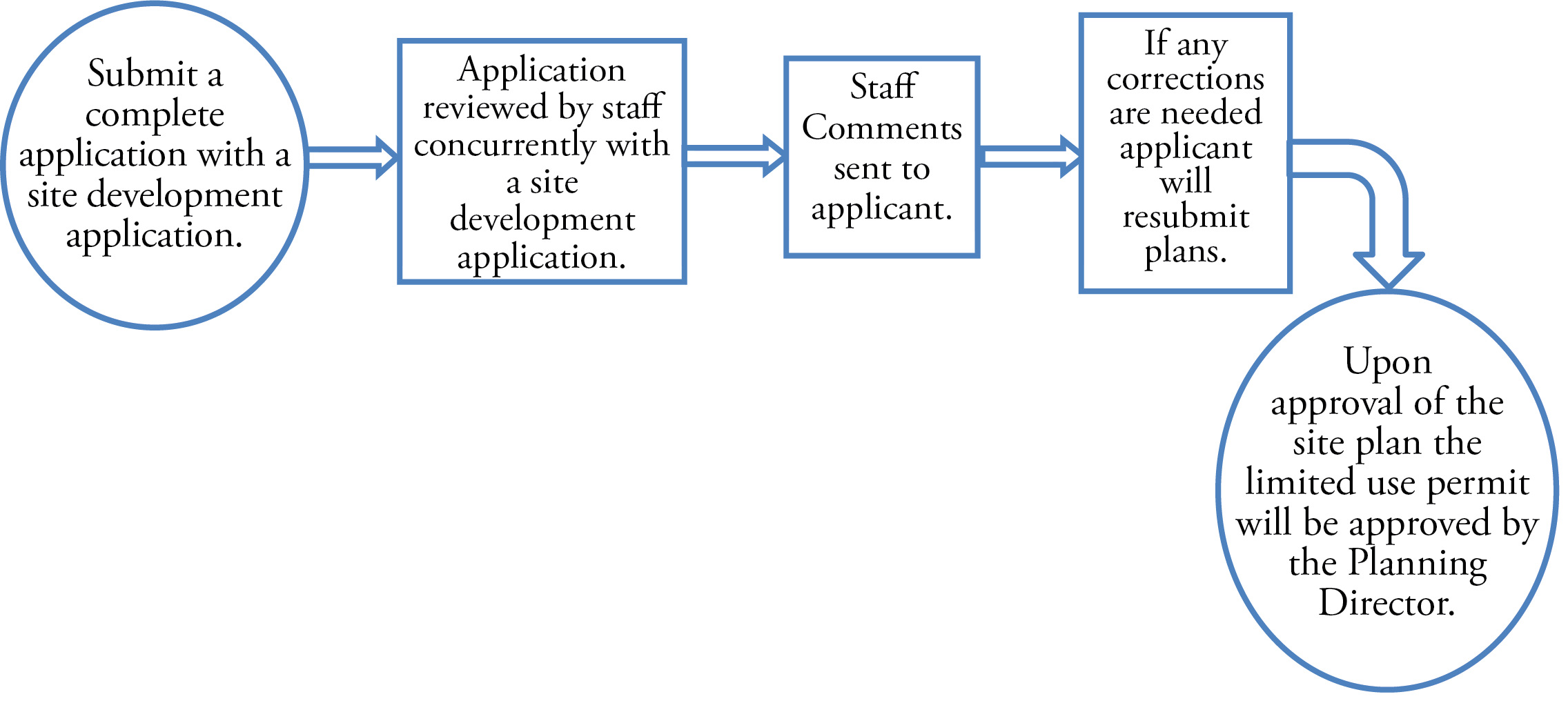
Criteria for Approval. A Limited Use Permit shall be approved if it is demonstrated that the compatibility requirements for a particular use have been met. The development standards associated with each limited use may vary in order to assure an appropriate transition between uses is achieved.
2.6.5.
General Process. An application for a limited use permit will be submitted concurrently with a site development application. The site plan will be reviewed for all base zoning requirements and any additional requirements associated with the limited use. The Planning Director shall approve, approve with conditions or deny the limited use permit application.
Sec. 2.7. - Variances (board of adjustments).
2.7.1.
Application of Requirements. This section applies in the following areas:
2.7.2.
Intent. The purpose of a variance process is to allow a property owner to deviate from the set of development regulations when a request arises from such a condition which is unique to the property in question and which is not ordinarily shared by others in the same district and is not create by an action of the property owners or applicant.
2.7.3.
Applicability. The following variances may be granted by the Board of Adjustments when the request is applicable to an existing platted lot:
•
To vary the applicable lot area, lot width or frontage, lot depth or impervious cover;
•
To vary the applicable minimum building setback requirements, lot coverage, and maximum building height;
•
To vary the regulations pertaining to signs as permitted by the sign ordinance;
•
To vary the regulations pertaining to off-street parking and loading;
•
To vary the regulations pertaining to fencing standards.
2.7.4.
Criteria for Approval. Variances from the strict application of the stated requirements shall be authorized only when the Board approves findings of fact in writing. Proposed findings shall be submitted by the proponent of the variance in writing showing that the evidence provided by the proponent demonstrates that the following conditions exist:
A.
The variance requested arises from such condition which is unique to the property in question and which is not ordinarily shared by others in the same neighborhood or zoning district;
B.
The particular physical surroundings, shape or topographical condition of the specific property involved would result in a practical difficulty or unnecessary hardship or inequity upon or for the owner or occupant, as distinguished from a mere inconvenience, if the provisions of the regulations were literally enforced;
C.
The request for a variance is not based exclusively upon a desire from the owner, occupant, or applicant for increased financial gain from the property, or to reduce an existing financial hardship.
D.
The granting of the variances will not be materially detrimental or injurious to, or adversely affect the rights of, owners or residents of surrounding property.
E.
The proposed variance will not impair an adequate supply of light or air to adjacent property, substantially increase congestion in the public streets, increase the danger of fire, endanger the public safety, substantially diminish or impair property values within the neighborhood, or otherwise be opposed to the general spirit and intent of this Ordinance.
2.7.5.
General Process. An application for a variance shall be submitted to the Planning Director for review. The applicant shall submit written findings of fact supporting the request for a variance. Staff shall review all variance requests and provide the Board of Adjustments with a staff analysis of the request. Written notice of all Board of Adjustments hearings on proposed variances shall be sent to all owners of property located within two hundred (200) feet of the subject property seeking a variance. All notices shall be mailed via the US Post Office within not less than ten (10) days before any such hearing is held. Property owner information based on County Appraisal District records.

(Ord. No. 2016-68, § 1, 10-18-16; Ord. No. 2018-068, § pt. 1, 10-16-18)
Sec. 2.8. - Certificates of appropriate design.
2.8.1
Application of Requirements. This section applies in the following areas:
2.8.2
Intent. The purpose of a Certificate of Appropriate Design is to help maintain the architectural significance of Seguin's historic districts and landmarks.
2.8.3
Applicability. Any person carrying out any work that will result in an exterior alteration, restoration, reconstruction, new construction or moving of a landmark or property with a Historic Landmark Designation or located in a historic District must first obtain a Certificate of Appropriateness.
2.8.4.
Criteria for Approval. In considering an application for a Certificate of Appropriateness, the Historic Preservation and Design Commission and Historic Preservation Officer are guided by The Secretary of Interior's Standards for Rehabilitation of Historic Buildings and the City of Seguin Design Guidelines. These standards can be found in the Technical Manual and can be accessed on the Main Street Department website.
2.8.5.
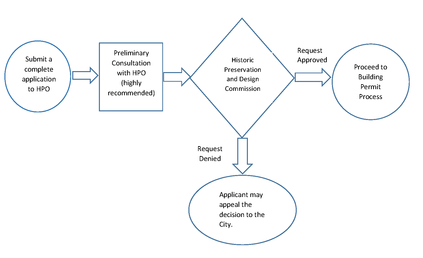
General Process. Applications for a certificate of Appropriateness shall be made on forms provided by the City and must contain legal authorization by the property owner for the City to proceed with the request. Requirements for a complete application can be found in the technical manual and on the application. The application shall be filed with the Historic Preservation Officer and will be reviewed by the Historic Preservation Officer prior to being submitted to the Historic Preservation & Design Commission. Appeals of the Commission's decision shall be reviewed by the City Council.
(Ord. No. 2019-005, § 3, 2-19-19)
Sec. 2.9. - Subdivision development.
2.9.0.
[In general.]
A.
Application of Requirements. This section applies in the following areas:
B.
General. The provisions of Chapter 4 apply to any non-exempt division of land within the corporate boundaries of the City and within its extraterritorial jurisdiction. The procedures of this section are authorized under the authority of Tex. Loc. Gov't. Code ch. 212. A subdivision plat inside the City or within the extraterritorial jurisdiction (ETJ) of the City of Seguin a plat shall first be submitted to the Director of Planning for review and approved by the identified decider before being recorded with the County Clerk. No building permit shall be issued for any building or structure on a property until a subdivision or a development plat has been approved and filed for record.
C.
Intent. It is the purpose of this Article to promote sound planning in the subdivision of land, and to provide consistent rules, which protect the public health, safety, and welfare while allowing the legal platting of land.
D.
Types of Subdivision Plats. Each type of subdivision plat has its own requirements and applicable decision makers. The type of subdivision plat required to be submitted is dependent on the following:
1.
Size of Subdivision (both in acreage and number of lots);
2.
Required public improvements to service the subdivision; and
3.
Access to the lots.
E.
Exceptions. A plat is required for any tract of land divided into two or more parts, except as provided in the Texas Local Government Code or for the following:
1.
Sale, inheritance, or gift of land by metes and bounds of tracts upon which no improvements, development, subdivision or alteration is intended;
2.
A division of land created by order of a court of competent jurisdiction;
3.
A division of land that results in the creation of two or more parcels, each of which is greater than five acres inside the City limits, or each of which is greater than ten acres within the City's extraterritorial jurisdiction, when each parcel has direct access to an existing public street, and no dedication of public facilities is required under this Unified Development Code in connection with the division;
4.
Creation of a remainder tract over 5 acres in size;
5.
Acquisition of land for governmental purposes by dedication, condemnation, or easement;
6.
Requests for building permits for unplatted properties located within the city limits for the following:
•
Accessory buildings (as otherwise permitted in accordance with this Code);
•
The construction or repair of a fence;
•
Remodeling or repairs which involve no expansion of square footage; or
•
Building additions on a lot with existing structures which increases the total combined square footage of all existing buildings on the lot by no more than 30 percent and no more than 10,000 square feet (over a five-year time period) and does not exceed the maximum impervious cover in accordance with Section 3.6 and does not adversely impact surrounding properties;
7.
Requests for building permits for new construction and/or building additions on unplatted properties or properties within the city limits that are zoned for single-family residential development if the following criteria are met:
•
The property has legal access to a public street; and
•
The property has access to utilities; and
•
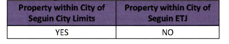
The property in its current configuration was created by a metes and bounds legal description recorded in a deed of transfer or sale at the office of the Guadalupe County Clerk prior to June 26, 1987 or prior to being subject to the City of Seguin's subdivision regulations. Please refer to the table below to determine if the property is eligible for a plat exception under this section.
In order to determine the exception for single-family residential in Section 2.9.0.E.7, an application, fee, and documentation shall be required as outlined in the technical manual.
F.
Time for Decision and General Process.
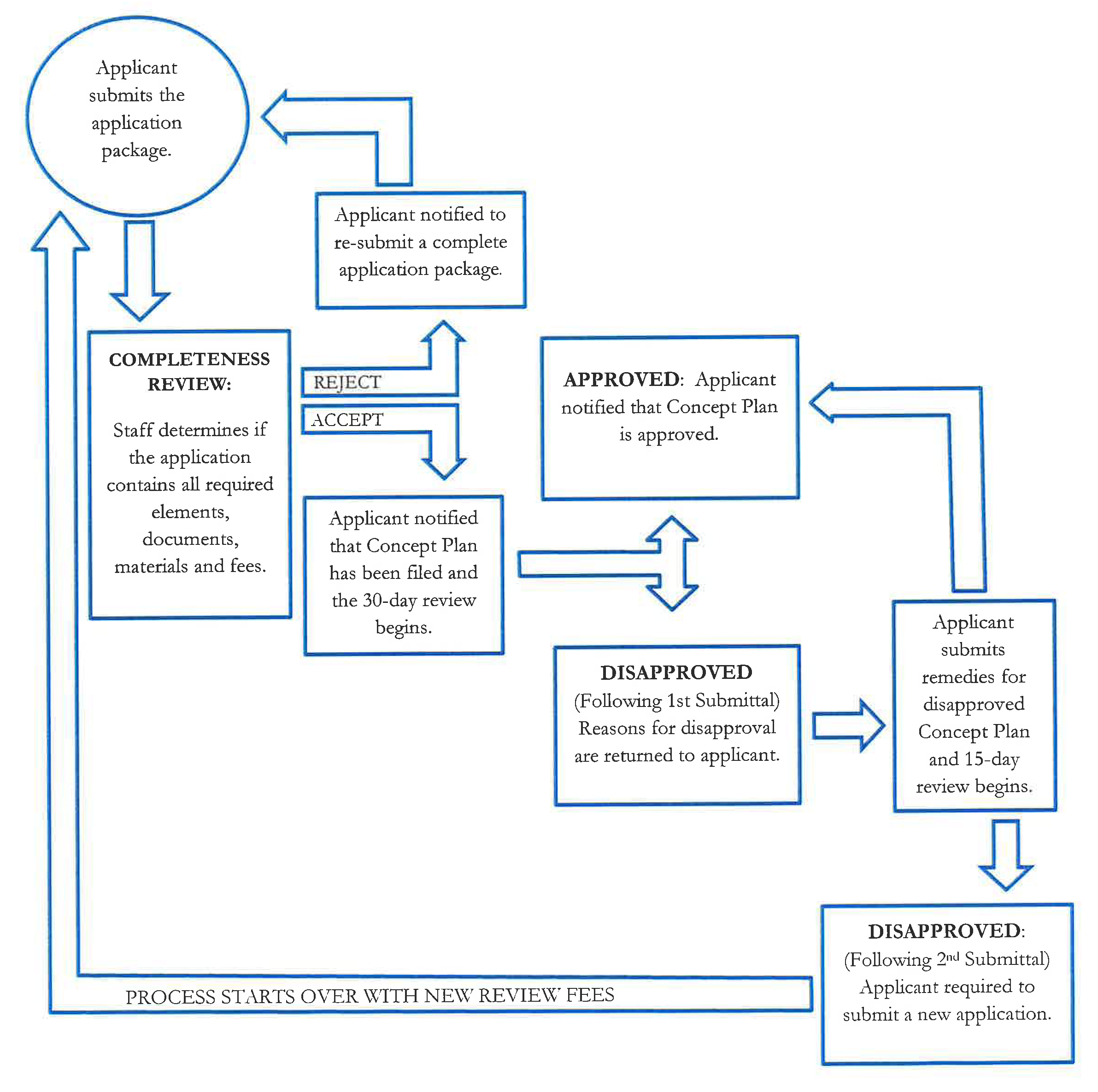
Completeness Reviews: All subdivision development studies, concept plans, and plats are subject to a completeness review in which City staff will verify that all required documents and information have been submitted in order to confirm that the application is ready to be filed for review by the City. Completeness reviews will be completed within 5 business days of receipt. The official filing date of the application is the date the completeness review is approved and the applications is accepted for review by the City of Seguin.
Development Studies: Development studies are reviewed by staff and are administratively approved by the City Engineer. These reviews can be conducted concurrently with the Subdivision Concept Plan but only if the 30-day waiver for the Concept Plan is completed (Development studies are not subject to Section 212.009 of the Texas Local Government Code.)
Subdivision Concept Plans: Concept Plans are required to be submitted, reviewed, and approved prior to submitting a Public Infrastructure Permit. Subdivision Concept Plans are reviewed by staff and are administratively approved by the Planning Director and the City Engineer. Applicants can choose one of two submittal options:
•
Submit in writing a waiver to Section 212.009 of the Texas Local Government Code to allow for time to address any outstanding issues that are not in compliance with the applicable regulations and development requirements. Multiple reviews will be allowed without disapproval and the applicant can re-submit without additional review fees.
•
Forego a waiver to Section 212.009 of the Texas Local Government Code and staff will complete a 30-day review of the original filing. If the Concept Plan does not meet all applicable regulations and development requirements, the plan will be disapproved with written comments addressing specific reasons for disapproval. The applicant will be given one opportunity to address the comments by submitting a written response that remedies all comments on the disapproved plan. City staff will complete the review of the applicant's written response within 15 days. If the applicant's written response does not adequately address all comments, the Concept Plan will be disapproved, and the process will start over with a new application and new review fees.
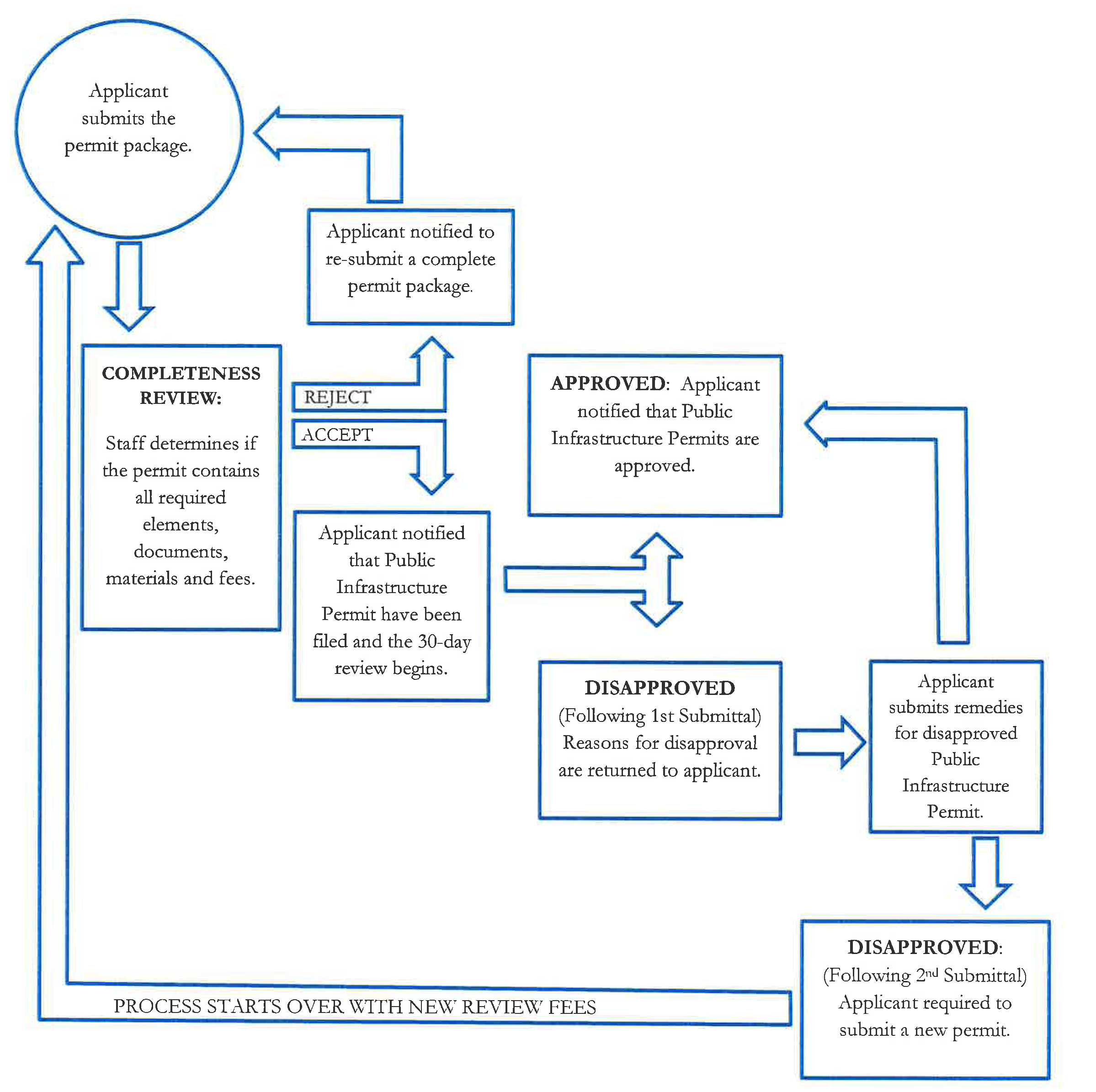
Public Infrastructure Permit: A Public Infrastructure Permit is required to be submitted, reviewed, and approved prior to submitting Final Plats. Public Infrastructure Permits are reviewed by staff and are administratively approved by the City Engineer. (Public Infrastructure Permits are not subject to Section 212.009 of the Texas Local Government Code.)
Minor Plats, Minor Replats, Amending Plats, and Vacating Plats: Minor plats, minor replats, amending plats, and vacating plats are administrative plats that are reviewed by staff and are administratively approved by the Planning Director and the City Engineer.
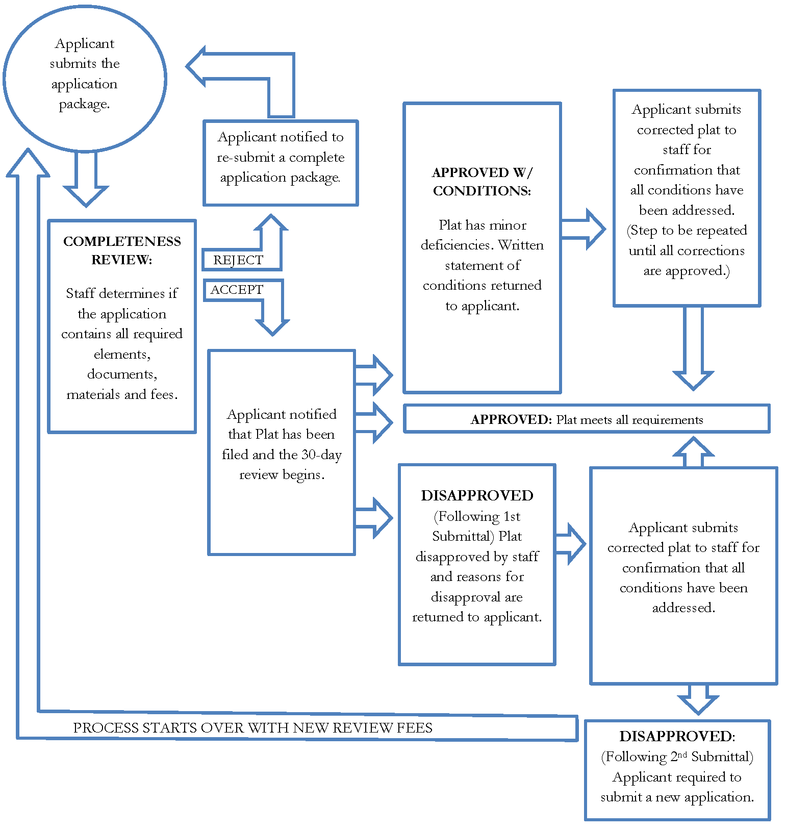
Following the completeness review, staff will conduct a review of the plat. City staff will approve, approve with conditions, or disapprove the plat as follows:
Approve: The plat meets all of the requirements of the Unified Development Code, Technical Manual, and other applicable regulations and development requirements.
Approve with Conditions: The plat has minor deficiencies that can be revised by the applicant and reviewed by staff without significant changes to the proposed lot configurations or street alignments. Minor deficiencies include plat notes, easement locations, signature blocks, missing measurements, lot dimensions, or any other deficiencies that the Planning Director or City Engineer determine can be fully corrected without a significant impact to the design of the subdivision plat. The applicant shall address the comments and re-submit the plat to the City for review until all deficiencies have been corrected. City staff will complete each subsequent review of the corrected plat within 15 days.
Disapprove: If the plat does not meet all applicable regulations and development requirements and the deficiencies require significant modifications to the layout of the subdivision, staff will disapprove the plat with written comments addressing specific reasons for the disapproval. The applicant will be given one opportunity to address the comments by re-submitting the plat with remedies that address all of the comments on the disapproved plat. If the applicant does not adequately address all comments, staff will disapprove the plat and the process will start over with a new application and new review fees.
Preliminary Plats: Preliminary Plats are optional prior to submitting a Public Infrastructure Permit and only consist of the phase/unit currently being developed. It is strongly recommended that a Preliminary Plat be approved before the submittal of a Public Infrastructure Permit. This is to ensure all lot dimensions and standards, along with the necessary easements, are properly sized and located for the proposed infrastructure. Preliminary plats are administrative plats that are reviewed by staff and are administratively approved by the Planning Director and the City Engineer. Following the completeness review, staff will conduct a review of the plat. City staff will approve, approve with conditions, or disapprove the plat as follows:
Approve: The plat meets all of the requirements of the Unified Development Code, Technical Manual, and other applicable regulations and development requirements.
Approve with Conditions: The plat has minor deficiencies that can be revised by the applicant and reviewed by staff without significant changes to the proposed lot configurations or street alignments. Minor deficiencies include plat notes, easement locations, signature blocks, missing measurements, lot dimensions, or any other deficiencies that the Planning Director or City Engineer determine can be fully corrected without a significant impact to the design of the subdivision plat. The applicant shall address the comments and re-submit the plat to the City for review until all deficiencies have been corrected. City staff will complete each subsequent review of the corrected plat within 15 days.
Disapprove: If the plat does not meet all applicable regulations and development requirements and the deficiencies require significant modifications to the layout of the subdivision, staff will disapprove the plat with written comments addressing specific reasons for the disapproval. The applicant will be given one opportunity to address the comments by re-submitting the plat with remedies that address all of the comments on the disapproved plat. If the applicant does not adequately address all comments, staff will disapprove the plat and the process will start over with a new application and new review fees.
Final Plats (including replats with more than four buildable lots): Final plats are administrative plats that are reviewed by staff and are administratively approved by the Planning Director and the City Engineer. If public improvements are required for the proposed final plat, a Public Infrastructure Permit shall be submitted reviewed, and approved prior to submitting the final to the City of Seguin. Following the completeness review, staff will conduct a review of the plat. City staff will approve, approve with conditions, or disapprove the plat as follows:
Approve: The plat meets all of the requirements of the Unified Development Code, Technical Manual, and other applicable regulations and development requirements.
Approve with Conditions: The plat has minor deficiencies that can be revised by the applicant and reviewed by staff without significant changes to the proposed lot configurations or street alignments. Minor deficiencies include plat notes, easement locations, signature blocks, missing measurements, lot dimensions, or any other deficiencies that the Planning Director or City Engineer determine can be fully corrected without a significant impact to the design of the subdivision plat. The applicant shall address the comments and re-submit the plat to the City for review until all deficiencies have been corrected. City staff will complete each subsequent review of the corrected plat within 15 days.
Disapprove: If the plat does not meet all applicable regulations and development requirements and the deficiencies require significant modifications to the layout of the subdivision, staff will disapprove the plat with written comments addressing specific reasons for the disapproval. The applicant will be given one opportunity to address the comments by re-submitting the plat with remedies that address all of the comments on the disapproved plat. If the applicant does not adequately address all comments, staff will disapprove the plat and the process will start over with a new application and new review fees.
Subdivision Concept Plan: General Process
* If a waiver is signed, the documents can be resubmitted for review without disapproval until all comments are addressed and the Concept plan is approved.
Public Infrastructure Permit: General Process
Plat: General Process (All Plats except residential replats that require a variance.)
* Waiver prohibited by Section 212.0097 of the Texas Local Government Code
2.9.1.
Subdivision Concept Plan.
A.
Intent. Subdivision Concept Plans shall be used to determine the general layout of the subdivision, the adequacy of public facilities needed to serve the intended development and the overall compliance of the land division with applicable requirements of this Unified Development Code. Approval of a concept plan establishes a mutual commitment on behalf of the City and the applicant to the subdivision layout for purposes of final plat approval, including the location of proposed parks, open space lots, drainage lots, the location and width of proposed streets, and that utilities are available to serve the subdivided land to the extent shown on the concept plan and referenced documents.
B.
Applicability. A Subdivision Concept Plan is required for all subdivisions that require a Final Plat that proposes phases, new streets, parks, open space, drainage lots, or utility extensions, as determined by the Director of Planning & Codes and City Engineer. Minor plats, minor replats, amending plats, and vacating plats do not require the submittal of a concept plan.
C.
Criteria for Approval. Subdivision standards are detailed in Chapter 4. Concept Plans are evaluated using the following criteria:
1.
If the property is located inside the City limits, the plat is consistent with all zoning requirements for the property;
2.
If located in the ETJ, the plat meets any county standards to be applied under an interlocal agreement between the City and Guadalupe County;
3.
The proposed configuration of roads, water, wastewater, drainage and park facilities conform to the stated requirements of this Unified Development Code;
4.
The appropriate right-of-way dedications have been identified on the plat;
5.
The proposed plat is consistent with the stated goals of the comprehensive master plan;
6.
If the property is proposed to be platted in phases the following requirements shall apply:
•
The schedule of development is feasible and prudent, and assures that the proposed development will progress to completion within the time limits proposed.
•
The location, size and sequence of the phases of development proposed assure orderly and efficient development of the land subject to the plat.
D.
Process. Applications for a concept plan shall be made on forms provided by the City and must contain legal authorization by the property owner for the City to proceed with the request. Requirements for a complete application can be found in the technical manual and on the application.
E.
Action. If the concept plan meets the requirements of this UDC and any applicable agreements (interlocal agreement applicable to ETJ properties and/or any development agreements applicable to the property), the Planning Director and City Engineer shall approve the plat request for a period of three years from the date of the final approval.
F.
Extension. The approval of a Subdivision Concept Plan application shall remain in effect for a period of three years from the date the application was approved by the Planning Director and City Engineer, during which period the applicant shall make progress towards completion of a Final Subdivision Plat for the land subject to the Subdivision Concept Plan (as defined in V.T.C.A., Local Government Code § 245.005(c) as amended). If no progress is made towards completion of a Final Subdivision Plat for the land subject to the Subdivision Concept Plan (as defined in V.T.C.A., Local Government Code § 245.005(c) as amended) within the three year period, the Subdivision Concept Plan approval shall expire and the concept plan shall be null and void, unless extended by the Planning Director and City Engineer.
G.
Amendments. Minor changes to the Concept Plan may be approved by the Planning Director and City Engineer without the necessity of filing a new application for an amended Concept Plan. Minor changes shall include minor adjustments in street alignments, block lengths, street names, phase boundaries, and other changes that do not significantly alter the design of the subdivision, provided that such changes are consistent with any approved development studies or other development applications. Major amendments shall require submittal and approval of a new application for a Concept Plan.
2.9.2.
Final Subdivision Plat.
A.
Intent. A Final Plat is required to assure that the division or development of the land subject to the plat is consistent with all standards of this UDC, including but not limited to the following:
1.
Adequacy of public facilities;
2.
All other requirements and conditions have been satisfied or provided for to allow the plat to be recorded, and to assure that the subdivision meets all other standards of this UDC to enable initiation of site preparation activities for any lot or tract subject to the plat.
B.
Applicability. Approval of a Final Plat shall be required prior to any non-exempt division of land and prior to any site development permit or building permit being issued for a development. Replats that qualify as final plats will follow the same review and approval process as final plats.
C.
Criteria for Approval. A Final Plat, shall consider the following criteria:
1.
The final plat shall conform to the approved Concept Plan as approved by the Planning Director and City Engineer; and
2.
The final plat shall conform to all of the requirements outlined in the UDC and the technical manual.
3.
The final layout of the subdivision or development meets all standards for adequacy of public facilities contained in this UDC and the public infrastructure permits required for the proposed subdivision plat have been approved by the City Engineer.
D.
Process.
1.
Application. Applications for a final plat shall be made on forms provided by the City and must contain legal authorization by the property owner for the City to proceed with the request. Requirements for a complete application can be found in the technical manual and on the application.
2.
Staff Review. The plat shall be reviewed by staff to identify deficiencies that do not meet the regulations adopted for subdivision development. Within 30 days of the plat filing date a letter of approval, approval with conditions or disapproval will be submitted to the applicant for formal action on the plat. If staff presents the applicant with a letter for approval with conditions or disapproval, the letter shall articulate the specific reasons and deficiencies for which a conditional approval or disapproval are necessary.
3.
Action. If the subdivision plat meets the requirements of this UDC and any applicable regulations, development requirements or agreements (interlocal agreement applicable to ETJ properties and/or any development agreements applicable to the property) staff shall approve the plat request for a period of two years from the date of the final approval. If the subdivision plat does not meet all of the requirements staff shall approve with conditions or disapprove the plat as directed in Section 2.9.F of the UDC.
4.
Subdivision Improvements. Prior to recordation of a plat all subdivision improvements must be either constructed, accepted by the City Engineer and the appropriate maintenance bonds must be in place or fiscal posted for the required improvements. Please see section on public infrastructure permits.
5.
Extension. The approval of a Final Subdivision Plat application shall remain in effect for a period of two years from the date the application was approved or approved with conditions by the Planning Director, during which period the applicant shall submit any required revisions for approval and make all other changes needed to record the plat. If the final Subdivision Plat has not been recorded within the two-year period, the final plat unless extended by the Planning Director, shall expire and the applicable plat shall be deemed null and void.
2.9.3.
Minor Plat.
A.
Intent. The purpose of a Minor Subdivision Plat is to allow for the administrative approval of plat in which number of lots is limited and the extension of public infrastructure is not needed.
B.
Applicability. The Planning Director is authorized to approve minor plats involving four or fewer lots fronting on an existing street and not requiring the creation of any new street or the extension of municipal facilities. Replats that qualify as minor plats will follow the same review and approval process as minor plats.
C.
Criteria for Approval. Subdivision standards are detailed in Chapter 4. Minor Plats are evaluated using the following criteria:
1.
If located within the City limits the minor subdivision plat is consistent with all zoning requirements for the property and all other requirements of this Unified Development Code that apply to the plat.
2.
If located in the ETJ- the plat meets any county standards to be applied under an interlocal agreement between the City and Guadalupe County.
3.
All lots to be created by the plat are adequately served by all required City utilities and services, and do not require the extension of any municipal facilities to serve any lot within the subdivision.
D.
Process.
1.
Application. Applications for a minor plat shall be made on forms provided by the City and must contain legal authorization by the property owner for the City to proceed with the request. Requirements for a complete application can be found in the technical manual and on the application.
2.
Staff Review. The plat shall be reviewed by staff to identify deficiencies that do not meet the regulations adopted for subdivision development. Within 30 days of the plat filing date a letter of approval, approval with conditions or disapproval will be submitted to the applicant for formal action on the plat. If staff presents the applicant with a letter for approval with conditions or disapproval, the letter shall articulate the specific reasons and deficiencies for which a conditional approval or disapproval are necessary.
3.
Action. If the subdivision plat meets the requirements of this UDC and any applicable regulations, development requirements or agreements (interlocal agreement applicable to ETJ properties and/or any development agreements applicable to the property) staff shall approve the plat request for a period of two years from the date of the final approval. If the subdivision plat does not meet all of the requirements staff shall approve with conditions or disapprove the plat as directed in Section 2.9.F of the UDC.
4.
Extension. The approval of a Minor Plat application shall remain in effect for a period of two years from the date the application was approved or approved with conditions by the Planning Director, during which period the applicant shall submit any required revisions for approval and make all other changes needed to record the plat. If the plat has not been recorded within the two-year period, the plat (unless extended by the Planning Director), shall expire and the applicable plat shall be deemed null and void.
2.9.4.
Amending Plat.
A.
Intent. An amended plat is required for error correction on a recorded plat, boundary changes between adjacent lots where no new lots would be created, and lot consolidation between two or more lots where an entire plat will not be vacated.
B.
Applicability. The provisions of this section are authorized under Local Government Code Chapter 212 and shall be applicable to all areas within the City's limits and throughout the City's ETJ. An amending plat may be filed in accordance with the procedures and requirements set forth in the Local Government Code section 212.016 and may be used in the following situations:
1.
To correct an error in a course or distance shown on the preceding plat;
2.
To add a course or distance that was omitted on the preceding plat;
3.
To correct an error in a real property description shown on the preceding plat;
4.
To indicate monuments set after the death, disability, or retirement from practice of the engineer or surveyor responsible for setting monuments;
5.
To show the location or character of a monument that has been changed in location or character or that is shown incorrectly as to location or character on the preceding plat;
6.
To correct any other type of scrivener or clerical error or omission previously approved, including lot numbers, acreage, street names, and identification of adjacent recorded plats;
7.
To correct an error in courses and distances of lot lines between two adjacent lots if:
a.
Both lot owners join in the application for amending the plat and neither lot is abolished;
b.
The amendment does not attempt to remove recorded covenants; or
c.
The amendment does not have a material adverse effect on the property rights of the other owners in the plat;
8.
To relocate a lot line to eliminate an inadvertent encroachment of a building or other improvement on a lot line or easement;
9.
To relocate one or more lot lines between one or more adjacent lots if:
a.
The owners of all those lots join in the application for amending the plat; and
b.
The amendment does not attempt to remove recorded covenants or restrictions; and
c.
The amendment does not increase the number of lots;
10.
To make necessary changes to the preceding plat to create six or fewer lots in the subdivision or a part of the subdivision covered by the preceding plat if:
a.
The changes do not affect applicable zoning and other regulations of the municipality;
b.
The changes do not attempt to amend or remove any covenants or restrictions; or
c.
The area covered by the changes is located in an area that the municipal planning commission or other appropriate governing body of the municipality has approved, after a public hearing, as a residential improvement area; or
11.
To replat one or more lots fronting on an existing street if:
a.
The owners of all those lots join in the application for amending the plat;
b.
The amendment does not attempt to remove recorded covenants or restrictions;
c.
The amendment does not increase the number of lots; and
d.
The amendment does not create or require the creation of a new street or make necessary the extension of municipal facilities.
C.
Criteria for Approval. Subdivision standards are detailed in Chapter 4. Amending plats are evaluated using the following criteria:
1.
New lots will not be created;
2.
If located within the City limits, the subdivision plat is consistent with all zoning requirements for the property and all other requirements of this Unified Development Code that apply to the plat;
3.
If located in the ETJ, the plat meets any county standards to be applied under an interlocal agreement between the City and Guadalupe County;
4.
All lots to be created by the plat are adequately served by all required City utilities and services, and do not require the extension of any municipal facilities to serve any lot within the subdivision.
D.
Process. Applications for an amending plat shall be made on forms provided by the City and must contain legal authorization by all property owners for the City to proceed with the request. Requirements for a complete application can be found in the technical manual and on the application. All comments must be addressed prior to the Planning Director approving the request. The approval of an Amending Subdivision Plat application shall remain in effect for a period of two years from the date that the application was approved by the Director or the Planning. The applicant may request an extension of 1 year.
2.9.5.
Replatting without Vacating Previous Plat.
A.
Intent. A replat is required when a property owner is seeking to change the number or configuration of current lots within a subdivision.
B.
Applicability. The provisions of this section are authorized under Local Government Code Chapter 212 and shall be applicable to all areas within the City's limits and throughout the City's ETJ. A replat is any plat that complies with Local Government Code sections 212.014, 212.0145, and 212.015, as amended.
1.
Replat. A new plat of all or a portion of a previously approved plat. Replats eliminate the prior plats as to the area replatted.
2.
Residential Replat. A replat where either:
(i)
During the preceding 5 years, part was zoned for residential use by not more than 2 units per lot, or
(ii)
Any lot is restricted to residential use by not more than 2 units.
C.
Criteria for Approval. Subdivision standards are detailed in Chapter 4. Replats are evaluated using the following criteria:
1.
Requirements of the Texas Local Government Code are met.
2.
The plat does not attempt to amend or remove any covenants or restrictions.
3.
If located within the City limits, the subdivision plat is consistent with all zoning requirements for the property and all other requirements of this Unified Development Code that apply to the plat.
4.
If located in the ETJ, the plat meets any county standards to be applied under an interlocal agreement between the City and Guadalupe County.
5.
The final layout of the subdivision meets all standards for adequacy of public facilities contained in this UDC and the public infrastructure permits required for the proposed subdivision plat have been approved by the City Engineer and Utilities Directors.
D.
Process.
1.
Applications. Applications for a replat shall be made on forms provided by the City and must contain legal authorization by all property owners for the City to proceed with the request. Requirements for a complete application can be found in the technical manual and on the application. A replat is reviewed as a Minor Plat or a Final Plat and follows the review and approval process for minor and final plats as identified in this code.
2.
Notice. In accordance with LGC Section 212.015 for a residential replat, written notice of the approval of a replat shall be given not later than the 15th day after the date the replat is approved to all property owners within the original subdivision that are within 200 feet of the lots to be replatted.
3.
Variance. If the proposed replat requires a variance, a public hearing shall be held by the Planning Commission, and notice shall be provided before the 15 th day before the hearing by publication in an official newspaper and by written notice to all property owners within the original subdivision that are within 200 feet of the lots to be replatted. If the variance is protested in accordance with V.T.C.A., Local Government Code § 212, the proposed replat must receive, in order to be approved, the affirmative vote of at least three-fourths of the members present of the municipal planning commission or governing body, or both. For a legal protest, written instruments signed by the owners of at least 20 percent of the area of the lots or land immediately adjoining the area covered by the proposed replat and extending 200 feet from that area, but within the original subdivision, must be filed with the Planning Director prior to the close of the public hearing.
2.9.6.
Vacating Plat.
A.
Intent. A vacating plat allows for vacation of an entire subdivision plat if development will not occur consistent with the recorded plat.
B.
Applicability. The owner of all contiguous lots shown on a plat of record in the City or its extraterritorial jurisdiction may request the lots be vacated resulting in a single, unplatted parcel. When no lots on a subdivision plat have been sold, the developer may request the vacation of the plat prior to the installation of public improvements. If any lot in a subdivision has been sold, the recorded subdivision plat or any portion thereof may be vacated only upon application of all lot owners in the subdivision.
C.
Criteria for Approval. Subdivision standards are detailed in Chapter 4. Plat Vacations are evaluated using the following criteria:
1.
Requirements of the Texas Local Government Code are met;
2.
It will not leave any lots without adequate utility or drainage easements;
3.
It will not create a landlocked parcel, or vacate street rights-of-way or access easements needed to access other property;
4.
The plat vacation is requested before improvements covered by guarantees are installed;
5.
It will not inhibit the provision of adequate public facilities or services to other property.
D.
Process. Applications for a plat vacation shall be made on forms provided by the City and must contain legal authorization by the property owner for the City to proceed with the request. Requirements for a complete application can be found in the technical manual and on the application. The plat is vacated when a signed, acknowledged instrument declaring the plat vacated is approved and recorded in the manner prescribed for the original plat. On the execution and recording of the vacating instrument, the vacated plat shall have no further effect.
2.9.7.
Unity of Title Agreement.
A.
Intent. A unity of title agreement is to provide an expeditious means of developing two (or more) adjacent residential lots under the same ownership as a single lot. The agreement is transferable with all properties and runs with the land rather than the ownership.
B.
Applicability. The procedures for an agreement shall apply only for the purpose of constructing structures or buildings allowed in residential districts.
C.
Criteria for Approval. The Director of Planning shall decide whether to approve, conditionally approve, or deny the unity of title agreement based on the following criteria:
1.
The combined area and dimensions of the contiguous lots shall meet all dimensional standards for a single lot in accordance with the applicable zoning district under the City's Unified Development Code.
2.
All lots must be under the same ownership.
3.
All lots must be zoned for one-family or two-family residential uses.
4.
A unity of title agreement shall not attempt to remove or modify recorded covenants or restrictions or easements.
5.
A unity of title agreement shall not require the dedication of any additional right-of-way or easements.
D.
Process.
1.
Application. An application for approval of an agreement for a unity of title agreement shall be prepared in accordance with the Technical Manual.
2.
Approval. Upon approval by the Director of Planning, an agreement for unity of title shall be recorded and is controlling over the recorded plat until such time as the structures or buildings requiring the unity of title are removed, demolished, or brought into conformance with the regulations of the applicable zoning district.
3.
Recording. The Unity of Title agreement shall be signed by all interested parties (including property owners and City of Seguin representatives), and recorded in the official records of Guadalupe County.
4.
Release of Agreement. A release of the Unity of Title bearing all necessary signatures (as described above) shall only be recorded by the City of Seguin following review and approval by the Planning Director.
2.9.8.
Subdivision Variance Request.
A.
Application of Requirements. This section applies in the following areas:
B.
Intent. The purpose of a subdivision variance process is to allow a property owner to deviate from the set of development regulations when a request arises from such a condition which is unique to the property in question and which is not ordinarily shared by others in the same district and is not create by an action of the property owners or applicant.
C.
Applicability. The following variances may be granted by the Planning and Zoning Commission when the request is applicable to an undeveloped and unplatted property seeking to subdivide the property:
•
To vary the applicable lot area, lot width or frontage, lot depth or impervious cover;
•
To vary the applicable minimum building setback requirements, lot coverage, and maximum building height;
•
Subdivision regulations contained in Chapter 4 of the UDC.
D.
Criteria for Approval. The Planning Commission may authorize a variance when, in its opinion, undue hardship will result from requiring strict compliance. In granting a variance, the Planning Commission shall prescribe only conditions that it deems necessary or desirable to the public interest; in making the findings, the Planning Commission shall take into account the character of the proposed use of the land involved and existing uses of land in the vicinity, the number of persons who will reside or work in the proposed subdivision, and the probable effect of such variances upon traffic conditions and upon the public health, safety, convenience, and welfare in the vicinity. No variance shall be granted unless the planning commission finds:
1.
That there are special or unique circumstances or conditions affecting the land involved such that the strict application of this ordinance would deprive the applicant of the reasonable use of his land.
2.
That the granting of the variance will not be detrimental to the public health, safety, welfare, or injurious to other property in the area.
3.
That the granting of the variance will not have the effect of preventing the orderly subdivision of other land in the area in accordance with the provisions of this ordinance. Such findings of the Planning Commission, together with the specified facts upon which such findings are based, shall be incorporated into the official minutes of the Planning Commission meeting at which such variance is granted. Pecuniary hardship to the subdivider, standing alone, shall not be deemed to constitute hardship.
4.
No variance shall be granted to the required subdivision improvements set out in Chapter 4.
5.
Authorization for a variance under the conditions set forth herein shall require an affirmative vote by two-thirds of the planning commission members.
E.
General Process. An application for a variance shall be submitted to the Planning Director for review. The applicant shall submit written findings of fact supporting the request for a variance. Staff shall review all variance requests and provide the Planning and Zoning Commission with a staff analysis of the request. Written notice of all Planning and Zoning Commission hearings on proposed variances shall be sent to all owners of property located within two hundred (200) feet of the subject property seeking a variance. All notices shall be mailed via the U.S. Post Office within not less than ten (10) days before any such hearing is held. Property owner information based on County Appraisal District records.

2.9.10.
Public Infrastructure Permits—Submittal of Plans through City Acceptance of Improvements.
A.
Application of Requirements. This section applies in the following areas:
B.
General. Public Infrastructure Permits are complete and detailed construction plans and written specifications indicating the method of construction and the materials to be used for the installation of subdivision improvements (including but not limited to water distribution system, sanitary sewer system, stormwater drainage system, proposed bridges or culverts, existing and proposed streets, alleys, sidewalks, trails electrical distribution system, and street lighting system).
C.
Intent. The purpose of public infrastructure permit is to assure that subdivision improvements required to be installed in order to serve a subdivision or a development are constructed in accordance with all standards of this Unified Development Code and the accompanying technical manual.
D.
Criteria for Approval. The City Engineer shall render a decision on the public infrastructure permit in accordance with the following criteria:
•
The permits are consistent with the approved Subdivision Concept Plan;
•
The permits conform to the standards of this Unified Development Code, City Standards, Technical Criteria, and other Federal and State criteria.
E.
Process.
1.
Application. Applications for a public infrastructure permit shall be made on forms provided by the City and must contain legal authorization by the property owner for the City to proceed with the request. Requirements for a complete application can be found in the technical manual and on the application.
2.
Processing and Decision. All public infrastructure permits must be approved prior to the submittal of a final plat. Public Infrastructure Permits are approved for a period of 2 years unless fiscal surety has been posted for the improvements. The applicant may request and extension to the approval should the construction of the improvements take longer than the 2 year time period to start.
3.
Post Plan Approval. If the applicant chooses to construct the required improvements prior to recordation of the final plat, all such construction shall be inspected while in progress by the appropriate City department and must be approved upon completion by the City Engineer, City Staff, and any other public utility if that utility provides service to the development. Written notification by such officials stating that the construction conforms to the specifications and standards contained in or referred to in this chapter must be presented to the Planning Director prior to recordation of the final plat. If the applicant chooses to file security in lieu of completing construction prior to the recording of the plat the applicant may provide a:
•
Performance bond or surety bond;
•
Letter of credit; or
•
Escrow funds equal to the total installation cost of the required improvements
Security shall be in an amount equal to 115 percent of the estimated cost of completion of the required subdivision improvements. The issuer of any surety bond or letter of credit shall be licensed and approved to conduct business in the State of Texas and subject to the approval of the City Engineer and the City Attorney.
Performance bonds.
a)
All performance bonds must be executed by such sureties as are named in the current list of "Companies Holding Certificates of Authority as Acceptable Sureties on Federal Bonds and as Acceptable Reinsuring Companies", as published in Circular 570, as may be amended by the Financial Management Service, Surety Bond Branch, US Department of the Treasury.
b)
All performance bonds must be signed by an agent and must be accompanied by a certified copy of the authority for him or her to act.
c)
All performance bonds shall be obtained from surety or insurance companies that are duly licensed or authorized to conduct business in Texas to issue performance bonds for limits and coverage required.
d)
In cases of dispute the Court of Jurisdiction shall be located in Guadalupe County, Texas.
Letter of credit.
a)
All letters of credit shall be irrevocable and renewable for the life of the project.
b)
Be for a term sufficient to cover the completion of the required subdivision improvements; and
c)
Require only that the City present the issuer with a sight draft and a certificate by the issue of the letter of credit.
d)
The issuer shall be licensed to conduct business in Texas and be approved by both the State of Texas and the City of Seguin.
e)
In case of dispute the Court of Jurisdiction shall be located in Guadalupe County, Texas
Escrow account.
a)
The subdivider shall deposit cash or other instrument readily convertible into cash at face value, either with the City, or in escrow with a bank or savings and loan institution.
b)
The use of any instrument other than cash shall be subject to the approval of the City. The amount of the deposit shall equal 115 percent of the estimated construction costs for all remaining required improvements.
c)
In the case of any escrow account, the developer shall file with the City an agreement between the financial institution and the developer guaranteeing the following:
■
That the funds of said escrow account shall be held in trust until released by the City and may not be used or pledged by the developer as security in any other matter during that period.
■
That in the case of a failure on the part of the developer to complete said improvements, the financial institution shall immediately make the funds in said account available to the City for use in the completion of those improvements.
F.
Partial Completion. As portions of the subdivision improvements are completed in accordance with the approved engineering plans, the applicant may make written application with the City Engineer to reduce the amount of the original security. If the City Engineer is satisfied that such portion of the improvements has been completed in accordance with City standards, the City may, but is not required to, cause the amount of the security to be reduced by such amounts that it deems to be appropriate. Letters of credit may not be reduced more frequently than quarterly, so that the remaining amount of the security adequately insures the completion of the remaining subdivision improvements.
G.
Guarantee of materials and workmanship.
1.
The applicant or developer shall require of the construction contractors with whom he contracts and shall himself be responsible for guaranteeing that all materials required under this code and workmanship in connection with such improvements are free of defects for a period of two years after acceptance of the improvements by the City Engineer and any other utility provider.
2.
Prior to the acceptance of subdivision improvements or approval of private improvements for each phase a maintenance bond or other surety instrument shall be accepted by the City in compliance with the following:
a)
Shall be in an amount equal to fifteen percent of the cost of improvements for the first two calendar years following acceptance of said improvements.
b)
Shall cover all street, drainage and utility improvements. The construction value and final pay applications shall be provided to the City Engineer to support said warranty and maintenance bonds amounts
c)
Shall be satisfactory to the City Attorney as to form, sufficiency and manner of execution.
d)
In an instance where a maintenance bond or other surety instrument has been posted and defect or failure of any required improvement occurs within the period of coverage, the City may declare said bond or surety instrument to be in default and require that the improvements be repaired and replaced.
e)
Whenever a defect or failure of any required improvement occurs within the period of coverage, the City shall require that a new maintenance bond or surety instrument be posted for a period of one full calendar year after the date of acceptance by the City of the corrected defect or failure sufficient to cover the corrected defect or failure.
f)
In case of dispute the Court of record shall be in Guadalupe County, Texas.
3.
The City shall inspect all required improvements to ensure that construction is being accomplished in accordance with the plans and specifications approved by the City. The City shall have the right to inspect any construction work being performed to ensure that it is proceeding in accordance with the intent of the provisions of this chapter. Any change in design that is required during construction should be made by the licensed professional engineer whose seal and signature are shown on the plans. Another engineer may make revisions to the original engineering plans if so authorized by the owner of the plans, and if those revisions are noted on the plans or documents. All revisions shall be approved by the City Engineer. If the City Engineer finds, upon inspection, that any of the required subdivision improvements have not been constructed in accordance with the plans and specifications approved by the City then the developer shall be responsible for completing and correcting the deficiencies at the developer's expense.
4.
The developer/applicant shall pay for testing services that verify conformance with the approved plans and specifications. All expenses for tests that fail to meet these specifications shall also be paid for by the developer.
5.
Upon completion, inspection, and acceptance of the required utility improvements, utility provider(s) shall submit a letter to the City Engineer and the developer/applicant stating that all required utility improvements have been satisfactorily completed and accepted by the utility provider.
6.
The City may withhold all City services and improvements of whatsoever nature, including the maintenance of streets and the furnishing of all other City services from any subdivision or property until all of the street, utility, storm drainage and other subdivision improvements are properly constructed according to the approved public infrastructure permit, and until such subdivision improvements are dedicated to and accepted by the City.
7.
If the surety on any performance bond furnished by the applicant is declared bankrupt, or becomes insolvent, or its right to do business is terminated in the state, or the surety ceases to meet the requirements listed in Circular 570, the developer shall, within 20 business days thereafter, substitute another performance bond and surety, both of which must be acceptable to the City.
8.
When all of the improvements are found to be constructed and completed in accordance with the approved plans and specifications and with the City's standards, and upon receipt of one set of "record drawing" plans, and a digital copy of all plans (in a format as determined by the City Engineer) the City Engineer shall accept such improvements for the City, subject to the guaranty of material and workmanship provisions in this section. The City Engineer may withhold approval for reasonable cause to include failure to construct subdivision improvements to code or City specifications, for violations of this Code, for failure to provide accurate or complete data as required by the City Engineer, or for failure to correct subdivision improvements which fail within two years of their acceptance in accordance with this chapter.
H.
Temporary Improvements.
1.
The applicant shall build and pay for all costs of temporary improvements required by the City and shall maintain those temporary improvements for the period specified by the City.
2.
Any temporary subdivision improvement (e.g., a temporary cul-de-sac, alley turnout, drainage swale, erosion control device, etc.) shall be placed within an easement established specifically for that purpose. The recording information of the instrument establishing the temporary easement shall be by instrument and approved by the City Engineer. A temporary easement for a required subdivision improvement shall not be abandoned without the City Engineer's approval and without written consent by the City.
I.
Government units. Governmental units to which these contract and security provisions apply may file, in lieu of the contract and security, a certified resolution or ordinance from officers or agents authorized to act in their behalf, agreeing to comply with the provisions of this chapter.
J.
Acceptance.
1.
Acceptance of dedication offers. Acceptance of formal offers for the dedication of streets, public areas, easements, or parks shall be by authorization of the City Engineer. The approval by the Planning Commission of a final plat shall not, in and of itself, be deemed to constitute or imply the acceptance by the City of any subdivision improvements required by the plat. The City may require the plat to be endorsed with appropriate notes to this effect.
2.
No applicant or contractor shall begin construction of subdivision improvements, including grading, within a subdivision until the public infrastructure permits are approved by the City Engineer. The developer/applicant shall notify the City Engineer prior to commencement of construction. This notice shall give the location and date of the start of construction.
3.
Acceptance of the development shall mean that the developer has transferred all rights to all the subdivision improvements to the City for use and maintenance. The City Engineer may, at his option, accept dedication of a portion of the required public improvements if the remaining subdivision improvements are not immediately required for health and safety reasons; and if the property owner has posted a performance bond, letter of credit or cash bond in the amount of 115 percent of the estimated cost of those remaining improvements for a length of time to be determined by the City Engineer.
4.
Upon acceptance of the required subdivision improvements, the City Engineer (or designee) shall issue a letter of acceptance (LOA) to the developer/applicant stating that all required subdivision improvements have been satisfactorily completed and accepted by the City.
K.
Deferral of required improvements.
1.
The Planning Commission may upon petition of the property owner and favorable recommendation of the City Engineer defer at the time of plat approval, subject to appropriate conditions, the provision of any or all subdivision improvements as in its judgment, are not required in the immediate interests of the public health, safety and general welfare.
2.
Whenever a petition to defer the construction of any subdivision improvements required under this chapter is granted by the Planning and Zoning Commission, the property owner shall deposit in escrow with the City their share of the costs of the future subdivision improvements as approved by the City Engineer prior to filing of the plat, or the property owner may execute a separate improvement agreement secured by a cash escrow or, where authorized, a letter of credit, including a contingency of 15 percent guaranteeing completion of the deferred subdivision improvements upon demand of the City.
L.
General Process. Below is a description of the general public infrastructure permit process.
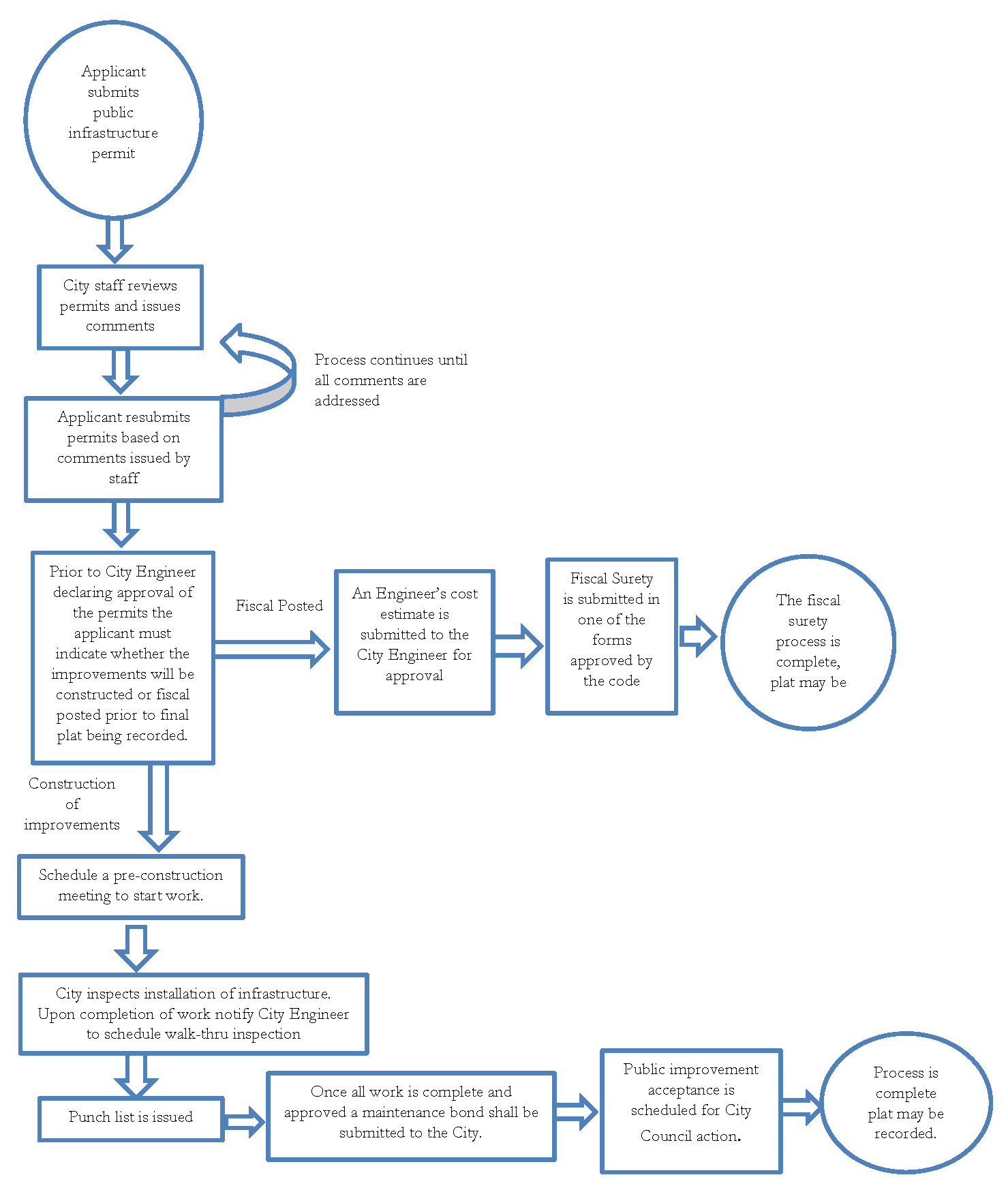
2.9.11.
Preliminary Subdivision Plat.
A.
Intent. A Preliminary Plat assures that the division or development of the land subject to the plat is consistent with all standards of Section 3.6 Lot Dimensional and Development Standards and that all appropriate easements are identified. Preliminary plats are optional, but strongly encouraged because lot standards are not reviewed as part of the Public Infrastructure Permit process.
B.
Applicability. If a Preliminary Plat is submitted, approval shall be required prior to the submittal of a Public Infrastructure Permit. Preliminary plats shall only be submitted for the phase/unit currently being developed. Each phase is a separate plat and cannot be combined. Approval of lot layout and placement of easements will ensure consistency with the Public Infrastructure Permits. Preliminary plats need only be submitted for phased development with public infrastructure.
C.
Criteria for Approval. In considering final action on a Preliminary Plat, staff shall consider the following criteria:
1.
The preliminary plat shall conform to the approved Subdivision Concept Plan as approved by the Planning Director and City Engineer; and
2.
The preliminary plat shall conform to all of the requirements outlined in the UDC Section 3.6.
3.
The preliminary plat shall identify all easements.
D.
Process.
1.
Application. Applications for a preliminary plat shall be made on forms provided by the City and must contain legal authorization by the property owner for the City to proceed with the request. Requirements for a complete application can be found in the technical manual and on the application. The deadline for applications can be found on the City's website.
2.
Staff Review. The preliminary plat shall be reviewed by staff to identify deficiencies that do not meet the regulations adopted for subdivision development. Within 30 days of the plat filing date a letter of approval, approval with conditions or disapproval will be submitted to the applicant for formal action on the plat. If staff presents the applicant with a letter recommending approval with conditions or disapproval, the letter shall articulate the specific reasons and deficiencies for which a conditional approval or disapproval are necessary.
3.
Action. If the preliminary plat meets the requirements of UDC Section 3.6 and any applicable regulations, development requirements or agreements (interlocal agreement applicable to ETJ properties and/or any development agreements applicable to the property) the Planning Director shall approve the plat request for a period of two years from the date of the final approval. If the subdivision plat does not meet all of the requirements the Commission shall approve with conditions or disapprove the plat as directed in Section 2.9.F of the UDC.
4.
Expiration and Extension. The approval of a Preliminary Subdivision Plat application shall remain in effect for a period of two years from the date the application was approved or approved with conditions by the Planning Director, during which period the applicant shall submit any required revisions for approval and make all other changes required. If the Public Infrastructure Permit has not been approved within the two-year period, the preliminary plat unless extended by the Planning Director for one more year, shall expire and the applicable plat shall be deemed null and void.
(Ord. No. 2016-68, § 2, 10-18-16; Ord. No. 2016-70, § 1, 11-1-16; Ord. No. 2017-45, pt. 1, 9-12-17; Ord. No. 2019-054, §§ 4—6, 9-17-19; Ord. No. 2021-010, §§ 1, 2, 2-23-21; Ord. No. 2022-043, § 1, 5-24-22; Ord. No. 2023-003, pt. 1, 1-17-23; Ord. No. 2024-061, pts. 3—7, 11-19-24)
Sec. 2.10. - Floodplain development permit.
2.10.1.
Application of Requirements. This section applies in the following areas:
2.10.2.
Intent. Regulates construction in areas subject to flood hazards.
2.10.3.
Applicability. A floodplain development permit applies to all areas of special flood hazard within the jurisdiction of the City of Seguin, Texas. No structure or land shall be located, altered, or have its use changed without approval of a floodplain development permit.
2.10.4 Criteria for Approval and Process. Floodplain development permit standards are detailed in Chapter 4. Application for a floodplain development permit shall be presented to the Floodplain Administrator. Application materials should include but not be limited to, plans in duplicate drawn to scale showing the location, dimensions, and elevation of proposed landscape alterations, existing and proposed structures, including the placement of manufactured homes, and the location of the foregoing in relation to areas of special flood hazard. For all proposed developments within, abutting, or adjacent to a floodplain, a Flood Study is required per the Stormwater Criteria Manual and shall be approved by the City Engineer prior to approval of the floodplain development permit. Additionally, the following information is required:
A.
Elevation (in relation to mean sea level), of the lowest floor (including basement) of all new and substantially improved structures;
B.
Elevation in relation to mean sea level to which any nonresidential structure shall be floodproofed;
C.
A certificate from a registered professional engineer or architect that the nonresidential floodproofed structure shall meet the flood proofing criteria included in Chapter 7;
D.
Description of the extent to which any watercourse or natural drainage will be altered or relocated as a proposed development;
E.
Approval or denial of a floodplain development permit by the floodplain administrator shall be based on all of the provisions of Chapter 7 and the following relevant factors:
1.
The danger to life and property due to flooding or erosion damage;
2.
The susceptibility of the proposed facility and its contents to flood damage and the effect of such damage on the individual owner;
3.
The danger that materials may be swept onto other lands to the injury of others;
4.
The compatibility of the proposed use with existing and anticipated development;
5.
The safety of access to the property in times of flood for ordinary and emergency vehicles;
6.
The costs of providing governmental services during and after flood conditions including maintenance and repair of streets and bridges, and public utilities and facilities such as sewer, gas, electrical and water systems;
7.
The expected heights, velocity, duration, rate of rise and sediment transport of the floodwaters and the effects of wave action, if applicable, expected at the site;
8.
The necessity to the facility of a waterfront location, where applicable;
9.
The availability of alternative locations, not subject to flooding or erosion damage, for the proposed use;
10.
The relationship of the proposed use to the comprehensive plan for the area.
(Ord. No. 2024-026, pt. 1(Att.), 5-21-24)
Sec. 2.11. - Site development permit.
2.11.1.
Application of Requirements. This section applies in the following areas:
2.11.2.
Intent. The purpose of a site development permit shall be to apply the zoning, development and public facilities standards contained within this Unified Development Code and Technical Criteria Manual to a specific development proposed for a platted property.
2.11.3.
Applicability. A site development permit shall be submitted for all development within the City limits, except for single family residential development.
2.11.4.
Prior Approvals. An application for a site development permit shall not be approved unless the following have been approved and remain in effect for the subject property:
A.
The property is zoned to allow the proposed development.
B.
Any variances required to allow a proposed development have been approved.
C.
The subject property is appropriately platted.
2.11.5.
Criteria and Process. All site development permit applications shall be submitted to the Director of Planning and the City Engineer, or their designees, for approval. The following criteria shall be used to determine whether the application for a site development permit shall be approved, approved with conditions, or denied:
A.
A complete application has been submitted. The requirements for a complete application can be found on the application and the Technical Manual;
B.
The site development permit is consistent with any previous approvals (i.e. development agreements, plat notes, special use permits, and variances);
C.
The site development permit is consistent with all zoning district regulations the property is subject to (base zoning district and any applicable overlay district requirements);
D.
The requirements outlined in Chapter 5 of this Unified Development Code.
2.11.6.
Exception. A site grading permit may be issued prior to the approval of a site development permit if public infrastructure permits are substantially approved by the City Engineer.
(Ord. No. 2023-003, pt. 1, 1-17-23)
Sec. 2.12. - Building permits.
2.12.1.
Application of Requirements. This section applies in the following areas:
2.12.2.
Applicability. Any owner, authorized agent or contractor who desires to construct, enlarge, alter, repair, move, demolish, roof, reroof or change the occupancy of a building or structure or to cause any such work to be done shall first make application to the Building Official and obtain the required permit for the work.
2.12.3.
Prior Approvals. An application for a building permit shall not be approved unless the following have been approved and remain in effect for the subject property:
A.
The property is zoned to allow the proposed development.
B.
Any variances required to allow a proposed development have been approved.
C.
The subject property is platted or qualifies for a plat exception.
D.
Site development permit has been approved (if required). A building permit and a site plan can be concurrently reviewed, but the site plan must be approved before the building permit can be issued.
2.12.4.
Criteria and Process. Building permit requests are evaluated by the Building Official, or his or her designee, using all the following criteria:
A.
The project conforms to this code, the Building Code, the Fire Code, and other applicable regulations.
B.
The parcel does not have any violations of this code or other applicable City or State regulations.
C.
The building permit is consistent with the following:
1.
Zoning designation.
2.
Special use permits and/or limited use permits, if applicable.
3.
Variances if applicable.
4.
Subdivision plat.
5.
Site plans.
2.12.5.
Expiration. A building permit shall become invalid unless work has commenced within 180 days from issuance date.
2.12.6.
Exception. Model Home Exception for Single-Family Residential or Duplex Development. Within a phase containing public improvements that have not yet been finally accepted, the City will issue building permits for no more than two (2) model homes of differencing floor plans, prior to the recordation of the plat provided that the final plat for the phase has been approved and the following conditions have been met:
• All water mains providing service to the subdivision section in which the lot is located have been constructed, installed, and connected to the public water system by the developer and inspected, tested, and approved by the City;
• All wastewater mains providing service to the subdivision section in which the lot is located have been constructed, installed and connected to the City's wastewater system by the developer and inspected, tested and approved by the City; and
• All streets, curbs, and gutters as required by code have been installed and inspected by the City.
As used herein, Model Home means a housing unit typical of the styles available for sale in a particular subdivision but used for display and sales only.
(Ord. No. 2020-031, § 1, 4-21-20; Ord. No. 2023-003, pt. 1, 1-17-23)
Sec. 2.13. - Certificate of occupancy.
2.13.1.
Application of Requirements. This section applies in the following areas:
2.13.2.
Applicability. An application for a certificate of occupancy is required within the City limits after the construction, alteration or placement of a structure and prior to habitation or any use of the structure. A certificate of occupancy also is required prior to a change in the use of any structure.
2.13.3.
Prior Approvals. An application for a certificate of occupancy shall not be approved unless the following have been approved and remain in effect for the subject property:
A.
Plat is recorded.
B.
All required public improvements have been approved and accepted by the City Engineer.
C.
An approved building permit has been issued.
2.13.4.
Criteria and Process. Building permit requests are evaluated by the Building Official, or his or her designee, using all the following criteria:
A.
The location of the structure on the property is in accordance with the approved application for the building permit;
B.
Where a change of use in an existing structure is proposed, the use conforms to the use regulations governing the property;
C.
The structure, following inspection by the Building Official, was built in conformity with the Building Code, as incorporated in the Unified Development Code and City Code of Ordinances;
D.
There are no outstanding permit requirements;
E.
When the property lies within a special flood zone, an elevation certificate prepared in accordance with FEMA standards is provided.
Sec. 2.14. - Temporary certificate of occupancy.
2.14.1.
Application of Requirements. This section applies in the following areas:
2.14.2.
Intent. The certificate of occupancy (CO) is the final construction document issued by the Building Official to authorize occupancy of a structure upon completion of all building and construction related issues. No building or structure shall be used or occupied, and no change in the existing occupancy classification of a building or structure or portion thereof shall be made until the Building Official has issued a certificate of occupancy. It is sometimes necessary to request a temporary certificate of occupancy (TCO) prior to the final certificate of occupancy being issued. The TCO is intended to acknowledge that some building features may not be completed even though the building is safe for occupancy, or that a portion of the building can be safely occupied while work continues in another area.
2.14.3.
Applicability. A temporary certificate of occupancy shall only be issued for commercial development in which the City Engineer, Director of Planning, Fire Department and Building Official have determined a plan for completing the appropriate work has been established. Temporary certificates should be issued only when incidental construction remains. Before the request will be considered, installed fire alarm and/or sprinkler systems must have passed field acceptance tests. It is important to remember that an approval to stock is for goods only; it is not authorization for people to occupy the structure. The TCO requires all the same inspections as a certificate of occupancy as well as additional fees and submittals. For this reason, do not view the TCO as a short cut to occupying the structure. In some circumstances, escrow payment may be required for any unfinished work. When required, the value of the escrow payment will be set at 110% of the value of the work to be completed.
Sec. 2.15. - Outdoor festival permit.
2.15.1.
Application of Requirements. This section applies in the following areas:
2.15.2.
Applicability. Outdoor festivals include, but are not limited to, outdoor concerts, carnivals, circuses, trade shows, auto shows and any activity that includes the following:
A.
Where performances or audience are not located within a permanent structure; and
B.
Where the performance is located on property other than City owned parks, facilities or permanent campuses including church and school facilities, and other permanent locations designed to accommodate mass gatherings that can meet the permit standards;
C.
Where attempts are made to organize and promote the event by advertisement to the public.
2.15.3.
Permit Requirements. No person shall act to promote an outdoor festival in the City of Seguin, Texas without first obtaining a valid permit in accordance with the provisions of this article. The permit application procedure is as follows:
A.
An application shall be filed at least 45 days prior to the event with the Planning Department. Failure to meet the filing deadline may result in denial or delay of the application.
B.
The application shall include the following information:
1.
Name, address, phone number, e-mail of the person or organization promoting the event;
2.
A legal or street address of the event;
3.
The name, address and phone number of the owner of the property on which the event is to take place;
4.
A copy of the agreement between the landowner and the applicant, if different;
5.
The exact dates and times of the event;
6.
The maximum number of persons that the applicant will allow to attend the event and a statement describing how the applicant will control the number of persons attending the event;
7.
A security and access plan to be reviewed and approved by the Seguin Police and Fire Departments. An inclement weather plan addressing parking and other pertinent information is required. Inadequate security or unsafe access and traffic planning may result in denial or delay of the permit;
8.
A detailed description of the applicant's health and sanitation preparations for the event and how the applicant will comply with the minimum standards, including, but not limited to, restrooms, drinking water and food preparation, if applicable;
9.
A parking plan showing how the applicant intends to regulate parking for the maximum number of persons allowed to attend the event. Parking shall be limited to areas approved by City police, fire and planning staff;
10.
A complete list of similar events the applicant has promoted within the past three years, including the date, time and location of each event.
2.15.4.
Application reporting. City of Seguin staff shall review and act on the permit within 15 days of receipt of a completed application. An incomplete application shall be returned and marked "incomplete". Reapplication shall be considered as a new application. City staff may impose reasonable conditions or restrictions on the granting of a permit, including, but not limited to, the following:
A.
Restrictions on cooking, fires, amplified sound, the use of alcoholic beverages, the use of animals, equipment or vehicles, the number of persons to be present, parking location and area, or any activity that may appear likely to create a risk of unreasonable harm to the public. The applicant shall comply with all local noise ordinances.
B.
A requirement that the applicant carry a minimum of $500,000.00 per occurrence in commercial general liability insurance naming the City of Seguin as additional insured for claims occurring in the City right-of-way.
C.
Sanitary and refuse facilities that are reasonably necessary for the event being planned.
D.
Inspections by City staff of the event shall be permitted during the event or at any time prior to or after the event to ensure that the maximum standards of health, sanitation and safety prescribed by local and state laws, rules and orders are being maintained.
E.
Permits required by this article shall be publicly posted in the area where the activity is conducted or produced and shall be exhibited upon demand to any law enforcement officer or agent of the City upon demand. The posted permit shall have emergency contact information for the person(s) responsible for the operation of the event.
2.15.5.
Zoning. Outdoor festivals are approved in the following zoning districts only:
•
Commercial
•
Industrial
•
Public
2.15.6.
Denial of permit. A permit may be denied if it is found that:
A.
False or misleading information has been given by the applicant;
B.
Improper zoning designation;
C.
The applicant has not made adequate preparations to limit the number of persons attending the event;
D.
The preparations do not ensure that minimum standards for sanitation and health will be maintained;
E.
The time and place for the event create a substantial danger of traffic or pedestrian congestion and disruption of other lawful activities;
F.
Inadequate parking area for the maximum number of persons attending the event;
G.
Adequate arrangements for traffic control have not been provided;
H.
Adequate medical and nursing care will not be provided;
I.
The event will violate any applicable federal, state or local law or ordinance;
J.
The event will not have adequate security personnel;
K.
The permit holder has two or more violations of this article within a 12-month period.
2.15.7.
Appeal hearing request. An applicant, within ten days after notification of the City's findings, may file a written request for a hearing at the next regularly scheduled meeting of the Zoning Board of Adjustment, to show cause why the permit application should be granted or should not be denied. A hearing may result in delay of the event. The findings of the Zoning Board of Adjustment are final and any further remedy may be taken to the appropriate court of record within ten days of the Zoning Board of Adjustment decision.
Sec. 2.16. - Variance to distance requirements for businesses selling alcoholic beverages.
2.16.1 Application of Requirements.
This section applies in the following areas:
2.16.2 Applicability.
A business that sells alcoholic beverages is eligible to apply for a variance from the distance requirements set forth in section 6-2 of the Seguin Code of Ordinances if the business is not a bar, tavern, nightclub, restaurant, or similar business that derives 51 percent or more of its income from the sale of alcoholic beverages for on-premise consumption.
2.16.3 Procedure for Requesting Variance.
A business that sells alcoholic beverages that proposes to locate the business at a location that is closer to a church, school, or public hospital than is permissible under section 6-2 of the Seguin Code of Ordinances, and that is eligible to apply for a variance under this section, shall submit an application to the City of Seguin and make payment of the application fee as set forth in the Fee Schedule as adopted in Exhibit C of the Seguin Code of Ordinances.
2.16.4 General Process.
The Planning and Zoning Commission shall hold a public hearing to consider the applicant's request for a variance. All churches, public and private schools, and public hospitals within 300 feet of the proposed business, as measured in accordance with section 6-2 of the Seguin Code of Ordinances, shall be notified of the public hearing by certified mail.
2.16.5 Criteria for Approval.
Following the public hearing, the Commission may approve the request, approve the request with conditions, or deny the request. The Commission shall consider the health, safety, and welfare of the public and the equities of the situation to determine if it is in the best interest of the community to grant the variance, and shall only prescribe conditions that it deems necessary or desirable to the public interest. Furthermore, in granting a variance, the Commission shall consider if the enforcement of the distance requirements in a particular instance:
•Is not in the best interest of the public;
•Constitutes waste or inefficient use of land or other resources;
•Creates an undue hardship on an applicant for a license or permit;
•Is not effective or necessary; or
•Does not serve its intended purpose.
2.16.6 Appeal.
An applicant may appeal an adverse decision by the Planning and Zoning Commission to the Seguin City Council. The City Council shall conduct a public hearing prior to making a decision on the appeal.
(Ord. No. 2025-003, pt. 2, 1-21-25)
Editor's note— Ord. No. 2025-003, pt. 1, adopted Jan. 21, 2025, repealed the former § 2.16, and enacted a new § 2.16 as set out herein. The former § 2.16 pertained to similar subject matter and derived from Ord. No. 2016-67, §§ 1 and 2, adopted Oct. 18, 2016.
Sec. 2.17. - Amendment to the city's comprehensive master plan.
2.17.1.
Application of Requirements. This section applies in the following areas:

2.17.2.
Types of Amendments.
A.
Periodic Amendment. The City Council, upon recommendation of the Planning and Zoning Commission, may amend the Comprehensive Plan from time to time on its own motion or through initiation by City staff.
B.
Map Amendments. The Planning and Zoning Commission, the City Council, or City staff may initiate a request for amendment of the Future Land Use Map or Thoroughfare Plan.
2.17.3.
Processing a Comprehensive Master Plan Amendment.
•
The Long Range Planning Commission shall hold a public hearing and make a recommendation to the Planning and Zoning Commission.
•
The Planning and Zoning Commission shall hold a public hearing after receiving the report and recommendation of the Director and Long Range Planning Committee.
•
The Planning and Zoning Commission shall make a recommendation regarding the proposed Master Plan amendment(s) to the City Council. The Planning and Zoning Commission may recommend approval, approval with conditions, or denial of the amendments for a Master Plan amendment. After a public hearing the City Council may approve, reject or modify the requested amendments by resolution. The text and/or maps of the Master Plan shall be amended to reflect the Council's decision as needed.