
Selma City Zoning Code
ARTICLE IV
PERMISSIBLE USES
Sec. 17-400. - Intent.
It is the intent of this article to provide standards for land uses in accordance with the comprehensive plan and other development policies of the Town Council, and to promote the organization of land uses to minimize conflicts between different types of land use activities while recognizing the Town's need for diverse activities.
(Ord. No. 2021-64-R, 7-13-21)
Sec. 17-401. - Table of Permissible Uses.
A.
The Table of Permissible Uses is hereby established. For convenience, this Table is set forth at the end of this Part 1.
B.
The Table of Permissible Uses should be read in close conjunction with the definitions set forth in Article II and the other interpretive provisions set forth in this article.
C.
If the Table of Permissible Uses and any provision of Article IV, Part 2. "Overlay Districts and Supplementary Use Regulations," conflict, the Table of Permissible Uses shall control.
(Ord. No. 2021-64-R, 7-13-21)
Sec. 17-402. - Use of the designations P or SUP in Table of Permissible Uses.
A.
Subject to Section 17-403 when used in connection with a particular use in the Table of Permissible Uses, the letter "P" means that the use is permissible in the indicated zone with a certificate of zoning compliance issued by the Land Use Administrator; the letters "SUP" means a special use permit must be obtained from the Town Council. A section number listed in the column labelled "SUPP STANDARD" means that the use is permitted if the conditions in the corresponding section are met, and the letters "PC" means a means that a proposed use meets the conditions of this article, and particularly those conditions specific to individual uses listed in each row in the Table of Permitted Uses. (For example, use number 1.330. "Multi-family apartments" must meet the use listed in Section 17-548).
B.
Use of the designation "SUP" for combination uses (use 30.000) is explained in Section 17-408, "Combination Uses."
(Ord. No. 2021-64-R, 7-13-21)
Sec. 17-403. - Town Council jurisdiction over uses otherwise permissible with a zoning permit.
Notwithstanding any other provisions of this article, whenever the Table of Permissible Uses (interpreted in the light of Section 17-402 and the other provisions of this article) provides that a use in a nonresidential zone or a nonconforming use in a residential zone is permissible with a zoning permit, a special use permit shall nevertheless be required if the Administrator finds that the proposed use would have an extraordinary impact on neighboring properties or the public. In making this determination, the Administrator shall consider, among other factors, whether the use is proposed for an undeveloped or previously developed lot, whether the proposed use constitutes a change from one (1) principal use classification to another, whether the use is proposed for a site that poses peculiar traffic or other hazards or difficulties, and whether the proposed use is substantially unique or is likely to have impacts that differ substantially from those presented by other uses that are permissible in the zoning district in question.
(Ord. No. 2021-64-R, 7-13-21)
Sec. 17-404. - Permissible uses and specific exclusions.
A.
The presumption established by this ordinance is that all legitimate uses of land are permissible within at least one (1) zoning district in the Town's planning and development regulation jurisdiction. Therefore, because the list of permissible uses set forth in Section 17-410 (the Table of Permissible Uses) cannot be all inclusive, those uses that are listed shall be interpreted liberally to include other uses that have similar impacts to the listed uses.
B.
Notwithstanding subsection A., all uses that are not listed in Section 17-410 (the Table of Permissible Uses), even given the most liberal interpretation, the Planning Director shall follow the procedure below at C. "Unlisted Uses."
C.
Unlisted Uses:
1.
Procedure for Approving Unlisted Uses. Where a particular use category or use type is not specifically allowed under this ordinance and is also not prohibited or restricted by this ordinance, the Planning Director may permit the use category or type if the criteria of subsection 2. below are met. The Planning Director shall give due consideration to the intent of this ordinance concerning the district(s) involved, the character of the uses specifically identified, and the character of the use(s) in question.
2.
Criteria for Approving Unlisted Uses. In order to determine that the proposed use(s) has an impact that is similar in nature, function, and duration to the other uses allowed in a specific zoning district, the Planning Director shall assess all relevant characteristics of the proposed use, including but not limited to the following:
a)
The volume and type of sales (retail and wholesale), size and type of items sold and nature of inventory on the premises;
b)
Any processing done on the premises (including assembly, manufacturing, warehousing, shipping, distribution), any dangerous, hazardous, toxic, or explosive materials used in the processing;
c)
The nature and location of storage and outdoor display of merchandise (enclosed, open, inside or outside the principal building) and predominant types of items stored (such as business vehicles, work-in-process, inventory, and merchandise, construction materials, scrap and junk, and raw materials including liquids and powders);
d)
The type, size and nature of buildings and structures;
e)
The number and density of employees and customers per unit area of site in relation to business hours and employment shifts;
f)
Transportation requirements, including the modal split for people and freight, by volume type and characteristic of traffic generation to and from the site, trip purposes and whether trip purposes can be shared by other uses on the site;
g)
Parking requirements, turnover and generation, ratio of the number of spaces required per unit area or activity, and the potential for shared parking with other uses;
h)
The amount and nature of any nuisances generated on the premises, including but not limited to noise, smoke, odor, glare, vibration, radiation and fumes;
i)
Any special public utility requirements for serving the proposed use, including but not limited to water supply, waste water output, pre-treatment of wastes and emissions required or recommended, and any significant power structures and communications towers or facilities; and
j)
The impact on adjacent properties created by the proposed use will not be greater than that of other uses in the zoning district.
3.
Determination by the Planning Director; Effects. All determinations by the Planning Director made pursuant to subsection 2. above shall be in writing. In making the determination described in subsection 2. above, the Planning Director shall initiate an amendment to this ordinance if the particular use or category of use(s) is likely to be common or to recur frequently, or that omission of specific inclusion and reference to this ordinance is likely to lead to public uncertainty and confusion. Until final action has been taken on such proposed amendment, the determination of the Planning Director shall be binding on all officers and departments of the Town. If no amendment is initiated, the Planning Director's determination shall thereafter be binding on all officers and departments of the Town, without further action or amendment of this ordinance.
4.
Appeal of Determination of the Planning Director. The determination of the Planning Director may be appealed to the Zoning Board of Adjustment pursuant to the procedures set forth in Section 17-1400 of this ordinance.
5.
Prohibited Uses. Without limiting the generality of the foregoing provisions, the following uses are specifically prohibited in all districts:
a)
Any use that involves the manufacture, handling, sale, distribution, or storage of any highly combustible or explosive materials in violation of the Town's fire prevention code or this chapter. See Section 17-534 "Explosives Use and Storage of";
b)
Except as provided by this ordinance, salvage yards, junk yards and all other types of recycling facilities;
c)
Use of a recreational vehicle as a temporary or permanent residence. (Situations that do not comply with this subsection on the effective date of this ordinance (April 13, 2004) are required to conform within one (1) year of the effective date of this ordinance); and
d)
Except for roadside stands which are permitted subject to Sections 17-548 Mobile Food Vendor (food trucks) and 17-555 Roadside Stands, use of a motor vehicle parked on a lot as a structure in which, out of which, or from which any goods are sold or stored, any services are performed, or other business is conducted. Situations that do not comply with this subsection on the effective date of this ordinance are required to conform within thirty (30) days.
(Ord. No. 2021-64-R, 7-13-21)
Sec. 17-405. - Accessory uses.
A.
Section 17-410 (the Table of Permissible Uses) classifies different principal uses according to their different impacts. Whenever an activity (which may or may not be separately listed as a principal use in the table) is conducted in conjunction with another principal use and the former use (i) constitutes only an incidental or insubstantial part of the total activity that takes place on a lot or (ii) is commonly associated with the principal use and integrally related to it, then the former use may be regarded as accessory to the principal use and may be carried on underneath the umbrella of the permit issued for the principal use. For example, a swimming pool/tennis court complex is customarily associated with and integrally related to a residential subdivision or multi-family development and would be regarded as accessory to such principal uses, even though such facilities, if developed apart from a residential development, would require a permit.
B.
For purposes of interpreting subsection A.:
1.
A use may be regarded as incidental or insubstantial if it is incidental or insubstantial in and of itself or in relation to the principal use.
2.
To be "commonly associated" with a principal use, it is not necessary for an accessory use to relate to such principal use more times than not, but only that the association of such accessory use with such principal use takes place with sufficient frequency that there is common acceptance of their relatedness.
3.
Without limiting the generality of subsections A. and B., the following activities, so long as they satisfy the general criteria set forth above and any supplementary standards listed in Article IV, Part 1 are specifically regarded as accessory to residential principal uses:
a)
Offices or studios within an enclosed building and used by an occupant of a residence located on the same lot as such building to carry on administrative or artistic activities of a commercial nature, so long as such activities do not fall within the definition of a home occupation;
b)
Hobbies or recreational activities of a noncommercial nature;
c)
The renting out of one (1) or two (2) rooms within a single-family residence (which one (1) or two (2) rooms do not themselves constitute a separate dwelling unit) to not more than two (2) persons who are not part of the family that resides in the single-family dwelling;
d)
Yard sales or garage sales, so long as such sales are not conducted on the same lot for more than three (3) days (whether consecutive or not) during any ninety-day period;
e)
Swimming pools (See supplemental standards at Section 17-563);
f)
Retaining walls and fences;
g)
Temporary health care structures (See supplemental standards at Section 17-563);
h)
Family child care home (N.C. regulations apply (See supplemental standards at Section 17-535);
i)
Solar-energy or wind-energy generating facilities meeting the standards of G.S. ch. 160D;
j)
Temporary storage facilities (See supplemental standards at Section 17-564); and
k)
Temporary health care structures (granny pods) (See supplemental standard sat Section 17-563).
C.
Without limiting the generality of subsections (A) and (B), the following activities shall not be regarded as accessory to a residential principal use and are prohibited in residential districts and on properties that are used primarily for residential purposes (i.e., a single-family detached dwelling in the GB zoning district):
1.
The raising or keeping of four (4) or more dogs and/or four (4) cats six (6) months or older.
2.
The raising and keeping of six (6) or more bee hives.
(Ord. No. 2021-64-R, 7-13-21)
Sec. 17-406. - Permissible uses not requiring permits.
Notwithstanding any other provisions of this ordinance, no zoning or special use permit is necessary for the following uses:
A.
Streets;
B.
Electric power, telephone, telegraph, cable television, gas, water, sewer and other utility lines, wires or pipes, together with supporting poles or structures, located within a public right-of-way;
C.
Neighborhood utility facilities located within a public right-of-way with the permission of the owner (State or Town) of the right-of-way; and
D.
Household Pets. Household pets are permitted in all zoning districts where residences are permitted and within residences that are lawful nonconforming uses. Household pets include, but are not limited to, dogs, cats, rabbits, gerbils, hamsters, parakeets, parrots, and cockatiels, provided they are not raised for commercial purposes. Household pets do not include chickens or domestic fowl. A maximum of five (5) household pets or five (5) bee hives are allowed per residence.
(Ord. No. 2021-64-R, 7-13-21)
Sec. 17-407. - Change in use.
A.
A substantial change in use of property occurs whenever the essential character or nature of the activity conducted on a lot changes. This occurs whenever:
1.
The change involves a change from one (1) principal use category to another;
2.
If the original use is a combination use or planned development, the relative proportion of space devoted to the individual principal uses that comprise the combination use or planned development changes to such an extent that the parking requirements for the overall use are altered;
3.
If the original use is a combination use or planned development use, the mixture of types of individual principal uses that comprise the combination use or planned development use changes;
4.
If the original use is a planned residential development, the relative proportions of different types of dwelling units change; or
5.
If there is only one (1) business or enterprise conducted on the lot (regardless of whether that business or enterprise consists of one (1) individual principal use or a combination use), that business or enterprise moves out and a different type of enterprise moves in (even though the new business or enterprise may be classified under the same principal use or combination use category as the previous type of business). For example, if there is only one (1) building on a lot and a florist shop that is the sole tenant of that building moves out and is replaced by a clothing store that does not constitute a change in use because both tenants fall within principal use classification 2.120. For a second example, if the florist shop moved out of a rented space in a shopping center and was replaced by a clothing store, that would not constitute a change in use since there is more than one (1) business on the lot and the essential character of the activity conducted on that lot (i.e., a shopping center, which is a combination use) has not changed.
B.
A mere change in the status of property from unoccupied to occupied or vice versa does not constitute a change in use. Whether a change in use occurs shall be determined by comparing the two (2) active uses of the property without regard to any intervening period during which the property may have been unoccupied unless the property has remained unoccupied for more than one hundred eighty (180) consecutive days or has been abandoned. In the case of nonresidential uses, if the property has been unoccupied for more than one hundred eighty (180) consecutive days or abandoned, a new zoning, special use permit must be obtained before property may be occupied again.
C.
A mere change in ownership of a business or enterprise or a change in the name shall not be regarded as a change in use.
D.
A change in use as defined by the N.C. Building Code.
(Ord. No. 2021-64-R, 7-13-21)
Sec. 17-408. - Combination uses.
A.
When a combination use comprises two (2) or more principal uses that require different types of permits (zoning or special use permit), then the permit authorizing the combination use shall be:
1.
A special use permit if any of the principal uses combined requires a special use permit.
2.
A zoning permit in all other cases.
This is indicated in the Table of Permissible Uses by the designation "P/SUP" in each of the columns adjacent to the 30.000 classification.
B.
Unless otherwise provided elsewhere in this ordinance, when a combination use consists of a single-family detached residential subdivision where a portion is dedicated to the owners and two-family or multi-family uses, the total density permissible on the entire tract shall be determined by having the developer indicate on the plans the portion of the total lot that will be developed for each purpose and calculating the density for each portion as if it were a separate lot.
C.
For uses only in Section 17-422 "Water Supply Watershed Protection District" the total density permissible on the entire tract when a single-family detached cluster subdivision is combined with two-family or multi-family uses is determined by dividing the area of the tract by the minimum square footage per dwelling unit in Sections 17-430 "Table of Density and Dimensional Regulations" and 17-432, "Minimum Lot Area."
(Ord. No. 2021-64-R, 7-13-21)
Sec. 17-409. - More specific use controls.
Whenever a development could fall within more than one (1) use classification in Section 17-410 (the Table of Permissible Uses), the classification that most closely and most specifically describes the development shall control. For example, a small doctor's office or clinic clearly falls within the 3.110 classification (office and service operations conducted entirely indoors and designed to attract customers or clients to the premises). However, classification 3.130 (offices or clinics of physicians or dentists with not more than a ten-thousand square foot building footprint) more specifically covers this use and is, therefore, controlling.
(Ord. No. 2021-64-R, 7-13-21)
Sec. 17-410. - Table of Permitted Uses.
(Ord. No. 2021-64-R, 7-13-21; Ord. No. 2022-5-O, § 1, 3-8-22; Ord. No. 2024-019-O, § 1, 8-13-24; Ord. No. 20230110, § 1, 1-10-23; Ord. No. 2024-031-O, § 1, 3-6-25)
Sec. 17-411. - Zoning map determinations.
A.
The Administrator is authorized to interpret the zoning map and to pass upon disputed questions of lot lines or district boundary lines and similar questions.
B.
An application for a map interpretation shall be submitted to the Administrator. The application shall contain sufficient information to enable the Administrator to make the necessary interpretation.
C.
Where uncertainty exists as to the boundaries of districts as shown on the Official Zoning Map, the following rules shall apply:
1.
Boundaries indicated as approximately following the centerlines of alleys, streets, highways, streams, or railroads shall be construed to follow such centerlines;
2.
Boundaries indicated as approximately following lot lines, Town limits or extraterritorial boundary lines shall be construed as following such lines, limits or boundaries;
3.
Boundaries indicated as following shorelines shall be construed to follow such shorelines, and in the event of change in the shoreline, shall be construed as following such shorelines;
4.
Where a district boundary divides a lot or where distances are not specifically indicated on the Official Zoning Maps, the boundary shall be determined by measurement, using the scale of the Official Zoning Map; and
5.
Where any street or alley is hereafter officially closed or withdrawn, the regulations applicable to each parcel of abutting property shall apply to that portion of such street or alley added to the parcel by virtue of such closure or withdrawal.
D.
Interpretations of the location of floodway and floodplain boundary lines may be made by the Administrator as provided in Article X, "Flood Damage Prevention."
(Ord. No. 2021-64-R, 7-13-21; Ord. No. 2022-5-O, § 1, 3-8-22)
Sec. 17-420. - Historic Districts.
A.
Intent. The Historic Districts are intended to protect and conserve the heritage and character of the Selma community by providing for the preservation of designated areas within the planning and development regulation jurisdiction, including individual properties therein, to embody important elements of social, economic, political, or architectural history, and promote the stabilization and enhancement of property values throughout such areas.
It is intended that these regulations ensure, insofar as possible, that building or structures in the Historic Districts shall be in harmony with other buildings or structures located therein.
B.
Establishment of Historic Districts. Historic Districts are hereby established as districts which overlay other zoning districts as established in Article III. The boundaries of the various Historic Districts shall comply with use and intensity regulations, or other regulations applicable to the underlying zoning district. Three (3) Historic Districts have been and are established in the Town. The three (3) Historic Overlay Districts are the:
1.
Uptown Selma Historic Overlay District;
2.
West Selma Historic Overlay District; and
3.
Harrison Campus Historic Overlay District (See Section 17-420M. below)
C.
The standard of review for consideration of Certificates of Appropriateness are the United States Secretary of the Interior's "Standards for Rehabilitation and Guidelines for Rehabilitating Historic Buildings."
D.
Creation, Amendment or Dissolution of Historic Districts. Historic Districts may from time to time be designated, amended, or repealed, provided, however, that no district shall be recommended for designation unless it is deemed to be of special significance in terms of its historical, prehistorical, architectural or cultural importance. Such district must also possess integrity of design, setting, workmanship, materials, feeling and/or association. No district shall be designated, amended, or repealed until the following procedures have been carried out:
1.
An investigation and report describing the significance of the buildings, structures, features, sites, or surroundings included in any such proposed district, and a description of the boundaries of such district has been prepared;
2.
The North Carolina Department of Cultural Resources, acting through the State Historic Preservation Officer or his or her designee, shall have made an analysis of and recommendations concerning such report and description of proposed boundaries. Failure of the Department to submit its written analysis and recommendations to the Town of Selma Council within thirty (30) calendar days after a written request for such analysis has been received by the Department of Cultural Resources shall relieve the Town Council of any responsibility for awaiting such analysis, and the Town Council may at any time thereafter take any necessary action to adopt or amend its zoning ordinance; and
3.
The Town Council or Historic Preservation Commission may also, in its discretion, refer the report and the proposed boundaries to any other interested body for its recommendations prior to acting to amend the zoning ordinance.
With respect to any changes in the boundaries of such district after its initial establishment, or the creation of additional districts within the Town's planning and development regulation jurisdiction, the investigative studies and reports required by Section 17-420C.1. shall be prepared by the Commission and shall be referred to the Planning Board for its review and comment according to the procedures set forth in this ordinance. Changes in the boundaries of an initial district or proposal for additional districts shall be submitted to the North Carolina Department of Cultural Resources in accordance with the provisions of Section 17-420C., above. Upon receipt of these reports and recommendations, the Town Council may proceed in the same manner as would otherwise be required for the adoption or amendment of any appropriate zoning ordinance provisions.
E.
Historic Landmarks.
1.
Upon complying with the required landmark designation procedures set forth herein, the Town Council may adopt and from time to time amend or repeal an ordinance designating one (1) or more historic landmarks. No property shall be recommended for designation as a landmark unless it is deemed and found by the Commission to be of special significance in terms of its historical, prehistorical, architectural, or cultural importance and to possess integrity of design, setting, workmanship, materials, feeling and/or association.
2.
The ordinance designating a landmark shall describe each property designated in the ordinance, the name or names of the owner or owners of the property, those elements of the property that are integral to its historical, architectural, or prehistorical value, including the land area of the property so designated and any other information the Town Council deems necessary. For each building, structure, site, area or object so designated as a landmark, the ordinance shall require that the waiting period set forth in this ordinance be observed prior to its demolition. A suitable sign for each property designated as a landmark may be placed on the property with the owner's consent; otherwise, the sign may be placed on a nearby public right-of-way.
3.
No property shall be designated as a landmark until the following steps have been taken:
a)
As a guide for the identification and evaluation of landmarks, the Commission shall, at the earliest possible time and consistent with the resources available to it, undertake an inventory of properties of historical, architectural, prehistorical, and cultural significance within the Town's planning and development regulation jurisdiction;
b)
The Commission shall make or cause to be made an investigation and report on the historic, architectural, prehistorical, educational, or cultural significance of each building, structure, site, area or object proposed for designation or acquisition. Such report shall be forwarded to the Division of Archives and History, North Carolina Department of Cultural Resources;
c)
The North Carolina Department of Cultural Resources, acting through the State Historic Preservation Officer or his or her designee, shall either upon request of the Department or at the initiative of the Commission be given an opportunity to review and comment upon the substance and effect of the designation of any landmark. All comments will be provided in writing. If the Department does not submit its comments to the Commission within thirty (30) days following receipt by the Department of the report, the Commission and the Town Council shall be relieved of any responsibility to consider such comments;
d)
The Commission and the Town Council shall hold a joint legislative public hearing (or separate public hearings) on the proposed ordinance. Reasonable notice of the time and place thereof shall be given;
e)
Following the public hearing(s), the Town Council may adopt the ordinance as proposed, adopt the ordinance with any amendments it deems necessary or reject the proposed ordinance;
f)
Upon adoption of the ordinance, the owners and occupants of each landmark shall be given written notification of such designation insofar as reasonable diligence permits. One (1) copy of the ordinance and all amendments thereto shall be recorded by the Council (or their designee) in the Johnston County Registry. Each landmark shall be indexed according to the name of the owner of the property in the grantor and grantee indexes in the Johnston County Register of Deeds office and the Commission shall pay a reasonable fee for filing and indexing. A second copy of the ordinance and all amendments thereto shall be kept on file in the office of the Town of Selma Clerk and be made available for public inspection at any reasonable time. A third copy of the ordinance and all amendments thereto shall be given to the building inspector. The fact that a building, structure, site area or object has been designated a landmark shall be clearly indicated on all tax maps maintained by Johnston County for such period as the designation remains in effect; and
g)
Upon the adoption of the landmark ordinance or any amendments thereto, it is the duty of the Commission to give notice thereof to the tax supervisor of Johnston County. The designation and any recorded restrictions upon the property limiting its use for preservation purposes shall be considered by the tax supervisor in appraising it for tax purposes.
F.
Certificate of Appropriateness Required.
1.
From and after the designation of a landmark or a historic district, no exterior portion of any building or other structure (including walls, fences, light fixtures, steps and pavement or other appurtenant features), or any above ground utility structure, or any type of outdoor advertising sign shall be erected, altered, restored, moved, or demolished within the Historic Districts until after an application for a certificate of appropriateness as to exterior architectural features has been approved.
For purposes of this article "exterior architectural features" shall include the architectural style, general design and general arrangement of the exterior of a building or other structure, including the kind and texture of the building material, the size and scale of the building, and the type and style of all windows, doors, signs and other appurtenant fixtures. In the case of outdoor advertising signs, "exterior" architectural features shall be construed to mean the style, material, size, and location of all such signs.
2.
Such a certificate of appropriateness shall be issued prior to the issuance of a zoning permit and building permit or any other permit granted for purposes of constructing altering or demolishing buildings or structures. A certificate of appropriateness shall be required whether a land use permit is required. Any land use permit or other permit not issued in conformity with this section shall be invalid.
3.
The State of North Carolina (including its agencies, political subdivisions and instrumentalities), the Town of Selma and all public utilities shall be required to obtain a certificate of appropriateness for construction, alteration, moving or demolition within the historic district or on designated landmarks.
G.
Procedures for Approval of Certificates of Appropriateness.
1.
Application submittal requirements. Applications for certificates of appropriateness shall be filed with the planning director.
2.
The planning director shall prescribe the form(s) on which applications are made.
The application shall be filed prior to the next regularly scheduled meeting of the Historic Preservation Commission. Each application shall be accompanied by sketches, drawings, photographs, specifications, descriptions, and other information of sufficient detail to clearly show the proposed exterior alterations, additions, changes, or new construction. The names and mailing addresses of property owners filing and/or subject to the application and the addresses of property within one hundred (100) feet on all sides of the property which is the subject of the application must also be filed. The Commission shall adopt, through its rules of procedure, appropriate procedures for pre-application meetings.
3.
No application shall be accepted by the planning director unless it complies with the requirements in the preceding subsection.
4.
The historic district commission may specify criteria for situations in which the planning director may waive any of the application material requirements.
H.
Notification of Affected Property Owners.
1.
Prior to any evidentiary hearing on an application for a certificate of appropriateness, the secretary of the commission (or Planning Director, if no secretary has been named) shall, by a mailing that is sent not more than 25 nor less than 10 days prior to the meeting at which the matter is to be heard, provide notification of the application to the owners of property within one hundred (100) feet on all sides of the subject property. Within that same time period, the local government shall also prominently post a notice of the hearing on the site that is the subject of the hearing or on an adjacent street or highway right-of-way.
2.
As part of the review procedures, the Historic Preservation Commission may view the premises and seek the advice of the North Carolina Department of Cultural Resources or other such expert advice as it may deem necessary under the circumstances.
I.
Public Hearing. The Historic Preservation Commission will hold an evidentiary hearing concerning the application at which the applicants and all other interested parties may be heard. The hearing will follow the quasi-judicial procedures found in Article XIV. Part 2: Hearing Procedure. All meetings of the Commission shall be open to the public in accordance with the North Carolina Open Meetings Law, G.S. Ch. 143, Art. 33C.
J.
Action on the Application. The action on an application shall be approval or approval with conditions or denial, and the quasi-judicial decision of the Historic Preservation Commission must be supported by specific findings of fact indicating the extent to which the application is or is not congruous with the special character of the historic district or landmark. Such action shall be based upon the review criteria established in subsections H) and I) of this section, the United States Secretary of the Interior's "Standards for Rehabilitation and Guidelines for Rehabilitating Historic Buildings" and any other review criteria as established by the Historic Preservation Commission in its rules of procedure. The action shall be one (1) of the following:
1.
Approval.
2.
Approval subject to conditions. The commission may impose such reasonable conditions on the approval of an application as will ensure that the spirit and intent of this article are achieved.
3.
Denial.
Failure to take final action on an application within one hundred eighty (180) days after the receipt of a completed application by the Planning Director, or extensions thereof approved in writing by the applicant and Commission, shall result in approval of the application as submitted.
Once issued, a certificate of appropriateness is valid for one (1) year. If after commencement of work authorized by the certificate, the work is not completed within the one (1) year, the certificate shall expire.
K.
Actions After Decision. The Planning Director shall notify the applicant of a decision in writing and shall file a copy of it in the Town's Planning Department. If the application is denied, the notice shall include the reasons for such action. The Planning Director will record a copy in the Johnston County Registry.
L.
Appeal of Decision. A quasi-judicial decision by the commission on an application for a certificate of appropriateness may be appealed to the Johnston County Superior Court. Written notice of the intent to appeal must be sent to the Commission via the Town Clerk and Planning Director, postmarked within thirty (30) days following the decision.
The State of North Carolina shall have a right of appeal to the North Carolina Historical Commission, which shall render its decision within thirty (30) days from the date that a notice of appeal by the state is received by the Historical Commission. The decision of the Historical Commission shall be final and binding upon both the State and the Commission.
M.
Review Criteria. No certificate of appropriateness shall be granted unless the Historic Preservation Commission finds that the application complies with the United States Secretary of the Interior's "Standards for Rehabilitation and Guidelines for Rehabilitating Historic Buildings." It is the intent of these regulations to insure, insofar as possible, that construction, reconstruction, alteration, restoration, moving or demolition of buildings, structures, appurtenant fixtures, outdoor advertising signs or other significant features in the district or of landmarks shall be congruous with the special character of the district or landmark. Notwithstanding the foregoing, the Commission may apply the above-mentioned principles and standards in a manner that is consistent with their spirit, rather than literally, when it concludes that the benefit derived from strict adherence to the principles and standards is outweighed by the practical or financial hardships imposed on an applicant by such literal application on non-contributing structures.
N.
[Features/Elements of Design.] In addition to the principles and standards, the following features or elements of design shall be considered in reviewing applications for certificates of appropriateness:
1.
Lot coverage, defined as the percentage of the lot area covered by primary structures;
2.
Setback, defined as the distance from the lot lines to the building;
3.
Building height;
4.
Spacing of buildings, defined as the distance between adjacent buildings;
5.
Proportion, shape, positioning, location, pattern, sizes and style of all elements of fenestration and entry doors;
6.
Surface materials and textures;
7.
Roof shapes, forms and materials;
8.
Use of regional or local architectural traditions;
9.
General form and proportion of buildings and structures and the relationship of additions to the main structure;
10.
Expression of architectural traditions;
11.
Orientation of the building to the street;
12.
Scale, determined by the size of the units of construction and architectural details in relation to the human scale and by the relationship of the building mass to adjoining open space and nearby buildings and structures, and maintenance of pedestrian scale;
13.
Proportion of width to height of the total building facade;
14.
Archaeological sites and resources associated with standing structures;
15.
Effect of trees and other landscape elements;
16.
Major landscaping which would impact known archaeological sites;
17.
Style, material, size and location of all outdoor advertising signs;
18.
Appurtenant features and fixtures, such as lighting;
19.
Structural condition and soundness;
20.
Walls - physical ingredients, such as brick, stone or wood walls, wrought iron fences, evergreen landscape masses;
21.
Ground cover or paving; and
22.
Significant landscape, archaeological and natural features.
O.
[Interior Arrangement or Use.] The review criteria do not include and the review shall not consider interior arrangements or use.
P.
Administrative Approval of Minor Works.
1.
Notwithstanding Section 17-420G., above, upon receipt of a completed application, the Planning Director (also referred to as the Zoning Administrator) may issue a certificate of appropriateness for minor works that are consistent with the provisions of Section 17-420H., above, and the Design Principles and Standards adopted by the Commission. If the Zoning Administrator determines that an applicant seeks a certificate of appropriateness for a minor work as defined herein, he may waive the requirement that the application be submitted twenty-one (21) days prior to the next Commission meeting and the requirement that the application contain the names and addresses of nearby property owners.
2.
Minor works are defined as those exterior changes that do not involve a change to the visual character of the property and do not involve substantial alterations, additions or removals that could impair the integrity of the property and/or district as a whole. The Zoning Administrator shall make the determination as to whether the application involves a minor work as defined herein. See the table below for list of Minor and Major Work projects. The Minor works list is only to apply to the West Selma Historic District. All projects located in the Downtown and the Richard B. Harrison District(s) are still to come before the Commission for review.
3.
The Zoning Administrator may approve but may not deny an application for a certificate of appropriateness for minor works. If the Zoning Administrator decides not to issue a certificate of appropriateness for a minor work, the application shall be referred to the Commission for action.
4.
A decision by the Zoning Administrator to issue a certificate of appropriateness for minor works may be appealed to the Board of Adjustment in the same manner as other administrative decisions by the Zoning Administrator.
Q.
Certain changes not prohibited. Nothing in this article shall be construed to prevent the ordinary maintenance or repair of any exterior architectural feature in the Historic District that does not involve a change in design, material, or other outer appearance thereof, or to prevent the construction, reconstruction, alteration, restoration, moving, or demolition of any such feature that the building inspector or similar town official shall certify is required by the public safety because of unsafe or dangerous condition.
R.
Delay in Demolition of Landmarks and Buildings Within Historic Districts.
1.
An application for a certificate of appropriateness authorizing the demolition, removal or destruction of a designated landmark or a building, structure or site within a historic district may not be denied except as provided in Section 17-420J.3., below. However, the effective date of such a certificate may be delayed for up to three hundred sixty-five (365) days from the date of approval. The period of delay shall be reduced by the Commission if it finds that the owner would suffer extreme hardship or be permanently deprived of all beneficial use or return from such property by the delay. During the delay period, the Commission shall negotiate with the owner to find a means of preserving the building, structure or site. If the Commission finds that a building, structure or site has no special significance or value toward maintaining the character of a district, it shall waive all or part of such period of delay and authorize earlier demolition or removal.
2.
If the Commission has voted to recommend the designation of a landmark or the designation of an area as a historic district and final designation has not been made by the Town Council, the demolition or destruction of any building, structure or site in the proposed district or on the property of the designated landmark may be delayed by the Commission for up to one hundred eighty (180) days or until the Town Council takes final action on the designation, whichever occurs first.
3.
An application for a certificate of appropriateness authorizing the demolition of a building, structure or site determined by the State Historic Preservation Officer as having statewide significance as defined in the criteria of the National Register of Historic Places may be denied except where the Commission finds that the owner would suffer extreme hardship or be permanently deprived of all beneficial use or return by virtue of the denial.
S.
Prevention of Demolition by Neglect.
1.
Intent. The purpose of this section is to permit the Town of Selma, through the Commission and the Planning and Economic Development Department, to protect the town's historic resources by intervening when a contributing property is undergoing demolition by neglect. The contributing property shall be in the central business district adjacent to a Historic District or in a Historic District. It is also the intent of this section to protect contributing and significant historic structures located in a Historic District and Historic Landmarks from demolition by neglect.
2.
Definitions.
a)
Contributing Property. Any property, building or structure, or part thereof, that has been designated as "Contributing" by the United States National Park Service through the National Register of Historic Places nomination form submitted by the Town of Selma and certified by the National Park Service, and any subsequent amendments thereto.
b)
Demolition by Neglect. The deterioration of any contributing property to such an extent that the structural integrity of its architectural details of historic value or other important historic aspects of the property may be lost to current and future generations.
c)
Owner. For the purposes of this section, the "owner" shall include the legal owner of record of a property, building or structure, as indicated by the Johnston County tax records and the Johnston County Registry. The owner shall also include any other person exercising lawful control over a property, building or structure (for example, a tenant or other occupant) who can be discovered by the Town staff using reasonable diligence.
d)
Undue Economic Hardship. An owner's financial inability to make the repairs specified in an order issued pursuant to this section. See also Section 17-420S.6.
3.
Standards. The owner(s) of historic landmark(s), structure(s) within a Historic District or a contributing property shall prevent the demolition by neglect of the property, including the preservation of exterior architectural features and the prevention and/or correction of structural defects. The following non-exhaustive list includes examples of defects which may constitute demolition by neglect:
a)
Deterioration of exterior walls, foundations, or other vertical supports which results in leaning, sagging, splitting, listing, or buckling;
b)
Deterioration of flooring or floor supports, roofs, or other horizontal members which results in leaning, sagging, splitting, listing, or buckling;
c)
Deterioration of an external chimney which results in leaning, sagging, splitting, listing, or buckling of the chimney;
d)
Deterioration or crumbling of exterior plasters or mortars where there is evidence that such condition exposes structural elements to decay;
e)
Ineffective waterproofing of exterior walls, roofs, and foundations, including broken windows or doors or broken or malfunctioning gutters;
f)
Defective protection or lack of weather protection for exterior wall and roof coverings, including lack of paint, or excessive weathering due to lack of paint or other protective covering;
g)
Rotting, holes, and other forms of decay where there is evidence that such conditions have exposed structural elements;
h)
Deterioration of exterior stairs, porches, handrails, window and door frames, cornices, entablatures, wall facings, and architectural details that causes delamination, instability, loss of shape and form, or crumbling;
i)
Deterioration of contributing accessory structures; and
j)
Overgrown plants/landscaping features which threaten the structural integrity or relevant, significant architectural detail of a structure.
4.
Procedure for Enforcement.
a)
Any citizen who believes that a property is undergoing demolition by neglect may make a written complaint to the Planning and Inspections Department. The complaint must include a description of the property, including a street address, and the nature of the deterioration claimed to constitute demolition by neglect.
b)
Upon the receipt of the complaint or where there is otherwise a reasonable basis to believe that demolition by neglect may be occurring, the Planning and Economic Development Department and Johnston County Inspection Department staffs will conduct a preliminary investigation, and if upon investigation, the staff person determines that a contributing property may be undergoing demolition by neglect, he or she shall provide the owner written notice that the matter will be brought before the Commission at its next regularly scheduled meeting that is at least ten (10) days from the date of the notice. The written notice shall include the following:
1)
A summary of the defects alleged to constitute demolition by neglect;
2)
The date, time and location for when and where the Commission will hear and consider the matter;
3)
Any reports prepared by the town staff;
4)
A summary description of the demolition by neglect review process;
5)
A statement that during the evidentiary hearing the owner and any other interested persons have the right to be represented by an attorney and present evidence at the hearing, including evidence of any undue economic hardship that repairing the alleged demolition by neglect would cause; and
6)
A statement that additional information can be obtained from the Planning and Economic Development Department staff during regular business hours.
c)
The Commission shall conduct an evidentiary hearing of the matter, and if it finds that a contributing property is undergoing demolition by neglect, it shall prepare a written order directing the owner to take corrective action within a reasonable period of time. The order shall include findings of fact; conclusions of law; and when possible references to applicable standards.
d)
If the Commission issues an order requiring the repair of any demolition by neglect, the owner may file a claim stating that complying with the order would cause the owner undue economic hardship. A claim of undue economic hardship must be submitted in writing to the Planning and Economic Development Department no later than ten (10) days after the date the written order to repair is issued. An applicant must include with a claim all available supporting evidence and a statement of what specific relief is requested (i.e., more time to comply, waiving of certain repair work, etc.). Should additional evidence become available after a claim is made but before the Commission considers the matter, it shall be duty of the owner to provide this additional evidence to the Town planning staff immediately. The order to repair the demolition by neglect shall be stayed while the claim of undue economic hardship is pending.
e)
Using an evidentiary hearing and the factors provided in Section 17-420K.6., the Commission shall consider a claim of undue economic hardship at least ten (10) days after the filing of said claim. The order approving or denying some or all requested relief shall be in writing, include relevant findings of fact, and shall specify the relief granted.
5.
Methods of Service.
a)
Notices and orders issued by the town in connection with a demolition by neglect complaint shall be served by first class mail upon the owner of record at the most recent mailing address listed in the Johnston County tax records.
b)
If, after using reasonable diligence, the town Planning staff determine that a person other than the legal owner has lawful control and/or custody of the property, building or structure, the staff shall also serve a copy of all notices and orders on said person by first class mail to the person's last known mailing address.
c)
The town staff shall also serve a copy of all notices and orders by first class mail upon any lienholders of record and holders of deeds of trust or mortgages of record. Failure to comply with this subsection shall in no way affect the validity of any notice or order that has otherwise been properly served.
6.
Safeguards from Undue Economic Hardship.
a)
When a claim of undue economic hardship is made, the owner must provide evidence describing the circumstances of the hardship. The owner shall provide, at a minimum, the following information:
1)
The nature of the ownership (individual, business, or nonprofit) of the property, building or structure and a statement of the legal relationship of the owner to the property (i.e., fee simple ownership, tenant, etc.);
2)
If the owner has legal title to all or some part of the property, building or structure, the owner shall also state how much was paid for the property, building or structure; the date of acquisition; from whom the property, building or structure was purchased, including a description of the relationship between the owner and the person from whom the property, building or structure was acquired; and whether the property, building or structure or was acquired by other means such as by gift or inheritance;
3)
The financial resources of the owner;
4)
The estimated cost of repairs necessary to comply with an order to repair. Whenever possible, these estimates should be in the form of written estimates by a contractor, engineer or architect licensed in North Carolina;
5)
Assessed value of the land and improvements;
6)
Annual debt service (i.e., mortgage payments), if any, for the previous two (2) years; and
7)
Any listing of the property for sale or rent, price asked, and offers received, if any.
b)
Additionally, for income-producing properties, the owner shall provide the following information:
1)
Annual gross income from the property for the previous two (2) years;
2)
Itemized operating and maintenance expenses for the previous two (2) years;
3)
Proof that adequate and competent management procedures have been used for the management of the property, building or structure; and
4)
Annual cash flow for the previous two (2) years.
c)
The Commission may require any additional evidence that it deems relevant to the questions of whether undue economic hardship exists, and the appropriateness of the relief proposed to be granted.
7.
Appeals. Any order to repair and any order pertaining to a claim of undue economic hardship may be appealed by an aggrieved party to the Board of Adjustment within the same time, in the same manner and for the same filing fee as appeals of quasi-judicial decisions to grant or deny a certificate of appropriateness. Such appeals shall be in the nature of certiorari and not de novo. See Section 17-1400 et seq.
8.
Enforcement. Failure to comply with an order to repair or, if applicable, an order granting relief from undue economic hardship shall be a violation of the Selma Unified Development Ordinance and shall be punishable according to established procedures and penalties for such violations. The Town's remedies shall include, but not be limited to, the levying of civil penalties, with each day that violation continues being deemed a separate violation; the seeking of an injunction and/or an order of abatement; and such other equitable relief as may be available.
9.
Other Town Powers. Nothing in this ordinance shall diminish the Town's power to declare a property, building or structure to be a public nuisance or otherwise in violation of the North Carolina State Building Code or the Town of Selma Minimum Housing Code.
T.
HCOD - Harrison Campus Historic Overlay District Standards.
1.
Intent. The HCOD is intended to protect and preserve the former campus of the historic Harrison School as a testament to the integral contributions made by the school and its alumni to Selma's cultural, economic, political, and educational heritage.
2.
Boundaries. The area of the HCOD is defined as that property historically known to have served as the Harrison School campus, and bound by S. Brevard St., W. Noble St., S. Green St., W. Watson St., S. Smithfield St., and W. Preston St.
3.
Development within the district. No exterior portion of any building or other structure (including walls, fences, light fixtures, steps and pavement, or other appurtenant features), or any above-ground utility structure shall be erected, altered, restored, moved, or demolished within the district until a certificate of appropriateness has been granted in accordance with Section 17-420.
4.
Permitted uses. The following uses, and no other uses, are permitted as a principal use:
a)
Publicly owned parks and recreation facilities.
b)
Special uses. The following uses are allowed upon approval of a special use permit by the town council:
1)
Accredited pre-kindergarten, elementary, and secondary schools.
2)
Offices.
3)
Accessory and temporary uses.
4)
Historical markers and memorials.
5)
Accessory structures.
(Ord. No. 2021-64-R, 7-13-21; Ord. No. 2024-032-O, § 1, 2-11-25)
Sec. 17-421. - Mixed Use District.
A.
Intent. It is the intent of this section to regulate development and land use activities in a manner allowing maximum flexibility within a site-specific plan codified within the terms of a development agreement between the Town of Selma and a developer or development group.
B.
Standards. The standards of both the Mixed Use Development Overlay District and the underlying zoning district shall apply as shown on the official Zoning Map of the Town. Where these standards differ, the standards of the Mixed Use District shall govern.
C.
Definitions Specific to this Section 17-421. [The definitions in this subsection are also found in Article II, Definitions. The following words, terms, and phrases, when used in this subsection (C), shall have the meanings ascribed to them in this Section 17-421, except where the context clearly indicates a different meaning:]
MUD or Mixed Use Development - The mixed use development to be developed and built out by a developer consisting of sections developed for hotels, restaurants, and other hospitality facilities; retail stores; medical offices and facilities; business and industrial facilities; residential units; and retirement living facilities; and existing buildings to be repurposed and redeveloped.
D.
Development Regulations. The following regulations shall apply:
1.
The minimum acreage involved in this district is 200 contiguous acres of land.
2.
Fifteen (15) percent of the total area shall be maintained as open space. Street rights-of-way, parking lots, building areas, and yards held in individual ownership shall not constitute any part of the required open space; however, building areas for recreational facilities may be computed as open space.
3.
Required development mix. A minimum of three of the use categories listed below shall be included in any MUD district:
a.
Flex space;
b.
Office/institutional;
c.
Research, technology, and industrial;
d.
Commercial;
e.
Residential.
E.
MUD master plan. The proposed Mixed Use Development master plan shall indicate the particular portions of the lot that the developer intends to develop for each of the elements described above.
(Ord. No. 2021-64-R, 7-13-21; Ord. No. 2022-059-O, § 1, 6-14-22)
Sec. 17-422. - Water Supply Watershed Protection District.
A.
Intent. It is the intent of this section to regulate development and land use activities in a manner which will limit exposure of water supply watersheds to pollution. Sources of pollution include leachate from septic tank nitrification fields, stormwater runoff, accidental spillage from residential, commercial, and industrial activities, and discharge or process and cooling water, among others.
As required by G.S. § 143-214.5 et seq., the State of North Carolina Environmental Management Commission has classified each of the state's drinking water supply watersheds to its most appropriate classification. The Neuse River watershed is classified as "WS-IV" which are protected water supply watersheds which generally moderate to highly developed. Water supply watershed protection is a proactive approach to the preservation and treatment of drinking water supplies rather than a reactive approach of treatment prior to consumption.
B.
Standards. The standards of both the Water Supply Watershed Protection Overlay District and the underlying zoning district shall apply as shown on the official Zoning Map of the Town. Where these standards differ, the standards of the Water Supply Watershed Protection District shall govern.
C.
Definitions Specific to this Section 17-422. [The definitions in this subsection are also found in Article II, Definitions. The following words, terms and phrases, when used in this subsection (C), shall have the meanings ascribed to them in this Section 17-422, except where the context clearly indicates a different meaning:]
1.
Best Management Practice (BMP): A structural or nonstructural management-based practice used singularly or in combination to reduce non-point source inputs to receiving waters to achieve water quality protection goals. See also "Stormwater Control Measure" (SCM).
2.
Buffer: An area of natural or planted vegetation through which stormwater runoff flows in a diffuse manner so that the runoff does not become channelized, and which provides for filtration of the runoff pollutants. The buffer is measured landward from the normal pool elevation of impounded structures and from the top of the bank of each side of streams, ponds or rivers.
3.
Built-Upon Area: An area that includes that portion of a development project that is covered by impervious or partially impervious cover including buildings, pavement, gravel roads and parking areas, recreation facilities (e.g. tennis courts), etc. Note: Wooden slatted decks and the water area of swimming pools are considered pervious.
4.
Composting Facility: A facility in which only stumps, limbs, leaves, grass, and untreated wood collected from yard clearing or landscaping operations is deposited.
5.
Critical Area: The area adjacent to the water supply intake where risk associated with pollution is greater than from the remaining portions of the watershed. The critical area shall extend one (1) mile from the water supply intake or to a ridge line of the watershed, whichever comes first.
6.
Discharging Landfill: A facility with liners, monitoring equipment and other measures to detect and prevent leachate from entering the environment and in which the leachate is treated on site and discharged to a receiving stream.
7.
Engineered Stormwater Control Structure: A device, building or series of devices or structures designed by a NC registered professional engineer, landscape architect to reduce non-point source inputs to receiving waters to achieve water quality protection goals. (See BMPs above.)
8.
Hazardous Material: Any substance listed as such in: SARA Section 302, Extremely Hazardous Substances, CECLA Hazardous Substances, or Section 311 of CWA (oil and hazardous substances).
9.
Protected Area: The remaining portion of a WS-IV watershed exclusive of the critical area.
10.
Stormwater Control Measure (SCM): Another name for Best Management Practice.
11.
Toxic Substance: Any substance or combination of substances (including disease causing agents) which after discharge and upon exposure, ingestion, inhalation, or assimilation into any organism, either directly from the environment or indirectly by ingestion through food chains, has the potential to cause death, disease, behavioral abnormalities, cancer, genetic mutations, physiological malfunctions, or physical deformation in such organisms of their off spring or other adverse health effects.
12.
Variance (major): A variance that results in either of the following (1) The complete waiver of a management requirement; or (2) The relaxation, by a factor more than ten (10) percent of any requirement that takes the form of a numerical standard.
13.
Variance (minor): A variance that does not qualify as a major variance.
14.
Water Dependent Structure: Any structure for which the use requires access to or proximity to or citing within surface waters to fulfill its basic purpose, such as boat ramps, boat houses, docks and bulkheads. Ancillary facilities such as outlets for boat supplies, parking lots and commercial boat storage areas are not water dependent structures.
15.
Watershed: The entire land area within the Town of Selma's planning and development regulation jurisdiction which contributes surface drainage to the water supply intake of any water treatment plant.
D.
Development Regulations. The following regulations shall apply:
1.
WS-IV-PA—Protected Area Overlay District.
a)
Allowed uses as allowed by the zoning district regulations in this chapter. See the Zoning Map for the zoning of specific properties.
b)
Agricultural uses subject to the Food Security Act of 1985 and the Food, Agriculture, Conservation, and Trade Act of 1990. Agriculture activities conducted after January 1, 1993, shall maintain a minimum ten (10) foot vegetative buffer along all perennial stream waters as indicated on the Johnston County GIS, or as determined by other reliable sources.
c)
Silviculture, subject to the provisions of the Forest Practices Guidelines Related to Water Quality.
d)
Residential uses.
e)
Non-residential uses.
f)
Density and built-upon areas. There are four (4) options for different kinds of development based on the amount of impervious surface and the amount and kind of stormwater control options provided on each site. The options are listed below at subsections 1), 2), 3) and 4), from the least dense and least expensive to develop to the densest, but most expensive to develop.
1)
Single-family residential. Where neither public water and sewer are available, the minimum lot size shall be not less than forty-three thousand five hundred sixty (43,560) square feet, or as determined by the Johnston County Department of Environmental Health. Where either a public water supply system or public sanitary sewer, or both, are available, the minimum lot size shall be not less than twenty thousand (20,000) (excluding roadway right-of-way) square feet or one-third (⅓) acre for projects without a curb and gutter street system, except within an approved cluster development.
2)
All other residential and non-residential development. All other residential development shall not exceed twenty-four (24) percent built upon area on a project by project basis. For projects without a curb and gutter street system, development shall not exceed thirty-six (36) percent built-upon area on a project by project basis. For the purpose of calculating the built upon area, total project area shall include the gross acreage in the tract on which the project is to be developed.
3)
Cluster development is allowed in Watershed Areas under the following conditions:
i.
Minimum lot sizes are not applicable to single family cluster development projects; however, the total number of lots shall not exceed the number of lots allowed for single family detached development in sub-subsections 1) and 2) above. Density or built-upon area for the project shall not exceed that allowed for the critical area, balance of watershed or protected area, whichever applies.
ii.
All built-upon area shall be designed and located to minimize stormwater runoff impact to the receiving waters and minimize concentrated stormwater flow, maximize the use of sheet flow through vegetated areas, and maximize the flow length through vegetated areas.
iii.
Areas of concentrated density development shall be located in upland area and away, to the maximum extent practicable, from surface waters and drainage ways.
iv.
The remainder of the tract shall remain in a vegetated or natural state. The title to the open space area shall be conveyed to an incorporated homeowner's association for management; to a local government for preservation as a park or open space; or to a conservation organization for preservation in a permanent easement. Where a property association is not incorporated, a maintenance agreement shall be filed with the property deeds.
Cluster developments that meet the applicable low [2] density requirements shall transport stormwater runoff by vegetated conveyances to the maximum extent practicable.
4)
High Density Option: In addition to the development allowed under paragraphs 1), 2) and 3) above, new development and expansions to existing development that require a Sedimentation/Erosion Control Plan may be built at an impervious surface ratio of up to seventy (70) percent if the development meets all the following requirements:
i.
All stormwater control structures shall be designed by a North Carolina registered professional with qualifications appropriate for the type of system required; these registered professionals are defined as professional engineers, landscape architect, to the extent that the design represents are defined as professional engineers, landscape architect, to the extent that G.S., Chapter 89A allow and land surveyors, to the extent that the design represents incidental drainage within a subdivision, as provided in G.S. § 89(C)-3(7).
ii.
All stormwater controls shall use wet detention as a primary treatment system unless alternative stormwater management measures, as outlined in subsection 3. below, are used. Wet detention ponds shall be designed for specific pollutant removal according to modeling techniques approved by the North Carolina Division of Environmental Management. Specific requirements for these systems shall be in accordance with following design criteria:
→
Wet detention ponds shall be designed to remove eighty-five (85) percent of total suspended solids in the permanent pool and storage runoff from a one-inch rainfall from the site above the permanent pool;
→
The designed runoff storage volume shall be above the permanent pool;
→
The discharge rate from these systems following the 1-inch rainfall design storm shall be such that the runoff does not draw down to the permanent pool level in less than two (2) days and that the pond is drawn down to the permanent pool level within at least five (5) days;
→
The mean permanent pool depth shall be a minimum of three (3) feet;
→
The inlet structure shall be designed to minimize turbulence using baffles or other appropriate design features;
→
Vegetative filters shall be constructed for the overflow and discharge of all stormwater wet detention ponds and shall be at least thirty (30) feet in length. The slope and width of the vegetative filter shall be determined to provide a non-erosive velocity of flow-through the filter for a 10-year, 24-hour storm with a 10-year, 1-hour intensity with a slope of five (5) percent or less. Vegetation in the filter shall be natural vegetation, grasses or artificially planted wetland vegetation appropriate for the site characteristics;
iii.
Alternative stormwater management systems, consisting of one (1) treatment option or a combination of treatment options, may be used. The design criteria for approval shall be eighty-five (85) percent average annual removal of Total Suspended Solids. Also, the discharge rate shall meet one (1) of the following criteria:
→
The discharge rate following the 1-inch design storm shall be such that the runoff draws down to the pre-storm design stage within five (5) days, but not less than two (2) days; or
→
The post development peak discharge rate shall equal the predevelopment rate for the 1-year, 24-hour storm.
iv.
In addition to the vegetative filters required in subsection i. above, all land areas outside of the pond shall be provided with a ground cover sufficient to restrain erosion within thirty (3) days after any land disturbance. Upon completion of the stormwater control structure, a permanent ground cover shall be established and maintained as part of the maintenance agreement described in subsection F below.
v.
A description of the area containing the stormwater control structure shall be prepared and filed in consistent with subsection F, as a separate deed with the Johnston County Register of Deeds along with any easements necessary for general access to the stormwater control structure. The deeded area shall include the stormwater control structure, vegetative filters, all pipes and water control structures, berms, dikes, etc., and sufficient area to perform inspections, maintenance, repairs, and reconstruction.
Qualifying areas of the stormwater control structure may be considered pervious when computing total built-upon area. However, if the structure is used to compute the percentage built-upon area for one (1) site, it shall not be used to compute built-upon are for any other site or area.
E.
Posting of Financial Security Required.
F.
1.
All new stormwater control structures shall be conditioned on the posting of adequate financial assurance for maintenance, repairs, or reconstruction necessary for adequate performance of the stormwater control structures.
2.
Financial assurance shall be in the form of the following:
a)
Security Performance Bond or other security. The permit applicant shall obtain either a performance bond from a surety bonding company authorized to do business in North Carolina, an irrevocable letter of credit or other instrument readily convertible into cash at face value payable to the Town of Selma placed in escrow with a financial institution designated as an official depository of the Town. The bond or other instrument shall be in an amount equal to 1.25 times the total cost of the stormwater control structure, as estimated by the applicant and approved by the Town Council. The total cost of the stormwater control structure shall include the value of all materials such as piping and other structures; seeding and soil stabilization; design and engineering; and grading, excavation, fill, etc. The cost shall not be prorated as part of a larger project, but rather under the assumption of an independent mobilization.
b)
Cash or Equivalent Security Deposited After the Release of the Performance Bond. Consistent with subsection E.2)a), the permit applicant shall deposit with the Town either cash or other instrument approved by the Town Council that is readily convertible into cash at face value. The cash or security shall be in an amount equal to fifteen (15) percent of the total cost of the stormwater control structure or the estimated cost of maintaining the stormwater control structure over a ten-year period, whichever is greater. The estimated cost of maintaining the stormwater control structure shall be consistent with the approved operation and maintenance plan or manual provided by the developer under subsection 11.a). The amount shall be computed by estimating the maintenance cost for twenty-five (25) years and multiplying this amount by to fifths or 0.4.
G.
Operation and Maintenance Agreement. Permit applicants using the High-Density Development Option shall enter into a binding Operation and Maintenance Agreement between the Town and all interests in the development. Said Agreement shall require the owning entity to maintain, repair, and if necessary, reconstruct the stormwater control structure in the accordance with the operation management plan or manual provided by the developer. The Operation and Maintenance Agreement shall be filed with the Johnston County Register of Deeds by the Planning Director.
H.
Default Under the Performance Bond or Other Security. Upon default of the permit applicant to complete and/or maintain the stormwater control structure as spelled out in the performance bond or other security, the Town Council may obtain and use all or any portion of the funds necessary to complete the improvements based on an engineering estimate. The Town shall return any funds not spent in completing the improvements to the owning entity.
I.
Default Under the Cash Security. Upon default of the owning entity to maintain, repair and, if necessary, reconstruct the stormwater control structure in accordance with the Operation and Maintenance Agreement, the Town shall obtain and use all or any portion of the cash security to make necessary improvements based on an engineering estimate. Such expenditure of funds shall only be made after exhausting all other reasonable remedies seeking the owning entity to comply with the terms and conditions of the Operation and Maintenance Agreement. The Town shall not return any deposited cash funds.
J.
Maintenance and Upkeep.
1.
An operation and maintenance plan or manual shall be provided by the developer for each stormwater control structure, indicating what operation and maintenance actions are needed, what specific quantitative criteria will be used for determining when those actions are to be taken and, consistent with the Operation and Maintenance Agreement, who is responsible for those actions. The plan shall clearly indicate the steps that will be taken for restoring a stormwater control structure to design specifications if a failure occurs.
2.
Landscaping and grounds management shall be the responsibility of the owning entity. However, vegetation shall not be established or allowed to mature to the extent that the integrity of the control structure is diminished or threatened, or to the extent of interfering with any easement or access to the stormwater control structure.
3.
Except for general landscaping and grounds management, the owning entity shall notify the Planning Director prior to any repair or reconstruction of the stormwater control structure. All improvements shall be made consistent with the approval plans and specifications of the stormwater control structure and the operation and maintenance plan or manual. After notification by the owning entity, the Planning Director shall inspect the completed improvements and shall inform the owning entity of any required additions, changes, or modifications and of the time to complete said improvements. The Planning Director may consult with an engineer or landscape architect (to the extent that the G.S. Ch. 89A, allow) designated by the Town Council.
K.
Approval of Development Proposals and Amendments.
1.
Amendments to the plans and specifications of the stormwater control structure and/or the operation and maintenance plan or manual shall be approved by the Town Council. Proposed changes shall be prepared by a North Carolina registered professional engineer or landscape architect (to the extent that the General Statutes, Chapter 89A, allow) and submitted to and reviewed by the Planning Director, Town Engineer, or other department agency or person selected by the Planning Director or Town Engineer prior to review by the Town Council.
2.
If the Town Council approves the proposed plan or changes, the owning entity of the stormwater control structure shall file copies of the revisions with the Office of the Planning Director sealed by a registered NC engineer or landscape architect.
3.
If the Town Council disapproves the plan or changes, the proposal may be revised and resubmitted to the Town Council as a new proposal. If the proposal has not been revised and is essentially the same that already reviewed, it shall be returned to the applicant.
4.
If the Town Council finds that the operation and maintenance plan or manual is inadequate for any reason, the Council shall notify the owning entity of any required changes and shall direct the owning entity to prepare and file copies of the revised agreement with the Office of the Planning Director. If the changes are satisfactorily made, the Planning Director shall record them with the Johnston County Register of Deeds.
L.
Application and Inspection Fees.
1.
Processing and inspection fees shall be submitted in the form of a check or money order made payable to the Town. Applications shall be returned if not accompanied by the required fee.
2.
A permit and inspection fee schedule, as approved by the Town Council, shall be posted in the Office of the Planning Director or Town Clerk.
3.
Inspection fees shall be valid for sixty (60) days. An inspection fee shall be required when improvements are made to the stormwater control structure consistent with subsection Df)4) except in the case when a similar fee has been paid within the last sixty (60) days.
4.
Inspections and Release of the Performance Bond. The stormwater control structure shall be inspected by the Planning Director and Town engineer, after the owning entity notifies the Planning Director that all work has been completed. At this inspection, the owning entity shall provide:
a)
The signed deed, related easements and survey plat for the stormwater control structure ready for filing with the Johnston County Register of Deeds.
b)
A certification sealed by an engineer or landscape architect (to the extent that the General Statutes, Chapter 89A, allow) stating that the stormwater control structure is complete and consistent with the approved plans and specifications.
5.
The Planning Director shall present the materials submitted by the developer and the inspection report and recommendations to the Town Council at its next regularly scheduled meeting.
a)
If the Council approves the inspection report and accepts the certification, deed, and easements, the Council shall direct the Planning Director to file the deed and easements with the Johnston County Register of Deeds, release up to seventy-five (75) percent of the value of the performance bond or other security and issue a Zoning Permit for the stormwater control structure, consistent with Article VI, Part 1. "Certificates of Zoning Compliance and Special Use Permits."
b)
If deficiencies are found, the Council shall direct those improvements and inspections be made and/ or documents corrected and resubmitted to the Council.
c)
No sooner than one (1) year after the filing date of the deed, easements and maintenance agreement, the developer may petition the Town Council to release the remaining value of the performance bond or other security. Upon receipt of said petition, the Town Engineer and Planning Director shall inspect the stormwater control structure to determine whether the controls are performing as designed and intended. The Planning Director shall present the petition, inspection report, and recommendations to the Town Council.
d)
If the Council approves the report and accepts the petition, the developer shall deposit with the Town a cash amount equal to that described in subsection E.2. after which, the Council shall release the performance bond or other security.
e)
If the Town Council does not accept the report and rejects the petition, the Council shall provide the developer with instructions to correct any deficiencies and all steps necessary for the release the performance bond or other security.
f)
A Zoning Permit shall not be issued for any building within the permitted development until the Town Council has approved the stormwater control structure, as provided in subsection J.
6.
All stormwater control structures shall be inspected at least once on an annual basis to determine whether the controls are performing as designed and intended. Records of inspection shall be maintained on forms approved or supplied by the North Carolina Division of Environmental Management. Annual inspections shall begin within one (1) year of filing date of the deed for the stormwater control structure.
7.
In the event the Planning Director or Town Engineer discovers the need for corrective action or improvements, the Planning Director shall notify the owning entity of the needed improvements and the date by which the corrective action is to be completed. All improvements shall be made consistent with the plans and specifications of the stormwater control structure and the operation maintenance plan or manual. After notification by the owning entity, the Planning Director and/or Town Engineer shall inspect and approve the completed improvements. The Town staff may consult with an engineer or landscape architect (to the extent that the General Statutes, Chapter 89A, allow).
8.
Appeals of any order, requirement, administrative decision, or determination made by the Planning Director or Town Engineer may be made to and decided by the Board of Adjustment consistent with Article XIV, Part 1.
M.
Buffer areas. For all new development activities proposed within the WS-IV-PA districts, a minimum of thirty-foot vegetative buffer is required adjacent to a perennial stream water as indicated on the Johnston County GIS, or as determined by other reliable sources. Vegetation within such buffers shall remain undisturbed except as may be necessary to accommodate the following uses:
1.
Boat docks, ramps, piers or similar water-dependent structures.
2.
Reconstruction, rehabilitation, or restoration of structures listed in the National Register of Historic Places.
3.
Roads or driveways, provided they cross the buffer at a horizontal angle of at least sixty (60) degrees.
4.
Other structures such as flag poles, signs or security lights.
5.
Public projects where no practical alternative exists.
N.
Additional Review of Subdivisions in Watershed Areas—Application Review Procedures:
1.
All proposed subdivisions shall be reviewed prior to recording in the Johnston County Registry by submitting a vicinity map to the Administrator to determine whether the property is located within the designated Public Water Supply Watershed. Subdivisions that are not within the designated watershed area shall not be subject to the provisions of this subsection and may be recorded provided the Administrator initials the vicinity map.
2.
Subdivision applications shall be filed with the Administrator. The application shall include a completed application form, five (5) copies of the plat and supporting documentation deemed necessary by the Administrator.
3.
The Administrator shall review the completed application and submit recommendations to the Planning Board for further review and recommendation on final action to the Town Council. The Town Council shall either approve, approve conditionally or disapprove each application by majority vote of the members present and voting. The Administrator shall provide public agencies an opportunity to review and submit their comments and recommendations. However, failure of the agencies to submit their comments and recommendations shall not delay the Board's action within the prescribed time limit. Those public agencies may include, but are not limited to, the following:
a)
The NC DOT district engineer about proposed streets and highways;
b)
The director of the Johnston County Health Department about proposed private water systems or sewer systems normally approved by the Health Department;
c)
The State Division of Environmental Management about proposed sewer systems normally approved by the Division, engineered stormwater controls or stormwater management in general; or
d)
Any other agency or official designated by the Administrator, Planning Board or Town Council.
4.
If the Town Council approves the application, such approval shall be indicated on copies of the plat by the following certificate and signed by the Mayor or the Director of Planning & Economic Development (the Administrator):
"Certificate of Approval for Recording
I certify that the plat shown hereon complies with the Watershed Protection Ordinance and is approved by the Town Council of the Town of Selma for recording in the Johnston County Registry.
NOTICE: This property is located within a Public Water Supply Watershed - development restrictions may apply."
5.
If the Town Council disapproves or approves conditionally the application, the reasons for such action shall be stated in writing for the applicant and entered in the minutes. The subdivider may make changes and submit a revised plan, which shall constitute a separate request for review.
O.
Subdivision Standards and Required Improvements.
1.
All lots shall provide adequate building space in accordance with the development standards contained herein. Lots which are smaller than the minimum required for residential lots shall be identified on the plat as "NOT FOR RESIDENTIAL PURPOSES."
2.
For the purpose of calculating built-upon area, total project area shall include total acreage in the tract on which the project is to be developed.
3.
Stormwater Drainage Facilities. The application shall be accompanied by a description of the proposed method of providing stormwater drainage. The subdivider shall provide a drainage system that diverts stormwater away from surface waters and incorporates best management practices to minimize water quality impacts. See also Article V, Section 17-506, "Drainage and Stormwater Management."
4.
Erosion and Sedimentation Control. The application shall, where required, be accompanied by a written statement that a sedimentation and erosion control plan has been submitted to and approved by the Land Quality Section, Division of Environmental Management, Fayetteville Regional Office.
5.
Roads Constructed in Critical Areas and Watershed Buffer Areas. Where possible, roads should be located outside of critical areas and watershed buffer areas. Roads constructed within these areas shall be designed and constructed to minimize their impact on water quality. Swale street systems. Within the WS-IV-CA and WS-IV-PA districts, the town council may authorize development which would utilize a swale rather than a curb-and-gutter street system provided such streets are designed and constructed in accordance with the North Carolina Department of Highways-Minimum Constructions Standards for Subdivision Roads manual.
P.
Exemptions.
1.
Existing Single-Family Development Exempt. Existing single family dwelling units or proposed additions or expansions to such units shall be exempt from these regulations.
2.
Non-single Family Existing Development. Existing non-single family development which does not currently comply with these provisions may be continued and maintained without penalty. Proposed expansions to structures classified as existing development, including non-residential within the critical area, which would qualify as permitted uses within the underlying zoning district may be allowed but shall be required to comply fully with these regulations. The existing built-upon area shall not be required to be included when calculating permissible density.
3.
Existing Vacant Lots. Existing vacant lots or which plats or deeds have been recorded in the Johnston County Register of Deeds office prior to the first adoption of this chapter, April 13, 2004, may be used for any of the permissible uses allowed in the watershed area in which it is located, provided that whenever two (2) or more contiguous residential lots of record are in single ownership at any time after the adoption of this chapter and such lots individually have less area then the minimum requirements for residential purposes for the watershed area in which such lots are located, then such lots shall be considered as a single property for the purpose of compliance with these requirements.
4.
Occupied Lots. Lots occupied for residential purposes at the initial adoption date of these regulations (April 13, 2004) may continue to be used provided that whenever two (2) or more contiguous lots of record, one (1) of which is occupied, are in single ownership on the effective date of these regulations, and such lots individually or together have less area than required by the minimum standards, then such lots shall be combined to create lot(s) meeting the minimum lot size requirements or which minimize the degree of non-conformity.
5.
Reconstruction of Buildings or Built-upon Areas. Any existing building or built-upon area not in conformance with the restrictions of this section that has been damaged or removed may be repaired and/or reconstructed, except that these are not restrictions on single family residential development, provided:
a)
Repair or reconstruction is initiated within twelve (12) months and completed within two (2) years of such damage; and
b)
The total amount of space devoted to build-upon area may not be increased unless stormwater control that equals or exceeds the previous development is provided.
6.
Planned unit development. Planned unit developments proposed within water supply watershed areas, development densities shall comply with the regulations established under this section in lieu of development densities set forth elsewhere in this chapter.
Q.
Variances.
1.
Notification of Other Local Governments. Whenever an application for a variance to the provisions of this section the town shall notify any other local governments having jurisdiction within the watershed and any entity using the water supply for consumption purposes to allow these parties an opportunity to comment on the application.
2.
Public hearing. The Board of Adjustment shall conduct an evidentiary hearing on the application for a variance in accordance with the procedures set forth in Article XIV of this chapter. The Board shall have the power to authorize, in specific cases, minor variances, as defined herein, from the terms of this section as will not be contrary to the public interest.
3.
Preliminary Record of Hearing. If the application calls for the granting of a major variance, as determined herein, and if the Board decides in favor of granting the variance, a preliminary record of the hearing shall be prepared within thirty (30) days. The preliminary record shall include:
a)
The variance application;
b)
The hearing notices;
c)
The evidence presented;
d)
Proposed findings and exceptions;
e)
The proposed quasi-judicial decision, including any conditions proposed to be added to the permit.
4.
Preliminary Record for Review. The preliminary record shall be sent to the North Carolina Environmental Management Commission (EMC) for review as follows:
a)
If the EMC concludes from the preliminary record that the variance EMC qualifies as a major variance and that:
1)
The property owner can secure no reasonable return from or make any practical use of the property unless the proposed variance is granted; and
2)
The variance, if granted, will not result in a threat to the water supply, the EMC shall then approve the variance as proposed or approve the proposed variance with conditions.
b)
If the EMC concludes from the preliminary record that the variance EMC qualifies as a major variance and that:
1)
The property owner can secure a reasonable return from or make a practical use of the property without the proposed variance, or
2)
The variance, if granted, will result in a serious threat to the water supply, the EMC shall deny approval of the variance as proposed.
5.
Final Decision. The EMC shall prepare a final quasi-judicial decision relative to the proposed variance and transmit it to the Board of Adjustment. The Board shall advise the applicant for the propose variance of the EMC's final decision.
6.
Record. A record of all variances granted during a calendar year shall be transmitted to the division of environmental management on or before January 1 of the following year.
7.
[Expiration.] A variance issued in accordance with this subsection shall be considered a part of the Zoning Permit and shall expire if a building permit or Certificate of Occupancy Permit for such use is not obtained by the applicant within six (6) months from the date of the decision.
(Ord. No. 2021-64-R, 7-13-21)
Development that uses the 10/70% provision (see page 6 for explanation of SIA provision) is considered "high density development" and thus a 100-foot vegetated buffer is required.
Sec. 17-430. - Table of Density and Dimensional Regulations.
The Table of Density and Dimensional Regulations should be read in close conjunction with the definitions set forth in Article II, "Definitions," the footnotes to the table on the next page and other provisions set forth in this article.
Table of Density and Dimensional Regulations Notes:
NOTE 1: R-20 Minimum lot size for a duplex is 25,000 sq. ft. Minimum lot size for a mobile home and all other uses is one-half (½) acre.
NOTE 2: R-20 Minimum lot width is seventy-five (75) feet except for cul-de-sac lots on the turning circle where the width at the street may be no less than forty (40) feet.
NOTE 3: R-20 Fifteen (15) feet for corner lots.
NOTE 4: R-10 One (1) acre for all non-residential uses.
NOTE 5: R-8 and TR. For single family residential minimum lot size is 8,000 square feet; density shall not exceed 5.0 dwelling units per gross acre in the development. Minimum lot size for a duplex is 10,500 square feet.
TR Multifamily density shall not exceed 8.0 dwelling units per gross acre in the development.
Planned unit developments have a maximum overall density of ten (10) units per net buildable acre. (See Section 17-552.)
All non-residential uses have a minimum lot size of one (1) acre.
NOTE 6: MHP: Where City water/sewer not available, density will be determined by the size of septic field and/or well location as determined by the Johnston County Health Department.
NOTE 7: MHP Street Setbacks ALL Yards: Sixty (60) feet from any arterial or collector street; Fifty (50) feet from any street outside the mobile home per development. (See Section 17-544.)
NOTE 8: MHP Setbacks from Lot Lines and Property Boundaries not on streets: Twenty (20) feet from any external mobile home park boundary; Ten (10) feet from any interior lot line. (See Section 17-544.)
NOTE 9: IN, GB, IB: An additional ten-foot front and rear setback is required from adjacent property used or zoned residentially.
NOTE 10: NB: Forty-foot front setback from any arterial or collector street.
NOTE 11: NB: Thirty-foot front setback from any local street.
NOTE 12: NB: Twenty-five-foot side yard setback from any access easement.
NOTE 13: NB: Twenty-foot side yard setback from any property zoned residential.
NOTE 14: NB: Eight-foot side yard setback from any property zoned non-residential.
NOTE 15: I-1: Forty-foot height limit adjacent to property zoned residential, otherwise no height limit. I-2: Seventy-five-foot height limit adjacent to property zoned residential, otherwise no height limit.
NOTE 16: CB and TR: Where an established building or building setback line exists on a majority of the lots on the same side of a street in a block, new principal structures must use the existing setback line. Where an established building or building setback line exists on a less than 50% of the lots on the same side of a street in a block, new principal structures must use the average existing setback line or build to the minimum required setback line.
NOTE 17: R-A, R-20: There is no height limit for buildings or structures on "bona fide farms." (See Article II.)
NOTE 18: ALL DISTRICTS: For uses not connected to a public water and/or sanitary sewer system minimum lot sizes may vary based on the requirements of the Johnston County Health Department.
NOTE 19: See Section 17-433 for the maximum permissible impervious surface ratios in the Water Supply Watershed District. See Section 17-422 "Water Supply Watershed Protection District."
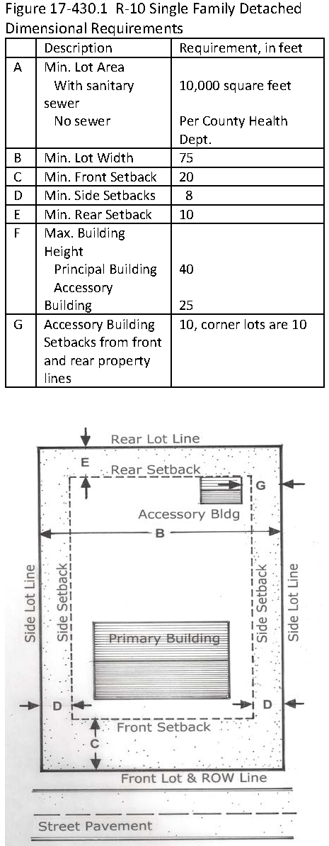
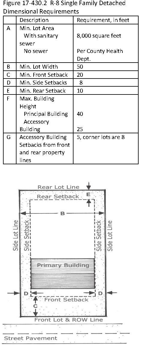
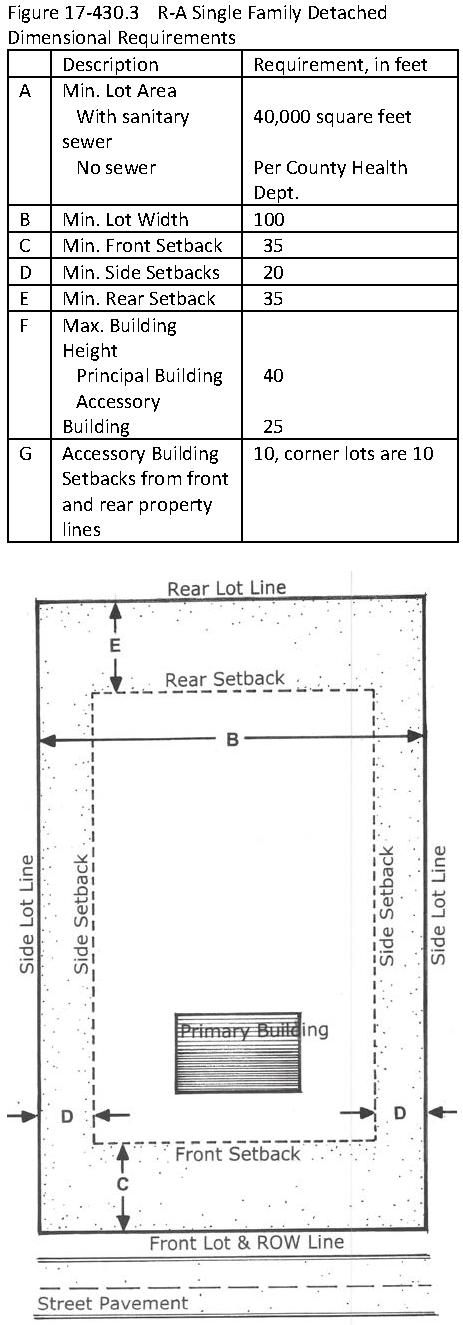
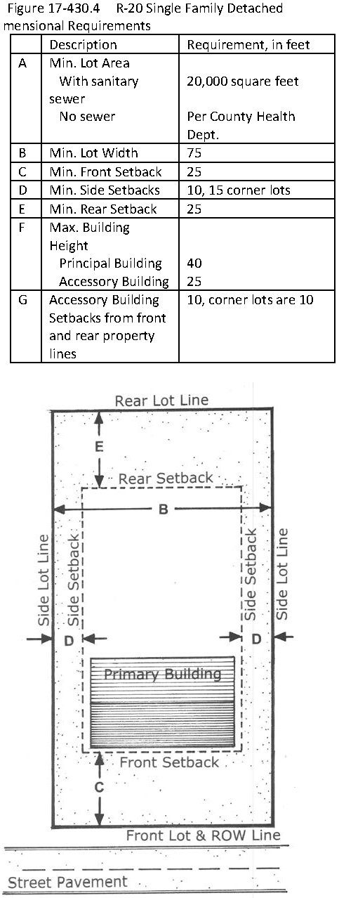
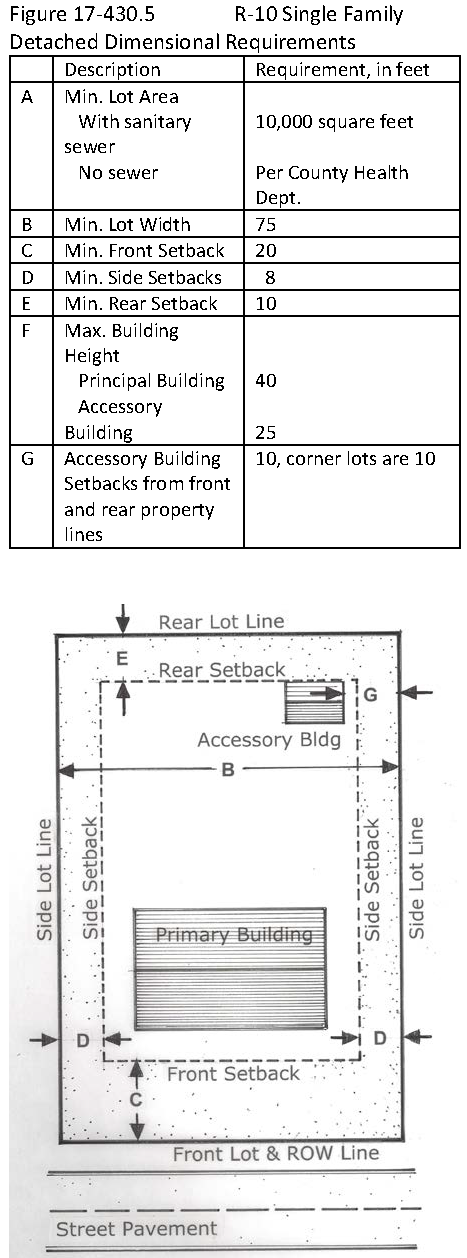
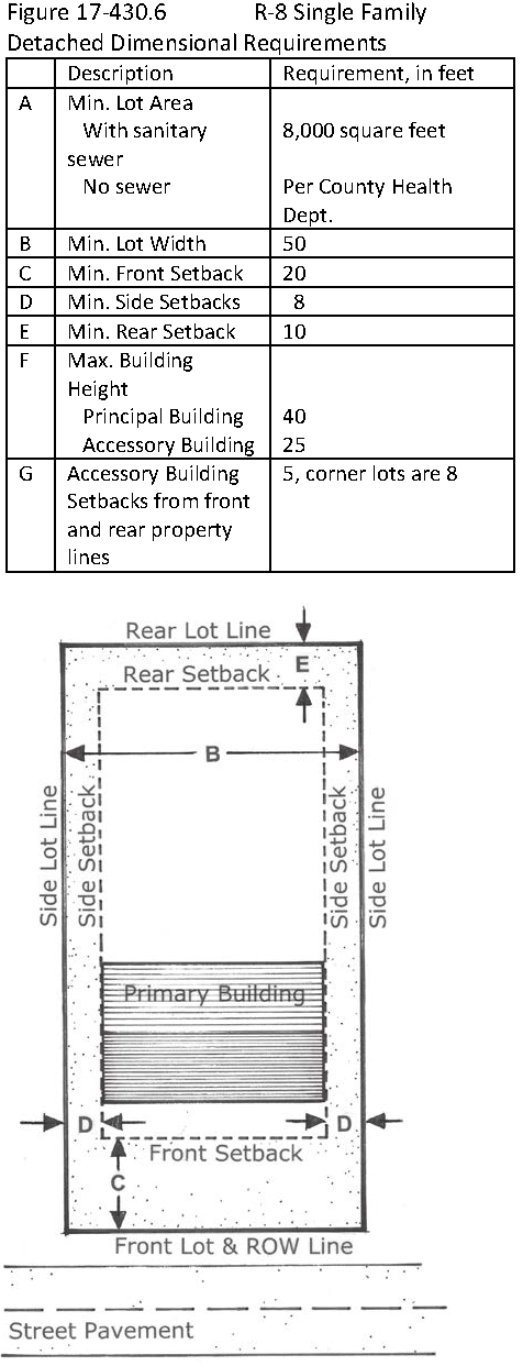
![]()
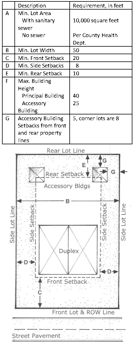
![]()
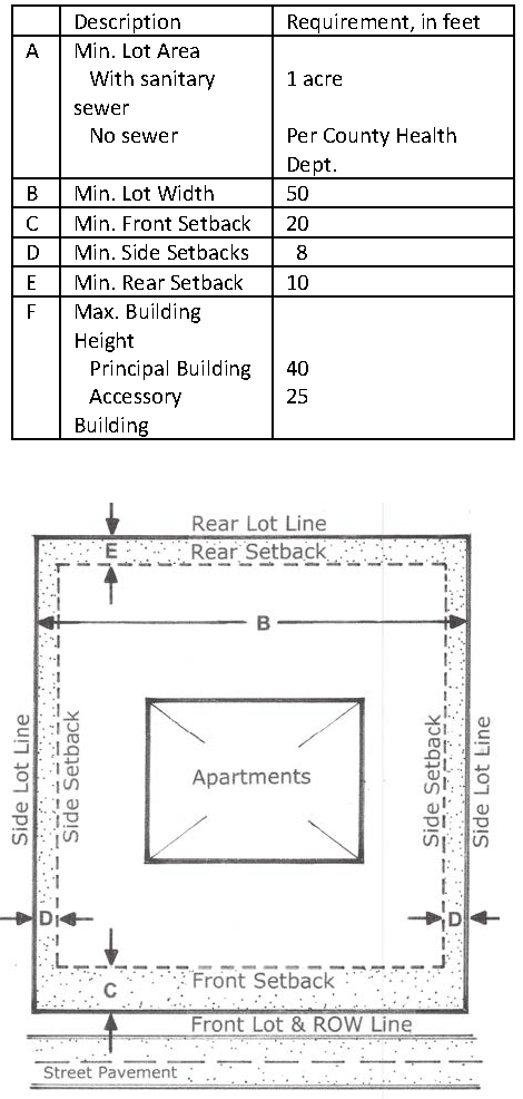
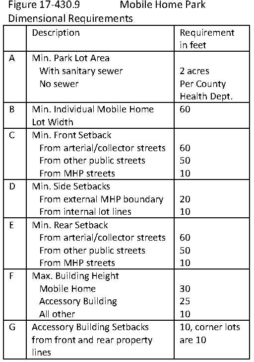
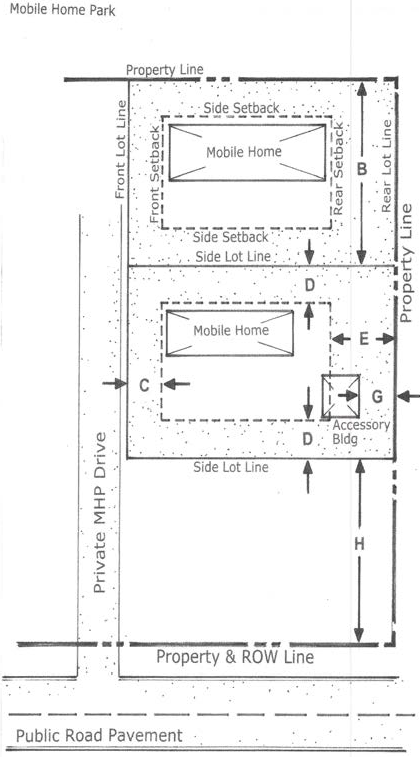
(Ord. No. 2021-64-R, 7-13-21; Ord. No. 2024-009-O, § 1, 3-12-24)
Sec. 17-431. - Principal buildings and accessory buildings.
Except as otherwise provided by this chapter, there shall be no more than one (1) principal building and its customary accessory building(s) on a single lot.
(Ord. No. 2021-64-R, 7-13-21)
Sec. 17-432. - Minimum lot area.
Subject to the provisions of Sections 17-422D.6. and H., which are part of the Water Supply Watershed Overlay District; 17-440, "Single-Family Residential Cluster Development"; all lots shall be at least the minimum size prescribed in the Table of Density and Dimensional Regulations in Section 17-430 in the column labeled "Min. (minimum) Lot Area."
(Ord. No. 2021-64-R, 7-13-21)
Sec. 17-433. - Maximum impervious surface ratio per lot or property.
All lots or properties shall have the maximum square footage of impervious surfaces prescribed in the Table of Density and Dimensional Regulations in Section 17-430 in the column labeled "Maximum Impervious Surface Area" except that impervious surfaces may be less as required in Section 17-422, Water Supply Watershed Overlay Districts. The more restrictive requirement shall control. "Impervious surface" is defined in Section 17-422.
(Ord. No. 2021-64-R, 7-13-21)
Sec. 17-434. - Minimum lot widths.
A.
No lot may be created that is so narrow or otherwise so irregularly shaped that it would be impracticable to construct on it a building that:
1.
Could be used for purposes that are permissible in that zoning district, and
2.
Could satisfy any applicable setback requirements for that district.
B.
Without limiting the generality of the foregoing standard, the minimum recommended lot widths for each zoning district are provided in the Table of Density and Dimensional Regulations in Section 17-430 in the column labeled "Min. Lot Width." These recommended minimum lot widths are presumptively deemed to satisfy the standard set forth in subsection (A), above. The lot width shall be measured along a straight line connecting the points at which a line that demarcates the required setback from the street intersects with lot boundary lines at the opposite sides of the lot.
C.
No lot created after the effective date of this chapter that is less than the recommended width as set forth in this article shall be entitled to a variance from any building setback requirement.
(Ord. No. 2021-64-R, 7-13-21)
Sec. 17-435. - Building setback requirements.
A.
Subject to Sections 17-436, "Accessory Building Setback Requirements," and the other provisions of this section, no portion of any building may be located on any lot closer to any lot boundary line or to the street right-of-way or the centerline line than is authorized in the Table of Density and Dimensional Regulations in Section 17-430 in the columns labeled "Min. Front Yard Setback," "Min. Side Yard Setback," and "Min. Rear Yard Setback." Signs are subject to the setback requirements of Sections 17-1108, "Temporary Signs," 17-1109, "Permanent Signs" or Section 17-1110, "Outdoor Advertising Sign Overlay District," whichever is appropriate. The following provisions shall be used to interpret the table and this section.
B.
If the street right-of-way line is readily determinable (by reference to a recorded map, set irons, or other means), the setback shall be measured from such right-of-way line. If the right-of-way line is not so determinable, the setback shall be measured from the edge of the street pavement or, in the case of a dirt road, from the edge of the visible road bed.
C.
As used in this section, the term "lot boundary line" refers to lot boundaries other than those that abut streets.
D.
As used only in this section, the term "building" includes any substantial structure which by nature of its size, scale, dimensions, bulk, or use tends to constitute a visual obstruction or generate activity similar to that usually associated with a building. Without limiting the generality of the foregoing, the following structures shall be deemed to fall within this description:
1.
Gas pumps and overhead canopies or roofs; and
2.
Fences running along lot boundaries adjacent to public street rights-of-way if such fences exceed six (6) feet in height and are substantially opaque. See also Appendix D on "Fences and Walls."
E.
Notwithstanding any other provision of this chapter, a sign may be erected on or affixed to a structure that (i) has a principal function that is something other than the support of the sign (e.g., a fence), but (ii) does not constitute a building as defined in this chapter, only if such sign is located to comply with the setback requirement applicable to freestanding signs in the district where such sign is located.
F.
Whenever a lot in a nonresidential zoning district has a common boundary line with a lot in a residential zoning district, and the property line setback requirement applicable to the residential lot is greater than that applicable to the nonresidential lot, then the lot in the nonresidential district shall be required to observe the property line setback requirement applicable to the adjoining residential lot.
G.
Setback distances shall be measured from the property line or street right-of-way line to a point on the lot that is directly below the nearest extension of any part of the building that is substantially a part of the building itself and not a mere appendage to it (such as a flagpole, etc.).
H.
Whenever a private road that serves more than three (3) lots or more than three (3) dwelling units or that serves any nonresidential use tending to generate traffic equivalent to more than three (3) dwelling units is located along a lot boundary, then:
1.
If the lot is not also bordered by a public street, buildings and freestanding signs shall be set back from the private road just as if such road were a public street; and
2.
If the lot is also bordered by a public street, then the setback distance on lots used for residential purposes shall be measured from the inside boundary of the traveled portion of the private road.
(Ord. No. 2021-64-R, 7-13-21)
Sec. 17-436. - Accessory building setback requirements.
A.
Accessory buildings shall be located at least ten (10) feet from any lot line, except for the R-8, TR, CB districts where accessory uses may be located at least five (5) feet from any lot line.
B.
Notwithstanding subsection A., above, when an accessory building is located on a corner lot, the accessory building shall be set back from the side street lot line a distance at least equal to the minimum side yard setback required for the zoning district in which the lot is located. For example, an accessory building located on a corner lot in the R20 zoning district must be setback at least fifteen (15) feet from the side street lot line and ten (10) feet from all other lot lines.
C.
All accessory buildings shall be located to the rear of the principal building.
D.
Except in the MHP zoning district, for lots measuring less than one (1) acre, the combined area of all accessory buildings shall be limited to no more than thirty-three (33) percent of the enclosed finished heated living space or area, including enclosed porches, of the principal building located on the lot. For the purposes of this section, the following structures are excluded from the calculation of heated living space: decks, patios, attached garages, carports, attics, any porches not enclosed and storage rooms that are only entered from the exterior.
E.
In the MHP zoning district, accessory buildings shall be no larger than one hundred (100) square feet.
F.
In calculating the permissible area of an accessory building, all impervious surfaces, built upon area or spaces connected to the accessory building, whether it is enclosed or under roof, shall be included.
G.
The maximum height of an accessory building shall not exceed twenty-five (25) feet at any point.
1.
Exception: In Industrial Districts the maximum height of an accessory building shall not exceed either the height of the principal structure or thirty-five (35) feet, whichever is greater.
(Ord. No. 2021-64-R, 7-13-21; Ord. No. 2025-007-O, § 1, 7-8-25)
Sec. 17-437. - Swimming pool setback requirements.
A.
All swimming pools must be located in the rear yard at least ten (10) feet from any property line. All swimming pools must comply with the N.C. Building Code.
B.
Notwithstanding subsection A., above, when a swimming pool is located on a corner lot, it shall be set back from the side street lot line a distance at least equal to the minimum side yard setback required for the zoning district in which the lot is located. For example, a swimming pool located on a corner lot in the R20 zoning district must be set back at least fifteen (15) feet from the side street lot line and ten (10) feet from all other lot lines.
C.
See Section 17-561 for additional requirements for swimming pools.
(Ord. No. 2021-64-R, 7-13-21)
Sec. 17-438. - Building height limitations.
A.
No building shall be taller than the maximum height prescribed in the Table of Density and Dimensional Regulations in Section 17-430 in the column labeled, "Maximum Bldg. Height."
B.
Subject to subsection C. of this section, the following features are exempt from the district height limitations set forth in subsection A.:
1.
Spires, towers or similar decorative structures located on the primary worship building of a church, mosque, synagogue, temple or other building used for religious purposes, provided that such structures are not intended for occupancy or storage.
2.
Chimneys, elevator shafts and similar structural appendages not intended as places of occupancy or storage.
3.
Flagpoles and similar devices.
4.
Antennas, heating and air conditioning equipment, solar collectors, and similar equipment, fixtures and devices.
C.
The features listed in subsection B. are exempt from the height limitations set forth in subsection A. if they conform to the following requirements:
1.
Not more than one-third (⅓) of the total roof area may be consumed by such features.
2.
The features described in subsection B.4. above must be set back from the edge of the roof a minimum distance of one (1) foot for every foot by which such features extend above the roof surface of the principal building to which they are attached to shield the features listed in subsections B.2. and 4. from view, the permit-issuing authority may authorize or require that parapet walls be constructed up to a height not exceeding that of the features to be screened.
D.
Notwithstanding subsection (A), above, in any zoning district, the vertical distance from the ground to a point of access to a roof surface of any nonresidential building or any multi-family residential building containing four (4) or more dwelling units may not exceed thirty-five (35) feet unless the Town Fire Chief, or his or her designee, certifies to the permit issuing authority that such building is designed to provide adequate access for fire-fighting personnel or the building inspector certifies that the building is otherwise designed or equipped to provide adequate protection against the dangers of fire. For the purposes of this subsection, "point of access" refers to the top of any parapet wall or the lowest point of a roof's surface, whichever is greater.
E.
Towers and antennas are allowed in the various zoning districts as permitted in the Table of Permissible Uses (Section 17-410), use classification 18.000.
(Ord. No. 2021-64-R, 7-13-21)
Sec. 17-441. - Density on lots where portion dedicated to Town.
A.
Subject to the other provisions of this section, if (i) any portion of a tract lies within an area designated on any officially adopted town plan as part of a proposed public park, greenway, or bikeway, and (ii) before the tract is developed, the owner of the tract, with the concurrence of the Town, dedicates to the Town that portion of the tract so designated, then, when the remainder of the tract is developed for residential purposes, the permissible density at which the remainder may be developed shall be calculated in accordance with the provisions of this section.
B.
If the proposed use of the remainder of the tract is a single-family detached residential subdivision, then the lot sizes in such subdivision may be reduced in accordance with the provisions of Section 17-422, "Water Supply Watershed Protection District," subsection "Single-Family Residential Cluster Development," except that the developer need not set aside usable open space to the extent that an equivalent amount of land has previously been dedicated to the Town in accordance with subsection (A) of this section.
C.
If the proposed use of the remainder of the tract is a two-family or multi-family project, the permissible density at which the remainder may be developed shall be calculated by regarding the dedicated portion of the original lot as if it were still part of the lot proposed for development.
D.
If the portion of the tract that remains after dedication as provided in subsection (A) of this section is divided in such a way that the resultant parcels are intended for future subdivision or development, then each of the resultant parcels shall be entitled to its prorated share of the "density bonus" provided for in subsections B. and C. of this section.
(Ord. No. 2021-64-R, 7-13-21)
Sec. 17-450. - Purpose.
A Zoning Permit is required for short-term uses and certain seasonal or transient uses not otherwise allowed. Prior to conducting or establishing a temporary use or structure, approval of a Zoning Permit by the Administrator is required pursuant to Article VI of this chapter.
(Ord. No. 2021-64-R, 7-13-21)
Sec. 17-451. - Approval criteria.
All temporary uses listed in this Part or in Section 17-410 "Table of Permitted Uses" require a Zoning Permit. The Administrator shall not approve or modify and approve an application for a Zoning Use Permit unless the following criteria, specific regulations and time limitations are met in addition to criteria for any particular temporary use as specified below.
A.
Compatibility with/Effect on Surrounding Area. The allowance of such use shall not be detrimental to the public health, safety and general welfare, and the use shall be consistent with the purpose and intent of this chapter and the specific zoning district in which it will be located; and the use is compatible in intensity, characteristics and appearance with existing land uses in the immediate vicinity of the temporary use, and the use, value and qualities of the neighborhood surrounding the temporary use will not be adversely affected by the use or activities associated with it. In addition to those listed herein, factors such as location, noise, odor, light, dust control and hours of operation shall be considered.
B.
Location (Permission Required). The use shall not be on publicly or privately owned property unless the applicant first obtains written approval from the owner.
C.
Traffic. The location of the temporary use or structure shall be such that adverse effects on surrounding properties will be minimal, particularly regarding any type of traffic generated or impacted by the temporary use or structure and impact upon traffic circulation in the area.
D.
Parking and Access. Adequate off-street parking shall be provided to serve the use. The use shall not displace the required off-street parking spaces or loading areas of the principal permitted uses on the site. The entrance and exit drives shall be designed to prevent traffic hazards and nuisances.
E.
Property Line Setbacks. Structures and/or display of merchandise shall comply with the yard and property line setback requirements of the zone district within which it is located. The items shall be displayed so as not to interfere with the sight triangle of the intersection of the curb line of any two (2) streets or a driveway and a street. In no case, shall items be displayed or business conducted within the public right-of-way.
F.
This subsection Shall Not Apply to the CB District.
G.
Signs. Signage for temporary uses shall be permitted only within the time frame for which the temporary use is permitted. See Article XI for specific standards for signs.
H.
Number Per Parcel. Only one (1) Zoning Permit for a Temporary Use shall be permitted for a single parcel of land at any given time.
I.
Period of Time Between Permits. The period of time an expired Zoning Permit for a Temporary Use on a parcel and application for another Zoning Permit for a Temporary Use on that same parcel shall be at least three (3) months. This restriction shall not apply to real estate development and constructed related temporary uses.
(Ord. No. 2021-64-R, 7-13-21)
Sec. 17-452. - Real estate development and construction-related temporary uses.
A.
Contractors Office and Equipment/Storage Sheds Accessory to a Construction Project (Residential or Non-Residential).
1.
Placement of such a temporary use is limited to a period of time determined by an estimated project completion date with the option of an extension of up to one (1) year as and if approved by the Administrator. A construction trailer may be used for a contractor's office or for the contractor's storage of equipment or materials. All temporary buildings and trailers shall be completely removed from the site within thirty (30) days of issuance of a Certificate of Occupancy or completion of the construction project, whichever occurs first.
a)
Real Estate Office in a Construction Trailer or Temporary Modular Unit. Temporary structures, such as construction trailers or temporary modular units may be used as real estate sales offices in any new construction project for the sale of units within that project only. Such a temporary use may be allowed in all zoning districts. The permit shall be valid until the project is completed or for a period of two (2) years from the time of the recording of the most recent final plat.
b)
Real Estate Office in a Model Home Accessory to Construction of a New Residential Development. Limited to a period of time not to exceed one (1) year with the option of an extension of up to one (1) year as and if approved by the Administrator. The number of employees utilizing the office at any one (1) time may not exceed five (5). A real estate office may not contain sleeping or cooking accommodations unless located in a model dwelling.
(Ord. No. 2021-64-R, 7-13-21)
Sec. 17-453. - No recreational vehicles.
No Recreational Vehicles shall be permitted as a Temporary Uses.
(Ord. No. 2021-64-R, 7-13-21)
Sec. 17-454. - Amusement enterprises.
Carnivals, circuses, fairs, and amusement rides may be allowed in any non-residential zoning district for a period not to exceed thirty (30) days within any ninety-day period, which shall not include two (2) consecutive thirty-day periods. This classification excludes events conducted in a permanent entertainment facility.
(Ord. No. 2021-64-R, 7-13-21)
Sec. 17-455. - Religious events.
Religious events in a tent or other temporary structure may be allowed in any non-residential zoning district for a period not to exceed sixty (60) days.
(Ord. No. 2021-64-R, 7-13-21)
Sec. 17-456. - Special events and activities.
Special events and activities conducted on public property such as school sites and public parks shall be exempt from the provisions of this section of the Ordinance but must comply with any guidelines, regulations and permitting process required by the authorizing agency.
(Ord. No. 2021-64-R, 7-13-21)
Sec. 17-457. - Similar and compatible uses not specified.
If a particular temporary use is listed in the Ordinance, the Administrator shall have the authority to grant a zoning permit for a temporary "similar and compatible use."
Determination of what constitutes similar and compatible shall be made by the Administrator in accordance with Section 17-404C.
(Ord. No. 2021-64-R, 7-13-21)