
Sierra Madre City Zoning Code
CHAPTER 17
52 - H HILLSIDE MANAGEMENT ZONE11
Sections:
Editor's note— Ord. No. 1294, § 1, readopted and ratified Ordinance No. 1256, adopted in 2006.
17.52.010 - Purpose.
The purposes of this chapter are to:
A.
Protect the natural environment of hillside areas from change by preserving and protecting the views to and from hillside areas in the city to maintain the identity, image and environmental quality of the city;
B.
Maintain an environmental equilibrium consistent with the native vegetation, animal life, geology, slopes, and drainage patterns;
C.
Facilitate hillside preservation through the development standards and guidelines set forth in this chapter; to direct and encourage development that is sensitive to the unique characteristics of the hillside areas in the city, which include, but are not limited to, slopes, land forms, vegetation and scenic quality; accordingly, innovation in the design of buildings and structures is encouraged so long as the result preserves hillside areas and is consistent with this chapter and with the General Plan;
D.
Ensure that development in the hillside areas is located so as to result in the least environmental impact;
E.
Ensure that all hillside development is designed to fit the existing land form;
F.
Preserve significant natural features of hillside areas, including swales, canyons, knolls, ridgelines, and rock outcrops. Development may necessarily affect natural features; therefore, a major design criterion for all hillside development shall be the minimization of impacts on such natural features;
G.
Provide safe ingress and egress for vehicular and pedestrian traffic to and within hillside areas, with minimal disturbance of natural features;
H.
Correlate intensity of development to steepness of terrain to minimize grading, removal of natural vegetation; and to prevent the creation of land instability or fire hazards;
I.
Provide, in hillside areas, alternative approaches to conventional flat-land development practices by achieving land use patterns and intensities that are consistent with the natural features of hillside areas;
J.
Encourage the planning, design, development and use of home sites which:
1.
Eliminate fire hazards,
2.
Prevent exposure to geological hazards,
3.
Provide adequate drainage controls, preventing erosion and siltation,
4.
Use proper construction materials,
5.
Make best use of natural terrain,
K.
Prohibit development that will cause hazards to the public peace, health, welfare, and safety.
(Ord. 1994, § 1(Exh. A), 6-23-09)
17.52.020 - Conflict.
Should any conflict or ambiguity arise in the application to an R-H-zoned lot of any two or more provisions of this title, the more restrictive application or interpretation shall apply.
(Ord. 1994, § 1(Exh. A), 6-23-09)
17.52.030 - Creation of hillside management zone.
There is hereby created the hillside management residential zone. The designation on the city's official zoning map for the hillside management residential zone shall be "R-H."
(Ord. 1994, § 1(Exh. A), 6-23-09)
17.52.040 - Applicability.
A.
The provisions of this chapter shall apply to the use and development of all of R-H-zoned lots in the city.
B.
All buildings, structures and uses located on any R-H-zoned lot shall comply with all of the provisions of this title, including, but not limited to, the provisions of this chapter, except as provided in Chapter 17.56 ("Nonconforming uses").
(Ord. 1994, § 1(Exh. A), 6-23-09)
17.52.050 - Permit requirements.
A.
This chapter establishes two types of permits for development in the R-H zones - administrative hillside development permits and hillside development permits.
B.
No person shall grade, erect, or construct into, over, or on top of property within an R-H-zone without first obtaining an administrative hillside development permit or a hillside development permit in compliance with this chapter.
C.
No person shall subdivide, whether by tract map, or parcel map, property within the R-H-zone without first obtaining a hillside development permit in compliance with this chapter.
(Ord. 1994, § 1(Exh. A), 6-23-09)
17.52.060 - Exemptions from permit requirements.
The following actions and activities in the R-H zone shall be exempt from the requirement of an administrative hillside development permit or a hillside development permit, provided that the actions and activities in the R-H zone comply with the development standards of this chapter:
A.
Minimal grading that does not require a grading permit under Title 15 (Buildings and Construction) of this code and does not alter the natural drainage or grade of a site.
B.
Construction that does not require a building permit under Title 15 (Buildings and Construction) of this code, whether or not a mechanical, electrical or plumbing permit is required.
C.
Interior remodels, including any remodel that does not add square footage (whether or not offset by other reductions in square footage) and does not alter the exterior appearance of a structure.
D.
Re-roofing of any structure, using the same color and type of materials as existing.
(Ord. 1994, § 1(Exh. A), 6-23-09)
17.52.070 - Land use regulations.
A.
Allowed Uses in the R-H Zone. No discretionary permit is required by this chapter for the following uses of land in the R-H zone, which uses shall be allowed by right except as otherwise required by this code:
1.
Home occupations.
2.
Garage sales.
3.
Transitional and supportive housing.
B.
Uses in the R-H Zone Requiring an Administrative Hillside Development Permit. The following uses of land shall be allowed subject to the granting of an administrative hillside development permit in compliance with this chapter. All uses not specified in this subsection B. or in subsection A. above shall require a hillside development permit.
1.
Grading not exempted from permit requirements by Section 17.52.060 of less than fifty cubic yards that either disturbs less than five thousand square feet of the surface area of the lot or is necessary for fire hazard mitigation, as determined by the fire marshal, provided that grading complies with all of the requirements of this chapter.
2.
Any remodels of, or additions to, existing, legal, primary structures, which:
a.
Result in an increase in gross floor area of fifty percent or less of the original structure, up to a maximum of four thousand square feet; and
b.
Are consistent in character with the original structure and compatible in scale, proportion and character with neighboring properties.
c.
Will not unreasonably interfere with the use, possession and enjoyment of neighboring properties.
3.
Accessory structures:
a.
Swimming pools, hot tubs, spas, pool/spa equipment and/or similar recreational facilities not governed by Section (C)(7) or (C)(8) of this section.
b.
Communication devices intended for noncommercial use and enjoyment by the resident of the property on which the device is located, such as, amateur ham radio and similar devices, provided such devices comply with Section 17.20.060(E)(1);
c.
Miscellaneous structures and uses, such as trash enclosures, barbecues, garages, tool sheds and similar uses, measuring less than six hundred square feet.
4.
Infill Development: New construction or remodels where:
a.
The proposed structure(s) are not visible from any of the viewpoints identified in 17.52.120(A)(10) that are more than five hundred feet from the structure(s) and the total area of all proposed structures on the lot is less than four thousand square feet;
b.
At least eighty percent of the building pad is located in Slope Categories 1 and 2;
c.
No portion of the building pad is located in Slope Category 4; and
d.
All lots contiguous to the site have already been developed with a residence or other primary structure.
5.
Modular and manufactured homes as a type of dwelling unit, one per dwelling unit.
6.
Family daycare homes, one per dwelling unit.
C.
Uses in the R-H Zone Requiring a Hillside Development Permit. The following uses of land shall be allowed subject to the granting of a hillside development permit in compliance with this chapter:
1.
Any primary or accessory use permitted in the R-1 one-family residential zone (as set forth in Sections 17.20.020 and 17.60.030).
2.
Construction of a detached single-family dwelling unit on an existing legal lot;
3.
Land divisions, whether by parcel map, tract map, or otherwise;
4.
Grading not governed by Sections 17.52.060(A) or (B)(1) of this code;
5.
Remodels of, or additions onto, existing, legal, primary structures not governed by section (B) of this section;
6.
An accessory structure or any combination of accessory structures, not governed by Section 17.52.070(B);
7.
Swimming pools, hot tubs, spas, pool/spa equipment and/or similar recreational facilities located within twenty-five feet from a public or private street or alley and visible to or from any public or private street or alley;
8.
Tennis courts, basketball courts, and similar sports courts and associated lighting, subject to the issuance of grading permit and building permits if and as required by Title 15 (Buildings and Construction) of this code;
9.
Stables, corrals, and similar facilities for the noncommercial keeping of animals other than livestock that it is lawful to keep in residential zones of the city under the other applicable provisions of this code.
D.
Uses Prohibited in the R-H Zone. No person shall use, or permit the use of, any R-H-zoned lot for:
1.
Breeding, raising, keeping or maintaining livestock; or
2.
Any use not governed by paragraphs A, B, or C of this section.
(Ord. 1994, § 1(Exh. A), 6-23-09; Ord. No. 1352, § 9, 2-11-14; Ord. No. 1441, §§ 2—4(Exh. B), 5-11-21)
17.52.080 - Definitions.
In addition to the definitions contained elsewhere in this title, the words and phrases set forth below shall be given the following meanings for the purposes of this chapter unless the context clearly requires otherwise:
"Bedroom." For those properties which are nonconforming with regard to the on-site parking space requirements of this chapter, the addition of a bedroom(s) will require that the property conforms to such parking requirements, pursuant to the following definition of bedroom:
The following rooms which regularly make up a standard dwelling unit shall not be considered a bedroom: one kitchen, one living room, one family or recreation room, one dining room, and bathrooms.
"Building envelope" means the space enclosed by the exterior walls and roof of a building.
"Contour" means a line drawn on a plan which connects all points of equal elevation.
"Contour grading" means a grading technique designed to result in earth forms which resemble natural terrain. Horizontal and vertical curve variations are often used for slope banks. Contour grading does not necessarily minimize the amount of cut and fill.
"Cut" means earth material removed by artificial means, such as excavation or any other form of human activity or the act of removing such material.
"Existing" means the condition of a site when a development application for that site is submitted. "Existing grade" means the grade of a site when a development application for that site is submitted.
"Fill" means earth material placed by artificial means, such as truck import or any other form of human activity, or the act of placing such material.
"Finish grade" means the final elevation of ground surface after development consistent with an approved grading plan.
"Fuel modification/brush clearance program" means a plan required by Section 17.52.170(A)(6) as approved by the reviewing authority.
"General plan" means the General Plan of the City of Sierra Madre as adopted and amended through the date on which reference to the General Plan is made.
"Grading" means excavating, filling, or smoothing earth.
"Green building standards" means the building standards of the United States Green Building Council's Leadership in Energy and Environmental Design (LEED) Rating System Version 2.0, any successor to those standards, or other standards with similar purposes approved by the director.
"Gross floor area" means the sum of the horizontal, above-grade areas (regardless of use) of floors of buildings and structures measured from the exterior face of exterior walls. Gross floor area includes, without limitation, habitable space, non-habitable space, storage areas, and covered parking areas. Gross floor area does not include basements or other subterranean spaces. If a space is partially subterranean, only that portion which, from floor to ceiling, is below grade shall be excepted from gross floor area. If the reviewing authority finds that to do so would advance the purposes stated in Section 17.52.010, it may exclude from gross floor area the space within exterior walls which are unusually thick, such as hay bale, adobe, insulated concrete form, and other wall systems consistent with green building standards.
"Hillside view line" means those lines shown as such on the Sierra Madre Hillside Management District Map.
"Hillside zone" or "R-H zone" means that zone classification created by Section 17.52.030.
"Land division" means the creation of two or more lots or parcels of land for separate sale, lease, financing, or use for which an approval, other than a lot line adjustment, is required by Title 16 of this code (Subdivisions).
"Natural" means the condition of land prior to human alteration, determined on the basis of the oldest reliable evidence available to the reviewing authority at the time of its decision, including topographic maps and aerial photographs. Thus, for example, "natural slope" means the slope of a lot or portion thereof which is not manufactured or manmade.
"Original structure" means, for purposes of rules stated in this chapter regarding remodels and additions, the structure as it existed before one or more proposed remodels or additions approved or constructed in a twenty-four-month period.
"Pad" or "building pad" means an area on a lot upon which a building or structure may be placed.
"Prominent ridge" means a ridge so designated on the Sierra Madre Hillside Management District Map.
"Protected tree" has the meaning specified in Section 12.20.020 of this code.
"Purposes of this chapter" shall mean the purposes specified in Section 17.52.010 of this chapter.
"Reviewing authority" means the director, planning commission or city council when making a decision this chapter delegates to him, her or it.
"Sierra Madre Hillside Management District Map" means the Sierra Madre Hillside Management District Map (Map A) as adopted by Ordinance No. 1294 and as amended from time to time
"Slope" means an inclined ground surface of a lot, or portion of a lot, the inclination of which is expressed as a ratio of horizontal distance (run) to vertical distance or change in elevation (rise). The percentage of any given slope is determined by dividing the rise by the run multiplied by one hundred.
"Slope, man-made" shall mean a graded area consisting wholly or partially of either cut or filled material.
"Slope category" means one of the slope categories defined in Section 17.52.110.
"Suitability analysis" means a graphical drawing or model that depicts all environmental constraints that affect a project site to aid identification of areas where development is or is not appropriate which drawing or model is required by Section 17.52.100(A)(5) or (B)(8).
"Unit" means a residential dwelling unit.
(Ord. 1994, § 1(Exh. A), 6-23-09; Ord. No. 1354, § 4, 6-10-14)
17.52.090 - Permit application filing and review procedures.
A.
Application Filing. An application for an administrative hillside development permit or a hillside development permit shall be submitted to the planning and community preservation department on forms supplied by the department. To be deemed complete and accepted for filing, an application shall be accompanied by the information and materials set forth in Section 17.52.100 (Permit application contents).
B.
Concurrent Applications. An application for an administrative hillside development permit or a hillside development permit may be processed and approved concurrently with any other development permits required by this title and any other applicable provision of this code.
C.
Voluntary Pre-Application Review Process.
1.
Prior to submitting an application for an administrative hillside development permit or a hillside development permit, an applicant may voluntarily meet with the director to review the requirements of this chapter.
2.
The purpose of a pre-application meeting is to review the requirements of this chapter; to identify and review available information regarding physical conditions affecting the subject property; to respond to the applicant's questions, and to present and review general plan and other city plans, ordinances, policies, and standards affecting use and development of the property.
3.
The pre-application meeting shall not constitute a comprehensive hillside development permit application review and shall not commence any timeline under any law, statute, or ordinance. City comments are to provide direction to facilitate review and processing of an administrative hillside development permit or hillside development permit application and shall not confer any right or entitlement on any person.
D.
Reviewing Authority. Except as otherwise provided by this chapter, the reviewing authority for an administrative hillside development permit application shall be the director. The reviewing authority for a hillside development permit application shall be the planning commission. The reviewing authority shall approve, conditionally approve, or deny an application for a hillside development permit in writing.
E.
Notice and Review Procedure.
1.
Administrative Hillside Development Permit. An administrative hillside development permit shall be processed in compliance with the requirements for a minor conditional use permit set forth in Chapter 17.60 of this title. The director may refer any application for an administrative hillside development permit to the planning commission if the director determines at the director's sole discretion that the proposed development has the potential to result in significant environmental impacts or alteration of the natural terrain. In the event the director refers an application to the planning commission, the planning commission shall follow the requirements for a conditional use permit set forth in Chapter 17.60 of this title.
2.
Hillside Development Permit. A hillside development permit shall be processed in compliance with the requirements established for a conditional use permit set forth in Chapter 17.60 of this title. In addition to all other hearing notices related to an application for a conditional use permit, at least ten days' notice by first class mail shall be given to the record owners of all real property located within one thousand feet of the boundaries of the property for which a hillside development permit is sought.
3.
Findings Required. In approving an administrative hillside development permit or a hillside development permit, the reviewing authority shall make all of the following findings:
a.
The proposed development is consistent with and serves to implement the general plan and specifically, those general plan goals and policies that pertain to hillside development;
b.
The proposed development is consistent with the purposes of this chapter;
c.
The design of the development minimizes exposure of persons to natural hazards and maximizes access to public open space areas;
d.
The design and location of structures or uses avoids, eliminates, or adequately mitigates each of the environmental constraints described in this chapter and other significant environmental impacts identified upon environmental review of the application;
e.
The proposed development complies with the standards set forth in this chapter, including Section 17.52.120 (Design and Development Standards for Uses Requiring Hillside Development Permits) and Section 17.52.160 (Architectural and Site Design Standards).
4.
Modification of Standards Upon Certain Additional Findings.
a.
For remodels of, or additions to, existing, legal, primary structures, which result in an increase in gross floor area of twenty-five percent or less of the original structure, the reviewing authority may modify the requirements of Section 17.52.120(A)(4) and (A)(6) through (A)(11) (Design and Development Standards) and 17.52.160(C)(1) (Architectural and site design standards) where:
1.
Requiring strict compliance would be contrary to the purposes of this chapter; and
2.
Allowing the modification would substantially advance the purposes of this chapter.
b.
For new construction or remodels beyond the scope of subsection (E)(4)(a) above, the reviewing authority may modify the requirements of Section 17.52.120(A)(4), (6), (7) or (9) through (A)(11) (Design and Development Standards) and 17.52.160(C)(1) (Architectural and site design standards) where:
1.
Requiring strict compliance would run contrary to the purposes of this chapter; and
2.
Allowing the modification would substantially advance the purposes of this chapter.
c.
The reviewing authority may modify the requirements of Section 17.52.120(A)(4) and (A)(6) through (A)(11) (Design and Development Standards) for infill developments specified in Section 17.52.070(B)(5) where:
1.
Requiring strict compliance would run contrary to the purposes of this chapter; and
2.
Allowing the modification would substantially advance the purposes of this chapter.
(Ord. 1994, § 1(Exh. A), 6-23-09; Ord. No. 1455, § 6(Exh. E), 5-24-22; Ord. No. 1466, § 78, 3-28-23)
17.52.100 - Permit application contents.
A.
Contents of Application for Hillside Development Permit. A complete application for a hillside development permit shall include the information required by this code for an application for a conditional use permit as well as the following:
1.
A site or plot plan of the subject property drawn to a scale prescribed by the planning department, but not less than a scale of one inch to one hundred feet, reflecting the proposed project, including property lines and all existing and proposed easements and public rights-of-way;
2.
A topographical map of the subject property and as much of the neighboring terrain as is necessary to evaluate the application, but not to exceed one hundred fifty feet from the boundaries of the subject property in any direction. This map shall be drawn to the same scale as the site or plot plan required in subsection (A)(1) of this section, with a maximum contour interval of five feet. The map shall delineate slope bands in the range of zero to less than fifteen percent, fifteen to less than twenty percent, twenty to less than twenty-five percent, and twenty-five percent or greater. Also included shall be a tabulation of the land in each slope category specified in square feet and an average slope calculation for the entire property; and
3.
A complete proposed grading plan for the subject property, drawn to the same scale as required in subsection (A)(1) of this section; and
4.
A flood plan including all measures, such as elevated building pads or floor plates, necessary to ensure adequate protection of persons and property.
5.
A suitability analysis that clearly delineates the following on-site constraints: category 4 slopes, riparian areas, drainage areas, flood plains, vegetation types (including sensitive or critical habitat, protected trees, and other vegetation to be affected by the project in a manner which might have a significant biological or aesthetic impact on the environment or implicate the concerns of Section 17.52.180 of this chapter), prominent ridgelines and, if requested by the director, archaeological, historic and paleontological resources.
6.
Conceptual plans, including a conceptual fencing and landscaping plan, sufficient to establish that the proposed project is consistent with the construction and grading standards set forth in Section 17.52.150, the architectural and site design standards set forth in Section 17.52.160 and the fire prevention and landscaping standards set forth in Section 17.52.170.
7.
Diagrams and photos and, if requested by the director, installation of three-dimensional story poles (e.g., frameworks of boards, PVC pipe, guy wire with pennants, etc.) that outline the walls, roofs, and other features that will determine the location, mass, and bulk of the proposed structure(s).
8.
If requested by the director, a three-dimensional, scale model of the subject property and the area one hundred fifty feet outside the boundaries of the subject property, including cross sections, a detailed slope analysis based on a triangulated irregular network ("TIN") model, and such other graphic information as, in the director's judgment, would aid in the city's review of the project (e.g., rendered perspectives, computer generated simulations, etc.); all graphic information shall be drawn to such scale as prescribed by the director;
9.
If requested by the director, a site-specific archaeological, historic and paleontological report identifying all such resources on a project site, analyzing potential adverse impacts to such resources, and identifying effective mitigation measures to reduce potential adverse impacts to a level of insignificance if it is feasible to do so and to the maximum extent feasible if it is not.
10.
If requested by the director, all or any portion of the materials required for a subdivision pursuant to subsection C below, as necessary to evaluate the hillside development permit application.
B.
Contents of Application for Administrative Hillside Development Permit. A complete application for an administrative hillside development permit shall include the information required by this code for an application for a minor conditional use permit as well as any item listed in subsection A requested by the director.
C.
Contents of Application for Land Divisions. A complete application for a hillside development permit for a land division shall include the information required by this code for the type of land division sought to be approved (e.g., parcel map or tract map) as well as the following:
1.
A site or plot plan of the subject property drawn to scale prescribed by the director, but not less than a scale of one inch to one hundred feet, reflecting the proposed land division, including property lines and all existing and proposed easements and public rights-of-way;
2.
A topographical map of the subject property and all terrain within one hundred fifty feet of the boundaries of the subject property. This map shall be drawn to the same scale as the site or plot plan required in subsection (C)(1) of this section, with a maximum contour interval of five feet. The map shall delineate slope bands in the range of zero to less than fifteen percent, fifteen to less than twenty percent, twenty to less than twenty-five percent, and twenty-five percent or greater. Also included shall be a tabulation of the land in each slope category specified in square feet and an average slope calculation for the entire property;
3.
A complete proposed grading plan for any grading of the subject property to be conducted in connection with the proposed land division, drawn to the same scale as required in subsection (C)(1) of this section;
4.
A complete flood plan including all measures, such as elevated building pads or floor plates, necessary to ensure adequate protection of persons and property;
5.
A biotic resources management plan pursuant to Section 17.52.180;
6.
If requested by the director, a vegetation map of the subject property drawn to the same scale as required in subsection (C)(1) of this section, showing the location of all vegetation formations and indicating the species present, the number of each and their locations, including sensitive or critical habitat, protected trees, and other vegetation to be affected by the project in a manner which might have a significant biological or aesthetic impact on the environment or implicate the concerns of Section 17.52.180 of this chapter. The map shall also show the location of all existing trees on the subject property with a trunk diameter of two inches or greater or a vertical height from ground level to treetop of fifteen feet or more. This map shall identify the species of all such trees and show their trunk diameters, canopies, heights and conditions;
7.
If requested by the director, a census of indigenous plants, insects and animals species located on the subject property, specifying any threatened or endangered species and any other species that might be impacted by the project in a manner which might have significant biological or aesthetic impacts on the environment of the project or implicate the concerns of Section 17.52.180 of this chapter;
8.
A suitability analysis that clearly delineates the following on-site constraints: category 4 slopes, riparian areas, drainage areas, flood plains, vegetation types (including sensitive or critical habitat, protected trees, and other vegetation to be affected by the project in a manner which might have a significant biological or aesthetic impact on the environment or implicate the concerns of Section 17.52.180 of this chapter), prominent ridgelines and, if requested by the director, archaeological, historic and paleontological resources;
9.
If requested by the director, three-dimensional, scale models of the natural condition, existing condition and/or proposed condition of the subject property and the area one hundred fifty feet outside the boundaries of the subject property, including a depiction of all existing or proposed improvements or infrastructure, cross sections, a detailed slope analysis based on a triangulated irregular network ("TIN") model, and such other graphic information which, in the director's judgment, would aid in the city's review of the proposed land division (e.g., rendered perspectives, computer generated simulations, etc.); all graphic information shall be drawn to such scale as prescribed by the director; and
10.
If requested by the director, a site-specific archaeological, historic and paleontological report identifying all such resources on a project site, analyzing potential adverse impacts to such resources, and identifying effective mitigation measures to reduce potential adverse impacts to a level of insignificance if it is feasible to do so and to the maximum extent feasible if it is not.
(Ord. 1994, § 1(Exh. A), 6-23-09)
17.52.110 - Determination of slope categories.
Each portion of each R-H zoned lot shall be categorized on the basis of substantial evidence in the record by the reviewing authority, prior to or as a part of the administrative hillside development permit, hillside development permit, or land division approval process, as indicated in Table 1 (Slope Categories):
Table 1
Slope Category
For administrative hillside development permits, slope category shall be determined based upon the grade of the existing slope, rather than the natural slope, unless the reviewing authority finds that doing so would impair the purposes listed in 17.52.010.
(Ord. 1994, § 1(Exh. A), 6-23-09)
17.52.120 - Design and development standards for uses requiring permits.
A.
Except as expressly provided otherwise in this chapter, the following design and development standards shall apply to all construction or development activities in the R-H zone for which a hillside development permit or an administrative hillside development permit is required:
1.
Only one dwelling unit may be developed on a lot, except that second units shall be permitted subject to the same terms, provisions and restrictions applicable to second units in the R-1 zone as provided in Chapter 17.22.
2.
Buildings and structures on R-H-zoned lots shall be designed to minimize their adverse visual impacts. The siting, shape, materials and colors of all such buildings and structures shall be designed and maintained so as to blend with the natural landscape.
3.
The design and location of structures or uses in the R-H zone shall avoid, eliminate, or mitigate to a level of insignificance each of the environmental constraints described in this chapter and other significant environmental impacts identified upon environmental review of the application.
4.
Front, side and rear yard setbacks shall be as provided for in the R-1 zone (Sections 17.20.050 to 17.20.070). In addition, no buildings or structure shall be placed within one hundred feet of natural, unaltered riparian areas.
5.
The maximum permissible gross floor area of all structures on an R-H-zoned lot shall be computed as follows, up to a maximum of six thousand five hundred square feet:
For lots of less than six thousand square feet: one thousand eight hundred square feet;
For lots between six thousand and eleven thousand square feet: thirty percent of the lot area;
For lots of more than eleven thousand square feet, three thousand three hundred square feet plus ten percent of the lot area in excess of eleven thousand square feet.
6.
The combined footprints of all structures and all impervious coverage on an R-H-zoned lot shall not exceed one hundred ten percent of the permissible gross floor area.
7.
No dwelling in the R-H zone shall contain less than six hundred square feet of floor area.
8.
Slope: The placement of buildings and uses on an R-H-zoned lot shall be limited based upon the slope category or categories of the lot, as follows:
Slope Category 1. Buildings and structures may be located on R-H-zoned lots or portions thereof in Slope Category 1; provided that, to the greatest extent possible, all such buildings and structures shall be designed with special architectural and design techniques to minimize grading.
Slope Category 2. Buildings and structures may be located on R-H-zoned lots or portions thereof in Slope Category 2; provided, that such buildings and structures shall be designed using techniques such as split-level foundations of greater than eighteen inches, stem walls, stacking and clustering, so that such buildings and structures conform as much as is feasible to the natural topography.
Slope Category 3. Buildings and structures may be placed on R-H-zoned lots or portions thereof in Slope Category 3; provided that it is demonstrated, to the satisfaction of the reviewing authority, taking into account the professional advice of the city engineer, that all adverse seismic safety and environmental impacts can be eliminated by the use of open space, larger yard areas, the use of structural techniques such as stepped foundations, or other similar design and construction techniques.
Slope Category 4. Except as expressly provided otherwise in this subsection, no buildings or structures shall be located on any portion of an R-H-zoned lot in Slope Category 4. Portions of such lots classified in Slope Category 4 shall be maintained in their natural condition, without grading or alteration of any other sort, unless the applicant demonstrates that there is no feasible alternative to the proposed grading and the proposed grading is necessary to protect adjacent land from any or all of the following:
a.
Slope instability;
b.
Fire hazards;
c.
Seismic damage; or
d.
Flood or storm damage.
Portions of R-H-zoned lots in Slope Category 4 shall be included within the dimensions of a lot for purposes of meeting lot area, lot width, lot depth and yard area requirements. Fencing, drought-tolerant landscaping and irrigation systems may be located in areas in slope category 4.
9.
Every development on an R-H-zoned lot shall maintain the number of off-street parking spaces required pursuant to Chapter 17.68 of this title plus one space for each one thousand square feet of floor area in excess of four thousand. Development of an R-H-zoned lot shall observe all other provisions of this title relating to off-street parking facilities, including those provided for in the R-1 zone.
10.
No portion of any building or structure on any R-H-zoned lot shall be located closer to a prominent ridge that the lesser of (i) one hundred feet, measured horizontally on a topographic map or (ii) fifty feet measured vertically on a cross-section. No portion of any building or structure shall extend above the line of sight between a prominent ridge and any of the following points of reference or intersections which are five hundred feet or more from the proposed building or structure:
A.
West Orange Grove Avenue and South Michillinda Avenue;
B.
West Orange Grove Avenue and South Sunnyside Avenue;
C.
West Orange Grove Avenue and South Lima Street;
D.
Orange Grove Avenue and South Baldwin Avenue;
E.
Orange Grove Avenue South Mountain Trail Avenue;
F.
East Orange Grove Avenue and Rancho Rd.;
G.
West Sierra Madre Boulevard and Michillinda Avenue;
H.
West Sierra Madre Boulevard and Sunnyside Avenue;
I.
West Sierra Madre Boulevard and Lima Street;
J.
West Sierra Madre Boulevard and Hermosa Avenue—Memorial Park;
K.
Sierra Madre Boulevard and Baldwin Avenue;
L.
East Sierra Madre Boulevard and Mountain Trail Avenue;
M.
East Sierra Madre Boulevard and Canon Avenue;
N.
611 East Sierra Madre Boulevard—Sierra Vista Park;
O.
141 West Highland Avenue—Sierra Madre School;
P.
160 North Canon Avenue—Sierra Madre School;
Q.
North Michillinda Avenue and West Grandview Avenue;
R.
West Grandview Avenue and North Sunnyside Avenue;
S.
West Grandview Avenue and North Lima Street;
T.
North Baldwin Avenue and Grandview Avenue;
U.
East Grandview Avenue and North Mountain Trail Avenue;
V.
East Grandview Avenue and North Canon Avenue;
W.
East Grandview Avenue and Camillo Street;
X.
East Grandview Avenue and Santa Anita Avenue;
Y.
The westerly intersection of Baldwin Avenue and Foothill Boulevard (adjacent to the west bound entrance and exit to the 210 freeway);
11.
Cut and fill operations on any R-H-zoned lot in excess of two thousand cubic yards shall not be permitted unless specifically approved by the reviewing authority upon finding that:
i)
Such grading is necessary to obtain a reasonable economic use of such lot;
ii)
Such grading will not be contrary to the purposes of this chapter; and
iii)
Such grading will not create any condition likely to cause injury to persons or property.
Import of more than thirty-two and one-half cubic yards of material onto an R-H-zoned lot is prohibited; for this purpose the site of a land division shall be deemed a single R-H-zoned lot until a final map or other instrument is recorded to evidence finality of the land division even if the site of the division constitutes more than one legal parcel prior to effectiveness of the land division.
12.
No building or structure shall be located on any R-H-zoned lot to the north of the hillside view line, unless the applicant demonstrates to the satisfaction of the reviewing authority that the location and design of the proposed building or structure will not adversely affect the viewscape as shown in Figure 1.
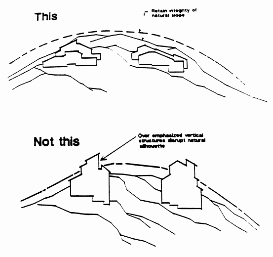
Figure 1-Building/Structure Placement
13.
All structures or uses in the R-H-zone shall be designed and located, and all hillside development permit approvals and administrative hillside development permit approvals shall be conditioned, to ensure compliance with the construction and grading standards set forth in Section 17.52.150, the architectural and site design standards set forth in Section 17.52.160 and the fire prevention and landscaping standards set forth in Section 17.52.170.
(Ord. 1994, § 1(Exh. A), 6-23-09; Ord. No. 1466, § 79, 3-28-23)
17.52.130 - Land divisions.
A.
Joint Application. No land division of any lot or parcel in the R-H-zone shall be approved unless and until all of the requirements of this title and Title 16 of this code (Subdivisions) have been met. Applications required pursuant to Title 16 for the development of a project must be submitted prior to or contemporaneously with hillside development permit or administrative hillside development permit applications filed pursuant to this chapter so that land divisions and tract improvements are not authorized in the R-H zone in the absence of both a land division approval under Title 16 and a permit under this chapter. It is not the intent of this provision to prevent custom-home development of land after it has been divided.
B.
Notice. In addition to all other hearing notices related to an application for a land division, at least ten days' notice by first class mail shall be given to the record owners of all real property located within one thousand feet of the boundaries of the subject property.
(Ord. 1994, § 1(Exh. A), 6-23-09)
17.52.140 - Design and development standards for land divisions.
The following design and development standards shall apply to all land divisions in the R-H-zone for which a hillside development permit is required by this chapter:
1.
The number and location of lots resulting from a land division shall be based upon findings that each of the environmental constraints described in this chapter, and all other significant environmental impacts identified upon environmental review of the application, have been avoided, eliminated or adequately mitigated. If such finding is not made, the subdivision application shall be denied.
2.
The maximum number of lots or parcels that may be permitted pursuant to a land division of an R-H-zoned property shall be calculated by multiplying the development limit factor (units/acre) by the area of the property in each slope category as follows, rounding the product down to the nearest whole number:
In addition, each lot resulting from such a land division must comply with all the requirements of this chapter, including subsections A and B above.
The following three examples are for the purposes of illustration: i) if a property is entirely in Slope Category 3, and has an area of 4.05 acres, the total number of lots which can be established thereon is two (.50 x 4.05 = 2.025, which is rounded down to two); ii) if a property contains one-half acres in Slope Category 2, plus 3.55 acres in Slope Category 4, for a total area of 4.05 acres, the total number of lots which can be established thereon is one (.5 x 2.00 = 1 plus .01 x 3.55 = .0355, for a total of 1.0355 which is rounded down to one); and iii) if a property contains 4.05 acres entirely in Slope Category 1, the total number of lots which can be established thereon is two (since the minimum parcel size is two acres pursuant to (C)(1) of this section.
3.
Each lot resulting from land divisions in the R-H-zone shall comply with the following minimum specifications:
a.
Application of the formula in subsection B of this section to the area and slope of the lot must produce a value of at least one;
b.
Have a minimum lot width of one hundred fifty feet;
c.
Have a minimum lot depth of one hundred fifty feet;
d.
Contain a minimum contiguous area within Slope Categories 1 through 3 of at least three thousand five hundred square feet;
e.
Be developable without requiring a variance from the standards of this title, other than a minor variance pursuant to Section 17.60.025 of this code; and
f.
Be a minimum of two acres in size.
4.
Grading in connection with a land division shall conform to the following requirements:
a.
The amount and location of grading shall be specified by a condition of the approval of the land division and shall be established by the reviewing authority so as to minimize alteration of natural land forms while allowing reasonable economic use of private property.
b.
Cut and fill operations to develop common infrastructure and other site improvements for the use or benefit of more than one lot in a land division shall not be permitted in excess of one thousand cubic yards times the number of lots in the subdivision unless specifically approved by the reviewing authority upon finding that:
a)
Such grading is necessary to obtain any reasonable use of the property proposed to be divided;
b)
Such grading operations will not be contrary to the purposes of this chapter; and
c)
Such grading will not create any condition likely to cause injury to persons or property.
c.
Total cut and fill operations for the use or benefit of any single lot in the subdivision (including the creation of a building pad, driveway and any retaining walls), must comply with the limitations of Subsection 17.52.120(A)(11), whether such grading is approved as part of a subdivision or as part of a subsequent hillside development permit or administrative hillside development permit.
d.
All utilities shall be placed beneath roads or other graded areas and no grading shall be permitted for the purpose of installing utilities alone.
5.
The lots resulting from a land division in the R-H-zone shall be designed and located, and all land division approvals shall be conditioned, to establish reasonable and regular lot boundaries and to comply with the construction and grading standards set forth in Section 17.52.150, the architectural and site design standards set forth in Section 17.52.160 and the fire prevention standards set forth in Section 17.52.170.
(Ord. 1994, § 1(Exh. A), 6-23-09)
17.52.150 - Construction, grading and drainage standards.
A.
Reserved.
B.
Final Grading Plan. A grading plan shall be submitted for approval in accordance with the provisions of this code, which shall comply with the following:
1.
No finished slopes steeper than fifty percent (2:1) shall be created; and
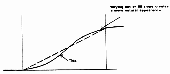
Figure 2-Varied Cut and Fill Slopes
2.
All grading operations shall be conducted and/or phased as approved by the reviewing authority, so that prompt re-vegetation of the graded area and/or prompt construction on pads created by such grading will eliminate the risk of erosion to the greatest extent possible;
3.
Soil necessary for use on cut and filled slopes may be stockpiled at approved locations on an R-H-zoned lot, during grading operations for a time specified pursuant to an approval under this chapter and pursuant to measures specified in that approval to mitigate air quality, aesthetic and other impacts;
4.
Grading operation shall be prohibited between October 15th of each year and April 15th of the next year to avoid adverse effects caused by rain conditions;
5.
Each grading permit shall include a plan for erosion control and silt retention;
6.
Drill holes and exploratory trenches for collection of geologic and soil data may be permitted without a grading permit by the director, provided that all such trenching shall be back filled in a manner approved in writing by the director; erosion protection shall be provided for any slopes which exceed twenty percent;
7.
Cut slopes for purposes of establishing a pad shall not exceed twenty feet in height. Fill slopes shall not exceed nine feet in depth at any point;
8.
Contour grading techniques shall be used to provide a variety of slope percentages and slope directions in a three-dimensional, undulating pattern similar to adjacent existing terrain. Hard edges left by cut and fill operations shall be given rounded appearances that closely resemble adjacent, natural contours as shown in Figure 3; and
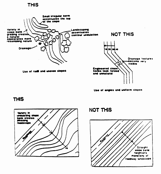
Figure 3-Contour Grading Techniques
9.
Where possible, graded areas shall be designed with manufactured slopes located on the uphill side of structures or with other techniques to hide the slope behind the structure as shown in Figure 4.
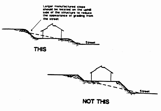
Figure 4-Manufactured Slopes
C.
Drainage. When a drainage plan is required, that plan shall be submitted for approval in accordance with the provisions of this code, and shall comply with the following:
1.
Debris basins, rip rap, and energy-dissipating devices shall be constructed and maintained on an R-H-zoned lot where necessary to reduce erosion. Except for necessary flood control, significant natural drainage courses shall not be altered by grading activity. If a drainage crossing is required, a natural crossing and bank protection shall be preferred over steel and concrete systems. Where brow ditches are required, they shall be naturalized with plants and native rock.
2.
Development of an R-H-zoned lot shall provide for the control of runoff in a manner approved by the reviewing authority.
3.
All cuts shall be drained in a manner approved by the reviewing authority.
4.
Cross-lot drainage may only be increased or concentrated if the reviewing authority finds that such increase or concentration will not adversely affect the use of the proposed lots and adjacent lots, and that cross-lot drainage is necessary to minimize grading. Where an increase or concentration of cross lot drainage occurs, one lot may drain across one other lot only if an easement is provided covering the entire area downstream of the site that is affected by said increase or concentration of drainage. Increased or concentrated stormwater runoff crossing lot lines shall be captured and conveyed within an improved, open V gutter which has a natural appearance.
5.
Drainage channels shall be placed in inconspicuous locations, and shall receive a naturalizing treatment including native rock, colored concrete and landscaping, so that the structure appears as an integral part of the environment, as shown in Figure 5; and
6.
Natural drainage courses shall be preserved and, if necessary, rehabilitated. Drainage features shall be incorporated as an integral part of lot and land division design.
7.
An erosion and sedimentation control plan shall be implemented as required pursuant to Section 7.08.030 and Section 15.48.300(D) of this code.
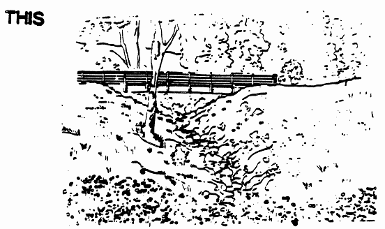
Figure 5-Drainage Channels
8.
All sites, regardless of size shall prepare and implement a Water Quality Management Plan, giving preference to non-structural Best Management Practices, as described in Development Planning for Storm Water Management - A Manual for the Standard Urban Storm Water Management, as prepared by Los Angeles County Department of Public Works, current edition. Best Management Practices shall not be limited to reduction of construction-related impacts, but shall include permanent measures to reduce rainfall runoff from each site, and shall ensure that rainfall emanating from the site shall be free from contamination from silt, fertilizers, pesticides and other contaminants. Where applicable, the landscape plan shall demonstrate where these BMPs shall be located.
D.
Retaining walls associated with a pad proposed by any application pursuant to this chapter shall be located and designed as follows:
1.
Walls located upslope from a building or structure shall not exceed four feet in height. Terraced retaining structures may be used when separated by at least three feet and screened by appropriate landscaping as approved by the reviewing authority as shown in Figure 6. The total height of an upslope wall system shall be no more than twenty feet.
2.
Walls located downslope from a building or structure shall not exceed three feet in height from the daylight line. Where an additional retained portion of the lot is necessary due to unusual or extreme conditions, such as lot configuration, steep slope or road design, then the use of terraced retaining structures shall be considered on a lot-by-lot basis. Terraced walls shall not exceed three feet in height and shall be separated by at least three feet and screened by appropriate landscaping as approved by the reviewing authority as shown in Figure 6. The total height of a downslope wall system shall be no more than nine feet. The top of a retaining wall system shall be separated from any other structure by a distance at least equal to the height of the retaining wall system.
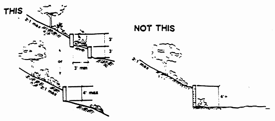
Figure 6-Retaining Walls
3.
Retaining walls which are an integral part of a building or structure shall not exceed eight feet in height. Visual impacts of such a building or structure shall be mitigated by contour grading and landscaping techniques as approved by the reviewing authority.
(Ord. 1994, § 1(Exh. A), 6-23-09)
17.52.160 - Architectural and site design standards.
Any construction or development approved pursuant to this chapter shall comply with the following architectural and site design requirements:
A.
Site Design.
1.
The dimensions of a building parallel to the direction of an adjacent slope shall be maximized to limit grading and to better fit the building to the natural terrain as shown in Figure 7.
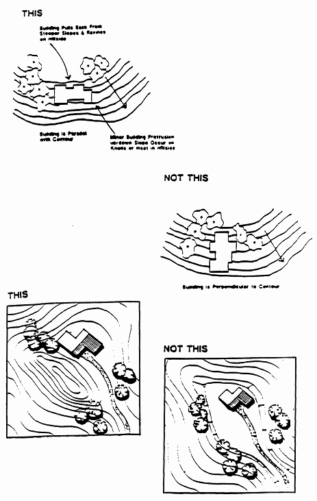
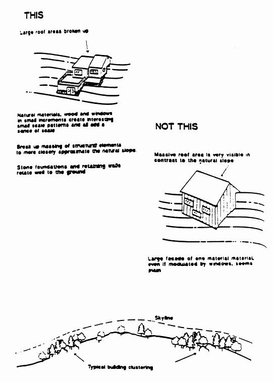
Figure 7-Architectural Controls
2.
Building design shall be sensitive to the natural terrain, and buildings shall be located to minimize grading and to preserve natural features.
3.
Buildings and structures shall be oriented to preserve significant views from neighboring properties to the greatest extent feasible.
4.
The conditions of approval of a land division shall require development of the R-H-zoned lots resulting from the land division to use techniques such as variable setbacks, multiple orientations and other site-planning techniques, to preserve open space and protect natural features.
5.
Development of R-H-zoned lots shall use permanent measures, beyond construction Best Management Practices, to reduce rainfall runoff from each site, to ensure that rainfall emanating from the site shall be free from contamination from silt, fertilizers, pesticides and other contaminants, and provide for the recharge of groundwater to the greatest extent feasible.
B.
Architectural Standards.
1.
Buildings shall be terraced to follow the slope of a pad.
2.
All sides of each building visible from adjacent properties or public or private rights-of-way shall be designed with architecturally compatible treatments and materials.
Building Envelope for Cross Lot Slope
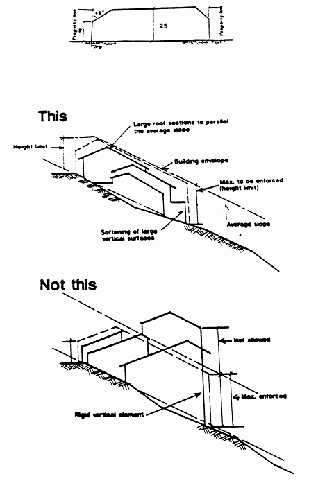
Figure 8-Cross Lot Building Envelope
3.
The form, mass and profile of buildings, structures and architectural features shall be designed to blend with the natural terrain and to preserve the character and profile of natural slopes. The following techniques are recommended:
a.
Split pads, stepped footings and grade separations to permit structures to step up the natural slope as shown in Figure 9;
b.
Detaching parts of a dwelling, such as a garage;
c.
Avoiding gable ends on downhill elevations. The slope of a roof should be oriented in the same direction as the natural slope and should not exceed natural slope contour by twenty percent or more;
d.
Use of below-grade rooms to reduce building mass and provide energy-efficient and environmentally desirable spaces;
e.
Use of roofs on lower levels as decks serving higher levels.
f.
Use of green building standards to the extent feasible and where consistent with the purposes of this chapter.
4.
Excessive cantilevers on downhill elevations shall be avoided.
5.
The visible areas of a building shall be minimized by grading and landscaping techniques.
6.
Building materials and color schemes shall blend with the natural landscape of earth tones and natural chaparral.
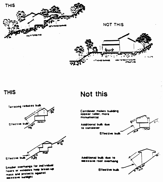
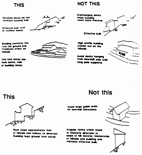
Figure 9-Form, Mass and Profile
C.
Height Restrictions. The building envelope for each building on an R-H-zoned lot shall comply with the following:
1.
The following height restrictions shall apply:
a.
Downhill Lot. Building height shall not exceed twenty-five feet as measured from the lower of natural grade or existing grade at any point on the structure. Building height shall not exceed fifteen feet at the side setback lines of the lot, and shall not exceed the height of a plane extending from a height of fifteen feet at the side setback line up towards the center of the lot at a forty-five degree angle, as shown in Figure 10.
Building Envelope for Downhill Lot
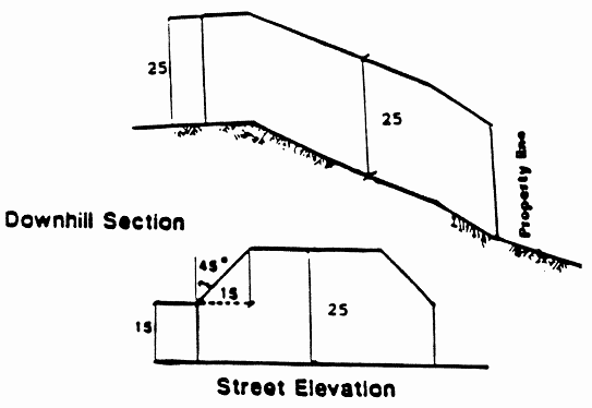
Figure 10-Downhill Lot Building Envelope
b.
Uphill Lot. Building height shall not exceed twenty-five feet as measured from lower of natural grade or existing grade at any point on the structure. Building height shall not exceed fifteen feet at the front setback line of the lot and shall not exceed the height of a plane extending from a height of fifteen feet at the front setback line up and toward the rear of the lot at a forty-five degree angle. Building height shall not exceed fifteen feet at the side setback lines of the lot, and shall not exceed the height of a plane extending a height of fifteen feet at the side setback line up towards the center of the lot at a forty-five degree angle, as shown in Figure 11.
Building Envelope for Uphill Lot
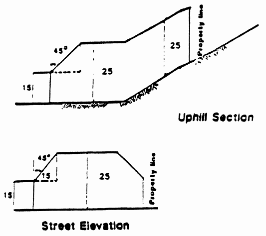
Figure 11-Uphill Lot Building Envelope
c.
Cross Slope Lots. Building height shall not exceed twenty-five feet, as measured from the lower of natural grade or existing grade, at any point on the structure. Building height shall not exceed fifteen feet at the side setback lines of the lot, and shall not exceed the height of a plane extending a height of fifteen feet at the side setback line up towards the center of the lot at a forty-five degree.
2.
For additions or remodels to existing structures, the height restrictions in this section shall be determined based upon the grade of the existing slope, rather than the grade of the natural slope, unless the reviewing authority finds that doing so would impair the purposes listed in Section 17.52.010.
(Ord. 1994, § 1(Exh. A), 6-23-09)
17.52.170 - Fire prevention and landscaping standards.
A.
Fire Plan. Where required, a fire plan shall be approved in conjunction with any approval under this chapter to protect persons and property and shall include required planting of fire-resistant vegetation and other appropriate regulations, including the following:
1.
Roofing. Roofs of all buildings and structures shall be constructed and maintained of noncombustible materials; and shall be constructed and maintained of color(s) that blend with the natural landscape;
2.
Eaves. Open eaves shall be prohibited to prevent the nesting of birds or placement of other combustible material within the roof area;
3.
Exterior Wall Surfaces. All exterior walls of buildings shall be surfaced with noncombustible, fire-retardant or fire-resistant materials and shall be constructed and maintained of color(s) that blend with the natural landscape; and exterior structural supports and undersides of floors and decks not enclosed by walls shall be constructed so as to provide for fire safety and to adequately address aesthetic considerations; and the undersides of any exterior floors, decks, balconies, etc., shall be enclosed with a three-hour-rated wall;
4.
Overhangs. Balconies, patios, roofs, eaves and other similar overhangs or projections shall be constructed of noncombustible material or shall be protected by fire-retardant or fire-resistant materials;
5.
Sprinkler Systems. All enclosed spaces shall be protected by a fire sprinkler system;
6.
Fuel Modification/Brush Control. Owners and occupants shall comply with all applicable provisions of an approved fuel modification/brush control program. If an owner or occupant of any lot believes that compliance with the fuel modification/brush control program is impracticable because of difficult terrain, danger of erosion, or other unusual circumstance, he or she may apply, in writing, to the planning commission for a suspension or modification of the program as applied to his or her lot. If the planning commission finds that such compliance is impractical, it shall authorize such a suspension or modification of the program as it applies to that lot but may not authorize a violation of any other ordinance of the city or other applicable law; and
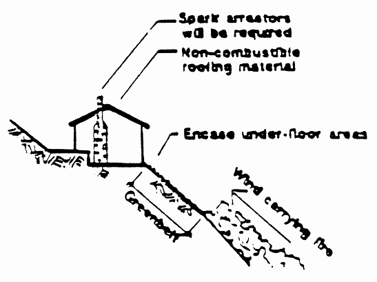
Figure 12-Fuel Modification/Brush Control
7.
The existence of a swimming pool on a property shall be marked on the curb in front of the property in a manner approved by the fire department.
B.
Fencing and landscaping plans. Where required, prior to the issuance of any building permit for development of any R-H-zoned lot, a final fencing and landscaping plan consistent with any prior approvals shall be submitted for review and approval. Except as otherwise required by an approval issued pursuant to this chapter, the reviewing authority for such plan shall be the director. (See Figure 13)
1.
Walls and fences shall be subject to the height limits applicable to walls and fences in the R-1 zone.
2.
Fencing and landscaping plans shall include fire-retardant materials and plantings, with minimal irrigation systems, to comply with water conservation measures and to provide natural habitat and erosion control.
3.
All new plant materials shall conform to the city's list of recommended and prohibited plant materials, as adopted by resolution of the city council and amended from time to time.
4.
Site improvements shall utilize permeable materials wherever site conditions permit.
5.
Landscaping plans shall include the following:
a.
The total square footage of all landscaped areas and square footage of each landscaped area;
b.
Percentage of the lot devoted to landscaping;
c.
The type of plant materials, i.e., the botanical and common names;
d.
Location, container size and number of all new plant materials;
e.
The use of native or adapted plants;
f.
The total square footage of all hardscape areas and square footage of each hardscape area;
g.
The type of hardscape materials and the permeability of each;
h.
An irrigation plan that minimizes use of potable water by at least one of the following strategies: drought-resistant landscaping, irrigation with captured rainwater, recycled gray water, or non-potable water, high-efficiency equipment, or climate-based controllers;
i.
Type, size, and location of a permanent irrigation system adequate for the proposed landscaping;
j.
Demonstrated compliance with the fire plan approved for the site pursuant to Sction 17.52.170(a), including fuel modification and brush control areas;
k.
Undisturbed, natural areas; and
l.
A lighting plan that demonstrates exterior lighting does not allow light trespass across property lines and is shielded to direct illumination downward, away from adjacent properties;
6.
Perimeter fencing may not enclose more than seven thousand two hundred square feet or be placed in any area within Slope Category 4.
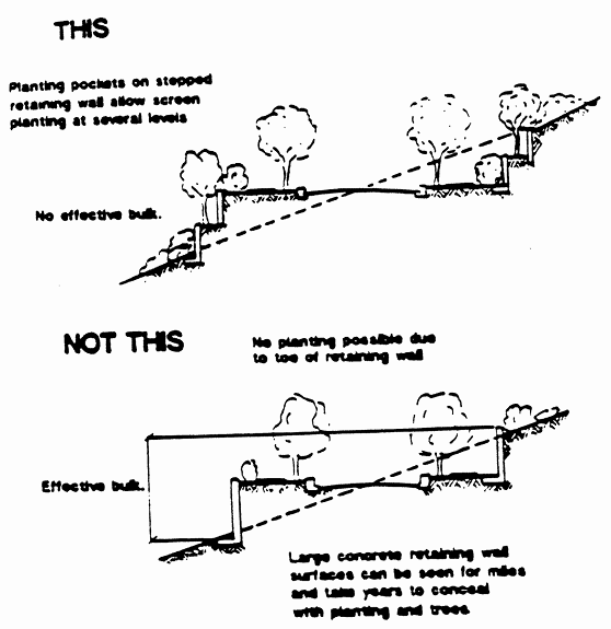
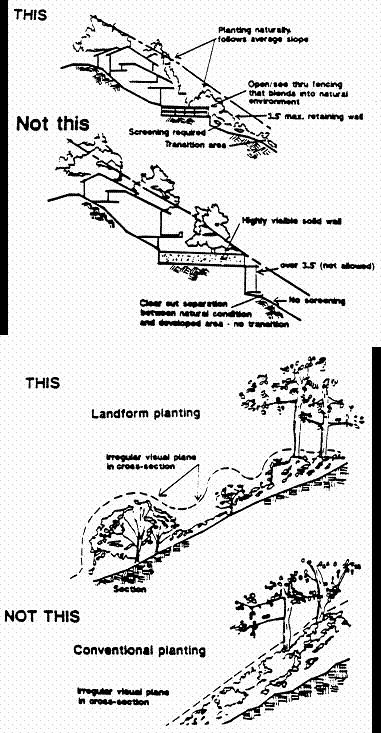
Figure 13-Fencing and Landscaping
(Ord. 1994, § 1(Exh. A), 6-23-09)
17.52.180 - Biotic resources management plan.
Where required, a biotic resources management plan shall be prepared by a biologist or other qualified professional and shall include the following:
a.
Biotic Assessment. A complete assessment of flora and fauna within and adjacent to the project area, with particular emphasis upon identifying endangered, threatened, and locally unique species, as well as sensitive and critical habitats;
b.
Impacts. A discussion of direct, indirect and cumulative impacts anticipated to adversely affect biological resources;
c.
Mitigation Measures. An identification of effective mitigation measures to reduce such impacts to levels of insignificance, preserve and encourage native plant species and prohibit non-native, invasive plant species. Mitigation measures shall also address potential adverse impacts from any increased runoff, sedimentation, erosion and urban pollutants on streams, watercourses and sensitive habitats on or near the project site;
d.
No Net Loss of Sensitive Habitats. The identified mitigation measures shall observe state and federal policy regarding wetland and other habitat values. In addition, the plan shall discuss project alternatives to minimize adverse impacts to wildlife and to benefit wildlife and wildlife habitat. Mitigation measures shall include elimination of non-native, invasive plant species and preservation and placement of native plant species. Projects affecting watercourses shall incorporate stream buffer areas to be maintained in a natural condition through nonstructural flood control methods to maintain their value as wildlife corridors;
e.
Permits. If state and federal permits are required for a project, the biotic resource manage plan shall include a discussion of the necessary biological permits (including but not limited to permits administered by the following agencies or pursuant to the following programs: California Department of Fish and Game, California Fish and Game Code Section 1600, United States Army Corps of Engineers, U.S. Department of the Interior Fish and Wildlife Service, and Clean Water Act, Section 404). The plan shall satisfy any applicable requirements of the California Environmental Quality Act and State and Local CEQA Guidelines.
(Ord. 1994, § 1(Exh. A), 6-23-09)
17.52.190 - Effect of approved plans.
A.
When a plan required by this chapter, e.g., a land division, building plan, grading plan, fire plan, fencing and landscaping plan, or any other plan, has been reviewed and approved as provided in this chapter, the owners and occupants of the lot to which the plan applies, shall comply in all respects with that plan and shall not permit any other person to fail to do so.
B.
In addition to the other remedies provided by this code or other applicable law, any failure to comply with an approved plan as specified in paragraph A of this section shall be grounds for the revocation of any approval granted hereunder with respect to the property with respect to which the violation occurred.
C.
A hillside development permit or administrative hillside development permit granted in compliance with this chapter shall run with the land and continue to be valid upon a change of ownership of the site, activity, use or structure that was the subject of the permit. All terms and conditions of the entitlement shall be binding upon any new owners, whether or not recorded against title.
(Ord. 1994, § 1(Exh. A), 6-23-09)
17.52.200 - Lighting.
All lighting of the buildings, structures, landscaping, yards, parking areas, or similar facilities shall be in compliance with the city's "Dark Sky" objectives and policies. Lighting shall be shielded and directed downward to reflect away from adjoining properties.
(Ord. No. 1413, § 5, 5-28-19)
Editor's note— Section 5 of Ord. No. 1413, adopted May 28, 2019, set out provisions designated as § 17.52.180. Inasmuch as section so numbered already exists, said provisions have been redesignated as § 17.52.200 to avoid duplication, at the discretion of the editor.