
Silverton City Zoning Code
ARTICLE 2
Zoning Districts
Sec. 15-2-10. - Zoning districts established.
To implement the Master Plan and the purposes and provisions of this Land Use Code, the Town has established the following zoning districts.
(Ord. No. 2025-01, § 2(Exh. A), 1-27-2025)
Sec. 15-2-20. - Compass master plan implementation.
(a)
Table Section 15-2-2 identifies which zoning district(s) appropriately implement(s) a given future land use category identified in the Future Land Use Framework of the Compass Master Plan.
(b)
A future land use category is a broadly identified and can be implemented through more than one zoning district. A dot indicates that the zoning district presumptively implements the corresponding land use category designation and is therefore an appropriate option for zoning or rezoning of land within that designated area on the Future Land Use Framework. The Town Administrator may also interpret the Future Land Use Framework to allow the inclusion of other proposed zoning districts based on the consistency of the development scale and uses allowed in the proposed zoning district with existing, proposed, or allowed development on abutting and adjacent lots.
(c)
A blank cell (no dot) indicates that the zoning district is not an appropriate option for zoning or rezoning of land within the corresponding land use category.
(Ord. No. 2025-01, § 2(Exh. A), 1-27-2025)
Sec. 15-2-30. - Official zoning map.
The boundaries of the zoning districts are delineated on the Official Zoning Map. The Official Zoning Map shall be available on the Town website and an official copy shall be on file in the Town Clerk's office.
(Ord. No. 2025-01, § 2(Exh. A), 1-27-2025)
Sec. 15-2-40. - Interpretation of district boundaries.
The following rules shall be applied as necessary to interpret the Zoning Map. Rules of interpretation may be applied either singularly or jointly, as needed.
(a)
Zoning district boundaries shall be located on municipal corporate lines, section lines, parcel lines, lot lines, natural feature boundary lines or on the center lines of highways, streets, alleys, railroad rights-of-way, water bodies (natural and man-made), or ditches or these lines extended. Boundaries that appear to follow an established line shall be construed to follow the line.
(b)
In cases where these lines are not used, the zoning district lines shall be as determined by using the Zoning Map scale.
(c)
Rights-of-way are not zoned unless vacated. Vacated right-of-way is zoned with the same district as the parcel into which it is incorporated or next to which it is adjacent. If a vacated right-of-way is adjacent to two or more zoning districts the Town Administrator shall interpret the application of the Zoning Map.
(d)
If a lot or zoning lot is divided by a zoning district boundary line at the time of enactment of this Code or by subsequent amendments, the appropriate standards and uses for the zoning district that comprises the majority of the parcel area shall apply to the entire lot or zoning lot. If the lot or zoning lot is divided equally, the Town Administrator may adjust the district boundary to apply a single district to the property. The adjustment shall be made in consideration of adjacent zoning, land uses, and compliance with the Master Plan. The Town Administrator may refer the interpretation of a zoning district boundary to the Board of Trustees if the determination has the potential to create significant impacts on adjacent properties.
(Ord. No. 2025-01, § 2(Exh. A), 1-27-2025)
Sec. 15-2-50. - Base zoning districts and dimensions.
(a)
Summary of Zoning District Dimensional Standards.
(1)
All new development and redevelopment shall comply with the standards in Table Sec. 15-2-3 unless another section of this Code provides an alternative standard for a particular use, layout, or development type. Sections of this Code that may provide alternative standards include but are not limited to Section 15-3-50, Use-Specific Standards.
(2)
All standards in Table Sec. 15-2-3 shall apply to the zoning lot.
(b)
Single-Unit Attached Lots.
(1)
The minimum lot area for exterior units shall be 2,500 square feet and the minimum lot area for interior units shall be 2,000 square feet. If there are only two units included in the primary structure, both units shall be considered exterior units.
(2)
The minimum lot width for exterior units shall be 25 feet and the minimum lot area for interior units shall be 20 feet.
(3)
Side setbacks shall only apply to the perimeter of a single-unit attached structure and not to individual townhouse/rowhouse lots.
(c)
Lots Less Than 2,500 Square Feet. Existing lots less than 2,500 square feet in area may be developed if:
(1)
The subject lot was established on the original Town Plat or prior to the Effective Date; and
(2)
The lot meets all standards required by Table Sec. 15-2-3: Zoning Districts Dimensional Standards Summary, excluding minimum lot area and minimum lot width.
(d)
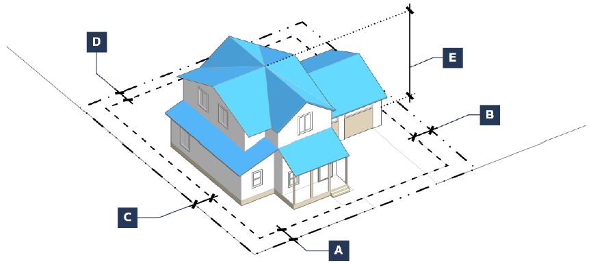
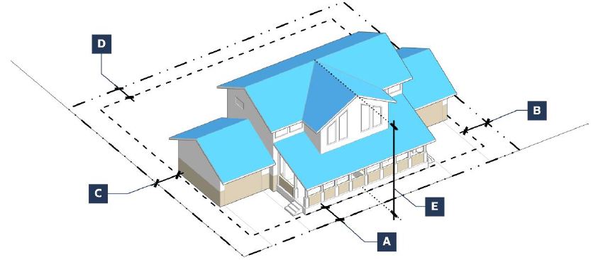
Graphics.
(1)
Each base zoning district is accompanied by representative photos and a graphic depicting how the lot and building standards apply to lots and building forms within the respective district. The photos and graphics are intended to represent the general character of development within the district.
(2)
The graphics are not regulatory and are not to be compared to the visual look of a proposed development.
(3)
The graphics do not reflect all standards from the Code that may apply to a project and are intentionally conceptual versus detailed.
(e)
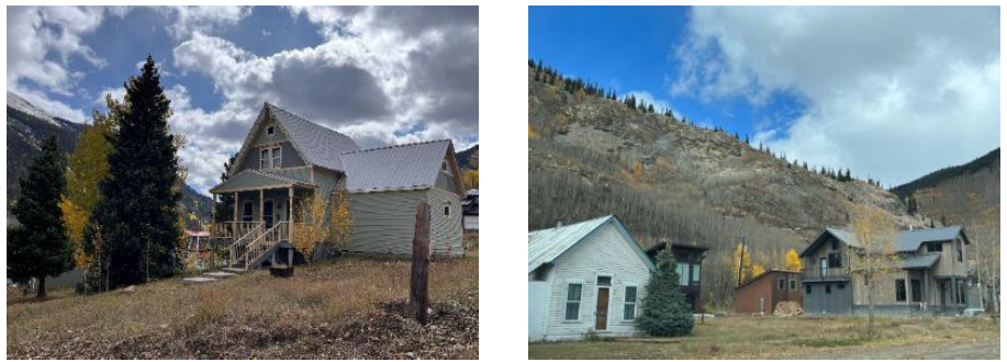
R-1: Neighborhood Residential.
(1)
Purpose. This district is designed to accommodate single-unit and duplex dwellings as well as limited public or civic uses. It is intended for application in the existing predominantly residential areas in Town identified for single-unit and duplex housing infill in the Master Plan.
(2)
Dimensional Standards.
(f)
R-2: Mixed Residential.
(1)
Purpose. This district is designed to accommodate a variety of housing types including single-unit detached and attached, duplex, triplex, fourplex, and multiunit dwellings as well as limited public or civic uses. It is intended for application as transition areas between neighborhood residential and mixed-use districts identified for housing infill and neighborhood mixed-use in the Master Plan.
(2)
Dimensional Standards.
(g)
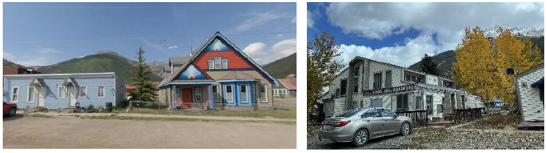
MU-1: Downtown Mixed-Use.
(1)
Purpose. This district is designed to accommodate a variety of commercial, service, entertainment, and residential uses in the historic core of Silverton in a pedestrian-oriented setting, following the design character and patterns of the downtown area. It is intended for application in the business/mixed use area as identified in the Master Plan.

(2)
Dimensional Standards.
(h)
C-1: Gateway Commercial.
(1)
Purpose. This district is designed to accommodate a mix of retail and commercial services, creative spaces, office, and other supportive uses to meet the needs of residents and tourists. A mix of higher-density and second story housing types are also allowed to provide for live/work opportunities. It is intended for application in the business/mixed use and neighborhood mixed-use areas identified in the Master Plan around the two gateway entrances to town.

(2)
Dimensional Standards.
(i)
C-2: Employment Commercial.
(1)
Purpose. This district is designed to accommodate a variety of businesses and activities, including industrial and manufacturing activities, as well as supporting office and commercial uses. It is intended for application on nonresidential lots in the southeastern portion of town identified for neighborhood mixed-use in the Master Plan.
(2)
Dimensional Standards.
(j)
P: Public.
(1)
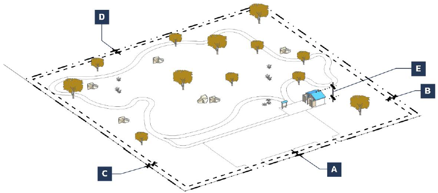
Purpose. This district is designed to accommodate public and quasi-public uses and activities such as parks, open spaces, trails, community centers, or public safety facilities. It is intended for application in the areas identified for recreation in the Master Plan.

(2)
Dimensional Standards.
(Ord. No. 2025-01, § 2(Exh. A), 1-27-2025)
Sec. 15-2-60. - Exceptions and encroachments.
(a)
Permitted Encroachments into Setbacks. Certain building and site features listed in the table below may extend into the required building setback limits for each zoning district.
(b)
Permitted Exceptions to Height Limitations. Certain building and site features listed in the table below may exceed the maximum height limitation established for each zoning district.
(Ord. No. 2025-01, § 2(Exh. A), 1-27-2025)
Sec. 15-2-70. - Planned unit development (PUD).
(a)
Purpose.
(1)
The purpose of this Section is to:
a.
Encourage development that contains unique or innovative design features;
b.
Enhance unique, natural, resource or scenic features;
c.
Preserve open spaces; and
d.
Allow the negotiation of a specialized zoning district in exchange for development that implements the Master Plan goals and the intent of this LUC.
(b)
Applicability.
(1)
This district is intended to be used only when no other base or overlay district in this Code, and no combination of those districts, can be used to approve a new development that provides substantial additional benefits to the Town that would not otherwise be required by this Code.
(2)
PUD rezoning is prohibited when used only to change development standards, such as sign requirements.
(c)
Eligibility to Apply for a PUD.
An application for rezoning to a PUD zoning district shall comply with all of the following requirements.
(1)
The PUD shall:
a.
Address a unique, site-specific situation; or
b.
Confer a substantial benefit to the Town, representing an improvement in quality over what could have been accomplished through application of the applicable base district or development standards. Improvements in quality may include, but are not limited to:
(i)
Improvements in open space provision and access;
(ii)
Environmental protection;
(iii)
Protection or improvement of a historic structure that would not otherwise be required to be preserved or improved;
(iv)
Efficient provision of streets, roads, and other utilities and services; or
(v)
Provision of affordable housing as defined by this LUC.
(2)
Permitted uses may not be changed through the PUD process.
(d)
Relationship to Zoning and Subdivision.
(1)
Default Zoning District(s).
a.
The approval of a PUD application creates a new base zoning district, subject to a new Overall Development Plan, that replaces the existing base district for the property. Approval of a PUD district may not occur without simultaneous approval of an Overall Development Plan.
b.
The Overall Development Plan shall identify one or more existing base zoning district(s) applicable to each portion of the property, referred to as the default zoning district(s).
(i)
The application may identify different default zoning districts for different portions of the property.
(ii)
Each PUD application may identify proposed modifications to the Code standards, including but not limited to setbacks, lot area, and site and building design standards, through the Overall Development Plan.
(iii)
The standards applicable to each identified default zoning district shall apply to that portion of the property unless the PUD application requests, and the Town approves, a specific different standard or provision for that portion of the property.
c.
Following approval of a PUD and Overall Development Plan, review and approval of a Site Plan is required for any portion of the property subject to development, pursuant to Section 15-8-30(l).
(2)
Subdivision.
a.
A PUD application may request both rezoning and subdivision approval for all or part of the property, in which case:
(i)
The Overall Development Plan shall be accompanied by a Preliminary Plan for a major subdivision meeting the requirements of Section 15-8-40(k)(3); and
(ii)
The review and public hearing requirements for the approval of a PUD shall also constitute review and approval of the Preliminary Plan for the subdivision, and a separate process for review and approval of a major subdivision as described in Section 15-8-40(k) shall not be required.
(3)
Post-Approval Actions.
a.
Following approval of a PUD and related major subdivision Preliminary Plan, no development of the property or sale of any lots may occur without Town approval of a Final Plat pursuant to Section 15-8-40(k)(4).
b.
Following approval of a PUD, an applicant may request simultaneous approval of a Final Plat and Site Plan for all or part of the property.
(e)
Rezoning to PUD. Zoning Map Amendment (PUD) applications shall follow the review procedures in Section 15-8-40(o)(3)b.
(Ord. No. 2025-01, § 2(Exh. A), 1-27-2025)
Sec. 15-2-80. - Overlay zoning districts.
(a)
Historic District Overlay.
(1)
Purpose. The purpose of the Historic District Overlay is to create a reasonable balance between private property rights and the public interest in preserving the Town's unique historic character, centered around downtown, while promoting the public health, safety, and welfare through:
a.
The protection and preservation of the Town's historic and cultural heritage as represented through the establishment of the Town's Historic Register;
b.
The protection and enhancement to quality of life and of the Town's economy through the preservation of historical attractions for local residents, tourists, and visitors; and
c.
The expansion of public awareness, appreciation, and knowledge of the Town's unique local history.
(2)
Applicability. This Section shall apply to all properties within the Historic District Overlay boundaries. These properties shall retain the uses of and are subject to the underlying base zoning district in addition to the standards of this Section.
(3)
Establishment of the Town's Historic Register.
a.
The Town of Silverton's Register of Historic Places (the "Town's Historic Register") is hereby established as the Historic District Overlay.
b.
Properties may be added to the Historic District Overlay and therefore listed in the Town's Historic Register only if the property or district has been so designated pursuant to Section 15-8-40(d).
c.
All properties listed in the Colorado State Register of Historic Properties and the National Register of Historic Places are eligible for the Town's Historic Register but are not designated until approval, pursuant to Section 15-8-40(d).
(4)
Historic District Overlay Map. The Historic District Overlay map shall be available on the Town of Silverton's website and an official copy shall be on file in the Town Administrator's office. The Town shall maintain a current record of all pending designations which shall be on file in the Town Clerk's office. Any changes shall be reported to the State Historic Preservation Officer.
(5)
Maintenance. No owner, lessee, or occupant of any property within the Historic District Overlay shall fail to prevent significant deterioration of the exterior of the building, structure, object, or special feature beyond the condition of the property within the Historic District Overlay.
(6)
Demolition. In order to demolish or partially demolish a property within the Historic District Overlay, the property owner shall apply for a Historic District Overlay Review, Major prior to demolition per Section 15-8-40(g). The Town Administrator may limit this requirement to Contributing Properties.
(7)
Design Standards for All Development in the Historic District Overlay.
a.
Greene Street Mixed-Use Required.
(i)
All new development or redevelopment of structures that abut Greene Street shall maintain an active principal nonresidential use on the ground floor of the building. An active principal nonresidential use shall be defined as a land use that tends to have or encourage interaction between the use and pedestrians on a street, including entering and exiting the use, and viewing activity and/or merchandise inside the use from a street. It does not include ground floor parking areas, storage areas, utility facilities, or stairwells that are not accessible from the street.
(ii)
The entirety of the ground floor shall be built to commercial building standards according to the Town's adopted building code.
(iii)
The principal nonresidential space shall have a minimum depth of 20 feet measured from the front of the building to the inside wall opposite of the street frontage. The remaining ground floor area and upper stories may contain residential dwelling units.
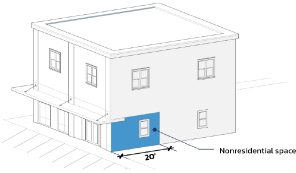
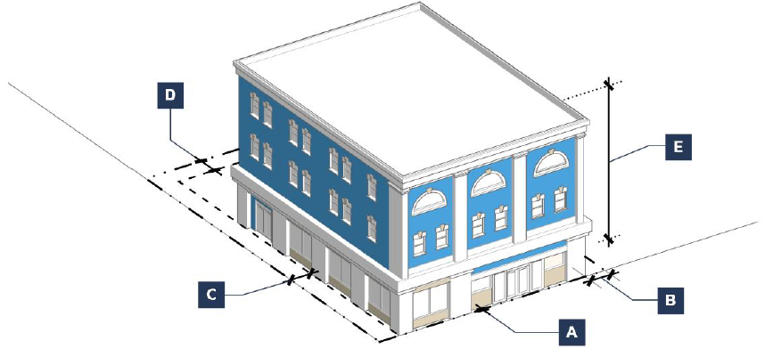
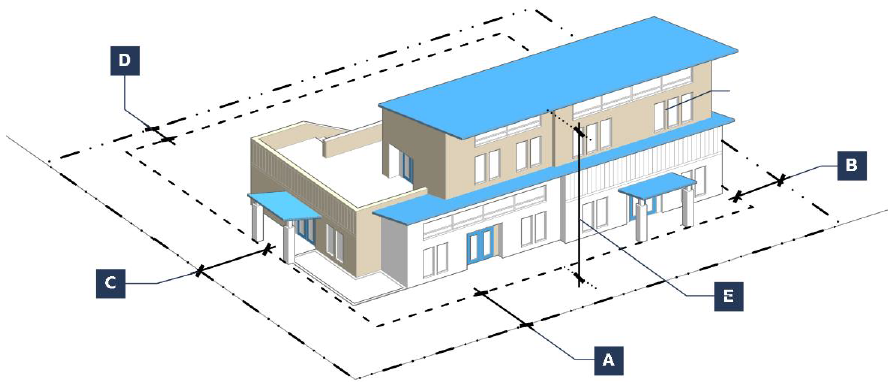
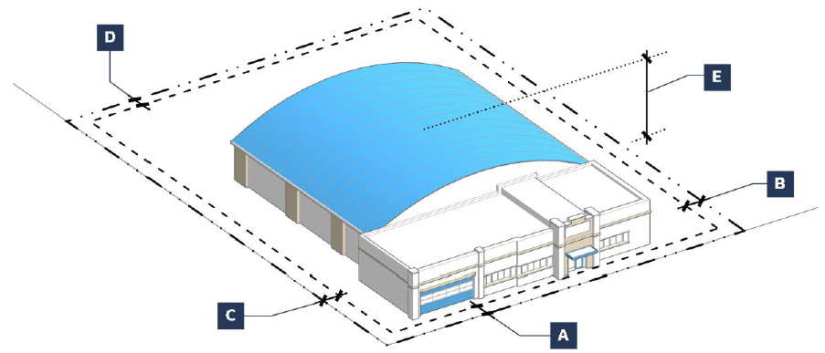
Figure Sec. 15-2-1: Minimum Nonresidential Space Depth
b.
Build-to Line (Distance from Property Line).
(i)
All buildings shall be constructed to a build-to line at the back of the sidewalk.
(ii)
Building facades may be recessed if an arcade or similar covered passageway abuts the front setback.
(iii)
Existing structures located behind the build-to-line (e.g., further into the lot interior) may be modified provided the setback is not increased.
c.
Architectural Projections. Architectural projections, including cornices, balconies, canopies, awnings and entry features, may encroach into public rights-of-way where contextually appropriate, subject to Public Works approval prior to submitting a Building Permit.
d.
Blank Walls. Blank, windowless walls are prohibited on any street frontage, except for structures adjacent to undeveloped or vacant lots. If blank walls cannot be avoided, design accents such as pilasters or other facade articulations should be utilized to reduce the overall wall mass.
e.
Screening. All HVAC systems, exhaust pipes or stacks, elevator housing, satellite dishes and other telecommunications receiving devices shall be screened from street-front and corner lot view. Solar energy devices such as panels are exempt from this requirement.
(8)
Additional Design Standards for New Construction and Non-Contributing Property. New construction and Non-Contributing Property within the Historic District Overlay shall be differentiated from the Contributing Properties but shall be compatible with the historic materials, features, size, scale and proportion, and massing to protect the integrity of the Historic District Overlay and its environment. When included as part of the building design, elements that may be reviewed to establish consistency with the district and adjacent buildings include, but are not limited to:
a.
Kickplates;
b.
Plate glass commercial windows;
c.
Window head and sill details;
d.
Oriel windows;
e.
Paneled entry doors with transom above;
f.
Columns with bases and capitals;
g.
Belt course elements;
h.
Quality of materials and craftsmanship;
i.
Sidelights;
j.
Storefront cornice (denials, brackets, corbels);
k.
Upper cornice and parapet detail (corbelled treatments); and
l.
Signage.
(9)
Additional Design Standards for Contributing Properties.
a.
Compliance with Secretary of the Interior's Standards. In addition to the standards set forth in this Section, all exteriors of Contributing Properties including new additions in the Historic District Overlay shall comply with the Secretary of the Interior's Standards for the Treatment of Historic Properties: Standards for Rehabilitation as set forth in 36 CFR Part 68. The Guidelines for Rehabilitating Historic Buildings are advisory and should be used to assist in applying the Standards.
b.
Facade Treatments. Large buildings shall be articulated or designed to resemble the character and scale of the original buildings in the district, with each storefront 50 feet wide or less.
c.
Entries.
(i)
On the first floor, entries shall incorporate glass doors and large, vertically oriented store front windows and front entry doors shall be recessed. The Town Administrator or Historic Preservation Committee may approve an alternative design if the design provides equivalent or superior results than compliance with the established standards of this Section.
(ii)
Entries shall be designed to adequately protect from falling snow. Snow guards shall be installed where necessary and as required by the Building Official.
d.
Windows. Windows on all stories shall be vertically oriented and organized in a symmetrical, balanced, and regular pattern. The Town Administrator or Historic Preservation Committee may approve an alternative design if the design provides equivalent or superior results than compliance with the established standards of this Section.
(Ord. No. 2025-01, § 2(Exh. A), 1-27-2025)