
Star City Zoning Code
CHAPTER 3
ZONING DISTRICT STANDARDS
ARTICLE C: - ADDITIONAL COMMERCIAL AND OFFICE DISTRICT STANDARDS[1]
(Amended by Ord. 404-2024 on 6/18/2024)
ARTICLE E: - ADDITIONAL MIXED-USE DISTRICT STANDARDS[2]
(Amended by Ord. 404-2024 on 6/18/2024)
8-3A-1: - Zoning Districts and Purposes Established
The following zoning districts are hereby established. For the interpretation of this title, the zoning districts have been formulated to realize the general purposes as set forth in this title. In addition, the specific purpose of each zoning district shall be as follows:
(A) AGRICULTURAL DISTRICT: To provide for agricultural use with parcels that are 5 acres or larger in size. May include active agriculture, viticulture, equestrian, and residential. Uses include native open space and active farmland. The agricultural land use is not amenity based (sewer, water, schools) and will usually be located away from goods and services. These areas encourage the keeping and raising of crops and/or animals and do not necessarily include manicured yards, sidewalks, bike paths, streetlights or planned park and recreation facilities. Density may be limited due to the limited availability of infrastructure. Wells and septic systems should be permitted for lots in this land use designation if approved by the applicable Health Department. Easements of at least 20-feet in width shall be provided where determined necessary for the future extension of water and sewer mains. Modified street sections and a reduction in light pollution (by reducing or eliminating lighting standards) may be offered for a more rural feel. Private streets may be permitted in this district for access to newly subdivided or split property. This district does allow for some commercial uses as specified in 8-3A-3.
(RR) RURAL-RESIDENTIAL DISTRICT: To provide for rural single-family residential use adjacent to agricultural uses, adjacent to other Rural Residential type uses, and adjacent to BLM land areas. Parcels are to be two acres minimum. It is the intent of this land use designation to help to preserve Star's rural feel. Huge manicured "Rural Residential" lots are discouraged and therefore manicured home site areas on these properties should not exceed 1/2 acre. Uses may include active agriculture, viticulture, equestrian, and residential. Uses include native open space and small-scale active farmland. The Rural Residential land use is not amenity based (sewer, water, schools) and will usually be located away from goods and services. These areas encourage the keeping and raising of small-scale crops and/or animals and do not necessarily include manicured yards, sidewalks, bike paths, streetlights or planned park and recreation facilities. Density may be further limited due to the limited availability of infrastructure. Modified street sections and a reduction in light pollution (by reducing or eliminating lighting standards) may be offered for a more rural feel. Private streets may be permitted in this district for access to newly subdivided or split property. This land use designation is to be located such that it does not block extension of urban services at reasonable costs. Wells and septic systems should be permitted for lots in this land use designation if approved by the applicable Health Department. Easements of at least 20-feet in width shall be provided where determined necessary for the future extension of water and sewer mains. This district does allow for some commercial uses as specified in 8-3A-3.
(R) RESIDENTIAL DISTRICT: To provide regulations and districts for various residential neighborhoods. Gross density in a Residential (R) district shall be determined according to the numeral following the R. The numeral designates the maximum number of dwelling units per acre. In zoning designations of R-1, R-2, R-3, R-4 and R-5, housing shall be single family detached unless approved with a PUD or development agreement. Connection to municipal water and sewer facilities are required for all subdivision and lot split applications submitted after the effective date hereof in all districts exceeding one dwelling unit per acre. Wells and septic systems may be permitted for larger lots in this land use designation that are not adjacent to municipal services, as determined by the Sewer District, and if approved by the applicable Health Department. Private streets may be approved in this district for access to newly subdivided or split property. This district does allow for some non-residential uses as specified in 8-3A-3.
(RC) RIVERFRONT CENTER: To provide for a mixture of uses which may, at the sole discretion of the Council, include office, small-scale retail, restaurants, offices, entertainment, and high-density residential within the comprehensive plan area designated as Riverfront Center. The Riverfront Center is planned to be a vibrant mixed-use center for the community that builds off River access and connection north to Main Street, the Riverwalk Park, and the River House. High density housing is encouraged on the upper floors of buildings and at the fringes of the land use designation. The focus of the Riverfront Center is a large-scale community civic space and gathering area at the Boise River edge. Development within this zone is to proceed through the PUD process unless a development agreement has already been executed for the particular property. This zone may allow the development community to be more innovative in design and placement of structures subject to Council review and approval. Rezoning within this land use designation is to be strictly monitored by the city to assure that the Riverfront Center is not being used simply to justify high density residential use. High-density residential uses should be part of the Riverfront Center though may not exceed thirty percent (30%) of the overall size of the development.
(CBD) CENTRAL BUSINESS DISTRICT: To provide for commercial, retail, civic, office, and entertainment uses. Residential uses, including higher densities may be allowed on the upper floors of multiple use buildings and may also be allowed at the fringes of the land use designation shown on the comprehensive plan. Live/work designed development is also encouraged in this district. Developments in this district are to place an emphasis on pedestrian and bicycle access and compatibility. Special emphasis shall be placed on development in the central downtown area to encourage and create a vibrant, walkable downtown community that incorporates the Boise River as an active amenity.
(C-1) NEIGHBORHOOD COMMERCIAL DISTRICT: To provide for the establishment of convenience business uses which tend to meet the daily needs of the residents of an immediate neighborhood while establishing development standards that prevent adverse effects on residential uses adjoining a C-1 district. Such districts are typically appropriate for small shopping clusters or integrated shopping centers located within residential neighborhoods, where compatible.
(C-2) GENERAL COMMERCIAL DISTRICT: To provide for the establishment of areas for commercial uses allowed in other commercial zones and commercial uses which are more intensive than those permitted in other commercial zones, and typically located adjacent to arterial roadways and not immediately adjacent to residential, including the establishment of areas for travel related services such as hotels, motels, service stations, drive-in restaurants, offices, limited warehousing, commercial services and retail sales.
(LO) LIMITED OFFICE DISTRICT: To provide for the establishment of groupings of professional, research, executive, administrative, accounting, clerical, limited commercial and similar uses. Development shall not be traffic intensive and research facilities shall not involve heavy testing operations of any kind. The L-O district is designed to act as a buffer between other more intense nonresidential uses and residential uses and is thus a transitional use.
(LI) LIGHT INDUSTRIAL DISTRICT: To provide for manufacturing, warehousing, mini-storage and open storage, multi-tenant industrial park, contractors yards, and similar uses. Limited office and commercial uses may be permitted as ancillary uses. All development within this land use shall be free of hazardous or objectionable elements such as excessive noise, odor, dust, smoke, or glare.
(PS) PUBLIC/SEMIPUBLIC: To provide for the development of such uses as golf courses, parks, recreation facilities, greenways, schools, cemeteries, and public service facilities such as government offices and utilities. All development within this land use is encouraged to be designed to accommodate the different needs, interests, and age levels of residents in matters concerning both recreation and civil activities.
(MU) MIXED USE DISTRICT: To provide for a mixture of uses which may, at the sole discretion of the Council, include office, commercial, and/or residential depending upon the specific comprehensive plan area designated as Mixed Use. Development within this zone is to proceed through the PUD process unless a development agreement has already been executed for the particular property. Identifying areas for mixed-use development has two objectives. The first objective is to give the city a better tool to manage the type of developments through the planned unit development and/or the Development Agreement process. The second objective is that this zone may allow the development community to be more innovative in design and placement of structures subject to Council review and approval. Rezoning within this land use designation is to be strictly monitored by the city to assure that the Mixed-Use areas are not being used simply to justify high density residential use. Residential uses may be part of an overall mixed-use development that includes a non-residential component and may not exceed 30% of the overall size of the development.
(PUD) PLANNED UNIT DEVELOPMENT: This designation, following any zoning designation noted on the official zoning map of the city (i.e., R-4-PUD), indicates that the development was approved by the city as a planned unit development, with specific allowances and design approved by Council.
(DA) DEVELOPMENT AGREEMENT: This designation, following any zoning designation noted on the official zoning map of the city (i.e., C-2-DA), indicates that the zoning was approved by the city with a development agreement, with specific conditions of zoning.
(Ord. 303, 2-11-2020; amd. Ord. 310, 7-21-2020; Repealed & Replaced by Ord. 370-2022 on 7/19/2022; Amended by Ord. 404-2024 on 6/18/2024)
8-3A-2: - Official Zoning Map
The boundaries of the districts are shown on the official zoning map of the city of Star. The official zoning map is made a part of this title, as well as such other map or maps that are duly adopted. Said official zoning maps properly attested, shall be placed and remain on file in the office of the Star city clerk.
(Ord. 303, 2-11-2020; amd. Ord. 310, 7-21-2020; Repealed & Replaced by Ord. 370-2022 on 7/19/2022)
8-3A-3: - Uses Within Zoning Districts
The following table lists principal permitted (P), accessory uses (A), conditional (C), or prohibited (N) uses.
A.
Permitted uses and accessory uses shall be reviewed in accord with this title. It shall be unlawful and a violation of this title for any person to conduct any permitted use in any district, unless such person first obtains each applicable permit from the city.
B.
Uses that are listed as C shall be subject to a conditional use permit approval through the public hearing process. Conditional uses shall be approved in accord with the procedures and regulations for conditional uses set forth in this title. It shall be unlawful and a violation of this title for any person to conduct any conditional use in any district, unless such person shall first obtain a conditional use permit approval through the public hearing process from the city.
C.
The administrator shall interpret the appropriate district for land uses not specifically mentioned by determining the district in which similar uses are permitted. If the administrator determines that a proposed use is not specifically mentioned and is not similar to any specifically mentioned use the administrator shall determine that the use is prohibited.
D.
When submitting a CUP, PUD or development agreement for a mixed-use zone, or for multiple conditional uses on one site, all uses that are contemplated for the development shall be identified with the application and shall be reviewed by the council to determine which may be permitted, which should remain as conditional uses and which should be prohibited. A development agreement may be used in lieu of a conditional use permit application or a PUD application if the council makes the findings as otherwise required.
E.
In zoning designations of R-1, R-2, R-3, R-4 and R-5, housing shall be single family detached unless approved with a PUD or development agreement in lieu of a PUD.
F.
As of the adoption of this ordinance the Rural transitional district zone (RT) has been eliminated for new zoning. Properties with a Rural transitional zoning designation (RT) on the effective date of this ordinance shall be considered nonconforming use properties subject to the nonconforming use regulations herein and shall automatically revert to Rural Residential (RR) for the purpose of zoning until a time that they are rezoned to a district that meets the adopted Comprehensive Plan Land Use Map.
1 Indicates uses that are subject to specific use standards in accord with chapter 5 of this title.
(Repealed & Replaced by Ord. 370-2022 on 7/19/2022; Amended by Ord. 404-2024 on 6/18/2024; Ord. No. 413-2025, § 3, 2-18-2025)
8-3A-4: - Zoning District Dimensional Standards
1 Front yard setback shall be measured from the face of the garage to the face of the sidewalk, allowing for 20' of parking on the driveway without overhang onto the sidewalk.
2 Zero-Lot-Line, reduced street side yard setbacks and reduced front and rear setback waivers may be requested through the Development Agreement process. All other side yard setback requests for detached structures shall not be granted waivers, unless approved by Council as part of a Planned Unit Development.
3 All setbacks in the CBD, C-1. C-2, LO, IL, PS, RC and M-U zone shall maintain a minimum 15' when adjacent to a residential use or zone. A waiver may be requested if thee adjacent property has the potential to redevelop as a non-residential use in the future.
4 As approved by the Fire District.
5 35' height requirement unless a height exception is approved by Council through the Conditional Use Permit or Planned Unit Development Process.
Note Conditions:
A.
Minimum Property Size:
1.
Each property shall be of sufficient size to meet the minimum setbacks as established in this section.
2.
Minimum property size shall be determined exclusive of land that is used for the conveyance of irrigation water, drainage, creek or river flows unless: a) the water is conveyed through pipe or tile; and b) included as part of a utility easement that generally runs along the property lines.
3.
When two (2) or more parcels of land, each of which is of inadequate area and dimension to qualify for a permitted use under the requirements of the district in which the parcels are located, are held in one ownership, they shall be used as one property for such use.
B.
Minimum Street Frontage:
1.
Properties with street frontages on cul-de-sacs or at approximately a ninety-degree (90°) angle shall be a minimum of twenty feet (20') measured as a chord measurement.
2.
Street knuckles shall be separated from through traffic by a landscape island. Properties with frontages on such knuckles shall be a minimum of twenty feet (20') measured as a chord measurement.
3.
All other properties with street frontage shall have a minimum of thirty-five feet (35').
C.
Additional Setback Criteria:
1.
Chimneys, pop out windows, direct vent gas fireplaces, entertainment centers, window seats and other projections which do not increase the usable floor area and do not exceed eight feet (8') in width may project up to two feet (2') into any required setback, provided that projections that are at finished grade, including, but not limited to, chimneys and fireplaces, do not encroach within a side yard utility easement.
2.
One detached accessory building that is less than two hundred (200) square feet in area and nine feet (9') or less in height shall be allowed in the required rear yard. In no case shall an accessory building be allowed in the street yard or the required side yard.
3.
Accessory structures, such as decks and patios, which are one foot (1') or less in height, as measured from the property's finished grade, may occupy any yard area.
4.
In all residential zones garages and carports opening onto a side street must have a minimum distance between the opening of such garage or carport and the side street lot line of not less than twenty feet (20').
5.
Front yard setback from arterial and collector streets (as identified on the highway district functional classification map) is 30 feet in all residential zoning districts.
6.
Street side setback on arterial and collector streets (as identified on the highway district functional classification map) is 20 feet in all residential zoning districts.
7.
Setback areas are subject to drainage compliance or otherwise specified within this title.
8.
If a Planned Unit Development is approved, waivers to setbacks may be permitted if determined by the council to be appropriate for the development and that such waivers will be compatible with the area and shall meet emergency service requirements.
9.
Building eaves may project up to two feet (2') into any required setback.
10.
Patio covers may project to within 10' of the rear yard setback provided that posts or foundations are not located within the required setback, and utility easements are not encroached upon.
D.
Maximum Height Limit:
1.
Height exceptions shall not be permitted except by discretion of the council with the submittal of a conditional use permit or development agreement application.
2.
The maximum height limitations shall not apply to the following architectural features, not intended for human occupation: spire or steeple, belfry, cupola, chimney. Such architectural features shall have a maximum height limit of twenty feet (20'), as measured from the roofline.
3.
The maximum height limitations shall not apply to the following: amateur radio antenna; bridge tower; fire and hose tower; observation tower; power line tower; smokestack; water tank or tower; ventilator; windmill; wireless communication facility, or other commercial or personal tower and/or antenna structure; or other appurtenances usually required to be placed above the level of the ground and not intended for human occupancy.
4.
No exception shall be allowed to the height limit where the height of any structures will constitute a hazard to the safe landing and takeoff of aircraft in an established airport.
E.
All new residential and accessory structures over two hundred (200) square feet within any zoning district shall comply with residential setbacks. Accessory structures less than two hundred (200) square feet shall not intrude on the primary structures required side yard setback.
F.
Spite strips, common lots, unreasonable development phasing, or other means of any type purposely or unintentional that may result in the blocking of services or development, including but not limited to sewer, water, streets, or utilities are prohibited in any zoning district within the City of Star.
(Ord. 303, 2-11-2020; amd. Ord. 310, 7-21-2020; Repealed & Replaced by Ord. 370-2022 on 7/19/2022; Amended by Ord. 404-2024 on 6/18/2024)
8-3B-1: - All Agricultural and Residential Districts
A.
Comply with Section 8-3A-1: ZONING DISTRICTS AND PURPOSE ESTABLISHED.
B.
Lighting shall comply with dark sky lighting requirements.
(Ord. 303, 2-11-2020; amd. Ord. 310, 7-21-2020; Repealed & Replaced by Ord. 370-2022 on 7/19/2022)
8-3B-2: - Rural Residential District
A.
Comply with Section 8-3A-1: ZONING DISTRICTS AND PURPOSE ESTABLISHED.
B.
Manicured homesite areas shall be minimal and subordinate to open rural ground for pastures, farming, and other rural uses.
C.
Rural style street sections shall be provided if approved by the applicable roadway authority.
D.
Rural Residential developments are to be located so that they do not block extension of urban services at reasonable costs and will require utility easements where necessary to assure urban service extensions.
(Ord. 303, 2-11-2020; amd. Ord. 310, 7-21-2020; Repealed & Replaced by Ord. 370-2022 on 7/19/2022)
8-3B-3: - Residential Districts
A.
Comply with Section 8-3A-1: ZONING DISTRICTS AND PURPOSE ESTABLISHED.
B.
When development is planned with lots that directly abut existing lots within a Rural Residential area, or "Special Transition Overlay Area" as shown on the Comprehensive Plan Land Use map, an appropriate transition shall be provided for the two abutting residential lot types. A transition shall take into consideration site constraints that may exist and may include clustering of the urban lots in order to provide an open space area avoiding urban lots directly abutting rural residential lots, or may include the provision of a buffer strip avoiding urban lots directly abutting rural residential lots, or may include setbacks within the urban lots similar to the rural residential lots directly abutting, or may include the provision of one half to one acre size lots directly abutting the rural residential lots.
C.
Urban style development, as guided by provisions within the compressive plan and this Title, is required to limit urban sprawl, however, densities of no more than 1 to 2 dwelling units per acre are to be designed within the floodplain, ridgeline developable areas and hillside developable areas (both as defined within the comprehensive plan).
D.
Housing developments with densities of R-11 and higher shall be designed to limit height, increase setbacks and/or provide additional landscaping along the perimeter of the development, if determined by the council, where abutting areas are planned for lower densities.
E.
Rezoning to R-11 and higher shall not be allowed unless adequate ingress/egress to major transportation corridors is assured.
F.
All new residential, accessory uses or additions/remodels within the residential zones shall pave all unpaved driveways to the home.
G.
Spite strips, common lots, unreasonable development phasing, or other means of any type purposely or unintentional that may result in the blocking of services or development, including but not limited to sewer, water, streets, or utilities are prohibited in any zoning district within the City of Star.
H.
In any development that requires a traffic signal as part of the approval process, the developer shall be responsible for providing an Emergency Opticom System to the intersection.
I.
Transitional Lots: For proposed residential developments located adjacent to a Special Transition Area only, as determined on the current Comprehensive Plan Land Use Map, transitional standards listed below shall be required if reasonable evidence is presented that adjacent properties will not be further subdivided in the future. This shall be through a legal encumbrance that prevents the adjacent land from being further subdivided. These encumbrances shall include:
1.
Property with a Future Comprehensive Plan Land Use Map designation that does not allow future redevelopment to densities lower than one dwelling unit per acre;
2.
Subdivision CC&R's preventing further redevelopment;
3.
Easements granted to municipal or other political entities, voluntary development easements granted to conservation land trusts, or other, legal encumbrances conserving the property in perpetuity, such as deed restrictions.
This specifically excludes statements from landowners regarding future intent without proof of legal encumbrance.
The allowed Transitional Density for new development adjacent to Special Transition Areas, shall be as follows:
J.
Additional residential standards applying to all new residential subdivisions:
1.
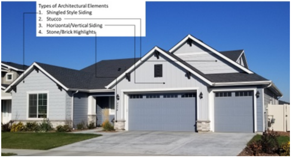
Residential Elevations (see figure below):
a.
Building elevations for all residential uses shall be submitted with any development application and will be included as part of any preliminary plat, development agreement and/or any other condition of approval.
b.
Single-Family Residential Building Front and Side Elevation Minimum Standards. These standards shall be reviewed for compliance with all submitted residential building permits under the Building Zoning Certificate Process. Council may adopt these standards as part of a development agreement or preliminary plat approval. The following minimum standards shall be applied to all new residential structure elements in all zones:
(1)
Exterior finishes shall be primarily horizontal / vertical wood or wood product siding, brick, stucco, stone, or other decorative masonry product. A minimum of three (3) architectural elements shall be provided for all single- family residential structures. These elements shall include, but are not limited to, shingled, horizontal or vertical siding, stone or brick highlights, garage door windows or hardware, colored window frames or other architectural treatments deemed appropriate by the administrator.
(2)
Two-story detached structures should provide a minimum of one, second story side window per side elevation, when appropriate.
(3)
A minimum one (1) foot overhand shall be provided on all roof overhangs. Administrator may approve deviation from this standard.
(4)
Dwellings backing up to collector or arterial streets shall have read elevations and/or architectural designs that provide depth and dimension, avoiding the flat-wall appearance. These elements must be functional and may not be minimized or created solely for the purpose of compliance with this provision.
(5)
Additional landscaping buffers may also be required.
2.
Dwelling Unit Design. Building styles shall be spread throughout the entire development (including contiguously owned and phased properties). Nowhere within the development shall any fewer than five (5) different exterior elevation styles and/or floorplans be located adjacent to each other. The number of different dwelling styles within a development shall be as follows:
a.
1 to 50 units = minimum of 5 architectural styles and/or floorplans.
b.
51 to 100 units = minimum of 7 architectural styles and/or floorplans.
c.
101 and over unites = minimum of 10 architectural styles and/or floorplans.
3.
Homeowner Associations. all subdivision shall be maintained by a Homeowners association with appropriate Conditions, Covenants and Restriction (CC&R's). CC&R's are not enforceable by the City and are private contracts between the developer and the property owner.
4.
Irrigation and drainage ditches shall not be covered, tiled or re-routed as part of any new residential development unless specifically approved by Council and the applicable irrigation and/or drainage district. Perforated piping may be considered as an option if tiling is allowed.
(Ord. 303, 2-11-2020; amd. Ord. 310, 7-21-2020; Repealed & Replaced by Ord. 370-2022 on 7/19/2022; Amended by Ord. 404-2024 on 6/18/2024)
8-3C-1: - All Commercial and Office Districts
A.
Comply with Section 8-3A-1: ZONING DISTRICTS AND PURPOSE ESTABLISHED.
B.
New commercial developments shall incorporate site and architectural design recommendations from the Architectural Overlay Design Guidelines for the Central Business District and Riverfront Center.
C.
Big Box Retail Commercial, generally a single-story single use building over 50,000 square feet, shall not be permitted unless approved by Council.
D.
Commercial buildings and centers, including shopping centers and strip malls immediately adjacent to State Street and Star Road shall front eh roadway with parking located to the read. Single buildings may provide parking on the sides as approved by Council. Direct access to these roadways shall be limited to avoid excessive access points. Existing alleyways shall be utilized when present, or new alleyways as permitted by the transportation authority.
E.
All commercial buildings fronting State Street, Star Road and State Highway 16 & 20/26 shall be designed with architectural elements facing the roadways that provide a visually pleasing character to the public view, as may be determined through the Design Review Process.
F.
Site Improvements:
1.
Prior to any ground disturbance for any commercial, industrial or other non-residential buildings, a Commercial Site Improvements application shall be submitted to the City for approval by the City Engineer. This shall include any new site development initiated prior to a City Building permit.
2.
In any development that requires a traffic signal as part of the approval process, the applicant shall be responsible for providing an Emergency Opticom System to the intersection.
3.
One (1) full-size copy of the construction drawings, drawn in accordance with the requirements hereinafter stated. The construction Drawings shall be submitted on good quality paper, be professionally drafted, shall have the dimensions of not less than twenty-four inches by thirty-six inches (24" x 36"), and shall be drawn to a scale of not less than one inch to one hundred feet (1"=100') and contain a drafting date and north arrow.
a.
Application shall include compliance with Section 8-4A-8 and 8-4A-11 of this ordinance.
b.
Construction drawings shall include both above ground and below ground improvements, including the proposed building envelope of proposed improvements. Said improvements must include proposed finished grades of all impervious surfaces, and shall be in conformance with all Federal, State, and local regulations. Construction drawings shall include an erosion and sediment control plan, prior to pre-construction meeting.
c.
Electronic file of all application materials in original pdf format shall be submitted with the application on a thumb drive.
4.
Irrigation and drainage ditches shall not be covered, tiled or re-routed as part of any new residential development unless specifically approved by Council and the applicable irrigation and/or drainage district. Perforated piping may be considered as an option if tiling is allowed.
5.
Certification of Completion: Upon completion of construction of any commercial development, and/or other improvements subject to architectural review approval, a written certification of completion shall be prepared by the licensed engineer and/or architect responsible for the approved plan. The certifications of completion shall state that the installation of all improvements is in substantial compliance with the city approved plans. the certification shall be submitted prior the issuance of a certificate of occupancy, signature of a final plat, or release of bond and is required as part of, and not in lieu of, the inspections performed, and certificates issued by the city.
(Ord. 303, 2-11-2020; amd. Ord. 310, 7-21-2020; Repealed & Replaced by Ord. 370-2022 on 7/19/2022; Amended by Ord. 404-2024 on 6/18/2024)
8-3C-2: - Additional Central Business District (CBD)
A.
Comply with Section 8-3A-1: ZONING DISTRICTS AND PURPOSE ESTABLISHED.
B.
High density residential may be permitted within the CBD in multiple use buildings with commercial or office type uses on the first floor and high density residential on upper floors.
C.
New development on Main Street and Star Road, generally north and south of State Street, shall include transition consisting of a compatible mix of lower intensity commercial, retail and office type uses mixed with live/work type residential. Existing Single-Family uses are encouraged to convert to or redevelop as non-residential uses.
D.
Big box retail commercial, generally a single-story single use building over 50,000 square feet, shall not be permitted, unless approved by Council.
E.
Commercial buildings and centers, including shopping centers and stirp malls immediately adjacent to State Street and Star Road shall from the roadway with parking located to the rear. Single buildings may provide parking on the sides as approved by Council. Direct access to these roadways shall be limited to avoid excessive access points. Existing alleyways be utilized when present.
F.
All commercial buildings fronting State Street, or Star Road, and State Highway 16 & 20/26 shall be designed with architectural elements facing the roadways that provide a visually pleasing character to the public view, as may be determined through the Design Review process.
G.
The Council may place requirements on a mixed-use development, including a ratio of uses and/or timing of phases, to ensure that the overall development maintains its commercial intent.
H.
New development shall incorporate site and architectural design recommendations from the Architectural Overlay Design Guidelines for the Central Business District and Riverfront Center.
I.
Any new development shall comply with Section 8-3C-1C of this title regarding site improvements.
J.
Irrigation and drainage ditches shall not be covered, tiled or re-routed as part of any new development unless specifically approved by Council and the applicable irrigation and/or drainage district. Perforated piping may be considered as an option if tiling is allowed.
K.
Certification of Completion: Upon the completion of construction of any commercial development, and/or other improvements subject to architectural review approval, a written certification of completion shall be prepared by the licensed engineer and/or architect responsible for the approved plan. The certifications of completion shall state that the installation of all improvements is in substantial compliance with the city approved plans. This certification shall be submitted prior the issuance of a certificate of occupancy, signature of a final plat, or release of bond, and is required as a part of, and not in lieu of, the inspections performed and certificates issued by the city.
(Ord. 303, 2-11-2020; amd. Ord. 310, 7-21-2020; Repealed & Replaced by Ord. 370-2022 on 7/19/2022; Amended by Ord. 404-2024 on 6/18/2024)
8-3D-1: - LI Light Industrial District
A.
Comply with Section 8-3A-1: ZONING DISTRICTS AND PURPOSE ESTABLISHED.
B.
Specific Standards for Light Industry:
1.
All mechanical equipment emissions; shipping and/or delivery; or other outdoor activity areas shall be located a minimum of three hundred feet (300') from any abutting residential districts, or the use is subject to a conditional use permit.
2.
The application shall identify how the proposed use will address the impacts of noise and other emissions on adjoining residential districts. More specifically, the following adverse effects shall be mitigated through setbacks, buffers, sound attenuation and/or hours of operation:
a.
Noise, odor, or vibrations; or direct or reflected glare detectable by the human senses without the aid of instruments.
b.
Radioactivity and electric or electromagnetic disturbances that unduly interfere with the normal operation of equipment, instruments, or appliances on abutting properties.
c.
Any other emission or radiation that endangers human health, results in damages to vegetation or property or which exceeds health and safety standards.
d.
In the event that the administrator determines that the applicant cannot adequately address such impacts, the use shall be subject to conditional use approval.
C.
New development shall incorporate site and architectural design recommendations from the Architectural Overlay Design Guidelines for the Central Business District and Riverfront Center.
D.
Any new development shall comply with Section 8-3C-1C of this title regarding site improvements.
E.
Irrigation and drainage ditches shall not be covered, tiled or re-routed as part of any new industrial development unless specifically required by the applicable irrigation and/or drainage district. Perforated piping may be considered as an option if tiling is allowed.
F.
Certification of Completion: Upon the completion of construction of any industrial development, and/or other improvements subject to architectural review approval, a written certification of completion shall be prepared by the licensed engineer and architect responsible for the approved plan. The certifications shall state that the installation of all improvements is in substantial compliance with the city approved plans. This certification shall be submitted prior the issuance of a certificate of occupancy, signature of a final plat, or release of bond, and is required as a part of, and not in lieu of, the inspections performed, and certificates issued by the city.
(Ord. 303, 2-11-2020; amd. Ord. 310, 7-21-2020; Repealed & Replaced by Ord. 370-2022 on 7/19/2022; Amended by Ord. 404-2024 on 6/18/2024)
8-3E-1: - MU Mixed Use District
A.
Comply with Section 8-3A-1: ZONING DISTRICTS AND PURPOSE ESTABLISHED.
B.
All development applications within a mixed-use district shall be accompanied by a conditional use permit, planned unit development, or development agreement application, which shall include a concept plan of the development.
C.
The administrator shall make a recommendation to the applicant regarding what mix of uses are appropriate for any mixed-use development and shall then make a recommendation to the Council.
D.
The development shall include uses from two (2) or more of the land use categories such as residential, commercial, office, light industrial, public space or agricultural.
E.
Mixed-use areas along state highways, where adequate access can be provided for commercial use, shall be predominantly commercial with a very minor component of residential unless the residential is placed on upper floors as part of a mixed-use building.
F.
For any mixed-use development which includes a residential component, a minimum of two (2) housing types, including but not limited to, single-family detached dwellings, single family attached dwellings and multi-family dwellings, shall be required. This excludes multi-family that is proposed to be placed solely on upper floors as part of a mixed-use building.
G.
The Council may place requirements on a mixed-use development, including a ratio of uses and/or timing of phases, to ensure that the overall development maintains its mixed-use intent.
H.
New development shall incorporate site and architectural design recommendations from the Architectural Overlay Design Guidelines for the Central Business District and Riverfront Center.
I.
Any new development shall comply with Section 8-3C-1C of this title regarding site improvements.
J.
Big box commercial, generally a single-story single use building over 50,000 square feet, shall not be permitted unless approved by Council.
K.
Commercial buildings and centers, including shopping centers and strip malls immediately adjacent to State Street and Star Road shall front he roadway with parking located to the rear. Single buildings may provide parking on the sides as approved by Council. Direct access to these roadways shall be limited to avoid excessive access points. Existing alleyways shall be utilized when present.
L.
Irrigation and drainage ditches shall not be covered, tiled or re-routed as part of any new mixed use development unless specifically required by the applicable irrigation and/or drainage district. Perforated piping may be considered as an option if tiling is allowed.
M.
Certification of Completion: Upon the completion of construction of any mixed use development, and/or other improvements subject to architectural review approval, a written certification of completion shall be prepared by the licensed engineer and/or architect responsible for the approved plan. This certification shall be submitted prior to the issuance of a certificate of occupancy, signature of a final plat, or release of bond, and is required as a part of, and not in lieu of, the inspections performed, and certificates issued by the city.
N.
All commercial buildings fronting State Street, Star Road, and State Highway 16 & 20/26 shall be designed with architectural elements facing the roadways that provide a visually pleasing character to the public view, as may be determined through the Design Review process.
(Ord. 303, 2-11-2020; amd. Ord. 310, 7-21-2020; Repealed & Replaced by Ord. 370-2022 on 7/19/2022)
8-3F-1: - RC Riverfront Center District
A.
Comply with Section 8-3A-1: Zoning Districts and Purpose Established.
B.
All development applications within the Riverfront Center shall be accompanied by a conditional use permit, planned unit development, or development agreement application, which shall include a concept plan of the development.
C.
The administrator shall make a recommendation to the applicant regarding what mix of uses are appropriate for the Riverfront Center and shall then make a recommendation to the Council.
D.
The Riverfront Center shall include uses from two (2) or more of the land use categories such as residential, commercial, office, or public space.
E.
The Riverfront Center shall include outdoor gathering space as a central focus along the Boise Riverfront and accommodate connections to the Boise Greenbelt system from the mixed-use area.
F.
Single-family detached dwellings, and single family attached dwellings are prohibited within the Riverfront Center. A range of multi-family dwellings are encouraged are encouraged, though not required to be accommodated on upper floors as part of a vertical, mixed-use building.
G.
The Council may place requirements on development within the Riverfront Center, including a ratio of uses and/or timing of phases, to ensure that the overall development maintains its mixed-use intent.
H.
New development shall incorporate site and architectural design recommendations from the Architectural Overlay Design Guidelines for the Central Business District and Riverfront Center.
I.
Any new development shall comply with Section 8-3C-1C of this title regarding site improvements.
(Ord. 303, 2-11-2020; amd. Ord. 310, 7-21-2020; Repealed & Replaced by Ord. 370-2022 on 7/19/2022)
8-3G-1:
A.
An Architectural Overlay District boundary is all the existing Central Business District north of the Boise River, and approximately 750' on either side of SH-44 from city limit to city limit, and Star Road from the Boise River north, and including all future annexations within this area. This shall also include all other non-residential zoned uses and properties throughout the City. Single-family dwellings that are part of an approved PUD or Conditional Use Permit shall comply with this section.
B.
Architectural Overlay District includes the entirety of the South of the River Area Plan.
C.
The "STAR DESIGN GUIDELINES, CENTRAL BUSINESS DISTRICT AND RIVERFRONT CENTER" (the Guidelines), is adopted through this ordinance. It may be amended from time to time by a Resolution of the Star City Council and shall be used within the Architectural Overlay District.
D.
If the Architectural Overlay District Guidelines conflict with other parts of the City of Star code, the Architectural Overlay District Guidelines shall be used.
(Repealed & Replaced by Ord. 370-2022 on 7/19/2022; Amended by Ord. 404-2024 on 6/18/2024)

