
Star City Zoning Code
CHAPTER 6
SUBDIVISION REGULATIONS
8-6A-1: - Purpose
The purpose of this chapter shall be to implement a general rule for the subdivision of the land in the Star city limits and the area of city impact. This chapter shall be based on the officially adopted comprehensive plan of the city and is enacted in order to promote and protect the public health, safety, comfort, convenience, prosperity, and general welfare and to achieve the following objectives:
A.
To promote the achievement of the proposals of the Star comprehensive plan;
B.
To advance the city as a self-sufficient employment and economic center;
C.
To encourage excellence and creativity in the design of all future developments and to preserve the natural beauty of Star;
D.
To encourage orderly growth and development, to avoid scattered development of land that results in:
1.
Lack of water supply, sewer service, drainage, transportation facilities, or otherwise essential public services; or
2.
Excessive expenditure of public funds for the supply of such services;
E.
To provide for desirable and appropriately located living areas and a variety of dwelling types and densities with adequate provision for sunlight, fresh air, and usable open space;
F.
To provide for the manner and form of making and filing of plats;
G.
To specify the requirements as to the extent and the manner in which:
1.
Roads and streets shall be created and improved;
2.
Water and sewer and other utility mains, piping connections, or other facilities shall be installed;
3.
Pedestrian pathways consistent with the comprehensive plan are to be located and designed; and
4.
Opportunities for future transit routes and stations are created;
H.
To protect existing surface waters throughout the city limits; and
I.
To specify the administration of the regulations of this chapter by defining the powers and duties of approval authorities.
(Ord. 303, 2-11-2020; amd. Ord. 310, 7-21-2020; Repealed & Replaced by Ord. 370-2022 on 7/19/2022)
8-6A-2: - Applications
Applicants shall submit to the administrator an appropriate city application and required information listed on the application and specified within this title.
(Ord. 303, 2-11-2020; amd. Ord. 310, 7-21-2020; Repealed & Replaced by Ord. 370-2022 on 7/19/2022)
8-6A-3: - Preliminary Plat Process
A.
Preapplication Conference: The applicant shall complete a preapplication conference with the administrator or designee prior to submittal of an application for a preliminary plat. The purpose of this meeting is to discuss early and informally the purpose and effect of this title and the criteria and standards contained herein.
B.
Neighborhood Meeting: Applicants are required to hold a neighborhood meeting, in conformance with Section 8-1A-6C to provide an opportunity for public review of the proposed project prior to the submittal of an application. The applicant shall provide a summary of the meeting, including questions and concerns of the neighbors and how the submitted application addresses those issues.
C.
Application Requirements: A complete subdivision application form and preliminary plat data as required in this title, together with fees shall be submitted to the administrator. At the discretion of the administrator or city engineer, appropriate supplementary information may also be required to sufficiently detail the proposed development within any special development area, including, but not limited to, hillside, planned unit development, floodplain, cemetery, manufactured home parks, and/or hazardous or unique areas of development. When possible, any unresolved access or traffic generation issues related to ACHD/HD4 or ITD regulated roadways shall be resolved by the applicant prior to acceptance of any application. The administrator may require a letter from the appropriate transportation agency or servient property owner to be submitted with the application.
D.
Required Information and Data: The contents of the preliminary plat and related information shall be in such a form as stipulated by the City Council, however, additional plans, maps or data deemed necessary by the administrator may also be required. This includes but is not limited to a preliminary grading plan and/or statement referencing future pad elevations, when areas of floodplain or steeper slopes are impacted, or excessive grade differences are proposed. The applicant shall submit to the administrator at least the following:
1.
One (1) full-size copy of the preliminary plat of the proposed subdivision, drawn in accordance with the requirements hereinafter stated. The preliminary plat shall be submitted on good quality paper, be professionally drafted, shall have the dimensions of not less than twenty-four inches by thirty-six inches (24" x 36"), and shall be drawn to a scale of not less than one inch to one hundred feet (1"=100') and contain a drafting date and north arrow.
2.
For hillside developments, one (1) bound copy of the preliminary engineering plans (not meant to be cross sections or detailed designs) showing streets, water, sewers, sidewalks, and other required public improvements, together with preliminary site grading, drainage and irrigation plans of the proposed subdivision. Such engineering plans shall contain sufficient information and detail to make a determination as to conformance of the proposed improvements to applicable regulations, ordinances and standards.
3.
Any required traffic impact study shall be submitted and accepted by the appropriate transportation authority prior to submittal of a preliminary plat application. A hearing date before the Council shall not be scheduled until the traffic impact study has been approved and the transportation authority has issued a staff report on the development application.
4.
One (1) full-size copy of a landscape plan showing all open space, common areas, amenities, street trees and development signage.
5.
Additional information on the preliminary plat and separately submitted information to include the following:
a.
The name of the proposed subdivision, as approved in advance by the Ada County Surveyors office;
b.
The name, address, telephone and email of the applicant, developer, engineer and surveyor or drafter who prepared the preliminary plat;
c.
The names and addresses of all adjoining property owners and recorded plats within three hundred feet (300') of the external boundaries of the land being considered for subdivision;
d.
The land use and existing and proposed zoning of the proposed subdivision and the adjacent land;
e.
Streets, street names, rights of ways and roadway widths, including adjoining streets or roadways;
f.
Lot lines and blocks showing the dimensions and numbers of each, together with area of each lot in acres and square feet;
g.
Contour lines, shown at five-foot (5') intervals where the land slope is greater than ten percent (10%) and at two-foot (2') intervals where land slope is ten percent (10%) or less, referenced to an established benchmark, including location and elevation;
h.
Any proposed or existing utilities, including, but not limited to, power poles, storm and sanitary sewers, irrigation laterals, ditches, bridges, culverts, water mains and fire hydrants;
i.
Any flood zone information including FEMA FIRM panels;
j.
The legal description of the boundary of the property being subdivided with the seal of the surveyor of record;
k.
Phasing plan showing all proposed phases of the development;
l.
Preliminary irrigation analysis showing availability of water rights and distribution of irrigation to the lots within the proposed subdivision, or waiver request;
m.
One (1) copy of a site report of the highest seasonal groundwater elevation prepared by a licensed engineer;
n.
A statement on the intent of the development regarding future site grading elevations, including estimated differences between the existing and finished grades, and how many feet a site may be raised relative to the adjacent land uses;
o.
A narrative, signed by the applicant, fully describing the proposed subdivision, including such information as number and type of uses on the lots (residential single, two or multi-family, commercial, etc.), common lots and the proposed uses of those lots (open space, parks, playgrounds, landscaping, or other uses) and any other information deemed necessary to explain the intent of the development including how it relates to other concurrently submitted applications (annexations, rezones, PUD's, CUP's, etc.);
p.
Neighborhood meeting information including sign-in sheet, copy of meeting letter, copy of mailing labels, and detailed summary of neighbor questions and concerns and how the development has been designed to address those concerns;
q.
A vicinity map showing the relationship of the proposed plat to the surrounding area (1/2-mile radius);
r.
Deeds, affidavit of legal interest, address labels, postal service location approval, ACHD/CHD4/ITD traffic study review status, electronic copies, or any other required information deemed necessary by the administrator to allow for proper review of the application;
s.
A conceptual site plan shall be submitted for any non-residential developments showing building locations, parking and loading areas, traffic access drives and traffic circulation and trash enclosure locations;
t.
Any additional required information for special area of developments including, but not limited to hillsides, wetlands or as further specified in this Title.
u.
Building elevations for all residential uses shall be submitted with the application and will be included as part of any development agreement and/or condition of approval.
v.
Electronic file of all application materials in original .pdf format shall be submitted with the application on a thumb drive.
6.
Additional information in the application as determined by the administrator may include the following:
a.
Building elevations, non-residential uses, clubhouses, well houses, or other elevations deemed necessary to assist the Council in their decision regarding a development;
b.
Colored site plan and renderings of a subdivision detailing residential lot locations, open space and common areas, buffers, roadways, waterways and irrigation ditches, fencing, signs and landscaping.
E.
Acceptance: Upon receipt of the preliminary plat, payment of all associated application fees, and compliance with all other requirements as provided for herein, the administrator shall certify the application as complete and shall affix the date of acceptance.
F.
Decision: A decision on a preliminary plat for a parcel of land is made by the City Council after receiving a recommendation from the administrator and a public hearing is held.
(Ord. 303, 2-11-2020; amd. Ord. 310, 7-21-2020; Repealed & Replaced by Ord. 370-2022 on 7/19/2022; Amended by Ord. 404-2024 on 6/18/2024)
8-6A-4: - Final Plat Process
A.
Application Requirements: After the approval or conditional approval of the preliminary plat, the applicant may cause the total parcel, or any part thereof, to be surveyed and a final plat prepared in accord with the approved preliminary plat. An application and fees shall be submitted to the administrator on forms provided by the City.
B.
Contents of Final Plat: The final plat shall include and be in compliance with all items required under Idaho Code section 50-1301 et seq. The final plat submittal shall include at least:
1.
A written application for approval of such final plat as stipulated by the council;
2.
Proof of current ownership of the real property included in the proposed final plat and consent of recorded owners of the plat;
3.
Such other information as the administrator or designee and/or city engineer may deem necessary to establish whether or not all proper parties have signed and/or approved said final plat;
4.
Conformance with the approved preliminary plat and meeting all requirements or conditions thereof;
5.
Conformance with all requirements and provisions of this title;
6.
Conformance with acceptable engineering, architectural and surveying practices and local standards including those set forth in Section 8-4A- 11; and
7.
Proposed drainage and stormwater, grading, and irrigation plans and associated reports shall be submitted with the final plat application. No site improvements of any kind shall commence until City Engineer approval of civil plans.
8.
The final plat application shall provide draft CC&R's that include, but not be limited to, information relating to setbacks, fencing, private street maintenance information, and any other information required by the City through an approved Development Agreement and/or conditions of approval of the preliminary and final plat. A statement of where the specific information is within the draft document shall be provided at the time of application.
C.
Administrator Review:
1.
Acceptance: Upon receipt of the final plat, and compliance with all other requirements as provided for herein, the administrator shall certify the application as complete and shall affix the date of acceptance.
2.
Substantial Compliance:
a.
The administrator or designee shall review the final plat for substantial compliance with the approved or conditionally approved preliminary plat. The final plat shall be determined in substantial compliance with the preliminary plat, notwithstanding the following changes:
(1)
The number of buildable lots is the same or fewer;
(2)
The amount of common open space has been increased or is the same;
(3)
The amount of open space is relocated with no reduction in the total amount;
(4)
The number of open space lots has been increased or is the same; or
(5)
The transportation authority has required minor changes, including updated street and/or sidewalk widths or standards.
3.
Not in Substantial Compliance: If the administrator determines that there is substantial difference in the final plat than that which was approved as part of the original a preliminary plat process, the intent of the development, or conditions that have not been met, the administrator may require that a new preliminary plat be submitted to the city.
D.
Decision on Final Plat: Decision on the final plat is made by the City Council.
E.
Recording of the Final Plat: Upon approval or approval with conditions by the council and signature of the city clerk and city engineer, the applicant may submit the final plat to the county recorder for recording. The final plat shall contain the certifications required under Idaho Code section 50-1301 et seq., as well as those required by the city of Star.
(Ord. 303, 2-11-2020; amd. Ord. 310, 7-21-2020; Repealed & Replaced by Ord. 370-2022 on 7/19/2022)
8-6A-5: - Combined Preliminary and Final Plat Process
A.
Applicability: A subdivision application may be processed as both a preliminary and final plat if all the following exist:
1.
The proposed subdivision does not exceed five (5) lots (excluding common and/or landscaping lots); or a previous plat was approved on the subject property; and
2.
No new public street dedication, excluding widening of an existing street, is required (private streets are ok); and
3.
No major special development considerations are involved, such as development in a floodplain or hillside development.
B.
Preapplication Conference: The applicant shall complete a preapplication conference with the administrator prior to submittal of an application for a combined preliminary and final plat. The purpose of this meeting is to discuss early and informally the purpose and effect of this title and the criteria and standards contained herein.
C.
Neighborhood Meeting: Applicants are required to hold a neighborhood meeting, in conformance with Section 8-1A-6C, to provide an opportunity for public review of the proposed project prior to the submittal of an application. The applicant shall provide a summary of the meeting, including questions and concerns of the neighbors and how the submitted application addresses those issues.
D.
Application Requirements: Applications and fees, in accord with subsection 8-6A-3 of this article shall be submitted.
E.
Contents of Final Plat: The final plat shall include all items required in subsection 8-6A-4B of this article or any additional items required by the Administrator.
F.
Decision: A decision on a combined preliminary and final plat is made by the city council.
(Ord. 303, 2-11-2020; amd. Ord. 310, 7-21-2020; Repealed & Replaced by Ord. 370-2022 on 7/19/2022; Amended by Ord. 404-2024 on 6/18/2024)
8-6A-6: - Short Plat Process
A.
Applicability: A subdivision application for a short plat may be processed provided that it meets all of the following conditions:
1.
The property is an original lot in a recorded subdivision;
2.
The property is not the result of a previous short plat of a lot and/or the property is not the result of an approved parcel division by Ada or Canyon County Development Services;
3.
The proposed subdivision does not exceed a total of two (2) lots on a previously platted property or parcel of land;
4.
No new public street dedication, or new proposed private street, excluding widening of an existing street, is involved;
5.
There are no impacts on the health, safety or general welfare of the city, and the subdivision is in the best interest of the city.
B.
Preapplication Conference: The applicant shall complete a preapplication conference with the administrator prior to submittal of an application for a combined preliminary and final plat. The purpose of this meeting is to discuss early and informally the purpose and effect of this title and the criteria and standards contained herein.
C.
Application Requirements: Applications and fees, in accord with subsection 8-6A-3C, 8-6A-3D and 8-6A-4 of this article shall be submitted.
D.
Final Approval Notice: Upon determination by the administrator that the short plat is in conformance with this article, a final approval letter shall be issued.
E.
Time Limit and Completion of Tasks: Upon tentative approval of the application by the administrator, subject to any applicable conditions of approval and the regulations of this title, the applicant or owner shall have one year to complete the following tasks:
1.
Cause the property to be surveyed and a record of survey recorded;
2.
Execute and record the necessary deeds to accomplish the property boundary adjustments as approved;
3.
Obtain new tax parcel numbers and street addresses from the county assessor; and
4.
Provide copies of the recorded record of survey, recorded deeds, and the new tax parcel numbers to the administrator.
F.
A condominium plat application for any number of lots for property in any district shall be processed as a short plat where all buildings are constructed or have received building permits for construction. A condominium plat amendment for interior alterations or modifications shall be exempt from further review.
(Ord. 303, 2-11-2020; amd. Ord. 310, 7-21-2020; Repealed & Replaced by Ord. 370-2022 on 7/19/2022)
8-6A-7: - Required Findings
In consideration of a preliminary plat or combined preliminary and final plat, the decision-making body shall make the following findings:
A.
The plat is in conformance with the comprehensive plan;
B.
Public services are available or can be made available and are adequate to accommodate the proposed development;
C.
There is public financial capability of supporting services for the proposed development;
D.
The development will not be detrimental to the public health, safety or general welfare; and
E.
The development preserves significant natural, scenic or historic features.
(Ord. 303, 2-11-2020; amd. Ord. 310, 7-21-2020; Repealed & Replaced by Ord. 370-2022 on 7/19/2022)
8-6A-8: - Term of Approvals
A.
Failure to Submit Final Plat: Approval of a preliminary plat or combined preliminary and final plat or short plat shall become null and void if the applicant fails to obtain city engineer signatures of a final plat within two (2) years of the approval of the preliminary plat (signed finding of fact). Minor land divisions shall be recorded approval one year of plat.
B.
Phased Development: In the event that the development of the preliminary plat is made in successive phases in an orderly and reasonable manner, and conforms substantially to the approved preliminary plat, such segments, if submitted within successive intervals of eighteen (18) months, may be considered for final approval without resubmission for preliminary plat approval.
C.
Authorize Extension: Upon written request and filed by the applicant prior to the termination date of the period in accord with subsection A of this section, the administrator may authorize a single extension of time to record the final plat not to exceed twenty-four (24) months. Additional time extensions up to twenty-four (24) months as determined and approved by the city council may be granted. Submittal of a Council approved time extension request shall be a minimum of thirty (30) days prior to the expiration date. With all time extensions, the administrator or city council may require the preliminary plat, combined preliminary and final plat or short plat to comply with the current provisions of this title.
D.
Failure to Meet Timetable: If the above timetable is not met and the applicant does not receive a time extension, the property may, as determined by the administrator, be required to go through the platting procedure again.
(Ord. 303, 2-11-2020; amd. Ord. 310, 7-21-2020; Repealed & Replaced by Ord. 370-2022 on 7/19/2022; Amended by Ord. 404-2024 on 6/18/2024)
8-6A-9: - Minor Land Division Process
A.
Purpose: The purpose of the minor land division process is to allow the creation of up to four buildable parcels without being subject to the procedural provisions of the Preliminary and Final Plat regulations of this title. A Record of Survey, application and the appropriate fees are required for a minor land division of a lot, tract or parcel of land.
B.
Applicability: A minor land division must meet the following conditions:
1.
These regulations apply to all existing lots and parcels in Star city limits of record, as it exists in its original configuration in the City of Star after December 12, 1997, or a lot as it exists in an approved subdivision after December 12, 1997. It shall be the responsibility of the applicant to provide proper proof to the administrator showing eligibility for this property division.
2.
The existing zoning designation of the property allows for the proposed density associated with the minor land division. A residential property that needs a rezone or annexation does not qualify. Properties annexed into the City or rezoned without a preliminary plat shall not qualify for a future minor land division.
3.
No minor land division shall create more than 4 new parcels.
4.
No property involved in a minor land division shall be involved in a subsequent minor land division.
5.
Wet line sewer and central water lines must be currently located adjacent to or within the public right-of-way that abuts the parcel to be divided. This shall not apply to proposed parcels greater than one-acre in size that utilize an individual septic system, provided that appropriate Health District and Star Sewer and Water District approvals are provided or conditioned as part of the approval.
6.
No new public street dedication, excluding widening of an existing street, is involved. Private streets meeting the standards of subsection 8-4D-3, and common/shared driveways with Fire District approval may be permitted.
7.
No new public utility lines shall be extended within the public right-of-way to the property involved in the minor land division.
8.
All resulting parcels must conform to the minimum requirements of all existing land use regulations including the adopted Unified Development Code.
9.
If any of the following conditions are present, a subdivision application and/or rezone application shall be required.
a.
Dividing a lot in an existing subdivision that has already maximized the density of the existing zoning designation, violates a Development Agreement condition for maximum number of lots, or removes required open space and/or amenities;
b.
The possibility for public or private streets that would provide greater connectivity to the area, as determined by the Administrator;
c.
Creating lots that will have incompatible setbacks to surrounding parcels, as determined by the Administrator (i.e., side yards adjacent to rear yards);
d.
The creation of multiple driveway access points on a collector or arterial roadway when a public or private street could avoid the situation;
e.
Creating a larger remnant parcel that could otherwise be included in an overall subdivision; and
f.
New property lines configured in a way that could create future setback or access issues.
10.
All existing buildings to remain shall meet applicable zoning requirements regarding allowed uses and parking shall comply with all requirements of the existing zone. Additionally, the following shall apply:
a.
Any setback that was legally non-conforming prior to the minor land division may remain as a legal non-conforming setback, provided that the legal non-conforming setback is not altered by the minor land division, and that all new buildings and additions meet the current zoning setback requirements;
b.
Any building not meeting the required setback that is to be partially or completely demolished or moved shall either be demolished or moved prior to the final approval of the minor land division;
c.
Special setbacks, as allowed for in Section 8-3A-4 of this Title, shall be clearly illustrated on the recorded record of survey;
d.
Any existing structures shall connect to public water and sewer lines prior to final approval of the minor land division, unless otherwise allowed in this section;
e.
If required parking is provided by means of a permanent shared- parking agreement, a note on the face of the survey must list the total required and provided parking for all parcels to which the shared parking provisions of the shared-parking agreement applies;
f.
When a utility crosses land being divided, a utility easement shall be provided and indicated on the Record of Survey. If an easement is located in a proposed permanent structure construction area, the easement shall be vacated prior to the Administrators final approval of the minor land division; and
g.
All new parcels that abut the public right-of-way shall be improved with sidewalk, curb and gutter per the Transportation Authority requirements, and, if applicable, a paved driveway apron that extends to the edge of street pavement will be required. All right-of-way improvements, license agreements, and/or bonding shall be completed prior to the Administrators final approval of the minor land division.
C.
Process:
1.
Application: An application and fees shall be submitted to the administrator on forms provided by the planning department.
2.
Preapplication Conference: The applicant shall complete a preapplication conference with the administrator prior to submittal of an application for a minor land division. The purpose of this meeting is to discuss early and informally the purpose and effect of this title and the criteria and standards contained herein.
3.
Final Approval Notice: Upon determination by the administrator that the minor land division is in conformance with this article, a final approval letter shall be issued.
4.
Time Limit and Completion of Tasks: Upon tentative approval of the application by the administrator, subject to any applicable conditions of approval and the regulations of this title, the applicant or owner shall have one year to complete the following tasks:
a.
Cause the property to be surveyed and a record of survey recorded;
b.
Execute and record the necessary deeds to accomplish the property boundary adjustments as approved;
c.
Obtain new tax parcel numbers and street addresses from the county assessor; and
d.
Provide copies of the recorded record of survey, recorded deeds, and the new tax parcel numbers to the administrator.
(Adopted by Ord. 370-2022 on 7/19/2022; Amended by Ord. 404-2024 on 6/18/2024)
8-6A-10: - Property Boundary Adjustment or Division
A.
Purpose: The purpose of these regulations is to allow for the adjustment of property lines between existing properties, to allow for the reduction in the number of buildable lots, or to allow the creation of an additional parcel from an original parcel of record for the transfer of ownership or development.
B.
Applicability: These regulations apply to all existing lots and parcels in Star city limits. For a property division, any original parcel, or lot of record, as it exists in its original configuration in the City of Star after December 12, 1997, or a County parcel of record that is being annexed into the City of Star, and is not the result of a previous property division in the County, may be eligible for one (1) administrative property division provided that both new parcels meet the current zoning and dimensional standards of this title. It shall be the responsibility of the applicant to provide proper proof to the administrator showing eligibility for this property division.
C.
Process:
1.
Application: An application and fees shall be submitted to the administrator on forms provided by the planning department.
2.
Time Limit on Completion of Tasks: Upon tentative approval of the application by the administrator, subject to any applicable conditions of approval and the regulations of this title, the applicant or owner shall have one year to complete the following tasks:
a.
Cause the property to be surveyed and a record of survey recorded;
b.
Execute and record the deeds to accomplish the property boundary adjustments as approved;
c.
Obtain new tax parcel numbers and street addresses from the county assessor; and
d.
Provide copies of the recorded record of survey, recorded deeds, and the new tax parcel numbers to the administrator.
3.
Final Approval Notice: Upon determination by the administrator that the final property boundary adjustment or division is in conformance with this article, a final acceptance letter shall be issued.
D.
Standards:
1.
A property boundary adjustment or division shall not reduce the property sizes below the minimum dimensional standards prescribed by this title; or if one or more of the properties is nonconforming as to the minimum dimensional standards prescribed by this title, the property boundary adjustment shall not increase the nonconformity.
a.
A property boundary adjustment shall not increase the original number of properties but may decrease the original number of properties.
b.
A property boundary adjustment or division shall not change or move any public streets or publicly dedicated areas in any manner.
c.
A property boundary adjustment or division does not vacate the platted lot lines or easements of a recorded subdivision. Any private or public easement may be vacated in accord with the requirements of this title.
d.
If a new lot or parcel is created as part of a property division, both lots or parcels shall be subject to the requirement of connection to municipal services, if available, and shall be subject to additional improvements as determined by the administrator and subject to this title, including but not limited to sidewalks and paved driveways.
(Ord. 303, 2-11-2020; amd. Ord. 310, 7-21-2020; Repealed & Replaced by Ord. 370-2022 on 7/19/2022)
8-6B-1: - Applicability
A.
All plats submitted in accord with the provisions of this chapter, and all subdivisions, improvements and facilities done, constructed or made in accord with said provisions shall comply with the minimum design standards set forth in this article provided, however, that any higher standards adopted by any transportation or health authority shall otherwise prevail.
B.
It shall be the responsibility and liability of every applicant, and the owner of the land being subdivided, to construct and install every improvement shown on the plat of the subdivision, represented to be included in the subdivision at any presentation before the city council, and all improvements required by the ordinances of the city specifically including the requirements of this article, and this responsibility and liability shall be personal to the developer and the owner and shall also run with the land, and this responsibility and liability shall be shown on the plat of the subdivision.
(Ord. 303, 2-11-2020; amd. Ord. 310, 7-21-2020; Repealed & Replaced by Ord. 370-2022 on 7/19/2022)
8-6B-2: - Improvement Standards
A.
Compliance with All Applicable Requirements: The plat shall comply with all applicable requirements as set forth in this title.
B.
Streets:
1.
Dedication: Within a proposed subdivision, arterial and collector streets as shown on the comprehensive plan shall be dedicated to the public in all cases; in general, all other streets shall also be dedicated to public use.
2.
Street Specifications: The design, location, and widths of all street and street intersections shall comply with the requirements of the transportation authority and Fire District, unless alternative standards are adopted by the city of Star. Public and private street widths shall be a minimum of thirty-six feet (36') unless specifically approved by Council.
3.
Street Names: The naming of streets shall conform to the requirements of the county street naming committee, with the following exceptions:
a.
The street name shall generally comply with this subsection.
b.
Street names shall not duplicate any existing street name within the county, except where a new street is a continuation of an existing street.
c.
Street names that may be spelled differently but sound the same as existing streets shall not be used.
d.
All new streets shall be named as follows: streets having predominantly north-south direction shall be named "Avenue" or "Road"; streets having a predominantly east-west direction shall be named "Street" or "Way"; meandering streets shall be named "Drive", "Terrace", "Path", or "Trail"; and cul-de-sacs shall be named "Circle", "Court", and "Place". Private streets shall be named "Lane".
e.
For streets that provide primary access to a subdivision or neighborhood and that align with an existing or planned street across an intersection that is not part of the same subdivision or neighborhood, the street name shall not duplicate the name of the subdivision or neighborhood.
f.
Proposed streets which are a continuation of an existing street shall be given the same name as the existing street.
g.
Street name signs shall be installed in the appropriate locations at each street intersection.
4.
Cul-De-Sacs: No street that ends in a cul-de-sac or a dead end shall be longer than seven hundred fifty feet (750').
5.
Alleys: All alleys shall be approved by the Fire District and shall have a minimum of twenty-foot (20') right-of-way and shall be paved, unless otherwise required.
6.
Coving: Coving, or meandering design of roadways shall be encouraged, where reasonable, to provide a unique feel to a neighborhood versus a standard grid roadway system. The grid system may also be utilized where appropriate to provide for a variety of street designs within the overall project.
C.
Driveways: All driveway openings in curbs shall comply with the requirements of the authorized transportation authority.
D.
Common / Shared Driveways:
1.
Common / Shared Driveways shall not be permitted for residential developments unless an approved, emergency turn-around is provided, and the driveway is approved by the Fire District.
2.
For commercial or other non-residential uses, common driveways serving multiple structures and/or properties shall meet the requirements of the Fire District.
3.
Width Standards: Common driveways shall be a minimum of twenty-eight feet (28') in width.
4.
Maximum Length: Common driveways shall be a maximum of one hundred fifty feet (150') in length or less, unless otherwise approved by the fire district.
5.
Improvement Standards: Common driveways shall be paved with a surface capable of supporting emergency services vehicles and equipment.
6.
Abutting Properties: Unless limited by significant geographical features, all properties that abut a common driveway shall take access from the driveway.
7.
Turning Radius: Common driveways shall be straight or provide a twenty-eight foot (28') inside and fifty foot (50') outside turning radius.
8.
Depictions: For any plats using a common driveway, the setbacks, building envelope, and orientation of the lots and structures shall be shown on the preliminary and/or final plat.
9.
Easement: A perpetual ingress/egress easement shall be filed with the county recorder, which shall include a requirement for maintenance of a paved surface capable of supporting fire vehicles and equipment.
E.
Easements:
1.
Utility easements shall be provided along front lot lines, rear lot lines and side lot lines when deemed necessary by the city engineer or designee.
2.
Total easement width shall not be less than ten feet (10').
F.
Blocks: In the residential districts, no block shall be more than seven hundred fifty feet (750') in length without an intersecting street, alley, or other City and ACHD/HD4 approved remedy. Remedies include traffic calming and/or waiver from City Council for the lengths.
G.
Reserve Strips: Privately held reserve strips or "spite strips" controlling access from adjacent lands to public streets shall be prohibited.
H.
Flag Lots: Flag lots are prohibited in all residential zones greater than R-2, unless specifically approved by Council. Any approved flag lot shall also be approved by the Fire District.
I.
Pathway easements shall be open to the public.
J.
Pathway easements shall be required along the Boise river as shown within the comprehensive plan and shall be open to the public.
(Ord. 303, 2-11-2020; amd. Ord. 310, 7-21-2020; Repealed & Replaced by Ord. 370-2022 on 7/19/2022; Amended by Ord. 404-2024 on 6/18/2024)
8-6B-3: - Developer's Responsibility
The developer has the responsibility of maintaining the subdivision property until such time that the subdivision is turned over to a homeowner or business owner association. Failure to comply with the following may result in a stop work order being issued until the violations are remedied, and/or revocation of preliminary plat / final plat approvals. The following are requirements of the developer:
A.
Keep property weed abated at all times. At no time shall weeds exceed a height of 12" in height.
B.
Mitigate dust throughout all development stages of the subdivision. Water trucks shall be on-site and in operation at all times during site earthwork activities.
C.
Maintain the site for debris daily and prevent wind-blown debris. This shall include, but is not limited to trach, junk or disabled vehicles during any portion of the development process.
D.
All trash receptacles and construction site garbage bins shall be emptied on a regular basis and not left over-flowing.
E.
Clean up of any mud and/or dirt that is deposited from construction onto streets daily. This shall include an streets used to access the property.
F.
Streets within the development shall be swept and cleaned weekly, or as needed.
G.
Coordinate with the United States Postal Service for the best location of mail receptacles. The mail receptacle shall not be placed in the vision triangle.
H.
Provide the city with GIS locations of all streetlights and irrigation facilities.
I.
Provide a construction sign, to be located at all entrances to a development, indicating the rules for all sub-contractors to follow from the first day of grading of the site through to sale of homes. This sign should include, but not be limited to, dust, music, dogs, site debris, mud, and starting/stopping hours for contractors (7 a.m. starting time). Sign is subject to approval by the administrator prior to installation.
J.
Homeowners Associations: The developer is required to establish a homeowner association in any development that has common maintenance or ownership of utilities, recreation areas, landscaping, etc. The Covenants, Conditions and Restrictions established for the homeowner association shall include a provision allowing the homeowner association to amend the controlling documents (CC&Rs, architectural control guidelines and bylaws) by simple majority vote of the members of the association after all lots in the subdivision have been sold by the developer.
1.
This one-time amendment may occur at the first annual meeting following the sale of the last building lot owned by the developer.
2.
The new document shall be recorded in the county records and shall be distributed to every owner in the association.
3.
CC&Rs and bylaws amended using this reduced majority, shall not be used to:
a.
Introduce or alter a system of fines for homeowner non- compliance, unless to remove an existing system of fines.
b.
Attempt to control parking on public roads or property that is not wholly owned by the HOA.
c.
Permanently reduce the supermajority required for changing the CC&Rs and bylaws below sixty percent (60%).
d.
Restrict the use of private property beyond the restrictions contained in the Star City Code or in the original CC&Rs, including all forms of renting and leasing.
e.
Remove or otherwise alter plans or conditions approved by the City, including but not limited to landscaping, required open space, amenities, setbacks and other design and dimensional standards as approved by Council.
f.
Any of the above may be accomplished using the super majority as described in the original bylaws.
K.
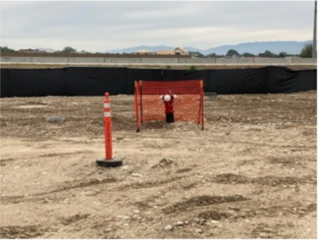
Fire Hydrants: All fire hydrants, once installed, shall have orange temporary construction fencing placed around the hydrant no less than 3 feet in circumference from top of hydrant and open on the front (See picture below). The fencing shall remain unobstructed twenty-four (24) hours a day, seven days a week. This fence shall remain in place until all construction activities are completed within 100 feet of the hydrant. There shall also be no obstructions within 15 feet, including parking, placement of porta-potties, construction materials, construction trash boxes or any other objects that may encumber access to the hydrant, including weeds.
FIGURE 8-6B-3(a)
HYDRANT FENCING
L.
Water Meters: All water meters should have their lids on and secured at all times. There shall also be no obstructions within 15 feet, including parking, placement of porta-potties, construction materials, construction trash boxes or any other objects that may encumber access to the meter, including weeds.
M.
Burning/Open Fires: Outdoor burning at construction sites shall follow the city ordinance for outdoor burning. The outdoor burn line should be notified before the commencement of any burning. All burns shall follow City Municipal Code (3-3-1 thru 3-3-6). Burning is only allowed between the hours of 8:00 AM to sunset.
(Ord. 303, 2-11-2020; amd. Ord. 310, 7-21-2020; Repealed & Replaced by Ord. 370-2022 on 7/19/2022; Amended by Ord. 404-2024 on 6/18/2024)

