
Stuart City Zoning Code
CHAPTER II
ZONING DISTRICTS USES ALLOWED, DENSITY, INTENSITY
2.03.00. - DENSITY[1]
Editor's note— Section 2.03.00 has been restructured at the discretion of the editor for clarity. Tables 3, 3a, 3b, and 4 have are laid out in sections 2.03.07—2.03.10, respectively.
2.07.00. - DESIGNATION OF PLANNED UNIT DEVELOPMENT (PUD)
A.
Purpose. The purpose of this section 2.07.00 is to provide an alternative means of residential, commercial, public service and industrial land development and an alternative zoning procedure that may be used to establish residential, commercial, public service and industrial planned unit development zoning districts at appropriate locations and in accordance with the planning and development objectives of the city.
A planned unit development (PUD) established according to the provisions of this section may depart from the strict application of use, setback, parking requirements, and other requirements of standard zoning districts. A PUD shall be consistent with the overall planning and development goals and objectives of the city as reflected by the City of Stuart Comprehensive Plan. A primary purpose of this section is to provide a set of zoning requirements as a starting point from which such flexibility may be accomplished while maintaining and protecting the public health, safety and welfare of the citizens.
A second purpose of this section is to establish a resilient living and working environment through the application of enlightened and imaginative approaches to community planning, stormwater infrastructure and property design. A PUD should provide a variety of natural features and scenic areas, efficient and economical land use, improved amenities, orderly and economical development and the protection of adjacent existing and future development. Therefore, the PUD alternative may allow uses and design concepts which are not specifically allowed in standard zoning districts.
To the extent that any provisions of this section conflict with any other provisions of this Code, the provisions of this section shall prevail.
B.
PUD defined. A PUD may be an residential planned unit development (RPUD), an commercial planned unit development (CPUD), an mixed-use planned unit development (MXPUD), an industrial planned unit development (IPUD), an urban planned unit development (UPUD), or an public service planned unit development (PSPUD). A PUD shall consist of land under unified control which may be planned and developed as a whole as a single development operation or as an approved programmed series of development operations by multiple developers. A typical PUD will include principal and accessory uses and structures substantially related to the character of the development itself and to the surrounding area of which it is a part.
As used above, "unified control" means that all land to be included within a PUD shall be owned or otherwise under the legal control of the person or legal entity which has applied for PUD district zoning. Such person or entity shall be legally capable of providing a commitment to the city that the PUD development will comply with all PUD documents, plans, standards and conditions ultimately approved by the city.
A PUD district shall consist of the approved PUD classification and the regulations thereof set forth in this section 2.07.00, and as well as any other documents specifically included within the PUD ordinance adopted by the city commission. The ordinance approving a PUD shall be deemed a zoning ordinance. The provisions of the PUD zoning ordinance shall replace all conflicting development regulations set forth in this Code which would otherwise apply to the development site. The PUD ordinance shall be recorded in the public records of Martin County. The PUD applicant shall also execute a PUD agreement that incorporates the terms and conditions that are set forth in the PUD ordinance.
The applicant may proceed with development only after a plat, if required by the city commission, is recorded in the Martin County public records and after certification by the city development director that the construction plans and other required documents substantially conform to all documents approved as part of the PUD ordinance. The applicant must produce evidence that would bind his successors in title to any commitments made upon approval of PUD.
C.
PUD district to be shown on official zoning map of the city. The boundaries of land zoned PUD by ordinance of the city commission shall be indicated as such on the official zoning map of the city.
D.
Residential planned unit development districts.
1.
Location. An RPUD may be located anywhere in the city in any area defined and described as "low density residential," "multi-family residential," "office/residential," "institutional," "downtown redevelopment," "neighborhood/special district," "East Stuart," or "marine/industrial" by the future land use element of the City of Stuart's comprehensive plan.
2.
Uses. The buildings, structures, land and water within an RPUD may be used for any of the following uses:
a.
A combination of uses permitted in the zoning classifications of R-1A, R-1, R-2 and R-3 districts.
b.
Residential uses not specifically permitted in the R-1A, R-1, R-2 or R-3 districts but which are of a like nature and quality to those uses permitted in said districts as determined by the city commission.
c.
Commercial uses which are compatible with the residential uses permitted in the RPUD district provided the commercial uses shall not comprise more than 30 percent of the total development site and shall be buffered from the residential uses by site design and landscaping.
d.
A vertical as well as horizontal combination of residential and commercial uses which are mutually compatible as determined by the city commission provided the commercial uses shall not comprise more than 30 percent of the total development gross square footage
3.
Density. The gross residential density for an RPUD shall not exceed the maximum permitted as prescribed by policy A7.2 of the City of Stuart Comprehensive Plan relating to gross densities:
4.
General. The following general requirements shall apply to an RPUD district:
a.
RPUD standards regarding circulation, parking, utilities, drainage, open space, density and other standards shall apply as described in this Code except as modified by the city commission as reflected by the adopted RPUD ordinance.
b.
Open space. Not less than 30 percent of the RPUD shall be open space as defined herein. Required open space may include native vegetation areas and landscape buffers between the site and adjacent property; however, other required landscaping shall not count towards the open space requirement. In the event that less than 25 percent of the RPUD is comprised of native vegetation area, then all existing native vegetation area shall be maintained as part of the required open space.
c.
Maximum building area. Building coverage shall not exceed the maximum floor area ratio (FAR) as defined in the comprehensive plan and section 2.03.00, table 4 - intensity of development: lot area and floor area ratio (FAR).
d.
Native vegetation. Excluding wetlands defined by the SFWMD, not less than 25 percent of the total development site shall remain as undeveloped native vegetation area. The required native vegetation area may include open space areas and the landscape buffer between the site and adjacent property; however, other required landscaping such as parking area interior landscaping shall not count towards the native vegetation requirement. The location of the native vegetation area shall be determined using a study of the site with consideration to the value of existing vegetation.
E.
Commercial planned unit development (CPUD) districts.
1.
Location. A CPUD may be located anywhere in the city in any area defined and described "multi-family residential," "office/residential," "commercial, "industrial," "public," "downtown redevelopment," "neighborhood/special district, "East Stuart," or "marine/industrial" by the Future Land Use Element of the City of Stuart's Comprehensive Plan, and which is of suitable character and compatible with surrounding uses as determined by the city commission.
2.
Uses permitted in a CPUD district. The buildings, structures, land or water within a CPUD district may be used only for the following purposes:
a.
Any and all uses set forth in the present zoning classifications of R-1A, R-1, R-2, R-3, B-1, B-2, B-3 and B-4 inclusive, providing such uses are compatible with uses on adjacent property as determined by the city commission.
b.
Residential uses which are designed to be compatible with the adjacent commercial uses. The residential uses shall not comprise more than 30 percent of the development site excluding the open space, natural vegetation area and wetlands.
c.
Commercial residential uses such as apartments, hotels and resorts provided said uses do not comprise more than 30 percent of the development site excluding the open space, natural vegetation area and wetlands.
d.
Commercial uses not specifically set forth in any of the standard zoning categories, but which are compatible and of like nature and quality to those commercial uses allowed on B-1, B-2, B-3 or R-3 zoning classifications as determined by the city commission.
3.
Commercial PUD standards. The following standards shall apply to a CPUD district:
a.
CPUD standards regarding circulation, parking, utilities, drainage, open space and other standards shall apply as described in this Code except as modified by the city commission as part of the CPUD ordinance.
b.
Open space. Not less than 25 percent of the CPUD shall be open space as defined herein. Required open space may include native vegetation areas and landscape buffers between the site and adjacent property; however, other required landscaping such as parking area interior landscaping shall not count towards the open space requirement. In the event that less than 25 percent of the CPUD is comprised of native vegetation area, then all existing native vegetation area shall be maintained as part of the required open space.
c.
Native vegetation. Excluding wetlands defined by the South Florida Water Management District, not less than 25 percent of the total development site shall remain as undeveloped native vegetation area. The required native vegetation area may include open space areas and the landscape buffer between the site and adjacent property; however, other required landscaping shall not count towards the native vegetation requirement. The location of the native vegetation area shall be determined using a study of the site with consideration to the value of existing vegetation.
F.
Public service planned unit development (PSPUD) districts.
1.
Location. A PSPUD may be located anywhere in the city in any area defined and described "public," "recreation," "downtown redevelopment," "neighborhood/special district," "East Stuart," "conservation," or "marine/industrial" by the Future Land Use Element of the City of Stuart's comprehensive plan and which is of suitable character and compatible with surrounding uses as determined by the city commission.
2.
Uses permitted in a PSPUD district. The buildings, structures, land or water within a PSPUD district may be used only for the uses permitted by right in the public service district.
3.
Public service PUD standards. The following standards shall apply to a PSPUD district:
a.
PSPUD standards regarding circulation, parking, utilities, drainage, open space and other standards shall apply as described in this Code except as modified by the city commission as part of the PSPUD Ordinance.
b.
Open space. Not less than 25 percent of the PSPUD shall be open space as defined herein. Required open space may include native vegetation areas and landscape buffers between the site and adjacent property; however, other required landscaping such as parking area interior landscaping shall not count towards the open space requirement. In the event that less than 25 percent of the PSPUD is comprised of native vegetation area, then all existing native vegetation area shall be maintained as part of the required open space.
c.
Native vegetation. Excluding wetlands defined by the South Florida Water Management District, not less than 25 percent of the total development site shall remain as undeveloped native vegetation area. The required native vegetation area may include open space areas and the landscape buffer between the site and adjacent property; however, other required landscaping shall not count towards the native vegetation requirement. The location of the native vegetation area shall be determined using a study of the site with consideration to the value of the existing vegetation.
G.
Industrial planned unit (IPUD) development.
1.
Location. A IPUD may be located anywhere in the city where the area is defined and described "industrial" or "marine/industrial" by the future land use element of the City of Stuart's comprehensive plan and which is of suitable character and compatible with surrounding uses as determined by the city commission.
2.
Uses permitted in an IPUD district. The buildings, structures, land and water within a IPUD district may incorporate only those uses identified in the industrial zoning district.
3.
Industrial PUD standards. The following standards shall apply to a IPUD district:
a.
IPUD standards. IPUD standards regarding circulation, parking, utilities, drainage, open space and other standards shall apply as described in this Code except as modified by the city commission as part of the IPUD ordinance.
b.
Open space. Not less than 25 percent of the IPUD shall be open space as defined herein. Required open space may include native vegetation areas and landscape buffers between the site and adjacent property; however, other required landscaping such as parking area interior landscaping shall not count towards the open space requirement. In the event that less than 25 percent of the IPUD is comprised of native vegetation area, then all existing native vegetation area shall be maintained as part of the required open space.
c.
Native vegetation. Excluding wetlands defined by the South Florida Water Management District, not less than 25 percent of the total development site shall remain as undeveloped native vegetation area. The required native vegetation area may include open space areas and the landscape buffer between the site and adjacent property; however, other required landscaping shall not count towards the native vegetation requirement. The location of the native vegetation area shall be determined using a study of the site with consideration to the value of existing vegetation.
H.
Mixed use planned unit development (MXPUD) districts.
1.
Location. An MXPUD may be located anywhere in the city in any area defined and described "office/residential," "multi-family residential," "commercial," "industrial," "institutional," "recreation," "downtown redevelopment," "East Stuart," "marine/industrial," or "neighborhood/special district," and "public," by the future land use element of the City of Stuart's Comprehensive Plan, and which is of suitable character and compatible with surrounding uses as determined by the city commission.
2.
Uses permitted in an MXPUD district. The buildings, structures, land or water within a MXPUD district are subject to the following requirements:
a.
An MXPUD shall be any combination of two or more integrated residential, commercial, hospital, governmental, and light industrial uses, providing such uses are compatible with existing conforming uses on adjacent property as determined by the city commission.
b.
Residential uses integrated into the MXPUD shall be designed to be compatible, and developed in combination, with any associated commercial, retail, medical, governmental, and light industrial uses.
c.
Commercial uses not specifically set forth in any of the standard zoning categories, but which are compatible and of like nature and quality to those commercial uses permitted in B-1, B-2, B-3 and B-4 or R-3 zoning classifications are allowed, as determined by the city commission.
d.
Industrial (high-impact) uses as identified in section 2.02.02., Table 2, of the Code may be permitted subject to a major conditional use approval as approved by the city commission.
e.
Governmental or other public uses as permitted by the city commission.
f.
Adult business uses or agricultural uses as specified in section 2.02.02, Table 2 are not permitted.
3.
Mixed-use PUD standards. The following standards shall apply to a MXPUD district:
a.
[Standards.] MXPUD standards regarding circulation, parking, open space, utilities, drainage, and other standards shall apply as described in this section, except as modified by the city commission as part of an individual MXPUD ordinance.
b.
Reserved.
c.
Reserved.
d.
Reserved.
e.
Amenity space. Not less than 35 percent of the MXPUD shall be amenity space. Credit not exceeding five percent shall be permitted for street improvements that are contiguous with the site at the sole discretion of the city commission.
f.
Native vegetation. A minimum of 25 percent of the total development site area shall remain as undeveloped native vegetation area, excluding wetlands defined by the South Florida Water Management District where the same exists. In the event that less than 25 percent of the MXPUD is comprised of native vegetation area, then the existing native vegetation area shall be maintained as part of the required amenity space. The required native vegetation area may include the landscape buffer between the site and adjacent property. The location of the existing native vegetation area(s) shall be determined using a study of the site that enables consideration as to its value and retention as a native vegetation area. Any deficit in naturally occurring required native vegetation shall be made up in offsite mitigation of preservation areas, within the city.
g.
Reserved.
h.
Multi-family/FAR: Multi-family density shall be reduced by commercial. For every 800 square feet of commercial, the residential density of the property shall be reduced by one (1) residential unit.
i.
Reserved.
j.
Architectural standards. Buildings within an MXPUD shall, at a minimum, incorporate architectural detailing and use materials that meet the standards outlined in section 3.01.04 of this Code in respect of building walls, roofs and gutters, arcades and porches, windows and doors, architectural features, balconies and parapet walls.
I.
Urban planned unit development (UPUD) districts.
a.
Location. A UPUD may be located only within the defined community redevelopment area of the city.
b.
Density.
i.
A UPUD shall not exceed the density outlined in policy A7.2 of the City of Stuart Comprehensive Plan relating to gross densities of the underlying future land use designation as defined and described "low-density residential," "office/residential," "multi-family residential," "commercial," "industrial," "marine-industrial," "recreation," "downtown redevelopment," or "public," by the future land use element of the City of Stuart Comprehensive Plan, and which is of suitable character and compatible with surrounding uses as determined by the city commission.
(Ord. No. 2539-2025, § 2, 4-16-25)
c.
Uses. Uses permitted in a UPUD district. The uses of buildings, structures, land or water within a UPUD district are subject to the permitted uses outlined in subsection 3.01.03.F.2 urban code district uses.
d.
Development standards. UPUD development standards shall be benchmarked against one of the urban districts as defined in section 3.01.00 urban code having regard to building placement, building height, non-residential parking, curb cuts, stormwater, open space, landscaping, architectural standards and the urban district design objectives. UPUD standards regarding circulation, parking, utilities, drainage, open space, density and other standards shall apply as described in this Code except as modified by the city commission as reflected by the adopted UPUD ordinance.
J.
Planned unit development (PUD) amenity. All PUD applications are encouraged to incorporate one or a combination of PUD amenities that demonstrate that the subject application meets the purpose of the Land Development Code in providing enlightened and imaginative approaches to community planning, stormwater infrastructure and property design. Guidance as to what may be considered to be a PUD Amenity is contained within the city's Planned Unit Development Amenity Guidelines, hereby adopted by reference, which may be revised from time to time.
1.
Definition.
PUD amenity means a feature or facility that is added to a PUD development project that enhances the project beyond those required under the city's standard zoning regulations and which demonstrates the application of enlightened and imaginative approaches to one or more of the following:
a.
Community planning,
b.
Stormwater management,
c.
Environmental stewardship,
d.
Sustainable living,
e.
Architectural and/or property design,
f.
Historic preservation.
(Ord. No. 1711-00, 2-14-00; Ord. No. 1777-01, § 1, 4-9-01; Ord. No. 1865-02, § 1, 6-24-02; Ord. No. 1877-02, §§ 1, 2, 7-22-02; Ord. No. 2054-05, § 1, 11-28-05; Ord. No. 2077-06, § 2, 7-10-06; Ord. No. 2332-2016, § 1, 10-10-2016; Ord. No. 2332-2017, § 1, 8-28-17; Ord. No. 2401-2019, § 1, 4-8-19; Ord. No. 2423-2020, § 1, 1-27-20; Ord. No. 2446-2020, § 1, 9-28-20; Ord. No. 2515-2023, § 1, 4-10-23)
Sec. 2.00.01. - Purpose.
The purpose of this chapter is to:
(a)
Identify the implementing zoning districts for the future land use categories contained in the city's comprehensive plan;
(b)
Establish development approval processes for specific uses; and
(c)
Identify measurable development standards (e.g. building height, setback, lot size, density).
(Ord. No. 2401-2019, § 1, 4-8-19)
Sec. 2.00.02. - Exceptions and additional standards.
The urban code district, East Stuart district and S.E. Ocean Boulevard overlay zone are established by the City of Stuart based on the need for special protective measures, additional design standards, and redevelopment incentives in those areas. Due to the special nature of these areas, the uses and development standards allowed are described in chapter III of this land development code. The additional design standards described in chapter III of this Code will be applied in the case of any proposed planned unit development (PUD) within these areas or within the defined community redevelopment area (CRA).
(Ord. No. 2401-2019, § 1, 4-8-19)
Sec. 2.01.01. - Relationship of zoning districts to future land use map categories.
Land use classifications for Stuart are identified and described in the future land use element of the comprehensive plan and delineated on the future land use map. Table 1 - zoning district/future land use category compatibility reflects the zone districts and the future land use categories that the zone districts implement.
(Ord. No. 2401-2019, § 1, 4-8-19)
Sec. 2.01.02. - Designation of districts.
The designated zoning districts within the city are:
A.
R-1A residential - single family estate; R-1 residential - single family general;
B.
R-2 residential - duplex;
C.
R-3 residential - multi-family/office;
D.
B-1 business limited;
E.
B-2 business general;
F.
B-3 business restricted;
G.
B-4 limited business/manufacturing;
H.
P public service;
I.
I industrial;
J.
H hospital;
K.
Planned unit development (PUD):
1.
Residential (RPUD);
2.
Commercial (CPUD);
3.
Public service (PSPUD);
4.
Industrial (IPUD);
5.
Mixed use (MXPUD);
6.
Urban (UPUD);
L.
Urban district:
1.
Urban general (UG);
2.
Urban center (UC);
3.
Urban neighborhood (UN);
4.
Urban highway (UH);
5.
Urban waterfront (UW);
6.
Creek North (CN);
7.
Creek South (CS);
8.
Creek Industrial (CI);
(Ord. No. 2498-2023, § 1(Exh. A), 2-13-23)
M.
East Stuart Neighborhood:
1.
Business and mixed use (BMU);
2.
General residential and office (GRO);
3.
Single-family and duplex (SFD);
N.
S.E. Ocean Boulevard overlay.
(Ord. No. 2401-2019, § 1, 4-8-19; Ord. No. 2498-2023, § 1(Exh. A), 2-13-23)
Sec. 2.01.03. - Table 1.
ZONING DISTRICT/FUTURE LAND USE CATEGORY COMPATIBILITY
(Ord. No. 2401-2019, § 1, 4-8-19; Ord. No. 2498-2023, § 1(Exh. A), 2-13-23)
Sec. 2.02.01. - Generally.
It is the purpose of this section to identify the uses allowed in each zoning district (Table 2 - residential uses, business uses and public service, industrial, agriculture, hospital and PUD districts uses).
A.
Consideration of uses not specifically listed. If a use is not listed within a specific zoning district, then the use is not allowed. However, a proposed use that is not listed within a particular zoning district, but which is determined by the city development director to have a character, similar nature, and impact to a permitted use in that district, the city development director may make a determination of comparability to the applicant. Conditions may be placed on the decision. A determination by city development director that a proposed use is not similar to a permitted use may be appealed according to procedures in chapter VIII.
In making such finding, the city development director may assess all relevant characteristics of the proposed use, including but not limited to the following, as applicable:
a.
The typical volume and type of sales (retail or wholesale); size and type of items sold; and nature of inventory on the premises;
b.
Any processing done on the premises, including assembly, manufacturing, warehousing, shipping, distribution; and any dangerous, hazardous, toxic, or explosive materials used in the processing;
c.
The nature and location of storage and outdoor display of merchandise; whether storage is enclosed, open, inside, or outside the principal building; and predominant types of items stored (such as business vehicles, work-in-process, inventory, and merchandise, construction materials, scrap and junk, and raw materials including liquids and powders hazardous or not);
d.
The type, size, and typical massing of buildings and structures associated with the unlisted use;
e.
Transportation requirements, including the modal split for people and freight, by volume type and characteristics of traffic generation to and from the site; trip purposes and whether trip purposes can be shared by other uses on the site;
f.
Parking requirements, turnover and generation, ratio of the number of spaces required per unit area or activity, and the potential for shared parking with other uses;
g.
The amount and nature of any external effects generated on the premises, including but not limited to noise, smoke, odor, glare, vibration, radiation and fumes;
h.
Any special public utility requirements for serving the proposed use, including but not limited to water supply, waste water, pre-treatment of wastes and emissions required or recommended, and any significant power structures and communications towers or facilities; and
i.
The type and extent of impacts on adjacent properties created by the proposed use in comparison to impacts from other uses allowed in the zoning district.
(Ord. No. 2401-2019, § 1, 4-8-19)
Sec. 2.02.02. - Table 2: Land uses
Footnotes:
1 Contingent repeal and substitution authorized. At such time as a master facilities plan is adopted for the hospital district for hospital use and development, thereupon all portions of the land development regulations in conflict therewith shall be repealed and superseded by the said master facilities plan.
2 E.g. radiology, anesthesiology, pathology and related uses and services, provided that such uses and services are offered by the hospital to the general public in the same manner as other hospital uses and services.
Note: Uses permitted in an Urban Planned Unit Development will be restricted to those listed as being permitted in section 3.01.00 Urban Code.
Key:
P - Use permitted by right; subject to all other applicable requirements of the Code.
CU - Use permitted as a conditional use by approval of a Major Conditional Use approval through the public hearing process.
A - Allowed through City Commission public hearing process by Resolution.
□ - Prohibited.
(Ord. No. 2401-2019, § 1, 4-8-19; Ord. No. 2531-2024, § 2, 10-14-24; Ord. No. 2539-2025, § 2, 4-16-25)
Sec. 2.03.01. - Generally.
Except as expressly provided herein, the densities for all zoning districts are set forth in table 3 - maximum dwelling units per acre and percentages of residential and non-residential uses and floor area ratio (FAR) for all zoning districts are set forth in table 4 - intensity of development: parcel area and floor area ratio (FAR).
(Ord. No. 2401-2019, § 1, 4-8-19; Ord. No. 2539-2025, § 2, 4-16-25)
Sec. 2.03.02. - Density.
A.
The residential density for R-3, R-M, and B-1 of up to ten dwelling units per acre shall not be applicable to existing PUD zoning districts nor to those created hereafter.
B.
Nothing in this section shall prevent a land owner from requesting a change of zone from a multi-family zone to RPUD. In such an event, however, the densities set forth in table 3 - maximum dwelling units per acre for an RPUD must be followed. Such lands as may be used in creating such density calculations, shall not be used in any other calculation at any time, and a unity of title declaration shall be required to be recorded in the public records of Martin County, Florida.
(Ord. No. 2401-2019, § 1, 4-8-19)
Sec. 2.03.03. - Planned unit development (PUD) density.
The density for a planned unit development shall not exceed those densities set forth in table 3b - maximum dwelling units per acre for planned unit developments (PUD), - such density will only be granted by the city commission as part of a planned unit development zoning agreement.
(Ord. No. 2332-2017, § 1, 8-28-17; Ord. No. 2401-2019, § 1, 4-8-19)
Sec. 2.03.04. - ALF density.
The residential density for an ALF is set forth in table 3 - maximum dwelling units per acre for each respective zoning district. This density does not include adult care facilities. They will be governed by the residential district density in which they are located.
(Ord. No. 2401-2019, § 1, 4-8-19)
Sec. 2.03.05. - Maximum dwelling units per acre.
The following table 3a - maximum dwelling units per acre, reflects the potential maximum dwelling units per acre for each zoning district.
(Ord. No. 2401-2019, § 1, 4-8-19)
Sec. 2.03.06. - Intensity of development: Parcel area and floor area ratio (FAR) table.
The following table 4 - intensity of development: parcel area and floor area ratio (FAR) reflects the percentages of residential and/or non-residential uses allowed on a parcel and a ratio of the floor area of a building to the area of the parcel in the future land use categories.
(Ord. No. 2401-2019, § 1, 4-8-19; Ord. No. 2539-2025, § 2, 4-16-25)
Sec. 2.03.07. - Table 3.
MAXIMUM DWELLING UNITS PER ACRE
R-1A single family—estate; R-1 single family—general; R-2 duplex; R-3 multi-family/office; R-M residential multi-family; B-1 business-limited; B-2 business-general; B-3 business-restricted; B-4 limited business/manufacturing; P public service; I industrial; H hospital; planned unit development (PUD) includes residential (RPUD), commercial (CPUD), public service (PSPUD), industrial (IPUD), and mixed use (MXPUD); urban code district includes urban general (UG), urban center (UC), urban neighborhood (UN), urban highway (UH), urban waterfront (UW), creek north (CN), creek south (CS), and creek industrial (CI); East Stuart Neighborhood includes business and mixed use (BMU), general residential and office (GRO), single-family and duplex (SFD).
Footnotes:
1 = Assisted living facility (ALF) is allowed a maximum of 20 units per acre in land use classification multi-family residential, office/residential, and downtown redevelopment.
2 = Single family detached dwelling unit.
3 = Single family attached dwelling unit.
4 = Multi-family dwelling unit.
5 = Reserved.
6 = Up to 20 units with major urban code conditional use.
7 = Based on R-1 density requirements.
8 = Based on R-2 density requirements.
9 = Based on R-3, B-1 and B-2 density requirements.
10 = Up to 20 with East Stuart Neighborhood conditional use approval.
11 = Up to 20 upon approval by city commission with a RPUD.
Key:
E = Only residential dwelling units allowed and only by conditional use.
L = Limited. No maximum density established by Land Development Code or comprehensive plan at this time. Rather, the term "limited" is used instead of a numerical value.
— = Not Permitted.
(Ord. No. 2498-2023, § 1(Exh. A), 2-13-23; Ord. No. 2539-2025, § 2, 4-16-25)
Sec. 2.03.08. - Table 3a.
MAXIMUM DWELLING UNITS PER ACRE
R-1A single family—estate; R-1 single family—general; R-2 duplex; R-3 multi-family/office; R-M residential multi-family; B-1 business-limited; B-2 business-general; B-3 business-restricted; B-4 limited business/manufacturing; P public service; I industrial; H hospital; urban code district includes urban general (UG), urban center (UC), urban neighborhood (UN), urban highway (UH), urban waterfront (UW), creek north (CN), creek south (CS), creek industrial (CI); East Stuart district includes business and mixed use (BMU), general residential and office (GRO), single-family and duplex (SFD).
Footnotes:
1.
Assisted living facility (ALF) is allowed a maximum of 20 units per acre in land use classification multi-family residential, office/residential, and downtown redevelopment.
2.
Units per acre in the low-density residential classification are limited to 7.26 maximum for single family units to 11.62 maximum for duplex units.
3.
Units per acre are limited to ten maximum for single family units to 11.62 maximum for multi-family and duplex units.
4.
Up to 20 du per acre upon approval by city commission through an urban code exception.
Key:
E = Only residential dwelling units allowed and only by conditional use.
L = Limited. No maximum density established by Land Development Code or comprehensive plan at this time. Rather, the term "limited" is used instead of a numerical value.
(Ord. No. 2332-2017, § 1, 8-28-17; Ord. No. 2401-2019, § 1, 4-8-19; Ord. No. 2498-2023, § 1(Exh. A), 2-13-23; Ord. No. 2539-2025, § 2, 4-16-25)
Sec. 2.03.09. - Table 3b.
MAXIMUM DWELLING UNITS PER ACRE FOR PLANNED UNIT DEVELOPMENT (PUD)
Footnotes:
1.
Units per acre in an eligible PUD in the low-density residential designation are limited to 7.26 maximum for single family units to 11.62 maximum for duplex units.
(Ord. No. 2401-2019, § 1, 4-8-19; Ord. No. 2498-2023, § 1(Exh. A), 2-13-23; Ord. No. 2539-2025, § 2, 4-16-25)
Sec. 2.03.10. - Table 4.
INTENSITY OF DEVELOPMENT LOT AREA AND FLOOR AREA RATIO (FAR)
Footnotes:
1 = Inside community redevelopment agency (CRA) boundary.
2 = Outside CRA boundary.
3 = Recreation uses shall not exceed 25 percent of the land area.
4 = Multi-Family FAR: For every residential unit, the density for the commercial shall be reduced by 800 square feet.
(Ord. No. 2401-2019, § 1, 4-8-19; Ord. No. 2498-2023, § 1(Exh. A), 2-13-23; Ord. No. 2539-2025, § 2, 4-16-25)
Sec. 2.04.01. - Generally.
The following Tables 5, 6, and 7 reflect parcel area, impervious surface coverage, setback and height requirements.
TABLE 5 - RESIDENTIAL AREA, IMPERVIOUS SURFACE COVERAGE, SETBACK AND HEIGHT REQUIREMENTS
(Ord. No. 2454-2020, § 1, 11-9-20; Ord. No. 2539-2025, § 2, 4-16-25)
TABLE 6 - COMMERCIAL AREA, IMPERVIOUS SURFACE COVERAGE, SETBACK, AND HEIGHT REQUIREMENTS
TABLE 7 - PUBLIC SERVICE, INDUSTRIAL AND HOSPITAL AREA, IMPERVIOUS SURFACE COVERAGE, SETBACK AND HEIGHT REQUIREMENTS
Footnotes:
This provision is subject to amendment at such time as a master facilities plan is adopted for the hospital district for hospital use and development, thereupon all portions of the land development regulations in conflict therewith shall be repealed and superseded by the said master facilities plan.
(Ord. No. 2539-2025, § 2, 4-16-25)
Sec. 2.04.02. - Supplemental area requirements.
A.
Minimum width and area of parcels.
1.
No parcel shall be reduced so that its width, depth, front, side, rear yard, minimum parcel area, or other requirements of this Code are not maintained. This section shall not apply when a portion of a parcel is subsequently acquired for public purposes.
2.
No residential parcel shall be less than 50 feet in width. In the case of irregularly shaped parcels, the average parcel width shall be measured and determined in accordance with the definition of average parcel width set forth in chapter XII.
(Ord. No. 2332-2017, § 1, 8-28-17; Ord. No. 2454-2020, § 1, 11-9-20)
B.
Adjoining parcels of record.
1.
If two or more adjoining parcels of record with continuous frontage are in a single ownership at any time and such parcels individually are less than the parcel width requirements for the zone in which they are located, such groups of parcels shall be considered as a single parcel or several parcels of record of minimum permitted size and the resulting parcel(s) of record shall be subject to the dimensional requirements of this chapter.
(Ord. No. 2539-2025, § 2, 4-16-25)
Sec. 2.04.03. - Supplemental impervious surface coverage requirements.
A.
Generally. Impervious surface coverage on a development site shall not exceed the maximum coverage amounts provided in the Tables 5, 6, and 7 of this chapter. Land within the Urban District, East Stuart District, and S.E. Ocean Boulevard Overlay may be subject to different maximum coverage amount.
B.
Impervious surface coverage calculation. Impervious surface coverage is determined by calculating the total impervious surface area as a percentage of the gross site area. Water bodies are impervious and shall be included as such in the calculation of impervious surface coverage.
C.
Increased impervious surface coverage allowances for residential zoning districts. Up to 65 percent of the building site for single-family and two-family dwellings in R-1A, R-1, R-2, and R-3 may consist of impervious surface coverage in which may be located building additions, accessory structures, patios, and pools. To utilize this additional coverage, the applicant must show either that the soils of the site can be proven to accommodate the additional runoff via soil boring tests by a registered professional engineer, or:
(a)
The runoff created by the additional coverage will be retained on-site via retention facilities for a ten-year, three-day storm event for parcels which are not more than one acre and for a 25-year, three-day event for parcels which are one acre or greater in area; and
(b)
Retention areas will not be located above drainfields; and
(c)
Retention areas shall be not more than two feet deep unless a professional engineer certifies the appropriate plans and installation; and
(d)
All improvements will show compliance with section 6.03.00, Stormwater Management, of this Code.
(e)
The applicant shall be required to install one tree as defined in section 6.04.00 on the site for every 500 square feet, or fraction thereof, of additional impervious surface coverage as permitted in Table 7 above. The applicant shall also replace not less than 50 percent of all trees and shrubs removed for the installation of additional impervious surface coverage.
(Ord. No. 1432-95, § 6.01.02.E, 9-25-95; Ord. No. 1451-96, 3-25-96; Ord. No. 1720-00, 3-27-00)
D.
Treatment of cluster development. Because impervious surface coverage is calculated for the gross site, cluster development or other site design alternatives may result in individual parcels within a development project exceeding the amount of impervious surface coverage, while other parcels may be devoted entirely to open space. The city development director or city commission may require, as a condition of approval, deed restrictions or covenants that guarantee the maintenance of such open space in perpetuity; and
E.
Alternative paving materials. If pervious concrete is proposed for a project, then 50 percent of the area covered with pervious concrete shall be considered as a pervious surface provided it is installed and maintained in accordance with section 6.01.14 of this Code. Other porous paving materials may be utilized with a credit for pervious coverage as determined by the city development director and as per section 6.01.14 of this Code.
(Ord. No. 2539-2025, § 2, 4-16-25)
Sec. 2.04.04. - Supplemental building setback requirements.
A.
Construction prohibited within setback lines.
1.
No person shall construct or erect a building or other permanent structure with the exception of fences, sidewalks, pools, walls, terraces, decks, driveways, or accessory structures (see section 6.09.00 for setback requirements) on any parcel or tract for which a setback line has been established by this chapter, between such setback line and the property line from which the setback has been established.
2.
Notwithstanding the foregoing, in order to accommodate reasonable residential growth while maintaining the character of older neighborhoods, setback requirements for additions to existing houses on 50 feet × 125 feet and smaller parcels shall be lessened as follows:
Front yard: 15 feet;
Side yard: five feet; and
Rear yard: ten feet.
The front yard setback shall be lessened to ten feet with the construction of a porch along, at a minimum, 50 percent of the first floor street facade.
(Ord. No. 1720-00, 3-27-00)
3.
Notwithstanding the foregoing, the front yard setback for construction on a parcel in the R-1 district and the R-1A district shall be the lesser of 25 feet, as set forth above, or the average of the front yard setback distances existing on the adjacent parcels which are located on each side of said parcel.
4.
Excluding street walls, fences, and entryway arbors and bowers a setback must be free of structures that are higher than four feet.
5.
Architectural features such as cornices, eaves, gutters, fireplaces, flower boxes, bay windows, decorative molding and balconies, and front staircases designed complementary to the principle structure, which are part of the structure or attached thereto, may project no more than three feet into a required setback area. Equipment tanks, filters, stairwells, stairways attached post construction, and enclosed floor space are not considered architectural features and, therefore, must meet principal structure setbacks, unless otherwise varied pursuant to other sections of the land development regulations.
6.
Where a lawful porch or screened porch existed on or before July, 1999, except those detached and constructed as an accessory structure within the required rear setback area, such structure may be enclosed without application to or approval by the board of adjustment for a variance to a required setback area, provided no part of the structure, excluding eaves, is closer than 15 feet to the rear property line or eight feet to the side property line.
7.
The address of a house or location of the front door shall have no effect on the setback regulations outlined above.
B.
Required building setbacks for corner parcels and/or parcels abutting alleyways or streets.
1.
The following specific setbacks shall apply to the streets so designated, unless other provisions of the unified code provide a greater setback:
a.
A minimum setback line of ten feet from a street or alley on every corner parcel, or parcel which abuts a street or alley; or which shall hereafter abut a street or alley by virtue of the platting or construction of an alley or street.
C.
Required building setbacks for attached garages in residential zoning districts.
1.
A street facing, front entry garage or carport exceeding one automobile capacity shall have a front yard setback of minimum of 35 feet.
D.
Front setback reduction in single-family residential zoning districts.
1.
Applicable to R-1A Single-family, R-1 Single-family; R-2 Single-family; and R-3 Single-family: In an effort to retain a sense of community as well as preserve a more neighborhood-oriented architectural styling, the front setback shall be lessened to 15 feet with the construction of a porch along, at a minimum, 50 percent of the first floor street facade.
(Ord. No. 1720-00, 3-27-00)
E.
Non-residential use common boundary setback.
1.
For a proposed non-residential use adjacent to a residential use or residential zoning district a common boundary setback of the greater of 30 feet or the height of the highest non-residential building shall be provided. This common boundary setback does not apply to a proposed multi-family development.
2.
For a proposed non-residential use in the "R-3" residential district adjacent to an undeveloped property in the "R-3" residential district a common boundary setback of the greater of 15 feet or the highest proposed non-residential building.
3.
Each/any setback requirement for R-3 Professional Building, R-3 Residential Units with Business listed in Table 7 and those districts listed in Tables 8 and 9 are subject to amendment in accordance with section 2.04.04.E.1 and 2 above.
4.
All requirements relative to front, side, and rear yards shall be the same as required in the residential district to which the front, side, or rear property in a B-1, B-2, B-3, B-4 or I district adjoins or lies directly across a street or alley from a residential district.
5.
For all commercial and non-residential structures, more than one story in height, the entire building must meet additional setbacks of ten feet on side yards and five feet on the rear yard per each additional story above the ground floor.
(Ord. No. 1720-00, 3-27-00)
6.
Greater setbacks may be required to meet transitional landscape buffer requirements per section 6.04.06.
(Ord. No. 2539-2025, § 2, 4-16-25)
Sec. 2.04.05. - Supplemental building setbacks for waterfront properties.
All waterfront properties shall conform to the Comprehensive Plan and Code section 5.06.00 mandated waterside setbacks of 25 feet citywide and ten feet CRA, measured from the waterside parcel line or perpendicular to the mean high waterline as established by a licensed surveyor, whichever is nearer to the principal structure on the same parcel; or perpendicular to the centerline of a seawall.
(Ord. No. 1720-00, 3-27-00; Ord. No. 2539-2025, § 2, 4-16-25)
Sec. 2.04.06. - Supplemental building setbacks on certain streets.
The following specific setbacks and streetscape standards shall apply to the streets so designated in Figure 2.04-1, unless other provisions of this Code provide a greater setback. In cases where the above setbacks differ from those contained in chapter II, chapter III shall apply.
Figure 2.04-1:
Streetscape standards. Front setback areas shall be detailed to augment public right-of-way design, to establish shaded, continuous routes for pedestrians and cyclists, and to organize landscaping. The standards and regulations set forth below shall apply to all new development and substantial renovation.
1.
US-1/Federal Highway Streetscape from SW Joan Jefferson Way to SE Dixie Cutoff Rd. A minimum streetscape area no less than 20 feet in width, measured from the back of curb, shall be provided. The streetscape area is a combination of public right-of-way and the required building setback. Figure 2.04-2 illustrates possible means of meeting the streetscape standards. The streetscape area shall be organized as follows:
a.
Shared-use path or sidewalk. A continuous ten-feet pedestrian and cycling path shall be provided. Any portion of the shared-use path or sidewalk within the front setback area shall be improved as an extension of the public sidewalk and shall match the public sidewalk in design and material, providing a seamless physical transition.
b.
Shade trees and landscaping area. Shade trees provide a shaded environment for pedestrians, improve stormwater management, reduce urban heat island effect, and improve the overall visual appearance of the street. Street trees shall be provided as follows:
i.
Shade trees shall be planted in accordance with the City of Stuart Landscape Code and shall be consistent with US-1/Federal Highway Street Tree Master Plan tree species.
ii.
Planted uniformly spaced at a minimum of 30 feet on center within a minimum ten-feet wide landscape area. Spacing of trees may only exceed 30 feet to accommodate curb cuts, fire hydrants, utilities, existing canopy trees. Shade trees are encouraged to be planted to separate pedestrians from vehicular travel lanes.
iii.
Shade trees and landscape areas may be planted with tree boxes or other low impact green infrastructure to maximize the stormwater benefit.
iv.
Shade trees shall be trimmed to provide minimum eight feet clear height at sidewalks and 14 feet clear height at streets.
v.
If site constraints such as existing utility easements, public infrastructure, or right-of-way constraints prevent the installation of required shade trees, the development director may approve an alternative organization of the streetscape elements. The building shall provide devices such as awnings or roof overhangs to establish a shaded pedestrian environment.
c.
Building entrances. The main entrance to every building shall be and face a public right-of-way or civic open space. The main entrance(s) to ground story commercial space(s) shall face a public right-of-way or civic open space. Doors allowing public access shall occur at intervals no greater than 150 feet per facade or side of building.
d.
Frontage types. Frontage types define architectural characteristics for the detailing of building entrances. Frontage types may be required as part of a special zoning code areas. See chapter III.
e.
Dedication. A voluntary dedication consistent with the approved US-1/Federal Highway Street Tree Program Res. 12-2023 CRA shall be submitted as part of a minor development plan application or amendment to an existing development order to participate in the program. The property owner may also be required to enter into a maintenance agreement requiring the property owner to be responsible for and maintain improvements made by the owner to meet the requirements of this section.
f.
Parking code relief. Relief from the Stuart Parking Code may be permitted when the streetscape standards are fully implemented as part of a substantial renovation or a minor development plan application. The required on-site parking may be reduced by ten percent or by the existing parking spaces removed in streetscape implementation, whichever is greater. An approved by minor development plan application or amendment to an existing development order shall record the parking space credit. Failure to maintain landscaping will revoke parking space credit.
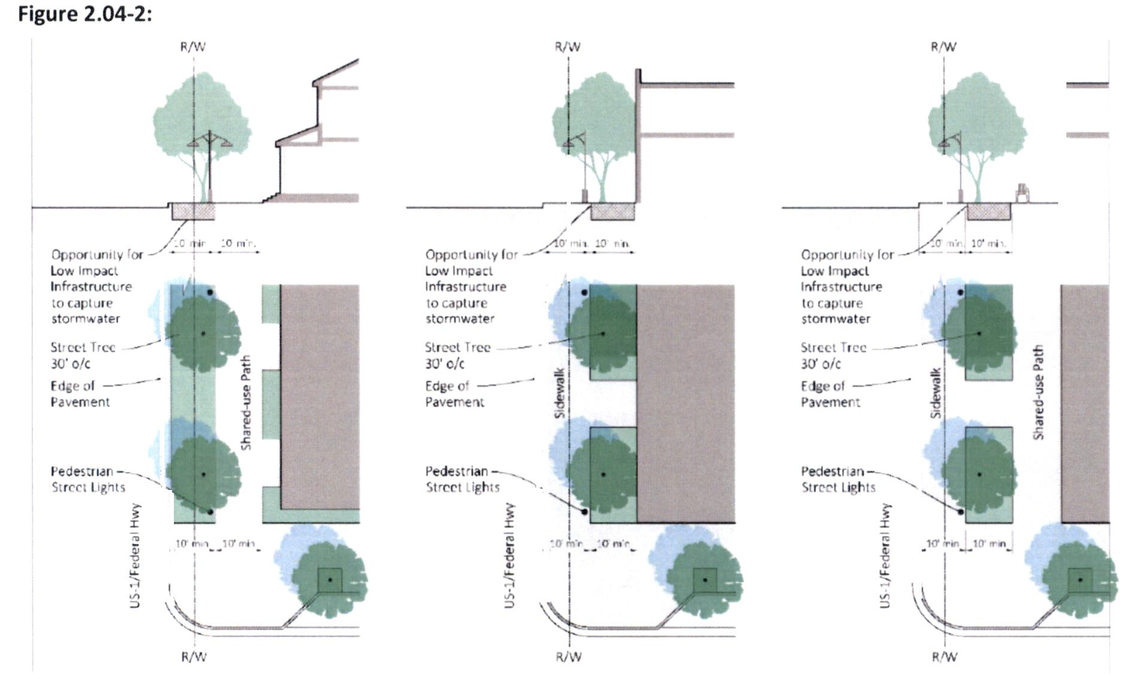
(Ord. No. 2520-2023, § 1(Exh. A), 10-23-23)
Sec. 2.04.07. - Supplemental building height.
A.
Building height.
1.
Building height is measured from the lowest permissible finished first-floor elevation set forth in LDR section 6.03.02.B.4. to the surface of a flat roof and the eave of a pitched roof. The peak of a pitched roof may not exceed 15 feet above maximum building height.
2.
A parapet wall shall not exceed 24 inches in height, provided however, a greater height of up to ten feet may be permitted by the city development director if necessary to conceal rooftop utilities such as stairway and elevator bulkheads and other roof equipment. No height of greater than 24 inches shall be permitted for more than 40 percent of any facade of a building. A parapet wall shall be designed to be consistent and compatible with the design and treatment of the facade of the structure.
B.
Roof top occupancy.
1.
Occupancy residential uses of a flat rooftop, which are ancillary to residential occupancies, shall be limited to uses which are ancillary to residential occupancies and shall be enclosed by a code-compliant safety railing or other approved barrier. Except as otherwise permitted by this Code, no permanently affixed structures, including, gazebos, trellises, or other similar structures shall be allowed on the roof of a four-story building. Maintenance and repairs shall not be deemed occupancy as that term is used in this paragraph.
2.
Rooftop dining, as defined by this Code, is permitted as a major conditional use, and in accordance with the supplemental standards in section 2.06.19.
Sec. 2.05.01. - Purpose.
A.
Support the Comprehensive Plan growth management goal of more efficient use of urban residential land, including the development potential for existing substandard lots.
B.
Provide a housing type that responds to changing household sizes and ages (e.g., retirees, small families, single person households).
C.
Provide opportunities for ownership of small, detached dwelling units within single-family neighborhoods.
D.
Provide guidelines to ensure compatibility with surrounding land uses.
Sec. 2.05.02. - Applicability.
The developments eligible for consideration include:
A.
New single-family residential construction; and
B.
Single-family residential redevelopment, including retrofitting/remodeling; but
C.
The cottage lot provisions shall be applicable in the R-1, R-2, and R-3 land use districts, but shall not be applicable in the R-1A, or the Community Redevelopment Area (CRA) districts.
Sec. 2.05.03. - Permitted uses.
A.
Single-family residential structures.
B.
Accessory structures incidental to the principal use.
C.
Home occupations (as defined in the LDC).
Sec. 2.05.04. - Future annexed area.
All residentially zoned land annexed into the city that does not meet minimum standards for development, such as minimum lot area or minimum lot width, shall be eligible for development under the provisions of these cottage lot provisions.
Sec. 2.05.05. - On-site parking standards.
A.
Each new single-family residential unit shall provide two parking spaces.
B.
Parking shall be located behind the front facade of the structure, where possible.
Sec. 2.05.06. - Development standards.
New single-family development, and redevelopment or remodel of single-family residences, on existing substandard lots (Exhibit A), shall be permitted to meet the cottage lot standards set forth below, on lots of record as of December 10, 2007. However, it is not the intent of the city commission to allow the creation, partition, or subdivision of lots of record after December 10, 2007, to create substandard lots, and thus come under the development rights provisions of the cottage lot section. To address stormwater and other potentially negative impacts on adjoining properties, the city development director may require stem wall construction and limited window opens, including privacy windows, at the side yard second floor level.
Sec. 2.05.07. - Reserved.
Editor's note— Ord. No. 2539-2025, § 2, adopted April 16, 2025, repealed § 2.05.07, which pertained to: exhibit a - building form standard.
Sec. 2.06.01. - Generally.
Certain uses have unique characteristics that require the imposition of development standards in addition to those minimum standards which may pertain to the general group of uses encompassing the use. These uses are listed in this part together with the specific standards that apply to the development and use of land for the specified activity. These standards shall be met in addition to all other standards of this Code, unless specifically exempted.
Sec. 2.06.02. - Manufactured/mobile home/recreational vehicle developments.
A.
Water supply.
(1)
Each site used as a manufactured/mobile home/recreational vehicle development shall be provided with an adequate supply of water of safe sanitary quality, approved by the Florida Department of Environmental Protection.
(2)
Where water from sources other than the municipal supply is proposed to be used, the source of the supply shall first be approved by the Florida Department of Environmental Protection.
B.
Waste and sewage disposal. Each manufactured/mobile home/recreational vehicle development shall be provided with safe and adequate means for the collection and removal of waste and garbage, and shall be either connected to the city sewer system, where such is available, or to a septic tank, all of which shall comply fully with all laws, ordinances or regulations prescribed by the city or the state.
C.
Size, condition of manufactured/mobile home/recreational vehicle site.
(1)
Each unit or site reserved for the accommodation of any manufactured/mobile home/recreational vehicle shall be not less than 25 by 35 feet, and shall be clearly defined by markers at each corner.
(2)
The site shall be level, free from rocks and weeds, and well drained.
(3)
The site shall be landscaped in accordance section 6.04.00, Landscaping. Compliance is required due to the classification of mobile homes as vehicles.
D.
Distance between manufactured/mobile homes/recreational vehicle; setback of manufactured/mobile home/recreational vehicle.
(1)
No manufactured/mobile home/recreational vehicle shall be located on any site where there is less than ten feet between the trailer and a building or another manufactured/mobile home/recreational vehicle.
(2)
No manufactured/mobile home/recreational vehicle site shall be placed or erected within less than five feet from the property line separating the development from adjoining property, measured from the nearest point of the manufactured/mobile home/recreational vehicle site.
(3)
No manufactured/mobile home/recreational vehicle development abutting on any public street, avenue, boulevard, terrace, court or place shall locate any manufactured/mobile home/recreational vehicle site beyond the established setback line and in no case closer than 20 feet to such street, avenue, boulevard, terrace, court or place.
E.
Roadways; entrances and exits.
(1)
Hard surfaced roadways or driveways shall be provided in a manufactured/mobile home/recreational vehicle development, not less than 18 feet in width.
(2)
Roadways or driveways shall be so located that each unit in the development is easily accessible.
(3)
All entrances and exits shall be well marked and so arranged that they can be easily controlled and supervised.
F.
Density.
(1)
No manufactured/mobile home/recreational vehicle development shall exceed ten units per acre.
G.
Prevention of trespass.
(1)
Each manufactured/mobile home/recreational vehicle development shall clearly indicate one or more entrances and exits, the use of which shall be enforced.
(2)
Where it is established by complaint of adjoining property owners that their property is being trespassed upon by patrons of any manufactured/mobile home/recreational vehicle development, the owner, manager or other person responsible, shall provide a fence or other effective barrier to insure the owners of adjoining property protection against trespass.
Sec. 2.06.03. - Assisted living facilities (ALF).
A.
Purpose. The purpose of this section is to provide standards, regulations and guidelines for the development of assisted living facilities (ALFs).
B.
Application. The provisions of subsections 2.06.03 C. and 2.06.03 D. shall only apply to facilities which provide housing to more than 12 persons or which are one or more acres in size.
C.
Procedures and prerequisites for use. Assisted living facilities which house four or fewer unrelated persons shall be a use by right in all residential zones. Licensed ALFs for five or more unrelated persons shall be a use allowed within RPUD districts or by conditional use in all zones that allow multi-family uses.
(1)
For facilities intended for RPUD districts, the provisions of section 2.07.00, planned unit development requirements, together with a site plan shall be required.
(2)
Standards.
a.
For facilities allowed by conditional use in multi-family zones, the permitted density of any facility shall be ten units per acre. For facilities intended for RPUD districts, the permitted density of any facility shall be up to a maximum of 30 units per acre.
b.
For all facilities, off-street parking shall be provided on the minimum basis of one space for every four living units, and one space for each staff person employed as determined by the maximum working shift. The city commission may require the provision of additional parking in the reasonable exercise of its discretion.
c.
For all facilities, each unit in the facility to be occupied by one person shall be a minimum of 250 square feet; each unit in the facility to be occupied by two persons shall be a minimum of 450 square feet. Additionally, at least 100 square feet of interior common area shall be provided for each unit. For facilities in excess of 150 units, the city commission may reduce the square footage requirements for common areas in exchange for increased area of the units, additional exterior common areas, or recreational facilities.
d.
All facilities shall provide facilities sufficient, as determined by the city commission, in size to serve meals to residents, and shall provide at least two meals a day to its residents which shall be included in the monthly fee.
e.
All facilities shall also provide the following amenities or services for its residents:
1.
An office or examination room for the purpose of housing a qualified and properly licensed nurse or nursing staff.
2.
T.V. and game room, library, arts and crafts center or other similar facility to provide leisure activities for facility residents.
3.
Laundry facilities for the residents.
f.
All facilities may also provide the following amenities for its residents:
1.
Sauna, swimming pool, tennis or other appropriate recreation facilities.
2.
A small scale convenience store to provide personal items such as toiletries, magazines, a small selection of groceries, prescriptions. Said facility shall be self-contained within the structure and open only to the residents of the facility.
g.
All facilities shall be subject to a 45-foot height maximum.
h.
All facilities shall be subject to the regulations applicable in R-3 districts which pertain to lot coverage, and setbacks.
i.
At least 20 percent of each facility site intended for an R-3 district shall be maintained as open space to be either a lawn or landscaped area which can be used for recreation and other leisure activities. Facilities intended for RPUD shall be subject to a 30 percent open space requirement.
j.
All signs in conjunction with any facility shall meet the applicable requirements pertaining to the R-3 zoning district.
k.
Accessory uses shall be limited to those normal and incidental to residential dwelling units, as determined by the city.
l.
Each facility and all its units shall be served by one master meter for water, sewer, and electric utilities.
m.
Any plan for a facility must establish not only compliance with those requirements set forth in subsections 2.06.03.C.2.a. through e. above, but also that such use will be reasonably compatible with the surrounding neighborhood on the basis of the following considerations:
1.
Ingress and egress to property and proposed structures thereon with particular reference to automotive and pedestrian safety and convenience, traffic flow and control, and access in case of fire.
2.
Off-street parking and loading areas where required, with particular attention to the economic, noise, glare or odor effects of the plan approval on adjoining properties and properties generally in the district.
3.
Location of refuse and service areas.
4.
Utilities with reference to locations, availability, and compatibility.
5.
Screening and buffering with reference to the type, dimensions, and character.
6.
Signs, if any, proposed exterior lighting with reference to glare, traffic safety, economic effect, compatibility and harmony with property in the district.
7.
Required yards and other open space.
8.
Height.
9.
Landscaping.
10.
Renewal and/or termination dates.
11.
Function, hours of operation, type and amount of traffic to be generated, building size and setbacks, relationship to land values and other factors that may be used to measure compatibility.
12.
In particular, the city commission may consider the size, location and state of repair of the facility, the ability of the site to accommodate required parking, ancillary service and outdoor activity requirements in the use and such off-site characteristics as may be documented including traffic generation and noise.
D.
Individual ownership; change in use.
(1)
No facility may offer or provide for individual ownership of its units unless the units fully comply with requirements of the City Code and applicable building codes in regard to multifamily structures.
(2)
In the event a facility is no longer used for an assisted living facility or is modified for the purpose of creating individual ownership of units by the conversion of the facility to a condominium or to any use other than as an assisted living facility, the plan approval provided for herein shall automatically terminate and the project, its buildings and facilities shall be subject to all requirements of multi family structures as permitted by the Code in the applicable district.
E.
Notice of conversion. If application is made to convert any condominium, apartment complex, or other multi-family residential complex to an assisted living facility or to construct an assisted living facility on property encompassed within the site plan of any residential complex as described above, the applicant shall, as a condition precedent to proceeding with the application, submit proof that all residents of the affected complex have received notice of the application and the date and time of the public hearing at which said application shall be considered.
Sec. 2.06.04. - Child care centers.
A.
Generally. Child care centers, are permitted in B-1, B-2, B-3, and the Urban Code District, may be allowed in RPUD (if under five acres), CPUD, MXPUD, and by conditional use in R-3 (if under five acres), B-4, and the BMU and GRO of the East Stuart District (if under three acres), subject to the following standards:
(1)
Required square footage of outdoor play area per child shall meet Florida Department of Children and Family Services standards and provide proof of issuance of a state license for such facility;
(2)
The outdoor play area is enclosed by a fence having a height of at least five feet in order to prevent passage through the planting;
(3)
One non-illuminated sign may be permitted to identify the principal structure, but such sign cannot exceed the size and height requirements of the respective zoning district, and cannot contain any advertising other than the name of the business;
(4)
The location of outdoor play equipment shall be determined in the site plan review;
(5)
The principal and accessory buildings shall meet all yard setback and height requirements of the applicable zoning district; and
(6)
Proof of application of a state license for such facility before approval of the conditional use shall be shown and such license must be issued before, or at the same time, of any certificate of occupancy or business tax receipt may be issued for such facility.
Sec. 2.06.05. - Automobile/boat sales and service facilities.
A.
Gasoline or other motor fuel stations, including storage tanks but excluding principal use signs, must be placed not less than 25 feet from any side or rear property lines, except where such side or rear property lines abut a street, in which case the setback shall be that required for such streets measured from the street centerline. All buildings or structures including gas pumps and storage tanks, except principal use signs, shall comply with the setback requirements of any abutting street. If on a corner lot, the means of access and egress shall be determined by the local or state department that owns the right-of-way. Ingress and egress shall be arranged and designed so as to minimize the interference with the flow of traffic.
B.
Auto/boat sales facilities must provide room for all repair and servicing inside an enclosed building, unless within an Industrial zoned district.
C.
Garages and repair shops must provide room for all repair and servicing inside an enclosed building, unless within an Industrial zoned district.
Sec. 2.06.06. - Automatic amusement center and game rooms.
Video game rooms must be at least 500 feet from any school or church. Unless entrance by minors is prohibited, bicycle racks to park one bicycle per every two machines must be provided.
Sec. 2.06.07. - Industrial uses.
The following standards shall apply when a proposed industrial development requires major development plan approval (over 50,000 square feet in gross floor area), or if an industrial planned unit development is proposed.
A.
Industry shall be of a nature as not to be injurious or offensive or detrimental to the present or intended character of the "B-4," "I" or "IPUD" zoning districts or vicinity by reason of emission of noise, dust, glare, smoke, gas, fire, odors, vibration, fumes, toxic waste materials.
B.
Planned industrial parks and new industrial developments must provide that abutting residential properties will be protected from drainage of surface water, noise, odor, glare, dust, and fumes or other objectionable conditions; that provision is made for adequate vehicular and pedestrian access and circulation so as not to present problems of safety on the site or unduly impeded normal traffic movement on adjacent streets; that requirements for parking as provided in chapter VI are met. Further, no building structure, or land within 100 feet of any parcel line or a parcel located in a residential district shall be used in connection with the operations of any establishment. Off-street parking and off-street loading space may be located within this setback area in accordance with regulations on parking in chapter VI. Within 300 feet of a residential district boundary line, all activities and operations shall be completely screened by a solid wall at least eight feet in height, and open storage shall not be of greater height than that of the enclosed fence, except that off-street loading and unloading spaces may be located in accordance with parking provisions of chapter VI.
C.
Sign painting and/or manufacturing shops must contain such activities within an enclosed building.
(Ord. No. 2539-2025, § 2, 4-16-25)
Sec. 2.06.08. - Urban agriculture.
A.
Purpose and intent. The purpose of permitting urban agriculture is to promote local food production for local consumption and promote the health, environmental and economic benefits of having such uses. Urban farms and community gardens are types of urban agriculture. Urban farms promote the local production of food primarily for sale to local sellers and consumers residing or doing business in Martin County, Florida. Community gardens promote the local production of food for use or consumption by the individuals directly involved in the food production. Community gardens may be divided into separate plots for cultivation by one or more individuals or may be farmed collectively.
B.
Applicability.
1.
This section shall apply to urban farms and community gardens.
2.
This section does not apply to a private garden which is accessory to an existing principal residential dwelling unit or multi-family residential development.
C.
Development standards.
1.
Maintenance responsibilities. The owner of the property on which the community garden or urban farm is located shall be responsible for maintaining the property so that it does not become overgrown with weeds, infested by invasive exotic plants or vermin, or a source of erosion or stormwater runoff and shall meet the applicable requirements of this Code.
a.
Abandonment. In the event that a property is not used as a community garden or urban farm for 60 or more consecutive days, the approval for such use shall expire and the site shall be restored by the property owner so as not to conflict with chapter 20, article II of the City Code of Ordinances.
2.
Size limitation. Community gardens shall not be greater than one-quarter acre in size without conditional use approval. Urban farms shall not be greater than five acres in size without conditional use approval. At least 50 percent of an urban farm site must be used for cultivation.
3.
Environmental assessment. Any person or group who wishes to establish an urban farm with plant beds that are not separated from the ground by a physical barrier shall obtain a phase I environmental site assessment to determine if any soil contamination exists. Such soil must be tested for any contaminants that would render it unsuitable for cultivating food on topsoil, including, but not limited to, lead and other toxic heavy metals; industrial solvents; gasoline; oils and greases; perclorethylene; and other chemicals that can be transmitted to people via soil contact or consumption of foods grown in such soil. If any historical sources of contamination are identified in the environmental site assessment, the applicant shall conduct all appropriate testing to determine the type and level of contamination, and conduct the appropriate remediation procedures to ensure that soil is suitable for gardening
4.
Permitted structures.
a.
Community gardens are permitted to have greenhouses, hoophouses, coldframes, storage sheds (as defined in chapter XII), shade pavilions, and planting preparation houses.
i.
Location. All structures shall meet the requirements of the underlying zoning district for setbacks.
ii.
Height. No building or other structure may be greater than 15 feet in height.
iii.
Impervious surface coverage. All structures shall not exceed the maximum impervious surface coverage of the underlying zoning district. Walkways should be unpaved and covered with mulch, gravel, or shell except as necessary to meet the needs of individuals with disabilities.
b.
Urban farms are permitted to have greenhouses, hoophouses, coldframes, and similar structures used to extend the growing season, as well as sheds, shade pavilions, farm stands, restrooms, and offices.
i.
Location and height. All structures shall meet the requirements of the underlying zoning district for setbacks. No permitted structure may be greater than 15 feet in height.
ii.
Impervious surface coverage. All structures shall not exceed the maximum impervious surface coverage of the underlying zoning district. Sheds, shade pavilions, farm stands, restrooms, offices or other structures that are not used for cultivating crops shall not exceed 15 percent of the gross urban farm area. Walkways should be unpaved and covered with mulch, gravel, or shell except as necessary to meet the needs of individuals with disabilities.
5.
Required planting setbacks. All plantings shall be planted no closer than five feet from the front, side or rear property lines. Cultivated area shall not encroach onto adjacent properties. All plantings shall comply with the visibility at intersection requirements pursuant to section 6.04.03.B.8 of this Code.
6.
Hours of operation and equipment. No gardening activities for urban farms and community gardens shall take place before sunrise or after sunset. Motorized-powered equipment for cultivating or maintenance purposes shall be operated in accordance with chapter 20, article VI (Noise) of the Code of Ordinances. The use of hand tools and domestic gardening tools is encouraged.
7.
Chemical application. Gardening in accordance with the University of Florida's Institute of Food and Agricultural Sciences, Florida Friendly Landscaping program is strongly encouraged. The use of fertilizer, pesticide, insecticide, herbicide or agricultural use chemicals must be consistent with label instructions and be in compliance with applicable sections of chapter 20, article VIII (Fertilizer) of the Code of Ordinances. All chemicals and fuels shall be stored in an enclosed, locked structure when the site is unattended.
8.
Fences. All fencing shall comply with the applicable fencing requirements of the underlying zoning district, except that fencing for community gardens within the R-1A, R-1, R-2, R-3 and R-M zoning districts shall not exceed four feet in height along road right-of-ways.
9.
Signage.
a.
Community gardens are permitted one sign, which shall not exceed four square feet in area, shall not exceed five feet in height, and shall have minimum property line setback of ten feet.
b.
Urban farms shall comply with section 6.11.00 of this Code.
10.
Composting and trash storage. Compost and organic matter shall be contained in appropriate containers or a contained area which shall be located with a 25-foot setback from all rights-of-way and a five-foot setback from all property lines. No trash or debris shall be stored or allowed to remain on the property unless contained in city-approved receptacle (e.g., carts or dumpsters).
11.
Sales of produce and plants.
a.
A community garden is not intended to be a commercial enterprise; however, there may be occasions when surplus of produce and horticultural plants are available, which may be sold off the premises or on-site via an approved special events permit pursuant to chapter 36, article III of the Code of Ordinances.
b.
The produce and horticultural plants grown in an urban farm may be sold on or off the premises and the property owner or garden coordinator shall obtain a business tax/certificate of use pursuant to the City Code of Ordinances prior to making any sales.
12.
Pursuant to chapter 8, article I of the Code of Ordinances, livestock shall be prohibited, with the exception of domestic chickens (Gallus domesticus) being kept, harbored, raised, or maintained as accessory to an urban farm, subject to the following restrictions:
a.
No more than 30 chickens per acre may be kept on an urban farm, with roosters prohibited;
b.
The chickens shall be provided with a covered enclosure (i.e., "henhouse/coop") and must be kept in the covered enclosure or a fully enclosed run at all times. Chickens must be secured within the henhouse/coop during non-daylight hours;
c.
Covered enclosures and fully enclosed runs must meet the standards of permitted structures included in section 2.06.09.C.4, and shall not be placed within ten feet to any property line of an adjacent property or 25 feet of any adjacent residential structure;
d.
The space per bird in the henhouse/coop shall not be less than four square feet per bird, and the space per bird in the fully enclosed run shall not be less than ten square feet per bird;
e.
Odors from chickens, chicken manure, or other chicken related substances shall not be detectable at the property boundaries. Enclosures shall be adequately ventilated, kept in neat condition, including provision of clean, dry bedding materials and regular removal of waste materials. All manure not used for composting or fertilizing shall be removed promptly, and shall not be allowed to accumulate and cause a hazard or nuisance to the health, welfare, or safety of humans or animals;
f.
All enclosures for the keeping of chickens shall be so constructed and maintained as to prevent rodents or other pests from being harbored underneath, within, or within the walls of the enclosure. The henhouse/coop must be impenetrable to rodents, wild birds, and predators, including dogs and cats;
g.
All feed and other items associated with the keeping of chickens that are likely to attract or become infested with or infected by rodents or other pests shall be kept in secure containers or otherwise protected so as to prevent rodents and other pests from gaining access to or coming into contact with them;
h.
No dog or cat that kills a chicken will, for that reason alone, be considered a dangerous or aggressive animal;
i.
Sales of eggs shall be conducted in accordance with section 2.06.08.C.11, and all applicable state and federal regulations; and
j.
Humane harvesting of chickens is permitted by trained personnel, according to all applicable state and federal regulations.
13.
Prohibition on agricultural tax exemption. A property owner shall be prohibited from seeking an agricultural tax exemption afforded by the local, state, or federal tax regulations.
14.
Administrative variances. Requests for administrative variances to the setback and structure size limitations may be made in accordance with section 8.04.08 of this Code.
D.
Application process. An application for administrative approval of a community garden or urban farm must be submitted to the development department along with the following documentation:
1.
Letters of no objection from adjoining property owners when a proposed community garden abuts property zoned or used for residential purposes;
2.
Rules and regulations that govern the operations of the farm or garden;
3.
Anticipated number of persons to be involved in the operation;
4.
Photograph(s) of the proposed urban farm or community garden site; and
5.
Site plan, drawn to scale, showing the following:
a.
Property size with dimensions;
b.
Location of existing and proposed structures on the property;
c.
Existing streets, easements or land restrictions on the property;
d.
Proposed fencing or screening;
e.
Off-street parking spaces, if required; and
f.
On-site water source.
Sec. 2.06.09. - Home occupations.
A.
Standards. The following specific standards shall apply to all home occupations:
(1)
The home occupation shall involve no more than one employee on site at any one time, not including members of the family residing in the dwelling unit who may be engaged in the home occupation, provided that there is sufficient off-street parking on an "approved paved surface" as defined in section 10-69(a) of the Code of Ordinances.
(2)
The use of the dwelling unit for the home occupation shall be clearly incidental and secondary to the residential use and shall under no circumstances change the residential character of the dwelling.
(3)
The floor area dedicated to the home occupation shall not exceed 25 percent of the floor area of the dwelling unit.
(4)
No building or yard space other than the principal building shall be used for home occupation purposes. There shall be no on-site, indoor or outside display or storage of materials or supplies.
(5)
There shall be no change in the outside appearance of the building or premises as a result of such occupation.
(6)
No signage of any kind may be displayed, with the exception of licensed real estate brokers who shall be permitted one sign, one square foot in size, to be placed at the home entrance.
(7)
No home occupation shall be conducted in any accessory building unless approved by a Major Conditional Use.
(8)
Advertisements for the business shall not state the residential address, only the phone number.
(9)
There shall be no use of utilities or community facilities beyond that normal to the use of the property for residential purposes.
(10)
No equipment shall be used in the home occupation which creates fire hazards, electrical interference, noise, vibration, glare, fumes, odors detectable to the normal senses outside the dwelling unit. In the case of electrical interference, no equipment or process shall be used which creates visual or audible interference in any radio or television receivers off the premises, or causes fluctuations in line voltage off the premises.
(11)
No commodity shall be sold on the premises nor displayed or warehoused on the premises for sale elsewhere.
(12)
No commercial vehicle may be parked or stored on-site for use in conjunction with the home occupation.
(13)
The home occupation shall not generate pedestrian or vehicular traffic in greater volume than would normally be expected to the home.
(14)
The use can qualify for all local, state and federal licenses, certificates and permits.
(15)
Any violation of these regulations may result in the revocation of any home occupation business tax receipt, in addition to any other remedy for such violation provided in the city's Code.
(16)
The issuance of a business tax receipt to engage in a home occupation in accordance with this ordinance shall not be deemed to be a change in zoning nor an official expression of opinion as to the proper zoning for the particular property.
(Ord. No. 2539-2025, § 2, 4-16-25)
Sec. 2.06.10. - Adult businesses.
A.
Adult business premises regulations.
(1)
All adult materials shall be located and the activities of employees which include the exposure of specified anatomical areas shall take place within the adult business premises.
(2)
No adult materials or activities of employees which include the exposure of specified anatomical areas shall be visible from the exterior of the adult business premises in any way including, but not limited to, exterior apertures such as opened doors and unobscured windows.
(3)
No merchandise, advertising or depictions of the activities of an adult business shall be displayed on the exterior of the adult business premises or in any location where they are visible from public right-of-way.
(4)
No adult business shall display a sign:
a.
Advertising the presentation of any activity prohibited by Florida statute law or any applicable city ordinance; or
b.
Capable of leading a reasonable person to believe that the establishment engages in an activity prohibited by Florida statute law or any applicable city ordinance.
(5)
Additional landscaping shall be provided adjacent to public right-of-way and adjacent to private property:
a.
A landscaped strip at least five feet wide shall be provided along the boundary of adjacent public right-of-way between the right-of-way and all on-site parking areas and other vehicular use areas to consist of one tree for every 50 feet or portion thereof and a fence, wall or hedge not less than four feet in height at planting; and
b.
An opaque fence, wall or hedge shall be provided along the boundary of adjacent private property of a height of not less than four feet nor more than eight feet at planting.
B.
Distance requirements. The following distances shall be measured by straight line measurement without regard to intervening buildings from the nearest point of the building or unit within a building in which the proposed adult business is to be located to the nearest point of the lot, use, right-of-way line or district from which the proposed adult business is to be separated.
(1)
No adult business shall commence operation within 1,000 feet of the "R-1A," "R-1," "R-2," "R-3" and "RPUD" residential zoning districts, as well as any existing residential use regardless of the parcel's zoning designation.
(2)
No adult business shall commence operation within 1,000 feet of any other adult entertainment establishment.
(3)
No adult business shall commence operation within 1,000 feet of a church or school.
(4)
No adult business shall commence operation within 250 feet from the nearest right-of-way line of State Road 5, commonly known as "U.S. 1." as laid out and in use on July 26, 1995. This requirement shall also include that portion of State Road 5 consisting of the Roosevelt Bridge and the approaches thereto.
C.
Prohibited activities.
(1)
It shall be unlawful for an employee of an adult business to engage in specified sexual activities within the adult business premises in the presence of a patron or spectator of the business or for any form of compensation.
(2)
It shall be unlawful for an employee of an adult business to physically touch a patron or spectator of an adult business while simultaneously revealing specified anatomical areas.
D.
Amortization of non-conforming adult businesses.
(1)
An adult business in violation of the location or distancing requirements of this ordinance at the time of its enactment on June 26, 1995, shall be deemed a nonconforming use which may remain in operation until January 1, 1998. No such nonconforming use shall continue to operate as an adult business after January 1, 1998, except in compliance with the requirements of this ordinance.
(2)
If any nonconforming adult business ceases to do business for a continuous period of six months, it shall be deemed abandoned and shall not thereafter reopen except in conformance with these regulations.
(Ord. No. 1420-95, 6-26-95)
Sec. 2.06.11. - Telecommunication facilities.
A.
Purpose. The purpose and intent of this article is to provide a uniform and comprehensive set of standards for the development and installation of telecommunication towers, antenna support structures, antennas and related facilities. The regulations contained herein are designed to protect and promote public health, safety, community welfare and the aesthetic quality of the city, while at the same time not unduly restricting the development of needed telecommunication facilities or denying wireless communications suppliers access to the public switched telephone network (PSTN). This regulation encourages managed development of telecommunication infrastructure.
B.
Submittal requirements. In addition to the applicable site plan or PUD submittal requirements, applications for all towers shall include the following documentation:
1)
Land used and existing towers. Identification of all land uses within 1,000 feet and existing towers within one mile of the proposed tower site.
2)
Proof of necessity. No new telecommunication facility shall be permitted unless the applicant demonstrates that there is no existing tower or structure that can accommodate the applicant's proposed antenna and facilities. All evidence submitted by the applicant regarding necessity shall be signed and sealed by appropriate licensed professionals. The applicant shall demonstrate that there is no existing tower or structure that can accommodate the proposed antenna and facilities using the following criteria:
a.
No existing towers or suitable alternative structures are located within the geographic antenna placement area required to meet the applicant's engineering requirements.
b.
No existing towers or structures are of sufficient height to meet the applicant's engineering requirements.
c.
No existing towers or structures have sufficient structural strength to support the applicant's antenna and related equipment.
d.
Existing towers that may be geographically and structurally suitable for co-location cannot be used due to predictable electromagnetic interference between existing radiators and proposed co-locators. Proof of unsuitability by applicant shall be provided to the city.
e.
The applicant is unable to make use of existing towers or structures because of excessive economic demands or other conditions of use that the applicant cannot meet. The estimated cost of the construction of a new tower shall be one criterion to determine whether the economic demand of the tower owner is excessive.
3)
Demonstration of intended service area. The applicant shall demonstrate that the antenna or tower must be placed in the location proposed for the intended service area. The demonstrations shall be provided using relevant technological evidence. The demonstration shall include a drawing showing the boundaries of the intended service area around the proposed location and its relationship to the applicant's grid system. In relation to the intended service area, the applicant shall also demonstrate that the proposed antenna or tower is no higher than necessary to function satisfactorily and to accommodate the co-location requirement.
4)
Authorization. Telecommunication towers and STFs (stealth telecommunications facilities) shall comply with applicable Federal Aviation Administration and Federal Communications Commission regulations. Evidence of compliance must be submitted prior to issuance of building permits for construction. The Martin County airport manager shall be notified by the applicant of all applications within ten days of filing. All new telecommunication towers and STFs shall include an FAA study for the proposed site.
5)
Certification. All certifications required for the construction of telecommunication towers and STFs shall be sealed by a Florida registered engineer.
6)
Design. All telecommunication towers and STFs must be structurally certified to withstand a category four hurricane and ANSI/TIA 22 or the most recent wind loadings required by the State of Florida Building Code for the City of Stuart area, whichever is most restrictive. This documentation shall be submitted with the application.
C.
Setbacks. All telecommunication towers, STFs and accessory and support structures including guy anchors shall comply with the applicable zoning district setbacks. For guyed towers, applicants should submit certified break-apart area calculations in order for the property boundary setbacks of the tower to be determined. The break-apart calculations shall be verified by the city development director. If the applicant does not submit break-apart calculations, the minimum setbacks from all property lines shall be 110 percent of the height of the tower.
D.
Fencing. A wall or fence no less than ten feet in height from finished grade shall be constructed around each telecommunication tower and around related support or guy anchors. Access to the tower shall be locked.
E.
Warning signs. Warning signs with six inch lettering shall be installed five feet above finished grade on the required fence. "NO TRESPASSING" warning signs shall be attached to the fence and be spaced no more than 40 feet apart. If voltage above 220 volts is necessary for the operation of the tower and is present at the base of the tower, signs located no more than 40 feet apart and attached to the fence shall indicate "DANGER HIGH VOLTAGE." In the event that warning signs intended to be attached to a fence would be obstructed by landscaping, then the applicant shall attach warning signs to free-standing poles that are properly spaced around the site so as to be clearly visible. FCC required signage shall be displayed and visible outside of the fencing.
F.
Maintenance of facilities. Telecommunication towers and STFs shall be maintained and inspected by the telecommunications provider once every five years, or within 90 days following a catastrophic act of nature or other emergency that may affect the structural integrity of the tower, to ensure the continuing structural integrity of the tower and accessory structures. If the report recommends that repairs are required, then a letter shall be submitted to the city to verify that such repairs have been completed along with the inspection records. The city may require repair or removal of the tower based on inspection records. The city shall have no responsibility regarding such repairs. The applicant shall be required to keep all inspection, maintenance, and similar records on file and shall make these records available to the city for review upon request.
G.
Shared use. To discourage the proliferation of telecommunication towers, and to promote shared use of facilities, all monopoles shall be designed to accommodate not less than one additional similar provider in addition to the applicant, and all other self-supporting type towers shall be designed to accommodate not less than two additional providers in addition to the applicant. Land space at the tower site shall also be adequate to accommodate these additional collocations. Placement of more than one tower on a land site may be permitted if all setbacks, design and landscape requirements are met for each facility. The applicant must demonstrate to the satisfaction of the city development director that no existing or planned tower can accommodate the applicant's requirements.
H.
Dedication of tower use to the city. The city may require, as a condition of approval, the dedication of space on a tower for communications equipment required for public safety. The need for such public use shall be indicated to the applicant prior to formal approval of an application. Space which has been dedicated to the city for public safety shall constitute one additional provider per shared use requirements of this Code. In the case of co-use with the city, the applicant shall certify that none of the proposed or future users of the tower shall interfere with its use by the city for public safety.
I.
Landscape buffers. In addition to landscaping requirements per chapter VI of this Code, landscape buffers shall be required around the perimeter fencing of the telecommunication tower and any accessory uses, including guy anchors. Landscape buffers shall be located outside and within ten feet of the required fence and shall include not less than one tree and suitable ground cover for every 20 linear feet of fence. In addition, a hedge shall be installed around the exterior perimeter of fences per the chapter VI of this Code.
J.
Architectural design, colors and warning lights. Except where superseded by the requirements of other governmental agencies possessing jurisdiction over telecommunications facilities, telecommunications towers shall be gray galvanized steel. Warning lights for telecommunications towers and STFs shall be blinking red lights and not strobe lights unless otherwise required by applicable regulations.
K.
Access. A 12-foot-wide stabilized access driveway is acceptable to a telecommunication tower, unless the city development director determines, based on public safety concerns, that circumstances require paved access. The turn-around area shall be approved by the city engineer, police chief and fire chief.
L.
Parking. For new telecommunication towers exceeding 150 feet in height, a minimum of one on-site parking space shall be provided. The parking area shall be paved if the access road is paved. After evaluation of the proposed telecommunication tower and related facilities, staff may determine that additional spaces are required as a condition of approval.
M.
Occupancy. Telecommunication towers and accessory structures shall be unoccupied.
N.
Accessory or principal use. A tower may constitute an accessory use on a parcel containing a separate principal use. If a tower constitutes a principal use, then it must be located on a property which meets the minimum parcel size requirements of the district in which the tower is located and is large enough to accommodate the tower, accessory structures, landscaping, parking and other required improvements.
(Ord. No. 2539-2025, § 2, 4-16-25)
O.
Signs and advertising. The use of any portion of a tower for signs or advertising is prohibited.
P.
Telecommunication tower distance requirements. The following distances shall be measured by straight line measurement without regard to intervening buildings from the nearest point of the building or unit within a building in which the proposed telecommunications tower is to be located to the nearest point of the parcel, use, right-of-way line or district from which the proposed telecommunications tower is to be separated.
(1)
No telecommunications tower shall be constructed within 500 feet of the "R-1A," "R-1," "R-2," "R-3" and "RM" residential zoning districts within the city or within 500 feet of a residential area outside the city.
(2)
No telecommunications tower shall be constructed within 500 feet of a school.
(3)
No telecommunications tower shall be constructed within 100 feet from the nearest right-of-way line of State Road 5, commonly known as "U.S. 1." as laid out and in use on July 26, 1995. This requirement shall also include that portion of State Road 5 consisting of the Roosevelt Bridge and the approaches thereto.
(Ord. No. 2539-2025, § 2, 4-16-25)
Q.
Fire protection. Tower support buildings shall be built of non-combustible construction with built-in ventilation. A smoke detector shall be installed which upon activation will shunt trip the electrical power to the building. Except for emergency power operation, no combustible storage is permitted in tower support buildings. Prefabricated tower support buildings which comply with provisions of applicable NFPA standards shall be permitted.
R.
Tower removal. An unused tower shall be removed within three months of cessation of all telecommunications uses.
S.
Tower replacement.
Existing non-conforming towers and STFs established prior to February 24, 1997 shall not be considered in conflict with this Code but shall be governed as follows:
1.
Nothing in this Code shall prohibit routine maintenance on a nonconforming tower or STF or prohibit the placement of additional antennas (co-location) on a non-conforming tower.
2.
To promote shared use of towers, if an applicant can demonstrate that an existing telecommunications tower location which has been approved by the commission by resolution or conditional use is needed by an additional telecommunications provider, the existing telecommunications tower may be replaced with a tower not to exceed 120 percent of the height of the existing tower.
T.
Temporary facilities. Temporary facilities known as "cells on wheels" shall be allowed for periods up to 30 days during documented states of emergency as declared by the city manager, and for testing purposes as authorized by the FCC, and for special events subject to the review and approval of the airport manager and city development director. The development director has the authority to extend the period for one additional 30-day period. Extensions beyond 60 days may be granted by the city commission based upon proper justification and necessity. All locations for temporary facilities shall be governed by the requirements set forth in this section and subject to airport manager's acceptance for height limitations. Applications for temporary facilities shall be made on the same applicable form as regular towers, submitted to the city development director and accompanied by an application fee of $500.00 payable to the city.
Sec. 2.06.12. - Formula businesses.
A.
Procedure. Review of an application to locate a formula business within the formula business area described below shall follow the procedures set forth in section 3.01.06 for a major Urban Code conditional use.
B.
Formula business area. A formula business may be located in the area within the following boundaries only by major Urban Code conditional use. Commence at the northernmost point of Lot 10 Danforths Addition, thence along the St. Lucie River to Detroit Avenue, thence south along Detroit Avenue to East Ocean Boulevard, thence west along East Ocean Boulevard to the intersection with S.E. Flagler Street, thence south along S.E. Flagler Street to the easternmost point of Lot C of Lainhart and Potter addition and southwest across the F.E.C. Railroad right-of-way to S.E. Old Dixie Highway, thence southeast along S.E. Old Dixie Highway to Martin Luther King Jr. Boulevard, thence west along Martin Luther King Jr. Boulevard to the southerly extension of Camden Avenue, thence north along Camden Avenue to a point directly west of the northernmost point of lot 14, Block 15 Frazier Addition, thence west to the southerly extension of S.W. Albany Avenue, thence north along S.W. Albany Avenue to the F.E.C. Railroad right-of-way, thence across the F.E.C. Railroad right-of-way to the westernmost point of Lot 10 Danforths Addition, thence northeasterly along the west boundary of Lot 10 Danforths Addition to the point of beginning. The following graphic depicts this area.
EXHIBIT A: FORMULA BUSINESS AREA
(Ord. No. 2498-2023, § 1(Exh. A), 2-13-23)
C.
Standards. The following specific standards shall apply to formula businesses in the Urban Center, Urban Neighborhood, Urban General, Urban Waterfront sub-districts of the Urban District, and Creek North Zoning.
(1)
The proposed formula business will not alter the identity of the urban district in a way which detracts from its uniqueness or contributes to a nationwide trend of standardized downtown offerings.
(2)
The proposed formula business will contribute to a diverse and appropriate blend of businesses in the urban district.
(3)
The proposed formula business will complement those businesses already in the urban district and help promote and foster the local economic base as a whole.
(4)
The proposed formula business will be compatible with existing surrounding uses.
(5)
The proposed formula business has been designed and will be operated in a nonobtrusive manner to preserve the community's character and ambiance and the proposed intensity of uses on the site is appropriate given the uses permitted on the site and on adjoining sites.
(6)
The proposed formula business meets all of the following fixed criteria:
a.
The size of the business shall not exceed 1,500 square feet of gross floor area in the Old Downtown District.
b.
The first floor street frontage of the business shall not exceed 35 feet in width in the Old Downtown District.
c.
Architectural Style, design, exterior facade colors shall comply with the surrounding neighborhood and requirements of the Urban Code and Creek District Code.
d.
Corporate structural elements and signage will be designed to be in harmony with architectural features and elements of the building and neighborhood as approved by the Development Director.
e.
No drive thru windows shall be permitted.
(Ord. No. 2498-2023, § 1(Exh. A), 2-13-23)
D.
Distance requirements. A formula business shall not locate within 300 feet of an existing formula business establishment in the Old Downtown District.
(Ord. No. 2498-2023, § 1(Exh. A), 2-13-23)
E.
Existing formula business. A business may be a formula business that exists on the 14th day of February, 2005, the effective date of this ordinance. Any such business, and any business that becomes a formula business by virtue of the creation of six or more other such businesses, shall be deemed a legal nonconforming use of a building subject to the provisions of Sec. 8.03.00 of this Code.
(Ord. No. 2498-2023, § 1(Exh. A), 2-13-23)
Sec. 2.06.13. - Dog-friendly restaurants.
A.
Purpose. The Dixie Cup Clary Local Control Act, F.S. § 509.233, grants the city the authority to provide exemptions from § 6-501.115, 2001 FDA Food Code, as adopted and incorporated by the division of hotels and restaurants in F.A.C. ch. 61C-4.010(6) (2006). The purpose of this section is to allow dogs in public food service establishments in a manner consistent with the three-year pilot program approved by state statute. The procedure adopted pursuant to this section provides an exemption, for those public food service establishments which have received a permit, to those sections of the Food and Drug Administration Food Code that prohibit live animals in public food service establishments.
B.
No dog shall be in a public food service establishment unless allowed by state law and the public food service establishment has received and maintains an unexpired permit pursuant to this section allowing dogs in designated outdoor areas of the establishment.
C.
Application requirements. Public food service establishments must apply for and receive a permit from the city development department, before patrons' dogs are allowed on the premises. The city development director shall establish a reasonable fee to cover the cost of processing the initial application and renewals. The application for a permit shall require such information from the applicant as is deemed reasonably necessary to enforce the provisions of this section, but shall require, at a minimum, the following information:
(1)
Name, location, mailing address and division of hotels and restaurants-issued license number of the public food service establishment.
(2)
Name, mailing address and telephone contact information of the permit applicant. The name, mailing address and telephone contact information of the owner of the public food service establishment shall be provided if the owner is not the permit applicant.
(3)
A diagram and description of the outdoor area which is requested to be designated as available to patrons' dogs, including dimensions of the designated area; a depiction of the number and placement of tables, chairs and restaurant equipment, if any; the entryways and exits to the designated outdoor area; the boundaries of the designated area and of the other outdoor dining areas no surrounding property lines and public rights-of-way, including sidewalks and common pathways; and such other information as is deemed necessary by the city development director. The diagram shall be accurate and to scale but need not be prepared by a licensed design professional. A copy of the approved diagram shall be attached to the permit.
(4)
A description of the days of the week and hours of operation those patrons' dogs will be permitted in the designated outdoor area.
(5)
For permits authorizing "dog-friendly restaurants" within the outdoor areas of public food service establishments located on a city right-of-way, the city development director shall require the applicant to produce evidence of the following:
a.
A valid unexpired revocable permit under section 70-91 et seq. of the City Code; and
b.
A properly executed certificate of insurance on forms which are to be furnished by the city providing commercial general liability insurance in the amount of $500,000.00 per occurrence, and $1,000,000.00 aggregate. The policy shall not have exclusions for animals and animal bites. All insurance shall be from companies duly authorized to do business in the State of Florida. All liability policies shall provide that the city is an additional insured as to the operation of the sidewalk cafe and shall provide for the severability of interest. Thirty days' written notice must be given the city of any cancellation or reduction in the policy coverage.
D.
Regulations. Public food service establishments that receive a permit for a designated outdoor area pursuant to this section shall require that:
(1)
Employees shall wash or otherwise sanitize their hands promptly after touching, petting or otherwise handling any dog(s) and shall wash their hands before entering other parts of the public food service establishment from the designated outdoor area.
(2)
Employees are prohibited from touching, petting or otherwise handling any dog while serving or carrying food or beverages or while handling or carrying tableware.
(3)
Patrons in a designated outdoor area shall be advised by appropriate signage, at conspicuous locations, that they should sanitize their hands before eating. Waterless hand sanitizer shall be provided at all tables in the designated outdoor area.
(4)
Patrons shall not leave their dogs unattended for any period of time. Patrons shall keep their dogs on a leash at all times and shall keep their dogs under reasonable control.
(5)
Employees and patrons shall not allow dogs to come into contact with serving dishes, utensils, tableware, linens, paper products or any other items involved with food service operations. Patrons shall be advised of this requirement by appropriate signage at conspicuous locations.
(6)
Employees and patrons shall not allow any part of a dog to be on chairs, tables or other furnishings.
(7)
Employees shall clean and sanitize all table and chair surfaces with an approved product between seating of patrons.
(8)
Employees shall remove all dropped food and spilled drink from the floor or ground as soon as possible, but in no event less frequently than between seating of patrons at the nearest table.
(9)
Employees and patrons shall remove all dog waste immediately and the floor or ground shall be immediately cleaned and sanitized with an approved project. The public food service establishment shall keep a kit with the appropriate materials for this purpose near the designated outdoor area. Dog waste shall not be carried in or through indoor portions of the public food establishment.
(10)
Employees and patrons shall not permit dogs to be in or to travel through, indoor or non-designated outdoor portions of the public food service establishment.
(11)
A sign or signs notifying the public that the designated outdoor area is available for the use of patrons and patrons' dogs shall be posted in a conspicuous manner and place, as determined by the city development director that places the public on notice.
(12)
A sign or signs informing patrons of these laws shall be posted on premises in a conspicuous manner and place as determined by the city development director.
(13)
A sign or signs informing employees of these laws shall be posted on the premises in a conspicuous manner and place as determined by the city development director.
(14)
Ingress and egress to the designated outdoor area shall not require entrance into or passage through any indoor area or non-designated outdoor portions of the public food service establishment.
(15)
The public food service establishment and designated outdoor area shall comply with all permit conditions and the approved diagram.
(16)
Employees and patrons shall not allow any dog to be in the designated outdoor area of the public food service establishment if the public food service establishment is in violation of any of the requirements of this section.
(17)
Permits shall be conspicuously displayed in the designated outdoor area.
(18)
It shall be unlawful to fail to comply with any of the requirements of this section. Each instance of a dog on the premises of a public food service establishment without a permit is a separate violation.
E.
Expiration and revocation.
(1)
A permit issued pursuant to this section shall expire automatically upon the sale of the public food service establishment and cannot be transferred to a subsequent owner. The subsequent owner may apply for a revocable permit pursuant to this section if the subsequent owner wishes to continue to allow patrons' dogs in a designated outdoor area of the public food service establishment.
(2)
Permits are renewed and inspected annually by the development department. In the event the permittee does not pay the renewal fee, the permit is revoked.
(3)
A revocable permit may be revoked by the city development director if, after notice and reasonable time in which the grounds for revocation may be corrected, the public food service establishment fails to comply with any condition of approval, fails to comply with the approved diagram, fails to maintain any required state or local license or is found to be in violation of any provision of this section. If the grounds for revocation is a failure to maintain any required state or local license, the revocation may take effect immediately upon giving notice of revocation to the permit holder.
(4)
If a public food service establishment's permit is revoked, no new revocable permit may be approved for the establishment until the expiration of 180 days following the date of revocation.
F.
Complaints and reporting.
(1)
Complaints may be made in writing to the city development director, who shall timely accept, document, and respond to all complaints. The city development director shall timely report to the division of hotels and restaurants all complaints and the response to such complaints.
(2)
The city development director shall provide the division of hotels and restaurants with a copy of all approved applications and permits issued.
(3)
All applications, permits and other related materials shall contain the division of hotels and restaurants-issued license number for the public food service establishment.
Sec. 2.06.14. - Pain management clinics.
A.
Definitions. The following terms, as used in this Code, "approved pain specialist," "pain management clinic or clinic," and "pharmacy" are found in chapter XII, Definitions, of this Code.
B.
General requirements; conditional use.
1.
Each pain management clinic shall at all times, be in compliance with each and every provision of this section, as well as all applicable federal laws, state laws, administrative rules, and city codes. It is the intention of this section to insure compliance with all provisions of Laws of Fla. ch. 2010-211, as incorporated in the Florida Statutes, and F.A.C. 64B8-9.0131 (medical doctors) or F.A.C. 64B15-14.005 and F.A.C. 64B15-14.009 (osteopathic physicians), all as amended from time to time, and to provide additional city regulations not covered or regulated thereby; and
2.
A pain management clinic, as defined herein, shall be permitted only as a conditional use, as provided in section 11.01.10, Stuart Land Development Code (LDC), and must be operated by an approved pain specialist, or as a Florida Agency for Health Care Administration (ACHA) licensed operation, under F.S. ch. 400, part X, and as otherwise required by Florida law; and
3.
In the event the owner or operator of a state licensed or designated pain management clinic has such license or designation revoked by the Florida Board of Medicine, the Florida Board of Osteopathic Medicine or by ACHA, any conditional use approval granted hereunder shall simultaneously be revoked, and shall thereafter be null and void.
C.
Location. On or after September 13, 2010, any new pain management clinics shall only be located in the following zoning districts, subject to the other requirements of this section:
1.
In the "H" Hospital zoning district, and in those portions of the "R-3" (multi-family) residential zoning district, which allow for professional office use, and which are shown on the boundary map below:
2.
In the "CPUD" commercial planned unit development districts. Pain management clinics shall only be permitted in CPUD locations where the predominate use within the CPUD is office or professional office. Any existing CPUD shall qualify for a new or expanded pain management clinic use, by obtaining a major PUD amendment, and demonstrating strict compliance with all of criteria contained in this section.
3.
Pain management clinics, regardless of location, which exist on September 13, 2010, shall be deemed a lawful use, and not subject to the provisions of section 8.03.00, LDC, regarding non-conforming uses.
D.
Distance requirements. The following distances shall be measured by straight line measurement without regard to intervening buildings from the nearest point of the building or unit within a building in which the proposed clinic is to be located to the nearest point of the parcel, use, right-of-way line or district from which the proposed clinic is to be separated.
1.
No pain management clinic shall commence operation within 300 feet of any other pain management clinic.
2.
No pain management clinic shall be co-located in the same office or building with a pharmacy, unless such pharmacy shall have pre-dated the pain management clinic by at least one year.
3.
No pain management clinic shall commence operation within 200 feet of a pharmacy, unless such pharmacy shall have pre-dated the pain management clinic by at least one year.
4.
Regardless of the other provisions of subsection C, above, no pain management clinic shall commence operation within 250 feet from the nearest right-of-way line of State Road 5, commonly known as "U.S. Highway 1" as laid out and in use on July 26, 1995. This requirement shall also include that portion of State Road 5 consisting of the Roosevelt Bridge and the approaches thereto.
(Ord. No. 2539-2025, § 2, 4-16-25)
E.
Other regulations.
1.
It shall be unlawful for any clinic to be open for operation between the hours of 6:00 p.m. and 7:00 a.m.
2.
It shall be unlawful for a clinic owner or operator to direct or encourage any patient or business invitee to stand, sit, or gather outside of the building in which the clinic operates, on the adjoining sidewalk or in the area(s) designated for parking, in such manner as to restrict or interfere with the lawful entry into or out of such clinic or other uses co-located within a building. This prohibition includes sitting in or on a vehicle. The clinic owner(s) and operator(s) shall be responsible to actively monitor and apply this regulation. Clinics shall provide sufficient inside seating to insure and provide adequate seating for all patients or business invitees, and those who accompany such persons.
3.
The number of parking spaces required for pain management clinics shall be the same as for those required of medical offices, but may be subject to a parking analysis study as provided in section 6.01.17, LDC, when the development director has reasonable doubt as to the safety, sufficiency or configuration of available vehicle parking.
F.
Signage.
1.
Approved signage for a pain management clinic shall not include any word(s) or phrase(s) which offers or suggests goods, drugs, prescriptions or services in violation of any applicable state law or which otherwise violates state law, including without limitation, the provisions of F.S. § 456.037 (active license required), F.S. § 456.057 (patient records requirements), F.S. § 458.3265 (pain management clinic registration - MD), F.S. § 458.327 (medical practice violations and penalties), F.S. § 458.331 (medical disciplinary actions), F.S. § 459.0137 (pain management clinic registration - DO), F.S. § 459.013 (osteopathic practice violations and penalties), F.S. § 459.015 (osteopath disciplinary actions), F.S. § 465.0276 (dispensing practitioners) or F.S. § 893.055 (drug monitoring program), as currently written or amended.
2.
Signage for a pain management clinic shall not contain any word or phrase that uses the word "pain," unless the clinic is operated by an approved pain specialist or as an AHCA licensed operation (F.S. ch. 400, part X). No off-premise signage, including billboards wherever located, shall be permitted for the advertisement of pain management clinics.
3.
Signage for a pain management clinic must contain the correct name of the physician or physicians designated by the clinic pursuant to F.S. § 458.3265(1), as amended from time to time, and such signage shall be kept current at all times with the correct name of the practice, the correct name of the physician(s) designated, and other relevant information.
4.
Nothing contained in this section shall be interpreted to restrict the use of the word "pain" in advertising by Florida licensed chiropractors, physical therapists, nurse practitioners, naturapaths, acupuncturists, massage therapists, dentists, oral surgeons, or similar treating or dispensing professionals not licensed under F.S. ch. 458 or 459.
G.
Landlord responsibilities. Owners or landlords who lease space to a pain management clinic must expressly incorporate the provisions of this section 2.06.16 into their lease(s) with the clinic. Any such lease, whether oral or written, must provide that a violation of any federal or state law or municipal ordinance regulating or affecting pain management clinics shall be a material breach of the lease and shall constitute grounds for termination and eviction by the owner or landlord.
Sec. 2.06.15. - Minimum single-family and duplex residential design standards for new construction.
These design standards shall apply to all new single-family and duplex residential development. Mobile homes, properties within the Urban Code District, additions and restoration development are excluded from these provisions.
A.
Purpose. The purpose and intent of this article is to provide minimum design standards for single-family and duplex residential development, which shall apply to all new single-family detached structures and duplexes.
B.
New single-family and duplex residential development shall meet the following minimum design standards:
(1)
Driveways and walkways shall consist of concrete, brick or concrete pavers, asphalt, stamped pattern concrete systems, rock salt textured concrete with integral color, grass block, or other similar material approved by the city development director.
(2)
Yards shall be sodded or otherwise landscaped in accordance with section 6.04.08.A.
(3)
Foundations shall consist of slab on grade, stem wall, poured concrete piers or pilings and shall be the sole means by which load and uplift standards are met. Dry stack foundations and cable tie down systems are not permitted.
(4)
For the purpose of minimizing storm water impacts, the finished floor elevations of surrounding properties shall be taken into consideration in establishing the finished floor elevation of the new structure. Fill may be placed on site to the level of natural grade, maintaining the overall drainage of the neighborhood. If new construction has a floor level higher than natural grade, the foundation is to provide for the rise in floor level, rather than mounding fill to building perimeter. Minor grading directing water away from house to natural established drainage is allowed.
(5)
Exterior equipment, including, but not limited to, air conditioning equipment, heat pumps, generators and pool equipment, shall be shielded from view.
(6)
Main entries shall be prominent and orientated to the street unless another pattern is well established in the surrounding neighborhood.
(Ord. No. 2539-2025, § 2, 4-16-25)
Sec. 2.06.16. - Shooting ranges, indoor.
A.
All firing shall take place within a completely enclosed building.
B.
No shooting range shall be located within 50 feet of a residential district.
C.
Applications for the development of an indoor shooting range shall include a plan by a Florida registered engineer demonstrating that the building is soundproof and appropriately designed for such use.
Sec. 2.06.17. - Supplemental parking standards for live aboard vessels.
A.
Any property owner or business entity seeking a utility services agreement from the city for the purpose of obtaining or amending a marine related environmental permit or submerged land lease from any state agency shall provide and maintain one parking space for each parking intensive vessel slip, as defined herein, the number and location of which shall be identified and agreed to in the utilities services agreement. The number of parking spaces required for each non-parking intensive vessel slip shall comply with the off-street parking standards set forth in chapter 6 of this Code. A conditional use to the parking intensive vessel slip standard referenced above may be granted as set forth in this Code.
B.
Notwithstanding any provision in this Code to the contrary, including sections 8.03.00—8.03.02 "Non-conforming uses," for existing, legal non-conforming marinas, which already have a utility services agreement with the city, the supplemental parking standard for parking intensive vessel slips, shall only apply to parking intensive vessel slips created after the adoption date of this provision.
Sec. 2.06.18. - Kennels, veterinarians or similar facilities.
A.
Outdoor exercise areas accessory to kennels, veterinarians or similar facilities shall be screened with an opaque six-foot high fence or wall and shall only be utilized between the hours of 6:00 a.m. to 8:00 p.m.
Sec. 2.06.19. - Rooftop dining.
A.
Definitions. The term "rooftop dining" is found in chapter XII of this Code.
B.
Procedure and locations. Rooftop dining shall be permitted in the B-1 and B-2 zoning districts by major conditional use approval; in the urban district by a major urban code conditional use approval; in East Stuart by an East Stuart district major conditional use approval, or in commercial planned unit development (CPUD), urban planned unit development (UPUD), or mixed use planned unit development (MXPUD). Any existing CPUD, UPUD, or MXPUD may qualify for a rooftop dining area by obtaining a major PUD amendment.
C.
Standards. Rooftop dining areas shall be subject to the following conditions:
a.
The rooftop dining area shall be associated with an establishment doing business within the principal building. The floor immediately below the rooftop area must be occupied by a nonresidential use.
b.
The preferred main access to the rooftop shall be from the interior space of the business within the principal building, provided an exterior access may be permitted upon demonstration of a de minimum impact on surrounding properties.
c.
Use of the rooftop shall not exceed the hours of operation for the principal use, but in no event shall the rooftop be open and occupied later than 10:00 p.m.
d.
No live entertainment, music, speakers, television, or public address system shall be permitted on the rooftop. The windows and doors to areas where such noise originates shall be closed (except when being used as permitted means of egress), or such areas must be sound-proofed so as to prevent sound from being heard at the street level of the building.
e.
Service areas, preparation stations and similar facilities shall be ancillary in nature, as determined by the city commission, and shall service the rooftop dining area only.
f.
All lights associated with the rooftop dining area shall be designed to effectively eliminate glare and not be directed towards property lines. All lighting associated with rooftop dining areas shall be turned off when the area is not in use.
g.
Walls or railings shall comply with the applicable Florida Building Code requirements.
h.
All applications for rooftop dining shall be accompanied by an engineer's or architect's certification that the proposed use is compliant with all applicable codes, including ADA, building code and life safety code standards, and that the subject building is structurally capable of supporting the additional loads.
i.
Seats associated with rooftop dining areas shall not be creditable towards obtaining a 4COP-SRX license; and the square footage of rooftop dining area will not be subject to the 30 percent gross floor area limitation in the old downtown section as regulated by section 4-3 of the Stuart Code of Ordinances.
j.
The number of rooftop seats permitted in the old downtown district shall be capped at 24 per establishment unless a supplemental parking arrangement is proposed by the applicant and accepted by the city commission.
k.
To prevent litter and the possibility of intrusion by rodents, birds or other pests, rooftop dining areas shall at all times, when the area is not in use, be kept free of trash, debris and food waste.
D.
Expiration and revocation.
a.
Approval for a rooftop dining area shall expire automatically upon the sale of the establishment and cannot be transferred to a subsequent owner. The subsequent owner may apply for a new conditional use permit.
(Ord. No. 2401-2019, § 1, 4-8-19)
Sec. 2.06.20. - Conditional use approval required for the location of any gasoline or other motor fuel stations on certain properties fronting U.S. Highway 1 and Palm City Road.
Effective June 8, 2015, approval of any gasoline or other motor fuel stations, as defined by this Code, on certain commercially zoned properties fronting the west side of U.S. Highway 1 and a portion of Palm City Road, located approximately between State Road-76 and Frasier Creek and identified by the Exhibit 1A below, shall require "major conditional use approval application" as set forth in chapter 11, section 11.01.11 of this Code.
(Ord. No. 2539-2025, § 2, 4-16-25)
Exhibit 1A (shaded parcels are subject to this section)
Sec. 2.06.21. - Conditional use approval required for fuel production facilities.
Effective July 20, 2015, approval of any fuel production facility shall require a "major conditional use approval application" as set forth in chapter 11, section 11.01.01 of this Code. For the purposes of this section, a fuel production facility shall mean any establishment engaged in the manufacturing, processing, distilling, refining, transporting, or distributing of petrochemicals, ethanol or biodiesel fuels, or any liquid or gaseous hydrocarbon products, including the conversion of products to fuel, and including the storage of any materials associated therewith. Fuel production facilities shall be limited to industrial or IPUD zoning districts. This definition shall not include gasoline of other motor fuel stations, nor shall it apply to research and development activities involving incidental volumes of materials, as determined by the city development director, which are stored in accordance with all applicable laws and regulations.
Sec. 2.06.22. - EV charging infrastructure.
A.
Definitions:
Electric Vehicle (EV) means a vehicle that operates exclusively on electrical energy from an off-board source that is stored in the vehicle's batteries, and which produces zero tailpipe emissions or pollution when stationary or operating.
Electric Vehicle Charging Station (EVCS) means a parking space that is equipped to allow an EV to recharge.
Electric Vehicle Charging Infrastructure (EVCI) means equipment provided to support future electric vehicle charging. This shall include, but not be limited to; the design of electrical panels and service equipment to support the additional electrical demand, the panel capacity to support additional feeder/branch circuits, and the installation of raceways, both underground and surface-mounted, to support the electrical vehicle supply equipment.
Electric Vehicle Charging Rate (EVCR) means the rate at which an electric vehicle is charged:
1.
Level-1 is considered slow charging. Voltage up to 120v.
2.
Level-2 is considered medium charging. Voltage is greater than 120v and includes 240v.
3.
Level-3 is considered fast or rapid charging. Voltage is greater than 240v.
B.
Standards: The EVCI shall be installed per the requirements of the current edition of the National Electrical Code.
(Ord. No. 2448-200, § 1, 8-24-20; Ord. No. 2448-2020, § 1, 8-24-2020; Ord. No. 2539-2025, § 2, 4-16-25)
Sec. 2.06.23. - Non-medical marijuana dispensaries and retail sales.
A.
Purpose. The City of Stuart finds that the cultivation, possession, sale, and use of recreational marijuana may be harmful to the public health, safety, and welfare if not carefully regulated within city limits to define the location and conditions best suited for the unique characteristics of facilities that are licensed to dispense recreational marijuana for personal use. It is not the intent of the city to apply all such supplemental use standards to medical marijuana dispensaries subject to the requirements of F.S. § 381.986, and any entity and facility authorized under state law to cultivate marijuana exclusively for medicinal purposes and uses. Any licensed marijuana dispensary exclusively selling and distributing medicinal marijuana substances shall be held to the same municipal zoning and permitting standards as any entity defined as "pharmacy," in accordance with the preemption provisions of F.S. § 381.986(11).
B.
Definitions. For the purposes of this section, the following words and terms shall have the following meanings:
Caregiver means a person who is at least 21 years old who has agreed to assist with a qualifying patient's medical use of marijuana and has qualified for and obtained a caregiver identification card issued by the Florida Department of Health, or any successor agency authorized by the State of Florida.
Debilitating medical condition means cancer, epilepsy, glaucoma, positive status for human immunodeficiency virus (HIV), acquired immune deficiency syndrome (AIDS), post-traumatic stress disorder (PTSD), amyotrophic lateral sclerosis (ALS), Crohn's disease, Parkinson's disease, multiple sclerosis, or other debilitating medical conditions of the same kind or class as or comparable to those enumerated, and for which a physician believes that the medical use of marijuana would likely outweigh the potential health risks for a patient.
Department means the Florida Department of Health or its successor agency for the purposes of this subsection.
Identification card means a document issued by the State of Florida that identifies a qualifying patient or a caregiver.
Marijuana means all parts of any plant of the genus Cannabis and shall have the meaning given cannabis in F.S. § 893.02(3), and, in addition, "Low-THC cannabis" as defined in F.S. § 381.986(1)(b), shall also be included in the meaning of the term "marijuana" to the extent that such definition does not include those THC concentrations that contain no more than 0.3 percent THC on a dry weight basis and/or that are approved by the U.S. Food and Drug Administration and in accordance with the laws of the State of Florida.
Marijuana accessories means any equipment, product, or material of any kind that are used for inhaling, ingesting, topically applying, or otherwise introducing marijuana products into the human body for personal use.
Marijuana products means marijuana or goods containing marijuana.
Medical marijuana treatment center (MMTC) means an entity that is authorized to acquire, cultivate, possesses, processes (including development of related products such as food, tinctures, aerosols, oils, or ointments), transfers, transports, sells, distributes, dispenses, or administers marijuana, products containing marijuana, related supplies, or educational materials to qualifying patients or their caregivers and is registered pursuant to F.S. § 381.986 and the provisions set forth by the department.
Medical use means the acquisition, possession, use, delivery, transfer, or administration of an amount of marijuana not in conflict with department rules, or of related supplies by a qualifying patient or caregiver for use by the caregiver's designated qualifying patient for the treatment of a debilitating medical condition.
Non-medical marijuana dispensary shall mean any entity or facility licensed under state law to dispense non-medical marijuana for recreational and personal use.
Open and public means a place open to the general public, which includes a place to which the public or a substantial number of the public has access without restriction, including, but not limited to, highways, streets and sidewalks, transportation facilities, places of amusement, parks, playgrounds, waterways, and the common areas of public buildings and facilities that are generally open or accessible to members of the public without restriction.
Personal use means the possession, purchase, or use of marijuana products or marijuana accessories by an adult 21 years of age or older for non-medical personal consumption by smoking, ingestion, or otherwise.
Physician means a person who is licensed to practice medicine in Florida.
Physician certification means a written document signed by a physician, stating that in the physician's professional opinion, the patient suffers from a debilitating medical condition, that the medical use of marijuana would likely outweigh the potential health risks for the patient, and for how long the physician recommends the medical use of marijuana for the patient. A physician certification may only be provided after the physician has conducted a physical examination and a full assessment of the medical history of the patient. In order for a physician certification to be issued to a minor, a parent or legal guardian of the minor must consent in writing.
Qualifying patient means a person who has been diagnosed to have a debilitating medical condition, who has a physician certification, and a valid qualifying patient identification card authorized by the State of Florida.
Recreational marijuana means any and all non-medical marijuana products manufactured, distributed, possessed, and sold at retail for personal use.
C.
General requirements; conditional use.
1.
No non-medical marijuana dispensary to be located in the city shall have a gross floor area in excess of 2,000 square feet without a major conditional use approval by the city commission.
2.
In addition to municipal zoning requirements governing a non-medical marijuana dispensary conditional use, no dispensary shall be permitted to exceed 6,000 square feet in gross floor area.
3.
In the event the owner or operator of any marijuana dispensary has its state license revoked by the state authority responsible with such licensure, any conditional use approval granted hereunder shall be revoked after 180 days if the owner or operator of the dispensary has not been reissued an active license for such use and shall thereafter be null and void.
D.
Location. No marijuana dispensary licensed under state law to dispense recreational marijuana for retail sale is permitted to operate within the Historic Downtown Exclusion Zone as identified in Figure EXCZ-01, and further described as those real properties within the boundary of the centerlines of S.W. Seminole Street on the north, S.W. Flagler Avenue on the south, S. Colorado Street on the east, and S.W. St. Lucie Avenue on the west; plus the city hall and city hall annex property west of and contiguous to S.W. St. Lucie Avenue, being Lot 36 according to the plat of the Feroe Subdivision recorded in the public records of Martin County, Florida, at Plat Book 2, Page 25, and Lots 3, 4, 5, 6, 7, 7A, 8, 9, and 9A according to the plat of Revised Danforth's Addition recorded in the public records of Martin County, Florida, at Plat Book 5, Page 69; and those properties located east of and contiguous to South Colorado Street, being Lots 8, 9, 12, and 24-28, Block 3, and Lots 19-23, Block 4, amended plat of Porter's Addition recorded in the public records of Martin County, Florida at Plat Book 2, Page 75.
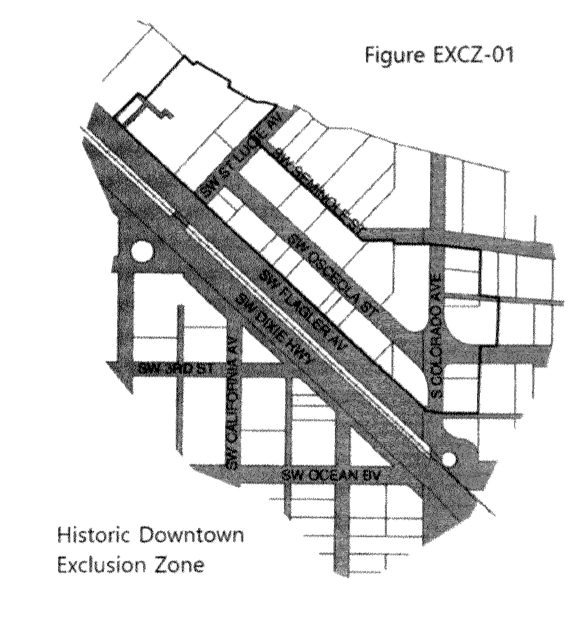
Any new non-medical marijuana dispensing facility shall be located in the following zoning districts, subject to the other requirements of this section and applicable land development regulations:
1.
In the "B-1" (Business Limited), "B-2" (Business General), "B-3" (Business Restricted), and "B-4" (Limited Business/Manufacturing) Zoning Districts.
2.
In the "CPUD" Commercial Planned Unit Development Zoning Districts.
3.
In the "I" Industrial Zoning District.
4.
In the "IPUD" Industrial Planned Unit Development Zoning Districts.
5.
In the "UH" Urban Highway Zoning Overlay District.
6.
All licensed marijuana dispensaries, regardless of location, which exist on October 31, 2024, and which are in possession of an active business tax receipt issued by the City of Stuart shall be deemed a lawful use, and not subject to the provisions of chapter VIII of the land development code, regarding non-conforming uses and lots.
E.
Distance requirements. The following distance requirements shall apply to non-medical marijuana dispensaries irrespective of their zoning and land use designation:
1.
No licensed business where non-medical marijuana and recreational marijuana products are sold shall be established within 500 feet of any other such establishment, except as elsewhere provided in this chapter. The interval distance requirement specified herein shall be measured in a straight line on the official city map between the main entrances of the establishments.
2.
No marijuana dispensary shall be located within 500 feet of the real property that comprises a public or private elementary, middle, or secondary school unless the city commission approves the location via waiver through a formal public hearing of the city commission.
3.
A marijuana dispensary in existence and lawfully operating within the City of Stuart before October 31, 2024, shall be exempt from the distance requirement provisions of this subsection to the extent that such distances are not in conflict with state law.
F.
Parking. All non-medical marijuana dispensaries, depending on the zoning designation, shall conform to the same parking standards as other retail sales and service uses.
G.
Other regulations.
1.
It shall be unlawful for the owner or operator of any marijuana dispensary to encourage any guest or customer to loiter outside of the building, around adjacent properties, or in designated parking areas, including the use of any substance or product procured from the dispensary.
(Ord. No. 2531-2024, § 1, 10-14-24)