
Stuart City Zoning Code
CHAPTER VI
ON-SITE AND OFF-SITE DEVELOPMENT STANDARDS
6.04.00. - LANDSCAPING
A.
Title. The provisions of this section 6.04.00 shall be known as the "Stuart Landscape Code" and "landscape code."
6.05.00. - COMMERCIAL DEVELOPMENT STANDARDS
A.
Purpose and intent. The purpose of this section is to supplement the development regulations of this Code with specific regulations for commercial development. Commercial development depends upon high visibility from major public streets. Consequently, the design of commercial development determines much of the image and attractiveness of the streetscapes and character of a community. Massive or generic developments that do not contribute to, or integrate with, the community in a positive manner can be detrimental to a community's image and sense of place. The goal of this section is to create and maintain a positive ambiance and strong community image and identity by providing for architectural and site design treatments which will enhance the visual appearance of commercial development in the city while still providing for design flexibility. These standards are intended to enhance the quality of life in the city.
The prominent styles of architecture in the city include a blend of the Spanish Mediterranean with barrel tile roofs, stucco facades, arches and wood accent members used as typical details and the Florida Cracker style with metal roofs and covered porches. While no particular style of architecture is prohibited herein, the above styles and the interpretation or blending of characteristics associated with these styles are encouraged.
This section provides for a basic level of architectural design with site design features which incorporate safe and convenient vehicular use areas and pedestrian ways and landscaping, lighting and signage treatments intended to result in a comprehensive plan for building design and site development. These regulations are intended to promote the use of crime prevention through environmental design principals including visibility for law enforcement and other people in the area, natural surveillance by placing areas of activity where they can be seen by law enforcement and the public, and defensible space by designing areas which people will take as their own and not be willing to relinquish to undesirable activities.
B.
Application of section.
1.
The provisions of this section 6.05.00 shall apply to a commercial development regardless of the comprehensive plan designation and zoning district classification of said land.
2.
The provisions of this section shall apply to commercial development as new development or as renovation development as these terms are defined in chapter XII of this Code for which a complete application for site plan approval has not been received by the city development department prior to July 1, 1999, or the construction of which has not begun by July 1, 2000.
3.
The provisions of this section shall apply to a commercial development which is a vacant development as of July 1, 1999.
4.
The provisions of this section shall apply to all buildings and structures within commercial properties.
C.
Administrative modification. The city development director may allow the use of alternative design standards to modify, to the least extent possible, the supplemental commercial design standards contained herein if the use of such alternative design standards meets the full intent of the supplemental commercial design standards and applicable policies of the city's comprehensive plan.
(Ord. No. 1700-99, 12-18-99)
D.
Standards supplemental. The provisions of this section shall be deemed to be supplemental to other applicable provisions of this Code. In cases of conflict, the provisions of this section shall prevail, unless the conflicting provisions are within the Urban District Code, East Stuart District Code or S.E. Ocean Boulevard Overlay Zone, in which case, those provisions shall prevail.
6.06.00. - GREEN DEVELOPMENT
A.
Purpose. The intent of this section is to provide a scope of measurement for the incorporation of green development standards and elements and to make available a mechanism whereby green building elements may be credited to new and renovation development within the city.
B.
Standards. In the event that new development or renovation development projects meet or exceed the city's green development standards by designing, constructing, implementing and continually maintaining the minimum points requirements based upon the LEED© points systems as outlined in Table 6.06.00 B.1 below, such projects shall be granted incentive credit measure(s) identified at in 6.06.00.C of this Code, which shall be permitted subject to limitation by, and prior approval of the development director.
Table 6.06.00.B.1
Minimum points required to qualify for incentive credit measure(s)
Notes:
1.
LEED®-EB Green Building Rating System For Existing Buildings, Upgrades, Operations and Maintenance, Version 2.0, July 2005, as amended.
2.
LEED®-NC Green Building Rating System For New Construction & Major Renovations Version 2.2, October 2005, as amended.
3.
LEED®-H Green Building Rating System For Homes Pilot version 1.11a, February 2007, as amended.
4.
LEED®-ND Green Building Rating System For Neighborhood Development, Pilot Version, February 2007, as amended.
5.
LEED®-CI Green Building Rating System For Commercial Interiors, Version 2.0, December 2005, as amended.
6.
LEED®-CS Green Building Rating System For Core and Shell Development, Version 2.0, July 2006, as amended.
C.
Incentive credit measures. Incentive credits shall be granted subject to full documentary evidence being provided to the satisfaction of the development director, prior to submission of the appropriate development permits. The city requires a pre-application meeting for the purposes of a "green review," and confirming through a development or other agreement, that the minimum required LEED® points will be incorporated into the development and maintained in perpetuity, subject to the following:
1.
For the purpose of allowing the orientation of a building to take full benefit of available natural resources, and to accommodate architectural variation and innovation, an administrative variance may be granted concurrently to a site permit subject to the requirements of section 8.04.08.
2.
For the purpose of further expediting the appropriate development review process for projects and developments that qualify as "green developments" in accordance with the requirements of Table 6.06.00 B.1, and which have completed a pre-application review with City of Stuart building official and development staff, the developer shall receive written confirmation that the project meets or does not meet the city's qualification requirements for green development and shall be furnished an anticipated expedited review timeline, within two working days of submittal.
(Ord. No. 2113-07, § 2, 7-23-07)
6.07.00. - LIGHTING
A.
Purpose and intent. All commercial development shall be designed to provide safe, convenient and efficient lighting for pedestrians and vehicles. Lighting shall be designed in a consistent and coordinated manner for the entire site. The lighting and lighting fixtures shall be integrated and designed so as to enhance the visual impact of the project on the community.
B.
Shielding. Lighting shall be designed so as to prevent direct glare, light spillage and hazardous interference with automotive and pedestrian traffic on adjacent streets and all adjacent properties.
C.
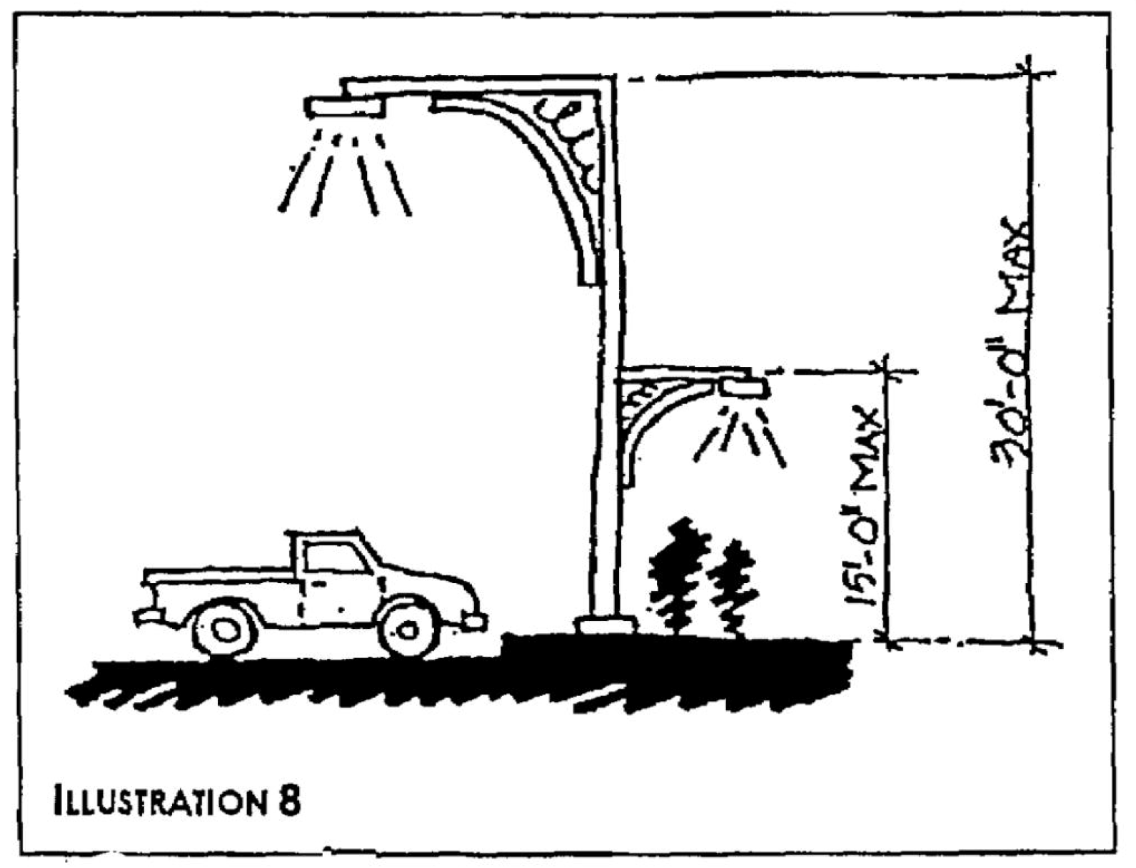
Fixture height. Lighting fixtures shall be a maximum of 30 feet in height within a parking lot and shall be a maximum of 15 feet in height within non-vehicular pedestrian areas (see illustration 8).
D.
Design. Lighting shall be used to accent key architectural elements and to emphasize landscape features. Light fixtures shall be designed as an integral design element that complements the design of the project through style, material or color.
E.
Lighting details shall be exhibited on all landscape plans and reviewed for public safety concerns in accordance with site plan review procedures.
F.
Lighting on a proposed non-residential or multi-family residential use shall be designed and installed so the light source does not shine directly onto adjacent residential uses or a residential zoning district. Light emanating from a proposed non-residential or multi-family residential use shall not exceed 0.2 footcandles as measured at the common boundary. Light fixtures located in parking areas adjacent to residential uses or residential zoning districts shall not exceed 15 feet in height.
6.10.00. - OUTDOOR STORAGE
A.
Applicability. All businesses and services shall be conducted within completely enclosed buildings in the B-1, B-2, and B-4 business zoning districts. If in the discretion of the city development director a demonstrated necessity exists for an outdoor storage area in the B-1, B-2, or B-4 zoning districts due to the economic hardship of enclosing the area, an outdoor storage area may be allowed subject to the following standards.
B.
Standards for outdoor storage areas.
1.
Location and maintenance.
a.
An outdoor storage area may be located adjacent to a structure but shall not be located in the front yard setback area.
b.
No loose materials such as sand, lumber, cardboard boxes, and the like which are subject to being scattered or blown about the premises by normal weather conditions shall be allowed.
c.
An outdoor storage area shall be kept neat and orderly. The area shall not be permitted to take on the characteristics of a junkyard.
d.
Materials stored shall not be stacked in piles higher than five feet and shall not be visible from surrounding properties or rights-of-way.
e.
An outdoor storage area shall be designed and developed in a manner which does not interfere with proper traffic circulation.
f.
If the National Weather Advisory Service identifies weather conditions which are predicted to include winds of 75 mph or greater, all materials stored as outdoor storage shall be removed from the open, fenced locations and placed in an enclosed building at least 24 hours prior to the predicted onset of such winds or as soon as reasonably practical if less notice is provided.
g.
All outdoor storage areas existing as of July 26, 1999, shall comply with the following buffering and screening requirements.
2.
Screening and buffering.
a.
An outdoor service or storage area shall be visually screened from adjacent uses by a shadowbox fence, or a masonry wall, or a chain-link fence with green or black slats. In the discretion of the city development director an opaque landscape buffer may be used instead of a fence or wall provided the area is visually screened from adjacent property as effectively as though a fence or wall were used.
b.
The screening used shall be not less than six feet in height. A wall or fence shall not exceed six feet in height in the B-1 zoning district, and eight feet in height in the B-2 or B-4 zoning district. Access through a fence or wall shall be limited through opaque gates that shall be closed when not in use.
c.
The screening used for an outdoor storage area adjacent to public right-of-way(s) shall be set back a minimum of five feet from the side and rear property lines.
d.
The screening used for an outdoor storage area adjacent to residential uses or a residential zoning district shall be consistent with those regulations stated in section 6.04.06.
Sec. 6.00.01. - Purpose.
The purpose of this chapter is to provide development design and improvement standards applicable to all development activity within the city.
Sec. 6.00.02. - Responsibility for improvements.
All improvements required by this chapter shall be designed, installed, and paid for by the developer.
Sec. 6.00.03. - Principles of development design.
The provisions of this chapter are intended to ensure functional and attractive development. Development design shall first take into account the protection of natural resources as prescribed in chapter V of this Code. All development shall be designed to avoid unnecessary impervious surface cover; to provide adequate access to parcels and sites; and to avoid adverse effects of shadow, glare, noise, odor, traffic, drainage, and utilities on surrounding properties.
(Ord. No. 2539-2025, § 2, 4-16-25)
Sec. 6.00.04. - Site design qualitative development standards.
A.
Generally. The intent of these site design qualitative development standards is to establish qualitative standards to be applied by the city in the review of residential development plans, minor development plans and major development plans submitted to the city as required by this Code. The purpose of these standards is to insure that all site plan development complies with the comprehensive plan of the city and with the Stuart land development regulations and to promote harmonious and compatible development within the city.
B.
Standards.
1.
Harmonious and efficient organization. All elements of a development plan shall be organized harmoniously and efficiently in relation to topography, the size and type of the subject property, the character and development of nearby property, and the type and size of buildings. Site improvements shall be arranged to have minimal effects on nearby property and in a manner that will not impede the development of nearby property for uses permitted by the Stuart Comprehensive Plan and this Code.
2.
Preservation of natural conditions. The landscape shall be preserved in its natural state to the maximum degree practical by minimizing tree and soil removal and by other appropriate site planning techniques. Terrain and vegetation shall not be disturbed in a manner likely to increase soil erosion in or near the site or to harm endangered or threatened plant or animal populations.
3.
Screening and buffering. Fences, walls, or vegetative screening shall be provided where needed to protect the occupants of the site from undesirable views, lighting, noise or other adverse effects of nearby property, and to protect the occupants of nearby property from like adverse effects produced by the development of the site.
4.
Enhancement of residential privacy. The development plan shall provide reasonable visual and auditory privacy for all dwelling units located within and near the site. Fences, walls, barriers and vegetation shall be arranged to protect and enhance the appearance of the site and the privacy of the occupants.
5.
Emergency access. Buildings, walls, landscaping and other site features shall be arranged and constructed to permit access by emergency vehicles to all buildings.
6.
Access to public and private ways. All buildings, dwelling units and other facilities designed or intended for occupancy or assembly shall have safe and convenient access to public and private ways including streets, sidewalks and parking areas, and to other areas on the site designed or intended for common use.
7.
Pedestrian circulation. For developments which include residential units, the pedestrian circulation system shall be separated to the maximum extent possible from the vehicular circulation system. Sidewalks shall be provided if desirable for pedestrian safety and shall be constructed in accordance with city standards.
8.
Location and design of access drives. Access drives to the site shall be located and designed to maximize public safety and convenience and to minimize negative traffic impacts on property. Access improvements located both on and off the site shall be provided if desirable for public safety.
9.
Coordination of on-site and off-site circulation. The arrangement of on-site public and private ways including streets, sidewalks, bicycle paths and parking areas for vehicular and pedestrian circulation shall be coordinated with the existing and planned pattern of off-site public and private ways for vehicular and pedestrian circulation.
10.
Location and design of on-site ways. On-site public and private ways including streets, sidewalks, bicycle paths and parking areas shall be located and designed to occupy no more land than is required to provide safe and convenient vehicular and pedestrian circulation. Such ways shall not unnecessarily fragment development into small areas or segments.
11.
Drainage. Stormwater drainage shall be accommodated on the site or shall be removed from the site in a manner which does not adversely affect nearby property or the public storm drainage system. The necessary facilities, including grading, gutters, piping and the treatment of soil, shall be provided to accommodate stormwater retention, percolation and drainage, and to prevent erosion and the formation of silt.
12.
Exterior lighting. Exterior lighting shall not produce glare on nearby property or otherwise interfere with the quiet enjoyment of nearby property or with public safety and convenience.
(Ord. No. 1345-94, 3-28-94)
Sec. 6.01.01. - General provisions.
A.
Purpose. This section establishes minimum requirements applicable to the development of transportation systems, including public and private streets, bikeways, pedestrian ways, parking and loading areas, and access control to and from public streets. The standards in this section are intended to minimize the traffic impacts of development, to assure that all developments adequately and safely provide for the storage and movement of vehicles consistent with good engineering and development design practices.
B.
Compliance with the Stuart building and construction regulations. All required elements of the transportation system shall be provided in compliance with the engineering design and construction standards specified by the Florida Building Code as it may be amended from time to time.
Sec. 6.01.02. - Streets.
A.
Street classification system established.
1.
Streets in the city are classified and mapped according to function served in order to allow for regulation of access, road and right-of-way widths, circulation patterns, design speed and construction standards. (Refer to the transportation element of the City of Stuart Comprehensive Plan.)
2.
Private streets and streets that are to be dedicated to the city are classified in a street hierarchy system with design tailored to function. The street hierarchy system shall be defined by road function and average daily traffic (ADT), calculated by trip generation rates prepared by the Institute of Transportation Engineers. Trip generation rates from other sources may be used if the developer demonstrates the alternative source better reflects local conditions.
3.
When a street continues an existing street that previously terminated outside the subdivision, or is a street that will be continued beyond the subdivision or development at some future time, the classification of the street will be based upon the street in its entirety, both within and outside of the subdivision or development.
4.
Residential streets are primarily suited for providing direct access to residential development, but may give access to limited non-residential uses, provided average daily traffic (ADT) volume generated by the non-residential use does not exceed applicable standards for the affected streets. All residential streets should be designed to minimize unnecessary and/or speeding traffic.
5.
The following streets hierarchy is established in accordance with the City of Stuart Comprehensive Plan: local, collector, arterial. All development proposals containing new streets or taking access from existing streets shall conform to the standards and criteria contained in this part.
B.
Local streets. A route providing service which is of relatively low average traffic volume, short average trip lengths or minimal through traffic movements, and high land access for abutting property.
C.
Collector streets. A route providing service which is of relatively moderate average traffic volume, moderately average trip length, and moderately average operating speed. Such a route also collects and distributes traffic between local roads or arterial roads and serves as linkage between land access and mobility needs.
D.
Arterial streets. A route providing service which is relatively continuous and of relatively high traffic volume, long average trip length, high operating speed, and high mobility importance. In addition, every United States numbered highway is an arterial road.
E.
Street classification standards.
1.
Generally.
a.
Residential streets shall be laid out to provide adequate traffic circulation in the developed area and should begin and terminate at a main street. The minimum pavement width shall be 20 feet for two-way street and 12 feet for a one-way street.
b.
Residential streets shall provide access to all building and/or units of the development not otherwise served.
c.
All roads and streets shall enter and leave adjoining roadways, as nearly as practicable, at right angles thereto. In no case shall the intersection skew angle be greater than 60 degrees.
d.
Street terminating in a dead end shall have a circular or square cul-de-sac with a paved area diameter or square equal to 90 feet.
e.
Utility easements ten feet in width shall be provided along both sides of all streets.
f.
Public alleyways shall remain open for pedestrian access, fire protection, and other public services. New public alleyways are encouraged.
g.
No new arterial roadways shall be built or expanded in areas designated as residential on the future land use map, a part of the City of Stuart Comprehensive Plan.
Sec. 6.01.03. - Rights-of-way.
A.
Minimum right-of-way widths. The minimum width of right-of-way of streets shall be:
1.
State roads, as required by the Florida Department of Transportation.
2.
Arterial streets, 50 feet each side of the centerline.
3.
Local streets, 20 feet each side of the centerline.
4.
Cul-de-sacs, 90-foot diameter or square.
5.
Alleys of not less than 15 feet, or easements for utilities of not less than ten feet shall be platted.
Sec. 6.01.04. - Sidewalks and bikeways.
A.
Concurrent pedestrian use. Designation of a route as part of the public bicycle path system shall not preclude its concurrent use by pedestrians, unless so specifically stated in the resolution making such designation.
B.
Minimum width. Except as otherwise provided by this Code or by ordinance, where practicable, all sidewalks and bikeways within the city shall be not less than eight feet in width.
C.
When required. Sidewalks and/or bikeways shall be provided for internal circulation and linkage to other projects when such facilities are possible given the particular physical characteristics of the site, type of project, and adjacent land uses. Determination of feasibility shall be made by the city development director.
Sec. 6.01.05. - Pedestrian access for large-scale commercial development (LCD).
A.
Purpose and intent. All large-scale commercial development shall be designed to provide safe opportunities for alternative modes of transportation by connecting with existing and future pedestrian and bicycle pathways within the city and the county and to provide safe passage from public right-of-way to the building or project, between projects and between alternative modes of transportation.
B.
Pedestrian access. Pedestrian ways, linkages and paths shall be provided from the building entries to surrounding streets, external sidewalks and development outparcels. Pedestrian ways shall be designed to provide access between parking areas and the building entries in a coordinated and safe manner and shall be constructed of paver blocks, stamped concrete, colored concrete or similar materials to promote traffic calming. All pedestrian ways shall include reflective striping. Pedestrian ways may be incorporated within a required landscape perimeter strip, provided said landscape strip is not less than ten feet in width. Pedestrian circulation shall be provided between abutting commercial properties through the use of walkways and similar pedestrian-oriented facilities.
C.
Minimum ratios. Pedestrian ways shall be provided at a minimum ratio of one for each public vehicular entrance to a commercial or non-residential site excluding the ingress and egress points intended primarily for service, delivery or employee vehicles.
D.
Minimum dimensions. Pedestrian walkways shall be a minimum of six feet wide.
E.
Pedestrian crosswalks at building perimeter. Building perimeter crosswalks shall be designed and coordinated to move people safely to and from buildings and parking areas by identifying pedestrian crossings with signage, variations in pavement materials or markings and reflective striping.
F.
Shade. Pedestrian walkways shall provide intermittent shaded areas when the walkway exceeds 100 linear feet in length at a ratio of 100 square feet of shaded area per every 100 linear feet of walkway.
G.
Pedestrian amenities. For an LCD, pedestrian amenities in the form of permanently installed gazebos, arbors, benches, fountains, water fountains, or other amenities shall be provided. The type of amenity shall be determined by the square footage of buildings on the site as indicated in the table below. The location of pedestrian amenities shall be shown on the site plan. The design of all amenities shall be of durable, long-lasting materials, consistent with the design of the principal structures on-site or a thematic design standard adopted by the city. Benches must be not less than six feet in length and located adjacent to either shade trees or gazebos or similar structure designed to provide shade.
(Ord. No. 2396-2019, § 1, 3-25-19)
Sec. 6.01.06. - Access.
A.
Accessibility to the handicapped and the elderly. All proposed development shall be accessible to the handicapped and the elderly, and shall have handicapped parking spaces and barrier-free entrances in accordance with F.S. ch. 553, part II, as amended, and ch. 11, Florida Building Code.
B.
Number of access points. (Reserved.)
C.
Separation of access points. (Reserved.)
D.
Frontage on service roads and common driveways. (Reserved.)
E.
Alternative designs. (Reserved.)
F.
Access to residential parcels. (Reserved.)
(Ord. No. 2539-2025, § 2, 4-16-25)
Sec. 6.01.07. - Standards for drive-through facilities.
A.
Generally. No building inside the city limits shall be built, constructed nor altered in such a manner that would provide any "drive-through" or "walk-through" facility unless it shall be so constructed that such facility will not interfere with the public use of public ways, streets, alleys or areas.
B.
Applicable standards. Upon application for a development permit, which includes a drive-through or walk-through facility, the construction plans shall be examined by the city development department, and the said department must specifically endorse approval of such facility on the said plans which remain on file with the city development department. In making such determination, the city development director shall consider the type of business, the existing and projected traffic flow of the public areas bounding the property and the nearness of other like installations.
C.
A "drive-through" or "walk-through" facility shall be designed, constructed and used so as not to interfere with the public use of public ways, streets, alleys or other public areas. The city development director shall specifically approve such facility. In making such determination, the type of business, the existing and projected traffic flow of nearby public areas and the nearness of other like facilities shall be considered.
D.
The minimum number of queuing or stacking spaces required shall be as follows. Variations from these minimums may be allowed by the city development director upon the basis of a traffic study.
E.
Each queue space shall be a minimum of ten feet by 20 feet. Queuing lane dimensions shall be measured from the point indicated in the queue space schedule to the end of the queuing lane. Dimensions of queuing lanes shall be shown on the site plan.
F.
Each queue lane shall be clearly defined and designed so as to not conflict or interfere with other traffic using the site. A bypass lane with a minimum width of 12 feet shall be provided if a one-way traffic flow is used in the parking lot. The bypass lane shall be clearly designated and distinct from the queuing area.
Sec. 6.01.08. - Non-residential vehicular access.
A.
Whenever possible, vehicular access for a proposed non-residential site shall be restricted to established arterial and collector roadways that are predominantly abutted by properties zoned for non-residential use. If direct access to such an established arterial or collector roadway is not possible, limited access on another public roadway is allowed provided that ingress and egress is directed away from residential streets.
B.
No ingress or egress points shall be located on SE Osceola Street for a non-residential use with access onto other adjacent non-residential streets.
Sec. 6.01.09. - Stuart Parking Code.
A.
This parking code shall apply to all development for which a complete application for site plan review pursuant to section 11.02.07 of the Stuart land development regulations has not been filed with the city development department on or before September 4, 2024, as follows:
1.
The construction of a new building or structure on unimproved real property;
2.
The construction of a new addition to an existing building or structure on improved real property; or
3.
Changes in use including changes in the intensity of an existing use.
B.
No certificate of occupancy shall be issued for any portion or phase of a development to which this parking code applies until all required parking and loading spaces and all required landscaping have been installed pursuant to the requirements of this Stuart Land Development Code. In the event of the construction of an addition to an existing building or in the event of a change in use, the entire building to which an addition has been constructed or in which a use has changed shall comply with this parking code in all respects.
C.
This Stuart Parking Code applies to a vacant building or structure which, as of September 4, 2024, and at any time thereafter, has remained unoccupied continuously for the previous 365 days. This parking code does not apply to a development for which a building permit was issued prior to September 4, 2024, unless such development becomes vacant for 365 days.
D.
This Stuart Parking Code applies to all parking spaces installed on public or private property after September 4, 2024. Required parking and loading facilities shall be maintained as long as the use served thereby continues to exist.
E.
This parking code shall apply in all respects in the Urban District, East Stuart District, and S.E. Ocean Boulevard Overlay Zone as reflected in chapter III of this Code, provided however, the number of required parking spaces has been reduced as provided in the Urban Code and East Stuart District.
(Ord. No. 2539-2025, § 2, 4-16-25)
Sec. 6.01.10. - Rules for computing parking requirements.
A.
In the event the computation of the number of required parking spaces results in a fractional space, the number of required spaces is the nearest whole number.
B.
The number of required parking and loading spaces for a use not specifically listed in section 6.01.13 below shall be determined by the city development director with reference to the listed use most similar in parking and loading needs to the unlisted use.
C.
For properties containing more than one use, the number of required parking spaces is the cumulative number of spaces for all uses, absent an approved shared parking as provided at section 6.01.12 below.
D.
Each 20 linear inches of benches or pews shall be considered one seat where the computation of required parking spaces relates to seating provided by benches or pews.
E.
Gross floor area shall be used for the computation of required parking spaces relating to floor area.
F.
The greatest number of employees, including owners and managers, present on a premise at any one time shall be used for the computation of required parking spaces relating to the number of employees.
G.
For a single-family dwelling, a driveway may be used to provide two tandem parking spaces provided sufficient driveway space is available exclusive of right-of-way or road easements.
H.
Reserved.
I.
If electric charging stations are installed adjacent to parking spaces, those spaces may still be counted towards the required number of off-street parking spaces.
(Ord. No. 2539-2025, § 2, 4-16-25)
Sec. 6.01.11. - Location of required parking spaces.
A.
Parking is not required in the Old Downtown District (see map 3.01.03.F.1.a.i.a of this Code). Elsewhere, all required parking spaces shall be located on the same real property upon which is located the principal use served thereby. The term "same real property" means the principal use site and the parking site are in the same ownership. Alternatively, the owner or lessee of the principal use site may hold an ownership or leasehold interest in the parking site.
B.
If the site of the principal use and the location of required parking to serve the principal use are not contiguous, the nearest portion of the parking site shall be located within 500 feet of the front entrance to the principal use as measured by a safe and convenient pedestrian route including appropriate signage to delineate the route. As used in this subsection, "contiguous" requires a common boundary and does not include properties separated by a road, alley, or other public right-of-way.
Required parking spaces located on the site of the principal use shall not be relocated elsewhere except by major conditional approval issued by the city commission as provided in this Code. Required parking spaces which are located on contiguous property or on property within 500 feet of the site of the principal use shall not be relocated to a more distant location from the site of the principal use as measured by a safe and convenient pedestrian route except by a major conditional approval issued by the city commission as provided in this Code.
On and after January 12, 1998, a new use of property, including the expansion or intensification of an existing use, may result in an increase in the number of required parking spaces generated by uses of the property as determined in accordance with this Code. Such additional spaces shall be located either on the site of the principal use or on property contiguous to the site of the principal use, or on property within 500 feet of the front entrance to the principal use site as measured by a safe and convenient pedestrian route. The route shall include appropriate signage to delineate the route site. In the event six or more of the additional required parking spaces will be located on property within 500 feet of but not contiguous to the site of the principal use, the location of the six or more additional spaces shall be approved by major conditional use approval issued by the city commission as provided in this Code.
(Ord. No. 1537-98, 1-12-98)
C.
A "unity of title" document in a form acceptable to the city attorney may be required by the city development director to restrict the use of the parking area or site to parking. A unity of title document shall be filed in the office of the city development director and shall be recorded in the public records of Martin County, Florida.
Sec. 6.01.12. - Reserved.
Editor's note— Ord. No. 2539-2025, § 2, adopted April 16, 2025, repealed § 6.01.12, which pertained to shared parking and joint use of facilities, and derived from Ord. No. 2077-06, § 2, adopted July 10, 2006.
Sec. 6.01.13. - Off-street parking schedule.
Off-street parking spaces shall be provided in accordance with the minimum standards contained in the following schedule:
Sec. 6.01.14. - Design standards for off-street parking.
A.
Generally. The minimum width of parking spaces (stalls) and accessways (aisles) as they relate to the parking schematic shown below shall be:
The length of a stall may be reduced up to two feet to enable a parked vehicle to overhang a landscaped area which is not less than six feet in width and located on the property. This shall not be construed to permit an overhang on adjacent or public property.
The minimum curb length for stalls shall be:
B.
Paving of parking surfaces.
1.
All parking lots as defined in chapter 12, including, parking spaces, accessways and loading zones shall be paved and otherwise constructed in accordance with the applicable ordinances of the city. As an alternative to paving, parking spaces and accessways may be provided on stabilized grassed areas for uses requiring only occasional parking or transitory vehicle storage as needed by recreational facilities, vehicle dealerships, churches, assembly halls and flea markets. Transitory vehicle storage shall occur only in the rear of such facility and shall only be used by the specified vehicle dealership for their own saleable vehicles. Paved parking shall be provided, however, for the full-time employees of such uses.
(Ord. No. 1721-00, 3-27-00)
2.
All parking spaces, access drives and loading zones shall be paved in accordance with the Code of Ordinances of the City of Stuart, Florida, and shall be maintained in good condition and be free of pot holes, loose or cracked pavement, broken wheel stops, and any other conditions which might be otherwise detrimental to the health or safety of the inhabitants of the city as determined by the city development director.
(Ord. No. 1652-98, 11-23-98)
3.
Pervious parking surfaces are permitted when the following conditions are met:
a)
Pervious paving materials and other soil stabilization techniques are used in a manner as to assure that parking will remain functional in heavy rains or drought;
b)
Pervious paving materials are installed according to manufacturer's specifications, including sub-surface preparation, composition, and density of compaction;
c)
Soils of the "Sand Ridges and Coastal Ridges" and the "Low Ridges and Knolls," as mapped in the Natural Resources Conservation Service's Soil Survey of Martin County, Florida (dated April 1981) shall represent favorable free-draining soil areas for a pervious credit to be awarded for the use of pervious concrete. Sub-surface soil testing must demonstrate that the manufacturer's specifications will be met to allow for percolation and other stormwater functions. A registered professional engineer shall also make inspections and tests as necessary to certify that construction of the pavement is consistent with the approved plans as well as industry and manufacturer's standards;
d)
Pervious parking areas shall allow stormwater to percolate into the ground as designed as part of an overall stormwater management system and in accordance with the approved plan document at a rate sufficient to accommodate the five-year, 24-hour storm event;
e)
Such areas shall be provided with drainage facilities adequate to properly dispose of all surface water runoff. Special care shall be taken to prevent erosion and sedimentation; and
f)
Regular maintenance of pervious parking areas is necessary to ensure long-term integrity of function. Sweeping or other recommended maintenance procedures as per manufacturer's specifications must be implemented. If such areas cease to function in providing adequate parking, drainage or cause sedimentation within the drainage system which reduces the effectiveness of the system or decreases water quality, then paving to normal design standards will be required. In such an event, any credit given towards pervious surface area for the pervious parking area will be revoked, and pervious areas shall be installed which are comparable to the area credited.
(Ord. No. 1431-95, §§ 6.07.07.B, C, 9-25-95; Ord. No. 1451-96, 3-25-96)
C.
Off-street parking design.
1.
Purpose and intent. All development shall be designed to provide safe, convenient and efficient access for pedestrians and vehicles. Parking shall be designed in a consistent and coordinated manner throughout the development site. The parking area shall be integrated and designed so as to enhance the visual appearance of the community.
2.
Design standards. Angled parking spaces with the same degree of angle shall be located throughout the site to provide efficient and safe traffic and pedestrian circulation. A mixture of one-way and two-way parking aisles or differing degrees of angled parking within any parking area is prohibited except as follows.
a.
A single bay of parking provided along the perimeter of the site may vary in angle in order to maximize the number of spaces provided.
b.
A mixture of parking aisles and degrees may be permitted if individual parking areas are physically separated from one another by a continuous landscape buffer, a minimum five feet in width with limited access.
3.
Parking area design. Parking areas shall be designed to the following standards.
a.
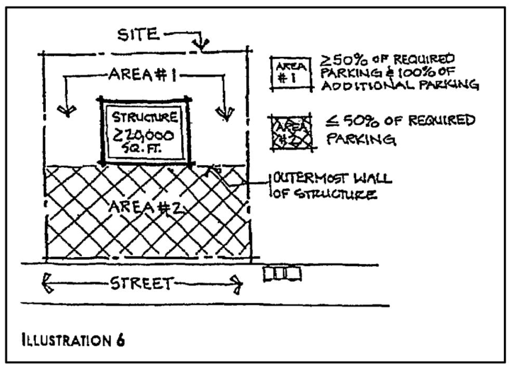
For an LCD, not less than 50 percent of the required off-street parking and 100 percent of the overflow parking shall be located between the street facade and the rear of the property (see illustration 6).
b.
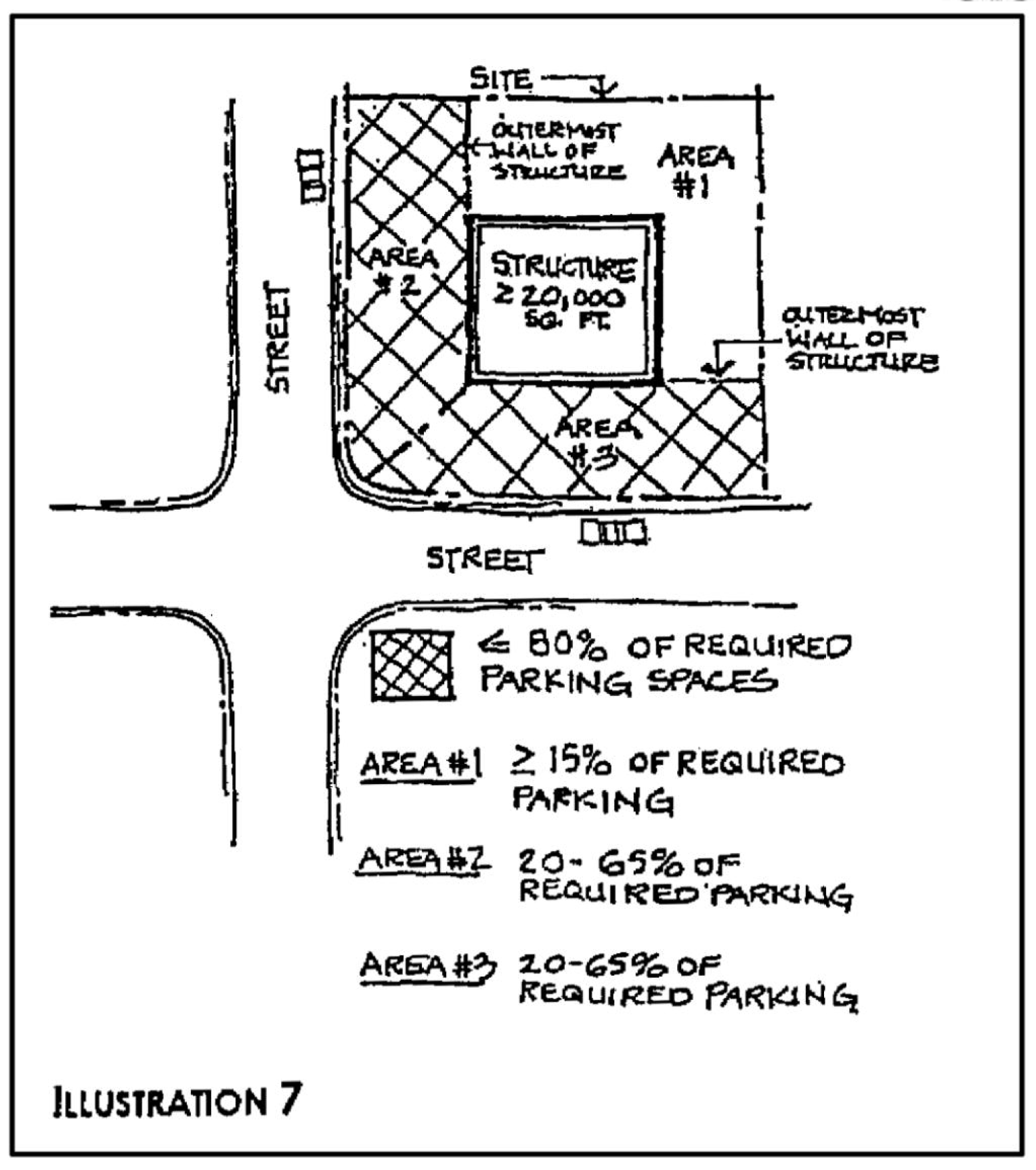
On corner lots, no more than 80 percent of the off-street parking for all commercial developments shall be located between any primary facade of the building or project and the abutting street. No single side of a commercial or non-residential development shall contain more than 65 percent of the required parking (see illustration 7).
c.
Within an LCD, all uses which provide shopping carts for use by patrons, one parking space per 25 spaces shall be dedicated for the storage of shopping carts. This storage area shall include fence materials to keep the shopping carts in the space.
d.
All parking areas within a development site shall be interconnected.
e.
Within an LCD, all parking areas which abut collector or arterial streets shall be designed to interconnect with parking areas on adjacent properties. Plan documents for parking areas must identify an appropriate location for such interconnections which meets commonly accepted engineering principles and include an engineering design to accommodate said interconnection.
Sec. 6.01.15. - Parking structure standards.
A.
A minimum of 60 percent of any primary facade of a parking structure shall incorporate two of the following.
1.
Transparent windows, with clear or lightly-tinted glass, where pedestrian oriented businesses are located along primary facades of the parking structure;
2.
Display windows;
3.
Decorative metal grill-work or similar detailing which provides texture and partially or fully covers the parking structure opening(s);
4.
Art or architectural treatment such as sculpture, mosaic, glass block, opaque art glass, relief work or similar features; or
5.
Vertical trellis or other landscaping or pedestrian plaza area.
Sec. 6.01.16. - Transit stops.
A development for which more than 200 parking spaces is provided shall also provide a transit stop in a location which is proximate to the roadway network. The developer shall provide benches or other seating facilities, trash receptacles, lighting and a covered structure for the transit stop. The city shall provide a detailed rendering of a "typical" transit stop. The location of the transit stop may be shown on the site plan. In lieu of providing the transit stop, the city may require that the developer execute a written agreement with the city indicating that the transit stop will be constructed by a date established by the city.
Sec. 6.01.17. - Parking study.
A parking study, when required by this section, shall include, but not be limited to:
1.
Estimates of parking requirements based on recommendations provided by the Institute of Transportation Engineers or similar resources for uses or combinations of uses which are the same or comparable in density, scale, bulk, area, type of activity, and location to the proposed use; and
2.
An analysis of the extent to which a transportation system management program or use of alternative forms of transportation reduce parking demand.
Sec. 6.01.18. - Off-street loading requirements.
In addition to the parking required for non-residential uses, loading spaces may also be required at the discretion of the city development director using the guidelines set forth below for the loading and unloading of vehicles. All loading spaces shall be located and screened to avoid nuisance impacts to adjacent areas with special consideration for noise. A sufficient number of loading spaces shall be provided to accommodate the maximum number of buses or trucks to be loaded or unloaded at any one time. Wheel stops or curbs shall be provided to prevent any vehicle using a loading space from encroaching upon unpaved areas or adjacent property.
A.
Small inventory commercial uses. Commercial establishments of a type that do not deal in large quantities of goods, including, but not limited to, offices, restaurants, auditoriums, and hotels and motels, may be required to provide off-street loading as follows:
Each loading space shall be not less than ten feet in width and 25 feet in length.
B.
Industrial and large inventory commercial uses. Uses of a type that deal in large quantities of goods, including, but not limited to, industrial, wholesale, storage warehouses, hospitals and retail establishments, may be required to provide off-street loading spaces as follows:
Each loading space shall be not less than 12 feet in width and 50 feet in length.
(Ord. No. 1422-95, §§ 6.03.00—6.03.09, 7-1-95)
Sec. 6.01.19. - Payment in lieu of parking program.
A.
Developer's option. In lieu of providing up to three parking spaces required for any use located in Stuart Community Redevelopment Area, a developer may pay into the "Stuart Payment in Lieu of Parking Trust Fund" a sum of money that is the product of the number of parking spaces required but not provided and the current cost to provide a single parking space in the Stuart Community Redevelopment Area.
B.
Computation of cost to provide parking space. Effective September 22, 2014, the cost to provide a single parking space in the Stuart Community Redevelopment Area shall be based on the following:
Public works director's estimated cost per parking space based on a 7,200 square foot, 22-space prototypical surface parking lot including the cost of paving, car stops, drive aisles, drainage, landscaping, signage, lighting and land value. Land value shall be determined by averaging the property appraiser's assessed land value per square foot of five sample parcels within a 1,000 foot radius of the property for which the PILOP payment is being proposed.
Sample calculation of fee per parking space (example only):
Parcels within 1,000'
Fee per parking space calculation:
C.
Stuart payment in lieu of Parking Trust Fund established. The "Stuart Payment in Lieu of Parking Trust Fund" account is hereby established into which shall be deposited all payments made by developers pursuant to this section. Monies deposited into said account shall be used by the city for the exclusive purpose of paying the cost of land acquisition, construction, reconstruction, lease payments, signage, maintenance, or other expenses associated with the provision of public parking spaces in the Stuart Community Redevelopment Area. Said cost includes the cost of all labor and materials, the cost to acquire all lands, property, rights, easements, and franchises acquired, the cost of financing charges, the cost of interest prior to and during construction and, for one year after completion of construction, discount on the sale of municipal bonds, the cost of plans and specifications, surveys of estimates of costs and of revenues, the costs of engineering and legal services, and such other costs and expenses necessary or incident to determining the feasibility or practicability of such construction or reconstruction, administrative expenses, and such other expenses as may be necessary or incident, to the construction or reconstruction of its financing.
D.
Time of payment. Payments made pursuant to this section shall be made upon the issuance of a building permit, for any portion or phase of a development project to which the parking spaces that are required for a particular use but are not provided relate.
E.
Record of the PILOP. Record of the PILOP shall be executed in a form acceptable to the city attorney, shall be recorded with the Martin County clerk's office and shall run with the land.
(Ord. No. 1851-02, § 1, 4-22-02; Ord. No. 2023-05, § 1, 2-28-05; Ord. No. 2290-2014, § 1, 9-22-14)
Sec. 6.01.20. - Bicycle parking.
A.
Purpose and intent. The bicycle parking is intended to encourage the use of bicycles as a means of transportation in the city, by ensuring that adequate bicycle parking facilities are provided at travel destinations. By encouraging the use of bicycles, the public health, safety and welfare will be furthered through improved air quality, reduced energy consumption and more efficient use of vehicular parking facilities.
B.
When required. The bicycle parking shall apply to new development, substantial improvements or an addition to an existing building for non-residential or multi-family development requiring ten or more off-street vehicular parking spaces. Properties exempt from the parking requirements of this Code shall be exempt from the bicycle parking requirements. Whenever the use at an existing building or structure is changed to another use, so that the amount of existing bicycle parking on-site is less than required by this section, additional spaces shall be provided in the amount required by this section, unless an administrative variance is granted.
C.
Site plan. The location of bicycle racks and design shall be shown on the site plan.
D.
Uses exempt. The following uses shall be exempt from bicycle parking requirements: Single-family homes, duplex, and assisted living facility.
E.
Applicability. The city development director shall have the authority to modify the bicycle parking requirements contained in this section, included but not limited to situations in which compliance cannot be met due to physical site constraints. Such modification shall be noted on the site plan.
F.
General requirements.
1.
Bicycle parking shall be provided in accordance with the standards of this section, and shall be made available prior to the issuance of any certificate of occupancy. Bicycle parking may consist of short-term bicycle parking, long-term bicycle parking, or any combination thereof.
2.
Short-term bicycle parking may include outdoor bicycle parking spaces and bicycle racks not protected from the weather (e.g. retail store to accommodate shoppers).
3.
Long-term bicycle parking may consist of bicycle lockers, bike stations, bicycle racks in covered loading dock areas or parking garages, and bicycle parking spaces that are indoors or otherwise protected from the weather. Areas provided inside of multi-story office buildings for employees and visitors may count as long-term bicycle parking with an approved bicycle plan. A long-term bicycle parking is encouraged for residential and office building for residents and employees.
4.
The term "bicycle parking facility" means a device such as a rack or locker where bicycles can be parked and secured.
G.
Minimum number of bicycle parking spaces required.
1.
Non-residential development.
(a)
Two bicycle parking spaces (one bicycle rack) for the first ten required off-street vehicular parking spaces.
(b)
Two additional bicycle parking spaces for each additional 30 required off-street vehicular parking spaces or fraction thereof.
(c)
In no case shall more than 20 bicycle parking spaces (ten bicycle racks) be required.
2.
Multi-family development.
(a)
Two bicycle parking spaces (one bicycle rack) per five units within the community redevelopment area.
(b)
Two bicycle parking spaces (one bicycle rack) per ten units outside the community redevelopment area boundary,
(c)
In no case shall more than 20 bicycle parking spaces (ten bicycle racks) be required.
H.
Bicycle parking facility design standards.
1.
Bicycle parking facilities shall be permanently affixed to a hard surface such as concrete, asphalt, or pavers.
2.
It is the intent of this section to locate bicycle parking facilities on the project site where they will best encourage the use of bicycles for transportation. The preferred location is near the primary entrance of the principal building. It shall be clearly visible from the entrance of the building served (including both the patron and employee entrances where separate entrances are provided). The city development director shall have the authority to determine the most appropriate location during site plan review.
3.
Bicycle parking facilities shall be located in well-lit areas.
4.
Bicycle parking spaces shall be separated from vehicle parking spaces by physical barriers, such as curbs, wheel stops, bollards or other similar features, to protect bicycles from damage.
5.
Bicycle parking facilities shall be located on the development site except where public bicycle parking is provided in the right-of-way by the city.
6.
Bicycle parking facilities shall not impede ingress or egress to any building or project site and shall not be placed in the functional area of a sidewalk or where it interferes with any fire hydrant, parking meter, bus stop, loading zone, sidewalk ramp, wheelchair ramp, or similar public facility.
7.
Bicycle parking facility shall be identified by installing the bicycle parking sign as shown below at a prominent location around the area (such as on the building façade), if feasible. If the bicycle parking spaces are provided in vehicular parking area (e.g. parking lots or parking garage), the bicycle parking space must be posted with a permanent above-grade sign placed at a distance of 84 inches above the ground to the bottom of the sign.

8.
Bicycle racks may be oriented parallel, diagonal, or perpendicular to sidewalks (see layouts shown below). It may be placed as a single rack by itself at key areas or multiple racks side-by-side in parking spaces.
9.
All developments may refer to Association of Pediatrician and Bicycle Professionals (APBP) for national standards for bicycle parking not provided in this section. See diagrams below for typical setbacks for installing bicycle racks near walls, streets, infrastructure, or other racks.
I.
Bicycle rack design. Required bicycle racks shall meet the city's bicycle rack design shown below. It shall be an inverted "U" rack with the city's custom laser cut logo plate welded to the round tubing for capacity of two bicycles with a light green powder-coated finish.
J.
Alternative bicycle rack design. At the discretion of the city development director, the alternative bicycle rack design may be approved if in compliance with the following standards:
1.
Types: Inverted "U" hoop rack, round rack, hitch rack or some variations of the upside down "U" design. Custom designs may be used provided that it meets the criteria of acceptable bicycle rack design.
2.
Capacity: Designed to accommodate two bicycle parking spaces per rack.
3.
Finish: Galvanized, stainless steel, powder-coated with a color or other weather-proof surface.
4.
Size: Accepts multiple bicycle frame sizes and styles.
5.
Compatibility: Accommodates the use of cable and U-type locks.
6.
Function: Supports a bicycle frame in two places.
7.
Purpose: Allows the frame and at least one wheel of the bicycle to be locked to the rack.
8.
Scale: Visible to pedestrians and the visually impaired, but consistent with the scale of the bicycle located to the device.
9.
Durability: Maintenance-free or fabricated from materials that weather in an aesthetically pleasing manner.
10.
Simplicity: East to understand and operate, with no moving parts.
11.
Operation: Usable without lifting the bicycle onto the device.
(Ord. No. 2396, § 1, 3-25-19)
Sec. 6.02.01. - Requirements for public utility stations including water treatment plants and sewage lift stations.
A.
Fencing required. All such uses shall be enclosed within a fence not less than six feet in height unless otherwise required by the public works director.
B.
Buffered from adjacent land use. All such uses shall be suitably landscaped in accordance with section 6.04.00. Berming, landscaping, and/or wooden fencing shall be required in order to separate and visually conceal public utility structures within residential areas.
C.
Storage. The storage of vehicles and/or equipment on the premises is prohibited.
Sec. 6.03.01. - Generally.
A.
Intent. It is the policy of the City of Stuart to promote efficient use and management of stormwater. To the maximum extent possible, stormwater will be percolated into the shallow aquifer by use of retention/detention areas, underground storage, green space, pervious pavement, and exfiltration systems. It is also the policy of the City of Stuart to protect existing facilities from adverse impacts of new construction.
B.
Applicability.
1.
The provisions of this chapter shall apply to development within the City of Stuart municipal boundaries, excluding the urban district, as follows:
(a)
All new development shall be required to comply with the site design requirements of the South Florida Water Management District. New development shall be required to comply with all requirements for water quality as set forth in this chapter. Exfiltration systems shall be used for water quality purposes only. Proper management of stormwater runoff shall be accommodated through retention and detention, green space, allowable discharge and up to 40 percent underground storage.
(b)
Renovation development, vacant development and infill development shall be required to comply with all requirements for water quality as set forth in this chapter. Exfiltration systems shall be used for water quality purposes only. Not more than 40 percent of stormwater runoff may be stored in underground storage structures. The remaining 60 percent of the required stormwater runoff shall be accommodated through retention and detention, green space, and allowable discharge.
2.
In the Urban Code District and East Stuart District, all development, including new development, substantial renovation and infill development, shall be required to comply with all requirements for water quality as set forth in this chapter. Exfiltration systems shall be used for water quality purposes only. Proper management of stormwater runoff may be accommodated through any combination of underground storage structures, retention and detention, green space, and allowable discharge.
A certificate of occupancy shall not be issued if any portion of a stormwater system is not in compliance with the approved site plan.
C.
Site planning.
1.
Developments must, in their site planning, account for and compensate for historic drainage patterns in the area of the development so as not to cause flooding to adjacent and surrounding properties.
2.
Alterations, additions and modifications of existing facilities, as to the extent of the alteration, addition or modification are subject to this chapter.
D.
Drainage. An adequate drainage system, including necessary ditches, canals, swales, percolation areas, berms, dikes, weirs, detention ponds, storm sewers, drain inlets, manholes, headwalls, endwalls, culverts, bridges and other appurtenances shall be required in all subdivisions and developments for the positive drainage of storm and groundwater. The drainage system shall provide for surface waters affecting the subdivision or development.
E.
Stormwater treatment. Stormwater treatment facilities shall be required in the subdivision or development to control stormwater runoff quality by providing for on-site retention/detention or other appropriate treatment technique for stormwater.
F.
Maintenance. The capacity of a stormwater management system shall be properly maintained. Methods of required maintenance may include vacuuming exfiltration systems, vacuuming and pressure-cleaning pervious parking areas, replacement of berms, the installation of silt screens or similar devices, and the installation of sod. If any portion of a stormwater system ceases to function as designed, the property owner or occupant may be required to remove, repair or replace that portion of a stormwater system.
G.
Infill development.
1.
All single family and duplex residential infill parcel development shall submit the following at time of building permit submittal:
(a)
A topographic survey which identifies existing improvements within and adjacent to the site.
(b)
A parcel grading plan that is designed to maintain consistent regional elevations at grade and prevent excessive stormwater runoff. The stormwater parcel grading plan may be reviewed by the city's consultant engineer at no cost to the applicant.
2.
Residential infill development shall comply with the approved parcel grading plan and with the following:
(a)
Parcel fill shall be limited to the minimum as determined by the stormwater management requirements.
(b)
Foundation construction shall comprise of a stem-wall or extended footers or other method of foundation construction as approved during the building permit process.
(c)
The owner/developer is responsible for showing that the development will not cause or increase off-site flooding to properties adjacent to or along the discharge path from the infill parcel.
(d)
If the residential infill parcel has a waterfront then a buffered shoreline or other approved method for preventing excessive stormwater run-off into the waterbody shall be required.
(Ord. No. 2453-2021, § 1(Exh. A), 1-25-21; Ord. No. 2539-2025, § 2, 4-16-25)
Sec. 6.03.02. - Drainage specifications.
A.
Drainage requirements. All subdivisions and developments must have comprehensive storm drainage facilities which convey stormwater runoff through easements to drainage canals/ditches, natural water courses, or public storm sewers subject to municipal or agency approval. The design data of the drainage system shall be submitted along with the construction plans in a report form prepared by the developer's engineer indicating the method of control of storm and groundwater, including the method of drainage, existing water elevations, recurring high groundwater and surface water elevations, proposed design water elevations, drainage structures, canals, ditches and any other pertinent information pertaining to the system. The system shall provide for drainage of parcels, streets, roads and other public areas including surface waters which drain into or through the property. The design for drainage of the subdivision or development must be adequate to provide for surface water drainage of adjacent contributory areas. Where additional facilities are required to accommodate contributory surface waters, right-of-way shall be provided for future needs; however, the developer may be permitted to excavate or open sufficient capacity to provide for existing drainage needs whenever the developed or undeveloped status of adjacent areas so warrants as determined by the city engineer. The runoff coefficients used in the design of the subdivision or development shall consider final development and shall be calculated based on sample areas of each type of ultimate use.
(Ord. No. 2539-2025, § 2, 4-16-25)
B.
Engineering standards.
1.
Generally. The drainage system shall be designed for long-life and ease of maintenance by normal maintenance methods. The minimum pipe size used within storm sewer systems in public right-of-way shall have the equivalent cross-section of a 15-inch diameter pipe. Distance between terminating or intermediate structures shall not exceed those required for the proper maintenance between inlets or manholes.
Materials used in the system and construction methods shall meet American Society for Testing Materials (ASTM), American Association of State Highway Officials (AASHO) and current Florida Department of Transportation (FDOT) specifications. Drainage pipes shall be fitted with headwalls, endwalls, inlets and other appropriate terminating and intermediate structures. Septic systems shall be located according to Martin County health department standards.
2.
Roadway systems. The storm sewer systems shall be designed so that the elevation of the hydraulic gradient at any location is not higher than the grade elevation of any inlet in the system. The hydraulic gradient shall be designed for the three-year, one-hour storm event. Pipes shall be sloped to maintain sufficient cleaning velocities.
3.
Parking lots. Parking lots served by exfiltration trenches shall have a minimum elevation above the five-year, one-hour flood stage in accordance with South Florida Water Management District Permit Information Manual, Volume IV (as amended).
4.
Finished floor elevations. Finished first floor elevations of all buildings or structures shall not be lower than the higher of the following elevations:
a.
Two feet above the flood stage elevations established by FEMA; or
b.
18 inches above the crown of the street on which the building(s) or structure(s) fronts.
(Ord. No. 1841-02, § 5, 6-10-02; Ord. No. 1979-04, § 2, 6-28-04)
Sec. 6.03.03. - Stormwater management.
A.
Generally. Rainfall runoff, surface and groundwaters shall be managed in subdivisions and developments to minimize degradation of water quality, reduce nutrients, turbidity, debris and other detrimental substances being discharged, and maximize retention and detention to promote the reuse of this resource. Runoff from roads, parking lots, roofs and other impervious surfaces should be directed to areas where water quality treatment can be accomplished prior to introduction into any storm sewer or other receiving facilities. All pervious areas shall be covered with vegetation or have some acceptable form of erosion protection and dust control.
B.
Stormwater treatment and acceptable runoff rates. No stormwater structures, including gutters from roofs and parking lots, shall be permitted to exit onto public rights-of-way including sidewalks. Gutters may be required for roof drains at the discretion of the city development director.
Runoff from the design storms shall be accounted for by retention, detention, or a combination thereof in the overall system, including swales, lakes, canals and greenways, and shall be provided as follows:
1.
Wet retention volume shall be provided for the first inch of runoff from the developed project, or the total runoff of 2.5 inches times the percentage of imperviousness, whichever is greater; or
2.
Dry detention volume shall be provided equal to 75 percent of the above amounts computed for wet detention; or
3.
Retention volume shall be provided equal to 50 percent of the above amounts computed for wet detention. Retention volume included in flood protection calculations requires a guarantee of long term operation and maintenance of system bleed-down ability. Examples of such guarantee include evidence of excellent soil percolation rates, such as coastal ridge sands, or an operations entity which specifically reserves funds for operation, maintenance and replacement.
If detention systems are used, not more than one-half of the required detention volume shall be discharged in the first 24 hours. Systems with inlets in grassed areas will be credited with up to 0.2 inches of the required wet detention amount for the contributing areas. Full credit will be based on a ratio of 10:1 impervious area to pervious area with proportionately less credit granted for greater ratios.
The rates of off-site discharge shall not exceed pre-redevelopment discharge rates for the three-year and five-year one-day storm events or the ten-year and 25-year, three-day storm events. The owner/developer is responsible for showing that the development will not cause or increase off-site flooding to properties adjacent to or along the discharge path from the development in the event of a 100-year, three-day storm event. Retention and detention areas shall be designed so that they will recover the required retention or detention storage volume, as appropriate, described in section 6.03.03 B. within 72 hours.
C.
Swales. Swales may be used to convey and collect surface waters. The minimum grade for swales used for conveyance purposes shall be 0.003 feet per foot. The maximum grade shall be limited to that grade which will not produce erosive water velocities. Swales used for other purposes may be at grade. The side slopes on swale sections shall not be steeper than 4:1 (four horizontal to one vertical), and the swale may occupy all of a retention or detention area. Swales shall be constructed in accordance with these regulations. Side slopes steeper than 3:1 may be approved by the city engineer on a site specific basis.
D.
Location of treatment facilities. All major treatment facilities such as swales, lakes, canals, and other retention and detention areas used for stormwater management prior to discharge from the development shall be shown on the site plan, civil plan or plat and dedicated to the entity responsible for their maintenance. All retention and detention areas shall include, where necessary, a 20-foot maintenance easement with a side slope not steeper than 4:1 (four horizontal to one vertical), except as approved by the city commission upon recommendation by the city engineer on a site specific basis.
E.
Alternatives. Alternate treatment methods or facilities which in the opinion of the city director of public works are equal or superior to the above requirements may be approved. Application for such approvals shall be accompanied by written data, calculations and analysis which show, by accepted engineering principles, that the alternate treatment methods or facilities are equal or superior to those specified.
Sec. 6.03.04. - Stormwater management for all commercial development.
A.
Purpose and intent. All commercial development shall be designed to promote the function of stormwater quality and to maximize the natural appearance such improvements.
B.
Natural and manmade bodies of water including retention areas.
1.
The design of natural and manmade bodies of water, including retention areas, shall comply with the following:
a.
The shape of a manmade body of water, including wet retention areas, shall be designed to appear natural by having off-sets in the edge alignment that are a minimum of ten feet and spaced 50 feet apart (see illustration 13).
b.
Littoral zones as well as wet stormwater treatment areas shall be planted with appropriate native vegetation to promote the ability of the pond to provide environmental habitat.
c.
For an LCD, retention ponds shall be designed with "double ponds" where the majority of the first flush of stormwater runoff is diverted into the first pond, and the remaining runoff is diverted into the second pond. The planting of native vegetation around and within these two ponds shall be designed specifically for the composition of the water in these ponds.
2.
Natural and manmade bodies of water including retention areas exceeding 20,000 square feet in area which are located adjacent to a public right-of-way shall be incorporated into the overall design of the project to provide at least two of the following:
a.
A minimum of five-foot wide walkway with trees an average of 50 feet on center and shaded minimum of six-foot long benches or picnic tables every 150 linear feet; or
b.
A public access pier with covered structure and seating; or
c.
A plaza or courtyard, 200 square feet minimum, with shaded benches or picnic tables adjacent to the water body; or
d.
A decorative water feature designed for aeration.
Sec. 6.03.05. - Soils.
The civil plan shall show the location and results of test borings of the subsurface condition of the tract to be developed. The tests shall be the type performed by the Natural Resources Conservation Service, or qualified professional, including percolation characteristics and detailed soils data. When non-pervious soils (hardpan or other impervious soils) or unstable soils (peat, muck, etc.) are encountered, the plan shall reflect a satisfactory design to cope with such conditions. Impervious soils must be removed from below retention areas and exfiltration systems and parking areas designated as pervious on the approved site plan. If the soil analysis reflects that the area contains hardpan or other impervious soils or contains peat, muck or other unstable materials, the city engineer shall require such additional design and construction as are necessary to assure proper drainage and development of the area. Test locations shall be mutually determined by the developer's engineer and the city engineer and shall be recorded as to location and result on the civil and "as-built" civil plans.
Sec. 6.03.06. - Adoption of South Florida Water Management District Requirements by reference.
Drainage runoff, percolation, and predevelopment discharge are to be calculated in accordance with South Florida Water Management District, Permit Information Manual Volume IV (as amended). These requirements are made a part of this chapter by reference. The requirements may be amended by the commission by adoption of a certification by the director of public works of any change which is proper, and such amendment shall be by reference. Such amended requirements will be maintained on file in the office of the public works director.
(Ord. No. 1451-96, 3-25-96)
Sec. 6.03.07. - Development activities.
To reduce pollutants and sediment in stormwater runoff, best management practices shall be maintained during and after all development activities.
A.
Civil plans and development permits shall be required and reviewed by the city prior to the initiation of construction operations. Civil plans shall include descriptions of structures, procedures, and/or control measures designed to reduce and control sediment and pollutant loading either directly or indirectly related to stormwater runoff and/or site wastewater.
B.
Development activities over any existing or planned stormwater management system or any such operations causing interference with any stormwater management system shall not be permitted.
C.
Monitoring shall be carried out during and after development activities as conditions to the development permit to determine and verify compliance with this section.
(Ord. No. 2048-05, § 2, 11-14-05)
Sec. 6.03.08. - Erosion and sediment control.
1.
[Minimum requirements.] The following are minimum requirements for controlling erosion and sedimentation from development. The City of Stuart may impose more-stringent practices for controlling erosion and sedimentation on an "as-needed" basis. These practices may include the use of silt fences, sediment traps, check dams, diversion dikes and inlet/outlet protection.
a.
Additional precautions shall be taken to secure the construction site prior to a hurricane or severe weather.
b.
Permanent or temporary soil stabilization shall be applied to denuded areas within 15 days after final grade is reached on any portion of the site.
c.
Sediment basins, traps, perimeter dikes, sediment barriers and other measures intended to trap sediment on site shall be constructed as a first step in grading. Earthen structures shall be seeded and mulched within 15 days of stabilization.
d.
Cut-and-fill slopes shall be designed and constructed in a manner which will minimize erosion.
e.
All storm sewer inlets which are made operable during construction shall be protected so that sediment-laden water will not enter the system without first being filtered.
f.
All temporary and permanent erosion and sediment control devices shall be maintained and repaired as needed until the end of the project, at which time these devices will be removed, but not until approved by the city.
g.
Minimization of sediment, concrete and other construction materials by runoff or vehicles on paved roadways shall be of an utmost importance. Sediment shall be removed from the roadway surface by shoveling or sweeping.
2.
National pollutant discharge elimination system (NPDES)—Construction site requirements.
a.
State and (FDEP) rules must be adhered to for construction activities that require an NPDES construction activities permit. Applicant shall consult current state and federal regulations to determine applicability and specific requirements.
b.
Stormwater pollution prevention plan (PPP) must be prepared prior to submitting a notice of intent (NOI) to the FDEP. Forms can be obtained from the appropriate agency. To obtain state forms go to the Florida state [State of Florida] web site at: www.dep.state.fl.us/water/stormwater/npdes.
3.
Construction dewatering.
a.
Construction dewatering activities shall meet all state and South Florida Water Management District (SFWMD) requirements, especially turbidity requirements for dewatering discharge. If necessary due to the amount, location, or type of dewatering proposed, the applicant shall obtain and provide the appropriate permit(s) from SFWMD.
(Ord. No. 2048-05, § 2, 11-14-05)
Sec. 6.03.09. - NPDES permits.
Any person who holds a national pollutant discharge elimination system (NPDES) permit shall provide a copy of such permit to the director of development no later than 60 calendar days after issuance.
(Ord. No. 2048-05, § 2, 11-14-05)
Sec. 6.03.10. - Enforcement and penalties.
(a)
Action. The city may take all actions necessary, including the issuances of cease and desist orders, the assessment of penalties, the prosecution of notices of violation pursuit to F.S. ch. 162 and the city's code enforcement procedure, or the filing of any appropriate court or administrative action to recover damages or enforce compliance (including injunction) with the provisions of this article and with any regulation or permit issued hereunder.
(b)
Continuing violation. A person shall be deemed in violation of this Code for each and every day during any continuing violation of any provision of this article, or of any regulation or permit issued hereunder.
(c)
Cease and desist orders. Pursuant to City Code, the public works director may order any person to immediately cease and desist any discharges into the stormwater system determined by the public works director or other authorized officials of the city to be in violation of this article, or any regulation or permit issued hereunder. This may be based on investigation, surveillance, monitoring, sampling, testing, and/or sound engineering and operational evaluations.
(Ord. No. 2048-05, § 2, 11-14-05)
Sec. 6.04.01. - Applicability of Stuart Landscape Code.
A.
This Stuart Landscape Code applies to new development and to a renovation development for which a building permit has been issued by the city after July 1, 1995. No certificate of occupancy shall be issued for any portion or phase of a new development or a renovation development to which this landscape code applies until all required landscaping has been installed pursuant to the requirements of this landscape code.
B.
This Stuart Landscape Code applies to a vacant development which, as of July 1, 1995, and at any time thereafter, has remained unoccupied continuously for the previous 180 days. This landscape code does not apply to a development for which a building permit was issued prior to July 1, 1995, unless such development becomes a vacant development.
C.
This Stuart Landscape Code applies to all development to which the Stuart Parking Code is applicable beginning July 1, 1995.
D.
This Stuart Landscape Code applies to all landscaping installed on public or private property after July 1, 1995.
E.
All development for which landscaping is required by this Stuart Landscape Code shall comply with the xeriscape requirements set forth below in section 6.04.05 prior to issuance of a certificate of occupancy.
F.
The development design of a renovation development or a vacant development may preclude a literal compliance with all the landscape design, installation and irrigation requirements of this landscape code. In such event, the required landscaping that may be reasonably and economically accommodated at the discretion of the city development director shall be provided.
G.
Activities relating to land clearing shall comply with the requirements of chapter V, Resource Protection Related Development Standards, of this Code.
H.
All landscaping required by this landscape code shall be installed and maintained as required by this landscape code. The failure to do so shall constitute a violation of this landscape code subject to code enforcement procedures and regulations.
I.
The provisions of this landscape code apply to properties within the Urban Code, East Stuart Code, and S.E. Ocean Boulevard Overlay Zone as provided at chapter III of this Code.
Sec. 6.04.02. - General provisions.
A.
Plant material standards.
1.
At least 60 percent of all required landscaping in the form of trees, shrubs, ground cover and grass shall collectively consist of native vegetation. No one species of tree shall exceed 25 percent of the minimum number of trees required. Neither existing trees nor trees in excess of the minimum number required shall be subject to this limitation. The native vegetation shall be selected from the following City of Stuart plant list. This list may be amended as necessary from time to time by resolution:
(Ord. No. 1826-02, § 1, 1-28-02; Ord. No. 2539-2025, § 2, 4-16-25)
2.
Not less than 60 percent of all trees used to meet landscaping requirements shall be shade or canopy trees. Trees shall have a minimum height of 12 feet and a minimum spread of six feet at planting. Palm trees may be substituted for any number of the remaining trees provided that two palm trees shall be counted as one tree. Requirements of shade or canopy trees shall be mitigated when proposed locations will conflict with overhead power lines. Forms of mitigation may include: the replacement of each shade or canopy tree with three small accent trees, the planting of shade or canopy trees at an alternate site as determined by the Stuart Beautification Committee, the requirement of additional existing native trees, or other mitigation methods as determined by the city development director.
(Ord. No. 2539-2025, § 2, 4-16-25)
3.
Plant materials used in conformance with the provisions of this landscape code shall conform to the Standards for Florida No. 1 or better as given in "Grades and Standards for Nursery Plants" Part I and Part II, 1963, State of Florida, Department of Agriculture, Tallahassee. Grass sod shall be clean and reasonably free of weeds and noxious pests or diseases. Grass seed shall be delivered to the job site in bags with Florida Department of Agriculture tags attached indicating quality control program.
4.
Banyan trees, Ficus trees, and Rubber trees and any other tree species identified by the city development director as likely to cause damage to public roadways, public facilities or building foundations shall not be planted closer than 12 feet thereto unless the tree root system is completely contained within a container or barrier five feet square and five feet deep and for which the construction requirements shall be four inch thick concrete reinforced with #6 road mesh (6 × 6 × 6) or equivalent.
5.
Trees of species whose canopy could be damaged by or could cause damage to overhead power lines shall not be planted closer than a horizontal distance from overhead power lines of 30 feet for large-sized trees and 20 feet for medium-sized trees. Large- and medium-sized trees shall be determined by current Florida Power and Light (FPL) guidelines. Small trees can be planted adjacent to power lines. Palm should be planted at a distance equal to or greater than the average frond length plus two feet from the power lines. Plantings near pad mounted transformers shall not restrict access to or maintenance of the transformer, and a five-foot clearance is recommended. For additional information, contact Florida Power and Light (FPL) for recommended tree lists and setbacks.
6.
Shrubs shall be a minimum of 24 inches in height and have a minimum 12-inch spread or be a three-gallon container size at planting.
7.
Hedges shall be 80 percent opaque within one year thereafter. At planting, hedge shrubs shall be not less than 24 inches in height with an 18-inch spread and shall be "full" specimens, which are fully rooted in three-gallon containers. Hedge shrubs shall be planted 24 inches on center. Unless otherwise specified, hedges shall be maintained at a minimum height of 30 inches.
8.
Vines shall be a minimum of 30 inches in height at planting and may be used in conjunction with fences, screens, or walls to meet physical barrier requirements. No vines shall be planted within utility easements or within five feet of any existing or proposed utility pole, guy wire or pad-mounted transformer.
9.
Ground cover used in lieu of grass shall be planted so as to present a finished appearance and reasonable complete coverage within three months of installation. All landscaped areas shall be sodded or otherwise covered with ground cover.
10.
Grass areas shall be planted in species locally grown as permanent lawns. Grass areas may be sodded, plugged, sprigged or seeded provided solid sod shall be used in swales or other areas subject to erosion. In areas where solid sod or grass seed is not used, nurse grass seed shall be sown for immediate effect and protection until coverage is otherwise achieved.
B.
Installation.
1.
All required landscaping installed pursuant to this landscape code shall be installed according to accepted good planting practices.
2.
Landscaped areas shall be protected from vehicular encroachment by car stops, curbs, or other appropriate means.
3.
For a major development, as defined in chapter XII, a registered landscape architect shall inspect and certify that all required landscaping has been installed in accordance with the landscape plan and the requirements of this landscape code. No certificate of occupancy or similar authorization will be issued until the required landscaping has been certified.
C.
Irrigation.
1.
Landscaped areas shall be provided with an irrigation system of sufficient capacity to maintain the landscaping in a healthy growing condition. All irrigation systems shall be designed, installed and maintained in such a manner as not to be a nuisance to adjacent properties and uses and to the general public.
2.
Design plans for the irrigation system must be submitted with the required landscape plan for review and approval by the city development department.
3.
All irrigation systems shall include a "rain switch" to monitor rain levels and irrigation needs.
4.
Xeriscape areas must have a readily available water supply to provide temporary irrigation until plantings are established.
5.
Natural areas and native vegetation left undisturbed by development may be excluded from the irrigation system.
D.
Existing native vegetation.
1.
All native vegetation which is not located in areas requiring their removal as reflected by an approved plan document shall be retained in an undisturbed state as provided in chapter V, Resource Protection Related Development Standards, of this Code.
2.
All non-native and nuisance species shall be removed upon development as specified in chapter V, Resource Protection Related Development Standards, of this Code.
3.
Existing healthy trees which have a caliper of six-inch DBH, or larger, and which are not an invasive plant species may be credited toward meeting the minimum number of required trees. Areas within a development may be designated as natural vegetation areas where the natural grade and existing native vegetation will remain undisturbed. Trees that are not an invasive plant species which are located in such areas and have a caliper of four inches DBH or larger may be credited toward meeting the minimum number of required trees.
Sec. 6.04.03. - Landscape design.
A.
For a major development and minor development, a landscape plan shall be submitted and approved as part of the development approval process and prior to the issuance of a development permit. Landscape plans for a major development shall be prepared by a registered landscape architect. All landscape plans must show the location of existing or proposed utility lines that could be impacted by the vegetation being planted.
B.
Landscape standards.
1.
Not less than 20 percent of the total gross area of a development site shall be landscaped. The landscaped areas shall be located on the site in such manner as to maximize preservation of existing trees with priority given to specimen and/or historic trees as described in chapter V, Resource Protection Related Development Standards, of this Code.
2.
Not less than 50 percent of the required landscaping for a major development shall be interior landscaping as described in subsection 6.04.07 C. of this landscaping code.
3.
Impervious surfaces shall not be placed within five feet of the base of an existing tree to be preserved.
4.
Mulch shall be designed and installed in all planting areas to a depth of two to three inches. The type of mulch shall be specified on the landscape plan.
5.
Not less than 50 percent of a required shoreline protection zone, as defined in chapter XII, shall consist of native vegetation.
6.
In order to allow for flexibility and creativity in design standards, hedges may be replaced or interrupted in areas which provide for a decorative wall and berms and other creative landscape features and landscape materials may be clustered so long as the parking area remains screened from public right-of-way and adjacent private property. Such modification must be approved by the city development director in accordance with site plan review procedures and must be consistent with the intent of this landscape code.
7.
In the event the number of parking spaces to be installed exceeds the minimum number of parking spaces required by the Stuart Parking Code, the required landscaping shall be increased by 100 square feet for each additional parking space. The additional landscaping shall consist of shrubs, ground cover, grass and mulch in accordance with the standards of these regulations. For each additional 500 square feet of impervious surface or fraction thereof, one shade tree shall be provided in addition to the shrubs, ground cover, grass and mulch.
8.
Visibility triangles. All landscaping within a visibility triangle shall provide unobstructed cross-visibility at a level between three feet and six feet and shall comply with the most current edition of the State of Florida DOT Roadway and Traffic Design Standards, Index 546 regarding visibility triangles. Trees or palms having limbs and foliage trimmed in such a manner that no limbs or foliage extend into the cross-visibility area shall be allowed provided the location does not itself create a traffic hazard. Landscaping, except grass or ground cover shall not be located closer than three feet from the edge of any driveway pavement. Refer to Landscape Exhibit D, Visibility Triangle.
Sec. 6.04.04. - Maintenance.
A.
General.
1.
The owner and the lawful occupant of real property landscaped as new development, renovation development or vacant development pursuant to the provisions of this landscape code are each responsible for the maintenance of all such required landscaping in a healthy, growing condition.
2.
The owner and the lawful occupant of real property landscaped prior to the effective date of this landscape code are each responsible for the maintenance of all installed landscaping in a healthy, growing condition. The city shall periodically inspect all areas of required landscaping for proper maintenance. Regular maintenance includes irrigation, fertilization, and routine pruning of all trees and shrubs. The owner or lawful occupant of the real property shall be responsible to correct any deficiency reported by inspection within a reasonable time frame. Failure to comply will result in a hearing before the code enforcement magistrate.
(Ord. No. 1826-02, § 1, 1-28-02)
3.
Landscaped areas shall be maintained in a neat and orderly appearance and kept free from refuse and debris. All walls and fences shall be maintained in good condition so as to present a neat and orderly appearance and shall be kept free from graffiti.
4.
Trees shall be pruned only as necessary to promote healthy growth or to avoid powerlines. Trees shall not be severely pruned or "hatracked" in order to permanently maintain growth at a reduced height. Pruning shall be accomplished in accordance with current applicable National Arborists' Standards and the American National Standards Institute (ANSI) Standard A300 Pruning/Trimming Standards.
B.
Installation and maintenance guarantee. Prior to the issuance of a certificate of occupancy for any portion of a new development, renovation development or vacant development landscaped pursuant to the provisions of this landscape code, an installation and maintenance guarantee in a form acceptable to the city development director shall be provided to guarantee the installation and maintenance of the required landscaping and the irrigation system in accordance with the provisions of this landscape code and other applicable ordinances, and as defined in chapter XII of this Code. This guarantee shall list all required landscape materials and shall describe the irrigation system to which it pertains.
Sec. 6.04.05. - Xeriscape landscaping.
A.
All development for which landscaping is required by this Code shall comply with the xeriscape requirements set forth below prior to issuance of a certificate of occupancy. For a development for which a landscape plan is required prior to issuance of a building permit, the selected design options and the accompanying points necessary to meet the following xeriscape requirements shall be clearly tabulated on the landscape plan.
B.
To obtain a development permit, an applicant shall attain a minimum of 50 points from the following table of design options. As used in the table, "list" means the list of drought tolerant species set forth in the most current South Florida Water Management District's Waterwise, South Florida Landscapes, Landscaping to Promote Water Conservation Using the Principles of Xeriscape™. A copy of the guide is available for public inspection and copying at the office of the city development department.
C.
Design options:
(Ord. No. 1284-93, § 6.06.03.E., 4-26-93; Ord. No. 1417-95, 7-1-95)
Sec. 6.04.06. - Land use transitions and landscape buffers.
The character and aesthetics of residential neighborhoods are of special interest to the city because they provide a quality of living that makes Stuart a vibrant community. It is necessary to protect and buffer these residential neighborhoods from adverse impacts from neighboring non-residential uses and multi-family residential uses. The following regulations are intended to assist in providing a subtle transition between residential uses and neighboring non-residential uses and multi-family residential uses.
A.
Applicability.
1.
Types of development. The "transitional regulations" set forth in this section 6.04.06 apply to an application for new development, renovation development, and vacant development as those terms are defined in chapter XII of this Code.
2.
Development incompatibility. Specifically, these transitional regulations apply to an application for non-residential development approval and to an application for single-family or multi-family residential development approval on property adjacent to an existing residential use or an adjacent residential zoning district. These regulations do not apply, however, to a proposed non-residential use adjacent to an existing non-residential use in the "R-3" residential zoning district.
3.
Conflicts. In the event of a conflict between a transitional regulation in this section 6.04.06 and the requirements set forth in chapter III of this Code, the chapter III requirements shall prevail. Otherwise, in the event of a conflict between any transitional regulations in this section 6.04.06 and other Code sections, the transitional regulation shall prevail.
B.
Transitional regulations.
As used herein, the term "common boundary" means the common boundary of the proposed non-residential or multi-family use and the adjacent residential use or residential zoning district. As used herein, the terms "buffer" and "buffer screen" are defined in chapter XII of this Code.
1.
Except as modified below, buffer width requirements for one-story developments, including parking lots, shall be:
(Ord. No. 1453-96, 6-1-96)
2.
The modification to the above buffer requirements are as follows:
a.
For multi-story developments, the buffer width is an additional ten feet for each upper story.
b.
A buffer of not less than 15 feet in width shall be provided along the common boundary between the side and rear of any proposed use and a residential use or residential zoning district that is separated by a street, road, or other right-of-way of less than 100 feet in width.
c.
For sites with no native vegetation, the side and rear landscape strip shall be at least 25 feet in depth and planted with native vegetation, in accordance with section 5.04.02.A.4 of this Code.
3.
The following modifications to the above buffer requirements apply to "R-3" zoning district:
a.
The "commercial and other non-residential" side yard buffer width for an "abutting multi-family use or zone" property which is undeveloped and zoned "R-3" residential district shall be 15 and not 25 feet.
b.
In the "R-3" residential district, the side yard buffer between proposed and existing non-residential uses shall be 12.5 feet instead of 25 feet.
(Ord. No. 1687-99, 8-9-99)
c.
A buffer of not less than 15 feet in width shall be provided along the common boundary between a proposed non-residential use in the "R-3" residential zoning district and adjacent undeveloped property in the "R-3" residential zoning district.
4.
Buffer use. No structures, mechanical equipment, trash receptacles, parking areas, or internal driveways shall be located in the common boundary buffer within 15 feet of the property line.
5.
Buffer materials. The following buffer landscape requirements shall apply, however, not less than one tree shall be planted every 30 linear feet of the common boundary.
a.
A buffer shall consist of landscaping to include a landscape screen.
b.
A buffer shall include a buffer screen the width of which is 25 percent of the width of the required buffer. The buffer screen shall include a six-foot high wall or fence with five-foot wide landscape area located along the property line. Where a proposed non-residential development will abut a residential development, the five-foot wide landscape area shall be located outside the six-foot high wall or fence.
c.
A fence or wall included in a buffer screen shall be constructed with the side of the fence or wall with the finished appearance facing the use of lesser intensity.
d.
An opening through a buffer area may be provided to facilitate pedestrian or vehicular traffic between developments subject to the approval of the city development director; however, no parking spaces shall be located within the buffer.
(Ord. No. 1453-96, 6-1-96)
e.
Excluding the buffer screen area, a dry retention area may be located in a buffer. Existing plant material within a dry retention area shall not be credited toward meeting the landscape requirements of this landscape code.
Refer to Landscaping Exhibit B, Typical Buffers.
Sec. 6.04.07. - Parking areas for multi-family and all non-residential developments.
A.
Parking area landscaping adjacent to streets. On the site of a multi-family or a non-residential development which includes a parking area not entirely screened visually by an intervening building from abutting streets, landscaping shall be installed as follows:
1.
A landscaped strip of land not less than ten feet in width shall be located between the parking area and the abutting street.
2.
The landscaping provided within the landscaped strip shall include:
a.
One tree for every 30 linear feet of required landscape strip planted singly or in clusters, not be more than 50 feet apart, located between the common parcel line and the parking area; and
b.
A hedge, wall, berm or other durable landscape barrier placed along the outside perimeter of the strip adjacent to right-of-way; and
c.
Other landscaping, such as shrubs or vines, planted five feet on-center along the street side of a wall; and
d.
Grass, ground cover, or other landscape treatment.
(Ord. No. 2539-2025, § 2, 4-16-25)
B.
Adjacent to private property. On the site of a multi-family or a non-residential development which includes a parking area not entirely screened visually by an intervening building from abutting private property, landscaping shall be installed as follows:
1.
A landscaped strip of land not less than five feet in width shall be located between the parking area and the abutting private property.
2.
The landscaping provided within the landscaped strip shall include:
a.
One tree for every 30 linear feet of required landscape strip planted singly or in clusters, not be more than 50 feet apart, located between the common parcel line and the abutting private property; and
(Ord. No. 2539-2025, § 2, 4-16-25)
b.
A hedge, wall, berm or other durable landscape barrier placed along the outside perimeter of the strip adjacent to property line; and
c.
Other landscaping, such as shrubs or vines, planted five feet on-center along the street side of a wall; and
d.
Grass, ground cover, or other landscape treatment.
3.
Shrubs comprising a hedge shall be planted in the landscaped strip at 24 to 30 inches on-center.
4.
Not less than 25 percent of the strip shall be ground cover.
5.
Property located between the strip and parking area shall also be landscaped with grass or other ground cover at a minimum.
C.
Parking area interior landscaping.
1.
For a major development, not less than 50 percent of the required landscaping shall be interior landscaping exclusive of required buffer. Interior landscaping shall be located around the periphery of structures and interspersed throughout parking areas.
2.
A landscaped area not less than five feet wide, consisting primarily of shrubbery, shall be provided along the sides of the building which abut a parking area. A landscaped area not less than two feet in width shall be provided along the sides and rear of a building where abutting an on-site service or access driveway. The landscaping located along the sides and rear of buildings which abut a parking area or driveways shall include a hedge, one tree for every 30 linear feet, and ground cover. This landscaping may be clustered to allow for creativity and flexibility in design with the approval of the city development director.
3.
Interior landscaping shall include not less than one tree for every 500 square feet or fraction thereof of interior landscaped area. Interior landscaped areas shall be located in such a manner as to divide and break up the expanse of paving.
(Ord. No. 1453-96, 6-1-96)
4.
Vehicles may not encroach more than two feet into any interior landscaped area. Two feet of said landscaped area may be part of the required depth of each abutting parking space.
5.
Interior landscaped islands shall be provided between every ten parking spaces. Each interior island shall be not less than six feet in width. Each interior island shall contain not less than one shade tree and a combination of shrubs, ground cover, grass, and mulch. Any hedge materials located within an interior landscaped island shall be maintained at a height of not more than 24 inches.
6.
Terminal landscaped islands shall be provided at the end of each parking row. Full terminal landscaped islands shall be not less than ten feet in width and two parking spaces in length. Other terminal landscaped islands shall be not less than ten feet in width and one parking space in length. The length of these islands may be five feet less than the required parking space length. Each terminal island shall contain not less than one shade tree per 18 feet in length and a combination of shrubs, ground cover, grass and mulch.
7.
Interior landscaped medians shall be provided between every interior row of parking spaces and not less than six feet in width. Interior medians shall be landscaped with not less than one shade tree every 20 linear feet thereof planted singly or in clusters provided that no trees shall be located more than 50 feet apart and a combination of shrubs, ground cover, grass and mulch. Trees shall be planted between parking spaces as shown on Landscaping Exhibit C, Example of Commercial Development. Any hedge materials located within an interior landscaped median shall be maintained at a height of not more than 24 inches.
8.
Not less than 60 percent of trees used in the parking area interior landscaping shall be shade trees.
(Ord. No. 2539-2025, § 2, 4-16-25)
9.
Interior landscaped islands may be used for surface water storage under the following conditions:
a)
Such islands shall be not less than ten feet in width.
b)
The slope of the median shall not exceed 4:1, and no median shall be more than 1½ feet below the top of the pavement of the parking area.
c)
Medians utilized for surface water storage shall be curbed with six-inch curbs with openings spaced to alleviate erosion of the island or median. Openings shall have erosion protection (i.e., concrete flumes with energy dissipators) installed from the top of the pavement of the parking area to the bottom of the swale.
d)
If the median is designed for transmission of stormwater, the median shall contain raised inlets to provide retention; however, no organic mulch or small-leaf trees shall be permitted within the island or median.
e)
Tree species planted in the median shall be proven adaptable to standing water.
Otherwise, interior and terminal landscaped islands and medians shall not be utilized for surface water storage and shall be filled or crowned.
10.
Underground parking structures and multi-level parking structures shall have a landscaped buffer 20 feet in width on the front lot line. The landscaped buffer shall be measured at right angles to the property line unless a wider area is specified as part of the district regulations.
Refer to Landscaping Exhibit C, Example of Commercial Development.
Sec. 6.04.08. - Development landscaping requirements.
A.
Single-family and two-family development. Single-family and two-family development either newly constructed or renovated at a cost of $15,000.00 or more shall include one existing or planted tree for every 3,000 square feet of lot area or fraction thereof and per dwelling unit. At least one tree shall be located in the front yard and at least one tree shall be located in the rear yard. Trees shall be shown on a site plan.
B.
Multi-family residential development.
1.
Multi-family development shall provide a landscaped strip of land of not less than ten feet in width between the building walls and parking areas. Landscape materials shall be provided as follows:
a.
The greater of one tree for every 20 linear feet of required landscape perimeter area, or one tree for every 200 square feet of planting area or a major portion thereof, with no less than 50 percent being shade trees, located between the building walls and parking areas; and
b.
A hedge or other durable landscape barrier not less than three feet in height at installation placed in a continuous manner along the building walls.
2.
A landscaped strip of land not less than ten feet in depth shall be located between the abutting right-of-way and parking areas. Landscape materials shall be provided as follows:
a.
The greater of one tree for every 25 linear feet of required landscape perimeter area, or one tree for every 250 square feet of planting area or major portion thereof, with no less than 75 percent being shade trees, located between the abutting right-of-way and parking area; and
b.
A hedge, wall, berm or other durable landscape barrier not less than three feet in height at installation placed in a continuous manner along the building walls; and
c.
A combination of grass, ground cover, or other landscape treatment excluding paving which covers the remainder of the landscaped strip.
3.
All property excluding the required landscape strip lying between the building and parking area and between the right-of-way and parking area shall be landscaped with grass or other ground cover.
4.
Multi-family residential development shall provide not less than one tree for each 1,500 square feet, or fraction thereof, of development site.
5.
Not less than 20 percent of the development site shall be landscaped.
Refer to Landscaping Exhibit E, Example of Multi-Family Development.
C.
Commercial and other non-residential development. A commercial or other non-residential development being either new development, renovation development, or vacant development shall include one existing or planted tree for every 2,500 square feet, or fraction thereof, of the development site. Not less than 20 percent of the development site shall be landscaped.
D.
Large-Scale Commercial Development (LCD). An LCD which requires more than 200 parking spaces shall include a landscape strip with a landscape berm between the parking area and the fronting street of a width of not less than 20 feet. The height of the berm shall be lowered at driveway entrances to accommodate a monument sign and to promote vehicle safety. All trees to be located within this strip shall be not less than 16 feet high at installation with a spread of six feet. Required landscape materials, including shrubs, may be clustered along said landscape berm.
Sec. 6.04.09. - Variance appeal to board of adjustment.
A variance appeal to landscape code is forth in section 8.07.00.
Sec. 6.04.10. - Loading, storage, mechanical equipment, solid waste disposal facilities and other service function areas.
A.
Purpose and intent. The negative visual impacts of service function areas within commercial and non-residential development that may detract or affect the streetscape, landscape or the overall community image shall be minimized.
B.
Buffering and screening. Loading areas or docks, outdoor storage, trash collection, mechanical equipment, trash compaction, truck parking, recycling, rooftop equipment and other service function areas shall be fully screened and out of view from adjacent properties at ground view level when located along primary facades or within view of public rights-of-way or residentially zoned properties.
C.
Materials and design. Screening materials for and the design of service function areas shall be consistent with design treatment of the primary facades of commercial or non-residential development including its landscaping.
EXHIBIT A
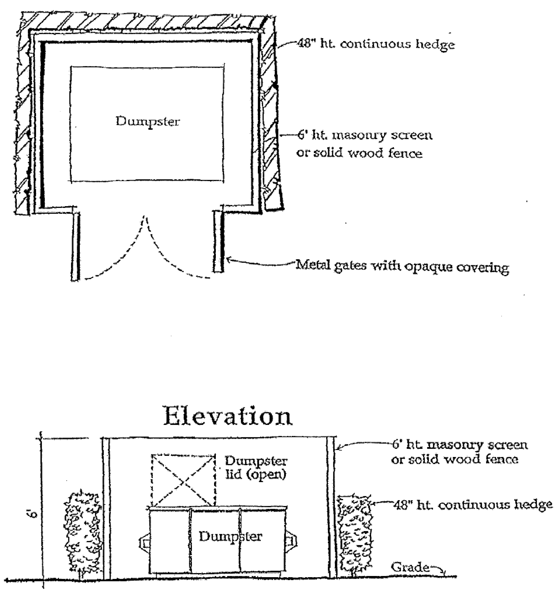
EXHIBIT B
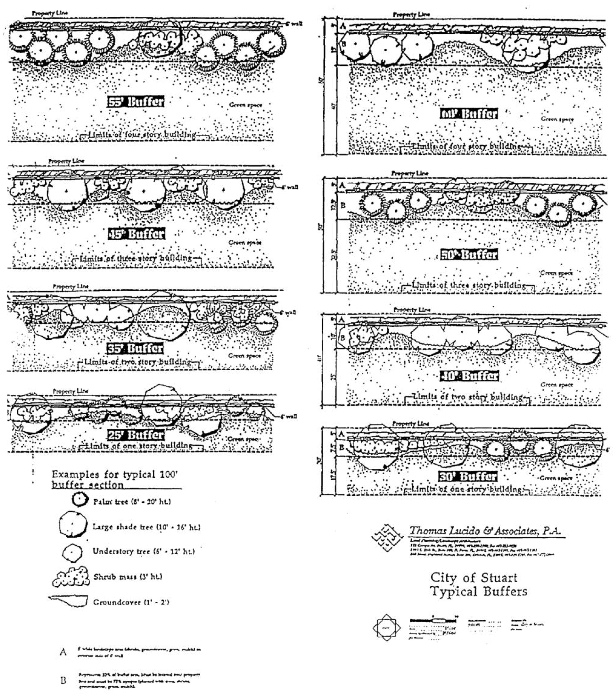
EXHIBIT C
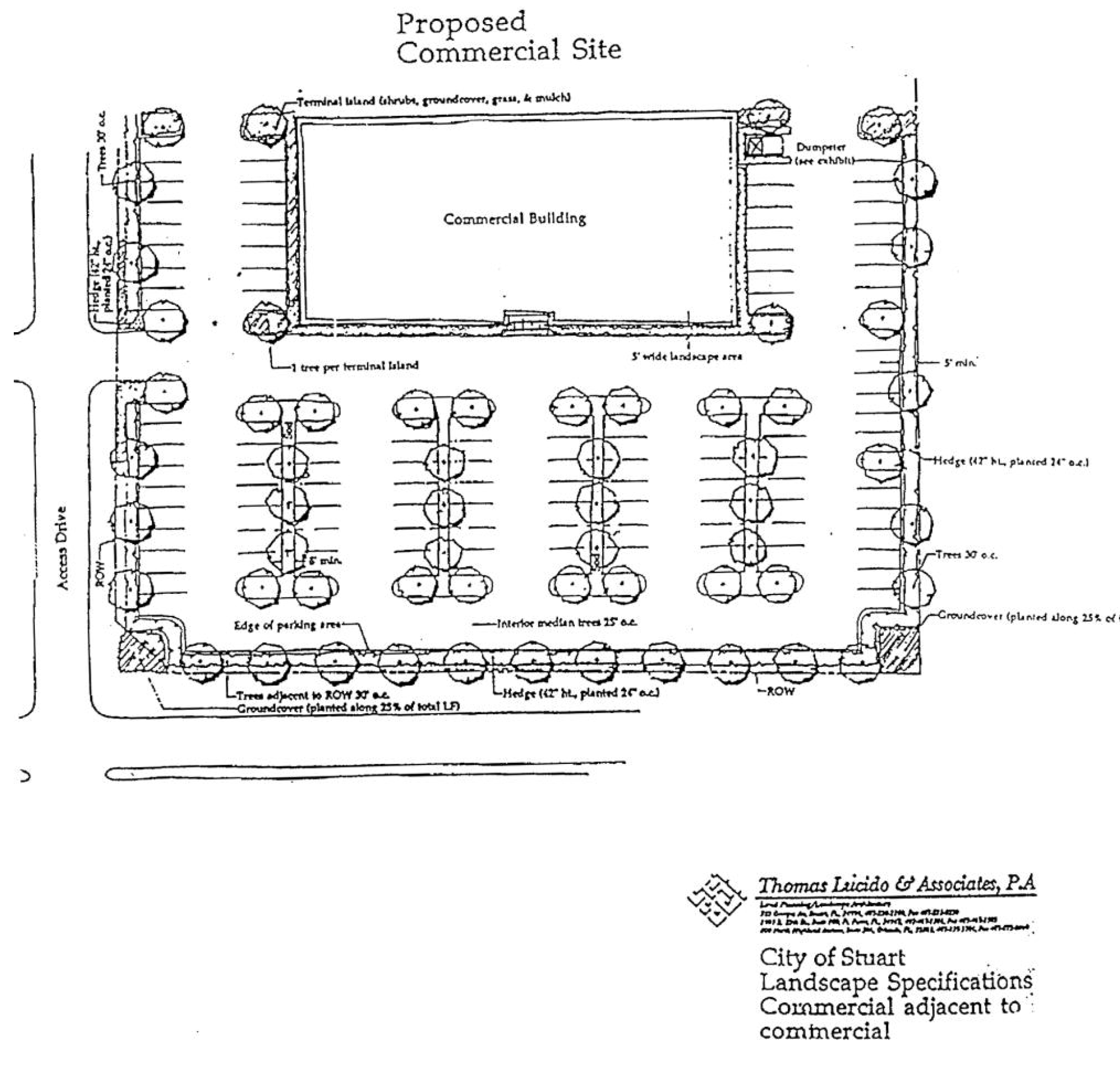
EXHIBIT D
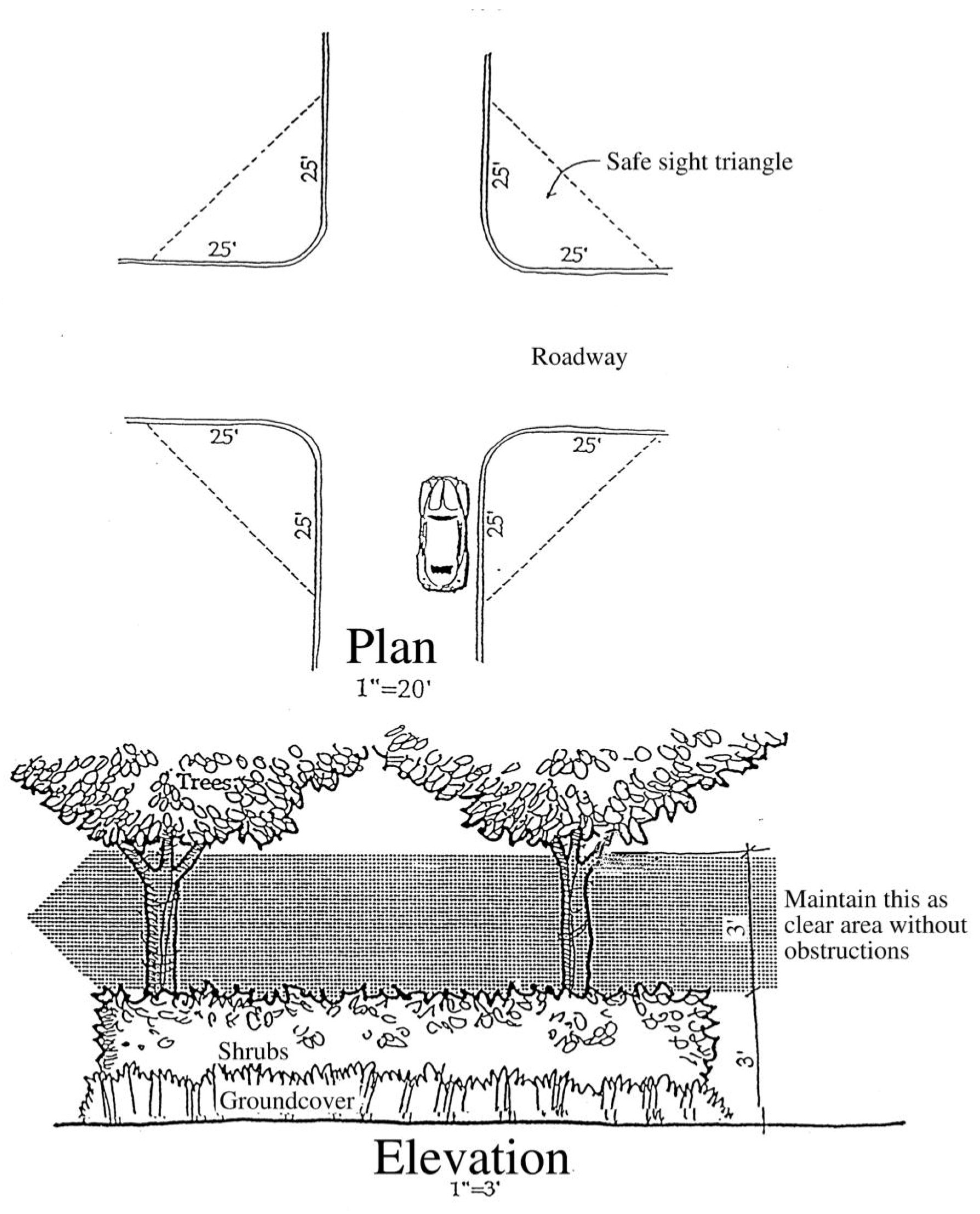
EXHIBIT E
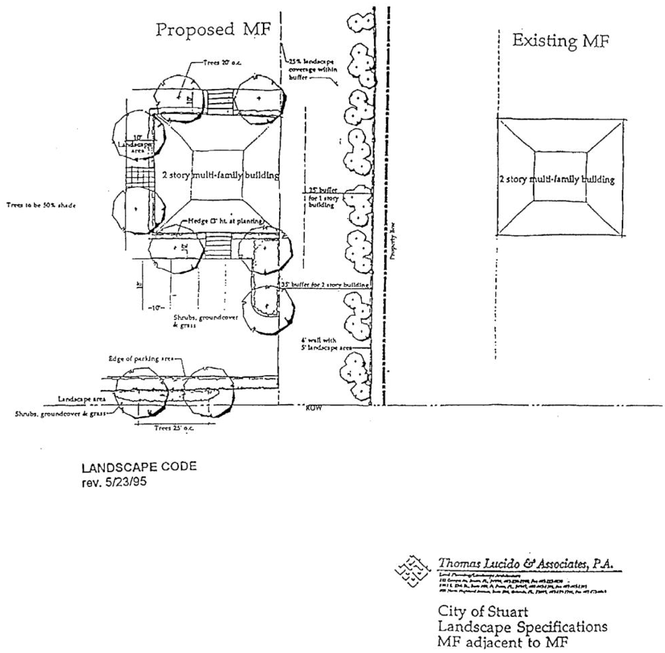
Sec. 6.05.01. - Types of commercial development.
All types and sizes of commercial development are regulated by the standards included in this section. As used in this section the term "large scale commercial development," hereinafter "LCD," means including any commercial or other non-residential development of greater than 20,000 square feet in gross building area. In the case of multiple buildings within the same commercial or other non-residential development, including planned unit developments, phased developments and outparcels in different ownership than the primary parcel, the total square footage of all buildings shall comprise the gross building area.
When making a determination as to whether or not a particular development constitutes an LCD, the city development director shall consider the design of facilities and site components which are likely to be shared with the development of other properties, including, but not limited to, parking, drainage, vehicular access, native preservation and common areas.
Sec. 6.05.02. - Building design and location.
A.
Purpose and intent. All commercial buildings shall be designed to maintain and enhance the attractiveness of the streetscape and the existing architectural design of the community. Buildings shall have architectural features and patterns that provide visual interest from the perspective of the pedestrian, reduce massing and recognize local character. Facades shall be designed to reduce the mass or scale and uniform monolithic appearance of large unadorned walls, while providing visual interest that will be consistent with the community's identity and character through the use of detail and scale. The building's mass shall be varied in height and width so that it appears to be divided into distinct massing elements and details that can be perceived at the scale of the pedestrian (see illustrations 1 and 2).
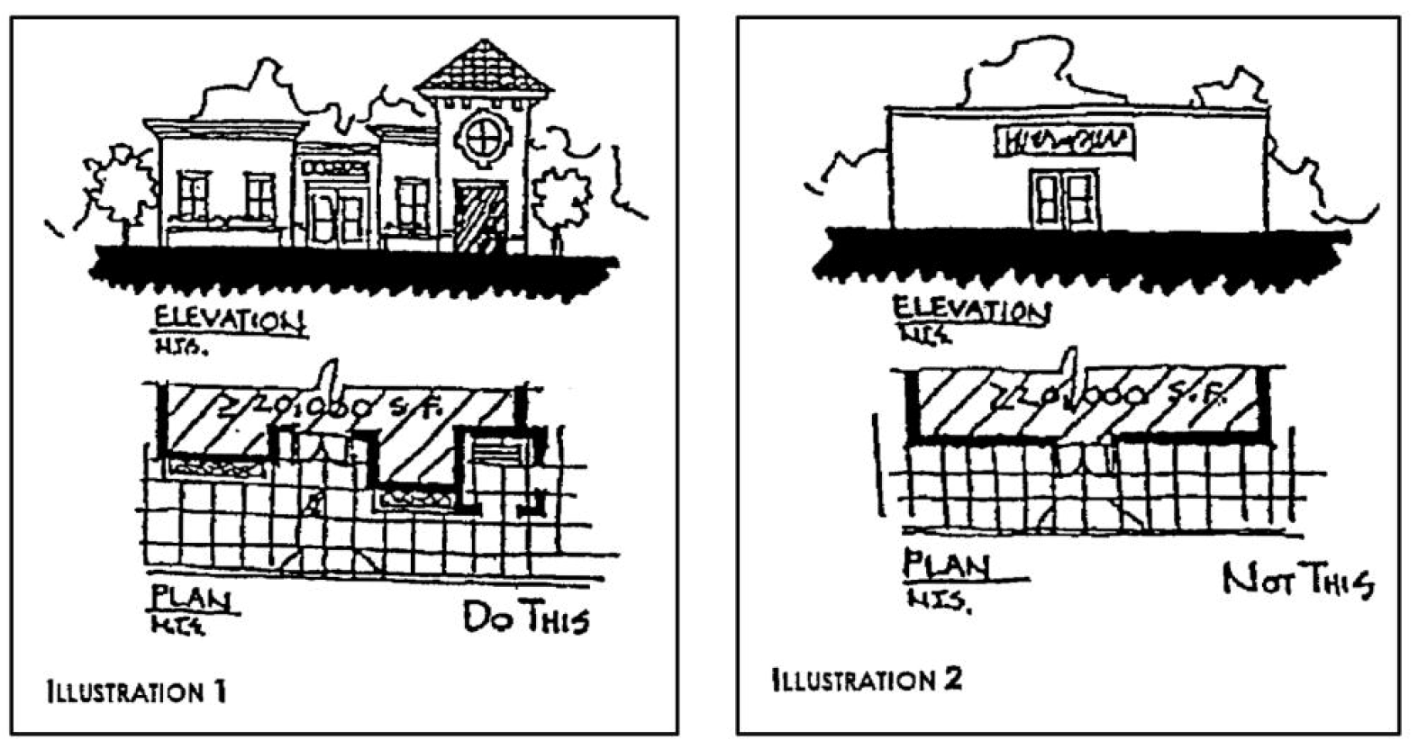
Corner lots at an intersection of two or more arterial or collector roads shall be designed with additional architectural embellishments, such as corner towers or other design features, to emphasize their location as gateways and transition points within the community.
B.
Building location.
1.
For all roadways excluding SE Ocean Blvd., Osceola Street and SR 707/Dixie Highway, the distance between the primary front facade of a commercial building and the nearest abutting right-of-way shall be as follows:
a.
For all commercial development which is not more than 50,000 square feet, including LCDs, the setback of the primary front facade shall be not less than 20 feet but not more than 100 feet.
b.
For a single-use LCD which is greater than 50,000 square feet, the setback of the primary front facade shall be not less than 20 feet but not more than 200 feet.
c.
For a multi-use LCD which is greater than 50,000 square feet, the setback of the primary front facade shall be not less than 20 feet but not more than 200 feet, provided however that the setback for any individual building within the LCD which is not more than 50,000 square feet, the setback of the primary front facade shall be not less than 20 feet but not more than 100 feet.
2.
For Osceola Street outside of the Urban District and SR 707/Dixie Highway outside of the Urban District or East Stuart District, the distance between the primary front facade of a commercial building and the nearest abutting right-of-way shall be not less than ten feet but not more than 50 feet.
C.
Building orientation. Building facades adjacent to an arterial or collector street shall either have windows along no less than 50 percent of their horizontal length or a primary customer entrance. Additional entrances and windows facing additional abutting public streets or adjacent buildings are encouraged. Buildings shall be oriented to maximize pedestrian access.
D.
Facade design. All primary facades of a building shall be designed with consistent architectural style, detail and trim features. The facades of all buildings shall also adhere to the requirements of this section with respect to architectural design treatments for primary facades.
E.
Massing. Primary facades shall be designed to employ the following design treatments on the ground floor.
1.
No horizontal length or uninterrupted curve of a primary facade shall exceed 100 linear feet. For arcaded facades, no horizontal length or uninterrupted curve of the arcaded facade shall exceed 120 feet. Varied lengths are desirable. Projections and recesses shall have a minimum depth of three feet with 25 percent of these having a varied length with a minimum differential of one foot (see illustration 3).
2.
A single wall plane shall not constitute more than 60 percent of each affected ground floor primary facade.
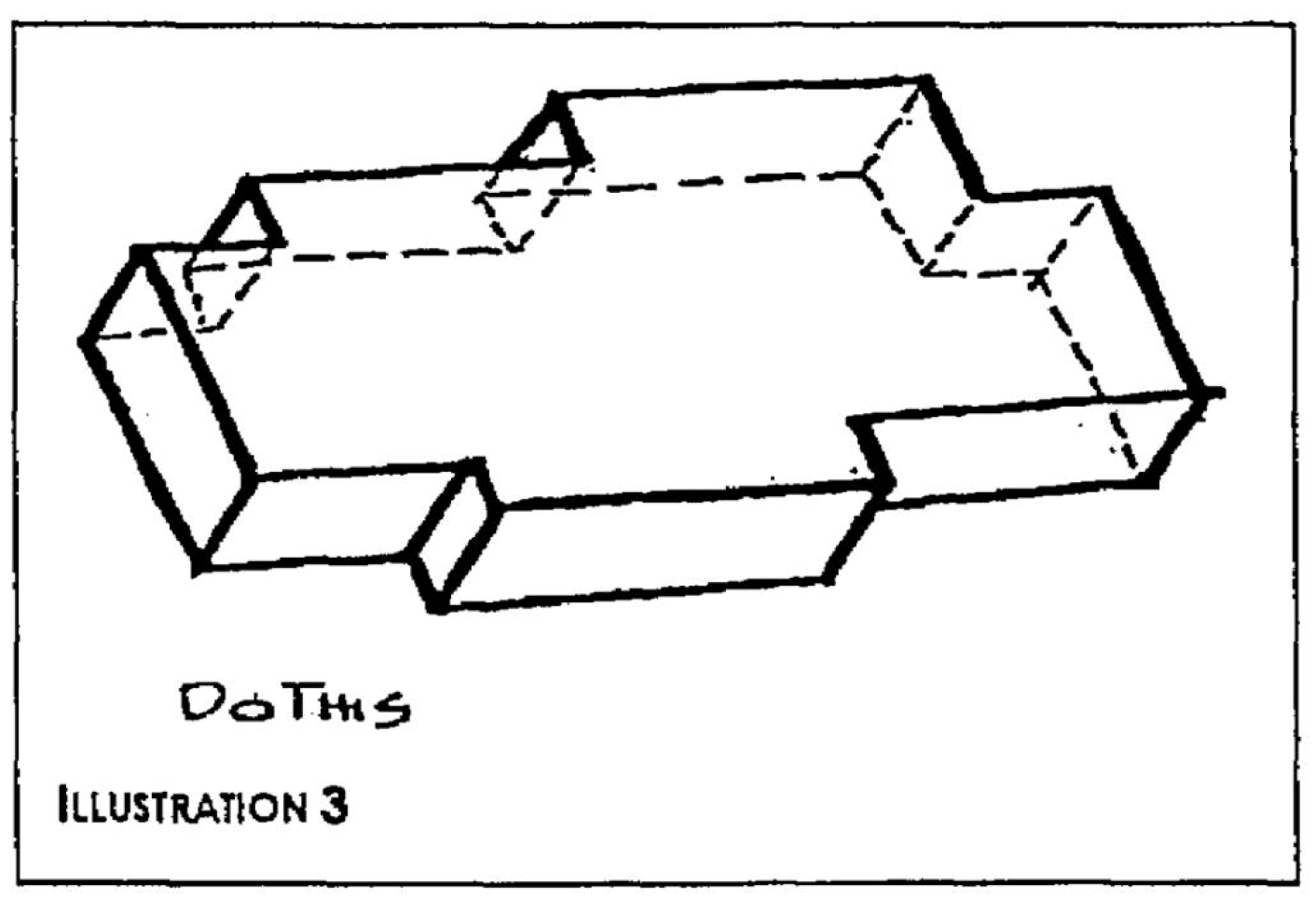
NOTES: Horizontal length or uninterrupted curve of primary façade not to exceed 100 linear feet and of arcaded facade not to exceed 120 feet. Minimum depth of 3 feet for projections and recesses.
3.
Primary facades on the ground floor shall have features along a minimum of 50 percent of their horizontal length. These features include, but are not limited to, arcades a minimum of eight feet clear in width, display windows, entry areas and other such design elements. Awning areas shall be excluded from this calculation unless associated with windows or doors and are in increments of ten feet in length or less.
F.
Other design standards. Commercial development which is not an LCD shall provide a minimum of four of the following building design treatments. For an LCD, a minimum of five of the following building treatments shall be provided (see illustrations 4 and 5).
1.
Overhangs;
2.
Arcades, minimum of eight feet clear in width;
3.
Sculptured artwork;
4.
Raised cornice parapets over doors;
5.
Peaked roof forms;
6.
Display windows;
7.
Ornamental and structural architectural details, other than cornices, which are integrated into the building structure and overall design;
8.
Clock or bell towers;
9.
Decorative light fixtures;
10.
Decorative landscape planters or planting areas, a minimum of five feet wide, and areas for shaded seating consisting of a minimum of 100 square feet;
11.
Integration of specialty pavers, or stamped, colored concrete along the building's walkway to constitute a minimum of 60 percent of walkway area; or
12.
Water elements, a minimum of 150 square feet in area.
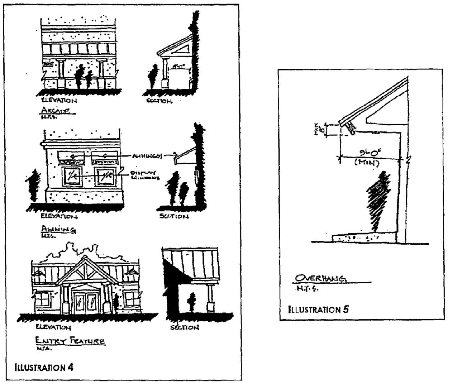
G.
Building architectural elevations for transition between non-residential and residential uses.
1.
That portion of a proposed non-residential building or multi-family residential building that will face an adjacent residential use shall be architecturally designed to be harmonious with and complementary to the adjacent residential use in terms of building elevations, architectural materials and roof lines. Harmony may require a reduction in the mass of the non-residential building or the size of that portion of the non-residential building that is nearest the residential use. Harmony may also require a reduction in wall heights, articulation of wall and roof planes, and architectural decoration.
2.
Windows at the second floor and above of a proposed non-residential building or multi-family residential building shall be oriented and designed so as to preclude a direct line of sight onto adjacent residential uses within 50 feet of the common boundary.
3.
No overhead doors or loading areas shall be designed along the common boundary side of the proposed non-residential building.
4.
Roof-mounted equipment on a proposed non-residential building shall be visually screened from the first and second floor of an adjacent residential use or residential zoning district and from public right-of-way.
H.
Noise. On a proposed non-residential use or multi-family use property all mechanical, electrical, and communications equipment shall be located, designed and screened to minimize noise emanating from the common boundary.
Sec. 6.05.03. - Detail features for all commercial developments.
A.
Purpose and intent. The design elements in the following standards shall be integral parts of the building's primary facades and shall be integrated into the overall architectural style. These elements shall not consist solely of applied graphics or paint.
B.
Blank wall areas. Blank wall areas shall not exceed ten feet in vertical direction and 20 feet in horizontal direction of any facade. Control and expansion joints within this area shall constitute blank wall area unless used as a decorative pattern and spaced at intervals of six feet or less. Relief and reveal work depth must be a minimum of one-half inch (see illustration 9).
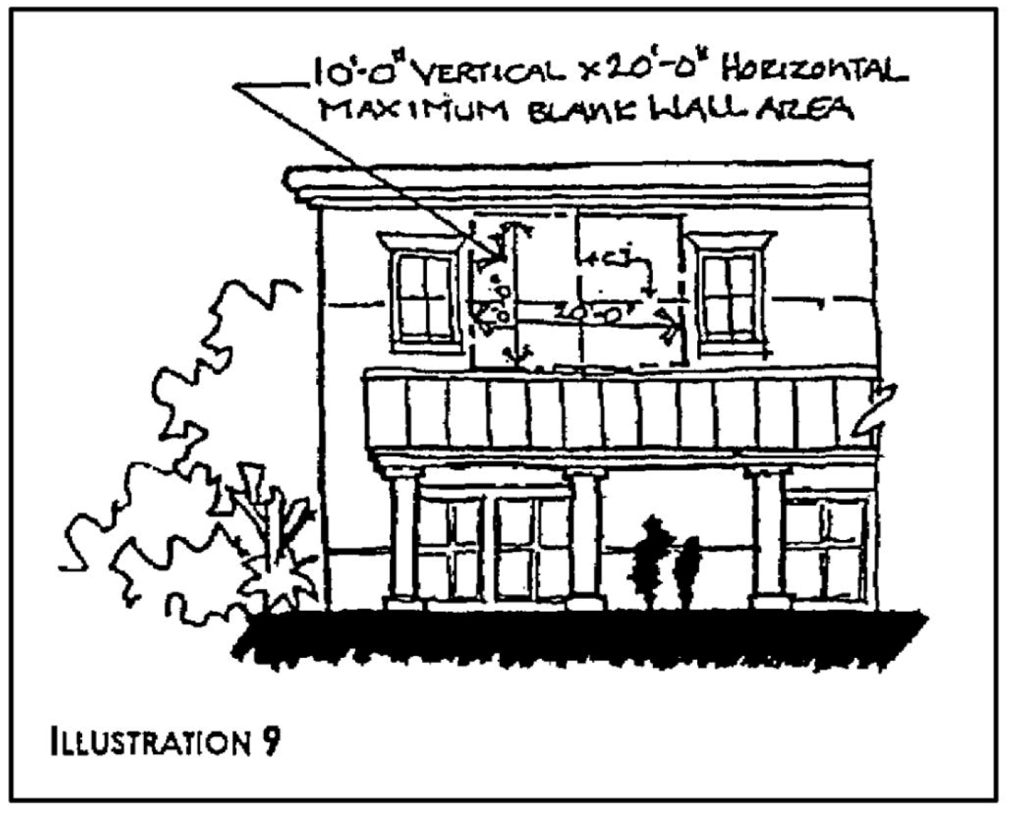
C.
Repeating facade treatments. Primary facades shall include a repeating pattern and shall include no less than three of the design elements listed below. At least one of these design elements shall repeat horizontally. All design elements shall repeat at intervals of no more than 30 feet, either horizontally or vertically.
1.
Color change;
2.
Texture change;
3.
Material module change;
4.
Expression of architectural or structural bays, through a change in plane of no less than 12 inches in width, such as a reveal, an offset, or a projecting rib (see illustration 10);
5.
Architectural banding;
6.
Building setbacks or projections, a minimum of three feet in width on upper levels; or
7.
Pattern change.
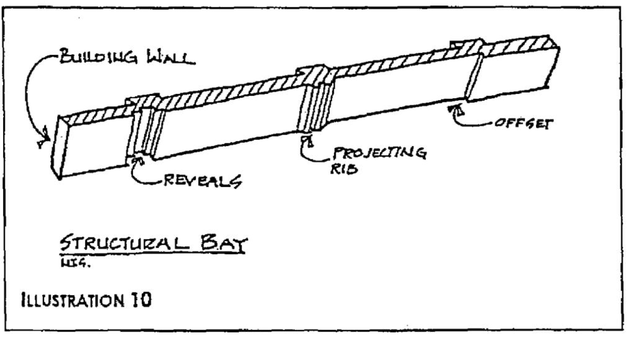
Sec. 6.05.04. - Additional facade design treatments for multiple-use buildings.
A.
Purpose and intent. The presence of buildings with multiple tenants creates variety, breaks up large expanses of uninterrupted facades and expands the range of onsite activities. Windows and window displays of such stores shall be used to contribute to the visual interest of exterior facades. The standards in this section are directed toward those situations where more than one retailer, with separate exterior customer entrances, is located within the principal building.
B.
First floor primary facade treatment. The first floor of the primary facades of such multi-use buildings shall, at a minimum, utilize windows between the heights of three feet and eight feet above the walkway grade for no less than 50 percent of the horizontal length of the building facade. Windows shall be recessed, a minimum of one-half inch, and shall include visually prominent sills, shutters, stucco reliefs or other such forms of framing.
Sec. 6.05.05. - Roof treatments for all commercial development.
A.
Purpose and intent. Variations in roof lines shall be used to add interest to and reduce the massing of buildings. Roof features shall be in scale with building mass and shall complement the character of adjoining or adjacent buildings and neighborhoods. Roofing material shall be constructed of durable high quality materials in order to enhance the appearance and attractiveness of the community.
B.
Roof edge and parapet treatment. At a minimum of two locations, the roof edge or parapet shall have a vertical change from the dominant roof design which is a minimum of three feet. At least one such change shall be located on a primary facade adjacent to a collector or arterial right-of-way (see illustration 11).
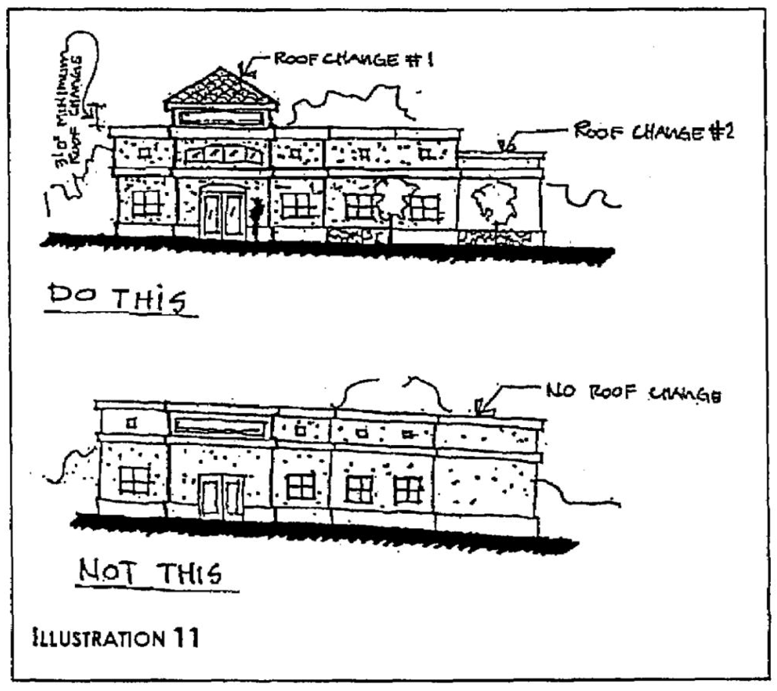
Roofs shall meet at least two of the following requirements:
1.
Parapets shall be used to conceal roof top equipment and flat roofs;
2.
Where overhanging eaves are used, overhangs shall be no less than three feet beyond the supporting walls with a minimum fascia of eight inches;
3.
Three or more roof slope planes per primary facade (see illustration 12);
4.
Sloping roofs, which do not exceed the average height of the supporting walls, with an average slope greater than or equal to one foot of vertical rise for every three feet of horizontal run and less than or an average slope equal to one foot of vertical rise for every one foot of horizontal run;
5.
Three-dimensional cornice treatment which shall be a minimum of 12 inches in height with a minimum of three reliefs; or
6.
Additional vertical roof changes with a minimum change in elevation of two feet.
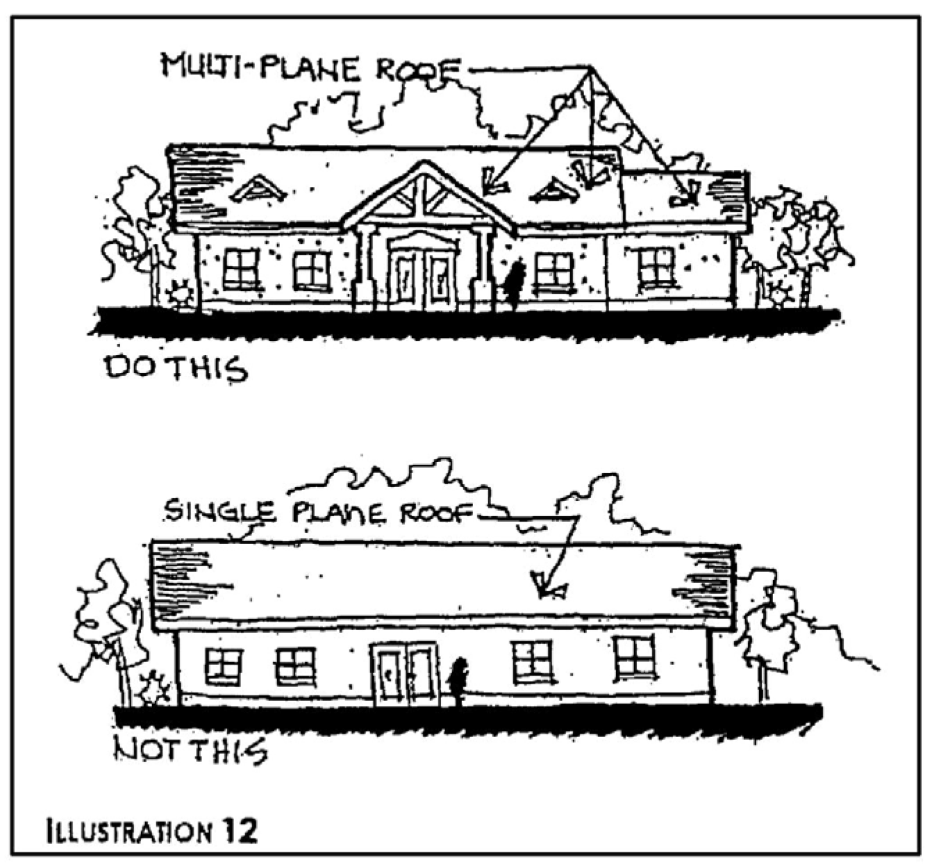
C.
Prohibited roof types and materials. The following types of materials are prohibited:
1.
Asphalt shingles, except laminated, 320-pound, 30-year architectural grade asphalt shingles or better;
2.
Mansard roofs and canopies without a minimum vertical distance of eight feet and at an angle not less than 25 degrees, and not greater than 70 degrees;
3.
Roofs utilizing less than or equal to a two to 12 pitch utilizing full parapet coverage; and
4.
Back-lit awnings used as a mansard or canopy roof.
Sec. 6.05.06. - Entryways and customer entrance treatments.
A.
Purpose and intent. Entryway design elements and variations shall give protection from the sun and adverse weather conditions. These elements shall be integrated into a comprehensive design style for the project.
B.
Single use LCD. A single-use LCD shall include the following:
1.
Single-use LCD buildings shall have clearly defined, highly visible customer entrances.
2.
An outdoor patio area adjacent to the customer entrance shall be provided of a minimum of 200 square feet in area which incorporates the following:
a.
Benches or other seating components;
b.
Decorative landscape planters or wing walls which incorporate landscaped areas; and
c.
Structural or vegetative shading.
d.
For a single-use LCD which is greater than 100,000 square feet, a minimum of one percent of the total gross floor area of the building or commercial project shall be dedicated to community space. Said community space shall be located off or adjacent to the circulation path of the complex or main structure and shall incorporate benches or other seating components.
C.
Multi-use LCD. A multi-use LCD shall include the following:
1.
Anchor tenants shall provide clearly defined, highly visible customer entrances.
2.
An outdoor patio area adjacent to the customer entrance shall be provided of a minimum of 200 square feet in area which incorporates the following:
a.
Benches or other seating components;
b.
Decorative landscape planters or wing walls which incorporate landscaped areas; and
c.
Structural or vegetative shading.
3.
Any building within a multi-use LCD which is greater than 100,000 square feet, a minimum of one percent of the total gross floor area of the building or commercial project shall be dedicated to community space. Said community space shall be located off or adjacent to the circulation path of the complex or main structure and shall incorporate benches or other seating components.
Sec. 6.05.07. - Materials and color for all commercial development.
A.
Purpose and intent. Exterior building colors and materials contribute significantly to the visual impact of a building on the community. They shall be well-designed and integrated into a comprehensive design style for the project.
B.
Exterior building material standards. The following standards shall apply to all buildings within a commercial or non-residential development.
1.
Predominant exterior building materials shall include, but are not limited to:
a.
Stucco;
b.
Brick;
c.
Tinted or textured concrete masonry units, but not including smooth or rib-faced concrete block; or
d.
Stone, excluding ashlar or rubble construction look.
2.
Predominant exterior building materials that are prohibited include:
a.
Plastic siding;
b.
Corrugated or reflective metal panels;
c.
Tile;
d.
Smooth or rib-faced concrete block; and
e.
Applied stone in an ashlar or rubble look.
3.
Exterior building materials, windows, and doors shall include those materials that contain or attenuate noise within the structure, such that with any operable windows and doors, open or shut, the sound pressure level does not exceed the limits established in section 20-151(a) and (b) of the City Code of Ordinances.
(Ord. No. 2097-07, § 2, 1-22-07)
C.
Predominant exterior color. All building or structure wall colors shall be restricted to muted pastel or earth-tone shades. The use of black or florescent colors is prohibited as a predominant exterior building color.
D.
Interior building material standards. The following standards shall apply to all buildings within a commercial or non-residential development.
1.
Predominant interior building materials shall include, but are not limited to:
a.
Sound attenuating materials, deployed so as to meet the requirements of section 20-151(a) and (b) of the City Code of Ordinances.
(Ord. No. 2097-07, § 3, 1-22-07)
Sec. 6.08.01. - Solid waste and recycling container standards.
A.
Purpose and intent. The purpose of this section is to supplement the development regulations of this Code with specific regulations providing solid waste and recycling minimum container standards (Table Inset). Carts, dumpsters, compaction, roll-off and other solid waste containers shall meet or exceed the city's solid waste and recycling minimum container standards, as set forth herein, thereby creating and maintaining a positive ambiance and strong community image and identity. Solid waste container enclosures or service function areas shall use specific design standards (Illustrations Inset 14-19). By using these standards, it is the city commission's intent to enhance the visual appearance of the city while providing for design flexibility. All of these regulations are intended to enhance the quality of life in the city.
B.
All single-family and duplex residential units shall have at a minimum, the solid waste collection carts provided by the city. If the city's carts are lost, stolen, or materially damaged, such carts shall be replaced at the property owner's expense. For the convenience of the city, the city may replace such carts at no expense to the property owner, based upon newer models, or normal wear and tear.
C.
The provisions of this section shall apply to commercial, non-residential and multi-family development constructed as new development or as renovation development, as those terms are defined in chapter XII of this Code, for which a complete application for site plan approval has not been received by the city development department prior to December 31, 2010, or for which a building permit has not been obtained by January 31, 2011. Commercial and multi-family units shall not require dumpsters (or dumpster enclosures or service function areas) if the amount of solid waste generated does not exceed 190 gallons per week (2 carts x 95 gallons per cart), and if the amount of recycled materials does not exceed 130 gallons per week (2 carts x 65 gallons per cart). If city containers or carts are lost, stolen, or materially damaged, they shall be replaced at the property owner's expense. For the convenience of the city, the city may replace such carts or containers at no expense to the property owner, based upon newer models, or normal wear and tear.
D.
Commercial, non-residential, and multi-family residential development trash collection containers, including carts, dumpsters and compaction and roll-off containers shall have enclosures, which are sometimes referred to in this Code as service function areas. Said service function areas shall be constructed in accordance with the city's solid waste and recycling minimum container standards as shown in Illustrations Inset 14 through 20, inclusive. Such carts, dumpsters and compaction and roll-off containers shall meet or exceed the city's solid waste and recycling minimum container standards, shown immediately below:
Solid Waste and Recycling Minimum Container Standards
E.
Materials and design standards. Screening materials for, and the design of, enclosures or service function areas, including the landscaping, shall be consistent with or complimentary to the design treatment of the primary facades of commercial, non-residential and multi-family residential development structures, and shall meet the minimum requirements of the Florida Building Code. Such enclosures shall be constructed on three sides with concrete, concrete block, pre-fabricated concrete panels, wooden fence, or other materials approved by the city, and on the fourth side with a closable and lockable gate that is opaque or has opaque inserts.
ILLUSTRATIONS INSET 14—19
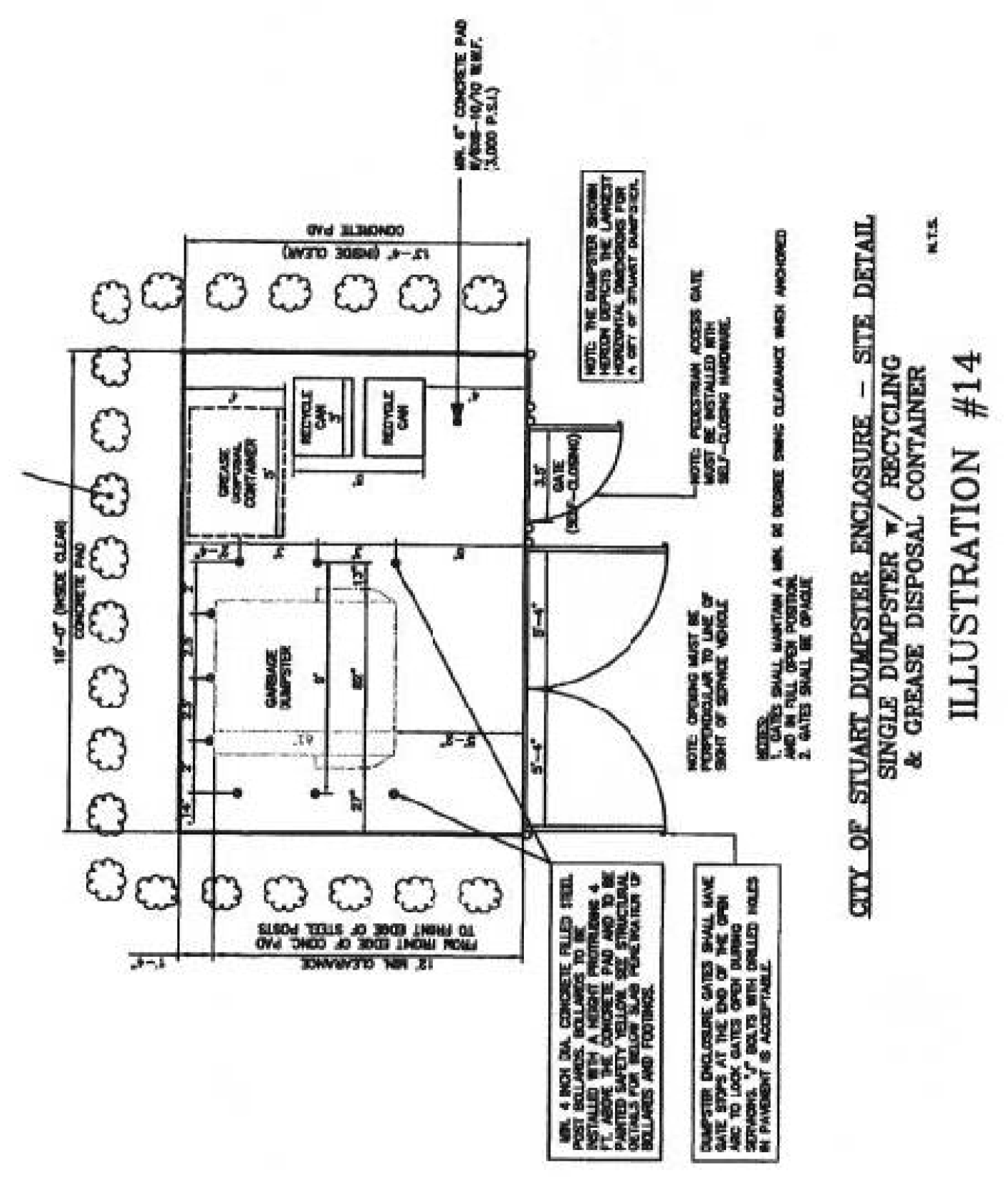
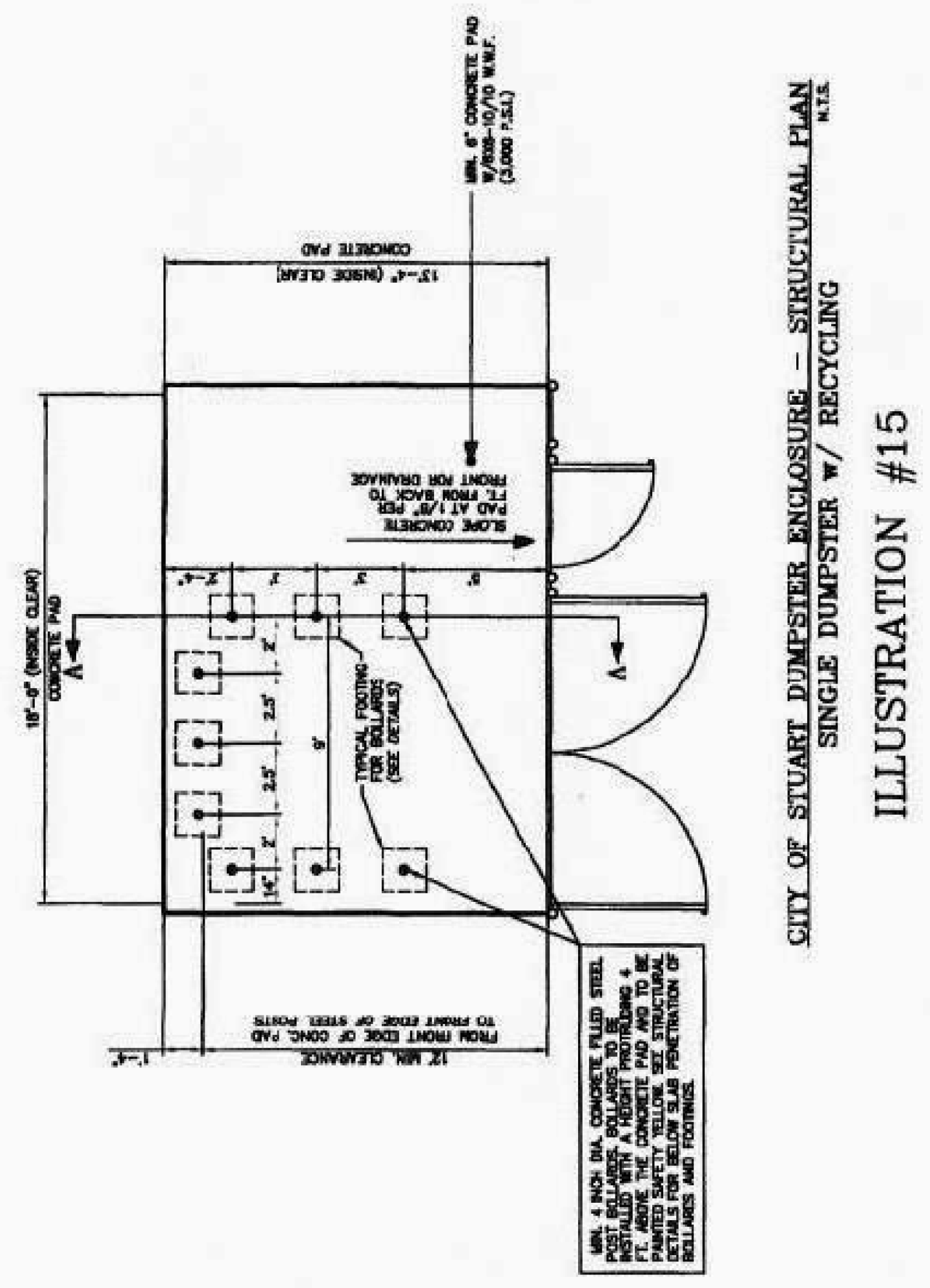
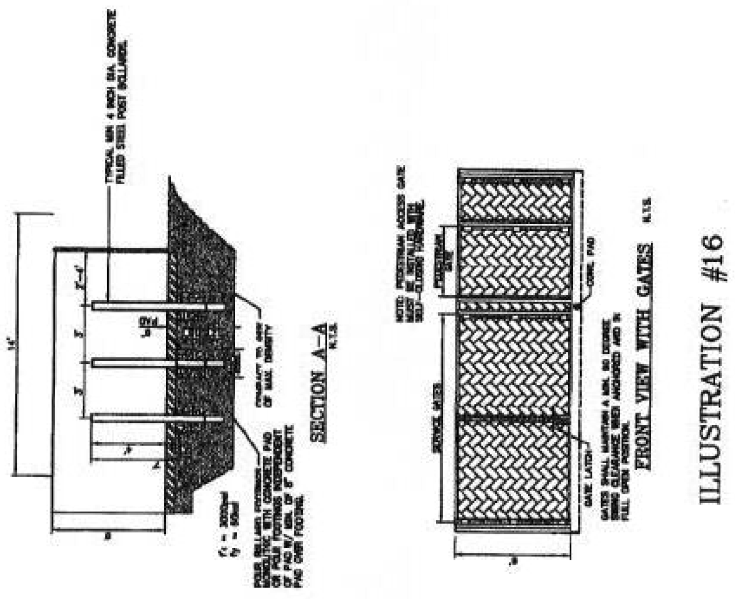
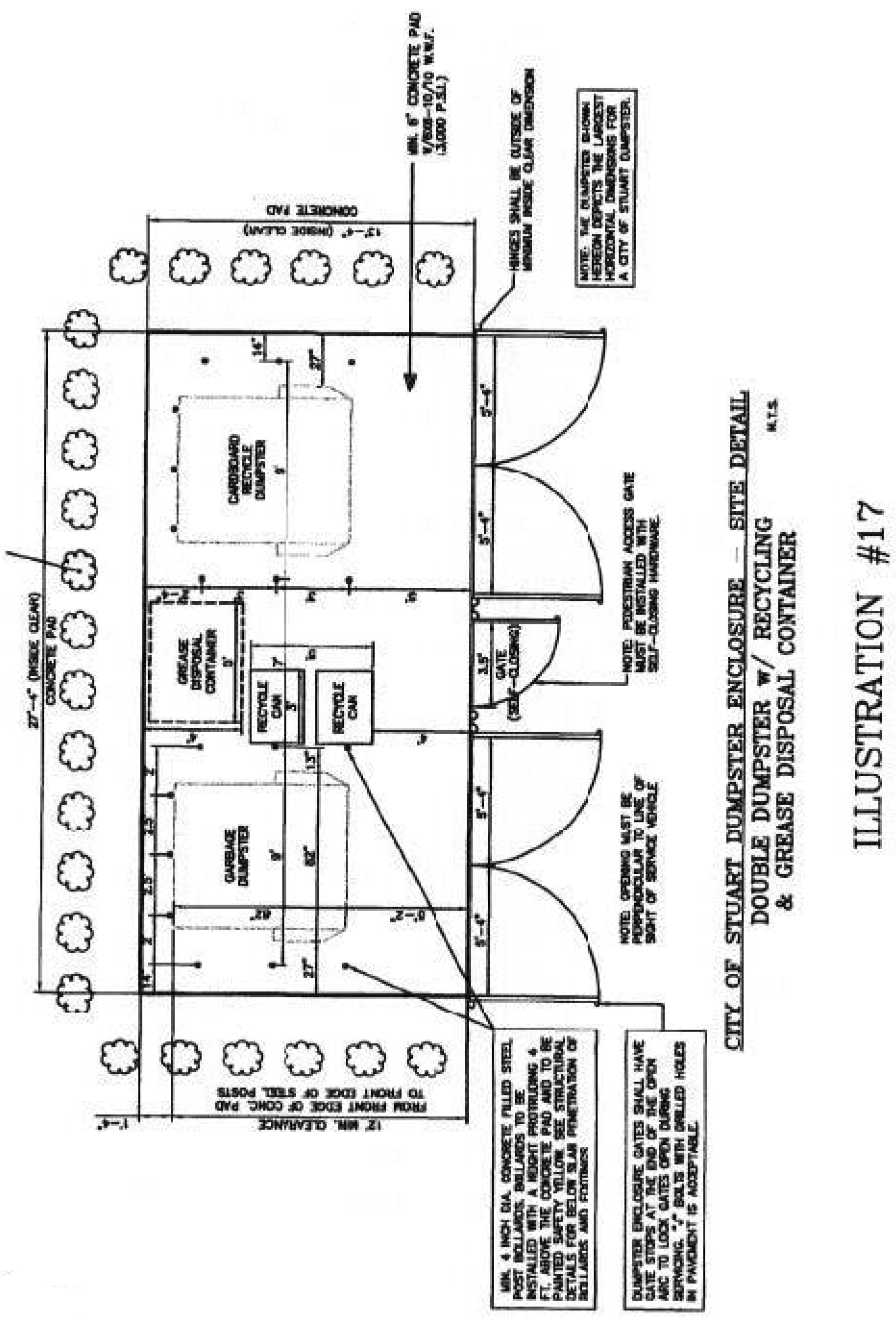
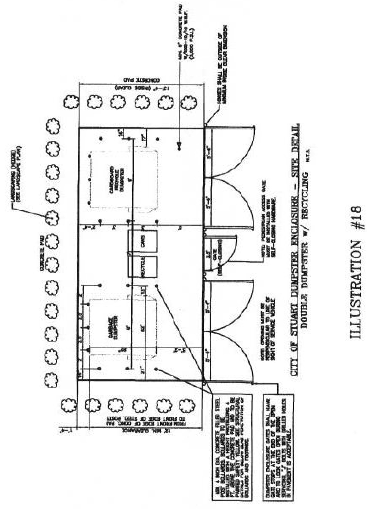
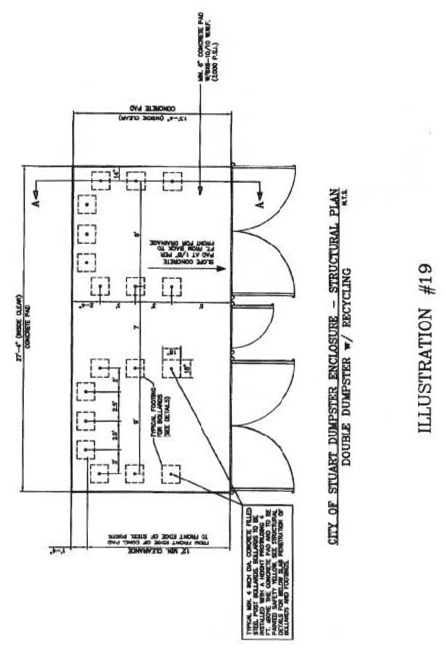
Sec. 6.09.01. - Purpose.
It is the purpose of this chapter to regulate the installation, configuration, and use of accessory structures, and the conduct of accessory uses, in order to ensure that they are not harmful either aesthetically or physically to residents and surrounding areas. In cases of conflict with provisions in the Urban District Code, East Stuart District Code or S.E. Ocean Boulevard Overlay Zone, the provisions in those sections shall prevail.
(Ord. No. 1827-02, § 2, 1-28-02; Ord. No. 2539-2025, § 2, 4-16-25)
Sec. 6.09.02. - General standards and requirements.
Not more than three accessory structures (excluding satellite television antenna systems, swimming pools, fences, walls, hedges, enclosures, and awnings), including a detached accessory dwelling unit, may be located on a parcel, provided that the following requirements are met:
A.
Principal structure required. No accessory structure shall be constructed unless there exists a permitted principal structure on the parcel, located in full compliance with all standards and requirements of this Code.
B.
Compliance with requirements for principal structure required. All accessory structures, including a detached accessory dwelling unit, shall comply with standards pertaining to the principal use, unless exempted or superseded elsewhere in this Code.
C.
Location.
1.
Setbacks. Accessory structures shall not be located between the front facade of the principal building and the front property line and shall only be permitted in side and rear yards, subject to minimum five-foot side and rear setbacks from the property line. On corner lots the side setback shall be ten feet.
2.
Separation. There shall not be less than five feet separation between an accessory structure and the principal building.
3.
Size. In a residential district the height of an accessory structure shall not exceed the height of the principal structure and the footprint of an accessory structure shall not exceed 50 percent of the footprint of the principal structure. The interior ceiling of the first floor of an accessory structure shall not exceed ten feet above the finished floor elevation.
4.
Design. The architectural design and materials shall be consistent with the principal structure, neighborhood and use conventional residential windows and doors.
D.
Drainage calculations. Accessory structures and detached accessory dwelling units shall be included in all calculations of impervious surface and stormwater runoff.
E.
Detached accessory dwelling unit. In addition to the general standards and requirements set forth above for accessory structures, a single detached accessory dwelling unit may be located on the same lot as a single-family detached home provided that the following requirements are met:
1.
A detached accessory dwelling unit shall not exceed one story in height. The unit may be located on a second story if the first story is utilized as a garage or storage facility.
2.
A detached accessory dwelling unit shall be set back from the side and rear property lines not less than five feet. On corner lots the side setback shall be ten feet. An accessory dwelling unit to be located on the second story of a detached garage or storage facility shall meet the side and rear yard setbacks required of the principal structure.
3.
A detached accessory unit shall be separated from the principal building and other accessory structures a distance not less than five feet.
4.
The accessory dwelling unit shall contain one full bath and kitchen facilities.
5.
An accessory dwelling unit and the primary dwelling unit shall be occupied by members of a single family as that term is defined in this Code. The accessory dwelling unit shall use the same street address as the primary dwelling unit.
6.
An ADU must be on the same water and electric meter as the primary residence. No additional meters will be permitted.
(Ord. No. 1453-96, 6-1-96; Ord. No. 1720-00, 3-27-00; Ord. No. 1827-02, § 2, 1-28-02; Ord. No. 1860-02 § 1, 5-20-02; Ord. No. 2539-2025, § 2, 4-16-25)
Sec. 6.09.03. - Satellite television antenna systems.
The following regulations shall apply to satellite television antenna systems also known as television dish antennas, with the exception of those video antennas covered under 47 CFR 1.4000, including direct-to-home satellite dishes that are less than one meter (39.37 inches) in diameter, wireless cable antennas less than one meter in diameter, and antennas used to receive local television broadcast signals:
A.
Installations in residential zoning districts.
1.
Location. All satellite television antenna systems shall be permanently and securely mounted at ground level and shall serve only a single location. Apartments, condominiums, and properties under unified ownership shall be considered one location. No such system shall be located within any front or side yard unless no part of the system is visible to persons standing at ground level on adjacent properties or streets. The system shall be located as close as possible to the main residential structure, but in no case shall the edge of the dish be closer than five feet from the real property lines.
2.
Appearance. No satellite television antenna shall exceed 15 feet in height or 13 feet in width. The dish antenna of any such system shall be painted or impregnated beige, white, or some other natural color blending with the colors of surrounding vegetation and structures. The foundation and base of the system shall not exceed six inches in height above ground level.
3.
Buffering. An opaque fence or landscaped barrier of at least 3½ feet in height shall be constructed around the foundation and base of the system.
B.
Installation in all other zoning districts.
1.
Location. In nonresidential zoning districts, satellite television antenna systems shall not be installed within the front portion of the property. The "front" of the property is defined as that portion of the property which faces the street address and the "front portion" is that portion of the front which extends back to the building line. Said systems may be installed above ground level and upon building roofs, but the combined height of any such antenna system and the building shall not exceed the overall height of 45 feet. All antenna systems installed upon a building roof shall be located, if possible, so that they may not be seen from street level. All antenna systems shall be installed at least 20 feet (measured from the edge of the dish) from any adjoining residential property line.
C.
Permit. All satellite television antenna systems shall be deemed accessory uses and structures and shall require a building permit before construction. An application for the permit shall be made to the city development department accompanied by a plan document showing the dimensions and location of the proposed satellite television antenna system in relation to the boundaries, setback lines and existing structures on the property; and a document (unless such a document has been previously filed with a prior application regarding the same type of system from the same manufacturer in which case said prior document shall satisfy this requirement) signed and sealed by a licensed professional engineer registered in the State of Florida showing the system's method of installation and permanent mounting, listing the materials to be used and certifying that the system is able to sustain winds up to 120 miles per hour.
D.
Nonconforming antenna systems. Nonconforming antenna systems in place and properly maintained as of the effective date of this section may continue in use notwithstanding their nonconforming status subject to the conditions below:
1.
The use of any nonconforming antenna system shall terminate whenever said antenna system is damaged or destroyed and the repairs would cost 50 percent or more of the original cost of said antenna system or if it becomes a hazard or danger. Upon termination of use as indicated above, said antenna system shall be immediately removed by the owner at the owner's expense.
2.
The use of any nonconforming antenna system shall terminate upon abandonment by the owner, who shall immediately thereafter remove said antenna system or bring it into conformity at his own expense.
Sec. 6.09.04. - Swimming pools.
A.
Code adopted. The most recent edition of the Florida Building Code is hereby adopted as the city swimming pool code, subject to such location modifications as may from time to time be adopted. A copy of this document shall be available for public review in the city development department.
B.
Additional requirements. No provision of this section shall be construed to require that a swimming pool or spa be built within an easement to a property.
(Ord. No. 1720-00, 3-27-00)
In addition to the Standard Swimming Pool Code the following requirements must be met:
1.
A No. 8 copper ground wire secured to a ground rod and connected to all metal parts of the pool, such as structural steel, stairs, lights, drains, pipes, etc., must be installed.
2.
All swimming pools and spas without a screen enclosure, public or private, above or below the ground, shall be installed no closer to the rear or side lot boundaries than five feet from the water-bearing wall surfaces of the swimming pool or spa.
(Ord. No. 1720-00, 3-27-00)
3.
A swimming pool or spa and appurtenant screen enclosure, of which 90 percent shall be screen material, shall be permitted in a rear yard, provided that it complies with the setback requirements for buildings as required for the lot's zoning classification.
(Ord. No. 1720-00, 3-27-00)
4.
If a patio is provided adjacent to or surrounding the swimming pool, it shall be designed so as to be self-draining away from the pool, but not on adjacent property.
5.
In determining the maximum depth of a pool in relation to the depth of an adjacent footer, the following rules shall apply:
a.
No pool excavation shall be deeper than the footer of any building or structure by a 30-degree angle measured from the horizontal plane from the bottom of the footer to the bottom of the excavation.
b.
The only time deviation from this rule may be allowed is when the city development director determines one of the following conditions will exist:
(1)
The soil weight bearing characteristics will allow construction of the pool closer to the structure or footer.
(2)
The pool will be constructed before the footer or other structure is built, thereby preventing the soil from shifting.
(3)
Sheet piling will be installed protecting the footer or structure from soil shifting.
C.
Fences for swimming pools. On and after July 23, 1990, the following conditions must be met:
1.
In addition to the safety requirements of F.S. § 515.27, a fence shall be installed that meet the requirements of this subsection, unless a barrier meeting the specific requirements of F.S. § 515.29 is installed.
2.
All new swimming pools must have a fence at least four feet high, with a spring lock gate, or be otherwise completely enclosed; provided, however, that no fencing need be erected on any side abutting a barrier such as a lake, river, creek, or canal.
3.
A building permit final inspection will not be conducted for a new swimming pool, unless the proper building permit for a fence receives a final inspection simultaneously.
4.
It shall be unlawful for any person, firm or corporation to build or cause to be built a new swimming pool, unless such pool is properly fenced in accordance with subsection C.1 of this section.
5.
All spas shall be secured with a locked cover or must have a fence at least four feet in height, with a spring lock gate, or be otherwise completely enclosed; provided, however that no fencing need be erected on any side abutting a barrier such as a lake, river, creek, or canal.
(Ord. No. 1720-00, 3-27-00)
Sec. 6.09.05. - Fences, walls, hedges, and enclosures.
A.
General requirements for all walls and fences. The regulations set forth in this section 6.09.05 shall apply to any existing or new development for residential, business, public, or industrial property for which a fence or accessory structure permit application has been submitted to the city development department.
(Ord. No. 1742, 7-10-00)
1.
The requirements of this section shall be in addition to and shall supersede in the event of a conflict those contained in the building code, relating to type of construction and materials of fences or walls.
2.
Any fence or wall over six feet in height must be designed and sealed by a licensed professional engineer or licensed architect.
3.
Wooden fences shall be of the woven or staggered type, with at least 30 percent of their area open to permit the flow of air. Only within the R-1A, R-1, and R-2 zoning districts shall a stockade type fence be permitted.
(Ord. No. 1741-00, 7-10-00)
4.
Fences and walls shall be constructed of concrete, cement blocks, brick, chain link, wood, ornamental wrought iron, stone, or any alternate material as approved by the city development director. Concrete or cement block walls shall be stucco or provided with a textured finish.
(Ord. No. 1742, 7-10-00)
5.
Metal fences shall be of non-corrodible metal or galvanized wire fabric, having a minimum of 11 gauge.
6.
Ornamental iron fences shall meet the requirements of subsection 6.09.05.A.17 of this Code.
7.
Fences or walls should be generally in harmony and compatible with their surroundings, including, but not limited to the following factors of compatibility: maximum height, materials, fence or wall type and use of landscaping.
8.
All fences and walls shall be maintained in good repair on both sides, so as to be structurally sound.
9.
All fences and walls on the same property shall be continuous in alignment and of uniform construction and appearance.
10.
All new and existing fences and walls shall be finished on the exterior side (all framing facing the interior) and shall be maintained in an attractive condition.
11.
No fence shall be constructed of materials which easily corrode, decay or rust, unless specifically treated to inhibit such corrosion, decay or rust.
12.
The height of fences and walls shall be measured from existing natural elevation of a lot, prior to any construction or alteration.
(Ord. No. 1453-96, 6-1-96)
13.
An entryway bower, arbor, or trellis, constructed in conjunction with a fence or wall, shall not exceed a maximum height of nine feet, measured from existing grade.
14.
A fence or wall shall only be located on a developed parcel of land unless the owner or contractor can clearly demonstrate that an extenuating circumstance exists creating a situation that compromises the safety, health, and general welfare of surrounding residents.
15.
No fences, walls, or hedges may be located within the intersection sight-triangle as set forth in subsection 6.04.03.B.8., Visibility triangles.
(Ord. No. 1742, 7-10-00)
16.
Electrical fences prohibited. Electrically charged fences are prohibited, except in prisons or jails.
17.
Barbed wire or razor wire fences. Barbed wire fences are hereby prohibited, except at the top of fences or walls erected in industrial, business, commercial or public use zoning districts. Razor wire fences shall only be permitted to be used in jails or prisons.
18.
Dangerous materials prohibited. Unless specifically permitted in this article, no fence, wall, or other enclosures shall include materials or devices, such as broken glass, spikes, razors, nails or similar materials intended or designed to maim, mutilate or cause other bodily injury to any person or animal.
19.
Construction design for wind pressure and other stresses. All fences and walls shall be adequately secured and designed to withstand wind pressure of at least 50 pounds per square foot and any additional stresses to which they would normally be subjected, unless the building code calls for higher standards or more restrictive construction.
20.
Obstruction of water drainage. In no case shall a fence or wall restrict the natural sheet flow of water or impede movement of drainage water from swales, drainage ditches, etc.
21.
All non-residential and multi-family development projects shall also install a construction fence with a temporary six-foot chain link fence with obscure green or black fabric of uniform color or other visual barrier material approved by the development director around the site prior to the initiation of the construction phase.
B.
Specific requirements, including type, material, and design for fences or walls—In single-family or duplex residential districts. In single-family and duplex residential zoning districts, all fences and walls constructed shall comply with the following requirements:
1.
For single family and duplex lots on R-2 zoned property, fences and walls may be erected or maintained along or adjacent to a lot line to a height not exceeding six feet in the side and rear yards. Opaque fences and walls erected within the front yard shall not exceed a height of four feet, unless otherwise allowed in this chapter. Open fences, such as chain link, picket, lattice, rail or similar fences and are not otherwise opaque, shall not exceed a height of six feet. Opaque fences and walls may be raised to six feet along the side lot line, if at least ten feet from the front yard property line or sidewalk, whichever is closest. Opaque fences within the front yard may not completely enclose and obscure the house from view of the public right-of-way, unless they are less than four feet high. Such fences and walls may be raised to six feet in height for a total length of eight feet per property. For all other residential zoning districts, the maximum height of walls or fences along the rear and side yards shall be six feet. All heights are measured from the base of the fence.
2.
If the fence or wall abuts (disregarding intervening alleys or unopened rights-of-way) a zoning district other than single-family or duplex residential, then the single-family owner or occupancy may elect to comply with the requirements of such abutting zoning district.
C.
Same—In multiple-family residential districts. The regulations set forth in this subsection shall apply only to an application for a fence and wall permit and shall not exist in conflict with any regulations otherwise herein this Code regarding buffers and required buffer materials for non-residential development abutting a residential use or zone. In multiple-family residential zoning districts, all fences and walls constructed shall comply with the following requirements:
1.
The maximum height of walls or fences shall be six feet;
2.
If the fence or wall abuts (disregarding intervening alleys or unopened rights-of-way) a zoning district other than single-family, duplex or multiple-family residential, then the multiple-family owner or occupant may elect to comply with the requirements of such abutting zoning district.
3.
Fences and walls shall be setback a minimum of three feet from any abutting right-of-way for the purpose of landscape beautification. Landscaping materials shall consist of a hedge and groundcover or other grounded landscape treatment.
4.
Chain link or mesh fences, minimum gauge of 11, shall be vinyl coated along, at a minimum, the weave of the fencing material. Colors of the vinyl material shall be limited to green or black.
5.
Walls shall have pilasters spaced at recurring intervals and shall include associated wall and corner caps. A minimum of two of the following architectural embellishments, complementing the existing or proposed building(s) on site and not to exceed 12 inches in height, shall be included:
•
Ornamental stone mountings.
•
Peaked cap along ridge of wall.
•
Ornamental ironwork.
•
Buttresses.
•
Built-in planter.
6.
One of the above must be built by the occupant or owner of the multiple-family property, but the owner or occupant of the single-family or duplex property may build it, if desired.
7.
Plans for either of the above shall be included as a part of the development permit application for such multiple-family property and shall be erected during or immediately after the erection of the principal building, and in any event, before the certificate of occupancy of the principal building is issued.
8.
Any such buffer or wall previously built must be maintained.
D.
Same—In business and public districts. The regulations set forth in this subsection shall apply only to an application for a fence and wall permit and shall not exist in conflict with any regulations otherwise herein this Code regarding buffers and required buffer materials for non-residential development abutting a residential use or zone. In business zoning districts, all fences and walls constructed shall comply with the following requirements:
1.
Fences or walls erected in the B-1 zoning district shall be no higher than six feet. Fences or walls shall be setback a minimum of three feet from any abutting street right-of-way for the purpose of landscape beautification. Landscaping materials shall consist of a hedge and groundcover or other grounded landscape treatment.
2.
Fences or walls erected in the B-2 or B-4 zoning districts shall be no higher than eight feet. Fences or walls shall be setback a minimum of five feet from any abutting street right-of-way for the purpose of landscape beautification. Landscaping materials shall consist of one flowering or accent tree for every 30 linear feet, planted singly or in clusters; a hedge and groundcover or other grounded landscape treatment.
3.
Chain link or mesh fences, minimum gauge of 11, shall be vinyl coated along, at a minimum, the weave of the fencing material. Colors of the vinyl material shall be limited to green or black.
4.
Walls shall have pilasters spaced at recurring intervals and shall include associated wall and corner caps. A minimum of two of the following architectural embellishments, complementing the existing or proposed building(s) on site and not to exceed 12 inches in height, shall be included:
•
Ornamental stone mountings.
•
Peaked cap along ridge of wall.
•
Ornamental ironwork.
•
Buttresses.
•
Built-in planter.
5.
Such wall must be built by the occupant or owner of the business, or commercial property, but the owner or occupant of the residential property may build it, if desired.
6.
Plans for such wall shall be included as a part of the development permit application on such business or commercial property and shall be erected during or immediately after the erection of the principal building thereon, and in any event, before the certificate of occupancy of the principal building is issued.
7.
Any such wall previously built must be maintained.
E.
Same—Separating industrial zoning districts from other districts.
1.
Fences or walls erected in the I (Industrial) zoning district shall be no higher than ten feet. Fences and walls shall be setback a minimum of five feet from any abutting street right-of-way for the purpose of landscape beautification.
2.
Whenever any industrial zoning district, which is not vacant, abuts (disregarding intervening easements or unopened rights-of-way) any other non-residential zoning district, there shall be a masonry dividing wall erected, to a minimum height of six feet (eight-foot minimum within 300 feet of a residential zoning district) with a maximum of ten feet, the full length of the property line adjoining such other district or a landscaped buffer of not less than six feet in width accompanied by a six-foot high structure. Such landscaped buffer shall be designed and planted so as to be 80 percent opaque when viewed horizontally between two and six feet above ground level.
3.
Such wall must be built by the occupant or owner of the industrial property, but the owner or occupant of the other zoned property may build it, if desired.
4.
Plans for such wall shall be included as a part of the development permit application for such industrial property and such wall shall be erected during or immediately after the erection of the principal building, and in any event, before the certificate of occupancy of the principal building is issued.
5.
Any such wall previously built must be maintained.
F.
Height of fences or walls at intersections.
1.
Anything else in this section to the contrary notwithstanding, three feet (as measured from the crown of the road) shall be the maximum height of any section of new fence or wall which is located within 20 feet of the following intersections, unless protected by a traffic-control device:
a.
The right-of-way lines of two streets;
b.
The right-of-way line of a street and the right-of-way line of an alley;
c.
The right-of-way line of a street and the right-of-way line of a railroad.
2.
Three feet (as measured from the crown of the road) shall be the maximum height of any section of new fence or wall which is located within eight feet of the following intersections:
a.
The centerline of a driveway and the abutting right-of-way line.
(Ord. No. 2406-2019, § 1, 10-28-19)
Sec. 6.09.06. - Awnings, canopies, and cabanas.
A.
Number of cabana rooms and carports per trailer or structure; master plans for cabana rooms, detached rigid canopies. Only one cabana room and one carport shall be permitted as an adjunct to any one mobile home, trailer or structure. Typical drawings for cabana rooms or detached rigid canopies shall be approved by the building official when prefabricated under controlled factory conditions and such typical drawings together with its roof, walls, panels, beams, columns, connections, and principal members in compression, tension or flexure shall have been analyzed by a Florida registered professional engineer and design calculations, details, plans and specifications have been provided bearing his seal, signature, and affidavit as set forth in the Florida Building Code. To be so approved, each such typical drawing must meet the minimum design loads required by the Florida Building Code, for foundation, floor and walls. The roof may be as described in 6-490(b). In the event an application for an installation or construction permit is based on a previously approved typical drawing, unrevised reprints of the typical drawing shall accompany each application for a permit for the purpose of providing the building official with a means for comparison and as an aid to identification.
Sec. 6.11.01. - Purpose and goals.
The city commission recognizes the importance of signs to the health, safety and welfare of the community. Therefore the purposes of this sign code are:
1)
To encourage the efficient and effective use of signs as a means of communications in the city;
2)
To balance, maintain and enhance the aesthetic environment of the city, and its ability to attract sources of economic development and growth;
3)
To improve pedestrian and traffic flow and safety;
4)
To minimize the possible adverse effects of signs on nearby public and private property;
5)
To foster the integration of signage with architectural and landscape designs permitted in the Land Development Code;
6)
To streamline the approval process by requiring unified signage plans; and
7)
To enable the fair and consistent enforcement of this sign code.
These purposes are reflected by the city actively participating in and regulating the size, location and number of signs, as well as the overall appearance and design of signs. Definitions related to this section are contained in chapter XII.
To accomplish these purposes, the following goals are incorporated into the code:
A.
Communication. Signs should not deny other persons or groups the use of sight lines on or to public rights-of-way, should not obscure important public messages or warnings, and should not overwhelm readers with too many messages. Signs can and should help persons to identify and understand the city and the character of its neighborhoods, and commercial areas.
B.
Preservation of community's beauty. The city includes a historic district, as well as major office and retail centers, and residential areas. The city relies heavily on its natural riverine and marine surroundings, and the beautification efforts of its active population to retain its reputation as America's Most Beautiful City (designated as 2008 "Most Beautiful City in America, Population 15,001 to 25,000" by the America in Bloom organization). Therefore, signs shall be designed and constructed to add to the natural and developed beauty of the community.
C.
Property value protection. Signs should not create a nuisance to the occupancy or use of other properties as a result of their size, height, brightness, or movement. They should be in harmony with buildings, the neighborhood, and other conforming signs in the area. The surface materials of signs, including, but not limited to, the paint, stucco, metal, wood, and composites, shall be maintained such that the colors, textures and general appearance are also maintained.
D.
Content neutral signage. Sign regulation within the city shall be "content neutral." Sign structures erected are subject to all of the requirements of this code. However, it is not the purpose or goal of the city to regulate the content of signs, regardless of whether they are commercial or non-commercial. No permitting decision shall be based upon the content or the message contained (i.e., the viewpoint expressed) on such signs.
E.
Safety. Signs shall be planned, designed, constructed, installed, and maintained such that they are safe and secure at all times. They shall be designed and constructed to meet or exceed all wind-load requirements of the Florida Building Code, and they shall be maintained so that the structural and electrical integrity of the sign is intact at all times.
Sec. 6.11.02. - Permit required.
It shall be unlawful for any person to post, display, erect or modify a sign or sign structure that requires a permit provided for in this code, without first having obtained a permit therefor. Signs or sign structures erected without a valid permit shall be in violation, and it shall be mandatory to obtain a permit, based on this chapter, failing which, the sign or sign structure shall be removed by the owner or occupant, or by the city, as provided herein. All signs not expressly allowed by this code are prohibited.
Sec. 6.11.03. - Non-conforming pole signs.
Pole signs erected, under a valid permit, prior to July 12, 2010, which are now "non-conforming" shall be allowed to remain in accordance with the structure requirements set forth in the Stuart Land Development Code (LDC), except as stated below:
A.
Abandoned and/or damaged signs. To have all abandoned or damaged non-conforming pole signs within the City of Stuart removed in an expeditious manner.
1.
Any damaged non-conforming sign that requires a permit to be repaired shall be removed within 90 days after written notification from the City of Stuart.
2.
Any abandoned non-conforming pole signs pertaining to or associated with a business which is no longer on-going, and which has been inactive or out of business for a continuous period of 180 days or longer shall be removed within 90 days after written notification from the City of Stuart.
3.
Incorporation of an existing pole sign within a new monument sign is encouraged and may earn "green development" points for adaptive re-use under section 6.06.00, LDC.
4.
The conversion of any pole sign to a conforming sign shall be issued on a no-fee sign permit.
B.
Notification prior to removal. The city development director shall be responsible for notifying the owner of each existing sign with a message unit, billboard, or a pole sign of the removal provision, and the expected removal date. An owner of such sign(s) shall not be fined for failure to remove such sign(s) without having been first notified in writing by the city of the requirement to remove the sign(s) and given a reasonable time within which to comply.
(Ord. No. 2469-2021, § 1, 12-13-21)
Editor's note— Ord. No. 2469-2021, § 1, adopted Dec. 13, 2021, repealed the former § 6.11.03 and enacted a new § 6.11.03 as set out herein. The former § 6.11.03 pertained to non-conforming signs; amortization of certain signs and derived from (Code of 2017 § 6.11.03).
Sec. 6.11.04. - Permit procedures.
A.
Issuance of permits, validity and renewal. Permit applications shall be reviewed by the development director within 30 days of submission of the permit application. Upon satisfactory compliance with the minimum submission requirements of the LDC and a determination that the proposed sign meets all applicable standards set forth in the LDC, the development director, shall cause a sign permit to be issued to the applicant. The permit shall be valid for 180 days from its approval, during which period the sign may be erected, inspected and a certificate of completion obtained from the city. However, the development director, for good cause shown and upon payment of 100 percent of the original application fee, may renew the permit for an additional 90-day period provided there have not been later enacted sign code provisions which invalidate or disallow the permit. Appeals from the decision of the development director, or the building official are as provided in section 8.07.00.
B.
Permits for individual signs. Permits for all lawful signs shall be on a form promulgated by the development director.
C.
Minimum submission requirements. The application form and associated submission materials shall include, at least, the following:
1.
The type of sign and/or sign structure as set forth in this code.
2.
The street address of the property upon which the sign and/or sign structure is to be located along with identification of where on said property the sign will be located. If there is no street address, another suitable method of identifying the location shall be provided.
3.
The area per sign face and the aggregate area of the sign and/or sign structure.
4.
The name and address of the owner, and any other person in control or possession of the real property upon which the sign or sign structure is to be located.
5.
Written consent of the owner, or his designated agent, granting permission for the construction, operation, maintenance, and displaying of the sign and/or sign structure.
6.
One copy of a sketch plan in a computer-assisted drawing (CAD) file (.pdf or other acceptable format), paper or Mylar, drawn to scale and dimensioned, showing elevations of the sign as proposed, and its relationship to other existing or proposed signs, structures (including walls and fences), and landscape (including trees) on the site and within the viewshed.
7.
The certification and seal of a state registered engineer or architect shall be affixed to drawings of signs and/or sign structures where the sign face is in excess of 32 square feet certifying that it is designed in accordance with wind load requirements of the Florida Building Code. However, an engineer's certification and seal shall not be required solely for the application or alteration of individual letters, numbers or characters composed of unlighted, high density architectural foam, cast metal, formed plastic, or the like.
8.
A sign contractor shall provide a signed certificate stating that each sign structure constructed under permit complies with the wind load requirements of the Florida Building Code.
Sec. 6.11.05. - Aesthetic attributes.
The aesthetic quality of a building, or of an entire neighborhood, is materially affected by achieving visual harmony of the signage on or about a structure as it relates to the architecture of the building and its adjacent surroundings. In addition to the limitations on signs imposed elsewhere in this code, the following aesthetic considerations must be met:
A.
Garishness. The overall effect of the lettering, configuration or color of a sign shall not be garish. Garish signs are those that are too bright or gaudy, showy, glaring, and/or cheaply brilliant or involving excessive ornamentation. Garish signs are not in harmony with and are not compatible with the building or adjacent surroundings, and detract from the overall beauty of the city.
B.
Scale and conformity with surroundings. The scale of the sign in terms of site area and building volume shall be consistent with the scale of the building on which it is to be placed, and the neighborhood or streetscape where it is to be located. Scale shall also be considered in terms of site design standards as described herein with respect to sign height and area.
C.
Quality. All signs shall be of a professional quality and have a professional appearance that enhances the visual aesthetics of the area. This sign code describes basic standards which apply to many types of signs.
Sec. 6.11.06. - Code applicability.
The application of the code requirements to specific types of signs, and the location of signs in specific land use (zoning) districts is set forth in a matrix contained in Table 6.11.17, which shall govern the actual dimensional requirements for such signs. Signs approved in planned unit development (PUD) projects are additionally subject to any conditions specified in the PUD agreement.
Sec. 6.11.07. - Sign area, dimensioning, lighting and colors.
A.
Basis for measurement. The sign area shall be expressed in square feet or square inches that is allowed in accordance within these regulations for each sign face. The sign face includes any background material, panel, trim, color, and direct or self-illumination used that differentiates the sign from the building, structure, backdrop surface, or object upon which, or against which, it is placed. When there is no such differentiation, the sign face shall be one or more rectangles just large enough to enclose all lettering, illustrations, ornamentation, symbols, or logos. A sign structure shall not be included in the total sign area provided that no lettering, illustrations, ornamentation, symbols, or logos are displayed on, or designed as part of, the sign structure.
B.
Basis for sign measurement. The basis and method of sign measurement is depicted graphically, below:
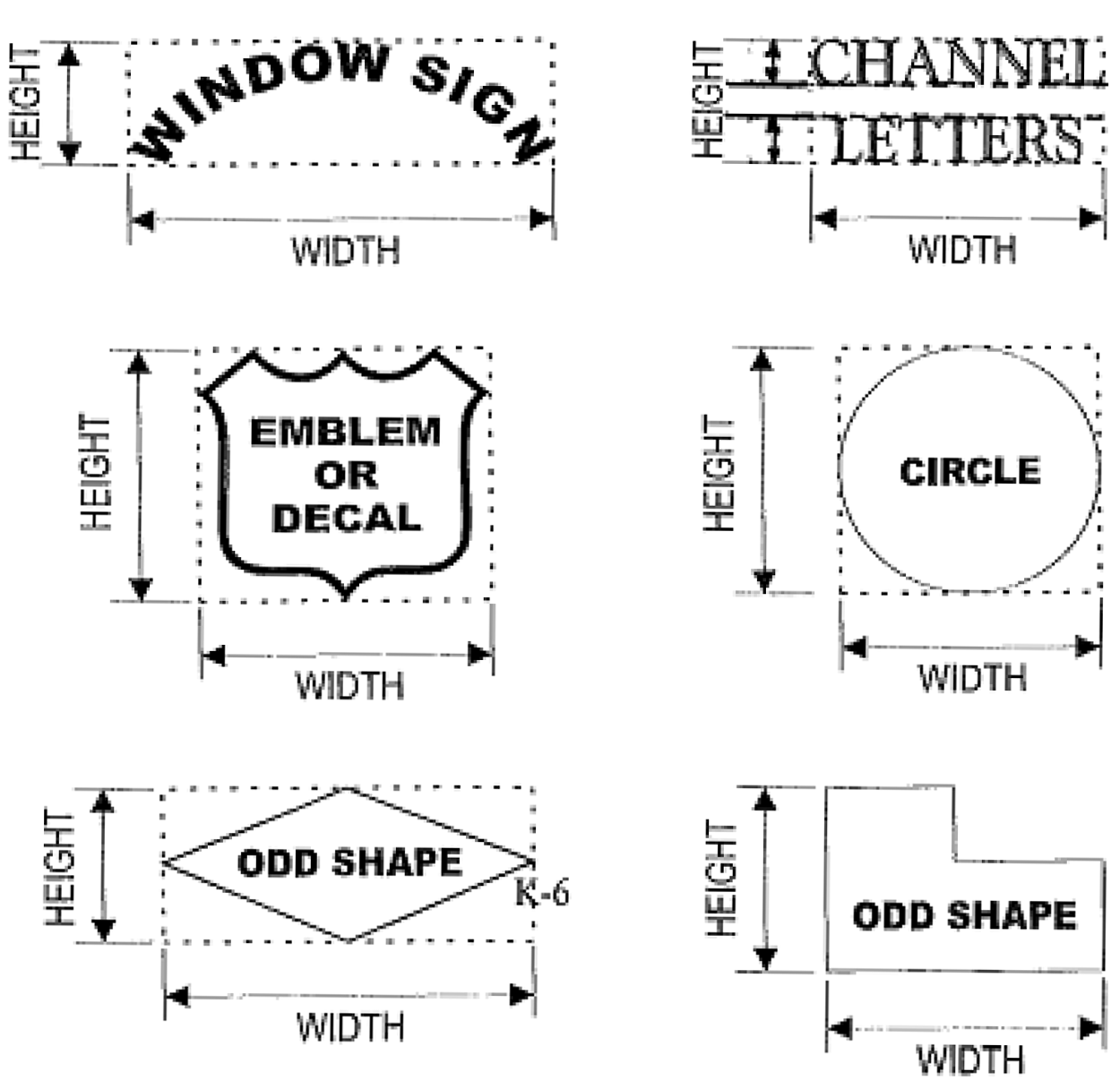
C.
Height. The vertical height of a sign is measured from the highest point of the sign to the finished grade at the base of the sign, where the finished grade is defined as the grade adjacent to the sign, as set by flood elevation requirements on the property, but not including any artificial berm or swale.
D.
Illumination. Signs may be illuminated directly or indirectly, unless specifically prohibited elsewhere in the land development code. In residential zoning districts, all overhead illumination shall provide shielding so that the light is not directed toward adjacent residential property. Illumination of monument or free-standing signs shall be external and directed from the ground via "up-lighting" or from behind individual letters via "backlighting." Wall signs or fixed projecting signs may include individual illuminated letters or letters which are lighted from behind via "backlighting." Illumination of signs shall exclude exposed neon tube lighting, or similar, and electronic changeable copy, unless permitted elsewhere in this code.
Sec. 6.11.08. - Design requirements and restrictions.
A.
Restrictions as to functions. The use of a sign shall be restricted to functions as set forth in the matrix in Table 6.11.17.
B.
Building outline. The use of neon or similar lighting to outline a building structure shall be limited to U.S. 1 (Federal Highway) frontage only and at an elevation not higher than 25 feet. The building outline shall be limited to a single band only and for the purpose of total signage on the site shall be calculated as one square foot of signage for every four linear feet of neon, not to exceed 50 square feet. The neon or similar lighting used to outline a building structure shall be counted as part of the total allowable wall sign area even though it may not otherwise be considered as signage.
Sec. 6.11.09. - Unified signage plan; location, safety, design requirements and restrictions.
A.
Unified signage plan purpose. The unified signage plan shall provide unified elements to increase visual appeal and integrate into the overall building design, color, scale and massing. The unified plan will avoid visual clutter and provide a unified sign theme with similar lettering styles and color.
1.
Unified signage plan. The permitted location of all allowable signs on any developed property, except single family and duplex residential properties, shall be in accordance with a unified signage plan, which shall show all signage to be used on a given site. The requirement for the submission of a unified signage plan shall be for all new and renovation development. A proposal for signage for a new multi-story building, or renovation development of more than 5,000 square feet shall require a unified signage plan for the entire building.
2.
Existing signage. Where a building(s) has existing wall signage, and the owner or tenant seeks to increase the signage, a proposed unified signage plan must be submitted, incorporating the existing and proposed signage, along with a sign permit application.
3.
Wall Signage for multi-story building. The size and amount of all allowable wall signs shall be based on a percentage of the wall areas computed as the length multiplied by the height of the geometric figures which comprise the actual wall area fronting on a street. The wall length shall be the building face. The height of the wall for computing purposes shall not exceed 25 feet for two or more story structures. However, for retail centers only, the first story shall be treated as single buildings and separate locations set forth in the design standards matrix for wall signage in Table 6.11.17.
UNIFIED SIGNAGE AREA TABLE 6.11.09
(Example: 100 linear feet x 25 feet height building = 2,500 square feet x 4.75% = 118.75 square feet total signage allowed)
a.
The maximum allowable wall signage on a single building is 200 square feet.
b.
No wall sign shall be mounted more than 18 inches from the wall face of the building.
c.
No wall sign shall cover, in whole or in part, any required wall opening.
4.
Changes to the unified signage plan. Any change or variation in a sign design from the approved unified signage plan requires the approval of the development department who will assess whether a variation is in keeping with the intent and goals of the approved unified signage plan.
B.
Location.
1.
Agreement required. Whenever a sign is permitted within a setback area or easement, the applicant shall be required to provide the written agreement of the property owner stating, among other things, that it is the obligation of the property owner to relocate the sign at such time as the city determines additional right-of-way or setback is required, or if it later conflicts with the right of way or a prior recorded easement. A performance surety in the amount of 110 percent of the estimated cost of removal acceptable to the city attorney may be required to assure removal of the sign structure, prior to permitting.
2.
Obstructions. A sign shall be located in such a manner as to not obscure an existing sign unless provisions are made for the removal of the obscured sign, or unless it is not reasonable and practical to locate the new sign elsewhere on the site.
C.
Safety.
1.
Safety determination required. Whenever consideration is given to locating a sign within a setback area, the development director must determine that the location of the sign does not present a hazard to pedestrians or to vehicular traffic circulation. Because of the unique and varying building locations and access configurations on a site, no specific "site triangle" is required by this code. However, it is required that signs shall be located such that they do not present a hazard to vehicle drivers, bicyclists, and pedestrians who are using adjacent public and private rights of way, and prior to the issuance of every sign permit, the development director shall make such determination. Safety is a primary consideration of this code, and notwithstanding any earlier building permit or approved site plan location of a sign, the development director may require the relocation of any sign, based upon a finding that it is required to provide for the reasonable safety of vehicle drivers, bicyclists, and pedestrians.
2.
Traffic safety. No sign shall be located in such a manner that it is a hazard to automotive or pedestrian traffic nor shall any sign or lighting of a sign be so placed as to obstruct the vision of the driver of any motor vehicle where vision is necessary for safety.
3.
Height of ground signs (monument or free-standing) at intersections. Anything else in this section to the contrary notwithstanding, three feet (as measured from the crown of the road) shall be the maximum height of any section of new ground signs which is located within ten feet of the following, unless the subject intersection is protected by a traffic-control device:
(a)
The right-of-way lines of two streets;
(b)
The right-of-way lines of a street and a right-of-way line of an alley;
(c)
The right-of-way line of a street and the right-of-way line of a railroad;
(d)
The right-of-way line of a driveway and right-of-way line of a street, alley, railroad or another driveway.
D.
Limitations and requirements for certain sign types on a property.
1.
Wall signs, monument and free-standing signs - only two of the three types of signs shall be permitted per street frontage.
2.
Each separate building or location shall have the street number address located on a sign that is identifiable and readable (using normal 20/20 vision) from the adjacent roadway to which the building address is assigned. The street number address on a building or on any location shall be limited to a maximum of 12 inches in height and shall not be calculated as a total allowable area for any signage.
E.
Sign messages; sign code is "content neutral."
1.
Notwithstanding anything contained in this sign code to the contrary, any sign erected pursuant to the provisions of this code may, at the option of the applicant, contain either a commercial or non-commercial message, related or unrelated to the use located on the premises where the sign is erected. Either a commercial or non-commercial message may occupy the entire sign face or portion thereof. The sign face may be changed from a commercial message to non-commercial message as desired by the owner of the sign, subject to the further provisions of this code, and provided that:
1)
The size and design criteria conform to the applicable portions of this code;
2)
The sign is allowed by this code;
3)
The sign conforms to the setback and other requirements of the zoning district in which located;
4)
The appropriate permits have been obtained;
5)
The construction materials and methods meet the requirements of the Florida Building Codes; and
6)
A certificate of use has been issued by the city building official, if required.
For the purposes of this code, non-commercial messages, by their very nature, shall never be deemed "off-premises signs." The only exception to this provision is where the city has a proprietary interest in the sign, that is, sponsors or co-sponsors an event, owns or controls the sign, or sign location, or otherwise has lawful discretion in the content of the sign.
2.
Permitting decisions shall only be based upon the criteria expressed in this code.
No permitting decision shall be based upon the content or the message contained (i.e., the viewpoint expressed) on such signs.
3.
Notwithstanding subsections 1 and 2 above, no sign shall contain any message or image that is obscene, profane, lewd, or pornographic; or which incites public unrest, terrorism, or overthrow of the government; or which violates the constitutional protections of individuals, or which otherwise has been found to violate applicable law.
Sec. 6.11.10. - Structural standards.
In addition to provisions of the Florida Building Code, the following structural standards shall be required for all signs erected in the city.
A.
Securing signs. Wall signs shall be securely attached to the building or structure by means of metal anchors, bolts, or expansion screws. No wood blocks or anchorage with wood used in connection with screws or nails shall be considered proper anchorage, except in the case of wall signs attached to studs or other structural members of buildings or structures having non-masonry walls. No sign shall be attached to a non-structural parapet wall.
B.
Wind loading. Every sign shall be constructed in a manner as to withstand 140 miles per hour based on three-second gust wind speed. Sign contractors or the owner shall submit plans showing location, structural members, and design calculations for wind loading and for signs 32 square feet or over, a certification sealed by a state-registered engineer or architect stating that the design will meet the requirements of this code shall be submitted. All sign contractors shall sign a certificate stating wind loading will meet requirements of this chapter where signs under 32 square feet are submitted.
Sec. 6.11.11. - Removal and disposition of certain signs.
A.
Removal and disposition of certain signs. It shall be unlawful to erect, use or maintain a sign or sign structure when it does not comply with the requirements of this Code. Unlawful signs are subject to removal pursuant to the following provisions:
1.
Summary procedures for removal. The city finds that the inexpensive nature of temporary signs, wind signs, sidewalk signs, valet parking signs,, snipe signs, flags, and, and the administrative and cost burden imposed by elaborate procedural prerequisites prior to removal, requires the summary removal of these signs, when unlawfully erected and maintained. The city development director, or designee, or any code enforcement officer, is hereby authorized to remove such signs when unlawfully erected and maintained, subject to the provisions contained herein. Upon removal of a sign from private property, pursuant to this section, a notice of violation, citation or summons may be issued, or a written notice shall be sent, either by hand delivery or by first-class mail to the occupant of the property from which the sign was removed, or if the sign identifies a party other than the occupant of the property, the party so identified. The notice shall advise that the sign has been removed and shall state that the sign may be retrieved within 30 days of the date of the notice upon payment of the fine or administrative fee established therefor, and that, if the sign is not retrieved within 30 days, it will be disposed of by the city, without further notice.
2.
Permanent signs. Signs and sign structures not subject to removal pursuant to the provisions above, which are or have been erected or maintained unlawfully, are subject all remedies available at law or equity for the removal of signs or sign structures which are or have been unlawfully erected or maintained.
B.
Responsibility of maintenance; unsafe signs; abandoned signs; violations and liens.
1.
All signs shall be properly maintained. Exposed surfaces shall be cleaned and painted, if paint is required. Defective or damaged parts shall be replaced.
If any sign regulated in this article is found by the building official to be unsafe, not secure, a menace to the public, or constructed, erected or maintained in violation of the provisions of this article, written notice by the building official shall be given to the owner of the sign and of the property the sign is located upon. If the owner or person in possession of the property fails to remove or alter the structure so as to comply with the provisions of this article within ten days after the notice is delivered, the development director, building official or their designee shall approve the removal or alteration of the sign to comply with the code, at the expense of the owner of the property upon which it is located.
2.
Notwithstanding the above provisions, any sign which is found to be in an unsafe and dangerous condition, because it violates the current Florida Building Code or the current Florida Fire Prevention Code or NFPA codes referenced therein, or because it otherwise constitutes a clear and present danger to life or property, as determined by a city building inspector or code enforcement officer, shall be modified or removed by its owner upon reasonable notice to do so. Upon the failure or inability of the owner to modify or remove such sign following notice, or when reasonable notice cannot be given because of an immediate danger, the city shall modify or remove the sign.
3.
If any sign regulated in this article is found to be abandoned or the business advertised shall move from the property where the sign is located, the owner, agent or responsible person shall be responsible to remove the sign, cover the sign with a plain fabric cover or place a blank copy panel in the sign frame within 30 days of the abandonment or relocation of the business. An additional extension may be granted by the city development director for a good cause shown.
4.
Upon the failure, neglect or refusal of any owner, agent or responsible person to remove or repair any sign in violation of this article, after reasonable notice by the city development director or building official, and in addition to any other remedies available to the city, the city manager is hereby authorized and empowered to effect the removal of the sign which is in violation.
5.
A sign shall not be located on a vacant or an undeveloped parcel of land, except upon good cause shown, and upon the written approval of the city manager. In this context, good cause shall consist of a reasonable basis, not exclusively economic in nature, which may include, but shall not be limited to, insufficient land on an adjacent principal site for an otherwise permitable sign, lack of sight distance to properly observe a sign on a principal site, or a sign that specifically pertains to the undeveloped parcel.
6.
Responsibility for cost of repair or removal. When the city has made reasonable repairs or removed a sign or has paid for the repair or removal thereof, the actual cost, plus accrued interest at the rate of ten percent per year, shall be paid to the city by the owner of the property upon which the sign is located.
7.
Violations of this code. In lieu of the general penalty available to it in section 1-13, or the provisions of section 26-26, the city may elect to issue a citation under section 26-25, to a violator of this Code, and fine the violator $50.00 for the first violation, $100.00 for the second violation, and $200.00 for the third and any subsequent violations within any one-year period.
8.
City's lien right. If the amount due to the city for any administrative fines or costs, including the costs for repair of removal, shall not be paid to the city by or on behalf of the property owner within the time established in the written citation or magistrate's order, then such amount, together with all interest accrued at the rate of ten percent per year, shall become a lien upon the property of the owner, as provided in section 26-24.
Sec. 6.11.12. - Types of signs permitted.
A.
Ground signs (monument or freestanding). A ground sign shall not be affixed to any structure and is limited to no more than two sign faces. A ground sign is either a freestanding sign or a monument sign. All ground signs shall contain the street address number.
1.
Setback requirements for ground signs. For new or renovation development, the setback for a ground sign shall be a minimum of ten feet from the right-of-way line. The setback is measured from the closest portion of the sign, sign structure or sign footer to the right-of-way. Projecting signs, canopy signs, and wall signs may not extend into the setback areas. No sign, sign structure or sign footer shall extend into a public or private right-of-way. Relief from the ten-foot setback requirement may be obtained by administrative variance, for good cause shown, which cause may include, but shall not be limited to, sign encroachment into required parking, provision for additional landscape area and materials, provision of a smaller sign than allowed, obstruction of an existing sign, and less than permitted total signage. Except as provided above, replacement signs may be relocated at the existing location.
B.
Freestanding signs. Freestanding signs shall be wood or composite material supported by one or two wood or composite posts, with the top edge of the sign no higher than six feet above the finished grade, and shall not exceed six feet in width. Each post shall have ornamental post caps or covers. A freestanding sign shall not be used as a frame for a cabinet sign.
C.
Monument signs. Monument signs shall be composed of metal frame, textured brick, concrete block, or other masonry, and finished with stucco or other textured material, and having a solid base. The top edge of the sign shall be no higher than elsewhere permitted in this code, and the skirt and base shall be no smaller than 80 percent of the sign width nor greater than 120 percent of the sign width. A monument sign shall not be used as a frame for a cabinet sign that exceeds 25 percent of the sign area.
D.
Projecting signs. A projecting sign is affixed to a structure and extends at a right angle from the structure.
1.
A projecting sign shall not have more than two sign faces. Projecting signs may project into the public right-of-way, but must have clear sidewalks by at least nine feet, and be no closer than two feet from the curb.
2.
Signs must not project more than six feet from the wall face of a building.
3.
The permitted size of a fixed projecting sign shall not exceed eight square feet or 16 square feet, dependent upon the applicable zoning district.
4.
All businesses in the Old Downtown District must have a projecting awning/canopy sign and an under canopy sign, if the building has an awning or a canopy sign.
E.
Under canopy signs. A sign hung from the underside of an awning or canopy or ceiling of an arcade or covered walkway or portico. It may be rigid or it may swing. Any swinging sign shall be removed during a major storm event. Such a sign shall not have more than two sign faces.
1.
No portion of any sign projecting over a public sidewalk shall be less than nine feet above the grade of the sidewalk, with the exception of awning valances which shall not be less than eight feet above the sidewalk.
2.
Any sign projecting over private property and located where motor trucks may be required to pass beneath it shall be erected and maintained at a height of not less than 14 feet.
3.
Signs consisting of one line of letters not exceeding nine inches in height may be painted, placed or installed upon the hanging border only of any awning erected and maintained in accordance with this chapter. A graphic or other similar feature not exceeding an area of eight square feet, may be painted, placed, or installed elsewhere on any awning provided that any such graphic shall comply with all other provisions of this chapter.
F.
Window signs.
1.
Plastic signs, or signs painted on the glass may be placed upon windows when limited to 20 percent of the aggregate glass area, per tenant space or per main use.
2.
Signs displayed from the inside of the glass but which are visible from the outside shall be considered as window signs.
3.
Window signs shall not be placed where they substantially obscure the view of a person to the interior of the building through the window.
G.
Wall signs.
1.
A wall sign must be professionally hand-painted or flush mounted on board, or in a raised channel or individual letters. Such a sign may be applied to a structural mansard or building face.
2.
Gas station canopy shall be limited to a maximum of one wall sign per right-of-way frontage and shall be counted as part of the allowable wall signage per occupancy.
H.
Billboards.
1.
No billboard shall be erected except on property within an industrial district.
2.
Billboards shall not exceed a size of 100 square feet per sign face, with a maximum of two faces per sign. No billboard shall exceed 20 feet in width or eight feet in height, with the overall height of the sign and structure not to exceed 25 feet.
3.
Billboards shall not be located closer than 300 feet to any residentially zoned land, nor less than 1,000 feet from each other, with such measurement to be made from the point of location of the sign structure to the nearest point of residentially zoned land or to the nearest point of location of the sign structure, as applicable.
4.
Billboards shall be subject to the zoning regulations of the applicable district upon which the sign is situated.
5.
Prior to the issuance of a permit for any billboard sign, the applicant shall furnish a certified copy of the recorded deed showing ownership, and a copy of the lease or easement for the land upon which the sign shall be placed. A copy of the permit from the Florida Department of Transportation, when required by the state, shall also be furnished to the city.
6.
The owner or person in possession of any property with a billboard located upon it shall be required to include the area of the billboard(s) in its total permitted signage.
7.
These provisions shall not apply to the three billboards that are the subject of a settlement agreement entered into by the city in 2009.
Sec. 6.11.13. - Special purpose signs and signing.
As an aid to the motoring public, the city commission has determined that the following special purpose signs serve the public interest and welfare by providing basic information regarding fuel price, location, time, temperature, dates of events, and the like. Permits for the following signs shall be issued provided that the provisions contained herein are in compliance:
A.
Grand opening banner. One banner may be placed on the building of a newly opened location pursuant to the following:
1.
Display is limited to four weeks.
2.
The banner shall not exceed one square foot per linear foot of occupancy frontage, and a total area of 50 square feet.
3.
The banner shall not be higher than 15 feet above the finished grade, and must be placed on the building on the predominate street front.
4.
Banners shall be made of color fast material, and shall be securely fastened so as not to become a safety hazard.
B.
Special event banner signs. The city manager may approve one or more banners for a non-profit, charitable organization or special event as defined in section 36, article III, City Code of Ordinances, on any street, sidewalk, public building, park or playground, or on private property, subject to the following criteria:
1.
The sign shall be located on the property where the event is being held, or on public property or rights of way, or on private property with the written consent of the property owner. Any of the foregoing shall require the written permission of the city manager and shall provide notice to the general public of a special event; and
2.
The sign shall be temporary and for a stated limited period of not more than 14 days prior to the event, and it must be removed by the second day after the event;
3.
Each sign shall not exceed 20 square feet in area;
4.
When permitted, the sign must meet the following additional criteria:
a.
The sign will not conceal or obstruct adjacent land uses or signs;
b.
The sign will not conflict with the principal permitted use of the site or adjoining sites;
c.
The sign will not interfere with, or obstruct the vision of, or distract motorists, bicyclists or pedestrians; and
d.
The sign will be installed and maintained in a safe manner;
e.
The approval, or disapproval, of such sign shall not be based on the content of the message contained (i.e., the viewpoint expressed) on such sign;
f.
The city manager shall render a decision within ten days after an application is made for utilizing this sign type for a special event. Such a decision shall be deemed an administrative interpretation and any person adversely affected has the right to appeal the decision to the city commission, in writing within 30 days of the written rendering of the decision by the city manager.
C.
Special event city street banners. Special event city street banner signage, in accordance with this subsection, shall be permitted by the city manager, for special events if it is determined that the sign meets all of the following criteria:
(i)
The city is a sponsor or co-sponsor of the event; or
(ii)
The event sponsor is a not-for-profit organization; and
(iii)
The street banner sign must be no larger than three feet in height by 24 feet in length, and if placed above a street, be at least 15 feet above the surface of the street on city installed or controlled poles. The street banner sign must be constructed of a vinyl awning material or similar and meet wind load requirements established by the city development director; and
(iv)
Display of the special event street banner sign will be limited to a maximum of 14 days prior to the event and must be removed no later than two days after the event; and
(v)
The sign will not conceal or obstruct adjacent land uses or signs; and
(vi)
The sign will not interfere with, obstruct the vision of, or distract motorists, bicyclists or pedestrians, and will not conflict with the principal permitted use of the site or adjoining sites; and the sign will be installed and maintained in a safe manner; and
(vii)
As a sponsor or co-sponsor, the city reserves the right to participate and comment on the content of the banner sign. However, from a regulatory viewpoint, the city's decision to approve, or disapprove such sign shall not be based on the content of the message contained (i.e., the viewpoint expressed) on such sign;
(viii)
The city manager shall render a decision within ten days after an application is made for utilizing this sign type for a special event. Such a decision shall be deemed an administrative interpretation and an applicant has the right to appeal the decision to the city commission, in writing, within 30 days following the written rendition of the city manager's decision. The city commission's decision regarding the use of the public right-of-way shall be final and non-appealable.
D.
Drive-thru window signs. Sign boards used at locations in conjunction with service at a drive-thru window are permitted so long as the size of the board does not exceed seven feet in height, nor 24 square feet in total area, with a maximum of two signs per drive thru window.
E.
Subdivision identification signs. Residential subdivision identification signs shall be located only at the roadway entrance(s) to the subdivision and subject to the following standards:
1.
Such signs may be either one double faced sign or two signs where there are two walls at the entrance and where the signs are permanently affixed to the walls at each entrance of the subdivision.
2.
Each sign area shall be no greater than 36 square feet in area.
3.
Subdivision entrance signs are permitted within all residential zoning districts.
4.
Such subdivision entrance sign may be erected within rights-of-way or median strips adjacent to the subdivision, if approved by the city. A subdivision sign may also be located within the setbacks of private property within the subdivision or adjacent to the subdivision.
5.
Any such sign erected within a right-of-way or setback shall be at least ten feet from a paved roadway and signs located within a median shall be at least five feet from any paved roadway.
6.
All signs proposed to be located within a right-of-way or median shall be reviewed and approved by the development director, the police chief, and the public works director, for compliance with this section.
7.
Any such signs approved for location within the right-of-way or median, if such right-of-way or median is not within the jurisdiction of the city, shall obtain written permission from the governmental entity controlling the right-of-way or median prior to erecting the sign in a requested and approved location.
8.
Any signs proposed to be located on adjacent private property shall be approved and permitted by the owners of the adjacent property. Any such signs lying on private property shall be considered an additional permitted sign without regard to other applicable sections of this Code.
F.
Construction site signs. Temporary construction site signs identifying that an approved, active, on-site development project is underway, shall be permitted provided that such signs shall be subject to the following standards:
1.
One temporary freestanding sign per street frontage, non-illuminated, with sign area of not more than 32 square feet, nor more than six feet in height; or
2.
One temporary wall sign per street frontage, which shall be non-illuminated with a sign area of not more than 32 square feet;
3.
Construction signs may be installed at the time of submission of a building permit application. It must be removed upon expiration of building permit or building permit application or when the project obtains a certificate of occupancy.
G.
Awning signs.
1.
No portion of any sign projecting over a public sidewalk shall be less than nine feet above the grade of the sidewalk, with the exception of awning valances which shall not be less than eight feet above the sidewalk.
2.
Any sign projecting over private property and located where motor trucks may be required to pass beneath it shall be erected and maintained at a height of not less than 14 feet.
3.
Signs consisting of one line of letters not exceeding nine inches in height may be painted, placed or installed upon the hanging border only of any awning erected and maintained in accordance with this chapter. An identification emblem, insignia, initial or other similar feature not exceeding an area of eight square feet, may be painted, placed, or installed elsewhere on any awning provided that any sign, insignia or other such similar items shall comply with all other provisions of this chapter.
H.
Changeable copy signs.
1.
Manual or electronic changeable copy information signs shall be permitted when attached to or made part of an otherwise permitted monument sign, and only related to a theater, auditorium, convention center, sports field or arena, a regional attraction facility, or for motor fuel pricing, or a time & temperature sign. Such signs shall be limited to one changeable copy message sign per street frontage, and no more than two such signs shall be permitted on any individual parcel, including PUDs.
2.
Electronic changeable copy signs shall be permitted to change their message no more than four times within a 24-hour period, except that time & temperature signs may change as the temperature changes, and as the time changes in one minute increments.
3.
Changeable copy signs shall comply with the permitted area of the sign to which it is attached pursuant to design standard matrix, table 6.11.17. The changeable copy element of the sign shall not exceed 25 percent of the total sign area.
4.
Maximum height and setbacks shall comply with the permitted height and setbacks for the sign type pursuant to design standard matrix, table 6.11.17.
5.
Types of manual or electronic changeable copy sign:
a.
Motor fuel pricing signs. Motor fueling stations shall provide signage displaying the price of fuels. Signs shall advertise the price of motor fuels sold on the premises, subject to the following regulations:
i.
One motor fuel price sign shall be permitted per street frontage with a maximum of two signs per fuel station. It shall be affixed to a permanent sign structure or to a building and shall not be located closer than ten feet to any side property line. The price sign shall be included in the total area of signage otherwise permitted.
ii.
The sign shall not be more than 12 square feet per sign face.
iii.
Signs placed on fuel pumps shall not exceed three square feet per sign face nor a total of six square feet per sign.
b.
Time and temperature signs. Signs giving time and temperature, or either time or temperature information shall be permitted when attached to or made part of an otherwise permitted sign. Such signs shall not be larger than 20 percent of the permitted area of the sign to which they are attached or included. Such signs shall be counted as part of the permitted area of the sign to which they are attached.
6.
Prohibited lighting for electronic message sign:
a.
Lamps, light emitting diodes, or bulbs in excess of the amount and intensity of light generated by a 30-watt incandescent lamp (the amount of light, measured in lumens, varies for lamp types. For example, a 30-watt incandescent lamp produces approximately 300 lumens).
b.
Exposed reflectorized lamps, light emitting diodes, or bulbs; and lamps or bulbs not covered by a lens, filter, louver or sunscreen; or modes of operation that scroll, flash, zoom, twinkle or sparkle, or appear to do so.
I.
Landmarked signs. The city shall designate a sign as a landmarked sign, based upon authenticated documentation that such sign is at least 25 years old and has existed as a defining feature of a landmarked or historic building or event. The acceptance of a sign as a landmarked sign is subject to the written determination of the city development director, considering the age, location, condition, construction, and historic significance.
1.
Landmarked signs shall be classified as conforming signs, and shall be permitted to be restored, maintained and repaired.
2.
Landmarked signs shall be exempt from setback, size, height, and area requirements of the code, except that such signs shall maintain not greater than their historic dimensions or area.
3.
Landmarked signs placement shall leave street corners free of obstructions to allow for safe vehicle and pedestrian movement and placement of utilities; and may be relocated on a site to do so.
J.
Mural signs. Mural signs shall be counted as wall signs for the portion which includes any message, logo or which depicts a product or service, and shall be of such a design as to compliment the architectural style of the subject building and shall be in keeping with the general character of the land use district. There shall be a maximum of only one mural sign per building. The sign portion of a mural sign, if any, shall comply with the dimensional requirements of a wall sign.
K.
Memorial marker signs. Memorial marker signs may be installed within a city road right-of-way at the request of an immediate family member. Memorial marker signs will be installed by city personnel after first receiving a signed memorial marker sign application. The memorial marker shall consist of a 15-inch diameter round aluminum sign panel with engineering grade sign sheeting with a white background, and black letters. The memorial marker will be placed on a standard u-channel post and be located at the outside edge of the mowing limits, or as directed by the public works director, or designee. Placement of the deceased's name on the memorial marker will be at the immediate family's option. No additional decorations or ornaments will be permitted. The memorial marker will remain in place for a minimum of one year, unless it becomes necessary to remove the marker for construction or maintenance purposes.
(Ord. No. 2399-2019, § 1, 5-13-19)
Sec. 6.11.14. - "No fee permit" signs.
The following signs are allowed to be erected on private property in the city, subject to the granting of a "no-fee permit," so long as they conform to the following criteria:
A.
Temporary signs. One temporary freestanding sign per street frontage, non-illuminated, with a sign area of not more than 12 square feet per sign face with two face maximum per sign on any private lot or parcel. A temporary sign may be erected for a limited time period not to exceed six months per year. Signs may not be placed in a location that constitutes a safety hazard or hindrance to pedestrian or vehicular traffic. No temporary sign shall be placed on any public right-of-way or public property, without the written permission of the city development director, and for good cause shown. Generally, signs shall not be placed upon public rights of way or public property unless the government is a sponsor or unless the sign is for public benefit, such as the wayfinder signs below.
B.
Governmental flags. Official governmental flags may be displayed on any real property in the city in accordance with the standards and customs for the display of flags, including the USC 36, chapter 10, and other governmental regulations, all as amended from time to time, and the following additional rules:
1.
One flag pole shall be permitted on a single property, unless otherwise permitted in a planned unit development, and no flag pole shall exceed 50 feet in height. Flag poles on single family and duplex residential properties shall not exceed 20 feet in height. Not more than two flags may be flown on a single pole. Three flags may be flown from a single pole with a yardarm designed for such purpose. The maximum area of each flag shall be determined by the height of the flag pole as follows:
Up to 20 feet . . . . . . . . 3 × 5 feet
20 to 25 feet . . . . . . . . 4 × 6 feet
25 to 30 feet . . . . . . . . 5 × 8 feet
30 to 35 feet . . . . . . . . 5 × 8 feet
35 to 40 feet . . . . . . . . 6 × 10 feet
40 to 45 feet . . . . . . . . 6 × 10 feet
45 to 50 feet . . . . . . . . 8 x 12 feet
2.
A flag pole shall not be closer than ten feet to any property line or overhead electric line.
3.
In lieu of the flag pole permitted above, one flag may be flown on a pole projecting from a building.
4.
If a flag pole is less than 20 feet in height, it shall be considered as an exempt sign, not requiring a permit.
C.
Wayfinder and directional signs within public rights-of-way. These signs include the following:
1.
A sign that provides notice to the public of a public meeting, locations open to the public, or a special event.
2.
A sign designed to guide or direct pedestrians or vehicular traffic and which may include kiosks that provide information of general benefit to the community.
3.
A wayfinder or directional sign shall meet the following criteria:
a.
The signs shall not conceal or obstruct adjacent land uses or signs;
b.
The signs shall not conflict with the principal permitted use of the site or adjoining sites;
c.
The signs shall not interfere with, obstruct vision of or distract motorists, bicyclists or pedestrians; and
d.
Directional signs shall be no greater than eight inches by 30 inches per sign.
4.
The public works director or the police chief may require the location or relocation based on potential or actual traffic obstruction.
D.
Mural. A mural, which is not a mural sign, may be painted or placed on one or more exterior walls, subject to review of a representation and its approval by the community redevelopment board (within the community redevelopment area) or the land planning agency, elsewhere within the city, The representation may include an illustration, sketch, model, photograph, or other means of visually conveying the proposed mural.
Sec. 6.11.15. - Exempt signs (not requiring a permit).
The following signs are allowed to be erected on private property in the city, without a permit, so long as they conform to the following criteria:
A.
Valet parking signs. Valet parking signs shall be limited to one sandwich board. The sign area shall not exceed six square feet in area. The location of such sign shall be approved by the development director, and the police chief. The sign must be removed during hours when the approved valet parking queue is not in use. Traffic control cones may be used for queuing purposes; however they shall not contain any additional signage or markings, and must be removed when the valet parking queue is not in use.
B.
Automated teller machine (ATM) panels. One panel which is physically constructed within and is an integral part of an ATM.
C.
Directional signs. Such signs shall be for the purpose of directing vehicular and pedestrian traffic, and shall not extend more than five feet from the ground and shall not be greater than four square feet in area per sign face.
D.
Hours of operation signs. Signs denoting hours of operation shall be non-illuminated; have a sign face of not more than one square foot and be located close to the entry of the establishment.
E.
Instructional signs. Instructional signs are signs which convey safety information or legal information or instructions with respect to the premises on which located, including, but not limited to, "no trespassing," "danger" or "bad dog" signs. Such signs shall not have a height of more than five feet from the ground and shall not be greater than three square feet in area.
F.
Nameplates. One nameplate sign per building, not exceeding three square feet in area, and bearing the building or occupant name or street address of the principal building.
G.
Non-residential and multi-family residential real estate signs.
a.
One freestanding sign structure with up to two sign faces, with or without post caps or covers, shall be permitted for each street frontage.
b.
Signs shall not exceed 16 square feet in area per face, and shall not be higher than six feet above the adjacent finished grade. A V-shape sign shall be permitted and shall be considered as one sign as long as it has no more than two faces, and the interior angle does not exceed 90 degrees.
H.
Single family and duplex residential real estate signs.
a.
One freestanding sign structure with up to two sign faces shall be permitted for each single-family or duplex property, and shall not exceed three square feet in area, per face, and shall not be higher than four feet above the adjacent finished grade. One additional sign per lot may be erected on a lot which borders a waterway or which is a corner lot, provided that the additional sign is located along the waterways or placed so there is only one sign per street frontage.
b.
One freestanding sign structure with up to two sign faces shall be permitted for each multi-family property, and shall not exceed 16 square feet in area per face, and shall not be higher than six feet above the adjacent finished grade. One additional sign per lot may be erected on a lot which borders a waterway or which is a corner lot, provided that the additional sign is located along the waterways or placed so there is only one sign per street frontage.
c.
An additional "rider" sign of not greater than one square foot may be attached to or accompany a residential real estate sign.
I.
Tenant panels. The tenant panels in a directory sign, or a sign which accommodates a tenant, is exempt from needing a permit provided that the sign was permitted and there is no change in colors or letter style.
J.
Political signs. Temporary political signs of not more than two sides with a maximum area of 16 square feet or less may be placed or approved by the owner or occupant on private real property. No political signs may be located within any right-of-way or on any public property pursuant to section 14-27 of the Code of Ordinances. Election campaign material shall be removed pursuant to those provisions contained in section 14-26 of the Code of Ordinances.
Sec. 6.11.16. - Prohibited signs.
The following signs, or sign features, are prohibited within the City of Stuart; however, certain exceptions as noted herein are allowed. It shall be unlawful for any persons to erect prohibited signs or use prohibited sign features:
A.
Wind signs.
B.
Roof signs.
C.
Snipe signs.
D.
Banners and flags, not otherwise permitted herein.
E.
Signs confusing to vehicular drivers.
F.
Vehicular signs, except graphics applied or painted upon a vehicle.
G.
Waterborne signs.
H.
Private signs in public rights-of-way.
I.
Pole signs.
J.
Intermittent lighting, animation, moving or rotating signs, not including governmental traffic signals and devices.
K.
Balloons.
L.
Noise producing signs.
M.
Off-premise signs, except for banners as provided herein.
N.
Obscene signs as follows: A sign shall not exhibit thereon any lewd, lascivious, or obscene character or illustration, as the same may be defined by community standards and by law.
O.
Sidewalk signs and sandwich board sidewalk signs. Effective December 31, 2013.
P.
Electronic message units, not otherwise permitted herein.
Q.
Billboards, not otherwise permitted herein. This provision shall not apply to the three billboards that are the subject of a settlement agreement entered into by the city in 2009.
R.
Any sign not provided for, or expressly permitted by this code is prohibited.
Sec. 6.11.17. - Design standards matrix.
The following matrix table sets forth additional standards for various types of signs when located in various zoning districts or defined by use. The standards set forth therein are subject to descriptions, interpretations, exceptions, and limitations as provided for elsewhere in the LDC.
Table 6.11.17