Zoneomics Logo
search icon

Stuart City Zoning Code

CHAPTER V

RESOURCE PROTECTION RELATED DEVELOPMENT STANDARDS

5.00.00.- IN GENERAL

The intent of this chapter is to protect and manage wetlands, environmentally sensitive lands, historic and specimen trees, mangroves, and the shoreline within the city to implement the goals, objectives and policies of the comprehensive plan of the city.

The regulations of this chapter apply to all public and private lands within the city. Pursuant to chapter XI of this Code, a permit shall be required for any development or other site activity that alters, impacts or removes environmentally sensitive lands, wetlands or trees within the city. Any violation of this chapter shall constitute a municipal ordinance violation and may be prosecuted before the code enforcement board of the city as provided in chapter 26 of the City Code of Ordinances below.

(Ord. No. 1824-02, § 1, 1-28-02)

These regulations will be applied to proposed development site plans or proposed plat plans submitted to the city to all site activity that occurs on or after February 14, 2000.

5.01.00.- AVOIDANCE OR MINIMIZATION OF WETLAND AND OTHER ENVIRONMENTAL IMPACTS

A.

Impacts to wetlands and other environmentally sensitive lands shall be avoided or minimized to the greatest extent practicable.

(Ord. No. 2165-08, § 2, 11-24-08)


5.02.00.- ENVIRONMENTAL ASSESSMENT REPORT FOR SITES WITH WETLANDS OF GREATER THAN ONE ACRE

For properties with wetlands and for properties of greater than one acre, an application for site plan approval or plat approval shall include an environmental assessment report relating to the subject property that has been prepared by a qualified environmental professional (i.e., certified ecologist, certified environmental professional, professional wetland scientist, or other recognized certification). The report shall include the information listed below:

A.

Site description. A description of the site location and acreage, including adjacent streets and roads, Township, Section, Range and street address, if any, shall be included. A site location map at a scale sufficient to show the site and its relationship to the city municipal boundary shall be provided.

B.

Vegetative description. A description of the vegetation on the site and each separate type of upland vegetation or land cover and each type of wetland vegetation cover shall be mapped and described in accordance with the Florida Land Use, Cover, and Forms Classification System. The map shall include total acreage calculations of each vegetative type shown on the map. A recent aerial photograph of the subject property to correspond to the map shall be included. The U.S. Fish and Wildlife Service (USFWS) Endangered Species database and the Florida Department of Agriculture and Consumer Services list of state-designated plant species shall be reviewed prior to conducting a site visit. A description of listed plant species actually observed or expected on the site based on observed habitat shall be included.

C.

Wetland delineation.

1.

A copy of a wetland delineation map according to the State of Florida shall be submitted to the city development department. If the delineation of wetlands is not complete at the time of review, a map depicting the approximate location and types of wetlands shall be submitted for planning purposes. Issuance of a development permit will not occur until a verified wetland determination is completed and development plans revised accordingly.

2.

For those sites where wetlands have been determined to be present, a separate determination of the existence of outstanding resource wetlands shall be provided. This determination shall meet the criteria for an outstanding resource wetland provided in this chapter. A separate map of outstanding resource wetlands shall be included.

D.

Wildlife evaluation.

1.

A description of the wildlife actually observed or expected on the site based on observed habitat shall be included. Habitat indicators such as tracks, burrows, nests, and live sightings should be documented for species listed by Florida Fish and Wildlife Conservation Commission (FWC) and the (USFWS) as endangered, threatened or of special concern. The USFWS Endangered Species database and FWC list of state-designated wildlife species shall be reviewed prior to conducting a site visit.

2.

The field reconnaissance and identification efforts and methods including transects, random observation, and reference documents used in the wildlife evaluation shall be described. Copies of correspondence with the FWC and USFWS shall be provided. In instances where the presence of listed species is actually observed or expected based on habitat, the city development director may include a disclaimer and/or condition to an issued permit that all other applicable state and federal permits be obtained prior to commencement of the development.

E.

Preserve area and upland buffer evaluation. A calculation of the preserve area and upland buffer requirements for the project as set forth in this chapter shall be included. This evaluation must include a summary of total site area, acreage of wetlands, acreage of native upland and of non-native upland. A map depicting each area type, as well as locations of wildlife observations from the wildlife evaluation shall be provided.

F.

Native vegetation preserve area onsite/offsite relocation assessment. For sites where an upland native vegetation preserve area is proposed to be relocated either onsite or offsite, the proposed onsite or offsite relocation area should be the same type as the community proposed to be impacted. A specific assessment of this relocation area shall be performed in accordance with section 5.04.00 of this Code. On-site preserve areas of a different type may be proposed and allowed at the city's discretion, providing that the area is a native vegetative community that is rare within the city or Martin County.

5.03.00.- WETLANDS

The wetlands subject to the provisions of this chapter are those that have been "verified" by the State of Florida.

(Ord. No. 2165-08, § 2, 11-24-08)


5.04.00.- ENVIRONMENTALLY SENSITIVE LANDS

No site clearing of any public or private lands within the city shall be permitted without approval by the city. Proposed development site plans and plat applications for sites of greater than one acre shall include a native vegetation preserve area for the preservation of upland areas in functional habitat units.

(Ord. No. 1824-02, § 1, 1-28-02; Ord. No. 2165-08, § 2, 11-24-08)


Sec. 5.01.01.- Initial determination required.

A.

Evidence required. Prior to seeking environmental permits from state and federal agencies, and prior to the issuance of a development permit by the city, an applicant for development approval shall provide evidence to the city development director that the following environmental impact avoidance and minimization techniques have been employed to the greatest extent practicable in the preparation of a proposed site plan.

B.

On-site avoidance.

1.

Can another vertical level be added to a building to decrease the overall building footprint?

2.

Can the building footprint be reduced and still achieve the project's purpose and need?

3.

Can a building be repositioned on the parcel to reduce or eliminate environmental impacts?

4.

Can multiple structures be clustered to reduce or eliminate impacts?

5.

Can road or utility alignments be reconfigured?

6.

Can spans and bridges be used instead of culverts?

C.

Site engineering changes.

1.

Can grading be minimized by incorporating natural topography?

2.

Can more trees and vegetation be preserved?

3.

Can parcel layout be reconfigured?

4.

Can state waters, including wetlands, be concentrated into subdivision "common areas"?

5.

Can the project's stormwater facilities be designed using Low Impact Development (LID) Techniques as described in the University of Florida IFAS Extension publication "LID Practices: Integrating Wetlands & Enhancing Stormwater Basins," copies of which shall be made available by the city development department?

(Ord. No. 2539-2025, § 2, 4-16-25)

D.

On-site minimization.

1.

Can some of the above listed techniques be used to further minimize impacts?

2.

Can directional drilling be used to install underground utilities instead of excavation and backfill?

3.

Can equipment fitted with low pressure tires or tracks be used?

4.

Can any permanent impacts (e.g., access roads) be converted to temporary impacts?

5.

Can construction staging or stockpiling of materials occur in areas outside of environmentally sensitive lands?

(Ord. No. 2165-08, § 2, 11-24-08)

Sec. 5.03.01.- Wetland verification and illustration.

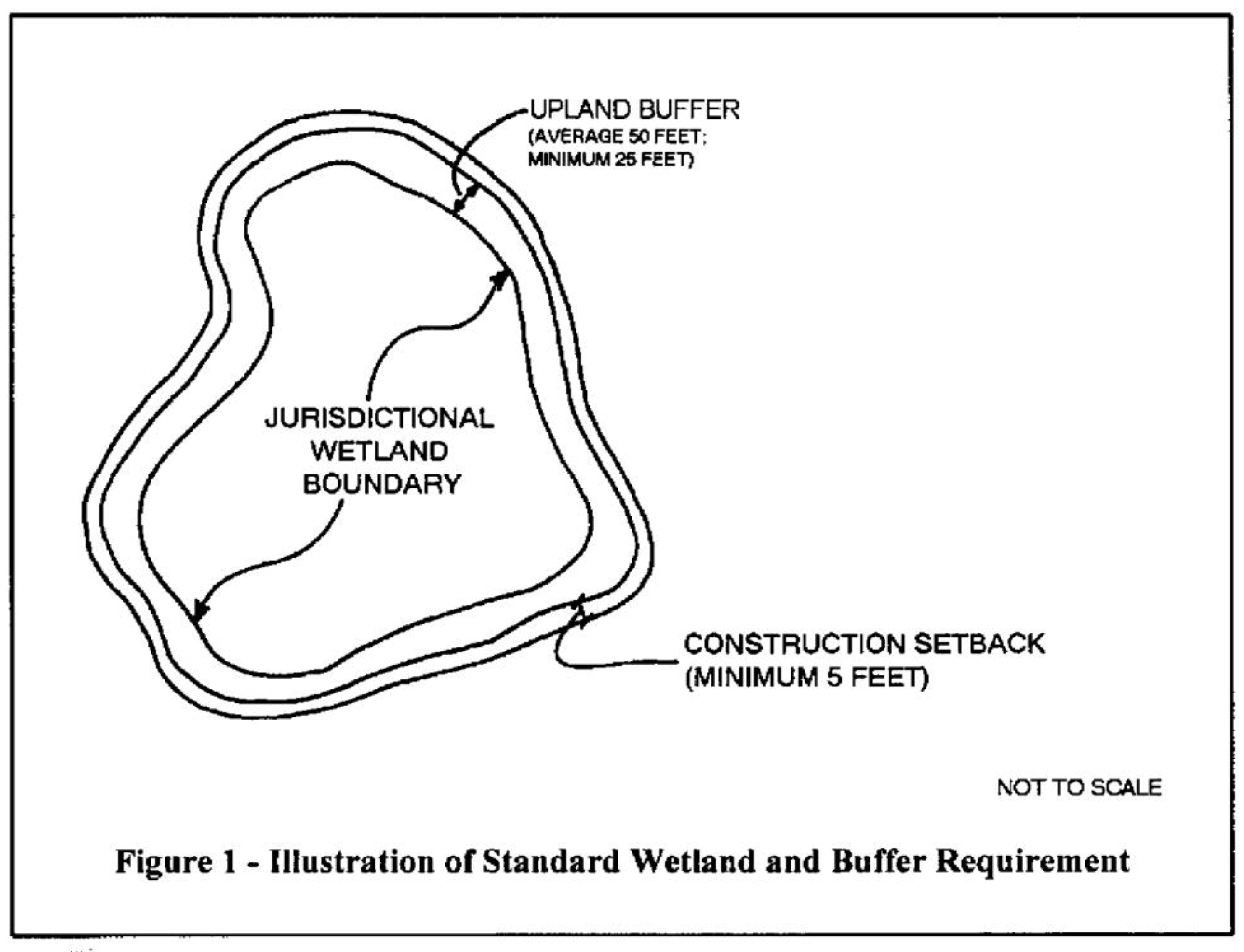
Wetland verification for the purposes of protection under this chapter shall be consistent with F.S. § 373.421, and with F.A.C. ch. 62-340. A wetland, with the required upland buffer and construction setback area, is depicted above as a "jurisdictional wetland boundary" in Figure 1. Surrounding the wetland is the required "upland buffer" and the "construction setback."

(Ord. No. 2165-08, § 2, 11-24-08)

Sec. 5.03.02. - Wetland protection standards.

A.

Introduction. To preserve and protect wetlands, the city advocates a development pattern that avoids or minimizes damage to wetlands and directs development to lands that are not environmentally sensitive. The city encourages activities not dependent upon a wetland location be located at upland sites. To promote compact urban development and discourage urban sprawl, the city allows wetland impacts under certain conditions and only where all practical measures to avoid wetlands have been applied.

B.

Impacts to wetlands prohibited. Except as otherwise provided herein, any impact upon a wetland, whether directly or indirectly caused, is prohibited. An impact upon a wetland is damage to a wetland caused by any means.

An impact to a wetland is prohibited unless the mitigation requirements of this chapter and each of the following criteria are satisfied. Further, the proposed impact must be made in the context of a planned unit development (PUD) agreement.

(Ord. No. 2539-2025, § 2, 4-16-25)

1.

If wetlands exist on the development site, the developer shall meet with the city development director to discuss preliminary site design prior to the submittal of a permit application to the State of Florida. The city development director may include a disclaimer and/or condition to an issued permit that all other applicable state and federal permits be obtained prior to commencement of the development.

2.

The requirements for elimination and reduction of impacts to wetlands in accordance with F.A.C. 40E-1, Basis of Review for Environmental Resource Permit Applications, section 4.2.1., as amended from time to time, shall be met. The city development director may include a disclaimer and/or condition to an issued permit that all other applicable state and federal permits be obtained prior to commencement of the development.

3.

The requirements for avoidance and minimization of direct impacts to wetlands in accordance with the federal Clean Water Act, as amended from time to time, shall be met. The city development director may include a disclaimer and/or condition to an issued permit that all other applicable state and federal permits be obtained prior to commencement of the development. A final permit from the corps shall precede any direct impact to a wetland.

4.

In those instances where wetland delineation was not conducted using the post-1994 accepted practice for doing so and no permit was required from the State of Florida, impact to a wetland is prohibited unless the mitigation requirements of section 5.03.03.D and at least one of the following conditions exists:

a.

The proposed impact is necessary to accommodate roads, utilities, and other infrastructure that cannot otherwise be reasonably provided without the impact;

b.

More than 75 percent of the vegetation within the wetland to be impacted is non-native vegetation;

c.

A larger upland preserve area(s) with significantly higher ecological values, not required for preservation by this chapter, will be preserved elsewhere on the site.

5.

Unless otherwise approved by the city commission, new onsite sewage disposal systems must be located not less than 75 feet from wetlands for parcels created after January 1, 1972, and not less than 50 feet from wetlands for parcels created prior to 1972.

(Ord. No. 2539-2025, § 2, 4-16-25)

6.

No wetland impacts shall be permitted on sites where no development activity is proposed.

C.

Upland buffer requirements for verified wetlands. To protect wetlands, upland buffers around wetlands shall be provided and preserved around each wetland or portion thereof on the property.

1.

The minimum average width of an upland buffer shall be 50 feet and at no point shall its width be less than 25 feet. The minimum average width of an upland buffer around an outstanding resource wetland shall be 75 feet and at no point be less than 50 feet.

2.

Except as otherwise provided in this chapter, the native vegetation within an upland buffer shall not be disturbed by development activity.

3.

Any portion of a required upland buffer not comprised of native vegetation shall be planted with native vegetation.

a.

Planting shall include all vegetation types that are consistent with the native uplands in the vicinity, including canopy, understory and ground cover.

b.

The non-native vegetation in the upland buffer planted area shall be removed.

c.

Planting shall be installed according to a planting plan prepared by an environmental professional consistent with the latest version of "26 Ecological Communities of Florida" published by the Florida Chapter of the Soil and Water Conservation Society and approved by the city development director.

4.

An upland buffer shall be protected by a construction setback of ten feet from the upland buffer boundary. For accessory structures, the setback from an upland buffer shall be a minimum of five feet. Within this setback area, no earthwork, construction or placement of structures shall be permitted.

D.

Greenways between wetlands on development sites of greater than five acres.

1.

The provisions of this subsection apply to developments of greater than five acres.

2.

The upland buffer around wetlands shall be extended to provide a greenway connection between wetlands that are separated by 200 feet or less of native upland habitat. A greenway will be located entirely on the development site and may be required in relation to a wetland on adjacent property.

3.

The area of a greenway is included in the required preserve area.

4.

The location of greenways between wetlands both on the development site and on property adjacent to the development site is illustrated in Figure 2 below.
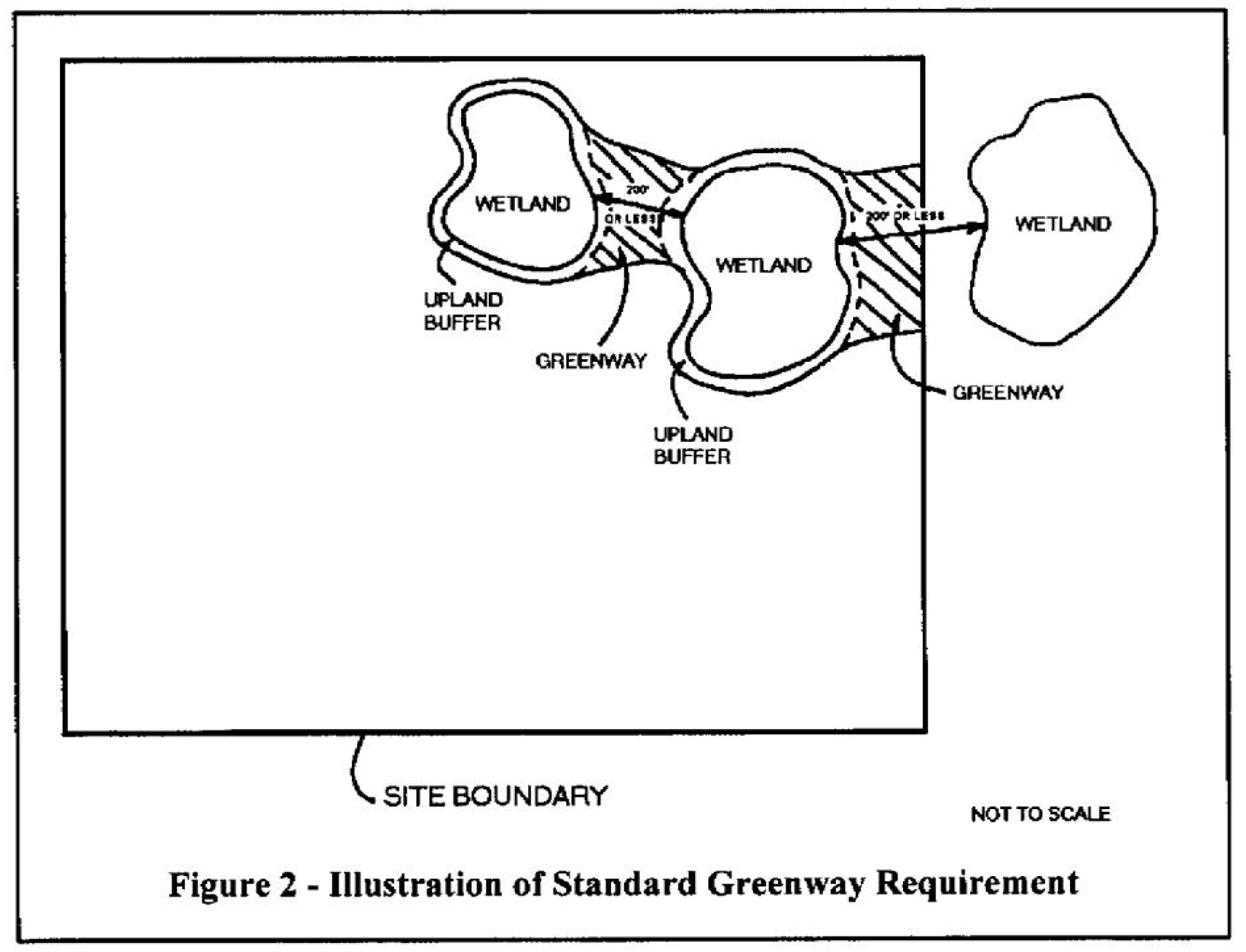
5.

Up to ten percent of the required parking that would otherwise be located in a greenway may, if approved by the city development director, either be waived or provided on stabilized grass or similar pervious parking surface.

6.

A greenway may be crossed to accommodate roads, utilities or other infrastructure that cannot, as determined by the city development director, be reasonably located elsewhere. The crossing shall be designed to maintain hydrologic and wildlife connections through appropriate structures such as culverts and to otherwise minimize impact upon the greenway.

(Ord. No. 2165-08, § 2, 11-24-08)

Sec. 5.03.03. - Wetland mitigation.

In the event an applicant proposes an impact upon a wetland, the applicant shall also propose mitigation to offset the effects of such impact in compliance with the mitigation requirements established by the State of Florida and the Army Corps of Engineers. The city development director may include a disclaimer and/or condition to an issued permit that all other applicable state and federal permits be obtained prior to commencement of the development A permit from the State of Florida shall precede any impact to a wetland.

A.

South Florida Water Management District requirements. Prior to site plan approval, compliance of proposed mitigation with applicable regulations of the State of Florida shall be provided to the city. The city development director may include a disclaimer and/or condition to an issued permit that all other applicable state and federal permits be obtained prior to commencement of the development. A permit from the State of Florida shall precede any impact to a wetland.

B.

Clean Water Act requirements. The proposed mitigation shall comply in all respects with section 404 of the Clean Water Act as amended from time to time. The city development director may include a disclaimer and/or condition to an issued permit that all other applicable state and federal permits be obtained prior to commencement of the development. A final permit from the corps is required before any wetland impacts occur.

C.

Wetland mitigation priorities. If the State of Florida determines that a wetland, or a portion thereof may be mitigated, that mitigation may proceed according to the following geographic priorities:

1.

The first priority shall be mitigation on-site.

2.

The second priority shall be mitigation within the same watershed basin.

3.

The third priority shall be mitigation within watershed basins identified in the conservation element of the city's Comprehensive Plan.

4.

The fourth priority shall be mitigation within watershed basins in Martin County.

5.

The fifth priority shall be mitigation within a mitigation bank whose service area covers the development site.

D.

Other requirements. In those instances where wetland delineation was not conducted using the post-1994 accepted practice for doing so and no permit was required from the State of Florida, impact to a wetland shall be permitted only if the mitigation requirements below are met:

1.

The proposed mitigation will replace the wetland functions and associated values lost as a result of the impact as determined in accordance with the South Florida Water Management District Wetland Rapid Assessment Procedure;

2.

Any crossings of wetlands for access or infrastructure will provide continued hydrologic and wildlife connections through culverts or other appropriate structural means;

3.

The applicant has a sufficient perpetual property interest to ensure completion and perpetual preservation of the mitigation area;

4.

The applicant has provided a long-term monitoring and maintenance plan that will ensure the success of the mitigation according to the maintenance plan;

5.

The applicant provides financial assurance such as a bond or letter of credit to ensure completion, monitoring and maintenance of the mitigation.

(Ord. No. 2165-08, § 2, 11-24-08)

Sec. 5.04.01.- Requirements for sites of greater than one acre.

For sites where less than 25 percent of the development site, exclusive of wetlands that are verified to be a "wetland" by the State of Florida, exists as native vegetative areas, all native vegetative areas shall be preserved. For sites where greater than 25 percent of the development site, exclusive of wetlands that are so verified by the State of Florida, exists as native vegetative areas, not less than 25 percent of the development site shall be preserved as a native vegetative area. This area can consist of the upland buffers, greenways, native uplands, wetland areas of less than one-half acre and not verified to be a "wetland" by the State of Florida, habitat of listed species, and habitat of wildlife.

(Ord. No. 1824-02, § 1, 1-28-02; Ord. No. 2165-08, § 2, 11-24-08)

Sec. 5.04.02. - Identification of native vegetation preserve area for sites of greater than one acre.

The preserve area shall be set aside in accordance with the following priorities:

A.

Native vegetation preserve area priority criteria.

1.

On development sites where upland buffers for wetlands is required, the first priority for the identification of the native vegetation preserve area shall include the areas of upland buffers and greenways, if any, and then areas of native vegetation.

2.

After the location of the upland buffers for wetlands, the balance of the native vegetation preserve area shall be areas of existing native habitat of listed species. Necessary permits from the U.S. Fish and Wildlife Service and the Florida Fish and Wildlife Conservation Commission may require a larger native vegetation preserve area and in such event those permit requirements shall apply.

3.

In the event, given the foregoing criteria, the entire native vegetation preserve area required has not been provided for, the balance of the native vegetation preserve area shall be located with reference to the following:

a.

Areas for integration and maintenance of environmental systems; and

b.

Protection of ecotones and diverse habitat types, including the interface of wetlands, uplands and various upland types; and

c.

Preservation of wetlands that are isolated from other wetlands or upland systems and not connected to native habitat.

4.

For sites with no native vegetation, the landscaping requirements of this Code shall be met with native vegetation, however, the side and rear landscape strip shall be 25 feet in depth and planted with native vegetation. The location and type shall be determined by the presence or absence of native vegetation on adjacent property.

B.

Native vegetation preserve area on-site relocation option. Excluding native vegetation included within areas of listed species habitat and upland buffers, the applicant may propose relocation or replanting of native vegetation that would otherwise be preserved, providing that the relocated preserve area be assessed in terms of its value as habitat. The relocated onsite preserve should be of the same or better quality as the area proposed for relocation. On-site preserve areas of a different type may be proposed and allowed at the city's discretion, providing that the area is a native vegetative community that is rare within the city or Martin County. This assessment should be included as a separate section of the environmental assessment report (section 5.02.00); and

On-site relocation criteria:

Relocation allows for establishment of native upland habitat contiguous to existing native habitat thus creating larger contiguous tracts of habitat providing greater native habitat function and connectivity with clear benefits for listed species.

Relocation of native upland habitat provides clear synergistic benefits to on-site wetlands that are to be preserved, enhanced, or created.

The on-site preserve area community should be the same type as the on-site community to be impacted. An environmental assessment should be conducted by a qualified environmental professional (i.e., certified ecologist, certified environmental professional, professional wetland scientist, or other recognized certification) for the on-site areas that:

a.

Indicates the size of the proposed preserve area;

b.

Describes the community type using the Florida Land Use, Cover and Forms Classification System (FLUCCS), including FLUCCs codes for land use in the surrounding vicinity and including an aerial map with FLUCCS overlay;

c.

Provides an inventory of the dominant vegetation;

d.

Indicates the approximate percent cover of exotic vegetation and type;

e.

Lists protected floral and faunal species that could occur and that were observed;

f.

Describes the land use in the surrounding vicinity in relation to the proposed preserve area; and

g.

Describes the conceptual restoration plan (including restoration and management needs), if applicable.

C.

Native vegetation preserve area off-site relocation option. Excluding native vegetation included within areas of listed species habitat and upland buffers, the applicant may propose relocation or replanting of native vegetation that would otherwise be preserved, providing that the relocated preserve area be assessed in terms of its value as habitat. The relocated offsite preserve should be of the same or better quality as the area proposed for relocation. On-site preserve areas of a different type may be proposed and allowed at the city's discretion, providing that the area is a native vegetative community that is rare within the city or Martin County. This assessment should be included as a separate section of the environmental assessment report (section 5.02.00); and

Off-site relocation criteria:

The off-site preserve area community should be the same type as the on-site community to be impacted and should be of the same or greater quality. An environmental assessment should be conducted by a qualified environmental professional (i.e., certified ecologist, certified environmental professional, professional wetland scientist, or other recognized certification) for both the on-site and off-site areas that:

a.

Indicates the size of the proposed preserve area;

b.

Describes the community type using the Florida Land Use, Cover and Form Classification System (FLUCCS), including FLUCCs codes for land use in the surrounding vicinity, and including an aerial map with FLUCCS overlay;

c.

Provides an inventory of the dominant vegetation;

d.

Indicates the approximate percent cover of exotic vegetation and type;

e.

Lists protected floral and faunal species that could occur and that were observed;

f.

Describes the land use in the surrounding vicinity in relation to the proposed preserve area; and

g.

Describes the conceptual restoration plan (including restoration and management needs), if applicable:

1.

The native vegetation that would otherwise be preserved on the development site is not the habitat of listed species;

2.

The required upland buffers are provided;

3.

The development site is proposed for non-residential uses or mixed-use;

4.

The location of the off-site preserve area is approved by the city and consistent with adopted environmental management plans;

5.

The preserve area is provided according to one of the following options:

a.

Provision of not less than two acres of off-site preserve area for every one acre of on-site native vegetation preserve area not provided said off-site preserve area being of a superior habitat quality; or

b.

Payment to the city of an amount that is 150 percent of the appraised value of the entire development site that is prorated to apply to the native vegetation preserve area acreage not provided for deposit into a city environmental trust fund for stormwater quality improvements, and for the acquisition, enhancement and maintenance of environmentally sensitive lands, and for environmental education.

(Ord. No. 1824-02, § 1, 1-28-02; Ord. No. 2165-08, § 2, 11-24-08)

Sec. 5.04.03. - Monitoring and maintenance of preserve areas for sites of greater than one acre.

In order to ensure that the wetland and upland preserve areas remain a native vegetative area and a functional habitat for wildlife, these areas must be monitored and maintained in their native form. This requirement shall be met both during construction of approved projects as well as throughout the existence of the project and its associated preserve areas.

A.

Preserve area protection plan during construction. The application for site plan approval for a site of greater than one acre shall include a preserve area protection plan the provisions of which shall be implemented prior to construction to prevent encroachment and negative effects upon required preserve areas. The plan shall include the following:

1.

A barricade plan shall indicate the locations and types of barricades that will be employed to prevent encroachment of construction activities into the preserve areas.

2.

An erosion and turbidity control plan shall indicate the locations and types of erosion control that will be employed to prevent runoff of turbid water into the preserve areas.

3.

A schedule for the inspection and maintenance of barricades and erosion controls prior to and during the construction period shall be provided.

4.

A signage and information plan depicting locations and text for signs designating preserve areas shall indicate that the signs will be placed at an interval of one per parcel with perimeter bordering preserve or buffer areas or every 100 feet for perimeter areas that do not include parcels.

(Ord. No. 2539-2025, § 2, 4-16-25)

5.

The preserve areas signs shall include the following statement:

"PRESERVE AREA -

NO DUMPING -

NO TRIMMING - NO MOWING."

BY ORDER OF THE CITY OF STUART

B.

Preserve area vegetative requirements. As a condition of site plan or plat approval for a site of greater than one acre, the proposed development project shall meet the following criteria for preserve areas.

1.

All nuisance and non-native vegetation shall be eradicated within all wetlands and upland preserve areas except as specified in subsection B.3 of this section. Non-native vegetation includes all species on the Florida Exotic Pest Plant Council list as amended from time to time. Nuisance vegetation includes, but is not limited to, cattail, primrose willow and other species designated as nuisance or undesirable by the South Florida Water Management District.

2.

Eradication shall consist of the most ecologically sound combination of mechanical removal, manual removal and herbicide treatment. All vegetative debris generated by the eradication must be disposed of outside the wetland or preserve area.

3.

A limited amount of non-native vegetation may be allowed to remain as a visual and noise buffer as determined by the city development director on a particular site.

C.

Preserve area maintenance. For sites that are greater than one acre, the application for site plan or plat approval shall include a preserve area maintenance plan.

1.

The preserve area maintenance plan shall include the following:

a.

Provision shall be made for annual monitoring of the vegetative cover in the preserve area for the five years after completion of the project.

b.

The vegetative cover data shall be collected in accordance with generally accepted scientific methods, including any occurrence of non-native vegetation or nuisance vegetation. Data shall be documented on a summary monitoring sheet.

c.

Monitoring reports shall include the quantitative vegetation cover data from designated monitoring locations within the preserve area. The vegetative coverage data shall be measured as absolute coverage within an area of approximately 2,500 square feet at each monitoring station.

d.

The vegetation shall be measured in percent coverage of the canopy and understory layer and ground cover. The total percent cover should not exceed 100 percent, and each species documented will be reported in both common and Latin names.

e.

The coverage shall be measured by visual observation in each of four quadrants from the fixed monitoring point. Observations extend approximately 50 feet from the observer in each direction thus covering approximately 2,500 square feet at each station. The data from each quadrant observation is combined to calculate the vegetative coverage. Station locations are to be permanently marked to ensure consistency in data collection.

f.

At least one panoramic photo shall be collected from each of the established monitoring stations to provide documentation of vegetative coverage.

g.

The monitoring report shall include recommendations for maintenance, if necessary.

h.

Provision shall be made for continued eradication of nuisance and non-native vegetation that may occur in the preserve area and for habitat management to continually maintain the type and quality of habitat originally intended for the project.

i.

Provision shall be made for financial assurance for not less than five years that monitoring and maintenance of the preserve area will be conducted per the plan.

2.

The preserve area maintenance plan and provisions shall be included in the deeds and covenants which run with the property.

3.

A preserve area maintenance plan compliance analysis report shall be filed annually with the city for each of the first five years following completion of the project. The report shall detail compliance with the plan, and shall include an update of the specific monitoring criteria as listed above and a description of the effort needed to comply with the plan on an annual basis.

4.

Prior to issuance of a certificate of occupancy for any portion of the development, the developer shall execute a contract with the city whereby the developer and successors in interest to the developer are bound to comply with the plan. Said contract shall be recorded in the public records of Martin County, Florida and shall specifically provide for injunctive relief and specific performance and shall indicate any intended third party beneficiaries.

5.

Violation of a plan shall constitute a violation of this Code enforceable through code enforcement proceedings as well as other available legal and equitable remedies provided by law.

(Ord. No. 2165-08, § 2, 11-24-08)

Sec. 5.04.04. - Activities presumed to have an insignificant adverse effect on protected areas.

1.

Certain activities are presumed to have an insignificant adverse effect on the beneficial functions of protected areas established in section 5.04.02. Notwithstanding the prohibition in section 5.03.02., the following activities may be undertaken.

a.

Scenic, historic, wildlife, or scientific preserves.

b.

Minor maintenance or emergency repair to existing structures or improved areas.

c.

Establishment of the Stuart Riverwalk.

(Ord. No. 2165-08, § 2, 11-24-08)

Sec. 5.05.01.- Tree location map and survey requirements for sites of greater than one acre.

A.

Tree protection information. The following requirements regarding tree protection shall apply to all applications for site plan approval for sites greater than one acre.

1.

A tree location map, as defined in chapter XII, shall be filed with the application for site plan approval. The map shall indicate the approximate locations of all historic trees and all specimen trees on the site. These trees are defined in chapter XII.

2.

Each tree so mapped shall be designated on the tree location map by size in diameter at 4.5 feet above the ground (diameter breast height - DBH) and type. The tree location map shall depict the proposed building and construction areas within the proposed project and how those areas affect the mapped trees.

3.

In the event trees subject to protection in this section will be removed or otherwise impacted directly, or will be filled at the base or otherwise impacted indirectly, a tree survey, as defined in chapter XII, shall be prepared.

B.

Protected tree species and criteria.

1.

Specimen trees as defined in chapter XII.

(Ord. No. 1788-01, § 1, 6-25-01)

2.

Historic trees as defined in chapter XII.

3.

The city tree list follows:

CITY OF STUART TREE LIST

American Holly (Ilex opaca)
Bald Cypress (Taxodium distichum)
Banyan Tree (Ficus benghalensis)
Dahoon Holly (Ilex cassine)
Gumbo Limbo (Bursera simaruba)
Hickory (Carya ashei)
Laurel Oak (Quercus laurifolia)
Live Oak (Quercus virginiana)
Loblolly Bay (Gordonia lasianthus)
Mahogany (Swietenia mahogani)
Red Bay (Persea borbonia)
Red Maple (Acer rubrum)
Sand Pine (Pinus clausa)
Slash Pine (Pinus elliottii var. densa)
Southern Magnolia (Magnolia grandiflora)
Southern Red Cedar (Juniperus silicicola)
Strangler Fig (Ficus aurea)
Sweet Bay (Magnolia virginia)
Sweet Gum (Liquidambar styraciflua)
Sycamore (Plantanum occidentalis)


4.

The city flowering tree list follows:

CITY OF STUART FLOWERING TREE LIST

Glaucous Cassia 1 (Cassia surattensis)
Weeping Bottlebrush 1 (Callistemon viminallis)
Lemon Bottlebrush 1 (Callistemon lanceolata)
Golden Rain Tree 1 (Koelreuteria formosana)
Queens Crepe Myrtle 1 (Lagerstromia speciosa)
Paradise Tree (Simaruba glauca)
Silver Trumpet 1 (Tabebuia caraiba)
Pink Tab or Trumpet Tree 1 (Tabebuia heterophylla)
Jerusalem Thorn 1 (Parkinsonia aculeata)
Princess Flower Tree 1 (Tibouchina grandiflora )
Hong Kong Orchid 1 (Bauhinia blakeana)


1 It is recognized that these plant materials are not considered native vegetation materials and do not count towards the native vegetation requirements of this Code.

(Ord. No. 2165-08, § 2, 11-24-08)

Sec. 5.05.02. - Tree replacement and protection requirements.

A.

Historic trees and specimen trees. Historic trees and specimen trees located within that portion of a development site to be developed shall be protected or replaced in accordance with the following criteria. No historic or specimen trees shall be removed without a tree removal permit, unless:

a.

The tree is located on residential property and an arborist or landscape architect has provided documentation that the tree presents a danger to persons or property; or

b.

The removal is in conjunction with an approved development order where a tree survey was submitted.

B.

If required, a tree removal permit must be issued by the city development department for work undertaken pursuant to this section. Application for such permit shall be on forms prescribed by the city development director. The fee for such permit shall be set by the city manager.

C.

Specimen trees. Unless the specimen tree is located on a residential property where an arborist or landscape architect provides documentation that the tree presents a danger to persons or property, then all practical measures shall be taken to leave specimen trees in place and preserved within development sites.

a.

Specimen trees within parking areas shall be preserved with tree wells or other appropriate measures, if practical. Any parking space requirement that would require the removal of a specimen tree may be waived by the city development director if no fewer than 90 percent of the required parking spaces will be provided. Otherwise, specimen trees shall be relocated within the development site.

b.

Specimen trees within building envelopes or for which there is no practical alternative for preservation shall be relocated within the development site.

c.

Specimen trees, excluding slash pine trees, for which relocation is not possible or is not expected to be successful, shall be replaced with like species within the development site. Replacement trees shall have a combined DBH of two and one-half times the DBH of the trees replaced. The minimum size for replacement trees is four and one-half inches DBH. Determination of the number of replacement trees or contribution to city tree fund shall be calculated in accordance with table 1 below. Replacement trees shall be native to Florida or not documented as an invasive species.

d.

Specimen trees, specifically and only slash pines, for which relocation is not possible or is not expected to be successful, shall be replaced with like species within the development site. Replacement trees shall have a combined DBH of one and one-half times the DBH of the trees replaced. The minimum size for replacement trees is two and one-half inches DBH. Determination of the number of slash pines or contribution to city tree fund shall be calculated in accordance with table 1 below.

e.

When not feasible to replant with like species of slash pine, replacement trees may be substituted with the following trees (or other approved native shade trees) on a 1:1 ratio:

• Alexander Palm.

• Coconut Palm.

• Chinese Fan Palm.

• Date Palm.

• Majesty Palm.

• Royal Palm.

• Christmas Palm.

• Washington Palm.

• Sabal Palmetto.

Shade trees (may count towards canopy coverage calculations):

• American Holly.

• Dahoon Holly.

• Laurel Oak.

• Live Oak.

• Mahogany.

• Red Bay.

• Red Maple.

• Royal Poinciana.

• Slash Pine.

• Southern Magnolia.

• Sweet Bay.

• Sweet Gum.

• Sycamore.

• Variegated Mahoe.

For every one foot of clear trunk of palm tree exceeding minimum palm tree size per section 6.04.02.A.2 and for each additional inch of DBH of canopy or specimen trees of the landscape code, credit will be given for one inch of replacement.

f.

Additional preservation of native habitat beyond that required by section 5.04.00 may be substituted for a proportion of the tree replacement requirements of this section as approved by the city development director. Such preservation is additional to requirements for wetlands and preserve areas and shall include sufficient native trees to meet the DBH replacement requirements in subsection C.c of this section.

g.

Credit towards tree replacement requirements shall be provided for landscaping required by section 6.04.00 only if all required trees are planted at a minimum DBH of four and one-half inches and all required palms are planted at a minimum of 14 feet clear trunk. If required trees or palms, as proposed for a development site in accordance with the landscape code, are planted at minimum landscape code requirements, then no credit is obtainable.

h.

As determined by the city development director, monies may be contributed as part of tree replacement requirements. This tree replacement mitigation, through payment into the city tree replacement fund, shall only provide for a 50 percent mitigation of the required number of trees to be replaced. The city development director shall coordinate the recovery and disbursement of said funds in accordance with the general provisions of this chapter.

i.

Innovative stormwater treatment design which is demonstrated to exceed water quality treatment above that required in section 6.03.00 and South Florida Water Management District best management practice and reduces post-development stormwater pollutant loading of total nitrates and phosphates by 81 or more percent may be substituted for a proportion of the tree replacement fund payment in accordance with table 2 of this section and as approved by the city development director.

j.

Proposals that incorporate low impact development (LID) practices that include, but are not limited to, a combination of sustainable drainage design, preservation of open space above code requirement, bio-swales and pervious pavement may be substituted for a proportion of the tree replacement requirements of this section and as approved by the city development director.

k.

Proposals that demonstrate a tree canopy coverage greater than 30 percent of the site area may qualify for a reduction in a proportion of the city tree replacement fund payment in accordance with the provisions of table 3 of this section and as approved by the city development director. Tree canopy coverage is calculated as the area of shade generated by tree foliage at ground level.

l.

Additional inches required under the tree replacement calculation may be credited through the planting of native understory shrubs that are made in addition to landscaping code requirements and listed here; credit will be at a proportion in accordance with table 4 of this section and as approved by the city development director.

Native shrub and ground cover list:

• Beach Sunflower.

• Blue Eyed Grass.

• Buttonwood.

• Carolina Jessamine.

• Cherry Laurel.

• Cocoplum.

• Coontie.

• Coral Honeysuckle.

• Cordgrass.

• Dwarf Firebush.

• Dwarf Schillings Holly.

• Erect Swordfern.

• Fakahatchee Grass.

• Firebush.

• Florida Privet.

• Gallberry.

• Lantana species.

• Myrsine.

• Periwinkle.

• Pink Muhly.

• Sand Cord Grass.

• Shiny Blueberry.

• Silver Buttonwood.

• Simpson's Stopper.

• Spider Lily.

• Swamp Fern.

• Swamp Lilly.

• Trumpet Honeysuckle.

• Walter's Virburnum.

• Wax Myrtle.

• Wild Allamanda.

m.

Relocated trees that do not survive at least two years shall, in turn, be replaced. A mechanism for financial assurance that relocated, and replacement trees will meet survival criteria shall be provided.

n.

Wherever feasible, tree removal within single family and duplex properties shall substitute replacement trees with like species on a 1:1 ratio.

Table 1: Proposed Formulas for Tree Replacement and Contribution into City Tree Fund

Tree Replacement Formula—Slash Pine:
Total # inches to remove × 1.5 = Total # inches to be replaced / Minimum size to replace 2.5" = Total # trees to plant × 50% mitigation to pay into city tree fund × 175% of plant finder wholesale = Total $ amount to pay into city tree fund
Tree Replacement Formula—All Trees Less Slash Pine:
Total # inches to remove × 2.5 = Total # inches to be replaced / Minimum size to replace 4.5" = Total # trees to plant × 50% mitigation to pay into city tree fund × 175% of plant finder wholesale = Total $ amount to pay into city tree fund


Table 2: Credit for Providing Additional Nitrate and Phosphate Removal

Percentage of Nitrate and Phosphate Loading Reduction from Stormwater Maximum Pollutant Removal Factor for Construction Value of Additional Stormwater Treatment a
81% to 85% 1.25
86% to 89% 1.5
90%+ 2.0


Table 2 Notes:

a.

The value of additional stormwater treatment measures as provided by an engineer's probable cost of construction is multiplied by the pollutant removal factor to provide an equivalent dollar amount, which may only be credited to offset all or part of the required city tree replacement fund.

Table 3: Credit for Providing Additional Tree Canopy

Total Site Tree Canopy Coverage Maximum Credit Reduction to the Required City Tree Replacement Fund
30% to 35% 15%
36% to 40% 30%
40% + 50%


Table 4: Credit for Providing Additional Understory Native Planting

Size of Native Shrub Maximum Credit Inches
1 gallon plant 1 inch per 24 plants
3 gallon plant 1 inch per 12 plants


D.

Historic trees. Unless the historic tree is located on a residential property where an arborist or landscape architect provides documentation that the tree presents a danger to persons or property the tree shall be preserved.

a.

A site plan, development permit, or plat application shall indicate the preservation of all historic trees in all areas proposed for development. The site application shall indicate protective measures to ensure the preservation and longevity of all historic trees, such as tree wells, construction barricades or fencing, or relocation.

b.

Any parking space requirement or building envelope which would require the removal of a historic tree may be waived by the city development director if no fewer than 90 percent of the required parking spaces are provided.

In the event no practical alternative exists to locating structures on the site so as to accommodate a historic tree, the applicant for development may submit for major development plan approval or planned unit development (PUD) to consider the removal and replacement of the historic tree. The city commission shall be guided by a consideration of the environmental as well as aesthetic and economic value of the historic tree to be replaced in deciding the appropriate means and manner of its removal and replacement.

c.

Wherever feasible, tree removal within single family and duplex properties shall substitute replacement trees with like species on a 1:1 ratio.

(Ord. No. 1788-01, § 1, 6-25-01; Ord. No. 2165-08, § 2, 11-24-08; Ord. No. 2432-2020, § 1, 4-13-20)

Sec. 5.05.03. - Protection during development.

A.

Generally.

1.

To assure the health and survival of protected trees that are not to be removed, the developer shall avoid the following kinds of tree injuries during all development activities:

a.

Mechanical injuries to roots, trunk, and branches;

b.

Injuries by chemical poisoning;

c.

Injuries by grade changes;

d.

Injuries by excavations, fill and;

e.

Injuries by paving.

2.

At a minimum, the protective measures described below shall be taken where appropriate to the development activity. Additional reasonable requirements may be necessary and shall be taken to preserve the health of protected trees in particular circumstances.

B.

Avoiding mechanical injuries.

1.

Prior to any land preparation or other development activities a protective barrier easily visible to equipment operators shall be placed around all protected trees so as to encompass the entire tree protection zone.

2.

No attachment, wires (other than supportive wires), signs or permits may be fastened to any protected tree.

3.

No equipment, construction materials or debris of any kind shall be placed within the protective barrier.

4.

Landscaping activities within the bounds of the protective barrier (before and after it is removed) shall be accomplished with light machinery or manual labor. Grubbing, such as clearing of existing vegetation or similar activities, is prohibited within the protective barrier except for removal of prohibited species. The only activity permitted within protective barriers shall be supplemental landscaping. Supplemental landscape plant material shall be of similar cultural classification as existing vegetation. Temporary irrigation shall be permitted on an as-needed basis until plant establishment.

5.

In lieu of constructing the barriers required above, the developer may physically designate large areas containing protected trees where no land preparation or other development activities of any kind will occur. The area shall be designated by placing stakes a maximum of 25 feet apart and tying ribbon, plastic tape or rope from stake to stake along the outside perimeter of the area. This perimeter line shall be beyond the tree protection zone of any protected trees growing within the area.

6.

Required protective barriers and perimeter lines shall remain in place until all construction activity, except landscaping within the protected area, is terminated.

C.

Avoiding injuries due to chemical poisoning.

1.

No fuel, paint, solvent, oil, thinner, asphalt, cement, grout or any other construction chemical or other material or tools of any kind shall be stored, or allowed in any manner to enter, within a required protective barrier or perimeter line.

2.

No equipment shall be cleaned within a required protective barrier or perimeter line.

D.

Avoiding injuries due to excavations.

1.

Water, sewer, and other utility lines should be routed around the tree protection zones of protected trees.

2.

If a line cannot reasonably be routed around the tree protection zone, the line shall be tunneled beneath the area within the zone. The tunnel shall be offset to one side of the trunk to prevent damage to the main tap roots.

(Ord. No. 2165-08, § 2, 11-24-08)

Sec. 5.05.04. - Emergencies.

In the case of emergencies such as hurricanes, windstorms, floods, freezes or other disasters or hazards, the requirements of this section may be waived by the city manager or his/her designee upon a finding that such waiver is necessary so that public or private work to restore order in the community will not be impeded.

(Ord. No. 2165-08, § 2, 11-24-08)

Sec. 5.05.05. - Public right-of-way.

No trees shall be removed from the public right-of-way except under the direction of the city development director and the parks and recreation director. No tree shall be planted in the public right-of-way without authorization from the city.

(Ord. No. 2165-08, § 2, 11-24-08)

Sec. 5.05.06. - Clearance of vegetation over streets and sidewalks.

Trees and shrubbery shall be trimmed by the city and/or authorized agencies so that there shall be a clear space of eight feet over all sidewalks and ten feet over all streets within the city.

(Ord. No. 2165-08, § 2, 11-24-08)

Sec. 5.05.07. - City tree replacement fund.

A.

Establishment of the city tree replacement fund. The city tree replacement fund is created in association with the City of Stuart department of financial services for the purpose of accepting and disbursing payments made to the city as part of tree replacement mitigation and other monies deposited from penalties for tree removal, illegal grading, or illegal clearing. These monies shall be placed in an account and shall be used for funding tree planting and replacement on private or public property within the city, exotic vegetation removal and native habitat enhancement on private or public property within the city, acquisition of land within the city for preservation purposes, matches for habitat management related grants.

B.

Term of existence. The city tree replacement fund account shall be self-perpetuating from year to year unless specifically terminated by the city commission.

C.

Purpose. Funds received shall be utilized for acquiring and planting trees for public purposes within the city or for creating innovative stormwater treatment systems or living shoreline installations within public lands. Acquired trees shall be suitable to the site conditions and listed within the city tree list. Public lands selected for plantings, living shoreline installations or innovative stormwater treatment systems shall be publicly owned or managed lands in public right-of-way.

D.

Source of funds. Fund monies may consist of the following:

1.

All monies collected pursuant to the penalties outlined in section this Code and the Code of Ordinances.

2.

All monies collected as part of tree replacement mitigation allowances.

E.

Fund administration.

1.

Funds shall be expended, utilized and disbursed only for the purposes designated herein.

2.

The fund shall be a separate set of self-balancing accounts established and maintained by the City of Stuart.

3.

Funds shall be managed in accordance with the City's Code of Ordinances as they relate to financial matters.

4.

Monies obtained pursuant to this section may be accepted on behalf of the City of Stuart by the city development director or their designee, and upon receipt shall be delivered to the City of Stuart department of financial services, which shall cause the same to be credited to the trust.

(Ord. No. 1788-01, § 1, 6-25-01; Ord. No. 1966-04, § 2, 1-26-04; Ord. No. 2165-08, § 2, 11-24-08; Ord. No. 2432-2020, § 1, 4-13-20)

Sec. 5.05.08. - Penalties.

A.

A tree removal permit in compliance with Florida Statutes must be issued by the city development department for work undertaken pursuant to this chapter V of this Code.

1.

Failure to obtain a tree removal permit shall be deemed a violation of the code.

B.

Except as otherwise provided in this Code, the removal of any trees without a permit on any parcel of land is a violation subject to the penalties as set forth herein. The owner of the real property as well as any person or entity causing the violation to occur shall be responsible subject to the penalties.

C.

The property owner of the land on which the trees were located or any person and/or entity who removes any tree from any property in violation of this Code shall be subject to the following penalties:

1.

If historic and/or specimen trees are removed without a permit or otherwise in violation of section 5.05.00 of the City's Land Development Code, then a penalty for the replacement of the required diameter at breast height (DBH) inches (as defined in city regulations) shall calculated as set forth below:

a.

First, the number of inches removed based upon the DBH shall be determined.

b.

Once the base amount is determined, the replacement inches shall be calculated pursuant to tree replacement formula set forth in 5.05.02, table 1.

c.

Compliance shall be a combination of restoration and fine based upon three times the number of DBH inches calculated from table 1.

d.

Example. Ten inches removed without permit. Type of trees removed pursuant to table 5.05.02 table 1 would require specimen trees to be replaced at a rate of 1.5. Ten inches require 15 inches as replacement. Then, the penalty is three times the replacement (15 x 3 = 45) resulting in 45 inches. The property owner shall be responsible to replant the 45 inches or pay the balance into the city tree replacement fund.

D.

Remediation:

1.

Prior to a final hearing, the violator shall present a remedial action plan to the development director with the intent to replant sufficient trees to restore the property to an appropriate level.

2.

If the remedial action plan is not approved by the development director, the matter shall be set for a final hearing with the magistrate or city commission as set forth above. However, if the development director approves the remedial action plan, then a consent agreement resolving the matter can be executed by the violator and the development director. Completion of the remedial plan shall resolve the matter without further hearing.

a.

If the development director determines that full restoration onsite is not feasible, the balance shall be paid into the city tree fund within a reasonable amount of time as set forth in the agreement.

b.

Violation of the consent agreement will be treated as a separate matter.

3.

Separate from the administrative variance procedures set forth the city regulations, the development director shall have the discretion to execute an administrative variance amending the landscape plan of a previously approved development. The scope of the variance shall be limited to modifications of the landscape plan only and shall not authorize a modification of the site plan.

4.

Until the property is brought into compliance by consent agreement or pursuant to magistrate or commission order, the development department may withhold the issuance of further development orders on the subject property including, but not limited to, building permits or certificates of occupancy.

(Ord. No. 2478-2022, §§ 1, 2, 3-14-22; Ord. No. 2491-2022, § 1, 6-27-22)

Editor's note— Ord. No. 2491-2022, § 1, adopted June 27, 2022, amended § 5.05.08 and in doing so changed the title of said section from "Tree removal; penalties for violations" to "Penalties," as set out herein.

Sec. 5.06.01.- Introduction and resource management approach.

The function and value of shoreline and mangrove areas have been recognized by the Florida Department of Environmental Protection through its "Mangrove Trimming Rule." This section is intended to permit the city to monitor shoreline and mangrove protection within the city.

(Ord. No. 2165-08, § 2, 11-24-08)

Sec. 5.06.02. - Shoreline protection zone delineation.

A.

Definition. As used in this chapter, the term "shoreline protection zone" means the land adjacent to the shoreline, including the shoreline, of the St. Lucie River, Poppleton Creek, Frazier Creek, Haney Creek, Krueger Creek, and Willoughby Creek. Except as otherwise provided in section 5.06.02.B.4 of this Code, no development shall be permitted within the shoreline protection zone.

B.

Construction limited.

1.

An application for site plan approval that includes a portion of the St. Lucie River and Poppleton Creek, Frazier Creek, Haney Creek, Krueger Creek and Willoughby Creek shall include a delineation of the shoreline protection zone. The zone shall be established by survey.

2.

Outside the community redevelopment area, the shoreline protection zone for any water body shall be 25 feet from the mean high water line.

3.

Within the community redevelopment area, the shoreline protection zone for any water body shall be ten feet from the mean high water line.

4.

The following types of development shall be permitted:

i.

Docks, marinas or interpretative walks permitted by the State of Florida;

ii.

Stormwater retention areas;

iii.

Landscaping;

iv.

Bulkheads and seawalls which function to protect existing development and are located landward of riverine wetlands and their ecotones;

v.

Riprap; and

vi.

Unpaved, stabilized parking.

5.

Any construction activity proposed within the Zone are subject to the permitting and technical requirements in chapter 10, Building and Building Regulations, article VIII, of the City of Stuart Code of Ordinances, and shall have a valid permit from the South Florida Water Management District or the Florida Department of Environmental Protection.

(Ord. No. 2165-08, § 2, 11-24-08)

Sec. 5.06.03. - Mangrove protection.

The Florida Mangrove Trimming and Preservation Act applies to lands within the city. The city will monitor mangrove alteration projects. Prior to initiating any mangrove trimming or alteration within the city limits, the city development director may include a disclaimer and/or condition to an issued permit that all other applicable state and federal permits be obtained prior to commencement of the development, including, but not limited to, a mangrove trimming permit or mangrove alteration permit from the Florida Department of Environmental Protection.

(Ord. No. 2165-08, § 2, 11-24-08)

Sec. 5.06.04. - Prohibited ongoing activities.

The following standards apply to post-development activities taking place within any protected area.

A.

Handling and storage of fuel, hazardous and toxic substances, and wastes.

1.

Developments where fuel or hazardous or toxic substances or wastes will be generated, handled, stored, transferred, or sold shall employ the best available facilities and procedures for the prevention, containment, recovery, and mitigation of spillage of fuel and hazardous or toxic substances or wastes. Facilities and procedures shall be designed to prevent substances or wastes from entering the water or soil, and employ adequate means for prompt and effective clean-up and spills that do occur.

2.

No toxic or hazardous wastes or substances shall be stored in outdoor containers.

3.

Storage or disposal of all types of wastes or substances is prohibited on shorelines.

B.

Prohibited uses. The long-term storage of equipment or materials, and the disposal of wastes shall be prohibited.

C.

Fertilizers, herbicides, or pesticides.

1.

Fertilizers, herbicides, or pesticides shall not be applied in a protected area except for projects conducted under the authority of F.S. §§ 373.451—373.4595, the Surface Water Improvement and Management Act, and governmentally authorized mosquito control programs, or in accordance with chapter 20, article VIII of the city's Code of Ordinances.

2.

Fertilizers, pesticides, and herbicides shall be applied sparingly and at appropriate rates and time intervals in accordance with chapter 20, article VIII of the city's Code of Ordinances.

D.

Spray vehicles. Vehicles used for mixing or spraying chemicals are prohibited from withdrawing water directly from waters in protected areas.

E.

Pump-out, holding, and treatment facilities for wastes from mobile sources. Sewage, solid waste, and petroleum waste generated by vessels or vehicles on the site shall be properly collected and disposed of.

(Ord. No. 2165-08, § 2, 11-24-08)

Sec. 5.07.01.- Title.

These regulations shall be known as the "Floodplain Management Ordinance of Stuart," hereinafter referred to as "this ordinance."

Sec. 5.07.01.A.- Scope.

The provisions of this ordinance shall apply to all development that is wholly within or partially within any flood hazard area, including, but not limited to, the subdivision of land; filling, grading, and other site improvements and utility installations; construction, alteration, remodeling, enlargement, improvement, replacement, repair, relocation or demolition of buildings, structures, and facilities that are exempt from the Florida Building Code; placement, installation, or replacement of manufactured homes and manufactured buildings; installation or replacement of tanks; placement of recreational vehicles; installation of swimming pools; and any other development.

Sec. 5.07.01.B.- Intent.

The purposes of this ordinance and the flood load and flood resistant construction requirements of the Florida Building Code are to establish minimum requirements to safeguard the public health, safety, and general welfare and to minimize public and private losses due to flooding through regulation of development in flood hazard areas to:

(1)

Minimize unnecessary disruption of commerce, access and public service during times of flooding;

(2)

Require the use of appropriate construction practices in order to prevent or minimize future flood damage;

(3)

Manage filling, grading, dredging, mining, paving, excavation, drilling operations, storage of equipment or materials, and other development which may increase flood damage or erosion potential;

(4)

Manage the alteration of flood hazard areas, watercourses, and shorelines to minimize the impact of development on the natural and beneficial functions of the floodplain;

(5)

Minimize damage to public and private facilities and utilities;

(6)

Help maintain a stable tax base by providing for the sound use and development of flood hazard areas;

(7)

Minimize the need for future expenditure of public funds for flood control projects and response to and recovery from flood events; and

(8)

Meet the requirements of the National Flood Insurance Program for community participation as set forth in the 44 CFR 59.22.

Sec. 5.07.01.C.- Coordination with the Florida Building Code.

This ordinance is intended to be administered and enforced in conjunction with the Florida Building Code. Where cited, ASCE 24 refers to the edition of the standard that is referenced by the Florida Building Code.

Sec. 5.07.01.D.- Warning.

The degree of flood protection required by this ordinance and the Florida Building Code, as amended by this community, is considered the minimum reasonable for regulatory purposes and is based on scientific and engineering considerations. Larger floods can and will occur. Flood heights may be increased by man-made or natural causes. This ordinance does not imply that land outside of mapped special flood hazard areas, or that uses permitted within such flood hazard areas, will be free from flooding or flood damage. The flood hazard areas and base flood elevations contained in the Flood Insurance Study and shown on Flood Insurance Rate Maps and the requirements of 44 CFR 59 and 60 may be revised by the Federal Emergency Management Agency, requiring this community to revise these regulations to remain eligible for participation in the National Flood Insurance Program. No guaranty of vested use, existing use, or future use is implied or expressed by compliance with this ordinance.

Sec. 5.07.01.E.- Disclaimer of Liability.

This ordinance shall not create liability on the part of the Stuart commission or by any officer or employee thereof for any flood damage that results from reliance on this ordinance or any administrative decision lawfully made thereunder.

Sec. 5.07.02.A.- General.

Where there is a conflict between a general requirement and a specific requirement, the specific requirement shall be applicable.

Sec. 5.07.02.B.- Areas to which this ordinance applies.

This ordinance shall apply to all flood hazard areas within Stuart, as established in section 5.07.02.B. of this ordinance.

Sec. 5.07.02.C.- Basis for establishing flood hazard areas.

The Flood Insurance Study for Martin County, Florida and Incorporated Areas dated March 16, 2015, and all subsequent amendments and revisions, and the accompanying Flood Insurance Rate Maps (FIRM), and all subsequent amendments and revisions to such maps, are adopted by reference as a part of this ordinance and shall serve as the minimum basis for establishing flood hazard areas. Studies and maps that establish flood hazard areas are on file at the City of Stuart, 121 S.W. Flagler Avenue, Stuart, FL 34994.

Sec. 5.07.02.C.1.- Submission of additional data to establish flood hazard areas.

To establish flood hazard areas and base flood elevations, pursuant to section 5.07.05 of this ordinance the Floodplain Administrator may require submission of additional data. Where field surveyed topography prepared by a Florida licensed professional surveyor or digital topography accepted by the community indicates that ground elevations:

(1)

Are below the closest applicable base flood elevation, even in areas not delineated as a special flood hazard area on a FIRM, the area shall be considered as flood hazard area and subject to the requirements of this ordinance and, as applicable, the requirements of the Florida Building Code.

(2)

Are above the closest applicable base flood elevation, the area shall be regulated as special flood hazard area unless the applicant obtains a letter of map change that removes the area from the special flood hazard area.

Sec. 5.07.02.D.- Other laws.

The provisions of this ordinance shall not be deemed to nullify any provisions of local, state or federal law.

Sec. 5.07.02.E.- Abrogation and greater restrictions.

This ordinance supersedes any ordinance in effect for management of development in flood hazard areas. However, it is not intended to repeal or abrogate any existing ordinances, including, but not limited to, land development regulations, zoning ordinances, stormwater management regulations, or the Florida Building Code. In the event of a conflict between this ordinance and any other ordinance, the more restrictive shall govern. This ordinance shall not impair any deed restriction, covenant or easement, but any land that is subject to such interests shall also be governed by this ordinance.

Sec. 5.07.02.F.- Interpretation.

In the interpretation and application of this ordinance, all provisions shall be:

(1)

Considered as minimum requirements;

(2)

Liberally construed in favor of the governing body; and

(3)

Deemed neither to limit nor repeal any other powers granted under state statutes.

Sec. 5.07.03.A.- Designation.

The public works director is designated as the floodplain administrator. The floodplain administrator may delegate performance of certain duties to other employees.

Sec. 5.07.03.B.- General.

The floodplain administrator is authorized and directed to administer and enforce the provisions of this ordinance. The floodplain administrator shall have the authority to render interpretations of this ordinance consistent with the intent and purpose of this ordinance and may establish policies and procedures in order to clarify the application of its provisions. Such interpretations, policies, and procedures shall not have the effect of waiving requirements specifically provided in this ordinance without the granting of a variance pursuant to section 5.07.07 of this ordinance.

Sec. 5.07.03.C.- Applications and permits.

The floodplain administrator, in coordination with other pertinent offices of the community, shall:

(1)

Review applications and plans to determine whether proposed new development will be located in flood hazard areas;

(2)

Review applications for modification of any existing development in flood hazard areas for compliance with the requirements of this ordinance;

(3)

Interpret flood hazard area boundaries where such interpretation is necessary to determine the exact location of boundaries; a person contesting the determination shall have the opportunity to appeal the interpretation;

(4)

Provide available flood elevation and flood hazard information;

(5)

Determine whether additional flood hazard data shall be obtained from other sources or shall be developed by an applicant;

(6)

Review applications to determine whether proposed development will be reasonably safe from flooding;

(7)

Issue floodplain development permits or approvals for development other than buildings and structures that are subject to the Florida Building Code, including buildings, structures and facilities exempt from the Florida Building Code, when compliance with this ordinance is demonstrated, or disapprove the same in the event of noncompliance; and

(8)

Coordinate with and provide comments to the building official to assure that applications, plan reviews, and inspections for buildings and structures in flood hazard areas comply with the applicable provisions of this ordinance.

Sec. 5.07.03.D.- Substantial improvement and substantial damage determinations.

For applications for building permits to improve buildings and structures, including alterations, movement, enlargement, replacement, repair, change of occupancy, additions, rehabilitations, renovations, substantial improvements, repairs of substantial damage, and any other improvement of or work on such buildings and structures, the floodplain administrator, in coordination with the building official, shall:

(1)

Estimate the market value, or require the applicant to obtain an appraisal of the market value prepared by a qualified independent appraiser, of the building or structure before the start of construction of the proposed work; in the case of repair, the market value of the building or structure shall be the market value before the damage occurred and before any repairs are made;

(2)

Compare the cost to perform the improvement, the cost to repair a damaged building to its pre-damaged condition, or the combined costs of improvements and repairs, if applicable, to the market value of the building or structure;

(3)

Determine and document whether the proposed work constitutes substantial improvement or repair of substantial damage; and

(4)

Notify the applicant if it is determined that the work constitutes substantial improvement or repair of substantial damage and that compliance with the flood resistant construction requirements of the Florida Building Code and this ordinance is required.

Sec. 5.07.03.E.- Modifications of the strict application of the requirements of the Florida Building Code.

The floodplain administrator shall review requests submitted to the building official that seek approval to modify the strict application of the flood load and flood resistant construction requirements of the Florida Building Code to determine whether such requests require the granting of a variance pursuant to section 5.07.07 of this ordinance.

Sec. 5.07.03.F.- Notices and orders.

The floodplain administrator shall coordinate with appropriate local agencies for the issuance of all necessary notices or orders to ensure compliance with this ordinance.

Sec. 5.07.03.G.- Inspections.

The floodplain administrator shall make the required inspections as specified in section 5.07.06 of this ordinance for development that is not subject to the Florida Building Code, including buildings, structures and facilities exempt from the Florida Building Code. The Floodplain Administrator shall inspect flood hazard areas to determine if development is undertaken without issuance of a permit.

Sec. 5.07.03.H.- Other duties of the floodplain administrator.

The floodplain administrator shall have other duties, including, but not limited to:

(1)

Establish, in coordination with the building official, procedures for administering and documenting determinations of substantial improvement and substantial damage made pursuant to section 5.07.03.D. of this ordinance;

(2)

Require that applicants proposing alteration of a watercourse notify adjacent communities and the Florida Division of Emergency Management, State Floodplain Management Office, and submit copies of such notifications to the Federal Emergency Management Agency (FEMA);

(3)

Require applicants who submit hydrologic and hydraulic engineering analyses to support permit applications to submit to FEMA the data and information necessary to maintain the flood insurance rate maps if the analyses propose to change base flood elevations, flood hazard area boundaries, or floodway designations; such submissions shall be made within six months of such data becoming available;

(4)

Review required design certifications and documentation of elevations specified by this ordinance and the Florida Building Code and this ordinance to determine that such certifications and documentations are complete;

(5)

Notify the Federal Emergency Management Agency when the corporate boundaries of Stuart are modified; and

(6)

Advise applicants for new buildings and structures, including substantial improvements, that are located in any unit of the Coastal Barrier Resources System established by the Coastal Barrier Resources Act (Pub. L. 97-348) and the Coastal Barrier Improvement Act of 1990 (Pub. L. 101-591) that federal flood insurance is not available on such construction; areas subject to this limitation are identified on flood insurance rate maps as "Coastal Barrier Resource System Areas" and "Otherwise Protected Areas."

Sec. 5.07.03.I.- Floodplain management records.

Regardless of any limitation on the period required for retention of public records, the floodplain administrator shall maintain and permanently keep and make available for public inspection all records that are necessary for the administration of this ordinance and the flood resistant construction requirements of the Florida Building Code, including flood insurance rate maps; letters of change; records of issuance of permits and denial of permits; determinations of whether proposed work constitutes substantial improvement or repair of substantial damage; required design certifications and documentation of elevations specified by the Florida Building Code and this ordinance; notifications to adjacent communities, FEMA, and the state related to alterations of watercourses; assurances that the flood carrying capacity of altered watercourses will be maintained; documentation related to appeals and variances, including justification for issuance or denial; and records of enforcement actions taken pursuant to this ordinance and the flood resistant construction requirements of the Florida Building Code. These records shall be available for public inspection at City of Stuart, 121 S.W. Flagler Avenue, Stuart, FL 34994.

Sec. 5.07.04.A.- Permits required.

Any owner or owner's authorized agent (hereinafter "applicant") who intends to undertake any development activity within the scope of this ordinance, including buildings, structures and facilities exempt from the Florida Building Code, which is wholly within or partially within any flood hazard area shall first make application to the floodplain administrator, and the building official, if applicable, and shall obtain the required permit(s) and approval(s). No such permit or approval shall be issued until compliance with the requirements of this ordinance and all other applicable codes and regulations has been satisfied.

Sec. 5.07.04.B.- Floodplain development permits or approvals.

Floodplain development permits or approvals shall be issued pursuant to this ordinance for any development activities not subject to the requirements of the Florida Building Code, including buildings, structures and facilities exempt from the Florida Building Code. Depending on the nature and extent of proposed development that includes a building or structure, the floodplain administrator may determine that a floodplain development permit or approval is required in addition to a building permit.

Sec. 5.07.04.B.1.- Buildings, structures and facilities exempt from the Florida Building Code.

Pursuant to the requirements of federal regulation for participation in the National Flood Insurance Program (44 CFR 59 and 60), floodplain development permits or approvals shall be required for the following buildings, structures and facilities that are exempt from the Florida Building Code and any further exemptions provided by law, which are subject to the requirements of this ordinance:

(1)

Railroads and ancillary facilities associated with the railroad.

(2)

Nonresidential farm buildings on farms, as provided in F.S. § 604.50.

(3)

Temporary buildings or sheds used exclusively for construction purposes.

(4)

Mobile or modular structures used as temporary offices.

(5)

Those structures or facilities of electric utilities, as defined in F.S. § 366.02, which are directly involved in the generation, transmission, or distribution of electricity.

(6)

Chickees constructed by the Miccosukee Tribe of Indians of Florida or the Seminole Tribe of Florida. As used in this paragraph, the term "chickee" means an open-sided wooden hut that has a thatched roof of palm or palmetto or other traditional materials, and that does not incorporate any electrical, plumbing, or other non-wood features.

(7)

Family mausoleums not exceeding 250 square feet in area which are prefabricated and assembled on site or preassembled and delivered on site and have walls, roofs, and a floor constructed of granite, marble, or reinforced concrete.

(8)

Temporary housing provided by the Department of Corrections to any prisoner in the state correctional system.

(9)

Structures identified in F.S. § 553.73(10)(k) are not exempt from the Florida Building Code if such structures are located in flood hazard areas established on flood insurance rate maps.

Sec. 5.07.04.C.- Application for a permit or approval.

To obtain a floodplain development permit or approval the applicant shall first file an application in writing on a form furnished by the community. The information provided shall:

(1)

Identify and describe the development to be covered by the permit or approval.

(2)

Describe the land on which the proposed development is to be conducted by legal description, street address or similar description that will readily identify and definitively locate the site.

(3)

Indicate the use and occupancy for which the proposed development is intended.

(4)

Be accompanied by a site plan or construction documents as specified in section 5.07.05 of this ordinance.

(5)

State the valuation of the proposed work.

(6)

Be signed by the applicant or the applicant's authorized agent.

(7)

Give such other data and information as required by the floodplain administrator.

Sec. 5.07.04.D.- Validity of permit or approval.

The issuance of a floodplain development permit or approval pursuant to this ordinance shall not be construed to be a permit for, or approval of, any violation of this ordinance, the Florida Building Codes, or any other ordinance of this community. The issuance of permits based on submitted applications, construction documents, and information shall not prevent the floodplain administrator from requiring the correction of errors and omissions.

Sec. 5.07.04.E.- Expiration.

A floodplain development permit or approval shall become invalid unless the work authorized by such permit is commenced within 180 days after its issuance, or if the work authorized is suspended or abandoned for a period of 180 days after the work commences. Extensions for periods of not more than 180 days each shall be requested in writing and justifiable cause shall be demonstrated.

Sec. 5.07.04.F.- Suspension or revocation.

The floodplain administrator is authorized to suspend or revoke a floodplain development permit or approval if the permit was issued in error, on the basis of incorrect, inaccurate or incomplete information, or in violation of this ordinance or any other ordinance, regulation or requirement of this community.

Sec. 5.07.04.G.- Other permits required.

Floodplain development permits and building permits shall include a condition that all other applicable state or federal permits be obtained before commencement of the permitted development, including, but not limited to, the following:

(1)

The South Florida Water Management District; F.S. § 373.036.

(2)

Florida Department of Health for onsite sewage treatment and disposal systems; F.S. § 381.0065 and F.A.C. 64E-6.

(3)

Florida Department of Environmental Protection for construction, reconstruction, changes, or physical activities for shore protection or other activities seaward of the coastal construction control line; F.S. § 161.141.

(4)

Florida Department of Environmental Protection for activities subject to the Joint Coastal Permit; F.S. § 161.055.

(5)

Florida Department of Environmental Protection for activities that affect wetlands and alter surface water flows, in conjunction with the U.S. Army Corps of Engineers; section 404 of the Clean Water Act.

(6)

Federal permits and approvals.

Sec. 5.07.05.A.- Information for development in flood hazard areas.

The site plan or construction documents for any development subject to the requirements of this ordinance shall be drawn to scale and shall include, as applicable to the proposed development:

(1)

Delineation of flood hazard areas, floodway boundaries and flood zone(s), base flood elevation(s), and ground elevations if necessary for review of the proposed development.

(2)

Where base flood elevations, or floodway data are not included on the FIRM or in the flood insurance study, they shall be established in accordance with section 5.07.05.B.(2) or (3) of this ordinance.

(3)

Where the parcel on which the proposed development will take place will have more than 50 parcels or is larger than 5 acres and the base flood elevations are not included on the FIRM or in the flood insurance study, such elevations shall be established in accordance with section 5.07.05.B.(1) of this ordinance.

(Ord. No. 2539-2025, § 2, 4-16-25)

(4)

Location of the proposed activity and proposed structures, and locations of existing buildings and structures; in coastal high hazard areas, new buildings shall be located landward of the reach of mean high tide.

(5)

Location, extent, amount, and proposed final grades of any filling, grading, or excavation.

(6)

Where the placement of fill is proposed, the amount, type, and source of fill material; compaction specifications; a description of the intended purpose of the fill areas; and evidence that the proposed fill areas are the minimum necessary to achieve the intended purpose.

(7)

Delineation of the Coastal Construction Control Line or notation that the site is seaward of the coastal construction control line, if applicable.

(8)

Extent of any proposed alteration of sand dunes or mangrove stands, provided such alteration is approved by the Florida Department of Environmental Protection.

(9)

Existing and proposed alignment of any proposed alteration of a watercourse.

The floodplain administrator is authorized to waive the submission of site plans, construction documents, and other data that are required by this ordinance but that are not required to be prepared by a registered design professional if it is found that the nature of the proposed development is such that the review of such submissions is not necessary to ascertain compliance with this ordinance.

Sec. 5.07.05.B.- Information in flood hazard areas without base flood elevations (approximate Zone A).

Where flood hazard areas are delineated on the FIRM and base flood elevation data have not been provided, the Floodplain Administrator shall:

(1)

Require the applicant to include base flood elevation data prepared in accordance with currently accepted engineering practices.

(2)

Obtain, review, and provide to applicants base flood elevation and floodway data available from a federal or state agency or other source or require the applicant to obtain and use base flood elevation and floodway data available from a federal or state agency or other source.

(3)

Where base flood elevation and floodway data are not available from another source, where the available data are deemed by the floodplain administrator to not reasonably reflect flooding conditions, or where the available data are known to be scientifically or technically incorrect or otherwise inadequate:

(a)

Require the applicant to include base flood elevation data prepared in accordance with currently accepted engineering practices; or

(b)

Specify that the base flood elevation is two feet above the highest adjacent grade at the location of the development, provided there is no evidence indicating flood depths have been or may be greater than two feet.

(4)

Where the base flood elevation data are to be used to support a letter of map change from FEMA, advise the applicant that the analyses shall be prepared by a Florida-licensed engineer in a format required by FEMA, and that it shall be the responsibility of the applicant to satisfy the submittal requirements and pay the processing fees.

Sec. 5.07.05.C.- Additional analyses and certifications.

As applicable to the location and nature of the proposed development activity, and in addition to the requirements of this section, the applicant shall have the following analyses signed and sealed by a Florida licensed engineer for submission with the site plan and construction documents:

(1)

For development activities proposed to be located in a regulatory floodway, a floodway encroachment analysis that demonstrates that the encroachment of the proposed development will not cause any increase in base flood elevations; where the applicant proposes to undertake development activities that do increase base flood elevations, the applicant shall submit such analysis to FEMA as specified in section 5.07.05.D of this ordinance and shall submit the conditional letter of map revision, if issued by FEMA, with the site plan and construction documents.

(2)

For development activities proposed to be located in a riverine flood hazard area for which base flood elevations are included in the flood insurance study or on the FIRM and floodways have not been designated, hydrologic and hydraulic analyses that demonstrate that the cumulative effect of the proposed development, when combined with all other existing and anticipated flood hazard area encroachments, will not increase the base flood elevation more than one foot at any point within the community. This requirement does not apply in isolated flood hazard areas not connected to a riverine flood hazard area or in flood hazard areas identified as Zone AO or Zone AH.

(3)

For alteration of a watercourse, an engineering analysis prepared in accordance with standard engineering practices which demonstrates that the flood-carrying capacity of the altered or relocated portion of the watercourse will not be decreased, and certification that the altered watercourse shall be maintained in a manner which preserves the channel's flood-carrying capacity; the applicant shall submit the analysis to FEMA as specified in section 5.07.05.D of this ordinance.

(4)

For activities that propose to alter sand dunes or mangrove stands in coastal high hazard areas (Zone V), an engineering analysis that demonstrates that the proposed alteration will not increase the potential for flood damage.

Sec. 5.07.05.D.- Submission of additional data.

When additional hydrologic, hydraulic or other engineering data, studies, and additional analyses are submitted to support an application, the applicant has the right to seek a letter of map change from FEMA to change the base flood elevations, change floodway boundaries, or change boundaries of flood hazard areas shown on FIRMs, and to submit such data to FEMA for such purposes. The analyses shall be prepared by a Florida-licensed engineer in a format required by FEMA. Submittal requirements and processing fees shall be the responsibility of the applicant.

Sec. 5.07.06.A.- General.

Development for which a floodplain development permit or approval is required shall be subject to inspection.

Sec. 5.07.06.A.1.- Development other than buildings and structures.

The floodplain administrator shall inspect all development to determine compliance with the requirements of this ordinance and the conditions of issued floodplain development permits or approvals.

Sec. 5.07.06.A.2.- Buildings, structures and facilities exempt from the Florida Building Code.

The floodplain administrator shall inspect buildings, structures and facilities exempt from the Florida Building Code to determine compliance with the requirements of this ordinance and the conditions of issued floodplain development permits or approvals.

Sec. 5.07.06.A.2.a.- Buildings, structures and facilities exempt from the Florida Building Code, lowest floor inspection.

Upon placement of the lowest floor, including basement, and prior to further vertical construction, the owner of a building, structure or facility exempt from the Florida Building Code, or the owner's authorized agent, shall submit to the floodplain administrator:

(1)

If a design flood elevation was used to determine the required elevation of the lowest floor, the certification of elevation of the lowest floor prepared and sealed by a Florida-licensed professional surveyor; or

(2)

If the elevation used to determine the required elevation of the lowest floor was determined in accordance with section 5.07.05.B.(3)(b) of this ordinance, the documentation of height of the lowest floor above highest adjacent grade, prepared by the owner or the owner's authorized agent.

Sec. 5.07.06.A.2.b.- Buildings, structures and facilities exempt from the Florida Building Code, final inspection.

As part of the final inspection, the owner or owner's authorized agent shall submit to the floodplain administrator a final certification of elevation of the lowest floor or final documentation of the height of the lowest floor above the highest adjacent grade; such certifications and documentations shall be prepared as specified in section 5.07.06.A.2.a. of this ordinance.

Sec. 5.07.06.A.3.- Manufactured homes.

The public works director shall inspect manufactured homes that are installed or replaced in flood hazard areas to determine compliance with the requirements of this ordinance and the conditions of the issued permit. Upon placement of a manufactured home, certification of the elevation of the lowest floor shall be submitted to the public works director.

Sec. 5.07.07.A.- General.

The Stuart Magistrate shall hear and decide on requests for appeals and requests for variances from the strict application of this ordinance. Pursuant to F.S. § 553.73(5), the Stuart Magistrate shall hear and decide on requests for appeals and requests for variances from the strict application of the flood resistant construction requirements of the Florida Building Code. This section does not apply to section 3109 of the Florida Building Code, Building.

Sec. 5.07.07.B.- Appeals.

The Stuart Magistrate shall hear and decide appeals when it is alleged there is an error in any requirement, decision, or determination made by the floodplain administrator in the administration and enforcement of this ordinance. Any person aggrieved by the decision of the Stuart Magistrate may appeal such decision to the Circuit Court, as provided by Florida Statutes.

Sec. 5.07.07.C.- Limitations on authority to grant variances.

The Stuart Magistrate shall base its decisions on variances on technical justifications submitted by applicants, the considerations for issuance in section 5.07.07.F of this ordinance, the conditions of issuance set forth in section 5.07.07.G of this ordinance, and the comments and recommendations of the floodplain administrator and the building official. The Stuart Magistrate has the right to attach such conditions as it deems necessary to further the purposes and objectives of this ordinance.

Sec. 5.07.07.C.1.- Restrictions in floodways.

A variance shall not be issued for any proposed development in a floodway if any increase in base flood elevations would result, as evidenced by the applicable analyses and certifications required in section 5.07.05.C of this ordinance.

Sec. 5.07.07.D.- Historic buildings.

A variance is authorized to be issued for the repair, improvement, or rehabilitation of a historic building that is determined eligible for the exception to the flood resistant construction requirements of the Florida Building Code, Existing Building, chapter 11, Historic Buildings, upon a determination that the proposed repair, improvement, or rehabilitation will not preclude the building's continued designation as a historic building and the variance is the minimum necessary to preserve the historic character and design of the building. If the proposed work precludes the building's continued designation as a historic building, a variance shall not be granted and the building and any repair, improvement, and rehabilitation shall be subject to the requirements of the Florida Building Code.

Sec. 5.07.07.E.- Functionally dependent uses.

A variance is authorized to be issued for the construction or substantial improvement necessary for the conduct of a functionally dependent use, as defined in this ordinance, provided the variance meets the requirements of section 5.07.07.C.1, is the minimum necessary considering the flood hazard, and all due consideration has been given to use of methods and materials that minimize flood damage during occurrence of the base flood.

Sec. 5.07.07.F.- Considerations for issuance of variances.

In reviewing requests for variances, the Stuart Magistrate shall consider all technical evaluations, all relevant factors, all other applicable provisions of the Florida Building Code, this ordinance, and the following:

(1)

The danger that materials and debris may be swept onto other lands resulting in further injury or damage;

(2)

The danger to life and property due to flooding or erosion damage;

(3)

The susceptibility of the proposed development, including contents, to flood damage and the effect of such damage on current and future owners;

(4)

The importance of the services provided by the proposed development to the community;

(5)

The availability of alternate locations for the proposed development that are subject to lower risk of flooding or erosion;

(6)

The compatibility of the proposed development with existing and anticipated development;

(7)

The relationship of the proposed development to the comprehensive plan and floodplain management program for the area;

(8)

The safety of access to the property in times of flooding for ordinary and emergency vehicles;

(9)

The expected heights, velocity, duration, rate of rise and debris and sediment transport of the floodwaters and the effects of wave action, if applicable, expected at the site; and

(10)

The costs of providing governmental services during and after flood conditions including maintenance and repair of public utilities and facilities such as sewer, gas, electrical and water systems, streets and bridges.

Sec. 5.07.07.G.- Conditions for issuance of variances.

Variances shall be issued only upon:

(1)

Submission by the applicant, of a showing of good and sufficient cause that the unique characteristics of the size, configuration, or topography of the site limit compliance with any provision of this ordinance or the required elevation standards;

(2)

Determination by the Stuart Magistrate that:

(a)

Failure to grant the variance would result in exceptional hardship due to the physical characteristics of the land that render the parcel undevelopable; increased costs to satisfy the requirements or inconvenience do not constitute hardship;

(Ord. No. 2539-2025, § 2, 4-16-25)

(b)

The granting of a variance will not result in increased flood heights, additional threats to public safety, extraordinary public expense, nor create nuisances, cause fraud on or victimization of the public or conflict with existing local laws and ordinances; and

(c)

The variance is the minimum necessary, considering the flood hazard, to afford relief;

(3)

Receipt of a signed statement by the applicant that the variance, if granted, shall be recorded in the Office of the Clerk of the Court in such a manner that it appears in the chain of title of the affected parcel of land; and

(4)

If the request is for a variance to allow construction of the lowest floor of a new building, or substantial improvement of a building, below the required elevation, a copy in the record of a written notice from the floodplain administrator to the applicant for the variance, specifying the difference between the base flood elevation and the proposed elevation of the lowest floor, stating that the cost of federal flood insurance will be commensurate with the increased risk resulting from the reduced floor elevation (up to amounts as high as $25.00 for $100.00 of insurance coverage), and stating that construction below the base flood elevation increases risks to life and property.

Sec. 5.07.08.A.- Violations.

Any development that is not within the scope of the Florida Building Code but that is regulated by this ordinance that is performed without an issued permit, that is in conflict with an issued permit, or that does not fully comply with this ordinance, shall be deemed a violation of this ordinance. A building or structure without the documentation of elevation of the lowest floor, other required design certifications, or other evidence of compliance required by this ordinance or the Florida Building Code is presumed to be a violation until such time as that documentation is provided.

Sec. 5.07.08.B.- Authority.

For development that is not within the scope of the Florida Building Code but that is regulated by this ordinance and that is determined to be a violation, the floodplain administrator is authorized to serve notices of violation or stop work orders to owners of the property involved, to the owner's agent, or to the person or persons performing the work.

Sec. 5.07.08.C.- Unlawful continuance.

Any person who shall continue any work after having been served with a notice of violation or a stop work order, except such work as that person is directed to perform to remove or remedy a violation or unsafe condition, shall be subject to penalties as prescribed by law.

Sec. 5.07.09.A.1.- Scope.

Unless otherwise expressly stated, the following words and terms shall, for the purposes of this ordinance, have the meanings shown in this section.

Sec. 5.07.09.A.2.- Terms defined in the Florida Building Code.

Where terms are not defined in this ordinance and are defined in the Florida Building Code, such terms shall have the meanings ascribed to them in that code.

Sec. 5.07.09.A.3.- Terms not defined.

Where terms are not defined in this ordinance or the Florida Building Code, such terms shall have ordinarily accepted meanings such as the context implies.

Sec. 5.07.09.B.- Definitions.

Definitions pertaining to this section can be found in chapter 12.

Sec. 5.07.10.A.1.- Design and construction of buildings, structures and facilities exempt from the Florida Building Code.

Pursuant to section 5.07.04.B.1 of this ordinance, buildings, structures, and facilities that are exempt from the Florida Building Code, including substantial improvement or repair of substantial damage of such buildings, structures and facilities, shall be designed and constructed in accordance with the flood load and flood resistant construction requirements of ASCE 24. Structures exempt from the Florida Building Code that are not walled and roofed buildings shall comply with the requirements of section 5.07.10.G. of this ordinance.

Sec. 5.07.10.A.2.- Buildings and structures seaward of the coastal construction control line.

If extending, in whole or in part, seaward of the coastal construction control line and also located, in whole or in part, in a flood hazard area:

(1)

Buildings and structures shall be designed and constructed to comply with the more restrictive applicable requirements of the Florida Building Code, Building section 3109 and section 1612 or Florida Building Code, Residential Section R322.

(2)

Minor structures and non-habitable major structures as defined in F.S. § 161.54 shall be designed and constructed to comply with the intent and applicable provisions of this ordinance and ASCE 24.

Sec. 5.07.10.B.1.- Minimum requirements.

Subdivision proposals, including proposals for manufactured home parks and subdivisions, shall be reviewed to determine that:

(1)

Such proposals are consistent with the need to minimize flood damage and will be reasonably safe from flooding;

(2)

All public utilities and facilities such as sewer, gas, electric, communications, and water systems are located and constructed to minimize or eliminate flood damage; and

(3)

Adequate drainage is provided to reduce exposure to flood hazards; in Zones AH and AO, adequate drainage paths shall be provided to guide floodwaters around and away from proposed structures.

Sec. 5.07.10.B.2.- Subdivision plats.

Where any portion of proposed subdivisions, including manufactured home parks and subdivisions, lies within a flood hazard area, the following shall be required:

(1)

Delineation of flood hazard areas, floodway boundaries and flood zones, and design flood elevations, as appropriate, shall be shown on preliminary plats;

(2)

Where the subdivision has more than 50 parcels of record or is larger than five acres and base flood elevations are not included on the FIRM, the base flood elevations determined in accordance with section 5.07.05.B(1) of this ordinance; and

(Ord. No. 2539-2025, § 2, 4-16-25)

(3)

Compliance with the site improvement and utilities requirements of section 5.07.10.C of this ordinance.

Sec. 5.07.10.C.1.- Minimum requirements.

All proposed new development shall be reviewed to determine that:

(1)

Such proposals are consistent with the need to minimize flood damage and will be reasonably safe from flooding;

(2)

All public utilities and facilities such as sewer, gas, electric, communications, and water systems are located and constructed to minimize or eliminate flood damage; and

(3)

Adequate drainage is provided to reduce exposure to flood hazards; in Zones AH and AO, adequate drainage paths shall be provided to guide floodwaters around and away from proposed structures.

Sec. 5.07.10.C.2.- Sanitary sewage facilities.

All new and replacement sanitary sewage facilities, private sewage treatment plants (including all pumping stations and collector systems), and on-site waste disposal systems shall be designed in accordance with the standards for onsite sewage treatment and disposal systems in F.A.C. ch. 64E-6 and ASCE 24 chapter 7 to minimize or eliminate infiltration of floodwaters into the facilities and discharge from the facilities into flood waters, and impairment of the facilities and systems.

Sec. 5.07.10.C.3.- Water supply facilities.

All new and replacement water supply facilities shall be designed in accordance with the water well construction standards in F.A.C. ch. 62-532.500 and ASCE 24 chapter 7 to minimize or eliminate infiltration of floodwaters into the systems.

Sec. 5.07.10.C.4.- Limitations on sites in regulatory floodways.

No development, including, but not limited to, site improvements, and land disturbing activity involving fill or regrading, shall be authorized in the regulatory floodway unless the floodway encroachment analysis required in section 5.07.05.C(1) of this ordinance demonstrates that the proposed development or land disturbing activity will not result in any increase in the base flood elevation.

Sec. 5.07.10.C.5.- Limitations on placement of fill.

Subject to the limitations of this ordinance, fill shall be designed to be stable under conditions of flooding including rapid rise and rapid drawdown of floodwaters, prolonged inundation, and protection against flood-related erosion and scour. In addition to these requirements, if intended to support buildings and structures (Zone A only), fill shall comply with the requirements of the Florida Building Code.

Sec. 5.07.10.C.6.- Limitations on sites in coastal high hazard areas (Zone V).

In coastal high hazard areas, alteration of sand dunes and mangrove stands shall be permitted only if such alteration is approved by the Florida Department of Environmental Protection and only if the engineering analysis required by section 5.07.05.C(4) of this ordinance demonstrates that the proposed alteration will not increase the potential for flood damage. Construction or restoration of dunes under or around elevated buildings and structures shall comply with Section 5.07.10.G.8(3) of this ordinance.

Sec. 5.07.10.D.1.- General.

All manufactured homes installed in flood hazard areas shall be installed by an installer that is licensed pursuant to F.S. § 320.8249 and shall comply with the requirements of F.A.C. ch. 15C-1 and the requirements of this ordinance. If located seaward of the coastal construction control line, all manufactured homes shall comply with the more restrictive of the applicable requirements.

Sec. 5.07.10.D.2.- Foundations.

All new manufactured homes and replacement manufactured homes installed in flood hazard areas shall be installed on permanent, reinforced foundations that:

(1)

In flood hazard areas (Zone A) other than coastal high hazard areas, are designed in accordance with the foundation requirements of the Florida Building Code, Residential Section R322.2 and this ordinance.

(2)

In coastal high hazard areas (Zone V), are designed in accordance with the foundation requirements of the Florida Building Code, Residential Section R322.3 and this ordinance.

Sec. 5.07.10.D.3.- Anchoring.

All new manufactured homes and replacement manufactured homes shall be installed using methods and practices, which minimize flood damage and shall be securely anchored to an adequately anchored foundation system to resist flotation, collapse or lateral movement. Methods of anchoring include, but are not limited to, use of over-the-top or frame ties to ground anchors. This anchoring requirement is in addition to applicable state and local anchoring requirements for wind resistance.

Sec. 5.07.10.D.4.- Elevation.

Manufactured homes that are placed, replaced, or substantially improved shall comply with section 5.07.10.D.4.a or 5.07.10.D.4.b of this ordinance, as applicable.

Sec. 5.07.10.D.4.a.- General elevation requirement.

Unless subject to the requirements of section 5.07.10.D.4.b of this ordinance, all manufactured homes that are placed, replaced, or substantially improved on sites located:

(a)

Outside of a manufactured home park or subdivision;

(b)

In a new manufactured home park or subdivision;

(c)

In an expansion to an existing manufactured home park or subdivision; or

(d)

In an existing manufactured home park or subdivision upon which a manufactured home has incurred "substantial damage" as the result of a flood, shall be elevated such that the bottom of the frame is at or above the elevation required, as applicable to the flood hazard area, in the Florida Building Code, Residential, section R322.2 (Zone A) or section R322.3 (Zone V).

Sec. 5.07.10.D.4.b.- Elevation requirement for certain existing manufactured home parks and subdivisions.

Manufactured homes that are not subject to section 5.07.10.D.4.a of this ordinance, including manufactured homes that are placed, replaced, or substantially improved on sites located in an existing manufactured home park or subdivision, unless on a site where substantial damage as result of flooding has occurred, shall be elevated such that either the:

(1)

Bottom of the frame of the manufactured home is at or above the elevation required, as applicable to the flood hazard area, in the Florida Building Code, Residential, section R322.2 (Zone A) or section R322.3 (Zone V); or

(2)

Bottom of the frame is supported by reinforced piers or other foundation elements of at least equivalent strength that are not less than 36 inches in height above grade.

Sec. 5.07.10.D.5.- Enclosures.

Enclosed areas below elevated manufactured homes shall comply with the requirements of the Florida Building Code, Residential, section R322 for such enclosed areas, as applicable to the flood hazard area.

Sec. 5.07.10.D.6.- Utility equipment.

Utility equipment that serves manufactured homes, including electric, heating, ventilation, plumbing, and air conditioning equipment and other service facilities, shall comply with the requirements of the Florida Building Code, Residential, section R322, as applicable to the flood hazard area.

Sec. 5.07.10.E.1.- Temporary placement.

Recreational vehicles and park trailers placed temporarily in flood hazard areas shall:

(1)

Be on the site for fewer than 180 consecutive days; or

(2)

Be fully licensed and ready for highway use, which means the recreational vehicle or park model is on wheels or jacking system, is attached to the site only by quick-disconnect type utilities and security devices, and has no permanent attachments such as additions, rooms, stairs, decks and porches.

Sec. 5.07.10.E.2.- Permanent placement.

Recreational vehicles and park trailers that do not meet the limitations in section 5.07.10.E.1 of this ordinance for temporary placement shall meet the requirements of section 5.07.10.D of this ordinance for manufactured homes.

Sec. 5.07.10.F.1.- Underground tanks.

Underground tanks in flood hazard areas shall be anchored to prevent flotation, collapse or lateral movement resulting from hydrodynamic and hydrostatic loads during conditions of the design flood, including the effects of buoyancy assuming the tank is empty.

Sec. 5.07.10.F.2.- Above-ground tanks, not elevated.

Above-ground tanks that do not meet the elevation requirements of section 5.07.10.F.3 of this ordinance shall:

(1)

Be permitted in flood hazard areas (Zone A) other than coastal high hazard areas, provided the tanks are anchored or otherwise designed and constructed to prevent flotation, collapse or lateral movement resulting from hydrodynamic and hydrostatic loads during conditions of the design flood, including the effects of buoyancy assuming the tank is empty and the effects of flood-borne debris.

(2)

Not be permitted in coastal high hazard areas (Zone V).

Sec. 5.07.10.F.3.- Above-ground tanks, elevated.

Above-ground tanks in flood hazard areas shall be attached to and elevated to or above the design flood elevation on a supporting structure that is designed to prevent flotation, collapse or lateral movement during conditions of the design flood. Tank- supporting structures shall meet the foundation requirements of the applicable flood hazard area.

Sec. 5.07.10.F.4.- Tank inlets and vents.

Tank inlets, fill openings, outlets and vents shall be:

(1)

At or above the design flood elevation or fitted with covers designed to prevent the inflow of floodwater or outflow of the contents of the tanks during conditions of the design flood; and

(2)

Anchored to prevent lateral movement resulting from hydrodynamic and hydrostatic loads, including the effects of buoyancy, during conditions of the design flood.

Sec. 5.07.10.G.1.- General requirements for other development.

All development, including man-made changes to improved or unimproved real estate for which specific provisions are not specified in this ordinance or the Florida Building Code, shall:

(1)

Be located and constructed to minimize flood damage;

(2)

Meet the limitations of section 5.07.10.C.4 of this ordinance if located in a regulated floodway;

(3)

Be anchored to prevent flotation, collapse or lateral movement resulting from hydrostatic loads, including the effects of buoyancy, during conditions of the design flood;

(4)

Be constructed of flood damage-resistant materials; and

(5)

Have mechanical, plumbing, and electrical systems above the design flood elevation, except that minimum electric service required to address life safety and electric code requirements is permitted below the design flood elevation provided it conforms to the provisions of the electrical part of building code for wet locations.

Sec. 5.07.10.G.2.- Fences in regulated floodways.

Fences in regulated floodways that have the potential to block the passage of floodwaters, such as stockade fences and wire mesh fences, shall meet the limitations of section 5.07.10.C.4 of this ordinance.

Sec. 5.07.10.G.3.- Retaining walls, sidewalks and driveways in regulated floodways.

Retaining walls and sidewalks and driveways that involve the placement of fill in regulated floodways shall meet the limitations of section 5.07.10.C.4 of this ordinance.

Sec. 5.07.10.G.4.- Roads and watercourse crossings in regulated floodways.

Roads and watercourse crossings, including roads, bridges, culverts, low-water crossings and similar means for vehicles or pedestrians to travel from one side of a watercourse to the other side, that encroach into regulated floodways shall meet the limitations of section 5.07.10.C.4 of this ordinance. Alteration of a watercourse that is part of a road or watercourse crossing shall meet the requirements of section 5.07.05.C.(3) of this ordinance.

Sec. 5.07.10.G.5.- Concrete slabs used as parking pads, enclosure floors, landings, decks, walkways, patios and similar nonstructural uses in coastal high hazard areas (Zone V).

In coastal high hazard areas, concrete slabs used as parking pads, enclosure floors, landings, decks, walkways, patios and similar nonstructural uses are permitted beneath or adjacent to buildings and structures provided the concrete slabs are designed and constructed to be:

(1)

Structurally independent of the foundation system of the building or structure;

(2)

Frangible and not reinforced, so as to minimize debris during flooding that is capable of causing significant damage to any structure; and

(3)

Have a maximum slab thickness of not more than four inches.

Sec. 5.07.10.G.6.- Decks and patios in coastal high hazard areas (Zone V).

In addition to the requirements of the Florida Building Code, in coastal high hazard areas decks and patios shall be located, designed, and constructed in compliance with the following:

(1)

A deck that is structurally attached to a building or structure shall have the bottom of the lowest horizontal structural member at or above the design flood elevation and any supporting members that extend below the design flood elevation shall comply with the foundation requirements that apply to the building or structure, which shall be designed to accommodate any increased loads resulting from the attached deck.

(2)

A deck or patio that is located below the design flood elevation shall be structurally independent from buildings or structures and their foundation systems, and shall be designed and constructed either to remain intact and in place during design flood conditions or to break apart into small pieces to minimize debris during flooding that is capable of causing structural damage to the building or structure or to adjacent buildings and structures.

(3)

A deck or patio that has a vertical thickness of more than 12 inches or that is constructed with more than the minimum amount of fill necessary for site drainage shall not be approved unless an analysis prepared by a qualified registered design professional demonstrates no harmful diversion of floodwaters or wave run-up and wave reflection that would increase damage to the building or structure or to adjacent buildings and structures.

(4)

A deck or patio that has a vertical thickness of 12 inches or less and that is at natural grade or on nonstructural fill material that is similar to and compatible with local soils and is the minimum amount necessary for site drainage may be approved without requiring analysis of the impact on diversion of floodwaters or wave run-up and wave reflection.

Sec. 5.07.10.G.7.- Other development in coastal high hazard areas (Zone V).

In coastal high hazard areas, development activities other than buildings and structures shall be permitted only if also authorized by the appropriate federal, state or local authority; if located outside the footprint of, and not structurally attached to, buildings and structures; and if analyses prepared by qualified registered design professionals demonstrate no harmful diversion of floodwaters or wave run-up and wave reflection that would increase damage to adjacent buildings and structures. Such other development activities include, but are not limited to:

(1)

Bulkheads, seawalls, retaining walls, revetments, and similar erosion control structures;

(2)

Solid fences and privacy walls, and fences prone to trapping debris, unless designed and constructed to fail under flood conditions less than the design flood or otherwise function to avoid obstruction of floodwaters; and

(3)

On-site sewage treatment and disposal systems defined in F.A.C. 64E-6.002 as filled systems or mound systems.

Sec. 5.07.10.G.8.- Nonstructural fill in coastal high hazard areas (Zone V).

In coastal high hazard areas:

(1)

Minor grading and the placement of minor quantities of nonstructural fill shall be permitted for landscaping and for drainage purposes under and around buildings.

(2)

Nonstructural fill with finished slopes that are steeper than one unit vertical to five units horizontal shall be permitted only if an analysis prepared by a qualified registered design professional demonstrates no harmful diversion of floodwaters or wave run-up and wave reflection that would increase damage to adjacent buildings and structures.

(3)

Where authorized by the Florida Department of Environmental Protection or applicable local approval, sand dune construction and restoration of sand dunes under or around elevated buildings are permitted without additional engineering analysis or certification of the diversion of floodwater or wave run-up and wave reflection if the scale and location of the dune work is consistent with local beach-dune morphology and the vertical clearance is maintained between the top of the sand dune and the lowest horizontal structural member of the building.

Sec. 5.08.01.- Martin County Wellfield Protection Ordinance.

The Martin County Wellfield Protection Ordinance No. 949, February 26, 2014, or subsequent amendments thereto, is hereby adopted by reference as part of this Code. Copies of this document shall be made available to the public at the office of the city clerk or Martin County's website.

Sec. 5.09.01.- 30-day waiting period before demolishing a historic structure.

A.

A permit to demolish a historic structure shall not be issued within 30 days of the date of the filing of a completed application, including the payment of any required fee, during which the city shall explore with the owner/applicant the possibility of:

1.

Preserving the structure;

2.

Relocating the structure on the existing site;

3.

Donating the structure to the city or other preservation organization for the purpose of relocating it to another site.

B.

The city recognizes the list in subsection A. of this section, in rank order, preferring that preservation be considered prior to relocation on site, and before the structure is donated to an off-site location.

C.

During the 30-day waiting period described above, and in addition to the permit application for demolition, the applicant shall address each of the priorities above with the city development director or designee, and shall indicate the efforts made and the outcome of each priority. If during the 30-day waiting period it is determined that the structure is not historically significant, a demolition permit may be issued.

(Ord. No. 2091-06, § 2, 12-11-06)

Sec. 5.09.02. - 90-day waiting period before demolishing a historic structure.

For other than R-1 and R1-A-zoned property, a permit to demolish a historic structure shall not be issued within 90 days of the date of the filing of a completed application, including the payment of any required fee, during which the city shall explore with the owner/applicant the preservation options set forth in section 5.09.01. If a permit for new development is issued before the end of the 90-day period, a demolition permit shall be granted at the same time. If during the 90-day waiting period it is determined that the structure is not historically significant, a demolition permit may be issued.

(Ord. No. 2091-06, § 2, 12-11-06)

Sec. 5.09.03. - Risk to the public's health, safety and welfare.

Upon a determination by the building official that a historic structure poses an immediate or imminent risk to the public's health, safety and welfare, the required waiting period and additional limitation on demolishing a historic structure may be waived by the city manager, in the public interest.

(Ord. No. 2091-06, § 2, 12-11-06)

Sec. 5.09.04. - Demolition by neglect; prohibited.

A.

On or after December 11, 2006, every owner of an historic structure shall maintain and keep in good repair:

1)

All of the exterior portions of such buildings or structures; and

2)

All interior portions thereof, including structural, electrical, plumbing, and mechanical (HVAC) systems which, if not so maintained, may cause such buildings or structures to deteriorate or become damaged or otherwise fall into a state of disrepair.

Failure to so maintain a historic structure shall be a violation of this chapter.

B.

The building official or designee shall make a determination of demolition by neglect based upon an evaluation of a historic structure that determines neglect and lack of maintenance to be the most significant causative factors for the overall deterioration of the structure, but also considering the effects of wear and tear caused by natural elements, such as oxidation and weather. Upon a determination of demolition by neglect, the city may remedy the violation as otherwise provided by law, including, but not limited to, code enforcement, repairs performed by or on behalf of the city, and the recording of all appropriate liens in the public records.

(Ord. No. 2091-06, § 2, 12-11-06)

Sec. 5.09.05. - Tax exemptions for certain historic structures.

Upon confirmation that a historic structure within the city has qualified for a ten-year ad valorem tax exemption for the assessed value of improvements resulting from restoration, or rehabilitation made to the structure in accordance with a certificate of appropriateness issued by the Martin County Historic Preservation Board on or after January 1, 2003, a like exemption shall be granted by the city commission.

(Ord. No. 2091-06, § 2, 12-11-06)

Sec. 5.09.06. - Hearing; provided.

In the event that:

1)

An application for demolition permit is denied by the city; or

2)

An applicant disputes a development order made by the city regarding a historic structure,

the applicant shall have 30 days from written rendition of the denial or other development order within which to appeal said decision by seeking a hearing before the city commission. Such request must be in writing, filed with the city clerk, and must specify the basis upon which the denial or development order is being challenged.

(Ord. No. 2091-06, § 2, 12-11-06)

Sec. 5.09.07. - City sponsored historic signs.

A.

Goals and objectives. City sponsored historic signs are intended to educate the public about the historic significance of various structures and places within the city. Uniform historic signs identify properties and places that are historically significant to the community, to improve public knowledge of our rich and diverse heritage, and to encourage citizens to promote the preservation of historic resources.

B.

Funding; installation, and maintenance. City sponsored historic signs shall be funded in accordance with a fee established by resolution of the city commission from time to time. Installation will be performed by the city within public rights-of-way. An applicant can request installation on private property immediately adjacent to the public right-of-way. If installation on private property is proposed, it shall only occur upon the written approval of the city manager, and the donation of an easement by the property owner for the erection of the sign. Upon erection, the sign shall become, and shall remain, the property of the city, and shall not be removed, without the approval of the city manager. The city shall maintain the sign. Routine sign cleaning by the adjacent property owner is expected and appreciated.

C.

Qualification and eligibility. The city sponsored historic signs shall be available for any structure within the city which meets at least one of the following criteria:

1)

The structure or site is listed on the National Historic Register (maintained by the U.S. Department of Interior) or directly determined by the Secretary of the Interior (Ordinance No. 2210-2010).

2)

The structure or site is listed on the Florida Inventory of Historic Places, individually listed by local historic preservation programs that are approved by state, or directly by Secretary of the Interior (Ordinance No. 2210-2010).

3)

The structure or site is listed on the City of Stuart's 2013 update of the "1991 Historic Properties Survey" completed by Historic Properties, Inc., St. Augustine, Florida, maintained by the city development director (Ordinance No. 2210-2010).

4)

Other qualifications determined by the city commission.

D.

Sign design.

1)

The sign narrative should recognize the original property owner or such information that is relevant to the property's historic significance. The narrative should not recognize the current owner, nor should it provide directional information.

2)

Signs will be designed, approved and installed by the City of Stuart. The following are the dimensions of the signs:

(1)

24" x 18" permanent outdoor sign (double-sided)

(2)

4" x 4" x 8' blue pressure treated post

Note: In addition to the Historic Preservation Program set forth below, there are other provisions in the City's Code of Ordinances and the Land Development Code relating to historic properties. The following list is provided as a cross-reference to these other provisions.

Chapter 10, City of Stuart Code of Ordinances, section 10-57 1) Maintenance of historic buildings.
Chapter 3, City of Stuart Land Development Code, subsection 3.01.03.F.1 (c); subsection 3.01.03.F.7.; subsection 3.01.06.A.2.; subsection 3.01.06.A.17.; subsection 3.02.03.A.; subsection 3.02.06.G.; section 3.02.12; 1) Parking credit for historic buildings in urban subdistricts.
2) Major and minor urban code conditional use for relief from urban code regulations to preserve historic buildings.
3) Preserving and restoring historic buildings in urban subdistricts and East Stuart.
4) Replication of historic buildings within same footprint in East Stuart.
Chapter 5, City of Stuart Land Development Code, subsection 5.07.07.D.; section 5.09.01section 5.09.06 1) Variance for the repair, improvement, or rehabilitation of historic buildings.
2) Waiting period before demolishing historic buildings.
3) Maintaining historic buildings and determination of demolition due to neglect or lack of maintenance.
4) Incentives for historic buildings.
5) Appeal/hearing process for applications denied.
Chapter 8, City of Stuart Land Development Code, subsection 8.00.04.B.; section 8.03.02 1) Community redevelopment board review applications pertaining to historic buildings in urban sub-district.
2) Exceptions for discontinuing of nonconforming use of land or vacant structures related to historic preservation.
Chapter 12, City of Stuart Land Development Code, Definitions containing the term historic: Architectural character; East Stuart Code District Conditional Use; Environmentally sensitive area; Environmentally sensitive resources or resource area; Historic structure; Historic tree; Landmark or historic sign; Major Urban Code District Conditional Use; Museum; Public art; Replication; S.E. Ocean Boulevard Overlay Zone Major Conditional Use; Tree location map; Tree survey


(Ord. No. 2356-2017, § 1, 8-28-17)

Sec. 5.09.01.A.1.- Purpose and applicability.

(a)

The purpose of section 5.09.00.A. is to establish procedures for organizing a Stuart Historic Preservation Board, for designating landmarks, sites, historic districts and archaeological sites, and for processing applications for designation, certificates of appropriateness, certificates to dig, and for the establishment and enforcement of program regulations.

(b)

Section 5.09.00.A. shall apply to the City of Stuart and to properties owned or leased by the City of Stuart within the city limits, which have been designated or hold a certificate of appropriateness or certificate to dig. Subsection 5.09.01.A.15, Tax exemptions for designated historic properties, shall also apply within the city limits of Stuart to the extent of any ad valorem taxes levied by the city commission.

(c)

When any provision of section 5.09.00.A. is in conflict with any other provision of the Land Development Code, or the Code, section 5.09.00.A. shall prevail.

(Ord. No. 2356-2017, § 1, 8-28-17)

Sec. 5.09.01.A.2. - Definitions. (To be applied only to this section and are separate and distinct from definitions in chapter 12 of this Code.)

For the purposes of section 5.09.00.A. the following words, terms and phrases shall have the meanings as set forth below:

Archaeological geo-environmental zone. An area which is likely to yield information on the history and prehistory of Martin County. Zones are based on prehistoric settlement patterns in Martin County. Eleven zones have been identified for protection in an archaeological survey of Martin County (AHC Technical Report #124) prepared by the Archaeological and Historical Conservancy, Inc. (AHC) in September 1995, and again in June 1998 (revised October 1998), AHC Technical Report #213. The zones conform to natural physiographic features which were the focal points for prehistoric and historic activities.

Archaeological site. Those sites listed in an archaeological survey of Martin County (AHC Technical Report #124) prepared by the Archaeological and Historical Conservancy, Inc. (AHC) in September 1995, and again in June 1998 (revised October 1998), AHC Technical Report #213 and any sites identified by a professional archaeologist during future archaeological surveys which meet the criteria for listing in the State of Florida Master Site File.

Architectural features. Architectural features shall include, but not be limited to the architectural style, scale, massing, siting, and general design of the structure. The general arrangement of the exterior of the building or structure including the type, style and color of roofs, windows, doors and appurtenances shall be regarded as architectural features. Architectural features shall also include, when applicable, interior spaces where interior designation has been given.

Building. As defined by the U.S. Department of the Interior, National Park Service, National Register of Historic Places, a building is created principally to shelter any form of human activity.

Certificate of appropriateness. A certificate, similar to a building permit, permitting certain alterations or improvements to a designated individual site or property in a designated historic district based on the guidelines for preservation approved by the SHPB.

Certificate of designation. A certificate issued by the SHPB recognizing properties designated pursuant to section 5.09.00.A.

Certificate to dig. A certificate, issued by the City of Stuart based on the guidelines for preservation approved by the SHPB. A certificate to dig authorizes certain excavations or ground disturbing activities that may affect known archaeological sites or may involve the discovery of as yet unknown archaeological sites within an archaeological zone.

Demolition. The intended destructive removal of a building, in whole or in part, from its site.

Demolition by neglect. Neglect in the maintenance of any building or structure resulting in one or more of the following:

A.

The deterioration of a building(s) or structure, to the extent that it creates or permits a hazardous or unsafe condition as determined by the building official.

B.

The deterioration, as determined by the building official, of a building or structure, characterized by one or more of the following:

1.

Parts that may fall and injure persons or property;

2.

Deteriorated or inadequate foundation;

3.

Defective or deteriorated floor supports or floor supports insufficient to carry imposed loads safely;

4.

Walls or other vertical supports that split, lean, list or buckle due to defective material or deterioration;

5.

Walls or other vertical supports that are insufficient to carry imposed loads safely;

6.

Ceilings, roofs, ceiling and roof supports, or other horizontal parts of a structure which sag, split, or buckle due to defective material or deterioration or are insufficient to carry imposed loads safely;

7.

Any fault, defect or condition in the building which renders the building or structure structurally unsafe or not properly water-tight;

8.

Unsafe electrical and/or mechanical conditions;

9.

Water intrusion causing water damage to the interior of the building or structure caused by broken or missing windows, broken or missing doors and/or deterioration of roofing material; or

10.

Excessive damage to exterior and interior wood framing, flooring systems, and finishes caused by termites, to the extent that the building or structure may be unsafe.

Design guidelines. Those guidelines established in "The Secretary of the Interior's Standards for the Treatment of Historic Properties, 1995."

Designated historic property. Any property or site awarded a certificate of designation by the Stuart Historic Preservation Board (SHPB).

Economic hardship. Proof that the owner cannot realize a reasonable return upon the value of the property and that an onerous and excessive financial burden upon the property would result.

Exterior. All outside surfaces of a building or structure.

Guidelines for preservation. Criteria published in The Secretary of the Interior's Standards for Rehabilitation and Guidelines for Rehabilitating Historic Buildings.

Historic district. A collection of archaeological sites, buildings, structures, landscape features, or other improvements that are concentrated in the same area and have been designated as a district pursuant to section 5.09.00.A.

Historic marker. An official marker, whose size, design and descriptive wording and placement of location has been approved by the SHPB, and which complies with the state historic marker program specifications.

Historic resource. Any prehistoric or historic district, site, building, structure, object or other real or personal property of historical, architectural or archaeological value. The properties or resources may include but are not limited to monuments, memorials, Indian habitations, ceremonial sites, abandoned settlements, sunken or abandoned ships, engineering works, treasure troves, artifacts or other objects with intrinsic historical or archaeological value, or any part thereof, relating to the history, government or culture of the city, county, the state or the United States of America.

Historic sites survey. A comprehensive survey compiled by the City of Stuart involving the identification, research, and documentation of buildings, sites, and structures of any historical, cultural, archaeological, or architectural importance in the City of Stuart.

Individual site. An archaeological site, building, structure, or other improvement that has been designated as an individual site pursuant to section 5.09.00.A.

Interior. An area contained within the walls or confines of a building or structure.

Landscape feature. Any improvement or vegetation including, but not limited to walls, courtyards, fences, shrubbery, trees, sidewalks, planters, plantings, gates, street furniture, signs and exterior lighting used in landscaping.

Local register of historic landmarks. The master document created through the designation of various sites, buildings, structures, objects and districts.

National Register of Historic Places. A federal listing maintained by the U.S. Department of the Interior, National Park Service, of buildings, sites, structures, objects, and districts that have attained a quality of significance as determined by the Historic Preservation Act of 1966 as amended.

Ordinary maintenance. Work done to prevent deterioration of a building or structure or decay of, or damage to, a building or structure or any part thereof by restoring the building or structure as nearly as practicable to its condition prior to such deterioration, decay or damage.

Site improvements. Site improvements shall include but are not limited to site regrading, subsurface alterations, fill deposition, paving, landscaping, walls, fences, courtyards, signs and exterior lighting.

Structure. Means anything constructed or erected on the ground or attached to anything constructed or erected on the ground as distinguished from a building.

Stuart Historic Preservation Board (SHPB). A board of citizens established for the purpose of assisting in the implementation of section 5.09.00.A.

Treatments. Standards for four distinct, but interrelated, approaches to the preservation, rehabilitation, restoration or reconstruction of historic properties.

(Ord. No. 2356-2017, § 1, 8-28-17)

Sec. 5.09.01.A.3. - Stuart Historic Preservation Board.

(a)

Powers and duties. There is hereby created a Stuart Historic Preservation Board (SHPB). The powers and duties of the SHPB include, but are not limited to the following:

(1)

Adopt or amend rules of procedure not inconsistent with the LDC or F.S. ch. 267.

(2)

Designate individual sites, buildings, districts, and archaeological zones pursuant to subsection 5.09.01.A.5.

(3)

Approve historical markers and issue certificates of designation.

(4)

Establish procedures for the issuance of certificates of appropriateness and certificates to dig.

(5)

Recommend zoning and building code amendments to the proper authorities.

(6)

Promote an awareness of the benefits of historic preservation and its benefits to the community.

(7)

Perform periodic updates to the historic architectural survey.

(8)

Perform periodic updates to the archaeological survey.

(9)

Record and maintain records of the SHPB's actions and decisions.

(10)

Provide an annual report to the city commission.

(11)

Review, develop, and recommend ordinances to the city commission that promote the preservation and rehabilitation of historic buildings.

(12)

Seek out worthy projects for matching grants-in-aid from sources which have as their purpose the preservation for public benefit of properties that are significant in American history, architecture, archaeology, and culture.

(13)

Review applications for all buildings, properties and sites in the City of Stuart nominated for listing on the National Register of Historic Places.

(14)

Establish criteria and procedures for the expedited review of certain projects by staff.

(15)

Seek expertise on proposals or matters requiring evaluation by a professional or a discipline not represented on the board.

(b)

Membership appointment qualifications and terms.

(1)

In addition to its duties set forth in section 8.00.04 of this Code, the Stuart Community Redevelopment Board (CRB) shall also serve as the Stuart Historic Preservation Board (SHPB) effective on a city-wide basis. Appointment of at least one member to the CRB/SHPB with architectural and/or historic preservation experience is encouraged but shall not be mandatory.

(c)

Meetings.

(1)

Regular meetings of the SHPB shall be held as necessary to fulfill their duties.

(2)

Special meetings of the SHPB may be called by the chair.

(3)

No business shall be conducted by the SHPB without a quorum consisting of four members.

(4)

All actions of the SHPB require the affirmative vote of a majority of the members present.

(d)

Staffing.

(1)

The city manager shall designate staff for the Stuart Historic Preservation Board.

(2)

The city attorney or designee shall serve as legal advisor to the SHPB.

(3)

The city manager or designee shall make recommendations to the SHPB regarding zoning and planning issues, and design guidelines consistent with The Secretary of the Interior's Standards for Rehabilitation. In addition, the city manager or designee shall administer staff review of applications for certificates of appropriateness and certificates to dig.

(4)

The development department shall identify applications for building permits submitted for buildings or structures identified on a historic site's survey and immediately notify the city manager or designee of all such applications received. The development department may continue to review and evaluate any such application, but shall not issue the permit requested until the city manager or designee has reviewed the application, evaluated the appropriateness of such building or structure for designation, consulted with local civic groups, public agencies, or interested citizens concerning potential designation of the building or structure, and notified the applicant and the property owner of the historic significance of the building or structure and of the opportunity to apply for designation pursuant to this chapter. The development department may act upon any such application upon receiving written notice from the city manager or designee of the completion of such review, evaluation, consultation, and notification, or the expiration of 30 days from the date of receipt of the application, whichever occurs sooner.

(5)

The building division shall inspect all buildings and structures that have received certificates of appropriateness for compliance with the requirements of such certificates and of this chapter.

(6)

Nothing in this chapter shall limit the authority of the building official to enforce the provisions of this Code, and specifically the provisions concerning unsafe buildings or systems.

(7)

Information regarding exemptions to the State of Florida's handicap accessibility code shall be made available by the building official.

(8)

The city's fire marshal shall be authorized to make special exceptions for historic structures as provided in F.S. ch. 509, Part I, Public Lodging and Food Service Establishments, F.S. § 509.215(6) Fire Safety; and F.S. ch. 633, Fire Prevention and Control, F.S. § 633.022(2) Uniform fire safety standards, and F.S. § 633.025(5) Minimum fire safety standards.

(e)

Ex parte communications. Members of the SHPB shall comply with Florida law regarding ex parte communications when an action of the SHPB is considered a quasi-judicial proceeding.

(f)

Voting conflicts. Members of the SHPB shall comply with the provisions of F.S. § 112.2143, regarding voting conflicts.

(g)

Financial disclosure. Members of the SHPB shall comply with the provisions of F.S. § 112.3145, regarding financial disclosure.

(Ord. No. 2356-2017, § 1, 8-28-17)

Sec. 5.09.01.A.4. - Designation of individual sites, buildings, districts and archaeological ones.

(a)

Criteria. The SHPB shall issue certificates of designation to designate historic sites, districts, places, buildings, structures, landscape features, archaeological sites, and other improvements or physical features that:

(1)

Are significant in City of Stuart's history, architecture, archeology or culture and possess an integrity of location, design, setting, materials, workmanship, or association; or

(2)

Are associated with distinctive elements of the cultural, social, political, economic, scientific, prehistoric, and architectural history that have contributed to the pattern of history in the City of Stuart, south Florida, the Nation; or

(3)

Are associated with the lives of persons significant in the City of Stuart's, the State of Florida's or the United States of America's past; or

(4)

Embody the distinctive characteristics of a type, period, style, or method of construction or work of a master; or that possess high artistic value; or that represent a distinguishable entity whose components may lack individual distinction; or

(5)

Have yielded, or are likely to yield information in history, or prehistory; or

(6)

Are listed in the National Register of Historic Places.

(b)

Properties not generally considered; exceptions. Certain properties which include cemeteries, birthplaces, properties owned by religious institutions or used for religious purposes, structures that have been moved from their original locations, properties commemorative in nature, and properties that have achieved significance within the last 50 years, will not normally be considered for designation. However, such properties will qualify if they are integral parts of districts that do meet the criteria, or if they fall within the following categories:

(1)

A religious property deriving primary significance from architectural or artistic distinction or historical importance; or

(2)

A building or structure removed from its location but which is primarily significant for architectural value, or is the surviving structure most importantly associated with an historic event or person; or

(3)

A birthplace or grave of a historical figure of outstanding importance if there is no other appropriate site or building directly associated with his/her, productive life; or

(4)

A cemetery which derives its primary significance from graves of persons of transcendent importance, from age, distinctive design features, or from association with historic events; or

(5)

A property primarily commemorative in intent if design, age, tradition or symbolic value has invested it with its own historical significance; or

(6)

A property or district achieving significance within the past 50 years if it is of exceptional importance.

(Ord. No. 2356-2017, § 1, 8-28-17)

Sec. 5.09.01.A.5. - Designation procedure.

(a)

An historic designation petition shall be filed with the City of Stuart in a form approved by the SHPB and made available to the public. At a minimum, the petition shall include the following information:

(1)

A copy of the recorded deed for each parcel;

(2)

A detailed explanation of how the site meets the criteria of subsection 5.09.01.A.4.;

(3)

A copy of the master site file, if any exists for the site;

(4)

A map identifying the location of the site within the city; and

(5)

A site plan identifying the location of the site on the parcel or parcels.

(b)

In reference to an individual property, the petition shall be filed by the owner of the subject property or other person having a power of attorney from the owner to file the petition and to act on behalf of the owner in reference to the petition.

(c)

In reference to an historic district, the petition shall be filed by a property owner in the proposed district or other person having a power of attorney to file the petition and to act on behalf of the owner in reference to the petition.

(d)

The SHPB shall consider the historic designation petition and either direct staff to begin the designation process or deny the petition.

(e)

Absent the filing of an historic designation petition, the SHPB may direct staff to begin the designation process for those archaeological zones and sites outlined in Technical Report #124 prepared by the Archaeological and Historical Conservancy, Inc. (AHC) in September 1995, and again in June 1998 (revised October 1998), AHC Technical Report #213. The SHPB may also direct staff to begin the designation process for any additional zones or sites included in any update of historical or archaeological surveys.

(f)

Upon being directed to begin the designation process, staff shall prepare an investigation and designation report. The format of these reports may vary according to the type of designation; however at a minimum all reports must address the following: the historical, cultural, architectural, or archaeological significance of the property or properties being considered for designation; a recommendation of boundaries for districts and archaeological zones and identification of boundaries of individual properties being considered; and where a district is proposed, the report shall identify those properties, if any, within the district which do not contribute to the period of significance. Upon completion of the report, the report shall be filed with the SHPB.

(g)

For each individual property, district, or archaeological zone proposed for designation, a public hearing must be held no sooner than 15 days or no later than 60 days from the date a designation report has been filed with the SHPB. Notice of the public hearing shall be published in a newspaper of general circulation at least 15 days prior to the public hearing.

(h)

The SHPB shall consider the designation request at a public hearing. The public hearing may be continued by the SHPB to a fixed date, time and place. After the conclusion of the public hearing, the SHPB shall approve, approve with modifications or deny the request for a certificate of designation by resolution which shall constitute the final action of the SHPB. Resolutions shall be recorded in the public records of Martin County and a copy provided to the applicant.

(i)

Owners of private or public property which qualifies for a certificate of designation shall be given the opportunity to accept or reject the designation. If the designation is rejected, the development of or improvements to the property will not be governed by the section 5.09.00.A. and the property will not qualify for incentives for historical resources preservation provided in subsections 5.09.01.A.14. and 5.09.01.A.15. If a private property owner chooses to accept a certificate of designation, then the provisions of section 5.09.00.A. shall apply to that property and the certificate of designation shall be recorded in the public records of Martin County, Florida and shall be shown in the property appraiser's records of those properties.

(j)

With the exception of active participants in the tax abatement program, for good cause shown, a participant in the historic site or building designation program may seek to withdraw from the program upon approval of the Stuart City Commission, provided a recommendation regarding said withdrawal request by the SHPB is first provided to the city commission.

(Ord. No. 2356-2017, § 1, 8-28-17)

Sec. 5.09.01.A.6. - Historic Preservation/GIS Overlay.

(a)

A Historic Preservation/GIS Overlay shall be created to depict the extent of designated properties in the City of Stuart.

(b)

The overlay will contain the name of the individual property, district, or zone as furnished by the SHPB.

(c)

An inventory by address, master site file number, and legal description will be maintained by the City of Stuart of all properties contained within the GIS Overlay.

(d)

Amendments to or rescission of the designation of individual properties, districts, and zones will be recorded as part of the overlay.

(Ord. No. 2356-2017, § 1, 8-28-17)

Sec. 5.09.01.A.7. - Certificate of appropriateness procedure.

(a)

Certificate required as prerequisite to alteration, etc. A certificate of appropriateness shall be required for designated properties prior to:

(1)

Any material change or alteration in the exterior appearance of existing buildings, objects or structures;

(2)

Demolition of any building, object or structure;

(3)

The movement or relocation of any building object, or structure;

(4)

Any new construction of principal or accessory buildings or structures;

(5)

Disturbance of an archaeological site; or

(6)

Division of a tract or parcel of a designated property into two or more lots.

(b)

Application. An application for a certificate of appropriateness shall be filed with the City of Stuart in a form approved by the SHPB. At a minimum the application must include: full plans and specifications; site plan and samples of materials to fully describe the proposed appearance, color, texture, or material, and architectural design of the buildings; and any outbuilding, wall, courtyard, fence, or landscape features. The applicant shall provide adequate information to enable the SHPB to visualize the effect of the proposed action on the applicant's building and its adjacent buildings and streetscapes. If an application involves a designated archaeological site the applicant shall provide full plans and specifications of work that may affect the surface and subsurface of the archaeological site. An applicant may request a pre-application meeting with the SHPB where the SHPB may provide informal comments regarding any proposed action that would require a certificate of appropriateness.

(c)

Consideration by the SHPB. The SHPB shall consider the application at a public meeting within 30 days of the application being deemed complete. Notice of the meeting shall be provided to the applicant. The SHPB may continue the meeting to a fixed date, time and place. After the conclusion of the public meeting the SHPB shall approve, approve with modifications or deny the request for a certificate of appropriateness by resolution which shall constitute the final action of the SHPB. Resolutions shall be recorded in the public records of Martin County. A copy of the resolution shall be provided to the applicant and the building division. The SHPB may establish a procedure for the administrative review and approval of an application for a certificate of appropriateness.

(d)

Demolition.

(1)

In addition to other applicable provisions of section 5.09.00.A. the following criteria shall be utilized in evaluating applications for a certificate of appropriateness for demolition of designated properties:

a.

Is the structure of such interest or quality that it would reasonably meet national, state, or local criteria for designation?

b.

Is the structure of such design, craftsmanship, or material that it could be reproduced only with great difficulty and/or expense?

c.

Is the structure one of the last remaining examples of its kind in the neighborhood, the city, the county or the region?

d.

Does the structure contribute significantly to the historic character of a designated district?

e.

Would retention of the structure promote the general welfare of the city by providing an opportunity for study of local prehistory, history, architecture and design or by developing an understanding of the importance and value of a particular culture and heritage?

f.

Are there definite plans for reuse of the property if the proposed demolition is carried out, and what will be the effect of those plans on the character of the surrounding area?

(2)

A certificate of appropriateness for demolition may be granted with a delayed effective date of up to six months. The effective date shall be determined by the SHPB based upon the relative significance of the structure and the probable time required to arrange an alternative to demolition. During the demolition delay period, the SHPB may take such steps as it deems necessary to preserve the structure. Such steps may include, but shall not be limited to consultation with civic groups, public agencies, and interested citizens, recommendations for acquisition of property by public or private bodies or agencies, and exploration of the possibility of moving one or more structures or other features, plus mitigation (salvage archaeology) as may be deemed necessary or desirable.

(e)

Building permit not to be issued without certificate. No building permit shall be issued by the City of Stuart Building Division for any designated property in the City of Stuart without a certificate of appropriateness. In addition, the building division shall issue stop work orders on any work performed on a designated property which is not in compliance with an issued certificate of appropriateness.

(f)

Compliance of work with certificate standards. All work performed pursuant to the issuance of any certificate of appropriateness shall conform to the requirements of the certificate. The city manager shall designate appropriate staff to make the necessary inspections and who shall be empowered to issue a stop work order if the performance of work on a designated property is not in compliance with the issued certificate. No work shall proceed as long as a stop work order continues in effect. Copies of any inspection reports and stop work orders shall be furnished to the SHPB and the applicant. The building official shall be responsible for ensuring that any work not done in compliance with an issued certificate of appropriateness is corrected prior to rescinding the stop work order.

(g)

Emergency, temporary measures. For the purpose of remedying emergency conditions determined to be dangerous to life, health, or property, nothing contained herein shall prevent the making of any necessary repairs to a designated building or site. The owner of a building damaged by fire or natural calamity is permitted to stabilize the building immediately to prevent further damage and threat to public safety without SHPB approval. Further reconstruction or renovation shall require a certificate of appropriateness.

(Ord. No. 2356-2017, § 1, 8-28-17)

Sec. 5.09.01.A.8. - Variances.

Where, by reason of particular site conditions and restraints, or because of unusual circumstances applicable solely to the particular applicant, strict enforcement of the provisions of section 5.09.00.A. would result in economic hardship to the applicant, the SHPB may grant variances from the requirements of section 5.09.00.A.

(a)

In any instance where there is a claim of economic hardship, the owner shall submit, by affidavit, to the SHPB at least 15 days prior to a regularly scheduled meeting of the SHPB, the following information:

1.

For all property:

a.

The amount paid for the property, the date of purchase and the party from whom purchased;

b.

The assessed value of the land and improvements thereon according to the two most recent assessments;

c.

Real estate taxes for the previous two years;

d.

Annual debt service, if any, for the previous two years;

e.

All appraisals obtained within the previous two years by the owner or applicant in connection with his purchase, financing, or ownership of the property;

f.

Any listing of the property for sale or rent, price asked and offers received, if any;

g.

Any consideration by the owner as to profitable adaptive uses for the property; and

h.

Recent sales of similar properties in the immediate area.

2.

For income producing property:

a.

Annual gross income from the property for the previous two years;

b.

Itemized operating and maintenance expenses for the previous two years; and

c.

Annual cash flow, if any, for the previous two years.

(b)

The SHPB may require an applicant to furnish additional information by affidavit relevant to a determination of undue economic hardship. In the event that any of the required information cannot be obtained by the applicant, the applicant shall file with his affidavit a statement of the information which cannot be obtained and shall describe the reasons why such information cannot be obtained.

(c)

The SHPB shall not grant a variance unless it determines that:

1.

The variance is the minimum variance required to make reasonable use of the land, building or structure.

2.

The grant of the variance will be in harmony with the general purpose and intent of section 5.09.00.A.

(Ord. No. 2356-2017, § 1, 8-28-17)

Sec. 5.09.01.A.9. - Maintenance of designated properties.

Nothing in section 5.09.00.A. shall be construed to prevent ordinary maintenance or repair of any exterior elements of a designated building, or structure, or object which does not involve a change of color, design, appearance or material, and which does not require a building permit.

(Ord. No. 2356-2017, § 1, 8-28-17)

Sec. 5.09.01.A.10. - Demolition by neglect.

(a)

Requirements. Every owner of a designated site or of property within a designated historic district or archaeological zone, or of a building or other historic resource listed on the local register of historic landmarks shall keep in good repair:

1.

All of the exterior portions of such buildings or structures;

2.

All interior portions thereof which, if not so maintained, may cause such buildings or structures to deteriorate or become damaged or otherwise fall into a state of disrepair; and

3.

In addition, where the historic resource is an archaeological site, the owner shall be required to maintain his property in such a manner as not to adversely affect the archaeological integrity of the site.

(b)

Determining neglect. The SHPB may request that the City of Stuart Building Division conduct an inspection of a designated site, district or zone or resource listed on the local register of historic landmarks and file a complete report of existing conditions and remedies, to the SHPB. The City of Stuart Building Division shall make its determination based upon the definition of demolition by neglect in subsection 5.09.01.A.2. as well as applicable building code requirements.

(c)

Notification and enforcement. Where the SHPB determines that properties within a designated historic district or a designated historic property lack maintenance and repair to such an extent as to detract from the desirable character of the district or resource, the SHPB shall notify the owner of record, by certified mail, within 30 days of such findings. The SHPB shall request the owner of the property to appear before the SHPB and the SHPB shall present ways to improve the condition of the property. If the owner fails to take action within a prescribed period of time, the SHPB may request that city staff initiate appropriate enforcement proceedings.

(d)

Emergency conditions applicable to this part. The building official shall immediately notify the SHPB of cases where there are emergency conditions dangerous to life, health or property affecting a designated building, structure or archeological site or property listed on the local register of historical landmarks. After consultation with the SHPB, the building official may order the remedying of the dangerous conditions.

(Ord. No. 2356-2017, § 1, 8-28-17)

Sec. 5.09.01.A.11. - Certificates to dig.

(a)

Certificates required for archaeological sites. Within a designated archaeological site listed on the local register of historic sites no building permit shall be issued for new construction, filling, grading, grubbing, large scale digging, swimming pool excavation, the removal of trees, the planting of trees or any other ground disturbing activity that occurs at locations more than three inches below adjacent surrounding ground surface, encompasses a combined area of equal to or greater than 100 square feet, or which may disturb or reveal an interred archaeological site without the applicant first obtaining a certificate to dig.

(b)

Application process.

1.

An application for a certificate to dig shall be filed with the City of Stuart in a form approved by the SHPB. The City of Stuart may waive the requirement for a certificate to dig in those cases where alterations are regarded as minor or minimal such as, but not limited to: placement of irrigation systems, fence posts six inches or less in diameter, or ditches 12 inches or less in width and other minor or minimal alterations as determined by the criteria of the SHPB.

2.

Within 30 days of the application being deemed complete, staff shall approve, approve with modifications or deny the request for a certificate to dig. Such determination shall be based up on the designation report for the archaeological zone and any guidelines established by the SHPB. Approval of the request may be subject to specified conditions including but not limited to site inspections by staff and conditions regarding site excavation. The applicant shall agree to permit a city designated archaeologist to conduct excavations for the time of the application until the effective date. The determination by staff shall be reduced to writing and provided to the applicant.

3.

The applicant may request a review of the staff decision to the SHPB by filing a request within 30 days of the receipt of the determination. The SHPB shall consider such request at its next regularly scheduled meeting and approve, approve with modifications or deny the request by resolution which shall constitute the final action of the SHPB. Resolutions shall be recorded in the public records of Martin County. A copy of the resolution shall be provided to the applicant.

(c)

Work to conform to certificate; stop work order.

1.

All work performed pursuant to the issuance of a certificate to dig shall conform to the requirements of such certificate.

2.

In the event that work is performed which is not in accordance with such certificate, the appropriate staff shall be empowered to issue a stop-work order and all work shall cease.

(d)

Ground disturbing activities.

1.

Ground disturbing activities shall be suspended within 100 feet of the discovery of any archaeological artifact or burial and the staff of the Stuart Historic Preservation Board shall be notified within 24 hours of the discovery. This suspension may last for up to 30 days from the date of notification to allow for an initial evaluation of significance by a professional archaeologist. If human skeletal remains are found, then F.S. § 872.05, as amended, shall control.

2.

If the resource is found to be potentially significant, activities shall be further suspended for up to 30 days to allow for further evaluation by a professional archaeologist.

3.

Ground disturbing activities shall be undertaken with caution in the surrounding area.

(Ord. No. 2356-2017, § 1, 8-28-17)

Sec. 5.09.01.A.12. - Appeals.

Appeals of final actions of the SHPB shall be made to the city commission in a manner provided for in section 8.07.00, Appeals and Hearing, LDC.

(Ord. No. 2356-2017, § 1, 8-28-17)

Sec. 5.09.01.A.13. - Enforcement.

Enforcement of section 5.09.00.A. shall be consistent with this Land Development Code.

(Ord. No. 2356-2017, § 1, 8-28-17)

Sec. 5.09.01.A.14. - Incentives and conservation easements.

(a)

Properties designated as individual sites or as designated properties within a district or zone may be eligible for financial assistance set aside for historic preservation by the City of Stuart, or the State of Florida.

(b)

Owners are also encouraged to consider granting, selling, or leasing conservation easements, pursuant to F.S. ch. 704.

(c)

Upon compliance with all other provisions of this Code, a residentially used historic resource located on a parcel of land within the community redevelopment area, which has been designated, may be relocated to another parcel within the community redevelopment area and may continue to be used for residential purposes.

(d)

The application, permit and other fees applicable to the relocation of a historic structure may be paid by the City of Stuart after review and recommendation by the Stuart Historic Preservation Board and approval by the city commission. The approval shall be implemented through an agreement between the City of Stuart and the applicant including, but not limited to:

1)

A project completion schedule; and

2)

The posting of a bond, letter of credit, or other form of security to guarantee the timely completion of the project based upon the cost of such completion.

(Ord. No. 2356-2017, § 1, 8-28-17)

Sec. 5.09.01.A.15. - Tax exemptions for designated historic properties.

(a)

Scope of tax exemptions. A method is hereby created for the city commission, in its discretion, to allow ad valorem tax exemptions for the restoration or rehabilitation of designated historic properties. The exemption shall apply to up to 100 percent of the assessed value of all improvements to historic properties which result from restoration, or rehabilitation made in accordance with a certificate of appropriateness issued by the SHPB on or after October 1, 2017. The exemption applies only to taxes levied by the city commission and not to taxes levied for the payment of bonds or to taxes authorized by a vote of the electors pursuant to subsection 9(b) or section 12, Article VII of the Florida Constitution. The exemption does not apply to personal property.

(b)

Duration of tax exemptions. Any exemption granted under section 5.09.00.A. to a particular property shall remain in effect for up to ten years. In order to retain an exemption, however, the historic character of the property, and improvements which qualified the property for exemption, must be maintained over the period for which the exemption was granted.

(c)

Eligible properties and improvements.

1.

Property is qualified for an exemption if at the time the exemption is granted, the property is:

a.

Individually listed in the National Register of Historic Places pursuant to the National Historic Preservation Act of 1966, as amended; or

b.

A contributing property to a national-register-listed district; or

c.

Designated as a historic property, or as a contributing property to a historic district, under the terms of section 5.09.00.A.

2.

In order for an improvement to an historic property to qualify the property for an exemption, the improvement must:

a.

Be consistent with the United States Secretary of the Interior's Standards of Rehabilitation; and

b.

Be determined by the City of Stuart to meet criteria established in rules adopted by the Florida Division of Historical Resources.

(d)

Applications.

1.

Any person, firm, or corporation that desires an ad valorem tax exemption for the improvement of an historic property must, in the year the exemption is desired to take effect, file with the City of Stuart a written application on a form prescribed by the Florida Division of Historical Resources. The application must include the following information:

a.

The name of the property owner and the location of the historic property;

b.

A description of the improvements to real property for which an exemption is requested and the date of commencement of construction of such improvements;

c.

Proof, to the satisfaction of the City of Stuart, that the property to be rehabilitated or restored is an historic property under section 5.09.00.A.;

d.

Proof, to the satisfaction of the City of Stuart, that the improvements to the property will be consistent with the United States Secretary of the Interior's Standards for Rehabilitation and will be made in accordance with guidelines developed by the Florida Division of Historical Resources;

e.

Other information deemed appropriate by the Florida Division of Historical Resources, or requested by the City of Stuart; and

f.

A completed application for a certificate of appropriateness for the qualifying restoration, or rehabilitation.

(e)

Required covenant. To qualify for an exemption, the property owner must enter into a covenant or agreement with the City of Stuart for the term for which the exemption is granted. The form of the covenant or agreement must be established by the Florida Division of Historical Resources and must require that the character of the property, and the qualifying improvements to the property, be maintained during the period that the exemption is granted. The covenant or agreement shall be binding on the current property owner, transferee, and the owner's heirs, successors, or assigns. Violation of the covenant or agreement results in the property owner being subject to the payment of the differences between the total amount of taxes which would have been due in March in each of the previous years in which the covenant or agreement was in effect had the property not received the exemption and the total amount of taxes actually paid in those years, plus interest on the difference calculated as provided in F.S. § 212.12(3).

(f)

Review by the City of Stuart. The city manager or designee will review applications for exemptions and recommend that the city commission either grant or deny the exemption. Such reviews must be conducted in accordance with rules adopted by the Florida Division of Historical Resources. The recommendation and the reasons therefore, must be provided to the applicant and to the city commission before consideration of the application at public meeting of the city commission.

(g)

Approval by the City of Stuart. A majority vote of the city commission shall be required to approve a written application for exemption. Such exemption shall take effect on the January 1 following substantial completion of the improvement. The city commission shall include the following in the resolution approving the application for exemption:

1.

The name of the owner and the address of the historic property for which exemption is granted;

2.

The period of time for which the exemption will remain in effect and the expiration date of the exemption; and

3.

A finding that the historic or archaeological property meets the requirements of F.S. § 196.1997 and section 5.09.00.A.

(Ord. No. 2356-2017, § 1, 8-28-17)

Sec. 5.09.01.A.16. - Procedure for review of nominations for the National Register of Historic Places.

(a)

Comment period. In compliance with existing federal regulations, appropriate local officials, owners of record, and applicants shall be given a minimum of 30 days and not more than 75 days prior to a SHPB meeting in which to comment on or object to the listing of a property in the National Register to be reviewed.

(b)

Objections. Objections by property owners must be notarized to prevent nomination to the National Register.

(Ord. No. 2356-2017, § 1, 8-28-17)

Sec. 5.10.01.- Generally.

Pursuant to section 5.04.04, development activities shall be limited to uses and activities that are presumed to have an insignificant adverse effect on an environmentally sensitive area. The density or intensity of a use that would have been allowed on a site designated as an environmentally sensitive area, in the absence of the application of this Code, may be used by clustering the development in areas within the project site that are not environmentally sensitive. New development may be clustered on upland portions of a development site, which are not otherwise environmentally sensitive lands. Development densities and intensities may be transferred out of the environmentally sensitive area on a one-for-one basis, provided however, the development density and intensity in the non-environmentally sensitive portion of the site shall not exceed 150 percent of the maximum density and intensity otherwise allowed for the non-environmentally sensitive portion.

(Ord. No. 1878-02, § 1, 7-22-02)

Sec. 5.10.02. - Clustering.

Development on parcels containing an environmentally sensitive area may be clustered on non-sensitive portions of the site by concentrating the number of units or the amount of square footage allowed for the entire site under the otherwise applicable land use designations on those non-environmentally sensitive portions of the site, provided however, the density or intensity of the site shall not exceed 150 percent of the maximum density or intensity allowed in section 2.03.00 of this Code for the non-environmentally sensitive portion of the site.

(Ord. No. 1878-02, § 1, 7-22-02)