
Sugar Land City Zoning Code
CHAPTER 5
SUBDIVISION REGULATIONS
Sec. 5-1. - Authority.
The following rules and regulations are hereby adopted as the Subdivision Regulations of the City of Sugar Land, Texas, also known and cited as the "Sugar Land Subdivision Ordinance." These regulations shall be applicable to the filing of plats and the subdivision of land, as that term is defined herein and in Chapter 212 of Texas Local Government Code, within the corporate City limits of the City of Sugar Land as they may be from time to time adjusted by annexation or disannexation and within all the areas of the extraterritorial jurisdiction of the City of Sugar Land as that area may exist from time to time as provided by Chapter 42, Texas Local Government Code. The City shall have all remedies and rights provided by such Chapter 212 with regard to the control and approval of subdivisions and plats both within the City and within its extraterritorial jurisdiction.
Sec. 5-2. - Interpretation and Purpose.
In the interpretation and application of the provisions of these regulations, it is the intention of the City Council that the principles, standards and requirements provided for herein shall be minimum requirements for the platting and developing of subdivisions in the City and its extraterritorial jurisdiction.
Subdivision of land is one of the first steps in the process of urban development. The distribution and relationship of residential, commercial, industrial and agricultural uses throughout the community along with the system of improvements for thoroughfares, utilities, public facilities and community amenities determine in large measure the quality of life enjoyed by the residents of the community. Health, safety, economy, amenities, environmental sensitivity and convenience are all factors which influence and determine a community's quality of life and character. A community's quality of life is of public interest. Consequently, the subdivision of land, as it affects a community's quality of life, is an activity where regulation is a valid function of municipal government. The regulations contained herein are designed and intended to encourage the development of a quality urban environment by establishing standards for the provision of adequate light, air, open space, stormwater drainage, transportation, public utilities and facilities, and other needs necessary for ensuring the creation and continuance of a healthy, attractive, safe and efficient community that provides for the conservation, enhancement and protection of its human and natural resources. Through the application of these regulations, the interests of the public, as well as those public and private parties, both present and future, having interest in property affected by these regulations are protected by the granting of certain rights and privileges. By establishing a fair and rational procedure for developing land, the following requirements further the possibility that land will be developed for its most beneficial use in accordance with existing social, economic, and environmental conditions.
The procedure and standards for the development, layout and design of subdivisions of land within the corporate limits and extraterritorial jurisdiction of the City of Sugar Land, Texas, are intended to:
1.
Promote and develop the utilization of land in a manner to assure the best possible community environment in accordance with the City's Comprehensive Plan and, where applicable, the zoning ordinance of the City;
2.
Guide and assist the subdividers in the correct procedures to be followed and to inform them of the standards which shall be required;
3.
Protect the public interest by supervising the location, design, class and type of streets, sidewalks, utilities and essential areas and services required;
4.
Assist orderly, efficient and coordinated development within the City and its extraterritorial jurisdiction;
5.
Provide neighborhood conservation and prevent the development of slums and blight;
6.
Harmoniously relate the development of the various tracts of land to the existing community and facilitate the future development of adjoining tracts;
7.
Prevent pollution of the ground, air and water; to assure the adequacy of drainage facilities; to safeguard both surface and groundwater supplies; and to encourage the wise preservation, use and management of natural resources throughout the City in order to preserve the integrity, stability, and beauty of the community and the value of the land;
8.
Preserve the natural features of the City and to ensure appropriate development with regard to these natural features;
9.
Establish adequate and accurate records of land subdivision;
10.
Ensure that public or private facilities are available and will have a sufficient capacity to serve proposed subdivisions and developments within the extraterritorial jurisdiction;
11.
Protect and provide for the public health, safety, and general welfare of the community;
12.
Protect the character and the social and economic stability of all parts of the community and encourage the orderly and beneficial development of all parts of the community;
13.
Protect and conserve the value of land throughout the community and the value of buildings and improvements upon the land, and minimize the conflicts among the various uses of land and buildings;
14.
Guide public and private policy and action in providing adequate and efficient transportation systems, public utilities, and other public amenities and facilities;
Minimum standards for development are contained herein and in the City's current Design Standards and all other applicable ordinances, codes and requirements. The Comprehensive Plan expresses policies designed to achieve an optimal quality of development in the City. If only the minimum standards are followed, as expressed by the various ordinances regulating land development, a standardization of development will occur. Subdivision design should be of a quality to carry out the purpose and spirit of the policies expressed in the Comprehensive Plan and in this chapter, and are encouraged to exceed the minimum standards required herein.
Sec. 5-3. - Definitions.
A.
For the purpose of this Chapter, the following terms, phrases, words and their derivations shall have the meaning given herein. When consistent with the context, words used in the present tense include the future, words in the plural number include the singular number, and words in the singular number include the plural number. Definitions not expressly prescribed herein are to be determined in accordance with customary usage in municipal planning and engineering practices. The words "shall" or "must" are always mandatory, while the word "may" is merely directory.
Access Easement: See Chapter 10 for definition.
Administrative Plat: A type of Final Plat, limited in application, which may be approved by the City Manager or Director under the provisions of Chapter 212 of the Texas Local Government Code. Minor Plats and Amending Plats are types of Administrative Plats.
Amending Plat: A type of Final Plat that controls over the preceding plat without vacation of that plat and is submitted for approval of certain dimensional and notational corrections and lot line adjustments under the provisions of Chapter 212 of the Texas Local Government Code.
Alley: See Chapter 10 for definition.
City: See Chapter 10 for definition.
City Engineer: This term shall apply only to such registered professional engineer or firm of registered professional consulting engineers that has been specifically designated as such by the City Manager.
City Manager: The person holding the position of City Manager as appointed by the City Council according to the City Charter.
Civic Space: See Chapter 10 for definition.
Comprehensive Plan: The Comprehensive Plan of the City and adjoining areas as adopted by the City Council and recommended by the Planning and Zoning Commission, including all its revisions. This plan indicates the general location recommended for various land uses, transportation routes, public and private buildings, streets, parks, water, sewer, and other public and private developments and improvements. The Comprehensive Plan can also be defined as the series of plans such as the Master Thoroughfare Plan, Water Master Plan, Pedestrian and Bicycle Master Plan, and Parks, Recreation, and Open Space Master Plan, among others.
Condominium: Joint ownership and control, as distinguished from sole ownership and control, of specified horizontal layers of air space; each condominium unit is individually owned, while the common elements of the condominium building, structure, or development are jointly owned. Condominiums may be commercial, industrial, recreational, or residential.
Cul-de-sac: A circular Right-of-Way in which a vehicle can turn 180 degrees around a center point or area. A cul-de-sac is a street having but 1 outlet and terminated on the opposite end by a vehicular turnaround (see Figure 5-3.A). The following are variations of cul-de-sac:
Court: A cul-de-sac with a depth of less than 150 feet.
Crescent: A type of cul-de-sac street in the shape of a half-circle with no more than 200 feet of width.
Elbow: A corner intersection of 2 streets marked with a cul-de-sac for vehicular turnarounds.
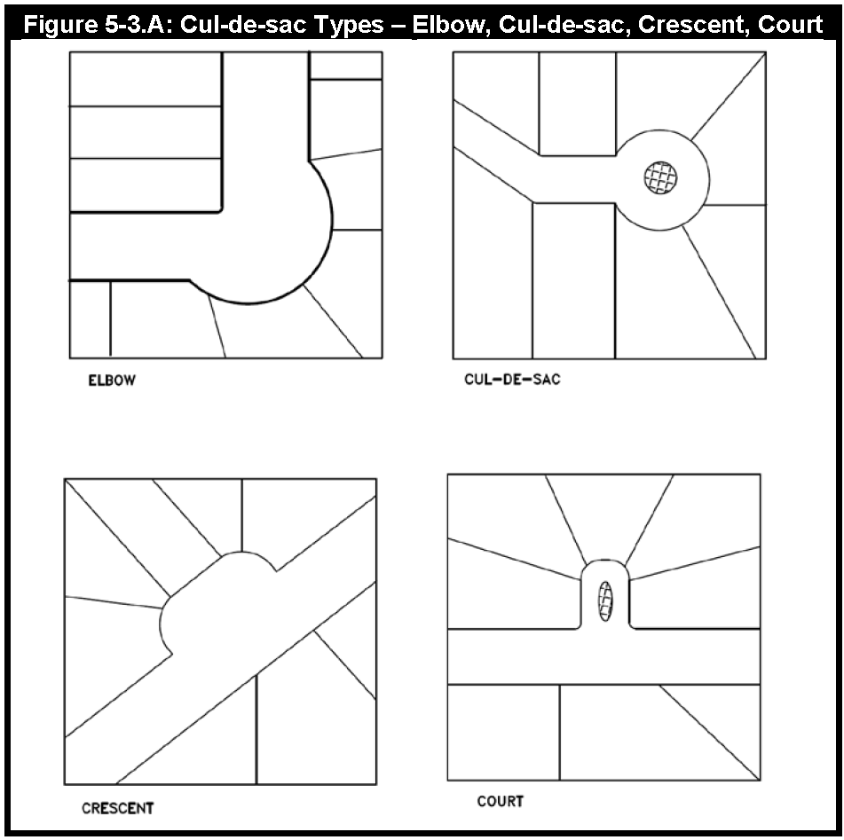
Figure 5-3.A
Dead-End Street: A street, other than a cul-de-sac with only 1 outlet.
Design Standards: The currently adopted document which provides the general requirements for the design of public improvements, private improvements that connect to or affect the public infrastructure and the supporting documents for approval in the City and its extraterritorial jurisdiction. Specific design criteria are included in the document. The Design Standards are incorporated into the Development Code as Chapter 6.
Development: A planning or construction project involving substantial property involvement and usually including the subdivision of land and change in land use character.
Development Review Committee: A committee of City staff members from various departments, such as Planning, Engineering, Building Permits and Inspections, Fire, and Public Works, tasked with reviewing and processing development applications.
Director: The person designated or assigned by the City Manager to administer the Subdivision Regulations or any other provisions of this Code. Director includes any person authorized to perform the duties of the Director.
Duplex: See Chapter 10 for definition.
Easement: Authorization by a property owner designating part of his or her property for the use by another for a specified purpose.
Engineer: A person duly authorized under the provisions of the Texas Engineering Registration Act, as heretofore or hereafter amended, to practice the profession of engineering and who is specifically qualified to design and prepare infrastructure construction plans, specifications and documents for subdivision development.
Final Plat: A map or drawing of a proposed subdivision prepared to meet all of the requirements for approval by the City. Distances shall be accurate to the nearest hundredth of a foot. The Final Plat of any lot, tract, or parcel of land shall be recorded in the records of Fort Bend County, Texas. A Short Form Final Plat is also Final Plat.
General Land Plan: A general or conceptual plan for an area proposed for partial or complete subdivision. The General Land Plan shall show the proposed locations of land uses, streets, phasing of development, important physical features, and other applicable information for the entire area to be developed.
Land Planner: Persons other than surveyors or engineers who also possess and can demonstrate a valid proficiency in the planning of residential, commercial, industrial, and other related developments, such proficiency often having been acquired by education in the field of landscape architecture or other specialized planning curriculum and/or by actual experience and practice in the field of land planning, and may be a member of the American Institute of Certified Planners.
Master Thoroughfare Plan: A plan adopted by the City Council which identifies the general routing and classification of proposed streets and thoroughfares. The plan may also establish the function and capacity of the various thoroughfares as they relate to the land uses they are proposed to serve.
Mews: See Chapter 10 for definition.
Middle Housing: See Chapter 10 for definition.
Minor Plat: A type of Final Plat that involves 4 or fewer lots or reserves fronting on an existing street that does not require the creation of any new street or the extension of municipal facilities. A Minor Plat is an Administrative Plat.
Off-Street Facility: Pedestrian and/or bicycle facilities located outside the paved area used by vehicles and includes Sidewalks, Sidepaths, and Shared Use Paths (trails).
On-Street Facility: Bicycle facilities located on the street, such as bicycle lanes, buffered bicycle lanes, shared lane markings, and cycle tracks.
Patio Home or Zero Lot Line Home: A single-family detached dwelling unit with a 0 building line on 1 side.
Pavement Width: The portion of a street available for vehicular traffic from back of curb to back of curb.
Person: Any individual, association, firm, corporation, governmental agency, or political subdivision.
Planned Unit Development (PUD): Land in the extraterritorial jurisdiction, under unified control, to be planned and developed as a whole in a single development operation or definitively programmed series of development operations or phases. PUDs promote the development of a tract of land in a unified manner and may allow for certain alternative standards from the established development standards for lot sizes, lot width, building lines, as established in this chapter.
Planning and Zoning Commission: Same as Commission. The Commission is appointed by the City Council under the provisions of the City Charter to approve subdivision plats and make recommendations on other planning issues as per City Charter.
Plat certificate: A certificate letter issued upon approval and recordation of the subdivision certifying that the subdivision has met all the requirements for a plat.
Point of Connection: A driveway connecting to a Public Street or Private Street that provides access into a development site. At a minimum, a Point of Connection must provide 1 ingress and 1 egress. For example, 1 Point of Connection can be a two-way driveway or 2 opposite-direction one-way driveways.
Preliminary Plat: A map or drawing of a proposed subdivision illustrating the general features of the development for review and approval by the Commission, but not suitable for recordation in the county records. The Preliminary Plat is designed to allow the subdivider to obtain approval of the general lot and street layout of a development prior to investment in detailed information contained in a Final Plat and related engineering public infrastructure construction plans.
Private Infrastructure: Infrastructure designated as private on a recorded plat, and may include streets, sidewalks, streetlights, and any other street related appurtenances.
Private Streets, Residential and Nonresidential: A privately owned and maintained street that is designated as such and is a separate reserve on a plat.
Property Owners Association: An incorporated association owned by or whose members consist primarily of the owners of the property covered by the dedicatory instrument and through which the owners, or the board of directors or similar governing body, manage or regulate the subdivision, planned unit development, condominium or townhouse regime, or similar planned development.
Public Improvements: Any improvement, facility, or service together with its associated public site or Right-of-Way necessary to provide transportation, drainage, water, sewer, or similar public services.
Public Utility: Any entity, other than the City, that provides utility services to the public, such as water, sewer, electric, or gas.
Radial Lot: A lot fronting onto a curvilinear street such as an elbow, cul-de-sac, crescent or court (see Figure 5-3.A.).
Record Plat: A plat of any lot, tract, reserve, or parcel of land that is recorded with the Fort Bend County clerk following final approval by the City.
Replat: The resubdivision of all or any part of a subdivision or any block or lot of a previously platted subdivision.
Reserve: A reserve is the same as a Lot and subject to the same platting requirements. Nonresidential lots are typically known as reserves within this Chapter.
Short Form Final Plat: A type of Final Plat that involves no more than 4 lots, tracts or reserves; located within an existing public street circulation system; meeting the existing zoning requirements if located within the City; does not propose to vacate public street Rights-of-Ways or easements; and meets other requirements as set forth in Sec. 5-12 of this Chapter. A Short Form Final Plat combines the requirements of a Preliminary Plat and a Final Plat into one process.
Sidewalk: A pedestrian facility adjacent to a roadway. The City's Design Standards identifies requirements for Sidewalks.
Sidepath: A shared pedestrian and bicycle facility adjacent to a roadway. The City's Design Standards identify requirements for Sidepaths.
Shared Use Path (Trail): A shared pedestrian and bicycle facility not adjacent to a roadway. The City's Design Standards identify requirements for Shared Use Paths.
Site Plan: A plan, to scale, showing uses and structures proposed for a parcel of land as required by the regulations. Site Plans include lot lines, streets, building sites, reserved open space, easements, driveways, and other features in accordance with graphic requirements identified in the Development Application Handbook.
Street: See Chapter 10 for definition.
Street Width (Rights-of-Way): The shortest distance between the lines which delineate the Rights-of-Way of a street.
Subdivider: Any person or any agent thereof dividing or proposing to divide land so as to constitute a subdivision as that term is defined herein. The term "subdivider" shall be restricted to include the owner, equitable owner, or authorized agent and is synonymous with developer.
Subdivision (also addition): A division of a lot, tract, or parcel into 2 or more Lots, tracts, or parcels or other divisions of land for sale or development; however, when such lot, tract, etc., is divided for sale or development and the remaining Lot is more than 5 acres, the remainder does not have to be platted. Subdivision shall include the dedication of public streets, access easements, utility easements and fire lanes. The resubdivision or replatting of lots in a previous subdivision is a subdivision.
Surveyor: A registered professional land surveyor, as authorized by state law, to practice the profession of surveying.
Townhome: A residential unit that shares at least 1 common or party wall with another unit. Each unit and the land upon which it stands is individually owned, subject to a party wall agreement with the adjacent owner.
Tract: A tract is the same as a Lot and shall be subject to the same platting requirements.
Zoning ordinance: The ordinance which sets forth land use regulations and standards within the corporate limits of the City.
B.
General definitions may be found in Chapter 10.
(Ord. No. 2373, § 7, 5-9-25)
Sec. 5-4. - Application of Regulations.
A.
Final Plat Required. No plat of a subdivision within the corporate limits or extraterritorial jurisdiction shall be recorded until a Final Plat, accurately describing the property, has been prepared in accordance with these subdivision regulations and approved by the City.
B.
Permits. No site plan, building permit, certificate of occupancy, plumbing permit, electrical permit, floodplain reclamation permit, or utility tap within the corporate limits shall be approved without a recorded plat or letter of plat exemption.
C.
Conformance with Regulations and Standards. Any subdivision within the city and its extraterritorial jurisdiction shall conform to these Subdivision Regulations, the City's current Design Standards and other applicable ordinances, development agreements and standards.
D.
Plat Approval Certification. In accordance with state law, the following procedures shall be followed before any utility service connection, including, but not limited to, water, gas, sewer and electricity, may be made or any such utility service provided:
1.
Upon approval of a plat by the City, the City shall issue to the person or entity applying for the approval of a certificate stating that the plat has been reviewed and approved by the City.
2.
Within 20 days of receiving a written request from an owner or a public utility, the Director shall make the following determinations regarding the owner's land or the land in which the public utility is interested and that is located within the City's platting jurisdiction:
a.
Whether a plat is required by law; and
b.
If a plat is required, whether a plat has been reviewed and approved by the City.
Such request shall identify the land by metes and bounds, address or other adequate legal description.
3.
If the Director determines that a plat is not required, the City shall issue to the requesting party a written certification within 10 days of that determination. If the Director determines that a plat is required, once a plat has been prepared, reviewed and approved by the City, the Director shall issue to the requesting party a Plat certificate.
Sec. 5-5. - Subject Developments.
The provisions of these subdivision regulations and the current Design Standards shall apply to the following forms of land subdivision and development activity:
1.
The division of land into 2 or more lots, tracts, reserves, sites or parcels;
2.
All subdivisions of land, whether by metes and bounds division or by plat, which were outside the jurisdiction of the City's subdivision regulations in Fort Bend County, Texas, and which subsequently came within the jurisdiction of the City's subdivision regulations through annexation or extension of the City's extraterritorial jurisdiction;
3.
The division of land previously subdivided or platted into tracts, lots, sites or parcels and not recorded, that were subject to and not in accordance with adopted City subdivision regulations in effect at the time of such subdividing or platting;
4.
The combining of 2 or more contiguous tracts, lots, sites or parcels for the purpose of creating 1 or more legal lots;
5.
The dedication or vacation of streets, fire lanes and alleys through any tract of land regardless of the area involved;
6.
The vacation of a previously recorded subdivision plat;
7.
Permanent public or semipublic spaces (such as golf courses, recreational uses, institutional uses, schools, open spaces or park areas, and similar uses); or
8.
Any other development on an undeveloped or semi-developed site within the corporate limits or extraterritorial jurisdiction.
Sec. 5-6. - Exemptions.
A.
The provisions of these subdivision regulations shall not apply to:
1.
Land legally platted and approved prior to the effective date of these subdivision regulations except as otherwise provided herein (construction of facilities shall conform to the current Design Standards in effect at the time of construction);
2.
Land constituting a single tract, lot, site or parcel for which a legal deed of record describing the boundary of such tract, lot site or parcel was filed of record in the Deed Records of Fort Bend County, Texas, on or before December 31, 1959;
3.
Sales of tracts of land by metes and bounds or tracts on which no improvements or alteration dividing the original tract is occurring;
4.
Existing cemeteries complying with all state and local laws and regulations (exemptions do not apply to new cemeteries or expansion of existing cemeteries);
5.
Divisions of land created by order of a court of competent jurisdiction; or
6.
Subdivision development that is exempt by state law.
B.
If platting is not required, the City shall issue a certificate of exemption prior to issuing a building permit or site plan approval in the City limits.
Sec. 5-7. - Purpose.
The purpose of this Article is to establish the procedures and requirements for the submittal, review, recommendation, consideration and action by the Commission and City Council to provide the necessary details and orderly processing of the subdivision of land in the City and its extraterritorial jurisdiction.
Sec. 5-8. - Preapplication.
The subdivider should seek the advice and assistance of the City and consult early and informally with the Director before preparing a land plan or the Preliminary Plat and before formal application for its approval.
Sec. 5-9. - General Land Plan.
A.
A property owner shall submit a General Land Plan to the City for review. The Commission must make a recommendation to City Council. City Council will consider and either approve, disapprove with reasons, or approve with conditions the General Land Plan. The General Land Plan must be approved prior to the submittal of any Preliminary Plat. A General Land Plan is required, except as noted below, for any tract of land over 50 acres in size proposed for residential use or any parcel proposed for nonresidential use over 30 acres. If the Director determines that an area less than 50 acres contains unique features or is surrounded by existing or proposed subdivisions with potential limited access, a General Land Plan may be required to be reviewed prior to the Preliminary Plat submittal.
B.
The purpose of the General Land Plan is to guide the design of subdivisions and allow the Commission and City Council to review the proposed major thoroughfare and collector street patterns, land use, environmental issues, the property's relationship to adjoining subdivisions or properties, and conformance to the Comprehensive Plan. General Land Plans shall meet the intent of the City's adopted Comprehensive Plan, guiding documents, and other policy guidance.
C.
Where a phased or partial development is proposed, the General Land Plan area shall include the entire property from which the phase is being subdivided. Where the applicant can demonstrate that natural or man-made features, such as thoroughfares and creeks, make unnecessary the inclusion of the entire property in the land plan to adequately review the items listed in the preceding paragraph, the subdivider may request approval from the Director for a submittal of a smaller land plan area. Boundaries such as thoroughfares (existing or proposed), creeks, political subdivisions, or other such natural or man-made features may be used to delineate the smaller plan area.
D.
A General Land Plan shall not be required if the Director determines that the Preliminary Plat(s) contains sufficient information to provide for the proper coordination of development.
E.
The General Land Plan shall be reviewed by the Parks and Recreation Director for conformance with park land dedication requirements prior to the recommendation of the land plan by the Commission. Substantial changes to the General Land Plan which may affect the park dedication requirements and park location shall be resubmitted for review.
F.
General Land Plan submittal package requirements (including graphic requirements, number of copies, and schedules) are contained in the Development Application Handbook as authorized in Section 5-17 of this Chapter. Submittals shall be accompanied by the required fee established by the Code of Ordinances.
G.
The filing date of an application for General Land Plan to be considered by the Commission shall be the date when the application is certified and marked "filed" by the Director that all information required by the application of these regulations have been properly submitted and all fees paid. The date the application is certified and marked "filed" is the date to be considered as the initial date of the statutory 30-day time period in which the Commission is required to act upon a General Land Plan submitted to it under the Texas Local Government Code.
At the time of the Commission review, the Commission will consider the General Land Plan and the written Director's recommendation and may take 1 of the following actions for a recommendation to the City Council:
1.
Recommend approval;
2.
Recommend disapproval with reasons;
3.
Recommend approval with conditions.
H.
The filing date of an application for General Land Plan to be considered by the City Council shall be the date when the application is approved by the Commission. The filing date of the application is the date to be considered as the initial date of the statutory 30-day time period in which the City Council is required to act upon a General Land Plan submitted to it under the Texas Local Government Code.
I.
Any General Land Plan or subdivision plat involving a change to a proposed corridor in the City Master Thoroughfare Plan shall be preceded by submission and approval of a traffic impact analysis if required by the Director. Failure to provide for such approval prior to submission of a General Land Plan may be grounds for denial.
J.
The approval of the General Land Plan by the City Council does not constitute approval of the subsequent plats within the plan boundaries.
(Ord. No. 2187, §§ 4, 5, 1-7-2020)
Sec. 5-10. - Preliminary Plats.
A.
General Requirements.
1.
A Preliminary Plat of any proposed subdivision shall be submitted for Commission approval in compliance with the requirements set forth in this chapter.
2.
Preliminary Plat submittal package requirements (including graphic requirements, number of copies, and schedules) are contained in the Development Application Handbook as authorized in Section 5-17 of this Chapter.
3.
Submittals shall be accompanied by the required fee established by the Code of Ordinances.
4.
The Preliminary Plat shall be in accordance with the General Land Plan, if applicable, and the approved Comprehensive Plan.
5.
The Preliminary Plat may be prepared by an engineer, land planner, or surveyor.
6.
The Director shall be furnished with copies of letters verifying contact with the following agencies:
a.
For plats located in the extraterritorial jurisdiction, Fort Bend County Drainage District, stating that the proposed subdivision is in compliance with the drainage requirements of Fort Bend County and any applicable fees have been addressed.
b.
For plats containing residential units, the appropriate school district official.
c.
All applicable utility companies including gas, electric, and telephone. A copy of the Preliminary Plat should be sent to the utility company at this time for the establishment of the easements.
d.
The appropriate post office.
e.
Any other applicable district or entity with jurisdiction in the area to verify adequate capacities and applicable fees.
Verification letters in response to applicant contact shall be received by the Director prior to the submission of the Final Plat for approval by the Commission.
7.
The filing date of an application for Preliminary Plat approval by the Commission shall be the date when the application is certified complete and marked "filed" by the Director that all information required by the application of these regulations have been properly submitted and all fees paid. The date the application is certified and marked "filed" is the date to be considered as the initial date of the statutory 30-day time period in which the Commission is required to act upon a plat submitted to it under the Texas Local Government Code.
8.
The Director shall review the Preliminary Plat for compliance with these regulations and make a written recommendation to the Commission before its consideration for approval. The subdivider or designated representative shall be provided with a copy of this report prior to the Commission meeting.
9.
Following review of the Preliminary Plat and other materials submitted, and discussions with the subdivider on changes deemed advisable and the kind and extent of improvements to be made, the Commission shall act thereon as submitted or modified. The Commission will consider the Final Plat and the written Director's recommendation and may take 1 of the following actions:
a.
Approve;
b.
Disapprove with reasons; or
c.
Approve with conditions.
10.
Approval of a Preliminary Plat by the Commission shall be deemed an expression of conditional approval to the layouts submitted on the Preliminary Plat as a guide for the preparation of the Final Plat and the future installation of streets, water, sewer, and other required improvements and utilities and to the preparation of the infrastructure construction plans. The subdivider is responsible for the resolution of the review conditions and any additional requirements of this chapter and other applicable ordinances.
11.
Approval of a Preliminary Plat shall be effective for 1 year.
12.
An extension of approval may be requested when submitted in writing at least 30 days prior to the expiration date. The fee for such extension shall be established by the Code of Ordinances.
13.
No construction work shall begin on the proposed public improvements in the subdivision prior to the approval of a Preliminary Plat by the Commission and approval of public infrastructure construction plans by the City. The subdivider may at their own risk undertake certain ground excavations for clearing, grading and drainage purposes. Any required permits shall be issued prior to commencement of work.
14.
A Preliminary Plat shall not be required if the proposed subdivision meets the criteria as set forth in Section 5-12 (Short Form Final Plat).
15.
Any plat within Sugar Land's extraterritorial jurisdiction shall also be subject to Fort Bend County platting requirements and the more restrictive requirements shall govern.
(Ord. No. 2187, §§ 6, 7, 1-7-2020)
Sec. 5-11. - Final Plats.
A.
A Final Plat and engineering infrastructure construction drawings and specifications are required for any area in the City or its extraterritorial jurisdiction. The Final Plat shall be in general conformance with the Preliminary Plat as approved and shall incorporate all conditions, changes, directions and additions approved by the Commission. If the Final Plat is in the City's extraterritorial jurisdiction, it shall also be approved by the County Commissioners Court prior to plat recordation. The Final Plat shall not be submitted for Commission approval until detailed engineering infrastructure construction plans have been submitted for review and approval by the City.
B.
The Final Plat shall constitute only that portion of the approved Preliminary Plat which the subdivider proposes to record and then develop. Such portion must conform to all the requirements of these regulations.
C.
The Final Plat and any Replats shall be prepared by a registered public land surveyor (RPLS).
D.
The filing date of an application for Final Plat approval by the Commission shall be the date when the application is certified complete and marked "filed" by the Director that all information required by the application of these regulations have been properly submitted and all fees paid. The date the application is certified and marked "filed" is the date to be considered as the initial date of the statutory 30-day time period in which the Commission is required to act upon a plat submitted to it under the Texas Local Government Code.
E.
The Director shall review the Final Plat for compliance with these regulations and make a written recommendation to the Commission. The subdivider or their designated representative shall be furnished with a copy of the written recommendation.
F.
The Commission will consider the Final Plat and the written Director's recommendation and may take 1 of the following actions:
1.
Approve;
2.
Approve with conditions; or
3.
Disapprove with reasons.
G.
With the approval of the Director, minor changes including addition of easements, correction of clerical errors or omissions may be made prior to submittal for signatures and recordation. A substantial change to the approved Final Plat prior to recordation shall require resubmittal to the Commission.
H.
Approval of the Final Plat is valid for 1 year from the date of approval for recordation. An extension of approval may be requested when submitted in writing at least 30 days prior to the expiration. Applicable fees may apply as identified in Chapter 2 of the Code of Ordinances.
I.
Prior to the submittal of the Final Plat for review and approval, engineering infrastructure construction plans showing paving and design details of streets, alleys, culverts, bridges, storm sewers, water mains, sanitary sewers and other engineering details of the proposed subdivision shall be submitted to the Director for review by the City Engineer. Such infrastructure construction plans shall be prepared by a registered professional engineer and shall conform to the current Design Standards and applicable ordinances adopted by the City of Sugar Land. Infrastructure construction plans must be approved prior to construction of any infrastructure and prior to the recordation of a Final Plat. Infrastructure construction plans will not be approved prior to the submittal of a Preliminary Plat.
J.
No construction work shall begin on the proposed private improvements, except Private Infrastructure, in the proposed subdivision prior to the approval and recordation of the Final Plat. No construction work shall begin on the proposed Public or Private Infrastructure in the proposed subdivision prior to the submittal and approval of engineering infrastructure construction plans in accordance with the current Design Standards. The subdivider may undertake certain ground excavations for grading and drainage purposes after required approvals are issued. Any excavation prior to approval of the Final Plat shall be at the subdivider's risk and any work done is to facilitate the subdivider's schedule and does not imply final approval of the work. In order to record an approved Final Plat that contains public infrastructure, either:
1.
The improvements must be constructed and initially accepted by the City, or
2.
Adequate security must be provided for the improvements, in accordance with Article V of this Chapter.
K.
Final Plat submittal package requirements (including graphic requirements, number of copies, and schedules) are contained in the Development Application Handbook as authorized in Section 5-17 of this Chapter. Submittals shall be accompanied by the required fee established by the Code of Ordinances.
L.
The Director shall be furnished with copies of letters from contacts with the following agencies:
1.
For the extraterritorial jurisdiction, Fort Bend County Drainage District, stating that the proposed subdivision is in compliance with the drainage requirements of Fort Bend County and any applicable fees have been addressed.
2.
For plats containing residential units, the appropriate school district official, stating that the school district has reviewed the land plan of the proposed subdivision and the preliminary subdivision plat for planning purposes.
3.
All applicable utility companies including gas, electric, and telephone, stating that the utility companies have knowledge of the proposed subdivision and are currently negotiating the necessary service easements. A copy of the proposed Final Plat should be sent to the utility company at this time for the establishment of the easements as determined by the utility company.
4.
Any other applicable district or entity with jurisdiction in the area to verify adequate capacities and applicable fees.
5.
A letter from the appropriate post office stating that postal service will be available is not required.
These verification letters must be received by the Director prior to the submission of the Final Plat for approval by the Commission.
(Ord. No. 2187, §§ 8, 9, 1-7-2020)
Sec. 5-12. - Short Form Final Plats.
A.
Short Form Final Plat combines the requirements of a Preliminary Plat and a Final Plat.
B.
Approval of subdivision under the Short Form procedure eliminates the necessity for a Preliminary Plat as required in Section 5-10.
C.
A Short Form Final Plat procedure may be requested if it meets the following requirements:
1.
No more than 4 lots, tracts or reserves are included;
2.
The area to be platted lies within an existing public street circulation system already approved by the Commission and recorded;
3.
The proposed development meets all the requirements of the existing zoning district, if within the City limits;
4.
The plat does not propose to vacate public street Rights-of-Way or easements;
5.
The plat does not propose creation or extension of public Rights-of-Way;
6.
The proposed development does not require any significant drainage improvements and if contained wholly or partially within the 100-year floodplain, conforms to Federal Emergency Management Agency floodplain management rules;
7.
The proposed development is consistent with the Master Thoroughfare Plan and creates no significant traffic congestion on the existing public street system; and
8.
The proposed development creates no requests for subdivision or zoning variances;
D.
This procedure shall not be available if there is evidence of previous repeated use of the Short Form procedure in a manner to circumvent the intent of this Chapter or the requirements for larger scale development, as determined by the Director;
E.
The Short Form Final Plat shall meet all of the requirements for a Final Plat in sections 5-11 and 5-17.
F.
Short Form Final Plat submittal package requirements (including graphic requirements, number of copies, and schedules) are contained in the Development Application Handbook as authorized in Section 5-17 of this Chapter. Submittals shall be accompanied by the required fee established by the Code of Ordinances.
Sec. 5-13. - Vacating of Plats.
A.
A plat may be vacated by request of the subdivider. In addition to the procedure outlined below and in conformance with Chapter 212 of the Texas Local Government Code, as amended, the submittal requirements for the vacation to the Commission are the same as for approval of a Final Plat.
B.
The plat vacating procedure is as follows:
1.
The owners of the tract covered by a plat may vacate the plat any time before any lot in the plat is sold. The plat is vacated when a signed, acknowledged instrument declaring the plat vacated is approved and recorded in the manner prescribed herein for a Final Plat.
2.
If lots in the plat have been sold, the plat, or any part of the plat, may be vacated on the application of all the owners of lots in the plat with approval obtained in the manner prescribed for the original plat.
3.
The County Clerk shall write legibly on the vacated plat the word "Vacated" and shall enter on the plat a reference to the volume and page at which the vacating instrument is recorded.
4.
On the execution and recording of the vacating instrument, the vacated plat has no effect.
C.
A vacated plat shall be approved by the Commission. The Commission may reject any vacation instrument which abridges or destroys any public rights in improvements, easements, streets, alleys, or similar public areas which are deemed by the City necessary to serve the surrounding area.
D.
An approved vacated plat must be recorded and operates to destroy the effect of the recording of the preceding plat and to divest all public rights to the streets, alleys, and other public areas laid out or described in the plat.
E.
Vacating Plat submittal package requirements (including graphic requirements, number of copies, and schedules) are contained in the Development Application Handbook as authorized in Section 5-17 of this Chapter. Submittals shall be accompanied by the required fee established by the Code of Ordinances.
Sec. 5-14. - Replats.
A.
A Replat is a redesign of all or a part of a recorded plat or subdivision of land which substantially changes the elements of the plat. The same procedures shall be followed as for Preliminary, Final or Short Form Final Plat. The Replat must be in accordance with the current Chapter 212 of the Texas Local Government Code. The application request for the public hearing (in the case of a variance being requested) for the Replat shall be made at least 30 days prior to a regularly scheduled Commission meeting.
B.
A Replat of a subdivision or part of a subdivision may be recorded and is controlling over the preceding plat without vacation of that plat if the Replat:
1.
Is signed and acknowledged by all the owners of the property being replatted;
2.
Does not attempt to amend or remove any covenants or restrictions.
3.
Is approved by the Commission.
C.
Additional Requirements for Certain Replats.
1.
In addition to compliance with paragraph B. above, a Replat without vacation of the preceding plat must conform to the requirements of this subsection C. if:
a.
During the preceding 5 years, any of the area to be replatted was limited by an interim or permanent zoning classification to residential use for not more than 2 residential units per lot; or
b.
Any lot in the preceding plat was limited by deed restrictions to residential use for not more than 2 residential units per lot.
The City shall provide written notification by mail of the approval of the replat, not later than the 15th day after the date the replat is approved, to each owner of a lot in the original subdivision that is within 200 feet of the lots to be replatted according to the most recent tax roll. This requirement does not apply if the City holds a public hearing along with written notice as part of a replat that requires a variance, as outlined in Section C.2 below. The written notification shall include the zoning designation of the property after the replat (for lots within corporate limits) and the phone number and e-mail address that an owner of a lot may use to contact the municipality about the replat.
2.
If a variance is requested by the applicant relating to the plat, a public hearing is required before the Commission can take action on the plat. Notice of the public hearing required for a plat in the case of a variance being requested shall be given before the 15th day before the date of the hearing by:
a.
Publication in an official newspaper or a newspaper of general circulation in Fort Bend County; and
b.
Written notice, with a copy of subparagraph c. below attached, forwarded by City to the owners of lots that are in the original subdivision and that are within 200 feet of the lots to be replatted, as indicated on the most recently approved municipal tax roll or in the case of a subdivision within the extraterritorial jurisdiction the most recently approved ad valorem tax roll within 200 feet of the property upon which the Replat with variance is requested. The written notice may be delivered by depositing the notice, properly addressed with postage prepaid, in a post office or postal depository within the boundaries of the City.
c.
If the proposed Replat requires a zoning variance or subdivision variance and is protested in accordance with this subparagraph, the proposed Replat must receive, in order to be approved, the affirmative vote of at least ¾ of all members of the Commission. For a legal protest, written instruments signed by the owners of at least 20% of the area of the lots or land immediately adjoining the area covered by the proposed Replat and extending 200 feet from that area, but within the original subdivision, must be filed with the City prior to the close of the public hearing. The property owners shall be furnished with these requirements with the written notice of the public hearing.
d.
In computing the percentage of land area under the subparagraph above, the area of streets and alleys shall be included.
e.
Compliance with subparagraphs c. and d. above is not required for approval of a Replat of part of a preceding plat if the area to be replatted was designated or reserved for other than single-family or duplex-family residential use by notation on the last legally recorded plat or in the legally recorded restrictions applicable to the plat.
3.
The Replat of the subdivision shall meet all the requirements for a new subdivision that may be pertinent, as provided for herein. It shall show the existing property being resubdivided. No Preliminary Plat shall be required on Replats if waived by the Director.
4.
The title shall identify the document under the main subdivision title as "Lots _____ being a Replat of Lots _____ of Block _____ of the _____ Subdivision." or in the case of non-residential as "Reserves _____ being a Replat of Reserves _____ of Block _____ of the _____ Subdivision." A reason for the Replat shall also be stated on the plat.
5.
A partial Replat of only the affected lots will be accepted when the conditions and/or options allowed by the amending plat procedure are not applicable.
D.
Replat submittal package requirements (including graphic requirements, number of copies, and schedules) are contained in the Development Application Handbook as authorized in Section 5-17 of this Chapter. Submittals shall be accompanied by the required fee established by the Code of Ordinances.
(Ord. No. 2187, §§ 10—12, 1-7-2020)
Sec. 5-15. - Administrative Plats—Amending Plats.
A.
Amending Plat procedure shall be in accordance with the current Chapter 212 of the Texas Local Government Code.
B.
An Amending Plat shall meet all of the informational requirements set forth for a Final Plat.
C.
The City Manager or Director may approve, and the Mayor shall sign, an Amending Plat that complies with this section. The City Manager or Director may, for any reason, elect to present the amending plat to the Commission, to approve or deny, as in the case of other plats. The City Manager or Director may not issue a denial of an Amending Plat. If the City Manager or Director refuses to approve the Amending Plat, the plat shall be referred to the Commission, as in the case of other plats, within the time period applicable to other plats. The Amending Plat, which may be recorded and is controlling over the preceding plat without vacation of that plat, may be approved if the Amending Plat is signed by the applicants only and is solely for 1 or more of the following purposes:
1.
Correct an error in a course or distance shown on the preceding plat;
2.
Add a course or distance that was omitted on the preceding plat;
3.
Correct an error in a real property description shown on the preceding plat;
4.
Indicate monuments set after the death, disability, or retirement from practice of the engineer or surveyor responsible for setting monuments;
5.
Show the location or character of a monument that has been changed in location or character or that is shown incorrectly as to location or character on the preceding plat;
6.
Correct any other type of scrivener or clerical error or omission previously approved by the municipal authority responsible for approving plats. Such errors may include, but are not limited to, lot numbers, acreage, street names, and identification of adjacent recorded plats;
7.
To correct an error in courses and distances of lot lines between 2 adjacent lots where both lot owners join in the application for amending the plat, neither lot is abolished, the amendment does not attempt to remove recorded covenants or restrictions, the amendment does not have a materially adverse effect on the property rights of the owners in the plat;
8.
Relocate a lot line to eliminate an inadvertent encroachment of a building or other improvement on a lot line or easement;
9.
Relocate 1 or more lot lines between 1 or more adjacent lots if:
a.
The owners of all those lots join in the application for amending the plat;
b.
The amendment does not attempt to remove recorded covenants or restrictions; and
c.
The amendment does not increase the number of lots.
10.
To make necessary changes to the preceding plat to create 6 or fewer lots in the subdivision or a part of the subdivision covered by the preceding plat if:
a.
the changes do not affect applicable zoning and other regulations of the municipality;
b.
the changes do not attempt to amend or remove any covenants or restrictions; and
c.
the area covered by the changes is located in an area that the municipal planning commission or other appropriate governing body of the municipality has approved, after a public hearing, as a residential improvement area; or
11.
To replat 1 or more lots fronting on an existing street if:
a.
the owners of all those lots join in the application for amending the plat;
b.
the amendment does not attempt to remove recorded covenants or restrictions;
c.
the amendment does not increase the number of lots; and
d.
the amendment does not create or require the creation of a new street or make necessary the extension of municipal facilities.
D.
Notice, a public hearing, and the approval of other lot owners are not required for the approval and issuance of an Amending Plat.
E.
When an Amending Plat is prepared, the surveyor shall be required to survey only those lots which are affected by the changes. The surveyor shall sign the replat stating the lots which have changed in addition to any other corrections which have been made.
F.
The property owners for the lots which are changed shall be the only additional signatures necessary to the original signatures.
G.
Final Plat submittal package requirements (including graphic requirements, number of copies, and schedules) are contained in the Development Application Handbook as authorized in Section 5-17 of this Chapter. Submittals shall be accompanied by the required fee established by the Code of Ordinances.
(Ord. No. 2187, § 13, 1-7-2020)
Sec. 5-16. - Administrative Plats—Minor Plats.
A.
The City Manager or employee designated by the City Manager may approve, and the Mayor shall sign, a Minor Plat, which is a plat involving 4 or fewer lots fronting on an existing street and not requiring the creation of any new street or the extension of municipal facilities.
B.
The City Manager or designated employee may, for any reason, elect to present the Minor Plat to the Commission for approval or denial, as in the case of other plats. The City Manager or designated employee may not issue a denial of a Minor Plat. If the City Manager or designated employee refuses to approve the Minor Plat, the plat shall be referred to the Commission, as in the case of other plats, within the time period applicable to other plats.
C.
Minor Plat submittal package requirements (including graphic requirements, number of copies, and schedules) are contained in the Development Application Handbook as authorized in Section 5-17 of this Chapter. Submittals shall be accompanied by the required fee established by the Code of Ordinances.
(Ord. No. 2187, § 14, 1-7-2020)
Sec. 5-17. - Submittal and Graphic Requirements.
A.
The Planning and Engineering departments are authorized to establish in writing policies and procedures, including submittal and graphic requirements, specifying the information that must be submitted to the City, including the form and manner of submission, for those development documents, including General Land Plans, Preliminary Plats, Final Plats, Amending Plats, Minor Plats, Site Plan Packages, Engineering Infrastructure Construction Plans, and certain other technical information related to infrastructure plans for development. These requirements are contained in the Development Application Handbook.
B.
Should applications not be submitted to the City as specified by the Development Application Handbook as authorized by this Section, the application will not be accepted by the City for consideration by the approving authority and is considered an incomplete submittal.
Sec. 5-18. - Plat Recordation.
A.
Within 1 year following the approval of the Final Plat, the subdivider may submit a recordation package containing the required number of originals to the City for signatures. The originals shall be on at least 3-mil camera-positive matte finish (both sides) film. All signatures must be clearly affixed in permanent black ink. All seals shall be affixed in black ink or a raised seal. Submissions under this section shall be in accordance with this Chapter and the Development Application Handbook.
B.
In addition to the recordation package, and prior to City signatures, the subdivider must submit:
1.
A current title commitment (or city planning letter) for the specified tract identifying the property owner, acreage, and any encumbrances on the property.
2.
Current original tax certificates.
3.
Verification that all requirements of applicable ordinances have been met, including specific requirements as authorized under executed Development Agreements with the subdivider when applicable.
4.
Approved Engineering Infrastructure Construction Plans. The subdivider has the option of constructing all public improvements and receiving initial acceptance, or providing adequate security to complete the improvements, in accordance with the provisions of Article V of this Chapter. Approval of engineering infrastructure construction plans shall be valid for 1 year, unless an extension is granted by the City Engineer.
5.
Certification that all required development fees have been paid.
6.
A copy of the proposed restrictive covenants.
C.
If the plat is within the City, the plat originals shall be forwarded by the City to the applicant for submittal to the County Clerk's Office for recordation.
D.
If the plat is in the extraterritorial jurisdiction, the plat originals shall be forwarded by the City to the applicant for submittal to the Fort Bend County Engineering Office for approval by Fort Bend County Commissioners Court and recordation.
E.
Upon recordation, an electronic copy of the recorded plat shall be provided to the City.
F.
Upon recordation, and once the subdivider has coordinated with the utility provider, the subdivider must submit an address map in accordance with the Development Application Handbook.
G.
No plat shall be released for filing unless all public improvements have been approved in accordance with the subdivision ordinance and the current Design Standards. Plat recordation is authorized once all public improvements have been constructed, or adequate security is provided to the City (in-City plats) or the County (ETJ plats) in accordance with Article V of these regulations.
(Ord. No. 2187, § 15, 1-7-2020)
Sec. 5-19. - Streets.
A.
General Provisions.
1.
The arrangement, character, extent, width, grade, and location of all streets shall conform to the Master Thoroughfare Plan and the current Design Standards, and shall be considered in their relation to existing and planned streets or driveways, to topographical conditions, to public safety and in their appropriate relation to the proposed uses of the land to be served by such streets.
2.
All streets shall be paved in accordance with the current Design Standards.
3.
All lots, tracts, and reserves shall have frontage on an approved Public Street, Private Street, Primary Access Easement, or as otherwise provided in this Section.
a.
Single-family Lots shall have frontage on an approved Public Street or Private Street.
b.
Nonresidential, townhome, and multifamily Lots, tracts, and reserves shall have frontage on an approved Public Street, Private Street, or Primary Access Easement provided that nonresidential subdivisions:
1)
Thirty-two acres or less may utilize a combination of Public Street, Private Street, and Primary Access Easements for access within and around the subdivision, subject to the provisions of this Section.
2)
More than 32 acres, in order to provide adequate vehicular circulation:
a)
Shall provide a Public Street or Private Street through the development connecting to a Public Street in 2 locations as far apart as possible, and
b)
Do not qualify for use of Primary Access Easements as the sole means of access through the subdivision.
3)
For the purposes of calculating the total acreage of a subdivision, all contiguous property under the same ownership must be included, and a property cannot be subdivided or its acreage calculated in separate pieces to avoid the requirements of this subsection.
c.
In the LPR district, Middle Housing lots shall have frontage on an approved Public Street, Mews, or Civic Space and vehicular access shall be provided via an Alley.
4.
No existing public street in a subdivision shall be converted to a private street.
5.
No private street in a developed subdivision shall be accepted as a public street.
6.
Maintenance access to a landscape, drainage or open space reserve may be provided through an adjoining reserve by access easement or use designation on the reserve.
7.
General transportation requirements. The provisions of this Section 5-19 (Streets) are subject to the applicable provisions of Chapter 1, Article II (Street System Improvements) of the Development Code.
B.
Residential Private Streets.
1.
Approval of Residential Private Streets. Residential Private Street may be approved:
a.
Within the City through a Planned Development (PD) District as authorized by Chapter 2, Article II of this Code, and
b.
Within the extraterritorial jurisdiction (ETJ) through a Development Agreement approved by City Council as authorized by Chapter 5, Article III of this Code.
c.
Once approved through a PD or a Development Agreement, the Final Plat must include plat notes reflecting the requirements for Private Streets established in this Section.
2.
Requirements for Residential Private Streets. Residential Private Streets must:
a.
Comply with the City's Design Standards for public streets.
b.
Be designated on the plat and the plat shall contain specific notes stating that the City is not responsible for the maintenance of private streets, sidewalks, or streetlights contained within the private subdivision section, and that the applicable property owner association shall be responsible for maintenance of the private infrastructure within the subdivision.
c.
Not be an Arterial or Collector Street on the Master Thoroughfare Plan, not adversely affect existing traffic circulation on adjacent public streets, and not have a negative impact on planning for the area.
d.
Have a maximum travel distance of 2,000 feet from a connecting Public Street, unless a specific approval is applied for and granted following a technical review by the City Engineer.
e.
Provide access to police, fire, emergency vehicles, utility operations and maintenance, and other municipal personnel as needed, and such access be so noted on the plat.
f.
If gated, have access control devices located in accordance with the Design Standards, and meet other regulations adopted by the City, including redundancy requirements. The developer shall provide to the City all equipment necessary to operate the access control devices, as determined by the City and at no cost to the City. Access control devices must comply with specifications required by the City Fire Marshal.
g.
Include a readily visible sign giving notice that the street is private.
3.
Developer Obligations for Residential Private Streets. The developer shall record subdivision covenants approved by the City prior to the sale of any lot in the subdivision. Covenants shall require at a minimum that:
a.
Property owners shall pay monthly or annual assessments into a maintenance and capital replacement fund restricted for use for maintenance and repair cost for the Residential Private Streets in the subdivision.
1)
The monthly or annual assessments shall be initially established in an amount that will, at the end of the first 5 years of the assessments, not be less than 3% of the initial cost, adjusted for inflation, of constructing the private infrastructure in the subdivision.
2)
Thereafter, the monthly or annual assessment shall be established in an amount that will, at the end of 35 years, not be less than the reconstruction cost of the private infrastructure, adjusted for inflation.
3)
The property owners association shall utilize this maintenance and capital replacement fund to maintain the private infrastructure in the subdivision.
b.
Property owners shall pay monthly or annual assessments to perpetually maintain the markings or postings required for fire lanes and the required signs giving notice of the private street and to provide access control mechanisms for emergency vehicles.
c.
Homeowners release the City from any damage to the Residential Private Streets and sidewalks that may be caused by maintenance, repair or replacement of public utilities.
4.
Residential Private Streets Accounting Report. The Property Owners' Association responsible for maintaining Residential Private Streets established after July 21, 2015, shall:
a.
Submit to the City an affidavit setting forth an annual financial report, using a standard City format, indicating the funds set aside in the required private street maintenance and capital replacement fund.
b.
10 years after first certification of compliance of a private street within a development, provide to the City every 5 years a reserve fund study for private infrastructure, using a standard City format. The reserve fund study must be signed and sealed by a registered engineer. The study shall include, but not be limited to, the following:
1)
Location of infrastructure,
2)
Age of infrastructure,
3)
Expected life of infrastructure,
4)
Cost to replace infrastructure,
5)
Funds in maintenance and capital replacement fund account:
a)
Maintenance and capital replacement fund must comply with required funding of this Section.
6)
Determination of whether funds will be sufficient to maintain and replace private infrastructure, and
7)
Determination whether assessments need to be increased to retain sufficient fund for maintenance and replacement of private infrastructure.
C.
Nonresidential Private Streets.
1.
Nonresidential Private Streets may be utilized when a subdivider constructs a street serving nonresidential reserves that will serve the functions of a typical public street but be privately owned and maintained. Access is provided to individual lots or reserves by a private platted street shown as a Reserve on the plat. Nonresidential Private Streets may be approved:
a.
Within the City through a Planned Development (PD) District as authorized by Chapter 2, Article II of this Code, and
b.
Within the extraterritorial jurisdiction (ETJ) through a Development Agreement approved by City Council as authorized by Chapter 5, Article III of this Code.
c.
Once approved through a PD or a Development Agreement, the Final Plat must include plat notes reflecting the requirements for Private Streets established in this Section.
2.
Nonresidential Private Streets must:
a.
Comply with all City codes and standards for public streets.
b.
Be designated on the plat and the plat shall contain specific notes stating that the City is not responsible for the maintenance of private infrastructure contained within the private subdivision section, and that the applicable property owner association shall be responsible for maintenance of the private infrastructure within the subdivision.
3.
The Developer shall record subdivision covenants approved by the City prior to the sale of any lot or reserve in the subdivision. Covenants shall require at a minimum that:
a.
Property owners shall pay monthly or annual assessments into a maintenance and capital replacement fund restricted for use for maintenance and repair cost for the Nonresidential Private Streets in the subdivision.
1)
The monthly or annual assessments shall be initially established in an amount that will, at the end of the first 5 years of the assessments, not be less than 3% of the initial cost, adjusted for inflation, of constructing the private infrastructure in the subdivision.
2)
Thereafter, the monthly or annual assessment shall be established in an amount that will, at the end of 35 years, not be less than the reconstruction cost of the private infrastructure, adjusted for inflation.
3)
The property owners association shall utilize this maintenance and capital replacement fund to maintain the private infrastructure in the subdivision.
b.
Property owners shall pay monthly or annual assessments to perpetually maintain the markings or postings required for fire lanes and the required signs giving notice of the private street and to provide access control mechanisms for emergency vehicles.
4.
Primary Access Easements. A Primary Access Easement is a privately maintained main access route that serves 1 or more lots or reserves, but does not typically serve the full function of a public or private street (see Figures 5-19.A and 5-19.B). Primary Access Easements may be required when shared driveway access is necessary to meet driveway spacing requirements along a Public Street or Private Street.
a.
For lots, tracts, or reserves, with frontage on a public or private street, a connection to a Primary Access Easement is not required if the development has the acreage (X) and minimum points of connection (Y) as identified in the following chart:
b.
For the purposes of calculating the total acreage of a development:
1)
All contiguous property under the same ownership must be included, and a property cannot be subdivided or its acreage calculated in separate pieces to avoid the requirements of this subsection.
2)
When 2 properties share a driveway, the total acreage and Points of Connection may be calculated together to determine if a Primary Access Easement is required.
Figure 5-19.A
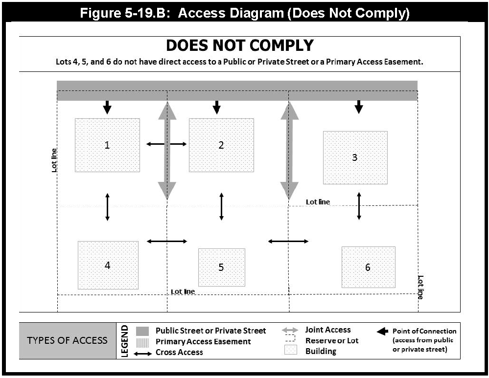
Figure 5-19.B
c.
Primary Access Easements in the City and the ETJ shall comply with the following requirements: (see Figure 5-19.C and Figure 5-19.D)
1)
Minimum number of traffic lanes: 2 lanes
2)
Minimum lane width: 11 feet
3)
Easement width: 23 feet
4)
Minimum vertical clearance: 15.5 feet
5)
Minimum lateral clearance: 6 feet
6)
On-street parking is prohibited
7)
Sidewalks.
a)
Sidewalks shall be a minimum of 5 feet wide.
b)
A 3 foot clear area shall be located between the curb and the sidewalk.
c)
If the Primary Access easement serves a single lot, tract, or reserve, a sidewalk is only required on one side of the Primary Access Easement. If the Primary Access Easement serves 2 or more lots, tracts, or reserves, sidewalks are required on both sides of the Primary Access Easement.
d)
If the street to which a Primary Access Easement connects is not required to have pedestrian and bicycle facilities, the Primary Access Easement is not required to have sidewalks. However, if a Primary Access Easements connects to multiple streets, and one of the streets is required to have pedestrian and bicycle facilities, the Primary Access Easement must have sidewalks.
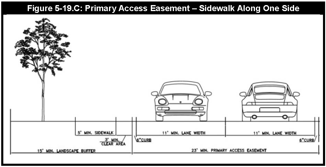
Figure 5-19.C
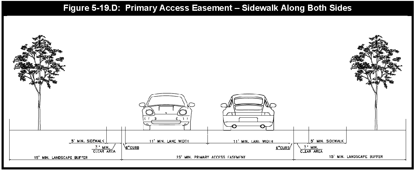
Figure 5-19.D
8)
Paving. Primary Access Easements shall follow paving standards specified in the Design Standards for public streets. Primary Access Easements may use enhanced or alternative paving materials as approved by the City Engineer.
9)
Easements. Where a Primary Access Easement is located on a common property line between 2 reserves, the Easement shall be evenly divided between both reserves.
10)
Vehicle intrusion. Sidewalks adjacent to Primary Access Easements must be protected from vehicle intrusion by curbs or similar Structures. Where head-in parking is provided adjacent to a sidewalk, a 3-foot clear area shall be provided between the sidewalk and head-in parking see (Figure 5-19.E).
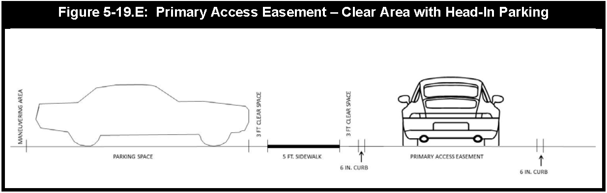
Figure 5-19.E
11)
Pedestrian Public Access Easement. A public access easement allowing for pedestrian public access shall be provided on the plat or recorded by separate instrument.
12)
Maintenance Agreement. A recorded maintenance agreement indicating specific maintenance provisions between the property owners shall be submitted to the City prior to the approval of a Site Plan Package containing a Primary Access Easement.
13)
Flag Lots. Flag lots may not be used to circumvent the requirement for a Primary Access Easement (see Figure 5-19.F).
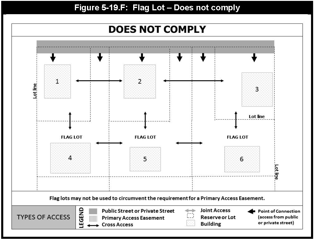
Figure 5-19.F
14)
Primary Access Easement shall serve as a public access easement for all City and County services including police, fire, emergency vehicles, and utility operations and maintenance personnel and shall be so noted on the plat.
15)
Alternative standards for Primary Access Easements may be approved by the City Engineer as per Sec. 5-54.
d.
In addition to the aforementioned requirements, Primary Access Easements in the City shall comply with the following:
1)
Lighting. Lighting must comply with the street lighting standards established in the Design Standards.
2)
Landscaping and Street Trees. Trees shall be planted within the landscape area adjacent to the sidewalk and may not be located in the clear area between the curb and sidewalk. See Article XV: Landscaping and Screening Regulations for additional requirements.
D.
[Reserved.]
E.
Additional Regulations.
1.
The minimum requirements for design and construction of streets are detailed in the Design Standards.
2.
Streets Not in Master Thoroughfare Plan. When a street is not on the Master Thoroughfare Plan, the arrangement of streets in a subdivision shall:
a.
Provide for the continuation or appropriate protection of existing streets in surrounding areas; or conform to a plan for the neighborhood approved or adopted by the City to meet a particular situation where topographical or other conditions make continuance or conformity to existing streets impracticable.
b.
Provide for future access to adjacent vacant areas which will likely develop in the future.
c.
Resolve alignment with existing Right-of-Way and driveway openings.
3.
Minor Residential Streets. Minor residential streets shall be so designed that their use by through traffic will be discouraged.
4.
Street Widths. Street Right-of-Way widths shall be as shown on the Master Thoroughfare Plan.
5.
Half Streets. Half streets shall be prohibited, except when essential to the reasonable development of the subdivision in conforming with the other requirements of these regulations and the Master Thoroughfare Plan, and where the City Council finds it will be practical to require the dedication of the other ½ when the adjoining property is subdivided. Whenever a partial street previously has been platted along a common property line, the other portion of the street shall be platted.
6.
Dead-End or Stub Streets. Dead-end or stub streets are temporary in nature and are not allowed except to provide for access to adjacent land areas and in no case shall be more than 250 feet in length or equal to 1 lot depth, whichever is greater. A temporary turnaround shall be provided and indicated on the plat.
7.
Street Access Buffers. To prevent access from abutting undeveloped property, the City may approve a plat with an undedicated strip of land parallel to the plat boundary where any portion of a proposed street abuts undeveloped acreage. The plat shall specifically provide that the undedicated strip of land will automatically terminate and be dedicated for and may be used for street Right-of-Way when construction of a connecting street is undertaken by a governmental entity or otherwise approved for connection in accordance with City regulations. Except as required by the City in this Article as "street access buffers," strips of land controlling access to or egress from other property, or to or from any street or alley, or having the effect of restricting or damaging the adjoining property for subdivision purposes, or which will not be taxable or accessible for special improvements, shall not be permitted in any subdivision.
8.
New Streets. New streets which are an extension of existing streets shall bear the names of existing streets and shall be dedicated with appropriate transitions and widths.
9.
Street Names. New street names shall not be named to duplicate or cause confusion with existing street names. New street names shall be approved by the Commission when the Final Plat is approved. Courts shall have street names. Crescents and elbows shall not have separate street names. Streets that have no houses fronting on them shall also have a street name.
10.
Street Lighting. Street lighting shall conform to the latest edition of the Illuminating Engineering Society Handbook and City's Design Standards. Prior to the recordation of the Final Plat, the developer shall pay to the City current cost of acquiring and installing the street lights along public streets and the cost of operating and maintaining the street lights for 3 years, as determined by the City.
F.
Alleys.
1.
Nonresidential Alleys. Alleys shall be allowed in commercial and industrial districts, except that the City may require that definite and assured provision is made for service access, such as off-street loading, unloading and parking consistent with and adequate for the use proposed.
2.
Residential Alleys. Unless required by a property's zoning designation, alleys shall not be required but may be allowed to connect to a subdivision with existing alleys for the purpose of providing continuity on providing parallel secondary access.
3.
Dead-End Alleys. Permanent dead end and "hammerhead" alleys are prohibited. All alleys shall have adequate turnouts and street entrances such that vehicular traffic flow is continuous and efficient. Where a temporary dead end alley situation is unavoidable (such as due to project phasing), a temporary, paved cul-de-sac or turnout onto a street, either of which will require a temporary alley easement, shall be shown on the plat. If a permanent dead-end alley is unavoidable due to unique, site-specific constraints, an adequate turnaround facility shall be provided as determined by the City Engineer.
4.
Alleys may not exceed a maximum length 1,400 feet unless otherwise approved by a Specific Approval by the City Engineer. The maximum length for alleys that serve lots that front on Mews or Civic Space is 500 feet.
5.
Alleys shall be constructed to meet the requirements of the Design Standards.
(Ord. No. 2373, § 8, 5-9-25)
Sec. 5-20. - Blocks.
A.
The length, width, and shapes of blocks shall be determined with due regard to:
1.
Provision of adequate building sites suitable to the special needs of the type of use contemplated.
2.
Zoning requirements as to lot sizes, setbacks, and dimensions, if applicable.
3.
Needs for convenient access, circulation, control, and safety of street traffic.
B.
Length and widths shall be in conformance with the Design Standards. In general, intersecting streets, determining the blocks, lengths and widths, shall be provided at such intervals as to serve cross-traffic adequately and to meet existing streets or customary subdivision practices.
1.
Minimum block length 500 feet; however, in cases where physical barriers or property ownership creates conditions where it is appropriate that these standards be varied having due regard for connecting streets, circulation of traffic and public safety. The minimum block length in the LPR District shall be 200 feet.
2.
Maximum block length 1,200 feet, except where no existing subdivision controls, the block length may increase to 1,400 feet. The maximum block length in the LPR District shall be 600 feet.
3.
When possible, the block width or depth shall allow 2 tiers of lots back-to-back except when prevented by the size of the property or the need to back on an Arterial street identified. When adjacent to an Arterial street, the subdivider may not double front lots.
C.
Blocks shall be numbered consecutively within the overall plat.
(Ord. No. 2373, § 9, 5-9-25)
Sec. 5-21. - Lots.
Except as provided herein, all Lots must conform to the requirements of this Section. For Lots located within the City's corporate limits, if there is a conflict between the provisions of this section and the provisions of the zoning regulations of Chapter 2 of this Code, the zoning regulations control.
1.
Lots shall be laid out, wherever physically possible, so that a lot is not split by a jurisdictional boundary.
2.
Lot widths are measured as follows:
a.
Lot fronting on a straight front lot line: The length of the front lot line (see Figure 5-21.A).
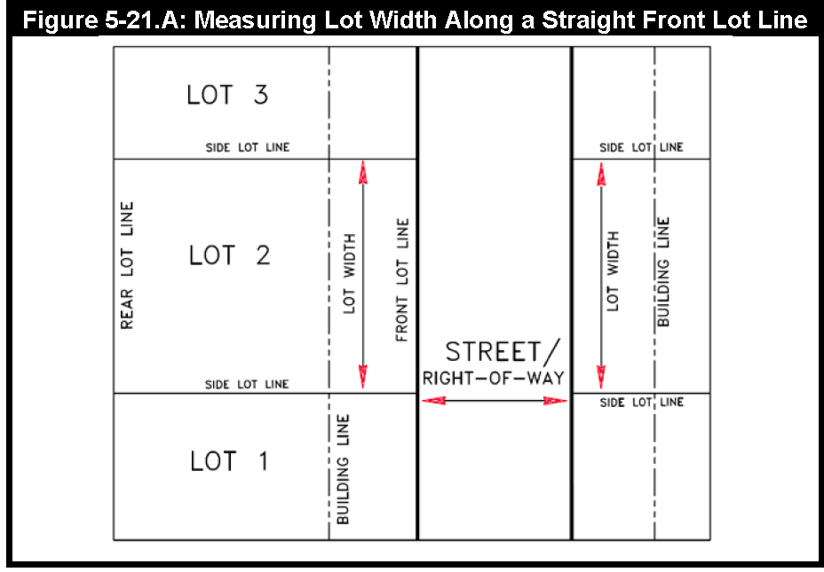
Figure 5-21.A
b.
Lot located on the outside of the arc of a curved Right-of-Way: The length of the shortest line that connects the side lot lines and is tangent to the required front building line (see Figure 5-21.B).
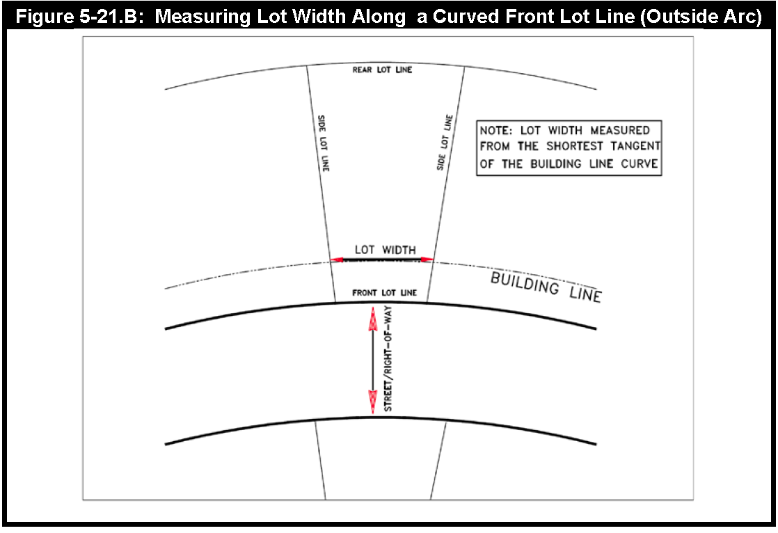
Figure 5-21.B
c.
Lot located on the inside of the arc of a curved Right-of-Way: The length of the straight line that connects the 2 points at which the required front building line intersects the side lot lines (see Figure 5-21.C).
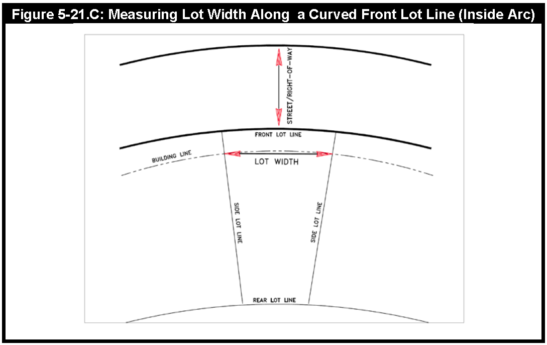
Figure 5-21.C
d.
Other irregular lots. (Irregular building lot lines or side lot lines not perpendicular or radial to the street Right-of-Way): The length of the shortest line tangent to the required building line drawn in a location that demonstrates a building area width similar to that of regular lots (see Figure 5-21.D).
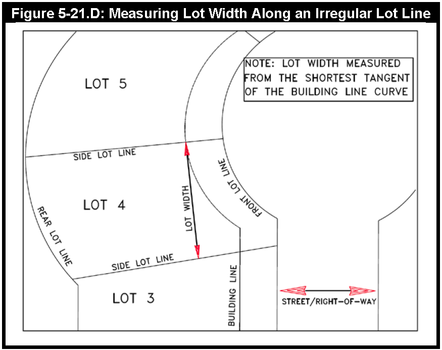
Figure 5-21.D
3.
Residential lots shall meet the following minimum lot requirements in Table 5-21.1:
4.
Side lot lines should be generally at right angles or radial to the street Right-of-Way lines.
5.
Double frontage and reverse frontage lots shall be avoided except where essential to provide separation of residential development from Arterial Streets designated on the Master Thoroughfare Plan or to overcome specific problems of topography and orientation. Where lots have double frontage, a front building line shall be established for each street and access shall not be allowed from the Arterial Street.
6.
Each subdivision must provide 1 access street to a collector street for each 75 lots, or portion thereof, within the subdivision. The requirement applies to each platted phase of a subdivision. In this paragraph, a "collector" street means a street that meets the Geometric Street Design Standards for collector streets as set forth in the Sugar Land Design Standards.
7.
Lots may be labeled with their proposed use or as unrestricted reserves. Lots reserved for landscape and detention uses may also be designated as utility easements.
Sec. 5-22. - Building Lines (Setbacks).
Final Plats shall show front and street side building lines (setbacks). All lots within the City shall provide at least the minimum setbacks as required by the zoning ordinance. All setbacks within the City's extraterritorial jurisdiction shall be as follows:
1.
Residential Building Line Requirements.
a.
Where a reserve is located between a lot Side Yard and the street, the reserve shall have a minimum width 10 feet (see Figure 5-22.A).
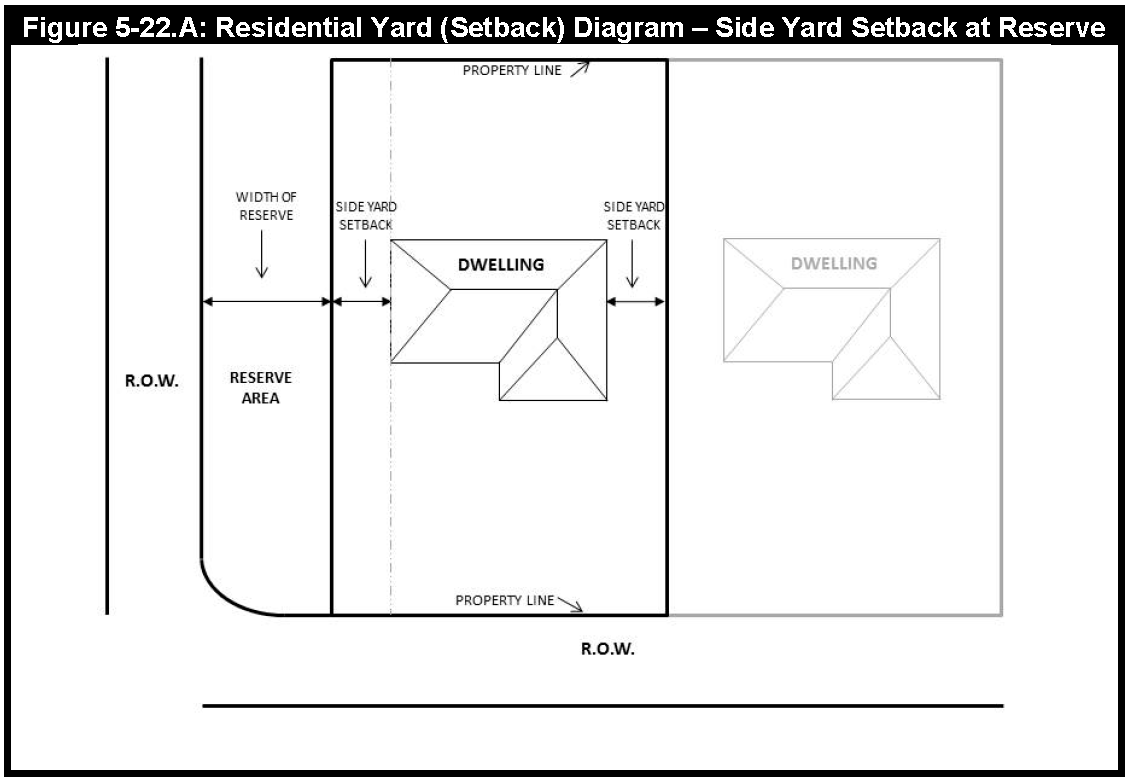
Figure 5-22.A
b.
Private Garages shall be set back a minimum of 20 feet from the street side property line.
c.
A 25-foot rear Building Line is required when the lot backs on an Arterial or Collector street, or on a lake or waterway.
d.
The transition from a 15-foot to a 25-foot building line shall occur at an angle of 45 degrees.
e.
The 5-foot side building line may be indicated by note on the plat rather than on each lot. The 20-foot setback requirement for Private Garages on corner lots may be indicated by note.
f.
Every part of a required side yard shall be open and unobstructed except for fencing and the ordinary projections of window sills, belt courses, cornices, and other architectural features not to exceed 12 inches into the required side yard, and roof eaves projecting not to exceed 24 inches into the required side yard.
g.
All Private Garages, accessory buildings and uses shall be located completely within the building lines.
2.
Nonresidential and Multifamily Lots. Multifamily and nonresidential lots shall meet the following minimum setback requirements:
3.
Where a platted Lot abuts that portion of a Street that contains a turn lane that prevents the Lot from meeting the same minimum setback requirements of adjacent Lots in the same block that do not abut the turn lane, the required setback of the Lot shall be measured from a line determined by extending the same Building Line that determines the same minimum setback required of the adjacent Lots located on the same side of the Street and within the same block that do not abut the turn lane (see Figure 5-22.B).
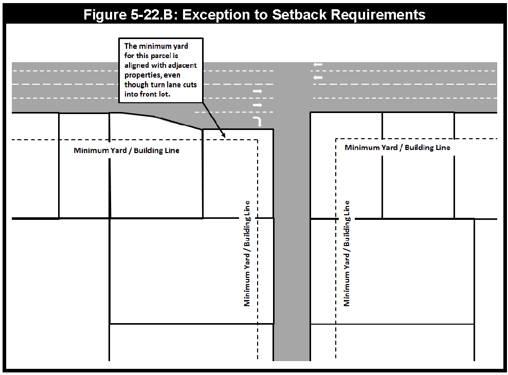
Figure 5-22.B
Sec. 5-23. - Adoption of Design Standards.
A.
The City of Sugar Land Design Standards, dated June 2007, as amended, are adopted in furtherance of the implementation and administration of this Chapter.
B.
The City Engineer may from time-to-time add to, delete from, or revise the Design Standards without Council action if the revision:
1.
Does not conflict with a provision of this Chapter;
2.
Is for the purpose of providing detailed or technical specifications, requirements, or procedures applicable to the matters regulated under this Chapter, but does not implement new substantive regulations or requirements not addressed in this Chapter;
3.
Is adopted in compliance with written procedures, as approved by the City Manager, that provide for public notice, an opportunity for public comment, and consideration of any public comments prior to adoption; and
4.
Is approved by the City Manager.
C.
Any person required to comply with a provision of this Chapter must also comply with any applicable provisions of the Design Standards as a condition of approval of any activity, permit, plat, or other approval required under this Chapter or the Design Standards.
Sec. 5-24. - Utility Easements and Services.
A.
All utility easements for water, sanitary sewer, and storm sewer must be shown on the Final Plat.
B.
Where a subdivision is traversed by a watercourse, ditch, drainage way, or channel, the subdivider must provide a storm sewer easement or drainage Right-of-Way conforming substantially with the course and of such additional width as may be designated by the City or Fort Bend County Drainage District, subject to determination using proper engineering considerations. Maintenance easements must be specified.
C.
All lots, tracts and reserves shall be served by public water, sanitary sewer and storm sewer. These public improvements shall be designed, constructed, inspected, and accepted according to the latest edition of the Design Standards, Comprehensive Plan, Water and Wastewater Master Plan, and any other applicable plans approved for the area by the City, or the utility district's utility plans, whichever is applicable.
D.
All utility service lines for residential distribution for electricity, telephone, gas, cable television and any other such service shall be underground with the exception of electric major transmission (three-phase lines) or feeder lines. These lines shall be located on the perimeter of a subdivision whenever possible, but not along street Rights-of-Way. It is recommended that commercial developments have an underground feed from the nearest power line for individual service. The standards for easement requirements for utility service lines are stated in this Section.
E.
Easements must conform to the following regulations:
1.
Water Related Easements.
a.
Fire hydrants located outside of a street Right-of-Way or water line easement must be placed in a 10-foot by 10-foot easement. Water lines leading and connecting to fire hydrants that are not adjacent to a Right-of-Way must be public and placed within a minimum 10-foot easement.
b.
Water lines leading and connecting to fire hydrants shall be placed within Landscaped areas in order to provide maintenance access. The City Engineer may consider a Specific Approval to deviate from this standard where unique, site-specific constraints exist.
c.
Water meters 2 inches and smaller in diameter may be set in a street Right-of-Way or water line easement.
d.
Water meters larger than 2 inches in diameter must be set in a 10-foot by 20-foot water meter easement. Variations for the placement of multiple meters require specific approval.
e.
Water mains located in easements not adjacent to street Rights-of-Way must be centered in a 16-foot wide easement.
f.
Water lines located between 2 single-family homes may be centered in a 10-foot wide easement if the line is cased in C900 casing from the front building line to within 15 feet of the rear lot line, leaving non-cased pipe at the rear lot line, and having gate valves on both ends of the line in order to isolate the section.
g.
Water lines, except at a flush valve, located in a street Right-of-Way less than 5 feet from the street Right-of-Way line must have a water line easement adjoining the street Right-of-Way. Easements adjoining a street Right-of-Way for water lines smaller than 12 inches in diameter must have a minimum width of 5 feet. Easements adjoining a street Right-of-Way for water lines 12 inches or greater in diameter must have a minimum width of 10 feet.
2.
Sanitary Sewer Easements.
a.
Rear lot sanitary sewer lines are not permitted in new residential developments.
b.
The minimum width of a sanitary sewer easement is 16 feet.
c.
The preferred location for sanitary sewers is in the street Right-of-Way. Sanitary sewers placed at a depth of less than 10 feet below grade and within 5 feet of the edge of a street Right-of-Way must have an exclusive 5-foot sanitary sewer easement adjoining the street Right-of-Way or easement. Sanitary sewers placed at a depth equal to or greater than 10 feet below grade and within 5 feet of the edge of street Right-of-Way must have an exclusive 10-foot sanitary sewer easement adjoining the street Right-of-Way or easement.
d.
Easements for force mains of all sizes must have a minimum width of 16 feet for a single force main when the force main is not located adjacent to a street Right-of-Way. When the force main is located in an easement adjacent to a street Right-of-Way, the force main must be located at the center of a 10-foot wide easement. When the force main is located less than 5 feet from the street Right-of-Way line within the street Right-of-Way, the force main must have an easement adjacent to the street Right-of-Way with a minimum width of 5 feet.
e.
Sanitary sewer mains, trunk or force mains must be located so that the centerline of the pipe is at least 7½ feet from the edge of the easement.
f.
Where sanitary sewers or force mains are installed in easements separated from street Rights-of-Way by other private or utility company easements, the sanitary sewer easement must be extended along or across the private utility company easement to provide access for maintenance of the sewer or force main.
g.
Combined storm and sanitary sewer easements must have the minimum widths as required for storm sewer easements below. When placed in a combined storm and sanitary sewer easement, sanitary sewer mains, trunk or force mains must be located so that the centerline of the pipe is not less than 7½ feet from the edge of the easement.
h.
For combined storm and sanitary sewer easements located adjacent to public Rights-of-Way where the sanitary sewer is located along the outside of the easement, the centerline of the sanitary sewer pipe must be located at least 7½ feet from the edge of the easement.
3.
Storm Sewer Easement.
a.
Storm sewers located in an easement adjacent to a street Right-of-Way or other public easement must have a minimum easement width of 10 feet.
b.
Storm sewers not located in an easement adjacent to a street Right-of-Way or other public easement must have a minimum easement width of 20 feet. All storm sewers must be constructed in the center of the easement.
c.
Storm sewers with a diameter or width greater than 10 feet but less than 15 feet have a minimum easement width of 25 feet.
d.
The City Engineer will determine the minimum easement width for a storm sewer greater than 15 feet in diameter or width.
e.
Storm sewers with a flow line depth between 15 feet and 20 feet must have a minimum easement width of 40 feet.
f.
Storm sewers with a flow line depth greater than 20 feet must have a minimum easement width of 50 feet and require a specific approval through the process outlined in the Design Standards.
g.
Storm sewers must be located so that there is at least 5 feet from the outside edge of the storm sewer to the edge of the easement.
h.
When approvals are granted for a special use or combination easement along a side or back lot line, the minimum easement width is 25 feet.
4.
Drainage Maintenance Easements.
a.
All dry detention basins shall have a maintenance easement for drainage dedicated around the detention facility. The easement shall include a maintenance strip measured from top of bank to a width defined in the table below (see Table 5-24.1 and Figure 5-24.A).
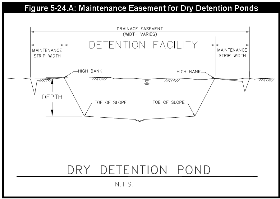
Figure 5-24.A
b.
All wet ponds and amenity lakes shall have a maintenance easement for drainage dedicated around the drainage facility. The easement shall include a maintenance strip measured from top of bank to a width defined in the table below (see Table 5-24.2 and Figure 5-24.B).
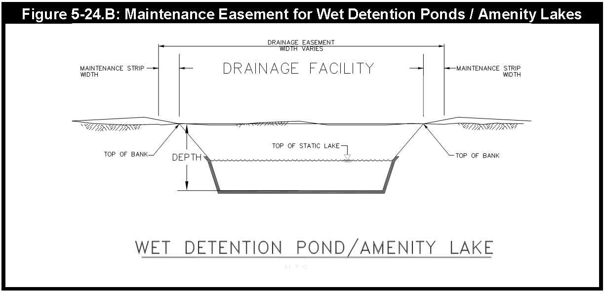
Figure 5-24.B
5.
Public Dry Utilities.
a.
Dry utility easements shall comply with requirements set forth by applicable utility companies. Easements may be split equally between 2 adjoining lots. Except as otherwise specified by the utility companies:
1)
Electric, phone and cable services require a minimum easement of 14 feet,
2)
Street lights require a minimum easement of 5 feet, and
3)
Call boxes require a minimum easement of 5 feet.
Sec. 5-25. - Noise Mitigation Barriers.
A.
Definitions. In this Section:
1.
Major Street means an Arterial street, highway, freeway, or the frontage road of a freeway or highway.
2.
NMB means a noise mitigation barrier.
3.
Residential use means a single-family attached dwelling, a single-family detached dwelling, or a two-family dwelling.
B.
General Requirement. Any person that plats a subdivision in which the rear or street side yard of a lot within the subdivision proposed for residential use abuts upon the Right-of-Way of a Major Street must provide for the installation and the maintenance of a NMB as a buffer for those lots as provided for in this paragraph.
1.
Location. A NMB must be located within an established common area or an easement running along and parallel to the rear lot line or street side lot line that abuts upon the Major Street but outside of the adjacent public street Right-of-Way. The location of any NMB at street intersections shall conform to the City and the American Association of State Highway and Transportation Officials (AASHTO) sight distance requirements.
2.
Height and Setback of NMB.
a)
The NMB shall have the following minimum heights based on distance from the abutting Arterial:
b)
For a NMB abutting upon a highway, freeway, or the frontage road of a freeway, the developer shall provide to the City a noise analysis that complies with state and federal regulations applicable to highway projects. The NMB shall be placed at a distance from the Right-of-Way of the highway, freeway, or the frontage road and be of a height that would be required by state and federal regulations for mitigation on noise for a highway project, but in no case may the NMB be less than 10 feet in height.
c)
The required height of a NMB is measured from the top of the curb of the abutting Major Street to the top of the NMB. To remain at a consistent height elevation, the required height of a NMB may be measured from the top of the curb of the lowest drainage inlet of the abutting Major Street.
3.
Design and Materials. The design plans for any NMB that has masonry walls 6 feet and greater shall be prepared and approved by a professional engineer. The NMB may be a masonry wall, a combination of a masonry wall and berm, or a berm. The masonry wall must be composed of stone, brick, concrete, hollow clay tile, split-faced concrete block or tile, or other similar building material. The NMB must be solid without substantial gaps or openings. The side slope for any berm must be at least 4 feet to each 1 foot of height. The NMB, including the concrete footing for the NMB, must comply with any applicable provisions of the City's adopted building code.
4.
Maintenance. Prior to the sale of a lot in the subdivision, the developer shall establish and record in the real property records of Fort Bend County deed restrictions that establish a property owners' association that will exercise the responsibility, through the establishment and collection of homeowners' association fees assessed against the lots, to perpetually maintain and repair the NMB and the common area in which the NMB is located. All NMB repairs shall be made using the same kind of material as used in the original structure.
5.
Timing. The construction of barriers and buffers must be completed prior to certification of compliance of streets or acceptance of public infrastructure.
Sec. 5-26. - Pedestrian and Bicycle Facilities.
A.
Sidewalks.
1.
Sidewalks shall be provided in all residential and nonresidential developments as set forth in the current Design Standards.
2.
Sidewalks are required as follows:
a.
Minimum 5 feet wide on all local streets, and
b.
Minimum 6 feet wide on streets identified in the Master Thoroughfare Plan as Minor Collector, Major Collector, Arterial, State Highway, or Freeway.
3.
Sidewalks are not required, except as indicated in the Pedestrian and Bicycle Master Plan, in the following areas highlighted in Figure 5-26.A.
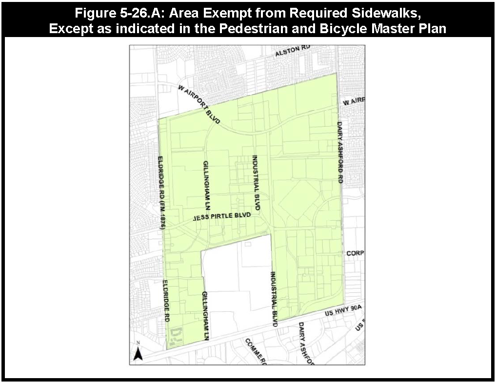
Figure 5-26.A
B.
Access Easements. If the Right-of-Way does not adequately accommodate an off-street pedestrian and bicycle facility identified in the Pedestrian and Bicycle Master Plan (including Sidewalks, Sidepaths, and Shared Use Paths (Trails)), a pedestrian and bicycle access easement shall be established adjacent to the Right-of-Way. Standards for access easements are specified in the City's Design Standards and the Pedestrian and Bicycle Master Plan.
C.
New Streets. The developer shall construct on-street facilities in accordance with the Design Standards and the Pedestrian and Bicycle Master Plan for new streets within and abutting the development.
D.
City Initiated Upsizing. At the City's request, the developer may be required to upsize or increase the width of a Sidewalk within a development in accordance with the Pedestrian and Bicycle Master Plan. The City will reimburse the developer for the oversize cost as defined in this Chapter.
E.
Additional Facilities. After providing the minimum required pedestrian and bicycle facilities, the developer may install additional facilities, at his or her expense. The additional facilities are not required to comply with the Design Standards.
F.
Connections to Existing and Planned Facilities. Where a development is located adjacent to an existing or planned pedestrian and/or bicycle facility identified in the Pedestrian and Bicycle Master Plan, an access easement shall be established, in accordance with the Design Standards, to provide direct public access to each adjacent off-street facility. Access shall be located so as to provide the most direct access possible to each adjacent facility.
G.
Exceptions to Design Standards for Required Pedestrian and Bicycle Facilities. Where unique site conditions exist, the City Engineer may approve a Specific Approval for alternative standards to the required Design Standards for pedestrian and bicycle facilities.
Sec. 5-27. - Oversized Facilities and City Cost Participation.
A.
Where this Code requires a development to provide for streets, sidewalks, sidepaths, shared use paths (trails), water or sewer lines, drainage facilities or other public improvements, the City may choose to participate in the cost of increasing the size or scope of the improvements required by the development to meet the needs of the general public.
B.
If the City chooses to participate, the developer will execute the City's standard agreement for cost sharing in the construction of public improvements that contains the respective duties of the parties. The cost of the public improvements will be determined by the public bidding procedures required by state law for public projects. Bids shall be solicited to: (1) obtain the cost of the public improvements the developer would be required to provide under City ordinance; and (2) the cost of the public improvements resulting from the increase in the size or scope of the public improvements as requested by the City. Under the agreement, the City will pay the difference between the developer's cost of construction and the costs of the increase in size or scope of the public improvements as shown in the bids.
C.
In compliance with state law, the City may choose to participate in the cost of construction of public improvements without public bids when the City's cost is 30% or less of the total contract price or as otherwise allowed by law.
Sec. 5-29. - Areas for Public Use.
The subdivider shall give consideration to suitable sites for parks, playgrounds, schools, and other areas for public use so as to conform with the Comprehensive Plan and recommendations of the City Council through a General Land Plan. Any provision for schools, parks, and other public uses, shall be indicated on the Preliminary Plat.
Sec. 5-30. - Park Land Dedication.
The dedication of public park land or private recreational facilities shall comply with the following park land dedication requirements and the Parks, Recreation, and Open Space Master Plan of the Comprehensive Plan:
1.
In view of the fact that land when subdivided increases in value to the owner and that residential subdividing increases the burden on the City's park and recreation facilities, the City shall require residential subdividers to offset some of this additional burden by dedicating suitable sites for park and recreation purposes or to make a cash deposit to the City in lieu thereof.
2.
The method of assuring that adequate and suitable areas for park and recreation sites are set aside shall be guided by the Comprehensive Plan and shall be governed by the following standards and regulations:
a.
The subdivider or developer shall dedicate a site or sites for park and recreation purposes at the time that the plat is recorded at a location(s) recommended by the developer and approved by the City, at a ratio of 1 acre of park for every 350 persons in the subdivision or development. This ratio is the City standard number of acres of park to be available in ratio to the increment of population added and to be served by the completely developed subdivision or development complex. Such added population being computed at the rate 3.5 persons per single-family residence or 2.4 persons per multifamily living unit. The City Council shall have final approval of any public parkland site(s) selected. The following definitions and conditions shall apply if there is a site dedication for park purposes:
1)
The area of the park or recreation site to be dedicated shall be appropriate in area, shape and terrain for the uses intended for it in the Parks, Recreation, and Open Space Master Plan. Where streets, ditches or easements infringe on or are part of the area to be dedicated, the City Council must determine whether to agree to the acceptance of those areas. Any infringements that make the area unsuitable for parks and recreation uses shall not be considered as part of the required park dedication acreage.
2)
When a subdivision or complex is to be developed in stages or units and the required park site is to be provided in future stages or units, a binding agreement concerning the size, improvements and tentative location of the park site(s) must be delivered with the Final Plat of the first stage or unit.
3)
The foregoing subsections shall not apply in the case of a replat of a plat, subdivision or addition that has previously met facility requirements, or the resubdividing or existing single lots, unless the replatting results in an increase in facility requirements.
4)
Each park and recreation site shall, upon completion of all construction of surrounding facilities, have ready access to a public street.
5)
The first priority in meeting parks and recreation facilities needs shall be the commitment of neighborhood park sites. Each neighborhood will be defined in the Parks, Recreation, and Open Space Master Plan, should be approximately 1 square mile and serve approximately 2,000 single-family housing units. Neighborhood parks should be public and of about 10 acres in size, centrally located, and easily accessible by foot from all parts of the neighborhood. Coordination of school and park sites is encouraged; therefore, the public park areas shall be reduced to 5 acres in size if properly coordinated with adjacent school recreation facilities.
6)
Up to 50% of the park and recreation facility requirements may be met by private park and recreation facilities as long as these facilities meet requirements of Section 5-34 of this Chapter.
7)
Park and recreation facilities in the City shall be dedicated to the City upon City Council approval unless approved as a private park site under terms of subparagraph 6. above. Park and recreation facilities in the City's corporate jurisdiction shall be dedicated to the City. If the City does not wish to accept the dedication of public park land in its corporate jurisdiction, it shall be dedicated to the county, municipal utility district, or a homeowners' association, as defined by Section 5-34 herein.
8)
At the time of dedication of a site for park purposes, the subdivider or developer shall furnish the City, at subdivider's or developer's expense, an owner's title insurance policy on standard printed owner's form covering the park and recreation sites in the amount of the value of the property subject only to exceptions acceptable to the City which will not materially affect its value for park and recreation purposes.
3.
The City Council may elect to accept money as an alternative to the dedication of part, or all, of the park land under any of the following conditions:
a.
Where there is no public park required by the Comprehensive Plan;
b.
If the developer does not wish to establish private parks; or
c.
Where the subdivision is too small to dedicate park sites sufficiently large enough to be economically operated.
4.
For a subdivider or developer to pay a fee in lieu of land, the subdivider must submit a written request to the Director. The City Council will take into consideration recommendations from the Development Review Committee and Parks and Recreation Director as to whether to require a land dedication or accept a fee in lieu of land. If the request to pay the fee is approved, payment shall be made by submitting a cashier's check to the Director after the time of Final Plat approval but prior to the time the plat is filed with the County Clerk's office, or prior to the issuance of a building permit.
5.
Money in lieu of Park Land fees are identified in Chapter 2 of the Code of Ordinances.
6.
Improvements. The developer may improve the park area by the addition of playgrounds, swimming pools, tennis courts or similar recreational amenities. If the area has fulfilled the commitment for neighborhood park space, the City shall allow a 100% credit for the original cost of the improvements to public parks as money in lieu of land and shall allow a 50% credit for the original cost of the improvements to private parks as money in lieu of land.
7.
In the Lake Pointe Redevelopment District, the park land dedication requirement set forth in this section may be satisfied through the provision of Civic Space if:
a.
The Civic Space contains recreational amenities, as described in Section 5-30.6; and
b.
The Parks and Recreation Director approves of the proposed recreational amenities.
(Ord. No. 2373, § 10, 5-9-25)
Sec. 5-31. - School Sites.
School sites for public schools shall be coordinated with the appropriate school district within whose jurisdiction the plat lies.
Sec. 5-32. - Public Facilities.
Public facilities such as fire stations, libraries, municipal and county buildings, and municipal utility district operations shall be platted individually or contained within a plat. The location of these facilities shall be coordinated with the applicable governing body and in compliance with the Comprehensive Plan of the City.
Sec. 5-33. - Wetlands.
If there are any areas previously designated which constitute wetlands by the federal law, these areas shall be indicated on the plat. In addition, any restrictions on these areas shall be noted on the plat.
Sec. 5-34. - Homeowners' or Property Owners' Association.
A.
Applicability. When a subdivision contains either common open space or other improvements which are not intended to be dedicated to the City or other perpetual entity for public use, a homeowners' or property owners' association shall be created, and the duties and responsibilities shall be established in a declaration consistent with state and other appropriate laws, must be submitted to the City, and made a part of the Final Plat documents.
B.
Membership. A homeowners' or property owners' association shall be an incorporated nonprofit organization operating under recorded land declarations through which:
1.
Each lot owner in a described land area is automatically a member; and
2.
Each lot is automatically subject to a charge for a proportionate share of the expenses for the association's activities, such as maintenance of common open spaces or the provision and upkeep of common recreational facilities.
C.
Legal Requirements. In order to assure the establishment of a permanent homeowners' or property owners' association, including its financing and the rights and responsibilities of the property owners in relation to the use, management and ownership of common property or common areas, the subdivision plat, dedication documents, covenants, or other recorded legal agreements must:
1.
Legally create an automatic membership, nonprofit association;
2.
Place title to the common property or common areas in the association or give definite assurance that it automatically will be so placed within a reasonable, definite time;
3.
Appropriately limit the uses of the common property or common areas;
4.
Give each lot owner the right to the use and enjoyment of the common property or common areas;
5.
Place responsibility for operation and maintenance of the common property or common areas in the association;
6.
Place an association charge on each lot in a manner which will both assure sufficient association funds and provide adequate safeguards for the lot owners against undesirable high charges;
7.
Give each lot owner voting rights in the association; and
8.
Identify land area within the association's jurisdiction including, but not limited to, the following:
a.
Property to be transferred to public agencies;
b.
The individual residential or commercial lots;
c.
The common properties to be transferred by the developer to the association; and
d.
Other parcels.
D.
Protective Covenants. Protective covenants shall be developed which, among other things, shall make the association responsible for:
1.
The maintenance and operation of all common property;
2.
The enforcement of all other covenants;
3.
The administration of architectural controls (optional); and
4.
Certain specified exterior maintenance of exterior improvements of individual properties (optional).
Sec. 5-35. - Improvements.
A.
All subdivisions must provide public improvements that the City shall accept, if located in the corporate City limits, or issue a certificate of compliance, if located in the extraterritorial jurisdiction. The required public improvements of the subdivision shall include, but are not limited to, the following:
1.
Water and wastewater facilities;
2.
Drainage facilities;
3.
Streets;
4.
Street lights;
5.
Street signs;
6.
Sidewalks;
7.
Traffic-control devices required as part of the subdivision; and
8.
Appurtenances to the above, and any other public facilities required as part of the proposed subdivision.
B.
All aspects of the design and implementation of public improvements shall comply with the Design Standards and any other applicable City codes and ordinances, including preparation and submittal of infrastructure construction plans and construction inspection. However, when property is subdivided for nonresidential or multifamily lots and Sidewalks are the only public infrastructure required by this Chapter, submittal of construction plans will not be required.
C.
All subdivisions in the extraterritorial jurisdiction shall also be reviewed and approved by Fort Bend County.
D.
Prior to the final approval construction of the streets and utilities, monuments for the subdivision shall be in place for the perimeter, Right-of-Way corners, angle points, and points of curvature using an iron pipe or rod of not less than 5/8 inch in diameter and 36 inches long and set 6 inches below finished grade. Plat boundary corners shall be set and shall include a cap or tag with the surveyor's registration number. Acceptance by the City shall be contingent upon proper documentation. All lot corner monuments shall be set prior to the issuance of a building permit or the beginning of principal building construction. The lot corner monuments shall be iron rods not less than ½ inch in diameter and 24 inches in length.
E.
The final approval of construction and acceptance of the improvements in a subdivision shall be in accordance with the requirements established in the current Design Standards.
F.
Building Permit Statement to be Recorded on Plat. The City shall not issue any permits for construction within the subdivision within the corporate limits, except permits to construct public improvements, until such time as all public improvements of the subdivision have been constructed and accepted by the City or a certified check, performance bond or letter of credit is provided to and accepted by the City. A notation stating the above shall appear on each Final Plat.
G.
Guarantee of Public Improvements. Before considering the Final Plat of a subdivision, the City must be satisfied that all public improvements required will be constructed in accordance with the requirements in the Design Standards.
1.
The subdivider shall, unless the City Council has determined otherwise, guarantee these public improvements will be constructed in one of the following ways:
a.
Deposit a certified check with, and payable to, the City in an amount equal to the cost to complete such public improvements, including the cost of remaining engineering and inspection services;
b.
Furnish the City with a performance bond executed by a surety company authorized to do business in the State of Texas in an amount equal to the cost to complete such public improvements, including the cost of remaining engineering and inspection services. The performance bond shall be in a form approved by the City Attorney and must be executed by a corporate surety in conformance with the standards of Texas Government Code Chapter 2253;
c.
Furnish the City with a letter of credit payable by an acceptable financial institution to the City in a form approved by the City Attorney, guaranteeing the payment of an amount equal to the cost to complete such public improvements including the cost of remaining engineering and inspection services. The letter of credit shall be irrevocable and shall be for a term sufficient to cover the 12-month period plus an additional 30 calendar days and require only that the City present the issuer a letter signed by an authorized representative of the City certifying to the City's right to draw or collect funds under the specific terms of the letter of credit; or
d.
As an alternative to providing financial securities for public infrastructure associated with the final plat, the subdivider may construct all improvements, receive initial acceptance of the improvements, and provide a maintenance bond guaranteeing their maintenance as required herein. If all public improvements have not been constructed at the time the subdivider requests plat recordation, the subdivider shall provide a financial security (Performance Bond, Letter of Credit, or Certified Check) in the amount of the improvements not yet constructed.
2.
The above requirements for guarantees do not apply to the following:
a.
Public water, wastewater, paving, and drainage improvements financed through a municipal utility district, levee improvement district or other special district created under state law.
b.
Sidewalks that directly front or side single-family residential lots that will be constructed when the lot is improved.
3.
In all instances, the original mylar copies of the Final Plat, without benefit of required signatures of City officials, shall be held in escrow by the Director and shall not be released for any purpose until the improvements are constructed or a financial security is provided, unless exempt from guarantee requirements as stated above.
4.
Upon the requirements of this Section being satisfied, the Final Plat shall be considered fully approved, except as otherwise provided for in these regulations, and the original copies of the Final Plat shall be signed by the appropriate City officials.
5.
If a performance bond or a letter of credit is the method selected by the subdivider for guaranteeing such improvements, such document is subject to the condition that the public improvements will be completed within 12 months after recordation of the Final Plat, unless a longer time is approved by the City, upon the determination that such longer time period would not be unreasonable. If the required public improvements guaranteed by the performance bond or letter of credit are not or will not be completed within the time specified by the City, the City Engineer shall have the authority to extend the time period within which the subdivider shall complete the public improvements, subject to the extension of the expiration date of the approval of the plat, performance bond or letter of credit.
H.
Security.
1.
Waiver of Security. The City Council may waive all or a portion of the security requirements of this section if it finds that the public health, safety and general welfare will not be harmed by such waiver. The City Council shall take into consideration the extent of public improvements to be installed and the likelihood that such improvements will be installed by the subdivider within the 12-month period, the impact that may result if such improvements are not timely installed, and the hardship to the subdivider if the security requirements are imposed.
2.
Release of Security. As portions of the public improvements are completed in accordance with the Design Standards, the subdivider may make application to the Director to reduce the amount of the original letter of credit, performance bond or certified check. If the City Engineer is satisfied that such portion of the public improvements has been completed in accordance with City standards, the City may cause the amount of the letter of credit, performance bond or certified check to be reduced by such amount that the City Engineer deems appropriate, so that the remaining amount of the letter of credit, performance bond or certified check adequately insures the completion of the remaining public improvements.
3.
Determination of Amount. A professional engineer licensed to practice in the State of Texas shall furnish estimates of the costs of engineering and construction of all required improvements to the Director who shall present the information to the City Engineer for review of the estimates in order to determine the adequacy of the guarantee instrument for insuring the construction of the required facilities.
4.
Coordination with Fort Bend County. If the subdivision is located in the extraterritorial jurisdiction and is subject to the County bonding requirements, the subdivider may provide the financial security conforming to the above requirements in the name of Fort Bend County; provided, that the current County regulations stipulate that the security will not be reduced or released without written approval by the Director, and provided that the instrument is transferable from the County to the City upon annexation.
I.
Approval of a Final Plat shall be deemed to have expired in a subdivision for which no assurances for completion have been posted or the improvements have not been completed within the period of 1 year. In those cases where a security instrument has been required and improvements have not been completed within the terms of such security instrument, the City shall declare the subdivider to be in default and require that all the improvements be installed unless extended under the provisions of this Section.
J.
The City shall inspect all required improvements to ensure compliance with City requirements and approved infrastructure construction plans. When all required improvements have been satisfactorily completed, the City shall either accept, in writing, the improvements as having been satisfactorily completed or shall issue a punch list to the developer denoting items remaining to be completed. The City shall not accept dedications of required improvements nor release or reduce a performance bond or other assurance until such time as it determines that:
1.
All improvements have been satisfactorily completed;
2.
The required number of "as built" plans have been submitted to and accepted by the City;
3.
The required maintenance bond has been provided; and
4.
Any and all other requirements identified in this Chapter or other City codes and ordinances have been satisfied.
K.
Before the release of any security instrument guaranteeing the construction of required subdivision improvements or the signing of the Final Plat where subdivision improvements were made prior to the filing of the Final Plat for recordation, the subdivider will furnish the City with a maintenance bond to assure the quality of materials and workmanship and maintenance of all required improvements. The maintenance bond must be satisfactory to the City as to form, sufficiency, and manner of execution. The bond shall be in compliance with Table 5-35.1: Bond Requirements for Public Infrastructure.
L.
Whenever a defect or failure of any required improvement occurs within the period of coverage, the City will require that a new bond be posted for a period of 1 full calendar year sufficient to cover the corrected defect or failure.
Sec. 5-36. - Flood Damage Prevention.
Sec. 5-37. - Site Plan Package.
Site plan packages for developments in the extraterritorial jurisdiction shall be submitted for review and approval prior to commencement of construction.
Requirements for site plan package submittals within the City are covered in Chapter 2, Zoning Regulations The purpose of submittal of the site plan package is to allow the staff to review traffic issues, utilities, environmental issues, and the property's relationship to adjoining properties. The review shall include, but is not limited to building lines, driveway locations, connection to existing utilities, and drainage. The site plan package shall illustrate that the development complies with this Code and the Design Standards. Where a phased development or redevelopment is proposed, the site plan area shall include the entire platted lot from which the phase is being developed.
Sec. 5-38. - Form and Slab Surveys.
The City shall require the submittal of a form survey and subsequent slab survey for every structure in the City. The surveys shall be prepared by a registered professional surveyor. Copies of the surveys will be filed within the City, logged into the appropriate record system and returned to the builder for his or her records. Noncompliance of the submittal of the required surveys is a violation of this Chapter.
Sec. 5-39. - Schedule of Fees.
Fees and charges required in this Chapter shall be as established by separate ordinance of the City Council from time to time. Fees are listed in Chapter 2 of the Code of Ordinances.
Such fees and charges shall be collected by the City when any application is received by the City.
Such fees and charges shall be imposed regardless of the action taken by the Commission and City Council thereon. Such fees shall be collected for the purpose of defraying the costs of administrative, clerical and inspection services necessary to properly review applications. Any required fees, unless specifically stated otherwise, shall be paid prior to the recording of the plat.
Sec. 5-40. - Enforcement.
Any subdivision of land being developed in violation of the terms and provisions of these regulations is hereby declared to be a public nuisance and the Director is hereby authorized to institute any action which may be necessary to restrain or abate such violations.
Sec. 5-41. - Variances.
A.
The Commission shall review the variance request and make a recommendation to the City Council. The City Council may then authorize a variance from these regulations when in its opinion undue hardship will result from requiring strict compliance. The applicant shall have the responsibility of proving the variance is a hardship. In granting a variance, the City Council shall prescribe conditions that it deems necessary or desirable to the public interest and making the findings hereinbelow required to eliminate the hardship. The City Council shall take into account the nature of the proposed use of land involved and existing uses of the land in the vicinity, the number of persons who will reside or work in the proposed subdivision, and the probable effect of such variance upon traffic conditions and upon the public health, safety, convenience, and welfare in the vicinity. No variance will be granted unless the City Council finds that an undue hardship exists. The following conditions must be present for consideration:
1.
There are special circumstances or conditions affecting the land involved such that the strict application of the provisions of this Chapter would deprive the applicant of the reasonable use of his land;
2.
The granting of the variance will not be detrimental to the public health, safety or welfare, or injurious to other property in the area;
3.
The granting of the variance will not have the effect of preventing the orderly subdivision of other lands in the area in accordance with the provisions of this chapter; and
4.
A more appropriate design solution exists which is not currently allowed in this Chapter.
B.
Such recommendations of the Commission and findings of the City Council, together with the specific facts on which such findings are based, shall be incorporated in the official minutes of the Commission and City Council meetings at which such variance is recommended or granted. Variances may be granted only when in harmony with the general purpose and intent of this Chapter, so that the public health, safety and welfare may be secured and substantial justice done. Economic hardship to the subdivider, standing alone, shall not be deemed to constitute undue hardship. The City Council may reach a conclusion that a hardship exists if it finds that:
1.
If the applicant complies strictly with the provisions of this Chapter, the applicant can make no reasonable use of the property;
2.
The hardship relates to the applicant's land, rather than personal circumstances;
3.
The hardship is unique to the property, rather than one shared by many surrounding properties;
4.
The hardship is not the result of the applicant's own actions.
C.
In granting variances, the City may impose such reasonable conditions as will ensure that the use of the property to which the variance applies will be as compatible as practicable with the surrounding properties.
D.
A variance may be issued for an indefinite duration or for a specified duration only.
E.
The nature of the variance and any conditions attached to it shall be entered on the application and plat and refer to the written record of the variance for further information. All such conditions are enforceable in the same manner as any other applicable requirement of this Chapter.
F.
The City Council shall not authorize a variance that would constitute a violation of any other valid ordinance of the City.
G.
The request for a variance shall be made in writing and accompanied by a fee as set forth in the City's fee schedule in Chapter 2 of the Code of Ordinances.
H.
In cases where a variance was submitted in conjunction with a Final Plat, the plat is considered incomplete until the variance receives approval or denial by the City Council. Following Council determination on the variance, the Final Plat will be submitted to the Commission for approval or denial. If a variance is submitted with a General Land Plan, the Commission shall make a recommendation on both the variance and General Land Plan prior to Council approval or denial of each item.
Sec. 5-42. - ETJ Development Agreements.
A.
The City Council may enter into a Development Agreement with a Developer of land that is located in the City's extraterritorial jurisdiction (ETJ) to:
1.
Extend the City's planning authority over the land by providing for a development plan to be prepared by the Developer and approved by the City under which certain general uses and development of the land are authorized;
2.
Authorize enforcement by the City of certain land use and development regulations in the same manner the regulations are enforced within the City's city limits; and
3.
Authorize enforcement by the City of land use and development regulations other than those that apply within the City's city limits and the ETJ, as may be agreed to by the Developer and the City.
B.
Plats for land subject to a Development Agreement must be submitted in conformance with the approved Development Agreement.
C.
Planned Unit Developments approved prior to July 21,2015 are hereby validated.
Sec. 5-50. - Driveway Width Requirements.
A.
Single-family residential driveways must be constructed with a minimum width of 10 feet at the Right-of-Way line (see Figure 5-51.A).
B.
Nonresidential and multifamily residential driveways that connect to an Arterial Street, Highway, or Freeway must be 35 feet wide.
C.
Other nonresidential driveways must be a minimum of 25 feet wide.
D.
Driveways for utility facilities may be constructed using single-family residential driveway standards with specific approval from the City Engineer.
E.
One-way driveways must be no less than 16 feet wide and shall be approved by the City Engineer.
F.
Primary Access Easements must be approved by the City Engineer prior to construction.
Sec. 5-51. - Driveway Separation Requirements.
A.
Single-family residential driveways must access on the street of the lowest classification. If a corner lot, single-family residential driveways shall be located at the side of the lot furthest away from the intersection. Any deviation from this criteria requires specific approval through the City Engineer. These dimensions only apply to the roadway classification shown. If access is to a different classification of the road, then intersection spacing shall apply in accordance with the City's Design Standards (see Figure 5-51.A).
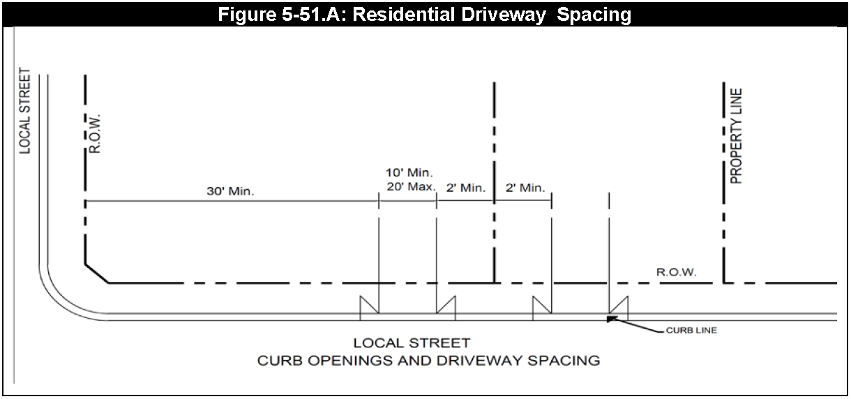
Figure 5-51.A
B.
The location of all nonresidential and multifamily residential driveways that will connect to a Public Street, Nonresidential Private Street, or Primary Access Easement must be approved by the City Engineer prior to construction.
C.
To reduce the number of conflict points and to facilitate traffic flow on Arterial and Collector streets, nonresidential driveways may be placed no closer than the following distances from adjacent streets and driveways (measured from the projected curb line of the existing intersecting street or driveway to the projected curb line of the proposed driveway):
D.
When planning a new driveway, the developer must demonstrate that the location of the proposed driveway does not preclude adjacent lots, tracts, or reserves from complying with driveway separation requirements. If the placement of a driveway along a lot, tract or reserve prevents the adjacent lot, tract or reserve from meeting the driveway separation requirements, a Joint Access Easement shall be required.
Sec. 5-52. - Nonresidential Driveway Alignment.
A.
On streets classified as Collectors, Arterials, and Highways that do not contain medians, non-single-family residential driveways must align with driveways on the opposite side of the street and meet the minimum separation requirements from existing driveways on both sides of the street. On undivided collector streets within industrial zoned areas, the opposite side driveway separation requirement may be waived by the City Engineer based upon a review of traffic and safety conditions. Driveways must be aligned with existing median openings, or be located an adequate distance from the median opening so that a driveway at the median opening will meet separation requirements whenever possible.
B.
At an intersection in which 1 public street terminates at the intersection of a connecting cross street, a driveway on the cross street in alignment with the terminating street must safely accommodate the cross-section of the intersecting public street.
C.
Driveways must be located and designed so as to have adequate sight distances along the intersecting street as defined in the Design Standards.
Sec. 5-53. - Driveway Radius Standards.
A.
Driveway radii may not extend beyond the projection of a property corner to the back of curb.
B.
For nonresidential (excluding utilities) and multifamily uses, driveways accessing an Arterial must be a minimum radius of 35 feet. Radii for nonresidential (excluding utilities) and multi-family driveways on other roadways must be a minimum of 25 feet.
C.
For Single-family residential uses, driveways accessing a local street must have a minimum radius of 5 feet. Radii for single-family residential driveways on other roadways (minor collector and above) must be a minimum of 10 feet.
D.
For nonresidential and multifamily uses, the minimum driveway radius accessing a Primary Access Easement is 10 feet.
Sec. 5-54. - Alternative Standards.
A.
Specific Approval for Primary Access Easements. The City Engineer may approve alternative Primary Access Easement designs not specified in this Chapter if he or she determines that the alternative designs better address the unique site conditions and serve the intent of this Chapter.
B.
Specific Approval for Separation from Existing Driveway. If the separation requirements for nonresidential or multifamily driveways cannot be met because of the location of existing driveways on adjoining tracts, shared access will need to be considered. The City Engineer will grant a specific approval for an access driveway when the design engineer provides documentation showing:
1.
The minimum separation requirements cannot be met due to an existing driveway on an adjacent property,
2.
Reasonable efforts have been made to obtain joint access and it cannot be obtained, and
3.
Access cannot be obtained to any other public Street. When granting a specific approval, the City Engineer will indicate the approved location of the driveway and to the extent possible, will maximize the distance between the new driveway and the nearest intersecting public Street.
C.
Alternative Standards to Driveway Requirements for Public Streets and Nonresidential Private Streets. City Council may authorize an alternative standard to any driveway requirement in this Article for which specific approval authority has not been granted to the City Engineer. A request for approval of alternative standards must be submitted to the City Engineer's office in writing. The request must include the justification for the request, drawings providing sufficient detail to describe the request, and traffic data or any other supporting information. Incomplete requests will be rejected until all items are addressed by the applicant. Any work related to the alternative standard that proceeds without approval is subject to removal and replacement in accordance with the City's Design Standards at the sole expense of the applicant.