
Sugar Land City Zoning Code
CHAPTER 8
FLOOD DAMAGE REDUCTION REGULATIONS
Sec. 8-1. - Statutory Authorization.
In Section 16.3145 et seq., Tex. Water Code, the legislature of the State of Texas has delegated the responsibility to local governmental units to adopt regulations designed to minimize flood losses and to be eligible to participate in the National Flood Insurance Program.
(Ord. No. 1979, § 2, 12-2-14)
Sec. 8-2. - Findings of Fact.
As a part of these provisions, the City finds that:
1.
The flood hazard areas of the City are subject to periodic inundation which results in loss of life and property, health and safety hazards, disruption of commerce and governmental services, and extraordinary public expenditures for flood protection and relief, all of which adversely affect the public health, safety and general welfare.
2.
These flood losses are exacerbated by the cumulative effect of obstructions in floodplains which cause an increase in flood heights and velocities, and by the occupancy of flood hazard areas by uses vulnerable to floods and hazardous to other land because they are inadequately elevated, flood proofed or otherwise protected from flood damage.
(Ord. No. 1979, § 2, 12-2-14)
Sec. 8-3. - Statement of Purpose.
It is the purpose of this Chapter to promote the public health, safety and general welfare, and to minimize public and private losses due to flood conditions in specific areas by provisions designed to:
1.
Protect human life and health;
2.
Minimize expenditures of public money for costly flood-control projects;
3.
Minimize the need for rescue and relief efforts associated with flooding and generally undertaken at the expense of the general public;
4.
Minimize prolonged business interruptions;
5.
Minimize damage to public facilities and utilities such as water and gas mains, electric, telephone and sewer lines, streets and bridges located in floodplains;
6.
Help maintain a stable tax base by providing for the sound use and development of flood-prone areas in such a manner as to minimize future flood blight areas;
7.
Ensure that potential buyers are notified that property is in a flood area;
8.
Require new development and construction to result in no adverse impact to surrounding or nearby properties, which prohibits the action of 1 property owner from adversely impacting the rights of other property owners, as measured by increased flood peaks, flood stage, flood velocity, and erosion and sedimentation; and
9.
Ensure that all new construction and substantial improvements must be elevated sufficiently so that the minimum finished floor elevation is at least 2 feet above the BFE as established by Atlas 14, Vol. 11, Texas, 1.5 feet above adjacent natural ground, or 1 foot above top of curb, whichever is the higher elevation. Provided, however:
a.
If the Atlas 14, Vol. 11, Texas Base Flood Elevation is not available, the minimum elevation will be 2 feet above the effective 500-year floodplain elevation provided in the then effective FEMA Flood Insurance Study (FIS) or best available data; and
b.
For new construction and substantial improvements located inside Levee protected areas (i.e., levee improvement districts), the minimum finished floor elevation is at least 2 feet above maximum ponding elevations (established using Atlas 14, Vol. 11, Texas), 1.5 feet above adjacent natural ground, or 1 foot above top of curb, whichever is the higher elevation.
(Ord. No. 1979, § 2, 12-2-14; Ord. No. 2151, § 2, 4-2-19; Ord. No. 2248, § 2, 11-2-21)
Sec. 8-4. - Methods of Reducing Flood Losses.
To accomplish its purposes, this Chapter uses the following methods:
1.
Restricts or prohibits uses that are dangerous to health, safety or property in times of flood, or cause excessive increases in flood heights or velocities;
2.
Requires that uses vulnerable to floods, including facilities which serve such uses, be protected against flood damage at the time of initial construction;
3.
Controls the alteration of natural floodplains, stream channels, and natural protective barriers, which are involved in the accommodation of flood waters;
4.
Controls filling, grading, dredging and other development which may increase flood damage;
5.
Prevents or regulates the construction of flood barriers which will unnaturally divert flood waters or which may increase flood hazards to other land; and
6.
Ensures that all new development and construction is regulated with a set of consistent standards and criteria aimed at reducing the potential for flood losses.
(Ord. No. 1979, § 2, 12-2-14)
Sec. 8-5. - Definitions.
Appeal means a request for a review of the City Engineer's interpretation of any provision of this Chapter or a request for a variance.
Appurtenant Structure means a structure which is on the same parcel of property as the principal structure to be insured and the use of which is incidental to the use of the principal structure.
Area of Future Conditions Flood Hazard means the land area that would be inundated by the 1% annual chance (100-year) flood based on fully developed conditions hydrology.
Area of Shallow Flooding means a designated AO, AH, AR/AO, AR/AH, or VO zone on a community's flood insurance rate map (FIRM) with a 1% or greater annual chance of flooding to an average depth of 1 to 3 feet where a clearly defined channel does not exist, where the path of flooding is unpredictable and where high velocity flow may be evident. Such flooding is characterized by ponding or sheet flow.
Area of Special Flood Hazard means the land in the floodplain within a community subject to a 1% or greater chance of flooding in any given year. The area may be designated as Zone A on the flood hazard boundary map (FHBM). After detailed rate making has been completed in preparation for publication of the FIRM, Zone A usually is refined into Zones A, AO, AH, A1-30, AE, A99, AR, AR/A1-30, AR/AE, AR/AO, AR/AH, AR/A, VO, V1-30, VE or V.
Atlas 14, Vol. 11, Texas means the National Oceanic and Atmospheric Administration Atlas 14, Precipitation-Frequency Atlas of the United States, Volume 11, Version 2.0: Texas, as may be amended from time to time.
Base Flood Elevation (BFE) is the flood elevation occurring at a given location as a result of the occurrence of the Base Flood event (established using Atlas 14, Vol. 11, Texas).
Basement means any area of a building having its floor subgrade (below ground level) on all sides.
Breakaway Wall means a wall that is not part of the structural support of the building and is intended through its design and construction to collapse under specific lateral loading forces, without causing damage to the elevated portion of the building or supporting foundation system.
Critical Facility means a facility that:
A.
Is critical to the community's public health and safety;
B.
Is essential to the orderly functioning of a community;
C.
Stores or produces highly volatile, toxic, or water-reactive materials; or
D.
Houses occupants that may be insufficiently mobile to avoid loss of life or injury;
Examples of critical facilities include hospitals, schools, daycare facilities, public electric utilities, fire stations, emergency operation centers, police facilities, detention centers, nursing homes, wastewater treatment facilities, water plants, gas/oil/propane storage facilities, hazardous waste handling and storage facilities, or other public equipment storage facilities.
Critical Feature means an integral and readily identifiable part of a flood protection system, without which the flood protection provided by the entire system would be compromised.
Development means any man-made change to improved or unimproved real estate, including, but not limited to, buildings or other structures, mining, dredging, filling, grading, paving, excavation or drilling operations, or storage of equipment or materials.
Elevated Building means, for insurance purposes, a non-basement building, which has its lowest elevated floor raised above ground level by foundation walls, shear walls, posts, piers, pilings, or columns.
Existing Construction means, for the purposes of determining rates, structures for which the "start of construction" commenced before the effective date of the FIRM or before January 1, 1975, for FIRMs effective before that date. "Existing construction" may also be referred to as "existing structures."
Existing Manufactured Home Park or Subdivision means a manufactured home park or subdivision for which the construction of facilities for servicing the lots on which the manufactured homes are to be affixed (including, at a minimum, the installation of utilities, the construction of streets, and either final site grading or the pouring of concrete pads) is completed before March 17, 1987.
Expansion to an Existing Manufactured Home Park or Subdivision means the preparation of additional sites by the construction of facilities for servicing the lots on which the manufactured homes are to be affixed (including the installation of utilities, the construction of streets, and either final site grading or the pouring of concrete pads).
Flood or Flooding means a general and temporary condition of partial or complete inundation of normally dry land areas from the overflow of inland or tidal waters or the unusual and rapid accumulation or runoff of surface waters from any source.
Flood Elevation Study means an examination, evaluation and determination of flood hazards and, if appropriate, corresponding water surface elevations, or an examination, evaluation and determination of mudslide (i.e., mudflow) and/or flood-related erosion hazards.
Flood Insurance Rate Map (FIRM) means an official map of a community on which the Federal Insurance Administrator has delineated both the areas of special flood hazards and the risk premium zones applicable to the community.
Flood Insurance Study (FIS). See "Flood elevation study."
Flood Proofing means any combination of structural and non-structural additions, changes, or adjustments to structures which reduce or eliminate flood damage to real estate or improved real property, water and sanitary facilities, structures and their contents.
Flood Protection System means those physical, structural works for which funds have been authorized, appropriated and expended, and which have been constructed specifically to modify flooding in order to reduce the extent of the areas within a community subject to a "special flood hazard" and the extent of the depths of associated flooding. Such a system typically includes hurricane tidal barriers, dams, reservoirs, levees or dikes. These specialized flood-modifying works are those constructed in conformance with sound engineering standards.
Floodplain or Flood-Prone Area means any land area susceptible to being inundated by water from any source. (See definition of "Flooding.")
Floodplain Management means the operation of an overall program of corrective and preventive measures for reducing flood damage, including but not limited to emergency preparedness plans, flood control works and floodplain management regulations.
Floodplain Management Regulations means zoning ordinances, subdivision regulations, building codes, health regulations, special purpose ordinances (such as a floodplain ordinance, grading ordinance and erosion control ordinance), and other applications of police power. The term describes such state or local regulations, in any combination thereof, which provide standards for the purpose of flood damage prevention and reduction.
Floodway (Regulatory Floodway) means the channel of a river or other watercourse and the adjacent land areas that must be reserved in order to discharge the base flood without cumulatively increasing the water surface elevation more than a designated height.
Functionally Dependent Use means a use which cannot perform its intended purpose unless it is located or carried out in close proximity to water. The term includes only docking facilities or port facilities that are necessary for the loading and unloading of cargo or passengers, and shipbuilding and ship repair facilities, but does not include long-term storage or related manufacturing facilities.
Highest Adjacent Grade means the highest natural elevation of the ground surface prior to construction and next to the proposed walls of a structure.
Historic Structure means any structure that is:
A.
Listed individually in the National Register of Historic Places (a listing maintained by the Department of Interior) or preliminarily determined by the Secretary of the Interior as meeting the requirements for individual listing on the National Register;
B.
Certified or preliminarily determined by the Secretary of the Interior as contributing to the historical significance of a registered historic district or a district preliminarily determined by the Secretary to qualify as a registered historic district;
C.
Individually listed on a state inventory of historic places in states with historic preservation programs which have been approved by the Secretary of Interior; or
D.
Individually listed on a local inventory of historic places in communities with historic preservation programs that have been certified either:
1.
By an approved state program as determined by the Secretary of the Interior or;
2.
Directly by the Secretary of the Interior in states without approved programs.
Levee means a man-made structure, usually an earthen embankment, designed and constructed in accordance with sound engineering practices to contain, control or divert the flow of water so as to provide protection from temporary flooding.
Levee System means a flood protection system which consists of a levee, or levees, and associated structures, such as a closure and drainage devices, which are constructed and operated in accordance with sound engineering practices.
Lowest Floor means the lowest floor of the lowest enclosed area (including basement). An unfinished or flood-resistant enclosure, usable solely for parking of vehicles, building access or storage, in an area other than a basement area is not considered a building's lowest floor; provided, that such enclosure is not built so as to render the structure in violation of the applicable nonelevation design requirement of 44 CFR, § 60.3 of the National Flood Insurance Program regulations.
Lowest Finished Floor Elevation, or Lowest Floor Elevation, is the elevation above mean sea level at the point where the lowest floor within a structure is found. For buildings constructed on concrete slab on grade, the lowest floor elevation is the minimum building slab elevation. For elevated buildings, the lowest finished floor elevation is measured at the top of the lowest floor joist.
Manufactured Home means a structure transportable in 1 or more sections, which is built on a permanent chassis and is designed for use with or without a permanent foundation when connected to the required utilities. The term "manufactured home" does not include a "recreational vehicle."
Manufactured Home Park or Subdivision means a parcel (or contiguous parcels) of land divided into 2 or more manufactured home lots for rent or sale.
Mean Sea Level means, for purposes of the National Flood Insurance Program, North American Vertical Datum of 1988 (NAVD 88) or other datum to which base flood elevations shown on a community's flood insurance rate map are referenced.
New Construction means, for the purpose of determining insurance rates, structures for which the "start of construction" commenced on or after the effective date of an initial FIRM or after December 31, 1974, whichever is later, and includes any subsequent improvements to such structures. For floodplain management purposes, "new construction" means structures for which the "start of construction" commenced on or after the effective date of a floodplain management regulation adopted by a community and includes any subsequent improvements to such structures.
New Manufactured Home Park or Subdivision means a manufactured home park or subdivision for which the construction of facilities for servicing the lots on which the manufactured homes are to be affixed (including at a minimum, the installation of utilities, the construction of streets, and either final site grading or the pouring of concrete pads) is completed on or after March 17, 1987.
Recreational Vehicle means a vehicle which is:
A.
Built on a single chassis;
B.
400 square feet or less when measured at the largest horizontal projections;
C.
Designed to be self-propelled or permanently towable by a light duty truck; and
D.
Designed primarily not for use as a permanent dwelling but as temporary living quarters for recreational, camping, travel, or seasonal use.
Repetitive Loss Structure means an NFIP-insured building that has incurred flood-related damages on 2 occasions during a 10-year period ending on the date of the event for which the insured makes a second claim. The cost of repairing the flood damage, on average, must equal or exceed 25 percent of the market value of the building at the time of each flood.
Riverine means relating to, formed by, or resembling a river (including tributaries), stream, brook, etc.
Severe Repetitive Loss Structure means an NFIP-insured building that has incurred flood-related damage for which 4 or more separate claims payments have been made, with the amount of each claim (building and contents payments) exceeding $5,000.00, and with the cumulative amount of such claims payments exceeding $20,000.00, or for which at least 2 separate claims payments (building payments only) have been made under such coverage, with the cumulative amount of such claims exceeding the market value of the building. In both instances, at least 2 of the claims must be within 10 years of each other, and claims made within 10 days of each other will be counted as 1 claim.
Start of Construction (for other than new construction or substantial improvements under the Coastal Barrier Resources Act (Pub. L. 97-348)), includes substantial improvement and means the date the building permit was issued, provided the actual start of construction, repair, reconstruction, rehabilitation, addition placement, or other improvement was within 180 days of the permit date. The actual start means either the first placement of permanent construction of a structure on a site, such as the pouring of slab or footings, the installation of piles, the construction of columns, or any work beyond the stage of excavation; or the placement of a manufactured home on a foundation. Permanent construction does not include land preparation, such as clearing, grading and filling; nor does it include the installation of streets and/or walkways; nor does it include excavation for basement, footings, piers or foundations or the erection of temporary forms; nor does it include the installation on the property of accessory buildings, such as garages or sheds not occupied as dwelling units or not part of the main structure. For a substantial improvement, the actual start of construction means the first alteration of any wall, ceiling, floor, or other structural part of a building, whether or not that alteration affects the external dimensions of the building.
Structure means a walled and roofed building, including a gas or liquid storage tank, that is principally above ground, as well as a manufactured home.
Substantial Damage means damage of any origin sustained by a structure whereby the cost of restoring the structure to its before damaged condition would equal or exceed 50% of the market value of the structure before the damage occurred.
Substantial Improvement means any reconstruction, rehabilitation, addition, or other improvement of a structure, the cost of which equals or exceeds 50% of the market value of the structure before "start of construction" of the improvement. This term includes structures which have incurred "repetitive loss" or "substantial damage," regardless of the actual repair work performed. The term does not, however, include either:
A.
Any project for improvement of a structure to correct existing violations of state or local health, sanitary, or safety code specifications which have been identified by the local code enforcement official and which are the minimum necessary to assure safe living conditions; or
B.
Any alteration of a "historic structure," provided that the alteration will not preclude the structure's continued designation as a "historic structure."
Variance is a grant of relief to a person from the requirements of this Chapter when specific enforcement would result in unnecessary hardship. A variance, therefore, permits construction or development in a manner otherwise prohibited by this Chapter. (For full requirements, see 44 CFR § 60.6 of the National Flood Insurance Program Regulations.)
Violation means the failure of a structure or other development to be fully compliant with the community's floodplain management regulations. A structure or other development without the elevation certificate, other certifications, or other evidence of compliance required in 44 CFR § 60.3(b)(5), (c)(4), (c)(10), (d)(3), (e)(2), (e)(4), or (e)(5) is presumed to be in violation until such time as that documentation is provided.
Water Surface Elevation means the height, in relation to the North American Vertical Datum of 1988 (NAVD 88), 2001 Adjustment, as listed in the City's Design Standards (or other datum, where specified), of floods of various magnitudes and frequencies in the floodplains of coastal or riverine areas.
(Ord. No. 1979, § 2, 12-2-14; Ord. No. 2151, § 3, 4-2-19; Ord. No. 2192, § 3, 5-5-20; Ord. No. 2248, § 3, 11-2-21)
Sec. 8-6. - Atlas 14, Vol. 11, Texas adopted.
Atlas 14, Vol. 11, Texas is adopted.
(Ord. No. 2151, § 2, 4-2-19)
Sec. 8-11. - Lands to Which This Chapter Applies.
This Chapter shall apply to all areas within the jurisdiction of the City.
(Ord. No. 1979, § 2, 12-2-14)
Sec. 8-12. - Basis for Establishing the Areas of Special Flood Hazard.
The areas of special flood hazard identified by the Federal Emergency Management Agency in a scientific and engineering report entitled "Flood Insurance Study for Fort Bend County, Texas and Incorporated Areas" dated April 2, 2014, with accompanying flood insurance rate maps (FIRM) and flood boundary floodway maps (FBFM) and any revisions thereto, as well as any revised or ongoing studies (such as drainage studies), are adopted by reference and declared to be part of this Chapter.
(Ord. No. 1979, § 2, 12-2-14)
Sec. 8-13. - Establishment of Development Permit.
A floodplain development permit is required to ensure conformance with the provisions of this Chapter. As part of the building permit application, a floodplain development checklist will be completed. This will include NFIP required data such as base flood elevation (BFE), minimum lowest finished floor elevation (LFF), construction certificate (including elevation certificate), and construction drawings. A new construction certificate (including elevation certificate) and the "as-built" or finished construction drawings must be submitted to the City prior to the issuance of a certificate of occupancy.
(Ord. No. 1979, § 2, 12-2-14; Ord. No. 2248, § 4, 11-2-21)
Sec. 8-14. - Compliance.
No structure or land shall hereafter be located, altered or have its use changed without full compliance with the terms of this Chapter and other applicable regulations.
(Ord. No. 1979, § 2, 12-2-14)
Sec. 8-15. - Abrogation and Greater Restrictions.
This Chapter is not intended to repeal, abrogate or impair any existing easements, covenants or deed restrictions. However, where this Chapter and another conflict or overlap, whichever imposes the more stringent restriction shall prevail.
(Ord. No. 1979, § 2, 12-2-14)
Sec. 8-16. - Interpretation.
In the interpretation and application of this Chapter, all provisions shall be:
A.
Considered as minimum requirements;
B.
Liberally construed in favor of the City; and
C.
Deemed neither to limit nor repeal any other powers granted under State statutes.
(Ord. No. 1979, § 2, 12-2-14)
Sec. 8-17. - Warning and Disclaimer of Liability.
The degree of flood protection required by this Chapter is considered reasonable for regulatory purposes and is based on scientific and engineering considerations. On rare occasions, greater floods can and will occur, and flood heights may be increased by man-made or natural causes. This Chapter does not imply that land outside the areas of special flood hazards or uses permitted within such areas will be free from flooding or flood damages. This Chapter shall not create liability on the part of the City or any official or employee thereof for any flood damages that result from reliance on this Chapter or any administrative decision lawfully made thereunder.
(Ord. No. 1979, § 2, 12-2-14)
Sec. 8-18. - Designation of the Floodplain Administrator.
The City Engineer, or his designee, is hereby appointed the Floodplain Administrator to administer and implement the provisions of this Chapter and other appropriate sections of 44 CFR, Part 9 (National Flood Insurance Program Regulations) pertaining to floodplain management.
(Ord. No. 1979, § 2, 12-2-14)
Sec. 8-19. - Duties and Responsibilities of the Floodplain Administrator.
Duties and responsibilities of the Floodplain Administrator shall include, but not be limited to, the following:
A.
Maintaining and holding open for public inspection all records pertaining to the provisions of this Chapter;
B.
Reviewing permit applications to determine whether proposed building sites will be reasonably safe from flooding;
C.
Reviewing, approving or denying all applications for development permits required by adoption of this Chapter;
D.
Reviewing permits for proposed development to assure that all necessary permits have been obtained from those federal, state or local government agencies (including Section 404 of the Federal Water Pollution Control Act Amendments of 1972, 33 U.S.C.A. § 1344) from which prior approval is required;
E.
Where interpretations are needed as to the exact location of the boundaries of the areas of special flood hazards (for example, where there appears to be a conflict between a mapped boundary and actual field conditions), making the necessary interpretations;
F.
Notifying, in riverine situations, adjacent communities and the State Coordinating Agency which is the Texas Water Development Board prior to any alteration or relocation of a watercourse, and submit evidence of such notification to the Federal Emergency Management Agency;
G.
Assuring that the flood-carrying capacity within the altered or relocated portion of any watercourse is maintained;
H.
When base flood elevation data has not been provided in accordance with Section 8-12, obtaining, reviewing and reasonably utilizing any base flood elevation data and floodway data available from a federal, state or other source in order to administer the provisions of this Chapter;
I.
When a regulatory floodway has not been designated, requiring that no new construction, substantial improvements or other development (including fill) shall be permitted within Zones A1-30 and AE on the City's FIRM, unless it is demonstrated that the cumulative effect of the proposed development, when combined with all other existing and anticipated development, will not increase the water surface elevation of the base flood more than 1 foot at any point within the community;
J.
Under the provision of 44 CFR § 60.3(D)(3) of the National Flood Insurance Program Regulations, it is prohibited any encroachment, including fill, new construction, substantial improvements and other development within the adopted regulatory floodway unless it has been demonstrated through hydrologic and hydraulic analysis performed in accordance with standard engineering practice that the proposed encroachment would not result in any increase in flood levels within the community during the occurrence of the base flood discharge;
K.
Requiring that any encroachment, including fill, new construction, substantial improvement, or other development within a special flood hazard area provide compensatory floodplain storage at least equal to the amount of encroachment within at a location within the same watershed, within ½ mile of the encroachment, and within the corporate limits of the City of Sugar Land; and
L.
Enforcing the City's "No Adverse Impact" Floodplain Management requirements as described in this Chapter prohibiting the action of 1 property owner from adversely impacting the rights of other property owners, as measured by increased flood peaks, flood stage, flood velocity, and erosion and sedimentation.
(Ord. No. 1979, § 2, 12-2-14; Ord. No. 2192, § 4, 5-5-20)
Sec. 8-20. - Permit Procedures.
A.
Application for a floodplain development permit must be presented to the Floodplain Administrator on forms furnished by him/her and may include, but not be limited to, plans in duplicate drawn to scale showing the location, dimensions and elevation of proposed landscape alterations, existing and proposed structures, and the location of the foregoing in relation to areas of special flood hazard. Additionally, the following information is required:
1.
Elevation (in relation to mean sea level) of the lowest floor (including basement) of all new and substantially improved structures;
2.
Elevation in relation to mean sea level to which any building occupied by a nonresidential use shall be flood proofed;
3.
A certificate from a registered professional engineer or architect that the nonresidential flood proofed structure shall meet the flood proofing criteria of Section 8-28(b) of this Chapter;
4.
Description of the extent to which any watercourse or natural drainage will be altered or relocated as a result of proposed development; and
5.
A record of all such information in accordance with Section 8-19(a) of this Chapter.
B.
Approval or denial of a floodplain development permit by the Floodplain Administrator shall be based on all of the provisions of this Chapter and the following additional relevant factors:
1.
The danger to life and property due to flooding or erosion damage;
2.
The susceptibility of the proposed facility and its contents to flood damage and the effect of such damage on the individual owner;
3.
The danger that materials may be swept onto other lands to the injury of others;
4.
The compatibility of the proposed use with existing and anticipated development;
5.
The safety of access to the property in times of flood for ordinary and emergency vehicles;
6.
The costs of providing governmental services during and after flood conditions including maintenance and repair of streets and bridges, and public utilities and facilities such as sewer, gas, electrical and water systems;
7.
The expected heights, velocity, duration, rate of rise and sediment transport of the flood waters and the effects of wave action, if applicable, expected at the site;
8.
The necessity to the facility of a waterfront location, where applicable;
9.
The availability of alternative locations, not subject to flooding or erosion damage, for the proposed use; and
10.
The relationship of the proposed use to the Comprehensive Plan for that area.
(Ord. No. 1979, § 2, 12-2-14)
Sec. 8-21. - Variance Procedures.
A.
The City Council shall hear and render judgment on requests for variances from the requirements of this Chapter.
B.
The City Council shall hear and render judgment on an appeal only when it is alleged there is an error in any requirement, decision or determination made by the Floodplain Administrator in the enforcement or administration of this Chapter.
C.
Any person or persons aggrieved by the decision of the City Council may appeal such decision in the courts of competent jurisdiction.
D.
The Floodplain Administrator shall maintain a record of all actions involving an appeal and shall report variances to the Federal Emergency Management Agency upon request.
E.
Variances may be issued for the reconstruction, rehabilitation or restoration of structures listed on the National Register of Historic Places or a state inventory of historic places, without regard to the procedures set forth in the remainder of this Chapter.
F.
Variances may be issued for the repair or rehabilitation of historic structures upon a determination that the proposed repair or rehabilitation will not preclude the structure's continued designation as a historic structure and the variance is the minimum necessary to preserve the historic character and design of the structure.
G.
Variances may be issued for substantial improvements on a lot ½ acre or less in size and contiguous to and surrounded by lots with existing structures constructed below the base flood level, providing the relevant factors in Section 8-20(b) of this Chapter have been fully considered. As the lot size increases beyond a ½ acre, the technical justification required for issuing the variance increases.
H.
Upon consideration of the factors noted above and the intent of this Chapter, the City Council may attach such conditions to the granting of variances as it deems necessary to further the purpose and objectives of this Chapter (Section 8-3).
I.
Variances shall not be issued within any designated floodway if any increase in flood levels during the base flood discharge would result.
J.
Prerequisites for granting variances shall be as follows:
1.
A determination that the variance is the minimum necessary, considering the flood hazard, to afford relief;
2.
Showing a good and sufficient cause;
3.
A determination that failure to grant the variance would result in exceptional hardship to the applicant; and
4.
A determination that the granting of a variance will not result in increased flood heights, additional threats to public safety, extraordinary public expense, create nuisances, cause fraud or victimization of the public, or conflict with State law or City ordinances.
K.
Except as provided herein, variances will be limited to rehabilitation, renovation, or expansion of existing structures and shall not be granted for new structures.
L.
Any applicant to whom a variance is granted shall be given written notice that the structure will be permitted to be built with the lowest floor elevation below the minimum finished floor elevation, as required by the City's Design Standards, and that the cost of flood insurance will be commensurate with the increased risk resulting from the reduced lowest floor elevation.
M.
Variances may be issued by the City Council for substantial improvements and for other development necessary for the conduct of a functionally dependent use; provided, that the criteria outlined in Section 8-20 of this Chapter are met, and the structure or other development is protected by methods that minimize flood damages during the base flood and create no additional threats to public safety.
(Ord. No. 1979, § 2, 12-2-14; Ord. No. 2248, § 5, 11-2-21)
Sec. 8-22. - Infrastructure Design Standards.
Design requirements for all drainage infrastructure, including storm sewers, channels, detention facilities, and other structures and facilities used to collect, convey, and store storm runoff, are set forth in the latest approved version of the City of Sugar Land Design Standards. The City's Design Standards apply to all areas regardless of location inside or outside of a special flood hazard area.
(Ord. No. 1979, § 2, 12-2-14)
Sec. 8-23. - Levee Standards.
This Section applies to levees constructed on or after the enactment of this ordinance. By January 1 of each year, owners of all levees constructed and operated within the City must provide to the Floodplain Administrator:
A.
An operation and maintenance plan that satisfies the requirements of the latest version of the Fort Bend County Drainage District Drainage Criteria Manual;
B.
An annual report on the condition of the levee and any repairs or modifications made during the preceding year; and
C.
An emergency action plan (EAP) that includes the Floodplain Administrator and his designee in the list of emergency contacts.
(Ord. No. 1979, § 2, 12-2-14)
Sec. 8-27. - General Standards.
In all areas of special flood hazards, the following provisions are required for all new construction and substantial improvements:
A.
All new construction or substantial improvements shall be designed (or modified) and adequately anchored to prevent flotation, collapse or lateral movement of the structure resulting from hydrodynamic and hydrostatic loads, including the effects of buoyancy;
B.
All new construction or substantial improvements shall be constructed by methods and practices that minimize flood damage;
C.
All new construction or substantial improvements shall be constructed with materials resistant to flood damage;
D.
All new construction or substantial improvements must be designed and constructed with electrical, heating, ventilation, plumbing, air conditioning equipment, and other service facilities, including machinery or equipment placed within attached garages, elevated to at least 1 foot above the BFE so as to prevent water from entering or accumulating within the components during conditions of flooding;
E.
All new and replacement water supply systems shall be designed to minimize or eliminate infiltration of flood waters into the system;
F.
New and replacement sanitary sewage systems shall be designed to minimize or eliminate infiltration of flood waters into the system and discharge from the systems into flood waters;
G.
On-site waste disposal systems shall be located to avoid impairment to them or contamination from them during flooding;
H.
The lowest elevation of the first floor of all structures and buildings must be constructed at least 2 feet above the 100-year floodplain base flood elevation as established by Atlas 14, Vol. 11, Texas, 1.5 feet above adjacent natural ground, or 1 foot above top of curb, whichever is the higher elevation shown on the latest FIRM map panels or the latest available data provided by the City if there is no FIRM that provides for a BFE as indicated in Section 8.3.9. All public streets must to designed so that the lowest top of curb elevation is equal to or above the 100-year floodplain elevation, or, in lieu thereof, the developer may provide documentation satisfactory to the City to show that the lowest public street top of curb elevation is not exceeded by the 100-year floodplain elevation for more than 4 hours. The 100-year floodplain is the 100-year water surface elevation in the outfall channel, receiving stream, or detention facility designated to receive storm runoff from the proposed development as established by Atlas 14, Vol. 11, Texas. For leveed areas subject to multiple outlet condition analyses under the City's Design Standards and the Fort Bend County Drainage District drainage criteria, the requirements in this paragraph must to be met for all conditions. Special consideration may be given to tracts containing natural aesthetic amenities within existing developed areas and served by existing outfall drainage facilities, where the addition of fill would result in the destruction of those amenities and for which there is no other feasible method to meet the aforementioned criteria. When base flood elevation data is not available in accordance with Section 8-12 of this Chapter, and reliable base flood elevation data and floodway data is not available from a federal, state or other source, a floodplain study must be provided by a professional engineer that establishes the base flood elevation (BFE) and the floodplain and floodway boundaries prior to the City issuing a development permit; and
I.
Any encroachment, including fill, new construction, substantial improvement, or other development within a special flood hazard area, must provide compensatory floodplain storage that is at least equal to the amount of encroachment within at a location within the same watershed, within ½ mile of the encroachment, and within the corporate limits of the City. Mitigation plans that do not meet these conditions must be supported by an engineering study and a recommendation prepared by a registered professional engineer and must be approved by the Floodplain Administrator.
(Ord. No. 1979, § 2, 12-2-14; Ord. No. 2192, § 5, 5-5-20; Ord. No. 2248, § 6, 11-2-21)
Sec. 8-28. - Specific Standards.
In all areas of special flood hazards where base flood elevation data has been provided, as set forth hereinabove, the following provisions are required:
A.
Residential Construction. New construction and substantial improvements of any residential structure must have the lowest floor (including basement) elevated a minimum of 2 feet above the base flood elevation as established by Atlas 14, Vol. 11, Texas, 1.5 feet above adjacent natural ground, or 1 foot above top of curb, whichever is the higher elevation as indicated in Section 8.3.9. A registered professional engineer, architect or land surveyor will submit a certification to the Floodplain Administrator that the standard of this subsection is satisfied. (See City Design Standards and Subdivision Regulations Ordinance for more details.)
B.
Nonresidential Construction. New construction and substantial improvements of any commercial, industrial or other nonresidential structure must either have the lowest floor (including basement) elevated a minimum of 2 feet above the base flood level as established by Atlas 14, Vol. 11, Texas, 1.5 feet above adjacent natural ground, or 1 foot above top of curb, whichever is the higher elevation as established in Section 8.3.9 or, together with attendant utility and sanitary facilities or any structure that is 1 foot above and below the BFE must be designed and constructed so that they are watertight with walls substantially impermeable to the passage of water and with structural components having the capability of resisting hydrostatic and hydrodynamic loads including the effects of buoyancy from at least 1 foot above the BFE to the depth of the facility (see Figure 1). A registered professional engineer or architect must develop and/or review structural design, specifications and plans for the construction, and certify that the design and methods of construction are in accordance with accepted standards of practice as outlined in this subsection. A record of such certification which includes the specific elevation (in relation to mean sea level) to which such structures are flood proofed will be maintained by the Floodplain Administrator.
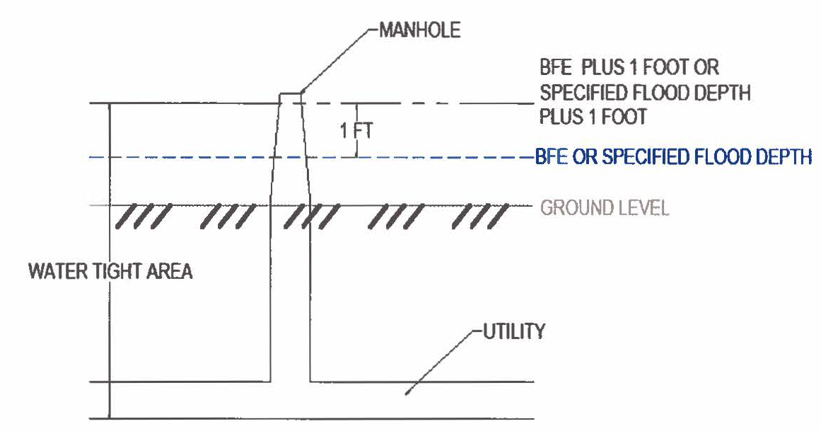
Figure 1. Waterproofing Utility
C.
Enclosures. New construction and substantial improvements, with fully enclosed areas below the lowest floor that are usable solely for parking of vehicles, building access or storage in an area other than a basement and which are subject to flooding must be designed to automatically equalize hydrostatic flood forces on exterior walls by allowing for the entry and exit of floodwaters. Designs for meeting this requirement must either be certified by a registered professional engineer or architect or meet or exceed the following minimum criteria:
1.
A minimum of 2 openings on separate walls having a total net area of not less than 1 square inch for every square foot of enclosed area subject to flooding must be provided;
2.
The bottom of all openings must be no higher than 1 foot above grade; and
3.
Openings may be equipped with screens, louvers, valves, or other coverings or devices provided that they permit the automatic entry and exit of floodwaters.
D.
Manufactured Homes.
1.
All manufactured homes to be placed within Zone A on a community's FHBM or FIRM shall be installed using methods and practices which minimize flood damage. For the purposes of this requirement, manufactured homes must be elevated and anchored to resist flotation, collapse, or lateral movement. Methods of anchoring may include, but are not limited to, use of over-the-top or frame ties to ground anchors. This requirement is in addition to applicable State and local anchoring requirements for resisting wind forces.
2.
Manufactured homes that are placed or substantially improved within Zones A, AH, and AE on the community's FIRM on sites: (i) outside of a manufactured home park or subdivision, (ii) in a new manufactured home park or subdivision, (iii) in an expansion to an existing manufactured home park or subdivision, or (iv) in an existing manufactured home park or subdivision on which a manufactured home has incurred "substantial damage" as a result of a flood, be elevated on a permanent foundation such that the bottom of the chassis of the manufactured home is elevated a minimum of 2 feet above the base flood elevation as established by Atlas 14, Vol. 11, Texas, as required in Section 8.3.9, and be securely anchored to an adequately anchored foundation system to resist flotation, collapse, and lateral movement.
3.
Manufactured homes to be placed or substantially improved on sites in an existing manufactured home park or subdivision within Zones A, AH and AE on the community's FIRM that are not subject to the provisions of this Section must be elevated so that the lowest floor of the manufactured home is a minimum of 2 feet above the BFE as established by Atlas 14, Vol. 11, Texas, as specified in Section 8.3.9.
E.
Recreational Vehicles. Recreational vehicles placed on sites within Zones A, AH, and AE on the community's FIRM must (i) be on the site for fewer than 180 consecutive days, (ii) be fully licensed and ready for highway use, or (iii) meet the permit requirements of Section 8-20 of this Chapter and the elevation and anchoring requirements for "manufactured homes" of this Section. A recreational vehicle is ready for highway use if it is on its wheels or jacking system, is attached to the site only by quick disconnect type utilities and security devices, and has no permanently attached additions.
(Ord. No. 1979, § 2, 12-2-14; Ord. No. 2192, §§ 6—8, 5-5-20; Ord. No. 2248, §§ 7, 8, 11-2-21)
Sec. 8-29. - Standards for Subdivision Proposals.
A.
All subdivision proposals, including manufactured home parks and subdivisions, shall be consistent with Sections 8-2 through 8-4 of this Chapter and conform to the City's Subdivision Regulations and Design Standards.
B.
All proposals for the development of subdivisions, including manufactured home parks and subdivisions, shall meet all of the requirements of this Chapter.
C.
Base flood elevation data shall be generated for subdivision proposals and other proposed development, including manufactured home parks and subdivisions, if greater than 50 lots or 5 acres, whichever is lesser, if not otherwise provided in this Chapter.
D.
All subdivision proposals, including manufactured home parks and subdivisions, must have adequate drainage provided as required by the City's Design Standards to reduce exposure to flood hazards.
E.
All subdivision proposals, including manufactured home parks and subdivisions, must have public utilities and facilities, such as sewer, gas, electrical and water systems, located and constructed to minimize or eliminate flood damage.
F.
All subdivision proposals, including manufactured homes parks and subdivisions, shall comply with the minimum slab elevations required for all buildings and manufactured homes as set forth in the City's Subdivision Regulations and Design Standards.
(Ord. No. 1979, § 2, 12-2-14)
Sec. 8-30. - Standards for Areas of Shallow Flooding (AO/AH Zones).
Located within the areas of special flood hazard are areas designated as shallow flooding. These areas have special flood hazards associated with base flood depths of 1 to 3 feet where a clearly defined channel does not exist and where the path of flooding is unpredictable and where velocity flow may be evident. Such flooding is characterized by ponding or sheet flow; therefore, the following provisions apply:
A.
All new construction and substantial improvements of residential structures must have the lowest floor (including basement) elevated above the highest adjacent grade of at least 1 foot higher than the depth number specified in feet on the community's FIRM (at least 3 feet if no depth number is specified).
B.
All new construction and substantial improvements of non-residential structures:
1.
Have the lowest floor (including basement) elevated to at least 1 foot above the BFE or the highest adjacent grade of at least 1 foot higher than the depth number specified in feet on the community's FIRM (at least 3 feet if no depth number is specified), or
2.
Together with attendant utility and sanitary facilities or any structure that is 1 foot above and below the BFE must be designed and constructed so that they are watertight with walls substantially impermeable to the passage of water and with structural components having the capability of resisting hydrostatic and hydrodynamic loads including the effects of buoyancy from at least 1 foot above the BFE to the depth of the facility (see Figure 1) in an AH Zone. The same requirement applies in an AO Zone, with at least 1 foot above the specified flood depth to the depth of the facility (see Figure 1).
C.
A registered professional engineer or architect shall submit a certification to the Floodplain Administrator that the standards of this Section are satisfied.
D.
Require within Zones AH or AO adequate drainage paths around structures on slopes to guide flood waters around and away from proposed structures.
(Ord. No. 1979, § 2, 12-2-14; Ord. No. 2248, § 9, 11-2-21)
Sec. 8-31. - Floodways.
Located within areas of special flood hazard established in Section 8-12 of this Chapter are areas designated as floodways. Since the floodway is an extremely hazardous area due to the velocity of flood waters which carry debris, potential projectiles and erosion potential, the following provisions shall apply:
A.
Encroachments are prohibited, including fill, new construction, substantial improvements and other development within the adopted regulatory floodway unless it has been demonstrated through hydrologic and hydraulic analyses performed in accordance with standard engineering practice that the proposed encroachment would not result in any increase in flood levels within the community during the occurrence of the base flood discharge.
B.
If the above requirement is satisfied, all new construction and substantial improvements shall comply with all applicable flood hazard reduction provisions of this Article.
C.
Under the provisions of 44 CFR § 65.12, of the National Flood Insurance Regulations, a community may permit encroachments within the adopted regulatory floodway that would result in an increase in base flood elevations, provided that the community first completes all of the provisions required by Section 65.12.
(Ord. No. 1979, § 2, 12-2-14)
Sec. 8-32. - Standards for Critical Facilities.
The minimum finished floor elevation of any critical facility shall be a minimum of 2 feet above the 100-year base flood elevation.
(Ord. No. 1979, § 2, 12-2-14)
Sec. 8-37. - Offense, Penalty and Culpable Mental State.
A.
Penalty. It is unlawful for a person to:
1.
Violate or fail to comply with a provision of this Chapter; or
2.
Erect, construct or alter any structure, or place any fill material, in violation of the detailed statement or drawing submitted and approved under this Chapter.
Any person found guilty of violating a provision of this Chapter may be punished as provided for in Section 1-7 of this Code.
B.
Culpable Mental State. A violation of this Chapter requires a culpable mental state of "intentional", "knowing" or "recklessness."
C.
Continuing Violations. Each day any violation continues constitutes a separate offense.
(Ord. No. 1979, § 2, 12-2-14)
Sec. 8-38. - Inspection.
The Floodplain Administrator may inspect all premises subject to this Chapter at any time before, during or after any new construction or substantial improvements or other development in order to assure compliance with all provisions of the development permit and all flood damage regulations.
(Ord. No. 1979, § 2, 12-2-14)
Sec. 8-39. - Stop Work Orders.
Upon notice from the Floodplain Administrator that work on any building, structure, dike, bridge or any improvement which would affect water drainage is being done contrary to the provisions of this Chapter, or in a dangerous or unsafe manner, such work shall be immediately stopped. Such notice shall be in writing and shall be given to the owner of the property or to his agent, or to the person doing the work, and shall state the conditions under which work may be resumed. Where an emergency exists, no written notice shall be required to be given by the Floodplain Administrator; provided however, written notice shall follow within 24 hours from the time oral notice to stop is issued.
(Ord. No. 1979, § 2, 12-2-14)
Sec. 8-40. - Revocation of Permit.
The Floodplain Administrator may revoke a permit or approval issued under the provisions of this Chapter in cases where there has been any false statement or misrepresentation as to a material fact in the application or plans upon which the permit or approval was based.
(Ord. No. 1979, § 2, 12-2-14)
Sec. 8-41. - Repetitive loss.
A.
The Floodplain Administrator may declare any existing structure as a repetitive loss structure as required to qualify the structure for increased cost of compliance (ICC) benefits allowed by a National Flood Insurance Program flood policy claim. To be declared a repetitive loss structure the following conditions must be met:
1.
The structure must have a flood insurance policy that includes the increased cost of compliance coverage.
2.
The structure must have been flooded twice during a 10-year period with each flood event causing damage for which the repair cost equals or exceeds 25 percent of the market value of the structure.
B.
If any nonconforming use or structure is substantially damaged or experiences a repetitive loss, as defined in this article, it shall not be reconstructed except in conformity with the provisions of this section.
(Ord. No. 2248, § 10, 11-2-21)