
Summit County Unincorporated
City Zoning Code
City Zoning Code
3500
- BASIC DEVELOPMENT REGULATIONS AND STANDARDS
3501: - General
This section includes regulations and standards for development in all zoning districts, except as otherwise provided. Regulations in this section address the following items:
A.
Availability of access and services: Section 3504.
B.
Building and site design standards: Section 3505.
C.
Maintenance of common areas: Section 3508.
D.
Environmental impact: Section 3510.
E.
Industrial/commercial performance standards: Section 3512.
F.
Manufactured home park development standards: Section 3513.
3502: - Purpose and Intent
The purpose of this section is to establish requirements that developers must meet to insure, as development occurs:
A.
Impacts on services and infrastructure are mitigated.
B.
Development is at an appropriate scale for the project site and its surroundings.
C.
Adjacent land uses are compatible with each other.
D.
Summit County's natural beauty is protected and enhanced.
E.
Development is attractive and in keeping with Summit County's mountain character.
F.
Hazard areas are avoided.
G.
Public health, safety and welfare is protected.
3503: - Additional Development Regulations and Standards
The County has adopted additional development standards and regulations as part of its Zoning Regulations that are not part of this section. These include:
A.
Landscaping Requirements: Section 3600.
B.
Parking Requirements: Section 3700.
C.
Regulations and standards for Specific Land Uses: Section 3800.
D.
Regulations and standards for Overlay Zoning Districts: Chapter 4.
E.
Road & Bridge Standards: Chapter 5.
F.
Grading and Excavation Regulations: Chapter 6.
G.
Water Quality Control Regulations: Chapter 7.
H.
Subdivision Regulations: Chapter 8.
I.
Sign Regulations: Chapter 9.
J.
Areas and Activities of State Interest: Chapter 10.
K.
Community Appearance, Maintenance and Safety: Chapter 11.
L.
Development Review Procedures: Chapter 12.
M.
Public Hearings, Appeals, Takings/Vested Rights and Administrative Relief: Chapter 13.
N.
Administration; Nonconforming Parcels, Uses and Structures; Illegal Parcels, Uses and Structures and General Provisions: Chapter 14.
These regulations and standards apply to all zoning districts in the County unless noted otherwise in the specific provisions of a section or chapter.
3504: - Availability of Access and Services
3504.01: Services Matrix
The services matrix in Figure 3-4 lists the types of information required at each stage in the development process on availability of access, fire protection and emergency medical services, the need for public use areas and availability of water, wastewater treatment and utilities. The sections that follow provide further explanation of these requirements. It is important to note that the information in the matrix is not all-inclusive. It must be used in conjunction with the text in this section to identify the requirements applicable to a development.
3504.02: Major Development Projects
A.
Purpose and Intent: The introduction of urban intensities in undeveloped, outlying areas or a significant increase in density in areas already developed at urban intensities often causes a demand for the extension or expansion of services at a much higher cost to taxpayers. The BOCC is concerned with such development projects. It is the intent of the BOCC to consider development projects to be major developments when, by virtue of their location, intensity, scope or scale, they are considered to have major impact and/or demand on such services and facilities.
B.
It is a requirement of this Code that a developer proposing a major development project provide for:
1.
Improvements to roads and other transportation facilities;
2.
Additional fire, police and emergency medical services and facilities;
3.
Water and wastewater treatment capacity needed by the development project;
4.
Other infrastructure and maintenance such that, in light of the anticipated demand upon such infrastructure and maintenance generated by the development, it will not overload existing services and facilities in the county; and,
5.
The cost of extending or providing services is proportionately addressed by the developer, including ongoing costs (i.e., operating, maintenance, etc.).
C.
Definition of Major Development Project: A development project is classified as major if it has a combination of characteristics which would result in either introducing higher-intensity or larger scale uses in areas where the current land use pattern is rural in character and where urban services are lacking or causing a significant increase in density or larger scale uses in existing developed areas. The Planning Director shall make the determination if a proposed development project is major using the criteria stated in this section. An applicant may appeal this determination to the BOCC. The final decision as to whether or not a proposed development project is major shall be made by the BOCC during a work session. In determining whether or not a development project is to be considered major, the following criteria are to be considered:
1.
Would cause urbanization of an otherwise rural area.
2.
Could have an urbanizing impact upon surrounding properties such as an increase in traffic, noise, or lighting.
3.
Would add at least 100 new dwelling units or lodging rooms.
4.
Would add at least 25,000 square feet of new commercial space.
5.
Would result in commercial uses in an otherwise rural area.
6.
Would require the formation of a special district.
7.
Would require the extension of water or wastewater treatment systems outside existing service area boundaries or require a significant expansion of existing water and wastewater treatment services or create significant increase in demand for other public infrastructure or services.
8.
Any other development proposal having a similar level of significant impact in terms of intensity or scope of use proposed, demand on infrastructure, or other comparable major development characteristics.
D.
Preparation of Study: An impact study ("Study") shall be prepared for major development projects as part of either: 1) the preliminary review of a zoning amendment (preliminary zoning); or 2) a major PUD modification. The Study shall analyze the cumulative and proportional demand for services and facilities that would result from the development project and estimate any initial and ongoing cost of providing the services and facilities. The Study shall take into account existing infrastructure and how such may provide services and facilities for the proposed major development project. The Study shall also estimate the proportional cost of such facilities and services that are the responsibility of the applicant to provide that are proportional to and designed to offset the impacts of the zoning amendment. The Study shall also provide an estimated and rational timeline for providing any needed services and/or facilities. The Study may also provide a mechanism for payment of "in lieu" fees for services and/ or facilities. The Study shall be prepared by a consultant or other qualified person selected by mutual agreement of the County and the developer. The cost of the Study shall be paid by the developer prior to the first public hearing on an application or such other mutually agreeable time that occurs prior to final action on a development review application by the BOCC. The Study shall include, but not be limited to the following elements, unless the Planning Director waives such items as unnecessary:
1.
Emergency Communications:
a.
Estimate of number of emergency calls which would be received by the Emergency Communications Center.
b.
Analysis of need for communications equipment needed to handle increased volume of calls and to maintain existing level of service.
c.
Estimate of cost for additional communications equipment.
2.
Emergency Services:
a.
Estimate of number of emergency calls expected from the development.
b.
Analysis of need for emergency equipment and services that would result from increased volume of calls.
c.
Analysis of development's location on the logistics of maintaining existing response times for the Summit County Ambulance Service or its successor.
d.
Estimate of cost for additional emergency equipment and services and for facilities needed to maintain existing response times.
3.
Fire Protection:
a.
Estimate of number of calls for fire protection expected from the development.
b.
Analysis of need for additional firefighting equipment and facilities that would result from increased volume of calls.
c.
Analysis of development's location on the logistics of maintaining existing response times for the fire district that would provide service to the development.
d.
Estimate of cost for additional firefighting equipment and facilities needed to provide protection to the development and to maintain existing response times.
4.
Police Protection:
a.
Estimate of number of calls for police protection expected from the development.
b.
Analysis of need for additional equipment and facilities that would result from increased volume of calls.
c.
Analysis of development's location on the logistics of maintaining existing response times for the Summit County Sheriff's Department.
d.
Estimate of cost for additional equipment and facilities needed to provide protection to the development and to maintain existing response times.
5.
Roads:
a.
Estimate of traffic volumes expected from the development.
b.
Analysis of need for additional road capacity, upgrading the condition or design of existing roads, traffic signals and signs, striping, guard rails and other road improvements which would result from increased traffic in accordance with standards established in the County Road Standards (see Chapter 5).
c.
Estimate of cost of road improvements.
d.
Estimated cost of operation and maintenance of existing and proposed roads, and road facilities such as traffic control devices, including an analysis on the proposed assumption or distribution of said costs.
6.
Transportation and Transit:
a.
Estimate of traffic impacts/transit needs expected from the proposal.
b.
Estimate of cost of associated infrastructure improvements.
c.
Estimated cost of operating and maintenance of existing and proposed transit facilities, infrastructure, and services, including an analysis on the proposed assumption or distribution of said costs.
7.
Water and Wastewater Treatment Service:
a.
Estimate of need for additional water or wastewater treatment capacity, upgrading the condition or design of existing water or wastewater lines or associated systems or treatment plants or other system improvements which would result from the increased water or wastewater treatment capacity.
b.
Estimate of cost of water or wastewater treatment system improvements.
c.
Estimated cost of maintenance.
8.
Other Infrastructure:
a.
Estimate of the need for any other additional infrastructure and upgrading the condition or design of affected infrastructure. Other infrastructure includes, but is not limited to, electric lines or electric distribution systems and telecommunication lines or telecommunication systems.
b.
Estimate of cost of other infrastructure improvements.
c.
Estimated cost of maintenance.
9.
Schools and Child Care:
a.
Estimate of number of school age children expected from the development.
b.
Analysis of need for additional school and child care facilities which would result from increased school attendance.
c.
Estimate of cost for additional school and child care facilities.
10.
Affordable Workforce Housing:
a.
Estimate of the number of employees and residents generated by the new proposed development.
b.
Analysis of the need for affordable workforce housing generated by the new proposed development.
c.
Analysis of the affordable workforce housing component, if any, proffered in conjunction with the new proposed development.
11.
Fiscal Impact Analysis: The Study shall also include an analysis of the positive and negative fiscal impacts to the County and any special districts associated with the major development project.
12.
Proposed Schedule: The Study shall include a schedule, acceptable to the BOCC, for the construction of improvements or facilities, the provision of services, the payment of in lieu fees, or a combination thereof, such that the impacts of a major development would be accommodated without a disproportionate burden on existing improvements, facilities or services.
13.
Analysis of Past Improvements: The Study may address the provisions of past services or facilities provided by a developer and the developer may be given credit for such improvements, to the extent that such improvements or facilities offset the impact and/or demand being generated by the new zoning amendment. It is acknowledged that the existing status and sufficiency of current facilities and services already needs to be addressed as specified in this section and that it is not necessary to have a separate section addressing past improvements if already addressed in each section of the Study.
14.
Additional Considerations: The Planning Director may, in the reasonable exercise of their discretion, request any additional information or factors be considered and analyzed in the study if deemed relevant to the nature and impacts of the development proposed.
E.
Revisions to Study: If substantive changes are made to a major development project during the review of the project, the Study shall be revised to take into account changes in the project such that an accurate Study is available prior to final action on the zone change for the development project. The revisions shall be prepared by a consultant or other qualified person selected by mutual agreement of the County and the developer. The cost of revisions shall be paid by the developer prior to the final public hearing on the zoning amendment application.
F.
Review and Acceptance of Study: Results of the study and proposed requirements for the construction of improvements or facilities, the provision of services or the payment of in lieu fees based on the study shall be reviewed by the Planning Commission and the BOCC with the developer as part of the zoning amendment process for a major development project. The developer shall have an opportunity to propose changes in the Study's suggested requirements and alternative methods of addressing any impacts. The BOCC shall act to accept the Study prior to taking final action on a zoning amendment application for a major development project. The BOCC may request revisions to the Study prior to finding it acceptable. The applicant shall pay the cost for any Study revisions prior to the final public hearing on a zoning amendment application.
G.
Conditions of Approval: Approval of a zoning amendment for a major development project shall include 1) requirements determined by the BOCC for the construction of improvements or facilities, the provision of services or the payment of in lieu fees identified as needed in the Study accepted by the BOCC, and 2) a proposed schedule for implementing the requirements. The allowance for payment of fees in lieu of construction of improvements or facilities or in lieu of the provision of services shall be at the discretion of the BOCC. The conditions of approval may include provision for a payback agreement where future developments become beneficiaries of the improvements or facilities provided by the developer. The purpose of such conditions shall be to allow the BOCC to require an applicant to provide facilities, services or fees that are designed to offset the impacts of the zoning amendment.
Every lot shall have access that is sufficient to afford a reasonable means of ingress and egress for emergency vehicles as well as for all traffic needing or desiring access to the property and its intended use. Unless otherwise provided for in a PUD, such access shall be provided either by a public or private street meeting the requirements of the County Road Standards (see Chapter 5) and as follows:
A.
Residential Uses: Access for up to four (4) single-family detached dwelling units or two (2) duplexes may be provided by a common driveway that then connects to either a public or private street. Easements for proposed common driveways shall be either platted or provided by another legal mechanism of record approved by the County. Access for multi-family developments shall be provided by individual driveways that provide access to common parking areas, which then connect to either a public or private street. If the units in a multi-family development are offered for individual sale (i.e. condominiums or townhouses), any common parking areas and driveways shall be owned and maintained by an owners association or by a special or metropolitan district. Provisions for maintenance shall be stated in covenants on the property or by an alternative method accepted by the County Attorney as providing sufficient enforceability. Driveways and parking areas shall meet the requirements of the County Road Standards (see Chapter 5) and the Parking Regulations contained in Section 3700 et seq.
B.
Nonresidential Uses: Access to lots zoned or developed for commercial, industrial, community or institutional uses shall be provided either by driveways or by parking areas which then connect by driveways to either a public or private street. Driveways and parking areas shall meet the requirements of the County's Road Standards (see Chapter 5). Where these uses are located in a commercial center or a business or industrial park, access may be provided by common parking areas and driveways that may also be shared by more than one development project, subject to approval by the Planning Commission. Easements for common parking areas and driveways shall be platted or provided by another legal mechanism of record approved by the County.
C.
Emergency Access:
1.
Definition: Emergency access is provided if at least two (2) different routes for emergency vehicles are available from the County highway system to a specific structure. For the purposes of this section, the County highway system consists of the arterial and collector street system.
2.
Provision for Emergency Access: Emergency access may be required by the Review Authority based on the nature and scope of a proposed development and feasibility. The requirement for emergency access shall not apply to subdivisions in the A-1 and BC Zoning Districts consisting of lots of 20 or more acres in size unless necessary to reduce the wildfire hazard due to the property's slope, aspect, vegetation, availability of firefighting infrastructure or other relevant factors as identified in the CWPP. In assessing feasibility, consideration shall be given to the cost of road construction, ability to obtain easements from adjacent property owners and the amount of environmental damage that would occur. In order for a road to qualify as providing emergency access, the County must receive an adequate guarantee that the road will be maintained on a year round basis.
3.
Design Considerations: The County Road Standards limit the length of cul-de-sacs (see Chapter 5). A variance from County Road Standards must be obtained to use cul-de-sacs in excess of these standards.
4.
Alternatives: Where provision of emergency access is not required by the Review Authority, the County may require other mitigation measures to ensure public health and safety.
D.
Requirements for Zoning Amendment Approval:
1.
Preliminary Review: Prior to preliminary approval of a zoning amendment, the applicant shall identify the intended means of providing access from the existing County road system to the proposed development. If the means of access involves the acquisition of easements or rights-of-way across intervening property and the Planning Department anticipates problems with such acquisition, the applicant shall provide evidence acceptable to the County that such easements or rights of way have been acquired or an option agreement for their acquisition has been executed. If a development project is determined to be a major development project in accordance with Section 3504.02.B, an analysis of the impact of the development on roads shall be prepared in accordance with Section 3504.02 as part of the preliminary zoning request for the development.
2.
Final Review: Prior to final approval of a zoning amendment, the applicant shall have established a means of access from the existing County road system to the development. The extent of the easements or rights-of-way acquired shall be sufficient to construct an access road meeting the requirements of the County's Road Standards for the type of development proposed (see Chapter 5). If a development project is determined to be major, final approval of a zoning amendment may include requirements for the construction of road improvements identified as needed in the impact study accepted by the BOCC or payment of in lieu fees and a schedule therefore as provided in Section 3504.02.
E.
Requirements for Subdivision Approval: Requirements for access shall be as stated in the County Subdivision Regulations (see Chapter 8). These requirements are summarized in Figure 3-4. Where a conflict exists between the County Subdivision Regulations and Figure 3-4, the Subdivision Regulations shall govern.
F.
Requirements for Site Plan, Conditional Use Permit and Temporary Use Permit and Other Development Review Approvals Requiring Access: Requirements for access shall be as stated in applicable regulations contained in this Code.
3504.04: Fire Protection and Emergency Services
A.
Requirements for Zoning Amendment Approval:
1.
Preliminary Review: Each request for preliminary approval of a zoning amendment change shall be referred to the fire district, which would provide service to the development. The fire district may make recommendations regarding emergency access and mitigation measures for potential fire hazards as part of its review. The Review Authority may impose conditions regarding emergency access and mitigation of potential fire hazards deemed by the Review Authority, to be reasonable on its approval of a preliminary zoning request based on such factors as slope, aspect, vegetation types, availability of firefighting infrastructure, and other relevant factors as identified in the Summit County Community Wildfire Protection Plan (CWPP). If a development project is determined to be major, an analysis of the impact of the development on the need for fire protection and emergency medical equipment and facilities, and on maintaining existing response times shall be prepared in accordance with Section 3504.02 as part of the preliminary review of the zone change for the development.
2.
Final Review: Each request for final approval of a zoning amendment shall be referred to the fire district, which would provide service to the development. The fire district may make recommendations regarding emergency access and mitigation measures for potential fire hazards as part of its review. The BOCC may include requirements regarding emergency access and mitigation of potential fire hazards deemed reasonable by the BOCC as part of its approval of a PUD designation. If a development project is determined to be a major development project in accordance with Section 3504.02.B, approval of a final zoning amendment change may include requirements for the provision of fire protection and emergency medical equipment and facilities identified as needed in the impact study accepted by the BOCC, or payment of in lieu fees, and a schedule therefore as provided in Section 3504.02.
B.
Requirements for Subdivision Approval: Prior to approval of any final plat map, the applicant shall be required to provide sign-offs from the agencies responsible for providing fire protection and emergency services for the proposed subdivision if required by the Review Authority.
C.
Requirements for Site Plan and Other Development Reviews Approvals Necessitating Fire Protection or Emergency Medical Services: Prior to approval of any site plan, the applicant shall provide sign-offs from the agencies responsible for providing fire protection and emergency medical services for the proposed development if required by the Review Authority.
A.
Preliminary Zoning Amendment: If a development project is determined to be a major development project in accordance with Section 3504.02.B, an analysis of the impact of the development on the need for equipment and facilities for police protection and on maintaining existing response times shall be prepared in accordance with Section 3504.02 as part of the preliminary review of the zoning amendment for the development.
B.
Final Zoning Amendment: If a development project is determined to be major, approval of a final zoning amendment may include requirements for the provision of equipment and facilities for police protection identified as needed in the impact study accepted by the BOCC, or payment of in lieu fees, and a schedule therefore as provided by Section 3504.02.
3504.07: Water, Wastewater Treatment and Utilities
A.
Requirements for Zoning Amendment Approval:
1.
Preliminary Review: Prior to preliminary approval of any zoning amendment, the applicant shall identify the source they propose to use for the provision of water, wastewater treatment and utilities and the feasibility of its use. If the applicant proposes to provide water and wastewater treatment through other than a central system, and the area proposed for development has a history of soil or water quality problems, the Public Health Department anticipates problems with the proposed technique or the Planning Department anticipates problems with water rights, the applicant shall provide the information listed below, depending on the situation:
a.
Source of water rights.
b.
Test well data.
c.
Proposed location of leach fields and soil absorption beds.
d.
Soil types and suitability for use in leach fields and soil absorption beds.
e.
Engineering feasibility study.
2.
Final Review: Prior to final approval of any zone change, the applicant shall provide evidence that water, wastewater treatment and utilities are available to serve the development. With respect to utilities, the utility company expected to provide service to the development shall signify that capacity is available and the extension of lines is feasible. If the applicant proposes to provide water or wastewater treatment through a central system, the purveyor expected to provide the service shall signify that capacity is available to serve the proposed development. If the applicant proposes to provide water or wastewater treatment through other than a central system, the applicant shall provide the following to the County:
a.
Sign-off from the State Engineer's Office that adequate water rights are available.
b.
Evidence that water quality is acceptable.
c.
Evidence that the onsite wastewater treatment system is feasible.
B.
Requirements for Subdivision Approval: Requirements for water, wastewater treatment and utilities, which shall be met prior to approval of any preliminary plat and of any final plat shall be as stated in the County Subdivision Regulations (see Chapter 8). These requirements are summarized in Figure 3-4. Where a conflict exists between the County Subdivision Regulations and Figure 3-4, the Subdivision Regulations shall govern.
C.
Requirements for Site Plan Approval: Prior to approval of any site plan, the applicant shall provide sign-offs from the purveyors responsible for providing water and wastewater treatment for the development, if such services will be provided by a central system, and sign-offs from the utility companies indicating that utility services are available. If water and wastewater treatment services will be provided from other than a central system, the applicant shall provide evidence acceptable to the County that:
1.
Adequate water rights have been acquired to supply the proposed development.
2.
Data on the quality, dependability and quantity of water available meet the requirements of the Public Health Department.
3.
Soil study data meet the requirements of the Public Health Department. Notwithstanding the foregoing, an applicant for a site plan for a single family residence may propose to use a cistern to store water and the water may be hauled to the site from an off-site location if: 1) the Public Health Department determines that there is a hardship, such as but not limited to inability to drill a producing well or non-potable water quality; and 2) the applicant provides a cistern system design that is reviewed and approved by the Public Health Department.
3505: - Building and Site Design Standards
3505.01: General Provisions
A.
Development Standards Matrices: The development standards matrices in Figures 3-5 and 3-6 are summaries of certain building and site design standards and are provided for ease of reference. The requirements included in the matrices are the most basic and the easiest to state in numerical terms. They include:
1.
Density .....Figure 3-5
2.
Height limits .....Figure 3-5
3.
Site area .....Figure 3-5
4.
Site coverage .....Figure 3-5
5.
Wall and fence height limits .....Figure 3-5
6.
Minimum Setback Requirements .....Figure 3-6
Sections in the Code that provide further explanation of these requirements, including important definitions and calculating methods, are cross-referenced in the matrices. Additional sections in the Code state other building and site design standards that do not appear in the matrices. It is important to note that the information in the matrices is not all-inclusive. It must be used in conjunction with the Code to identify the requirements applicable to a development project.
B.
Applicability to PUDs: Where a PUD Zoning District is proposed, the provisions in this section shall be used as guidelines in formulating the PUD designation. Building and site design standards that differ from those stated in this section may be adopted as part of a PUD designation because of special circumstances or in order to achieve certain development or design objectives. It is the County's intent in providing for PUD Zoning Districts to allow such flexibility in building and site design standards where an overall benefit to the County is achieved. After a PUD designation is adopted, the development regulations and standards stated in the PUD designation shall supersede the provisions of this section. Where an adopted PUD designation does not address a building or site design standard covered by this section, the provisions contained in this section shall apply as determined by the Planning Director. The Planning Director shall consider the type of use, intensity of use, type of structure and similar factors to identify the standard covered by this section closest in comparison to the situation in the PUD and shall use the regulations that apply to that situation.
C.
Applicability to the NR-2 Zoning District: The building and site design standards for properties in the NR-2 Zoning District shall be as established in the State or Federal approved authorization. Where a State or Federal authorization does not address a building or site design standard covered by this section, the provisions contained in this section shall apply as determined by the Planning Director. The Planning Director shall consider the type of use, intensity of use, type of structure and similar factors to identify the standard covered by this section closest in comparison to the situation and shall use the regulations that apply to that situation.
D.
Applicability to R-P, B-3, R-25, B-1 and All Other Zoning Districts Remaining in Effect Listed in Section 3305.01: Where a plan approved for an R-P Zoning District or the regulations for a zoning district remaining in effect do not address a building or site design standard covered by this section, the provisions contained in this section shall apply as determined by the Planning Director. The Planning Director shall consider the type of use, intensity of use, type of structure and similar factors to identify the standards covered by this section that are closest in comparison to the situation and shall use such regulations that apply to that situation.
E.
Relationship to Covenants: Section 1202 of the Code establishes the relationship of the Code to private covenants.
Compliance with Density Limits: Density limits for the different zoning districts are stated in Figure 3-5. Such density limits do not set an absolute level of density that will be permitted for any particular property or development proposal. Rather the density limits set forth the theoretical, maximum or absolute ceiling of density allowed. The ultimate density that can be achieved on any given lot may be further restricted by: application of master plan goals or policies, subdivision regulations, development standards, other provisions in the Code, or any other applicable laws, rules or regulations. The provisions of this section apply to all development in the unincorporated portions of the County, unless an alternative method is outlined for a specific zoning district. The density limits for specific zoning districts are calculated and applied as follows:
A.
Residential Zoning Districts: Unless explicitly allowed in the applicable zone district, a maximum of one primary use is permitted on any individual lot with a size of less than 80 acres. For any parcel with a size of less than 80 acres, additional primary uses shall be reviewed through a Class 4 conditional use permit.
1.
A-1 and BC Zoning Districts: Figure 3-5 states the density limits for specific uses allowed in these zoning districts. For residential uses in these zoning districts, the limit stated is the minimum amount of land required for the establishment of a primary dwelling unit. In determining compliance with the limit on residential density, gross site area shall be used. In the A-1 zoning district, where a subsidiary residence (i.e. accessory dwelling unit or caretaker unit) is permitted, the minimum land area requirement need only be met for the primary dwelling unit and need not be increased for the establishment of a subsidiary residence.
2.
RU, RE, R-1, R-2, R-3, R-4, R-6, R-251, RME1, RC-5000, RC-40000 and SU-11Zoning Districts: The density limit stated in Figure 3-5 is the minimum amount of land required for each parcel containing a primary single-family or duplex dwelling unit. Net site area shall be used as the foundation for determining compliance with the limits established in Figure 3-5. In zoning districts where a subsidiary residence (i.e. accessory dwelling unit) is permitted or conditional, the minimum land area requirement need only be met for the primary dwelling units and need not be increased for the establishment of a subsidiary residence.
3.
Planned Unit Developments and R-P2Zoning Districts: Density limits and maximum floor area for PUD and R-P Zoning Districts shall be stated in the PUD designation or R-P plan. To the extent a PUD or R-P Zoning District does not address, state or represent density limits, the methodology to calculate such density or floor area limits similar to those contained in this section, the provisions as provided for in this section (Section 3505 et seq.) shall be applied.
4.
MHP Zoning District: Limitations on density for the MHP zoning district is provided for in Figure 3-5. In the MHP zoning district, where a subsidiary residence (i.e. employee housing) is permitted, the minimum land area requirement need only be met for the primary dwelling units and need not be increased for the establishment of a subsidiary residence.
B.
Commercial and Industrial Zoning Districts and Non-residential Development in Other Zoning Districts:
1.
Density limits in Figure 3-5 for the CG, CN, B-1, B-3, I-1 or M-1 Zoning districts are calculated through the use of a floor area ratio (FAR). FAR is calculated by dividing the floor area by the net site area. Calculating density based on multiple site acreage, rather than parcel-by-parcel, is allowed if all owners of lots within the site are parties to the development application and an overall development plan for the entire site is approved.
2.
Additional limitations on density for the B-3 zoning district is as provided for in Section 3515 et seq.
C.
Calculating Density for Zoning Districts That Permit Multi-family Development:
1.
Density: Density for multi-family residential development shall be calculated in two different ways, neither of which can be exceeded:
a.
Dwelling Units Per Acre;
The total number of multi-family residential dwelling units built can be equal to the density permitted by the underlying zoning and as stated in Figure 3-5.
b.
Total Floor Area:
The maximum total floor area allowed shall be calculated using the following formula:
Number of Multi-family Residential Dwelling Units Permitted per the Underlying Zoning District × (multiplied by) 1,400 square feet = Total Floor Area Allowed
2.
Dwelling Unit Size: If fewer residential dwelling units are proposed or constructed than allowed per the underlying zoning, the size of the dwelling units can exceed an average of 1,400 square feet of floor area, provided the total floor area allowed is not exceeded.
3.
Additions: A property owner may apply for an addition to a dwelling unit in a multi-family development if the floor area of the proposed addition does not exceed the total floor area allowed for the property as a whole. The County does not regulate how any remaining floor area on a given property is allocated.
4.
Other Code Requirements: When calculating the dwelling units per acre or total floor area allowed on any given property, all other development standards in the Code shall be evaluated and met, including but not limited to: height, site area, site coverage, setback, snow storage, parking requirements.
5.
Where Guest Houses are allowed by a PUD, such units are not units of density capable of being transferred per the TDR provisions set forth in Section 3506 nor are they considered units of density for subdivision purposes.
D.
Lock-off and Lodge Rooms:
1.
Permitted Zoning Districts and Density: Density associated with lock-off or lodge rooms shall comply with the density limits permitted by the underlying zoning district.
a.
Lock-off rooms are permitted in the R-6, R-6 w/Plan, R-25 and R-P zoning districts. Lock-off rooms may be permitted in a PUD as an allowed use if such use is requested as a part of the creation or modification of a PUD per the zoning amendment process.
b.
Lodge rooms are permitted in the B-1 and CG zoning districts. Lodge rooms may be permitted in a PUD as an allowed use if such use is requested as a part of the creation or modification of a PUD per the zoning amendment process.
2.
Calculating Density: For the purpose of calculating allowable density: one (1) lock-off or lodge room is equal to one-third (⅓) of a multifamily dwelling unit.
a.
Lock-off room: If approved, a multifamily dwelling unit can have a separate lock-off room(s). If a lock-off room is proposed or constructed as part of one multifamily dwelling unit, the density shall be considered to increase by ⅓ of a dwelling unit. Therefore, the density of a multifamily dwelling unit that has a lock-off room would be 1.3 dwelling units (instead of one (1) dwelling unit).
b.
Lodge room: Each lodge room within a lodge shall count as one-third (⅓) of a dwelling unit.
3.
Allowable Room Size/Total Floor Area: The total floor area allowed for a lock-off or lodge room shall not exceed an average per building of 467 square feet of floor area each.
E.
Density Requirements and Subdivision Exemptions: If a proposed project/development meets the density requirements of the underlying zoning, such residential dwelling units or non-residential structures on the lot may be platted in accordance with this Code's subdivision exemption requirements listed in Section 8400 et seq. Duplex, townhouse or multi-family dwellings or non-residential structures may be subdivided into parcels that do not meet required density provisions provided: 1) the site continues to be developed as one (1) entity according to an approved or modified development plan in accordance with the requirements of this Code; 2) the overall site development adheres to the site area requirements of the underlying zoning district; 3) the property continues to meet and adhere to all requirements of any townhouse plat or condominium map, or other applicable documents of record; and, 4) any subdivision plat for the development site includes a plat note stating the development of the parcels is subject to an overall development plan.
F.
Open Space Reservations: If part of a project site is reserved as open space and retaining this area in open space is necessary to comply with density limits, this area shall be restricted from development by the PUD designation (if the property is part of a PUD), by a plat note if the property is subdivided or by an alternative method acceptable to the County. The purpose of the restriction shall be to make certain that development is prohibited regardless of the property's ownership, unless this restriction is removed by a subsequent zoning amendment action approved by the BOCC. Open space areas reserved to assure compliance with density limits cannot be used to comply with the requirement in the County Subdivision Regulations for public use areas (see Chapter 8).
A.
Allowance for Dumpsters: Dumpsters may be used for trash or recycling collection in:
1.
Any multi-family residential, commercial or industrial development.
2.
Manufactured home parks.
3.
A single-family residential subdivision so long as the dumpster is approved as a part of the subdivision or a majority of the homeowners in the subdivision have given permission for a central trash handling and recycling facility.
4.
Any community or institutional facility.
5.
Dumpsters may be used for trash and recycling collection on a temporary basis on a single-family residential lot for a) trash and recycling collection associated with construction as evidenced by an active building permit, or, b) clearing the lot of accumulated rubbish.
When centralized trash collection is utilized, space for centralized recycling shall also be provided. A dumpster enclosure may also be utilized for the limited storage of maintenance equipment associated with a project.
B.
Consultation with Trash Hauler: Developers proposing the use of permanent dumpsters shall consult with the entity responsible for trash collection prior to preparing any site plan or subdivision application for submittal to the County in order to obtain recommendations from the trash hauler on the number of dumpsters needed and on the placement and design of dumpster enclosures. The Review Authority shall consider the recommendations of the trash hauler and shall determine the number and capacity of dumpsters needed, the proposed locations for dumpsters and the design of enclosures as part of site plan or subdivision review.
C.
Placement: Based on the consultation with the trash hauler, proposed locations for dumpsters shall be approved as part of site plan or subdivision review. Placement of dumpsters shall be coordinated with the number, size and distribution of buildings on the site and the distances between buildings and dumpsters shall be as close as practical.
D.
Capacity: The number of dumpsters and frequency of collection shall be sufficient to prevent containers from overflowing. Based on the consultation with the trash hauler, the number of dumpsters to be provided shall be determined by the Review Authority as part of site plan or subdivision review.
E.
Enclosures Required: Dumpsters shall be placed in dumpster enclosures. The Review Authority shall determine the design of the enclosures at the time of site plan or subdivision review. At a minimum, dumpster enclosures shall have three (3) sides of at least six (6) feet in height. The Review Authority may require, as a condition of site plan or subdivision approval, the addition of doors or roofs to dumpster enclosures where a dumpster enclosure can be seen from a public way or where a building may overlook a dumpster.
F.
Location in the Required Setback: Dumpster enclosures that have a roof cannot be located in a required setback. Otherwise, a dumpster that is enclosed by a six (6) foot high fence may be located in the setback provided the other applicable requirements of the Code are met, such as but not limited to required site distance and landscape buffering.
G.
Animal Resistant Construction: Where food debris is a part of the waste stream for the dumpster, such dumpster shall be covered and capable of excluding unwanted animals such as rodents, bears, birds, etc.
3505.04: Drainage Improvements
Summit County has adopted drainage standards as part of the County Subdivision Regulations (Chapter 8). Compliance with the drainage standards in Chapter 8 shall be required as part of site plan or subdivision review. Where a drainage design has been approved at the time of subdivision and the drainage design is adequate to address site drainage issues, the Engineering Department may waive the requirement for submittal of a drainage design at the time of site plan review.
3505.05: Building Architectural Design Standards
A.
General Provisions:
1.
Purpose and Intent: This section provides design standards for certain development in Summit County to ensure that the community's character is protected and the overall community vision regarding design expectations is achieved. These standards are intended to accomplish the following goals:
a.
To encourage the design of buildings that will be compatible in terms of scale, materials and forms with the mountain setting in which the buildings are being established. Buildings should promote a sense of place, by respecting the existing context in which they are being placed. Architectural detailing and materials should be used to complement and enhance the perception of the local mountain environment.
b.
To ensure that buildings are designed to convey a human scale and provide interest to pedestrians, particularly along the edges of large commercial, industrial and multi-family structures.
c.
To provide variations in building mass and scale.
2.
Applicability: The provisions of this section apply to duplex, multi-family, commercial, industrial and other non-residential development. Single-family development has to only comply with the Building Material and Color section outlined below (Section 3505.05.D). Please refer to Section 12600 et seq. for the site plan process and for information on how these design requirements will be evaluated.
3.
Alternative Methods of Compliance: It is the County's intent to encourage high quality design in development without dictating specific architectural styles. This is accomplished by the establishment of the design objectives that follow below. It is the County's desire to provide flexibility to applicants in building design. Applicants may propose, and the County may approve, alternative methods for building design, provided the applicant can demonstrate that the alternative will meet or exceed the level of design that is expressed in the following objectives.
B.
Building Mass and Scale: Variations in building mass and scale shall be provided in order to provide architectural interest and a sense of human scale. Achieving a human scale can be accomplished by using familiar building forms and architectural elements that can be interpreted in human dimensions. Buildings accordingly shall be designed to have a significant variation in wall planes, roof lines and roof forms and to have projecting elements, such as dormers, bay windows, decks, etc.
C.
Primary Building Entrance: The primary entrance to a building shall be clearly defined and should orient to a public way in order to convey a human scale, encourage pedestrian activity and provide visual interest.
D.
Building Material and Color Design Standard: Unless otherwise approved by the Review Authority, or restricted by the Building or Fire codes, natural or naturally appearing building materials and colors shall be used in a manner which causes the structure to blend into the surrounding environment to the maximum extent reasonably practicable. Fluorescent and neon colors are prohibited.
E.
Design Standards for Commercial and Mixed-Use Development:
1.
Parking Lot Design: Parking lots shall be designed in accordance with the applicable Landscaping Regulations contained in Section 3600 et seq. Wherever possible, provision shall be made for vehicular circulation between parking lots on adjacent properties. When deemed feasible and appropriate by the Review Authority, provisions shall also be made for pedestrian access through a parking lot by a sidewalk separated from the parking areas and driveways. Where a mass transit stop is provided adjacent to a project or where a sidewalk or other pedestrian way is provided adjacent to such project, a pedestrian connection shall be provided from such areas to an entrance of the commercial or mix-use facility. Where necessary, easements shall be granted to the public for this purpose. Additional requirements for parking lot design are contained in Section 3700 et seq. and in Chapter 5.
2.
Coordination of Development Between Parcels: The Review Authority may require the submittal of a master site plan for each commercial area prior to approving site plans for individual parcels in the area. The reason for requiring a master site plan is to encourage property owners in the area to coordinate parking areas and drives, pedestrian access, building locations, landscaping, snow storage and other Code-required components between parcels and to obtain an overall development plan for an area. Whenever practicable, property owners are encouraged to assemble parcels so coordinated planning is facilitated. A master site plan may be amended from time-to-time, with such changes reviewed and acted on by the Review Authority pursuant to the site plan modification provisions contained in Section 12600 et seq.
3.
Coordination of Access Points: The Review Authority may require the submittal of an access plan for each commercial area prior to approving site plans for individual parcels in the area. The reason for requiring a master access plan is to minimize the number of access points into the commercial area by creating an internal circulation system between parcels in the commercial area using parking areas and drives.
4.
Commercial Façade Design: Commercial or mixed-use buildings with a ground floor commercial facade that faces a public way shall provide a minimum of 60% of the linear frontage along the base of the building with a combination of two (2) or more of the following elements that will create interest for pedestrians and help to establish a human scale:
a.
Display windows;
b.
Architectural details that are integrated into the design of the building;
c.
Awnings or canopies.
Site features, such as a patio, courtyard, planter or site walls may be used in addition to (not instead of) one of the above-listed elements to create pedestrian interest.
F.
Cross-Referencing Code and PUD Design Standards in Subdivision Covenants:
1.
Purpose and Intent: The County regards the establishment and maintenance of attractive residential neighborhoods as important to creating a quality living environment for its residents and visitors, maintaining property values, preserving aesthetic values and complementing the County's considerable natural assets. It is the County's intent to encourage high quality design in residential neighborhoods that complements the natural environment and gives a sense of cohesiveness to the neighborhood, without dictating specific architectural styles.
2.
Establishment of Design Criteria: As part of the submittal for any residential subdivision or any zoning amendments, the developer shall submit design criteria that refer to the applicable design standards of this Code and, in cases where a subdivision is located in a PUD, the applicable design standards of the PUD. The criteria shall be in the form of covenants and the covenants shall include a mechanism for the enforcement of the design criteria. The covenants shall be recorded in conjunction with the recordation of the subdivision plat.
G.
Application of Design Standards to PUD Zoning Districts: The building design standards for development in any PUD Zoning District shall be established as part of the PUD designation or as a part of the PUD modification process and shall be reflected in covenants recorded against the property. The standards contained in this section shall be used as guidelines in the formulation of design standards for a PUD. Where design standards for buildings are established in a PUD, these design standards shall be applied as provided for in Section 3505.01.A. Where a specific building design standard is not stated in the PUD designation, the Planning Director shall determine the building design standards which apply in accordance with Section 3505.01.
A.
Compliance with Height Limits: Height limits for the different zoning districts, except PUD Zoning Districts, are stated in Figure 3-5. Height limits for approved PUD Zoning Districts shall be stated in the PUD designation. If height limits are not stated in a PUD, the Planning Director shall determine the building height requirements which apply in accordance with Section 3505.01. The height limits in Figure 3-5 apply to both buildings and structures. In regards to Figure 3-5, where a height limit pertaining to a particular use in a zoning district differs from the general height limit for the zoning district, the specific height shall apply to any structures or buildings intended for that use. An information sheet further explaining how building height is measured, the plan submittal requirements and Site Improvement Location Certificate requirements is available in the Planning Department. Heights of buildings and structures are calculated as follows:
B.
Measuring Height:
1.
Building Height: The distance measured vertically from any point on a proposed or existing roof or eave (including but not limited to the roofing material) to the natural or finished grade (whichever is more restrictive) located directly below said point of the roof or eaves. Within any building footprint, height shall be measured vertically from any point on a proposed or existing roof (including but not limited to the roofing material) to the natural grade directly below said point on a proposed or existing roof.
a.
This methodology for measuring height limitations can best be visualized as an irregular surface located above the building site at the height limit permitted by the underlying zoning district, having the same shape as the natural or finished grade of the building site (whichever is more restrictive).
b.
Where there are minor irregularities in the natural grade (as determined by the Planning Department), these areas shall not be used in determining compliance with the height limitation set forth herein and the surrounding typical natural grade shall be used.
c.
Window wells and similar building appurtenances installed below grade, as approved by the Planning Department, shall not be counted as the finished grade for the purposes of calculating building height.
2.
Plan Submittal Requirements: All development reviews subject to the height limits established by this Code shall submit the following information to ensure the requirements set forth herein are met:
a.
A certified topographic survey of the building site with one (1) or two (2) foot contour intervals in a United States Geological Survey ("USGS") datum prepared by a Colorado Professional Land Surveyor (other provisions of this Code require a topographic survey of all areas to be disturbed). Such survey shall be prepared to ensure that the County can certify elevations, floorplans and overall height based on reliable site plan datum. The USGS datum shall be indicated as a note on the topographic survey stating what datum was used and how it was derived. Notwithstanding the foregoing, the Planning Department may waive the submission of existing topographic data if a proposed building is: 1) located on slopes that are ten percent (10%) or less, and 2) the proposed building or structure and any associated roof appendages are not within five (5) feet of the maximum height allowed by the underlying zoning district.
b.
A plan view (i.e., bird's eye view) of the building site that shows the 1) natural grade; 2) finished grade; 3) outline of the building; 4) outline of the roof dripline and the corresponding mean sea elevation for all horizontal eaves; 5) a roof plan showing roof ridgelines and the corresponding mean sea level elevations in a USGS datum; and 6) the roof appendages and the corresponding mean sea level elevations in a USGS datum. The above-mentioned information shall be depicted using differing line weights so as to be clearly differentiated.
c.
Elevation drawings of all facades of a proposed building or structure that show: 1) the maximum roof or structure height in mean sea level elevation in a USGS datum based on the certified topographic survey datum as specified above; 2) the natural grade of the site; 3) the finished grade of the site; and, 4) the ridgeline elevations in mean sea elevation (other submittal requirements contained in this Code also require the submission of additional details on building elevations to ensure compliance with other Code design provisions).
3.
Site Improvement Location Certificates: To ensure compliance with the height limits, whenever a structure or building is proposed to be within one (1) foot of the maximum height limit established by the underlying zoning district, the County shall require an SILC prior to the Building Department's framing inspection. This SILC shall show the mean sea level elevation in the USGS datum (used for the topographic survey as required in 3505.06.B.2) of all ridgelines and eaves within one (1) foot of the maximum height limit established by the underlying zoning district, based on the site datum described above. Roof appendages, as described in Subsection C below do not have to be reflected on the SILC. The Planning Department may also require a SILC be submitted prior to the Building Department's footing inspection, and such SILC shall show the mean sea level elevation in the USGS datum (used for the topographic survey as required in 3505.06.B.2) of the top of all footings.
C.
Exceptions to Height Limits: The following exceptions to height limits are allowed:
1.
Appendages: Chimneys, vents, television or radio antennas or other roof appendages may exceed the maximum height allowance by ten percent (10%).
2.
Utility facilities: Minor utility facilities shall be exempt from height limits. Height limits for major utility facilities may be established by the County as part of its approval of a conditional use permit for the facility (see Section 12300 et seq.), its approval of an installation's location and extent (see Section 121000 et seq.) or as part of a permit or agreement for an Area or Activity of State Interest (see Chapter 10).
A.
Design Objective: The purpose of this section is to establish regulations for all exterior lighting in the County, including but not limited to parking area lighting, walkway lighting, building lighting, signage lighting, pathway lighting and street lighting as necessary for safety, function and user awareness. The intent of these regulations is to allow for such lighting while minimizing or eliminating the lighting impacts caused by development, including but not limited to the amount of glare, and overall light pollution that brightens the night time skies, which are an integral feature of the mountain environment. The purpose of this section is to provide appropriate controls for exterior lighting that will preserve the dark nighttime skies of Summit County, while allowing adequate site lighting for public safety.
B.
Alternative Methods of Compliance: It is the County's intent to encourage high quality design in developments without dictating specific architectural styles. This is accomplished by the establishment of the design objectives and standards below. These standards are intended to be minimum requirements for the exterior lighting design for all development in the County. These standards provide specific measures for development that, if complied with, will be deemed sufficient proof that the requirements of this section have been met. However, these standards may not be the only method by which the County's goals can be achieved and it is the County's desire to provide flexibility to applicants in building design. Applicants may propose, and the County may approve, alternative methods for lighting design, provided the applicant can demonstrate that the alternative will meet or exceed the level of design that is expressed in the following objectives and standards.
C.
Applicability: The requirements of this section shall apply to all developments that are required to provide outdoor lighting by the provisions of this Code, and any development that desires to use exterior lighting or replace existing exterior lighting. When modifications are proposed to residential structures, and such modifications require a building permit, any existing non-compliant exterior lighting which is adjacent to or reasonably associated with the proposed modification shall be replaced with fixtures that comply with these provisions.
D.
Standards: Exterior lighting shall comply with the following standards:
1.
Required Lighting Fixture: All exterior fixtures shall be full cut off fixtures.

2.
Where Lighting Must Be Provided: For multi-family residential, commercial, lodging developments, mobile home parks, other non-residential development and other development with common parking areas or walkways, exterior lighting shall be provided in parking areas and along walkways, as deemed necessary by the Review Authority.
3.
Confining Direct Rays to a Site: All direct rays shall be confined to the site on which the lighting is located.
4.
Flood lamps: Flood lamps shall have full cut off fixtures so that the light sources are not visible off-site. Spotlights that do not have shielding devices are prohibited.
5.
Other Lighting: Lighting that illuminates any element of a building or structure, landscaping, signs, flags or outdoor artwork, shall be aimed at the object to be illuminated, be in full cut off fixtures and shall minimize light spill.
6.
Maximum Height Limitations for Exterior Lighting: The following lists maximum heights of lighting standards and fixtures and may be limited by the more restrictive requirements listed in this section:
a.
The maximum height of parking lot luminaries shall be 18 feet, measured from finished grade. A luminary may be installed to a height of up to 24 feet if the applicant can demonstrate that the visual impacts of the lighting that is emitted from the proposed luminary will be less than that from a luminary that complies with the 18-foot height limitation.
b.
Exterior light fixtures mounted on buildings or other structures shall be mounted no more than 15 feet in height above finished grade unless such lighting is located at a building or dwelling unit entrance or exit or located on a building next to a deck entry.
c.
Lamps lighting pedestrian ways shall not exceed 18 feet in height.
d.
Wall mounted light fixtures shall not extend above the height of the wall to which they are mounted.
7.
Lighting Limitations for Canopies and Awnings:
a.
Awnings shall not be internally illuminated.
b.
Lights shall not be mounted on the top, sides or fascia of a canopy or awning, unless such lighting is needed for an approved sign that is attached to the canopy or awning.
c.
If a luminary is to be installed in any canopy that is designated for pedestrian use, loading or service, then the luminary shall be recessed into the canopy structure.
d.
Decorative lamps housing incandescent light sources that are hung under portals are not subject to these limitations on lighting of canopies and awnings.
8.
Additional Design Standards for Exterior Lighting:
a.
If an exposed unfinished concrete base is used as a support for a light standard, the height of the base may not exceed two (2) feet above finished grade. The base may exceed two (2) feet in height if it is covered with textured concrete, colored concrete, rock or similar material.
b.
All parking lot light fixtures in a single parking lot shall be similar in design.
E.
Lighting Plan Submission Requirements: An applicant subject to a development review as required by this Code shall submit a lighting plan that includes the following information:
1.
The location of all exterior lights within the development shall be shown on the site plan and building elevation drawings, including but not limited to entrance lighting, security lighting and architectural lighting. The plans shall illustrate the location of the lights, the height of the lights, describe the type of lighting devices, fixtures, lamps and wattage, and supports that will be employed. For projects that have a common parking area or walkways that must be lit, the proposed height of all lighting standards and fixtures shall be identified.
2.
Photographs, cut sheets or other illustrations shall be provided that show the proposed full cut-off fixtures, including but not limited to cut sheets showing the design and finishes of all fixtures.
F.
Prohibited Lighting:
1.
The installation or erection of any lighting that simulates, imitates or conflicts with warning signals, emergency signals or traffic signals is prohibited.
2.
Blinking or flashing lights and exposed strip lights used to illuminate building facades or to outline buildings are prohibited, except that temporary decorative lights are allowed for a period of up to eight (8) weeks during a calendar year.
3.
Lighting that causes off-site glare.
4.
Lighting that is not in a full cut-off-fixture (excludes seasonal holiday lighting).
3505.08: Manufactured and Modular Structures
A.
A-1, BC, RU, RE, RME, R-25, R-1, R-2, R-3, R-4, R-6 and R-P:
1.
Criteria for Manufactured Homes: Manufactured homes are permitted in these zoning districts for use as residences provided the following criteria are met:
a.
Certification: The home shall have certification pursuant to the "National Manufactured Housing Construction and Safety Standards Act of 1974" (42 U.S.C. 5401 et seq., as amended).
b.
Size and Design:
i.
The dimensions shall be at least 24 feet by 36 feet.
ii.
Exterior shall be of brick, wood or cosmetically equivalent siding and roof shall be pitched.
iii.
Prior to delivery to the site the home shall meet, on an equivalent performance engineering basis, unique public safety requirements of the Building Code such as snow load, wind shear and energy conservation factors.
c.
Site Preparation, Delivery and Installation:
i.
A permanent, engineered foundation approved by the Building Department shall be constructed prior to delivery of any portion of the home to the site.
ii.
The home shall be complete including sanitary, heating and electrical systems and be ready for occupancy when delivered to the site except for minor assembly.
iii.
Home shall be installed on a foundation meeting the requirements of this section.
iv.
Installation shall be complete, including any minor assembly, and the home ready for occupancy within 14 calendar days of delivery.
2.
Criteria for Modular Homes: Modular homes are permitted in these zoning districts for use as residences provided the following criteria are met:
a.
Certification and Design: The home shall meet the "Factory-Built Housing Construction Code of the State of Colorado" and shall be so certified by the Colorado Division of Housing prior to delivery to the site.
b.
Site Preparation, Delivery and Installation: Home shall be installed on a permanent, engineered foundation approved by the Building Department. The foundation shall be constructed prior to delivery of any portion of the home to the site.
3.
Modular Structures as Temporary Offices: Modular structures are permitted in these zoning districts for use as temporary real estate or construction offices with approval of a temporary use permit or for any nonresidential use permitted by the zoning district if the criteria stated in Section 3505.08 are met.
B.
MHP:
1.
Criteria for Manufactured Homes: Manufactured homes are permitted in this zoning district for use as residences provided the following criteria are met:
a.
Certification: Manufactured homes first occupied in Summit County after September 21, 1983 shall have affixed a data plate and heating certificate stating in substance that:
i.
The home is designed to comply with Federal mobile or manufactured home construction and safety standards in force at the time of manufacture.
ii.
The home is designed for Colorado structural and wind zone requirements.
iii.
The home is designed for Colorado outdoor winter design temperature zones.
iv.
Heating equipment installed in the home has capacity to maintain an average 70 degrees Fahrenheit temperature inside the home with an outdoor temperature of -20 degree Fahrenheit.
b.
Site Preparation, Delivery and Installation:
i.
Permanent or non-permanent foundations approved by the Building Department shall be constructed prior to delivery of any portion of the home to the site.
ii.
The home shall be complete including sanitary, heating and electrical systems and be ready for occupancy when delivered to site except for minor assembly.
iii.
The home shall be installed on a foundation meeting the requirements of Section 3505.08.A.1.c.
iv.
Installation shall be complete, including any minor assembly, and the home ready for occupancy within 14 calendar days of delivery.
2.
Modular homes are permitted in this zoning district for use as residences provided the criteria in Section 3505.08.A.2 are met.
C.
CG, CN, B-3, B-1, R-25, PUD and I-1: Modular structures are permitted for any use allowed by the zoning district regulations as long as the following criteria are met:
1.
Compliance with Building Code: The structure shall meet the requirements of the Building Code including unique public safety requirements such as snow load, wind shear and energy conservation factors.
2.
Design: Exterior treatment shall meet the requirements of any design criteria in effect for the zoning district where the building is to be located and the applicable requirements pertaining to exterior materials contained in Section 3505.05 et seq.
3.
Site Preparation, Delivery and Installation: The structure shall be installed on a permanent, engineered foundation approved by the Building Department. The foundation shall be constructed prior to delivery of any portion of the structure to the site.
D.
M-1:
1.
Manufactured or modular homes are permitted for use as a caretaker unit or employee housing subject to meeting the applicable criteria in Section 3505.08 et seq.
2.
Modular structures are permitted for use as a mining company's business office subject to meeting the applicable criteria in Section 3505.08 et seq.
E.
Temporary Offices: Manufactured structures may be used for temporary construction or real estate offices with approval of a temporary use permit. The criteria for approval of permits for these types of temporary offices are stated in Sections 3806 et seq. and 3817 et seq.
F.
Storage of Unassembled Structures: The storage of unassembled manufactured or modular structures for longer than 14 calendar days is prohibited in all zoning districts except for the I-1 Zoning District. Assembly consists of the placement of the manufactured or modular structure on its foundation, the fastening together of preassembled sections and connection to utilities such that the structure is ready for occupancy.
3505.09: Off-Street Loading Areas
The number of spaces, location and design of loading and unloading areas shall comply with the requirements in Section 3705.02.E and shall be determined as part of site plan review.
Requirement for Open Space Area: Open Space Areas may be required as part of a rezoning, PUD rezoning, PUD amendment, or other types of applications where open space areas are an integral part of the proposed development or otherwise required by the Code. Open space areas facilitate numerous community benefits such as providing extensions to existing undeveloped open space lands, buffers to developed areas, view corridors, access to trails, trailheads, water bodies, National Forest areas, passive recreation uses including trails, unique ecological habitats and historic sites.
A.
Where open space areas are proposed or required, such designated areas shall comport with the purpose and intent of providing such, including provisions related to Public Use Area Fees (Section 3509 et seq.), Density (Section 3505.02 et seq.), Subdivision Regulations (Section 8000 et seq.), Zoning Amendments (Section 12100 et seq.), Planned Unit Developments (Section 12200 et seq.), and Site Plans (Section 12600 et seq.).
B.
In development applications that have requirements for dedicated open space areas, only land dedicated as public or common private open space may be counted towards meeting that requirement and private property on individual lots left in an undeveloped state may not be counted.
3505.11: Outdoor Storage Areas and Yards
Regulations on the location and screening of outdoor storage areas and yards, including outdoor storage of motor vehicles and recreational vehicles, are stated in Section 3815 et seq. and are intended to be used in evaluating the design of development projects. Regulations on the types of materials or items allowed to be stored in County zoning districts are also stated in Section 3815 et seq. The requirement for the provision of storage yards for recreational vehicles is stated in Section 3505.12.
3505.12: Recreational Vehicle Storage Yards
A.
Requirement for Storage Yard: Multi-family residential developments and manufactured home parks receiving site plan approval shall provide a yard for the storage of recreational vehicles equivalent to 25 square feet per dwelling unit or manufactured home, except that this requirement may be waived or reduced for a multi-family development if the Review Authority determines, based on the intended use of the development, that the provision for storage of recreational vehicles needs to be modified.
B.
Design of Storage Yard: A storage yard shall be graveled or paved and shall be enclosed by an opaque wall or fence at least six (6) feet in height. Where the wall or fence includes a gate, the gate shall be constructed of solid materials so as to be opaque.
A setback is an undeveloped open area of fixed width within a parcel along the front, side or rear property line which shall remain free of any development and no building, structural improvement or paving is to be placed in any required setback except as provided in Section 3505.13.F. and G.
A.
Setback Requirements: The setback requirements for each zoning district, except for R-P and PUD zoning districts, are stated in Figure 3-6. Setback Requirements for R-P and PUD zoning districts shall be as stated in the R-P plan or PUD Designation. If setbacks are not stated in the R-P plan or PUD designation, the Code Administrator shall determine the setback requirements which apply in accordance with Section 3505.01.
B.
Measuring Setbacks: Setbacks are measured perpendicular from the lot or parcel boundary that borders the setback area to be measured. In addition, in those zone districts that require improvements to be setback from trails, such setbacks shall be measured perpendicular from the trail easement boundaries, not the edge of pavement, tread or shoulder.
C.
Building to Building Setbacks: Building to building setbacks are subject to the provisions set forth in the applicable building code unless otherwise stated in a PUD. If the building to building setbacks required per the applicable building code are more restrictive than those required by a PUD, then those restrictions in the building code shall prevail.
D.
Road Setbacks: Road setbacks are listed in Figure 3-6 and are based on the adjacent road classification. Where the road setback is greater than the property line setback, the road setback shall prevail. In PUDs and RP where no road setback is listed, the property line setbacks shall be used.
1.
For properties containing roads within prescriptive rights-of-ways or prescriptive easements, the setback shall be measured from the edge of the maintained roadway, or the travelled portion of the roadway for roads that are not maintained by Summit County. A request for an exception to this requirement will be considered pursuant to the provisions for administrative relief in Section 13400 et seq. In order to grant administrative relief from this requirement, the Code Administrator must consult with the Summit County Road and Bridge Department and make the following findings: 1) that adequate space is available for necessary road maintenance and snow removal operations, including an indemnification agreement for these activities; 2) that public health, safety and welfare will not be significantly negatively impacted; and 3) that one of the following exists:
a.
The strict application of this setback requirement would result in peculiar and exceptional practical difficulties to, or exceptional and undue hardship upon, the property owner in the development of the property because of special circumstances applicable to the property such as size, shape, topography or other extraordinary or exceptional physical conditions; or
b.
Reasonable use of the property is not otherwise available without granting of administrative relief, and the relief being granted is the minimum necessary to allow for reasonable use.
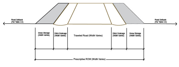
E.
Trail Setbacks: Setback distances from hard and soft surface trail easements or right-of-way shall be ten (10) feet. Setbacks from hard and soft surface recreational pathways may be reduced if approved by the Open Space and Trails Department and if one (1) or more of the following exists: 1) topography or natural vegetation that provides a visual separation such that any buildings or improvements on the site (driveways excepted) cannot be seen from the recreational pathway; or 2) if lot dimensions, preexisting structures or other physical site attributes preclude the ability of individuals to meet established setbacks.
F.
Open Parking Areas: Open parking area setback requirements are as follows:
1.
For Single-Family Detached and Duplex Dwelling Units, Including But Not Limited to Single-Family and Duplex Dwelling Units in R-P and PUD Zoning Districts: Where it is not possible to build a driveway to County standards because of the steepness of the lot, a parking area or parking platform may be constructed adjacent to the road right-of-way and within the required setback, subject to approval by the County Engineer per the applicable requirements of this Code.
2.
For CG, CN, B-1, B-3, I-1, M-1, Multi-family Residential Uses in R-P or PUD Zoning Districts, Commercial or Industrial Uses in PUD Zoning Districts and Other Non-residential Development:
a.
Front and Street Side: Within ten (10) feet of the property line, except that no parking areas are allowed within 20 feet of property lines abutting highway or arterial rights-of-way.
b.
Side and Rear: Within five (5) feet of the property line, except that no parking areas are allowed within 15 feet of a property line where that line is a boundary between:
i.
A single-family and a multi-family residential zoning district.
ii.
An area(s) of a PUD Zoning District and an area(s) of an R-P Zoning District where single-family and multi-family residential development abut.
iii.
A residential zoning district (including an area of a PUD allowing residential development) and either a commercial or industrial zoning district, community or institutional facility or an area of a PUD allowing commercial or industrial development or development of a community or institutional facility.
iv.
A mining zoning district and either a residential or commercial zoning district, community or institutional facility or an area of a PUD allowing residential or commercial development or development of a community or institutional facility.
v.
Community and institutional facilities: Regulations regarding the placement of open parking areas serving community or institutional facilities shall be as stated for commercial uses in D.2 of this Section.
3.
For Residential Development in All Zoning Districts in the County: Parking areas for single-family and duplexes and accessory dwelling units (ADU) should be located outside of the setback unless meeting the exceptions below:
a.
The parking is located in a driveway that is compliant with Chapter 5 of the Code and has not been expanded beyond the width permitted by this Code;
b.
On a single-family lot with a permitted ADU, one parking space may be located within the setback provided it is a minimum of 5' from all property lines.
G.
Exceptions to Setback Requirements:
1.
Duplex Units: Where a lot line is to be established along the common wall shared by two (2) dwelling units in a duplex, the side setback requirement on either side of this internal lot line may be reduced or eliminated.
a.
Notwithstanding the establishment of a reduced or eliminated setback to the internal lot line of a duplex lot, a detached ADU shall comply with the applicable setback of the zoning district.
2.
Interior Property Lines: Where a manufactured home park, multi-family residential, commercial, industrial or mixed-use development is proposed for a site consisting of two (2) or more contiguous parcels, setback requirements along the interior property lines may be reduced or eliminated if:
a.
An overall development plan has been approved for the site and the site continues to be developed as one entity according to the approved development plan.
b.
Structures do not cross parcel lines.
c.
The Placement of structures complies with building-to-building setback requirements and with the requirements of the Building Code.
3.
Minor Structures and Uses: The following minor structures and uses are allowed in any required setback, but shall not obstruct motorist's vision at access points.
a.
Bus shelters used as a part of a community transit system.
b.
Uncovered decks and patios within 18 inches of finished grade.
c.
Driveways, including driveways that must be elevated due to topographic conditions.
d.
Flagpoles that do not exceed the maximum height limit established in the underlying zoning district.
e.
Mailboxes and newspaper tubes.
f.
Landscape planters.
g.
Play equipment.
h.
Signs, with an approved sign permit.
i.
Walkways.
j.
Walls and fences, as provided in Section 3505.17.
k.
Minor utility facilities.
l.
Light bollards/fixtures.
m.
Sheds provided that 1) the sheds are located in the rear or side yard and are located a minimum of five (5) feet from all property lines (including the driplines of the shed); and 2) the maximum size of such shed shall not exceed 200 square feet of floor area nor shall the maximum height exceed eight (8) feet. Sheds larger than 200 square feet must be located outside of the required setbacks.
n.
Ranch signs and similar entry structures for parcels greater than five (5) acres.
o.
Signs as permitted by this Code, subject to any sign setbacks established in the Sign Regulations.
p.
Hot tubs, provided that 1) the hot tubs are located in the rear yard, 2) a minimum setback of five (5) feet to all property lines is maintained, and 3) buffering or screening is provided to the adjoining property or properties.
q.
Railings for walkways, patios, decks, stairs or driveways as required to meet code requirements.
r.
Stairs less than 18 inches above finished grade.
s.
Any structure if it is buried below natural grade if 1) the finished grade provides a smooth transition into the unaltered natural grade, and 2) the setback area retains its open character.
t.
Typical non-structural residential recreational amenities including play sets, sandboxes, tree houses, benches, picnic tables, grills, dog houses and other similar non-structural residential recreational amenities that do not adversely impact the open character of the setback area.
u.
Art.
v.
Solar energy systems as indicated in Section 3507.01.
w.
Raised garden beds.
4.
Variable Setbacks to Facilitate Wetland Protection: To facilitate the protection of wetlands as defined in Chapter 15 and their corresponding 25-foot buffer, a property owner may apply for administrative relief from the applicable zone district property line setback standards pursuant to Section 13400 et seq. of this Code.
H.
Verifying Setbacks: A Site Improvement Location Certificate ("SILC") shall be required to verify setbacks when structures or improvements, which are not listed as an exception in Section G above, are within ten feet of a setback unless otherwise verified by the Planning Department.
Site area requirements for the different zoning districts are stated in Figure 3-5. In certain cases, Figure 3-5 lists specific site area requirements for particular uses. Where a specific site area required for a particular use differs from the general requirement for the zoning district, the specific requirement shall apply when a site is created for that use. Compliance with minimum site area requirements is determined as follows:
A.
A-1 and BC Zoning Districts: Minimum site area is synonymous with the minimum parcel size allowed, except for approved rural land use subdivisions (see Section 8420 et seq.). In determining compliance with site area requirements where the requirement is for 20 or more acres, gross site area shall be used.
B.
RU, RE, R-1, R-2, R-3 and R-4 Zoning Districts: Minimum site area is synonymous with the minimum parcel size allowed. In determining compliance with the minimum size required, net site area shall be used.
C.
R-6 and R-25 Zoning Districts: Minimum site area is synonymous with the minimum parcel size allowed. In determining compliance with the minimum size required for one (1) dwelling unit, net site area shall be used. A duplex lot shall contain sufficient square footage of lot area to allow the development of a duplex (two (2) dwelling units) unless other applicable zoning regulations, plat notes or documents allow for the development of a duplex.
D.
R-P Zoning District: A site consists of a parcel or group of contiguous parcels included in an overall plan for development approved by the County. Site area requirements may vary for different planning areas under the overall plan. The overall plan shall specify site area requirements of each planning area and may include a map illustrating site area requirements. If site area requirements are not stated for an R-P Zoning District, the Planning Director shall determine the site area requirements which apply in accordance with Section 3505.01.
E.
MHP, CG, CN, B-1, I-1, and M-1 Zoning Districts: A site consists of a parcel or group of contiguous parcels that are planned and developed as a unit, and the following site area requirements apply:
1.
MHP Zoning District: Each manufactured home park shall contain a minimum of ten (10) acres.
2.
CG Zoning District: Each area having this zoning designation shall contain a minimum of five (5) acres.
3.
CN Zoning District: Each area having this zoning designation shall contain a minimum of one (1) acre.
4.
I-1 Zoning District: Each area having this zoning designation shall contain a minimum of five (5) acres.
5.
PUD Zoning District: Where established, site area requirements for PUDs shall be stated in the PUD designation. If site area requirements are not stated in a PUD, the Planning Director shall determine the site area requirements which apply in accordance with Section 3505.01.
F.
B-3 Zoning District: 20,000 sq. ft., except that any lot platted prior to an area being zoned B-3 shall be considered to meet the required minimum lot area. The minimum lot area for a residential-only subdivision is stated in Section 3515.
G.
R-4 with Plan, R-6 with Plan and PUD Zoning Districts and Multi-family Development That may be Permitted in Other Zoning Districts: A site may consists of a parcel or group of contiguous parcels included in an overall plan for development approved by the County. Site area requirements may vary for different planning areas under the overall plan approved by the County. If site area requirements are not stated for one of these zoning districts, the Planning Director shall determine the site area requirements which apply in accordance with Section 3505.01.
H.
Site Area Requirements and Subdivision Exemptions: If a duplex lot or multi-family lot meets the minimum site area requirements of the underlying zoning, such lots may be platted in accordance with this Code's subdivision exemption requirements listed in Section 8400 et seq. Duplex dwellings, townhouse dwellings or multi-family dwellings may be subdivided into parcels that do not meet required site area provisions provided 1) the site continues to be developed as one (1) entity according to an approved or modified development plan in accordance with the requirements of this Code; 2) the overall site development adheres to the site area requirements of the underlying zoning district; 3) the property continues to meet and adhere to all requirements of any townhouse plat or condominium map, or other applicable documents of record; and, 4) any subdivision plat for the development site includes a plat note stating the development of the parcels is subject to an overall development plan. Notwithstanding the foregoing, a duplex dwelling subdivision exemption shall be divided so that the lot for one (1) dwelling unit contains no less than 40% of the total land area in the original lot unless other site areas are approved by the Planning Department that allow for each lot to have approximately 30 to 50% of the land area in each resultant duplex lot.
I.
Waiver of Site Area Requirements for Replatting Legal Non-conforming Lots: The Review Authority may approve the replatting and establishment of lots that do not meet the minimum site area requirements if the following criteria are met during the required subdivision development review process:
1.
At least two (2) legal non-conforming lots are being platted through a preliminary/final plat or subdivision exemption development review process.
2.
There is no increase or decrease in the pre-existing site area of the non-conforming parcels or lots involved in the subdivision process and all lots retain the same or greater area as exists prior to the subdivision review process.
3.
The proposed reconfiguration is to either a) create better development sites per the policies contained in applicable master plans, or b) to achieve other broader community goals or objectives that further the public interest, or c) to resolve some lot or parcel boundary dispute, including but not limited to structural encroachments, setback encroachments of structures or encroachments of wells or septic system components.
4.
A nonconforming parcel plan review has been or will be obtained prior to establishing any new uses on a parcel, if deemed necessary by the Review Authority, or such review is not required by the provisions of this Code.
Site coverage limitations are required to ensure that a certain portion of each development site remains undeveloped in order to provide relief from large expanses of building mass and pavement.
A.
Application of Coverage Requirement: The maximum amount of building and impervious site coverage (as defined in Chapter 15) permitted for each zoning district, and for specific uses in each zoning district, are stated in Figure 3-5. Coverage requirements are applied as follows:
1.
A-1, BC, RU, RE, RME, R-1, R-2, R-3, R-4, R-6 and R-25 Zoning Districts: Maximum coverage limits are calculated based on net site area, except for approved rural land use subdivisions (see Section 8420 et seq.).
2.
MHP, CG, CN, B-1, B-3, I-1 and M-1 Zoning Districts: A site consists of a lot or group of contiguous parcels which are planned and developed as a unit. Each parcel shall meet the maximum coverage requirements as outlined in Figure 3-5.
3.
For PUD Zoning Districts: Where established, coverage limits for PUDs shall be stated in the PUD designation. If site coverage limits are not stated in the PUD designation, the Planning Director shall determine the site coverage limits which apply in accordance with Section 3505.01.B.
4.
R-4 with Plan, R-6 with Plan and PUD Zoning Districts and Multi-family Development That May Be Permitted in Other Zoning Districts: A site may consist of a parcel or group of contiguous parcels included in an overall plan for development approved by the County. Site coverage requirements may vary for different planning areas under the overall plan approved by the County. If site area requirements are not stated for one of these zoning districts, the Planning Director shall determine the site area requirements which apply in accordance with Section 3505.01.D.
5.
Site Coverage Requirements and Subdivision Exemptions: If a duplex dwelling or multi-family dwelling meets the site coverage requirements of the underlying zoning, such units may be platted in accordance with this Code's subdivision exemption requirements listed in Section 8400 et seq. Duplex dwellings, townhouse dwellings or multi-family dwellings may be subdivided into parcels that do not meet required site coverage provisions provided 1) the site continues to be developed as one (1) development application according to an approved or modified development plan in accordance with the requirements of this Code; 2) the overall site development adheres to the site coverage requirements of the underlying zoning district; 3) the property continues to meet and adhere to all requirements of any townhouse plat or condominium map, or other applicable documents of record; and, 4) any subdivision plat for the development site includes a plat note stating the development of the parcels is subject to an overall development plan.
B.
Compliance with Requirement:
1.
Types of areas: Areas which are not counted towards site coverage shall either be:
a.
Undisturbed areas left in a natural state; or
b.
Landscaped and revegetated areas having a permeable surface.
3505.16: Street, Driveway and Parking Areas
Summit County has adopted Road Standards. Any streets, driveways or parking areas constructed in conjunction with a development project shall comply with the standards in Chapter 5 and the other required provisions of this Code, including but not limited to the design requirements stated in Section 3600 et seq. and Section 3700 et seq.
The height, location and design of walls and fences are regulated by this Code as provided in this section. Berm design standards are addressed separately in the Landscaping Regulations of this Code (see section 3600).
A.
Wall and Fence Heights: The maximum heights for walls or fences are stated below and summarized in the development standards matrix, except as provided in Section 3505.17.B. No wall or fence shall obstruct visibility at access points.
1.
A-1 Zoning District: On parcels having 20 or more acres, wall and fence heights are not regulated except that they shall not cause a visual obstruction at access points. On parcels of less than 20 acres, fences shall comply with requirements for residential zoning districts (see Section 3505.17.A.2).
2.
RU, RE, RME, R-1, R-2, R-3, R-4, R-6, R-25, R-P and MHP Zoning Districts:
a.
Front: Fences and walls in the front setback shall be no higher than four (4) feet above grade at the property line, and shall not cause a visual obstruction at access points. Fences or walls in the front yard but not in the front setback may exceed four (4) feet up to a maximum of six (6) feet above grade.
b.
Street side: Fences or walls in any setback abutting street right-of-way shall comply with the height limits on fences and walls in front setbacks except where there is no vehicular access to the site from that side. In that case, the height of the fence or wall may be six (6) feet above grade at the property line.
c.
Maximum height: Fences and walls in areas other than the front or street side setbacks shall be no higher than six feet (6) above grade.
3.
CG, CN, B-1 and B-3 Zoning Districts and Other Commercial Development as May be Allowed in Other Zoning Districts:
a.
Front: Fences and walls in the front setback shall be no higher than four (4) feet above grade at the property line, and shall not cause a visual obstruction at access points. Fences or walls in the front yard but not in the front setback may exceed four (4) feet up to a maximum of eight feet (8) above grade.
b.
Street Side: Fences or walls in any setback abutting street right-of-way shall comply with the height limits on fences and walls in front setbacks except where there is no vehicular access to the site from that side. In that case, the height of the fence or wall may be eight (8) feet at the property line.
c.
Maximum Height: Fences and walls in areas other than the front or street side shall not be higher than eight (8) feet at the property line.
4.
I-1 and M-1 Zoning Districts:
a.
Front: Fences and walls in the front setback shall be no higher than six (6) feet above grade at the property line and shall not cause a visual obstruction at access points. Fences or walls in the front yard but not in the front setback may exceed six (6) feet up to a maximum of ten (10) feet above grade at the property line.
b.
Street Side: Fences and walls in any setback abutting street right-of-way shall comply with the height limits on fences and walls in front setbacks except where there is no vehicular access to the site from that side. In that case, the height of the fence or wall may be ten (10) feet above grade at the property line.
c.
Maximum Height: Fences and walls in areas other than the front or street side shall be no higher than ten (10) feet above grade.
5.
For Planned Unit Developments: Where limits on heights of fences or walls are established in a PUD, these limits shall apply as provided for in Section 3505.01. Where height limits for fences or walls are not stated in the PUD designation, the Planning Director shall determine the height limits for fences or walls which apply in accordance with Section 3505.01.
6.
BC Zoning District:
a.
Wildlife and Fencing: All fences or walls shall be constructed to effectively hold livestock while allowing for the passage of wildlife. Areas that may be fenced shall be limited to the immediate area of site disturbance around the principal structure and areas for livestock. Fencing areas for livestock shall be limited to a size equal to the area required for the number of livestock animals physically kept on a property, subject to the requirements of Section 3802 et seq. and Figure 3-8. For example, if two (2) horses are kept on the property, a maximum of four (4) acres may be fenced.
b.
Maximum Heights: The maximum height for fences and walls shall be the same as for residential zoning districts as outlined in Section 3505.17.A.2 provided that such fencing shall also comply with the requirement regarding wildlife friendly fencing outlined above.
B.
Exceptions to Wall and Fence Heights: The following exceptions to limits on wall and fence heights apply in all zoning districts:
1.
Height limits specified in this section do not apply to retaining walls or construction fencing (up to 12 feet) for large-scale projects or projects with significant safety concerns as determined by the Planning Department.
2.
The maximum height of a fence or wall shall be three and one-half (3½) feet above grade within the sight triangle of any street intersection.
3.
Sports and recreation facilities may have wall and fence heights that exceed the requirements of this section provided such heights are based on industry accepted standards.
C.
Wall and Fence Design: All fences or walls shall be constructed to be wildlife friendly and to not ensnare or otherwise cause injury to wildlife. All fences or walls enclosing an area of one (1) acre or greater shall be designed to allow for the safe passage of wildlife. See Colorado Parks and Wildlife guidelines for wildlife friendly fencing (Fencing with Wildlife in Mind, Colorado Division of Wildlife, 2009, as may be updated or amended); examples are included below. The design of fences, including the types of material used for construction, shall comply with the following requirements except that retaining walls do not have to meet the following standards (refer to Section D below for the design standards for retaining walls). A request for an exception to these requirements will be considered pursuant to the provisions for administrative relief in Section 13400 et seq. In order to grant administrative relief from this requirement, the Code Administrator and property owner must consult with the Colorado Parks and Wildlife to review the specifics details of the property, the reason for the request, and to identify the appropriate fencing that will minimize impacts to wildlife.
1.
Use of Natural Materials: Walls and fences constructed as part of multi-family, mixed-use or commercial development shall be constructed of natural materials such as wood, river rock or stone or naturally appearing materials approved by the Planning Department. For all new construction and/or additions in excess of 25% of the value of the existing structure, permissible fencing materials shall include a section of five (5) lineal feet of non-combustible material within 10-feet of any structure. Compliance shall be verified as part of any required defensible space inspection. This requirement may be waived by the Review Authority when the specific conditions and individual circumstances (i.e. slope, aspect, vegetation types, availability of firefighting infrastructure, and other relevant factors as identified in the CWPP) of a given project do not warrant imposition of this standard. Concrete fences are not permitted unless faced with a material as required above.
2.
Barbed Wire, Wire Strand and Electric Fences: Barbed wire, wire strand and electric-charged fences are regulated as follows:
a.
Permitted in A-1, BC (as may be limited in Section A.6 above), M-1, RU, RME and RE zoning districts and in other zoning districts where a conditional use permit has been approved for the keeping of livestock.
b.
Permitted as specified in the National Electric Code, as amended or as deemed necessary and appropriate by the Review Authority to promote demonstrated security concerns and the public health, safety and welfare.
c.
Prohibited in all other zoning districts except as provided for above unless a specific allowance has been made in a PUD designation.
d.
Electric fences may be used in accordance with Section 3802.02.E.4 et seq. specifically in association with beekeeping.
3.
Chain Link: Chain link fences are permitted except that in the RU, RME, RE, R-1, R-2, R-3, R-4, R-6, R-P and MHP zoning districts, chain link fences shall not be used for purposes of enclosing storage areas where such storage must be screened from view in accordance with Section 3815 et seq. Chain link fences are permitted to be used in the I-1 and M-1 zoning districts for enclosing storage areas, provided that such fences shall be equipped with slats in order to create an opaque screen as required by Section 3815 et seq.
4.
Storage Yards: Walls and fences enclosing storage yards and gates in such fences and walls shall be opaque if so required by this Code.
5.
PUDs: Where design standards for fences are established in a PUD, these design standards shall be applied as provided for in Section 3505.01. Where height limits for fences are not specifically stated in the PUD designation, the Planning Director shall determine the height limits for fences that apply in accordance with Section 3505.01.
D.
Retaining Walls:
1.
Design:
a.
Colorado Licensed Professional Engineer Design: All retaining walls in excess of four (4) feet in total height, whether in a single line or in steps, shall be designed and stamped certified by a Colorado Licensed Professional Engineer.
b.
Maximum Height: To the extent practicable, large retaining walls shall be broken up by steps. The maximum height of a retaining wall shall be eight (8) feet, and if more retaining is necessary above that height, a four (4) foot step in the wall shall be required. All stepping of retaining walls shall require a setback for each step with a minimum of one-half the height of the wall preceding it.
c.
Landscaping: Landscaping shall be provided on any steps in the retaining wall and at the base of the wall to soften the appearance of a retaining wall.
d.
Visual Impacts: Attention shall be given to the visual impact of retaining walls as viewed from off-site. Every reasonable effort shall be made to reduce visual impact through the color and type of materials used and height of retaining walls.
2.
Materials: Retaining walls shall be constructed from such materials as concrete, reinforced earth rock, gabions or other decay resistant materials. If gabions are used, large rocks shall be used to fill the gabions, and they shall be faced with treated timbers. The appearance of retaining walls shall be softened through the architectural finish on the surface and with landscaping.
3.
Drainage: All retaining walls shall have adequate subsurface drainage.
4.
PUDs: Where design standards for retaining walls are established in a PUD, these design standards shall be applied as provided for in Section 3505.01. Where design standards for retaining walls are not specifically stated in the PUD designation, the Planning Director shall determine the design standards that apply in accordance with Section 3505.01.
A.
Size Limits: The maximum size for a garage associated with a single-family dwelling shall be as follows:
1.
BC Zoning District: Total floor area of garages (and all other accessory structures) in the BC zoning District shall not exceed 600 square feet.
2.
All Other Zoning Districts: 1,500 sq. ft. of floor area in a single-family dwelling that contains up to 3,000 square feet of floor area. For single-family dwellings that contain more than 3,000 square feet, maximum garage size is a function of the floor area contained in the dwelling, with the maximum garage size allowed at 50% of the floor area contained in the dwelling up to a maximum of 2,000 square feet of in garage floor area.
3.
There shall be no size limit for a garage on a parcel greater than 35 acres located within the A-1 Zoning District.
B.
Location: Except as provided in the RC-5000 and RC-40000 zoning districts, a garage associated with a residential use must be located on the same parcel as the residential use. The garage may be either attached to or detached from the primary residential structure. Both attached and detached garages are allowed on the same parcel provided the size of both garages combined does not exceed the maximum size limit as stated above.
C.
Exceptions to Size Limits: Areas which are located within the garage area of a dwelling or the garage structure, but are separated from the actual parking areas, such as but not limited to workshop areas or rooms, storage areas and utility areas, shall not be counted in the size of the garage if such areas are designed as one of the following areas:
1.
An area that has a floor elevation at least six (6) inches higher or lower than the garage floor elevation.
2.
An area that is physically separated by a wall from the garage parking area (i.e., utility or storage rooms, a workshop area, etc.) that clearly cannot accommodate the parking of a vehicle.
3.
An area that has a maximum door opening of less than six (6) feet in width.
D.
Other Uses Permitted in Garages: Garages may contain workshops, storage areas, dog washes, chemical washouts (for residential uses only in residential zoning districts), utility sinks, offices, artist studios, and other similar uses. In detached garages, bedrooms not associated with an approved accessory dwelling unit are prohibited. Bathrooms are permitted in detached garages but are limited to a sink and a toilet. Wet bars are not permitted in or above a detached garage.
3505.19: Snow Storage and Snow Shedding Standards
A.
Applicability: The provisions of this section apply to duplex, multi-family, commercial, industrial and other non-residential development. Single-family development is exempt from the following requirements so long as snow storage is provided adjacent to paved areas in accordance with the provisions of subsection B below.
B.
Provision for Snow Storage: Snow storage areas shall be provided on each site adjacent to paved areas and other areas to be plowed subject to the standards of this section. The size of these areas shall be equivalent to at least 25% of paved or graveled surfaces on the site and shall be located to provide convenient access for snowplows. Uphill slopes of five to ten percent (5-10%) shall count at 75% of their area towards this requirement. Uphill slopes of eleven to twenty percent (11—20%) shall count at 50% of their area. Uphill slopes greater than 20% are not appropriate for snow storage, and shall not be counted in determining compliance with snow storage requirements. The area provided by downhill slopes used for snow storage shall be calculated at the time of development review. Heat traced or mechanically snow melted areas may be required by the Review Authority where high pedestrian traffic is anticipated and such areas do not receive adequate sun exposure in order to avoid ice buildup or other safety hazards. Where required by a review authority, adjacent snow storage areas do not have to be provided for heat traced or snow melt areas. Such areas, including pedestrian walkways, courtyards and driveways shall not be counted in the total area used to determine the minimum snow storage requirement so long as the heat tracing system is maintained and operated.
C.
Off-premise Snow Storage: Removal of snow to storage areas off-site in lieu of providing on-site snow storage may be permitted with approval of the Review Authority, if one of the following criteria is met:
1.
Evidence is provided showing that the property would otherwise comply with the minimum snow storage requirements described in Subsection B above, and that the area that would have been used as on-site snow storage will remain in open space rather than used to increase the density of the project.
2.
Placement of the snow storage off-site will achieve important design objectives such as consolidating or better coordinating snow storage areas, increasing landscaped areas and buffering of buildings or reducing visual obstructions caused by snow stacking on the project site.
3.
The off-site snow storage area has provisions for buffering, screening, access and water quality.
D.
Proximity to Paved Areas: Snow storage shall be (1) provided adjacent to paved areas if not being stored off-site; and (2) setback a minimum of ten (10) feet from buildings to ensure emergency access to a building is not impeded.
E.
Snowmelt and Drainage Requirements: Snow storage areas shall be located in a manner that maximizes snowmelt and drainage opportunities. In addition, the following related criteria shall be met to the extent practicable:
1.
Location: To the extent practicable, snow storage areas shall be located in:
a.
Sunny areas to help speed the snow melting process.
b.
Revegetated areas to help with slowing the absorption of runoff, and prevent ponding.
2.
Drainage: Drainage from snowmelt areas shall be designed to:
a.
Divert snowmelt away from walks, driveways, parking areas and other paved surfaces.
b.
Divert snowmelt away from shaded areas to avoid freezing and subsequent ice hazards.
c.
Protect waterways and neighboring properties by providing methods for filtering runoff before such drainage enters a waterway.
d.
Minimize erosion.
F.
Other Design Standards:
1.
Sight Distance: Snow storage shall not interrupt pedestrian path sight distance or auto circulation sight distance as required by this Code.
2.
Protection of Road and Driveway Edges: Road and driveway edges shall be designed to be protected from snow removal activities by 1) reducing or eliminating traditional curb and gutter; 2) utilizing concrete pans adjacent to the driveway; or 3) utilizing other common engineering or BMPs to reduce damage to the edges of roads and driveways.
3.
Protection of Landscaping: Landscaping adjacent to snow storage areas that may be damaged or destroyed by snow storage activities shall be protected by the use of planters, elevated landscaping elements, timber walls or other mechanisms approved by the County.
4.
Protection of Buildings or Structures: Protective measures such as planters, retaining walls and bollards shall be used where it is deemed necessary by the County to prevent snow removal damage to buildings or structures.
G.
Snow and Ice Shedding Standards:
1.
Protection of Public Spaces: Public spaces, such as walkways, decks, balconies and entrances shall not be located below snow and ice shedding areas of roofs, wherever practicable. Where it is not practicable to avoid locating public spaces below snow shedding and icicle fall areas, such areas shall be protected by appropriate mechanisms, including but not limited to the use of architectural treatments such as dormers, shed roofs and canopies; the use of snow and ice stopping devices on the roof; and/or, the use of heat-traced roof and gutter systems.
2.
Protection of Landscaping: Existing vegetation, landscaped areas, parking, drives and buildings shall be protected from snow shedding, removal and storage activities by:
a.
Setting parking and drive areas back ten (10) feet from buildings so that these areas may be protected from snow shedding if the roof design indicates snow shedding onto such areas.
b.
Trees, delicate shrubs and other landscaping that may be damaged or destroyed by snow or ice shedding shall not be located below the roof of a building where snow and ice shedding can occur.
3505.20: Solar Access and Orientation
Summit County has a severe winter climate but a high number of days with sunshine. It is the County's policy to encourage the design of developments such that solar access is reasonably preserved for each building site and for adjacent properties. It is the County's intent to encourage the use of passive and active solar energy systems in both homes and businesses, and also to ensure developments do not negatively impact the solar access of neighboring properties to a significant degree.
A.
Shading: Developments have the potential to shade and decrease the solar access of adjacent properties. Developments shall be designed to preserve the solar access of adjacent properties to the extent practicable. The Planning Department may require a shade analysis for developments that could significantly affect the solar access of neighboring properties.
B.
Solar Design: The high number of sunny days in Summit County provides the opportunity to significantly increase the energy efficiency of structures through the use of effective passive solar design. Developments are encouraged to maximize the use of passive solar design. In addition, properly oriented roof areas allow for the installation of efficient solar energy systems. The County encourages roof areas to be designed to allow for the installation of efficient solar energy systems.
C.
Landscaping: Incorrectly designed landscaping has the potential to decrease the solar access of on and off-site development. The County encourages landscaping be designed to minimize impacts to solar access of on and off-site development while maintaining compliance with Section 3600 et seq.
A.
Outbuildings include, but are not limited to, sheds, workshops, detached structures, and barns. Outbuildings do not include garages. The size of outbuildings is limited as follows:
1.
The size of barns is not regulated on any parcels where the use is permitted, except that all structures on such parcels shall not exceed the site coverage limitations as set forth in Figure 3-5.
2.
On parcels less than 40,000 square feet, the cumulative size of all outbuildings, excluding barns where permitted, shall not exceed 1,000 square feet.
3.
On parcels greater than 40,000 square feet, there is no limitation on the individual or cumulative size of the outbuildings. However, such structures shall not exceed the site coverage limitations of the underlying zoning district as set forth in Figure 3-5.
B.
Outbuildings shall not contain bedrooms and shall not be used as a dwelling unit, except that detached historic structures may be used as an accessory dwelling unit if approved in accordance with Section 3809.03.M of the Code. Where outbuildings 200 square feet or larger contain electricity and running water, a covenant prohibiting the structure from being used as a dwelling unit or separate living quarters shall be required to be recorded prior to the issuance of a certificate of occupancy for such structure.
C.
Except for barns, doors on outbuildings shall not exceed six (6) feet in width.
3506: - Transferable Development Rights (TDRs) Program Regulations
3506.01: Purpose and Intent:
The transferable development rights program provides a means to help achieve the community's common vision for the future, and identified goals and objectives, such as but not limited to the protection of: backcountry and rural areas, lands with important resource protection or open space value, natural features, scenic vistas or visually important lands, environmentally sensitive areas, land with development constraints, and community character. Furthermore, these regulations are intended to:
• Implement key goals and policies/actions of the Countywide Comprehensive Plan, and respective basin master plans and subbasin plans.
• Provide a mechanism to compensate landowners who voluntarily participate in the TDR Program by giving up certain development/subdivision rights, thereby providing opportunities to preserve resources valued by the community.
• Encourage new development to occur in areas that have adequate infrastructure and services capable to accommodate growth or additional development.
• Moderate activity levels and the rate of growth in traffic volume to maintain acceptable levels of service. Particularly, reduce the amount of residential and vehicular activity associated with ultimate build-out allowed per zoning on backcountry or rural properties.
The Review Authority analyzing and approving a formal development project proposal determines whether a particular property is suitable to utilize the TDR program. Therefore, in cases where it is determined appropriate, utilization or acquisition of development rights is a condition supplemental to the successful approval of a County development project/application. The TDR program regulations are intended to be uniform and consistent between planning basins. However, portions of the regulations contained herein were developed in a manner to reflect unique characteristics or issues of each respective basin; therefore, the TDR regulations may vary depending on where a property is located. The transfer of development rights within the respective planning basins is allowed pursuant to the regulations contained in this subsection.
A.
Applicability: To carry forward the purpose and intent of the TDR program, the following regulations shall be applicable to all development that undertakes any of the following actions, except for actions listed under the exemptions set forth in subsection 3 below and 3506.04. No development project that seeks to utilize the TDR program regulations shall be approved by the County unless the provisions of this section are met. TDR program regulations are applied to various development projects in two ways: (1) utilization of the TDR program is mandatory for rezoning/upzonings; and (2) the TDR program may voluntarily be utilized in other types of development projects to mitigate issues.
1.
Rezonings/Upzonings: An application for a zoning amendment or PUD modification that would increase the development rights (or equivalent thereof) associated with the zoning of the property (with such zoning to specifically exclude any permitted or previously-approved conditional uses) in any one or more of the following ways shall transfer development rights accordingly:
a.
Residential Density: Increases the residential density of development beyond the maximum permitted by the existing zoning district; and/or
b.
Floor Area: Increases the permitted residential, commercial or industrial floor area beyond that permitted by the existing zoning district or this Code; and/or,
c.
Vehicle Trips: Increases the total number of vehicle trips generated by commercial or industrial development beyond that permitted by the existing zoning district; and/or,
d.
Mixed Uses/Combination of New Uses: Increases the overall activity levels beyond the maximum permitted by the existing zoning district. For example, where a combination of new uses are proposed on a property (e.g., mix of residential and commercial), it shall be shown that overall activity levels (i.e. residential density, floor area or vehicle trips) increase.
2.
Other Types of Applications:
a.
Any applicant may voluntarily propose to utilize the TDR program regulations provided that the applicant makes such an express proposal in writing, or on the record, and presents the same directly to the Review Authority. The voluntary transfer of a development right or development rights may be accepted as a means of mitigation if the Review Authority deems it is a reasonable and appropriate method to ameliorate concerns related to a proposed development project. Examples of types of issues that may be mitigated, including without limitation, are as follows:
i.
Attaining general conformance with master plans and applicable master plan goals and policies/actions;
ii.
Mitigating issues related to subdivisions (whether new subdivision, resubdivision or platted lots or reestablishing lot lines);
iii.
Mitigating impacts related to increased floor area or vehicle trips;
iv.
Mitigating impacts to the immediate neighborhood or community (e.g., traffic, noise or visual impacts);
v.
Offsetting taxation and assessment issues or homeowner association concerns;
vi.
Addressing other important development or planning concerns, policies, and/or unusual impacts.
b.
Utilization of the TDR program for a particular development project shall consider the following:
i.
Regulations or policies that are of sufficient exactitude so that proponents of new development are afforded due process, and the basis for the County's decision is clear for purposes of reasoned judicial review.
ii.
Rough proportionality in both nature and extent to the level of impact considered in utilizing and implementing the TDR program.
iii.
Maintaining an essential nexus to the concerns which precipitated the utilization of the TDR program for that application.
3.
Exemptions: The following types of development, TDR Banks and Planned Unit Developments (PUDs) are exempt from the provisions of these regulations:
a.
Local Resident Housing: Development of housing which meets the specifications for Affordable Workforce Housing set forth in Section 3809.02 et. seq., the specifications for Accessory Dwelling Units set forth in Section 3809.03 et. seq., or the specifications for Housing for On-Site Employees set forth in Section 3809.04 et. seq. of this Code.
b.
Community Facilities and Institutional Uses: Development applications or portions of development applications where the proposed land use is restricted to community facilities and institutional uses as defined by this Code.
c.
Blight Placer TDR Bank: The development rights located in the Blight Placer TDR Bank are not eligible to take advantage of the bonus density as specified in Section 3506.02.D.1.d.ii. However, the 2-units allowed to be located on the Blight Placer PUD property may take advantage of this provision.
d.
Keystone Resort PUD: Where upzonings are proposed within the existing boundaries of the Keystone Resort PUD, development rights may be transferred from other parcels within the neighborhood, from parcels in other neighborhoods of the PUD, or from identified TDR sending areas, in accordance with the specific requirements of the PUD. When a zoning amendment request would exceed the overall density allocated to the Keystone Resort PUD, new density will only be allowed if it is transferred from a designated TDR Sending Area.
i.
For any future rezonings of the NR-2 zoning district land known as "the Soda Ridge Triangle" into the Keystone Resort PUD, up to 14 actual TDR units (35 equivalent units) for the requested rezoning may originate from the Keystone "PUD-wide Density Bank".
ii.
For rezoning requests of land designated NR-2 that is contiguous to the Keystone Resort PUD, the proportion of development rights transferred or originating from either the Keystone Resort PUD, PUD-wide Density Bank or designated TDR Sending Area shall be determined at the time of the individual request. The BOCC shall make the final determination with input from the Snake River Planning Commission.
e.
Copper Mountain Resort PUD: Where upzonings are proposed within the existing boundaries of the Copper Mountain Resort PUD, equivalent unit density may be transferred from other parcels within the neighborhood or from parcels in other neighborhoods of the PUD in accordance with the specific Density Transfer requirements contained in the PUD. When a zoning amendment request would exceed the overall density allocated to the Copper Mountain Resort PUD, new density will only be allowed if it is transferred from a designated TDR Sending Area.
B.
Mapping and Designation of TDR Sending, Receiving, Optional and Neutral Areas:
1.
Official TDR Maps: The properties designated as Sending, Receiving, Optional and Neutral Areas are depicted on maps marked as Official Transferable Development Rights Maps for each of the respective planning basins. These maps are included as part of this Code by this reference and shall be kept on file in the Planning Department and available for public inspection. The BOCC may amend these maps from time-to-time (see Section 3506.02.C).
2.
Sending Areas: Parcels suitable to transfer development rights from shall be identified as Sending Areas and shown on the respective basin's Official Transferable Development Rights Map. In order to be eligible to be utilized as a sending area, all such parcels shall meet the following criteria to the satisfaction of the County:
a.
The Sending Area is a legal parcel in accordance with all the applicable provisions of this Code, and, if applicable, is in compliances with the merger of nonconforming parcels requirements specified in Section 14101.02.F.
b.
The applicant has an ownership interest in the property sufficient to proceed with transfer of development rights as proposed, including clear title and no encumbrances or restraints, private or otherwise, on the title that would preclude its eligibility to be used for transfer of development rights. Examples of encumbrances that could restrict the availability and sale of development rights from a particular property include, but are not limited to, existing conservation easements, access or utility easements, plat notes, or property purchased with GOCO (Great Outdoors Colorado) funds.
c.
No significant environmental or other liabilities exist on the property, such as but not limited to extensive environmental remediation needs that would preclude the County from accepting title to the property. In the Snake River, Ten Mile or Upper Blue basins, in rare instances where the County does not want to accept title to the property, the transfer of development rights from the property could still be recognized as specified in Section 3506.02.F. below.
d.
In the Upper Blue Basin, properties containing wetlands of "high importance" or wetlands of "concern", as defined in the "Final Report on Enhancement of Wetlands Management in Summit County", February, 2003 (copy on file at the County Planning Department), may also qualify to serve as TDR Sending Areas. In order to qualify, 50 percent or more of the property must be covered by wetlands of "high importance" or wetlands of "concern". The Official Transferable Development Rights Map for the Upper Blue Basin does not identify the location of such lands; therefore, a site-specific delineation of wetlands will be required in order to confirm that a parcel is covered 50 percent or more by wetlands of "high importance" or wetlands of "concern". Such wetlands shall be delineated to the satisfaction of the County Engineer that the wetlands meet the criteria to be classified as wetlands of "high importance" or wetlands of "concern," a site-specific delineation may not be required.
In accordance with Sections 3506.02.A.2. and 3506.02.C., Sending Areas may be eligible to utilize and retire development rights to offset the impacts of other types of applications without necessitating an amendment to the Official Transferable Development Rights Map.
3.
Receiving Areas: Parcels determined to be potentially suitable for the receipt of development rights shall be identified as Receiving Areas and shown on the respective basin's Official Transferable Development Rights Map. A parcel may not be used as a Receiving Area unless it receives approval for a zoning amendment, PUD, PUD amendment, or is otherwise authorized through an official BOCC approval. Receiving Areas identified on Official TDR Sending and Receiving Areas Maps represent areas that could "possibly" serve as sites for additional density or more intense development. Receiving areas represent properties where it is felt adequate infrastructure and services capable to accommodate growth or additional development might be available. However, just because a property is identified as a "receiving area" on an Official TDR Sending and Receiving Areas Map does not imply, grant or vest the right to actually utilize or receive TDRs. The Review Authority analyzing and approving a formal development project/application determines whether a particular property is suitable to utilize or receive TDRs. Therefore, utilization or acquisition of TDRs is a condition supplemental to the successful approval of a County development project/application. The following areas have specific requirements related to receiving TDRs:
a.
Lower Blue Basin: In the Lower Blue Basin a Receiving Area parcels located in the "Rural Area" of the basin seeking to utilize development rights shall only receive such development rights from identified Sending Areas also located in the "Rural Area" of the basin.
b.
NR-2 Zoned Properties: Properties with a NR-2 Zoning District designation, but not identified as TDR Receiving Areas on Official Transferable Development Rights Maps, may be allowed to serve as TDR Receiving Areas provided that the zoning amendment Review Authority determines (i) that the uses and densities proposed are in general conformity with the applicable master plan policies and applicable master plan land use designations; (ii) that any specific restrictions on the use of the property are given consideration, and (iii) that the Receiving Area receives approval for a zoning amendment subject to the provisions of this Code.
4.
Optional Areas: Optional areas are only identified in the Lower Blue Basin. Those parcels that have been determined to be suitable for sending or receiving development rights shall be identified as an Optional Area, and therefore eligible to send or receive density. However, designation as an Optional Area only enables a parcel to send or receive development rights, it does not enable the parcel to do both. A parcel identified as an Optional Area may not be used as a Receiving Area unless it receives the necessary approval as described above in Section 3506.02B.3.When a property becomes designated as either a Sending or Receiving area, through affirmative action such as requesting approval to send or receive a TDR from the property, the Official Transferable Development Rights Map for the Lower Blue Basin shall be amended accordingly (reference Section 3506.02.C. below).
5.
Neutral Areas: Those parcels that have been determined to not be suitable for sending or receiving density, and therefore not eligible to participate in the transfer of development rights, have been identified as Neutral Areas and shown on the respective basin's Official Transferable Development Rights Map. In order to encourage sensitive site design and minimize environmental, visual or other impacts, properties identified as Neutral Areas may be allowed to cluster density on contiguous properties. The clustering of density may be allowed provided the properties: are held in common ownership, there is no increase in density, and the proposal to cluster density is approved through the applicable development review process (e.g. rezoning, subdivision).
C.
Amendments to the Official Transferable Development Rights Maps:
Modifications to the TDR designations reflected on the respective basin Official Transferable Development Rights Maps may be warranted based on changing conditions, such as: growth and development patterns, land use approvals, availability of infrastructure, community sentiments, conservation easements, land trades or purchases, etc.
1.
TDR Receiving Situations Requiring an Amendment to the Official TDR Maps:
Only designated TDR Receiving Areas can accept and use development rights in conjunction with a rezoning. If a property proposed for rezoning is not identified as a TDR Receiving Area on the Official Basin TDR Map, an application to amend the applicable TDR Map to change the property's TDR designation to a Receiving Area shall be submitted concurrently with the rezoning application.
2.
TDR Receiving Situations Not Requiring an Amendment to the Official TDR Maps:
When a transfer of development rights is approved to offset impacts in conjunction with "Other Types of Applications", per the provisions of Section 3506.02.A.2, the property does not need to be identified as a TDR Receiving Area, and an amendment to the Official Basin TDR Map is not required to enable utilization and retirement of development rights to occur.
3.
Review Process, Submittal Requirements and Criteria for Approval:
An applicant seeking an amendment to an Official Transferable Development Rights Map shall follow the Class 5 development review process outlined in Section 12000 et seq. The following shall be submitted to the Planning Department as part of the application to enable evaluation by the Review Authority:
a.
Description of the property location, statement of interest in the property, and the request to change the TDR designation.
b.
A written narrative describing how the subject property meets the applicable criteria outlined below:
i.
For requests to change a TDR Receiving or Neutral Area designation to a TDR Sending Area designation, the following criteria shall be met:
aa.
The property has a master plan rural land use designation or other County development policy/action or regulation that specifically contemplates sending development rights.
ba.
The property is in an area not readily served by urban facilities and services (e.g., public wastewater and water).
ca.
Surrounding properties primarily have a TDR Sending Area designation.
da.
Designation of the property as a TDR Sending Area would be consistent with the overall philosophy of protecting rural areas, backcountry areas or environmentally sensitive areas, or would be consistent with accomplishing other important master plan goals and policies/actions.
ii.
For requests to change a TDR Sending or Neutral Area designation to a TDR Receiving Area designation, the following criteria shall be met:
aa.
The property has the ability, based on master plan land use designation or other County development policy/action or regulation, to accommodate additional development densities.
ba.
Designation of the property as a TDR Receiving Area would be consistent with the overall philosophy of directing development to urbanized locations or with accomplishing other important master plan goals and policies/actions.
iii.
In the Lower Blue Basin, for requests to change from either a TDR Sending, Receiving or Neutral Area designation to an Optional Area designation, the subject property must have inherent site characteristics (e.g., size, available infrastructure or visually important lands) that support and demonstrate the property is suitable for both sending and receiving additional development rights/densities as set forth in Sections C.2 and C.3 above.
iv.
For requests to change a TDR Sending, Receiving or Optional Area to a Neutral Area designation, the following criteria shall be met:
aa.
The property has a master plan land use designation or other County development policy that supports the Neutral Area designation; and/or
ba.
It is demonstrated that the property is not suitable for transferring development rights from or to, and therefore should not be eligible to send or receive density.
4.
Administrative Changes to the Official TDR Maps: Administrative changes to the Official Transferable Development Rights Maps shall be allowed to correct mapping errors or to reflect actions that have occurred, which have affected the density on a particular property (e.g., land trades, rezonings to the open space zone district, recordation of a conservation easement or restrictive covenants placed on sending areas). Determination of whether a proposed change is administrative shall be made by the Code Administrator. Administrative changes to the Official TDR Maps shall follow the Class 6 development review process outlined in Section 12000 et seq.
D.
Development Rights Sending Area Value, TDR Banks and Sales Price: Once a request for a TDR transfer has been approved, either the development right shall be purchased from a TDR Bank or transferred from identified Sending Areas (including Optional Areas that have become a Sending Area) using the following formula:
1.
Sending Area Value:
a.
Vacant Property: Twenty (20) acres of vacant property in an identified Sending Area equals one (1) development right. Fractions of a development right shall be recognized for Sending Area properties less than or exceeding twenty (20) acres in size. For example, 5 acres equals one-fourth (¼) of a development right, 25 acres equals one and one-fourth (1¼) development rights, and 35 acres equals one and three-quarters (1¾) development rights.
b.
Accessory Units and Guest Houses: An accessory unit or guest house use on a property, if already allowed by the underlying zoning designation, shall not be considered as additional density that could be utilized as a transferable development right.
c.
Developed Property and the Transfer of Residual Development Rights or Square Feet of Floor Area: Unused or residual development right value associated with a property shall not be sold or transferred as a development right or fraction of a development right.
i.
The transfer of unused or residual square feet of floor area to another property, to increase structure size, shall not be allowed. For example, if an owner of a 20-acre BC zoned property in the Ten Mile Basin chooses to build a 950 sq. ft. home instead of the maximum 1,650 sq. ft. home as allowed per the BC Zoning District regulations, the unused or residual development rights or square feet of floor area cannot be sold or transferred, but will remain on the property and be available to the existing or future property owner for potential additions or expansions of the structure on the property. Also reference Section 3514 et seq.
ii.
Lower Blue Basin: Properties zoned A-1 in the Lower Blue Basin and identified as Sending Areas have one (1) development right per 20 acres, provided the portion of the property being used as a Sending Area contains only the permitted uses allowed within designated open space tracts in rural land use subdivisions, as set forth in Section 8426.04 of this Code.
d.
Exceptions: Exceptions to the development right values of one (1) development right per twenty (20) acres of property, are as follows:
i.
Platted lots in a Sending Area shall have a value of one (1) development right per platted lot. In the Upper Blue Basin, lots which are not located in identified Sending Areas shall qualify to have a value of one (1) development right per platted lot, provided that at least 50 percent of the total area of the lot is covered by wetlands of high importance or wetlands of concern, as set forth in Section 3506.02.B.2.
ii.
For those properties identified as "Sending Areas—Significant Wildlife Value" on the Official Transferable Development Rights Sending and Receiving Areas Map for the Snake River Basin, the development right shall have a value of 2:1 (including the 2-units allowed to be located on the Blight Placer PUD). For example, 20 acres of property equals two (2) TDRs, instead of one (1) TDR.
iii.
An individual, un-platted parcel two acres or less in size is equal to one-tenth (1/10) of a development right.
iv.
In the Lower Blue Basin, if a rural cluster subdivision is reviewed and approved, then the Sending Area development rights available on that property will be equal to the density recognized per the approval.
2.
TDR Banks and Sales Value of a Development Right: TDR banks serve as a known location to purchase and facilitate the sale of development rights. The County currently administers two TDR Banks: a) Countywide TDR Bank and b) Joint Upper Blue TDR Bank.
a.
Countywide TDR Bank: The Countywide TDR Bank contains separate accounts for the Lower Blue, Snake River, Ten Mile and Upper Blue basins. The value of a development right sold by the Countywide TDR Bank is determined as follows:
i.
Lower Blue Basin Account: No set value has been established for development rights sold from the Lower Blue Basin account. The value of development rights sold by the Lower Blue Basin account is determined by the County on a case-by-case basis and is the fair market value of a development right.
ii.
Snake River, Ten Mile and Upper Blue Basins Accounts: The value of development rights sold from these respective accounts is calculated by the Summit County Planning Department on an annual basis in accordance with the Summit County TDR Price Calculation Methodology. The documented TDR Price Calculation Methodology used to annually determine the price of a development right is approved by the Board of County Commissioners and kept on file in the Planning Department.
b.
Joint Upper Blue TDR Bank: The Joint Upper Blue TDR Bank facilitates the sale of development rights as part of the Upper Blue TDR program and the Intergovernmental Agreement ("IGA") Between Summit County and Town of Breckenridge ("Town") Concerning Transferable Development Rights in the Upper Blue Basin. The price of a development right sold by the Joint Upper Blue TDR Bank shall be determined pursuant to the IGA and such documentation of the annually adjusted price shall be kept on file in the Planning Department.
E.
Utilization of Development Rights: Based on approval by the County, development rights can be utilized a number of ways in conjunction with different kinds of development projects. The following identifies how development rights can be used when accepted or transferred to a property in conjunction with a rezoning approval. These conversions shall be used as a guide in evaluating the utilization and acceptance of development rights in other types of applications.
1.
Actual Unit and Floor Area: When transferring development rights the following standards shall be equal to one (1) development right:
a.
One (1) single-family residential or duplex dwelling unit not to exceed 4,356 square feet of floor area;
b.
One (1) multi-family dwelling unit not to exceed 1,400 square feet of floor area (i.e. townhouses and condominiums); or not to exceed an average per dwelling unit of 1,400 square feet of floor area;
c.
Three (3) lock-off or lodge rooms (no kitchen), not to exceed an average per building of 467 square feet of floor area each; or,
d.
One thousand (1,000) square feet of non-residential gross floor area (e.g., commercial, industrial, etc.).
These conversions shall be used as a guide in evaluating the utilization and acceptance of development rights in other types of applications (reference section 3506.02.A.2).
Residual Floor Area: If the maximum permitted size of a dwelling unit is not built, unused or residual floor area cannot be sold or transferred, but will remain on the property and be available to the existing or future property owner for potential additions or expansions of the structure on the property. In no event shall unused or residual floor area be used for more dwelling units or density than allowed per zoning.
Additional Floor Area: Additional floor area or fractions of development rights shall be transferred if additional floor area, above the maximum permitted through the above development right conversions, is requested. For example, 1.25 development rights would need to be transferred to build a 5,445 square foot single-family residence; or one (1) development right would need to be transferred to build 1,000 square feet of additional non-residential gross floor area. In no event shall additional floor area or fractions of development rights purchased allow for the actual number of dwelling units or density permitted per zoning to be exceeded.
Floor Area Backcountry (BC) Zoned Parcels and TDR banks: BC Zoning District properties shall not be eligible to acquire development rights, or fractions thereof, from TDR banks to increase structure size (i.e. meet or maximize BC Zoning District acreage thresholds and formulas). Properties zoned BC shall be eligible to utilize only the Parcel Assemblage process in Section 3514.04.B.7 to increase allowed structure size.
2.
Increase in Vehicle Trips: For proposed changes in commercial or industrial use, not involving changes in floor area modification, but that would increase the average daily vehicle trips ("ADT") over and above the number of trips that would be generated by the most intense use(s) that could occur under the existing zoning or PUD approval, the applicant shall transfer development rights (based on the formula under Section 3506.02.D) in a quantity sufficient to reach a rate equal to the expected increase in vehicle trips. Vehicle trips shall be determined based on the formula of one (1) development right transferred equaling the vehicle trips generated by a single-family dwelling unit, as specified in the most recent version of Trip Generation manuals prepared by the Institute of Transportation Engineers.
F.
Recordation of Transfer of Development Rights: All transactions involving the use of the TDR program regulations and the transfer of development rights shall be filed with the Planning Department. In order to effectuate the transfer of development rights a Transferable Development Rights Certificate shall be issued by the Planning Department and recorded in the Office of the Clerk and Recorder. TDR Certificates shall be issued for 1) development rights purchased, transferred or retired from County properties or established TDR banks, 2) in exchange for TDR Sending Area properties deeded to the County or 3) private party transfers. For properties deeded to the County, TDR Certificates shall be issued in values established in Section 3506.02.D above. Issuance and recordation of a TDR Certificate are subject to the specific provisions and applicable guidelines below.
1.
Schedule/Timeline for Recordation: For zoning amendments or other types of applications involving development rights, the applicant shall obtain a development rights certificate as specified in the approval within 18 months of the approval (also reference 12105.04, 12201.02 and 12202.06). If the applicant fails to complete the recordation of development rights within the 18 month time period, the respective approval shall become null and void, unless the approval is renewed per Section 12002 et seq. If a zoning amendment, PUD or PUD amendment is considered to be a "substantial development" (i.e. 15 or more development rights), an alternative time period or schedule to transfer development rights may be approved by the Review Authority and shall be stated in the resolution of approval (reference Section 3506.04).
2.
Snake River and Ten Mile Basins: In the Snake River and Ten Mile basins, title to all TDR Sending Area properties shall be transferred to Summit County via an instrument recorded in the Office of the Summit County Clerk and Recorder. However, in unique or rare situations the County may determine that it is not appropriate to transfer title/ownership of a property to the County, but instead may be retained by the current owner or transferred to another party (e.g., U.S. Forest Service). Under these circumstances a Transferable Development Rights Certificate shall still be issued. However, a perpetual restrictive covenant or other document enforceable by the County and in a form acceptable to the County shall be recorded in the Office of the Clerk and Recorder. Such restrictive covenant or document shall clearly describe the disposition of the property and shall prevent development or uses inconsistent with the TDR program regulations.
3.
Upper Blue Basin: In the Upper Blue Basin, title to all TDR Sending Area properties used to seed the Joint Upper Blue TDR Bank or used in conjunction with rezonings/upzonings in the Upper Blue Basin shall be transferred jointly to Summit County and the Town of Breckenridge via an instrument recorded in the Office of the Summit County Clerk and Recorder. However, if development rights are transferred into the Upper Blue Basin via an interbasin transfer, title to the TDR Sending Area property shall not be transferred jointly to the County and Town but to the County alone, unless as identified Section F.2 above. In the Upper Blue Basin, in certain situations, it may be determined that it is not appropriate to transfer title/ownerships of a property to the County and Town, but instead may be retained by the current owner or transferred to another party. In such a situation a perpetual restrictive covenant or other document would need to be mutually developed by the County and Town, enforceable by both parties, and recorded in the Office of the Clerk and Recorder.
4.
Lower Blue Basin and Restrictive Covenant: In the Lower Blue Basin the sale of development rights shall occur between private entities or the County. In certain instances, a property owner may want to transfer fee title of a TDR Sending Area property to the County. This may occur so long as the Sending Area property is legally subdivided and title recorded via an instrument in the Office of the Summit County Clerk and Recorder. In the Lower Blue Basin a property owner may retain ownership of the property subject to the issuance of a Transferable Development Right Certificate and recording document identifying residual and permitted uses. Under these circumstances the property owner shall work with the County to develop a perpetual restrictive covenant or other document enforceable by the County, and in a form acceptable to the County, which shall be placed on the Sending Area property and recorded in the Office of the Clerk and Recorder. In light of the TDR program's purpose and intent, the restrictive covenant or document shall identify uses which align with both the property owner's and County's goals to protect the rural character and identity of the Lower Blue Basin (e.g., by preserving ranching and agricultural uses and other natural resource values unique to the property).
Such restrictive covenant or document shall clearly:
a.
Describe the disposition of the property.
b.
Describe that portion of the land intended to serve as a Sending Area. If less than all development rights are transferred off a TDR Sending Area parcel, then an area shall be defined on the Sending Area parcel, equaling the acreage/development right value transferred.
c.
Describe the residual and permitted uses allowed which may reflect, among other things: historic use of the property, preservation of open space, or uses typically consistent and associated with past agricultural operations and normal expansion thereof. If mutually consented to by the property owner and County, these uses could include:
i.
Agricultural operations, with the following provision applicable to lumber operations: Lumber operations shall only be permitted when timber harvest is for resource management purposes (i.e. maintaining forest health) in conjunction with a forest management plan approved by the CSFS.
ii.
Animal keeping (see Section 3802).
iii.
Existing agricultural buildings and barns.
iv.
Reconstruction/replacement of damaged structures or existing agricultural buildings and barns. Where an existing structure is damaged or destroyed, the structure may be restored or repaired to not more than its original size (bulk, mass and height); provided the restoration occurs within generally the same footprint as the original structure and architectural designed to demonstrate rural character/exhibit similar character of the previous building or structure.
v.
Fences—repair, replacement and new fences when used for agricultural or resource protection purposes (i.e. keeping cattle out of a stream), provided the fences shall be constructed to effectively hold livestock while allowing for the passage of wildlife.
vi.
Minor utilities—maintenance of existing minor utilities and placement of new minor utilities when underground and when the disturbed area is restored and re-vegetated.
vii.
Roads:
- Existing public or private roads and the maintenance of the roads.
- New construction of roads for purposes of providing access to agricultural structures and/or operations, fire mitigation or similar purpose, or other uses allowed by this section.
viii.
Stormwater detention facilities for on-site agricultural operations and drainage.
ix.
Recreation trails and pathways.
x.
Leach fields for septic systems provided any ground disturbance is restored.
xi.
Wellheads/well houses and developed springs.
xii.
Wetlands, stream and wildlife enhancement projects.
xiii.
Repair and replacement of existing irrigation ditches, headgates, water diversion structures, dikes and construction of new irrigation or water structures for the purposes of reasonable and customary management of irrigation water for agriculture.
xiv.
Other uses consistent with protection of open space values, preserving rural/agricultural character, and other goals of the Lower Blue Master Plan or County development policies, as approved in the final restrictive covenant. For example, construction of a building necessary for legitimate agricultural operations (i.e. loafing shed).
5.
Subsurface Mineral Rights: Where the property owner holds an interest in subsurface mineral rights, the subsurface mineral rights shall also be deeded to the County, or in the Upper Blue Basin, jointly to Summit County and the Town of Breckenridge, unless the BOCC makes a finding that the open space values of the property are important enough to accept the property without subsurface mineral rights and further provided that the applicant demonstrates the ability to access such rights from other lands by ownership or a lease of adjacent property, or other methods approved by the County. In making such findings, the BOCC shall use the Selection Criteria in the Summit County Open Space Protection Plan. If the County decides to take ownership of a Sending Area property without obtaining ownership of the subsurface mineral rights, an agreement shall be recorded acknowledging that access to the subsurface mineral estate shall not be allowed from the surface of said property.
6.
Private Party Transfer of Development Rights: The transfer of development rights between private persons shall be subject to all provisions of the TDR program regulations. Nothing shall preclude the sale of a development right between private entities so long as the sale is: registered with the County, a Transferable Development Rights Certificate is issued, and is in full compliance with the provisions as provided in Section 3506 et seq.
(Res. No. 25-51, 6-24-2025)
The preferred method of complying with the TDR program regulations is to acquire development rights from within the basin where they are proposed to be utilized. However, the Review Authority for the basin which is proposed to receive the development rights may consider an allowance for interbasin TDRs to occur between individual planning basins as a part of a zoning amendment or other type of application. Allowing for the interbasin transfer of development rights supports the idea of helping to facilitate a cohesive and uniform Countywide TDR Program and can increase creative opportunities for the use of development rights.
A.
Process: An applicant shall specify the reason and nature of such an interbasin transfer in its development project proposal. During the review of a development project proposal the planning commission retains the ability to accept or deny a proposed interbasin transfer, and can require an applicant to indicate the portion of development rights proposed to be transferred from other basins. The resolution approving an interbasin transfer of development rights shall specify the basin and parcels from which the development rights (or portion of development rights) will be obtained.
B.
Review Criteria: In order for a basin planning commission to approve the proposed interbasin development rights transfer, the following criteria shall be evaluated in conjunction with a proposed development project:
1.
The proposed transfer of development rights is in general conformance with the applicable master plan goals and policies/actions, provided such goals and policies do not contradict the provisions of this Code.
2.
Evidence that the proposed development rights, or a portion of the development rights, are not readily available within the respective basin where the proposed development project is located.
3.
The proposal will further the preservation or protection of environmental, conservation, visual or historic resource values.
4.
The proposal will demonstrate legal, physical or financial viability.
5.
A referral or recommendation from the basin planning commission(s) where the development rights are proposed to be transferred from.
C.
Transfer Ratios: Interbasin transfers shall be consistent with the Development Right Values for Sending Areas established in Section 3506.02.D. For interbasin transfer purposes, specific provisions and exceptions include:
1.
Lower Blue Basin: No development rights shall be transferred from other basins of the County into the "Rural Area" of the Lower blue Basin, but may be transferred into the "Urban/Silverthorne Area".
2.
Snake River Basin: Per Section 3506.02.D1.d.ii, the development right value for properties identified as "Sending Areas—Significant Wildlife Value" on the Official Transferable Development Rights Map for the Snake River Basin, shall be 2:1 (including the 2-units allowed to be located on the Blight Placer PUD property).
3.
Upper Blue Basin: No development rights shall be transferred from other basins of the County into the Upper Blue Basin until development rights have first been transferred out of the Upper Blue Basin to other basins of the County, according to the following ratio: For every four (4) development rights transferred out of the Upper Blue Basin, three (3) development rights shall be allowed to be transferred from other basins into the Upper Blue Basin. This ratio is established to accomplish the goal of the Joint Upper Blue Master Plan to reduce overall density and activity levels in the basin. The Planning Department shall be responsible for tracking development rights transferred into and out of the basin to ensure that the above provisions are complied with. Nothing in this section shall prohibit additional development rights (beyond the established four-out/three-in ratio) from being transferred out of the Upper Blue Basin to other basins of the County.
4.
Backcountry (BC) Zoned Properties and Floor Area Assemblage: Backcountry zoned properties may not transfer or receive development rights from other basins in order to meet the BC Zoning District acreage assemblage thresholds or formulas to increase structure size. Also reference Section 3514.
3506.04: Voluntary and Alternative Measures of Compliance with TDR Program Regulations
The regulations contained in this subsection are only applicable to development project proposals in the Lower Blue, Snake River and Ten Mile basins. In consideration of the key goals, policies and strategies contained in the Joint Upper Blue Master Plan, the following provisions are not applicable to the Upper Blue Basin. Additionally, the following regulations shall be applicable only to a zoning amendment or PUD modification that qualifies as a "substantial development" proposal and would increase the development rights (or equivalent thereof) associated with the zoning of the property (with such zoning to specifically exclude any permitted or previously approved conditional uses). A substantial development is any development project proposal of fifteen (15) or more development rights (or equivalent thereof). The utilization of the TDR program regulations remains the preferred alternative to account for new development rights involved in a zoning amendment application for substantial developments. The decision as to whether or not to accept an offered alternative to full utilization of the TDR program regulations and transfer of development rights is a discretionary decision within the sole province of the Review Authority for any given zoning amendment application. A full release of an applicant's TDR program regulation requirements and obligations shall only be granted under exceptional circumstances, and in no circumstance shall any such alternative be required of any applicant.
A.
Purpose and Intent:
The County has determined that in some cases applicants should be afforded flexibility to propose or provide sufficient benefits in lieu of development rights. The intent of providing voluntary and alternative measures to the TDR program regulations is to mitigate the impacts of increasing development rights through furthering other related legitimate community interests and objectives as specifically promoted by master plan goals and policies or other County development policies. By offering such alternatives, the voluntary compliance measures are intended to increase flexibility in the application of the TDR program by allowing applicants a second, voluntary means of attaining compliance and approval of development applications in a manner that continues to promote specific Countywide Comprehensive Plan or respective basin master plans' goals and policies/actions. In accordance with the Countywide Comprehensive Plan TDR policies, as presently located in the Land Use Element, Goal C. policies/actions 1 and 2, and subject to change from time to time, an applicant may propose an alternative means to the transfer of development rights to meet the applicable TDR program regulation requirements. Additionally, it is recognized that in rare instances the amount of development rights required by a project might not be readily available for purchase or transfer. In light of such considerations an applicant may propose certain alternatives to the TDR program regulation requirements using one or a combination of the alternative measures as set forth below. The following types of proposals should be evaluated as an alternative measure of compliance, in part or in whole, to meet TDR program regulation requirements.
B.
Alternative Programs and Projects:
An alternative program or project proposal shall be made by an applicant to satisfy, in whole or in part, a numerical TDR program regulation requirement. Such proposal shall proportionally offset the impacts of the requested development rights in a manner that promotes, establishes or supports a program or project that substantially furthers other legitimate community interests and objectives as depicted by master plan goals and policies/actions or other County development policies.
1.
Examples of such projects or programs that may be proposed by the applicant, and may in turn be considered by the Review Authority, include, but are not limited to, the following:
a.
Dedication of land for purposes of open space, development of community facilities, provision of deed-restricted affordable workforce housing, or other legitimate community interests and objectives.
b.
Construction of facilities for purposes of public recreation and transportation, or public health, safety and welfare purposes.
c.
Provision of deed-restricted affordable workforce housing that meets the specifications set forth in Section 3809.02 of this code.
d.
Donation of funds for purposes of promotion, establishment or support of a program or project that substantially furthers other legitimate community interests and objectives.
e.
Commitment to the provision of services for purposes of promotion, establishment or support of a program or project that substantially furthers other legitimate community interests and objectives.
2.
No such proposal may be approved by the Review Authority unless the following criteria are evaluated and satisfied:
a.
The application is for a substantial development.
b.
The applicant has certified that the program or project at issue is offered on a completely voluntary basis, pursuant to the exercise of a viable choice by such applicant, and that the applicant understands that it is not required to make such a proposal under any circumstance.
c.
The applicant has demonstrated, based upon substantial evidence presented at relevant public hearing(s), and by means of a professional, empirical study, that such density bonus proposal is roughly proportional to the impact of the proposed increase in density, pursuant to County regulations, goals and policies related to such increase in density.
d.
The applicant has demonstrated, based upon substantial evidence presented at relevant public hearing(s), and by means of a professional, empirical study, that an essential nexus exists between the legitimate community interests and objectives advanced by such program or project and the impacts of the increase in development rights from the development project.
e.
The applicant has proposed an alternative to the TDR program regulations requirements that advances legitimate community interests and objectives as specifically promoted by master plan goals and policies, other County development policies, or otherwise in this Code.
f.
The program or project shall be roughly proportional to the total value of a specific TDR program regulation requirement that would otherwise apply to the applicant's development project proposal. The rough proportionality shall be based upon the calculated fair market value of development rights as determined in accordance with Section 3506.02.D.2. In the Lower Blue Basin values shall be considered on a case-by-case basis based on detailed information submitted by the applicant.
In the event an interbasin transfer is proposed as part of a substantial development application, the process, criteria and ratios established in Section 3506.03 shall be referenced.
C.
Payment in Lieu of Utilizing the TDR Program Regulations:
1.
In instances where development rights are not available for purchase or transfer, or the utilization of such otherwise present substantial practical difficulties, a financial contribution in lieu of transferring development rights may be allowed as an option to offset TDR program regulation requirements, in whole or in part, that have been identified as a result of a development project proposal.
2.
If the applicant elects to propose an in lieu payment, the applicant shall be required to articulate the legitimate concerns which justify the proposal. Any in lieu proposal shall be evaluated by the Review Authority, and the Review Authority may refuse a payment in lieu of transferring development rights and require that development rights be transferred, in accordance with the provisions of this Section.
3.
Under no circumstances shall any payment in lieu of utilizing the TDR program regulations exceed the total value of any specific development right requirement that would otherwise apply to the applicant's development project proposal, based upon the calculated fair market value of such development rights as determined in accordance with Section 3506.D.2 (TDR Banks and Sales Price of a Development Right).
4.
All payments in lieu allowed herein shall be deposited into a specified account expressly authorized to retain such payments. Such monies shall be utilized to sustain the County's efforts to provide funding for the acquisition of development rights from properties identified as TDR Sending Areas on the Official Transferable Development Rights Maps. Any payment in lieu of utilizing the TDR program regulations shall occur prior to recordation of the applicable zoning amendment or PUD designation documents, unless an alternative time period is approved by the Review Authority and stated in the resolution of approval for the zoning amendment, PUD, or PUD amendment.
(Res. No. 25-51, 6-24-2025)
3507: - Renewable Energy System Standards
Increased energy costs, government rebates and incentives, and a greater awareness of sustainability issues and human impacts on our planet have created an increased interest in renewable energy systems for homes and businesses. It is the County's intent to allow for and encourage such systems in locations that minimize impacts on the environment and the surrounding area.
3507.01: Solar Energy Systems
A.
Small Scale Solar Energy Systems: Small scale solar energy systems shall be used primarily for on-site, private purposes. Ground mounted systems in commercial, industrial, and multi-family developments shall be reviewed through the Class 2 review process. All other systems shall be reviewed through the Class 1 review process.
1.
Location:
a.
Roof Mounted: Allowed in all Zoning Districts, including PUD's as an accessory use.
b.
Ground Mounted: Allowed in all Zoning Districts, including PUD's, as an accessory use in accordance with the following provisions:
i.
Systems may be ground mounted in the front, side, or rear yard. Systems may not be mounted in the front setback area.
ii.
Ground mounted systems may be located within side and rear setback areas a minimum of 10 feet from the lot line, but may not be located within any road setbacks unless:
aa.
There are no public health, safety, or welfare issues with the proposed location.
ba.
The Road and Bridge and Engineering Departments have approved the location and the property owner has completed an indemnification agreement releasing the County from any liability associated with allowing a structure within the road setback area.
ca.
The applicant has demonstrated, to the satisfaction of the Planning Department, that there is no alternative location on the property or on an existing or proposed structure that is viable without: i) removing significant numbers of healthy trees, or ii) reducing the efficiency of the system by 15% or more.
iii.
Ground mounted systems shall comply with applicable stream and wetland setbacks.
iv.
All building and disturbance envelope restrictions shall apply to ground mounted solar energy systems.
v.
If deemed necessary by the review authority to adequately buffer the system, landscaping, berms and/or an alternative location may be required.
vi.
Ground mounted systems in the BC zoning district must also be in conformance with Section 3514.04.D.
2.
Height:
a.
Roof Mounted: Roof mounted systems may exceed the permitted height by a maximum of ten percent (10%).
b.
Ground Mounted: Ground mounted systems may be a maximum of 25 feet tall. The permitted height of systems located in side and rear setback areas shall not be greater than the distance from the system to the nearest property line.
3.
Legal Nonconforming Structures: Solar energy systems may be roof mounted on legal nonconforming structures. Systems located on portions of the building that are nonconforming cannot extend above the ridgeline of the roof the system is mounted on and cannot extend more than one foot above the roof surface, measured perpendicularly from the roof surface.
4.
Shared Systems: Solar Energy systems shared by up to 10 property owners may be allowed with approval of a conditional use permit following the Class 4 development review process per Section 12300. Such systems may be located on vacant lots. Such systems must comply with the location and height regulations for small scale solar energy systems.
B.
Large Scale Solar Energy Systems: Large scale solar energy systems are primarily used to produce power for use off-site, and may be allowed in the A-1, M-1, CG, CN, B-1, B-3, and I-1 zoning districts, and within areas of PUDs allowing uses consistent with these zoning districts, with approval of a conditional use permit following the Class 4 development review process per Section 12300.
A.
Small Scale Wind Energy Systems: Small scale wind energy systems shall be used primarily for on-site, private purposes. Systems shall be reviewed through the Class 1 review process unless otherwise indicated in this Section.
1.
Horizontal Axis Wind Turbines ("HAWT")
a.
A-1 and M-1: HAWTs are permitted on parcels of 20 acres or more. On parcels less than 20 acres, HAWTs shall be reviewed through a class 4 conditional use permit. Maximum height shall be 80 feet. Setbacks to any property line shall be two times the height of the turbine.
b.
R-U, R-E, RME, OS, and BC: HAWTs shall be reviewed through a class 4 conditional use permit. Maximum height shall be 80 feet. Setbacks to any property line shall be two times the height of the turbine.
c.
R-1, R-2, R-3, R-4, R-6, R-25, R-P, RC-40000, RC-5000, CG, CN, B-1, B-3, and I-1: Not permitted.
d.
PUD: Systems shall be permitted within PUDs as stated in the PUD as an accessory use. If a PUD does not specifically state that a small scale wind energy system is allowed, then such systems shall be allowed in accordance with the most similar zoning district allowing uses and having lot sizes most similar to the use and lot size permitted in the PUD, as determined by the Planning Department.
2.
Vertical Axis Wind Turbines ("VAWT")
a.
All Zoning Districts: Roof mounted VAWTs are permitted up to a maximum of ten percent (10%) above the permitted height.
b.
VAWTs that are tower mounted shall be permitted in accordance with the regulations for HAWTs, as indicated in Section 3507.02.A.1.
3.
Noise: Except during severe wind storms, wind turbines shall not cause a sound level exceeding fifty (50) dba, as measured at the nearest lot line.
4.
Colors: Towers, turbines, and blades or vanes shall be a color that blends with the background of the structure, and shall be nonreflective.
5.
Height: Height for horizontal axis turbines is measured to the center of the turbine shaft. Vertical axis turbines shall be measured to the top of the blades or vanes. Height shall be measured as indicated in Section 3505.06.
B.
Large Scale Wind Energy Systems: Large scale wind energy systems are primarily used to produce power for use off-site, and may be allowed in the A-1 and M-1 zoning districts with approval of a conditional use permit following the Class 4 development review process per Section 12300.
3507.03: Hydroelectric Energy Systems
A.
Small Scale Hydroelectric Energy Systems: Small scale hydroelectric energy systems are allowed in all zoning districts, including PUDs, as an accessory use and shall be reviewed through the Class 2 application process. Small scale hydroelectric energy systems shall be used primarily for on-site, private purposes and shall comply with the following standards:
1.
Wheel turbines, generators, and other mechanical equipment shall be enclosed in a wheelhouse/pumphouse structure.
2.
The system shall be designed to blend in with its surrounding environment. All system components, including the structure and pipes shall not create visual or auditory impacts, or create impediments or other unnatural hazards or impacts upon wildlife. If deemed necessary by the review authority to adequately buffer the system and associated buildings, landscaping and/or berms may be required.
3.
The system shall be designed to minimize the length of the diversion to the maximum extent practicable in order to minimize impacts to the stream section with reduced flows. Systems shall be designed to minimize construction disturbance and permanent disturbance to streams.
4.
Dams are not permitted for any small scale hydroelectric system. Partial diversion structures such as weirs or head gates are allowed with proper permitting.
5.
The system shall comply with all applicable water quality control regulations contained in Chapter 7, and other applicable portions of the Code.
6.
Equipment housing structures shall be permitted within setback areas in accordance with Section 3505.13.G.3.L.
B.
Large Scale Hydroelectric Energy Systems: Large scale hydroelectric energy systems are primarily used to produce power for use off-site, and may be allowed in the A-1, M-1, and I-1 zoning districts with approval of a conditional use permit following the Class 4 development review process per Section 12300.
3507.04: Wood Burning Energy Systems
A.
Small Scale Wood Burning Energy Systems: Small scale wood burning energy systems are allowed as an accessory use on lots which are a minimum of 5 acres in all residential Zoning Districts, including PUDs, and shall be used primarily for on-site, private purposes. Small scale wood burning energy systems shall be reviewed through the Class 1 application process. Only clean untreated wood or pellets shall be burned. Systems located within structures other than the primary structure or garage shall comply with the following standards.
1.
Smoke: Systems must be outdoor wood-fired hydronic heater devices, or similar as approved by the Public Health and Building Inspection Departments in accordance with the current adopted Building Codes.
2.
Location: Systems may be located in the side or rear yard. Systems are not permitted within setback areas.
3.
Height: Structure height may not exceed the permitted building height. The chimney height may exceed the permitted height by up to a maximum of ten (10) percent.
4.
Unless otherwise approved by the Review Authority, natural colors shall be used.
B.
Large Scale Wood Burning Energy Systems: Large scale wood burning energy systems are primarily used to produce power for use off-site, and may be allowed in the A-1, M-1, and I-1 zoning districts with approval of a conditional use permit following the Class 4 development review process per Section 12300.
3508: - Maintenance of Common Areas
Whenever a development project includes streets, common open space, common driveways (except common driveways serving two (2) or fewer residential units), parking areas or pathways or common recreational facilities, the developer shall provide for the continued maintenance and repair of such land and improvements through the formation of an owners association. The articles of incorporation, association bylaws and Covenants, Conditions & Restrictions ("CC&Rs") shall be submitted to the Planning Department with submittal of the first plat for the development. No plat shall be approved unless the BOCC determines that the CC&Rs contain adequate provisions for maintenance and repair of common areas. The articles of incorporation, association bylaws and CC&Rs shall be recorded prior to or concurrent with recordation of the plat. The CC&R's shall, at minimum, address the maintenance of such common elements, including, but not limited to:
• Common driveway construction and maintenance;
• Road Maintenance, including but not limited to construction, maintenance, and snow removal;
• Detention pond maintenance;
• Maintenance of open space and other common areas, public or private;
• Forest management per an approved forest management plan;
• Trash and recycling collection, including limitations on placing containers outside overnight;
• Common area landscaping and noxious weed management.
For all such common area maintenance provisions included in the CC&R's, the developer shall execute an "Agreement for the Preservation of Association Maintenance Responsibilities", or other County approved agreement or covenant, between the homeowner's association and the Board of County Commissioners to be recorded concurrently with the CC&R's. The agreement or covenant shall ensure that, in lieu of the County acting as a party to the declaration, that such maintenance responsibilities persist pursuant to the scope and standards set forth in the declarations, and that the association agrees that no modifications to those maintenance provisions in the declarations shall be adopted without the advance written notice to and express consent of Summit County. Whenever a development project includes a community water or wastewater treatment system, the developer shall provide for the continued operation, maintenance and repair of such systems through the annexation of the property to an existing water, sanitation or metropolitan district or through an alternative method acceptable to the County. Current County policies regarding acceptable methods of managing water and wastewater treatment systems are located in the County Subdivision Regulations (Chapter 8).
3509: - Public Use Areas
3509.01: General
A.
Authority: Summit County is authorized by law to require the payment of development charges and/or the reservation or dedication of sites and land areas for schools and parks when such requirements are reasonably necessary to serve new development and the future residents, occupants, patrons and beneficiaries thereof.
B.
Purpose and Intent:
1.
The need for public use areas in a particular county is generally proportionate to its population, including residents, seasonal workers, visitors, and travelers. As population increases, so also does the need for recreational lands and facilities and other related public amenities increase. In addition, Summit County's economy is highly dependent on tourism generated by the County's recreational amenities, and such tourist use also generates a high demand on those recreational amenities.
2.
The BOCC accordingly finds it is reasonable that any new development that generates increases in either population, commercial traffic and customers, demands on public use areas, public amenities, or other public resources by means of land development, be required to satisfy the respective needs for public use areas that said developments may create.
3.
Public use areas, in the context of this section, shall include: parks, recreational open space lands, paved pathways, trails, recreational facilities, school sites, historic sites and structures or other necessary and desirable services or facilities accessible to the general public. Such sites, services and facilities do not include streets, roads or motor vehicle transportation facilities and the like.
4.
Development, for the purposes of this section, shall encompass any residential, commercial or industrial use of property, and "new development" as used in this section shall mean any proposal for preliminary or final approval of an application for rezoning, planned unit development, conditional use permit, subdivision, subdivision exemption, development agreement, site specific development agreement, site plan, or similar types of application for new construction associated with any residential, commercial or industrial use where it is determined that a proportional public use area fee has not been collected through a previous approval.
5.
All public use area requirements as set forth herein are intended to be roughly proportionate and directly related to the impacts posed by the subject development.
3509.02: Requirements for Public Use Areas
All new development, as such term is defined herein, shall be required to provide for public use areas in accordance with the provisions of this Section 3509 et seq., as a condition of permit or application approval. Notwithstanding the foregoing, the following proposals for new development are exempt from these public use area requirements:
A.
Deed-restricted dwelling units that are permanently restricted to affordable workforce housing or housing for on-site employees, in accordance with Section 3809 et seq. of the Code, and accepted as such by the County.
B.
Community facilities and institutional uses.
C.
Any proposal for new development that does not present any additional impacts in terms of demand upon or impacts to public use areas, provided the subject property in such development has previously satisfied the public use area requirements of this Code during any prior development approval which did properly address considerations reflective of the existing level of development in accordance with the following criteria:
1.
The application does not propose to increase the floor area of the present structure;
2.
The application does not substantially alter the building foot print, or;
3.
The application proposes to maintain or decrease the existing activity level and intensity of uses on the property.
D.
Any commercial or industrial application for new development that meets the following parameters may be exempted, in whole or in part, from public use area fees if the Review Authority finds such exemption to be appropriate in light of the circumstances:
1.
The application does not propose to increase the floor area of the present structure;
2.
The application does not substantially alter the building foot print or;
3.
The application does not potentially increase overall impacts of the existing commercial or industrial uses on the property; and,
4.
The application proposes to maintain or decrease the existing activity level and intensity of uses on the property.
The Review Authority shall make specific findings in support of any such exemption, and such findings shall address the considerations articulated herein.
3509.03: Methods of Compliance
A.
The requirement for public use areas in any application should be satisfied through the dedication of appropriate property interests to protect the recreational character and/or provide public access to public use areas, in a manner roughly proportionate to the potential impacts presented by such development. Notwithstanding the foregoing, the Review Authority for any application shall have the right to consider and accept or reject any proposed dedication based on considerations of the utility, function, and value of such property.
B.
If the requirement cannot reasonably be satisfied by means of the dedication of property interests, the applicant may propose to satisfy the same by means of construction of paved pathways, trails, and other recreational facilities.
C.
If the requirement cannot reasonably be satisfied by means of either the dedication of property interests or construction of recreational facilities, as set forth above, then the applicant may propose to satisfy the same by the payment of public use area fees in lieu of such required dedication, in a sum empirically deemed to be proportionate and directly related to the potential impacts posed by such development.
D.
Applications for approval of new development shall include a statement as to how the applicant proposes to comply with the requirement for public use areas. At the time of the development application review, a determination shall be made by the applicable Review Authority as to what proposed method or combination of methods may be deemed acceptable to meet the requirements of this section.
E.
Public use area requirements shall be met prior to the recordation of a plat for subdivisions and prior to the issuance of a building permit for other types of development, whichever comes first.
3509.04: Evaluation Standards for Proposed Methods of Compliance
Specific requirements related to each method of compliance are as follows:
A.
Property Interest Dedication or Reservations: Property interest dedications shall be evaluated by the following criteria in determining whether such a dedication is acceptable:
1.
A minimum of five (5) acres is typically required for park dedications. Nonetheless, open space features of smaller size may be acceptable if it is determined by the Open Space and Trails Director that all other remaining criteria are met.
2.
School sites must be in compliance with any master plan for school facilities and must meet the following minimum acreage requirements:
a.
Elementary schools 10 acres.
b.
Junior high schools 30 acres.
c.
Senior high schools 45 acres.
3.
The proposed property interest dedication must address an important function in the broad scope of the County's open space, paved pathway, trail, and recreation systems in terms of proximity and utility to the recreational needs addressed.
4.
The degree to which the proposed property interest dedication fosters the continuity of open space links, trails and other major components of the County's open space, paved pathway, trail, and recreation systems shall be considered in any proposal.
5.
The degree to which natural features, scenic vistas, watersheds, habitat and wildlife species, historic, archeological and paleontological resources will be preserved and utilized in a manner which furthers the goals and policies of this section shall be considered in any proposal.
6.
An analysis as to whether the land proposed for dedication is suitable for use for schools, parks or recreational facilities shall be based on the following considerations:
a.
Location.
b.
Access.
c.
Size.
d.
Shape.
e.
Topography.
f.
Geology and soil conditions.
g.
Vegetation.
h.
Drainage.
i.
Availability of water, wastewater treatment and utilities.
7.
The degree to which the park and recreation facilities offered relate to the demographic characteristics of the population to be generated by the subdivision shall be considered in any proposal.
The applicant shall submit information on the value of the land to be dedicated. In the case of a disagreement between the County and the applicant as to the value of the land, an independent appraisal of the value of the land or easement to be dedicated shall be performed by a qualified professional real estate appraiser. The appraisal shall determine the amount of credit toward the required fees that will be granted. The applicant shall pay for the appraisal, which shall be performed by an independent appraiser mutually agreed upon by the County and the applicant.
B.
Credit/Exemption for Public Recreational Facilities: A credit toward the dedication requirement may be granted for provision of public paved pathways, trails, and recreational facilities. The amount of credit will be determined based on the cost of recreational facilities provided versus the value of land dedication that would be required, or the calculation total for fees in lieu if proposed.
C.
Credit for Existing Residential Units or Lots, or Floor Area for Industrial or Commercial Uses: Existing legally established residential lots shall be given one credit per residential lot or unit. Existing and legally established industrial and commercial uses shall be allocated one credit for every 1,000 square feet of floor area. Credits shall be deducted from the public use area dedication required of any specific development as set forth above. This credit allowance is to be distinguished from the exemption considerations addressed in Section 3509.02 above. Moreover, this credit shall only be allowed if it is confirmed that either of the two following standards have been satisfied:
1.
The residential lot or unit, or floor area for industrial or commercial uses was in legal existence prior to the County's adoption of public use area requirements in 1976.
2.
The residential lot or unit, or floor area for industrial or commercial uses has previously complied with the public use area requirements. Previous compliance, as used in this section, shall only pertain to any lot, unit, or floor area that has already generated and provided a requisite public use area dedication or fee in lieu of the same. Existing lots, units, or floor area that are included in a new development shall not be afforded said credit if no such public use area considerations were addressed in prior approvals. A public use area credit provided for in this subsection (C) shall be equal to the current per unit public use area fee provided for in subsection (D) below.
D.
Public Use Area Fee: The public use area fee shall be assessed as $1,500.00 per residential unit and/or 1,000 square feet of floor area for new buildings with commercial or industrial type uses. The public use area fee has been established on an empirical basis, in consideration of the per capita development costs of parks, trails, and other facilities within the boundaries of Summit County, Colorado as of the date of adoption of these regulations, in proportional relation to the anticipated demands and impacts generated by new development. The method for determining the fee may be reviewed and revised from time to time as deemed necessary by the BOCC, and may be addressed periodically every two years from the date of adoption of these regulations if deemed appropriate by the BOCC.
3509.05: Land Dedications or Reservations
A.
Relationship to Zoning Regulations: Land dedicated or reserved for the purpose of meeting requirements for public use areas may not include the following types of land areas:
1.
Land necessary to meet the requirements for open space area or the limits on density in the County Zoning Regulations.
2.
Land designated as public or private open space by means of any previous development approval, including without limit land so designated in any Planned Unit Development.
3.
Land previously designated as a right of way area, utility easement area, common driveway or other easement that would unreasonably interfere with the use and enjoyment of the area for public recreation purposes.
B.
Restrictive Mechanism: Land for which credit is requested for public use area requirements must be prohibited from development for other than recreational purposes using one of the following methods:
1.
Dedication to Summit County.
2.
Prohibited from development by either a plat note, covenant or deed restriction and the instrument restricting the use of the property requires Summit County's consent to any change in the restriction.
3.
Other method acceptable to the Planning and Open Space and Trails Departments.
3510: - Environmental Impact
3510.01: Air Quality
Woodstoves and fireplaces shall meet all Federal, State and County requirements in effect at the time building permits are issued.
3510.02: Grading and Excavation
All development projects shall comply with the requirements of the County Grading and Excavation Regulations (Chapter 6). A grading permit shall be obtained from the County Engineering Department prior to conducting any earth disturbing activity, except as provided in Chapter 6.
All development projects shall be designed and constructed to minimize erosion during and after construction and shall comply with the erosion control and revegetation requirements contained in Chapter 7.
All development projects shall comply with the requirements of the County's Water Quality Control Regulations contained in Chapter 7.
3510.05: Waterways and Wetlands
A.
Compliance with 404 Permit Requirements: Any person proposing to conduct earth disturbing activities in any waterways or wetlands in the unincorporated area of Summit County shall comply with requirements for permits under Section 404 of the Federal Clean Water Act ("CWA"). Prior to final action on any final plat or site plan which includes areas in waterways or wetlands, and prior to the issuance of any grading or building permit, the applicant shall provide evidence that a 404 permit has been issued (unless otherwise exempted from such permits, including but not limited to properly exempted agricultural activities), CPW has granted approval for the work to be done under the auspices of the Division's nationwide 404 permit in accordance with Chapter 7 or that no permit is needed.
B.
Compliance with Water Quality Control Regulations: Summit County has adopted Water Quality Control Regulations that appear in Chapter 7. Any development application that includes areas in waterways or wetlands shall comply with these Water Quality Control Regulations.
These regulations specify requirements for the following:
1.
Streamside setbacks.
2.
Stream crossings by roads and utilities.
3.
Limitations on construction in wetlands areas.
C.
Rehabilitation of Waterways and Wetlands: Where a proposed PUD includes waterways or wetlands that have been disturbed by such activities as dredge mining, the issue of rehabilitation or restoration of the waterway or wetlands shall be addressed during the review of the PUD. The Planning Department shall consult with CPW on improvements needed for rehabilitation or restoration and what benefits would be derived. Approval of a PUD may include a requirement that rehabilitation or restoration work be done on waterways or wetlands, where the PUD would allow higher intensity development than is permitted by the existing zoning, as a method of mitigating the impact of the higher intensity development. The Planning Commission or BOCC may require a financial guarantee from the developer or issuance of grading or building permits may be phased to insure adequate progress toward completion of required improvements to waterways and wetlands.
3512: - Industrial/Commercial Performance Standards
The following performance standards apply to all uses located in the B-1, B-3, CG, CN and I-1 and to industrial and commercial uses established outside these zoning districts.
3512.01: Fire and Explosive Hazards
Materials or products that decompose by detonation shall be handled, sorted and utilized in accord with the National Fire Protection Association ("NFPA") Standards, the Fire Code, and the standards of applicable State and Federal agencies.
Any operation producing intense glare or heat shall be conducted within an enclosed building or with other effective screening in such a manner as to make glare or heat imperceptible from any point along the property line.
Whenever exterior lighting is installed in a commercial or industrial development, it shall be designed and installed so that all direct rays are confined to the site and adjacent properties are protected from glare. Additional requirements for lighting are stated in Section 3505.07.
A.
Noise Levels: Noise produced by a commercial or industrial operation shall not exceed the levels established in C.R.S. § 25-12-101 et seq. as maximum permissible noise levels for commercial and light industrial zones, respectively.
B.
Construction Noise: Noise from construction operations is prohibited on Sundays, and from 7:00 p.m. to 6:59 a.m. on weekdays and Saturdays except as provided in a County approved temporary or conditional use permit or in a County approved PUD designation, or when construction work is required to make emergency repairs. Construction noise shall not exceed the maximum permissible noise levels for industrial zones as specified in C.R.S. § 25-12-101 et seq.
C.
Snowmaking: Noise from snowmaking equipment is exempt from regulation.
No industrial or commercial use shall cause or allow the emission of odorous air contaminants from any single source such as to result in detectable odors that exceed the following limits:
A.
For areas located so that all abutting properties are zoned for either commercial or industrial purposes, it is a violation if odors are detected after the odorous air has been diluted with seven (7) or more volumes of odor free air.
B.
For all other areas, it is a violation if odors are detected after the odorous air has been diluted with fifteen (15) or more volumes of odor free air, except if the source is an agricultural operation.
C.
When the source is an agricultural operation, the emission of odorous air contaminants shall not be considered a violation of this regulation provided the best practical treatment, maintenance and control available shall be utilized in order to maintain the lowest possible emission of odorous gases.
3512.06: Particulate Emissions
No particles of fly ash shall exceed two-tenths (0.2) grain per cubic foot of flue gas at a stack temperature of 500 degrees Fahrenheit.
A.
Releases: Release of radioactivity shall be subject to State and Federal regulations and any other agency having jurisdiction over such releases. Where conflicts between regulations exist, the most restrictive provisions shall apply.
B.
Storage: Radioactive materials shall be stored in fireproof containers made of steel or concrete. Radioactive materials shall not be stored in containers made of lead or other low melting metals or alloys unless such containers are encased in steel.
C.
Use of Radioactive Materials: Medical sources of radiation residues, such as x-ray machines, gamma and neutron sources and pharmaceutical isotopes which are used for diagnostic and therapeutic purposes, shall be permitted when located within a hospital, clinic, medical or dental office or medical research facility. Smoke alarms are also allowed. Other uses of radioactive materials shall be limited to measuring, gauging and calibration devices, such as tracer elements in x-ray and similar apparatus.
No industrial or commercial use shall emit any air contaminant that is of such a shade or density as to obscure an observer's vision in excess of 20% opacity. This requirement shall not apply to: 1) fires authorized or administered by a regulatory agency with jurisdiction, including but not limited to general open burns or planned ignition fires; or 2) start-up, any process modification or adjustment or occasional cleaning of control equipment, the shade or appearance of which does not obscure an observer's vision in excess of 40% opacity for a period totaling no more than three (3) minutes in any one (1) hour. This requirement shall not apply to fugitive dust, or uses associated with forest management, forest health and agricultural uses.
No industrial or commercial use shall result in vibration perceptible to a person without instruments at any point along the property boundaries.
3513: - Manufactured Home Park Development Standards
3513.01: General
Manufactured home parks offer an opportunity to live in a detached residence but often on a much smaller lot and at higher densities than more conventional single-family neighborhoods. Such parks are also unique in that residents usually own their manufactured home, but rent the space it occupies so they have only partial control over the quality of their living environment. If manufactured home parks are developed without attention to layout, landscaping and screening and adequate space for storage, they may have an adverse impact on adjacent properties and on the general appearance of the County. On the other hand, manufactured home parks provide one of the few sources of lower cost housing in the County. For these reasons, manufactured home parks are viewed as an important and unique land use that requires particular standards for park design and development. These standards are intended to:
A.
Promote the health and safety of the manufactured home park residents.
B.
Provide for adequate open space, space for storage, landscaping and screening to serve the needs of the residents and to create a pleasing, aesthetic appearance when the park is viewed from off-site.
C.
Create a high quality living environment through encouraging varied layouts, layouts that reflect the natural terrain, provision of landscaping and recreational facilities. Notwithstanding the provision of this section, manufactured home parks shall also meet applicable development regulations and standards in this Code.
All manufactured homes placed in or relocated to a manufactured home park in Summit County after adoption of this Code shall meet the certification requirements stated in Section 3505.08.
3513.03: Density and Dimensional Requirements
Restrictions on density, height, site area, site coverage, height of walls and fences and setbacks for manufactured home parks are indicated in Figures 3-5 and 3-6, with further standards provided in Section 3505. Manufactured homes shall be parked so that the front hitch shall not protrude onto any sidewalk or street or into any required setback.
3513.04: Design and Maintenance
A.
Improvements to Individual Spaces:
1.
Foundation and Anchors: Each manufactured home space shall be improved to include an adequate foundation for the placement and anchoring of a manufactured home, thereby securing the manufactured home against uplift, sliding, rotation and overturning. Each space shall be provided with ground anchors and tie downs placed at least at each corner of the manufactured home foundation and be able to sustain a minimum tensile strength of 2,800 pounds.
2.
Skirting: Skirting shall be installed and shall be provided with doors to permit convenient access to wastewater, water and gas connections. Skirting material shall be weatherproof, fire-resistant and durable. The inspection panels shall be not less than four (4) square feet in area and having no less than 18 inches in the least dimension.
3.
Storage Areas and Buildings:
a.
Area below manufactured home: The space below each manufactured home shall be kept clean and free from refuse. Such space may be used for storage provided the ground is covered with an impervious material and the area is maintained to prevent the harboring of rodents. No combustible materials shall be stored beneath a manufactured home.
b.
Outdoor storage: Outdoor storage in manufactured home parks shall comply with the requirements of Section 3815 et seq. In addition, firewood stored outdoors shall not encroach into the minimum separation area required to be maintained between manufactured homes to protect against fire hazards.
c.
Storage buildings: Storage buildings shall be designed in a manner that enhances the appearance of the manufactured home and shall be constructed in a professional manner from durable materials. The area occupied by any storage buildings shall be included in calculating maximum impervious coverage allowances (see Figure 3-5).
d.
Liquid propane tanks: Liquid propane tanks shall be stored in accordance with National Fire Protection Association (NFPA) standards and the Fire Code.
4.
Utility Riser: Each manufactured home space shall have provided a utility riser located and installed so as not to be damaged during placement of a manufactured home.
B.
Maintenance of Individual Spaces: Manufactured home park residents shall be responsible for keeping their individual spaces free from debris and refuse and shall keep landscaping trimmed, mowed and in a thriving condition.
C.
Park Layout: Whenever possible, the layout of manufactured homes spaces shall follow variations in natural terrain and preserve unique natural features of the site such as tree stands, watercourses and rock outcrops. Where sites are flat and with few distinguishing features, every effort shall be made to create curvilinear or clustered patterns of mobile home spaces rather than regimented rows. Interspersing open spaces is also encouraged.
Fire protection requirements shall be in accordance with NFPA Standards and the Fire Code.
A.
In manufactured home parks where lots are offered for sale, the developer shall be responsible for the landscaping of the front yard of each mobile home site after roads, parking areas and pads for manufactured homes have been constructed and for the maintenance of landscaping for one (1) year or until a manufactured home is purchased or installed by an individual owner, whichever is longer. In manufactured home parks where title to the land is retained by the developer or operator of the manufactured home park, the developer or operator shall be responsible for the installation and maintenance of landscaping in the park in accordance with the County approved landscaping plan.
B.
Additional landscaping may be required to provide screening, buffering and to soften the visual appearance of a manufactured home park. Such requirements shall be established at the time of site plan review and shall be made a condition of approval.
C.
In manufactured home subdivisions where lots are planned to be sold to individual owners, the developer shall provide for the formation of an owners association which will have responsibility for maintenance of any common area landscaping (see Section 3508).
Each manufactured home space shall be connected to a central water and wastewater treatment system and shall be provided with adequate hookups to water, wastewater treatment, electric power, telephone and fuel supplies. All utility lines, including service lines, shall be underground.
3514: - Backcountry (BC) Zoning District Standards
3514.01: Purpose and Intent
The Purpose and Intent of the BC Zoning District is outlined in Section 3301.17, establishing the BC Zoning District and is further defined in this Section.
A.
A primary intent of the BC Zoning District is to limit improvements to backcountry roads as a means of maintaining the area's existing historic character and as a means of preserving historic access methods. Property owners in the BC Zoning District must recognize that access to their property may not be legally perfected, access may be restricted in the winter, and that allowed improvements to roads used for summer access may be limited. Because of these limitations, emergency vehicle access to properties in the BC Zoning District may not be feasible. Public services and facilities will typically not be provided in the BC Zoning District. Persons interested in owning land with ready access to public services and facilities are advised to seek out the more developed/urban areas of the County.
B.
The BC Zoning District provides tradeoffs to backcountry property owners. There are limitations on the size of structures. However, property owners are no longer required to improve roads accessing their properties to County standards, as is typically required under existing laws. The road improvement requirement was a significant obstacle to backcountry property owners who wished to build a small cabin/structure on their property.
C.
Development in the BC Zoning District shall be subject to the site plan review provisions contained in Section 12600 et seq. Structures built in the BC Zoning District shall be designed in a manner and constructed with materials that are compatible with the character of the backcountry areas of Summit County.
D.
Development in the BC Zoning District is intended to be harmonious with the characteristics of backcountry areas and these areas may have limited access to public services and facilities and for emergency vehicles; therefore commercial uses are limited to those which have been determined to be compatible with the character of the BC zoning district. Uses that are typically more compatible with developed areas such as but not limited to Short-term Rental and Bed and Breakfast operations are not permitted on BC zoned properties.
Uses allowed in the BC Zoning District are identified in Figure 3-2. For some of these uses, additional standards apply, as identified below:
A.
Mining: Mining shall be limited to mining as defined in Chapter 15 that has been permitted through a limited impact permit (i.e.110 permit) issued by the Division of Reclamation, Mining, and Safety (DRMS) and applicable County regulations. At the discretion of the Planning Director, mining operations not covered by a section 110 permit may be permitted in the BC Zoning District with a conditional use permit (Class 4) when such operations are specifically tied to the purposes of reclaiming historic mining impacts and/or improving habitat or the natural environment.
B.
Single Family Dwellings: Single-family dwellings are limited to a maximum of 2,400 square feet of floor area. Actual dwelling size is determined according to Section 3514.04 et seq.
C.
Nordic Ski Huts: Nordic ski huts may be allowed subject to a conditional use permit up to a maximum size of 2,400 square feet. Size of the hut shall be determined in accordance with the standards for single-family dwellings, as outlined in Section 3514.04 et seq.
D.
Packing and Outfitting Operations: Packing and outfitting operations may be allowed subject to a conditional use permit serving no more than 20 persons per day, up to a maximum size of 2,400 square feet. Size of the packing and outfitting facilities shall be determined in accordance with the standards for single-family dwellings, as outlined in Section 3514.04 et seq.
E.
Commercial Timber Harvest and Extensive Tree Clearing: Commercial timber harvesting and / or extensive tree clearing in excess of one-half acre may be allowed subject to a Class 2 conditional use permit (see Section 12300 et. seq.). Tree clearing for the purposes of site clearing to accommodate structures, roads or driveways, leach field areas and utilities, as allowed in the site disturbance and vegetation removal standards of this section, is exempt from the requirement to obtain a conditional use permit, even when the timber is sold by the property owner. In addition to the review criteria listed in Section 12300 of the Code, the Review Authority shall also consider the following criteria in reviewing a commercial timber harvest or extensive tree clearing conditional use permit application:
1.
Commercial timber harvesting and extensive tree clearing activities shall utilize best management practices ("BMPs") for timber harvesting, as specified in the Colorado Forest Stewardship Guidelines or most recent similar publication as prepared by Colorado State Forest Service (CSFS). The applicant shall provide a site plan (not required to scale) showing the proposed harvest activities and indicating the BMPs being employed. A forest management plan may substitute for this site plan. The Planning Department shall consult with the CSFS to determine that BMPs, at a minimum, meet the Guidelines specified above.
2.
Where new roads are constructed for commercial timber harvesting and tree clearing purposes, the roads shall be temporary. Once the timber harvest or tree clearing is complete, the road surface shall be regraded, revegetated and reclaimed to a state substantially equivalent to its preexisting condition, which shall be weed free, as determined by the County Engineer, unless it is determined that the road may remain to allow access for fire mitigation or for other public purposes.
3.
Reclamation and/or revegetation of areas disturbed by timber harvest activities and tree clearing is required, including noxious weed management. The applicant shall provide a bond to cover reclamation costs as a condition of approval.
F.
Trails and Trailheads: The Construction of new trails and trailheads in the Backcountry ("BC") Zoning District shall require a Class 2 Conditional Use Permit review utilizing the criteria contained in Section 12302.04.
G.
Storage: Outdoor Storage is permitted only in accordance with the provisions in Section 3815.02, with the additional requirement that regardless of parcel size, all outdoor storage in the BC Zoning District shall be screened as described in Section 3815.02.B. Motor vehicle storage is permitted in accordance with Section 3815.07, and Recreational Vehicle, Boat or Trailer storage is permitted in accordance with Section 3815.08.B.
3514.03: Road and Driveway Limitations, Standards and Regulations
Improvements to roads and driveways not meeting the standards established under these regulations are prohibited. To the maximum extent practicable, roads and driveways shall be located in a manner that reduces site disturbance and the visibility of the structure and associated improvements. In order to achieve the foregoing, access roads and/or driveways shall access the structure from the least impactful location, whether that is from above, to the side, or below the structure. Structures shall be located on the site and driveway length shall be minimized in a manner that reduces the amount of site disturbance and visual impacts. The standards in this Section are the maximum improvements allowed; roads and driveways in the Backcountry zone are intended to maintain the historic level of improvements and not intended to promote increased usage by passenger vehicles.
A.
Improvements to Existing Roads and Driveways: Improvements to existing roads shall not be allowed, unless a conditional use permit is approved by the Review Authority. Improvements to existing driveways shall not exceed the standards specified in this section and should occur within the existing alignment. Road and driveway realignments may in certain cases be allowed in conjunction with a conditional use permit if the County Engineer determines that the realignment would more effectively mitigate potential environmental impacts (e.g. erosion, wetland protection). In the case of an inconsistency with the standards in Chapter 5 of the Code, the standards in this section shall prevail. If required by the County, access easements or evidence of allowances across private property and/or National Forest System lands must be provided for any road realignments.
B.
Construction of New Road and Driveway Improvements: Construction of new roads, driveways and bridges/stream crossings may be allowed, provided there is no existing access to the property determined to be adequate by the County Engineer and provided the new road or driveway complies with the road/driveway standards and the site disturbance/design standards of this section. New temporary roads, for private timber harvesting or mining purposes only, may also be allowed subject to the standards of this section, provided that the road surface is regraded, revegetated and reclaimed to a state substantially equivalent to its preexisting condition, which shall be weed free, as determined by the County Engineer, unless it is determined that the road may remain to allow access for fire mitigation or for other public purposes once the logging or mining is discontinued.
1.
Where permitted under these regulations, road and driveway construction in the BC Zoning District shall comply with the following guidelines and the site disturbance standards:
a.
Travelway Width: Ten (10) feet maximum for roads and 8 foot maximum for driveways, with turnouts provided at specified distances as determined by the County Engineer.
b.
Grade: Twelve percent (12%) maximum.
c.
Design Capacity: 100 ADT
d.
Surface: Gravel or natural surface, no pavement or asphalt is allowed. Use of materials imported from off-site is discouraged and shall be minimized.
2.
All roads and driveways shall be designed and constructed using best management practices ("BMPs") to ensure adequate erosion control.
3.
Recognition of Access Across Private Property:
a.
When a proposed or existing road or driveway crosses through private property or National Forest System lands, an Applicant shall make reasonable efforts to obtain all necessary easements related to such access, and if deemed necessary by the County, the Applicant shall dedicate necessary rights-of-way related to such access to the County.
b.
Notwithstanding the foregoing, if an Applicant is unable to secure such rights of access despite appropriate diligent efforts to accomplish the same, the County may, in the exercise of its sole discretion, recognize such allegedly established historic access and allow the construction of a home in the BC Zoning District. The County may allow this, provided the Applicant provides an appropriate combination of the following: (1) bona fide affidavits of prescriptive use of such road or driveway crossing private lands in a form acceptable to the County, or such other form of tangible and demonstrative evidence regarding such claimed historic use; (2) in cases where a new road or driveway alignment is necessitated and approved, express easements across such intervening property shall be required; and (3) in cases where a road or driveway crosses National Forest System lands, evidence of a special use permit, an express acknowledgement or allowance of access from the USFS, or other appropriate demonstration of legal right to cross such National Forest System lands deemed acceptable by the County. The County may also require a license and maintenance agreement outlining items including but not limited to: maintenance responsibility and standards for construction in the right-of-way, winter access limitations, and documenting the over the snow access route to be used by the applicant.
4.
Variances. Deviations from these regulations may be allowed with the primary purpose to minimize land disturbance, subject to obtaining a variance from the Design and Construction Standards pursuant to Section 5600 et seq.; including a finding that the proposed roadway will minimize environmental impacts and not create a hazardous or unsafe condition. As part of the review of the variance, the Planning Director shall make a recommendation to the County Engineer regarding consistency of the request with the intent of the Backcountry zone district. In addition to the criteria in Section 5600, variances should be allowed in order to:
a.
Minimize cuts and fills. Backcountry roads typically follow terrain and have variable grades rather than significant cut and fill.
b.
Avoid environmental and visual impacts that would otherwise be caused by strict adherence to the road standards.
C.
Winter Plowing: Winter access to Backcountry zoned parcels is generally limited to over the snow access. Any winter plowing of roads and driveways in the BC Zoning District (between November 1 and April 30), including plowing that existed at the time these regulations were initially adopted, is required to obtain a conditional use permit. The Review Authority may approve a conditional use permit provided the plowing is consistent with the following criteria:
1.
A minimum amount of snow (approximately 4 inches) shall be required to be left on the road surface to allow for over-snow use, where necessary to accommodate other users. The minimum amount of snow left on the road surface shall be determined by the Review Authority, based on site characteristics and effects on travel.
2.
If the road is considered a significant winter route as designated in a County master plan or receives documented substantial current and historic use as a recreational route, and when deemed necessary by the Review Authority, alternative access for other road uses (i.e. skiers) shall be required to be provided for safety purposes.
3.
Plowing of the existing road shall not create a potentially hazardous and unsafe condition for vehicles. If a conditional use permit for winter plowing is denied, the applicant and County shall endeavor to cooperate to identify adequate parking at or near the location where existing plowing terminates, subject to land ownership constraints at that location.
4.
Driveways are exempt from the requirement to obtain a conditional use permit for winter plowing if they are used exclusively to provide access to a residence (not used as a travel way for other users).
3514.04: Development Standards
A.
Density and Minimum Parcel Sizes:
For the purposes of subdivision or rezoning, the following standards shall apply:
1.
Density: Maximum density for any parcel shall be one (1) unit per 20 acres.
2.
Minimum Parcel Size: Minimum parcel size shall be 20 acres, except for parcels created through approved rural land use subdivisions. Legally created parcels less than 20 acres in size in the BC Zoning District existing as of August 14, 2007 are considered legal nonconforming parcels and shall not require a nonconforming parcel plan review, provided, however, that all parcels are subject to the County's merger provisions as established in Section 14101.02 F.
B.
Structure/Dwelling Size:
1.
Base Allowance:
a.
Upper Blue and Ten Mile Basins: For any parcel of two (2) acres or less a maximum of 750 square feet of floor area shall be allowed.
b.
Snake River Basin: For any parcel of two (2) acres or less a maximum of 900 square feet of floor area shall be allowed.
2.
Additional Allowance: For each additional acre of land in excess of two (2) acres, an additional 50 square feet of floor area is allowed up to a maximum of 2,400 square feet. Additional square footage shall be granted for fractional acreage (e.g., 2.75 acres would allow for 787.5 sq. ft. of floor area in the Ten Mile and Upper Blue Basins and 937.5 sq. ft. of floor area in the Snake River Basin).
3.
Accessory Structures: Accessory structures including but not limited to garages, carports, storage sheds, and greenhouses are allowed up to a maximum total size of all accessory structures of 600 square feet. For structures without walls such as covered porches and carports which have one or more open side, the structure size shall be the entire area beneath the roof structure, in accordance with the Summit County Building Code. Accessory structures can be attached or incorporated into the primary residence, or can be detached provided that the structures are sited in close proximity to the primary residence so that site disturbance is minimized. Accessory uses are encouraged to be attached or incorporated into the primary residence whenever possible, in order to reduce site disturbance and visual impacts.
4.
Mechanical and Equipment Rooms: The area of mechanical and/or equipment rooms shall be considered as part of the floor area of the type of structure they are serving (i.e. a mechanical room in a dwelling shall be considered part of the dwelling floor area). The floor area of a mechanical room serving a dwelling and an attached accessory structure may count towards either the dwelling or accessory structure size limits.
5.
Decks and Covered Porches: Decks are limited to a maximum of thirty percent (30%) of the allowed residential structure size. E.g., a 7-acre parcel in the Upper Blue Basin would be allowed up to 1000 sq. ft. of residential structure, and therefore up to 300 sq. ft. of deck. Deck areas are an additional structural allowance and are specifically recognized as an additional allowance to the dwelling and accessory structure size limitations described herein. Up to 30% of the allowed deck area may be covered; deck or porch areas in excess of the allowance shall be considered as part of the dwelling floor area or accessory structure size depending on the classification of the structure to which they are attached.
6.
Eaves and Overhangs: Eaves and roof overhangs for all structures shall be limited to a maximum of three (3) feet measured from the exterior wall to the outer edge of the eave. An entryway cover of up to three feet from the exterior wall shall be permitted for each exterior door on a structure. Eaves and overhangs in excess of these limits shall be counted as either covered deck, dwelling floor area or accessory structure size depending on the classification of the structure. Eaves in excess of three feet that are part of an engineered passive solar design shall not be counted as structure size.
7.
Parcel Assemblages: Parcels can be assembled to meet the acreage thresholds and formulas described above in Section 3514.04.B.2. Parcels do not have to be contiguous, but all parcels involved in the assemblage must be located within the BC Zoning District. This provision allows for property owners to voluntarily transfer floor area allowances from one (1) or more parcel(s) to another in the BC Zoning District to allow a larger structure size. For the purposes of this section, the parcel proposed for development is referred to as the "developed" parcel, and all other parcels involved in the parcel assemblage are referred to as the "protected" parcel(s).
a.
Base Allowance for Other Parcels: For non-contiguous parcels used to assemble additional acres to increase the structure size, an additional 50 sq. ft. of floor areas is allowed per acre (as described in these regulations). Said non-contiguous parcels involved in the transfer do not have a base allowance of 750 sq. ft. or 900 sq. ft. (as described in these regulations) for assemblage purposes. The square footage that can be transferred is based on the total acreage of all parcels assembled (e.g., if a property owner in the Snake River Basin assembles two 2.5-acre parcels, the property on which the owner chooses to build would get the base allowance of 900 sq. ft. for the first two acres plus 25 sq. ft. for the 0.5 acre. Additionally, the property owner can transfer 50 sq. ft. per acre from the other 2.5 acre parcel (2.5 acres × 50 sq. ft. = 125 sq. ft. for a total house size of 1,050 sq. ft.).
b.
Disposition of Parcels Used in Assemblage: Where parcels are assembled to increase structure size, title to all parcels used for the assemblage (except the parcel where a structure is proposed) shall be transferred to Summit County via an instrument recorded in the Office of the Summit County Clerk and Recorder. However, in unique or rare situations the County may determine that it is not appropriate to transfer title/ownership of a property to the County, but instead title/ownership may be retained by the current owner or transferred to another party (e.g., the U.S. Forest Service). Under these circumstances, a perpetual restrictive covenant or other document enforceable by the County and in a form acceptable to the County shall be recorded in the Office of the Clerk and Recorder. Such restrictive covenant or document shall clearly describe the disposition of the property and shall prevent development or uses inconsistent with the Open Space Zoning District. The transfer of title/ownership or other approved restriction shall be approved by the County and recorded prior to issuance of a building permit.
c.
Review Process and Criteria for Approval: All applications for a proposed parcel assemblage are required to obtain approval from the BOCC and shall follow the Class 6 development review process (refer to Section 12000 et. seq.) In addition, all applications shall be referred to the applicable basin planning commission for review and comment, and legal notice of the Class 6 development review process shall be sent to all property owners within 300 feet of the property boundary, as specified in Section 13103.01.B.5. The following criteria must be met for the BOCC to approve a parcel assemblage:
i.
All properties included in the proposed parcel assemblage are legal parcels in accordance with the applicable provisions of this Code, and, if applicable, are in compliance with the merger of nonconforming parcels requirements specified in Section 14101.02.F.
ii.
The applicant and/or authorizing property owner(s) have an ownership interest in all involved parcels sufficient to proceed with the proposed parcel assemblage, including clear title and no encumbrances or restraints, private or otherwise, on the title that would preclude its eligibility to be used for parcel assemblage.
iii.
The applicant has provided certification from the County Treasurer's office that all ad valorem taxes applicable to the proposed parcel assemblage, for years prior to the year in which approval is under consideration, have been paid in accordance with all applicable requirements for collection of property taxes.
iv.
All known environmental or safety concerns or issues on the protected parcel(s) shall be disclosed by the property owner. The County shall have reasonable access to the property to evaluate it for environmental concerns. In the event the County or landowner identifies potentially hazardous materials or conditions or other significant environmental concerns, the owner shall provide sufficient studies, including but not limited to, a Phase I Environmental Assessment for the County to determine if it can accept title to the parcel(s).
aa.
If the County is accepting title to the protected parcel(s), no significant environmental or other liabilities exist on the parcel(s), such as but not limited to extensive environmental remediation needs that may preclude the County from accepting title to the property.
ba.
If the County determines that title to the protected parcel(s) shall be retained by the current owner or transferred to a third party, a perpetual restrictive covenant shall be recorded against the protected parcel(s), as specified in Section 3514.04.B.4.b. above, to the satisfaction of the County.
v.
The proposed parcel assemblage is consistent with the overall philosophy of minimizing development within rural backcountry areas and/or environmentally sensitive areas, and is consistent with accomplishing other master plan goals and policies/actions. The cumulative impact of the proposed parcel assemblage, taking into account both the developed and protected parcels and potential development thereon, results in the minimization of disturbance within the following areas, to the satisfaction of the Review Authority:
aa.
Environmentally sensitive areas, including but not limited to wetlands and wetland setback areas, streams, floodplains, slopes 30 percent or greater, avalanche hazard areas and other geologic hazards, critical fish and wildlife habitat, and alpine tundra.
ba.
Lands of highest visual importance as primarily identified on the Visually Important Lands Map in the respective basin master plan.
vi.
When evaluating the suitability of protected parcels, protection of the following areas is encouraged whenever possible:
aa.
Lands adjacent to publicly owned property which meet the County's open space criteria guidelines and which can combine with other open space properties to enlarge and/or connect existing open space parcels.
ba.
Lands with significant recreational value, as described in the County's open space criteria guidelines, particularly those with value for non-motorized passive recreational uses not requiring intensive maintenance or management (i.e., lands containing trails or trailheads, or that provide access or extensions thereto; and/or lands that provide opportunities for dispersed passive recreation.)
vii.
The proposed parcel assemblage is consistent with the purpose and intent of the BC Zoning District and all provisions for BC Zoning District parcel assemblages set forth in Section 3514.04.B.4 of the Development Code.
d.
Interbasin Transfer Parcel Assemblage: BC Zoning District properties shall not be eligible to transfer development rights, or square foot equivalents, to other basins to take advantage of the BC Zoning District acreage assemblage thresholds or formulas to increase structure size.
e.
TDR Banks: BC Zoning District properties shall not be eligible to acquire development rights, or square foot equivalents, from TDR banks to increase structure size (i.e., meet or maximize BC Zoning District acreage thresholds and formulas). Properties zoned BC shall be eligible to utilize only the Parcel Assemblage process to increase allowed structure size.
f.
Transfer of Residual Development Rights or Square Footage: Unused, residual or remnant development right value associated with a BC Zoning District property shall not be sold or transferred as a development right or fraction of a development right. Additionally, the transfer of unused or residual square footage to another BC Zoning District property, to be used as part of a parcel assemblage to increase structure size, shall not be allowed (e.g., if an owner of a 20-acre BC zoned parcel in the Upper Blue Basin chooses to build a 950 sq. ft. home instead of a maximum 1,650 sq. ft. home as allowed per the BC Zoning District, the unused or residual development rights or square footage cannot be sold or transferred, but will remain on the property and be available to the existing or future property owner for potential additions or expansions of the structure on the property).
8.
Reconstruction of Damaged Structures: Where a legal nonconforming structure in the BC Zoning District is damaged or destroyed, the structure may be restored or repaired to not more than its original size, provided the restoration occurs within generally the same footprint as the original structure occupied.
C.
Parking: A minimum of two (2) parking spaces are required for each residential structure, with a gravel or natural surface; pavement or asphalt is not allowed. If off-site parking is proposed, an adequate parking plan shall be identified as part of the application submittal.
D.
Utilities: All of the utilities discussed under this subsection shall conform to the site disturbance and design standards of Section 3514.04 and the other applicable requirements of this Code. Wherever possible, environmentally-friendly alternatives (e.g., solar power, composting or incinerator toilets) to traditional utility services are encouraged.
1.
Water: A potable water supply shall be provided. Where practicable, wells shall be located in close proximity to the residence so that minimal site disturbance is caused by placement of the water lines, provided the County's Onsite Wastewater Treatment System ("OWTS") regulations for well separation are complied with. Site disturbance from the drilling and placement of the well shall be minimized.
2.
Wastewater Treatment: A means of wastewater treatment which complies with the County's OWTS requirements is required. Where a traditional septic system and leach field is proposed, the leach field shall utilize a trench design as opposed to a bed design, if practicable. Where the County determines that it is impractical to access a property with a septic system cleaning vehicle, the Public/Environmental Health Department may require the use of composting or incinerator toilets.
a.
It is preferred to maintain a hillside's natural character and minimize impacts of septic system design. Therefore, to the maximum extent practicable, septic systems shall be installed in a manner that 1) effectively treats wastewater; 2) minimizes site disturbance; and 3) does not purposely or "incidentally" remove trees to accommodate views and aesthetics as seen from the proposed residence. Installation of a septic system and subsequent clearing of trees immediately adjacent to a proposed structure shall be done only out of "necessity" if no other practicable alternatives exist for septic system design and location. The purpose of this provision is not to prevent a property owner from installing a septic system close to the residence. Rather, the purpose of the provision is to prevent a property owner from clear cutting trees to accommodate views.
b.
Septic systems shall be designed in the most environmentally and visually sensitive manner possible. The design shall incorporate methods to reduce site disturbance. The Planning Department, in conjunction and cooperation with the Public/Environmental Health Department, shall review the design of the septic system to ensure that disturbance is reduced. For example, trench design may be required as opposed to bed design, if such design mitigates visual impacts and effective treatment of the wastewater can still be achieved. The review of the final septic system design by the Public/Environmental Health Department shall occur concurrently with the Planning Department's review to ensure that site disturbance and visual impacts are mitigated and minimized per the provisions of this section.
c.
Methods to reduce site disturbance for septic systems shall include, but are not limited to, the utilization of small machinery, selective cutting versus clear cutting. Where septic systems and leach fields are proposed, the disturbance area associated with the septic system and leach field, including any disturbance for access by machinery, shall be outlined in the site plan.
3.
Other Utilities (electric, gas, phone, cable): Utilities shall be installed underground (below access roads or driveways), unless the applicant can demonstrate to the satisfaction of the Planning Department that other alternatives for placement of utilities would have less impacts.
4.
Generators: Where generators are used on a BC Zoning District property, the generators shall be placed in a fully enclosed, four-side storage building that minimizes noise impacts. Noise shall not exceed the standards for residential noise as established in Summit County Ordinance 12.
5.
Small Scale Renewable Energy Systems:
As a means of providing renewable energy, the installation of small scale renewable energy systems for residential use is encouraged on backcountry properties. Small scale renewable energy systems that are incidental and subordinate to a principal use established and located on a property shall be permitted as a use-by-right on BC zoned properties. These systems shall be installed on an individual property and used to provide energy for the principal use established on the property (i.e., on-site use, not off-site use). Small scale renewable energy systems as defined by the Code include, but are not limited to: small scale hydroelectric, small scale wind turbines, and small scale solar energy systems.
a.
Installation of Renewable Energy Systems: When small scale renewable energy systems are installed on BC zoned properties, the systems shall be designed and placed in a manner that 1) exhibits environmental sensitivity, and 2) satisfactorily minimizes impacts to the backcountry character and resources. Significant site grading shall be avoided in the installation and location of such renewable energy systems. The design of such renewable energy systems shall be reviewed on a case-by-case basis when installed on property zoned BC.
b.
The efficient functioning of solar energy systems is of primary importance, and the standards listed in this section are not intended to preclude the installation of solar energy systems on backcountry properties.
c.
Careful consideration shall be given to the integration of solar energy equipment into buildings, whether during construction of a new structure or retrofitting of an existing structure. While recognizing solar strategies to optimize placement and performance, the following standards shall be addressed in the design, approval and installation of solar energy systems:
i.
Integrated Installations: It is preferred that solar be integrated into the design and construction of a new building. For example, integrate solar energy techniques and other mechanical equipment into the overall design of a building, to ensure that the equipment is visually compatible with existing roof pitches and materials.
ii.
Location of Separate Structures/Ground Mounting: When solar is not integrated into the design of a building and is separate from the primary structure, the following issues shall be addressed: compatibility with the architecture of the primary structure, location of equipment, visual continuity and screening. A ground mounted solar array does not count towards the maximum permitted accessory structure size, unless the array is subsequently used to shelter vehicles, or for other storage or other purposes.
iii.
Height: Small scale renewable energy systems placed on roofs may exceed the maximum permitted building height (25 feet) by 10%. Systems placed on the roof of a legal, non-conforming structure, which exceeds 25 feet in height, may exceed the existing roof height by 10%. Ground mounted solar panels shall not exceed 25 feet in height.
aa.
Administrative Relief: A request for an exception to these height restrictions may be considered pursuant to the provisions for administrative relief in Section 13400 et seq. Administrative relief may be granted if a property owner demonstrates that a functional solar energy system cannot be installed in accordance with these height limits, due to special circumstances applicable to the property such as topography, limited solar access or other unique physical conditions.
iv.
Site Grading: Significant site grading shall be avoided in the installation and location of solar equipment.
E.
Site Disturbance and Design Standards:
1.
Site Disturbance and Vegetation Removal: No earth-disturbing activity (unless involving less than 500 square feet of surface area) shall be allowed unless approved by a building, and associated grading and excavation permit, which have been approved for the property and such plans comply with the plans approved as a part of the required development review process. Earth-disturbance and tree removal other than that indicated on the official plans is prohibited unless such plans are approved in accordance with Section 12001, Minor Revisions or Modifications. All grading permits shall identify the disposal location for any excess materials.
Development, including structures, roads or driveways, leach field areas and utilities, shall minimize the need for earth-moving and site disturbance to the maximum extent practicable. Site disturbance, including vegetation removal, shall be confined to that area needed to reasonably accommodate the footprint of the building, driveways or roads, leach fields, utilities and defensible space for fire mitigation. Structures, driveways, parking areas and utilities shall be located in a manner that reduces site disturbance to the greatest extent practicable. Areas proposed to be undisturbed shall be fenced during construction or otherwise protected from site disturbance to the satisfaction of the Planning Department. Fencing shall include orange construction fencing or a similar alternative approved by the Planning Department. The fencing shall remain in place until a Certificate of Occupancy ("CO") is issued or until the Planning Department determines the fencing can be removed. Additional site disturbance may be permissible for mining and forestry activities as permitted under these regulations.
2.
Slopes: Where practical and consistent with the other standards of this subsection, structures shall be sited on the portion of the parcel that has lesser slopes. The maximum slope for building sites shall be 30%. Where site conditions would preclude development based on the above standards, the County may allow for some disturbance of sloped areas in excess of 30%, consistent with the slope limitation provisions of Section 7102. Other components of the development including roads, driveways, leach fields and utilities shall not be located on slopes greater than 15%. Existing roads located in areas with grades exceeding 15% may be utilized if approved by the County Engineer. Retaining walls shall be used to minimize earth disturbance on steep slopes. Retaining walls shall be constructed in compliance with Section 3505.17.D of the Code.
3.
Streams/Water Bodies/Wetlands: Soil disturbance and structures shall be setback a minimum of 25 feet from any stream, water body or wetland, and meet all other applicable requirements as set forth in Chapters 7 and 12 of the Code.
4.
Building Design, Materials, and Colors: Structures shall be of a design that is consistent with the character of the backcountry areas of Summit County. Primary building materials and colors, including materials used for accessory structures, shall to the extent practicable mimic and blend with those found in the surrounding natural landscape. Use of wood, stone and other natural looking materials is encouraged. Colors shall be earth-tone, dark and/or subdued. The applicant shall provide a color board to the Planning Department showing proposed colors as part of the site plan application. Highly reflective glass or metal surfaces are prohibited (with the exception of solar energy systems), and instead the use of glass with 15% or less reflectance and non-reflective metal surfaces is encouraged. Windows shall be limited to a maximum of 40% of a wall plane. Fire retardant materials shall be allowed, provided these materials have a natural appearance, and are approved by the Planning Department during the building permit review process. The Planning Department shall maintain and make available a "Backcountry Design Reference Guide" as adopted March 27, 2018 to aid in determining whether a proposed structure meets these design criteria.
5.
Fencing: Permanent fencing is strongly discouraged. All fences shall be constructed to comply with specific BC Zoning District requirements for fencing as identified in Section 3505.17.A.
6.
Exterior Lighting: Exterior lighting shall utilize full cut off fixtures so that all direct rays are confined to the site and so that adjacent properties are protected from glare as required by Section 3505.07. An exterior lighting detail sheet indicating the types of fixtures shall be required for all building permit applications.
7.
Tree Removal: For regulations pertaining to "Commercial Timber Harvest" or any clearing of trees in excess of ½ acre, refer to Section 3514.02, and for "Fire Mitigation" for new construction refer to Section 3514.04.F. Due to the location, high visibility and unique characteristics of BC Zoning District properties, tree removal shall be given special consideration. It is important on BC Zoning District properties to assess and balance the relationship between: maintaining view corridors or visually important lands, protecting or sustaining forest health, and applicable wildfire risk and appropriate mitigation measures. Therefore, it is recognized it is often necessary and appropriate for property owners to conduct selective felling and/or thinning of trees. However, arbitrary or extensive cutting of trees for purposes other than protecting and sustaining forest health or mitigating wildfire risk (e.g., removing trees just to accommodate views and aesthetics) shall be prohibited:
a.
Non-Permissible Tree Removal
i.
No tree removal shall be allowed outside of the disturbance envelope (as identified on the site plan), except as required for utility installation, driveway construction, fire mitigation, and forest management.
ii.
Tree removal within a temporary construction staging area is not permitted, unless the tree removal is done for fire mitigation or forest management, in accordance with a County approved fire mitigation or forest management plan.
b.
Permitted Tree Removal & Notification Requirements
i.
Tree removal deemed necessary for fire mitigation and forest management may be permitted outside of the disturbance envelope upon written approval from the Planning Department, after review and approval of a tree removal plan prepared by a certified forester or fire mitigation officer.
ii.
Removal of trees that are diseased or dead and are located within the Immediate and Intermediate defensible space zones around a structure may occur without written notification to the Planning Department.
c.
Tree Replacement
For any trees that need to be replaced due to illegal tree clearing, the owner shall submit a Site Plan Improvements Agreement and a performance bond. The replacement trees shall have a two-year warranty period, to be secured by said bond, in order to ensure their successful establishment.
8.
Setbacks: Setback requirements for properties in the BC Zoning District are identified in Figure 3-6. In addition to the standard setbacks from property lines, setbacks of 100 feet are required from both roads and trails that have been identified as significant winter or summer routes in an adopted master plan. The 100 foot setback requirement from roads and trails in the BC zoning district shall be measured from the edge of the road or trail surface. Setbacks from roads and trails may be reduced pursuant to an administrative review by the Planning Department if one or more of the following exists:
a.
topography or natural vegetation provides a visual separation such that any buildings or improvements on the site (driveways excepted) do not have a significant visual impact as seen from public roads or trails;
b.
if an existing access road serves the building site;
c.
if lot dimensions preclude the ability to meet the 100 foot setback;
d.
or if reducing the setback would, based on existing site conditions (i.e., steep slopes, wetlands), avoid significant environmental impacts that would otherwise be caused by strict adherence to the setback requirement.
F.
Fire Mitigation: All development shall comply with the County fire hazard mitigation requirements for new construction.
G.
Geologic, Mining & Environmental Hazards: Parcels or areas subject to geologic hazards shall not be developed for any use that might endanger health and safety, life or property unless the hazards can be eliminated or mitigated in a manner acceptable to the County. Geologic hazards include, but are not limited to: avalanches, landslides, rock falls, mud flows, unstable slopes or soils, ground subsidence, radioactivity, or other environmental hazards such as prospect pits, adits and shafts due to historic mining, etc.
If there is evidence to believe geologic hazards exist on the site, a geotechnical report shall be submitted to the Planning Department with a building permit application, and the proposed site plan shall be referred to the Colorado Geologic Survey for an evaluation of those geologic factors, which would have a significant impact on the proposed use of the land. Site plans and construction shall be designed or conducted in accordance with the recommendations of the Colorado Geologic Survey, unless an Applicant provides evidence acceptable to the County that an alternative design is in accord with sound engineering and planning principles.
3514.05: Public Trails/Recreation Access
A.
Public access on existing public roads, identified as significant winter or summer routes in adopted master plans, or that receive documented substantial current and historic use, shall be preserved or acquired to the maximum extent possible for both summer and winter use. The County shall work cooperatively with owners of property in the BC Zoning District to ensure that through-access on such roads is preserved or acquired.
B.
Public access on existing trails, pathways and other established routes and trailhead areas for both summer and winter use, identified as significant winter or summer routes in adopted master plans, or that receive documented substantial current and historic use, should be preserved or acquired to the maximum extent possible. Landowners are encouraged to work cooperatively with the County Open Space and Trails Department to address recreational access issues on their properties. The Open Space and Trails Department shall work cooperatively with landowners to attempt to secure access to important trails and established routes.
C.
Trails shall be kept in their historic alignments to the greatest extent possible. Road and driveway crossings of trails shall be avoided and minimized wherever possible.
3514.06: Site Plan Review Procedures
All developments in the BC Zoning District that require a building permit or disturb more than 500 feet of surface area shall be subject to administrative site plan review of the Planning Department. The site plan shall comply with all requirements of Section 12600 et seq. and shall also comply with all requirements of this section. As part of the site plan submittal, a vicinity map of the area, a boundary survey (if required by the Planning Department to evaluate compliance with Section 14101.02.F) and a topographic survey of the area proposed to be disturbed (shown in one (1) or two (2) foot contour intervals) shall be included. Where snow conditions preclude the ability to perform a field visit to a backcountry site, the Planning Department may extend the review period until such time that the site can be reasonably accessed and evaluated. In order to determine if a conditional use permit is needed for winter plowing, the site plan shall include: 1) a statement regarding whether an Applicant intends to plow snow, or 2) a statement that access inhibited by snow will be by other means (snowshoes, skis, snowmobiles, etc.).
3514.07: Transferable Development Rights
Pursuant to Section 3506.02 et seq., where development rights from BC Zoning District properties in designated Sending Areas are transferred to designated Receiving Areas, restrictions on development rights that exist on the Sending Area property as a result of the BC Zoning District designation (e.g., use limits, limited structure size, site disturbance and design standards, road and driveway construction or maintenance standards, etc.) shall not apply to the Receiving Area property the development rights are transferred to.
3515: - B-3 Zoning District
3515.01: Purpose and Intent
A.
The B-3 Zoning District was established to encourage the coordination and clustering of mixed-use development in centers from five (5) to 30 acres in size. The intent is to create a village containing a mix of land uses, although the village need not be self-sufficient. Development standards and review criteria are specifically intended to discourage strip development and encourage a low-scale, low impact village area.
B.
The B-3 Zoning District is an antiquated zoning district remaining in effect per Section 3305.01. A property in the County cannot be rezoned to B-3, but must instead rezone to one of the zoning districts listed in Section 3301.
The following land uses are permitted uses pursuant to the procedures and general review criteria set forth in this Code:
A.
Animal clinic (small animals only).
B.
Reserved.
C.
Games Arcades.
D.
Office, administrative/business/professional.
E.
Office, government.
F.
Restaurant, standard (no carry-out or drive-through).
G.
Service commercial.
H.
Wholesale sales.
I.
Bus shelter.
J.
Clinic.
K.
Museum.
L.
Public safety and emergency services, including fire or police stations and emergency medical services.
M.
Utility facility, minor.
N.
Residential units integrated into a commercial structure, provided that the residential square footage does not exceed the commercial square footage.
O.
Medical Marijuana Center, Optional Premise Cultivation Operation, and Infused Products Manufacturing in accordance with the provisions set forth in Section 3804 et seq.
The following conditional uses may be permitted within the B-3 Zoning District pursuant to the procedures and general review criteria set forth in Section 12300 et seq. In addition, where specific conditions or standards are set forth in the B-3 regulations, the proposed conditional use shall satisfy both those specific conditions and standards and the general review criteria set forth in Section 12300 et seq.
A.
Animal hospital (small animals only).
B.
Bar/tavern.
C.
Business, retail and service (unless specifically listed as a permitted use in Subsection 3515.02. above), provided the following requirements are met in addition to the general conditional use review criteria set forth in Section 12300 et seq.:
1.
Average Daily Trips (ADT) generated by the use shall not exceed 130 ADT per 1, 000 square feet of floor area, according to the Trip Generation Manual (Institute of Transportation Engineers, current edition); and
2.
Where applicable, access to the site shall be provided through the use of shared entry drives, secondary access/frontage roads, or other means. Primary access shall not be via Highway 9; and,
3.
The use is consistent with the purpose of this zoning district and any applicable master or subbasin plans.
D.
Childcare center.
E.
Church.
F.
Community center.
G.
Convalescent home.
H.
Convenience market, provided the following conditions are satisfied:
1.
Where applicable, access to the site shall be provided through the use of shared entry drives, secondary access/frontage road or other means and direct access from a State Highway shall not be relied upon.
2.
The total square footage of all convenience markets within a 5,000 foot diameter the B-3 Zoning District shall not exceed 3,500 square feet of floor area and shall not provide more than eight (8) gas pumps.
I.
Fraternal/service club.
J.
Light industrial uses.
K.
Outdoor display of artwork, subject to the standards set forth in Sections 3813 et seq.
L.
Nursery/greenhouse.
M.
Outdoor storage.
N.
Retirement home.
O.
Warehouses and mini-warehouses/storage facilities.
P.
Bed & Breakfast with an STR License.
Q.
Residential uses that comprise no more than of 50% of the square footage of a mixed-use structure.
R.
Residential-only structures, provided that:
1.
No more than four (4) residential units shall be permitted in a structure.
2.
Units must be a minimum of 1,200 square feet and a maximum of 1,800 square feet, excluding all garages and accessory buildings. In multi-unit developments, ten percent (10%) of the units may be smaller than 1,200 square feet, and up to ten percent (10%) of the units may be larger than 1,800 square feet.
3.
Restrictive covenants must be in place prohibiting short-term rentals.
4.
The Planning Commission must determine that an all-residential development is in keeping with the village character and function of the area.
5.
Permitted density for all-residential projects shall be calculated as provided for in this section, except that proposed rights-of-way and easements for a residential-only subdivision or project are included in the total site area in determining the maximum permitted floor area (existing rights-of-way are excluded). In figuring FAR for residential projects, the FAR methodology outlined in Section 3515.05.A prevails over the FAR definition contained in Chapter 15.
6.
Outdoor residential storage, including snowmobiles, boats and recreational vehicles shall be prohibited.
7.
Maximum height of residential buildings shall be no more than 30 feet above existing grade. Appendages such as chimneys, vents and television or radio antennas, or architectural accents approved by the Review Authority, may exceed the height allowance by ten percent (10%).
8.
There are no minimum lot area or lot frontage requirements for a residential-only subdivision. The minimum lot size and minimum lot frontage shall be proposed by an applicant and reviewed and approved by the Planning Commission based on input from key referral agencies such as a fire department, the County Engineer, the Planning Department and the County Public Health Department. Proposed lot sizes and lot frontages shall ensure adequate access, permeable area and area for ensuring a buildable lot per the provisions of this section and other applicable provisions of this Code.
A.
Maximum Density: One to twelve (1:12) FAR except as provided for in the B-3 regulations. For the purposes of the B-3 Zoning District, FAR shall be measured as the ratio of all enclosed floor area, expressed in square feet permitted on a site to the gross site area.
B.
Permitted Density: Permitted density in the B-3 Zoning District is one to twelve (1:12) FAR.
C.
Density Bonus: The criteria and required development standards for increases in density in excess of one to twelve (1:12) FAR are stated in Table 3-1.
TABLE 3-1: Density Bonus System for the B-3 Zoning District
*A site is considered jointly planned and developed if an overall development plan for the entire site is submitted and all owners within the site are parties to the development application. Parcels within the site must either be contiguous or separated by a right-of-way, except that parcels separated by a highway or arterial right-of-way, as defined in Section 5102 of the County Road Standards, cannot be considered part of the same site. To receive a density bonus, applicants must fulfill both minimum site area and landscaping/open space requirements. To achieve higher density than one to eleven (1:11), applicants must fulfill all the landscaping/open space requirements listed for less dense bonuses, in addition to the requirement for the density desired. Only areas designated as public or private open space shall be counted towards fulfilling the landscaping/open space requirements. Landscaped or open areas included in the individual lots shall not be counted towards meeting the landscaping/open space requirements.
All development will be required to comply with the following site plan criteria:
A.
Access, Circulation and Parking:
1.
Prior to approval of a site plan for a parcel which fronts on a major collector road, arterial highway or State highway, a master plan for access and circulation between the parcel being planned and adjacent parcels must be approved by the appropriate Planning Commission.
2.
Provision shall be made for vehicular and non-motorized and pedestrian circulation between adjacent parcels. Where necessary, easements shall be granted to the public for these purposes.
3.
Parking areas must be located and improved so that views of parked cars from adjacent streets or highways are screened either through building placement or landscaping. Berms may be used in screening if the design is approved by the Planning Commission. Natural undulations and landscaping should be emphasized in berm design.
B.
Drainage, Grading and Utility Plans: Plans shall be submitted as part of site plan review showing how grading and drainage improvements will be accomplished. Where practicable, these plans must be coordinated with adjacent parcels and if it is not possible to make these improvements without affecting adjacent parcels, appropriate easements and cooperative agreements must be obtained.
C.
Area and Architectural Character: Site plans in the B-3 Zone are subject to the provisions of any design guidelines, standards or overlay zoning districts in place for the subject area. If no such design guidance exists, the following standards shall apply:
1.
Area Character: The character of the area should be of a human scale, compatible with residential surroundings. Spacing and orientation of buildings should be coordinated with and proportionate to adjacent development. Development should take advantage of the natural backdrop and should be compatible with the rural character.
2.
Signage: Temporary signage is regulated by the provisions of the County's Sign Regulations contained in Chapter 9. Permanent signage shall be subdued and must be compatible with residential surroundings. Each commercial building is allowed one (1) 20 square foot sign (to be permitted through the County sign permit review process) unless an overall sign program is approved for a project by the Basin Planning Commission for the basin where the proposal is located. In review of a signage program, signs shall achieve:
a.
Subdued character;
b.
Coordination between buildings and between businesses in one (1) building; and,
c.
One (1) principal sign per building with one (1) smaller identification sign per business or leasable space.
3.
Building Character: Building character shall be one (1) to two (2) stories in height with third stories primarily as accents. Architectural designs shall be coherent and create interest through varied rooflines, building façade treatments, structural openings, covered walkways and entrances. Architecture shall create rustic, historical mountain buildings of simple style. Roof forms shall be similar to those of traditional rural buildings, such as simple gable and shed forms.
4.
Exterior Materials: Exterior building materials should be compatible with the mountain environment. Appropriate primary building materials include painted wood clapboard and board and batten siding. Masonry, including brick, shall be used only as secondary materials. Stone buildings may be appropriate. The following materials are not allowed as primary building materials: concrete, concrete block or unrelieved stucco. Metal panels and asphalt shingles are appropriate roofing materials.
D.
Walls and Fences:
1.
Materials: The following fence or wall materials are prohibited: concrete or concrete block, solid board, vinyl, chain link or plywood. Chain link fencing may be allowed to the extent needed to comply with the non-combustible fencing provisions within ten (10) feet of a structure pursuant to Section 3505.17.C(1). Natural materials such as wood, river rock or stone must be used, unless a specific exemption is granted by the Review Authority.
2.
Height: Fences and walls in the front setback shall be no higher than four (4) feet above grade at the property line and shall not cause a visual obstruction at access points. Fences or walls in the front yard but not in the front setback may be a maximum of eight (8) feet above grade. Height limits shall be the same in street-side setbacks, except where there is no vehicular access to the site from that side. When no access exists on a side, the height of the fence or wall may be eight (8) feet at the property line. Fences and walls in other areas shall not exceed eight (8) feet at the property line.
E.
Open Space/Landscaping: The primary purpose of landscaping and provision of open space is to screen development in order to maintain the rural character of the highway corridor. 40% of a site shall remain in a landscaped or undisturbed state and as dedicated open space. A detailed open space/landscape plan shall be submitted at the site plan review stage that indicates types, sizes, and quantities of landscape material and methods of planting. Plant materials native to the immediately surrounding area must be used. Parking areas shall incorporate landscaping as a method of breaking up the lineal appearance of asphalt areas. The ten (10) foot front setback between roads and parking areas shall be landscaped and not used as snow storage. To meet the minimum open space requirement, the intended land must be dedicated as public or private open space. Undisturbed land on individual lots may not be used to count towards meeting the open space requirement.
F.
Lighting: Exterior lighting shall be placed to light only the site being developed and so as not to produce glare. Exterior lighting must be full cut-off fixtures.
3516: - RME: Residential Mountain Estates
3516.01: Purpose and Intent
A.
The RME Zoning District was established to provide a zoning district to accommodate larger lot development in the rural areas of the County.
B.
The RME Zoning District is an antiquated zoning district remaining in effect per Section 3305.01. A property in the County cannot be rezoned to RME, but must instead rezone to one of the zoning districts listed in Section 3301.
C.
If a property was rezoned to RME after 1969, it is recognized in some instances that the BOCC may have limited density on parcels zoned RME beyond the mathematic limits of the actual parcel size via limits stated in the resolution of approval to ensure the parcel met the criteria for decision. Owners of property zoned RME are thus hereby advised that they remain responsible to accurately ascertain the limitations on density set forth in any such resolutions, which may or may not be of record.
A.
Single-family dwelling.
B.
Manufactured home per the requirements of this Code.
C.
Modular home per the requirements of this Code.
A.
Private garage.
B.
Private barn or stable to shelter horses, kept and/or used by the occupants of the property.
C.
Home occupation per the requirements of this Code.
D.
Storage building.
E.
Minor utility facilities.
F.
Accessory dwelling uit per the requirements of this Code.
Church, school, college, public library, public museum, community building, pump house water storage tank, public utility regulator or substation.
3517: - R-P: Residential with Plan
3517.01: Purpose and Intent
A.
Due to the geographical location of Summit County and being a major domestic watershed for the State of Colorado, particular attention must be paid to location the of high density development. The R-P Zoning District was established to accommodate this development under appropriate conditions as set forth in this Code.
B.
The R-P Zoning District is an antiquated zoning district remaining in effect per Section 3305.01. A property in the County cannot be rezoned to R-P, but must instead rezone to one of the zoning districts listed in Section 3301.
In general, the following uses may be permitted uses in the R-P zone, however, the actual R-P plan approved by the County establishes the final permitted uses, density and overall development plan. After R-P zoning is established on a parcel, the permitted uses, density and overall development plan shall prevail, provided however the accessory and conditional uses outlined below may be requested per the applicable development review process of this Code.
A.
Single-family dwelling.
B.
Multi-family dwelling.
C.
Home for the aged or nursing home.
D.
Well, pump house, public utility facilities serving the immediate neighborhood.
A.
Private garage.
B.
Storage building.
C.
Management or rental office for use within a project.
D.
Accessory dwelling unit per the requirements of this Code.
E.
Minor utility facilities.
3518: - R-25 Zoning District
3518.01: Purpose and Intent
A.
Due to the geographical location of Summit County and being a major domestic watershed for the State of Colorado, particular attention must be paid to the location of high density development. The R-25 Zoning District was established to accommodate this development under appropriate conditions as set forth in this Code.
B.
The R-25 Zoning District is an antiquated zoning district remaining in effect per Section 3305.01. A property in the County cannot be rezoned to R-25, but must instead rezone to one of the zoning districts listed in Section 3301.
A.
Single-family dwelling.
B.
Multi-family dwelling.
C.
Home for the Aged or nursing home.
D.
Well, pump house, public utility, facilities serving the immediate neighborhood.
A.
Private garage.
B.
Storage building.
C.
Management or rental office for use within a project.
D.
Accessory dwelling unit per the requirements of this Code.
E.
Minor utility facility.
3519: - SU-1: Special Use
3519.01: Purpose and Intent
A.
The SU-1 Zoning District was established to provide a zoning district to accommodate special and unique uses in the County.
B.
The SU-1 Zoning District is an antiquated zoning district remaining in effect per Section 3305.01. A property in the County cannot be rezoned to SU-1, but must instead be rezoned to one of the zoning districts listed in Section 3301.
C.
If a property was rezoned to SU-1, it is recognized in some instances that the BOCC may have limited density and uses via the zoning amendment process via (i) limits stated in the resolution of approval to ensure the parcel met the criteria for decision; or (ii) the analysis of the zoning amendment and the ensuing findings made by the Review Authority. Owners of property zoned SU-1 are thus hereby advised that they remain responsible to accurately ascertain the limitations on density or uses set forth in any such resolutions, which may or may not be of record.
The following are permitted uses in the SU-1 Zoning District. However, such uses are only permitted to the extent that the County specifically permitted a use pursuant to the zoning amendment or other resolution of approval. It is acknowledged and understood that each SU-1 Zoning District in the County cannot have all of these uses and that the specific uses permitted are necessarily limited by the County's approval.
A.
Campground, public and private.
B.
Cemetery, mausoleum.
C.
Fair ground, race track.
D.
Outdoor theater.
E.
Riding stable or academy.
F.
Mobile home park.
A.
Rifle, pistol, archery, trap, skeet range.
B.
Mortuary when accessory to a cemetery or mausoleum.
A.
Minor utility facility.
B.
Restroom, shower and laundry facilities.
C.
Stables.
D.
Concession stands.
E.
Grandstand, clubhouse, locker rooms.
F.
Such other accessory uses and structures as are customarily required to conduct the principal uses permitted in this zoning district.
3520: - B-1: Highway Business
3520.01: Purpose and Intent
The B-1 Zoning District was established to provide a commercially oriented highway business zoning district in the county.
A.
Auto accessory parts and repair.
B.
Auto sales and service, not including auto salvage or wrecking.
C.
Auto service station and garage.
D.
Auto wash and polish service.
E.
Bowling alley.
F.
Restaurant, standard (no carry-out or drive-through).
G.
Hotel, motel, restaurant, bar and lounge.
H.
Insurance, real estate offices.
I.
Laundry and cleaning services.
J.
Liquor, drug, food store.
K.
Novelty, curio and souvenir shop.
L.
Outdoor entertainment facilities.
M.
Sporting goods.
N.
Tourist home.
O.
Medical Marijuana Center, Optional Premise Cultivation Operation, and Infused Products Manufacturing in accordance with the provisions set forth in Section 3804 et seq.
3521: - RC-5000 Rural Community
3521.01: Purpose and Intent
It is the intent of the RC-5000 Zoning District to provide for single-family residential neighborhoods on lots which were platted prior to enactment of County Zoning Regulations in 1969, which are located in existing unincorporated communities and which allow for a higher-density, more intense development pattern than is typical of residential neighborhoods since Zoning Regulations were enacted. Such areas have developed as village-like rural communities. Recreational vehicles may be placed on the lots and used as seasonal residences under certain conditions in accordance with the provisions set forth in Section 3819 and if approved under a Class 2 Conditional Use Permit in accordance with the provisions set forth in Section 12300. This zoning district shall not be utilized for the creation of new communities in undeveloped areas. Development standards and uses allowed for this zoning designation are set forth in the Figures in this Code.