
Sun Prairie City Zoning Code
CHAPTER 17
12 - ESTABLISHMENT OF DISTRICTS
17.12.010 - Purpose.
The area located within the jurisdiction of this title (see Section 17.04.080) is divided into zoning districts of such number and community character as are necessary to achieve compatibility of land uses within each district, to implement the officially adopted city of Sun Prairie comprehensive plan, and to achieve the other purposes of this title (see Section 17.04.050).
(Prior code § 13-3-1)
17.12.020 - Standard zoning districts and standard zoning district categories.
For the purpose of this title, all areas within the jurisdiction of this title (see Section 17.04.080) are divided into the following standard zoning districts, and standard zoning district categories (listed in underlined text), which shall be designated as follows:
Agricultural District:
Rural holding (RH-35ac) district
Residential Districts:
;hg;Countryside residential (CR-5ac) district
Estate residential (ER-1) district
Suburban residential (SR-4) district
Mixed residential (MR-8) district
Urban residential (UR-12) district
Nonresidential Districts:
Office District:
Suburban office (SO) district
Commercial Districts:
;hg;Neighborhood commercial (NC) district
Suburban commercial (SC) district
Urban commercial (UC) district
Central commercial (CC) district
Industrial Districts:
;hg;Suburban industrial (SI) district
Urban industrial (UI) district
Heavy industrial (HI) district
(Prior code § 13-3-2)
17.12.030 - Map of standard zoning districts.
Standard zoning districts established by this title are shown on Sheet 1 of the official zoning map of the city of Sun Prairie, which together with all explanatory materials thereon, is made part of this title.
(Prior code § 13-3-3)
17.12.040 - Interpretation of zoning district boundaries.
The following rules shall be used to determine the precise location of any zoning district boundary shown on the official zoning map of the city of Sun Prairie:
1.
Zoning district boundaries shown as following or approximately following the limits of any city, village, town or county boundary shall be construed as following such limits.
2.
Zoning district boundaries shown as following or approximately following streets or railroad lines shall be construed as following the centerline of such streets or railroad lines.
3.
Zoning district boundary lines shown as following or approximately following platted lot lines or other property lines as shown on the city of Sun Prairie or county of Dane tax maps shall be construed as following such lines.
4.
Zoning district boundaries shown as following or approximately following the centerlines of streams, rivers, or other continuously flowing watercourses shall be construed as following the channel centerlines of such watercourses, and, in the event of a natural change in the location of such streams, rivers, or other watercourses, the zoning district boundary shall be construed as moving with the channel centerline.
5.
Zoning district boundaries shown as following or approximately following ridgelines or watershed boundaries shall be construed as following such lines.
6.
Zoning district boundaries shown as separated from, any of the features listed in subsections (1) through (5) of this section, shall be construed to be at such distances therefrom as are shown on the official zoning map.
7.
Where any uncertainty exists as to the exact location of a zoning district boundary line, as shown on the official zoning map, the location of the line shall be determined by the zoning administrator. (Prior code § 13-3-4)
17.12.050 - Statements regarding the purpose and intent of standard zoning districts.
The following subsections specify the purpose and intent of the standard zoning districts established by this title. References to "development options" refer to conventional, equestrian, and cluster development options which are explained in detail in Section 17.16.070.
A.
Agricultural District.
1.
Rural Holding (RH-35ac) District. This district is intended to permit development which is solely of a rural community character. The land use standards for this district permit very low density single-family residential development at an average density of one dwelling unit for every thirty-five (35) acres, as well as a variety of agricultural and agricultural support land uses. Density and intensity standards for this district are designed to ensure that development which requires even a minimum of urban services does not occur until such services are available. As such, the rural holding (RH-35ac) district shall either serve as a designation which preserves and protects agricultural activities, or as a "holding zone" which provides for an interim land use (agriculture) that will easily permit further development (with rezoning to another district) at the appropriate time. In order to ensure a minimum of disruption to residential development, no nonresidential land use within this district shall have direct access to a local residential street or a residential collector street.
Rationale: This district is used to provide for the protection of agricultural activities, and a very low density residential area for those who want to live in a rural environment and who retain enough land with their residence to ensure that the rural environment is maintained as long as the rural holding (RH-35ac) district designation is retained. In this manner, even if all property were developed in a given area with the rural holding (RH-35ac) district designation, the rural community character of that area would still be maintained.
B.
Residential Districts.
1.
Countryside Residential (CR-5ac) District. This district is intended to permit development which has a very low density, countryside community character. Unlike the case for the rural holding (RH-35ac) district, the land use standards for this district permit primarily single-family detached residential development and a variety of related institutional land uses, and are not oriented to a wide range of agricultural activities.
Density and intensity standards for this district are designed to ensure that the countryside residential (CR-5ac) district shall serve as a designation which preserves and protects the countryside community character of its area. A variety of residential development options are available in this district, with a maximum gross density (MGD) of approximately one dwelling unit for every five acres.
Rationale: This district is used to provide for the permanent protection of a very low density residential area for those who want to live in a countryside environment and who retain enough land with their residence, or in their development, to ensure that the countryside community character is maintained as long as the countryside residential (CR-5ac) district designation is retained, regardless of how much development occurs within that area.
2.
Estate Residential (ER-1) District. This district is intended to permit development which has a low density, estate community character. Like the case for the countryside residential (CR-5ac) district, the land use standards for this district permit primarily single-family detached residential development and a variety of related institutional land uses. Density and intensity standards for this district are designed to ensure that the estate residential (ER-1) district shall serve as a designation which preserves and protects the estate community character of its area. A variety of residential development options are available in this district, with a maximum gross density (MGD) of approximately one dwelling unit per acre.
Rationale: This district is used to provide for the permanent protection of a low density residential area for those who want to live in an estate environment and who retain enough land with their residence, or in their development, to ensure that the estate community character is maintained as long as the estate residential (ER-1) district designation is retained, regardless of how much development occurs within that area.
3.
Suburban Residential (SR-4) District. This district is intended to permit development which has a moderate density, suburban community character. This district is intended to be the principal district for single-family development within the city. Unlike the case for the previously described residential districts, the land use standards for this district permit both single-family detached residential development and certain types of moderate density single-family attached development, as well as a variety of related institutional land uses.
Density and intensity standards for this district are designed to ensure that the suburban residential (SR-4) district shall serve as a designation which preserves and protects the suburban residential community character of its area. A variety of residential development options are available in this district, with a maximum gross density (MGD) of approximately four dwelling units per acre.
Rationale: This district is used to provide for the permanent protection of a moderate density residential area for those who want to live in a suburban residential environment and who retain enough land with their residence, or in their development, to ensure that the suburban community character is maintained as long as the suburban residential (SR-4) district designation is retained, regardless of how much development occurs within that area.
4.
Mixed Residential (MR-8) District. This district is intended to permit development which has a moderately high density community character which lies somewhere between suburban and urban. The land use standards for this district permit both single-family detached residential development and certain types of moderately high density single-family attached development permitted by right, and both moderately high density single-family attached development and certain types of multi-family development permitted as a conditional use, as well as a variety of related institutional land uses. Density and intensity standards for this district are designed to ensure that the mixed residential (MR-8) district shall serve as a designation which preserves and protects the moderately high density residential community character of its area. A variety of residential development options are available in this district, with a maximum gross density (MGD) of approximately eight dwelling units per acre.
Rationale: This district is used to provide for the permanent protection of an area for those who want to live in a moderately high density residential environment and who retain enough land with their residence, or in their development, to ensure that the desired community character is maintained as long as the mixed residential (MR-8) district designation is retained, regardless of how much development occurs within that area. As such, this district is intended to provide the principal location for a wide range of single-family attached dwelling types, including twin houses, duplexes, atrium houses, and weak link townhouses.
5.
Urban Residential (UR-12) District. This district is intended to permit development which has a high density, urban community character. The land use standards for this district permit both single-family detached and single-family attached development permitted by right, and multi-family development permitted as a conditional use, as well as a variety of related institutional land uses. Density and intensity standards for this district are designed to ensure that the urban residential (UR-12) district shall serve as a designation which preserves and protects the urban residential community character of its area. A variety of residential development options are available in this district, with a maximum gross density (MGD) of approximately twelve (12) dwelling units per acre.
Rationale: This district is used to provide for the permanent protection of an area for those who want to live in a high density residential environment and who retain enough land with their residence, or in their development, to ensure that the urban community character is maintained as long as the urban residential (UR-12) district designation is retained, regardless of how much development occurs within that area. As such, it is intended to provide the principal location for multi-family development, including multiplexes and apartments.
C.
Nonresidential Districts.
1.
Suburban Office (SO) District. This district is intended to permit high-quality office and institutional land uses at an intensity compatible with the overall suburban community character of the city. A relatively low maximum floor area ratio (FAR) and significant areas of landscaping are required in this district to ensure that this effect is achieved. In order to ensure a district shall take direct access to a local residential street or a residential collector street.
Rationale: This district is used to provide for the permanent protection of an area for those who desire a high quality office environment which maintains the attractiveness of the site and retains enough open land in their development to ensure that the suburban community character is maintained as long as the suburban office (SO) district designation is retained, regardless of how much development occurs within that area.
2.
Neighborhood Commercial (NC) District. This district is intended to permit small scale commercial development which is compatible with the desired overall suburban community character of the area in general, and with adjacent residential development in particular. This is accomplished with relatively low maximum floor area ratios (FARs). Significant areas of landscaping are required in this district to ensure that this effect is achieved. In order to ensure a minimum of disruption to residential development, no development within this district shall take direct access to a local residential street or a residential collector street.
Rationale: This district is used to provide both convenience oriented goods and services and for the permanent protection of adjacent residential areas by permitting only a limited range of commercial activities. The desired suburban community character of the development is attained through the floor area ratio (FAR) and landscape surface area ratio (LSR) requirements, and by restricting the maximum building size (MBS) of all buildings on a lot within this district to fifteen thousand (15,000) square feet. Together, these requirements ensure that the desired suburban community character is maintained as long as the neighborhood commercial (NC) district designation is retained, regardless of how much development occurs within that area.
3.
Suburban Commercial (SC) District. This district is intended to permit large and small scale commercial development which is compatible with the desired overall suburban community character of the area in general. This is accomplished with relatively low maximum floor area ratios (FARs). Significant areas of landscaping are required in this district to ensure that this effect is achieved. A wide range of office, retail, and lodging land uses are permitted within this district. In order to ensure a minimum of disruption to residential development, no development within this district shall take direct access to a local residential street or a residential collector street.
Rationale: This district is intended to serve as the principal zoning district for commercial development which occurs after the adoption of this title. The standards of this district are designed to provide a clear distinction from the urban commercial (UC) and central commercial (CC) districts in terms of permitted intensity of development, and required green space areas. The desired suburban community character of the development is attained through the floor area ratio (FAR) and landscape surface area ratio (LSR) requirements.
Together, these requirements ensure that the desired suburban community character is maintained as long as the suburban commercial (SC) district designation is retained, regardless of how much development occurs within that area.
4.
Urban Commercial (UC) District. This district is intended to permit both large and small scale commercial development at intensities which provide significant incentives for infill development and the continued economic viability of existing development. To accomplish this effect, maximum permitted floor area ratios (FARs) are significantly higher and minimum required green space ratios (GSRs) are substantially lower than those required in the suburban commercial (SC) district. A wide range of office, retail, and lodging land uses are permitted within this district. In order to ensure a minimum of disruption to residential development, no development within this district shall take direct access to a local residential street or a residential collector street.
Rationale: This district is intended to provide an alternative, primarily infill development, designation for commercial activity to the suburban commercial (SC) district. Performance standards for the urban commercial (UC) district are designed to ensure the long-term economic health of strip commercial development areas, existing as of the effective date of the ordinance codified in this title, by limiting the attraction of the suburban commercial (SC) district to those uses which can afford the relatively higher development costs and rents associated with development in that district.
5.
Central Commercial (CC) District. This district is intended to permit both large and small scale commercial development at an intensity which provides significant incentives for infill development, redevelopment, and the continued economic viability of existing development. To accomplish this effect, maximum floor area ratios (FARs) permitted in this district are much higher than those allowed in the suburban commercial (SC) and urban commercial (UC) districts. A wide range of office, retail, and lodging land uses are permitted within this district. In order to ensure a minimum of disruption to residential development, no development within this district shall take direct access to a local residential street or a residential collector street. This district is strictly limited to downtown locations.
Rationale: This district is intended to provide a primarily infill development alternative for commercial activity to the suburban commercial (SC) and urban commercial (UC) district designed to assist in maintaining the long-term economic viability of the downtown.
Any demolition of an existing structure, construction of a new structure or substantial change to the exterior of any existing structure within the central commercial zoning district shall be allowed only after the city council has issued a conditional use permit authorizing the proposed demolition, new construction or substantial change of the structure. A conditional use permit shall not be required for general maintenance of the site. This conditional use permit requirement shall be in effect from December 21, 1999 to June 30, 2001.
6.
Suburban Industrial (SI) District. This district is intended to permit both large and small scale industrial and office development at an intensity which is consistent with the overall desired suburban community character of the community. Beyond a relatively low maximum floor area ratio (FAR) and a relatively high minimum green space ratio (GSR), the primary distinguishing feature of this district is that it is geared to indoor industrial activities which are not typically associated with high levels of noise, soot, odors and other potential nuisances for adjoining properties. In order to ensure a minimum of disruption to residential development, no development within this district shall take direct access to a local residential street or a residential collector street.
Rationale: This district is intended to provide a location for suburban intensity light industrial land uses such as assembly operations, storage and warehousing facilities, offices, and light manufacturing which are protected from potential nuisances associated with certain development permitted within the heavy industrial (HI) district. In addition, land uses shall comply with the minimum performance standards presented in Chapter 17.36.
7.
Urban Industrial (UI) District. This district is intended to permit both large and small scale industrial and office development at an intensity which is consistent with existing transition and urban intensity development in the older, southern areas of the community. Beyond a relatively high maximum floor area ratio (FAR) and a relatively high minimum green space ratio (GSR),the primary distinguishing feature of this district is that it is geared to indoor industrial activities which are not typically associated with high levels of noise, soot, odors and other potential nuisances for adjoining properties. In order to ensure a minimum of disruption to residential development, no development within this district shall take direct access to a local residential street or a residential collector street.
Rationale: This district is intended to provide a location for urban intensity light industrial land uses such as assembly operations, storage and warehousing facilities, offices, and light manufacturing which are protected from potential nuisances associated with certain development permitted within the heavy industrial (HI) district. In addition, uses shall comply with the minimum performance standards presented in Chapter 17.36.
8.
Heavy Industrial (HI) District. This district is intended to permit both large and small scale industrial and office development at an intensity which provides ample incentive for infill development and redevelopment of industrial areas existing as of the effective date of the ordinance codified in this title. This district is designed to permit a very wide variety of industrial uses which may occur both indoors and outdoors, including certain land uses which are permitted in no other zoning district because of their potential to create nuisances for adjoining properties. In order to ensure a minimum of disruption to residential development, no development within this district shall take direct access to a local residential street or a residential collector street.
Rationale: This district is intended to provide a location for both light and heavy industrial uses in a zoning district in which the potential for nuisance complaints from nearby properties is minimized. It must be emphasized that this is not a district where virtually any land use is permitted, as all uses shall comply with the minimum performance standards presented in Chapter 17.36. In addition, certain land uses such as extraction, junkyards and salvage operations, and freight terminals are permitted within this district only upon the granting of a conditional use permit.
D.
This district is intended to permit planned developments for development and redevelopment in areas of the community that are experiencing a lack of significant reinvestment, and/or to accommodate forms of development that promote both the aesthetic and economic development objectives of the city by controlling the site design and appearance, density or intensity of development in terms of more flexible requirements for land uses, density, intensity, bulk, landscaping, and parking requirements. For the specific procedures and requirements governing the creation of planned development districts, see Sections 17.12.080 and 17.12.090.
(Ord. 480, 1999; Ord. 460, (part), 1999; prior code § 13-3-5)
17.12.060 - Environmental corridor: natural and historic resource protection overlay zoning districts.
A.
This title employs overlay zoning districts to identify and regulate areas in which environmental corridor: natural and historic resource protection requirements apply. Each type of natural or historic resource regulated by this title is represented by an overlay zoning district bearing its name.
B.
Environmental corridor: natural and historic resource protection overlay districts include:
Floodplain overlay district;
Wetland overlay district;
Drainageway overlay district
Shoreland overlay district;
Woodland overlay district;
Steep slope overlay district;
Ridge top overlay district;
Prairie overlay district;
Historic preservation overlay district.
C.
For specific environmental corridor: natural and historic resource protection overlay district regulations, see Chapter 17.28.
(Ord. 228A, § 3, 1-17-2006; prior code § 13-3-6)
17.12.070 - Map of environmental corridor: natural and historic resource protection overlay districts.
Environmental corridor: natural and historic resource protection overlay zoning districts established by this title are shown on Sheet 2 of the official zoning map of the city, which together with all the explanatory material thereon, is made part of this title. For specific environmental corridor: natural and historic resource protection overlay district designation criteria, see Chapter 17.28.
(Ord. 228A, § 4, 1-17-2006; prior code § 13-3-7)
17.12.080 - Planned development (PD) district procedures.
A.
Purpose.
1.
The purpose of this section is to provide regulations which govern the procedure and requirements for the review and approval, or denial, of proposed planned developments (PDs).
2.
Planned developments are intended to foster development and redevelopment in areas of the community which are experiencing a lack of significant reinvestment, and/or to accommodate forms of development that forward public and private objectives that are not possible within standard zoning districts. Furthermore, planned developments are designed to forward both the aesthetic and economic development objectives of the city by controlling the site design and the appearance, density or intensity of development in terms of more flexible requirements for land uses, density, intensity, bulk, landscaping and parking requirements. Variation from certain land division ordinance provisions, official map requirements and other development-related regulations may also be sought under this process. In exchange for such flexibility, a planned development shall provide a much higher level of site design, architectural control and other aspects of aesthetic and functional excellence than normally required for other developments.
3.
All planned developments are required to meet certain procedural requirements applicable only to planned developments, in addition to the general requirements of the zoning ordinance. A public hearing process is required to review a request for a planned development. This process shall essentially combine the process for a zoning map amendment with that required for a conditional use, with several additional requirements.
(Ord. 460, (part), 1999; prior code § 13-3-8 (part), 1999)
17.12.090 - Planned development district regulations.
A.
Provision of Flexible Development Standards for Planned Developments.
1.
Permitted Location. Planned developments shall be permitted with the approval of a planned development zoning district, specific to the approved planned development in accordance with the procedures of subsections 2.F. and G., of this section.
2.
Flexible Development Standards. The following variations from the development standards of the most comparable standard zoning district(s) may be provided with the approval of a planned development.
a.
Land Use Requirements. All land uses considered as "residential", "institutional", "commercial", "office", "light industrial", or "recreational" may be permitted within a planned development as specified in the general development plan and the precise implementation plan for the approved planned development.
b.
Density and Intensity Requirements. All requirements listed for residential density (number of dwelling units per acre) and nonresidential intensity (percentage of lot area compared to total floor area and impervious surface area) shall be as specified in the approved planned development.
c.
Bulk Requirements. All bulk requirements (building setback and height) shall be as specified in the approved planned development.
d.
Landscaping Requirements. All landscaping requirements shall be as specified in the approved planned development.
e.
Parking and Loading Requirements. All requirements for off-street parking, traffic circulation, and off-street loading shall be as specified in the approved planned development.
f.
Other Development Requirements Imposed by Ordinance or Plan. Requirements of the land division ordinance, official map or other local regulations or plans shall be as specified in the approved planned development.
3.
Requirements to Depict All Aspects of Development. Only development which is explicitly depicted on the site plan required by the city as part of the approved planned development shall be permitted, even if such development (including all aspects of land use, density and bulk, landscaping, and parking and loading) is otherwise permitted.
4.
Minimum Site Area Requirements. The minimum site areas required for planned development projects shall be as follows:
* "Infill planned developments" are defined as new development or redevelopment projects that are proposed on scattered, vacant sites within already developed areas or neighborhoods.
B.
Initiation of Request for Approval of a Planned Development. Proceedings for approval of a planned development shall be initiated by:
1.
An application of the owner(s) of the subject property; or
2.
A recommendation of the plan commission and action by the common council, relative to city-owned property.
C.
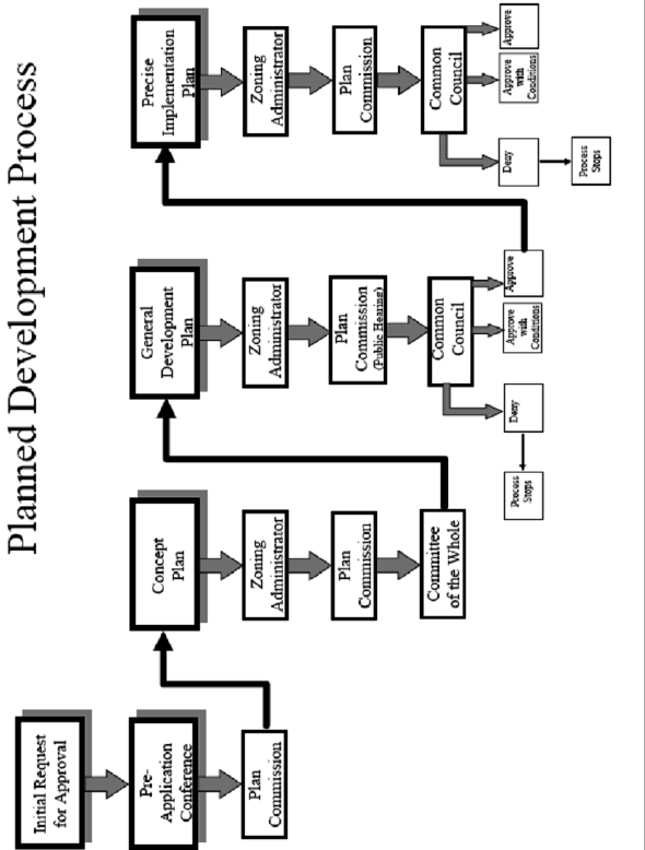
Application Requirements. All applications for proposed planned developments, regardless of the party of their initiation per subsection B., of this section, shall be certified as complete by the zoning administrator. Such applications, when complete, shall apply to each of the process steps in subsections E. through G., of this section. With the plan commission's approval (and generally for simple PDs), the applicant may combine PD process steps as deemed appropriate.
D.
PD Process Step 1: Pre-Application Conference (Optional).
1.
The applicant (may) contact the zoning administrator to place an informal discussion item for the PD on the plan commission agenda.
2.
No details beyond the name of the applicant, the location of the subject property, a listing of potential land uses, and the identification of the discussion item as a PD is required to be given in the agenda.
3.
At the plan commission meeting, the applicant shall engage in an informal discussion with the plan commission regarding the potential PD. Appropriate topics for discussion may include the location of the PD, general project themes and images, the general mix of types and/or land uses being considered, approximate residential densities and nonresidential intensities, the general treatment of natural features, the general relationship to nearby properties and public streets, potential development phasing limitations, and relationship to the comprehensive (master) plan.
4.
Points of discussion and conclusions reached in this stage of the process shall in no way be binding upon the applicant or the city, but should be considered as the informal, nonbinding basis for proceeding to the next step.
E.
PD Process Step 2: Concept Plan (Required).
1.
The applicant shall provide the zoning administrator with an application and a draft PD concept plan submittal packet for a determination of completeness prior to placing the proposed PD on the plan commission and committee of the whole agenda for concept plan review. This submittal packet shall contain all of the following items, prior to its acceptance by the zoning administrator and placement on the agenda for concept plan review:
a.
A location map of the subject property and its vicinity at eleven (11) inches by seventeen (17) inches, as depicted on a copy of the city of Sun Prairie comprehensive (master) plan land use plan map;
b.
A general written description of the proposed PD including:
i.
General project themes and images;
ii.
The general mix of dwelling unit types and/or land uses;
iii.
Approximate residential densities and nonresidential intensities as described by dwelling units per acre, floor area ratio (total building floor area divided by site area) and impervious surface area ratio (total impervious surface area divided by site area);
iv.
The general treatment of natural features;
v.
The general relationship to nearby properties and public streets;
vi.
The general relationship of the project to the comprehensive (master) plan;
vii.
Proposed development phasing, including a plan illustrating the sequence of development on the property and expected number of dwelling units to be constructed per year.
c.
The zoning administrator shall prepare a written description of requested variations from the requirements of the most comparable standard zoning district(s) and land division ordinance requirements, including:
i.
Land use;
ii.
Density and intensity;
iii.
Bulk;
iv.
Access, parking and loading;
v.
Landscaping;
vi.
Variations related to other municipal ordinances and plans including engineering and public works standards and requirements.
The purpose of this listing shall be to provide the plan commission with information necessary to determine the relative merits of the project in regard to private benefit versus public benefit resulting from design flexibility.
d.
A concept plan drawing (at eleven (11) inches by seventeen (17) inches) of the general land use layout and location of major public streets and/or private drives. The applicant may submit copies of a larger version in addition to the eleven (11) inches by seventeen (17) inches.
2.
Once the zoning administrator has received a complete packet as determined by the administrator, the proposed PD concept plan shall be placed on the plan commission agenda within forty-five (45) days of the city's receipt of a complete packet.
3.
At the plan commission meeting, the applicant shall engage in an informal discussion regarding the concept plan PD. Appropriate topics for discussion may include any of the information provided in the PD concept plan submittal packet, or other items as determined by the plan commission.
4.
Points of discussion and conclusions reached in this stage of the process shall be in no way be binding upon the applicant or the city, but should be considered as the informal, nonbinding basis for proceeding to the next step.
5.
If approval or conditional approval of the concept plan is recommended by the plan commission, the concept plan shall be referred to the committee of the whole for consideration. The committee of the whole shall then review and comment on the concept plan. The committee of the whole's review and comments are advisory.
6.
Approval or conditional approval of the concept plan by the plan commission shall entitle the developer to prepare and submit to the plan commission a general development plan, provided the general development plan conforms substantially to the concept plan, including any conditions of approval. If the concept plan is approved by the plan commission, the general development plan must be filed within six months of the date of concept plan approval by the plan commission or the concept plan is void. Previous concept plan approvals shall not constitute grounds for automatic approval upon resubmission.
F.
PD Process Step 3: General Development Plan (GDP) (Required).
1.
The applicant shall provide the zoning administrator with an application and a draft GDP submittal packet for a determination of completeness prior to placing the proposed GDP on the plan commission agenda for GDP review. The zoning administrator shall place the draft GDP on the plan commission agenda within forty-five (45) days of receiving a complete GDP submittal packet. This submittal packet shall contain all of the following items, prior to its acceptance by the zoning administrator and placement of the item on a plan commission agenda for GDP review:
a.
A location map of the subject property and its vicinity at eleven (11) inches by seventeen (17) inches, as depicted on a copy of the city of Sun Prairie comprehensive (master) plan land use plan map;
b.
A vicinity map of the subject property showing all lands for which the planned development is proposed, and all other lands within two hundred (200) feet of the boundaries of the subject property, together with the names and addresses of the owners of all lands on such map as the same appear on the current records of the register of deeds of Dane County. Such map shall clearly indicate the current zoning of the subject property and its environs, the jurisdiction(s) which maintains that control, and which watershed the project area lies within. Such map and all its parts and attachments shall be submitted in a form which is clearly reproducible with a photocopier, and shall be at a scale which is not less than one inch equals eight hundred (800) feet. All lot dimensions of the subject property, a graphic scale, and a north arrow shall be provided;
c.
A general written description of proposed PD including:
i.
General project themes and images;
ii.
The general mix of land uses, including (if applicable) dwelling unit types;
iii.
Approximate residential densities and nonresidential intensities as described by dwelling units per acre, floor area ratio (the total floor area divided by the site area) and impervious surface area ratio (the total impervious surface area divided by the site area);
iv.
The general treatment of natural features;
v.
The general relationship to nearby properties, and to public streets, utilities and facilities;
vi.
The general relationship of the project to the comprehensive (master) plan;
vii.
A statement of rationale as to why PD zoning is proposed. This shall identify barriers that the applicant perceives in the form of the requirements of standard zoning districts, and the opportunities for community betterment the applicant suggests are available through the proposed PD zoning;
viii.
The zoning administrator shall prepare a complete list and description of zoning and land division ordinance standards of the most comparable standard zoning district(s)/requirements which will not be met by the proposed PD and the location(s) in which they apply, and a complete list of zoning standards which will be more than met by the proposed PD and the location(s) in which they apply shall be identified. A list of items shall be provided, including:
1.
Land use;
2.
Density and intensity;
3.
Bulk;
4.
Landscaping;
5.
Access, parking and loading requirements;
6.
Variations related to other municipal ordinances and plans including engineering and public works standards and requirements.
The purpose of this list shall be to provide the committee of the whole, plan commission, public works committee, technical review committee and other review bodies with the information necessary to determine the relative merits of the project in regard to private benefit versus public benefit created by design flexibility.
d.
A general development plan drawing at a minimum scale of one inch equals one hundred (100) feet (eleven (11) inches by seventeen (17) inches) reduction shall also be provided by applicant) of the proposed project showing at least the following information in sufficient detail to make an evaluation against criteria for approval:
i.
A conceptual site plan drawing (at eleven (11) inches by seventeen (17) inches) of the general land use layout and the general location of major public streets and/or private drives. The applicant may submit copies of a larger version of this "bubble plan" in addition to the eleven (11) inches by seventeen (17) inches reduction;
ii.
Location of recreational and open space areas and facilities and specifically describing those that are to be reserved or dedicated for public acquisition and use, stormwater facilities, drainageways, and floodplains;
iii.
Statistical data on minimum lot sizes in the development, the approximate areas of large development lots and pads, density/intensity of various parts of the development, floor area ratio, impervious surface area ratio and landscape surface area ratio of various land uses, expected staging, and any other plans required by the plan commission or common council;
iv.
Notations relating the written information provided in subsection (F)(1)(c)(i) through (vi) to specific areas on the GDP drawing;
v.
Maps shall include existing topography, locations of public streets, sidewalks and bicycle paths.
e.
A general conceptual landscaping plan for subject property, noting in text and/or general map labels, the anticipated general compliance with requirements for the locations of foundation, street, yard and paving, landscaping; and anticipated instances of noncompliance with the landscaping requirements of the ordinance codified in this title (as noted in the listing of variations prepared by the zoning administrator) and the anticipated use of extra landscaping and bufferyards. Land uses exempted by the zoning ordinance from required landscaping such as agricultural uses and detached single-family dwellings are not required to provide conceptual or detailed landscaping plans.
f.
For single building planned developments, a series of general conceptual building elevations depicting the general architectural theme for the planned development, including notes as to the general range of materials and colors proposed. For multi-building planned developments, a written description of the proposed range of architectural character(s) for the planned development, and sample drawings and/or photos for this project or other developments that provide visual examples of such character(s).
g.
A general conceptual signage plan for the project, including project identification signs, concepts for public fixtures and signs (such as street light fixtures and/or poles or street sign faces and/or poles), and group development signs which are proposed to vary from city standards or common practices.
h.
Written Justification for the Proposed Planned Development. (The applicant shall follow the requirements of the zoning map amendment procedure in Section 17.44.030 of the city of Sun Prairie zoning ordinance to develop such written justification.) The applicant must demonstrate that the generally desired balance between public and private benefits associated with standard development is improved in the public's favor with the approval of the proposed planned development.
i.
A development phasing plan that demonstrates compliance with the city's development phasing plan.
2.
The city may require the developer (after the developer has been notified by the city of the need for the study) to conduct, at the developer's expense, a traffic impact study. The city shall require the developer to enter into a predevelopment agreement, obligating the developer to reimburse the city for any additional costs it incurs, including without limitation, time incurred by city staff in reviewing the project.
3.
The proposed GDP shall be forwarded to the plan commission for review and public hearing. After holding a public hearing, the plan commission shall make a recommendation to the common council for approval, approval with conditions, or denial of the proposed GDP. The plan commission and common council may, upon consideration of the request, table the GDP for a reasonable period of time to obtain more information or clarification of issues directly related to the consideration of the GDP. The same procedures used for amendments to the official zoning map shall be followed for this process.
4.
If the common council conditionally approves the PD/GDP, the applicant shall submit, to the zoning administrator, a copy of the PD/GDP that satisfies the conditions of approval. Once the zoning administrator has certified that the conditions have been satisfied, an affidavit of notice for the PD/GDP shall be recorded with the Dane County Register of Deeds. Along with paper copies, the applicant shall submit an electronic copy of the final PD/GDP, in a format as specified by the zoning administrator.
5.
Approval of the PD/GDP shall establish the basic right of use for the area in conformity with the PD/GDP as approved, which shall be recorded by the zoning administrator as an integral component of the district regulations, but such PD/GDP shall not make permissible any of the uses as proposed until a precise implementation plan (PIP) is submitted and approved for all or a portion of the PD/GDP.
G.
PD Process Step 4: Precise Implementation Plan (PIP) (Required).
1.
After the approval date of the rezoning to PD/GDP (i.e., the date of the ordinance approval of the GDP by the common council) and certification that any conditions of approval have been satisfied, the applicant may file an application for a proposed precise implementation plan (PIP) with the plan commission. The zoning administrator shall place the proposed PIP on the agenda of the plan commission within forty-five (45) days of receiving a complete PIP submittal packet from the applicant. This submittal packet shall contain all of the following items, prior to its acceptance by the zoning administrator and placement of the item on a plan commission agenda for review:
a.
A location map of the subject property and its vicinity at eleven (11) inches by seventeen (17) inches, as depicted on a copy of the city of Sun Prairie comprehensive (master) plan land use plan map;
b.
A vicinity map of the subject property showing all lands for which the planned development is proposed, and all other lands within two hundred (200) feet of the boundaries of the subject property, together with the names and addresses of the owners of all lands on such map as the names appear on the current records of the register of deeds of Dane County. Such map shall clearly indicate the current zoning of the subject property and its environs, and the jurisdiction(s) which maintains that control. Such map and all its parts and attachments shall be submitted in a form which is clearly reproducible with a photocopier, and shall be at a scale which is not less than one inch equals eight hundred (800) feet. All lot dimensions of the subject property, a graphic scale, and a north arrow shall be provided;
c.
A general written description of proposed PIP including:
i.
Specific project themes and images;
ii.
The specific mix of land uses, including (if applicable) dwelling unit types;
iii.
Specific residential densities and nonresidential intensities as described by dwelling units per acre, floor area ratio (the total floor area divided by the site area) and impervious surface area ratio (the total impervious surface area divided by the site area);
iv.
The specific treatment of natural features;
v.
The specific relationship to nearby properties, and to public streets, utilities and facilities;
d.
A precise implementation plan drawing at a minimum scale of one inch equals one hundred (100) feet (eleven (11) inches by seventeen (17) inches reduction shall also be provided by applicant) of the proposed project showing at least the following information in sufficient detail to make an evaluation against criteria for approval:
i.
A PIP site plan conforming to any and all of the requirements of the site plan review and approval procedures required by the city. If the proposed planned development is a cluster development, a proposed preliminary plat or conceptual plat shall be provided in addition to the required site plan;
ii.
Location of recreational and open space areas and facilities, stormwater facilities and drainageways and specifically describing those that are to be reserved or dedicated for public acquisition and use;
iii.
Statistical data on minimum lot sizes in the development, the precise areas of all development lots and pads, density/intensity of various parts of the development, floor area ratio, impervious surface area ratio and landscape surface area ratio of various land uses, expected staging, and any other plans required by the plan commission or common council;
iv.
Notations relating the written information provided in subsections (F)(1)(c)(i) through (vi) of this section to specific areas on the PIP drawing;
v.
Precise implementation plan drawings shall include all street and utility layouts, storm water systems, detention/retention facilities (sizing and calculations) and pedestrian ways;
vi.
Location of proposed right-of-way and street widths for all streets within the proposed development.
e.
A landscaping plan for subject property, specifying the location, species, and installed size of all trees and shrubs. This plan shall also include a chart which provides a cumulative total for each species, type and required location (foundation, yard, street, paved area or bufferyard) of all plants. Land uses exempted by the zoning ordinance from required landscaping such as agricultural uses and detached single-family dwellings are not required to provide conceptual or detailed landscaping plans.
f.
A series of building elevations for the entire exterior of all buildings in the planned development, including detailed notes as to the materials and colors proposed except for single-family detached and duplex dwellings which shall follow general design guidelines established by the developer and approved as part of the PIP.
g.
A signage plan for the project, including all project identification signs, concepts for public fixtures and signs (such as street light fixtures and/or poles or street sign faces and/or poles), and group development signage themes which are proposed to vary from city standards or common practices.
h.
A general outline of the intended organizational structure for a property owners' association, if any, deed restrictions and provisions for private provision of common services, if any.
i.
A written description which demonstrates the full consistency of the proposed PIP with the approved PD/GDP, including development phasing limitations established in the GDP.
j.
Any and all deviations between the requirements of the applicable PD/GDP zoning district and the proposed PIP development;
k.
The area included in a precise implementation plan may be only a portion of the area included in a previously approved PD/GDP;
l.
A timeline indicating anticipated construction phasing including, the dates that project construction will commence and project construction will be complete.
2.
When the PIP submission is deemed by the zoning administrator to be complete, the matter shall be reviewed by city staff and then placed on the agenda of the plan commission for review, consideration and a recommendation for approval, approval with conditions, or denial. No public hearing is required at this stage.
3.
The PIP submission shall be reviewed by the plan commission against the standards of the ordinance codified in this title, Title 16, Subdivisions and the previously approved PD/GDP. The plan commission shall recommend approval, approval with conditions, or denial of the PIP. The plan commission may, upon consideration of the request, table the PIP for a reasonable period of time to obtain more information or clarification of issues directly related to the consideration of the PIP. In order to approve a PIP or approve with conditions, the plan commission must determine that the PIP is consistent with the previously approved PD/GDP.
4.
The common council shall consider and act on the PIP after reviewing the recommendations of the plan commission on the same. The common council shall approve, approve with conditions, refer for further consideration, or deny the PIP. The common council may, upon consideration of the request, table the PIP for a reasonable period of time to obtain more information or clarification of issues directly related to the consideration of the PIP.
a.
For PIPs associated with PD/GDPs approved prior to November 6, 2008, the common council shall approve a PIP that is consistent with the previously approved PD/GDP.
b.
For PIPs associated with PD/GDPs approved after November 6, 2008, the common council shall consider the PIP's compliance with the general written description of the PD/GDP as required in Section 17.12.090(E)(1)(b) (including the general project theme), the standards of the zoning ordinance and the standards of the subdivision ordinance.
5.
If the common council conditionally approves the PD/PIP, the applicant shall submit, to the zoning administrator, a PIP that satisfies the conditions of approval. Once the zoning administrator has certified that the conditions have been satisfied, the applicant may apply for a building permit. Along with paper copies, the applicant shall submit an electronic copy of the final PD/PIP, in a format as specified by the zoning administrator.
6.
Prior to construction of any required land division improvements and before the issuance of any building permits, the applicant and the owner shall enter into a development agreement with the city per the requirements of Section 16.32.020 of the city of Sun Prairie subdivision ordinance to guarantee the implementation of the development according to the terms and conditions established as part of the PD/GDP and PD/PIP, including any building permit limits necessary for compliance with the approved GDP, PIP, and/or the city's development phasing plan.
7.
This paragraph shall only apply to PIPs associated with PD/GDPs approved after November 6, 2008. Within twenty-four (24) months of the approval of a PIP by the common council, the PIP as approved shall be commenced by the issuance of a building permit except for single-family and duplex uses where a single PIP is intended to cover multiple lots within a subdivision to be built over a number of years. Failure to commence the PIP by the issuance of a building permit within the 24-month period shall render the PIP null and void. Within the initial 24-month period, the applicant may request a one-time extension of the PIP for up to twenty-four (24) months. Such request shall require approval by resolution of the common council. For PIP's that include multiple buildings, the issuance of a building permit for the first building shall satisfy the requirements of this section, provided that detailed building plans and site plans are provided for all buildings within the area covered by the PIP.
H.
Planned Development Implementation. Upon approval of a development agreement between the developer and the city per Section 16.32.020 of the city of Sun Prairie subdivision ordinance, and upon approval of the PD/PIP by the common council, the applicant may apply for building permits, zoning and use permits from the zoning administrator. Upon granting of the necessary permits, and following city review and approval of all construction plans and specifications, the applicant may commence construction.
I.
Determination of Most Comparable Standard Zoning Districts. The zoning administrator shall be responsible for making a determination as to the most comparable set of standard zoning districts.
J.
Fees. Required fees shall be as set by resolution of the common council. Any municipal consultant costs, and (if land is to be divided) costs of reviewing the preliminary and final plats of the subdivision per the municipal code shall be reimbursed by the applicant. These reimbursement expenses are in addition to the regular application fee.
(Ord. 383, § 1, 10-21-2008; Ord. 161, § 1, 9-21-2004; Ord. 2004-123, § 2; Ord. 510, 2000; Ord. 460 (part), 1999; prior code § 13-3-8 (part), 1999)
Editor's note— Ordinance 460 contained two sections numbered as § 13-3-8. The second section has been editorially changed to § 17.12.090.
17.12.100 - City of Sun Prairie business district revitalization overlay district (BDO).
This section creates an overlay zoning district to identify and regulate the areas within which the city of Sun Prairie business district revitalization overlay district regulations shall apply. Section 17.16.190 describes the purpose of the business district revitalization overlay district and lists specific regulations that apply within the business district revitalization overlay district. The purpose of the business district revitalization overlay district is to aid in the implementation of the recommendations contained in the duly adopted city of Sun Prairie business district revitalization plan, an element of the city of Sun Prairie Master Plan 2020.
(Ord. 575, § 2, 2001; prior code § 13-3-9)
17.12.110 - Map of business district revitalization overlay district.
Business district revitalization overlay districts established by this title are shown on Sheet 3 of the official zoning map of the city of Sun Prairie, which together with any explanatory material thereon, is hereby incorporated by reference and made a part of this title.
(Ord. 575, § 3, 2001; prior code § 13-3-10)
17.12.120 - City of Sun Prairie westside neighborhood land use and transportation system improvement plan zoning map amendment and conditional use permit moratorium overlay district.
This section creates an overlay zoning district to identify the areas within which the city of Sun Prairie westside neighborhood land use and transportation system improvement plan zoning map amendment and conditional use permit moratorium applies. The purpose of city of Sun Prairie westside neighborhood land use and transportation system improvement plan zoning map amendment and conditional use permit moratorium overlay district is to give the city of Sun Prairie time to prepare and adopt a plan that provides detailed land use and transportation system improvement recommendations for the city of Sun Prairie's westside neighborhood. Permitting new development within the city of Sun Prairie westside neighborhood land use and transportation system improvement plan zoning map amendment and conditional use permit moratorium overlay district prior to adoption of the plan would severely curtail the effectiveness of the plan before it has been completed and foster inefficient and ill-conceived growth.
(Ord. 2002-54, § 1, 2002)
17.12.130 - Map of city of Sun Prairie westside neighborhood land use plan and transportation system improvement plan moratorium overlay district.
The city of Sun Prairie westside neighborhood land use plan and transportation system improvement plan moratorium overlay district established by this article is shown on Sheet 4 of the official zoning map of the city of Sun Prairie, which together with any explanatory material thereon, is hereby incorporated by reference and made a part of this article.
(Ord. 2002-54, § 2, 2002)
17.12.140 - City of Sun Prairie interchange sign overlay district.
This section creates an overlay zoning district to identify and regulate the areas within which the city of Sun Prairie interchange sign overlay district regulations shall apply. Section 17.40.070(C)(1) lists specific regulations that apply to signs within the interchange sign overlay district. The purpose of the interchange sign overlay district is to aid in the implementation of the city's sign regulations contained in Chapter 17.40.
(Ord. 513, § 1, 11-20-2012; Ord. 231, § 1(2), 1-17-2006)
17.12.150 - Map of interchange sign overlay district.
Interchange sign overlay districts established by this title are shown on Sheets 5a and 5b of the official zoning map of the city of Sun Prairie, which together with any explanatory material thereon, is hereby incorporated by reference and made a part of this title.
(Ord. 231, § 1(3), 1-17-2006)
17.12.160 - Main Street corridor overlay district (MSO).
This section creates an overlay zoning district to identify and regulate the areas within which the city of Sun Prairie Main Street corridor overlay district regulations shall apply. Section 17.16.200 describes the purpose of the Main Street corridor overlay district and lists specific regulations that apply within said district. The purpose of the Main Street corridor overlay district is to aid in the implementation of the recommendations contained in the duly adopted city of Sun Prairie Main Street corridor plan, an element of the city of Sun Prairie comprehensive plan.
(Ord. 450, § 1, 12-21-2010)
17.12.170 - Map of Main Street corridor overlay district.
The Main Street corridor overlay district established by this title is shown on Sheet 6 of the official zoning map of the city of Sun Prairie, which together with any explanatory material thereon, is hereby incorporated by reference and made part of this title.
(Ord. 450, § 1, 12-21-2010)
17.12.180 - Main Street live-work overlay district (LWO).
This section creates an overlay zoning district to identify and regulate the areas within which the city of Sun Prairie Main Street live-work overlay district regulations shall apply. Section 17.16.210 describes the purpose of the Main Street live-work overlay district and lists specific regulations that apply within said district. The purpose of the Main Street live-work overlay district is to aid in the implementation of the recommendations contained in the duly adopted city of Sun Prairie Main Street corridor plan, an element of the city of Sun Prairie comprehensive plan.
(Ord. 451, § 1, 12-21-2010)
17.12.190 - Map of Main Street live-work overlay district.
The Main Street live-work overlay district established by this title is shown on Sheet 7 of the official zoning map of the city of Sun Prairie, which together with any explanatory material thereon, is hereby incorporated by reference and made part of this title.
(Ord. 451, § 1, 12-21-2010)
17.12.200 - City of Sun Prairie wellhead protection overlay district.
This section creates an overlay zoning district to identify and regulate the areas within which the city of Sun Prairie wellhead protection overlay district regulations shall apply. Section 17.16.220 describes the purpose of the wellhead protection overlay district and lists specific regulations that apply to uses within said district. The purpose of the wellhead protection overlay district is to protect the drinking water supply for the city.
(Ord. 453, § 1(17.12.140), 12-21-2010)
Editor's note— Section 1 of Ord. 453, adopted Dec. 21, 2010, created provisions designated as § 17.12.140. Inasmuch as there already exists a section so designated, said provisions have been renumbered to read as herein set out to avoid duplication of numbers.
17.12.210 - Map of wellhead protection overlay district.
Wellhead protection overlay districts established by this title are shown on Sheet 8, zoning map of the city of Sun Prairie, which together with any explanatory material thereon, is hereby incorporated by reference and made a part of this title.
(Ord. 453, § 2(17.12.150), 12-21-2010)
Editor's note— Section 2 of Ord. 453, adopted Dec. 21, 2010, created provisions designated as § 17.12.150. Inasmuch as there already exists a section so designated, said provisions have been renumbered to read as herein set out to avoid duplication of numbers.