
Sun Prairie City Zoning Code
CHAPTER 17
28 - ENVIRONMENTAL CORRIDOR: NATURAL RESOURCE PROTECTION REGULATIONS1
Editor's note— Section 5 of Ord. 228A, adopted January 17, 2006, amended the title of Ch. 17.28 to read as herein set out.
17.28.010 - Purpose.
The purpose of this chapter is to set forth the requirements for the mandatory protection of natural and historic resources and permanently protected green space areas within the jurisdiction of this title (see Section 17.04.080). The provisions of this chapter interact closely with the provisions of Section 17.16.040 (uses permitted in other permanently protected green space areas), Section 17.16.160 (natural resource disruption and required mitigation standards), Section 17.20.030 (required natural resources site evaluation), and Sections 17.20.040 and 17.20.050 which provide residential and nonresidential development standards (including minimum required green space ratios (GSRs) and minimum required landscape surface ratios (LSRs). Section 17.20.060 provides a complete overview of the interrelationship between the above-listed sections. In part, the provisions of this chapter are designed to ensure the implementation of the City of Sun Prairie comprehensive plan, the environmental protection element of the Dane County regional development guide, and Sections 62.231, 62.23(7)(em), and 87.30, Wisconsin Statutes.
(Prior code § 13-7-1)
17.28.020 - How to use this chapter.
This chapter contains the standards which govern the protection, disturbance, and mitigation of disruption of all natural and historic resources and other permanently protected green space areas. The provisions of this chapter are intended to supplement those of the City of Sun Prairie, Dane County, the State of Wisconsin, and the Federal Government of the United States which pertain to natural resource protection. Prior to using the provisions of this chapter to determine the permitted disruption of such areas, the requirements provided below should be reviewed. This chapter recognizes the important and diverse benefits which natural and historic resource features provide in terms of protecting the health, safety, and general welfare of the community. Each of the following sections is oriented to each natural resource type, and is designed to accomplish several objectives:
A.
First, a definition of the natural or historic resource is provided;
B.
Second, the specific purposes of the protective regulations governing each natural or historic resource type are provided;
C.
Third, the required method of identifying and determining the boundaries of the natural or historic resource area is given;
D.
Fourth, mandatory protection requirements are identified.
Note: Protection requirements for specific land uses and natural resource types designed to minimize disruption of natural resource functions are presented in Section 17.16.160.
(Prior code § 13-7-2)
17.28.025 - Environmental corridors.
A.
Definition. Environmental corridors are continuous systems of open space in urban and urbanizing areas, that include environmentally sensitive lands and natural resources requiring protection from disturbance and development, and lands needed for open space and recreational use. They are based mainly on drainageways and stream channels, floodplains, wetlands, steep slopes, and other resource features, and are part of a countywide system of continuous open spacecorridors. Buffer zones for each environmental resource as defined in this section are considered a part of that specific resource.
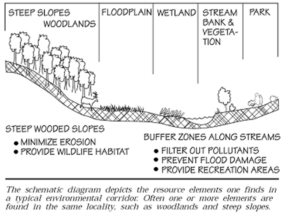
Environmental Corridor
B.
Purpose of Environmental Corridor Protection Requirements. The objective is to delineate, in local and regional plans, those lands and resources, which perform important environmental functions and need to be protected from development and urbanization. Protection of these corridors in the community helps the city to protect lands needed for drainage and recreation; avoid problems from development on steep slopes, problem soils or flood-prone areas; protect water resources and avoid pollution; and enhance scenic beauty and wildlife habitat. Once delineated and adopted, the corridors are used by the city and state and federal agencies in making decisions on the location of urban development and major facilities. The corridors are also used as a basis or starting point for open space and recreation planning and acquisition. An important use of the corridors is in RPC/DNR review of sewer extensions and sewer service areas, to direct urban development to areas outside the corridors.
C.
Determination of Environmental Corridor Boundaries. General environmental corridor boundaries are depicted on Sheet 2 of the official zoning map. The Dane County Regional Planning Commission staff has worked with local units of government in Dane County to delineate the corridors, based on available information and mapping of environmental resources and open space lands (water bodies and drainageways, floodplains, wetlands, steep slopes, woodlands, areas of unique vegetation or geology, existing and proposed parks, etc.). All environmental corridors within urban service areas county-wide have been mapped. Upon the proposal of development activity on any property, which contains an environmental corridor depicted on the official zoning map, the petitioner shall prepare a detailed site analysis per the requirements of Section 17.28.120. This analysis shall depict the location of all environmental corridor areas on the subject property as related to the provisions of subsection A of this section.
D.
Mandatory Environmental Corridor Protection Requirements. Environmental corridors shall remain in an undisturbed state except for the land uses permitted in Section 17.16.040 for the specific "Permanently Protected Green Space" type and per the requirements of Section 17.16.160.
1.
Buffer zone. A buffer zone is a vegetative strip of land adjacent to a stream, lake, or wetland, which serves as a protection for that water resource. Buffers moderate flow rates of stormwater runoff into receiving waters, stabilize banks and shorelines, filter nutrients and sediments from runoff, support fish habitat, provide habitat for other wildlife, and screen aesthetically unappealing land uses. Buffers can also serve to moderate stream temperatures, critical for some fish species such as trout. Buffer zones are established in this ordinance for wetlands, perennial streams, intermittent streams or open drainageways, and lakes, as shown on Sheet 2 of the official zoning map.
2.
Required minimum buffer zone widths for applicable environmental resources are listed in Table 17.28.025 D.2., below.
Table 17.28.025 D.2.
Minimum Buffer Zone Widths
*
Navigability of a stream must be determined by the Wisconsin Department of Natural Resources.
E.
Amendments to the Environmental Corridor. Amendments to the Environmental Corridor involve amending Sheet 2 of the City of Sun Prairie Official Zoning Map and procedures for amending the official zoning map, contained in Section 17.44.030 must be followed. The department of natural resources, regional planning commission, or other agencies may also need to be involved in the approval process.
(Ord. 228A, § 6, 1-17-2006)
17.28.030 - Floodplains.
A.
Statutory Authorization, Finding of Fact, Statement of Purpose, Title and General Provisions.
1.
Statutory Authorization. This ordinance is adopted pursuant to the authorization in s. 61.35 and 62.23 and the requirements in s. 87.30, Wisconsin Statutes.
2.
Finding of Fact. Uncontrolled development and use of the floodplains and rivers of this municipality would impair the public health, safety, convenience, general welfare and tax base.
3.
Statement of Purpose. This section is intended to regulate floodplain development to:
a.
Protect life, health and property;
b.
Minimize expenditures of public funds for flood control projects;
c.
Minimize rescue and relief efforts undertaken at the expense of the taxpayers;
d.
Minimize business interruptions and other economic disruptions;
e.
Minimize damage to public facilities in the floodplain;
f.
Minimize the occurrence of future flood blight areas in the floodplain;
g.
Discourage the victimization of unwary land and homebuyers;
h.
Prevent increases in flood heights that could increase flood damage and result in conflicts between property owners; and
i.
Discourage development in a floodplain if there is any practicable alternative to locate the activity, use or structure outside of the floodplain.
4.
Title. The ordinance from which this section is derived shall be known as the "Floodplain Zoning Ordinance for the City of Sun Prairie, Wisconsin."
5.
General Provisions.
a.
Areas to be Regulated: This section regulates all areas of special flood hazard identified as zones A, AO, AH, A1-30, or AE on the flood insurance rate map. Additional areas identified on maps approved by the Department of Natural Resources (DNR) and local community may also be regulated under the provisions of this ordinance, where applicable.
b.
Official Maps and Revisions: Special Flood Hazard Areas (SFHA) are designated as zones A, A1—30, AE, AH or AO on the Flood Insurance Rate Maps (FIRMs) based on flood hazard analyses summarized in the flood insurance study (FIS) listed in subd. (a) below. Additional flood hazard areas subject to regulation under this ordinance are identified on maps based on studies approved by the DNR and listed in subd. (b) below. These maps and revisions are on file in the office of the zoning administrator, City of Sun Prairie.
i.
Official Maps: Based on the FIS:
(a)
Flood Insurance Rate Map (FIRM), panel numbers 55025C0267G, dated Jan. 2, 2009;
(b)
Flood Insurance Rate Map (FIRM) panel numbers 55025C0258H, 55025C0259H, 55025C0266H, 55025C0269H, 55025C0279H, 55025C0285H, 55025C0286H, 55025C0287H, 55025C0288H, and 55025C0291H, dated Sep. 17, 2014;
(c)
Flood Insurance Rate Map (FIRM) panel numbers 55025C0280J, dated April 9, 2025.
(d)
Flood Insurance Study (FIS) for Dane County, dated April 9, 2025.
(e)
08-05-1760P Letter of Map Revision effective Feb. 27, 2009.
(f)
10-05-3124P Letter of Map Revision effective Aug. 30, 2010.
(g)
15-05-4807P Letter of Map Revision effective Feb. 12, 2016.
(h)
21-05-0005P Letter of Map Revision effective Dec. 15, 2021.
Approved by: The DNR and FEMA
ii.
Official Maps: Based on Other Studies. Any maps referenced in this section must be approved by the DNR and be more restrictive than those based on the FIS at the site of the proposed development.
(a)
General floodplain boundaries are depicted on Sheet 2 of the city of Sun Prairie Official Zoning Map. Upon the proposal of development activity on any property, which contains a floodplain depicted on this map and/or the flood insurance rate map (FIRM) identified in this title, the petitioner shall prepare a detailed site analysis per the requirements of Section 17.28.120. This analysis shall depict the location of all floodway (FW), floodfringe (FF) and general floodplain (GFP) districts on the subject property. Unmapped floodplains do exist within the city. For these areas, the city may require a floodplain determination prior to the issuance of a permit for any work in such areas or prior to final approval of a land use application. These areas shall be considered floodplain and shall be labeled as such on subdivision plats, certified survey maps, and site plans.
(b)
Flood Storage Map, panel numbers 12-13, dated April 9, 2025, approved by the DNR.
c.
Establishment of Floodplain Zoning Districts: The flood hazard areas regulated by this ordinance are divided into four districts as follows:
i.
The floodway district (FW), is the channel of a river or stream and those portions of the floodplain adjoining the channel required to carry the regional floodwaters, within AE Zones as shown on the FIRM, or within A Zones shown on the FIRM when determined according to subsection E.1.e.
ii.
The floodfringe district (FF) is that portion of a riverine special flood hazard area outside the floodway within AE zones on the FIRM, or, when floodway limits have been determined according to subsection E.1.e., within A zones shown on the FIRM.
iii.
The general floodplain district (GFP) is those areas that may be covered by floodwater during the regional flood and does not have a BFE or floodway boundary determined, including A, AH and AO zones on the FIRM.
iv.
The flood storage district (FSD) is that area of the floodplain where storage of floodwaters is calculated to reduce the regional flood discharge.
d.
Locating Floodplain Boundaries: Discrepancies between the exterior boundaries of zones A1—30, AE, AH, or A on the official floodplain zoning map and actual field conditions may be resolved using the criteria in (i) or (ii) below. If a significant difference exists, the map shall be amended according to subsection H. The zoning administrator can rely on a boundary derived from a profile elevation to grant or deny a land use permit, whether or not a map amendment is required. The zoning administrator shall be responsible for documenting actual pre-development field conditions and the basis upon which the district boundary was determined. Disputes between the zoning administrator and an applicant over the district boundary line shall be settled according to subsection G.3.c. and the criteria in i. and ii. below. Where the flood profiles are based on established base flood elevations from a FIRM, FEMA must approve any map amendment or revision pursuant to subsection H.
i.
If flood profiles exist, the map scale and the profile elevations shall determine the district boundary. The regional or base flood elevations shall govern if there are any discrepancies.
ii.
Where flood profiles do not exist for projects, including any boundary of zone A or AO, the location of the boundary shall be determined by the map scale.
e.
Removal of Lands from Floodplain:
i.
Compliance with the provisions of this section shall not be grounds for removing land from the floodplain unless it is filled at least two feet above the regional or base flood elevation, the fill is contiguous to land outside the floodplain, and the map is amended pursuant to subsection H.
ii.
The delineation of any of the floodplain districts may be revised by the community where natural or man-made changes have occurred and/or where more detailed studies have been conducted. However, prior to any such change, approval must be obtained from the Wisconsin Department of Natural Resources and Federal Emergency Management Agency. A completed letter of map revision is a record of this approval. The floodplain administrator shall not sign a community acknowledgement form unless all criteria set forth in the following paragraphs are met:
a.
The land and/or land around the structure must be filled at least two feet above the regional or base flood elevation;
b.
The fill must be contiguous to land outside the floodplain; Applicant shall obtain floodplain development permit before applying for a LOMR or LOMR-F.
iii.
Removal of lands from the floodplain may also occur by operation of §87.30(1)(e), Wis. Stat. if a property owner has obtained a letter of map amendment from the federal emergency management agency under 44 C.F.R. 70.
f.
Compliance:
i.
No structure or use within areas regulated by this ordinance shall hereafter be located, erected, constructed, reconstructed, repaired, extended, converted, enlarged, or altered without full compliance with the terms of these regulations and all other applicable regulations that apply to uses within the jurisdiction of these regulations.
ii.
Failure to obtain a floodplain development permit shall be a violation of these regulations and shall be punishable in accordance with subsection I.
iii.
Floodplain development permits issued on the basis of plans and applications approved by the floodplain administrator authorize only the use, and arrangement, set forth in such approved plans and applications, or amendments thereto if approved by the floodplain administrator. Use, arrangement, or construction contrary to that authorized shall be deemed a violation of these regulations and punishable in accordance with subsection I.
g.
Municipalities and State Agencies Regulated: Unless specifically exempted by law, all cities, villages, towns, and counties are required to comply with this section and obtain all necessary permits. State agencies are required to comply if Section 13.48(13), Wisconsin Statutes applies. The construction, reconstruction, maintenance and repair of state highways and bridges by the Wisconsin Department of Transportation is exempt when Section 30.2022, Wisconsin Statutes applies. Although exempt from a local zoning permit and permit fees, DOT must provide sufficient project documentation and analysis to ensure that the community is in compliance with federal, state, and local floodplain standards.
h.
Abrogation and Greater Restrictions:
i.
This section supersedes all the provisions of any municipal zoning ordinance enacted under s. 62.23 or s. 87.30, Wisconsin Statutes, which relate to floodplains. A more restrictive ordinance shall continue in full force and effect to the extent of the greater restrictions, but not otherwise.
ii.
This section is not intended to repeal, abrogate or impair any existing deed restrictions, covenants or easements. If this section imposes greater restrictions, the provisions of this section shall prevail.
i.
Interpretation: In their interpretation and application, the provisions of this section are the minimum requirements liberally construed in favor of the governing body and are not a limitation on or repeal of any other powers granted by the Wisconsin Statutes. If a provision of this section, required by ch. NR 116, Wisconsin Administrative Code, is unclear, the provision shall be interpreted in light of the standards in effect on the date of the adoption of this section or in effect on the date of the most recent text amendment to this section.
j.
Warning and Disclaimer of Liability: The flood protection standards in this section are based on engineering experience and research. Larger floods may occur or the flood height may be increased by man-made or natural causes. This section does not imply or guarantee that non-floodplain areas or permitted floodplain uses will be free from flooding and flood damages. This section does not create liability on the part of, or a cause of action against, the municipality or any officer or employee thereof for any flood damage that may result from reliance on this section.
k.
Severability: Should any portion of this section be declared unconstitutional or invalid by a court of competent jurisdiction, the remainder of this section shall not be affected.
l.
Annexed Areas for Cities and Villages: The Dane County floodplain zoning provisions in effect on the date of annexation shall remain in effect and shall be enforced by the municipality for all annexed areas until the municipality adopts and enforces an ordinance which meets the requirements of ch. NR 116, Wisconsin Administrative Code and 44 CFR 59-72, National Flood Insurance Program (NFIP). These annexed lands are described on the municipality's official zoning map. County floodplain zoning provisions are incorporated by reference for the purpose of administering this section and are on file in the office of the municipal zoning administrator. All plats or maps of annexation shall show the regional flood elevation and the floodway location.
B.
General Standards Applicable to All Floodplain Districts. The community shall review all permit applications to determine whether proposed building sites will be reasonably safe from flooding and assure that all necessary permits have been received from those governmental agencies whose approval is required by federal or state law. If a proposed building site is in a flood-prone area, all new construction and substantial improvements shall be designed and anchored to prevent flotation, collapse, or lateral movement of the structure resulting from hydrodynamic and hydrostatic loads, including the effects of buoyancy; be constructed with flood-resistant materials; be constructed by methods and practices that minimize flood damages; be constructed with electrical, heating, ventilation, plumbing, and air conditioning equipment and other service facilities that are designed and/or located so as to prevent water from entering or accumulating within the components during conditions of flooding. If a subdivision or other proposed new development is in a flood-prone area, the community shall assure that such proposed subdivision or other proposed new development is consistent with the need to minimize flood damage within the flood-prone area; that public utilities and facilities such as sewer, gas, electrical, and water systems are located and constructed to minimize or eliminate flood damage; and that adequate drainage is provided to reduce exposure to flood hazards. All subdivision proposals (including manufactured home parks) shall include regional flood elevation and floodway data for any development that meets the subdivision definition of this ordinance and all other requirements in subsection G.1.b.
1.
Hydraulic and Hydrologic Analyses.
a.
No floodplain development shall:
i.
Obstruct flow, defined as development which blocks the conveyance of floodwaters by itself or with other development, causing any increase in the regional flood height; or
ii.
Cause any increase in the regional flood height due to floodplain storage area lost.
b.
The zoning administrator shall deny permits if it is determined the proposed development will obstruct flow or cause any increase in the regional flood height, based on the officially adopted FIRM or other adopted map, unless the provisions of subsection H. Amendments, are met.
2.
Watercourse Alterations. No land use permit to alter or relocate a watercourse in a mapped floodplain shall be issued until the local official has notified in writing all adjacent municipalities, the department and FEMA regional offices, and required the applicant to secure all necessary state and federal permits. The standards of subsection B.1 must be met and the flood carrying capacity of any altered or relocated watercourse shall be maintained. As soon as is practicable, but not later than six months after the date of the watercourse alteration or relocation and pursuant to subsection H. Amendments, the community shall apply for a letter of map revision (LOMR) from FEMA. Any such alterations must be reviewed and approved by FEMA and the DNR through the LOMC process.
3.
Chapters 30, 31, Wisconsin Statutes, Development. Development which requires a permit from the department, under Chapter 30 and 31, Wisconsin Statutes, such as docks, piers, wharves, bridges, culverts, dams and navigational aids, may be allowed if the necessary permits are obtained and amendments to the floodplain zoning ordinance are made according to subsection H. Amendments.
4.
Public or Private Campgrounds. Public or private campgrounds shall have a low flood damage potential and shall meet the following provisions:
a.
The campground is approved by the Department of Agriculture, Trade and Consumer Protection.
b.
A land use permit for the campground is issued by the zoning administrator.
c.
The character of the river system and the campground elevation are such that a 72-hour warning of an impending flood can be given to all campground occupants.
d.
There is an adequate flood warning procedure for the campground that offers the minimum notice required under this section to all persons in the campground. This procedure shall include a written agreement between the campground owner, the floodplain zoning agency or zoning administrator, the municipal emergency government coordinator and the chief law enforcement official which specifies the flood elevation at which evacuation shall occur, personnel responsible for monitoring flood elevations, types of warning systems to be used and the procedures for notifying at-risk parties, and the methods and personnel responsible for conducting the evacuation.
e.
This agreement shall be for no more than one calendar year, at which time the agreement shall be reviewed and updated by the officials identified in subsection d. above, to remain in compliance with all applicable regulations, including those of the state department of health services and all other applicable regulations.
f.
All mobile recreational vehicles placed on the site must meet one of the following:
i.
Be fully licensed, if required, and ready for highway use (A mobile recreational vehicle is ready for highway use if it is on its wheels or jacking system, is attached to the site only by quick-disconnect utilities and security devices and has no permanently attached additions); or
ii.
Not occupy any site in the campground for more than one hundred eighty (180) consecutive days, at which time the recreational vehicle must be removed from the floodplain for a minimum of twenty-four (24) hours; or
iii.
Meet the requirements in either subsection C., D., E.1., or E.3. for the floodplain district in which the structure is located.
g.
All camping units that remain on site for more than thirty (30) days shall be issued a limited authorization by the campground operator, a written copy of which is kept on file at the campground. Such authorization shall allow placement of a camping unit consistent with B.4.f. and shall ensure compliance with all the provisions of this section.
h.
The municipality shall monitor the limited authorizations issued by the campground operator to assure compliance with the terms of this section.
i.
The campground shall have signs clearly posted at all entrances warning of the flood hazard and the procedures for evacuation when a flood warning is issued.
j.
All service facilities, including but not limited to refuse collection, electrical service, gas lines, propane tanks, sewage systems and wells shall be properly anchored and placed at or floodproofed to the flood protection elevation.
k.
Standards for structures in a campground:
i.
All structures must comply with subsection B.4 or meet the applicable requirements in subsections C., D., E.1., or E.3. for the floodplain district in which the structure is located;
ii.
Deck/landing-a portable landing may be allowed for a camping unit for each entry provided that the landing is not permanently attached to the ground or camping unit, is no more than two hundred (200) square feet in size, shall be portable, contain no walls or roof, and can be removed from the campground by a truck and/or trailer. Sections of such portable landings may be placed together to form a single deck not greater than 200 square feet at one entry point. Provisions for the removal of these temporary landings during flood events must be addressed within the written agreement with the municipality compliant with section B.4.d. Any such deck/landing structure may be constructed at elevations lower than the flood protection elevation but must not obstruct flow of flood waters or cause any increase in flood levels during the occurrence of the regional flood;
iii.
Decks/patios that are constructed completely at grade may be allowed, but must also comply with applicable shoreland zoning standards;
iv.
Camping equipment and appurtenant equipment in the campground may be allowed provided that the equipment is not permanently attached to the ground or camping unit, is not used as a habitable structure, and must not obstruct flow of flood waters or cause any increase in flood levels during the occurrence of the regional flood. Provisions for the removal of this equipment during flooding events shall be addressed within the written agreement with the municipality compliant with section B.4.d.; and
v.
Once a flood warning in the written agreement has been issued for the campground, the campground owner or the designated operator shall ensure that all persons, camping units, decks, camping equipment and appurtenant equipment in the campground shall be evacuated within the timelines specified within the written agreement with the municipality compliant with section B.4.d.
l.
A land use permit shall be obtained as provided under G.1.b. before any development; repair, modification or addition to an existing structure; or change in the use of a building or structure, including sewer and water facilities, may be initiated.
C.
Floodway District (FW).
1.
Applicability. This section applies to all floodway areas on the floodplain zoning maps and those identified pursuant to subsection E.1.e.
2.
Permitted Uses. The following open space uses are allowed in the floodway district and the floodway areas of the general floodplain district, if:
•
They are not prohibited by any other ordinance.
•
They meet the standards in subsections C.3 and C.4.
•
All permits or certificates have been issued according to subsection G.
a.
Agricultural uses, such as: farming, outdoor plant nurseries, horticulture, viticulture and wild crop harvesting.
b.
Nonstructural industrial and commercial uses, such as loading areas, parking areas and airport landing strips.
c.
Nonstructural recreational uses, such as golf courses, tennis courts, archery ranges, picnic grounds, boat ramps, swimming areas, parks, wildlife and nature preserves, game farms, fish hatcheries, shooting, trap and skeet activities, hunting and fishing areas and hiking and horseback riding trails, subject to the fill limitations of subsection C.3.d.
d.
Uses or structures accessory to open space uses, or classified as historic structures that comply with subsections C.3 and C.4.
e.
Extraction of sand, gravel or other materials that comply with subsection C.3.d.
f.
Functionally water-dependent uses, such as docks, piers or wharves, dams, flowage areas, culverts, navigational aids and river crossings of transmission lines, and pipelines that comply with Chapter 30 and 31, Wisconsin Statutes.
g.
Public utilities, streets and bridges that comply with subsection C.3.c.
h.
Portable latrines that are removed prior to flooding and systems associated with recreational areas and Department-approved campgrounds that meet the applicable provisions of local ordinances and ch. SPS 383, Wis. Adm. Code.
i.
Public or private wells used to obtain potable water for recreational areas that meet the requirements of local ordinances and chs. NR 811 and NR 812, Wis. Adm. Code.
j.
Wastewater treatment ponds or facilities permitted under s. NR 110.15(3)(b), Wis. Adm. Code.
k.
Sanitary sewer or water supply lines to service existing or proposed development located outside the floodway that complies with the regulations for the floodplain area occupied.
3.
Standards for Developments in the Floodway.
a.
General:
i.
Any development in the floodway shall comply with subsection B., and have a low flood damage potential.
ii.
Applicants shall provide an analysis calculating the effects of this proposal on the regional flood height to determine the effects of the proposal according to subsection B.1 and G.1.b.iii. The analysis must be completed by a registered professional engineer in the state of Wisconsin.
iii.
Any encroachment in the regulatory floodway is prohibited unless the data submitted for subdivision C.3.a.ii. above demonstrates that the encroachment will cause no increase in flood elevations in flood events up to the base flood at any location or removes the encroached area from the regulatory floodway as provided in subsection A.5.e.
b.
Structures: Structures accessory to permanent open space uses, including utility and sanitary facilities, or functionally dependent on a waterfront location may be allowed by permit if the structures comply with the following criteria:
i.
Not designed for human habitation, does not have a high flood damage potential and is constructed to minimize flood damage;
ii.
Shall either have the lowest floor elevated to or above the flood protection elevation or shall meet all the following standards:
•
Have the lowest floor elevated to or above the regional flood elevation and be dry floodproofed so that the structure is watertight with walls substantially impermeable to the passage of water and completely dry to the flood protection elevation without human intervention during flooding;
•
Have structural components capable of meeting all provisions of Section 3.3(2)(g) and;
•
Be certified by a registered professional engineer or architect, through the use of a Federal Emergency Management Agency Floodproofing Certificate, that the design and methods of construction are in accordance with subsection C.3.b.vii.
iii.
Must be anchored to resist flotation, collapse, and lateral movement;
iv.
Mechanical and utility equipment must be elevated or flood proofed to or above the flood protection elevation; and
v.
Must not obstruct flow of flood waters or cause any increase in flood levels during the occurrence of the regional flood.
vi.
For a structure designed to allow the automatic entry of floodwaters below the regional flood elevation, the applicant shall submit a plan that meets subsection C.3.b.i through C.3.b.vii. and meets or exceeds the following standards:
•
The lowest floor must be elevated to or above the regional flood elevation;
•
A minimum of two openings having a total net area of not less than one square inch for every square foot of enclosed area subject to flooding;
•
The bottom of all openings shall be no higher than one foot above the lowest adjacent grade; openings may be equipped with screens, louvers, valves, or other coverings or devices provided that they permit the automatic entry and exit of floodwaters, otherwise must remain open.
•
The use must be limited to parking, building access or limited storage.
vii.
Certification: Whenever floodproofing measures are required, a registered professional engineer or architect shall certify that the following floodproofing measures will be utilized, where appropriate, and are adequate to withstand the flood depths, pressures, velocities, impact and uplift forces and other factors associated with the regional flood:
•
Reinforcement of floors and walls to resist rupture, collapse, or lateral movement caused by water pressures or debris buildup;
•
Construction of wells, water supply systems and waste treatment systems so as to prevent the entrance of flood waters in such systems and must be in accordance with provisions in subsections C.4.d. and C.4.e.;
•
Subsurface drainage systems to relieve external pressures on foundation walls and basement floors;
•
Cutoff valves on sewer lines or the elimination of gravity flow basement drains; and
•
Placement of utilities to or above the flood protection elevation.
c.
Public Utilities, Streets and Bridges: Public utilities, streets and bridges may be allowed by permit, if:
i.
Adequate floodproofing measures are provided to the flood protection elevation; and
ii.
Construction meets the development standards of subsection B.1.
d.
Fills or Deposition of Materials: Fills or deposition of materials may be allowed by permit, if:
i.
The requirements of subsection B.1 are met;
ii.
No material is deposited in navigable waters unless a permit is issued by the department pursuant to Chapter 30, Wisconsin Statutes, and a permit pursuant to Section 404 of the Federal Water Pollution Control Act, Amendments of 1972, 33 U.S.C. 1344 has been issued, if applicable, and all other requirements have been met;
iii.
The fill or other materials will be protected against erosion by riprap, vegetative cover, sheet piling or bulkheading;
iv.
The fill is not classified as a solid or hazardous material; and
v.
The requirements of Sections 17.16.160 and 15.28.030 are met.
4.
Prohibited Uses. All uses not listed as permitted uses in subsection C.2., are prohibited, including the following uses:
a.
Habitable structures, structures with high flood damage potential, or those not associated with permanent open-space uses;
b.
Storing materials that are buoyant, flammable, explosive, injurious to property, water quality, or human, animal, plant, fish or other aquatic life;
c.
Uses not in harmony with or detrimental to uses permitted in the adjoining districts;
d.
Any private or public sewage systems, except portable latrines that are removed prior to flooding and systems associated with recreational areas and Department approved campgrounds that meet the applicable provisions of local ordinances and Chapter SPS 383, Wisconsin Administrative Code;
e.
Any public or private wells which are used to obtain potable water, except those for recreational areas that meet the requirements of local ordinances and Chapters NR 811 and NR 812, Wisconsin Administrative Code;
f.
Any solid or hazardous waste disposal sites;
g.
Any wastewater treatment ponds or facilities, except those permitted under Section NR 110.15(3)(b), Wisconsin Administrative Code; and
h.
Any sanitary sewer or water supply lines, except those to service existing or proposed development located outside the floodway which complies with the regulations for the floodplain area occupied.
D.
Floodfringe District (FF).
1.
Applicability. This section applies to all floodfringe areas shown on the floodplain zoning maps and those identified pursuant to subsection E.1.e.
2.
Permitted Uses. Any structure, land use, or development is allowed in the floodfringe district if the standards in subsection D.3., are met, the use is not prohibited by this or any other ordinance or regulation and all permits or certificates specified in subsection G.1., have been issued.
3.
Standards for Development in the Floodfringe. Subsection B.1. shall apply in addition to the following requirements according to the use requested. Any existing structure in the floodfringe must meet the requirements of subsection F.
a.
Residential Uses: Any structure, including a manufactured home, which is to be newly constructed or moved into the floodfringe, shall meet or exceed the following standards. Any existing structure in the floodfringe must meet the requirements of subsection F.
i.
All new construction, including placement of manufactured homes, and substantial improvement of residential structures, shall have the lowest floor elevated to or above the flood protection elevation on fill. The fill around the structure shall be one foot or more above the regional flood elevation extending at least 15 feet beyond the limits of the structure. No area may be removed from the floodfringe district unless it can be shown to meet s. 1.5(5).
ii.
Notwithstanding subsection D.3.a.i., a basement or crawlspace floor may be placed at the regional flood elevation if the basement or crawlspace is designed to make all portions of the structure below the flood protection elevation watertight with walls substantially impermeable to the passage of water and with structural components having the capability of resisting hydrostatic and hydrodynamic loads and effects of buoyancy. No floor of any kind is allowed below the regional flood elevation.
iii.
Contiguous dryland access shall be provided from a structure to land outside of the floodplain, except as provided in paragraph iv.
iv.
In developments where existing street or sewer line elevations make compliance with paragraph iii. impractical, the municipality may permit new development and substantial improvements where roads are below the regional flood elevation, if:
(a)
The municipality has written assurance from police, fire and emergency services that rescue and relief will be provided to the structure(s) by wheeled vehicles during a regional flood event; or
(b)
The municipality has a DNR-approved emergency evacuation plan that follows acceptable hazard mitigation planning guidelines.
b.
In addition to subsection B, new construction and substantial improvements of accessory structures shall be constructed on fill with the lowest floor at or above the regional flood elevation.
c.
Commercial Uses: In addition to subsection B, any commercial structure which is erected, altered or moved into the floodfringe shall meet the requirements of subsection D.3.a. Subject to the requirements of subsection D.3.e., storage yards, surface parking lots and other such uses may be placed at lower elevations if an adequate warning system exists to protect life and property.
d.
Manufacturing and Industrial Uses: In addition to subsection B, any manufacturing or industrial structure which is erected, altered or moved into the floodfringe shall have the lowest floor elevated to or above the flood protection elevation or meet the floodproofing standards in subsection G.5. Subject to the requirements of subparagraph D.3.e., storage yards, surface parking lots and other such uses may be placed at lower elevations if an adequate warning system exists to protect life and property.
e.
Storage of Materials: Materials that are buoyant, flammable, explosive, or injurious to property, water quality or human, animal, plant, fish or aquatic life shall be stored at or above the flood protection elevation or floodproofed in compliance with subsection G.5. Adequate measures shall be taken to ensure that such materials will not enter the water body during flooding.
f.
Public Utilities, Streets and Bridges: All utilities, streets and bridges shall be designed to be compatible with comprehensive floodplain development plans; and
i.
When failure of public utilities, streets and bridges would endanger public health or safety, or where such facilities are deemed essential, construction or repair of such facilities shall only be permitted if they are designed to comply with subsection G.5.
ii.
Minor roads or non-essential utilities may be constructed at lower elevations if they are designed to withstand flood forces to the regional flood elevation.
g.
Sewage Systems: All sewage disposal systems shall be designed to minimize or eliminate infiltration of flood water into the system, pursuant to subsection G.5.c., to the flood protection elevation and meet the provisions of all local ordinances and Chapter SPS 383, Wisconsin Administrative Code.
h.
Wells: All wells shall be designed to minimize or eliminate infiltration of flood waters into the system, pursuant to subsection G.5.c., to the flood protection elevation and shall meet the provisions of chs. NR 811 and NR 812, Wisconsin Administrative Code.
i.
Solid Waste Disposal Sites: Disposal of solid or hazardous waste is prohibited in floodfringe areas.
j.
Deposition of Materials: Any deposited material must meet all the provisions of this section.
k.
Manufactured Homes.
i.
Owners or operators of all manufactured home parks and subdivisions shall provide adequate surface drainage to minimize flood damage, and prepare, secure approval and file an evacuation plan, indicating vehicular access and escape routes, with local emergency management authorities.
ii.
In existing manufactured home parks, all new homes, replacement homes on existing pads, and substantially improved homes shall:
(a)
Have the lowest floor elevated to the flood protection elevation; and
(b)
Be anchored so they do not float, collapse or move laterally during a flood.
iii.
Outside of existing manufactured home parks, including new manufactured home parks and all single units outside of existing parks, all new, replacement and substantially improved manufactured homes shall meet the residential development standards for the floodfringe in subsection D.3.a.
l.
Mobile Recreational Vehicles: All mobile recreational vehicles that are on site for one hundred eighty (180) consecutive days or more, or are not fully licensed and ready for highway use, shall meet the elevation and anchoring requirements in subsection D.3.k.ii. and iii. A mobile recreational vehicle is ready for highway use if it is on its wheels or jacking system, is attached to the site only by quick-disconnect utilities and security devices and has no permanently attached additions.
E.
Other Floodplain Districts. Other floodplain districts may be established under the section and reflected on the floodplain zoning map. These districts may include general floodplain districts and flood storage districts.
1.
General Floodplain District (GFP).
a.
Applicability. The provisions for the General Floodplain District shall apply to development in all floodplains mapped as A, AO, AH, and in AE zones within which a floodway is not delineated on the Flood Insurance Rate Maps identified in subsection A.5.b.i.
b.
Floodway Boundaries. For proposed development in zone A, or in zone AE within which a floodway is not delineated on the Flood Insurance Rate Map identified in subsection A.5.b.i., the boundaries of the regulatory floodway shall be determined pursuant to subsection E.1.e. If the development is proposed to encroach upon the regulatory floodway, the development is subject to the standards of subsection C. If the development is located entirely within the floodfringe, the development is subject to the standards of subsection D.
c.
Permitted uses. Pursuant to subsection E.1.e., it shall be determined whether the proposed use is located within the floodway or floodfringe. Those uses permitted in the floodway (subsection C.2.) and floodfringe (subsection D.2.) districts are allowed within the general floodplain district, according to the standards of subsection E.1.d., provided that all permits or certificates required under subsection G.1. have been issued.
d.
Standards for Development in the General Floodplain District. Subsection C. applies to floodway areas, determined pursuant to subsection E.1.e., subsection D. applies to floodfringe areas, determined pursuant to determined pursuant to subsection E.1.e.
i.
New construction and substantial improvement of structures in zone AO shall have the lowest floor, including basement, elevated:
(a)
To or above the depth, in feet, as shown on the FIRM above the highest adjacent natural grade; or
(b)
If the depth is not specified on the FIRM, to or above two (2) feet above the highest adjacent natural grade.
ii.
New construction and substantial improvement of structures in zone AH shall have the lowest floor, including basement, elevated to or above the flood protection elevation.
iii.
In AO/AH zones, provide adequate drainage paths to guide floodwaters around structures. All development in zones AO and zone AH shall meet the requirements of subsection D. applicable to flood fringe areas.
e.
Determining Floodway and Floodfringe Limits. Upon receiving an application for development within zone A, or within zone AE where a floodway has not been delineated on the flood insurance rate maps, the zoning administrator shall:
i.
Require the applicant to submit two copies of an aerial photograph or a plan which shows the proposed development with respect to the general floodplain district limits, stream channel, and existing floodplain developments, along with a legal description of the property, fill limits and elevations, building floor elevations and flood proofing measures; and the flood zone as shown on the FIRM.
ii.
Require the applicant to furnish any of the following information deemed necessary by the department to evaluate the effects of the proposal upon flood height and flood flows, regional flood elevation and to determine floodway boundaries.
(a)
A hydrologic and hydraulic study as specified in subsection G.1.b.iii.
(b)
Plan (surface view) showing elevations or contours of the ground; pertinent structure, fill or storage elevations; size, location and layout of all proposed and existing structures on the site; location and elevations of streets, water supply, and sanitary facilities; soil types and other pertinent information;
(c)
Specifications for building construction and materials, floodproofing, filling, dredging, channel improvement, storage, water supply and sanitary facilities.
2.
Flood Storage District. The flood storage district delineates that portion of the floodplain where storage of floodwaters has been taken into account and is relied upon to reduce the regional flood discharge. The district protects the flood storage areas and assures that any development in the storage areas will not decrease the effective flood storage capacity which would cause higher flood elevations.
a.
Applicability. The provisions of this section apply to all areas within the flood storage district (FSD), as shown on the official floodplain zoning maps.
b.
Permitted Uses. Any use or development which occurs in a flood storage district must meet the applicable requirements in subsection D.3.
c.
Standards for Development in Flood Storage Districts.
i.
Development in a flood storage district shall not cause an increase equal or greater than 0.00 of a foot in the height of the regional flood.
ii.
No development shall be allowed which removes flood storage volume unless an equal volume of storage as defined by the pre-development ground surface and the regional flood elevation shall be provided in the immediate area of the proposed development to compensate for the volume of storage which is lost, (compensatory storage). Excavation below the groundwater table is not considered to provide an equal volume of storage.
iii.
If compensatory storage cannot be provided, the area may not be developed unless the entire area zoned as flood storage district on this waterway is rezoned to the floodfringe district. This must include a revision to the floodplain study and map done for the waterway to revert to the higher regional flood discharge calculated without floodplain storage, as per subsection H. of this section.
iv.
No area may be removed from the flood storage district unless it can be shown that the area has been filled to the flood protection elevation and is contiguous to other lands lying outside of the floodplain.
F.
Nonconforming Uses.
1.
General.
a.
Applicability:
i.
The standards in this section shall apply to all uses and buildings that do not conform to the provisions contained within a floodplain zoning ordinance or with s. 87.30, Wisconsin Statutes and §§ NR 116.12-14, Wis. Adm. Code and 44 CFR 59-72., these standards shall apply to all modifications or additions to any nonconforming use or structure and to the use of any structure or premises which was lawful before the passage of this ordinance or any amendment thereto. A party asserting existence of a lawfully established nonconforming use or structure has the burden of proving that the use or structure was compliant with the floodplain zoning ordinance in effect at the time the use or structure was created.
ii.
As permit applications are received for additions, modifications, or substantial improvements to nonconforming buildings in the floodplain, municipalities shall develop a list of those nonconforming buildings, their present equalized assessed value and a list of the costs of those activities associated with changes to those buildings.
b.
The existing lawful use of a structure or its accessory use which is not in conformity with the provisions of this section may continue subject to the following conditions:
i.
No modifications or additions to a nonconforming use or structure shall be permitted unless they comply with this section. The words "modification" and "addition" include, but are not limited to, any alteration, addition, modification, structural repair, rebuilding or replacement of any such existing use, structure or accessory structure or use. Maintenance is not considered a modification; this includes painting, decorating, paneling and other nonstructural components and the maintenance, repair or replacement of existing private sewage or water supply systems or connections to public utilities. Any costs associated with the repair of a damaged structure are not considered maintenance. The construction of a deck that does not exceed two hundred (200) square feet and that is adjacent to the exterior wall of a principal structure is not an extension, modification or addition. The roof of the structure may extend over a portion of the deck in order to provide safe ingress and egress to the principal structure.
ii.
If a nonconforming use or the use of a nonconforming structure is discontinued for twelve (12) consecutive months, it is no longer permitted and any future use of the property, and any structure or building thereon, shall conform to the applicable requirements of this section;
iii.
The municipality shall keep a record which lists all nonconforming uses and nonconforming structures, their present equalized assessed value, the cost of all modifications or additions which have been permitted, and the percentage of the structure's total current value those modifications represent;
iv.
No modification or addition to any nonconforming structure or any structure with a nonconforming use, which over the life of the structure would equal or exceed fifty percent (50%) of its present equalized assessed value, shall be allowed unless the entire structure is permanently changed to a conforming structure with a conforming use in compliance with the applicable requirements of this section. Contiguous dry land access must be provided for residential and commercial uses in compliance with subsection D.3.a. The costs of elevating the lowest floor of a nonconforming building or a building with a nonconforming use to the flood protection elevation are excluded from the fifty percent (50%) provisions of this paragraph;
v.
No maintenance, on a per event basis, to any nonconforming structure or any structure with a nonconforming use, the cost of which would equal or exceed fifty percent (50%) of its present equalized assessed value, shall be allowed unless the entire structure is permanently changed to a conforming structure with a conforming use in compliance with the applicable requirements of this section. Contiguous dry land access must be provided for residential and commercial uses in compliance with subsection D.3.a. Maintenance to any nonconforming structure, which does not exceed 50% of its present equalized assessed value on a per event basis, does not count against the cumulative calculations over the life of the structure for substantial improvement calculations
vi.
If on a per event basis the total value of the work being done under subsections iv. and v. equals or exceeds fifty percent (50%) of the present equalized assessed value the work shall not be permitted unless the entire structure is permanently changed to a conforming structure with a conforming use in compliance with the applicable requirements of this section. Contiguous dry land access must be provided for residential and commercial uses in compliance with subsection D.3.a.
vii.
Except as provided in subsection viii. below, if any nonconforming structure or any structure with a nonconforming use is destroyed or is substantially damaged, it cannot be replaced, reconstructed or rebuilt unless the use and the structure meet the current ordinance requirements. A structure is considered substantially damaged if the total cost to restore the structure to its pre-damaged condition equals or exceeds fifty percent (50%) of the structure's present equalized assessed value.
viii.
For nonconforming buildings that are substantially damaged or destroyed by a non-flood disaster, the repair or reconstruction of any such nonconforming building shall be permitted in order to restore it to the size and use in effect prior to the damage event, provided that the minimum requirements below are met and all required permits have been granted prior to the start of construction.
(a)
Residential Structures.
(1)
Shall have the lowest floor, including basement, elevated to or above the base flood elevation using fill, pilings, columns, posts or perimeter walls. Perimeter walls must meet the requirements of subsection G.5.b.
(2)
Shall be anchored to prevent flotation, collapse, or lateral movement of the structure resulting from hydrodynamic and hydrostatic loads, including the effects of buoyancy and shall be constructed with methods and materials resistant to flood damage.
(3)
Shall be constructed with electrical, heating, ventilation, plumbing and air conditioning equipment and other service facilities that are designed and/or elevated so as to prevent water from entering or accumulating within the components during conditions of flooding.
(4)
In A zones, obtain, review and utilize any flood data available from a federal, state or other source.
(5)
In AO zones with no elevations specified, shall have the lowest floor, including basement, meet the standards in subsection E.1.d.
(6)
In AO zones, shall have adequate drainage paths around structures on slopes to guide floodwaters around and away from the structure.
(b)
Nonresidential Structures.
(1)
Shall meet the requirements of subsection F.1.b.viii.a.1—6.
(2)
Shall either have the lowest floor, including basement, elevated to or above the regional flood elevation; or, together with attendant utility and sanitary facilities, shall meet the standards in subsection G.5.a. or b.
(3)
In AO zones with no elevations specified, shall have the lowest floor, including basement, meet the standards in subsection E.1.d.
c.
A nonconforming historic structure may be altered if the alteration will not preclude the structures continued designation as a historic structure, the alteration will comply with subsection C.3., flood resistant materials are used, and construction practices and floodproofing methods that comply with subsection G.5. are used. Repair or rehabilitation of historic structures shall be exempt from the development standards of subsection F.1.b.viii if it is determined that the proposed repair or rehabilitation will not preclude the structure's continued designation as a historic structure and is the minimum necessary to preserve the historic character and design of the structure.
2.
Floodway District.
a.
No modification or addition shall be allowed to any nonconforming structure or any structure with a nonconforming use in the floodway district, unless such modification or addition:
i.
Has been granted a permit or variance which meets all ordinance requirements;
ii.
Meets the requirements of subsection F.1;
iii.
Shall not increase the obstruction to flood flows or regional flood height;
iv.
Any addition to the existing structure shall be floodproofed, pursuant to subsection G.5., by means other than the use of fill, to the flood protection elevation; and
v.
If any part of the foundation below the flood protection elevation is enclosed, the following standards shall apply:
(a)
The enclosed area shall be designed by a registered architect or engineer to allow for the efficient entry and exit of flood waters without human intervention. A minimum of two openings must be provided with a minimum net area of at least one square inch for every one square foot of the enclosed area. The lowest part of the opening can be no more than twelve (12) inches above the adjacent grade;
(b)
The parts of the foundation located below the flood protection elevation must be constructed of flood-resistant materials;
(c)
Mechanical and utility equipment must be elevated or floodproofed to or above the flood protection elevation; and
(d)
The use must be limited to parking, building access or limited storage.
b.
No new on-site sewage disposal system, or addition to an existing on-site sewage disposal system, except where an addition has been ordered by a government agency to correct a hazard to public health, shall be allowed in the floodway district. Any replacement, repair or maintenance of an existing on-site sewage disposal system in a floodway area shall meet the applicable requirements of all municipal ordinances, subsection G.5.c. and ch. SPS 383, Wisconsin Administrative Code.
c.
No new well or modification to an existing well used to obtain potable water shall be allowed in the floodway district. Any replacement, repair or maintenance of an existing well in the floodway district shall meet the applicable requirements of all municipal ordinances, subsection G.5.c. and Chapters NR 811 and NR 812, Wisconsin Administrative Code.
3.
Floodfringe District.
a.
No modification or addition shall be allowed to any nonconforming structure or any structure with a nonconforming use unless such modification or addition has been granted a permit or variance by the municipality, and meets the requirements of subsection D.3., except where subsection F.3.b. is applicable.
b.
Where compliance with the provisions of paragraph (a) above would result in unnecessary hardship and only where the structure will not be used for human habitation or be associated with a high flood damage potential, the board of adjustment/appeals, using the procedures established in subsection G.3., may grant a variance from those provisions of paragraph (a) for modifications or additions using the criteria listed below. Modifications or additions which are protected to elevations lower than the flood protection elevation may be permitted if:
i.
No floor is allowed below the regional flood elevation for residential or commercial structures;
ii.
Human lives are not endangered;
iii.
Public facilities, such as water or sewer, shall not be installed;
iv.
Flood depths shall not exceed two feet;
v.
Flood velocities shall not exceed two feet per second; and
vi.
The structure shall not be used for storage of materials as described in subsection D.3.e.
c.
All new private sewage disposal systems, or addition to, replacement, repair or maintenance of a private sewage disposal system shall meet all the applicable provisions of all local ordinances, subsection G.5.c. and ch. SPS 383, Wisconsin Administrative Code.
d.
All new wells, or addition to, replacement, repair or maintenance of a well shall meet the applicable provisions of this section, subsection G.5.c. and ch. NR 811 and NR 812, Wisconsin Administrative Code.
4.
Flood Storage District. No modifications or additions shall be allowed to any nonconforming structure in a flood storage area unless the standards outlined in subsection E.2.c. are met.
G.
Administration. Where a zoning administrator, planning agency or a board of adjustment/appeals has already been appointed to administer a zoning ordinance adopted under Sections 59.69, 59.692 or 62.23(7), Wisconsin Statutes, these officials shall also administer this section.
1.
Zoning Administrator.
a.
Duties and Powers. The zoning administrator is authorized to administer this section and shall have the following duties and powers:
i.
Advise applicants of the ordinance provisions, assist in preparing permit applications and appeals, and assure that the regional flood elevation for the proposed development is shown on all permit applications.
ii.
Issue permits and inspect properties for compliance with provisions of this section and issue certificates of compliance where appropriate.
iii.
Inspect and assess all damaged floodplain structures to determine if substantial damage to the structures has occurred.
iv.
Keep records of all official actions such as:
(a)
All permits issued, inspections made, and work approved;
(b)
Documentation of certified lowest floor and regional flood elevations;
(c)
Floodproofing certificates.
(d)
Water surface profiles, floodplain zoning maps and ordinances, nonconforming uses and structures including changes, appeals, variances and amendments.
(e)
All substantial damage assessment reports for floodplain structures.
(f)
List of nonconforming structures and uses.
v.
Submit copies of the following items to the department regional office:
(a)
Within ten (10) days of the decision, a copy of any decisions on variances, appeals for map or text interpretations, and map or text amendments.
(b)
Copies of case-by-case analyses and other required information.
(c)
Copies of substantial damage assessments performed and all related correspondence concerning the assessments.
vi.
Investigate, prepare reports, and report violations of this section to the municipal zoning agency and attorney for prosecution. Copies of the reports shall also be sent to the department regional office.
vii.
Submit copies of amendments to the FEMA regional office.
b.
Land Use Permit. A land use permit shall be obtained before any development; repair, modification or addition to an existing structure; or change in the use of a building or structure, including sewer and water facilities, may be initiated. Application to the zoning administrator shall include:
i.
General Information:
(a)
Name and address of the applicant, property owner and contractor;
(b)
Legal description, proposed use, and whether it is new construction or a modification;
ii.
Site Development Plan: A site plan drawn to scale shall be submitted with the permit application form and shall contain:
(a)
Location, dimensions, area and elevation of the lot;
(b)
Location of the ordinary highwater mark of any abutting navigable waterways;
(c)
Location of any structures with distances measured from the lot lines and street center lines;
(d)
Location of any existing or proposed on-site sewage systems or private water supply systems;
(e)
Location and elevation of existing or future access roads;
(f)
Location of floodplain and floodway limits as determined from the official floodplain zoning maps;
(g)
The elevation of the lowest floor of proposed buildings and any fill using the vertical datum from the adopted study — either National Geodetic Vertical Datum (NGVD) or North American Vertical Datum (NAVD);
(h)
Data sufficient to determine the regional flood elevation in NGVD or NAVD at the location of the development and to determine whether or not the requirements of subsection C. or D. are met; and
(i)
Data to determine if the proposed development will cause an obstruction to flow or an increase in regional flood height or discharge according to subsection B.1. This may include any of the information noted in subsection C.3.a.
iii.
Hydraulic and Hydrologic Studies to Analyze Development. All hydraulic and hydrologic studies shall be completed under the direct supervision of a professional engineer registered in the state. The study contractor shall be responsible for the technical adequacy of the study. All studies shall be reviewed and approved by the department.
(a)
Zone A Floodplains and in AE zones within which a floodway is not delineated:
(1)
Hydrology.
•
The appropriate method shall be based on the standards in ch. NR 116.07(3), Wisconsin Administrative Code, Hydrologic Analysis: Determination of Regional Flood Discharge.
(2)
Hydraulic Modeling. The regional flood elevation shall be based on the standards in ch. NR 116.07(4), Wisconsin Administrative Code, Hydraulic Analysis: Determination of Regional Flood Elevation and the following:
•
Determination of the required limits of the hydraulic model shall be based on detailed study information for downstream structures (dam, bridge, culvert) to determine adequate starting WSEL for the study.
•
Channel sections must be surveyed.
•
Minimum four-foot contour data in the overbanks shall be used for the development of cross section overbank and floodplain mapping.
•
A maximum distance of 500 feet between cross sections is allowed in developed areas with additional intermediate cross sections required at transitions in channel bottom slope including a survey of the channel at each location.
•
The most current version of HEC-RAS shall be used.
•
A survey of bridge and culvert openings and the top of road is required at each structure.
•
Additional cross sections are required at the downstream and upstream limits of the proposed development and any necessary intermediate locations based on the length of the reach if greater than 500 feet.
•
Standard accepted engineering practices shall be used when assigning parameters for the base model such as flow, Manning's N values, expansion and contraction coefficients or effective flow limits. The base model shall be calibrated to past flooding data such as high water marks to determine the reasonableness of the model results. If no historical data is available, adequate justification shall be provided for any parameters outside standard accepted engineering practices.
•
The model must extend past the upstream limit of the difference in the existing and proposed flood profiles in order to provide a tie-in to existing studies. The height difference between the proposed flood profile and the existing study profiles shall be no more than 0.00 feet.
(3)
Mapping. A work map of the reach studied shall be provided, showing all cross section locations, floodway/floodplain limits based on best available topographic data, geographic limits of the proposed development and whether the proposed development is located in the floodway.
•
If the proposed development is located outside of the floodway, then it is determined to have no impact on the regional flood elevation.
•
If any part of the proposed development is in the floodway, it must be added to the base model to show the difference between existing and proposed conditions. The study must ensure that all coefficients remain the same as in the existing model, unless adequate justification based on standard accepted engineering practices is provided.
(b)
Zone AE Floodplains.
(1)
Hydrology. If the proposed hydrology will change the existing study, the appropriate method to be used shall be based on ch. NR 116.07(3), Wisconsin Administrative Code, Hydrologic Analysis: Determination of Regional Flood Discharge.
(2)
Hydraulic Model. The regional flood elevation shall be based on the standards in ch. NR 116.07(4), Wisconsin Administrative Code, Hydraulic Analysis: Determination of Regional Flood Elevation and the following:
•
Duplicate Effective Model. The effective model shall be reproduced to ensure correct transference of the model data and to allow integration of the revised data to provide a continuous FIS model upstream and downstream of the revised reach. If data from the effective model is available, models shall be generated that duplicate the FIS profiles and the elevations shown in the Floodway Data Table in the FIS report to within 0.1 foot.
•
Corrected Effective Model. The corrected effective model shall not include any man-made physical changes since the effective model date, but shall import the model into the most current version of HEC-RAS for department review.
•
Existing (Pre-Project Conditions) Model. The existing model shall be required to support conclusions about the actual impacts of the project associated with the revised (post-project) model or to establish more up-to-date models on which to base the revised (post-project) model.
•
Revised (Post-Project Conditions) Model. The revised (post-project conditions) model shall incorporate the existing model and any proposed changes to the topography caused by the proposed development. This model shall reflect proposed conditions.
•
All changes to the duplicate effective model and subsequent models must be supported by certified topographic information, bridge plans, construction plans and survey notes.
•
Changes to the hydraulic models shall be limited to the stream reach for which the revision is being requested. Cross sections upstream and downstream of the revised reach shall be identical to those in the effective model and result in water surface elevations and topwidths computed by the revised models matching those in the effective models upstream and downstream of the revised reach as required. The effective model shall not be truncated.
(3)
Mapping. Maps and associated engineering data shall be submitted to the department for review which meet the following conditions:
•
Consistency between the revised hydraulic models, the revised floodplain and floodway delineations, the revised flood profiles, topographic work map, annotated FIRMs and/or flood boundary floodway maps (FBFMs), construction plans, bridge plans.
•
Certified topographic map of suitable scale, contour interval, and a planimetric map showing the applicable items. If a digital version of the map is available, it may be submitted in order that the FIRM may be more easily revised.
•
Annotated FIRM panel showing the revised one percent and 0.2 percent annual chance floodplains and floodway boundaries.
•
If an annotated FIRM and/or FBFM and digital mapping data (GIS or CADD) are used then all supporting documentation or metadata must be included with the data submission along with the Universal Transverse Mercator (UTM) projection and State Plane Coordinate System in accordance with FEMA mapping specifications.
•
The revised floodplain boundaries shall tie into the effective floodplain boundaries.
•
All cross sections from the effective model shall be labeled in accordance with the effective map and a cross section lookup table shall be included to relate to the model input numbering scheme.
•
Both the current and proposed floodways shall be shown on the map.
•
The stream centerline, or profile baseline used to measure stream distances in the model shall be visible on the map.
iv.
Expiration. All permits issued under the authority of this section shall expire no more than one hundred eighty (180) days after issuance. The permit may be extended for a maximum of one hundred eighty (180) days for good and sufficient cause. If the permitted work has not started within one hundred eighty (180) days of the permit date, the development must comply with any regulation, including any revision to the FIRM or FIS, which took effect after the permit date.
c.
Certificate of compliance. No land shall be occupied or used, and no building which is hereafter constructed, altered, added to, modified, repaired, rebuilt or replaced shall be occupied until a certificate of compliance is issued by the zoning administrator, except where no permit is required, subject to the following provisions:
i.
The certificate of compliance shall show that the building or premises or part thereof, and the proposed use, conform to the provisions of this section;
ii.
Application for such certificate shall be concurrent with the application for a permit;
iii.
If all ordinance provisions are met, the certificate of compliance shall be issued within ten (10) days after written notification that the permitted work is completed;
iv.
The applicant shall submit a certification signed by a registered professional engineer, architect or land surveyor that the fill, lowest floor and floodproofing elevations are in compliance with the permit issued. Floodproofing measures also require certification by a registered professional engineer or architect that the requirements of subsection G.5. are met.
v.
Where applicable pursuant to subsection E.1.d., the applicant must submit a certification by a registered professional engineer or surveyor of the elevation of the bottom of the lowest horizontal structural member supporting the lowest floor (excluding pilings or columns), and an indication of whether the structure contains a basement.
vi.
Where applicable pursuant to subsection E.1.d., the applicant must submit certifications by a registered professional engineer or architect that the structural design and methods of construction meet accepted standards of practice as required by subsection E.1.d.
d.
Other Permits. Prior to obtaining a floodplain development permit the applicant must secure all necessary permits from federal, state, and local agencies, including but not limited to those required by the U.S. Army Corps of Engineers under Section 404 of the Federal Water Pollution Control Act, Amendments of 1972, 33 U.S.C. 1344.
2.
Zoning Agency.
a.
The plan commission shall:
i.
Oversee the functions of the office of the zoning administrator;
ii.
Review and advise the governing body on all proposed amendments to this section, maps and text; and
iii.
Publish adequate notice pursuant to Ch. 985, Wisconsin Statutes, specifying the date, time, place and subject of the public hearing.
b.
The plan commission shall not:
i.
Grant variances to the terms of the ordinance in place of action by the board of appeals; or
ii.
Amend the text or zoning maps in place of official action by the governing body.
3.
Zoning Board of Appeals. The zoning board of appeals, created under Section 62.23(7)(e), Wisconsin Statutes, is hereby authorized or shall be appointed to act for the purposes of this section. The board shall exercise the powers conferred by Wisconsin Statutes and adopt rules for the conduct of business. The zoning administrator shall not be the secretary of the board.
a.
Powers and Duties. The board of appeals shall:
i.
Appeals. Hear and decide appeals where it is alleged there is an error in any order, requirement, decision or determination made by an administrative official in the enforcement or administration of this section;
ii.
Boundary Disputes. Hear and decide disputes concerning the district boundaries shown on the official floodplain zoning map; and
iii.
Variances. Hear and decide, upon appeal, variances from the ordinance standards.
b.
Appeals to the Board.
i.
Appeals to the board may be taken by any person aggrieved, or by any officer or department of the municipality affected by any decision of the zoning administrator or other administrative officer. Such appeal shall be taken within thirty (30) days unless otherwise provided by the rules of the board, by filing with the official whose decision is in question, and with the board, a notice of appeal specifying the reasons for the appeal. The official whose decision is in question shall transmit to the board all records regarding the matter appealed.
ii.
Notice and Hearing for Appeals Including Variances.
(a)
Notice. The board shall:
(1)
Fix a reasonable time for the hearing;
(2)
Publish adequate notice pursuant to Wisconsin Statutes, specifying the date, time, place and subject of the hearing; and
(3)
Assure that notice shall be mailed to the parties in interest and the department regional office at least ten (10) days in advance of the hearing.
(b)
Hearing. Any party may appear in person or by agent. The board shall:
(1)
Resolve boundary disputes according to subsection G.3.c.;
(2)
Decide variance applications according to subsection G.3.d.; and
(3)
Decide appeals of permit denials according to subsection G.4.
iii.
Decision: The final decision regarding the appeal or variance application shall:
(a)
Be made within a reasonable time;
(b)
Be sent to the department regional office within ten (10) days of the decision;
(c)
Be a written determination signed by the chairman or secretary of the board;
(d)
State the specific facts which are the basis for the board's decision;
(e)
Either affirm, reverse, vary or modify the order, requirement, decision or determination appealed, in whole or in part, dismiss the appeal for lack of jurisdiction or grant or deny the variance application; and
(f)
Include the reasons for granting an appeal, describing the hardship demonstrated by the applicant in the case of a variance, clearly stated in the recorded minutes of the board proceedings.
c.
Boundary Disputes. The following procedure shall be used by the board in hearing disputes concerning floodplain district boundaries:
i.
If a floodplain district boundary is established by approximate or detailed floodplain studies, the flood elevations or profiles shall prevail in locating the boundary;
ii.
The person contesting the boundary location shall be given a reasonable opportunity to present arguments and technical evidence to the board; and
iii.
If the boundary is incorrectly mapped, the board should inform the zoning committee or the person contesting the boundary location to petition the governing body for a map amendment according to subsection H.
d.
Variance.
i.
The board may, upon appeal, grant a variance from the standards of this section if an applicant convincingly demonstrates that:
(a)
Literal enforcement of the ordinance will cause unnecessary hardship;
(b)
The hardship is due to adoption of the floodplain ordinance and unique property conditions, not common to adjacent lots or premises. In such case the ordinance or map must be amended;
(c)
The variance is not contrary to the public interest; and
(d)
The variance is consistent with the purpose of this section in subsection A.3.
ii.
In addition to the criteria in paragraph i., to qualify for a variance under FEMA regulations, the following criteria must be met:
(a)
The variance shall not cause any increase in the regional flood elevation;
(b)
The applicant has shown good and sufficient cause for issuance of the variance;
(c)
Failure to grant the variance would result in exceptional hardship;
(d)
Granting the variance will not result in additional threats to public safety, extraordinary expense, create a nuisance, cause fraud on or victimization of the public, or conflict with existing local laws or ordinances; and
(e)
The variance granted is the minimum necessary, considering the flood hazard, to afford relief.
iii.
A variance shall not:
(a)
Grant, extend or increase any use prohibited in the zoning district;
(b)
Be granted for a hardship based solely on an economic gain or loss;
(c)
Be granted for a hardship which is self-created.
(d)
Damage the rights or property values of other persons in the area;
(e)
Allow actions without the amendments to this section or map(s) required in subsection H.; and
(f)
Allow any alteration of an historic structure, including its use, which would preclude its continued designation as an historic structure.
iv.
When a floodplain variance is granted the board shall notify the applicant in writing that it may increase risks to life and property and flood insurance premiums could increase up to twenty-five dollars ($25.00) per one hundred dollars ($100.00) of coverage. A copy shall be maintained with the variance record.
4.
To Review Appeals of Permit Denials.
a.
The zoning agency (subsection G.2.) or board shall review all data related to the appeal. This may include:
i.
Permit application data listed in subsection G.1.b.;
ii.
Floodway/floodfringe determination data in subsection E.1.e.;
iii.
Data listed in subsection C.3.a.ii where the applicant has not submitted this information to the zoning administrator; and
iv.
Other data submitted with the application, or submitted to the board with the appeal.
b.
For appeals of all denied permits the board shall:
i.
Follow the procedures of subsection G.3.;
ii.
Consider zoning agency recommendations; and
iii.
Either uphold the denial or grant the appeal.
c.
For appeals concerning increases in regional flood elevation the board shall:
i.
Uphold the denial where the board agrees with the data showing an increase in flood elevation. Increases may only be allowed after amending the flood profile and map and all appropriate legal arrangements are made with all adversely affected property owners as per the requirements of subsection H.; and
ii.
Grant the appeal where the board agrees that the data properly demonstrates that the project does not cause an increase provided no other reasons for denial exist.
5.
Floodproofing Standards.
a.
No permit or variance shall be issued for a non-residential structure designed to be watertight below the regional flood elevation until the applicant submits a plan certified by a registered professional engineer or architect that the floodproofing measures will protect the structure or development to or above the flood protection elevation and submits a FEMA floodproofing certificate. Floodproofing is not an alternative to the development standards in subsections B., C., D., E.1., or E.3.
b.
For a structure designed to allow the entry of floodwaters, no permit or variance shall be issued until the applicant submits a plan either:
i.
Certified by a registered professional engineer or architect; or
ii.
Meeting or exceeding the following standards:
(a)
A minimum of two openings having a total net area of not less than one square inch for every square foot of enclosed area subject to flooding;
(b)
The bottom of all openings shall be no higher than one foot above grade; and
(c)
Openings may be equipped with screens, louvers, valves, or other coverings or devices provided that they permit the automatic entry and exit of floodwaters.
c.
Floodproofing measures shall be designed, as appropriate, to:
i.
Withstand flood pressures, depths, velocities, uplift and impact forces and other regional flood factors;
ii.
Protect structures to the flood protection elevation;
iii.
Anchor structures to foundations to resist flotation and lateral movement; and
iv.
Minimize or eliminate infiltration of flood waters.
v.
Minimize or eliminate discharges into flood waters.
vi.
Placement of essential utilities to or above the flood protection elevation; and
vii.
If any part of the foundation below the flood protection elevation is enclosed, the following standards shall apply:
(a)
The enclosed area shall be designed by a registered architect or engineer to allow for the efficient entry and exit of flood waters without human intervention. A minimum of two openings must be provided with a minimum net area of at least one square inch for every one square foot of the enclosed area. The lowest part of the opening can be no more than twelve (12) inches above the adjacent grade;
(b)
The parts of the foundation located below the flood protection elevation must be constructed of flood-resistant materials;
(c)
Mechanical and utility equipment must be elevated or floodproofed to or above the flood protection elevation; and
(d)
The use must be limited to parking, building access or limited storage.
6.
Public Information.
a.
Place marks on structures to show the depth of inundation during the regional flood.
b.
All maps, engineering data and regulations shall be available and widely distributed.
c.
Real estate transfers should show what floodplain district any real property is in.
H.
Amendments. Obstructions or increases may only be permitted if amendments are made to this section, the official floodplain zoning maps, floodway lines and water surface profiles, in accordance with subsection H.1.
•
In AE zones with a mapped floodway, no obstructions or increases shall be permitted unless the applicant receives a conditional letter of map revision from FEMA and amendments are made to this section, the official floodplain zoning maps, floodway lines and water surface profiles, in accordance with subsection H.1. Any such alterations must be reviewed and approved by FEMA and the DNR.
•
In A zones increases equal to or greater than 1.0 foot may only be permitted if the applicant receives a conditional letter of map revision from FEMA and amendments are made to this section, the official floodplain maps, floodway lines, and water surface profiles, in accordance with subsection H.1.
1.
General. The governing body shall change or supplement the floodplain zoning district boundaries and this section in the manner outlined in subsection H.2. below. Actions which require an amendment to the ordinance and/or submittal of a letter of map change (LOMC) include, but are not limited to, the following:
a.
Any fill or floodway encroachment that obstructs flow causing any increase in the regional flood height;
b.
Any change to the floodplain boundaries and/or watercourse alterations on the FIRM;
c.
Any changes to any other officially adopted floodplain maps listed in subsection A.5.b.ii.;
d.
Any floodplain fill which raises the elevation of the filled area to a height at or above the flood protection elevation and is contiguous to land lying outside the floodplain;
e.
Correction of discrepancies between the water surface profiles and floodplain maps;
f.
Any upgrade to a floodplain zoning ordinance text required by Section NR 116.05, Wisconsin Administrative Code, or otherwise required by law, or for changes by the municipality; and
g.
All channel relocations and changes to the maps to alter floodway lines or to remove an area from the floodway or the floodfringe that is based on a base flood elevation from a FIRM requires prior approval by FEMA.
2.
Procedures. Ordinance amendments may be made upon petition of any party according to the provisions of Section 62.23, Wisconsin Statutes. The petitions shall include all data required by subsections E.1.e. and G.1.b. The land use permit shall not be issued until a letter of map revision is issued by FEMA for the proposed changes.
a.
The proposed amendment shall be referred to the zoning agency for a public hearing and recommendation to the governing body. The amendment and notice of public hearing shall be submitted to the department regional office for review prior to the hearing. The amendment procedure shall comply with the provisions of Section 62.23, Wisconsin Statutes.
b.
No amendments shall become effective until reviewed and approved by the department.
c.
All persons petitioning for a map amendment that obstructs flow causing any increase in the regional flood height, shall obtain flooding easements or other appropriate legal arrangements from all adversely affected property owners and notify local units of government before the amendment can be approved by the governing body.
I.
Enforcement and Penalties. Any violation of the provisions of this section by any person shall be unlawful and shall be referred to the municipal attorney who shall expeditiously prosecute all such violators. A violator shall, upon conviction, forfeit to the municipality a penalty of not more than fifty dollars ($50.00), together with a taxable cost of such action. Each day of continued violation shall constitute a separate offense. Every violation of this section is a public nuisance and the creation may be enjoined and the maintenance may be abated by action at suit of the municipality, the state, or any citizen thereof pursuant to Section 87.30, Wisconsin Statutes.
J.
Definitions. Unless specifically defined, words and phrases in this section shall have their common law meaning and shall be applied in accordance with their common usage. Words used in the present tense include the future, the singular number includes the plural and the plural number includes the singular. The word "may" is permissive, "shall" is mandatory and is not discretionary.
1.
"A zones"—Those areas shown on the Official Floodplain Zoning Map which would be inundated by the regional flood. These areas may be numbered or unnumbered A Zones. The A Zones may or may not be reflective of flood profiles, depending on the availability of data for a given area.
2.
"AH zone"—See "area of shallow flooding".
3.
"AO zone"—See "area of shallow flooding".
4.
"Accessory structure or use"—A facility, structure, building or use which is accessory or incidental to the principal use of a property, structure or building. An accessory structure shall not be used for human habitation.
5.
"Alteration"—An enhancement, upgrade or substantial change or modification other than an addition or repair to a dwelling or to electrical, plumbing, heating, ventilating, air conditioning and other systems within a structure.
6.
"Area of shallow flooding"—A designated AO, AH, AR/AO, AR/AH, or VO zone on a community's Flood insurance rate map (FIRM) with a one-percent or greater annual chance of flooding to an average depth of one to three feet where a clearly defined channel does not exist, where the path of flooding is unpredictable, and where velocity flood may be evident. Such flooding is characterized by ponding or sheet flow.
7.
"Base flood"—Means the flood having a one-percent chance of being equaled or exceeded in any given year, as published by FEMA as part of a FIS and depicted on a FIRM.
8.
"Basement"—Any enclosed area of a building having its floor sub-grade on all sides.
9.
"Breakaway wall"—A wall that is not part of the structural support of the building and is intended through its design and construction to collapse under specific lateral loading forces, without causing damage to the elevated portion of the building or supporting foundation system.
10.
"Building"—See "Structure."
11.
"Bulkhead line"—A geographic line along a reach of navigable water that has been adopted by a municipal ordinance and approved by the Department pursuant to s. 30.11, Wisconsin Statutes, and which allows limited filling between this bulkhead line and the original ordinary highwater mark, except where such filling is prohibited by the floodway provisions of this ordinance.
12.
"Campground"—Any parcel of land which is designed, maintained, intended or used for the purpose of providing sites for nonpermanent overnight use by four or more camping units, or which is advertised or represented as a camping area.
13.
"Camping unit"—Any portable device, no more than four hundred (400) square feet in area, used as a temporary shelter, including but not limited to a camping trailer, motor home, bus, van, pick-up truck, or tent that is fully licensed, if required, and ready for highway use.
14.
"Certificate of compliance"—A certification that the construction and the use of land or a building, the elevation of fill or the lowest floor of a structure is in compliance with all of the provisions of this section.
15.
"Channel"—A natural or artificial watercourse with definite bed and banks to confine and conduct normal flow of water.
16.
"Crawlways or crawl space"—An enclosed area below the first usable floor of a building, generally less than five feet in height, used for access to plumbing and electrical utilities.
17.
"Deck"—An unenclosed exterior structure that has no roof or sides and has a permeable floor which allows the infiltration of precipitation.
18.
"Department"—The Wisconsin Department of Natural Resources.
19.
"Development"—Any artificial change to improved or unimproved real estate, including, but not limited to, the construction of buildings, structures or accessory structures; the construction of additions or alterations to buildings, structures or accessory structures; the repair of any damaged structure or the improvement or renovation of any structure, regardless of percentage of damage or improvement; the placement of buildings or structures; subdivision layout and site preparation; mining, dredging, filling, grading, paving, excavation or drilling operations; the storage, deposition or extraction of materials or equipment; and the installation, repair or removal of public or private sewage disposal systems or water supply facilities.
20.
"Dryland access"—A vehicular access route which is above the regional flood elevation and which connects land located in the floodplain to land outside the floodplain, such as a road with its surface above regional flood elevation and wide enough for wheeled rescue and relief vehicles.
21.
"Encroachment"—Any fill, structure, equipment, use or development in the floodway.
22.
"Federal Emergency Management Agency (FEMA)"—The federal agency that administers the National Flood Insurance Program.
23.
"Flood insurance rate map (FIRM)"—A map of a community on which the Federal Insurance Administration has delineated both the floodplain and the risk premium zones applicable to the community. This map can only be amended by the Federal Emergency Management Agency.
24.
"Flood or flooding"—A general and temporary condition of partial or complete inundation of normally dry land areas caused by one of the following conditions:
•
The overflow or rise of inland waters;
•
The rapid accumulation or runoff of surface waters from any source;
•
The inundation caused by waves or currents of water exceeding anticipated cyclical levels along the shore of Lake Michigan or Lake Superior; or
•
The sudden increase caused by an unusually high water level in a natural body of water, accompanied by a severe storm, or by an unanticipated force of nature, such as a seiche, or by some similarly unusual event.
25.
"Flood frequency"—The probability of a flood occurrence which is determined from statistical analyses. The frequency of a particular flood event is usually expressed as occurring, on the average once in a specified number of years or as a percent (%) chance of occurring in any given year.
26.
"Floodfringe"—That portion of the floodplain outside of the floodway which is covered by flood waters during the regional flood and associated with standing water rather than flowing water.
27.
"Flood hazard boundary map"—A map designating approximate flood hazard areas. Flood hazard areas are designated as unnumbered A Zones and do not contain floodway lines or regional flood elevations. This map forms the basis for both the regulatory and insurance aspects of the National Flood Insurance Program (NFIP) until superseded by a flood insurance study and a flood insurance rate map.
28.
"Flood insurance study"—A technical engineering examination, evaluation, and determination of the local flood hazard areas. It provides maps designating those areas affected by the regional flood and provides both flood insurance rate zones and base flood elevations and may provide floodway lines. The flood hazard areas are designated as numbered and unnumbered A Zones. Flood Insurance Rate Maps, that accompany the Flood Insurance Study, form the basis for both the regulatory and the insurance aspects of the National Flood Insurance Program.
29.
"Floodplain"—Land which has been or may be covered by flood water during the regional flood. It includes the floodway and the floodfringe and may include other designated floodplain areas for regulatory purposes.
30.
"Floodplain island"—A natural geologic land formation within the floodplain that is surrounded, but not covered, by floodwater during the regional flood.
31.
"Floodplain management"—Policy and procedures to ensure wise use of floodplains, including mapping and engineering, mitigation, education, and administration and enforcement of floodplain regulations.
32.
"Flood profile"—A graph or a longitudinal profile line showing the relationship of the water surface elevation of a flood event to locations of land surface elevations along a stream or river.
33.
"Floodproofing"—Any combination of structural provisions, changes or adjustments to properties and structures, water and sanitary facilities and contents of buildings subject to flooding, for the purpose of reducing or eliminating flood damage.
34.
"Flood protection elevation"—An elevation of two feet of freeboard above the Regional Flood Elevation. (Also see: FREEBOARD.)
35.
"Flood storage"—Those floodplain areas where storage of floodwaters has been taken into account during analysis in reducing the regional flood discharge.
36.
"Floodway"—The channel of a river or stream and those portions of the floodplain adjoining the channel required to carry the regional flood discharge.
37.
"Freeboard"—A safety factor expressed in terms of a specified number of feet above a calculated flood level. Freeboard compensates for any factors that cause flood heights greater than those calculated, including ice jams, debris accumulation, wave action, obstruction of bridge openings and floodways, the effects of watershed urbanization, loss of flood storage areas due to development and aggregation of the river or stream bed.
38.
"Habitable structure"—Any structure or portion thereof used or designed for human habitation.
39.
"Hearing notice"—Publication or posting meeting the requirements of Ch. 985, Wisconsin Statutes. For appeals, a Class 1 notice, published once at least one week (7 days) before the hearing, is required. For all zoning ordinances and amendments, a Class 2 notice, published twice, once each week consecutively, the last at least a week (7 days) before the hearing. Local ordinances or bylaws may require additional notice, exceeding these minimums.
40.
"High flood damage potential"—Damage that could result from flooding that includes any danger to life or health or any significant economic loss to a structure or building and its contents.
41.
"Highest adjacent grade"—The highest natural elevation of the ground surface prior to construction next to the proposed walls of a structure.
42.
"Historic structure"—Any structure that is either:
•
Listed individually in the National Register of Historic Places or preliminarily determined by the Secretary of the Interior as meeting the requirements for individual listing on the National Register;
•
Certified or preliminarily determined by the Secretary of the Interior as contributing to the historical significance of a registered historic district or a district preliminarily determined by the Secretary to qualify as a registered historic district;
•
Individually listed on a state inventory of historic places in states with historic preservation programs which have been approved by the Secretary of the Interior; or
•
Individually listed on a local inventory of historic places in communities with historic preservation programs that have been certified either by an approved state program, as determined by the Secretary of the Interior; or by the Secretary of the Interior in states without approved programs.
43.
"Increase in regional flood height"—A calculated upward rise in the regional flood elevation greater than 0.00 foot, based on a comparison of existing conditions and proposed conditions which is directly attributable to development in the floodplain but not attributable to manipulation of mathematical variables such as roughness factors, expansion and contraction coefficients and discharge.
44.
"Land use"—Any nonstructural use made of unimproved or improved real estate. (Also see "development.")
45.
"Lowest adjacent grade"—Elevation of the lowest ground surface that touches any of the exterior walls of a building.
46.
"Lowest floor"—The lowest floor of the lowest enclosed area (including basement).
47.
"Maintenance"—The act or process of ordinary upkeep and repairs, including redecorating, refinishing, nonstructural repairs, or the replacement of existing fixtures, systems or equipment with equivalent fixtures, systems or structures.
48.
"Manufactured home"—A structure transportable in one or more sections, which is built on a permanent chassis and is designed to be used with or without a permanent foundation when connected to required utilities. The term "manufactured home" includes a mobile home but does not include a "mobile recreational vehicle."
49.
"Mobile/manufactured home park or subdivision"—A parcel (or contiguous parcels) of land, divided into two or more manufactured home lots for rent or sale.
50.
"Mobile/manufactured home park or subdivision, existing"—A parcel of land, divided into two or more manufactured home lots for rent or sale, on which the construction of facilities for servicing the lots is completed before the effective date of this section. At a minimum, this would include the installation of utilities, the construction of streets and either final site grading or the pouring of concrete pads.
51.
"Mobile/manufactured home park, expansion to existing"—The preparation of additional sites by the construction of facilities for servicing the lots on which the manufactured homes are to be affixed. This includes installation of utilities, construction of streets and either final site grading, or the pouring if concrete pads.
52.
"Mobile recreational vehicle"—A vehicle which is built on a single chassis, four hundred (400) square feet or less when measured at the largest horizontal projection, designed to be self-propelled, carried or permanently towable by a licensed, light-duty vehicle, is licensed for highway use if registration is required and is designed primarily not for use as a permanent dwelling, but as temporary living quarters for recreational, camping, travel or seasonal use. Manufactured homes that are towed or carried onto a parcel of land, but do not remain capable of being towed or carried, including park model homes, do not fall within the definition of "mobile recreational vehicles."
53.
"Model, corrected effective"—A hydraulic engineering model that corrects any errors that occur in the duplicate effective model, adds any additional cross sections to the duplicate effective model, or incorporates more detailed topographic information than that used in the current effective model.
54.
"Model, duplicate effective"—A copy of the hydraulic analysis used in the effective FIS and referred to as the effective model.
55.
"Model, effective"—The hydraulic engineering model that was used to produce the current effective flood insurance study.
56.
"Model, existing (pre-project)"—A modification of the Duplicate Effective Model or Corrected Effective Model to reflect any man made modifications that have occurred within the floodplain since the date of the effective model but prior to the construction of the project for which the revision is being requested. If no modification has occurred since the date of the effective model, then this model would be identical to the Corrected Effective Model or Duplicate Effective Model.
57.
"Model, revised (post-project)"—A modification of the Existing or Pre-Project Conditions Model, Duplicate Effective Model or Corrected Effective Model to reflect revised or post-project conditions.
58.
"Municipality" or "Municipal"—The county, city or village governmental units enacting, administering and enforcing this zoning ordinance.
59.
"NAVD or North American Vertical Datum"—Elevations referenced to mean sea level datum, 1988 adjustment.
60.
"NGVD" or "National Geodetic Vertical Datum"—Elevations referenced to mean sea level datum, 1929 adjustment.
61.
"New construction"—Structures for which the start of construction commenced on or after the effective date of a floodplain zoning regulation adopted by this community and includes any subsequent improvements to such structures.
62.
"Non-flood disaster"—A fire or an ice storm, tornado, windstorm, mudslide or other destructive act of nature, but excludes a flood.
63.
"Nonconforming structure"—An existing lawful structure or building which is not in conformity with the dimensional or structural requirements of this ordinance for the area of the floodplain which it occupies. (For example, an existing residential structure in the floodfringe district is a conforming use. However, if the lowest floor is lower than the flood protection elevation, the structure is nonconforming.)
64.
"Nonconforming use"—An existing lawful use or accessory use of a structure or building which is not in conformity with the provisions of this ordinance for the area of the floodplain which it occupies. (Such as a residence in the floodway.)
65.
"Obstruction to flow"—Any development which blocks the conveyance of floodwaters such that this development alone or together with any future development will cause an increase in regional flood height.
66.
"Official floodplain zoning map"—That map, adopted and made part of this ordinance, as described in s. 1.5(2), which has been approved by the Department and FEMA.
67.
"Open space use"—Those uses having a relatively low flood damage potential and not involving structures.
68.
"Ordinary highwater mark"—The point on the bank or shore up to which the presence and action of surface water is so continuous as to leave a distinctive mark such as by erosion, destruction or prevention of terrestrial vegetation, predominance of aquatic vegetation, or other easily recognized characteristic.
69.
"Person"—An individual, or group of individuals, corporation, partnership, association, municipality or state agency.
70.
"Private sewage system"—A sewage treatment and disposal system serving one structure with a septic tank and soil absorption field located on the same parcel as the structure. It also means an alternative sewage system approved by the Department of Safety and Professional Services, including a substitute for the septic tank or soil absorption field, a holding tank, a system serving more than one structure or a system located on a different parcel than the structure.
71.
"Public utilities"—Those utilities using underground or overhead transmission lines such as electric, telephone and telegraph, and distribution and collection systems such as water, sanitary sewer and storm sewer.
72.
"Reasonably safe from flooding"—Means base flood waters will not inundate the land or damage structures to be removed from the floodplain and that any subsurface waters related to the base flood will not damage existing or proposed buildings.
73.
"Regional flood"—A flood determined to be representative of large floods known to have occurred in Wisconsin. A regional flood is a flood with a one percent chance of being equaled or exceeded in any given year, and if depicted on the FIRM, the RFE is equivalent to the BFE.
74.
"Start of construction"—The date the building permit was issued, provided the actual start of construction, repair, reconstruction, rehabilitation, addition, placement, or other improvement was within 180 days of the permit date. The actual start means either the first placement of permanent construction on a site, such as the pouring of slab or footings, the installation of piles, the construction of columns, or any work beyond initial excavation, or the placement of a manufactured home on a foundation. Permanent construction does not include land preparation, such as clearing, grading and filling, nor does it include the installation of streets and/or walkways, nor does it include excavation for a basement, footings, piers or foundations or the erection of temporary forms, nor does it include the installation on the property of accessory buildings, such as garages or sheds not occupied as dwelling units or not part of the main structure. For an alteration, the actual start of construction means the first alteration of any wall, ceiling, floor or other structural part of a building, whether or not that alteration affects the external dimensions of the building.
75.
"Structure"—Any manmade object with form, shape and utility, either permanently or temporarily attached to, placed upon or set into the ground, stream bed or lake bed, including, but not limited to, roofed and walled buildings, gas or liquid storage tanks, bridges, dams and culverts.
76.
"Subdivision"—Has the meaning given in s. 236.02(12), Wis. Wisconsin Statutes.
77.
"Substantial damage"—Damage of any origin sustained by a structure, whereby the cost of restoring the structure to its pre-damaged condition would equal or exceed fifty (50) percent of the equalized assessed value of the structure before the damage occurred.
78.
"Substantial improvement"—Any repair, reconstruction, rehabilitation, addition or improvement of a building or structure, the cost of which equals or exceeds 50 percent of the equalized assessed value of the structure before the improvement or repair is started. If the structure has sustained substantial damage, any repairs are considered substantial improvement regardless of the work performed. The term does not include either any project for the improvement of a building required to correct existing health, sanitary or safety code violations identified by the building official and that are the minimum necessary to assure safe living conditions; or any alteration of a historic structure provided that the alteration will not preclude the structure's continued designation as a historic structure.
79.
"Unnecessary hardship"—Where special conditions affecting a particular property, which were not self-created, have made strict conformity with restrictions governing areas, setbacks, frontage, height or density unnecessarily burdensome or unreasonable in light of the purposes of the ordinance.
80.
"Variance"—An authorization by the board of adjustment or appeals for the construction or maintenance of a building or structure in a manner which is inconsistent with dimensional standards (not uses) contained in the floodplain zoning ordinance.
81.
"Violation"—The failure of a structure or other development to be fully compliant with the floodplain zoning ordinance. A structure or other development without required permits, lowest floor elevation documentation, floodproofing certificates or required floodway encroachment calculations is presumed to be in violation until such time as that documentation is provided.
82.
"Watershed"—The entire region contributing runoff or surface water to a watercourse or body of water.
83.
"Water surface profile"—A graphical representation showing the elevation of the water surface of a watercourse for each position along a reach of river or stream at a certain flood flow. A water surface profile of the regional flood is used in regulating floodplain areas.
84.
"Well"—means an excavation opening in the ground made by digging, boring, drilling, driving or other methods, to obtain groundwater regardless of its intended use.
(Ord. No. 963, § 1, 1-21-2025; Ord. No. 884, § 1, 3-15-2022; Ord. No. 869, § 1, 4-16-2021; Ord. 642, § 1, 5-17-2016; Ord. 574, § 1, 9-2-2014; Ord. 392, § 1, 12-2-2008; Ord. 386, § 1, 11-18-2008; Ord. 228A, § 7, 1-17-2006; Ord. 179, § 2, 4-5-2005; Ord. 2003-100, § 1, 2003; Ord. 66, § 2, 2002; prior code § 13-7-3)
17.28.040 - Wetlands.
A.
Statutory Authorization. This chapter is adopted pursuant to the authorization in Sections 62.23, 62.231, 87.30 and 144.26, Wisconsin Statutes.
B.
Findings of Fact.
1.
Findings of Fact. Uncontrolled use of the shoreland-wetlands, inland wetlands, and the pollution of the navigable waters of the city would adversely affect the public health, safety, convenience, and general welfare and impair the tax base. The Legislature of Wisconsin has delegated responsibility to all municipalities to further the maintenance of safe and healthful conditions; prevent and control water pollution; protect spawning grounds, fish and aquatic life; control buildings sites, placement of structures and land uses; and preserve shore cover and natural beauty.
2.
Purpose. To promote the public health, safety, convenience and general welfare, this chapter has been established to:
a.
Further the maintenance of safe and healthful conditions;
b.
Prevent and control water pollution by filtering or storage of sediments, nutrients, heavy metals or organic compounds that would otherwise drain into navigable waters and to maintain storm and flood water capacity;
c.
Protect fish spawning grounds, fish, aquatic life and wildlife by preserving wetlands and other fish and aquatic habitat;
d.
Prohibit certain uses detrimental to the wetland area;
e.
Preserve shore cover and natural beauty by restricting the removal of natural shoreland cover and controlling wetland excavation, filling and other earth moving activities.
C.
Title of Chapter. Wetland Zoning Ordinance Chapter for the city of Sun Prairie, Wisconsin.
D.
Compliance. The use of wetlands, and the alteration of wetlands within the city shall be in full compliance with the terms of this chapter and other applicable local, state or federal regulations. (However, see subsection M of this section, for the standards applicable to nonconforming uses.) All permitted development shall require the issuance of a zoning permit unless otherwise expressly excluded by a provision of this chapter.
E.
Municipalities and State Agencies Regulated. Unless specifically exempted by law, all cities, villages, towns and counties are required to comply with this chapter and obtain all necessary permits. State agencies are required to comply if Section 13.48(13), Wisconsin Statutes, applies. The construction, reconstruction, maintenance and repair of state highways and bridges by the Wisconsin Department of Transportation are exempt when Section 30.12(4)(a), Wisconsin Statutes, applies.
1.
This chapter supersedes all the provisions of any city zoning ordinance enacted under Sections 62.23 or 87.30, Wisconsin Statutes, which relate to wetlands, except that where another city zoning ordinance is more restrictive than the provisions contained in this chapter, that ordinance shall continue in full force and effect to the extent of the greater restrictions, but not otherwise.
2.
This chapter is not intended to repeal, abrogate or impair any existing deed restrictions, covenants or easements. However, where this chapter imposes greater restrictions, the provisions of this chapter shall prevail.
F.
Abrogation and Greater Restrictions.
1.
This chapter supersedes all the provisions of any city zoning ordinance enacted under Sections 62.23 or 87.30, Wisconsin Statutes, which relate to wetlands, except that where another city zoning ordinance is more restrictive than the provisions contained in this chapter, that ordinance shall continue in full force and effect to the extent of the greater restrictions, but not otherwise.
2.
This chapter is not intended to repeal, abrogate or impair any existing deed restrictions, covenants or easements. However, where this chapter imposes greater restrictions, the provisions of this chapter shall prevail.
G.
Interpretation. In their interpretation and application, the provisions of this chapter shall be held to be minimum requirements and shall be liberally construed in favor of the city and shall not be deemed a limitation or repeal of any other powers granted by the Wisconsin Statutes. Where a provision of this chapter is required by a standard in Chapter NR 117, Wisconsin Administrative Code, and where the chapter provision is unclear, the provision shall be interpreted in light of the Chapter NR 117 standards in effect on the date of the adoption of this chapter or in effect on the date of the most recent text amendment to this chapter.
H.
Purpose of Wetland Zoning. This chapter is adopted to maintain safe and healthful conditions to prevent and control water pollution to protect fish spawning grounds, fish and aquatic life and wildlife habitat, to preserve shore cover and natural beauty and to control building and development in wetlands whenever possible. When development is permitted in a wetland, the development should occur in a manner which minimizes adverse impacts upon the wetland.
I.
Official Wetland Zoning Maps. The following maps are adopted and made a part of this chapter and are on file in the office of the city clerk for the city of Sun Prairie, Wisconsin:
1.
Wetland inventory map(s) stamped "Final" on July 1, 1986;
2.
United States Geological Service Quadrangle Maps;
3.
General wetland boundaries are depicted on Sheet 2 of the city of Sun Prairie Official Zoning Map;
4.
Flood hazard boundary maps.
J.
District Boundaries.
1.
The wetland zoning district includes all wetlands in the city of Sun Prairie, Wisconsin, which are shown on any federal or state wetland inventory map, Sheet 2 of the official zoning map, or as determined by field investigation. Wetland buffer zones are required for all wetlands within the city and its environs and shall meet the minimum standards outlined in Table 17.28.025 D.2. General wetland boundaries are depicted on Sheet 2 of the official zoning map:
2.
Determinations of navigability and ordinary high-water mark shall initially be made by the zoning administrator. When questions arise, the zoning administrator shall contact the appropriate district office of the department for a final determination of navigability or ordinary high-water mark.
3.
When an apparent discrepancy exists between the wetland district boundary shown on the official wetland zoning maps and the actual field conditions at the time the maps were adopted, the zoning administrator shall contact the appropriate district office of the department to determine if the wetland district boundary as mapped, is in error. If the department staff concur with the zoning administrator that a particular area was incorrectly mapped as a wetland, the zoning administrator shall have the authority to immediately grant or deny a land use or building permit in accordance with the regulations applicable to the correct zoning district. In order to correct wetland mapping errors shown on the official wetland zoning maps, the zoning administrator shall be responsible for initiating a wetland map amendment within a reasonable period.
4.
Upon the proposal of development activity on any property, which contains a wetland depicted on any of the official wetland zoning maps identified in this title, or as discovered through field investigation, the petitioner shall prepare a detailed site analysis per the requirements of Section 17.28.120. This analysis shall depict the location of all wetlands on the subject property.
K.
Permitted Uses. The following uses are permitted subject to the provisions of Chapters 30 and 31, Wisconsin Statutes, and the provisions of other local, state and federal laws, if applicable:
1.
Activities and uses which do not require the issuance of a zoning permit, provided that no wetland alteration occurs:
a.
Hiking, fishing, trapping, hunting, swimming, snowmobiling and boating;
b.
The harvesting of wild crops, such as marsh hay, ferns, moss, wild rice, berries, tree fruits and tree seeds, in a manner that is not injurious to the natural reproduction of such crops;
c.
The practice of silviculture, including the planting, thinning and harvesting of timber;
d.
The pasturing of livestock;
e.
The cultivation of agricultural crops;
f.
The construction and maintenance of duck blinds.
2.
Uses which do not require the issuance of a zoning and/or building permit and which may involve wetland alterations only to the extent specifically provided below:
a.
The practice of silviculture, including limited temporary water level stabilization measures which are necessary to alleviate abnormally wet or dry conditions that would have an adverse impact on the conduct of silvicultural activities if not corrected;
b.
The cultivation of cranberries, including limited wetland alterations necessary for the purpose of growing and harvesting cranberries;
c.
The maintenance and repair of existing drainage ditches, where permissible under Section 30.20 Wisconsin Statutes, or of other existing drainage systems (such as tiling) to restore pre-existing levels of drainage, including the minimum amount of filling necessary to dispose of dredged spoil, provided that the filling is permissible under Chapter 30, Wisconsin Statutes, and that dredged spoil is placed on existing spoil banks where possible;
d.
The construction and maintenance of fences for the pasturing of livestock, including limited excavating and filling necessary for such construction or maintenance;
e.
The installation and maintenance of sealed tiles for the purpose of draining lands outside the wetland zoning district provided that such installation or maintenance is done in a manner designed to minimize the adverse impact upon the natural functions of the wetland listed in Section 17.28.040 V.3., of this chapter; and contact the appropriate district office of the department to determine if the wetland district boundary as mapped, is in error. If the department staff concur with the zoning administrator that a particular area was incorrectly mapped as a wetland, the zoning administrator shall have the authority to immediately grant to deny land use or building permit in accordance with the regulations applicable to the correct zoning district. In order to correct wetland mapping errors shown on the official wetland zoning maps, the zoning administrator shall be responsible for initiating a wetland map amendment within a reasonable period;
f.
The maintenance, repair, replacement and reconstruction of existing highways and bridges, including limited excavating and filling necessary for such maintenance, repair, replacement or reconstruction.
3.
Uses which are allowed upon the issuance of a conditional use permit and which may include wetland alterations only to the extent specifically provided below:
a.
The construction and maintenance of roads which are necessary for the continuity of the municipal street system, the provision of essential utility and emergency services or to provide access to uses permitted in this section, provided that:
i.
The road cannot, as a practical matter, be located outside the wetland;
ii.
The road is designed and constructed to minimize the adverse impact upon the natural functions of the wetland listed in Section 17.28.040 V.3., of this chapter;
iii.
The road is designed and constructed with the minimum cross-sectional area practical to serve the intended use;
iv.
Road construction activities are carried out in the immediate area of the roadbed only;
v.
Any wetland alteration must be necessary for the construction or maintenance of the road.
b.
The construction and maintenance of nonresidential buildings provided that:
i.
The building is used solely in conjunction with a use permitted in the wetland district or for the raising of waterfowl, minnows or other wetland or aquatic animals;
ii.
The building cannot, as a practical matter, be located outside the wetland;
iii.
The building does not exceed five hundred (500) square feet in floor area;
iv.
Only limited filling and excavating necessary to provide structural support for the building is allowed.
c.
The establishment and development of public and private parks and recreation areas, outdoor education areas, historic, natural and scientific areas, game refuges and closed areas, fish and wildlife habitat improvement projects, game bird and animal farms, wildlife preserves and public boat launching ramps, provided that:
i.
Any private development allowed under this paragraph shall be used exclusively for the permitted purpose;
ii.
Only limited filling and excavating necessary for the development of public boat launching ramps, swimming beached or the construction of park shelters or similar structures is allowed;
iii.
The construction and maintenance of roads necessary for the uses permitted this section are allowed only where such construction and maintenance meets the criteria in subsection K.3.a., of this section;
iv.
Wetland alterations in game refuges and closed areas, fish and wildlife habitat improvement projects, game bird and animal farms, wildlife preserves shall be for the purpose of improving wildlife habitat or to otherwise enhance wetland values.
d.
The construction and maintenance of electric and telephone transmission lines and water, gas and sewer distribution lines, and related facilities provided that:
i.
The transmission and distribution lines and related facilities cannot, as a practical matter, be located outside the wetland;
ii.
Only limited filling or excavating necessary for such construction or maintenance is allowed;
iii.
Such construction or maintenance is done in a manner designed to minimize the adverse impact upon the natural functions of the wetland listed in Section 17.28.040 V.3., of this chapter.
e.
The construction and maintenance of railroad lines, provided that:
i.
The railroad lines cannot, as a practical matter, be located outside the wetland;
ii.
Only limited wetland alteration necessary for such construction or maintenance is allowed;
iii.
Such construction or maintenance is done in a manner designed to minimize the adverse impact upon the natural functions of the wetland as listed in Section 17.28.040 V.3., of this chapter.
f.
The construction and maintenance of storm water detention facilities provided that:
i.
The storm water detention facility cannot, as a practical matter, be located outside the wetland;
ii.
Only limited wetland alteration necessary for such construction or maintenance is allowed;
iii.
Such construction or maintenance is done in a manner designed to minimize the adverse impact upon the natural functions of the wetland as listed in Section 17.28.040 V.3., of this chapter.
L.
Prohibited Uses. Any use not listed in Section 17.28.040 K., of this chapter, is prohibited, unless the wetland or a portion of the wetland has been rezoned by amendment of this chapter in accordance with Section 17.28.040 V., of this chapter.
The use of a boathouse for human habitation and the construction or placement of a boathouse or fixed houseboat below the ordinary high-water mark of any navigable waters are prohibited.
M.
Nonconforming Structures and Uses. The existing lawful use of a structure, building or property, or its accessory use, which is not in conformity with the provisions of this chapter may be continued subject to the following conditions:
1.
Notwithstanding Section 62.23(7)(h), Wisconsin Statutes, the repair, reconstruction, renovation, remodeling or expansion of a legal nonconforming structure in existence at the time of adoption or subsequent amendment of this chapter adopted under Section 62.231. Wisconsin Statutes, or of an environmental control facility in existence on May 7, 1982, related to that structure, is permitted under Section 62.231(5), Wisconsin Statutes. Section 62.23(7)(h), Wisconsin Statures, applies to any environmental control facility that was not in existence on May 7, 1982, but was in existence on the effective date of this chapter or amendment.
2.
If a nonconforming use or the use of a nonconforming structure is discontinued for twelve (12) consecutive months, any future use of the building, structure or property shall conform to the appropriate provisions of this chapter.
3.
Any legal nonconforming use of property which does not involve the use of a structure and which existed at the time of the adoption or subsequent amendment of this chapter adopted under Section 62.231, Wisconsin Statutes, may be continued although such use does not conform with the provisions of this chapter. However, such nonconforming use may not be extended.
4.
The maintenance and repair of nonconforming boathouses which are located below the ordinary high-water mark of any navigable waters shall comply with the requirements of Section 30.121, Wisconsin Statutes.
5.
Uses which are nuisances under common law shall not be permitted to continue as nonconforming uses.
N.
Zoning Administrator. The zoning administrator shall have the following duties and powers:
1.
Advise applicants as to the provisions of this chapter and assist them in preparing permit applications and appeal forms;
2.
Issue permits and certificates of compliance and inspect properties for compliance with this chapter;
3.
Keep records of all permits issued, inspections made, work approved and other official actions;
4.
Have access to any structure or premises between the hours of eight a.m. and six p.m. for the purpose of performing these duties;
5.
Submit copies of decisions on variances, conditional use permits, appeals for a map or text interpretation, and map or text amendments within ten (10) days after they are granted or denied, to the appropriate district office of the department;
6.
Investigate and report violations of this chapter to the appropriate city planning agency and the district attorney, corporation counsel or city attorney.
O.
Zoning Permits.
1.
When Required. Unless another section of this chapter specifically exempts certain types of development from this requirement, a zoning permit shall be obtained from the zoning administrator before any new development, as defined in Section 17.28.040 X.2., of this chapter, or any change in the use of an existing building or structure is initiated.
2.
Application. An application for a permit shall be made to the zoning administrator upon forms furnished by the city and shall include, for the purpose of proper enforcement of these regulations, the following information:
a.
General Information:
i.
Name, address, and telephone number of applicant, property owner and contractor, where applicable;
ii.
Legal description of the property and a general description of the proposed use or development;
iii.
Whether or not a private water or sewage system is to be installed.
b.
Site Development Plan: The site development plan shall be drawn to scale and submitted as a part of the permit application form and shall contain the following information:
i.
Dimensions and area of lot;
ii.
Location of any structures with distances measured from the lot lines and centerline of all abutting streets or highways;
iii.
Location of any existing or proposed on-site sewage systems or private water supply systems;
iv.
Location of the ordinary high-water mark of any abutting navigable waterways;
v.
Location and landward limit of all wetlands and wetland buffers;
vi.
Existing and proposed topographic and drainage features and vegetative cover;
vii.
Location of floodplain and floodway limits on the property as determined from floodplain zoning maps used to delineate floodplain areas;
viii.
Location of existing or future access roads; and
ix.
Specifications and dimensions for areas of proposed wetland alteration.
3.
Expiration. All permits issued under the authority of this chapter shall expire one year from the date of issuance.
P.
Certificates of Compliance.
1.
Except where no zoning permit or conditional use permit is required, no land shall be occupied or used, and no building which is hereafter constructed, altered, added to, modified, rebuilt or replaced shall be occupied, until a certificate of compliance is issued by the zoning administrator subject to the following provisions:
a.
The certificate of compliance shall show that the building or premises or part thereof, and the proposed use thereof, conform to the provisions of this ordinance;
b.
Application for such certificate shall be concurrent with the application for a zoning or conditional use permit;
c.
The certificate of compliance shall be issued within ten (10) days after the completion of the work specified in the zoning or conditional use permit, providing the building or premises or proposed use thereof conforms with all the provisions of this chapter.
2.
The zoning administrator may issue a temporary certificate of compliance for a building, premises or part thereof pursuant to rules and regulations established therefore, by the common council.
3.
Upon written request from the owner, the zoning administrator shall issue a certificate of compliance for any building or premises existing at the time of the adoption, certifying after inspection, the extent and type of use made of the building or premises and whether or not such use conforms to the provisions of this chapter.
Q.
Conditional Use Permits for Wetland Areas.
1.
Application. Any use listed as a conditional use in this chapter shall be permitted only after an application has been submitted to the zoning administrator and a conditional use permit has been granted by the plan commission following the procedures in Sections 17.28.040 U.3., 4. and 5., for hearing and deciding appeals.
2.
Conditions. Upon consideration of the permit application and the standards applicable to the permitted uses in Section 17.28.040 K.3., of the chapter, the plan commission shall attach such conditions to a conditional use permit, in addition to those required elsewhere in this chapter, as are necessary to further the purposes of this chapter as listed in Section 17.28.040 B.2., of this chapter. Such conditions may include specifications for, without limitation because of specific enumeration: Type of shore cover, erosion controls increased setbacks; specific sewage disposal and water supply facilities; landscaping and planting screens; period of operation; operational control; sureties; deed restrictions; location of piers, docks, parking areas and signs; and type of construction. To secure information upon which to base its determination, the zoning administrator may require the applicant to furnish, in addition to the information required for a zoning permit, other pertinent information which is necessary to determine if the proposed use is consistent with the purpose of this chapter.
R.
Fees. The common council, by resolution, shall establish fees for permits and administrative procedures under this chapter.
S.
Recording. Where a zoning permit or conditional use permit is approved, an appropriate record shall be made by the zoning administrator of the land use and structures permitted.
T.
Revocation. Where the conditions of a zoning permit or conditional use permit are violated, the permit shall be revoked by the plan commission.
U.
Board of Appeals.
1.
Appointment. The mayor shall appoint a board of appeals under Chapter 17.16 of this Code of Ordinances and Section 62.23(7)(e), Wisconsin Statutes, consisting of five members subject to confirmation by the common council. The board of appeals shall adopt rules for the conduct of the business of the board of appeals as required by Section 62.23(7)(e)3., Wisconsin Statutes.
2.
Powers and Duties. The board of appeals:
a.
Shall hear and decide appeals where it is alleged there is error in any order, requirement, decision or determination made by an administrative official in the enforcement or administration of this chapter.
b.
May authorize upon appeal in specific cases, such variance from the dimensional terms of the ordinance as shall not be contrary to the public interest, where owning to special conditions, unique to a property, a literal enforcement of this chapter will result in unnecessary hardship as defined in Section 17.28.040 X.2. In the issuance of a variance, the purpose of the chapter shall be observed and substantial justice done. No variance from the terms of this chapter shall be granted which is contrary to the public interest. A variance may be granted where, owing to special conditions, a literal enforcement of the provisions of this chapter would result in unnecessary hardship. The granting of a variance shall not have the effect of granting or extending any use of property which is prohibited in that zoning district by this chapter.
3.
Appeals to the Board. Appeals to the board of appeals may be taken by any person aggrieved or by an officer, department, board or bureau of the community affected by any order, requirement decision, or determination of the zoning administrator or other administrative official. Such appeals shall be taken within a reasonable time, as provided by the rules of the board by filing with the official from whom the appeal is taken, and with the board of appeals, a notice of appeal specifying the reasons therefor. The zoning administrator or other official from whom the appeal is taken shall transmit to the board all the papers constituting the record on which the appeal action was taken.
4.
Public Hearings.
a.
Before making a decision on an appeal or application the board of appeals shall, within a reasonable period of time, hold a public hearing. The board shall give public notice of the hearing by publishing a Class 2 notice under Chapter 985, Wisconsin Statutes, specifying the date, time and place of the hearing and the matters to come before the board. At the public hearing, any party may appear in person, by agent or by attorney and present testimony.
b.
A copy of such notice shall be mailed to the parties in interest and the appropriate district office of the department at least ten (10) days prior to all public hearings on issues involving wetland zoning.
5.
Decisions.
a.
The final disposition of an appeal or application to the board of appeals, shall be in the form of a written decision, made within a reasonable time after the public hearing, signed by the board chairperson. Such decision shall state the specific facts which are the basis of the board's determination and shall either affirm, reverse, or modify the order, requirement, decision or determination appealed, in whole or in part, dismiss the appeal for lack of jurisdiction or persecution, or grant the application.
b.
A copy of such decision shall be mailed to the parties in interest and the appropriate district office of the department within ten (10) days after the decision is issued.
V.
Amending Wetland Zoning Regulations. The common council may from time to time, alter, supplement or change the district boundaries and the regulations contained in this chapter in accordance with the requirements of Section 62.23(7)(d)2, Wisconsin Statutes; NR 117, Wisconsin Administrative Code; and the following:
1.
A copy of each proposed text or map amendment shall be submitted to the appropriate district office of the department within five days of the submission of the proposed amendment to the city planning agency.
2.
All proposed text and map amendments to the wetland zoning regulations shall be referred to the city plan commission, and a public hearing shall be held as required by Section 62.23(7)(d)2, Wisconsin Statutes. The appropriate district office of the department shall be provided with written notice of the public hearing at least ten (10) days prior to such hearing.
3.
In order to insure that the shoreland protection objectives in Section 144.26, Wisconsin Statutes, will be accomplished by the amendment, the common council may not rezone a wetland in a wetland zoning district, or any portion thereof, where the proposed rezoning may result in a significant adverse impact upon any of the following:
a.
Storm and floodwater storage capacity;
b.
Maintenance of dry season stream flow or the discharge of groundwater to a wetland, the recharge of groundwater from a wetland to another area or the flow of groundwater through a wetland;
c.
Filtering or storage of sediments, nutrients, heavy metals or organic compounds that would otherwise drain into navigable waters;
d.
Shoreline protection against soil erosion;
e.
Fish spawning, breeding, nursery or feeding grounds;
f.
Wildlife habitat;
g.
Areas of special recreational, scenic or scientific interest, including scarce wetland types and habitat of endangered species.
4.
Where the district office of the department determines that a proposed rezoning may have a significant adverse impact upon any of the criteria listed in subsection C., of this section, the department shall so notify the city of its determination either prior to or during the public hearing held on the proposed amendment.
5.
The appropriate district office of the department shall be provided with:
a.
A copy of the recommendations and report, if any, of the city plan commission on the proposed text or map amendment, within ten (10) days after the submission of those recommendations to the common council;
b.
Written notice of the common council's action on the proposed text or map amendment within ten (10) days after the action is taken;
c.
If the department notifies the city plan commission in writing that a proposed amendment may have a significant adverse impact upon any of the criteria listed in subsection C., of this section, that proposed amendment, if approved by the common council, may not become effective until more than thirty (30) days have elapsed since written notice of the common council approval was mailed to the department, as required by subsection E., of this section. If within the thirty-day period, the department notifies the common council that the department intends to adopt a superseding wetland zoning ordinance for the city under Section 62.231(6), Wisconsin Statutes, the proposed amendment may not become effective until the ordinance adoption procedure under Section 62.231(6), Wisconsin Statutes, is completed or otherwise terminated.
W.
Enforcement and Penalties. Any development, building or structure or accessory building or structure constructed, altered, added to, modified, rebuilt or replaced or any use or accessory use established after the effective date of this chapter in violation of the provisions of this chapter, by any person, firm, association, corporation (including building contractors or their agents) shall be deemed a violation. The zoning administrator shall refer violations to the common council and the city attorney who shall prosecute such violations. Any person, firm, association, or corporation who violates or refuses to comply with any of the provisions of this chapter shall be subject to a forfeiture as specified in Section 1.24.010, action. Each day of continued violation shall constitute a separate offense. Every violation of this chapter is a public nuisance and the creation thereof may be enjoined and the maintenance thereof may be abated by action at suit of the city, the state, or any citizen thereof pursuant to Section 87.30(2), Wisconsin Statutes.
X.
Definitions.
1.
For the purpose of administering and enforcing this chapter, the terms or words used herein shall be interpreted as follows: Words used in the present tense include the future; words in the singular number include the plural number; words in the plural number include the singular number. The word "shall" is mandatory, not permissive. All distances unless otherwise specified, shall be measured horizontally.
2.
The following terms used in this chapter mean:
"Accessory structure or use" means a detached subordinate structure or a use which is clearly incidental to, and customarily found in connection with, the principal structure or use to which it is related and which is located on the same lot as that of the principal structure or use.
"Boathouse," as defined in Section 30.121(1), Wisconsin Statutes, means a permanent structure used for the storage of watercraft and associated materials and includes all structures which are totally enclosed, have roofs or walls or any combination of structural parts.
"Department" means the Wisconsin Department of Natural Resources.
"Development" means any man-made change to improved or unimproved real estate, including, but not limited to, the construction of buildings, structures or accessory structures; the construction of additions or substantial alterations to buildings, structures or accessory structures; the placement of buildings or structures; ditching, lagooning, dredging, filling, grading, paving, excavation or drilling operations; and the deposition or extraction of earthen materials.
"Drainage system" means one or more artificial ditches, tile drains or similar devices which collect surface runoff or groundwater and convey it to a point of discharge.
"Environmental control facility" means any facility, temporary or permanent, which is reasonably expected to abate, reduce or aid in the prevention, measurement, control or monitoring of noise, air or water pollutants, solid waste and thermal pollution, radiation or other pollutants, including facilities installed principally to supplement or to replace existing property or equipment not meeting or allegedly not meeting acceptable pollution control standards or which are to be supplemented or replaced by other pollution control facilities.
"Fixed houseboat," as defined in Section 30.121(1), Wisconsin Statutes, means a structure not actually used for navigation which extends beyond the ordinary high-water mark of a navigable waterway and is retained in place either by cables to the shoreline or by anchor or spudpoles attached to the bed of the waterway.
"Navigable waters" means Lake Superior, Lake Michigan, all natural inland lakes within Wisconsin, and all streams, ponds, sloughs, flowages and other water within the territorial limits of this state, including the Wisconsin portion of boundary waters, which are navigable under the laws of this state. Under Section 144.26(2)(d), Wisconsin Statutes, notwithstanding any other provision of law or administrative rule promulgated thereunder, shoreland ordinances required under Section 62.231, Wisconsin Statutes, and Chapter NR 117, Wisconsin Administrative Code, do not apply to lands adjacent to farm drainage ditches if:
i.
Such lands are not adjacent to a natural navigable stream or river;
ii.
Those parts of such drainage ditches adjacent to such lands were not navigable streams before ditching;
iii.
Such lands are maintained in nonstructural agricultural use.
"Ordinary high-water mark" means the point on the bank or shore up to which the presence and action of surface water is so continuous so as to leave a distinctive mark such as erosion, destruction or prevention of terrestrial vegetation, predominance of aquatic vegetation, or other easily recognized characteristic.
"Planning agency" means the city plan commission created under Section 62.23(1), Wisconsin Statutes.
"Regional flood" means a flood determined to be representative of large floods known to have generally occurred in Wisconsin and which may be expected to occur or be exceeded on a particular stream because of like physical characteristics, once in every one hundred (100) years.
"Shorelands" means lands within the following distances from the ordinary high-water mark of navigable waters; one thousand (1,000) feet from a lake, pond or flowage; and three hundred (300) feet from a river or stream or to the landward side of the floodplain, whichever distance is greater.
"Shoreland-wetland district" means the zoning district, created in this shoreland-wetland zoning ordinance, comprised of shorelands that are designated as wetlands on the wetlands inventory maps which have been adopted and made a party of this chapter as described in Section 17.28.040 I.2., of this chapter.
"Special exception or conditional use" means a use which is permitted by this ordinance provided that certain conditions specified in the chapter are met and that a permit is granted by the planning agency designated by the common council.
"Unnecessary hardship" means that circumstance where special conditions, which were not self-created, affect a particular property and make strict conformity with the restrictions governing area, setbacks, frontage, height or density unnecessarily burdensome or unreasonable in light of the purpose of this ordinance.
"Variance" means an authorization granted by the board of appeals to construct, alter or use a building or structure in a manner that deviates from the dimensional standards of this chapter.
"Wetland district" means the zoning district, created in this wetland zoning ordinance, comprised of wetlands shown on any federal or state wetland inventory map, Sheet 2 of the official zoning map, and as determined by field investigation.
"Wetlands" means those areas where water is at, near or above the land surface long enough to support aquatic or hydrophytic vegetation and which have soils indicative of wet conditions. This may include "shoreland wetlands" and "inland wetlands".
"Wetlands alteration" means any filling, flooding, draining, dredging, ditching, tiling, excavating, temporary water level stabilization measures or dike and dam construction in a wetland area.
(Ord. 228A, § 8, 1-17-2006; prior code § 13-7-4)
17.28.050 - Shorelands.
A.
Definition. "Shorelands" are lands within the following distances from the ordinary highwater mark of navigable waters: One thousand (1,000) feet from a lake, pond or flowage; three hundred (300) feet from a river or stream or to the landward side of the floodplain, whichever distance is greater.
B.
Purpose of Shoreland Protection Requirements. Shorelands serve to protect land/water margins from erosion due to site disruption. Because of regular contact with wave action, currents, and runoff, such areas are highly susceptible to continuous, and in some cases, rapid erosion. Shoreland protection also provides a natural vegetation buffer which serves to reduce water velocities and wave energy, and filters significant amounts of water-borne pollutants and sediments. Shorelands also promote infiltration and groundwater recharging, and provide a unique habitat at the land/water margin.
C.
Determination of Shoreland Buffer Zones. General shoreland boundaries are set forth in Table 17.28.025 D.2 and depicted on Sheet 2 of the Official Zoning Map. Upon the proposal of development activity on any property which contains a shoreland depicted on the official zoning map, the petitioner shall prepare a detailed site analysis per the requirements of Section 17.28.120. This analysis shall depict the location of all shoreland buffer areas on the subject property. This section does not apply to lands adjacent to an artificially constructed drainage ditch, pond or stormwater retention basin if the drainage ditch, pond or retention basin is not hydrologically connected to a natural navigable water body.
D.
Zoning of Annexed Shoreland. All shorelands, including shorelands annexed to the City of Sun Prairie after May 7, 1982 that prior to annexation were subject to the Dane County Shoreland Zoning Ordinance in effect at the time of annexation, shall be subject to the following regulations:
1.
All principal and accessory buildings shall be set back at least seventy-five (75) feet from the ordinary high-water mark.
2.
A setback less than seventy-five (75) feet for a principle building may be allowed if all of the following apply:
a.
The principal building is constructed or placed on a lot or parcel of land that is immediately adjacent on each side to a lot or parcel of land containing a principal building; and
b.
The principal building is constructed or placed within a distance equal to the average setback of the principal buildings on the adjacent lots if or thirty-five (35) feet from the ordinary high-water mark, whichever distance is greater.
3.
Vegetative buffer zone. A vegetative buffer zone shall extend the entire length of the shoreline and thirty-five (35) feet inland. Existing vegetation within the vegetation buffer zone shall be maintained except as follows:
a.
If the vegetation in a vegetative buffer zone contains invasive species or dead or diseased vegetation, the owner of the shoreland property may remove the vegetation, except that if the owner removes all of the vegetation in the vegetative buffer zone, the owner shall establish a vegetative buffer zone with new vegetation.
b.
Vegetation may be removed in order to establish a viewing or access corridor that is no greater than thirty (30) feet wide for every one hundred (100) feet of shoreline frontage and that extends no more than thirty-five (35) feet inland from the ordinary high-water mark.
E.
Mandatory Shoreland Protection Requirements. Shoreland buffer zones shall remain in an undisturbed state, except for the land uses permitted in Section 17.16.040 per the requirements of Section 17.16.160.
(Ord. 567, § 3, 7-8-2014; Ord. 228A, § 9, 1-17-2006; prior code § 13-7-5)
17.28.060 - Drainageways.
A.
Definition. "Drainageways" are navigable or nonnavigable, aboveground watercourses, detention basins and/or their environs which are identified by the presence of one or more of the following:
1.
All areas within seventy-five (75) feet of the ordinary high-water mark of a "navigable stream", as classified by the DNR. Such stream may be shown as a "perennial stream", "intermittent stream", or "open channel drainageway", on Sheet 2 of the official zoning map for the City of Sun Prairie and its environs, which includes the applicable buffer zone per Table 17.28.025 D.2.;
2.
All areas within seventy-five (75) feet centered on a "nonnavigable stream", as classified by the DNR. Such streams may be shown as a "perennial stream", "intermittent stream", or "open channel drainageway", on Sheet 2 of the official zoning map for the City of Sun Prairie and its environs, which includes the buffer zone for an intermittent stream per Table 17.28.025 D.2.
B.
Purpose of Drainageway Protection Requirements. Drainageways serve in the transporting of surface runoff to downstream areas. As such, drainageways serve to carry surface waters, supplement floodplain, wetland, and shoreland water storage functions in heavy storm or melt events, filter water-borne pollutants and sediments, promote infiltration and groundwater recharging, and provide a unique habitat at the land/water margin. Drainageway protection requirements preserve each of these functions as well as greatly reducing the potential for soil erosion along drainageways by protecting vegetative groundcover in areas which are susceptible to variable runoff flows and moderate to rapid water movement.
C.
Determination of Drainageway Boundaries. General drainageway boundaries are depicted on Sheet 2 of the official zoning map. Upon the proposal of development activity on any property which contains a drainageway depicted on the official zoning map, the petitioner shall prepare a detailed site analysis per the requirements of Section 17.28.120. This analysis shall depict the location of all drainageway areas on the subject property as related to the provisions of subsection A., of this section.
D.
Mandatory Drainageway Protection Requirements. Drainageways shall remain in an undisturbed state except for the land uses permitted in Section 17.16.040 per the requirements in Section 17.16.160. Vegetation clearing to maintain drainageway functions is permitted with the written approval of the city engineer. All areas designated as drainageways shall be located within a public easement or dedication for maintenance purposes to preserve proper drainage flow.
(Ord. 228A, § 10, 1-17-2006; prior code § 13-7-6)
17.28.070 - Woodlands.
A.
Definition. "Woodlands" are areas of trees whose combined canopies cover a minimum of eighty percent (80%) of an area of one acre or more, as shown on environmental corridors maps for the city and its environs, prepared by the Dane County regional planning commission.
B.
Purpose of Woodland Protection Requirements. Woodlands provide a wide variety of environmental functions. These include atmospheric benefits such as removing air-borne pollutants, carbon dioxide uptake, oxygen production, and evapotranspiration returns. Water quality benefits include substantial nutrient uptake rates (particularly for nitrogen and phosphorus) and surface runoff reduction in terms of both volumes and velocities. Woodlands provide unique wildlife habitats and food sources. Woodlands are excellent soil stabilizers, greatly reducing runoff-related soil erosion. Woodlands also serve to reduce wind velocities which further reduces soil erosion. Finally, under proper management techniques, woodlands serve as regenerative fuel sources.
C.
Determination of Woodland Boundaries. General woodland boundaries are depicted on Sheet 2 of the official zoning map. Upon the proposal of development activity on any property which contains a woodland depicted on the official zoning map, the petitioner shall prepare a detailed site analysis per the requirements of Section 17.28.120. This analysis shall depict the location of all woodland areas on the subject property as related to the provisions of subsection A., of this section.
D.
Mandatory Woodland Protection Requirements.
1.
Woodlands shall remain in an undisturbed state except for the land uses permitted in Section 17.16.040, per the requirements of Section 17.16.160, and areas subject to the following mitigation requirements. Tree removal (30% or less) operations are permitted as a special use in all woodland areas per the requirements of Section 17.16.080 F. Tree removal (more than 30%) is permitted as a conditional use in all woodland areas per the requirements of Section 17.16.080 G.
2.
Areas of the subject property which are proposed for inclusion within other permanently protected green space areas and which conform to the reforestation mitigation requirements of Section 17.32.080 may be substituted for woodlands subject to tree removal (more than 30%).
(Ord. 276, § 1, 10-3-2006; prior code § 13-7-7)
17.28.080 - Steep slopes.
A.
Definition. "Steep slopes" are areas which contain a gradient of twelve percent (12%) or greater, (equivalent to a ten-foot elevation change in a distance of eighty-three (83) feet or less), as shown on environmental corridors maps for the city and its environs, prepared by the Dane County regional planning commission.
B.
Purpose of Steep Slope Protection Requirements. Steep slopes are particularly susceptible to damage resulting from site disruption, primarily related to soil erosion. Such damage is likely to spread to areas which were not originally disturbed. Such erosion reduces the productivity of the soil, results in exacerbated erosion downhill, and results in increased sedimentation in drainageways, wetlands, streams, ponds and lakes. Beyond adversely effecting the environmental functions of these resources areas, such sedimentation also increases flood hazards by reducing the flood water storage capacity of hydrological system components, thus elevating the flood level of the drainage system in effected areas. Beyond these threats to the public safety, disruption of steep slopes also increases the likelihood of slippage and slumping, unstable soil movements which may threaten adjacent properties, buildings, and public facilities such as roads and utilities.
C.
Determination of Steep Slope Boundaries. General steep slope boundaries are depicted on Sheet 2 of the official zoning map. Upon the proposal of development activity on any property which contains a steep slope depicted on the official zoning map, the petitioner shall prepare a detailed site analysis per the requirements of Section 17.28.120. This analysis shall depict the location of all steep slope areas on the subject property as related to the provisions of subsection A., of section.
D.
Mandatory Steep Slope Protection Requirements. Steep slopes shall remain in an undisturbed state except for the land uses permitted in Section 17.16.040 per the requirements of Section 17.16.160. Steep slopes subject to the reforestation requirements of Section 17.32.080 may be removed from the steep slope natural resource classification and may be developed as woodlands to the extent permitted by the tree removal (30% or less) provisions of Section 17.16.080 F., and the provisions of Section 17.16.160.
(Ord. 276, § 1, 10-3-2006; prior code § 13-7-8)
17.28.090 - Ridgetops.
A.
Definition. "Ridgetops" are areas which are located within one hundred (100) feet of, and at a higher elevation than, areas designated as steep slopes (see Section 17.28.080 A.), as shown on environmental corridors maps for the city and its environs, prepared by the Dane County regional planning commission.
B.
Purpose of Ridgetop Protection Requirements. Because of their exposed position above steep slopes, ridgetops are susceptible to damage resulting from site disruption, primarily related to wind-related and water-related soil erosion. Such damage is likely to spread to areas which were not originally disturbed. Such erosion reduces the productivity of the soil, results in exacerbated erosion downhill, and results in increased sedimentation in drainageways, wetlands, streams, ponds and lakes. Beyond adversely effecting the environmental functions of these resources areas, such sedimentation also increases flood hazards by reducing the flood water storage capacity of hydrological system components and thus elevating the flood level of the drainage system in effected areas. Beyond these threats to the public safety, disruption of ridgetops also increases the likelihood of slippage and slumping, unstable soil movements which may threaten adjacent properties, buildings, and public facilities such as roads and utilities.
C.
Determination of Ridgetop Boundaries. General ridgetop boundaries are depicted on Sheet 2 of the official zoning map. Upon the proposal of development activity on any property which contains a ridgetop depicted on the official zoning map, the petitioner shall prepare a detailed site analysis per the requirements of Section 17.28.120. This analysis shall depict the location of all ridgetop areas on the subject property as related to the provisions of subsection A., of this section.
D.
Mandatory Ridgetop Protection Requirements. Ridgetops shall remain in an undisturbed state except for the land uses permitted in Section 17.16.040 per the requirements of Section 17.16.160. Ridgetops subject to the reforestation requirements of Section 17.32.080 may be removed from the ridgetop natural resource classification and may be developed as woodlands to the extent permitted by the tree removal (30% or less) provisions of Section 17.16.080 F., and the provisions of Section 17.16.160.
(Ord. 276, § 1, 10-3-2006; prior code § 13-7-9)
17.28.100 - Prairies.
A.
Definition. "Prairies" are areas of one acre or more which are dominated by the presence of native grasses, including, but not limited to, Big Bluestem, Little Bluestem, Foxtail Barley, Gama Grass, Indian Grass, Switch Grass, and Prairie Cordgrass. Prairies created as part of a prairie restoration process shall not be subject to the provisions of this section.
B.
Purpose of Prairie Protection Requirements. Prairies provide a unique and rare habitat which is also an important remnant component of the midwestern heritage.
C.
Determination of Prairie Boundaries. General prairie boundaries are depicted on Sheet 2 of the official zoning map. Upon the proposal of development activity on any property which contains a prairie depicted on the official zoning map, the petitioner shall prepare a detailed site analysis per the requirements of Section 17.28.120. This analysis shall depict the location of all prairie areas on the subject property as related to the provisions of subsection A of this section.
D.
Mandatory Prairie Protection Requirements.
1.
Prairies shall remain in an undisturbed state except for the land uses permitted in Section 17.16.040 per the requirements of Section 17.16.160, or unless subject to the following mitigation practices: Section 17.28.100 D.2.
2.
Disruption to prairie areas shall not be permitted unless an area equal in size is re-established in native prairie elsewhere on the same property, per the approval of the zoning administrator working in conjunction with the Wisconsin Department of Natural Resources.
(Prior code § 13-7-10)
17.28.110 - Other permanently protected green space.
A.
Definition. "Other permanently protected green space" includes all areas designated as permanently protected green space which do not contain protected natural resource areas. These areas are typically required to provide permanent green space per the requirements of Chapter 17.20 of this title.
B.
Purpose of Protection Requirements for Other Permanently Protected Green Space. These areas are protected in order to meet the minimum green space ratio (GSR) requirements of Section 17.20.040 associated with various cluster residential development options.
C.
Determination of Other Permanently Protected Green Space Boundaries. Boundaries of these areas shall be as depicted as required to fulfill the minimum green space ratio (GSR) requirements of this title per Chapter 17.20.
D.
Mandatory Protection Requirements for Other Permanently Protected Green Space.
1.
Other permanently protected green space areas shall remain in an undisturbed state except for the land uses permitted in Section 17.60.040 per the requirements of Section 17.16.160.
2.
Other permanently protected green space areas shall be planted per the landscaping requirements of Section 17.32.070.
E.
Dedicated Park Lands. Permanently protected green space areas dedicated and accepted as public open space, shall not be counted as part of the gross site area (GSA) of the subject property. Such areas shall be subtracted as a component of line (1)(b) in the calculations of Section 17.20.030 C.
(Prior code § 13-7-11)
17.28.120 - Detailed site analysis.
A.
Purpose. The detailed site analysis required by this chapter is designed to provide the clear identification of permanently protected green space areas on a site which is proposed for development. The detailed survey work required to identify these areas accurately on a map is not required prior to the initiation of development plans for an area. A detailed site analysis shall be performed in conjunction with required land division documents or development site plans (see Section 17.44.070) for any and all properties containing permanently protected green space areas. (See also Section 17.20.030, required natural resources site evaluation.)
B.
Description. The detailed site analysis shall be shown on a map of the subject property which depicts the location of all protected natural resource areas, as defined by the provisions of this chapter, and as located by an on-site survey. The detailed site analysis shall meet the following requirements:
1.
Scale. A minimum scale of one inch equals two hundred (200) feet shall be used.
2.
Topography. Topographic information is not required for any property which does not contain steep slopes (as designated on Sheet 2 of the official zoning map). For such properties, topographic information with a minimum contour interval of two feet is required.
3.
Specific Natural Resources Areas. All natural resource areas which require protection under the provisions of this title, including buffer zones, shall be accurately outlined and clearly labeled. Particular care as to clarity shall be taken in areas where different resource types overlap with one another.
4.
Development Pads.
a.
All site disruption (including tree removal (30% or less)) proposed to occur within permanently protected natural resource areas shall be limited to development pads. Development pads shall be depicted on the detailed site analysis map, site plans required for development permits, and the recorded plat of subdivision or certified survey map.
b.
Beyond visible damage to natural resources, vegetation, soil, and drainage patterns, site disruption activities shall not compact soil covering tree roots, or otherwise damage trees beyond the area in which trees are to be removed from. All trees with calipers exceeding three inches, whose canopies are located adjacent to disturbed areas, which die within a period of five years following site disruption shall be replaced by the property owner with a three inch caliper tree of the same type (canopy or understory). Therefore, care shall be taken to ensure that equipment and actions associated with permitted site disruption activities are limited to the area in which they are permitted. The use of snow fences and other barriers to outline development pads during disruption activity is strongly recommended to limit the extent of inadvertent compaction or other disturbance of earth, and collision damage to vegetation intended for protection. Such barriers should be placed no closer to protected trees than a point on the ground directly under their outer canopy edge.
5.
Mitigation Areas. All mitigation areas related to the provisions of this title shall be depicted on the detailed site analysis map with notations provided which describe the mitigation techniques employed.
C.
Required Procedure for Submission and Review.
1.
Required Timing of Submission. The detailed site analysis map shall be submitted to the zoning administrator for initial review prior to, or concurrently with, the submission of the preliminary plat of subdivision or the certified survey map; or if the proposed development does not involve a land division, then submittal is required as an attachment to a required site plan (see Section 17.44.070). A concept plan of the proposed development may be submitted prior to the submission of the detailed site analysis map, however, in no way does the acceptance and/or general approval of the concept plan indicate the approval of green space protection concepts and/or natural resource feature locations. A detailed site analysis map prepared for the subject property which has been previously approved by city staff, may be submitted for any subsequent development activity on the site. However, modifications to such a previously approved map will be required if the analysis is no longer accurate for the subject property.
2.
Review by City Staff. City staff shall review the submitted detailed site analysis map for general compliance with the following data sources:
a.
Sheet 2 of the official zoning map;
b.
Applicable Dane County regional planning commission environmental corridors maps;
c.
Air photos of the subject property;
d.
USGS quads and other sources of topographic information;
e.
Applicable FEMA and related floodplain maps;
f.
Applicable federal and state wetland inventory maps;
g.
The City of Sun Prairie master plan;
h.
Site visits.
The zoning administrator shall provide the petitioner with a written evaluation of the submitted detailed site analysis map which shall indicate the acceptance by city staff, or the need for further analysis work, discussion with the petitioner and/or staff-recognized experts, or a joint site visit.
3.
Modification of Detailed Site Analysis Map. If necessary, as determined by city staff, revised detailed site analysis maps shall be prepared and submitted for review by city staff, until a version is deemed acceptable. Staff review of the detailed site analysis map may be appealed to the board of zoning appeals as a matter of ordinance interpretation. (See Section 17.48.040.)
4.
Acceptance of Detailed Site Analysis Map. Upon notification of acceptance by city staff (or in case of appeal, by determination of the board of zoning appeals), the petitioner may proceed with the submittal of necessary development documents.
D.
Integration of Detailed Site Analysis Information with Required Development and/or Land Division Documents. Information contained on the detailed site analysis map relating to the boundaries of permanently protected green space areas (including natural resource protection areas, other permanently protected green space areas, and required mitigation areas) shall be clearly depicted on any and all site plans required as a precondition for application for any development permit (such as a building permit) and on any proposed plat of subdivision or certified survey map. (See also, Section 17.44.070 regarding required site plans.)
(Ord. 276, § 1, 10-3-2006; Ord. 228A, § 11, 1-17-2006; prior code § 13-7-12)
17.28.130 - Historic preservation.
A.
Definition. Any place, structure or object with a special character, historic, archeological or aesthetic interest or other significant value as identified by the placement of the place, structure or object on the National Register of Historic Places in Wisconsin or the state register of historic place.
B.
Purpose of Historic Preservation Requirements. For the purpose of promoting the health, safety and general welfare of the community such significant places, structures or objects and their significant characteristics shall be preserved.
C.
Determination of Historic Preservation Boundaries. Only those places, structures or objects identified by their placement on the National Register of Historic Places in Wisconsin or the state register of historic places shall qualify for protection under this section.
D.
Mandatory Historic Preservation Requirements. Places, structures or objects identified by their placement on the National Register of Historic Places in Wisconsin or the state register of historic places shall remain in an undisturbed state except for the facilitation of rehabilitation and restoration permitted by the Wisconsin Historic Building Code and administered by the Department of Industry, Labor and Human Relations (DILHR).
(Prior code § 13-7-13)