
Sun Prairie City Zoning Code
CHAPTER 17
32 - LANDSCAPING AND BUFFERYARD REGULATIONS
17.32.010 - Purpose.
The purpose of this chapter is to indicate the minimum requirements for the landscaping of developed lots, street frontages, paved areas, permanently protected green space areas, reforestation areas, and bufferyards.
(Prior code § 13-8-1)
17.32.020 - How to use this chapter.
This chapter contains the standards which govern the amount, size, type, installation and maintenance of required landscaping. This chapter recognizes the important and diverse benefits which landscaping provides in terms of protecting the health, safety, and general welfare of the community, and implementing the comprehensive plan. Each section of this chapter is oriented to a specific category of required landscaping. These include landscaping requirements for developed lots (Section 17.32.040), landscaping requirements for street frontages (Section 17.32.050), landscaping requirements for paved areas (Section 17.32.060), landscaping requirements for permanently protected green space areas (Section 17.32.070), landscaping requirements for reforestation (Section 17.32.080), and landscaping requirements for bufferyards (Section 17.32.090). In each instance, a "plant unit" concept is used to provide a maximum amount of flexibility in terms of the selection of plant materials. Section 17.32.030 discusses standard plant unit alternatives used by this chapter. At the end of this chapter, Section 17.32.100 provides a listing of plant species fitting into the "canopy tree", "understory tree", and "shrub" categories used by this title, Section 17.32.110 provides requirements for the installation and maintenance of required landscaping, and Section 17.32.120 describes the procedure for calculating landscaping requirements for this chapter.
(Prior code § 13-8-2)
17.32.030 - Plant units.
All landscaping requirements are stated in terms of the number of plant units required. All landscaping shall conform to one or more of the plant unit alternatives identified by this section.
Illustration 17.32.030, depiction of plant unit alternatives and identification of their minimum requirements, depicts and specifies alternative plant units that may be used for bufferyards, general landscaping, and for paved areas. In general, the five alternative plant mixes are interchangeable, but Alternative D is best suited for street plantings and Alternative E is best suited for the interior of paved areas. In cases where a year-round screen is required, evergreens should be used instead of deciduous trees and shrubs. A detailed listing of which plant species fit each plant type is provided in Section 17.32.100.
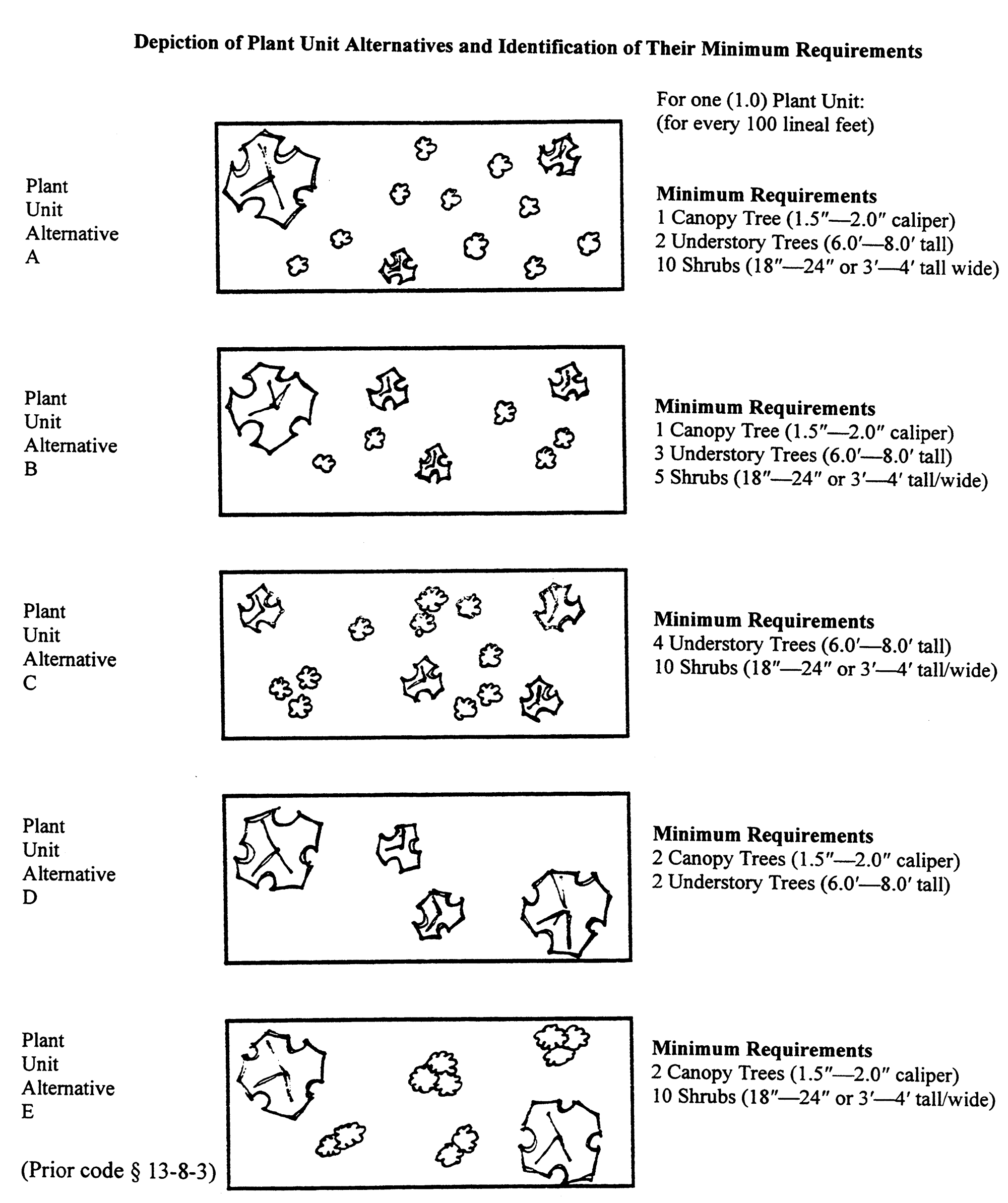
Plant Unit Alternatives
17.32.040 - Landscaping requirements for developed lots.
A.
This section requires that certain residential and nonresidential lots developed after the effective date of this chapter (see Section 17.04.100) contain a minimum amount of landscaping.
B.
Landscaping required by this section is most effective if located close to buildings on the subject property, and shall not be located in those areas required for landscaping as street frontages, paved areas, protected green space areas, reforestation areas, or bufferyards, under Sections 17.32.050 through 17.32.090 of this chapter.
C.
For each acre of gross site area (GSA) of multiplex, apartment, or nonresidential property, the following number of plant units (as described in Section 17.32.030) shall be provided on a prorated basis, and installed and maintained per the requirements of Section 17.32.110:
(Prior code § 13-8-4)
17.32.050 - Landscaping requirements for street frontages.
A.
This section requires that certain residential and nonresidential lots developed after the effective date of this chapter (see Section 17.04.100) contain a minimum amount of landscaping in those areas which abut the right-of-way of a public street. Plant unit alternative D is recommended for use in meeting this requirement.
B.
All landscaping used to meet this requirement shall be located within the distance from the right-of-way indicated in the following table. In no instance shall such landscaping be located within a public right-of-way.
C.
In instances where a zoning district boundary (or a development option boundary within the same zoning district) is located immediately adjacent to or within a public street right-of-way, the more intensive landscaping requirements (of this section, or twenty-five percent (25%) of the requirements of Section 17.32.090(B)) shall be used.
D.
For every one hundred (100) feet of street frontage where a developed lot abuts a public street right-of-way the following number of plant units (as described in Section 17.32.030) shall be provided on a prorated basis, and installed and maintained per the requirements of Section 17.32.110.
(Prior code § 13-8-5)
17.32.060 - Landscaping requirements for paved areas.
A.
This section requires that certain paved areas developed after the effective date of this title (see Section 17.04.100) provide a minimum amount of landscaping within the paved area, and/or within ten (10) feet of the paved area. These requirements shall not apply to single-family residential uses.
B.
A minimum of three hundred sixty (360) square feet of landscaped area, which shall be located within ten (10) feet of the paved area, is required for the placement of each plant unit. Such area does not have to be provided in one contiguous area—sample configurations are depicted on the following page.
C.
Unless a waiver is granted by the city engineer, all landscaping areas required by this section shall be located within an area which is separated from the paved area by a continuous minimum four-inch tall curb which is constructed of concrete, asphalt or similar material approved by the city engineer.
D.
For every twenty (20) off-street parking stalls or ten thousand (10,000) square feet of pavement (whichever yields the greater landscaping requirement) located in a development, the following number of plant units (as described in Section 17.32.030) shall be provided on a prorated basis, and installed and maintained per the requirements of Section 17.32.110:
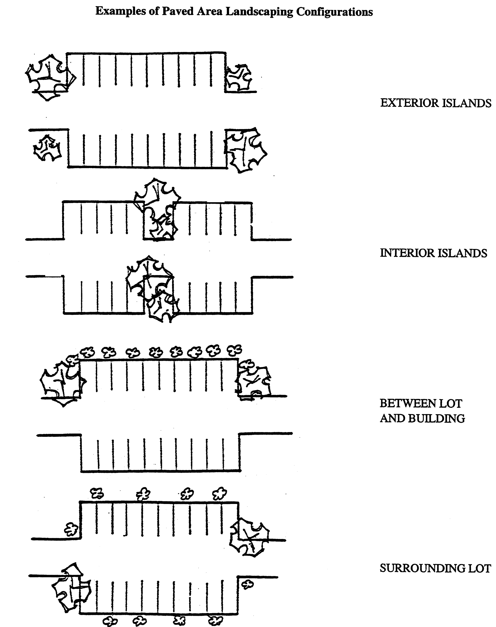
Paved Area Landscaping
(Ord. 562, 2001; prior code § 13-8-6)
17.32.070 - Landscaping requirements for other permanently protected green spaces.
A.
This section requires that each acre of other permanently protected green space (see Section 17.28.110) approved after the effective date of this title be planted with a minimum amount of landscaping.
B.
For every one acre of other permanently protected green space in a development, two plant units (as described in Section 17.32.030) shall be provided. In addition, adequate ground cover shall be provided to stabilize the soil. (Prior code 13-8-7)
17.32.080 - Landscaping requirements for required reforestation.
A.
This section requires that each acre of required reforestation area approved after the effective date of this title (see Section 17.04.100) be planted with a minimum amount of landscaping.
B.
For every one acre of reforestation area required under the provisions of this title, ten (10) plant units of Alternative A, B, or D (as described in Section 17.32.030) shall be provided. In addition, adequate ground cover shall be provided to stabilize the soil.
Rationale: The provisions of this section are designed to ensure that reforestation efforts required as part of woodland disruption mitigation standards result in the thorough and reasonably rapid replacement of the important and varied environmental functions which woodlands provide. (See Section 17.28.070.) (Prior code § 13-8-8)
17.32.090 - Landscaping requirements for bufferyards.
A.
Purpose. This section provides the landscaping and width requirements for bufferyards on lots developed after the effective date of this title. (See Section 17.04.100.) A bufferyard is a combination of distance and a visual buffer or barrier. It includes an area, together with the combination of plantings, berms and fencing, that are required to eliminate or reduce existing or potential nuisances. These nuisances can occur between adjacent zoning districts and between different development options within the same zoning district. Such nuisances are dirt, litter, noise, glare of lights, signs, and incompatible land uses, buildings or parking areas.
Rationale: One of zoning's most important functions is the separation of land uses into districts which have similar character and contain compatible uses. The location of districts is supposed to provide protection, but in the city, this is not the case since zoning districts permitting uses as diverse as single-family residential and industrial uses were located next to one another long before the effective date of this title. Bufferyards will operate to minimize the negative impact of any future use on neighboring uses.
B.
Required Locations for Bufferyards. Bufferyards shall be located along (and within) the outer perimeter of a lot wherever two different zoning districts, or two different development options within the same zoning district, abut one another. Bufferyards may be located in required setback areas. Bufferyards shall also be required adjacent to rights-of-way wherever a zoning district or development option boundary is located within such right-of-way. In such instances, the one-half of the bufferyard requirements of this section shall be used instead of the street frontage landscaping required in Section 17.32.050, if such requirements of this section are greater. (In such instances, the width of the right-of-way may be counted as contributing to the width requirements for a bufferyard, however, the minimum width required along the street frontage by Section 17.32.050, shall be provided in all cases.) Bufferyard plantings or structures shall not be located on any portion of any existing, dedicated, or officially mapped right-of-way.
C.
Determination of Required Bufferyard. The determination of bufferyard requirements is a two-staged process. First, the required level of bufferyard opacity is determined using Table 17.32.090(D)(1). Opacity is a quantitatively-derived measure which indicates the degree to which a particular bufferyard screens the adjoining property. The required level of opacity indicated by this table is directly related to the degree to which the potential character of development differs between different zoning districts and/or development options. The provisions of this subsection indicate the minimum requirements for bufferyards located along zoning district and development option boundaries.
1.
Identification of Required Level of Opacity. Table 17.32.090(D)(1) shall be used to determine the minimum level of opacity for the required bufferyard. The required level of opacity is determined by the value given in the cell of the table at which the column heading along the top row of the table (representing the subject property's zoning district and development option) intersects with the row heading along the left hand side of the table (representing the adjacent property's zoning district and development option). The value listed is the required level of opacity for the bufferyard on the subject property.
2.
Identification of Detailed Bufferyard Requirements. Table 17.32.090(D)(2) shall be used to select the minimum levels of bufferyard width, landscaping, berming and fencing needed to achieve the minimum level of opacity (from Table 17.32.090(D)(1) for the required bufferyard. The landscaping component of each option is given in plant units (as described in Section 17.32.030). For any given bufferyard, any combination of options for the same level of opacity may be used. This approach provides a very broad range of choice for bufferyard width, landscaping, berming and fencing, which can be varied according to site features.
a.
If a proposed use adjoins a parcel for which a bufferyard is required by the presence of a zoning or development option boundary, that use shall provide a bufferyard with the level of the opacity indicated in Table 17.32.090(D)(1).
b.
For each level of opacity listed in Table 17.32.090(D)(1), a wide variety of width, plant unit, berm, and structure combinations are possible. These are listed in Table 17.32.090(D)(2). The requirements listed in Table 17.32.090(D)(2) pertain to the number of plant units, the minimum bufferyard width, and the type of berm or fencing required within every one hundred (100) feet of required bufferyard. A variety of plant unit options are available and may be mixed within distinct portions of the same bufferyard. Section 17.32.030 describes the various available plant unit alternatives. Section 17.32.100 provides a listing of tree and shrub species which correspond to the plant unit descriptions.
D.
Tables for Required Bufferyards. See Tables 17.32.090(D)(1) and (2).
Notes for Table 17.32.090(D)(1):
* ;hg;For properties zoned in the rural holding district (RH-35ac), refer to the comprehensive
plan's preferred future land use map (Map 11-3) to determine the proposed zoning district
for such property. Bufferyard requirements shall be taken from this proposal.
**Refer to Section 17.24.095 for exceptions to landscaping requirements for bufferyards for nonresidential uses in the Urban Residential (UR-12) zoning district.
Caution: The required opacity levels listed in Table 17.32.090(D)(1) are generally different on either side of any given zoning district or development option boundary. Care should be taken to properly use this table (per subsection 17.32.090(C)(1)) to determine the subject property's requirement.

Table 17.32.090(D)(1)
Table 17.32.090(D)(2) Detailed Bufferyard Requirements
* Fences contributing to landscaping requirements are not permitted along street frontages for nonresidential uses. Where used in combination with plant materials to meet bufferyard requirements, a minimum of fifty percent (50%) of all plant materials shall be located on the exterior side (the side away from the center of the subject property) of the fence.
(1) The twenty-five (25) foot bufferyard shall be allowed only for infill developments on lots containing existing structures. Fifty percent (50%) of the required canopy and understory trees shall be evergreen landscaping for yard round screening.
Note: Opacity standards provided courtesy of Lane Kending, Inc.
(Ord. 144, § 3, 6-1-2004; prior code 13-8-9)
17.32.100 - Classification of plant species.
For the purpose of this chapter, plant materials are classified into three groupings: canopy trees, understory trees, and shrubs, species suitable for bufferyard use and compatible with Dane County climate and soil factors are listed in Table 17.32.100, below. The zoning administrator (see Section 17.48.020) shall review proposals for, and the applicability of, species not contained in this list and is authorized to approve appropriate similar species.
Table 17.32.100
Classification of Plant Species
TYPE OF PLANT
Genus and Species
Common Name
CANOPY TREES
Acer
Maple Species (except those listed as understory trees)
Carva
Hickory Species
Celtis
Hackberry Species
Fagis Grandiflora
American Beech
Ginkgo Biloba
Ginkgo or Maidenhair Tree
Gleditsia Triacanthos
Common Honey-Locust
Gymnocladus Dioicus
Kentucky Coffee Tree
Halesia Monticola
Mountain Silverbell
Juglans Regia
English or Persian Walnut
Liquidambar Styraciflua
Sweet Gum
Metasequoia Glyptostroboides
Dawn Redwood
Nyssa Sylvatica
Black Gum or Black Tupelo
Pinus
Pine Species
Plantanus
Plane Tree Species
Populus
Poplar Species
Pseudotsuga Menziesii
Douglas Fir
Quercus
Oak Species
UNDERSTORY TREES
Acer Competre
Hedge Maple
Acer Carpinifolium
Hormbeam Maple
Acer Ginnala
Amur Maple
Acer Palmatum
Japanese Maple
Aesculus Glabra
Ohio Buckeye
Amelanchier Grandiflora
Apple Serviceberry
Betula Poplifolia
Gray Birch
Carpinus Betulus Globosa
European Hornbeam
Carya Tomentosa
Mockernut
Cercis Siliquastrum
Judas Tree
Cornus Kousa
Japanese Dogwood
Cornus Mas
Cornelian Cherry
Cornus Officinalis
Japanese Cornel
Cotinus Americanus
American Smoke Tree
Crataegus
Hawthorn Species
Elaeagnus Angustifolia
Russian Olive
Evodia Danielli
Korean Evodia
Franklinia Alatamaha
Franklinia
Halesia Carolina
Carolina Silverbell
Koelreuteria Paniculata
Golden Rain Tree
Laburnum
Laburnum Species
Malus
Crab Apple Species
Picea
Spruce Species
Prunus
Cherry Species
Quercus Marilandica
Black Jack Oak
Salix Babylonica
Babylon Weeping Willow
Styrax
Snowbell Species
SHRUBS
Amelanchier 3'—4' minimum
Juneberry Species
Aronia 3'—4' minimum
Chokeberry Species
Berberis 18"—24" minimum
Barberry Species
Cornus 3'—4' minimum
Dogwood Species
Cotoneaster 3'—4' minimum
Various Species
Euonymus 3'—4' minimum
Burning Bush Species
Hydrangea 3'—4' minimum
Hydrangea Species
Juniperus 18"—24" minimum for spreading
3'—4' minimum for upright
Juniper Species
Lonicera 3'—4' minimum
Honeysuckle Species
Philadelphus 3'—4' minimum
Mockorange Species
Physocarpus 3'—4' minimum
Ninebark Species
Potentilla 18"—24" minimum
Various Species
Rhus 3'—4' minimum
Sumac Species
Sambucus 3'—4' minimum
Elder Species
Sheperdia 3'—4' minimum
Buffaloberry Species
Spirea 18"—24" minimum
Various Species
Syringa 3'—4' minimum
Lilac Species
Taxus 18"—24" minimum
Yew Species
Thuja 3'—4' minimum
Arbor-vitae Species
Tsuga 3'—4' minimum
Hemlock Species
Vaccinium Corymbosum 3'—4' minimum
Highbrush Blueberry
Viburnum 3'—4' minimum
Various Species
Weigela 3'—4' minimum
Various Species
(Prior code § 13-8-10)
17.32.110 - Requirements for the installation, maintenance and use of landscaped and bufferyard areas.
A.
Installation.
1.
Any and all landscaping and bufferyard material required by the provisions of this title shall be installed on the subject property, in accordance with the approved site plan (see Section 17.44.070) within seven hundred thirty (730) days of the issuance of an occupancy permit for any building on the subject property.
2.
Surety.
a.
The property owner shall file, subject to approval by the city administrator, a bond, a certificate of deposit, an irrevocable letter of credit, or a certified check, in amount equal to one hundred ten percent (110%) of the estimate of landscaping materials and installation cost prepared by the zoning administrator as surety to guarantee that such improvements will be completed by the property owner or his or her contractors within such seven hundred thirty (730) day period. An enforceable contract, for all work on the subject property required under the provisions of this chapter, from a qualified contractor (valid for such seven hundred thirty (730) day period), may be used in lieu of such cost estimate to determine the amount of surety.
b.
If a part of a plat of subdivision approved per the requirements of this title, such amount may be split into amounts which are applicable to phases of the plat approved per the requirements of Section 16.32.020 of the city of Sun Prairie land division ordinance.
c.
Governmental units to which these bond and guarantee provisions apply, may, in lieu of such contract or instrument of guarantee, file a resolution or letter from officers authorized to act in its behalf, agreeing to comply with the provisions of this chapter.
3.
Existing plant material which meets the requirements of Section 17.32.020 and which will be preserved on the subject property following the completion of development, may be counted as contributing to the landscaping requirements.
4.
All landscaping and bufferyard areas shall be seeded with lawn or native ground cover unless such vegetation is already fully established.
5.
The exact placement of required plants and structures shall be the decision of each property owner within the requirements of this chapter, except that the following requirements shall be met:
a.
Evergreen shrubs shall be planted in clusters in order to maximize their chance for survival.
b.
Where a combination of plant materials, and/or berming and/or fencing is used in a bufferyard, the fence and/or berm shall be located toward the interior of the subject property and the plant material shall be located toward the exterior of the subject property.
c.
A property owner may establish through a written agreement, recorded with the register of deeds office, that an adjacent property owners shall agree to provide a partial or full portion of the required bufferyard on an immediately adjacent portion of their land, thereby exempting the developer from providing all or a portion of the required bufferyard on his or her property.
d.
In no manner shall landscaping or bufferyard materials be selected and/or located in a manner which results in the creation of a safety or visibility hazard. (See Section 17.36.030.)
B.
Maintenance. The continued and continual maintenance of all required landscaping and bufferyard materials shall be a requirement of this title and shall be the responsibility of the owner of the property on which such materials are required. This requirement shall run with the property and is binding upon all future property owners. Development of any and all property following the effective date of this title shall constitute an agreement by the property owner to comply with the provisions of this section. Upon failure to comply with these provisions, the city may enter upon the property for the purpose of evaluating and maintaining all required landscaping and bufferyard materials, and may specially assess the costs thereof against the property. Failure to comply with this requirement shall be considered a violation of this title, and shall be subject to any and all applicable enforcement procedures and penalties. (See Section 17.48.060.)
C.
Use of Required Bufferyard and Landscaped Areas. Any and all required bufferyards or landscaped areas may be used for passive recreation activities. Such areas may contain pedestrian, bike or equestrian trails provided that: no required material is eliminated; the total width of the required bufferyard, or the total area of required landscaping, is maintained; and all other regulations of this title are met. In no event, however, shall swimming pools, tennis courts, sports fields, golf courses, or other such active recreation used be permitted in such areas. Furthermore, in no instance shall any parking be permitted in such areas, nor shall any outdoor display of storage of materials be permitted in such areas. Paving in such areas shall be limited to that required for necessary access to, through or across the subject property. (Prior code § 13-8-11)
17.32.120 - Calculating landscaping and bufferyard requirements.
In calculating the number of required plant units under the provisions of this chapter, all areas and distances on which required calculations are based shall be rounded up to the nearest whole number of square feet or linear feet. Any partial plant derived from the required calculations of this chapter (for example 23.3 canopy trees) shall be rounded up to the nearest whole plant (twenty-four (24) canopy trees). (Prior code § 13-8-12)
17.32.130 - Depiction of required site plan.
Any and all proposed landscaping on the subject property, required to meet the standards of this title, shall be clearly depicted and labeled as to its location and make-up on the site plan required for the development of the subject property. (Refer to Section 17.44.070.) (Prior code § 13-8-13)