
Villa Rica City Zoning Code
CHAPTER I
- IN GENERAL2
Editor's note— An Ord. of 11-14-2023 repealed ch. I, §§ 1.01—1.13, and enacted a new ch. I as set out herein and as may later be amended. Former ch. I pertained to similar subject matter and derived from an Ord. of 8-11-2020.
Sec. 1.01.- Title.
1)
This Ordinance shall be known and may be cited and referred to as the "Zoning Ordinance of the City of Villa Rica, Georgia," and shall be referred to as "this Ordinance."
(Ord. of 11-14-2023)
Sec. 1.02. - Purpose.
1)
This Ordinance is hereby enacted by the City of Villa Rica, Georgia, for the purpose of:
a)
Promoting the public health, safety, comfort, and general welfare;
b)
To conserve and protect property and property values;
c)
To secure the most adequate and economical provisions for public improvement, paying due regard to with the Comprehensive Plan and any changes made thereto as reflected in the Zoning Map and documents and records of The City of Villa Rica for the desirable future development of the City; and
d)
To provide a method of administration and to prescribe penalties for the violations of the provisions hereafter described: all as authorized by the provisions of the Chapters and the Sections applicable under the Georgia Code.
(Ord. of 11-14-2023)
Sec. 1.03. - Territory under the zoning ordinance.
1)
This Ordinance shall be effective in the incorporated areas of the City of Villa Rica, Georgia. Upon annexation of territory into the City of Villa Rica, the County zoning regulations then in effect on that territory shall become null and void.
(Ord. of 11-14-2023)
Sec. 1.04. - Applicability and compliance.
1)
All buildings erected hereafter, all uses of land or buildings established hereafter, all structural alterations, changes in site or site flow, and relocation of existing buildings occurring hereafter, and all enlargements of or additions to existing legally conforming uses exceeding thirty-five percent (35%) of the existing site or structure occurring hereafter as determined by the Community Development Director ("Director") shall be subject to all the regulations of this Zoning Ordinance as they apply to the zoning districts in which such buildings or uses of land shall be located.
a)
All changes of use proposed within existing structures on developed parcels shall be exempt from all supplementary regulations within this ordinance except parking requirements.
b)
All changes of use proposed within new structures or structures expanded beyond 35% of the existing structure's square footage on developed parcels shall be subject to all applicable regulations within this ordinance as set forth herein.
c)
All changes of use proposed within existing buildings, new buildings, or buildings expanded beyond thirty-five percent (35%) of the existing structure's square footage, and located on underdeveloped or undeveloped lots shall be subject to all applicable regulations within this ordinance as set forth herein.
2)
This Ordinance shall not be construed as abating any action now pending under, or by virtue of, the prior existing zoning ordinance; or as discontinuing, abating, modifying, or altering any penalty accruing or about to accrue; or as affecting the liability of any person, firm, or corporation; or as waiving any right of the City of Villa Rica under any section or provision existing at the time of the effective date of this Ordinance; or as vacating or annulling any rights obtained by any person, firm, or corporation, by lawful action of the City, except as shall be expressly provided for in this Ordinance.
3)
See also Chapter III, Nonconformities.
4)
Municipal, county, and state owned properties shall be exempt from all use and use district regulations set forth within this ordinance. This section shall not be construed to exempt such uses and structures from following development or supplemental regulations found herein. Utility providers are subject to all regulations found within this ordinance unless otherwise indicated.
(Ord. of 11-14-2023)
Sec. 1.05. - Transition rules.
1)
Any application that has been filed with the Planning & Zoning Commission or its designees and is full and complete, prior to the effective date of this Zoning Ordinance, shall be regulated by the terms and conditions of the Zoning Ordinance that was in place at the time of filing. However, all administrative procedures shall follow those set forth by this Zoning Ordinance.
(Ord. of 11-14-2023)
Sec. 1.06. - How to use this document.
1)
STRUCTURE. The structure of the text of this Ordinance is as follows: Chapter (indicated by 1, etc.), Section (indicated by 1.1, etc.), and subsequent Subsections (indicated by a, i, etc.). Below is an example of this format:
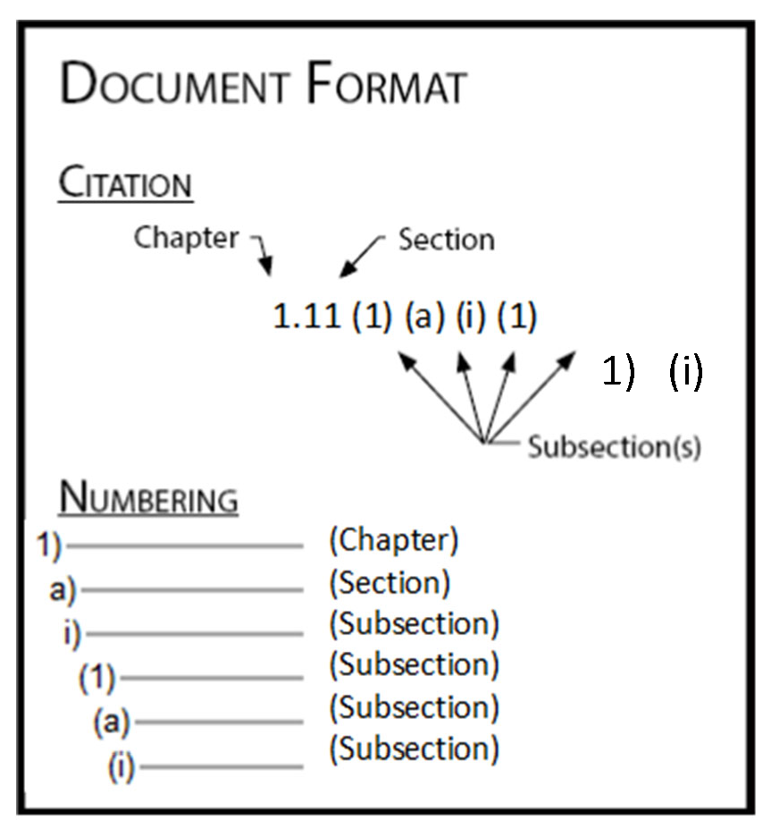
2)
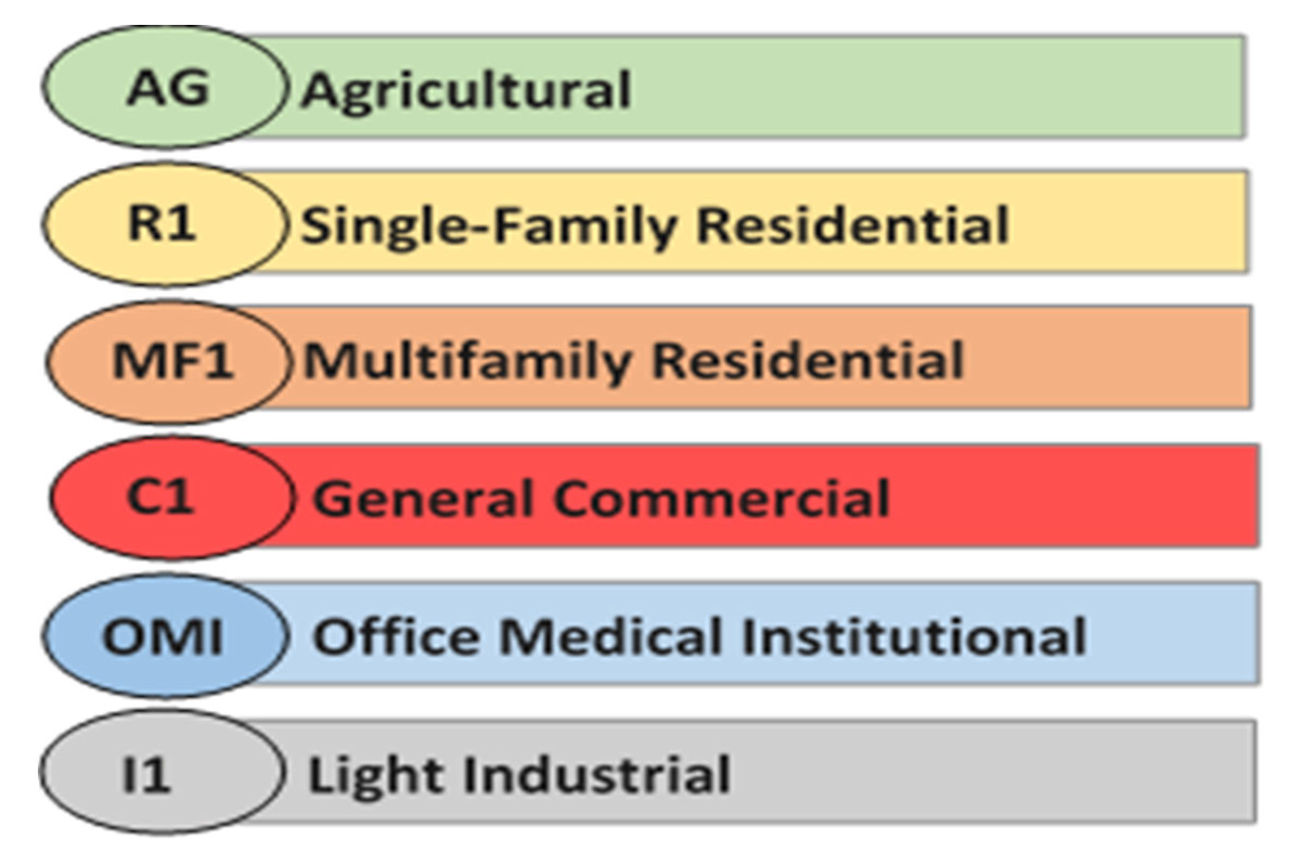
APPLICABLE DISTRICTS. Zoning district designation identifiers are located in various places throughout the document. If one of these identifiers appears within a section, then that section will apply to the corresponding zoning district. Samples of district identifiers follow:
(Ord. of 11-14-2023)
Sec. 1.07. - Interpretations.
1)
In their interpretation and application, the provisions of this Ordinance shall be held to be minimum or maximum requirements, adopted for the promotion of the public health, safety, and the general welfare.
(Ord. of 11-14-2023)
Sec. 1.08. - Interpretation of terms or words.
1)
For the purpose of this Ordinance, certain terms or words are defined, and the words or terms used shall be interpreted as follows:
a)
The word "person" includes a firm, association, organization, partnership, trust, company, corporation or other legal entity, as well as an individual;
b)
The present tense includes the future tense, the singular number includes the plural, and the plural number includes the singular;
c)
The word "shall" is a mandatory requirement, the word "may" is a permissive requirement, and the word "should" is a preferred requirement;
d)
The words "used" or "occupied" include the words "intended, designed, constructed, converted, altered or arranged to be used or occupied"; and
e)
The word "lot" includes the words "plot, tract, or parcel."
(Ord. of 11-14-2023)
Sec. 1.09. - Zoning map.
1)
OFFICIAL ZONING MAP. The city is divided into zones or districts as shown on the Official Zoning Map as amended, which, together with all explanatory matter, is adopted by reference and declared to be a part of this Ordinance. See also Section 11.05, Zoning Map and Text Amendments.
2)
LOCATION AND MAINTENANCE OF THE OFFICIAL ZONING MAP.
a)
Regardless of the existence of copies of the official Zoning Map which, from time to time may be published, the Official Zoning Map shall be located in the office of the Community Development department. It shall be the final authority as to the current zoning status of land and water areas in the city. Current copies may be obtained from the Community Development department.
b)
The official Zoning Map may be maintained in electronic form, and depicted in various formats and scales as appropriate to the need, under the direction of the Community Development Director.
c)
No changes of any nature shall be made on the Official Zoning Map or shown except in conformity with the procedures set forth in this Ordinance. Any unauthorized change of any kind by a person or persons shall be considered a violation of this Ordinance and punishable as provided under Chapter XII, Violations and Enforcement.
3)
REPLACEMENT OF THE OFFICIAL ZONING MAP. In the event that the official Zoning Map becomes damaged, destroyed, lost or difficult to interpret because of the nature or number of changes and additions or loss of electronic information, the Villa Rica City Council may, by Resolution, adopt a new Official Zoning Map which shall supersede the prior Official Zoning Map. The new Official Zoning Map may correct drafting or other errors or omissions in the prior Official Zoning Map, but no correction shall have the effect of amending the original Official Zoning Map or any subsequent amendment.
4)
RULES FOR INTERPRETATION OF DISTRICT BOUNDARIES. Where uncertainty exists with respect to the boundaries of districts as shown on the Official Zoning Map, the following rules shall apply:
a)
Boundaries indicated as approximately following the center lines of thoroughfares or highways, street lines or highway right-of-way lines, or alleys shall be construed to follow the centerlines;
b)
Boundaries indicated as approximately following platted lot lines shall be construed as following the lot line;
c)
Boundaries indicated as approximately following city limits shall be construed as following the City Limits;
d)
Boundaries indicated as following railroad lines shall be construed to be midway between the main tracks;
e)
Boundaries indicated as approximately following the centerlines of streams, rivers, canals, lakes or other bodies of water shall be construed to follow the centerlines;
f)
Boundaries indicated as approximately following floodplain lines shall be construed to follow the floodplain lines;
g)
Boundaries indicated as parallel to or extensions of features indicated in the subsections above shall be so controlled. Distances not specifically indicated on the Official Zoning Map shall be determined by the scale of the map by the Community Development Director;
h)
Where physical features existing on the ground are at variance with those shown as the Official Zoning Map, or in other circumstances not covered by the subsections above, the Community Development Director shall interpret the boundaries. The Villa Rica City Council shall hear appeals to the decision of the Community Development Director; and
i)
When a zoning district boundary line divides a lot or parcel, the Director shall determine the applicable zoning district. The Director may require a rezone or replat of the site if any portion of a construction or development proposal overlaps two (2) or more zoning districts. The petitioner shall be responsible for filing the appropriate forms and for paying the appropriate filing fees to rezone or replat the lot or parcel. If a portion of a lot or parcel is in an overlay district, the entire lot or parcel shall be deemed as being within the overlay district.
(Ord. of 11-14-2023)
Sec. 1.10. - Conflict of law.
1)
Whenever the regulations of this Ordinance require a greater width or size of setbacks or other open space, a lower height limit, greater percentage of lot to be left unoccupied, a lower density of development, a more restrictive use of land, or impose other higher standards than are required in any other lawfully adopted rules, regulations, ordinances, private deed restrictions or private covenants, these regulations shall govern.
(Ord. of 11-14-2023)
Sec. 1.11. - Severability clause.
1)
Should any section or provision of this Ordinance be declared by the courts to be unconstitutional or invalid, that decision shall not affect the validity of the Zoning Ordinance as a whole, or any part other than the part declared to be unconstitutional or invalid.
(Ord. of 11-14-2023)
Sec. 1.12. - Repeal of conflicting ordinance.
1)
All ordinances or parts of ordinances in conflict with this Zoning Ordinance or inconsistent with the provisions of this Ordinance are repealed to the extent necessary to give this Ordinance full force and effect.
(Ord. of 11-14-2023)
Sec. 1.13. - Effective date.
1)
This Ordinance shall become effective from and after the date of its approval and adoption.
(Ord. of 11-14-2023)