
Waynesboro City Zoning Code
ARTICLE 3
- PLANNED AND OVERLAY ZONING DISTRICTS
Sec. 98-3.1.- Planned and overlay districts established.
The following planned and overlay districts are hereby established:
Sec. 98-3.2.1. - Purpose statement
A.
General. The Planned Unit Development (PUD) district is intended to accommodate development that may be difficult if not impossible to carry out under otherwise applicable or available zoning district standards. Examples of the types of development that may benefit from the PUD district include the following:
1.
Enhanced Protection of Natural Resource Areas. Developments that offer enhanced protection of natural resources and sensitive environmental features, including streams, water bodies, floodplains, wetlands, steep slopes, woodlands, wildlife habitats and native plant communities.
2.
Traditional Neighborhood Development. Developments characterized by lot configurations, street patterns, streetscapes, and neighborhood amenities commonly found in urban neighborhoods platted or otherwise created before the 1950s.
3.
Mixed-Use Development. Developments that contain a complementary mix of residential and nonresidential uses.
B.
Implement the Comprehensive Plan. The Comprehensive Plan, and the Land Use Guide contained therein, recommends land use combinations for respective areas of the city. According to the Guide, the specific mix of uses in a Planned Unit Development should include a variety of physically and functionally integrated land uses, including light industrial, commercial, office, educational, civic, institutional, residential and service uses.
Sec. 98-3.2.2. - Code of development.
In approving a Planned Unit Development district, the City Council shall require a Code of Development for each PUD development. The development proposed in the PUD shall be compatible with surrounding land uses and shall maintain and enhance the value of surrounding properties. The Code of Development shall be prepared by a professionally certified civil engineer, landscape architect or other land use professional. The approved Code of Development shall be filed as part of the approval and shall include:
A.
Introduction. Each PUD development shall be designed to achieve the purposes for the PUD district as described Sec. 98-3.2.1.
B.
Concept Plan. A concept plan shall illustrate the plan of development, including, but not limited to, streets and trails, land use pattern, and the relationship between the proposed PUD development and adjacent development.
C.
Permitted Uses. The mix of permitted uses shall be established by the City Council at the time of approval and must be in accordance with the Comprehensive Plan Land Use Guide.
D.
Area and Dimensional Standards. Area and dimensional standards shall be established at the time of approval.
E.
Common Area and Amenities. The PUD district shall include a minimum of 20 percent common area. Common area and amenities shall comply with the standards of Sec. 98-5.8.
F.
Design Guidelines. The PUD district Code of Development shall include a comprehensive set of design guidelines that demonstrate the project will be appropriate within the context of the surrounding properties and the larger community. Such features shall be adopted in conjunction with and as part of the approval of a PUD approval.
G.
Site Development Standards. Site Development Standards of Article 5 may be modified as part of Planned Unit Development approval in order to allow the applicant flexibility to maximize quality and livability within the built environment.
H.
Street Standards. Typical street design standards, as described in City Code, Chapter 74, Article 4, may be modified as part of a Planned Unit Development approval in order to allow the developer or subdivider more flexibility in the arrangement of streets and lots. Approved streets should protect for the convenience, health, safety and general welfare of the future residents of the subdivision as well as the character of the surrounding property and the general welfare of the entire community.
I.
Project Boundary Buffer Alternatives. When a Planned Unit Development is proposed abutting an existing or approved residential subdivision that is not part of the Planned Unit Development, a project boundary buffer shall be provided in accordance with Sec. 98-5.4.5.A.2.
J.
Phasing. If development is proposed to occur in phases, the PUD Code of Development shall include a phasing plan for the development, and projected build-out events or dates for each phase. Each phase shall constitute a self-sufficient infrastructure system and include a proportionate share of any required common area and amenity facilities, unless some or all of such area and facilities is provided in a completed phase(s).
Sec. 98-3.3.1. - General.
The overlay district standards of this section prescribe additional regulations as described herein, applicable to underlying parcels. These supplemental regulations are in addition to, and shall overlap and overlay, those of the underlying zoning districts. Properties within an overlay district are designated on the Zoning District Map. Parcels in the Historic Preservation Overlay district are also governed by one or more zoning districts, which continue in full force with applicable regulations as set forth elsewhere in this Chapter.
Sec. 98-3.3.2. - Corridor overlay (-CO).
A.
Purposes. The corridor overlay (-CO) district is intended to protect and enhance significant entrance corridors to the city or those corridors of notable visual quality. All development in the -CO district shall be carefully reviewed for compliance with the applicable requirements of this Chapter to ensure that this purpose is affected to the extent possible.
B.
Applicability. The -CO district shall apply as shown on the Zoning District Map to an area extending 500 feet from either side of the centerline of the right-of-way along the following corridors:
1.
Delphine Avenue from I-64 northeast to the corporate limits;
2.
East Main Street from the corporate limits northwest to Broad Street;
3.
West Main Street from the corporate limits southeast to Broad Street;
4.
Rosser Avenue and/or P. Buckley Moss Drive from the corporate limits northeast to Main Street;
5.
Ivy Street from the corporate limits south to Hopeman Parkway;
6.
Broad Street (from East Main to West Main); and
7.
Interstate 64 through the city of Waynesboro.
C.
Permitted Uses. All permitted and conditional uses of the underlying zoning district are allowed subject to the specific requirements and procedures for each use type.
D.
Maximum Front Yard Requirement. Maximum front yard in the -CO district shall be as follows:
1.
Maximum: 95 feet.
E.
Prominent Building Requirements.
1.
Purpose. The purpose of this section is to facilitate the creation of a convenient, attractive and harmonious community compatible with historic development by providing articulation and human scale for the prominent building façades of relatively large buildings.
2.
Applicability. The standards of this subsection E shall apply to:
(a)
Construction, renovation or redevelopment of nonresidential structures and complexes with aggregate floor area of more than 60,000 square feet; and/or
(b)
Expansion of such structures or complexes by more than 3,000 square feet or ten percent of existing floor area.
3.
Building Articulation Standards.
(a)
Façades greater than 100 feet in length, measured horizontally, shall incorporate wall plane projections or recesses having a minimum depth of three percent of the length of the façade and extending a minimum of 20 percent of the length of the façade. No uninterrupted length of any façade shall exceed 100 horizontal feet.
(b)
Ground floor façades that face public rights-of-way or parking areas shall have arcades, display windows, entry areas, awnings or other such features along a minimum of 75 percent of their horizontal length and a corner wrap of the same façade treatment for a distance equal to five percent of the ground floor façade extending from all front building corners.
(c)
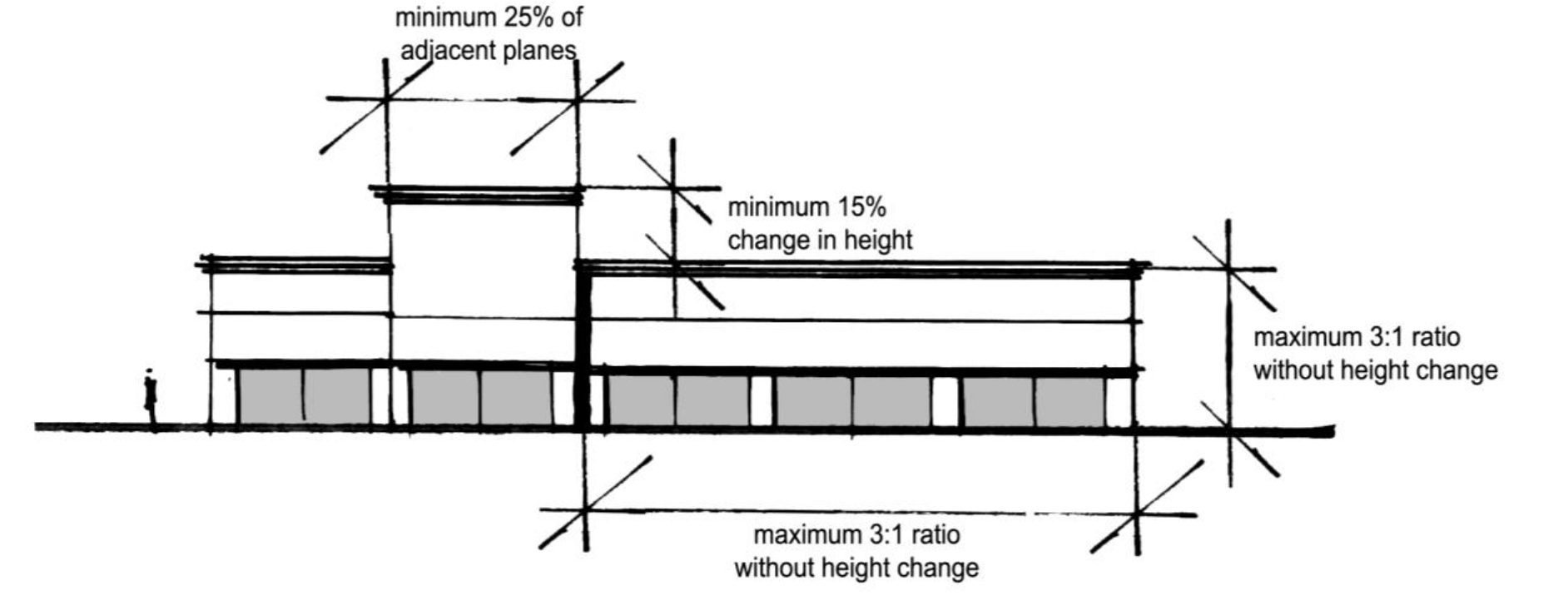
No horizontal wall section shall extend for a distance greater than three times its height without a change in elevation of a minimum of 15 percent of such height. This height change shall continue for a minimum of 25 percent of the length of either adjacent plane.
4.
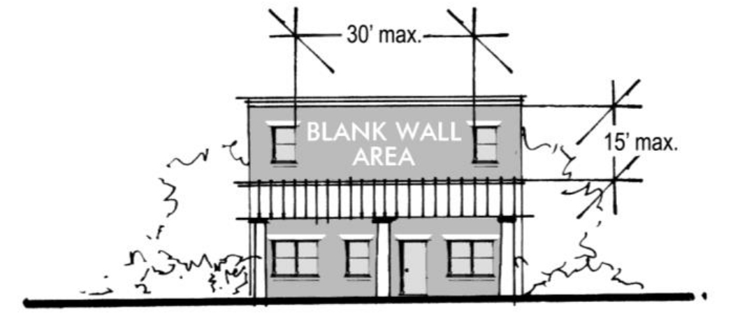
Blank Wall Area. Blank wall areas on building façades facing public right-of-way shall extend a maximum of 15 feet in the vertical direction or 30 feet in the horizontal direction.
F.
Alternative Compliance. The City Council may modify the standards of this section by Conditional Use Permit in accordance with Sec. 98-7.6 where the alternative proposed achieves the purposes of this subsection Sec. 98-3.3.2.
Sec. 98-3.3.3. - Historic preservation overlay (-HPO).
A.
Purpose and Intent. The -HPO district is established, in accordance with VA Code Ann. 15.2-2306, to protect and enhance valuable historic resources of the nation, state and the City. Protection of historic resources promotes the general welfare by generating economic opportunities and attracting visitors; encouraging interest and education in architecture, design and history; and making the City an attractive and desirable place to live and work. Specifically, the -HPO district is intended to:
1.
Encourage the preservation and rehabilitation of important historic, architectural and cultural resources;
2.
Prevent the loss of irreplaceable historic resources and diminishment of the City's historic districts;
3.
Promote resources that link present and future generations to the City's unique history and thereby contribute to a shared sense of community;
4.
Enhance tourism and economic development opportunities;
5.
Preserve property values and contribute to pleasant and attractive neighborhoods; and
6.
Pursue the Comprehensive Plan goals for historic preservation.
B.
Applicability.
1.
The -HPO district shall apply, as shown on the Zoning District Map, to the following historic districts and historic landmarks as described in the Virginia Landmarks Register and the National Register of Historic Places:
(a)
Historic Districts.
(1)
The Tree Streets Historic District.
(2)
The Port Republic Road Historic District.
(3)
The Waynesboro Downtown Historic District.
(b)
Landmarks.
(1)
Fishburne Military School.
(2)
Fairfax Hall.
(3)
The Plumb House.
(4)
The Coiner-Quesenbery House.
2.
Designation of Historic Districts and Landmarks.
(a)
Additional parcels, structures and buildings may be added to the -HPO district as new landmarks and districts or as additions to existing districts through an inventory and designation process in keeping with the Virginia Department of Historic Resource requirements for district and landmark designation. The City Council may designate local landmarks and districts following this process regardless of State or national designations.
(b)
Designation of parcels or landmarks to the Historic Preservation Overlay district requires a Zoning District Map amendment (rezoning) as described in Sec. 98-7.4.
C.
Permitted Uses. All permitted and conditional uses of the underlying zoning district are allowed subject to the specific requirements and procedures for each use classification, provided however, manufactured homes shall not be permitted.
D.
Maintenance and Building Code Provisions. Owners of historic landmarks or contributing historic buildings and structures shall not allow them to fall into a state of disrepair so as to endanger their physical integrity or the public health and safety.
E.
Order of Demolition for Unsafe Buildings. Nothing in this article shall apply to or in any way prevent the moving, or demolition in whole or in part of any building or structure in the city which is in such a dangerous, hazardous or unsafe condition that it has been ordered demolished by the Building Official.
F.
Certificate of Appropriateness.
1.
Applicability. A Certificate of Appropriateness is required prior to demolition or relocation of an historic structure.
2.
Application Requirements. An application for Certificate of Appropriateness shall be submitted in accordance with Sec. 98-7.3.3 Application Requirements.
3.
Notice and Public Hearings. The Planning Commission shall hold all required public hearings and give notice in accordance with Sec. 98-7.2.5, Notice and public hearings.
4.
Action by Planning Director. The Planning Director shall review the application and, considering the review criteria in subsections 7 and 8, below, and make a recommendation to the Planning Commission.
5.
Action by Planning Commission.
(a)
Following a properly advertised public hearing and after having reviewed relevant information on the matter the Planning Commission may approve the application as proposed, approve the application with modifications or deny the application in which case written reasons for denial shall be forwarded to the applicant.
(b)
The Planning Director shall forward written notice of approval, modification or denial to the Zoning Administrator.
6.
Right to Relocate or Demolish.
(a)
In accordance with VA Code Ann. 15.2-2306, the owner of any historic landmark, building or structure shall have the right to relocate or demolish such landmark, building or structure so long as:
(1)
The owner has applied to the City for the right to do so in a manner as described (herein);
(2)
The owner has, for a time period as listed herein and at a price reasonably related to its fair market value, made a bona fide offer to sell:
(i)
The landmark, structure or building and the land pertaining thereto; or
(ii)
The landmark, building or structure for sale separate from the land to any individual or entity which gives reasonable assurance to preserve the landmark, structure or building.
(3)
No bona fide contract, binding on all parties thereto, shall have been executed for the sale of landmark, structure or building and the land pertaining thereto, prior to the applicable time period as listed below:
(i)
Three months when the offering price is less than $25,000.00;
(ii)
Four months when the offering price is $25,000.00 or more but less than $40,000.00;
(iii)
Five months when the offering price is $40,000.00 or more but less than $55,000.00;
(iv)
Six months when the offering price is $55,000.00 or more but less than $75,000.00;
(v)
Seven months when the offering price is $75,000.00 or more but less than $90,000.00; and
(vi)
12 months when the offering price is $90,000.00 or more.
(b)
Bona Fide Offer to Sell.
(1)
The applicant shall, in writing, notify the Zoning Administrator of the bona fide offer to sell to begin the offer time period as listed above. The applicant shall provide the Zoning Administrator evidence of normal efforts of an earnest seller to aggressively market the property including conspicuous and regular advertising in publications of local circulation or advertising with various listing services. The applicant shall also place conspicuous advertising on the property in a location and of such size as might normally be expected for the sale of any property by an earnest seller. The Zoning Administrator shall review the applicant's offer to sell and any proposed conditions to that sale within ten days of the original notice to determine that a bona fide offer has been initiated. If at any time the seller fails to follow or maintain the bona fide offer to sell, the time period for sale shall lapse.
(2)
If no bona fide contract to sell has been executed at the termination of the offer period, the seller shall provide the Zoning Administrator an affidavit demonstrating their efforts to sell, detailing inquiries and attesting to the fact that no viable purchase offer was made.
(3)
Sale of the property shall terminate the petition to demolish and any new owner would be required to follow the procedures as listed (herein) in order to demolish or relocate a regulated structure.
(c)
Fair Market Value. Fair market value shall be considered a price not exceeding the assessed value of the property, as determined by the City's real estate assessor, such assessment being performed upon indication by the owner/applicant that he/she wishes to pursue demolition after denial of a certificate of appropriateness by the Planning Commission. This assessment shall be based on both an interior and exterior inspection of the property and shall represent a current assessment of the property's fair market value. The owner/applicant may challenge the assessed value as a fair market value by seeking at his/her sole expense an independent appraisal of the property in question completed by a licensed appraiser. Should the City's real estate assessor and the independent appraiser not agree upon the said fair market value, they shall choose a third qualified appraiser. A median value shall be established by the three appraisers, which shall be final and binding. The bona fide offer to sell period shall commence once a fair market value is established.
7.
Demolition criteria. The Planning Commission may consider any or all of the following criteria when deliberating on an application for certificate of appropriateness to demolish a landmark or structure or building within the -HPO district:
(a)
Whether or not the building or structure embodies distinctive characteristics of a type, period, style, method of construction, represents the work of a master, possesses high artistic values or is associated with events that make a significant contribution to the broad local history or is associated with historically significant persons.
(b)
Whether or not the building or structure contributes visible architectural value to and provides historic continuity with properties within the same block, including both sides of the street, and the viewshed.
(c)
Whether the building or structure is of such age, authenticity and unusual or uncommon design, setting, workmanship, and materials, and whether such design, quality and workmanship and traditional materials could be reproduced.
(d)
Specific plans for the site should the structure or building be demolished and the architectural compatibility of those plans and uses with properties within the same block, including both sides of the street and the viewshed.
(e)
Whether it is economically and practically feasible in the opinion of a qualified structural engineer and/or building trades professional to preserve or restore the structure.
(f)
Whether the property owner can make alternate, economically viable uses of the property.
(g)
Whether relocation may be appropriate and feasible as an alternative to demolition.
(h)
Whether the existing structure is suited to or can be adapted to a proposed change in land use.
(i)
Whether the structure or building is a contributing or noncontributing resource within the -HPO district.
8.
Relocation Criteria. The Planning Commission may consider any or all of the following criteria when deliberating on an application for certificate of appropriateness to relocate a landmark or structure or building within the -HPO district:
(a)
Whether or not the building or structure embodies distinctive characteristics of a type, period, style, method of construction, represents the work of a master, possesses high artistic values or is associated with events that make a significant contribution to the broad local history or is associated with historically significant persons.
(b)
Whether or not the building or structure contributes visible architectural value to and provides historic continuity with properties within the same block, including both sides of the street, and the viewshed.
(c)
Specific plans for the site, should the structure or building be demolished; and the architectural compatibility of those plans and uses with properties within the same block, including both sides of the street, and the viewshed.
(d)
Whether the structure or building can be moved without harm or damage to its physical integrity.
(e)
Whether the proposed relocation area is compatible with the building or structure's documented historic, scenic, cultural, aesthetic or architectural character in terms of architectural style and period of construction and furthers preservation of the building or structure and is located within the city.
(f)
Where appropriate, relocation should be encouraged by allowing improvements to be sold separate from the underlying property at an offering price not to exceed the fair market value as determined according to Sec. 98-3.3.3.F.6(c).
(g)
Whether the structure or building is a contributing or non-contributing resource within the -HPO district.
(h)
Whether the existing structure is suited to or can be adapted to a proposed change in land use.
9.
Appeals. If an application for a Certificate of Appropriateness is denied or modified, the applicant may appeal such decision within 30 days to the City Council. The City Council shall consider the application following a review of the Planning Director's report and the full written record of the Planning Commission's meeting and decision on the matter.
(Ord. No. 2012-31, 6-8-12)
Sec. 98-3.3.4. - Groundwater management overlay (-GMO).
A.
Purpose and Intent. For the protection of public health and to ensure the availability of a pure water supply, the City Council may delineate groundwater management areas within the City in areas where the aquifers are known to contain any contaminant or contaminants exceeding the maximum contaminant levels established under State or Federal law, including an appropriate buffer area.
B.
Applicability. The -GMO district shall apply as shown on the Zoning District Map. Such groundwater management areas shall constitute an overlay on existing zoning and may be established in the same manner as property within the city is rezoned pursuant to Sec. 98-7.4.
C.
Permitted Uses. All permitted and conditional uses of the underlying zoning district are allowed subject to the specific requirements and procedures for each use classification; provided, however, such uses may be further restricted by the City Council in conjunction with development review.
D.
Requirements as to Domestic Water Supply. Connection of buildings to city water system shall be required for all development within the -GMO district where such service is available either on-site, by easement or in an adjacent public right-of-way. Thereafter, use of any other source of water supply for domestic use shall cease. A reasonable charge for the connection may be imposed for such connection, but irrespective of anything in the City Code to the contrary, said charges shall not exceed the actual cost to the City of installing the line.
E.
Restrictions on Private Wells. No person owning property within a groundwater management area designated hereunder shall place a new well or operate an existing well for domestic use on such property unless a public water system as described in Sec. 98-3.3.4.D is not available to such property. This section shall not prohibit use of an existing well for lawn or ornamental plant irrigation.
Sec. 98-3.3.5. - Floodplain overlay (-FO).
A.
Purposes. The purposes of this section, comprising the City's -FO district regulations, are to prevent the loss of life and property, the creation of health and safety hazards, the disruption of commerce and governmental services, the extraordinary and unnecessary expenditure of public funds for flood protection and relief, and the impairment of the tax base by:
1.
Regulating uses, activities, and development which, alone or in combination with other existing or future uses, activities, and development, will cause unacceptable increases in flood elevations, velocities and frequencies;
2.
Restricting or prohibiting certain uses, activities and development from locating within districts subject to flooding;
3.
Requiring all those uses, activities, and developments that do occur in floodprone districts to be protected and/or floodproofed against flooding and flood damage;
4.
Ensuring that dwellings and their inhabitants are protected from hazards associated with flooding; and
5.
Protecting individuals from buying land and structures which are unsuited for intended purposes because of flood hazards.
B.
Scope.
1.
These provisions shall apply to all privately- and publicly-owned lands within the jurisdiction of the City and identified as being floodprone.
2.
The degree of flood protection sought by the provisions of this section is considered reasonable for regulatory purposes and is based on acceptable engineering methods of study. Larger floods may occur on rare occasions. Flood elevations may be increased by manmade or natural causes, such as ice jams and bridge openings restricted by debris. This section does not imply that districts outside the -FO district, or that land uses permitted within such district, will be free from flooding or flood damage.
3.
This section shall not create liability on the part of the City or any officer or employee thereof for any flood damages that result from reliance on this section or any administrative decision lawfully made thereunder.
4.
This section supersedes any ordinance currently in effect in floodprone districts. However, any underlying ordinance shall remain in full force and effect to the extent that its provisions are more restrictive than this section.
5.
Any and all improvements, analyses, studies and/or investigations required by this section shall be performed at the sole cost of the applicant and/or land owner.
C.
Delineation of District. The boundaries of the -FO district, described below, are established as shown on the Flood Insurance Rate Map which is declared to be a part of this ordinance and which shall be kept on file in the office of the Zoning Administrator. The effective date of the Flood Insurance Rate Map and Flood Insurance Study is September 28, 2007 and as periodically revised and/or amended by FEMA.
1.
The Floodway zone is delineated, for purposes of this ordinance, using the criterion that certain areas within the floodplain must be capable of carrying the waters of the 100-year flood without increasing the water surface elevation of that flood more than one foot at any point. The areas included in this zone are specifically defined in the City of Waynesboro Flood Insurance Study.
2.
The special floodplain district shall be those areas identified as an AE zone on the maps accompanying the Flood Insurance Study for which 100-year flood elevations have been provided.
3.
The approximated floodplain district shall be those areas identified as an A or A99 zone on the maps accompanying the Flood Insurance Study. In these zones, no detailed flood profiles or elevations are provided, but the 100-year floodplain boundary has been approximated. For these areas, the 100-year flood elevations and floodway information from federal, state, and other acceptable sources shall be used, when available. Where the specific 100-year flood elevation cannot be determined for this area using other sources of data, such as the U.S. Army Corps of Engineers Flood Plain Information Reports, U.S. Geological Survey Flood-prone Quadrangles, etc., then the applicant for the proposed use, development and/or activity shall determine this elevation in accordance with hydrologic and hydraulic engineering techniques. Hydrologic and hydraulic analyses shall be undertaken only by professional engineers or others of demonstrated qualifications, who shall certify that the technical methods used correctly reflect currently-accepted technical concepts. Studies, analyses, computations, etc., shall be submitted in sufficient detail to allow a thorough review by the governing body.
4.
The shallow flooding district shall be those areas identified as zone AO or AH on the maps accompanying the Flood Insurance Study.
5.
Where no floodway has been determined, the Floodplain Administrator may require that the applicant for the proposed use, development and/or activity shall determine the floodway in accordance with hydrologic and hydraulic engineering techniques. Hydrologic and hydraulic analyses shall be undertaken only by qualified engineers or others of demonstrated qualifications, who shall certify the technical methods used to reflect currently accepted technical concepts. Studies, analyses, computations, etc., shall be submitted in sufficient detail to allow a thorough review by the City.
D.
Physical Changes Affecting Flood Conditions.
1.
In the event that the base flood elevations increase or decrease resulting from physical changes affecting flood or flooding conditions, as soon as practicable, but not later than six months after the date such information becomes available, the Floodplain Administrator shall notify the Federal Insurance Administrator of the changes by submitting technical or scientific data. Such a submission is necessary so that upon confirmation of those physical changes affecting flooding conditions, risk premium rates and flood plain management requirements will be based upon current data.
2.
The flood carrying capacity within an altered or relocated portion of any watercourse shall be maintained.
E.
Floodplain Development Permits. A floodplain development permit is required for all development in the -FO district pursuant to the requirements of Sec. 98-7.12.
F.
Prohibited and Allowable Development.
1.
General.
(a)
No land shall be developed and no structure shall be located, relocated, constructed, reconstructed, enlarged or structurally altered in the -FO district except in full compliance with the terms and provisions of this section and any other applicable ordinances and regulations which apply to uses within the jurisdiction of this section.
(b)
In all areas covered by this section, which shall include all property lying in the -FO district and zoned in any of the zoning classifications under this Chapter, no uses, activities or development shall be permitted except in compliance with the following restrictions and such other reasonable safeguards and regulations as the Floodplain Administrator may impose for the promotion and maintenance of the general welfare, health and commerce of the inhabitants of the city, and in accordance with good zoning practices; and, in addition, no such development shall be permitted in such areas except upon written approval of compliance by the Floodplain Administrator in accordance with the restrictions, safeguards and regulations described in this section, which shall be given precedence over any other provision of this Chapter which may appear in conflict with this section.
2.
Prohibited Uses. The following uses shall be prohibited in the -FO district:
(a)
Solid waste, trash hauling, landfills, dumps, junkyards, storage tanks, hazardous materials storage, outdoor storage of vehicles and/or materials;
(b)
The filling of jurisdictional wetlands;
(c)
Damming or relocation of any watercourse that will result in any downstream increase in flood levels during the base flood; and
(d)
The construction or storage of any object subject to flotation or movement during flooding.
3.
Permitted Uses. In the -FO district the following uses and activities are permitted, provided that they are in compliance with the provisions of the underlying district and provided that they do not require structures, fill or storage of materials and equipment:
(a)
Agricultural uses, such as general farming, pasture, grazing, outdoor plant nurseries, horticulture, truck farming, forestry, sod farming, and wild crop harvesting.
(b)
Public and private recreational uses and activities, such as parks, day camps, picnic grounds, golf courses, boat launching and swimming areas, horseback riding and hiking trails, wildlife and nature preserves, game farms, fish hatcheries, athletic playing fields, and fishing areas.
(c)
Accessory residential uses, such as yard areas, gardens, play areas, and pervious loading areas.
(d)
Accessory industrial and commercial uses, such as yard areas, pervious parking and loading areas, airport landing strips, etc.
4.
Fill. In any development where filling has been completed in order to make a building lot, the developer shall seek and have approved a letter of Federal insurance rate map amendment through the Federal Emergency Management Agency.
5.
Approval Conditions. No zoning approval or occupancy permit shall be issued under this section for any allowable development in the -FO district except on the following conditions:
(a)
All new construction and substantial improvement of structures shall have the lowest floor, including basement, elevated at least one foot above the design flood elevation; or be designed, together with attendant utility and sanitary facilities, so that below the design flood elevation the structure is watertight with walls substantially impermeable to the passage of water and with structural components having the capability of resisting hydrostatic and hydrodynamic loads and effects of buoyancy.
(b)
No recreational vehicles may be placed on sites except for non-residential use and then shall either be on the site for fewer than 180 consecutive days, or be fully licensed and ready for highway use. A recreational vehicle is ready for highway use if it is on its wheels or jacking system, is attached to the site only by quick disconnect-type utilities and security devices, and has no permanently attached additions.
(c)
Electrical control panels in permitted structures shall be mounted above the design flood elevation.
(d)
All new or replacement water facilities shall be designed to minimize or eliminate infiltration of floodwaters into the system and be located and constructed to minimize or eliminate flood damages.
(e)
All new or replacement sanitary sewer facilities and private package sewage treatment plants, including all pumping stations and collector systems, shall be designed to minimize or eliminate infiltration of floodwaters into the systems and discharges from the systems into the floodwaters. In addition, they shall be located and constructed to minimize or eliminate flood damage and impairment.
(f)
New development shall be reviewed to assure that it will be reasonably safe from flooding, and submittals shall include base flood elevation data. If proposed new development is in the -FO district, proposals shall be reviewed to assure:
(1)
They are consistent with the need to minimize flood damage;
(2)
Public utilities and facilities, such as sewer, gas, electrical, and water systems are located and constructed to minimize or eliminate flood damage;
(3)
Adequate drainage is provided to reduce exposure to potential flood hazards; and
(4)
New lots that may be prone to flood hazard are not created.
(g)
No new construction, substantial improvements, or other development (including, but not limited to, fill) shall be permitted within zone AE (base flood elevation as determined and specified on map) on the community's FIRM (flood insurance rate map), unless it is demonstrated that the cumulative effect of the proposed development, when combined with all other existing and anticipated development, will not increase the water surface elevation of the base flood more than one foot at any point within the community.
(h)
Within any floodway area, no encroachments, including, but not limited to, fill, new construction, substantial improvements or other development shall be permitted unless the applicant demonstrates, through hydrologic and hydraulic analyses, and in accordance with standard engineering practice, that the proposed encroachment would result in any increase in the 100-year flood elevation.
(i)
Where floodproofing is utilized for a particular structure in accordance with this section a qualified engineer or architect shall certify that the floodproofing methods are adequate to withstand the flood depths, pressures, velocities, impact, and uplift forces and other factors associated with the base flood, and a record of such certificates indicating the specific elevation in relation to mean sea level, to which such structures are floodproofed, shall be maintained by the Building Official.
(j)
Industrialized buildings/modular structures that are placed or substantially improved on sites shall be elevated on a permanent foundation such that the lowest floor of the structure is elevated to or above the design flood elevation and be securely anchored to an adequately anchored foundation system to resist flotation, collapse and lateral movement.
(k)
Permitted structures shall be constructed and placed on the building site so as to minimize obstruction to the flow of flooding waters. Permitted structures shall not be constructed in the floodway.
(l)
Permitted structures shall be anchored to prevent flotation, collapse and lateral movement which may result in damage or restriction of the flow of floodwaters.
(m)
The developer shall demonstrate to the City that through appropriate methods as approved or otherwise mandated by the Floodplain Administrator that the flood-carrying capacity within the altered or relocated portion of any watercourse is maintained.
(n)
All storm drainage facilities shall be designed to convey the flow of surface waters without damage to persons or property. The systems shall ensure drainage away from buildings and onsite waste disposal sites. The City may require a primarily underground system to accommodate frequent floods and a secondary surface system to accommodate larger, less frequent floods. Drainage plans shall be consistent with local and regional drainage plans. The facilities shall be designed to prevent the discharge of excess runoff onto adjacent properties.
(o)
All utilities, such as gas lines, electrical and telephone systems being placed in floodprone areas should be located, elevated, where possible, and constructed to minimize the chance of impairment during a flooding occurrence.
(p)
Streets and sidewalks should be designed to minimize their potential for increasing and aggravating the levels of flood flow. Drainage openings shall be required to sufficiently discharge flood flows without unduly increasing flood elevations.
(q)
Such development shall be undertaken only in strict compliance with the provisions of this section and with all other applicable state and local codes and ordinances, such as the Building Code and Appendix G, Flood Resistant Construction, as amended or as henceforth may be amended at any future time. Prior to the issuance of any building permit, the City shall require all applications to include compliance with all applicable State and Federal laws, codes and regulations. Under no circumstances shall any use, activity and/or development adversely affect the capacity of the channels or floodway of any watercourse, drainage ditch, or any other drainage facility or system.
(r)
Foundation vents shall have a minimum of two openings having a total net area of not less than one square inch for every square foot of enclosed area subject to flooding shall be provided. The bottom of all openings shall be no higher than one foot above finished grade. Openings may be equipped with screens, louvers, valves, or other coverings or devices provided that they permit the automatic entry and exit of floodwaters.
(s)
Manufactured homes that are placed or substantially improved within zone AE on the community's FIRM on sites (i) outside of a manufactured home park or subdivision, (ii) in a new manufactured home park or subdivision, (iii) in an expansion to an existing manufactured home park or subdivision, or (iv) in an existing manufactured home park or subdivision on which a manufactured home has incurred "substantial damage" as the result of a flood, shall be elevated so that:
(1)
The lowest floor of the manufactured home is elevated no lower than the design flood elevation; or the manufactured home chassis is supported by reinforced piers or other foundation elements of at least an equivalent strength, of no less than 36 inches in height above the grade; and
The manufactured home must be securely anchored to the adequately anchored foundation system to resist flotation, collapse and lateral movement.
(Ord. No. 2012-31, 6-8-12)
Sec. 98-3.3.6. - General standards.
The following provisions shall apply to all development in the -FO district:
A.
New construction and substantial improvements shall be according to the VA USBC, and anchored to prevent flotation, collapse or lateral movement of the structure.
B.
Manufactured homes shall be anchored to prevent flotation, collapse, or lateral movement. Methods of anchoring may include, but are not limited to, use of over-the-top or frame ties to ground anchors. This standard shall be in addition to and consistent with applicable state anchoring requirements for resisting wind forces.
C.
New construction and substantial improvements shall be constructed with materials and utility equipment resistant to flood damage.
D.
New construction or substantial improvements shall be constructed by methods and practices that minimize flood damage.
E.
Electrical, heating, ventilation, plumbing, air conditioning equipment and other service facilities, including duct work, shall be designed and/or located so as to prevent water from entering or accumulating within the components during conditions of flooding.
F.
New and replacement water supply systems shall be designed to minimize or eliminate infiltration of flood waters into the system.
G.
New and replacement sanitary sewage systems shall be designed to minimize or eliminate infiltration of flood waters into the systems and discharges from the systems into flood waters.
H.
On-site waste disposal systems shall be located and constructed to avoid impairment to them or contamination from them during flooding.
Sec. 98-3.3.7. - Specific standards.
In all special flood hazard areas where base flood elevations have been provided in the Flood Insurance Study or generated according Sec. 98-3.3.7.G, the following provisions shall apply:
A.
Residential Construction. New construction or substantial improvement of any residential structure (including manufactured homes) shall have the lowest floor, including basement, elevated to or above the base flood elevation (recommend > one-foot freeboard).
B.
Non-Residential Construction. New construction or substantial improvement of any commercial, industrial, or non-residential building (or manufactured home) shall have the lowest floor, including basement, elevated to or above the base flood elevation (recommend > one-foot freeboard). Buildings located in all A1-30, AE, and AH zones may be flood-proofed in lieu of being elevated provided that all areas of the building components below the elevation corresponding to the BFE plus one foot are water tight with walls substantially impermeable to the passage of water, and use structural components having the capability of resisting hydrostatic and hydrodynamic loads and the effect of buoyancy. A registered professional engineer or architect shall certify that the standards of this subsection are satisfied. Such certification, including the specific elevation (in relation to mean sea level) to which such structures are floodproofed, shall be maintained by the Zoning Administrator as required by Sec. 98-6.7.2.D.
C.
Elevated Buildings. Fully enclosed areas, of new construction or substantially improved structures, which are below the regulatory flood protection elevation shall:
1.
Not be designed or used for human habitation, but shall only be used for parking of vehicles, building access, or limited storage of maintenance equipment used in connection with the premises. Access to the enclosed area shall be the minimum necessary to allow for parking of vehicles (garage door) or limited storage of maintenance equipment (standard exterior door), or entry to the living area (stairway or elevator).
2.
Be constructed entirely of flood resistant materials below the regulatory flood protection elevation;
3.
Include, in zones A, AO, AE, and A1-30, measures to automatically equalize hydrostatic flood forces on walls by allowing for the entry and exit of floodwaters. To meet this requirement, the openings must either be certified by a professional engineer or architect or meet the following minimum design criteria:
(a)
Provide a minimum of two openings on different sides of each enclosed area subject to flooding.
(b)
The total net area of all openings must be at least one square inch for each square foot of enclosed area subject to flooding.
(c)
If a building has more than one enclosed area, each area must have openings to allow floodwaters to automatically enter and exit.
(d)
The bottom of all required openings shall be no higher than one foot above the adjacent grade.
(e)
Openings may be equipped with screens, louvers, or other opening coverings or devices, provided they permit the automatic flow of floodwaters in both directions.
4.
Foundation enclosures made of flexible skirting are not considered enclosures for regulatory purposes, and, therefore, do not require openings. Masonry or wood underpinning, regardless of structural status, is considered an enclosure and requires openings as outlined above.
D.
Standards for Manufactured Homes, Mobile Homes and Recreational Vehicles.
1.
All manufactured homes or mobile homes placed, or substantially improved, on individual lots or parcels, in expansions to existing manufactured or mobile home parks or subdivisions, in a new manufactured or mobile home park or subdivision or in an existing manufactured or mobile home park or subdivision on which a manufactured home has incurred substantial damage as the result of a flood, must meet all the requirements for new construction, including the elevation and anchoring requirements in Sec. 98-3.3.6.A and B, and Sec. 98-3.3.7.A.
2.
All recreational vehicles placed on sites must either:
(a)
Be on the site for fewer than 180 consecutive days;
(b)
Be fully licensed and ready for highway use (a recreational vehicle is ready for highway use if it is on its wheels or jacking system, is attached to the site only by quick disconnect type utilities and security devices and has no permanently attached additions); or,
(c)
Meet all the requirements for manufactured or mobile homes in Sec. 98-4.2.7 and this subsection D.
E.
Standards for the Floodway District. The following provisions shall apply within the Floodway District:
1.
Encroachments. Encroachments, including fill, new construction, substantial improvements and other developments are prohibited unless certification such as hydrologic and hydraulic analyses (with supporting technical data) is provided demonstrating that encroachments shall not result in any increase in flood levels during occurrence of the base flood. Hydrologic and hydraulic analyses shall be undertaken only by professional engineers or others of demonstrated qualifications, who shall certify that the technical methods used correctly reflect currently-accepted technical concepts. Studies, analyses, computations, etc., shall be submitted in sufficient detail to allow a thorough review by the Floodplain Administrator. Development activities which increase the water surface elevation of the base flood may be allowed, provided that the {developer or applicant} first applies—with the City of Waynesboro's endorsement—for a conditional Flood Insurance Rate Map and floodway revision, and receives the approval of the Federal Emergency Management Agency.
2.
If Sec. 98-3.3.7.E.1 is satisfied, all new construction and substantial improvements shall comply with all applicable flood hazard reduction provisions of Sec. 98-3.3.5.
3.
The placement of manufactured or mobile homes is prohibited, except in an existing manufactured or mobile homes park or subdivision. A replacement manufactured home may be placed on a lot in an existing manufactured home park or subdivision provided the anchoring, elevation, and encroachment standards are met.
F.
Standards for the Special Floodplain District. The following provisions shall apply within the special floodplain district:
1.
Until a regulatory floodway is designated, no new construction, substantial improvements, or other development (including fill) shall be permitted within the areas of special flood hazard, designated as zones A1-30 and AE on the Flood Insurance Rate Map, unless it is demonstrated that the cumulative effect of the proposed development, when combined with all other existing and anticipated development, will not increase the water surface elevation of the base flood more than one foot at any point within the City of Waynesboro.
2.
Development activities in zones Al-30, AE, and AH, on the City of Waynesboro's Flood Insurance Rate Map which increase the water surface elevation of the base flood by more than one foot may be allowed, provided that the {developer or applicant} first applies—with the City of Waynesboro's endorsement—for a conditional Flood Insurance Rate Map revision, and receives the approval of the Federal Emergency Management Agency.
G.
Standards for Approximated Floodplain. The following provisions shall apply with the Approximate Floodplain District:
1.
The approximated floodplain district shall be that floodplain area for which no detailed flood profiles or elevations are provided, but where a 100-year floodplain boundary has been approximated. Such areas are shown as zone A on the maps accompanying the Flood Insurance Study. For these areas, the 100-year flood elevations and floodway information from federal, state, and other acceptable sources shall be used, when available. Where the specific 100-year flood elevation cannot be determined for this area using other sources of data, such as the U. S. Army Corps of Engineers Floodplain Information Reports, U. S. Geological Survey Flood-Prone Quadrangles, etc., then the applicant for the proposed use, development and/or activity shall determine this elevation. For development proposed in the approximate floodplain the applicant must use technical methods that correctly reflect currently accepted technical concepts, such as point on boundary, high water marks, or hydrologic and hydraulic analyses. Studies, analyses, computations, etc., shall be submitted in sufficient detail to allow a thorough review by the Floodplain Administrator.
2.
The Floodplain Administrator reserves the right to require hydrologic and hydraulic analyses for any development.
3.
When such base flood elevation data is utilized, the lowest floor shall be elevated to or above the base flood elevation (recommend > one-foot freeboard). During the permitting process, the Floodplain Administrator shall obtain:
(a)
the elevation of the lowest floor (including the basement) of all new and substantially improved structures; and,
(b)
the elevation (in relation to mean sea level) to which the structure has been flood-proofed if the structure has been flood-proofed in accordance with the requirements of this article.
H.
Standards for the Shallow Flooding District. The following provisions shall apply within the shallow flooding district:
1.
All new construction and substantial improvements of residential structures shall have the lowest floor, including basement, elevated to or above the flood depth specified on the Flood Insurance Rate Map, above the highest adjacent grade at least as high as the depth number specified in feet on the FIRM. If no flood depth number is specified, the lowest floor, including basement, shall be elevated no less than two feet (recommend: one-foot freeboard) above the highest adjacent grade. When a freeboard is included in the height of a structure, the flood insurance premiums will be significantly cheaper.
2.
All new construction and substantial improvements of non-residential structures shall:
(a)
Have the lowest floor, including basement, elevated to or above the flood depth specified on the Flood Insurance Rate Map, above the highest adjacent grade at least as high as the depth number specified in feet on the FIRM. If no flood depth number is specified, the lowest floor, including basement, shall be elevated at least two feet (recommend one-foot freeboard above the flood depth level) above the highest adjacent grade; or
(b)
Be completely flood-proofed to the specified flood level if the structure has been flood-proofed in accordance with the requirements of this article, so that any space below that level is watertight with walls substantially impermeable to the passage of water and with structural components having the capability of resisting hydrostatic and hydrodynamic loads and effects of buoyancy.
3.
Adequate drainage paths around structures on slopes shall be provided to guide floodwaters around and away from proposed structures.
I.
Standards for Subdivision Proposals.
1.
All subdivision proposals shall be consistent with the need to minimize flood damage;
2.
All subdivision proposals shall have public utilities and facilities such as sewer, gas, electrical and water systems located and constructed to minimize flood damage;
3.
All subdivision proposals shall have adequate drainage provided to reduce exposure to flood hazards, and
4.
Base flood elevation data shall be provided for subdivision proposals and other proposed development proposals (including manufactured home parks and subdivisions) that exceed 50 lots or five acres, whichever is the lesser.
J.
Construction on Land Lying Partially within District. Nothing in this section shall prohibit any use or construction on a parcel of land lying partly in the -FO district and partly outside such -FO district, if such use or construction is confined to the portion of such parcel of land lying outside the -FO district and is otherwise in accordance with this section and other relevant sections of this Chapter. The Building Official may issue a building permit for such use or construction outside the -FO district on the written representation of the applicant satisfactory to the Building Official that the use or construction will in fact be outside the -FO district.
K.
Existing Buildings and Structures in Floodplain Areas. A building or structure which lawfully existed before the enactment of these provisions, but which is not in conformity with the provisions of this section, may be continued subject to the condition that substantial damage to or improvement of any building or structure shall require the entire structure to be brought into full compliance with the provisions of this section.
L.
Other Applicable Provisions of This Chapter. In addition to the provisions of this section relating to the -FO district, all other provisions of this Chapter are applicable except as herein otherwise modified.
M.
Administrative Appeal. An appeal from any decision by the Floodplain Administrator shall be made within 30 days of the final decision in accordance with Sec. 98-7.15, Administrative appeal.