
Waynesville City Zoning Code
CHAPTER 6
INFRASTRUCTURE STANDARDS
6.1 - Purpose and Intent.
The purpose of this Chapter is to establish criteria for the site development and subdivision of real property within the jurisdiction of the Town of Waynesville. These standards are set forth to:
• Promote the orderly growth and development of the Town of Waynesville; and
• Provide for suitable residential and nonresidential development with adequate streets, utilities and appropriate building sites; and
• Coordinate streets within subdivisions with existing or planned streets and with other public facilities.
6.2 - Applicability.
6.2.1 Site Plan and Subdivision Authority and Applicability.
A.
Subdivision Defined: For the purposes of this chapter, "subdivision" shall mean all divisions of a tract or parcel of land into two (2) or more lots, building sites, or other divisions for the purpose of sale or building development (whether immediate or future) and shall include all divisions of land involving the dedication of new streets or a change in existing streets.
B.
Statutory Exemptions: The following are not included within the definition above nor are they subject to the regulations of this Ordinance, provided however, that any document or plat to be recorded pursuant to any such exclusion shall bear the notation, "Exempt pursuant to the Town of Waynesville Land Development Standards," and the signature of the Administrator before being presented for recordation.
1.
The combination or recombination of portions of previously subdivided and recorded lots where the total number of lots is not increased and the resultant lots are equal to or exceed the land development standards of the town.
2.
The division of land into parcels greater than ten (10) acres in size where no street right-of-way dedication is involved.
3.
The public acquisition by purchase of strips of land for the widening or opening of streets.
4.
The division of a tract in single ownership whose entire area is no greater than two (2) acres into not more than three (3) lots, where no street right-of-way dedication is involved, and where the resultant lots are equal to or exceed the land development standards of the Town of Waynesville.
5.
The conveyance to lineal descendants for the purpose of dividing real estate among said lineal descendants. At such time that any lineal descendants or their successors in interest develop or building upon their respective property, the property must conform in all respects to the regulations of the Town of Waynesville.
C.
Site Plans Defined: A site plan is an architectural and/or engineering drawing of proposed improvements for a specific lot that depicts such elements as building footprints, driveways, parking areas, drainage, utilities, lighting, and landscaping.
D.
Conformity Required: From and after the adoption of this chapter, no real property lying within the jurisdiction of the Town of Waynesville shall be developed or subdivided except in conformance with all applicable provisions of this Ordinance. In addition, after the effective date of this chapter, no plat for subdivision of land within the jurisdiction of this chapter shall be certified for recording by the Administrator, nor shall the Register of Deeds record any plat until it has been submitted and approved in accordance with the provisions of this section.
6.2.2 Required Conformance to the Specifications of the Town's Public Services Department.
The specifications of the Town's Public Services Department are herein incorporated by reference. Conformance to them is required in addition to the standards of this Ordinance.
6.2.3 Other Relevant Standards for Site Plans and Subdivisions.
In addition to the standards found in this Chapter, standards in the following may also apply:
• Chapter 7: Civic Space
• Chapter 8: Tree Protection, Landscaping, and Screening
• Chapter 9: Parking
• Chapter 10: Lighting
• Chapter 11: Signs
• Chapter 12: Environmental Protection
(Ord. No. O-06-22, § 7, 3-22-2022)
6.3 - Required Improvements for all Development.
All required improvements set forth in this Chapter shall be installed or constructed by the developer at no cost to the Town except as may otherwise be specifically provided herein or by Town policy or agreement. Required improvements under this Chapter shall not be installed or constructed until required construction plans have been approved by the Administrator. The Town may, in order to serve future development, require the developer to install certain oversized improvements and/or to increase such improvements to a size and/or extent beyond that necessary for the needs created by the developer. In such cases, the Town shall enter into an agreement to reimburse the developer for the oversizing and/or extension based upon rates as agreed to by the Town.
6.4 - Connectivity.
6.4.1 Street Network.
A.
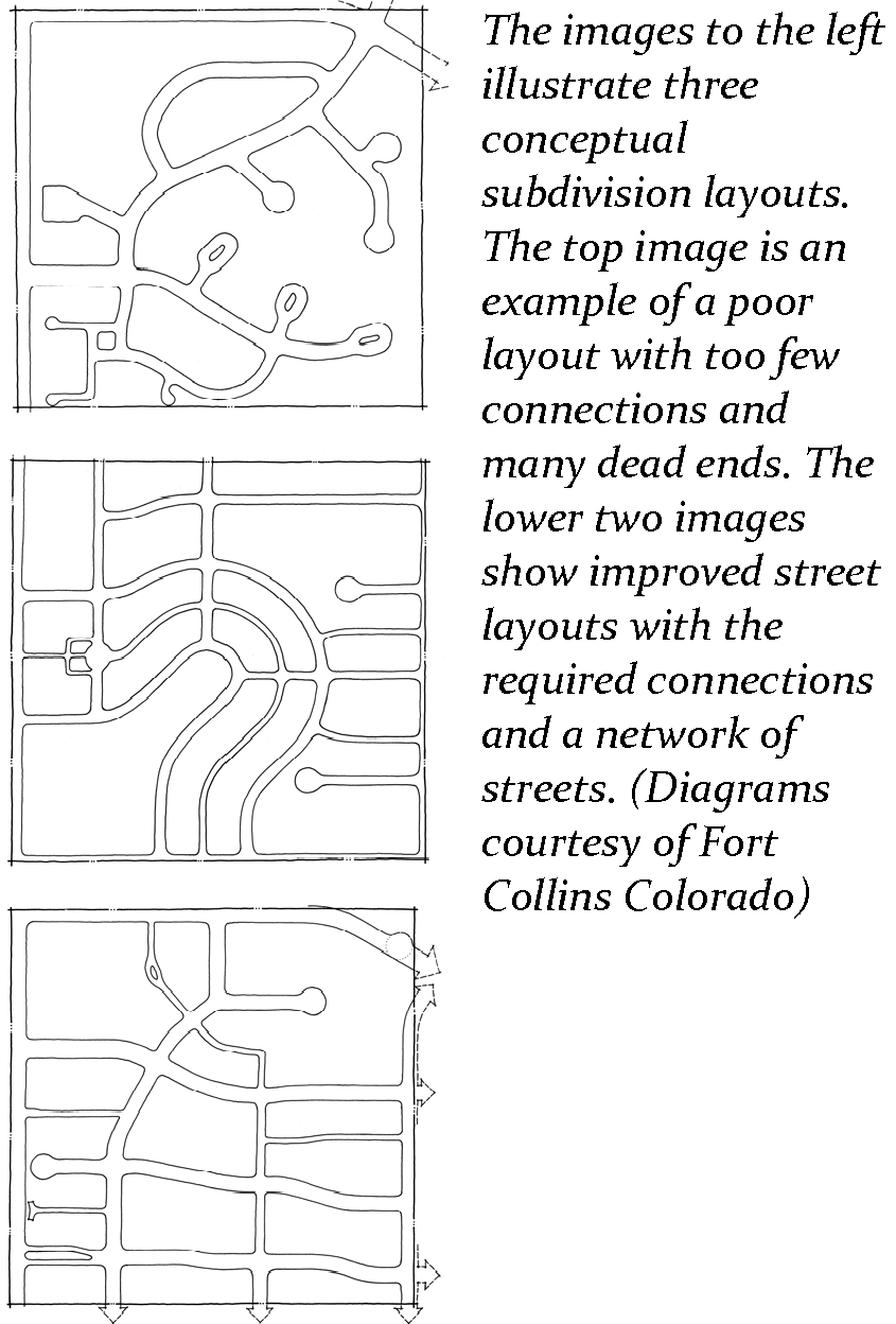
Streets to be Interconnected: Except where determined not feasible by the Administrator, all streets shall be designed to form part of an interconnected street pattern. Streets must connect with adjacent street networks to the extent possible. Street designs will be assessed, in terms of meeting this interconnectivity standard, on their ability to: permit multiple routes between origin/destination points; diffuse traffic; and, shorten walking distances. [154.309(B)(2)]
B.
Block Lengths: Low speed, low volume streets shall be designed with short block lengths of between two hundred and fifty (250) and five hundred (500) feet. The Administrator may approve alternative block length designs based on topography, the existence of environmentally sensitive lands, the need to preserve cultural resources and similar considerations. [154.309(B)(2)]
C.
Compliance with Adopted Plans: Streets shall be planned with due regard to the designated corridors shown on the adopted Thoroughfare Plan.
D.
Reserve Strips Prohibited: Reserve strips and non-access easements adjoining street rights-of-way for the purpose of preventing access to or from adjacent property (except those required by the Town Council to prevent access to thoroughfares), and half-streets shall not be permitted.
E.
Street Stubs:
1.
Connection to Street Stubs Required: New developments shall connect to any existing street stubs from adjacent properties.
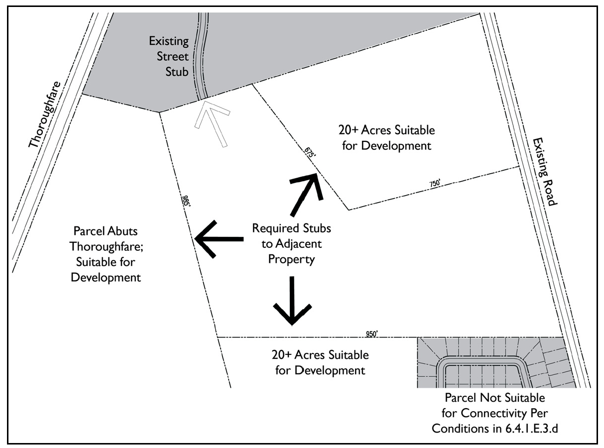
2.
Street Stub Prioritization: New development shall stub to all adjacent properties where practical. The location of new required street stubs shall be prioritized as follows:
a.
Adjacent parcels 20 acres or greater
b.
Adjacent parcels that abut or are traversed by existing or proposed thoroughfares or collector streets.
c.
Where any adopted transportation or land use plan recommends a street connection.
3.
Exemptions: Street stubs shall not be required where the conditions listed below would prevent connections:
• Topographical conditions (where pre-development slopes are 18 percent or greater)
• Environmental conditions (e.g., jurisdictional wetlands)
• Property shape
• Property accessibility (e.g., existing platted subdivision with no stubs)
• Land use relationships (e.g., incompatible land use)
4.
Stub Street Details: Stub streets and streets intended for extension during future phases shall be constructed to extend to the property line or as close to the line as practical. It shall be the responsibility of the second development to construct the connection to an existing stub street. Stub (or dead head) streets shall not exceed 150 feet in length without a paved turnaround (permanent or temporary). A clearly visible street sign shall be erected at the end of the stub street stating that the street is planned to connect to a future street.
6.4.2 Pedestrian/Bicycle Connections.
A.
Connections to Greenways and Parks: When lots abut greenways, parks and open space areas, accessways must be provided at a minimum of every six hundred (600) feet. Where a cul-de-sac street is permitted within a development, accessways to greenways, parks and open space areas must be provided where such streets back up to these areas.
B.
Connection of Cul-de-sacs: Where two (2) cul-de-sac streets end within three hundred (300) feet of each other, accessways shall be provided between the cul-de-sacs where feasible.
C.
Minimum Pedestrian/Bicycle Accessway Width: Five (5) feet.
D.
Surface Treatment of Accessways: The surface of accessways shall be constructed of a smooth, compactable material that is accessible for wheelchairs and strollers. Acceptable materials include asphalt, concrete, and crushed stone.
6.4.3 Public Transit Connections.
Projects with 100 or more residential units or 100,000 square feet of non-residential space that are adjacent to present or planned transit routes shall provide adequate and well-located space for a shelter and bus drop-off area.
(Ord. No. O-06-22, § 8, 3-22-2022; Ord. No. O-28-24, § 2, 6-11-2024)
6.5 - Transportation Plan Conformity.
The location and design of streets shall be in conformance with the adopted Transportation Plans of the North Carolina Department of Transportation and of the Town, including any Pedestrian, Greenway, Bicycle, Transit or other Transportation Plans that have been adopted by the Town of Waynesville or NCDOT.
6.5.1 Reservation Required.
Whenever a tract of land included within any proposed development plan embraces any part of the thoroughfare network as designated on the Thoroughfare Plan or other town-adopted Transportation Plan, the development shall be required to reserve the thoroughfare right-of-way for up to ten (10) years.
6.5.2 Dedication of Adequate Right-of-Way Abutting Existing Substandard Thoroughfares.
If a development site abuts an existing thoroughfare with a right-of-way width less than that recommended in the adopted Thoroughfare Plan or similarly adopted specific design plan, then the development shall include dedication of any additional right-of-way along the development's frontage on the thoroughfare. The dedication shall include right-of-way sufficient to widen the right-of-way to 45 feet from the centerline of the existing roadway unless a thoroughfare cross-section has been adopted, in which case the development shall dedicate the amount of right-of-way needed to achieve the proposed cross-section. In addition, the development shall be required to build all such improvements located behind the proposed curb (e.g., trees, lights, sidewalks).
6.5.3 Proposed New Thoroughfares.
A.
Incorporation of Thoroughfare: If (i) an adopted Thoroughfare Plan, Collector Street Plan or Transportation Plan proposes a new major thoroughfare across part of a development site; and (ii) an alignment for the thoroughfare has been determined to a reasonable degree of certainty (for example, as a centerline alignment on a functional design plan); and (iii) the thoroughfare could appropriately serve to provide direct access to the development (for example, it would not be a freeway or other restricted-access road), then the development shall incorporate the major thoroughfare into its internal road layout by having one of the development's roads run along the proposed thoroughfare alignment.
B.
Reservation of Future Right-of-Way:
1.
If (i) an adopted Thoroughfare Plan, Collector Street Plan or Transportation Plan proposes a new major thoroughfare - other than one defined in subsection 1 above - across part of a development site; and (ii) an alignment for the thoroughfare has been determined to a reasonable degree of certainty (for example, as a centerline alignment on a functional design plan); and (iii) the Town's development regulations reasonably allow the developer to both realize the maximum lot density allowed by the site's zoning and physical characteristics and avoid developing that part of the site needed as future right-of-way for the proposed thoroughfare, then the development shall include reservation of the thoroughfare's future right-of-way; that is, it shall not include lots or other development within the land area needed as the thoroughfare's future right-of-way.
2.
Land area needed as future right-of-way shall be determined from NCDOT plans where available, or other by applying half the right-of-way width recommended in the Thoroughfare Plan along each side of the thoroughfare's proposed centerline alignment.
C.
Exception to Applicability: If neither provision A nor provision B above applies to a proposed development across which a major thoroughfare is proposed, then no incorporation of the thoroughfare or reservation of future right-of-way for the thoroughfare shall be required.
D.
Record Plat Notice of Future Right-of-Way: If the Thoroughfare Plan recommends the widening of an existing major thoroughfare abutting a development site, or proposes a new major thoroughfare across part of a development site, the record plat for the development shall include notice of such. If the land area needed for the planned widening or new thoroughfare can be ascertained with a reasonable degree of certainty, the record plat shall delineate it and label it as future right-of-way.
(Ord. No. O-35-22, § 1, 11-8-2022)
6.6 - Street Classification and Design.
The purpose and intent of these standards are to create an attractive, safe, and multi-modal transportation system.
6.6.1 General Guidelines.
A.
Streets constructed as part of new subdivisions or other development must comply with the design standards as provided in this section for safety according to its classification.
B.
Streets may be accepted into the Town street system for maintenance with approval of the Town Council. However, streets with two or more of the following characteristics, should not be accepted into the Town's roadway system for maintenance:
1.
Roadways in elevations above 2900 feet, and/or
2.
Roadways with grades above 22% with a maintained distance over 500 feet, and/or
3.
Roadways in areas prone to rockslides, and/or
4.
Roadways where the Town is unable to provide emergency services due to geometrics of the roadway, and/or
5.
Roadway stopping sight distance is inconsistent with design speed.
C.
Design Speed and Posted Speed Limit: Design speed is a selected speed used to determine the various geometric design features of a roadway. The posted speed limit is established either by law or by traffic control devices. Speed limit is usually less than the design speed.
D.
Street Design Includes Multiple Elements: The roadway or vehicle travel surface, which may include an improved shoulder or bicycle lane; curb and gutter, swale or other stormwater conveyance; planted strips and landscaping as required; sidewalks, greenways or other pedestrian facilities such as crosswalks as required.
E.
Blocks are units of land, inclusive of private land, alleys, parking areas and sidewalks or other features that are circumscribed by a combination of streets, waterways, or linear greenspace that break up the linear development pattern along a roadway. New streets shall be organized with blocks that are a maximum of 500 feet in length, unless within a conservation subdivision or hillside development, or within Low Density Residential Districts (CC-RL, EN-RL, FC-RL, or HT-RL).
6.6.2 Town Street Classifications.
All streets, public or private, shall comply with the design standards in this section. NCDOT approval is required for development in the ETJ.
6.6.2.A Boulevard

Definition: Boulevards provide multi-lane access to commercial and mixed-use developments. Boulevards also serve to carry regional traffic throughout the town. (Russ Avenue is an example of a Boulevard.)
• Right-of-Way Width: 100—124 feet (Curb and Gutter)
• Lane Widths: 10—12 feet
• Median Width: 10—20 feet (and available for designated turn lanes)
• Traffic Lanes: 4 or 5 lanes
• Parking Lanes: None, generally off-street parking
• Curb Type: Vertical curb and gutter or LID open drainage (Additional right-of-way may be required for natural drainage sections)
• Curb Radius: 15—25 feet at street intersection (Ref. Sec. 6.7.6)
• Grades: As approved by Administrator (Ref. Sec. 6.7.4)
• Design Speed: 50 mph
• Stopping Sight Distance: minimum 425 feet (Ref. Sec. 6.7.1)
• Pedestrian Facilities: Intersection bulbouts (required) and mid-block crosswalks
• Walkway Type: 6 ft. sidewalk both sides (Residential Districts) 8 ft. all other districts
• Bicycle Facilities: 5 ft. Bike Lane (Ref. Sec. 6.9.3) or 6 ft. w/ on-street parking
• Planter Type: Continuous planting strip - 6 ft. (curb) or 8 ft. (Open Drainage)
• Landscape Type: 1 per 40 ft. of street frontage (Ref. Sec. 8.5.1)
6.6.2.B Avenue

Definition: Avenues serve as arterial, collector, or local route connectors between neighborhoods and area centers. Used in residential and commercial areas, often terminating at prominent buildings, downtown centers or plazas. Avenues may also circulate around squares or neighborhood parks. (Dellwood Road and Howell Mill Road are examples of Avenues.)
• Right-of-Way Width: 80—104 feet (Curb and Gutter)
• Lane Widths: 10—12 feet
• Median Width: 12—18 feet (Optional)
• Traffic Lanes: 2—3 lanes
• Parking Lanes: parking on both sides (Ref. Sec. 6.7.11)
• Curb Type: Vertical curb and gutter or LID or Open Drainage (Additional right-of-way may be required for natural drainage sections)
• Curb Radius: 15—25 feet at street intersection (Ref. Sec. 6.7.6)
• Grades: As approved by Administrator (Ref. Sec. 6.7.4)
• Design Speed: 45 mph
• Stopping Sight Distance: Minimum 360 feet (Ref. Sec. 6.7.1)
• Pedestrian Facilities: Intersection bulbouts (required) and Mid-block crosswalks
• Walkway Type: 6 ft. sidewalk both sides (Residential Districts) 8 ft. all other districts
• Bicycle Facilities: 5 ft. Bike Lane (Ref. Sec. 6.9.3) or 6 ft. w/ on-street parking
• Planter Type: Continuous planting strip - 6 ft. (curb) or 8 ft. (Open Drainage)
• Landscape Type: 1 per 40 ft. of street frontage (Ref. Sec. 8.5.1)
6.6.2.C Business District Street

Definition: Business District Streets can be arterial, collectors, or local streets that serve as a primary thoroughfare for traffic circulation in a limited area. They provide access to downtown, commercial or outlying business districts and may have a high percentage of truck traffic. A destination street that serves as a center of civic, social, and commercial activity. (North Main Street in Downtown, Depot and Commerce Street in Frog Level, and Hazelwood Avenue in Hazelwood are examples of Business District Streets).
• Right-of-Way Width: 60—80 feet (Curb and Gutter)
• Lane Widths: 10—12 feet
• Traffic Lanes: 2—3 lanes
• Parking Lanes: Both sides or (one side only as appropriate) (Ref. Sec. 6.7.11)
• Curb Type: Vertical curb and gutter
• Curb Radius: 15—25 ft. at street intersection (Ref. Sec. 6.7.6)
• Grades: As approved by Administrator (Ref. Sec. 6.7.4)
• Design Speed: 35 mph
• Stopping Sight Distance: minimum 250 feet (Ref. Sec. 6.7.1)
• Pedestrian Facilities: Intersection bulbouts (required) and crosswalks at all intersections and Mid-block as appropriate.
• Walkway Type: 12 ft. sidewalk both sides (16 ft. required for outdoor seating areas) (dimensions are measured from back of curb to the outside edge of sidewalk)
• Bicycle Facilities: Normal Lane with integrated bicycle traffic or Wide Lane of 3—5 foot improved or striped shoulder (Ref. Sec. 6.9.3)
• Planter Type: Tree wells or 6 ft. continuous planting strip (included in walkway type dimension)
• Landscape Type: 1 per 40 ft. of street frontage (Ref. Sec. 8.5.1)
6.6.2.D Residential Street

Definition: Local Residential streets serve as the primary transportation network in the community. Generally, they contain more than 50% residential dwellings based on road frontage.
• Right-of-Way Width: Minimum 40 feet (Curb and Gutter), 50 ft. (Open Drainage)
• Pavement Widths: Minimum 20 feet (27 ft. with parking)
• Traffic Lanes: Generally two lanes (one in each direction)
• Parking Lanes: Parking on one side (Ref. Sec. 6.7.11)
• Curb Type: Vertical Curb and Gutter or LID (Low Impact Development) (Ref. Sec. 12.5)
• Curb Radius: 15 feet at street intersection (Ref. Sec. 6.7.6)
• Grades: Maximum Grade of 18% for a maximum length of 2,500 feet (Ref. Sec. 6.7.4)
• Design Speed: 40 mph
• Stopping Sight Distance: Minimum 305 feet (Ref. Sec. 6.7.1)
• Walkway Type: 5 ft. sidewalk both sides (one side with environmental constraints (Ref. Sec. 6.6.2.H))
• Bicycle Facilities: Normal Lane with integrated bicycle traffic or Wide Lane of 3—5 foot improved or striped shoulder (Ref. Sec. 6.9.3)
• Planter Type: Continuous planting strip 5 ft. (Curb) or 8 ft. (Swale)
• Landscape Type: 1 per 40 ft. of street frontage (see 8.5.1)
• Subdivision Type: All Major Subdivisions
6.6.2.E Lane

Definition: Lanes are small traveled ways intended to provide direct access to the front of a limited number of residential structures and the number of lots served. Generally, they are very short; often less than four hundred (400) feet. Items including, but not limited to, traffic carrying capacity, topography, and connectivity, and emergency vehicle access, shall be a consideration when permitting a lane in lieu of a street.
• Right-of-Way Width: Minimum 36 feet (Curb and Gutter), 46 feet (Open Drainage)
• Pavement Widths: Minimum 20 feet
• Traffic Lanes: Two lanes (one lane in each direction) or one lane as a one-way street or loop, as approved by fire code official
• Parking Lanes: Parking on one side (Ref. Sec. 6.7.11)
• Curb Type: Vertical Curb and Gutter, Open Drainage or LID (Low Impact Development) (Ref. Sec. 12.5) (Additional right-of-way may be required for natural drainage sections)
• Curb Radius: 15 feet at street intersection (Ref. Sec. 6.7.6)
• Grades: Maximum Grade of 18% for a maximum length of 2,500 feet (Ref. Sec. 6.7.4)
• Design Speed: 35 mph
• Stopping Sight Distance: Minimum 250 feet (Ref. Sec. 6.7.1)
• Walkway Type: 5 ft. sidewalk one side (4 feet with environmental constraints)
• Bicycle Facilities: Normal Lane with integrated bicycle traffic or Wide Lane of 3—5 foot improved or striped shoulder. Type N or W (Ref. Sec. 6.9.3)
• Planter Type: Continuous planting strip 5 ft. (Curb) or 8 ft. (Open Drainage)
• Landscape Type: 1 per 40 ft. of street frontage (Ref. Sec. 8.5.1)
• Length: Maximum 800 ft. unless approved by the Administrator
6.6.2.F Alley

Definition: Alleys are intended to provide indirect, limited access to the rear of properties but not to accommodate through traffic. Utilities, either above ground or underground, may be located in alleyways to provide service connections to rear elevations.
• Right-of-Way Width: 20—24 feet
• Pavement Widths: Minimum 14 feet
• Parking Lanes: None
• Curb Type: Inverted Crown
• Curb Radius: Taper at street intersection
• Grades: As approved by Administrator (Ref. Sec. 6.7.4)
• Design Speed: 30 mph
• Stopping Sight Distance: 200 feet
• Walkway Type: Path optional
• Landscape Type: None
• Building Setback from Alley Centerline: 15 ft.
• Maximum Length: Approved by Administrator
6.6.2.G Conservation or Hillside Street
Definition: Streets designed to accommodate environmental constraints and to encourage minimal grading and adaption to the natural character of the land. This street standard can be applied when environmental issues, environmental protection and/or conservation are a consideration. This standard can only be used with the pre-approval of the administrator.
• Right-of-way width: Minimum 36 ft. (Vertical Curb), 46 ft. (Open Drainage)
• Pavement Widths: Minimum 20 ft. (14 ft. in one-way sections with pull-out every 150 ft. or as allowed by Town Fire Officials)
• Traffic Lanes: 1 or 2 lanes
• Parking Lanes: None (off-road parking only)
• Curb Type: Vertical Curb, Open Drainage or LID (Low Impact Development) with Curb and gutter at intersections (Additional right-of-way may be required for natural drainage sections) (Ref. Sec. 12.5)
• Curb Radius: 15 ft. at street intersection (Ref. Sec. 6.7.6)
• Grades: As approved by Administrator (Ref. Sec. 6.7.4)
• Design Speed: 40 mph
• Stopping Sight Distance: Minimum 305 feet (Ref. Sec. 6.7.1)
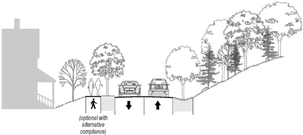
• Walkway Type: 5 ft. (4 ft. with environmental constraints) sidewalk on one side (For Alternative Compliance Ref. Sec. 6.8C)
• Bicycle Facilities: Optional Type N or W (Ref. Sec. 6.9.3)
• Planter Type: Continuous planting strip of 5 ft. (Rolled Curb) or Open Drainage (For Alternative Compliance Ref. Sec. 6.8.1) (Ref. Sec 6.8C for Tree Conservation)
• Landscape Type: 1 per 40 ft. of street frontage (Ref. Sec. 8.5.1)
(Ord. No. O-01-15, § 5, 1-27-2015; Ord. No. O-35-22, §§ 2, 3, 11-8-2022)
6.7 - Street Engineering Standards.
The following standards are intended to provide general clarity for most conditions in Waynesville. Deviations to these standards may be granted by the Administrator subject to generally accepted safety and engineering practices.
6.7.1 Stopping Sight Distances.
Stopping Sight Distance (SSD) is the forward view that a driver has at all times while driving the indicated maximum speed limit for each classification of Town Street. The SSD is greatly dependent on the approach grade. The values presented are for an assumed approach grade within a range of -3% to +3%. For approach grades outside this range, the design engineer shall be required to certify that SSD is met at all timesalong the street. *Guidance obtained with reference to NCDOT Subdivision Manual, AASHTO (American Association of State Highway and Transportation Official), (Highway Capacity Manual, and NACTO (National Association of City Transportation Officials).
Minimum stopping sight distance should conform to the design speed of the roadway. (Ref. Sec. 6.6.2)
The required sight distances set forth in this section should be provided by both vertical and horizontal alignment. Where grades vary from level conditions, stopping sight distances must be increased for downhill grades, but may be decreased for uphill grades. In cases where the speed limit is greater, refer to the latest published copy of AASHTO's "A Policy on Geometric Design of Highways and Streets."
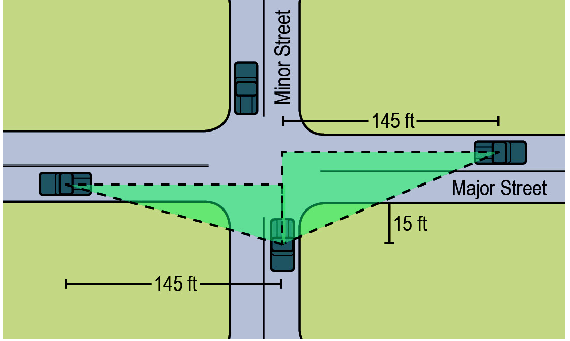
6.7.2 Sight Triangles.
The minimum sight triangle for stop conditions at a street intersection shall be one hundred forty-five (145) feet along the major road and fifteen (15) feet on the minor road approach from the edge of the traveled way. The 145 feet is measured in the center of the near lane looking left, and to the center of the far lane looking right. The intersection sight triangle shall be permanent right-of-way.
6.7.3 Intersections.
A.
Intersection Angles: The most desirable intersections are those with angles of 75 to 90 degrees. Intersections with angles of 60 to 75 degrees are acceptable under extreme conditions.
B.
Intersection Offsets:
1.
Intersection Offset Standards: If intersections are offset they should be in accordance with the following:
a.
The offset should be to the left at major streets.
b.
At least one hundred and twenty (120) feet offset between centerlines is desirable.
2.
T-Intersection Preferred for Low Density Residential Streets: For low density residential neighborhood, the use of two T-intersections with proper offset is preferable to using a standard four-way intersection as a means to calm traffic and highlight important views. The opposite side of the terminated street should have a strong visual presence to frame the view (e.g., civic space, civic building, vertical landscaping treatment, prominent architectural feature).
6.7.4 Grades.
A.
Vertical Curves: K values for vertical curve design should be consistent with design speed and stopping sight distance. (Ref. Sec. 6.7.1).
B.
Maximum Grade for Residental Streets and Lanes: Maximum Grade of 18% for a maximum length of 2,500 feet. Each 2,500-foot maximum grade section must be separated by a 500-foot section of 7% maximum grade. The maximum grade can be increased by 3% for distances less than 500 feet as long as there is a 500-foot "normal maximum grade" section between each "increased maximum grade" section.
C.
Maximum Grade All Other Street Types: As approved by Administrator. Must meet AASHTO guidelines.
D.
Minimum Street Grades: No grades less than 0.5% should be used to facilitate water drainage (e.g., vertical slope, cross-slope, inverted crown).
6.7.5 Centerline Radii.
When determining the centerline radius for a new roadway, refer to the latest published copy of AASHTO's "A Policy on Geometric Design of Highways and Streets".
6.7.6 Curb Radii and Construction.
A.
Curb Radius (Minimum): 15 feet
B.
Larger Radius May Be Required: Where deemed necessary for safety by the Administrator, some intersections on avenues, main streets and boulevards may require a curb radius of up to twenty-five (25) feet. With these larger curb radii, sidewalks may be set back six (6) to ten (10) feet from curbs and on-street parking may be restricted thirty (30) feet back from the intersection on each street.
C.
Minimum Specifications: All curbed streets shall be built in accordance with the specifications of the Town's Public Services Department.
D.
Minimum Gutter Dimension: Unless otherwise approved by the Administrator or as stipulated below, gutters must be a minimum of eighteen (18) inches in width.
E.
Minimum Gutter Dimension (Lanes and Street Medians): 1 foot.
F.
Ramps Required: Wheel chair ramps shall be provided at all curb and gutter intersections and at other major points of pedestrian flow in accordance with ADA Accessibility Standards.
G.
Alternative Compliance: Curbs - When the permeable pavement is in use or when the direct stormwater runoff has less impact than the concentrated runoff of standard drainage systems. Low Impact Development (LID) stormwater controls may be used with approval by the administrator.
1.
Alternative Compliance: Alternative provisions for curbs meeting the intent of this section may be used where unreasonable or impractical situations would result from the application of these requirements or where an alternative drainage plan is preferred for stormwater management. Such situations may result from significant street trees, impending road widening, topography, utility easements, lot configuration or other unusual site conditions.
2.
In districts such as Hillside Protection areas and Conservation Subdivisions, Low Impact Development (LID) or preservation of existing vegetation may be used with approval by the administrator. All alternative stormwater features shall be constructed in accordance with the standards in the latest edition of the North Carolina Environmental Quality's (NCDEQ) Stormwater Design Manual. (Ref. Sec. 12.5). The Administrator may approve an alternate plan that proposes different stormwater amenities provided that the intent of this section is fulfilled.
6.7.7 Pavement Standards.
A.
Minimum Specifications: All street types, except alleys, shall be paved to meet the specifications of the Town's Public Services Department.
B.
Pavement Depth and Material: Minimum design is eight (8) inches stone base and two (2) inches pavement surface.
C.
Alleys: Pavement is not required for alleys. However, when alleys are proposed to be paved, the pavement shall meet the specifications of the Town's Public Services Department. Where alleys are to be unpaved, an appropriate concrete apron shall be installed to restrain all alley surfacing material from entering the street.
6.7.8 Utilities.
A.
Minimum Specifications: All utility installations within rights-of-way shall be consistent with the specifications of the Town's Public Services Department and Section 6.11 of this Chapter.
B.
Horizontal Location: Where there are curbed sections, poles and other above ground utilities shall be located behind sidewalks or as far back as practical from the edge of the traveled way with six (6) feet as a design safety guide. Where the section is not curbed (drainage stands, etc.), pole lines shall be located inside the right-of-way under an encroachment agreement. These lines shall be located as close as is practicable to the right-of-way line.
C.
Lighting: Lighting shall be provided along new traveled ways in conformance with the standards set forth 10.3.5, Street Lighting.
6.7.9 Drainage Systems in Streets.
A.
The Administrator shall review all drainage prior to acceptance of any facility to the town system. Drainage in easement areas are not considered a portion of the street facility. Permanent drainage easements may be established, however, the town does not accept maintenance responsibility for easement outside of the street right-of-way.
B.
Design Frequency: The minimum design frequency is ten (10) years. However, the design frequency for cross drainage on thoroughfare routes (major and minor) shall be fifty (50) years. All storm drainage shall be adequate so that the street may be maintained at minimal cost and not cause flooding at the design frequency.
C.
Pipe Sizes: Minimum cross pipe diameter shall be eighteen (18) inches. The minimum driveway culvert size shall be fifteen (15) inches.
D.
Subsurface Drainage: Subsurface drainage shall be provided, if necessary, to maintain a stable subgrade.
E.
Retention/Detention Basins: Retention/detention basins shall be located outside of the right-of-way.
F.
Bridges: Bridges to be built by private interests for future acceptance shall be designed for a minimum live load of HS-20 and designed for hydraulic requirements in accordance with flood hazard areas. Materials of construction shall be pre-stressed concrete, reinforced concrete to the maximum extent feasible.
G.
Open Drainage: Open drainage shall include rock dams every thirty (30) feet in the ditchline on slopes. The ditchline should be planted to help clean drain flows.
6.7.10 Islands or Short Medians at Subdivision Entrances.
A.
Administrator Approval: The Administrator will review all requests for islands or short medians at subdivision entrances.
B.
Maintenance: Maintenance shall be by the developer or property owner's association. The island or median section will be removed if not properly maintained.
6.7.11 Parking Spaces on Streets.
All mid-block parallel parking spaces shall be (7) feet in width by twenty-two (22) to twenty-six (26) feet in length and end of block spaces maybe seven (7) feet in width by twenty (29) feet in length as determined by the administrator subject to the constraint of the existing conditions. The dimension is measured from the face of the curb and may include the gutter. All on-street parking spaces must meet local fire code, the latest editions of the Architectural Graphic Standards, and the Manual on Uniform Traffic Control Devices (MUTCD) guidelines, and are subject to approval by the administrator.
(Ord. No. O-06-22, §§ 9—11, 3-22-2022; Ord. No. O-35-22, § 4, 11-8-2022)
6.8 - Pedestrian Facilities.
The purpose and intent of this section is to establish criteria for the development of pedestrian facilities within the jurisdiction of the Town of Waynesville. These standards are set forth to:
1.
Provide a safe and walkable pedestrian environment while considering local environmental constraints, low impact development standards, and public safety
2.
Promote access for those who are mobility impaired or wheelchair dependent.
3.
Improve connectivity and convenience among residential, recreational, and commercial areas.
6.8.1 Sidewalks.
A.
General Standards/Location: Sidewalks are required in accordance with the street classifications in Section 6.6.2. as part of major site plans and major subdivisions, and wherever designated in the adopted pedestrian plan. Alternative facilities may be considered in the RL District and in areas where Hillside Protection standards apply (See Section 12.6) in accordance with C below. A payment in lieu may be considered in all districts in accordance with D below.
B.
Design Standards:
1.
Where existing sidewalk abuts an area where new sidewalk is to be developed, the new sidewalk shall be the same width as the existing sidewalk or meet the standards of the 6.6.2, whichever standard width is greater.
2.
Within commercial areas and places with high pedestrian volumes, sidewalks should be designed to meet the anticipated pedestrian/traffic volume as well as accommodate outdoor seating areas.
3.
Sidewalks shall be constructed of concrete or other approved materials (such as pavers) and built in accordance with the specifications of the Town's Public Services Department.
4.
Where a sidewalk abuts a curb because of right-of-way, topographic or existing building limitation, the minimum width shall increase by 1 foot. Where a sidewalk abuts a wall the minimum width shall increase by 1 foot.
C.
Alternative Compliance: Alternative provisions for pedestrian movement meeting the intent of this chapter may be used where unreasonable or impractical situations would result from the application of these requirements. Such situations may result from significant street trees, impending road widening, topography, utility easements, lot configuration or other unusual site conditions. Alternative pedestrian facilities may also be used as part of Low Impact Development (LID), development design, hillside, or within conservation and cottage development with approval by the administrator.
1.
In districts where trails are permitted in lieu of sidewalks (RL & Hillside Protection areas & Conservation Subdivisions), they shall be constructed in accordance with the standards in 6.8.2. Trails are generally allowed in very low-density development and are only required on one side of the road
2.
The Administrator may approve an alternate plan that proposes different pedestrian amenities provided that the intent of this section is fulfilled.
D.
Payments in Lieu: In lieu of alternative compliance in C above, the Administrator may approve a payment in lieu (in accordance with an adopted annual fee schedule) where any one or a combination of factors render compliance impractical:
1.
Steep slopes;
2.
Absence of existing sidewalks along the corridor and in the general neighborhood;
3.
Where sidewalks are not shown on an adopted Comprehensive Pedestrian Plan.
6.8.2 Trails.
Trails, if provided, shall comply with the following standards:

A.
Width: 6—14 ft.
B.
Right-of-way/Easement Width: 18—20 ft.
C.
Connections: Trail stubs at property lines should be placed in areas that are easily accessible for future connectivity through adjacent parcels.
D.
Materials: Compact gravel, concrete, or asphalt or other material approved by the Administrator.
6.8.3 Pedestrian Crosswalks.
Mid-block crossings, bulb-outs, raised crosswalks and similar crossing techniques should be commonly used to accommodate pedestrians when appropriate for traffic conditions and site specific situations as directed by the Administrator. All designs shall be consistent with the Town's adopted Pedestrian Plan.
(Ord. No. O-06-22, § 12, 3-22-2022; Ord. No. O-35-22, § 5, 11-8-2022)
6.9 - Bicycle Facilities.
6.9.1 Requirement for Installation.
A.
Bike lanes or separate off-street multi-use paths shall be installed on developer-built or modified roadways where designated for such by the Town of Waynesville Transportation Plan or similarly adopted plan; and/or as specified in Section 6.9.3 below where the adopted plan does not provide sufficient guidance.
B.
Where a proposed development does not include new or widening of existing collector or thoroughfare streets, the developer shall reserve right-of-way sufficient to accommodate the appropriate bikeway facility.
6.9.2 Design Standards.
Bike lanes and bike paths shall be designed according to the North Carolina Bicycle Facilities Planning and Design Guidelines published by NCDOT and shall include all appropriate signage and pavement markings. Variations from the NCDOT standards may be allowed subject to approval from the Administrator based on the standards below.
6.9.3 Applicability of Bicycle Facilities.
Bicycle facilities shall be included in the cross-sections of Section 6.6.2, Town Street Classification based on the matrix below. Motor vehicle volumes shall be based on projected motor vehicle volumes in a 20-year time horizon. Speeds shall be based on the design speed of the proposed roadway.
N Normal Lane, 9—12 feet wide. Cyclists would operate in mixed traffic near the middle of the lane.
W Wide Lane, 13—15 feet wide. Cyclists would generally operate in the right most portion of the lane. MUTCD-approved shared lane markings shall be used.
BL Bike Lane, 4—6 feet wide (striped/marked) or narrow shoulder. In general, bike lanes should be at least 5 feet wide at higher traffic volumes (over 20,000 ADT) and higher speeds (40 mph and higher) and 6 feet wide next to on-street parking.
S Separated Lane. Anything wider than 6-foot bike lane, including wide bike lanes/shoulders or parallel multi-use paths.
6.10 - Transportation Impact Analysis.
A Transportation Impact Analysis (TIA) is a specialized study that evaluates the effects and impacts of a development's traffic on the surrounding transportation infrastructure. It is an essential part of the development review process to assist developers and governmental agencies in making land use decisions involving annexations, subdivisions, rezonings, special land uses, and other development reviews. The TIA helps identify where developments may have a significant impact on safety, traffic, roadway operations, and provides a means for the developer and governmental agencies to mitigate these impacts. The TIA should address issues such as transportation network safety, operation, access management, and bicycle/pedestrian facilities. Ultimately the TIA can be used to evaluate whether the scale of development is appropriate for a particular site and what improvements may be necessary to provide safe and efficient access and traffic flow. The TIA may show improvements being necessary on the development site or off site on the surrounding transportation network.
6.10.1 When Required.
The Town of Waynesville requires a Traffic Impact Analysis using its own thresholds, parameters, and mitigation requirements. The Town's requirements may not reflect the same requirements as NCDOT. According to the NCDOT TIA Guidelines, municipal TIA requirements take precedence over NCDOT TIA requirements, if more restrictive.
A TIA shall be required for a rezoning, subdivision plan, site plan, special use permit, certificate of zoning compliance, or preliminary plat for developments under the following conditions:
A.
Trip Generation Threshold: A TIA is required when a development is anticipated to generate 500 trips per day or 50 trips in the peak hour. (Trips do NOT equal cars. One car leaving and then returning equals 2 trips). Examples of common land uses that approximate this threshold include:
• 50 single-family homes.
• 70 apartments/townhomes.
• 100 room hotel.
• 30,000 square foot office building.
• 20,000 square foot shopping center.
B.
Other Thresholds: A TIA is also required at 70% of the Trip Generation threshold (350 daily trips or 35 peak hour trips) when one or more of the following conditions are met:
1.
Site is within 1 mile of a school greater than 250 students with a school access directly or indirectly (1 turn away) on the same road of at least one of the site access points.
2.
If the Town determines that an impacted street is substandard due to safety or operation.
6.10.2 Pre-submittal Meeting.
An applicant for development authorization for any project expected to meet or exceed the TIA thresholds specified in Section 6.10.1 above, shall schedule a pre-submittal meeting with the Development Services Director. The engineering firm expected to prepare the TIA shall attend this meeting which will establish the study area, the TIA scoping assumptions and to discuss any existing conditions, geometric concerns and other considerations related to the project's location, context, and nearby land uses. The outcome of the meeting should include an agreement between the Town and the applicant on the TIA assumptions and focus areas.
6.10.3 TIA Contents and Requirements.
The details of a traffic impact analysis report shall be determined based on the pre-submittal meeting and should follow the "Guidelines for TIA Submissions" document available through the Development Services Department. The report shall include existing conditions, background conditions, buildout conditions, and horizon conditions, as well as any focus concerns within the study area identified in the pre-submittal meeting.
The study area is initially defined as encompassing the site access point or points to a point where the background volume of peak hour traffic on any approach will be increased by 10% due to traffic generated from the development. The study area can include stretches of roadway if deemed applicable by the Town in the pre-submittal meeting. Any changes to the study area should be discussed during the pre-submittal meeting before the study is commenced or prior to the TIA report being submitted.
A TIA will vary in range and complexity depending on the type and size of the proposed development and based on the scope determined during the pre-submittal meeting. Reports shall be sealed by a qualified North Carolina licensed engineer to provide such analysis and recommendations. The submission shall include all pertinent traffic data and computations affecting the design proposal and study area.
6.10.4 Improvements May Be Required.
Based on the findings of the analysis, mitigation measures may be required to improve adjacent roadways such as the creation of turn lanes, bridge replacement, crosswalks, road widening, or other physical improvements. The TIA could also involve strategies other than roadway construction or other physical improvements such as changes to traffic signal timing or phasing, and transportation demand management strategies.
6.10.5 Thresholds for Mitigation.
The Town requires consideration of roadway and/or operational improvements when the proposed development causes changes to the roadway Level of Service (LOS), causes increased queuing, or creates an atmosphere for increased roadway crashes.
Mitigation Thresholds:
1.
No mitigation will be necessary if the approach Level of Service (LOS) remains an "A" or "B" between Background and Horizon conditions AND if safety and operational concerns do not exist based on sight distance, blocking, queuing, or crash history.
2.
If the approach LOS at Background is a "C," "D," "E," or "F" and the delay increases more than 15% at Horizon conditions, mitigation is required to reduce the increased delay to less than 15%.
3.
If the individual movement LOS is a "C," "D," "E," or "F" and the delay increases more than 25% at Horizon conditions, mitigation is required to reduce the increased delay to less than 25%.
4.
If the site-generated traffic causes an increased queue from Background to Horizon Conditions of 25% or more on any individual movement, mitigation is required to reduce the queue increase to less than 25%.
5.
If the crash history shows greater than 3 similar crashes within a 12-month period "preventable" mitigation to reduce the chances of similar crashes involving site-generated traffic may be required.
6.
Mitigation should include references to the available right-of-way, potential constraints, project phasing, and innovative techniques to achieve the required mitigation goals.
6.10.6 Alternative to a Traffic Impact Analysis
If a TIA is not required according to the Town's thresholds, the Town may still require an alternate traffic study to validate the safety and operation of the street system at or near the proposed site or to address a substandard street issue within the predetermined study area. Alternate studies may include:
1.
Left of Right Turn Lane warrant analysis at the site access points. This analysis should be conducted using NCDOT methodology found in the current edition of the NCDOT Driveway manual.
2.
Sealed Technical Memorandum addressing only the site access point including operation, safety, and trip impact to the adjacent roadway.
3.
Sealed Safety Study along a stretch of street impacted by the site to address construction traffic, roadway width adequacy, pavement adequacy, etc.
The Town will use the submitted TIA as a tool to determine mitigation or improvements on the street network. The Town reserves the right to require less than or more than what is recommended in the TIA based on the right-of-way availability, safety, community concerns, or other factors.
Editor's note— Former § 6.10.6, TIA Requirements, was repealed by Ord. No. O-07-22, § 4, adopted May 10, 2022. The current guidance as part of the technical guidance document will be maintained by the development Services Department.
6.10.7 Payments-in-Lieu of Improvements.
The Town Council may, at its discretion, accept either mitigation measures to be completed by the developer or a fee paid to the Town in lieu of mitigation. The fee shall be equal to the costs of the required mitigation measures, as determined by the Administrator. A combination of mitigation measures and payments-in-lieu of dedication may be permitted. Payments-in-lieu of dedication shall be approved as part of the Development Plan.
(Ord. No. O-07-22, §§ 1—4, 5-10-2022; Ord. No. O-28-24, § 2, 6-11-2024)
6.11 - Utilities.
6.11.1 Purpose and Scope.
A.
The purpose of this section is to establish minimum utility design standards within the Town of Waynesville, its extraterritorial planning jurisdiction and other areas to which the Town of Waynesville provides public utilities.
B.
Except as provided elsewhere in this chapter, it shall be unlawful for any person to begin the installation of any utilities without first obtaining a certificate of land development standards compliance from the Administrator.
C.
All Utilities to be Underground: All major developments must place all utilities underground in accordance with the standards set forth in this section.
D.
Additional permits may be necessary pursuant to the regulations of the State of North Carolina.
6.11.2 General Standards
A.
Construction plans for utilities must be submitted meeting all of the standards required on the applicable development application.
B.
Where utilities are provided within the rights-of-way of lanes, streets, main streets and avenues, underground utilities may cross under or run longitudinally under the pavement, provided future utility stub-outs are installed prior to paving. For boulevards and state highways, underground utilities may cross under but may not run longitudinally under the pavement, except in cases of unusual circumstances as approved by the Administrator.
C.
Where utilities are installed outside of the rights-of-way, utilities, either above ground or underground, may be located in alleyways. If utilities are not to be placed in the alleyways or streets rights-of-way, developers are required to provide an additional five (5) feet minimum utility easement behind the sidewalk.
D.
Pipeline materials shall be approved by the Administrator.
E.
All nonferrous pipeline shall be installed with a locator wire (exception - sewer lines).
F.
All structures shall be water-rated.
6.11.3 Water Systems.
A.
All development applications must be accompanied by satisfactory evidence as to the proposed method and system of water supply.
B.
In no case shall water lines be extended beyond the Urban Services Boundary line established in the Town of Waynesville Land Development Plan unless approved by the Town Council.
C.
The installation of all water systems (except for individual wells) shall be required prior to final plat approval or the issuance of a certificate of occupancy unless otherwise permitted in this chapter.
D.
Public Water Systems:
1.
Where connection is proposed to the public sewer system and dedicated to the Town of Waynesville, the proposed system shall be installed according to the specifications of the Town's Public Services Department and designed by a registered engineer. Plans shall be reviewed and approved by the Public Works Department for the Town of Waynesville and any applicable state agency. A letter of approval from the Public Works Department and appropriate state agency must accompany the development application.
2.
Connection to the public water system shall be required as set forth below depending on the number of dwelling units proposed in a development and the distance the development is located from existing public water supply systems.
a.
One unit - connection required if development is within two hundred (200) feet of a public system.
b.
Two units - connection required if development is within four hundred (400) feet of a public system.
c.
Three units - connection required if development is within six hundred (600) feet of a public system.
d.
Four units - connection required if development is within eight hundred (800) feet of a public system.
e.
Five units or more - connection required if development is within one thousand (1,000) feet of a public system.
3.
Where a water line six (6) inches or greater in diameter is required in a public water system, fire hydrants shall be installed on the line. The hydrants shall be spaced so that coverage to all building sites along the line may be provided with not more than five hundred (500) feet of hose and shall be located to facilitate access, hose laying and drainage.
E.
Private Systems: Where private individual systems are proposed for a development, a written statement or letter of approval from the Haywood County Health Department shall be submitted with the development application indicating that each lot has adequate land area and soil conditions suitable to accommodate the proposed methods of water supply.
6.11.4 Sanitary Sewer Systems.
A.
All development applications must be accompanied by satisfactory evidence as to the proposed method and system of sanitary sewer.
B.
In no case shall sanitary sewer lines be extended beyond the Urban Services Boundary line established in the Town of Waynesville Land Development Plan unless approved by the Town Council.
C.
The installation of all sanitary sewer systems (except for individual septic systems) shall be required prior to final plan approval or the issuance of a certificate of occupancy unless otherwise permitted in this ordinance.
D.
Public Sewer Systems:
1.
Where connection is proposed to the public sewer system and dedicated to the Town of Waynesville, the proposed system shall be installed according to the specifications of the Town's Public Services Department and designed by a registered engineer. Plans shall be reviewed and approved by the Public Works Department for the Town of Waynesville and any applicable state agency. A letter of approval from the Public Works Department and appropriate state agency must accompany the development application.
2.
Connection to the public sewer system shall not be required for developments on slopes exceeding 30% average.
3.
Installation of sewer lines requiring the Town of Waynesville to pump sewage is not permitted.
4.
Connection to the public sewer system shall be required as set forth below depending on the number of dwelling units proposed in a development and the distance the development is located from existing public sewer system.
a.
One unit - connection required if development is within two hundred (200) feet of a public system.
b.
Two units - connection required if development is within four hundred (400) feet of a public system.
c.
Three units - connection required if development is within six hundred (600) feet of a public system.
d.
Four units - connection required if development is within eight hundred (800) feet of a public system.
e.
Five units or more - connection required if development is within one thousand (1,000) feet of a public system.
E.
Private Systems:
1.
Private sanitary systems are not permitted.
2.
Private treatment systems resulting in discharges to surface waters are not permitted.
3.
Individual on-site systems are permitted.
4.
Where individual systems are proposed for a development, a written statement or letter of approval from the Haywood County Health Department shall be submitted with the development application. Such approval must indicate that each lot in the development has adequate land area and soil conditions suitable to accommodate the proposed methods of water supply and sewage disposal.
5.
When individual, on-lot systems are approved, each lot so served shall be of a size and shape to accommodate the necessary length of a leach field at a safe distance from and at a lower elevation than the proposed building(s). Such lot size and shape shall conform to the requirements of the land development district in which they are located.
6.11.5 Electricity, Telephone, and Cable.
A.
Electricity and telephone service shall be provided to all developments.
B.
Cable service shall be required where reasonably accessible.
C.
Telephone, electric, cable and street lighting wires shall be constructed underground in accordance with the requirements set forth for the applicable land development district. When such utilities are required to be placed underground, the Administrator may exempt developments from such a requirement where it is determined that topographic, bedrock or underground water conditions would result in excessive costs to the developer to provide underground utilities.
D.
Overhead utility lines, where permitted, shall be located at the rear of all lots unless the Administrator, upon the recommendation of the utility company, provides reasons that justify the location of easements at another location. The width of the easement to be provided shall be determined by the Administrator.
E.
Whenever a sanitary sewer line and electric and/or telephone line are each placed underground in the same utility easement, the total easement width shall not be less than twenty (20) feet.
F.
Pole lines where permitted inside the right-of-way shall be at or as close to the right-of-way line as is possible.
G.
Electric and communications facilities shall conform to the current National Electric Safety Code.
H.
Joint use poles are required.
I.
Vertical clearances shall be no less than eighteen (18) feet. For boulevards and highways the minimum clearance shall be twenty-two (22) feet.
J.
The minimum depth of cover shall be three (3) feet for primary and three (3) feet crossing under grade. Two (2) foot minimum cover is required for all other installations.
6.11.6 Stormwater Drainage Facilities.
A.
See Section 12.5 for stormwater drainage facilities system requirements.
(Ord. No. O-06-22, § 13, 3-22-2022; Ord. No. O-28-24, § 2, 6-11-2024)
6.12 - Improvement Guarantees.
6.12.1 General.
A.
In lieu of requiring the completion, installation and dedication of all improvements prior to final plat or site development approval, the town may enter into an agreement with the developer whereby the developer shall agree to complete all required improvements.
B.
Once the agreement is signed by both parties and the required security is provided, the final plat may be approved by the Administrator.
C.
Duration: The duration of the performance guarantee shall initially be one year, unless the developer determines that the scope of work for the required improvements necessitates a longer duration. In the case of a bonded obligation, the completion date shall be set one year from the date the bond is issued, unless the developer determines that the scope of work for the required improvements necessitates a longer duration (160D-804.1(1a)).
D.
Extension: If the improvements are not completed before the guarantee is likely to expire, the Administrator may extend the performance guarantee, or the developer may provide a new performance guarantee, for an additional period. An extension under this section shall only be for a duration necessary to complete the required improvements. If the extension is granted, the amount of the renewed performance guarantee shall not exceed 125% of the improvements yet to be completed. The new amount must be reduced for improvements that have already been completed (160D-804.1(1b)).
6.12.2 Types of Guarantees.
To secure this agreement, the developer shall provide, subject to the approval of the Administrator and Town Attorney, either one or a combination of the following guarantees, not to exceed or be less than one hundred and twenty-five (125%) percent of the estimated cost of improvements.
A.
Surety Performance Bond:
1.
The developer shall obtain a performance bond from a surety bonding company authorized to do business in the state of North Carolina.
2.
The bond shall be payable to the town in an amount equal to one hundred and twenty-five (125%) percent of the total cost of the remaining improvements, as estimated by the developer and approved by the Administrator.
B.
Letter of Credit:
1.
The developer may obtain a letter of credit issued by any financial institution licensed to do business in North Carolina.
2.
A satisfactory, irrevocable letter of credit as approved by the town attorney and deposited with the town clerk shall be submitted, containing the following information:
a.
Indication that the Town is the sole beneficiary,
b.
The amount (of the letter of credit) as approved,
c.
Account number and/or credit number that drafts may be drawn on,
d.
List of improvements that shall be built that the letter is guaranteeing,
e.
Terms in which the town may make drafts on the account,
f.
Expiration date of the letter.
C.
Cash or Equivalent Security:
1.
The developer shall deposit cash or other instrument readily convertible into cash at face value either with the town or in escrow with a financial institution designated as an official depository of the town.
2.
The use of any instrument other than cash shall be subject to the approval of the Town Manager and Town Attorney.
3.
The amount of deposit shall be equal to one hundred and twenty-five (125%) percent of the cost of the remaining improvements, as estimated by the developer and approved by the Administrator.
4.
If cash, or other instrument, is deposited in escrow with a financial institution, the developer shall file with the Town Manager an agreement between the financial institution and the developer guaranteeing that:
a.
The escrow account shall be held in trust until released by the town manager, and may not be used or pledged by the developer in any other matter during the term of the escrow.
b.
In the case of a failure on the part of the developer to complete the improvements, the financial institution shall, upon notification by the town manager, immediately either pay to the town all funds in the account, or deliver to the town any other instruments fully endorsed or otherwise made payable in full to the town.
6.12.3 Relevant Provisions:
A.
Default by Developer:
1.
Upon default, meaning failure on the part of the developer or surety to make timely completion of the required improvements, the Town Council may require the developer, the surety, or the financial institution holding the escrow account to pay all or any portion of the bond or escrow account fund to the town.
2.
Upon payment, the Town Council, in its discretion, may expend such portion of the funds as it deems necessary to complete all or any portion of the required improvements.
B.
Release of Guarantee:
1.
The Town Manager may release a portion of any security posted as the improvements are completed and recommended for approval by the Administrator.
2.
Within thirty-two (32) days after approval of all improvements by the Administrator, the Town Manager may release the security guarantee.
C.
Warranty Against Defects.
1.
Prior to the approval of the Final Plat or acceptance by the Town of any improvements in any subdivision or site development project, the developer shall furnish to the Town a written warranty against defects which shall guarantee the material and workmanship of required improvements for a period of not less than one year from the date of such acceptance. Such warranty shall be accompanied by a financial guarantee payable to the Town equal to at least 10 percent of the cost of the installation of such improvements as determined by the Town Manager. Such financial guarantee shall be in the form of financial guarantee as provided for in A or B above.
2.
Release of Warrantee: Upon successful performance of the improvements, as determined by the Town Manager, the financial guarantee shall be returned to the developer. Upon the failure of an improvement to perform within the generally accepted standards for the type improvement as determined by the Town Manager, the developer shall be notified and given a reasonable period of time to correct the defects. Should the developer fail to act, fail to act in a timely manner, or otherwise fail to correct the defect(s), the Town Manager shall find the developer in default and proceed in the same manner as provided for in Subsection C above. Although other town owned/managed utilities and services as are required in this ordinance (e.g., electric, natural gas) are not included in this warranty against defects, any grading, boring, cutting or other disturbances in public easements or rights-of-way associated with the installation or such facilities shall be restored prior to the release of this financial guarantee.
D.
Coverage: The performance guarantee shall be used only for the completion of the required improvements. It shall not be used for repairs or maintenance after initial completion (160D-804.1(4)). If the project has common areas that require maintenance, the developer or the entity to which the property has been officially transferred is responsible for maintaining these common areas.
E.
Exclusion: Performance guarantees associated with erosion control and stormwater control are not subject to the provisions of this section.
(Ord. No. O-11-21, § 7, 6-22-2021; Ord. No. O-28-24, § 2, 6-11-2024)