
Weston Marathon County
City Zoning Code
City Zoning Code
ARTICLE 94
14 SPECIAL ZONING DISTRICTS
Sec 94.14.01 Listing And Purpose Of Special Zoning Districts
- PD Planned Development. The PD district is intended to encourage and promote improved environmental design by allowing for greater freedom, imagination, and flexibility in land developments so zoned, as compared applying one or more standard zoning districts, while assuring compliance to the purpose of this Chapter and with the Comprehensive Plan. Such developments shall be characterized by:
- Coordinated, professional, unified, and creative site and building planning and design.
- The thoughtful mixing of compatible uses within the context of a unified project, and/or the blending of uses in the development with surrounding existing and planned uses.
- Coordination of architectural styles, building forms and relationships, graphics, and other improvements.
- Preservation of natural landscape features and utilization of such features in a harmonious fashion.
- Attractive recreational or other development- or community-enhancing spaces and features.
- A safe, efficient, convenient, and integrated system for pedestrian and vehicular access and movement.
- Efficient use of land resulting in cost effective networks of utilities, streets, and other facilities.
- Environmental sustainability and energy efficiency.
Flexibility granted through the use of the PD district shall be compensated through development design that generally exceeds minimum standards were the project developed under one or more standard zoning districts.
- N Neighborhoods. The N Neighborhood district is intended to facilitate cohesive planned neighborhood developments that include desirable and innovative variations in the mix and relationship of uses, structures, and open spaces, consistent with proven principles of high-quality neighborhood design including traditional neighborhood design and conservation neighborhood design. Further, this zoning district and the developments within it shall be characterized by:
- An environment that promotes human interaction, walkability, and a sense of place;
- A mix of housing styles, types, and sizes to facilitate housing choice and meet the requirements of people with different housing needs;
- Other characteristics similar to those expected in the PD district as listed in subsection (1).
Sec 94.14.02 Minimum PD And N District Sizes
- For each PD District. Each mapped PD district shall be a minimum of 20,000 square feet in area.
- For each N District. Each mapped N zoning district shall be a minimum of 10 acres in area, except that an individual N projects may be smaller than 10 acres if it is anticipated in the Comprehensive Plan to be part of a contiguous N-zoned area of 10 acres or greater.
Sec 94.14.03 Allowable And Required Uses In The PD And N Districts
Any land use that is a permitted by right use, conditional use, or temporary use in any of the other zoning districts in this Chapter, or mix of uses, may be permitted within a particular PD & N district subject to the criteria listed below. Subject to the following specifications, all Specific Implementation Plans shall list the range of approved land uses in that particular PD or N district. Such list may consist wholly or partly of references to permitted and conditional uses in one or more standard zoning districts. Additionally, each N district may include commercial uses not exceeding 25 percent of the area of that entire N district plus the following:
- At least one Residential Use Area(s) which shall meet the purpose of the N district in Section 94.14.01 2 and any applicable Comprehensive Plan housing policy.
- At least one Mixed-use Area unless the Comprehensive Plan identifies the location of a mixed-use area on a nearby site. Mixed-use areas are intended to serve as pedestrian-friendly gathering places and focal points. Figure 14.03(1) shows examples of mixed-use areas. The mixed-use area shall include sites to accommodate the appropriate mix of at least two of the following:
- Neighborhood commercial uses, such as those normally allowed in the B-1 Neighborhood Business district.
- Attached residential dwellings, such as duplexes, townhouses, or multi-family residences.
- Civic or institutional uses, such as a place of worship or educational facility.
- At least one Common Green Space Area. At least 15 percent of the area of each N district must remain as permanently protected common green space, such as public parks, environmental corridors, trails, protected natural areas, and private parks that are permanently restricted from non-recreational development, but not including private yards, stormwater management basins, or stormwater conveyance channels. Where the Village’s Comprehensive Plan or comprehensive outdoor recreation plan recommends a park, trail, or other recreational facility for the proposed N district area, the developer shall make reasonable accommodation for the recommended facility.
Figure 14.03(1): Example of Mixed-Use Area Design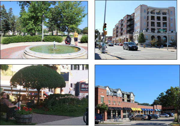
Sec 94.14.04 Density, Intensity, And Bulk Requirements
Flexibility in lot area, lot width, setback, height, yard, floor area ratio, open space requirements, and other dimensional and density standards from those in Article 5 may be permitted. Each individual PD or N district shall establish lot area, lot width, building setbacks, and/or building separation standards via its approved Specific Implementation Plan, including with reference to such standards in Article 5 where desired, by default shall utilize the following such standards or some combination.
- Minimum Lot Area and Width. Minimum lot areas and widths shall be as follows:
- For Single-Family Detached Residences:
- Minimum lot area shall be 5,000 square feet.
- Minimum lot width shall be 50 feet.
- Total building coverage shall not exceed 80 percent of the lot.
- For Two-Family Residences:
- Minimum lot area shall be 3,000 square feet per dwelling unit.
- Minimum lot width shall be 30 feet per dwelling unit.
- Total building coverage shall not exceed 80 percent of the lot.
- For Multi-Family Residences:
- Minimum lot area shall be 1,000 sf/studio dwelling unit + 400 sf per each bedroom.
- Minimum lot width shall be 60 feet, or 15 feet per dwelling unit for zero lot line structures.
- Each multi-family residential building shall be within 100 feet of a public street right-of-way.
- Minimum lot areas and widths for all other uses shall be as specified in the approved Specific Implementation Plan for the particular project.
- For Single-Family Detached Residences:
- Building Setbacks and Separation. Buildings shall be placed relatively close to the street to promote interaction, enclose space along the street, and direct less attractive site features to less visible yards.
- The minimum front and street side yard shall be five feet.
- The minimum interior side yard shall be five feet, except for approved zero-lot line buildings.
- The minimum rear yard and building separation shall be ten feet.
- Vision clearance triangles in Section 94.12.07 12 shall be required.
Sec 94.14.05 Circulation And Parking Requirements
- Circulation System. The circulation system shall allow for different modes of transportation; provide functional and visual links within the PD or N district connect to existing and proposed developments outside the district while controlling through traffic; provide adequate traffic capacity; provide connected pedestrian and bicycle routes; limit direct lot access on arterial and collector streets with ; and promote safe and efficient mobility. More specific design standards are as follows:
- Block size. Shall meet the requirements in Chapter 74, unless expressly permitted through a waiver to such standard or Specific Implementation Plan approval.
- Pedestrian circulation. Convenient and continuous pedestrian circulation systems shall be provided to minimize conflicts between pedestrians and motor vehicles. All public streets, except for alleys, shall be bordered by sidewalk or shared-use path, unless expressly permitted through Specific Implementation Plan approval. Clear and well-lit walkways shall connect non-residential and multi-family residential building entrances to the adjacent public sidewalk/path and to associated parking areas. Between-lot walkways or paths may be required where necessary to maintain the continuity of the pedestrian circulation system.
- Bicycle circulation. Facilities for bicycle travel shall be included in the project and installed at the developer’s expense, unless otherwise approved by the Village. Within each N district, such facilities may include off-street bicycle and multi-use paths, striped bicycle lanes on streets, signed bicycle routes, or some combination. Any existing bicycle routes through the site shall be preserved, enhanced, or relocated if necessary. Bicycle routes and facilities shall implement the recommendations in the Village Comprehensive Plan or comprehensive outdoor recreation plan. All businesses, civic uses, and multi-family dwelling units shall provide adequate bicycle parking areas and facilities per Section 94.12.09(14).
- Motor vehicle circulation. Motor vehicle circulation shall be designed to efficiently move motor vehicle traffic via multiple routes and to minimize conflicts with pedestrians and bicycles. Traffic calming features such as curb extensions, traffic circles, medians, and on-street parking along local streets are encouraged to slow traffic speeds. Any arterial and collector streets shall be subject to access controls. Minimum street design standards within the N district shall be in accordance with Figures 14.05(1) through (3) except as expressly permitted through Specific Implementation Plan approval.
- Street layout. The project shall maintain the existing street grid, where present, and restore any disrupted street grid where feasible. The orientation of streets shall be consistent with the Village Comprehensive Plan, enhance the visual impact of common open spaces and prominent buildings, create lots that facilitate passive solar design, minimize street gradients, and minimize the use of double frontage lots. All streets shall extend through the project or terminate at other streets, except streets may temporarily “dead end” when such streets will connect to future phases or other sites outside the N district, and local streets may permanently terminate in a cul-de-sac only where site conditions require a cul-de-sac and there will be a through connection via a walkway or path at the end.
- Parking and Loading. Parking and loading requirements shall be per Article 12, except that adjacent on-street parking may apply toward the minimum parking requirements and otherwise as expressly permitted through Specific Implementation Plan approval. Shared use parking lots and structures are encouraged, and parking lots shall be predominately located to the rear or interior sides of buildings (see Figure 14.05(4) for examples). The edges of parking lots, landscaped islands, and all other areas not used for parking or vehicular circulation shall be landscaped. Minimizing impervious surfaces through the use of pervious pavement, interlocking pavers, and similar techniques is encouraged, particularly for remote parking lots and parking areas for periodic uses.
Figure 14.05(1): Minimum Street Design Requirements
| Street Classification | Street Width, curb-face to curb-face (feet) | Curb & Gutter | Street Terrace | Sidewalks | Bicycle Lanes |
| Collector Street | 30 (two-sided parking) 26 (one-sided parking) 24 (no parking) | Both sides, | Both sides, minimum 8.5 feet wide | Both sides, minimum 5 feet wide | Where required, add two 5 foot wide lanes |
| Local Street | 28 (two-sided parking) 24 (one-sided parking) 20 (no parking) | Both sides, | Both sides, minimum 7 feet wide | At least one side, minimum 5 feet wide | None |
| Alley | 12 (no parking) | 2 foot flat ribbon | None | None | None |
Figure 14.05(2): Schematic sketch of a minimum collector street cross-section with one-sided parking and two bike lanes.
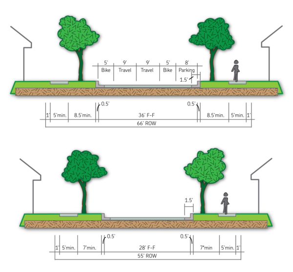
Figure 14.05(3): Schematic sketch of a recommended local street cross-section with two-sided parking.
Figure 14.05(4): Examples of Desired Parking Lot Placement and Landscaping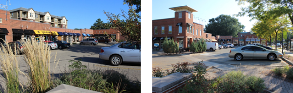
Sec 94.14.06 Architectural Requirements.
In addition to meeting applicable requirements of Article 10, each principal building shall include a variety of architectural features and building materials to give each building or group of buildings a distinct character, while maintaining a compatible design theme throughout the district. More specific design requirements and guidelines are included in Figures 14.06(1) through (3), and as follows:
Figure 14.06(1): Architectural Requirements, Single-Family Detached Residences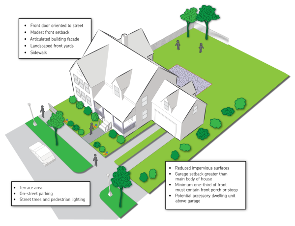
Figure 14.06(2): Architectural Requirements, Multi-Family Residences
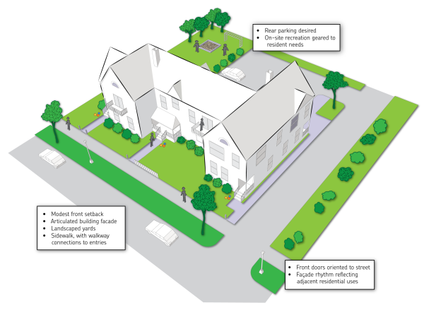
Figure 14.06(3): Architectural Requirements, Business and Mixed Use Buildings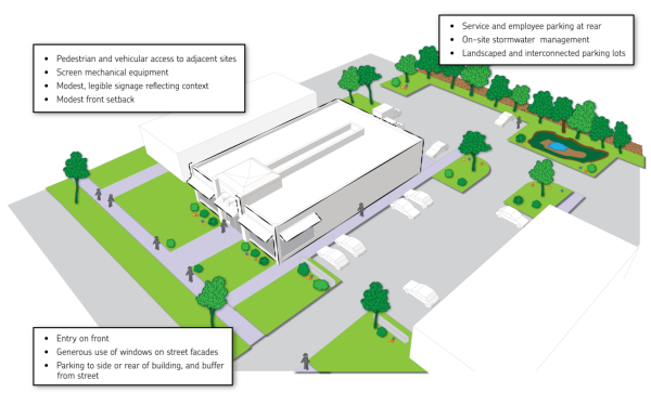
- General Design. New buildings shall be of consistently high and lasting quality throughout the project. The bulk and height of each building shall relate to and flow from surrounding buildings, and shall be in proper proportion to the size of the lot on which it is to be placed. Design monotony shall be avoided (see Figure 14.06(4) for examples).
Figure 14.06(4): Examples of Design Variation with Consistent Form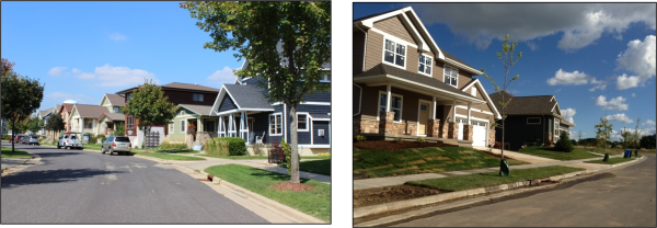
- Maximum Height. New structures within shall be no more than five stories unless the Fire Department verifies the ability to adequately service a taller building and such alternative maximum building height is specified in the Specific Implementation Plan.
- Entries and Facades. Similar architectural features, materials, and the articulation of a building façade shall be continued on all sides visible from a public street. Except as expressly permitted through Specific Implementation Plan approval:
- The front façade of at least one principal building shall face onto the front of street side yard of a public street.
- Porches, entry bays, covered walkways or stoops, hooded front doors, or other similar architectural elements shall define the front entrances. Residential front porches shall be a minimum of six feet deep to enhance aesthetics and function.
- For nonresidential buildings, a minimum of 50 percent of the public street façade(s) on the ground floor shall be transparent, consisting of window or door openings, and entries shall face the public street.
- Garages. Garages and garage doors shall not be the principal visual element as viewed from the public street. Except as expressly permitted through Specific Implementation Plan approval:
- Garages accessed from the public street, where garage doors face a public street, shall occupy no more than 50 percent of the front façade of each principal residential building.
- Residential garages shall meet standards illustrated in Figure 14.06(5).
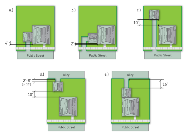
Figure 14.06(5): Alternative Garage Locations on a Residential Lot: a) Attached garage is accessed from a street (street-loaded garage). 4’ min setback required if no front porch or similar front yard building projection; 2’ with front porch. b) Attached garage is accessed from a street (side-loaded garage). 2’ min setback required. c) Detached garage, behind the house, is accessed from a street. 10’ separation between house and garage. d) Detached garage is accessed from an alley. Either 2’ to 8’ setback from alley right-of-way, or 16’ minimum setback from alley right-of-way. 10’ separation between house and garage. e) Attached garage is accessed from an alley. 16’ minimum setback from alley right-of-way to enable parking between garage and alley.
Note: These standards apply unless alternative standards are expressly permitted through Specific Implementation Plan approval.
Sec 94.14.07 Additional Requirements
- Street Trees. Shall be required in accordance with Section 94.11.02(3)(a), except where alternate standards of comparably quality are included as part of an approved Specific Implementation Plan.
- Landscaping. Shall be required in accordance with Article 11, except where alternate standards of comparable or greater quality are included as part of an approved Specific Implementation Plan.
- Natural Resource Protection. Shall be required in accordance with all local, state, and federal laws. Additionally, natural resources shall be integrated into the development design as aesthetic and conservation landscape elements. The development shall identify and provide for the permanent preservation of wetlands, floodplains, slopes of 20 percent or greater, areas of rare or documented endangered plant or animal species, the majority of any naturally-occurring mature woodland area, and historic and archaeological sites. to the extent determined practical by the Village approval authority Permanent preservation of these areas shall be achieved through the implementation of techniques such as conservation easements, restrictive covenants, deed restrictions, dedication to the public or an appropriate non-profit organization, and/or the establishment of buildable or “no build” areas on a subdivision plat or certified survey map.
- Stormwater Management. Stormwater management and erosion control shall be accordance with the Village’s Municipal Code. Additionally, each PD and N district shall include stormwater management systems that focus on Best Management Practices (BMPs). BMPs may include overland water transfer, natural landscape planting and restoration to increase infiltration and reduce runoff, bio-infiltration systems, natural stormwater basin design, residential roof runoff directed to yard areas, and rain gardens, among other potential BMPs.
- Performance Standards and Signage. Shall be in accordance with Articles 12 and 13 accordingly, except where alternate standards of comparable quality are included as part of an approved Specific Implementation Plan. and no state or federal law is violated Additionally, features such as lighting and signs may be required to adhere to a design theme throughout the as specified in an approved Specific Implementation Plan.
- Land Division. Shall comply with Chapter 74 of the Village’s Municipal Code, except as alternative requirements waivers or exceptions may apply to projects in the PD or N districts under that chapter
- Utility Service. All development within each PD and N district that requires potable water and sanitary waste disposal shall be provided with municipal water and sanitary sewer service, respectively.
Sec 94.14.08 Procedural Requirements For Special Districts
- Pre-application Conference. Prior to the official submission of a petition for the approval of rezoning to a PD or N district, the owner or the owner’s agent shall meet with the Zoning Administrator to discuss the scope and proposed nature of the contemplated development (i.e., concept review), who before allowing official submission may refer the concept to the Plan Commission for its preliminary review and comment.
- Petition for Rezoning Approval/General Development Plan. Following the pre-application conference, the owner or the owner’s agent may file a petition with the Zoning Administrator for approval of a rezoning to the PD or N district. Such petition shall be accompanied by payment of the required fee. per the Village fee Schedule The procedure for rezoning to a PD or N district shall be as required for any other zoning district change as set forth under Section 94.16.03, except that, in addition thereto, an easily reproducible electronic copy of a General Development Plan (GDP), along with hard copies in a quantity and size determined by the Zoning Administrator, shall be filed by the applicant along with the petition for rezoning, together including the following information except to any extent modified by the Zoning Administrator:
- A written report that provides general information about the site including a location map; the project vision, objectives, themes, and images; its economic feasibility and financing; target markets; and relationship of the project to surrounding land uses, the Comprehensive Plan, and other applicable Village plans.
- A completed site assessment per Section 74.2.03.
- Overall conceptual development plan for the entire site, drawn to scale, and showing proposed general areas to be retained in open space, recreation, and stormwater management; existing and proposed public streets and paths; different land use areas by proposed type and density; residential density; number and type of dwelling units; projected population; projected non-residential development intensity; projected employment; availability of or requirements for municipal services; and relationship of the proposed improvements to surrounding properties.
- A general outline of the organizational structure of a property owners’ or management association, which may be proposed to be established for the purpose of providing any necessary private services.
- A preliminary analysis and map showing the general locations of proposed public utility connections, and anticipated upgrades of public utilities to serve the project.
- A conceptual landscape plan showing general locations and types of proposed landscaping, including maintenance of existing vegetation where appropriate.
- A proposed schedule for the implementation of the project, including expected start and end dates and a conceptual phasing plan, if the applicant intends to phase construction of the project.
- Schematic architectural plans showing the character of the proposed buildings, along with a generalized program of proposed signage and lighting.
- A preliminary list of land uses that are proposed to be allowed within the PD and N district as permitted-by-right, conditional, and/or temporary uses, which may include reference to use lists normally applicable to one or more standard of zoning districts.
- Plan Commission Recommendation. In considering the petition and GDP, the Plan Commission shall apply the criteria in Sections 94.14.09 and 94.16.03(7). Upon submission of a complete rezoning petition and the GDP, the Plan Commission shall hold a public hearing on the application and the GDP and thereafter recommend to the Village Board that the petition and plan be approved as submitted, approved with modifications and/or conditions, referred for further consideration, or denied approval.
- Village Board Action. Upon receipt of the recommendation of the Plan Commission, the Village Board may take such action thereon as it deems reasonable and appropriate. If the petition and GDP are approved, said GDP shall establish the basic right for use of the lands in conformity with the plan as approved including any conditions of the GDP approval. Rezoning to the PD or N district and approval of such development shall be conditioned upon approval of a Specific Implementation Plan and shall not make permissible any of the uses as proposed until the events listed in Section 94.14.10(4) occur.
- Recording. The GDP, if approved, shall be recorded with the Marathon County Register of Deed's office by the applicant following such approval. The recorded version shall include any changes to reflect applicable conditions of GDP approval, as approved by the Zoning Administrator prior to recording. Within 30 days of its recording, the applicant shall provide the Village with a digital PDF copy of the recorded GDP, a copy in an easily reproducible and editable format such as MS Word, and proof of GDP recording.
- Effect of GDP Approval and Recording. Approval of the rezoning and GDP, and GDP recording, shall entitle a Specific Implementation Plan (SIP) in accord with such GDP, and conditions of its approval, and all other applicable requirements of this Chapter. Such GDP approval shall become null and void if the SIP has not been submitted within five years of the date of Village Board approval of the GDP. The rezoning to PUD shall take effect only once the events listed in Section 94.19.10(4) have occurred.
Sec 94.14.09 Criteria For General Development Plan (GDP) Approval
Each GDP application shall meet the following criteria to obtain approval:
- Consistent with Purpose of this Chapter and this Article.
- Character and Integrity of Land Use. The uses proposed and their intensity and arrangement on the site will be of a visual and operational character that meets the following criteria:
- Is compatible to the physical nature of the site and surrounding land uses.
- Would produce an attractive environment of sustained aesthetic and ecological desirability, economic stability, community sustainability, and practicality compatible with the Comprehensive Plan.
- Would not adversely affect the anticipated provision of municipal services.
- Would not create traffic or parking demand incompatible with facilities designed to serve it.
- Economic Feasibility and Impact. The project will not adversely affect the economic prosperity of the Village or the values of surrounding properties.
- General Engineering Standards. The proposed general plans for utilities, storm water management, and transportation systems follow required standards and are necessary to ensure the public safety and welfare as determined by the Director of Public Works.
- Preservation and Maintenance of Open Space. With regards to permanent open space within the project adequate provisions are made for its permanent reservation or dedication to the public as follows:
- For private reservation, the open area to be reserved shall be protected against building development minimally by the area against any future building or use except as consistent with that of generally providing permanent open or recreational space.
- The care and maintenance of any such open space reservations shall be ensured by establishment of appropriate management organization(s) for the project. The manner of ensuring maintenance and assessing such cost to individual properties shall be included in any development agreement with the Village and shall be included in the title to each property.
- Ownership and tax liability of private open space reservations are established in a manner acceptable to the Village.
- Implementation Schedule. A reasonable schedule has been established for the implementation of the development, including suitable provisions for assurance that each phase shall be brought to completion in a manner that would not result in an adverse effect upon the Village as a result of termination at that point.
- Considerations for Residential Components of a PD or N District. The Village, in its review of the residential components of a GDP, shall further consider whether:
- Such development will create an attractive residential environment of sustained desirability, including structures designed in relation and with respect to terrain; consideration of safe, convenient, and interconnected bicycle, pedestrian, and automobile flow; and ready access to recreation space.
- The density and design within the development will be generally consistent with the recommendations of the Comprehensive Plan as applicable to the PD or N district area, except as explicitly enabled under this Chapter, and the community’s capacity to provide needed municipal services and facilities.
- Provision has been made for the installation of adequate public facilities, fire and police protection, and parking, and the continuing maintenance and operation of such facilities.
- Such development will contribute to the goal of environmental sustainability and energy efficiency through the proper arrangement, density, orientation, and design for development; transportation access; natural area preservation and enhancement; and other features unique to the project.
- Considerations for Non-residential Components of a PD or N District. The Village, in its review of the non-residential components of a GDP further consider whether:
- The proposed development will be adequately served by parking, loading, and truck service facilities.
- The proposed development will be adequately provided with and shall not impose any undue burden on public services and facilities such as fire and police protection, street maintenance, water, sanitary sewer and storm water drainage, and maintenance of public areas.
- The locations of entrances and exits have been designated to prevent unnecessary interference with the safe and efficient movement of traffic on surrounding streets and the development will not create any adverse effect upon the general traffic pattern of the surrounding area.
- The architectural design, landscaping, control of lighting, and general site development will result in an attractive area not adversely affecting the property values of the surrounding neighborhood.
Sec 94.14.10 Specific Implementation Plan (SIP) Approval
- Specific Implementation Plan Application. The applicant shall file with the Zoning Administrator one easily reproducible and editable copy of a Specific Implementation Plan (SIP), hard copies may be requested in a quantity and size determined by the Zoning Administrator, and the associated fee per the Village Fee Schedule. Normally, a SIP may be filed only after a GDP has been approved by the Village Board, modified as ay be required by such approval, and recorded. However, with prior authorization of the Zoning Administrator for developments of limited complexity, the applicant may submit a SIP concurrent with a GDP application associated with all or part of the same land. Regardless of sequence, the SIP may be for all or part of the GDP area. Each SIP application shall include the following information except to any extent modified by the Zoning Administrator:
- A written report describing the proposed SIP, including specific project themes and images (e.g., drawings, photos, simulations), a specific list of permitted-by-right, conditional, and temporary land uses (including reference to such lists in standard zoning districts as desired), specific densities and dimensional standards for residential and nonresidential all uses and structures, the specific land area and treatment of open space areas, and an evaluation of the proposed SIP in relationship to the previously approved GDP and conditions of its approval (including an explanation if the SIP does not include the full area of the approved GDP).
- A location map and a legal description of the boundaries of the subject property included in the proposed SIP area and the approved GDP area (if different).
- A precise description of the type, number, and size of dwelling units; a description of the type and amount of square feet devoted to non-residential uses; the estimated population and number of employees; and projected character and volume of truck and automobile traffic generated by the project.
- Site summary data including gross site area, area and lineal feet of street rights-of- way, net area proposed for development and common open space uses, net subdivided area, total number of building sites, average or typical lot and building site sizes; and total acres expected to be devoted to each projected land use.
- A detailed neighborhood development plan showing the precise mix and locations of projected land uses; densities of use areas and development sites; building setbacks and massing; streets, paths, sidewalks, main driveways, and parking areas; parks, squares, and other common open spaces; and street trees and other natural elements.
- Intent to adhere to requirements in Sections 94.14.04 to 94.14.07 of this Article, and any proposed variations to such requirements where authorized under those sections.
- All proposed dimensional standards, paralleling the types of standards normally listed within standard zoning districts of the Village per Article 5.
- Whether and to what extent accessory buildings, fences, RV and firewood storage, and other ancillary features often allowed or anticipated in developments over time will be allowed within the SIP, with reference to applicable articles and sections of this Chapter and determined sufficient by the Zoning Administrator to enable effective zoning administration over the SIP area in perpetuity.
- For all sites within the SIP where final plan approval is being sought, except for single- and two-family dwellings, detailed site and building plan(s) meeting the requirements of Section 94.16.09.
- For single- and two-family dwellings, architectural design guidelines contained within a declaration of covenants, deed restrictions, or other similar document, in lieu of the Village reviewing a site and building plan for each individual dwelling.
- Detailed signage plan and lighting plan, each demonstrating a unified or compatible sign and lighting theme throughout the SIP area, and including permitted areas, heights, quantities and other features of permanent and temporary signs as are included within Article 13.
- As may be applicable, a final plat or certified survey map of the area included within the SIP that meets associated requirements in Chapter 74, with any requested waivers or exceptions to Chapter 74 requirements indicated.
- Engineering and stormwater management, meeting all State, County, and Village requirements, including those in and authorized under Section 94.16.09 and Chapter 74.
- If applicable, a demolition plan depicting any demolition to occur on the site and an environmental assessment or. remediation plan
- A development schedule indicating the following:
- The approximate date when construction of the project is expected to begin;
- The phases in which the project will be built and the approximate date when construction of each phase is expected to begin;
- The anticipated pace of development and types and quantities of development in each phase; and
- The approximate date when the development of each of the phases will be completed.
- A phasing plan map.
- Agreements, bylaws, provisions, or covenants that will govern the organizational structure, use, maintenance and continued protection of the PD or N district.
- Any other plans, documents, or schedules required by the Village.
- A written report describing the proposed SIP, including specific project themes and images (e.g., drawings, photos, simulations), a specific list of permitted-by-right, conditional, and temporary land uses (including reference to such lists in standard zoning districts as desired), specific densities and dimensional standards for residential and nonresidential all uses and structures, the specific land area and treatment of open space areas, and an evaluation of the proposed SIP in relationship to the previously approved GDP and conditions of its approval (including an explanation if the SIP does not include the full area of the approved GDP).
- Plan Commission Review and Approval. Upon submission of the SIP the Plan Commission shall review the same to determine if the SIP is in compliance with the approved GDP and conditions of its approval, applicable provisions of this Article, and any other provisions of this Chapter that are applicable to the proposed development. The Plan Commission shall thereafter act to approve the SIP as submitted, approve with modifications and/or conditions, or deny approval. The Village Board will still be required to approve any plat associated with the SIP per Chapter 74, even though SIP approval rests with the Commission.
- Recording. If the SIP is so approved it shall be recorded at the Marathon County Register of Deeds office by the developer. The recorded version shall include any changes to reflect applicable conditions of SIP approval, as approved by the Zoning Administrator prior to recording. Within 30 days of its recording, the applicant shall provide the Village with a digital PDF copy of the recorded SIP, plus a copy in an easily reproducible and editable format such as MS Word.
- Effect of SIP Approval. The Zoning Administrator shall cause the amendment of the Official Zoning Map to reflect the rezoning to PD or N and shall authorize construction in the SIP area only after the applicant has provided digital copies of the recorded SIP and any associated final plat or certified survey map. Upon the occurrence of these events, the SIP shall become part of this Chapter and shall be enforceable as part of this Chapter, as the SIP may from time to time be amended per Section 94.14.11. All requirements associated with overlay zoning districts in Articles 6 through 9 shall continue to apply with the SIP area. Where the SIP is silent to a particularly type of zoning requirement in this Chapter, the Zoning Administrator may utilize such requirement in this Chapter to the extent consistent with the SIP.
- Lapse of SIP Approval. Final SIP approval shall terminate, and the SIP shall be deemed null and void for any undeveloped part of the SIP area in one or both of the following circumstances:
- If an SIP is granted final approval and thereafter five years have lapsed without the applicant or owner applying for a building permit within the SIP area for an authorized use.
- If the approved SIP includes a phased implementation program, and five years have lapsed between (i) the acceptance of public infrastructure or initial occupancy of a building in a phase preceding the final phase and (ii) commencement of construction of the next phase.
In the event the land affected by either such circumstance has been rezoned to the PD or N district per subsection (4), the Zoning Administrator shall initiate an application to rezone the undeveloped land in the area from the PD or N district back to the standard zoning district(s) over the land before PD or N was approved, or to the nearest comparable standard zoning district(s).
Sec 94.14.11 Amendment Of General Development Plan (GDP) Or Specific Implementation Plan (SIP)
Any subsequent change or modification of the approved GDP or SIP shall first be submitted to the Village for consideration. If, in the opinion of the Zoning Administrator, such change or modification constitutes a substantial alteration of the original GDP and/or SIP, the procedures described in Sections 94.14.08 and/or 94.14.10, as appropriate, shall be followed before the modified GDP and/or SIP may take effect. If the Zoning Administrator determines that such change or modification does not constitute a significant alteration, then he or she may approve or reject such change or modification and report such action to the Plan Commission. All such modified GDPs and SIPs, shall be re-recorded by the applicant within 30 days of approval, with re-recorded copies provided to the Village.