Weston Marathon County
City Zoning Code
City Zoning Code
ARTICLE 94
5 DENSITY, INTENSITY AND BULK REGULATIONS
Sec 94.5.01 Purpose
The purpose of this Article is to establish base density, intensity, and dimensional requirements for each standard zoning district.
Sec 94.5.02 Location Of Density, Intensity, And Bulk Regulations
- Except where otherwise expressly stated, all lots and improvements within the Rural, Open Space and Residential standard zoning districts shall comply with the regulations prescribed in Figures 5.01(1) and (2), and all lots and improvements within non-residential standard zoning districts shall comply with the regulations prescribed in Figures 5.02(1) and (2).
- Allowable yard setback adjustments, intrusions into required yards, and exceptions to maximum height are found in Sections 5.03 through 5.05. Substandard lots, nonconforming uses, nonconforming structures, and nonconforming sites legally created before establishment of these requirements are addressed in Article 15.
Sec 94.5.03: Yard Setback Adjustments
- Limitations on Yard Setback Adjustments
- No yard shall be reduced in area or dimension so as to make such yard less than the minimum required by this Chapter. If an existing yard is less than the minimum required, it shall not be reduced further, except where exempted by the provisions of this Section.
- No required yard or lot area allocated to satisfy the minimum yard or lot area requirements for one building or structure shall be used to satisfy the minimum yard or lot area requirement for another building or structure.
- Front Yard Setback and Corner Lot Street Side Yard Setback Adjustment
The required front or street side yard setback for a principal structure may be reduced on any lot where more than 50 percent of the same-type principal structures on the same block face do not meet the required front yard or street side yard setback. In such instances, the required front yard or street side yard setback for the proposed structure shall be the average of all the same-type principal structures on the same block face.
Sec 94.5.04 Intrusions Into Required Yards
The minimum setbacks listed in Figures 5.01(2), 5.02(2), and 5.03(2) establish the minimum required yards/setbacks in the associated zoning districts, except that the following intrusions by buildings and structures are permitted into the minimum required yards:
- Permitted Intrusions into Required Front and Street Side Yards.
- Chimneys, flues, sills, pilasters, lintels, cornices, eaves, gutters, satellite dishes with a diameter of 20 inches or less, and other architectural and ornamental features attached to a building, provided they do not extend more than two and one-half feet into the required yard.
- Yard lights, ornamental lights, and nameplate signs, provided they comply with applicable exterior lighting requirements of Section 94.12.11.
- Terraces, steps, open walled porches, decks, stoops, or similar appurtenances to residential buildings that do not extend above the floor level of the adjacent building entrance, provided they do not locate closer than 20 feet to any front or street lot line.
- Fences, in accordance with Section 94.12.03.
- Lawn ornaments and flag poles, provided that in residential zoning districts flag poles do not exceed 35 feet in height and lawn ornaments do not exceed 6 feet in height, and that flag poles are constructed with footings that extend not less than 42 inches below the existing ground level unless secured in another manner verified by a structural engineer.
- Stormwater retention and detention ponds and stormwater related structures.
- Permitted Intrusions into Required Interior Side Yards.
- Chimneys, flues, sills, pilasters, lintels, cornices, eaves, gutters, satellite dishes with a diameter of 20 inches or less, and other ornamental features attached to a building, provided they do not extend more than two and one-half feet into the required yard.
- Fences, in accordance with Section 94.12.03.
- Fire escapes that do not extend more than three feet into the required yard.
- Lawn ornaments and flag poles, provided that in residential zoning districts flag poles do not exceed 35 feet in height and all lawn ornaments do not exceed 6 feet in height, and that flag poles are constructed with footings that extend not less than 42 inches below the existing ground level unless secured in another manner verified by a structural engineer.
- Stormwater retention and detention ponds and stormwater related structures.
- Permitted Intrusions into Required Rear Yards.
- Terraces, steps, uncovered porches, decks, stoops, or similar appurtenances to residential buildings, provided they do not locate closer than 20 feet to the rear lot line.
- Chimneys, flues, sills, pilasters, lintels, cornices, eaves, gutters, satellite dishes with a diameter of 20 inches or less, and other architectural and ornamental features attached to a building, provided they do not extend more than two and one-half feet into the minimum required yard.
- Fences, in accordance with Section 94.12.03.
- Fire escapes that do not extend more than three feet into the minimum required yard.
- Lawn ornaments, play sets, tree houses, trampolines, and flag poles, provided that in residential zoning districts flag poles do not exceed 35 feet in height and all other lawn ornaments do not exceed 6 feet in height, that flag poles are constructed with footings that extend not less than 42 inches below the existing ground level unless secured in another manner verified by a structural engineer, and that tree houses are not intended for human habitation.
- Stormwater retention and detention ponds and stormwater related structures.
Sec 94.5.05 Exceptions To Maximum Height Regulations; Collaborative Opportunities
- Exceptions: The maximum building heights listed in Figures 5.01(2), 5.02(2), and 5.03(2) are the maximum permitted heights for all buildings and structures in the associated zoning districts, except for
- Church spires; belfries; cupolas and domes that do not contain useable space; public monuments; water towers; telecommunication towers; fire and hose towers; flag poles; and farm structures such as barns, silos, and grain elevators.
- Any building or structure not listed in subsection (a), subject to the granting of a conditional use permit that specifically states the maximum permitted height of the proposed building or structure.
- Criteria for the Granting of Exceptions: For a structure described under subsection (1) to exceed the maximum building heights in Figures 5.01(2), 5.02(2), and 5.03(2), all of the following criteria must be met:
- The structure must be constructed with footings that extend not less than 42 inches below the existing ground level, or a greater depth if required by the Building Code.
- The structure will be set back from all property lines consistent with the applicable requirements of Figures 5.01(2), 5.02(2), and 5.03(2), or with any permitted intrusions in Section 94.5.06.
- The placement of the structure will not have an undue negative impact on light and air on adjacent properties, in the opinion of the Zoning Administrator.
- Relationship to AH Airport Height Limitation Overlay District: In the event of conflict between the exceptions authorized under subsection (1) and the maximum heights permitted under Section 94.6.04, the maximum heights under Section 94.6.04 shall control.
- Collaboration with Telecommunication Providers: As part of the approval of building permits for structures listed in subsection (1), the Village encourages collaboration with telecommunication providers to collocate antenna arrays on such structures as a means to increase phone and internet access and minimize the proliferation of stand-alone telecommunication towers.
Sec 94.5.06 Building Area And Coverage Inclusions And Exclusions
- The maximum accessory structure floor areas listed in Figure 5.01(1) are the maximum permitted areas for all buildings and structures in the associated zoning districts, except for farm structures such as barns, silos, and grain elevators in those districts where such structures are used for agricultural purposes.
- In all districts, all principal and accessory structures rising one or more feet above the immediate surrounding grade, including garages, sheds, carports, roofed or walled storage areas, covered or uncovered decks, gazebos, boathouses, and above-ground swimming pools shall be counted toward the calculation of building coverage. No other structures or improvements shall be counted.
Sec 94.5.07 Landscape Surface Ratio Inclusions And Exclusions
- In all districts, except as allowed in subsection (2), no impervious surfaces, including gravel, shall count toward the calculation of landscape surface area.
- Minor or temporary impervious surfaces such as landscaping retaining walls, planters, bird baths, lawn statues, seasonal decorative displays, poles for clothes drying, flag poles, portable play structures such as swing sets and trampolines, stormwater management basins and swales, and grass roofs shall count toward the calculation of landscape surface area.
Figure 5.01(1): Rural, Open Space and Residential District Lot Dimension and Intensity StandardsZoning District Minimum Lot Area Minimum Lot
Width (ft)Minimum Public
Street Frontage (ft)Maximum Total
Building CoverageMaximum Accessory
Structure Floor Area (sf) (a)Minimum Landscape
Surface Ratio (LSR)FP Farmland Preservation 20 acres 300 60 N/A N/A N/A AR Agriculture and Residential 20 acres (f)(g) 300(f) 60 N/A 1,600(h) N/A RR-2 Rural Residential 2 Acres 2.0 acres 150 60 20% 1,600 N/A RR-5 Rural Residential 5 Acres 5.0 acres 200 60 20% 1,600(h) N/A PR Parks and Recreation N/A N/A N/A 10% N/A 75% SF-L Single Family – Large Lot 20,000 sf 100 50 30% 1,200 50% SF-S Single Family – Small Lot 10,000 sf 80 40 40% 1000 40% 2F Two Family Residential (c) 10,000 sf (b) 80 (b) 40 40% 800 40% MF Multi Family Residential (d) 1,600 sf/studio dwelling unit + 400 sf per each bedroom 80 (b) 40 40% 10% of Lot Area 30% MH Manufactured Home 5,000 sf/home (e) 50 N/A 40% 350 30% (a) Maximum Accessory Structure floor area may be increased by Conditional Use Permit as provided under Section 94.16.06 and per the standards in Section 94.4.09(2).
(b) For zero lot line structures, each separate lot shall have a minimum lot area of 5,000 sq. ft. per unit and must be at least 40 feet in width within the 2F district and 20 feet in width within the MF district.
(c) Single-Family Detached Residences within the 2F district shall comply with the SF-S district requirements.
(d) Single-Family Detached and Two-family Residences within the MF district shall have a minimum lot area of 3,000 square feet per unit.(e) Total area of each “Manufactured Home Community” shall be a minimum of 10 acres.
(f) Instead of a 20-acre minimum lot size, land in the AR district may be developed at a density of one residential lot per 20 acres and a minimum lot size of 2.0 acres and minimum lot width of 150 feet. See Section 94.5.08 for further description and method of calculation for regulating at a one residential lot per 20-acre density in the AR district.
(g) Parcel size in the AR district to be calculated based on gross acreage, including roads and navigable waters within the deeded parcel. Each such parcel meets the 20-acre minimum, even if net acreage is less than 20 acres following the removal of roads and navigable waters, if such removal does not reduce the gross acreage by greater than 15% for corner parcels or 10% for all other parcels.
(h) Maximum Accessory Structure Floor Area is increased to 2,500 square feet on parcels that exceed 10 acres.Figure 5.01(2): Rural, Open Space and Residential District Setback and Height Standards
Zoning District Minimum Setbacks (ft) (b) Minimum Building Separation (ft) Maximum Building Height Principal Building (e.g., Residence) including Attached Garage Detached Accessory Building (a) Hard or Gravel Surface (d) Principal Building Accessory Building Front (a) Street Side (a) Interior Side Rear Interior Side (c) Rear Interior Side or Rear Front or Street (a) Feet Floors Feet FP 50 30 20 40 15 15 6 10 10 NA NA NA AR 50 30 20 40 15 15 6 10 10 35 2.5 35 RR-2 50 30 20 40 15 15 6 10 10 35 2.5 35 RR-5 50 30 20 40 15 15 6 10 10 35 2.5 35 PR 30 30 12 20 12 12 6 10 10 35 2.5 25 SF-L 50 30 12 20 6 6 3 5 10 35 2.5 20 SF-S 30 20 8 20 6 6 3 5 10 35 2.5 20 2F (e) 30 20 8 20 6 6 3 5 10 35 2.5 20 MF (f) 30 30 8 20 6 6 6 10 10 50 4 20 MH 20(g) 20(g) 6 10 6 6 3 5 10(h) 20 1 15 Along any second street side yard, the minimum building setback shall instead be the minimum interior side yard setback, Also, see Section 94.4.09(2) for standards related to detached accessory buildings located within front yard areas, minimum separation requirements associated with detached accessory buildings, and other standards associated with detached accessory structures.
(b) Additional setbacks may be required along zoning district boundaries for bufferyards for a particular land use under Article 4 or Section 94.11.02(3)(d).
(c) Minimum front and street side yard accessory setbacks are equal to the minimum front and street side yard setback for the principal building, including the modification in note (a) where a lot has a second street side yard. Minimum interior side and rear setbacks for pergolas, treehouses, and similar minor recreational structures as determined by the Zoning Administrator shall be the same as applicable to minimum hard or gravel surfaces.
(d) Includes all gravel and hard surfaces as defined in Section 94.17.04, along with recreational vehicles where allowed in rear yards per Section 94.12.07(2)(d). This setback excludes intrusions required for driveway access onto public streets and where permitted or required for cross access, pedestrian ways, shared driveways, and shared parking lots.
(e) Single-Family Detached Residences shall comply with the requirements for the SF-S district. No interior side yard principal building setback along the common wall of setback along the common wall of zero lot line structures.
(f) Single-Family Detached Residences shall comply with requirements of the SF-S District. Two-Family Residences shall comply with the requirements for the 2F district. No interior side yard setbacks for zero lot line structures.
(g) A minimum 100-foot wide buffer must be provided around the perimeter of each “Manufactured Home Community.”
(h) 5 feet from the accompanying home and 10 feet from all other buildings. See Section 94.4.09(2) for further requirements regarding setbacks for Detached Accessory Structures (for Residential Use).Figure 5.01(3): Representation of Yards and Minimum Setbacks
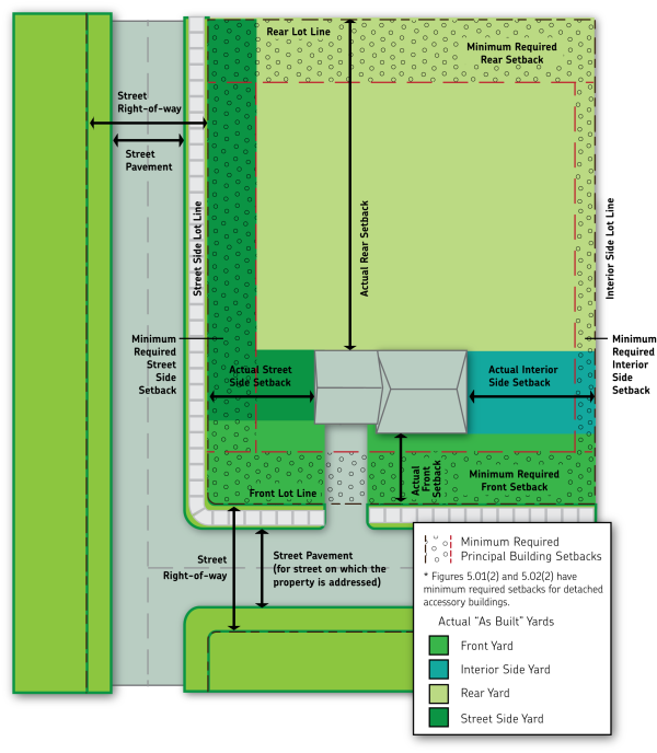
Figure 5.01(4): Different Yard and Setback Areas in a Variety of Different Lot Configurations
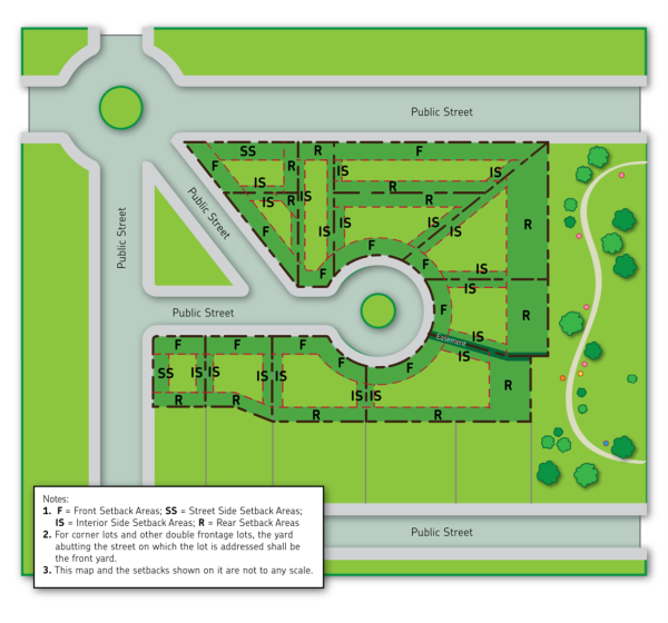 Figure 5.02(1): Non-residential District Density and Intensity Standards
Zoning District Minimum Lot Area Minimum Lot Width (ft) Minimum Public Street Lot Frontage (ft) Minimum Landscape Surface Ratio (LSR) Max Floor Area Ratio (FAR) (a) INT Institutional 20,000 sf 80 40 20% 0.5 B-1 Neighborhood Business 20,000 sf 80 40 20% 0.5 B-2 Highway Business 20,000 sf 80 40 20% 0.5 B-3 General Business 30,000 sf 80 40 20% 0.5 BP Business Park 40,000 sf 100 50 20% 1.5 LI Light Industrial 30,000 sf 80 40 15% 0.5 GI General Industrial 40,000 sf 100 50 10% 1.0 RM Rural Mix 20 acres (b) 300 60 N/A 0.1 (a) Does not include structured parking or underground parking.
(b) Parcel size in the RM district to be calculated based on gross acreage, including roads and navigable waters within the deeded parcel. Each such parcel meets the 20-acre minimum, even if net acreage is less than 20 acres following the removal of roads and navigable waters, if such removal does not reduce the gross acreage by greater than 15% for corner parcels or 10% for all other parcels.Figure 5.02(2): Non-residential District Setback and Height Standards
Zoning District Minimum Setbacks (ft) (b)
Minimum Building Separation (ft)Maximum Building Height (stories/ft, whichever is greater)
Each Building to Front and Street Side Lot Lines (a)
Principal Building to Interior Side Lot Line
Principal Building to Rear Lot Line
Accessory Building to Interior Side/Rear Lot Line (a)(d)Hard or Gravel Surface (c)
Front or Street SideHard or Gravel Surface (c)
Interior Side or RearPrincipal Buildings Accessory Buildings INT Institutional 20 8 20 3 15 10 10 3/45 1/20 B-1 Neighborhood Business 10 6 10 3 10 5 10 3/45 1/20 B-2 Highway Business 30 12 20 6 15 10 10 3/45 1/20 B-3 General Business 30 12 20 6 15 10 10 3/45 1/20 BP Business Park 30 12 20 10 15 10 10 4/60 1/20 LI Light Industrial 30 12 20 10 10 5 10 3/45 1/20 GI General Industrial 40 15 30 10 10 5 10 4/60 2/35 RM Rural Mix 50 30 20 40 15 10 10 3/45 2.5/35 (a) See Section 94.4.09(1) for standards related to detached accessory buildings located within front yard areas, minimum separation requirements associated with detached accessory structures, and other standards associated with detached accessory structures.
(b) Additional setbacks may be required along zoning district boundaries for bufferyards, if required for a particular land use in Article 4 or Section 94.11.02(3)(d). No interior side lot line setback for zero lot line structures.
(c) Includes all gravel and hard surfaces as defined in Section 94.17.04. This setback does not apply to intrusions for driveway and pedestrian way entrances from street; driveways, pedestrian ways, and parking lots that are shared or provide cross-access between lots; or any land inside of a fenced yard area in an industrial district.(d) Front and street side yard setbacks for accessory structures as the same as the minimum front and street side setback for the principal structure.
Amended by Ord. 15-022 - Figure 5.01(1) on 10/21/2015
Amended by Ord. 16-014 - Figure 5.01(1) on 4/20/2016
Amended by Ord. 16-035 - Figure 5.01(1) on 8/18/2016
Amended by Ord. 16-046 - Figure 5.02(1) & (2) on 12/21/2016
Amended by Ord. 17-026 - Figure 5.02(2) on 8/23/2017
Amended by Ord. 17-038 - Figure 5.01(1) on 12/20/2017
Amended by Ord. 19-001 - Figure 5.01(1) on 1/23/2019
Amended by Ord. 20-005 - Figure 5.01(1) on 3/19/2020
Amended by Ord. 21-011 on 5/17/2021
Amended by Ord. 23-006 on 3/24/2023
Amended by Ord. 23-011 on 5/15/2023
Amended by Ord. 24-022 on 12/16/2024
Amended by Ord. 25-011 on 8/18/2025
Sec 94.5.08 Calculating Maximum Permitted Density In AR District
- Calculation Method. The method described in this Section shall be used to calculate the maximum permitted number of dwelling units on lands in the AR Agriculture and Residential district.
- Determine Parcel(s) to be used in Calculation. Determine whether calculation of maximum residential density will be based on a single parcel (e.g., a single ¼ ¼ section of land), or on all lands in contiguous common ownership. Generally, maximum density will be calculated on a parcel basis. However, when there is more than one common contiguous parcel, the applicant is encouraged to include all AR zoned lands in contiguous common ownership in the calculation.
- Measure Parcel/Ownership Area. Measure the “gross site area” of the individual parcel or contiguous common ownership lands, including all roads and navigable waters that are within the deed parcel.
- Incorporate Density Factor. Divide the gross site area by 20 and round up if any fractional amount is equal to ½ or greater. This is the total number of dwelling units that are permitted on the lands zoned AR, including preexisting dwellings and other preexisting principal uses.
- Small Parcels. Individual, legally created parcels that are less than 20 acres in gross site area in the AR district shall be allowed a total of one dwelling unit. No further residential dwelling units or principal land uses shall be permitted while the land remains under AR zoning on individual parcels less than 20 acres.
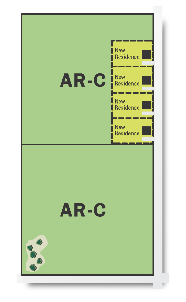
- Figure 5.03 shows one of several possible approaches of how the total of 4 dwelling units might be constructed on an 80-acre example contiguous common ownership tract zoned AR.
Figure 5.03: Example of “1 per 20” Density in AR Zoning District - Demarcation on Official Zoning Map. Upon the date of the first permit for a residential dwelling unit or other principal use under the provisions of this Section, the Zoning Administrator shall mark the associated parcel or set of contiguous common ownership lands as AR-C (with the “C” representing cluster) on the Official Zoning Map. The Zoning Administrator shall keep track of the total number of dwelling units or other principal uses created and remaining on each parcel or set of contiguous common ownership lands from the date of that first permit and may also mark remaining dwelling units for each parcel or set of contiguous common ownership lands on the Official Zoning Map. All additional dwelling units or other principal uses following that initial date shall conform to the maximum density calculated for the parcel or contiguous common ownership lands as such lands were sized and configured on that initial date.
- Recorded Document Required. In conjunction with the division of the first residential lot or permitting of the first new residence on a parcel in the AR zoning district, the landowner must record a document in the Marathon County Register of Deeds Office reflecting how the allotted number of dwelling units are to be allocated among the affected parcels. This shall be done prior to the recording of any land division, and in a form approved by the Zoning Administrator. Subsequent modifications to any such recorded document, changing the allotment or assignment of principal uses or otherwise, shall be permitted only upon advance written authorization of the Zoning Administrator. The land owner shall then record a new or amended document showing the modifications.