
Apopka City Zoning Code
ARTICLE 3
ZONING DISTRICTS
3.1.1. - Compliance with Zoning District Standards
Land in the City shall not be developed except in accordance with the zoning district regulations of this article and all other regulations of this LDC.
3.1.2. - Establishment of Zoning Districts
This LDC establishes the base, planned development, and overlay zoning districts identified in Table 3.1.2: Establishment of Zoning Districts. The boundaries of each of the zoning districts are identified on the Official Zoning District Map.
3.1.3. - Organization of Zoning Districts
A.
Base Zoning Districts
1.
Base zoning districts include Residential, Commercial, Industrial, and Special Purpose districts, as shown in Table 3.1.2: Establishment of Zoning Districts. Base districts are established initially by the City's adoption of this LDC, and subsequently by a zoning map amendment (see Sec. 2.5.1.D., General Map Amendment, or Sec. 2.5.1.E., Site-Specific Map Amendment).
2.
The general intent and standards of each base zoning district is set forth in Section 3.3, Residential Base Zoning Districts, through Section 3.6, Special Purpose Base Zoning Districts.
3.
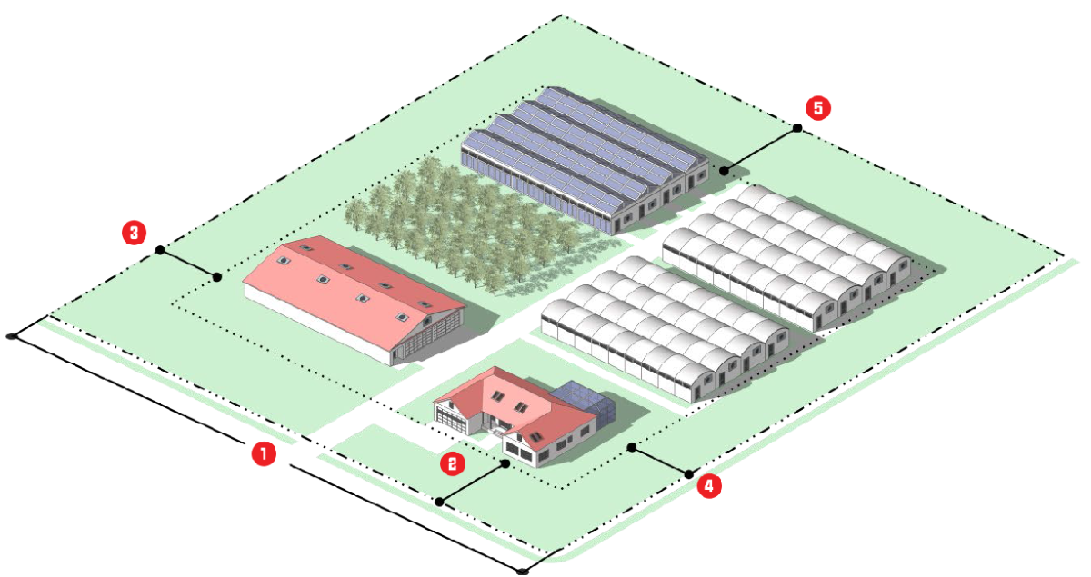
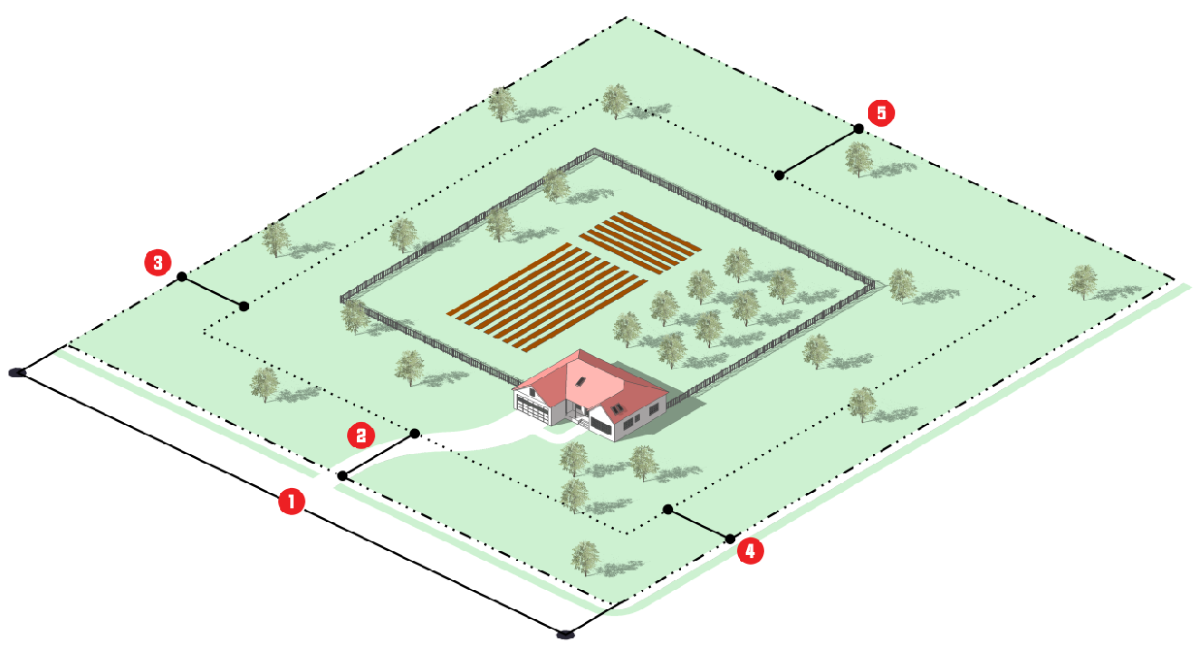
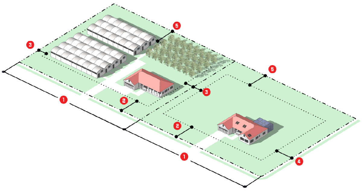
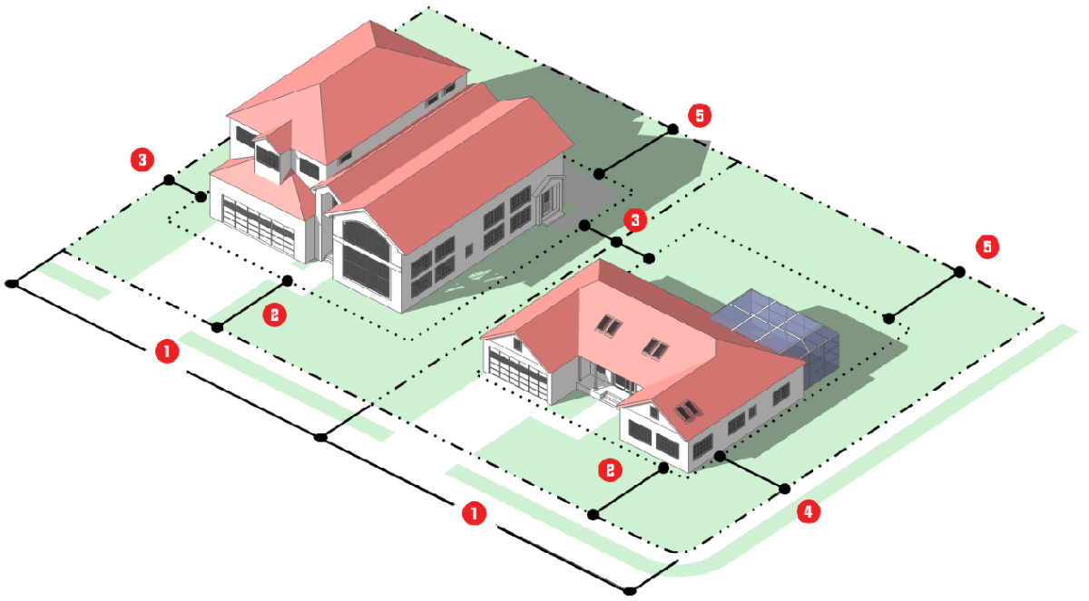
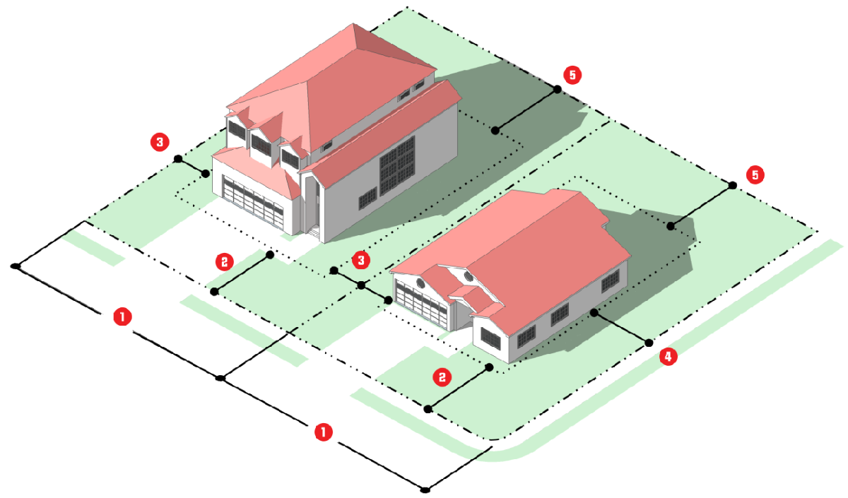
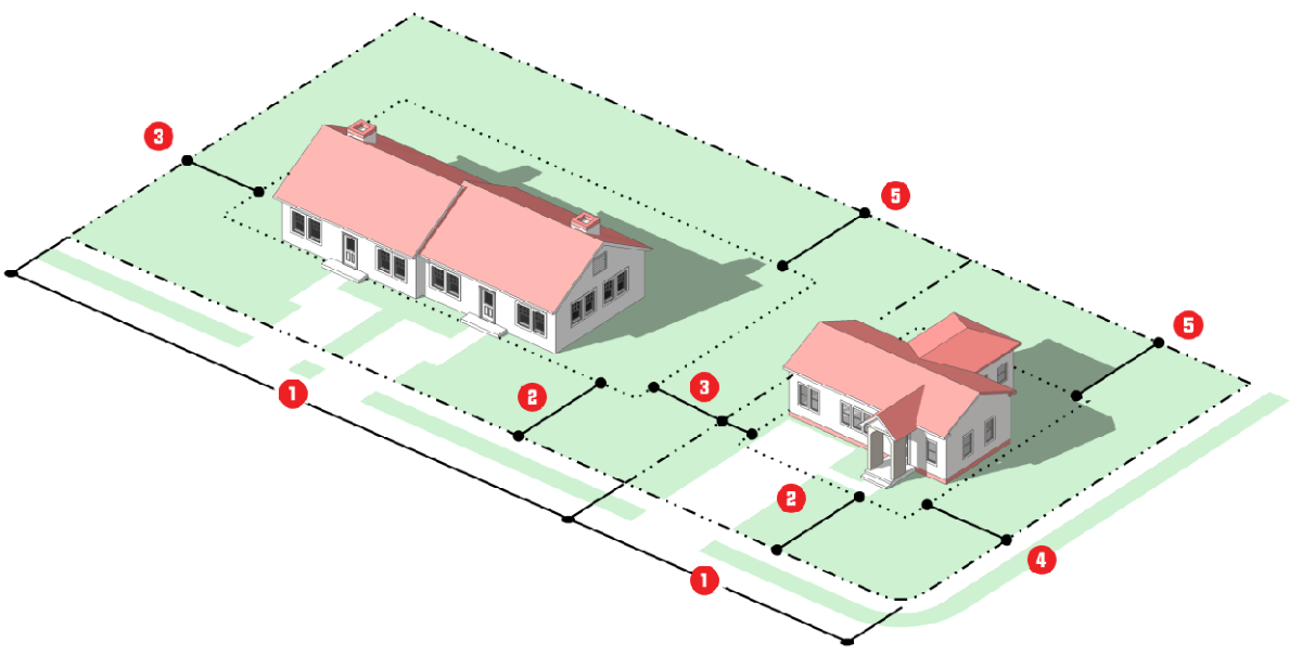
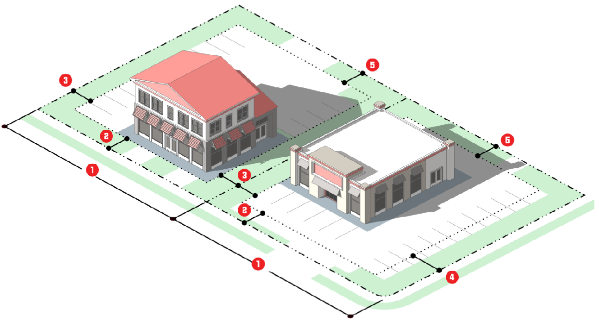
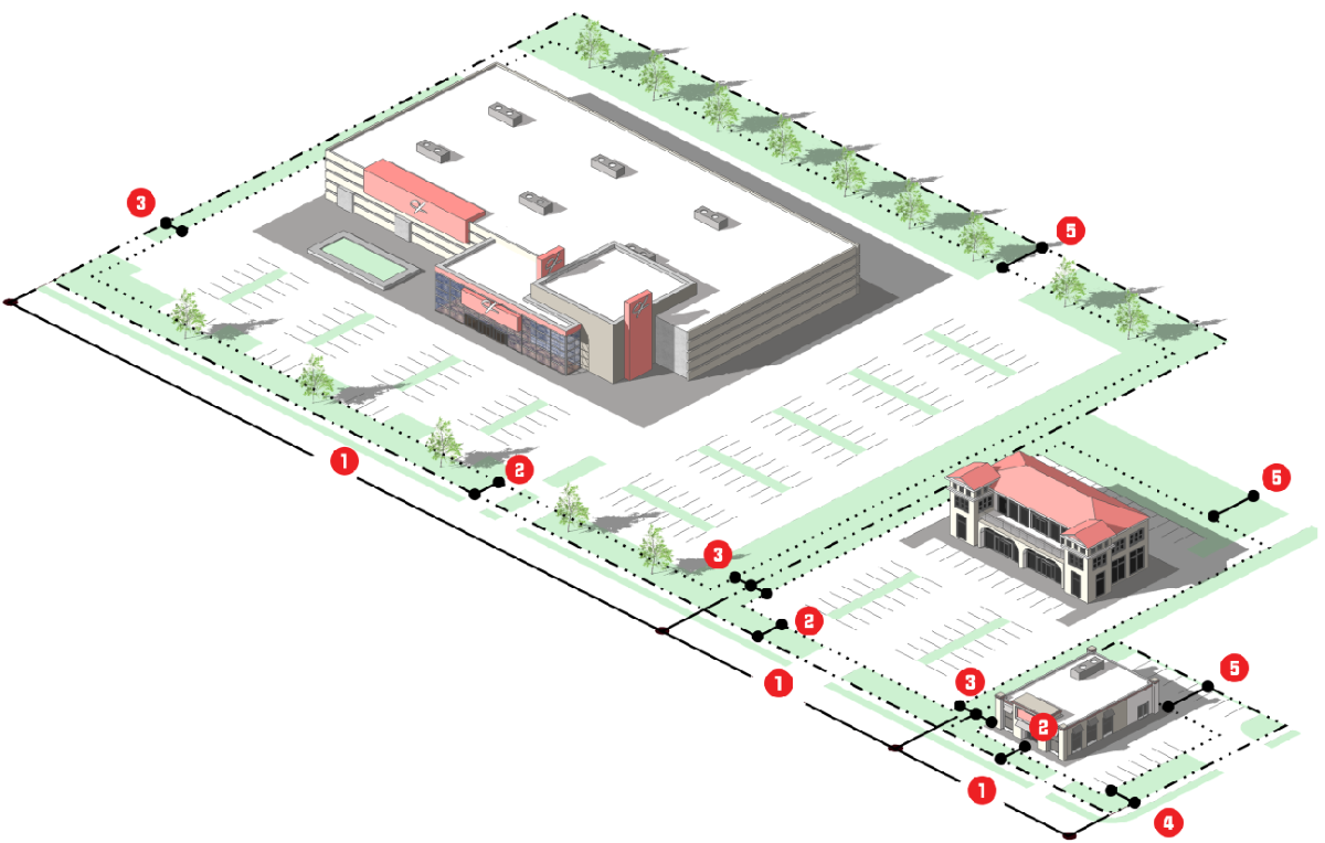
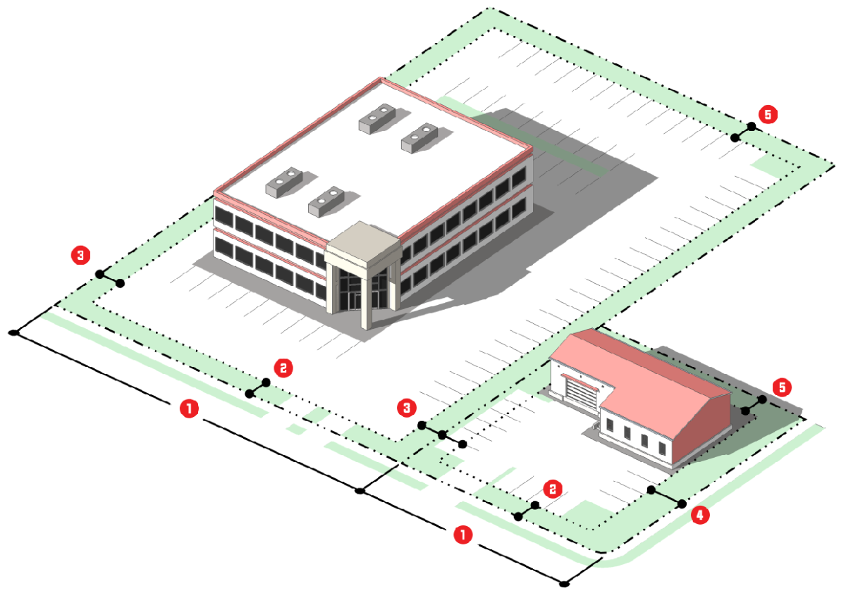
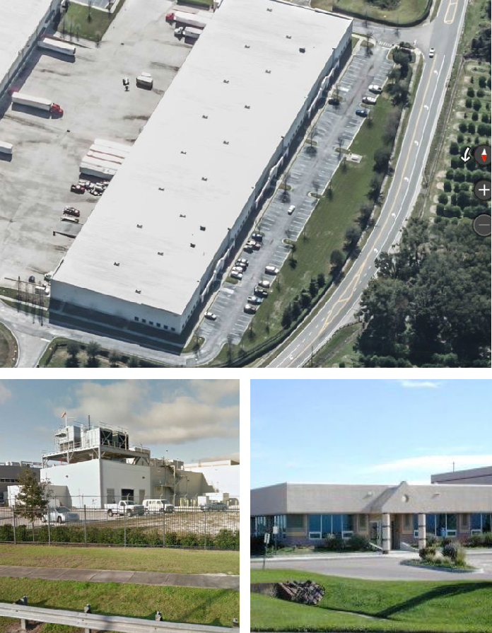
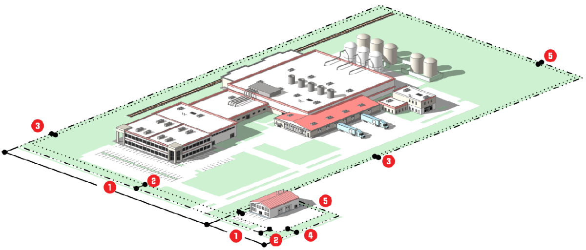
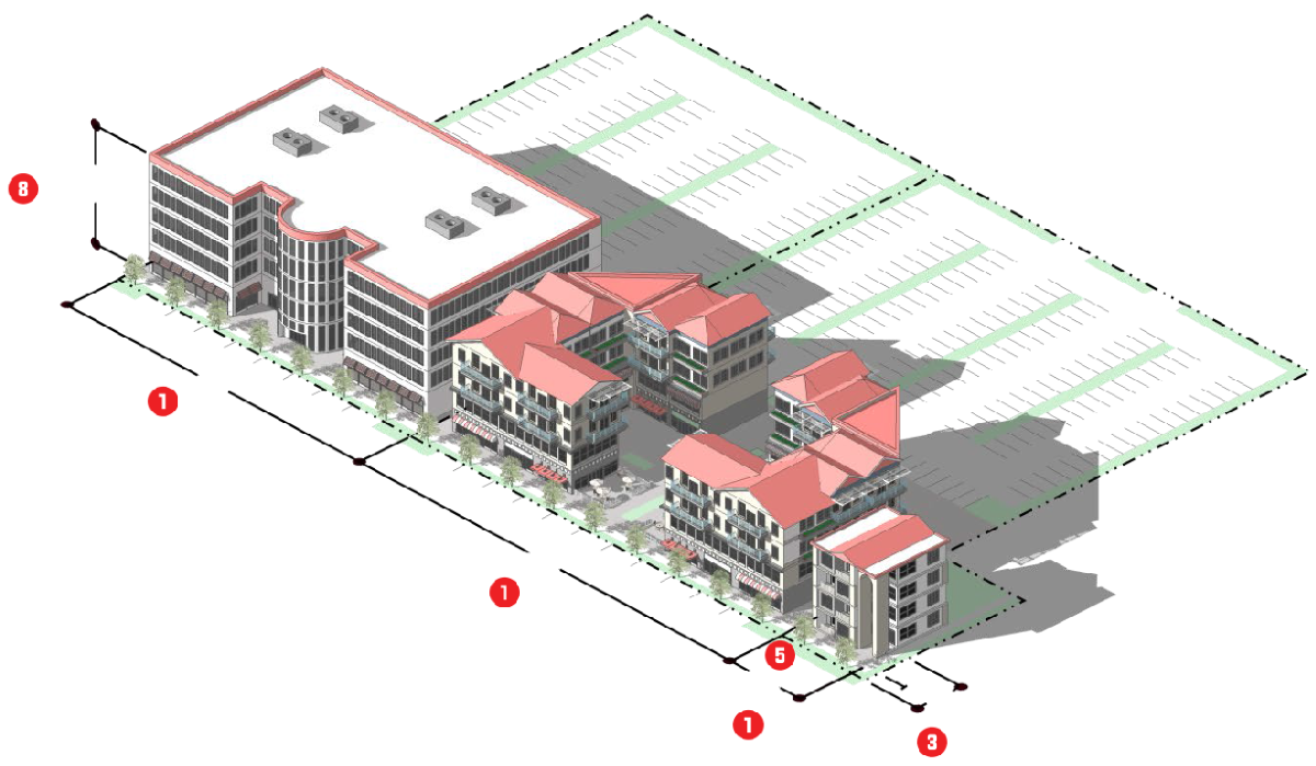
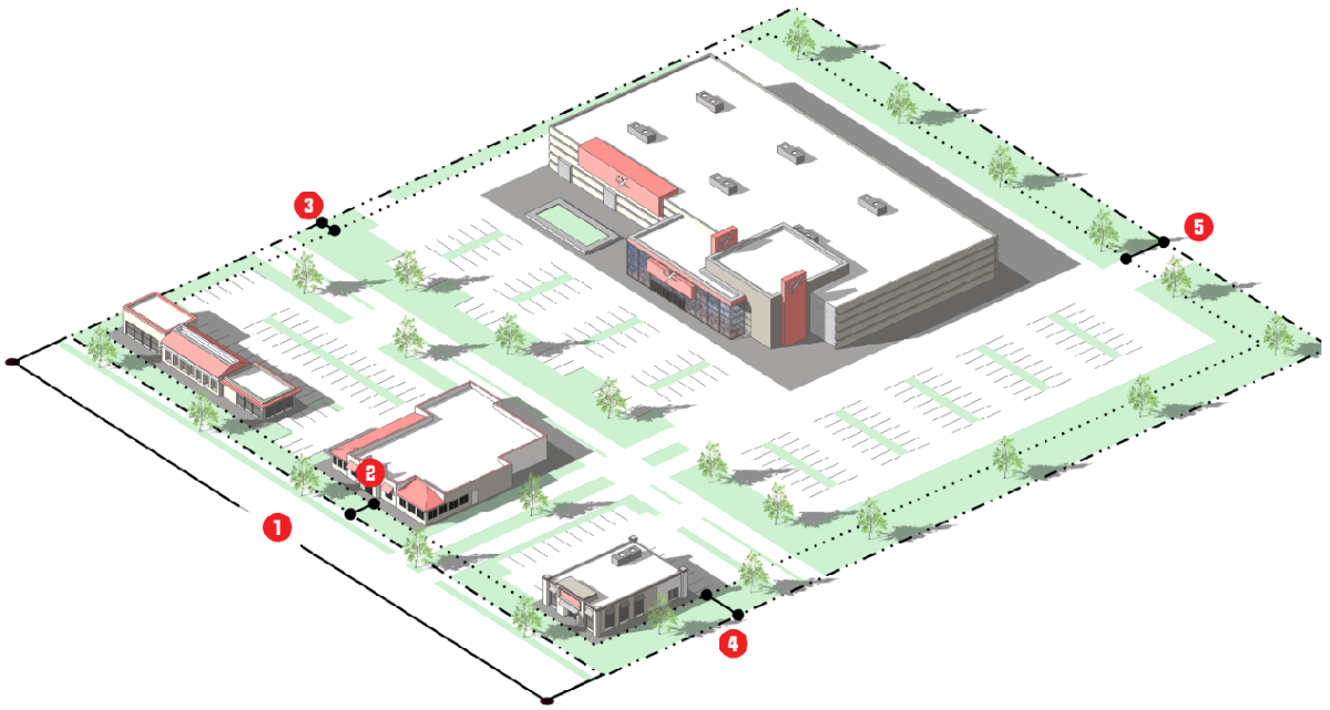
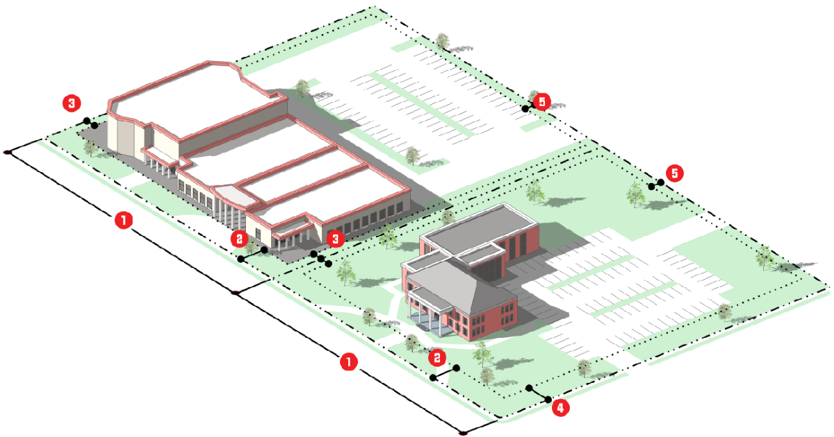
For each base zoning district, the regulations set out the district's purpose, the density and intensity and other dimensional standards applicable in the district, form standards (where relevant), and reference other LDC standards generally applicable to development in the district. Each base zoning district also includes photographs depicting a building form typical in the district and an illustration depicting how the district's dimensional standards apply to lots and typical building forms. Graphics are included for illustrative purposes and show the application of the dimensional, density, and intensity standards to some of the uses allowed in the district. If there is a conflict between the illustrations and the text or tables, the text and tables control.
4.
Residential subdivisions established prior to March 6, 2019 may maintain the primary structure setbacks (front, rear, side) at a minimum as originally approved.
B.
Planned Development Districts
1.
The general purpose of the planned development district is set forth in Section 3.7, Planned Development District, in addition to the standards applicable to the proposed planned development district.
2.
Planned development districts are adopted by the City Council as amendments to the Official Zoning District Map in accordance with Sec. 2.5.1.F, Planned Development, and Sec. 2.5.1.E, Site-Specific Zoning Map Amendment. The name and location of the specific PD District is shown on the Official Zoning District Map and recorded, as appropriate.
3.
Planned development districts are subject to an approved PD Plan and PD Agreement, which establishes a plan for development, and specific rules for individual PD Districts. As provided in Sec. 2.5.1.F, Planned Development, the PD Plan and PD Agreement is included with the adopting ordinance, and recorded, as appropriate.
C.
Overlay Districts
1.
Overlay zoning districts (see Table 3.1.2, Establishment of Zoning Districts) are established initially by the City's adoption of this LDC, and subsequently by approval of a zoning map amendment (see Sec. 2.5.1.D, General Map Amendment, or Sec. 2.5.1.E, Site-Specific Map Amendment (Rezoning)).
2.
Standards governing development in an overlay zoning district shall apply in addition to, or instead of, the standards governing development in the underlying base zoning district or PD District. If the regulations governing an overlay district expressly conflict with those governing an underlying base zoning district, the regulations governing the overlay district shall control. If land is classified into multiple overlay districts and the regulations governing one overlay district expressly conflict with those governing another overlay district, the more restrictive regulations control.
(Ord. No. 2994, § IV, 3-15-2023)
3.2.1. - General Purposes of Agricultural and Transitional Base Zoning Districts
The purpose and intent of the Agricultural and Transitional base districts are to:
A.
Provide appropriately located lands for agricultural and nursery production, agricultural support uses, low-density residential dwellings in a rural setting, and related uses; and
B.
Accommodate lands that are annexed into the City without the concurrent adoption of another base zoning district.
3.2.2. - Established Agricultural and Transitional Base Zoning Districts
The agricultural and transitional base zoning districts established by this LDC are identified in Table 3.2.2: Established Agricultural and Transitional Base Zoning Districts.
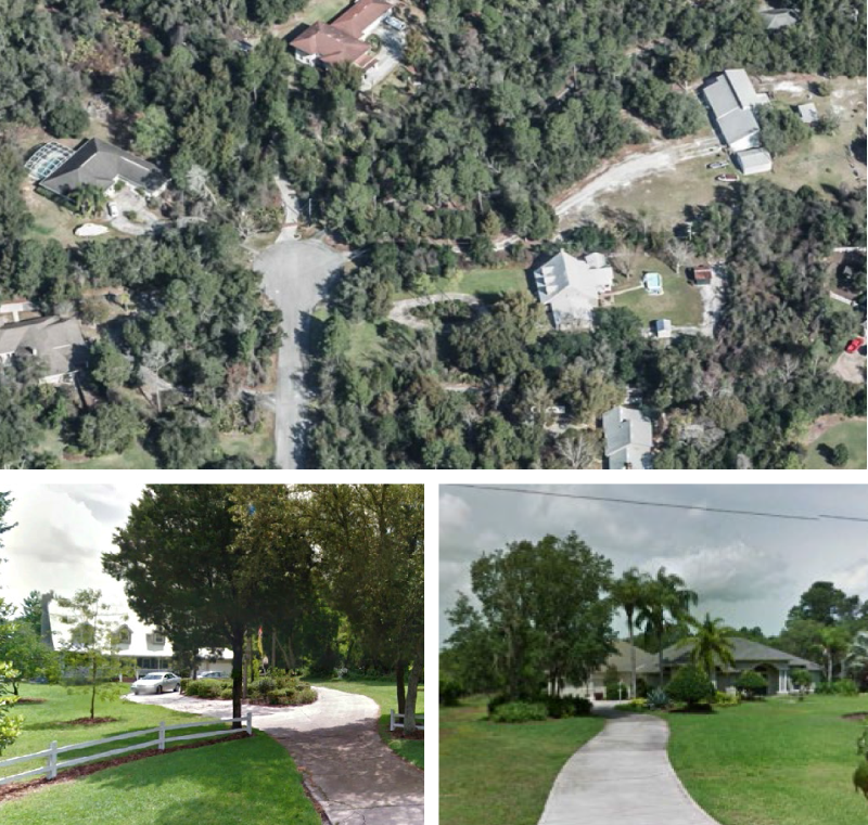
3.2.3. - AG: Agriculture District
A.
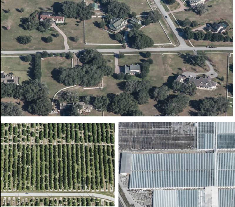
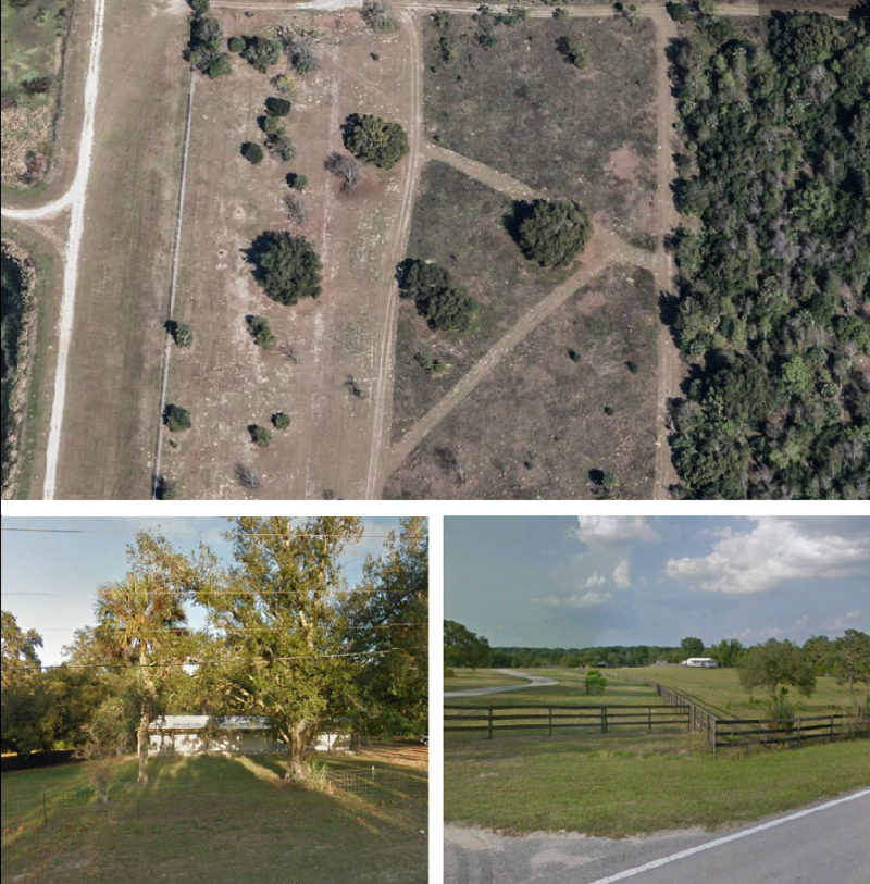
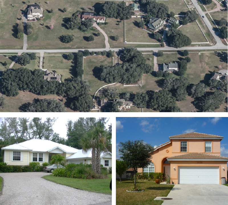
Purpose. The purpose of the AG: Agriculture District is to provide for lands that accommodate agricultural and nursery production, agricultural support uses, and low-density single-family detached dwellings in a rural setting. The district includes significant areas of open space, and a minimum lot area of two and one-half acres. District regulations discourage development that substantially interferes with agriculture production, nurseries, and the general rural character of the district.
B.
Use Standards. Allowed uses and use-specific standards for principal, accessory, and temporary uses are established in Article 4: Use Regulations.
C.
Intensity and Dimensional Standards
| Standard | Single-family [1] Mobile Home [3] | All Other Uses | |
|---|---|---|---|
| Lot Area, min. (sf.) | 108,900 | 108,900 | |
| Living Area, min. (sf.) | 2,000 | Not applicable | |
| Lot Width, min. (ft.) | 150[2] | None | |
| Front Yard Setback, min. (ft.) | 45 | 50 | |
| Side Yard Setback, min. (ft.) | 35 | 50 | |
| Corner Side Yard Setback, min. (ft.) | 35 | 50 | |
| Rear Yard Setback, min. (ft.) | 50 | 50 | |
| Building Height, max. (ft.) | 35 | 35 | |
| Density, max (du/acre) | 0.4[4] | 0.4[4] | |
| Notes: sf. = square feet; ft. = feet; min.= minimum; max.= maximum
[1] Lot area, minimum is applied for every dwelling unit. [2] Lots located on culs-de-sac or on curves are allowed to reduce lot width by up to 40 percent of the minimum width at the property line, but are required to maintain a 150 feet width at the building line. [3] Use-Specific Standards in accordance with Sec. 4.2.3.C.1.d. [4] Residential development north of Ponkan Road and west of Rock Springs Road (Park Avenue) shall be restricted to no more than two dwelling units an acre, unless otherwise authorized through the adopted Wekiva Parkway Interchange Plan. Refer to Apopka Comprehensive Plan. | |||
D.
Reference to Other Standards
Article 5: Development Standards
Section 5.1 Off-Street Parking, Bicycle Parking, and Loading Standards
Section 5.2 Landscaping and Buffer Standards
Section 5.3 Tree Protection Standards
Section 5.4 Open Space Set-Aside Standards
Section 5.5 Fences and Walls
Section 5.6 Exterior Lighting
Section 5.7 Development Design Guidelines
Section 5.8 Neighborhood Compatibility Standards
Section 5.9 Agricultural Compatibility Standards
Section 5.10 Signs
Section 5.11 Green Building Standards
Section 5.12 Green Building Incentives
Section 5.13 Roads, Streets, Sidewalks, and Bikeways
Section 5.14 Utilities
Section 5.15 Guarantees and Sureties
Section 5.16 Miscellaneous Standards
Article 6: Environmental Standards
Article 7: Concurrency Management System
(Ord. No. 2805, § III, 11-18-2020; Ord. No. 2877, § II, 12-15-2021)
3.2.4. - T: Transitional District
A.
Purpose. The purpose of the T: Transitional district is to provide a base zoning district to accommodate lands that are annexed into the City without the concurrent adoption of another base zoning district other than the T district. Lands in the T district are allowed to be developed at low densities, and are intended to be amended at the appropriate time to a different zoning district that is consistent with the Future Land Use Map (FLUM) and the goals, objectives, and policies of the comprehensive plan.
B.
Use Standards. Allowed uses and use-specific standards for principal, accessory, and temporary uses are established in Article 4: Use Regulations.
C.
Intensity and Dimensional Standards
| Standard | All Uses | |
|---|---|---|
| Lot Area, min. (sf.) | 108,900 | |
| Lot Width, min. (ft.) | 150 | |
| Front Yard Setback, min. (ft.) | 50 | |
| Side Yard Setback, min. (ft.) | 50 | |
| Corner Side Yard Setback, min. (ft.) | 50 | |
| Rear Yard Setback, min. (ft.) | 50 | |
| Building Height, max. (ft.) | 35 | |
| Density, max (dus/acre) | 0.4 | |
| Notes: sf. = square feet; ft. = feet; min.= minimum; max.= maximum | ||
D.
Reference to Other Standards
Article 5: Development Standards
Section 5.1 Off-Street Parking, Bicycle Parking, and Loading Standards
Section 5.2 Landscaping and Buffer Standards
Section 5.3 Tree Protection Standards
Section 5.4 Open Space Set-Aside Standards
Section 5.5 Fences and Walls
Section 5.6 Exterior Lighting
Section 5.7 Development Design Guidelines
Section 5.8 Neighborhood Compatibility Standards
Section 5.9 Agricultural Compatibility Standards
Section 5.10 Signs
Section 5.11 Green Building Standards
Section 5.12 Green Building Incentives
Section 5.13 Roads, Streets, Sidewalks, and Bikeways
Section 5.14 Utilities
Section 5.15 Guarantees and Sureties
Section 5.16 Miscellaneous Standards
Article 6: Environmental Standards
Article 7: Concurrency Management System
3.3.1. - General Purposes of Residential Base Zoning Districts
The purpose and intent of Residential base zoning districts are to:
A.
Provide appropriately located lands for residential development that are consistent with the goals, policies, and objectives of the comprehensive plan, and other adopted City plans;
B.
Support and preserve the development pattern and character of established neighborhoods;
C.
Provide a range and diversity of housing choices, with varying densities, types, and designs, to meet the needs of the City's citizens;
D.
Provide for safe and efficient vehicular, bicycle, and pedestrian access and circulation, and neighborhoods that promote multiple forms of mobility;
E.
Protect residential neighborhoods from incompatible development;
F.
Protect residential districts from flooding and other adverse environmental impacts;
G.
Provide for the public services and facilities needed to serve residential development;
H.
Maintain the City's neighborhoods as safe and convenient places to live;
I.
Ensure compatible infill development; and
J.
Promote green building practices in terms of energy efficiency and conservation, the use of alternative energy, greenhouse gas reduction, water supply and water quality protection, food security, materials recycling, and similar goals.
3.3.2. - Established Residential Base Zoning Districts
The residential base zoning districts established by this LDC are identified in Table 3.3.2: Established Residential Base Zoning Districts.
3.3.3. - RCE: Residential Country Estate District
A.
Purpose. The purpose of the RCE: Residential Country Estate district is to provide lands to accommodate nurseries and other agricultural activities, as well as single-family detached residential dwellings at low densities in a more rural setting. The district includes significant areas of open space, and a minimum lot area of one acre per dwelling unit. District regulations discourage development that substantially interferes with nurseries and the general rural and open character of the district.
B.
Use Standards. Allowed uses and use-specific standards for principal, accessory, and temporary uses are established in Article 4: Use Regulations.
C.
Intensity and Dimensional Standards
| Standard | Single-family [one du] | All Other Uses | |
|---|---|---|---|
| Lot Area, min. (sf.) | 43,560 | 43,560 | |
| Living Area, min. (sf.) | 2,000 | Not applicable | |
| Lot Width, min. (ft.) | 130 | 130 | |
| Front Yard Setback, min. (ft.) | 35 | 35 | |
| Side Yard Setback, min. (ft.) | 15 | 15 | |
| Corner Side Yard/Double Front Setback, min. (ft.) | 35 | 35 | |
| Rear Yard Setback, min. (ft.) | 35 | 35 | |
| Building Height, max. (ft.) | 35 | 35 | |
| Density, max (dus/acre) | 1 | Not applicable | |
| Notes: sf. = square feet; ft. = feet; min.= minimum; max.= maximum; du = dwelling unit
| |||
D.
Reference to Other Standards
Article 5: Development Standards
Section 5.1 Off-Street Parking, Bicycle Parking, and Loading Standards
Section 5.2 Landscaping and Buffer Standards
Section 5.3 Tree Protection Standards
Section 5.4 Open Space Set-Aside Standards
Section 5.5 Fences and Walls
Section 5.6 Exterior Lighting
Section 5.7 Development Design Guidelines
Section 5.8 Neighborhood Compatibility Standards
Section 5.9 Agricultural Compatibility Standards
Section 5.10 Signs
Section 5.11 Green Building Standards
Section 5.12 Green Building Incentives
Section 5.13 Roads, Streets, Sidewalks, and Bikeways
Section 5.14 Utilities
Section 5.15 Guarantees and Sureties
Section 5.16 Miscellaneous Standards
Article 6: Environmental Standards
Article 7: Concurrency Management System
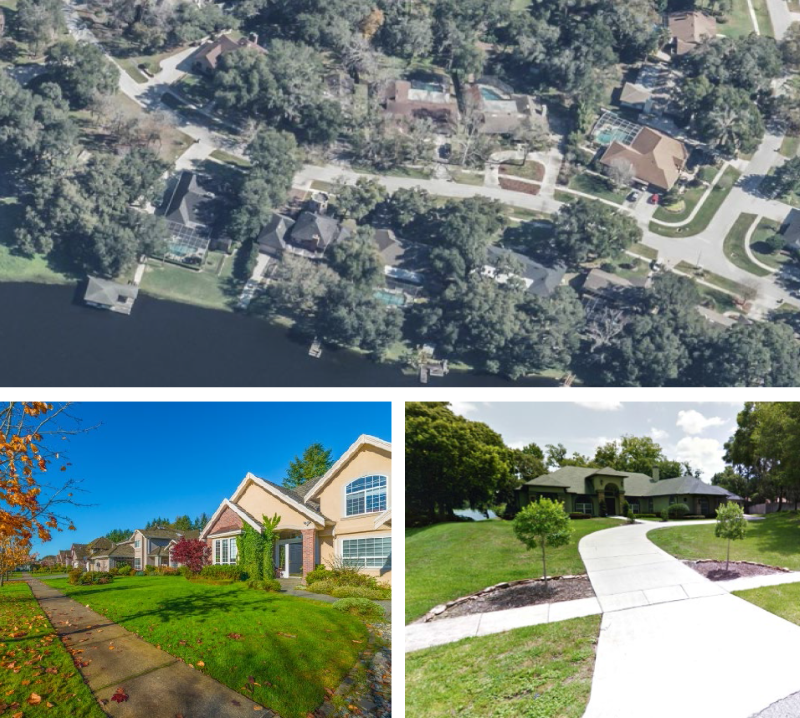
3.3.4. - RSF-1A: Residential Single-Family Estate District
A.
Purpose. The purpose of the RSF-1A: Residential Single-Family Estate district is to provide lands that accommodate primarily medium-density, single-family detached dwellings on lots with a minimum lot area of 12,500 square feet per dwelling unit. The district also accommodates parks and minor utility facilities. District regulations discourage development that substantially interferes with the quiet residential nature of the district.
B.
Use Standards. Allowed uses and use-specific standards for principal, accessory, and temporary uses are established in Article 4: Use Regulations.
C.
Intensity and Dimensional Standards
| Standard | Single-family [one du] | All Other Uses | |
|---|---|---|---|
| Lot Area, min. (sf.) | 12,500 | 12,500 | |
| Living Area, min. (sf.) | 1,800 | Not applicable | |
| Lot Width, min. (ft.) | 95 [2] | 95 [2] | |
| Front Yard Setback, min. (ft.) | 25 | 25 | |
| Side Yard Setback, min. (ft.) | 10 | 10 | |
| Corner Side Yard/Double Front Setback, min. (ft.) | 25 | 25 | |
| Rear Yard Setback, min. (ft.) | 25 | 25 | |
| Building Height, max. (ft.) | 35 | 35 | |
| Density, max (dus/acre) | 3 [1] | 3 [1] | |
| Notes: sf. = square feet; ft. = feet; min.= minimum; max.= maximum; du = dwelling unit
[1] Residential development north of Ponkan Road and west of Rock Springs Road (Park Avenue) shall be restricted to no more than two dwelling units an acre, unless otherwise authorized through the adopted Wekiva Parkway Interchange Plan. [2] Lots located on a cul-de-sac or on curves are allowed to reduce lot width by up to 40 percent of the minimum width at the property line, but are required to maintain a 95 feet width at the building line. | |||
D.
Reference to Other Standards
Article 5: Development Standards
Section 5.1 Off-Street Parking, Bicycle Parking, and Loading Standards
Section 5.2 Landscaping and Buffer Standards
Section 5.3 Tree Protection Standards
Section 5.4 Open Space Set-Aside Standards
Section 5.5 Fences and Walls
Section 5.6 Exterior Lighting
Section 5.7 Development Design Guidelines
Section 5.8 Neighborhood Compatibility Standards
Section 5.9 Agricultural Compatibility Standards
Section 5.10 Signs
Section 5.11 Green Building Standards
Section 5.12 Green Building Incentives
Section 5.13 Roads, Streets, Sidewalks, and Bikeways
Section 5.14 Utilities
Section 5.15 Guarantees and Sureties
Section 5.16 Miscellaneous Standards
Article 6: Environmental Standards
Article 7: Concurrency Management System
(Ord. No. 2877, § III, 12-15-2021)
3.3.5. - RSF-1B: Residential Single-Family District—Large Lot
A.
Purpose. The purpose of the RSF-1B: Residential Single-Family- Large Lot district is to provide lands that accommodate primarily single-family detached dwellings on lots with a minimum area of 8,000 square feet per dwelling unit. The district also accommodates parks and minor utility facilities. District regulations discourage development that substantially interferes with the quiet residential nature of the district.
B.
Use Standards. Allowed uses and use-specific standards for principal, accessory, and temporary uses are established in Article 4: Use Regulations.
C.
Intensity and Dimensional Standards
| Standard | Single-family [one du] | All Other Uses | |
|---|---|---|---|
| Lot Area, min. (sf.) | 8,000 | 8,000 | |
| Living Area, min. (sf.) | 1,600 | Not applicable | |
| Lot Width, min. (ft.) | 75 [2] | 75 [3] | |
| Front Yard Setback, min. (ft.) | 25 | 25 | |
| Side Yard Setback, min. (ft.) | 10 | 10 | |
| Corner Side Yard/Double Front Setback, min. (ft.) | 25 | 25 | |
| Rear Yard Setback, min. (ft.) | 25 | 25 | |
| Building Height, max. (ft.) | 35 | 35 | |
| Density, max (dus/acre) | 5 [1] | Not applicable | |
| Notes: sf. = square feet; ft. = feet; min.= minimum; max.= maximum; du = dwelling unit
[1] Residential development north of Ponkan Road and west of Rock Springs Road (Park Avenue) shall be restricted to no more than 2 development units an acre, unless otherwise authorized through the adopted Wekiva Parkway Interchange Plan. Refer to the Apopka Comprehensive Plan. [2] Lots located on a cul-de-sac or on curves are allowed to reduce lot width by up to 40 percent of the minimum width at the property line, but are required to maintain a 75 feet width at the building line. [3] Lots located on a cul-de-sac or on curves are allowed to reduce lot width by up to 40 percent of the minimum width at the property line, but are required to maintain a 75 feet width for other uses at the building line with Community Development Director's approval. | |||
D.
Reference to Other Standards
Article 5: Development Standards
Section 5.1 Off-Street Parking, Bicycle Parking, and Loading Standards
Section 5.2 Landscaping and Buffer Standards
Section 5.3 Tree Protection Standards
Section 5.4 Open Space Set-Aside Standards
Section 5.5 Fences and Walls
Section 5.6 Exterior Lighting
Section 5.7 Development Design Guidelines
Section 5.8 Neighborhood Compatibility Standards
Section 5.9 Agricultural Compatibility Standards
Section 5.10 Signs
Section 5.11 Green Building Standards
Section 5.12 Green Building Incentives
Section 5.13 Roads, Streets, Sidewalks, and Bikeways
Section 5.14 Utilities
Section 5.15 Guarantees and Sureties
Section 5.16 Miscellaneous Standards
Article 6: Environmental Standards
Article 7: Concurrency Management System
(Ord. No. 2877, § IV, 12-15-2021)
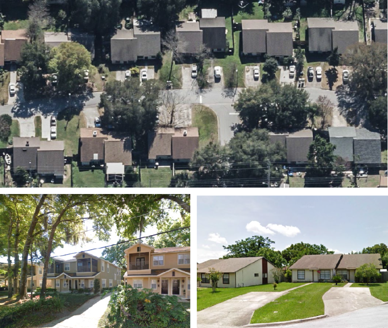
3.3.6. - RTF: Residential Two-Family District
A.
Purpose. The purpose of the RTF: Residential Two-Family district is to provide lands to accommodate primarily single-family detached dwellings and two-family attached dwellings. The district also accommodates parks, community gardens, and minor utility facilities. District regulations discourage development that substantially interferes with the residential nature of the district.
B.
Use Standards. Allowed uses and use-specific standards for principal, accessory, and temporary uses are established in Article 4: Use Regulations.
C.
Intensity and Dimensional Standards
| Standard | Single-family [one du] | Two-Family [two du] [4] | All Other Uses | |
|---|---|---|---|---|
| Lot Area, min. (sf.) | 6,000 | 12,000 | 6,000 | |
| Living Area, min. (sf per unit) | 1,500 | 1,350 | Not applicable | |
| Lot Width, min. (ft.) | 60 [3] | 110 [1] | 60 | |
| Front Yard Setback, min. (ft.) | 25 | 25 | 25 | |
| Side Yard Setback, min. (ft.) | 7.5 [1] | 7.5 and 0 [1] | 7.5 [1] | |
| Corner Side Yard/Double Front Setback, min. (ft.) | 25 | 25 | 25 | |
| Rear Yard Setback, min. (ft.) | 20 | 20 | 20 | |
| Building Height, max. (ft.) | 35 | 35 | 35 | |
| Density, max (dus/acre) | [2] | [2] | Not applicable | |
| Notes: sf. = square feet; ft. = feet; min.= minimum; max.= maximum; du = dwelling unit
[1] Minimum of 15 feet between structures; 0 feet on one side for duplex party wall attached dwelling units. [2] Residential development north of Ponkan Road and west of Rock Springs Road (Park Avenue) will be restricted to no more than two dwelling units per acre, unless otherwise authorized through the adopted Wekiva Parkway Interchange Plan. Refer to the Apopka Comprehensive Plan. [3] Lots located on a cul-de-sac or on curves are allowed to reduce lot width by up to 40 percent of the minimum width at the property line, but are required to maintain a 60 feet width for Single-family or 110 feet width for Two-family at the building line. [4] Two-Family units less than 55 feet wide must provide rear alley access rather than front loaded garages. Alley design is 18 feet minimum width: 14 feet paved, 2 feet each side curb and gutter area. | ||||
D.
Reference to Other Standards
Article 5: Development Standards
Section 5.1 Off-Street Parking, Bicycle Parking, and Loading Standards
Section 5.2 Landscaping and Buffer Standards
Section 5.3 Tree Protection Standards
Section 5.4 Open Space Set-Aside Standards
Section 5.5 Fences and Walls
Section 5.6 Exterior Lighting
Section 5.7 Development Design Guidelines
Section 5.8 Neighborhood Compatibility Standards
Section 5.9 Agricultural Compatibility Standards
Section 5.10 Signs
Section 5.11 Green Building Standards
Section 5.12 Green Building Incentives
Section 5.13 Roads, Streets, Sidewalks, and Bikeways
Section 5.14 Utilities
Section 5.15 Guarantees and Sureties
Section 5.16 Miscellaneous Standards
Article 6: Environmental Standards
Article 7: Concurrency Management System
(Ord. No. 2877, § V, 12-15-2021; Ord. No. 2994, § V, 3-15-2023)
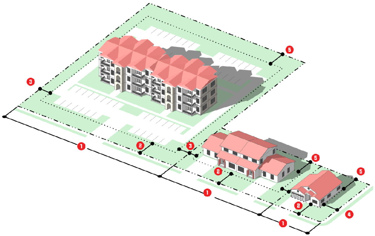
3.3.7. - RMF: Residential Multi-Family District
A.
Purpose. The purpose of the RMF: Residential Multi-Family district is to primarily accommodate small and medium scale multifamily development that is oriented toward the street, and provides pedestrian entrances from the street. The district also accommodates detached single-family detached dwellings, two-family dwellings, townhomes, parks and recreation centers, and community gardens.
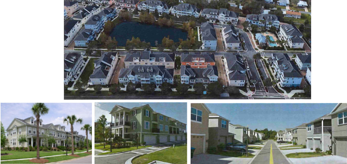
B.
Use Standards. Allowed uses and use-specific standards for principal, accessory, and temporary uses are established in Article 4: Use Regulations.
C.
Intensity and Dimensional Standards
| Standard | Single-family [one du] | Two-Family & Townhome [4] | Multi-Family | All Other Uses | |
|---|---|---|---|---|---|
| Lot Area, min. (sf.) | 7,500 | 15,000 | 43,560 | 7,500 | |
| Living Area, min. (sf per unit) | 1,500 | 1,500 |
750 (1 bd)
900 (2+ bd) | Not applicable | |
| Lot Width, min. (ft.) | 55 [3] | 100 [3] | 100 | 70 | |
| Front Yard Setback, min. (ft.) | 25 | 25 | 25 | 25 | |
| Side Yard Setback, min. (ft.) | 5 [1] | 10 [1] | 15 [1] | 7.5 | |
| Corner Side Yard/Double Front Setback, min. (ft.) | 25 | 25 | 25 | 25 | |
| Rear Yard Setback, min. (ft.) | 20 | 20 | 25 | 25 | |
| Building Height, max. (ft.) | 35 | 35 | 35—55 [5] | 35 | |
| Density, max (dus/acre) | [2] | [2] | [2] | Not applicable | |
| Notes: sf. = square feet; ft. = feet; min.= minimum; max.= maximum; du = dwelling unit
[1] Minimum of 10 feet between structures, only applies to exterior units. [2] Residential development north of Ponkan Road and west of Rock Springs Road (Park Avenue) shall be restricted to no more than two dwelling units an acre, unless otherwise authorized through the adopted Wekiva Parkway Interchange Plan. Refer to the Apopka Comprehensive Plan. [3] ;hgLots located on a cul-de-sac or on curves are allowed to reduce lot width by up to 40 percent of the minimum width at the property line, but are required to maintain a 55 feet width for Single-family or 100 feet width for Multi-family at the building line. [4] Two-Family and Townhome units less than 55 feet wide must provide private dedicated rear alley access rather than front loaded garages. Alley design is 18 feet minimum width: 14 feet paved, 2 feet each side curb and gutter area. The alley is to provide for utilities where applicable and solid waste pickup. Solid waste receptacles shall be screened from view. The front of all units must face a main road for addressing. [5] One to two story max. is 35'; Three-story max. is 40'; Four-story max. is 50'; Five-story max. is 60'. | |||||
D.
Reference to Other Standards
Article 5: Development Standards
Section 5.1 Off-Street Parking, Bicycle Parking, and Loading Standards
Section 5.2 Landscaping and Buffer Standards
Section 5.3 Tree Protection Standards
Section 5.4 Open Space Set-Aside Standards
Section 5.5 Fences and Walls
Section 5.6 Exterior Lighting
Section 5.7 Development Design Guidelines
Section 5.8 Neighborhood Compatibility Standards
Section 5.9 Agricultural Compatibility Standards
Section 5.10 Signs
Section 5.11 Green Building Standards
Section 5.12 Green Building Incentives
Section 5.13 Roads, Streets, Sidewalks, and Bikeways
Section 5.14 Utilities
Section 5.15 Guarantees and Sureties
Section 5.16 Miscellaneous Standards
Article 6: Environmental Standards
Article 7: Concurrency Management System
(Ord. No. 2745, § 3, 1-15-2020; Ord. No. 2877, § VI, 12-15-2021; Ord. No. 2994, § V, 3-15-2023; Ord. No. 3021, § I, 9-20-2023)
3.3.8. - RMU: Residential Mixed-Use District
A.
Purpose. The purpose of the RMU: Residential Mixed-Use district is to accommodate a variety of medium density residential development, as well as small and medium-scale retail, personal service, eating and drinking establishment, and mixed-use development that supports walkable urbanism. District development should be oriented to the street, be walkable and support multiple modes of mobility. The vertical mixing of residential and nonresidential uses within a single project, with residential development above the ground floor is strongly encouraged. The horizontal mixing of well-integrated stand-alone residential and nonresidential development is also encouraged.
B.
Use Standards. Allowed uses and use-specific standards for principal, accessory, and temporary uses are established in Article 4: Use Regulations.
C.
Intensity and Dimensional Standards
| Standard | Townhome [4] | Multi-Family | Other Uses | |
|---|---|---|---|---|
| Lot Area, min. (sf.) | 8,000 | 8,000 | 5,000 | |
| Living Area, min. (sf per unit) | 1,350 |
750 (1 bd)
900 (2+ bd) | 750 | |
| Lot Width, min. (ft.) | 50 [3] | 100 | 100 | |
| Front Yard Setback, min. (ft.) | 15 | 15 | 15 | |
| Side Yard Setback, min. (ft.) | 7.5 [1] | 10 [1] | 10 [1] | |
| Corner Side Yard/Double Front Setback, min. (ft.) | 7.5 | 20 | 10 [1] | |
| Rear Yard Setback, min. (ft.) | 20 | 25 | 25 | |
| Building Height, max. (ft.) | 35 | 35—55 [5] | 35 | |
| Density, max (dus/acre) | [2] | [2] | [2] | |
| Notes: sf. = square feet; ft. = feet; min.= minimum; max.= maximum; bd = bedroom
[1] Only applies to the exterior units. [2] Residential development north of Ponkan Road and west of Rock Springs Road (Park Avenue) will be restricted to no more than two dwelling units an acre, unless otherwise authorized through the adopted Wekiva Parkway Interchange Plan. Refer to the Apopka Comprehensive Plan. [3] Lots located on cul-de-sac and curves are allowed to reduce lot width by up to 40 percent of the minimum width at the property line, but are required to maintain a 50 feet width for Townhome or 100 feet width for Multi-family at the building line. [4] Townhome units less than 55 feet wide must provide private dedicated rear alley access rather than front loaded garages. Alley design is 18 feet minimum width: 14 feet paved, 2 feet each side curb and gutter area. The alley is to provide for utilities where applicable and solid waste pickup. Solid waste receptacles shall be screened from view. The front of all units must face a main road for addressing. [5] One to two story max. is 35'; Three-story max. is 40'; Four-story max. is 50'; Five-story max. is 60'. | ||||
D.
Reference to Other Standards
Article 5: Development Standards
Section 5.1 Off-Street Parking, Bicycle Parking, and Loading Standards
Section 5.2 Landscaping and Buffer Standards
Section 5.3 Tree Protection Standards
Section 5.4 Open Space Set-Aside Standards
Section 5.5 Fences and Walls
Section 5.6 Exterior Lighting
Section 5.7 Development Design Guidelines
Section 5.8 Neighborhood Compatibility Standards
Section 5.9 Agricultural Compatibility Standards
Section 5.10 Signs
Section 5.11 Green Building Standards
Section 5.12 Green Building Incentives
Section 5.13 Roads, Streets, Sidewalks, and Bikeways
Section 5.14 Utilities
Section 5.15 Guarantees and Sureties
Section 5.16 Miscellaneous Standards
Article 6: Environmental Standards
Article 7: Concurrency Management System
(Ord. No. 2877, § VII, 12-15-2021; Ord. No. 2994, § V, 3-15-2023; Ord. No. 3021, § II, 9-20-2023)
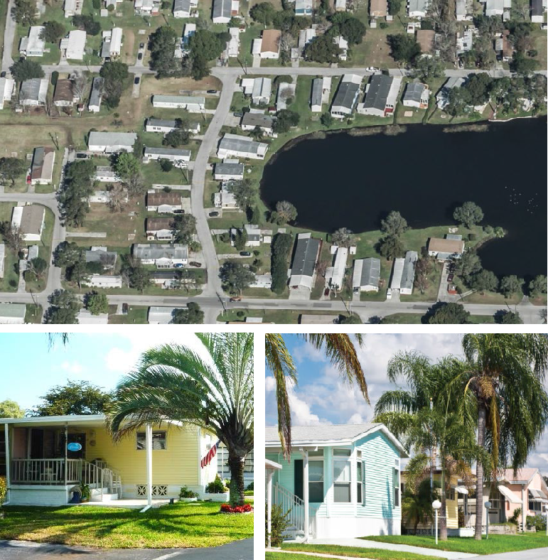
3.3.9. - MHP: Mobile Home Park District
A.
Purpose. The purpose of the MHP: Mobile Home Park District is to provide a zoning district for lands that existed on March 6, 2019 that accommodate mobile homes sites as part of an overall existing subdivision of mobile home parks. It is intended that the mobile home parks: include residences and related support services and recreational facilities and other amenities; respect the topographic and other environmental characteristics of the site on which they are located; and mitigate potential adverse impacts on surrounding development. It is also the intent of the City Council in adopting this district that no other lands be classified MHP: Mobile Home Park, after March 6, 2019.
B.
Use Standards. Allowed uses and use-specific standards for principal, accessory, and temporary uses are established in Article 4: Use Regulations.
C.
Intensity and Dimensional Standards
D.
Other Standards
E.
Reference to Other Standards
Article 5: Development Standards
Section 5.1 Off-Street Parking, Bicycle Parking, and Loading Standards
Section 5.2 Landscaping and Buffer Standards
Section 5.3 Tree Protection Standards
Section 5.4 Open Space Set-Aside Standards
Section 5.5 Fences and Walls
Section 5.6 Exterior Lighting
Section 5.7 Development Design Guidelines
Section 5.8 Neighborhood Compatibility Standards
Section 5.9 Agricultural Compatibility Standards
Section 5.10 Signs
Section 5.11 Green Building Standards
Section 5.12 Green Building Incentives
Section 5.13 Roads, Streets, Sidewalks, and Bikeways
Section 5.14 Utilities
Section 5.15 Guarantees and Sureties
Section 5.16 Miscellaneous Standards
Article 6: Environmental Standards
Article 7: Concurrency Management System
(Ord. No. 2925, § I, 5-18-2022)
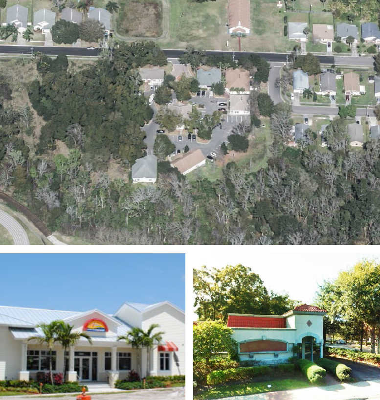
3.4.1. - General Purposes of Commercial Zoning Districts
The commercial base zoning districts are established for the general purpose of ensuring there are lands in the City that provide a wide range of retail, office, service, employment, and related development to meet the needs of the City's residents, and more specifically to:
A.
Strengthen the City's economic base, and provide employment opportunities close to home for City residents;
B.
Provide appropriately located lands for a full range of business and commercial uses needed by the City's residents, businesses, and workers, consistent with the goals, objectives, and policies of the comprehensive plan and other adopted City plans;
C.
Create suitable environments for various types of mixed-use development, where business, office, retail, and residential development is designed and integrated in compatible ways;
D.
Encourage, support and ensure a high quality design in retail, office, service, employment, and related development in the City;
E.
Accommodate new infill development and redevelopment that is consistent with the goals, objectives, and policies of the comprehensive plan and other adopted City plans, especially along certain of the City's older commercial corridors,;
F.
Ensure commercial development is located and designed to protect and preserve the character of single-family neighborhoods; and
G.
Create suitable environments for various types of businesses, and protect them from the adverse effects of incompatible development.
3.4.2. - Established Commercial Base Zoning Districts
The commercial base zoning districts established by this LDC are identified in Table 3.4.2: Established Commercial Base Zoning Districts.
3.4.3. - C-N: Neighborhood Commercial District
A.
Purpose. The purpose of the C-N: Neighborhood Commercial district is to provide lands that accommodate a range of small-scale, low-intensity, neighborhood-serving commercial development that provide goods and services to residents of a neighborhood. District regulations are intended to ensure uses, development intensities, and development form that is consistent with a pedestrian-friendly and neighborhood scale. Development allowed in the district includes limited retail sales and services, personal services, eating or drinking establishments, and related uses. Mixed use development is also allowed, with residential above the ground floor, at a scale and form that is consistent with district character.
B.
Use Standards. Allowed uses and use-specific standards for principal, accessory, and temporary uses are established in Article 4: Use Regulations.
C.
Intensity and Dimensional Standards
| Standard | All Uses | |
|---|---|---|
| Lot Area, min. (sf.) | 7,500 | |
| Lot Width, min. (ft.) | 75 | |
| Front Yard Setback, min. (ft.) | 10 | |
| Side Yard Setback, min. (ft.) | 10 [1] | |
| Corner Side Yard Setback, min. (ft.) | 30 | |
| Rear Yard Setback, min. (ft.) | 10/30 [1] | |
| Building Height, max. (ft.) | 35 | |
| Building Floorplate, max. (sf.) | 4,000 | |
| Density, max (dus/acre) | Not applicable [3] | |
| Intensity, max (FAR) | 0.25 [2][4] | |
| Notes: sf. = square feet; ft. = feet; min.= minimum; max.= maximum
[1] Thirty (30) feet when adjacent to a residential use or a Residential district. [2] Residential development north of Ponkan Road and west of Rock Springs Road (Park Avenue) shall be restricted to no more than 2 dwelling units an acre, unless otherwise authorized through the adopted Wekiva Parkway Interchange Plan. [3] Residential development shall only be located above the ground floor. [4] Floorplate of individual building shall not exceed 4,000 sf. | ||
D.
Reference to Other Standards
Article 5: Development Standards
Section 5.1 Off-Street Parking, Bicycle Parking, and Loading Standards
Section 5.2 Landscaping and Buffer Standards
Section 5.3 Tree Protection Standards
Section 5.4 Open Space Set-Aside Standards
Section 5.5 Fences and Walls
Section 5.6 Exterior Lighting
Section 5.7 Development Design Guidelines
Section 5.8 Neighborhood Compatibility Standards
Section 5.9 Agricultural Compatibility Standards
Section 5.10 Signs
Section 5.11 Green Building Standards
Section 5.12 Green Building Incentives
Section 5.13 Roads, Streets, Sidewalks, and Bikeways
Section 5.14 Utilities
Section 5.15 Guarantees and Sureties
Section 5.16 Miscellaneous Standards
Article 6: Environmental Standards
Article 7: Concurrency Management System
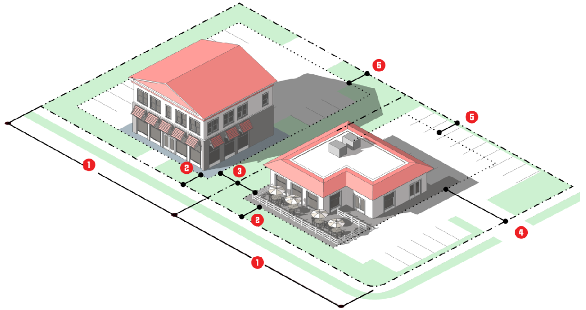
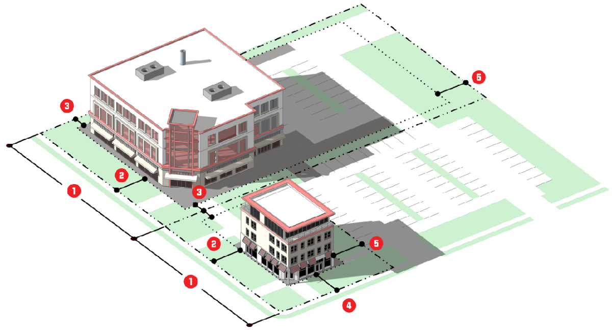
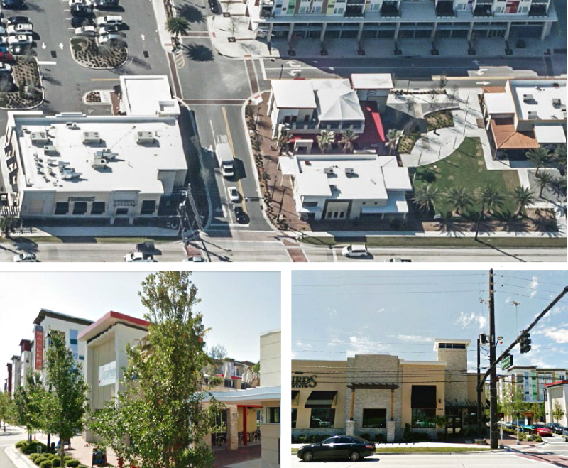
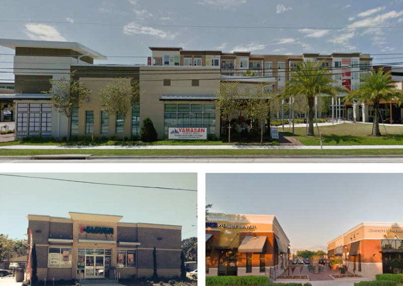
3.4.4. - C-C: Community Commercial District
A.
Purpose. The purpose of the C-C: Community Commercial district is to provide lands that accommodate community-serving commercial, office, mixed use, and limited residential development (above commercial and office uses) , at medium intensities and densities. Allowed uses include retail sales, personal services, eating and drinking establishments, offices, recreation/entertainment uses, vehicle sales and services, mixed use, live/work, and multi-family dwellings above ground-level commercial and office uses.
B.
Use Standards. Allowed uses and use-specific standards for principal, accessory, and temporary uses are established in Article 4: Use Regulations.
C.
Intensity and Dimensional Standards
| Standard | All Other Uses | |
|---|---|---|
| Lot Area, min. (sf.) | 10,000 | |
| Lot Width, min. (ft.) | 100 | |
| Front Yard Setback, min. (ft.) | 10 | |
| Side Yard Setback, min. (ft.) | 10 | |
| Corner Side Yard Setback, min. (ft.) | 15 | |
| Rear Yard Setback, min. (ft.) | 10/30 [2] | |
| Building Height, max. (ft.) | 35 | |
| Density, max (dus/acre) | 6 [3][4] | |
| Floor Area Ratio (FAR), max. | 0.25 | |
| Notes: sf. = square feet; ft. = feet; min.= minimum; max.= maximum
[1] Only applies to the exterior units. [2] Thirty (30) feet when adjacent to a residential use or a Residential district. [3] Residential development north of Ponkan Road and west of Rock Springs Road (Park Avenue) shall be restricted to no more than 2 dwelling units an acre, unless otherwise authorized through the adopted Wekiva Parkway Interchange Plan. [4] Residential development shall only be located above the ground floor. | ||
D.
Reference to Other Standards
Article 5: Development Standards
Section 5.1 Off-Street Parking, Bicycle Parking, and Loading Standards
Section 5.2 Landscaping and Buffer Standards
Section 5.3 Tree Protection Standards
Section 5.4 Open Space Set-Aside Standards
Section 5.5 Fences and Walls
Section 5.6 Exterior Lighting
Section 5.7 Development Design Guidelines
Section 5.8 Neighborhood Compatibility Standards
Section 5.9 Agricultural Compatibility Standards
Section 5.10 Signs
Section 5.11 Green Building Standards
Section 5.12 Green Building Incentives
Section 5.13 Roads, Streets, Sidewalks, and Bikeways
Section 5.14 Utilities
Section 5.15 Guarantees and Sureties
Section 5.16 Miscellaneous Standards
Article 6: Environmental Standards
Article 7: Concurrency Management System
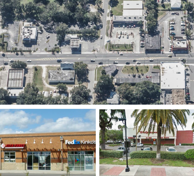
3.4.5. - C-R: Regional Commercial District
A.
Purpose. The purpose of the C-R: Regional Commercial district is to provide lands that accommodate region-serving commercial development, with some residential and mixed use development. The district is characterized by large-scale commercial, office, and other nonresidential development serving a 25-mile radius, along with mixed-use and moderate density residential development. Allowed uses include retail sales and services, personal services, offices, eating and drinking establishments, visitor accommodation, recreation/entertainment, vehicle sales and services, live/work, moderate density stand-alone townhome and multi-family development, and mixed-use development.
B.
Use Standards. Allowed uses and use-specific standards for principal, accessory, and temporary uses are established in Article 4: Use Regulations.
C.
Intensity and Dimensional Standards
| Standard | Multifamily | All Other Uses [4] | |
|---|---|---|---|
| Lot Area, min. (sf.) | 8,000 | 15,000 | |
| Lot Width, min. (ft.) | 100 | 150 | |
| Front Yard Setback, min. (ft.) | 15 | 15 | |
| Side Yard Setback, min. (ft.) | 10 | 10 | |
| Corner Side Yard Setback, min. (ft.) | 15 [1] | 15 | |
| Rear Yard Setback, min. (ft.) | 25 | 10/30 [2] | |
| Building Height, max. (ft.) | 35 | 35 | |
| Density, max (dus/acre) | 8 [3][4][5] | Not applicable | |
| Floor Area Ratio (FAR), max. | Not applicable | 0.25 [4][5] | |
| Notes: sf. = square feet; ft. = feet; min.= minimum; max.= maximum
[1] Only applies to the exterior units. [2] Thirty (30) feet when adjacent to a residential use or a Residential district. [3] Residential development north of Ponkan Road and west of Rock Springs Road (Park Avenue) shall be restricted to no more than 2 dwelling units an acre, unless otherwise authorized through the adopted Wekiva Parkway Interchange Plan. [4] Horizontal mixed-use development shall comply with the standards form "All Other Uses." [5] Horizontal mixed-use development may achieve both the maximum density for "Multifamily" and the maximum FAR for "All Other Uses." | |||
D.
Reference to Other Standards
Article 5: Development Standards
Section 5.1 Off-Street Parking, Bicycle Parking, and Loading Standards
Section 5.2 Landscaping and Buffer Standards
Section 5.3 Tree Protection Standards
Section 5.4 Open Space Set-Aside Standards
Section 5.5 Fences and Walls
Section 5.6 Exterior Lighting
Section 5.7 Development Design Guidelines
Section 5.8 Neighborhood Compatibility Standards
Section 5.9 Agricultural Compatibility Standards
Section 5.10 Signs
Section 5.11 Green Building Standards
Section 5.12 Green Building Incentives
Section 5.13 Roads, Streets, Sidewalks, and Bikeways
Section 5.14 Utilities
Section 5.15 Guarantees and Sureties
Section 5.16 Miscellaneous Standards
Article 6: Environmental Standards
Article 7: Concurrency Management System
3.4.6. - O: Office District
A.
Purpose. The purpose of the O: Office district is to provide lands that accommodate a broad range of office, limited commercial development, and small-scale residential development, typically in locations where visibility and good access are important. Development is encouraged to be configured with multiple uses, shared parking, and coordinated signage and landscaping. Allowed uses include medical and dental offices, professional offices, and other general offices, eating and drinking establishments, live-work units, small-scale townhome development, and mixed-use development.
B.
Use Standards. Allowed uses and use-specific standards for principal, accessory, and temporary uses are established in Article 4: Use Regulations.
C.
Intensity and Dimensional Standards
| Standard | Town home and Multi-Family | All Other Uses [4] | |
|---|---|---|---|
| Lot Area, min. (sf.) | 15,000 | 10,000 | |
| Lot Width, min. (ft.) | 140 | 85 | |
| Front Yard Setback, min. (ft.) | 25 | 25 | |
| Side Yard Setback, min. (ft.) | 10 [1] | 10 | |
| Corner Side Yard Setback, min. (ft.) | 20 | 25 | |
| Rear Yard Setback, min. (ft.) | 25 | 10/25 [2] | |
| Building Height, max. (ft.) | 35 | 35 | |
| Density, max (dus/acre) | 5 [3] | Not applicable | |
| Floor Area Ratio (FAR), max. | Not applicable | 0.30 | |
| Notes: sf. = square feet; ft. = feet; min.= minimum; max.= maximum
[1] Only applies to the exterior units. [2] Twenty-five feet when adjacent to a residential use or a Residential district. [3] Residential development north of Ponkan Road and west of Rock Springs Road (Park Avenue) shall be restricted to no more than 2 dwelling units an acre, unless otherwise authorized through the adopted Wekiva Parkway Interchange Plan. [4] Horizontal mixed use development shall comply with the standards for "All Other Uses." Maximum density/intensity for residential and nonresidential horizontal mixed use development shall not exceed the maximum FAR for "All Other Uses." | |||
D.
Reference to Other Standards
Article 5: Development Standards
Section 5.1 Off-Street Parking, Bicycle Parking, and Loading Standards
Section 5.2 Landscaping and Buffer Standards
Section 5.3 Tree Protection Standards
Section 5.4 Open Space Set-Aside Standards
Section 5.5 Fences and Walls
Section 5.6 Exterior Lighting
Section 5.7 Development Design Guidelines
Section 5.8 Neighborhood Compatibility Standards
Section 5.9 Agricultural Compatibility Standards
Section 5.10 Signs
Section 5.11 Green Building Standards
Section 5.12 Green Building Incentives
Section 5.13 Roads, Streets, Sidewalks, and Bikeways
Section 5.14 Utilities
Section 5.15 Guarantees and Sureties
Section 5.16 Miscellaneous Standards
Article 6: Environmental Standards
Article 7: Concurrency Management System
3.4.7. - C-COR: Corridor Commercial District
A.
Purpose. The purpose of the C-COR: Corridor Commercial district is to provide lands that accommodate a moderate range of primarily commercial uses along commercial corridors, in ways that support infill and redevelopment. Allowed uses include, retail sales, personal services, office, eating and drinking, visitor accommodation, recreation/entertainment, and vehicle sales and services uses, moderate density townhome and multi-family dwellings, and mixed-use development.
B.
Use Standards. Allowed uses and use-specific standards for principal, accessory, and temporary uses are established in Article 4: Use Regulations.
C.
Intensity and Dimensional Standards
| Standard | Town home and Multi-Family | All Other Uses [4] | |
|---|---|---|---|
| Lot Area, min. (sf.) | 8,000 | 10,000 | |
| Lot Width, min. (ft.) | 50 | 50 | |
| Front Yard Setback, min. (ft.) | 15 | 10 | |
| Side Yard Setback, min. (ft.) | 7.5 [1] | 10 | |
| Corner Side Yard Setback, min. (ft.) | 7.5 | 15 | |
| Rear Yard Setback, min. (ft.) | 20 | 10/30 [2] | |
| Building Height, max. (ft.) | 35 | 35 | |
| Density, max (dus/acre) | 5 [3][4][5] | Not applicable | |
| Floor Area Ratio (FAR), max. | Not applicable | 0.25 [4][5] | |
| Notes: sf. = square feet; ft. = feet; min.= minimum; max.= maximum
[1] Only applies to the exterior units. [2] Twenty-five (25) feet when adjacent to a residential use or a Residential district. [3] Residential development north of Ponkan Road and west of Rock Springs Road (Park Avenue) shall be restricted to no more than 2 dwelling units an acre, unless otherwise authorized through the adopted Wekiva Parkway Interchange Plan. [4] Horizontal mixed-use development shall comply with the standards in "All Other Uses." [5] Horizontal mixed-use development may achieve both the maximum density for "Townhome and Multifamily" and the maximum FAR for "All Other Uses." | |||
D.
Reference to Other Standards
Article 5: Development Standards
Section 5.1 Off-Street Parking, Bicycle Parking, and Loading Standards
Section 5.2 Landscaping and Buffer Standards
Section 5.3 Tree Protection Standards
Section 5.4 Open Space Set-Aside Standards
Section 5.5 Fences and Walls
Section 5.6 Exterior Lighting
Section 5.7 Development Design Guidelines
Section 5.8 Neighborhood Compatibility Standards
Section 5.9 Agricultural Compatibility Standards
Section 5.10 Signs
Section 5.11 Green Building Standards
Section 5.12 Green Building Incentives
Section 5.13 Roads, Streets, Sidewalks, and Bikeways
Section 5.14 Utilities
Section 5.15 Guarantees and Sureties
Section 5.16 Miscellaneous Standards
Article 6: Environmental Standards
Article 7: Concurrency Management System
3.5.1. - General Purposes of Industrial Districts
The purpose of the Industrial base zoning districts is to:
A.
Provide appropriately located lands for the full range of industrial uses needed by the City's businesses and residents, consistent with the goals, objectives, and policies of the comprehensive plan and other adopted City plans;
B.
Strengthen the City's economic base, and provide employment opportunities;
C.
Create suitable environments for various types of light industrial and industrial development, and protect them from the adverse effects of incompatible development;
D.
Ensure industrial development is located and designed to protect and preserve the character of existing single-family districts and neighborhoods;
E.
Improve the design quality of industrial areas; and
F.
Provide a place to locate uses that are generally incompatible with other uses in other zoning districts.
3.5.2. - Established Industrial Districts
The Industrial districts established by this LDC are identified in Table 3.5.2: Established Industrial Districts.
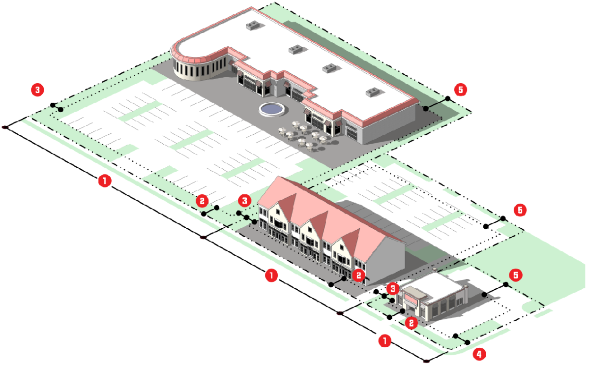
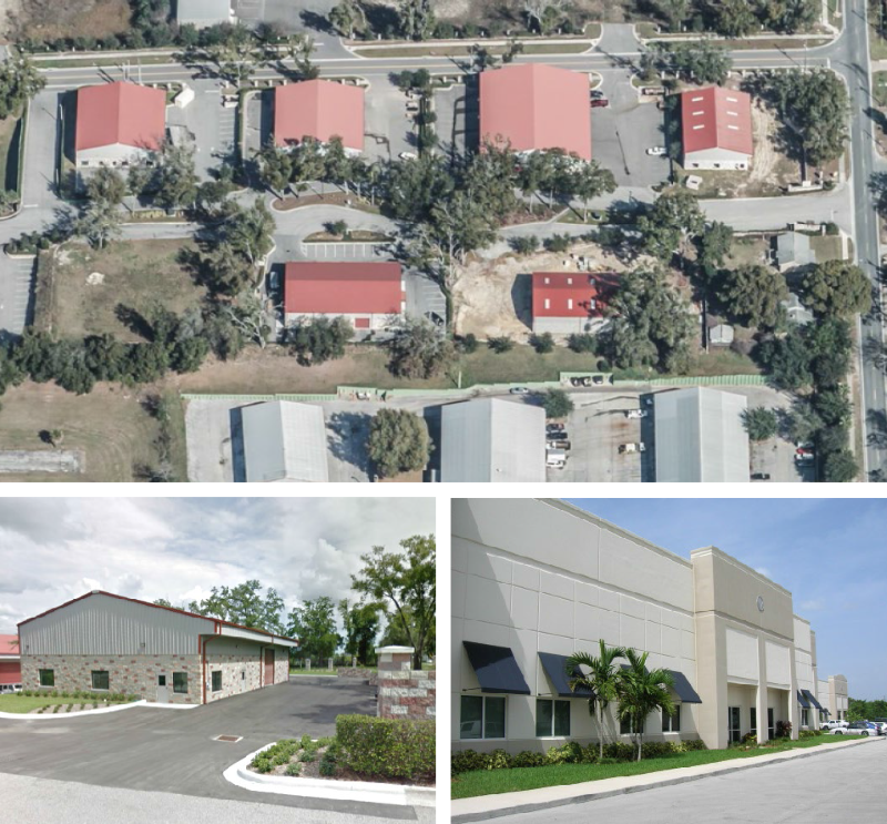
3.5.3. - I-L: Light Industrial District
A.
Purpose. The purpose of the LI: Light Industrial district is to provide lands that accommodate light industrial and support development. Allowed uses include wholesaling, distribution, storage, processing, research and development, and light manufacturing. The district also accommodates support uses such as office and limited commercial uses that primarily serve the principal light industrial uses.
B.
Use Standards. Allowed uses and use-specific standards for principal, accessory, and temporary uses are established in Article 4: Use Regulations.
C.
Intensity and Dimensional Standards
| Standard | All Other Uses | |
|---|---|---|
| Lot Area, min. (sf.) | 12,000 | |
| Lot Width, min. (ft.) | 100 | |
| Front Yard Setback, min. (ft.) | 10 | |
| Side Yard Setback, min. (ft.) | 10/30 [1] | |
| Corner Side Yard Setback, min. (ft.) | 15 | |
| Rear Yard Setback, min. (ft.) | 10/30 [1] | |
| Building Height, max. (ft.) | 45 | |
| Floor Area Ratio (FAR), max. | 0.40 | |
| Notes: sf. = square feet; ft. = feet; min.= minimum; max.= maximum
[1] Thirty (30) feet when adjacent to a residential use or a Residential district. | ||
D.
Reference to Other Standards
Article 5: Development Standards
Section 5.1 Off-Street Parking, Bicycle Parking, and Loading Standards
Section 5.2 Landscaping and Buffer Standards
Section 5.3 Tree Protection Standards
Section 5.4 Open Space Set-Aside Standards
Section 5.5 Fences and Walls
Section 5.6 Exterior Lighting
Section 5.7 Development Design Guidelines
Section 5.8 Neighborhood Compatibility Standards
Section 5.9 Agricultural Compatibility Standards
Section 5.10 Signs
Section 5.11 Green Building Standards
Section 5.12 Green Building Incentives
Section 5.13 Roads, Streets, Sidewalks, and Bikeways
Section 5.14 Utilities
Section 5.15 Guarantees and Sureties
Section 5.16 Miscellaneous Standards
Article 6: Environmental Standards
Article 7: Concurrency Management System
(Ord. No. 2805, § IV, 11-18-2020)
3.5.4. - I-H: Heavy Industrial District
A.
Purpose. The purpose of the I-H: Heavy Industrial district is to provide lands that accommodate heavy industrial development that generally requires large sites, as well as industrial uses that are important to the City's economic growth but may impact adjacent lands. The uses generally involve greater potential for adverse off-site impacts on the environment and surrounding development (e.g. from dust, fumes, smoke, odor, noise, or vibration, or due to extensive movement of vehicles, materials, and goods). Allowed uses include heavy manufacturing, warehouse distribution, wholesale sales, major utility facilities, and research laboratories. District development is intended to include buffers and the use of mitigation techniques to ensure heavy industrial development mitigates potential impacts to surrounding residential development.
B.
Use Standards. Allowed uses and use-specific standards for principal, accessory, and temporary uses are established in Article 4: Use Regulations.
C.
Intensity and Dimensional Standards
| Standard | All Other Uses | |
|---|---|---|
| Lot Area, min. (sf.) | 25,000 | |
| Lot Width, min. (ft.) | 150 | |
| Front Yard Setback, min. (ft.) | 25 | |
| Side Yard Setback, min. (ft.) | 10/100 [1] | |
| Corner Side Yard Setback, min. (ft.) | 25 | |
| Rear Yard Setback, min. (ft.) | 10/100 [1] | |
| Building Height, max. (ft.) | 45 | |
| Floor Area Ratio (FAR), max. | 0.60 | |
| Notes: sf. = square feet; ft. = feet; min.= minimum; max.= maximum
[1] One hundred (100) feet when adjacent to a residential use or a Residential district. | ||
D.
Reference to Other Standards
Article 5: Development Standards
Section 5.1 Off-Street Parking, Bicycle Parking, and Loading Standards
Section 5.2 Landscaping and Buffer Standards
Section 5.3 Tree Protection Standards
Section 5.4 Open Space Set-Aside Standards
Section 5.5 Fences and Walls
Section 5.6 Exterior Lighting
Section 5.7 Development Design Guidelines
Section 5.8 Neighborhood Compatibility Standards
Section 5.9 Agricultural Compatibility Standards
Section 5.10 Signs
Section 5.11 Green Building Standards
Section 5.12 Green Building Incentives
Section 5.13 Roads, Streets, Sidewalks, and Bikeways
Section 5.14 Utilities
Section 5.15 Guarantees and Sureties
Section 5.16 Miscellaneous Standards
Article 6: Environmental Standards
Article 7: Concurrency Management System
(Ord. No. 2805, § V, 11-18-2020)
3.6.1. - General Purpose of Special Purpose Districts
The purpose and intent of Special Purpose base zoning districts are to:
A.
Accommodate development patterns in specific places in the City that provide lands that accommodate higher density/intensity, walkable development, that supports multiple forms of mobility, and mixed-use development that does not easily fit within the other base zoning district; or
B.
Accommodate the development, maintenance, and expansion of special land uses, such as airports or park and recreation facilities.
3.6.2. - Established Special Purpose Base Zoning Districts
Special Purpose base zoning districts established by this LDC are identified in Table 3.6.2: Established Special Purpose Base Zoning Districts.
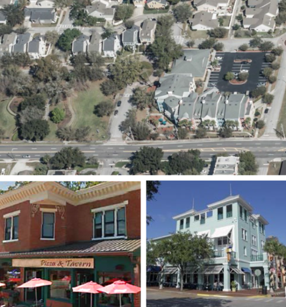
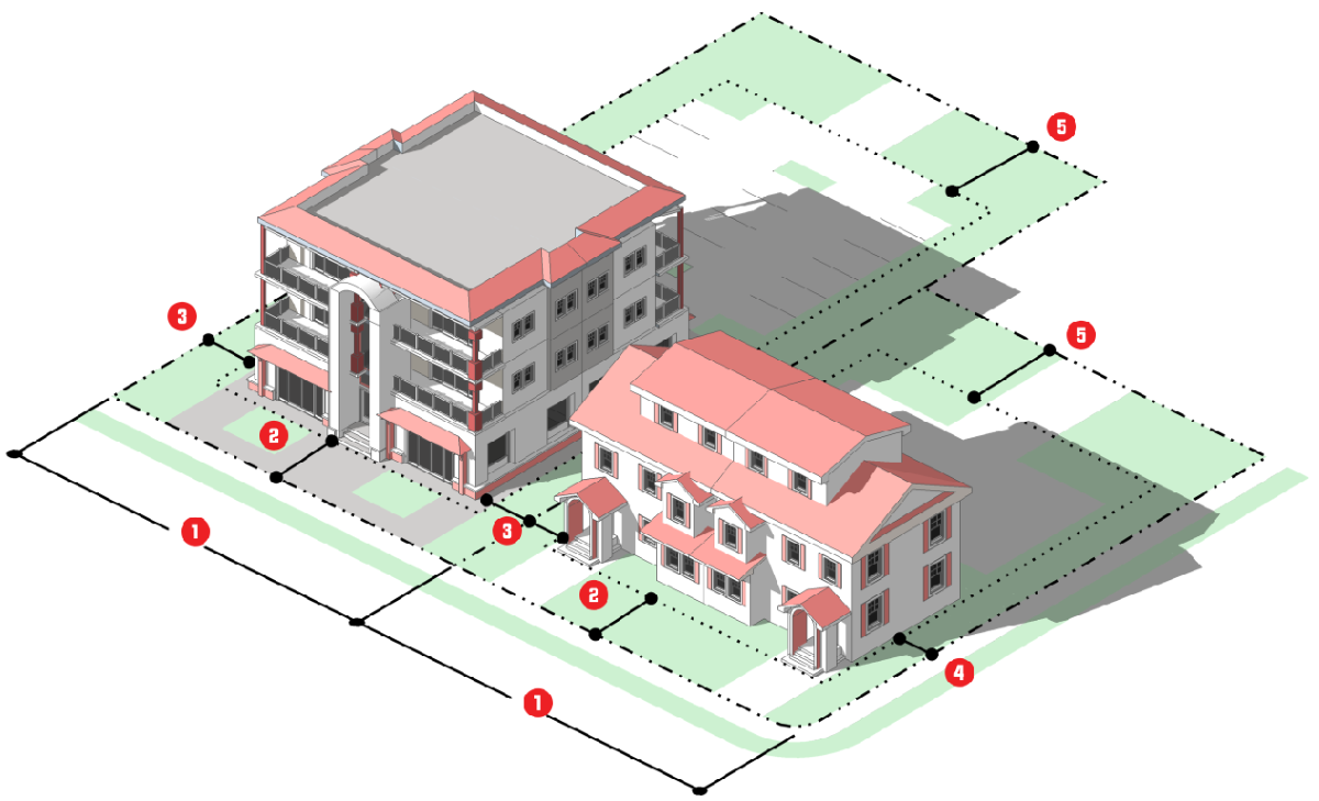
3.6.3. - MU-D: Mixed-Use Downtown District
A.
Purpose. The purpose of the MU-D: Downtown - Mixed Use district is to provide lands that accommodate downtown Apopka as a center of commerce, government, and culture. Principal types of development include higher intensity government, commercial, and employment uses, as well and higher density residential development, and mixed-uses, all in a form that is attractive, pedestrian-friendly, and supports multiples modes of mobility. Allowed uses include offices, retail services, personal services, recreation/entertainment, communication, education, health care, visitor accommodation, eating and drinking establishments, multi-family and townhome dwellings, and mixed-use. (See Appendix F: Downtown Overlays)

B.
Use Standards. Allowed uses and use-specific standards for principal, accessory, and temporary uses are established in Article 4: Use Regulations.
C.
Intensity and Dimensional Standards
| Standard | Residential | All Other Uses [7] | |
|---|---|---|---|
| Lot Area, min. (sf.) | 5,000 | Not applicable | |
| Living Area, min. (sf) |
1,350 SF
750 MF (1 bd) 900 MF (2+ bd) | Not applicable | |
| Lot Width, min. (ft.) | 50 | Not applicable | |
| Build-to-Line, min./max.(ft.) | 20/25 [1] [2] | 0 [3] | |
| Building width at build-to-line, min. (% of lot width) | 60 [2][4] | 60 | |
| Front Yard Setback, min. (ft.) | See 2 above | 10' or [1] [2] | |
| Side Yard Setback, min. (ft.) | 5 | [7] | |
| Corner Side Yard Setback, min. (ft.) | See 2 above | 10' or [1] [2] | |
| Rear Yard Setback, min. (ft.) | 20 | [7] | |
| Building Height, max. (ft.) | 55 | 55 | |
| Density, max (dus/acre) | [5] | Not applicable | |
| Floor Area Ratio (FAR), max. | Not applicable | 2.0 [6] | |
| Notes: sf. = square feet; ft. = feet; min.= minimum; max.= maximum
[1] The front setback line of the principal structure shall be equal to or average of the existing neighboring structures on a specific block; the build-to line is intended to create an even building façade line along a street. [2] Where existing buildings along street frontage are all located behind the build-to-line, the buildings may not be extended to the rear or side unless they are first extended frontwards to comply with the maximum build-to-line standard, and the minimum building width at the build-to-line standard. [3] Setbacks up to 30 feet from the build-to-line are allowed for civic space or outdoor dining, as long as they demarcate the build-to-line by some additional feature. [4] The build-to-line width remaining where there are no buildings may be occupied by outdoor gathering spaces, outdoor dining areas, walkways, landscaped areas, stormwater management facilities that use low impact development techniques. [5] Applicable to a residential development, and the residential component of a mixed-use development. [6] Applicable to a nonresidential development and the nonresidential component of a mixed-use development. [7] "All Other Use" - for the MU-D Mixed-Use Downtown, please refer to the Comprehensive Plan's Future Land Use for the primary land use. (e.g. commercial, residential, industrial, mixed-use, etc.) The MU-D provides for mixed use opportunities. The various zoning districts that are outlined in Article 1, Table 1.8.1 Transition to New Zoning Districts, shall provide the setback guidance within the MU-D for those various Comprehensive Plan Future Land Uses. A building setback line shall be 0 to 25 feet unless otherwise determined inappropriate for a specific site by the Community Development Director. As an option, the Build-to-line may be adhered to in order to keep the existing setbacks in a block(s) to keep a new building or development compatible with the surrounding area. The Community Development Director shall make the final determination for setbacks. | |||
D.
Other Standards
E.
Reference to Other Standards
Article 5: Development Standards
Section 5.1 Off-Street Parking, Bicycle Parking, and Loading Standards
Section 5.2 Landscaping and Buffer Standards
Section 5.3 Tree Protection Standards
Section 5.4 Open Space Set-Aside Standards
Section 5.5 Fences and Walls
Section 5.6 Exterior Lighting
Section 5.7 Development Design Guidelines
Section 5.8 Neighborhood Compatibility Standards
Section 5.9 Agricultural Compatibility Standards
Section 5.10 Signs
Section 5.11 Green Building Standards
Section 5.12 Green Building Incentives
Section 5.13 Roads, Streets, Sidewalks, and Bikeways
Section 5.14 Utilities
Section 5.15 Guarantees and Sureties
Section 5.16 Miscellaneous Standards
Article 6: Environmental Standards
Article 7: Concurrency Management System
(Ord. No. 2745, § 4, 1-15-2020; Ord. No. 2994, § VI, 3-15-2023; Ord. No. 3021, § III, 9-20-2023)
3.6.4. - MU-ES: Mixed-Use East Shore District
A.
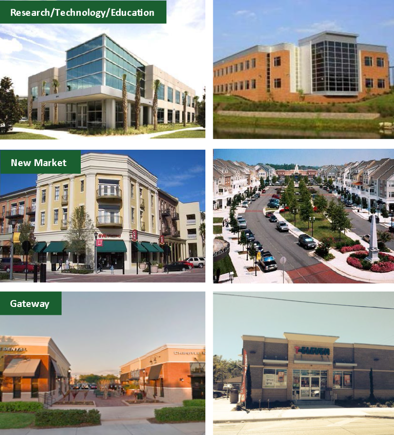
Purpose. The purpose of the MU-ES: Mixed-Use East Shore District is to provide lands that support the Ocoee Apopka Road Small Area Plan as a mixed-use, pedestrian-friendly showcase corridor that encourages mixed-use development at higher densities and intensities. The districts may also be applied outside of the area covered by the small area plan. Three sub districts are located within the MU-ES district: The MU-ES-RTE: The Mixed-Use East Shore-Research/Technology/Education subdistrict, provides for a higher intensity mix of light industrial, office, and employment uses. The MU-ES-NM: The Mixed-Use East Shore-New Market subdistrict supports the creation of a village center that supports a mix of retail, office and residential uses with a strong pedestrian form. The MU-ES-GT: The Mixed-Use East Shore-Gateway subdistrict, provides lands that connect to the New Market subdistrict that support a larger block structure, and permit a range of uses including multi-family, retail, light industrial, gas stations and large-scale retail development when outparcels frame the street.
B.
Use Standards. Allowed uses and use-specific standards for principal, accessory, and temporary uses are established in Article 4: Use Regulations.
3.6.5. - MU-ES-RTE: Mixed Use East Shore-Research/Technology/Education Subdistrict
A.
Purpose. The purpose of the MU-ES-RTE: Mixed-Use East Shore-Research/Technology/Education
subdistrict is to provide lands for a higher intensity mix of light industrial, office,
educational, research and development, and employment uses, that are pedestrian-friendly,
well connected, and support multiple modes of mobility. Multifamily and townhomes
are also allowed in the subdistrict, and mixed-use development is encouraged. The
subdistrict's primary focus is to provide opportunities and support research and development
opportunities and a range of educational facilities.
Street and block layout has a larger footprint to support these range of uses in instances
where they prefer a campus-like setting.

B.
Use Standards. Allowed uses and use-specific standards for principal, accessory, and temporary uses are established in Article 4: Use Regulations.
C.
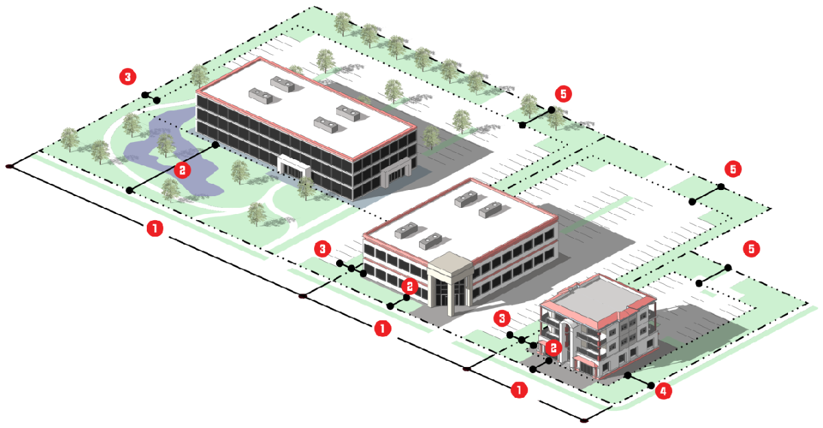
Intensity and Dimensional Standards, MU-ES-RTE (Research/Technology/Education)
| Standard | Townhome | Multi-Family | All Other Uses | |
|---|---|---|---|---|
| Lot Area, min. (sf.) | 8,000 | 8,000 | 6,000 | |
| Living Area, min. (sf per unit) | 1,000 | 750 | Not applicable | |
| Lot Width, min. (ft.) | 50 | 100 | 50 | |
| Front Yard Setback, min. and max. (ft.) | 15 min. | 15 min./80 max.[1] | 15 min./80 max.[1] | |
| Building width in build-to-zone, min (% of lot width) | 50 | 50 [2][3] | 50 [2][3] | |
| Side Yard Setback, min. (ft.) | 7.5 [4] | 10 [4] | 10 | |
| Corner Side Yard Setback, min. (ft.) | 7.5 | 20 | 20 | |
| Rear Yard Setback, min. (ft.) | 20 | 25 | 25 | |
| Building Height, max. (ft.) | 35 | 35 | 50 [5] | |
| Density, max (dus/acre) | 10 [6] | 15 [6][7] | Not applicable | |
| FAR, min. and max. | Not applicable | Not applicable | 0.25 min./1.0 max.[8] | |
| Notes: sf. = square feet; ft. = feet; min.= minimum; max.= maximum
[1] The area between the minimum and maximum build-to-lines that extends the width of the lot constitutes the building-to zone [2] Where existing buildings along street frontage are all located behind the build-to-zone, the buildings may not be extended to the rear or side unless they are first extended frontwards to comply with the maximum build-to-line standards, and the minimum building width in the build-to-zone standard. [3] The remaining build-to-zone width may be occupied by outdoor gathering spaces, outdoor dining areas, walkways, landscaped areas, stormwater management facilities that use low impact development techniques. [4] Minimum of 15 ft. between structures, only applies to exterior units. [5] Additional height, up to seven stories may be approved as a special exception permit in accordance with Sec. 2.5.1.G, Special Exception Permit. [6] Residential development north of Ponkan Road and west of Rock Springs Road (Park Avenue) will be restricted to no more than 2 DUs per acre, unless otherwise authorized through the adopted Wekiva Parkway Interchange Plan. [7] Applicable to a residential development, and the residential component of a mixed-use development. [8] Applicable to a nonresidential development, and the nonresidential component of a mixed-use development. | ||||
D.
Other Standards, MU-ES-RTE (Research/Technology/Education)
E.
Reference to Other Standards
Article 5: Development Standards
Section 5.1 Off-Street Parking, Bicycle Parking, and Loading Standards
Section 5.2 Landscaping and Buffer Standards
Section 5.3 Tree Protection Standards
Section 5.4 Open Space Set-Aside Standards
Section 5.5 Fences and Walls
Section 5.6 Exterior Lighting
Section 5.7 Development Design Guidelines
Section 5.8 Neighborhood Compatibility Standards
Section 5.9 Agricultural Compatibility Standards
Section 5.10 Signs
Section 5.11 Green Building Standards
Section 5.12 Green Building Incentives
Section 5.13 Roads, Streets, Sidewalks, and Bikeways
Section 5.14 Utilities
Section 5.15 Guarantees and Sureties
Section 5.16 Miscellaneous Standards
Article 6: Environmental Standards
Article 7: Concurrency Management System
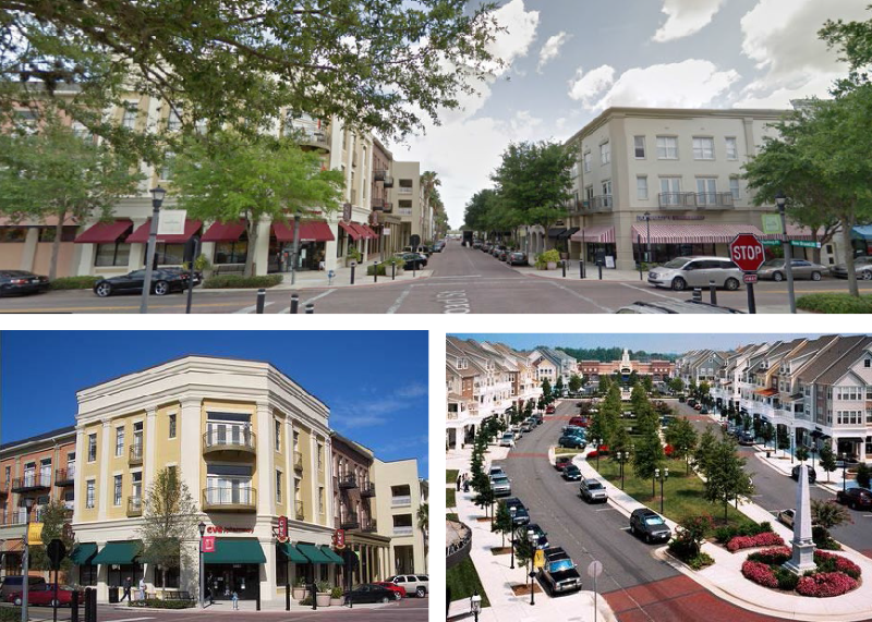
3.6.6. - MU-ES-NM: Mixed Use East Shore-New Market Subdistrict
A.
Purpose. The purpose of the MU-ES-NM: Mixed-Use East Shore-New Market subdistrict is to provide lands that support a walkable, high intensity/density village center that is well connected and supports multiple modes of mobility. A mix of retail, office and residential uses is allowed. The subdistrict encourages the development of ground floor retail and restaurants, with residential on the upper floors. The subdistrict allows for a wide range of uses including retail, office, multifamily, townhome, two-family, and light industrial (high tech) uses. Form and scale focuses predominately on the pedestrian.
B.
Use Standards. Allowed uses and use-specific standards for principal, accessory, and temporary uses are established in Article 4: Use Regulations.
C.
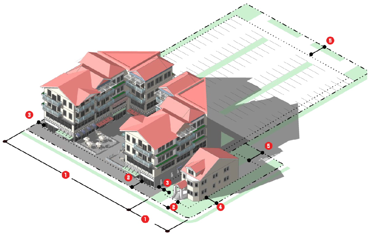
Intensity and Dimensional Standards, MU-ES-NM (New Market)
| Standard | Single-family [one du] | Two-Family & Townhome | Multi-Family | All Other Uses | |
|---|---|---|---|---|---|
| Lot Area, min. (sf.) | 5,000 | 7,000 | 8,000 | 5,000 | |
| Living Area, min. (sf per unit) | 1,200 | 1,000 | 750 | Not applicable | |
| Lot Width, min. (ft.) | 40 [1] | 50 | 75 | 50 | |
| Front Yard Setback, min. and max. (ft.) | 15 min. | 15 min./30 max. [2] | 10 min./30 max. [2] | 10 min./30 max. [2] | |
| Building width in build-to-zone, min (% of lot width) | 80 | 80 [3] | 80 [3] | 80 [3] | |
| Side Yard Setback, min. (ft.) | 4 min; 10 total | 7.5 [4] | 15 [4] | 5 | |
| Corner Side Yard Setback, min. (ft.) | 15 | 7.5 | Not applicable | Not applicable | |
| Rear Yard Setback, min. (ft.) | 20 | 20 | 15 | 5 | |
| Building Height, max. (ft.) | 35 | 45 | 50 | 50 [5] | |
| Density, max. (dus/acre) | 8 [6] | 12 [6][7] | 15 [6][7] | Not applicable | |
| FAR, min. and max. | Not applicable | Not applicable | Not applicable | 0.25 min./1.0 max.[8] | |
| Notes: sf. = square feet; ft. = feet; min.= minimum; max.= maximum; du=dwelling unit
[1] A minimum of two-thirds of the lots for single-family detached dwellings with a width of 50 feet or less shall gain vehicle access by a rear alley. [2] The area between the minimum and maximum build-to-lines that extends the width of the lot constitutes the build-to-zone. [3] The remaining build-to-zone width may be occupied by outdoor gathering spaces, outdoor dining areas, walkways, landscaped areas, stormwater management facilities that use low impact development techniques. [4] Minimum of 15' between structures, only applies to exterior units. [5] Additional height, up to seven stories may be approved as a special exception permit in accordance with Sec. 2.5.1.G, Special Exception Permit. [6] Residential development north of Ponkan Road and west of Rock Springs Road (Park Avenue) will be restricted to no more than 2 DUs per acre, unless otherwise authorized through the adopted Wekiva Parkway Interchange Plan. [7] Applicable to a residential development, and the residential component of a mixed-use development. [8] Applicable to a nonresidential development, and the nonresidential component of a mixed-use development. | |||||
D.
Other Standards, MU-ES-NM (New Market)
E.
Reference to Other Standards
Article 5: Development Standards
Section 5.1 Off-Street Parking, Bicycle Parking, and Loading Standards
Section 5.2 Landscaping and Buffer Standards
Section 5.3 Tree Protection Standards
Section 5.4 Open Space Set-Aside Standards
Section 5.5 Fences and Walls
Section 5.6 Exterior Lighting
Section 5.7 Development Design Guidelines
Section 5.8 Neighborhood Compatibility Standards
Section 5.9 Agricultural Compatibility Standards
Section 5.10 Signs
Section 5.11 Green Building Standards
Section 5.12 Green Building Incentives
Section 5.13 Roads, Streets, Sidewalks, and Bikeways
Section 5.14 Utilities
Section 5.15 Guarantees and Sureties
Section 5.16 Miscellaneous Standards
Article 6: Environmental Standards
Article 7: Concurrency Management System
3.6.7. - MU-ES-GT: Mixed-Use East Shore-Gateway Subdistrict
A.
Purpose. The purpose of the MU-ES-GT: Mixed-Use East Shore-Gateway subdistrict, is to serve as a gateway to the MU-ES-NM subdistrict, with uses that are more suburban in character but are developed in a more walkable and pedestrian-friendly form. Subdistrict streets, while supporting a larger block structure than the other subdistricts, are well connected and support multiple modes of mobility. The subdistrict allows for a range of uses including multi-family, retail, light industrial, gas stations, and large scale retailers when outparcels frame the street.
B.
Use Standards. Allowed uses and use-specific standards for principal, accessory, and temporary uses are established in Article 4: Use Regulations.
C.
Intensity and Dimensional Standards, MU-ES-GT (Gateway)
| Standard | Single-family [one du] | Two-Family & Townhome | Multi-Family | All Other Uses | |
|---|---|---|---|---|---|
| Lot Area, min. (sf.) | 7,500 | 8,000 | 8,000 | 7,500 | |
| Living Area, min. (sf per unit) | 1,350 | 1,000 | 750 | Not applicable | |
| Lot Width, min. (ft.) | 70 | 50 | 100 | 75 | |
| Front Yard Setback, min. and max.(ft.) | 25 min. | 15 min. | 15 min./80 max.[1] | 15 min./80 max.[1] | |
| Building width in build-to-zone, min (% of lot width) | 60 | 60 | 60 [2] | 60 [2] | |
| Side Yard Setback, min. (ft.) | 7.5 [3] | 7.5 [3] | 10 [3] | 10 [3] | |
| Corner Side Yard Setback, min. (ft.) | 20 | 7.5 | 20 | 20 | |
| Rear Yard Setback, min. (ft.) | 25 | 20 | 25 | 10 | |
| Building Height, max. (ft.) | 35 | 35 | 45 | 45 | |
| Density, max (dus/acre) | 5 [4] | 10 [4] | 15 [4][5] | Not applicable | |
| FAR, min. and max. | Not applicable | Not applicable | Not applicable | 0.25 min./1.0 max. [6] | |
| Notes: sf. = square feet; ft. = feet; min.= minimum; max.= maximum; du = dwelling unit
[1] The area between the minimum and maximum build-to-lines that extends the width of the lot constitutes the build-to-zone. [2] The remaining build-to-zone width may be occupied by outdoor gathering spaces, outdoor dining areas, walkways, landscaped areas, stormwater management facilities that use low impact development techniques. [3] Minimum of 15 ft. between structures, only applies to exterior units. [4] Residential development north of Ponkan Road and west of Rock Springs Road (Park Avenue) will be restricted to no more than 2 DUs per acre, unless otherwise authorized through the adopted Wekiva Parkway Interchange Plan. [5] Applicable to a residential development, and the residential component of a mixed-use development. [6] Applicable to a nonresidential development, and the nonresidential component of a mixed-use development. | |||||
D.
Other Standards, MU-ES-GT (Gateway)
E.
Reference to Other Standards
Article 5: Development Standards
Section 5.1 Off-Street Parking, Bicycle Parking, and Loading Standards
Section 5.2 Landscaping and Buffer Standards
Section 5.3 Tree Protection Standards
Section 5.4 Open Space Set-Aside Standards
Section 5.5 Fences and Walls
Section 5.6 Exterior Lighting
Section 5.7 Development Design Guidelines
Section 5.8 Neighborhood Compatibility Standards
Section 5.9 Agricultural Compatibility Standards
Section 5.10 Signs
Section 5.11 Green Building Standards
Section 5.12 Green Building Incentives
Section 5.13 Roads, Streets, Sidewalks, and Bikeways
Section 5.14 Utilities
Section 5.15 Guarantees and Sureties
Section 5.16 Miscellaneous Standards
Article 6: Environmental Standards
Article 7: Concurrency Management System
(Ord. No. 2877, § VIII, 12-15-2021)
3.6.8. - MU-KPI: Kelly Park Interchange District Mixed-Use
The MU-KPI: Kelly Park Interchange District Mixed-Use is found in Appendix A, which is incorporated here by reference.
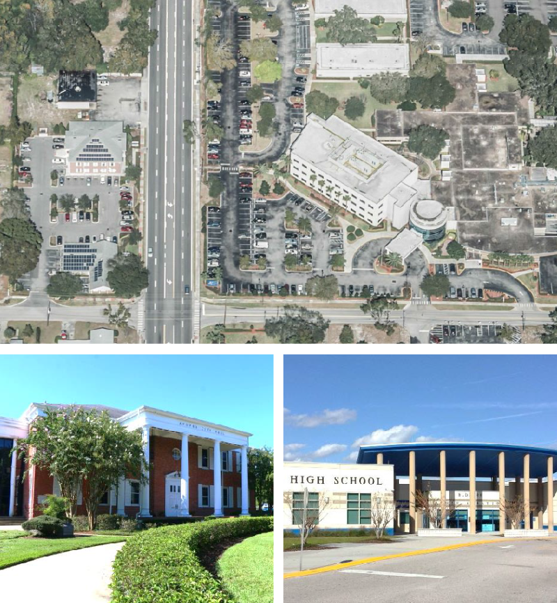
3.6.9. - INST: Institutional District
A.
Purpose. The purpose of the INST: Institutional district is to provide lands that accommodate institutional uses typically developed on larger sites such as elementary, middle, and high schools, cultural facilities, government offices, post offices, and colleges. Development may include the grouping of multiple institutional buildings, and inter-related public, private, and nonprofit development. District standards are intended to protect surrounding residential uses from incompatible development.
B.
Use Standards. Allowed uses and use-specific standards for principal, accessory, and temporary uses are established in Article 4: Use Regulations.
C.
Intensity and Dimensional Standards
| Standard | All Other Uses | |
|---|---|---|
| Lot Area, min. (sf.) | 10,000 | |
| Lot Width, min. (ft.) | 85 | |
| Front Yard Setback, min. (ft.) | 25 | |
| Side Yard Setback, min. (ft.) | 10 | |
| Corner Side Yard Setback, min. (ft.) | 25 | |
| Rear Yard Setback, min. (ft.) | 10/25 [1] | |
| Building Height, max. (ft.) | 35 | |
| Density, max (dus/acre) | Not applicable | |
| Floor Area Ratio (FAR), max. | 0.30 | |
| Notes: sf. = square feet; ft. = feet; min.= minimum; max.= maximum
[1] Twenty-five (25) feet when adjacent to a residential use or a Residential district. | ||
D.
Reference to Other Standards
Article 5: Development Standards
Section 5.1 Off-Street Parking, Bicycle Parking, and Loading Standards
Section 5.2 Landscaping and Buffer Standards
Section 5.3 Tree Protection Standards
Section 5.4 Open Space Set-Aside Standards
Section 5.5 Fences and Walls
Section 5.6 Exterior Lighting
Section 5.7 Development Design Guidelines
Section 5.8 Neighborhood Compatibility Standards
Section 5.9 Agricultural Compatibility Standards
Section 5.10 Signs
Section 5.11 Green Building Standards
Section 5.12 Green Building Incentives
Section 5.13 Roads, Streets, Sidewalks, and Bikeways
Section 5.14 Utilities
Section 5.15 Guarantees and Sureties
Section 5.16 Miscellaneous Standards
Article 6: Environmental Standards
Article 7: Concurrency Management System
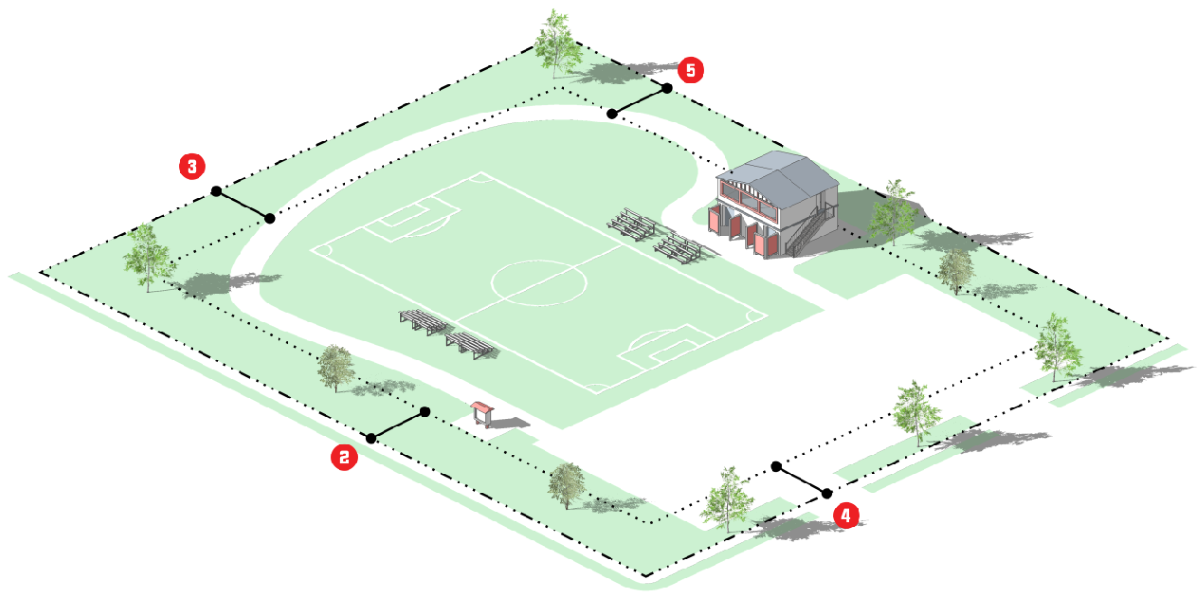
3.6.10. - PR: Parks and Recreation District
A.
Purpose. The purpose of the PR: Parks and Recreation district is to provide lands to accommodate the preservation and protection of publicly owned active park and recreation lands, passive open space lands, and publicly owned lands that preserve significant natural features and environmentally sensitive areas. District standards limit development in these areas in order to preserve the City's natural, scenic, and recreational assets, ensure their proper functioning, and promote visitor enjoyment.
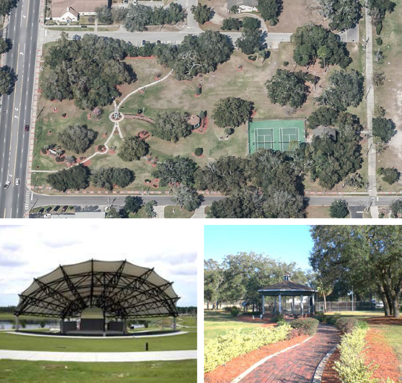
B.
Use Standards. Allowed uses and use-specific standards for principal, accessory, and temporary uses are established in Article 4: Use Regulations.
C.
Intensity and Dimensional Standards
| Standard | All Other Uses | |
|---|---|---|
| Lot Area, min. (sf.) | No Applicable | |
| Lot Width, min. (ft.) | Not applicable | |
| Front Yard Setback, min. (ft.) | 25 | |
| Side Yard Setback, min. (ft.) | 25 | |
| Corner Side Yard Setback, min. (ft.) | 25 | |
| Rear Yard Setback, min. (ft.) | 25 | |
| Building Height, max. (ft.) | 35 | |
| Density, max (dus/acre) | Not applicable | |
| Floor Area Ratio (FAR), max. | Not applicable | |
| Notes: sf. = square feet; ft. = feet; min.= minimum; max.= maximum
| ||
D.
Reference to Other Standards
Article 5: Development Standards
Section 5.1 Off-Street Parking, Bicycle Parking, and Loading Standards
Section 5.2 Landscaping and Buffer Standards
Section 5.3 Tree Protection Standards
Section 5.4 Open Space Set-Aside Standards
Section 5.5 Fences and Walls
Section 5.6 Exterior Lighting
Section 5.7 Development Design Guidelines
Section 5.8 Neighborhood Compatibility Standards
Section 5.9 Agricultural Compatibility Standards
Section 5.10 Signs
Section 5.11 Green Building Standards
Section 5.12 Green Building Incentives
Section 5.13 Roads, Streets, Sidewalks, and Bikeways
Section 5.14 Utilities
Section 5.15 Guarantees and Sureties
Section 5.16 Miscellaneous Standards
Article 6: Environmental Standards
Article 7: Concurrency Management System
3.6.11. - AIR: Orlando Apopka Airport District
A.
Purpose
1.
It is hereby declared:
a.
That the creation or establishment of an airport hazard and the incompatible use of land in airport vicinities are public nuisances and injure the community served by the airport in question.
b.
That it is therefore necessary in the interest of the public health, public safety, and general welfare that the creation or establishment of airport hazards and incompatible land uses be prevented; and
c.
That this should be accomplished, to the extent legally possible, by the exercise of the police power, without compensation.
2.
It is further declared that the limitation of land uses incompatible with normal airport operations, the prevention of the creation or establishment of airport hazards, and the elimination, removal, alteration, mitigation, or marking and lighting of existing airport hazards are public purposes for which the City of Apopka may raise and expend public funds and acquire land or property interests therein, or air rights thereover.
3.
Reasonableness. All airport zoning regulations adopted under the Orlando Apopka Zoning District Regulations or future ordinances shall be reasonable and may not impose any requirement or restriction which is not reasonably necessary to effectuate the purposes of the Orlando Apopka Zoning District Regulations. In determining reasonable regulations, the City of Apopka shall consider, among other things, the character of the flying operations expected to be conducted at the airport, the nature of the terrain within the airport hazard area and runway protection zones, the character of the neighborhood, the uses to which the property to be zoned is put and adaptable, and the impact of any new use, activity, or construction on the airport's operating capability and capacity.
4.
In the event that the City of Apopka has adopted, or hereafter adopts, a comprehensive plan or policy regulating, among other things, the height of buildings, structures, and natural objects, and uses of property, any airport zoning regulations applicable to the same area or portion thereof may be incorporated in and made a part of such comprehensive plan or policy, and be administered and enforced in connection therewith.
B.
Use Standards. Allowed uses and use-specific standards for principal, accessory, and temporary uses are established in Article 4: Use Regulations.
C.
Other Standards
1.
Community Development Director and Airport Manager
a.
The Community Development Director or designee in coordination with the Airport Manager shall administer all airport-zoning regulations adopted under the Orlando Apopka Zoning District Regulations.
b.
The Community Development Director or designee and the City of Apopka Code Enforcement shall enforce all airport-zoning regulations adopted under this section.
c.
The duties of the Community Development Director or designee pursuant to this Orlando Apopka Zoning District Regulations shall include:
1.
Deciding all permits under Sec. 333.07(1), Fla. Stat.,
2.
Deciding all matters under Sec. 333.07(3), Fla. Stat., as they pertain to the Airport,
3.
And all other matters under this section applying to the Community Development Director or designee.
d.
The Community Development Director or designee shall not have or exercise any of the powers herein delegated to the City of Apopka Planning Commission to hear and decide appeals.
2.
Land Use Compatibility.
a.
Plans Adopted by Reference For the purpose of ensuring land use, zoning and development compatibility within and near the boundaries of the airport, a master plan for the Orlando Apopka Airport, as amended, and all building, zoning, development and land use plans, codes and regulations, including the City of Apopka Code of Ordinances and City of Apopka Comprehensive Plan, and Florida Building Code as amended, are hereby adopted and incorporated by reference and shall govern all development, construction, permitting, variance and actions not specifically delineated herein.
b.
Review Considerations. Airport land use compatibility regulations shall be reviewed with consideration for the following:
1.
Whether sanitary landfills are located within the following areas:
(a)
Within 10,000 feet from the nearest point of any runway used or planned to be used by turbojet or turboprop aircraft. (Refer to Maps.)
(b)
Within 5,000 feet from the nearest point of any runway used only by piston-type aircraft. (Refer to Maps.)
(c)
Civil airport imaginary surfaces defined in Title 14 of the Code of Federal Regulations (14 CFR) part 77.25. A case-by-case review of such landfills shall be performed.
c.
Landfills and birds. Where any landfill is located and constructed that attracts or sustains hazardous bird movements from feeding, water, or roosting areas into, or across, the runways or approach and departure patterns of aircraft. The landfill operator must incorporate bird management techniques or other practices to minimize bird hazards to airborne aircraft.
d.
Noise Studies, Complete. Where the City of Apopka has conducted a noise study in accordance with the provisions of 14 CFR part 150, neither residential construction nor any educational facility as defined in the Orlando Apopka Zoning District Regulations with the exception of aviation school facilities, shall be permitted within the area contiguous to the airport defined by an outer noise contour that is considered incompatible with that type of construction by 14 CFR, part 150, or an equivalent noise level as established by other types of noise studies.
e.
Noise Studies, Incomplete. Where the City of Apopka has not conducted a noise study, neither residential construction nor any educational facility as defined in this Code, with the exception of aviation school facilities, shall be permitted within an area contiguous to the airport measuring one half the length of the longest runway on either side of and at the end of each runway centerline.
f.
Incompatible Uses. New incompatible uses, activities, or construction within runway clear zones, within runway clear zones (See Appendix E.) including uses activities, or construction in runway clear zones which are incompatible with normal airport operations or endanger public health, safety, and welfare by resulting in congregations of people, emissions of light or smoke, or attraction of birds shall be restricted.
g.
Educational Facilities.
1.
The construction of an educational facility of a public or private school at either end of a runway, within an area which extends five miles in a direct line along the centerline of the runway, and which has a width measuring one-half the length of the runway is prohibited.
2.
This subsection may not be construed to require the removal, alteration, sound conditioning, or other change, or to interfere with the continued use or adjacent expansion of any educational facility or site in existence on July 1, 1993
h.
Exceptions. Exceptions approving construction of an educational facility within the delineated area shall only be granted when the City of Apopka makes specific findings detailing how the public policy reasons for allowing the construction outweigh health and safety concerns prohibiting such a location.
i.
FDOT Compliance. The City of Apopka shall provide a copy of all airport protection zoning regulations and airport land use compatibility zoning regulations, and any related amendments, to FDOT's aviation office within 30 days after adoption.
j.
More Restrictive. This section does not prohibit the City of Apopka, from establishing airport zoning regulations more restrictive than prescribed in Ch. 333, Fla. Stat., in order to protect the health, safety, and welfare of the public in the air and on the ground.
k.
Permitted Uses. Site improvements may be required if determined by the Community Development Department and subject to requirements and standards by FDOT and FAA
1.
Aircraft operation, including heliports.
2.
Flight instruction and aviation school facility.
3.
Aircraft rental.
4.
Aircraft charter and taxi service.
5.
Aircraft engine and accessory maintenance.
6.
Aeronautical radio and instrument operations.
7.
Hangar rental service.
8.
Aviation service, light repair and restoration.
9.
Aircraft tire sales and repair.
10.
Aircraft sales and brokerage.
11.
Aviation-related administrative offices.
12.
Other uses which are similar and compatible to the uses permitted herein which adhere to the intent of the district and which are not prohibited as specified in this code. Use determination shall be based upon the Community Development Director's determination.
l.
Prohibited Uses.
1.
Any residential use.
2.
Automobile or vehicle service and repair.
3.
Schools, Places of Worship and any other institutional uses not related to airport or aviation-related business.
4.
Commercial and office uses not considered an aviation-related business.
5.
Outside storage of parts, materials, equipment, automobiles, trailers, boats, etc.
6.
Telecommunications towers not associated with airport use or navigation.
7.
All other uses which do not meet the stated purpose of this district and prohibited by Ch. 333, Florida Statutes.
3.
Permitting Requirements
a.
Permit Required. A permit shall be obtained before any new structure or use may be constructed or established and before any existing use or structure may be substantially changed or substantially altered or repaired; such permit shall be obtained from the City of Apopka Community Development Department, Building Division in coordination with the Airport Manager and in conjunction with FAA requirements and procedures.
1.
The FAA Notice Criteria Tool and Obstruction Evaluation/Airport Analysis tools are hereby adopted, as amended from time to time, by reference at the following website: https://oeaaa.faa.gov/oeaaa/external/gisTools/gisAction.jsp?action=showNoNoticeRequiredToolForm
(a)
If the Notice Criteria Tool indicates that the proposed construction or alteration does not exceed Notice criteria standards (Part 77, subpart B), it is not required to file a Notice with the FAA (FAA form 7460-1) and the Notice Criteria Tool response should be submitted to the IDA board which will determine whether an airport zoning permit may be required due to other airport zoning issues such as land use; or
(b)
If the Notice Criteria Tool response indicates that the proposed construction or alteration does exceed Notice criteria standards (Part 77, subpart B) and/or that the FAA requests the filing of a notice, the applicant shall prepare and submit the Notice (FAA form 7460-1) manually or by utilizing the electronic submittal process at the FAA website: (https://www.faa.gov/documentLibrary/media/Form/FAA_Form_7460-1_AJV-1-050117.pdf). The Notice form must be submitted at least 45 days before the start date of the proposed construction or alteration or the date an application for a construction permit is filed, whichever is earliest. (14 C.F.R. s. 77.7)
b.
FDOT Compliance. Proposals for the construction or alteration of an obstruction must obtain a permit from Florida Department of Transportation (FDOT), subject to subsections (c), (d), and (e). However, permits from FDOT will be required only within an airport hazard area where federal obstruction standards are exceeded and if the proposed construction or alteration is within a 10-nautical-mile radius of the airport reference point, located at the approximate geometric center of all usable runways of a public-use airport or military airport.
c.
Permit Exceptions. A permit is not required for existing structures that received construction permits from the Federal Communications Commission for structure exceeding federal obstruction standards before May 20, 1975; a permit is not required for any necessary replacement or repairs to such existing structures if the height and location are unchanged.
d.
Marking and Lighting. In issuing a permit under this section, the City of Apopka shall require the owner of the obstruction to install, operate, and maintain thereon, at his or her own expense, marking and lighting in conformance with the specific standards established by the Federal Aviation Administration.
e.
Permit Processing. Upon receipt of a complete permit application, the City of Apopka shall provide a copy of the application to FDOT's aviation office by certified mail, return receipt requested, or by a delivery service that provides a receipt evidencing delivery. To evaluate technical consistency with this subsection, FDOT shall have a 15-day review period following receipt of the application, which must run concurrently with the City of Apopka permitting process. Cranes, construction equipment, and other temporary structures in use or in place for a period not to exceed 18 consecutive months are exempt from FDOT's review, unless such review is requested by FDOT.
f.
FDOT Review. FDOT shall issue or deny a permit for the construction or alteration of an obstruction. The department shall review permit applications in conformity with Sec. 120.60, Fla. Stat. In determining whether to issue or deny a permit, the department shall consider:
1.
The safety of persons on the ground and in the air.
2.
The safe and efficient use of navigable airspace.
3.
The nature of the terrain and height of existing structures.
4.
The effect of the construction or alteration of an obstruction on the state licensing standards for a public-use airport contained in Florida Statutes Chapter 330 and rules adopted thereunder.
5.
The character of existing and planned flight operations and developments at public-use airports.
6.
Federal airways, visual flight rules, flyways and corridors, and instrument approaches as designated by the Federal Aviation Administration.
7.
The effect of the construction or alteration of an obstruction on the minimum descent altitude or the decision height at the affected airport.
8.
The cumulative effects on navigable airspace of all existing obstructions and all known proposed obstructions in the area.
g.
Permit Approval. Except as provided herein, applications for permits shall be granted, provided the matter applied for meets the provisions of the City of Apopka Airport Zoning, the Ch. 333, Fla. Stat., Title 14 of the Code of Federal Regulations (14 CFR) and the all other regulations adopted and in force hereunder.
4.
Signage
a.
Freestanding sign shall be a monument type sign and shall comply with standards set forth in Sec. 5.10, Signs.
b.
One wall sign is permitted for each hangar.
1.
Wall sign shall not exceed four (4) square feet in copy area.
5.
Nonconforming Uses or Structures
a.
Continuance. The regulations promulgated herein shall not be construed to require removal, lowering, or other change or alteration of any obstruction not conforming to the regulation when adopted or amended, or otherwise interfere with the continuance of any nonconforming use, except as provided in Sec. 333.07(1) and (3), Fla. Stat..
b.
Applications. Applications proposing to construct, alter, or allow an airport obstruction in an airport hazard area in violation of the airport protection zoning regulations adopted under this chapter must apply for a permit. A permit may not be issued if it would allow the establishment or creation of an airport hazard or if it would permit a nonconforming obstruction to become a greater hazard to air navigation than it was when the applicable airport protection zoning regulation was adopted which allowed the establishment or creation of the obstruction, or than it is when the application for a permit is made.
c.
Abandonment. If the Community Development Department determines that a nonconforming obstruction has been abandoned or is more than 80 percent torn down, destroyed, deteriorated, or decayed, a permit may not be granted if it would allow the obstruction to exceed the applicable height limit or otherwise deviate from the airport protection zoning regulations. Whether or not an application is made for a permit under this subsection, the owner of the nonconforming obstruction may be required, at his or her own expense, to lower, remove, reconstruct, alter, or equip such obstruction as may be necessary to conform to the current airport protection zoning regulations. If the owner of the nonconforming obstruction neglects or refuses to comply with such requirement for 10 days after notice, the administrative agency may report the violation to the political subdivision involved, which subdivision, through its appropriate agency, may proceed to have the obstruction so lowered, removed, reconstructed, altered, or equipped and assess the cost and expense thereof upon the owner of the obstruction or the land whereon it is or was located.
d.
Compliance. If the owner of the nonconforming structure or tree shall neglect or refuse to comply with such order for 10 days after notice thereof, the Airport Manager may report the violation to the City of Apopka, which through its appropriate agency, may proceed to have the object so lowered, removed, reconstructed, or equipped, and assess the cost and expense thereof upon the object or the land whereon it is or was located, and, unless such an assessment is paid within 90 days from the service of notice thereof on the owner or the owner's agent, of such object or land, the sum shall be a lien on said land, and shall bear interest thereafter at the rate of 6 percent per annum until paid, and shall be collected in the same manner as taxes on real property are collected by the City of Apopka, or, at the option of the City of Apopka, said lien may be enforced in the manner provided for enforcement of liens by Ch. 85, Fla. Stat., as amended.
e.
Hazards. If a nonconforming obstruction is determined to be an airport hazard and the owner will not remove, lower, or otherwise eliminate it or the approach protection necessary cannot, because of constitutional limitations, be provided by airport regulations under this entire section; or it appears advisable that the necessary approach protection be provided by acquisition of property rights rather than by airport zoning regulations, the City of Apopka may acquire, by purchase, grant, or condemnation in the manner provided by Ch. 73, Fla. Stat., as amended; such property, air right, navigation easement, or other estate, portion or interest in the property or nonconforming structure or use or such interest in the air above such property, tree, structure, or use, in question, as may be necessary to effectuate the purposes of this section, and in so doing, if by condemnation, to have the right to take immediate possession of the property, interest in property, air right, or other right sought to be condemned, at the time, and in the manner and form, and as authorized by Ch. 74, Fla. Stat., as amended. In the case of the purchase of any property or any easement or estate or interest therein or the acquisition of the same by the power of eminent domain the City of Apopka making such purchase or exercising such power shall in addition to the damages for the taking, injury or destruction of property also pay the cost of the removal and relocation of any structure or any public utility which is required to be moved to a new location.
6.
Public Notice. Airport zoning regulations may not be adopted, amended, or repealed except by action of the City of Apopka City Council, after a public hearing in relation thereto, at which parties in interest and citizens shall have an opportunity to be heard. Notice of the hearing shall be published at least once a week for two consecutive weeks in a newspaper of general circulation in the City of Apopka or subdivisions where the airport zoning regulations are to be adopted, amended, or repealed.
7.
Airport Zoning Commission
a.
Planning Commission Authority. The City of Apopka shall utilize the Apopka Planning Commission to act as the airport zoning commission for all matters pertaining to land use activities, modifications and appeals, in the same manner and authority as other property subject to the Planning Commission decisions as described in the City of Apopka Code of Ordinances as amended. In all airport issues, regulations or other matters heard by the Planning Commission in its authority to act as the airport zoning commission, the Commission shall have and exercise the following powers:
1.
To hear and decide appeals from any order, requirement, decision, or determination made by the Community Development Director or designee in the enforcement of the airport zoning regulations.
2.
To hear and decide any special exceptions to the terms of the airport zoning regulations upon which the Planning Commission may be required to pass under such regulations.
3.
The concurring vote of a majority of the members of the Planning Commission shall be sufficient to reverse any order, requirement, decision, or determination of the Community Development Director or designee, or to decide in favor of the applicant on any matter upon which it is required to pass under the airport zoning regulations, or to effect any variation in such regulations.
4.
The Planning Commission shall utilize rules in accordance with the provisions of the ordinance or resolution by which it was created. Meetings shall be held at the call of the chair and at such other times as the Commission may determine. The chair, or in the chair's absence the acting chair, may administer oaths and compel the attendance of witnesses, and all meetings shall be public. The Planning Commission shall keep minutes of its proceedings, showing the vote of each member upon each question, or, if absent or failing to vote, indicating such fact. The Planning Commission shall keep records of its examinations and other official actions, all of which shall be immediately filed in the office of the Planning and Zoning Division and shall be a public record.
8.
Appeals
a.
Who May Make Appeal. Any person aggrieved, or taxpayer affected, by any decision of the Community Development Director or designee made in its administration of airport zoning regulations adopted based on Ch. 333, Fla. Stat.; which is of the opinion that a decision of the Community Development Director or designee is an improper application of airport zoning regulations may appeal to the Planning Commission authorized to hear and decide appeals from the decisions of the Community Development Director or designee.
b.
Notice of Appeal. All appeals taken under this section must be taken within a reasonable time, as provided by the rules of the Planning Commission, by filing with the Community Development Department from which appeal is taken and with the Planning Commission, a notice of appeal specifying the grounds thereof. The Community Development Department shall forthwith transmit to the Planning Commission all the papers constituting the record upon which the action appealed from was taken, or properly certified copies thereof in lieu of originals.
c.
Stay of Proceedings. An appeal shall follow all proceedings in furtherance of the action appealed from, unless the Community Development Department or designee from which the appeal is taken certifies to the Planning Commission, after the notice of appeal has been filed with it, that by reason of the facts stated a stay of proceedings would, in its opinion, cause imminent peril to life or property. In such cases, proceedings shall not be stayed otherwise than by an order of the Planning Commission on notice to the Community Development Department on due cause shown.
d.
Notice and Time of Hearings. The Planning Commission shall fix a reasonable time for the hearing of appeals, give public notice and due notice to the parties in interest, and decide the same within a reasonable time. Upon the hearing, any party may appear in person or by agent or by attorney.
e.
Authority of Commission to Rule. The Planning Commission may, in conformity with the provisions of this entire section, reverse or affirm wholly or partly, or modify, the order, requirement, decision, or determination appealed from and may make such order, requirement, decision, or determination as ought to be made, and to that end shall have all the powers of the Community Development Department from which the appeal is taken.
9.
Judicial Review
a.
Time Limitation. Any person aggrieved, or taxpayer affected, by any decision of the Community Development Department, or the Planning Commission, may apply for judicial relief to the circuit court in the judicial circuit where the Planning Commission is located within 30 days after rendition of the decision by the Planning Commission. Review shall be by petition for writ of certiorari, which shall be governed by the Florida Rules of Appellate Procedure.
b.
Effect of Application. In any case in which airport zoning regulations adopted under this section, are held by a court to interfere with the use and enjoyment of a particular structure or parcel of land to such an extent, or to be so onerous in their application to such a structure or parcel of land, as to constitute a taking or deprivation of that property in violation of the State Constitution or the Constitution of the United States, such holding shall not affect the application of such regulations to other structures and parcels of land, or such regulations as are not involved in the particular decision.
c.
Exhaustion of Remedies. No appeal shall be or is permitted under this section, to any courts, as herein provided, save and except an appeal from a decision of the Planning Commission, the appeal herein provided being from such final decision of the Planning Commission only, the appellant being hereby required to exhaust his or her remedies hereunder of application for permits, exceptions and variances, and appeal to the Planning Commission, and gaining a determination by the Commission, before being permitted to appeal to the court hereunder.
10.
Enforcement and Remedies
a.
Non-compliance. Non-compliance with the terms codified herein may result in action including but not limited to revocation of the City of Apopka Permit and/or Business Tax Receipt (BTR), fines for code violations, and referral to the City of Apopka Code Enforcement Magistrate for adjudication.
b.
Violations. Each violation of Ch. 333, Fla. Stat or of any airport zoning regulations, orders, or rulings adopted or made pursuant to Ch. 333, Fla. Stat. shall constitute a misdemeanor of the second degree, punishable as provided Sec. 775.082 or Sec. 775.083, Fla. Stat., and each day a violation continues to exist shall constitute a separate offense.
c.
Court Relief. In addition, the City of Apopka or may institute in any court of competent jurisdiction an action to prevent, restrain, correct, or abate any violation of the Orlando Apopka Airport Zoning District Regulations or of airport zoning regulations or of any order or ruling made in connection with their administration or enforcement, and the court shall adjudge to the plaintiff such relief, by way of injunction, which may be mandatory, or otherwise, as may be proper under all the facts and circumstances of the case in order to fully effectuate the purposes of this entire section and of the regulations adopted and orders and rulings made pursuant thereto.
d.
FDOT Authority. FDOT may institute a civil action for injunctive relief in the appropriate circuit court to prevent violation of any provision of Ch. 333, Fla. Stat.
e.
Penalties. Each violation of this article or of any regulation, order or ruling promulgated under this article shall be punishable by a fine of not more than $500.00 or imprisonment for not more than six months, or both such fine and imprisonment, and each day a violation continues to exist shall constitute a separate offense.
D.
Reference to Other Standards
Article 5: Development Standards
Section 5.1 Off-Street Parking, Bicycle Parking, and Loading Standards
Section 5.2 Landscaping and Buffer Standards
Section 5.3 Tree Protection Standards
Section 5.4 Open Space Set-Aside Standards
Section 5.5 Fences and Walls
Section 5.6 Exterior Lighting
Section 5.7 Development Design Guidelines
Section 5.8 Neighborhood Compatibility Standards
Section 5.9 Agricultural Compatibility Standards
Section 5.10 Signs
Section 5.11 Green Building Standards
Section 5.12 Green Building Incentives
Section 5.13 Roads, Streets, Sidewalks, and Bikeways
Section 5.14 Utilities
Section 5.15 Guarantees and Sureties
Section 5.16 Miscellaneous Standards
Article 6: Environmental Standards
Article 7: Concurrency Management System
3.7.1. - Established Planned Development Zoning District
The Planned Development zoning district established by this LDC is identified in Table 3.7.1: Established Planned Development Zoning District.
3.7.2. - Planned Development District
A.
Purpose. The purpose of the Planned Development - (PD) zoning district is to encourage innovative, integrated, and efficient land planning and physical design concepts. The planned development district is intended to achieve a high quality of development, environmental sensitivity, energy efficiency, and adequate public facilities and services, and other goals and objectives by:
(1)
Reducing the inflexibility of zoning district standards that sometimes results from strict application of the base district, and development and form standards;
(2)
Allowing greater flexibility in selecting: the form and design of development, the ways by which pedestrians and traffic circulate, how the development is located and designed to respect the natural features of the land and protect the environment, the location and integration of open space and civic space into the development, and design amenities;
(3)
Encouraging a greater mix of land uses within the same development;
(4)
Allowing more efficient use of land, with smaller networks of streets and utilities;
(5)
Providing pedestrian connections within the site and to the public right-of-way; and
(6)
Promoting development forms and patterns that respect the character of established surrounding neighborhoods and other types of land uses.
B.
Use Standards. Allowed uses and use-specific standards for principal, accessory, and temporary uses are established in Article 4: Use Regulations. The specific uses that may be developed in the district shall be identified in the PD Plan
C.
Intensity and Dimensional Standards
| Standard | Requirement | |
|---|---|---|
| Lot Area, min. (sf.) | To be determined in PD Plan. | |
| Lot Width, min. (ft.) | ||
| Front Yard Setback, min. (ft.) | ||
| Side Yard Setback, min. (ft.) | ||
| Corner Side Yard Setback, min. (ft.) | ||
| Rear Yard Setback, min. (ft.) | ||
| Building Height, max. (ft.) | ||
| Density, max (dus/acre) | ||
| Floor Area Ratio (FAR), max. | ||
| Notes: sf. = square feet; ft. = feet; min.= minimum; max.= maximum
| ||
D.
Classification of Planned Development Zoning District. Land shall be classified into a PD zoning district only in accordance with the procedures and standards set forth in Sec. 2.5.1.F, Planned Development, and this section.
E.
PD District Development Standards
1.
Development Standards in PD District
a.
Development in a PD district shall comply with the standards in Article 5: Development Standards, Article 6: Environment Standards, and Article 7: Concurrency, unless they are modified as allowed by Table 3.7.2.E.1: PD District Development Standards Subject to Modification.
b.
Modifications to development standards, as allowed Table 3.7.2.E.1: PD District Development Standards Subject to Modification, shall be:
1.
Consistent with the purposes of the PD district; and
2.
Documented in the PD Plan and PD Agreement, with a clear basis for why the change is needed, how it supports the purposes of the district, and how it supports high-quality development.
F.
Planned Development Zoning District Standards. The application for the PD zoning district classification, shall include a PD Plan and PD Agreement, and comply with the following standards.
1.
PD Plan. The PD Plan shall:
a.
Establish a statement of planning and development goals for the PD district that is in accordance with the comprehensive plan and other adopted City plans, as applicable, as well as the purposes of the individual PD district;
b.
Identify the specific principal, accessory, and temporary uses permitted in the PD district. They shall be consistent with the Principal Use Table (see Article 4: Use Regulations), and the purposes of the PD district. Uses shall also be subject to applicable use-specific standards identified in the PD Plan, and any additional limitations or requirements applicable to the individual PD district;
c.
Establish the general location of each development area in the PD district, its acreage, types and mix of land uses (if applicable), number of residential units (by use type), nonresidential floor area (by use type), residential density, and nonresidential intensity;
d.
Establish the density, intensity, and dimensional standards that apply in the individual PD district. The density, intensity, and dimensional standards shall be consistent with the requirements of the individual PD district, and its purposes;
e.
No more than 75 percent of the residential lots in a development or phase shall be 50 feet in width or less. The remaining lots shall be a minimum of 65 feet in width. Any increase or decrease in lot width or percentage may be accepted, denied or accepted with conditions of the plan by the City Council. Justifications by the applicant may depend on surrounding land use, existing development patterns or other land use factors including (but not limited to) utilities, roads, development intensity or environmental factors.
f.
Where relevant, establish the standards and requirements that ensure development on the perimeter of the PD district is designed and located to be compatible with the character of adjacent existing or approved development. Determination of compatible character shall be based on densities/intensities, lot size and dimensions, building height, building mass and scale, form and design features, hours of operation, exterior lighting, and siting of service areas;
g.
Establish the general location, amount, and type (whether designated for active or passive recreation) of open space, consistent with the purposes of the individual PD district;
h.
Identify the location of environmentally sensitive lands, resource lands, wildlife habitat, and waterway corridors, and indicate how protection of these lands will be assured consistent with the purposes of the individual PD district and the requirements of this LDC;
i.
Identify the on-site pedestrian and bicycle circulation systems, and how they will connect to off-site pedestrian and bicycle systems in ways that are consistent with the purposes of the individual PD district, and the requirements of this LDC;
j.
Identify the general design and layout of the on-site transportation circulation system, including the general location of all public streets, existing or projected transit corridors, and how they interface with the pedestrian circulation system (pedestrian and bicycle pathways, and trails), and connect to existing and planned City and regional systems in a manner consistent with the purposes of the individual PD district, and the requirements of this LDC;
k.
Identify the general location of on-site potable water and wastewater facilities, and how they will connect to existing and planned City and regional systems in a manner consistent with the purposes of the individual PD district, and the requirements of this LDC;
l.
Identify the general location of on-site storm drainage facilities, and how they will connect to existing and planned City systems, in a manner consistent with the purposes of the individual PD district, and the requirements of this LDC;
m.
Identify the general location and layout of all other on-site and off-site public facilities serving the development, and how they are consistent with the purposes of the individual PD district. The other on-site and off-site public facilities considered shall include—but not limited to—parks, schools, and facilities for fire protection, police protection, emergency management, stormwater management, and solid waste management;
n.
Establish provisions addressing how transportation, potable water, wastewater, stormwater management, and other public facilities will be provided to accommodate the proposed development; and
o.
Establish the development standards that will be applied to development. The development standards shall be consistent with the requirements of the individual PD district and its purposes, and the requirements of this LDC, as appropriate. At a minimum, the development standards shall address:
1.
Off-Street Parking, Bicycle Parking, and Loading Standards;
2.
Landscaping and Buffer Standards
3.
Tree Protection Standards;
4.
Open Space Set-Aside Standards;
5.
Fences and Walls;
6.
Exterior Lighting;
7.
Development Design Guidelines;
8.
Neighborhood Compatibility Standards, if applicable;
9.
Agricultural Compatibility Standards, if applicable;
10.
Signs;
11.
Green Building Standards;
12.
Green Building Incentives, if applicable;
13.
Roads, Streets, Sidewalks, and Bikeways;
14.
Utilities;
15.
Guarantees and Sureties; and
16.
Miscellaneous Standards
2.
PD Agreement
a.
A PD Agreement is also a required component for the establishment of a PD district. A PD Agreement shall include, but not be limited to:
1.
Conditions related to approval of the application for the individual PD district classification;
2.
Conditions related to the approval of the PD Plan, including any conditions related to the form and design of development shown in the PD Plan;
3.
Provisions addressing how public facilities (pedestrian and bicycle, other transportation, potable water, wastewater, stormwater management, and other public facilities) will be provided to accommodate the proposed development. This shall include but not be limited to:
(a)
Recognition that the applicant/landowner will be responsible to design and construct or install required and proposed on-site public facilities in compliance with applicable City, State, and federal regulations; and
(b)
The responsibility of the applicant/landowner to dedicate to the public the rights-of-way and easements necessary for the construction or installation of required and proposed on-site public facilities in compliance with applicable City, State, and federal regulations.
4.
Provisions related to environmental protection and monitoring (e.g., restoration of mitigation measures, annual inspection reports);
5.
Identification of community benefits and amenities that will be provided to compensate for the added development flexibility afforded by the individual PD zoning district; and
6.
Any other provisions the City Council determines are relevant and necessary to the development of the PD district.
b.
All conditions shall be related in both type and amount to the anticipated impacts of the proposed development on the public and surrounding lands.
3.
Development Phasing Plan. If development in a PD district is proposed to be phased, the PD Plan shall include a development phasing plan that identifies the general sequence or phases in which the planned development is proposed to be developed, including how residential and nonresidential development will be timed, how infrastructure (public and private), open space, and other amenities will be provided and timed, how development will be coordinated with the City's capital improvements program, and how environmentally sensitive lands will be protected and monitored.
4.
Conversion Schedule. The PD Plan may include a conversion schedule that identifies the extent to which one type of use may be converted to another type of use.
5.
Compensating Community Benefits. Compensating community benefits shall also be identified in the PD Plan and Agreement. These benefits shall be in addition to what is otherwise required to meet the minimum standards of this LDC and other City, County, State, and federal regulations. They may include, but are not limited to:
a.
Improved Design. The use of architectural design that exceeds any minimum standards established in this LDC or any other City regulation, or the use of site design incorporating principles of walkable urbanism and traditional neighborhood development, compatible with the comprehensive plan and other adopted City plans.
b.
Green Building. The use of environmental, energy efficiency, or resiliency principles in community, site, and building design, beyond the minimum standards or established in Sec. 5.12, Green Building Standards.
c.
Natural Preservation. The preservation of environmentally sensitive lands, natural features, or trees, on the site, that exceed the requirements of this LDC.
d.
Dedication of Land or Facilities or In-Lieu Fee Contribution
1.
Parks, Recreation, and Open Space. The dedication of land, construction of facilities, or contribution of an in-lieu fee for public parks, trails and trail linkages, greenways, waterfront access, recreation facilities, or open space called for in the comprehensive plan or other adopted City plans, beyond the requirements of Sec. 5.5, Open Space Set-Aside Standards.
2.
Stormwater Management Facilities. The dedication of land, construction of facilities, or contribution of an in-lieu fee for stormwater management facilities that exceed the requirements of the LDC or the City Code of Ordinances.
3.
Transportation Facilities. The dedication of land, construction of facilities, or contribution of an in-lieu fee for off-site transportation facilities that exceed the requirements of Sec. 5.13, Roads, Streets, Sidewalks, and Bikeways.
4.
Community Facilities. The dedication of land or construction of facilities for community facilities (e.g. cultural arts center, public plaza, and public art) called for in the comprehensive plan or other adopted City plans.
e.
Rehabilitation of Historic Structures. The protection and/or rehabilitation of a historic structure or site identified on the National Register of Historic Places or the local register of historic places.
f.
Workforce Housing. The construction of workforce dwelling units, and/or contribution of funds for such construction, that is consistent with the comprehensive plan or other adopted City plans.
g.
Other. Any other community benefit that would provide benefits to the development site and the citizens of the City, generally.
3.8.1. - General Purposes of Overlay Districts
The purpose and intent of Overlay zoning districts are to provide supplemental standards with respect to special areas, land uses, or environmental features that supersede the standards of the underlying base zoning district.
3.8.2. - Established Overlay Zoning Districts
Overlay zoning districts established by this LDC are identified in Table 3.8.2: Established Overlay Zoning Districts.
3.8.3. - Conflicting Standards
If there is a conflict between any base zoning district and overlay district regulations, the overlay district regulations shall control, unless expressly stated to the contrary.
3.8.4. - Classification of Overlay Districts
Land shall be classified or reclassified into an overlay zoning district only in accordance with the procedures and standards in either Sec. 2.5.1.D, General Map Amendment, or Sec. 2.5.1.E., Site-Specific Zoning Map Amendment (Rezoning).
3.8.5. - NC-O: Neighborhood Conservation Overlay District
A.
Purpose. The purpose of the Neighborhood Conservation Overlay (NCO) district is to protect and preserve unique development features and community character in Apopka's neighborhoods. The district is intended to promote development that is compatible with existing neighborhood character, with specific development standards tailored to individual neighborhoods based on unique architectural, natural, cultural, and historic attributes.
B.
Applicability
1.
General Applicability. The standards and requirements in this section apply to individually-designated NCO districts, in addition to base zoning district requirements. Individual NCO districts may also contain additional, neighborhood-specific standards and requirements.
2.
Specific Areas of Applicability. Specific NCO districts will be listed below as they are established by the City Council.
3.
District Boundaries. Individual NCO districts shall be placed on the Official Zoning District Map.
C.
Procedure and Standards For Designation
1.
Individual NCO districts shall be established as an Official Zoning District Map amendment in accordance with Sec. 2.5.1.E., Site-Specific Zoning Map Amendment (Rezoning). In addition to zoning map amendment procedures and review standards, areas shall meet the following standards, in order to be eligible for a NCO district designation.
a.
A neighborhood plan is approved for the area, specifying the development context in the district.
b.
At least 65 percent of the land area within the proposed NCO district, not including street and other rights-of-way, is developed.
c.
Development patterns in the proposed NCO district demonstrate an on-going effort to maintain or rehabilitate the character and physical features of existing buildings.
d.
There is existing or potential pressure for new development or redevelopment and new infill development within the district.
e.
Development standards proposed for the individual NCO district will encourage the retention of the general character and appearance of existing development.
f.
One or more of the following attributes creates a distinctive, cohesive, and identifiable character for the proposed NCO district:
1.
Scale, size, type of construction, or distinctive building materials;
2.
Lot layouts, setbacks, street layouts, alleys or sidewalks;
3.
Special natural or streetscape characteristics, such as rivers, lakes, wetland areas, parks, gardens, or street landscaping;
4.
Land use patterns, including mixed or unique uses or activities; or
5.
Proximity to historic districts or sites.
D.
Modifications of Otherwise Applicable Development Regulations. Individual NCO districts shall identify specific standards for new construction and substantial improvements to existing structures.
1.
Standards for individual NCO districts may include, but are not be limited to:
a.
Lot size;
b.
Location of proposed buildings or additions;
c.
Setbacks or required yards;
d.
Building height;
e.
Building size (for principal and accessory structures);
f.
Building orientation;
g.
Exterior building materials and colors;
h.
Building roof line and pitch;
i.
Building foundation treatment;
j.
Garage location;
k.
Porch treatment;
l.
Landscaping and screening;
m.
Impervious surface coverage;
n.
Paving requirements or limitations;
o.
Exterior lighting;
p.
Required features on a front facade;
q.
Neighborhood character and compatibility;
r.
Views to or from specific locations;
s.
Riparian areas, wetland areas, or drainage patterns; and
t.
Demolition of structures.
2.
In addition, the City Council may also prohibit use types within an NCO district.
3.8.6. - H-O: Historic Overlay District
A.
Purpose. The purpose of the Historic Overlay (H-O) district is to:
1.
Protect and preserve areas of the City and individual sites having special historic or cultural significance;
2.
Ensure new development and redevelopment is consistent with the character of existing development in the H-O districts; and
3.
Prevent destruction of historic structures and encroachment by uses, structures, and site development features that are incompatible with the unique appearance and historic and cultural significance in the H-O districts.
B.
Applicability
1.
General Applicability
a.
The standards and requirements in this section apply to individually listed historic places put on the local register and development within individually-designated H-O districts, in addition to base zoning district requirements.
2.
Specific Applicability
a.
The Individual historic places listed on the local historic register include:
3.
District Boundaries. Individual H-O districts and historic places on the local historic register shall be placed on the Official Zoning Map.
C.
Local Register of Historic Places
1.
Establishment. A local register of historic places is hereby established as a means of identifying and classifying various sites, buildings, structures, objects, and districts as historic and/or architecturally significant. The local register will be maintained by the Director, and is available for public review in the office of the Director during normal business hours.
2.
Initiation of Placement on the Local Register. A request for placement of sites, buildings, structures, objects or districts on the local register may be initiated by the City Council, the Historic Preservation Board, the owner of the site, building, structure, object, or area; or, in the case of a district, by the owner of a site, building, structure, object, or area within the proposed district.
3.
Placement on the Local Register. The following procedure shall be followed for placement of sites, buildings, structures, objects, areas, and districts on the local register:
a.
A nomination form, available from the Director, shall be completed by the applicant and returned to the Director.
b.
Upon receipt of a completed nomination form, including necessary documentation, the Director shall place the nomination on the agenda of the next regularly scheduled meeting of the historic preservation board. If the next regularly scheduled meeting of the board is too close at hand to allow for the required notice to be given, the nomination shall be placed on the agenda of the succeeding regularly scheduled meeting.
c.
Adequate notice of the historic preservation board's consideration of the nomination shall be provided to the public at large, and to the owner(s) of the nominated property(ies), at least 15 days in advance of the meeting at which the nomination will be considered by the board.
d.
The board shall, within 90 days from the date of the meeting at which the nomination is first on the board's agenda, review the nomination and write a recommendation thereon. The recommendation shall include specific findings and conclusions as to why the nomination does or does not meet the appropriate criteria for listing on the local register. The recommendation shall also include any owner's objection to the listing. If the nomination is of a district, the recommendation shall also clearly specify, through the use of maps, lists, or other means, those buildings, objects, or structures which are classified as contributing to the historical significance of the district. If the 90-day period runs and the board has not prepared and sent a recommendation, and the period has not been extended by mutual consent of the applicant and the board, the nomination may be submitted by the applicant directly to the Planning Commission.
e.
The nomination form and the board's recommendation shall be sent to the Planning Commission and proceed as a text or map amendment, as appropriate (See Secs. 2.5.1.C, Text Amendments, and 2.5.1.E, Site-Specific Map Amendment (Rezoning)).
4.
Criteria for Listing on the Local Register:
a.
A site, building, or district must meet the following criteria before it may be listed on the local register:
1.
The site, building, or district possesses historic integrity of location, design, setting, materials, workmanship, distinguishable features, and association; and
2.
The site, building or district is associated with events that are significant to local, state, or national history; or the district site, building, structure, or object embodies the distinctive characteristics of a type, period, or method of construction, or represents the work of a master, or possesses high artistic values, or represents a significant and distinguishable entity whose components may lack individual distinction.
b.
A site or building located in a local register of historic places district shall be designated as contributing to that district if it meets the following criteria:
1.
The property is one which, by its location, design, setting, materials, workmanship, feeling and association, adds to the district's sense of time and place and historical development.
2.
A property should not be considered contributing if the property's integrity of location, design, setting, materials, workmanship, feeling and association has been so altered that the overall integrity of the property has been irretrievably lost.
3.
Structures that have been built within the past 50 years shall not be considered to contribute to the significance of a district, unless a strong justification concerning their historical or architectural merit is given or the historical attributes of the district are considered to be less than 50 years old.
5.
Effect of Listing on Local Register
a.
The Director may issue an official certificate of historic significance to the owner of properties listed individually on the local register or judged as contributing to the character of a district listed on the local register. The Mayor is authorized to issue and place official signs denoting the geographic boundaries of each district listed on the local register.
b.
Structures and buildings listed individually on the local register or judged as contributing to the character of a district listed on the local register shall be deemed historic and entitled to modified enforcement of the Standard Building Code as provided by chapter 1, section 101.5, of the Standard Building Code Congress International, Inc.
c.
For individual structures or H-O districts listed on the Local Register, the DRC may create a reduction or exemption in parking requirements in Sec. 5.1., Off-Street Parking, Bicycle Parking, and Loading Standards, if such a reduction or exemption is necessary to allow a viable use of the historic structure, unless the reduction or exemption would create a severe parking shortage or traffic congestion.