
Apopka City Zoning Code
ARTICLE 5
DEVELOPMENT STANDARDS
SECTION 5.7.- DEVELOPMENT DESIGN GUIDELINES
The City of Apopka Development Design Guidelines are included in this LDC as Appendix D and incorporated herein by reference.
5.1.1.- Purpose and Intent
The purpose of this section is to ensure provision of off-street vehicular parking, bicycle parking, and loading facilities in proportion to the generalized vehicular parking, bicycle parking, and loading demand of the different zoning districts and different uses allowed by this LDC. The standards in this section are intended to provide for adequate off-street vehicular parking, bicycle parking, and loading while supporting walkable urbanism in appropriate locations, and allowing the flexibility needed to accommodate alternative parking solutions. The standards are also intended to achieve City policies of supporting redevelopment of commercial corridors, accommodating appropriate infill development, and avoiding excessive paved surface areas.
5.1.2. - Applicability
A.
New Development. All new development shall provide off-street vehicular parking, bicycle parking, and loading areas in accordance with the standards of this section.
B.
Existing Development
1.
Change in Use. Any change in use of existing development shall be accompanied by provision of any additional off-street vehicular parking, bicycle parking, and loading spaces required for the change in use by this section, as approved by the DRC.
2.
Expansion. If an existing structure or use is expanded or enlarged (in terms of the number of dwelling units, floor area, number of employees, or seating capacity), any additional off-street vehicular parking bicycle parking, and loading spaces that may be required shall be provided in accordance with the requirements of this section for both the existing and expanded or enlarged part of the structure or use.
5.1.3. - Timing of Review
Review for compliance with these standards shall occur during review of a planned development (2.5.1.F, Planned Development), development plan (major or minor) (Sec. 2.5.2.A, Development Plan (Major and Minor)), or plat (subdivision), (Sec. 2.5.2.B, Plat (Subdivision), or building permit (Code of Ordinances Art.VI, Sec. 6.08.00), whichever occurs first.
5.1.4. - Parking Plan Required
All development applications subject to review for compliance with the standards of this section which propose more than ten off-street vehicular parking spaces shall include a parking plan. The parking plan shall accurately designate the number and location of required parking spaces, access aisles, and driveways, and the relation of the vehicular off-street parking facilities and bicycle parking facilities (if applicable) to the development they are designed to serve, including how the parking facilities coordinate with the vehicular, pedestrian, and bicycle circulation systems for the development.
5.1.5. - General Standards for Off-Street Vehicular Parking and Loading Areas
A.
Use of Vehicular Parking and Loading Areas
1.
General. Off-street vehicular parking areas required by this section shall be used solely for the parking of licensed motorized vehicles in operating condition. Required parking spaces and loading berths may not be used for the display of goods for sale (except that farmers' markets and food trucks permitted under this LDC may be permitted to operate within parking areas), or the sale, lease, storage, dismantling, or service of any vehicles, boats, motor homes, campers, mobile homes, building materials, equipment, or supplies.
2.
Parking of Vehicles at Residential Development. Off-street vehicular parking shall not be located within any required front yard of a residential development, except up to two vehicles may be parked on-site of a residential use within an area whose surface is specifically prepared for parking and surfaced with concrete, asphalt, brick, gravel, or other similar materials clearly delineating such parking spaces.
3.
Rear-Loading Lots. Lots 50 feet or less in width shall be rear-loading and locate on-site parking and access in the rear of the lot. Residential lots between 50 feet and 55 feet shall not be permitted to avoid the rear-loaded alley requirement.
4.
Parking of Commercial Vehicles in Residential Districts
a.
General. Commercial vehicles are prohibited on any public or private property in any Residential district, except:
1.
Where construction is ongoing for which a valid Building Permit has been issued, and the construction requires the use of the prohibited vehicles.
2.
Persons are performing lawful and authorized work upon the premises where the vehicle is parked, and are using the vehicle for immediate pickup or delivery service.
3.
The vehicle is a standard pickup and paneled truck having a carrying capacity of one ton gross weight, or less.
4.
The vehicle is an emergency service vehicle.
5.
The vehicle is parked entirely inside a garage, or is parked in a carport where no part of the vehicle extends outside the roofline of the carport.
6.
For one travel trailer or recreational vehicle, if the travel trailer or recreational vehicle is not parked or stored for more than 48 hours on the site, unless it is located behind the front yard building line. (A travel trailer or recreational vehicle shall not be occupied either temporarily or permanently while it is parked, unless it is located in a mobile home or recreational vehicle park.)
b.
Commercial vehicles. For the purposes of this subsection, commercial vehicles include:
1.
Trucks or other vehicles having a rated capacity of over three-quarters of a ton, including trucks or other vehicles used or designed for use in transporting or as a temporary or permanent base, platform or support of equipment, machinery or power plant of all types;
2.
Truck tractors having dual rear wheels.
3.
Disabled vehicles on an emergency basis, if they are not parked for more than 24 hours, by which time the vehicle shall be removed by wrecker towing or other means, regardless of the nature of the emergency. (Disabled vehicles or trailers may be stored on a site within a completely enclosed building or carport.)
4.
Trailers or semitrailers having dual rear wheels or such trailers having an overall length of more than 12 feet.
5.
Stake body trucks, buses, and walk-in vans.
6.
Trailers used to transport and store commercial equipment and/or materials, except for utility vehicles (Nothing contained in this subsection shall prohibit the parking of vehicles of public or private utility companies on the public streets for the period of time required in locating, relocating, servicing, testing, or repairing the company's equipment, nor shall these provisions be construed to prohibit parking of vehicles actually in use in the construction, repair, or maintenance of any road, street or alley, as long as the vehicles do not exceed 10,000 pounds of gross vehicle weight.)
B.
Identified as to Purpose and Location. Off-street vehicular parking areas of three or more spaces and all off-street loading areas shall include painted lines, wheel stops, or other methods of identifying individual parking spaces and loading berths and distinguishing such spaces or berths from aisles. Specific dimensional and marking standards are defined in Sec. 5.1.5.F, Markings.
C.
Surfacing
1.
General. Except as provided for in paragraph 2 and 3 below, all off-street vehicular parking and loading areas shall be surfaced with all-weather hard surface with asphaltic concrete, concrete, brick, stone, pavers, or an equivalent hard, dustless, and bonded surface material. Use of surfacing that includes recycled materials (e.g., glass, rubber, used asphalt, brick, block, and concrete) is encouraged. These surfaces shall be maintained in a smooth, well-graded, clean, orderly, and dust-free condition.
2.
Pervious or Semi-Pervious Surfacing. The use of pervious or semi-pervious parking area surfacing materials—including, but not limited to—pervious asphalt and concrete, open joint pavers, and reinforced grass/gravel/shell grids may be approved for off-street vehicular parking and loading areas, provided such surfacing is subject to an on-going maintenance program (e.g., sweeping, annual vacuuming). Any pervious or semi-pervious surfacing used for aisles within or driveways to parking and loading areas shall be certified as capable of accommodating anticipated traffic loading stresses and maintenance impacts.
Figure 5.1.5.C.2: Use of Pervious Material in an Off-Site Vehicular Parking Area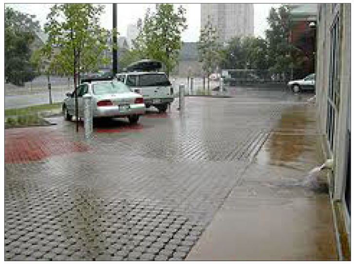
D.
Certain Residential Uses. Off-street parking spaces and driveways for single-family detached, two-family (duplex), and townhouse dwellings may, in-lieu of surfacing in accordance with 5.1.5.C.1, General, or Pervious or Semi-Pervious Surfacing, and 5.1.5.C.2, Pervious or Semi-Pervious Surfacing above:
1.
Be covered with pervious material such as crushed stone, gravel, or mulch, if such material is:
a.
Confined to the vehicular parking space and/or driveway with a device expressly designed for such purposes, including but not limited to bricks, railroad ties, and plastic/PVC landscaping boarders; and
b.
Renewed or replaced as reasonably necessary to maintain a neat and orderly appearance; or
2.
Include surfacing in two strips ("tire ribbons") of a material specified in Sec. 5.1.5.C, Surfacing above, designed to provide a driving surface for the wheels of an automobile along the length of the parking space and/or driveway, provided the overall parking space meets the minimum dimensional requirements in this section.
E.
Location and Arrangement
1.
Safe and Convenient Access
a.
Off-street vehicular parking and loading areas shall be arranged for convenient access between an adjacent road or street and all parking spaces and loading berths to facilitate ease of mobility, ample clearance, and safety of vehicles and pedestrians. Each off-street parking space and loading berth shall have adequate, unobstructed means for the ingress and egress of vehicles.
b.
Except for off-street vehicular parking areas serving single-family detached or two-family (duplex) dwellings, off-street parking areas shall be arranged so no parking or maneuvering incidental to parking shall occur on a public road, street, or sidewalk.
c.
Except for off-street vehicular parking areas serving single-family detached, two-family (duplex), and townhouse dwellings, off-street parking areas shall be arranged so an automobile may be parked or un-parked without moving another automobile, unless it is within an automated or mechanical parking deck or garage or part of valet or tandem parking in accordance with Sec. 5.1.8, Off-Street Parking Alternatives .
d.
Off-street vehicular parking areas, aisles, pedestrian walks, landscaping, and open space shall be designed as integral parts of an overall development plan and shall be properly related to existing and proposed buildings.
e.
Buildings, parking and loading areas, landscaping, and open spaces shall be designed so that pedestrians moving from parking areas to buildings and between buildings are not unreasonably exposed to vehicular traffic.
f.
Landscaped, paved, and gradually inclined or flat pedestrian walks shall be provided along the lines of the most intense use, particularly from building entrances to streets, parking areas, and adjacent buildings. Pedestrian walks should be designed to discourage incursions into landscaped areas except at designated crossings.
g.
Each off-street parking space shall open directly onto an aisle or driveway that, except for single-family detached and two-family (duplex) dwellings, is not a public street.
h.
Aisles and driveways shall not be used for parking vehicles, except that the driveway of a single-family detached or two-family (duplex) dwelling shall be counted as a parking space for the dwelling unit.
i.
The design of the off-street vehicular parking area shall be based on a definite and logical system of drive lanes to serve the parking and loading spaces. A physical separation or barrier, such as vertical curbs, may be required to separate parking spaces from travel lanes.
j.
No parking space shall be located so as to block access by emergency vehicles.
k.
A maximum of a two-foot overhang is allowed from a curb or wheel stop onto a non-paved surface for all off-street vehicular parking spaces except parallel spaces. The two-foot overhang areas may not intrude onto pedestrian walkways, landscaped buffers, accessways, rights-of-way, or adjacent property not a part of the site.
l.
Access ways for internal traffic circulation of parking areas shall be a minimum of 18 feet for one-way traffic and 24 feet for two-way traffic.
m.
Off-street loading areas shall be arranged so no loading berth extends into the required aisle of a vehicular parking area.
n.
An entrance or exit to a vehicular parking area shall not be located within 25 feet of a Residential district.
2.
Backing onto Streets Prohibited. Except for parking areas serving single-family detached or attached, or two-family (duplex) dwellings, all off-street vehicular parking and loading areas shall be arranged so that no vehicle is required to back out from such areas directly onto a street.
F.
Markings
1.
Except for vehicular parking areas serving single-family detached or two-family (duplex) dwellings, each required off-street parking area and space, and each off-street loading area and berth, shall be identified by surface markings that are arranged to provide for orderly and safe loading, unloading, parking, and storage of vehicles. Such markings—including striping, directional arrows, lettering on signs and in handicapped-designated areas, and labeling of the pavement—shall be maintained so as to be readily visible at all times.
2.
One-way and two-way accesses into required parking facilities shall be identified by directional arrows. Any two-way access located at any angle other than 90 degrees to a street shall be marked with a traffic separation stripe running the length of the access. This requirement does not apply to parking lot drive aisles.
G.
Stormwater Management/Drainage. All off-street vehicular parking and loading areas shall comply with Sec. 6.7, Stormwater Management Systems, and shall be properly drained so as to eliminate standing water and prevent damage to adjacent land and public and private roads, streets, and alleys.
H.
Exterior Lighting. Lighted off-street vehicular parking and loading areas shall comply with Sec. 5.7, Exterior Lighting, or Lighting Standards.
I.
Landscaping, Buffering, and Tree Protection
1.
Off-street vehicular parking areas shall comply with the requirements of Sec. 5.3, Landscape and Buffer Standards, and Sec. 5.4, Tree Protection Standards.
2.
Except for off-street vehicular parking areas serving single-family detached or two-family dwellings (duplex), each parking space shall include a permanently anchored wheel stop, except for tandem parking spaces at the edge of a vehicular parking area, or impervious area. Wheel stops are not required between parking spaces used for tandem parking.
3.
Wheel stops, when used, shall be made of concrete, metal, rubber, or other material of comparable durability, and shall be at least six feet long and at least six inches high. When used, one wheel stop shall be provided per parking space.
4.
A rail, fence, curb or other continuous barricade sufficient to retain the parked vehicles completely within the parking area shall be provided, except at exit and access driveways.
J.
Accessible Parking for Physically Disabled
1.
Development required to provide off-street vehicular parking spaces shall ensure that a portion of the total number of required off-street parking spaces shall be specifically designated, located, and reserved for use by persons with physical disabilities, in accordance with Table 5.1.5.J: Accessible Parking, the standards in Ch. 316, Fla. Stat.; the Florida Accessibility Code for Building Construction adopted pursuant to Sec. 553.503, Fla. Stat.; and the Federal Americans with Disabilities Act Accessibility Guidelines.
2.
Where van parking is provided pursuant to state and federal requirements, for every six parking spaces or fraction thereof required by Table 5.1.5.J: Accessible Parking, at least one shall be a van parking space.
K.
Maintained In Good Repair at All Times. All off-street vehicular parking and loading areas shall be maintained in safe condition and good repair at all times so as not to constitute a hazard to public safety or a visual or aesthetic nuisance to surrounding land.
(Ord. No. 2877, § XIV, 12-15-2021)
5.1.6. - Off-Street Vehicular Parking Space Standards
A.
Minimum Number of Off-Street Vehicular Parking Spaces. Except as otherwise provided for mixed-use developments (see Sec. 5.1.6.C), new development, a change in use, or expansion of development shall provide the minimum number of off-street vehicular parking spaces in accordance with Table 5.1.6.A: Minimum Number of Off-Street Vehicular Parking Spaces, based on the principal use(s) involved and the extent of development. Interpretation of the off-street parking space standards for principal uses with variable parking demands or unlisted principal uses shall be in accordance with Sec. 5.1.6.B, Unlisted Uses.
B.
Unlisted Uses. An applicant proposing to develop a principal use that is unlisted in Table 5.1.6.A: Minimum Number of Off-Street Vehicle Parking Spaces, shall propose the amount of required parking by one of the three methods outlined in this subsection. On receiving the application proposing to develop a principal use not expressly listed in Table 5.1.6.A, with the proposed amount of parking, the Director shall:
1.
Apply the minimum off-street vehicular parking space requirement specified in Table 5.1.6.A for the listed use that is deemed most similar to the proposed use; or
2.
Establish the minimum off-street parking space requirement by reference to standard parking resources published by the Institute for Transportation Engineers (ITE), Urban Land Institute (ULI), National Parking Association, or the American Planning Association; or
3.
Require the applicant to conduct a parking demand study to demonstrate the appropriate minimum off-street parking space requirement. The study shall estimate parking demand based on the recommendations of the ITE, ULI or another acceptable source of parking demand data. This demand study shall include relevant data collected from uses or combinations of uses from at least three different sites that are the same or comparable to the proposed use in terms of density, scale, bulk, area, type of activity, and location. The study methodology shall be approved by the Director prior to being conducted.
C.
Mixed-Use Development
1.
Unless an alternative parking plan is approved in accordance with Sec. 5.1.6.C.2, below, development containing more than one use shall provide parking spaces in an amount equal to the total of the standards for all individual uses.
2.
An applicant for a development containing more than one use may submit an alternative parking plan (see Sec. 5.1.8, Off-Street Parking Alternatives ) that proposes a reduction in the minimum number of required off-street parking spaces for the development based on a comprehensive analysis of parking demand for each use by time of day, in addition to any other reduction for off-street parking alternatives (see Sec. 5.1.8, Off-Street Parking Alternatives ).
D.
Maximum Number of Off-Street Vehicular Parking Spaces. For a multifamily development, mixed-use development, or any use in the Office Uses or Retail Sales and Service Uses category, the maximum number of off-street parking spaces shall not exceed 125 percent of the minimum number of off-street parking spaces required for that use in Table 5.1.6.A: Minimum Number of Off-Street Vehicular Parking Spaces, except as may be allowed through approval of an alternative parking plan in accordance with Sec. 5.1.8.B, Provision over Maximum Allowed .
E.
Electric Vehicle (EV) Charging Stations. Up to ten percent of the required number of off-street vehicular parking spaces may be used and designated as electric vehicle (EV) charging stations, subject to the standards in this section. The Director shall have authority to approve the use and designation of additional required parking spaces as electric vehicle charging stations, provided that such additional spaces shall count as only one-half of a parking space when computing the minimum number of parking spaces required. Parking spaces used as electric vehicle charging stations shall consist as one or more group(s) of contiguous spaces located where they can be readily identified by electric vehicle drivers (e.g., through signage), but where their use by non-electric vehicles is discouraged.
5.1.7. - Dimensional Standards for Vehicular Parking Spaces and Aisles
A.
General. Except as otherwise provided in Sec. 5.1.7.B, Smaller Parking Spaces for Compact Cars, Tandem Parking, and Certain Uses, below or other parts of this subsection, standard vehicle parking spaces and parking aisles shall comply with the minimum dimensional standards established in Table 5.1.7.A: Dimensional Standards for Vehicular Parking Spaces and Aisles, and be located on the site of the development it serves. See Figure 5.1.7.A: Measurement of Parking Space and Aisle Dimension.
Figure 5.1.7: Measurement of Parking Space and Aisle Dimensions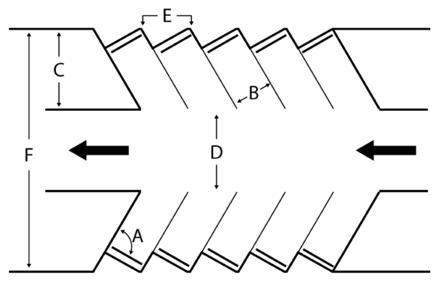
B.
Smaller Parking Spaces for Compact Cars, Tandem Parking, and Certain Uses
1.
Up to 20 percent of required off-street vehicular parking spaces may be designated for use by compact cars. The dimensions of such designated off-street parking spaces may be reduced to a width of eight feet and a depth/length of 16 feet per vehicle.
2.
The dimensions of off-street vehicular parking spaces may be reduced to a width of eight feet and a depth/length of 18 feet per vehicle where the parking spaces are:
a.
Used for tandem parking (see 5.1.8.F, Valet and Tandem Parking); or
b.
Located within a development containing industrial services uses, manufacturing and production uses, or warehouse and freight movement uses.
3.
The dimensions of off-street vehicular parking spaces for single-family detached and attached, and two-family (duplex) dwellings may be reduced to a width of eight feet and a depth/length of 16 feet per vehicle.
C.
Vertical Clearance. All off-street vehicular parking spaces shall have a minimum overhead clearance of seven feet for vehicle parking, and 8.2 feet for van-accessible parking.
5.1.8. - Off-Street Parking Alternatives
A.
Alternative Parking Plan. The Director is authorized to approve an alternative parking plan that proposes alternatives to providing the off-street vehicular parking spaces required by Table 5.1.6.A: Minimum Number of Off-Street Vehicular Parking Spaces, in accordance with the following standards. The alternative parking plan shall be submitted with a development application for a planned development (2.5.1.F, Planned Development), development plan (major or minor) (Sec. 2.5.2.A, Development Plan (Major and Minor)), or plat (subdivision), (Sec. 2.5.2.B, Plat (Subdivision), or building permit (Code of Ordinances Art.VI, Sec. 6.08.00), whichever occurs first.
B.
Provision over Maximum Allowed
1.
General. An alternative parking plan prepared specifically for the proposed plan for development may propose to exceed the maximum number of off-street vehicular parking spaces allowed in Sec. 5.1.6.D, Maximum Number of Off-Street Vehicular Parking Spaces.
2.
Parking Demand Study. The alternative parking plan shall include a parking demand study demonstrating how the maximum number of parking spaces allowed by Sec. 5.1.6.D, Maximum Number of Off-Street Vehicular Parking Spaces, is insufficient for the proposed development.
C.
Shared Parking for Single-Use Development. An applicant for a single-use development may use an alternative parking plan to meet a portion of the minimum number of off-street vehicular parking spaces required in Table 5.1.6.A: Minimum Number of Off-Street Vehicular Parking Spaces, for that use through sharing parking with other existing uses. Such use of shared parking shall be allowed in accordance with the following standards:
1.
Adequate Spaces. There are adequate parking spaces for current developments relying on the shared parking lot.
2.
Maximum Shared Spaces. Up to 50 percent of the number of parking spaces required for the use may be shared with other uses, provided that parking demands do not overlap.
3.
Location
a.
Shared parking spaces shall be located adjacent to the development or on the same block and within 800 feet of the primary pedestrian entrances to the uses served by the parking.
b.
Shared parking spaces shall not be separated from the use they serve by a street.
4.
Pedestrian Access. Adequate and safe pedestrian access by a walkway protected by a landscape buffer or a curb separation and elevation from the street grade shall be provided between the shared parking areas and the primary pedestrian entrances to the uses served by the parking.
5.
Signage Directing Public to Parking Spaces. Signage shall be provided to direct the public to the shared parking spaces.
6.
Justification. The alternative parking plan shall include justification of the feasibility of shared parking among the proposed uses, using methods from ITE, ULI, or another acceptable source. Such justification shall address, at a minimum, the size and type of the uses proposed to share off-street vehicular parking spaces, the composition of their tenants, the types and hours of their operations, the anticipated peak parking and traffic demands they generate, and the anticipated rate of turnover in parking space use.
7.
Shared Parking Agreement
a.
An approved shared parking arrangement shall be enforced through written agreement among all the owners or long-term lessees of lands containing the uses proposed to share off-street vehicular parking spaces.
b.
The agreement shall provide all parties the right to joint use of the shared parking area for at least 15 years, and shall ensure that as long as the off-site parking is needed to comply with this section, land containing either the off-site parking area or the served use will not be transferred, except in conjunction with the transfer of land containing the other.
c.
The agreement shall state that no party can cancel the agreement without first sending notice by certified mail to the Director, at least 30 days prior to the termination of the agreement.
d.
The agreement shall be submitted to the Director for review and comment, and then to the City Attorney for review and approval before execution.
e.
An attested copy of an approved and executed agreement shall be recorded in the public records of Orange County before issuance of a Building Permit for any use to be served by the shared parking area.
f.
The agreement shall be considered a restriction running with the land and shall bind the heirs, successors, and assigns of the landowners. A violation of the agreement shall constitute a violation of this LDC, which may be enforced in accordance with Article 9: Enforcement.
g.
No use served by the shared parking agreement may be continued if the shared parking becomes unavailable to the use, unless substitute off-street vehicular parking spaces are provided in accordance with this section.
D.
Off-Site Vehicular Parking. An alternative parking plan may be proposed to meet a portion of the minimum number of off-street vehicular parking spaces required for a use with off-site parking—i.e., off-street vehicular parking spaces located on a parcel or lot separate from the parcel or lot containing the use—in accordance with the following standards.
1.
Zoning District Classification. The zoning district classification of the off-site vehicular parking shall be one that allows the use served by off-site parking (and thus off-street parking accessory to such use), or that allows the parking as a principal use.
2.
Location
a.
Off-site parking spaces shall be located within a walking distance of the primary pedestrian entrances to the uses served by the parking, in accordance with Table 5.1.8.D.2.a: Allowed Distances for Off-site Vehicular Parking.
b.
Off-site parking spaces shall not be separated from the use they serve by any street more intensive than a local street unless safe pedestrian access across the street is provided by appropriate traffic controls (e.g., signalized crosswalk), or a grade-separated pedestrian walkway.
3.
Space Clearly Marked. Each parking space shall be clearly marked with signage that:
a.
Indicates that the space is reserved exclusively for the use being served, and that the user may cause violators to be towed;
b.
Does not exceed two square feet in sign area; and
c.
Does not include any commercial message.
4.
Pedestrian Access. Adequate, safe, and well-lit pedestrian access shall be provided between the off-site vehicular parking area and the primary pedestrian entrances to the use served by the off-site parking.
5.
Off-Site Parking Agreement. If land containing the off-site vehicular parking area is not under the same ownership as land containing the principal use served, the off-site parking arrangement shall be established in a written agreement between the owners of land containing the off-site vehicular parking area and land containing the served use. The agreement shall comply with the following requirements:
a.
The agreement shall provide the owner of the served use the right to use the off-site vehicular parking area for at least 15 years, and shall specify that the parking spaces are for the exclusive use of the served use, including any customers and employees;
b.
The agreement shall state that no party can cancel the agreement without first sending notice by certified mail to the Director, at least 30 days prior to the termination of the agreement;
c.
The agreement shall be submitted to the Director, for review and comment, and then to the City Attorney, for review and approval before execution;
d.
An attested copy of an approved and executed agreement shall be recorded in the public records of Orange County before issuance of a Building Permit for any use to be served by the off-site vehicular parking area;
e.
The agreement shall be considered a restriction running with the land and shall bind the heirs, successors, and assigns of the landowner(s);
f.
A violation of the agreement shall constitute a violation of this LDC, which may be enforced in accordance with Article 9: Enforcement; and
g.
No use served by the off-site vehicular parking may be continued if the off-site parking becomes unavailable, unless substitute off-street parking spaces are provided in accordance with this section.
E.
Deferred Parking. An alternative parking plan may propose to defer construction of up to 25 percent of the number of off-street vehicular parking spaces required by Table 5.1.6.A: Minimum Number of Off-Street Vehicular Parking Spaces, in accordance with the following standards:
1.
Justification. The alternative parking plan shall include a study demonstrating that because of the location, nature, or mix of uses, there is a reasonable probability the number of vehicular parking spaces actually needed to serve the development is less than the minimum required by Table 5.1.6.A: Minimum Number of Off-Street Vehicular Parking Spaces.
2.
Reserve Parking Plan. The alternative parking plan shall include a reserve parking plan identifying: (a) the amount of off-street vehicular parking being deferred, and (b) the location of the area to be reserved for future parking, if future parking is needed.
3.
Parking Demand Study
a.
The alternative parking plan shall provide assurance that within 24 months after the initial Certificate of Occupancy is issued for the proposed development, an off-street parking demand study evaluating the adequacy of the existing parking spaces in meeting the off-street vehicular parking demand generated by the development will be submitted to the Director.
b.
If the Director determines that the study demonstrates the existing vehicular parking is adequate, then construction of the remaining number of vehicular parking spaces shall not be required. If the Director determines the study indicates additional parking is needed, such parking shall be provided consistent with the reserve parking plan and the standards of this section.
4.
Limitations on Reserve Areas. Areas reserved for future vehicular parking shall not be used for buildings, storage, loading, or other purposes. Such area may be used for temporary overflow parking, provided such use is sufficiently infrequent to ensure maintenance of its ground cover in a healthy condition.
5.
Landscaping of Reserve Areas Required. Areas reserved for future off-street vehicular parking shall be landscaped with an appropriate ground cover, and if ultimately developed for off-street parking, shall be landscaped in accordance with Sec. 5.2.5.B, Off-Street Vehicular Parking Area Planting.
F.
Valet and Tandem Parking. An alternative parking plan may propose to use valet and tandem parking to meet a portion of the minimum number of off-street vehicular parking spaces required for commercial uses in accordance with the following standards:
1.
Number of Valet or Tandem Spaces. No more than 35 percent of the total number of vehicular parking spaces provided shall be designated for valet or tandem spaces except for restaurants, where up to 50 percent of spaces may be designated for valet parking, and hotels, where up to 60 percent of parking spaces may be designated for valet parking.
2.
Drop-Off and Pick-Up Areas. The development shall provide a designated drop-off and pick-up area. The drop-off and pick-up area may be located adjacent to the building(s) served, but may not be located in a fire lane or where its use would impede vehicular and/or pedestrian circulation, cause queuing in a public street, or impede an internal drive aisle serving the development. Drop-off and pick-up areas shall not be allowed to use sidewalks for any stationing of vehicles.
3.
Valet or Tandem Parking Agreement
a.
Valet or tandem parking may be established and managed only in accordance with a valet or tandem parking agreement. The agreement shall be for a minimum of 10 years, and include provisions ensuring that a valet parking attendant will be on duty during hours of operation of the uses served by the valet parking.
b.
The agreement shall be submitted to the Director for review and comment, and then to the City Attorney for review and approval before execution.
c.
An attested copy of an approved and executed agreement shall be recorded in the public records of Orange County before issuance of a Building Permit for any use to be served by the valet or tandem parking.
d.
The agreement shall be considered a restriction running with the land and shall bind the heirs, successors, and assigns of the landowner(s). A violation of the agreement shall constitute a violation of this LDC, which may be enforced in accordance with Article 9: Enforcement.
e.
No use served by valet or tandem parking may be continued if the valet or tandem service becomes unavailable, unless substitute off-street vehicular parking spaces are provided in accordance with this section.
G.
Property on Local Register of Historic Places or in a Historic District. An alternative parking plan may be proposed for any property placed on the local register of historic places, or that is located in an historic district that contributes to the historic character of the district, if the applicant demonstrates that the reduction or exemption of off-street vehicular parking is necessary to allow for a viable use of the historic structure and the reduction or exemption will not create a severe parking shortage or severe traffic congestion.
H.
Alternative Surfacing Materials for Parking Areas.
(a)
Certain land uses, due to their unique character or due to the low volume of traffic produced, may provide parking surfaces of grass, wood mulch or other materials after obtaining approval from the Development Review Committee (DRC). In granting such a request, the DRC shall consider the following matters:
(1)
The type of partially pervious material or type of wood mulch to be used for surfacing.
(2)
The site characteristics of the parking lot, including but not limited to the elevation, slope, drainage, soil type and adjacent surface conditions.
(3)
The type and amount of anticipated traffic flow in the parking lot.
(4)
The parking area shall not be for storage of materials or vehicles, or overnight parking unless approved by the DRC.
(b)
The following criteria shall be used in development and construction of an approved wood mulch parking area:
(1)
Use shall be essentially for passive parking, i.e., not more than two ingress/egress movements per day per vehicle space. Such limited uses shall be determined by the DRC.
(2)
Natural soil on the site must be sandy, with only enough clay to bind particles and preclude rutting or flowing.
(3)
Soil percolation must absorb a minimum of three and one-half inches of rainfall per hour over the entire area to be mulched.
(4)
Parking areas shall be graded as level as possible, with maximum slope in any direction not to exceed three percent, to preclude surface runoff from washing away mulch materials.
(5)
Subsurface areas shall be cleared and grubbed to remove all living plant growth, and then be graded and treated with an approved herbicide to prevent further growth in areas to be mulched.
(6)
Surfacing shall not be less than three inches of clean bark mulch, free from chips and sticks, after wetting and rolling.
(7)
Mulched areas shall be contained by concrete ribbon curbing, pressure-treated timbers, or precast concrete bumper blocks laid end to end. For this purpose, concrete sidewalks at or between ends of rows of vehicle spaces, not less than five feet wide, may be used, as well as concrete entrance drives and curb cuts, where applicable.
(8)
All mulch parking areas shall be maintained and resupplied with fresh mulch at least once per year.
(c)
Minimum standards for any alternative surface materials for parking areas.
(1)
Requirements for size of lot or parcel coverage, number of vehicle spaces and driving lanes shall be the same as that for conventionally paved parking areas. All circulation areas and drive isles shall be paved.
(2)
The DRC shall have sole discretion in determining whether or not the use of wood mulch, or other materials such as paver block or turf block, shall be suitable and acceptable for any specific low volume parking location.
(3)
Green areas (planters, with grass and shrubs or trees) shall comprise not less than 20 percent of the total parking area, including driveways and walkways, and shall be provided with automatic or manual irrigation facilities, equipped with rain sensors and backflow preventers, and with adequate pressure and coverage to enable periodic wetting of the mulched areas to keep the mulch sufficiently moist to prevent its being blown or strewn by winds or vehicle exhausts, or ignited by the latter.
(4)
Landscape islands, parking space and lot dimensions shall be in accordance with the LDC.
(5)
A minimum of 25 percent of the required parking spaces shall be paved in accordance with the Land Development Code. Any extra parking spaces over the Code required number may also use the alternative surface materials as noted above. All Accessible parking spaces shall be paved in accordance with Florida Statutes and the LDC.
(Ord. No. 3021, § VII, 9-20-2023)
5.1.9. - Reduced Parking Standards for Parking Demand Reduction Strategies
Use of alternative transportation and transportation demand reduction strategies allows development to reduce the amount of vehicular parking provided below the requirements of Table 5.1.6.A: Minimum Number of Off-Street Vehicular Parking Spaces. All reductions shall be taken as cumulative and not exclusive.
A.
Transportation Demand Management. The Director may, through approval of a Transportation Demand Management (TDM) plan, authorize up to a 30 percent reduction in the minimum number of off-street vehicular parking spaces required by Table 5.1.6.A: Minimum Number of Off-Street Vehicular Parking Spaces, for nonresidential or mixed-use developments having a floor area of at least 25,000 square feet, in accordance with the following standards.
1.
TDM Plan. The TDM plan shall include facts, projections, an analysis (e.g., type of development, proximity to transit and/or other multi-modal systems, anticipated number of employees and/or patrons, minimum parking requirements) and indicate the types of transportation demand management activities that will be instituted to reduce single-occupant vehicle use and reduce traffic congestion. The plan shall identify the amount by which parking requirements have been reduced from the amounts otherwise required by this section.
2.
Transportation Demand Management Activities. The TDM plan shall be required to provide the following transportation demand management activities:
a.
A Guaranteed Ride Home program that offers emergency ride services to each employee with an allowance of no fewer than four rides per year, which an applicant may establish to serve the development or in partnership with other developments or uses.
b.
Written disclosure of transportation information and educational materials to all employees, that makes transportation and ride-sharing information available to employees. (This may be met by Human Resources Officers or other administrators of an organization.)
c.
Formation of transportation demand reduction programs such as carpooling, vanpooling, ridesharing, subsidy of employee bus passes, teleworking, and shuttle service programs.
3.
Two Transportation Demand Management Options Required. The plan will also require two of the following transportation demand management strategies.
a.
Establishment of a development-specific website that provides multi-modal transportation information such as real-time travel/traffic information, bus schedules and maps, and logging of alternative commutes (e.g., bicycle, pedestrian, carpool, and vanpool). Specific information will vary depending on the specific services and transportation infrastructure available in the vicinity of the development, but in general will allow tenants or customers to compare travel modes available.
b.
In-lieu of the website described in 1 above, installation of a real-time visual display screen or other display device of this type that provides multi-modal transportation information.
c.
A parking cash-out or transportation stipend, or provision of a cash incentive to employees not to use vehicular parking spaces otherwise available to tenants of a development.
d.
Unbundling of vehicular parking spaces from leases, or issuing tenant leases that do not include parking as an integral part of a floor-area space lease and require parking to be leased, purchased, or otherwise accessed through separate payment.
e.
Creation of a Preferential Parking Management Plan that specifically marks spaces for registered carpool and/or vanpool vehicles that are located near building entrances or in other preferential locations.
f.
Institution of off-peak work schedules that allow employees to arrive and depart at times other than the peak morning commute period (defined as 7:00 a.m. to 9:00 a.m.) and peak evening commute period (defined as 5:00 p.m. to 7:00 p.m.).
g.
Any other transportation demand management activity as may be approved by the Director as a means of complying with the parking reduction provisions of this subsection.
4.
Recording of TDM Plan. A copy of the approved TDM plan shall be recorded in the public records of Orange County before issuance of a Building Permit for the development to be served by the plan. The TDM plan shall be recorded against the land, and the applicant and/or successors in interest in the land shall be responsible for implementing the plan in perpetuity.
5.
TDM Program Coordinator
a.
The applicant shall appoint a TDM program coordinator to oversee transportation demand management activities.
b.
The TDM program coordinator shall be a licensed engineer, certified planner, or a traffic consultant that is also a qualified or trained TDM professional.
c.
The TDM program coordinator shall be appointed prior to issuance of a Building Permit for the buildings to be served by the transportation demand management program.
6.
TDM Report. The TDM program coordinator shall submit to the Director a report on a biennial basis that details implementation of the approved TDM plan and the extent to which it has achieved the target reduction in drive-alone trips that justified the original reduction in parking. The report shall include, but is not limited to, the following:
a.
A description of transportation demand management activities undertaken;
b.
An analysis of vehicular parking demand reductions based on employee and/or resident use of ridership programs or alternative transportation options;
c.
Changes to the TDM plan to increase bus ridership, bicycle ridership, and other commuting alternatives, as defined in 7. below; and
d.
The results of an employee transportation survey.
7.
Amendments. The Director may approve amendments to an approved TDM plan in accordance with the procedures and standards for its original approval. Changes in transportation options subsequent to the approval of the original plan that allow a development to meet the reduction targets identified in the original plan, such as introduction of new transit service to a development area, shall not require amendments to the plan as long as annual reports can demonstrate that these services are contributing to the plan's intent.
8.
Parking Required if TDM Terminated. If the applicant or successors in interest in the development subject to a TDM plan stop implementing the plan or fail to submit a TDM report within one year of the regularly scheduled date the biennial report is due, the TDM plan shall be terminated and become null and void. Any such termination of the TDM plan does not negate the parties' obligations to comply with parking requirements of this section and this LDC, and thus shall constitute a violation of this LDC. No use served by the TDM plan may be continued unless another TDM plan is approved or all required off-street vehicular parking spaces are provided in accordance with this section, within 120 days of termination of the TDM plan.
B.
Special Facilities for Bicycle Commuters. The Director may authorize up to a five percent reduction in the minimum number of off-street vehicular parking spaces required by Table 5.1.6.A: Minimum Number of Off-Street Vehicular Parking Spaces, for developments that comply with the bicycle parking standards in Sec. 5.1.11, Bicycle Parking Standards, Bicycle Parking Standards, and provide both of the following:
1.
Additional enclosed (indoor or locker) and secure bicycle parking spaces equal to at least five percent of the number of vehicle parking spaces provided; and
2.
Shower and dressing areas for employees.
C.
Other Eligible Alternatives. The Director may authorize up to a 10 percent reduction in the minimum number of off-street parking spaces required by Table 5.1.6.A: Minimum Number of Off-Street Vehicular Parking Spaces, if an applicant submits an alternative parking plan that demonstrates the applicant will effectively reduce parking demand on the site of the subject development, provided the applicant also demonstrates that the proposed plan of development will do at least as good a job in protecting surrounding neighborhoods, maintaining traffic-circulation patterns, and promoting quality urban design as would strict compliance with the otherwise applicable off-street vehicular parking standards.
5.1.10. - Vehicle Stacking Spaces and Lanes
A.
Drive-Through and Similar Facilities
1.
Required Number of Stacking Spaces. In addition to meeting the off-street vehicular parking standards in Table 5.1.6.A: Minimum Number of Off-Street Vehicular Parking Spaces, uses with drive-through facilities and other auto-oriented uses where vehicles queue up to access a service facility shall provide at least the minimum number of stacking spaces established in Table 5.1.10.A.1: Minimum Stacking Spaces for Drive-Through and Similar Facilities.
2.
Stacking Space Standards. Required stacking spaces shall:
a.
Be a minimum of 10 feet wide and 20 feet long;
b.
Be contiguous;
c.
Not impede onsite or offsite vehicular traffic movements or movements into or out of off-street parking spaces;
d.
Not impede onsite or offsite bicycle or pedestrian traffic movements; and
e.
Be separated from access aisles and other vehicular surface areas by raised medians, if necessary for traffic movement and safety.
f.
Where turns are required at the exit lanes, the minimum distance from any drive-up station to the beginning point of the curve shall be 34 feet. The minimum inside turning radius shall be 25 feet.
(Ord. No. 2775, § VII, 7-15-2020)
5.1.11. - Bicycle Parking Standards
A.
Minimum Bicycle Parking Required. The following shall include short-term and long-term bicycle parking spaces in accordance with Table 5.1.11.A: Bicycle Parking Standards:
1.
All new development; and
2.
Any individual expansion or alteration of a building existing prior to March 6, 2019 if the expansion increases the building's gross floor area by 50 percent or more, or the alteration involves 50 percent or more of the building's gross floor area (including interior alterations), provided no long-term bicycle parking is required if the building has a gross floor area of less than 2,500 square feet after the expansion or alteration.
B.
Reduction Based on Alternative Bicycle Parking Plan. The Director may authorize up to a 25 percent reduction in the minimum number of bicycle parking spaces required by Table 5.1.11.A: Bicycle Parking Standards, if the applicant submits an alternative bicycle parking plan that:
1.
Demonstrates the demand and need for bicycle parking on the site is less than required by this subsection because of the site's location, the site design, proximity to transit, or other factors; or
2.
Offers a strategy that demonstrates other non-auto and non-bicycle travel modes will be used by occupants and users of the development that reduces the demand for bicycle parking spaces.
C.
Bicycle Parking Space Standards
1.
A bicycle parking space shall be located on a paved or similar hard, all-weather surface, having a slope not greater than three percent.
2.
Lighting shall be provided for bicycle parking spaces that are accessible to the public or bicyclists after dark.
3.
Bicycle parking is encouraged to be visible from the main entrance of the building it serves; however, directional signage shall be provided where a bicycle parking space is not visible from a main entrance to the building for which the bicycle parking space is required.
4.
The minimum dimensional requirements for a bicycle parking space are:
a.
Six feet long by two feet wide (see Figure 5.1.11.C.4.b-1: Example of Bicycle Parking Space and Parking Rack Dimensional Standards); or
b.
If designed for vertical storage, four feet long by two feet wide by eight feet high (see Figure 5.1.11.C.4.b-2: Example of Vertical Bicycle Parking Dimensional Standards).
Figure 5.1.11.C.4.b-1: Example of Bicycle Parking Space and Parking Rack Dimensional
Standards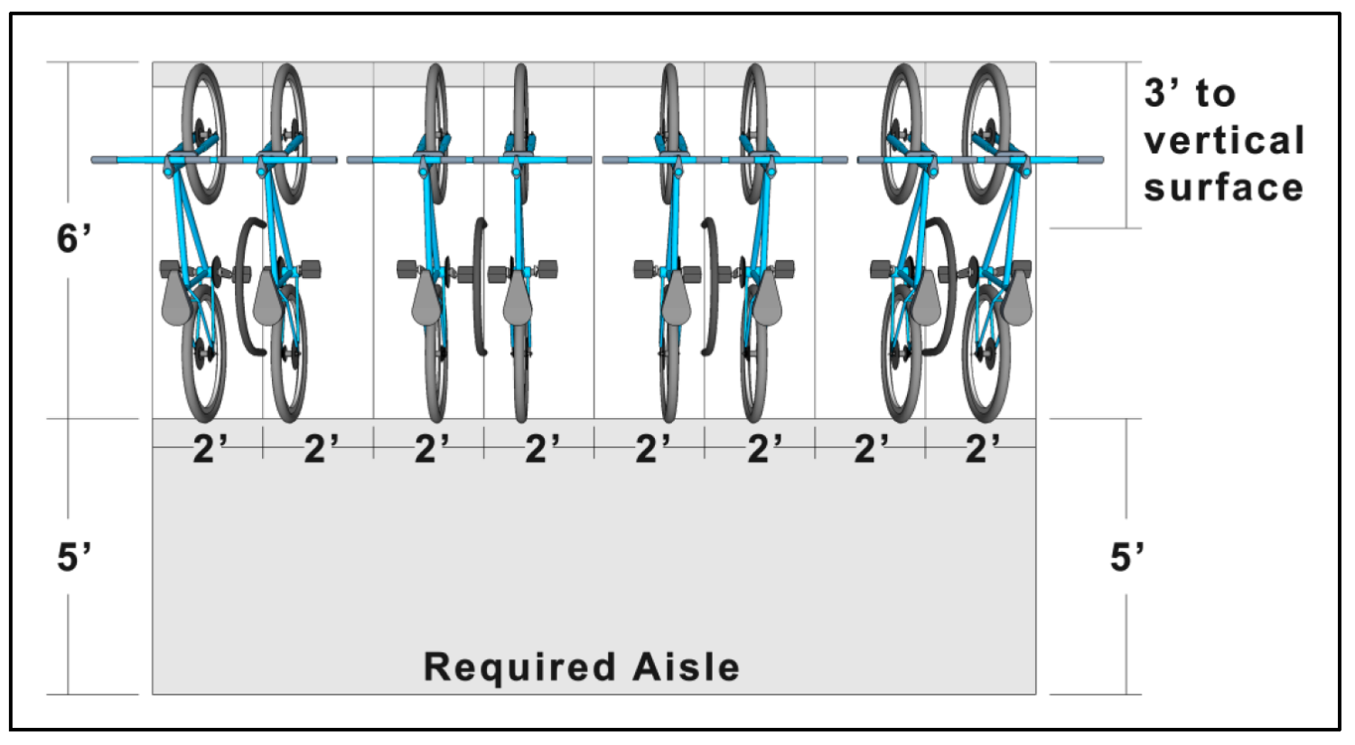
Figure 5.1.11.C.4.b-2: Example of Vertical Bicycle Parking Dimensional Standards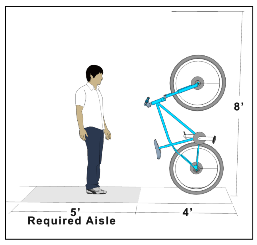
5.
A bicycle parking space shall be accessible without moving another parked bicycle.
6.
Not more than 25 percent of required short-term bicycle parking spaces and 25 percent of required long-term bicycle parking spaces may be vertical or wall-mounted parking.
7.
A bicycle parking rack shall:
a.
Allow for the securing of the frame and at least one wheel of a bicycle in a bicycle parking space to the rack with an industry-standard U-shaped bike lock;
b.
Provide each bicycle parking space with support for a bicycle in a stable position with direct support to the bicycle frame;
c.
Be securely anchored to the ground or to a structural element of a building or structure;
d.
Be designed and located so it does not block pedestrian circulation systems and pedestrian movements;
e.
Be constructed of materials designed to withstand cutting, severe weather, and permanent exposure to the elements, such as powder-coated steel or stainless steel;
f.
If bicycles must be moved onto or off of the rack parallel to their direction of travel, provide an aisle having a minimum width of five feet between all bicycle parking spaces served by the rack and any bicycle spaces served by another bicycle parking rack, vehicular surface areas, or obstructions, including but not limited to fences, walls, doors, posts, columns, or landscaping areas (see Figure 5.1.11.C.4.b-1: Example of Bicycle Parking Space and Parking Rack Dimensional Standards, and Figure 5.1.11.C.4.b-2: Example of Vertical Bicycle Parking Dimensional Standards);
g.
Be located at least three feet from any vertical surface, such as another bicycle parking rack, the side of a building, a tree, or a fence or wall (see Figure 5.1.11.C.4.b-1: Example of Bicycle Parking Space and Parking Rack Dimensional Standards); and
h.
Be separated from any abutting vehicular surface area by at least three feet and a physical barrier, such as bollards, curbing, wheel stops, reflective wands, or a fence or wall.
8.
Bicycle parking areas shall be maintained free of inoperable bicycles (such as bicycles with flat tires or missing parts) and debris. Bicycle parking racks shall be maintained in good repair, securely anchored, and free of rust.
D.
Short-Term Bicycle Parking Standards. A short-term bicycle parking space shall:
1.
Include independent access to a bicycle parking rack for supporting and securing a bicycle;
2.
Be located within 75 feet of a public entrance to the building for which the space is required, measured along the most direct pedestrian access route, provided, a short-term bicycle parking space located in a bicycle parking area serving more than one use shall be located within 150 feet of a public entrance to the building for which the space is required, measured along the most direct pedestrian access route; and
3.
Be located to ensure significant visibility by the public and users of the building for which the space is required.
E.
Long-Term Bicycle Parking Standards. A long-term bicycle parking space shall:
1.
Include one of the following features:
a.
A bicycle locker or similar structure manufactured for the sole purpose of securing and protecting a standard size bicycle from rain, theft, and tampering by fully securing the bicycle in a temporary enclosure; or
b.
A secured and dedicated bicycle parking area provided either inside the principal building on the lot, within a parking structure, or in a structure located elsewhere on the lot. The secured and dedicated bicycle parking area shall be designed to protect each bicycle from weather, theft, and vandalism and shall have a minimum of eight feet of clearance above the floor or ground.
2.
Be located within 500 feet of a public entrance to the building for which the space is required, measured along the most direct pedestrian access route, provided, a long-term bicycle parking space located in a bicycle parking area serving more than one use shall be located within 750 feet of a public entrance to the building for which the space is required, measured along the most direct pedestrian access route.
(Ord. No. 2994, § IX, 3-15-2023)
5.1.12. - Loading Area Standards
A.
Minimum Number of Off-Street Loading Berths. Any new development involving the routine vehicular delivery or shipping of goods, supplies, or equipment to or from the development shall provide a sufficient number of off-street loading berths to accommodate the delivery and shipping operations of the development's uses in a safe and convenient manner. Table 5.1.12.A: Minimum Number of Off-Street Loading Berths, sets forth the minimum number of loading berths for the different principal uses. For proposed uses not listed in Table 5.1.12.A, the requirement for a use most similar to the proposed use shall apply. The off-street loading birth berth shall be arranged so that vehicles shall maneuver for loading and unloading entirely within the property lines of the site.
B.
Dimensional Standards for Loading Areas
1.
Each loading berth shall be of sufficient size to accommodate the types of vehicles likely to use the loading area. The minimum loading berth size that presumptively satisfies loading berth needs is least 15 feet wide and 45 feet long in industrial uses. For all other uses, a berth as short as 25 feet may be allowed. The length of a loading area should be increased up to 55 feet if full-length tractor trailers must be accommodated. The Director may require a larger loading berth or allow a smaller loading berth on determining that the characteristics of the particular development warrant such increase or reduction and the general standard is met.
2.
Each loading berth shall have at least 15 feet of overhead clearance.
C.
Location of Loading Areas
1.
To the maximum extent practicable, loading areas should be located to the rear of the use they serve (see Figure 5.1.12.B.2: Loading Area Configuration).
2.
To the maximum extent practicable, loading areas should be located adjacent to the building's loading doors.
3.
Loading areas shall be located and designed so vehicles using them can maneuver safely and conveniently to them from a public street and complete loading without obstructing or interfering with any public right-of-way or any parking space or parking lot aisle.
Figure 5.1.12.B.2: Loading Area Configuration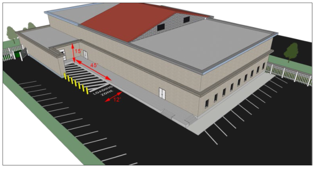
5.2.1.- Purpose
The purpose of this section is to provide for the planting and maintenance of shrubs, trees, undercover, and other plants by:
A.
Ensuring the planting, maintenance, and survival of trees, shrubs, and other plants in appropriate locations;
B.
Mitigating against erosion and sedimentation;
C.
Reducing storm water runoff;
D.
Preserving and protecting the water table and surface waters;
E.
Improving air quality;
F.
Increasing tree canopy to provide shade and moderate the effect of heat;
G.
Reducing visual pollution from the built environment, and mitigating between incompatible land uses;
H.
Providing visual screening, where appropriate;
I.
Restoring land denuded as a result of construction and clearing;
J.
Protecting and enhancing property values; and
K.
Improving the visual quality of the City.
5.2.2. - Applicability
A.
Unless exempted in accordance with B, below, or expressly stated to the contrary in this section, the standards in this section apply to:
1.
All new development;
2.
Any individual expansion or alteration of a building existing prior to March 6, 2019 if the expansion increases the building's floor area by 50 percent or more, or the alteration involves 50 percent or more of the building's floor area (including interior alterations); and
3.
Any change in use.
B.
The following types of development are exempt from the requirements of Sec. 5.2.4, Landscape Plan; Sec. 5.2.5, Landscaping and Buffer Standards; and Sec. 5.2.6, Alternative Landscape Plan:
1.
Single-family detached dwellings; and
2.
Two-family (duplex) dwellings;
C.
Development exempted in accordance with subsection B shall be required to plant three canopy trees on the lot, except that two canopy trees may be planted on lots less than 55 feet wide (two understory trees may be substituted for one canopy tree.)
D.
No Certificate of Occupancy for development subject to the requirements of this section shall be issued until the applicant has installed landscaping in accordance with the landscaping plan approved in accordance with the requirements of this section.
5.2.3. - Timing of Review
Review for compliance with the standards of this section shall occur during review of a development application for a planned development (2.5.1.F, Planned Development), special exception (Sec. 2.5.1.G. G, Special Exception Permit), development plan (major or minor) (Sec. 2.5.2.A, Development Plan (Major and Minor)), plat (subdivision), (Sec. 2.5.2.B, Plat (Subdivision), or building permit (Code of Ordinances Art.VI, Sec. 6.08.00), as appropriate.
5.2.4. - Landscape Plan
A.
A landscape plan demonstrating how landscaping will be planted on a development site to comply with the standards of this section, signed and sealed by a landscape architect licensed to practice in the State of Florida, shall be included with the development application where compliance with this section is reviewed in accordance with Sec. 5.2.3, Timing of Review.
B.
Prior to the issuance of a permit for the construction of a new nonresidential building, common area within residential development, or the substantial alteration of a non-residential building or site, a landscape and/or irrigation plan, when required, shall be submitted to, reviewed by, and approved by the City. The plans shall:
1.
Be prepared by and bear the seal of a landscape architect and/or irrigation contractor.
2.
Be drawn to scale, including dimensions and distances.
3.
Delineate the existing and proposed parking spaces, or other vehicular areas, access aisles, driveways, and similar features, plants, trees, and other obstacles.
4.
Irrigation systems shall be drawn with parts and requirements listed in Article 5.2.5.D.5.
5.
Designate by name and location the plant material to be installed or preserved in accordance with the requirements of this Article.
6.
Identify and describe the location and characteristics of all other landscape materials to be used.
7.
Show all landscape features, including areas of vegetation required to be preserved by law, in context with the location and outline of existing and proposed buildings and other improvements on the site, if any.
8.
Include a tabulation clearly displaying the relevant statistical information necessary for the City to evaluate compliance with the provisions of this chapter. This includes gross acreage, area of preservation areas, number of trees to be planted or preserved, square footage of paved areas, and such other information as may be necessary.
9.
Contain such other information that may be required by the City that is reasonable and necessary to determine that the landscape or irrigation plan meets the requirements of this chapter.
10.
The requirement for a landscape plan sealed by a landscape architect, or an irrigation plan stamped by an irrigation contractor, may be waived by the City for individual owner-occupied landscape and irrigation projects. However, the project shall comply with the requirements of this section and shall meet the standards outlined herein.
C.
Residential Self Certification
1.
Single-family residential developments are required to submit a self-certification checklist to the City upon completion of all installations.
2.
Contractors and owner/contractors shall be accountable for proper installation and compliance through self-certification. The City may conduct an adequate number of random inspections to ensure compliance with this code.
3.
A contractor or owner/contractor must submit a completed and endorsed checklist on a form provided by the City. A copy of the certification checklist must also be provided to the property owner. A list of plants installed on the site must be attached to the self-certification checklist and provided to both the City and property owner.
4.
No certificate of occupancy shall be issued until a completed self-certification checklist has been submitted to the City.
D.
Inspections—Non-residential and Residential Common Areas
1.
Prior to the issuance of any Certificate of Occupancy or Certificate of Acceptance, contractors and owner/contractors shall request a final inspection of work performed after the submittal of a self-certification checklist. The City shall conduct an inspection to ensure compliance with this code.
2.
Upon final inspection, a contractor or owner/contractor must submit to the City a record drawing of the project identifying modifications if there were changes from the originally submitted plan.
3.
Certificates of occupancy—No certificate of occupancy shall be issued until:
a.
An affidavit of completion and compliance and a completion sketch, if there were modifications from the original plan, have been submitted and accepted by the City; and
b.
The City has conducted any required final inspection.
(Ord. No. 2745, § 7, 1-15-2020)
5.2.5. - Landscaping and Buffer Standards
A.
Foundation Planting
1.
Applicability. The standards in Sec. 5.2.5.A.1.a, Foundation Planting Standards, apply to all multifamily, commercial, and industrial development (except in the I-H district), and all development approved as a special exception (see Sec. 2.5.1.G, Special Exception Permit).
a.
Foundation Planting Standards
1.
Except for a building built to the lot line, all buildings facing rights-of-way shall contain a foundation landscaping area adjacent to the building that is a minimum of four feet in width and extends the entire length of the building facade. The foundation landscaping area shall contain:
(a)
Shrubs a minimum of 24 inches in height, planted a minimum of 30 inches on-center, depending on variety and approved by the DRC; and
(b)
A minimum of one small decorative or ornamental tree that is at least 15 gallons for every 20 feet of length.
2.
Foundation landscaping adjacent to pedestrian walkways shall be protected by a barrier, such as curbing.
3.
All landscape planting materials shall be Florida No. One Grade or better.
4.
In addition, multifamily and nonresidential development shall plant one canopy shade tree and ten shrubs (minimum height 36 inches) per 35 lineal feet, or fraction thereof, of property perimeter both abutting and not abutting a street or parking area.
B.
Off-Street Vehicular Parking Area Planting
1.
Applicability. All off-street vehicular parking areas shall include landscaping both within the interior of the vehicular parking area and around its perimeter.
2.
Interior Vehicular Parking Area Landscaping. Except for a parking structure, an off-street vehicular area shall include interior planting areas that comply with the standards of this subsection.
a.
Size and Configuration
1.
General Parking Lot Standards
(a)
Parking Islands. A parking island shall be provided for every ten parking spaces in a row. The parking island shall be a minimum width of ten feet, measured from the back of all required curbing, and a minimum length of the parking space. Parking islands shall be distributed so that rows of parking between any two landscaped islands contain an average of ten or fewer contiguous spaces. Terminal parking islands shall be required at the ends of rows. (See Figure 5.2.5.B.2.i: Interior Parking Area Minimum Plantings)
(b)
Building- and Sidewalk-Adjacent Parking
i.
Where parking spaces are adjacent to a building, there shall be foundation landscaping between the parking spaces and the building.
ii.
Parking spaces that are adjacent to a building shall include a wheel stop for each space.
iii.
Parking spaces that are adjacent to an internal sidewalk shall include a wheel stop for each space that ensures a minimum four foot wide sidewalk is maintained.
(c)
Minimum Plantings
i.
A minimum of one canopy shade tree, plus an additional one canopy shade tree for every ten spaces or any portion thereof, shall be required for an off-street vehicular parking area.
ii.
Interior landscaping shall account for a minimum of ten percent of an off-street vehicular parking area.
iii.
Interior landscaping should consist of a mix of vegetation including, but not limited to, trees, shrubs and ground cover.
iv.
Tree clumping within interior islands is encouraged.
v.
Sufficient shade trees shall be planted so that 30 percent of the gross parking lot area shall be covered by canopy at mature growth.
(d)
All parking islands shall be protected from vehicular encroachment by curbing or wheel stops, which should be raised unless such areas are designed as a part of the on-site retention and recharge areas.
(e)
Where wheel stops are used, the length of the parking stall may be reduced to 18 feet if a landscaped dividing strip (or a parking island) is widened to at least eight feet.
(f)
Interior aisleway intersections shall be defined by planters.
(g)
Interior planters shall be designed at the same elevation as adjacent vehicular parking areas, except as necessary to save existing trees.
(h)
Interior planters for nonpublic, specialized vehicular use areas where large machinery or large vehicles are stored, serviced, or used, may be relocated to perimeter areas as additional buffers, screening, or beautification.
(i)
Driveway medians without shrubs shall be at least four feet wide, and driveway medians with shrubs or trees shall be at least six feet wide.
(j)
At least 90 percent of the parking spaces shall be within 80 feet of the trunk of a tree. Landscaping around the perimeter, in bufferyards, or other required plantings may be used to meet this requirement. (see Figure 5.2.5.B.2.j: Interior Parking Area Minimum Plantings)
Figure 5.2.5.B.2.j: Interior Parking Area Minimum Plantings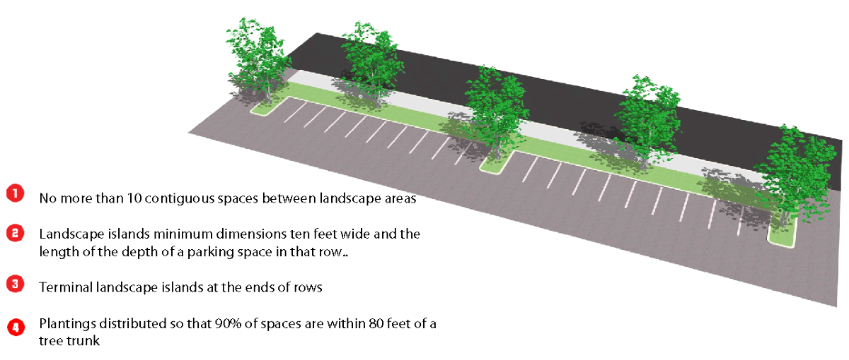
(k)
Low Impact Design (LID) is encouraged for landscaped areas.
2.
Large Parking Lot Standards. In addition to the standards in subsection 1, above, off-street vehicular surface parking areas with 300 or more spaces shall be organized into a series of smaller modules 25,000 square feet or less per module, and be visually separated by continuous landscaped islands at least 11 feet wide that contain pedestrian pathways located at least every six parking bays.
b.
Perimeter Off-street Vehicular Parking Area Landscaping
1.
Landscaping shall be installed to provide visual relief, screen off-street vehicular parking areas, and reduce noise and vibration from adjacent properties.
2.
A hedge row, consisting of shrubs a minimum height of 36 inches and planted three and one-half feet on center, or other approved screening shall be required where off-street vehicular parking areas are adjacent to a street.
c.
All lime rock or any other similar base material must be removed below landscape islands or medians prior to installation of soil and plant materials to assure proper plant growth and prevent plants from becoming root bound.
3.
Bufferyards
a.
Applicability. Unless exempted in accordance with subsection b, below, all new development shall comply with the requirements of this section.
b.
Relation to Setbacks. Bufferyards shall be in addition to setbacks (See Article 3: Zoning Districts) or use standards (See Article 4: Use Regulations)
c.
Required Width and Plantings
1.
Different types of bufferyards are required when different types of uses are proposed adjacent to existing types of uses or vacant lands in different zoning districts. (See Table 5.2.5.B.3.d-1: Bufferyard Application) The options for the different types of bufferyards required by different uses are established in Table: 5.2.5.B.3.d-2: Bufferyards and Types.
2.
The planting requirement for each type of bufferyard established in Table 5.2.5.B.3.d-2: Bufferyards and Types.
| Table 5.2.5.B.3.D-2: Bufferyards and Types | |||||||
|---|---|---|---|---|---|---|---|
| Buffer Type and Configuration | Option 1: Minimum Width 25 Feet | Option 2: Minimum Width 15 feet | Option 3: Minimum Width 5 feet | ||||
| Plantings per 100 linear feet | Plantings per 100 linear feet | ||||||
| Canopy Trees | Understory Trees | Shrubs | Canopy Trees | Understory Trees | Shrubs | ||
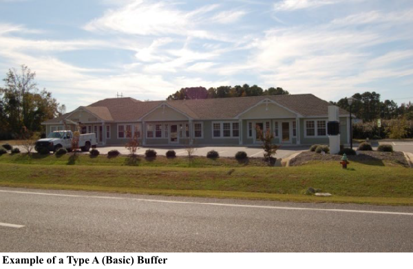
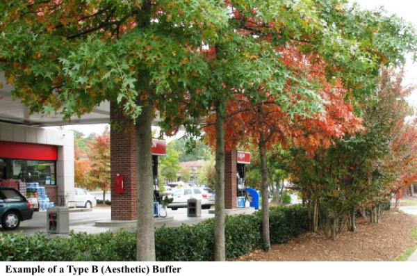
| Type A: Basic | |||||||
| This bufferyard functions as basic edge demarcating individual properties with a slight visual obstruction from the ground to a height of ten feet. | 3 | 0 | 0 | 1 | 6 | 0 | 3-foot-tall semi-opaque (75% transparent) fence or wall + 5 evergreen shrubs per every 100 linear feet |
| Type B: Aesthetic | |||||||
| This bufferyard functions as an intermittent visual obstruction from the ground to a height of at least 20 feet, and creates the impression of spatial separation without eliminating visual contact between uses. | 3 | 0 | 12 | 1 | 7 | 5 | 4-foot-tall semi-opaque (50% transparent) fence or wall + 10 evergreen shrubs per every 100 linear feet |
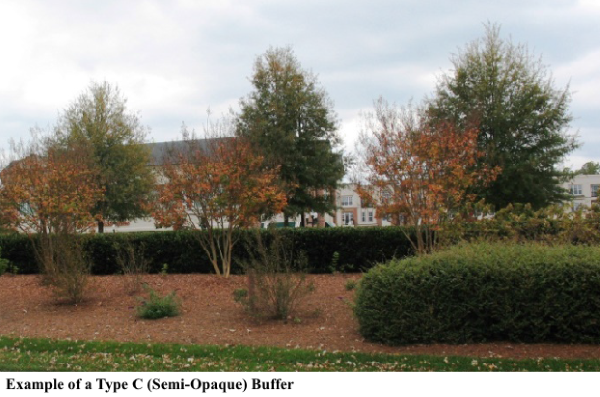
| Type C: Semi Opaque | |||||||
| This bufferyard functions as a semi-opaque screen from the ground to at least a height of four feet. | 3 | 5 | 11 | 2 | 6 | 15 | 6-foot-tall opaque fence or wall + 15 evergreen shrubs per every 100 linear feet |
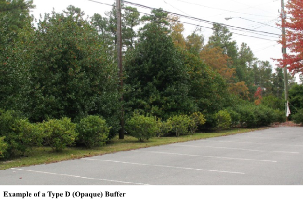
| Type D: Opaque | |||||||
| This bufferyard functions as an opaque screen from the ground to a height of at least six feet. This type of buffer prevents visual contact between uses and creates a strong impression of total separation. | 3 | 7 | 23 | 2 | 8 | 29 | 6-foot-tall opaque wall + 20 evergreen shrubs per every 100 feet |
| Type E: Alternative Special Exception | |||||||
| 15 feet wide; one canopy tree every 30 feet, on center, with each tree a minimum three inch caliper DBH and 8 feet in height at the time of planting; if adjacent to road rights of way, one understory tree every 15 feet, on center, with each tree a minimum two and one-half inch caliper DBH; and one shrub every 42 inches, on center, with a minimum height of three feet at time of planting. | |||||||
|
Notes:
1. Perimeter buffer widths (but not vegetation amounts) may be reduced in accordance with Section 2.5.5.B, Administrative Adjustment. 2. Where an adjacent use is designed for solar access, small trees shall be substituted for shade trees. 3. All canopy trees must be a minimum three inch caliper DBH and eight feet in height at the time of planting. 4. All understory trees must be a minimum two inch caliper DBH at the time of planting. | |||||||
 |  | ||||||
 |  | ||||||
d.
Location of Bufferyards. Bufferyards required by this section shall be located along the outer perimeter of the parcel and shall extend to the parcel boundary line or right-of-way line; however, the bufferyard may be located along shared access easements between parcels in nonresidential development.
e.
Development Within Required Bufferyards
1.
The required bufferyard shall not contain any development, impervious surfaces, screen enclosures, decks, or site features (except fences or walls) that do not function to meet the standards of this section or that require removal of existing vegetation, unless otherwise permitted in this LDC.
2.
Sidewalks, trails, and other elements associated with passive recreation may be placed in bufferyards if all required landscaping is provided and damage to existing vegetation is minimized.
3.
Overhead and underground utilities required or allowed by the City are permitted in bufferyards, but shall minimize the impact to vegetation, to the maximum extent practicable. Where required landscaping material is damaged or removed due to utility activity within a required bufferyard, the landowner shall be responsible for replanting all damaged or removed vegetation as necessary to ensure the bufferyard meets the standards in this LDC.
f.
Credit for Existing Vegetation. Existing vegetation located within ten feet of a required bufferyard that meets the size standards of Table 5.3.4.B.4.D-1., may be preserved and credited toward the perimeter bufferyard standards provided it is retained during and after the development process
g.
Credit for Required Landscaping. Required landscaping associated with perimeter landscaping around an off-street vehicular parking area may be credited towards the bufferyard requirements.
4.
Maintenance Standards. The owner of land subject to the requirements of this section shall be responsible for the maintenance of landscaping in a healthy and good condition. Maintenance of a landscape area includes compliance with following standards.
a.
Maintenance Standards for Cultivated Landscape Areas
1.
Maintenance of Mulch Layers. Any required mulch layer shall be maintained.
2.
Maintenance of Plants, Replacement. All plants required to be planted shall be maintained in a healthy, pest-free condition. Within six months of a determination by the Director that a plant is dead or severely damaged or diseased, the plant shall be replaced by the property owner in accordance with the standards in this section.
3.
Removal of Dead, Diseased or Dangerous Trees or Shrubs. The property owner shall be responsible for the removal of any dead, diseased, or dangerous trees or shrubs, or parts thereof, which overhang or interfere with traffic control devices, public sidewalks, rights-of-way, or property owned by the City. The City shall have the authority to order the removal of any such trees or shrubs.
4.
Pruning
(a)
All pruning shall be accomplished according to good horticultural standards.
(b)
Trees shall be pruned only as necessary to promote healthy growth. Trees shall be allowed to attain their normal size and shall not be severely pruned or "hat-racked" in order to permanently maintain growth at a reduced height. Trees may be periodically pruned or thinned in order to reduce the leaf mass in preparation for tropical storms. All pruning shall be accomplished in accordance with the standards established by the Tree Care Industry Association.
Figure 5.3.4.B.7.a.4.(b): Example of "Hat-Racking"
5.
Grass shall be mown in order to encourage deep root growth and the preservation of irrigation water.
6.
All roads, streets, curbs, and sidewalks shall be edged when necessary in order to prevent encroachment from the adjacent grassed areas.
7.
All watering of planted areas shall be managed so as to:
(a)
Maintain healthy flora;
(b)
Make plant material more drought tolerant;
(c)
Avoid excessive turf growth;
(d)
Minimize fungus growth;
(e)
Stimulate deep root growth; and
(f)
Minimize leaching of fertilizer.
8.
Irrigation systems shall be installed, operated, and maintained in accordance with Sec. 5.2.5.D.4.
b.
Maintenance of Natural Plant Communities. All open space areas that are to be preserved as natural plant communities shall be trimmed as necessary of all exotic vegetation, lawn grasses, trash or other debris, and shall be managed to maintain the plant community for the purpose it was preserved.
C.
Plant Diversity
1.
To curtail the spread of disease or insect infestation in a plant species, new tree plantings shall comply with the following standards:
a.
When fewer than 20 trees are required on a site, at least two different species shall be utilized, in roughly equal proportions.
b.
When more than 20 but fewer than 40 trees are required to be planted on a site, at least three different species shall be utilized, in roughly equal proportions.
c.
When 40 or more trees are required on a site, at least four different species shall be utilized, in roughly equal proportions.
2.
Nothing in this subsection shall be construed to prevent the utilization of a larger number of different species than specified above.
D.
Water-Wise Standards
1.
Purpose. It is the intent of this subsection to assist the City in achieving water conservation through proper plant selection, installation, and maintenance through the following:
a.
Appropriate planning and design;
b.
Limiting turf areas to locations where it provides functional benefits;
c.
Efficient irrigation systems;
d.
The use of soil amendments to improve water holding capacity of the soil;
e.
The use of mulches, where appropriate;
f.
The use of drought-tolerant plants;
g.
The preservation of existing plant communities and the re-establishment of native plant communities;
h.
The use of canopy trees to reduce transpiration rates of understory plant materials;
i.
Retention of stormwater runoff on site; and
j.
The use of pervious paving materials.
2.
Appropriate Plant Selection and Location. All plants, shrubs, and trees planted shall comply with the following standards:
a.
Plant selection shall be based on the plant's adaptability to the existing conditions present at the site, and shall consider the appropriate hardiness zone, soil type, and moisture conditions, exposure to sun, and mature plant size, established by the Florida Friendly Landscaping Guide to Plant Selection & Landscape Design maintained by the Florida Friendly Landscaping program. Plants selected must be suited to withstand the soil and physical growing conditions found in the microclimate of each location on site with supplemental irrigation only during periods of low rainfall.
b.
Plants shall be grouped in accordance with their respective water and maintenance needs to provide for efficient irrigation. Plants with similar water, soil, climate, sun, and light requirements shall be grouped together.
c.
Landscape shall be installed a minimum of 2.5 feet from the foundation of a building or structure.
d.
Turf and non-turf areas shall be designed to be distinctly separate when irrigation is used.
e.
A landscape maintenance checklist and information regarding the plants installed shall be provided to the property owner by the contractor.
f.
A landscape architect must verify and approve the soil types being used for the plants are approved for the development project. Soil samples are recommended to be verified prior to planting to assure growth potential for the plants being used.
3.
Selection of Grass Species. Turf applications shall comply with the following:
a.
Lawn areas shall be planted with species suitable as permanent lawns. Effective erosion control is mandatory in swales, rights-of-way, or other areas subject to erosion. See Appendix B for turfgrass and groundcovers lists.
b.
The primary types of grass used are encouraged to comply with the UF/IFAS Florida Yards and Neighborhoods (FYN) program for Central and South Florida.
c.
No more than 50 percent of the green space area or one-half acre, whichever is less, may be planted with a lawn grass that has a rating of low in regards to drought tolerance as established in b, above. (e.g. St. Augustine grass). Florida-Friendly Landscaping™ Groundcovers for Apopka, FL that are listed in Appendix B are encouraged for use in all developments.
d.
Grass with a rating of medium or better is strongly encouraged (e.g. Bahia grass).
e.
Medians, and retention areas shall use drought tolerant grasses with a rating of medium or better as established in Sec. b, above.
f.
In addition to those approved within b, above, drought tolerant grasses listed in Appendix B and the Florida-Friendly Landscaping™ Groundcovers for Apopka, FL are approved for use by this code.
4.
Live Oak Location. Due to potential root size expansion, live oak trees are strongly discouraged from being planted as street trees within landscape or buffer strips less than eight feet wide or 200 feet in area.
5.
Irrigation System Standards
a.
Applicability. These provisions apply to new irrigation system installations on individual residential parcels, subdivisions, and other residential common areas, multifamily development, all nonresidential developments, and additions of one or more zones to an existing irrigation system, and all expansions. No future expansion or modification will be allowed on a water wise system that would make the system non-compliant with this article.
b.
Exemptions from Irrigation Standards. The following are exempted from irrigation standards.
1.
Hand watering and portable sprinklers.
2.
Bona fide agricultural uses.
3.
Golf course play areas and specialized athletic fields, provided however, the remainder of any such property shall comply with the requirements of this section.
c.
New irrigation systems are required for the following types of development as features:
1.
Single-family detached and two-family (duplex) dwellings:
(a)
Each dwelling unit shall have a minimum of two hose bibs.
(b)
All commons areas shall be irrigated through an automatic irrigation system. This requirement may be waived by the Director in consultation with the City Water Conservation Specialist if as a water conservation technique a landscaped area only contains plant species that do not require irrigation. Consideration of a waiver of the irrigation requirement shall include, but not be limited to, the area covered by native vegetation, local conditions such as sun or shade, type of soil, depth to water table, and size and configuration of lot.
2.
Landscape in multifamily and nonresidential development, except this requirement may be waived by the Director in consultation with the City Water Conservation Specialist for a landscaped area implementing water conservation techniques including only containing plant species that do not require irrigation. Consideration of a waiver of the irrigation requirement shall include, but not be limited to, the area covered by native vegetation, local conditions such as sun or shade, type of soil, depth to water table, and size and configuration of a lot.
3.
Irrigation systems shall be designed and constructed in accordance with the technical standards contained in Appendix F of the Plumbing Volume of the Florida Building Code, the most recent edition of the Florida Irrigation Standards Manual and the following:
(a)
Irrigation systems shall be designed and installed at a water pressure of 40 p.s.i.
(b)
A rain sensing shutoff device shall be required on all irrigation systems to avoid irrigation during periods of sufficient rainfall. Equipment shall consist of an automatic sensing device or switch which will override the irrigation cycle when adequate rainfall has occurred. It must be placed where it is exposed to unobstructed natural rainfall and comply with Ch. 373, Fla. Stat., Water Conservation; Automatic Sprinkler Systems.
(c)
The use of irrigation risers is prohibited.
(d)
Check valves which are capable of holding a minimum of a five foot head shall be used in low-lying areas to prevent head drainage.
(e)
Back-flow into any water source shall be prevented as provided in Rule 62-555, FAC, Permitting, Construction, Operation, and Maintenance of Public Water Systems. Any back-flow prevention device that is testable, shall be tested by a state-licensed plumbing contractor (see Ch. 489, Fla. Stat.) upon installation, whenever the device is repaired and annually, when connected to a municipal or investor-owned drinking water system. Back-flow prevention devices are required on irrigation systems connected to private wells when the well source is also used as a private drinking water source.
(f)
Irrigation design shall be appropriate for the type of plant being grown and for the type of soil.
(g)
Irrigation system equipment shall be installed in accordance with manufacturer's specifications.
(h)
Irrigation zones shall be divided according to:
i.
Available flow rate;
ii.
Vegetated groupings (i.e., turf, shrubs, native plants, etc.);
iii.
Sprinkler types (i.e., sprinklers with matching precipitation rates); and
iv.
Soil characteristics
(i)
Spray heads and rotors shall not be mixed in the same zone.
(j)
Narrow areas, four feet or less, are not to be irrigated unless low volume/micro-irrigation is used.
(k)
Low volume irrigation is required for all trees, shrubs, and groundcover beds. (The Director in consultation with the City Water Conservation Specialist may waive this requirement if special circumstances exist).
(l)
Distribution equipment in a given zone shall have matched precipitation rates.
(m)
Application rates shall be calculated and programmed with an irrigation timer to avoid runoff and to permit uniform water infiltration into the soil, considering land slope, soil hydraulic properties, vegetative ground cover, and prevailing winds.
(n)
There shall be a minimum separation of four inches between distribution equipment and pavement.
(o)
There shall be a minimum separation of 24 inches between distribution equipment and buildings and other vertical structures.
(p)
There shall be no direct spray onto walkways, buildings, roadways, and drives.
(q)
Rotors and sprays in turf areas shall be spaced to provide head-to-head coverage.
(r)
Water conveyance systems shall have a flow velocity of five feet per second, or less.
(s)
Pipelines shall be designed to provide the system with the appropriate pressure required for maximum irrigation uniformity.
(t)
Pressure regulating heads shall be identifiable from the top of the head.
(u)
A maintenance checklist shall be affixed to or near the controller, accompanied by a recommendations for maintenance schedule, proper irrigation system settings according to season, checking the rain sensor device, and filter cleaning; and information on current water restrictions.
(v)
Upon completion of the irrigation system, a tag or sticker shall be affixed to the timer box if it is an automatic system. If it is a manual system, a sticker or tag shall be affixed to the outside main electrical breaker box on the inside of the door. The tag or sticker shall include the permit number (for nonresidential development), a copy of the landscape and irrigation certification and checklist, the date installed, the number of zones, and the installer's names.
(w)
Any irrigation system which is used for the application of chemicals shall be equipped with an antisiphon device constructed in accordance with Ch. 487, Fla. Stat.
(x)
All irrigation system underground piping shall have a minimum soil cover of six inches.
(y)
Piping and fittings approved by the National Sanitation Foundation for potable water use shall be used upstream of a backflow device.
(z)
System controls that use low voltage wiring shall be installed in accordance with the National Electric Code.
(aa)
Reclaimed irrigation water and application facilities shall be lavender in color. Routine repairs covering less than 12 inches on residential systems may use any color pipe. Irrigation heads shall be lavender in color if available from the manufacturer. A sign must be posted indicating reclaimed water is being used as irrigation (in English and Spanish). A warning sign prohibiting consumption shall be posted at any hose bib dispensing reuse water. Irrigation using reclaimed water rather than potable water when reclaimed water is reasonably available is strongly encouraged.
(bb)
Low volume irrigation zones shall have a pressure regulator and a filter with a mesh smaller than the emitter openings.
4.
System Layout
(a)
A landscaped area on a site shall be divided into high, medium, and low volume irrigation areas. The areas may not be modified outside of the standards of b through d, below.
(b)
A high volume irrigation area shall not exceed 50 percent of the landscaped area, or cover more than one-half acre on single-family residential lots.
(c)
A medium volume irrigation area shall not exceed 75 percent of the landscaped area, and shall not exceed 25 percent of the landscaped area if high volume irrigation is utilized on the site.
(d)
At least 25 percent of a landscaped area must be covered by a low volume irrigation area.
5.
System Operation and Maintenance
(a)
Irrigation systems shall be operated properly and in compliance with this section
(b)
All automatic controllers shall be programmed to maximize water conservation.
(c)
Automatic irrigation systems shall be operated in compliance with City administrative rules or St. John's River Water Management District rules. (see Code of Ordinances, Sec. 82-194)
(d)
Irrigation systems shall be maintained to meet the requirements of this section and the spirit of water conservation. Systems shall be routinely examined to prevent waste of water due to loss of heads, broken pipes or misadjusted nozzles.
6.
Native Vegetation Retention. Any area preserved as native vegetation shall be exempt from any irrigation requirement, given:
(a)
No supplemental water shall be applied to the native vegetation area.
(b)
The native vegetation will only be pruned by hand.
(c)
Mechanical mowing or clearing is prohibited.
E.
Right-of-Way and Adjacent Property Maintenance
1.
Maintenance
A.
It shall be the duty of the owner of each lot, tract or parcel of land within the city to reasonably mow, maintain, regulate and effectively control excessive growth and accumulation of weeds, undergrowth, or dead or living plant life between the property and the adjacent road right-of-way.
B.
It shall be the duty of any established association (e.g. homeowner's association or management group) within the city, to reasonably mow, maintain, regulate and effectively control excessive growth and accumulation of weeds, undergrowth, or dead or living plant life between the property and the adjacent road right-of-way at the following locations:
1.
Right-of-way adjacent to a development perimeter which is separated from the property by a development wall of fence.
2.
Medians and common areas located within the legally described development area of the association.
C.
Determination by the city that an adjacent right-of-way or adjacent property is improperly maintained shall constitute a nuisance subject to code enforcement.
F.
Single-family or Two-family Residential Lot Trees. Each residential lot shall contain at least the following minimum number of residential lot trees. These trees must be a minimum of eight feet in height and at least three inches in caliper. The Community Development Director or designee may approve a substitution of one canopy tree for two understory trees. Plant selection shall be based on Florida Friendly Landscaping Guide to Plant Selection & Landscape Design maintained by the Florida Friendly Landscaping program. Also refer to Table 5.3.8.D.1. Tree Replacement List and Planting Strip Widths.
1.
Lots less than 5,000 square feet shall contain a minimum of one canopy tree.
2.
Lot 5,000 to 7,999 square feet shall contain a minimum of two canopy trees.
3.
Lots 8,000 to 11,999 square feet shall contain a minimum of four canopy trees.
4.
Lots 12,000 to 19,999 square feet shall contain a minimum of five canopy trees.
5.
Lots 20,000 square feet or greater shall contain a minimum of six canopy trees.
(Ord. No. 2745, §§ 8, 9, 1-15-2020; Ord. No. 2877, § XV, 12-15-2021; Ord. No. 2925, § III, 5-18-2022)
5.2.6. - Alternative Landscape Plan
A.
General. An alternative landscape plan may be approved where a deviation from the landscaping standards in this section, or the tree protection standards in Sec. 5.3 Tree Protection Standards, is justified because of site or development conditions that make compliance with such standards impossible or impractical. Such conditions may include:
1.
Natural conditions, such as lakes, ponds, or other natural features;
2.
The likelihood that landscaping material would be ineffective at maturity due to placement, or other existing site conditions;
3.
Lot size or configuration;
4.
The presence of utility or other easements;
5.
The potential for interference with public safety; and
6.
Other situations where strict adherence to the landscaping or tree protection standards are determined to be impractical by the Director.
B.
Submittal and Review. An applicant may submit an alternative landscape plan as part of an application for approval of a development plan (major or minor) (Sec. 2.5.2.A, Development Plan (Major and Minor)), or plat (subdivision), (Sec. 2.5.2.B, Plat (Subdivision), or building permit (Code of Ordinances Art.VI, Sec. 6.08.00), as appropriate. The Director shall review and approve an alternative landscape plan if it meets the purpose and intent of the landscaping standards in this section, or Section 5.3, Tree Protection Standards, as appropriate, and this section.
C.
Allowable Deviations. Allowable deviations from the standards of this section and Section 5.3, Tree Protection Standards, include, but are not limited to, the following:
1.
Reduction in Standards Due to Protection of Natural Features, Public Safety, or Parcel Configuration. A reduction in the count, spacing, species diversity, or site standards of this section by up to 20 percent may be allowed when desirable in terms of enhanced protection of existing natural features, to address public safety issues, or a site design as determined by the DRC.
2.
Substitution Near Power Lines. Required canopy tree planting may be substituted for two understory trees within 20 feet of an overhead power line.
5.3.1.- Purpose
The purpose of this section is to provide for protection and maintenance of trees. The standards are intended to:
A.
Preserve the visual and aesthetic qualities of the City;
B.
Encourage site design techniques that preserve the natural environment and enhance the developed environment;
C.
Increase control of erosion and sediment runoff;
D.
Conserve energy by reducing heating and cooling costs;
E.
Preserve and enhancing air and water quality;
F.
Reduce the heat island effect; and
G.
Maintain and enhance the quality of life in the City.
5.3.2. - Applicability
A.
General. Unless exempted in accordance with B, below, the standards in this section apply to all new development in the City.
B.
Exemptions. The following activities are exempt from this section; however, any removal requires approval of the Community Development Director or designee:
1.
Utility Operations. Tree removal by duly constituted communication, water, sewer, electrical, or other utility companies, or Federal, State, County or City agencies, or engineers or surveyors working under a contract with such utility companies or agencies, provided the tree removal is limited to those trees necessary for maintenance of existing lines or facilities or for construction of new lines or facilities for providing utility service to its customers, and provided that the activity is conducted in a way that avoids any unnecessary removal, and in the case of aerial electrical utility lines, is not greater than that specified by the National Electrical Safety Codes as necessary to achieve safe electrical clearances.
2.
Surveyors. Tree removal by a Florida licensed land surveyor in the performance of duties, provided the tree removal or alteration is limited to a swath three feet or less in width.
3.
Commercial Growers. Tree removal at commercial nurseries, botanical gardens, tree farms and groves, if the trees removed were planted for silvicultural or agricultural purposes, or for the sale or intended sale in the ordinary course of business.
4.
Emergencies. Tree removal during emergencies caused by hurricane or other natural disaster.
5.
Maintenance by City Crews. The planting, pruning, or maintenance and removal of trees, plants and shrubs by City crews within the illumination lines of lights, streets, alleys, avenues, lanes, squares, and public grounds, as necessary to ensure public safety or to preserve or enhance the symmetry and beauty of public grounds.
6.
Intersection Visibility. The selective and limited removal of trees or vegetation necessary to obtain clear visibility at driveways or intersections
7.
Single-Family Detached and Two-Family (Duplex) Homes. Removal of trees other than specimen trees on developed single-family detached and two-family (duplex) lots or lots within a single-family detached or two-family (duplex) subdivision platted before March 6, 2019;
8.
Dead or Diseased Tree. The removal of dead, diseased, or naturally fallen trees, including specimen trees;
9.
Residential Property. The pruning, trimming, or removal of a tree, including specimen trees, on developed single-family detached and two-family (duplex) lots or lots within a single-family detached or two-family (duplex) subdivision platted after March 6, 2019, if the property owner submits documentation to the City from an arborist certified by the International Society of Arboriculture or from a Florida licensed landscape architect that the tree presents a danger to persons or property; and
10.
On-going Agricultural Operations. The removal and cutting of trees as part of an ongoing agricultural operation, including silvicultural operations.
(Ord. No. 2805, § VIII, 11-18-2020; Ord. No. 2994, § X, 3-15-2023)
5.3.3. - Arbor Permit Required
An Arbor Permit shall be approved in accordance with Sec. 2.5.4.A, Arbor Permit, prior to removal of a tree protected by this section.
5.3.4. - Timing of Review
Review for compliance with these standards shall occur during review of a development plan (major or minor) (Sec. 2.5.2.A, Development Plan (Major and Minor)), plat (subdivision), (Sec. 2.5.2.B, Plat (Subdivision), arbor permit (Sec. 2.5.4.A, Arbor Permit), or building permit (Code of Ordinances Art.VI, Sec. 6.08.00), whichever occurs first.
5.3.5. - Responsibility for Compliance
Failure to comply with the standards in this section is a violation of this LDC and subject to the remedies and penalties in this section and Article 9: Enforcement
5.3.6. - Existing Tree Canopy Defined
A.
For the purposes of this section, "existing tree canopy" consists of the crowns of all healthy self-supporting canopy trees with a diameter at breast height (DBH) of ten inches or greater and the crowns of all healthy self-supporting understory trees with a caliper size of four inches or greater, provided, however, that "existing tree canopy" shall not include prohibited tree species.
B.
A protected canopy tree is an individual canopy tree of 10 inches DBH or a self-supporting understory tree of four inches or greater DBH, that would qualify as a part of the existing tree canopy in Sec. 5.3.6.A, above.
5.3.7. - Retention of Existing Canopy
A.
Existing Tree Canopy Inventory Required. Prior to any tree clearing, development work, land disturbing activity, or activity to officially set aside a preservation area the owner of land subject to this section shall prepare and submit an inventory of existing canopy and understory trees on the development site, subject to the following requirements.
1.
General. The inventory shall identify all existing canopy trees (which includes specimen trees and understory trees) on the development site that are healthy. Known dead or diseased trees shall be identified, where practical. Groups of existing canopy and understory trees in close proximity (i.e., those within five feet of each other) may be designated as a clump of trees, with the predominant species, estimated number, and average diameter indicated.
2.
Specimen Trees. The inventory shall indicate the species, size (in DBH), health, and location of each specimen tree on the site.
3.
Protected Canopy Trees. The inventory shall indicate the number of existing canopy trees on site.
4.
Protected Understory Trees. The inventory shall include the number of understory trees on site.
5.
Additional Trees. The inventory shall indicate other trees at least six inches DBH on site.
6.
Professional Preparation. Tree inventories for lots larger than two acres in area shall be prepared by a licensed landscape architect, surveyor under the direction of a licensed landscape architect, arborist, or registered forester, and shall have an accuracy of plus or minus three feet.
7.
Tree Survey. A tree survey shall be required for any nonresidential development or residential subdivision requiring development plans. The applicant shall provide the following information as part of the tree survey:
(a)
Aerial photograph (minimum one inch equals 200 feet) or drawing indicating utility lines, boundary lines, dimensions, surrounding streets, and proposed development improvements.
(b)
Common and botanical name of major tree groups shown.
(c)
Estimated height and DBH of major tree groups shown.
(d)
Each DBH, location, botanical and common name of any protected tree stands, individuals or specimen trees.
(e)
Estimated DBH of trees less than six inches DBH and percentage of those trees to be removed.
(f)
Plans on how those remaining trees shall be protected and type of barriers to be used.
(g)
Proposed changes, if any, in site elevation grades and major contours of the land will be required on landscape plans. Care will be taken not to change original grade around those protected or remaining trees.
(h)
All trees dead, diseased, or dying and for which restoration to sound condition is not practical or in instances when a disease [exists] which can be expected to be transmitted to other trees, or to endanger the tree's health or to the public as determined by the city can be excluded from the tree survey.
The following items must be clearly listed on the tree survey or landscape plan:
(a)
Total Tree Inches on Current, Non-Altered Site.
(b)
Total Tree Inches to be Removed.
(c)
Total Tree Inches to be Replaced.
(d)
Maximum Tree Stock and Calculations.
(e)
Quantity of Specimen Trees (24" or Greater) Being Removed.
(f)
Site Clearing Area in Square Feet and Acres
(g)
The minimum percentage of a development site's existing tree canopy cover that is required to be retained and protected.
B.
Existing Tree Canopy Retention Standards
1.
Table 5.3.7.B.2.c: Tree Canopy Retention Standards, establishes the minimum percentage of a development site's existing tree canopy cover that is required to be retained and protected, based on the site's existing tree canopy cover and its base zoning district designation. The table identifies minimum required existing tree canopy retention requirements for existing tree canopy cover at six percentage points (100%, 80%, 60%, 40%, 20%, and 0%)
2.
Where the existing tree canopy cover falls between two percentage points shown on the table (e.g., 65%), the following calculations shall be undertaken to determine minimum required tree canopy retention.
a.
In the AG, T, RCE, RSF-1A, RSF-1B, RTF, and PR- districts, add 0.25 to the minimum required tree canopy retention percentage for each percentage point the existing tree canopy cover falls below a percentage point identified in the first column of the table.
Figure 5.3.7.B.2.a.: Existing Tree Canopy Retention
b.
In the RMF, RMU, MHP, C-N, C-C, O, and INST districts, the same calculation is made, except 0.125 is added to the minimum required tree canopy retention percentage for each percentage point the existing tree canopy cover falls below a percentage point identified in the first column of the table.
c.
In the C-COR, C-R, I-L, I-H, MU-D, MU-ES, MU-KPI and AIR districts, the same calculation is made, except 0.05 is added to the minimum required tree canopy retention percentage for each percentage point the existing tree canopy cover falls below a percentage point identified in the first column of the table.
C.
Establishment of Tree Protection Area
1.
The tree protection area is the area of a development site that includes the portions of the existing tree canopy cover (and the associated roots within the drip line of the canopy) that are required to be retained and protected in accordance with Table 5.3.7.B.2.c, Tree Canopy Retention Standards. The tree protection area is established in accordance with this section.
D.
Tree Protection Area
1.
The tree protection area shall be identified in the application for a development plan (major or minor) (Sec. 2.5.2.A, Development Plan (Major and Minor)), plat (subdivision), (Sec. 2.5.2.B, Plat (Subdivision), arbor permit, (Sec. 2.5.4.A, Arbor Permit) or building permit (Code of Ordinances Art.VI, Sec. 6.08.00), as appropriate.
2.
To the extent practicable, tree protection areas shall be located proximate to lot lines or site boundaries to ensure that retained trees will assist in limiting visual and auditory impacts from one form of development to another.
3.
The Director shall have discretion in adjusting the exact location of the tree protection area based on site conditions and the need for efficient development of the site.
E.
Priority Retention Area
1.
The location and configuration of the tree protection area shall be determined in accordance with the following priority retention areas, which are listed in order of priority.
a.
Existing tree canopy containing specimen trees, and their associated root zones;
b.
Existing tree canopy located in riparian buffers, wetlands, or wetland protection areas;
c.
Existing tree canopy containing stands or groups of mature deciduous trees;
d.
Existing tree canopy needed for required landscaping (i.e., bufferyards and planting strips around off-street vehicular use areas); and
e.
Existing tree canopy that is a part of wildlife habitat and other sensitive natural areas.
F.
Reforestations.
Protected trees may be removed from a development site if the landowner demonstrates development on the site cannot be located and designed to allow for a reasonable use, after exploration of applicable alternatives for relief, and submission and approval of an alternative landscaping plan (See Sec. 5.2.6, Alternative Landscape Plan) and if the removal of protected trees comply with the following:
1.
The trees removed are replaced on a one-to-one basis, based on the DBH of the removed trees.
2.
The replacement trees have a minimum size of three caliper inches.
3.
The replacement trees are planted in appropriate areas of the development site and clustered to the maximum extent practicable as a means of reestablishing existing tree canopy; and
4.
The replacement trees are planted with sufficient room to accommodate future growth.
(Ord. No. 2745, § 10, 1-15-2020)
5.3.8. - Retention of Specimen Trees
A.
Specimen Tree Defined. Specimen trees are all native trees with a DBH of 24 inches or greater or trees designated by resolution of the City Council because of their type, size, age, or other criteria.
B.
Specimen Tree Protection Standards
1.
Healthy specimen trees shall not be cut or destroyed except in accordance with Sec. 5.3.8.C, Removal of a Specimen Tree.
2.
The area within the drip line of any specimen tree shall not be subject to paving or soil compaction greater than ten percent of the total area within the drip line, or within 12 feet of the tree trunk. (See Figure 5.3.8.B.2.)
Figure 5.3.8.B.2: Limits of Paving or Compaction Near Specimen Trees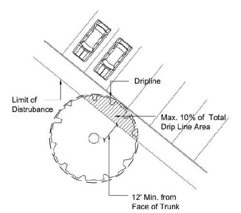
C.
Removal of a Specimen Tree. Specimen trees may be removed if the landowner demonstrates to the Director one of the following conditions:
1.
Removal of a Healthy Specimen Tree. A specimen tree is in healthy condition, and all of the following standards are met:
a.
The landowner is otherwise in compliance with this section;
b.
The specimen tree is not located within a tree protection area;
c.
The specimen tree prevents development of a lot platted before March 6, 2019 in a way that limits building area to less than otherwise allowed.
d.
Mitigation is provided in accordance with Sec. 3.5.8.D, Replacement or Mitigation Standards.
D.
Replacement and Mitigation Standards. Removal of existing tree canopy (and specimen trees) required to be retained by this section or damage or removal of trees within a tree protection area, shall require replacement of the tree in accordance with these standards.
1.
Removal or Damage in Violation. If trees required to be protected by this section are damaged or removed without an Arbor Permit or otherwise in violation of this LDC, or when work is done contrary to the permit or this LDC, the Director shall notify those conducting the work, the landowner, or the agent, and work shall stop immediately. Following notification of violation, the landowner or agent shall have up to two weeks to submit a restoration plan in accordance with Sec. 5.3.8.D.2, Restoration Plan Required, below.
2.
Restoration Plan Required
a.
A restoration plan—including a narrative describing the tree replanting proposed and a schedule for restoration efforts—shall be completed prior to the certificate of occupancy being issued.
b.
If no new certificate of occupancy is required, then failure to submit and follow a restoration plan shall be subject to Article 9: Enforcement
3.
Replacement Requirements
a.
As a part of development approval, for every specimen or non-specimen tree inch DBH removed, the Director shall apply a fee as calculated in the City Code of Ordinances.
b.
For every canopy tree that is removed or damaged, one canopy replacement tree is required.
c.
Minimum size of a replacement tree shall be three inches DBH with a minimum planted height of eight feet. Florida Grade A trees are required.
4.
Extent of Removal Undetermined. In cases where the total DBH of trees removed in violation cannot be determined, eight replacement trees shall be provided per acre of disturbed area.
5.
Transplanting Trees. All trees transplanted to the site shall be maintained in healthy living condition.
6.
Irrigation Required. An irrigation system shall be provided for replacement trees. Nothing in these standards shall prevent hand-watering or other irrigation techniques, subject to approval by the Director.
7.
Establishment Period. Replacement trees shall be subject to a performance guarantee posted for a one-year establishment period. In the event the replacement trees do not survive the establishment period, the landowner or agent shall install new replacement trees.
E.
Replacement Tree Species List and Tree Planting Strip Widths. The following tree replacement species are suggested because they are native to the region and/or their proven performance in Central Florida. The following tree may be used as replacement stock without prior approval but must be planted within the noted planting width. All other replacement trees must be approved by the Community Development Director or designee.
(Ord. No. 2925, § IV, 5-18-2022)
5.3.9. - Tree Protection During Construction
A.
Owner's Responsibility. During construction, the landowner or developer shall be responsible for the erection of any and all barriers necessary to protect trees within a tree protection area or other existing vegetation to be retained from damage both during and after construction.
B.
Tree Protection Fencing
1.
Where Required. Trees within the tree protection area, shall be fenced with a sturdy and visible fence before grading or other development activity begins. Fencing shall be erected no closer than one linear foot to the tree's drip line. The Director shall consider the existing site conditions in determining the exact location of tree protection fencing. Nothing shall prevent the use of alternative tree protection measures, as approved by the Director.
Figure 5.3.9.B.1: Tree Protection Fencing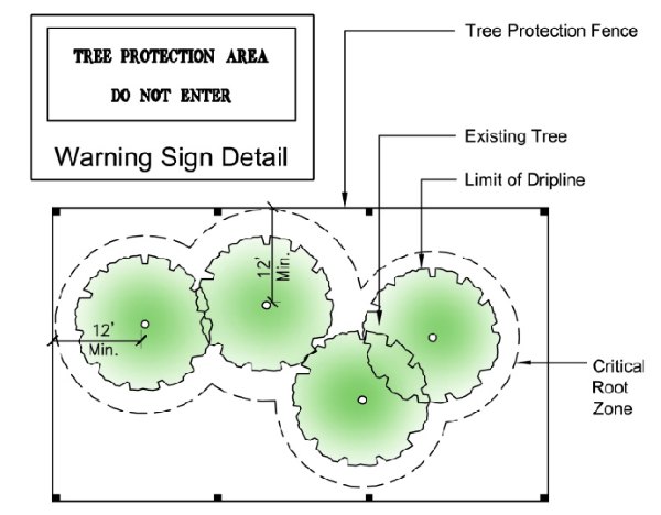
2.
Type of Fencing. All fencing required by this section shall be a minimum four feet high and be made of durable construction (i.e., chain link or wooden post with 2x4 wire mesh). Posts shall be located no more than ten feet on-center. Chain link or wire fencing utilized as tree protection fencing shall not be required to be vinyl coated. Passive forms of tree protection may be utilized to delineate tree protection areas that are remote from areas of land disturbance. These must be surrounded by fencing, continuous rope, or durable taping (minimum four inches wide).
3.
Signage. Signs shall be installed on the tree protection fence visible on all sides of the fenced-in area at a rate of at least one for every 150 linear feet. The size of each sign must be a minimum of two feet by two feet and shall contain the following language: "TREE PROTECTION AREA: KEEP OUT."
Figure 5.3.9.B.3: Tree Protection Signage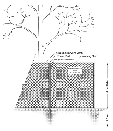
4.
Inspection. All tree protection measures shall be inspected and approved by the Director prior to start of any land disturbing activities. Failure to have tree protection measures in place prior to land disturbance (other than surveying) is a violation of this LDC.
5.
When Required. No construction, grading, equipment, or material storage, or any other activity shall be allowed within the fenced area. Fencing shall be maintained until after the final site inspection.
5.3.10. - Deferral of Tree Replacement
A.
If the applicant can demonstrate that the market conditions are such that replacement trees are not readily available or the time of year is not suitable for planting, then compliance with this LDC may be deferred for a period of time approved by the Director, but in no case for a cumulative time in excess of 18 months.
B.
The applicant shall post a cash escrow, or other financial security acceptable to the Director, for an amount sufficient to pay the costs plus ten percent for the required, but not yet installed, landscaping before such deferral shall be authorized.
5.3.11. - Incentives for Retroactive Compliance
The City may administratively provide incentives for residents to retroactively comply with the provisions of this code. Incentives may include financial assistance, equipment, services, or other mechanisms, to promote the reduction in the use of water and the protection of the environment and natural resources.
1.
Eligibility
a.
Existing city customers in homes or other developments that were built prior to the adoption of this article are eligible to apply for currently active incentives provided by the City. Incentives may be limited to single family homes.
b.
All incentives awarded are subject to the submittal of complete applications and determination of eligibility and qualification by the City. Applications will be accepted only from the current property owner(s) of record.
c.
The incentive program is provided on a first come, first served basis, and is subject to the availability of budgeted funding.
d.
Incentives will be awarded on a one (1) time basis to any physical address regardless of changes in property ownership.
2.
Incentives. The incentives, which may change from time to time, will be established to encourage residents to retrofit existing inefficient and high water-use devices with effective and efficient water-use devices.
a.
Examples of incentives include:
1.
Rotor/Spray head replacement
2.
Low Volume Irrigation Systems retrofits
3.
Rain Sensor or Soil Moisture Sensors installations.
4.
ET Controller/Smart Controller installations
5.
Irrigation Audit provided to residents
(Ord. No. 2745, § 11, 1-15-2020)
5.4.1.- Purpose
Open space set-asides are intended for the use and enjoyment of a development's residents, employees, or users. Open space set-asides serve numerous purposes, including preserving natural resources, ensuring resident access to open areas and active recreation, reducing the heat island effect of developed areas, providing civic and meeting spaces, enhancing storm water management, and providing other public health benefits.
5.4.2. - Applicability
A.
General. Unless exempted in accordance with subsection B below, the standards in this section shall apply to all new development in the City.
B.
Exemptions. The following development is exempted from the standards in this section:
1.
Rural and agricultural, and open space uses; and
2.
Single-family detached dwellings or two-family (duplex) dwellings on a single lot.
5.4.3. - Timing of Review
Review for compliance with these standards shall occur during review of a planned development (2.5.1.F, Planned Development), development plan (major or minor) (Sec. 2.5.2.A, Development Plan (Major and Minor)), or plat (subdivision), (Sec. 2.5.2.B, Plat (Subdivision), or building permit (Code of Ordinances Art.VI, Sec. 6.08.00), whichever occurs first.
5.4.4. - Amount of Open Space Set-Asides Required
Development subject to the standards in this section shall provide the minimum amounts of open space set-asides identified in Table 5.4.4: Required Open Space Set-Asides, based on the district classification.
5.4.5. - Areas Counted as Open Space Set-Asides
The features and areas identified in Table 5.4.5: Open Space Set-Aside Features, shall be credited towards compliance with the open space set-aside standards of this section for development in the areas indicated:
| Table 5.4.5: Open Space Set-Aside Features | ||
|---|---|---|
| Area Counted as Common Open Space Set-Asides | Description |
Design and Maintenance
Requirements |
| Natural Features | ||
 | Natural features (including lakes, ponds, rivers, streams, rivers, wetlands, drainageways, and other riparian areas), riparian buffers, flood hazard areas, wildlife habitat and woodland areas | Preservation of any existing natural features shall have highest priority for locating open space set-asides, except in the MU-D, MU-ES, and MU-KPI districts. Maintenance is limited to the minimum removal and avoidance of hazards, nuisances, and unhealthy conditions. |
| Active Recreational Areas | ||
 | Land occupied by areas and facilities used for active recreational purposes, such as ballfields, playgrounds, tennis courts, pools, jogging trails, and community buildings and clubhouses, and land dedicated for parks. | Active recreational areas may occupy up to 100 percent of the open space set-asides (if no natural features exist on the site) except in the Commercial districts, and the MU-D, MU-ES, and MU-KPI districts. No less than 35 percent of the total open space set-aside area within a residential development outside the Commercial districts and the MU-D, MU-ES, and MU-KPI districts shall consist of active recreational areas. Active recreational areas shall be compact and contiguous, to the maximum extent practicable, unless used to link or continue existing or public open space lands. |
| Passive Recreation (Including Plantings and Gardens) | ||
 | Formally planned and regularly maintained open areas that provide passive recreation opportunities, including arranged plantings, gardens, gazebos, and similar structures | Passive recreation shall have direct access to a street. |
| Squares, Forecourts, and Plazas | ||
 | Squares, forecourts, plazas, and civic greens that provide active gathering places and opportunities to create special places | Such features shall be at least 600 square feet in area. Such features shall have direct access to a street or sidewalk or pedestrian way that connects to a street. Surrounding buildings shall be oriented toward the square, forecourt, or plaza when possible, and a connection shall be made to surrounding development. No less than 50 percent of the total open space set-aside area within the MU-D, MU-ES, and MU-KPI districts shall be a square, forecourt, or plaza. |
| Required Landscape Areas and Agricultural Buffer | ||
 | All areas occupied by required landscaping areas, tree protection areas, perimeter buffers, vegetative screening, and riparian buffers, and agricultural buffers, except landscaped area within vehicular use areas | See Sec. 5.2, Landscaping and Buffer Standards, Sec. 3, Tree Protection Standards, Sec. 5.8, Neighborhood Compatibility Standards, and Sec. 5.9, Agricultural Compatibility Standards |
| Stormwater Management Areas Treated as Site Amenities | ||
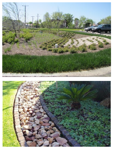 | Up to 75 percent of the land area occupied by stormwater management facilities (including retention and detention ponds and other bioretention devices), when such features are treated as an open space site amenity | To qualify, stormwater management facilities shall support passive recreation uses by providing access, gentle slopes (less than 3:1), and pedestrian elements such as paths and benches. |
| Public Access Easements with Paths or Trails | ||
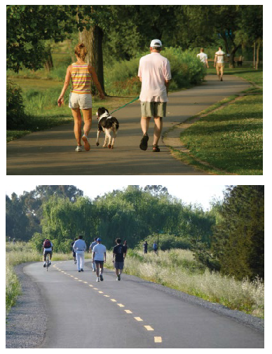 | Public access easements that combine utility easements with paths or trails that are available for passive recreational activities such as walking, running, and biking | Such public access easements shall include at least one improved access from a public street, sidewalk, or trail that includes signage designating the access point. |
5.4.6. - Areas Not Counted as Open Space Set-Asides
The following areas shall not be counted as open space set-asides:
A.
Private yards not subject to an open space or conservation easement;
B.
Street rights-of-way or private access easements, including sidewalks located within those rights-of-way or easements;
C.
Vehicular parking areas or lots (including the landscaped areas);
D.
Driveways for dwellings;
E.
Land covered by structures not designated for active recreational uses;
F.
Designated outdoor storage areas; and
G.
Storm water management facilities and ponds, unless located and designed as a site amenity (e.g., with low fencing, vegetative landscaping, gentle slopes, fountain or other visible water circulation device, and pedestrian access or seating).
(Ord. No. 2994, § XI, 3-15-2023)
5.4.7. - Design Standards for Open Space Set-Asides
Land used as an open space set-aside shall comply with the following design standards:
A.
Location. Open space shall be located so as to be readily accessible and useable by occupants and users of the development. Where possible, a portion of the open space set-aside should provide focal points for the development through prominent placement or easy visual access from streets.
B.
Configuration.
1.
Open space set-asides shall be compact and contiguous unless a different configuration is needed to continue an existing trail or accommodate preservation of natural features.
2.
If the development site is adjacent to existing or planned public trails, parks, or other public open space area land, the open space set-aside shall, to the maximum extent practicable, be located to adjoin, extend, and enlarge the trail, park, or other public land (see Figure 5.4.7.C: Example Open Space Set-Aside Configuration).
3.
If a passive recreation open space set-aside area with a minimum width of 20 feet or more abuts an existing or planned public open space area, no perimeter buffer shall be established between the two open space areas.
C.
Orientation of Adjacent Buildings. To the maximum extent possible, buildings adjacent to the required open space set-asides shall have at least one entrance facing the open space set-aside.
Figure 5.4.7.C: Example Open Space Set-Aside Configuration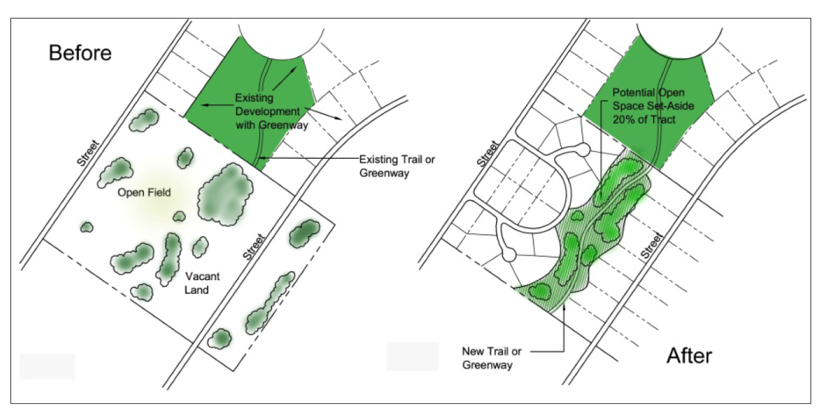
D.
Prioritization of Open Space Set-Aside.
1.
Except in the MU-D, MU-ES, and MU-KPI districts, and to the maximum extent practicable, open space set-asides shall be located and organized to include, protect, and enhance as many of the following open areas and features as possible, in the following general order of priority:
a.
Natural features such as riparian areas, riparian buffers, flood hazard areas, floodplains, and wildlife habitat and woodland areas;
b.
Water features such as rivers, bays, lakes, creeks, canals, natural ponds, and retention and detention ponds;
c.
Protected trees and other mature trees;
d.
Parks and trails;
e.
Lands with active agricultural uses and activities;
f.
Perimeter buffers or visual transitions between different types or intensities of uses; and
g.
Areas that accommodate multiple compatible open space set-aside uses rather than a single use.
2.
In the MU-D, MU-ES, and MU-KPI districts, and to the maximum extent practicable, open space set-asides shall be located and organized to include, protect, or enhance the open areas and features identified in Table 5.4.5: Open Space Set-Aside Features, above, except that the establishment of squares, plazas, forecourts, civic greens, and similar urban open space amenities shall have the highest priority.
5.4.8. - Development in Open Space Set-Asides
Development within open space set-asides shall be limited to that appropriate to the purposes of the type(s) of open space set-asides. Where appropriate, such development may include, but is not limited to, walking, jogging, and biking paths or trails; benches or other seating areas; meeting areas; tables, shelters, grills, and other picnicking facilities; docks and other facilities for fishing; environmental education guides and exhibits; gazebos and other decorative structures; fountains or other water features; play structures for children; gardens or seasonal planting areas; pools; athletic fields and courts; and associated clubhouses.
5.4.9. - Ownership, Management, and Maintenance of Open Space Set-Asides
A.
Open space set-asides shall be managed and maintained as permanent open space through one or more of the following options:
1.
Conveyance of open space set-aside areas to a property owners' or homeowners' association that holds the land in common ownership and will be responsible for managing and maintaining the land for its intended open space purposes, in perpetuity;
2.
Conveyance of open space set-aside areas to a third party beneficiary such as an environmental or civic organization that is organized for, capable of, and willing to accept responsibility for managing and maintaining the land for its intended open space purposes, in perpetuity; or
3.
Establishment of easements on those parts of individually-owned lots including open space set-aside areas that require the areas to be managed consistent with the land's intended open space purposes and prohibit any inconsistent future development, in perpetuity.
B.
All options involving private ownership of open space set-aside areas shall include deed restrictions, covenants, or other legal instruments that ensure continued use of the land for its intended open space purposes, in perpetuity, and provide for the continued and effective management, operation, and maintenance of the land and facilities.
C.
Responsibility for managing and maintaining open space set-asides rests with the owner of the land of the open space set-asides. Failure to maintain open space set-asides in accordance with this section and the development approval or permit shall be a violation of this LDC.
5.5.1.- Purpose
The purpose of this section is to establish standards for the location, height, and appearance of fences and walls in the City, and ensure the safety, security, and privacy of properties.
5.5.2. - Applicability
A.
General. Unless exempted in accordance with Sec. 5.5.2.B, Exemptions, the standards in this section apply to all construction, substantial reconstruction, or replacement of fences or walls in the City.
B.
Exemptions. The following fences and walls are exempt from the standards in this section:
1.
Fences and walls required for support of a principal or accessory structure;
2.
Fences or barricades around construction sites;
3.
Fences for tree protection;
4.
Fences customarily provided for athletic fields and recreational facilities;
5.
Landscaping berms installed without fences; and
6.
Fences at parks and schools, where such uses are owned by public agencies.
5.5.3. - Timing of Review
Review for compliance with these standards shall occur during review of a planned development (2.5.1.F, Planned Development), development plan (major or minor) (Sec. 2.5.2.A, Development Plan (Major and Minor)), or plat (subdivision), (Sec. 2.5.2.B, Plat (Subdivision), or building permit (Code of Ordinances Art.VI, Sec. 6.08.00), whichever occurs first.
5.5.4. - General Standards
A.
General
1.
Fences and walls shall be located outside of the public right-of-way.
2.
Fences and walls are allowed on the property line between two or more parcels of land held in private ownership.
3.
Fences and walls may be located within any required yard
4.
Fences and Walls shall not be located within two feet of a sidewalk.
B.
In Utility Easements. Fences located within utility easements shall receive written authorization from the easement holder or the City, as applicable. The City shall not be responsible for damage to, or the repair or replacement of, fences that must be removed to access utility easements or facilities.
C.
Blocking Natural Drainage Flow. Fences and walls shall not be located where they would block or divert a natural drainage flow onto or off of any land. Nothing in this subsection shall be construed to prevent the installation of temporary fencing to protect existing trees, limit sedimentation, or control erosion.
D.
Blocking Access to Fire Hydrants. Fences and walls shall not be located where they would prevent immediate view of, or access to, fire hydrants or other fire-fighting water supply devices, in accordance with the Fire Code.
E.
Within Required Landscaping Areas. Fences and walls may be installed within required landscaping areas, subject to an approved landscaping plan. They shall be configured so as not to disturb or damage existing vegetation or installed plant material, to the maximum extent practicable.
F.
Within Sight Triangle. Fences and walls located within a required site triangle shall not be located in such a manner as to limit or obstruct the sight distance of motorists entering or leaving the intersection as established in the last edition of the Manual of Uniform Minimum Standards for Design, Construction, and Maintenance for Streets and Highways, FDOT.
G.
Obstructing Windows or Doors. Fences and walls shall not block access from a window or door.
H.
Avoidance of Traffic Hazards. Notwithstanding other provisions of this section, fences and walls shall not be allowed in a location the Director determines will create a traffic hazard.
I.
Maintenance. Fences and walls and associated landscaping shall be maintained in good repair and in a safe and attractive condition. Maintenance of fences and walls shall include, but not be limited to:
1.
The replacement of missing, decayed, or broken structural or decorative elements;
2.
The repair of deteriorated or damaged fence materials; and
3.
The preservation or repair of weathered surfaces visible from the public right-of-way, sagging, and leaning of any fence or wall post more than 10 degrees from vertical.
5.5.5. - Height Standards
A.
General Height Standards. The height of fences and walls except for residential developments on corner lots shall comply with Table 5.5.5.A: Fence and Wall Height
B.
Residential Development on Corner Lot Standards. A fence or wall for a residential unit on a corner lot shall comply with one of the following standards:
1.
Option 1 (See Figure 5.5.5.B.1):
a.
A fence or wall within a front or street-side front setback:
1.
Shall have a maximum height of four feet.
2.
Shall be set back at least two feet from sidewalks, right-of-way (ROW), and front driveways.
b.
A fence or wall within a side or rear setback shall have a maximum height of six feet, up to the front setback including the double front building setback line.
c.
The lot setback shall comply with the applicable zoning district.
d.
Corner clear view triangle standards shall control over other setback standards.
e.
No fence or wall shall be permitted on a local road lot within 30 feet of an intersecting street right-of-way (ROW) and 50 feet on collector and arterial roads, measured from the ROW line
f.
No fence or wall shall be erected within a landscape or utility easement that is within a side-street front setback.
Figure 5.5.5.B.1: Residential Development on Corner Lot
Option 1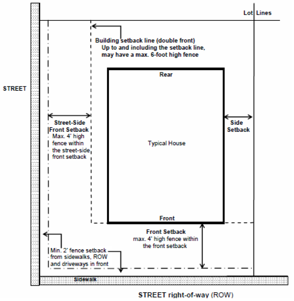
2.
Option 2 (See Figure 5.5.5.B.2):
a.
A fence or wall in the street-side front setback on a residential lot that is double-fronted (roadway on front and side of a building, regardless of intersection), shall have a maximum height of six feet if it complies with the following additional standards:
1.
The fence or wall is a maximum of one-half the front setback distance from the building (rounding down to the whole foot).
2.
The fence or wall is setback at least 20 feet from the front of the building.
3.
No fence or wall shall be erected within a landscape or utility easement that is within a side-street front setback.
Figure 5.5.5.B.2: Residential Development on Corner Lot
Option 2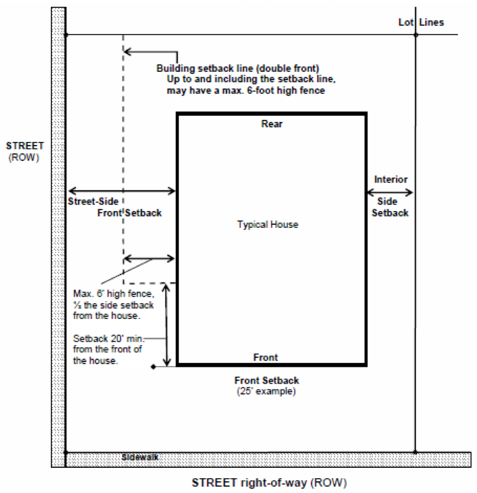
(Ord. No. 2994, § XII, 3-15-2023)
5.5.6. - Materials Standards
A.
General. Unless otherwise specified in Sec. 5.5.6.B, Prohibited Materials, fences and walls shall be constructed of any one or more of the following materials:
1.
Masonry or stone;
2.
Ornamental iron, except that fencing shall not incorporate spiked tops within a Residential district without approval of a security exemption plan in accordance with Sec. 5.5.12, Security Exemption Plan;
3.
Painted wood, pressure treated wood, or rot-resistant wood such as cedar, cypress, or teak;
4.
Composite materials designed to appear as wood, metal, or masonry;
5.
Chain link only in AG, RCE, INST, PR, I-L, I-H, or AIR districts, or as a customary part of a sports field. Where chain link fencing is permitted, all chain link fences in RCE, INST, PR, I-L, I-H, and AIR shall be vinyl coated or powder coated (or equivalent as approved by the DRC), and installed with the pointed ends to the ground (rounded or smooth on top);
6.
All fences in I-L and I-H that are adjacent to any road right-of-way, chain link, or wooden fences shall not be allowed. (see Appendix D—Development Design Guidelines, 4.6 Fences and Walls). Side or rear fencing in I-L and I-H chain link that is vinyl or powder coated, or solid fencing or wall as approved by the DRC.
7.
Dog park chain link fencing shall be allowed provided it is vinyl or powder coated (or equivalent as approved by the DRC.
8.
Walls clad with substrate material intended to support living vegetation.
B.
Prohibited Materials. The following fence types or materials are prohibited:
1.
Barbed or razor wire, unless approved as part of a security exemption plan in accordance with Sec. 5.5.12, Security Exemption Plan, except on land that is assessed for agricultural use, or on land used for installation and operation of high-voltage equipment at substations for electrical generation, transmission, and distribution in connection with providing public utility service in the City by a regulated public utility. In no event shall barbed wire be placed so as to project outward over any sidewalk, street, or public way, or over property of an adjacent owner. Where barbed wire is allowed, it shall be a minimum of six feet above the ground, held by vinyl-coated brackets matching the color of the fence, and limited to three strands;
2.
Fences and walls erected in any Residential, Commercial, or the MU-D, MU-ES, or MU-KPI districts that contain any substance such as broken glass, spikes, nails, razor edges or similar materials designed to inflict pain or injury to any person or animal;
3.
Fences constructed of chicken wire, corrugated metal, fabric materials, fiberboard, garage door panels, plywood, rolled plastic, sheet metal, debris, junk, or waste materials, unless such materials are recycled and reprocessed, for marketing to the general public, as building materials designed to resemble new building materials (e.g., picket fencing made from recycled plastic and fiber);
4.
Chain link fences, except as allowed per Sec. 5.5.6.A.
5.
Above-ground fences that carry electrical current, except below-ground electrical fences intended for the keeping of pets.
(Ord. No. 2745, § 12, 1-15-2020; Ord. No. 2877, § XVI, 12-15-2021)
5.5.7. - Perimeter Fences and Walls Abutting Street Right-of-Way
Except in the I-H and AIR districts, fences or walls that are located within 15 feet of a street right-of-way shall:
1.
Be of a uniform style;
2.
Be constructed of brick, stone, concrete (when covered with stucco or similar finish), vinyl, or vertical wooden boards; and
3.
Include breaks, offsets, access points, or other design details in the fence or wall plane at least every 200 feet (see Figure 5.5.7.3: Fence and Wall Offsets).
Figure 5.5.7.3: Fence and Wall Offsets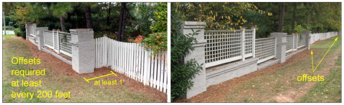
5.5.8. - Appearance
A.
Finished Side to Outside. Wherever a fence or wall is installed, if one side of the fence or wall appears more "finished" than the other (e.g., one side of a fence has visible support framing and the other does not, or one side of a wall has a textured surface and the other does not), the more "finished" side of the fence shall face the exterior of the lot rather than the interior of the lot (see Figure 5.5.8.A: Fence with Finished Side Out).
Figure 5.5.8.A: Fence with Finished Side Out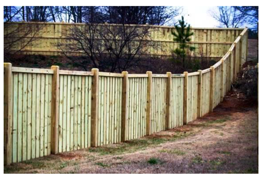
B.
Compatibility of Materials Along a Single Lot Side. All fencing or wall segments located along a single lot side shall be composed of a uniform style and color.
C.
Fence and Wall Landscaping. Except in the I-H and AIR districts, all fences and walls exceeding four feet in height, if located within 15 feet of a street right-of-way, shall be supplemented with landscape screening in accordance with the standards in 1 and 2 below, to soften the visual impact of the fence or wall. These standards shall apply to fences in Residential single-family districts (RSF-1A, RSF-1B) only if they are located within 15 feet of the right-of-way of a principal arterial street or minor arterial street. (See Figure 5.5.8.C.2: Fence and Wall Landscaping.)
1.
Shrubs Required. One evergreen shrub shall be installed for every five linear feet of fence or wall, on the side of the fence or wall facing the public street right-of-way. Shrubs may be installed in a staggered, clustered, grouped, or linear fashion.
2.
Substitution of Understory Trees. One understory or ornamental tree may be substituted for every three shrubs provided that the tree meets the size standards of Sec. 5.2, Landscaping and Buffer Standards.
Figure 5.5.8.C.2: Fence and Wall Landscaping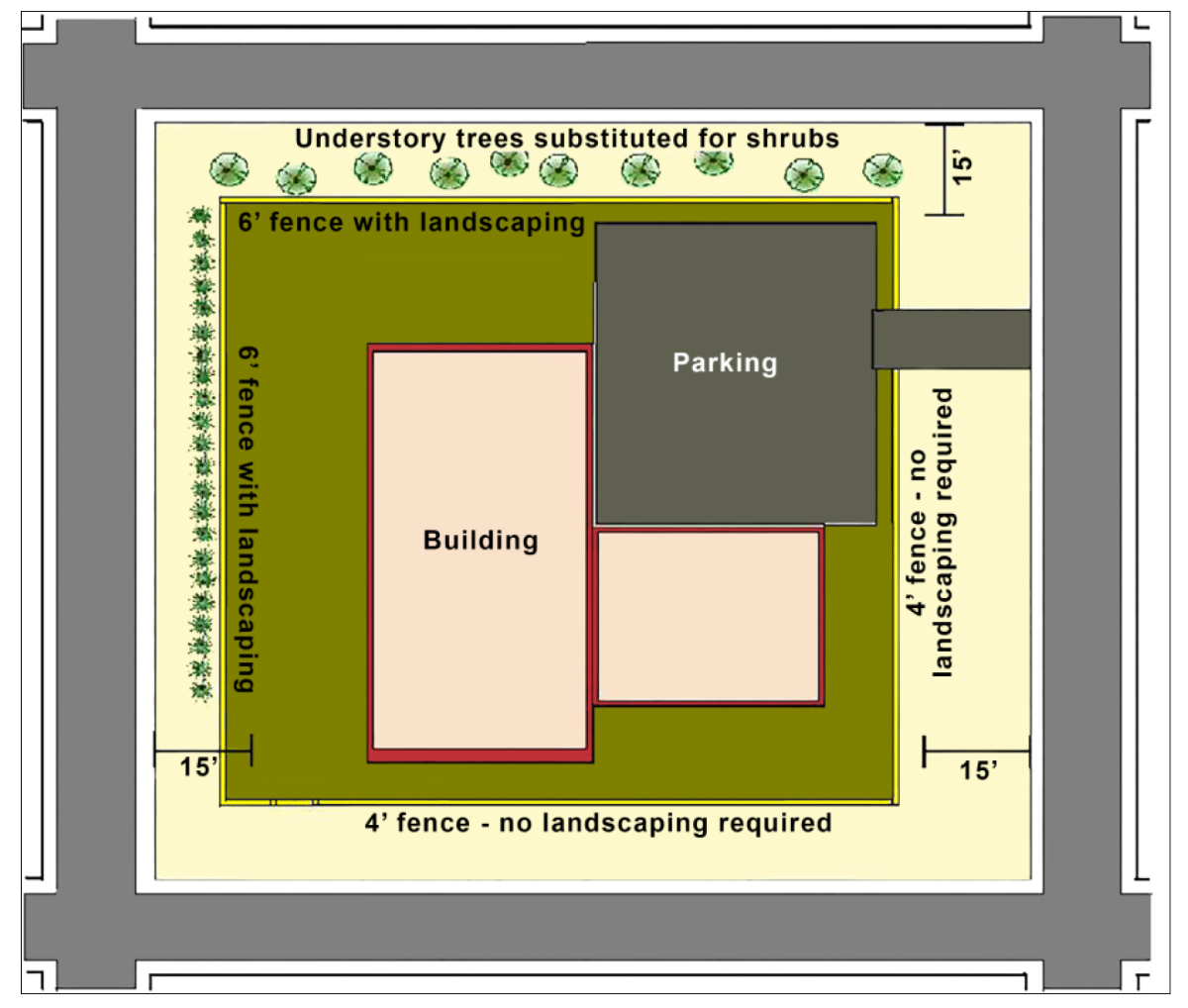
5.5.9. - Fence and Wall Construction
Fences and walls shall comply with the Florida Building Code, shall require the proper permits prior to construction, and shall be constructed in accordance with the proposed finished grade elevation.
5.5.10. - Gates
Gates shall comply with the following standards:
A.
All gates shall have hardware to secure the gate in a closed position.
B.
All unattended gates and gates opening onto a public sidewalk area shall be self-closing, self-latching, and locked when not in use.
5.5.11. - Retaining Walls
All retaining walls over 30 inches in height shall be supported by a professional engineering report that provides full structural design of the wall including structural engineering, geotechnical engineering, and civil engineering. Retaining walls over 30 inches in height shall have safety railings engineered on top of the walls. Retaining walls shall be a maximum of six feet in height. Retaining wall access and maintenance easements shall be provided both above and below all retaining walls. Easements shall be at least five feet wide and have a maximum slope of ten to one
5.5.12. - Security Exemption Plan
A landowner, or a representative of a public agency responsible for a government facility or other use in need of heightened security may submit to the Director a security exemption plan proposing a fence or wall taller than those permitted by this section or proposing the use of barbed and/or razor wire or electric wire atop a fence or wall for security reasons. The Director may approve or approve with conditions, the security exemption plan, upon finding all of the following:
A.
Need for Safety or Security Reasons. The condition, location, or use of the land, or the history of activity in the area, indicates the land or any materials stored or used on it are in significantly greater danger of theft or damage than surrounding land, or represent a significant hazard to public safety without:
1.
A taller fence or wall;
2.
An electric fence; or
3.
Use of barbed and/or razor wire atop a fence or wall.
B.
No Adverse Effect. The proposed fence or wall will not have a significant adverse effect on the security, functioning, appearance, or value of adjacent lands, or the surrounding area as a whole
C.
Denial of Security Exemption Plan. If the Director finds the applicant fails to demonstrate compliance with Sec. 5.5.12.A and B, above, the security plan shall be denied.
5.6.1.- Purpose and Intent
The purpose and intent of this section is to regulate exterior lighting to:
A.
Ensure all exterior lighting is designed and installed to maintain adequate lighting levels on site;
B.
Assure that excessive light spillage and glare are not directed at adjacent lands, neighboring areas, and motorists;
C.
Curtail light pollution, reduce skyglow, and preserve the nighttime environment for the enjoyment of residents and visitors;
D.
Conserve energy and resources to the greatest extent possible; and
E.
Provide security for persons and land.
5.6.2. - Applicability
A.
General. Unless exempted in accordance with Sec. 5.6.2.A.2, below, the standards of this section apply to:
1.
All new development in the City; and
2.
Any individual expansion or alteration of a building existing prior to March 6, 2019 if the expansion increases the building's floor area by 50 percent or more, or the alteration involves 50 percent or more of the building's floor area (including interior alterations).
B.
Streetlight Assessment.
1.
All developments with public streets shall be required to enter into a Streetlight Special Assessment Agreement whereas the developer shall pay the streetlight assessment for the subdivision until such time that each individual lot is sold or conveyed, at which time the new owner shall be assessed the proportionate share of the street lights.
2.
After conveyance of the HOA to the subdivision's HOA, the unsold lots assessments shall be paid by the subdivision HOA. Each lot or parcel within the subdivision, except any City-owned lift stations or similar City sites, shall pay their proportionate share of the streetlight costs.
3.
All developments shall provide streetlighting for both nonresidential and residential subdivisions at entrance(s) from the main roads into the proposed development, internal private or public streets, and all county or city roads that border the development. All streetlights shall be part of the Streetlight Special Assessment. The Community Development Director or City Engineer shall make the final decision if any variation is requested.
C.
Exemptions. The following types of lighting are exempted from the standards of this section:
1.
Lighting exempt under State or federal law;
2.
FAA-mandated lighting associated with a utility tower or airport;
3.
Lighting for public monuments and statuary;
4.
Lighting solely for signage (see Section 5.10, Signs)
5.
Lighting for outdoor recreational uses such as ball diamonds, football fields, soccer fields, other playing fields, tennis courts, and similar uses, provided that:
a.
Light poles are not more than 30 feet in height, except at ball diamonds, football fields, and other playing fields, where they can be taller;
b.
Maximum illumination at the property line is not brighter than two foot-candles; and
c.
Exterior lighting is extinguished no later than 11:00 p.m., except to complete an activity that is in progress prior to 11:00 p.m.
6.
Temporary lighting for circuses, fairs, carnivals, theatrical, and other performance areas-provided such lighting is discontinued upon completion of the performance;
7.
Temporary lighting of construction sites, provided such lighting is discontinued upon completion of the construction activity;
8.
Temporary lighting for emergency situations, provided such lighting is discontinued upon abatement of the emergency situation;
9.
Security lighting controlled and activated by motion sensor devices for a duration of 15 minutes or less;
10.
Underwater lighting in swimming pools, fountains, and other water features;
11.
Holiday or festive lighting-provided such lighting does not create unsafe glare on street rights-of-way;
12.
Outdoor lighting fixtures that do not comply with provisions of this section on March 6, 2019, provided they are brought into compliance with this section when they become unrepairable.
(Ord. No. 2775, § VIII, 7-15-2020; Ord. No. 2805, § IX, 11-18-2020)
5.6.3. - Timing of Review
Review for compliance with these standards shall occur during review of a planned development (2.5.1.F, Planned Development), development plan (major or minor) (Sec. 2.5.2.A, Development Plan (Major and Minor)), or building permit (Code of Ordinances Art.VI, Sec. 6.08.00), whichever occurs first. Upon approval by the Development Review Committee (DRC), the lighting design and plans requirement may be delayed provided a plan note is added that, at a minimum states "Lighting requirements must meet all City of Apopka and the electric provider's regulations at the time of any construction plan submittal and any subsequent approvals."
(Ord. No. 2745, § 13, 1-15-2020)
5.6.4. - Lighting Plan
To ensure compliance with the standards of this section, a lighting plan demonstrating how exterior lighting will comply with the standards of this section shall be included as part of a development application unless otherwise addressed by the Development Review Committee.
(Ord. No. 2745, § 13, 1-15-2020)
5.6.5. - Prohibited Lighting
The following exterior lighting is prohibited:
A.
Light fixtures that imitate an official highway or traffic control light or sign;
B.
Light fixtures in the direct line of vision with any traffic control light or sign;
C.
Privately-owned light fixtures located in the public right-of-way;
D.
Searchlights, except when used by State, Federal, or local authorities, or where they are used to illuminate alleys, parking garages and working (maintenance) areas, if they are shielded and aimed so that they do not result in lighting on any adjacent lot or public right-of-way exceeding two footcandles; and
E.
Light types of limited spectral emission, such as low pressure sodium or mercury vapor lights. (Light sources shall be color-correct types such as Halogen, LED, or metal halide).
5.6.6. - Street Lighting
A.
All street lights shall be located inside full cut-off fixtures mounted on non-corrosive poles served by underground wiring
B.
The light structure and light color of street lights in an individual subdivision or development shall be consistent throughout the subdivision or development.
5.6.7. - General Standards for Exterior Lighting
Development subject to this section shall comply with the following standards:
A.
Hours of Illumination. Public, civic, and institutional uses, commercial uses, and industrial uses that are adjacent to existing residential development shall extinguish all exterior lighting—except lighting necessary for security or emergency purposes—by 10:00 p.m. or within one hour of closing, whichever occurs first. For the purposes of this paragraph, lighting "necessary for security or emergency purposes" shall be construed to mean the minimum amount of exterior lighting necessary to illuminate possible points of entry or exit into a structure, to illuminate exterior walkways, or to illuminate outdoor storage areas. Lighting activated by motion sensor devices is strongly encouraged.
B.
Shielding with Full Cut-off Fixtures. All exterior luminaries, including security lighting, shall be full cut-off fixtures that are directed downward, consistent with Figure 5.7.7.B-1: Full Cut-off Fixtures. In no case shall lighting be directed above a horizontal plane through the lighting fixture. See Figure 5.7.7.B-2: Examples of Fully Shielded Light Fixtures.
Figure 5.6.7.B-1: Full Cut-off Fixtures
Figure 5.6.7.B-2: Examples of Fully Shielded Light Fixtures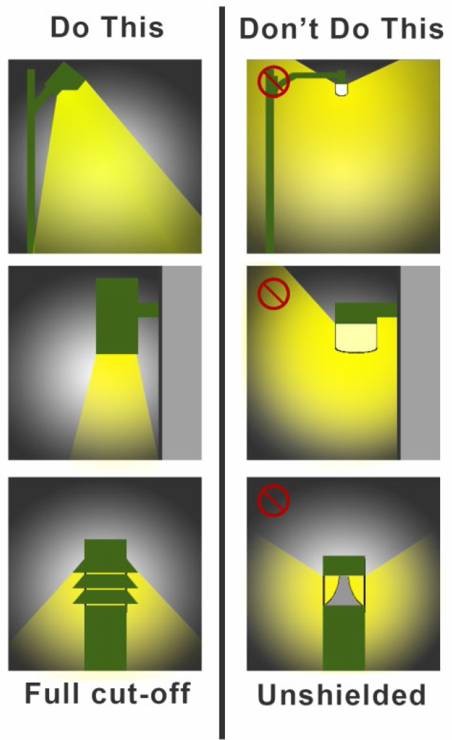
C.
Maximum Illumination Levels.
1.
All exterior lighting shall be designed and located so that the maximum illumination measured in foot-candles at ground level at a lot line shall not exceed the standards in Table 5.6.7.C: Maximum Illumination Levels, and Figure 5.6.7.C Maximum Illumination Levels.
Figure 5.6.7.C: Maximum Illumination Levels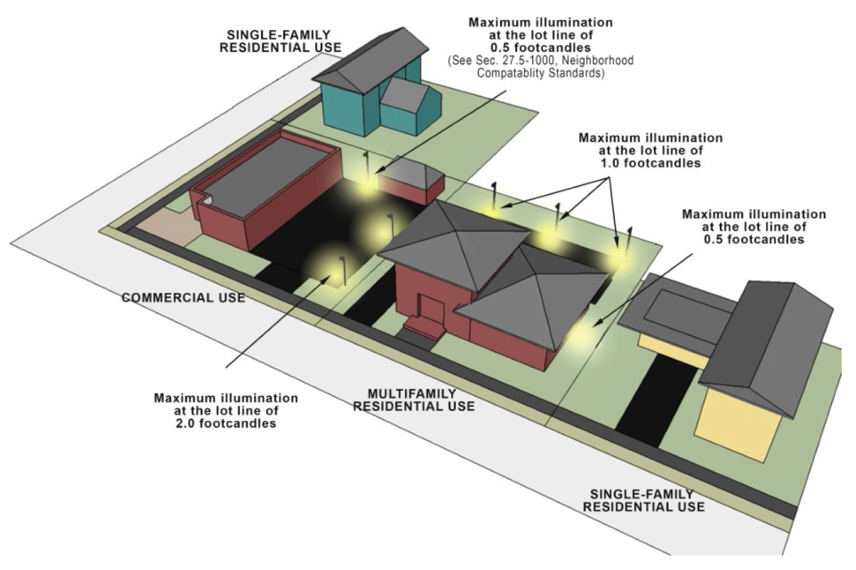
2.
All exterior light fixtures shall generate at least 80 lumens per watt of energy consumed, as shown on the manufacturers specifications for the fixture.
D.
Maximum Height. Except for athletic fields, where poles shall not exceed 95 feet in height, and street lighting (see Sec. 5.6.6), the height of exterior light fixtures, whether mounted on poles, walls, or by other means, shall comply with the standards in Table 5.6.7.D: Maximum Height for Exterior Lighting, unless otherwise approved by the DRC—Development Review Committee with Duke Energy (or its successor) reference.
(Ord. No. 2877, § XVII, 12-15-2021)
5.6.8. - Lighting Design Standards for Specific Uses and Site Features
In addition to complying with all applicable standards in Sec. 5.6.7, General Standards for Exterior Lighting, the specific uses and site features identified in this subsection shall comply with the standards established for that type of use or site feature.
A.
Awnings. Awnings or canopies used for building accents over doors and windows shall not be internally illuminated (i.e., from underneath or behind the awning) unless the awning material is entirely opaque.
B.
Canopies. Areas under a canopy shall be designed so as not to create glare off-site. Acceptable methods include one or both of the following:
1.
A recessed fixture incorporating a lens cover that is either recessed or flush with the bottom surface (ceiling) of the canopy that provides a full cutoff or fully-shielded light distribution.
2.
A surface mounted fixture incorporating a flat glass that provides a full cutoff or fully-shielded light distribution.
C.
Sports and Performance Venues. Lighting fixtures for outdoor sports areas, athletic fields, and performance areas shall be equipped with an existing glare control package (e.g., louvers, shields, or similar devices) and aimed so that their beams are directed and fall within the primary playing or performance area.
D.
Wall Pack Lights.
1.
Wall packs on the exterior of the building shall be fully shielded (e.g., true cut-off type bulb or light source not visible from off-site) to direct the light vertically downward and be of low wattage (100 watts or lower).
2.
Wall pack light sources visible from any location off the site are prohibited.
E.
Pedestrian Lighting. Pedestrian light fixtures within parks and recreation facilities shall comply with the following:
1.
Light fixtures for sidewalks, walkways, trails, and bicycle paths, shall provide at least 1.2 foot candles of illumination, but not exceed 2.0 foot candles.
2.
Light poles shall not be higher than 18 feet above grade and shall be placed a maximum of 100 feet apart, unless otherwise approved by the DRC—Development Review Committee with Duke Energy (or its successor) reference.
3.
Pedestrian bollard lamps shall be mounted no higher than four feet above grade and shall not exceed 900 lumens for any single lamp. See Figure 5.6.8.E.3: Examples of Pedestrian Bollard Lamps
Figure 5.6.8.E.3: Examples of Pedestrian Bollard Lamps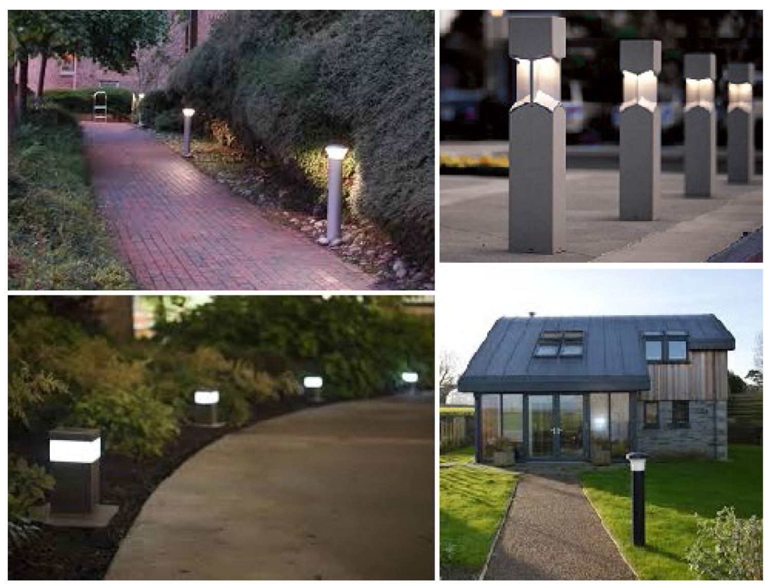
F.
Decorative and Landscape Lighting. Outdoor light fixtures used for decorative effects shall comply with the following standards:
1.
Decorative lighting intended to enhance the appearance of a building and/or landscaping shall cast all light downward (rather than upward) against the building surface or onto a landscape feature.
2.
Decorative lighting shall not exceed 100 watts of incandescent illuminance or the equivalent.
(Ord. No. 2745, § 14, 1-15-2020; Ord. No. 2877, § XVIII, 12-15-2021)
5.6.9. - Measurement
A.
General. Light level measurements shall be made at the lot line of the land upon which light to be measured is being generated. If measurement on private property is not possible or practical, light level measurements may be made at the boundary of the public street right-of-way that adjoins the land. Measurements shall be made at finished grade (ground level), with the light-registering portion of the meter held parallel to the ground pointing up. The meter shall have cosine and color correction and have an accuracy tolerance of no greater than plus or minus five percent.
B.
Light Meter Calibrated within Two Years. Measurements shall be taken with a light meter that has been calibrated within two years.
5.6.10. - Exemptions for a Security Plan
A.
Government facilities, parks, public safety, and other development may submit a security plan to the Director proposing exterior lighting that deviates from the standards in this section. The Director shall approve or approve with conditions the security plan and its proposed deviation from the standards, upon finding that:
1.
The proposed deviation from the standards is necessary for the adequate protection of the subject land, development, or the public;
2.
The condition, location, or use of the land, or the history of activity in the area, indicates the land or any materials stored or used on it are in significantly greater danger of theft or damage, or members of the public are at greater risk for harm than on surrounding land without the additional lighting; and
3.
The proposed deviation from the standards is the minimum required, and will not have a significant adverse effect on neighboring lands.
B.
If the Director finds the applicant fails to demonstrate compliance Sec. 5.6.10.A, above, the security plan shall be denied.
5.8.1.- Purpose and Intent
The purpose of these neighborhood compatibility standards is to provide a proper transition and ensure compatibility between single-family detached or two-family (duplex)dwellings, vacant lands in the residential single-family zoning districts (RSF-1A, RSF-1B) or residential two family zoning district (RTF), and other more intense forms of development. More specifically, it is the intent of these standards to:
A.
Protect the character of existing neighborhoods consisting of primarily single-family detached or two-family (duplex) dwellings from potentially-adverse impacts resulting from more intense and incompatible adjacent forms of development;
B.
Limit the excessive consumption of available land though the utilization of large vegetated buffers in favor of development form and design treatments; and
C.
Establish and maintain vibrant pedestrian-oriented areas where differing uses can operate in close proximity to one another.
5.8.2. - Applicability
A.
General
1.
Except as otherwise provided in Sec. 5.8.2.B, Exemptions, these standards apply to new multifamily and nonresidential development when located on land adjacent to, or across a street or alley from protected development.
2.
Except as otherwise provided in Sec. 5.8.2.B, Exemptions, these standards apply to expansions and alterations to multifamily and nonresidential development when located on land adjacent to, or across a street or alley from protected development or parcels, if the expansion increases the building's floor area by 50 percent or more, or the alteration involves 50 percent or more of the building's floor area (including interior alterations).
3.
For the purposes of this section, "protected development" shall mean existing single-family detached or two-family (duplex) dwellings, vacant lands in the residential single-family districts (RSF-1A, RSF-1B), and vacant lands in the residential two-family zoning district (RTF).
4.
For the purposes of this section, "multifamily and nonresidential development" shall include the following:
a.
Mixed-use development;
b.
Live-work dwellings;
c.
Multifamily dwellings;
d.
Townhome dwellings;
e.
Uses in the Group Living uses category;
f.
Uses in the Public, Civic, and Institutional use classification;
g.
Uses in the Commercial use classification; and
h.
Uses in the Industrial use classification.
B.
Exemptions. Uses exempt from these standards include the following:
1.
Multifamily and nonresidential development when the adjacent protected development is located on a lot within a nonresidential district;
2.
Multifamily and nonresidential development when separated from the adjacent protected development or parcel by a street with four or more lanes or a right-of-way greater than 75 feet;
3.
Development in the MU-D, MU-ES, and MU-KPI districts;
4.
Uses in the Educational uses category; and
5.
Places of worship.
C.
Timing of Review. Review for compliance with these standards shall occur during review of a planned development (2.5.1.F, Planned Development), development plan (major or minor) (Sec. 2.5.2.A, Development Plan (Major and Minor)), plat (subdivision), (Sec. 2.5.2.B, Plat (Subdivision), or building permit (Code of Ordinances Art.VI, Sec. 6.08.00), whichever occurs first.
D.
Conflict. In the case of conflict between these standards and other standards in this LDC, these standards shall control unless expressly stated to the contrary.
5.8.3. - Neighborhood Compatibility Standards
Development subject to this section shall comply with the following standards.
A.
Off-Street Parking
1.
When required, off-street parking shall be established in one or more of the following locations, listed in priority order:
a.
Adjacent to off-street parking lots serving nonresidential uses on abutting lots;
b.
Adjacent to lot lines abutting nonresidential development;
c.
Adjacent to lot lines abutting mixed-use development; or
d.
Adjacent to lot lines abutting protected development or parcels.
2.
Parking structure facades adjacent to protected development or parcels shall be configured to appear as articulated or landscaped building walls, to soften their visual impact.
3.
Off-street surface parking areas located adjacent to protected development shall be screened by a Type D buffer (see Sec. 5.2.5.B.3, Bufferyards).
4.
The total amount of off-street parking shall not exceed 1.1 times the required minimum specified Table 5.1.6.A: Minimum Number of Off-Street Vehicular Parking Spaces, and may be reduced through an alternative parking plan (see Sec. 5.1.8.A, Alternative Parking Plan) it will not have an adverse impact on the adjacent protected development.
B.
Building Orientation. Multifamily and nonresidential development shall be oriented to face similar forms of development on adjacent or opposing lots rather than protected development, to the maximum extent practicable.
C.
Building Height
1.
Building height shall not exceed the height established in Table 5.8.3.C: Maximum Height Where Neighborhood Compatibility Standards are Applicable. This section does not allow greater height than would otherwise be allowed on the parcel by the other provisions of this LDC. Distance from protected development is measured from the lot line of the protected development to the building line or the point of height change of the building subject to the standard.
2.
Buildings over three stories in height within 150 feet of the protected development shall be broken up into modules or wings with the smaller and shorter portions of the structure located adjacent to the protected development (see Figure 5.8.3.C, Building Height Modulation).
Figure 5.8.3.C: Building Height Modulation
3.
An additional building setback (see Table 5.8.3.C.3.) shall apply to buildings adjacent to, or across the street from, a neighborhood, residential single-family zoned district or use. Developers shall apply the setback just to those floors above the second story (step back approach, see Figure 5.8.3.E - Option A), to the entire façade (Option B) or a combination of the two (Option C). The additional setback/step-back requirement may render some sites ineligible for the maximum permitted height.
| Table 5.8.3.C.3. Height Setback for Multi-Story Buildings | ||
|---|---|---|
 | ||
| Building Height | Three stories or more | |
| Floor height |
First Floor: 12 foot min.
Additional Floors: 8 foot min. | |
| Additional "Stepped Back" distance | 10 feet for each additional floor above two if adjacent to neighborhood, residential single-family zoning district or use. | |
| Decorative Elements |
Max. 10 feet
| |
Figure 5.8.3.E. Setbacks Abutting Residential Single-Family Zoning Districts or Uses
D.
Building Massing
1.
Building facades facing protected development shall be configured to appear as a series of distinct building modules, storefronts, wings, projections, or recesses that comply with the following standards:
a.
Each individual module, storefront, wing, projection, or recess shall maintain a minimum width of at least 20 feet and a maximum width of 50 feet (see Figure 5.8.3.D: Building Massing).
Figure 5.8.3.D: Building Massing
b.
Projections or recesses shall maintain a minimum offset of two feet from the primary building facade wall plane.
2.
Exterior, open corridors facing a protected development are prohibited on multifamily and visitor accommodation building facades.
E.
Architectural Features. Buildings subject to these standards shall use similarly-sized and patterned architectural features such as windows, doors, awnings, arcades, pilasters, cornices, and other building features found on adjacent protected development (see Figure 5.8.3.D: Building Massing).
F.
Building Roof Form
1.
Buildings subject to these standards shall include roof forms that incorporate changes in roof plane or slope with at least a two-foot projection, recess, ridge or valley no less than every 40 feet, overhanging eaves at least five feet wide, or parapet walls with three-dimensional cornices.
2.
Structures on lots abutting a protected development shall maintain a pitched roof within 150 feet of the lot line shared with such development (see Figure 5.8.3.D: Building Massing).
3.
All roof-mounted equipment shall be configured so as to avoid or minimize its view from adjacent streets and protected developments and parcels, to the maximum extent practicable.
G.
Building Materials
1.
Transparency. Building facades within 150 feet of a protected development or parcel shall comply with the standards in Table 5.8.3.G.1: Transparency Standards
2.
Exterior Materials. Facades facing a protected development or parcel shall comply with the following exterior materials standards:
a.
Materials and material configurations shall be consistent with those commonly used on single-family detached or two-family (duplex) dwellings.
b.
Plywood, concrete block, and corrugated metal are prohibited as exterior materials.
c.
Split-face masonry unit and vinyl siding shall not exceed 25 percent of a building facade.
H.
Site Features
1.
Loading, Service, and Refuse Collection Areas. Loading, service, and refuse collection areas shall be:
a.
Screened from view of protected development, using materials that are the same as, or of equal quality to, the materials used for the principal building; or
b.
Incorporated into the overall design of the site so that the visual and acoustic impacts of these functions are fully contained within an enclosure or otherwise out of view from adjacent properties and public streets.
2.
Drive-Through Service Facilities
a.
In no instance shall a drive-through or pick-up window be located on a building facade that faces a protected development.
b.
Order boxes associated with a drive-through or pick-up window shall be at least 200 feet from a lot containing a protected development or a protected parcel.
3.
Exterior Lighting. Exterior lighting shall:
a.
Have a maximum height of 15 feet if within 150 feet of the lot line of a protected development; and
b.
Be configured so that the source of illumination is not visible from a public street right-of-way or an adjacent protected development.
4.
Signage Standards
a.
To the maximum extent practicable, signage shall be located a minimum of 150 feet from lot lines shared with a protected development.
b.
The maximum sign copy area for freestanding, ground, and wall signs shall be reduced by 25 percent within 50 feet of lot lines shared with a protected development.
c.
Signage within 100 feet of a lot line shared with a protected development shall be limited to directional or incidental signage.
5.
Open Space Set-Asides
a.
Required open space set-asides shall be located between a proposed development and an adjacent protected development, to the maximum extent practicable.
b.
Outdoor recreation features such as swimming pools, tennis courts, playgrounds, and similar features shall be at least 100 feet from any lot line shared with a protected development.
6.
Utilities. All utilities serving individual buildings or developments shall be located underground.
I.
Perimeter Fence or Wall
1.
Where a development subject to these standards abuts a protected development, an opaque fence six feet high shall be provided along the shared boundary to help screen the development from view of the protected development, in addition to the bufferyard standards of Sec. 5.2.5.B.3, Bufferyard.
J.
Operational Standards. Development subject to these standards shall:
1.
Prohibit outdoor dining or other outdoor activities within 150 feet of protected development;
2.
Limit trash collection or other service functions to only between the hours of 7:00 a.m. and 7:00 p.m.
(Ord. No. 2745, § 15, 1-15-2020)
5.9.1.- Purpose and Intent
The purpose and intent of these agricultural compatibility standards is to promote development that is compatible with existing agricultural uses and activities in the City. More specifically, these standards are intended to:
A.
Ensure new non-agricultural development does not negatively impact the continuation of existing adjacent agricultural uses and activities in the Agricultural (AG) zoning district;
B.
Maintain and promote rural character in the Agricultural (AG) zoning district;
C.
Allow landowners and residents conducting agricultural uses and activities to capture the monetary value of their land through limited development while continuing agricultural uses and activities; and
D.
Ensure greater compatibility between existing agricultural uses and activities and new non-agricultural development.
5.9.2. - Applicability
A.
General. Except where exempted in paragraph B. below, the standards in this section shall apply to all new residential and nonresidential uses that are proposed to be located adjacent to an ongoing agricultural use or activity in the AG zoning district.
B.
Timing of Review. Review for compliance with these standards shall occur during review of a planned development (2.5.1.F, Planned Development), development plan (major or minor) (Sec. 2.5.2.A, Development Plan (Major and Minor)), plat (subdivision), (Sec. 2.5.2.B, Plat (Subdivision), or building permit (Code of Ordinances Art.VI, Sec. 6.08.00), whichever occurs first.
5.9.3. - Agricultural Compatibility Standards
Development subject to this section shall comply with the following standards.
A.
Agricultural Buffer
1.
Buffer Required. Development shall provide and maintain a vegetative buffer and fencing (or walls) along all property lines abutting land that accommodates an agricultural use or activity in accordance with the standards of this subsection, for as long as the agricultural use or activity continues (see Figure 5.9.3.A.1: Agricultural Compatibility Features).
Figure 5.9.3.A.1: Agricultural Compatibility Features
2.
Buffer Width
a.
The agricultural buffer shall be at least 75 feet wide.
b.
The Director may allow the buffer width to be reduced by up to 25 feet upon determining the reduced buffer width is justified by the type or intensity of the adjacent agricultural use or activity, an intervening topographic change, an intervening riparian buffer, or the existence or provision of vegetation in addition to that required in Sec. 5.9.3.A.3, Buffer Materials.
3.
Buffer Materials
a.
Agricultural buffers shall consist of a mix of trees, shrubs, berms, and natural features sufficient to reduce noise, spray drift, and dust, diffuse light; and act as a physical separation between non-agricultural and agricultural uses and activities. All buffers shall incorporate a vegetative screening component to reduce conflict potential between residential/nonresidential and agricultural uses and activities.
b.
A buffer shall incorporate a wall or fence to provide additional screening and/or limit access between the development and the abutting agricultural uses or activities.
c.
Where the agricultural buffer is directly adjacent to a residential dwelling or residential lot, the length of the buffer running parallel to the dwelling along the property line shall be landscaped as follows, in addition to the buffer and fence:
1.
The buffer shall be planted with a minimum of two offset rows of trees that provides an average spacing between the canopies of trees of ten feet or less, at maturity.
2.
Each tree shall be a minimum height of eight feet and minimum caliper of two inches when planted.
3.
Each tree shall be a native species that can be expected to attain a minimum height of 35 feet and have a crown width of 25 feet or greater, at maturity.
4.
Development Allowed in Buffer. Development allowed within a buffer is limited to:
a.
Landscaping with native plants, trees, or hedgerows;
b.
Crossings by roadways, driveways, railroad tracks, and utility lines (and associated maintenance corridors), where the crossing is aligned to minimize any reduction of the buffer's effectiveness;
c.
Trails that involve minimal removal or disturbance of buffer vegetation;
d.
Stormwater management facilities, to the extent they are determined to be necessary by the Director;
e.
Vegetation management, including the planting of vegetation or pruning of vegetation, removal of individual trees that pose a danger to human life or nearby buildings, removal of individual trees to preserve other vegetation from extensive pest infestation, removal of understory nuisance or invasive vegetation, or removal or disturbance of vegetation as part of emergency fire control measures; and
f.
Any other development determined by the Director to be consistent with the use of the property as an agricultural buffer.
5.
Maintenance
a.
Landowner(s) are responsible for all aspects of continuous maintenance of buffer areas.
b.
Landowner(s) shall be responsible for maintaining landscape plants in a healthy and attractive condition. Dead or dying plants shall be replaced with materials of equal size and similar variety within six months, weather permitting.
c.
If the development consists of multiple parcels that may be held under separate ownership, a homeowners' association, property owners' association, or similar entity shall be required to maintain the buffer.
d.
Buffer maintenance requirements shall be stipulated through inclusion in covenants, conditions, and restrictions, as appropriate.
B.
Location and Configuration of Open Space Set-Asides. In cases where new development subject to these standards includes open space set-asides, they shall be located, to the maximum extent practicable, between the abutting existing agricultural uses or activities and the buildings in the new development, and be configured to accommodate the agricultural buffer required in this section. (See Figure 5.9.3.A.1: Agricultural Compatibility Features).
C.
Lot Size Configuration. Except for lots platted prior to March 6, 2019 lots bordering the vegetated buffer shall maintain a minimum lot area twice the minimum lot area otherwise required by the base zoning district where the development is located. (See Figure 5.9.3.A.1: Agricultural Compatibility Features).
D.
Preservation of Direct Access for Agricultural Uses and Activities. Development subject to these standards shall be configured to ensure agricultural uses and activities retain direct access to adjacent streets.
E.
Notification on Planned Development, Development Plan (Major and Minor), and Plat (Subdivision). Planned developments, development plans (major and minor), and plats (subdivisions) subject to these standards shall bear a notation on each individual development approval indicating the development is adjacent to an existing agricultural use or activity that is anticipated to generate noise, light, dust, odor, or vibration as part of its normal operations.
5.10.1.- Purpose and Intent
The purpose and intent of this section is to:
A.
Preserve, protect and promote the public health, safety and welfare and general esthetic quality of the City;
B.
Enhance the economy and the business and industry of the City by promoting the reasonable, orderly, and effective display of signs and encouraging better communication with the public;
C.
Enhance the physical appearance of the City by preserving the scenic and natural beauty;
D.
Protect the general public from damage and injury caused by the faulty and uncontrolled construction and use of signs;
E.
Reduce sign or advertising distractions in order to protect pedestrians and motorists from damage or injury caused by the distractions, obstructions, and hazards that may increase traffic accidents;
F.
Protect the physical and mental well-being of the general public by recognizing and encouraging a sense of esthetic appreciation for the visual environment;
G.
Preserve the value of private property by assuring the compatibility of signs with surrounding land uses;
H.
Restrict the proliferation of signs; and
I.
Encourage the use of architecturally compatible signs as much as possible.
5.10.2. - No Defense of Nuisance Action
Compliance with the requirements of this subsection shall not constitute a defense to an action brought to abate a nuisance under the common law.
5.10.3. - Maintenance
A.
All signs and all sign components shall be maintained in a state of good repair and present a neat and clean appearance.
B.
When the message portion of any sign ceases to be operated, offered, or conducted, the sign shall be removed within 30 days. The sign structure may remain so long as it is properly maintained. This subsection shall not be construed to alter the effect of the LDC which prohibits the replacement of a nonconforming sign, nor shall this subsection be construed to prevent the changing of the message of a sign.
C.
The vegetation around, in front of, behind and underneath the base of freestanding signs for a distance of ten feet shall be neatly trimmed, free of unsightly weeds, and free of rubbish or debris that would constitute a fire or health hazard.
5.10.4. - Permitting Requirements
A.
No sign or sign structure shall be erected, substantially altered, displayed, or changed, except for signs as provided herein, until after a sign permit is issued. Repainting or changing the message of a sign shall not, in and of itself, be considered a substantial alteration, unless indicated otherwise in this section.
B.
A sign erected, altered, displayed or substantially changed without a permit is an illegal sign and shall be subject to the penalties set forth in Article 9: Enforcement.
C.
Development plan applications for single-occupancy developments and for multiple-occupancy developments under 10,000 square feet of gross building area shall identify the location of all freestanding signs and provide a sketch of the monument structure and sign, including a description of materials used for the monument construction.
5.10.5. - Development Plan Application Contents
A.
Development plan applications for single or multiple-occupancy developments with 10,000 square feet of gross building area or greater shall include a master sign plan submitted in accordance with the following:
1.
Signs for multiple-occupancy development shall conform to an approved master sign plan submitted in conjunction with the development application. The master sign plan shall be included as part of a development plan which shall be maintained on file by the City. As a minimum, the sign format of a master sign plan shall specify and include the following:
a.
Freestanding Signs. The development plan shall include a sketch of all freestanding signs, materials for the monument construction, sign location, setbacks to property lines and distance to sidewalks, distance to other freestanding signs located on or off-site, sign height, sign face dimensions and area calculations, total allowable sign area calculations, information regarding the electronic reader board, if applicable, landscape plan for the area around the sign; and any other information necessary to determine compliance with this section.
b.
Wall and other Signs. Provide the types of signs and dimensions (not to exceed the size limits contained in this section) which will be permitted each occupant within the complex. The sign format shall also contain common design elements, such as placement, color, shape or style of lettering, which lend a unified appearance to the signs of the occupants within the complex.
2.
Substantial modification of the master sign plan may only be modified with the approval of the board which approved the initial master sign plan upon submission of a revised master sign plan and specifications detailing the revised format. Modifications determined to be minor or insignificant by the City may be approved by the Director.
5.10.6. - Prohibited Signs
A.
Generally. It shall be unlawful to erect, cause to be erected, maintain or cause to be maintained any sign not expressly authorized by this section, unless authorized by the Apopka City Council.
B.
Specific Prohibited Signs. Unless expressly authorized elsewhere in this LDC, the following signs are prohibited:
1.
Signs that are in violation of the building code or electrical code;
2.
Signs that do or will constitute a safety hazard;
3.
Blank temporary signs;
4.
Signs with visible flashing, moving, revolving, or rotating parts or visible mechanical movements of any description or other apparent visible movement achieved by electrical, electronic or mechanical means, except for traditional barber poles and as may be permitted for off-premise signs;
5.
Signs with the optical illusion of movement by means of a design that presents a pattern capable of giving the illusion of motion or changing of copy;
6.
Signs with lights or illuminations that flash, move, rotate, scintillate, blink, flicker or vary in intensity or color except for time-temperature-date signs;
7.
Strings of light bulbs used on commercially developed parcels for commercial purposes, unless:
a.
Used as traditional holiday decoration;
b.
They are completely attached to the primary structure; or
c.
Are used for landscaping or outdoor seating enhancement;
8.
Signs commonly referred to as wind signs, consisting of flags, pennants, ribbons, spinners, streamers or captive balloons, or other objects or material fastened in such a manner as to move upon being subjected to pressure by wind;
9.
Signs that are attention-getting devices which incorporate projected images, emit any sound, odor, or visible matter, such as smoke or steam that is intended to attract attention, or involve the use of live animals;
10.
Signs attached to the roof of any building or attached to the building which projects above the roof or is suspended above the roof;
11.
Signs or sign structures that interfere in any way with free use of any fire escape, emergency exit or standpipe, or that obstruct any window so that security visibility is hampered;
12.
Signs that resemble any official sign or marker erected by any governmental agency or that by reason of position, shape or color would conflict with the proper functioning of any traffic sign or signal, or be of a size, location, movement, content, color or illumination that may be confused with or construed as a traffic-control device, including any sign within ten feet of a public right-of-way or within 100 feet of traffic-control lights that contain red or green lights that might be confused with traffic-control lights.
13.
Signs that obstruct the vision of pedestrians, cyclists, or motorists traveling on or entering public streets;
14.
Signs that are of such intensity or brilliance as to cause glare or impair the vision of any motorist, cyclist, or pedestrian using or entering a public way;
15.
Signs that are a hazard or a nuisance to occupants of any property because of glare or other characteristics;
16.
Nongovernmental signs that use the words "stop," "look," "danger, or any similar word, phrase, or symbol;
17.
Signs that contain any lighting or control mechanism that causes unreasonable interference with radio, television, or other communication signals;
18.
Searchlights used to advertise or promote a business or to attract customers to a property;
19.
Signs that are painted, pasted or printed on any curbstone, flagstone, pavement, or any portion of any sidewalk or street, except house numbers and traffic-control signs;
20.
Signs placed upon benches, bus shelters, or waste receptacles, except as may be authorized in writing pursuant to Ch. 337, Fla. Stat.;
21.
Signs erected on public property, or on private property (such as private utility poles) located on public property, other than signs erected by public authority for public purposes and signs authorized in writing in accordance with Ch. 337, Fla. Stat.;
22.
Signs erected over or across any public street (i.e., street banner), except governmental signs authorized by the City;
23.
Parked vehicles with advertising signs. Any vehicle or trailer with a sign or signs placed or painted thereon, which sign or signs are intended to be viewed from a main vehicular public right-of-way, subject to the following exceptions:
a.
Any vehicle or trailer which is actively engaged in making deliveries, pickups, or otherwise actively in use. Such vehicle or trailer, when not in use, shall be parked so as to not be viewed from any main vehicular public right-of-way.
b.
Any alternate location for parking shall be approved by the City or as located on an approved development plan, where no allowable location is reasonably available. Such alternate location shall be as inconspicuous from the public right-of-way as reasonably possible.
24.
Signs placed in the public right-of-way without authorization from the City and the associated jurisdictional governmental agency;
25.
Pole signs; and
26.
Immoral, indecent, or obscene signs.
(Ord. No. 2745, § 16, 1-15-2020)
5.10.7. - General Standards for Permanent Signs
The following standards are applicable for all permanent signs:
A.
Total Allowable Sign Area
1.
The combined sign area for all permanent signs appearing or placed at any development or parcel shall not exceed the total allowable sign area as determined by standards of this section.
a.
Total allowable sign area calculation. A summation of the maximum sign area achievable at any development or parcel according to Sec. 5.10.8.A, Freestanding Signs for Single- and Multiple- Occupancy Development for Freestanding Signs; according to Sec. 5.10.8.B, Development for wall signs, and according to Sec. 5.10.8.E, Electronic Reader Board Signs for an electronic reader board. (Example: if Sec. 5.10.8.A allows a maximum freestanding sign area of 60 square feet, Sec. 5.10.8.B allows a maximum wall sign area of 100 square feet; and Sec. 5.10.8.E allows a maximum of 24 square feet for an electronic reader board, the total allowable sign area (TASA) is 184 square feet.)
b.
The total allowable sign area for a development or parcel may be shared among those permanent sign types at a development or parcel, but the sign area for any permanent sign type cannot exceed the maximum allowed by applicable standards established for that permanent sign type. (Example: if the total allowable sign area for a development is 184 square feet, but Sec. 5.10.8.E limits the maximum area for a freestanding sign to 60 square feet, then the freestanding sign shall not exceed 60 square feet.)
c.
Any total allowable sign area not applied to a freestanding, wall, or electronic reader board may be applied to other allowed permanent signs such as a window sign, human sign, or sandwich board. Other restrictions in this section may further restrict the use of these permanent sign types.
B.
Permitted Areas. Except where otherwise specifically provided in Sec. 5.10.9.G, Residential Development for residential zoning districts, permanent signs shall be permitted only on land zoned AG, T, C-N, C-C, C-R, O, C-COR, I-L, I-H, MU-D, MU-ES, MU-KPI, INST, PR, and AIR. Land zoned PD shall also comply with Sec. 5.10.7, General Standards for Permanent Signs unless other standards are established within a PD master sign plan and/or PD Agreement.
C.
Measurement Determinations
1.
Distance Between Signs. Unless otherwise provided in this section, the minimum required distance between signs shall be one-half the width of the lot measured along the street right-of-way from the closest parts of any two signs.
2.
Facade Area. The facade area shall be measured by determining the area within a two-dimensional geometric figure coinciding with the edges of the walls, windows, doors, parapets, marquees, and mansards of greater than 45 degrees that form a side of a building or unit.
3.
Sign Area
a.
Generally. The area of a sign shall be the area within the smallest square, rectangle, parallelogram, triangle, circle or semicircle, the sides of which touch the extreme points or edges of the sign face.
b.
Special Situations
1.
Where a sign is composed of letters or pictures attached directly to a facade, window, door, or marquee and the letters or pictures are not enclosed by a border or trimming, the sign area shall be the area within the smallest rectangle, parallelogram, triangle, circle or semicircle, the sides of which touch the extreme points of the letters or pictures.
2.
Where four sign faces are arranged in a square, rectangle, or diamond, the area of the sign shall be the area of the two largest faces.
3.
Where a sign is in the form of a three-dimensional object, the area shall be determined by drawing a square, rectangle, parallelogram, triangle, circle or semicircle, the sides of which touch the extreme points or edges of the projected image of the sign and multiplying that area by two. The "projected image" is that created by tracing the largest possible two dimensional outline of the sign.
D.
Design, Construction, and Location Standards
1.
General. All permanent signs must comply with the following design, construction, and location standards.
2.
Illumination Standards
a.
Sign lighting may not be designed or located to cause confusion with traffic lights.
b.
Illumination by floodlights or spotlights is permissible if no emitted light shines directly onto an adjoining property or into the eyes of motorists or pedestrians using or entering public streets.
c.
Lighting mechanisms for illuminated signs shall project a maximum of 18 inches perpendicularly from any surface of the sign over public space.
3.
Placement Standards
a.
Near Street and Driveway Intersections
1.
Signs greater than two square feet shall not be located within a sight triangle.
2.
Monument signs and portable signs shall not be located closer than 50 feet from the intersection of two streets.
3.
Where two monument signs are allowed for a corner lot, the two signs shall be at least 50 feet apart, and no more than one sign shall be placed along a single street frontage.
b.
Over Right-of-Way. No sign shall project over, into, or on a public right-of-way except as expressly allowed in other sections of this LDC.
c.
Blocking Exits, Fire Escapes, Standpipes. No sign or sign structure shall be erected that impedes use of any fire escape, emergency exit, or standpipe.
d.
Sign Visibility. Monument signs should be placed in a manner and location that promotes their visibility from public roads, sidewalks, and trails, with consideration to compliance with requirements of this section. Landscape design and selected plants will establish a view corridor or triangle to promote sign visibility, taking into consideration effects of plant growth and maturity to avoid screening the monument sign and its base.
4.
Clearance Standards
a.
All signs over pedestrian ways shall be a minimum of eight feet above a pedestrian way.
b.
All signs shall provide 13 feet six inches of vehicular clearance.
5.
Relationship to Building Features and Landscaping
a.
Building Signs. A building sign shall not extend beyond any edge of the surface to which it is attached, nor shall any portion of the sign extend above the roof line.
b.
Freestanding Signs
1.
Freestanding signs and the sign base and structure shall be designed and placed in a manner which will be architecturally compatible with the building and in harmony with the character of surrounding development.
(a)
All freestanding signs shall be designed as a monument sign type. The sign face, including the message and text displayed, for all freestanding signs shall be static and cannot contain any changeable copy or variable electronic message or reader board.
(b)
Monument sign base and structure design and materials for a monument sign shall be architecturally compatible with the character of the building and shall comply with the following:
i.
The sign base shall be at least 18 inches high, measured from the ground surface of the general grade of the parcel. The base shall be as wide as the sign.
ii.
The street number shall be placed at the top upper edge or at the top upper corner nearest the street. Street numbers shall be at least three inches high.
iii.
Sign base material shall consist of brick or stone material only.
iv.
Plastic or vinyl slip-over signs shall not be used to cover existing signs.
c.
Pole Signs. A pole sign, if allowed because of a site hardship precluding use of a monument sign, should also include a sign base at the ground similar to the design of a monument sign, to the greatest extent practical. The stanchion (pole) and structure supporting the sign will also be architecturally compatible within the building and designed as a column.
E.
Number of Signs
1.
Generally. In general, the number of signs shall be the number of noncontiguous sign faces. Multiple noncontiguous sign faces may be counted as a single sign if all the sign faces are included in the geometric figure used for determining the sign area.
2.
Special Situations—Multiple Sign Faces Counted as One Sign
a.
Where two sign faces are placed back-to-back and are at no point more than two feet apart, it shall be counted as one sign.
b.
If a sign has four faces arranged in a square, rectangle, or diamond, it shall be counted as two signs and, therefore, prohibited.
F.
Size Limitations. No signs of any type shall exceed the requirements of this section, unless a variance is granted by the Planning Commission. A variance may be granted only if the Planning Commission finds a need in accordance with variance criteria of Sec. 2.5.5.A, Zoning Variance, and the variance will have no adverse effect on adjacent properties
5.10.8. - Standards for Specific Sign Types
A.
Freestanding Signs for Single- and Multiple-Occupancy Development
1.
No freestanding sign is allowed on a parcel or development where a building is located within 15 feet from a right-of-way.
2.
Each multiple-occupancy development and each single-occupancy development may have one freestanding sign. Two freestanding signs may be allowed in accordance with Sec. 5.10.8.A.5.
3.
All freestanding signs shall be monument signs unless it is determined by the Planning Commission that hardships created by existing site conditions cause construction of a monument sign to be impractical or create a potential hazard. Freestanding signs shall comply with the standards in Table 5.10.8.A.3: Freestanding/Monument Signs: Sign Face Size and Distance From Other Signs.
4.
Height of freestanding signs, as measured from the ground surface area beneath the sign shall comply with the standards in Table 5.10.8.A.4: Maximum Height of Freestanding/Monument Signs.
5.
Development with frontage on more than one public right-of-way shall comply with the following standards:
a.
In addition to signs allowed in accordance with Sec. 5.10.8.A.2, each multiple-occupancy development and each single-occupancy development with frontage on more than one public right-of-way may have one secondary freestanding sign, except a freestanding sign on a secondary street frontage is not allowed where its location is within 200 feet of a Residential district.
b.
A sign located along a secondary street frontage shall display only the name of the business or development. All secondary freestanding signs shall be monument signs and shall not include an electronic reader board.
c.
Size of secondary freestanding sign:
1.
The size of the secondary freestanding sign shall be no more than 30 square feet in area for a single-occupancy or multiple-occupancy development where street frontage is less than 300 feet. Where street frontage is 300 feet or greater, the sign area shall not exceed 60 square feet in area for multiple-occupancy development.
2.
The property owner shall designate which frontage will contain the primary or secondary sign, but single street frontage cannot contain both.
3.
The maximum height of a sign on a secondary frontage street shall not exceed six feet except where the secondary street frontage is 300 feet or greater. The height may be the same as that for the primary frontage sign.
6.
In addition to signage authorized in accordance with this section, a freestanding sign may be permitted on developed outparcels with an area of 22,500 square feet or more, and with a minimum street frontage of 125 feet. Freestanding and wall signs for outparcels for such development shall comply with the following:
a.
One freestanding sign per outparcel may be installed if the size does not exceed a total of 50 square feet.
b.
The sign shall not exceed six feet in height.
c.
The sign shall be a monument sign.
d.
Freestanding signs for outparcels may be placed at the property line but shall be located at least two feet from a sidewalk, unless it would create a hazard to public safety (in which case the sign must be set back a greater distance to abate the hazard).
e.
Electronic reader board or changeable copy signs are not allowed on outparcels.
B.
Wall and Projecting Signs for Single- and Multiple-Occupancy Development. Wall signs shall be permitted in all areas other than residential districts if they comply with the following:
1.
Primary and Secondary Wall Sign Sizing
a.
One primary wall sign is permitted on each wall of a building, parallel or perpendicular to a road or street, not exceeding an area equal to 15 percent of the front wall face height (interior roof) multiplied by the building width, not exceeding 200 square feet. A secondary wall sign may be permitted on up to two walls provided it is a maximum 50 percent of the primary wall sign's available square footage, and both signs square footage shall be counted separately toward the maximum total square footage as allowed by this code .
b.
The front wall face shall be calculated by multiplying the roof height multiplied by the building width, times 15 percent. (H × W × 15%)
c.
A secondary wall sign may be permitted on up to two walls provided it is no larger than 50 percent of the area of the primary wall sign on that face.
2.
High-rise Signs
a.
High-rise, multiunit office, retail, industrial or medical centers; that are at least four stories or 50 feet tall; that have a common primary entrance may be allowed one wall sign on each wall parallel or perpendicular to a road or street, for a maximum of four signs.
b.
Wall signs for each individual business within such a center are not permitted.
c.
Signs shall be placed upon the wall or parapet of a building.
d.
Signs shall not extend above the roofline of any building except when placed upon a parapet, in which case the sign shall not extend above the parapet wall.
e.
High-rise signs must be on-site signs. Should circumstances change so that a high-rise sign is no longer on-site, the sign shall be deemed illegal and be removed.
f.
Where a high rise sign would be within 1,000 feet of residential districts, the sign shall not be lit.
g.
The maximum allowable copy area for signs below 30 feet above ground level shall not be more than one square foot for each lineal foot of building frontage along the primary street frontage of the building.
h.
The maximum allowable copy area for signs higher than 30 feet above ground level shall be five square feet for every 1,000 square feet of gross floor area;
i.
The total sign area shall not exceed 800 square feet.
j.
High rise buildings over five stories may be permitted a maximum 200 square foot sign on each top area, with a maximum of four signs, one per street frontage. Any logo shall be considered part of the allowed sign area.
3.
Tenant Wall Signs for Multiple-Occupancy Development
a.
Each tenant of a multiple-occupancy development may display a tenant wall sign on the principal building in which the occupant is located, subject to the following limitations:
1.
The sign shall be placed only on the exterior surface of the principal building, or portion thereof, which is included as part of the tenant's individually leased or owned, premises in accordance with the following:
(a)
The occupant may display, in the leased or owned area, as many as two tenant signs on the side which is the primary entrance/exit to that portion of the premises. A tenant wall sign shall not exceed 48 inches in height, measured from the bottom of the copy area to the top, and shall not be wider than 75 percent of the horizontal frontage of the tenant space. The total combined area of the tenant wall signs shall not exceed 100 square feet.
(b)
Only one building side will be considered as being an occupant's primary entrance/exit.
(c)
If the occupant has an entrance/exit on a corner or on more than one side, the occupant may choose which building side counts as having the primary entrance/exit.
(d)
One additional sign may be placed on the secondary entrance/exit side of the occupant's leased or owned area. The maximum area of the additional sign shall not exceed 16 square feet and shall not exceed 24 inches in height.
(e)
A tenant sign shall not cover architectural detailing, windows, or building ornamentation.
4.
Projecting signs
a.
Within the MU-D: Mixed Use- Downtown district, projecting signs are a type of wall sign and may be permitted to extend over walkways, provided they are at least eight feet above ground level and shall not project more than 48 inches from the wall of a building. No sign or supporting structure shall extend above the top of a parapet wall. Any projecting sign shall count towards the maximum wall sign area allowed for a building.
b.
Projecting signs may be placed on any building in any Commercial district, Industrial district, or AG district in accordance with the above and shall be counted as part of the allowable wall signage.
C.
Window Signs. Window signs may be placed within building windows of all Commercial, Industrial, and Special Purpose districts except the C-N district development. They shall comply with the following:
1.
Multiple-occupancy development and a single-occupancy development may select to have an electronic reader board or may select window signs in accordance with this section, but cannot use both. A window sign is only allowed if an electronic reader board sign, whether or not operational, has not been installed.
2.
Window signs are not allowed within any window facing a Residential district if the window is within 200 feet of the Residential district.
3.
Window signs may cover up to 25 percent of the window area of any single wall. Sign coverage within windows may be limited and may not achieve 25 percent based on the total allowable sign area achievable for the development. Coverage of any single window panel shall not exceed 60 percent of its area. Placement of signs on windows of an entrance door is not allowed except for hours of operation.
4.
Exact duplicate or repetitive signs shall not appear on windows located on the same wall.
5.
Any product, good, or service for which a local, state, or federal law restricts sales to adult-aged persons shall not appear in a window sign except for fireworks during dates such sale activities are allowed under Florida law.
6.
Promotional posters for civic events may be placed within windows of any zoning district, including the C-N district, and do not apply to the window space limitation set forth in 3. above.
D.
Changeable Copy Signs
1.
General. Only one changeable copy sign is allowed per single-occupancy or multiple occupancy development. It must be integrated and designed as a component of the monument sign and comply with the following standards:
a.
A changeable copy sign is not allowed if an electronic message board is installed.
b.
A changeable copy sign is not allowed for outparcels and nonresidential development with a street frontage less than 50 feet.
c.
The sign area of the changeable copy sign shall not exceed 24 square feet, except the sign area shall not exceed 32 square feet in multi-unit centers with a floor area greater than 100,000 square feet.
2.
Location and Placement
a.
A changeable copy sign shall be located beneath the sign face of a monument sign.
b.
A changeable copy sign shall not be allowed on a pole sign.
c.
A changeable copy sign cannot be installed where a development is already using a portable sign, human sign, or window sign.
d.
A changeable copy sign shall not be illuminated and shall not contain any electronic component.
3.
Operational Standards
a.
Only letters, punctuation marks, and numbers can appear in a changeable copy sign, and shall be at least three inches in height. Graphics, art, or illustrations are not allowed. Letters and numbers appearing in a changeable copy sign shall be displayed in a single, uniform color.
b.
Background of a changeable copy sign shall be white in color only.
c.
Messages shall only address products, goods, promotions, events, and services offered or available at that property location.
d.
All changeable copy signs shall be maintained in a clean appearance, including the backboard. The backboard shall be replaced or repaired within 30 days notification from the City if it is determined that the sign cannot be maintained in a clean appearance because of damage caused by exposure to sun or weather, or damage caused by the effects of mold, oxidation, or other environmental elements.
e.
Only complete words or messages can be displayed. Missing letters or numbers shall be promptly replaced.
f.
The sign face of a changeable copy sign shall be contained in a cabinet with a transparent cover.
g.
It is recommended that text appearing in a changeable copy sign should be limited to ten words to allow passing motorists to read the entire changeable copy.
E.
Electronic Reader Board Signs
1.
General. Only one electronic reader board sign is allowed per single-occupancy or multiple occupancy development. It must be integrated and designed as a component of the monument sign in accordance to the following standards:
a.
An electronic reader board is not allowed if a changeable copy sign is installed.
b.
An electronic reader board is not allowed for nonresidential development with a street frontage less than 50 feet, and for outparcels within a multiple-occupancy development.
c.
The sign area of the electronic reader board portion of the sign shall not exceed 50 percent of the total sign face.
2.
Location and Placement
a.
Electronic reader boards shall not be located above the top edge of the sign face of a monument sign, and should be placed beneath the sign face. It may be placed at the side of the sign face.
b.
Pole signs are not allowed to hold or contain an electronic reader board.
c.
An electronic reader board cannot be installed where a development is already using a portable sign, human sign, or window sign.
d.
Electronic reader boards are prohibited within 1,000 feet from the clear zone of an airfield.
3.
Operational Standards
a.
The copy on an electronic reader board sign shall not change more than once in a 120 second period unless otherwise allowed by law or except as necessary on a sign for the public health and safety, including traffic control, that is owned and/or operated by the City, Orange County, the State of Florida, or the federal government. (This subsection does not apply to electronic reader board signs with time, date, and temperature information.)
b.
An electronic reader board sign shall comply with the following standards.
1.
Static display time for each message shall be a minimum of 120 seconds; for community information panel signs, the static display time for each message shall be a minimum of eight seconds;
2.
The maximum amount of time to completely change from one message to the next shall be two seconds;
3.
The change of message shall occur simultaneously for the entire sign face;
4.
The sign shall contain a default design that will hold the face of the sign at one position if a malfunction occurs;
5.
No flashing lights, traveling messages, animation, or other movements are permitted on an electronic reader board;
6.
Messages shall only address products, goods, promotions, events, and services offered or that are available at that property location. Community-wide events occurring in the Apopka area may also be displayed;
7.
The minimum size of any letter or number appearing in a message shall be two inches;
8.
Brightness or glare shall be controlled to avoid distractions to vehicular traffic, pedestrian, and adjoining properties. Adjustments shall be made upon written request from the City;
9.
All electronic reader signs shall be installed with an ambient light monitor;
10.
Dimmer control electronic graphic display signs shall have an automatic dimmer control to produce a distinct illumination change from a higher illumination level to a lower level for the time period between one half-hour before sunset and one-half hour after sunrise;
11.
The sign shall not exceed a maximum illumination of 5,000 nits (candelas per square meter) during daylight hours and a maximum illumination of 500 nits (candelas per square meter) between dusk to dawn, as measured from the sign's face at maximum brightness;
12.
Audio speakers or any form of pyrotechnics are prohibited in association with an electronic reader board sign; and
13.
It is recommended that the text of the electronic reader board should be limited to ten words to allow passing motorists to read the entire changeable copy.
4.
An electronic reader board sign with copy that moves continuously or appears to be moving, flashing, changing color, pulsing, or alternating shall be considered an animated sign and is prohibited as provided in Sec. 5.11.2, No Defense of Nuisance Action.
5.
When an electronic reader board is proposed in a sign permit, development plan, or master sign plan, the City may require a traffic safety study prepared by a professional engineer if such sign is near traffic conflict points such as intersections, merge points, exit ramps, traffic control signals or curved roadways. The study shall contain, but is not limited to, an analysis of possible traffic safety impacts, including impacts on motor vehicle drivers, pedestrians, cyclists, and visibility of traffic control devices or traffic control signals
F.
Aerial View Signage. Signage that is flat on a roof and can only be viewed from the sky or from aerial photography is prohibited except for standard signage associated with a lawful helicopter landing pad.
G.
Flags
1.
Number. There shall be no more than three flags displayed on any one parcel of land. Only one may be a corporate flag. Government flags must conform to the U.S. Flag Code, Public Law, 344; 36 U.S.C., Secs. 171—178.
2.
Size and Placement. The size of the flag, whether on flagpole or flagstaff, shall not be greater than one-third the height of the pole or extension of the flagstaff. Flags shall be set back at least five feet from all property lines and only be displayed from a flagpole or flagstaff (the placement of the flag on or attached to fences, other signs, etc., shall not be permitted). Government flags conform to the U.S. Flag Code, Public Law, 344; 36 U.S.C., Secs. 171—178.
3.
Flagpole Height. The maximum height of any flagpole shall not exceed ten feet above the height of any primary structure.
H.
Portable (Trailer) Signs
1.
Permit Required; Removal of Signs Upon Expiration of Permit; Penalty. A portable sign shall be required to obtain a sign permit which shall not be valid for longer than a period of 30 days, after which time the portable sign shall be removed from the property. A sign permit shall not be renewed nor shall a permit be obtained for the same parcel of property within a period of 30 days after the removal of a portable sign from the property. Signs which remain on the property after the permit has expired will be subject to removal by the City and a penalty fee of $25.00, in addition to actual costs incurred by the City for the removal.
2.
Number and Space Requirements. There shall be no more than one portable sign per parcel of property, with a minimum spacing of 300 feet between any two portable signs. In no instance shall a portable sign be placed on a parcel or located at a multiple-occupancy development if an electronic reader board sign, whether operational or not, is already installed or permitted for that same parcel or multiple-occupancy development.
3.
Placement in Relation to Property Line. Portable signs may be placed at the property line, but if the property line is located at the curb or sidewalk, the sign must set back a minimum of five feet.
4.
Dimensions. Portable signs, exclusive of the transportation mechanism, shall not exceed the exterior measurement of four feet in height or eight feet in length.
5.
Placement in Parking Spaces Prohibited. The placement of a portable sign in a parking space which is required to meet the minimum parking requirements of the City is prohibited.
6.
For Businesses Not a Part of Shopping Center; Minimum Spacing Requirements. A portable sign shall be permitted for businesses determined not to be a part of a shopping center, if they are located a minimum of 300 feet from another portable sign.
7.
Limitation to Commercial and Industrial Districts. All portable signs shall only be located in Commercial and Industrial districts.
8.
Lighting Requirements. All incandescent bulbs in, on, or attached to any portable sign shall be rated at not more than 75 watts. Flashing or distracting lights, including spotlights if directed so they cause a possible hazard to the public, are prohibited.
9.
Use as Permanent Sign Prohibited. Portable signs are prohibited from being used or constructed as a permanent sign.
10.
Identification of Owner. Each portable sign shall have permanently displayed the name, business address, and/or phone number of the owner of the sign.
11.
Off-Premise Portable Signs. A tenant of a single-occupancy or a multiple-occupancy development that has an installed electronic reader board, whether operational or not, may not use an off-site portable sign. A business can elect to use either an electronic reader board or an off-site portable sign, but cannot use both sign types. An off-premise portable sign will count towards the total allowable sign area for the host property receiving the sign.
a.
An off-premise portable sign shall be located within 300 feet of the advertised business.
b.
Off-premise portable signs shall be permitted on Main Street in the central downtown area of the City, defined geographically as from Central Avenue east to Forest Avenue at Main Street and from Third Street South to Fifth Street at Central Avenue.
c.
Off-premise portable signs shall be permitted to advertise more than one business as long as the businesses are located within 300 feet of the sign.
12.
Shopping Center Portable Signs
a.
Shopping center portable signs shall obtain a permit which shall not be valid for longer than a period of 30 days. The portable signs shall be removed, and a permit shall not be for the same parcel of property within a period of 15 days after the removal of a portable sign from the property.
I.
Off-Premise (Billboards, etc.) Signs
1.
General
a.
Applicable Location. Off-premise signs are allowed in the C-C, C-R, I-L, and I-H districts only. Off-premise signs are prohibited in the MU-D Mixed-Use Downtown district.
b.
Supporting Structure. Only a single supporting structure (monopole) shall be allowed for off-premises signs. No portion of the supporting structure shall be visible above any advertising display area.
c.
Single and Double-Faced Billboards. An off-premises sign structure may be single- or double-faced. Any double-faced structure shall have advertising surfaces of equal size and shape. For the purposes of this LDC, the following types of off-premise signs shall be considered double-faced:
1.
An off-premises sign structure where the signs are placed back-to-back, as long as the backs of the signs are not separated by more than 48 inches.
2.
An off-premises sign structure when constructed in the form of a "V" when viewed from above, provided the internal angle at the apex is not greater than 45 degrees and the off-premises sign structure is not separated by more than 36 inches at the apex of the "V."
d.
Multi-Faced Off-Premises Signs. An off-premises sign structure may have a maximum of two advertising surfaces facing one direction, if both surfaces are the same size and shape.
e.
Trivision or electronic reader board, light emitting diode (LED), or similar types of illuminated or off-premises signs. Computerized messages will be permitted if the sign does not function in a manner that is distracting to vehicular traffic or adjoining properties, and meets the sign standards for off-premises signs.
f.
Number of Surfaces. No more than two advertising surfaces shall be allowed per sign.
g.
Limited Access Highways (Also Known as "Limited Access Principal Arterials"). Off-premise signs will not be allowed to be constructed, erected, altered, or relocated within one mile of the outside curb (the nearest curb to the proposed sign) of the main traffic route of any limited access highway. It is intended that such setback shall not be measured from the curb line of ramps or other facilities used exclusively for access to or exit from such highway or street.
2.
Permissible Number, Area, Spacing, and Height of Permanent Off-Premises Signs
a.
Maximum Size. No permanent off-premises sign may exceed 310 square feet in size, per face.
b.
Maximum Height. No permanent off-premises sign, or combination of signs, may exceed 35 feet in height from ground level. An open space of not less than eight feet from ground level to the bottom of the billboard shall be maintained should there be a traffic, pedestrian, or safety hazard created by the presence of the sign.
c.
Maximum Width. No permanent off-premises sign, or combination of signs, may exceed 50 feet in width.
d.
Spacing
1.
No off-premises sign may be closer than 2,500 feet from any other off-premises sign on either side of the thoroughfare or thoroughfares to which the off-premises sign is directed.
2.
As of March 6, 2019, an electronic reader board, LED or electronic variable message off-premise sign is not allowed unless it replaces two other off-premise signs located within the City. The replacement electronic reader board, LED, or electronic variable message off-premise signs shall comply with the requirements of this section. The minimum spacing between tri-vision and electronic reader board off-premise signs shall be 4,000 feet from any other tri-vision or electronic reader board off-premise sign on either side of the thoroughfare or thoroughfares. Spacing shall be determined based on signs that have received the necessary City or County permits (Signs that have received prior authorization shall have priority over a later applicant in determining compliance with the spacing restrictions.)
3.
Setbacks
a.
All off-premises signs shall be set back a minimum of 15 feet from the front property line.
b.
All off-premises signs shall be set back a minimum of 25 feet from the side property line when located at an intersection.
c.
No off-premises sign shall be allowed within 250 feet of the nearest property line of any Residential district, public park, municipal, county, state or federal public building, place of worship or any public or private school.
d.
An off-premise sign using electronic reader board or other similar electronic variable or LED technology shall not be placed within one mile of an airfield clear zone.
4.
Special Requirements for Off-Premises Signs. No off-premises sign shall be permitted on a developed site. An off-premises sign shall be permitted only as a principal use. An on-premise sign using as electronic reader board shall comply with the operational standards in Sec. 5.10.8.E, Electronic Reader Board Signs.
5.
Landscaping
a.
Evergreen shrubbery and trees natural to the area, resistant to frost damage and drought, shall be provided to enhance the appearance of an off-premises sign to shield the sign where it may be within 100 feet of a residential dwelling; and
b.
A landscape island shall be provided around the base of an off-premises sign, at least ten feet in width that includes shrubs three feet on center and at least 36 inches tall at time of planting. In addition, coniferous and approved native trees sufficient to screen the off-premises pole shall be planted in accordance with Sec. 5.2, Landscaping and Buffer Standards.
c.
Maintenance shall be the responsibility of the owner of the property on which the sign is located to provide landscaping in a healthy condition so as to present a neat, healthy, and orderly appearance free of refuse and debris.
d.
Failure to provide proper maintenance shall incur a penalty or other appropriate enforcement.
(Ord. No. 2745, § 17, 1-15-2020; Ord. No. 2925, § IV, 5-18-2022)
5.10.9. - Standards for Special Purpose Signs
A.
Automobile Service Station Signs. Signs for an automobile service station shall comply with the following:
1.
Freestanding and Wall Signs
a.
Freestanding and wall signs shall comply with the standards for these respective sign types based on the zoning district in which they are located, or the lot, unless stated otherwise in this LDC. Product or service advertising shall be an integral part of the freestanding sign.
b.
Only one electronic reader board is allowed for an automobile service station and the price of fuel for up to two fuel types must appear in the sign at all times. The electronic reader board may be placed either within a monument sign or on a fuel station canopy sign, but not both.
2.
Automobile Service Station Canopy Signs. Two standard logo or electronic reader board signs may be attached to the side of an automobile service station canopy. The canopy sign shall not exceed an area greater than five percent of the square footage of the canopy sidewall area for the longest side and one of the short sides, multiplied by two. Only that portion of the canopy covering the service station shall apply to the canopy sign area calculation. Only fuel prices can appear in an electronic reader board placed on a canopy. Only one business name can appear on the service station canopy if a logo sign is selected instead of an electronic reader board. The canopy electronic reader board will not count towards the total allowable sign area. However, if an electronic reader board is not placed on the canopy, the sign area of the electronic reader board sign may only be transferred to window signs up to the total allowable sign area. Any sign or color placed on a service station canopy shall comply with the intent and purpose of the City's Development Design Guidelines. (See Section 5.7, Development Design Guidelines)
3.
Gasoline Pump Sign. A sign on a gasoline pump must be an integral part of the pump structure.
4.
Rack or Cabinet Signs. A rack or cabinet sign is a sign which is an integral part of a rack or cabinet, such as a display of oil, wiper blades, etc.
5.
Signs on Buffer Walls. No sign for an automobile service station shall be placed, painted, or otherwise erected on any buffer wall.
B.
Place of Worship Sign. A place of worship sign shall be permitted in all districts in accordance with the following standards:
1.
One monument sign may be located at the place of worship that does not exceed six feet in height, except it may extend to a maximum height of eight feet with embellishments.
2.
The sign area for the monument sign shall not exceed 32 square feet per face. An electronic reader board that does not exceed 24 square feet in area may be included in addition, on the primary sign structure.
3.
For places of worship located on property in a Residential district, an electronic reader board is only allowed as a special exception. (See Sec. 2.5.1.G, Special Exception Permit)
4.
Two wall signs may be allowed, calculated at one square foot per linear frontage of building that do not to exceed 150 square feet, in total.
C.
Community Information Signs
1.
Community information panel signs for public community information messages may be permitted in any Commercial, Industrial, or Special Purpose district, provided they do not exceed 32 square feet in area and is an electronic reader board.
2.
Patron advertising signs are allowed at ball fields, if the signs are attached to a fence surrounding the field, and placed only on the inside of fence with the sign copy area facing inward.
D.
Menu Board Signs. A menu board sign shall not exceed six feet in height or 30 square feet in area. A menu board sign shall be supported from the grade to the bottom of the sign having or appearing to have a solid base similar to and complementary to a development's monument sign. The design, materials, and finish of a menu board sign shall match those of the buildings on the same lot. One menu board sign is permitted per drive-through lane or drive-in station. No other commercial or promotional signs, including snipe-type signs, shall be located along drive-through lanes.
E.
Directional Signs
1.
On-site Directional Signs. One on-site directional sign at each access drive is permitted in multifamily and nonresidential development if it is limited in area to four square feet, including embellishments; an on-site directional sign shall be permitted as a permanent sign on all parcels, and shall not be counted as part of allowable sign area. The maximum height shall not exceed three feet.
2.
Off-site Directional Signs. Off-site directional signs are permitted in all Commercial, Industrial, and Special Purpose districts, if they comply with the following standards:
a.
Only one off-site directional sign is permitted per (host) parcel, with two off-site directional signs permitted for each establishment.
b.
An off-site directional sign shall be located within 2,000 feet of the subject being advertised, measured from property line to property line. Off-site directional signs shall only be allowed for commercial, public, civic, and institutional uses located on parcels that do not have frontage on an arterial street.
c.
Off-site directional signs may stand alone as a monument sign or wall sign, provided the following requirements are met for each sign-type:
1.
Monument off-site directional signs shall comply with the following:
(a)
Maximum sign copy area shall not exceed 16 square feet, and shall count towards the total allowable sign area for the host parcel or development;
(b)
Maximum height shall not exceed six feet;
(c)
The sign shall be setback at least five feet from any right-of-way line. Should a hazard to public safety be created, the City may establish a greater required setback in order to abate the hazard;
(d)
A landscape island shall be provided around the length of the sign and not be less than two feet in width. Shrubs planted shall be 18 inches in height, and be spaced two feet on center.
2.
An off-site directional sign placed within or on the monument sign or wall sign shall comply with the following:
(a)
The maximum sign copy area allowed shall comply with the host sign requirements for the district in which the sign is located (see Sec. 5.10.7, General Standards for Permanent Signs), provided the total copy area of the off-site directional sign does not exceed 16 square feet;
(b)
The height shall be in accordance with the standards in Sec. 5.10.7, General Standards for Permanent Signs;
(c)
In cases where an off-site directional sign is proposed to be placed on a nonconforming sign, the nonconforming sign shall comply with the requirements of this section. (This provision applies even when a change of copy area is needed to accommodate the off-site directional sign);
(d)
The design of an off-site directional sign shall be compatible with the architecture, style, color theme, etc., of the host's sign; and
(e)
An off-site directional wall sign shall not exceed the maximum number of signs and square feet allowed in Sec. 5.10.7, General Standards for Permanent Signs.
F.
Time-Temperature-Date Signs. Time-temperature-date signs are permitted on nonresidential parcels. The signs may only display numerical information in an easily readable manner and shall be kept accurate. They may be freestanding or wall signs and are subject to the regulations applicable to such signs. They shall be counted as part of an allowable sign area.
G.
Residential Development. Signs are allowed in residential developments if they comply with the following standards:
1.
One residential subdivision entrance sign is allowed on each side of an entrance or one in the median. The sign shall be a wall sign or monument sign and shall not truncate the corner of a residential lot;
2.
One ground sign per entrance to multifamily development is allowed if it does not exceed 36 square feet in sign area and eight feet in height;
3.
Community residential home living facilities may install one wall sign if it does not exceed six square feet in area;
4.
One garage sale sign is allowed if it is placed in the yard of the residence where the sale is to be held. In addition, up to two directional signs (located elsewhere) are allowed, which shall be removed within 24 hours following the end of sale. (Such signs shall not be subject to the permit requirements of Sec. 2.5.4.B, Sign Permit.)
5.
One real estate sign, not to exceed six square feet per face, shall be allowed on parcels less than two acres. For parcels two acres or greater, the real estate sign may be expanded up to 32 square feet per face.
a.
One real estate sign is allowed on each street frontage with a maximum of two signs per site.
b.
Real estate signs are not subject to the permit requirements of Sec. 2.5.4.B, Sign Permit.
H.
Real Estate Signs in Nonresidential Districts
1.
One real estate sign not to exceed 16 square feet per face is allowed on parcels less than two acres in a nonresidential district, on parcels two acres or greater, the real estate sign shall not exceed 32 square feet per face.
2.
A corner lot may have one real estate sign on each street frontage with a maximum of two signs per site.
3.
Real estate signs shall not be subject to the permit requirements of Sec. 2.5.4.B, Sign Permit.
4.
Real estate signs used for leasing offices or space shall be removed when all offices and units are occupied.
5.10.10. - Temporary Signs
Temporary signs are those that are used for a limited time and are not permanently mounted, such as but not limited to, political signs, sales and special event signs, and signs indicating the development of property. Temporary signs are allowed throughout the City, subject to a temporary sign permit in accordance with Sec. 2.5.4.B, Sign Permit, and the standards of this section and this LDC.
A.
Sign Types Allowed. A temporary sign may be a freestanding or wall sign, but shall not be an electric sign.
B.
Allowable Temporary Sign Uses. A temporary sign may display advertising if it complies with the following:
1.
Announcement of Temporary Uses. The temporary sign is an announcement for temporary uses such as fairs, carnivals, circuses, revivals, sporting events, anniversaries, or any public, charitable, educational, or religious events or functions. The signs are allowed for a period not to exceed 30 days and shall be removed within 24 hours after the special event.
2.
Development Sign
a.
One approved notification sign, not to exceed 32 square feet with a maximum height of eight feet, shall be allowed until a construction sign is installed. The sign may be installed after City approval of a development plan. Approval of notification signs shall not be subject to the permit requirements of Sec. 2.5.4.B, Sign Permit.
b.
One construction sign is allowed if it is not displayed more than 60 days prior to the beginning of actual construction of the project and is removed when construction is completed. If a sign is displayed in accordance with this section, but construction is not initiated within 60 days after the sign is displayed, or if construction is discontinued for a period of more than 60 days, the sign shall be removed, unless an approved extension is granted by the Director. The sign shall not exceed 64 square feet in area, nor exceed eight feet in height.
3.
New Business or Grand Opening. If a business has no permanent signs, a maximum of two temporary signs not to exceed allowable square footage of the permanent signs shall be securely attached to the building in the general location of the permanent sign. The message may be displayed for a period of not more than 60 days or until installation of the permanent sign(s), whichever occurs first.
4.
Political Signs. Political signs may be placed on private property provided:
a.
The signs are not placed on the site until after the candidate has qualified for an election, and the signs are removed within seven days after the general election or after the primary election if the candidate is no longer a viable candidate.
b.
The signs are located in Residential districts and do not exceed six square feet per face, or are located in Commercial, Industrial, and Special Purpose districts and do not exceed 32 square feet per face.
c.
The signs are not located on any public property or right-of-way or on any private property without the express permission of the owner, or as may be allowed at public polls.
d.
Political signs are not subject to the permit requirements of Sec. 2.5.4.B, Sign Permit.
5.
Weekend Directional Sign. A weekend directional signs is permitted throughout the City in accordance with Table 5.10.10.B.5.d: Weekend Directional Sign Standards, except in the MU-D Mixed-Use Downtown district. Each applicant is responsible for obtaining permission from the property owner where the sign is to be located prior to erecting the sign.
a.
Each sign shall include the name of the business or event. Either the address of the business or event location, or a directional arrow must be included in the sign. The arrow or address must comprise at least 20 percent of the sign area. General written directions may be included in the sign such as "at Kit Land Park." Phone numbers and sale prices shall not be included within any directional sign.
b.
The business or event for which the directional sign promotes or provides guidance must be located within the City. Special events held at a county or state park which is located within two miles from the City limits are eligible to request a weekend directional sign permit. Each weekend directional sign permit application shall list the weekends when the event or business promotion will occur.
c.
The duration of the weekend directional sign may be determined by the City but shall not exceed one calendar year. Signs shall only be posted on weekends on which the event or business promotion actually occurs.
d.
Weekend directional signs shall comply with the standards in Table 5.10.10.B.5.d: Weekend Directional Sign Standards
6.
Human Signs
a.
Human signs shall only be persons who stand or walk on the ground on private property. Human signs shall be located on private property where a sale, event, promotion, or the like is taking place which is recognized on the sign. Human signs may not be off-premises from where a promotion, sale, event, or the like takes place, except human signs may be allowed off-premise if authorized by the City through a Temporary Use Permit for a special event.
b.
The maximum time duration for a human sign permit is two consecutive weeks. Only three human sign permits shall be issued to the same business or business address within a calendar year (i.e., January 1 to December 31 of each year).
c.
The sign shall not exceed ten square feet in area and must be continuously held by or attached to a person. Human signs shall not hold or carry wind devices, flags, or balloons. Podiums, risers, stilts, vehicles, roofs, or other structures or devices shall not support a human sign. Spinning, visible flashing, moving, revolving, or rotating parts or visible mechanical movement of any description or other apparent visible movement achieved by electrical or mechanical means is prohibited.
d.
Location of human signs on private property may not interfere with the direct path of pedestrians using walkways or sidewalks and shall not use drive aisles or parking spaces in parking lots.
e.
Human signs cannot occur on private property already having in place an electronic reader board sign, whether operational or not, portable sign, or window signs (other than promotional posters for civic events) unless a Temporary Use Permit for a special event is approved.
f.
A Sign Permit shall be approved prior to use of a human sign for commercial advertising and promotion. A permit is not required for non-profit or charitable organizations if the human sign is located on that organization's premises or authorization is obtained from the owner of the property.
g.
Failure to comply with this subsection may result in immediate revocation of the Sign Permit. A repeat violation of these standards will cause a business to permanently forfeit the use of a human sign.
7.
Pedestrian-Oriented Signs. Pedestrian-oriented signs, such as A-frame or pedestal type signs, shall be allowed for businesses to attract pedestrian traffic. A pedestrian-oriented sign may be used to advertise changing specials such as food items, menus or other promotions; and shall only be used to advertise products or services available or for sale at the site where the sign is located. The allowable sign area for pedestrian-oriented signs shall not be counted against the total allowable sign area for a development or business.
a.
Pedestrian-oriented signs are only allowed for businesses and establishments located in the MU-D: Mixed Use Downtown district or those with frontage on the West Orange Trail. A parcel must directly abut West Orange Trail or internally contain a portion of the trail within an easement to qualify as having frontage to the trail.
b.
One A-frame type sign is allowed per primary entrance to a commercial structure or to a tenant space. A sandwich board sign must provide an unobstructed pedestrian clearance of at least four feet in width.
c.
Pedestrian-oriented signs are only allowed to be displayed during the hours a business is open. Outside of these hours the sign shall be removed and stored inside a building.
d.
The maximum height for a pedestrian-oriented sign is four feet. The maximum width is two and one-half feet. The maximum copy area is six square feet per side. Pedestrian-oriented signs shall be constructed of wood or metal materials. Plastic signs are not allowed.
e.
The base of the sign shall contain sufficient weight to prevent displacement from wind.
f.
Location of the sign shall allow a four-foot clearance for pedestrians and shall be located no further than 15 feet from the primary building or tenant entrance. Such signs shall be placed in a well-lit area.
g.
Pedestrian-oriented signs shall not be placed within a public sidewalk or right-of-way unless authorized by a Sign Permit and submittal of insurance which covers the City from liability (as determined by the City).
h.
A sign permit and fee is required for a pedestrian-oriented sign.
5.10.11. - Illegal Signs
Existing illegal signs shall, upon adoption of this LDC, be subject to code enforcement proceedings.
5.11.1.- Purpose and Intent
The purpose of this section is to ensure development in the City includes a minimum degree of green building features as a means of protecting and conserving resources, making development more resilient, supporting a healthy lifestyle for citizens, and ensuring a high quality of life for residents. Specifically, this section is intended to ensure development practices:
A.
Conserve energy;
B.
Promote the use of alternative energy;
C.
Conserve water resources;
D.
Protect water quality;
E.
Promote resiliency;
F.
Support walkable, mixed-use development in appropriate places;
G.
Support multiple modes of mobility;
H.
Promote a healthy landscape;
I.
Support urban agriculture; and
J.
Promote healthy and safe lifestyles.
5.11.2. - Applicability
A.
Unless exempted in accordance with Sec. 5.11.2.B, below, all development shall comply with the green building standards of this section.
B.
The following development is exempt from the standards of this section;
1.
New residential development of less than five dwelling units;
2.
New nonresidential development with a gross floor area of less than 7,500 square feet;
3.
New buildings that have achieved LEED requirements necessary to receive certification from the U.S. Green Building Council at the gold level or above, or comparable certifications from the International Code Council Green Construction Code, the National Green Building Standards, or similar certification programs as determined by the Director;
4.
Remodel of a building constructed prior to March 6, 2019 whose remodel cost is 50 percent or less of the appraised value of the development prior to the remodel; and
5.
Expansion of a building constructed prior to March 6, 2019 whose expansion is less than 50 percent of the gross floor area of the building.
5.11.3. - Timing of Review
Review for compliance with these standards shall take place during review of a planned development (2.5.1.F, Planned Development), development plan (major or minor) (Sec. 2.5.2.A, Development Plan (Major and Minor)), plat (subdivision), (Sec. 2.5.2.B, Plat (Subdivision), arbor permit (Sec. 2.5.4.A, Arbor Permit), or building permit (Code of Ordinances Art.VI, Sec. 6.08.00), whichever occurs first.
5.11.4. - Green Building Standards
A.
Minimum Amount of Points Required. Development subject to the standards of this section shall achieve the following minimum number of points from the menu of options shown in Table 5.11.4.B: Green Building Point System.
1.
Minimum Requirements for Residential Development
a.
5 to 29 units: 3 points.
b.
30 or more units: 4 points.
2.
Minimum Requirements for Nonresidential Development
a.
7,500 to 25,000 square feet: 3 points.
b.
More than 25,000 square feet: 4 points.
B.
Green Building Point System. Development subject to the standards of this section shall use Table 5.11.4.B: Green Building Point System, to determine compliance with this section.
C.
Documentation Required. Applicants shall provide documentation of techniques that will be used to satisfy the green building standards of this section at the time of submittal of a development application. Documentation for items that may not be visually verified as part of an inspection may be provided in the form of invoices, receipts, or delivery confirmation for the items in question.
5.11.5. - Failure to Install or Maintain Green Building Elements for Compliance
Failure to install or maintain approved green building elements that are to be provided to comply with this section is a violation of this LDC, and may result in revocation of the development approval or permit, and revocation of the authorization for use of green building incentives in accordance with Section 5.12, Green Building Incentives.
5.12.1.- Purpose and Intent
The purpose of this section is to add further support to green building practices in the City by providing incentives for developments that incorporate specific types of green building features above the minimum required in Section 5.11, Green Building Standards. Specifically, this section is intended to provide incentives for developments that incorporate green building features that support:
A.
Energy conservation;
B.
Alternative energy use;
C.
Water conservation;
D.
Water conservation and water quality;
E.
Resilient development practices;
F.
Healthy landscaping;
G.
Alternate forms of transportation; and
H.
Urban agriculture.
5.12.2. - Incentives
A.
Development integrating green building features in accordance with this section shall be eligible for the following incentives. They shall be integrated into a development in addition to those included in accordance with Sec. 5.12, Green Building Standards.
1.
An increase in the maximum allowable height by up to one story or 14 feet beyond the maximum allowed in the base zoning district;
2.
An increase in the maximum allowable lot coverage by 15 percent beyond the maximum allowed in the base zoning district; and
3.
A modification to the off-street parking requirements resulting in a reduction from the minimum requirements by 15 percent, or an increase to the maximum allowable number of spaces provided by 15 percent (without an alternative parking plan).
B.
Development may include a sufficient number of green building features to take advantage of more than one type of incentive, but in no instance shall the amount of an incentive be increased or decreased (as appropriate) beyond the maximum listed in this Subsection.
5.12.3. - Applicability
The incentives in this section are available to development and redevelopment in all base zoning districts, except the Agricultural and Transitional districts.
5.12.4. - Conflict with Neighborhood Compatibility
In cases where the incentives in this section conflict with the neighborhood protection standards in Sec. 5.9, Neighborhood Compatibility Standards, the neighborhood compatibility standards shall control.
5.12.5. - Procedure
A.
Development seeking to use green building incentives in accordance with this section shall include a written request with the development application that demonstrates how compliance with the standards in this section will be achieved.
B.
Review for compliance and granting of requests for incentives in accordance with this section shall occur during review of a development plan (major or minor) (see Sec. 2.5.2.A), or subdivision (see Sec. 2.5.2.B), whichever occurs first.
C.
The decision-making body or person responsible for review of the development application shall also be responsible for the review of the green building incentive request.
D.
The incentive(s) shall be based on the number of green building features provided, in accordance with Table 5.12.5: Green Building Incentives, and Table 5.12.6: Green Building Features. To obtain the right to a particular incentive identified in the left column of Table 5.12.5: Green Building Incentives (for example, a density bonus of up to one additional dwelling unit per acre beyond the maximum allowed in the base zoning district), the development proposed is required to provide the minimum number of green building features associated with the green building features from both schedule A and schedule B in Table 5.12.5: Green Building Incentives (for example, for a density bonus of up to two additional dwelling unit per acre beyond the maximum allowed in the base zoning district, the proposed development is required to include two green building features from Schedule A and four green building features from Schedule B). The green building features used to obtain the individual type of incentive shall only be counted for that incentive. If an applicant wants to achieve a second type of incentive (for example, both the density bonus incentive and the lot coverage incentive), the proposed development shall include the minimum number of green building features in Schedule A and Schedule B required for both incentives (two from Schedule A and four from Schedule B for the density bonus incentive, and two from Schedule A and three from Schedule B for the lot coverage incentive).
5.12.6. - Menu of Green Building Features
One or more of the green building features in Table 5.12.6: Green Building Features, may be offered by an applicant for proposed development in accordance with Table 5.12.5: Green Building Incentives.
5.12.7. - Failure to Install or Maintain Green Building Practices
Failure to install or maintain approved green building features that are to be provided to comply with this section is a violation of this LDC, and may result in revocation of the development approval or permit.
5.13.1.- Mobility, Circulation, and Connectivity Standards
A.
Purpose. The purpose of this section is to ensure that development is served by a coordinated multimodal transportation system that permits the safe and efficient movement of motor vehicles, emergency vehicles, transit, bicyclists, and pedestrians within the development and between the development and external transportation systems, neighboring development, and local destination points such as places of employment, schools, parks, and shopping areas. Such a multimodal transportation system is intended to:
1.
Provide mobility options;
2.
Increase the effectiveness of local service delivery;
3.
Reduce emergency response times;
4.
Promote healthy walking and bicycling;
5.
Facilitate use of public transportation;
6.
Contribute to the attractiveness of the development and community;
7.
Connect neighborhoods and increase opportunities for interaction between neighbors;
8.
Reduce vehicle miles of travel and travel times;
9.
Reduce greenhouse gas emissions;
10.
Improve air quality;
11.
Minimize congestion and traffic conflicts; and
12.
Preserve the safety and capacity of the City's transportation systems.
B.
Applicability
1.
General. The standards in this section apply to all new development in the City.
2.
Timing of Review. Review for compliance with the standards in this section shall occur during review of a development application for a planned development (2.5.1.F, Planned Development), development plan (major or minor) (Sec. 2.5.2.A, Development Plan (Major and Minor)), or plat (subdivision), (Sec. 2.5.2.B, Plat (Subdivision), or building permit (Code of Ordinances Art.VI, Sec. 6.08.00), whichever occurs first.
3.
Developer Responsible for Access and Circulation Improvements. The developer shall provide road, street, bikeway, sidewalk, and other access and circulation improvements in accordance with the standards for design and construction in this section.
C.
Access, Mobility, and Circulation Standards. Development subject to the requirements of this section shall comply with the following standards.
1.
Multimodal Access and Circulation System. All new development shall be served by a system of sidewalks, paths, roadways, accessways, and other facilities designed to provide for multiple travel modes (vehicular, pedestrian, and bicycle), as appropriate to the development's size, character, and relationship to surrounding development and development patterns, and existing and planned community transportation systems. Vehicular, bicycle, and pedestrian access and circulation systems shall be coordinated and integrated so as to provide transportation choices within and to and from the proposed development, as appropriate.
2.
Vehicular Access
a.
Required Vehicular Access and Circulation. A new development shall be served by a system of vehicular accessways and internal circulation (including driveway and alleys connecting from public or private streets, as well as fire lanes, parking lot drive aisles, and any circulation associated with parking, loading, or drive-through service windows) that are designed to accommodate appropriate circulation of firefighting and other emergency vehicles, school buses, garbage trucks, delivery vehicles, service vehicles, and passenger motor vehicles within the development.
b.
Vehicular Access Management
1.
Limitation on Direct Access Along Arterial and Collector Streets. Direct driveway access to a development's principal origin or destination points (including individual lots in a subdivision) may be provided directly from an arterial or collector street only if:
(a)
No alternative direct vehicular access from a lower-classified accessway (e.g., local street, driveway, or alley) is available or feasible to provide;
(b)
Only one two-way driveway, or one pair of one-way driveways, is allowed onto lots with 200 or less feet of lot frontage on the arterial or collector street, and no more than one additional two-way driveway or pair of one-way driveways is allowed per additional 200 feet of frontage; and
(c)
The development(s) served by the driveway is expected to generate an average daily traffic (ADT) count of 1,000 trips or less, or it is determined that the origin or destination points accessed by the driveway will generate sufficiently low traffic volumes, and the adjacent arterial or collector street has sufficiently low travel speeds and traffic volumes to allow safe driveway access while preserving the safety and efficiency of travel on the arterial or collector street.
c.
Vehicular Connectivity
1.
Purpose. The purpose of the following vehicular connectivity standards is to enhance safe and convenient mobility within and between neighborhoods and developments that helps integrate and connect neighborhoods, allow residents to conveniently visit neighbors and nearby commercial and mixed-use places without compromising the capacity of the City's streets to accommodate through-traffic, improve opportunities for comprehensive and convenient services, enhance efficient provision of public services, and improve the speed and effectiveness with which emergency services and police and fire protection can be provided to City residents.
2.
Cross Access Between Adjoining Nonresidential and Mixed-Use Developments
(a)
Vehicular Parking Areas
i.
An internal vehicular circulation system in new nonresidential and mixed-use development shall be designed and constructed to provide vehicular cross-access between any vehicular parking areas within the development and any vehicular parking areas (parking lots) on adjoining parcels containing nonresidential or mixed-use development, and to the boundary of adjoining vacant land if it is in a Commercial, MU-D, or MU-ES district (see Figure 5.13.1.C.2.c.2(a): Example of Vehicular Parking Area Cross-Access). The cross-access shall consist of a driveway or drive aisle that is at least 22 feet wide or two, one-way driveways or aisles that are each at least 14 feet wide.
Figure 5.13.1.C.2.c.2(a): Example of Vehicular Parking Area Cross-Access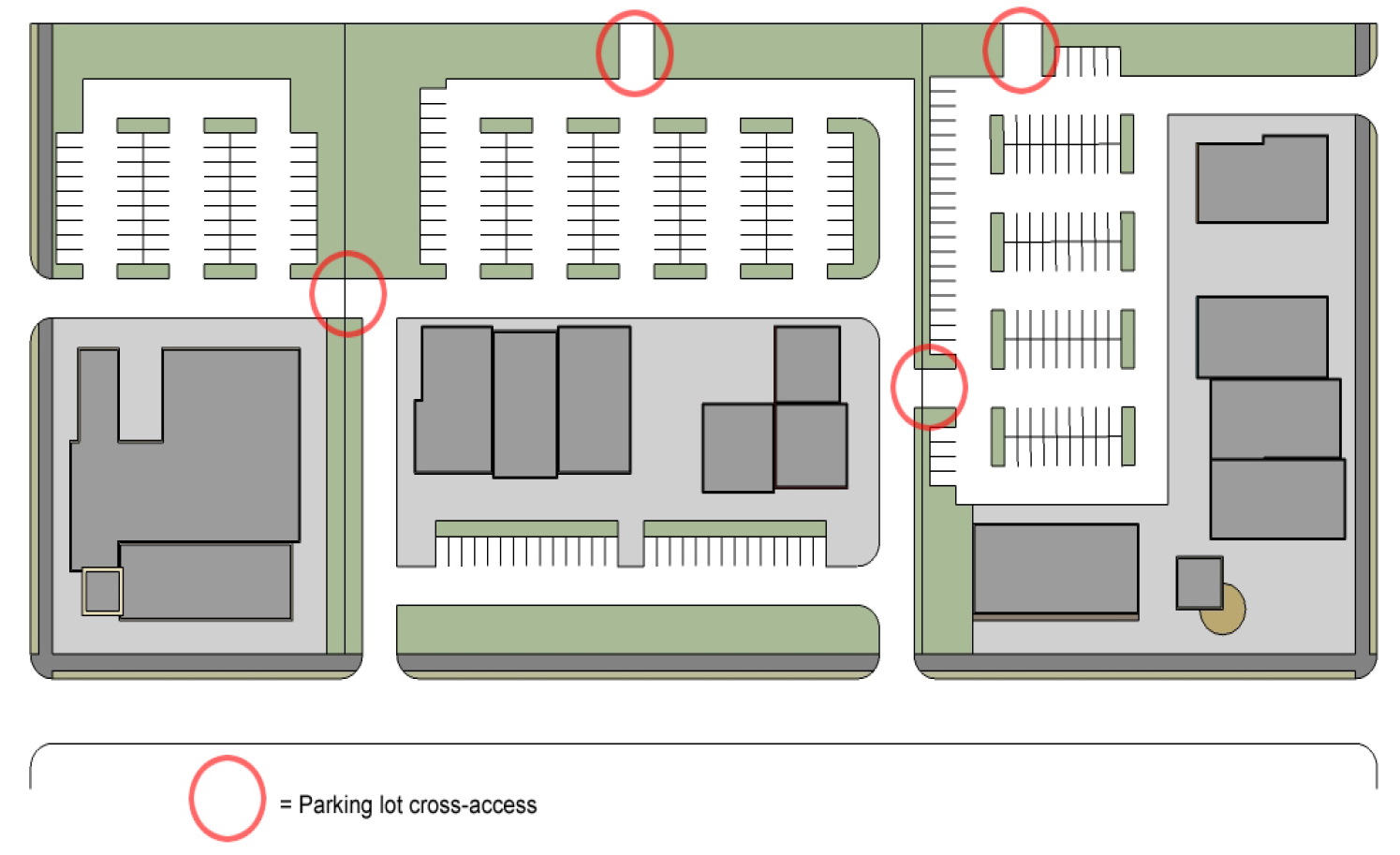
ii.
Easements allowing cross-access to and from lands served by a vehicular cross-access in accordance with paragraph 1 above, along with agreements defining maintenance responsibilities of land owners pertaining to the vehicular cross-access, shall be recorded in the public records of Orange County.
iii.
The Director may waive or modify the requirement for vehicular cross-access established in paragraph 1 on determining that such cross-access is impractical or undesirable due to the presence of topographic conditions, natural features, or vehicular safety factors.
3.
Pedestrian Cross-Access
(a)
An internal pedestrian circulation system in new multifamily, nonresidential, or mixed-use development shall be designed to allow for pedestrian cross access between the development's buildings and parking areas and those on adjoining lots containing multifamily, nonresidential, or mixed-use development.
(b)
Easements allowing cross-access to and from properties served by a pedestrian cross-access in accordance with paragraph 1, along with agreements defining maintenance responsibilities of land owners, shall be recorded in the public records of Orange County.
(c)
The Director may waive or modify the requirement for pedestrian cross-access established in paragraph 1 on determining that such cross-access is impractical or infeasible due to the presence of topographic conditions or natural features.
4.
Bicycle Cross-Access
(a)
An internal bicycle circulation system in the MU-D or MU-ES districts shall be designed and constructed to provide bicycle cross-access between it and any internal bicycle circulation system on adjoining parcels containing a multifamily, nonresidential, or mixed-use development, and to vacant lands in the MU-D or MU-ES districts.
(b)
Easements allowing cross-access to and from properties served by a bicycle cross-access in accordance with paragraph 1, along with agreements defining maintenance responsibilities of land owners, shall be recorded in the public records of Orange County.
(c)
The Director may waive or modify the requirement for bicycle cross-access established in paragraph 1 above, on determining that such cross-access is impractical or undesirable for typical bicyclists' use due to the presence of topographic conditions, natural features, or safety factors. Undesirable conditions shall be defined as those limiting mobility for bicycles as a form of transportation, such as narrow connections bounded on both sides by walls or embankments, or limited visibility when straight-line connections are not achievable.
5.
Pedestrian Connections. A right-of-way at least eight feet wide shall be provided in a single-family or two-family residential subdivision for pedestrian and bicycle access between a cul-de-sac head or street turnaround and the sidewalk system of the closest street or pedestrian path (as shown in Figure 5.13.1.C.2.c.5: Pedestrian Connections), if it:
(a)
Is in close proximity (defined generally as within a half-mile) to significant pedestrian generators or destinations such as schools, parks, trails, greenways, employment centers, mixed use development, retail centers, or similar features; or
(b)
Creates an unreasonable impediment to pedestrian circulation (defined generally as walking distance between uses on the cul-de-sac and uses on the closest street that is at least four times the actual physical distance between these two uses); and
(c)
Can be reasonably achieved and connected to an existing or proposed sidewalk, trail, greenway, or other type of pedestrian connection.
(d)
This pedestrian connection shall count as a link for the purpose of calculating the connectivity index.
Figure 5.13.1.C.2.c.5: Pedestrian Connections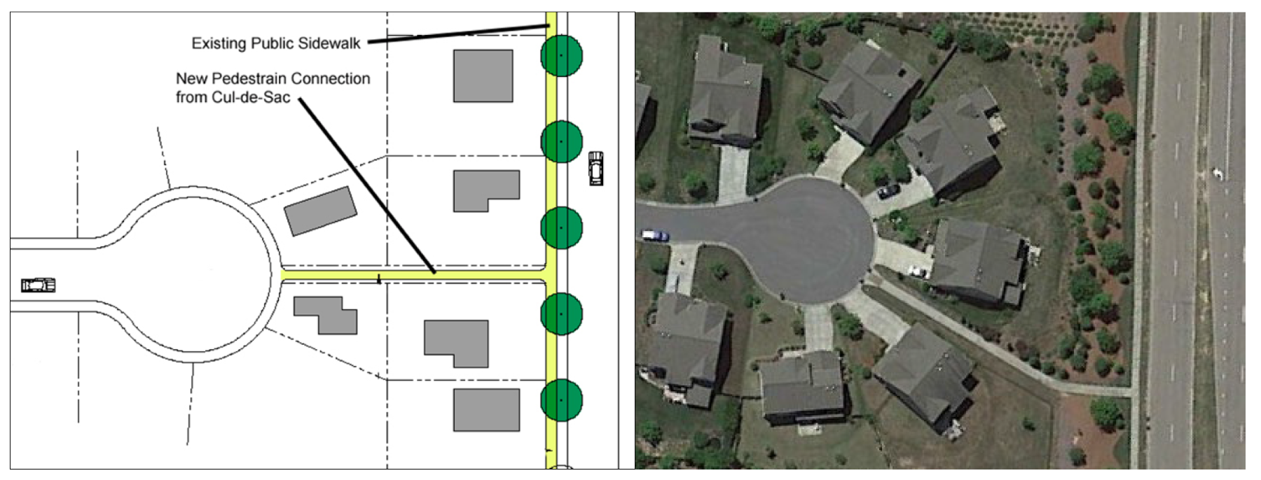
6.
External Street Connectivity
(a)
The arrangement of streets in a residential subdivision shall provide for the alignment and continuation of existing or proposed streets into adjoining lands where the adjoining lands are undeveloped and deemed appropriate for future development, or are developed and include opportunities for such connections.
(b)
Street rights-of-way shall be extended to or along adjoining property boundaries such that a street connection or street stub shall be provided for development where practicable and feasible in each direction (north, south, east, and west) for development that abuts vacant lands.
(c)
At all locations where streets terminate with no street connection, but a future connection is planned or accommodated, a sign shall be installed with the words "FUTURE STREET CONNECTION," to inform land owners.
(d)
The final plat shall identify all stub streets and include a notation that all street stubs are intended for connection with future streets on adjoining undeveloped or underdeveloped lands.
(e)
Stub streets that exceed 150 feet in length shall include a turn-around that shall be replaced when the stub street is connected.
7.
Continuation of Adjacent Streets. Proposed street layouts shall be coordinated with the existing street system in surrounding areas. Existing streets shall, to the maximum extent practicable, be extended to provide access to adjacent developments and subdivisions and to provide for additional points of ingress and egress.
8.
Traffic-Calming Measures
(a)
In residential subdivisions, street widths not in excess of basic design standards, short block lengths, on-street parking, controlled intersections, roundabouts, and other traffic-calming measures are encouraged on all local streets that connect between two nodes in the connectivity index system, provided they do not interfere with emergency vehicle access.
(b)
Residential development shall employ measures to interrupt direct vehicle flow on linear street segments over 800 linear feet long, to the maximum extent practicable (see Figure 5.13.1.C.2.c.8: Traffic Calming Measures). Such measures may include, but shall not be limited to:
Fig. 5.13.1.C.2.c.8: Traffic Calming
Measures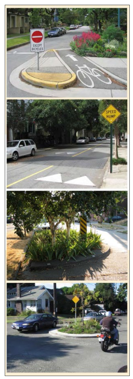
i.
Stop signs at street intersections;
ii.
Mini-roundabouts at intersections;
iii.
Curvilinear street segments to slow traffic and interrupt monotonous streetscapes;
iv.
Traffic-diverting physical devices such as neckdowns, chicanes, and diverter islands;
v.
Roadway striping to limit vehicular cartway widths or accommodate bike lanes; and
vi.
Raised intersections or elevated pedestrian street crossings.
(c)
Any physical installations that narrow the roadway and extend curbs toward the street centerline, such as bulbouts and chicanes, are discouraged on streets less than 24 feet wide, but are encouraged on wider streets as a traffic calming device and to reduce crossing distance for pedestrians, where practicable.
9.
Sidewalks Required
(a)
In all districts except the I-H district, sidewalks a minimum of five feet in width, and that comply with Sec. 5.13.6, Sidewalks and Bikeways, are required on both sides of all streets within a new development, redevelopment, and subdivision, along the entire frontage with a street (unless an existing sidewalk is already in place).
(b)
The Director, as appropriate, may waive or modify the requirement for sidewalks on determining that such sidewalks are impractical or infeasible due to the presence of topographic conditions or natural features that do not allow connections to be realistically made.
10.
Pedestrian Walkways through Large Vehicular Parking Areas
(a)
General. All vehicular parking areas and parking structures containing more than 200 parking spaces shall provide a clearly identified pedestrian path between parking areas and the primary pedestrian entrance(s) to the building(s) served by the parking areas, or to a pedestrian walkway providing direct access from the furthest extent of the parking area to the primary building entrance(s).
(b)
Pedestrian Walkways. Vehicular parking areas containing more than 200 parking spaces shall, at a minimum, include one pedestrian walkway every six parallel parking rows (every three double-row parking bays) or every 200 feet, whichever is the lesser dimension (see Figure 5.13.1.C.2.c.10(b): Pedestrian Walkways Through Vehicular Parking Area). The pedestrian walkway shall be constructed of a paved surface with concrete similar to that used for sidewalk standards for public streets. Other hardscape materials, such as brick pavers, may be used provided if they allow smooth surfaces along pedestrian paths and at vehicle crossings.
Figure 5.13.1.C.2.c.10(b): Pedestrian Walkways Through Vehicular Parking Area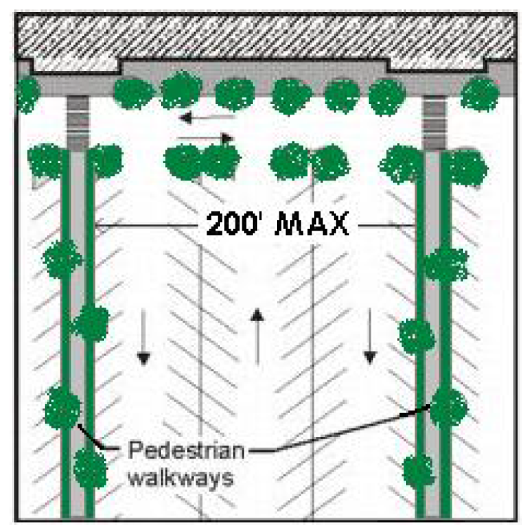
11.
Extension of Pedestrian Walkways. Pedestrian walkways providing access between vehicular parking areas and associated buildings may be extended to provide the connections to abutting street sidewalks or to adjoining development.
12.
Bicycle Facilities. In the MU-D and MU-ES districts, new developments and redevelopments are encouraged to include bike lanes, bike paths, or other bicycle facilities sufficient to allow safe and efficient bicycle access and circulation within the development.
5.13.2. - Minimum Street Design and Construction Standards
A.
Compliance with Technical Construction Standards. Unless modified by the standards in this section the guidelines of the Manual of Uniform Minimum Standards for Design, Construction and Maintenance for Streets and Highways, State of Florida, current edition (Green Book), the standards of the American Association of State Highways and Transportation Officials and the latest edition of the Orange County Road Construction Specifications shall be the minimum acceptable standards for street design.
B.
Design Standards
1.
General. Streets shall be classified based on the definitions, and with consideration of vehicle trip generation ratios as provided in this section. Where the City Council has adopted a higher classification than the classification based on projected traffic volumes, the higher classification shall be used. All streets shall be designed in accordance with the latest standards of the American Association of State Highways and Transportation Officials, Orange County road construction specifications, and the FDOT Manual of Uniform Minimum Standards for Design, Construction, and Maintenance for Streets and Highways (Green Book), and the following minimum standards, except that greater requirements shall be met when imposed by an agency having jurisdiction of a particular road.
a.
Minimum Right-of-way Width. Minimum right-of-way width shall be as specified in Sec. 5.13.7, Rights-of-way.
b.
Percent Grade. The percent grade of roadway centerline (closed drainage) shall comply with Table 5.13.2.B.1.b: Percent Grade of Roadway Centerline (Closed Drainage)
2.
Cul-de-sac
a.
A cul-de-sac shall be provided with a paved turnaround with a minimum radius (exclusive of curb) of 35 feet. The radius of the right-of-way shall be a minimum of 50 feet. The cul-de-sac radius may be increased at the discretion of the Fire Chief, to accommodate emergency vehicle apparatus.
b.
The length of a cul-de-sac shall be evaluated and approved based on roadway intersection level of service, emergency vehicle access, project layout, and general site planning standards.
c.
Whenever an island is proposed in the center of a cul-de-sac turnaround, the pavement shall be 24 feet, exclusive of curbs.
3.
Continuation of Existing Street Pattern. The proposed street layout shall be coordinated with the street system of the surrounding area. Streets on the proposed site shall be connected to existing streets in adjacent areas where required to provide for better traffic circulation and addition access points.
4.
Street Access to Adjoining Property. Street stubs to adjoining unplatted areas or future development phases shall be provided unless an amount equal to construction cost is paid to the City for completion of a road when adjoining development occurs. Street stubs in excess of 250 feet shall be provided with a temporary cul-de-sac turnaround. The developer of the adjoining area shall pay the cost of restoring the street to its original design cross section, and extending the street. A secured secondary access for emergency vehicles and essential services shall be provided when subdivision adjoins a development with a private street.
5.
Intersection Design
a.
Streets shall be laid out to intersect as nearly as possible at right angles. Multiple intersections involving the juncture of more than two streets are prohibited. In order to provide a clear view of intersecting streets to the motorist, there shall be a triangular area of clear visibility formed by two intersecting streets or the intersection of a driveway and a street.
b.
Nothing shall be erected, placed, parked, planted, or allowed to grow in such a manner as to materially impede vision (sight distance), as measured and determined in accordance with the FDOT Manual of Uniform Minimum Standards for Design, Construction and Maintenance for Streets and Highways (Green Book).
6.
Intersection Separation. Intersection separation shall comply with Sec. 5.13.3.B.2, Intersection Separation.
7.
Subdivision on Arterial or Collector Streets. Where a subdivision abuts or contains an existing or proposed street that is designated in the traffic element of the comprehensive plan to be improved or constructed and is shown on the Official Street Map, the developer shall be required to reserve or dedicate rights-of-way, and may be required to construct improvements, as determined by City Council.
8.
Half Streets. Half streets shall be prohibited except where a previously platted half street abuts land to be subdivided. The second half of the street shall be platted within the land being subdivided and the entire street shall be improved.
9.
Additional Right-of-Way. A proposed subdivision that includes a dedicated street which does not conform to the minimum right-of-way requirements of this LDC, or other applicable City or state requirements, shall provide for the dedication of additional right-of-way along either one or both sides of the street so that the minimum required right-of-way can be established. If the proposed subdivision abuts only one side of the street, then a minimum of one-half of the required additional right-of-way shall be dedicated.
10.
Vertical Alignment
a.
Vertical curves shall be required where the algebraic difference in intersecting grades equals or exceeds the values in Table 5.13.2.B.10.a: Vertical Alignment.
b.
All vertical curves shall be of sufficient length to provide a safe stopping sight distance compatible to the design speed of the street or road. Minimum length of all vertical curves shall be 100 feet.
c.
Minimum cross slopes and/or super-elevation rates of 0.0208 feet/foot (one quarter inch/foot) shall be utilized for the design of all streets or roads.
11.
Minimum Number of Access Points. A minimum of two points for vehicular access shall be provided into each residential development of 25 dwelling units or more. Nonresidential developments shall also provide a minimum of two points of vehicular access, as determined by the Development Review Committee (DRC). Additional access points may be required depending upon the size of the development (see below). Where adjoining existing development or other land development code requirements preclude the development of two public street access points, an unobstructed drivable stabilized surface for emergency vehicles (Fire/Police) and essential services (Sanitation/Public Works) may be substituted upon review and approval of the Development Review Committee (DRC).
The number of access points for residential developments shall be as follows:
a.
25—250 dwelling units: One full access point; plus one full access point or one planned secondary access point, or emergency access point to an existing right-of-way.
b.
251—750 dwelling units: Two full access points.
c.
751—1,000 dwelling units: Two full access points; plus a third full access point or one planned third access point, or emergency access point to an existing right-of-way.
d.
Over 1,000 dwelling units: Planned access per DRC-Development Review Committee direction.
C.
Design Requirements
1.
Compliance with state and county standards. All street construction shall comply with the latest edition of the Orange County road construction specifications and FDOT Standard Specifications for Road and Bridge Construction and Flexible Pavement Design Manual. A signed and sealed pavement design shall be provided for all roadway classifications applicable to the development. A design life of 20 years shall be used.
2.
Clearing and grading of rights-of-way. The owner or developer shall clear all rights-of-way according to minimum standards in the latest edition of the FDOT Standard Specifications for Road and Bridge Construction. All grades, including grades for streets, alleys, and drainage, shall be consistent with all grades approved for the subdivision. All debris shall be removed from the project site.
3.
Subgrade. All unstable materials such as muck, peat, or plastic clays shall be removed from the right-of-way. The areas then shall be backfilled with suitable material and compacted to 95 percent of the maximum density as determined by AASHTO T-180 test method.
a.
Subgrade Requirements for Limerock/Soil Cement/Crushed Concrete Base. Subgrade shall comply with the following:
1.
Compact to 95 percent of AASHTO T-180 for top 12 inches minimum, minimum LBR 40.
2.
Subgrade shall extend 12 inches beyond back of curb.
b.
Testing Intervals. Density and bearing value tests shall be taken at intervals not to exceed 300 feet or 800 square yards, as directed by the City Engineer.
4.
Base Course
a.
Thickness. The base course materials may be limerock, soil cement, or crushed concrete with a minimum thickness that complies with Table 5.13.2.C.5.a: [Minimum] Base Course Material Thickness.
b.
Limerock
1.
The limerock base shall be compacted to a density of not less than 98 percent maximum density as determined by AASHTO T-180, minimum LBR 100.
2.
Thickness checks and density tests shall be made at intervals not to exceed 300 feet.
c.
Soil Cement
1.
The soil cement base shall be constructed to conform with Table 5.13.2.C.5.c.1: Soil Cement Laboratory Design Mix Compressive Strength.
2.
The laboratory mix design shall be provided to the City prior to construction.
3.
Thickness checks and compressive strength tests shall be performed at intervals not to exceed 300 feet.
d.
Crushed Concrete
1.
The limerock base shall be compacted to a density of not less than 98 percent maximum density as determined by AASHTO T-180, minimum LBR 150.
2.
Thickness checks and density tests shall be made at intervals not to exceed 300 feet.
5.
Asphalt Concrete
a.
The materials used shall conform to the following:
1.
FDOT Type SP-9.5 or SP-12.5 asphaltic concrete.
2.
FDOT Type FC-9.5 or FC-12.5 Type FC-9.5 or FC-12.5 asphaltic concrete when a skid resistant surface is required.
b.
The asphalt concrete thickness shall conform with Table 5.13.2.C.6.b: Minimum Asphalt Concrete Thickness.
c.
A certified copy of the design mix shall be submitted to the City Engineer.
6.
Roadway Underdrains
a.
All streets shall be designed to provide a minimum clearance of one foot between the bottom of the road base and the estimated seasonal high-water table, or the artificial water table induced by an underdrain system with an appropriate factor of safety.
b.
The planned use of underdrain systems which control the seasonal high-water table to provide these minimum clearances, is allowed with the following requirements and limitations:
1.
The use of a limerock base in conjunction with underdrains is prohibited for streets constructed within City right-of-way.
2.
The underdrains shall be designed so that they flow no more than six months in an average rainfall year.
3.
The underdrain trench bottom shall not be placed below the seasonal low water table elevation.
4.
The distance between the bottom of the underdrain and the bottom of the roadway base shall not be less than 24 inches.
5.
Geotechnical engineer certification:
(a)
A Florida registered geotechnical engineer shall provide the following design certification: "This is to certify that the underdrain design for (street name) , extending from station _______ to station _______, has been designed such that the separation between the bottom of the road base and the artificially induced wet season water table is no less than one foot for the entire width of pavement."
(b)
The installation shall be inspected by the certifying engineer who shall then certify that the underdrain installation has been constructed according to the approved plans.
6.
The stormwater facilities shall be designed to accommodate expected flow contributed by the underdrain system.
7.
The City shall inspect the underdrain system for compliance prior to the issuance of a Certificate of Acceptance.
8.
Materials used shall be in accordance with the latest Orange County road construction specifications.
9.
If during construction the water table is encountered within the minimum clearance specified then the engineer of record shall be notified and a thorough investigation conducted.
7.
Curbs and Gutters
a.
All streets shall be paved and drained utilizing curb and gutter construction.
b.
The curb and gutter shall be FDOT Type "F", Type E, or Miami depending on the application. FDOT Type E, mountable median curb, may be used around median dividers on the high side of pavement. All curbing designed to handle water shall incorporate an approved gutter design. There shall be a stabilized subgrade beneath all curbs and one foot beyond the back of the curb.
c.
No water valve boxes, meters, portions of manholes, or other appurtenances of any kind relating to any underground utilities shall be located in any portion of a curb and gutter section.
d.
The minimum allowable flow line grade of curbs and gutters shall be 0.24 percent. The tolerance for ponded water in curb construction is one-fourth inch maximum; if exceeded, the section of curb shall be removed and reconstructed to grade.
e.
Plastering shall not be permitted on the face of the curb. Joints shall be sawed at intervals often feet, except where shorter intervals are required for closures, but, in no case, less than four feet.
f.
After concrete has set sufficiently, but in no case later than three days after construction, the curbs shall be backfilled.
g.
All cross-street valley gutters (i.e. FDOT drop curb) shall be constructed of concrete.
(Ord. No. 2805, § X, 11-18-2020; Ord. No. 2877, § XVIII, 12-15-2021)
5.13.3. - Street and Road Access
A.
Number of Access Points
1.
Paved Access Required. All development shall be required to provide paved access to a public right-of-way. Paved access to a public right-of-way may include private streets or other appropriate cross-access easements. The requirement for paved access beyond the right-of-way may be waived for agricultural development or for a single-family detached dwelling which is located on a parcel at least one acre in size, if the nearest dwelling or accessory building wall is more than 150 linear feet from the property's access point.
2.
Number of Access Points. The number of access points allowed for each development shall be based on the following standards:
a.
Type of road facility being accessed;
b.
Separation standards;
c.
Engineering design standards;
d.
Internal traffic circulation;
e.
Impact on transportation system; and
f.
Emergency vehicles access.
g.
In accordance with Sec. 5.13.2, B. 11. Minimum number of access points.
3.
Adjoining Property. Access to adjoining property shall be coordinated as required in Sec. 5.13.2.B.3, Continuation of Existing Street Pattern and Sec. 5.13.2.B.4, Street Access to Adjoining Property.
B.
Separation of Access Points
1.
Minimum Criteria. The design and location of urban intersections should be consistent with the terms included in these regulations, and the most current Manual of Uniform Minimum Standards for Design, Construction and Maintenance for Streets and Highways as prepared by FDOT.
2.
Intersection Separation. Intersections on streets or roads designated as arterials should not be less than 1,760 feet apart and intersections on streets or roads designated as collectors should not be less than 500 feet apart, centerline measurement. Intersections with centerline offsets of less than 150 feet are prohibited on local streets.
3.
Curb Cuts. No person shall construct a curb cut for a driveway, walkway or any other purpose without first obtaining approval from the City Engineer. Additional permits will be required from Orange County or FDOT for roads under their jurisdiction.
C.
Design Considerations
1.
The choice for the proper location of driveways must involve consideration of the amount of the conflict which can be expected to occur both within the off-street vehicular parking area and on abutting streets. One primary concept which shall be followed is to reduce the number of driveways to a practical minimum and to promote consolidated driveway usage wherever possible, thus providing fewer locations where conflicts may occur.
2.
The area to which the driveway provides access shall be of sufficient size and design to allow all necessary functions for loading, unloading, parking, and standing to be carried out on private property and completely off the street right-of-way.
a.
No design shall be permitted which requires any vehicle to back out onto a public street, except for single-family detached dwellings.
b.
Facilities with drive-in windows shall be so designed so that waiting vehicles do not extend into the street or right-of-way.
3.
The minimum spacing between adjacent driveways accessing arterial or collector streets shall comply with the following standards:
a.
Arterials:
1.
Speed limit greater than or equal to 45 mph: Nearest edge to nearest edge shall equal at least 660 feet.
2.
Speed limit less than 45 mph: Nearest edge to nearest edge shall equal at least 440 feet.
b.
Collectors:
1.
Speed limit greater than or equal to 45 mph: Nearest edge to nearest edge shall equal at least 440 feet.
2.
Speed limit less than 45 mph: Nearest edge to nearest edge shall equal at least 245 feet.
3.
Distances between adjacent one-way driveways with the inbound driveway upstream from the outbound driveway can be one-half the distance as that established in b.1 and b.2, above.
4.
Driveways on opposite sides of any undivided street classified collector or arterial shall be offset a minimum of 200 feet, measured from centerline to centerline, whenever possible.
5.
For developments that request more than one two-way driveway, based upon parcel size, projected trip generation of the site, amount of roadway frontage, and other appropriate design considerations, additional driveways may be permitted if all other provisions of this section are met.
4.
No driveway shall be permitted in the radius return of an intersection.
5.
All driveway widths shall be measured at the property or right-of-way line.
6.
All driveways shall be constructed as nearly to a right angle to the street or roadway as possible.
7.
All driveways shall cross the sidewalk area at the sidewalk grade.
8.
Concrete for the construction of driveway approaches (the portion of the driveway in the right-of-way including the sidewalk crossover) shall be at least 2,500 psi concrete and at least six inches in thickness (with six-inch by six-inch #10/#10 woven wire fabric reinforcing and with break and exposed joint at property line).
9.
No residential driveway shall be permitted within 40 feet of an intersection. This measurement shall be made from the centerline of the proposed driveway to the nearest right-of-way line of the intersecting street as measured along the adjacent right-of-way line.
10.
No edge of a residential driveway shall be closer than five feet to the adjoining lot or parcel.
11.
The minimum width of a driveway serving a single-family detached dwelling shall be ten feet, and the maximum width shall not exceed 18 feet, and 27 feet for a three-car garage.
12.
For all residential driveways, the width of the curb opening shall not exceed the width of the driveway by more than three feet on each side, except if a radius is used.
13.
Residential driveways shall have a minimum one foot six inch flare tapered back to the front of the sidewalk.
14.
Residential driveway approaches shall be designed so that the slope does not exceed the maximum as shown in the Apopka Construction Design Standards Manual in this LDC, unless approved by the City Engineer.
15.
No driveway shall be permitted which includes any municipal facility such as traffic signal standards, catchbasins, fire hydrants, or any other similar type structure, unless the facility is relocated at the property owner's expense.
16.
The minimum and maximum widths of commercial driveways shall conform with Table 5.13.3.C.16: Commercial Drive Width:
17.
Commercial driveways shall have a minimum 15-foot radius measured from the front of the sidewalk to the curb and gutter flow line.
18.
All nonresidential driveways shall be constructed in conformance to the plans and specifications approved by the City Engineer.
D.
Frontage Roads and Joint-Use Driveways.
1.
Arterial roads. Properties fronting on arterial streets unable to meet driveway separation criteria within this LDC shall have indirect access to the arterial by means of either joint-use driveways, or frontage roads, or in the case of corner parcels, by access to the collector or other facility that intersects the arterial. The following conditions shall apply:
a.
Arterial, No Existing Service Road, Incompatible Abutting Development. When a parcel is located where there is no existing service road, and the planned use of the subject parcel is incompatible for buffer yard requirements with existing uses of abutting lands (e.g., single-family detached dwelling) making a joint-use driveway undesirable, a temporary driveway with direct access from the subject parcel to the arterial, or in the case of a corner parcel, to the collector or other street or road that intersects the arterial, will be allowed provided that:
1.
Access rights to the subject parcel are dedicated to the City;
2.
The necessary cross-access easement for a planned service road is conveyed to the City; and
3.
When the use of an abutting property changes to a compatible use, a joint-use driveway is provided by the owner(s) of the subject property jointly with the owner(s) of the abutting property which use has changed, at a location approved by the DRC, and the temporary driveway shall be discontinued (if not used as the joint-use driveway); or
4.
When the use of two or more abutting properties changes to a compatible use, a service road fronting the subject properties is provided by the owners of the subject properties and the cross-access easement conveyed to the city and access to the individual properties is from the service road only, and the service road accesses the arterial or a street or road intersecting the arterial at a location approved by the DRC.
b.
Arterial, No Existing Service Road, Compatible Abutting Development. When a parcel of property is located where there is no existing service road, and the planned use of the subject property is compatible with existing uses of one or more abutting properties, a service road will be provided by the owner(s) of the subject property and the cross-access easement conveyed to the City, and access to the individual property will be from the service road only, and the service road will access the arterial or a facility intersecting the arterial at a location approved by the DRC.
c.
Arterial, Existing Service Road. When a parcel of property is located where there is an existing service road to the abutting properties, an extension of the service road, fronting the subject, will be provided by the owner(s) of the subject property, and the necessary cross-access easement for the service road will be conveyed to the City, and access to the subject property shall be from the service road only, and the service road shall access the arterial or a facility intersecting the arterial at a location approved by the DRC.
2.
Collector Streets. Properties fronting on collector streets unable to meet the driveway separation standards in this LDC should have indirect access to the collector street by means of either joint-use driveways, or service roads, or in the case of corner parcels, by access to the facility (if not an arterial) that intersects the collector. The following conditions shall apply:
a.
Collector, No Existing Service Road, No Planned Service Road. When a parcel of property is located where there is no existing or planned service road and the planned use of the subject property is incompatible with existing uses of abutting properties (e.g., single-family detached dwelling), making a joint-use driveway undesirable, a temporary driveway with direct access to the collector street, or in the case of a corner parcel, to the street or road (if not an arterial) that intersects the collector street, will be allowed provided that:
1.
Access rights to the parcel are dedicated to the City;
2.
The necessary cross-access easement is conveyed to the City;
3.
When the use of an abutting property changes to a compatible use, a joint-use driveway is provided by the owner(s) of the subject property jointly with the owner(s) of the abutting property which use has changed, at a location approved by the DRC, and the temporary driveway is discontinued (if not used as the joint-use driveway); and
4.
Joint-use driveways, with required cross-access easements, serve as many adjoining properties as necessary to maintain the minimum spacing of driveways as listed in this section.
b.
Collector, No Existing Service Road, Planned Service Road. When a parcel of property is located where there is no existing service road, but a service road is planned, and the planned use of the subject property is incompatible with existing uses of adjoining properties, (e.g., single-family detached dwelling), making a joint-use driveway undesirable, a temporary driveway with direct access to the collector street, or in the case of a corner parcel, to the facility (if not an arterial) that intersect the collector street, will be allowed provided that:
1.
Access rights are dedicated to the City;
2.
The necessary cross-access easement of the planned service road is conveyed to the City; and
3.
When the use of an adjoining property changes to a compatible use, a joint-use driveway is provided by the owner(s) of the subject property jointly with the owner(s) of the adjoining property which use has changed, at a location approved by the DRC, and the temporary driveway discontinued (if not used as the joint-use driveway); or
4.
When the use of two or more adjoining properties changes to compatible uses, a service road, fronting the subject properties, is provided by the owners of the subject properties and the necessary cross-access easement for the service road conveyed to the City, and access to the subject properties is from the service road only, and the service road has access to the collector, or other street or road (if not an arterial) intersecting the collector, at a location approved by the DRC.
c.
Collector, Existing Service Road. When a parcel of property is located where there is an existing service road to the adjoining properties, an extension of the service road, fronting the subject property, shall be provided by the owner(s) of the subject property and the necessary cross-access easement for the service road conveyed to the City, and access to the subject properties shall be from the service road only, and the service road shall access the collector, or facility (if not an arterial) intersecting the collector at a location approved by the DRC.
E.
Access to Residential Lots
1.
Access to nonresidential uses shall not be through an area designed, approved, or developed for residential use.
2.
All lots in a proposed residential subdivision shall have frontage on and access to a residential street.
(Ord. No. 2877, § XIX, 12-15-2021; Ord. No. 2994, § XIII, 3-15-2023)
5.13.4. - Streets
A.
Street Classification System Established. Streets in the City are classified according to function served in order to allow for regulation of access, road and right-of-way widths, circulation patterns, design speed, and construction standards. The function of a roadway is twofold: one function is to provide access to land uses adjacent to the roadway facility; the other function is to provide mobility through an area. As access to a roadway increases, the ability of the facility to provide mobility to through traffic decreases. Roadway facilities designed for mobility generally have higher speeds and restrictive access controls. Facilities designed for mobility generally have more capacity than those designed for land access. The hierarchy of streets is established based on and in accordance with the following categories and descriptions:
1.
Limited Access Roadways (Interstates, Expressways, Freeways). Limited access roadways are devoted primarily to the movement of trips over long distances. Access from adjoining parcels is prohibited, and access is limited to exit and entrance ramps located at major roadways. This roadway is generally a multi-lane divided facility designed to serve large volumes of high-speed traffic.
2.
Major Arterial. Major arterials are designed for the movement of large volumes of traffic over relatively long distances. They connect to other arterials or collectors and do not penetrate residential neighborhoods. Through traffic movement shall always take precedence over access to private property. Use of frontage roads and consolidation of access is strongly encouraged. Mobility is the primary function of this facility, consequently, access outs shall be strictly controlled.
3.
Minor Arterial. Minor arterials are very similar to major arterials but are designed to serve moderate volumes of traffic as well as provide connections to the major system. This facility has a lower degree of travel mobility than a major arterial. This type of roadway allows more land access than either limited access facilities or major arterials.
4.
Major Collector. Major collectors serve major community or regional facilities and carry through traffic. Collectors do not serve long, through trips, but rather short to moderate length trips. These routes also collect and distribute traffic between local roads or arterial roads and serve as linkage between land access and mobility needs.
5.
Minor Collector. Minor collectors have a function similar to that of a major collector, except that they serve a more limited geographic area. Land service is generally a significant function of this facility.
6.
Local. Local streets primarily exist to provide access to adjacent land uses. Average speeds and volumes are low, and trips are usually short in length. There is no emphasis on through traffic movement.
7.
Special Purpose Streets. Under special circumstances a new local street may be classified and designed as one of the following:
a.
Alley. An alley is a special type of street which provides a secondary means of access. The alley shall be designated, intended or adopted to serve as a means of accommodation to a limited area for primarily local convenience. Alleys shall have a minimum right-of-way width of 20 feet and shall be paved to the specifications provided herein. There shall be no parallel parking allowed on alleys. Lighting shall be required for safety and security in accordance with Sec. 5-6-2.A.3.
b.
Marginal Access Street (Frontage Road). A marginal access street is a street parallel and adjacent to a collector or higher level street which provides access to abutting properties and separation from through traffic. Marginal access streets shall meet at a minimum the same specifications as a local street.
B.
Official Traffic Circulation Map. The Official Future Traffic Circulation Map as adopted in the comprehensive plan shall be the Official Street Map, and any amendments thereto, adopted by the City as a part of the comprehensive plan. It is made a part of this LDC, and incorporated herein by reference. All existing roadways and streets within the City shall be designated on the Official Street Map. Any roadway or street abutting or affecting the design of a subdivision or land development which is not already classified on the Official Street Map shall be classified according to its function, design, and use by the City at the request of the owner/developer or during development plan review. The map shall be the basis for all decisions regarding required road and street improvements, reservation, or dedication of right-of-way for required road improvements, or access of proposed uses to existing or proposed roadways or streets.
C.
Additional Standards. Roads and streets shall also be arranged in accordance with the following:
1.
Conformity with the Orlando Urban Area Transportation System (OUATS) Plan or other such plan as may be determined applicable by the City;
2.
Integration with the street system of the surrounding area in a manner which is not detrimental to existing neighborhoods;
3.
Discouragement of through traffic on local streets; and
4.
Facilitation and coordination with the desirable future development of adjoining property of a similar character and provision for local circulation and convenient access to neighborhood facilities.
D.
Road and Street Names. The continuation of an existing road or street shall have the same name, even when it changes direction. When road or street names are interrupted by a channel, expressway, railroad, body of water or similar obstruction, and eventual connection is not possible, the segments shall bear different names. The name of a new road or street shall not duplicate the name of an existing road or street within the City.
1.
No separate name shall be used for a cul-de-sac that provides street frontage for three or less lots. The name shall be the same as that of the intersecting street. Where there is a series of long and short culs-de-sac, however, each should have separate names;
2.
The developer shall be responsible for naming streets within a project. Names should be chosen that relate to the scale and location of a project, which helps establish locational identity. Before minor development plan approval, the developer shall submit proposed street names to the Director for approval, and the City shall have final approval of all street names. The minor or major development plan shall include the overall tract illustrating the proposed street layout and proposed street name(s);
3.
The following are unacceptable City street names:
a.
Numerical names (such as one, two, three, etc.) except numbers which continue the established grid pattern (such as First Street, Second Street, etc.);
b.
Alphabetical letters (A, B, C, etc.);
c.
Complicated or compound names (these may be used sparingly but shall be avoided on streets less than 1,000 feet in length);
d.
Directional type street names, such as east, west, north, and south; unless in reference to the adopted grid numbering system (such as 120 East Main Street).
E.
Definition of Thoroughfare Designations. All road or street suffix names (as depicted in Table 5.13.4.E: Definition of Thoroughfare Designations) shall be used for street naming within the City. Street suffixes not mentioned may be used, provided the developer or property owner obtains approval by the Director.
| Table 5.13.4.E: Definition of Thoroughfare Designations | |
|---|---|
| Street Suffix | Definition |
| Alley or Alleyway | Located in the rear of residential or commercial lots. Used for servicing structures fronting on regularly established roadways. |
| Avenue | A roadway running in a north-south direction. |
| Boulevard or Parkway | A street divided by a landscape center island or median, used as a minor collector and serving as an internal traffic collector. |
| Circle | Streets which form a ring-like shape. All circles shall contain one name. |
| Court | Permanently closed street such as a cul-de-sac generally less than 1,000 feet. All courts shall have one name only. |
| Drive | Curving or meandering streets generally longer than 1,000 feet. |
| Lane | One-block roadway in a north-south or east-west direction, generally less than 1,000 feet long. |
| Loop | Short circular roadway which configuration is a U-shape (horseshoe-shape). |
| Parkway | (See Boulevard.) |
| Place | A cul-de-sac or permanent dead-end road. |
| Road | Thoroughfares or minor arterials that run in any direction. |
| Street | A roadway running in an east-west direction. |
| Way | Diagonal street in a northwest-southeast or northeast-southwest direction, generally less than 1,000 feet long. |
 | |
F.
Road and Street Name Changes. The naming or renaming of roads and streets within the City is necessary to eliminate confusion, facilitate improved emergency access by the Orange County 911 emergency system, and provide proper street identification. City Council may consider requests to name or rename a City road or street right-of-way by resolution and adopt such petition in accordance with this LDC and the following provisions:
1.
Affected property owner(s) shall mean any person owning property adjacent to a road or street right-of-way; and/or any structure or business with an assigned address which will be affected by the street name change, as identified on the latest County Tax Map.
2.
City Council is authorized to name and rename roads and streets within its jurisdiction in accordance with state and Orange County's policies and regulations. Request for duplicate street names within the City is prohibited.
3.
Any person within the City may petition to change a street name provided the following requirements are met:
a.
There is a signed petition by 75 percent of the affected property owner(s) confirming that there is no objection to the proposed road or street name;
b.
The road or street name change request identifies the reason(s) for the proposed name change; and
c.
The City Council finds the request is consistent with the overall City plans for road and street naming, addressing, and the 911 emergency systems.
(Ord. No. 2805, § XI, 11-18-2020; Ord. No. 2994, § XIII, 3-15-2023)
5.13.5. - Private Streets
A.
Purpose and Intent. The purpose and intent of a private street shall be for the control of external traffic through a development, for establishing a neighborhood identification, for provision of a private security system unique to the neighborhood, and for accommodating special overall design concepts consistent with this LDC and the goals for development in the City.
B.
Definition and Indemnification
1.
A private street or cross-access is an accessway designed for vehicular traffic and built according to City specifications for which the entry, use, and maintenance of the street vest in the private owners of the development except as provided in this section.
2.
The entity responsible for the maintenance of a private street shall indemnify and hold harmless the City for any liability, injury, damage, loss or death occurring on private streets or resulting from private streets. The indemnification shall be a condition of approval by the City of any private street or cross-access.
C.
Standards for Private Streets. Private streets shall comply with the following standards:
1.
All plans or proposals utilizing private streets shall be submitted and approved as a part of a planned development (Sec. 2.5.1.F, Planned Development), development plan (major or minor) (Sec. 2.5.2.A, Development Plan (Major and Minor)), or plat (subdivision), (Sec. 2.5.2.B, Plat (Subdivision), as appropriate.
2.
Private streets shall only be permitted in a project which generates 1,500 or less average daily trips (ADTs) according to the latest edition of the ITE Trip Generation Manual.
3.
All private streets shall be built to City construction standards and specifications.
4.
Ingress and egress easements for public emergency service and maintenance vehicles shall be granted to the City for all private streets within a development.
5.
A minimum ten-foot utility easement for water, wastewater, and sidewalks shall be dedicated to the City within the right-of-way for the private street. Wastewater easements may utilize the easements for ingress and egress.
6.
Private streets shall not be used to link two or more publicly dedicated rights-of-way unless an approved security system or traffic control system is provided.
7.
Design speeds for vehicular traffic on private streets shall not exceed 30 miles per hour. Speed bumps and other physical deterrents designed to decrease vehicle speed shall not be used under any circumstance on private streets. Speed humps may be used if approved by the City of Apopka and in accordance with the policies approved.
8.
Parking for vehicles shall be accommodated on-site. Private street access easements shall not be used or calculated to account for required parking in accordance with this LDC.
9.
Private streets and developments with private streets shall adhere to all Police Department requirements and shall be subject to City police protection and any and all law enforcement powers.
10.
A development with a private streets is strongly encouraged to utilize a security system with manned guards and/or an installed gate system.
11.
A development with private streets shall have signage indicating the street is private. Proposed street signs that vary from the standard City signs may be used subject to approval as part of the development plan or subdivision, as appropriate
12.
The name for private streets shall comply with the requirements of Sec. 5.13.4.D, Road and Street Names.
13.
All new or modified gated developments that have private streets without 24-hour staffed guard houses and with automatic opening devices, such as but not limited to, single-family developments, multi-family developments, commercial, office, institutional, and industrial developments, shall be required to install the following: Numeric Keypad, SOS Siren Operated Sensor and Knox Gate Key Switch, as approved by the Fire Department. The equipment shall be maintained so it is capable of proper operation at all times and shall be compatible with existing emergency vehicle preemption equipment. (Existing installations may continue in use subject to the approval of the Fire Department.)
14.
All gated developments with private streets shall be subject to the right of any entity holding a City franchise to access the neighborhood to provide services and utilize the streets and easements for those purposes. (This requirement shall be noted on all plats with private streets.)
D.
Impact Fees and Real Property Taxes. Developments utilizing private streets shall be subject to payment for all applicable traffic impact fees and other off-site improvements required by this LDC. For the purposes of this section, private streets shall be considered private real property, and subject to any and all taxes normally charged to nonexempt taxable real property by the authorized taxing agencies, regardless of any other sections in this LDC.
E.
Establishment and Maintenance Requirements. Private streets shall be established and maintained in accordance with the following:
1.
A nonprofit organization or other legal entity shall be established in accordance with state law for the ownership, care, and maintenance of the private streets.
2.
The organization shall be established by covenants and restrictions running with the land and shall be composed of all persons having ownership within the development. The organizations shall be responsible for the perpetuation, maintenance, use, and function of the private streets.
3.
All development with private streets shall be platted in accordance with the requirements of this LDC and shall have the private street easements (including utility easements) described and identified in the plat as to location, size, use, and control, in a restrictive covenant. The covenant shall set forth the method of assessment for the maintenance of private street easements. Private street easements shall include the entire access easement, including street stabilization, paving, surfacing, curbs, sidewalks, vegetative growth and complete stormwater drainage system.
4.
The covenants and restrictions established to protect and maintain private streets shall comply with the following:
a.
The covenants and restrictions for the maintenance, care, and operation of the private street easements shall include provisions for a reserve fund to be held in escrow by the nonprofit organization or other legal entity which shall be separate and apart from other assessments and funds. The reserve fund shall be assessed, collected, and held by the nonprofit organization or other legal entity on an annual basis to be used exclusively for the maintenance, care, and operation of the private street easements. Maintenance and care shall not include maintenance and care of decorative landscaping, routine landscape maintenance, or security equipment or personnel, but shall be restricted to the roadway surface itself and the adjacent storm drainage facilities. The nonprofit organization or other legal entity must notify the Public Services Director within 30 days that they intend to expend funds for the escrow reserve fund or as soon as possible, in the case of an emergency.
b.
An accounting report of the reserve fund assessed, collected, and held by the nonprofit organization or other legal entity shall be submitted to the City on an annual basis. The accounting report shall include a detailed revenue and expenditure report along with a standard balance sheet. The accounting report shall also contain a copy of the most recent bank statement for the reserve fund and a statement from the president of the organization that the accounting report is true and correct. The reserve fund to be held in escrow shall be held in an interest-bearing account in an approved financial institution located within the City.
5.
In the event that the City must maintain the private street easements in either an emergency or nonemergency situation, as determined by the Fire Department, Police Department, and Public Service Department, the covenants and restrictions running with the land shall provide the City the authority to utilize the reserve fund and to impose and collect an assessment from all the property owners within the development for an amount sufficient to make the necessary repairs and improvements to the easements. Such authority shall be granted to the City until such time as the organization is willing and able to resume their maintenance responsibility of the private street easements. It is not anticipated that private streets allowed under this section will ever become publicly dedicated right-of-way.
6.
Acceptable language shall be recorded on each individual deed of a development with private streets so that it is obvious to the owner and subsequent owners that such provisions for private street maintenance are contained in the covenant and restrictions of the development.
(Ord. No. 2877, § XX, 12-15-2021; Ord. No. 2994, § XIII, 3-15-2023)
5.13.6. - Sidewalks and Bikeways
A.
Sidewalk to be Constructed. Sidewalks are required to be constructed by the owner/developer of any new development.
B.
Sidewalk Design and Construction Standards
1.
Corner lots are required to have sidewalks along both streets.
2.
All subdivisions shall have four-foot-wide concrete sidewalks on both sides of all local and minor collector streets and five-foot-wide sidewalks on all arterial or major collector streets.
3.
All sidewalks shall be located within street rights-of-way or approved easements.
4.
Street trees shall be planted between the sidewalk and the street within a five-foot wide tree planting area.
5.
Sidewalks shall be a minimum of four inches in thickness, except at driveways where the thickness shall be six inches.
6.
All sidewalks intersecting with or terminating at a street shall be constructed with curb cut ramps according to the Apopka Construction Design Standards Manual in this LDC. Handicap ramps shall be installed according to FDOT specifications.
7.
All sidewalks shall be installed prior to final building inspection. Sidewalks adjacent to any common areas, including retention ponds, shall be installed prior to issuance of a Certificate of Acceptance for the subdivision.
8.
All sidewalks at driveways shall be reinforced with six-inch by six-inch WWF 10/10 mesh.
C.
Sidewalk Assessments. The City may, at its discretion, construct a sidewalk along any street or road it determines is needed and appropriate for the health, safety, and welfare of its citizens. In doing so, the City reserves the right to assess each property owner on a street frontage basis for the costs of the sidewalk.
D.
Sidewalk Deferral. The owner/developer may defer sidewalk construction until such time as individual buildings are constructed.
E.
Bikeways. When proposed development includes improvements or new construction of collector streets, the design of those facilities shall provide for bikeways.
1.
Onstreet bikeways shall be provided on both sides of the street with a minimum width of four feet with a white stripe separating the bikeway from the road traffic.
2.
The minimum off-street bikeway width shall be eight feet.
3.
When a bikeway is shared with normal pedestrian traffic, the minimum width shall be 12 feet.
4.
Bikeways shall be concrete and four inches thick unless otherwise approved by the DRC.
F.
Inspection; Condemnation; Rebuilding. All newly constructed sidewalks or driveway approaches (in the right-of-way) shall be subject to the inspection of the City Engineer, who shall condemn any that do not meet or exceed the standard specifications, either for materials or workmanship. If deemed necessary, Portland cement concrete sidewalks shall be cut through or cored to determine if they comply with the standard specifications. If the sidewalk or driveway approach is found not to comply with the specifications, the sidewalk or driveway approach shall be condemned. The City Engineer shall require sidewalks or driveway approaches which have been condemned to be rebuilt after notice is given to the adjoining property owners. The notice shall specify the length of time the owner will have to make the repairs.
G.
Replacement of Four-inch Sidewalks. Existing four-inch sidewalks shall be removed and replaced with six-inch-thick sidewalks in accordance with this LDC, when a new driveway approach is constructed.
5.13.7. - Rights-of-way
A.
Right-of-way Width. Minimum right-of-way width shall comply with the following for all streets and roads in the City.
1.
Arterial street: 100 feet (closed drainage).
2.
Major collector street: 80 feet (closed drainage).
3.
Minor collector street: 60 feet (closed drainage).
4.
Local street: 50 feet (closed drainage).
5.
Frontage road: 50 feet (closed drainage).
B.
Future Rights-of-way. The future traffic circulation network is identified in the traffic circulation element of the comprehensive plan. Where roadway construction, improvement, or reconstruction is required to serve the needs of the proposed development, future rights-of-way shall be dedicated for future use.
C.
Protection and Use of Right-of-way
1.
Use of the right-of-way for public or private utilities, including, but not limited to, sanitary sewer, potable water, reclaimed water, telephone facilities, cable television facilities, gas lines, or electrical facilities, shall be allowed if the installation of those facilities complies with the applicable standards in this LDC.
2.
All proposed construction within the City rights-of-way and easements requires a Right-of-Way Permit.
3.
All permit applications shall be filed with the City Engineer.
4.
A right-of-way permit fee in the amount established by City Council is required; except when work is limited to the following activities (for which alternative fees are required):
a.
Driveway construction.
b.
Sidewalk construction.
c.
Water utility connection.
d.
Sanitary sewer utility connection.
5.
A scaled and dimensioned drawing indicating the type and location of the proposed work must be submitted with the permit application.
6.
No person shall be granted a permit to cut any street or do any digging for the purpose of installing pipes or cables until the applicant executes a bond, acceptable and payable to the City. Such bond shall be in an amount sufficient to cover any damage that may be done by the work for which the permit is issued. The bond shall be conditioned so that the permittee will indemnify and protect the City against all costs and damages which may accrue in consequence of the operations covered by the permit, and conditioned further that the permittee will comply in all respects with the procedure and specifications required by the City and pay all damages for personal injuries or other damages that may be cast upon the City in such construction work and hold the City harmless from any loss or damage on account thereof, either personal injuries or property damage.
D.
Vacations of Rights-of-way. Applications to vacate a right-of-way shall be subject to approval by the City Council. Recommendations by the DRC shall be based on the following requirements:
1.
The requested vacation is consistent and/or does not conflict with the traffic circulation element of the comprehensive plan and Florida Statutes.
2.
The right-of-way does not provide the sole access to any property in the case of an entire right-of-way being proposed to be vacated. Remaining access shall not be by easement.
3.
The vacation would not jeopardize the current or future location of any utility.
4.
The proposed vacation is not detrimental to the public interest.
5.
The Land Use and Zoning of the adjacent property the vacated right-of-way is assigned to, shall be assigned to the applicable vacated right-of-way, and be combined with that parcel through a new deed.
(Ord. No. 2745, § 18, 1-15-2020)
5.13.8. - Transit Stops
A.
When Required. Any development with a parking requirement of more than 350 vehicles shall provide and dedicate to the City land area for a transit stop.
B.
Size and Design. The land area dedicated shall be sufficient to provide a transit stop with shelter and a separate paved transit lane 100 feet from the bus stop.
C.
Location. Transit stops shall be located at an appropriate site within the development project.
D.
Coordination with Transit Authorities. The location and design of the transit stop shall be coordinated with the applicable transit authorities.
5.13.9. - Numbering of Buildings
A.
Purpose
1.
This section is established for the purposes of providing a uniform system for the numbering of buildings and structures along public and private ways within the City, in the interest of the public health, safety and general welfare of the City's citizens.
2.
Numbering of buildings is done in accordance with the 911 emergency system to provide efficient service in case of an emergency; also to provide building numbers for the United States post office.
B.
Assignment of Building Numbers. The Director is responsible for issuing all new building numbers in conformity with the grid numbering system adopted by City Council. The Director is responsible for investigating and inspecting all existing building numbers to ensure compliance with this subsection and is also responsible for giving notice to owners and occupants whose current property addresses conflict with the adopted grid numbering system.
C.
Establishment of City Grid Numbering System. A grid numbering system is used for the assignment of street addresses. The system is based on a zero base point located at Central Avenue and Orange Street within the City, proceeding outward on a horizontal and vertical axis.
1.
The numbers increase north and south from Orange Street and east and west from Central Avenue;
2.
The numbers shall be assigned to buildings as determined by the grid system, as approved by the Director;
3.
Odd numbers will be issued to the buildings on the north and east sides of a public or private road or street. Even numbers will be issued to the buildings on the south and west sides of a public or private road or street;
4.
The assignment of numbers on corner lots shall be determined from the public or private road or street on which the building fronts; and
5.
In cases in which the public or private road or street runs both north/south and east/west, the grid direction shall be determined by the proportional length of the public or private road or street.
D.
Posting of Numbers on Buildings. All buildings shall have the assigned building number properly displayed, whether or not mail is delivered to the building. The posting of the building number shall be the responsibility of both the owner and occupant of the building and shall comply with the following:
1.
Building numbers for residential and nonresidential structures:
a.
Residential Dwelling Units. The building number shall be affixed to the front of the building so that it is visible and legible from the public or private road or street on which the building fronts. Numbers shall be four inches to six inches in height (4" to 6") unless otherwise approved by the Director.
b.
Multiple Residential Attached Units. Each assigned building number in a multifamily development such as an apartment complex shall be affixed to the front of the building so that it is visible and legible from the public or private street on which the building fronts. Individual dwelling units within the structure shall display the assigned unit number to the public in a conspicuous location which the dwelling unit occupies. Such unit numbers shall correspond to the floor level (first floor, second floor, etc.), as authorized by the Director. Numbers shall be four inches to ten inches in height (4" to 10") unless otherwise approved by Director.
c.
Nonresidential Structures
1.
All nonresidential structures shall affix the assigned number to the front of the building so that it is visible and legible from the public or private road or street on which the building fronts.
2.
In cases where structure occupants include multiple businesses (shopping centers) and/or tenants, each rear or side access and/or exit door shall affix the assigned number and licensed business name. Numbers shall be four inches to ten inches in height (4" to 10") unless otherwise approved by the Director.
2.
The number shall be in Arabic numerals unless otherwise approved by the Director. Decorative numbers or other numbers that are difficult to read will not be approved.
3.
The numbering shall be of a weather-resistant material, permanently affixed to the front of the building or structure.
4.
The building numbers shall not be less than four inches in height in any case, and shall be of a color that will contrast with the immediate background material.
5.
The numbering of all existing buildings shall be brought into compliance with this subsection within 60 days after notice is given to the owner and occupant about the building's noncompliance.
6.
A property owner or the property owner's agent is responsible for contacting the Director to determine the correct building number or numbers to be assigned to all buildings located or constructed on the owner's property. The owner or the owner's agent shall post the building number in accordance with this subsection prior to the building's occupancy. A certificate of occupancy shall not be issued until the Director verifies that the building is properly numbered in accordance with this subsection.
E.
Change of Address. The following requirements are established for the notification of a change of address:
1.
Where the existing building number does not conform to the requirements provided by this subsection, the Director shall provide a change of address notice to the owner and occupant of the building. A building number shall be changed within 60 days if it does not conform with the grid numbering system adopted by City Council as identified by the U.S. Postmaster, if the number is out of sequence with other numbers on the street, or if an odd or even number is on the wrong side of the street;
2.
A change of address notice shall contain the following:
a.
The correct building number and a requirement that the property owner and occupant post the number in accordance with the requirements of this subsection within 60 days from the date of the notice;
b.
The name of the person notified; and
c.
The date of the notice.
3.
A copy of the change of address notice shall be kept on file by the Director.
4.
Within 60 days from the date of the notice of change of address the property owner and occupant shall conform the building number to the requirements of this subsection.
F.
Existing Installations. Existing installations which essentially meet the requirements or spirit of this subsection, in that the building number is displayed in a manner and location so that it can be read with ease from the street, including numbers presently on or attached to a mailbox, shall be approved by the Director without further alteration.
G.
New Buildings. A Certificate of Occupancy shall not be issued for any building erected or located in the City until the Director verifies that the building number required is displayed in accordance with the requirements of this subsection.
H.
Tampering with Building Number Displays Prohibited. It shall be unlawful for any person to remove, obliterate, deface or otherwise render useless for the purpose of identification any building number displayed within the City.
I.
Appeals. A property owner who is aggrieved by decisions of the Director under this subsection, has the right to appeal the decision. (See Sec. 2.4.12.B, Appeal)
(Ord. No. 2994, § XIII, 3-15-2023)
5.13.10. - Complete Streets
A.
Purpose and Intent
1.
The City recognizes that planning the city transportation system involves more than just moving vehicles efficiently and safely. A transportation system needs to meet the needs of all types of users - motorists, pedestrians, bicyclists, transit users, freight haulers, emergency responders and citizens of all ages and abilities.
2.
Through implementation of this section, the City will use complete streets as a means to achieve a comprehensive and integrated transportation network that provides a broad range of benefits for residents, business owners and visitors, including multimodal transportation options, economic prosperity and growth, public health and safety improvements, and an enhanced quality of life.
3.
The City shall use this complete streets section to design, build, and maintain a safe, reliable, efficient, integrated and connected multimodal transportation network that provides access, mobility, and connectivity for all users. In addition, a complete streets network will improve economic opportunities, connect developments, and promote excellence in urban design and community character.
4.
This section addresses the changing financial, environmental, social, and economic realities to rethink the previous approach towards transportation planning and decision-making by addressing the multimodal mobility, economic development, health, and livability needs of the City. It ensures that officials, planners, engineers, developers, and other stakeholders working on projects and programs within the City, plan and design roadways with complete streets in mind.
5.
This section supports the Florida Department of Transportation's Complete Streets Policy (September 17, 2014); MetroPlan Orlando's Complete Streets Policy; and Orange County's Complete Streets Policy and Manual.
B.
Applicability and Scope
1.
This complete streets section applies to all City-owned transportation facilities in the public right-of-way and public easements including, but not limited to, streets, sidewalks, parking lots and all other connecting pathways. All phases of project implementation are covered, including planning, design, right-of-way acquisition, construction, and operations and maintenance. The City also considers maintenance and operation activities as opportunities to provide safer and more accessible transportation options for all users. A determination as to whether or not a specific street is a complete street, or how many design elements are appropriate will be determined on a case-by-case basis by the DRC.
2.
The City will consider every private development project as an opportunity to evaluate the level of Complete Streets elements within the general project area and connectivity to adjacent areas with the intent to improve safety and accessibility for all users.
3.
This policy is also applicable to the installation, replacement or reconstruction of underground utilities located within a public street right-of-way; however, water and sanitary sewer enterprise funds cannot be used as a complete streets funding source.
4.
New and redeveloped privately constructed streets and parking lots shall also adhere to this section and other relevant documents, with a key focus on achieving a viable interface between private development and the City's multimodal transportation system.
5.
To the extent practicable, this section shall also apply to State and County transportation facilities within the City, as coordinated with appropriate agencies including the Florida Department of Transportation and Orange County. The City understands that these facilities are not under the City's purview and ultimately policy, standards, planning, design, and construction decisions rest with their respective jurisdictions.
6.
Transportation projects and maintenance activities shall be:
a.
Suitable and appropriate to the function and context of the transportation facility;
b.
Sensitive to the neighborhood context and cognizant of the neighborhood needs;
c.
Flexible in project design to ensure that all users have safe access and use; and
d.
Considered a component of a comprehensive, integrated and interconnected transportation network that allows all users to choose between different modes of travel.
C.
Complete Streets Standards. The City shall work toward developing an integrated and connected multimodal transportation system of complete streets that serves all neighborhoods. Toward this end:
1.
Every transportation project, and phase of that project (including planning, scoping, funding, design, approval, implementation, and maintenance), by the City shall provide for complete streets for all categories of users.
2.
Wherever possible, the City shall strive to create a network of continuous bicycle and pedestrian-friendly routes, including routes that connect with transit and allow for convenient access to work, home, commercial areas, and schools.
3.
The City shall coordinate with adjacent jurisdictions and any other relevant public agencies, including FDOT, to ensure that, wherever possible, the network of continuous bicycle and pedestrian-friendly routes identified in subsection 2, above, that extend beyond City boundaries into adjacent jurisdictions.
4.
The City shall rely upon the current editions of street design standards and guidelines that promote and support complete streets:
a.
City of Apopka Development Design Guidelines.
b.
FDOT Design Manuel and FDOT Context Classification Document (http://www.flcompletestreets.com).
c.
FDOT Complete Streets Handbook (most current).
d.
Smart Growth America publications (www.smartgrowthamerica.org).
e.
American Planning Association Complete Streets: Best Policy and Implementation Practices (PAS 559).
f.
Pedestrian and Bicycle Information Center (www.pedbikeinfo.org).
g.
Americans with Disabilities Act Accessibility Guidelines (ADAAG).
h.
Public Rights-of-Way Accessibility Guidelines (PROWAG).
i.
Association of Pedestrian and Bicycle Professionals Essentials of Bicycle Parking (www.apbp.org).
j.
National Association of City Transportation Officials (NACTO) Urban Bikeway Design Guide and the Urban Street Design Guide.
k.
American Association of State Highway and Transportation Officials (AASHTO) publications, including AASHTO Guide for the Development of Bicycle Facilities, Fourth Edition (or latest edition) and Guide for the Planning, Design, and Operation of Pedestrian Facilities July 2004 edition (or latest edition).
l.
Institute of Traffic Engineers (www.ite.org) publications and guidance, including Designing Walkable Urban Thoroughfares: A Context Sensitive Approach (2010) and Recommended Design Guidelines to Accommodate Pedestrians and Bicycles at Interchanges (2014).
m.
Federal Highway Administration Office of Safety (www.safety.fhwa.dot.gov).
n.
Transportation Research Board, Highway Safety Performance Committee (www.safetyperformance.org).
o.
U.S. Department of Transportation, Federal Highway Administration Pedestrian Safety Guide and Countermeasure Selection System
p.
U.S. Department of Transportation, Federal Highway Administration Bicycle Safety Guide and Countermeasure Selection System
q.
U.S. Department of Transportation, Federal Highway Administration Separated Bike Lane Planning and Design Guide
5.
The requirements of this section shall be implemented throughout the City.
6.
All complete streets shall reflect the context and character of the surrounding built and natural environments, and enhance the appearance of such. At the planning stage, the City shall work with local residents, business operators, neighboring jurisdictions, school districts, students, property owners, and other stakeholders who will be directly affected by a complete streets project to address any concerns regarding context and character.
7.
The City recognizes that complete streets may be achieved through elements incorporated into a single street project, or incrementally through a series of improvements, in order to create a network of facilities that promotes safety and connectivity to destinations.
8.
The City will consider all appropriate possible funding sources to plan and implement this section and shall direct staff to investigate grants that may be available to make the realization of complete streets economically feasible.
9.
It is the intent of the City to incorporate the complete streets principles into appropriate public strategic plans, standards, relevant ordinances, practices and policies, and appropriate subsequent updates. The complete streets principles, where applicable and appropriate, may also be incorporated into plans, manuals, rules, practices, policies, training, procedures, regulations, and programs.
10.
Complete streets elements should be considered within the balance of mode and context of the community, including but not limited to: environmental sensitivity; costs; budgets; demand; probable use; space and area requirements and limitations; and legal requirements and limitations. Not all complete streets elements are required to make a street complete and/or be feasible at all locations or times.
11.
It is the intent of this section that the design and construction of all street projects should include complete streets elements as feasibility and funding allows, including, but not limited to:
a.
Public plans adopted by the City, which may be independent or part of the comprehensive plan; and
b.
Development-related ordinances and resolutions, including this LDC, among others, that are adopted or passed by the City.
D.
Lead Department. The Community Development Department and the Director shall lead the implementation of this section and coordinate with Orange County, MetroPlan Orlando, and FDOT when appropriate
E.
Implementation
1.
City staff shall reference this section during the development review process as a guide to developers.
2.
All street design standards used in the planning, designing, and implementing phases of transportation projects shall be reviewed to ensure that they reflect the best available design guidelines for effectively implementing complete streets.
3.
The Community Development Department shall incorporate provisions of this section into relevant internal manuals, checklists, rules, and procedures.
F.
Exceptions
1.
The City expects full compliance with this section. An exception for a specific project may be requested and granted when:
a.
Use of the roadway is prohibited by law for the category of user (e.g., pedestrians on an interstate freeway, vehicles on a pedestrian mall). In this case, efforts shall be made to accommodate the excluded category of user on a parallel route; or
b.
There is an absence of both a current and future need to accommodate the category of user (absence of future need may be shown via demographic, school, employment, and public transportation route data that demonstrate, for example, a low likelihood of bicycle, pedestrian, or transit activity in an area over the next 20 years). In determining future need, applicants and City staff shall consult relevant City and regional plans for land use and transportation, including the City's Comprehensive Plan; MetroPlan Orlando's Long Range Transportation Plan; the City's Joint Planning Agreement with Orange County; regional trail plans; and any other type of applicable plan; or
c.
The cost would be excessively disproportionate to the current need or future need over the next 20 years.
d.
Safety projects which are funded only for specific safety improvements identified by crash data and patterns, and are limited by the funding parameters of the program.
e.
The application of complete streets principles would be contrary to public safety.
f.
Any component of this section will have an adverse impact on existing environmental resources such as wetlands, floodplains, creeks or historic structures.
2.
An exception shall be granted only if:
a.
A request for exception is submitted in writing to the Director, at the earliest phase of project development a minimum of 30 days prior to any public hearing for approval to allow for public input.
b.
The request submittal includes a narrative of the reason for the request, project site map and drawings, and any other relevant supporting documentation.
c.
The DRC reviews the request, determines whether it meets the criteria for an exception, and makes a recommendation to the Director.
d.
The exception is approved or declined in writing by the Director, and the written approval is made available to the public.
5.14.1.- General Standards
A.
General. The following basic utilities are required for all development in the City:
1.
Electricity. All development and every lot within a subdivision shall have a source of electric power adequate to accommodate the reasonable needs of such use and every lot within the subdivision.
2.
Telephone. All development and every lot within a subdivision shall have a telephone service cable adequate to accommodate the reasonable needs of such use and every lot within the subdivision.
3.
Water and Sewer. All development and every lot within a subdivision shall have central potable water and wastewater hookup as required by the comprehensive plan.
4.
Illumination. All streets, driveways, sidewalks, bikeways, parking lots and other common areas and facilities in a development shall provide illumination consistent with standards established by Duke Energy (or current electric power provider).
5.
Fire Hydrants. All development served by a central water system shall include a system of fire hydrants consistent with the standards contained within this LDC. (See Sec. 5.14.4.D)
6.
Underground Utilities. Utility lines of all kinds, including but not limited to those of franchised utilities, electric power and light, telephone and telegraph, cable television, water, sewer and gas, shall be constructed and installed beneath the surface of the ground. It shall be the developer's responsibility to make the necessary arrangements to ensure compliance with this requirement with each utility in accordance with the utility's established policies. The underground installation of incidental appurtenances such as transformer boxes, pedestal-mounted boxes for electricity, or similar service hardware necessary for the provision of electric and communication utilities shall not be required. Major electric transmission lines are exempt from the underground installation requirement. Nothing in this subsection shall be construed to prohibit any entity furnishing utility service within the City from collecting, as a condition precedent to the installation of service facilities, any fee, prepayment or construction in aid of construction.
7.
Construction Start. A preconstruction meeting is required for all projects. It is the developer's responsibility to schedule the meeting with the City and any other appropriate parties.
a.
Construction shall not commence until after the preconstruction meeting is held.
b.
A preconstruction meeting will not be scheduled by the City until:
1.
After a development order is issued for development of a parcel or site;
2.
The City is in receipt of certification from Florida Power Corporation and United Telephone verifying that service is available for the development (It is the responsibility of the owner/developer to initiate and ensure the City receives the certification from both utilities); and
3.
The City is provided a copy of all permits required for construction to begin.
B.
Compliance
1.
The specifications set forth in this subsection are meant to provide minimum standards for the construction of utilities which:
a.
Are to be constructed within the City's corporate limits;
b.
Are to be dedicated to the City for ownership; and
c.
May become future additions to the City's utilities system.
2.
All plans submitted for review shall be in conformance with all Federal, State, and City regulations and codes. In no case shall minimum standards be less than those established by recognized governmental agencies, unless stated otherwise within these specifications.
3.
Where a certain manufacturer is specified for a particular piece of equipment, nonspecified product may be approved by the Public Services Director after submittal of a request in writing if the product is equal or better than the specific equipment or product.
C.
Utility Coordination. It shall be the responsibility of the owner/developer to coordinate all utilities concerning the owner/developer's development. All utilities shall be given a minimum two-week notice prior to commencement of construction.
D.
Water and Sewer Main Extensions—Master Plan Facilities
1.
In the event there is a need to construct off-site water and sanitary sewer facilities to serve the project, all design and construction will normally be at the owner/developer's expense.
2.
If the development is located in an area where the City is expecting future growth and development, then all facilities shall be sized in accordance with the City's applicable water and/or sewer master plan. In the event the owner/developer provides oversizing of off-site water and sewer facilities, the amount expended by the owner/developer for oversizing may be credited to the owner/developer's future capital facility fee, or paid by the City in a manner agreed upon by the City and the owner/developer as defined by an Oversizing Agreement.
3.
The amount credited to the owner/developer is generally the difference in material costs between the required facility and the oversized facility.
4.
The cost and requirements for oversizing and the method of payment shall be determined by the City Engineer and approved by the City Council.
5.14.2. - Utility Easements
A.
The term "utility easement" shall allow, but not be limited to, the installation of sanitary and storm sewers, water, gas, electrical, telephone and telegraph, and cable television lines.
B.
Easements will be centered on rear or side lot lines where necessary. Rear lot easements shall have a minimum width of seven feet six inches per lot (15 feet total), and side lot easements shall have a minimum width of five feet per lot (ten feet total), except that a minimum total width of 15 feet must be provided where necessary for storm or sanitary sewers. Waiver of these requirements may be authorized by the Director.
C.
"Drainage easements" will be required, as necessary, for all berms, swales, and storm sewers. No modification or demolition within these easements may be done without the approval of the City Engineer.
D.
No open drainage ditches shall be permitted within the boundaries of any development, or abutting any blocks, or tiers of lots, within any development.
E.
Where necessary for safety and convenience, pedestrian, bicycle, and service easements of suitable width shall be required as determined by the DRC.
F.
Any off-site easements that may be required shall be included in the proposal for development and made a standard for plan approval.
G.
Easements for all facilities must be shown on construction drawings and plats and be approved by the City Engineer. The easements and rights-of-way must be executed, accepted by the City Council, and recorded in the public records prior to issuance of a Building Permit.
H.
Easements shall be provided at no expense to the City.
I.
Applications to vacate a utility easement shall be subject to approval by the City Council. Recommendations by the DRC shall be based on the following:
1.
Whether the request to vacate is consistent with and/or does not conflict with utility company requirements.
2.
A determination that no need exists for a proposed vacated easement.
3.
Submission of all supporting documentation and compliance with all requirements for vacating procedures.
5.14.3. - Utility Excavation, Trenching, and Backfilling
This work shall be in accordance with the City of Apopka Utilities Design and Construction Standards Manual which is incorporated by reference into this LDC.
(Ord. No. 2775, § IX, 7-15-2020)
5.14.4. - Water Distribution Systems
This section establishes the following general technical standards for the design and installation of water distribution systems
A.
Water distribution systems and/or water main extensions shall be designed and constructed in accordance with the insurance services office (Fire Suppression Rating Schedule Edition 6-80).
B.
The following factors shall be utilized in the design of the water system:
1.
Maximum day demand (MDD): Calculated by multiplying the average daily demand by 2.5.
2.
Peak-hour demand (PHD): Calculated by multiplying the average daily demand by 4.0.
3.
Fire flow demand (FFD): Minimum 500 gpm. Fire flow demands will be subject to approval by both the Apopka Fire Department and City Engineer.
C.
Water main size determination
1.
The pipe diameter shall be adequate size to provide for maximum day demand (MDD) plus fire flow requirements or peak-hour demand, whichever is greater. The allowable minimum service pressure under design conditions shall not be less than 20 pounds per square inch within residential areas.
2.
Mains providing fire flows to hydrants shall be looped and not less than six inches in diameter or a minimum of eight inches in diameter for dead-end lines.
3.
For mains within commercial, industrial, and other high-density locations the minimum water main sizes specified in Sec. 5.14.4.C.2 above shall be increased by one size.
4.
The minimum water main size shall be six inches in diameter; however, four-inch-diameter mains will be accepted when used for consumptive use only within culs-de-sac.
D.
Fire hydrants
1.
Fire hydrants shall be located at intervals not to exceed 250 feet from any portion of any building located on the premises for commercial, industrial, multifamily or other areas deemed necessary by the Fire Department; and 500 feet from any portion of any single-family dwelling located on the premises.
2.
Fire hydrants that are located within the distance intervals required in Sec. 5.14.4.D.1, above, but determined by the Fire Department to be inaccessible for emergency response, are prohibited.
3.
Blue reflectors shall be affixed to roadways at the center of the road adjacent to a fire hydrant.
4.
Fire hydrants shall be color coded in accordance with Table 5.14.4.D.4: Fire Hydrant Color Code.
5.
Valve locations
a.
Valves shall be provided for all branch connections, dead-ends, fire hydrant stubs, or other locations, as required to provide an operable, easily maintained, and repairable water distribution system.
b.
Valves are to be placed so that the maximum allowable length of a water main required to be shut down for repair work shall be 500 feet in commercial, industrial, or multifamily areas, or 1,000 feet in other areas.
c.
Two valves shall be required at tees and three at crosses, unless in-line valves are sufficiently close so as to duplicate this requirement.
6.
No water meters or flow-measuring devices shall be installed on any main serving a fire hydrant, standpipe, or sprinkler system.
7.
Main line extensions must be extended across the full property frontage to facilitate future connection and extensions.
8.
Developers must obtain and comply with the terms of DEP permits for system extensions.
5.14.5. - Sanitary Sewer
A.
Development within the City shall connect to the City's wastewater collection system, except for the following residential lots as long as they are not located in environmentally sensitive areas as defined within the conservation element of the comprehensive plan:
1.
A residential lot is one acre or larger in size, and wastewater collection facilities are further than one-half mile from the lot, measured from the nearest lot line where facilities are located.
2.
A residential lot is one-half acre in size and located north of Ponkan Road.
B.
If the conditions of A, above, are met, a septic tank is permissible.
C.
Development which is in environmentally sensitive areas, as defined within the conservation element of the comprehensive plan, shall be required to connect to the City's sanitary sewer system.
5.14.6. - Reclaimed Water System
A.
General. New developments shall install reclaimed water lines in accordance with the Reuse Water MasterPlan in such a manner as to provide service to the entire property of the development. The main lines shall be extended across total property frontage to facilitate future extensions. The system shall be designed by a Florida registered engineer in accordance with regulations of the City and the DEP.
B.
Construction and Material Specifications. All construction and material specifications shall be in accordance with the Apopka Construction Design Standards Manual.
5.14.7. - Natural Gas Installation
1.
Natural gas line installation shall be required in all new re-subdivisions and new subdivisions over five lots.
2.
Cost of Installation.
(a)
Natural Gas Distribution Lines and Facilities. The cost of installation, including construction and materials, of all natural gas distribution lines and appurtenances must be borne by the developer, subdivider or re-subdivider.
(b)
Natural Gas Mains. The cost of extension of an existing natural gas main to the subdivision or re-subdivision property shall be borne by the developer, subdivider or re-subdivider, provided the existing natural gas main is determined by the Lake Apopka Natural Gas District, as natural gas provider, to be reasonably situated to the subdivision or re-subdivision.
(1)
Where the Lake Apopka Natural Gas District determines that there is no existing natural gas main reasonably situated to the subdivision or re-subdivision, the Lake Apopka Natural Gas District may offer the developer, subdivider or re-subdivider the option of cost-sharing of off-site improvements to extend the main to the property.
(2)
Subdivisions or re-subdivisions shall not be required to install natural gas lines where the Lake Apopka Natural Gas District has determined that service is not reasonably available.
(c)
Construction. Construction of natural gas installation and main extension shall be performed by the Lake Apopka Natural Gas District and/or its designee. Before the Lake Apopka Natural Gas District and/or its designee commences any natural gas installation and/or main extension construction, the cost for labor and materials, as estimated by the Lake Apopka Natural Gas District's engineer, must be paid to the Lake Apopka Natural Gas District in cash or a bond sufficient to cover the cost of construction. The cost will be determined from the point of the nearest available natural gas supply to the subdivision. Any excess payment or underpayment will be refunded or invoiced upon completion of installation.
3.
Easements and Permits. The developer, subdivider or re-subdivider shall grant the Lake Apopka Natural Gas District the use of such easements or rights-of-way, or as otherwise approved by the City, required for the purpose of constructing, operating and maintaining the natural gas pipeline distribution system. The Lake Apopka Natural Gas District shall obtain all required permits and authorizations from the City for installation of the natural gas pipeline system.
4.
Ownership and Maintenance. All distribution mains, lines, services and other installations on the inlet/upstream/street side of the meter, as well as the meter, shall be the property of the Lake Apopka Natural Gas District, who shall be responsible for their safe operation and proper maintenance. All facilities on the outlet/downstream/house side of the meter, including the house piping system and all natural gas appliances, shall be the property of the builder and/or their assigns, who shall be responsible for safe operation and proper maintenance of all such facilities.
(Ord. No. 3070, § 1, 8-21-2024)
5.15.1.- Applicability
A.
The provisions of this section apply to all proposed developments in the City, including private road subdivisions.
B.
Nothing in this section shall be construed as relieving a developer of any requirement relating to the concurrency requirements in Article 7: Concurrency Management System (CMS)
C.
This section does not modify existing agreements between a developer and the City for subdivisions platted and final development orders granted prior to March 6, 2019, providing such agreements are current as to all conditions and terms.
5.15.2. - Improvements Agreement Required
The approval of any development plan shall be subject to the developer providing assurance through an Improvement Agreement that all required improvements, including but not limited to storm drainage facilities, streets, roads, and highways, and water and sewer lines, shall be satisfactorily constructed according to the approved development plan. At a minimum, the Improvements Agreement shall:
A.
Include clear agreement that all improvements, whether required by this LDC or constructed at the developer's option, shall be constructed in accordance with the standards and provisions of this LDC.
B.
The term of the agreement indicating that all required improvements shall be satisfactorily constructed within the period stipulated. The term shall not exceed five years from the recording of the plat or 30 percent occupancy of the development, whichever occurs first.
C.
The projected total cost for each improvement. Cost for construction shall be determined by either of the following:
1.
Estimate prepared and provided by the applicant's engineer.
2.
A copy of an executed construction contract.
D.
Specification of the public improvements to be made and dedicated together with the timetable for making improvements.
E.
Agreement that upon failure of the applicant to make required improvements (or to cause them to be made) according to the schedule for making those improvements, the City shall utilize the security provided in connection with the agreement.
F.
Provision of the amount and type of security provided to ensure performance.
G.
Provision that the amount of the security may be reduced periodically, but not more than two times during each year, subsequent to the completion, inspection, and acceptance of improvements by the City.
5.15.3. - Amount and Type of Security
A.
The amount of the security identified in the Improvements Agreement shall be approved by the City Engineer and/or the official responsible for utility services.
B.
Security requirements may be met by, but are not limited to the following:
1.
Cashier's check;
2.
Certified check;
3.
Developer/lender/City/County agreement;
4.
Interest-bearing certificate of deposit;
5.
Irrevocable letters of credit; and/or
6.
Surety bond.
C.
The amount of security shall be 110 percent of the total construction costs for the required developer-installed improvements. The amount of security may be reduced commensurate with the completion and final acceptance of required improvements. In no case shall the amount of the bond be less than 110 percent of the cost of completing the remaining required improvements.
5.15.4. - Completion of Improvements
A.
When improvements are completed, final City acceptance is subject to the standards for City acceptance of infrastructure as established in this LDC.
B.
As required improvements are completed and accepted, the developer may apply for release of all or a portion of the bond consistent with the requirement in Sec. 5.15.3, Amount and Type of Security.
5.15.5. - Maintenance of Improvements
A.
A Maintenance Agreement and security shall also be provided to assure the City that all required improvements shall be maintained by the developer according to the following requirements:
1.
The period of maintenance shall be a minimum of one year;
2.
The maintenance period shall begin with the acceptance by the City of the constructed improvements;
3.
The security shall be in the amount of ten percent of the construction cost of the improvements; and
4.
The original agreement shall be maintained by the City Engineer or the official responsible for utility services.
B.
Whenever a proposed development provides for the creation of facilities or improvements which are not proposed for dedication to the City, a legal entity shall be created to be responsible for the ownership and maintenance of such facilities and/or improvements.
1.
When the proposed development is to be organized as a condominium under the provisions of Ch. 718 et seq., Fla. Stat., common facilities and property shall be conveyed to the condominium's association in accordance with state law.
2.
When no condominium is to be organized, an owners' association, community development district, or other similar entity shall be created, and all common facilities and property shall be conveyed to that association or other similar entity.
3.
A development order shall not be issued for a development for which an owners' association is required until the documents establishing such association is reviewed and approved by the City Attorney.
C.
An organization established for the purpose of owning and maintaining common facilities not proposed for dedication to the City shall be created by covenants running with the land. Such covenants shall be included with the final plat. Such organization shall not be dissolved nor shall it dispose of any common facilities or open space by sale or otherwise without first offering to dedicate the common facilities or open space to the City.
5.16.1.- Reserved
Editor's note— Ord. No. 2988, § II, adopted Jan. 4, 2023, repealed LDC § 5.16.1, which pertained to noise standards and derived from Ord. No. 2700, § 1, adopted March 6, 2019. The user's attention is directed to § 38-211 et seq.
5.16.2. - Air Pollution Standards
A.
To protect and enhance the air quality of the City, all sources of air pollution shall comply with rules set forth by the federal Environmental Protection Agency (EPA) and the DEP. No person shall operate a regulated source of air pollution without a valid operation permit issued by DEP.
B.
Air pollution emissions shall be tested and the results reported in accordance with techniques and methods adopted by DEP and submitted to DEP. These tests shall be carried out under the supervision of DEP and at the expense of the person responsible for the source of pollution.
5.16.3. - Fire and Explosive Hazards Standards
To provide regulations consistent with nationally recognized practices for the reasonable protection of life and property from the hazards of fire and explosion due to storage, use or handling of hazardous materials, substances and devices, and to minimize hazards to life and property due to fire and panic, the following standards apply to all development in the City:
A.
National Fire Protection Association, applicable standards.
B.
State Fire Marshal's rules and regulations.
C.
Standard Fire Prevention Code, applicable standards.
D.
Apopka Municipal Code.
5.16.4. - Electromagnetic Interference Standards
In all districts, no use, activity, or process shall be conducted which produces electric and/or magnetic fields which adversely affect public health, safety, and welfare including but not limited to interference with normal radio, telephone, or television reception from off the premises where the activity is conducted, excluding public utilities.
5.16.5. - Traffic Impact Analysis (TIA)
A.
Purpose and Intent
1.
New development creates an impact on the City's transportation network. In order for new development to contribute its fair share of the cost of transportation improvements, impact fees are imposed by the City in accordance with Sec. 7.5.3.B.8.
2.
The purpose of the TIA is to identify transportation-related impacts on the City's transportation system that are likely to be generated by a specific proposed development because of the type, size, density, trip generation, or location of the development. The TIA will identify access improvements, near-site improvements, and on-site improvements that are needed to accommodate the proposed development.
B.
Applicability
1.
Each new development which generates more than 400 average daily trips, or at the discretion of the Director will potentially create significant transportation-related impacts on the City's transportation network, shall be required to submit a transportation impact analysis (TIA) with a development plan (major or minor) (Sec. 2.5.2.A, Development Plan (Major and Minor)) or plat (Subdivision)(Sec. 2.5.2.B, Plat (Subdivision)), whichever occurs first.
2.
The TIA shall be prepared by a qualified transportation planner or professional engineer, in accordance with a methodology of transportation planning and engineering accepted by the Director. The expense of preparing the TIA is the responsibility of the owner or developer. The TIA shall be reviewed for accuracy and content by Director prior to its acceptance by the City. The cost of the review by the City's consultant is also the responsibility of the owner/developer.
3.
TIA requirements shall include the following, along with a description of the methodology, practices, and principles utilized in determining the findings:
a.
Existing Conditions
1.
General Site and Roadway Network Description. A detailed description of the proposed development including site location, type of development, projected construction completion dates, and phasing. The section shall also include a description of the roadway network for the area under study, right-of-way and pavement widths, signal locations, and signage.
2.
Discussion of Standards and Analysis Techniques. A detailed discussion of the proposed analysis methodology including intersection analysis, roadway capacities, and service volumes.
3.
Analysis of Existing Conditions. For all roadways and intersections within the roadway network for the area, the existing average daily traffic and peak-hour traffic volume, and roadway link analysis and intersection analysis.
4.
Planned and Programmed Improvements. The planned or programmed transportation improvements targeted for the roadway network for the area. The programmed improvements are ones that have some type of funding attached to them and are contained in a work program. A planned improvement is usually found in an area wide transportation plan or comprehensive plan but does not have funding attached to the improvements. The analysis shall distinguish between programmed improvements and planned improvements.
b.
Projected Traffic Characteristics
1.
Statement of Project's Trip Generation Characteristics. The project's trip generation characteristics in terms of daily and peak-hour generation. Full documentation shall be provided if the rate utilized is other than the most recent ITE Trip Generation Manual.
2.
Statement of Ambient Traffic. The ambient (background) traffic on the adjacent roadway network for the area. Anticipated traffic volumes generated from recently approved developments should be included in the background projections. (All growth factors require documentation and justification.)
3.
Statement of Trip Distribution and Assignment. The trip distribution, with appropriate justification and documentation. Project traffic shall be assigned to the roadway network for the area according to the trip distribution. Project traffic shall be superimposed over background volumes, with totals indicated in the appropriate format.
c.
Analysis of Transportation Impacts
1.
Roadway Network Impact. An analysis of the impact of the proposed development on roadways and intersections within the primary impact area. The levels of service indicated in the traffic element of the comprehensive plan shall be utilized in evaluating impact and determining when parts of the network have failed.
2.
Critical Intersection Impact. Analysis of the project's impact to the critical intersection(s) within the primary impact area.
d.
Transportation-Related Improvements
1.
Access Improvements. Access improvements needed to ensure established LOS standards are maintained. For the purpose of this section, access improvements are road improvements necessary to provide safe and adequate ingress and egress for efficient traffic operations. Access improvements include, but are not limited to, the following:
(a)
Rights-of-way and easements;
(b)
Left and right turn lanes;
(c)
Acceleration and deceleration lanes;
(d)
Traffic control devices, signage, and markings; and
(e)
Drainage and utilities as they relate to transportation improvements.
2.
Off-site or Near-site Improvements. Off-site or near-site road improvements needed to ensure established LOS standards are maintained in addition to impact fees to satisfy concurrency requirements. However, there shall be a rebuttal presumption that a left turn lane shall be required for all residential and nonresidential developments unless waived by the City Council. A right-turn lane shall be provided at each driveway when the speed limit equals or exceeds 35 miles per hour or if the development will generate 100 or more right-turn movements during the peak hour or if required by the City Engineer, unless waived by the City Council. Increased storage and transition queue lengths (waiting vehicle storage) may be required by the City Engineer to provide for additional storage, based upon a peak hour entering volume greater than 150 vehicles in the peak hour.
3.
On-site Improvements. On-site improvements needed to ensure safe and adequate ingress and egress to the site. On-site improvements are road improvements located within the boundaries of the specific parcel proposed for development, and road improvements which provide direct access (turn lane, taper, signalization, right-of-way dedication, etc.). They are the total responsibility of the developer and exclusive of the transportation impact fee.
4.
Traffic Signals. Traffic signals need to maintain established LOS, and ensure the roads and streets function properly. Traffic signals are optical communications (3-M) devices that are installed at all intersections requiring signaling devices for traffic control and to accommodate emergency vehicle responses. The terms and agreement of the installation of the devices are the responsibility of the developer and/or part of the transportation network and shall be coordinated through the Fire Department.
5.
Bicycle and Pedestrian Improvements. On-site and off-site provisions shall be provided in accordance with City codes. City trail systems shall be supported through various development related dedications as deemed legal and appropriate for connectivity.
e.
Conclusions and Recommendations. Recommended improvements and mitigating measures made necessary by the proposed development ensuring the roadway network of the area does not fall below the established level of service standard. On-site and off-site road improvements include but are not limited to:
1.
Road widening;
2.
Provision of turning, acceleration, and deceleration lanes;
3.
Signalization;
4.
Regulation of signage;
5.
New roadway construction; and
6.
Bicycle and pedestrian facilities and safety improvements.
f.
Use of TIA. The TIA will be utilized in the following ways:
1.
Determination of access improvement requirements;
2.
Determination of near-site improvement requirements;
3.
Determination of on-site improvement requirements; and
4.
Verification of compliance with the City's comprehensive plan.
(Ord. No. 2775, § X, 7-15-2020)
5.17.1.- Purpose
The purpose of this article is to provide development design and improvement standards applicable to all development activity within the City of Apopka.
(Ord. No. 2775, § XI, 7-15-2020)
5.17.2. - Responsibility for Improvements
All improvements required by this article shall be designed, installed and paid for by the developer. A professional engineer registered in the State of Florida qualified by training and experience to practice the engineering disciplines shall be employed to design all required improvements and to provide such professional services during construction as are generally considered to be part of a complete engineering service. All plans for improvements shall be prepared by such engineer and approved by all appropriate agencies including but not limited to the Florida department of environmental regulation, the St. Johns River Water Management District, Florida department of transportation, the City of Apopka or its designated agent or representative and any other agencies having jurisdiction.
(Ord. No. 2775, § XI, 7-15-2020)
5.17.3. - Principles of Development Design
The provisions of this article are intended to ensure functional and attractive development, to ensure an adequate and efficient supply of utilities, and to provide for safe and convenient vehicular and pedestrian traffic circulation. All development shall not be subject to flooding, poor drainage, erosion, or other conditions detrimental to the health, safety, and general welfare of the public. All development shall be designed to avoid adverse effects of shadow, glare, noise, odor, traffic, drainage, and utilities on surrounding properties.
(Ord. No. 2775, § XI, 7-15-2020)
5.17.4. - Inspections and Tests
A.
Staged inspections during construction are required, and it shall be the responsibility of the developer or his contractor to notify the city engineering division and arrange for these inspections.
B.
Tests which are required under this section shall be performed by a competent engineering testing laboratory which shall have an engineer registered in Florida as one of the responsible officials of the firm.
C.
During construction and upon completion of the following construction stages, the owner/developer shall notify the engineering division, police department and zoning division, when applicable, that each stage is ready for inspection and will await clearance by the engineering division before proceeding to the next stage:
1.
Clearing and grubbing;
2.
Utility systems;
3.
Storm drainage;
4.
Removal of unsuitable material;
5.
Stabilization of subgrade;
6.
Underdrains;
7.
Curb and gutter;
8.
Inlets, box culverts, and all other concrete structures when steel is in place prior to pouring;
9.
Base course during construction or mixing;
10.
Finishing base course prior to paving;
11.
Wearing surface during application;
12.
Cleanup and dressing of right-of-way;
13.
Sodding and/or seeding;
14.
Traffic control signs;
15.
Pavement markings;
16.
Final inspections.
D.
The city engineer or his designee will require a minimum of 24 hours to schedule inspections.
E.
The purpose of these inspections is to ensure compliance with the approved development plan and to verify the roads, storm drainage and utilities qualify for acceptance by the City. The City accepts no responsibility or liability for the work, or for any contractual conditions involving acceptance, payment or guarantees between the contractor and the developer, by virtue of these stage inspections. The City assumes no responsibility or commitment guaranteeing acceptance of the work, or for subsequent failure, by virtue of these stage inspections. However, if any aspect of the work being performed is determined as failing to comply with acceptable standards, corrections will be required by the City inspector as a condition for city acceptance. All required road, storm drainage, and utility improvements shall be installed and have the approval of the engineering division, the public services director, and/or other appropriate department(s) prior to acceptance by the City.
F.
Any site work approved by the city to be performed any time other than 8:00 a.m. to 5:00 p.m., Monday through Friday, including holidays, shall be subject to inspections by the engineering inspector. Should inspections be required, the developer shall be required to pay to the City the cost, based on the hourly salary rate, of the engineering inspector to make any required inspections.
(Ord. No. 2775, § XI, 7-15-2020)
5.17.5. - Inspections of Private Facilities
Inspections and verifications of private streets, drainage, sidewalks, and utilities in a private development shall be the same as public facilities.
(Ord. No. 2775, § XI, 7-15-2020)
5.17.6 - Certificate of Acceptance
After successful completion of all improvements the following documents, as required, shall be submitted to the city engineer prior to the issuance of the certificate of acceptance by the City:
A.
Water pressure test results;
B.
Satisfactory water bacteriological analysis;
C.
Sewer leakage test results;
D.
Sewer lamping test results and videotape of same including written report prepared by the firm performing the video inspection;
E.
Sewer force main pressure test results;
F.
Storm sewer test results;
G.
Laboratory test results for road subgrade;
H.
Laboratory test results for road base;
I.
Asphalt core results;
J.
Sidewalk installation or executed sidewalk agreement;
K.
DER water clearance letter;
L.
DER sewer clearance letter;
M.
Gas subordination agreement;
N.
As-built drawings comprised of three sets certified blueprints and two sets of reproducibles, in which one set of reproducibles shall be on 11" × 17" paper;
O.
Release of liens from the contractors, subcontractors and material suppliers of facilities accepted by the city;
P.
Bill of sale for all utilities accepted by the City;
Q.
Deed for lift station property;
R.
Verification from the electric company that electrical service will be provided;
S.
Verification from the telephone company that telephone service will be provided;
T.
One-year maintenance bond in the amount of ten percent of all improvements to be owned and maintained by the city, unless otherwise approved by the Director or their designee;
U.
Engineering inspection fees will be determined by City Council;
V.
Reimbursement for any and all costs for street signs and other public facilities installed by the City;
W.
Itemized cost sheet(s) for all facilities;
X.
An engineer's certification of completion of all infrastructure improvements in substantial compliance with approved design;
Y.
A surveyor's certification that all PRM's and PCP's have been installed; and
Z.
Payment of any and all associated fees, permits, taxes, or any other cost as may be imposed by the City.
(Ord. No. 2775, § XI, 7-15-2020)
5.17.7. - Responsibility During Maintenance Period
All improvements to be owned and operated by the city will be covered by a maintenance bond in the amount of ten percent of the construction costs. The bond will be in the form of a surety bond, cash bond, or irrevocable letter of credit (see City of Apopka Utilities Design and Construction Standards Manual). The bond will be in effect for one year from the date of acceptance by the city. During that maintenance period, the owner/developer will be expected to provide any maintenance required. This includes, but is not limited to:
A.
Repair and replacement of any system component, failed section of paving, etc.
B.
Control of erosion, replacement of sod, removal of soil washed onto pavement or into drainage system.
(Ord. No. 2775, § XI, 7-15-2020)
5.17.8. - Final Inspection
A.
Approximately 60 days prior to the expiration of the scheduled one-year maintenance period, but only after formal request by the applicant, the city engineer will schedule a final inspection.
B.
Prior to release of the maintenance bond the owner/developer will be required to correct any maintenance problems and design deficiencies which may have manifested themselves during the maintenance period.
(Ord. No. 2775, § XI, 7-15-2020)
5.17.9. - Permit Exemption
The City shall be exempt from obtaining all municipal permits for public infrastructure projects.
(Ord. No. 2775, § XI, 7-15-2020)
5.17.10. - Permit for Mass Grading, Earthwork, Excavation, or Fill
A.
A permit for mass grading, earthwork, excavation, or fill shall be issued by the City Engineer prior to performing any of these development or construction activities.
B.
The City Engineer shall not issue such a permit until approved by the Development Review Committee. Persons desiring such a permit shall submit a complete application and accurate plans for the proposed work to the City Engineer, who shall forward application and plans to the Development Review Committee. Proposed work shall not obstruct or materially interfere with any floodplain, natural watercourse, lake, water management system, environmentally sensitive area, wetland, roadway system, rights-of-way, or adjacent property.
C.
No such permit shall be required for:
1.
The installation of utilities;
2.
Foundations for any buildings, when building permits have been issued;
3.
Drainage ditch and canal maintenance, when permitted by the city;
4.
Excavations related to the accessory use of land to be filled upon completion of excavation, such as graves, septic tanks, etc.;
5.
Swimming pools in connection with residences, when building permits have been issued;
6.
Mass grading, earthwork, excavation, or fill in conjunction with a development that has been formally approved by the City;
7.
Any other activity similar in nature to those listed in subsections c.1. through c.6. of this section, when approved by the City; and
8.
Any public use by a political subdivision or agency of the United States or state.
D.
All work shall be in accordance with approved permits and plans approved by the issuing agency pursuant to this section.
E.
For vacant, residential lots that have no impact on floodplain or drainage, a maximum of one-foot fill may be permitted with City Engineer approval. Maximum area to spread such clean fill is a half-acre.
F.
All permits for mass grading, earthwork, excavation, or fill shall be subject to the following requirements:
1.
Final Major Development Plan approval from City Council or Final Development Plan approval from the Development Review Committee.
2.
Final Construction Plan approved by the issuing agency.
3.
Completion of the pre-construction meeting with the City Engineer prior to commencing any construction activity.
4.
Submittal and acceptance by the issuing agency a performance bond or other surety that covers 110 percent of construction cost for the construction entrance, clearing and grubbing, perimeter control, earthwork, restoration plan, and vegetative soil stabilization.
5.
Submittal of a tree removal permit issued by the Community Development Director or his designee, if required.
6.
Submittal of an Environmental Resource Permit or a formal determination that no permit is required issued by the St. Johns River Water Management District prior to the pre-construction meeting.
7.
Submittal and acceptance by the issuing agency of an approved haul route plan if soil will be imported or exported from the project site.
8.
Submittal of an issued Florida Department of Environmental Protection Construction Generic Permit and a copy of the permittee's Qualified Stormwater Inspector license.
9.
Submittal and acceptance by the issuing agency of a Florida Department of Environmental Protection Stormwater Pollution Prevention Plan.
G.
As used in this section, the term "issuing agency" shall mean the City Council or the City Engineer, or such other officer or agency of the city designated by the City Council.
(Ord. No. 2775, § XI, 7-15-2020)
5.17.11. - Mail Kiosk Design Guidelines
Mailbox kiosks for residential, commercial or industrial uses, or those uses as determined by the Community Development Director, unless otherwise accepted by the Local U.S. Post Master and approved by the DRC, shall provide such kiosks with the following:
A.
Mailbox kiosks shall be covered by a shelter structure sufficient to protect the patron and delivery personnel from inclement weather. Shelter structure must cover the top, front, rear or sides by at least three feet, depending on where the access is provided.
B.
Sidewalk access must be provided for all kiosk access locations with at least a three-foot sidewalk (ADA approved).
C.
Kiosk cannot have direct access to a road, and must be from an internal drive or parking lot to prevent vehicles from blocking any drive lanes.
D.
Design and appearance of the mailbox kiosk shall be compatible with the architectural theme for homes in the residential community, and shall meet the intent of the Development Design Guidelines. Development applicant must obtain letter from Local U.S. Postal Master accepting proposed mailbox or kiosk system.
E.
Kiosk design for non-residential uses shall follow the same guidelines.
F.
Mailboxes located at the front of a single-family lot shall be decorative and have a uniform color and appearance with the house and/or subdivision theme.
G.
Mailboxes are not allowed along a rear alley.
(Ord. No. 2994, § XIV, 3-15-2023)