
Arvada City Zoning Code
CHAPTER 2
ZONING DISTRICTS
2-1-1-1. - Purpose of article.
A.
Generally. The purpose of this Article is to create zones within the City for the application of this Code, introduce the Official Zoning Map, set out the lot and area dimensions for the zoning districts, identify the housing palette, and identify exceptions to the lot, area, and height dimensions.
2-1-1-2. - Application of article.
A.
Generally. This Article provides the background about how to use this Article, and not to establish substantive requirements or limit the effect of the individual Divisions and Sections of this Article.
B.
Establishment of Zoning Districts.Division 2-1-2, Establishment of Zoning Districts, establishes the basic geographic framework for application of most of the other Chapters and Articles of this Code. The Division:
1.
Establishes the zoning districts in which various uses of land and intensities of development are allowed;
2.
Establishes the Official Zoning Map of the City of Arvada and provides rules for its interpretation of zoning district and overlay zone boundaries;
3.
Provides for how land will be zoned upon annexation; and
4.
Provides standards for rezoning property from one zoning district to another.
C.
Zoning Districts and Lot and Building Standards.
1.
Content.Division 2-1-3, Parks and Open Space and Residential Districts, through Division 2-1-6, Commercial and Industrial Districts, set out the purpose of each zoning district and the lot and building standards, e.g., building height, setbacks, and minimum lot area, that apply within each zoning district. For residential development, some of the residential and mixed-use zoning districts utilize the housing palette in Division 2-1-8, Housing Palette, for residential bulk standards.
2.
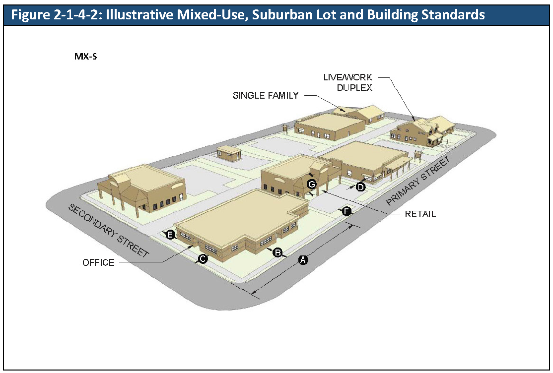
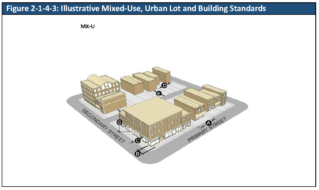
Illustrations and Images. For each base zoning district, an illustration demonstrates visually how the district's lot and building standards apply to lots, buildings, and structures. The purpose of the illustrations is to show the general character of the district but not necessarily the specific locations or buildings. The illustrations do not necessarily reflect all standards that may apply to development. If an illustration is inconsistent with the respective table of lot and building standards, the standards in the table shall govern. Images, including photographs, are provided to assist readers in envisioning the intent of the Code and do not act as guidelines or standards.
D.
Housing Palette.Division 2-1-8, Housing Palette, establishes the bulk standards for a variety of housing types.
E.
Principal Buildings. Section 2-1-9-1, One Principal Building per Lot, establishes standards for the number of principal buildings permitted on a lot.
F.
Arterial Street Setbacks. Section 2-1-9-2, Arterial Street Setbacks, establishes required minimum setbacks from arterial streets for single-family detached, duplex, townhomes and accessory dwelling units except along Ralston Road located west of Olde Town and east of Oak Street.
G.
Setbacks and Exceptions.Division 2-1-10, Exceptions and Adjustments to Lot and Building Standards, establishes the permitted encroachments and exceptions to lot and building standards, the height transition to RA and RN zoning districts or single-family detached units located in unincorporated Jefferson County, double frontage lots, and specific modification of lot area and width standards.
2-1-2-1. - Zoning districts established.
A.
Generally. In order to carry out the provisions of this Code, the City is divided into the following zoning districts and subdistricts:
1.
Parks and Open Space District
a.
OS Parks and Open Space District
2.
Residential Districts
a.
RA Residential/Agricultural District
b.
RN Residential Neighborhood District
i.
RN-32.5 Residential Neighborhood 32,500 Subdistrict
ii.
RN-12.5 Residential Neighborhood 12,500 Subdistrict
iii.
RN-7.5 Residential Neighborhood 7,500 Subdistrict
iv.
RN-6 Residential Neighborhood 6,000 Subdistrict
v.
RN-4 Residential Neighborhood 4,000 Subdistrict
vi.
RN-D Residential Neighborhood Single Family and Duplex Subdistrict
c.
R6 Residential 6 District
d.
R13 Residential 13 District
e.
R24 Residential 24 District
3.
Mixed-Use Districts
a.
MX-N Mixed-Use, Neighborhood District
b.
MX-S Mixed-Use, Suburban District
c.
MX-U Mixed-Use, Urban District
d.
MX-T Mixed-Use, Transit-Oriented District
4.
Olde Town Zoning District
a.
OT-E Olde Town East Subdistrict
b.
OT-EY Olde Town East Yukon Subdistrict
c.
OT-GV Olde Town Grandview Subdistrict
d.
OT-OW Olde Town Olde Wadsworth Subdistrict
e.
OT-RN Olde Town Residential Neighborhood Subdistrict
f.
OT-RR Olde Town Ralston Road Subdistrict
g.
OT-W Olde Town Webster Subdistrict
5.
Commercial District
a.
CG Commercial, General District
b.
CN Commercial, Neighborhood District
6.
Industrial Districts
a.
IL Industrial, Light District
b.
IG Industrial, General District
7.
Planned Unit Development District
a.
PUD Planned Unit Development District
(Ord. No. 4851, § 1, 7-10-2023)
2-1-2-2. - Official zoning map.
A.
Official Zoning Map Adopted. The boundaries of zoning districts are shown upon the map entitled "Official Zoning Map of the City of Arvada," referred to herein after as "Zoning Map," which is incorporated into and made part of this Code by this reference.
B.
Force and Effect. The Zoning Map and all notations, references, and other information shown on it are a part of this Code and have the same force and effect as this Code.
C.
Status of Zoning Map. The Zoning Map that is on file at the City shall control in the event of a conflict between the map that is on file and any other reproduction of said map.
D.
Maintenance of Zoning Map. Amendments to the Zoning Map shall be made administratively to implement all zone boundary changes approved by Ordinance of the City Council. Technical changes to the Zoning Map that are necessary to ensure that the Zoning Map accurately reflects zone boundaries shall also be made administratively.
2-1-2-3. - Interpretation of zoning map.
A.
Generally. The precise location of any zone boundary line shown on the Zoning Map shall be defined by the rules of this Section.
B.
Rezoning Ordinances.
1.
Rezoning ordinances shall be promptly reflected on the Zoning Map. The boundaries of property that are specified in a rezoning ordinance are controlling, except as provided in this Subsection.
2.
Conflicts between the zone boundaries on the Zoning Map and the zoning for property provided by an adopted rezoning ordinance dated after the effective date of this Code could result from administrative or scrivener's errors. In the event of such conflict:
a.
It is presumed that the adopted rezoning ordinance controls, and the Zoning Map shall be promptly corrected when the conflict is identified. The Director shall provide written notice of the correction to the owners of property that is the subject of a Zoning Map correction.
b.
The presumption may be rebutted if it is obvious that the error is within the text of the rezoning ordinance, in that:
i.
The rezoning affects property that was not the subject of the application for rezoning; or
ii.
The rezoning affects only a portion of the property that was the subject of the application, the application requested rezoning for the entire property, and the application was granted without conditions that restricted the extent of the rezoning.
3.
Any conflict between the boundaries on the Zoning Map and a development approval granted before the effective date shall be resolved as follows:
a.
If the Zoning Map conflicts with a rezoning ordinance adopted before the effective date, the Zoning Map boundaries control. However, if the rezoning ordinance was tied to a site specific development plan, then the Zoning Map designation shall not interfere with any vested rights created by the site specific development plan.
b.
If the Zoning Map conflicts with a Planned Unit Development ("PUD") boundary that was approved before the effective date but is not yet built-out, the PUD controls, unless there is record evidence to show that the Zoning Map was intended to adjust the boundaries of the PUD.
c.
If the Zoning Map conflicts with an approved PUD that is either expired or built-out, then the Zoning Map controls.
d.
If the Zoning Map conflicts with a development or annexation agreement, then the conflict shall be resolved according to the terms of the agreement.
C.
Interpretation of Zoning District Boundaries. In the absence of a rezoning ordinance that specifies parcel boundaries, where zone boundary lines appear to follow identifiable features, their location shall be determined by applying the following:
1.
Rights-of-Way. Boundary lines shown as following, or approximately following, streets, alleys, railroad tracks, or utility lines shall be construed as following the centerline of the right-of-way. Where the location of the actual streets or alleys differs from the location of corresponding streets or alleys on the Zoning Map, the location of the actual streets or alleys controls.
2.
Property Lines. Boundary lines shown as following, or approximately following, lot lines or other property lines shown on the Zoning Map shall be construed as following such lines.
3.
Watercourses. Boundary lines shown as following, or approximately following, the centerline of streams, canals, or other watercourses shall be construed as following the channel centerline. In the event of a natural change in the location of such streams or other watercourses, the zoning district boundary shall be construed as moving with the channel centerline. However, such movement shall not render existing development nonconforming.
4.
Parallel to Features. Boundary lines shown as separated from and parallel, or approximately parallel, to any of the features listed in paragraphs 1. through 4. above, shall be construed to be parallel to such features and at such distances as are shown by the scale on the Zoning Map.
5.
Unclear Zoning District Boundaries. In the event that a zoning district boundary is unclear or is disputed, the Director shall determine the location of the zoning district boundary.
D.
Un-subdivided Land or No Identifiable Feature. In the absence of a rezoning ordinance that specifies parcel boundaries, on un-subdivided land, or where a district boundary follows no identifiable feature, the location of zone boundaries shall be determined by applying the following rules:
1.
Text Dimensions. The boundary shall be located by reference to dimensions shown in text on the Zoning Map, if any.
2.
Map Scale. The boundary shall be located using the map scale appearing on the Zoning Map.
E.
All Land Within City Limits Shall Be Zoned. It is the intent of the City Council that all land within the City be zoned.
2-1-2-4. - Zoning of annexed land.
A.
Generally. Zoning of annexed land or land in the process of annexation is an initial zoning. The standards and procedures that apply to zoning of annexed land are the same as those applied to a rezoning of property within the City limits.
B.
Timing of Adoption of Zoning Ordinance. An ordinance proposing zoning of a parcel or parcels to be annexed shall not be finally adopted by the City Council before the date of final adoption of the annexation ordinance, but the annexation ordinance and the zoning ordinance for the annexed property may be processed concurrently, and at the City's discretion may be combined into a single ordinance as may be permitted by state law.
C.
Compliance with State Law. All annexations to the City shall meet the requirements of C.R.S. § 31-12-101, et seq., the "Municipal Annexation Act of 1965," as amended.
2-1-2-5. - Reserved.
Editor's note— Ord. No. 4867, § 1, adopted February 12, 2024, repealed § 2-1-2-5, which pertained to official floodplain maps and derived from Ord. No. 4748, § 4, 1-11-2021.
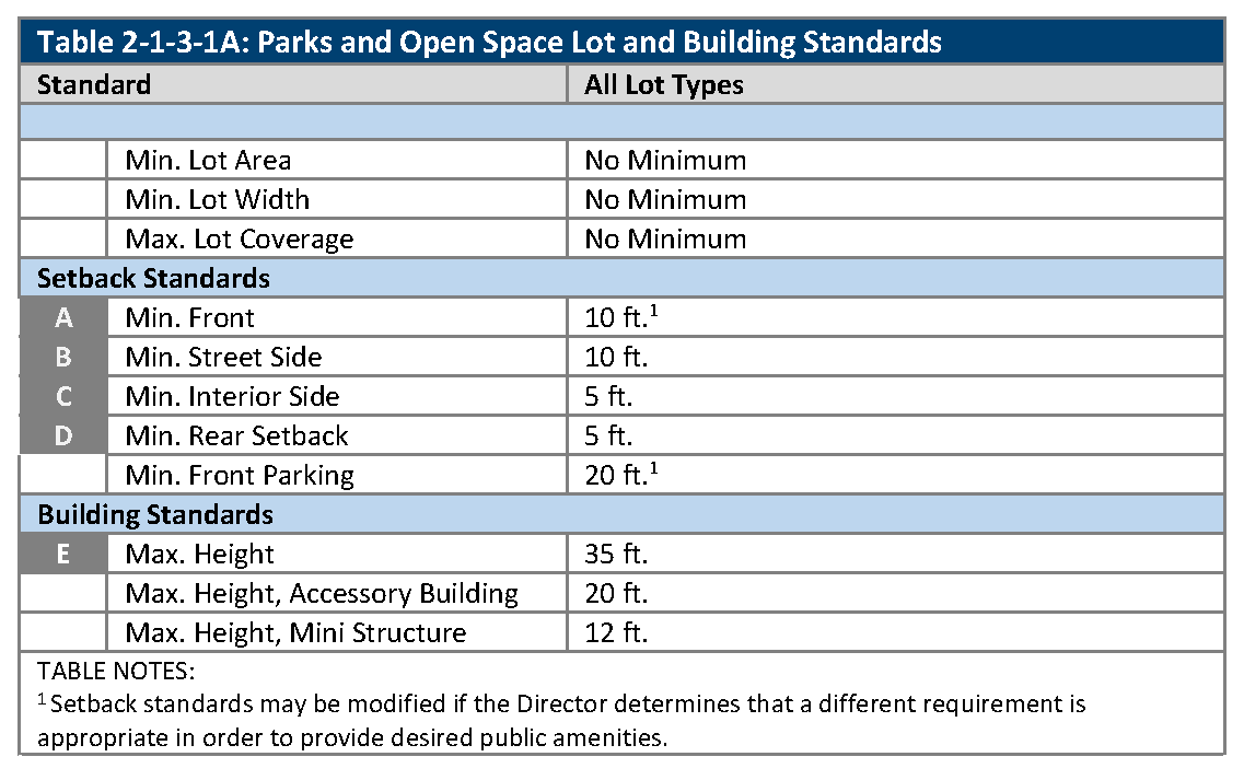
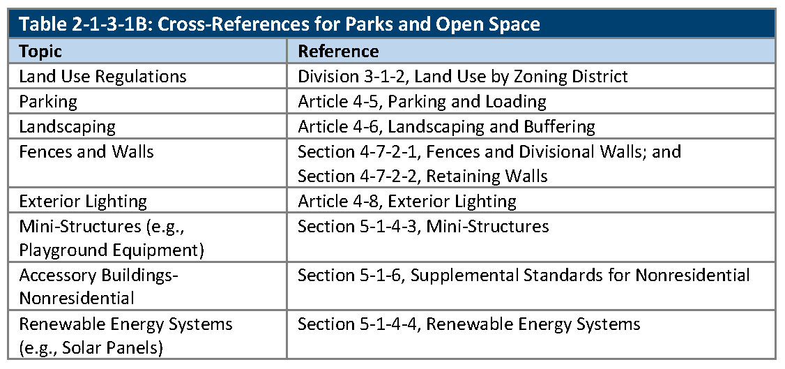
2-1-3-1. - OS: Parks and open space.
A.
Purpose. The purpose of the Parks and Open Space (OS) zoning district is to provide for public parks, open space, nature preserves, recreation facilities, golf courses, greenbelts, cemeteries, waterways, trails, protected floodplains, and fields.
B.
Relationship to the Comprehensive Plan. The OS zoning district generally implements the "Open Space and Parks" and "Public and Quasi-Public Facilities" land use categories stated in the Comprehensive Plan.
C.
Lot and Building Standards. The standards for lots and buildings in the OS zoning district are set out in Table 2-1-3-1A, Parks and Open Space Lot and Building Standards.
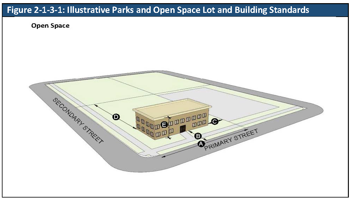
D.
Cross-References. The cross-references in Table 2-1-3-1B, Cross-References for Parks and Open Space, are provided for the reader's convenience and are not necessarily exhaustive of applicable regulations.
2-1-3-2. - RA: Residential/Agricultural.
A.
Purpose. The purpose of the Residential/Agricultural (RA) zoning district is to provide for "semi-rural" (rural, countryside, or estate) character, in the form of large-lot single-family residential neighborhoods; and agriculture, urban agriculture, greenhouses, stables, or other equestrian uses.
B.
Relationship to the Comprehensive Plan. The RA zoning district generally implements the "Low Density Residential" land use category stated in the Comprehensive Plan.
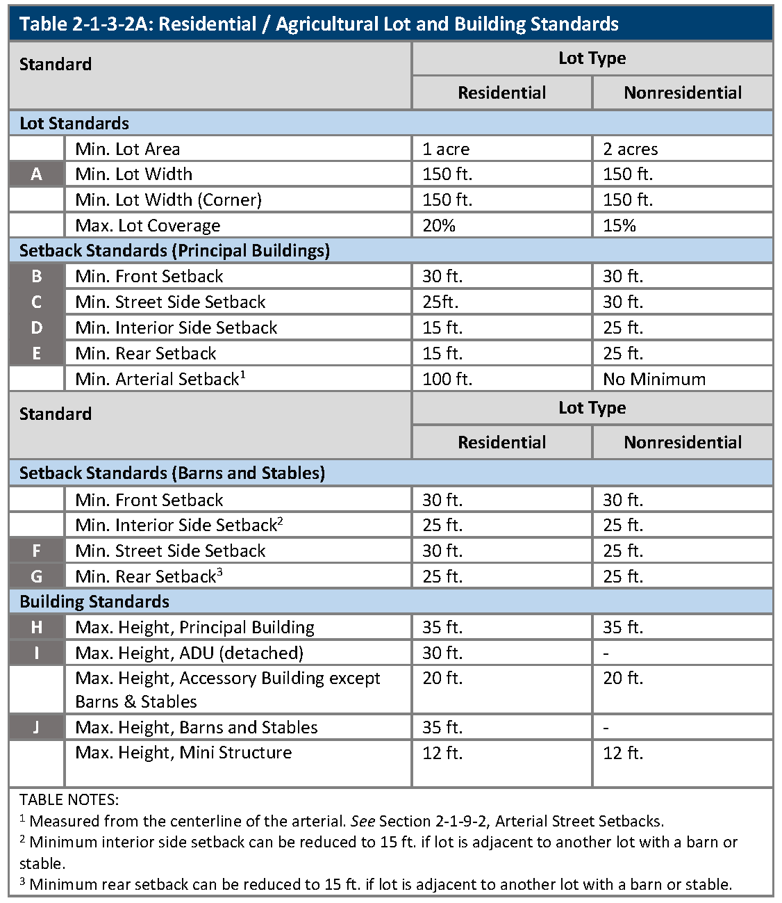
C.
Lot and Building Standards. The standards for lots and buildings in the RA zoning district are set out in Table 2-1-3-2A, Residential/Agricultural Lot and Building Standards.
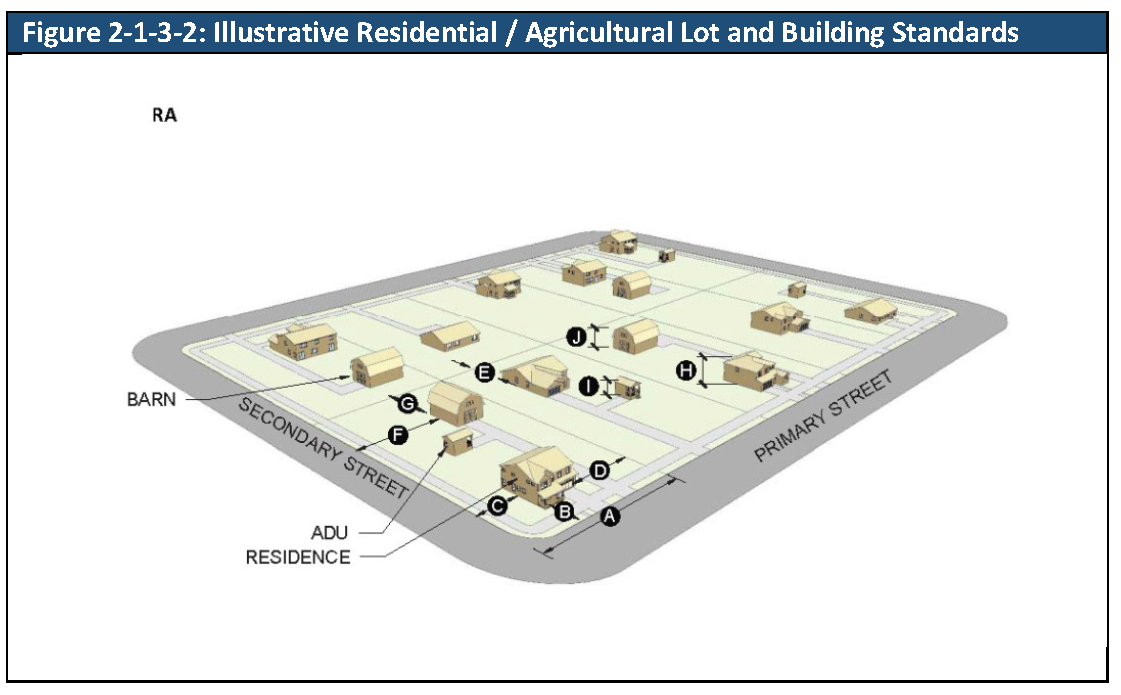
D.
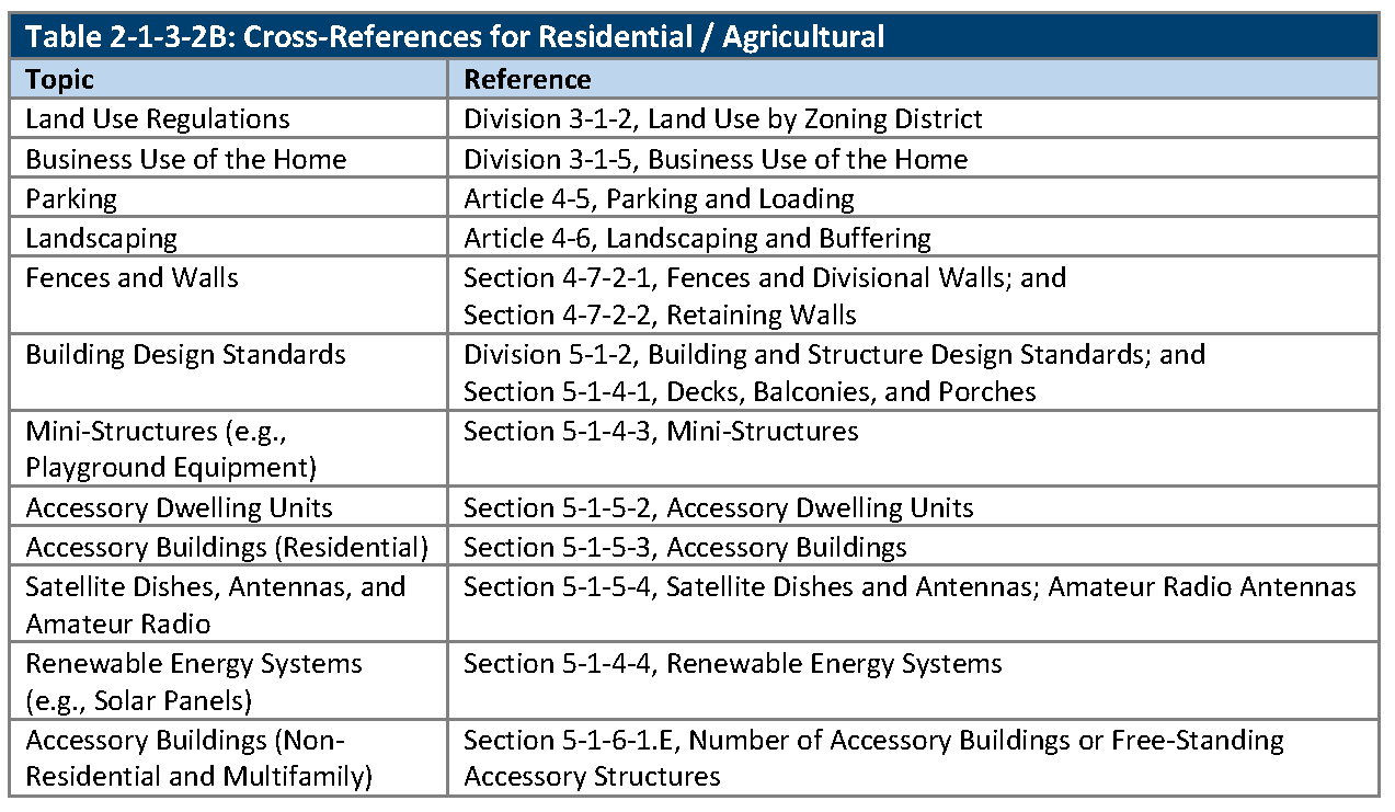
Cross-References. The cross-references in Table 2-1-3-2B, Cross-References for Residential/Agricultural, are provided for the reader's convenience and are not necessarily exhaustive of applicable regulations.
2-1-3-3. - RN: Residential neighborhood.
A.
Purpose. The purpose of the Residential Neighborhood (RN) zoning district is to maintain the character of mature, established neighborhoods in locations where residents expect that the character be relatively stable and allow development, redevelopment, and/or public projects that are consistent with a neighborhood's architectural character.
B.
Relationship to the Comprehensive Plan. The RN zoning district generally implements the "Suburban Residential" land use category stated in the Comprehensive Plan.
C.
Subdistricts. The Residential Neighborhood zoning district is divided into six subdistricts (RN-32.5, RN-12.5, RN-7.5, RN-6, RN-4, and RN-D) in order to reflect and preserve the existing development patterns within each subdistrict, while allowing for redevelopment and expansions of existing buildings at scales that are not disruptive of the surrounding neighborhood fabric.
D.
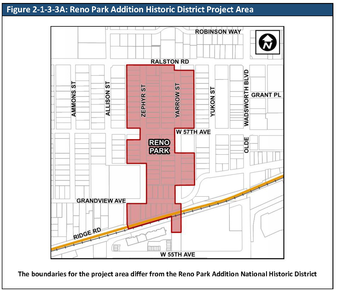
Reno Park Addition Historic District Project Area. The Reno Park Addition Historic District Project Area is an area of historic and architectural value and modifications to existing buildings types and new development shall adhere to the mandatory Design Guidelines for the Reno Park Addition Historic District Project Area contained in Appendix B of this Code. All projects located within the Reno Park Addition Historic District Project Area affected by the mandatory guidelines shall obtain a Certificate of Compliance with Design Guidelines in accordance with Section 8-3-5-4 prior to the approval of any permit. The boundaries of the Reno Park Addition Historic District Project Area are shown in Figure 2-1-3-3A, Reno Park Addition Historic District Project Area.
E.
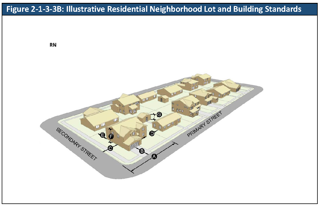
Residential Lot and Building Standards by Subdistrict. The standards for residential lots and buildings in each RN subdistrict are set out in Table 2-1-3-3A, Residential Neighborhood Lot and Building Standards. The lot and building standards are applied as follows:
1.
Existing Lots and Existing Buildings. All existing residential lots and existing residential buildings in the RN zoning district that were legally established shall become conforming on the effective date of this Code, regardless of whether they then conform to the standards of this Section.
2.
Expansion of Existing Residential Buildings.
a.
If a proposed building expansion extends beyond the existing foundation and does not comply with one or more of the setback standards of Table 2-1-3-3A, Residential Neighborhood Lot and Building Standards, then the Director may authorize a minor modification pursuant to Section 8-3-11-3, Administrative Minor Modifications.
b.
If an existing legally established residential building exceeds the height limitations of Table 2-1-3-3A, Residential Neighborhood Lot and Building Standards, all additions to the building shall comply with the standards in Table 2-1-3-3A, Residential Neighborhood Lot and Building Standards.
3.
New Residential Buildings. New residential buildings shall comply with all setback, building height, and lot coverage standards in Table 2-1-3-3A, Residential Neighborhood Lot and Building Standards. New residential buildings may be constructed on existing legally established lots that do not conform to the standards of Table 2-1-3-3A, Residential Neighborhood Lot and Building Standards.
4.
Creation of New Lots. The lot area and lot width standards in Table 2-1-3-3A, Residential Neighborhood Lot and Building Standards, apply to the creation of new residential lots by subdivision or resubdivision.
F.
Nonresidential Lot and Building Standards by Subdistrict. The standards for nonresidential lots and buildings in each RN subdistrict are set out in Table 2-1-3-3A, Residential Neighborhood Lot and Building Standards. The lot and building standards are applied as follows:
1.
Existing Lots. All existing nonresidential lots in the RN zoning district that were legally established shall become conforming on the effective date, regardless of whether they then conform to the standards of this Section.
2.
Expansion of Existing Nonresidential Buildings. No expansion of an existing nonresidential building shall extend beyond the applicable limitations set out in Table 2-1-3-3A, Residential Neighborhood Lot and Building Standards.
3.
New Buildings. New buildings shall comply with all setbacks, building height, and building coverage standards in Table 2-1-3-3A, Residential Neighborhood Lot and Building Standards. New buildings may be constructed on existing lots that do not conform to the standards of Table 2-1-3-3A, Residential Neighborhood Lot and Building Standards.
4.
Creation of New Lots.
a.
The lot area and lot width standards in Table 2-1-3-3A, Residential Neighborhood Lot and Building Standards, apply to the creation of new nonresidential lots by subdivision or resubdivision.
b.
Parks are exempt from minimum lot area and minimum lot width standards.
G.
Subdivision of lots in the RN-D Subdistrict. When a lot is to be subdivided for a duplex, the minimum area after subdivision shall be 3,000 square feet, the minimum lot width shall be 30 feet and the duplex must meet or exceed a combined 9,000 square feet. There shall be no setback required along the common lot line.
H.
Cross-References. The cross-references in Table 2-1-3-3B, Cross-References for Residential Neighborhood, are provided for the reader's convenience and are not necessarily exhaustive of applicable regulations.
(Ord. No. 4793, § 1, 3-21-2022)
2-1-3-4. - R6: Residential 6.
A.
Purpose. The purpose of the Residential 6 (R6) zoning district is to allow for new residential development of a variety of housing products up to a gross density of six units per acre along with supporting community and institutional uses.
B.
Relationship to the Comprehensive Plan. The R6 zoning district generally implements the "Suburban Residential" land use category stated in the Comprehensive Plan.
C.
Lot and Building Standards. The standards for lots and buildings in the R6 zoning district are set out in Table 2-1-3-4A, Residential 6 Lot and Building Standards and Division 2-1-8, Housing Palette.
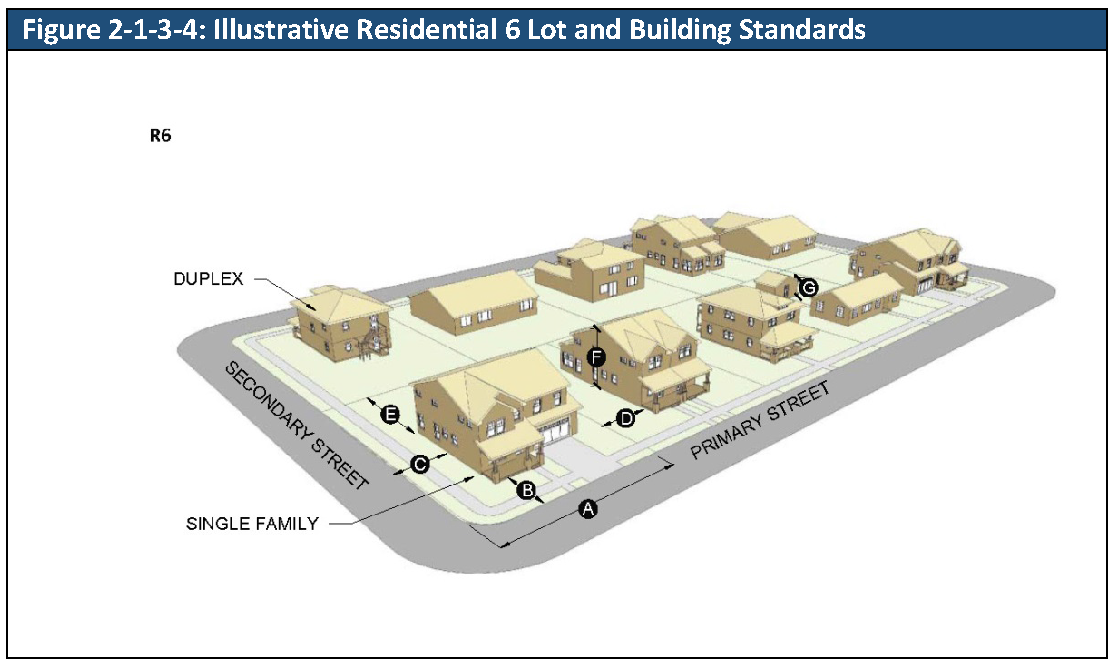
D.
Housing Palette. The following housing types identified in Division 2-1-8, Housing Palette, are allowed in the R6 zoning district:
1.
Single-Family Detached: Small General; General; Small Suburban; Suburban
2.
Zero Lot Line: Small General; General
3.
Duplexes: Side-By-Side; Over-Under
4.
Townhomes: Suburban Type
5.
Multiplexes
6.
Clustered Housing: Micro Homes; Cottage Types.
E.
Cross-References. The cross-references in Table 2-1-3-4B, Cross-References for Residential 6, are provided for the reader's convenience and are not necessarily exhaustive of applicable regulations.
(Ord. No. 4793, § 1, 3-21-2022)
2-1-3-5. - R13: Residential 13.
A.
Purpose. The purpose of the Residential 13 (R13) zoning district is to allow for new residential development of a variety of housing products up to a gross density of 13 units per acre.
B.
Relationship to the Comprehensive Plan. The R13 zoning district generally implements the "Medium Density Residential" land use category stated in the Comprehensive Plan.
C.
Lot and Building Standards. The standards for lots and buildings in the R13 zoning district are set out in Table 2-1-3-5A, Residential 13 Lot and Building Standards and Division 2-1-8, Housing Palette.
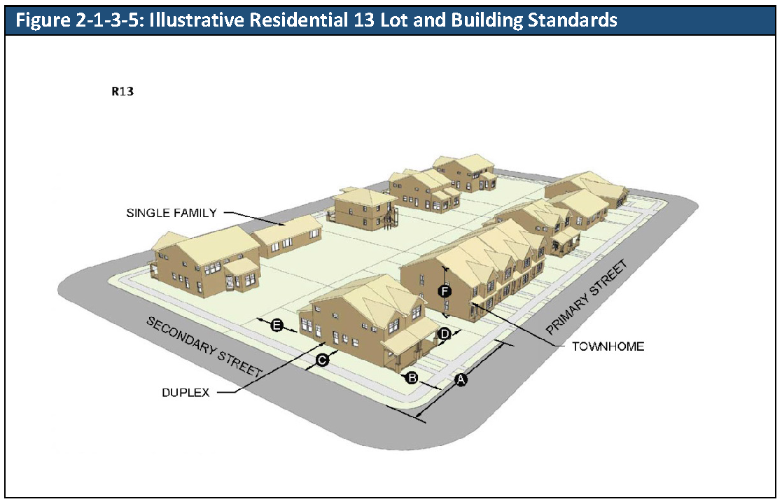
D.
Housing Palette. The following housing types identified in Division 2-1-8, Housing Palette, are allowed in the R13 zoning district:
1.
Single-Family Detached: Small Urban; Urban; Small General; General; Small Suburban
2.
Zero Lot Line: Small General; General
3.
Duplexes: Side-By-Side; Over-Under
4.
Townhomes: Suburban; Urban
5.
Multiplexes
6.
Multifamily: General
7.
Clustered Housing: Micro; Cottages Types.
E.
Cross-References. The cross-references in Table 2-1-3-5B, Cross-References for Residential 13, are provided for the reader's convenience and are not necessarily exhaustive of applicable regulations.
(Ord. No. 4793, § 1, 3-21-2022)
2-1-3-6. - R24: Residential 24.
A.
"Purpose. The purpose of the Residential 24 (R24) zoning district is to allow for new residential development of a variety of moderate to higher density housing products, up to a gross density of 24 units per acre.
B.
Relationship to the Comprehensive Plan. The R24 zoning district generally implements the "High Density Residential" land use category stated in the Comprehensive Plan.
C.
Lot and Building Standards. The standards for lots and buildings in the R24 zoning district are set out in Table 2-1-3-6A, Residential 24 Lot and Building Standards and Division 2-1-8, Housing Palette.
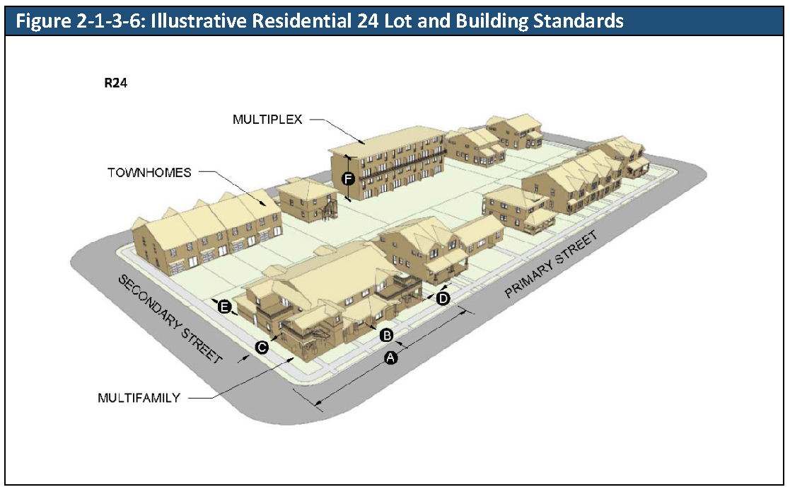
D.
Housing Palette. The following housing types identified in Division 2-1-8, Housing Palette, are allowed in the R24 zoning district:
1.
Single-Family Detached: Small Urban; Urban; Small General; General; Small Suburban
2.
Zero Lot Line: Small General; General
3.
Duplexes: Side-By-Side; Over-Under
4.
Townhomes: Suburban; Urban
5.
Multiplexes
6.
Multifamily: General; Urban
7.
Clustered Housing; Micro Homes; Cottages Types.
E.
Cross-References. The cross-references in Table 2-1-3-6B, Cross-References for Residential 24, are provided for the reader's convenience and are not necessarily exhaustive of applicable regulations.
(Ord. No. 4793, § 1, 3-21-2022)
2-1-4-1. - MX-N: Mixed-Use, Neighborhood.
A.
Purpose. The purpose of the Mixed-Use, Neighborhood (MX-N) zoning district is:
1.
To allow for and promote adaptive re-use of residential buildings on collector or arterial streets that are not necessarily desirable residential locations due to traffic patterns or volumes or other contextual factors; and
2.
To provide for new commercial and residential uses on blocks or corners in neighborhoods where such uses are desired and consistent in scale and height with the adjacent neighborhoods; and
3.
To accommodate a mix of lower-density, walkable, mixed-use and residential development along corridors near low- and medium-density residential neighborhoods.
B.
Relationship to the Comprehensive Plan. The MX-N zoning district generally implements the "Mixed Use" and "Mixed-Use: Residential Emphasis" land use category stated in the Comprehensive Plan.
C.
Lot and Building Standards. The standards for lots and buildings in the MX-N zoning district are set out in Table 2-1-4-1A, Mixed-Use, Neighborhood Lot and Building Standards and Division 2-1-8, Housing Palette.
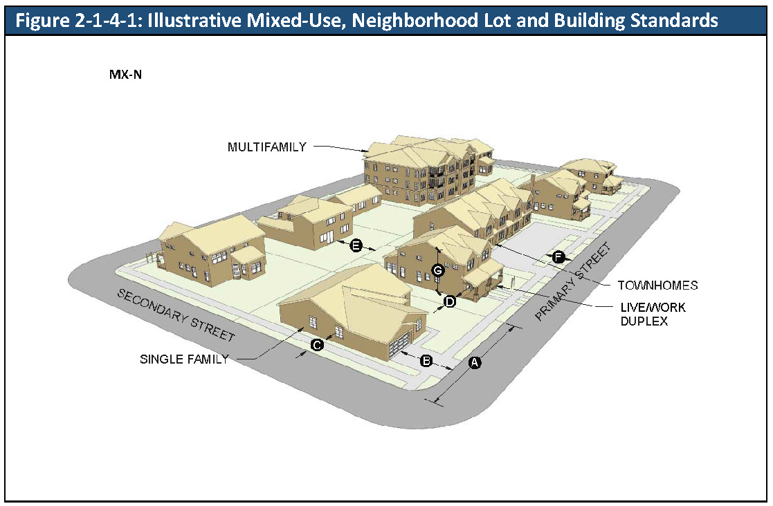
D.
Housing Palette. The following housing types identified in Division 2-1-8, Housing Palette, are allowed in the MX-N zoning district:
1.
Single-Family Detached: Small Urban; Urban; Small General; General; Small Suburban (See subsection 3-1-3-2A.)
2.
Duplexes: Side-By-Side; Over-Under
3.
Townhomes: Suburban; Urban
4.
Multiplexes
5.
Multifamily: General; Urban.
E.
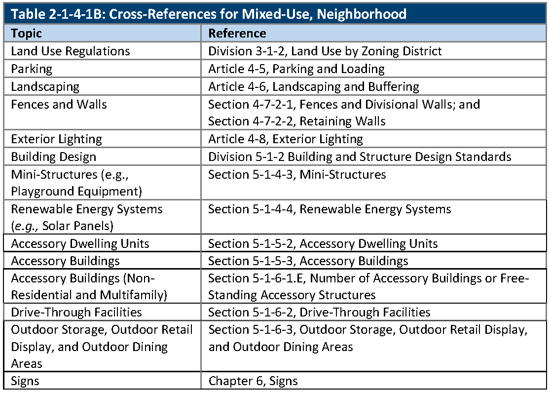
Cross-References. The cross-references in Table 2-1-4-1B, Cross-References for Mixed-Use, Neighborhood, are provided for the reader's convenience and are not necessarily exhaustive of applicable regulations.
2-1-4-2. - MX-S: Mixed-Use, Suburban.
A.
Purpose. The purpose of the Mixed-Use, Suburban (MX-S) zoning district is to provide for a variety of residential and nonresidential uses, in vertically mixed-use, horizontally mixed-use, or single-use configurations. The MX-S zoning district may be used to, among other things:
1.
Provide for neighborhood and community-serving centers, such as suburban office, research, or medical campuses, shopping centers, or developments with a mix of residential and nonresidential uses; and
2.
Promote redevelopment of outmoded commercial centers to accommodate mixed-use development with walkable active streetscapes.
B.
Relationship to the Comprehensive Plan. The MX-S zoning district generally implements the "Mixed-Use," "Mixed-Use Residential Emphasis" and "Neighborhood and Community Commercial/Office" land use categories stated in the Comprehensive Plan.
C.
Lot and Building Standards. The standards for lots and buildings in the MX-S zoning district are set out in Table 2-1-4-2A, Mixed-Use, Suburban Lot and Building Standards and Division 2-1-8, Housing Palette.
D.
Restriction on Single-Family Detached Residential Units. Single-family detached residential units shall be prohibited on any MX-S zoned property within 250 feet of the centerline of Marshall or Lamar Streets.
E.
Housing Palette. The following housing types identified in Division 2-1-8, Housing Palette, are allowed in the MX-S zoning district:
1.
Single-Family Detached: Small Urban; Urban; Small General; General; Small Suburban (See subsection 3-1-3-2A.)
2.
Zero Lot Line: Small General; General
3.
Duplexes: Side-By-Side; Over-Under
4.
Townhomes: Suburban; Urban
5.
Multiplexes
6.
Multifamily: General; Urban.
F.
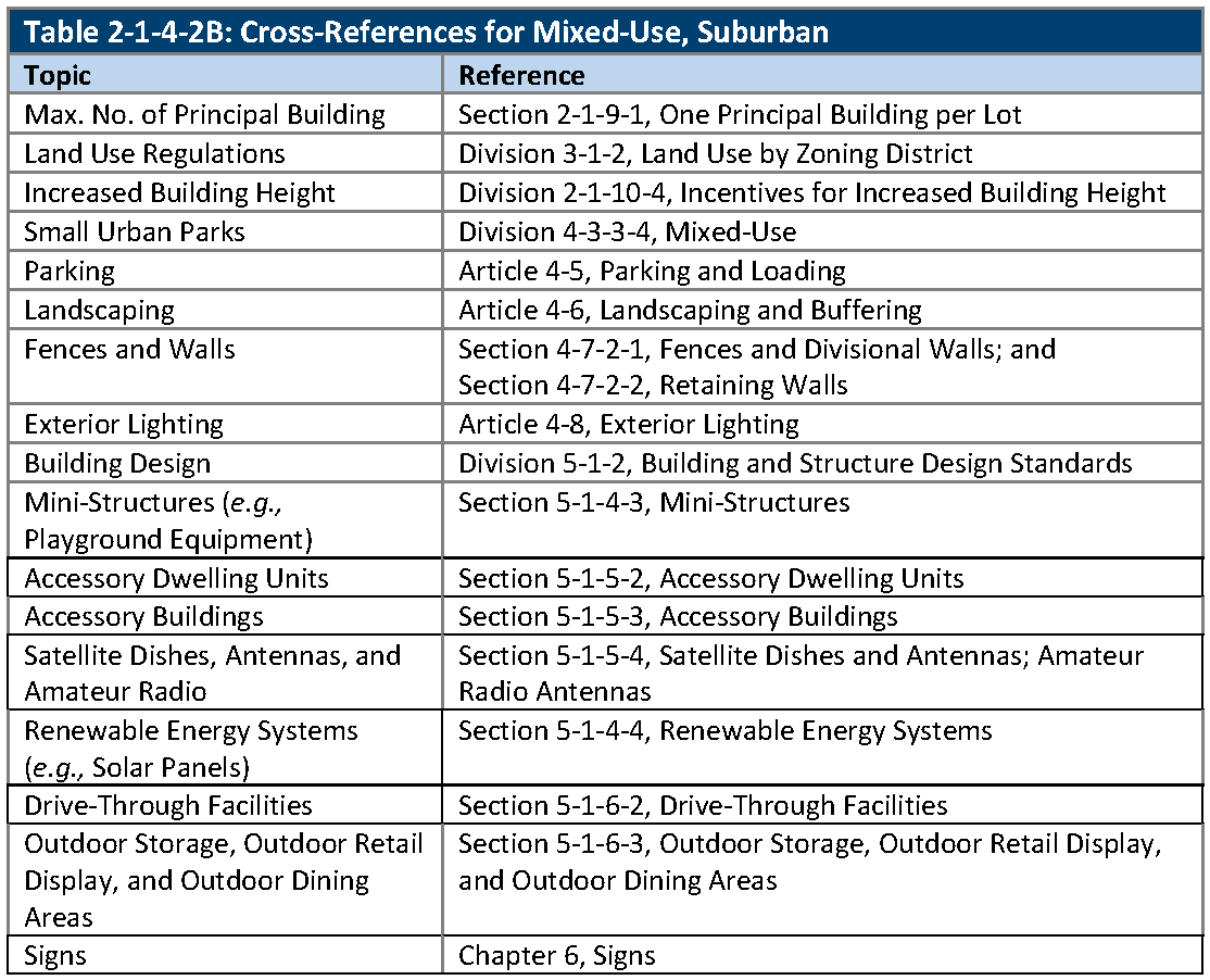
Cross-References. The cross-references in Table 2-1-4-2B, Cross-References for Mixed-Use, Suburban, are provided for the reader's convenience and are not necessarily exhaustive of applicable regulations.
(Ord. No. 4905, § 2, 8-19-2025)
2-1-4-3. - MX-U: Mixed-Use, Urban.
A.
Purpose. The purpose of the Mixed-Use, Urban (MX-U) zoning district is to:
1.
Provide for a variety of residential and nonresidential uses, in vertically mixed-use, horizontally mixed-use, or single-use configurations with an urban character.
B.
Vertical and Horizontal Buildings. Encourage vertical and horizontal mixed-use multi-story buildings with pedestrian-friendly streetscapes, public amenities, and good access to public transportation.
C.
Relationship to the Comprehensive Plan. The MX-U zoning district generally implements the "Mixed-Use" and "Neighborhood and Community Commercial/Office" land use categories stated in the Comprehensive Plan.
D.
Lot and Building Standards. The standards for lots and buildings in the MX-U zoning district are set out in Table 2-1-4-3A, Mixed-Use, Urban Lot and Building Standards and Division 2-1-8, Housing Palette.
1.
Maximum Heights. The maximum heights permitted are:
a.
MX-U-45: Maximum height of 45 feet;
b.
MX-U-65: Maximum height of 65 feet.
E.
Housing Palette. The following housing types identified in Division 2-1-8, Housing Palette, are allowed in the MX-U zoning district:
1.
Single-Family Detached: Small Urban; Urban (See subsection 3-1-3-2A.)
2.
Duplexes: Side-By-Side; Over-Under
3.
Townhomes: Suburban; Urban
4.
Multiplexes
5.
Multifamily: General; Urban.
F.
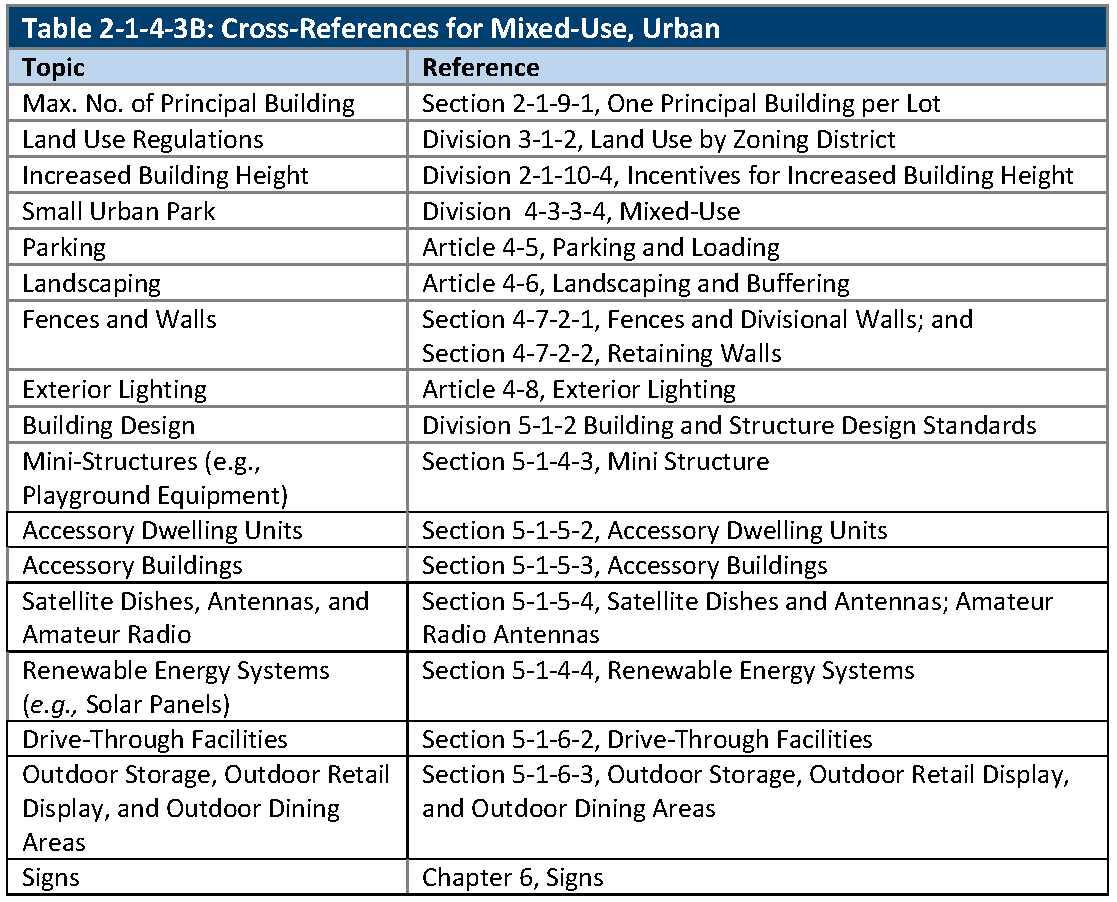
Cross-References. The cross-references in Table 2-1-4-3B, Cross-References for Mixed-Use, Urban, are provided for the reader's convenience and are not necessarily exhaustive of applicable regulations.
(Ord. No. 4905, § 3, 8-19-2025)
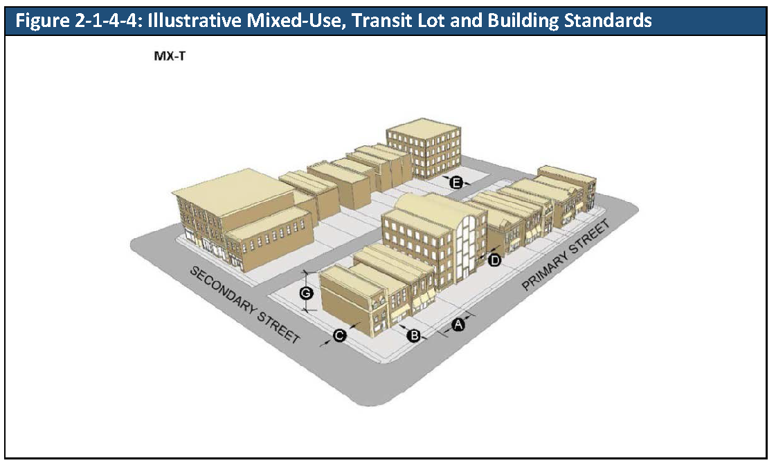
2-1-4-4. - MX-T: Mixed-Use, Transit.
A.
Purpose. The purpose of the Mixed-Use, Transit (MX-T) zoning district is to provide for urban-scale, higher density residential and nonresidential uses, in vertically or horizontally mixed-development on a single parcel or in a master planned area, and located along corridors with frequent bus and rail transit service. The MX-T district is intended to encourage higher-density infill development in appropriate locations.
B.
Relationship to the Comprehensive Plan. The MX-T zoning district generally implements the "Mixed-Use" and "Transit Framework Plan" land use categories stated in the Comprehensive Plan.
C.
Lot and Building Standards. The standards for lots and buildings in the MX-T zoning district are set out in Table 2-1-4-4A, Mixed-Use, Transit Lot and Building Standards and Housing Palette.
1.
Maximum Heights. The maximum heights permitted are:
a.
MX-T-45: Maximum height of 45 feet;
b.
MX-T-65: Maximum height of 65 feet;
c.
MX-T-80: Maximum height of 80 feet;
d.
MX-T-120: Maximum height of 120 feet.
D.
Grandview Avenue Height Restriction. For properties in the MX-T zoning district located on the south side of Grandview Avenue between Wadsworth Bypass and Lamar Street, the maximum height shall be 35 feet above the grade of the centerline of Grandview Avenue for a distance of 150 feet from centerline of Grandview Avenue.
E.
52ndAvenue Height Restriction. For properties in the MX-T zoning district located on the south side of W 52 nd Avenue between Saulsbury Court and Quay Street, the maximum height shall be 65 feet above the grade of the centerline of W 52 nd Avenue for a distance of 150 feet from W 52 nd Avenue.
F.
Housing Palette. The following housing types identified in Division 2-1-8, Housing Palette, are allowed in the MX-T zoning district:
1.
Townhomes: Suburban; Urban
2.
Multiplexes
3.
Multifamily: Urban.
G.
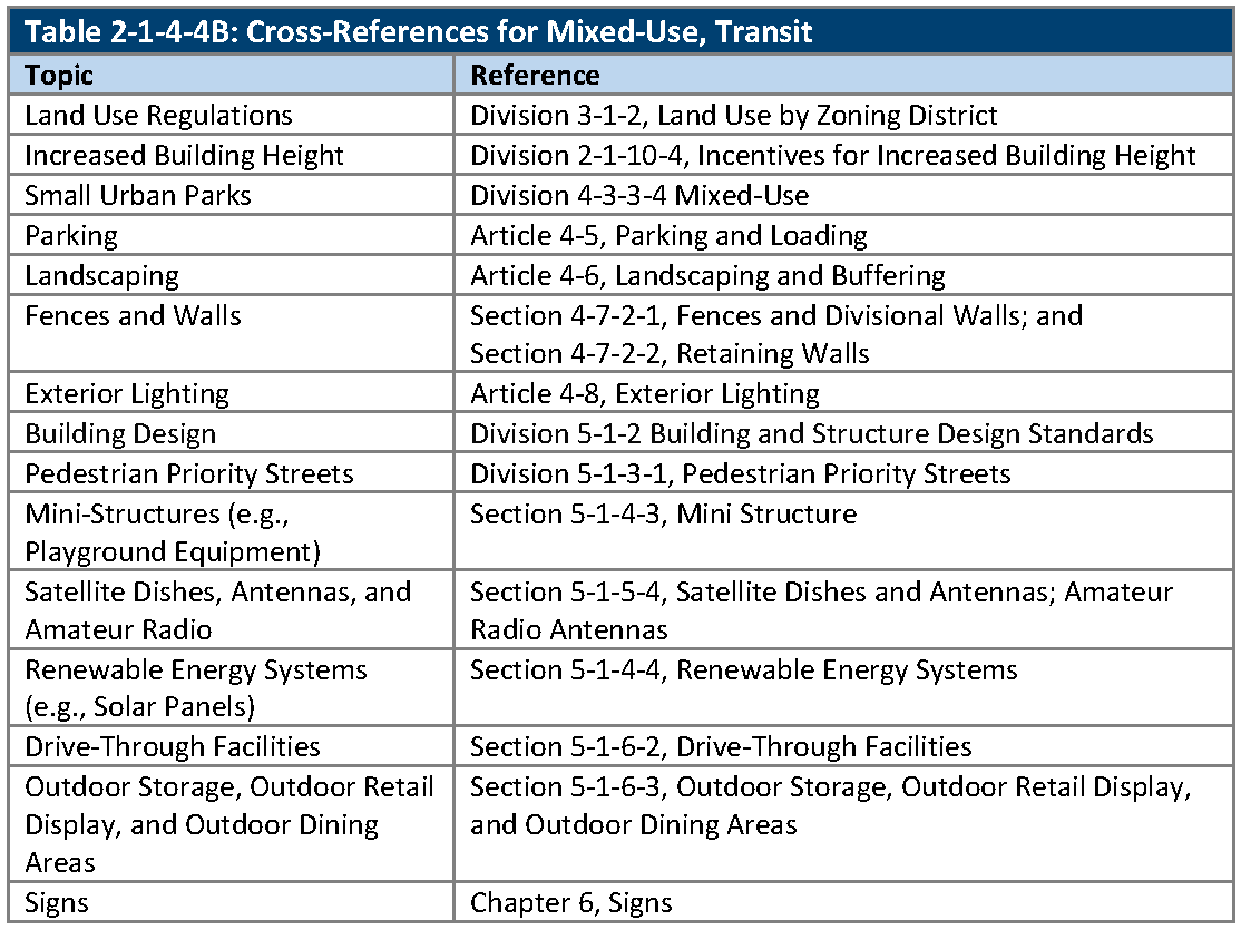
Cross-References. The cross-references in Table 2-1-4-4B, Cross-References for Mixed-Use, Urban, are provided for the reader's convenience and are not necessarily exhaustive of applicable regulations.
(Ord. No. 4793, § 1, 3-21-2022; Ord. No. 4905, § 4, 8-19-2025)
2-1-5-1. - OT: Olde Town.
A.
Purpose. The purpose of the Olde Town (OT) form-based zoning district is to protect the established historic character of Olde Town Arvada based on the City's adopted plans and design guidelines for the area. The purpose of this Division is to establish lot, building, and form standards for buildings in the OT zoning district. This Division is applied in conjunction with the Design Guidelines for Olde Town Arvada.
B.
Relationship to the Comprehensive Plan. The OT zoning district generally implements the "Transit Framework Plan" land use category stated in the Comprehensive Plan.
C.
Application of Division.
1.
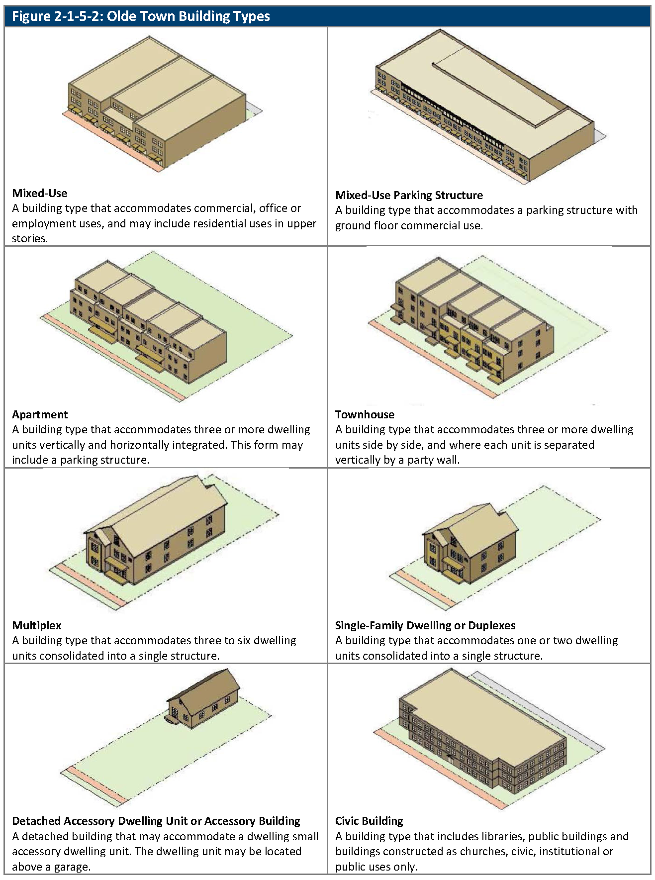
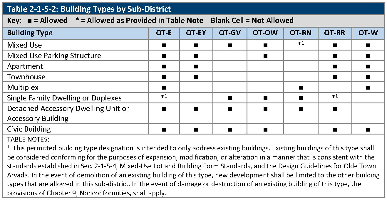
Section 2-1-5-2, Building Types, describes eight different building types that are permissible in the OT zoning district. The section includes a matrix that indicates which building types are allowed in each OT subdistrict.
2.
Section 2-1-5-3, Generally Applicable Lot and Building Form Standards, explains each of the standards and measures that are used in the tables in Section 2-1-5-4, Mixed-Use Building Type Lot and Building Form Standards, through Section 2-1-5-11, Civic Building Type Lot and Building Form Standards, inclusive.
3.
Section 2-1-5-4, Mixed-Use Lot and Building Form Standards, through Section 2-1-5-11, Civic Building Lot and Building Form Standards, inclusive, set out the specific standards that apply to each of the permissible building types.
D.
Future Expansion of Structure. Notwithstanding the build-to or frontage zone requirements established in this Division, enlargement, alteration, or expansion in the Olde Town Zoning District shall occur in the most historically appropriate location as determined through design review.
E.
Subdistricts. The Olde Town zoning district is divided into seven subdistricts that have different form, characteristics, and allowable land uses and the subdistricts contain form-based standards tailored to the distinct character of each area where the subdistrict is applied:
1.
OT-E: Olde Town East Subdistrict
2.
OT-EY: Olde Town East Yukon Subdistrict
3.
OT-GV: Olde Town Grandview Subdistrict
4.
OT-OW: Olde Town Olde Wadsworth Subdistrict
5.
OT-RN: Olde Town Residential Neighborhood Subdistrict
6.
OT-RR: Olde Town Ralston Road Subdistrict
7.
OT-W: Olde Town Webster Subdistrict.
F.
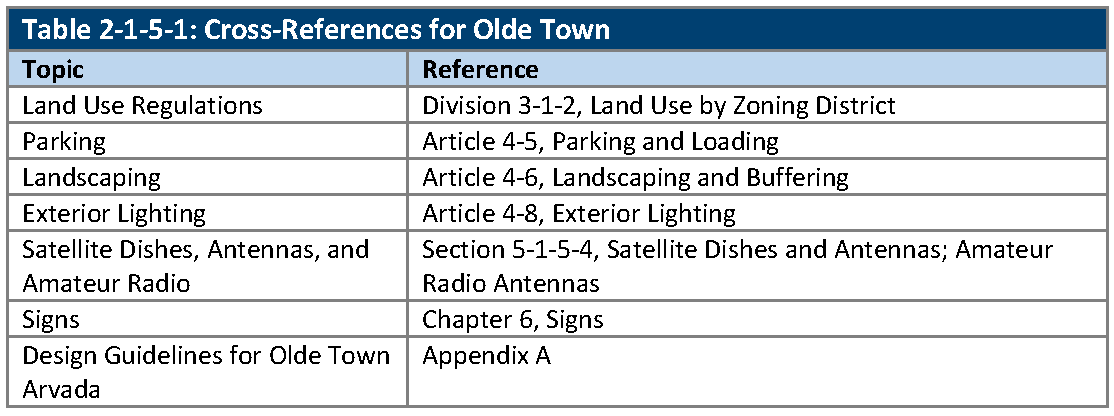
Cross-References. The cross-references in Table 2-1-5-1, Cross-References for Olde Town, are provided for the reader's convenience and are not necessarily exhaustive of applicable regulations.
2-1-5-2. - Building types.
A.
Building Types. The building types that may be permissible in the OT zoning district are set out in Figure 2-1-5-2, Olde Town Building Types.
B.
Allowed Building Types by Sub-District. The building types that are allowed within each sub-district of the Olde Town zoning district are set out in Table 2-1-5-2, Building Types by Sub-District.
2-1-5-3. - Generally applicable lot and building form standards.
A.
Generally. The provisions of this Section apply to individual building types as provided in Sections 2-1-5-4, Mixed-Use Building Type Lot and Building Form Standards, to 2-1-5-5, Mixed-Use Parking Structure Building Lot and Building Form Standards, inclusive.
B.
Front Yard Landscaping. Front yard landscaping may include both live plant materials and hardscape plaza or sidewalk areas, but in no case shall the front yard landscaping include areas for vehicle parking.
C.
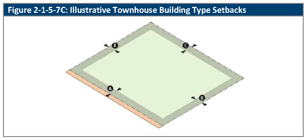
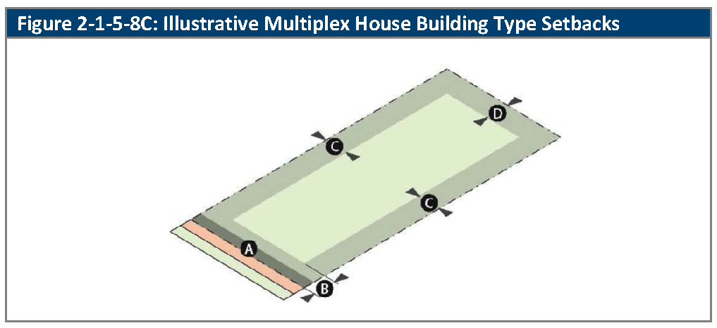
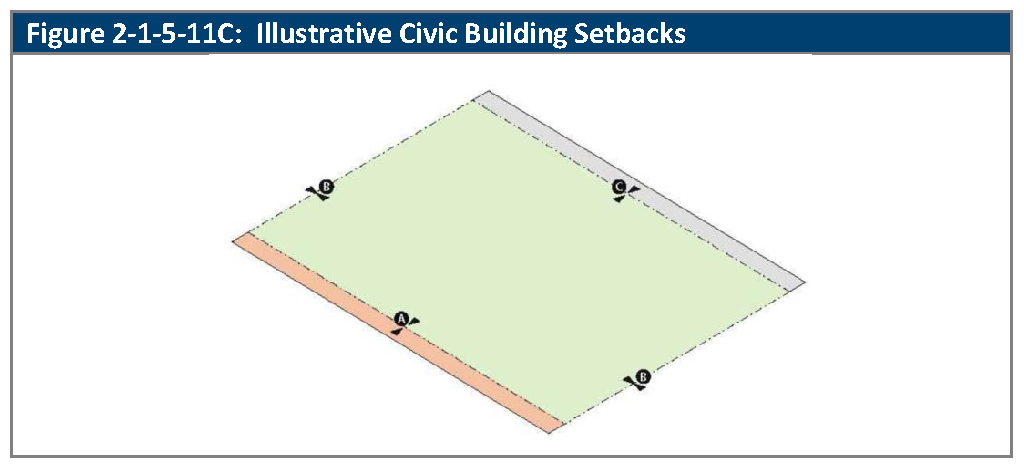
Setback Measurement.
1.
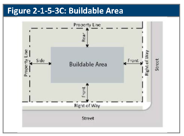
Front Setbacks. Front setback requirements apply along all street frontages and along the boundaries of McIlvoy Park and Olde Town Plaza. See Figure 2-1-5-3C, Front Setbacks, below.
2.
Side and Rear Setbacks. Side and rear setbacks are measured from side and rear property lines.
3.
Protected area: A protected area is a property in the OT zoning district which contains a single family or duplex building type, or is adjacent to the R-N, R13, or CG zoning districts.
D.
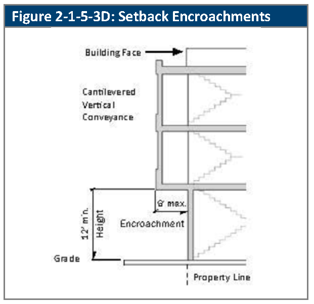
Setback Encroachments. The setback encroachments allowed in Section 2-1-10-1, Exceptions to Setback Standards, apply in the OT zoning district, except as specifically modified by this Subsection.
1.
A cantilevered vertical conveyance system such as steel-framed stairs is allowed to encroach into the front setback, provided that:
a.
The system will not cause accumulation of snow and ice on or over the public right-of-way;
b.
The encroachment does not exceed six feet;
c.
There is 12 feet of clearance from the surface of the sidewalk to the underside of the first structural member. See Figure 2-1-5-3D, Setback Encroachments; and
d.
A revocable permit is approved by the City, applicable.
2.
A protected area is a property in the OT zoning district which contains a single-family or duplex building type or is a property adjacent to the R-N, R13, or CG zoning districts.
3.
Setback encroachments are not allowed between the front property line and the frontage zone, except for a Cantilevered Vertical Conveyance Systems and as permitted in Section 2-1-10-1, Exceptions to Setback Standards and as permitted in Section 2-10-1, Exceptions to Setback Standards.
E.
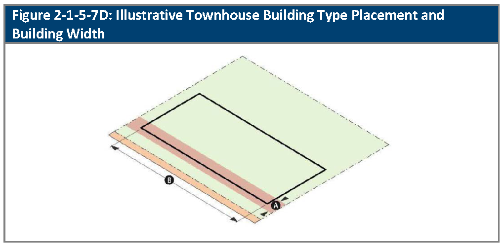
Frontage Zone.
1.
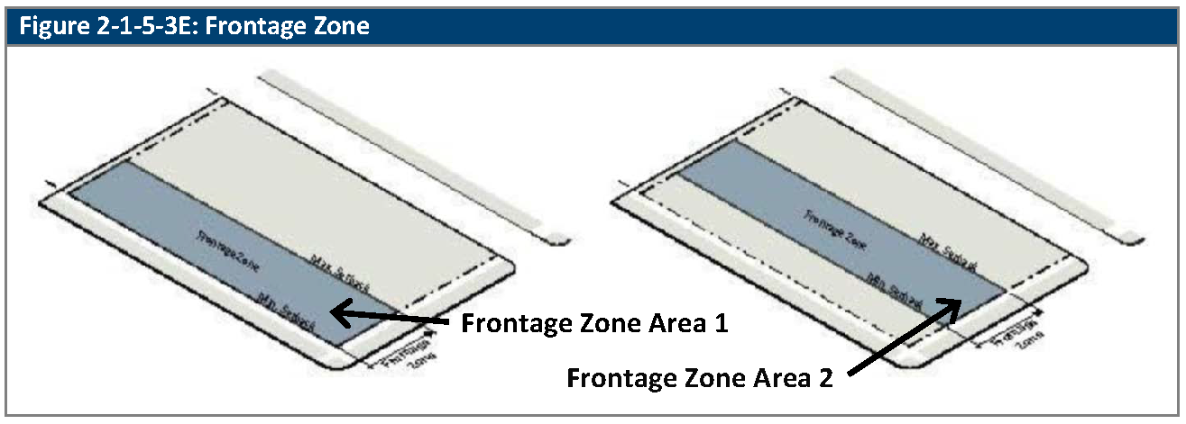
Generally. The frontage zone is an area of the subject property within which build-to requirements and additional height limitations may apply, based on subdistrict, building type, and context. See Figure 2-1-5-3E, Frontage Zone. Generally, frontage zone requirements apply along streets, McIlvoy Park and Olde Town Plaza boundaries.
2.
Landscape/Hardscape Requirement. The area of the frontage zone that is located between the building and the sidewalk must be landscaped or hardscaped.
3.
Variation. In some circumstances, the frontage zone is composed of two distinct areas, which may provide for different requirements for build-to lines or building height, depending upon the distance from the property line. In such cases, the two areas are described as "Area 1," which is the portion of the frontage zone that is closest to the street, and "Area 2," which is the portion of the frontage zone that extends from the interior boundary of Area 1 towards the interior of the subject property.
F.
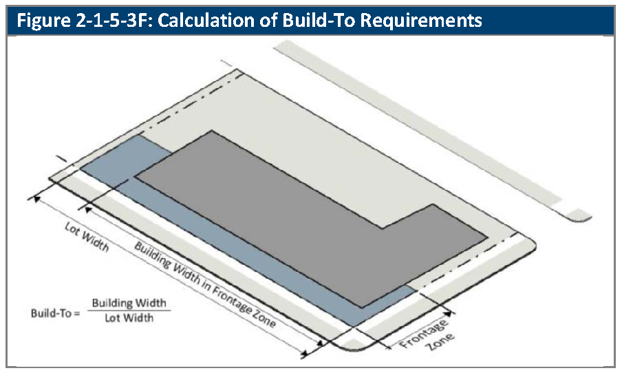
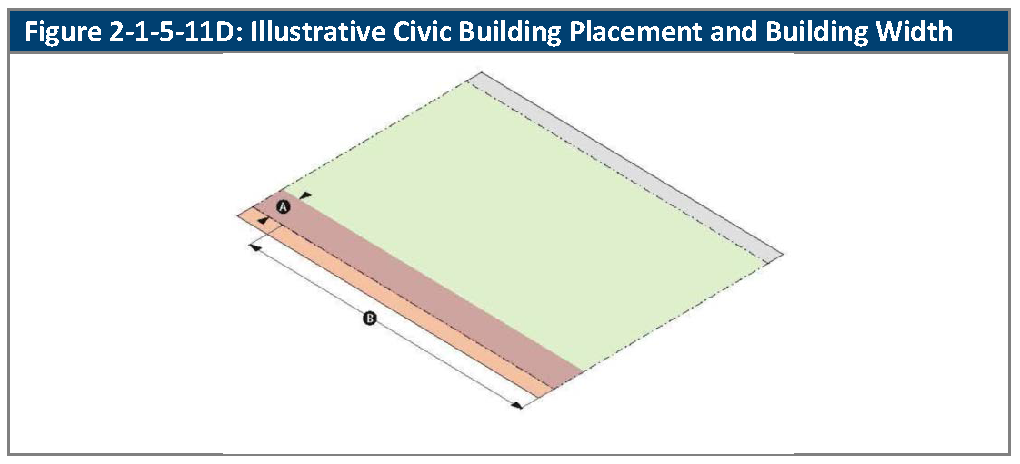
Build-To. The required build-to percentage specifies the proportion of the width of the frontage zone (see Subsection E. above), that must include a portion of the front building facade. It is measured as a percentage of the property frontage width of the building within the frontage zone divided by the length of the property line along which the frontage zone is established. A recessed entry, covered patio or other similar element that does not affect the fundamental relationship of the building to the street (even if it is not located within the frontage zone) may also be counted in the calculation of this proportion. See Figure 2-1-5-3F, Calculation of Build-To Requirements.
G.
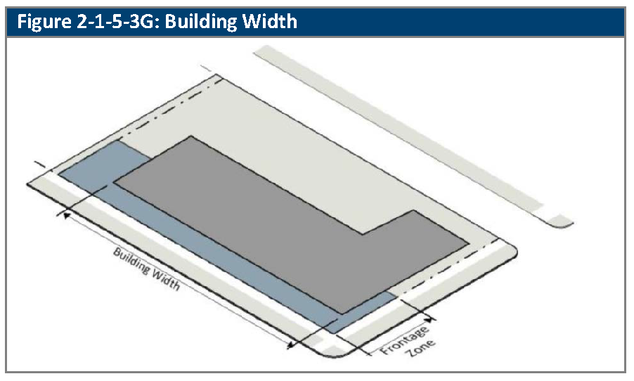
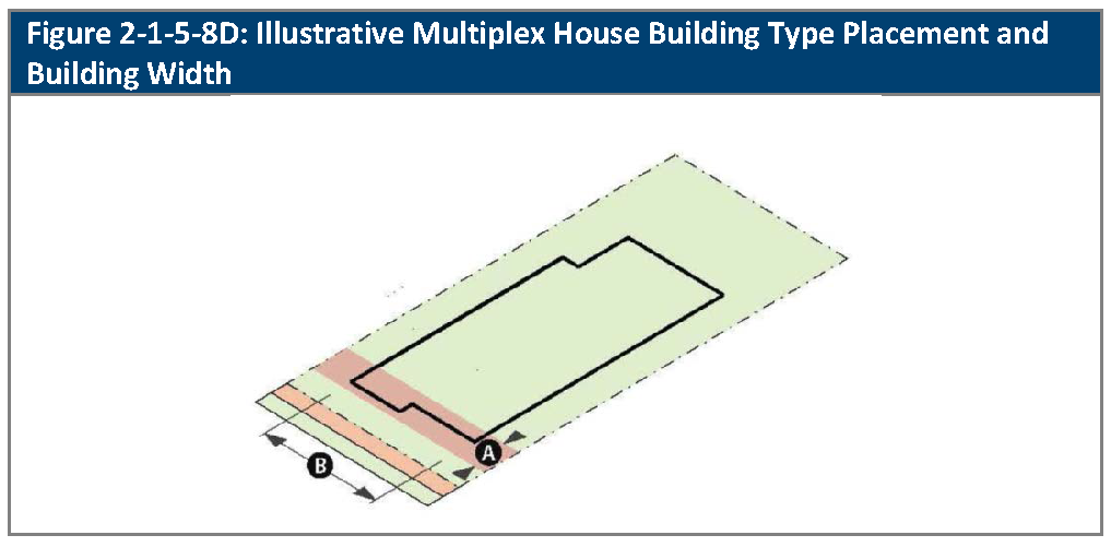
Building Width. Building width is the total building width that is allowed on a lot along a specified elevation. See Figure 2-1-5-3G, Building Width.
H.
Building Height.
1.
Measurement. Building height is measured as defined in Article 11-1-1.
2.
Number of Stories.
a.
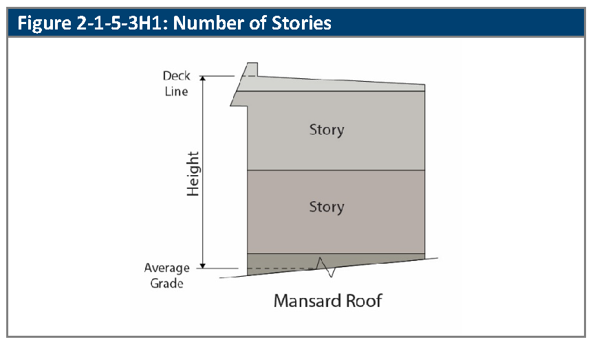
In addition to the building height, the number of stories permitted are established. Section 2-1-5. For the purposes of this Division, the relationship between stories and feet is set out in Table 2-1-5-3H, Olde Town Number of Stories. All height specifications in this Division that refer to "story" or "stories" also incorporate the "feet" measurements of Table 2-1-5-3H, Olde Town Number of Stories. Notwithstanding the dimensional height limits established in Table 2-1-5-3H, maximum height shall be historically accurate as determined through application of the Design Guidelines for Olde Town.
b.
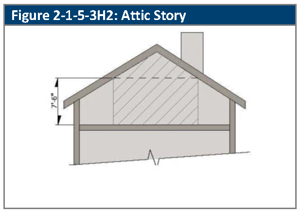
Space within a roof form counts as a story if 50 percent or more of the floor area has a clear height of seven and one-half feet or more, measured from the finished floor to the finished ceiling. See Figure 2-1-5-3H2, Attic Story.
I.
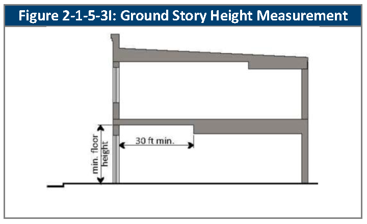
Floor Height.
1.
Ground floor elevation is measured from the average sidewalk level to the top of the finished ground floor.
2.
Ground story floor height is measured from the top of the finished floor to the ceiling above.
3.
Minimum ground story floor height applies only to the first 30 feet of building depth. See Figure 2-1-5-3I, Ground Story Height Measurement.
J.
Transparency.
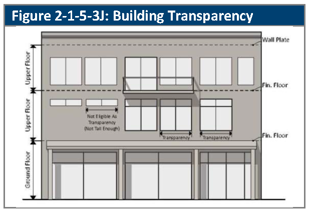
1.
Transparency refers to the minimum percentage of a building's width devoted to transparent windows and doors (clad or opaque windows and doors do not count toward the transparency requirements).
2.
This standard does not count ground story windows or doors that do not equal at least one-half of the floor height, or upper story windows or doors that do not equal at least one-third of the floor height. See Figure 2-1-5-3J, Building Transparency.
3.
The standard applies only on street-facing, McIlvoy Park-facing, and Olde Town Plaza-facing facades (as provided in the individual sections of this Division), and not interior or rear-facing facades.
K.
Blank Wall.
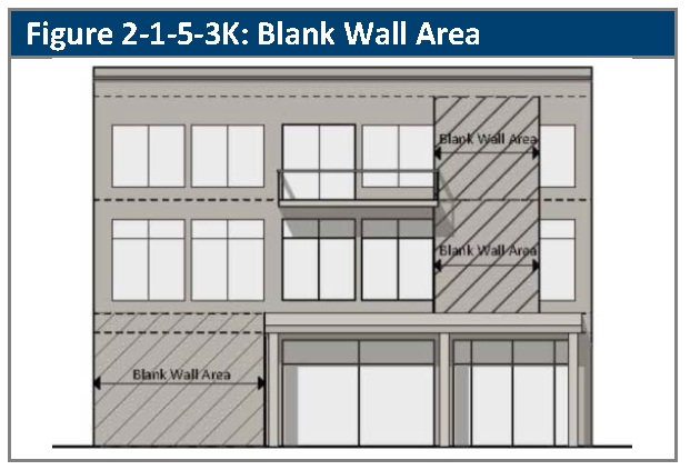
1.
Blank wall area means the width of any story of a street-facing wall that does not include a:
a.
Substantial material change (paint color is not considered a substantial change);
b.
Window or door; or
c.
Column, pilaster, or other articulation greater than 12 inches in depth. See Figure 2-1-5-3K, Blank Wall Area.
2.
Blank wall area standards apply to ground story and upper story facades that face adjoining streets, McIlvoy Park, or Olde Town Plaza, as provided in the individual sections of this Division.
L.
Building Entrances.
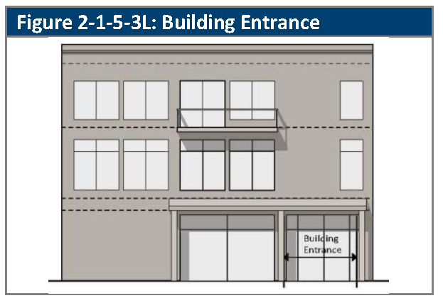
1.
An entrance providing both ingress and egress, operable to residents or customers at all times, is required if a street-facing, Olde Towne Plaza facing or McIlvoy Park-facing entrance is required. See Figure 2-1-5-3L, Building Entrance.
2.
Additional entrances from another street, pedestrian area or internal parking area are also permitted.
3.
An angled entrance that is provided at the corner of a building at the intersection of two streets or of a street and McIlvoy Park or Olde Town Plaza meets the entrance requirements for both streets, or the street and park or plaza.
M.
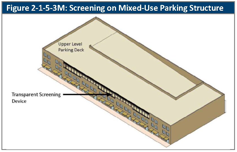
Transparent Screening Device.
1.
A Transparent Screening Device is a mostly transparent device used to screen parking on an upper levels of a Mixed-Use Parking Structure building type. See Figure 2-1-5-3M, Screening on Mixed-Use Parking Structure.
(Ord. No. 4905, §§ 5, 6, 8-19-2025)
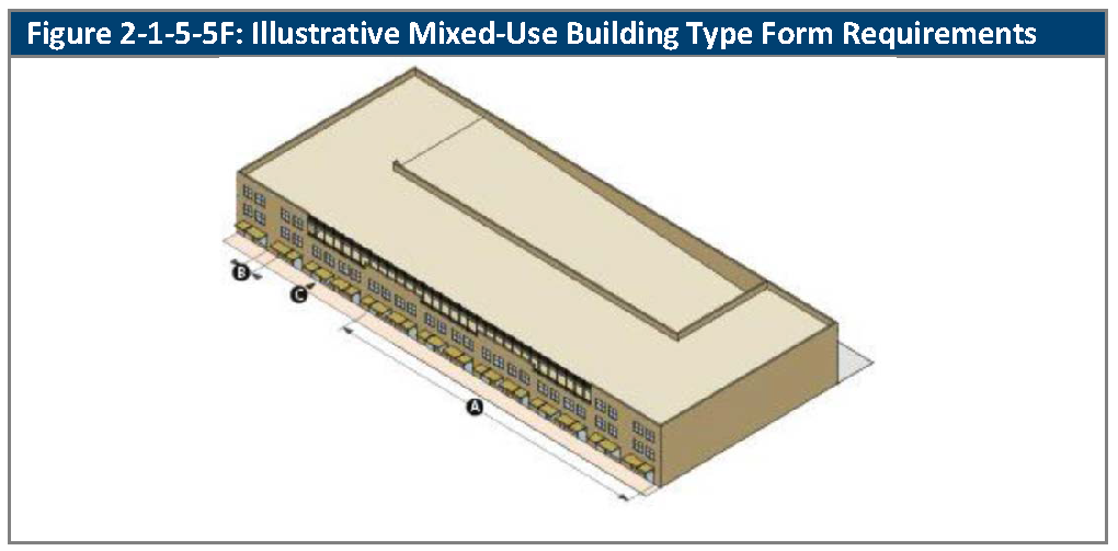
2-1-5-4. - Mixed-use building type lot and building form standards.
A.
Generally. The lot and building form standards that apply to mixed-use building type are set out in this Section.See Section 2-1-5-2, Building Types, as to which sub-districts of the OT zoning district allow mixed-use building types
B.
Lot Standards. Lot standards are as provided in Table 2-1-5-4B, Mixed-Use Lot Standards.
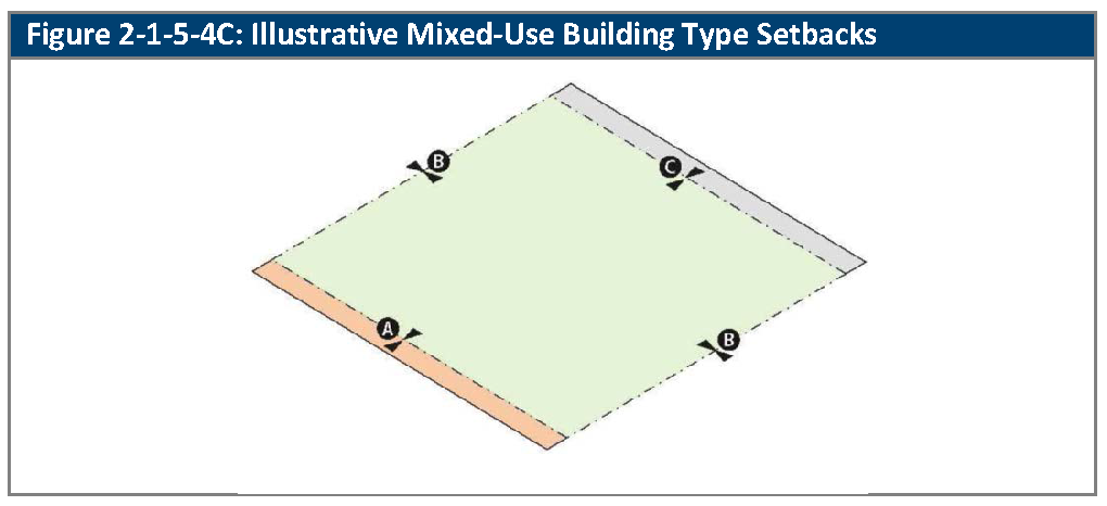
C.
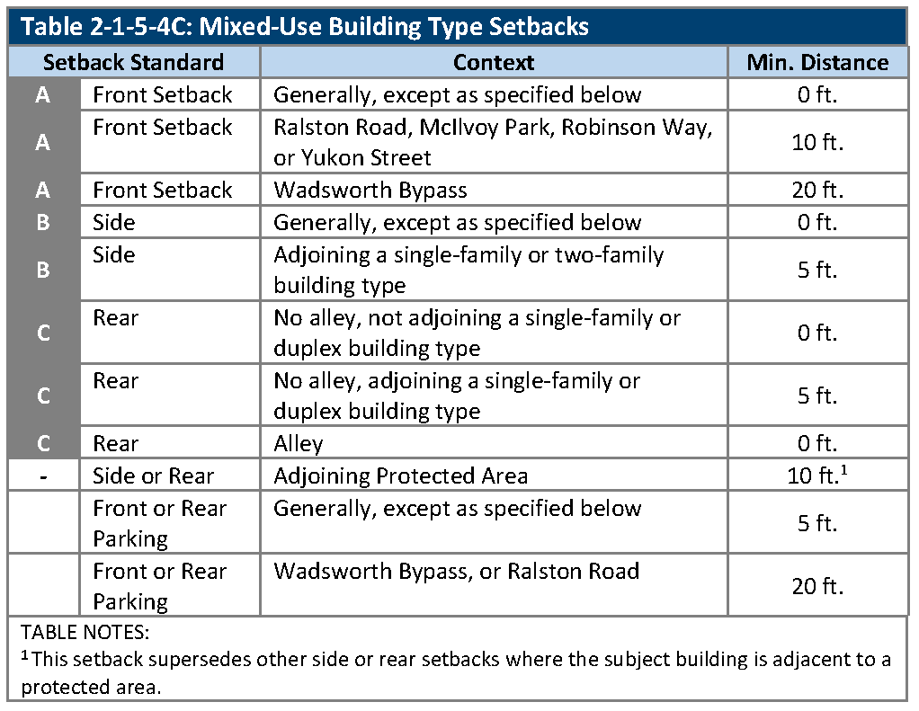
Building Setbacks. Building setbacks are as provided in Table 2-1-5-4C, Mixed-Use Building Setbacks.
D.
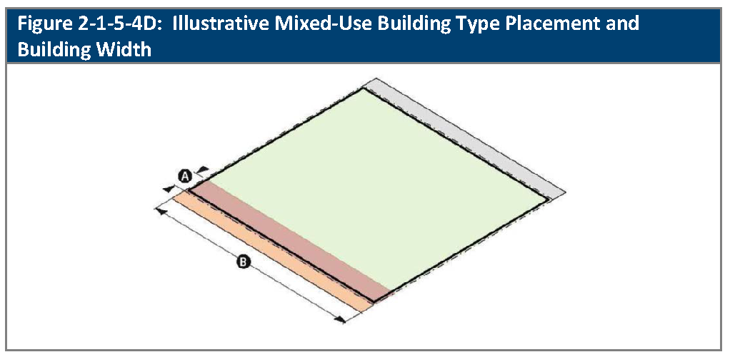
Building Placement and Building Width. Building placement and building width shall be as provided in Table 2-1-5-4D, Mixed-Use Building Type Placement and Building Width.
E.
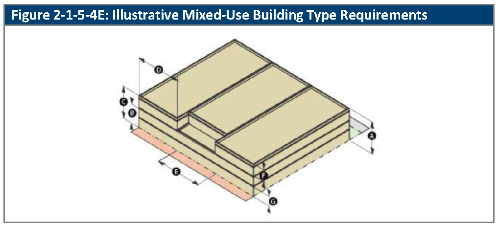
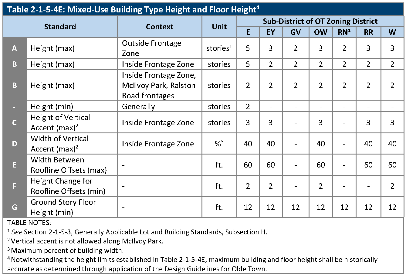
Building and Floor Height. Building height, floor height, and building width shall be as provided in Table 2-1-5-4E, Mixed-Use Building Type Height and Floor Height.
F.
Building Form. Building form shall be as provided in Table 2-1-5-4F, Mixed-Use Building Type Form.
(Ord. No. 4793, § 1, 3-21-2022; Ord. No. 4905, § 7, 8-19-2025)
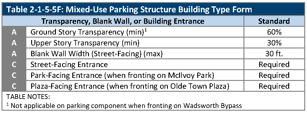
2-1-5-5. - Mixed-use parking structure type lot and building form standards.
A.
Generally. The lot and building form standards that apply to mixed-use parking structure type buildings are set out in this Section. See Section 2-1-5-2, Building Types, as to which sub-districts of the OT zoning district allow mixed-use parking structure type buildings. See Section 2-1-5-3, Generally Applicable Lot and Building Form Standards, regarding the application of the standards that are set out in this Section.
B.
Lot Standards. Lot standards are as provided in Table 2-1-5-5B, Mixed-Use Parking Structure Type Lot Standards.
C.
Building Setbacks. Building setbacks are as provided in Table 2-1-5-5C, Mixed-Use Parking Structure Building Type Setbacks.
D.
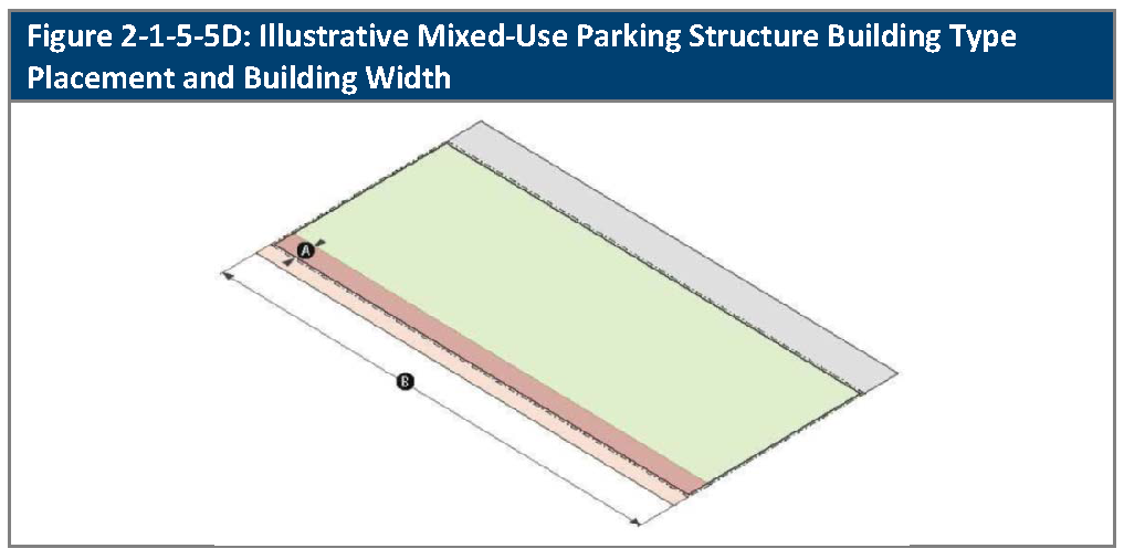
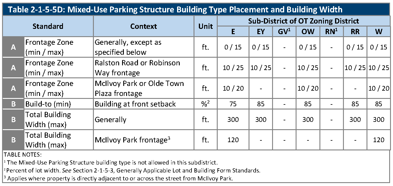
Building Placement and Building Width. Building placement and building width shall be as provided in Table 2-1-5-5D, Mixed-Use Parking Structure Type Building Placement and Building Width.
E.
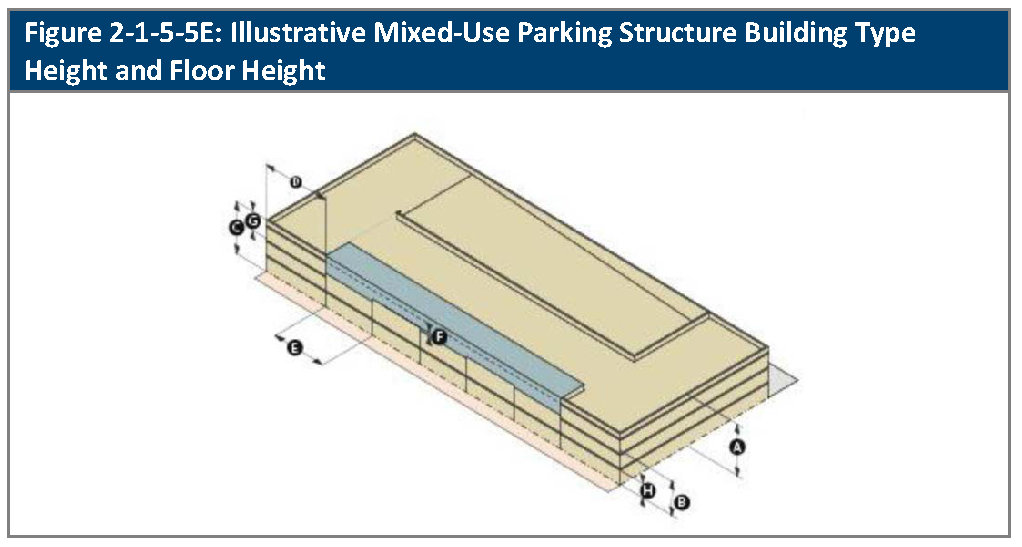
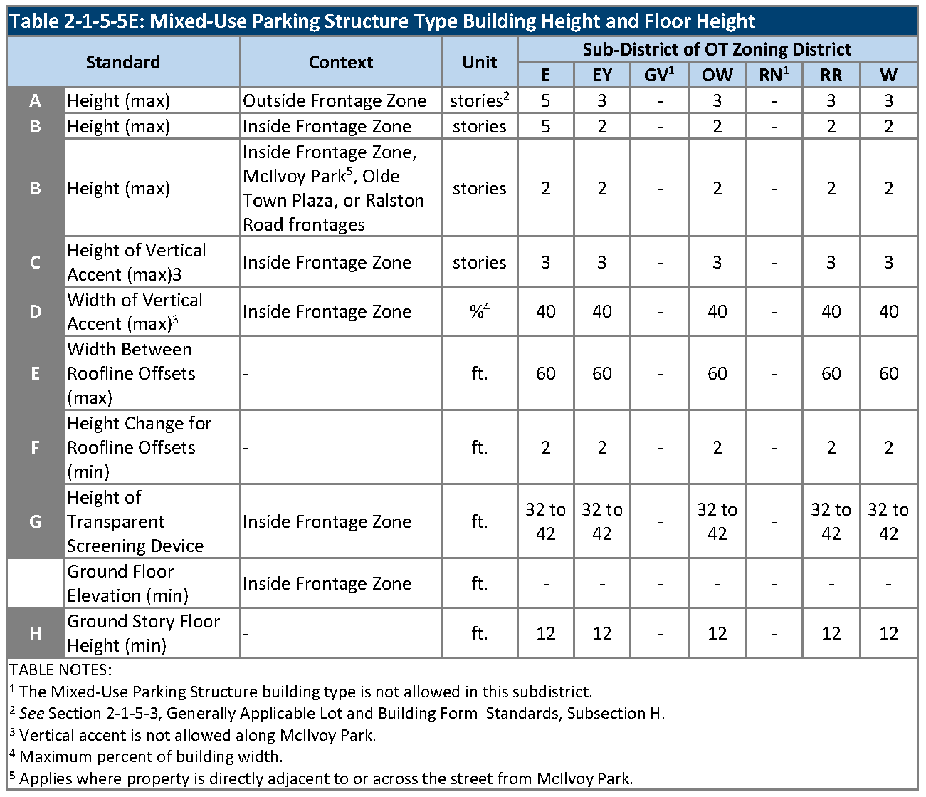
Building and Floor Height. Building height, floor height, and building width shall be as provided in Table 2-1-5-5E, Mixed-Use Parking Structure Type Building Height and Floor Height.
F.
Building Form. Building form shall be as provided in Table 2-1-5-5F, Mixed-Use Parking Structure Building Type Form.
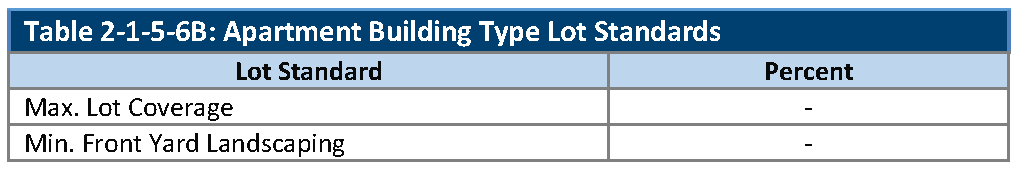
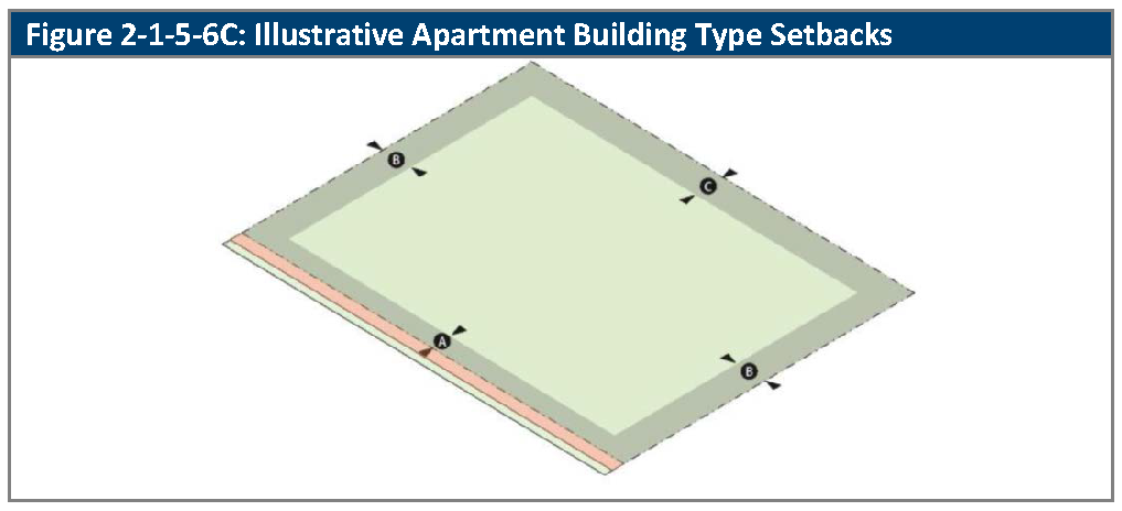
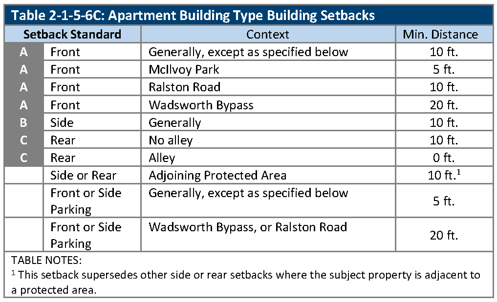
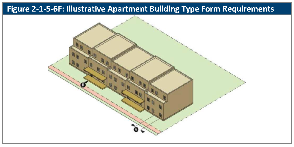
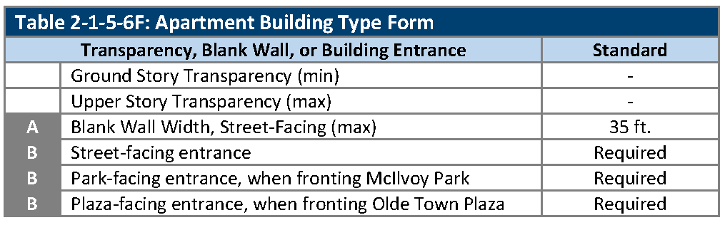
2-1-5-6. - Apartment building type lot and building standards.
A.
Generally. The lot and building standards that apply to apartment building types are set out in this Section. See Section 2-1-5-2, Building Types, as to which sub-districts of the OT zoning district allow apartment type buildings. See Section 2-1-5-3, Generally Applicable Lot and Building Standards, regarding the application of the standards that are set out in this Section.
B.
Lot Standards. Lot standards are as provided in Table 2-1-5-6B, Apartment Building Type Lot Standards.
C.
Building Setbacks. Building setbacks are as provided in Table 2-1-5-6C, Apartment Building Type Setbacks.
D.
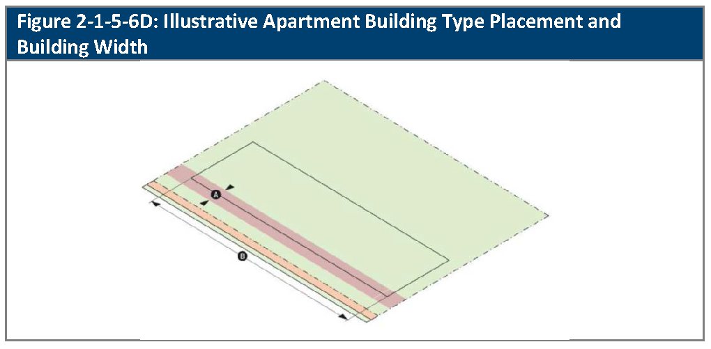
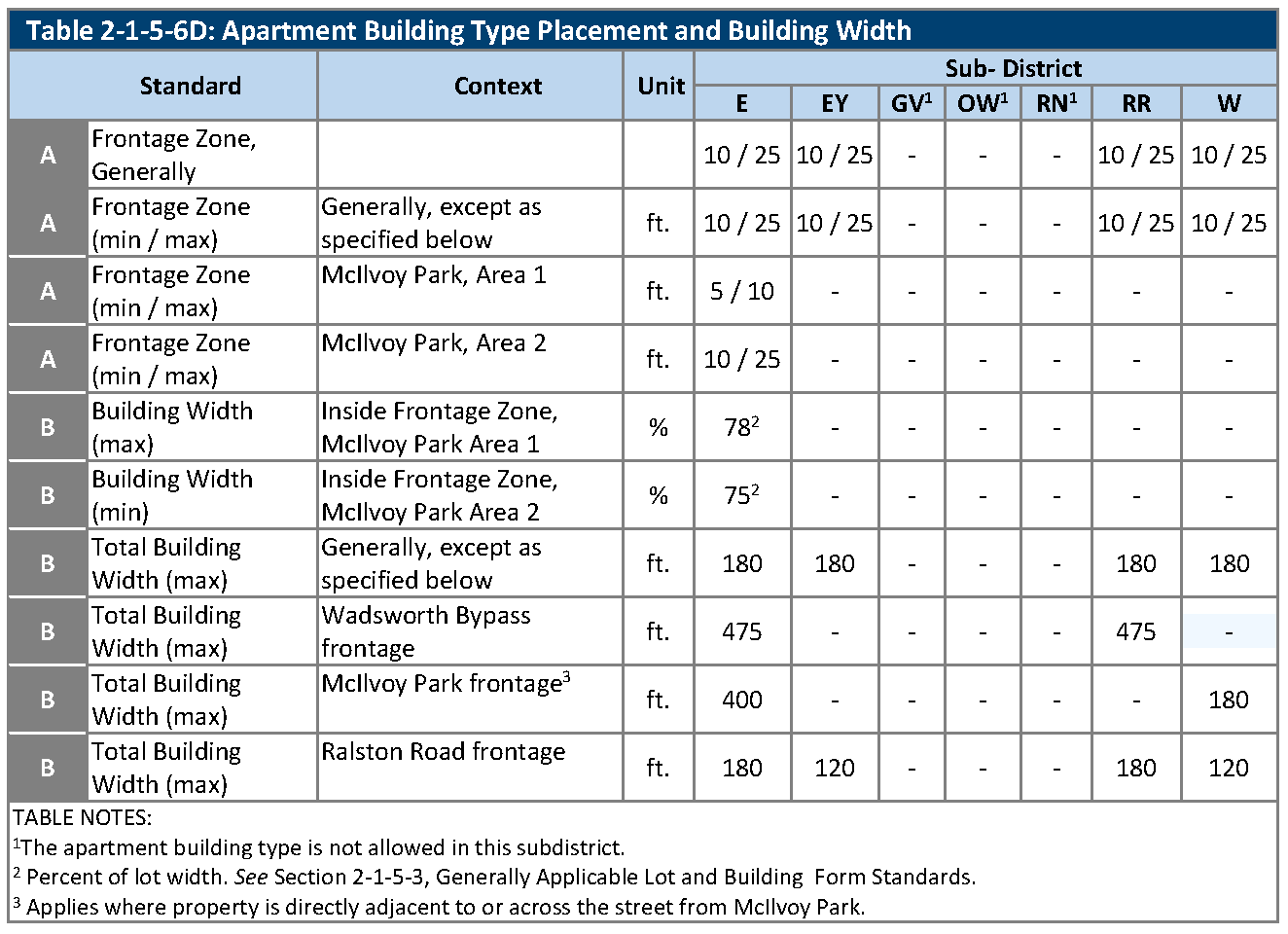
Building Placement and Building Width. Building placement and building width shall be as provided in Table 2-1-5-6D, Apartment Building Type Placement and Building Width.
E.
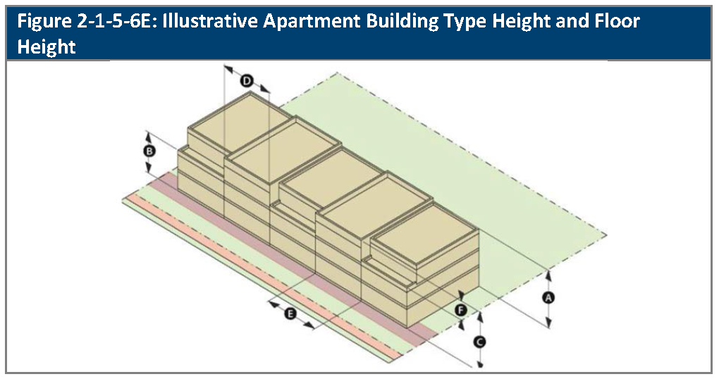
Building and Floor Height. Building height, floor height, and building width shall be as provided in Table 2-1-5-6E, Apartment Building Type Height and Floor Height.
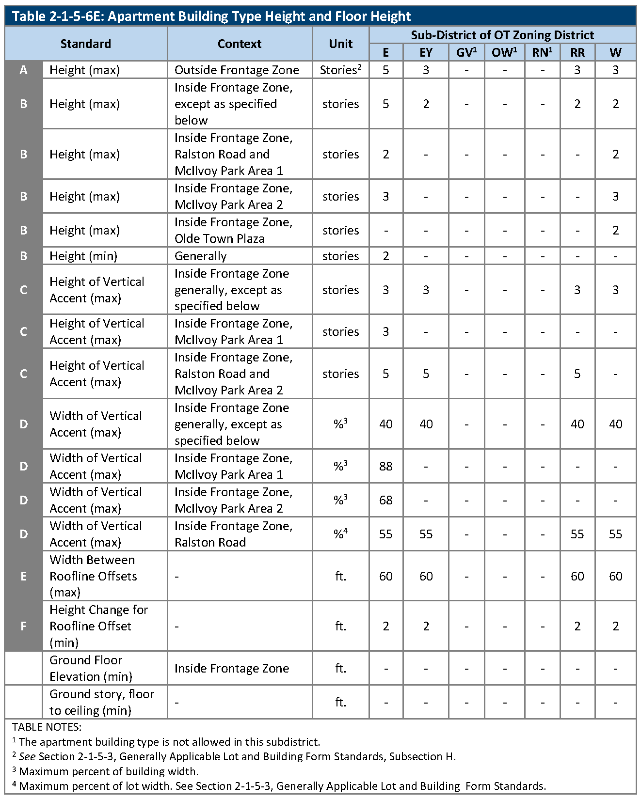
F.
Building Form. Building form shall be as provided in Table 2-1-5-6F, Apartment Building Type Form.
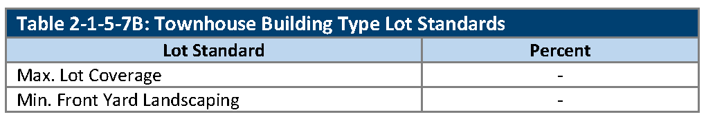
2-1-5-7. - Townhouse building type lot and building standards.
A.
Generally. The lot and building standards that apply to townhouse building types are set out in this Section. See Section 2-1-5-2, Building Types, as to which sub-districts of the OT zoning district allow townhouse building types. See Section 2-1-5-3, Generally Applicable Lot and Building Form Standards, regarding the application of the standards that are set out in this Section.
B.
Lot Standards. Lot standards are as provided in Table 2-1-5-7B, Townhouse Building Type Lot Standards.
C.
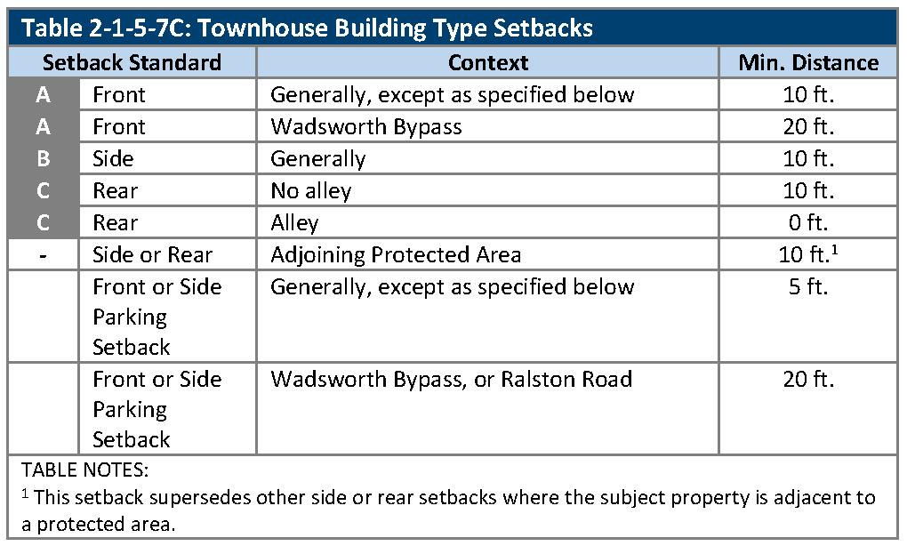
Building Setbacks. Building setbacks are as provided in Table 2-1-5-7C, Townhouse Building Type Setbacks.
D.
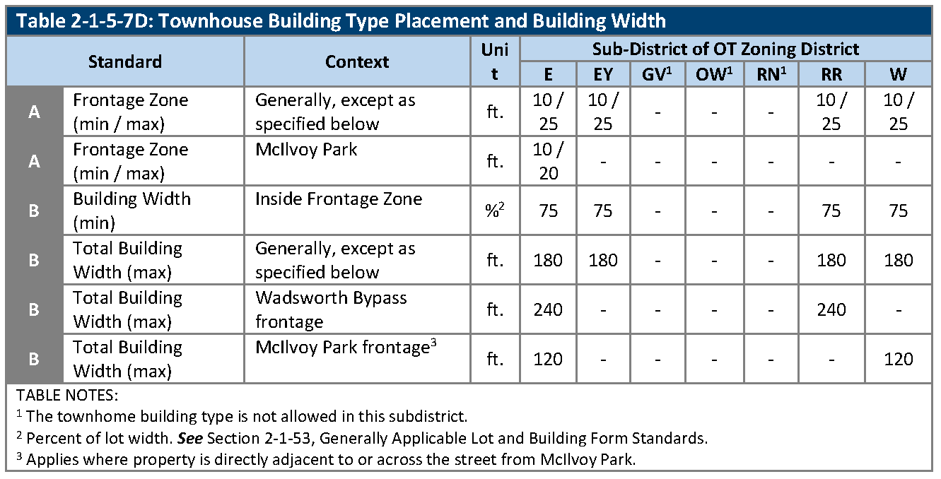
Building Placement and Building Width. Building placement and building width shall be as provided in Table 2-1-5-7D Townhome Building Type Placement and Building Width.
E.
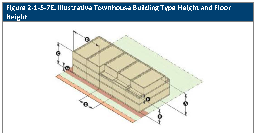
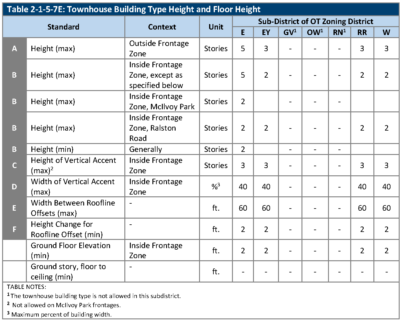
Building and Floor Height. Building height, floor height, and building width shall be as provided in Table 2-1-5-7E, Townhouse Building Type Height and Floor Height.
F.
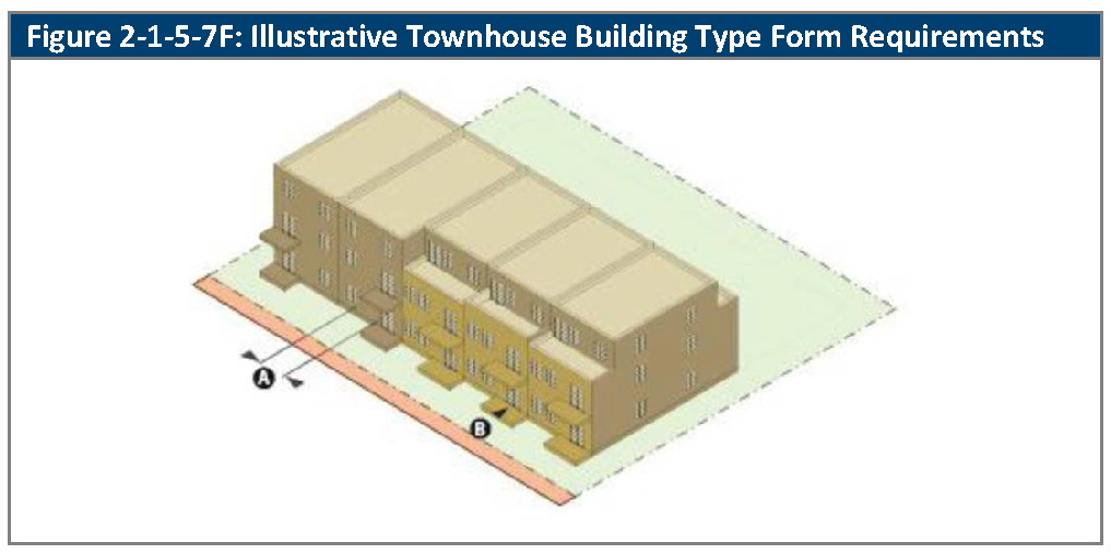
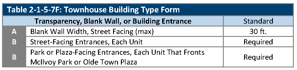
Building Form. Building form shall be as provided in Table 2-1-5-7F, Townhouse Building Type Form.
2-1-5-8. - Multiplex house lot and building standards.
A.
Generally. The lot and building standards that apply to multiplex house building types are set out in this Section. See Section 2-1-5-2, Building Types, as to which sub-districts of the OT zoning district allow multiplex house building types. See Section 2-1-5-3, Generally Applicable Lot and Building Form Standards, regarding the application of the standards that are set out in this Section.
B.
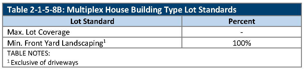
Lot Standards. Lot standards are as provided in Table 2-1-5-8B, Multiplex House Building Type Lot Standards.
C.
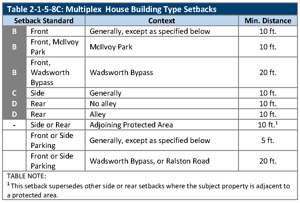
Building Setbacks. Building setbacks are as provided in Table 2-1-5-8C, Multiplex House Building Type Setbacks.
D.
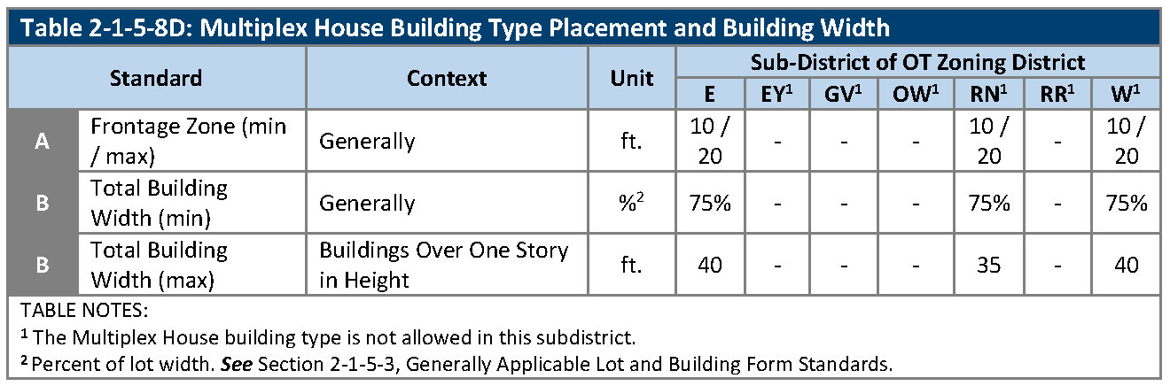
Building Placement and Building Width. Building placement and building width shall be as provided in Table 2-1-5-8D, Multiplex House Building Type Placement and Building Width.
E.
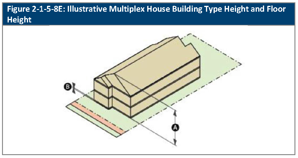
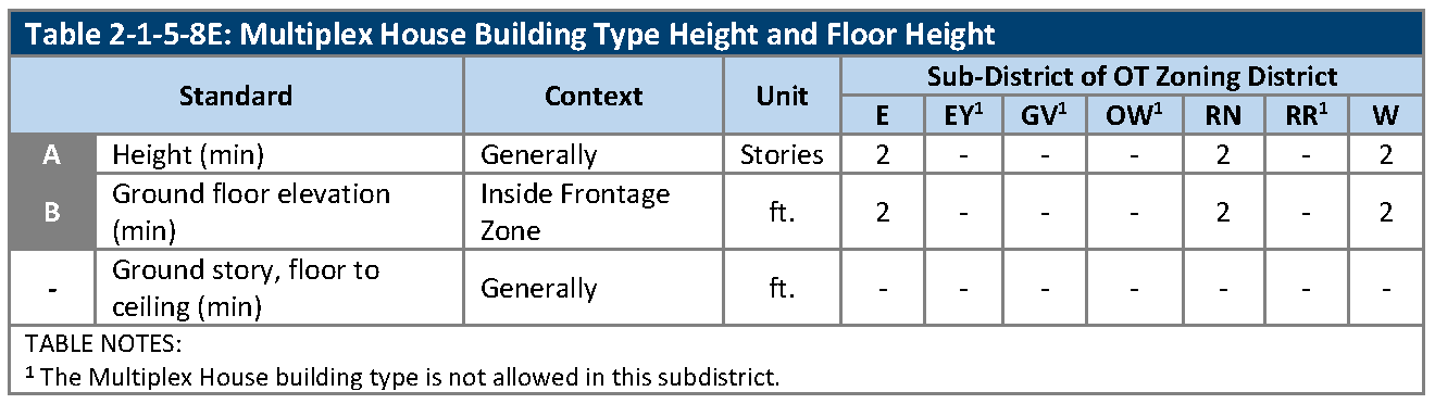
Building and Floor Height. Building height, floor height, and building width shall be as provided in Table 2-1-5-8E, Multiplex House Building Type Height and Floor Height.
F.
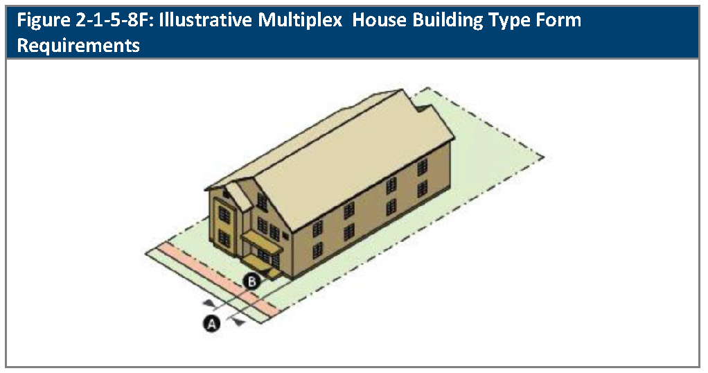
Building Form. Building form shall be as provided in Table 2-1-5-8F, Multiplex House Building Type Form.
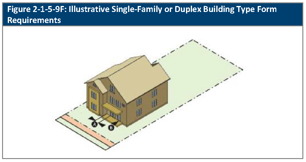
2-1-5-9. - Single-family dwelling or duplex building type lot and building standards.
A.
Generally. The lot and building standards that apply to single-family or duplex dwelling unit building types are set out in this Section. See Section 2-1-5-2, Building Types, as to which sub-districts of the OT zoning district allow single-family or duplex dwelling building types. See Section 2-1-5-3, Generally Applicable Lot and Building Form Standards, regarding the application of the standards that are set out in this Section.
B.
Lot Standards. Lot standards are as provided in Table 2-1-5-9B, Single-Family or Duplex Building Type Lot Standards
C.
Building Setbacks. Building setbacks are as provided in Table 2-1-5-9C, Single-Family or Duplex Building Type Setbacks.
D.
Building Placement and Building Width. Building placement and building width shall be as provided in Table 2-1-5-9D, Single-Family or Duplex Building Type Placement and Building Width.
E.
Building and Floor Height. Building height, and floor height shall be as provided in Table 2-1-5-9E, Single-Family or Duplex Building Type Height and Floor Height.
F.
Building Form. Building form shall be as provided in Table 2-1-5-9F, Single-Family or Duplex Building Type Form.
2-1-5-10. - Detached accessory dwelling unit or accessory building type standards.
A.
Generally. The standards that apply to detached accessory dwelling unit or other accessory building types are set out in this Section. See Section 2-1-5-2, Building Types, as to which sub-districts of the OT zoning district allow these types of buildings. See Section 2-1-5-3, Generally Applicable Lot and Building Form Standards, regarding the application of the standards that are set out in this Section.
B.
Lot Standards. Lot standards are as provided in Table 2-1-5-10B, Accessory Dwelling Unit or Accessory Building Type Lot Standards.
C.
Building Setbacks. Building setbacks are as provided in Table 2-1-5-10C, Accessory Dwelling Unit or Accessory Building Type Setbacks.
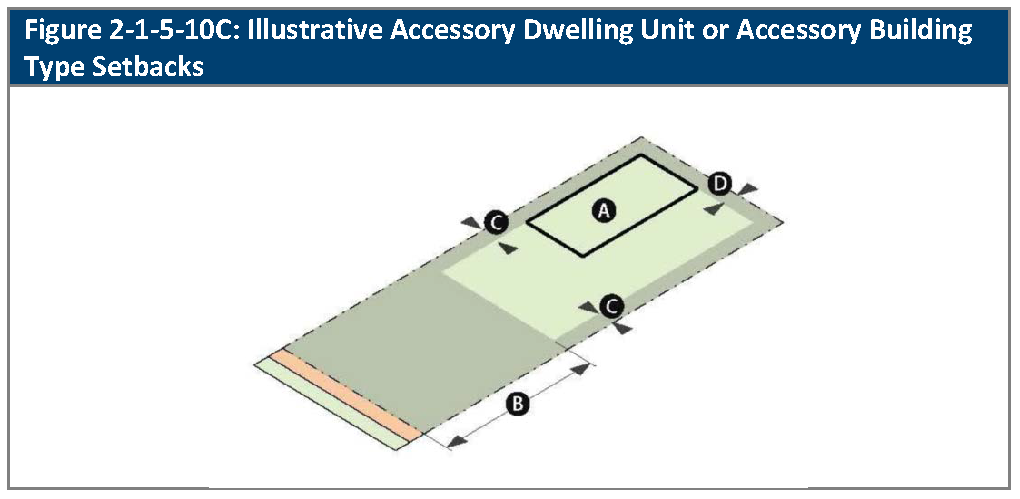
D.
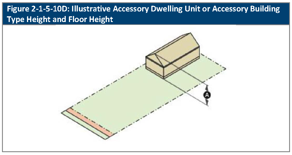
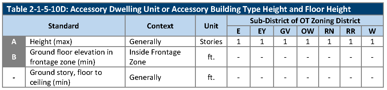
Building and Floor Height. Building height, and floor height shall be as provided in Table 2-1-5-10D, Accessory Dwelling Unit or Accessory Building Height and Floor Height.
E.
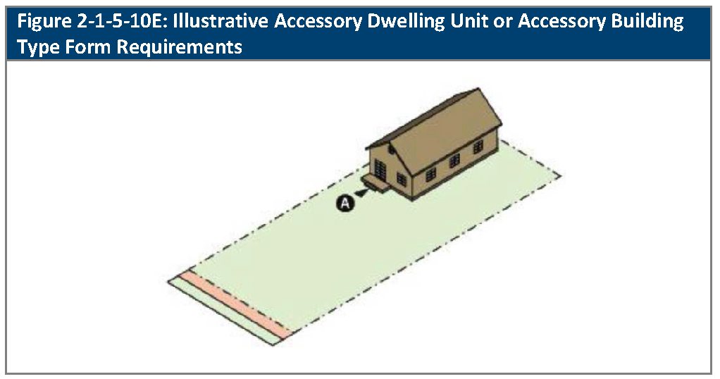
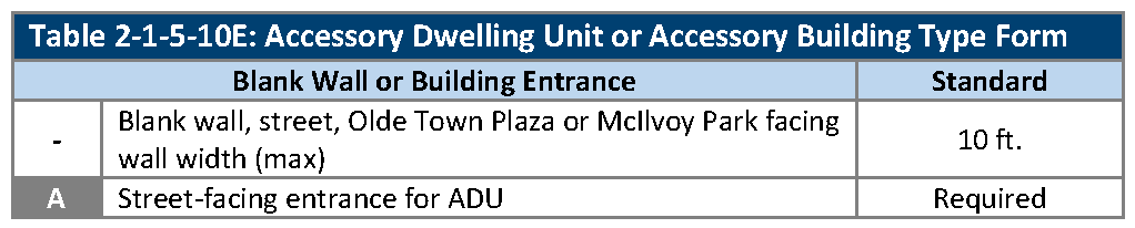
Building Form. Building form shall be as provided in Table 2-1-5-10E, Single-Family or Duplex Building Type Form.
(Ord. No. 4905, § 8, 8-19-2025)
2-1-5-11. - Civic building lot and building standards.
A.
Generally. The lot and building standards that apply to civic buildings are set out in this Section. See Section 2-1-5-2, Building Types, as to which sub-districts of the OT zoning district allow civic buildings. See Section 2-1-5-3, Generally Applicable Lot and Building Form Standards, regarding the application of the standards that are set out in this Section.
B.
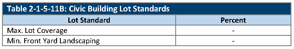
Lot Standards. Lot standards are as provided in Table 2-1-5-11B, Civic Building Lot Standards.
C.
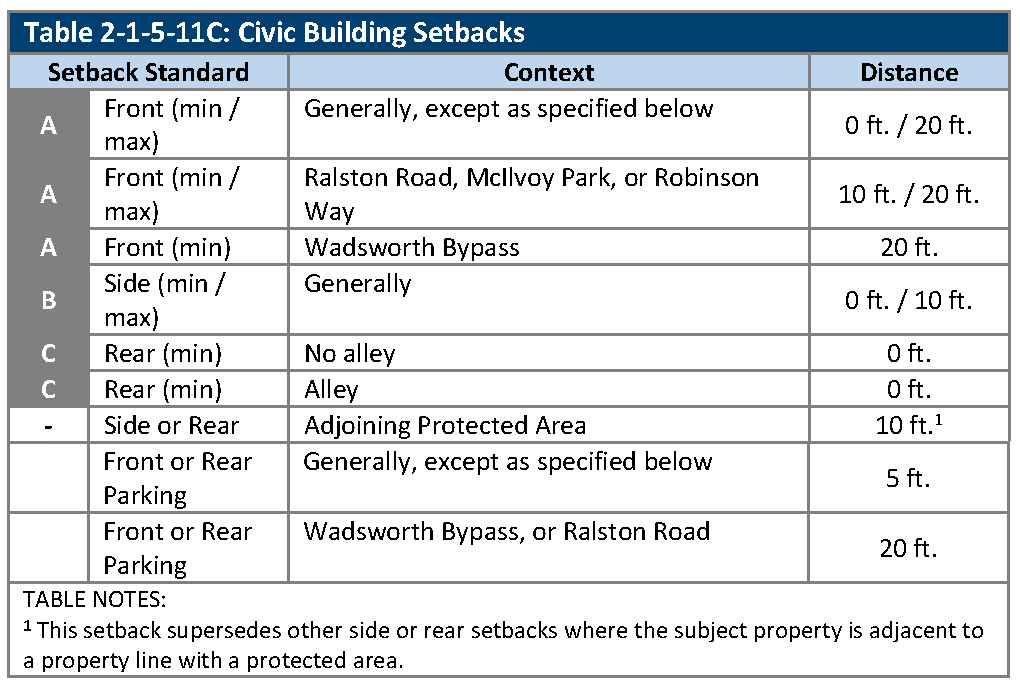
Building Setbacks. Building setbacks are as provided in Table 2-1-5-11C, Civic Building Setbacks.
D.
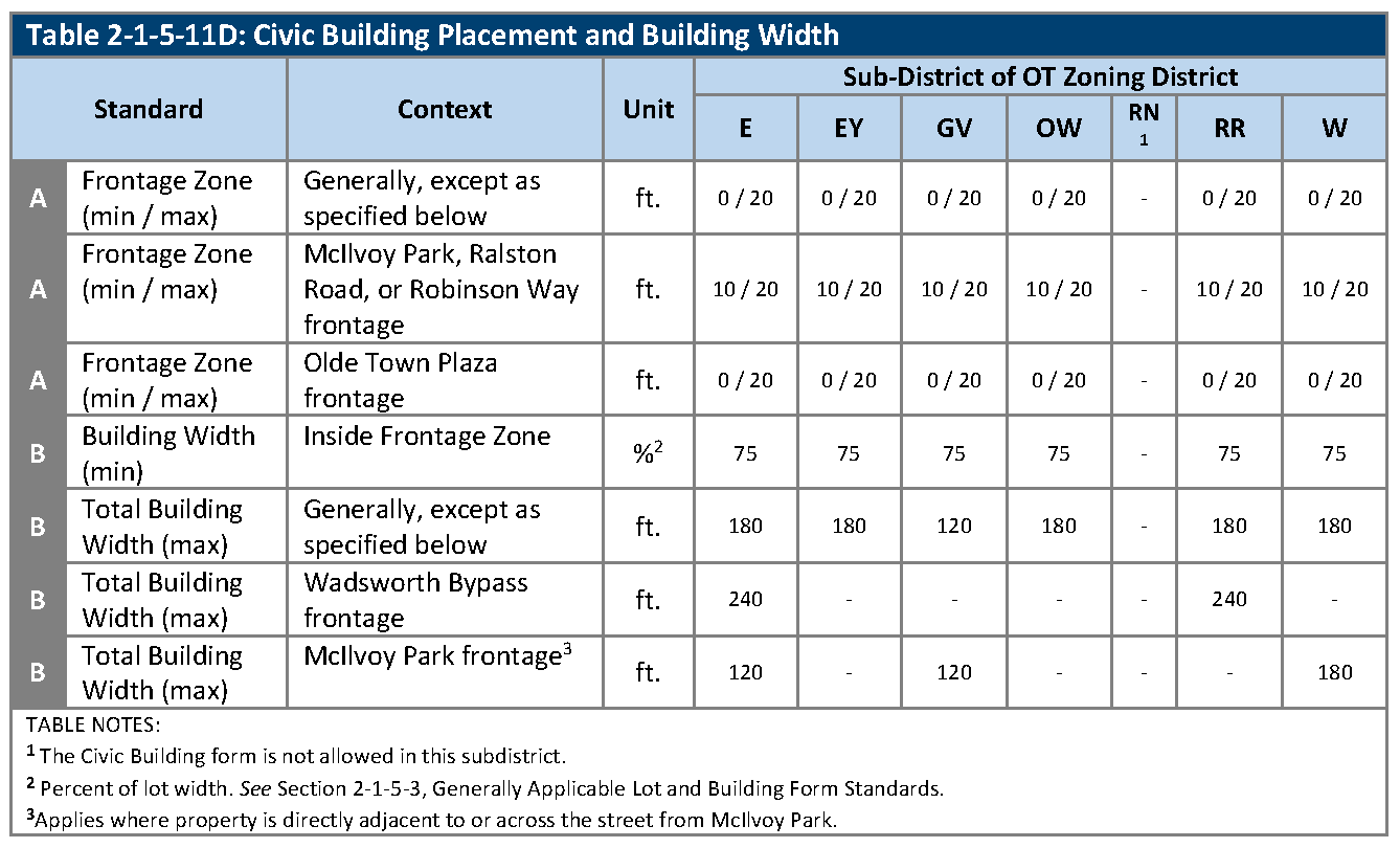
Building Placement and Building Width. Building placement and building width shall be as provided in Table 2-1-5-11D, Civic Building Placement and Building Width.
E.
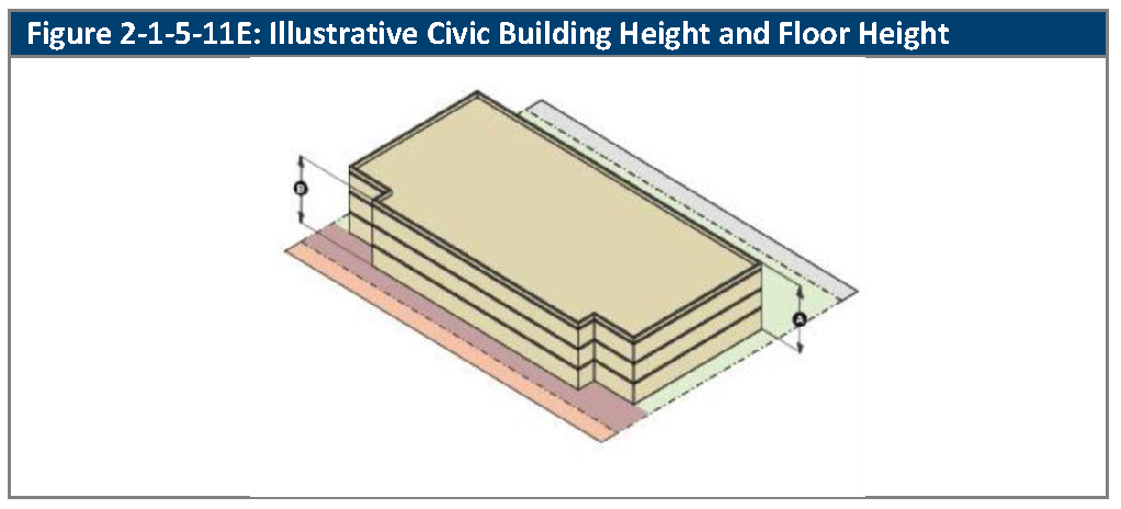
Building and Floor Height. Building height, and floor height shall be as provided in Table 2-1-5-11E, Civic Building Height and Floor Height.
F.
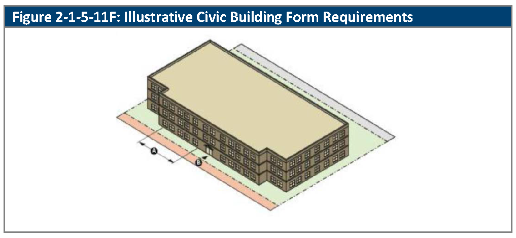
Building Form. Building form shall be as provided in Table 2-1-5-11F, Civic Building Form.
(Ord. No. 4793, § 1, 3-21-2022)
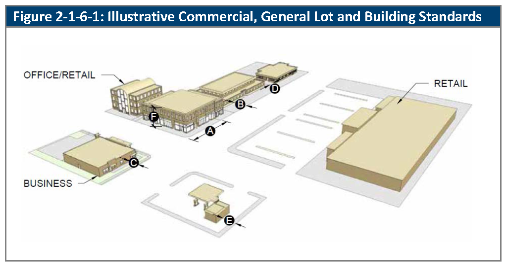
2-1-6-1. - CG: Commercial, General.
A.
Purpose. The purpose of the Commercial, General (CG) zoning district is to accommodate a wide variety of general retail and service uses, as well as professional and business offices serving both neighborhood and area-wide needs. This zoning district is typically situated along arterial streets, or where other appropriate high-volume vehicular access is available.
B.
Relationship to the Comprehensive Plan. The CG zoning district generally implements the "Neighborhood and Community Commercial/Office" land use category stated in the Comprehensive Plan.
C.
Lot and Building Standards. The standards for lots and buildings in the CG zoning district are set out in Table 2-1-6-1A, Commercial, General Lot and Building Standards.
D.
Cross-References. The cross-references in Table 2-1-6-1B, Cross-References for Commercial, General, are provided for the reader's convenience and are not necessarily exhaustive of applicable regulations.
(Ord. No. 4793, § 1, 3-21-2022)
2-1-6-2 - CN: Commercial, Neighborhood
A.
Purpose. The purpose of the Commercial, Neighborhood (CN) zoning district is to accommodate small scale retail, restaurant and service uses serving neighborhood needs. This zoning district is typically situated along collector or arterial streets within or at the edges of existing neighborhoods.
B.
Relationship to the Comprehensive Plan. The CN zoning district generally implements the "Neighborhood and Community Commercial/Office" land use category stated in the Comprehensive Plan.
C.
Lot and Building Standards. The standards for lots and buildings in the CN zoning district are set out in Table 2-1-6-2A, Commercial, Neighborhood Lot and Building Standards.
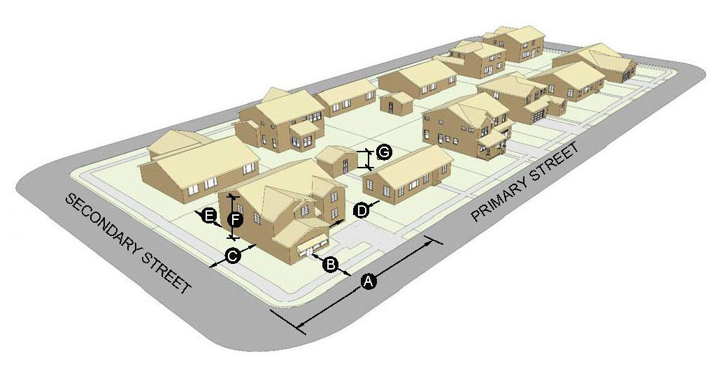
| Figure 2-1-6-2: Illustrative Commercial, Neighborhood Lot and Building Standards |
 |
D.
Cross-References. The cross-references in Table 2-1-6-2B, Cross-References for Commercial, Neighborhood, are provided for the reader's convenience and are not necessarily exhaustive of applicable regulations.
(Ord. No. 4851, § 1, 7-10-2023)
2-1-6-3. - IL: Industrial, Light.
A.
Purpose. The purpose of the Industrial, Light (IL) zoning district is to provide areas for light manufacturing, assembly and fabrication uses, office, research, food and beverage processing, packaging, or bottling, and compatible recreational activities.
B.
Relationship to the Comprehensive Plan. The IL zoning district generally implements the "Industrial/Office" land use category stated in the Comprehensive Plan.
C.
Lot and Building Standards. The standards for lots and buildings in the IL zoning district are set out in Table 2-1-6-3A, Industrial, Light Lot and Building Standards.
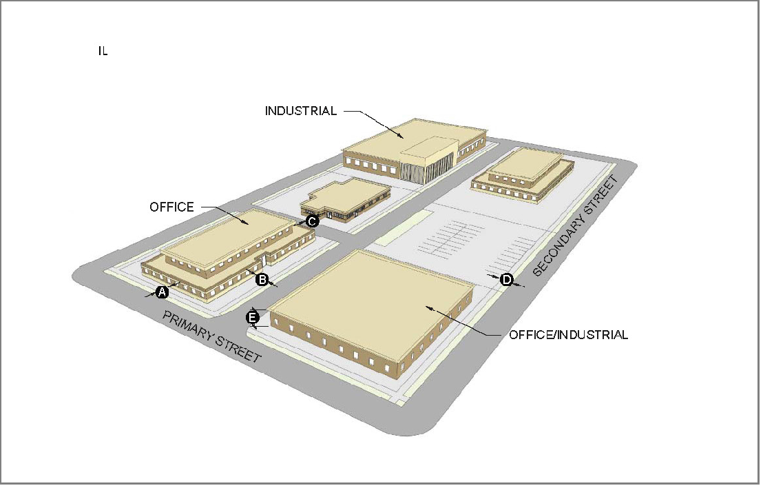
| Figure 2-1-6-3: Illustrative Industrial, Light Lot and Building Standards |
 |
D.
Cross-References. The cross-references in Table 2-1-6-3B, Cross-References for Industrial, Light, are provided for the reader's convenience and are not necessarily exhaustive of applicable regulations.
(Ord. No. 4793, § 1, 3-21-2022; Ord. No. 4851, § 1, 7-10-2023)
2-1-6-4. - IG: Industrial, General.
A.
Purpose. The purpose of the Industrial, General (IG) zoning district is to provide areas for a wide variety of industrial, manufacturing and heavy industries, heavy logistics centers, storage yards, and comparable uses and activities, as well as less intensive industries and supporting uses.
B.
Relationship to the Comprehensive Plan. The IG zoning district generally implements the "Industrial" land use category stated in the Comprehensive Plan.
C.
Lot and Building Standards. The standards for lots and buildings in the IG zoning district are set out in Table 2-1-6-4A, Industrial, General Lot and Building Standards.
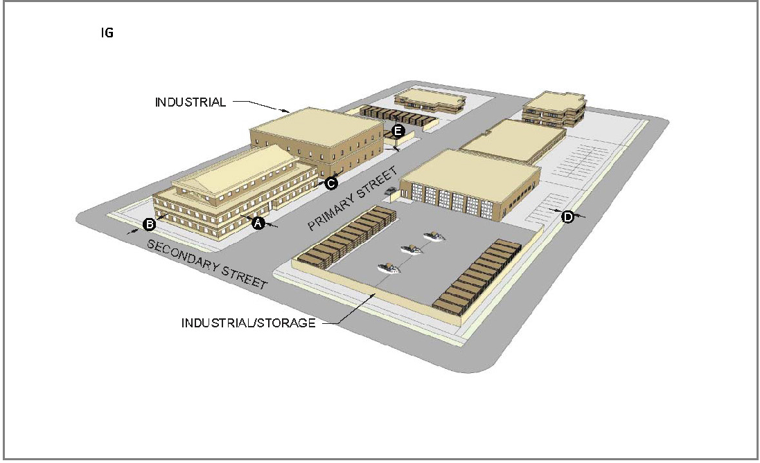
| Figure 2-1-6-4: Illustrative Industrial, General Lot and Building Standards |
 |
D.
Cross-References. The cross-references in Table 2-1-6-4B, Cross-References for Industrial, General, are provided for the reader's convenience and are not necessarily exhaustive of applicable regulations.
(Ord. No. 4793, § 1, 3-21-2022; Ord. No. 4851, § 1, 7-10-2023)
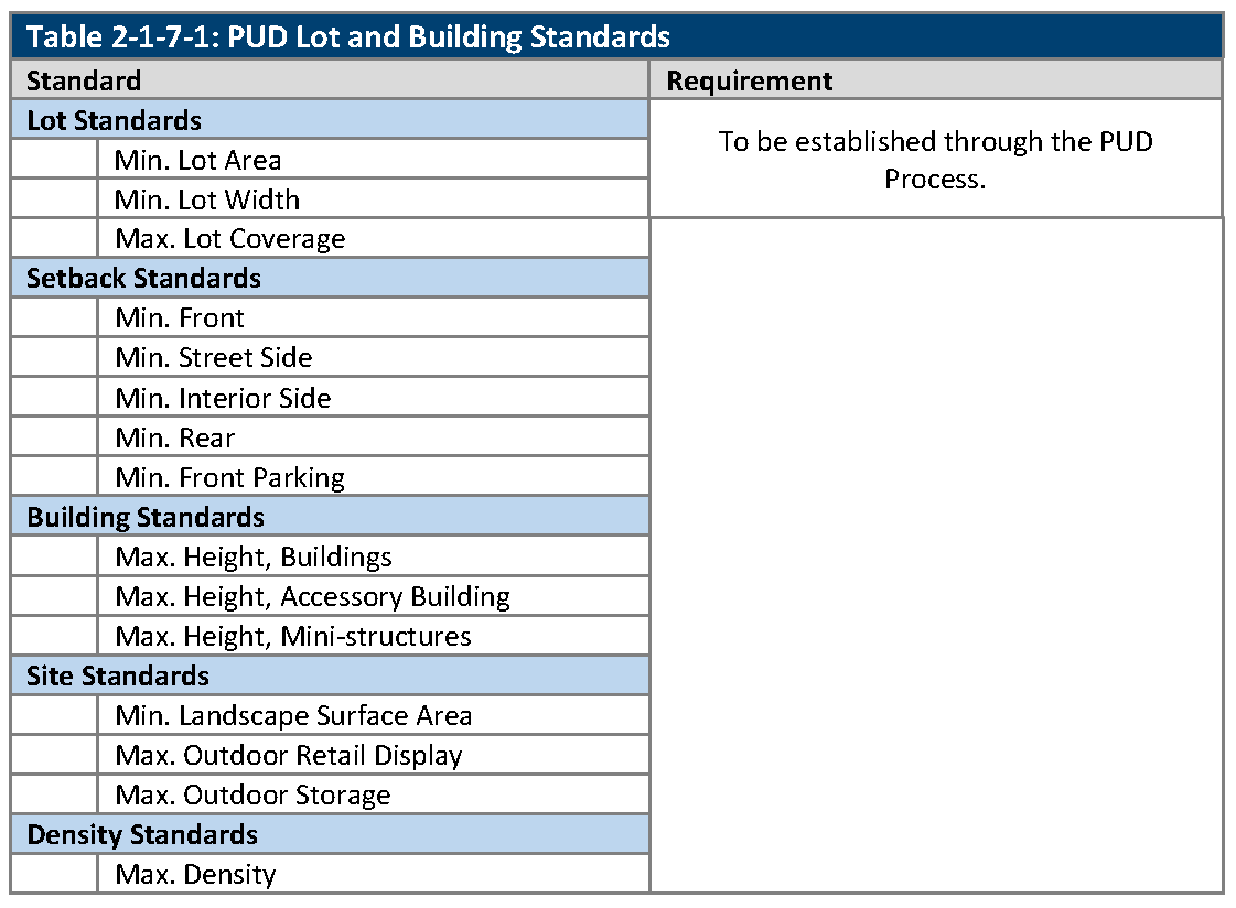
2-1-7-1. - Planned unit development.
A.
Purpose.
1.
The purposes of the Planned Unit Development zoning district are:
a.
To provide for procedures by which a subject property can be uniquely zoned and developed to meet the needs of the City, property owners, residents, and developers.
b.
To allow for flexibility that results in innovative or exceptional project and site design or for unique and imaginative uses or combinations of uses, where no other zoning district set out in this Land Development Code would allow for a product that is substantially similar to the proposed development, and where the proposed development would result in a net benefit to the community.
2.
Once approved by City Council, the PUD zoning district establishes the land use and development standards for the subject property as a separate and distinct zoning district.
B.
PUD Zoning Districts That Remain Following Adoption of this Code. Property that is subject to an approved outline development plan, preliminary development plan, or final development plan that was approved prior to the effective date of this LDC may be developed in accordance with the approved plans if the approved plans have not expired. See Section 8-2-3-14 Effect of Approvals and Division 8-3-12, Vested Rights.
C.
Uses Established. Any proposed use(s) allowed within a PUD zoning district shall be established as part of the approval granted by the Decision-Making Body
D.
Thresholds for Rezoning to PUD Zoning District. A subject property may be rezoned to PUD only if the proposed development could not be developed using the conventional zoning districts or standards established in this Code and meets the following criteria:
1.
The proposed development provides for a new land use or an innovative implementation of an existing land use, is consistent with the City's planning objectives, and will reinforce or catalyze economic development or provide innovative housing opportunities.
2.
The proposed development incorporates creative and superior quality design in the layout of buildings, common areas, and circulation, includes high-value design features, provides above-average recreational amenities or preserves natural, environmental or scenic resources that exceeds the standards of this LDC.
3.
The proposed development assures harmonious integration with surrounding land uses, neighborhood character, and environmental features.
4.
The proposed development implements the Comprehensive Plan, an adopted subarea or corridor plan, or an adopted urban renewal plan, or supports the implementation of such plans.
E.
Lot and Building Standards. Lot and building standards are established through the PUD process set out in Division 8-3-10, Planned Unit Development.
2-1-8-1. - Purpose and application of division.
A.
Purpose. The purpose of this Division is to establish a palette of lot and building types that accommodate a variety of housing types. The purpose of the housing palette is to allow for the creation of subdivisions with a variety of housing types.
B.
Application of Division. The housing palette applies in the zoning districts that allow residential uses in single-use buildings, except the RA zoning district, which is subject to Section 2-1-3-2, RA: Residential/Agricultural, the RN zoning district, which is subject to Section 2-1-3-3, RN: Residential Neighborhood, and the OT zoning district, which is subject to Division 2-1-5, Olde Town District. The Sections of this Division are applied as follows:
1.
Section 2-1-8-2, Housing Palette Lot Types, describes the residential lot types in the housing palette.
2.
Section 2-1-8-3, Using the Housing Palette, provides instructions on how to apply the housing palette.
3.
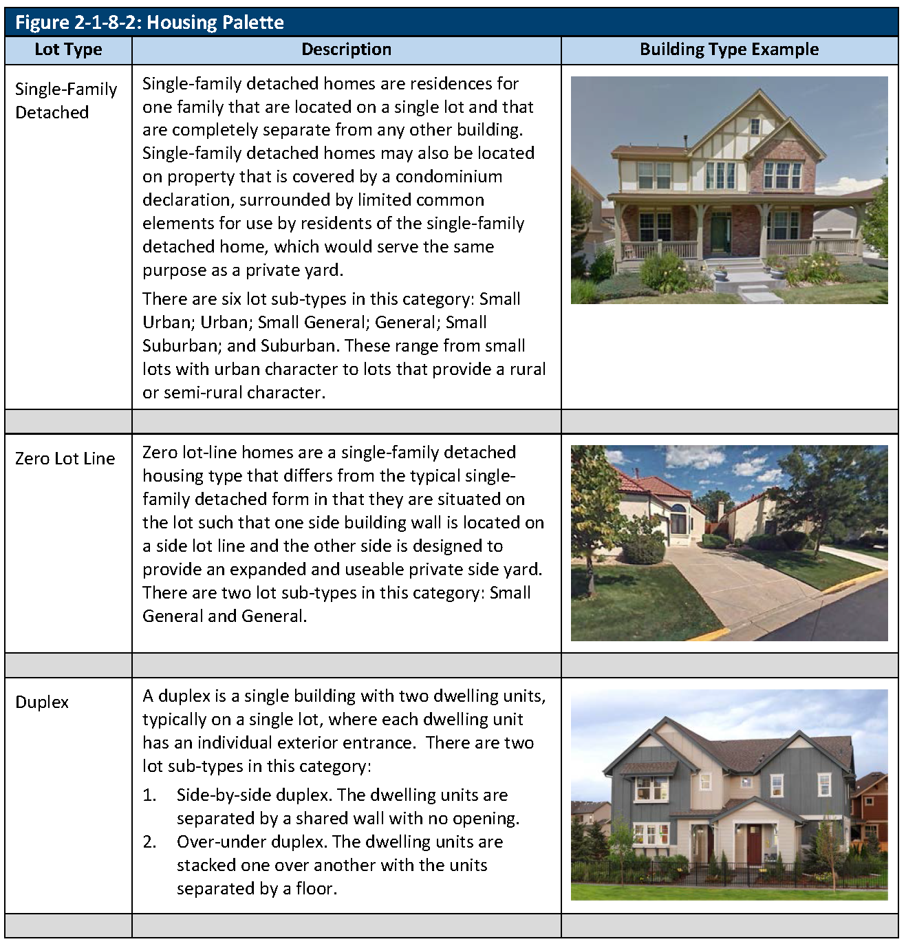
Section 2-1-8-4, Single-Family Detached, provides standards for lots that may be developed with single-family detached housing types.
4.
Section 2-1-8-5, Zero Lot Line, provides standards for lots that may be developed with zero lot line homes, and supplemental standards that are applied to the homes and to the subdivision blocks that contain them.
5.
Section 2-1-8-6, Duplexes, provides standards for lots that may be developed with duplex housing types.
6.
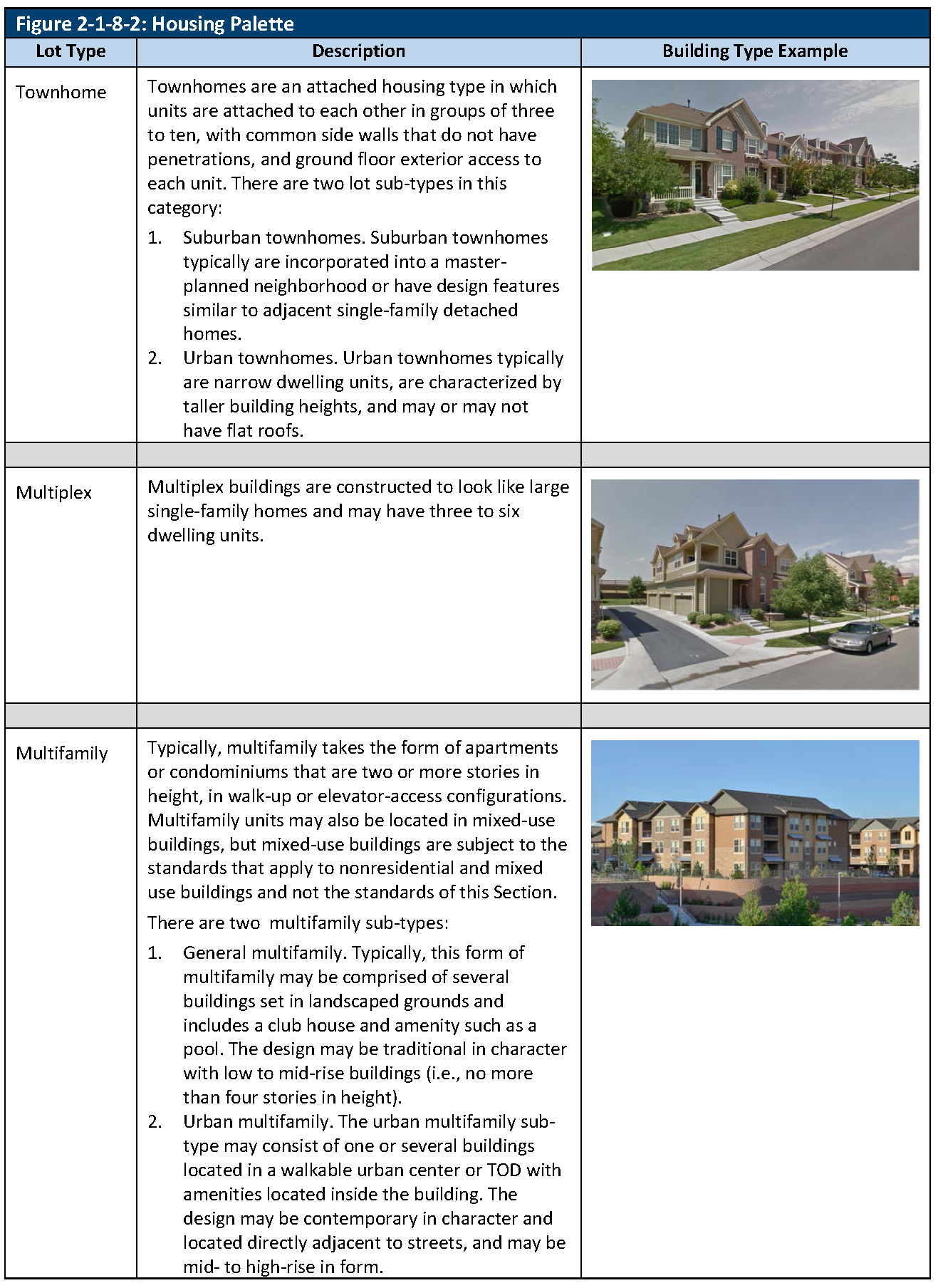
Section 2-1-8-7, Townhomes, provides standards for lots that may be developed with townhome housing types.
7.
Section 2-1-8-8, Multiplex and Multifamily, provides standards for lots that may be developed with multiplex or multifamily housing types.
8.
Section 2-1-8-9, Clustered Housing Types, provides standards for housing clusters that may be developed with cottages, micro-homes, or cluster duplexes.
2-1-8-2. - Housing palette lot types.
A.
Lot Types. Definitions of the residential building types in the Housing Palette are shown in Figure 2-1-8-2, Housing Palette, below.
2-1-8-3. - Using the housing palette.
A.
Generally. The housing types that are allowed in R6, R13, R24 and MX zoning districts are set out in the description of the zoning district in Division 2-1-3, Parks and Open Space and Residential Districts, and Division 2-1-4, Mixed-Use Districts. The housing palette set out in this Division provides lot and building standards for those housing types. It is applied in the third step of a three-step design process:
1.
Calculate the maximum number of dwelling units that are allowed on the subject property within the R6, R13, or R24 zoning districts by multiplying the maximum density standard set out in the applicable section of Division 2-1-3, Open Space and Residential Districts by the number of acres of area of the subject property.
2.
Identify required dedications and landscape surface area.
3.
Within the buildable areas of the property, and subject to the applicable design requirements of Chapter 4, Environmental and Site Design, include any of the housing types that are allowable for the subject property, up to the maximum number of dwelling units that are allowable on the subject property.
2-1-8-4. - Single-family detached.
A.
Lot and Building Standards. The lot and building standards for single-family detached homes are set out in Table 2-1-8-4, Single-Family Detached Lot and Building Standards. There are seven lot types, which are classified based on their area, width, and location of vehicular access. To meet the requirements for any lot type, both the lot area and the lot width minimums must be met.
(Ord. No. 4793, § 1, 3-21-2022; Ord. No. 4905, § 9, 8-19-2025)
2-1-8-5. - Zero lot line.
A.
Lot and Building Standards. The lot and building standards for zero lot-line homes are set out in Table 2-1-8-5, Zero Lot-Line Home Lot and Building Standards.
B.
Subdivision Block Layout. In addition to any other applicable standards from Chapter 4, Environmental and Site Design, the following standards apply to blocks that include zero lot line homes:
1.
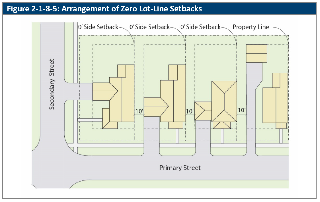
Lots that are designated for lot-line homes must be configured such that the zero setback (the "zero lot line") is on one side only, and on the same side of the lot for all of the lots on each street face. Street side setbacks are required where the side lot line borders a public right-of-way or for a lot or tract that is not approved for use as a zero lot-line home. See Figure 2-1-8-5, Arrangement of Zero Lot-Line Setbacks.
2.
Appropriate access and maintenance easements shall be provided to ensure that each lot owner is able to access and maintain the side of the building that is constructed upon the lot line. Easements for overhanging eaves may also be required, as appropriate to the design of the buildings.
C.
Building Design Standards. In addition to any other applicable residential building design standards, the following building design standards apply to all zero lot line homes:
1.
In order to provide a reasonable level of privacy in the adjoining side yard, no window, glass door, or door that includes windows shall be permitted on the zero lot-line side of the house unless:
a.
It opens into an enclosed courtyard; or
b.
It is composed of glass block, privacy glass, or similar treatment (except removable films), and is inoperable.
2.
The lot shall include a usable combined side and rear yard on the opposite of the zero-lot line.
(Ord. No. 4793, § 1, 3-21-2022)
2-1-8-6. - Duplexes.
A.
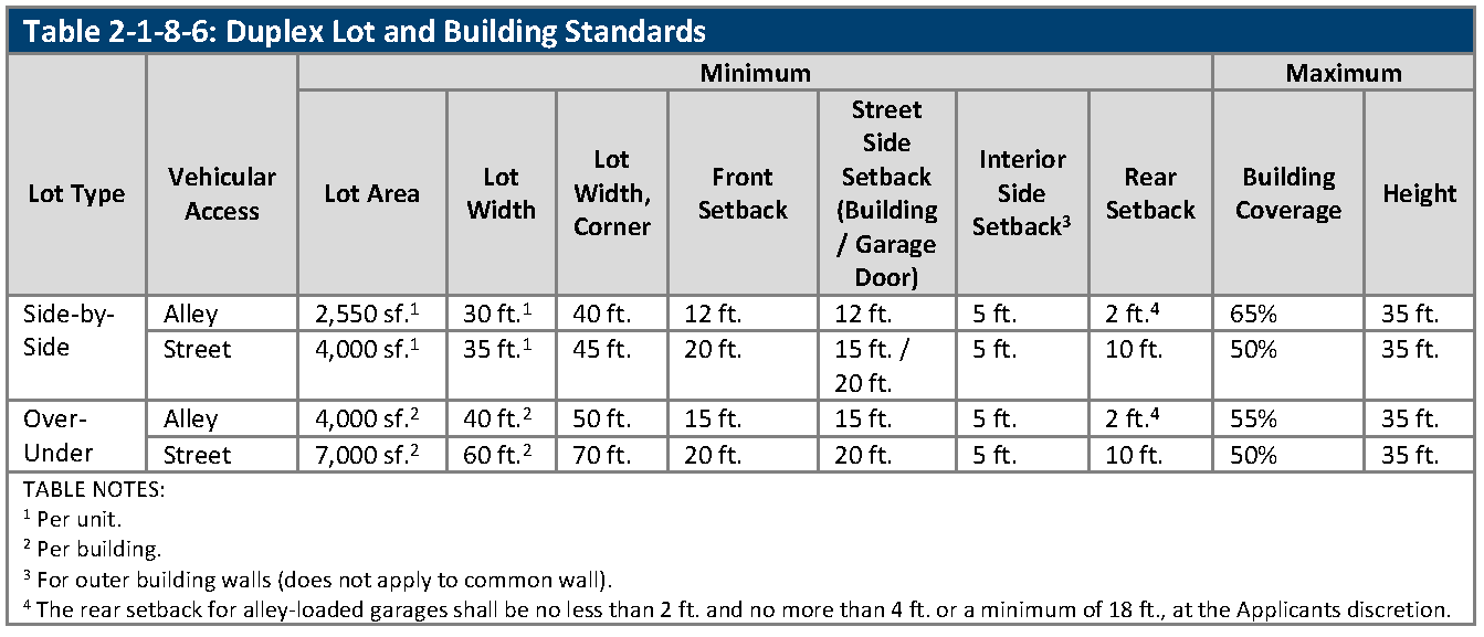
Lot and Building Standards. Table 2-1-8-6, Duplex Lot and Building Standards, sets out the lot and building requirements for duplexes.
2-1-8-7. - Townhomes.
A.
Lot and Building Standards. Table 2-1-8-7, Townhome Lot and Building Standards, sets out the lot and building requirements for townhomes.
(Ord. No. 4793, § 1, 3-21-2022)
2-1-8-8. - Multiplex and multifamily.
A.
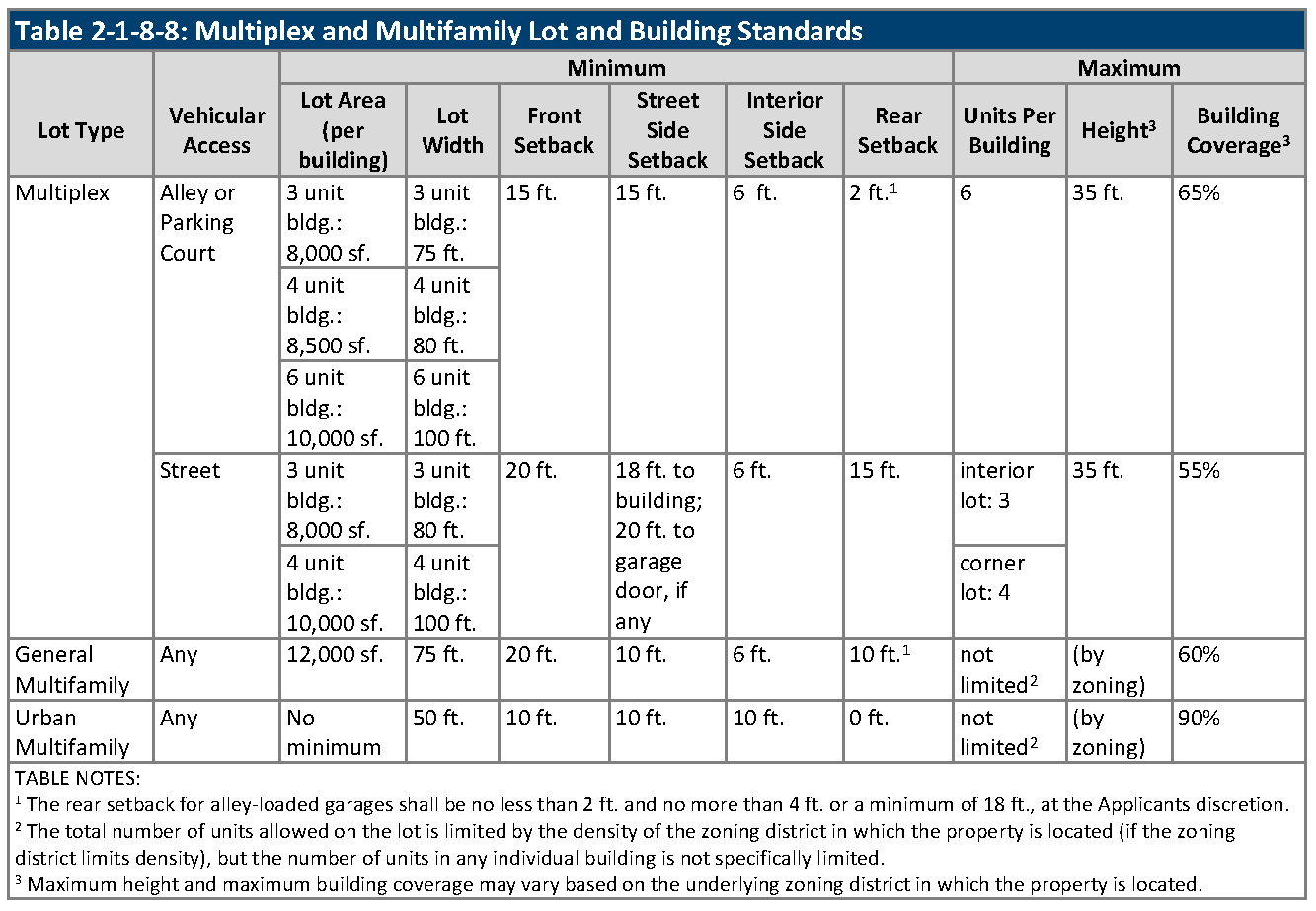
Lot and Building Standards. Table 2-1-8-8, Multiplex and Multifamily Lot and Building Standards, sets out the lot and building requirements for multiplex and multifamily.
2-1-8-9. - Clustered housing types.
A.
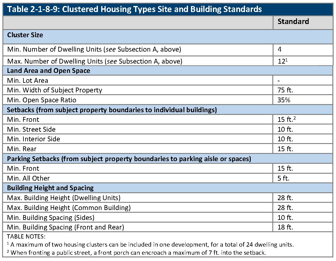
Housing Type Equivalencies. The clustered housing types may be mixed within a single cluster. For the purposes of the application of density standards and the minimum and maximum number of dwelling units in Table 2-1-8-9, Clustered Housing Types Site and Building Standards:
1.
A micro home is 400 gross floor area of building footprint or less and counted as one-half of a dwelling unit; and
2.
A cottage is between 401 gross floor area and 1,200 gross floor area of building footprint and counted as one dwelling unit.
B.
Site and Building Standards. The site and building standards for clustered housing types are set out in Table 2-1-8-9, Clustered Housing Types Site and Building Standards. Standards apply to the subject property upon which the cluster will be developed. Standards for individual lots in a cluster (if the cluster is divided into lots) are not specified.
C.
Subdivision Standards. The standards for clustered subdivision are set forth in Division 4-2-2 Cluster Subdivisions.
(Ord. No. 4793, § 1, 3-21-2022)
2-1-9-1. - One principal building per lot.
A.
Principal Building. In order to qualify as a principal building, all portions of a building must be structurally linked to each other, and not merely connected through the use of patios, breezeways, arcades, or similar devices.
B.
Generally. There shall be no limit on the number of principal buildings on an individual lot except as indicated in C., below, and provided that all other requirements in the Code are met.
C.
Single-Family Dwellings.
1.
There shall be no more than one principal building, plus permitted accessory buildings or mini-structures, per lot or tract of land within the RA or RN zoning districts, or on single-family detached, zero lot line, or duplex lots types as identified in Division 2-1-8, Housing Palette in the R6, R13, R24, MX-N, MX-S, or MX-U zoning districts.
(Ord. No. 4905, § 10, 8-19-2025)
2-1-9-2. - Arterial street setbacks.
A.
Arterial Street Setbacks. Except in the Olde Town Zoning District and along Ralston Road between Yukon Street and Oak Street, there shall be a setback of 100 feet for single-family detached, duplex, townhome buildings, multiplex, and accessory dwelling units (ADU) from the centerline of all arterial streets. The following applies for accessory buildings and uses:
1.
Parking may be allowed within the arterial street setback;
2.
An attached or detached garage that is accessory to a residential use is considered as a nonresidential building for the purposes of this provision. Therefore, the setback to the garage would be the standard setback for the zoning district; and
3.
If residential square footage is located above the garage, the setback shall be 100 feet from the centerline.
(Ord. No. 4905, § 11, 8-19-2025)
2-1-10-1. - Exceptions to setback standards.
The structures and features enumerated in Table 2-1-10-1, Permitted Encroachments into Required Setbacks, may encroach into required setbacks as provided in the table.
(Ord. No. 4793, § 1, 3-21-2022; Ord. No. 4905, § 12, 8-19-2025)
2-1-10-2. - Exceptions to maximum building or structure height.
A.
The maximum building or structure height limits established shall not apply to the following structures or structural elements:
1.
Chimneys, cornices without windows, cupolas, domes not used for human occupancy, elevator penthouses, roof top decks, monuments, parapet walls, skylights, spires, stairs, steeples, wireless communication facilities, theater scenery lofts, towers, ventilators, water tanks, and similar structures and necessary mechanical appurtenances, provided, with the exception of roof top decks, they:
a.
Do not cover more than 25 percent of the roof area of the structure to which they are attached; and
b.
Comply with applicable screen standards for mechanical equipment and appurtenances in Section 5-1-2-3, General Building Design Standards.
2.
Antennas, provided they comply with height limits established for the specific use in Section 5-1-5-4.
3.
Roof-mounted small scale solar energy collection systems, in accordance with standards in Section 5-1-4-4, Renewable Energy Systems.
4.
Small wind energy conversion systems, provided the maximum height of the system, including any tower and extended blades, is in accordance with the standards in Section 5-1-4-4, Renewable Energy Systems.
(Ord. No. 4905, § 13, 8-19-2025)
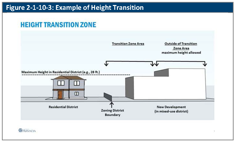
2-1-10-3. - Height transition to requirements.
A.
Generally. Projects in the R6, R13, and R24 zoning districts abutting a property in the RA and RN zoning district, projects within a PUD zone district with single-unit detached units that range in size minimum from 4,000 square feet to 32,500 square feet, or single-family detached units located in unincorporated Jefferson County shall comply with the height standards for the Height Transition Zone. The height transition zones are illustrated in Figure 2-1-10-3, Example of Height Transition abutting the RA and RN districts.
B.
Height Transition Zone Standards.
1.
Transition Zone for MX-N District. Any portion of a building located in the MX-N district and within 25 feet of a district boundary line for the RA and RN districts shall have a maximum height no greater than the maximum height allowed in the adjacent district.
2.
Transition Zone for MX-S and CG Districts. Any portion of a building located in the MX-S and CG districts and within 35 feet of a district boundary line for the RA and RN districts shall have a maximum height no greater than the maximum height allowed in the adjacent districts.
3.
Transition Zone for MX-U and MX-T Districts. Any portion of a building located in the MX-U and MX-T districts and within 45 feet of a district boundary line for the RA and RN districts shall have a maximum height no greater than the maximum height allowed in the adjacent districts.
4.
Transition Zone for IL and IG Districts. Any property located in the IL and IG districts and adjacent to a single-family detached residential use located in unincorporated Jefferson County shall maintain a 40-foot setback from the abutting lot line if the building height exceeds 35 feet.
C.
Two or More Abutting Lots. Where a lot abuts two or more residential districts, the residential district with the lowest maximum building height shall govern.
D.
Maximum Height. Any portion of a building located outside of the Height Transition Zone may have the maximum height allowed in the district.
(Ord. No. 4905, § 14, 8-19-2025)
2-1-10-4. - Incentives for increased building height.
A.
Generally. Within the MX zoning districts, an increased building height of 15 feet shall be allowed for projects that include affordable housing units provided, however, the maximum overall building height shall not exceed 120 feet.
B.
Affordable Housing. A development project that includes affordable units that utilize federal low-income housing tax credits (LIHTC), pursuant to Section 42 of the Internal Revenue Code, and include market rate units, shall be allowed the additional height identified in Section 2-1-10-4A above.
2-1-10-5. - Double-frontage lots.
A.
Generally. The lot and building standards of this Section apply to the development of double-frontage lots for residential purposes in all zoning districts except the Olde Town zoning district and MX zoning districts.
B.
Minimum Lot Depth. Double-frontage lots shall have a minimum lot depth of at least 130 feet (including any landscaped tree lawn).
C.
Minimum Rear Setbacks. Primary buildings and structures on double-frontage lots shall be set back from rear lot lines as provided in Table 2-1-10-5, Rear Setbacks for Double-Frontage Lots. The setbacks may be applied as a single setback for the entire primary building or structure, or as stepped setbacks that are applicable to portions of the primary building or structure that are above the stated heights.
(Ord. No. 4905, §§ 15, 16, 8-19-2025)
2-1-10-6. - Exception to frontage zone requirements.
Where a required frontage zone is encumbered by an easement or other physical constraint that can not be relocated, as determined by the Director, the frontage zone requirement shall be measured from the edge of the easement or constraint, or from a line determined by the Director.