
Arvada City Zoning Code
CHAPTER 4
ENVIRONMENTAL AND SITE DESIGN
4-1-1-1. - Purpose of article.
The purpose of this Article is to promote and maintain environmental quality and livability in the City, and to mitigate natural hazards to life, safety, and property using standards that regulate the location and design of development.
(Ord. No. 4867, § 2, 2-12-2024)
4-1-1-2. - Application of article.
A.
Generally. The Divisions within this Article are applied as follows:
1.
Division 4-1-2, Floodplain Regulations, establishes standards for development within the Regulatory Floodplain, in order to reduce and mitigate flood hazards.
2.
Division 4-1-3, Stormwater and Drainage Control, establishes design principles for grading and drainage system design.
3.
Division 4-1-4, Natural Hazards and Environmentally-Sensitive Areas, establishes standards for avoiding or mitigating natural hazard areas and for protecting environmentally-sensitive areas from the impacts of development.
4.
Division 4-1-5, Irrigation Canals and Ditches, establishes standards for development near irrigation canals and irrigation ditches.
B.
Relationship to Other Standards of this Code. The standards of this Article, particularly Division 4-1-2, Floodplain Regulations, and Division 4-1-5, Irrigation Canals and Ditches, may restrict development on certain locations of a subject property. When the application of these standards would result in exceptional hardship to the Applicant upon a determination that the variance is the minimum necessary, a variance may be permissible to allow development on other parts of the subject property pursuant to Section 8-3-11-2, Variances.
(Ord. No. 4867, § 2, 2-12-2024)
4-1-2-1. - Statutory authorization.
The Legislature of the State of Colorado has, in C.R.S. Title 29, Article 20, delegated the responsibility of local government units to adopt regulations designated to minimize flood losses. Therefore, the City Council of Arvada, Colorado, does hereby adopt the following floodplain management regulations.
(Ord. No. 4867, § 2, 2-12-2024)
4-1-2-2. - Findings of fact.
A.
Flood hazard areas of the City are subject to periodic inundation, which can result in loss of life and property, health and safety hazards, disruption of commerce and government services, and extraordinary public expenditures for flood protection and relief, all of which adversely affect the health, safety, and general welfare of the public.
B.
These flood losses are created by the cumulative effect of obstruction in floodplains which cause an increase in flood heights and velocities, and by the occupancy of flood hazard areas by uses vulnerable to floods and hazardous to other lands because they are inadequately elevated, floodproofed, or otherwise protected from flood damage.
(Ord. No. 4867, § 2, 2-12-2024)
4-1-2-3. - Purpose and definitions.
A.
This Division is intended to provide the means and the regulations to promote the health, safety, and general welfare of the public, and to minimize public and private losses due to flood conditions in specific areas subject to flood hazards, and to promote wise use of the floodplain. This Division has been established with the following purposes intended:
1.
To reduce the hazards of flood to human life, health, and property;
2.
To alert floodplain occupants, or potential occupants, to flood damages which may result from their own, or others' land use;
3.
To minimize damage to critical facilities, infrastructure, and other public facilities and utilities such as water, sewer, and gas mains; electrical and communications facilities; and streets and bridges located in the regulatory floodplain;
4.
To minimize prolonged business interruptions caused by flooding;
5.
To minimize the expenditure of public money for costly flood control projects;
6.
To minimize the need for rescue and relief efforts associated with flooding, which are generally undertaken at the expense of the public;
7.
To help maintain stable tax base by providing for the sound use and development of the regulatory floodplain, so as to minimize future flood blight areas;
8.
To ensure potential buyers are notified if properties are in a regulatory floodplain; and
9.
To encourage and facilitate urban water resources management techniques for the reduction of pollution and the enhancement of the urban environment.
B.
Terms used in this Division shall have the meanings set forth in section 11-3-3-1 of this Code if specifically defined.
(Ord. No. 4867, § 2, 2-12-2024)
4-1-2-4. - Methods of reducing flood losses.
A.
In order to accomplish its purposes, this Division includes methods and provisions for:
1.
Requiring all construction of permitted buildings to be in compliance with the City of Arvada Building Code;
2.
Restricting or prohibiting land uses that are: a) dangerous to public life, health, safety, and property in times of flooding, or b) result in damaging increases in erosion, flood heights, or velocities;
3.
Requiring land uses vulnerable to floods, including facilities that serve such uses, be protected against floods at the time of initial construction or substantial improvements;
4.
Regulating the manner in which a structure or building may be constructed in Special Flood Hazard areas;
5.
Regulating the method of construction of water supply and sanitation systems so as to reduce disease, contamination, and unsanitary conditions;
6.
Delineating and describing areas that could be inundated by floods;
7.
Regulating the method of construction and pattern of development within all uses in the regulatory floodplain;
8.
Regulating the alteration of natural floodplains, stream channels, and natural protective barriers, that help accommodate or channel flood waters;
9.
Regulating or prohibiting filling, grading, development, dredging, and unnecessary encroachments that may increase flood damage;
10.
Encouraging uses such as greenbelt, open space, agricultural, recreation facilities, and riding trails in floodplain areas;
11.
Preventing or regulating the construction of flood barriers that will unnaturally divert flood waters or that may increase flood hazards in other areas; and
12.
Prohibiting makeshift structures, enclosures, or other shelters used for human habitation in floodplain areas, except in locations expressly permitted by the City and having adequate sanitation facilities and approved flood evacuation plans.
(Ord. No. 4867, § 2, 2-12-2024)
4-1-2-5. - Adoption of official DFIRMs and related FISs and basis for establishing the Regulatory Floodplain.
A.
Official FIS and accompanying FIS adopted; revisions.
1.
Adoption. The City hereby adopts the following flood insurance studies and their accompanying flood insurance rate maps provided to the City by FEMA and any revisions thereto as the applicable FISs and FIRMs for the City:
a.
The Flood Insurance Study, Jefferson County, Colorado and Incorporated Areas and its accompanying FIRM and DFIRM dated January 15, 2021, and
b.
The Flood Insurance Study, Adams County, Colorado and Incorporated Areas and its accompanying FIRM and DFIRM dated September 28, 2018.
2.
Revisions through LOMR. Any revisions issued by FEMA to the maps and studies adopted in section 4-1-2-5(A) through a LOMR, together with all explanatory notations and matter thereon, are automatically adopted by the City upon the effective date of the LOMR without amendment to this Code and declared to be a part of this Code.
3.
Amendments. In the event FEMA provides the City with new, updated FISs or FIRMs, this section must be amended to adopt the most current FIRM and its accompanying FIS. The Floodplain Administrator shall keep a copy of the FIS, DFIRMs and FIRMs adopted by this Code on file and available for public inspection.
B.
Basis for establishing the Regulatory Floodplain.
1.
Regulatory Floodplain. The Regulatory Floodplain consists of all the Special Flood Hazard Areas (SFHAs) within the City as designated as such by the official FIS adopted in subsection A. of this Section. This Regulatory Floodplain is the minimum area within the City subject to the applicability of this Code and may be supplemented by studies designated and approved by the City.
2.
Boundaries. The boundaries of the Regulatory Floodplain, the Flood Fringe Sub-Zone, the Floodway Sub-Zone within City land, shall be determined from the current effective FEMA DFIRMs and related FISs adopted by the City pursuant to subsection A. of this Section. The boundary lines on the map shall be determined by using the scale appearing on the map. For the purpose of final determination of the Regulatory Floodplain boundaries, the base flood elevations on the 100-year flood profile shall control. The base flood elevations shall be shown on the flood profiles and tabulations in the adopted FISs and DFIRMs, as may be amended by FEMA through a LOMR or PMR.
3.
Conflict. Where there is a conflict between the boundary lines illustrated on the map and actual field conditions, the dispute shall be settled according to Section 8-3-11-7, Official Interpretations.
4.
Lack of information.
(a)
If the boundaries of an area are unclear based on the currently adopted FIRMs and FISs, and no other information is available by which to determine the boundaries of an area (i.e., site specific studies as provided by the property owner), the boundaries shall be determined by scaling distances on the maps provided in the FIS. Where interpretation is needed as to the exact location of the boundaries, the Floodplain Administrator shall make the necessary interpretation utilizing information deemed relevant by the Floodplain Administrator. In all cases, the base flood elevation as provided in the FIS shall be the governing factor in locating the boundary on any property.
(b)
When base flood elevation data has not been provided in accordance with these regulations, the Floodplain Administrator shall obtain, review, and reasonably utilize any base flood elevation data and floodway data available from a federal, state, or other sources, in order to administer the applicable provisions of Division 4-1-2, Floodplain Regulations.
(c)
For waterways with base flood elevations for which a regulatory floodway has not been designated, no new construction, substantial improvements, or other development (including fill) shall be permitted within zones A1-30 and AE on the FIRM adopted pursuant to Section 4-1-2-5, unless it is demonstrated that the cumulative effect of the proposed development, when combined with all other existing and anticipated development, will not increase the water surface elevation of the base flood more than one-half foot at any point within the community.
5.
District Types. A SFHA is not a separate Zoning District, but is an overlay over an existing Zoning District. The Regulatory Floodplain is subdivided into the Flood Fringe Sub-Zone (defined in Section 4-1-2-7) and the Floodway Sub-Zone (defined in Section 4-1-2-8). In addition to meeting the conditions of the underlying Zoning District, any property to be developed in the Regulatory Floodplain must meet the conditions of the applicable Floodway Sub-Zone and Flood Fringe Sub-Zone. For those areas where base flood elevation has not been determined, including Flood Zone A within the Flood Fringe Sub-Zone, the Floodplain Administrator shall obtain, review, and reasonably utilize any base flood elevation data from federal, state, or other source as criteria for determining final floodplain areas boundaries and administering rules, regulations and requirements within the Regulatory Floodplain.
6.
Other Areas. Areas outside of the Regulatory Floodplain but within the City and susceptible to being inundated as the result of a flood, including FHAD studies produced through the Urban Drainage and Flood Control District and designated by the Colorado Water Conservation Board, and the area of land over which flood water would flow from the spillway of a reservoir, shall be referred to as floodplain areas generally. Floodplain areas are still subject to the requirements of this Code.
7.
Areas Removed from the Regulatory Floodplain by Fill or Amendment. For purposes of this Article, areas removed from the Regulatory Floodplain include all existing and proposed LOMR-F and LOMA areas, if the LOMR-F or LOMA area has not previously been superseded by a standard LOMR.
(Ord. No. 4867, § 2, 2-12-2024)
4-1-2-6. - Regulatory Floodplain—General standards.
A.
Generally. The general standards of this Section apply to all areas within the Regulatory Floodplain and all floodplain areas as defined in Section 4-1-2-5(6).
B.
Anchoring.
1.
All new construction and substantial improvements shall be anchored to prevent flotation, collapse, or lateral movement of the structure, and capable of resisting the hydrostatic and hydrodynamic loads.
2.
All manufactured homes must be elevated and anchored to resist flotation, collapse, or lateral movement and must be capable of resisting the hydrostatic and hydrodynamic loads. Methods of anchoring may include, but are not limited to, use of over-the-top or frame ties to ground anchors. This requirement is in addition to applicable state and local anchoring requirements for resisting wind forces. Specific requirements may be:
a.
Over-the-top ties provided at each of the four corners of the manufactured home, with two additional ties per side at intermediate locations, with manufactured homes less than 50 feet long requiring only one additional tie per side; and
b.
Frame ties provided at each corner of the home with five additional ties per side at intermediate points, with manufactured homes less than 50 feet long requiring four additional ties per side; and
c.
All components of the anchoring system must be capable of carrying a force of 4,800 pounds; and
d.
Any additions to the manufactured home be similarly anchored.
C.
Construction Materials and Methods.
1.
All new construction and substantial improvements shall be constructed with utility equipment resistant to flood damage and using materials and methods that minimize flood damage.
2.
All new construction and substantial improvements shall be constructed with electrical, heating, ventilation, plumbing, and air conditioning equipment and other service facilities that are designed and/or located so as to prevent water from entering or accumulating within the components during conditions of flooding.
3.
New construction and substantial improvements, with fully enclosed areas below the lowest floor that are usable solely for parking of vehicles, building access, or storage in an area other than a basement and which are subject to flooding, shall be designed to automatically equalize hydrostatic flood forces on exterior walls by allowing for the entry and exit of floodwaters. Designs for meeting this requirement must either be certified by a registered Colorado Professional Engineer or architect, or meet or exceed the following minimum criteria:
a.
A minimum of two openings having a total net area of not less than one square inch for every square foot of enclosed area subject to flooding shall be provided.
b.
The bottom of all openings shall be no higher than one foot above lowest adjacent grade (LAG).
c.
Openings may be equipped with screens, louvers, valves, or other coverings or devices provided that they permit the automatic entry and exit of floodwaters.
D.
Utilities.
1.
All new and replacement water supply systems shall be designed to minimize or eliminate infiltration of flood waters into the system.
2.
New and replacement sanitary sewage systems shall be designed to minimize or eliminate infiltration of flood waters into the systems and discharge from the systems into flood waters.
3.
On-site waste disposal systems shall be located to avoid impairment to them or contamination from them during flooding.
E.
Fences.
1.
Fences may be permitted in the Regulatory Floodplain depending on the type and use of the fence at the discretion of the Floodplain Administrator. Any proposed fence in the Regulatory Floodplain shall require review by the Floodplain Administrator and issuance of a Floodplain Development Permit, in addition to other required permit(s). Table 4-1-2-6 is a guideline to provide assistance with understanding and selecting appropriate fencing in a floodplain, however exceptions may be made on a case-by-case basis upon the Floodplain Administrator's evaluation of the following: the proposed location of the fence and the designation of the location (i.e. whether the location is within the Flood Fringe Sub-Zone, Floodway Sub-Zone, Shallow Flooding Zone, etc.), the materials used for the fence (i.e. wire, rails, chain link, pickets, masonry, etc.), the dimension and length of the fence, and whether the fence is being replaced in kind.
F.
Subdivision Proposals.
1.
All subdivision proposals and other new development, including manufactured home parks or subdivisions, shall be reviewed by the appropriate City officials to determine whether the proposed development will be reasonably safe from flooding. Any such proposals in the Regulatory Floodplain shall be reviewed to ensure that:
a.
The proposal is consistent with the need to minimize flood damage;
b.
The proposal has public utilities and facilities such as sewer, gas, electrical, and water systems located and constructed to minimize flood damage;
c.
The proposal has adequate drainage provided to reduce exposure to flood damage; and
d.
Base flood elevation data is provided. All subdivision proposals and other proposed developments (including proposals for manufactured home parks and subdivisions) greater than 50 lots or 5 acres, whichever is lesser, shall include within such proposals base flood elevation data.
G.
Flood-Proofing. All-flood proofing measures mandated in this Section shall be subject to the requirements of this Code regarding the establishment of floodplain development permits, and regarding nonresidential structures. A professional engineer registered in the State of Colorado shall certify that the design and methods of construction are in accordance with accepted standards of practice for meeting the provisions of this Section and the design is consistent with the flood protection elevations for the particular area as shown by the flood profile, flood velocities, and other factors associated with the flood protection elevation. Such certifications shall be provided to the Floodplain Administrator as set forth in subsection 8-1-1-4, Floodplain Administrator. In addition to the flood-proofing measures described elsewhere in this Section, others may include:
1.
Installation of watertight doors, bulkheads and shutters,
2.
Reinforcement of walls to resist water pressure,
3.
Use of paints, membranes, or mortars to reduce seepage of water through walls,
4.
Addition of mass or weight to structures to resist flotation,
5.
Installation of pumps to lower water levels in structures,
6.
Addition or design of pumping facilities for subsurface drainage systems of buildings to relieve external foundation, wall, and basement floor pressures,
7.
Construction to resist rupture or collapse caused by water pressure or floating debris, and
8.
Installation of cutoff valves on sewer lines or the elimination of gravity flow basement drains.
(Ord. No. 4867, § 2, 2-12-2024; Ord. No. 4905, § 30, 8-19-2025)
4-1-2-7. - Flood fringe sub-zone standards.
A.
Generally. The Flood Fringe Sub-Zone represents the area that is inundated in the 100-year flood that may serve as a temporary storage area for the flood waters and is the area that lies landward of the floodway.
B.
Special Provisions.
1.
No fill, structure, deposit, or other floodplain uses are permitted in the flood fringe sub-zone that adversely affect the efficiency of any channels or floodways of any tributaries to the main stream or river; drainage ditches; or any other drainage facilities or systems. Tents and other makeshift structures, enclosures, or other similar shelters used for human habitation are also prohibited in the flood fringe sub-zone.
2.
If a property has been issued a LOMR-F and the property has been filled so as to remove it from the floodplain, no building permit shall be issued for a new structure to be constructed that would result in a finished floor elevation, including the basement, below the previously existing base flood elevation.
3.
Residential Construction. New construction and substantial improvement of any residential structure within or moved into the Regulatory Floodplain shall have the lowest floor (including the basement and any mechanical equipment or attendant utilities) constructed at or above the flood protection elevation of two feet above the base flood elevation. If such new construction or substantial improvement of a residential structure is within Flood Zone AO, then the lowest floor of the residential structure (including the basement and any mechanical equipment or attendant utilities) must be constructed at or above a point two feet above the depth number specified in feet on the DFIRM, and the depth number shall be at least two feet if it is not specified on the DFIRM. For new construction and substantial improvements of residential structures within Zones AH and AO in the Regulatory Floodplain, adequate drainage paths shall be constructed all around the structures on slopes to guide flood waters around and away from the structures. If neither base flood elevation nor depth number is available, the flood protection elevation shall be at least four feet above the highest adjacent grade.
4.
Nonresidential Construction. New construction and substantial improvements of any commercial, industrial, or other non-residential structure within or moved into the Regulatory Floodplain shall either:
a.
Have the lowest floor (including basement and any mechanical equipment or attendant utilities) constructed at or above the flood protection elevation of one foot above the base flood elevation, or at or above a point one foot above the depth number if within Flood Zone AO, and as specified in feet on the DFIRM (the depth number shall be at least two feet if it is not specified on the maps). If neither base flood elevation nor depth number is available, the flood protection elevation shall be at least three feet above the highest adjacent grade; or
b.
Together with attendant utility and sanitary facilities shall:
i.
Be flood-proofed to or above the flood protection elevation, such that the structure is watertight with walls substantially impermeable to the passage of water;
ii.
Have structural components capable of resisting hydrostatic and hydrodynamic loads and effects of buoyancy; and
iii.
Be certified by a Colorado registered professional engineer that the design and methods of construction are in accordance with accepted standards of practice for meeting the provisions of this paragraph. Such certifications shall be provided to the Floodplain Administrator as set forth in subsection 8-1-1-4.
c.
For non residential construction within Zones AH and AO in the Regulatory Floodplain, adequate drainage paths shall be constructed all around structures on slopes to guide flood waters around and away from the structures.
5.
Manufactured Homes. Manufactured homes shall be anchored in accordance with Section 4-1-2-6(B), Anchoring.
a.
All manufactured homes that are placed or substantially improved on a site in Zones A1-30, AH, or AE on the DFIRM shall be elevated on a permanent foundation such that the lowest floor of the manufactured home, together with mechanical equipment and attendant utilities, is constructed at or above a point two feet above the base flood elevation, and shall be securely anchored to an adequately anchored foundation system to resist flotation, collapse and lateral movement, if the manufactured home is:
i.
Outside of a manufactured home park or subdivision;
ii.
In a new manufactured home park or subdivision;
iii.
In an expansion to an existing manufactured home park or subdivision; or
iv.
In an existing manufactured home park or subdivision on which a manufactured home has incurred "substantial damage" as the result of a flood.
b.
All manufactured homes that are placed or substantially improved on sites in existing manufactured home parks or subdivisions that are not subject to the provisions in subsection (a) above, shall be elevated so that either:
i.
The lowest floor of the manufactured home, together with mechanical equipment and attendant utilities, is constructed at or above a point two feet above the base flood elevation; or
ii.
The manufactured home chassis is supported by reinforced piers or other foundation elements of at least equivalent strength that are no less than 36 inches in height above grade and are securely anchored to an adequately anchored foundation system to resist flotation, collapse, and lateral movement of the foundation from hydrostatic and hydrodynamic loads, including buoyancy.
c.
Any manufactured home park or manufactured home subdivision within the limits of the Regulatory Floodplain shall file an evacuation plan with the appropriate disaster preparedness authority indicating alternate vehicular access and escape routes.
6.
Recreational Vehicles.
a.
A recreational vehicle ("RV") is a vehicle which is:
i.
Built on a single chassis;
ii.
400 square feet or less when measured at the largest horizontal projection;
iii.
Designed to be self-propelled or permanently towable by a light duty truck; and
iv.
Designed primarily not for use as a permanent dwelling but as a temporary living quarters for recreational, camping, travel, or seasonal use.
b.
All RVs shall either:
i.
Be on the site for fewer than 180 consecutive days;
ii.
Be fully licensed and ready for highway use (meaning the RV is on its wheels or jacking system, is attached to the site only by quick disconnect type utilities, and has no permanently attached additions); or
iii.
Meet the permit requirements and elevation and anchoring requirements for a manufactured home for resisting flotation, collapse, and lateral movement from hydrostatic and hydrodynamic loads, including buoyancy.
7.
Critical Facilities. New construction and substantial improvements of any facility classified as a critical facility within or moved into the Regulatory Floodplain shall have the lowest floor (including basement and any mechanical equipment or attendant utilities) constructed at or above a point two feet above the base flood elevation. New critical facilities shall, when practicable as determined by the Floodplain Administrator, have continuous non-inundated access (ingress and egress for evacuation and emergency services) during a 100-year flood event.
8.
Materials Storage and Processing. The storage or processing of materials that are buoyant, flammable, explosive, or in times of flooding could be injurious to human, animal, or plant life, shall be at or above a point two feet above the base flood elevation for a particular area, or adequately flood-proofed in accordance with provisions in this Division.
9.
Approvals. Building plans for all projects or construction, regardless of the type of structure, that will be placed, altered, or constructed within the Flood Fringe Sub-Zone must be submitted to the Floodplain Administrator, for approval, in accordance with Section 8-3-5-6, Floodplain Development Permit, to ensure that said project or construction will not adversely affect the Regulatory Floodplain and is in compliance with the requirements of this code pertaining to the Regulatory Floodplain.
10.
Anchoring. Any structure permitted in the Flood Fringe Sub-Zone pursuant to this Section shall be firmly anchored to prevent the structure or building from floating away and thus threatening to restrict bridge openings and other restricted sections of the stream or river.
C.
Permitted Uses. Any uses permitted by the underlying zoning district, in conformance with the provisions in the above subsection (B), may be permitted by the Floodplain Administrator, subject to the following conditions:
1.
If the Floodplain Administrator disallows a requested use through a Floodplain Development Permit that is permitted in the underlying zoning district, and that is in conformance with the provisions in the above subsection (B), the Applicant may follow the procedures outlined in Section 8-3-11-6 Floodplain Variance, or Section 8-2-5, Administrative Appeals.
2.
The Floodplain Administrator may also require the Applicant to follow the procedure outlined in Section 8-3-5-6, Floodplain Development Permit for certain uses in the Flood Fringe Sub-Zone, when said action appears to be in the public interest, and where the health, safety, and welfare of the public may be in question.
D.
Watercourse. In riverine situations, adjacent communities and the state coordinating agency, which is the Colorado Water Conservation Board, should be notified prior to any alteration or relocation of a watercourse, and submit evidence of such notification to FEMA in order to ensure that the flood carrying capacity within the altered or relocated portion of any watercourse is maintained. The applicant is responsible for submitting such notification.
(Ord. No. 4867, § 2, 2-12-2024)
4-1-2-8. - Floodway sub-zone standards.
A.
Generally. Floodways are extremely dangerous areas due to the velocity of floodwaters that carry debris, potential projectiles, and have significant erosion potential.
B.
Special Provisions. The following regulations shall apply to all uses within the Floodway Sub-Zone, notwithstanding that such uses may be specifically permitted under the terms of this LDC:
1.
The flood protection elevation or height shall correspond to a point one foot (two feet for residential structures) above the base flood elevation shown on or attached to the flood map for a particular area.
2.
No structure or temporary structure, fill, including fill for roads and levees, deposit, obstruction, storage of materials, or other floodplain uses which acting alone or in combination with existing or future floodplain uses, shall be permitted that affects the efficiency of the floodplains based on the assumption that there will be an equal degree of encroachment extending for a significant reach on both sides of the stream. Tents, makeshift structures, enclosures, or other shelters used for human habitation are prohibited in their entirety, regardless of the impact on the efficiency of the floodplain, unless expressly allowed by the City.
3.
No floodplain uses shall affect the efficiency of or restrict the capacity of the channel or floodways of any tributaries to the main stream, drainage ditches, or any other drainage facilities or systems.
4.
No developments or improvements shall be allowed within the Floodway Sub-Zone that would result in any increase in flood levels during the occurrence of the base flood discharge within the City.
5.
Under the provisions of 44 CFR Chapter 1, Section 65.12, of the National Flood Insurance Program regulations, the City may approve certain development in Zones A1-30, AE, AH, on the City's FIRM which increases the water surface elevation of the base flood by more than one-half foot, provided that the City, or other appointed entity, first applies for a conditional FIRM revision through a CLOMR); fulfills the requirements for such revisions as established under the provisions of Section 65.12; and receives FEMA approval.
C.
Description of Permitted Uses. The following open uses shall be permitted within the Floodway Sub-Zone to the extent that they are also permitted in a particular area by the underlying zoning district:
1.
Agricultural uses such as: general farming, pasture, truck farming, sod farming, and wild crop harvesting;
2.
Industrial-Commercial uses such as: parking areas and airport landing strips;
3.
Public and private recreation uses not requiring permanent or temporary structures designed for human habitation, such as: parks, golf courses, driving ranges, picnic grounds, wildlife and nature preserves, shooting preserves, target ranges, trap and skeet ranges, hunting, fishing and biking areas;
4.
Utility facilities such as: transmission lines, excluding above ground support facilities; underground pipelines; water monitoring devices; roadways and bridges; and
5.
Uses very similar in nature to permitted uses may be allowed provided that they are consistent with the provisions of this Section.
D.
Description of Permitted Structures. Temporary and permanent structures accessory to open uses permitted in Subsection (C), above, shall be permitted subject to submittal of building plans to the Floodplain Administrator for approval in accordance with Section 8-3-5-6, Floodplain Development Permit, which:
1.
Will not be designed for human habitation;
2.
Will have a low flood damage potential;
3.
If permitted, will be constructed and placed on the building site so as to offer the minimum obstruction to the flow waters:
a.
Whenever possible, structures will be constructed with the longitudinal axis parallel to the direction of the flow of flood waters; and
b.
Insofar as feasible, structures will be placed so their longitudinal axis is approximately on the same line as those of adjoining structures; and
4.
Will be firmly anchored to prevent the structure or building from floating away, thus threatening to further restrict bridge openings and other restricted sections of the stream or river.
(Ord. No. 4867, § 2, 2-12-2024)
4-1-2-9. - Abrogation and greater restrictions.
This Division is not intended to repeal, abrogate, or impair any existing easements, covenants, or deed restrictions. However, where this Division or another Division, easement, covenant, or deed restriction conflict or overlap, whichever imposes the more stringent restrictions shall prevail.
(Ord. No. 4867, § 2, 2-12-2024)
4-1-2-10. - Warning and disclaimer of liability.
The degree of flood protection required by this Division is considered reasonable for regulatory purposes and is based on scientific and engineering considerations. On rare occasions greater floods can occur and will occur. Flood heights may be increased by manmade or natural causes.
This Division does not imply that land outside the Regulatory Floodplain or uses permitted within such areas will be free from flooding or flood damages. This Division shall not create liability on the part of the City or any official or employee thereof for any flood damages that result from reliance on this Division or any administrative decision lawfully made thereunder.
(Ord. No. 4867, § 2, 2-12-2024)
4-1-2-11. - Severability.
This Division and various parts thereof are hereby declared to be severable. Should any section of this Division be declared by the courts to be unconstitutional or invalid, such decision shall not affect the validity of the Division as a whole, or any portion thereof other than the section so declared to be unconstitutional or invalid.
(Ord. No. 4867, § 2, 2-12-2024)
4-1-3-1. - Purpose.
This Division has been established with the following purposes intended:
1.
Promote the public health, safety, and welfare by minimizing flood losses and the inconvenience and damage resulting from uncontrolled and unplanned stormwater runoff in the City;
2.
Minimize increases in stormwater runoff as a result of development;
3.
Reduce pollutants in stormwater discharges from construction activity;
4.
Minimize increases in non-point source pollution cause by stormwater runoff;
5.
Reduce flooding, siltation, stream bank erosion, and channel degradation; and
6.
Ensure that stormwater management controls are properly maintained.
(Ord. No. 4867, § 2, 2-12-2024)
4-1-3-2. - Applicability.
A.
This Division shall apply to all construction in the City that disturbs 10,000 square feet or more of land surface. Water quality standards and detention apply to all new development and redevelopment that disturbs one acre or more. Erosion control shall apply to all land and efforts to prevent, mitigate, and control accelerated soil erosion and shall include the design, installation, and implementation of temporary erosion control measures prior to any earth disturbance activities.
(Ord. No. 4867, § 2, 2-12-2024)
4-1-3-3. - Storm drainage facilities design.
A.
Storm Drainage Facilities. Design of storm drainage facilities, including but not limited to best management practices for permanent stormwater quality, shall be based upon the Urban Storm Drainage Criteria Manual of the Urban Drainage and Flood Control District, the City of Arvada Engineering Code of Standards and Specifications, and the City's Municipal Separate Storm Sewer System Permit requirements, as may be amended from time to time.
B.
On-Site Drainage Control. The best management practices for on-site drainage should be selected and designed to avoid or minimize, to the extent practicable, adverse water quality impacts of stormwater discharged from the development. Unless a regional drainage solution is required, the following shall apply:
1.
On-Site Drainage Facilities. Drainage facilities shall be provided on-site to control drainage, storm and surface waters within the development, and all drainage originating off-site traversing or flowing adjacent to the development.
2.
Detention. Designs shall provide detention facilities on-site to contain all stormwaters generated which are in excess of historic flows. These detention facilities shall be designed so that the peak flow from the property is as nearly equal, as practicable, to that which is deemed historic. Detention shall not be constructed within the 100-year floodplain.
3.
Underground Water Quality and Detention Facilities. Although surface stormwater quality and detention is encouraged, in some cases underground appurtenances are desired and allowed. Water quality must meet the City's Municipal Separate Storm Sewer System requirements to be approved for installation. Written verification of successful installation shall be submitted to the City Engineer from the manufacturer of the underground appurtenance prior to the first Certificate of Occupancy for the development.
4.
Management Practices. Permanent stormwater quality control shall be maintained by the property owner consistent with an Operations and Maintenance Manual (O&M Manual) submitted with the final site plan review. If not maintained, the City can access, maintain, and shall receive reimbursement from the property owner for maintenance conducted, or a lien will be placed on the property.
5.
Regional Drainage Solutions. Regional drainage solutions may be required for the development as determined by the City Engineer.
(Ord. No. 4867, § 2, 2-12-2024)
4-1-3-4. - Limitations on site disturbance.
A.
Generally. A site disturbance permit must be obtained in accordance with Chapter 50 of the City Code.
B.
Exemptions. This Section does not apply to agriculture and irrigation ditch or reservoir maintenance activities and is limited to only routine maintenance activities that are excluded from being an "applicable construction site" under the City's Municipal Separate Storm Sewer System (MS4) Permit.
C.
Limitation on Disturbed Area. Cuts, fills, grading, excavation, vegetation removal, and building construction shall be confined to the footprint of the proposed building, plus a working area of not more than 30 feet around each such footprint, plus any site disturbance necessary for installation and maintenance of utilities, access ways, trails, irrigation ditches, and fences, and for landscaping, agriculture, and similar activities.
D.
Erosion Control Plans and State Permits.
1.
All erosion control plans shall comply with applicable standards adopted by the Urban Drainage and Flood Control District, the City of Arvada Engineering Code of Standards and Specifications, and City Code Article IV, Sections 50-70 through 50-79 as may be amended from time to time.
2.
A Stormwater Management Plan is required in accordance with Chapter 50 of the Arvada City Code. A permit from the Colorado Discharge Permit System-Stormwater may be required from the Colorado Department of Public Health and Environment, Water Quality Control Division, prior to start of construction.
(Ord. No. 4867, § 2, 2-12-2024)
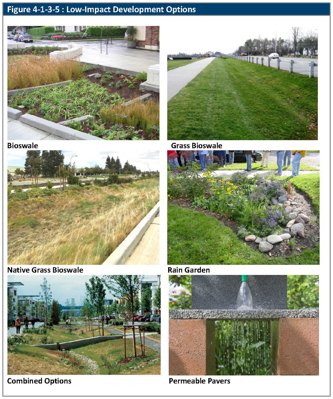
4-1-3-5. - Low-impact development practices.
A.
Purpose. The purpose of this Section is to encourage the incorporation of Low-Impact Development (LID) practices into site designs in order to mitigate the impacts of increased runoff and stormwater pollution from new development, redevelopment, and infill development as close to the source as practicable. LID practices, if designed and constructed correctly, help preserve permeable surfaces, remove pollutants, regenerate groundwater supply, and encourage the use of native plants.
B.
Low-Impact Development Options. The options below are encouraged to implement LID at the time of site development or redevelopment. The options are not intended to be prescriptive or to inhibit creative design. To implement the LID in order to reduce water quality treatment of stormwater runoff, the City's Municipal Separate Storm Sewer System Permit conditions must be met.
C.
Further descriptions and examples of LID options are in the Urban Drainage and Flood Control District, Urban Storm Drainage Criteria Manual, Volume 3 for the following:
1.
Bioswales are vegetated swales planted with wet tolerant species of plants or ornamental grasses. They transport, store, and allow infiltration of water, and can be designed as a landscape feature. Bioswales are not grassed, but are planted with a variety of plant species that can withstand occasional water inundation for short periods of time.
2.
Grassed swales are designed conveyance devices used to transport water over the surface of the ground to a point of disposal that may be a catch basin, ditch, or water body that will filter, infiltrate, evaporate, and clean water of total suspended solids, solid waste, and other pollutants. Swales are often appropriate along property lines, public streets, and around buildings.
3.
Rain gardens are small, shallow depressions planted with a variety of native or ornamental plants that can treat small amounts of runoff to improve water quality. Rain gardens are generally small collections of water-loving plants planted on a low site area to collect rainfall.
4.
Permeable pavers and porous surfaces allow water seepage through the joints and the gravel base beneath the pavers. This allows for the infiltration of rainwater, thereby reducing the runoff leaving a site. When used in conjunction with street tree planting, this allows for air circulation around tree roots and can easily be removed in order to trim tree roots and to regrade a walkable surface. Use of permeable pavers or porous pavement shall not be permitted in locations required for fire and emergency access unless specifically allowed by the City Engineer.
5.
Sand filters are depressions, trenches, barriers, or sand lenses constructed of porous matter that improves ground water recharge to filter, clean, and trap waterborne pollutants.
6.
Other Options.
a.
Other options include extended detention basins that may be used in open space tracts to treat the runoff from multiple lots, roads, and trails.
b.
Other LID options may be allowed as approved by the City Engineer.
(Ord. No. 4867, § 2, 2-12-2024)
4-1-4-1. - Purpose.
A.
Generally. New construction shall comply with the standards of this Division, unless compliance with a particular standard would prevent the construction of any permanent structure for a primary use on the land, or require the construction to violate another requirement of this LDC. Where more than one buildable site exists on a subject property and all buildable sites would violate at least one of the standards of this Division, the construction shall be located so as to comply with as many standards as possible.
B.
Disclaimer. These standards are considered reasonable for regulatory purposes and do not create liability on the part, or a cause of action against, the City.
(Ord. No. 4867, § 2, 2-12-2024)
4-1-4-2. - Limits of Development.
A.
The Limits of Development ("LOD") shall indicate the specific areas of a subdivision within which the development activity shall be contained in order to avoid areas identified in Section 4-1-4-3, Natural Hazard Areas, and features identified in Section 4-1-4-4, Significant Natural Features. LODs shall be indicated by the Applicant on the plat, and shall be reviewed and approved by the City as part of the development approval process based on:
1.
A visual analysis of the location and apparent extent of areas affected by natural hazards and significant natural features;
2.
Site topography, including but not limited to such characteristics such as steepness of slopes, existing drainage features, rock outcroppings, river and stream terraces, valley walls, ridgelines, and scenic topographic features;
3.
Any recommendations made by any other reviewing agency, including without limitation the U.S. Fish and Wildlife Service or the Colorado Division of Wildlife; and
4.
The practical needs of proposed construction activity in terms of ingress and egress to the developed project and necessary staging and operational areas.
(Ord. No. 4867, § 2, 2-12-2024)
4-1-4-3. - Natural hazard areas.
A.
If the subject property contains potential areas of natural or geologic hazard (such as unstable or potentially unstable slopes, faulting, landslides, or rockfalls) or soil conditions (including without limitation all expansive soils) unfavorable to development, or floodplains, the Applicant shall:
1.
Identify, on the plat, the LOD (as defined in Section 4-1-4-2, Limits of Development) and include a plat note that those areas are not available for development; or
2.
Provide a report from a geotechnical engineer licensed in Colorado identifying the mitigation measures or engineering precautions necessary to make such areas safe for development and occupancy, and include a plat note stating that development will be subject to those mitigation measures and engineering precautions; or
3.
Incorporate into the plat some combination of subsections (1) and (2) above.
(Ord. No. 4867, § 2, 2-12-2024)
4-1-4-4. - Significant natural features.
A.
Generally. If the subject property contains significant natural features (such as corridors, bluffs, ridges, steep slopes, stands of mature trees, rock outcroppings—including without limitation the Ralston Buttes—wetlands, native upland ecosystems, riparian areas, and wildlife corridors identified by the Colorado Division of Wildlife) or water features (such as drainages, washes, canals, ditches, lakes, natural ponds, and retention and detention ponds), the Applicant shall identify on the plat the Limits of Development as illustrated by Section 4-1-4-2, Limits of Development, include a plat note that areas outside the Limits of Development are not available for development, and incorporate measures to mitigate any visual, functional, or environmental impact of nearby development on such features.
B.
Groundwater Recharge. Any area providing groundwater recharge to bedrock aquifers shall be identified at the time of the development review, and the design of the proposed development shall preserve the total amount and the quality of naturally occurring recharge.
(Ord. No. 4867, § 2, 2-12-2024)
4-1-4-5. - Steep slopes and hazardous building conditions.
A.
Generally. New lots shall not be created on lands containing an average slope of 25 percent, as measured from the points with highest and lowest elevation within 25 feet of any portion of a proposed building, unless such lots designate a building envelope located to avoid such steep slope areas, and the location of the principal building is restricted to the building envelope. Roads and driveways leading to any primary or accessory structure may not be located on slopes in excess of 25 percent.
B.
Unstable Slopes and other Hazards. No new principal building, and no new accessory building (except mini-structures), shall be constructed in any location that shows evidence of slope instability, landslides, avalanche, flooding, or other natural or man-made hazards. If the City makes a preliminary determination that such evidence exists, the Applicant shall demonstrate, to the City's satisfaction, that the slope's ground surface and subsurface are not unstable, that the proposed development will not cause instability or increase the potential for slope failure, and that the development of the slope will not increase the degree of hazards.
(Ord. No. 4867, § 2, 2-12-2024; Ord. No. 4905, § 31, 8-19-2025)
4-1-4-6. - Ridgeline protection.
Residential dwellings on ridgelines identified through the development review process shall be sited and the buildings designed so as to not be prominent above any such ridgeline. A reduction in bulk or massing of the dwelling may be required, including limiting the height to one story and other suitable methods. Maintaining existing on-lot vegetation to provide a continuous screen or backdrop for the dwelling is also a suitable method.
(Ord. No. 4867, § 2, 2-12-2024)
4-1-5-1. - Protection of irrigation canals and ditches.
Where an irrigation canal or irrigation ditch is adjacent to or traverses a subject property, the City may require the Applicant to install walls, fences, or other methods for protective covering separating the lot or lots therefrom.
(Ord. No. 4867, § 2, 2-12-2024)
4-1-5-2. - Agreement required.
A.
Generally. The City does not adjudicate the relative interests of landowners and owners of irrigation canals and irrigation ditches (i.e., whether such interests are fee-simple or easement interests). As such, where development has the potential to impact an irrigation canal or irrigation ditch (e.g., by installation of an overhead, surface, or subterranean crossing); installation of infrastructure or improvements that may increase seepage (e.g., detention ponds in close proximity to the canal or ditch, or subsurface drainage systems); grading that could result in changes to the amount of stormwater runoff or pollution that reaches the canal or ditch; or improvements that increase the risk of trespass onto canal or ditch infrastructure or rights-of-way, including service roads), the Applicant shall provide to the City a fully executed agreement between the Applicant and the owner of the canal or ditch that is satisfactory to the City and addresses the impacts of the development on the canal or ditch.
B.
Street or Water and Sewer Utility Crossings. Any agreement related to crossing an irrigation canal or ditch for the purpose of providing public street access or accessing or obtaining water or sewer service from the City shall identify the City as an approved assignee and require prior written approval (or right to cure defaults in the event of provisions that allow for termination in the event of default) by the City for any modification or termination prior to said assignment.
(Ord. No. 4867, § 2, 2-12-2024)
4-1-5-3. - Irrigation ditch or canal crossings.
Technical design of irrigation ditch or canal crossings shall be approved by the City and unless the City or another entity is exercising its power of eminent domain to acquire the property interests necessary to install the crossing, the affected owner of the irrigation canal or irrigation ditch, prior to commencement of construction of the crossing.
(Ord. No. 4867, § 2, 2-12-2024)
4-1-6-1. - Restrictions on construction activities.
A.
Generally. The standards of this Section shall apply to all construction sites. The City Engineer may modify the requirements of Subsections B.1., E.3., E.4., F., and G., if the City Engineer finds that such modifications are necessary to provide for efficient, expeditious, and safe construction.
B.
Temporary Facilities.
1.
Temporary structures, portable offices, and other comparable buildings and structures shall be maintained in good repair and arranged in a compact and organized manner on the construction site, in a location that minimizes their visual impacts when viewed from the public street or adjacent properties.
2.
The timing of installation and removal of such facilities is subject to Section 3-1-4-3, Contractor Offices and Temporary Construction Uses.
C.
Tracking Control.
1.
Mud, dirt, or other debris deposited on the public or common roadway at construction access points shall be removed daily to avoid compaction and damage to the roadway and to minimize drainage system impacts.
2.
Cleaning of any construction equipment or tools on public streets, rights-of-way, or other vacant land is strictly prohibited.
D.
Debris Control.
1.
Construction debris shall be immediately placed into containers and screened to the extent possible during construction. Trash containers shall be emptied when full and on a regular basis, but not less than weekly.
2.
Dumping, burial of construction debris, debris pits, and burning of debris at any location is prohibited.
3.
After construction is completed, temporary barriers, surplus materials and all trash, debris and rubbish shall be promptly removed from the site.
4.
All backfill shall be cleared of building material, stone and rubbish prior to placement.
E.
Erosion, Siltation, and Dust Control.
1.
Precautions for controlling water and wind erosion and sedimentation are required during construction and shall be conducted as an integral part of the construction operation.
2.
Dust from topsoil and fill material that is stockpiled on site, as well as any areas disturbed by construction operations, shall be strictly controlled. All disturbed areas shall be stabilized.
3.
The City may require temporary diversion ditches, dikes, silt fences, filter boxes, tackifiers, and comparable facilities, in order to protect the site from erosion prior to completion of construction and establishment of permanent landscaping.
4.
Permanent surface and subsurface drainage systems shall not be used during construction unless entering water has been treated to remove suspended soil particles and other debris. To accomplish this, silting basins shall be installed at all locations necessary to intercept water before it enters catch basins and outfall locations. Silting basins shall be cleaned after each substantial rainstorm.
F.
Parking. No construction equipment shall be parked on the streets.
G.
Materials Storage. If equipment and materials are stored at the construction site, storage areas shall be unobtrusive when viewed from public streets and adjacent properties.
(Ord. No. 4867, § 2, 2-12-2024)
4-1-6-2. - Restoration of disturbed areas.
Disturbed areas shall be restored in accordance with City of Arvada Engineering Code of Standards and Specifications as may be amended from time to time.
(Ord. No. 4867, § 2, 2-12-2024)
4-2-1-1. - Purpose of article.
Generally. These regulations establishes the minimum standards for the land subdivision in order to facilitate the orderly growth and development of the City. The standards of this Article shall apply to all subdivision or re-subdivisions of land or air-space within the City, and any additional lands over which the City has control authority under C.R.S. § 31-23-212. No plat of a subdivision of land, or similar document pertaining to the division of air-space, shall be used for purposes of sale or building development until approved and recorded under the provisions of this Article.
4-2-1-2. - Application of article.
A.
Applicability and Exemptions.
1.
Unless otherwise expressly stated in a valid approved development agreement or annexation agreement, the provisions of this Article shall apply to the review and approval of a subdivision plat whenever any lot, tract, land parcel or air-space is created or divided into two or more lots, tracts, parcels, other land divisions, or air-space units for the purpose of sale or development.
2.
The standards of Articles 4-3, Site Design, 4-4, Access, Circulation, Mobility and Utilities, 4-1-4, Natural Hazard Areas and Environmentally-Sensitive Areas may be applicable in the layout and design of the subdivision. In addition, Article 8-4, Required Improvements, Dedications, and Fees may also apply. These Divisions and Article may also apply to a Master Plan that does not involve the subdivision of land if the Director determines that the proposed Master Plan development will create impacts similar to a subdivision of land.
B.
Exemptions. Review and approval of a subdivision plat shall not be require for the following:
1.
Any division of land to heirs through an estate proceeding.
2.
Any division of land created by lien, mortgage, deed of trust or other similar court action.
3.
Any division of land for sale as part of an approved cemetery, where the cemetery maintains property records as to the size, location, and ownership of the lots.
4.
Any transfer of land required by law.
5.
Any division of land by sale and purchase, dedication, eminent domain action, or any other method of conveyance, for the purpose of providing the City with land for street rights-of-way, parks, or other public use.
4-2-1-3. - Protection of existing vegetation, wildlife areas and natural features.
A.
General Requirements.
1.
The general layout of lots, roads, driveways, utilities, drainage facilities, and other services within all proposed subdivisions shall be designed in a manner that minimizes land disturbance and preserves existing trees, vegetation, watercourses, wildlife areas, and other natural features that would add value to the proposed development. The development standards set forth in Division 4-6-2, Tree Removal and Replacement, shall be considered in the layout of the subdivision in order to avoid creating lots or patterns of lots that will make compliance with such standards difficult or infeasible.
2.
Existing Trees On-Site. The determination of which existing site trees are to be saved, replaced, or relocated shall be made by the City, pursuant to Division 4-6-2, Tree Preservation and Replacement. No trees shall be removed from any subdivision or any change of grade of the land effected until approval of the plat has been granted. All trees on the platted area required to be retained shall be preserved, and all trees where required shall be welled and protected against change of grade.
B.
Geologic Hazard Areas and Protection of Natural Lands.
1.
General Requirements.
a.
All subdivisions shall comply with the standards in Division 4-1-4, Natural Hazards and Environmentally-Sensitive Areas.
b.
All subdivision plats shall be laid out with due regard to geologic hazards, including but not limited to existing soils, conditions, and slope stability. All subdivisions shall evidence design and use compatibility with existing soils, particularly in regard to topography, drainage, bearing capacity, and erosion potential. All subdivision design shall ensure adequate protection from potentially hazardous or undesirable soils or geological conditions on the development site.
c.
No subdivision shall be approved where the design or related facilities clearly constitute the creation of a hazardous circumstance or lack of provision for the public safety.
2.
Hazard Areas within Platted Lots.
a.
To the maximum extent feasible, lands that contain steep slopes (an average of 30 percent slope or greater as measured from the points with highest and lowest elevation within 25 feet of any portion of the proposed structure) or that show evidence of slope instability, landslides, avalanches, or other natural or man-made hazards shall not be included in platted lots, or alternately, shall not be included within the plats and/or an individual lot's identified Limits of Development. See Section 4-1-4-2, Limits of Development.
b.
Alternately, platted lots may contain such hazard areas only if an acceptable mitigation and remedial plan, prepared by a Colorado-licensed geotechnical engineer, is approved by the City Engineer. Such mitigation plans shall be judged by generally accepted principles of engineering adapted to the particular circumstances of the subdivision site. If approved, the plat shall include a plat note that all development in the subdivision shall be carried out in conformity with such mitigation and remedial plans.
3.
Floodplain.
a.
All subdivisions containing lands within the 100-year floodplain, as shown on the most current FIRM and FIS, shall comply with Division 4-1-2, Floodplain Regulations.
(Ord. No. 4867, § 3, 2-12-2024)
4-2-1-4. - Subdivision requirements and standards.
A.
General Requirements.
1.
Every subdivision shall comply with applicable zoning district, design and development standards in this LDC.
2.
Every subdivision shall comply with all other ordinances and regulations of the City of Arvada.
3.
Public infrastructure shall be constructed in accordance with the City of Arvada Engineering Code of Standards and Specifications as approved by the Director.
B.
Minimum Standards. The standards in this Article are minimum standards. The City may impose more restrictive standards when it finds that they are necessary to conform the design of a proposed subdivision to sound engineering or design standards or other standards in this LDC.
C.
Buildable Lots. All lots created through the subdivision process shall be developable and conform to the minimum zoning, development, and floodplain standards in this LDC. No subdivisions shall create lots that prohibit development due to configuration of the lots, steepness of terrain, location of watercourses or floodplain, natural physical conditions, or other existing conditions.
D.
Layout and Design. The design and layout of the lots shall be dependent upon topography, natural vegetation, soil conditions, drainage, street traffic, or other conditions. The following standards shall apply to:
1.
A subdivision of two or more lots;
2.
A division of a lot; or
3.
Combining lots.
E.
Lot Size and Configuration.
1.
Lot Area. The minimum area and dimensions of all lots shall conform to the requirements of the zoning districts and development standards relating to the zoning district in which the lot is located. See Chapter 2 of this Code.
2.
Lot Lines. Side lot lines shall be substantially at right angles or radial to street lines, except where other terrain makes such design impractical.
3.
Double Frontage Lots.
a.
Double frontage lots are discouraged in new subdivisions except where necessary to provide separation of residential development from parkways and arterials, or to overcome specific disadvantages of topography and orientation.
b.
If approved, double frontage lots shall have an average lot depth of not less than 130 feet.
c.
Unless waived by the Director, the owner/developer shall construct fences along the rear of double frontage lots. Such fences shall be six feet high, and composed of cedar picket fencing with brick posts not more than 60 feet apart, unless an alternate design or material is approved by the Director.
4.
Flag Lots. Flag lots and other irregularly shaped lots are discouraged in new and existing subdivisions.
5.
Corner Lots. Corner lots may be required to be wider than interior lots to provide for setback requirements.
F.
Drainage. Lots shall be designed and located to provide positive drainage away from all buildings, shall comply with the standards in Division 4-1-3, Stormwater and Drainage Control, and shall allow for the infiltration of stormwater runoff to the maximum extent feasible.
G.
Access.
1.
Every residential lot shall abut a public or private street or access easement. Access to residential lots shall be from local streets except as specifically authorized by the Director.
2.
For subdivisions, at least two points of vehicular access into a proposed subdivision shall be provided, where feasible, unless it can be shown to the satisfaction of the Director that legal, topographical, and/or engineering constraints preclude such access. The Director may allow for additional access supported by traffic impact study and meets all other design criteria.
3.
For lot splits, shared common access shall be provided to the maximum extent practicable.
H.
Block Layout and Length.
1.
Blocks shall normally be at least 400 feet in length and not more than 1,200 feet in length. The Director may approve a shorter or longer block length when necessary to accommodate natural features such as steep slopes, environmentally sensitive lands, and pedestrian linkages.
2.
Block lengths and widths shall be suitable for the uses contemplated and the zoning requirements pertaining to minimum lot sizes and dimensions.
3.
In blocks over 1,000 feet long, pedestrian, bicycle, and equestrian crosswalks may be required. Said crosswalks shall normally require a six and one-half foot width.
4.
Blocks along designated or planned parkways or arterial streets shall not be less than 660 feet in length, unless approved by the Director.
I.
Street Design. All public and private streets shall comply with the Article 4-4, Access, Circulation, Mobility, and Utilities, City of Arvada Engineering Code of Standards and Specifications, and the following standards:
1.
Coordination of Streets.
a.
All new collector and local streets shall connect with surrounding streets at safe and convenient locations as required by the Director to allow convenient movement of traffic and reasonable access for emergency vehicles.
b.
When connections to surrounding streets are proposed or required by the City, public right-of-way shall be dedicated and streets developed to existing paved rights-of-way.
c.
When developing adjacent to an existing RA or RN-32.5 zoning district where there is no paved street between the subdivision and an existing paved street, an interim street, improved in accordance with local street standards, shall be constructed by the Applicant for developments with densities in excess of one residential unit per acre of land.
d.
Whenever possible, proposed intersections along one side of a street shall coincide with existing or proposed intersections on the opposite side of such street. Where a centerline offset (jog) occurs at an intersection, the distance between centerlines of the intersecting streets shall be not less than required by the City of Arvada Engineering Code of Standards and Specifications.
e.
The street pattern shall not cause adjacent property to be landlocked nor prevent access to public land.
2.
Street Intersections.
a.
Streets shall be arranged in relation to existing topography to produce streets of reasonable gradient to facilitate adequate drainage and to produce desirable lots of maximum utility.
b.
Where a subdivision abuts or contains the right-of-way of a drainage way, a limited access highway, or an irrigation ditch, or abuts a commercial or industrial land use, the Director may require the location of a street approximately parallel to and on each side of this right-of-way at a distance suitable for appropriate use of the intervening land. This distance shall be determined with due regard for approach grades, drainage, bridges or future grade separations.
3.
Street Design Standards.
a.
Streets shall be related appropriately to the expected use of the property. Minimum requirements for street right-of-way, pavement width, and other standards for public and private streets are set forth in the City of Arvada Engineering Code of Standards and Specifications.
b.
Other designs and materials may be required for the construction of streets, curbs, and sidewalks when, in the determination of the Director, such methods would be more environmentally desirable or more in keeping with the design of the development or neighborhood.
c.
Turnarounds shall be provided at the ends of cul-de-sacs and at elbows on one-way streets. Turnarounds shall meet the minimum requirements of the Fire Protection District.
J.
Street Naming and Traffic Control Signs.
1.
Continuation of Existing Names. The City will assign a name subject to final plat, site plan or final development plan approval.
2.
Street Signage.
a.
All streets in a subdivision shall be named and identified by signs installed at every street intersection.
b.
These signs shall be standard street signs as indicated in the current edition of the Manual on Uniform Traffic Control Devices.
c.
All traffic control signs, as well as street name signs, required in a subdivision shall be provided and installed by the City at the expense of the subdivider in conformance with the current edition of the Manual on Uniform Traffic Control Devices, and any relevant Colorado state supplements.
K.
Sidewalks, Trails and Bicycle Paths.
1.
General Requirements.
a.
The layout and design of an interconnected system of sidewalks, trails, and/or bicycle paths shall be consistent with the City of Arvada Transportation Plan and Bicycle Plan, as amended, and all other adopted plans and policies.
b.
All subdivisions shall comply with the development standards set forth in Section 4-4-2-1, Pedestrian and Bicycle Access and Circulation.
c.
All subdivisions shall include an interconnected system of sidewalks, trails and or bicycle paths that directly connects to all uses, lots, open space areas, and parks.
2.
Trails.
a.
The owner/developer shall provide and construct pedestrian, bicycle, or equestrian trail rights-of-way in compliance with Section 4-4-2-1, Pedestrian and Bicycle Access and Circulation, and Section 8-4-3-6, Park and Trail Dedications and Fees-in-Lieu. Additional trail rights-of-way may be required where necessary for access to parks, schools, shopping areas, or other community facilities.
b.
Trails shall be eight feet wide, unless a wider trail is required by the City. All trails between lots shall be located within a minimum 40-foot wide landscaped strip, which 40-foot wide strip may be dedicated to the City or set aside as private, amenitized landscape surface area.
(Ord. No. 4793, § 3, 3-21-2022)
4-2-1-5. - Utility easements.
A.
All utility easements shall conform to the requirements of the appropriate utility company, unless inconsistent with the requirements of the City. Normally, these easements are as follows, unless it is unsuitable due to drainage, irrigation ditches, timber areas, or other obstructions.
1.
Non-exclusive utility easements shall be a minimum of eight feet wide within the front property lines running parallel and adjacent to all platted streets in and around the subdivision. Other additional easements, such as side lot line easements, may be required when the developer builds and points of service have become known.
2.
Drainage and Utility easements (eg., sewer, water, electricity, telephone, cable and wireless communications facilities) should measure eight feet wide along all rear property lines, five feet wide along the side of lots and eight feet wide along both sides of all streets. Easements adjacent to subdivided property should measure eight feet in width. Easements should normally be 16 feet in width, measuring eight feet on each side of abutting rear lot lines. Sanitary sewer and water line easements should be designed so that sewer and water lines flow under streets and not between lots.
3.
Easements required for street lighting should be five feet on all sides of the street light.
4.
In all cases, the owner/developer should consult with the utility company regarding requirements for a particular subdivision.
B.
Drainage Easements.
1.
Where a subdivision is traversed by a watercourse, drainage way, channel, stream or irrigation ditch, dedication of drainage easements or drainage right-of-way shall be required. Such easements shall conform substantially to the lines of such watercourse, and shall be of such width and construction, or both, as will be adequate for the purpose.
2.
The owner/developer shall dedicate, either in fee simple via plat or by drainage or conservation easement, land on both sides of existing watercourses, to a distance to be determined by the Director.
3.
To the maximum extent practicable, the drainage shall be maintained as an open channel with landscaped banks and shall be of adequate width for maximum potential volume of flow and for maintenance.
4.
Where topography or other conditions make the inclusion of drainage facilities within street rights-of-way impractical, perpetual and unobstructed easements at least 20 feet in width for such drainage facilities shall be provided across property outside the street lines and with satisfactory access. Easements shall be indicated on the plat. Drainage easements shall be carried from the street to a natural watercourse or other drainage facilities.
5.
When a proposed drainage system will carry water across private land outside the subdivision, appropriate drainage rights must be secured.
4-2-1-6. - Alternatives to subdivision standards.
Alternatives to the standards in this Article shall be subject to approval by the Director prior to approval of the subdivision application pursuant to Section 8-3-11-3, Administrative Minor Modifications.
4-2-2-1. - Cluster subdivisions.
A.
Generally. This Division provides optional standards for cluster subdivision development to create more compact development in order to preserve and protect sensitive lands, create amenitized landscape areas, and to implement the Comprehensive Plan and/or adopted specific area plans. A cluster subdivision is a residential or mixed-use subdivision in which some or all of the lots are allowed to be smaller (in area and width) than otherwise required for the underlying zoning district, in exchange for permanent protection of sensitive lands and/or open space.
B.
Zoning Districts Where Allowed.
1.
The cluster subdivision option is available in the R6, R13, and R24 zoning districts.
C.
Minimum Parcel Size. The minimum parcel size for a cluster subdivision shall be three acres.
D.
Cluster Subdivision Development Standards.
1.
All other standards in the LDC shall apply to cluster subdivisions unless modified by this Section.
E.
Identification and Maintenance of Protected Lands.
1.
Protected lands as defined in Section 4-1-4-2, Limits of Development, shall be identified on the final subdivision plat with a notation that indicates that those lands shall not be used for future development.
2.
Protected lands shall be identified with appropriate permanent signage markers in order to distinguish these areas from private lots.
3.
Protected lands shall be permanently maintained and preserved as:
a.
Open space tracts with deed restrictions;
b.
Land dedicated to the City;
c.
Land protected through a conservation easement; or
d.
Land protected by other means approved by the City.
4.
For any protected land not dedicated to the City, the developer shall provide a permanent mechanism acceptable to the City Attorney for the primary purpose of conservation, preservation, and management of protected lands.
5.
There shall be no further subdivision of land in an area approved for cluster subdivision; however, dedication of easements for public purposes may be permitted.
F.
Use of Protected Lands.
1.
Protected lands shall be left in an undisturbed natural state or landscaped pursuant to Section 4-6-5, Landscape Areas and Bufferyards.
2.
The protected lands shall be used for low-intensity recreation, agriculture, buffers, critical wildlife habitat, or other passive park or open space purposes.
3.
The use of protected lands may be further limited or controlled at the time of final approval where necessary to protect adjacent properties.
G.
Review and Approval of Cluster Subdivisions.
1.
The review and approval of cluster subdivisions shall follow the procedures for preliminary and final plats. The applicable procedure is dependent on the number of lots proposed in the cluster subdivision.
(Ord. No. 4793, § 3, 3-21-2022)
4-2-3-1. - Subdivision and boundary monuments.
A.
All subdivision and boundary monumentation shall comply with C.R.S. § 38-51-101, et seq.
4-2-3-2. - Street centerline control points (Range Points).
A.
Generally. The purpose of range point placement is to clearly, simply, and, as permanently as practical, mark the public right-of-way for the citizens of Arvada, the adjoining landowners, and the public at-large. Toward that end, the range points shall be placed so that two other range points are visible, via a line of sight contained entirely within the right-of-way, from any range point. The exception to this general rule shall be points set at the end of a cul-de-sac or a dead end street. These points require the defined visibility with only one other range point.
B.
Specific Placement Requirements.
1.
A range point shall be set at every intersection of the centerline of any street with the centerline of another street.
2.
One range point shall be set at the end of every cul-de-sac in accordance with Figure 4-2-3-2, Range Point Positions in Cul-de-sacs.
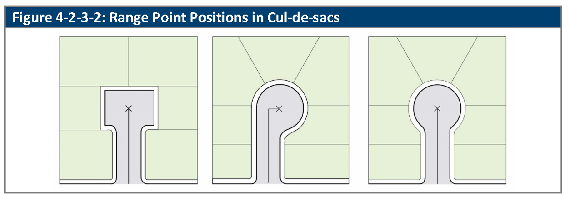
3.
If the visibility requirement cannot be met by setting the intersection and cul-de-sac end points, sufficient Points of Curvature along the centerline shall be set to meet the visibility requirement. If all Points of Curvature are set and the visibility requirement is still not met, then sufficient intermediate points shall be set along centerline to meet the visibility requirement.
4.
All points to be monumented shall be described on the plat of the subdivision.
C.
Monument Types.
1.
Gravel or Asphalt Streets. The monument shall be a metallic rod having a ⅝ inch minimum diameter, a minimum length of 18 inches and a 1½ inch minimum diameter metallic cap bearing the registration number of the professional land surveyor responsible for the establishment of the monument. The top of the monument shall be placed six inches below the finish grade of the road surface and inside a City-approved range box, the top of which shall be set flush with said road surface.
2.
Concrete Streets. The monument shall consist of a durable metallic disk, with a minimum three-inch stem, set above a metallic rod having a 5/8 inch minimum diameter and a minimum length of 18 inches. The top of the metallic disk shall be flush with the road surface, shall be firmly and permanently attached to that surface and shall bear the registration number of the professional land surveyor responsible for the establishment of the monument.
D.
Timing of Installation. All Range Points shall be set, and inspected and approved by the City, prior to the issuance of any Certificate of Occupancy within the subdivision.
4-2-3-3. - Identification and location of monuments on final plat.
A.
Generally. The final plat shall identify the exact location of monuments required by this LDC.
B.
Technical Requirements. The monument location information shall include the following:
1.
Description of points.
2.
Distance between points.
3.
Bearings on all exterior boundary and street centerline control and angles between all lot lines or repairs of these lines. In the instance of a lot line intersecting the arc of a curve at an angle of other than 90 degrees, an angle shall be given from the lot line to the long chord of the arc involved on the repair of the lot line.
4.
All curve data, including:
a.
Delta;
b.
Radius;
c.
Length of curve; and
d.
Long chord.
4-2-3-4. - Replacement of monuments.
Any monument or bench mark as required by this LDC that is disturbed before acceptance of all improvements shall be replaced by the owner/ developer at the owner/developer's expense.
4-3-1-1. - Purpose of article.
The purpose of this Article is to establish site design standards that address a development's relationship to its surrounding natural features and development patterns. They also address the relationship between key elements within the site. These standards address the physical relationship between the development and adjacent properties, public streets, neighborhoods, and the natural environment, in order to implement the Arvada Comprehensive Plan and the community's shared values and vision to ensure high-quality developments in the City of Arvada.
4-3-1-2. - Application of article.
A.
General Standards. The standards of Division 4-3-2, General Standards for Site Design, set out design objectives for all new development and redevelopment.
B.
Specific Standards. The standards of Division 4-3-3, Standards for Specific Development Types, set out design requirements for specific types of developments, as identified in each Section within the Division.
4-3-2-1. - Design objectives.
A.
Purpose and Intent. The design objectives of this Section are intended to result in plans that reflect high quality design that preserves important environmental resources, provides useable open space amenities, provides creative design in the layout of buildings, open space and circulation, design to complements the neighborhood character and social activities, and provides efficiency in the layout and provision of roads, utilities and other infrastructure. The principal objectives of this Division are to ensure that the elements of proposed development that are addressed by this Chapter 4, Environmental and Site Design, are appropriately configured.
B.
Objectives. Development shall result in harmonious, interrelated combinations of compatible buildings and uses that:
1.
Provide appropriate space for buffers and transitions between:
a.
Conflicting land uses; and
b.
Obvious changes in density or intensity between adjacent uses;
2.
Provide access and circulation and vehicular and pedestrian linkages among residential uses and recreational, institutional, retail, service, and office uses, with anticipated and planned future linkages to new development;
3.
Minimize impacts to water quality from runoff, erosion, or discharge of pollutants; and
4.
Recognize environmental constraints that affect the way land is developed by identifying specific areas affected by natural hazards, naturally steep slopes, wetlands, riparian areas, wildlife corridors, and floodplain.
C.
Contextual Design Objectives. If there is an identifiable development pattern in the immediate area of the development, then proposed development shall, to the maximum extent practicable, coordinate elements between adjacent sites, including:
1.
Reinforce the existing pattern and site features, particularly at the edges where the proposed development is not separated from existing development by a street or physical separation (i.e., railroad tracks, etc.);
2.
Provide shared driveways for accessing adjoining streets;
3.
Provide linkages of internal vehicular circulation systems;
4.
Provide linkages of interior pedestrian systems;
5.
Provide linkage/continuation of open space systems; and
6.
Integrate drainage and detention facilities.
4-3-2-2. - Landscape surface area.
A.
Generally. Development shall be designed with landscaped areas that support the resource values of the natural open space in terms of its ecological function (e.g., habitat, water quality enhancement, energy efficiency, etc.), aesthetic contribution, recreational value, and buffering value in accordance with Article 4-6, Landscaping and Buffering.
B.
Site Design. Site design shall be organized to include, protect or enhance the natural open spaces areas and landmark features of the site.
C.
Enhancement of Open Space/Open Space Corridors. Landscaped areas should be organized so as to create integrated systems that connect with dedicated school lands, parklands, other open spaces, or public lands or trails within the subject property or on adjoining property.
D.
Natural Resource and Hazard Areas. Natural resources such as water features including lakes, natural ponds, rivers, streams, wetlands, riparian areas, drainage ways, ditches, and flood hazard areas and vistas of natural features including distant peaks and ridges, steep slopes, existing tree canopy, wildlife habitat areas should be undisturbed.
(Ord. No. 4793, § 3, 3-21-2022)
Editor's note— Ord. No. 4793, § 3, adopted March 21, 2022, changed the title of § 4-3-2-2 from "Common open spaces." to read as herein set out.
4-3-2-3. - Landscape surface area, amenitized.
A.
Generally. Sometimes referred to as "common open space." Development shall be designed with amenities for the common use or enjoyment of residents, employees, or guests of the development. Any portion of the area intended to meet requirements of small urban parks (Section 4-3-3-4, Mixed-Use) must be publicly accessible. Amenities may include:
1.
Passive recreational facilities such as trails, community gardens, courtyards with seating, shaded picnic areas, scenic areas, open grassy areas large enough for recreation, or similar common areas; or
2.
Active recreational facilities such as pools, tennis courts, playgrounds, and clubhouses; or
3.
Commercial outdoor seating and dining areas, or similar common areas serving employees and/or guests.
B.
Accessibility. Areas shall be accessible to all residents, employees, or guests of a development and meet all design requirements of the Americans with Disabilities Act (ADA).
(Ord. No. 4793, § 3, 3-21-2022)
4-3-3-1. - Commercial.
A.
Generally. The standards of this Section shall apply to retail and office development in the CG zoning district that contains retail buildings with at least 50,000 square feet of cumulative gross leasable area.
B.
Pedestrian Plaza. Each such development shall include at least one pedestrian plaza at least 5,000 square feet in area as a visual and functional focal point of the development.
C.
Pedestrian Connections. For all uses, sidewalks or walkways serving the site shall be designed so that:
1.
Each point at which the system of sidewalks must cross a parking lot or internal street or driveway to make a required connection shall be clearly marked in accordance with the standards from the Manual on Uniform Traffic Control Devices (MUTCD), through the use of change in paving materials height, or distinctive colors; and
2.
Where sidewalks required above are providing pedestrian travel along private streets or drives, those sidewalks shall be detached from such private streets or drives for at least 50 percent of the linear distance of those adjacent sidewalks by a tree lawn at least eight feet in width. Sidewalks adjacent to parking spaces shall not be required to be detached; and
3.
All sidewalks shall be a minimum of five feet wide, or seven feet where there is adjacent perpendicular head-in parking.
4-3-3-2. - Residential.
A.
Generally. The standards of this Section apply to residential developments that include more than ten dwelling units, located in all residential zoning districts and the MX and OT zoning districts, where single-family, duplexes, townhomes, multiplex, and multifamily are permitted, as provided in the following Subsections.
B.
Arrangement of Landscape Areas and Buildings.
1.
Amenitized landscape areas shall be provided to the extent practicable and situated so that landscaped areas and outdoor recreation amenities are centrally located within the development.
2.
Principal buildings, such as club houses and recreational facilities, and landscaping shall, to the extent practicable, be located and designed so that residents can easily observe the buildings, landscaped areas, circulation paths, and access points into the development.
C.
Parking. For multiplex, townhome and multifamily development, at least 50 percent of required off-street parking shall be provided in garages or carports, rather than surface lots. Where surface parking lots are used, they shall to the extent practicable be located between or behind buildings, rather than adjacent to street frontages.
D.
Single-Family Detached, Duplex, and Multiplex.
1.
Generally. Single-family detached, duplex, and multiplex residential subdivisions shall be designed to mitigate the impacts of streets and paved areas on the neighborhood, and to provide comfortable alternative routes for pedestrians and bicyclists, including continuous sidewalks, tree-lined streets, and pedestrian-scaled details.
2.
Creation of Neighborhoods. Residential development that includes more than 200 dwelling units shall be designed to create identifiable "neighborhoods" of 30 to 100 units.
3.
Configuration of Lots. Lots shall be configured to maximize the number of lots that are:
a.
Within close proximity to an amenitized landscape area (e.g., playground or trail); and
b.
Connected by trails or common greens that do not cross streets.
E.
Townhome.
1.
Creation of Neighborhoods. Residential development that includes more than 200 dwelling units shall be designed to create identifiable "neighborhoods" of 30 to 100 units.
2.
Configuration of Lots. Lots shall be configured to maximize the number of lots that are:
a.
Within close proximity to an amenitized landscape area (e.g. playground or trail); or
b.
Connected by trails or common greens that do not cross streets.
3.
Buildings shall front on and align with:
a.
Adjacent streets; or
b.
Meet the minimum Non-Street Frontage Perimeter Setbacks identified in Table 2-1-8-7, Townhome Building Standards.
4.
Connectivity.
a.
Where there is a sidewalk, separation between buildings shall be a minimum of 20 feet wide to allow for a minimum five-foot wide sidewalk and landscaping
F.
Multifamily. The standards of this Subsection shall apply to all new multifamily residential development.
1.
Street Connectivity.
a.
Multifamily sites of ten acres or more shall include a minimum of one public street (or private drive that is built to City street standards), that is continuous through the subject property, and that connects to a public street on both ends.
b.
The Director may waive this requirement for a through-access street or drive, if it is demonstrated that:
i.
There are adequate alternatives available for residents and vehicles to travel through the subject property to adjacent properties and developments; or
ii.
There are no opportunities for a through-street to safely make such connections.
2.
Landscape Areas. Landscape areas shall be provided as follows:
a.
Large landscaped areas should be the fundamental organizing element of the site. Landscaped areas should be well defined by buildings and streets. Buildings should be oriented in such a way as to create courtyards and open space areas.
b.
Large existing trees and other natural features should be integrated into the landscape areas.
c.
Landscape areas should be centralized and directly accessible to a majority of the surrounding units. Where possible, it should be linked to adjacent parks, paths, and open space areas.
d.
The landscape areas shall be useable, non-riparian areas with slopes not exceeding 3:1.
3.
Site Amenities. In conjunction with the landscape surface area requirements, and the required small urban parks in the MX-S, MX-U and the MX-T zoning districts (See Subsection 4-3-3-4E), all multifamily projects shall provide site amenities from the list below for the residents. Amenities shall be centrally located for a majority of the residents, and may be located within the landscape areas. Multifamily projects with less than 50 units shall provide two of the amenities from the list below. Multifamily projects with more than 50 units shall provide three of the amenities from the list below.
a.
Plaza.
b.
Swimming pool.
c.
Sports court, such as tennis, basketball, or volleyball.
d.
Natural open space area with benches.
e.
Jogging trail.
f.
Fountain, art, or sculpture.
g.
Other amenity as approved by the Director.
(Ord. No. 4793, § 3, 3-21-2022)
4-3-3-3. - Clustered small housing.
A.
Generally. The standards of this Section apply to developments of the clustered small housing types that are described in Section 2-1-8-9, Clustered Housing Types.
B.
Common Green.
1.
Clustered housing types shall be organized around one or two amenitized landscape areas ("green(s)"), with no dimension that is less than the larger of:
a.
1.5 times the height of the tallest building that fronts on the common green; or
b.
20 feet, for micro homes or 30 feet for cottages.
2.
The common green(s) shall be developed and maintained to provide for passive and/or active recreation activities for the residents of the housing cluster.
3.
The common green(s) shall be centrally located and easily accessible to all dwelling units within the cluster.
4.
The common green(s) shall be surrounded by clustered housing types on at least two sides, which do not have to be opposite sides.
5.
Stormwater management facilities are allowed within a common green, if they do not adversely impact access to or use of the common green for all-season pedestrian access to the dwelling units, and for anticipated active and passive recreation activities.
C.
Front Porches.
1.
Cottages. Each cottage dwelling unit shall have a front porch that is not less than seven feet in any dimension.
2.
Micro Homes. Each micro home shall have a front porch that is not less than five feet in any dimension.
D.
Private Entry Yards.
1.
Each dwelling unit may have a private entry yard, in front of the building elevation that contains the primary entrance to the dwelling unit, that is:
a.
Not more than ten feet deep; and
b.
Enclosed with a fence that is not more than 36 inches in height in front of the front building plane, and not more than 60 inches in height behind the front building plane.
2.
Private entry yards may border the common greens, but are not included in the dimensions of the common green.
E.
Configuration. Housing clusters shall relate to both the street and to a common green, in that:
1.
Each building that is constructed along the principal street side of the subject property shall include architectural features that provide visual continuity with adjoining properties and visual interest from the street, such as a primary or secondary entrance or porch that is oriented to the street.
2.
Not less than 50 percent of the dwelling units shall front on a common green.
F.
Pedestrian Network.
1.
Pedestrian connections shall link all buildings to the street, common green(s), and parking areas.
2.
Pedestrian connections from parking areas to common buildings and the front doors of dwelling units shall traverse a common green.
3.
If housing clusters share a common building, see Subsection G., below, the pedestrian network shall connect the housing clusters.
G.
Common Building. A common building with amenities is allowed within clustered housing developments. Amenities may include a kitchen, meeting area, common dining area, indoor recreation facilities, storage (provided that other amenities are also provided in the building), and up to two guest bedrooms. Up to two housing clusters that are connected with pedestrian pathways may share a common building, unless the size of the common building and provided amenities are designed to accommodate additional clusters, the common building is centrally located and within 600 feet of all dwelling units, and the common building is connected to the clusters by pedestrian pathways.
H.
Individual Storage Buildings. One individual storage building is allowed for each dwelling unit, provided that:
1.
The storage building is not more than ten feet in height, measured from grade to the peak of the roof;
2.
The storage building is not more than 80 square feet in floor area;
3.
The storage building is located behind the dwelling unit, and set back:
a.
20 feet from any street; and
b.
Five feet from any boundary of the housing cluster and
4.
The storage building is screened from the street and a common green.
I.
Parking Design.
1.
Generally.
a.
Required parking shall be provided in shared surface parking lots, covered parking spaces in shared parking lots, shared detached garage buildings, or directly accessed from an alley.
b.
No parking space or drive aisle shall be located between a front building elevation and a common green.
c.
For alley accessed parking, parking spaces shall be located between the alley and rear building planes, and shall not extend into side or front yards of individual buildings.
2.
Surface Parking and Covered Parking Spaces.
a.
Surface parking and covered parking spaces shall be set back from streets as provided in Section 2-1-8-9, Clustered Housing Types.
b.
Surface parking and covered parking spaces shall be screened from the street and the common green(s) and from individual units with a parking lot bufferyard as provided in Section 4-6-6-3, Parking Area Landscape.
c.
Surface parking spaces shall be distributed on the site to minimize visual impacts and optimize access to individual units.
3.
Shared Detached Garage Buildings.
a.
Shared detached garage buildings may not exceed four overhead doors per building, and a total floor area of 1,200 square feet.
b.
Shared detached garage buildings shall be reserved for the parking of vehicles owned by the residents of the development.
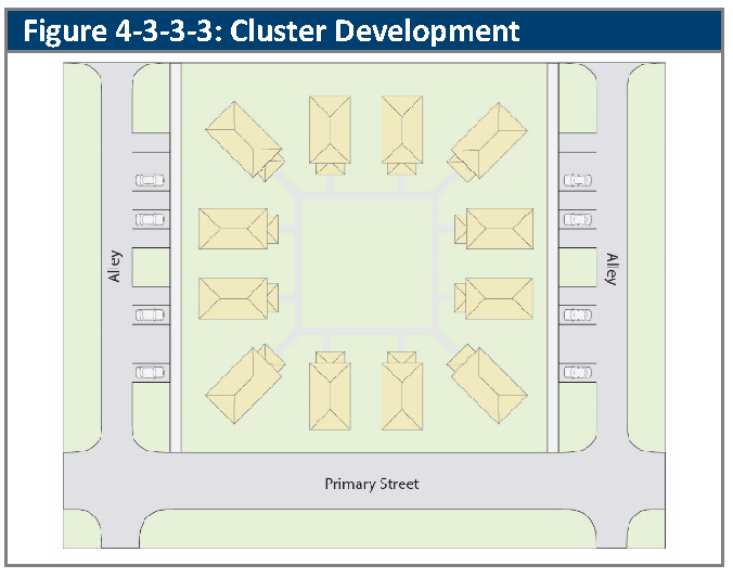
(Ord. No. 4793, § 3, 3-21-2022)
4-3-3-4. - Mixed-use.
A.
Generally. The standards of this Section apply to all development in the MX-S, MX-U, and MX-T zoning districts.
B.
Design Principles.
1.
Buildings shall, to the greatest extent practicable, front on and align with streets, including, if applicable, new streets within the development.
2.
If the subject property is greater than 30 acres, the development shall be oriented towards a small park, green, plaza, or public square which should serve as a focal point of the development.
3.
In locations where mixed-use developments are located adjacent to existing housing, the housing types that adjoin each other should be complimentary to the existing housing types.
C.
Street Network Design Principles.
1.
Streets and blocks should be organized in a generally rectilinear pattern. However, a strict grid is not required, and street layout should take into account the following:
a.
The design and location of streets should minimize the alteration of waterways, natural resources, and significant natural features of the subject property;
b.
Streets, alleys, sidewalks, and trails should provide multiple travel routes within and through the development; and
2.
Streets should provide for a balanced mix of pedestrian, non-automobile, and automobile travel routes.
3.
Squares, greens, parks, plazas, and landscape areas should be included in the block patterns of the blocks for all residential areas.
D.
Access and Parking.
1.
Access. Service access to buildings should be in the rear provided by alleys or other service routes.
2.
Parking.
a.
New streets should provide for on-street parking.
b.
Off-street parking for nonresidential and mixed-use buildings should be located behind principal buildings; or between buildings, provided that not more than one parking module separates buildings, and the parking lot is screened from adjacent streets by a parking lot bufferyard, except at points of ingress and egress.
c.
Above ground parking garages shall meet the following standards:
i.
The minimum setback for a parking garage shall be the same as what is required for the principal structure.
ii.
Where the top parking level of a parking garage is not enclosed, lighting for the top parking level may not exceed 12 feet above the parking surface.
iii.
The façade of the parking structure should use architectural enhancements and façade treatments to reduce the scale and balance building proportions with adjacent structures to minimize visual impact.
iv.
Each façade facing a public street shall be designed to conceal the view of all parked cars below the hoodline and the view of internal light source, when viewed from the street frontage.
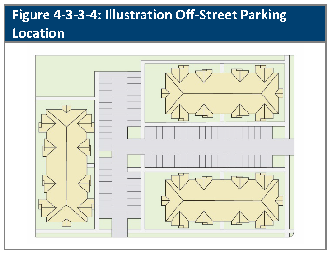
E.
Small Urban Parks.
1.
Generally. Small Urban Parks are typically privately-owned areas intended to provide publicly accessible park space within parts of the City that are planned or developed at an urban scale. These parks are located in urban centers, transit-oriented developments, and infill development parcels where development with higher densities is planned.
2.
Small Urban Parks shall complement and integrate with surrounding uses to serve the park needs of the residents:
a.
To provide a place for social interaction and leisure opportunities; and
b.
To create focal points and activity nodes within the urban fabric of the area.
3.
Small Urban Parks include:
a.
Open greens/spaces of predominantly lawn areas for unstructured recreational use partially surrounded by streets and the fronts of buildings.
b.
Squares which adjoin streets on two sides and are surrounded by the fronts of buildings with a prominent feature designed as a centerpiece of the space having formally arranged walks and landscaping.
c.
Plazas which are predominately paved, open-air spaces enclosed on two or more sides by buildings and bounded by one or two streets.
d.
Promenades which are set aside as principal means of access to and through an urban setting for pedestrians and bicyclists, facilitating connectivity between public streets, private property and civic destinations.
4.
General Design Standards.
a.
Small Urban Parks should be open to public use during typical City park operation hours.
b.
Small Urban Parks should serve as landmarks, focal points and centers of activity relative to other complementary uses.
c.
Entry points into the Small Urban Park should be highly visible and inviting.
d.
Small Urban Parks should be appropriately scaled pedestrian-oriented spaces designed to accommodate short-term formal activities.
e.
Small Urban Parks may be established for commemorative or identity purposes having a central focal point with hardscape and softscape design elements that focus attention on a monument or public art.
f.
Access to the park should be by walking, bicycling, and public transit.
g.
When a Small Urban Park is in the vicinity of ground floor residential, retail, office and civic building, the park should be defined by landscaping in beds or planters; low open-style fences; walls functioning as seating space; stairs/steps; or distinct paved surfaces serving as pedestrian zones around its perimeter.
h.
Expansive paved areas and key pedestrian zones in the park should have a distinctive surface or pattern that provides an organizing framework to the nature of the site and relates it to other public areas in the development.
i.
Small Urban Parks should be designed and constructed with high quality materials that are durable and convey a consistent visual image and sense of identity for the community as a whole as well as the immediate development area.
5.
Programmatic Elements.
a.
The following programmatic elements shall be provided within all Small Urban Parks.
i.
ADA-compliant internal circulation;
ii.
ADA-compliant connections to adjacent trails and rights-of-way;
iii.
Benches, chairs, or other seating, such as seating walls, to accommodate a minimum of one seated person per 500 sq. ft.;
iv.
Specialty paving, texture or colored hardscape, general mix of materials to accent entrances;
v.
Vegetative landscaping in beds, planters, or tree wells to complement hardscaping, to include a mixture of trees, shrubs, grasses, and flowering plants that provide four season interests;
vi.
Trash receptacle(s) at a minimum of one per 2500 sq. ft.; and
vii.
Pedestrian-scale lights for visitor safety.
b.
The following features of a Small Urban Park may count toward satisfaction of park land dedication requirements. For every 2,000 sq. ft. of required park area, at least one of the following shall be provided:
i.
Enhanced vegetative coverage - one evergreen or canopy tree, or two ornamental trees per 1,000 sq. ft. (groupings are allowed) and a minimum vegetative ground cover at maturity of 30 percent including shrubs, perennials, annual plantings, and turf. Pots and planters may include in area calculations.
ii.
Open turf area with a minimum of 500 sq. ft.
iii.
Public art - sculpture, wall mural, usable art, such custom artistic benches, planters, or other amenities.
iv.
Shelter or shade structure - gazebo, arbor, or similar structure.
v.
Play sculptures or play equipment.
vi.
Interpretive display - interpretive signs/historic signage/roofed sign.
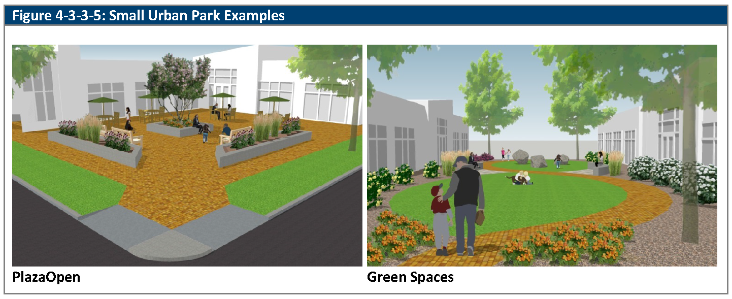
F.
Fueling/Service Station Site Design. In mixed-use zone districts, a fueling station shall be subject to the following:
1.
In the MX-S zoning district, the pump canopy may be located anywhere on the site outside of the required setbacks and landscape areas. The retail building or convenience kiosk associated with the fueling station shall meet the Frontage Zone requirements, per Table 2-1-4-2A.
2.
In the MX-U zoning district, the retail building or convenience kiosk associated with the fueling station shall meet the Frontage Zone requirements, per Table 2-1-4-3A, except that the building or kiosk shall only be required to meet 50 percent of the Frontage Zone requirement. The pump canopy shall be located behind or to the side of the building or kiosk.
3.
In the MX-T zoning district, a pump canopy shall only be located behind a building, or a convenience store or kiosk associated with the fueling station, that meets the Frontage Zone requirements, per Table 2-1-4-4A.
(Ord. No. 4905, § 32, 8-19-2025)
4-3-3-5. - Outdoor storage.
A.
Outdoor Storage, IL and IG Zoning Districts.
1.
Rear and Interior Side Setbacks. Outdoor storage shall be set back as required for the principal building, except:
a.
In the IL zoning district, where it may extend into the required rear setback area, up to the inside boundaries of any required bufferyards; and
b.
In the IG zoning district, where it may extend into any required interior side or rear setback area, up to the inside boundaries of required bufferyards.
2.
Front and Street-Side Setbacks. Outdoor storage uses in the IL and IG zoning districts shall be set back not less than 25 feet from front and street side property lines.
B.
Outdoor Storage, CG Zoning District.
1.
Front, Interior Side, and Street Side Setbacks. Outdoor storage areas shall be located behind the principal building. Outdoor storage shall be set back as required for the principal building.
2.
Rear Setbacks. Outdoor storage may extend into a rear setback up to the inside boundary of any required bufferyard.
C.
Configuration and Screening of Outdoor Storage Areas.
1.
Outdoor storage areas shall be screened from view from streets and adjacent property by a Type C or D bufferyard, per Section 4-6-5-3, Bufferyard Options, and/or the principal building. In the IG and IL zoning districts within the area south of West 60th Avenue and east of Lamar Street, the bufferyard is not required along interior property lines.
2.
The fence or wall that is used in the required buffer yard may exceed the maximum height allowed where the difference in grade between the right-of-way and the outdoor storage area makes a taller fence necessary to effectively screen the area.
3.
If outdoor storage areas include covered accessory structures, then the covering shall include at least one of the predominant exposed roofing colors of the principal building.
4.
Outdoor storage areas shall be accessible using an access drive that is not less than 22 feet in width.
D.
Restrictions on Use of Outdoor Storage Areas.
1.
Permitted hours of operation shall be 7:00 a.m. to 7:00 p.m.
2.
Outdoor storage areas shall only be used for the storage of operable equipment or materials used for the conduct of an approved use located on the same lot.
3.
Outdoor storage areas shall not be used for the storage of junk, inoperable vehicles or equipment, hazardous materials, refuse, or waste, except:
a.
As may be specifically allowed as a component of the approved use of the subject property (e.g., a salvage yard), provided that no storage or accumulation of waste products, including paint, stain, oils, grease, or other flammable, toxic, or hazardous materials, shall be permitted as part of any storage yard use if they exceed the currently adopted fire code requirements; or
b.
For a period of ten days, junk, inoperable vehicles or equipment, refuse, or waste may be stored, provided that:
i.
They were created as a result of the approved use of the subject property;
ii.
They are kept in appropriate containers to prevent windblown or waterborne debris; and
iii.
They are permanently disposed of or recycled after the 10-day period elapses (e.g., a contractor may store scrap materials from a job site for up to ten days, after which they must be transferred to a proper recycling or disposal facility).
4.
Flammable liquids or gases in excess of 1,000 gallons may be stored if they are integral to the principal use, and stored underground according to all applicable legal requirements.
5.
Outdoor storage areas shall be graded and maintained, and stored items shall be covered or arranged to prevent standing water from accumulating.
(Ord. No. 4905, §§ 33, 34, 8-19-2025)
4-4-1-1. - Purpose of article.
The purpose of this Article is to promote safe and efficient access to development and circulation within development, to provide for the efficient and hierarchical layout of streets, to provide for connections to transit services, and to ensure that development is served by appropriate utilities.
4-4-1-2. - Application of article.
A.
Generally. The divisions within this Chapter are applied as follows:
1.
Division 4-4-2, Access and Site Circulation, sets out standards for how access to a subject property is to be provided, and how the circulation system within the subject property is to be designed.
2.
Division 4-4-3, Streets, establishes standards for the layout of streets.
3.
Division 4-4-4, Transit, establishes standards for connectivity to transit stops.
4.
Division 4-4-5, Utilities, establishes standards for the provision of utilities and utility easements.
B.
Fire Codes. The access standards set out in and referred to by Division 4-4-2, Access and Site Circulation, may be modified by the City where necessary to ensure compliance with the current adopted Fire Code.
4-4-2-1. - Pedestrian and bicycle access and circulation.
A.
Generally. Pedestrian and bicycle access shall be designed and located as provided in this Section.
B.
Trails. Pedestrian, bicycle, and equestrian trails shall be constructed where indicated in the City's adopted Trails Plan and/or Bicycle Master Plan policies, and shall be designed and constructed to adopted City standards. Bicycle lanes shall be constructed where indicated in the City's adopted Bicycle Master Plan, and shall be designed and constructed to adopted City standards. Specific locations on a subject property may be determined at the time of development approval in order to promote the efficient development of the property.
C.
Pedestrian Connections.
1.
All primary entrances of principal buildings containing nonresidential (except agricultural) or mixed-uses, and each entryway serving dwelling units in a multifamily building, shall have direct accessible connections (access without having to cross a street) to a sidewalk, walkway, or trail that leads to a sidewalk adjacent to each public street that adjoins the subject property, between each principal building in the development, and to all existing or planned transit stop or park-n-ride locations identified by Regional Transportation District (RTD). Each such sidewalk, walkway, or trail shall be a minimum of five feet wide, or a minimum of seven feet wide where it is adjacent to areas where parked cars may overhang the walk or trail.
2.
Each proposed development that will include parking areas that extend more than 250 feet from the principal building shall provide a designated walkway from the row of parking furthest from the principal building to a principal building entrance used by residents, employees, or the public, or to a sidewalk leading to such entrance. Such walkways shall be distinguished from surrounding parking areas by changes in color or texture, raised surfaces, or landscaped edges.
D.
Bicycle Access. In developments containing nonresidential uses or multifamily uses, bicycle access routes shall be provided between public bicycle lanes or trails and on-site bicycle parking areas. Sites shall be designed to avoid or minimize all conflicting bicycle/motor vehicle and bicycle/pedestrian movements. All bicycle trails connecting to the Arvada park, open space, and trail system shall be constructed of concrete, and shall comply with City trail width requirements.
E.
Combined Trails. If a bicycle access route is combined with a pedestrian sidewalk, the combined path shall be at least ten feet wide if detached from the street, or 12 feet wide if attached to the street.
4-4-2-2. - General vehicular access and circulation.
A.
Generally. Vehicular access and site circulation shall be in accordance with the standards of this Section.
B.
Vehicular Access.
1.
Vehicular access to and from public streets is subject to the applicable standards of the City's Transportation Standards in the Engineering Code of Standards and Specifications.
2.
Driveways shall be consolidated to the greatest degree possible to reduce the number of sidewalk/driveway crossing points.
C.
Site Circulation. The circulation system (i.e., streets, alleys, service drives, access points, sidewalks, trails, and parking and loading areas) within the subject property and at points of connection to other properties or rights-of-way shall provide for the safe, efficient, convenient, and functional movement of vehicles, bicyclists, and pedestrians. These objectives shall be implemented such that the circulation system:
1.
Provides users the necessary sight distances, stacking space, and traffic control devices to ensure the safest and most predictable system of parking and circulation;
2.
Includes clearly defined points of ingress and egress that promote the orderly, safe, and logical movement of traffic within the subject property and on adjoining streets;
3.
Provides for emergency vehicle access (unobstructed by parking or loading areas), and sufficient areas to allow the staging of emergency rescue or fire-fighting efforts;
4.
Logically connects adjoining properties where appropriate;
5.
Minimizes the number of vehicular turning movements and points of vehicular conflict (particularly at access points); and
6.
Minimizes points of potential conflict between pedestrian and vehicular traffic.
4-4-2-3. - Truck and service access and circulation.
Truck and service access and circulation routes shall be designed to minimize potential traffic and noise conflicts with adjacent sites, walkways between sidewalks and principal building entrances, and internal circulation routes. Wherever possible, truck and service access to nonresidential uses shall not be from local residential streets.
4-4-3-1. - Purpose and applicability of division.
A.
Purpose. The purpose of this Division is to create an adaptable and well-connected transportation system that provides superior access to all sidewalks, trails, bike lanes, transit, and streets, that minimize impacts on air quality, and that reduces reliance on the automobile.
B.
Applicability. The standards of this Division shall apply to all development in the City, except insofar as they are in conflict with more specific standards that are applicable to the development.
4-4-3-2. - Major street plan.
A.
Generally. The layout of streets, highways, sidewalks, and trails shall comply with the Arvada Comprehensive plan, all adopted transportation plans, and the provisions of this LDC.
B.
Design Standards.
1.
The design of public streets shall reflect the nature and function of the street in relation to the proposed and existing surrounding land uses.
2.
Design and construction of public streets shall comply with the Transportation Standards in the Engineering Code of Standards and Specifications.
3.
All streets shall be designed to avoid steep grades and deep cuts to the maximum extent feasible given the site's natural topography.
4-4-3-3. - Intersection visibility.
A.
Generally. In all zoning districts, on any corner lot, nothing shall be erected, placed, parked, planted, or allowed to grow in such a manner as materially to impede visibility at the intersection.
B.
Minimum Sight Distances.
1.
The minimum sight distances shall be in compliance with the Transportation Standards in the Engineering Code of Standards and Specifications and the current standards of the American Association of State Highway and Transportation Officials (AASHTO "Green Book")
C.
Sight Triangles at Driveways. On the front property line of any lot or tract, no structure, fence, wall, sign, or planting that will obstruct vision between a height of 24 inches and eight feet above the driveway or above the grade of the approach lane shall be erected, placed, or maintained within the triangular area formed by the edge of the driveway and the front lot line, extending a distance of five feet into the lot along the driveway, and ten feet along the front lot line away from the driveway.
D.
Modification of Sight Distances and Sight Triangles.
1.
The Director may modify the minimum sight distances set out in Subsection B., above, where accepted engineering practice would indicate that a modified distance either greater or lesser, would be appropriate or necessary to protect public health, safety or welfare.
2.
The Director may modify the provisions of Subsection C., above, during the development approval process in order to allow for fences, walls, or plantings, if the Applicant demonstrates that the movement can be made safely considering sight distance, anticipated pedestrian and bicycle movements, and street geometrics.
4-4-3-4. - Street hierarchy and connectivity.
A.
Generally. Street and block patterns shall be consistent with the City's Transportation Plan, and should include a clear hierarchy of well-connected streets that distribute traffic over a multiple number of streets and avoid traffic congestion on major streets. Within each development, the access and circulation system should accommodate the safe, efficient, and convenient movement of vehicles, bicycles, and pedestrians through the development, and provide opportunities to link to adjacent neighborhoods and properties.
B.
General Distribution of Streets within the Street Hierarchy. Arterial streets, major collector streets, and minor collector streets shall be arranged generally in accordance with this Subsection (see Figure 4-4-3-4A, Illustrative Distribution of Arterial, Major Collector, and Minor Collector Streets, for illustrative example).
1.
Arterial Streets. Arterials are located at approximately one mile intervals in both east-west and north-south directions. Within each one-mile segment, arterials will align and connect across intersecting arterials to distribute traffic and provide continuity for designated bicycle routes.
2.
Major Collector Streets. Within each one mile segment, at least one collector street shall divide the segment east-west and another shall divide the segment north-south at approximately the half-mile points, and these major collector streets shall intersect the arterials within 110 feet of the half-mile points, resulting in areas of approximately 160 acres.
3.
Minor Collector Streets. For residential neighborhoods, within each approximately 160 acre area defined by major collectors, at least one minor collector street giving access to its interior shall be provided on every perimeter street of the area unless prevented by an obstacle. These minor collector streets should connect with each other through such 160 acre area to define four areas of approximately 40 acres each.
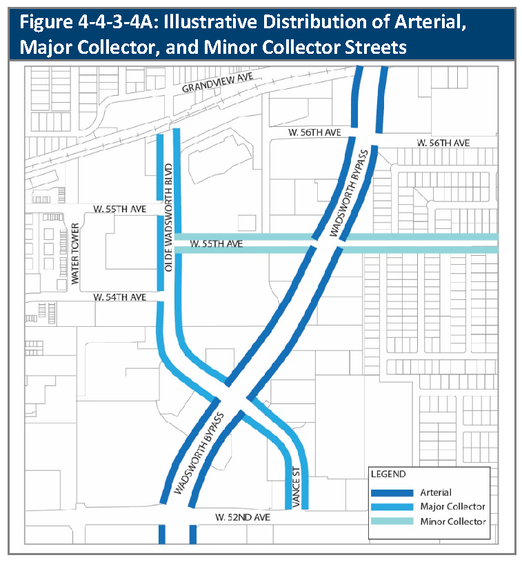
C.
Local Streets. For each generally 40-acre area, at least one local street giving access to its interior shall be provided on every perimeter street of the area unless prevented by an obstacle. Such streets should connect across other local streets depending on the land use relationship.
D.
Connectivity. Where property is to be developed and streets are stubbed to the property or where arterial, collector, or local streets are designated to connect to the property, the City may require rights-of-way and construction of those streets through and into the area contained within the development application.
E.
Access to Public Streets. All new lots shall have direct or indirect access to a public street, through one or more access points approved by the City. Indirect access may be provided through auto courts, loop lanes, or private streets, subject to approval of the fire district with jurisdiction over the subject property.
1.
Single-family detached and duplex buildings shall not have individual driveway access to an arterial or collector street, unless no other alternative is reasonably available.
2.
In the CN zoning district, parking areas for uses identified as Conditional shall have access to only an arterial or collector street, unless an alternative is allowed at the discretion of the City Council.
3.
All public and private streets shall comply with all applicable design and construction standards adopted by the City.
F.
Access and Driveways. All new lots and developments shall have access streets constructed in compliance with the Transportation Standards in the City's Engineering Code of Standards and Specifications. Single-family detached and duplex unit driveways shall not take direct access from arterial streets or collector streets, unless no other alternative is available. All access points shall be constructed so that:
1.
Vehicles may safely enter and exit the property;
2.
Interference with the convenient flow of traffic and conflict with pedestrians and bicycles is minimized; and
3.
Driveways shall be hard-surfaced with materials such as asphalt, concrete or other equivalent surface pursuant to the City's Engineering Code of Standards and Specifications. Recycled asphalt, gravel or other similar surfaces are not an approved surface. The surfacing requirements shall not apply to access drives on lots or tracts of three-quarters of an acre or more where the property structure is a single-family home and the access drive is more than 100 feet in length, or the access drive is for an accessory agriculture use.
G.
Cross-Access between Adjacent Uses. All multifamily and nonresidential development shall be designed to allow for cross-access to adjacent properties to encourage shared parking and shared access to public and private streets. This may be accomplished by one or more of the following:
1.
Connecting streets and drives;
2.
Coordinating parking lot and parking structure entrances;
3.
Providing common service and delivery areas;
4.
Providing shared parking areas; and
5.
Providing share driveways and access points for adjacent lots to minimize curb cuts.
The Director may allow alternatives to cross-access requirements if providing cross-access is deemed impractical, provided the Applicant provides adequate bicycle and pedestrian connections between adjacent development or land uses.
H.
Auto Courts. Up to four single-family detached dwelling units may share a single driveway access to a public street through the use of an auto court layout (see Figure 4-4-3-4B, Auto Courts Layout), provided that:
1.
The minimum width of the surface of an auto court shall be 20 feet unless a wider width is required by the fire district with jurisdiction over the subject property.
2.
Shared driveways shall be surfaced with concrete, not asphalt.
3.
Individual driveways leading from the shared driveway to each dwelling unit shall be at least 20 feet long, as measured between the front of the garage or carport and the closest edge of the shared driveway.
4.
The design of the auto court shall permit a passenger vehicle to back out of an individual driveway and turn 90 degrees using the individual drive or intersecting street.
5.
The auto court design shall comply with all off-street parking requirements applicable to single-family dwellings. In addition, each auto court design shall provide one-half off-street parking space per dwelling unit, in a location other than a private driveway.
6.
The Applicant must provide for private ownership and maintenance of the auto courts. Provisions for the private ownership and maintenance and repair of shared driveways shall be approved by the Director during the development approval process.
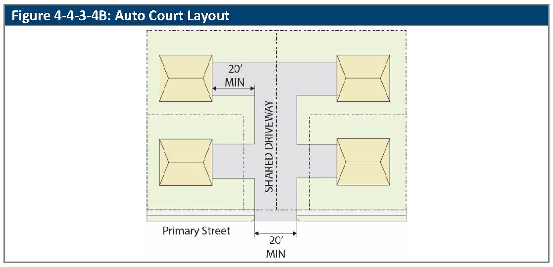
I.
Loop Lanes. Up to seven single-family dwelling units may share access to a public street through the use of a loop lane layout provided that:
1.
The surface of the loop lane shall be at least 20 feet wide, and shall be surfaced with concrete, not asphalt.
2.
No portion of the loop lane shall extend more than 250 feet from the public street to which the loop lane gives access.
3.
The common area surrounded by the loop lane shall be at least 60 feet wide.
4.
Individual driveways leading from the loop lane to each home shall be at least 20 feet long, as measured from the closest edge of the loop lane.
5.
Traffic on the loop lane shall be one-way only and shall be adequately signed as a one-way drive.
6.
The design of the loop lane shall permit a passenger vehicle to back out of an individual driveway and turn 90 degrees in either direction using only the individual driveway, the loop lane, or the intersecting public street.
7.
The loop lane design shall comply with all off-street parking requirements applicable to single-family dwellings. In addition, each loop lane design shall provide one-half off-street parking space per dwelling unit, in a location other than a private driveway.
8.
The Applicant must provide for private ownership and maintenance of the loop lane. Provisions for the private ownership and maintenance of both the loop lane surface and the common area surrounded by the loop lane shall be approved by the Director during the development approval process.
J.
Private Streets. The use of private streets is discouraged. Where allowed by the Director, private streets shall comply with all standards for the design of public streets of the same function adopted by the City. The Applicant must provide for private ownership and maintenance of the private streets. Provisions for the maintenance of private streets shall be approved by the Director during the development approval process.
K.
Alleys.
1.
The use of alleys is encouraged for development that is residential or predominantly residential in the RA, RN, R6, R13, R-24, MX-S, MX-U, MX-T, and PUD zoning districts. Where alleys are used, they shall comply with the following standards:
a.
The minimum right-of-way width of a residential alley shall be 16 feet.
b.
The minimum right-of-way width of a commercial or industrial alley shall be 20 feet.
c.
Residential alleys shall connect through the block to a publicly dedicated street on each end and must provide access to at least 50 percent of the garages on lots adjacent to the alley.
2.
The City may require alleys in the following circumstances:
a.
Along the rear lot lines of a multifamily development if the area of lots as subdivided will permit three or more dwelling units;
b.
Along the rear lot lines of all lots fronting on a major arterial street; and
c.
At any other location the Director or Decision-Making Body deems necessary.
3.
The Applicant must provide for private ownership and maintenance of the alley. Provisions for the private maintenance of alleys shall be approved by the Director during the development approval process.
L.
Cul-de-Sacs. A cul-de-sac may not exceed 500 feet in length, measured from the center of the intersection to the center of the turnaround. Where a parcel's size or shape makes a 500-foot limitation impractical, the Director may approve a longer cul-de-sac provided that there is no reasonable alternative.
1.
A "T" or "Y" design, or other acceptable design to provide a turn-around may be used if approved by the Director provided that the street does not exceed 200 feet in length
2.
No more than 20 lots may be located on a cul-de-sac. Cul-de-sacs that serve more than 20 lots require approval of the Director and the fire district with jurisdiction over the subject property.
M.
Utilities. All street and alley development shall accommodate all utility easements, service, and utility cabinet locations. Utility service cabinets and ground mounted equipment should be located in the least visible and least intrusive locations possible and shall be screened with evergreen shrubs or evergreen trees.
(Ord. No. 4851, § 3, 7-10-2023; Ord. No. 4905, §§ 35, 36, 8-19-2025)
4-4-4-1. - Transit.
A.
Generally. Nonresidential and multifamily residential developments shall incorporate bus stop locations within their site plan if requested by RTD, and each such bus stop location shall be designed to accommodate a bus shelter and passenger-loading apron complying with RTD design criteria, and may include a passenger shelter sized to accommodate anticipated usage.
B.
Pedestrian Connection. All existing and proposed bus stops and Park-n-Ride facilities identified by RTD shall be linked by paved walkways to at least one sidewalk and to at least one internal walkway within each adjacent nonresidential and multifamily development that contains more than one building.
C.
Timing. Any bus stop facilities requested by RTD on an existing street shall be constructed during the first phase of development.
4-4-5-1. - Required utilities.
A.
Required Utilities. The utilities described in this Section shall be provided by the Applicant, at the Applicant's cost, except as provided herein.
B.
Water and Sewer Lines.
1.
The Applicant shall design and install, at the Applicant's cost, all water and sanitary sewer lines and necessary appurtenances (e.g., fire hydrants, meters, blowoffs, cleanouts, valves, etc.) to serve its proposed development.
2.
Where water mains are required, water main sizes shall meet the minimum requirements of City and the fire district with jurisdiction over the subject property.
3.
All water and sanitary sewer mains shall be not less than eight inches nominal diameter, unless smaller diameters are permitted by the design criteria of the City.
C.
Electric Power and Natural Gas. Electric power and natural gas lines shall be installed underground pursuant to the standards set forth in Section 4-4-5-2, Underground Installation. The Applicant shall make the necessary arrangements, including payment for any construction or installation charges, with each of the serving utilities for the installation of such lines.
D.
Wired Communications. The Applicant shall provide for wired communications services, which may be telephone lines, cable lines, or fiber optic lines. The Applicant shall make the necessary arrangements, including payment for any construction or installation charges, with each of the serving utilities for the installation of such lines.
4-4-5-2. - Underground installation.
A.
Generally. Except as provided in Subsection B., below, all electric and communication utility lines and services, and all street lighting circuits, shall be installed underground.
B.
Exceptions. The following utility infrastructure may be installed above ground as provided herein:
1.
Transformers, switching boxes, terminal boxes, meter cabinets, pedestals, ducts and other facilities necessarily appurtenant to such underground and street lighting facilities, which may be placed above ground within a utility easement, or within a public right-of-way in a location approved by the City.
2.
Facilities reasonably necessary to connect underground facilities to existing or permitted overhead or over-ground facilities.
3.
Overhead electric transmission lines and distribution feeder lines over 110KV, and overhead communication long distance, trunk, and feeder lines.
4.
Existing utility facilities and structures that are not required to be removed or replaced as part of a development.
4-4-5-3. - Water supply.
The City shall have the right of first refusal on all ditch and water rights appurtenant to the property being developed. See also Section 8-3-3-4 C, Purchase and Sale of Water Right to the City upon annexation and the Chapter 12.2 Code of Ordinance.
4-5-1-1. - Purpose of article.
The purpose of this Article is to specify minimum requirements for the provision and design of off-street parking and loading areas, in proportion to the parking, loading, and transportation demands of different land uses throughout the City. The standards in this Article are intended to provide for adequate off-street parking and loading while supporting walkable urbanism in appropriate locations, and allowing the flexibility needed to accommodate alternative parking solutions. Off-street parking requirements in this Article shall apply to automobile, motorized vehicle, and bicycle parking.
4-5-1-2. - Application of article.
The divisions within this Article are applied as follows:
1.
Division 4-5-2, Parking and Loading Calculations, sets out standards for calculating the number of required parking and loading spaces based on the anticipated demand for parking and loading generated by the use of the subject property. The Division also provides for certain exemptions from parking requirements, as well as methodologies for reducing the amount of required parking.
2.
Division 4-5-3, Parking and Loading Design, sets out standards for the design of parking and loading areas.
3.
Division 4-5-4, Use and Maintenance of Parking Areas, sets out standards for how parking areas may be used, as well as minimum standards for their ongoing maintenance.
4-5-2-1. - Calculation of required parking spaces.
A.
Generally. Section 4-5-2-2, Parking Requirements Tables, sets out the number of parking spaces that are required for additions, significant redevelopment, and new developments for each land use that is listed in Division 3-1-2, Land Use by Zoning District.
B.
Rounding. When the calculation of required parking spaces results in a fractional parking space, the result of the parking calculation shall be rounded up to the nearest whole number.
C.
Tandem Parking Spaces. Tandem spaces are not counted towards the parking requirements of this Division, except as indicated in Section 4-5-3-5, Tandem Parking.
D.
Expansions to Buildings.
1.
Any expansion of the gross floor area of an existing principal building by more than 25 percent shall provide additional parking for the expansion areas, including accessible parking.
2.
Additional parking may be required for an expansion of the gross floor area of an existing principal building by 25 percent or less if the Director determines that the expansion to the building is likely to result in significant increases in on-street parking in any surrounding residential neighborhood.
E.
Change in Permitted Use.
1.
When a change of use results in an increase in required off-street parking above that required for the prior use, the requirements of this Division shall apply to the increase in required parking.
2.
The provisions of Subsection E.1., above, do not apply to any change in use in a commercial center, mixed-use development, or industrial building larger than 50,000 square feet in gross floor area, unless the Director determines that the change of use is likely to create a significant increase in on-street parking in any surrounding residential neighborhood.
F.
Maximum Parking in Commercial Centers.
1.
For commercial centers containing more than 50,000 square feet of retail and/or office space, the maximum number of off-street parking spaces allowed shall be 115 percent of the requirements shown in Section 4-5-2-2, Parking Requirements Tables.
2.
Upon the Applicant's written request, the Director or Decision-Making Body may approve a greater amount of off-street parking spaces if the greater number of spaces provides a greater service to prospective users of the center and a greater benefit to the community as a whole, while minimizing any aesthetic and visual impacts of additional paved parking areas on the surrounding areas. In determining whether to approve a greater number of parking spaces, the Director or Decision-Making Body shall consider the number of employees occupying the buildings or land use, the number and timing of expected customers or clients, the availability (if any) of nearby on-street parking, the availability (if any) of shared parking with abutting, adjacent, or surrounding land uses, the provision of purchased or leased parking spaces in a municipal or private parking lot meeting the requirements of the City, and any other factors unique to the Applicant's development request.
G.
Parking Reductions. Generally, the total number of required parking spaces is equal to the sum of the required parking for each use of a subject property. However, parking requirements may be reduced according to the methodology of Section 4-5-2-4, Shared Parking, and the provisions of Section 4-5-2-5, Parking Credits and Reductions.
4-5-2-2. - Parking requirements tables.
A.
Residential Land Uses. The required off-street parking for residential land uses is set out in Table 4-5-2-2A, Residential Land Use Parking Standards.
B.
Special Residential Land Uses. The required off-street parking for special residential land uses is set out in Table 4-5-2-2B, Additional Residential Land Use Parking Standards.
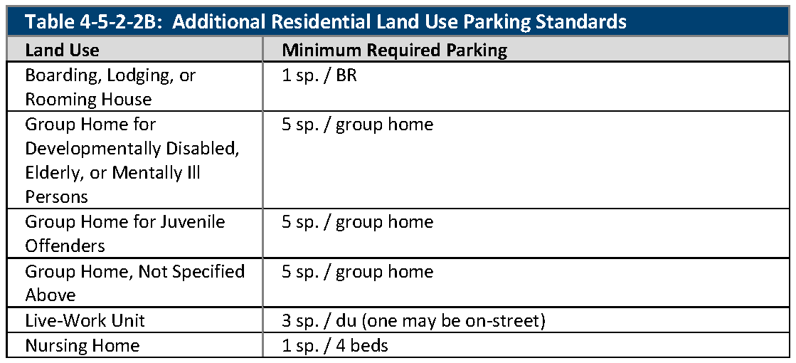
C.
Hospitality, Recreation, and Entertainment Land Uses. The required off-street parking for hospitality, recreation, and entertainment land uses is set out in Table 4-5-2-2C, Hospitality, Recreation, and Entertainment Land Use Parking Standards.
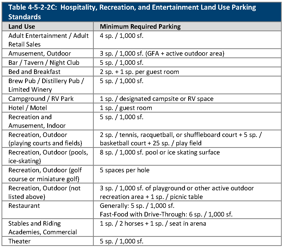
D.
Commercial Land Uses. The required off-street parking for commercial land uses is set out in Table 4-5-2-2D, Commercial Land Use Parking Standards.
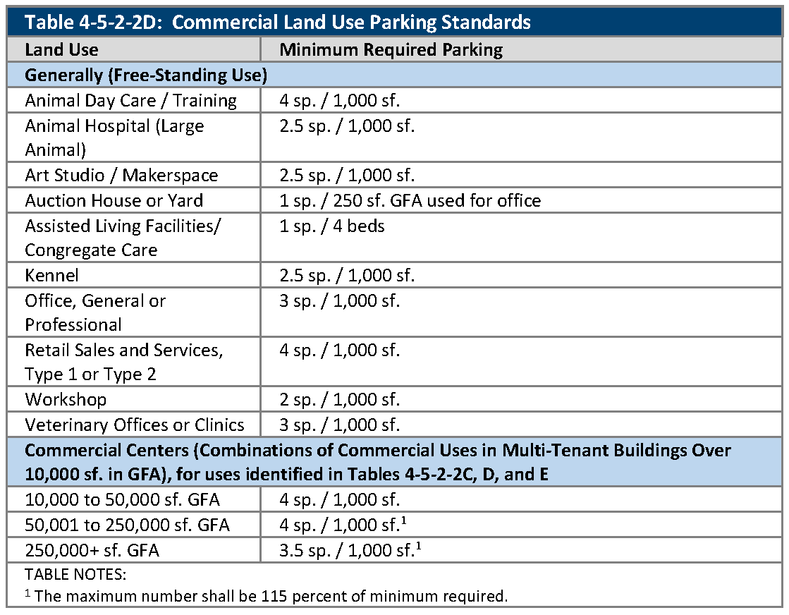
E.
Community, Civic, Educational, and Institutional Land Uses. The required off-street parking for community, civic, educational, and institutional land uses is set out in Table 4-5-2-2E, Community, Civic, Educational, and Institutional Land Use Parking Standards.
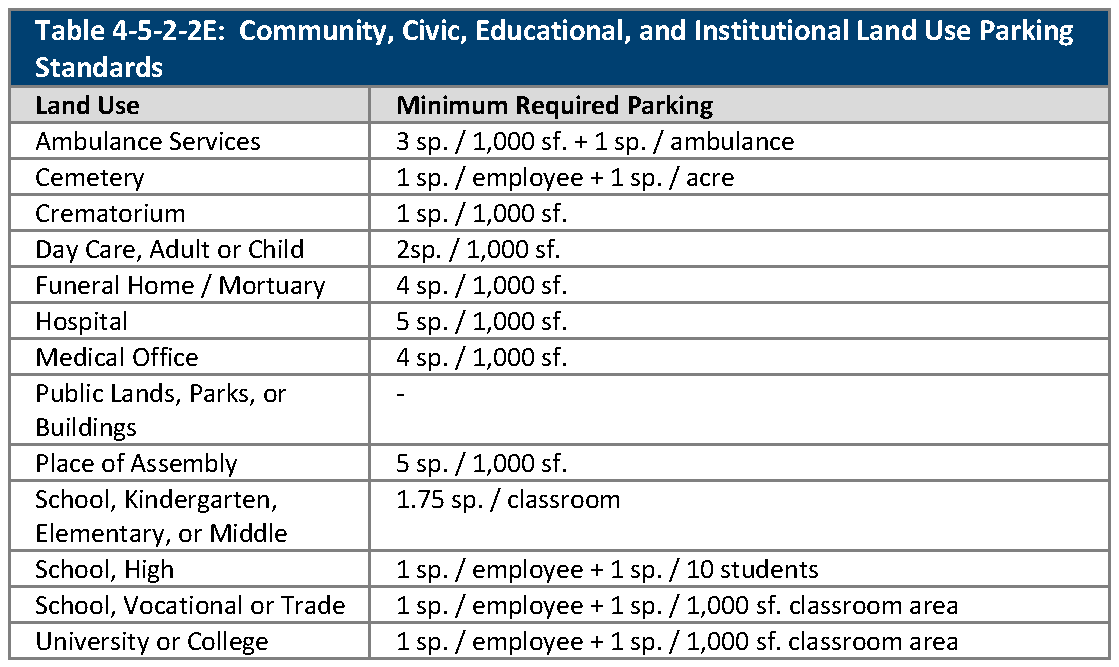
F.
Industrial, Processing, Recycling, Storage, and Disposal Land Uses. The required off-street parking for industrial, processing, recycling, storage, and disposal land uses is set out in Table 4-5-2-2F, Industrial, Processing, Recycling, Storage, and Disposal Land Use Parking Standards.
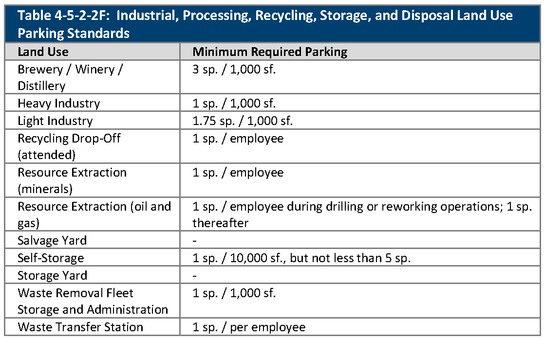
G.
Motor Vehicle Land Uses. The required off-street parking for motor vehicle and transportation land uses is set out in Table 4-5-2-2G, Motor Vehicle Land Use Parking Standards.
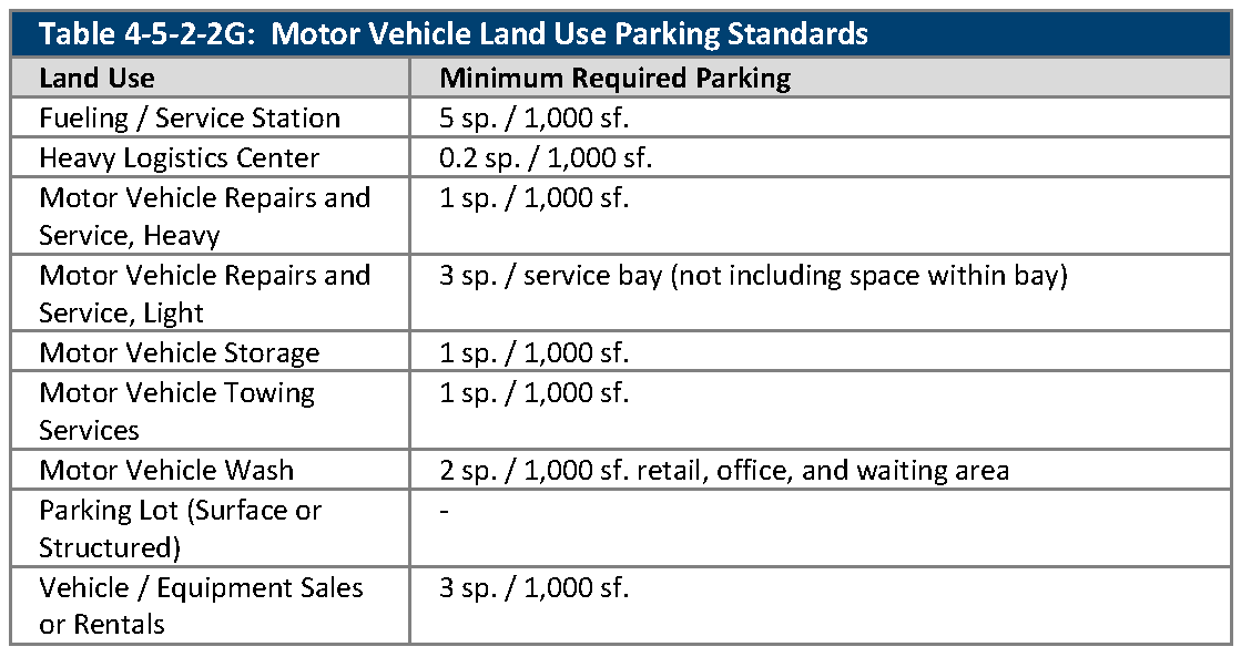
H.
Utility and Wireless Telecommunications Land Uses. The required off-street parking for utility and wireless telecommunications land uses is set out in Table 4-5-2-2H, Utility and Wireless Telecommunications Land Use Parking Standards.
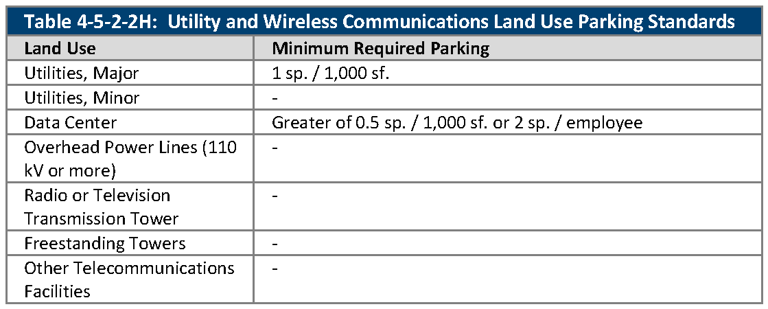
I.
Agricultural Land Uses. The required off-street parking for agricultural land uses is set out in Table 4-5-2-2I, Agricultural Land Use Parking Standards.
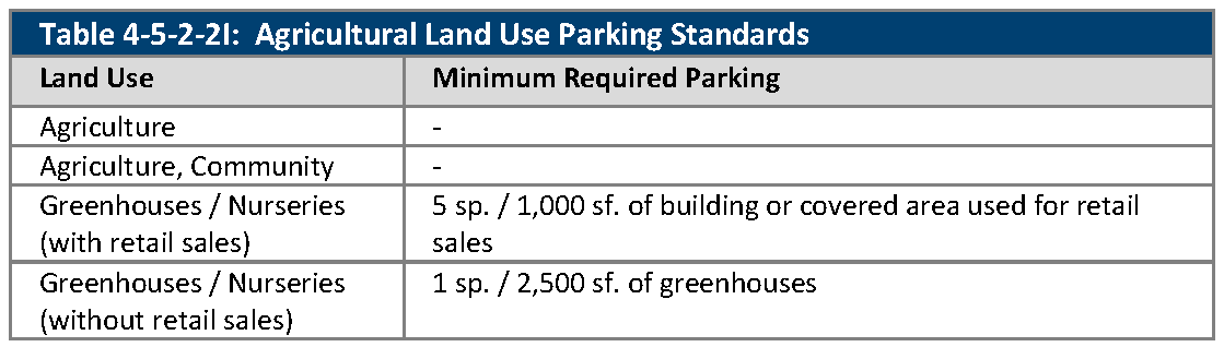
J.
Unlisted Uses. For uses not listed in Section 4-5-2-2, Parking Requirements Tables, the Director shall have the authority to establish minimum and maximum parking standards based on similar uses to the proposed use.
(Ord. No. 4793, § 3, 3-21-2022)
4-5-2-3. - Required accessible parking spaces.
A.
Generally. All "places of public accommodation," as defined in the Americans with Disabilities Act (42 U.S.C. 12101 et. seq) (ADA), must comply with the requirements of the ADA. Parking spaces that are accessible to disabled persons ("accessible parking spaces") shall be provided as set out in this Section. Accessible parking spaces shall be counted toward the total number of parking spaces that are provided for compliance with Section 4-5-2-2, Parking Requirements Tables, after applicable reductions pursuant to Section 4-5-2-4, Shared Parking, and Section 4-5-2-5, Parking Credits and Reductions.
B.
Number of Required Spaces. Accessible parking spaces shall be provided as set out in Table 4-5-2-3, Number of Accessible Parking Spaces, or as indicated in C. below, whichever requires more parking spaces and more van accessible parking spaces for disabled persons.
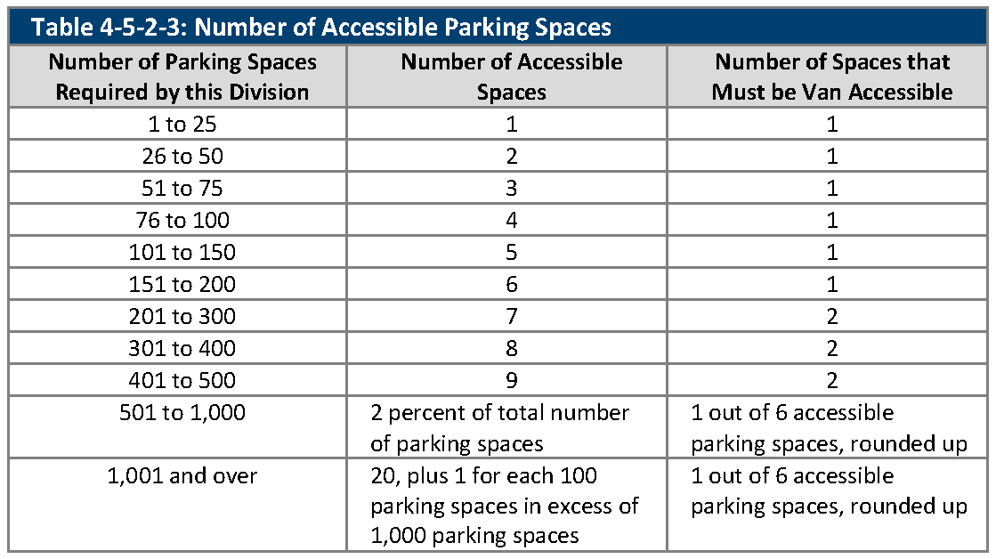
C.
Use-Specific Standards. In addition to the requirements of Table 4-5-2-3, Number of Accessible Parking Spaces, office uses, hospital outpatient facilities, rehabilitation facilities or outpatient physical therapy facilities, and residential uses are subject to additional requirements as indicated by the ADA Standards for Accessible Design, ADAAG Section 208, as amended.
4-5-2-4. - Shared parking.
A.
Generally. The City encourages the sharing of parking for its potential to reduce impervious surfaces or enhance the efficiency of land use. Thus, where a mix of uses creates synergy with respect to the utilization of parking spaces due to differences in peak parking demand periods, the City may reduce the required number of spaces according to the provisions of this Section.
1.
Shared Parking Reduction Table. Shared parking allows a reduction in the total number of required parking spaces when a subject property is occupied by two or more uses that typically do not experience peak parking demands at the same time. When any land or building is used for two or more uses that are listed in Table 4-5-2-4A, Shared Parking Reduction Table, the minimum number of parking spaces required may be reduced by the percentage indicated for each column of five time periods as shown below.
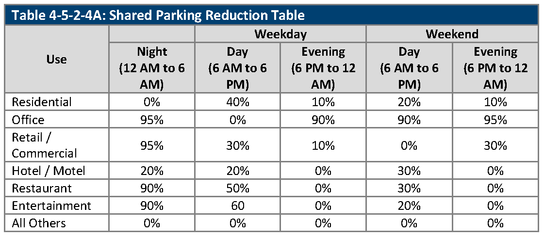
B.
Shared Parking Study.
1.
As an alternative to the methodology in Subsection A., above, an Applicant may submit to the Director a shared parking study to demonstrate that the parking that is required to serve mixed uses is less than the sum of the parking requirements for each individual use.
2.
The shared parking study shall:
a.
Address the size and type of the proposed development, the composition of tenants, and the anticipated peak parking and traffic loads for all uses that that will be sharing the off-street parking spaces;
b.
Review peak parking demand periods for the proposed uses during a 24-hour weekday and each weekend day, and shall propose a required number of parking spaces based on the combined maximum peak hour demand for parking; and
c.
Provide data on the following:
i.
The sensitivity of the proposed uses to change, e.g., a shopping center with no restaurant could have significant changes in parking if a restaurant was added;
ii.
Similar mixes of uses in other areas of the community; and
iii.
Degree of variability of parking for individual uses (average, range, and standard deviation).
3.
The City may require a reserved open area (which shall not be counted as open space) if it finds that the risk of parking needs changing over time so warrants. Once the project is occupied and well established, if there is a surplus of parking, the Applicant may request the Director in writing for additional development capacity and parking using the reserved area.
4.
The shared parking study that is allowed by this Subsection B shall be conducted by a qualified transportation planner or traffic engineer at the Applicant's expense.
C.
Shared Parking Among Different Lots. When a shared parking reduction is to be applied to uses on several different lots, the following shall be provided:
1.
Location Plan. A plan that provides for a pedestrian circulation system that conveniently connects the land uses and parking areas among the lots and meets the following:
a.
Location of Shared and/or Off-Site Parking.
i.
For nonresidential uses, every shared and/or off-site parking space shall be located within 500 feet (measured along a legal pedestrian route) of the entrance to each building for which the shared and/or off-site parking is provided.
ii.
For multifamily uses, every shared and/or off-site parking space shall be located within 300 feet (measured along a legal pedestrian route) of the entrance to each building for which the shared and/or off-site parking is provided.
iii.
Shared and/or off-site parking is not permitted for single-family detached, single-family attached, and duplex dwelling uses.
b.
Ineligible Activities. Accessible parking (ADA parking) shall not be permitted off-site.
2.
Shared Parking Easements and Shared Parking Agreement. Recorded shared parking easements, approved as to form by the City Attorney, that provide, at a minimum, for:
a.
Cross-access among the shared parking areas and connections to allow parking by the different uses in areas that are used for shared parking;
b.
Allocation of maintenance responsibilities;
c.
Terms for reallocating parking spaces upon redevelopment or re-use of any of the affected properties;
d.
A right of enforcement by the City; and
e.
Termination of the shared parking arrangement only if all required off-street parking spaces are provided in accordance with the requirements of Section 4-5-2-2, Parking Requirements Tables, for all participating properties.
3.
As an alternative to the establishment of an easement, a recorded shared parking agreement may be provided. The agreement shall include provisions indicated in Subsection C.2. above, unless otherwise approved by the Director.
4-5-2-5. - Parking credits and reductions.
A.
Generally. This Section sets out several ways to reduce the number of off-street parking spaces that must be provided pursuant to Section 4-5-2-2, Parking Requirements Tables. If used in conjunction with shared parking (see Section 4-5-2-4, Shared Parking), these reductions may be applied to one type of use to reduce the parking requirement for the use prior to calculating the shared parking reduction.
B.
On-Street Parking Credits. In an approved development that includes new on-street parking along internal streets in locations approved by the Director or Decision Making Body, on-street parking may be credited to adjacent uses.
C.
Off-Street Parking Reduction Zones. Parking reductions may be permitted in Transit-Oriented Development and Urban Center areas. The zones, shown in Figure 4-5-2-5, Off-Street Parking Reduction Zones, may have parking reductions based on the Parking Reduction Options identified in Subsection D., below. The maximum reduction for off-street parking requirements from all credits and reductions combined shall be subject to the following standards:
1.
Zone A. The minimum off-street parking requirements in Zone A are as follows:
a.
Residential Uses. The minimum off-street parking requirement for residential buildings or residential portions of mixed-use buildings is one off-street parking space per unit.
b.
Nonresidential Uses. Buildings identified by the City as historically significant for preservation, existing and new commercial buildings, and commercial portions of mixed-use buildings are not required to meet minimum off-street parking requirements.
2.
Zone B. The required minimum off-street parking in Zone B may be reduced as follows:
a.
Residential Uses. The maximum reduction in the minimum off-street parking requirements for residential uses from all credits and reductions combined shall not exceed 20 percent.
b.
Nonresidential Uses. The maximum reduction in the number of off-street parking requirements for nonresidential uses from all credits and reductions shall not exceed 25 percent.
3.
Zone C. The maximum reduction in off-street parking in Zone C for both residential and nonresidential uses from all credits and reductions combined shall not exceed 15 percent.
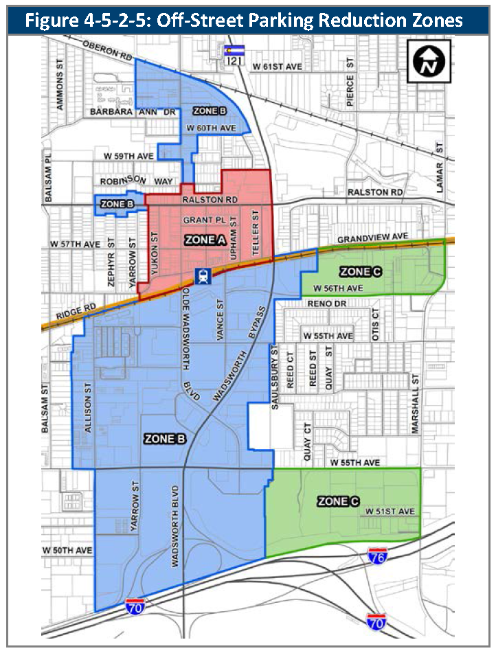
4.
Parking Reduction Options. The options below are intended to allow parking reductions at the time of site development or redevelopment. The options can be cumulative, but shall not exceed the maximum reductions in Subsection C., above.
a.
Valet and Tandem Parking. An alternative parking plan may propose the use of valet and tandem parking to meet a portion of the off-street parking spaces as required in Section 4-5-2-2, Parking Requirements Tables, in accordance with the standards below:
i.
Maximum Valet or Tandem Spaces.
(1)
No more than 20 percent of the total number of parking spaces provided shall be designated for valet or tandem spaces except for hotels, where up to 50 percent of parking spaces may be designated for valet parking.
(2)
Tandem and valet spaces shall be designed to accommodate not more than two vehicles per tandem/valet parking space.
(3)
Drop-Off and Pick-Up Areas. Should an owner or their agent elect to use valet or tandem parking, the development shall provide a designated drop-off and pick-up area. The drop-off and pick-up area may be located adjacent to the building served, but may not be located in a fire lane, where its use would impede vehicular and/or pedestrian circulation, or where it could cause queuing in a public right-of-way or internal drive aisle serving the development.
(4)
Valet Parking Agreement. An approved valet parking plan shall be established in conjunction with a written agreement. The agreement shall include provisions ensuring that a valet parking attendant will be on duty during the hours of operation of the uses served by the valet parking. The agreement shall be submitted to the Director for review and approval.
b.
Proximity to Transit. The minimum number of off-street parking spaces required for new development or redevelopment may be reduced if the proposed development or redevelopment is located within one-quarter mile, measured by the most direct walking route, of any RTD, or publicly authorized transit agency transit stop as follows:
i.
Up to 30 percent reduction with a peak frequency of 15 minutes or less.
ii.
Up to 15 percent reduction with a peak frequency of between 16 and 30 minutes.
c.
Transportation Demand Management. The Director may, through approval of a Transportation Demand Management (TDM) plan, authorize up to a 15 percent reduction in the minimum number of off-street parking spaces required for nonresidential or mixed-use developments having a floor area of at least 25,000 square feet, in accordance with the standards below:
i.
TDM Plan Requirements. The TDM plan shall include facts and/or projections including the type of development, proximity to transit and/or other multi-modal systems, anticipated number of employees and/or patrons, minimum parking requirements, and indicate the types of transportation demand management activities that will be instituted to reduce single-occupant vehicle use and ease traffic congestion. The TDM plan shall be approved by the Director prior issuance of a building permit or certificate of occupancy for the development to be served by the plan.
ii.
TDM Activities. The TDM plan shall provide at least three of the following TDM activities:
(1)
Establishment of a development-specific website that provides multi-modal transportation information such as real-time travel/traffic information, bus schedules and maps, and logging of alternative commutes, e.g., bicycle, pedestrian, carpool, and vanpool.
(2)
Written disclosure of transportation information and educational materials to all employees and/or residents.
(3)
Formation of transportation demand reduction programs such as carpooling, vanpooling, ridesharing, guaranteed ride home, and shuttle service programs.
(4)
Creation of a preferential parking management plan that specifically marks spaces for registered carpool and/or vanpool vehicles that are located near building entrances or in other preferential locations.
(5)
Institution of off-peak work schedules that allow employees to arrive and depart at times other than the peak morning commute period, defined as 7:00 a.m. to 9:00 a.m., and peak evening commute period, defined as 5:00 p.m. to 7:00 p.m.
(6)
Establishment of an office staffed by a transportation coordinator that makes transportation and ride-sharing information available to employees, residents, and nonresidents.
(7)
Any other TDM activity as may be approved by the Director as a means of complying with the parking reduction provisions of this Subsection.
iii.
TDM Program Coordinator. The Applicant shall appoint a TDM program coordinator to oversee TDM activities with the following qualifications:
(1)
The TDM program coordinator shall be a licensed engineer or a traffic consultant that is also a qualified or trained TDM professional.
(2)
The TDM program coordinator shall be appointed prior to issuance of a Building Permit or Certificate of Occupancy for the buildings to be served by the TDM program.
iv.
TDM Annual Report. The TDM program coordinator shall submit to the Director an annual report that details implementation of the approved TDM plan.
v.
Amendments. The Director may approve amendments to an approved TDM plan following the same process required for the initial approval.
vi.
Parking Required if TDM Terminated. If the Applicant and/or successors in interest in the property covered by the TDM plan stop implementing the plan or fail to submit a TDM annual report to the Director in a timely fashion, the TDM plan shall be considered terminated. Any such termination of the TDM plan shall not negate the parties' obligations to comply with parking requirements and shall constitute a violation of this Code. No use served by the TDM plan may be continued unless another TDM plan is approved or all required off-street parking spaces are provided in full within 120 days of termination of the TDM plan or determined by the Director.
d.
Carpool, Vanpool, and Shuttle Parking Credit. For each carpool, vanpool, or shared vehicle parking space provided, the minimum number of required off-street parking spaces may be reduced by four. Each shared vehicle, carpool, or vanpool space shall be signed for such use and shall count toward the minimum number of required parking spaces.
e.
Bicycle Parking Credit. The number of required off-street parking spaces may be reduced at a ratio of one motor vehicle parking space for each two additional secured bicycle parking spaces above the minimum bicycle parking requirements, up to a maximum of five percent of the required off-street parking spaces.
D.
Discretionary Parking Reduction. The Director may allow application of an alternative parking standard, provided that the Director determines the following:
1.
The reduction in the number of required parking spaces is not more than 20 percent; and
2.
The Applicant has demonstrated that:
a.
Site-specific physical constraints do not allow for the parking requirements to be met, and necessitate application of the alternative standard, and such constraints will not allow a reasonable use of the property without application of such alternative standard;
b.
A shared parking study indicates that parking needs of the use will be adequately served and can be accommodated through shared use of parking space with varying time periods of use; or
c.
The alternative standard achieves the intent of the parking standard, i.e., to ensure that the subject property provides adequate parking to avoid overflows onto other properties or backups onto adjacent streets, to the same or greater degree than the parking standard, and results in equivalent or greater benefits to the community as would compliance with the parking standard.
(Ord. No. 4905, § 37, 8-19-2025)
4-5-2-6. - Parking studies.
A.
Generally.
1.
Parking studies are a method to establish parking standards or to reduce parking requirements associated with a particular use. There are several reasons why an Applicant may seek approval of a parking study:
a.
Some of the uses that are listed in the tables in Section 4-5-2-2, Parking Requirements Tables, have nonlinear or widely varying parking demand characteristics, and Applicants for approval of those uses may have cause to seek an alternative parking standard.
b.
The Applicant has proposed a use that is not listed in Division 3-1-2, Land Use by Zoning District, no parking standard is provided in Section 4-5-2-2, Parking Requirements Tables, and therefore a parking standard must be established using a parking study.
c.
The Applicant has submitted a request to reduce the number of required parking spaces to less than that set out in Section 4-5-2-2, Parking Requirements Tables, due to the nature of the operations and/or location of a proposed use.
2.
Parking studies shall include and support all requested reductions in parking. Further parking credits and reductions that are otherwise available pursuant to Section 4-5-2-4, Shared Parking, and Section 4-5-2-5, Parking Credits and Reductions, shall not be applied when parking reductions are granted pursuant to this Section, unless such reductions are supported by the parking study.
B.
Parking Study Requirements.
1.
A parking study shall be conducted by a qualified transportation planner or traffic engineer at the Applicant's expense.
2.
The parking study shall provide:
a.
A peak parking analysis of at least five functionally comparable uses/projects.
b.
Documentation regarding the comparability of the referenced uses/projects, including: name, function, location, gross floor area, parking availability, access to transportation network (including vehicular, bicycle, pedestrian, and transit), use restrictions, and other factors that could affect the parking demand.
C.
Abbreviated Parking Study Requirements. The analytical requirements set out in Subsection B., above, may be reduced to two functionally comparable uses/projects if:
1.
The uses/projects are located in the City;
2.
The proposed use/project to which the parking study is to be applied has less than 5,000 square feet of floor area; or
3.
The parking study is used to justify a reduction in required parking and the requested reduction is 20 percent or less.
D.
Approval of Parking Study.
1.
The Director may rely upon the parking study or may request additional information or analysis, including, but not limited to: alternative or new data points, or consideration of additional or alternative factors related to comparability or peak demand, as supported by sound traffic engineering principles.
2.
As a condition of approval of a parking study, the Director may require that land be reserved or land-banked for additional parking if there is a demonstrably high probability the use could change, resulting in a higher demand for parking. Such additional land shall not be counted as open space.
4-5-2-7. - Off-street loading areas.
A.
Generally. Off-street loading areas shall be required for multifamily, mixed-use, and non-residential uses that require goods, merchandise, or equipment to be routinely delivered to or shipped from the subject property. Ridesharing services pick-up and drop-off areas should also be provided on site.
B.
Minimum Required Loading Spaces. Unless additional loading space is necessary to meet the requirements of the use, loading spaces for nonresidential uses described in Subsection A., above, including nonresidential components of mixed-use development, shall be provided according to the standards in Table 4-5-2-7, Minimum Loading Requirements.
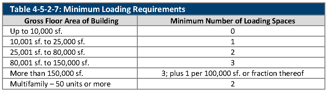
C.
Adjustment of Loading Requirements. The Director may reduce loading requirements if it is demonstrated that the loading requirements of a particular land use may be adequately met even if fewer spaces than are required by Table 4-5-2-7, Minimum Loading Requirements, are provided.
4-5-2-8. - Bicycle parking.
A.
Generally. Bicycle parking shall be provided as set out in this Section, and designed according to the requirements of Section 4-5-3-8, Bicycle Parking Design.
B.
Exceptions. Bicycle parking is not required for the following uses:
1.
The land uses that are set out in Section 3-1-2-10 Agriculture Land Use by Zoning District;
2.
The land uses that are set out in Section 3-1-2-9, Utility and Communications Land Use by Zoning District;
3.
Waste transfer station;
4.
Salvage yard;
5.
Heavy industry;
6.
Heavy logistics center;
7.
Waste Removal Fleet Storage and Administration;
8.
The land uses that are set out in Section 3-1-2-3 Additional Residential Land Use by Zoning District
9.
Single-family detached, duplex, townhome, or multiplex dwelling units.
C.
Minimum Number of Bicycle Parking Spaces. Except as provided in Subsection B., above, bicycle parking shall be provided as follows:
1.
Multifamily. One space for every four dwelling units. Twenty percent shall be for long-term.
2.
Elementary School. One space for every five students. Twenty-five percent shall be long-term.
3.
Middle School. One space for every five students. Twenty-five percent shall be long-term.
4.
High School. One space for every ten students. Twenty-five percent shall be long-term.
5.
College or University. One space for every ten students. Twenty-five percent shall be long-term.
6.
Personal Services. Personal services, if related to personal fitness (e.g., boxing or kickboxing instruction; fitness centers; martial arts instruction; swim instruction; or yoga instruction). One space for every ten required motor vehicle spaces. Ten percent shall be for long-term
7.
All Other Uses.
a.
Generally. One space for every 20 required motor vehicle parking spaces. Ten percent shall be long-term.
b.
MX-T Zoning District. One space for every ten required motor vehicle parking spaces.
c.
Olde Town District. One space for every five required motor vehicle parking spaces. For historic buildings that are not required to provide off-street parking, five spaces per building.
d.
MX-S, MX-U and CG Zoning Districts. One space for every 15 required motor vehicle parking spaces.
(Ord. No. 4905, § 38, 8-19-2025)
4-5-2-9. - Fleet vehicle parking.
A.
Generally. The maximum number of parking spaces allowed for fleet vehicles shall be as set out in this Section. Spaces used for fleet vehicles are in addition to the minimum parking requirements. Uses requiring fewer than 25 fleet parking spaces shall be exempt.
B.
Maximum Number of Fleet Vehicle Parking Spaces. The calculation to determine the maximum number of fleet vehicle parking spaces in the allowed zoning districts is as follows:
1.
In the CG zoning district, the maximum number shall be no more than 50 percent of the minimum required parking spaces, as identified in Section 4-5-2-1, Calculation of Required Parking Spaces.
2.
In the IL zoning district, the maximum number shall be no more than 100 percent of the minimum required parking spaces, as identified in Section 4-5-2-1, Calculation of Required Parking Spaces.
3.
In the IG zoning district, the maximum number shall be no more than 200 percent of the minimum required parking spaces, as identified in Section 4-5-2-1, Calculation of Required Parking Spaces.
(Ord. No. 4810, § 2, 9-19-2022)
4-5-3-1. - General design principles.
A.
Generally. Circulation systems within a subject property shall provide for continuous traffic flow with efficient, non-conflicting movement throughout the site.
B.
Vehicular-Pedestrian Conflicts.
1.
Conflicts between areas of significant pedestrian movement and vehicular circulation shall be minimized.
2.
Required drive-through stacking areas shall not intersect with pedestrian access to a public entrance of a building.
C.
Configuration of Parking Lots. If differentiated, short-term and long-term parking shall be clearly signed, and short-term parking areas shall generally be located closer to the primary public entrances of principal buildings.
1.
Parking lots and loading areas shall have access from a clearly defined drive aisle not less than 18 feet in width for one-way traffic and 24 feet in width for two-way traffic.
2.
Parking spaces shall be marked on the pavement surface with striping, or change of color or material.
D.
Parking in the Front Setbacks. Parking shall not be permitted within the front setback or frontage zone on any lot, except for single-family detached and duplex lots and multiplex sites with parking on paved driveways.
E.
Parking Areas Surface. All off-street parking spaces and areas required by Division 4-5-2-2, Parking Requirements Tables, vehicular access and drive aisles, and stacking areas shall be surfaced with bituminous asphalt, concrete, or other approved equivalent surface approved by the Director. Recycled asphalt, gravel, or similar compacted materials are not an acceptable parking surface.
1.
Any area used to park vehicles on a single-family or duplex lot, which is not an off-street parking space required by Table 4-5-2-2A, Residential Land Use Parking Standards, shall be clearly delineated, improved with concrete, asphalt, stone pavers, gravel or rock (provided the installation is sufficient to support vehicles), maintained free of weeds and display no visible dirt surface. However, no more than 60 percent of the front or street side yards shall be paved with an impervious material.
(Ord. No. 4793, § 3, 3-21-2022; Ord. No. 4905, § 39, 8-19-2025)
4-5-3-2. - Parking space and aisle standards.
A.
Generally. Parking spaces and access aisles shall be designed according to the standards of this Section.
B.
Arrangement.
1.
All parking spaces located across from each other, on the opposite side of a drive lane, shall be located at the same angle to the drive lane, except that parallel parking may be provided on one side of the drive lane in order to enhance accessible access.
2.
Angle parking located on a drive lane with a dead-end is not allowed unless:
a.
The angle of the parking space is 90 degrees to the direction of travel; or
b.
The geometry of the subject property requires such a configuration for an efficient parking layout and the Director determines that the design provides for safe circulation.
C.
Dimensions. The size of a parking stall, its angle, and the width of the access aisles shall conform to the standards set out in Table 4-5-3-2, Parking Area Dimensions.
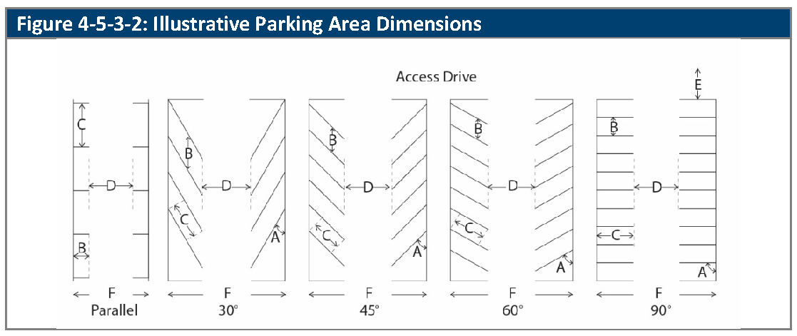
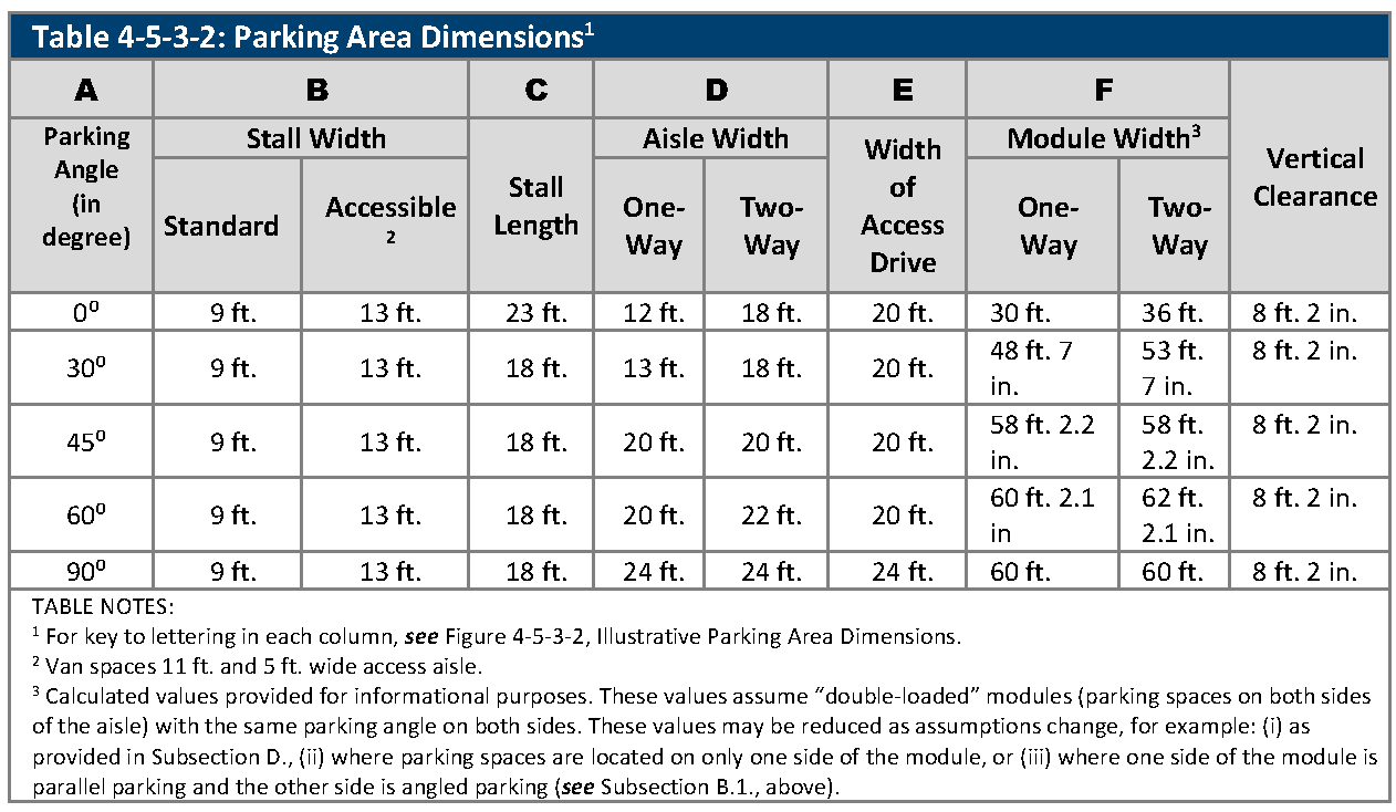
D.
Landscape. Landscape islands must be provided as indicated in Section 4-6-6-3, Parking Area Landscaping.
E.
Alternative Parking Dimensions. The Director may approve angles and dimensions that are different from those set out in Table 4-5-3-2, Illustrative Parking Area Dimensions, provided that the Applicant demonstrates that the angles and dimensions will provide for safe circulation and parking within the parking lot based on an AASHTO 2011 (US) - P design vehicle template, or such other template as the Director determines is appropriate based on the proposed land use.
F.
Overhangs. Where the adjacent sidewalk or landscape area is protected by a curb and is not less than seven feet in width, the length of standard parking spaces may be reduced by up to two feet. This allows a vehicle overhang up to two feet and an unobstructed walkway or landscape area of at least five feet in width. The use of wheel barriers in such locations is prohibited.
(Ord. No. 4905, § 40, 8-19-2025)
4-5-3-3. - Accessible parking standards.
A.
Generally. Parking for persons with disabilities shall be provided as required in Table 4-5-2-3, Required Accessible Parking Spaces, or as required by the Americans with Disabilities Act (ADA). Where provisions of this Section conflict with ADA, ADA shall control unless this Section provides for better access and such requirement is not prohibited by the ADA. Where the ADA provides design standards that are not included in this Section, such design standards shall control.
B.
Design of Accessible Parking Spaces. Required disabled parking spaces shall be:
1.
Situated so that they adjoin an accessible parking access aisle, and such that van-accessible parking spaces adjoin the access aisle on the passenger side of the vehicle;
2.
Paved with asphalt, concrete or other approved material;
3.
Designed so that slope, measured in any direction does not exceed a one foot rise to a 48-foot run;
4.
Designed so that whenever there is more than a one-half inch change in the elevation of the surface between an accessible route and the accessible parking space, a ramp is provided within 26 feet, connecting the route to the parking spaces. See Figure 4-5-3-3, Ramp Accessibility.
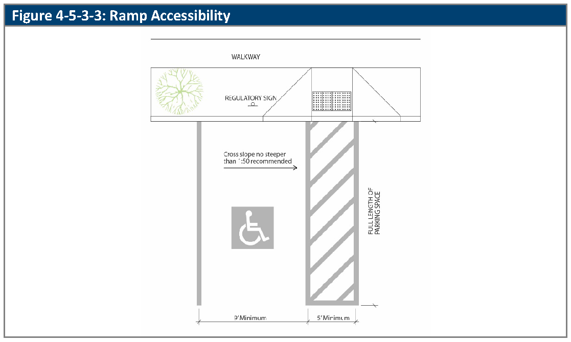
C.
Location. The location of accessible parking spaces shall be:
1.
As close as possible to principal accessible entrance(s);
2.
Dispersed in a multi-building development or shopping center to ensure easy access, and to minimize the travel distance for the disabled.
D.
Marking.
1.
Each accessible parking space shall be identified with a sign that includes:
a.
The International Symbol of Accessibility Parking Space marking per the MUTCD and ADA standards;
b.
The phrase "Accessible Parking"; and
c.
The statement "Van Accessible," if the space is a van-accessible parking space.
2.
Signs shall be printed with green lettering and symbols on a white background and shall conform to MUTCD standards.
3.
Signs shall be one foot wide by 18 inches high, and installed at least five feet, but not more than seven feet, above the finished floor (for parking structures) or ground surface (for surface parking), measured to the bottom of the sign.
4.
Signs shall be permanently mounted, with anchor bolts, on a post or on an adjacent structure or wall within ten feet of the disabled parking space, oriented to the center of the front of each handicapped parking space, facing the rear of the space.
5.
The symbol of accessibility shall be painted on the pavement of each disabled parking space.
E.
Accessible Routes. All accessible routes shall serve as emergency exits for disabled individuals and shall be free from obstructions. Required ramps shall be identified with a sign and be made with a permanent material which will provide all-weather access.
4-5-3-4. - Off-site parking.
A.
Generally. In lieu of locating parking spaces required by Division 4-5-2, Parking and Loading Calculations, on the lot that generates the demand for the required parking, parking spaces may be provided on any lot or premises controlled, i.e., by fee-simple ownership, easement interests, lease interests, or participation in a parking district or other joint venture to provide centralized off-street parking, by the owner of the use that generates the parking demand, provided that:
1.
The parking lot providing the parking is within 200 feet of the boundary of the property generating such parking requirements and no required off-street parking space within said parking lot is more than 500 feet from the property it is serving; and
2.
The parking spaces are not already counted towards the parking requirements of another use after application of Section 4-5-2-4, Shared Parking, Section 4-5-2-5, Parking Credits and Reductions, or Section 4-5-2-6, Parking Studies, as may be applicable.
B.
Exceptions. Off-site parking is not allowed in:
1.
Residential zoning districts, except that manufactured home parks and clustered housing types may utilize centralized parking; and
2.
Locations in which a street with more than two lanes separates the off-site parking area from the subject property.
(Ord. No. 4793, § 3, 3-21-2022; Ord. No. 4905, § 41, 8-19-2025)
4-5-3-5. - Tandem parking.
A.
Generally. Tandem parking spaces are counted towards required parking only if they meet the standards of this Section.
B.
Residential Uses. For single-family detached, duplex, townhome, multiplex and multi-family uses, tandem parking spaces are counted, provided that they are located on the same lot as the dwelling unit that they serve (or in the case of condominium or comparable ownership, are located on land adjacent to the unit and under exclusive control of the unit owner) and no more than half of the required parking spaces for each unit (rounded down) are tandem spaces.
C.
Bed and Breakfast. Off-street guest parking for bed and breakfast uses may be tandem.
D.
Motor Vehicle Repairs and Service, Light. For light motor vehicle repairs and service uses, on-site tandem parking spaces are counted, provided that no more than 30 percent of the required parking spaces are tandem spaces.
E.
Valet Parking. Valet parking spaces may be configured as tandem spaces.
4-5-3-6. - Vehicle stacking.
A.
Generally. Vehicle stacking spaces are used to measure the capacity of a drive-through lane to hold cars while transactions are taking place at drive-through stations. Adequate space must be provided for on-site stacking, storage and queuing of vehicles.
1.
The required stacking distance for the site may be distributed between access points serving the site, provided a minimum stacking of 20 feet is provided at all access points.
2.
Stacking spaces must be a minimum of 8.5 feet in width and 20 feet in length.
3.
Electronic devices such as loudspeakers, automobile service order devices, and similar instruments shall not be audible beyond the property line adjacent to a residential zone district.
4.
Stacking spaces for internal drive-through services shall be measured from the point of service and within a designated drive aisle.
B.
Drive-Through. Uses that include drive-through service shall provide the following minimum number of stacking spaces:
1.
Financial institutions, drive-through convenience retail, fueling stations, and pharmacies. Three stacking spaces.
2.
Drive-through restaurants.
a.
If two service windows are provided (one for payments and one for pick-up):
i.
Four stacking spaces to each menu board;
ii.
Three stacking spaces between the menu board and the first window, including the position at the first window; and
iii.
Two spaces between the first window and the second window, including the position at the second window (See Figure 4-5-3-6, Illustrative Stacking Requirements).
b.
If one service window is provided, for both payments and pick up:
i.
Six stacking spaces to the menu board; and
ii.
Three stacking spaces between the menu board and the service window.
3.
Drive-through only uses in buildings with less than 300 square feet of gross floor area and no separate menu board. Three stacking spaces per service window.
4.
Dry cleaners. Two stacking spaces per service window.
5.
Vehicle wash.
a.
Two stacking spaces for each bay in a self-service vehicle wash facility;
b.
Five stacking spaces for each in-bay or conveyor vehicle wash facility; and
c.
If the facility provides detailing, manual drying or polishing, and/or vacuuming, sufficient area to provide those services without creating additional demand for stacking at the vehicle wash entrance.
6.
Other Uses. The determination by the Director of stacking spaces necessary for other uses may require a queuing study conducted by a qualified transportation planner or traffic engineer at the Applicant's expense.
C.
Design.
1.
Stacking lanes shall be clearly marked, and shall not interfere with on-site or off-site traffic circulation, or access to parking spaces.
2.
Stacking areas shall not be located in the front setback or side street setback.
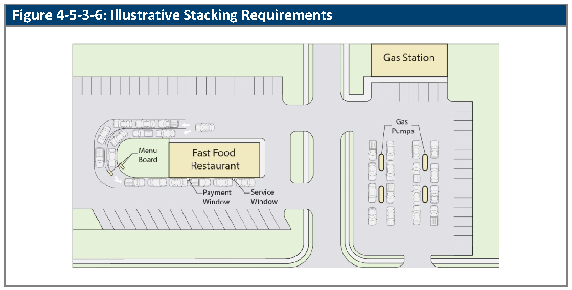
(Ord. No. 4793, § 3, 3-21-2022; Ord. No. 4905, §§ 42, 43, 8-19-2025)
4-5-3-7. - Design of off-street loading areas.
A.
Generally. All required off-street loading spaces shall be designed, constructed, and maintained in accordance with the standards and requirements of this Section.
B.
Location.
1.
Loading spaces shall be located on the same lot as the building or structure to which they relate.
2.
No loading space shall be located in any front setback area.
3.
Except where alley loading or over-the-curb loading is allowed, loading areas shall be located and designed to ensure adequate on-site maneuvering area for delivery vehicles.
4.
No loading area shall be designed in a manner that would allow any vehicle to extend into any front setback area or adjacent to any residential zone district while being loaded or unloaded.
5.
Trucks parked in loading areas shall not encroach into required parking spaces or building setbacks.
6.
Parked trucks loading or unloading materials shall not block travel lanes in parking lot or fire lanes.
C.
Buffering. Loading areas, including overhead doors, oriented so to face a residential zone district or a public right-of-way shall be screened from view from all property lines and adjacent streets to the greatest extent possible, as determined by the Director, by the following:
1.
By an opaque fence or wall between six feet and eight feet in height that incorporates at least one of the predominant materials and one of the predominant colors used in the principal building. The fence or wall may exceed eight feet in height when there is a difference in grade between the street and loading area to effectively screen the area. (For a drive-through stacking area, a fence or wall shall only be used when the area is adjacent to a residential zone district).
2.
A landscape berm may be used instead or combined with the required fence or wall.
3.
If such areas are covered, then the covering shall include at least one of the predominant exposed roofing colors on the principal building.
D.
Surfacing. All required off-street loading spaces and access drives shall be improved with an asphaltic, concrete, or equivalent surface and shall be graded and drained in order to dispose of all surface water accumulation within such areas, as well as any associated parking area.
E.
Alleys. All alleys that are used for loading shall meet the City of Arvada Engineering Code of Standards and Specifications.
(Ord. No. 4793, § 3, 3-21-2022; Ord. No. 4905, §§ 44, 45, 8-19-2025)
4-5-3-8. - Bicycle parking design.
A.
Generally. The bicycle parking spaces that are required by Section 4-5-2-8, Bicycle Parking, shall be designed according to the standards of this Section. The purpose of these design standards is to ensure that bicycle parking is convenient to bicyclists and provides security from theft and damage.
B.
Standards.
1.
Generally. Bicycle parking shall be designed to ensure that it is convenient to bicyclists and secured from theft and damage.
a.
Bicycle parking shall be securely locked and safeguarded from accidental or intentional damage.
b.
Each required bicycle parking space shall be accessible without moving another bicycle.
c.
There shall be an aisle at least five feet around the perimeter of all bicycle parking areas to allow room for bicycle maneuvering.
C.
Short-term Bicycle Parking. Short-term bicycle parking facilities or racks shall accommodate securing a bicycle using an industry-standard bike lock.
1.
Short-term bicycle parking spaces shall be located within 50 feet of the main entrance to the building. Where there is more than one main entrance to a building, short-term spaces should be split between building entrances.
2.
Bicycle racks shall meet the following standards:
a.
A U-shaped bike rack or variation thereof that allows for the bike to be locked to the rack by the frame and at least one wheel;
b.
A bicycle that is six feet long can be securely held with its frame supported so that the bicycle cannot be pushed or fall in a manner that will damage the wheel components; and
c.
The racks are securely anchored to a hard surface.
3.
MX Zoning Districts. Multifamily residential, mixed-use, and office uses in the MX-N, MX-S MX-U and MX-T zoning districts shall provide bicycle parking in locations where at least 50 percent of the required spaces, when more than three are required, are covered, secure, and illuminated. Such bicycle parking areas shall be maintained by the property owner, a property owners' association, or a metropolitan district.
4.
OT and CG Zoning Districts. Multifamily, schools, retail, and office uses in the OT and CG zoning districts shall provide bicycle parking locations that are secure, illuminated and along traveled ways.
D.
Long-term Bicycle Parking. Long-term bicycle parking shall be in a secure and weather-protected place. Long-term parking does not have to be provided on site; however long-term bicycle parking must be within a reasonable distance of a site in order to encourage bicycle use.
1.
Long-term bicycle parking is not required on a site when:
a.
Non-residential gross building area is less than 5,000 square feet; or
b.
There are ten or fewer residential units in a development or redevelopment.
2.
Long-term bicycle parking, when required, shall be located within 50 feet of a building entrance and be visible from the building entrance. If the location of the bicycle parking is not obvious from the building entrance, signs shall be posted that indicate the location of bicycle parking.
3.
Long-term bicycle parking is required to be covered and shall be at least one of the following:
a.
In a locked room;
b.
In a bicycle locker;
c.
In an area that is enclosed by a fence with a locked gate;
d.
A free standing building;
e.
Within view of an attendant or security guard; or
f.
In an area that is monitored by a security camera.
E.
Surfacing and Clear Area.
1.
The surface of bicycle parking spaces shall be of hardscape material such as asphalt, concrete, or other materials approved by the Director.
2.
Racks shall be bordered by physical barriers or located a sufficient distance from motor vehicles to prevent damage to parked bicycles.
(Ord. No. 4793, § 3, 3-21-2022; Ord. No. 4905, § 46, 8-19-2025)
4-5-3-9. - Reserved.
Editor's note— Ord. No. 4905, § 47, adopted August 19, 2025, repealed § 4-5-3-9, which pertained to snow storage.
4-5-4-1. - Use of parking and loading facilities.
A.
Generally. Required off-street parking spaces shall be available for operable passenger vehicles of the residents, customers, patrons, and/or employees of the use to which they relate.
B.
Storage.
1.
Parking Spaces and Parking Aisles. Storing materials, boats, campers, recreational vehicles, or inoperable vehicles, or overnight parking of trucks or trailers is prohibited in parking areas of multifamily, nonresidential, and mixed-use developments, unless:
a.
The outdoor storage use is permitted in the applicable zone and approved for the subject property;
b.
The areas that are set aside for such parking are not counted towards the parking requirements for the use; and
c.
The areas that are set aside for such parking comply with the requirements for outdoor storage (e.g., buffering or screening of outdoor storage areas).
2.
Loading Spaces. The long-term storage of trailers or shipping containers in loading spaces is prohibited. Such spaces shall be available for routine use by delivery vehicles.
C.
Prohibited Use of Parking Areas. No designated off-street parking facilities shall be used for the repair, display, service, or sales of any good or service unless expressly and specifically approved by the City. However, this Subsection does not apply to single-family detached and single-family attached driveways when they are used for garage sales or for minor repairs to vehicles owned by the resident of the property.
D.
Blocking of Access Prohibited.
1.
Blocking of loading spaces or parking spaces is prohibited, except as may be allowed by Section 3-1-4-13, Other Temporary Uses.
2.
Loading spaces or parking spaces shall not be designed or located in a manner that blocks access to other loading spaces, parking spaces (except permitted tandem spaces), parking aisles, fire lanes, ingress or egress points, or building entrances.
3.
Parking, loading, and access areas shall be kept free of any type of permanent or movable structures that block access (e.g., trash receptacles or compactors). Parking within or otherwise obstructing a driveway approach or a public sidewalk is prohibited.
4-5-4-2. - Surfacing and maintenance of off-street parking areas.
A.
Surfacing.
1.
Vehicle drive aisles, parking areas, stacking areas, and loading areas shall be graded and surfaced with concrete, bituminous asphalt, or other material approved by the Director. The surfacing material shall protect against potholes, erosion, and dust.
2.
Parking spaces shall be defined on the pavement surface with striping and color delineation.
3.
The Director may approve an alternative surface for low-turnover uses or overflow parking if:
a.
Use of the alternative surface will not cause undue airborne dust;
b.
The perimeter of the parking area is defined by curb and gutter, bricks, stones, or other similar devices; and
c.
Surfaces with loose materials are set back at least 25 feet from the edge of pavement of the connecting public street.
B.
Maintenance. Off-street parking surfaces shall be kept in good condition, free of weeds, dust, trash or debris, and parking space lines or markings shall be kept clearly visible and distinct.
4-6-1-1. - Purpose of article.
A.
The purpose of this Article is to:
B.
Encourage the preservation, protection and enhancement of the character of the City by:
1.
Adding aesthetic value to the urban landscape through a balance of buildings, paved areas, and landscaping; and
2.
Buffering uses that tend to create disproportionate impacts on adjacent properties in terms of noise, dust, lighting, and other factors that may be mitigated using landscaping, fencing, berms, distance, and/or divisional walls.
C.
Encourage consistent, attractive streetscapes that provide a sense of continuity with deciduous trees that provide shade in the summer and solar access in winter months.
D.
Encourage the preservation, protection and enhancement of the environmental quality of the City by:
1.
Preserving natural features such as stream corridors, wetlands and riparian areas, wildlife corridors, mature trees, ditches, and natural ponds;
2.
Using landscape materials to improve air quality, slow stormwater runoff, and prevent soil erosion;
3.
Moderating the heat island effect of urban areas;
4.
Promoting landscape designs that conserve energy and water resources;
5.
Preserving or limiting the removal of native grasses, healthy mature trees, and other desirable vegetative cover and ensuring the replacement of trees; and
6.
Providing stormwater water systems including low impact development (LID).
E.
Encourage the conservation of water resources by providing for the efficient use of irrigation, appropriate plant materials and regular maintenance of landscaped areas.
F.
Encourage the protection and enhancement of property values by:
1.
Enhancing the aesthetic appearance of development through the City; and
2.
Landscaping parking lots and other designated areas.
4-6-1-2. - Application of article.
A.
Tree Protection.Division 4-6-2, Tree Preservation and Replacement, sets out standards for preserving certain trees on-site, and for protecting trees that are designated for preservation.
B.
General Standards.Division 4-6-3, General Landscaping Standards, sets out the applicability for the standards and the general landscaping standards.
C.
Calculations.Division 4-6-4, Calculation of Landscape Requirements, sets out the standards for calculating the landscape requirements of this Article.
D.
Landscape Areas and Bufferyards.Division 4-6-5, Landscape Areas and Bufferyards Landscape Areas and Bufferyards, identifies the landscaping area types and the options for bufferyards.
E.
Other Landscape Areas.Division 4-6-6, Requirements by Landscape Area, sets out standards for street trees, plazas, parking lots, and certain other interior portions of a subject property.
F.
Additional Technical Requirements.Division 4-6-7, Additional Technical Requirements, sets out technical standards for certain elements of the landscape, including planting beds and berms.
G.
Maintenance and Warranties.Division 4-6-8, Maintenance and Warranties, sets out standards for how landscaping is to be maintained and warrantied.
4-6-2-1. - Tree survey.
A.
Generally. The determination that existing trees are to be preserved, replaced, or relocated pursuant to this Division shall be made by the Director based on professional tree analysis provided by the Applicant.
B.
Contents of Tree Survey. The tree survey shall be prepared by a professional forester, arborist, or a registered landscape architect, and shall include an analysis of existing trees with two-inch or greater calipers, including:
1.
A site plan locating each tree and recommending trees intended for preservation in place, transplanting on site, or replacement;
2.
Species and size of each tree (caliper/height);
3.
Condition, indicating overall health of each tree with an evaluation of structure, pests, disease, or other factors affecting each tree; and
4.
Recommendation for removal of all trees that are in a condition hazardous to the proposed development.
C.
Modification of Tree Survey Requirements. The Director shall establish the level of detail required for the tree analysis based on site conditions (e.g., for large sites with large stands of trees, the Director may allow delineation of tree canopy and estimates of the number of trees in each size category based on sampling, rather than comprehensive counts).
D.
Tree Removal Prior to Application Submittal. Applicants/owners are not permitted to remove trees two inches or larger, within six months prior to submittal of a development application, unless prior written approval of the Director has been obtained. Any development application for a site where such removal has occurred without permission shall be required to install 200 percent of the number of trees and shrubs otherwise required for the site.
4-6-2-2. - Tree removal and replacement.
A.
Generally. Existing healthy trees shall be incorporated into new developments to the maximum extent feasible.
B.
Penalty. If an Applicant fails to comply with the minimum provisions to preserve trees, the Applicant shall be required to replace each tree that is damaged beyond remedy or destroyed at the rate required in Table 4-6-2-2, Tree Preservation, Transplantation, and Removal. If an owner does not choose to replace irreparably damaged or destroyed trees intended for preservation, the Applicant will be penalized an amount equal to the caliper inch replacement cost plus 100 percent for those trees. The Applicant is required to spend the amount of the penalty for trees at the project. If the Applicant does not choose to plant trees on the project site, the City may choose to plant the trees on a nearby public property or park.
C.
Tree Preservation, Transplantation, and Removal.
1.
Trees shall be preserved, transplanted, or removed, based on their diameter at breast height, as provided in Table 4-6-2-2, Tree Preservation, Transplantation, and Removal. Trees that are preserved, transplanted, or replaced according to this Section may be credited towards development landscaping as provided in Section 4-6-4-2, Tree Preservation Credits.
2.
The Director shall determine through consultation with the City Forester when it is not feasible to preserve and retain protected tree(s) or to transplant them to another on-site location. If it is determined that it is not feasible to preserve or transplant protected tree(s), the Applicant shall replace such tree(s) according to this Section. Replacement trees shall be used to satisfy the tree planting standards of this Section.
3.
At the discretion of the Director, a fee-in-lieu may be determined that considers the size and value of any tree(s) that may need to be removed.
4.
Trees that meet one or more of the following removal criteria shall be exempt from the requirements of this Subsection as follows:
a.
Dead, dying or naturally fallen trees, or trees determined by the City to be a threat to public health, safety, or welfare;
b.
Trees that are determined by the City to substantially obstruct clear visibility at driveways and intersections;
c.
Trees included on the Colorado Department of Agriculture noxious weed list, unless the tree is deemed a significant specimen tree by the Director.
(Ord. No. 4905, § 48, 8-19-2025)
4-6-2-3. - Tree protection.
A.
Tree Protection Specifications. The following tree protection specifications should be followed to the maximum extent feasible for all projects with protected existing trees.
1.
Prior to and during construction, barriers shall be erected around all protected existing trees with such barriers to be of orange fencing a minimum of four feet in height, secured with metal T-posts, no closer than six feet from the trunk or one foot for every inch of diameter whichever is greater (for example, a ten-inch diameter tree will have a fence no closer than ten feet from the trunk). There shall be no storage or movement of equipment, material, debris or fill within the fenced tree protection zone unless previously approved by the Director.
2.
During the construction stage of development, the Applicant shall prevent the cleaning of equipment or material or the storage and disposal of waste material such as paints, oils, solvents, asphalt, concrete, motor oil or any other material harmful to the life of a tree within the fenced tree protection zone.
3.
No damaging attachment, wires, signs or permits may be fastened to any protected tree.
4.
Large property areas containing protected trees and separated from construction or land clearing areas, road rights-of-way and utility easements may be "ribboned off," rather than erecting protective fencing around each tree. This may be accomplished by placing metal T-post stakes a maximum of 50 feet apart and tying ribbon or rope from stake-to-stake along the outside perimeters of such areas being cleared.
5.
The installation of utilities, irrigation lines or any underground fixture within the fence tree protection zone shall be accomplished by boring under the root system of protected existing trees at a minimum depth of 24 inches.
4-6-3-1. - Applicability.
A.
Generally. All new construction, including building expansions that increase the footprint of a building by 25 percent or more, and modification to an existing landscape area shall comply with the standards in this Article.
B.
Exceptions. Exceptions to this Article are allowed under the following circumstances:
1.
Interior Tenant Improvement. The landscaping requirements of this Article shall not apply to existing structures where interior tenant improvements occur and where there is no addition to the number of parking spaces provided.
2.
Existing Structures. Where existing structures are situated so as to preclude the installation of required landscaping, the Director may authorize reductions for the required landscaping.
3.
Physical Limitations of the Site. The Director may authorize modifications to landscaping requirements for structure additions or tenant improvements where landscaping requirements are not feasible due to physical limitations of the site. Where the landscaping requirements have been modified, the landscaping shall be relocated in the following manner:
a.
To another portion of the lot;
b.
Along a property line; or
c.
To an area, including a nearby public park or other City-owned property, as determined by the Director upon review with the owner or developer.
4.
Single-Family Detached and Duplex. Single-family detached and duplex dwelling unit lots, are exempt from landscaping requirements, provided the initial development of the subdivision contains nine or fewer lots of single-family and/or duplex. Common landscape areas, bufferyards, water quality/detention basins, or streetscape areas, shall meet the applicable requirements of this Chapter.
C.
Site Changes. Townhome, multiplex, multifamily, mixed-use, commercial, and industrial uses that are part of larger project shall be required to submit a site plan for the area that is disturbed that meets the requirements of this Article. The Director may require that a site plan covering the entire project area be submitted.
D.
Parking lot Reconfiguration. Modifications to any existing parking lot in an amount greater than 20 percent, or expansions of an existing parking lot by 25 spaces or more shall meet the landscaping requirements of this Article for the area being modified or expanded.
(Ord. No. 4793, § 3, 3-21-2022)
4-6-3-2. - General landscaping standards.
A.
Landscape Plan Required. A landscape plan with designated landscaped areas shall be submitted as a part of all development applications where landscaping, buffering, or screening is required, unless the applicable Decision-Making Body determines that compliance with the provisions of this Article can be demonstrated without the use of a landscape plan. Final landscape plans shall be stamped, signed and dated by a State of Colorado Registered Landscape Architect for all projects except residential minor subdivisions as defined in Subsection B.4 above or where the Director determines the scope of the project does not warrant such plans.
B.
Vegetative Coverage. Landscaped areas shall be covered with shrubs in combination with lower water consuming ground-level plants, ornamental grasses, or turf for at least 75 percent of the landscape area, at maturity.
C.
Detention and Retention Ponds. Detention and retention ponds shall be physically, functionally and visually integrated into adjacent landscape uses through the use of topography, building and parking lot placement, plantings, permanent water features, recreational or open space amenities, or other methods. Slopes shall not exceed a 4:1 ratio or be flatter than two percent.
D.
Steep Slopes. Grading in landscaped areas shall not exceed slopes greater than 6:1 in the amenitized area of Small Urban Parks and 4:1 for all other areas, except that public maintained shrub beds and native grass areas shall not exceed 3:1 slope.
E.
Alternative Requirements for Hardscape Features.
1.
In mixed-use and nonresidential districts, pedestrian walks and other hardscape landscape features and amenities, such as Small Urban Parks, outdoor seating areas, and plazas with recreation and entertainment areas, water features, and public art, may comprise up to 50 percent of the landscape area.
2.
The Director may approve a greater percentage of hardscape features based on the consideration of the proposed development, mix of uses, and the quality of the proposed landscape design.
(Ord. No. 4793, § 3, 3-21-2022)
4-6-4-1. - Approved plant lists.
A.
Generally. Only those plants on the approved City's plant list may be used to meet the standards of this Article. Plants that are listed on the City's prohibited plant list shall not be installed, and the City may require their removal as a condition of development approval. Applicants may request that plants that are not listed be included on the approved plant list, and the Director may add them according to the standards in Subsection B.3., below.
B.
Approved Plant List.
1.
The Director shall maintain a list of approved plants by type and water demand.
2.
The Director may approve proposed plantings that are not on the approved plant list for use in a specific development, based upon evidence presented that the alternative plantings:
a.
Meet the intent and purpose of the proposed landscaping; and
b.
Are suitable to the local climate.
Such plantings will be counted as "approved plants" for the purposes of the proposed developments compliance with the standards of this Division.
4-6-4-2. - Tree preservation credits.
A.
Generally. Existing trees that are preserved on a subject property, excluding existing, individual residential lots, count towards the tree replacement requirements of this Article, provided that:
1.
They are either:
a.
On the approved plant list; or
b.
Deemed of significant community value by the Director; and
2.
They are not:
a.
Diseased;
b.
Poor in form;
c.
Leaning heavily over buildings;
d.
Too close to building foundations;
e.
Damaging sidewalks and driveways; or
f.
Impacting utilities.
B.
Credit for Preservation of Trees. Healthy, mature trees that are preserved on-site may count only towards trees removed.
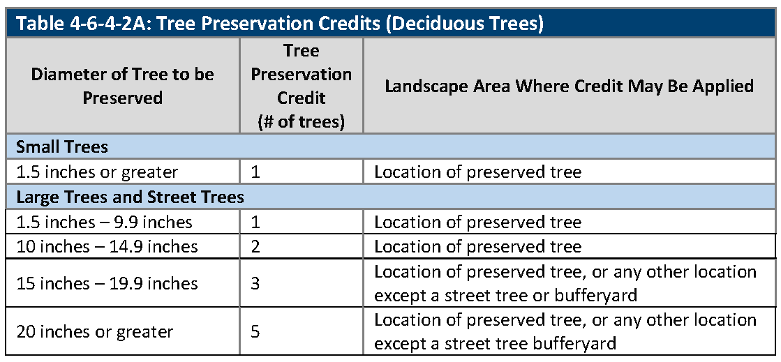
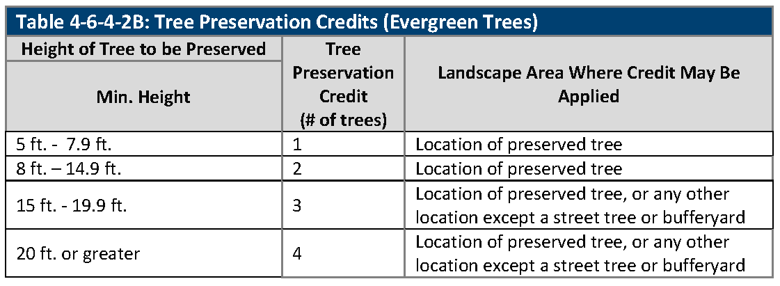
4-6-4-3. - Size and quality of landscape plants.
A.
Generally. In general, plant materials that are installed according to the requirements of this Article shall meet the standards that are set out in this Section.
B.
Minimum Size of Landscape Materials. The minimum sizes of landscape materials used to satisfy the requirements of this Article are set out in Table 4-6-4-3, Minimum Size of Landscape Materials. Larger sizes may be required to ensure survival or to implement a condition of approval of a planned unit development or conditional use.
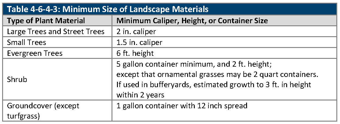
C.
Specification of Landscape Materials.
1.
All new plant material shall meet specifications of the American Standard for Nursery Stock (ANSI Z60.1) and 8 CCR § 1203-5, Rules Pertaining to the Administration and Enforcement of the Colorado Nursery Act.
2.
Plant materials shall be true to name and type, and first class representatives of their species or varieties.
3.
Container and bare root tree plantings are not permitted without the written permission of the Director upon good cause shown.
4-6-4-4. - Biodiversity.
A.
Generally. Diversity of the genus and species of trees and shrubs is required in order to prevent monocultures that could result in large-scale losses in the event of disease or blight.
B.
Standards.
1.
Within each of the large tree and shrub categories, not more than 30 percent of the trees or evergreens installed on a subject property shall be of a single genus, and not more than 20 percent of the trees or evergreens installed on a subject property shall be of a single species.
2.
A minimum of ten percent of the trees shall be evergreen.
3.
The Director may require biodiversity of street trees that are planted in public rights-of-way in order to serve the purpose of this Section.
C.
Exceptions. Exceptions may be made with written permission of the Director upon good cause shown, provided that the Director finds that the exception does not materially undermine the purpose of this Section.
4-6-5-1. - Identification of landscape areas.
A.
Generally. This Section sets out several different areas of a subject property in which specific quantities or techniques of landscaping may be required.
B.
Identification of Landscape Areas in All Development Types.
1.
Bufferyards are areas of a subject property that must be used for buffer ing the subject property from adjoining lots, parcels, or public rights-of-way. Bufferyards are generally situated along (or close to) property lines, outside of the public right-of-way.
2.
Streetscape areas are areas of a subject property adjacent to right-of-way, or the adjoining right-of-way itself that are used for the planting of street trees and other plant material.
3.
Parking lot landscape areas are those areas within surface parking lots that must be landscaped. Such surface parking areas include access aisles and off-street parking spaces.
4.
Building foundation landscape areas are those areas within ten feet outward from the exterior walls of principal buildings barring soil restrictions that are identified in the recommendation in a geotechnical report.
5.
Privately-owned open spaces are the areas that qualify as "open space," and which are subject to an easement or dedication that restricts future development to open space uses.
6.
Residential lot landscape areas are the yards on lots that are intended for individual ownership, or, in the case of common maintenance communities or condominiums, areas around dwelling units that would be located within private lots if the subdivision were platted for fee-simple ownership.
4-6-5-2. - Bufferyard purpose and applicability.
A.
Purposes of Bufferyards. A bufferyard is a landscaped area between two differing land uses and is designed to provide a transition between the uses, mitigate or minimize potential nuisances such as noise, light, and glare, protect the character of an area, and protect natural resources from impacts of nearby development.
B.
Applicability.
1.
Uses Requiring a Bufferyard. The following uses require a bufferyard per Section 4-6-5-3, Bufferyard Options, where directly adjacent to a single-family detached dwelling, duplex dwelling or multiplex, or a RN zoning district:
a.
Multifamily and townhomes;
b.
Mixed-use buildings;
c.
Non-residential buildings;
d.
Drive-through facilities;
e.
Industrial manufacturing and processing uses, and storage uses in the IL and IG zoning districts; and
f.
Dead-end drives and turnarounds.
2.
Additional Uses Requiring a Bufferyard. The following uses require a bufferyard per Section 4-6-5-3, Bufferyard Options, where directly adjacent to a multifamily, townhomes, or other attached residential buildings or a mixed-use building with a residential component:
a.
Drive-through facilities; and
b.
Industrial manufacturing, processing uses, and storage uses in the IL and IG zoning districts.
(Ord. No. 4793, § 3, 3-21-2022)
Editor's note— Ord. No. 4793, § 3, adopted March 21, 2022, changed the title of § 4-6-5-2 from "Purpose and applicability." to read as hereing set out.
4-6-5-3. - Bufferyard options.
A.
One of the following bufferyard options shall be installed along any non-street frontage or alley when required by Section 4-6-5-2, Purpose and Applicability, and landscape material shall be from the City's approved plant list to include acceptable buffer trees and shrubs. The options are identified below:
1.
Option A. A landscaped bufferyard with a minimum width of 30 feet shall be provided along the property line. Canopy shade trees, evergreen trees, and shrubs shall be provided as follows:
a.
Three trees and 20 shrubs per 100 lineal feet of adjacency. A minimum 20 percent evergreen trees.
2.
Option B. A landscaped bufferyard with a minimum width of 20 feet shall be provided along the property line. Canopy shade trees, evergreen trees, and shrubs shall be provided as follows:
a.
Four trees and 24 shrubs per 100 lineal feet of adjacency. A minimum 40 percent evergreen trees.
3.
Option C. A landscaped bufferyard with a minimum width of 20 feet shall be provided along the property line. The bufferyard shall include a six-foot tall solid fence or wall along the property line. Canopy shade trees, evergreen trees, and shrubs shall be provided as follows:
a.
Two trees and ten shrubs per 100 linear feet of adjacency plus six-foot tall solid fence or wall along the property line. A minimum 20 percent evergreen trees.
4.
Option D. A landscaped bufferyard with a minimum of ten feet shall be provided along the property line. The bufferyard shall include a six-foot tall solid fence or wall along the property line. Brick or stone columns shall be incorporated into the fence or wall design and spaced at least every 30 feet. Canopy shade trees, evergreen trees, and shrubs shall be provided as follows:
a.
Four trees and ten shrubs per 100 lineal feet of adjacency. A minimum 40 percent evergreen trees.
5.
Option E. Option E shall be permitted only in the CN, MX-N and OT zoning districts. A six-foot tall solid wall constructed of brick, stone or other comparable materials with brick or stone columns spaced at least every 30 feet may be installed in-lieu of landscaping for sites containing 25 or fewer parking spaces.
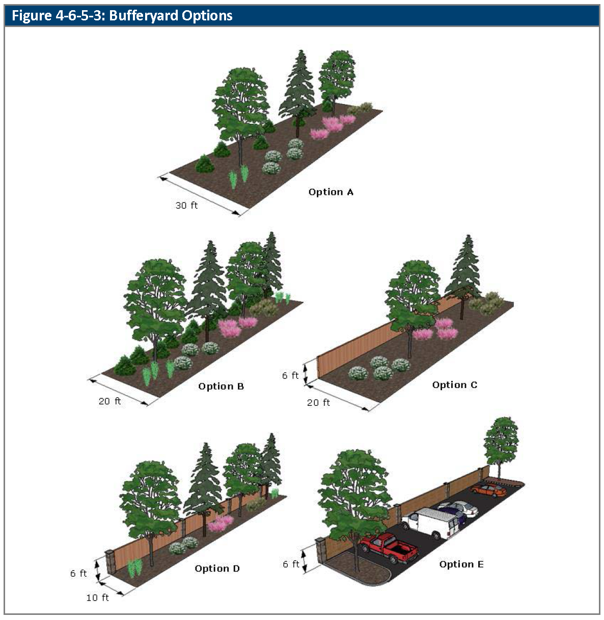
(Ord. No. 4851, § 3, 7-10-2023)
4-6-6-1. - Street trees.
A.
Generally. Deciduous street trees must be installed between the curb and detached sidewalk in street rights-of-way in locations approved by the Director or within ten feet of street rights-of-way with approval by the Director in cases where the Director determines that it is impractical to plant the street trees within the right-of-way. Street trees shall be located and spaced in accordance with the standards of this Section.
B.
Installation Requirements.
1.
Street Trees. All development shall provide at least one street tree for each 40 feet of street frontage unless the Director determines that a different number of trees is warranted because of existing conditions.
2.
Planting Locations.
a.
Generally, street trees shall be installed in a streetscape area with a minimum width of eight feet between back of curb and sidewalk.
b.
As an alternative to a streetscape area, tree grates or cutouts in sidewalks may be allowed in the MX, and OT zoning districts. Tree cutouts in sidewalks shall be of sufficient size to support healthy tree growth as determined by the Director.
c.
Alternative locations are allowed by approval of the Director according to the standards set out in Subsection A., above.
C.
Setbacks.
1.
The trunks of street trees shall be set back from driveways and alleys outside of the sight triangle.
2.
Street trees shall be planted so that:
a.
Their eventual growth can be reasonably controlled so as to avert interference with or obstruction of any improvements installed for public benefit; and
b.
Nearby overhead and underground utilities such as water, wastewater, gas, communications, and electrical, will not be disrupted or materially affected by branches or roots.
3.
No street trees that are more than 25 feet in height at maturity shall be planted under or within ten feet (measured horizontally) of any overhead power line, except street light or service lines.
D.
Maintenance. Maintenance of street trees shall be the responsibility of the adjacent property owner, unless the Applicant has provided for an alternative perpetual maintenance arrangement that is acceptable to the Director (e.g., via a property owners' association or special district).
4-6-6-2. - Street bufferyards.
A.
Street Bufferyards in Setbacks.
1.
In the CG, IL and IG zoning districts, and multifamily in the R13 and R24 zoning districts, the front setback shall be landscaped in accordance with Sections 4-6-6-4, Foundation Plantings and 4-6-6-5, General Landscape Areas.
2.
In the MX and OT zoning districts, if the principal building is set back more than five feet from the property line, then that area shall be landscaped in accordance with Sections 4-6-6-4, Foundation Plantings and 4-6-6-5, General Landscape Areas. If the building is set back less than five feet, the area shall be hardscaped with paving materials such as concrete, pavers or other quality paving materials, or landscaped with shrubs and ground-level plants. The remainder of all setbacks shall be landscaped in accordance with Sections 4-6-6-4, Foundation Plantings and 4-6-6-5, General Landscape Areas.
(Ord. No. 4793, § 3, 3-21-2022)
4-6-6-3. - Parking area landscaping.
A.
Generally. Surface parking lots shall be landscaped to reduce the apparent size of the parking area; prevent views of long rows of parked cars; create an impression of smaller, connected parking lots; provide shade for parked cars; reduce the heat island effect of an urbanized area; and define pedestrian access ways, according to the standards of this Section.
B.
Exceptions.
1.
The surface parking lot landscape requirements of this Section do not apply to:
a.
Parking lots in the IL and IG zoning districts if the subject property is located south of West 60th Avenue and east of or adjacent to Lamar Street; or
b.
Surface parking lots with 24 or fewer parking spaces and with 12 or fewer parking spaces in a row.
2.
The access point landscape requirements of this Section do not apply to driveways that provide access to individual single-family detached, duplex, multiplex, or townhome lots.
C.
Perimeter Landscape Buffer.
1.
Required Perimeter Landscape Buffer.
a.
Parking lots adjacent to single-family detached, duplex, multiplex, or townhome uses shall meet the Option C or D bufferyard in Division 4-6-5-3, Bufferyard Options.
2.
Exceptions.
a.
The requirements for perimeter landscaping do not apply at points of ingress or egress to the surface parking lot, or to points of cross-access among properties that share a parking lot.
D.
Required Surface Parking Lot Landscape Areas.
1.
Landscaping shall be installed in the following required landscape areas:
a.
Landscape islands are required at the end of each row of parking spaces in each parking module;
b.
Landscape islands are required and must be distributed throughout the parking lot, at a rate of at least one landscaped island for each 12 consecutive parking spaces;
c.
Vegetated entry medians are required with a minimum of at least 300 square feet in surface area and a minimum five feet in width (not including curbs), if the surface parking lot contains 180 or more parking spaces;
d.
Landscape strips are required at least 14 feet in width (not including curbs) that separate groups of parking modules (along their long edges) into "cells" as provided in Table 4-6-6-3, Parking Module Separation Requirements.
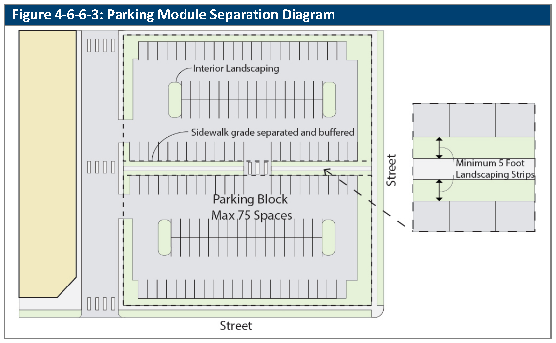
2.
Landscape islands that are used to meet the requirements of Subsection D.1.a. and D.1.b., above, shall be at least eight feet in width (not including curbs) and 16 feet in length, and may be combined (eight feet in width by 32 feet in length) at the ends of adjacent parking modules.
3.
Landscape strips may include sidewalks (and landscape islands may be crossed by sidewalks), but the sidewalks shall not be counted as required landscape areas for the purposes of the calculation of planting requirements (see Subsection E., below).
4.
A raised sidewalk to connect the parking area with major building entries should be provided between the cells with a five-foot planting strip on both sides of the sidewalk. An alternative layout is a sidewalk connection with a central five-foot wide landscaped area, flanked with sidewalks on both sides.
E.
Minimum Planting Requirements. Required surface parking lot landscape areas shall be planted with one shade tree or two ornamental trees, plus eight shrubs per 300 square feet of required landscape area.
(Ord. No. 4793, § 3, 3-21-2022)
4-6-6-4. - Foundation plantings.
A.
Generally. The foundation planting area is the area of ground that extends ten feet outward from street-facing principal building elevations, and wrapping five feet around the corners of street-facing principal building elevations. The foundation planting area does not extend into adjacent rights-of-way. Foundation plantings are required for all principal buildings as provided in this Section, except as provided in Subsection B., below.
B.
Exceptions. Foundation plantings are not required:
1.
For principal buildings used for:
a.
Multi-tenant nonresidential buildings that are designed with an adjacent sidewalk that provides principal public access to the individual tenant entrances;
b.
Land uses set out in Section 3-1-2-10, Agricultural Land Use by Zoning District.
2.
On lots that are developed with single-family, duplex, multiplex, clustered small housing types, and manufactured homes.
3.
For principal buildings located less than five feet from the property line.
C.
Planting Requirements.
1.
Foundation planting areas shall be planted with one shrub per five linear feet of building façade.
2.
Foundation plantings shall be used to accent the principal public entry to the building. Foundation plantings may be clustered for this purpose, and to provide interest and accent to other parts of the building, or to provide a foreground object to mitigate the appearance of building mass.
3.
Foundation planting areas may include areas with impervious surfaces; however, the area within the foundation planting area that is used for the installation of required landscape materials shall be large enough to support the healthy growth of the plant material.
4-6-6-5. - General landscape areas.
A.
Generally. Except as provided in Subsection B., below, the landscaping requirements of this Section apply to all permeable areas of the subject property that are not otherwise a designated required planting area pursuant to Division 4-6-5, Landscape Areas and Bufferyards or Section 4-6-6-1, Street Trees, through Section 4-6-6-4, Foundation Plantings, inclusive.
B.
Exceptions. The requirements of this Section do not apply to:
1.
Preserved open space; and
2.
Irrigation canals, irrigation ditches, reservoirs, and appurtenant maintenance areas (whether owned in fee simple or as easements).
C.
Planting Requirements. General landscape areas shall be planted with at least:
1.
One canopy or evergreen tree, or two ornamental trees per 3,000 square feet of landscape surface area;
2.
A minimum of ten percent of all trees shall be evergreen; and
3.
75 percent vegetative ground coverage at maturity, excluding tree canopy.
D.
Shrub Requirements. Shrubs shall be planted at a maximum spacing of five feet on center.
E.
Planting on Steeper Slopes. On slopes greater than 3:1, the following can be planted:
1.
Trees and shrubs; and
2.
Groundcovers.
(Ord. No. 4793, § 3, 3-21-2022)
4-6-6-6. - Single-family detached, duplex, multiplex, and townhome front yards.
Prior to the issuance of a certificate of occupancy, single family, duplex, multiplex, and townhome dwelling units shall be landscaped as follows:
1.
Front yards shall be landscaped with trees, turf, low ground covers, shrubs, or flowers.
2.
At least one tree (shade, ornamental, or evergreen) shall be provided for each front yard area.
4-6-6-7. - Variations of landscape area requirements.
The Director may authorize variations from the planting requirements of this Division if, based on documented soil conditions, the Director determines that the soils are unsuitable for such plantings in the required locations because they either:
1.
Will not support plant growth; or
2.
Require moisture control in order to prevent damage to the building foundation.
4-6-7-1. - Water-wise requirements.
A.
Generally. Water-wise landscaping techniques shall be used as provided in this Section.
B.
Restrictions on High-Water-Demand Landscapes.
1.
High water-demand landscapes (such as irrigated cool season turf grass) are limited to areas of high pedestrian activity, streetscape areas, primary entrance features, clubhouse grounds, wetland plantings, or in yards on single-family, duplex, multiplex, manufactured home, and cluster housing lots.
2.
High-water-demand turf shall be minimized to the extent practicable and not exceed 50 percent of the total common landscaped area in residential projects and 35 percent of the landscaped area in nonresidential or mixed-use projects.
3.
High-water-demand turf is specifically prohibited in the following (unless approved by the Director after reviewing evidence of a water-efficient irrigation system):
a.
Parking lot islands;
b.
Slopes greater than 4:1;
c.
Street medians;
d.
Stormwater detention ponds, unless designed for active recreation or needed as part of required wetlands; and
e.
Any space less than eight feet wide.
C.
Grouping Plants According to Water Needs. All plantings should be grouped according to their water needs to minimize water use.
D.
Soil Amendments. The Director shall maintain a list of approved soil amendments, or classes or characteristics of soil amendments, which shall be incorporated into landscape planting areas as follows:
1.
Prior to planting, all sites for plantings shall be prepared with soil amendments at a rate of three cubic yards per 1,000 square feet, to a minimum depth of six inches. A lesser amount shall be allowed if a soil test shows that such amendment is not necessary for water retention and deep rooting of plant materials.
2.
If the specified plant material requires less fertile soil, those areas may have less soil amendments installed if approved by the Director. Such areas shall be identified on the landscape plan.
E.
Existing Topsoil. Existing topsoil shall be salvaged and stockpiled for use as soil amendments or topsoil. No topsoil shall be removed from the subject property unless the City approves the transfer of topsoil to a City-owned park or open space area, or to another location owned by the owner of the subject property.
F.
Irrigation. The landscape plan shall label or note the type of irrigation to be applied to each plant hydrozone to ensure that plants receive only the needed water. In addition, the plan shall include:
1.
A rain sensor with automatic shut-off of the system during periods of high moisture;
2.
A drip, sub-surface, bubbler or low volume irrigation system for all planting strips less than eight feet wide, and all planting beds involving trees, shrubs, perennials, and groundcover; and
3.
An irrigation clock that allows programming to meet the differential needs of the specified planting plan.
G.
Restrictive Covenants Regarding Turf. Any restrictive covenant that becomes effective after July 15, 2003 shall not prohibit the use of water-wise landscaping or require more than 50 percent high-water-demand turf. This provision shall not restrict the individual and voluntary use of a greater percentage of high-water-demand turf.
4-6-7-2. - Groundcovers and planting beds.
A.
Generally. The standards of this Section apply to ground covers and planting beds.
B.
Inorganic Ground Cover. Inorganic material such as river rock, cobble rock, gravel, artificial turf, artificial plant material, concrete, or asphalt paving may not be used as a permanent, primary ground cover within the landscaped area, except where:
1.
Rock is utilized as an integral part of the landscape design, and does not exceed 25 percent of the front yard and is part of an approved plan;
2.
Drainage or soil conditions require a non-irrigated and/or surface pan at finished grading adjoining the building's foundation;
3.
Artificial turf is used as part of an approved plan for recreational fields or common amenities such as a clubhouse;
4.
Artificial turf is used for backyard and side yard applications that are not in public view. Public view includes any area viewable from areas with public access such as streets, sidewalks, parks, and trails. Artificial turf for a putting green not larger than 400 square feet may be placed in side or rear yard even if in public view; or
5.
Concrete, rock or asphalt materials are used for walkways, driveways or patios.
C.
Inorganic or Organic Mulch. Where inorganic or organic mulches are used, they shall be applied at a minimum depth of two inches and covered with plant materials such that the mulched area will be at least 75 percent covered at maturity.
D.
Plant Beds. Plant beds shall include landscaping, mulch over a weed barrier, and edging along turf areas.
4-6-7-3. - Berms.
Where used, berms shall be created and maintained to have a natural appearance, with variations in the berm ridge line and in the berm height. Berms shall have a maximum slope of 4:1 and shall be planted to prevent erosion with appropriate trees, shrubs, groundcovers, and/or grasses as determined by the Director.
4-6-8-1. - Landscape maintenance.
A.
Generally. All plants shall be maintained continually in a healthy condition in accordance with generally accepted professional horticultural standards and practices. Plants that die or are unhealthy shall be replaced according to the approved landscape plan.
B.
Pruning and Trimming. Regular pruning and trimming shall be performed to maintain health and an attractive appearance and to permit the plants to achieve their intended form and height.
C.
Groundskeeping. All landscape areas shall be kept free of weeds, litter and trash and all irrigation systems shall be properly maintained.
4-7-1-1. - Purpose of article.
The purpose of this Article is to provide reasonable regulations for the appearance, location, type and maintenance of fences and walls to ensure the safety of residents and the high-quality character and appearance of the City.
4-7-1-2. - Application of article.
A.
Fences and Divisional Walls.Division 4-7-2, Fences and Divisional Walls, provides a set of standards and tables establish heights and materials for fences, divisional walls, and retaining walls.
4-7-2-1. - Fences and divisional walls.
A.
Generally. All fences and divisional walls shall comply with the requirements of this Division.
1.
If a proposed fence or divisional wall is located directly adjacent to a zoning district boundary or on a shared property line, the less restrictive standards shall apply.
B.
Permits Required. All fences and divisional walls require fence permits, except for the following:
1.
Repair of a fence section not greater than eight linear feet in length.
C.
Height. All fences and divisional walls shall comply with the maximum heights shown in the following Table 4-7-2-1, Maximum Height of Fences and Divisional Walls Within Required Setback Areas, unless a different maximum height is explicitly permitted:
1.
By this Code or approved through the Minor or Major Modification, or PUD approval process;
2.
For an activity field (i.e., tennis court, baseball, football, soccer fields) at the discretion of the Director; or
3.
For fences associated with a Utility, Major for security purposes, city facilities, or city property, at the discretion of the Director.
D.
Location. All fences and divisional walls may encroach into required yards and setbacks. Fences and wall shall not:
1.
Be constructed within a public right-or-way or areas to be dedicated for public right-of-way unless a revocable permit is approved;
2.
Conflict with sight distance visibility of intersections or points of ingress/egress;
3.
Block or divert a natural drainage flow onto or off of any other property;
4.
Block access within an access easement; and
5.
Encroach into a utility easement, unless the easement holder has provided written consent. (This specific requirement shall only apply to masonry walls.)
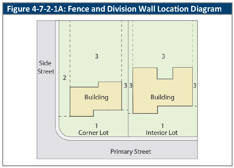
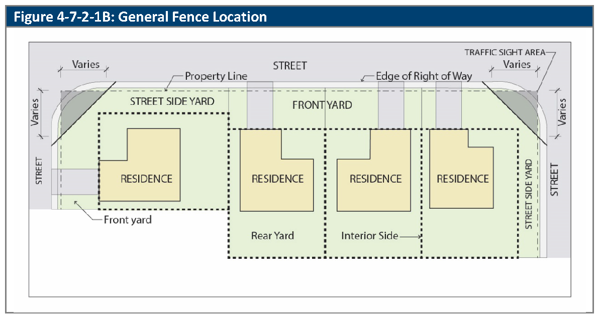
E.
Setbacks from Streets, Sidewalks, Open Space, Trails, and Multi-Use Pathways.
1.
No solid fence or divisional wall that is between four and eight feet in height shall be installed closer than:
a.
Eight feet from the flowline of a street; and
b.
Five feet to the nearest edge of a sidewalk, open space corridor less than 15 feet wide, trail, or multi-use pathway.
2.
No solid fence or divisional wall that is more than eight feet in height shall be installed closer than:
a.
Ten feet from the flowline of a street; and
b.
Eight feet to the nearest edge of a sidewalk, open space corridor less than 15 feet wide, trail, or multi-use pathway.
3.
Fences that exist in the condition identified in Subsection E1 and E2 above prior to the adoption of this Code shall be considered conforming.
4.
The area between the fence or divisional wall and the street, sidewalk, trail, or multi-use pathway shall be landscaped with shrubs, groundcover, perennials, ornamental grasses, or turf materials that provide contrast with the sidewalk. Inorganic ground cover such as river rock, cobble rock, or gravel may be used as part of the landscape provided that the ground cover, ornamental grasses or turf which are planted achieve 50 percent coverage at maturity. Hardscape materials are allowed only at points of access through the fence or divisional wall.
5.
Vehicular gates adjacent to streets and sidewalks shall be located a minimum of 18 feet from the sidewalk or the property line, whichever is greater, and shall not open outward from the private property.
6.
Fences shall comply with the sight triangle requirements of Section 4-4-3-3, Intersection Visibility.
F.
Design of Street-Facing Fences or Divisional Walls.
1.
All fences or divisional walls adjacent to a street, open space, trails, and multi-use pathways, the finished surface of the fence shall face towards the street frontage. Non-decorative elements such as fence posts and supporting structures, when visible on one side and not the other, shall face inward.
2.
No portion of any front yard setback may be fenced for use as an animal pen or dog run.
G.
Perimeter Fence and Walls. Perimeter fences and walls along arterial streets or railroad tracks may be constructed up to eight feet in height. Perimeter fencing shall be constructed of Western Red Cedar wood or other material approved by the Director, or masonry. Masonry fence posts two foot by two foot in size, shall be located at property corners but no further than 100 feet apart on-center, and with sloped column caps to drain water to the sides of the posts.
H.
Security Fencing.
1.
No barbed wire or other sharp-pointed fences or similar security devices on divisional walls shall be installed on any property, except:
a.
In the IL or IG zoning districts that is used for industrial purposes, upon demonstration to the Director or the Decision Making Body that a substantial security need justifies the installation; or
b.
In the RA or OS zoning districts on property that is used for agricultural purposes.
2.
Electrically charged fences are not allowed unless necessary for livestock control in an RA zoning district.
I.
Relationship to State Statutes or Regulations.
1.
Where the Colorado statutes or implementing administrative regulations require fencing or divisional walls that are taller than those that are allowed by Table 4-7-2-1, Maximum Height of Fences and Divisional Walls Within Required Setback Areas, the Director may approve the increased fence or divisional wall height in accordance with the statutes or implementing administrative regulations.
2.
If the fence or divisional wall is located within Area 1 or Area 2 as shown in Figure 4-7-2-1A, Fence and Divisional Wall Location Diagram, then where feasible and consistent with the statute or regulation, the Director shall require landscaping or design treatments to mitigate the visual impacts of the increased height of the fence or garden wall when viewed from the public streets. Mitigation measures may include, but are not limited to, tree, shrub, or hedge plantings; material and color selections that de-emphasize the fence or garden wall; transparency; and additional setbacks for the fence or divisional wall.
J.
Fence and Wall Materials.
1.
Fences and divisional walls shall be made of high quality, durable materials that require low maintenance and are complementary with the overall design of the principal building and site landscape. The following materials are allowed:
a.
Wood and composite wood;
b.
Non-reflective plastic and vinyl fencing;
c.
Natural stone, stacked stone, brick, stucco, decorative concrete masonry blocks that replicate the appearance of brick, stone, and stucco;
d.
Metal iron, metal picket and other metals simulating the appearance of wrought iron, chain-link fencing or aluminum or wrought iron decorative fencing.
2.
The Director may approve other materials that are equal to or surpass the materials listed in this Subsection J. in terms of durability, maintenance, and aesthetics.
3.
Prohibited Material. Sheet plastic, sheet metal, chicken wire, fabric materials, fiberboard, garage door panels, snow fencing, rope, plywood fences, PVC pipes, and miscellaneous materials not commonly used with residential fences are not allowed.
K.
Maintenance. All fences and divisional walls shall be maintained in good condition at all times.
(Ord. No. 4793, § 3, 3-21-2022; Ord. No. 4905, §§ 49—51, 8-19-2025)
4-7-2-2. - Retaining walls.
A.
Generally. All retaining walls shall meet the requirements of this Section. The purpose of these standards is to avoid large, flat, unbroken retaining wall planes by creating visual interest that is compatible with the architectural character of the surrounding area, creating texture and relief in walls, encouraging human scale detailing, and promoting the use of materials that are durable and of high quality.
B.
Maximum Height.
1.
The maximum height of a retaining wall shall be:
a.
Four feet; or
b.
Six feet, if attached to a principal building and necessary to compensate for a change in grade.
2.
Where additional height is necessary, a series of low retaining walls, none exceeding four feet in height, shall be used wherever possible. Where multiple retaining walls are used, a minimum of one foot of horizontal spacing is required for every one foot of tallest wall height. In such cases, walls shall be spaced from each other a horizontal distance equal to the height of the taller of the walls in each pair that are spaced.
3.
The Director may waive or modify the maximum height requirements of this Subsection if an alternative design is proposed that will achieve the design objectives set out in Subsection A., above, in a comparable or more favorable manner.
C.
Railing Required. Where the construction of a retaining wall results in a downward vertical drop of more than 30 inches within four horizontal feet of a sidewalk, walkway, or other public circulation area, a railing at least 42 inches in height shall be placed along the top edge of the retaining wall to prevent pedestrians from falling over the edge of the retaining wall.
D.
Retaining Wall Materials.
1.
Retaining walls shall be composed of any the following materials:
a.
Dry-stacked stone;
b.
Decorative (e.g., glazed, textured, split-face, etc.) pre-cast concrete masonry units;
c.
Masonry block with stone, brick, or stucco facing;
d.
Cast in place concrete with design features that improve its aesthetics including, but not limited to, surface treatments or integral colors; or
e.
Gabion walls as approved by the Director.
2.
Treated timber or railroad ties shall not be used except on lots with a single-family detached dwelling unit.
3.
The Director may waive or modify the materials requirements of this Subsection if it is demonstrated that:
a.
The wall is effectively screened from view due to its location and orientation and/or the presence of landscaping; or
b.
An alternative material is proposed that offers equal or better quality, durability, maintenance characteristics, and aesthetics.
(Ord. No. 4793, § 3, 3-21-2022)
4-8-1-1. - Purpose of article.
The purpose of this Article is to regulate exterior lighting to ensure all exterior lighting is designed and installed to maintain adequate lighting levels on site, limit light impacts, glare and curtail light pollution, to conserve and promote energy efficiency and provide security for persons and property for crime prevention.
4-8-1-2. - Application of article.
A.
General Standards.Division 4-8-2. General Lighting Standards, provides general design standards for light fixtures, standards for different land use categories, outdoor recreation lighting standards, and standards for the lighting curfew.
4-8-2-1. - Applicability.
A.
Generally. The following standards apply to all new development in the City and existing lighting system modifications, alterations, relocations or renovations to exterior fixtures after the effective date of this Code.
B.
Exceptions. The following are specifically exempted from the requirements of this Article:
1.
Public street lighting and other lighting providing by local governmental, state, federal agencies;
2.
Existing lighting that remains unchanged (including ongoing standard maintenance such as bulb lamp replacement provided that the replacement lamp is of equivalent luminance level, and/or painting of existing poles or fixtures as required by Section 4-8-2-2);
3.
Seasonal holiday lighting;
4.
Lighting of governmental flags and public monuments and statuary;
5.
Lighting for public art;
6.
Temporary lighting of construction sites provided such lighting is discontinued upon completion of the construction activity and night time use is limited to address security;
7.
Temporary lighting for emergency situations provided such lighting is discontinued upon abatement of the emergency situation; and
8.
Underwater lighting in swimming pools, fountains and other water features.
C.
Prohibited Lighting.
1.
Aerial lasers, searchlights and/or rotating beacons; unless part of a special event, for a maximum of five days;
2.
Flashing or blinking lights, or lighting with changing intensity;
3.
Light fixtures that imitate official highway or traffic control lights or signs that are not authorized by a state, federal, or city government; and
4.
Signage lighting that has not been approved by the City.
4-8-2-2. - General design standards.
A.
Shielding of Lights. Luminaires shall be shielded and directed to avoid glare and overspill onto adjacent property.
1.
All exterior light fixtures shall be full cutoff fixtures that are directed downward (90 degrees from true vertical) and shall have flat lenses, emitting no more than ten percent of the total lumens between 80 and 90 degrees from true vertical. Fixtures shall be configured so that lights do not cause glare.
2.
All light fixtures on structures, poles, bollards, stands, or mounted on a building shall have a shield, adjustable reflector, and/or non-protruding diffuser to shield the light source from sight from adjacent residential zoning districts.
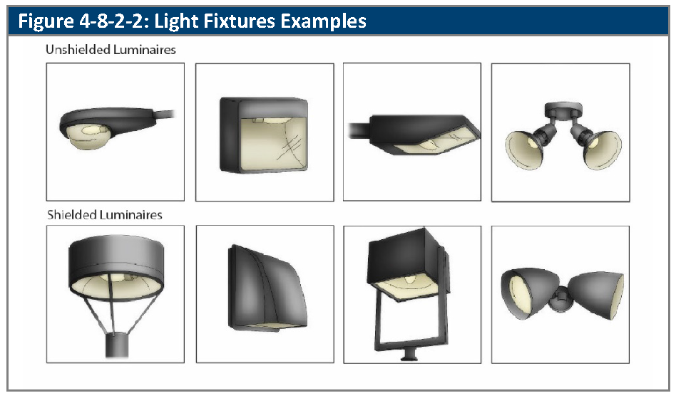
B.
Maximum Spill Light Illumination Levels. Except for public street lighting, all exterior lighting and indoor lighting visible from outside shall be designed to minimize adverse impacts on adjacent properties by minimizing glare and limiting light at the property line and located so that the maximum illumination measured in foot candles at ground level and for mixed-use development without property lines shall be measured a line half-way between buildings of differing uses and shall not exceed the standards in Table 4-8-2-2A, Maximum Illumination Levels.
1.
Maximum Illumination and Lighting Uniformity.
a.
Lighting shall have a uniformity ratio of ten to one (maximum to minimum).
b.
No single lamp shall exceed:
i.
All zone districts except IL and IG - 16,000 lumens
ii.
IL and IG zone districts - 20,000 lumens
2.
Maximum Light Levels.
a.
The maximum allowed light levels at any point on the property (as measured in foot candles) shall not exceed the following limits:
i.
Pedestrian areas (when not adjacent to parking lots): Three foot candles.
ii.
Multiplex, Townhome, and Multifamily Building Entries: Eight foot candles.
iii.
Parking lots and all other non-residential use areas: Eight foot candles.
iv.
Service Canopies (fuel stations, ATMs, Drive-Through's, etc.): 20 foot candles.
C.
Maximum Height. The height of exterior light fixtures, whether mounted on poles, walls, or by other means, shall comply with the standards in Table 4-8-2-2B, Maximum Height for Exterior Lighting.
D.
Motion-Activated Security Lighting.
1.
Motion-activated security lighting may emit up to 3,000 lumens per fixture.
2.
Not more than one motion-activated security light fixture is allowed per 60 linear feet of building elevation.
3.
Security lighting shall be timed to turn off after not more than five minutes after motion activation.
E.
Outdoor Sports or Performance Venue. Lighting fixtures for outdoor sports areas, athletic fields, and performance areas shall be equipped with a glare control package (e.g., louvers, shields, or similar devices) and aimed so that their beams are directed and fall within the primary playing or performance area.
1.
Lighting fixtures may not be more than 40 feet in height.
F.
Pedestrian Area Lighting.
1.
Pole light fixtures for plazas, small urban parks, sidewalks, walkways, trails, and bicycle paths outside of or not adjacent to vehicular surface areas (i.e., parking lots or streets) shall:
a.
Provide at least an average of 1 foot candle of illumination, but not exceed three foot candles;
b.
Have a maximum height of 15 feet; and
c.
No single lamp shall exceed 10,000 lumens.
2.
Pedestrian bollard lamps shall be mounted no higher than four feet above grade and shall not exceed three-foot candles.
a.
No single lamp shall exceed 900 lumens.
G.
Wall Pack Lights. Wall packs on the exterior of the building shall be fully shielded (e.g., true cut-off type bulb or light source not visible from off-site) to direct the light vertically downward and have a maximum of 1,600 lumens.
H.
Awnings. Awnings used for building accents over doors and windows shall not be internally illuminated (i.e., from underneath or behind the awning) unless the awning material is entirely opaque.
1.
Service Canopy Lighting. Canopy lighting for uses that shelter outside work, full-service areas or porte-cocheres shall have all light fixtures flushed mounted or recessed into the canopy and equipped with flat lenses.
I.
Decorative Lighting.
1.
Decorative lighting shall be permitted to enhance the appearance of a building and/or landscape feature provided that:
a.
All light is cast against the building surface or downward onto a landscape feature;
b.
All decorative lighting is directed away from residential uses located within 50 feet of the building façade on which the decorative lighting is mounted and is shielded to reduce light trespass on adjacent uses;
c.
The lamp is not visible from adjacent properties, pedestrian or vehicular traffic; and
d.
The decorative lighting does not exceed 1,600 lumens.
2.
Unshielded Tivoli and patio string lighting with no more than 200 lumens per foot provided that the lighting is turned off between 11:00 p.m. and 6:00 a.m.
J.
Pole and Fixture Color.
1.
All poles and fixtures (luminaires) shall be of dark colors including, but not limited to, black, dark gray, dark green or brown. Reflective or light colored poles and fixtures are not allowed.
(Ord. No. 4793, § 3, 3-21-2022; Ord. No. 4905, §§ 52—54, 8-19-2025)
4-8-2-3. - Single-family detached, duplex, and multiplex lighting standards.
A.
Generally. Exterior lighting on single-family detached, duplex, and multiplex uses shall conform to the requirements of this section.
B.
Exterior Fixture Type and Configuration. Fixtures shall emit no more than 850 lumens.
4-8-2-4. - Townhome, multifamily, mixed-use, and nonresidential lighting standards.
A.
Generally. Exterior lighting on multifamily, mixed-use and nonresidential uses shall conform to the requirements of this section.
B.
Exterior Fixture Types.
1.
"No cut-off" fixtures may be used for:
a.
Decorative purposes, provided that their luminaires produce no more than 1,500 lumens per fixture, and they are not installed more than eight feet above adjacent grade; and
b.
Illumination of individual balconies, decks (including rooftop), or porches, provided that their luminaires produce no more than 1,500 lumens per fixture.
4-8-2-5. - Outdoor recreation lighting standards.
A.
Generally. Ball diamonds, playing fields, driving ranges, tennis courts, and similar amusement or recreation uses have unique requirements for nighttime visibility and, generally, have limited hours of operation.
B.
Maximum Freestanding Fixture Height. No freestanding light fixture shall be greater than 40 feet in height, except that greater heights may be approved by the Director if it is demonstrated that the greater height improves site lighting compared to fixtures that are 40 feet in height or less.
C.
Maximum Illumination.
1.
Field and court lighting shall be designed so that any overspill of lighting onto adjacent single-family, duplex, multiplex, or townhome property shall not exceed one-half foot-candle, one foot-candle adjacent onto multifamily properties, and two foot-candles onto adjacent non-residential properties measured horizontally, at the property line.
2.
Buffering may be used to reduce impacts of outdoor recreation lighting in order to achieve compliance with the requirements of this Subsection C.
4-8-2-6. - Lighting curfew.
A.
Generally. Lighting shall be reduced or turned off as provided in this Article.
B.
Minimum Reduction. One hour after the close of business, all illumination shall be reduced by at least 70 percent, and remain in that state until at least one hour prior to open of business. This reduction in illumination may be achieved by dimming the lamps within a light fixture (luminaire), and/or turning off a luminaire or a portion of a multi-luminaire assemblage.
C.
Exemptions and Special Conditions.
1.
Residential uses (including residential units in mixed-use buildings).
2.
Lighting that is subject to Section 4-8-2-5, Outdoor Recreation Lighting Standards, shall be reduced by 50 percent immediately after the end of play and shall be fully turned off:
a.
One hour after the end of play; and
b.
When the facility is not in use.
3.
Lighting in excess of the minimum reduction may be used for security lighting provided that it is equipped with an adjustable distance/ranged setting and an amicable detector set to minimize nuisance trips from normal passing traffic and is to be timed to turn off after not more than 15 minutes after motion activation.
(Ord. No. 4793, § 3, 3-21-2022)